Embed Size (px)
Citation preview
Qaryut Village Profile (including Jalud Locality)
Prepared by
The Applied Research Institute – Jerusalem
Funded by
Spanish Cooperation
2014
Palestinian Localities Study Nablus Governorate
1
Acknowledgments
ARIJ hereby expresses its deep gratitude to the Spanish Agency for International Cooperation for
Development (AECID) for their funding of this project.
ARIJ is grateful to the Palestinian officials in the ministries, municipalities, joint services councils,
village committees and councils, and the Palestinian Central Bureau of Statistics (PCBS) for their
assistance and cooperation with the project team members during the data collection process.
ARIJ also thanks all the staff who worked throughout the past couple of years towards the
accomplishment of this work.
Palestinian Localities Study Nablus Governorate
2
Background
This report is part of a series of booklets which contain compiled information about each city, town,
and village in the Nablus Governorate. These booklets came about as a result of a comprehensive
study of all localities in the Nablus Governorate, and aim to depict the overall living conditions in the
governorate and present developmental plans to assist in improving the livelihood of the population
in the area. It was accomplished through the "Village Profiles and Needs Assessment" project funded
by the Spanish Agency for International Cooperation for Development (AECID).
The "Village Profiles and Needs Assessment" was designed to study, investigate, analyze and
document the socio-economic conditions and the programs and activities needed to mitigate the
impact of the current insecure political, economic and social conditions in the Nablus Governorate.
The project's objectives are to survey, analyze and document the available natural, human,
socioeconomic and environmental resources, and the existing limitations and needs assessment for
the development of the rural and marginalized areas in the Nablus Governorate. In addition, the
project aims to prepare strategic developmental programs and activities to mitigate the impact of the
current political, social, and economic instability with a focus on the agricultural sector.
All locality profiles in Arabic and English are available online at http://vprofile.arij.org.
Palestinian Localities Study Nablus Governorate
3
Table of Contents
Location and Physical Characteristics ____________________________________ 4
Religious and Archaeological Sites ______________________________________ 6
Population __________________________________________________________ 8
Education __________________________________________________________ 8
Health Status ________________________________________________________ 9
Economic Activities __________________________________________________ 10
Agricultural Sector __________________________________________________ 11
Institutions and Services ______________________________________________ 13
Infrastructure and Natural Resources ___________________________________ 14
Geopolitical Status in Qaryut village ____________________________________ 16
Development Plans and Projects _______________________________________ 20
Implemented Projects ________________________________________________ 20
Proposed Projects ___________________________________________________ 20
Locality Development Priorities and Needs _______________________________ 22
References: ________________________________________________________ 23
Palestinian Localities Study Nablus Governorate
4
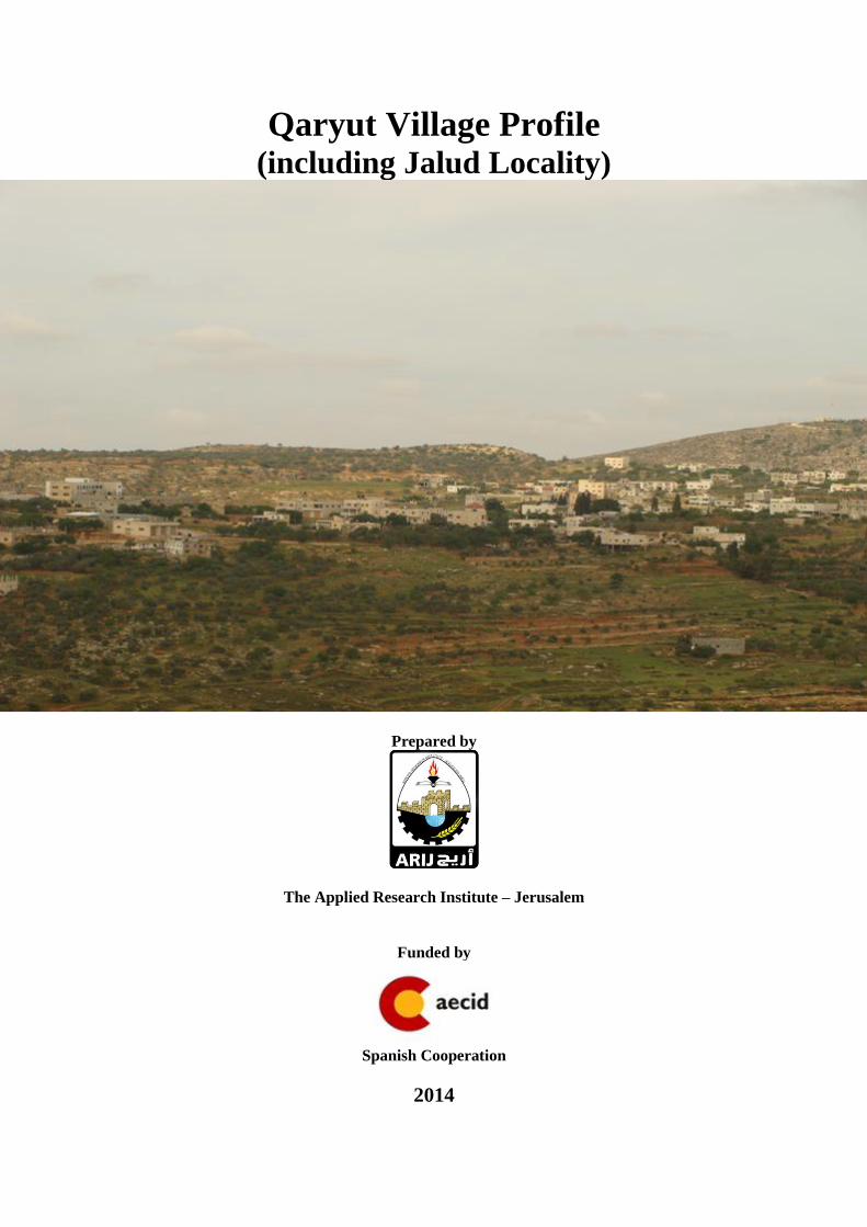
Qaryut Village Profile (including Jalud Locality)1
Location and Physical Characteristics
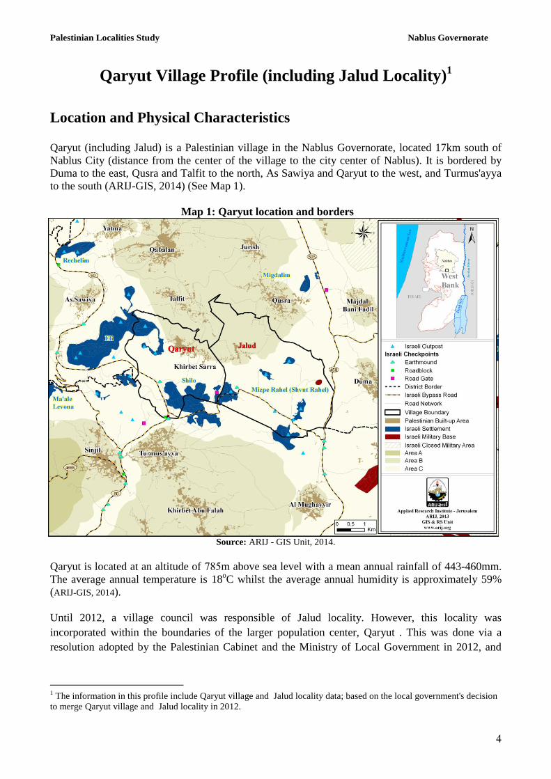
Qaryut (including Jalud) is a Palestinian village in the Nablus Governorate, located 17km south of
Nablus City (distance from the center of the village to the city center of Nablus). It is bordered by
Duma to the east, Qusra and Talfit to the north, As Sawiya and Qaryut to the west, and Turmus'ayya
to the south (ARIJ-GIS, 2014) (See Map 1).
Map 1: Qaryut location and borders
Source: ARIJ - GIS Unit, 2014.
Qaryut is located at an altitude of 587m above sea level with a mean annual rainfall of 443-460mm.
The average annual temperature is 18oC whilst the average annual humidity is approximately 59%
(ARIJ-GIS, 2014).
Until 2012, a village council was responsible of Jalud locality. However, this locality was
incorporated within the boundaries of the larger population center, Qaryut . This was done via a
resolution adopted by the Palestinian Cabinet and the Ministry of Local Government in 2012, and
1 The information in this profile include Qaryut village and Jalud locality data; based on the local government's decision
to merge Qaryut village and Jalud locality in 2012.
Palestinian Localities Study Nablus Governorate
7
according to this resolution, Jalud and Qaryut came under the administrative authority of one
municipal council which is called Qaryut Municipal Council.
The total area of Qaryut village consists of approximately 224453 dunums. The borders of this
locality are set according to the new local councils’ borders which were defined by the Palestinian
Ministry of Local Government. The new borders of the Palestinian localities were set by the
Palestinian National Authority; represented by the Ministry of Local Government, the Central
Elections Commission, the Ministry of Planning and the Palestinian Central Bureau of Statistics in
the year 2011. These governmental institutions reset the borders of the localities for the purpose of
the Palestinian elections that took place in the year 2011. Accordingly, ARIJ adopted these new
borders in this report since it found that the newly adopted borders, to a certain extent, better suit the
demographic, environmental and agricultural variables and facts on the ground. Also, ARIJ uses
these defined borders only for the sake of this research and study. It is worth noting that these
borders do not represent the areas and borders of the private properties at the locality level and are
not included in the PNA files of the private land holdings.
Since 1994, Qaryut has been governed by a Village Council which is currently administrated by 9
members appointed by the Palestinian National Authority (PNA). There is also 1 employee working
in the council, which has a permanent headquarters. It is located within the Services Council of
Aqraba. The Council does not own a waste collection vehicle (Qaryut Village Council, 2013).
It is the responsibility of the Village Council to provide a number of services to the residents of
Qaryut, including:
The establishment and maintenance of the drinking water network
The establishment and maintenance of the electricity network
Solid waste collection, road rehabilitation, construction and paving, and provision of social
services
Provision of space for government services
Implementation of projects and studies for the village
Protection of historical and archaeological sites
Provision of transportation
(Qaryut Village Council, 2013)
History Background:
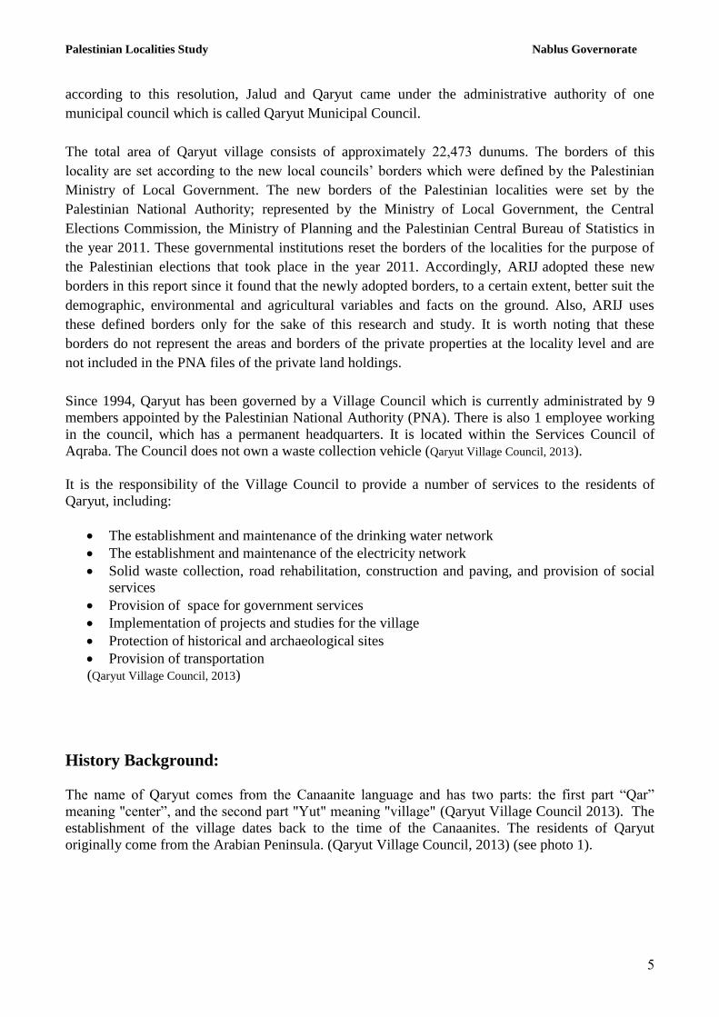
The name of Qaryut comes from the Canaanite language and has two parts: the first part “Qar”
meaning "center”, and the second part "Yut" meaning "village" (Qaryut Village Council 2013). The
establishment of the village dates back to the time of the Canaanites. The residents of Qaryut
originally come from the Arabian Peninsula. (Qaryut Village Council, 2013) (see photo 1).
Palestinian Localities Study Nablus Governorate
6
Photo of Qaryut
Religious and Archaeological Sites
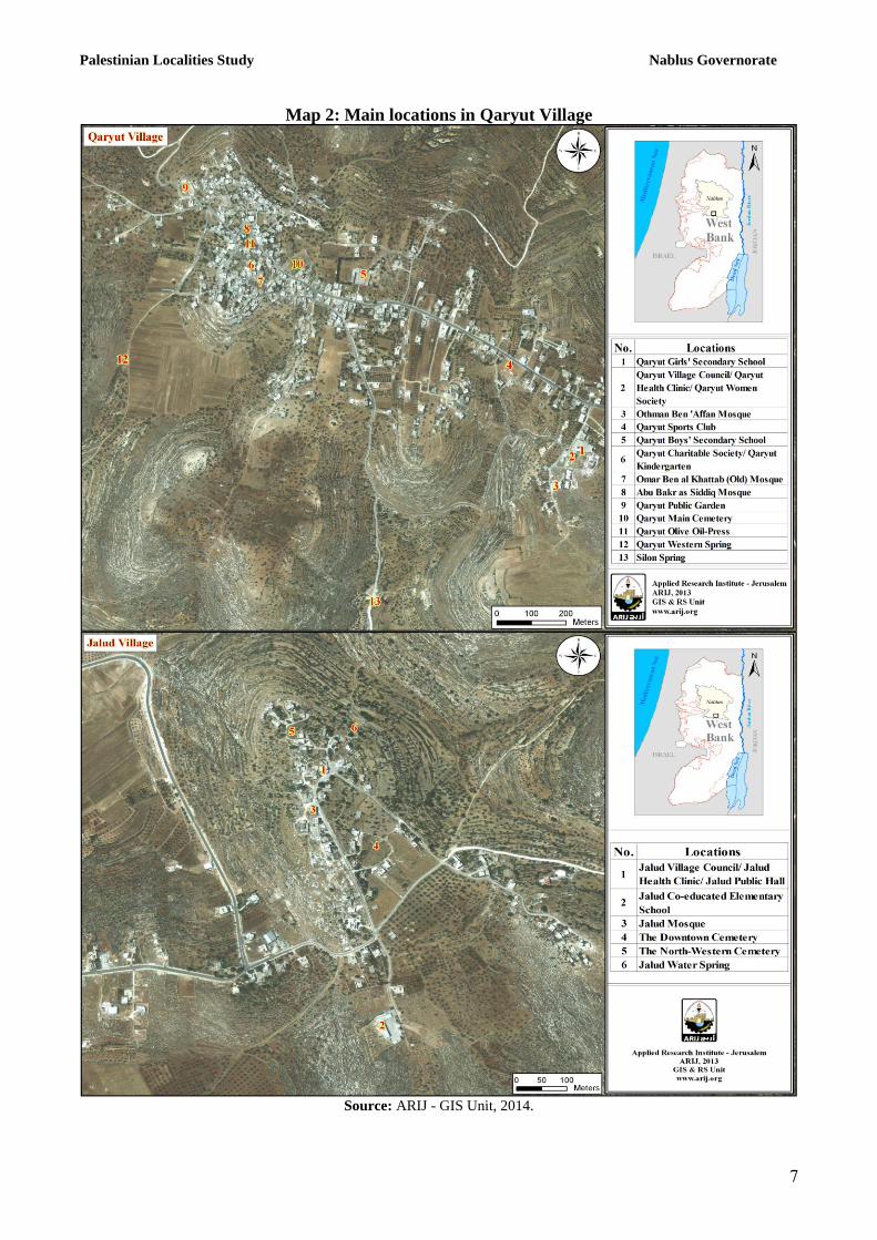
There are four mosques in Qaryut: Jalud, Al Shamale, Al Janobe, and Al Sharqe Mosques. There are
also a number of historic and archeological sites in the village, including: Khirbet Ceylon, the tomb
of Shaykh Bishar, and the Old Mosque. It is worth noting that none of them are currently eligible for
designation as an official tourism site (Qaryut Village Council, 2013) (See Map 2).
Palestinian Localities Study Nablus Governorate
5
Map 2: Main locations in Qaryut Village
Source: ARIJ - GIS Unit, 2014.
Palestinian Localities Study Nablus Governorate
8
Population
According to the Palestinian Central Bureau of Statistics (PCBS), the total population of Qaryut in
2007 was 24884, of whom 14471 were male and 14434 female. There were 481 households registered
as living in 727 housing units.
Age Groups and Gender
The General Census of Population and Housing carried out by PCBS in 2007 showed the distribution
of age groups in Qaryut as follows: 4338% were less than 15 years of age, 7136% were between 15
and 64 years of age, and 432% were 65 years of age or older. Data also showed that the sex ratio of
males to females in the village is 100: 11131 , meaning that males and females constitute 7133% and
4.35% of the population, respectively.
Families
Qaryut residents are from several families, including: Al Haj Mohammad, ‘Abad, Amteer, Hamoud,
Mo’amar, ‘Azim, Kasab, Khalil, Abo Najem families, and others.
(Qaryut Village Council, 2013).
Immigration
The field survey conducted by ARIJ staff shows that approximately 15 people have left the village
since the Al Aqsa Intifada in 2000 (Qaryut Village Council, 2013).
Education
According to the results of the PCBS Population, Housing and Establishment Census-2007, the
illiteracy rate among Qaryut population is approximately 538%, of which 58% are females. Of the
literate population, 1431% could only read and write, with no formal education, 2832% had
elementary education, 2.38% had preparatory education, 1334% had secondary education, and 635%
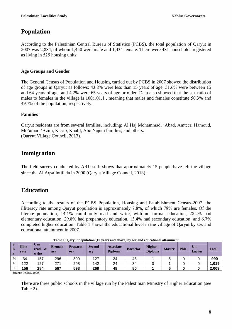
completed higher education. Table 1 shows the educational level in the village of Qaryut by sex and
educational attainment in 2007.
Table 1: Qaryut population (10 years and above) by sex and educational attainment
S
E
x
Illite-
rate
Can
read &
write
Element-
ary
Preparat-
ory
Second-
ary
Associate
Diploma Bachelor
Higher
Diploma Master
PhD Un-
known Total
M 34 157 296 300 127 24 46 1 5 0 0 990 F 122 127 271 298 142 24 34 0 1 0 0 1,019 T 156 284 567 598 269 48 80 1 6 0 0 2,009 Source: PCBS, 2009.
There are three public schools in the village run by the Palestinian Ministry of Higher Education (see
Table 2).
Palestinian Localities Study Nablus Governorate
.
Table 2: Schools in Qaryut by name, stage, sex, and supervising authority (2011/2012)
School Name Supervising Authority Sex
Qaryut Co-educated Secondary School Government Mixed
Qaryut Girls Secondary School Government Female
Jalud Co-educated Elementary School Government Mixed
Source: Directorate of Education in Nablus, 2012
In the village there are 858 students, 61 teachers, and 3. classes. The average number of students
per teacher in the school is nearly 14, whilst the average number of students per class is
approximately 23 (Directorate of Education in Nablus, 2012).
There is one kindergarten in Qaryut Village, which is run by a private organization (See Table 3
below).
Table 3: Kindergartens in Qaryut Village by name and supervising authority
Name of Kindergarten No. of Classes No. of Teachers Supervising Authority
Qaryut Charity Association Kindergarten 3 4 Private Source: Directorate of Education in Nablus, 2012
The educational sector in Qaryut village faces a number of obstacles, mainly:
The lack of classrooms in the village schools
The lack of scientific labs in the village schools
(Qaryut Village Council, 2013)
Health Status
Qaryut has several health facilities available, including a governmental Health Center (Qaryut),
which includes a governmental physician clinic, a private heart and arteries Clinic, and a private
pharmacy.
In the absence of necessary health services or in emergencies, patients are transferred to Rafidiya or
the National Hospital, or Ar Rahmah (Mercy) health clinic, or go to private health clinics, all in
Nablus City, which is about 2 km away. some also go to Qabalan Health Clinic (11km away)
(Qaryut Village Council, 2013).
The health sector in the village faces a number of obstacles and problems, principally:
The lack of an ambulance
The lack of private clinics
The need for more health centers in the village
(Qaryut Village Council, 2013)
Palestinian Localities Study Nablus Governorate
11
Economic Activities
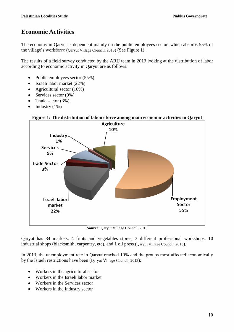
The economy in Qaryut is dependent mainly on the public employees sector, which absorbs 55% of
the village’s workforce (Qaryut Village Council, 2013) (See Figure 1).
The results of a field survey conducted by the ARIJ team in 2013 looking at the distribution of labor
according to economic activity in Qaryut are as follows:
Public employees sector (55%)
Israeli labor market (22%)
Agricultural sector (10%)
Services sector (9%)
Trade sector (3%)
Industry (1%)
Figure 1: The distribution of labour force among main economic activities in Qaryut
Source: Qaryut Village Council, 2013
Qaryut has 34 markets, 4 fruits and vegetables stores, 3 different professional workshops, 10
industrial shops (blacksmith, carpentry, etc), and 1 oil press (Qaryut Village Council, 2013).
In 2013, the unemployment rate in Qaryut reached 10% and the groups most affected economically
by the Israeli restrictions have been (Qaryut Village Council, 2013):
Workers in the agricultural sector
Workers in the Israeli labor market
Workers in the Services sector
Workers in the Industry sector
Palestinian Localities Study Nablus Governorate
11
Labor Force
According to the PCBS Population, Housing and Establishment Census-2007, 31% of Qaryut’s labor
force was economically active, of whom 87% were employed. 6.% were not economically active, of
whom 49.3% were students, and 37.4% were housekeepers (See Table 4).
Table 4: Qaryut population (10 years of age and above) by sex and employment status
S
e
x
Economically active Non-economically active
Not
stated Total Employ-
ed
Currently
Unem-
ployed
Un-
employed
(never
worked)
Total Stud-
ent
House-
keeping
Unable
to work
Not
working
& not
looking
for work
Others Total
M 503 28 50 581 336 1 55 13 4 409 0 990
F 36 1 4 41 348 518 84 4 24 978 0 1,019
T 539 29 54 622 684 519 139 17 28 1,387 0 2,009 M: Male; F: Female; T: Total.
Source: PCBS, 2009.
Agricultural Sector
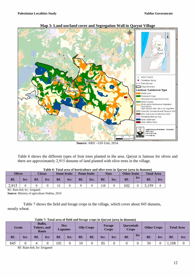
Qaryut has a total area of approximately 224453 dunums of which 1347.4 are ‘arable’ land and 368
dunums are registered as ‘residential’ (See Table 5 and Map 3).
Table 5: Land use and land cover in Qaryut village (area in dunum)
Total
Area
Built
up
Area
Agricultural area
(495,31)
Inland
water
Forests Open
Spaces
Area of
Industrial,
Commercial &
Transport Unit
Area of
Settlements,
Military
Bases &
Wall Zone
Permanen
t Crops
Green-
houses
Range-
lands
Arab
le
lands
224453 368 .4113 1 331 4424. 0 0 .4181 35 242.3
Source: ARIJ – GIS Unit, 2014.
Palestinian Localities Study Nablus Governorate
12
Map 3: Land use/land cover and Segregation Wall in Qaryut Village
Source: ARIJ - GIS Unit, 2014.
Table 6 shows the different types of fruit trees planted in the area. Qaryut is famous for olives and
there are approximately 24.17 dunums of land planted with olive trees in the village.
Table 6: Total area of horticulture and olive trees in Qaryut (area in dunums)
Olives Citrus Stone-fruits Pome fruits Nuts Other fruits Total Area
Rf. Irr. Rf. Irr. Rf. Irr. Rf. Irr. Rf. Irr. Rf. Irr
. Rf. Irr.
24.17 0 0 0 15 0 9 0 118 0 102 0 3417. 0
Rf.: Rain-fed; Irr.: Irrigated.
Source: Ministry of agriculture-Nablus, 2010
Table 7 shows the field and forage crops in the village, which cover about 847 dunums,
mostly wheat.
Table 7: Total area of field and forage crops in Qaryut (area in dunums)
Grain
Bulbs,
Tubers, and
Roots
Dry
Legumes Oily Crops
Forage
Crops
Qaryuttale
Crops Other Crops Total Area
Rf. Irr. Rf. Irr. Rf. Irr. Rf. Rf. Irr. Irr. Rf. Irr
. Rf. Irr. Rf. Irr.
847 0 4 0 105 0 10 0 85 0 0 0 59 0 14118 0
Rf: Rain-fed; Irr: Irrigated
Palestinian Localities Study Nablus Governorate
13
Source: Ministry of agriculture- Nablus, 2010
The difference in size of agricultural areas between the two sets of results obtained from the Ministry
of Agriculture (MoA) and ARIJ’s GIS Unit is explained by the difference in each organization’s
definition of land coverage and ownership. The MoA and the Palestinian Central Bureau of Statistics
(2011) conducted a survey which used a definition of agricultural areas based on land ownership.
Therefore, the areas included in the survey were those of actual holdings of agricultural areas and did
not include fragmented and small seasonal cultivated areas in residential and agricultural areas.
ARIJ’s survey, however, indicated the existence of a high proportion of small and fragmented
holdings (home gardens) throughout the occupied Palestinian territories. This therefore, accounts for
the larger area of agricultural holdings calculated by ARIJ.
The field survey conducted by the ARIJ team shows that 9% of the residents in Qaryut rear and keep
domestic animals such as cows, sheep and others (See Table 8).
Table 8: Livestock in Qaryut
Cows* Sheep Goats Camels Horses Donkeys Mules Broiler
Chickens
Layer
Chickens
Bee
Hives
75 341 781 0 0 0 0 414111 0 0 *Including cows, bull calves, heifer calves and bulls
Source: Palestinian Ministry of Agriculture - Nablus, 2010
There are approximately 33 kilometers of agricultural roads in the village, categorized as follows:
Table 9: Agricultural Roads in Qaryut Village and their Lengths Suitability of Agricultural Roads Length (km)
For vehicles 8
For tractors and agricultural machinery only 12
For animals only 13
Unsuitable 0 Source: Qaryut Village Council, 2013
The agricultural sector in the village faces several problems, including:
Confiscation of land
The lack of access to agricultural land
The lack of water sources.
The lack of economic feasibility
The lack of marketing of agricultural products, particularly olive oil
The lack of agricultural development and insufficient awareness of the farmers
Institutions and Services
Qaryut village has a number of local institutions and associations that provide services to various
sectors of society. These include:
Palestinian Localities Study Nablus Governorate
14
•Qaryut Village Council: Founded in 1994, and later registered by the Ministry of local
Government, its aim is bringing attention to the issues of the village, and providing all services to the
population, in addition to providing infrastructure services.
• Qaryut Sports Club: It was established in 1993, and was later registered by the Ministry of Youth
and Sports, with the aim to aid young athletes culturally, and socially. (Qaryut Village Council, 2013)
• Qaryut Charity Association: Founded in 1986, and later registered by the Ministry of Social
Affairs, it was concerned with providing educational services, such as a kindergarten.
• Qaryut Women's Association: Founded in 2004 and registered by the Ministry of Social Affairs,
it offers courses dealing with food processing and handicrafts.
Infrastructure and Natural Resources
Electricity and Telecommunication Services
Qaryut and Jalud has been connected to a public electricity network since 1984 and 2004
respectively. It is served by the Israeli Qatariya Electricity Company, which is the main source of
electricity in the village, through the North Electricity Company. 100% of the housing units in the
village are connected to the network. The village residents face a number of problems concerning
electricity, primarily the lack of electrical power (Qaryut Village Council, 2013).
Qaryut and Jalud is also connected to a telecommunications network and approximately 25% and
50% of the housing units within the village boundaries are connected to phone lines, respectively
(Qaryut Village Council, 2013).
Transportation Services
There are 11 taxis in Qaryut, however, if there is a lack of transportation, private cars will be used
(Qaryut Village Council, 2013). There are a number of problems facing the citizens such as the presence
of military checkpoints.There are 17 km of main roads and 14 km of secondary roads in Qaryut (See
Table 10).
Table 10: Roads in Qaryut Village
Status of Internal Roads Road Length (km)
Main Secondary
1. Paved & in good condition 13 6
2. Paved & in poor condition 0 0
3. Unpaved 4 8 Source: Qaryut Village Council, 2013
Water Resources
Qaryut is not provided with a public water network, so the citizens buy water via a water tank with
high prices ranging around 12 NIS/cubic meter (Qaryut Village Council, 2013). In addition, Qaryut
Palestinian Localities Study Nablus Governorate
17
village has 520 domestic wells to collect rain water, a water spring, and a public water tank with a 10
cubic meter capacity (Qaryut Village Council, 2013).
Wastewater Status
Qaryut village lacks a public sewerage network and most of the population uses cesspits and septic
tanks as a main means for wastewater disposal (Qaryut village council, 2013).
The wastewater collected by cesspits and septic tanks is discharged by wastewater tankers directly to
open areas or nearby valleys with little regard for the environment. Here it is noted that there is no
wastewater treatment either at the source or at the disposal sites and this poses a serious threat to the
environment in addition to public health (ARIJ - WERU, 2013).
Solid Waste Management
The Joint Services Council for Solid Waste Management for the Nablus City is responsible for
managing solid waste collection and disposal of the waste generated by citizens and establishments
in the village. Due to the fact that solid waste management is costly, a monthly fee of 15 NIS per
house per month is charged to the population for the service of domestic solid waste collection and
transportation. The rate of fees collected is 100% (Qaryut village council, 2013).
Most of the population in Qaryut benefits from the solid waste services, whereby waste is collected
from households, institutions, shops, and public squares in plastic bags, and placed in 15 containers
(of 1m³ capacity), located at various points in the village. The Joint Services Council collects the
solid waste twice per week and transports it using a waste collection vehicle to the waste landfill
Zahrat Al Fanjan in Jenin Governorate, 30km from the village. Here the waste is subsequently buried
in an environmentally sound way (Qaryut village council, 2013).
The daily per capita rate of solid waste production in Qaryut is 0.7kg. Thus the estimated amount of
solid waste produced per day from the Qaryut residents is nearly 2.2 tons, or 790 tons per year
(ARIJ-WERU, 2013).
Environmental Conditions
The village of Qaryut and other towns in the district of Nablus suffer from several environmental
problems which must be addressed. For instance:
Water Sector
The lack of water supply service in the village because of the lack of a public water network forces
the citizens to buy water at high prices.
Wastewater Management
The absence of a public sewerage network means that the residents are forced to use unhygienic
cesspits and septic tanks for the disposal of water and often dispose of wastewater in the streets. This
is particularly common in winter, as citizens cannot afford the high cost of sewage tankers during
this period. These methods cause environmental damage, health problems and the spread of
Palestinian Localities Study Nablus Governorate
16
epidemics and diseases in the village. The wastewater also contaminates the groundwater and water
collected in household cisterns (rainwater-harvesting cisterns). Most cesspits are built without lining,
allowing wastewater to enter into the ground, avoiding the need to use sewage tankers. Thus,
groundwater cannot be used as drinking water. Moreover, the untreated wastewater collected from
cesspits by sewage tankers is disposed of in open areas without concern for the damage it causes to
the environment and to residents' health.
Solid Waste Management:
The village of Qaryut does not suffer from any problems in solid waste management. The Joint
Services Council for Solid Waste Management for the Nablus City, disposes of their solid waste in
the Zahret al Finjan landfill in Jenin Governorate. This landfill is the main environment-friendly
landfill serving the town in addition to most of the localities in the Nablus Governorate.
Geopolitical Status in Qaryut village
According to the Oslo II Interim Agreement signed on 28th
September 1995 by the Palestinian
Liberation Organization (PLO) and Israel, Qaryout was divided into Area B and Area C.
Approximately 5,104 dunums (23% of the village’s total area) were classified as Area B, where the
Palestinian National Authority has complete control over civil matters but Israel continues to retain
overriding responsibility for security. The rest of the village’s area, constituting 17,369 dunums
(77% of the total area), was classified as Area C, where Israel retains full control over security and
administration related to the territory. In Area C, Palestinian building and land management is
prohibited unless through consent or authorization by the Israeli Civil Administration. The majority
of Qaryout’s population resides in Area B, while most of the land lying within Area C is Israeli
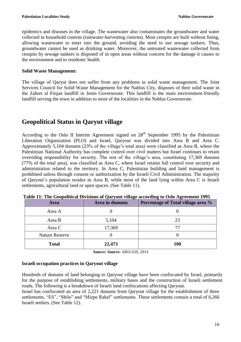
settlements, agricultural land or open spaces. (See Table 11).
Table 11: The Geopolitical Divisions of Qaryout village according to Oslo Agreement 1995
Percentage of Total village area % Area in dunums Area
0 0 Area A
23 5,104 Area B
77 17,369 Area C
0 0 Nature Reserve
100 22,473 Total
Source: Source: ARIJ-GIS, 2014
Israeli occupation practices in Qaryout village
Hundreds of dunums of land belonging to Qaryout village have been confiscated by Israel, primarily
for the purpose of establishing settlements, military bases and the construction of Israeli settlement
roads. The following is a breakdown of Israeli land confiscations affecting Qaryout.
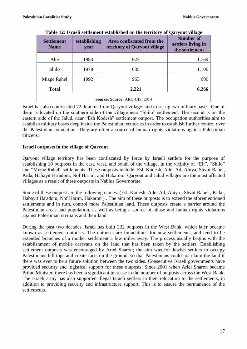
Israel has confiscated an area of 2,221 dunums from Qaryout village for the establishment of three
settlements, “Eli”, “Shilo” and “Mizpe Rahel” settlements. These settlements contain a total of 6,266
Israeli settlers. (See Table 12).
Palestinian Localities Study Nablus Governorate
15
Table 12: Israeli settlement established on the territory of Qaryout village
Israel has also confiscated 72 dunums from Qaryout village land to set up two military bases. One of
them is located on the southern side of the village near “Shilo” settlement. The second is on the
eastern side of the Jalud, near “Esh Kodesh” settlement outpost. The occupation authorities aim to
establish military bases deep inside the Palestinian territories in order to establish further control over
the Palestinian population. They are often a source of human rights violations against Palestinian
citizens.
Israeli outposts in the village of Qaryout
Qaryout village territory has been confiscated by force by Israeli settlers for the purpose of
establishing 10 outposts in the east, west, and south of the village, in the vicinity of “Eli”, “Shilo”
and “Mizpe Rahel” settlements. These outposts include: Esh Kodesh, Adei Ad, Ahiya, Shvut Rahel,
Kida, Habayit Ha'adom, Nof Harim, and Hakaron. Qaryout and Jalud villages are the most affected
villages as a result of these outposts in Nablus Governorate.
Some of these outpost are the following names: (Esh Kodesh, Adei Ad, Ahiya , Shvut Rahel , Kida ,
Habayit Ha'adom, Nof Harim, Hakaron ) . The aim of these outposts is to extend the aforementioned
settlements and in turn, control more Palestinian land. These outposts create a barrier around the
Palestinian areas and population, as well as being a source of abuse and human rights violations
against Palestinian civilians and their land.
During the past two decades, Israel has built 232 outposts in the West Bank, which later became
known as settlement outposts. The outposts are foundations for new settlements, and tend to be
extended branches of a mother settlement a few miles away. The process usually begins with the
establishment of mobile caravans on the land that has been taken by the settlers. Establishing
settlement outposts was encouraged by Ariel Sharon; the aim was for Jewish settlers to occupy
Palestinians hill tops and create facts on the ground, so that Palestinians could not claim the land if
there was ever to be a future solution between the two sides. Consecutive Israeli governments have
provided security and logistical support for these outposts. Since 2001 when Ariel Sharon became
Prime Minister, there has been a significant increase in the number of outposts across the West Bank. The Israeli army has also supported illegal Israeli settlers in their relocation to the settlements, in
addition to providing security and infrastructure support. This is to ensure the permanence of the
settlements.
Settlement
Name
establishing
year
Area confiscated from the
territory of Qaryout village
Number of
settlers living in
the settlement
Alie 1984 623 1,769
Shilo 1978 635 1,106
Mizpe Rahel 1992 963 600
Total 2,221 6,266
Source: Source: ARIJ-GIS, 2014
Palestinian Localities Study Nablus Governorate
18
Israeli checkpoints around Qaryout village
During the Second Intifada, Israeli occupation authorities established checkpoints upon Qaryout and
Jalud lands near bypass road No.60 and the Israeli settlements on the eastern and southern sides of
the village. Earth mound barriers were constructed to close the agricultural roads that link Qaryout
village and Israeli bypass road No. 60 (the southern entrance of Qaryout), as well as to cut the road
between Qaryout and Jalud and the agricultural lands near the Israeli settlements to the east. Some of
these checkpoints have since been removed after years of human rights violations.
Residents of Qaryout and Jalud villages, as well as the villages of southern Nablus, have been
negatively impacted by Za'tara permanent checkpoint; it is considered an important checkpoint as the
site cuts through the West Bank, as previously mentioned. Palestinians are often detained and
searched. This checkpoint has been a source of attacks on Palestinian citizens. However Israeli forces
have reduced such actions in recent years.
Over the last decade, military checkpoints in the area have continued to have a negative impact on
the daily lives of residents. Checkpoints continue to hinder freedom of movement and sever the links
between Nablus city and the surrounding villages, as well as the connection between the villages and
their agricultural lands. This has resulted in heavy economic losses for residents of the village as they
are forced to travel further distances which takes more time, in order to reach their agricultural land,
especially when checkpoints are closed.
For example, the closure of the southern entrance to the village of Qaryout forced residents to travel
an extra 20km extra and that’s in case they decided to go south toward Turmus'ayya and
neighboring areas, where they will have to go north, passing through the villages of Talfit ,Qabalan
and As Sawiya then back to the village through the bypass road number 60.
Israeli bypass roads in Qaryout town
Israeli authorities have constructed a number of bypass roads that stretch hundreds of kilometers
from the north to the south of the West Bank. These roads have led to the confiscation of hundreds
of agricultural and non-agricultural lands in order to link Israeli settlements with each other. It also
impedes Palestinian territorial continuity, enabling further Israeli control over Palestinian territory.
Israel has confiscated land from Qaryout and Jalud in order to construct Israeli bypass road No. 60
on the southern-western side of the villages. They have also constructed a settlement road which
links between “Shilo” and “Mizpe Rahel” settlements, the settlement outposts on the eastern side,
and bypass road No. 458. These roads extend 8km along the villages’ territory.
It should be noted that the real danger of the bypass roads lies in the confiscated land that were taken
for the benefit of what is known as the buffer zone. The buffer zone is imposed by the Israeli army
and usually occupies 75 meters on both sides of the road.
Israeli military orders in Qaryout and Jalud villages
Israeli occupation authorities have issued several military orders confiscating land in Qaryout and
Jalud villages. and the confiscation of land the following are two commands :
• Israeli occupation authorities represented by the Guard of Absentee Property, issued a military
order on 26th
June 2011, confiscating 189 dunums from Qaryout, claiming that it is “government
property" according to the Military Order of State Property number 59-1967.
Palestinian Localities Study Nablus Governorate
1.
• Israeli occupation authorities issued military order which holds the number (10/23 / T) on 22nd
August 2010, confiscating land from Jalud village for the establishment of a military building.
Settler attacks on Qaryout village
Attacks and violence perpetrated by settlers living in the settlements on Qaryout land has had a
profoundly negative impact on village residents and their property. Palestinian land owners are unable
to access their lands, as they have been fenced off with barbed wire. Settlers have planted trees in
these areas to reinforce their control over the area. The settlers have damaged and burned a number of
Palestinian owned trees and plants. Settlers have also attacked the land owners in an attempt to
intimidate and deter them from returning to their land.
Israel has confiscated some lands from Qaryout and the neighboring villages in order to establish
illegal settlements in the area for the purpose of the establishment of Israeli settlements, but also .
These settlements pose a constant threat to Palestinians on their own land. Since the establishment of
these settlements, Palestinian residents have been subjected to several violent attacks, for example
farmers have been attacked in order to prevent them from reaching their agricultural land. Settlers
have also stolen crops, damaged trees and attacked homes, places of worship, cars and other private
property.
The village of Qaryout has been is the most village that were subjected to more attacks and
violations than any other village in Nablus. It is possible to see more details, images and reports of
these violations from 2012 and 2013 on the Land Research Center’s website. These violations
include:
1 - 107 Roman trees damaged in Qaryout village (19/10/2013) (Report in Arabic).
2 - Dozens of farmers prevented from harvesting olives in the village of Qaryout (13/10/2013)
(Report in Arabic).
3 - Qaryout village residents prevented from establishing two agricultural roads on Qaryout land
(23.09.2013) (Report in Arabic).
4 - Expansion work for a number of outposts in the countryside south of Nablus (08.08.2013)
(Report in Arabic and English).
5 – Announcement of 166 settlement units in "Eli” settlement built on Palestinian lands,
(06.06.2013) (Report in Arabic).
6 –Residentsof Qaryout prevented using and taking advantage of 25 dunums of agricultural land in
Al Sarasra region (02/06/2013) (Report in Arabic).
7 –Settlers in "Shilo" settlement burned 13 dunums of Qaryout land (14/05/2013) (Report in Arabic).
8 - 78 olive trees destroyed in the village of Qaryout, Nablus Governorate (13/03/2013) (Report in
Arabic and English).
9 – Master plan developed to convert agricultural lands to residential areas for “Shilo” settlement
(11/28/2012) (Report in Arabic).
10 - Israeli occupation imposes arbitrary procedures against the people of Qaryout village
(28/11/2012) (Report in Arabic).
11 - Settlers from “Shilo" settlement close the southern entrance to the village Qaryout again
(25/11/2012) (Report in Arabic and English).
12 – Settlers from “Adei Ad” settlement control 10 dunums in the village of Qaryout (23/10/2012)
(Report in Arabic and English).
13 – Settlers of “Eli" settlement burn olive trees in Qaryout (14/10/2012) (Report in Arabic and
English).
Palestinian Localities Study Nablus Governorate
21
14 - Qaryout becomes a target for the occupation and settlers (10/10/2012) (Report in Arabic and
English).
15 – Settlers in "Elie" settlement destroy 86 olive trees in the village of Qaryout, (10/10/2012)
(Report in Arabic and English).
16 – Expansion of settlement outposts in the countryside south of Nablus (18/07/2012) (Report in
Arabic and English).
17 - Settlers cut down 40 olive trees in the village of Qaryout (12/03/2012) (Report in Arabic and
English).
18 – Settlers from “Shvut Rachel" uproot 60 olive trees in Qaryout territory (09/02/2012) (Report in
Arabic and English).
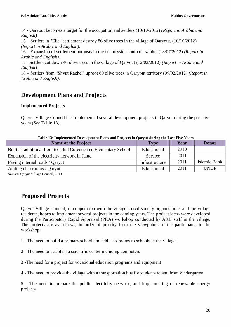
Development Plans and Projects
Implemented Projects
Qaryut Village Council has implemented several development projects in Qaryut during the past five
years (See Table 13).
Table 13: Implemented Development Plans and Projects in Qaryut during the Last Five Years
Name of the Project Type Year Donor
Built an additional floor to Jalud Co-educated Elementary School Educational 2111
Expansion of the electricity network in Jalud Service 2111
Paving internal roads / Qaryut Infrastructure 2111 Islamic Bank
Adding classrooms / Qaryut Educational 2111 UNDP
Source: Qaryut Village Council, 2013
Proposed Projects
Qaryut Village Council, in cooperation with the village’s civil society organizations and the village
residents, hopes to implement several projects in the coming years. The project ideas were developed
during the Participatory Rapid Appraisal (PRA) workshop conducted by ARIJ staff in the village.
The projects are as follows, in order of priority from the viewpoints of the participants in the
workshop:
1 - The need to build a primary school and add classrooms to schools in the village
2 - The need to establish a scientific center including computers
3 -The need for a project for vocational education programs and equipment
4 - The need to provide the village with a transportation bus for students to and from kindergarten
5 - The need to prepare the public electricity network, and implementing of renewable energy
projects
Palestinian Localities Study Nablus Governorate
21
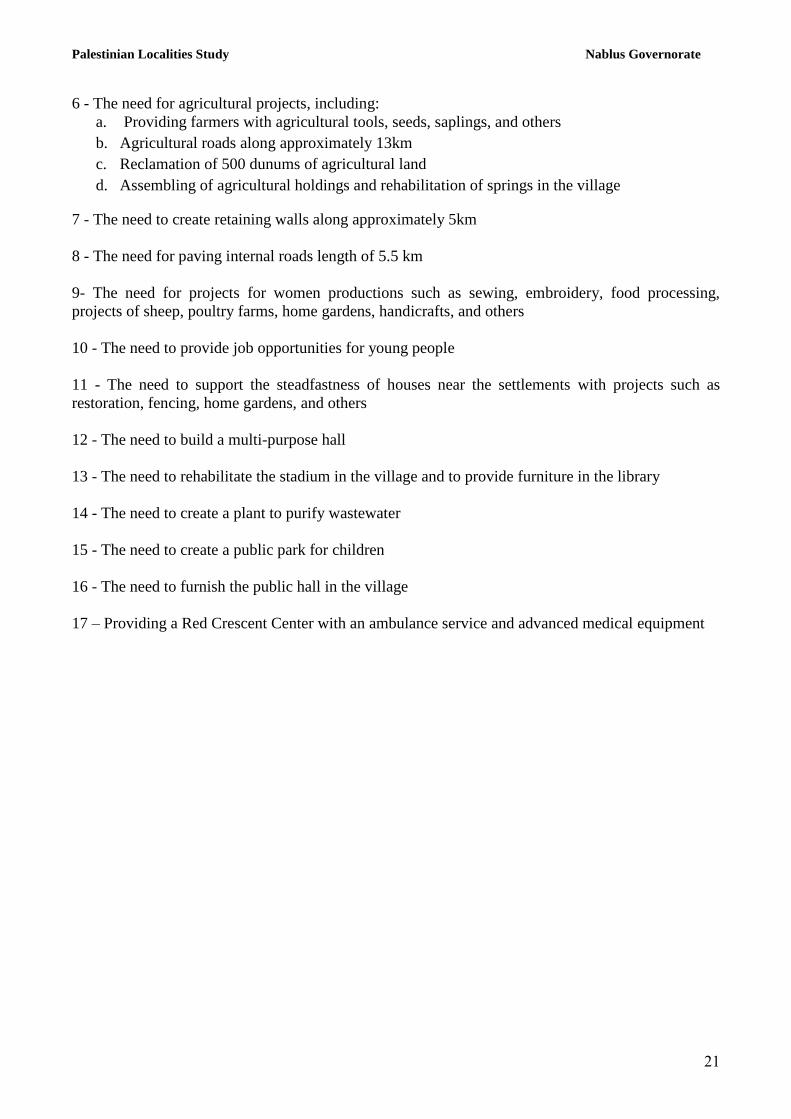
6 - The need for agricultural projects, including:
a. Providing farmers with agricultural tools, seeds, saplings, and others
b. Agricultural roads along approximately 13km
c. Reclamation of 500 dunums of agricultural land
d. Assembling of agricultural holdings and rehabilitation of springs in the village
7 - The need to create retaining walls along approximately 5km
8 - The need for paving internal roads length of 5.5 km
9- The need for projects for women productions such as sewing, embroidery, food processing,
projects of sheep, poultry farms, home gardens, handicrafts, and others
10 - The need to provide job opportunities for young people
11 - The need to support the steadfastness of houses near the settlements with projects such as
restoration, fencing, home gardens, and others
12 - The need to build a multi-purpose hall
13 - The need to rehabilitate the stadium in the village and to provide furniture in the library
14 - The need to create a plant to purify wastewater
15 - The need to create a public park for children
16 - The need to furnish the public hall in the village
17 – Providing a Red Crescent Center with an ambulance service and advanced medical equipment
Palestinian Localities Study Nablus Governorate
22
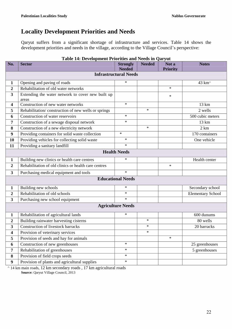
Locality Development Priorities and Needs
Qaryut suffers from a significant shortage of infrastructure and services. Table 14 shows the
development priorities and needs in the village, according to the Village Council’s perspective:
Table 14: Development Priorities and Needs in Qaryut
No. Sector Strongly
Needed
Needed Not a
Priority
Notes
Infrastructural Needs
1 Opening and paving of roads * 43 km^
2 Rehabilitation of old water networks *
3 Extending the water network to cover new built up
areas *
4 Construction of new water networks * 13 km
5 Rehabilitation/ construction of new wells or springs * 2 wells
6 Construction of water reservoirs * 500 cubic meters
7 Construction of a sewage disposal network * 13 km
8 Construction of a new electricity network * 2 km
9 Providing containers for solid waste collection * 170 containers
10 Providing vehicles for collecting solid waste * One vehicle
11 Providing a sanitary landfill *
Health Needs
1 Building new clinics or health care centres * Health center
2 Rehabilitation of old clinics or health care centres *
3 Purchasing medical equipment and tools *
Educational Needs
1 Building new schools * Secondary school
2 Rehabilitation of old schools * Elementary School
3 Purchasing new school equipment *
Agriculture Needs
1 Rehabilitation of agricultural lands * 600 dunums
2 Building rainwater harvesting cisterns * 80 wells
3 Construction of livestock barracks * 20 barracks
4 Provision of veterinary services *
5 Provision of seeds and hay for animals *
6 Construction of new greenhouses * 25 greenhouses
7 Rehabilitation of greenhouses * 5 greenhouses
8 Provision of field crops seeds *
9 Provision of plants and agricultural supplies *
^ 14 km main roads, 12 km secondary roads , 17 km agricultural roads Source: Qaryut Village Council, 2013
Palestinian Localities Study Nablus Governorate
23
References:
Applied Research Institute - Jerusalem (ARIJ), 2014. Geographic Information Systems and
Remote Sensing Unit Database. Bethlehem - Palestine.
Applied Research Institute - Jerusalem (ARIJ), 2014. Geographic Information Systems and
Remote Sensing Unit; Land Use Analysis (2012) – Half Meter High Accuracy. Bethlehem -
Palestine.
Applied Research Institute - Jerusalem (ARIJ). 2013. Water & Environment Research Unit
Database (WERU). Bethlehem - Palestine.
Ministry of Education & Higher Education (MOHE) - Nablus, 2012. Directorate of Education;
A database of schools (2011/2012). Nablus – Palestine.
Palestinian Central Bureau of Statistics. 2009. Ramallah, Palestine: General Census of
Population and Housing Censuses, 2007.
Palestinian Ministry of Agriculture (MOA), 2010. Directorate of Agriculture data (2009/2010).
Nablus – Palestine.
Qaryut Village Council, 2013.