Embed Size (px)
Citation preview

30
PART 1(30 MARKS) Attempt all questions from this Part.
Question 1
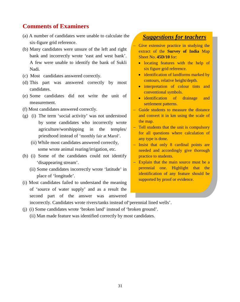
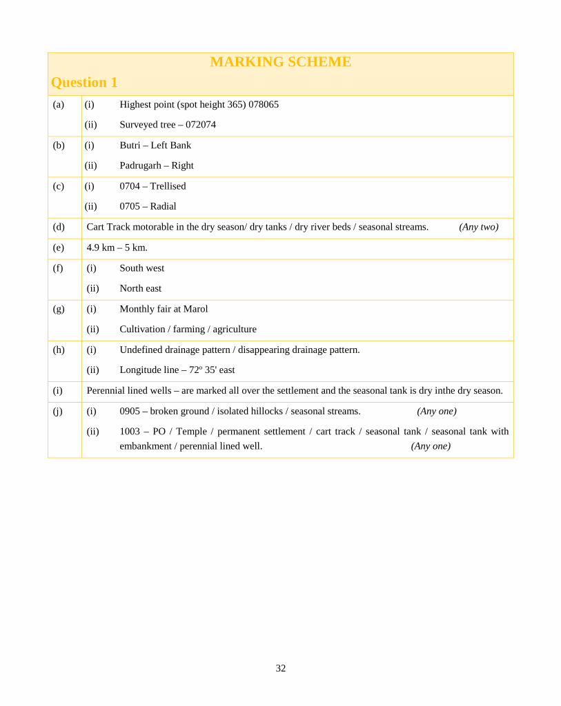
(a) Give the six-figure grid reference for: (i) The highest point in this map extract. (ii) Surveyed tree north of Rampura Khera.
[2]
(b) On which bank of Sukli Nadi lies: (i) Butri (ii) Padrugarh
[2]
(c) Differentiate between the drainage pattern shown in grid square: (i) 0704 (ii) 0705
[2]
(d) The region in this map extract receives seasonal rainfall. Give two reasons for your answer.
[2]
(e) Calculate the distance in km between settlement Bhatana and Makawal along the cart track.
[2]
(f) State the Compass direction of the following: (i) Dattani from Marol. (ii) Dhavli from Makawal.
[2]
(g) (i) Mention a social activity of people living in Marol. (ii) What is the main occupation of the people living in this region?
[2]
(h) What do you understand by: (i) The black broken line in 0807 (ii) The vertical black line close to Easting 10
[2]
(i) What is the main source of water supply to Bhatana? Give a reason for your answer.
[2]
(j) (i) Name one natural feature in the grid square 0905. (ii) Identify one man made feature in the grid square 1003.
[2]
Study the extract of the Survey of India Map Sheet No. 45D/10 and answer the following questions:
QUALITATIVE ANALYSIS
GEOGRAPHY (H.C.G.-PAPER-2)
31
Suggestions for teachers − Give extensive practice in studying the
extract of the Survey of India Map Sheet No. 45D/10 for: • locating features with the help of
six figure grid reference. • identification of landforms marked by
contours, relative height/depth. • interpretation of colour tints and
conventional symbols. • identification of drainage and
settlement patterns. − Guide students to measure the distance
and convert it in km using the scale of the map.
− Tell students that the unit is compulsory for all questions where calculation of any type is done.
− Insist that only 8 cardinal points are needed and accordingly give thorough practice to students.
− Explain that the main source must be a perennial one. Highlight that the identification of any feature should be supported by proof or evidence.
Comments of Examiners (a) A number of candidates were unable to calculate the
six-figure grid reference. (b) Many candidates were unsure of the left and right
bank and incorrectly wrote ‘east and west bank’. A few were unable to identify the bank of Sukli Nadi.
(c) Most candidates answered correctly. (d) This part was answered correctly by most
candidates. (e) Some candidates did not write the unit of
measurement. (f) Most candidates answered correctly. (g) (i) The term ‘social activity’ was not understood
by some candidates who incorrectly wrote agriculture/worshipping in the temples/ priesthood instead of ‘monthly fair at Marol’.
(ii) While most candidates answered correctly, some wrote animal rearing/irrigation, etc.
(h) (i) Some of the candidates could not identify ‘disappearing stream’.
(ii) Some candidates incorrectly wrote ‘latitude’ in place of ‘longitude’.
(i) Most candidates failed to understand the meaning of ‘source of water supply’ and as a result the second part of the answer was answered incorrectly. Candidates wrote rivers/tanks instead of‘perennial lined wells’.
(j) (i) Some candidates wrote ‘broken land’ instead of ‘broken ground’. (ii) Man made feature was identified correctly by most candidates.
32
MARKING SCHEME Question 1
(a) (i) Highest point (spot height 365) 078065
(ii) Surveyed tree – 072074
(b) (i) Butri – Left Bank
(ii) Padrugarh – Right
(c) (i) 0704 – Trellised
(ii) 0705 – Radial
(d) Cart Track motorable in the dry season/ dry tanks / dry river beds / seasonal streams. (Any two)
(e) 4.9 km – 5 km.
(f) (i) South west
(ii) North east
(g) (i) Monthly fair at Marol
(ii) Cultivation / farming / agriculture
(h) (i) Undefined drainage pattern / disappearing drainage pattern.
(ii) Longitude line – 72o 35' east
(i) Perennial lined wells – are marked all over the settlement and the seasonal tank is dry inthe dry season.
(j) (i) 0905 – broken ground / isolated hillocks / seasonal streams. (Any one)
(ii) 1003 – PO / Temple / permanent settlement / cart track / seasonal tank / seasonal tank with embankment / perennial lined well. (Any one)

33
Suggestions for teachers − Give practice to students in drawing the
tropic of Cancer as a dotted curved line. − Correct location of the hills must be
reinforced through regular practice. − Encourage students to use arrows for
marking location/ areas/ places/ direction correctly and clearly. The arrow head must be pointed towards the feature.
− Guide students to shade and name correctly, for which continuous practice is required.
− Drill marking of the soil without touching the Coast.
− Stress upon regular practice in map work with instruction on how to mark features correctly.
Question 2 On the outline map of India provided:
(a) Draw and name the Tropic of Cancer. [1]
(b) Label the river Godavari. [1]
(c) Mark and name the Garo Hills. [1]
(d) Mark C on the coal fields in Jharia. [1]
(e) Mark with an arrow and name the NE monsoon over the Bay of Bengal. [1]
(f) Shade and name the Gulf of Kutch. [1]
(g) Shade and name the coastal plain that receives rainfall in October-November. [1]
(h) Mark with a dot and name Delhi. [1]
(i) Shade a region with Black Cotton Soil. [1]
(j) Use an arrow to point at a densely populated state in South India. [1]
Comments of Examiners (a) Most of the candidates drew the ‘Tropic of Cancer’
as a straight line cutting through Gulf of Kutch instead of an arc (curved line).
(b) Most candidates marked Godavari correctly. (c) Garo hill was not marked correctly by many
candidates. Some candidates confused it with ‘Khasi’ and ‘Jaintia’.
(d) Jharia was not marked correctly by a few candidates.
(e) Most candidates marked the NE Monsoon over the Bay of Bengal correctly, However, in several cases, the arrow head was incorrectly pointed towards Myanmar and Bangladesh.
(f) Most candidates marked Gulf of Kutch correctly. (g) A few candidates shaded the entire east coast area
while some candidates shaded over the water area. (h) Some candidates marked Delhi anywhere along the
Yamuna. (i) The region with black cotton soil was correctly
marked by most candidates. (j) Some candidates did not demarcate the area correctly - the arrow was marked haphazardly. Some
candidates shaded the entire area of Kerala and Tamil Nadu.

34
MARKING SCHEME Question 2
Map
35
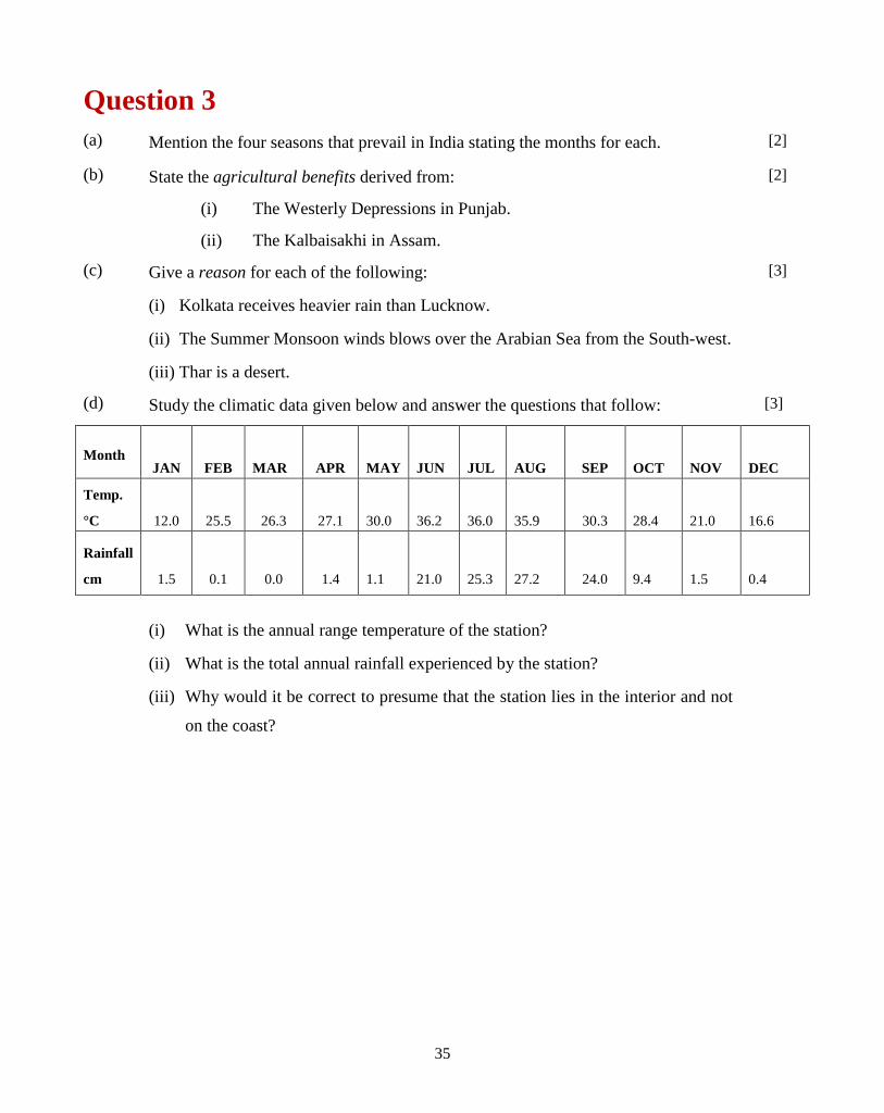
Question 3 (a) Mention the four seasons that prevail in India stating the months for each. [2]
(b) State the agricultural benefits derived from:
(i) The Westerly Depressions in Punjab.
(ii) The Kalbaisakhi in Assam.
[2]
(c) Give a reason for each of the following:
(i) Kolkata receives heavier rain than Lucknow.
(ii) The Summer Monsoon winds blows over the Arabian Sea from the South-west.
(iii) Thar is a desert.
[3]
(d) Study the climatic data given below and answer the questions that follow: [3]
Month JAN FEB
MAR APR
MAY
JUN
JUL
AUG SEP
OCT
NOV
DEC
Temp.
°C 12.0 25.5 26.3 27.1
30.0
36.2
36.0
35.9 30.3
28.4
21.0
16.6
Rainfall
cm 1.5 0.1 0.0 1.4
1.1
21.0
25.3
27.2 24.0
9.4
1.5
0.4
(i) What is the annual range temperature of the station?
(ii) What is the total annual rainfall experienced by the station?
(iii) Why would it be correct to presume that the station lies in the interior and not
on the coast?
36
Suggestions for teachers − For a better understanding, students must
be taught the seasons in a sequence. − Advise students to read the question
carefully and then write the answer accordingly.
− Explain clearly to students the difference between NE and SW Monsoon.
− Explain the location, places with a map. Basic concept of change in wind movement direction must be explained comprehensively. The Coriolis effect must also be taught.
− Revise concepts based on the climate data and give class tests.
− Develop reasoning skills through classroom discussions.
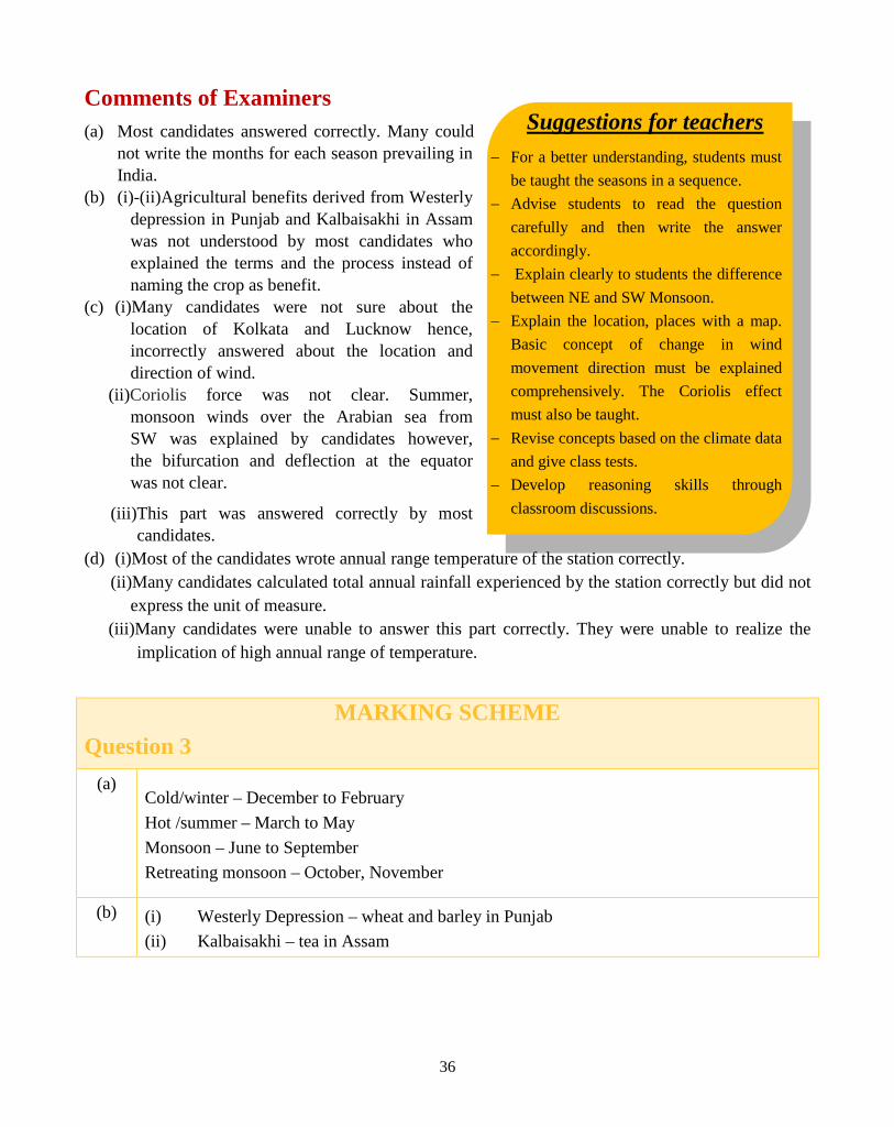
Comments of Examiners (a) Most candidates answered correctly. Many could
not write the months for each season prevailing in India.
(b) (i)-(ii)Agricultural benefits derived from Westerly depression in Punjab and Kalbaisakhi in Assam was not understood by most candidates who explained the terms and the process instead of naming the crop as benefit.
(c) (i)Many candidates were not sure about the location of Kolkata and Lucknow hence, incorrectly answered about the location and direction of wind.
(ii)Coriolis force was not clear. Summer, monsoon winds over the Arabian sea from SW was explained by candidates however, the bifurcation and deflection at the equator was not clear.
(iii)This part was answered correctly by most candidates.
(d) (i)Most of the candidates wrote annual range temperature of the station correctly. (ii)Many candidates calculated total annual rainfall experienced by the station correctly but did not
express the unit of measure. (iii)Many candidates were unable to answer this part correctly. They were unable to realize the
implication of high annual range of temperature.
MARKING SCHEME Question 3
(a) Cold/winter – December to February Hot /summer – March to May Monsoon – June to September Retreating monsoon – October, November
(b) (i) Westerly Depression – wheat and barley in Punjab (ii) Kalbaisakhi – tea in Assam
37
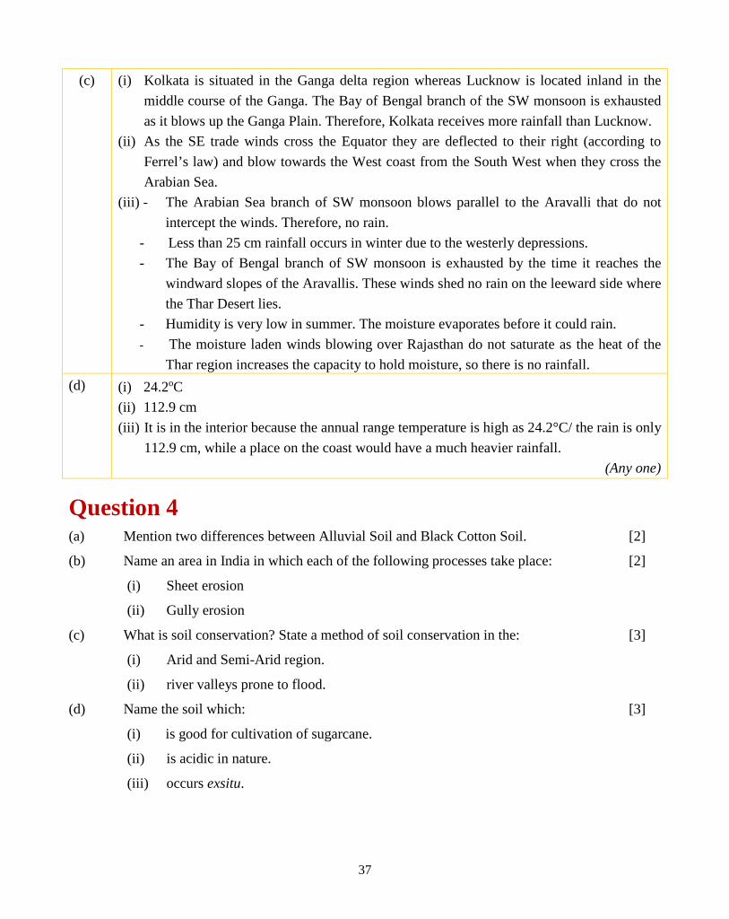
(c) (i) Kolkata is situated in the Ganga delta region whereas Lucknow is located inland in the middle course of the Ganga. The Bay of Bengal branch of the SW monsoon is exhausted as it blows up the Ganga Plain. Therefore, Kolkata receives more rainfall than Lucknow.
(ii) As the SE trade winds cross the Equator they are deflected to their right (according to Ferrel’s law) and blow towards the West coast from the South West when they cross the Arabian Sea.
(iii) - The Arabian Sea branch of SW monsoon blows parallel to the Aravalli that do not intercept the winds. Therefore, no rain.
- Less than 25 cm rainfall occurs in winter due to the westerly depressions. - The Bay of Bengal branch of SW monsoon is exhausted by the time it reaches the
windward slopes of the Aravallis. These winds shed no rain on the leeward side where the Thar Desert lies.
- Humidity is very low in summer. The moisture evaporates before it could rain. - The moisture laden winds blowing over Rajasthan do not saturate as the heat of the
Thar region increases the capacity to hold moisture, so there is no rainfall. (d) (i) 24.2oC
(ii) 112.9 cm (iii) It is in the interior because the annual range temperature is high as 24.2°C/ the rain is only
112.9 cm, while a place on the coast would have a much heavier rainfall. (Any one)
Question 4 (a) Mention two differences between Alluvial Soil and Black Cotton Soil. [2]
(b) Name an area in India in which each of the following processes take place:
(i) Sheet erosion
(ii) Gully erosion
[2]
(c) What is soil conservation? State a method of soil conservation in the:
(i) Arid and Semi-Arid region.
(ii) river valleys prone to flood.
[3]
(d) Name the soil which:
(i) is good for cultivation of sugarcane.
(ii) is acidic in nature.
(iii) occurs exsitu.
[3]

38
Suggestions for teachers − Teach students to write the differences
in a tabular form. It must be made clear to students that location is not considered as a characteristic.
− The concepts of area, state and region should be explained and doubts should be cleared.
− Formation and factors behind gullies, rivers should be clearly explained with examples.
− Guide students to write answers that are precise and to the point, along with keywords.
− Teach conservation methods in detail. Correct use of terminology must be stressed upon.
− Terms in-situ/ex-situ associated with weathering/ soil formation must be explained thoroughly.
Comments of Examiners (a) Most candidates wrote the differences between
Alluvial Soil and Black Cotton Soil correctly. (b) Naming an area of ‘sheet erosion’ and ‘gully erosion’
was misinterpreted by some candidates who instead of an area, named States.
(c) (i)-(ii)Most candidates answered the first part correctly. However, methods of soil conservation were not answered correctly by most of the candidates.
(d) (i)Most candidates could name the soil good for cultivation of sugarcane.
(ii)The soil which is acidic in nature was named correctly by most candidates.
(iii)A few candidates were unable to understand the meaning of ex-situ and wrote incorrect answers.
MARKING SCHEME Question 4
(a) Alluvial Soil Black Soil
Transported Soil Residual soil
Exsitu Insitu
Less moisture retention More moisture retention
Lighter in colour Dark in colour
Sandy / coarse in texture Clayey / fine grain
Rich in humus Deficient in humus (Any two)
(b) (i) Sheet erosion – flood plains of Brahmaputra, Ganga, Kosi, Damodar, Nilgiris.
(ii) Gully erosion – Chambal valley
(c) Soil conservation is an effort made by man to prevent soil erosion and to retain its
fertility.
39
Suggestions for teachers − Guide students to read and
understand the question carefully before making an attempt to answer them.
− Explain the characteristic features of the vegetation, different trees, uses and regions.
− Give more emphasis on explanation/reasoning type of questions which is an essential part of the learning process.
− A thorough revision of topics is required.
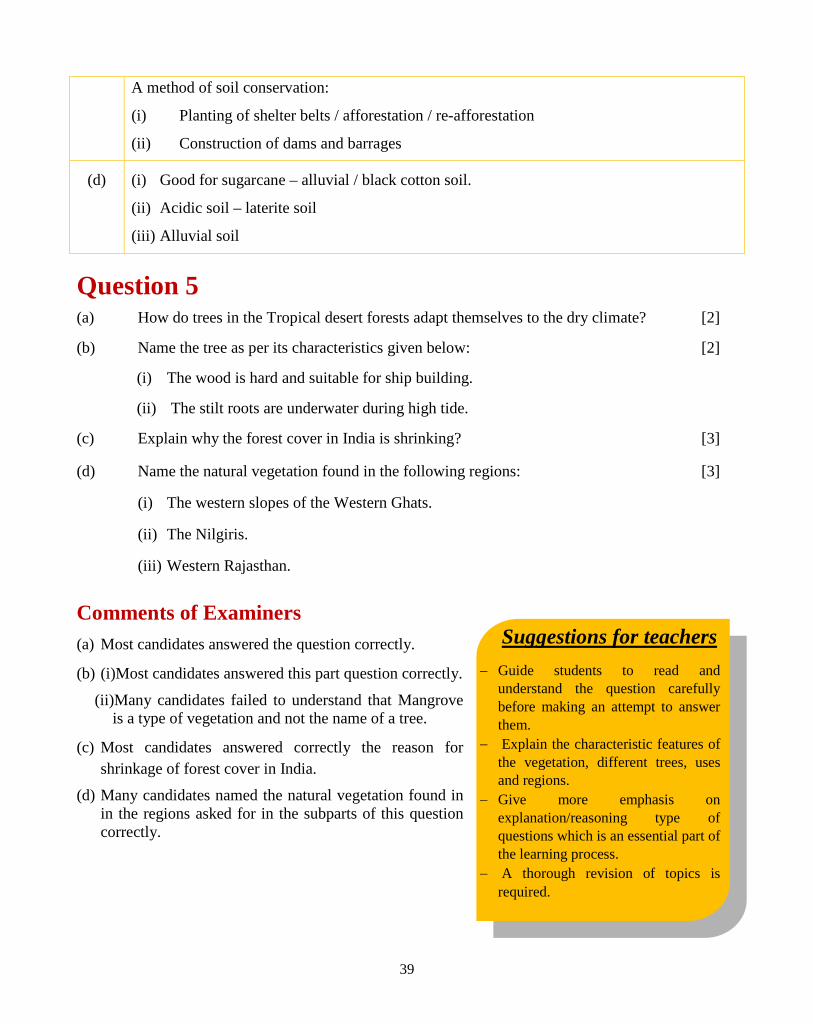
A method of soil conservation:
(i) Planting of shelter belts / afforestation / re-afforestation
(ii) Construction of dams and barrages
(d) (i) Good for sugarcane – alluvial / black cotton soil.
(ii) Acidic soil – laterite soil
(iii) Alluvial soil
Question 5 (a) How do trees in the Tropical desert forests adapt themselves to the dry climate? [2]
(b) Name the tree as per its characteristics given below:
(i) The wood is hard and suitable for ship building.
(ii) The stilt roots are underwater during high tide.
[2]
(c) Explain why the forest cover in India is shrinking? [3]
(d) Name the natural vegetation found in the following regions:
(i) The western slopes of the Western Ghats.
(ii) The Nilgiris.
(iii) Western Rajasthan.
[3]
Comments of Examiners (a) Most candidates answered the question correctly.
(b) (i)Most candidates answered this part question correctly.
(ii)Many candidates failed to understand that Mangrove is a type of vegetation and not the name of a tree.
(c) Most candidates answered correctly the reason for shrinkage of forest cover in India.
(d) Many candidates named the natural vegetation found in in the regions asked for in the subparts of this question correctly.
40
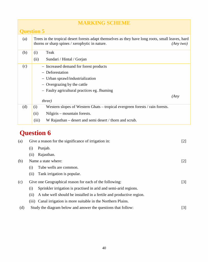
MARKING SCHEME Question 5
(a) Trees in the tropical desert forests adapt themselves as they have long roots, small leaves, hard thorns or sharp spines / xerophytic in nature. (Any two)
(b) (i) Teak (ii) Sundari / Hintal / Gorjan
(c) − Increased demand for forest products − Deforestation − Urban sprawl/industrialization − Overgrazing by the cattle − Faulty agricultural practices eg. Jhuming (Any three)
(d) (i) Western slopes of Western Ghats – tropical evergreen forests / rain forests. (ii) Nilgiris – mountain forests. (iii) W Rajasthan – desert and semi desert / thorn and scrub.
Question 6 (a) Give a reason for the significance of irrigation in:
(i) Punjab. (ii) Rajasthan.
[2]
(b) Name a state where: (i) Tube wells are common. (ii) Tank irrigation is popular.
[2]
(c) Give one Geographical reason for each of the following: (i) Sprinkler irrigation is practised in arid and semi-arid regions. (ii) A tube well should be installed in a fertile and productive region. (iii) Canal irrigation is more suitable in the Northern Plains.
[3]
(d) Study the diagram below and answer the questions that follow:
[3]

41
Suggestions for teachers − Emphasis must be given to application
based reasoning questions. − Class tests on reasoning questions
should be given regularly to improve the overall performance of students.
− Comparative study of different methods of irrigation, their advantages and disadvantages must be done.
− Modern methods of rainwater harvesting, mostly in Urban areas should be explained properly.
− Explain the importance of traditional and modern means of irrigation. Drip and Sprinkler method should be explained using images. Recharge of groundwater table should be given importance.
(i) Name the activity shown in the diagram.
(ii) Give two objectives of the activity named in (d) (i).
Comments of Examiners (a) The significance of irrigation in Punjab and
Rajasthan was not understood by many candidates. They explained the process instead of giving the correct reason.
(b) Many candidates answered both sub-parts of this question correctly. However, a few mentioned that tank irrigation is popular in North India.
(c) Most candidates wrote geographical reasons for the sub-parts of this question correctly. However,
tube wells being installed in fertile and productive region was not written correctly by some candidates.
(d) Most candidates wrote ‘water harvesting’ instead of ‘rainwater harvesting’ in sub-part (i).

42
MARKING SCHEME Question 6
(a) (i) Punjab – Rainfall is uncertain and varies from year to year and place to place / seasonal / water needed for Rabi crops (winter). The region is rich in agriculture.
(ii) Rajasthan – West Rajasthan receives less than 25 cm rainfall.
(b) (i) Uttar Pradesh / Bihar / Punjab / Haryana / Rajasthan / West Bengal (Any one)
(iii) Tamil Nadu / Andhra Pradesh / Karnataka (Any one)
(c) (i) Sprinkler irrigation – water is supplied through pipes – there is no loss of water by evaporation. Therefore, minimum wastage.
(ii) A tube well must be installed in a productive region so that the cost of construction and operation of the tube well may be recovered from increased farm production / it is less expensive / can be installed in the farming area / occupies less space / free from pollution.
(iii) Perennial rivers in the Northern plains supply water / plain surface for easy drainage / soft earth-easy to construct canals
(d) (i) Rainwater harvesting / ground water recharge
(ii) Objectives of rainwater harvesting:
− To meet the increasing demand for water − To reduce surface runoff
− To avoid flooding of roads
− To raise the groundwater level
− To improve the quality of ground water/reduce ground water pollution
− To reduce soil erosion
− To supplement household requirements of water during the hot summers
(Any two)
43
Suggestions for teachers – Highlight the importance of minerals and
transact the content by giving oral and written tests.
– Advise students to make tables to facilitate their learning. Oil fields should be taught with an indication of their location.
– Topics must be taught according to the scope of syllabus.
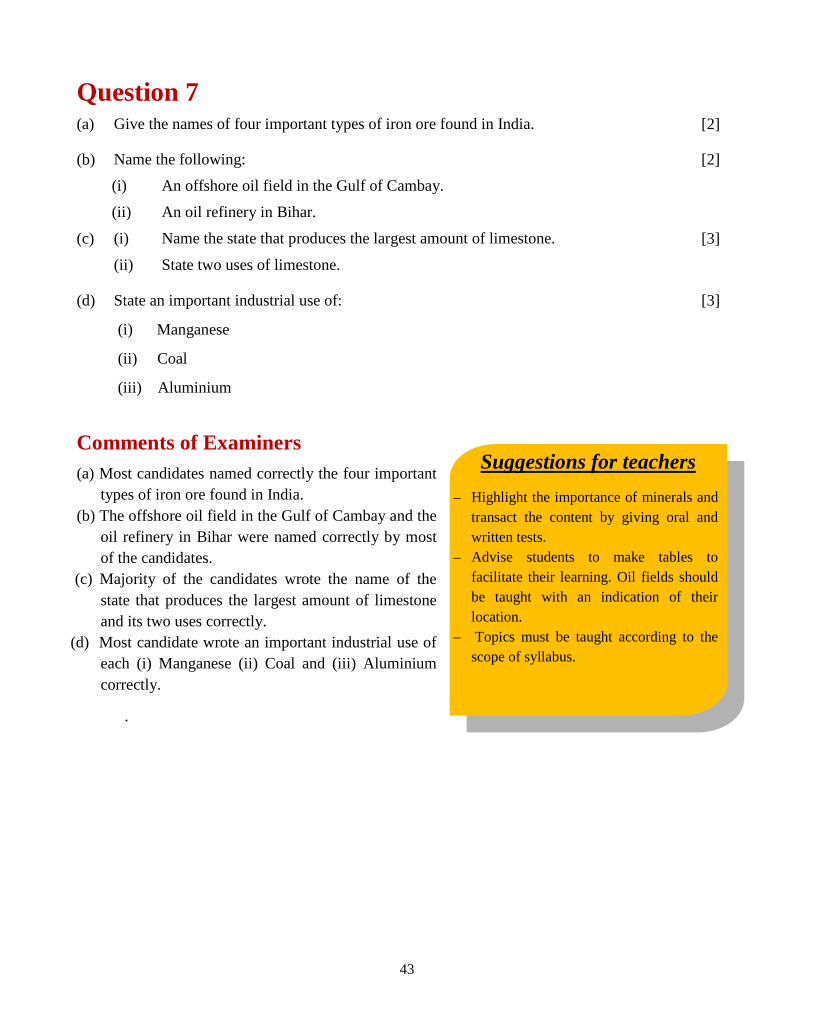
Question 7 (a) Give the names of four important types of iron ore found in India. [2]
(b) Name the following: (i) An offshore oil field in the Gulf of Cambay. (ii) An oil refinery in Bihar.
[2]
(c) (i) Name the state that produces the largest amount of limestone.
(ii) State two uses of limestone. [3]
(d) State an important industrial use of:
(i) Manganese
(ii) Coal
(iii) Aluminium
[3]
Comments of Examiners (a) Most candidates named correctly the four important
types of iron ore found in India. (b) The offshore oil field in the Gulf of Cambay and the
oil refinery in Bihar were named correctly by most of the candidates.
(c) Majority of the candidates wrote the name of the state that produces the largest amount of limestone and its two uses correctly.
(d) Most candidate wrote an important industrial use of each (i) Manganese (ii) Coal and (iii) Aluminium correctly.
.
44
MARKING SCHEME Question 7
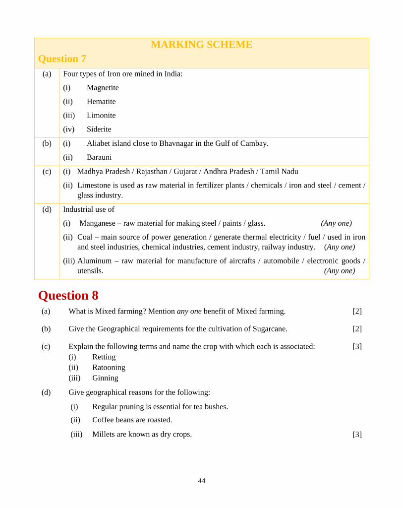
(a) Four types of Iron ore mined in India:
(i) Magnetite
(ii) Hematite
(iii) Limonite
(iv) Siderite
(b) (i) Aliabet island close to Bhavnagar in the Gulf of Cambay.
(ii) Barauni
(c) (i) Madhya Pradesh / Rajasthan / Gujarat / Andhra Pradesh / Tamil Nadu
(ii) Limestone is used as raw material in fertilizer plants / chemicals / iron and steel / cement / glass industry.
(d) Industrial use of
(i) Manganese – raw material for making steel / paints / glass. (Any one)
(ii) Coal – main source of power generation / generate thermal electricity / fuel / used in iron and steel industries, chemical industries, cement industry, railway industry. (Any one)
(iii) Aluminum – raw material for manufacture of aircrafts / automobile / electronic goods / utensils. (Any one)
Question 8 (a) What is Mixed farming? Mention any one benefit of Mixed farming.
(b) Give the Geographical requirements for the cultivation of Sugarcane.
(c) Explain the following terms and name the crop with which each is associated: (i) Retting (ii) Ratooning (iii) Ginning
(d) Give geographical reasons for the following:
(i) Regular pruning is essential for tea bushes.
(ii) Coffee beans are roasted.
(iii) Millets are known as dry crops.
[2]
[2]
[3]
[3]
45
Suggestions for teachers – Train students to learn the important
geographical terms and associated activities related to them.
– Lay stress on learning the correct range of temperature and rainfall requirement of crops.
– Guide students to read the question carefully. Tell them that if two things are asked in one question, answer should be written separately for each.
– Give more practice in reasoning type questions.
Comments of Examiners (a) Many candidates did not explain mixed farming
properly which reflected a lack of understanding of the topic.
(b) Most of the candidates gave geographical requirements for the cultivation of Sugarcane correctly.
(c) Most candidates were unable to explain the terms correctly and failed to mention the crop associated with each of the terms.
(d) (i) Most candidates answered correctly. (ii)Most candidates mentioned about the moisture
content instead of the aroma, flavour, taste, etc. (iii)Only a few candidates answered correctly.
MARKING SCHEME Question 8
(a) Mixed farming – cultivation of crops and livestock rearing on the same farm.
One benefit – cattle and poultry do not need extra expenditure; they thrive on farm waste / Livestock provides substitute income when crops are not ready.
(Any one) (b) Geographical requirement for Sugarcane cultivation:
− 20 degrees to 30 degrees Celsius temperature − 100 to 200 cm rainfall − Alluvial or Black soil (well drained)
(c) (i) Retting – It is a microbiological process in which the jute bundles are submerged in soft, clean water for 2 – 3 weeks, this helps to loosen the outer bark and helps in removal of the fibre from the stalk.
(ii) Ratooning – It is a shoot from the root-stock of sugarcane which has been cut leaving the root intact in the soil.
(iii) Ginning – It is the process in which cotton fibre is separated from the seed / raw material.
(d) (i) It helps in growing new shoots bearing soft leaves in plenty / facilitates plucking. (ii) Roasting gives coffee its taste, colour and flavor. (iii) Millets can withstand high temperatures and drought / it is a hardy crop / can grow in
areas of scanty rainfall / in adverse climatic conditions.
46
Suggestions for teachers – Show the location of states using map
and explain the geographical conditions. – Teach difference based questions with the
help of a tabular presentation. – Prepare charts for teaching of key terms
and associated activities. – Advise students to read the topic
thoroughly. A thorough revision can help in improving their performance levels.
Question 9 (a) Differentiate between Mineral-based Industry and Agro-based industry giving one
example for each.
[2]
(b) ‘Though Uttar Pradesh has the largest number of sugar mills yet Maharashtra is the
largest producer of sugar.’ Give any two reasons to justify the statement.
[2]
(c) Give the geographic term for each of the following:
(i) Non-mulberry silk produced in Madhya Pradesh.
(ii) Rejected cane after crushing.
(iii) The rearing of silk worms to obtain silk.
[3]
(d) With reference to the cotton textile industry answer the following questions:
(i) Give two reasons why Mumbai is an important cotton textile industry.
(ii) Mention two more important centres of cotton textile industry in India.
[3]
Comments of Examiners (a) Most candidates differentiated between mineral-
based industry and agro-based industry correctly citing appropriate examples for each.
(b) Majority of candidates misinterpreted the question and emphasized on UP having the largest number of sugar mills, and explained about UP and not about Maharashtra.
(c) Most candidates answered the sub-parts(i), (ii) and (iii) correctly.
(d) (i)Most candidates answered the question correctly.
(ii)Most candidates wrote incorrect answers, as they wrote on states instead of important centres.
47
MARKING SCHEME Question 9
(a) Mineral based industries use raw materials obtained from mines / e.g. iron and steel / cement / shipbuilding. Agro based industries use raw materials obtained from agriculture / e.g. sugar / cotton / jute.
(b) Maharashtra is the largest producer of sugar − the geographical conditions in the south are more suitable (temperature 20-30 degree
Celsius, rain 100-200 cm, no frost, black lava soil). − Large holdings are well planned. − Longer crushing season. − Mills are near the plantation (no loss of sucrose and cost of production is low). − Mills better managed in the cooperative sector. − The sugar lobby is responsible for large capital investment; hence farmers are interested in
growing sugarcane. (Any two)
(c) (i) Tussar (ii) Bagasse (iii) Sericulture
(d) With reference to cotton textile industry: (i) – Easy availability of raw material from the Black Soil region of Maharashtra. – Humid climate. – Cheap hydroelectric power. – Mumbai has international port – import / export facility. – Existence of ready market. – Skilled and unskilled labour from surrounding areas. – Well connected with hinterland by roads and railways. – Abundant supply of soft water for dyeing and bleaching. – Banking facilities available. (Any two) (ii) Ahmedabad / Surat / Bhavnagar / Kanpur / Coimbatore / Madurai / Salem / Modinagar /
Etawah / Moradabad / Saharanpur. (Any two)
48
Suggestions for teachers – Characteristic features of each integrated
steel plant should be taught with location, state and collaborators if any. Locational factors for each steel plant should include names of mines supplying raw materials.
– Train students to make a table of important industries and their centres followed by a thorough revision in class.
– The difference between coaches, engines and locomotives should be distinctly taught.
– Explain the basic features and products produced by industries specified in the syllabus.
Question 10 (a) ‘The Iron and Steel industry constitutes the backbone of modern industrial economy.’
Give two reasons to justify the statement.
[2]
(b) (i) Name an Iron and Steel Industry set up in Orissa with the help of a famous German firm.
(ii) From where does the industry named in b (i) get its iron ore and manganese?
[2]
(c) Name a manufacturing centre for each of the following industries: (i) Aircraft
(ii) HMT
(iii) Railway coaches
[3]
(d) Name two products each of the following industries:
(i) petrochemical industry. (ii) heavy engineering industry. (iii) electronic industry.
[3]
Comments of Examiners (a) Some candidates were unable to comprehend the
term ‘backbone’ and hence, wrote reasons that were vague in nature.
(b) (i)A few candidates were unable to identify the Rourkela Steel Plant. (ii)Most candidates answered incorrectly.
(i) & (ii) Most candidates answered these sub-parts of the question correctly.
(iii)Some candidates committed errors in identifying the manufacturers of railway coaches, engines and locomotives and hence, wrote incorrect answers.
(c) (i)A few candidates made mistakes in naming products based on the petrochemical industry.
(ii)Some candidates attempted the question correctly.
(iii)Most candidates answered correctly.
49
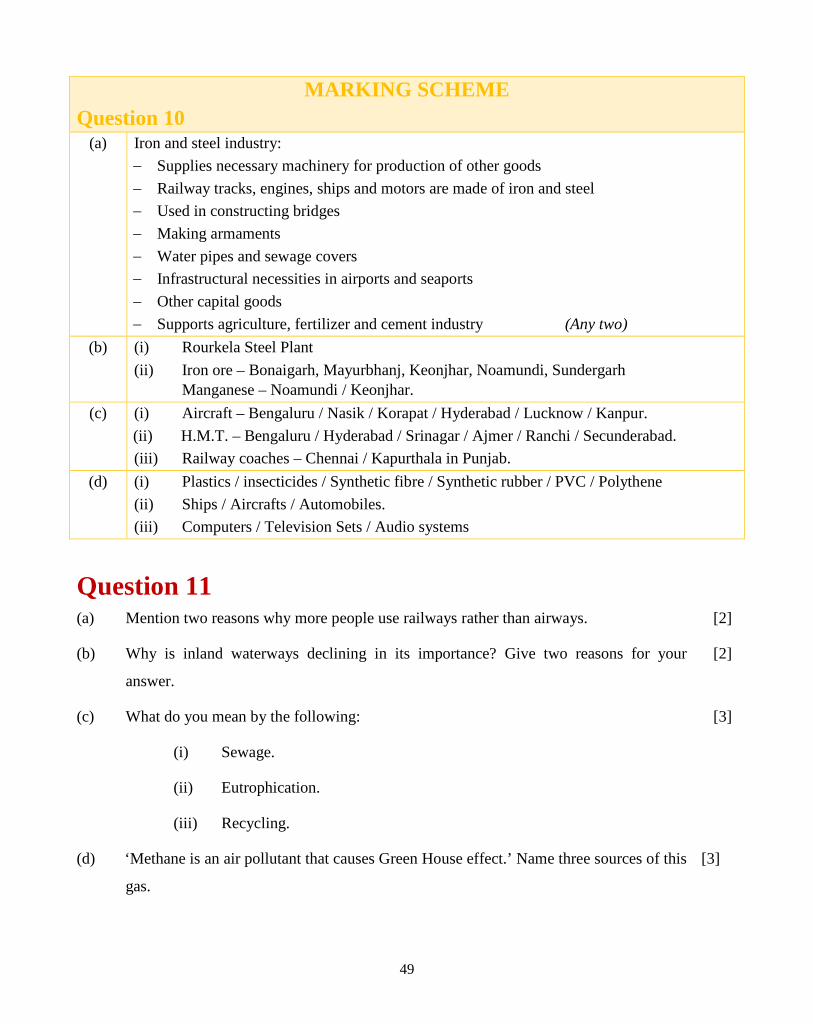
MARKING SCHEME Question 10
(a) Iron and steel industry: − Supplies necessary machinery for production of other goods − Railway tracks, engines, ships and motors are made of iron and steel − Used in constructing bridges − Making armaments − Water pipes and sewage covers − Infrastructural necessities in airports and seaports − Other capital goods − Supports agriculture, fertilizer and cement industry (Any two)
(b) (i) Rourkela Steel Plant (ii) Iron ore – Bonaigarh, Mayurbhanj, Keonjhar, Noamundi, Sundergarh Manganese – Noamundi / Keonjhar.
(c) (i) Aircraft – Bengaluru / Nasik / Korapat / Hyderabad / Lucknow / Kanpur. (ii) H.M.T. – Bengaluru / Hyderabad / Srinagar / Ajmer / Ranchi / Secunderabad. (iii) Railway coaches – Chennai / Kapurthala in Punjab.
(d) (i) Plastics / insecticides / Synthetic fibre / Synthetic rubber / PVC / Polythene (ii) Ships / Aircrafts / Automobiles. (iii) Computers / Television Sets / Audio systems
Question 11 (a) Mention two reasons why more people use railways rather than airways. [2]
(b) Why is inland waterways declining in its importance? Give two reasons for your
answer.
[2]
(c)
(d)
What do you mean by the following:
(i) Sewage.
(ii) Eutrophication.
(iii) Recycling.
‘Methane is an air pollutant that causes Green House effect.’ Name three sources of this
gas.
[3]
[3]

50
Suggestions for teachers – Discuss different means of transport,
their advantages and disadvantages with students.
– Wastes, their types and methods of their safe disposal should be explained to the students thoroughly.
– Practise the terms/ definitions regularly. – Thorough revision of important topics /
units in class helps in improving performance.
Comments of Examiners (a) Most candidates could give reasons for why railways
are used by more people than the airways. (b) Most candidates were unable to comprehend the
question and wrote incorrect and vague answers. (c) (i)Many candidates wrote generalised meaning of
sewage. (ii)Most candidates explained ‘Eutrophication’
correctly. (iii)Most candidates answered correctly except for a
few who appeared to be unaware of the term ‘Recycling’.
(d) Most candidates did not write three sources of methane correctly.
MARKING SCHEME Question 11
(a) More people travel by railways than by airways because: – Airways are expensive. – Airways do not allow passengers to carry much luggage. – Not all places are connected by airways. (Any two)
(b) Indian waterways is declining its importance because: – It provides access to limited areas. – It is much slower than roadways and railways.
(c) (i) Sewage: the waste water discharge from domestic premises like residences, institutions, and commercial establishments is known as sewage.
(ii) Eutrophication: Type of water pollution / it is process of depletion of oxygen from the water bodies either through natural or due to human activities / This process takes place due to introduction of nutrients and chemicals through discharge of domestic sewage, waste from industries and from agricultural fields.
(iii) Recycling or reuse involves the collection of used and discarded materials and processing these materials and making them into new products.
51
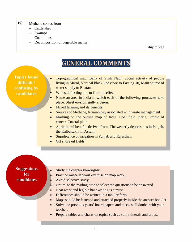
(d) Methane comes from – Cattle shed – Swamps – Coal mines – Decomposition of vegetable matter
(Any three)
GENERAL COMMENTS
• Topographical map: Bank of Sukli Nadi, Social activity of people living in Marol, Vertical black line close to Easting 10, Main source of water supply to Bhatana.
• Winds deflecting due to Coriolis effect. • Name an area in India in which each of the following processes take
place: Sheet erosion, gully erosion. • Mixed farming and its benefits. • Sources of Methane, terminology associated with waste management. • Marking on the outline map of India: Coal field Jharia, Tropic of
cancer, Coastal plain. • Agricultural benefits derived from: The westerly depressions in Punjab,
the Kalbaisakhi in Assam. • Significance of irrigation in Punjab and Rajasthan. • Off shore oil fields.
• Study the chapter thoroughly. • Practice miscellaneous exercise on map work. • Avoid selective study. • Optimize the reading time to select the questions to be answered. • Neat work and legible handwriting is a must. • Differences should be written in a tabular form. • Maps should be fastened and attached properly inside the answer booklet. • Solve the previous years’ board papers and discuss all doubts with your
teacher. • Prepare tables and charts on topics such as soil, minerals and crops.
Suggestions for
candidates
Topics found difficult /
confusing by candidates