Embed Size (px)
Citation preview
Journal of Coastal Research SI 39 316 - 318 ICS 2004 (Proceedings) Brazil ISSN 0749-0208
DIEHL, F.L.; HORN FILHO, N.O. and AMIN JR., A.H., 2006. Quaternary Evolution of the Peninsula,, Brazil. Journal of Coastal Research, SI 39 (Proceedings of the 8th International Coastal
Symposium), 316 - 318. , SC, Brazil, ISSN 0749-0208.
Paleogeographic aspects of the Porto Belo peninsula are presented, with emphasis on the Pleistocene and Holoceneepochs. The geology of the coastal plain was fundamental for determining, characterizing and describing theevolution of the peninsula. The methodology used was as follows: a literature review; a preliminary analysis ofsatellite images; an interpretation of the aerial photographs; geological mapping; granulometric analysis; a finalinterpretation of the photographs and images; an elaboration of the geological map and definition of the coastalevolution of the area. At the beginning of Quaternary period, the sea level was higher and the presence of the
archipelago was registred. During the transgression phases, the pre-existing coastal plain deposits andbasement rocks were eroded. Nevertheless, regressive periods were important in the formation of lagoonal andbeach deposits, partially covered by eolic sediments, in the form of terraces, plains and dunes.
Porto BeloSanta Catarina
Itajaí
PortoBelo
Coastal geology, sedimentology, geomorphology.ADDITIONALINDEX WORDS:
ABSTRACT
Quaternary Evolution of the Porto Belo Peninsula, Santa Catarina, Brazil
F. L. Diehl†; N. O. Horn Filho‡ andA. H.Amin Jr.
INTRODUCTION
The researchers of theof the University of have carried
out studies on the central-northern coast of the State of, through the project entitled “Integrated project of the
mouth of the river and adjacent coastal area:diagnosis and environmental evaluation”, with support from the
.In this project, the peninsula was studied in detail,
due to scientific interest and the exuberance of its landscape.The objective of the project was to describe the geomorphology,sedimentology and geoevolutional stages of the Quaternaryperiod of the coastal plain, and discuss the use and potential ofthe associated mineral resources and geoenvironmentalalterations arising from this use.
It is believed that this focus of study on the peninsula hasprovided criteria for the construction of activities which seekthe use and planning of coastal regions of the State of
This proposal challenges the stereotype ofoccupation of this coastal region adopted until now.
The methodology was as follows: (1) a literature review; (2)a preliminary analysis of the satellite images (at a scale of1:100,000); (3) interpretation of aerial photographs (from 1977and 1978) (at a scale of 1:25,000); (4) geological mapping,including topogeological profiling, sediments and rockssampling, detailed and general observations of the usesand potential of the mineral resources; (5) sedimentologicalanalysis; (6) entering the cartographic bases of the sheet for
(IBGE, 1983) into the Geographic InformationSystem GIS (INPE/GEOSISTEMAS, 1995a); (7) digitalt r e a t m e n t o f t h e i n f o r m a t i o n i n S I T I M(INPE/GEOSISTEMAS, 1995b); (8) final interpretation of thephotographs and images; (7) elaboration of a geological map(1:50.000 scale); (8) definition of the coastal evolution of thearea.
Centro de Ciências Tecnológicas daTerra e do Mar Vale do Itajaí
SantaCatarina
Itajaí-Açú
Fundação Banco do BrasilPorto Belo
SantaCatarina.
in loco
Camboriú
METHODS
RESULTS
Physiography
From the geographical point of view, the peninsula is locatedbetween latitudes 27º06'32,3” and 27º13'14,5” south andlongitudes 48º36'06,25” and 48º27'43,8” west, in the central
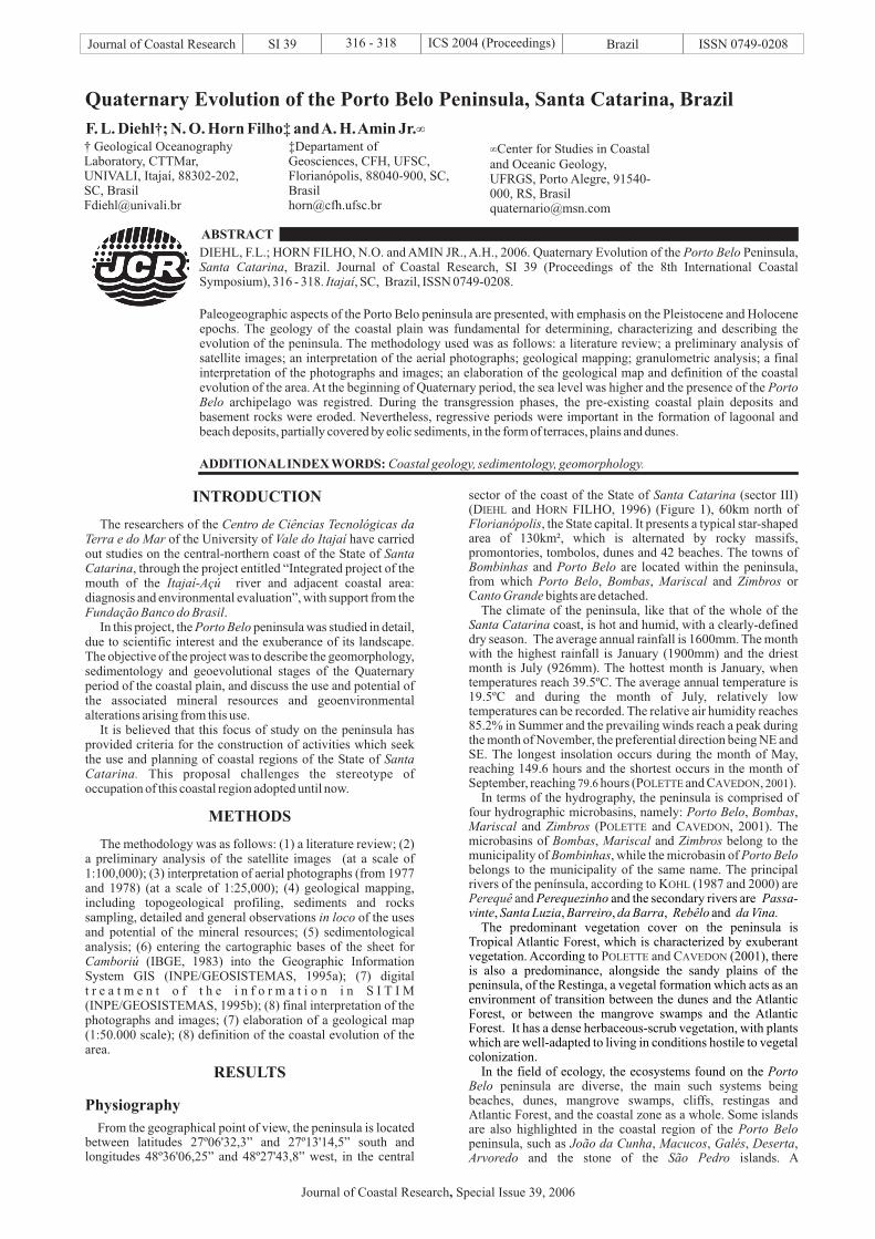
sector of the coast of the State of (sector III)(D and H FILHO, 1996) (Figure 1), 60km north of
, the State capital. It presents a typical star-shapedarea of 130km², which is alternated by rocky massifs,promontories, tombolos, dunes and 42 beaches. The towns of
and are located within the peninsula,from which , , and orC bights are detached.
The climate of the peninsula, like that of the whole of thecoast, is hot and humid, with a clearly-defined
dry season. The average annual rainfall is 1600mm. The monthwith the highest rainfall is January (1900mm) and the driestmonth is July (926mm). The hottest month is January, whentemperatures reach 39.5ºC. The average annual temperature is19.5ºC and during the month of July, relatively lowtemperatures can be recorded. The relative air humidity reaches85.2% in Summer and the prevailing winds reach a peak duringthe month of November, the preferential direction being NE andSE. The longest insolation occurs during the month of May,reaching 149.6 hours and the shortest occurs in the month ofSeptember, reaching hours (P and C , ).
In terms of the hydrography, the peninsula is comprised offour hydrographic microbasins, namely: , ,
and ( , 2001). Themicrobasins of , and belong to themunicipality of , while the microbasin ofbelongs to the municipality of the same name. The principalrivers of the península, according to K (1987 and 2000) are
and
Santa Catarina
Florianópolis
Bombinhas Porto BeloPorto Belo Bombas Mariscal Zimbros
anto Grande
Santa Catarina
Porto Belo BombasMariscal Zimbros
Bombas Mariscal ZimbrosBombinhas Porto Belo
Perequê
IEHL ORN
OLETTE AVEDON
OHL
79.6 2001
P and C
P and C
peninsula are diverse, the main such systems beingbeaches, dunes, mangrove swamps, cliffs, restingas andAtlantic Forest, and the coastal zone as a whole. Some islandsare also highlighted in the coastal region of thepeninsula, such as , , ,
OLETTE AVEDON
OLETTE AVEDON
Belo
Porto BeloJoão da Cunha Macucos Galés
and the secondary rivers are, , , , and
The predominant vegetation cover on the peninsula isTropical Atlantic Forest, which is characterized by exuberantvegetation. According to (2001), thereis also a predominance, alongside the sandy plains of thepeninsula, of the Restinga, a vegetal formation which acts as anenvironment of transition between the dunes and the AtlanticForest, or between the mangrove swamps and the AtlanticForest. It has a dense herbaceous-scrub vegetation, with plantswhich are well-adapted to living in conditions hostile to vegetalcolonization.
In the field of ecology, the ecosystems found on the
Perequezinho Passa-vinte Santa Luzia Barreiro da Barra Rebêlo da Vina.
Porto
DesertaArvoredo São Pedro
,and the stone of the islands. A
† Geological OceanographyLaboratory, CTTMar,UNIVALI, Itajaí, 88302-202,SC, [email protected]
‡Departament ofGeosciences, CFH, UFSC,Florianópolis, 88040-900, SC,[email protected]
Center for Studies in Coastaland Oceanic Geology,UFRGS, Porto Alegre, 91540-000, RS, [email protected]
Journal of Coastal Research Special Issue 39, 2006,
large portion of the Por
comprised of sand-clay sediments.The subsequent phase, the flooding of the coastal plain,
corresponding to the late Pleistocene epoch (120ka) at a highersea level than present, was responsible for the erosion of thesedimentary deposits, also reaching the rocks of the basement.
to Belo peninsula is located in na areasurrounding the conservation unit: the BiologicalMarine Reserve, an important ecological reserve of nationalimportance.
The geology of the region is comprised of metamorphicrocks of
rystalline Basement (M , 1958), destributed in theriver mountain range, which in turn forms part of the
coastal mountain ranges of .The regressive eposides which preceeded the trangressions
of the older Pleistocene (400ka) and the middle Pleistocene(325ka), together with important paleoclimatic phenomena ofthe epoca, were determining factors in the formation of depositsof the continental depositional system (eluvial, coluvial andalluvial fans) of the undifferentiated Quaternary period, locatedat the base of the continental elevations and islands and
Arvoredo
TijucasEast Santa Catarina
Geology and Geomorphology
Paleogeographic Evolution
the Group, an group of granitoid rocksdesignated Complex, and other granitic units,intrusive in this complex, denominatedmetagranitoids and metagranite. Besides theseformations there ares also Granite; IntrusiveSuite (B , 1996); according to C J .(1997).
The geology of the quaternary deposits of thepeninsula coastal plain was described by D (1995),D (1996), H F 1996), C J .(1997) and C J . (2000), and is comprised ofdeposits characteristic of two depositional systems: thecontinental and the transitional or coastal system.
The continental system is associated with slopes of thehighlands, and includes coluvial, alluvial fan and fluvialdeposits, generally dated undifferentiated Quaternary (from ±2MA AP until the present day). The coastal system, of the
lagoon-barrier type, includes pleistocenic and holocenicdeposits of the shallow marine, eolic, lagoonal and paludialenvironments, correlating to the III and IV barriers, originatingfrom the transgressions of the end of the Pleistocene andHolocene epochs.
In terms of the geomorphology, the peninsula has two distinctfeatures: a) Exposed Crystalline Basement, divided into themountain range river, which in turn forms part of theEast mountain range (H F ., 1996)and b) Coastal Plain, formed by a series of geomorphologicalfeatures, such as alluvial fans, talus, terraces, dunes, beaches,lakes and lagoons.
The geology and geomophology of the quaternary deposits ofthe coastal plain of the area studied are closely linked to thefluctuations in sea level which occurred during the last 2 millionyears. These were fundamental for the investigation,characterization the description of the evolution of the principalgeological units of the region.
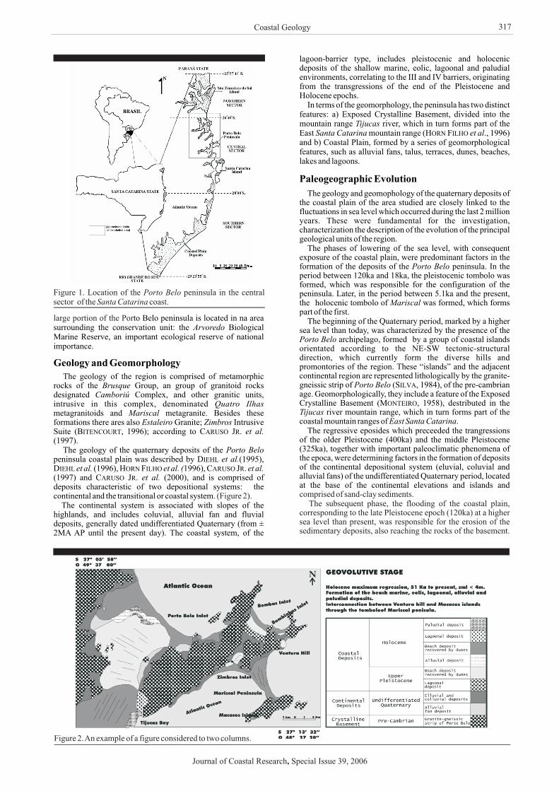
The phases of lowering of the sea level, with consequentexposure of the coastal plain, were predominant factors in theformation of the deposits of the peninsula. In theperiod between 120ka and 18ka, the pleistocenic tombolo wasformed, which was responsible for the configuration of thepeninsula. Later, in the period between 5.1ka and the present,the holocenic tombolo of was formed, which formspart of the first.
The beginning of the Quaternary period, marked by a highersea level than today, was characterized by the presence of the
archipelago, formed by a group of coastal islandsorientated according to the NE-SW tectonic-structuraldirection, which currently form the diverse hills andpromontories of the region. These “islands” and the adjacentcontinental region are represented lithologically by the granite-gneissic strip of (S , 1984), of the pre-cambrianage. Geomorphologically, they include a feature of the ExposedC
BrusqueCamboriú
Quatro IlhasMariscal
Estaleiro Zimbroset al.
Porto Beloet al.
et al. et al. ( et al.et al.
TijucasSanta Catarina et al
Porto Belo
Mariscal
Porto Belo
Porto Belo
ITENCOURT ARUSO R
IEHLIEHL ORN ILHO ARUSO R
ARUSO R
ORN ILHO
ILVA
ONTEIRO
(Figure 2).
Coastal Geology
Figure 1. Location of the peninsula in the centralsector of the coast.
Porto BeloSanta Catarina
Figure 2.An example of a figure considered to two columns.
Journal of Coastal Research Special Issue 39, 2006,
317
At the beginning of the retreat of the coastline during the period,led to the formation of frontal sand ridges of the sand barrier andthe first lagoonal bodies of the retrobarrier Subsequently, due tothe effects of colmatation, these developed into theenvironments of lagoons, wetlands and finally, lagoonaldeposits in the form of terraces of up to 12m in high.
The continuation of the regressive phase, between 120ka and18ka, when occurred a lowering of the sea level, led to theformation of marine beach deposits covered by eolic sedimentsin the form of sand ridges, with highs varying between 13 and17m above the current level. The sediments of the pleistocenuicdeposits are essential sandy, fine and medium, yellow, ochreand brownish in color, and mark the end of the Pleistoceneepoch in the State of and the area studied (HF 1994).
The Flandrian transgression, between 18ka and 5.1ka,determined the raising of the sea at relatively lower levels thanthose of the Pleistocene epoch. During this event of advancingcoastline, the pre-formed deposits of the inlets of ,
and the bay of weretotally or partially eroded. This process of erosion led to theformation of cliffs of up to 4m in high, delimiting thepleistocenic deposits of the holocenic. During this period, the
hill remained isolated from the rest of the coastalplain, appearing as an island, while the inlets ofand still had not yet been formed.
The holocenic regression, lasting from 5.1ka until thepresent, characterized by 3 transgressive maximums (5.1ka;3.6ka and 2.5ka), according to S (1985), led to theformation of the lagoonal deposits and inter-tidal marine beach,partially covered by eolic sediments. The beach and eolic sandspresent beige and whitened coloration, of fine and mediumgranulometry, with the exception of the coarser sands of thecontinuous strip of Restinga adjacent to the bay of
. In this period, the growth of the tombolo between the“island” of and the hill led to the formation ofthe peninsula.
In the paleodrainages forming part of the older deposits, thefluvial sediments are evidenced (alluvials), clay-sand,highlighting those of the river floodplain.
In the regressive episode which preceded the transgressivemaximum of 2.5ka, in environments which arehydrodynamically of low energy, the formation occurred of thepaludial, silt-clay deposits, with its associated characteristicvegetation (mangrove swamps and salt marshes). The tidalplain of the bay of is highlighted in the area of study.
At a global level, the alternating between glacial andinterglacial periods which occurred during the Quaternaryperiod in the northern hemisphere and its indirect consequencesin the austral oceans; the tectonic cenozoic movements; thedeformations of the terrestrial geoid and the accumulation ofsediments in the oceanic basins; among others, are importantcauses for explaining the formation of the immersed andsubmersed deposits of the coastal plains and adjacentcontinental shelves.
The geological-geomorpholocial evolution of the coastalplain of the Porto Belo peninsula, through the interpretation ofquaternary deposits, is closely related to the fluctuations in sealevel of the south Atlantic ocean. Among the deposits of thecoastal depositional system, the predominant ones are those ofthe holocenic age, followed by the deposits of the upperPleistocene, intermingled with the granitic archaean-proterozoic elevations of the basement and continental depositsof the undifferentiated Quaternary.
. and S.A., 1997.Contribuição à geologia de Itapema, Porto Belo eBombinhas (SC) : ca rac te r í s t i cas das rochasneoproterozóicas e dos ambientes deposicionais cenozóicos.
(Itajaí, Brazil,AOCEANO), pp. 48-50.
and V.B., 2000. Mapa geológicoda folha Camboriú, escala 1:50,000.
(Itajaí, Brazil,UNIVALI, pp. 192-194.
and A.H., 1995. Estádios geoevolutivos doQuaternário costeiro da península de Porto Belo e entornos,SC, Brazil .
(Mar del Plata,Argentina,ALICMAR), pp. 68-68.
F.L. and N.O., 1996. Compartimentaçãogeológico - geomorfológica da zona litorânea e planíciecosteira do estado de Santa Catarina. , 9, 39-50.
F.L.; N.O. and , A.H., 1996.Geologia do Quaternário e alterações ambientais da regiãoda península de Porto Belo, Santa Catarina, Brazil.
(Salvador, Brazil, SBG), pp. 33-38.N.O.; , J.; J.C.R. and
F.L., 1994. The coastal Pleistocene of Santa Catarinastate, southern Brazil - geological aspects.
(Tierradel Fuego,Argentina, IGCP253), pp. 9-10.
N.O.; F.L. and , A.H., 1996.Quaternary geology of the central-northern coastal plain ofthe Santa Catarina state, southern Brazil.
(Beijing, China,IGUS), pp. 202-202.
- IBGE.,1983.Florianópolis. IBGE/SEPLAN, s 1:50,000, 1 sheet.
-INPE/ , 1995a.
282p.-
INPE/ , 1995a, 1995b. 236p.D.H.B., 1987. . 1ªed.
São José, Brazil: Editora Canarinho, 204p.D.H.B., 2000. . 2ªed.
Blumenau, Brazil: Editora Odorizzi, 327p.C.A.F., 1958. Esboço geomorfológico.
Departamento Estadual deGeografia e Cartografia, Florianópolis.
M. and F. de S., 2001.
. Itajaí, Editora UNIVALI, 115p.L.C. da., 1984. Os terrenos metamórficos de médio e
alto grau do Pré-cambriano de Santa Catarina(Rio de
Janeiro, Brazil, SBG), 6: pp. 3069-3079.
and A.E.G.de., 1985. Flutuações do nível relativo do mar durante oQuaternário superior ao longo do litoral brasileiro e suasimplicações na sedimentação costeira.
, , 273-286.
Santa Catarinaet al.,
Porto BeloBombas, Bombinhas, Zimbros Tijucas
MacacosCanto Grande
Mariscal
et al.
TijucasMacacos Ventura
Mariscal
Perequê
Tijucas
Proceedings of the 10 Semana Nacional de Oceanografia
Proceedings of theSimpósio Brasileiro de Praias Arenosas
Proceendigs of the 6 CongresoLatinoamericano de Ciencias del Mar
Notas Técnicas
Proceedings of the 39 Congresso Brasileiro de Geologia
Proceedings ofthe Symposium of the Pleistocene in South America
Proceedings of the
30 International Geological Congress
Mapa planialtimético da folha de Camboriú.cale
Manual do SistemaGeográfico de Informações (SGI), v.2.5.
N.Porto Belo: sua história e sua gente
Porto Belo: sua história e sua gente
In: AtlasGeográfico de Santa Catarina.
Construindo odesenvolvimento sustentável para o município deBombinhas
Proceedings
of the 33 Congresso Brasileiro de Geologia
Revista Brasileira deGeociências 15(4)
ORN
ILHO
UGUIO
CARUSO JR, F.; BITENCOURT, M.F ARA JO,
CARUSO JR; KREBS, A.J.; WILDNER,W.; ARA JO, S.A.; DIEHL,F.L.; FRASSON, H.; CARMO,
DIEHL, F.L.; HORN FILHO, N.O.; KLEIN, A.H.F.; POLETTE, M.AMIN JR.,
DIEHL, HORN FILHO,
DIEHL, HORN FILHO, AMIN JR
HORN FILHO, ABREU DE CASTILHOS GR ,DIEHL,
HORN FILHO, DIEHL, AMIN JR
INSTITUTO BRASILEIRO DE GEOGRAFIA E ESTAT STICA
INSTITUTO NACIONAL DE PESQUISAS ESPACIAIS
IMAGEM GEOSISTEMAS
INSTITUTO NACIONAL DE PESQUISAS ESPACIAIS
IMAGEM GEOSISTEMAS
KOHL,
KOHL,
MONTEIRO,
POLETTE, CAVEDON,
SILVA,
SUGUIO, K.; MARTIN, L.; BITTENCOURT, A.C.S.P.;DOMINGUEZ, J.M.L.; FLEXOR, J.M. AZEVEDO,
CONCLUSIONS
ACKNOWLEDGEMENTS
LITERATURE CITED
The authors would like to thank the organizers of thesymposium for the opportunity to present this work during the
8 International Coastal Symposium. This presentation wasalso made possible by the support received from the Universityof and the Federal University ofand the financial support of the
th
Vale do Itajaí Santa CatarinaFundação Banco do Brasil.
Ú
Ú
É
Í
th
t h
th
th
th
.
Diehl et al.
Journal of Coastal Research Special Issue 39, 2006,
318