Embed Size (px)
Citation preview
QUATERNARY STRATIGRAPHY AND GEOLOGIC HISTORY OF THE CHARLIE LAKE (NTS 94A) MAP-
AREA, BRITISH COLUMBIA
Gregory Michael Douglas Hartman B.Sc., University of Northern B.C., 1999
THESIS SUBMITTED IN PARTIAL FULFILLMENT OF THE REQUIREMENTS FOR THE DEGREE OF
MASTER OF SCIENCE
In the Department of Earth Sciences
O Gregory M. D. Hartman 2005
SIMON FRASER UNIVERSITY
All rights reserved. This work may not be reproduced in whole or in part, by photocopy
or other means, without permission of the author
APPROVAL
Name: Gregory M. D. Hartman
Degree: Master of Science
Title of Thesis: Quaternary Stratigraphy and History of the Charlie Lake (NTS 94A) Map-Area, British Columbia
Examining Committee:
Chair: Dr. Peter Mustard
Date Defended:
Dr. John J. Clague Senior Supervisor Department of Earth Science Simon Fraser University
Dr. Peter T. Bobrowsky Supervisor Geological Survey of Canada
Dr. Oldrich Hungr Supervisor Department of Earth and Ocean Sciences University of British Columbia
Dr. Brent C. Ward Supervisor Department of Earth Science Simon Fraser University
Dr. Victor M. Levson External Examiner Department of Earth and Ocean Sciences University of Victoria
ABSTRACT
Two Cordilleran and three Laurentide glacial advances are recorded by
Quaternary sediments in the Charlie Lake map-area (NTS 94A). The advances are
inferred from the presence of exotic clasts derived from the Canadian Shield, fluvial
deposits, glaciolacustrine deposits, and tills within nested paleo-valleys excavated during
three interglaciations. The Late Wisconsinan Laurentide glaciation was the most
extensive Laurentide glaciation, and the only one recognized in western Alberta south of
the study area. Coalescence of Late Wisconsinan Laurentide and Cordilleran Ice
Sheets is not recognized within the study area.
Advancing Late Wisconsinan Laurentide ice blocked the east-flowing drainage
and impounded Glacial Lake Mathews within paleo-Peace River valley and its
tributaries. More than 100 m of fine sediment, deposited by suspension settling and
density underflows were deposited in the centre of the basin. Weak, plastic clay layers
within the glaciolacustrine sequence have developed shear planes on which more than
900 landslides have occurred.
KEY WORDS
Cordilleran glaciation, Laurentide, glaciation, Quaternary, stratigraphy, NTS 94A, Peace
River, British Columbia, Alberta Plateau, glacial lakes, paleo-valleys
EXECUTIVE SUMMARY
Two Cordilleran and three Laurentide glacial advances are recorded by
Quaternary sediments in the Charlie Lake map-area (NTS 94A), northeastern British
Columbia. The advances are inferred from the presence of exotic clasts derived from
the Canadian Shield, fluvial deposits, glaciolacustrine deposits, and tills within nested
paleo-valleys excavated during three interglaciations. Till of the last (Late Wisconsinan)
Laurentide glaciation occurs at the surface, except where it is overlain by postglacial
sediments. The Late Wisconsinan Laurentide glaciation was the most extensive
Quaternary glaciation and the only one recognized in western Alberta south of the study
area. Coalescence of the Late Wisconsinan Laurentide and Cordilleran ice sheets is not
recognized within the study area or within ancestral Peace River valley to the west,
supporting the interpretation that the Late Wisconsinan Cordilleran glacial advance was
restricted. Cordilleran and Laurentide Ice likely coalesced, at least briefly, during the
penultimate glaciation. This is inferred from flutings carved by Cordilleran ice that was
deflected by Laurentide ice as it extended onto the Alberta Plateau from a gap in the
Rocky Mountain front between Portage and Bullhead mountains. The earliest
Laurentide advance may have been the least extensive of the three recognized in the
study area. Erratics attributed to this event have not been found west of the Halfway
River - Beatton River drainage divide.
Advancing Late Wisconsinan Laurentide ice blocked the east-flowing drainage
and impounded Glacial Lake Mathews within paleo-Peace River valley and its
tributaries. This lake reached at least 632 m a.s.l., and more than 100 m of fine
sediment were deposited in the centre of the basin. The glaciolacustrine sequence is
dominated by sediments deposited by suspension settling and density underflows. The
lack of shallow-water and deltaic sediments is interpreted to indicate rapid initial
deepening of the lake and nearly uninterrupted sedimentation until the lake was
overridden by Laurentide ice. Peace River likely built a delta into this lake west of the
study area, near Portage Mountain.
The modern Peace River valley was cut during the early Holocene and coincides
only in part with its Middle Wisconsinan counterpart. Glacial Lake Mathews sediments,
which infill the interstadial valley, are locally exposed in the walls of the modern valley
and its tributaries. Weak, plastic clay layers within the glaciolacustrine sequence have
developed shear planes on which more than 900 landslides have occurred.
In completing this thesis I have been the recipient of generous help and support
in many different forms, ranging from technical and financial to intellectual and
emotional. I would like to acknowledge the following persons, whose assistance has
made this thesis better, or even possible:
Thank you, Dr. John Clague for superb mentorship, financial support, and the
enormous amount of time you have invested in this project. Thank you, committee
members Dr. Peter Bobrowsky, Dr. Oldrich Hungr, and Dr. Brent Ward for participating
in, and contributing to this study. Thank you Dr. Steve Evans for conceptualizing and
supporting the project. Thank you Dr. Vic Levson for examining the thesis. Thank you
Virginia Pow for standing by me throughout this endeavor. Thank you also for your help,
encouragement, patience, and ability to scare off bears! Thank you Dr. Bryan and Mrs.
Dona Hartman for your enormous contributions to this project, including: financial,
technical and logistical support. Thank you Dr. John Orwin for help in the field and
countless hours of mentorship during the write-up of this thesis. Thank you Kenna
Wilkie for field assistance and hours of proof-reading. Thank you Britta Jensen and
Tracy Arsenault for field assistance. Thank you Jordan Severin, Majid Al-Suwaidi, Pat
Johnstone, Michelle Hanson, John Lerette, Derek Kinakin, Julianne Madsen, Chris
Kowalchuk, Jacek Scibek, Kevin Cameron, and Drum Cavers for contributing to the
development of the ideas presented in this thesis. Thank you Dr. Jonathan Driver for
identifying the fossil. Thank you Tarja Vaisanen, Matt Plotnikoff, Christine Crosby,
Nedra Lodewyke, and Wendy Bourke for your assistance throughout my time at SFU.
Thank you Larry Dyke and Natural Resources Canada for financial support.
TABLE OF CONTENTS
Approval ........................................................................................................................ ii ...
Abstract ........................................................................................................................... III
....................................................................................................... Executive Summary iv
Acknowledgements ....................................................................................................... vi . .
Table of Contents ......................................................................................................... VII
List of Figures ................................................................................................................. x ..
List of Tables ................................................................................................................. XII
... Glossary ........................................................................................................................ XIII
Chapter 1 1 . 1 1.2
1.2.1 1.2.2
1.3 1.3.1 1.3.2 1.3.3 1.3.4
1.4 1.4.1 1.4.2 1.4.3
Introduction ............................................................................................. 1 Research Questions and Objectives ............................................................. 1
.................................................................................................... Study Area 2 Physiography ............................................................................................. 4 Bedrock Geology ....................................................................................... 7
Previous Quaternary Geology Research .................................................... 10 Early Quaternary Geology Research ....................................................... 11 Recent Quaternary Geology Research ................................................... 16 Landslide Research ................................................................................. 25 Radiocarbon Chronology ......................................................................... 25
Methods ...................................................................................................... 32 .......................................................................................... Field Methods 32
Office and Laboratory Analyses .............................................................. 34 ....................................................................................... Spatial Analysis 36
.................................................................... Chapter 2 Results and Interpretation 40 2.1 Bedrock Topography ................................................................................... 42
...................................................................... 2.1 . 1 Straths and Buried Valleys 42 .............................................................................. 2.1.2 Deep Bedrock Basins 48
.................................................................................................. 2.2 Lithofacies 5 2 2.2.1 Boulder Lag or Pavement ....................................................................... 53
............................................... 2.2.2 Clast-Supported Massive Boulder Gravel 55 ............................................................. 2.2.3 Clast-Supported Massive Gravel 58
........................................... 2.2.4 Clast-Supported Massive Imbricated Gravel 58 2.2.5 Horizontally Bedded Gravel ..................................................................... 59 2.2.6 Fining-Upward Gravel ............................................................................. 59 2.2.7 Planar Cross-Bedded Gravel ................................................................... 60 2.2.8 Trough Cross-Bedded Gravel .................................................................. 61 2.2.9 Massive Granule Gravel with Isolated Outsized Clasts ........................... 62
vii
2.2.10 2.2.11 2.2.12 2.2.13 2.2.14 2.2.15 2.2.16 2.2.17 2.2.18 2.2.19 2.2.20 2.2.21 2.2.22 2.2.23 2.2.24 2.2.25
2.3 2.3.1 2.3.2 2.3.3 2.3.4 2.3.5
2.4 2.4.1 2.4.2 2.4.3 2.4.4 2.4.5 2.4.6 2.4.7
2.4.8 2.4.9 2.4.10 2.4.1 1
2.5
Chapter 3 3.1
3.1.1 3.1.2 3.1.3 3.1.4 3.1.5 3.1.6
3.2 3.2.1 3.2.2
3.3
Massive Sand ......................................................................................... 62 Planar Cross-Bedded Sand ..................................................................... 64 Trough Cross-Bedded Sand .................................................................... 64 Rippled Sand ........................................................................................... 65 Horizontally Bedded Sand ....................................................................... 67 Horizontal and Drape Laminated Sand ................................................... 68 Sand with Deformed Bedding .................................................................. 69 Sand with Inclined Bedding ..................................................................... 69
................................................................. Laminated and Bedded Fines 72 Laminated and Bedded Fines with Dropstones ....................................... 74 Massive Fines ......................................................................................... 75 Massive Fines with Dropstones ............................................................... 75
...................................................... Massive Matrix-Supported Diamicton 76 ....................................................... Massive Clast-Supported Diamicton 77
Sheared Massive Clast-Supported Diamicton ......................................... 78 Stratified Matrix-Supported Diamicton ..................................................... 78
.............................................................................. Lithofacies Associations 80 Fluvial Lithofacies Association ................................................................. 82
................................................. Glaciolacustrine Lithofacies Association 83 Glacial Lithofacies Association ................................................................ 84 Glaciofluvial Lithofacies Association ........................................................ 84 Mass-Movement Lithofacies Association ................................................ 85
Lithostratigraphy and Genesis .................................................................... 85 Fluvial Deposits of the High Planation Surface ....................................... 86 Fluvial Deposits of the Upper Paleo-Valley ............................................. 89
.......... Advance-Phase Glaciolacustrine Deposits of Upper Paleo-valley 91 Pre-Late Wisconsinan Eastern-Provenance Till ...................................... 93
....................................................................... Western-Provenance Till 101 Fluvial Deposits of the Lower Paleo-Valley ........................................... 105 Advance-Phase Glaciolacustrine Deposits of the Lower Paleo- Valley ..................................................................................................... 108
....................................................................... Till of the Last Glaciation 112 .................................................. Late-glacial Glaciolacustrine Deposits 115
Holocene Fluvial Deposits ..................................................................... 115 ................................................................................ Landslide Deposits 117
Quaternary Sediments and Landsliding .................................................... 117
........................................................................................... Discussion 121 Stratigraphy and History ............................................................................ 121
...................................................................... Pre-Glacial River System 123 Early Non-Glacial River System ............................................................ 125
.......................................................................... Penultimate Glaciation 126 ............................................................................... The Last lnterstade 130
................................................................. Late Wisconsinan Glaciation 132 Modern Peace River Valley ................................................................... 140
Comparison with Previous Work ............................................................... 142 Laurentide Stratigraphy ........................................................................ 143
......................................................................... Cordilleran Stratigraphy 147 Relation between Slope Stability and Stratigraphy ................................... 151
viii
Chapter 4 Conclusion ........................................................................................... 154
References ................................................................................................................... 157
.................................................................................................................. Appendices 165 Appendix A: Section Database .................................................................................. 165 Appendix B: Water Well Database ........................................................................... 165
Appendix C: GIs Products ......................................................................................... 165
LIST OF FIGURES
Figure 1-1
Figure 1-2
Figure 1-3
Figure 1-4
Figure 1-5
Figure 2-1
Figure 2-2
Figure 2-3
Figure 2-4
Figure 2-5
Figure 2-6
Figure 2-7
Figure 2-8
Figure 2-9
British Columbia and the NTS 94A (Charlie Lake) map-area showing geographic features referred to in the text .................................................... 3
Topographic provinces of the NTS 94A map-area ........................................ 5
Bedrock geology of the Charlie Lake map-area ............................................ 8
Cross-section between Clear Hills and the Rocky Mountain Front ............... 9
Three-dimensional representation of the bedrock surface with well log and section data displayed as vertical line segments ........................... 39
Locations of measured sections in the map-area ....................................... 41
Upper elevations of fluvial gravel units associated with the two paleo.valleys. the high broad planation surface. postglacial terraces. and the modern river. based on measurements at sections and water wells .................................................................................................. 45
Topography of the bedrock surface. locations of high and low bedrock outcrops. and locations of wells and sections containing fluvial gravels associated with the straths ................................................... 46
Defined. approximate. and assumed limits of buried paleo-valleys ............ 47
Section SS-76 near Lynx Creek .................................................................. 50
Interpreted geology between drill-log M-1 near the Portage Mountain end moraine and drill-log M-2 at Lynx Creek .............................................. 51
Boulder lag at section SS-103 ..................................................................... 54
Clast-supported massive boulder gravel lithofacies at section SS-76 ......... 56
SS-76 fabric stereonet ................................................................................ 57
Figure 2-1 0 Massive granules with isolated outsized clasts at section SS-50 ................ 63
Figure 2-1 1 Rippled sand at section SS-56 .................................................................... 66
Figure 2-1 2 Sand with deformed bedding at section SS-60 ........................................... 70
Figure 2-1 3 Sand with inclined bedding at section SS-66 .............................................. 71
Figure 2-14 Laminated and bedded fines at section SS-3 ............................................. 73
Figure 2-1 5 Sheared massive clast-supported diamicton underlying massive matrix-supported diamicton at section SS-24 ............................................. 79
Figure 2-16 Typical sections from each of the four paleo-drainage systems ................. 87
............... Figure 2-17 Fluvial gravel of the broad high planation surface at section M-3 88
Figure 2-18 Fluvial gravel of the upper paleo-valley overlying the upper bedrock strath at section SS-49 ................................................................................ 90
Figure 2-1 9 Advance-phase glaciolacustrine sediments of the upper paleo-valley at section SS-10 .......................................................................................... 92
Figure 2-20 SS-26 fabric stereonet ................................................................................ 96
Figure 2-21 SS-24 fabric stereonet ................................................................................ 97
Figure 2-22 Two superposed tills at section SS-50 ........................................................ 98
Figure 2-23
Figure 2-24
Figure 2-25
Figure 2-26
Figure 2-27
Figure 2-28
Figure 2-29
Figure 2-30
Figure 2-31
Figure 2-32
Figure 2-33
Figure 2-34
Figure 3-1
Figure 3-2
Figure 3-3
Figure 3-4
Figure 3-5
Figure 3-6
Figure 3-7
SS-50 fabric stereonet ................................................................................ 99
Lodged and striated clast at the base of the lower till at section SS- 50 ......................................................................................................... 100
Till of western provenance at section SS-75 ............................................. 103
SS-75 fabric stereonet .............................................................................. 104
Fluvial gravel of the lower paleo-valley at section SS-58 showing a paleo-terrace above the main paleo-channel ............................................ 106
Conformable contact between fluvial gravel of the lower paleo-valley and overlying glaciolacustrine sediments at section SS-13 ...................... 107
Thick advance-phase glaciolacustrine deposits of the lower paleo- valley at section SS-56 .............................................................................. I 10
Cross-beds in glaciolacustrine sediments at section SS.60. indicating strong current flow during deposition ........................................ 111
Late Wisconsinan till with Shield clast at section SS-50 ........................... 113
Glacial flutings and drumlins in the Charlie Lake map-area ...................... 114
Late-glacial glaciolacustrine sediments at section SS-35 ......................... 116
Landslides in Beatton River valley ............................................................ 119
Stratigraphy of the NTS 94A map-area ..................................................... 122
Cross-section A-A' through Beatton and Peace River valleys showing the fluvial deposits of three relict drainage systems and overlying valley fills ................................................................................... 124
Bison vertebra from lower paleo-valley gravel at section SS-29 ............... 131
Distribution and upper elevation of Glacial Lake Mathews sediments measured in sections .............................................................................. 135
Reconstruction of Glacial Lake Mathews during the Late Wisconsinan advance of the Laurentide ice sheet .................................... 136
Incised. meandering canyons of the Beatton and Doig rivers ................... 141
Map of the Rocky Mountain front and Alberta Plateau showing areas of previous research and important geographic features .......................... 144
LIST TABL
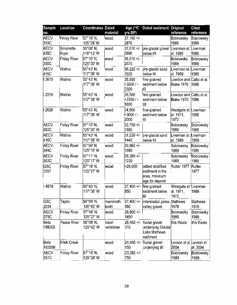
Table 1-1 Radiocarbon ages from the Alberta Plateau and adjacent Rocky Mountains that are pertinent to this thesis .................................................. 27
............................................. Table 2-1 Lithofacies coding scheme used in this study 52
Table 2-2 Lithofacies associations and corresponding lithofacies recognized in this study ..................................................................................................... 81
Table 2-3 Material properties of samples collected from intact. and sheared clay-rich laminae ....................................................................................... 120
xii
Calendar years ago Calendar age, AD 1950 datum.
Descriptive unit A descriptive unit is the smallest body of sediment recognized and described in the field. Descriptive units are the basis for a complete description of the sequence of sediments at sections.
GIs
Lithofacies
Geographic information system.
Sediment characterized by a specific group of physical properties, including particle size, structure, and mineral and lithic composition.
Lithofacies A group of lithofacies associated with a particular depositional association environment.
Lithostratigraphic Groups of related lithofacies that form mappable units and are unit products of a specific geologic event. Their description is based
on physical characteristics, from which depositional environments can be interpreted.
NTS National Topographic System.
Paleo-channel Ancient river bed.
Paleo-valley Ancient river valley.
Stratigraphic unit Lithostratigraphic units that are interpreted in both space and time, and thereby occupy a geochronologic position. Stratigraphic units imply a history that may not be ascertained from the physical characteristics of a deposit alone.
I4c yrs BP Radiocarbon age, AD 1950 datum
xiii

CHAPTER 1 INTRODUCTION
1 .I Research Questions and Objectives
The Peace River region is the most important oil and gas-producing area in
British Columbia. Development of the region's oil and gas reserves requires an
extensive system of pipelines, roads and railways that, at many locations, cross deeply
incised, steep-walled valleys of large rivers. The walls of these valleys are prone to
mass-movement. Thick deposits of Quaternary valley-fill sediments have been identified
as a source of landslides in the Charlie Lake map-area (Severin 2004). The deposits
have previously been described by Mathews (1978), but a better understanding of their
distribution and depositional history is required to minimize losses due to landslides. This
study attempts to provide a stratigraphic context for landslides in Quaternary sediments
in the Charlie lake map-area.
A second objective of the study is to reconstruct the Quaternary history of the
Charlie Lake map-area. Although the stratigraphy has previously been documented by
Mathews (1978), recent research conducted in and around the study area has lead to
the establishment of stratigraphies that are not compatible with Mathews' interpretation
regarding the history of both Cordilleran and Laurentide glaciations. Moreover, the
Quaternary stratigraphy all along the Rocky Mountain front has, in recent years, been
revised. Early researchers invoked multiple Cordilleran and Laurentide glaciations to
explain the stratigraphies they documented. In contrast, recent researchers have
argued for fewer glaciations. The Charlie Lake map-area is ideally located for a study of
interactions of Cordilleran and Laurentide glaciers for three reasons: First, the area is
susceptible to glaciation from both sources. Second, Quaternary sediments are well
exposed along Peace River and its tributaries. Third, interstadial and interglacial paleo-
valleys have been partially preserved, allowing an assessment of the stratigraphic
relations between valley-fill sediments of different age.
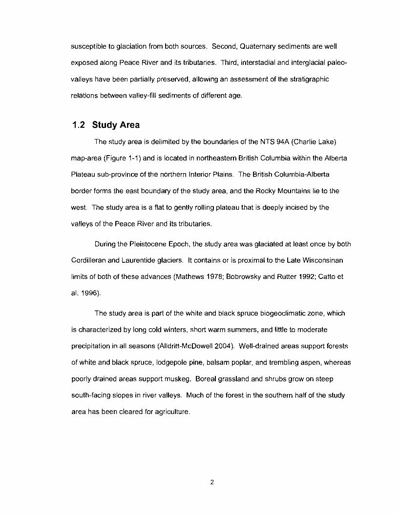
1.2 Study Area
The study area is delimited by the boundaries of the NTS 94A (Charlie Lake)
map-area (Figure 1-1) and is located in northeastern British Columbia within the Alberta
Plateau sub-province of the northern Interior Plains. The British Columbia-Alberta
border forms the east boundary of the study area, and the Rocky Mountains lie to the
west. The study area is a flat to gently rolling plateau that is deeply incised by the
valleys of the Peace River and its tributaries.
During the Pleistocene Epoch, the study area was glaciated at least once by both
Cordilleran and Laurentide glaciers. It contains or is proximal to the Late Wisconsinan
limits of both of these advances (Mathews 1978; Bobrowsky and Rutter 1992; Catto et
al. 1996).
The study area is part of the white and black spruce biogeoclimatic zone, which
is characterized by long cold winters, short warm summers, and little to moderate
precipitation in all seasons (Alldritt-McDowell 2004). Well-drained areas support forests
of white and black spruce, lodgepole pine, balsam poplar, and trembling aspen, whereas
poorly drained areas support muskeg. Boreal grassland and shrubs grow on steep
south-facing slopes in river valleys. Much of the forest in the southern half of the study
area has been cleared for agriculture.
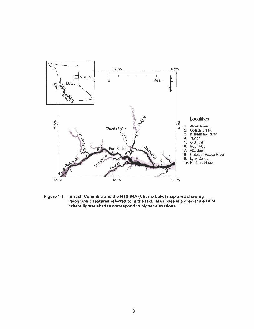
Localities b '2 1. Alces River " 2. Golata Creek
3. Kiskatinaw River 4. Taylor 5. Old Fort 6. Bear Flat 7. Attachie 8. Gates of Peace River 9. Lynx Creek 10. Hudon's Hope
Figure 1-1 British Columbia and the NTS 94A (Charlie Lake) map-area showing geographic features referred to in the text. Map base is a grey-scale DEM where lighter shades correspond to higher elevations.
Economic activities within the study area include agriculture, forestry, and oil and
gas exploitation. Two hydroelectric generating stations, the W. A. C. Bennett Dam and
the Peace Canyon Dam, are located directly west of the study area.
Quaternary sediments strongly influence human activities in the area. Of
particular importance to this study are landslide-prone valley-fill sediments and gravel
deposits that are mined for aggregate. Landslides impact highways, railways, pipelines,
electrical transmission lines, agricultural land, and residential development.
1.2.1 Physiography
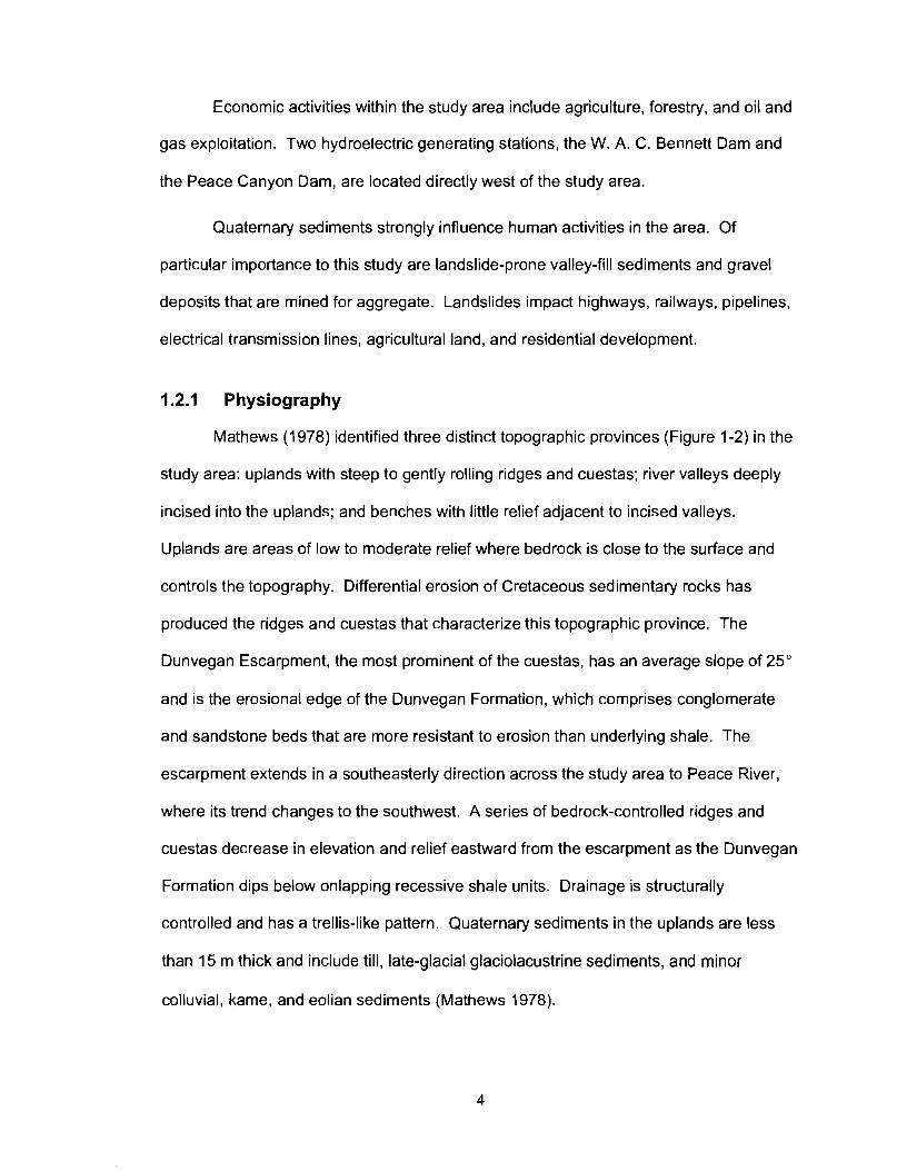
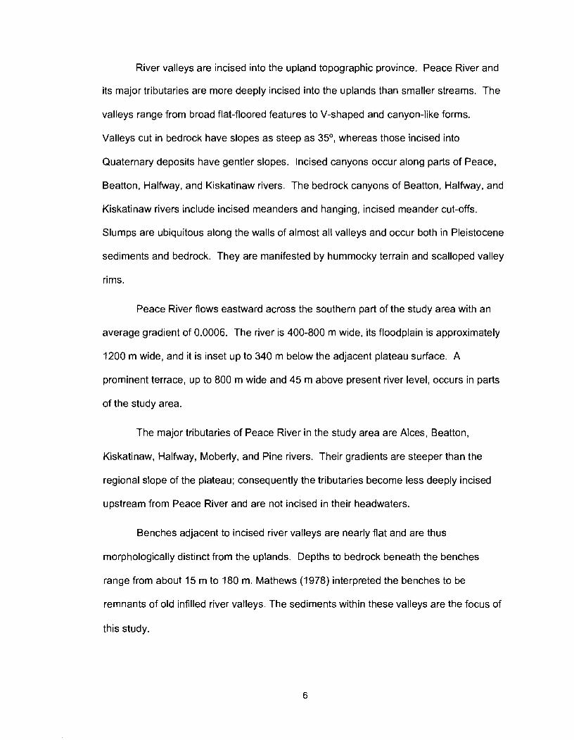
Mathews (1978) identified three distinct topographic provinces (Figure 1-2) in the
study area: uplands with steep to gently rolling ridges and cuestas; river valleys deeply
incised into the uplands; and benches with little relief adjacent to incised valleys.
Uplands are areas of low to moderate relief where bedrock is close to the surface and
controls the topography. Differential erosion of Cretaceous sedimentary rocks has
produced the ridges and cuestas that characterize this topographic province. The
Dunvegan Escarpment, the most prominent of the cuestas, has an average slope of 25"
and is the erosional edge of the Dunvegan Formation, which comprises conglomerate
and sandstone beds that are more resistant to erosion than underlying shale. The
escarpment extends in a southeasterly direction across the study area to Peace River,
where its trend changes to the southwest. A series of bedrock-controlled ridges and
cuestas decrease in elevation and relief eastward from the escarpment as the Dunvegan
Formation dips below onlapping recessive shale units. Drainage is structurally
controlled and has a trellis-like pattern. Quaternary sediments in the uplands are less
than 15 m thick and include till, late-glacial glaciolacustrine sediments, and minor
colluvial, kame, and eolian sediments (Mathews 1978).
LEGEND
E Benches
(3 rl Uplands
Incised valleys
Figure 1-2 Topographic provinces of the NTS 94A map-area, modified from Mathews (1978). Source: Quaternary Stratigraphy and Geomorphology o f Charlie Lake (94A) Map-Area, British Columbia. Paper 76-20, Geological Survey of Canada (O 1978), Figure 3. Reproduced and adapted with the permission of the Minister of Public Works and Government Services Canada, 2005 and courtesy of Natural Resources Canada, Geological Survey of Canada.
River valleys are incised into the upland topographic province. Peace River and
its major tributaries are more deeply incised into the uplands than smaller streams. The
valleys range from broad flat-floored features to V-shaped and canyon-like forms.
Valleys cut in bedrock have slopes as steep as 35O, whereas those incised into
Quaternary deposits have gentler slopes. Incised canyons occur along parts of Peace,
Beatton, Halfway, and Kiskatinaw rivers. The bedrock canyons of Beatton, Halfway, and
Kiskatinaw rivers include incised meanders and hanging, incised meander cut-offs.
Slumps are ubiquitous along the walls of almost all valleys and occur both in Pleistocene
sediments and bedrock. They are manifested by hummocky terrain and scalloped valley
rims.
Peace River flows eastward across the southern part of the study area with an
average gradient of 0.0006. The river is 400-800 m wide, its floodplain is approximately
1200 m wide, and it is inset up to 340 m below the adjacent plateau surface. A
prominent terrace, up to 800 m wide and 45 m above present river level, occurs in parts
of the study area.
The major tributaries of Peace River in the study area are Alces, Beatton,
Kiskatinaw, Halfway, Moberly, and Pine rivers. Their gradients are steeper than the
regional slope of the plateau; consequently the tributaries become less deeply incised
upstream from Peace River and are not incised in their headwaters.
Benches adjacent to incised river valleys are nearly flat and are thus
morphologically distinct from the uplands. Depths to bedrock beneath the benches
range from about 15 m to 180 m. Mathews (1978) interpreted the benches to be
remnants of old infilled river valleys. The sediments within these valleys are the focus of
this study.
1.2.2 Bedrock Geology
Sedimentary rocks of Paleozoic to Tertiary age underlie the Interior Plains, of
which the Alberta Plateau is a part (Figure 1-3; Stott and Aitken 1993). The lowermost
sedimentary strata are Paleozoic clastic, carbonate, and evaporite rocks that
unconformably overlie the Precambrian crystalline basement. These strata are overlain
by Mesozoic and Tertiary clastic rocks. The sedimentary cover rocks are up to 6 km
thick in the Cordilleran foreland but thin toward the northeast and eventually pinch out
against the Precambrian crystalline basement of the Canadian Shield.
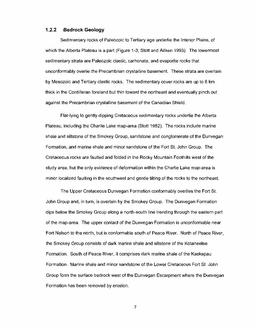
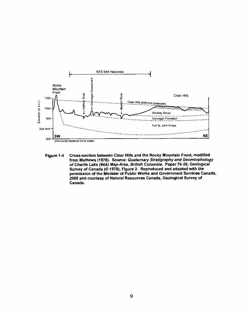
Flat-lying to gently dipping Cretaceous sedimentary rocks underlie the Alberta
Plateau, including the Charlie Lake map-area (Stott 1982). The rocks include marine
shale and siltstone of the Smokey Group, sandstone and conglomerate of the Dunvegan
Formation, and marine shale and minor sandstone of the Fort St. John Group. The
Cretaceous rocks are faulted and folded in the Rocky Mountain Foothills west of the
study area, but the only evidence of deformation within the Charlie Lake map-area is
minor localized faulting in the southwest and gentle tilting of the rocks to the northeast.
The Upper Cretaceous Dunvegan Formation conformably overlies the Fort St.
John Group and, in turn, is overlain by the Smokey Group. The Dunvegan Formation
dips below the Smokey Group along a north-south line trending through the eastern part
of the map-area. The upper contact of the Dunvegan Formation is unconformable near
Fort Nelson to the north, but is conformable south of Peace River. North of Peace River,
the Smokey Group consists of dark marine shale and siltstone of the Kotaneelee
Formation. South of Peace River, it comprises dark marine shale of the Kaskapau
Formation. Marine shale and minor sandstone of the Lower Cretaceous Fort St. John
Group form the surface bedrock west of the Dunvegan Escarpment where the Dunvegan
Formation has been removed by erosion.
LEGEND
2 Fort St. John Group
Kotaneelee Formation (Srnokey Group)
Figure 1-3 Bedrock geology of the Charlie Lake map-area (bedrock unit polygons from B.C. Geological Survey, B.C. Ministry of Energy Mines and Petroleum Resources O Province of British Columbia).
I. NTS 94A map-area i - Rocky Mountain Front
'.
W
Clear Hills
Dunvegan Formation . . . . . . . . . . . . . . . . . . . . . . . . . . . . . . . . . . '.
Clear Hills I
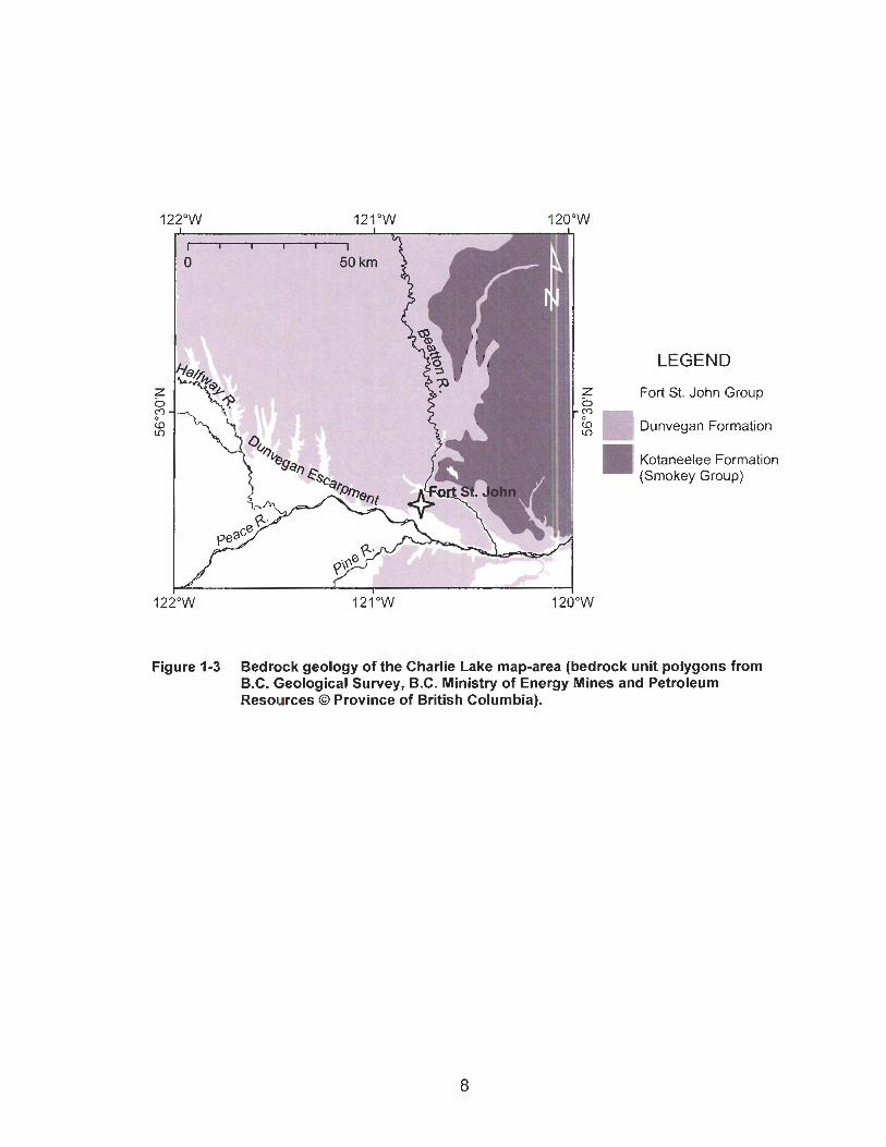
Figure 1-4 Cross-section between Clear Hills and the Rocky Mountain Front, modified from Mathews (1978). Source: Quaternary Stratigraphy and Geomorphology of Charlie Lake (94A) Map-Area, British Columbia. Paper 76-20, Geological Survey of Canada (O 1978), Figure 2. Reproduced and adapted with the permission of the Minister of Public Works and Government Services Canada, 2005 and courtesy of Natural Resources Canada, Geological Survey of Canada.
Sea level - '- -- - - --__ Fort St. John Group ---__ ----_ ----_ A___------ -----___ ----------_________________________________________________________________------- _____-----
SW NE -500
(Horizontal d~stance not to scale)
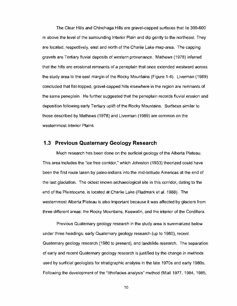
The Clear Hills and Chinchaga Hills are gravel-capped surfaces that lie 300-600
m above the level of the surrounding Interior Plain and dip gently to the northeast. They
are located, respectively, east and north of the Charlie Lake map-area. The capping
gravels are Tertiary fluvial deposits of western provenance. Mathews (1978) inferred
that the hills are erosional remnants of a peneplain that once extended westward across
the study area to the east margin of the Rocky Mountains (Figure 1-4). Liverman (1989)
concluded that flat-topped, gravel-capped hills elsewhere in the region are remnants of
the same peneplain. He further suggested that the peneplain records fluvial erosion and
deposition following early Tertiary uplift of the Rocky Mountains. Surfaces similar to
those described by Mathews (1 978) and Liverman (1 989) are common on the
westernmost Interior Plains.
1.3 Previous Quaternary Geology Research
Much research has been done on the surficial geology of the Alberta Plateau.
This area includes the "ice free corridor," which Johnston (1 933) theorized could have
been the first route taken by paleo-indians into the mid-latitude Americas at the end of
the last glaciation. The oldest known archaeological site in this corridor, dating to the
end of the Pleistocene, is located at Charlie Lake (Fladmark et al. 1988). The
westernmost Alberta Plateau is also important because it was affected by glaciers from
three different areas: the Rocky Mountains, Keewatin, and the interior of the Cordillera.
Previous Quaternary geology research in the study area is summarized below
under three headings: early Quaternary geology research (up to 198O), recent
Quaternary geology research (1980 to present), and landslide research. The separation
of early and recent Quaternary geology research is justified by the change in methods
used by surficial geologists for stratigraphic analysis in the late 1970s and early 1980s.
Following the development of the "lithofacies analysis" method (Miall 1977, 1984, 1985;

Walker 1984a, 1992a; Reading 1996), surficial geologists became more critical in their
description and interpretation of sediments, especially diamicton (Eyles et al. 1983). In
addition, MacDonald et al. (1 987) demonstrated that radiocarbon ages on gyttja and
some freshwater aquatic plants suffer an "old carbon effect." This development led to
the retraction or re-evaluation of stratigraphies that had been based on some old
radiocarbon ages.
1.3.1 Early Quaternary Geology Research
The earliest descriptions of Quaternary geology in and around the study area are
those of Selwyn (1 877) and Dawson (1 881). Both geologists noted thick deposits of
unconsolidated sediment along Peace River and its tributaries. Dawson described the
Quaternary deposits in some detail. He recognized extensive glaciolacustrine deposits
and theorized that sediments of montane and Laurentide provenance were deposited
throughout the study area from icebergs and ice shelves floating in an extensive
proglacial lake between Rocky Mountain glaciers and the Laurentide Ice Sheet.
Beach and Spivak (1943) investigated Peace River Canyon directly west of the
study area. They concluded that the canyon was cut at the end of the last (Late
Wisconsinan) glaciation after a terminal moraine was constructed between Portage and
Bullhead mountains, damming ancestral Peace River. Waters impounded behind the
moraine flowed over a saddle south of Portage Mountain and excavated Peace River
Canyon.
Henderson (1959) identified what he thought were deposits of three or possibly
four Laurentide glacial advances in the west half of the Winagami map-area (NTS 83N),
about 200 km east-southeast of Fort St. John. The oldest glacial deposit, termed
ancient till by Henderson, was assigned a pre-Wisconsinan age. The next younger till,
termed lower till, was found at the base of a thick sequence of Quaternary sediments
exposed in deep gullies. Henderson assigned the lower till to an Early Wisconsinan or
pre-Wisconsinan glaciation. The overlying, middle till was interpreted by Henderson to
be Early Wisconsinan in age. The youngest, upper till is widespread in the area and was
attributed to Late Wisconsinan glaciation. None of the four tills was directly dated,
although Henderson reports leaching depths and soil development on the middle and
upper tills.
Henderson (1959) mapped buried paleo-valleys similar in size and position to the
modern valleys of Peace, Smokey, and Little Smokey rivers. He identified only one
mature paleo-valley for each of these rivers and hypothesized that the valleys were
established prior to glaciation. He also argued that glaciations before the Late
Wisconsinan were not extensive enough to rearrange the drainage. In contrast, the
paleo-valleys were completely filled with sediment during the Late Wisconsinan, forcing
the rivers to locally establish new courses during deglaciation.
Tokarsky (1967) documented groundwater resources in Quaternary deposits in
the southwestern part of the Peace River map-area (NTS 84C). He mapped two buried
paleo-valleys, which he termed the Shaftesbury and Berwyn channels. The Shaftesbury
channel is parallel to the modern Peace River, and the Berwyn channel is one of its
tributaries. Tokarsky noted three levels of fluvial deposition within these valleys. The
highest deposit, the Grimshaw gravel, is associated with a high terrace of the
Shaftesbury channel. Tokarsky assigned it a preglacial age because of the absence of
eastern-provenance lithologies in the gravel. A lower, younger gravel unit is associated
with an intermediate terrace of the Shaftesbury channel and, like the Grimshaw gravel,
contains no stones of eastern provenance. The youngest, or main channel gravel
grades upward from preglacial to glaciofluvial. All buried valleys and associated fluvial
gravel deposits are overlain by a single Laurentide till.
St-Onge (1972) studied the Quaternary geology of the Ft. Assiniboine area within
the losegun map-area (NTS 83K), northwest of Edmonton. Sangamonian or older fluvial
gravel with no eastern-provenance clasts overlies Cretaceous bedrock. The gravel is
overlain by two Laurentide tills, which St-Onge assigned to the Wisconsinan Stage. The
two tills are separated by glaciofluvial gravel and sand containing wood that yielded a
radiocarbon age of >52,200 I4C yrs BP (GSC-1019-2). This radiocarbon age indicates
that the lower till is no younger than Early Wisconsinan. St-Onge inferred that the upper
till is Late Wisconsinan in age. Radiocarbon ages on postglacial sediments suggest that
the area was ice-free by 11,000 to 10,500 I4c yrs BP.
NTS 93P, which lies directly south of the Charlie Lake map-area, was studied by
Reimchen and Rutter (1 972) and Reimchen and Bouvier (1 980). They concluded that
the area was overridden by glaciers during three Cordilleran and two Laurentide
advances. Reimchen and Rutter (1972) noted a zone of mixed western and eastern
lithologies within the youngest till sheet. Further, they claimed that drumlins they
attributed to the Laurentide Ice Sheet are truncated by drumlins formed by the
Cordilleran Ice Sheet. They concluded that the Laurentide glacial maximum in this area
preceded the Cordilleran maximum and that the two ice sheets did not coalesce.
Neither Reimchen and Rutter (1972) nor Reimchen and Bouvier (1980) provided sub-till
radiocarbon ages. Reimchen and Rutter (1972), however, stated that till of the oldest
Cordilleran advance, unlike the two younger tills, is weathered and may have been
deposited during Early Wisconsinan or lllinoian time. The two younger Cordilleran tills
were deposited by glaciers that terminated in the glacial lake that formed when the
drainage was blocked by the Late Wisconsinan Laurentide Ice Sheet.
Carlson and Hackbarth (1974) published a map showing buried paleo-valleys in
the NTS 83M map-area, which is adjacent to the southeast corner of the Charlie Lake
map-area. The Shaftesbury channel, originally defined by Tokarsky (1 967), coincides
approximately with modern Peace River; the Wembley channel (Jones 1966) follows
modern Beaverlodge River; and the Bezanson channel follows modern Smokey River.
Rutter (1 977) described the Quaternary stratigraphy of the Rocky Mountain
Trench west of the Charlie Lake map-area. He proposed four Cordilleran advances, the
oldest of which reached the Charlie Lake map-area and was Early Wisconsinan or older
in age. Rutter argued that the other three advances were Late Wisconsinan. The most
extensive of the three Late Wisconsinan advances is the Early Portage Mountain
advance, which, according to Rutter, occurred early in the Late Wisconsinan and
involved coalescence of Cordilleran and Laurentide ice.
Mathews (1 963, 1972, 1973, 1978, 1980) made the most significant contribution
to our understanding of the Quaternary geology and history of the Charlie Lake map-
area. He concluded that two or possibly three Laurentide advances, and three or
possibly four Cordilleran advances affected the study area. He presented direct and
indirect evidence that all Laurentide advances extended into the Charlie Lake map-area.
He identified deposits of two of the four Cordilleran advances in the study area and
suggested that the other two advances did not reach that far east. Glacial advances
were separated by non-glacial periods, during which the east-flowing rivers carved
broad, mature valleys. Successive interglacial rivers generally followed the same paths
as their predecessors, but were locally diverted due to in-filling of paleo-valleys with drift.
Mathews (1 978) noted distinctive granite and granitoid gneiss clasts of eastern
(Canadian Shield) provenance in two paleo-valley gravel units. He argued that the
Laurentide Ice Sheet approached or overrode the study area prior to the time of gravel
deposition, because Shield clasts could not have reached the area without having been

carried there by a glacier or on ice bergs in a lake dammed by the nearby Laurentide Ice
Sheet.
The oldest unconsolidated sediment that Mathews (1 978) mapped is fluvial
gravel exposed in a borrow pit 8 km northwest of Clayhurst about 325 m above Peace
River. The gravel contains no Shield clasts, therefore Mathews interpreted it to be
preglacial.
Mathews (1 978) inferred an old Laurentide glaciation on the basis of Shield
clasts that he found in fluvial gravel along the north side of Peace River between Alces
River and Golata Creek. The gravel lies on a flat bedrock shelf about 150 m above the
present level of Peace River. The same gravel is present on a bedrock shelf north of
Peace River near Fort St. John, but there it contains no Shield clasts. On the basis of
these observations, Mathews (1978) concluded that the Laurentide Ice Sheet terminated
somewhere between Fort St. John and Golata Creek during this early glaciation.
Mathews (1978) inferred a second glaciation from an exposure of two tills and
Shield clasts in fluvial gravel. A river bluff 6.5 km southeast of Fort St. John exposes two
tills separated by what Mathews interpreted to be interglacial silt. Shield clasts occur in
fluvial gravel within a terraced paleo-valley with a floor about 30 m above present Peace
River. The paleo-valley is much wider than the modern Peace valley, therefore Mathews
concluded that it developed over a long period of time. A mammoth tooth recovered
from the gravel yielded a radiocarbon age of 27,400 +/- 580 I4c yrs BP (GSC-2034),
suggesting deposition during the Middle Wisconsinan. Mathews (1978) inferred that the
second glaciation was more extensive than the first because Shield clasts are present in
the younger gravel throughout the study area.
Deposits of the last glaciation include glaciolacustrine sediments filling Middle
Wisconsinan river valleys and overlying till, which occurs throughout the study area.
Mathews (1978) noted that the till contains both Cordilleran and Shield clasts. Clasts of
western provenance are dominant in the western third of the map-area, whereas
eastern-provenance clasts are dominant elsewhere in the map-area. Western-
provenance clasts include friable lithologies that would not survive lengthy fluvial
transport, but could be transported by glacial ice. Mathews interpreted this distribution to
be due to coalescence of the Cordilleran and Laurentide ice sheets in the Charlie Lake
area. The absence of a sharp boundary between western- and eastern-provenance till
may be due to shifts in the zone of coalescence of the two ice sheets. Mathews'
inference is supported by drumlins and flutings that appear to indicate deflection of west-
flowing Laurentide ice toward the southwest.
Deglaciation of the study area at the end of the last glaciation was accompanied
by the formation and evolution of Glacial Lake Peace. Mathews (1978) documented the
evolution of the lake from its shorelines and spillways. He was unable to directly date
Glacial Lake Peace, but regional evidence suggests that the lake drained before 10,000
14C yrs BP (Reimchen and Rutter 1972; Rutter et al. 1972; St-Onge 1972).
Mathews (1 980) later provided a more detailed discussion of the Late
Wisconsinan deglaciation of northeastern British Columbia. Drainage of Glacial Lake
Peace occurred between 10,400 +I- 170 I4C yrs BP and 9960 +I- 170 14C yrs BP. Peace
River and its tributaries began to incise their valleys as soon as Glacial Lake Peace
withdrew from the study area.
1.3.2 Recent Quaternary Geology Research
Catto (1 984) documented Quaternary deposits in the Edmonton area, which is
about 550 km southeast of the Charlie Lake map-area. He showed that a preglacial
fluvial gravel (Saskatchewan Gravel) overlies bedrock and is, in turn, overlain by a single
Laurentide till of Late Wisconsinan age.

Liverman (1 989) mapped the surficial geology of the Grande Prairie map-area
(NTS 83M), which is adjacent to the southeast corner of the Charlie Lake map-area. His
stratigraphy is based largely on exposures near Watino and on Simonette River. The
lowermost Quaternary unit at these sections is quartzite-rich fluvial gravel that Liverman
considered to be conformable with overlying glaciofluvial gravel and sand. The fluvial
gravel contains no minerals or clasts of eastern provenance and therefore was
interpreted to be preglacial. The overlying glaciofluvial gravel and sand contain detrital
wood that yielded radiocarbon ages ranging from 43,500 +I- 620 I4c yrs BP (GSC-1020)
to 27,400 +I- 850 14c yrs BP (1-4878). The glaciofluvial sediments, in turn, are overlain
by Late Wisconsinan Laurentide till. Liverman concluded that the Laurentide Ice Sheet
reached the Grand Prairie area only once, during the Late Wisconsinan. He does not
reconcile his interpretation with those of Henderson (1959) and St. Onge (1 972).
Liverman et al. (1989), however, suggested that the Grand Prairie stratigraphy could be
consistent with that of Mathews (1978) if:
1. the early Laurentide glaciers postulated by Mathews (1978) did not reach Watino, implying a lobate glacial margin; or
2. all Laurentide glacial events recognized by Mathews (1978) are Late Wisconsinan in age.
Liverman et al. (1989) stated that Mathews (1 978) did not provide chronological
or paleo-environmental evidence to demonstrate that the older paleo-valley gravel and
inter-till silt units are interglacial or interstadial deposits. They suggested that the gravel
and silt units may have been deposited in the Late Wisconsinan during minor retreat and
re-advance of the Laurentide Ice Sheet.
Andriashek and Fenton (1989) studied the surficial geology of the Sand River
map-area (NTS 73L) at the Alberta -Saskatchewan border about 600 km east of the
Charlie Lake map-area. They reported preglacial deposits and four tills separated by
paleosols. Although there are no absolute dates from the area, weathering profiles on
the tills suggest long periods of subaerial exposure between glaciations. Andriashek
and Fenton (1989) assigned the upper till to the Late Wisconsinan Substage and the
next older till to the Early Wisconsinan Substage. They considered the two oldest tills to
be pre-Wisconsinan in age.
Bobrowsky (1989) documented the Quaternary stratigraphy and geologic history
of the Northern Rocky Mountain Trench, northwest of the Charlie Lake map-area. He
recognized an extensive, early Cordilleran glaciation and traced its deposits to the
Interior Plains east of the Rocky Mountain front. Like Rutter (1977), he was unable to
date this glaciation. He suggested that it could be Early Wisconsinan, Illinoian, or even
older, and referred to it simply as pre-Late Wisconsinan. Unlike Rutter, however,
Bobrowsky (1989) recognized only one Cordilleran advance during the Late
Wisconsinan. He suggested that lithostratigraphic units that had previously been
interpreted as till were, instead, products of sediment gravity flows. The single Late
Wisconsinan Cordilleran glaciation built an end moraine at Portage Mountain near
Hudson's Hope. It culminated later than the Late Wisconsinan Laurentide advance.
Bobrowsky et al. (1 991) completed a reconnaissance study of the Quaternary
geology of the Peace River region, including the southern half of the NTS 94A map-area
and the northern half of the adjacent NTS 93P map-area. They presented two models of
the glacial history of the study area. The first model is based on the publications of
Rutter (1 976, 1977) and Mathews (1 978, 1980); it features two or three Laurentide
advances and three or four Cordilleran advances. The second model is based on
Bobrowsky (1989); it includes one Laurentide advance and two Cordilleran advances.
Bobrowsky et al. (1992) concluded that the latter model better explains the field
evidence. Deposits of the single Laurentide event overlie rhythmically laminated and
bedded sand, silt, and clay interpreted to have been deposited in a proglacial lake
dammed by advancing Laurentide ice. The glaciolacustrine sediments, in turn, overlie
gravel deposited as outwash on a braid-plain. Deposits of Glacial Lake Peace overlie
the single Laurentide till. Bobrowsky et al. (1992) also identified surface Shield erratics
throughout the study area, which allowed them to extend the western limit of Laurentide
ice about 60 km beyond that proposed by Mathews (1978).
Catto (1991 b) found no clasts or minerals of eastern provenance in the west-
central part of the NTS 93P map-area, thus moving the western limit of Laurentide ice in
that area east of the limit proposed by Reimchen and Rutter (1 977).
Charlie Lake cave has been extensively studied because it is the oldest known
archaeological site in the postulated "Ice-free Corridor" (Fladmark 1981; Fladmark et al.
1988; Driver 1988, 1998, 2001; Driver et al. 1996). The site has yielded radiocarbon
ages as old as 10,770 +I- 120 14c yrs BP (SFU-454) (Fladmark et al. 1988), and
deglaciation thus occurred considerably earlier.
Woolf (1 993) reported a radiocarbon age of 10,380 +I- 100 14C yrs BP (Beta
44201) on a bone recovered from deltaic sediments deposited in a southern arm of
Glacial Lake Peace. This delta is probably associated with one of three stages of the
Lake Peace defined by Mathews (1980): the Bessbourough stage, a lower unnamed
stage, and the final, Clayhurst stage. Assignment of the dated deltaic sediments to the
Bessbourough or unnamed stage requires the lake to have persisted into the Holocene,
which seems unlikely based on regional evidence. Assignment to the Clayhurst stage
requires north-south isostatic depression of about 0.0006, which would imply that
isostatic depression was dominated by Cordilleran ice.
Young et al. (1994) reported 29 radiocarbon ages from vertebrate bones
recovered from gravel near Edmonton that had previously been interpreted as preglacial.
The radiocarbon ages range from 21,330 +I- 340 to 42,910 +I- 3940 I4c yrs BP, thus
establishing a Middle Wisconsinan age for the gravel. The absence of Shield clasts in
the gravel demonstrates that no Laurentide glacier reached Edmonton prior to the Late
Wisconsinan. Young et al. (1994) further inferred that the only Laurentide glaciation of
areas south and southwest of Edmonton was Late Wisconsinan in age. They reasoned
that Laurentide ice could not have bypassed Edmonton to reach higher elevations to the
west and southwest. This inference is supported by ice sheet modelling (Mathews 1974)
and analysis of the recessional pattern of Late Wisconsinan Laurentide ice (Dyke and
Prest 1987).
Catto et al. (1996) summarized surficial geological studies in the western Peace
River - Grand Prairie areas of the Alberta Plateau and adjacent Rocky Mountains. They
confirmed and extended the findings of Catto (1 984), Liverman (1 989), Liverman et al.
(1989), and Young et al. (1994) and concluded that the Late Wisconsinan Laurentide Ice
Sheet was the only eastern-provenance glacier to have reached the area. They also
extended the mapping of the western limit of Laurentide glaciation done by Bobrowsky et
al. (1992) to the south. The limit reaches to 950 m a.s.1. in valleys of the Rocky
Mountain front, suggesting that Late Wisconsinan Laurentide ice was not opposed by
Cordilleran ice, because it would not have been able to ascend these valleys if
Cordilleran ice was present in them.
Catto et al. (1996) reported Cordilleran till along lower Halfway River and fields of
glacial flutes emanating from the Redwillow River valley in the NTS 94P map-area.
They assigned both the till and the flutes to the Early Cordilleran advance of Rutter
(1 977), Bobrowsky (1 989), and Bobrowsky and Rutter (1 992). The Cordilleran till lies
below Late Wisconsinan Laurentide till, and the flutes indicate unobstructed Cordilleran
ice flow onto the Alberta Plateau from the west. Catto et al. (1996) also reported two
new and important radiocarbon ages. They obtained an age of >51,000 I4c yrs BP
(GSC-4263-HP) on wood fragments from the Simonette section, the oldest radiocarbon
age from that area. A piece of wood from the contact between Late Wisconsinan till and
overlying Glacial Lake Peace sediments in the Fort St. John area yielded an age of
13,970 +I- 170 14c yrs BP (TO-2742). This age is a minimum for the deglaciation of this
part of Peace River valley and a maximum for the establishment of Glacial Lake Peace.
Catto et al. (1996) questioned Mathew's contention that Laurentide and
Cordilleran ice coalesced in the Charlie Lake map-area. They suggested that the low
proportion of eastern-provenance clasts in the western third of the map-area is more
likely due to dilution of eastern-provenance clasts in the till by western-provenance
sediment. The Laurentide Ice Sheet ascended the regional slope as it flowed across the
map-area; as it did so, it likely compressed, thereby increasing its erosive power and
incorporating more local and Cordilleran sediment.
Catto et al. (1 996) also disputed Mathews' (1978) conclusion that two Laurentide
tills are separated by interglacial silt by suggesting that the silt records a re-advance of
Late Wisconsinan age. They do not, however, explain Mathews' evidence of separate,
mature interglacial or interstadial paleo-valleys with eastern-provenance lithologies in
fluvial channel deposits, nor do they reconcile their results with the conclusions of St-
Onge (1 972).
Jackson et al. (1997) used cosmogenic surface exposure dating techniques to
show that the Foothills Erratic Train is Late Wisconsinan in age. The Foothills Erratics
Train comprises quartzite boulders derived from the Rocky Mountains near Jasper,
Alberta. The erratics extend east of the Front Ranges and southward across the Interior
Plains past Calgary. They delineate a zone of coalescence of Cordilleran and
Laurentide ice.
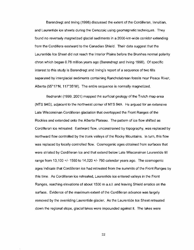
Barendregt and Irving (1998) discussed the extent of the Cordilleran, Innuitian,
and Laurentide ice sheets during the Cenozoic using geomagnetic techniques. They
found no reversely magnetized glacial sediments in a 2000-km-wide corridor extending
from the Cordillera eastward to the Canadian Shield. Their data suggest that the
Laurentide Ice Sheet did not reach the Interior Plains before the Brunhes normal polarity
chron which began 0.78 million years ago (Barendregt and Irving 1998). Of specific
interest to this study is Barendregt and Irving's report of a sequence of two tills
separated by interglacial sediments containing Rancholabrean fossils near Peace River,
Alberta (55'1 7'N, 11 7'35'W). The entire sequence is normally magnetized.
Bednarski (1999, 2001) mapped the surficial geology of the Trutch map-area
(NTS 94G), adjacent to the northwest corner of NTS 94A. He argued for an extensive
Late Wisconsinan Cordilleran glaciation that overtopped the Front Ranges of the
Rockies and extended onto the Alberta Plateau. The pattern of ice flow shifted as
Cordilleran ice retreated. Eastward flow, unconstrained by topography, was replaced by
northward flow controlled by the trunk valleys of the Rocky Mountains. In turn, this flow
was replaced by locally controlled flow. Cosmogenic ages obtained from surfaces that
were striated by Cordilleran ice and that extend below Late Wisconsinan Laurentide till
range from 13,100 +/- 1560 to 14,020 +/- 760 calendar years ago. The cosmogenic
ages indicate that Cordilleran ice had retreated from the summits of the Front Ranges by
this time. As Cordilleran ice retreated, Laurentide ice entered valleys in the Front
Ranges, reaching elevations of about 1500 m a.s.1. and leaving Shield erratics on the
surface. Evidence of the maximum extent of the Cordilleran advance was largely
removed by the overriding Laurentide glacier. As the Laurentide Ice Sheet retreated
down the regional slope, glacial lakes were impounded against it. The lakes were
initially confined to mountain valleys, but later expanded to cover large areas of the
Interior Plains.
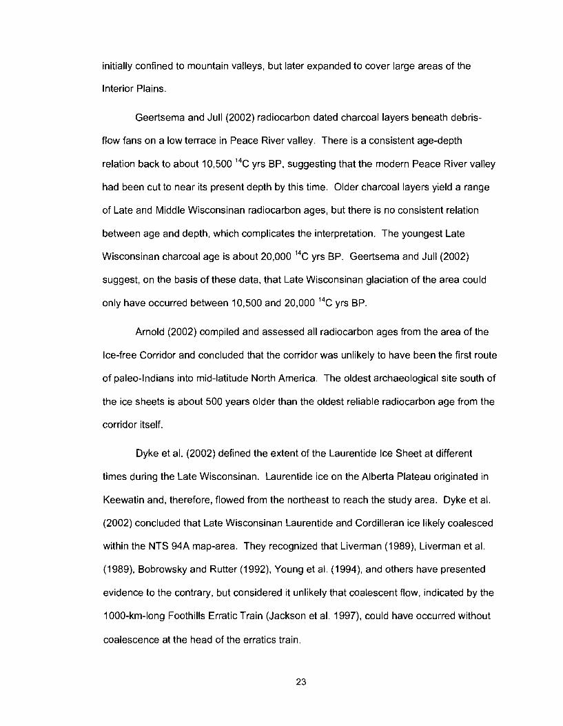
Geertsema and Jull (2002) radiocarbon dated charcoal layers beneath debris-
flow fans on a low terrace in Peace River valley. There is a consistent age-depth
relation back to about 10,500 14c yrs BP, suggesting that the modern Peace River valley
had been cut to near its present depth by this time. Older charcoal layers yield a range
of Late and Middle Wisconsinan radiocarbon ages, but there is no consistent relation
between age and depth, which complicates the interpretation. The youngest Late
Wisconsinan charcoal age is about 20,000 14c yrs BP. Geertsema and Jull (2002)
suggest, on the basis of these data, that Late Wisconsinan glaciation of the area could
only have occurred between 10,500 and 20,000 14c yrs BP.
Arnold (2002) compiled and assessed all radiocarbon ages from the area of the
Ice-free Corridor and concluded that the corridor was unlikely to have been the first route
of paleo-Indians into mid-latitude North America. The oldest archaeological site south of
the ice sheets is about 500 years older than the oldest reliable radiocarbon age from the
corridor itself.
Dyke et al. (2002) defined the extent of the Laurentide Ice Sheet at different
times during the Late Wisconsinan. Laurentide ice on the Alberta Plateau originated in
Keewatin and, therefore, flowed from the northeast to reach the study area. Dyke et al.
(2002) concluded that Late Wisconsinan Laurentide and Cordilleran ice likely coalesced
within the NTS 94A map-area. They recognized that Liverman (1989), Liverman et al.
(1 989), Bobrowsky and Rutter (1 992), Young et al. (1 994), and others have presented
evidence to the contrary, but considered it unlikely that coalescent flow, indicated by the
1000-km-long Foothills Erratic Train (Jackson et al. 1997), could have occurred without
coalescence at the head of the erratics train.
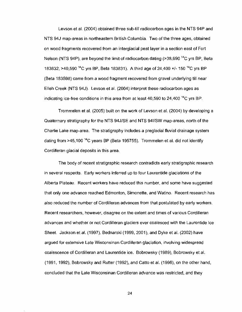
Levson et al. (2004) obtained three sub-till radiocarbon ages in the NTS 94P and
NTS 94J map-areas in northeastern British Columbia. Two of the three ages, obtained
on wood fragments recovered from an interglacial peat layer in a section east of Fort
Nelson (NTS 94P), are beyond the limit of radiocarbon dating (>38,690 14c yrs BP, Beta
183832; >40,590 14c yrs BP, Beta 183831). A third age of 24,400 +I- 150 14c yrs BP
(Beta 183598) came from a wood fragment recovered from gravel underlying till near
Elleh Creek (NTS 94J). Levson et al. (2004) interpret these radiocarbon ages as
indicating ice-free conditions in this area from at least 40,590 to 24,400 14c yrs BP.
Trommelen et al. (2005) built on the work of Levson et al. (2004) by developing a
Quaternary stratigraphy for the NTS 94JlSE and NTS 9411SW map-areas, north of the
Charlie Lake map-area. The stratigraphy includes a preglacial fluvial drainage system
dating from >45,100 14c years BP (Beta 195755). Trommelen et al. did not identify
Cordilleran glacial deposits in this area.
The body of recent stratigraphic research contradicts early stratigraphic research
in several respects. Early workers inferred up to four Laurentide glaciations of the
Alberta Plateau. Recent workers have reduced this number, and some have suggested
that only one advance reached Edmonton, Simonette, and Watino. Recent research has
also reduced the number of Cordilleran advances from that postulated by early workers.
Recent researchers, however, disagree on the extent and times of various Cordilleran
advances and whether or not Cordilleran glaciers ever coalesced with the Laurentide Ice
Sheet. Jackson et al. (1997), Bednarski (1999, 2001), and Dyke et al. (2002) have
argued for extensive Late Wisconsinan Cordilleran glaciation, involving widespread
coalescence of Cordilleran and Laurentide ice. Bobrowsky (1989), Bobrowsky et al.
(1 991, 1 992), Bobrowsky and Rutter (1 992), and Catto et al. (1996), on the other hand,
concluded that the Late Wisconsinan Cordilleran advance was restricted, and they
attributed the most extensive Cordilleran advance to an earlier glaciation. It is unlikely
that this disagreement is due to geography. The areas where these studies were
conducted are near enough that the difference between a full-fledged continental
glaciation and a restricted advance would have been noted by researchers. The source
of the disagreement is likely due to the different interpretations of the researchers.
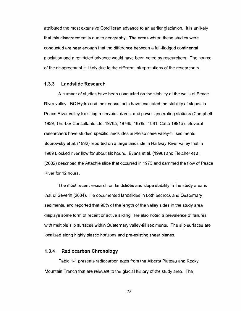
1.3.3 Landslide Research
A number of studies have been conducted on the stability of the walls of Peace
River valley. BC Hydro and their consultants have evaluated the stability of slopes in
Peace River valley for siting reservoirs, dams, and power-generating stations (Campbell
1959; Thurber Consultants Ltd. 1 976a, 1 976b, 1 976c, 1981 ; Catto 1991 a). Several
researchers have studied specific landslides in Pleistocene valley-fill sediments.
Bobrowsky et al. (1992) reported on a large landslide in Halfway River valley that in
1989 blocked river flow for about six hours. Evans et al. (1996) and Fletcher et al.
(2002) described the Attachie slide that occurred in 1973 and dammed the flow of Peace
River for 12 hours.
The most recent research on landslides and slope stability in the study area is
that of Severin (2004). He documented landslides in both bedrock and Quaternary
sediments, and reported that 90% of the length of the valley sides in the study area
displays some form of recent or active sliding. He also noted a prevalence of failures
with multiple slip surfaces within Quaternary valley-fill sediments. The slip surfaces are
localized along highly plastic horizons and pre-existing shear planes.
1.3.4 Radiocarbon Chronology
Table 1-1 presents radiocarbon ages from the Alberta Plateau and Rocky
Mountain Trench that are relevant to the glacial history of the study area. The
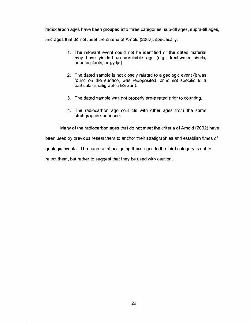
radiocarbon ages have been grouped into three categories: sub-till ages, supra-till ages,
and ages that do not meet the criteria of Arnold (2002), specifically:
1. The relevant event could not be identified or the dated material may have yielded an unreliable age (e.g., freshwater shells, aquatic plants, or gyttja).
2. The dated sample is not closely related to a geologic event (it was found on the surface, was redeposited, or is not specific to a particular stratigraphic horizon).
3. The dated sample was not properly pre-treated prior to counting.
4. The radiocarbon age conflicts with other ages from the same stratigraphic sequence.
Many of the radiocarbon ages that do not meet the criteria of Arnold (2002) have
been used by previous researchers to anchor their stratigraphies and establish times of
geologic events. The purpose of assigning these ages to the third category is not to
reject them, but rather to suggest that they be used with caution.
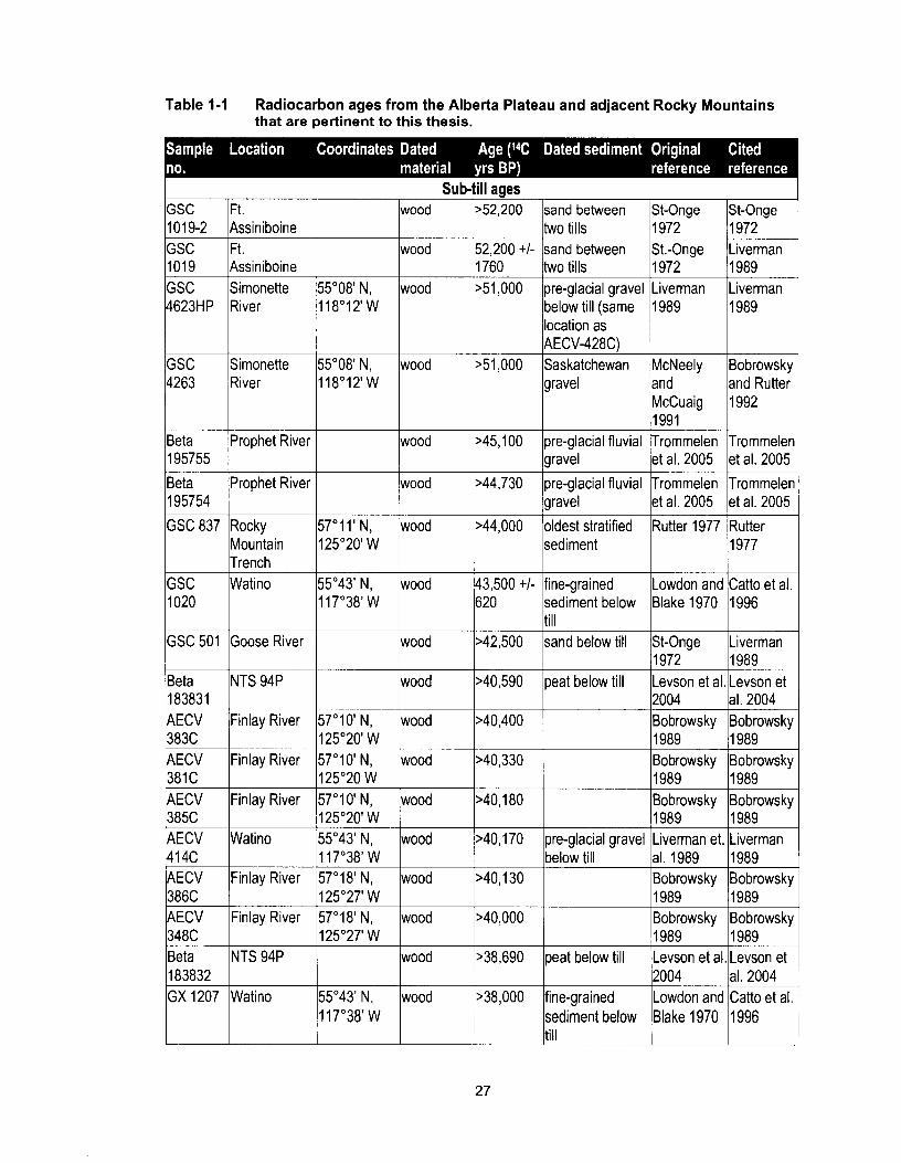
Table 1-1 Radiocarbon ages from the Alberta Plateau and adjacent Rocky Mountains that are pertinent to this thesis.
Sub-till ages GSC 1019-2 GSC 1019 GSC 4623HP
GSC 4263
Beta 195755
Beta 195754
GSC 837
GSC 1020
GSC 501
Ft. Assiniboine Ft. Assiniboine Simonette River
Simonette River
Prophet River
Prophet River
Rocky Mountain Trench
wood
Watino
Goose River
1 8383 1 AECV
57'1I1N, 125'20' W
>40,590
383C AECV Bobrowsky Bobrowsky ?
55'08' N, 118'12'W
55'08' N, 118'12'W
55'43' N, 11 7'38' W
Finlay River 2004 Bobrowsky
wood
wood
wood
wood
wood
wood
~52 ,200
52,200 +I- 1760 >51,000
>51,000
>45,100
>44,730
wood
peat below till al. 2004 Bobrowsky
Finlay River
wood
wood
57'1 0' N,
381 C AECV 38% AECV 414C AECV 386C AECV 348C Beta
sand between two tills sand between two tills pre-glacial gravel below till (same location as AECV-428C) Saskatchewan gravel
pre-glacial fluvial gravel
pre-glacial fluvial gravel
>44,000
1972 Levson et al.
125'20' W 57'10' N,
183832 GX 1207
43,500 +I- 620
>42,500 1989 Levson et
wood
wood
Finlay River
Watino
Finlay River
Finlay River
NTS 94P
St-Onge 1972 St.-Onge 1972 Liverman 1989
McNeely and McCuaig 1991 Trommelen et al. 2005
Trommelen et al. 2005
oldest stratified sediment
>40,400
Watino
St-Onge 1972 Liverman 1989 Liverman 1989
Bobrowsky and Rutter 1992
Trommeler et al. 2005
Trommeler et al. 2005
fine-grained sediment below till sand below till
125'20 W 57'1 0' N, 125'20' W 55'43' N, 1 17'38' W 57'18' N, 125'27' W 57'1 8' N, 125'27' W
Rutter 1977
55'43' N,
Rutter 1977
Lowdon and Blake 1970
St-Onge
wood
wood
wood
wood
wood
Catto et al. 1996
Liverman
wood
>40,180
>40,170
>40,130
>40,000
>38,690
>38,000
pre-glacial gravel below till
peat below till
fine-grained
1989 Bobrowsky 1989 Liverman et. al. 1989 Bobrowsky 1989 Bobrowsky 1989 Levson et al.
1989 Bobrowsky 1989 Liverman 1989 Bobrowsky 1989 Bobrowsky 1989 Levson et
2004 Lowdon and
al. 2004 Catto et al.
353C 125'28' W 2870 1989 1989 AECV Simonette 55'08' N, wood 37,010 +I- pre-glacial gravel Liverman et. Liverman 428C River 118'12' W 2690 below till al. 1989 1989 AECV 350C AECV 41% 12615
1 2516
1 2626
AECV 382C AECV
Bobrowsky Bobrowsky +--I""-
Finlay River
Watino
Watino
Watino
416C AECV
Watino
sediment in the 1 1977 /125'27' 1 I larea, minimum
57'10' N, 125'20' W 55'43'N, 11 7'38' W 55'43' N, 11 7'38' W
55'43' N, 1 17'38' W
Finlay River
352C GSC
125'20' W 55'43' N,
wood
wood
wood
wood
Watino 155'43' N, 117'38' W
1 17'38' W 57'09' N,
Finlay River
14878
wood
wood Finlay River
wood
GSC 2034 AECV 379C
36,510 +I- 2570 36,220 +I- 2520 35,500 +3300 1 - 2300 35,500 +2300 1 - 1800
57'10' N,
11440 wood 129,880 +I-
125'17'W 57'1 8' N,
Watino
Beta 188305
Beta 183598 AECV 351 C
34,900 +3000 1 - 2000 32,750 +I- 3180 31,530 +I-
Taylor
FinlayRiver
Bobrowsky
pre-glacial sand below till fine-grained sediment below till fine-grained sediment below till
below till
wood
55'43' N,
Peace River
Elleh Creek
Finlay River
Bobrowsky
fine-grained sediment below till
pre-glacial sand
11 7'38' W
56'09' N, 120'43' W 57"18'N, 125'27' W
1989 Liverman et. al. 1989 Lowdon and Blake 1970
Lowdon and Blake 1970
al. 1989 Bobrowsky
1230 >28,000
wood
56'08' N, 1 20'42' W
57'16' N, 1 25'28' W
1989 Liverman 1989 Catto et al. 1996
Catto et al. 1996
Westgate et al. 1971, 1972 Bobrowsky 1989 Liverman et.
1989 Bobrowsky
mammoth tooth wood
Liverman 1989
Bobrowsky 1989 Liverman
oldest stratified
27,400 +I-
bison vertebrae
wood
wood
850
27,400 +I- 580 26,800 +I- 1450
1989 Rutter 1977
age for deposit fine-grained
26,450 +I- 31 0
24,400 +I- 150 23,280 +I- 750
1989 Rutter
sediment below till interstadial paleo- valley gravel
Westgate et
fluvial gravel underlying Glacial Lake Mathews sediment fluvial gravel underlying till
Liverman al. 1971, 1972 Mathews 1978 Bobrowsky 1989
1989
Mathews 1978 Bobrowsky 1989
this thesis
Levson et al. 2004 Bobrowsky 1989
this thesis
Levson et al. 2004 Bobrowsky 1989

11 17'20' W ltusk 1450 I land utter land utter
r 0 2742 ~ t . St. John
1992 1992
SFU 223 Boone Lake I-
nla
TO 708
Bear Flat
Bear Flat
Finlay River
GSC 859
I
GSC l ~ a t i n o
Ft. Assiniboine
56'17' N, 121 '12' W
57'1 7' N, 125'28' W
Su~ra-till aaes
2895 RlDDL 392 AECV
detrital charcoal
wood
Charlie Lake cave Watino
56'17' N, 10,770 +I- cultural layer Fladmark et Liverman 120'56' W Ic0llagen from bone I 120 1 lal. 1988 11989
20,000 (error not available) 15,180 +I- 100
i6'10' N, wood 13,970 +I- - 120'44' W
wood
till-Glacial Lake Peace contact postglacial sediment above till postglacial terrace
55'35' N, 1 19'26' W
55'43' N, 11 7'38' W
56'17' N, /collagen 10,450 +I- lcultural layer Fladmark et Liverman 120'56' W from bone 150 lal.1988 1989
debris-flow sediment on terrace
10,900 +I- 160
56'17' N, charcoal 121'12' W
Catto et al. 1996 White et al. 1985
Jackson and Pawson 1984
wood
bone
Geertsema and Jull 2002 Bobrowsky 1989
Catto et al. 1996 Liverman 1989
Liverman 1989
1 1,700 +I- 260
11,200 +I- 100
sandy silt covered by ablation till or mudflow
10,500 (error not available)
10,380 +I- 160 10,380 +I- 100
Geertsema and Jull 2002 Bobrowsky 1989
St-Onge 1972
debris-flow sediment on postglacial terrace
cultural layer
deltaic sediment of a southern arm of Glacial Lake Peace
56'09' N, bone 120'42' W
1 1 7'38' W 56'17' N,
St-Onge 1972
10,240 +I- 160
10,200 +I- 55'43' N,
120'56' W 55'43' N,
Geertsema and Jull 2002
Fladmark et al. 1988 Woolf 1993
bone
bone
Geertsema and Jull 2002
Liverman 1989 Woolf 199:
postglacial terrace sediment
postglacial
wapiti rib
100 10,100 +I-
Bobrowsky et al. 1991
Churcher
210 9920 +I-
Bobrowsky and Rutter 1992 Catto et al.
terrace cultural layer
Burns,
1984 Driver 1988
1996 Liverrnan
1996 Catto et al.
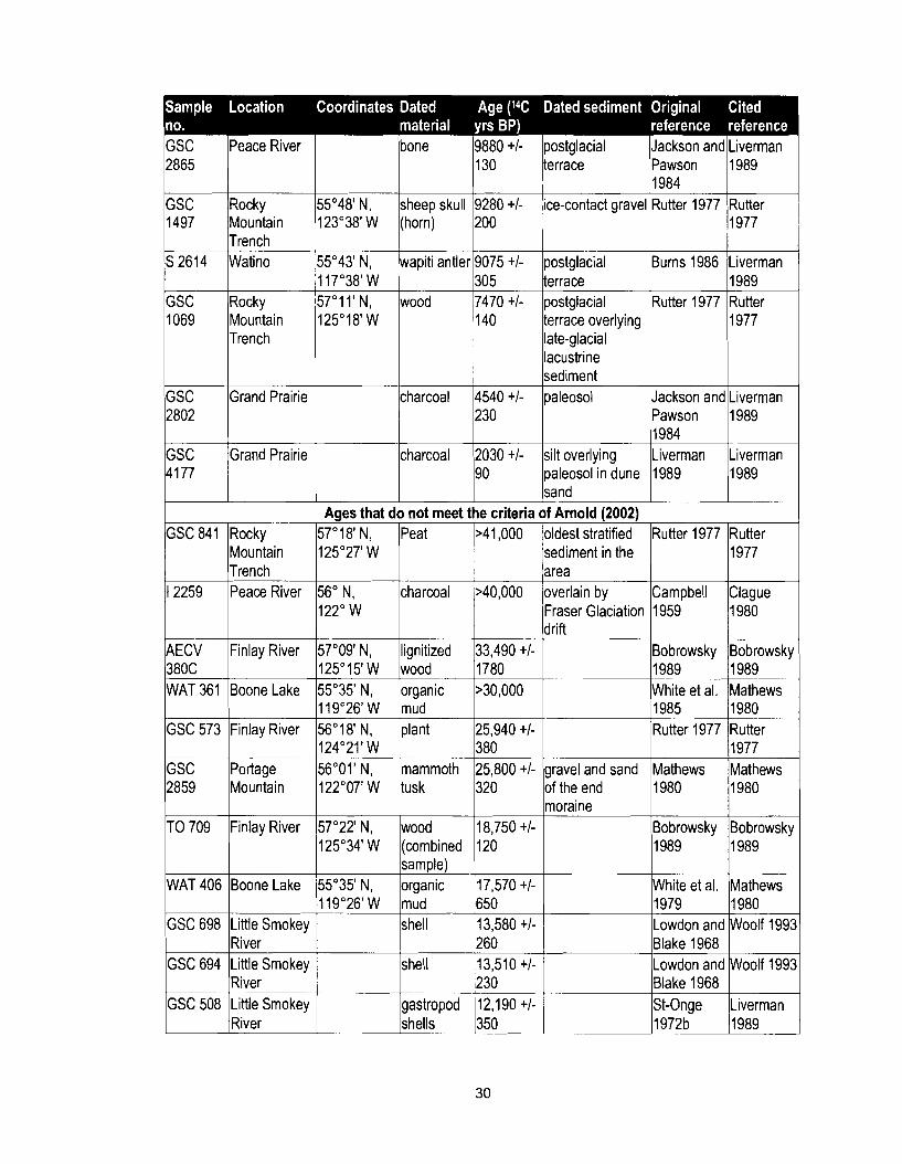
rfk i ~ e a c e River
Trench S 2614 Watino
Trench
bone 9880 +I- postglacial Jackson and Liverman 130 terrace Pawson 1989
I984 i5'48' N, sheep skull 9280 +I- ice-contact gravel Rutter 1977 Rutter 23"38'W (horn) 200 1977
i5"43' N, wapiti antler 9075 +I- postglacial Burns 1986 Liverman 17"38' W 305 terrace 1989 i7"11'N, wood 7470 +I- postglacial Rutter 1977 Rutter 25" 18' W terrace overlying 1977
late-glacial lacustrine sediment
charcoal 4540 +I- paleosol Jackson and Liverman
charcoal 2030 +I- silt overlying Liverman Liverman 1 190 paleosol in dune 1 1989 11989 ]sand
Aaes that do not meet the criteria of Arnold 120021 oldest stratified Rutter 1977 Rutter sediment in the 1 11977
,AEC&d ;inlay River
WAT 361 Boone Lake
1 2259
E g e Mountain
wood
Trench Peace River
mammoth tusk
56' N, 122" W
Bobrowsky 1989 White et al. 1985 Rutter 1977
Mathews 1980
charcoal
Bobrowskp 1989 Mathews 1980 Rutter 1977 Mathews 1980
TO 709
GSC 698 Little Smokey shell 13,580 +I- Lowdon and Woolf 199: 1 River 1 260 1 Blake 1968 1 WAT 406
>40,000
Finlay River
Boone Lake
GSC 694
GSC 508
area overlain by Fraser Glaciation drift
57'22' N, 125"34' W
55"35' N, 119"26'W
Little Smokey River Little Smokey River
Campbell 1959
wood
Clague 1980
shell
gastropod shells
18,750 +I- (combined 120 sample)
1989
White et al. 1979
organic mud
13,510 +I- 230 12,190 +I- 350
moraine
1989
Mathews 1980
17,570 +I- 650
Lowdon and Blake 1968 St-Onge 1972b
Bobrowsky
Woolf 199:
Liverman 1989
Bobrowsk)
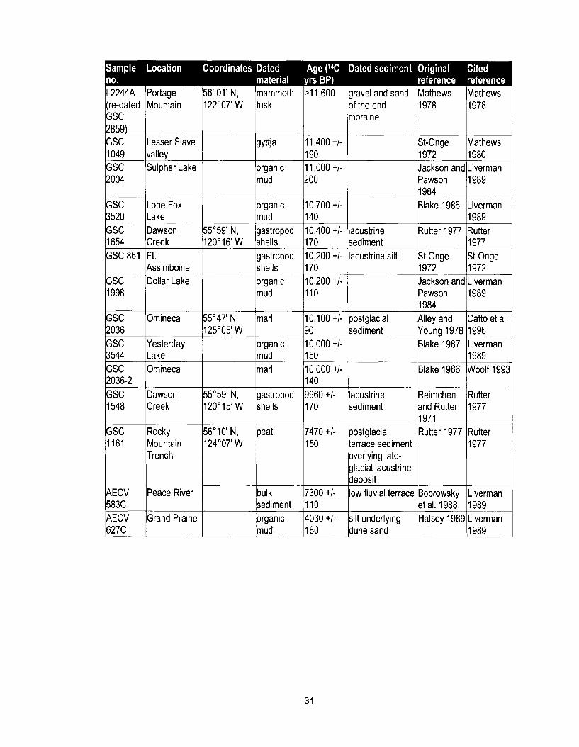
1 2244A Portage 56'01' N, (re-dated Mountain 122'07' W GSC 2859) GSC Lesser Slave
lrlley 1 Sulpher Lake
mammoth >I 1,600 tusk
190 organic 11,000 +I-
organic 10,700 +/- mud 1140
lravel and sand Mathews Mathews d the end 1978 1978 ioraine
St-Onge Mathews 1972 1980 Jackson and Liverman Pawson 1989 1984
--
Blake 1986 Liverman I989
-
GSC Dawson 55'59' N, gastropod 10,400 +I- lacustrine Rutter 1977 Rutter 1654 Creek 120'16' W shells 170 sediment 1977 GSC 861 Ft. gastropod 10,200 +I- lacustrine silt St-Onge St-Onge
Assiniboine shells 170 1972 1972 GSC Dollar Lake organic 10,200 +I- Jackson and Liverman 1998 mud 110 Pawson 1989
I984 GSC Ornineca 55'47' N, marl 10,100 +I- postglacial Alley and Catto et al.
125'05' W 90 sediment Young 1978 1996 organic 10,000 +I- Blake 1987 Liverman
Creek
Rocky Mountain Trench
mud 150 1989 marl 10,000 +I- Blake 1986 Woolf 199:
140 55'59' N, gastropod 9960 +I- lacustrine Reimchen Rutter 120•‹15' W shells 170 sediment and Rutter 1977
1971 56'10' N, peat 7470 +I- postglacial Rutter 1977 Rutter 124'07' W 150 terrace sediment 1977
overlying late- glacial lacustrine deposit
7300 +I- low fluvial terrace 583C sediment 110 et al. 1988 1989 AECV Grand Prairie organic 4030 +I- silt underlying Halsey 1989 Liverman 627C mud 180 dune sand 1989
1.4 Methods
1.4.1 Field Methods
Field work was conducted during the summers of 2002 and 2003. The author
reconnoitered the area in 2002 while assisting Mr. Jordan Severin (University of British
Columbia) in his MSc. study of landslides in the Charlie Lake map-area (Severin 2004).
Exposures of Quaternary sediments were visited and described during the summer of
2003. This task entailed locating intact exposures, defining and describing descriptive
units, measuring elevations of exposures and unit contacts, and collecting samples for
laboratory analysis.
Sections were located on aerial photographs and were then visited by truck and
boat. Most exposures are sited along eroding river banks and within active gravel pits.
Exposures were first assessed to determine whether they were intact or had slumped.
Intact exposures was cleaned and described in detail. Sediments were described and
grouped using the facies analysis method of Walker (1 984a, 1992a) (see also, Miall
1984, 1985; Eyles et al. 1983). Lithofacies were defined in terms of grain size, sorting,
stratification, and sedimentary structures (Table 2-1). Other characteristics and features
that were noted include colour, clast lithology, clast shape, clast orientation, presence of
rip-up clasts, imbrication, compaction, jointing, weathering, sliding planes, rupture
surfaces, and the angle of the face. Basal and upper contacts of units were also
described using the terms sharp, gradational, interfingering, planar, irregular, undulating,
horizontal, inclined, truncated, loaded, and weathered. Fossils, erratics, striated
surfaces, and deformation features were also noted. The sediments were then grouped
into descriptive units to facilitate interpretation. Descriptive units were defined on the
basis of lithofacies and contact relations.
Sediment texture was estimated in the field. Intermediate (b-axis) lengths of
cobble and boulder-sized clasts were measured with a tape. Sediments of mixed
lithology were described according to the dominant grain size, with subordinate grain
sizes indicated by an adjective, for example silty sand. In the case of very poorly sorted
sediment, the names of the two dominate grain sizes are followed by that of the minor
lithology, for example: silty sand with clay. Sediment samples of various textures were
collected for laboratory grain-size analysis, and the results were used to calibrate the
field textural identifications.
The colours of moist sediment samples were determined using the Geological
Society of America Rock Color Chart (Goddard et al. 1963). Pebble fabrics were
determined by measuring the trends and plunges of 50 (Woodcock 1977) rod-shaped
clasts (a-axis 1 2 x b-axis) on a small area of the exposure face. Orthoclase-rich granite
and granitoid gneiss pebbles, which do not occur in the sedimentary bedrock of the
Interior Plains or in the bedrock of the mountains west of the study area, were collected,
split, and identified.
Elevations were determined with a barometric altimeter and a laser range
finderlclinometer. Altimeter readings at sections were tied to readings made at
benchmarks of known elevation at the beginning and end of the day. Corrections were
made for changes in air pressure from repeat readings at fixed points adjacent to
measured sections. In general, no more than 20 minutes elapsed between the last
measurement at one permanent or temporary benchmark and the first measurement at
another, and no measurements were made without their being bracketed by repeat
measurements at one or more benchmarks.
A temporary benchmark at the base of each section served as a point from which
the base and top of the section and contacts were measured with the laser range
finderlclinometer. The range finderlclinometer uses an infrared laser emitter and
receiver to measure the distance to an object and an internal level to determine the
angle of the laser beam. The horizontal and vertical distances between the range finder
and the target are calculated by the instrument. The vertical distance is added to or
subtracted from the elevation of the temporary benchmark to establish the elevation of
the target.
The sources and magnitudes of errors in the estimated elevations include: (1)
error involved in reading the barometric altimeter (& 0.5 m); (2) interpolation error
associated with temporary benchmarks and atmospheric pressure changes (ca. a 1-5
m); and (3) measurement error associated with use of the laser range finder (a 5 cm at
150 m). The temporary benchmark at the base of each section was used for all
measurements at that section, thus the error associated with the benchmark is applied
equally to all measurements at the section. Differences in elevations between contacts
and between the base and top of the section are subject only to the error of the laser
m g e finderlclinometer.
1.4.2 Office and Laboratory Analyses
Office and laboratory analyses were completed in the fall of 2003 and spring of
2004. The main objective of this part of the study was to organize observations into
lithofacies, lithofacies associations, and lithostratigraphic units. This objective was
achieved by (1) collecting additional lithostratigraphic data, (2) identifying exotic pebbles,
(3) identifying and dating a fossil bison vertebra, (4) analyzing pebble fabric data, (5)
analyzing the particle-size distribution of sediment samples, and (5) determining
geotechnical properties of samples collected from sliding layers or suspected sliding
layers.
Additional stratigraphic information was acquired using the water well database
maintained by the British Columbia Ministry of Sustainable Resource Management
(Appendix B: Water Well Database). Geotechnical drilling and water well logs provided
data on the elevation of the bedrock surface in drift-covered areas. These data were
supplemented with elevations of bedrock outcrops reported in the literature and evident
on aerial photographs.
Lithofacies are bodies of sediments with specific physical characteristics (Eyles
et al. 1983). In this study, lithofacies were organized into groups of associated
sediments, interpreted to have been deposited in a particular sedimentary environment
(Walker l984a, l992a).
Distinctive pink granite and granitoid gneiss pebbles collected in the study area
were split in the field and examined under a stereoscopic microscope at Simon Fraser
University. Ms. Julianne Madsen and Mr. Kevin Cameron, both of whom have
backgrounds in igneous petrology at the graduate level, confirmed the identification of
the pebbles.
A fossil bison vertebra recovered by Mr. Jordan Severin from a fluvial gravel
lithostratigraphic unit exposed in a section near Taylor was radiocarbon dated at Beta
Analytic Laboratories Inc. following pre-treatment and collagen extraction.
Clast fabric data were processed using RockWorksTM software. Data were
plotted on a Schmidt equal-area, lower hemisphere stereonet, and the three primary
eigenvalues (Sl, S2, and S3) were calculated. Fabrics with values of
Ln(Sl/S2)/Ln(S2/S3) > 1 have clustered distributions, whereas those with values of
Ln(Sl/S2)/Ln(S2/S3) < 1 tend to have girdled distributions (Woodcock 1977).
Eigenvalue ratios alone are insufficient for interpreting fabric data (Hicock et al. 1996),
thus Schmidt plots were examined to determine whether the distributions are unimodal,
bimodal, polymodal, or girdle-like.
Grain-size and geotechnical analyses were performed by Soilcon Laboratories
Ltd. of Richmond, B.C. The sieve and pipette method (Day 1965; Franzmeier et al.
1977) was used for grain-size determinations. The Atterberg suite of tests defined the
liquid limit, plastic limit, and plasticity index (Hicks 1991).
1.4.3 Spatial Analysis
Stratigraphic information was entered in a geographic information system (GIs)
to examine lithostratigraphic units in three dimensions. The GIs was also used to
construct a bedrock surface and discern the form of buried paleo-valleys in the study
area. ArcViewTM version 8.2 software (ESRI Inc.) was used to manipulate and display
the data.
lnformation was processed before it was entered into the GIs. lnformation
processing included categorization of sediment data, evaluation of data quality,
georeferencing, and evaluation of elevations. Sediment data were placed into the
following broad descriptive categories: gravel, sand, fines, diamicton, unidentified
sediment, bedrock, covered, and unknown. Quality control involved discarding data that
were deemed unreliable or unusable. Most unreliable or unusable data were water well
logs with poorly described sediments. Georeferencing was accomplished by locating
data points on a map or aerial photograph, scanning the map or aerial photograph, and
importing the image into the GIs. The entire map or aerial photograph could then be
georeferenced by assigning coordinates to known points. Elevations were obtained for
points on the surface by assigning the raster cell values of the digital elevation model
(DEM) to the respective georeferenced data points. Where the point was below the
surface, the depth was subtracted from the value of the DEM raster cell in which the
data point is located.
The field data are of high quality. They required classification but not quality
assessment, elevation evaluation, or georeferencing. These data are the standard
against which other data were compared.
The water well data are of poor quality. They required extensive evaluation for
five reasons. First, few water well drillers have been trained in geology and sediment
description. Second, drillers commonly describe sediment only from cuttings. Third, unit
thicknesses and depths are unreliable. Fourth, the location of the water well is
commonly estimated, and the elevation of the well head is seldom reported. Fifth, many
drillers misinterpret bedrock in the study area as sediment and sediment as bedrock.
Because of these problems, each water well log was reviewed and compared with the
nearest measured section and nearby water well logs before the log was accepted. This
procedure showed that the well logs faithfully record gravel deposits, but other
lithologies, even bedrock, are not as reliably interpreted. Georeferencing of these data
could not be improved, and elevation control was required.
Drill logs obtained for geotechnical purposes are of much higher quality than
water well logs. They required classification but not quality assessment, georeferencing,
or elevation control.
Bedrock outcrops reported in published reports and on maps did not require
quality evaluation because the data consist simply of the presence of outcrops. They
did, however, require georeferencing. Elevations were assumed to be the same as the
DEM raster cell values where the outcrops were mapped.
Bedrock elevations were estimated from aerial photographs or from exposures in
valley walls where other sources of data were unavailable. The elevations were given
values of high or low relative to adjacent, better defined values to indicate either the
presence or absence of a paleo-valley at that site. These data could be accurately
georeferenced.
Each lithostratigraphic unit in the data set is shown in the GIs as a geo-
referenced vertical line segment with bounding elevations (Figure 1-5). A sequence of
sediments of different lithologies appears as a vertical tube of coloured line segments.
The colours correspond to specific lithologies, and the upper and lower limits of each
coloured line segment demarcate their elevations. In the case of bedrock, the vertical
line segment was assigned a default value of 20 m for display purposes, with the top at
the elevation of the bedrock surface. The bedrock surface was interpolated over known
and estimated bedrock surface points using inverse distance weighting, in which the
value of each cell is calculated from the values of the surrounding data points weighted
according to the inverse of their distances from the cell in question. In raster cells where
the elevation of the DEM raster cell is less than that of the interpolated bedrock surface,
the elevation of the DEM raster cell is used to model the bedrock surface. This
modification is based on the assumption that the modern drainage system is incised
more deeply into the bedrock than any past drainage system and, therefore, where the
river valleys are lower than the interpolated bedrock surface, they are incised into
bedrock.
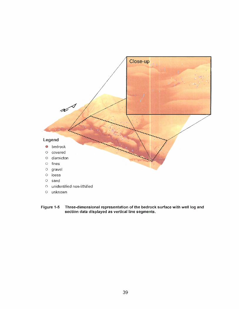
Legend
r bedrock 0 covered 0 diamicton 0 fines 0 gravel 0 loess 0 sand 0 unidentified non-lithified
0 unknown
Figure 1-5 Three-dimensional representation of the bedrock surface with well log and section data displayed as vertical line segments.

CHAPTER 2 RESULTS AND INTERPRETATION
Ninety-five sections in the Charlie Lake map-area were described during this
study (Figure 2-1). Detailed field study and laboratory analyses led to the definition of
356 descriptive units at the 95 sections (Appendix A). This chapter presents a summary
and interpretation of the raw section data using the facies analysis method. The
stratigraphy is developed successively from lithofacies descriptions, lithofacies
associations, and lithostratigraphic units (Miall 1977, 1984, 1985; Eyles et al. 1983;
Walker l984a, I992a; Reading 1996).
The bedrock topography of the study area is also reviewed in this chapter.
Outside of river valleys, Quaternary sediments generally form a thin cover over bedrock.
Within paleo-valleys, however, the bedrock surface is deeply buried. The elevation and
form of these buried bedrock valleys provide a framework for interpreting the
stratigraphy and Quaternary history of the area.
Sections (SS) are referred to by number. Descriptive units are identified in
parentheses after the section number, for example SS-56(3). The term "unit" is used in
two ways in this thesis -descriptive unit and lithostratigraphic unit. A descriptive unit is
the smallest body of sediment recognized in the field. Descriptive units were defined to
facilitate description of the vertical succession of sediments at sections, while not
providing too much detail for a regional study of this type. Most descriptive units
comprise only one lithofacies. In some cases, however, a descriptive unit consists of
two or more, closely related lithofacies that were difficult to separate in the field or were
individually too thin to plot.

Figure 2-1 Locations of measured sections in the map-area.
Lithostratigraphic units are groups of related lithofacies that form coherent
mappable bodies of sediment. They generally are products of specific geologic events
and have a restricted range of physical characteristics. Lithostratigraphic units can be
interpreted in both space and time. They imply a history that cannot be ascertained from
the physical characteristics of the deposit alone.
2.1 Bedrock Topography
Different buried valley systems are graded to different base levels, providing a
framework for understanding the Quaternary stratigraphy and history of the study area.
2.1 .I Straths and Buried Valleys
Peace River and its tributaries have incised almost 50 m deeper into bedrock
than any of their precursors. The river flows over bedrock along most of its path through
the study area. Two incised bedrock straths are exposed in the valley walls of Peace
River and its major tributaries. One strath lies at a higher elevation than the other. Both
straths are directly overlain by fluvial sediments. The bedrock straths and the fluvial
sediments that overlie them have also been identified in water well drill logs away from
valley wall exposures. A broad gravel-covered fluvial planation surface, which is not
incised, occurs locally on the uplands at a higher elevation than the two incised straths.
The two incised straths are the floors of paleo-valleys that are buried beneath up
to 180 m of Pleistocene sediment. The Pleistocene sediment fills preclude an
association with the modern Peace River drainage system. As Mathews (1 978)
suggested, the paleo-valleys define drainage systems that pre-date the glaciations that
were responsible for their burial. Therefore, the area occupied by the benches is a
composite representation of former valley positions, and the gravel-covered straths
represent the floors of the paleo-valleys. The straths are best delineated where they lie
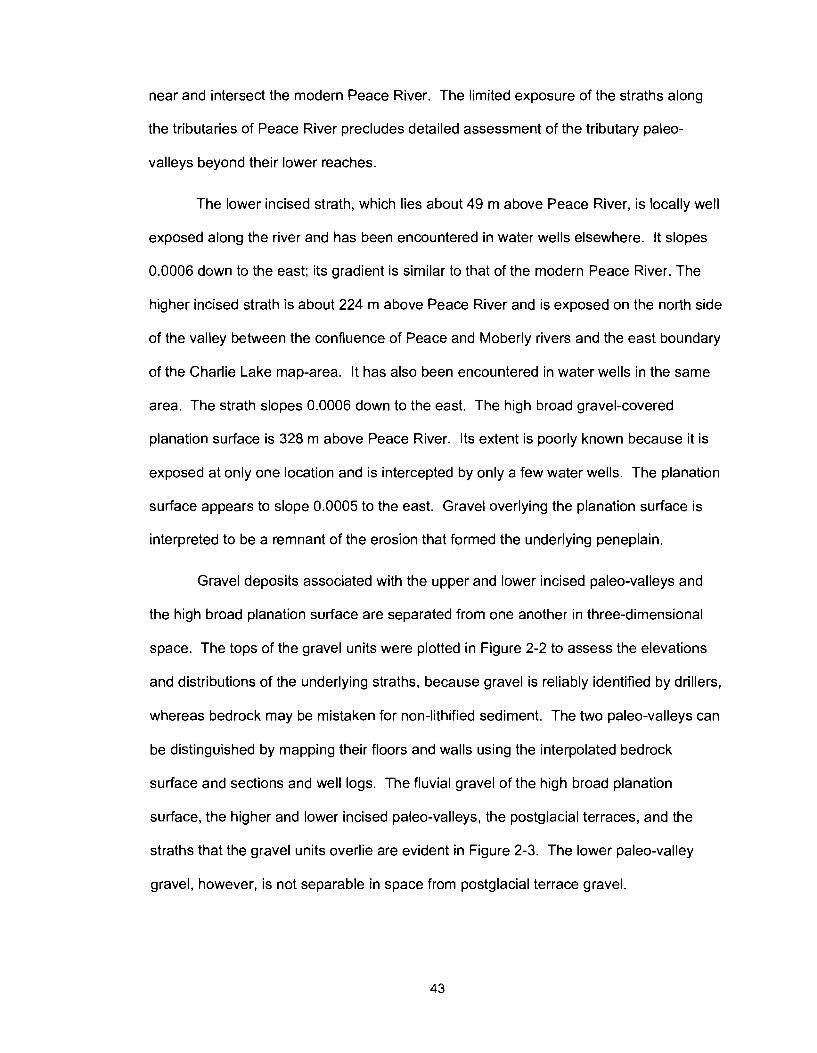
near and intersect the modern Peace River. The limited exposure of the straths along
the tributaries of Peace River precludes detailed assessment of the tributary paleo-
valleys beyond their lower reaches.
The lower incised strath, which lies about 49 m above Peace River, is locally well
exposed along the river and has been encountered in water wells elsewhere. It slopes
0.0006 down to the east; its gradient is similar to that of the modern Peace River. The
higher incised strath is about 224 m above Peace River and is exposed on the north side
of the valley between the confluence of Peace and Moberly rivers and the east boundary
of the Charlie Lake map-area. It has also been encountered in water wells in the same
area. The strath slopes 0.0006 down to the east. The high broad gravel-covered
planation surface is 328 m above Peace River. Its extent is poorly known because it is
exposed at only one location and is intercepted by only a few water wells. The planation
surface appears to slope 0.0005 to the east. Gravel overlying the planation surface is
interpreted to be a remnant of the erosion that formed the underlying peneplain.
Gravel deposits associated with the upper and lower incised paleo-valleys and
the high broad planation surface are separated from one another in three-dimensional
space. The tops of the gravel units were plotted in Figure 2-2 to assess the elevations
and distributions of the underlying straths, because gravel is reliably identified by drillers,
whereas bedrock may be mistaken for non-lithified sediment. The two paleo-valleys can
be distinguished by mapping their floors and walls using the interpolated bedrock
surface and sections and well logs. The fluvial gravel of the high broad planation
surface, the higher and lower incised paleo-valleys, the postglacial terraces, and the
straths that the gravel units overlie are evident in Figure 2-3. The lower paleo-valley
gravel, however, is not separable in space from postglacial terrace gravel.

The information displayed in Figure 2-3 was used to produce a map of buried
paleo-valleys in the study area (Figure 2-4). The lower paleo-valley system is better
constrained than the higher paleo-valley system. The original form of the high broad
planation surface is uncertain because its associated gravel is widely distributed and is
not confined to a channel in bedrock.
The lower paleo-valley system is dominated by a large valley that extends
eastward across the southern part of the study area near modern Peace River valley.
Tributaries of this trunk valley are close to Beatton, Pine, Moberly, Halfway, and Doig
river valleys. The lower paleo-valley system diverges from the modern drainage along
the canyons of Kiskatinaw, Beatton, Doig, and Halfway rivers and along two reaches of
Peace River, one near its confluence with Moberly River and the other at the eastern
edge of the map-area. The lower paleo-valleys are two to four times wider than their
modern counterparts and have flat floors and fairly steep walls.
The higher paleo-valley system is more difficult to delineate than the lower paleo-
valley system. The only upper paleo-valley that was definitively identified is on the north
side of Peace River between Moberly River and the eastern boundary of the map-area.
Although only a portion of this paleo-valley is preserved, what remains indicates that it
was almost four times as wide as the modern Peace River valley and wider than the
lower paleo-valley.
The lower paleo-valleys of Peace and Beatton rivers are incised into the higher
paleo-valley, as are the modern valleys of Peace, Beatton, and Alces rivers and many
smaller tributaries.
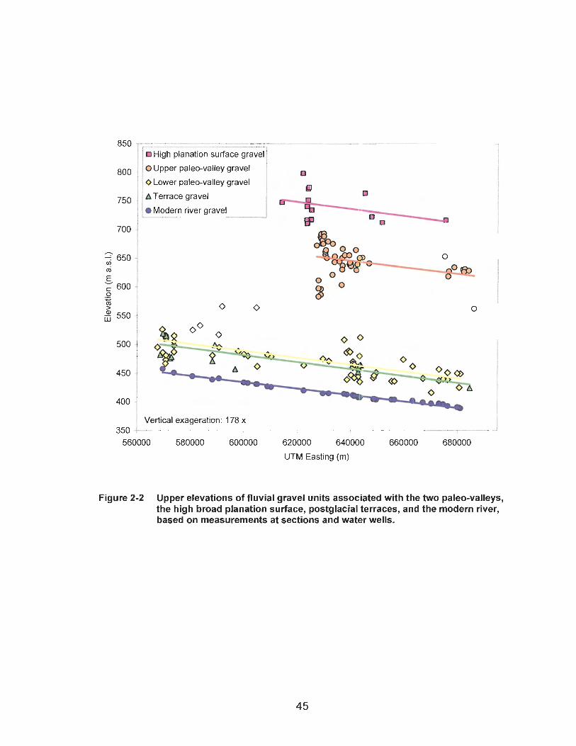
1 High planation surface gravel / 10 Upper paleo-valley gravel I O Lower paleo-valley gravel
sl A Terrace gravel rn
BP
Vertical exageration: 178 x -
620000 640000 660000
UTM Easting (m)
Figure 2-2 Upper elevations of fluvial gravel units associated with the two paleo-valleys, the high broad planation surface, postglacial terraces, and the modern river, based on measurements at sections and water wells.
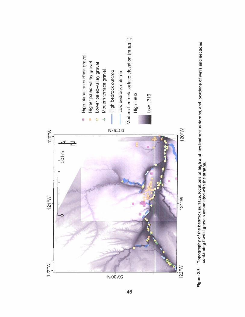
Hig
h pl
anat
ion
surf
ace
grav
el
Hig
her
pale
o-va
lley
grav
el
+ Lo
wer
pal
eo-v
alle
y gr
avel
M
oder
n te
rrac
e gr
avel
g-
H
igh
bedr
ock
outc
rop
m
0 a-
LO
Low
bed
rock
out
crop
Mod
ern
bedr
ock
surf
ace
elev
atio
n (m
ad
.)
Hig
h : 9
62
Lo
w: 3
16
Fig
ure
2-3
To
pogr
aphy
of t
he
bedr
ock
surf
ace,
loca
tion
s o
f h
igh
and
low
bed
rock
ou
tcro
ps,
and
loca
tion
s of
wel
ls a
nd s
ectio
ns
con
tain
ing
flu
vial
gra
vels
ass
oci
ated
with
th
e st
rath
s.
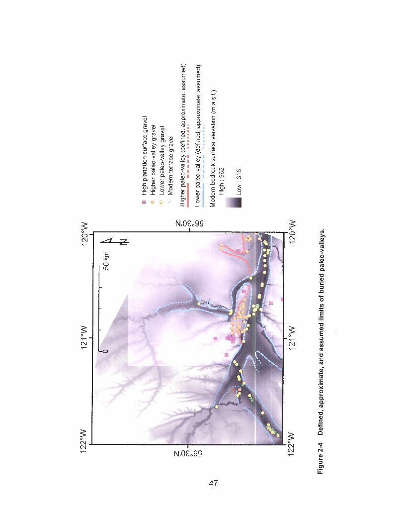
Hig
h pl
anat
ion
surf
ace
grav
el
Hig
her p
aleo
-val
ley
grav
el
- Lo
wer
pal
eo-v
alle
y gr
avel
M
oder
n te
rrac
e gr
avel
Hig
her p
aleo
-val
ley
(def
ined
, app
roxi
mat
e, a
ssum
ed)
- 111
11 ....I.. 1
Low
er p
aleo
-val
ley
(def
ined
, app
roxi
mat
e, a
ssum
ed)
- 11-
11 ...
.... 1
Mod
ern
bedr
ock
surfa
ce e
leva
tion
(m a
.s.1
.) H
igh
: 962
Figu
re 2
-4
Def
ined
, app
roxi
mat
e, a
nd a
ssum
ed li
mits
of
buri
ed p
aleo
-val
leys
.
2.1.2 Deep Bedrock Basins
Peace River flows over bedrock along most of its course through the study area.
This strath is the lowest post-Cretaceous fluvial erosion surface in the study area.
Deeper, presumably glacial, erosion has been inferred in two areas through drilling.
These areas are not evident at the surface, except along a short reach of Peace River
near its confluence with Lynx Creek (sections SS-76, SS-76a, and SS-76b). The
exposed strata near Lynx Creek include a massive, clast-supported boulder gravel
overlain by laminated fine sediments (Figure 2-5). Mathews (1978) described this
section and noted that the boulder gravel lies on contorted medium-grained sand
containing isolated cobbles. This lowest unit was not exposed at the time of field work
for this thesis.
The laminated fine sediments (FI, SI, Sm) at sections SS-76, SS-76a, and SS-
76b are clearly lacustrine. The massive boulder gravel may also be a subaqueous
deposit, the product of a high-energy sediment gravity flow such as a jokulhlaup. Such
sedimentation is consistent with deposition in a glacially scoured depression after ice
retreat.
Drilling 4.8 km east of Lynx Creek intercepted bedrock at an elevation of 393 m
a d . , 38 m below the level of Peace River in this area (Mathews 1978). A lacustrine
sequence infilling this bedrock depression is truncated by fluvial gravel that occurs at the
same elevation as gravel overlying the floor of the lower paleo-valley found elsewhere in
the study area.
The bedrock surface is also very low beneath the Portage Mountain end moraine
(Figure 2-6; Campbell 1959), in the former valley of ancestral Peace River between
Portage and Bull mountains (Beach and Spivak 1943). A borehole in this area ended at
153 m a.s.l., 362 m below modern Peace River, without reaching bedrock. The drill log
reveals interbedded and mixed sand, gravel, and clay near the bottom of the hole.
Above this, sand, silt, and clay dominate the log to 481 m a.s.1. Three gravel units were
found between 481 and 593 m a.s.1. The lowest of these units occurs at the same height
above the Peace River as, and probably correlates with, the fluvial gravel of the lower
paleo-valley found elsewhere in the study area.
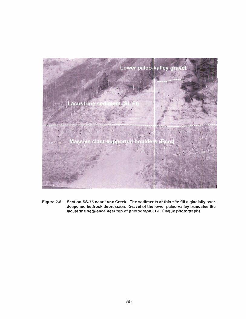
Figure 2-5 Section SS-76 near Lynx Creek. The sediments at this site fill a glacially over- deepened bedrock depression. Gravel of the lower paleo-valley truncates the lacustrine sequence near top of photograph (J.J. Clague photograph).

e Mountain end moraine
Lynx Creek
Drill log M-2 Lower paleo-valley gravel
- - - - - - _ _ ......I.*..........................
+--- Drill log M-1
/ Elevation of lower paleo-valley
-- /"'
West East .- __I
I I I I I 0 5 10 15 20 25
Distance (km)
Figure 2-6 Interpreted geology between drill-log M-I near the Portage Mountain end moraine and drill-log M-2 at Lynx Creek. The bedrock surface in this area is below the level of past fluvial erosion.
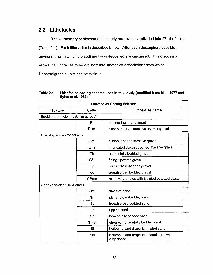
2.2 Lithofacies
The Quaternary sediments of the study area were subdivided into 27 lithofacies
(Table 2-1). Each lithofacies is described below. After each description, possible
environments in which the sediment was deposited are discussed. This discussion
allows the lithofacies to be grouped into lithofacies associations from which
lithostratigraphic units can be defined.
Table 2-1 Lithofacies coding scheme used in this study (modified from Miall 1977 and
Gravel (particles 2-256mm)
Gm I clast-supported massive gravel
Eyles et al. 1983)
Lithofacies Coding Scheme
I Gmi I imbricated clast-supported massive gravel
Lithofacies name Texture Code
Gh
Gfu
GP
Boulders (particles >256mm across)
horizontally bedded gravel
fining-upwards gravel
planar cross-bedded gravel
G t
GRmc
B I
Bcm
trough cross-bedded gravel
massive granules with isolated outsized clasts
Sand (particles 0.063-2mm)
boulder lag or pavement
clast-supported massive boulder gravel
Sm
s P
I Sh I horizontally bedded sand
massive sand
planar cross-bedded sand
St
S r
trough cross-bedded sand
rippled sand
Sld
I
Sh(s)
SI
horizontal and drape-laminated sand with dropstones
sheared horizontally bedded sand
horizontal and drape-laminated sand
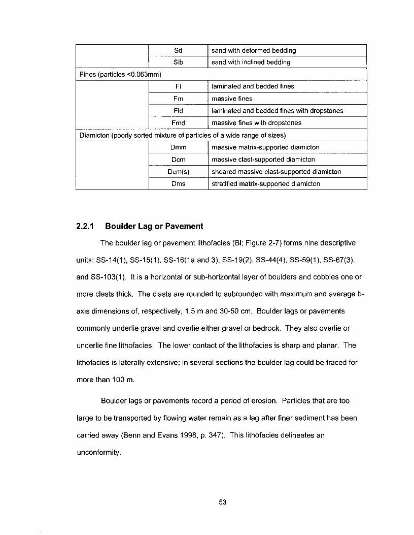
Fines (particles <0.063mm)
Sd
Sib
I F I I laminated and bedded fines
sand with deformed bedding
sand with inclined bedding
I Fmd I massive fines with dropstones
Fm
Fld
-
Diamicton (poorly sorted mixture of particles of a wide range of sizes)
massive fines
laminated and bedded fines with dropstones
I Dmm I massive matrix-supported diamicton
I Dms I stratified matrix-supported diamicton
Dcm
Dcm(s)
2.2.1 Boulder Lag or Pavement
The boulder lag or pavement lithofacies (BI; Figure 2-7) forms nine descriptive
units: SS-14(1), SS-15(1), SS-16(l a and 3), SS-19(2), SS-44(4), SS-59(1), SS-67(3),
and SS-103(1). It is a horizontal or sub-horizontal layer of boulders and cobbles one or
more clasts thick. The clasts are rounded to subrounded with maximum and average b-
axis dimensions of, respectively, 1.5 m and 30-50 cm. Boulder lags or pavements
commonly underlie gravel and overlie either gravel or bedrock. They also overlie or
underlie fine lithofacies. The lower contact of the lithofacies is sharp and planar. The
lithofacies is laterally extensive; in several sections the boulder lag could be traced for
more than 100 m.
massive clast-supported diamicton
sheared massive clast-supported diamicton
Boulder lags or pavements record a period of erosion. Particles that are too
large to be transported by flowing water remain as a lag after finer sediment has been
carried away (Benn and Evans 1998, p. 347). This lithofacies delineates an
unconformity .
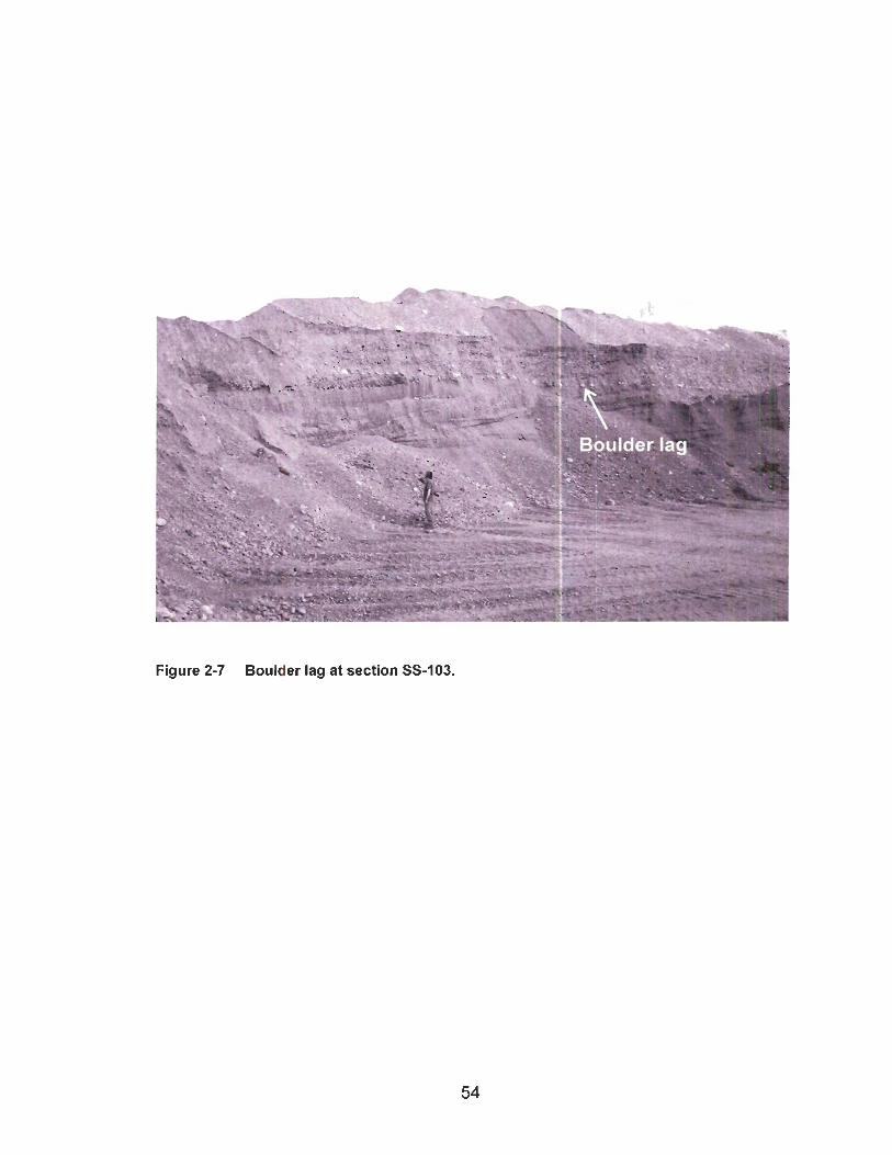
Figure 2-7 Boulder lag at section SS-103.
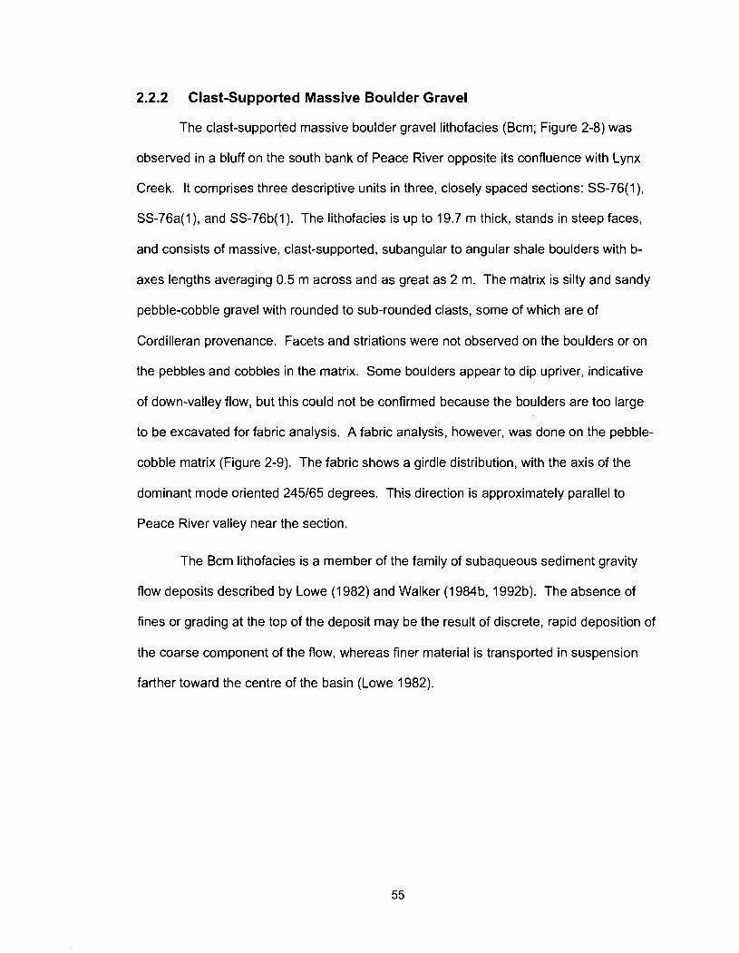
2.2.2 Clast-Supported Massive Boulder Gravel
The clast-supported massive boulder gravel lithofacies (Bcm; Figure 2-8) was
observed in a bluff on the south bank of Peace River opposite its confluence with Lynx
Creek. It comprises three descriptive units in three, closely spaced sections: SS-76(1),
SS-76a(l), and SS-76b(l). The lithofacies is up to 19.7 m thick, stands in steep faces,
and consists of massive, clast-supported, subangular to angular shale boulders with b-
axes lengths averaging 0.5 m across and as great as 2 m. The matrix is silty and sandy
pebble-cobble gravel with rounded to sub-rounded clasts, some of which are of
Cordilleran provenance. Facets and striations were not observed on the boulders or on
the pebbles and cobbles in the matrix. Some boulders appear to dip upriver, indicative
of down-valley flow, but this could not be confirmed because the boulders are too large
to be excavated for fabric analysis. A fabric analysis, however, was done on the pebble-
cobble matrix (Figure 2-9). The fabric shows a girdle distribution, with the axis of the
dominant mode oriented 245165 degrees. This direction is approximately parallel to
Peace River valley near the section.
The Bcm lithofacies is a member of the family of subaqueous sediment gravity
flow deposits described by Lowe (1 982) and Walker (1984b, l992b). The absence of
fines or grading at the top of the deposit may be the result of discrete, rapid deposition of
the coarse component of the flow, whereas finer material is transported in suspension
farther toward the centre of the basin (Lowe 1982).
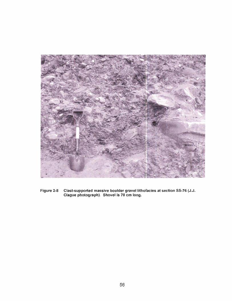
Figure 2-8 Clast-supported massive boulder gravel lithofacies at section SS-76 (J.J. Clague photograph). Shovel is 70 cm long.
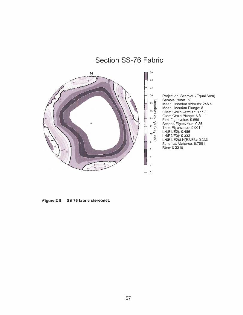
Figure 2-9 SS-76 fabric stereonet.
Projection: Schmidt: (Equal Area) Sample Points: 50 Mean Lineation Azimuth: 245.4 Mean Lineation Plunge: 6 Great Circle Azimuth: 177.2 Great Circle Plunge: 6.5 First Eigenvalue: 0.569 Second Eigenvalue: 0.35 Third Eigenvalue: 0.001 LN(EllE2): 0.486 LN(E21E3): 0.333 LN(EI/E2)/LN(E2/E3): 0.333 Spherical Variance: 0.7681 Rbar: 0.231 9
Section SS-76 Fabric
2.2.3 Clast-Supported Massive Gravel
The clast-supported massive gravel lithofacies (Gm) was observed at many
sections in the study area. It forms 57 descriptive units and is a minor constituent (lense
or interbed) of 17 units. Its average and maximum thicknesses are, respectively, 9.5 m
and 67.6 m. The lithofacies comprises pebble to cobble gravel with a sand or silty sand
matrix. Clasts are rounded to sub-rounded. The largest clasts have b-axis lengths of
about 20-25 cm and may be weakly to moderately imbricated. Stratification and grading
are typically weak. The lithofacies has a sharp, planar lower contact and a gradational
upper contact. It generally overlies bedrock and underlies finer material. Many
exposures of Gm in the study area extend for tens to hundreds of metres.
Lithostratigraphic units composed mostly or entirely of the Gm lithofacies are laterally
extensive and are commonly overlie the bedrock floors of the upper and lower paleo-
valleys and underlie postglacial river terraces.
The Gm lithofacies was deposited in channels of gravel-bed rivers (Collinson
1996). Clasts are transported as bed-load by traction currents and deposited in the river
channel. Silt and sand accumulate after the clast framework forms (Miall 1977). Miall
(1992) interpreted this lithofacies as longitudinal bars, lag deposits, and sieve deposits of
a river channel. The thickness of the gravel deposits in the study area is unusual for a
purely fluvial deposit and may, in part, indicate aggradation of a glaciofluvial system
(Benn and Evans 1998, p. 494).
2.2.4 Clast-Supported Massive Imbricated Gravel
Clast-supported massive imbricated gravel (Gmi) forms eight descriptive units:
SS-13(1), SS-16(1), SS-29(1), SS-32(1), SS-53(1), SS-55(1), SS-55a(l), and SS-56(1).
It ranges in thickness from 1.3 m to 23 m. Except for its pronounced clast imbrication,
Gmi is similar to clast-supported massive gravel (Gm). Imbrication in this lithofacies is
consistent with paleo-flow in the same direction as the modern drainage.
Imbrication arises from rolling and lodging of clasts on a channel floor (Walker
1984b). A clast on the bed of a river is most stable when its a-axis is transverse to flow
and its b-axis dips upstream (Rust and Koster 1984).
2.2.5 Horizontally Bedded Gravel
Horizontally bedded gravel (Gh) forms descriptive units SS-15a(l) and SS-48(1).
It has an average thickness of about 12 m. It consists of clast-supported, horizontally
bedded pebble-cobble gravel with a silty sand to coarse sand matrix. The clasts are
rounded to sub-rounded and are locally imbricated. Stratification is defined by
alternating beds of pebble and cobble gravel or by alternating beds of clast-supported
gravel and gravelly sand. Bed thickness ranges from a few tens of centimetres to 1 m.
Horizontally bedded gravel is deposited in river channels like its massive and
imbricated counterparts (Collinson 1996). Miall (1 992) suggested that thin beds of sand
are deposited on gravel bars and bedforms during waning flows or at low stages.
Collinson (1996) suggested that horizontal bedding is a product of alternating high and
low flow events. As in the case of the Gm lithofacies, the thickness of Gh deposits is
unusual for purely fluvial conditions and may indicate the aggrading conditions of a
glaciofluvial system (Benn and Evans 1998, p. 494).
2.2.6 Fining-Upward Gravel
The fining-upward gravel lithofacies (Gfu) constitutes five descriptive units: SS-
38(1), SS-44(1), SS-50(3), SS-62(1), and SS-67(3). It ranges in thickness from 6.3 m to
29.0 m. Clasts are rounded to sub-rounded and range in size from pebbles to boulders.
The gravel is clast-supported, but in some sections becomes matrix-supported near the
top of the unit as the gravel gives way to sand in the fining-up sequence.
Collinson (1996) suggested that the decrease in grain size from gravel to sand in
this lithofacies suggests a gradual diminution of flow competence. Fining-upward gravel
may be deposited on river bars that build up through aggradation to water depths where
flow competence is lower than in deeper water (Miall 1984, p. 21 ). A fining-up sequence
may, alternatively, record a diminution of flow due to a sudden decrease in river
discharge, for example due to damming of a river. Walker (1 984b) interpreted fining-
upward gravel and graded conglomerate to be members of the family of coarse gravel
turbidites. In this instance, the lithofacies records a decrease in the velocity of the
turbidity current.
The fining-up gravel lithofacies observed in this study are abnormally thick for a
purely fluvial deposit or a single turbidity current and may, in part, have been deposited
in glaciofluvial channels (Benn and Evans 1998, p. 494). Unconformities between
similar gravel units are difficult to recognize, therefore more than on cycle of deposition
may be present in a single descriptive unit of Gfu. Overall fining of the lithofacies may
reflect a decrease in flow velocity due to the damming of the drainage system by
advancing Laurentide ice.
2.2.7 Planar Cross-Bedded Gravel
The planar cross-bedded gravel lithofacies (Gp) forms eight descriptive units:
SS-4(1), SS-14(1), SS-15(1), SS-15a(l), SS-16(3), SS-19(1), SS-1 O3(l), and M-3(1).
The units range in thickness from 6.8 m to 28.1 m. The lithofacies consists of clast-
supported pebble to cobble gravel with rare outsized clasts. Clasts are rounded to sub-
rounded. Interstitial spaces are occupied by silty sand. Tabular, planar cross-beds are
defined by differences in texture. The cross-beds occur in sets 1-3 m thick, in which

individual beds are 10-40 cm thick and inclined at angles between 10 and 25O. A set lies
on an erosional contact and is, in turn, truncated by the lower contact of the overlying
set.
Miall (1984, p. 22) interpreted tabular cross-beds to be avalanche faces down
which grains roll or slump under current flow. A series of cross-beds represents
continuous deposition as the bedform accretes. The planar form of the cross-beds
results from migration of straight-crested bars with planar lee surfaces, or growth of
deltaic forms from older bar remnants (Miall 1977). Collinson (1 996) attributed the
cross-stratification of this lithofacies to stage fluctuations over a bar crest.
2.2.8 Trough Cross-Bedded Gravel
Trough cross-bedded gravel (Gt) is represented by one 20-m-thick unit at SS-
57(1). The lithofacies comprises pebble to cobble gravel with rare boulders. The clasts
are rounded to sub-rounded. Stratification is defined by differences in texture. The
cross-beds are approximately 3-5 m long and up to 0.5 m thick. The upper and basal
contacts of cross-beds are erosional.
Trough cross-stratified gravel is deposited by flow over the crest of a bar
(Collinson 1996). Miall (1 977) associated trough cross-beds with downstream migration
of dunes, in which the lee sides of the dunes are scalloped or hollowed out. In this
scenario, the arcuate shape of the trough cross-bed reflects the shape of the in-filled
surface. Miall (1977) noted that trough cross-beds can occur in solitary scours that have
been eroded into other deposits.
2.2.9 Massive Granule Gravel with Isolated Outsized Clasts
This lithofacies (GRmc) is represented by a single 2.9-m-thick bed of angular
granules with rare pebbles (SS-50(6); Figure 2-10). The sediment is clast-supported
with little or no matrix.
The angularity of the granules indicates a short distance of transport. The
pebbles, however, are rounded. Collinson (1996) suggested that breccia in a fluvial
setting may represent talus deposited on a valley floor by rockfall from a nearby valley
wall.
2.2.10 Massive Sand
Massive sand (Sm) occurs in five descriptive units: SS-1 O(1 O), SS-19(4), SS-
50(5), SS-76b(5), and SS-108(5). Four of the five units are dominated by this lithofacies;
one unit, SS-19(4), includes massive sand in a gradational relation with rippled sand
lithofacies. Massive sand beds range from 1.1 m to 2.9 m thick and consist of silty fine
sand to medium sand with scattered pebbles.
Massive sand may form in several ways. It is deposited from suspension in river
channels during floods (Collinson 1996). The lack of stratification may be due to post-
depositional bioturbation. Well sorted massive fine to medium sand may record eolian
deposition (Brookfield 1992). Brookfield suggested that eolian structures may be
indistinct and, as with fluvial sand, stratification may be destroyed by bioturbation.
Massive sand is deposited in lakes by sediment gravity flows, where the dominant
source of sediment is sand (Stowe et al. 1996).
The massive sand deposits documented in this study are associated with either
fluvial or glaciolacustrine lithofacies. Therefore fluvial or glaciolacustrine interpretations
of these deposits are preferred.
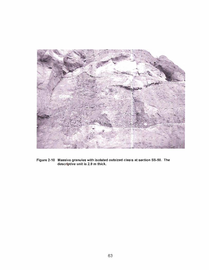
Figure 2-10 Massive granules with isolated outsized clasts at section SS-50. The descriptive unit is 2.9 m thick.
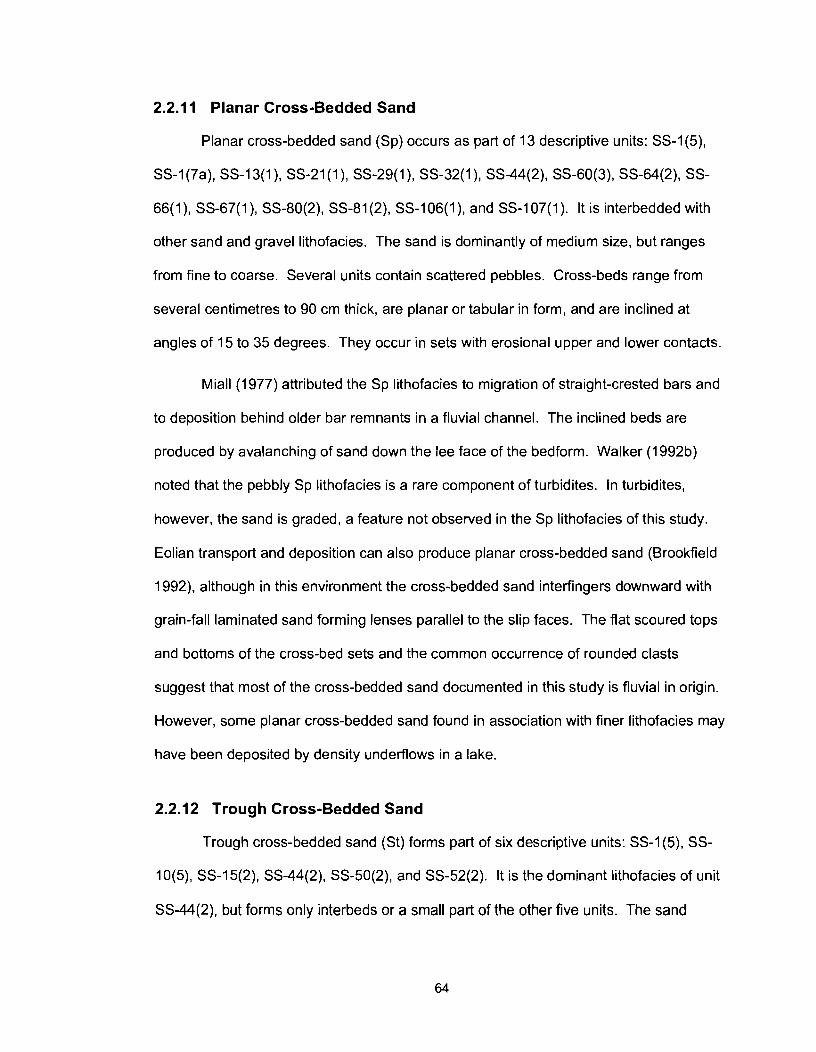
2.2.1 1 Planar Cross-Bedded Sand
Planar cross-bedded sand (Sp) occurs as part of 13 descriptive units: SS-1(5),
SS-1(7a), SS-13(1), SS-21 (I), SS-29(1), SS-32(1), SS-44(2), SS-60(3), SS-64(2), SS-
66(1), SS-67(1), SS-80(2), SS-81(2), SS-106(1), and SS-107(1). It is interbedded with
other sand and gravel lithofacies. The sand is dominantly of medium size, but ranges
from fine to coarse. Several units contain scattered pebbles. Cross-beds range from
several centimetres to 90 cm thick, are planar or tabular in form, and are inclined at
angles of 15 to 35 degrees. They occur in sets with erosional upper and lower contacts.
Miall (1977) attributed the Sp lithofacies to migration of straight-crested bars and
to deposition behind older bar remnants in a fluvial channel. The inclined beds are
produced by avalanching of sand down the lee face of the bedform. Walker (1992b)
noted that the pebbly Sp lithofacies is a rare component of turbidites. In turbidites,
however, the sand is graded, a feature not observed in the Sp lithofacies of this study.
Eolian transport and deposition can also produce planar cross-bedded sand (Brookfield
1992), although in this environment the cross-bedded sand interfingers downward with
grain-fall laminated sand forming lenses parallel to the slip faces. The flat scoured tops
and bottoms of the cross-bed sets and the common occurrence of rounded clasts
suggest that most of the cross-bedded sand documented in this study is fluvial in origin.
However, some planar cross-bedded sand found in association with finer lithofacies may
have been deposited by density underflows in a lake.
2.2.12 Trough Cross-Bedded Sand
Trough cross-bedded sand (St) forms part of six descriptive units: SS-1(5), SS-
10(5), SS-15(2), SS-44(2), SS-50(2), and SS-52(2). It is the dominant lithofacies of unit
SS-44(2), but forms only interbeds or a small part of the other five units. The sand

ranges from fine to coarse and locally contains scattered pebbles. Trough cross-beds
have lengths ranging from centimetre-scale to 3-4 m, and individual cross-beds are up to
40 cm thick. Some cross-beds are solitary, in which case they fill scours in other
sediments; however, most cross-beds occur in groups.
Miall (1977) attributed trough cross-bedded sand to deposition in fluvial channels.
Beds are produced by avalanching of sand down the lee faces of dunes, bars, or scours
with scalloped or arcuate lee faces. Sets of cross-beds result from the migration of a
bedform. Individual beds record changes in flow velocity or discharge (Collinson 1996).
Walker (1 992b) noted rare trough cross-bedded sand in deep-water turbidite sequences,
and Brookfield (1992) recorded the lithofacies in eolian deposits. Eolian and fluvial
trough cross-beds are similar, but the latter interfinger with grain-fall sand lithofacies at
their base and take the form of lenses that parallel the slip-face of the dune. Such
features are not associated with the St lithofacies observed in this study.
2.2.13 Rippled Sand
Rippled sand (Sr; Figure 2-1 1) is a significant component of 22 descriptive units:
SS-1(5, 7a, 8), SS-19(4), SS-44(2, 3,4), SS-50(3), SS-52(1), SS-53(2), SS-56(2, 3, 5),
SS-80(3), SS-82(1 and 3), SS-106(1), SS107(1), SS-108(1 and 3), and SS-108a(2). It
forms all of units SS-56(3) and SS-56(5), which are, respectively, 4.5 m and 3 m thick.
Rippled sand is also a minor component of other sand lithofacies, occurring either as
interbeds or lenses. The rippled sand lithofacies consists of very fine to medium sand.
Ripple amplitudes range from several millimetres to several centimetres. The stoss and
lee sides of ripples may be preserved, although commonly only the lee sides remain.
Rippled sand is deposited in several environments. Miall (1977) suggested that
variable flow velocity and sediment supply are responsible for the different forms in
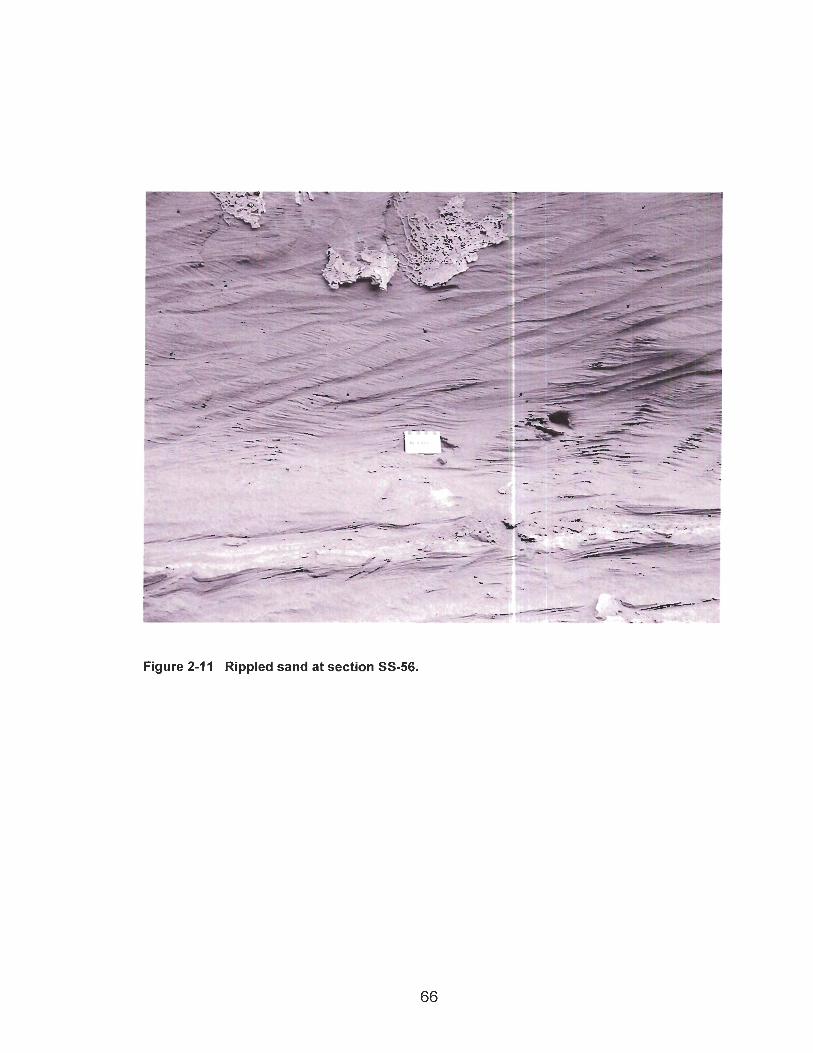
Figure 2-11 Rippled sand at section SS-56.
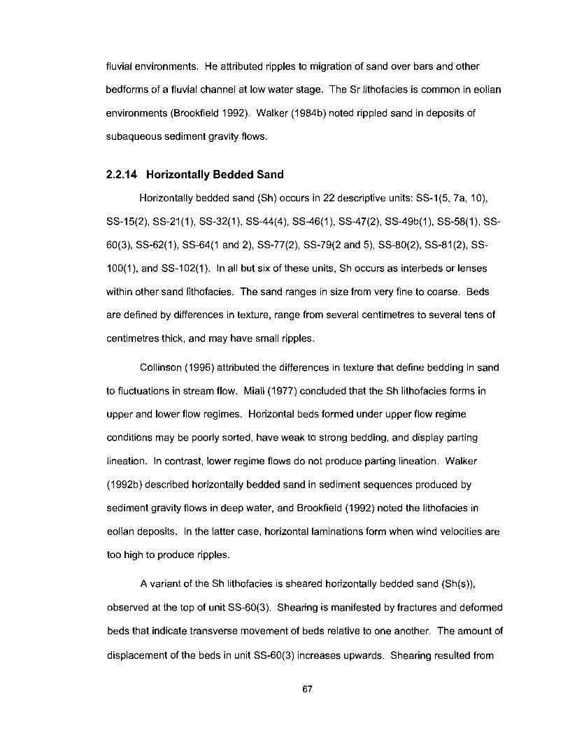
fluvial environments. He attributed ripples to migration of sand over bars and other
bedforms of a fluvial channel at low water stage. The Sr lithofacies is common in eolian
environments (Brookfield 1992). Walker (1 984b) noted rippled sand in deposits of
subaqueous sediment gravity flows.
2.2.14 Horizontally Bedded Sand
Horizontally bedded sand (Sh) occurs in 22 descriptive units: SS-1(5, 7a, 1 O),
SS-15(2), SS-21(1), SS-32(1), SS-44(4), SS-46(1), SS-47(2), SS-49b(l), SS-58(1), SS-
60(3), SS-62(1), SS-64(1 and 2), SS-77(2), SS-79(2 and 5), SS-80(2), SS-81(2), SS-
100(1), and SS-102(1). In all but six of these units, Sh occurs as interbeds or lenses
within other sand lithofacies. The sand ranges in size from very fine to coarse. Beds
are defined by differences in texture, range from several centimetres to several tens of
centimetres thick, and may have small ripples.
Collinson (1996) attributed the differences in texture that define bedding in sand
to fluctuations in stream flow. Miall (1977) concluded that the Sh lithofacies forms in
upper and lower flow regimes. Horizontal beds formed under upper flow regime
conditions may be poorly sorted, have weak to strong bedding, and display parting
lineation. In contrast, lower regime flows do not produce parting lineation. Walker
(1992b) described horizontally bedded sand in sediment sequences produced by
sediment gravity flows in deep water, and Brookfield (1 992) noted the lithofacies in
eolian deposits. In the latter case, horizontal laminations form when wind velocities are
too high to produce ripples.
A variant of the Sh lithofacies is sheared horizontally bedded sand (Sh(s)),
observed at the top of unit SS-60(3). Shearing is manifested by fractures and deformed
beds that indicate transverse movement of beds relative to one another. The amount of
displacement of the beds in unit SS-60(3) increases upwards. Shearing resulted from
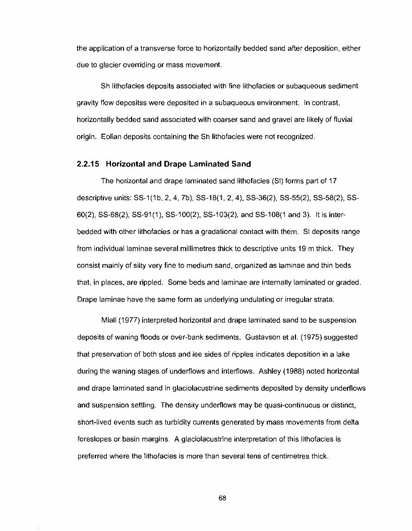
the application of a transverse force to horizontally bedded sand after deposition, either
due to glacier overriding or mass movement.
Sh lithofacies deposits associated with fine lithofacies or subaqueous sediment
gravity flow depositss were deposited in a subaqueous environment. In contrast,
horizontally bedded sand associated with coarser sand and gravel are likely of fluvial
origin. Eolian deposits containing the Sh lithofacies were not recognized.
2.2.1 5 Horizontal and Drape Laminated Sand
The horizontal and drape laminated sand lithofacies (SI) forms part of 17
descriptive units: SS-I ( I b, 2, 4, 7b), SS-18(1, 2,4), SS-36(2), SS-55(2), SS-58(2), SS-
60(2), SS-68(2), SS-91 ( I ) , SS-100(2), SS-103(2), and SS-108(1 and 3). It is inter-
bedded with other lithofacies or has a gradational contact with them. SI deposits range
from individual laminae several millimetres thick to descriptive units 19 m thick. They
consist mainly of silty very fine to medium sand, organized as laminae and thin beds
that, in places, are rippled. Some beds and laminae are internally laminated or graded.
Drape laminae have the same form as underlying undulating or irregular strata.
Miall (1977) interpreted horizontal and drape laminated sand to be suspension
deposits of waning floods or over-bank sediments. Gustavson et al. (1975) suggested
that preservation of both stoss and lee sides of ripples indicates deposition in a lake
during the waning stages of underflows and interflows. Ashley (1988) noted horizontal
and drape laminated sand in glaciolacustrine sediments deposited by density underflows
and suspension settling. The density underflows may be quasi-continuous or distinct,
short-lived events such as turbidity currents generated by mass movements from delta
foreslopes or basin margins. A glaciolacustrine interpretation of this lithofacies is
preferred where the lithofacies is more than several tens of centimetres thick.
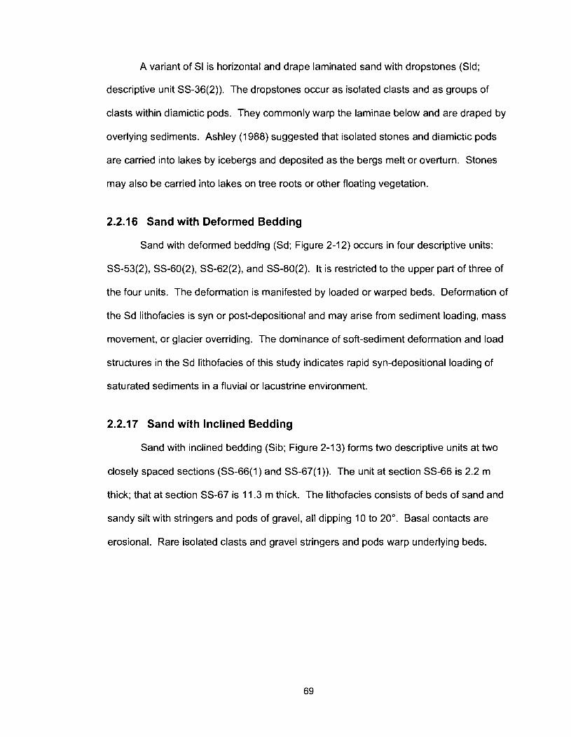
A variant of SI is horizontal and drape laminated sand with dropstones (Sld;
descriptive unit SS-36(2)). The dropstones occur as isolated clasts and as groups of
clasts within diamictic pods. They commonly warp the laminae below and are draped by
overlying sediments. Ashley (1 988) suggested that isolated stones and diamictic pods
are carried into lakes by icebergs and deposited as the bergs melt or overturn. Stones
may also be carried into lakes on tree roots or other floating vegetation.
2.2.16 Sand with Deformed Bedding
Sand with deformed bedding (Sd; Figure 2-1 2) occurs in four descriptive units:
SS-53(2), SS-60(2), SS-62(2), and SS-80(2). It is restricted to the upper part of three of
the four units. The deformation is manifested by loaded or warped beds. Deformation of
the Sd lithofacies is syn or post-depositional and may arise from sediment loading, mass
movement, or glacier overriding. The dominance of soft-sediment deformation and load
structures in the Sd lithofacies of this study indicates rapid syn-depositional loading of
saturated sediments in a fluvial or lacustrine environment.
2.2.17 Sand with Inclined Bedding
Sand with inclined bedding (Sib; Figure 2-1 3) forms two descriptive units at two
closely spaced sections (SS-66(1) and SS-67(1)). The unit at section SS-66 is 2.2 m
thick; that at section SS-67 is 11.3 m thick. The lithofacies consists of beds of sand and
sandy silt with stringers and pods of gravel, all dipping 10 to 20". Basal contacts are
erosional. Rare isolated clasts and gravel stringers and pods warp underlying beds.
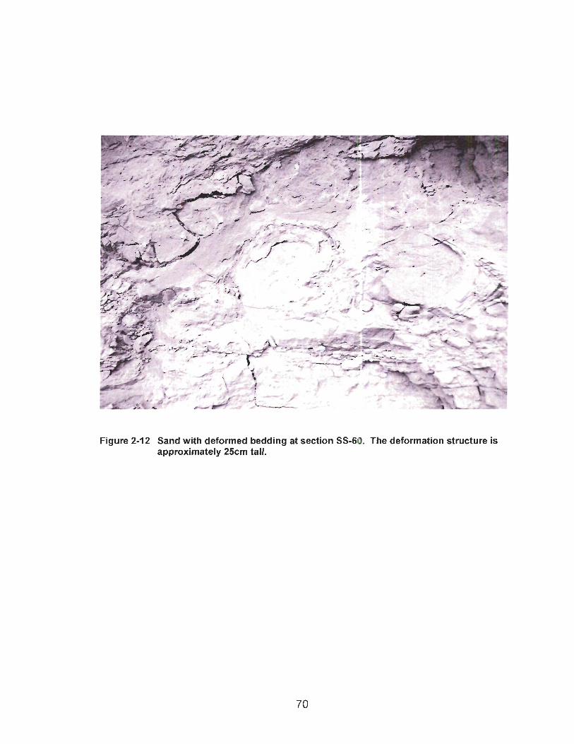
Figure 2-12 Sand with deformed bedding at section SS-60. The deformation structure is approximately 25cm tall.
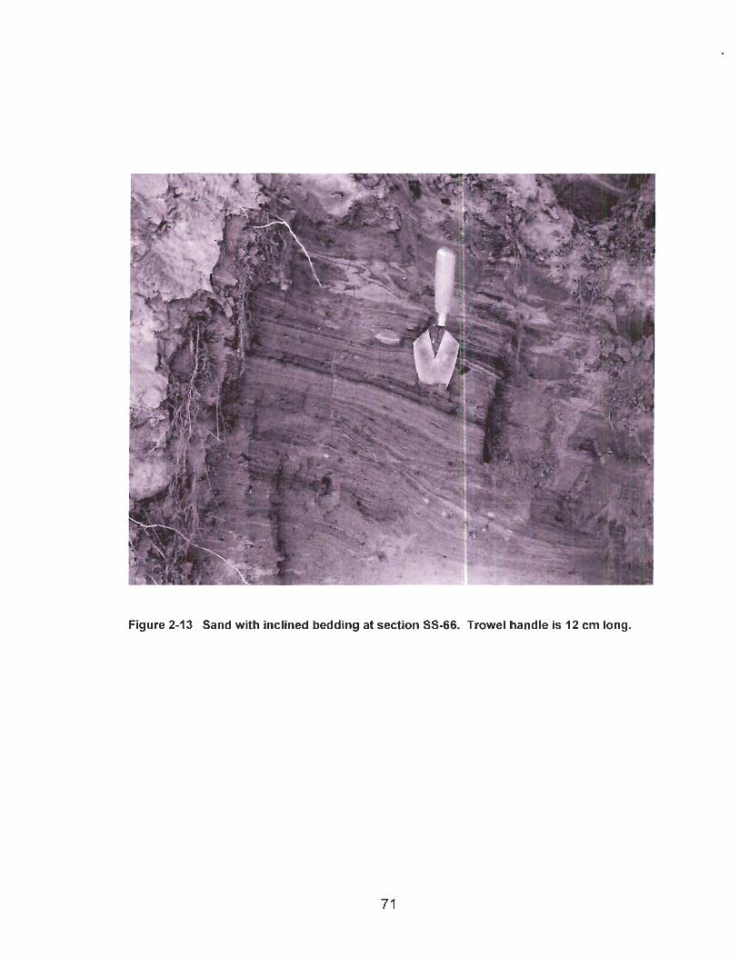
Figure 2-13 Sand with inclined bedding at section SS-66. Trowel handle is 12 cm long.
Church and Gilbert (1975) and Gustavson et al. (1975) attributed inclined planar
beds of sand and gravel to discontinuous avalanching of sediment down the slope of a
Gilbert-type delta. Syn-depositional deformation results from rapid subaqueous
deposition of sediment as the delta progrades (Eyles and Miall 1984). Sib deposits
documented in this study are not likely the foresets of a Gilbert-style delta as the
foresets of such a delta lie close to the angle of repose (Benn and Evans 1998, p. 522).
Rather, the deposits are interpreted to be subaqueous outwash.
2.2.18 Laminated and Bedded Fines
Laminated and bedded fines (FI; Figure 2-14) is one of the most common
lithofacies in the study area, forming part or all of 73 descriptive units. The lithofacies
constitutes most of 66 of the 73 units and occurs as interbeds, lenses, and channel fills
in the other seven units. It ranges from 0.1 m to 100 m thick and has an average
thickness of 17.6 m. The lithofacies is dominated by silt and clay-sized particles, but
commonly contains some fine sand. Strata range from less than one millimetre to 10 cm
thick and are distinguished by differences in texture. Strata comprising coarser
sediment are commonly thicker than those consisting of finer sediment. Silt and silty
sand beds commonly have sharp bases and are graded to massive. Micro-ripples are
present in some beds.
Laminated and bedded fines are common in low-energy lacustrine and
glaciolacustrine environments, distant from sediment sources (Ashley 1988, Wolfe and
Teller 1995). They are deposited by underflows, interflows, and overflows. Gustavson
et al. (1975) described a lateral gradation between FI deposits and distal prodelta slope
deposits. The lithofacies can also be deposited in overbank fluvial settings during the
waning stages of floods (Miall 1977).
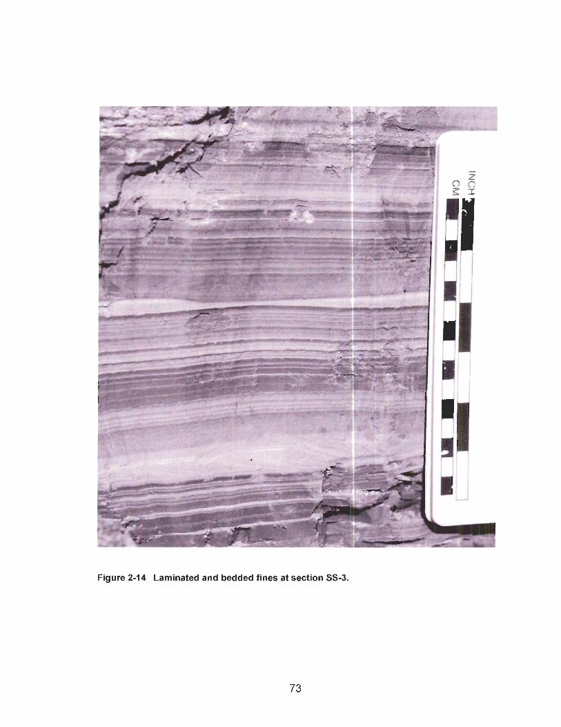
Figure 2-14 Laminated and bedded fines at section SS-3.
Thick and extensive deposits of laminated fines are unlikely to have been
deposited as overbank deposits in a fluvial setting. Therefore deposits of laminated
fines greater than several centimetres are interpreted to be lacustrine or glaciolacustrine
in origin.
2.2.19 Laminated and Bedded Fines with Dropstones
Laminated and bedded fines with dropstones (Fld) forms part or all of 22
descriptive units: SS-7(1), SS-10(7), SS-11(2), SS-16(2), SS-24(3), SS-26(3 and 4), SS-
35(3), SS-36(2), SS-49a(2), SS-50(4 and 1 I ) , SS-55(3), SS-75(2), SS-75a(l and 3), SS-
76(4), SS-78(3), SS-101(2), SS-1 O7(3), and SS-1 Og(2). Fld is the dominant lithofacies
of 17 of the 22 units and occurs as interbeds in the other five units. The lithofacies
ranges from 1 to 40 m thick and has an average thickness of 10.6 m. Except for its
dropstones, Fld is identical to FI (see section 2.2.18). The dropstones include isolated
clasts and clusters that constitute 1-25% of the sediment. The stones are sub-rounded
or faceted; many are striated. They are dominantly of Cordilleran provenance, but some
are derived from the Canadian Shield. Some of the stones warp and fold underlying
strata and are draped by overlying strata. Fld units with high stone concentrations are
commonly associated massive matrix-supported diamicton (Dmm).
Ashley (1988) attributed dropstones and diamictic pods in laminated fine
sediment to iceberg rafting and release in a glaciolacustrine environment. High
concentrations of coarse material indicate intense iceberg activity or a floating ice shelf
(Ashley 1988). Coarse debris can also be transported to intermediate and distal basin
locations by floating plant material, especially tree stems with root boles. However,
woody debris was not found within this lithofacies in the map-area.
2.2.20 Massive Fines
The massive fines lithofacies (Fm) forms part or all of ten descriptive units: SS-25(1),
SS-33(2), SS-55(5), SS-66(2), SS-67(2), SS-76a (4 and 5), SS-106(2), SS-107(4), and
SS-108(6). Eight of the ten units consist entirely of Fm; the other two comprise Fm and
FI separated by a gradational contact. The massive fines lithofacies ranges from 1.3 to
14.2 m thick, with an average thickness of 4.9 m. It appears structureless in the field
and consists of particles ranging from clay to very fine sand. Extensive root penetration
was noted in five of the ten occurrences of Fm. In units SS-25(1) and SS-33(2), the root
zone coincides with the transition from FI to Fm.
The massive fines lithofacies can form in four ways. First, it may represent
laminated fines that have been deformed or re-sedimented after deposition by
bioturbation, mass movement, iceberg scour, or lake-level changes accompanied by
current and wave reworking or by drying and wetting (Ashley 1988). Second, the
sediments may have been deposited in an environment where stratification was not
developed. Wolfe and Teller (1995) commented that massive fines are deposited where
wave activity or bioturbation prevent formation of strata. Third, massive fines may be
deposited under conditions of constant sediment flux or year-round vertical mixing of the
water column (Wolfe and Teller 1985). Fourth, they may accumulate in pools of
standing water in a fluvial environment, for example in abandoned channels (Miall 1977),
although in such situations the deposits would be thin.
2.2.21 Massive Fines with Dropstones
Massive fines with dropstones (Fmd) form descriptive units SS-25a (3) and SS-
101 (3), which are, respectively, 3 m and 7.9 m thick. Except for dropstones, Fmd is
identical to Fm. Stones are isolated and constitute only 1-3% of the sediment. They are
sub-rounded or faceted; many are striated. The stones are dominantly of Cordilleran
provenance, but many are derived from the Canadian Shield.
The Fmd lithofacies is glaciolacustrine sediment in which strata were destroyed
or never developed in the first place (Ashley 1988; Wolfe and Teller 1995). The stones
were dropped from icebergs or floating plant debris. Alternatively, Fmd could be clast-
poor till. Such till may be deposited by a glacier advancing over fine glaciolacustrine
sediment (Benn and Evans 1998, p. 393).
2.2.22 Massive Matrix-Supported Diamicton
Massive matrix-supported diamicton (Dmm) is a common lithofacies in the study
area, forming part or all of 61 descriptive units. Forty six of the 61 units consist entirely
of Dmm; in the other 15 units, Dmm occurs as interbeds, lenses, or pods. Massive
matrix-supported diamicton ranges from 0.9 m to 61.3 m thick and has an average
thickness of 12.4 m. The matrix of the diamicton is typically clayey silt or silty clay with
minor sand. Clast content ranges from 5% to over 30%. Clasts are dominantly rounded
or sub-rounded, although some are sub-angular to angular. Most clasts are pebble to
cobble-size, but clasts of up to 50 cm across are common and boulders up to several
metres across were noted in some exposures. Many of the clasts are faceted and
striated. The diamicton is generally dense and compact, forming steep outcrops of
blocky and vertically jointed sediment. Loose massive matrix-support diamicton also
exists, forming recessive outcrops. Shearing is commonly observed in this lithofacies.
The Dmm lithofacies may be deposited beneath a glacier as till or in a glacial
lake, with the coarse fraction raining out of suspension from icebergs or floating ice
shelves. In the latter case, stratification may be destroyed by fall-out of coarse debris
(Eyles et al. 1992), or it may never develop in the first place due to rapid accumulation of
fines (Ashley 1988). Dmm is also produced by mass movements, including landslides

and subaerial and subaqueous debris flows (Walker 1992b). Because the study area
was completely covered by a continental glacier at least once (Mathews 1972, 1978,
1980; Bobrowsky et al. 1991, 1992), surface and near-surface Dmm in areas of low relief
is almost certainly till. Where it is associated with landslide topography in areas of high
relief, Dmm is most likely a mass movement deposit.
Shearing of Dmm can occur during glacier overriding or due to secondary mass
movement. Deformation till or glaciotectonite, resulting from glacier overriding,
commonly exhibits widespread penetrative shearing (Benn and Evans 1998, p. 387).
2.2.23 Massive Clast-Supported Diamicton
Massive clast-supported diamicton (Dcm) comprises a lense, pod, or minor
interbed in five descriptive units: SS-1(3), SS-5(1 and 3), SS-56(1) and SS-82(2).
Descriptive unit SS-1(3) contains a clast-supported diamicton consisting of brecciated
laminated to bedded silt clasts in a matrix of fine sand. Most of the silt clasts are pebble
to cobble-size. Descriptive unit SS-5(1) includes a clast-supported diamicton with
pebble to cobble-size clasts and a silty matrix. No faceted or striated stones were found
in this unit. Units SS-5(3) and SS-82(2) are dominated by Dmm but include Dcm. Unit
SS-5(3) underlies a hummocky surface, suggesting a landslide origin. Unit SS-82(2) is
reversely graded and includes some planar cross-beds. Unit SS-56(1) is an interbed of
massive clast-supported diamicton within massive clast-supported gravel.
Massive clast-supported diamicton is associated with several types of sediment
gravity flows, including grain flows, cohesive to dilatant subaerial and subaqueous debris
flows, and high-density turbidity currents (Walker l984b, 1 9Wb; Stowe et al. 1996).
Walker noted that these processes, with the exception of cohesive debris flows, have a
clast-support mechanism such as turbulence, escaping pore fluid, or dispersive pressure
that allows the clasts to flow without having to be supported by a cohesive plastic matrix.
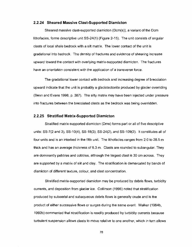
2.2.24 Sheared Massive Clast-Supported Diamicton
Sheared massive clast-supported diamicton (Dcm(s)), a variant of the Dcm
lithofacies, forms descriptive unit SS-24(1) (Figure 2-1 5). The unit consists of angular
clasts of local shale bedrock with a silt matrix. The lower contact of the unit is
gradational into bedrock. The density of fractures and evidence of shearing increase
upward toward the contact with overlying matrix-supported diamicton. The fractures
have an orientation consistent with the application of a transverse force.
The gradational lower contact with bedrock and increasing degree of brecciation
upward indicate that the unit is probably a glaciotectonite produced by glacier overriding
(Benn and Evans 1998, p. 387). The silty matrix may have been injected under pressure
into fractures between the brecciated clasts as the bedrock was being overridden.
2.2.25 Stratified Matrix-Supported Diamicton
Stratified matrix-supported diamicton (Dms) forms part or all of five descriptive
units: SS-7(2 and 3), SS-1 O(4), SS-18(3), SS-24(2), and SS-1 Og(2). It constitutes all of
four units and is an interbed in the fifth unit. The lithofacies ranges from 2.0 to 28.5 m
thick and has an average thickness of 9.3 m. Clasts are rounded to subangular. They
are dominantly pebbles and cobbles, although the largest clast is 30 cm across. They
are supported by a matrix of silt and clay. The stratification is demarcated by bands of
diamicton of different texture, colour, and clast concentration.
Stratified matrix-supported diamicton may be produced by debris flows, turbidity
currents, and deposition from glacier ice. Collinson (1 996) noted that stratification
produced by subaerial and subaqueous debris flows is generally crude and is the
product of either successive flows or surges during the same event. Walker (1984b,
1992b) commented that stratification is readily produced by turbidity currents because
turbulent suspension allows clasts to move relative to one another, which in turn allows
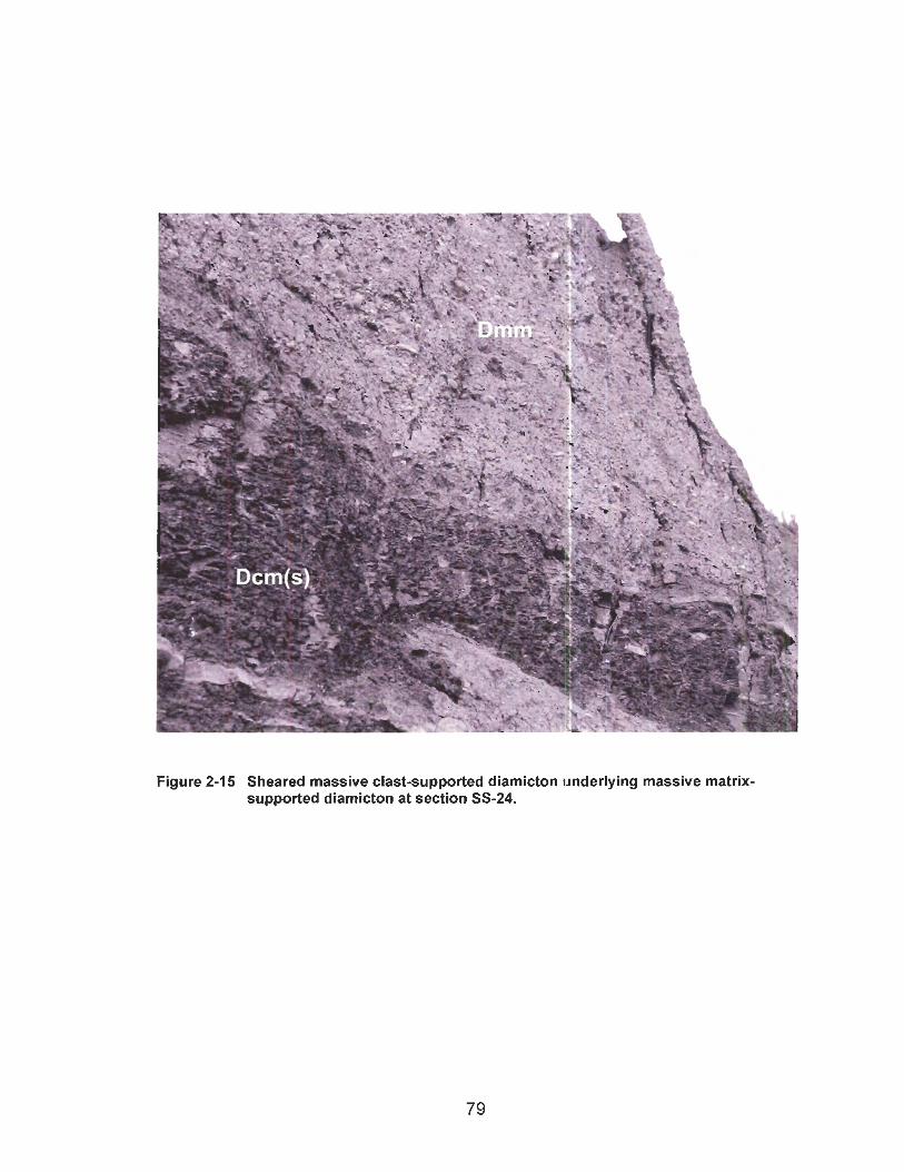
Dmm
Figure 2-15 Sheared massive clast-supported diamicton underlying massive matrix- supported diamicton at section SS-24.

structures such as grading and cross-beds to develop. Stratification may develop in till
due to changes in glacier flow direction or flow regime (Benn and Evans 1998). It also
develops as debris melts out at the base of a glacier (Eyles and Miall 1984).
2.3 Lithofacies Associations
A particular lithofacies can be deposited in more than one way; consequently it
alone may not provide a unique genetic interpretation for a deposit. Associations of
lithofacies, however, are unique to particular depositional environments. Environments
of deposition can be determined through study of the contacts and geometry of
lithofacies, and the relationships among adjacent lithofacies associations (Miall 1977,
1984, 1985; Eyles et al. 1983; Walker l984a, 1 992a; Reading 1996).
Analysis of the stratigraphic data presented in Appendix A reveals that certain
lithofacies are associated. Lithofacies associations may be differentiated from one other
by a dominant and characteristic lithofacies, inferred similar depositional environments,
or bounding unconformities. Lithofacies associations may also have a geometry
diagnostic of a certain depositional environment.
Three, first-order lithofacies associations account for most of the descriptive units
in this study: the fluvial lithofacies association, glaciolacustrine lithofacies association,
and glacial lithofacies association. Mass-movement lithofacies association is also
recognized, but is a minor element. Glaciofluvial lithofacies association is not
differentiated from fluvial lithofacies association in this study. As explained in section
2.3.4 and shown in Table 2-2, fluvial and glaciofluvial processes and deposits lie on a
continuum and their separation would be arbitrary. Table 2-2 summarizes the five
lithofacies associations and their associated lithofacies.
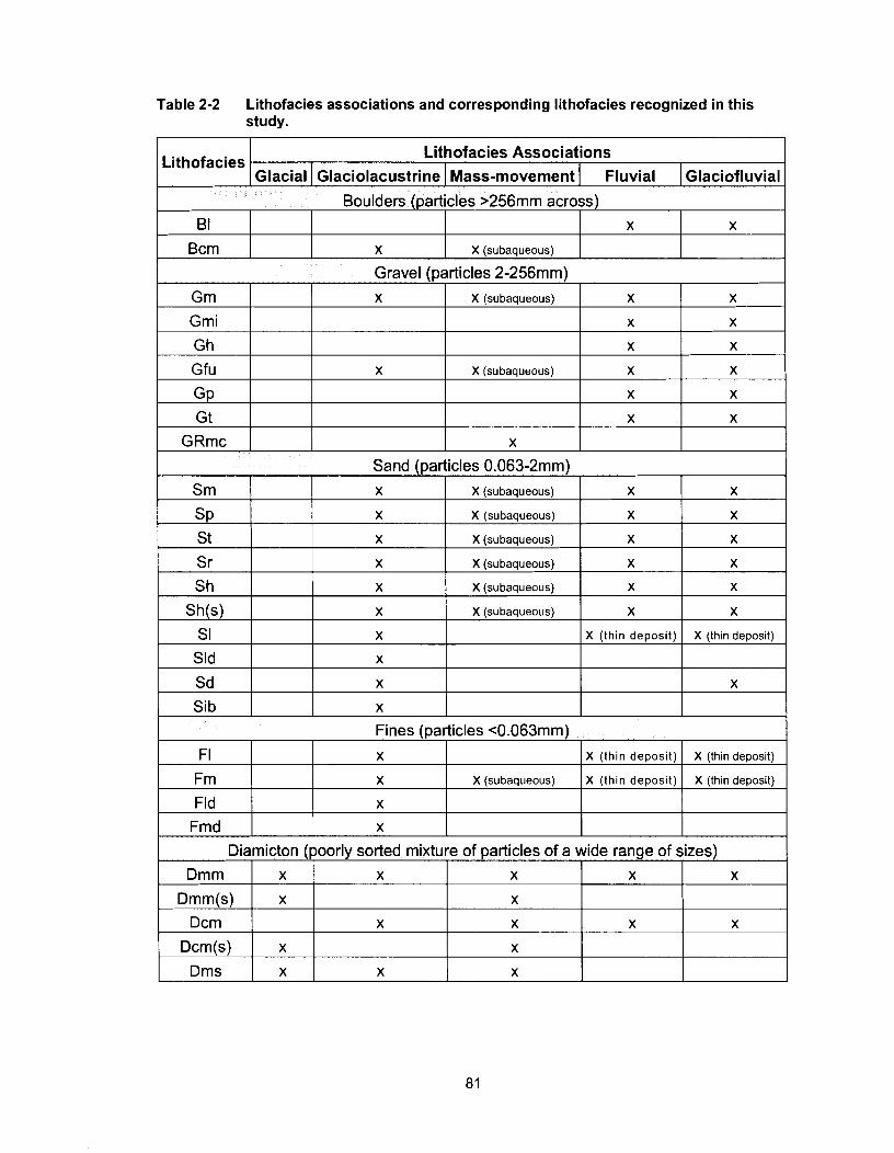
Table 2-2 Lithofacies associations and corresponding lithofacies recognized in this study.
1 Gravel bartides 2-256rnrn)
Lithofacies . Lithofacies Associations
Glacial 1 Glaciolacustrine I ass-movement I Fluvial 1 Glaciofluvial
Grn
Grni
Boulders (particles >256rnrn across)
Gh
Gfu
GP
B I
B c ~
X
Sand (particles 0.063-2rnrn)
X
Srn
SP St
Sr
Sh
Sh(s) s I
I Sib x
X
X (subaqueous)
Sld
Sd
X (subaqueous)
X
X
X
x
X
X
X
X (subaaueous)
X
x
x
x
Fines (particles <0.063rnrn)
I Fmd X
X
x
x
X
X
X (subaqueous)
x (subaqueous)
X (subaqueous)
X (subaqueous)
x
Frn
Fld
x
x
X
X
X
X
X (subaqueous)
X (subaqueous)
FI
x
X
X
X
x
X
X
X (thin deposit)
X X (thin deposit)
X
x
Diarnicton (poorly sorted mixture of particles of a wide range of sizes)
X
x
X
X
X (thin deposit)
X (thin depos~t)
Drnrn
Drnrn(s)
Dcm
X (subaqueous)
Drns
x
x
X (thin deposit)
x
X (thin deposit)
x
x
x
x
x
x
x
x
x
x
x
2.3.1 Fluvial Lithofacies Association
Miall (1 977, 1984, 1985, 1992) described the sedimentation processes and
deposits of fluvial environments and divided the deposits into lithofacies. His lithofacies
have been recognized in this study, with some minor modifications. They include
massive clast-supported gravel (Gm), massive clast-supported imbricated gravel (Gmi),
trough and planar cross-stratified gravel (Gt and Gp), fining-upwards gravel (Gfu),
horizontally bedded gravel (Gh) and sand (Sh), trough and planar cross-stratified sand
(St and Sp), rippled sand (Sr), laminated sand (SI), laminated and massive fines (FI and
Fm), and massive matrix-supported diamicton (Dmm).
In this study, lithofacies attributed to deposition in a fluvial environment are
commonly found together and occupy consistent stratigraphic positions at the base of
valley-fill sequences or as modern river and terrace deposits. An unconformable contact
forms the base of this lithofacies association. The underlying material is generally
bedrock, although in some cases it is Quaternary sediment. The upper contact is
conformable where it is overlain by fine-textured lithofacies or unconformable where it is
overlain by diamicton lithofacies. The fluvial lithofacies association has a geometry that
is consistent with a fluvial environment - it is tabular or concave-up where it occupies
valleys cut into bedrock and is tabular on bedrock straths. It is dominated by gravel
lithofacies (Gm, Gmi, Gh, Gfu, Gp, and Gt). Sand and fine lithofacies (Sm, Sp, St, Sr,
Sh, SI, FI, and Fm) are less common, and diamicton lithofacies are rare and occur only
near valley walls where they can be deposited by debris flows or other mass
movements.
2.3.2 Glaciolacustrine Lithofacies Association
Lithofacies associated with glaciolacustrine environments (Ashley 1988) include
matrix-supported to clast-supported massive diamictons (Dmm and Dcm), matrix-
supported to clast-supported stratified diamictons (Dms and Dcs), gravel with inclined
bedding (Gib), horizontally bedded sand (Sh), rippled sand (Sr), massive sand (Sm),
trough and planar cross-bedded sand (St and Sp), horizontal and drape-laminated sand
with (Sld) and without (SI) dropostones, sand with deformed bedding (Sd), sand with
inclined bedding (Sib), and massive and laminated fines with (Fmd and Fld) and without
(Fm and FI) dropstones. Sediment gravity flows may introduce both clast-supported
massive boulder gravel (Bcm) and massive gravel (Gm) into a glacial lake (Lowe 1982;
Walker 1984b, 1992b).
Glacial lakes occupy basins and are thus topographically constrained, although
ice may form part or all of the basin margins. Deltaic lithofacies typically occur at the
margins of the basin (Church and Gilbert 1975), and fine lithofacies are most common in
the centre (Eyles et al. 1992). Glaciolacustrine deposition, however, is controlled by
other factors, including proximity to the glacier, the thermal regime of the lake, shape of
the basin, fluvial input, and lake-level fluctuations. Basin margin and ice-proximal
deposits are coarser and more complex than central basin and ice-distal deposits
(Ashley 1988; Wolfe and Teller 1995). May (1 977) concluded that most common
glaciolacustrine deposits are laminated fines with (Fld) and without (FI) dropstones, and
horizontal and drape laminated sands with (Sld) and without (SI) dropstones.
Glaciolacustrine lithostratigraphic units generally have conformable lower contacts,
although lake-lowering events and energetic subaqueous sediment gravity flows may
leave unconformities between units.
2.3.3 Glacial Lithofacies Association
Till is sediment deposited directly from glacial ice with little or no modification by
other processes (Eyles et al. 1983). Almost without exception, till is diamicton (Dmm,
Dmm(s)). Till can be distinguished from other types of diamicton in section through a
combination of physical properties, including clast shape and fabric, particle size
distribution, compactness, and structures such as joints, faults, folds, and clastic dykes.
The geometry of diamictons and their stratigraphic position are critical in
assessing their depositional environments. The most important geometric
characteristics of till are the presence of an underlying unconformity and a regional
extent (Eyles et al. 1992). Till deposited by a continental ice sheet forms an irregular
blanket that is less than 50 m thick (commonly much less) and is not topographically
constrained to river valleys and local basins.
2.3.4 Glaciofluvial Lithofacies Association
Surface glaciofluvial sediments were mapped in the study area by Mathews
(1978). They form the uppermost units at several sections described in this study.
Glaciofluvial lithofacies associations are not defined in this thesis because glaciofluvial
and fluvial processes and deposits lie on a continuum and their separation would be
arbitrary. Further, outwash and braidplain fluvial deposits have similar morphologies and
sedimentology (Eyles and Miall 1984). Nevertheless, some researchers (Church and
Gilbert 1975, Jurgaitis and Juozapavicius 1988, Eyles et al. 1992) have commented that
glaciofluvial deposits are more poorly sorted, have a wider range of particle sizes, and
display a greater variety of sedimentary structures in section than fluvial deposits. Miall
(1 985) attributed stacked, massive to bedded gravel units (Gm, Gp) to fluvially
dominated ice-proximal deposition. Many sections in this study contain descriptive units
that have been classified as fluvial but display characteristics of fluvial and/or
glaciofluvial deposits, especially those with an abnormally great thickness of gravel-
dominated lithofacies (Benn and Evans 1998, p. 494). These units most likely contain
glaciofluvial deposits overlying fluvial deposits on a gradational contact.
2.3.5 Mass-Movement Lithofacies Association
Landslides are common in Peace River valley and the valleys of its tributaries.
An almost continuous apron of landslide debris, marked by hummocky topography,
tension cracks, tilted trees, sag ponds, down-dropped blocks, and scalloped headscarps,
covers the lower parts of valley walls (Severin 2004). Landslide deposits are
represented in section by diamicton lithofacies (Dmm, Dmm(s), Dcrn, Dcm(s), and Dms),
often with limited lateral extents. Landslide deposits are also represented in section by
intact, although sheared and deformed blocks of the failed parent material. The
association of the lithofacies with hummocky topography and landslide scarps where it
forms the uppermost unit facilitates a colluvial interpretation of the sediments.
2.4 Lithostratigraphy and Genesis
Geologic and geomorphic processes that have been active in an area can be
determined from lithofacies, lithofacies associations, and landforms. Sediments and
landforms, however, must be considered in a three-dimensional context in order to
understand their relations and to reconstruct the earth history they record.
Lithostratigraphy is the organization of lithofacies and lithofacies associations into bodies
of sediment that can be mapped. The spatial relations and contacts between these
bodies of sediment provide information on the style, distribution, and times of geologic
events (Miall 1977, 1984, 1985; Eyles et al. 1983; Walker 1984a, l992a; Reading 1996).
Figure 2-16 provides a summary of the Quaternary lithostratigraphy of the study area by
displaying typical sections from each of the four paleo-drainage systems.
2.4.1 Fluvial Deposits of the High Planation Surface
Fluvial deposits of the high planation surface (Figure 2-17) overlie a bedrock
strath that stands slightly higher than the adjacent uplands. Erosion has removed much
of this lithostratigraphic unit and lowered the surface of the uplands around the erosional
remnants. One exposure of the unit, at section M-3 (the Imperial gravel pit), is
complemented by 11 water well logs, two on the south side of Peace River opposite
Taylor and nine in the vicinity of Charlie Lake.
The lithostratigraphic unit is, on average, 5.7 m thick, and its upper surface is
about 328 m above present-day Peace River. The unit is composed mainly of planar
cross-bedded gravel lithofacies (Gp), with minor lenses of laminated fines (FI). Both
lithofacies are of the fluvial lithofacies association. All clasts are of Cordilleran or local
provenance. The unit overlies bedrock and underlies till and glaciolacustrine deposits of
the last glaciation.
The lithostratigraphic unit is interpreted to be channel deposits of a single-channel river,
possibly analogous to modern rivers of the Interior Plains, for example South
Saskatchewan River (Cant and Walker 1978). Lateral channel migration is indicated by
discontinuous cross-beds and silt lenses. Cross-beds at section M-I record northward
flow.
The planation surface underlying this lithostratigraphic unit slopes 0.0005 to the
east or northeast. It is incised by the higher and lower paleo-valleys and the modern
Peace River valley.
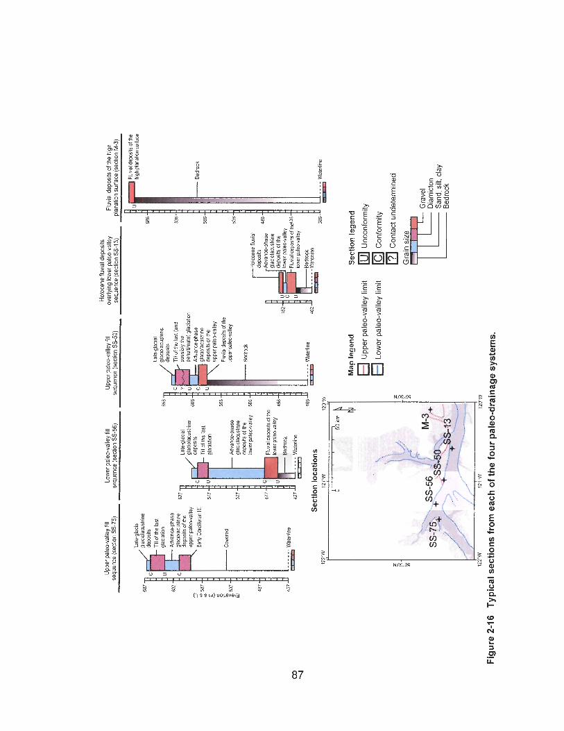
Hol
ocen
e flu
vial
dep
osits
U
pper
pal
eo-v
alle
y fill
Low
er p
aleo
-val
ley
fill
Upp
er p
aleo
-val
ley fill
over
lyin
g lo
wer
pal
eo-v
alle
y F
luvi
al d
epos
its o
f the
hig
h se
quen
ce (
sect
ion
SS-7
5)
sequ
ence
(se
ctio
n S
S-5
6)
sequ
ence
(se
ctio
n SS
-50)
se
quen
ce (
sect
ion
SS
-13)
pl
anat
ion
surf
ace
(sec
lion
M-3
)
686
636
586
536
Hol
ocen
e flu
vial
U
C
Fluv
lal d
epos
its of
thd3
6 U
Fiuv
tal d
epos
ils o
f the
hi
gh p
lana
tton s
urfa
ce
glac
~iac
ustr
ine
depo
sits
TI
1 of
the
last
gl
acia
lion
glac
i~ac
ustn
ne
depo
slis
T
ll of
the
lasl
(and
po
sslb
iy th
e pe
nulll
mat
e) gl
acia
llon
Adv
ance
-pha
se
giac
iola
cusl
rine
depw
~ts
of th
e up
per p
aleo
valle
y
Fluv
ial d
epos
its of
the
uppe
r pal
eo-v
alle
y
Adv
ance
-pha
se
glac
~oia
cusl
rme
depo
sils
of t
he
uppe
r pal
-val
ley
Early
Cor
dille
ran
till
Late
-gla
clal
gl
ac~o
lacu
stnn
e de
posi
ts
Till o
f the
last
gl
acia
lton
Bed
mck
- Co
vere
d
t Adv
anep
hase
gl
acio
lacu
slr~
ne
depo
sits
of t
he
low
er p
ako-
valle
y B
edm
ck
4771P
Fluv
ial d
epos
ils of
the
low
er p
aleo
-val
ley
456
Bed
rock
427
Wal
erl~
ne
- W
ater
line
II
Wat
erlin
e S
ectio
n lo
catio
ns
12
y
12l,*
w
12[
Map
leg
end
S
ectio
n le
gen
d
Upp
er p
aleo
-val
ley
limit
Unc
onfo
rmity
Low
er p
aleo
-val
ley
limit
Con
form
ity
13 Co
ntac
t und
eter
min
ed
Gra
in s
ize
m
Gra
ve,
- Sand, sill, cla
y I
Bed
rock
Figu
re 2
-16
Typi
cal s
ectio
ns f
rom
eac
h of
the
four
pal
eo-d
rain
age
syst
ems.
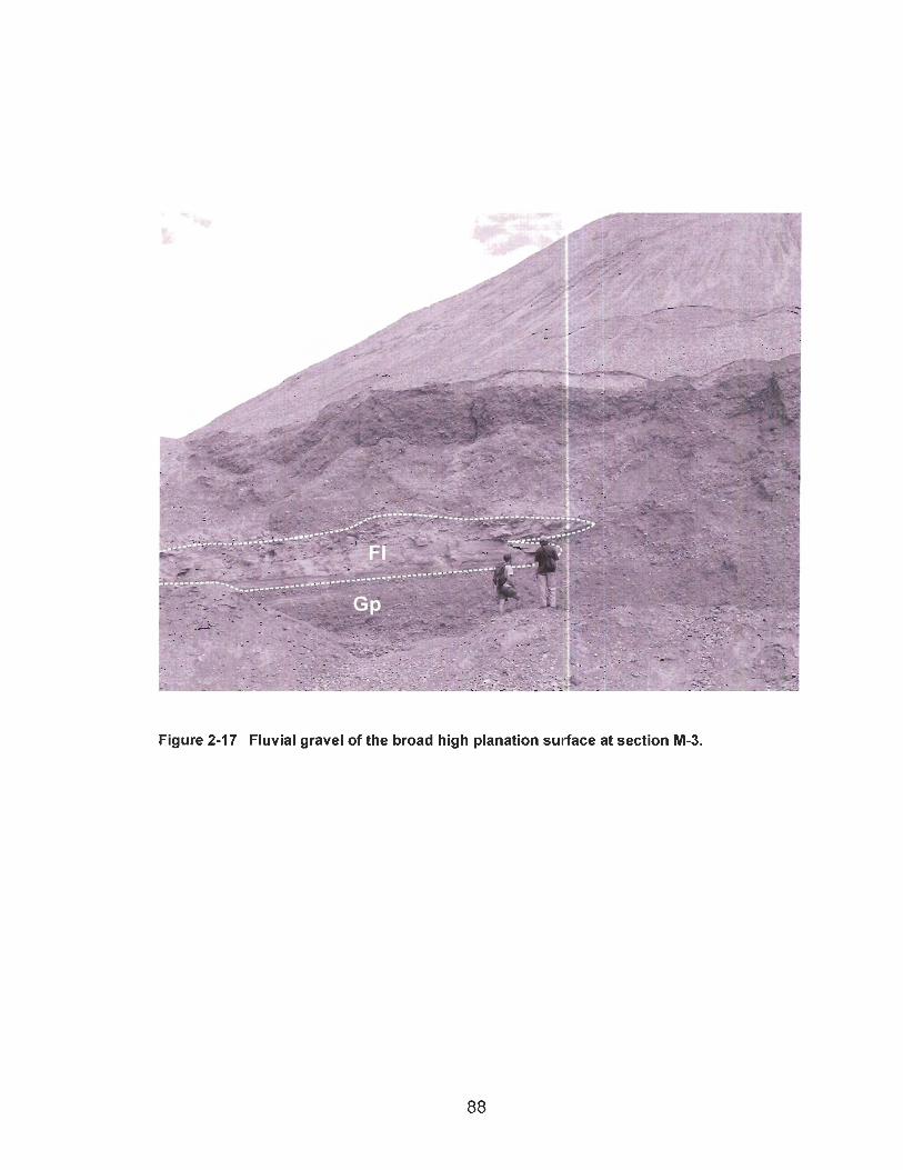
Figure 2-17 Fluvial gravel of the broad high planation sulface at section M-3.
2.4.2 Fluvial Deposits of the Upper Paleo-Valley
Fluvial deposits of the upper paleo-valley (Figure 2-18) lie on the higher of the
two incised bedrock straths described in section 2.1 . I . The strath is located on the north
side of Peace River valley between the confluence of Peace and Moberly rivers and the
eastern boundary of the study area (Figure 2-4). The strath and the sediments that
overlie it are recorded in nine sections and numerous water-well logs.
The top of the gravel lying on this strath is approximately 224 m above present-
day Peace River, and the gravel is 8.4 m thick on average. The dominance of gravel
lithofacies interpreted to be channel deposits (Gm, Gh) and the presence of silt lenses
(FI) suggest that the upper paleo-valley sediments were deposited by a braided river
(Church and Gilbert 1975; Miall 1977, 1984, 1985, 1992). The strath slopes 0.0006
eastward in the presumed direction of river flow, although no paleo-flow indicators were
found in exposures of the unit. Till unconformably overlies the gravel at four of the nine
exposures of the unit. Glaciolacustrine sediments overlie the gravel at the other five
exposures.
The upper gravel-covered strath is incised by the lower paleo-valley and the
modern Peace River valley. What remain of the strath and the gravel indicates a broad
valley occupied by an east-flowing paleo-Peace River.

Figure 2-18 Fluvial gravel of the upper paleo-valley overlying the upper bedrock strath at section SS-49.
The gravel is dominated by Cordilleran lithologies, notably quartzite, chert,
sandstone, coarse grey granitoid rocks, green to pink volcanic rocks, limestone, and
dolomite. However, it also contains rare granite gneiss clasts derived from the Canadian
Shield. These exotic clasts are present in eastern exposures near Alces River but not in
western exposures near Old Fort. Mathews (1978) reported Shield clasts in the gravel
as far west as Golata Creek. The presence of eastern-provenance clasts in fluvial
deposits of an east-flowing river suggests that an ancient Laurentide glaciation was
extensive enough to funnel meltwater into the Peace River basin as far west as Golata
Creek.
2.4.3 Advance-Phase Glaciolacustrine Deposits of Upper Paleo-valley
Thick glaciolacustrine deposits conformably overlie fluvial deposits of the upper
paleo-valley at sections SS-10, SS-22, SS-36, SS-50, and SS-109 (Figure 2-1 9). This
lithostratigraphic unit has maximum and average thicknesses of, respectively, 66 and
32.8 m, and occurs up to an elevation of 61 3 m a.s.1. within the upper paleo-valley.
The lithostratigraphic unit is dominated by lithofacies that record deposition from
suspension and underflows (FI, Fld, SI, Sld, Sm, Sr, and St). Dropstones and diamicton
pods, some containing Shield clasts, increase in abundance toward the top of the unit.
The transition from ice-distal to ice-proximal lithofacies indicates the approach of
Laurentide ice. Subaqueous debris flows are recorded by diamicton beds that load
underlying finer sediments. The presence of fluvial gravel lithofacies (Gm and Gfu) on
eroded glaciolacustrine sediments at section SS-50 suggests a lake-lowering event with
temporary reestablishment of fluvial flow. The gravel is, in turn, conformably draped by
glaciolacustrine sediments.
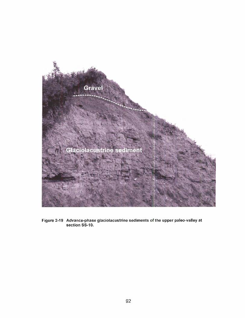
Figure 2-19 Advance-phase glaciolacustrine sediments d the upper paleo-valley at section SS-10.

The glaciolacustrine deposits of the upper paleo-valley are unconformably
overlain by till at section SS-50 and in several water well logs. At section SS-10, they
are unconformably overlain by fluvial gravel deposited during the Holocene. At three
other sections, the glaciolacustrine sediments directly underlie the surface, although
regionally they are overlain by till deposited during the last glaciation. They may also be
locally overlain by remnants of an older Laurentide till (see section 2.4.4).
2.4.4 Pre-Late Wisconsinan Eastern-Provenance Till
Mathews (1 978) documented two diamictons separated by stratified silt on the
north side of the Peace River valley southeast of Fort St. John. He interpreted the lower
of the two diamictons to be till of the penultimate glaciation.
A thick (up to 32 m) deposit of eastern-provenance till is exposed in sections
near Old Fort. Mathews (1978) hypothesized that tills of two glaciations may be present
here. An attempt was made to test this hypothesis by analyzing the fabric of the lower
till. A pebble fabric taken at the base of section SS-26 has a polymodal to girdle
distribution (Ln(SI/S2)/Ln(S2/S3) = 0.1 62;
Figure 2-20). The dominant mode is oriented towards 120"; a subordinate mode
is transverse to the dominant mode. The subordinate mode is parallel to regional ice
flow during the last glaciation (Mathews 1978). Striations on a boulder pavement at the
base of this unit trend 112", subparallel to the dominant fabric mode and thus transverse
to the regional Late Wisconsinan ice-flow direction. At section SS-24, however, a pebble
fabric from the base of a similar diamicton has a spread unimodal distribution
(Ln(SIlS2)lLn(S2/S3) = 0.359; Figure 2-21) with a dominant mode of 218", parallel to
surface ice-flow indicators.
Catto et al. (1996) noted several instances where till fabrics in the study area
indicate an upward change from flow aligned parallel to paleo-valleys to one consistent
with surface, Late Wisconsinan ice-flow indicators. These observations suggest that the
initial advance of Laurentide ice into the area was topographically controlled. Thus the
divergent fabric orientation at section SS-26 does not necessarily prove the presence of
more than one till.
Two diamictons directly overlie one another at section SS-50 near Old Fort
(Figure 2-22). This exposure is steep and approximately 60 m high. Only the lower
diamicton could be accessed, preventing detailed analysis of the contact between the
two units. However, the two diamictons can be distinguished on the basis of their clast
content, colour, and the presence of a recessive band at the sharp undulating contact
between the two units. The lower diamicton contains abundant Shield clasts and has a
strong bimodal fabric (Ln(SI/S2/Ln(S2/S3) = 1.372; Figure 2-23), with clusters oriented
248" and 68". A large anvil-shaped clast at the base of the lower diamicton appears to
haye been lodged (Figure 2-24). It has a flat upper surface that displays two sets of
striations, an older set oriented 240" and a younger set oriented 220". The fabric and
striations are roughly parallel to the surface ice-flow indicators. The lower diamicton is
interpreted to be till of eastern provenance. The upper diamicton corresponds
stratigraphically with the Late Wisconsinan Laurentide till.
Section SS-50 lies on the same bedrock shelf and roughly 10 km east of the
locality where Mathews (1 978) documented two tills separated by silt. The two tills may
have been deposited during separate glaciations. A second hypothesis is that both tills
were deposited during a single Late Wisconsinan glaciation separated by minor glacier
retreat. A third hypothesis is that the two tills were deposited by different sub-glacial
mechanisms during the same advance, as may happen in response to changing ice-flow
dynamics (Benn and Evans 1998, p. 557). The two tills cannot be assigned to two
separate glaciations without detailed analysis of the contact that separates them and
recovery of dateable material.
Although till of a pre-Late Wisconsinan eastern-provenance glaciation has not
been positively identified in the study area, two eastern-provenance glacial events are
recognized by the presence of Shield clasts in the gravels of the upper and lower paleo-
valleys as far west as Golata Creek and Lynx Creek, respectively. The clasts may have
been transported westward by glacier ice, ice rafting in a proglacial lake, or by meltwater
streams, thus the western limit of this glaciation is uncertain. However, the glaciation
was sufficiently extensive to dam the paleo-Peace River and create a lake that extended
west at least to Fort St. John.
Pre-Late Wisconsinan eastern-provenance till has recently been discovered
underlying dated gravel in the Elleh Creek area (NTS 94J) north of the NTS 94A map-
area (V.M. Levson, personal communication, 2005.). A radiocarbon age of 24,400 +/-
150 I4c yrs BP (Beta 183598; Levson et al. 2004) was obtained on a wood fragment
recovered from gravel overlying the lower eastern-provenance till and underlying the
Late Wisconsinan Laurentide till.
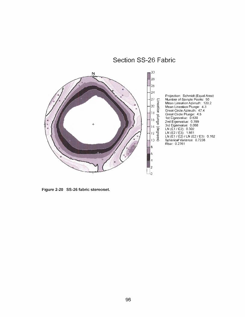
Section SS-26 Fabric
Projection: Schmidt (Equal Area) Number of Sample Points: 50 Mean Lineation Azimuth: 120.2 Mean Lineation Plunge: 4.3 Great Circle Azimuth: 47.4 Great Circle Plunge: 4.5 1st Eigenvalue: 0.539 2nd Eigenvalue: 0.399 3rd Eigenvalue: 0.068 LN (El I E2): 0.302 LN (E2 I E3): 1.861 LN (El I E2) I LN (E2 I E3): 0.162 Spherical Variance: 0.7238 Rbar: 0.2761
Figure 2-20 SS-26 fabric stereonet.
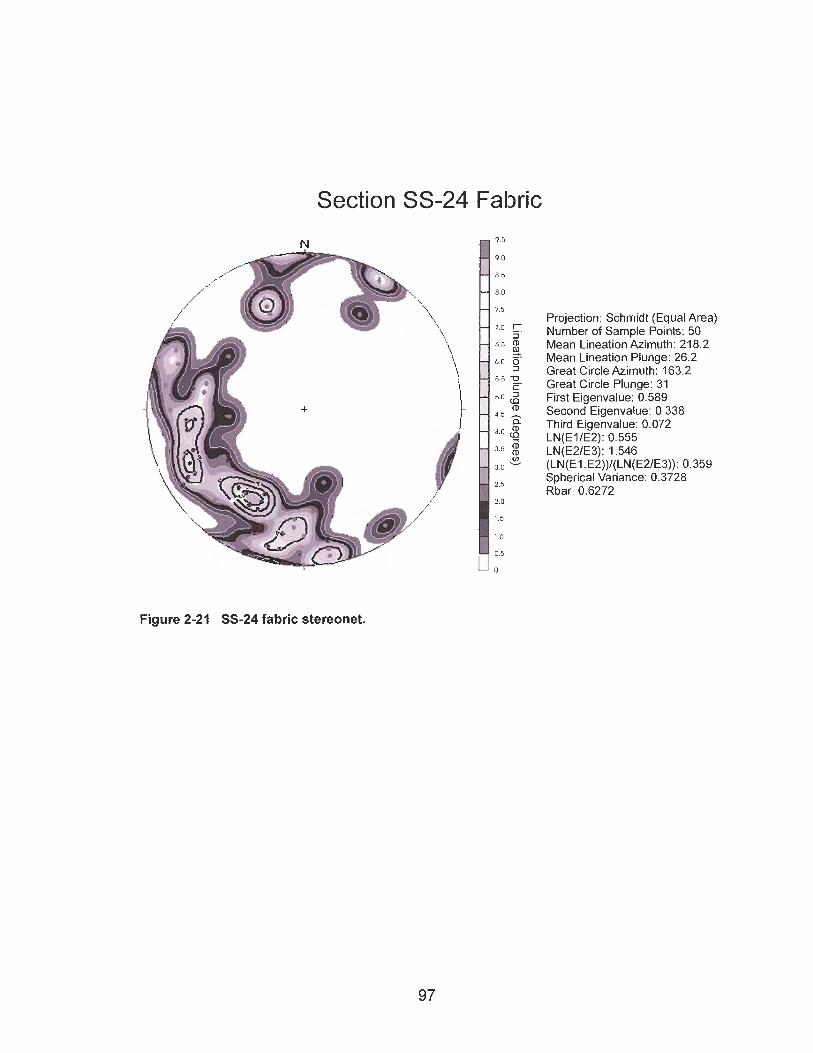
Section SS-24 Fabric
. .
i i
. - - a Third ~ i ~ e n v a l u e : 0.072
4.0 LN(ElIE2): 0.555
3 5 LN(E21E3): 1.546 " (LN(E1 .EZ))l(LN(EZIE3)): 0.359 3 0 -
2.5 Spherical Variance: 0.3728 Rbar: 0.6272
2.0
1.5
1 0
0.5
Projection: Schmidt (Equal Area) 7.0
# 7'5
Number of Sample Points: 50 - 6 5 $ Mean in eat ion kzimuth: 218.2 e.
,,, , Mean Lineation Plunge: 26.2 Great Circle Azimuth: 163.2
5.5 Great Circle Plunge: 31 5.0 2 First Eigenvalue: 0.589
(D Second Einenvalue: 0.338
Figure 2-21 SS-24 fabric stereonet.
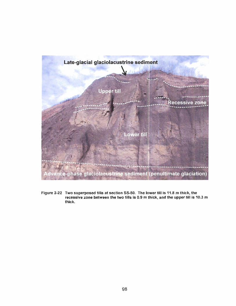
Advance
Figure 2-22 Two superposed tills at section SS-50. The lower till is 11.8 m thick, the recessive zone between the two tills is 0.9 m thick, and the upper till is 10.3 m thick.
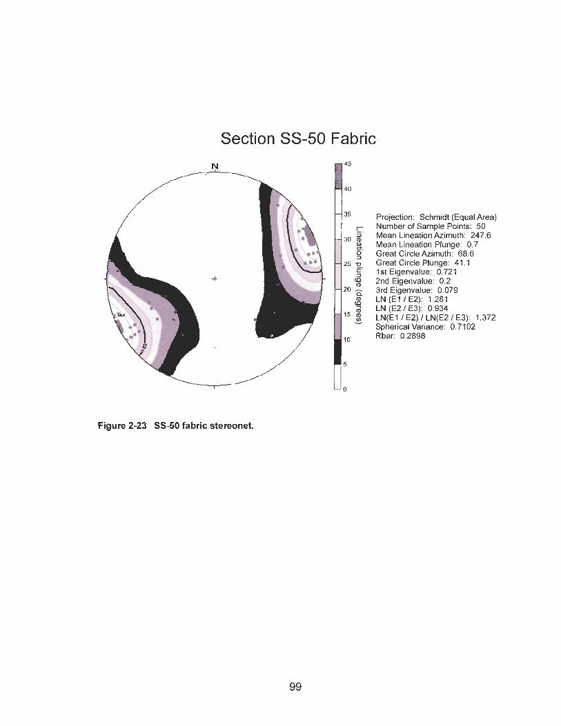
Section SS-50 Fabric
Projection: Schmidt (Equal Area) Number of Sample Points: 50 Mean Lineation Azimuth: 247.6 Mean Lineation Plunge: 0.7 Great Circle Azimuth: 68.6 Great Circle Plunge: 41 .I I st Eigenvalue: 0.72 1 2nd Eigenvalue: 0.2 3rd Eigenvalue: 0.079 LN (E l / E2): 1.281 LN (E2 / E3): 0.934 LN(E1 I E2) I LN(E2 I E3): 1.372 Spherical Variance: 0.71 02 Rbar: 0.2898
Figure 2-23 SS-50 fabric stereonet.
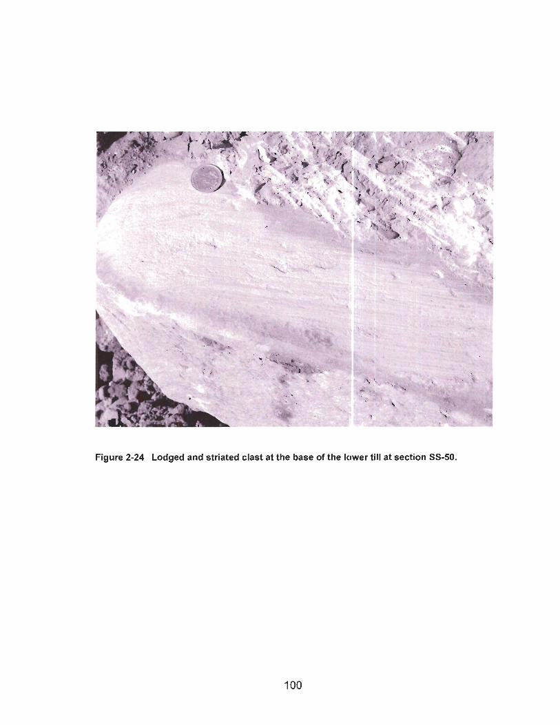
Figure 2-24 Lodged and striated clast at the base of the lower till at section SS-50.
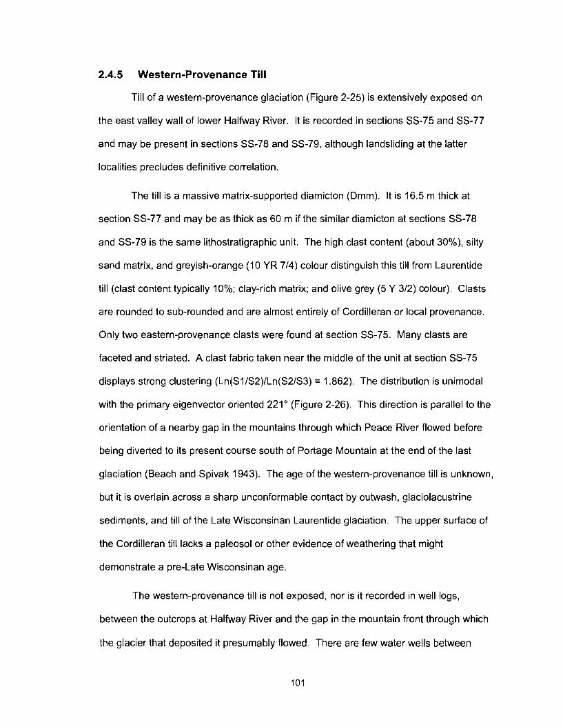
2.4.5 Western-Provenance Till
Till of a western-provenance glaciation (Figure 2-25) is extensively exposed on
the east valley wall of lower Halfway River. It is recorded in sections SS-75 and SS-77
and may be present in sections SS-78 and SS-79, although landsliding at the latter
localities precludes definitive correlation.
The till is a massive matrix-supported diamicton (Dmm). It is 16.5 m thick at
section SS-77 and may be as thick as 60 m if the similar diamicton at sections SS-78
and SS-79 is the same lithostratigraphic unit. The high clast content (about 30%), silty
sand matrix, and greyish-orange (10 YR 714) colour distinguish this till from Laurentide
till (clast content typically 10%; clay-rich matrix; and olive grey (5 Y 312) colour). Clasts
are rounded to sub-rounded and are almost entirely of Cordilleran or local provenance.
Only two eastern-provenance clasts were found at section SS-75. Many clasts are
faceted and striated. A clast fabric taken near the middle of the unit at section SS-75
displays strong clustering (Ln(SI/S2)/Ln(S2/S3) = 1.862). The distribution is unimodal
with the primary eigenvector oriented 221" (Figure 2-26). This direction is parallel to the
orientation of a nearby gap in the mountains through which Peace River flowed before
being diverted to its present course south of Portage Mountain at the end of the last
glaciation (Beach and Spivak 1943). The age of the western-provenance till is unknown,
but it is overlain across a sharp unconformable contact by outwash, glaciolacustrine
sediments, and till of the Late Wisconsinan Laurentide glaciation. The upper surface of
the Cordilleran till lacks a paleosol or other evidence of weathering that might
demonstrate a pre-Late Wisconsinan age.
The western-provenance till is not exposed, nor is it recorded in well logs,
between the outcrops at Halfway River and the gap in the mountain front through which
the glacier that deposited it presumably flowed. There are few water wells between
these two areas, but several sections provide good exposures. The absence of the
western-provenance till in these exposures seems peculiar, although it may have been
eroded or buried. Burial is likely because the deep bedrock basins described in section
2.1.2 are located in the area between the Portage Mountain end moraine and Halfway
River. If the Cordilleran glacier that deposited the till at Halfway River carved the basins
below the Portage Mountain end moraine and Lynx Creek, the till would lie on the basin
floors and thus be deeply buried.
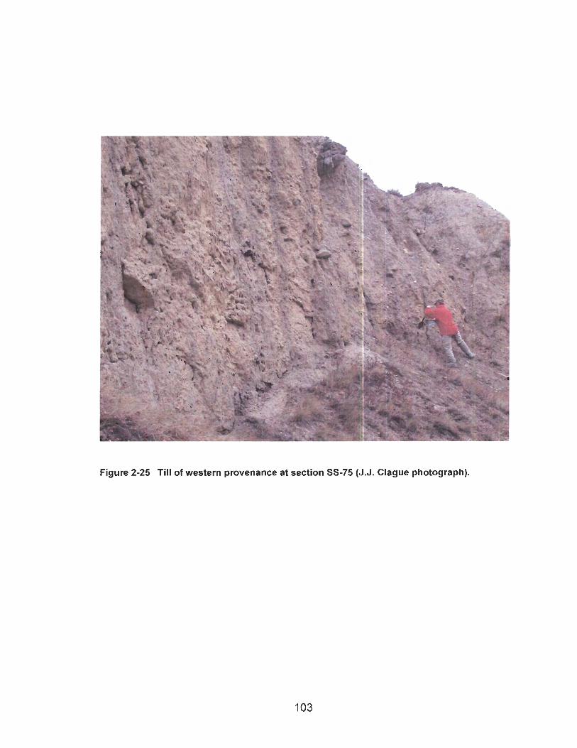
Figure 2-25 Till of western provenance at section SS-75 (.J.J. Clague photograph).
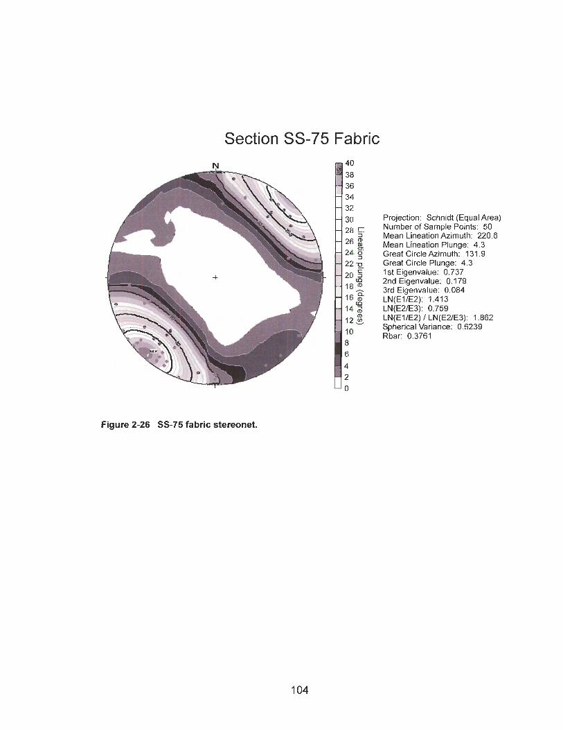
Section SS-75 Fabric
Figure 2-26 SS-75 fabric stereonet.
Projection: Schnidt (Equal Area) Number of Sample Points: 50 Mean Lineation Azimuth: 220.6 Mean Lineation Plunge: 4.3 Great Circle Azimuth: 131.9 Great Circle Plunge: 4.3 1st Eigenvalue: 0.737 2nd Eigenvalue: 0.179 3rd Eigenvalue: 0.084 LN(ElIE2): 1.41 3 LN(E2lE3): 0.759 LN(ElIE2) I LN(EZE3): 1.862 Spherical Variance: 0.6239 Rbar: 0.3761

2.4.6 Fluvial Deposits of the Lower Paleo-Valley
A lithostratigraphic unit composed of gravel-dominated lithofacies (Gm, Gmi, Gfu,
and Gh) lies on the floors of the lower paleo-valleys (Figure 2-27). It is well exposed in
the valley walls of the modern Peace River and its larger tributaries. The lower paleo-
valleys are incised by the modern drainage system where the paths of present-day rivers
match those of their former counterparts. The top of the gravel unit in this paleo-valley
system is about 49 m above river level. The maximum and average thicknesses of the
unit are, respectively, 67 and 13.2 m.
The gravel-covered strath of the lower Peace paleo-valley slopes 0.0006 to the
east. Eastward flow is supported by paleo-flow measurements on imbricated gravel at
11 sections. The dominance of gravel lithofacies (Gm, Gmi, Gfu, and Gh) interpreted to
be channel deposits and rare lenses of finer material (St, Sp, Sr, Sh, SI, Sm, FI, and Fm)
suggest that the river had a braided planform (Church and Gilbert 1975; Miall 1977,
1984, 1985, 1992).
The lithostratigraphic unit is dominated by Cordilleran and local lithologies,
specifically quartzite, chert, sandstone, coarse grey granitoid rocks, green to pink
volcanic rocks, limestone, and dolomite. It also contains clasts derived from the
Canadian Shield in exposures between Lynx Creek and the eastern boundary of the
study area. The distribution of Shield clasts suggests that pre-Late Wisconsinan
glaciation was reasonably extensive, although Laurentide ice need not have reached as
far west as Lynx Creek for eastern-provenance clasts to be present there.
Fluvial deposits of the lower paleo-valley are conformably overlain by advance-
phase glaciolacustrine deposits associated with the same valley system (Figure 2-28).
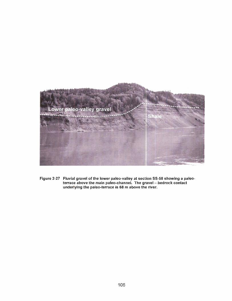
- o-xallev aravel :
Figure 2-27 Fluvial gravel of the lower paleo-valley at section SS-58 showing a paleo- terrace above the main paleo-channel. The gravel - bedrock contact underlying the paleo-terrace is 68 m above the river.
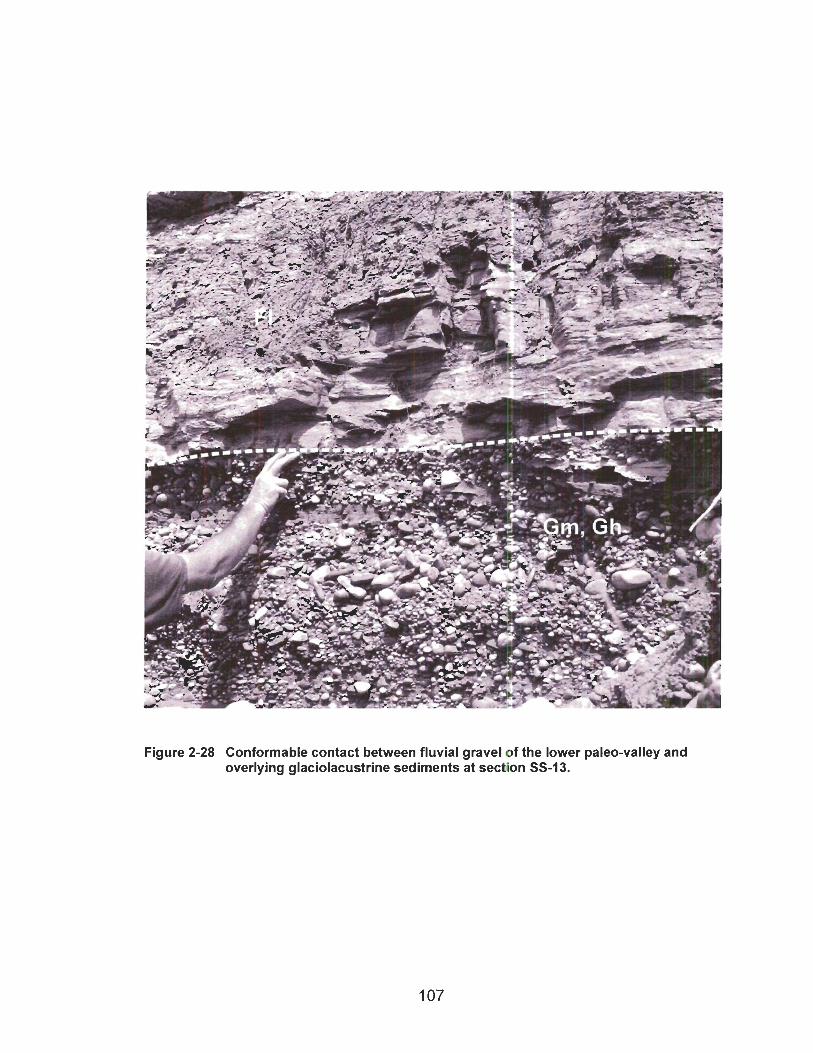
The contact between the two units is gradational, and generally spans no more than 1
m. At sections SS-18, SS-19, SS-44, SS-47, SS-64, and SS-81, however, the
gradational zone spans 2 to 25 m and is marked by an interfingering transition from
gravel (Gm, Gp, and Gfu), through sand (Sp, St, Sr, Sh, Sm, and SI), into silt (FI). This
relation indicates that the transition from fluvial to lacustrine sedimentation at these sites
involved an interplay between the two environments. Such interplay would be expected
during initial flooding of the valley when east-flowing rivers were blocked by advancing
Laurentide ice.
2.4.7 Advance-Phase Glaciolacustrine Deposits of the Lower Paleo-Valley
Thick glaciolacustrine sediments conformably overlie fluvial deposits of the lower
paleo-valley system and record damming of the paleo-Peace valley and its tributaries
early during the last glaciation. The sediments are notable for their thickness (up to 100
m) and homogeneity (Figure 2-29). They are dominated by laminated fines (FI) and
horizontal and drape laminated sands (SI) deposited from suspension and underflows in
ice-distal, deep-water environments (Gustavson et al. 1975, May 1977, Ashley 1988,
Wolfe and Teller 1995).
Coarser sediments, indicative of high-energy depositional processes, are also
present in the advance-phase glaciolacustrine sequence. They include clast-supported
massive diamicton (Dcm) deposited by subaqueous debris flows (May 1975), and cross-
bedded, horizontally bedded, and rippled sands (Sp, St, Sh, and Sr) deposited by
energetic density underflows (Wolfe and Teller 1995). Such coarser assemblages of
glaciolacustrine lithofacies have been interpreted to be basin-marginal (Ashley 1988;
Wolfe and Teller 1995). In the study area, these lithofacies generally are found in
sections near paleo-valley walls.

Sections SS-56, SS-60, and SS-75 contain a rippled and cross-bedded sand unit
at about the same elevation high in the glaciolacustrine sequence (Figure 2-30). The
sand records energetic deposition, possibly due to a strong underflow out of the paleo-
valley of Halfway River, which is near the three sections.
Glaciolacustrine sediments of the lower paleo-valley fill are generally free of
dropstones. However, at sections where the unit has not been deeply eroded by
overriding Laurentide ice, dropstones and diamictic pods increase in abundance upward
through the unit. The transition from ice-distal to ice-proximal glaciolacustrine lithofacies
is interpreted to be due to advance of the Laurentide Ice Sheet.
The advance-phase glaciolacustrine deposits may extend westward into the
Rocky Mountain foothills between Portage and Bullhead Mountains. The drill-log
through the Portage Mountain end moraine records silt, silty sand, and clayey sand
overlying interbedded gravel, sand, and silt (Campbell 1959). The gravel correlates in
thickness and elevation with fluvial deposits of the lower paleo-valley (section 2.1.2).
The overlying finer sediments likely record deposition in a lake dammed by advancing
Laurentide ice.
The highest elevation at which the lower paleo-valley glaciolacustrine sediments
have been found is 632 m a.s.1. This is a minimum elevation for the upper limit of the
lake.
Complete, intact sections of this lithostratigraphic unit are rare, because the
sediments are prone to landsliding. Failure generally occurs low in the sequence, where
sliding planes are localized in abundant clay-rich laminae. Clay-rich laminae, however,
occur throughout the sequence, and sliding planes were noted at high stratigraphic
positions.
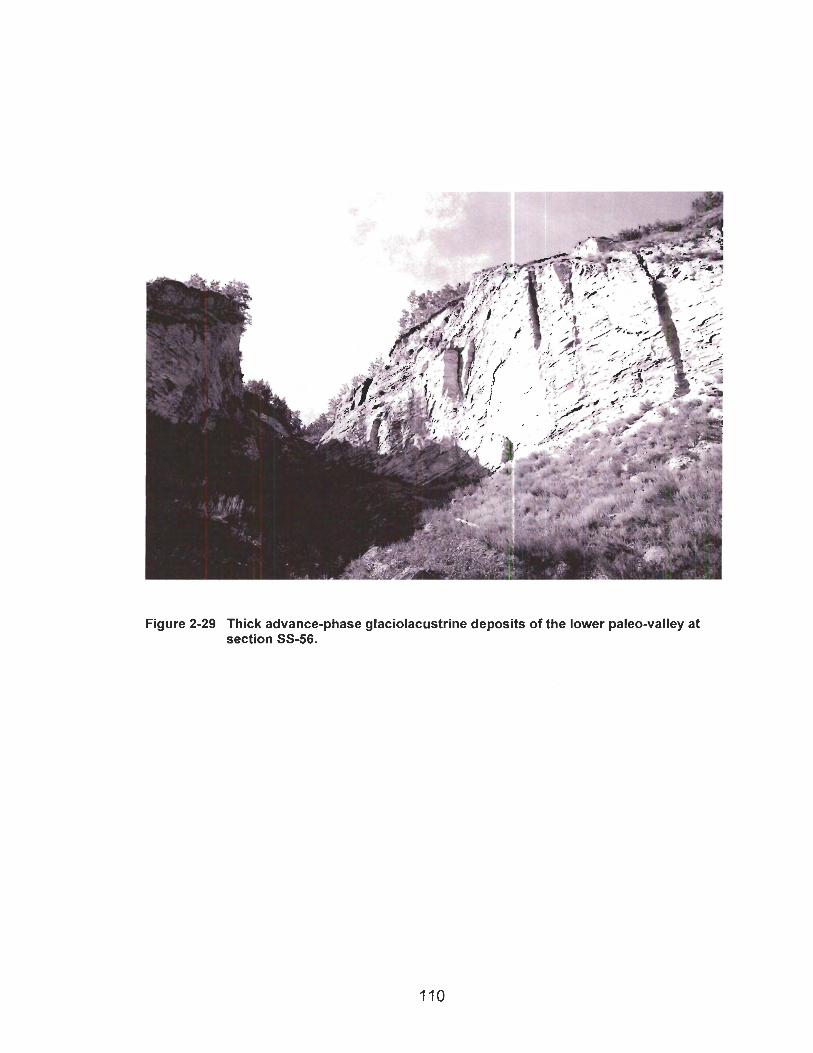
Figure 2-29 Thick advance-phase glaciolacustrine deposits of the lower paleo-valley at section SS-56.
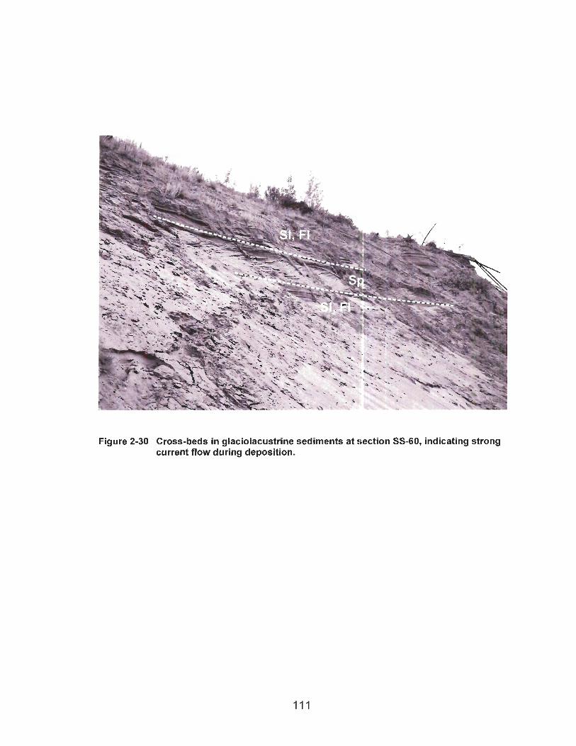
Figure 2-30 Cross-beds in glaciolacustrine sediments at section SS-60, indicating strong current flow during deposition.
2.4.8 Till of the Last Glaciation
Till of the last (Late Wisconsinan) glaciation occurs throughout the study area
(Figure 2-31). It unconformably overlies bedrock and glaciolacustrine sediments and is
conformably overlain by late-glacial glaciolacustrine sediments. The unit has the form of
an irregular blanket that is 12 m thick on average. It consists almost entirely of massive
matrix-supported diamicton (Dmm) with less than 15% clasts and more than 85% silt
and clay matrix. The till ranges in colour from olive grey (5 Y 312) to light olive grey (5 Y
512). Many clasts are well rounded, suggesting that they were eroded from fluvial
sediments. Granite and granitoid gneiss clasts derived from the Canadian Shield are
common in the till.
Drumlins and flutings mapped by Mathews (1978; Figure 2-32) suggest that late-
glacial regional ice flow was toward the south-southwest. In the southeast part of the
study area, the ice flow indicators gradually shift to the south-southeast. Pebble fabric
orientations and striated pavements measured at the base of the till at two sections (SS-
24 and SS-50) match the direction of regional ice flow. However, at sections SS-26 and
SS-91, the fabrics are parallel to the local paleo-valley axis and transverse to the
regional flow direction. These data suggest that initial Laurentide ice flow into these
areas was topographically controlled.
The ice sheet that deposited the till extended westward beyond the study area
into the Rocky Mountain foothills. Shield erratics occur above the maximum limit of
Glacial Lake Peace in east-draining valleys in the foothills (Bobrowsky et al. 1991; Catto
et al. 1996). No end moraines related to this advance have been recognized.

Figure 2-31 Late Wisconsinan till with Shield clast at section SS-50 (J.J. Clague photograph).
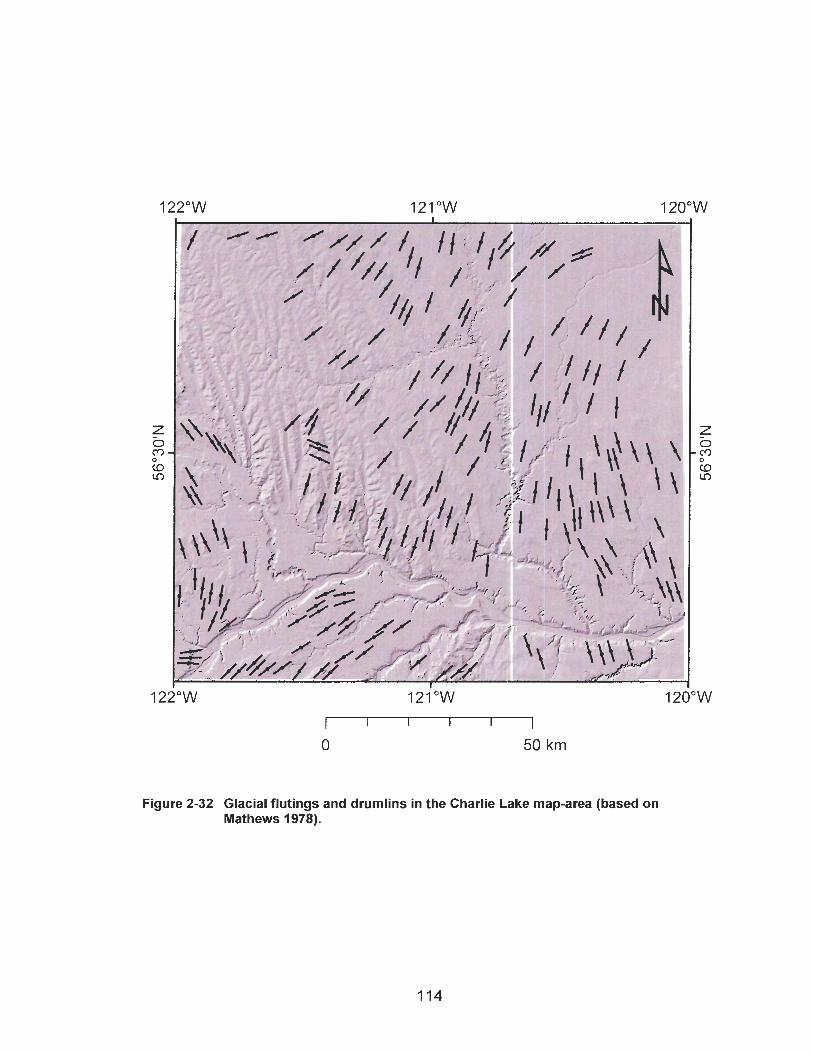
Figure 2-32 Glacial flutings and drumlins in the Charlie Lake map-area (based on Mathews 1978).

2.4.9 Late-glacial Glaciolacustrine Deposits
Glacial Lake Peace was impounded behind the retreating Laurentide Ice Sheet at
the end of the last glaciation (Mathews 1978, 1980). Sediments deposited in Glacial
Lake Peace occur at the surface, where they conformably overlie Late Wisconsinan till.
Glacial Lake Peace deposits consist mainly of laminated fines with dropstones (Fld;
Figure 2-33). The concentration of dropstones is generally less than 5%.
Several stages of Glacial Lake Peace have been identified from relict shorelines,
deltas, and spillways (Rutter 1977, Mathews 1980, Woolf 1993). The oldest and highest
stage of the lake (Bessborough stage) left shorelines between 835 and 855 m a.s.1. A
later, unnamed stage produced shorelines between 803 and 818 m a.s.1. This stage, in
turn, was followed by the Clayhurst stage, with shorelines between 680 and 725 rn a.s.1.
The last stage of Glacial Lake Peace in the study area was the Indian Creek stage,
recorded by a shoreline at 646 m a.s.1.
2.4.1 0 Holocene Fluvial Deposits
Fluvial gravel underlies terraces cut during postglacial incision of the modern
Peace River valley (Figure 2-1 6). The most prominent terrace is 45 m above present-
day Peace River; its capping gravel is about 17 m thick. The geomorphology of these
deposits readily facilitates their identification as Holocene fluvial deposits. The older
gravel units are generally overlain by glaciolacustrine sediments and till, whereas
Holocene gravel directly underlies terraces. In section, the gravel is similar to older
gravel units, except that the proportion of eastern-provenance clasts within the terrace
gravel is much greater.
Postglacial and older fluvial deposits are more difficult to differentiate where
Peace River incised paleo-valley gravel lithostratigraphic units. The most prominent
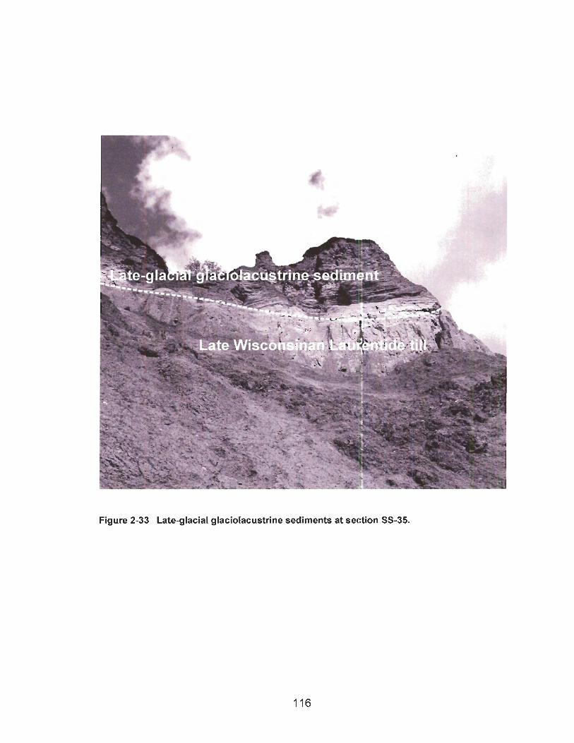
Figure 2-33 Late-glacial glaciolacustrine sediments at section SS-35.
Holocene terrace lies at approximately the same elevation as the strath of the lower
paleo-valley, and at many sections postglacial and paleo-valley gravels are superposed
across an unconformity (SS-13, SS-14, SS-15, SS-15a, SS-16, SS-47, SS-62, and SS-
103). Terrace gravel units at other sites may include, in their lower parts, gravel of the
lower paleo-valley, but the absence of a well defined unconformity between the two
complicates their recognition.
Radiocarbon ages on fossils recovered from gravels of the large postglacial
terrace at Taylor support the interpretation of superposed fluvial lithostratigraphic units:
Mathews (1 978) reported a radiocarbon age of 27,400 +I- 580 14c yrs BP (GSC-2034)
on a mammoth tooth from the Ostero gravel pit on this terrace. Bobrowsky et al. (1992)
obtained an age of 10,240 +I- 160 14C yrs BP (AECV-1206C) on bone from the same
gravel pit. A prominent boulder lag within the gravel and about 5-7 m above bedrock
(sections SS-15, SS-16, SS-19) may be the contact between pre- and postglacial gravel
at this site.
2.4.1 1 Landslide Deposits
Most landslide deposits consist of massive matrix-supported diarnicton (Dmrn).
The diamicton is less compact than typical Laurentide till and generally has a lower
stone content. Recognition of landslide deposits, however, is based less on lithofacies
analysis than on geomorphology. Landslides typically have hummocky surfaces, with
gentle to moderately inclined slopes. The surfaces are marked by tension cracks, tilted
trees, and sag ponds. They are located down-slope from scalloped head scarps.
2.5 Quaternary Sediments and Landsliding
Landslides are common throughout the Peace River valley and the valleys of its
larger tributaries (Figure 2-34). Severin (2004) recognized 1610 landslides in the Charlie
Lake map-area. About 56% of these landslides have sources in sediments filling paleo-
valleys (Severin 2004), mainly in advance-phase glaciolacustrine deposits of the lower
paleo-valley system. Landslides have also occurred in late-glacial glaciolacustrine
sediments (Geertsema 1998) and advance-phase glaciolacustrine sediments of the
upper paleo-valley system.
Landslide deposits have generally covered the sediments on which they slid,
preventing examination of the failure plane. However, the contact between landslide
debris and underlying intact sediment was observed at 20 sections (SS-5, SS-8, SS-17,
SS-28, SS-29, SS-30, SS-32, SS-34, SS-38, SS-40, SS-41, SS-45, SS-46, SS-48, SS-
55a, SS-56, SS-57, SS-58, SS-59, and SS-80). All of the contacts are within advance-
phase glaciolacustrine deposits of the lower paleo-valley system. At 15 of the 20 sites,
the contact between disturbed and intact material is just centimetres above the base of
the glaciolacustrine lithostratigraphic unit. At the other five sites (SS-5, SS-17, SS-30,
SS-38, and SS-80), the contact is higher in the sequence. A distinct sliding plane was
identified at only five sections (SS-30, SS-34, SS-56, SS-59, and SS-80).
Failure planes are located within clay-rich layers deposited by distal suspension
settling in a glacial lake. Atterberg limits were determined on two sediment samples
collected from failure planes and two samples of clay-rich layers that are not involved in
landsliding (Table 2-3). The intact and failed clay layers are similar in particle size
distribution and Atterberg limits; however, quantification of this observation is not
possible with a sample population of only four.
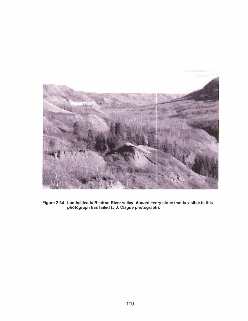
Figure 2-34 Landslides in Beatton River valley. Almost every slope that is visible in this photograph has failed (J.J. Clague photograph).
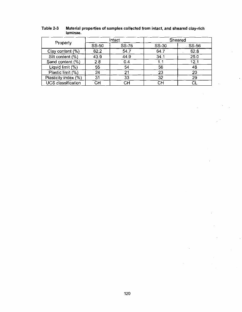
Table 2-3 Material properties of samples collected from intact, and sheared clay-rich laminae.
I UCS classification I CH CH CH CL
CHAPTER 3 DISCUSSION
3.1 Stratigraphy and History
Quaternary sediments on the western lnterior Plains of northeastern British
Columbia are associated with five drainage systems of different ages (Figure 3-1).
Deposits of four drainage systems are found in the study area. The fifth and oldest
system is recorded by fluvial gravel overlying an eastward-sloping peneplain east of the
study area (Mathews 1978; Liverman 1989). The Quaternary lithostratigraphic units that
define the four drainage systems in the study area include fluvial deposits of the high
bedrock planation surface, fluvial deposits of the upper paleo-valley system, fluvial
deposits of the lower paleo-valley system, and fluvial deposits of the modern valley
system. Fluvial deposits of three relict drainage systems and overlying valley fill are
shown in cross-section A-A' through Beatton and Peace River valleys (Figure 3-2).
East-draining rivers in the study area established themselves at successively
lower elevations through middle and late Tertiary and Quaternary time following the
Laramide Orogeny. Mathews (1 989) noted local dissected gravel-capped peneplains of
early Oligocene to late Tertiary age in the eastern foothills and western lnterior Plains
from Montana north to the Richardson Mountains in Yukon Territory. Remnants of lower
drainage systems are probably Pleistocene in age. As a result, successive drainage
systems cross-cut and nest within one another, producing a palimpsest of valley in-fills
that provide a framework on which a relative chronology of geologic events can be
placed.
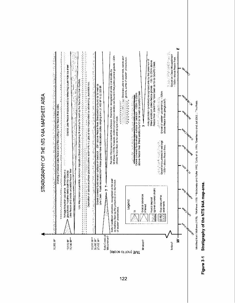
V3tlV
133HS
dW V
P6 S
IN 3
HlJO
AH
dVtl3llV
tllS
Incision of the drainage systems is probably due to a combination of epeirogenic
uplift (Pauaglia et al. 2001; McMillan and Heller 2002), increased erosion due to
climatic forcing in the late Cenozoic (Dethier 2001), and base-level lowering resulting
from drainage integration and glaciation (Pederson and Pazzaglia 2002). The
stratigraphy of the NTS 94A map-area is summarized in Figure 3-2.
3.1 .I Pre-Glacial River System
Fluvial gravel of the high planation surface is the oldest post-Cretaceous
lithostratigraphic unit in the study area. It was deposited prior to the first Laurentide
glaciation of the area, as it lacks eastern-provenance clasts. The stratigraphic unit
records a period of deposition following planation of bedrock surfaces by an east to
north-flowing river system. The gravel is interpreted to be a braidplain deposit (Church
and Gilbert 1975; Miall 1977, 1984, 1985, 1992). The river transported sediment of
smaller calibre, and may have been less energetic than modern Peace River. The wide
distribution of the gravel on low-relief upland bedrock surfaces suggests deposition on a
broad peneplain.
The age of the pre-glacial fluvial gravel is unknown. It is younger than the middle
to late Tertiary peneplains capped by similar gravel at the western edge of the Interior
Plains, including the Clear Hills, Saddle Hills, and Chinchaga Hills (Mathews 1978;
Liverman 1989; Stott and Aitken 1993). The gravel is tentatively assigned a late Tertiary
or early Pleistocene age because it pre-dates any Laurentide glaciation of the area and
lies on highly dissected, fluvially eroded, bedrock. The surface of the uplands
surrounding these erosional remnants has been lowered below the elevation at which
the gravel was deposited. The gravel capping the erosional remnants was deposited
late during the period of denudation of the plateau. Subsequently, drainage became
incised into this broad fluvial planation surface.
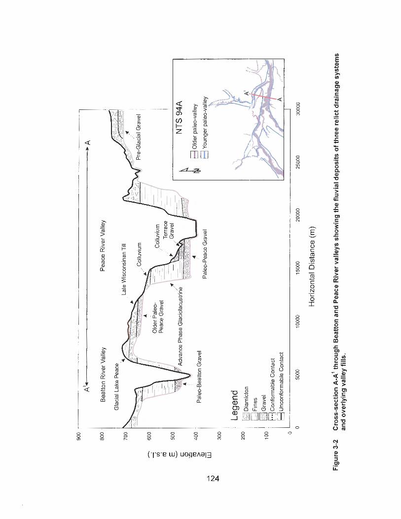
3.1.2 Early Non-Glacial River System
The next younger deposit in the study area is fluvial gravel of the upper paleo-
valley. Evidence for at least two major geologic events is preserved in this
lithostratigraphic unit: an early Laurentide glaciation and an interglaciation during which
rivers incised the lnterior Plains.
The gravel occupies the upper paleo-valley of Peace River north of the modern
river valley between Alces River and Old Fort. The paleo-valley has been incised by,
and thus pre-dates, the lower paleo-valley and modern Peace River valley. The broad,
flat-floored upper paleo-valley is that of a mature fluvial system. The paleo-valley is
much larger than postglacial Peace valley, suggesting that it formed over a long time.
The well sorted, coarse channel facies that dominate the lowermost sediments of
the valley fill are interpreted to be the deposits of a braided river (Church and Gilbert
1975; Miall 1977, 1984, 1985, 1992). The river flowed eastward across the study area
with an average gradient of 0.0006, similar to that of modern Peace River. The calibre
of its bed-load is also similar to that of modern Peace River.
The gravel of the upper paleo-valley contains the same lithologies as the older,
pre-glacial fluvial gravel, with one important exception. Rare clasts of granite and
granitoid gneiss derived from the Canadian Shield occur in exposures near Alces River
and Golata Creek and at section SS-109, but not farther west. The Shield clasts were
transported westward up the regional slope of the lnterior Plains during an early
Laurentide glaciation. Mathews (1978) concluded that the clasts were transported as far
west as Golata Creek by Laurentide ice. Alternatively, they could have been rafted on
icebergs in a lake dammed somewhere to the east by the Laurentide Ice Sheet, or they
could have been transported into paleo-Peace River valley by a northern tributary or by
meltwater diverted along the Laurentide ice margin. Without associated moraines or
other ice-marginal features, the exotic clasts do not prove that the western half of the
study area was covered by ice during this early advance. Their presence does,
however, indicate that an early Laurentide advance at least approached the study area.
This early glaciation may not have taken place until after the Matuyama
Reversed Polarity Chron (0.78 Ma). Barendregt and Irving (1998) found that all glacial
sediments on the central lnterior Plains are normally magnetized. They concluded that
the Laurentide Ice Sheet did not extend across the western lnterior Plains until after 0.78
Ma.
Glaciation may have been partly responsible for entrenchment of the high
bedrock planation surface. Pederson and Pazzaglia (2002) concluded that, although
epeirogenic uplift and climate change are significant causes of fluvial incision, they may
be subordinate to base-level lowering caused by drainage integration and glacial
repositioning of drainage. They noted a significant lag time between early Cenozoic
uplift in the western United States and late Cenozoic incision of the drainage in the
region and also documented incision following periods of drainage integration and
formation of new ice-marginal channels.
3.1.3 Penultimate Glaciation
3.1.3.1 Laurentide Advance
Advance-phase glaciolacustrine sediments of the upper paleo-valley conformably
overlie the early nonglacial fluvial gravel. The sediments were deposited when east-
flowing, paleo-Peace River was dammed by Laurentide ice advancing up the regional
slope of the western lnterior Plains. The glaciolacustrine sediments were noted as far
west as section SS-50, near Old Fort. However, the lake reached to at least 613 m a.s.1.
and thus probably extended farther west.
Paleo-Peace River was dammed by a glacier, not by a landslide. A landslide is
not a plausible damming mechanism because dropstones and diamicton pods increase
upward in the lacustrine unit in the paleo-valley fill. Furthermore, the highest shoreline
(61 3 m a.s.1.) indicates that the lake was at least as deep as the paleo-valley. The
presence of a Shield clast in a diamictic pod within the sediments at section SS-50
strengthens the argument that eastern-provenance ice impounded the lake.
The advance-phase glaciolacustrine sediments have not been dated, but they
were incised when the lower paleo-valley system formed and thus are older than that
system. The lower paleo-valley is no younger than Middle Wisconsinan, consequently
the glaciolacustrine sediments filling the upper paleo-valley system, as well as the
Laurentide ice sheet that impounded the lake in which these sediments accumulated,
are Early Wisconsinan or older in age.
Moraines of the penultimate Laurentide glaciation have not been identified in the
study area. Mathews (1 978), however, described a till that he attributed to a pre-Late
Wisconsinan Laurentide glaciation. In a section above Old Fort, Mathews recorded two
similar Laurentide tills separated by what he interpreted to be interglacial silt. He
assigned the upper till to the Late Wisconsinan and the lower till to an older glaciation.
Mathews suspected that the two tills were present farther north, within the limits of the
upper paleo-valley, but a paucity of subsurface data prevented him from testing this
hypothesis. The database in the area of Old Fort is little better today than at the time of
Mathews' study - there are few reliable water well logs and no other sources of
subsurface data. The available water well logs, however, do not show two diamictons
separated by silt.
Mathews' two-till section no longer exists, but a section near Old Fort exposes
two diamictons in direct contact with one another. Unfortunately, the upper diamicton
and its contact with the lower diamicton could not be accessed safely. Therefore, it
could not be demonstrated that the two diamictons are the product of two glaciations.
Liverman (1989) pointed out that two tills separated by silt can also be
interpreted to record a short interval of local glacier retreat within a single glaciation.
Mathews (1978) had no chronological control on his section, nor did he report leaching
or weathering of the lower till.
The older advance-phase glaciolacustrine sediments and Shield clasts within the
lower paleo-valley fluvial gravel provide definitive evidence for the penultimate
Laurentide advance. Although uncommon, Shield clasts were recovered from the lower
paleo-valley gravel as far west as Lynx Creek, corroborating Mathew's assertion that the
penultimate Laurentide glaciation transported eastern-provenance clasts farther west
than an earlier early Laurentide advance.
The western limit of the penultimate Laurentide glacial advance is unknown.
Because there are no definitive penultimate glacial landforms or till, the possibility must
be considered that Shield clasts were transported into the study area by a means other
than a glacier. Perhaps the clasts were rafted into the area on icebergs in the advance-
phase glacial lake, or perhaps the penultimate Laurentide ice sheet reached into the
Peace River watershed north of the study area, introducing Shield clasts that were
carried by streams to the positions they are found today.
The penultimate and Late Wisconsinan glaciations were separated by an
interglaciation or lengthy interstade during which the lower paleo-valley system
developed. No glacial advances have been recognized between the two glaciations.
Based on this evidence, the penultimate event is Early Wisconsinan (marine oxygen
isotope stage 4) or older.
3.1.3.2 Cordilleran Advance
Geologic research in the Rocky Mountain Trench has provided evidence for two
Cordilleran advances, an extensive early advance that extended onto the Alberta
Plateau, and a restricted Late Wisconsinan advance that terminated at the Portage
Mountain end moraine (Bobrowsky 1989; Bobrowsky and Rutter 1992). Cordilleran till is
well exposed in the east wall of lower Halfway River valley, 45 km east of the Portage
Mountain end moraine. The till is the only Cordilleran glacial deposit in the study area. It
probably was deposited during the earlier of the two advances identified by Bobrowsky
(1 989) and Bobrowsky and Rutter (1 992). Nonglacial sediments of Middle Wisconsinan
age overlie the early Cordilleran till in the Rocky Mountain Trench, indicating that the
Halfway River Cordilleran till is Early Wisconsinan in age or older.
The Cordilleran till in Halfway River valley was probably deposited by the glacier
that eroded the bedrock basins beneath the Portage Mountain end moraine and Lynx
Creek. Western-provenance till may mantle these bedrock depressions. A mixture of
clay, silt, sand, and gravel that Rutter (1977) tentatively identified as till was logged at
the base of a drill hole at Portage Mountain (Figure 2-6). The bedrock depressions are
filled with glaciolacustrine sediments that may have been deposited when the early
Cordilleran glacier retreated from the basins it had carved. The glaciolacustrine
sediments are truncated by probable fluvial deposits of the lower paleo-valley. This
stratigraphic relation suggests that the early Cordilleran advance is older than the lower
paleo-valley.
Exposures of sediments filling the lower paleo-valley occur between the Rocky
Mountain front and Halfway River. Cordilleran till is not present at any of these
exposures, making it unlikely that the Cordilleran till at Halfway River is Late
Wisconsinan in age. This inference is in agreement with Bobrowsky (1989), Bobrowsky
and Rutter (1992), and Catto et al. (1996), who have assigned the early Cordilleran till to
an Early Wisconsinan or older glaciation.
The location of the early Cordilleran till outcrops in lower Halfway River valley
coincides with a pronounced narrowing of the lower Peace River paleo-valley just
upstream of its confluence with Halfway River (Figure 2-4). There is no obvious reason
that the paleo-valley should narrow, such as, for example, an increase in river gradient
or the presence of more resistant bedrock in the valley walls at this site. Erosional
remnants of Quaternary deposits are, however, common in large river valleys.
Mathews (1978) argued that the Cordilleran till in lower Halfway River valley is a
flow-till deposited at the margin of a glacier that flowed from the Rocky Mountains during
the Late Wisconsinan. For the reasons stated above, Mathews' interpretation of this
deposit and his delineation of the lower paleo-valley at this position are likely incorrect.
3.1.4 The Last lnterstade
The lower paleo-valley fluvial deposits record an east-flowing paleo-Peace River
system. They are the oldest sediments that have been securely dated. Mathews (1978)
recovered a mammoth tooth that yielded a radiocarbon age of 27,400 +I- 580 I4c yrs BP
(GSC-2034) from paleo-valley gravel beneath Holocene terrace gravel at Taylor. A
bison vertebra (Figure 3-3) from the same unit at section SS-29 gave an age of 26,450
+I- 310 I4c yrs BP (Beta-188305). The two ages indicate that Peace River was
aggrading its channel within the lower paleo-valley during the last interstade (marine
oxygen isotope stage 3).
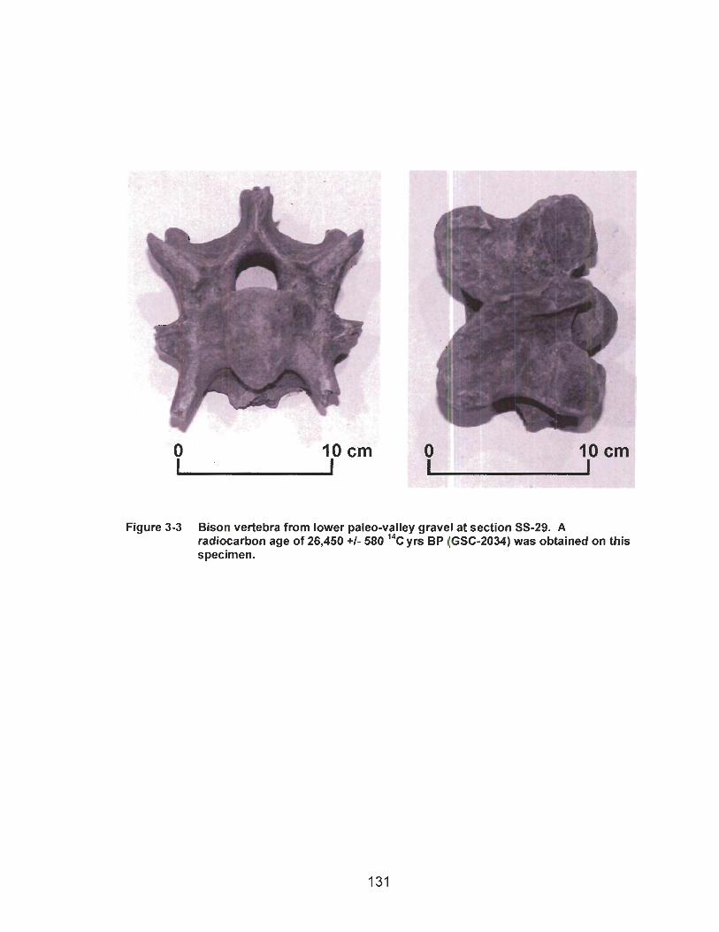
Figure 3-3 Bison vertebra from lower paleo-valley gravel at section SS-29. A radiocarbon age of 26,450 +I- 580 I4c yrs BP (GSC-2034) was obtained on this specimen.
Much of the lower paleo-valley system is preserved, although it has been incised
by modern Peace River and its tributaries. The valley had two to four times the width of
the present-day valley, with a broad flat floor and steep walls. The gradient of the paleo-
Peace River was 0.0006, the same as that of modern Peace River. The average size of
the clasts that it transported is also similar to that of the modern river. These
observations indicate that the two rivers were similar in size. The lower paleo-valley
gravel is probably a braided river deposit (Church and Gilbert 1975; Miall 1977, 1984,
1985, 1992).
Ancestral Peace River flowed north of Portage Mountain before the last
glaciation. It was blocked by the Portage Mountain end moraine and diverted through a
saddle south of Portage Mountain, where it excavated Peace River Canyon (Beach and
Spivak 1943). The end moraine lies within the ancestral Peace River valley between
Bullhead and Portage mountains.
Well sorted gravel was encountered between 527 and 547 m a.s.1. (Figure 2-6)
during drilling through the Portage Mountain end moraine (Campbell 1959). The gravel
is the same height above modern Peace River as fluvial gravel of the last interstade
elsewhere in the study area and probably was deposited by ancestral Peace River
during the Middle Wisconsinan.
3.1.5 Late Wisconsinan Glaciation
3.1.5.1 Glacial Lake Mathews
Advance-phase glaciolacustrine deposits completely fill the Middle Wisconsinan
Peace River valley and its tributaries. The sediments record damming of the drainage
by advancing Laurentide ice. The lake in which the sediments accumulated is here
termed Glacial Lake Mathews in recognition of the many contributions of the late Dr. W.
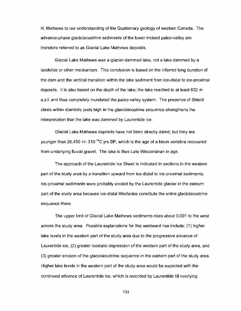
H. Mathews to our understanding of the Quaternary geology of western Canada. The
advance-phase glaciolacustrine sediments of the lower incised paleo-valley are
therefore referred to as Glacial Lake Mathews deposits.
Glacial Lake Mathews was a glacier-dammed lake, not a lake dammed by a
landslide or other mechanism. This conclusion is based on the inferred long duration of
the dam and the vertical transition within the lake sediment from ice-distal to ice-proximal
deposits. It is also based on the depth of the lake; the lake reached to at least 632 m
a.s.1. and thus completely inundated the paleo-valley system. The presence of Shield
clasts within diamictic pods high in the glaciolacustrine sequence strengthens the
interpretation that the lake was dammed by Laurentide ice.
Glacial Lake Mathews deposits have not been directly dated, but they are
younger than 26,450 +I- 310 14C yrs BP, which is the age of a bison vertebra recovered
from underlying fluvial gravel. The lake is thus Late Wisconsinan in age.
The approach of the Laurentide Ice Sheet is indicated in sections in the western
part of the study area by a transition upward from ice-distal to ice-proximal sediments.
Ice-proximal sediments were probably eroded by the Laurentide glacier in the eastern
part of the study area because ice-distal lithofacies constitute the entire glaciolacustrine
sequence there.
The upper limit of Glacial Lake Mathews sediments rises about 0.001 to the west
across the study area. Possible explanations for this westward rise include: (1) higher
lake levels in the western part of the study area due to the progressive advance of
Laurentide ice, (2) greater isostatic depression of the western part of the study area, and
(3) greater erosion of the glaciolacustrine sequence in the eastern part of the study area.
Higher lake levels in the western part of the study area would be expected with the
continued advance of Laurentide ice, which is recorded by Laurentide till overlying
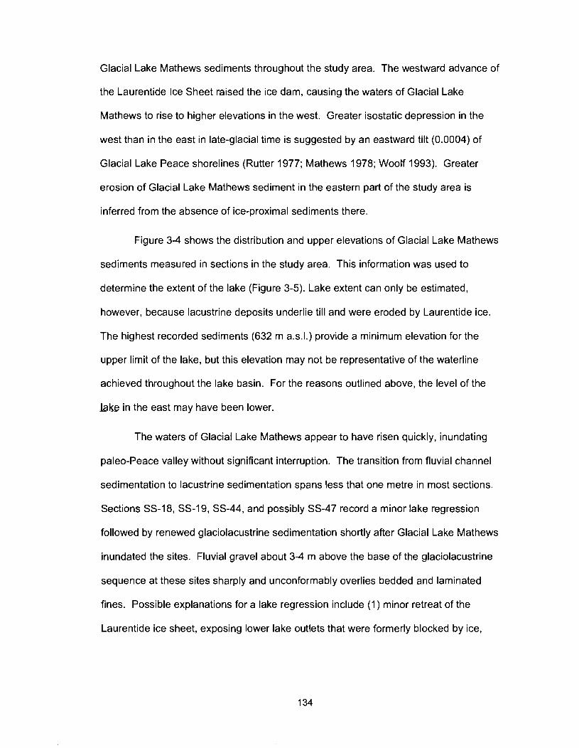
Glacial Lake Mathews sediments throughout the study area. The westward advance of
the Laurentide Ice Sheet raised the ice dam, causing the waters of Glacial Lake
Mathews to rise to higher elevations in the west. Greater isostatic depression in the
west than in the east in late-glacial time is suggested by an eastward tilt (0.0004) of
Glacial Lake Peace shorelines (Rutter 1977; Mathews 1978; Woolf 1993). Greater
erosion of Glacial Lake Mathews sediment in the eastern part of the study area is
inferred from the absence of ice-proximal sediments there.
Figure 3-4 shows the distribution and upper elevations of Glacial Lake Mathews
sediments measured in sections in the study area. This information was used to
determine the extent of the lake (Figure 3-5). Lake extent can only be estimated,
however, because lacustrine deposits underlie till and were eroded by Laurentide ice.
The highest recorded sediments (632 m a.s.1.) provide a minimum elevation for the
upper limit of the lake, but this elevation may not be representative of the waterline
achieved throughout the lake basin. For the reasons outlined above, the level of the
M e in the east may have been lower.
The waters of Glacial Lake Mathews appear to have risen quickly, inundating
paleo-Peace valley without significant interruption. The transition from fluvial channel
sedimentation to lacustrine sedimentation spans less that one metre in most sections.
Sections SS-18, SS-19, SS-44, and possibly SS-47 record a minor lake regression
followed by renewed glaciolacustrine sedimentation shortly after Glacial Lake Mathews
inundated the sites. Fluvial gravel about 3-4 m above the base of the glaciolacustrine
sequence at these sites sharply and unconformably overlies bedded and laminated
fines. Possible explanations for a lake regression include (1) minor retreat of the
Laurentide ice sheet, exposing lower lake outlets that were formerly blocked by ice,
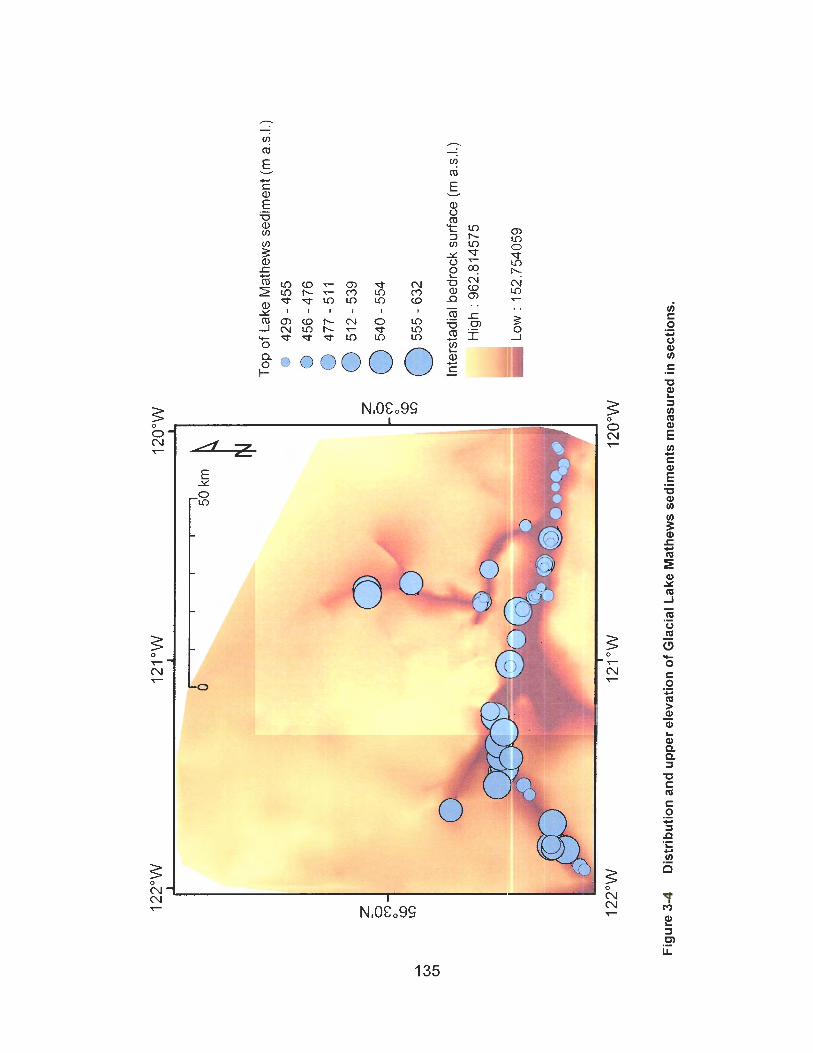
Top
of
Lake
Mat
hew
s se
dim
ent
(m a
.s.1
.)
lnte
rsta
dial
bed
rock
sur
face
(m
a.s
.1.)
Fig
ure
3-4
D
istr
ibu
tio
n a
nd
up
per
ele
vati
on
of
Gla
cial
Lak
e M
ath
ews
sed
imen
ts m
easu
red
in s
ecti
on
s.
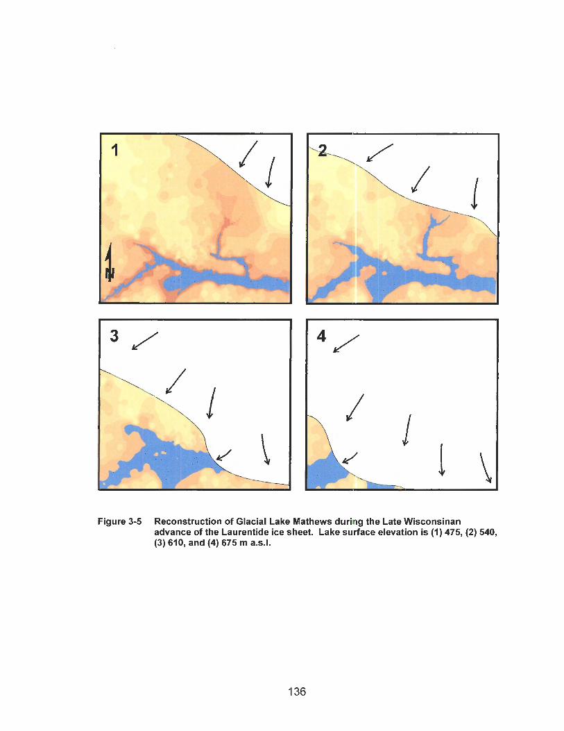
Figure 3-5 Reconstruction of Glacial Lake Mathews during the Late Wisconsinan advance of the Laurentide ice sheet. Lake surface elevation is (1) 475, (2) 540, (3) 610, and (4) 675 m a.s.1.
(2) erosion of the lake outlet or development of new and lower spillways as lake water
rose and overtopped drainage divides across which channels were subsequently eroded
by the out-flow, and (3) draining of the lake during an outburst flood (jokulhlaup). No
other lake-lowering event is recognized in the sequence of Glacial Lake Mathews
sediments.
No Glacial Lake Mathews deltaic sediments were identified at the sections
investigated in this study. Coarse stratified sediment occurs locally near paleo-valley
walls and is attributed to high-energy deposition by small streams. However, large
paleo-deltas associated with Peace River and its major tributaries were not found.
Progressive deepening of the lake may have prevented the development of a stable
delta at low water levels in central-basin positions. Deltas may thus lie some distance
up the paleo-Peace River valley and its tributaries, outside of the limit of sections
documented in this study.
The paleo-Peace River delta may be located in ancestral Peace River valley
north of Portage Mountain (Beach and Spivak, 1943). 'When the Portage Mountain end
moraine was drilled, three gravel units were encountered between 481 and 593 m a.s.1.
(Campbell 1959). The upper and middle gravels are separated by a unit of interstratified
sand and gravel, located between 544 and 573 m a d . The middle and lower gravels
are separated by a unit of interstratified silt, sand, and gravel that extends from 501 to
527 m a.s.1. Campbell (1959) interpreted both the higher sand and gravel unit and the
lower silt, sand, and gravel unit to be "lake and outwash deposits"; however, it is
possible that one or both of these units are deltaic deposits. Church and Gilbert (1975)
noted alternating coarse and fine grained beds near the toes of Gilbert-style deltas and
attributed them to discontinuous avalanching on the delta slope. As mentioned in
section 2.1.2, the lowest of the three gravel units is a fluvial deposit associated with the
lower paleo-valley. The "lake and outwash deposits" overlying the gravel are then most
likely deltaic deposits of Glacial Lake Mathews.
Glacial Lake Mathews sediments at sections SS-l(3-8), SS-1 O6(l), SS-1 O7(l),
and SS-108(1-3) in Beatton River valley include rippled and cross-bedded sand probably
deposited in a pro-delta environment (cf. Gustavson et al. 1975). Sections SS-1, SS-
106, and SS-107 occur between 537 and 587 m a.s.l., 58 km up valley from the mouth of
Beatton River. Section SS-108 is located between 540 and 554 m a.s.l., 46 km up valley
from the river mouth. Exposures in upper Halfway River valley, Pine River valley, and
Moberly River valley are too few and poor to identify any deltaic deposits that might be
present in the paleo-valleys of these rivers.
3.1 5 2 Late Wisconsinan Laurentide Glaciation
Laurentide till is present throughout the study area. It is the surface unit except
where overlain by Glacial Lake Peace and postglacial sediments Bobrowsky et al.
(1 992) and Catto et al. (1 996) found eastern-provenance Shield clasts up to about 950
m a.s.1. in the Rocky Mountain foothills west of the study area and argued that the
Laurentide Ice Sheet could not have ascended valleys in the foothills if it had been
opposed by east-flowing Cordilleran ice. This observation is consistent with the
conclusions of Bobrowsky (1989) and Bobrowsky and Rutter (1992) that the Cordilleran
advance was restricted and topographically constrained and that its limit in Peace River
valley was at Portage Mountain. Radiocarbon ages from Finlay River valley, a major
tributary of Peace valley, bracket the time of Late Wisconsinan Cordilleran glaciation to
between 15,180 +I- 100 I4c yrs BP (TO-708) and 10,100 +I- 90 I4C yrs BP (GSC-2036)
(Bobrowsky 1989). A series of Middle Wisconsinan radiocarbon ages on sediments
underlying till indicate that this advance was the only glaciation of Finlay River valley
during the Late Wisconsinan.
The Portage Mountain end moraine was built into Glacial Lake Peace (Rutter
1977; Mathews 1980; Bobrowsky 1989), indicating that the Laurentide Ice Sheet had
retreated before the Cordilleran glacier reached its maximum extent. Wood recovered
from the contact between Late Wisconsinan Laurentide till and overlying Glacial Lake
Peace sediments near Fort St. John gave a radiocarbon age of 13,970 +I- 170 14C yrs
BP (TO-2742) (Catto et al. 1996). This age is a minimum for local Laurentide
deglaciation. Bobrowsky (1989) argued that the two glaciers did not coalesce during the
Late Wisconsinan.
3.1.5.3 Glacial Lake Peace
Glacial Lake Peace formed behind the retreating Late Wisconsinan Laurentide
Ice Sheet. Its evolution has been documented by Mathews (1978) and Woolf (1993).
Mathews (1 978) recognized four stages of Glacial Lake Peace, from highest to lowest,
the Beesborough, unnamed, Clayhurst, and Indian Creek stages. The above-mentioned
radiocarbon age of 13,970 +I- 170 l4c yrs BP is probably close to the time of initiation of
Glacial Lake Peace at Fort St. John.
Glacial Lake Peace drained in stages, perhaps with rapid lowering of the lake
between stages. The lake retreated east of Fort St. John before 10,770 +/-I20 14c yrs
BP (SFU-454), which is the age of the lowest cultural layer at the Charlie Lake cave
archaeological site (Fladmark et al. 1988). Geertsema and Jull (2002) reported a series
of radiocarbon ages on charcoal layers in a debris-flow fan on the prominent river
terrace at Bear Flat. The charcoal layers increase in age consistently with depth to
about 10,500 l4c yrs BP, indicating that Glacial Lake Peace had drained and Peace
River had incised its modern valley to the level of the terrace before 10,500 14c yrs BP.

3.1.6 Modern Peace River Valley
Peace River may have excavated its modern valley rapidly, soon after
deglaciation. Entrenchment did not commence until Glacial Lake Peace drained from
the study area sometime after 13,970 +I- 170 l4c yrs BP (Catto et al. 1996), and was
well advanced or complete before 10,500 14c yrs BP (Geertsema and Jull 2002).
The rock-walled, incised canyons of Beatton, Halfway, and Kiskatinaw rivers
have a meandering planform, indicating that the tributaries of Peace River rapidly incised
their valleys (Figure 3-6). Meandering rivers typically are alluvial, and lateral channel
migration produces the meanders (Miall, 1992). The walls of the Beatton, Halfway, and
Kiskatinaw canyons are bedrock, and the meandering planform could not have
developed after the rivers incised to their present levels. Instead, the meandering
pattern developed when the rivers flowed over the floor of Glacial Lake Peace soon after
the lake drained. The rivers cut down through Lake Peace sediments and till and into
bedrock. Incision was so rapid that the rivers did not migrate laterally, preventing the
canyons from being widened and preserving the meander form.
The valleys of Peace River and its tributaries continue to be slowly widened and
deepened by river erosion and landslides. Landsliding commenced during initial incision
of the river valleys following draining of Glacial Lake Peace (Severin 2004).
The clast composition of contemporary river gravel is different from that of older
gravel units. The former has a much higher proportion of Shield clasts than the latter.
Shield clasts are rare in the fluvial gravel of the last interstade, and rarer still in the early
nonglacial fluvial gravel. In contrast, Shield clasts are abundant on gravel bars of the
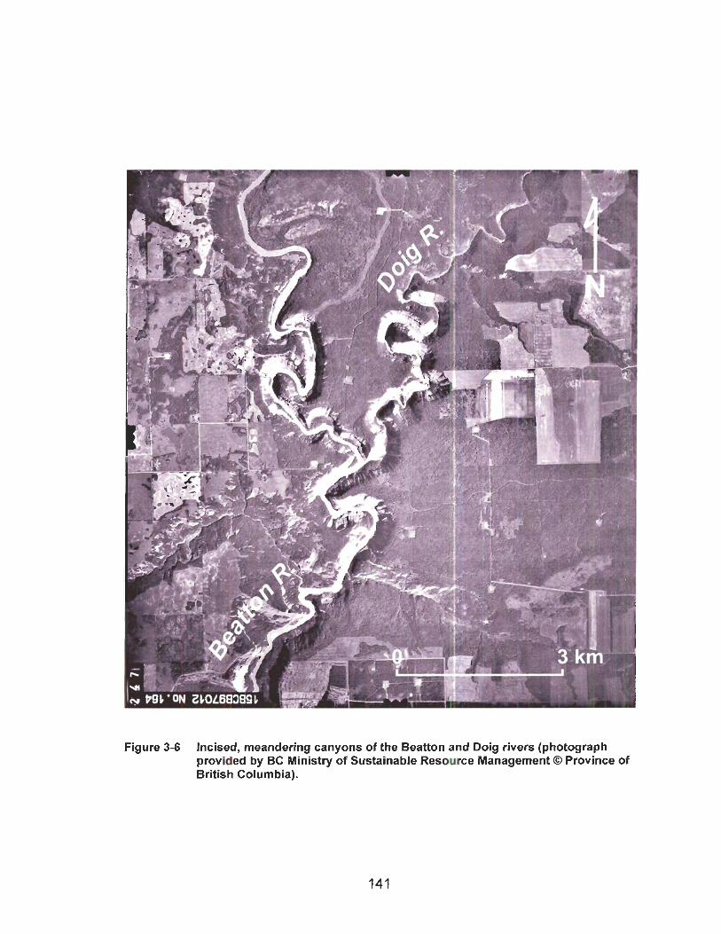
Figure 3-6 Incised, meandering canyons of the Beatton and Doig rivers (photograph provided by BC Ministry of Sustainable Resource Management O Province of British Columbia).
modern rivers and in postglacial terrace gravel. An explanation for this difference is that
the Late Wisconsinan Laurentide advance was the most extensive advance of the
Pleistocene, dispersing Shield clasts farther west than earlier advances. The difference
may also be due to the greater age and maturity of the paleo-valley gravels. The paleo-
valley gravels may have undergone more than one cycle of fluvial transport, during
which most of the Shield clasts were destroyed.
3.2 Comparison with Previous Work
The inferred Quaternary history of the study area developed during this study is
different in some respects from those proposed by previous researchers. The
differences relate to the number and extent of Cordilleran and Laurentide glaciations.
Two models have been developed to explain the Quaternary stratigraphy and
landforms of the westernmost Alberta Plateau (Bobrowsky et al. 1991). One model is
based on the work of Rutter (1976, 1977) and Mathews (1 978, 1980). It features two or
three Laurentide advances and three or four Cordilleran advances. Cordilleran and
Laurentide glaciers coalesced during one of the glaciations. The second model is based
on Bobrowsky (1989) and includes one Laurentide advance and two Cordilleran
advances without coalescence of Laurentide and Cordilleran glaciers.
The body of early stratigraphic research, with the exception of Tokarsky (1967),
supports the first model, which features multiple Laurentide and Cordilleran advances.
In contrast, the body of recent stratigraphic research supports the second model, with
only one Laurentide and two Cordilleran advances. Recent researchers, however,
disagree over the extent of the last Cordilleran glaciation. Bobrowsky (1989),
Bobrowsky et al. (1991, 1992), Bobrowsky and Rutter (1992), and Catto et al. (1996)
concluded that the Late Wisconsinan Cordilleran advance was restricted and assigned
the most extensive Cordilleran advance to an earlier glacial period. Jackson et al.
(1997), Bednarski (1999, 2001), Dyke et al. (2002) and Dyke (2004) on the other hand,
argued for an extensive Late Wisconsinan Cordilleran glaciation.
The stratigraphy presented in this thesis supports the interpretation of Mathews
(1978, 1980), specifically that there were three Laurentide and two Cordilleran advances
in the region. This stratigraphy is discussed in the following two sections in the context
of those developed during previous work. Figure 3-7 provides a regional map showing
important geographic features noted by previous researchers.
3.2.1 Laurentide Stratigraphy
Catto (1984), Liverman (1989), Liverman et al. (1989), and Young et al. (1994)
have shown that the Laurentide Ice Sheet reached Edmonton, Watino, and areas to the
south and west only once in the Quaternary, during the Late Wisconsinan. The
stratigraphy reported in this thesis requires three Laurentide glacial events separated by
interglaciations or long interstades. Only the last of the three glacial events is Late
Wisconsinan.
Laurentide glaciations documented in central Canada and the American Midwest
(Fulton 1989) were centred in northern Quebec and Labrador, Keewatin, and the Foxe
Basin (Dyke et at. 2002; Kleman et al. 2002; Dyke 2004). Ice would have to have flowed
in a southwest to south-southwest direction from the Keewatin ice dome to reach the
study area. Flutings in the study area that match this flow direction were noted by
Mathews (1 978, 1980; Figure 2-32). Laurentide ice may have reached the study area
one or more times prior to the Late Wisconsinan, while terminating short of Edmonton,
500 km to the southeast, and Watino, 160 km to the east-southeast.

Legend
Figure 3-7 Map of the Rocky Mountain front and Alberta Plateau showing areas of previous research and important geographic features.
Two, pre-Late Wisconsinan Laurentide advances are inferred in the study area
from the presence of Shield erratics in gravels of the upper and lower paleo-valley
systems and from glaciolacustrine sediments. The penultimate Laurentide advance is
interpreted to have been the more extensive of the two based on the distribution of
Shield erratics in the paleo-valley gravels.
The limits of these pre-Late Wisconsinan advances must lie north and east of
Edmonton and Watino, yet close enough to the study area to introduce Shield clasts into
the paleo-Peace River drainage and to impound lakes in its valleys. No Laurentide
glacier extended beyond the most distal Shield clasts that it transported, but the
locations of the clasts do not necessarily delineate the ice margin. Fluvial transport from
more northerly locations in the paleo-Peace basin or ice-rafting on a glacial lake may
have distributed Shield clasts south and west of the glacier limit. The presence of
eastern-provenance clasts in a fluvial gravel stratigraphic unit merely indicates that
Laurentide ice entered the watershed of the paleo-drainage system.
At least one early Laurentide advance reached as far as Elleh Creek-area (NTS
94J), north of NTS 94A (V.M. Levson, personal communication, 2005). As mentioned in
section 2.4.4, an eastern-provenance till underlies interstadial gravels in the Elleh Creek
area.
The interpretation presented in this thesis can be reconciled with those of Catto
(1984), Liverman (1989), Liverman et al. (1989), and Young et al. (1994) by considering
the paleogeography of the rivers that deposited the sediments on which these
researchers have based their stratigraphies and within which Shield clasts are absent.
The geography of the major basins at the west edge of the Interior Plains during the
Pleistocene was not significantly different from the geography of these basins today. As
Stott and Aitken (1993) pointed out, the distribution of high and low terrain was
established before the Quaternary and has been only slightly modified by glaciation.
Their conclusion is supported by the distribution of paleo-valleys in the study area and in
adjacent map areas (NTS 83M and NTS 84D; Carlson and Hackbarth 1974; Liverman
1989). Thus pre-Late Wisconsinan advances that terminated north and east of the
watersheds where Catto (1984), Liverman (1989), Liverman et al. (1989), and Young et
al. (1994) worked would not have introduced Shield clasts into these basins. The rivers
in these watersheds drained north and east, consequently Shield clasts would not be
present in paleo-channel gravels in these basins.
Catto (1984) and Young et al. (1994) studied the Saskatchewan Gravel near
Edmonton. This gravel was deposited by the preglacial, northeast-flowing North
Saskatchewan River. The watershed of the river is west and south of Edmonton and
Watino. It is south of, and separated from, the Peace River watershed by the watershed
of Athabasca River. Liverman (1989) and Liverman et al. (1989) investigated the
Simonette and Watino sections along Smokey and Simonette rivers, which are southern
tributaries of Peace River. Therefore, all of the stratigraphies from which only a single
Laurentide advance has been postulated come from paleo-drainage basins south and
west of Watino and Edmonton that drained to the north and east. Laurentide advances
that terminated or distributed erratics north or east of these basins would not be
recognized from the sediments upon which the stratigraphies are based.
The distribution of the Shield clasts on the westernmost Interior Plains and the
paleogeography of the basins in which they occur constrain pre-Late Wisconsinan
Laurentide ice limits. An early Laurentide glacial advance was extensive enough to
deposit Shield clasts in the watersheds of northern tributaries of ancestral Peace River,
including ancestral Beatton River, because these clasts are present in the upper paleo-
valley gravel as far west as Golata Creek. This early Laurentide advance did not cross
the drainage divide separating ancestral Beatton and Halfway rivers, nor did it extend
south and west of Watino. The penultimate Laurentide glacial advance extended west at
least as far as the Alberta-British Columbia boundary because ancestral Peace River in
the study area was impounded by this advance. In addition, Shield clasts are present in
the gravel of the lower paleo-valley as far west as Lynx Creek. The penultimate
Laurentide advance, however, did not reach Edmonton or Watino.
The pre-Late Wisconsinan, Laurentide glacial history proposed here is similar to
that of Mathews (1978). It is also consistent with the hypothesis of Liverman et al.
(1 989) that the early Laurentide advances recognized by Mathews (1 978) in the NTS
94A map-area did not reach Edmonton and Watino.
3.2.2 Cordilleran Stratigraphy
The stratigraphy presented in this thesis supports two Cordilleran advances, an
early, extensive pre-Late Wisconsinan advance and a restricted Late Wisconsinan
advance. Deposits of the Late Wisconsinan advance are limited to areas west of the
map-area, supporting the restricted Cordilleran glacial model of Bobrowsky (1989),
Bobrowsky et al. (1 991, 1992), Bobrowsky and Rutter (1 992), and Catto et al. (1 996).
Mathews (1978), however, argued that the Late Wisconsinan Cordilleran glacier in
Peace valley was extensive and that it merged with the Laurentide Ice Sheet, depositing
a single till consisting of mixed eastern and western lithologies. He was unable to
distinguish Cordilleran and Laurentide tills, which he attributed to the absence of a
distinct boundary between the two till sheets and to a shifting zone of interaction
between the two glaciers. He noted that the percentage of eastern-provenance clasts
decreases significantly in a narrow zone in the western third of the study area, coincident
with an increase in western-provenance clasts. This zone coincides with the zone of
coalescence of Cordilleran and Laurentide ice delineated by flutings (Mathews, 1978).
Several researchers have presented evidence for an extensive Late Wisconsinan
Cordilleran glacial advance in areas near NTS 94A (Jackson et al. 1997; Bednarski
1999, 2001; Dyke et al. 2002; Dyke 2004). Jackson et al. (1997) showed that the
Foothills Erratics Train was deposited during the Late Wisconsinan by coalescence of
Laurentide and Cordilleran ice on the westernmost Interior Plains. The source of the
Foothills Erratics Train is the Rocky Mountains near Jasper, Alberta. The erratics extend
more than 1000 km from Athabasca valley in the north to Lethbridge in the south. Dyke
et al. (2002) suggested that coalescence over such a distance would not be possible if
the ice sheets did not also coalesce in the vicinity of Peace River. This assertion is,
however, debatable. Significant and prolonged coalescence of Cordilleran and
Laurentide ice south of Athabasca valley does not require coalescence more than 400
km north of the head of the Foothills Erratics Train.
Bednarski (1999, 2001) presented evidence for an extensive Late Wisconsinan
Cordilleran Ice Sheet in the Trutch map-area (NTS 94G), adjacent to the northwest
corner of the study area. He reported striae trending east-northeast on mountain tops.
The striae are perpendicular to north-northeast trending mountain ridges, suggesting
that they were produced by ice flowing unhindered by topography. 3 6 ~ ~ exposure dating
of the striated surfaces suggests that they were deglaciated between 14,020 +I- 760 and
13,100 +I- 1560 calendar years ago. Distinctive slate and schist erratics east of the
Rocky Mountain front and derived from the east side of the Rocky Mountain Trench are
consistent with extensive Late Wisconsinan Cordilleran glaciation of the Trutch map-
area. Bednarski (1999, 2001) also noted eastern-provenance erratics and Laurentide till
in east-draining valleys of the Rocky Mountain foothills. He suggested that the
Laurentide Ice Sheet advanced into these valleys shortly after Cordilleran ice retreated
from them.
Dyke (2004) summarized the history of North American deglaciation at the end of
the last glacial period. The summary is largely based on radiocarbon ages from
postglacial sediments. Dyke proposed significant and prolonged coalescence of the
Cordilleran and Laurentide ice sheets. He suggested that the southern half of the Ice-
free Corridor may have opened about 13,500 14c yrs BP based on the radiocarbon age
of wood at the contact of Late Wisconsinan Laurentide till and Glacial Lake Peace
sediments near Fort St. John.
Bobrowsky (1 989) presented arguments against extensive Late Wisconsinan
Cordilleran glaciation in the Finlay River valley. The upper part of the valley remained
ice-free until at least 15,180 +I- 100 14c yrs BP (TO-708). Cordilleran ice thus advanced
to its eastern limit and retreated significantly in less than 5000 years. In addition, Late
Wisconsinan till in Finlay River valley has fewer far-travelled volcanic clasts derived from
the Omineca Mountains than pre-Late Wisconsinan till. The Late Wisconsinan till is
dominated by lithologies derived from local sources adjacent to the Rocky Mountain
h n c h .
Bobrowsky (1989) argued that the western-provenance clasts noted by Mathews
(1978) were most likely transported and deposited by a pre-Late Wisconsinan
Cordilleran advance and were subsequently entrained by Late Wisconsinan Laurentide
ice and deposited as part of its till. Catto et al. (1996) suggested that the marked
decrease in the proportion of eastern-provenance lithologies in Mathews' mixing zone is
probably due to entrainment of a greater amount of surficial material by the Laurentide
Ice Sheet in this area, rather than to coalescence of Laurentide and Cordilleran ice.
Bobrowsky et al. (1991, 1992), Catto (1991 b), and Catto et al. (1 996) reported
Shield erratics in east-draining valleys in the Rocky Mountain foothills to 950 m a.s.1.
This elevation is higher than the upper limit of Glacial Lake Peace, therefore the erratics
must have been deposited by Laurentide ice. The Laurentide Ice Sheet could not have
ascended the valleys in contact with Cordilleran ice.
If Bobrowsky (1989), Bobrowsky and Rutter (1991, 1992), and Catto et al. (1996)
are correct, the flutings noted by Mathews (1978; Figure 2-32) could only be a product of
coalescence of Laurentide and Cordilleran glaciers during a pre-Late Wisconsinan
glaciation. Additionally, the Late Wisconsinan Laurentide Ice Sheet could not have
removed these features. An argument to this effect was made by Catto et al. (1996) to
explain the Redwillow Fluting fan south of the study area. They argued that the
Redwillow Fluting fan formed at the base of a tongue of pre-Late Wisconsinan
Cordilleran ice that extended from the Rocky Mountains through Redwillow valley and
onto the Alberta Plateau. The flutings are not deflected, thus Catto et al. (1996)
suggested that the Cordilleran ice tongue did not coalesce with Laurentide ice. The
Redwillow Valley flutings are, however, overlain by Late Wisconsinan Laurentide till and
glaciolacustrine sediments.
The restricted Late Wisconsinan Cordilleran ice-cover model of Bobrowsky
(1 989), Bobrowsky and Rutter (1 992), and Catto et al. (1 996), and the extensive
Cordilleran ice-cover model of Bednarski (1999, 2001) are inconsistent with one another.
The Trutch map area, where Bednarski worked, and the Rocky Mountain Trench,
studied by Bobrowsky and Rutter, are separated by the Rocky Mountains, but such a
fundamental difference in the extent of Late Wisconsinan Cordilleran ice cannot be
explained by the different locations of the two study areas.
This study contributes little to resolving the debate over the extent of Cordilleran
ice in northeastern British Columbia during the Late Wisconsinan. However, the
restricted Late Wisconsinan Cordilleran ice-cover model of Bobrowsky (1 989),
Bobrowsky and Rutter (1992), and Catto et al. (1996) is favoured over the extensive
Cordilleran ice-cover model of Bednarski (1999, 2001) for the following two reasons:
First, wood from the contact between Late Wisconsinan Laurentide till and Glacial Lake
Peace sediments near Fort St. John yielded a radiocarbon age of 13,970 +I-1 70 14c yrs
BP (TO-2742) (Catto et al. 1996). This age suggests that Laurentide ice was in retreat
about 1000 years after Cordilleran ice began to advance down Finlay River valley, 500
km from Fort St. John. Assuming the radiocarbon ages are sound, it seems unlikely that
Cordilleran ice could have overtopped the Rocky Mountains and advanced to a limit east
of the mountain front prior to the Laurentide maximum, at which time the Laurentide Ice
Sheet deposited Shield clasts high in the valleys of the mountain front. Secondly,
Bednarski reports a Late Wisconsinan - early Holocene 3 6 ~ ~ exposure age from a
striated bedrock surface but does not definitively demonstrate that the surface was
striated by Cordilleran ice. An alternate hypothesis is that the surface was striated in the
Late Wisconsinan by locally sourced montane ice. Bobrowsky (1989), Bobrowsky and
Rutter (1992), and Catto et al. (1996) have all noted the significance of montane ice in
the glacial history of the Alberta Plateau and Rocky Mountain front.
3.3 Relation between Slope Stability and Stratigraphy
Severin (2004) documented 161 0 slope failures in the Peace River valley and its
larger tributaries. Glaciolacustrine deposits of Glacial Lake Mathews are the source of
more than 900 of these landslides.
Clay-rich strata are the common source of instability in this stratigraphic unit.
Although the Glacial Lake Mathews sequence is composed mainly of beds of silt and
sandy silt, rare clay-rich beds and laminae occur throughout the unit. Sheared and intact
clay-rich strata have high plasticity indices and low plastic and liquid limits (see section
2.5). Severin (2004) analyzed 12 sheared clay-rich laminae and four intact clay-rich
laminae and did not find a significant difference between the properties of the materials.
Silt strata are non-plastic, perhaps due to weak cementation or internal suction forces
(Fletcher et al. 2002), and are not failure planes..
Landslides in the Glacial Lake Mathews sequence are not associated with a
single clay-rich stratum, but rather occur at many levels in the stratigraphic unit. This
conclusion is based on three observations: ( I ) sliding planes are located at many
different heights above the base of the glaciolacustrine unit; (2) the majority of landslides
have two or more sliding planes (Severin 2004); and (3) intact and sheared clay-rich
laminae and beds have similar properties. Most commonly, however, failure occurs low
in the sequence, within 1 m of its base.
The post-depositional history of the Glacial Lake Mathews sequence may have
contributed to its instability. Late Wisconsinan glacier overriding sheared and over-
consolidated the glaciolacustrine sediments (Fletcher et al. 2002; Severin 2004).
Isostatic rebound and stress release due to rapid incision of Peace River valley just after
deglaciation may have produced faults and joints in the sediments tens to hundreds of
metres away from the valley walls (Fletcher et al. 2002; Severin 2004). Cruden et al.
(1 993) argued that over-consolidation, glaciotectonism, stress release, and valley
rebound have contributed to slope instability in a similar sequence of glaciolacustrine
sediments in the Saddle River valley, a tributary of Peace River in Alberta. They
considered the geological youthfulness of the river system to be important in causing
landslides.
Fletcher et al. (2002) noted that, over-consolidated, clay-rich lacustrine
sediments typically fail by intermittent ductile deformation controlled by pore water
pressure. The stratigraphic position of Glacial Lake Mathews deposits may improve
their stability because overlying clay-rich till and glaciolacustrine sediment reduce rates
of infiltration, and underlying fluvial gravel drain the unit. Fletcher et al. (2002) reported
very low pore water pressures in interstadial gravel near the Attachie Slide. With a few
exceptions, exposed paleo-valley gravels in the study area are dry, indicating that they
are not well connected to sources of groundwater recharge. Fletcher et al. (2002)
suggested, however, that surface water does enter the Glacial Lake Mathews sequence
through open tension cracks. The catastrophic Attachie Slide of May 1973 was
associated with heavy rains and high rates of snow-melt (Fletcher et al. 2002).
CHAPTER 4 CONCLUSION
Five late Cenozoic drainage systems have been identified in and adjacent to the
study area. Remnants of three relict drainage systems are present in the NTS 94A map-
area. Remnants of a fourth, older relict drainage system occur east and southeast of the
study area. The relict drainage systems within the study area are buried valleys that
have been incised one or more times by subsequent river systems. Younger drainage
systems have incised to successively greater depths, allowing stratigraphic relations
among Quaternary valley-fill sediments to be established.
The valley fills have a basal fluvial gravel unit and a thicker overlying
glaciolacustrine silt unit. They are typically overlain across an erosional contact by till or
postglacial fluvial deposits. At the end of the last interstade, Glacial Lake Mathews was
impounded in the valleys of the paleo-Peace River and its tributaries by the advance of
the Laurentide ice sheet. Over 100 m of bedded to laminated silt, sandy silt, and clay
were deposited in the centre of this lake.
The valley-fill sediments of the study area provide evidence for three Laurentide
and two Cordilleran glaciations. The glaciations are separated by interglaciations or
lengthy interstades during which the east-flowing fluvial drainage was re-established and
achieved maturity. The earliest Laurentide glacial advance was less extensive than the
penultimate glacial event, and the penultimate event was, in turn, less extensive than the
Late Wisconsinan event. The early Cordilleran glacial event was much more extensive
than the Late Wisconsinan Cordilleran event.
Flutings in the southwest quadrant of the Charlie Lake map-area record
coalescence of Cordilleran and Laurentide ice. Because the Late Wisconsinan
Cordilleran advance was restricted and did not extend past Portage Mountain, the
flutings are likely a product of the early Cordilleran and the penultimate Laurentide
glacial events. The distribution of eastern-provenance clasts in the valleys of the Rocky
Mountain foothills suggest that Laurentide and Cordilleran ice did not coalesce in the
study area during the Late Wisconsinan.
Till of the penultimate Laurentide glaciation has not been positively identified in
the study area. This result is not surprising for three reasons: (1) the area was
overridden in the Late Wisconsinan by Laurentide ice that was more extensive and,
presumably, more erosive than the penultimate Laurentide ice sheet; (2 ) the Late
Wisconsinan and penultimate Laurentide glaciers deposited similar tills that may not be
distinguishable if superposed; (3) the penultimate Laurentide till may have been eroded
significantly during the lengthy interstade between the two glaciations.
The stratigraphy presented in this thesis generally supports Mathews' (1978)
conclusions regarding the Quaternary history of the Charlie Lake map-area. The only
major difference is the greater extent of the Late Wisconsinan Cordilleran ice postulated
by Mathews (1 978).
Two pre-Late Wisconsinan Laurentide glaciations approached or reached the
Charlie Lake map-area. This conclusion seemingly contradicts the conclusion of other
researchers that no pre-Late Wisconsinan Laurentide advances reached Edmonton,
Simonette River, and Watino (Catto 1984; Liverman 1989; Liverman et al. 1989; Young
et al. 1994). The Fort St. John area, however, lies up-glacier of these areas. Therefore,
ice flowing from the Keewatin sector of any pre-Late Wisconsinan Laurentide Ice Sheet
could have reached the northern tributaries of the paleo-Peace River, or even the paleo-
Peace River itself, without reaching Edmonton, Simonette River, or Watino.
Glaciolacustrine sediments filling buried paleo-valleys pose a significant hazard
to development in the study area. Large landslides occur where Glacial Lake Mathews
sediments form the walls of Peace River valley and its larger tributaries. Failure occurs
preferentially along plastic clay-rich layers within the Glacial Lake Mathews unit. This
instability is not easily remedied, but a better understanding of the distribution and
properties of Glacial Lake Mathews deposits and the paleo-valleys they fill will aid land-
use planning and development decisions in the future.
REFERENCES
Alldritt-McDowell, J. 2004. The ecology of the Boreal White and Black Spruce Zone. British Columbia Ministry of Forests, Victoria, British Columbia, 6 pp.
Andriashek, L.D., and Fenton, M.M. 1989. Quaternary stratigraphy and surficial geology of the Sand River area 73L. Alberta Research Council, Report 57, 154 pp.
Arnold, T.G. 2002. Radiocarbon dates from the Ice-Free Corridor. Radiocarbon, 44(2): 437-454.
Ashley, G.M. 1988. Classification of glaciolacustrine sediments. In Genetic Classification of Glacigenic Deposits. Edited by R.P. Goldthwait. and C.L. Matsch. A. A. Balkema, Rotterdam, Netherlands, pp. 243-260.
Barendregt, R.W., and Irving, E. 1998. Changes in the extent of North American ice sheets during the late Cenozoic. Canadian Journal of Earth Sciences, 35(5): 504- 509.
Beach, H.H., and Spivak, J. 1943. The origin of the Peace River Canyon, British Columbia. American Journal of Science, 241 (6): 366-376.
Bednarski, J.M. 1999. Preliminary report on mapping surficial geology of Trutch map area, northeastern British Columbia. Geological Survey of Canada, Current Research, 1999-A: 35-43
Bednarski, J.M. 2001. Drift composition and surficial geology of the Trutch map area (94G), northeastern British Columbia. Geological Survey of Canada, Open File Report D38l5.
Benn, D.I., and Evans, D.J.A. 1998. Glaciers & Glaciation. Wiley, New York, NY, 734 pp.
Bobrowsky, P.T. 1989. Late Cenozoic geology of the northern Rocky Mountain Trench, British Columbia. Ph.D. thesis, University of Alberta, Edmonton, Alberta, 283 pp
Bobrowsky, P.T., and Rutter, N.W. 1992. The Quaternary geologic history of the Canadian Rocky Mountains. Geographie physique et Quaternaire, 46(1): 5-50.
Bobrowsky, P.T., Catto, N.R., and Levson, V. 1991. Reconnaissance Quaternary geological investigations in Peace River District, British Columbia. British Columbia Ministry of Energy, Mines and Petroleum Resources, Paper 1991 -1, pp. 345-358.
Bobrowsky, P.T., Smith, C.P., Grant, B., and Newell, J.M. 1992. Quaternary studies in the Peace River District, 1990; stratigraphy, mass movements and glaciation limits (94P). British Columbia Ministry of Energy, Mines and Petroleum Resources, Paper 1992-1, pp. 363-374.
Brookfield, M.E. 1992. Eolian systems. In Facies Models - Response to Sea Level Change. Edited by R.G. Walker, N.P. James. Geological Association of Canada, St. John's, Newfoundland, pp. 143-156.
Campbell, D.D. 1959. Portage Mountain Dam (site 3A) drill logs. In Peace River Hydro- Electric Project - Geology. Peace River Power Development Company Limited, Vancouver British Columbia, 134 pp.
Cant, D.J. and Walker, R.G. 1978. Fluvial processes and facies sequences in the sandy braided South Saskatchewan River, Canada. Sedimentology, 25(5): 625-648.
Carlson, V.A., and Hackbarth, D.A. 1974. Bedrock topography of the Grand Prairie area, NTS 83M. Alberta Research Council, Edmonton, Alberta.
Catto, N.R. 1984. Glacigenic deposits at the Edmonton Convention Centre, Edmonton, Alberta. Canadian Journal of Earth Sciences, 21 (12): 1473-1482.
Catto, N.R. 1991a. Quaternary and environmental geology of the proposed Site C hydroelectric dam, Peace River region, British Columbia. Geological Association of Canada, Newfoundland Section, Abstracts, 27: 172-1 73.
Catto, N.R. 1991 b. Quaternary geology and landforms of the eastern Peace River region, British Columbia NTS 94Al1,2,7,8. British Columbia Ministry of Energy, Mines and Petroleum Resources, Open File Report 1991 -1 1, 19 pp.
Catto, N.R., Liverman, D.G.E., Bobrowsky, P.T., Rutter, N., and Mandryk, C.A.S. 1996. Laurentide, Cordilleran, and Montane glaciation in the western Peace River- Grande Prairie region, Alberta and British Columbia, Canada. Quaternary International, 32(1996): 21-32.
Church, M., and Gilbert, R. 1975. Proglacial fluvial and lacustrine environments. In Proglacial fluvial and Lacustrine Environments. Society of Economic Paleontologists and Mineralogists, Special Publication, 23: 22-1 00.
Churcher, C.S. 1984. Faunal correlations of Pleistocene deposits in western Canada. In Correlation of Quaternary chronologies. GeoBooks, Norwich, United Kingdom. pp. 145-158.
Clague, J.J. 1980. Late Quaternary geology and geochronology of British Columbia, Part 1 : Radiocarbon dates. Geological Survey of Canada, Paper 80-1 3, 28 pp.
Collinson, J.D. 1996. Alluvial sediments. In Sedimentary Environments: Processes, Facies, Stratigraphy. Edited by H.G. Reading. Blackwell Science, Oxford, England, pp. 37-82.
Cruden, D.M., Keegan, T.R., and Thomson, S. 1993. The landslide dam on the Saddle River near Rycroft, Alberta. Canadian Geotechnical Journal, 30(6): 1003-1 005.
Dawson, G.M. 1881. Note on the geology of the Peace River region. American Journal of Science, 21: 391-394.
Day, P.R. 1965. Particle fractionation and particle-size analysis. In Methods of Soil Analysis, Part 1. American Society of Agronomy, Madison, Wisconsin, pp. 545- 567.
Dethier, D.P. 2001. Pleistocene incision rates in the Western United States calibrated
Driver,
Driver,
Driver,
Driver,
using Lava Creek B Tephra. Geology, 29(9): 783-786.
J.C. 1988. Late Pleistocene and Holocene vertebrates and palaeoenvironments from Charlie Lake Cave, northeast British Columbia. Canadian Journal of Earth Sciences, 25(lO): 1545-1 553.
J.C. 1998. Human adaptation at the Pleistocene/Holocene boundary in western Canada, 11,000 to 9000 BP. Quaternary International, 49-50: 141-1 50.
J.C. 2001. Paleoecological and archaeological Implications of the Charlie Lake Cave fauna, British Columbia, 10 500 to 9 500 B.P. In People and Wildlife in Northern North America, Essays in Honour of R. Dale Guthrie. Edited by S.C. Gerlach and M.S. Murray. British Archaeological Reports, Oxford, England, pp. 13-22
J.C., Handly, M., Fladmark, K.R., Nelson, D.E., Sullivan, G.M., and Preston, R. 1996. Stratigraphy, radiocarbon dating, and culture history of Charlie Lake Cave, British Columbia. Arctic, 49(3): 265-277.
Dyke, A.S. 2004. An outline of North American deglaciation with emphasis on central and northern Canada. in Quaternary Glaciations: Extent and Chronology. Edited by J. Ethers and P.L. Gibbard. Elsevier, Amsterdam, pp. 373-424.
Dyke, A.S., and Prest, V.K. 1987. Late Wisconsinan and Holocene retreat of the Laurentide ice sheet. Geographie physique et Quaternaire, 41: 237-263.
Dyke, A.S., Andrews, J.T., Clark, P.U., England, J.H., Miller, G.H., Shaw, J., Veillette, J.J., and Mix, A.C. 2002. The Laurentide and lnnuitian ice sheets during the last glacial maximum. Quaternary Science Reviews, 21(1-3): 9-31.
Evans, S.G., Hu, X.Q., and Enegren, E.G. 1996. The 1973 Attachie Slide, Peace River Valley, near Fort St. John, B.C., Canada: A landslide with a high-velocity flowslide component in Pleistocene sediments. Proceedings, 7th International Symposium on Landslides, Trondheim, Norway, pp. 715-720.
Eyles, N., and Miall, A.D. 1984. Glacial facies. In Facies Models (2nd ed.). Edited by R.G. Walker. Geological Association of Canada, Toronto, Ontario, pp. 15-38.
Eyles, N., Eyles, C.H., and Miall, A.D. 1983. Lithofacies types and vertical profile models; an alternative approach to the description and environmental interpretation of glacial diamict and diamictite sequences. Sedimentology, 30(3): 393-4 1 0.
Eyles, N., Eyles, C.H., Walker, R.G., and James, N.P. 1992. Glacial depositional systems. In Facies Models, Response to Sea Level Change. Edited by R.G. Walker and N.P. James. Geological Association of Canada, St. John's, Newfoundland, pp. 73-1 00.
Fladmark, K.R. 1981. Paleo-Indian artefacts from the Peace River district. B.C. Studies, 48: 124-135.
Fladmark, K.R., Driver, J.C., and Alexander, D. 1988. The Paleoindian component at Charlie Lake Cave (HbRf-39), British Columbia. American Antiquity, 53(2): 371- 384.
Fletcher, L., Hungr, O., and Evans, S.G. 2002. Contrasting failure behaviour of two large landslides in clay and silt. Canadian Geotechnical Journal, 39(1): 46-62.
Franzmeier, D.P., Steinhardt, G.C., Crum, J.F., and Norton, L.D. 1977. Soil characterization in Indiana: I. Field and laboratory procedures. Purdue University Agricultural Experimental Station Research Bulletin, 943: 13-14.
Fulton, R.J. (ed.). 1989. Quaternary geology of Canada and Greenland. Geological Survey of Canada, Geology of Canada, no. 1, 839 pp.
Geertsema, M. 1998. Flowslides in waterlain muds of northeastern British Columbia. In Eighth International Congress of the International Association for Engineering Geology and Environment. Edited by Moore, D. and Hungr, 0 . A.A. Balkema, Rotterdam, Netherlands, pp. 191 3-1921.
Geertsema, M., and Jull, A.J.T. 2002. Charcoal and sedimentation record from a fan at Bear Flat, northeastern British Columbia. Geological Society of America, Abstracts with Programs, 34(6): 31 9.
Goddard, E.N., Trask, P.D., DeFord, R.K., Rove, O.N., Singewald, J.T., Jr., and Overbeck, R.M. 1963. Rock color chart. Geological Society of America, New York, NY.
Gustavson, T.C., Ashley, G.M., and Boothroyd, J.C. 1975. Depositional sequences in glaciolacustrine deltas. In Proglacial Fluvial and Lacustrine Environments. Society of Economic Paleontologists and Mineralogists, Special Publication, 23: 264-280.
Halsey, L.A. 1989. Sedimentology and development of the Grande Prairie dune field, Alberta, Canada. M.Sc. thesis, Department of Geography, University of Alberta, Edmonton, Alberta. 173 p.
Henderson, E.P. 1959. Surficial geology of Sturgeon Lake map-area, Alberta. Geological Survey of Canada, Memoir 303,108 pp.
Hicks, R.W. 1991. Soil engineering properties. In Soils - Their Properties and Management, A Soil Conservation Handbook for NSW. Edited by P.E.V. Charman and B.W. Murphy. Sydney University Press, Melbourne, Australia.
Hicock, S.R., Goff, J.R., Lian, O.B., and Little, E.C. 1996. On the interpretation of subglacial till fabric. Journal of Sedinlentary Research, 66(5): 928-934.
Jackson, L.E. and Pawson, M. 1984. Alberta radiocarbon dates. Geological Survey of Canada Paper. 83-25.
Jackson, L.E., Jr., Phillips, F.M., Shimamura, K., and Little, E.C. 1997. Cosmogenic 3 6 ~ ~
dating of the Foothills Erratics Train, Alberta, Canada. Geology, 25(3): 195-198.
Johnston, W.A. 1933. Quaternary geology of North America in relation to the migration of man. In The American Aborigines, Their Origin and Antiquity. Edited by D. Jenness, University of Toronto Press, Toronto, Ontario, pp. 11 -45.
Jones, J.F. 1966. Geology and groundwater of the Peace River district. Alberta Research Council, Bulletin 16, 143 pp.
Jurgaitis, A., and Juozapavicius, G. 1988. Genetic classification of glaciofluvial deposits and criteria for their recognition. In Genetic Classification of Glacigenic Deposits. Edited by R.P. Goldthwait and C.L. Matsch. A. A. Balkema, Rotterdam, Netherlands, pp. 227-242.
Kleman, J., Fastook, J.L., Stroeven, A.P., Fabel, D., and Marshall, S.J. 2002. Geologically and geomorphologically constrained numerical model of Laurentide ice sheet inception and build-up. Quaternary International, 95-96: 87-98.
Levson, V.M., Ferby, T., Kerr, B., Johnsen, T., Bednarski, J., Smith, R., Blackwell, J., Jonnes, S. 2004. Quaternary geology and aggregate mapping in northeast British Columbia: Applications for oil and gas exploration and development. British Columbia Ministry of Energy and Mines, Summary of Activities, 12 pp.
Liverman, D.G.E. 1989. The Quaternary geology of the Grande Prairie area, Alberta. Ph.D. thesis, University of Alberta, Edmonton, Alberta, 360 pp.
Liverman, D.G.E., Catto, N.R., and Rutter, N.W. 1989. Laurentide glaciation in west- central Alberta; a single (late Wisconsinan) event. Canadian Journal of Earth Sciences, 26(2): 266-274.
Lowdon, J.A., and Blake, W., Jr. 1968. Geological Survey of Canada radiocarbon dates VI I. Radiocarbon, 1 O(2): 207-245.
Lowdon, J.A., and Blake, W., Jr. 1970. Geological Survey of Canada radiocarbon dates IX. Radiocarbon, 12(1): 46-86.
Lowe, D.R. 1982. Sediment gravity flows; II, Depositional models with special reference to the deposits of high-density turbidity currents. Journal of Sedimentary Petrology, 52(1): 279-297.
MacDonald, G.M., Beukens, R.P., Kieser, W.E., and Vitt, D.H. 1987. Comparative radiocarbon dating of terrestrial plant macrofossils and aquatic moss from the "ice-free corridor" of Western Canada. Geology, 15(9): 837-840.
Mathews, W.H. 1963. Quaternary stratigraphy and geomorphology of the Fort Saint John area, northeastern British Columbia. British Columbia Department of Mines and Petroleum Resources, 22 pp.
Mathews, W.H. 1972. Quaternary geology, Charlie Lake, British Columbia (94 A). Geological Survey of Canada, Paper 72-1A: 169-170.
Mathews, W.H. 1973. Quaternary geology, Charlie Lake, British Columbia. Geological Survey of Canada, Paper 73-1A: 210-21 1.
Mathews, W.H. 1974. Surface profiles of the Laurentide Ice Sheet in its marginal areas. Journal of Glaciology, l3(67): 37-43.
Mathews, W.H. 1978. Quaternary stratigraphy and geomorphology of Charlie Lake (94A) map-area, British Columbia. Geological Survey of Canada, Paper 76-20, 25 pp.
Mathews, W.H. 1980. Retreat of the last ice sheets in northeastern British Columbia and adjacent Alberta. Geological Survey of Canada, Bulletin 331, 22 pp.
Mathews, W.H. 1989. Development of Cordilleran landscapes during the Quaternary. In Quaternary geology of Canada and Greenland. Edited by R.J. Fulton. Geological Survey of Canada, Geology of Canada, 1: 32-34.
May, R.W. 1977. Facies model for sedimentation in the glaciolacustrine environment. Boreas, 6(2): 175-1 80.
McMillan, M.E., and Heller, P.L. 2002. Comparison of long-term rates of incision across the Rocky Mountain orogenic plateau. Geological Society of America, Abstracts with Programs, 34(6): 409.
McNeely, R., and McCuaig, S. 1991. Geological Survey of Canada radiocarbon dates; XXIX. Geological Survey of Canada, Ottawa, Ontario.
Miall, A.D. 1977. A review of the braided-river depositional environment. Earth Science Reviews, l3 ( l ) : 1-62.
Miall, A.D. 1984. Principles of sedimentary basin analysis. Springer-Verlag, New York, NY, 490 pp.
Miall, A.D. 1985. Architectural-element analysis; a new method of facies analysis applied to fluvial deposits. Earth-Science Reviews, 22(4): 261 -308.
Miall, A.D. 1992. Alluvial deposits. In Facies Models, Response to Sea Level Change. Edited by R.G. Walker and N.P. James. Geological Association of Canada, St. Johns, Newfoundland, pp. 11 9-142.
Pazzaglia, F.J., Wisniewski, P.A., and Zaprowski, B. 2001. The fluvial record of Rocky Mountain epeirogeny; a review. Geological Society of America, Abstracts with Programs, 33(5): 51.
Pederson, J.L., and Pazzaglia, F.J. 2002. Middle Cenozoic quiescence and late Cenozoic exhumation; how base-level change through drainage development and epeirogenesis has sculpted the West. Geological Society of America, Abstracts with Programs, 34(6): 408-409.
Reading, H.G. 1996. Sedimentary environments: processes, facies and stratigraphy. Blackwell Science, Oxford, England, 688 pp.
Reimchen, T.H.F., and Bouvier, G.C. 1980. Surficial geology; Dawson Creek, west of sixth meridian, British Columbia. Geological Survey of Canada, Map 1467A.
Reimchen, T.H.F., and Rutter, N.W. 1972. Quaternary geology, Dawson Creek, British Columbia (93 P). Geological Survey of Canada, Paper 72-lA, pp. 176-177.
Rust, B.R., and Koster, E.H. 1984. Coarse alluvial deposits. In Facies Models (2nd ed.). Edited by R.G. Walker. Geological Association of Canada, Toronto, Ontario., pp. 53-70.
Rutter, N.W. 1976. Multiple glaciation in the Canadian Rocky Mountains with special reference on north-eastern British Columbia. In Quaternary Stratigraphy of North America. Edited by W.C. Mahaney. Hutchinson and Ross, Stroudsburg, Pennsylvania, pp. 409-440.
Rutter, N.W. 1977. Multiple glaciation in the area of Williston Lake, British Columbia. Geological Survey of Canada,Bulletin 273, 24 pp.
Rutter, N.W., Geist, V., and Shackelton, D.M. 1972. A bighorn sheep skull 9280 years old from British Columbia. Journal of Mammalogy, 53(3): 641-644.
Selwyn, A.R.C. 1877. Report on exploration in British Columbia. In Report of Progress for 1985-76. Geological Survey of Canada, pp. 29-86.
Severin, J.M. 2004. Landslides in the Charlie Lake mapsheet, Fort St. John. M.Sc. thesis, University of British Columbia, Vancouver, British Columbia, 207 pp.
St-Onge, D-A. 1972. La stratigraphie du quaternaire des environs de Fort-Assiniboine, Alberta, Canada. Revue de Geographie de Montreal, 26(2): 153-163.
Stott, D.F. 1982. Lower Cretaceous Fort St. John Group and Upper Cretaceous Dunvegan Formation of the foothills and plains of Alberta, British Columbia, District of Mackenzie and Yukon Territory. Geological Survey of Canada, Bulletin 328,124 pp.
Stott, D.F., and Aitken, J.D. (eds.). 1993. Sedimentary cover of the craton in Canada. Geological Survey of Canada, Geology of Canada, no. 5, 826 pp.
Stowe, D.A.V., Reading, H.G., and Collinson, J.D. 1996. Deep seas. In Sedimentary Environments: Processes, Facies and Stratigraphy. Edited by H.G. Reading. Blackwell Science, Oxford, England, pp. 395-455.
Thurber Consultants Ltd. 1976a. Lower Peace River environmental study, Thurber Consultants Ltd., Victoria, British Columbia.
Thurber Consultants Ltd. 1976b. Lower Peace River Sites C and E hydroelectric development proposals: Environmental resource atlas, Thurber Consultants Ltd., Victoria, British Columbia.
Thurber Consultants Ltd. 1976c. Site C and E lower Peace River and tributaries, shoreline assessment. B.C. Hydro and Power Authority, File 15-2-37A, 53 pp.
Thurber Consultants Ltd. 1981. Site C reservoir, A report on field inspection of overburden landslides. B.C. Hydro and Power Authority, File No. 15-2-1 69A, 15 PP.
Tokarsky, 0 . 1967. Geology and groundwater resources (Quaternary) of the Grimshaw area, Alberta (Canada). M.Sc. thesis, University of Alberta, Edmonton, Alberta.
Trommelen, M.S., Levson, V.M., Hickin, A. and Ferbey, T. Quaternary geology of Fort Nelson (NTS 094JISE) and Fontas River (NTS 09411SW), Northeastern British Columbia. British Columbia Ministry of Energy and Mines, Summary of Activities, 17 PP.
Walker, R.G. 1984a. Facies models (2" ed.). Geological Association of Canada, Toronto, Ontario, 317 pp.
Walker, R.G. 1984b. Turbidites and associated coarse clastic deposits. In Facies Models (2nd ed.). Edited by R.G. Walker. Geological Association of Canada, Toronto, Ontario, pp. 171 -1 88.
Walker, R.G. 1992a. Facies, facies models and modern stratigraphic concepts. In Facies Models, Response to Sea Level Change. Edited by R.G. Walker. Geological Association of Canada, St. John's, Newfoundland, pp. 171 -188.
Walker, R.G. 1992b. Turbidites and submarine fans. In Facies Models - Response to Sea Level Change. Edited by R.G. Walker. Geological Association of Canada, St. John's, Newfoundland, pp. 239-263.
Westgate, J.A., Fritz, P., Matthews, J.V., Jr., Kalas, L., and Green, R. Sediments of mid- Wisconsin age in west-central Alberta; geochronology, insects, ostracodes, Molluscs, and the oxygen isotopic composition of molluscan shells. Abstracts with Programs - Geological Society of America, 3(6): 419.
Westgate, J.A., Fritz, P., Matthews, J.V., Jr., Kalas, L., Delorme, L.D., Green, R., and Aario, R. Geochronology and palaeoecology of mid-Wisconsin sediments in west-central Alberta, Canada. International Geological Congress, Abstracts-- Congres Geologique Internationale, Resumes, 24: 380.
White, J.M., Mathewes, R.W., and Mathews, W.H. 1979. Radiocarbon dates from Boone Lake and their relation to the "ice-free corridor" in the Peace River District of Alberta, Canada. Canadian Journal of Earth Sciences, 16(9): 1870-1 874.
White, J.M., Mathewes, R.W., and Mathews, W.H. 1985. Late Pleistocene chronology and environment of the "ice-free corridor" of northwestern Alberta. Quaternary Research (New York), 24(2): 173-186.
Wolfe, B., and Teller, J.T. 1995. Sedimentation in ice-dammed glacial Lake Assiniboine, Saskatchewan, and catastrophic drainage down the Assiniboine Valley. Geographie physique et Quaternaire, 49(2): 251-263.
Woodcock, N.H. 1977. Specifications of fabric shapes using an eigenvalue method. Geological Society of America Bulletin, 88: 1231-1 236.
Woolf, K.E. 1993. Radiocarbon chronology for glacial Lake Peace. M.Sc. thesis, Simon Fraser University, Burnaby, British Columbia, 93 pp.
Young, G.K., and Alley, N.F. 1978. The northern and central plateaus and mountains. In The soil landscapes of British Columbia. B.C. Ministry of the Environment, Victoria, BC, Canada, pp. 149-1 60.
Young, R.R., Burns, J.A., Smith, D.G., Arnold, L.D., and Rains, R.B. 1994. A single, late Wisconsin, Laurentide glaciation, Edmonton area and southwestern Alberta. Geology, 22(8): 683-686.
APPENDICES
Appendix A: Section Database
Appendix B: Water Well Database
Appendix C: GIs Products
The above Appendices, forming part of this thesis, may be found on the compact
disk in the pocket at the back of this volume.
These appendices are provided in .html format and are designed to be viewed as
web pages. Please use your web browser to view and use the appendices. This may
be done by selecting "file", then "open" on your browser's taskbar and navigating to
\appendi~es\appendix~home.htm. Alternatively, you may navigate to
\appendices\appendi~~home.htm using your file explorer, and open the Appendices by
right-clicking on the appendix-home.htm file, and selecting your web browser under the
"open with" heading.


![ROUNDING AND COMMINUTION RATES OF ICE CLASTS …that comminution of clasts at low temperatures occurs not just by mineral grain detachment but also by fracture [10]. This is a possible](https://img.pdfslide.net/doc/110x75/60383d1822b45e191819d4fb/rounding-and-comminution-rates-of-ice-clasts-that-comminution-of-clasts-at-low-temperatures.jpg)