Embed Size (px)
Citation preview
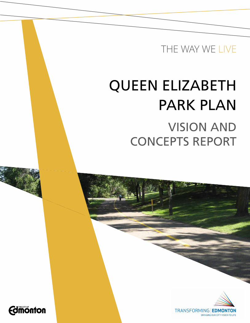
The way we live
queen elizabeth park plan
Vision anD ConCepts report
Queen Elizabeth Park Master Plan | City of Edmonton 2012
01 park Vision, Mission anD GuiDinG prinCiples ........................1
Vision, Mission and GuidinG PrinCiPlEs
ProGraMMinG nEEds assEssMEnt
02 preliMinary DesiGn ConCepts .......................................13
ConCEPt 1: tranQuil riVErfront
ConCEPt 2: Vibrant riVErfront
fEaturEs uniQuE to EaCh ConCEPt
WintEr aCtiVitiEs
table of Contents

Queen Elizabeth Park Master Plan | City of Edmonton 2012
Queen Elizabeth Park Master Plan | City of Edmonton 2012
1
01 park Vision, Mission anD GuiDinG prinCiples

2
Vision, Mission anD GuiDinG prinCiplesQueen Elizabeth Park’s vision statement describes a desired future state of the park that will result if the goals of the park master plan are achieved. a vision statement is bold, descriptive, and should inspire citizens to get involved in helping to realize this future state. an effective vision statement can help guide decisions for the future development of the park.
in contrast, the mission statement for Queen Elizabeth describes the park’s purpose within the overall river valley system of parks and who the target users are for the park.
from discussions with City of Edmonton staff, key stakeholders, aboriginal community members, and the wider public, a vision and mission for Queen Elizabeth Park began to emerge. this was complemented with an understanding of the visions and goals for several related plans and initiatives (see “related Policy and initiatives” section above).
Vision statEMEntQueen Elizabeth Park is a well-loved destination in the heart of Edmonton where people come to have memorable gatherings with friends and family, discover the rich cultural heritage of the river valley, experience a remarkable gateway into downtown, and connect with the natural world.
Mission statEMEntto provide a variety of ways for Edmonton residents and visitors to experience, understand, and connect to the river valley environment.
Queen Elizabeth Park Master Plan | City of Edmonton 2012
3
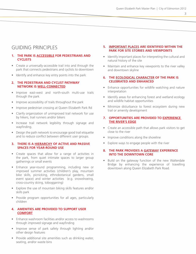
GuidinG PrinCiPlEs
1. The park is accessible for pedesTrians and cyclisTs
• Create a universally-accessible trail into and through the park that connects pedestrians and cyclists to downtown
• identify and enhance key entry points into the park
2. The pedesTrian and cyclisT paThway neTwork is well-connecTed
• improve east-west and north-south multi-use trails through the park
• improve accessibility of trails throughout the park
• improve pedestrian crossing at Queen Elizabeth Park rd
• Clarify organization of unimproved trail network for use by hikers, trail runners and/or bikers
• increase trail network legibility through signage and wayfinding.
• design the path network to encourage good trail etiquette and to reduce conflict between different user groups.
3. There is a hierarchy of acTive and passive spaces for year-round use
• Create spaces that allow for a range of activities in the park, from quiet intimate spaces to larger group gatherings or small events
• Enhance year-round programming, including new or improved summer activities (children’s play, mountain bike skills, picnicking, ethnobotanical gardens, small event space) and winter activities (e.g. snowshoeing, cross-country skiing, tobogganing)
• Explore the use of mountain biking skills features and/or skills park
• Provide program opportunities for all ages, particularly children
4. ameniTies are provided To supporT user comforT
• Enhance washroom facilities and/or access to washrooms through improved signage and wayfinding
• improve sense of park safety through lighting and/or other design features
• Provide additional site amenities such as drinking water, seating, and/or waste bins
5. imporTanT places are idenTified wiThin The park for siTe sTories and viewpoinTs
• identify important places for interpreting the cultural and natural history of the site
• Maintain and enhance key viewpoints to the river valley and downtown skyline
6. The ecological characTer of The park is celebraTed and enhanced
• Enhance opportunities for wildlife watching and nature interpretation
• identify areas for enhancing forest and wetland ecology and wildlife habitat opportunities
• Minimize disturbance to forest ecosystem during new trail or amenity development
7. opporTuniTies are provided To experience The river’s edge
• Create an accessible path that allows park visitors to get close to the river
• improve conditions along the shoreline
• Explore ways to engage people with the river
8. The park provides a gaTeway experience inTo The downTown core
• build on the gateway function of the new Walterdale bridge by enhancing the experience of travelling downtown along Queen Elizabeth Park road.

4
proGraMMinG neeDs assessMent
nEW ProGraM idEas for QuEEn ElizabEth Parkthe public consultation workshops and online survey generated several ideas for new programs and/or amenities in Queen Elizabeth Park. new or enhanced program ideas that were mentioned included:
• Mountain bike skills facility / trails
• non-motorized boat launch
• improved river access
• Enhanced winter activities, including cross-country skiing, snowshoeing, tobogganing opportunities
• Educational opportunities (school programs, general interpretation, guided walks)
• Pavilion / shelter for group gatherings (possibly year-round)
• Enhanced ecology and wildlife habitat
• splash park
• natural playground
• disc (frisbee) golf
• Expanded picnicking amenities
• bird watching
• identification of edible plants / ethnobotanical garden
• amphitheatre
• staging area for small events
• food production-related programming, including community gardens, orchard, and an edible forest garden
• improved lighting and safety
• infrastructure to support skateboarding / long boarding
two important recommendations to change pedestrian access were identified:
• Creation of an accessible trail into the park from saskatchewan drive
• Creation of a safer pedestrian connection between the upper and lower park areas (across Queen Elizabeth Park road)
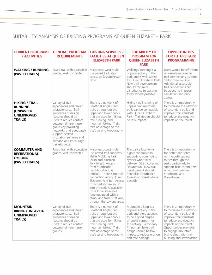
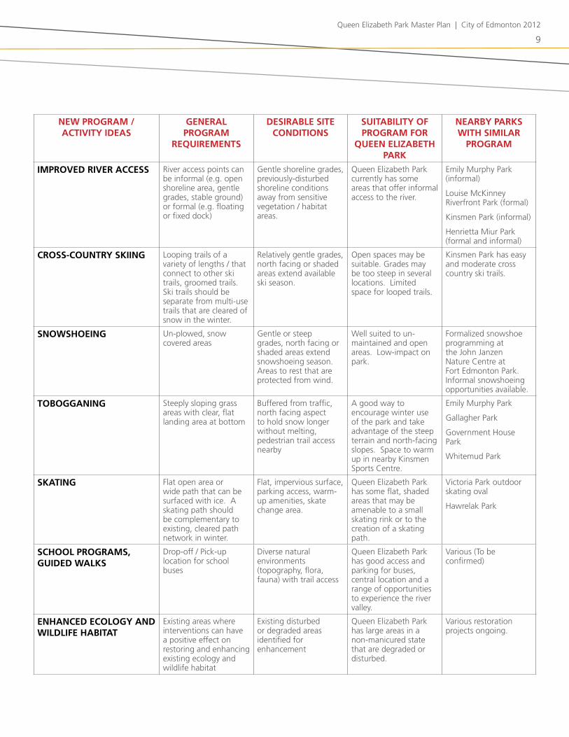
suitability analysis of ExistinG ProGraMs at QuEEn ElizabEth Parkthe table on the opposite page outlines the current programs and activities in Queen Elizabeth Park and indicates their general program requirements, the extent of existing services or facilities in the park, how suitable the activity is for the park, and what opportunities exist for the program in the future.
suitability analysis of PotEntial nEW ProGraMsthe table on page 5 provides a suitability analysis of potential new programs identified for Queen Elizabeth Park based on the ideas suggested above. the table summarizes the general requirements for new programs, their desirable site conditions, their suitability for Queen Elizabeth Park, and whether the program is accommodated at a river valley park within 10km.
Queen Elizabeth Park Master Plan | City of Edmonton 2012
5
currenT programs / acTiviTies
general program requiremenTs
exisTing services / faciliTies aT queen
elizabeTh park
suiTabiliTy of program for
queen elizabeTh park
opporTuniTies for fuTure park programming
walking / running (paved Trails)
Paved trail with accessible grades, well-connected
Major east-west multi-use paved trail, stair access to saskatchewan drive.
Walking / running is a popular activity in the park and is well-suited for Queen Elizabeth Park. new trail development should minimize disturbance to existing forest where possible.
users would benefit from universally-accessible trail connections to/from saskatchewan drive. additional accessible trail connections can be added to improve circulation and park access.
hiking / Trail running (unpaved/unimproved Trails)
Variety of trail experiences and terrain characteristics. trail guidelines or design features should be used to reduce conflict between different user groups by providing networks that adequately support desired circulation patterns and demand and encourage trail etiquette.
there is a network of unofficial single-track trails throughout the upper and lower parks that are used for hiking, trail running, and mountain biking. trails take advantage of the site’s varying topography.
hiking / trail running on unpaved/unimproved trails can be compatible with Queen Elizabeth Park. trail design should be low-impact.
there is an opportunity to formalize the network of secondary trails and improve trail standards to reduce any negative impacts on the forest.
commuTer and recreaTional cycling (paved Trails)
Paved trail with accessible grades, well-connected
Major east-west multi-use paved trail connects nellie McClung Park (east) and kinsmen Park (west). access from strathcona neighbourhood is difficult. there is no trail connection along Queen Elizabeth Park rd. access from saskatchewan dr. into the park is available from three staircases (one equipped with a ramp) and from 91st ave, through the lavigne area.
the park’s location is highly conducive to supporting commuting cyclists who travel between strathcona and downtown. new trail development should minimize disturbance to existing forest where possible.
there is an opportunity for better and safer north-south cycling routes through the park, particularly to support bike commuters who travel between strathcona and downtown.
mounTain biking (unpaved/unimproved Trails)
Variety of trail experiences and terrain characteristics. trail guidelines or design features should be used to reduce conflict between different user groups.
there is a network of unofficial single-track trails throughout the upper and lower parks that are used for hiking, trail running, and mountain biking. trails take advantage of the site’s varying topography.
Mountain biking is a popular activity in the park and there appears to be a good degree of public support for the activity. secondary / mountain bike trail design should be low impact to reduce erosion and tree damage.
there is an opportunity to formalize the network of secondary trails and improve trail standards to reduce any negative impacts on the forest. opportunities may exist to engage mountain biking clubs with trail building and stewardship.
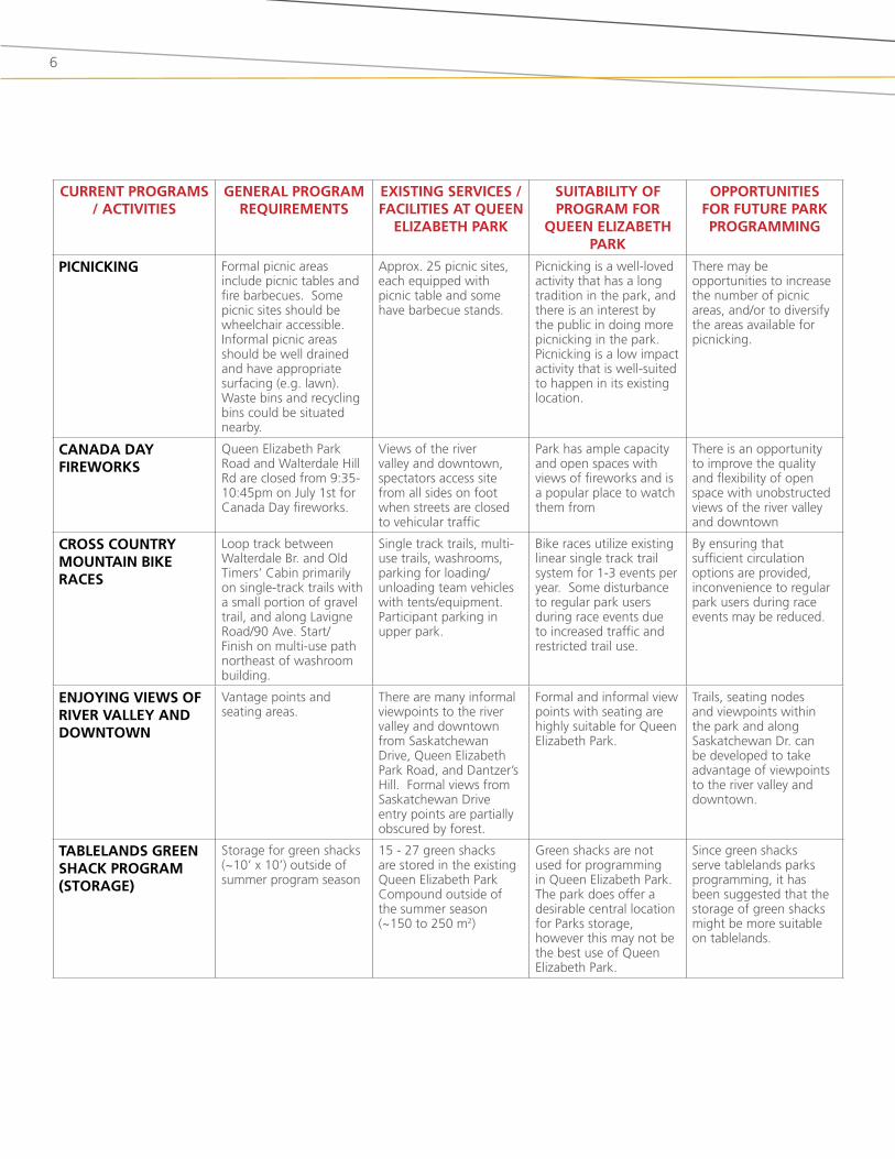
suitability analysis of ExistinG ProGraMs at QuEEn ElizabEth Park
6
currenT programs / acTiviTies
general program requiremenTs
exisTing services / faciliTies aT queen
elizabeTh park
suiTabiliTy of program for
queen elizabeTh park
opporTuniTies for fuTure park programming
picnicking formal picnic areas include picnic tables and fire barbecues. some picnic sites should be wheelchair accessible. informal picnic areas should be well drained and have appropriate surfacing (e.g. lawn). Waste bins and recycling bins could be situated nearby.
approx. 25 picnic sites, each equipped with picnic table and some have barbecue stands.
Picnicking is a well-loved activity that has a long tradition in the park, and there is an interest by the public in doing more picnicking in the park. Picnicking is a low impact activity that is well-suited to happen in its existing location.
there may be opportunities to increase the number of picnic areas, and/or to diversify the areas available for picnicking.
canada day fireworks
Queen Elizabeth Park road and Walterdale hill rd are closed from 9:35-10:45pm on July 1st for Canada day fireworks.
Views of the river valley and downtown, spectators access site from all sides on foot when streets are closed to vehicular traffic
Park has ample capacity and open spaces with views of fireworks and is a popular place to watch them from
there is an opportunity to improve the quality and flexibility of open space with unobstructed views of the river valley and downtown
cross counTry mounTain bike races
loop track between Walterdale br. and old timers’ Cabin primarily on single-track trails with a small portion of gravel trail, and along lavigne road/90 ave. start/finish on multi-use path northeast of washroom building.
single track trails, multi-use trails, washrooms, parking for loading/unloading team vehicles with tents/equipment. Participant parking in upper park.
bike races utilize existing linear single track trail system for 1-3 events per year. some disturbance to regular park users during race events due to increased traffic and restricted trail use.
by ensuring that sufficient circulation options are provided, inconvenience to regular park users during race events may be reduced.
enjoying views of river valley and downTown
Vantage points and seating areas.
there are many informal viewpoints to the river valley and downtown from saskatchewan drive, Queen Elizabeth Park road, and dantzer’s hill. formal views from saskatchewan drive entry points are partially obscured by forest.
formal and informal view points with seating are highly suitable for Queen Elizabeth Park.
trails, seating nodes and viewpoints within the park and along saskatchewan dr. can be developed to take advantage of viewpoints to the river valley and downtown.
Tablelands green shack program (sTorage)
storage for green shacks (~10’ x 10’) outside of summer program season
15 - 27 green shacks are stored in the existing Queen Elizabeth Park Compound outside of the summer season (~150 to 250 m2)
Green shacks are not used for programming in Queen Elizabeth Park. the park does offer a desirable central location for Parks storage, however this may not be the best use of Queen Elizabeth Park.
since green shacks serve tablelands parks programming, it has been suggested that the storage of green shacks might be more suitable on tablelands.
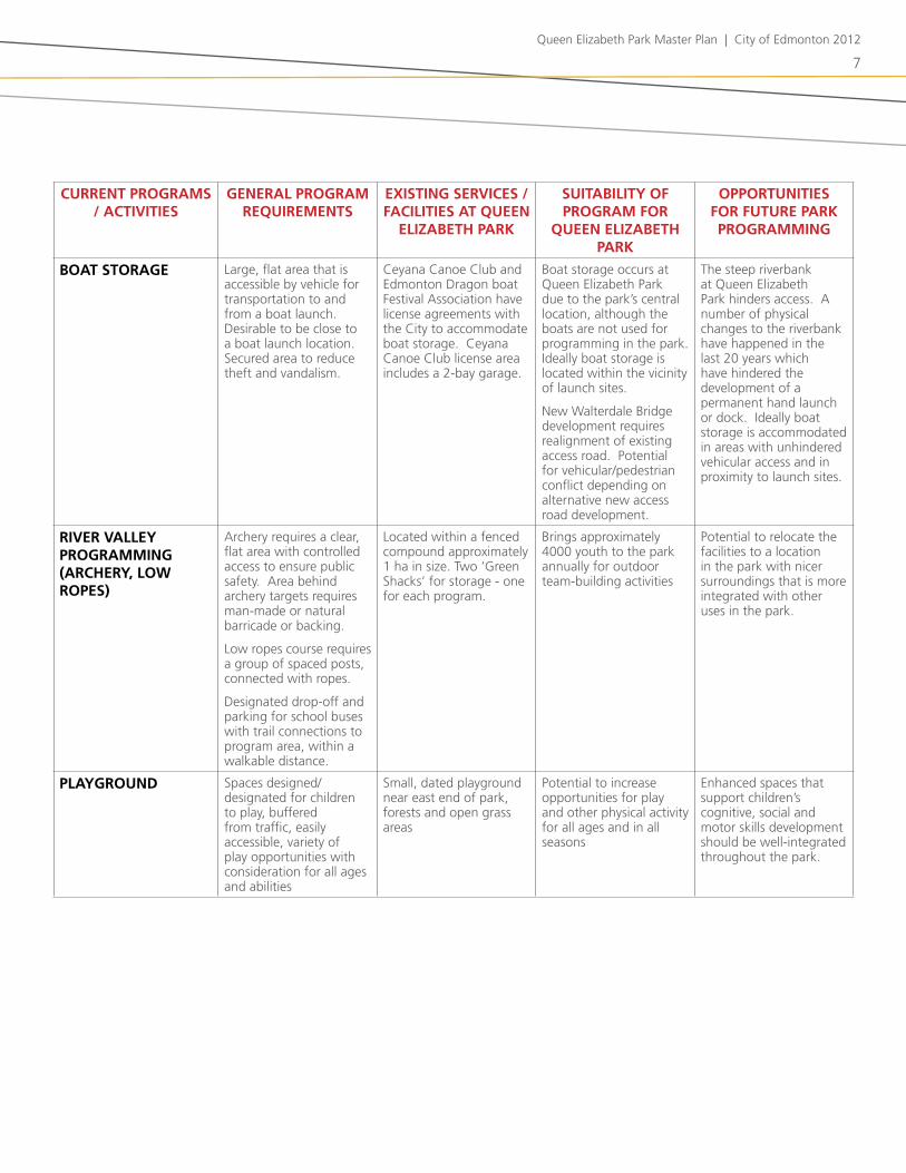
Queen Elizabeth Park Master Plan | City of Edmonton 2012
7
currenT programs / acTiviTies
general program requiremenTs
exisTing services / faciliTies aT queen
elizabeTh park
suiTabiliTy of program for
queen elizabeTh park
opporTuniTies for fuTure park programming
boaT sTorage large, flat area that is accessible by vehicle for transportation to and from a boat launch. desirable to be close to a boat launch location. secured area to reduce theft and vandalism.
Ceyana Canoe Club and Edmonton dragon boat festival association have license agreements with the City to accommodate boat storage. Ceyana Canoe Club license area includes a 2-bay garage.
boat storage occurs at Queen Elizabeth Park due to the park’s central location, although the boats are not used for programming in the park. ideally boat storage is located within the vicinity of launch sites.
new Walterdale bridge development requires realignment of existing access road. Potential for vehicular/pedestrian conflict depending on alternative new access road development.
the steep riverbank at Queen Elizabeth Park hinders access. a number of physical changes to the riverbank have happened in the last 20 years which have hindered the development of a permanent hand launch or dock. ideally boat storage is accommodated in areas with unhindered vehicular access and in proximity to launch sites.
river valley programming (archery, low ropes)
archery requires a clear, flat area with controlled access to ensure public safety. area behind archery targets requires man-made or natural barricade or backing.
low ropes course requires a group of spaced posts, connected with ropes.
designated drop-off and parking for school buses with trail connections to program area, within a walkable distance.
located within a fenced compound approximately 1 ha in size. two ‘Green shacks’ for storage - one for each program.
brings approximately 4000 youth to the park annually for outdoor team-building activities
Potential to relocate the facilities to a location in the park with nicer surroundings that is more integrated with other uses in the park.
playground spaces designed/designated for children to play, buffered from traffic, easily accessible, variety of play opportunities with consideration for all ages and abilities
small, dated playground near east end of park, forests and open grass areas
Potential to increase opportunities for play and other physical activity for all ages and in all seasons
Enhanced spaces that support children’s cognitive, social and motor skills development should be well-integrated throughout the park.
8
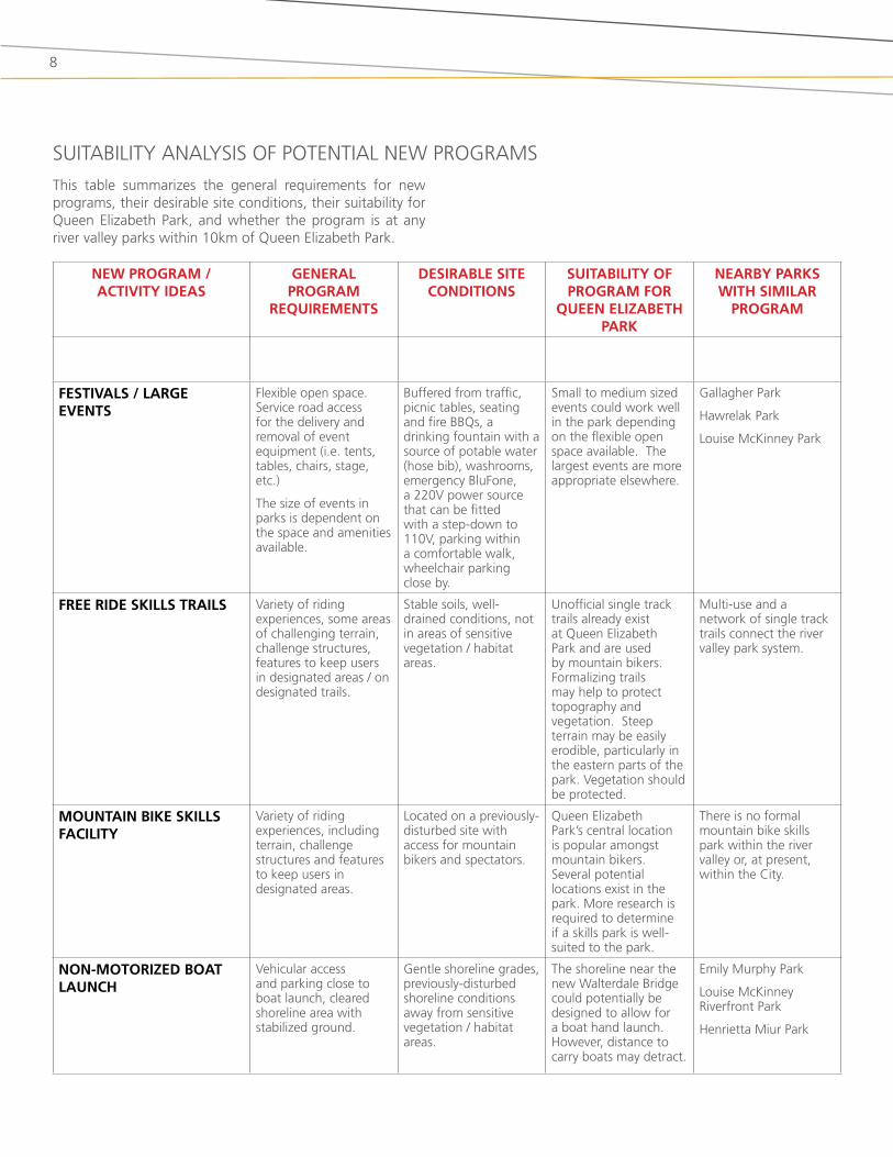
new program / acTiviTy ideas
general program
requiremenTs
desirable siTe condiTions
suiTabiliTy of program for
queen elizabeTh park
nearby parks wiTh similar
program
fesTivals / large evenTs
flexible open space. service road access for the delivery and removal of event equipment (i.e. tents, tables, chairs, stage, etc.)
the size of events in parks is dependent on the space and amenities available.
buffered from traffic, picnic tables, seating and fire bbQs, a drinking fountain with a source of potable water (hose bib), washrooms, emergency blufone, a 220V power source that can be fitted with a step-down to 110V, parking within a comfortable walk, wheelchair parking close by.
small to medium sized events could work well in the park depending on the flexible open space available. the largest events are more appropriate elsewhere.
Gallagher Park
hawrelak Park
louise Mckinney Park
free ride skills Trails Variety of riding experiences, some areas of challenging terrain, challenge structures, features to keep users in designated areas / on designated trails.
stable soils, well-drained conditions, not in areas of sensitive vegetation / habitat areas.
unofficial single track trails already exist at Queen Elizabeth Park and are used by mountain bikers. formalizing trails may help to protect topography and vegetation. steep terrain may be easily erodible, particularly in the eastern parts of the park. Vegetation should be protected.
Multi-use and a network of single track trails connect the river valley park system.
mounTain bike skills faciliTy
Variety of riding experiences, including terrain, challenge structures and features to keep users in designated areas.
located on a previously-disturbed site with access for mountain bikers and spectators.
Queen Elizabeth Park’s central location is popular amongst mountain bikers. several potential locations exist in the park. More research is required to determine if a skills park is well-suited to the park.
there is no formal mountain bike skills park within the river valley or, at present, within the City.
non-moTorized boaT launch
Vehicular access and parking close to boat launch, cleared shoreline area with stabilized ground.
Gentle shoreline grades, previously-disturbed shoreline conditions away from sensitive vegetation / habitat areas.
the shoreline near the new Walterdale bridge could potentially be designed to allow for a boat hand launch. however, distance to carry boats may detract.
Emily Murphy Park
louise Mckinney riverfront Park
henrietta Miur Park
suitability analysis of PotEntial nEW ProGraMs
this table summarizes the general requirements for new programs, their desirable site conditions, their suitability for Queen Elizabeth Park, and whether the program is at any river valley parks within 10km of Queen Elizabeth Park.
Queen Elizabeth Park Master Plan | City of Edmonton 2012
9
new program / acTiviTy ideas
general program
requiremenTs
desirable siTe condiTions
suiTabiliTy of program for
queen elizabeTh park
nearby parks wiTh similar
program
improved river access river access points can be informal (e.g. open shoreline area, gentle grades, stable ground) or formal (e.g. floating or fixed dock)
Gentle shoreline grades, previously-disturbed shoreline conditions away from sensitive vegetation / habitat areas.
Queen Elizabeth Park currently has some areas that offer informal access to the river.
Emily Murphy Park (informal)
louise Mckinney riverfront Park (formal)
kinsmen Park (informal)
henrietta Miur Park (formal and informal)
cross-counTry skiing looping trails of a variety of lengths / that connect to other ski trails, groomed trails. ski trails should be separate from multi-use trails that are cleared of snow in the winter.
relatively gentle grades, north facing or shaded areas extend available ski season.
open spaces may be suitable. Grades may be too steep in several locations. limited space for looped trails.
kinsmen Park has easy and moderate cross country ski trails.
snowshoeing un-plowed, snow covered areas
Gentle or steep grades, north facing or shaded areas extend snowshoeing season. areas to rest that are protected from wind.
Well suited to un-maintained and open areas. low-impact on park.
formalized snowshoe programming at the John Janzen nature Centre at fort Edmonton Park. informal snowshoeing opportunities available.
Tobogganing steeply sloping grass areas with clear, flat landing area at bottom
buffered from traffic, north facing aspect to hold snow longer without melting, pedestrian trail access nearby
a good way to encourage winter use of the park and take advantage of the steep terrain and north-facing slopes. space to warm up in nearby kinsmen sports Centre.
Emily Murphy Park
Gallagher Park
Government house Park
Whitemud Park
skaTing flat open area or wide path that can be surfaced with ice. a skating path should be complementary to existing, cleared path network in winter.
flat, impervious surface, parking access, warm-up amenities, skate change area.
Queen Elizabeth Park has some flat, shaded areas that may be amenable to a small skating rink or to the creation of a skating path.
Victoria Park outdoor skating oval
hawrelak Park
school programs, guided walks
drop-off / Pick-up location for school buses
diverse natural environments (topography, flora, fauna) with trail access
Queen Elizabeth Park has good access and parking for buses, central location and a range of opportunities to experience the river valley.
Various (to be confirmed)
enhanced ecology and wildlife habiTaT
Existing areas where interventions can have a positive effect on restoring and enhancing existing ecology and wildlife habitat
Existing disturbed or degraded areas identified for enhancement
Queen Elizabeth Park has large areas in a non-manicured state that are degraded or disturbed.
Various restoration projects ongoing.
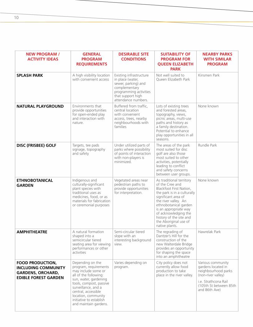
10
new program / acTiviTy ideas
general program
requiremenTs
desirable siTe condiTions
suiTabiliTy of program for
queen elizabeTh park
nearby parks wiTh similar
program
splash park a high visibility location with convenient access
Existing infrastructure in place (water, sewer, parking) and complementary programming activities that support high attendance numbers.
not well suited to Queen Elizabeth Park
kinsmen Park
naTural playground Environments that provide opportunities for open-ended play and interaction with nature.
buffered from traffic, central location with convenient access, trees, nearby neighbourhoods with families
lots of existing trees and forested areas, topography, views, picnic areas, multi-use paths and history as a family destination. Potential to enhance play opportunities in all seasons.
none known
disc (frisbee) golf targets, tee pads signage, topography and safety
under utilized parts of parks where possibility of points of interaction with non-players is minimized.
the areas of the park most suited for disc golf are also those most suited to other activities, potentially leading to conflict and safety concerns between user groups.
rundle Park
eThnoboTanical garden
indigenous and culturally-significant plant species with traditional uses as medicines, food, or as materials for fabrication or ceremonial purposes
Vegetated areas near pedestrian paths to provide opportunities for interpretation.
as traditional territory of the Cree and blackfoot first nation, the park is in a culturally significant area of the river valley. an ethnobotanical garden is an appropriate way of acknowledging the history of the site and the aboriginal use of native plants.
none known
amphiTheaTre a natural formation shaped into a semicircular tiered seating area for viewing performances or other activities
semi-circular tiered slope with an interesting background view.
the regrading of dantzer’s hill for the construction of the new Walterdale bridge provides an opportunity for shaping the space into an amphitheatre
hawrelak Park
food producTion, including communiTy gardens, orchard, edible foresT garden
depending on the program, requirements may include some or all of the following: sun, water, gardening tools, compost, passive surveillance, and a central, accessible location, community initiative to establish and maintain gardens.
Varies depending on program.
City policy does not currently allow food production to take place in the river valley.
Various community gardens located in neighbourhood parks (non-river valley)
i.e. strathcona rail (105th st between 85th and 86th ave)

Queen Elizabeth Park Master Plan | City of Edmonton 2012
11
nearby river valley parks /
approx. driving disTance from
queen elizabeTh park
impr
ov
ed T
ra
ils
un
impr
ov
ed T
ra
ils
pic
nic
siT
es
win
Ter
ized
w
ash
ro
om
s
ha
nd
bo
aT
lau
nc
h
pla
y a
rea
Tob
og
ga
nin
g
xc
sk
iing
sno
wsh
oei
ng
ice
ska
Tin
g
spo
rTs
fie
lds
poo
l /
spr
ay
pa
rk
co
ver
ed g
ro
up
/
pic
nic
sh
elTe
r
co
nc
essi
on
bld
g
info
rm
al
ope
n s
pac
e
riv
er a
cc
ess
oTher
queen elizabeTh park • • • • • • • • • •
unofficial skiing / snowshoeing / tobogganing / river access
kinsmen park (<500 m) • • • • • • • • • Pitch and Putt, museum
nellie mcclung park
(<500 m)• •
mill creek ravine park (1 km) • • • • • • •
vicToria park (3 km)
• • • • • • • •
Golf course adjacent, ball diamond, pitch and putt, cricket oval, horseshoes, pavilion planned, six reservable group picnic sites
emily murphy park (3 km) • • • • • • • • • • two reservable group
picnic sites
henrieTTa muir edwards park / gallagher park
(3 km)
• • • • • •Muttart Conservatory, Edmonton ski club, riverboat launch, festival site
hawrelak park (4 km) • • • • • • • • • • • •
Golf course adjacent, paddle boating, amphitheatre, five reservable group picnic sites, festival site
governmenT house park (4 km) • • • •
louise mckinney park (4 km) • • • • • • • •
Public dock, performance stage, riverfront plaza with future amenities / concession planned
whiTemud park (5 km) • • • • • • • Equestrian centre and trails
forT edmonTon park
(6 km)• • • • • Paid admission required
for museum facilities
buena visTa / wilfrid laurier
parks (10 km)
• • • • • • • • • • •trailered boat launch, fishing area, horseshoe pits, picnic site reservations available
inVEntory of aMEnitiEs and ProGraMs at nEarby Parks

Queen Elizabeth Park Master Plan | City of Edmonton 2012
12

Queen Elizabeth Park Master Plan | City of Edmonton 2012
13
02 preliMinary DesiGn ConCepts
two preliminary design concepts were developed for Queen Elizabeth Park based on information gathered in the disCoVEr phase, and based on the park vision, mission and guiding principles that were derived from this information. Public review and input on these concepts will inform the selection of a preferred approach for the park master plan.
14
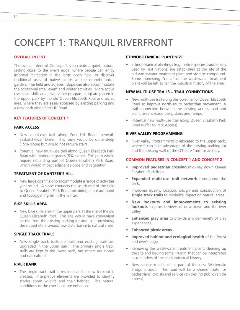
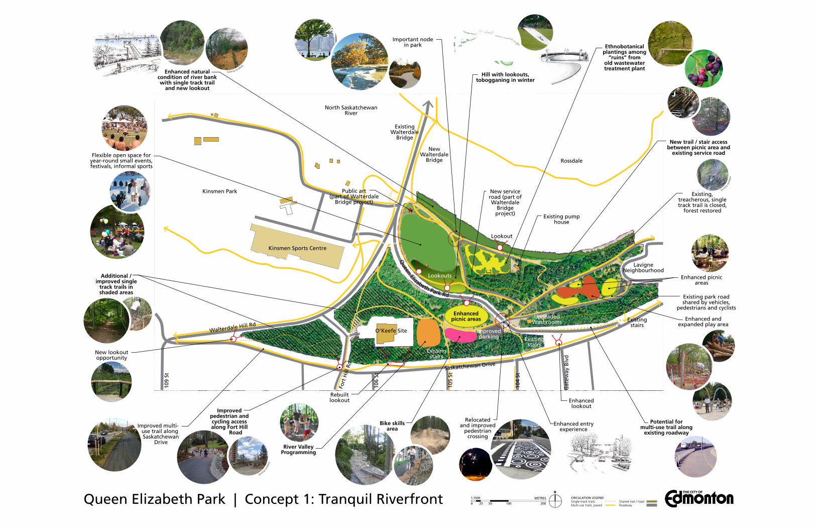
overall inTenT
the overall intent of Concept 1 is to create a quiet, natural setting close to the river’s edge, where people can enjoy informal recreation in the large open field, or discover traditional uses of native plants at the ethnobotanical garden. the field and adjacent slope can also accommodate the occasional small event and winter activities. More active uses (bike skills area, river valley programming) are placed in the upper park by the old Queen Elizabeth Pool and picnic area, where they are easily accessed by existing parking and a new path along fort hill road.
key feaTures of concepT 1
park access
• new multi-use trail along fort hill road, beneath saskatchewan drive. this route would be quite steep (15% slope) but would not require stairs.
• Potential new multi-use trail along Queen Elizabeth Park road with moderate grades (8% slope). this path would require rebuilding part of Queen Elizabeth Park road, which would impact adjacent slopes and vegetation.
TreaTmenT of danTzer’s hill
• new large open field to accommodate a range of activities year-round. a slope connects the south end of the field to Queen Elizabeth Park road, providing a lookout point and tobogganing hill in the winter.
bike skills area
• new bike skills area in the upper park at the site of the old Queen Elizabeth Pool. this site would have convenient access from the existing parking lot and, as a previously developed site, it avoids new disturbance to natural areas.
single Track Trails
• new single track trails are built and existing trails are upgraded in the upper park. the primary single track trails are kept in the lower park, but others are closed and naturalized.
river bank
• the single-track trail is retained and a new lookout is created. interpretive elements are provided to identify stories about wildlife and their habitat. the natural conditions of the river bank are enhanced.
ConCept 1: tranquil riVerfronteThnoboTanical planTings
• Ethnobotanical plantings (e.g. native species traditionally used by first nations) are established at the site of the old wastewater treatment plant and storage compound. some interesting “ruins” of the wastewater treatment plant will be left to tell the industrial history of the area.
new mulTi-use Trails + Trail connecTions
• new multi-use trail along the lower half of Queen Elizabeth road to improve north-south pedestrian movement. a trail connection between the existing access road and picnic area is made using stairs and ramps.
• Potential new multi-use trail along Queen Elizabeth Park road (refer to Park access)
river valley programming
• river Valley Programming is relocated to the upper park, where it can take advantage of the existing parking lot and the existing wall of the o’keefe yard for archery.
common feaTures in concepT 1 and concepT 2
• improved pedestrian crossing mid-way down Queen Elizabeth Park road
• expanded multi-use trail network throughout the park.
• improved quality, location, design and construction of single track trails to minimize impact on natural areas.
• new lookouts and improvements to existing lookouts to provide views of downtown and the river valley.
• enhanced play area to provide a wider variety of play experiences.
• enhanced picnic areas.
• improved habitat and ecological health of the forest and river’s edge.
• removing the wastewater treatment plant, cleaning up the site and leaving some “ruins” that can be interpreted as reminders of the site’s industrial history.
• new service road built as part of the new Walterdale bridge project. this road will be a shared route for pedestrians, cyclists and service vehicles (no public vehicle access).
*
Existin
g co
nditi
on
Existing condition
Existin
g co
nditi
on
N
0 25 50 100 200
METRES1:1500
va
Existing stairs
CIRCULATION LEGENDSingle-track trailsMulti-use trails, paved
Shared trail / roadRoadway
Queen Elizabeth Park | Concept 1: Tranquil Riverfront
Kinsmen Park
ExistingWalterdale
Bridge
Flexible open space for year-round small events, festivals, informal sports
Enhanced natural condition of river bank with single track trail
and new lookout
Important node in park
New service road (part of Walterdale
Bridge project)
Hill with lookouts, tobogganing in winter
Enhanced picnic areas
Bike skills area
Improvedparking
UpgradedWashrooms
Existing, treacherous, single track trail is closed,
forest restored
Enhanced picnic areas
Enhanced and expanded play area
Kinsmen Sports Centre
Walterdale Hill Rd
Saskatchewan Drive
North Saskatchewan River
Gat
eway
Blv
d
104
St
105
St
106
St
109
St
Fort
Hill
Rd
LavigneNeighbourhood
New Walterdale
Bridge
Lookouts
Lookout
Rossdale
Queen Elizabeth Park Rd
O’Keefe Site
Existing pump house
Ethnobotanical plantings among
“ruins” from old wastewater treatment plant
Potential formulti-use trail along
existing roadway
Enhancedlookout
Existing park road shared by vehicles,
pedestrians and cyclists
Relocated and improved
pedestrian crossing
Rebuilt lookout
Improved pedestrian and cycling access along Fort Hill
Road
New lookout opportunity
Improved multi-use trail along Saskatchewan
Drive
Public art (part of Walterdale
Bridge project)
Enhanced entry experience
Existing stairs
Existing stairs
New trail / stair access between picnic area and
existing service road
Additional / improved single
track trails in shaded areas
River Valley Programming
16
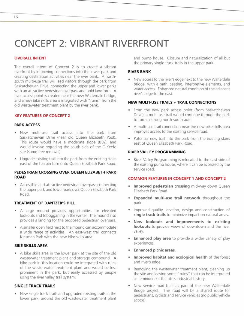
ConCept 2: Vibrant riVerfrontoverall inTenT
the overall intent of Concept 2 is to create a vibrant riverfront by improving connections into the lower park and creating destination activities near the river bank. a north-south multi-use trail will lead visitors through the park from saskatchewan drive, connecting the upper and lower parks with an attractive pedestrian overpass and bold landform. a river access point is created near the new Walterdale bridge, and a new bike skills area is integrated with “ruins” from the old wastewater treatment plant by the river bank.
key feaTures of concepT 2
park access
• new multi-use trail access into the park from saskatchewan drive (near old Queen Elizabeth Pool). this route would have a moderate slope (8%), and would involve regrading the south side of the o’keefe site (some tree removal).
• upgrade existing trail into the park from the existing stairs east of the hairpin turn onto Queen Elizabeth Park road.
pedesTrian crossing over queen elizabeTh park road
• accessible and attractive pedestrian overpass connecting the upper park and lower park over Queen Elizabeth Park road.
TreaTmenT of danTzer’s hill
• a large mound provides opportunities for elevated lookouts and tobogganing in the winter. the mound also provides a landing for the proposed pedestrian overpass.
• a smaller open field next to the mound can accommodate a wide range of activities. an east-west trail connects kinsmen Park with the new bike skills area.
bike skills area
• a bike skills area in the lower park at the site of the old wastewater treatment plant and storage compound. a bike park in this location could be integrated with ruins of the waste water treatment plant and would be less prominent in the park, but easily accessed by people using the river valley trail system.
single Track Trails
• new single track trails and upgraded existing trails in the lower park, around the old wastewater treatment plant
and pump house. Closure and naturalization of all but the primary single track trails in the upper park.
river bank
• new access to the river’s edge next to the new Walterdale bridge, with a path, seating, interpretive elements, and water access. Enhanced natural condition of the adjacent river’s edge to the east.
new mulTi-use Trails + Trail connecTions
• from the new park access point (from saskatchewan drive), a multi-use trail would continue through the park to form a strong north-south axis.
• a multi-use trail connection near the new bike skills area improves access to the existing service road.
• Potential new trail into the park from the existing stairs east of Queen Elizabeth Park road.
river valley programming
• river Valley Programming is relocated to the east side of the existing pump house, where it can be accessed by the service road.
common feaTures in concepT 1 and concepT 2
• improved pedestrian crossing mid-way down Queen Elizabeth Park road
• expanded multi-use trail network throughout the park.
• improved quality, location, design and construction of single track trails to minimize impact on natural areas.
• new lookouts and improvements to existing lookouts to provide views of downtown and the river valley.
• enhanced play area to provide a wider variety of play experiences.
• enhanced picnic areas.
• improved habitat and ecological health of the forest and river’s edge.
• removing the wastewater treatment plant, cleaning up the site and leaving some “ruins” that can be interpreted as reminders of the site’s industrial history.
• new service road built as part of the new Walterdale bridge project. this road will be a shared route for pedestrians, cyclists and service vehicles (no public vehicle access).
*
Fort
Hill
Rd
Queen Elizabeth Park | Concept 2: Vibrant Riverfront
Enhanced picnic areas
Kinsmen Park
ExistingWalterdale
Bridge
Flexible open space for year-round small events, festivals, informal sports
Enhanced natural condition of river
bank
Important node in park
New service road (part of Walterdale
Bridge project)
Improvedparking
UpgradedWashrooms
Existing, treacherous, single track trail is closed,
forest restored
Enhanced and expanded play area
Kinsmen Sports Centre
Walterdale Hill Rd
Saskatchewan Drive
North Saskatchewan
River
Gat
eway
Blv
d
104
St
105
St
106
St
109
St
Fort
Hill
Rd
LavigneNeighbourhood
New Walterdale
Bridge
Lookouts
Rossdale
Queen Elizabeth Park Rd
O’Keefe Site
Existing pump house
Enhancedlookout
Existing park road shared by vehicles,
pedestrians and cyclists
Relocated and improved
pedestrian crossing
Rebuilt lookoutNew lookout
opportunityImproved multi-use trail along
Saskatchewan Dr.
Public art(part of
WalterdaleBridgeproject)
Enhanced entry experience
Existing stairs
Existing stairs
Existing stairs
Existin
g co
nditi
on
Exis
ting
cond
ition
Existing conditio
nEnhanced picnic areas and ethnobotanical
plantings
Additional parking (stalls / parallel)
Potential to upgrade existing
trail (requires stair access)
107
St
Bike skills area
New / enhanced picnic areas
Additional / improved single track trails in
shaded areas
River Valley Programming
Pedestrianoverpass
Lookout opportunity
from Duggan Bridge
River access / viewpoint
Large mound with lookouts,
tobogganing in winter
New multi-use trail / entry
N
0 25 50 100 200
METRES1:1500 CIRCULATION LEGENDSingle-track trailsMulti-use trails, paved
Shared trail / roadRoadway

18
Queen Elizabeth Park Master Plan | City of Edmonton 2012
19
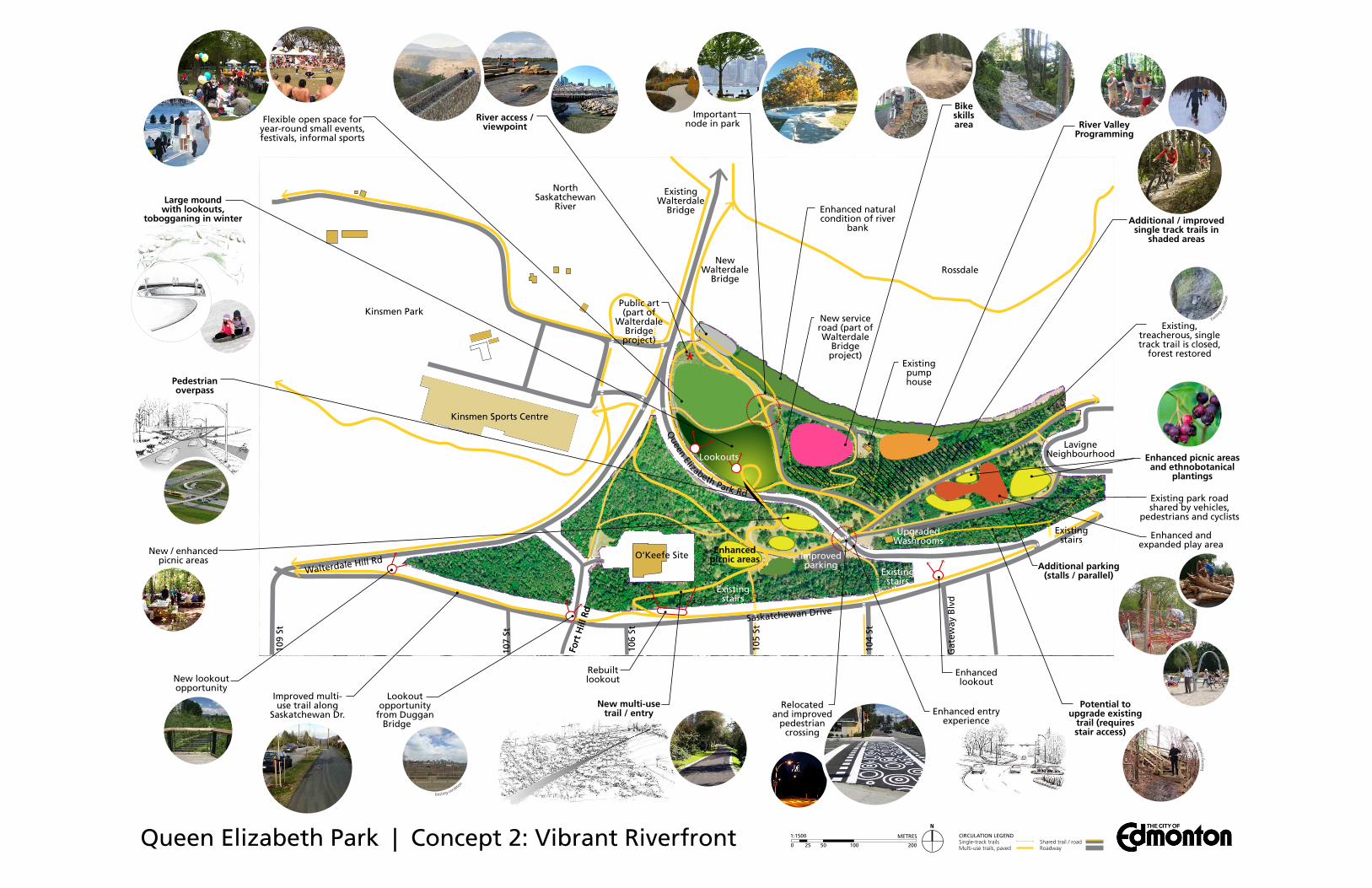
features unique to eaCh ConCept
feaTure concepT 1 concepT 2
park access new multi-use trail along fort hill road (below saskatchewan drive).
Potential new multi-use trail along Queen Elizabeth Park road.
accessible multi-use trail entry from saskatchewan drive to the old Queen Elizabeth Pool site which continues through the park to form a strong north-south multi-use axis.
upgrade existing trail into the park from the existing stairs east of the hairpin turn onto Queen Elizabeth Park road.
pedesTrian crossing over queen elizabeTh park road
Multi-use trail overpass over Queen Elizabeth Park road.
TreaTmenT of danTzer’s hill
small slope (lookouts, tobogganing hill) connecting Queen Elizabeth Park road to a large open field
large mound (landmark, lookout point, tobogganing hill) and open field for flexible programming in the area currently occupied by dantzer’s hill. an east-west trail across the field connects kinsmen Park to the new bike skills area.
river bank the single-track trail is retained and a new lookout and interpretation opportunities are provided. no official river access area.
river access is provided next to the new Walterdale bridge, allowing people to get down to the water’s edge. the single-track trail is upgraded to a more defined trail, with seating, and interpretation opportunities provided.
bike skills area situated in upper park, at site of old Queen Elizabeth Pool. access to strathcona neighbourhood and nearby parking.
situated in lower park at site of former wastewater treatment plant and storage compound. bike skills area incorporates “ruins” from old wastewater treatment plant. distance from parking.
single-Track Trails single-track trails upgraded and expanded in upper park. all but primary single-track trails in lower park are closed and naturalized.
single-track trails upgraded and expanded in lower park. all but primary single-track trails in upper park are closed and naturalized.
mulTi-use Trails and Trail connecTions
new multi-use trail along the lower half of Queen Elizabeth Park road.
Potential new multi-use trail along upper half of Queen Elizabeth Park road.
new connection between picnic area and existing service road using combination of stairs and ramps.
accessible multi-use trail north-south from saskatchewan drive to the new Walterdale bridge via overpass.
Multi-use trail connection near the new bike skills area for improved access to the river bank.
East-west trail across new field.
eThnoboTanical planTings
dedicated area for ethnobotanical plantings in the lower park, with “ruins” from old wastewater treatment plant.
no dedicated area for ethnobotanical plantings; plantings incorporated throughout park.
river valley programming
relocated to upper park, next to the old Queen Elizabeth Pool.
kept in lower park, but moved east of its current location.
20
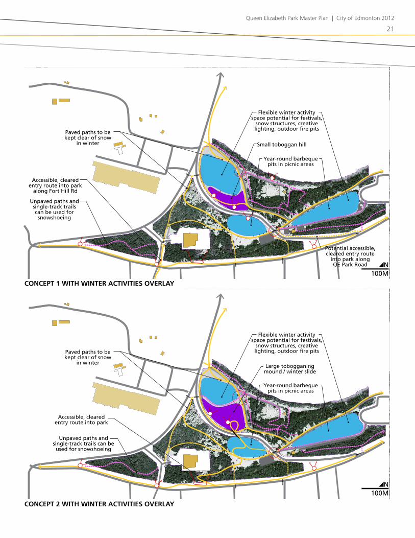
winTer in queen elizabeTh park
both conceptual designs for Queen Elizabeth Park allow for a variety of winter activities.
fill will be removed from dantzer’s hill as part of the new Walterdale bridge project, thereby creating the opportunity to re-grade this area into one of Edmonton’s best hills for tobogganing and other downhill uses (e.g. snow slide, snow scooters). in Concept 1 this hill is of a moderate size, while Concept 2 envisions it to be a larger, bolder mound feature that is linked to the pedestrian overpass. the hill would also provide good vantage points toward Edmonton’s winter skyline and snowy river valley.
new accessible paved paths are proposed to lead into the park from saskatchewan drive. these will be cleared of snow in the winter, thereby facilitating year-round access into the river valley. a network of cleared, paved paths will allow visitors to travel through the park and to adjacent parks and facilities (e.g. to kinsmen sports Centre) throughout the winter.
unpaved paths and single-track trails will not be cleared in the winter, allowing these areas to be used for snowshoeing, winter hiking, and winter mountain biking when conditions allow.
Clearings within the park can be programmed for a wide variety of winter activities. the large open field north of the tobogganing hill has the potential to be a prominent location in the river valley for winter festivals and snow structures (e.g. snow forts, wind barriers, ice climbing walls, snow mounds). smaller clearings in the picnic areas could be equipped with portable gas fire pits, year-round barbeques, and temporary winter warming huts. More detailed design can ensure that sun, shadow, wind, and snow are considered to create comfortable outdoor microclimates.
for special events, food trucks could be brought in to sell hot drinks and food, and affordable winter equipment rentals could be provided (e.g. snowshoes, toboggans) to help visitors fully enjoy the park in winter.
interesting lighting can be incorporated into seating, paths, structures (e.g. pedestrian overpass) and other elements to enliven these spaces and extend their usability past daylight hours.
interpretation of the site could incorporate messaging that speaks to winter activities (e.g. winter wildlife) and cultural traditions for living in a cold climate.
Winter aCtiVitieswinTerciTy sTraTegy incorporaTion
the City of Edmonton is currently developing a “WinterCity strategy” as a tool to help make Edmonton known world-wide as a “vibrant, fun, northern city.” the City has been soliciting ideas for winter programming from the public and over 400 ideas have been submitted. a draft WinterCity strategy is scheduled for release in summer 2012.
Queen Elizabeth Park Master Plan | City of Edmonton 2012
21
concepT 2 wiTh winTer acTiviTies overlay
concepT 1 wiTh winTer acTiviTies overlay
flexible winter activity space potential for festivals,
snow structures, creative lighting, outdoor fire pits
flexible winter activity space potential for festivals,
snow structures, creative lighting, outdoor fire pits
small toboggan hill
year-round barbeque pits in picnic areas
year-round barbeque pits in picnic areas
large tobogganing mound / winter slide
unpaved paths and single-track trails can be used for snowshoeing
accessible, cleared entry route into park
along fort hill rd
accessible, cleared entry route into park
potential accessible, cleared entry route
into park along qe park road
unpaved paths and single-track trails can be used for snowshoeing
paved paths to be kept clear of snow
in winter
paved paths to be kept clear of snow
in winter
n100M
n100M
n100M
n100M