Embed Size (px)
Citation preview
Land 101
Historical land research in Queensland
February 2020
This publication has been compiled by Kaye Nardella of Museum of Lands, Mapping and Surveying DNRME. © State of Queensland, 2020 The Queensland Government supports and encourages the dissemination and exchange of its information. The copyright in this publication is licensed under a Creative Commons Attribution 4.0 International (CC BY 4.0) licence. Under this licence you are free, without having to seek our permission, to use this publication in accordance with the licence terms.
You must keep intact the copyright notice and attribute the State of Queensland as the source of the publication. Note: Some content in this publication may have different licence terms as indicated. For more information on this licence, visit https://creativecommons.org/licenses/by/4.0/. The information contained herein is subject to change without notice. The Queensland Government shall not be liable for technical or other errors or omissions contained herein. The reader/user accepts all risks and responsibility for losses, damages, costs and other consequences resulting directly or indirectly from using this information.
1 DNRME Land 101 Historical land research in Queensland Guide version 1.0
Summary
To conduct historical land research in Queensland, knowledge of three components of land administration is critical. These components, administrative areas, property descriptions and land tenure are described. Examples are provided of where to locate them on cadastral maps and survey plans, and in land records, Queensland Government gazettes and digitised newspapers.
2 DNRME Land 101 Historical land research in Queensland Guide version 1.0
Contents
Table of figures .................................................................................................................................... 3
Table of resource links ........................................................................................................................ 3
Land administration .............................................................................................................................. 5
Administrative areas ............................................................................................................................. 5
Counties ................................................................................................................................................. 5
Resources ............................................................................................................................................ 5
Notes ................................................................................................................................................... 5
Parishes ................................................................................................................................................. 6
Resources ............................................................................................................................................ 6
Notes ................................................................................................................................................... 6
Pastoral Districts .................................................................................................................................... 7
Resources ............................................................................................................................................ 7
Notes ................................................................................................................................................... 7
Land Agent’s Districts (LADs) ................................................................................................................ 8
Resources ............................................................................................................................................ 8
Notes ................................................................................................................................................... 8
Property descriptions ............................................................................................................................ 9
Original property descriptions ................................................................................................................ 9
Property descriptions for rural / country blocks ................................................................................... 9
Property descriptions for town / city blocks ....................................................................................... 10
Property descriptions for pastoral runs / pastoral holdings ............................................................... 11
Notes ................................................................................................................................................. 11
Current property descriptions .............................................................................................................. 12
Tenure ................................................................................................................................................... 13
Freehold ............................................................................................................................................... 13
Old Land System ............................................................................................................................... 13
Torrens System ................................................................................................................................. 13
Leasehold ............................................................................................................................................ 14
Reserves .............................................................................................................................................. 15
Where to find these components ....................................................................................................... 15
Finding information on cadastral maps................................................................................................ 16
Finding information on survey plans .................................................................................................... 18
Finding information on land records .................................................................................................... 19
Finding information in Queensland Government Gazettes ................................................................. 20
Finding information in digitised newspapers ....................................................................................... 20
3 DNRME Land 101 Historical land research in Queensland Guide version 1.0
Table of figures
Figure 1: County of Cavendish .......................................................................................................................... 5 Figure 2: Parish of Avoca Sheet 1 ..................................................................................................................... 6 Figure 3: Mitchell Pastoral District ..................................................................................................................... 7 Figure 4: Land Agent’s Districts map (LADs outlined in red) ............................................................................. 8 Figure 5: Survey plan showing change to Land Agent’s District name ............................................................. 8 Figure 6: Portion 226 ......................................................................................................................................... 9 Figure 7: Property description on title .............................................................................................................. 10 Figure 8: Property description on title .............................................................................................................. 10 Figure 9: Town allotment (Ebagoola 1926) ..................................................................................................... 10 Figure 10: Pastoral runs, Mitchell Pastoral District .......................................................................................... 11 Figure 11: Part of survey plan SP304527 dated 2019 .................................................................................... 12 Figure 12: Deed of Grant/ Certificate of Title ................................................................................................... 13 Figure 13: Special Lease (2m16 dated 1954) ................................................................................................. 14 Figure 14: Reserves (2m16 dated 1954) ......................................................................................................... 15 Figure 15: Part of 40 Chain Parish of Wellshot dated 1936 ............................................................................ 16 Figure 16: Part of Queensland 2 mile series sheet 2m46 dated 1953 ............................................................ 17 Figure 17: Survey plan POR5761 dated 1894 ................................................................................................ 18 Figure 18: Freehold title with titles reference number of 10662183 dated 1887 ............................................. 19 Figure 19: Document on file for Lease AF.26 Ipswich Land Agent’s District dated 1891 ............................... 19 Figure 20: Qld Government Gazette for 1899 - G.G.1899.1.590 .................................................................... 20 Figure 21: The Beaudesert Times Friday 24 May 1935 page 8 ...................................................................... 20 Figure 22: The Courier Mail Saturday 15 December 1934 page 24 ............................................................... 21
Table of resource links
1. Map showing original County boundaries in 1890: https://gisservices.information.qld.gov.au/arcgis/rest/directories/historicalscans/cad_scans/cad-map-queensland-map-counties-1890.jpg
2. Map showing new County boundaries from 1901: https://gisservices.information.qld.gov.au/arcgis/rest/directories/historicalscans/cad_scans/cad-map-queensland-colony-map-no2c-counties-1900.jpg
3. List of old and new county prefixes for crown surveys: https://www.qld.gov.au/recreation/arts/heritage/museum-of-lands/maps-plans/historical-survey/county-prefixes
4. Map showing Land Agent’s Districts in 1967: https://gisservices.information.qld.gov.au/arcgis/rest/directories/historicalscans/cad_scans/cad-map-queensland-state-map-q6h-key-map-and-lad-1967.jpg
5. Map showing Pastoral Districts in 1886: https://gisservices.information.qld.gov.au/arcgis/rest/directories/historicalscans/cad_scans/cad-map-queensland-map-pastoral-districts-1886.jpg
6. Original run boundary maps available through Open Data: https://www.data.qld.gov.au/dataset/historical-cadastral-map-seriesqueensland/resource/df69e531-2c08-4367-8c85-bbffbcfdcb0f
7. Consolidated run boundary maps available through Open Data: https://www.data.qld.gov.au/dataset/historical-cadastral-map-seriesqueensland/resource/53199ee8-df2a-4b6a-a3e4-82fb38597d74
8. South east Queensland run boundary maps available through Open Data: https://www.data.qld.gov.au/dataset/historical-cadastral-map-seriesqueensland/resource/dce5efdf-3e10-47bf-9887-fe5573e67865
9. Cadastral parish maps available through Open Data: https://data.qld.gov.au/dataset/historical-cadastral-map-seriesqueensland
4 DNRME Land 101 Historical land research in Queensland Guide version 1.0
10. The Queensland Parish directory: https://publications.qld.gov.au/dataset/historical-parish-directoryqueensland
11. The Queensland Place names database: https://www.dnrm.qld.gov.au/qld/environment/land/place-names/search
12. Historical maps and plans: https://www.qld.gov.au/recreation/arts/heritage/museum-of-lands/maps-plans
13. Historical Map series available through Open Data: https://www.data.qld.gov.au/dataset?q=historical+%22map+series%22&organization=natural-resources-mines-and-energy&sort=score+desc%2C+metadata_modified+desc
14. Survey Plans: https://www.qld.gov.au/recreation/arts/heritage/museum-of-lands/maps-plans/historical-survey
15. Land records available through Queensland State Archives: https://www.qld.gov.au/recreation/arts/heritage/archives
16. Titles documents: https://www.business.qld.gov.au/industries/building-property-development/titles-property-surveying/titles-property/searches-copies
17. Qld Government Gazettes (1859 to 1900) available through Text Queensland: http://www.textqueensland.com.au/gazette
18. National Library of Australia guide on finding Qld Government Gazettes: https://www.nla.gov.au/research-guides/finding-government-gazettes/finding-government-gazettes-queensland
19. National Library of Australia’s Trove: https://trove.nla.gov.au/
5 DNRME Land 101 Historical land research in Queensland Guide version 1.0
Land administration
Land administration is the way the rules of land tenure are applied and made operational. It involves
determining, recording, managing and disseminating information about tenure, financial value and use
of land. When conducting historical land research, there are three key components to land
administration in Queensland that will assist, administrative area, property descriptions and tenure.
Administrative areas
The early administrative areas included pastoral districts, counties, parishes and land agent's
districts.
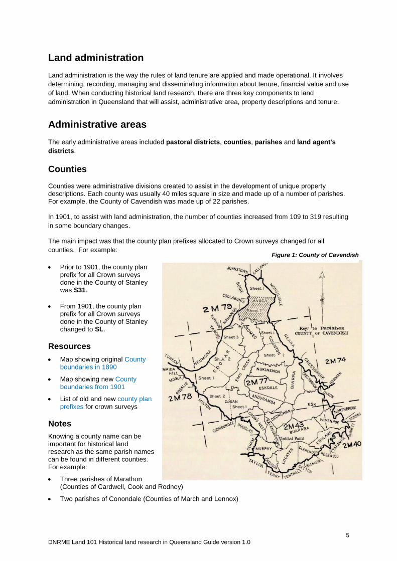
Counties
Counties were administrative divisions created to assist in the development of unique property descriptions. Each county was usually 40 miles square in size and made up of a number of parishes. For example, the County of Cavendish was made up of 22 parishes. In 1901, to assist with land administration, the number of counties increased from 109 to 319 resulting
in some boundary changes.
The main impact was that the county plan prefixes allocated to Crown surveys changed for all
counties. For example:
Prior to 1901, the county plan prefix for all Crown surveys done in the County of Stanley was S31.
From 1901, the county plan prefix for all Crown surveys done in the County of Stanley changed to SL.
Resources
Map showing original County boundaries in 1890
Map showing new County boundaries from 1901
List of old and new county plan prefixes for crown surveys
Notes
Knowing a county name can be important for historical land research as the same parish names can be found in different counties. For example:
Three parishes of Marathon (Counties of Cardwell, Cook and Rodney)
Two parishes of Conondale (Counties of March and Lennox)
Figure 1: County of Cavendish
6 DNRME Land 101 Historical land research in Queensland Guide version 1.0
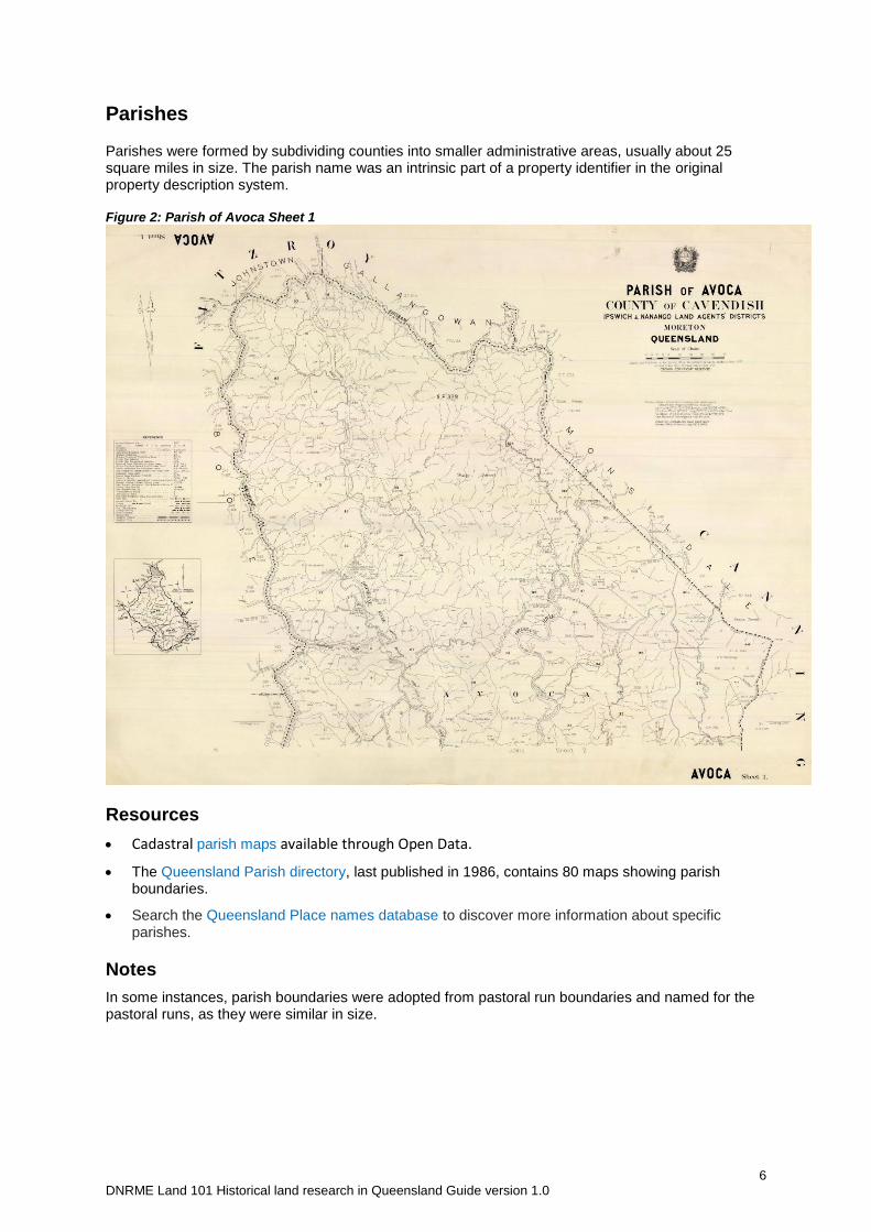
Parishes
Parishes were formed by subdividing counties into smaller administrative areas, usually about 25 square miles in size. The parish name was an intrinsic part of a property identifier in the original property description system. Figure 2: Parish of Avoca Sheet 1
Resources
Cadastral parish maps available through Open Data.
The Queensland Parish directory, last published in 1986, contains 80 maps showing parish boundaries.
Search the Queensland Place names database to discover more information about specific parishes.
Notes
In some instances, parish boundaries were adopted from pastoral run boundaries and named for the pastoral runs, as they were similar in size.
7 DNRME Land 101 Historical land research in Queensland Guide version 1.0
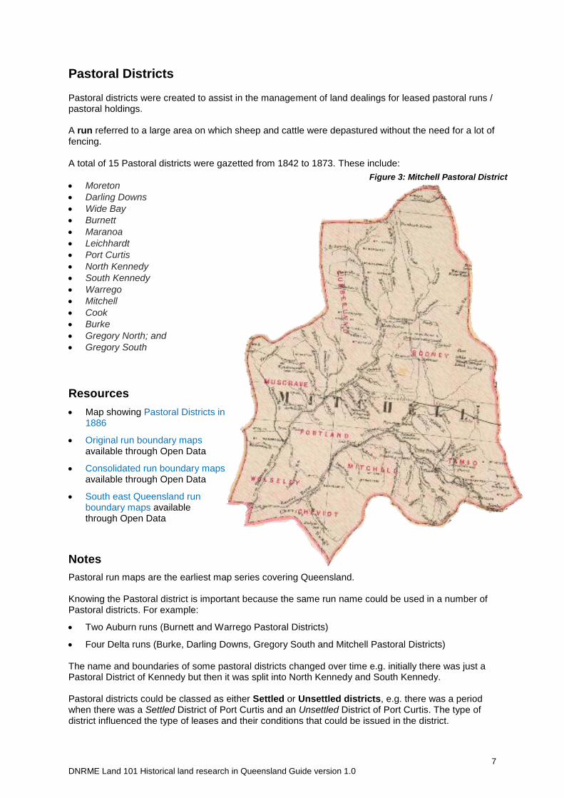
Figure 3: Mitchell Pastoral District
Pastoral Districts
Pastoral districts were created to assist in the management of land dealings for leased pastoral runs / pastoral holdings. A run referred to a large area on which sheep and cattle were depastured without the need for a lot of fencing. A total of 15 Pastoral districts were gazetted from 1842 to 1873. These include:
Moreton
Darling Downs
Wide Bay
Burnett
Maranoa
Leichhardt
Port Curtis
North Kennedy
South Kennedy
Warrego
Mitchell
Cook
Burke
Gregory North; and
Gregory South
Resources
Map showing Pastoral Districts in 1886
Original run boundary maps available through Open Data
Consolidated run boundary maps available through Open Data
South east Queensland run boundary maps available through Open Data
Notes
Pastoral run maps are the earliest map series covering Queensland. Knowing the Pastoral district is important because the same run name could be used in a number of Pastoral districts. For example:
Two Auburn runs (Burnett and Warrego Pastoral Districts)
Four Delta runs (Burke, Darling Downs, Gregory South and Mitchell Pastoral Districts) The name and boundaries of some pastoral districts changed over time e.g. initially there was just a Pastoral District of Kennedy but then it was split into North Kennedy and South Kennedy. Pastoral districts could be classed as either Settled or Unsettled districts, e.g. there was a period when there was a Settled District of Port Curtis and an Unsettled District of Port Curtis. The type of district influenced the type of leases and their conditions that could be issued in the district.
8 DNRME Land 101 Historical land research in Queensland Guide version 1.0
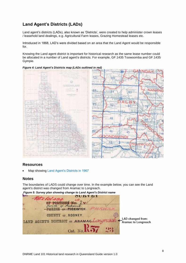
Land Agent’s Districts (LADs)
Land agent’s districts (LADs), also known as ‘Districts’, were created to help administer crown leases / leasehold land dealings, e.g. Agricultural Farm leases, Grazing Homestead leases etc. Introduced in 1868, LAD’s were divided based on an area that the Land Agent would be responsible for. Knowing the Land agent district is important for historical research as the same lease number could be allocated in a number of Land agent’s districts. For example, GF.1435 Toowoomba and GF.1435 Gympie. Figure 4: Land Agent’s Districts map (LADs outlined in red)
Resources
Map showing Land Agent’s Districts in 1967
Notes
The boundaries of LADS could change over time. In the example below, you can see the Land agent’s district was changed from Aramac to Longreach.
Figure 5: Survey plan showing change to Land Agent’s District name
9 DNRME Land 101 Historical land research in Queensland Guide version 1.0
Property descriptions
Property descriptions are how each block of land in Queensland is uniquely described. Two systems have been used in Queensland:
Original property descriptions, and
Current property descriptions
Original property descriptions
The system used to describe properties was influenced by where a property was located, the size of
the block and type of tenure.
Property descriptions for rural / country blocks
Smaller blocks of land in a rural setting were described based on parishes and counties.
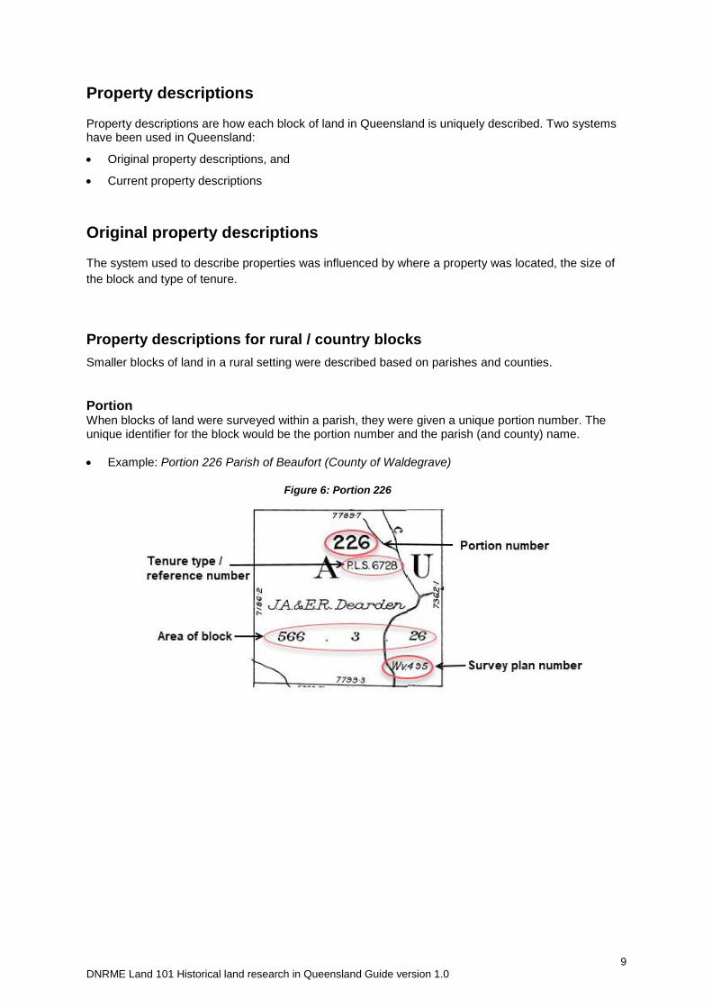
Portion When blocks of land were surveyed within a parish, they were given a unique portion number. The unique identifier for the block would be the portion number and the parish (and county) name.
Example: Portion 226 Parish of Beaufort (County of Waldegrave)
Figure 6: Portion 226
10 DNRME Land 101 Historical land research in Queensland Guide version 1.0
Subdivision When freehold blocks were subdivided for the first time, the resulting blocks were described as subdivisions (subs) of the portion.
Example: sub 1 and sub 2 of Portion 27 Parish of Toowoomba (County of Aubigny) Figure 7: Property description on title
Re-subdivision
If subdivisions were in turn subdivided, the resulting blocks were called resubdivisions (resubs) of the sub.
Example: resub 1 and resub 2 of sub 1 of Portion 56 Parish of Blenheim (County of Churchill)
Subdivision of a re-subdivision
Resubdivisions could be further subdivided in which case the description of sub was again used. The next subdivision of this block would use the resub description and this pattern would repeat.
Example: Sub 2 of resub 4 of sub 16 of resub 2 of sub A of Portion 158 Parish of Dixon (County of Stanley).
Figure 8: Property description on title
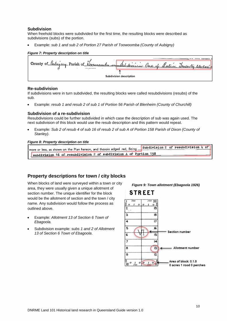
Property descriptions for town / city blocks
When blocks of land were surveyed within a town or city
area, they were usually given a unique allotment of
section number. The unique identifier for the block
would be the allotment of section and the town / city
name. Any subdivision would follow the process as
outlined above.
Example: Allotment 13 of Section 6 Town of Ebagoola.
Subdivision example: subs 1 and 2 of Allotment 13 of Section 6 Town of Ebagoola.
Figure 9: Town allotment (Ebagoola 1926)
11 DNRME Land 101 Historical land research in Queensland Guide version 1.0
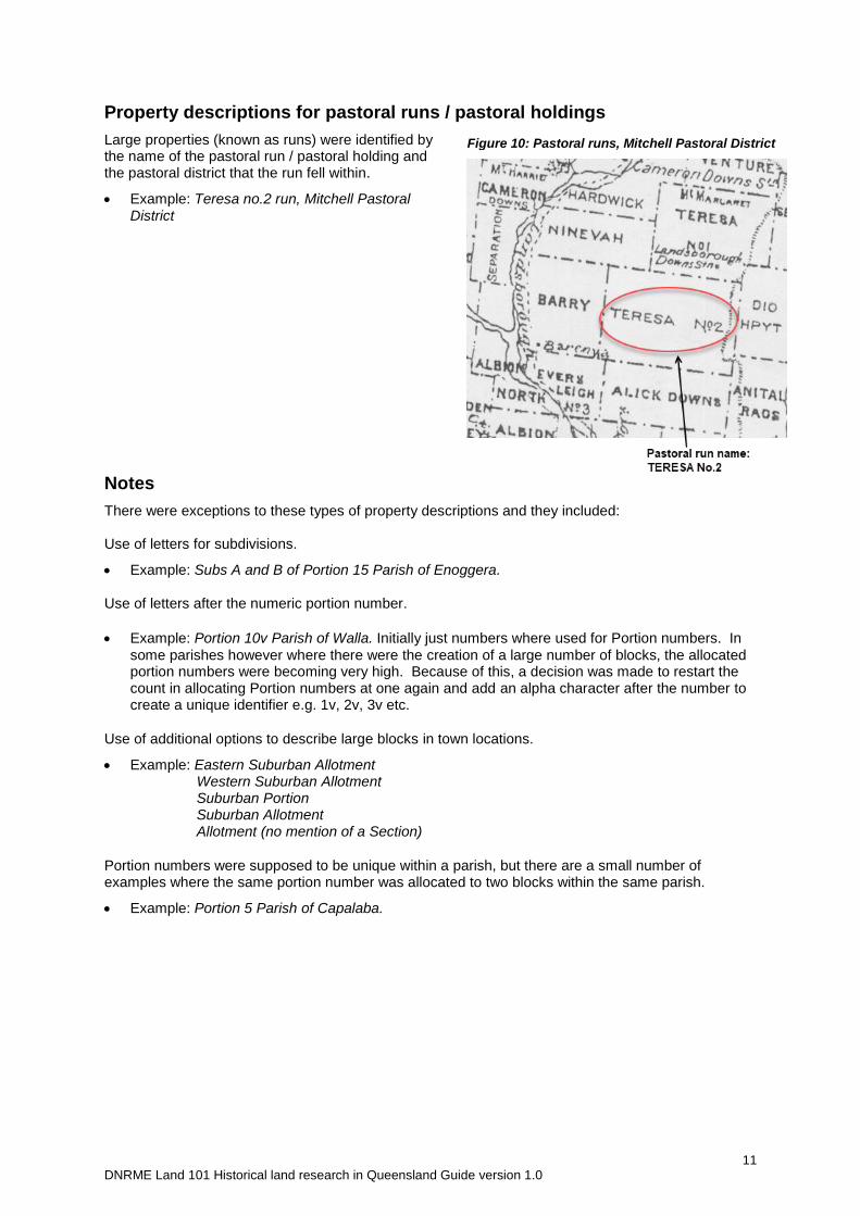
Property descriptions for pastoral runs / pastoral holdings
Large properties (known as runs) were identified by the name of the pastoral run / pastoral holding and the pastoral district that the run fell within.
Example: Teresa no.2 run, Mitchell Pastoral District
Notes
There were exceptions to these types of property descriptions and they included: Use of letters for subdivisions.
Example: Subs A and B of Portion 15 Parish of Enoggera. Use of letters after the numeric portion number.
Example: Portion 10v Parish of Walla. Initially just numbers where used for Portion numbers. In
some parishes however where there were the creation of a large number of blocks, the allocated portion numbers were becoming very high. Because of this, a decision was made to restart the count in allocating Portion numbers at one again and add an alpha character after the number to create a unique identifier e.g. 1v, 2v, 3v etc.
Use of additional options to describe large blocks in town locations.
Example: Eastern Suburban Allotment Western Suburban Allotment Suburban Portion Suburban Allotment Allotment (no mention of a Section)
Portion numbers were supposed to be unique within a parish, but there are a small number of examples where the same portion number was allocated to two blocks within the same parish.
Example: Portion 5 Parish of Capalaba.
Figure 10: Pastoral runs, Mitchell Pastoral District
12 DNRME Land 101 Historical land research in Queensland Guide version 1.0
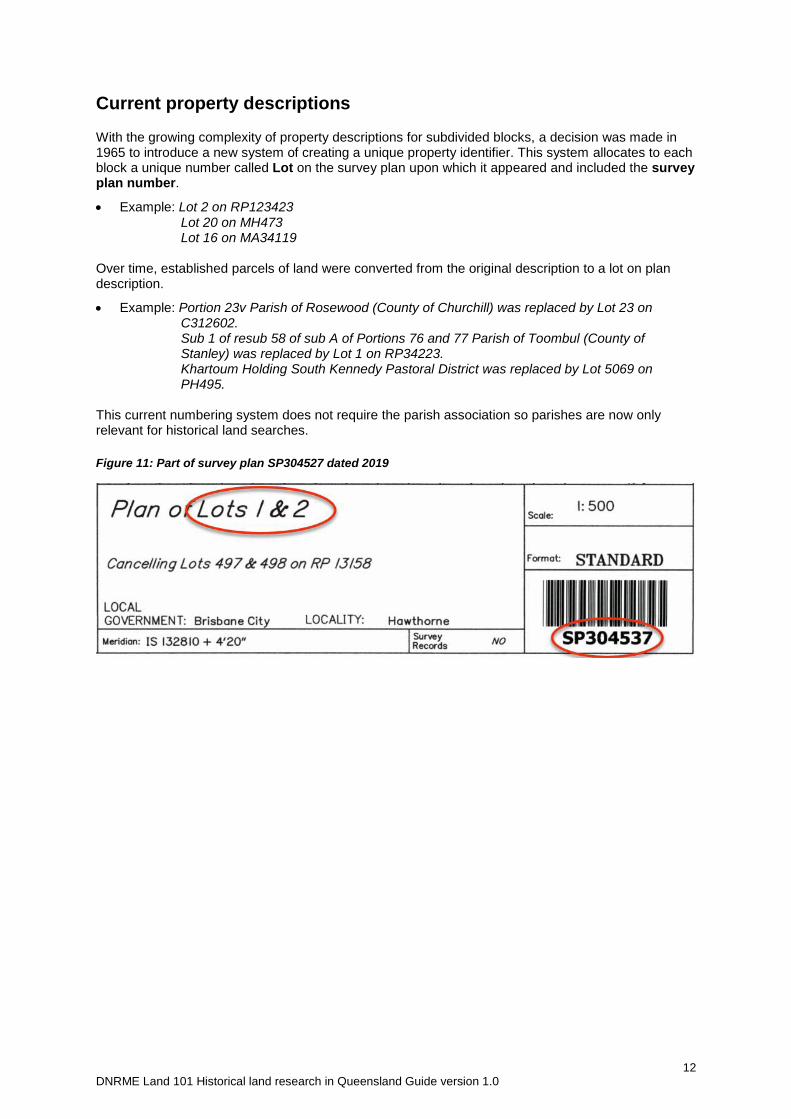
Current property descriptions
With the growing complexity of property descriptions for subdivided blocks, a decision was made in 1965 to introduce a new system of creating a unique property identifier. This system allocates to each block a unique number called Lot on the survey plan upon which it appeared and included the survey plan number.
Example: Lot 2 on RP123423 Lot 20 on MH473 Lot 16 on MA34119 Over time, established parcels of land were converted from the original description to a lot on plan description.
Example: Portion 23v Parish of Rosewood (County of Churchill) was replaced by Lot 23 on C312602.
Sub 1 of resub 58 of sub A of Portions 76 and 77 Parish of Toombul (County of Stanley) was replaced by Lot 1 on RP34223.
Khartoum Holding South Kennedy Pastoral District was replaced by Lot 5069 on PH495.
This current numbering system does not require the parish association so parishes are now only relevant for historical land searches.
Figure 11: Part of survey plan SP304527 dated 2019
13 DNRME Land 101 Historical land research in Queensland Guide version 1.0
Tenure
Knowledge of the tenure of a block is important because this allows the most appropriate resource to be searched for relevant information. There are three main types of tenure.
Freehold
Leasehold
Reserves
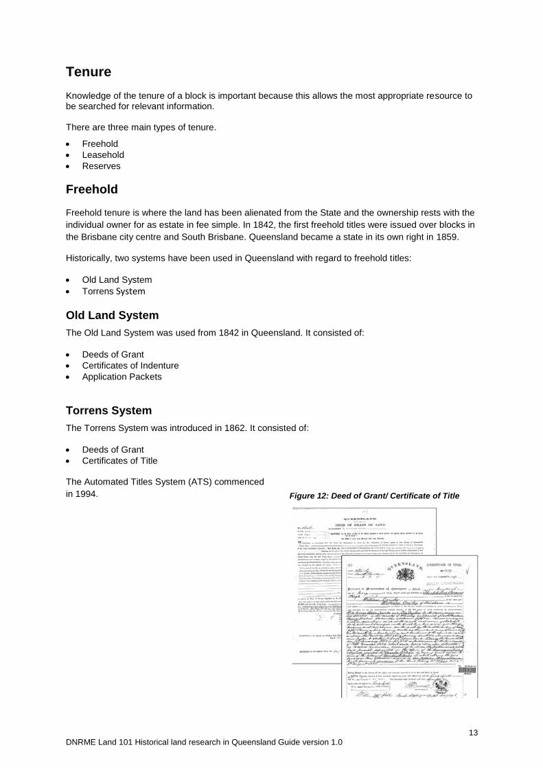
Freehold
Freehold tenure is where the land has been alienated from the State and the ownership rests with the
individual owner for as estate in fee simple. In 1842, the first freehold titles were issued over blocks in
the Brisbane city centre and South Brisbane. Queensland became a state in its own right in 1859.
Historically, two systems have been used in Queensland with regard to freehold titles:
Old Land System
Torrens System
Old Land System
The Old Land System was used from 1842 in Queensland. It consisted of:
Deeds of Grant
Certificates of Indenture
Application Packets
Torrens System
The Torrens System was introduced in 1862. It consisted of:
Deeds of Grant
Certificates of Title
The Automated Titles System (ATS) commenced
in 1994.
Figure 12: Deed of Grant/ Certificate of Title
14 DNRME Land 101 Historical land research in Queensland Guide version 1.0
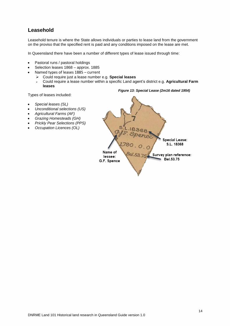
Leasehold
Leasehold tenure is where the State allows individuals or parties to lease land from the government on the proviso that the specified rent is paid and any conditions imposed on the lease are met. In Queensland there have been a number of different types of lease issued through time:
Pastoral runs / pastoral holdings
Selection leases 1868 – approx. 1885
Named types of leases 1885 – current Could require just a lease number e.g. Special leases Could require a lease number within a specific Land agent’s district e.g. Agricultural Farm
leases
Types of leases included:
Special leases (SL)
Unconditional selections (US)
Agricultural Farms (AF)
Grazing Homesteads (GH)
Prickly Pear Selections (PPS)
Occupation Licences (OL)
Figure 13: Special Lease (2m16 dated 1954)
15 DNRME Land 101 Historical land research in Queensland Guide version 1.0
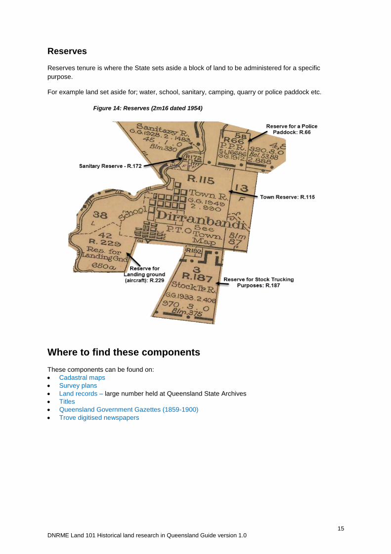
Reserves
Reserves tenure is where the State sets aside a block of land to be administered for a specific
purpose.
For example land set aside for; water, school, sanitary, camping, quarry or police paddock etc.
Where to find these components
These components can be found on:
Cadastral maps
Survey plans
Land records – large number held at Queensland State Archives
Titles
Queensland Government Gazettes (1859-1900)
Trove digitised newspapers
Figure 14: Reserves (2m16 dated 1954)
16 DNRME Land 101 Historical land research in Queensland Guide version 1.0
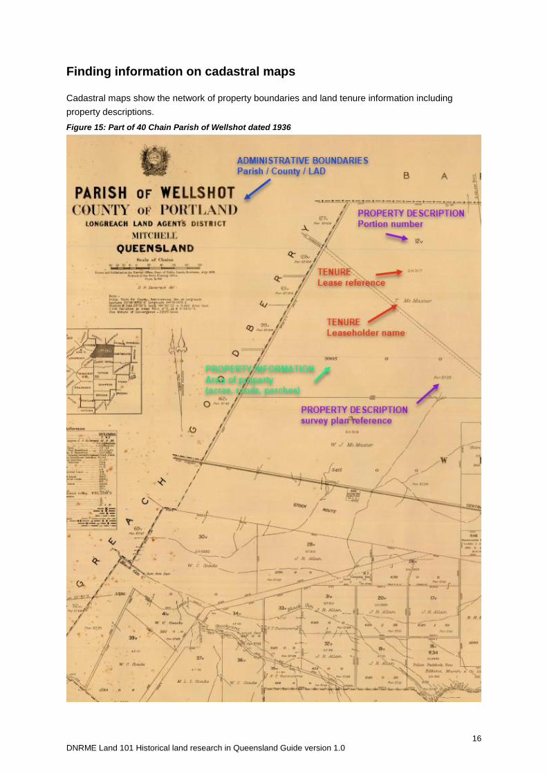
Finding information on cadastral maps
Cadastral maps show the network of property boundaries and land tenure information including
property descriptions.
Figure 15: Part of 40 Chain Parish of Wellshot dated 1936
17 DNRME Land 101 Historical land research in Queensland Guide version 1.0
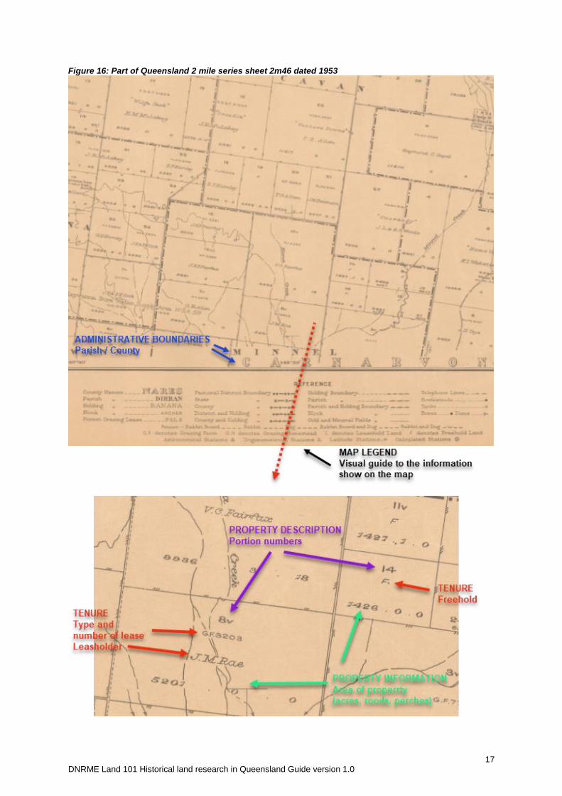
Figure 16: Part of Queensland 2 mile series sheet 2m46 dated 1953
18 DNRME Land 101 Historical land research in Queensland Guide version 1.0
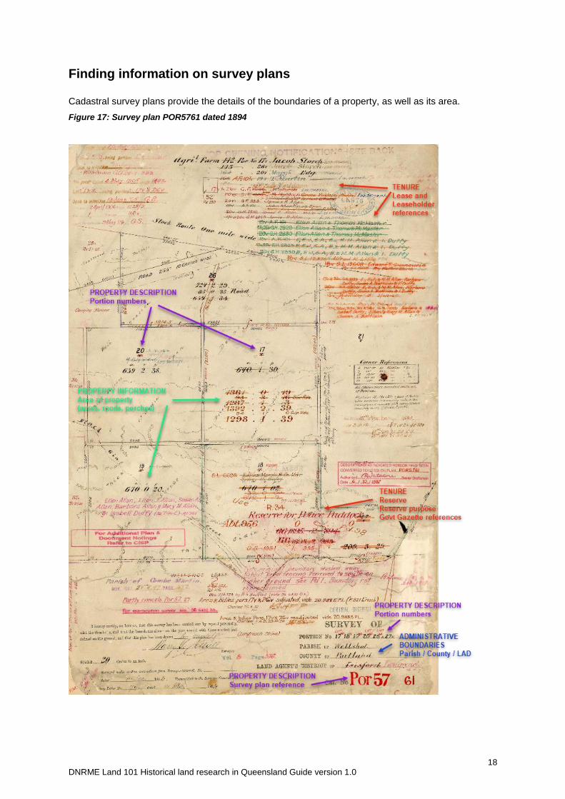
Finding information on survey plans
Cadastral survey plans provide the details of the boundaries of a property, as well as its area.
Figure 17: Survey plan POR5761 dated 1894
19 DNRME Land 101 Historical land research in Queensland Guide version 1.0
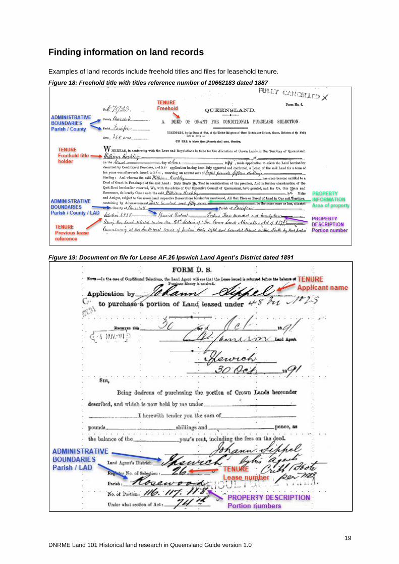
Finding information on land records
Examples of land records include freehold titles and files for leasehold tenure.
Figure 18: Freehold title with titles reference number of 10662183 dated 1887
Figure 19: Document on file for Lease AF.26 Ipswich Land Agent’s District dated 1891
20 DNRME Land 101 Historical land research in Queensland Guide version 1.0
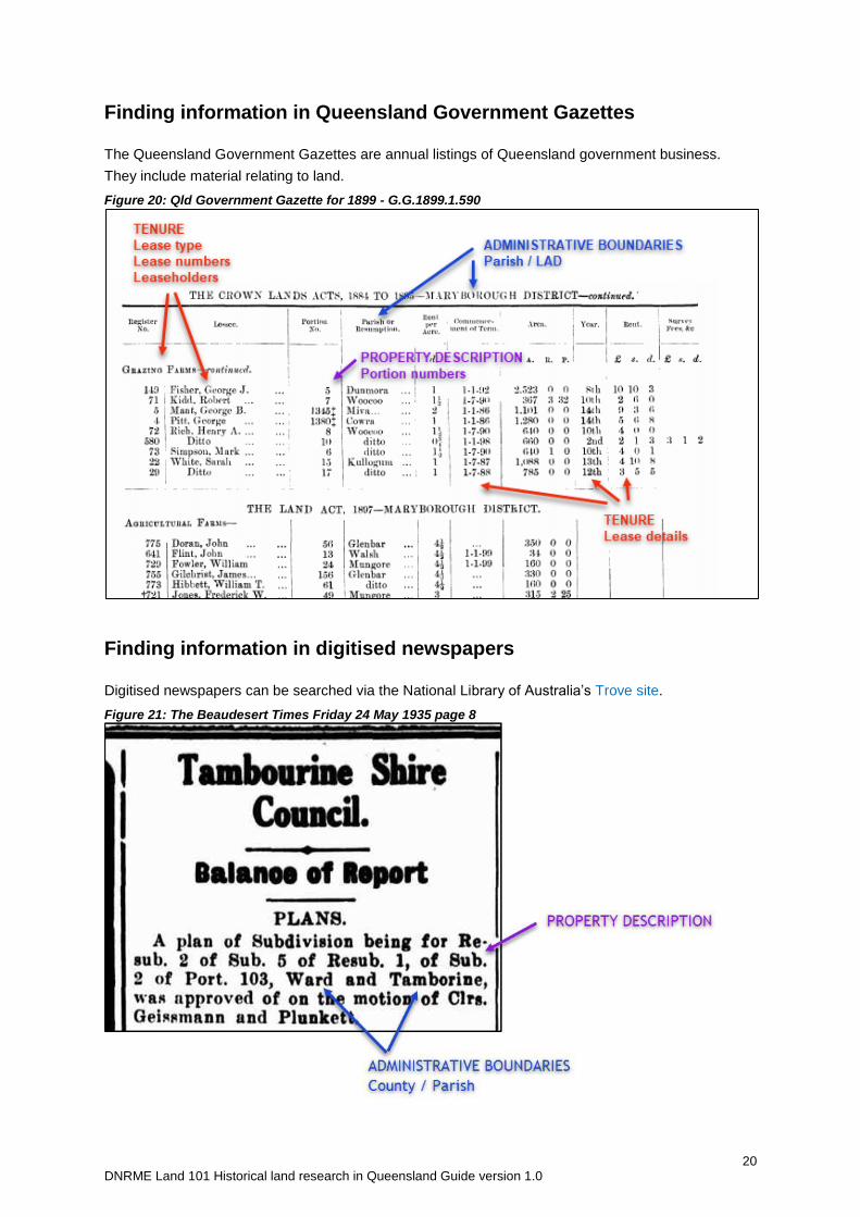
Finding information in Queensland Government Gazettes
The Queensland Government Gazettes are annual listings of Queensland government business.
They include material relating to land.
Figure 20: Qld Government Gazette for 1899 - G.G.1899.1.590
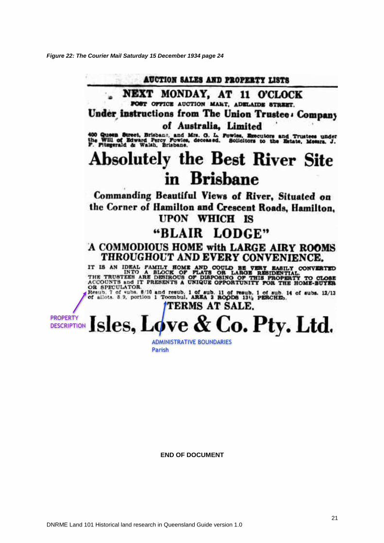
Finding information in digitised newspapers
Digitised newspapers can be searched via the National Library of Australia’s Trove site.
Figure 21: The Beaudesert Times Friday 24 May 1935 page 8
21 DNRME Land 101 Historical land research in Queensland Guide version 1.0
Figure 22: The Courier Mail Saturday 15 December 1934 page 24
END OF DOCUMENT