Embed Size (px)
Citation preview

Quiz #1, Part 1 results
(You can see the statistics yourself in “My Grades”)

Quizzes, Part 2Marking rubric posted, with
examples from student answers to the Practice Quiz, Part 2
(VISTA homepage Quizzes link on homepage Rubric...)

Goals for Today1. PREDICT whether upwelling or downwelling will
occur along a coastline, given surface wind direction
2. PREDICT the direction of wind-driven surface ocean currents anywhere on Earth with any continental configuration.
3. LIST differences between western and eastern boundary currents in subtropical gyres
Hydrosphere II: Surface ocean circulation w/continents

RELEVANCEFisheries Heat transport
Trans-portation
Christopher Duncklee
Digital Vision

Surface Ocean Currents
Marshak, Figure 18.10

Clicker question: The wind often blows from south to north along the coastline of Peru.
Toward what direction is the Ekman transport?
Peru
WIND
A. Generally northward B. Generally southward C. Generally toward the shoreD. Generally away from shoreE. There is no Ekman transport because of the presence of a continent.
12°S

Wind, Ekman transport, geostrophic flow, and coastal upwelling:
Peru
WIND
Ekmantransport
Hig
her
Lo
wer
Geostrophicflow

Along shorelines: Southern hemisphere upwelling
http://ww2010.atmos.uiuc.edu/(Gh)/guides/mtr/eln/upw.rxml
Upwelling of deeper water

Along shorelines: Northern hemisphere upwelling

Along shorelines: Coastal upwelling
Sea surfacetemperature,South Africa
Blue = coldRed = warm

Along shorelines: Coastal upwelling
Chlorophyll,South Africa
Red = more chlorophyll Blue = less chlorophyll

Clicker question: This image shows chlorophyll concentration in the ocean off the Arabian peninsula in a particular season in a particular year. This pattern is related to monsoon circulation in India. WHAT SEASON IS IT IN THIS IMAGE?
PeruA. Summer monsoonB. Winter monsoonC. In between summer & winterD. There’s not enough information given
Red – highBlue - low

In the open ocean:
TAO Project Office/PMEL/NOAA
Equatorial upwelling
Sea Surface Temperature

In the open ocean: Equatorial upwelling
Chlorophyll-ain surface water
Blue = LowGreen/yellow = HighDivergence
Convergence
Convergence

Surface Ocean Currents Equatorial currents
ERROR ALERT! The Equatorial Counter Current should be NORTH of the equator!

Intertropical Convergence Zone (thermal equator)
NOAA
Geographic equator
ITCZ
SouthAmerica
NE Trades
SE Trades
Which direction is the Ekman transport?
Light wind! Rising air!

NOAA
NE Trades
SE Trades
Ekman transport
Light wind!
Where are the convergences and divergences?
Intertropical Convergence Zone (thermal equator)

Equatorial dynamic topography
NOAA
Light wind!
Convergence at ~30ºS
Convergence at ~4ºN
Convergence at ~30ºN
Divergence at 0º
Divergence at ~10ºN
Where are the hills and valleys?

Clicker Question: Toward what direction does the geostrophic current flow under the ITCZ (between about 4°N and 10°N)?
NOAAHigh ~30ºS
High ~4ºN
High ~30ºN
Low 0º
Low ~10ºN
A.To the west
B. To the east
C. To the NED. To the NWE. There’s no
geostrophic current there

Follow-up Clicker Question: Toward what direction does the geostrophic current flow between about 0°N and 4°N?
NOAAHigh ~30ºS
High ~4ºN
High ~30ºN
Low 0º
Low ~10ºN
A.To the west
B. To the east
C. To the NED. To the NWE. There’s no
geostrophic current there

Equatorial dynamic topography
NOAA
Light wind!
High ~30ºS
High ~4ºN
High ~30ºN
Low 0º
Low ~10ºN
Which direction are the geostrophic currents?

Equatorial geostrophic currents
NOAA
North Equatorial Counter Current
North Equatorial Current
South Equatorial Current

JULY
Circular wind patterns

Ekman transport under the Bermuda High

Horizontal pressure gradient force
Geostrophic flow around a SUBTROPICAL GYRE
Coriolisforce
GeostrophicFlow

(Mercier and Le Traon)
Sea surface height:North Atlantic subtropical gyre
Red = High, Blue = low
70 cm0 cm-80 cm

Symmetric(atmospheric winds)
Asymmetric(ocean gyres)
H H
Asymmetrical ocean gyres (N. Hem.)
Western intensification

Steepness of mound sets flow speed
~10 cm/s
~150 cm/s
1000
– 2
000
m

Global dynamic topography

Surface Ocean Currents
Warm and cold currents

Global Sea Surface Temperature
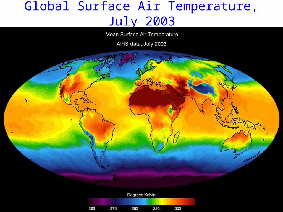
Global Surface Air Temperature, July 2003

• All major ocean currents are geostrophic, responding to pressure gradients that are set up by Ekman transport, which is driven by the wind.
• Upwelling & downwelling, coastal or open ocean• Complex equatorial currents, due to continents• Subtropical gyres:
Warm western boundary currents flow poleward; Cool eastern boundary currents flow equatorward.
• You can apply the same principles to any situation, along a coastline or in the open ocean, to deduce the direction and strength of ocean currents.
Summary: Surface Ocean Circulation
Relevance: food, heat, transportation

In preparation for next lecture…
So far, we have considered only the circulation near the surface of the ocean. The deep ocean also moves. What’s the major driver of deep ocean circulation?

Extra, unused slides below this one

Gulf Stream Warm Core Ring

Gulf Stream Ring formation
Warm rings north intocolder water
Cold rings south intowarmer water

G3

Sea surface temperature (SST)Sea surface temperature (SST)
February

Surface Air Temperature, January 2003Surface Air Temperature, January 2003

Sea surface Temperature (SST)Sea surface Temperature (SST)
August
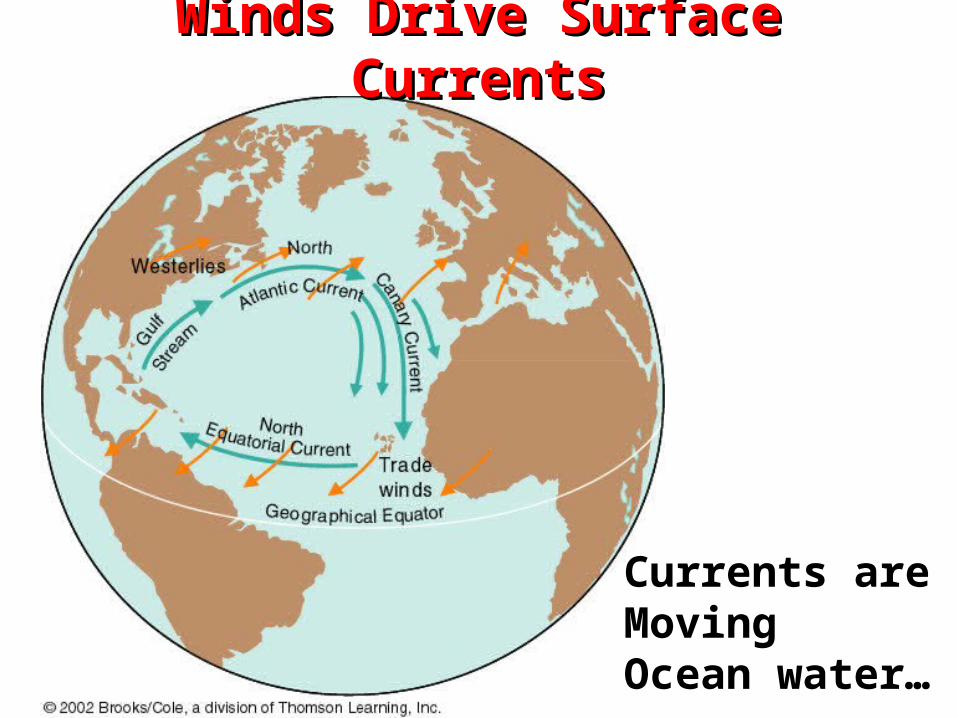
Winds Drive Surface CurrentsWinds Drive Surface Currents
Currents areMovingOcean water…

Effect of Coriolis on surface ocean Effect of Coriolis on surface ocean circulationcirculation

Ekman Transport 90o to wind direction
convergence
convergence

Another Look at ConvergenceAnother Look at Convergence


purple = low chlorophyll-a light blue = higher chlorophyll-a
High phytoplanktonHigh phytoplanktonconcentration at equatorconcentration at equator

Cool SST animations athttp://svs.gsfc.nasa.gov/vis/a000000/a003300/a003389/index.html

Along shorelines: Northern hemisphere upwelling
http://oceanmotion.org/html/background/upwelling-and-downwelling.htm

Along shorelines:
Cal
iforn
ia
WIND
EkmantransportH
igh
er
Lo
wer
Geostrophicflow

Co
asta
l up
wel
ling
Co
asta
l up
wel
ling
Ekman
Co
asta
l do
wn
wel
ling
Co
asta
l do
wn
wel
ling

Circular wind patterns:
Ekman? Pressure gradient? Geostrophic flow? Ocean currents?
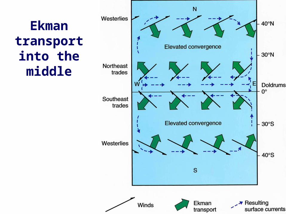
Ekman transport into the middle

This example driven by anticyclonic winds in the N. Hem.
Geostrophic current around a GYRE
Open Univ., Fig. 3.25
H

gravity
Ekman Transp
ort
How Does Water Flow Around a Hill?How Does Water Flow Around a Hill?
Resulting Flow“Around the hill”
Trade Winds
Coriolis


![APRIL 2017 DATE DAY KINDERGARTEN PRIMARY [GRADES 1-5] …€¦ · 29 SUNDAY Yes Master Quiz Round 2 Grades 6 -8 INTER NIMS BASKETBALL (BOYS) 30 MONDAY Quiz GR 6 -8 INTER NIMS BASKETBALL](https://img.pdfslide.net/doc/110x75/5f26325ffd75790dce026004/april-2017-date-day-kindergarten-primary-grades-1-5-29-sunday-yes-master-quiz.jpg)