Embed Size (px)
Citation preview
By vv'ILLIAM R. HALLI DAY
WASHINGTON DEPARTMENT OF CONSERVATION
DIVISION OF MINES AND GEOLOGY
INFORMATION CIRCULAR NO. 40
1963
State of Washington ALBERT D. ROSELLINI, Governor
Department of Conservation EARL COE, Director
DIVISION OF MINES AND GEOLOGY MARSHALL T. HUNTTING, Supervisor
Information Circular No. 40
CAVES OF
WASHINGTON
By
WILLIAM R. HALLIDAY
Director,
Washington Speleological Survey
$ 'TATE PRINTIN G PLANT, OLYMPIA. WASH .
1963
For sale by Department of Conservation, Olympia, Wasbingt-0n. Price, $1.00
FOREWORD
Spelunkers and scientists are familiar with caves in many parts of the country,
but only few know of the caves in Washington. This familiarity stems from extensive
explorations of the known caverns and from the excellent reports published by several
agencies. At least six State Geological Surveys have published comprehensive reports
on the caves of their respective states, and other agencies have published cave reports
for at least five other states.
When we learned that Dr. William R. Halliday, Director of the Washington
Speleological Survey, was compiling an inventory of the caves of Washington, an
agreement was made whereby the Division of Mines and Geology would publish his
report. We are fortunate to have the services of Dr. Halliday in this work. Although
his profession, medicine, makes heavy demands on his time, he has found time to
examine hundreds of caves in the United States and has explored almost all the known
caves in Washington.
Some 110 caves are described in this report. The limestone caverns here are
relatively small, but Washington's lava-tube caves are large, numerous, and complex.
Cave explorers and geologists will find these tubes interesting not only for their scientific
values but also for their opportunities for adventurous recreation. In addition, this
report will be helpful in evaluating the State's caves as war-time shelters and under
ground storage facilities.
August 15, 1963
iii
Marshal I T. Huntting, Supervisor Division of Mines and Geology Olympia, Washington
CO N'TE NTS
Foreword ------------------------------------------------------------------------ iii Introduction ---------------------------------------------------------------------- 1
Acknowledgments ---------------------------------------------------------- 6 f.Aap symbols --------------------------------------------------------------- 6
Descripttonsof caves-------------------------------------------------------------- 7 Adams County -------------------------------------------------------------- 7
Meyer Cave --------------------------------------------------------- 7 Asotin County ------------------------------------------------------------- 7 Benton County------------------------------------------------------------- 7 Chelan County---------------------------------~--------------------------- 7
Chelan Ice Cave----------------------------------------------------- 8 Clallam County ------------------------------------------------------------ 8
Agate Bay Caves----------------------------------------------------- 8 Carson Cave-------------------------------------------------------- 8 Hole-in-the-~all---------------------------------------------------- 8
Clark County -------------------------------------------------------------- 9 Columbia County ----------------------------------------------------------- 9 Cow Ii tz County ------------------------------------------------------------ 9
String Cave--------------------------------------------------------- 9 Other Caves-------------------------------------------------------- 10
Douglas County ------------------------------------------------------------ 10 Ferry County -------------------------------------------------------------- 10 Garfie Id County -------------------------------------------- --------------- 10 Grant County ---------------------·----------------------------------------- 10
Arrow Shaft Cave ---------------------------------------------------- 10 Beverly Ice Cave---------------------------------------------------- 10 Blue Lake Cave ----------------------------------------------------- 10 Blue Lake Rhino Cave ------------------------------------------------ 10 Boy Scout Cave ----------------------------------------------------- 11 Crab Creek Cave---------------------------------------------------- 11 Dry Fa 11 s Cave ------------------------------------------------------ 11 East Lenore Caves --------------------------------------------------- 12 Horsethief Cave ----------------------------------------------------- 12 Indian Cave ·---------------------------- ---------------------------- 12
V
CONTENTS
Descriptions of caves-Continued Grant County-Continued
Jasper Cave ----------------------------------------------------------Moonshiner 1s Caves Owl Cave Pictograph Cave Rhinoceros Cave Smyrna Ice Cave South Cave
West Lenore Caves ---------------------------------------------------Wi I son Creek Cave----------------------------------------------------
Grays Harbor County --------------------------------------------------------Island County--------------------------------------------------------------Jefferson County ------------------------------------------------------------
Lake Lena Caves------------------------------------------------------King County---------------------------------------------------------------
Ada i r 1s Cave --------------------------------------------------------Black River Cave ----------------------------------------------------Breakdown Cave---------------------------------------------~-------Clark's Cave--------------------------------------------------------C I iff Cave - ... --------------------------------------------------------Danger Cave--------------------------------------------------------Danger Cave Annex--------------------------------------------------Don's Cave----------------------------------------------------------
D0nlan1sCave ------------------------------------------------------Grotto Cave---------------------------------------------------------Hel I hole Cave ------------------------------------------------------Ledge Pit-----------------------------------------------------------Lookout Cave--------------------------------------------------------
lost Cave ----------------------------------------------------------Miner's Cave --------------------------------------------------------Mount lssaquahCave-------------------------------------------------Mount Snoqualmie Caves----------------------------------------------Newton Cave -------------------------------------------------------Prospector 1s Cave ----------------------------------------------------Red Cave-----------------------------------------------------------Second Cave---------------------------------------------------------
v1
12
12
13 13 13 13 13 13 13 13 13 13 14 14
14
14 14
14
14
14 18
18
18 18 18
19
20
21
22
22
22
23 27
28 28
CONTENTS
Descriptions of coves-Continued King County-Continued
Snoqualmie Caves----------------------------------------------------Stei nburn 's Cove -----------------------------------------------------Steinburn 's Coves -----------------------------------------------------Other coves
Kitsap County--------------------------------------------------------------Kittitos County-------------------------------------------------------------
Cox Cave---------------------------------------------· -------------T ri ni dad Cove -------------- -----------------------------------------Vantage Cove--------------------------------------------------------
Klickitat County ------------------------------------------------------------
Big Lava Cave ------------------------------------------------------Bronching Cove -----------------------------------------------------Butter Cave ----------------------------------------------------------Cheese Cave---------------------------------------------------------Ice Cove Levo Cave----------------------------------------------------------Levo Bridge Coves----------------------------------------------------Meat Cave
Red Cove-----------------------------------------------------------Spencer 1s Cave ------------------------------------------------------Spencer's Red Cove ---------------------------------------------------Stoirwel I Cave------------------------------------------------------Trillium Cove------------------------------------------------------ -Twi dwe 11 's Cove ------------------------------------------------ ------Other coves
Lewis County--------------------------------------------------------------Lincoln County-----~------------------------------------------------------Mason County-------------------------------------------------------------Okanogan County-----------------------------------------------------------
Al I bright Cove ------------------------------------------------------Boy Scout Cave------------------------------------------------------Mcloughlin Canyon Caves ---------------------------------------------Mount Olive Cove ---------------------------------------------------Riverside Cove------------------------------------------------------Other caves----------------------------------------------- ----------
vii
28
28
28
28
30 30 30 30 30 30 30 30
30 31
34 34 35
35
35
36
36 36
36
38 38 38 38 38 38 40
43
43 43 43 44
Descriptions of caves-Continued Pacific County
CONTENTS
Pend Ore i I le County -------------------------------------------------------Crawford Cave------------------------------------------------------Gardner Cave-------------------------------------------------------Indian Rock Caves----------------------------------------------------Lost Cave Other caves
Pierce County San Juan County------------------------------------------------------------
Guemes Island Henry Island---------------------------------------------------------Jones Island Lopez Island-----~--------------------------------------------------Orcas Island---------- ·----------------------------------------------
Double Hi 11 Cave------------------------------------------------Fowler 's Cave--------------------------------------------------Imperial Quarry Cave --------------------------------------------Langel I Quarry Cave Orki la Cave ---------------------------------------------------Point Doughty Cave---------------------------------------------Other caves----------------------------------------------------
San Juan Island Crook Property Cave ---------------------------------------------English Camp Cave Fern Cave-----------------------------------------------------Haffner 's Quarry Cave ------------------------------------------Lawson Property Cave -------------------------------------------Moonshiner's Cave----------------------------------------------Roadside Cave-------------------------------------------------Other eaves----------------------------------------------------
Shaw Island ---------------------------------------------------------Yansen 's Cave-------------------------------------------------Yansen's Little Cave --------------------------------------------Other caves----------------------------------------------------
Stewart Island--------------------------------------------------------viii
44
44
44
44
49
50 50
50
52 52 52 52 52 52
53 53
54
56
57
57
57
58
58
58
60
60
61
61
61
62
62
62
64
65
65
CONTENTS
Descriptions of caves-Continued San Juan County-Continued
Sucia Island Woody Island
---------------------------------------------------------------------------------------------------------------
Skog it County -------------------------------------------------------------Bat Cave----------------------------------------------------------Beckley1s Cave ------------------------------------------------------Beckley1s Shelter Cave - ---------------------------------------------Deception Cave -----------------------------------------------------Jackman Creek Cave-------------------------------------------------Jensen Cave --------------------------------------------------------Mc~ueen's Cave----------------------------------------------------Old Mi Iler Place Cave -----------------------------------------------Otter Cave ---------------------------------------------------------.Pleasant Ridge Cave -------------------------------------------------Raider Cave --------------------------------------------------------Rock Cave---------------------------------------------------------Surge Cave---------------------------------------------------------Three Mi le Creek Cave -----------------------------------------------Weaver's Cave ------------------------------------------------------Other caves--------------------------------------------------------
Skamania County-----------------------------------------------------------Ape Cave Bat Cave Big Cave
--------------------------------------------------------------------------------------------------------------------------------------------------------------------------------
Big Trench Cave System-----------------------------------------------Blasted Cave-------------------------------------------------------Boyles Creek Cave---------------------------------------------------Campground Ice Cave ------------------------------------------------Curly Creek Cave----------------------------------------------------Dry Creek Cave -----------------------------------------------------Dynamited Cave------------- ----------------------------------------
----------------------------------------------------Fol Is Creek Cave Fish Hatchery Cave --------------------------------------------------Guler Ice Cave------------------------------------------------------lce Cave -----------------------------------------------------------
ix
65
65
65
65
65
66
66
66
66
68 68
68 69
69
69
69
69
71
71
71
71
77 79 81
82
82
82
82
83
84
88· 90
92
92
CONTENTS
Descriptions of caves-Continued Skamania County-Continued
Lake Cave----------------------------------------------------------Lava Cave Lava Caves Lemei Road Cave----------------------------------------------------Little Red River Cave------------------------------------------------tv\ount Adams Ice Cave- ------------------------------------------------,
tv\ount St. He lens Cave -----------------------------------------------New Cave--------------------------- . -------------------------------
Nielsen'~Cave -------------------------------------------------------Nielsen's Big Cave ---------------------------------------------------0 le 's Cave---------------------------------------------------------Panther Creek Cave -------------------------------------------------.--Peterson Prairie Cave System ------------------------------------------Peterson Ridge Road Cave ---------------------------------------------SI i me Cave
Spear Point Cave ----------------------------------------------------Trout Lake Ice Cave--------------------------------------------------Other caves----------------------------------------------------------
Snohomish County-----------------------------------------------------------Bear Cave
Big Four Ice Cave-----------------------------------------------------1 cy Wind Cave
Spokane County-------------------------------------------------------------Ice Cave
Spokane Ice Cave----------------------------------------------------Other caves----------------------------------------------------------
Stevens County -------------------------------------------------------------Thurston County-------------------------------------------------------------Wahkiakum County Walla Walla County Whatcom County
Big Sinkhole Grotto ---------------------------------------------------Larrabee State Park Cave
Sinkhole Cave--------------------------------------------------------
X
93
96
96
96
97
98
98
98
100
100
100 104 104
104 106
110
110
110
111
111
111
111
111
112
112
112
H2
112
112
112
113
113
113
113
CONTENTS
Descriptions of caves-Continued
Whatcom County-Continued
Sumas Mountain Cave ------------------------------------------------ 114
Other caves--------------------------------------------------------- 116
Whitman County--------------------- --------------------------------------- 116
Yakima County------------------------------------------------------------- 116
Boulder Cave----------------------- --------------------------------- 116
Boulder Creek Cave -------------------------------------------------- 116
Crystal Caves------------------------------------------------------- 116
Indian Ocher Cave--------------------------------------------------- 116
Other caves--------------------------------------------------------- 116
References cited ------------------------------------------------------------------ 117
Glossary--- ---------------------------------------------------------------------- 122
Index of caves-------------------------------------------------------------------- 127
PLATE 1.
2.
3.
4. 5 •.
6.
7. 8. 9.
ILLUSTRATIONS
Map and vertical section of Gardner Cave --------------------------------- In packet
Map of Ape Cave ------------------------------------------------------ In _pocket
Map of Big Trench Cave System ------------------------------------------ In pocket
Map· of Dry Creek Cave------------------------------------------------- In pocket
Map of Dynamited Cave------------------------------------------------- In pocket
Map of Fa I ls Creek Cave ------------------------------------------------ In pocket
Map of Little Red River Cave -------------------------------------------- In pocket
Map of New Cave ----------------------------------------------------- In pocket
Map of Ole's Cave ----------------------------------------------------- In pocket
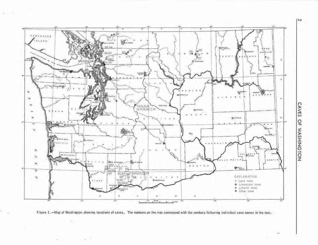
FIGURE 1. Map of Washington showing locations of caves ------------------------------ 2
2. Cavernous fissure southeast of the Ideal Cement Company quarry near Soda Springs 7
3. Typical small littoral cave on the Washington coast-------------------------- 9
4. Hole-in-the-Wall, a littoral cave ----------------------------------------- 9
X I
ILLUSTRATIONS
Page
FIGURE 5. Dry Fol Is Cave -------------------------------------------------------- 1 l 6. Indian Cave near Vantage ---------------------------------------------- 12 7. Smyrna Ice Cave ------------------------------------------------------ 12 8. Ml'.lp of Danger Cave --------------------------------------------------- 15 9. Breakdown-strewn entrance chamber of Danger Cave ------------------------ 16
10. The 40-foot pit in Danger Cave ------------------------------------------ 17 11. Drip slots at the bottom of the 60-foot drop in Hel I hole Cave ---------------- 19
12. Entrance of Ledge Pit --------------------------------------------- ----- 19
13. Sinkhole entrance of Lookout Cave --------------------------------------- 20
13A . Map of Lookout Cave -------------------------------------------------- 21
14 . Blocked entrance of Lost Cave ------------------------------------------- 22
15. Map of Newton Cave -------------------------------------------------- 24
16. Entrance of Newton Cave ---------------------------------------------- 25
17. Map of Prospector's Cave --------;..-------------------------------------- 27
18. Entrance of Prospector's Cave ------------------------------------------- 27
19. Irregular vertical vadose grooving in Red Cave ----------------------------- 29
20. Map of Butter-Stairwe 11 Tube Complex ------------------------------------ 31
2 l. Map of Cheese Cave ------------ --------------------------------------- 32
22. Cheese Cave---------------------------------------------------------- 32
23. Upper entrance of Cheese Cave ------------------------------------------ 33
24. Splash ring or concentric ---------------- ------------------------------- 34
25. Map of Twidwell 's Cave ------------------------------------------------ 37
26. Map of Allbright Cave ------------------------------------------------- 39
27. Allbright Cave, vertical section ----------------------------------------- 40
28. Entrance of Allbright Cave, in a hilltop sink ------------------------------ 41
29. Entrance of Allbright Cave ---------------------------------------------- 4 l
30. Large gours, and flowstone covered with moonmi lk, Gardner Cave ------------ 46
3 l. Large column i~ Gardner Cave ------------ ------------------------------ 46
32. False floor in Gardner Cave --------------------------------------------- 47
33. Map of Indian Rock Cave ----------------------------------------------- 49
34. Main entrance of largest Indian Rock Cave -------------------------------- 50
35. Paradise Ice Cave ----------------------------------------------------- 51
36. Map of Fowler's Cave -------------------------------------------------- 53
37. Entrance of Fowler's Cave ---------------------------------------------- 53
38. Map of Imperial Quarry Cave -------------------------------------------- 55
xii
ILLUSTRATIONS
Page
FIGURE 39. Mop of Longe 11 Quarry Cove -------------------------------------------- 56
40. Mop of Eng I ish Comp Cave ---------------------------------------------- 59
41. Joint cavity extending to surface, English Comp Cove----------------------- 59
42. Entrance of Eng I ish Comp Cove ------------------------------------------ 59
43. Mop of Hoffner's Quarry Cove ------------------------------------------- 60
44. Map of Roadside Cove -------------------------------------------------- 61
45. Entrance of Roadside Cave ---------------------------------------------- 62
46. Mop of Yansen's Cave -------------------------------------------------- 63
47. Mop of Yansen 's Little Cave -------------------------------------------- 64
48. Map of Jensen Cave ---------------------------------------------------- 67
49. Map of Three Mi le Creek Cave ------------------------------------------ 70
50. Drip-eroded sand deposits in Ape Cave ----------------------------------- 72
51. Ore type of ribbon stalactite -------------------------------------------- 73
52. Another type of ribbon stalactite ----------------------------------------- 73
53. Small "lava spring" in Ape Cave ----------------------------------------- 73
54. Broken specimens of "tapered" lava stalactites ----------------------------- 73
55. Rippled lava floor------------------------------------------------------ 75
56. "Lava bal I" in Ape Cove ------------------------------------------------ 75
57. Tubular lava sto locti te and g lobu lor lava stalagmite ------------------------- 75
58. "Pipestem" variations of a tubular lava stalactite --------------------------- 75
59. Hole in "upper floor" of Ape Cave --------------------------------------- 76
60. Horizontally divided passage at the lower end of Ape Cave ------------------ 76
61. An unusual form of lava stalactite in Ape Cave----------------------------- 76
62. Map of Bat Cave ------------------------------------------------------- 78
63. Upper entrance of Bat Cave -------------------------------------:--------- 78
64. Map of Big Cave ------------------------------------------------------- 80
65. Moths on a breakdown block in Big Cave ---------------------------------- 81
66. Mop of Curly Creek Cave ----------------------------------------------- 83
67. Main entrance of Dry Creek Cove -----------------..:---------------------- 84
68. Entrance of Dynamited Cove--------------------------------------------- 85
69. Downslope end of entrance section, Dynamited Cave------------------------ 85
70. Lovofol I into chamber above 40-foot pit, Dynamited Cave ------------------- 86
71. Lava cascade from an upper level to the main passage in Falls Creek Cave ----- 89
72. Group of lava stalagmites in a Washington cove ---------------------------- 90
73. Map of Fish Hatchery (Boyles Creek) Cove -------------------------------- 90
xiii
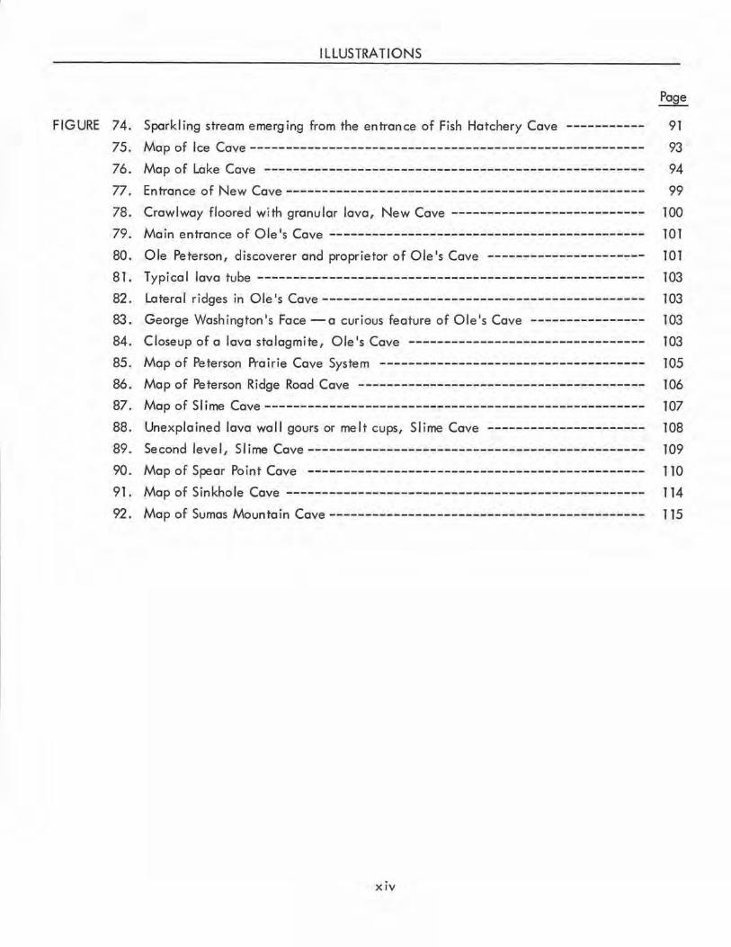
FIGURE 74.
75.
76.
77.
78.
79.
80.
81.
82 .
83.
84.
85.
86.
87.
88.
89.
90.
91.
92 .
ILLUSTRATIONS
Page
Spark I ing stream emerging from the entrance of Fish Hatchery Cave ----------- 91
Map of Ice Cave ------------------------------------------------------- 93
Map of Lake Cave -------------------------------- --------------------- 94
Entrance of New Cave-------------------------------------------------- 99
Crawlway floored with granular lava, New Cave --------------------------- 100
Main entrance of Ole's Cave -------------------------------------------- 101
Ole Peterson, discoverer and proprietor of Ole's Cave ---------------------- 101
T ypi ca I lava tube ------------------------------------------------------ 103 Lateral ridges in Ole's Cave--------------------------------------------- 103
George Washington's Face -a curious fea ture of Ole's Cave ---------------- 103
Closeup of a lava stalagmite, Ole's Cave --------------------------------- 103
Map of Peterson Prairie Cave System ------------------------------------- 105
Map of Peterson Ridge Road Cave ---------------------------------------- 106
Map of SI irne Cave ----------------------------------------------------- 107
Unexplained lava wall gours or melt cups, Slime Cave ---------------------- 108
Second level , SI ime Cave----------------------------------------------- 109
Map of Spear Point Cave ----------------------------------------------- 110
Map of Sinkhole Cave -------------------------------------------------- 114
Map of Sumas Mountain Cave-------------------------------------------- 115
XIV
CAVES OF WASHINGTON
By William R. Holliday
INTRODUCTION
Washington is not generally considered to be a 11cave state . 11 For those speleologists who are
concerned wholly with solution caverns in limestone and other soluble rocks, this is a reasonable concept.
It was not unti I 1942 that the Nc:itional Speleological Society, the nationwide organization of speleolo
gists and spelunkers, was able to determine that any solution cave existed in Washington (Bischoff, 1942).
The total slope length of the passages of the largest limestone cave in Washington, Gardner Cave, is only
about 1,050 feet . Nevertheless, the limestone caves of Washington are of interest because the unusual
variety of their environments is reflected in their differing natures, features, and contents.
Persons concerned with broader implications of speleology will find Washington a fruitful area
of study. This is particularly true of the student of lava tubes and of vulcanism in general . Ape Cave,
the longest lava-tube cave known in the continental United States, and perhaps the world's longest, is in
Skamania County. The concentration of lava-tube caves in Washington is not so great as in Lava Beds
National Monument in California, or perhaps in the Bend area of Oregon. However, Washington's nu
merous and extensive lava tubes provide a great variety of features of these caves and their enveloping
bedrock. To a lesser degree, the littoral (sea) caves of Washington, pounded out by wave action on
fissures and by compression of air therein, are also of specialized interest.
In discussing the caves of Washington, it is convenient to divide the State into four regions
the Olympic Peninsula-Willapa Hills area, northern Cascade Mountains, southern Cascade Mountains,
and the Columbia lava plateau.
The basalt flows of Miocene age in the Columbia lava plateau of eastern Washington contain no
known lava tube or sizable remnant thereof. The Mesozoic and Cenozoic limestones of limited extent in
the Olympic Peninsula and Willapa Hills region contain no known limestone cave. Both areas, however,
contain numerous caves of other types. In 1954 (Swanson and Bryan, 1954) the Washington Archeological
Survey recorded 188 caves in the state, 99 percent of which, it was stated, were in Miocene basalt,
mostly in the Columbia plateau region. As far as is known, the latter were all rockshelters rather than
true caves. In that report some lava tubes of the southern Cascade Mountains were erroneously listed as
occurring in Miocene basalt.
I I "-woc ' wl -= I A • 1 · ' A T~ A T I ', I 7 T ;, Ii\ :r r •.. ... ... ____ ______!_~·- ..... .... .. .. ... '
"o
~
0
0 Mi \ ) I l I
N 0. ~ ,..,.. A .. I
i I r l
~ ' ~ \\
I -I C 0 . I '
I . I H
' I
I I I I ' .
.... @ll"IIAM"' L------ -----1 i "l @ 11.1nv1,u I
I I
t ....
C"l
C)
C')
i r-3 --.... L "'M,\. A
hi
~1 ~ 1 I \ ,-~ ~f J t:;:::;::::1::±- · - -=+--J Y ~ ~ EXPLANATION
+ Lava tube • l.Jmestone cove .a. Littoral cove • Other cove
0 0
... ... . .. 1t1• Scok uo-.. . .. r r ,,..~ ... u,• ...
Figure 1.-Map of Washington showing locations of caves. The numbers on the map correspond with the numbers following individual cave names in the text.
0
... I
X
..
0
,,.
l~I
ur
"'
() )> < m V,
0 -n
~ )> V,
:r: z G) -i 0 z I.
INTRODUCTION 3
The limestone cave region of Washington is its northern strip, which includes the San Juan Islands,
the northern Cascade Mountains, and the Okanogan Highlands. In this strip there are caves in limestones
that appear to range from Cambrian to Permian (?) age, although age determinations in most of these
I imestones are difficu lt or impossible .
The other speleoliferous region of Washington is the southern Cascade Mountain area, where l~va
tubes have been found in a number of lava flows in a wedge-shaped area south of Mount St. Helens and
Mount Adams, extending from east to west across the central part of Skamania County and into adjoining
counties. No evidence has been found that any of these caves are in flows that were extruded prior to
the Pleistocene epoch, and it appears that all these tubes were formed in late Pleistocene and Recent
time (Halliday, 1960b).
This report on the caves of Washington is based on a corre lated 10-year field and bibliographic
study, 1nitiated by the Cascade Grotto of the National Speleological Society, continued by individual
members of The Mountaineers after the temporary inactivation of the Cascade Grotto, and revitalized by
the Washington Speleological Survey, a unit of the Western Speleological Survey.
The goals of this Survey have been to locate, survey, study, and describe in detail every lime
stone cavern and related karstic phenomenon, and every major lava tube in Washington. This report is
the result. The Survey has not attempted to locate and record every rockshelter or every littoral, talus,
or fissure cave in Washington, as these are of minor speleological importance, even though they may be
significant to archeologists, biologists, and others in fields allied to speleology. Only cursory mention
has been given to such caverns in th is report, although an attempt has been mode to list everything in
Washington that has been termed a~· This has been done not only for the reference of students of the
al lied sciences, but in order to prevent future confusion about the nature of minor caves, some of which
have received surpris ingly wide publicity in print and by word of mouth.
Because of the logistic problems of a volunteer effort of this kind, thi rugged terrain and heavy
vegetation of most of the cave areas, and the scant stratigraphic and geomorphic knowledge about much
of the State, the goals of this Survey have not been reached in full; even though additional exploration
and mapping will be completed in future years, they will probably always remain mere goals. As indica
ted further in the text, it has not been possible to locate a few caves that have been reported to exist.
One Washington cave is so difficult to find that the Survey has been unable to locate it again after an
initial cursory visit. It is entirely probable that a few important caves have not come to our attention,
and even more probable that there are a number of important caves not yet discovered because of dense
vegetation or lack of human visitation. Undoubtedly, there are still others that are choked with glacial
deposits, alluvium, or logging debris. Additions, corrections, and further information of any kind on
Washington caves would be extremely welcome, as would be the assistance of individuals who wish to aid
·the future work of the Survey in any other way.
In th is report the I imestone caves of the State are discussed in more deta i I than has been custom
ary in other state speleological surveys. It appears that the origin and development of limestone caves in
4 CAVES OF WASHINGTON
Washington, like those of other regions, are intimately related to regional and local geornorphic cycles.
Solution of the limestone by a~idic ground water begins beneath the water table, in a honeycomb or
latticelike pattern, along joints and other zones of greater permeability. Subsequently, in certain areas
preferential solution occurs under the influence of gravity and hydrostatic factors of sub-water-table flow,
and modified by stratigraphic and other factors . At a later stage the cave is drained by regional uplift
and (or) downcutting, and subsequently modified by vadose solution and speleothem deposition . Still
further modifications result from deposition of fills, under either vadose or phreatic conditions. The
complexity of the recent geomorphology of most of the limestone areas of Washington is reflected to a
considerable degree within its caves.
Because these caves are so few, are scattered so widely, and occur under such varied environ
mental conditions, it has seemed appropriate to discuss their features and speleogenesis individually and
in terms of the locality rather than as a group. As in caves of other areas, both phreatic and vadose
features are evident. The high-elevation caves of Mount Snoqualmie show marked modification by, for
example, solution by films, trickles, and drips of descending water, whereas the two large limestone
caves of eastern Washington (elevation 2,900 feet) have the massive speleothems that the other limestone
caves in Washington lack.
Discussion of the features and speleogenesis of the lava tubes of Washington has been hampered
by additional factors. As elsewhere, they are found only in flows of pahoehoe basalt. Accurate surveying
of lava tubes is a very difficult process, not only because of compass deviations caused by magnetite in
the lava flows, but also because in many lava tubes the physical effort of mapping approaches the endur
ance barrier. This report discusses lava tubes in much more detail than do previous, similar studies of
other areas . Nevertheless, much progress is still to be made.
The study of lava tubes is also hampered by the lack of a standard classification and specific
descriptions of their individ4,0I features. As a result, some of the terminology in this report may be some
what vague and may overlap or contradict usages elsewhere in the world. With the exception of a few
terms such as "cupola" and "contraction fissure," which it is hoped are used in the same sense as by their
originators in Hawaii, the terminology of the features of lava tubes used here is largely original, and is
as descriptive as possible. The study of lava tubes is in its infancy, and detailed sequential speleogenetic
studies are needed. It is evident from even these pre I iminary studies that lava-tube speleogenesis is much
more complex than is generally recognized. Many features and partial sequences indicative of this
complexity are listed in the descriptions of individual caves. This writer tentat ively holds a modified
version of the theories of Wentworth and Macdonald (1953) on the orig in of lava tubes. On the basis of
preliminary study of the lava tubes of Washington, it appears that they originate as sinuous, roughly
cylindrical structures, which may be simple or complex depending on prior surface and subsurface topog
raphy, as a result of effluence of molten lava and with some effects due to hot gases, and most of them
are markedly modified by the passage of lava through the primitive tube or system under a variety of
conditions . Additional studies will be necessary to determine or disprove the validity of this theory, and
INTRODUCTION 5
to determine the nature of many details of these caves . Studies of these processes are in progress and will
be the subject of a later re port.
In passing, it should be noted that this report follows the standard practice of nomenclature of
caves in glaciers and caves in various rocks that trap cold air and form ice. The former are glacier caves;
the latter are ice caves or glacieres. For a detailed study of ice coves and their meteorology the reader
is referred to an earlier report (Halliday, 1954).
All the lava tubes examined during this survey occur in pahoehoe basaltic lava flows on gentle
slopes. The thickness of roofs ranges from 1 to about 50 feet. Calcareous speleothems ore absent or
minute. Lava stalactites and stalagmites formed by dripping of lava ore present in a few caves. Ridges
and grooves on the walls of most of the caves record temporary I eve Is of flow of a lava river.
All the caves con be entered through breakdowns in the roof caused by collapse. Where not
coverecfby rubble, most, but not all, of their floors show typical congealed surfaces of lava rivers. Some
are typical smooth or ropy pahoehoe lava; others are granulated. Most of the lava tubes have effluent
or confluent branches or both. Several of them have two or more gently sloping sections connected by
short steep pitches. Others have as many as five superimposed levels, connected by pits of at least two
types.
Most of the tubes' original surfaces are heavily glazed by secondary remelting. Breakdown of
some tubes is so great that the pi le of rubble on the floor is higher than the orig incl roof. In other tubes,
only a thin veneer hos fallen, revealing multiple layers, each with a surface glaze. Some stretches of
the tubes are inaccessible as a result of trench I ike collapse of the roof; others because of solid fills of
undrained lava. None show explosion features, althoug.h two or three are entered through schollendoms.
None were noted in pressure ridges.
The slope of the floors of the tubes is subject to some variation and may be related to the pr'e
lova topography. These coves contain many features that indicate the conditions present during their
orig in and development, and in some a complex series of events can be traced. They appear to hove
functioned as conduits of lava flow. Some show distal ramification; others definitely do not. In several
of these caverns there are features that seem to indicate the existence of multiple extra-tubal lava sources
that have intersected the tubes at various points. As a group, these tubes do not seem entirely in accord
with the traditional concept of these caves as simple lava conduits with distal ramifications.
It must be stressed that many Washington caves, like those elsewhere, are dangerous and also
fragile. A cave visitor should never break, destroy, or remove any feature of any cave unless it is
essential for study by competent authorities. It may well not be replaced within the life span of the
human race, as many cavern features were formed under different conditions than now prevail. Because
most of the caves of Washington are at least potentially dangerous, neophytes interested in caves would
do well to accompanr;:rties of experienced cavers, rather than explore alone or with other inexperienced
persons. The writer1 will be glad to assist such persons upon request .
.!/The author's present (1962) address is 1117 - 36th Ave. E., Seattle, Wash.
6 CAVES OF WASHINGTON
AC KN OWLED GME N TS
Speleology requires teamwork, and a great many persons have assisted in the preparation of this
report and the research that preceded it. Their help is deeply appreciated. W. R. Danner, of the Uni
versity of British Columbia, contributed much of the information on limestone deposits of western Washing
ton and other valuable assistance, including critical review and several photographs. Homer I. Spencer
aided greatly in the survey of the Trout Lake area, as did (elsewhere) Carl Nielsen, Miss Ruth Brown ,
and Datus Perry. Members of the San Juan Reef Raiders and of the Washington Foldboat Club supplied
data on various littoral caves. Without the cordial assistance of Harry Reese, the extremely important
lava tubes of the Mount St. Helens flows would still be largely unknown. Senator Nat Washington
supplied information on caves near Soap Lake. Richard Snyder, of the University of Washington, kindly
identified salamanders; and Thomas C. Barr, of Tennessee Polytechnic Institute, identified the inverte
brates mentioned, with the exception of the grylloblattids, wh ich were studied by Ashley B. Gurney, of
the U.S. National Museum . Howard Coombs, of the University of Washington, identified the puzzling
red autobrecciated lava seen in Ape and Lake Caves. Bob and Ira Spring kindly contributed some of their
magnificent photographs. Charles I. Barker also supplied a photograph and arranged for the use of those
by Bill Lancaster. Special credit is due Bill Dailey of Portland for preparing the original maps used as
a base for the tracings used in this report. David Brannon, Jr. and Leonard Libbey gave valuable biblio
graphic assistance. So many persons helped in field work that it is impossible to name them all here.
Assistance of the U.S. Forest Service, the National Park Service, the National Speleological Society,
the Western Speleological Survey, the Seattle Public Library, and the University of Washington Library
is grate fu I ly acknow I edged.
MAP SYMBOLS
~ Cavern passage ~ Breakdown / Dip .::::=· ·
-Unsurveyed cavern :::==::::---:,, ~ Prominent rock 2 Feet be low entrance -- passage
'*1/i:D~ Dirt or mud slope 2 Feet above entrance c:> Passage with division
:V:: . V
® Cei ling height /~ Flowstone
!I Narrow passage over-II lying wide passage up>down Slope I::. Stalagmite
0 Chimney &:::>)) Pool or lake 'i/ Stalactite
0 Pit ~ XO Column
Streamcourse = / ===, Zt
~ ledge Ladder .,-- .... ____ .,
Dry streomcourse
DESCRIPTION S OF CAVES 7
DESCRIPTION S OF CAVES
ADAMS COUNTY
Adams County is not known to contain any limestone . Only one cave has been reported .
MEYER CAVE
This is a rockshelter near Ritzville in Miocene basalt (Swanson and Bryan, 1954) .
ASOTIN COUNTY
A little limestone occurs in the southeastern corner of Asotin County, but no caves of any type
have been reported. There are a number of rockshelters in the basalt walls of the canyon of the Snake
River .
BENTON COUNTY
No limestone is known in Benton County . Rockshelters undoubtedly are present, but no caves
have been reported.
Figure 2 . - Cavernous fi ssure southeast of the Ideal Cement Company quarry near Soda Springs, Chelan County . Photo by W. R. Danner.
CHELAN COUNTY
Chelan County contains small scattered
deposits of limestone, but, despite rumors of
the ir occurrence, the Survey has been unable
to locate any I imestone caves in th is county.
The most extensive I imestone areas are west of
Lake Wenatchee, in the valley of the Little
Wenatchee River. In that locality there are
numerous karstic features, including collapse
and solution sinks, a narrow cavernous fissure
(fig. 2), a sinkhole swallet, and a resurgence.
The latter two features are, respectively, in
and below the Soda Springs quarry of the Ideal
Cement Company . Another karst area with
sinks and at least three swallets is located on
the hillside on the south side of the Little
Wenatchee River for about 1 mile eastward
from Rainy Creek (W. R. Danner, written
8 CAVES OF WASHINGTON
communication). Caves have been locally reported about 2 miles southwest of Cashmere, but none were
found c;luring field work, and this is not a limestone area .
CHELAN ICE CAVE (1)*
This is a small overhang at the lower end of a talus slope, near the bottom of the canyon 6.2
miles south of the Chelan-Okanogan county line on U.S. Highway 97, east of the highway. It is a
typica l example of cold-trapping talus, and in warm weather the overhang serves as the egress of slowly
released cold air remaining from the previous winter. Because of its heavier weight, the cold air slowly
migrates downward through the irregular spaces among the talus fragments {Halliday, 1954). Ice usually
remains on the floor of the "cave" in late spring, and temporarily extends past the overhang for a few
feet. Other, similar occurrences are I isted in this report, and local inquiry has produced the information
that they are relatively common in Chelan County . Because of its location beside a main highway,
Chelan Ice Cave has been known for more than 50 years {Steele, 1904, p. 700).
CLALLAM COUNTY
The on ly caves reported in Clallam County are littoral. Most widely known are probably those
at Agate Bay, but sizable littoral caves are reported at the south end of Shi Shi Beach, at Point of Arches,
north of Cape Aiava, and north of La Push {fig. 3).
AGATE BAY CAVES (2)
Sec. 20, T. 31 N ., R. 8 W., Joyce quadrangle.
The extent of these littoral caverns is undetermined. They are of interest largely because of the
Indian legend which claims that, long before wh ite men came to the Northwest, two adventurous
braves paddled into one of the caves and were never seen again.
CARSON CAVE (3)
Sec. 13, T. 31 N., R. 16 W., Ozette Lake quadrangle.
This is a major littoral cavern 2 miles north of Cape Aiava . A large variety of marine life in
habits the cavern (Anon., 1960) .
HOLE-IN-THE-WALL (4)
This is a tunnel like littoral cavern (fig. 4) that extends through a headland about 2 miles north
of La Push. There is a smaller, somewhat similar tunnel north of Yellow Banks rtv . R. Danner, oral com
munication).
*The numbers following cave names correspond with the numbers that indicate the locations of the caves on the map (fig. 1) on page 2.
CLARK COUNTY 9
Figure 3 . - Typical small I ittoral cave on the Washington coast, north of La Push.
Figure 4 .-Hole-in-the-Wall, a littoral cave extending completely through a small headland about 2 miles north of La Push.
CLARK COUNTY
No limestone and no Recent or Pleistocene pahoehoe lava flows are known in Clark County.
There is said to be a smal I cave near Washougal, but it was not found during field work.
COLUMBIA COUNTY
No caves have been reported in Columbia County.
COWLITZ COUNTY .
The western fringes of the Mount St. Helens lavo-tube area extend into Cowlitz County. To
date, only one small lava tube has been found within the county, however.
STRING CAVE (5)
Sec. 25, T. 7 N., R. 4 E., Cougar quadrangle. Elevation about 1,100 feet.
This small cave, was found by the· writer on Nov. 5, 1960, but the presence of rotting string with
in the cave indicates that it had been visited previously. The main entrance is about 8 feet wide and 4
feet high. The cave continues northwestward for about 60 feet as a stoopway and crawlway. About 25
feet from the entrance is a chimney to the surface 10 feet overhead. Debris on the floor indicates that
the cave is a seasonal streamcourse . Tree casts and a few flow marks are present.
10 CAVES OF WASHINGTON
OTHER CAVES
On the southwest side of Grass Lake, west of the Mount St. Helens cave area, there is said to be
a lava sinkhole plugged by logs standing on end as if drawn into it by a whirlpool. It is believed locally
that this is the opening of a swallet that engulfed flood waters of Grass Lake on December 24, 1933, the
resurgence of which, on that date, excavated Christmas Canyon, a prominent landmark on the north wall
of the canyon of the Lewis River.
DOUG LAS COUNTY
A "cave dwelling" north of Orondo is shown on current State road maps. This is undoubtedly a
rockshe I ter site, as neither Ii mestone nor pa hoe hoe lava occurs near Orondo. There are loco I re ports of
a glaciere in talus, between Bridgeport and Brewster.
FERRY COUNTY
No caves are known in Ferry County . The Washington Division of Mines and Geology (written
communication, 1960) reports that a supposed ice cave near Covado is an old mine odit, which penetrates
about 75 feet of cold-trapping talus before entering solid rock .
GARFIELD COUNTY
No caves have been reported in Garfield County .
GRANT COUNTY
No limestone is known in Grant County . Most of the bedrock is basalt of Miocene age. A
considerable number of rockshelters in this county hove been termed "caves. 11
area .
ARROW SHAFT CAVE
This is a large rockshelter east of Lake Lenore (Washington, 1958), one of at least seven in the
BEVERLY ICE CAVE (See Smyrna Ice Cave.)
BLUE LAKE CAVE
This is a small rockshelter near Blue Lake (Washington, 1958) .
BLUE LAKE RHINO CAVE (See Rhinoceros Cave.)
GRANT COUNTY 11
BOY SCOUT CAVE
This is a small cave in talus, west of the north end of Soap Lake (N. W. Washington, oral com
munication}.
CRAB CREEK CAVE (Wilson Creek Cave}
Th is cave was not found during field work. It is believed to be a rockshelter near the town of
Wilson Creek.
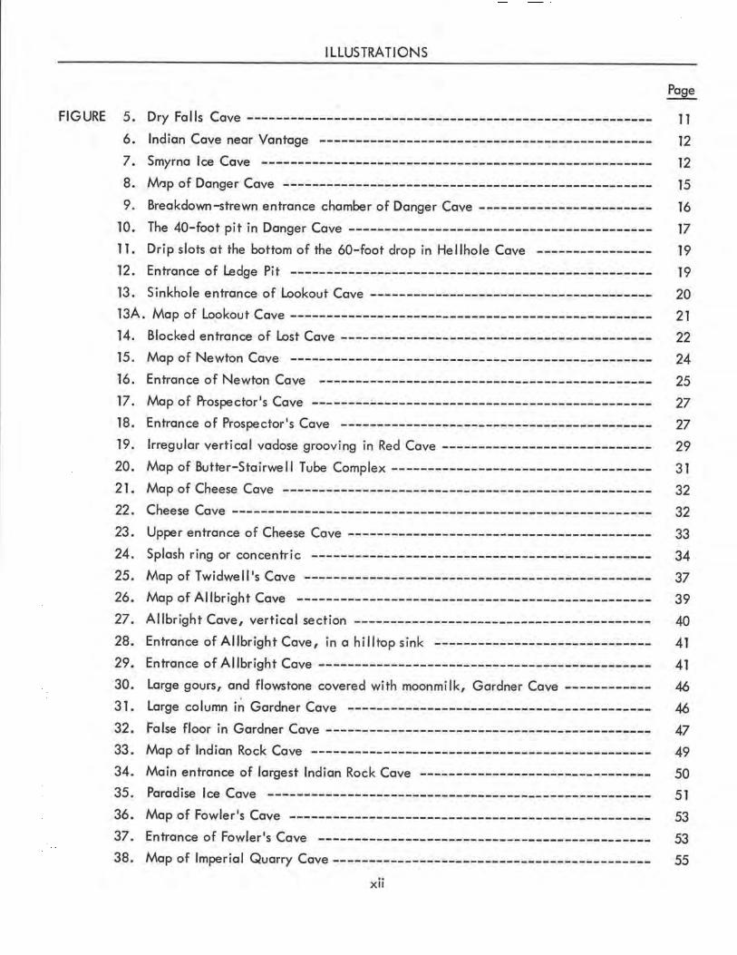
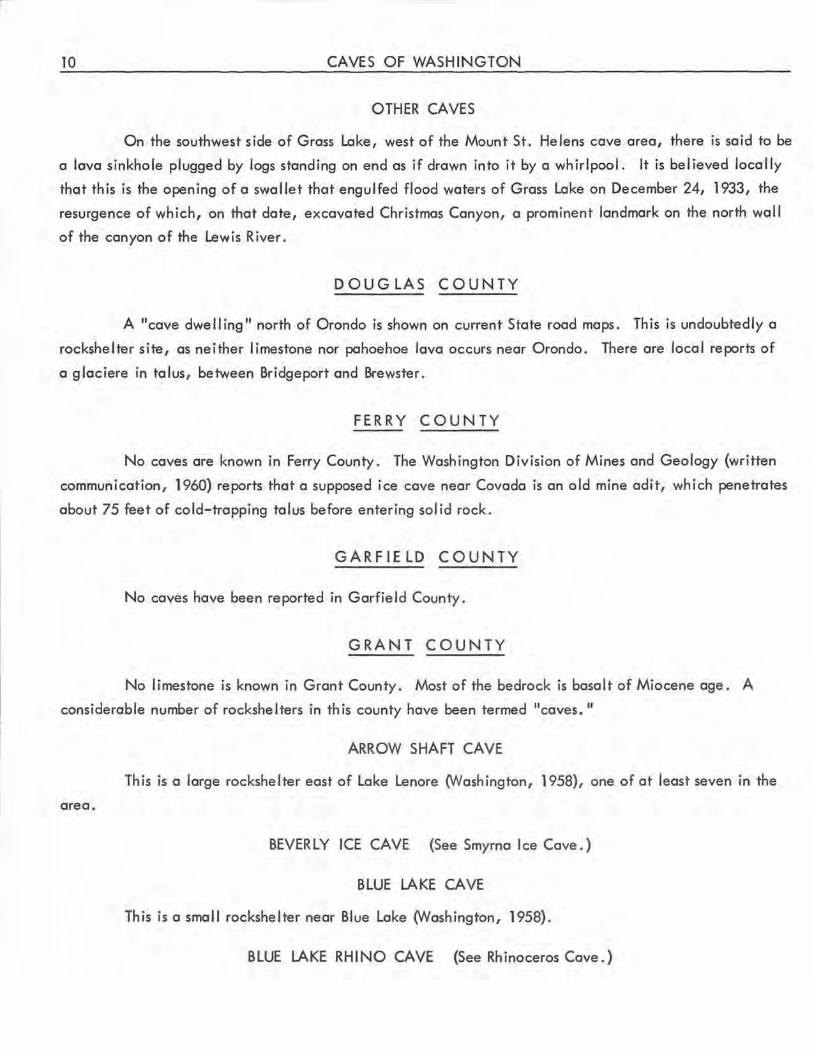
DRY FALLS CAVE
This small rockshelter (fig. 5) in basalt is near the trail descending into the Dry Falls basin from
the observation platform on the rim. The opening extends about 60 feet back into the sheer cliff.
Figure 5.-Dry Falls Cave. Photo by Bob and Ira Spring .
12 CAVES OF WASHINGTON
EAST LENORE CAVES
Besides Arrow Shaft Cave, six small rockshelters have been reported in the area east of Lake
Lenore (Wash ington, 1958).
HORSETHIEF CAVE
This is a 300-foot cave with two entrances in the cliff north of Soap Lake. The description is
suggestive of a block-creep cavern. (N. W. Washington, oral communication.)
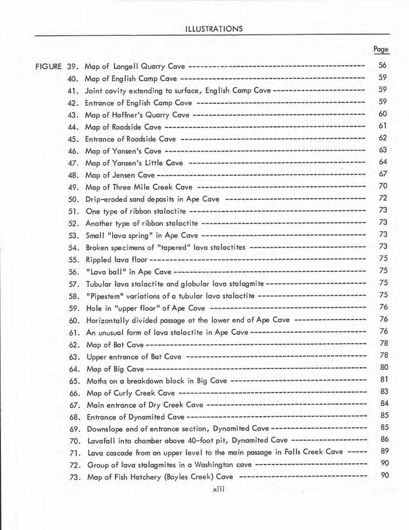
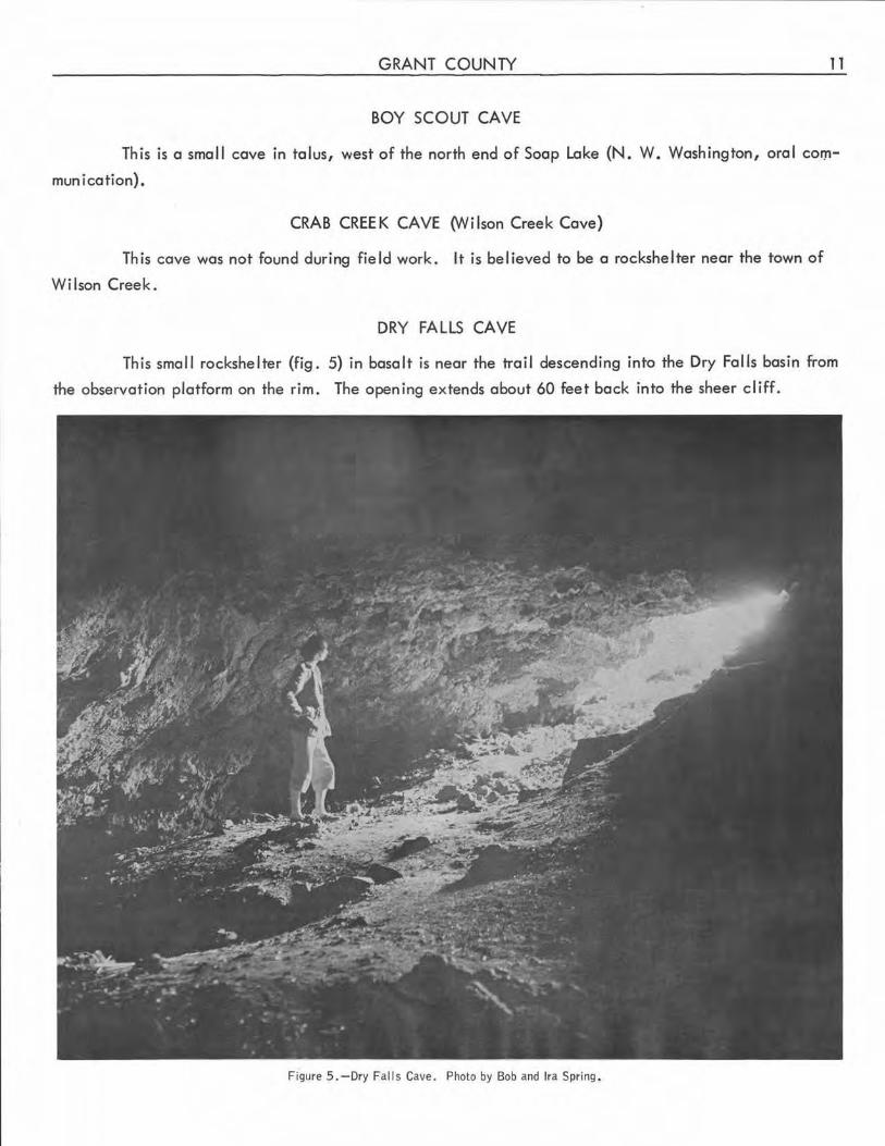
INDIAN CAVE
This is an easily seen rockshelter (fig. 6) about 1 mile south of Vantage, on the east bank of the
Columbia River. The name is a lso applicable to a number of other rockshe l ters in this area, which is under
study by various archeological organizations.
JASPER CAVE
This is a large rockshelter on the west wal I of Jasper Coulee (Washington, 1958) .
MOONSHINER'S CAVES
These two adjoining rockshelters are in T. 23 N., R. 23 E. A spring emerges from the floor of
one of them (Wash ington, 1958).
Figure 6. -Indian Cave near Vantage, Grant County. This is a typical rockshelter in the basalt of eastern Washington.
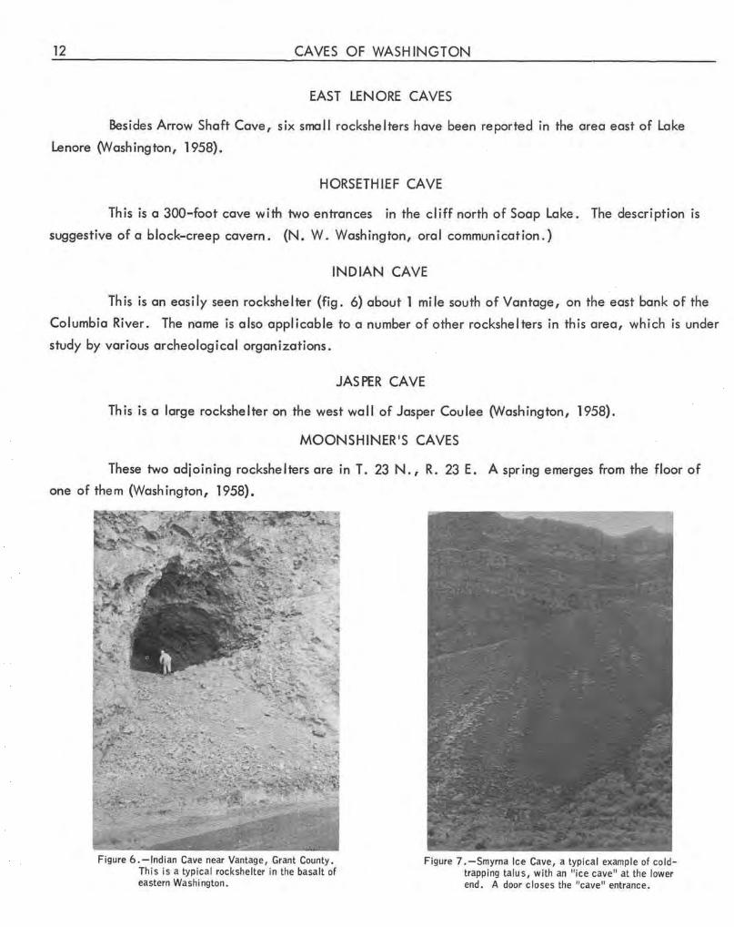
Figure 7. -Smyrna lc,e Cave, a typical example of coldtrapping talus, with an "ice cave" at the lower end . A door closes the "cave" entrance.
GRANT COUNTY 13
OWL CAVE
This is another rockshelter in basalt in the Grand Coulee area (Osborne, n . d . a).
PICTOGRAPH CAVE
This is a small rockshelter in T. 24 N., R. 26 E. (Osborne, n.d. b).
RHINOCEROS CAVE (Blue Lake Rhino Cave)
The mold of a rhinoceros in pillow lava at the mouth of Jasper Canyon has been termed a "cave"
in both popular and technical (Chappell and others, 1951) usage . The mold is about 8 feet long and is
entered through a small opening in the left thigh region .
SMYRNA ICE CAVE (6) (Beverly Ice Cave)
This is an artificial "cave 11 (fig. 7) dug into cold-trapping talus, 5 miles west of Smyrna. Its
location is shown on the U.S. Geological Survey Smyrna quadrangle.
SOUTH CAVE
This is a rockshelter in the lower Grand Coulee (Gallagher, 1959).
WEST LENORE CAVES
There are several rockshelters west of Lake Lenore in lower Grand Coulee (Washington, 1958).
WILSON CREEK CAVE (See Crab Creek Cave.)
GRAYS HARBOR COUNTY
No limestone cave has been reported in Grays Harbor County. There are a number of littoral
caves on the shore of the Quinault Indian Reservation. One extends completely through a small island
near Elephant Rock (Doward, 1958).
IS LAND COUNTY
No caves have been reported in Island County.
JEFFERSON COUNTY
Little limestone is present in Jefferson County. A number of littoral caverns are south of La
Push . The largest, about 100 feet long, parallels the cliff and is open at both ends. Other small littoral
caves, in basalt of the Crescent Formation, are along the west side of Dabob Bay and at Pulali Point on
Hood Canal (W. R. Danner, oral communication).
14 CAVES OF WASHINGTON
LAKE LENA CAVES
These are talus caves at the end of Lower Lena Lake (Morgan, 1952) . Their status as glacieres
1s uncertain.
KING COUNTY
King Co1,.1nty contains the largest I imestone caves known in western Washington. A number of
caves of other types are also in this County.
ADAIR'S CAYE (See Prospector's Cave.)
BLACK RIVER CAYE
Sec. 16, T. 23 N., R. 5 E., Renton quadrangle . Elevation about 50 feet.
Although this is not a limestone area, there is said to have been a small natural cave in the cut
bank of the Black River in Renton, below Maple Street and the Seattle highway. There is no trace of such
a cave today. One may have collapsed here about 20 years ago (Douglas, 1957}. The present residents
report that a sinkhole developed in their backyard about 1955, but it was filled to prevent accidents .
BREA KD OWN CA YE (See Danger Cave . )
CLARK'S CAYE (7)
Sec. 28, T. 23 N., R. 11 E., Snoqualmie quadrangle. Elevation about 4,750 feet.
This tiny cave was the first discovered of the Snoqualmie Pass group. It is at the base of the
slopes on the south side of the hanging valley on the south side of Mount Snoqualmie, just upstream from
a small pond. Its entire length of about 35 feet consists of tight crawlways (Steinburn, 1952). This cave
and a small, impenetrable fissure a few feet farther up the gulch serve as resurgences after periods of
heavy rainfall and are dry only in late summer.
CLIFF CAYE (8)
Sec . 28, T. 23 N., R. 11 E., Snoqualmie quadrangle . Elevation about 5,200 feet.
This small cavern is hardly more than a rockshelter in limestone. It is at the south end of the
small ridge that forms the east border of Cave Ridge, and is south of Red Cave.
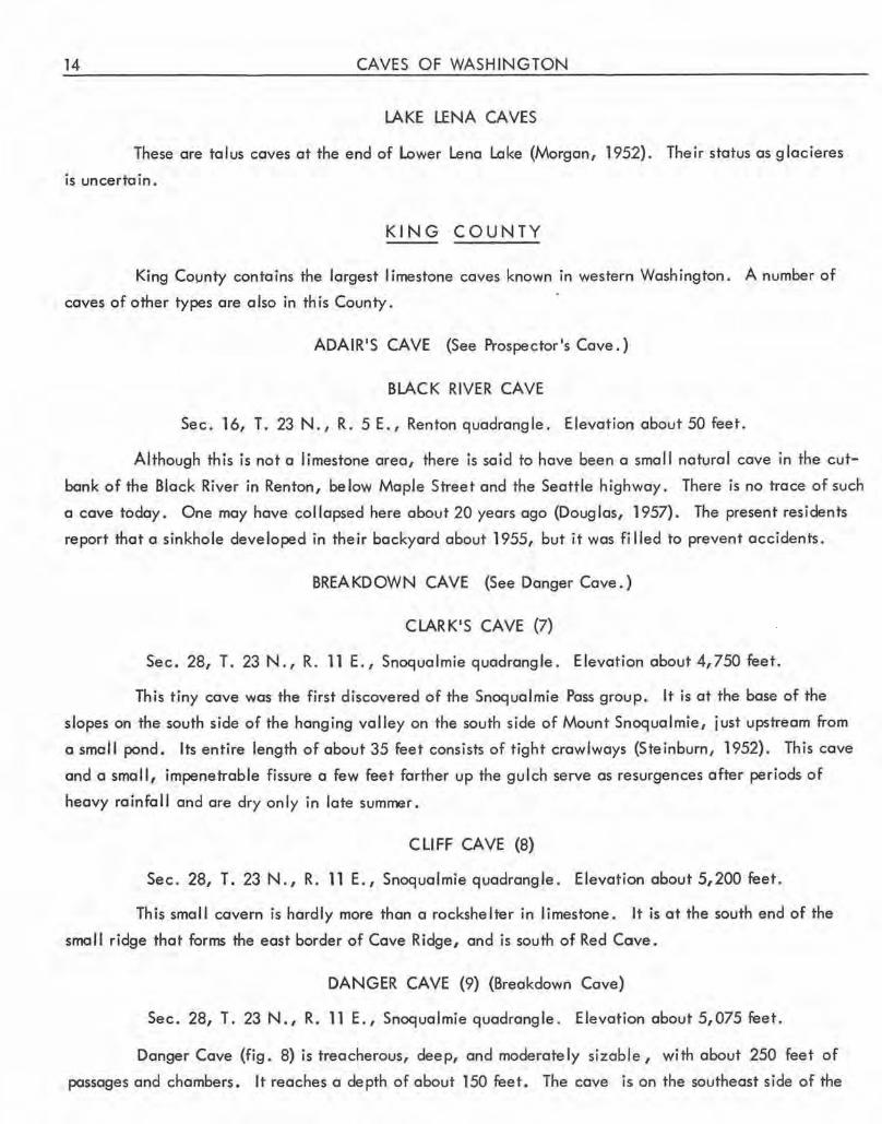
DANGER CAYE (9) (Breakdown Cave}
Sec . 28, T. 23 N., R. 11 E., Snoqualmie quadrangle. Elevation about 5,075 feet.
Danger Cave (fig. 8) is treacherous, deep, and moderately sizable, with about 250 feet of
passages and chambers. It reaches a depth of about 150 feet. The cave is on the southeast side of the
Dry
KING COUNTY
SMALL ENTRANCE
V
V
V
Block of fallen rock
Small room in breakdown below Upper Room has narrow pit 17' deep,
Steep slope; breakdown and fill fanning several ledges.
~ -N-j
'- This portion unsurveyed '-........ in detail. ......_ _____ ........
................
Massive breakdown \)
'~~ Q, ,.;--,.:\ '€:!I I -,~~~IN ROOM /
"'. ,..... I --~50
Figure 8. -Danger Cave, King County. Preliminary survey by Washington Speleo logical Survey, December 1960. Distances below entrance are estimated.
15
16 CAVES OF WASH INGTON
area locally called Sinkhole Amphitheater, opposite Red and Hellhole Caves, and is at the south end of a
sma l I lapies ravine about 100 yards long. The immediate environs are not forested, but low alpine growth
is present. Perhaps because of its position on the open ridge, Danger Cave is a little warmer than the
other caves of the group. Its name is due to the loose rock in the cave, which is a prohibitive risk to al I
but experienced cavers.
The bedrock at Danger Cave is a marble member of the Denny Formation, which is believed to be
of Permian age (Foster, 1960). It is heavily fractured and appears to dip about 30° S., as in most of Cave
Ridge. The beds exposed on the opposite sides of the main passage do not correspond, suggesting that the
cave has been formed along a fault aligned parallel to the dip of the bedrock. Extensive slumping and
breakdown are present throughout the cave, and deposits of sand, gravel, and boulders are prominent in its
lower areas.
-.-.,,.. .,,r ,....,
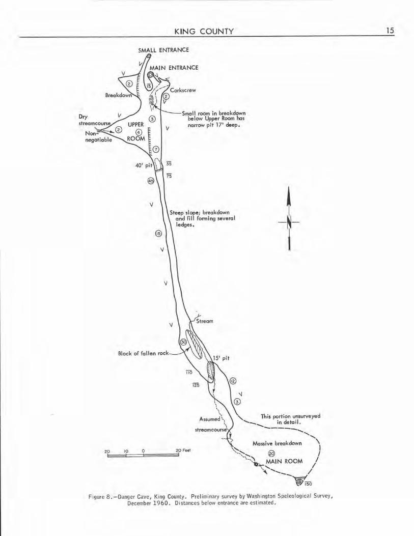
Figure 9. -Breakdown-strewn entrance chamber of Danger Cave, King County. Photo by Bob and Ira Spring.
KING COUNTY 17
The main entrance of the cave is a narrow opening in a small hillock. A steep, narrow passage
leads downward about 20 feet to the low entrance chamber (fig. 9), which can also be reached by a crawl
way from a tiny second entrance 15 feet north of the main entrance. The crawlway passes approximately
beneath the main entrance. The entrance chamber, known as the Upper Room, is 2 to 6 feet high, is
irregular in out I ine, and has a maximum width of 38 feet at a place where a narrow dry stream channel
enters the room from the west. This chamber ends at a 40-foot pit, 55 feet from the entrance. It contains
no speleothems. On the ceiling is a half-tube that appears to be of phreatic origin.
Just inside the main entrance of the cave, a tortuou~ narrow pit leads to two small breakdown
chambers beneath the entrance room. One contains a fissurelike pit, 17 feet deep, aligned with the main
fissure of the cave.
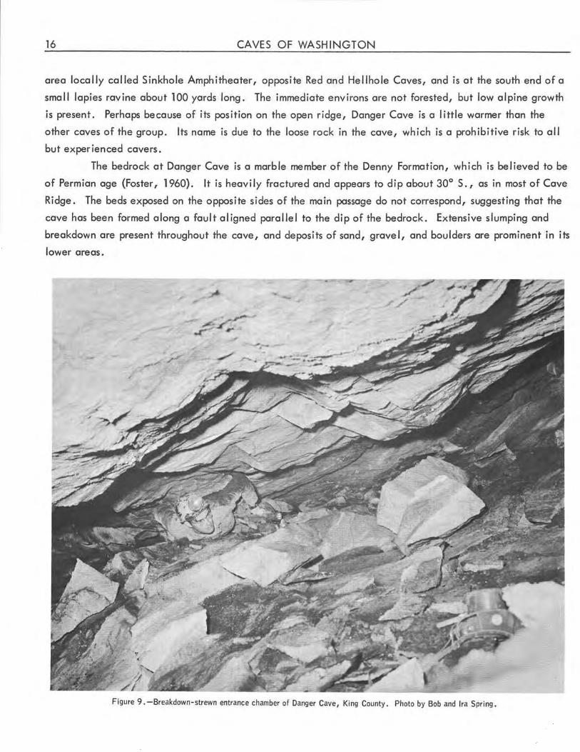
The 40-foot pit (fig. 10) at the end of the Upper Room is actually a dropoff to a steeply sloping
passage about 3 feet wide that extends southward. Its floor is covered with large accumulations of break-
down and stream deposits, which form several "levels, 11 pits, and
ledges. In widened horizontal joints, miniature ceiling pendants
are locally prominent. At a point about 100 feet downslope from
the base of the pit, a large block of fallen rock about 12 feet
long divides the passage . By ascending this block, a small
"upper leve l 11 can be entered, where vertical waterfall slots
are prominent. One group of slots approaches dome pit propor
tions. Extremely thin blades of impurities project from the walls,
and a little boxwork is developed locally.
Near the point where the fallen block divides the main
passage, a stream enters from the east and flows down the east
branch of the passage to a 15-foot pit beyond the block.
Below this pit is the breakdown-choked main room of
the cave. Its floor plan is irregular . The central part of its
south wall is about 30 feet southeast of the base of the pit. From
this point it is 55 feet to the farthest point of the east wall.
Great masses of breakdown are present. At the southeast corner
a sloping, gravel-strewn pit about 15 feet deep leads to a small Figure 10. - The 4 0-foot pit in Danger Cave, King County. pool that is the only visible part of a more extensive water
surface beneath the breakdown. Nearby are two short tubular
stalactites and a small white stalagmite, the only major speleothems in the cave.
At the southwest corner of this chamber a series of partly tubular bedrock passages permit the flow
of the cave stream to another small pond. These are the only passageways in the cave that are not heavily
modified by breakdown. During the wet weather other , smaller streams enter the cave through waterfall
chutes near this place.
18 CAVES OF WASHINGTON
Danger Cave is being enlarged and.flushed by vadose water. Speleothem deposition is almost nil.
Despite the great accumulations of breakdown and stream depos its, there is evidence of a sub- water - table
or ig in of the cave, but no sign of integration by sha llow sub-water-table flow. Of particular interest are
the ceiling pendants in widened horizontal joints along the main passage, which appear to have developed
when that passage was temporar ily filled with sediment .
DANGER CAVE ANNEX (10)
About 50 feet southeast of Danger Cave and 20 feet lower than its entrance is a small cavern . The
cave rn is aligned parallel to Danger Cave and consists of a steeply sloping passage about 30 feet long with
a single short, t ight crawlway to one side .
DON'S CAVE (11) {Mount Issaquah Cave)
Approximate ly sec. 36, T. 24N., R. 6E., Snohomish quadrangle.
This is a talus cave 111 feet long, roofed almost completely by a single enormous boulder. It is
on the western face of Mount Issaquah.
DONI.AN'S CAVE
Repeated search for th is cave, supposedly on Denny Peak, has been fruitless. The informant,
Joseph P. Donlan, in 1952 was unable to recogn ize any landmarks in the area where he believed that he
had discovered the cave 50 years earlier. There is an abandoned limestone quarry on a different part of
Denny Peak. The sound of running water can be heard through a crack near th is quarry, and a small
stream issues from talus farther down the slope.
GROTTO CAVE (See Lost Cave, King County.)
HELLHOLE CAVE (12)
Sec. 28, T. 23 N., R. 11 E. , Snoqualmie quadrangle. Elevationabout5,180feet.
Hellhole Cave is a few dozen yards south of the crest of Cave Ridge, about 200 yards west of Red
Cave. It is in a small flat above the northwest end of the so-called Sinkhole Amphitheater, about 100
feet northeast of a large col lapse sink. The smal I entrance sink of the cave is about 4 feet in diameter
and 8 feet deep, and is almost concealed by heather and other low a lpine plants.
The actual entrance of the cave is a triangular orifice at the bottom of the sink. It is about 12
inches on each side, and barely admits an agile, slender person. Below is a free 60-foot drop to the
floor of a large sloping chamber about 100 feet long, 35 feet wide, and 20 to 60 feet high. On the floor
are masses of breakdown, much of which is unstable. Because of the danger involved, the cavern has
been only partially explored. There are several narrow, roughly parallel side passages, but none has
been found to be more than about 100 feet long . Pits leading to a total depth of more than 100 feet below
the surface have been partia I ly explored.
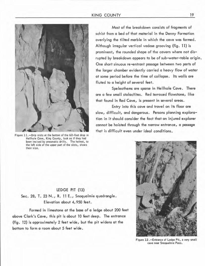
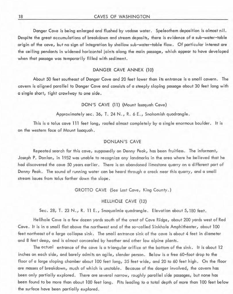
Figure 11.-0rip slots at the bottom of the 60-foot drop in Hellhole Cave, King County, look as if they had been incised by pneumatic drills. The helmet, to the left side of the upper part of the slots, shows their size.
LEDGE PIT (13)
KING COUNTY 19
Most of the breakdown consists of fragments of
schist from a bed of that material in the Denny Formation
overlying the tilted marble in which the cave was formed.
Although irregular vertical vadose grooving (fig. 11) is
prominent, the rounded shape of the cavern where not dis
rupted by breakdown appears to be of sub-water-table origin.
One short sinuous re-entrant passage between two parts of
the larger chamber evidently carried a heavy flow of water
at some period before the time of collapse. Its walls are
fluted to a height of several feet.
Speleothems are sparse in Hellhole Cave. There
are a few small stalactites. Red terraced flowstone, like
that found in Red Cave, is present in several areas.
Entry into this cave and travel on its floor are
slow, difficult, and dangerous. Persons planning explora
tion in it should consider the fact that an injured explorer
cannot be hoisted through the narrow entrance, a passage
that is difficult ·even under ideal cOhditions.
Sec. 28, T. 23 N., R. 11 E., Snoqualmie quadrangle .
Elevation about 4, 950 feet.
Formed in limestone at the base of a ledge about 200 feet
above Clark's Cave, this pit is about 10 feet deep. The entrance
(fig. 12) is approximately 2 feet wide, but the pit widens at the
bottom to form a room about 5 feet wide.
Figure 12. -Entrance of Ledge Pit, a very small cave near Snoqualmie Pass.
20 CAVES OF WASHINGTON
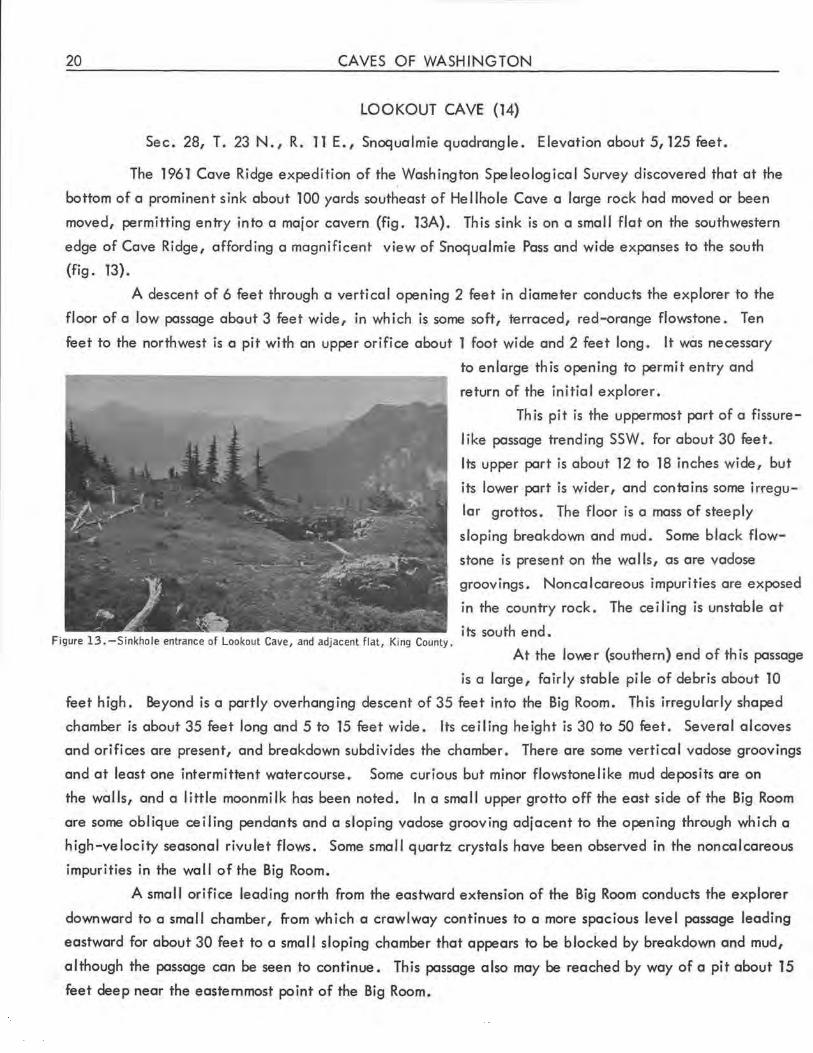
LOOKOUT CAVE (14)
Sec. 28, T. 23 N ., R. 11 E., Snoqualmie quadrangle. Elevation about 5,125 feet.
The 1961 Cave Ridge expedition of the Washington Speleological Survey discovered that at the
bottom of a prominent sink about 100 yards southeast of Hellhole Cave a large rock had moved or been
moved, permitting entry into a major cavern (fig. 13A). Th is sink is on a small flat on the southwestern
edge of Cave Ridge, affording a magnificent view of Snoqualmie Pass and wide expanses to the south
(fig. 13).
A descent of 6 feet through a vertical opening 2 feet in diameter conducts the explorer to the
floor of a low passage about 3 feet wide, in which is some soft, terraced, red-orange flowstone. Ten
feet to the northwest is a pit with an upper orifice about 1 foot wide and 2 feet long. It was necessary
Figure 13. -Sinkhole entrance of Lookout Cave, and adjacent flat, King County.
to enlarge this opening to permit entry and
return of the in i tia I explorer.
Th is pit is the uppermost part of a fissure
like passage trending SSW. for about 30 feet.
Its upper part is about 12 to 18 inches wide, but
its lower part is wider, and contains some irregu
lar grottos. The floor is a mass of steeply
sloping breakdown and mud. Some black flow
stone is present on the wal Is, as are vadose
groovings. Noncalcareous impurities are exposed
in the country rock. The ceiling is unstable at
its south end.
At the lo\\er (southern) end of this passage
is a large, fairly stable pile of debris about 10
feet high. Beyond is a partly overhanging descent of 35 feet into the Big Room. This irregularly shaped
chamber is about 35 feet long and 5 to 15 feet wide. Its ceiling height is 30 to 50 feet. Several alcoves
and orifices are present, and breakdown subdivides the chamber. There are some vertical vodose groovings
and at least one intermittent watercourse. Some curious but minor flowstonelike mud deposits are on
the walls, and a little moonmilk has been noted. In a small upper grotto off the east side of the Big Room
ore some oblique ceiling pendants and a sloping vodose grooving adjacent to the opening through which a
high-velocity seasonal rivulet flows. Some small quartz crystals hove been observed in the noncalcareous
impurities in the wal I of the Big Room.
A smal I orifice leading north from the eastward extension of the Big Room conducts the explorer
downward to a small chamber, from which a crawlway continues to a more spacious level passage leading
eastward for about 30 feet to a small sloping chamber that appears to be blocked by breakdown and mud,
although the passage can be seen to continue. This passage also may be reached by way of a pit about 15
feet deep near the easternmost point of the Big Room.
KING COUNTY 21
The south end of the Big Room is a steeply sloping grotto. At its lower end a short semivertical
passage opens westward into a pi le of breakdown at the northeast side of another chamber, about 10 feet
in diameter. This room slopes to the south and is the lowest point in the cave, at an estimated depth of
125 feet be low the entrance. From the northwest end of the chamber a long, steep, rock-strewn passage
leads upward for about 50 feet. In breakdown to the east of this passage, some very tight orifices remain
unexplored . There are several tiny white calcareous speleothems in this area . The total slope length of
known passages is about 200 feet. Biota is scant exce pt in the entrance zone, where rodent nests are
present. It is doubtful that this cave is connected to nearby Hellhole Cave. Smoke bombs released in
the latter on September 7, 1962, were not detected in Lookout Cave.
Because of loose rock and difficult conditions of exploration, only competent speleologists
should enter this cave.
Figure 13A.-Lookout Cave, King County . Compass and tape survey by Washington Speleological Survey, September 2, 1962. Depths estimated .
LOST CAVE (Grotto Cave)
Sec. 12, T. 26 N., R. 10 E., Skykomish quadrangle.
This cave, north of U.S . Highway 2 between Grotto and Baring, has not been found during field
work, although the entrance shown on a photograph (fig. 14) supposedly of the cave has been located
and partially excavated . The cave may have been filled during construction of the power I ine tower
directly above its supposed location. It was reported to be a limestone cave slanting steeply downward
and into the hillside, deep enough to require early explorers to place a rude ladder inside, and having
water at the bottom.
22 CAVES OF WASH INGTON
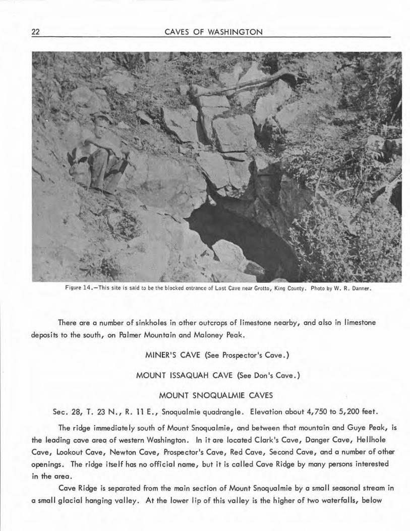
Figure 14.-This site is said to be the blocked entrance of Lost Cave near Grotto, King County. Photo by W.R. Danner.
There are a number of sinkholes in other outcrops of limestone nearby, and also in limestone
deposits to the south, on Palmer Mountain and Maloney Peak.
MINER'S CAVE (See Prospector's Cave.)
MOUNT ISSAQUAH CAVE (See Don's Cave.)
MOUNT SNOQUALMIE CAVES
Sec. 28, T. 23 N., R. 11 E., Snoqualmie quadrangle. Elevation about 4,750 to 5,200 feet.
The ridge immediately south of Mount Snoqualmie, and between that mountain and Guye Peak, is
the leading cave areq of western Washington. In it are located Clark's Cave, Danger Cave, Hellhole
Cave, Lookout Cave, Newton Cave, Prospector's Cave, Red Cave, Second Cave, and a number of other
openings. The ridge itself has no official name, but it is called Cave Ridge by many persons interested
in the area.
Cave Ridge is separated from the main section of Mount Snoqualmie by a small seasonal stream in
a small glacial hanging valley. At the lower lip of this valley is the higher of two waterfalls, below
KING COUNTY 23
which the stream joins the South Fork of the Snoqualmie River . At the upper end of this hanging valley
an arm of Mount Snoqualmie joins the ridge to the Mountain.
The summit line of Cave Ridge runs roughly from east to west, but it swings somewhat toward the
south at the west end, where a series of spurs complicate the topography. The arm of Mount Snoqualmie
and the curving ridge form a horseshoe-shaped open basin. This shallow basin contains many sinks, largely
developed along low parallel outcrops, or lapies, which are strike ridges of the dipping limestone members
of the bedrock. This basin is locally called Sinkhole Amphitheater. Cave Ridge and Sinkhole Amphitheater l
contain some of the most pronounced karst topography yet observed in the Pacific Northwest .
This is an alpine area, irregularly covered by alpine forest. Heather and low alpine plants are
thick. Bare limestone appears only on the lapies and immediately adjacent to some of the sinks, except
for a few unmantled areas on the arm of Mount Snoqualmie, where the limestone shows glacial striae.
Somefimes as much as 15 feet of snow remains throughout the summer in the hanging valley, which over
looks a precipitous 2, 000-foot descent to the glacial valley below.
The bedrock in which the caves occur is the Paleozoic, probably Permian, Denny Formation, which
consists largely of alternating beds of marble and schist (Foster, 1960) . The dip is generally north-north
east at about 30°, though there is some local variation. The caves tend to be formed primarily along the
dip or strike, with breakdown of overlying schist quite marked. In general, they are narrow, and most of
them are difficult and dangerous to explore.
The entire area is a fine example of glaciated, partly mantled mountain karst. A post-Miocene
erosion surface, deeply dissected subsequent to uplift, has been partially demarcated in this area, but its
relation to the caves has not been determined (Smith and Calkins, 1906). Some of the caves appear to
show partial correlation with local "flats, 11 but others do not.
Initial discovery and exploration of most of the caves in this area were by Thomas Steinburn, although
Robert Clark reported the two smal I caves at the lower end of the hanging valley (Steinburn, 1952,
Halliday, 1960a).
NEWTON CAVE (15)
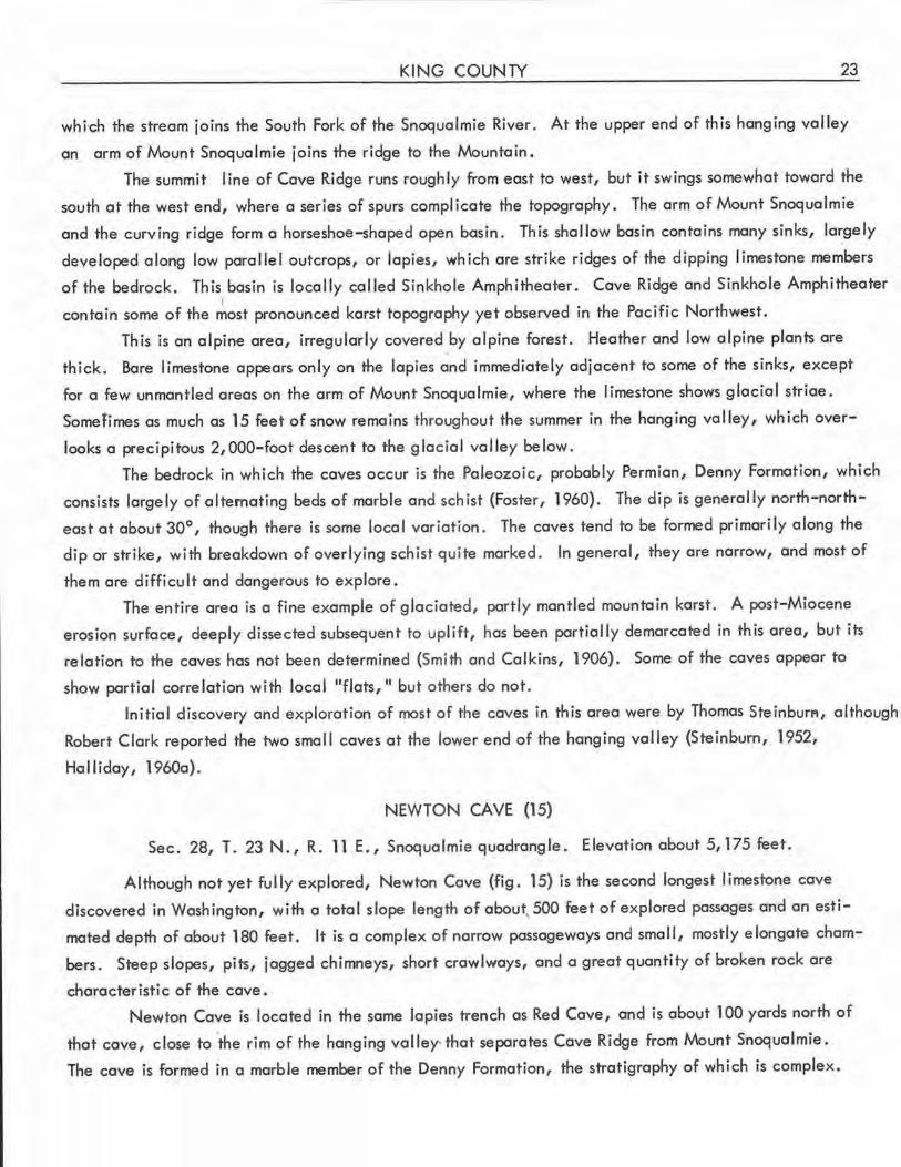
Sec. 28, T. 23 N., R. 11 E., Snoqualmie quadrangle. Elevation about 5,175 feet.
Although not yet fully explored, Newton Cave (fig. 15) is the second longest limestone cave
discovered in Washington, with a total slope length of about.500 feet of explored passages and an esti
mated depth of about 180 feet . It is a complex of narrow passageways and small, mostly elongate cham
bers. Steep slopes, pits, jagged chimneys, short crawlways, and a great quantity of broken rock are
characteristic of the cave.
Newton Cave is located in the same la pies trench as Red Cave, and is about 100 yards north of
that cave, close to the rim of the hanging valley that separates Cave Ridge from Mount Snoqualmie.
The cave is formed in a marble member of the Denny Formation, the stratigraphy of which is complex.
24 CAVES OF WASHINGTON
Ceiling non> @co I coreous
30 Upper level chambers in this area
> .:. Marked FLUTE ROOM 35
t -~-
' Slope steep,
slick
Red-orange flowstone
20 10 O 20 Feet E==:t:::=~========='
breakdown
85 >
4 sci
\C Crawlways Natural bridge (noncalcareous)
45
', ,.;,. ' ............ I.V @' '
BOXWORK 150
ROOM
Figure 15.-Newton Cave, King County. Preliminary survey by Washington Speleological Survey, 1960. Depths below entrance are estimated.
Metamorphism in this area was more intense than is evident in the walls of the other caves of the Mount
Snoqualmie group. The marble is fine grained., ~nd varies in color from milk white through faintly banded
white to a blue-white "curly" patterned marble. The joints exposed in the cave appear to bear little or
no relation to the bedding, even where the latter is distinct . At the west end of the Flute Room, and
possibly elsewhere in the cave, schist of the Denny Formation is exposed. Much more prominent than
the schist are outcrops of other, unidentified noncalcareous intrusions or inclusions, which range from
thin veinlets to masses several feet thick. The passages leading down from the Flute Room and The Slide
appear to have developed along or to be aligned with large masses of this material. Another example
can be seen at close range as the visitor climbs down a rope ladder in the cave entrance. Water dripping
off the ledge formed by this mass has dissolved in the underlying marble several short but well-developed
circular waterfall slots, which resemble miniature dome pits.
KING COUNTY 25
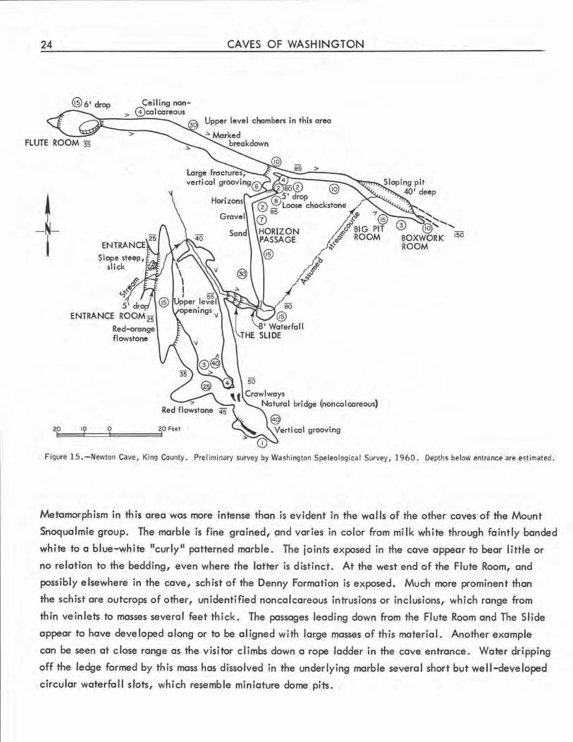
Figure 16 . -Entrance of Newton Cave, King County.
The entrance of Newton Cove (fig. 16)
is on os¥mmetricol sinkhole slanting eastward
beneath a small limestone bluff. A steep slope
20 feet long terminates with a sheer drop of 10
feet to the floor of the Entrance Room.
The Entrance Room is 55 feet long.
Its height overages 15 feet, and it is about 5
feet wide at floor level, although the upper
part of the room is wider. There ore several
possible passage openings in broken rock high
on its east wall. Features of interest include
a complex of drip slots beneath the entrance,
and deposits of orange-red flowstone on the
southern part of the west wo 11. The seasonal stream tho.t enters the cove entrance disappears in rubble
near the northern end of this room.
A short sloping passage leads downward from the southeast side of the Entrance Room to a steep
chimneylike chamber in which red flowstone hos been deposited along the steep slope . Beyond is a small
antechamber from which openings lead south and southeast.
A squeezeway to the southeast opens into a high-ceilinged chamber with marked vertical vadose
grooving. High on the wall of this chamber is a small hole that leads into a small grotto, from which a
narrow slot extends back down to the floor of the main room.
Two muddy crawlways at the north end of this high-ceilinged chamber and the opening to the
east from the antechamber just described join at the south end of a straight corridor about 40 feet long.
Several large chimneys with extensive vadose grooving are in the wider southern half of this passage . Its
north end is at a junction. To the east of th is junction is The Slide. To the north is a steep stream passage
that conducts the entrance stream to The SI ide.
The Slide is a steep,. narrow passage floored by a noncalcareous mass that is coated with a slick
organic(?) material. The upper part of this passage is in marble. Below The Slide, a gently sloping
passage a few feet long leads to a vertical 8-foot woterfal I that flows over the same noncalcareous mater
ial. Lateral to the deposit, differential solution has caused a separation of about 1 inch between the
marble and the insoluble mass.
At the base of this 8-foot woterfall is a small chamber. The stream disappears again, into its
floor. North of this chc,mber is an interesting 42-foot passage (the Horizon Passage) containing a variety
of fill materials, including sand and gravel. On the walls at its north end are at least three horizons
showing lateral solution at the water table, at successively lower levels. Stream fluting is present in
this passage, but it is indistinct because of superimposed fine vertical fluting.
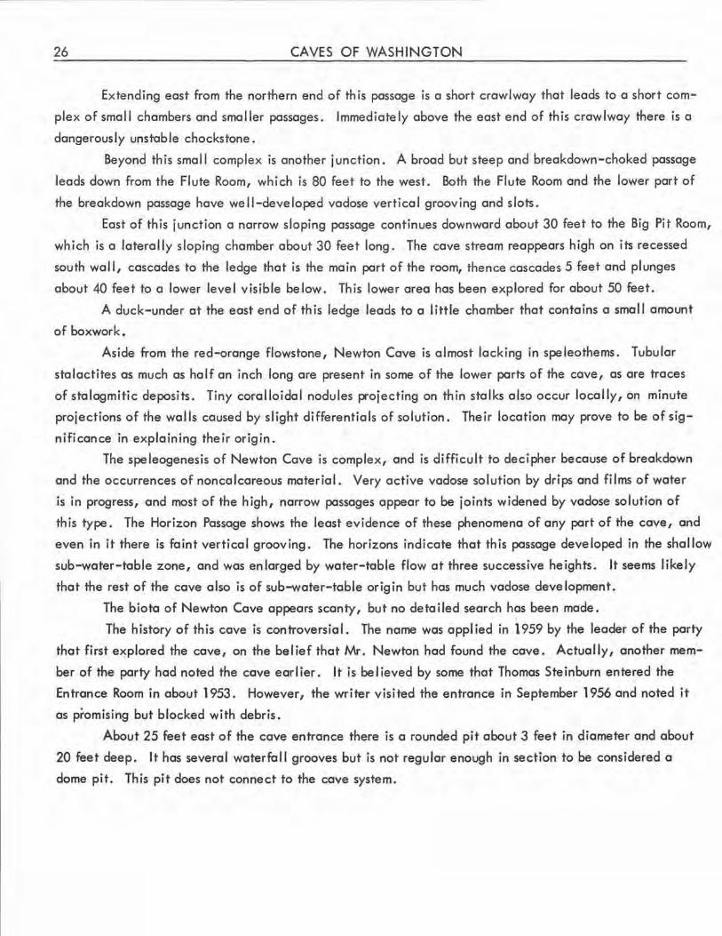
26 CAVES OF WASHINGTON
Extending east from the northern end of this passage is a short crawlway that leads to a short com
plex of small chambers and smaller passages. Immediately above the east end of this crawlway there is a
dangerously unstable chocks tone.
Beyond this smal I complex is another junction. A broad but steep and breakdown-choked passage
leads down from the Flute Room, which is 80 feet to the west . Both the Flute Room and the lower part of
the breakdown passage have well-developed vadose vertical grooving and slots.
East of this junction a narrow sloping passage continues downward about 30 feet to the Big Pit Room,
which is a laterally sloping chamber about 30 feet long. The cave stream reappears high on its recessed
south wall, cascades to the ledge that is the main part of the room, thence cascades 5 feet and plunges
about 40 feet to a lower level visible below. This lower area has been explored for about 50 feet.
A duck-under at ·the east end of this ledge leads to a little chamber that contains a small amount
of boxwork.
Aside from the red-orange flowstone, Newton Cave is almost lacking in speleothems. Tubular
stalactites as much as half an inch long are present in some of the lower parts of the cave, as are traces
of stalagmitic deposits. Tiny coralloidal nodules projecting on thin stalks also occur locally, on minute
projections of the wal Is caused by slight differentials of solution . Their location may prove to be of sig
nificance in explaining their origin.
The speleogenesis of Newton Cave is complex, and is difficult to decipher because of breakdown
and the occurrences of noncalcareous material. Very active vadose solution by drips and films of water
is in progress, and most of the high, narrow passages appear to be joints widened by vadose solution of
this type. The Horizon Passage shows the least evidence of these phenomena of any part of the cove, and
even in it there is faint vertical grooving. The horizons indicate that this passage developed in the shallow
sub-water-table zone, and was enlarged by water-table flow at three successive heights. It seems likely
that the rest of the cave also is of sub-water-table origin but has much vadose development.
The biota of Newton Cave appears scanty, but no detailed search has been made.
The history of this cove is controversial. The name was applied in 1959 by the leader of the party
that first explored the cave, on the belief that Mr. Newton had found the cave. Actually, another mem
ber of the party had noted the cave earlier. It is be I ieved by some that Thomas Ste inburn entered the
Entrance Room in about 1953. However, the writer vis ited the entrance in September 1956 and noted it
as promising but blocked with debris.
About 25 feet east of the cave entrance there is a rounded pit about 3 feet in diameter and about
20 feet deep. It has several waterfall grooves but is not regular enough in section to be considered a
dome pit. This pit does not connect to the cave system.
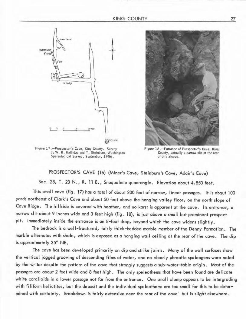
KING COUNTY
l I
0 Ory pool
Figure 17 . -Prospector's Cave, King County. Survey by W. R. Ha lliday and T. Steinburn , Washington Speleological Survey, September, 1956 .
Figure 18. -Entrance of Prospector's Cave, King County, actual ly a narrow slit at the rear of this alcove .
PROSPECTOR'S CAVE (16) (Miner's Cove, Steinburn's Cove, Adair's Cove)
Sec. 28, T. 23 N., R. 11 E., Snoqualmie quadrangle. Elevation about 4,850 feet.
27
This small cave {fig. 17) hos a total of about 200 feet of narrow, l inear passages. It is obQut 100
yards northeast of Clark's Cave and about 50 feet above the hanging valley floor, on the north slope of
Cave Ridge. The hillside is covered with heather, and no karst is apparent at the cove. Its entrance, a
"!arrow slit about 9 inches wide and 3 feet high {fig . 18), is just above a small but prominent prospect
pit. Immediately inside the entrance is an 8-foot drop, beyond which the cave widens slightly.
The bedrock is a well-fractured, fairly thick-bedded marble member of the Denny Formation. The
marble alternates with shale, which is exposed as a hanging wall ceiling at the rear of the cave. The dip
is approximately 35° NE.
The cave hos been developed primarily on dip and strike joints. Many of the wall surfaces show
the vertical jagged grooving of descending films of water, and no clearly phreotic speleogens were noted
by the writer despite the pattern of the cave that strongly suggests a sub-water-table origin . Most of the
passages are about 2 feet wide and 8 feet high. The only speleothems that hove been found are delicate
white corolloids in a lower passage not far from the entrance . One small clump appears to be intergrading
with filiform helictites, but the deposit and the individual speleothems ore too small for this to be deter
mined with certainty. Breakdown is fairly extensive near the rear of the cove· but is slight elsewhere.
28 CAVES OF WASHINGTON
RED CAVE (17)
Sec. 28, T. 23 N., R. 11 E., Snoqualmie quadrangle. Elevation about 5,175 feet.
This small, single-chambered cave is in a small karst ravine bounded by lapies, about midway along
the section of the arm of Mount Snoqualmie that joins Cave Ridge. Its entrance is at the south end of the
third collapse sink in this ravine south of the east end of the hanging valley. A few dozen feet farther
east the ridge drops away steeply to a small flat above Commonwealth Basin. A thin alpine forest is near
the cave, and heather and other low plants grow thickly.
The entrance of Red Cave is an irregular opening amid large breakdown blocks at the southern end
of the sink. A sloping passage 41 feet long enlarges near its lower end to form a chamber about 15 feet
wide and 20 feet high. Breakdown chokes a pit at its lower end. This pit is of consider.able depth but
is impenetrable. A 30-foot chimney above the west side of this room almost reaches the surface . In this
chimney is the deposit of bright-red terraced flowstone that is the source of the name of the cave.
The bedrock is a markedly fractured ma.rble member of the Denny Formation. The overlying schist
is exposed in the roof and the eastern wall of the cave. The beds dip about 65° north-northeast, but at
the entrance the bedding is grossly distorted by the presence of a wedge like intrusive body. The cave is
formed along the marble-schist contact, and much breakdown has accumulated. Vertical vadose grooves
(fig . 19) and related speleogens are very marked in the cave, and no clearly phreatic speleogens were
noted. Nevertheless, its overall contour appears to be phreatic.
SECOND CAVE (18)
Sec. 28, T. 23 N., R. 11 E., Snoqualmie quadrangle. Elevation about 4,760 feet.
About 100 feet upstream from Clark's Cave is the tiny entrance of the second cave discovered of
the Mount Snoqualmie group. It is even smaller than Clark's Cave (Steinburn, 1952).
SNOQUALMIE CAVES (See Mount Snoqualmie Caves.)
STEIN BURN 1S CAVE (See Prospector's Cave or Second Cave.)
STEINBURN 1S CAVES (See Mount Snoqualmie Caves.)
OTHER CAVES
Sec. 28, T. 23 N., R. 11 E. , Snoqualmie quadrangle.
The 9-inch-high entrance of an unexplored cave is at the base of the north face of a prominent
limestone outcrop just northwest of the crest of Cave Ridge, approximately on a line between Hellhole
and Clark's Caves. The cave slopes steeply downward for several feet, then levels off and continues for
an undetermined distance.
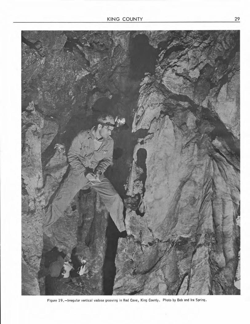
KING COUNTY 29
Figure 19. -Irregular vertical vadose grooving in Red Cave, King County. Photo by Bob and Ira Spring.
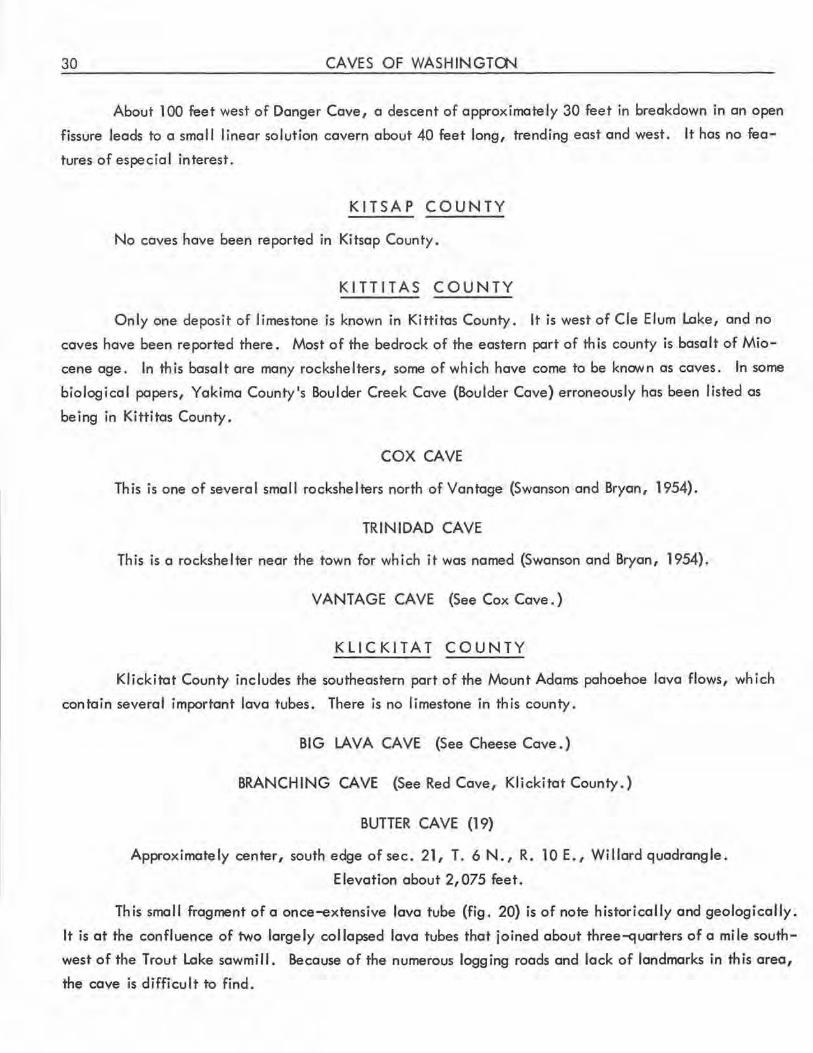
30 CAVES OF WASHINGTCN
About 100 feet west of Danger Cave, a descent of approximately 30 feet in breakdown in an open
fissure leads to a smal I linear solution cavern about 40 feet long, trending east and west. It has no fea
tures of especial interest.
KITSAP COUNTY
No caves have been reported in Kitsap County .
KITTITAS COUNTY
Only one deposit of limestone is known in Kittitas County. It is west of Cle Elum Lake, and no
caves have been reported there. Most of the bedrock of the eastern part of th is county is .basalt of Mio
cene age. In this basalt are many rockshelters, some of which have come to be known as caves. In some
biological papers, Yakima County's Boulder Creek Cave (Boulder Cave) erroneously has been listed as
being in Kittitas County .
COX CAVE
This is one of several small rockshelters north of Vantage (Swanson and Bryan, 1954) .
TRINIDAD CAVE
This is a rockshelter near the town for which it was named (Swanson and Bryan, 1954) .
VANTAGE CAVE (See Cox Cave.)
KLICKITAT COUNTY
Klickitat County includes the southeastern part of the Mount Adams pahoehoe lava flows, which
contain several important lava tubes. There is no limestone in this county.
Bl G LAV A CA VE (See Cheese Cave . )
BRANCHING CAVE (See Red Cave, Klickitat County.)
BUTTER CAVE (19)
Approximately center, south edge of sec. 21, T. 6 N., R. 10 E. , Willard quadrangle.
Elevation about 2,075 feet.
This small fragment of a once-extensive lava tube (fig. 20) is of note historically and geologically.
It is at the confluence of two largely collapsed lava tubes that joined about three-quarters of a mile south
west of the Trout Lake sawmill. Because of the numerous logging roads and lack of landmarks in this area ,
the cave is difficult to find.
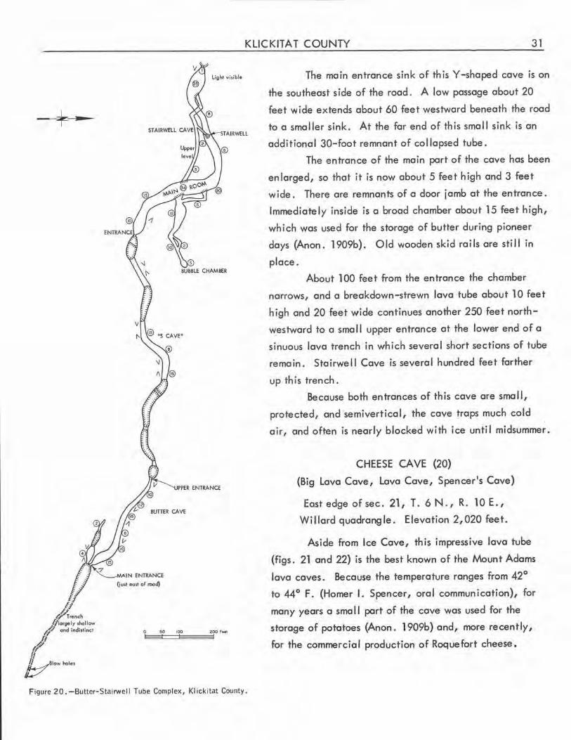
KLICKITAT COUNTY 31
!J J_J
Q Trend> blarr,.ly ,hollow
ll'Q and indistinct
J fl
bBlowholes
Light visible
TAIRWELL
BUTIER CAVE
Figure 20.-Butter-Stairwell Tube Complex, Klickitat County.
The main entrance sink of this Y-shaped cave rs on
the southeast side of the road. A low passage about 20
feet wide extends about 60 feet westward beneath the road
to a smaller sink. At the far end of this small sink is on
additional 30-foot remnant of col lapsed tube.
The entrance of the main part of the cave has been
enlarged, so that it is now about 5 feet high and 3 feet
wide. There are remnants of a door jamb at the entrance.
Immediately inside is a broad chamber about 15 feet high,
which was used for the storage of butter during pioneer
days (Anon. 1909b). Old wooden skid rails are still in
place.
About 100 feet from the entrance the chamber
narrows, and a breakdown-strewn lava tube about 10 feet
high and 20 feet wide continues another 250 feet north
w,estward to a sma 11 upper entrance at the lower end of a
sinuous lava trench in which several short sections of tube
remain. Stairwell Cave is several hundred feet farther
up this trench.
Because both entrances of this cave are small,
protected, and semiverticol, the cave traps much cold
air, and often is nearly blocked with ice until midsummer.
CHEESE CAVE (20)
(Big Lava Cave, Lava Cave, Spencer's Cave)
East edge of sec. 21, T. 6 N., R. 10 E.,
Willard quadrangle. Elevation 2,020 feet.
Aside from Ice Cave, this impressive lava tube
(figs. 21 and 22) is the best known of the Mount Adams
lava caves. Because the temperature ranges from 42°
to 44° F. (Homer I. Spencer, oral communication), for
many years a smal I part of the cove was used for the
storage of potatoes (Anon. 1909b) and, more recently,
for the commercial production of Roquefort cheese.
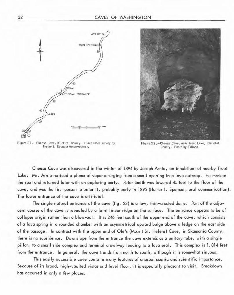
32 CAVES OF WASHINGTON
~ -~-
I
Figure 21. - Cheese Cave, Klickitat County . Plane table survey by Homer I. Spencer (uncorrected).
Figure 22 . -Cheese Cave, near Trout Lake, Klickitat County. Photo by Fi !loon.
Cheese Cave was discovered in the winter of 1894 by Joseph Arnie, an inhabitant of nearby Trout
Lake. Mr . Arnie noticed a plume of vapor emerging from a small opening in a lava owtcrop. He marked
the spot and returned later with an exploring party. Peter Smith was lowered 45 feet to the floor of the
cave, and was the first person to enter it, probably early in 1895 (Homer I. Spencer, oral communication).
The lower entrance of the cave is artificial .
The single natural entrance of the cave (fig. 23) is a low, thin-crusted dome. Part of the adja
cent course of the cave is revealed by a faint I inear ridge on the surface. The entrance appears to be of
collapse origin rather than a blow-out. It is 246 feet south of the upper end of the cave, which cons ists
of a lava spring in a rounded chamber with an asymmetrical upward bulge above a ledge on the east side
of the passage. In contrast with the upper end of Ole's (Mount St. Helens) Cave, in Skamania County,
there is no subsidence. Downslope from the entrance the cave extends as a unitary tube, with a single
pillar, to a small side complex and terminal crawlway leading to a lava seail. This complex is 1,814 feet
from the entrance. In general, the cave trends from north to south, although it is somewhat sinuous.
This easily accessible cave contains many features of unusual scenic and scientific importance .
Because of its broad, high-vaulted vistas and level floor, it is especially pleasant to visit. Breakdown
has occurred in only a few places.
KLICKITAT COUNTY 33
Figure 23 .-Upper entrance of Cheese Cave, Klickitat County. Photo by Bob and Ira Spring.
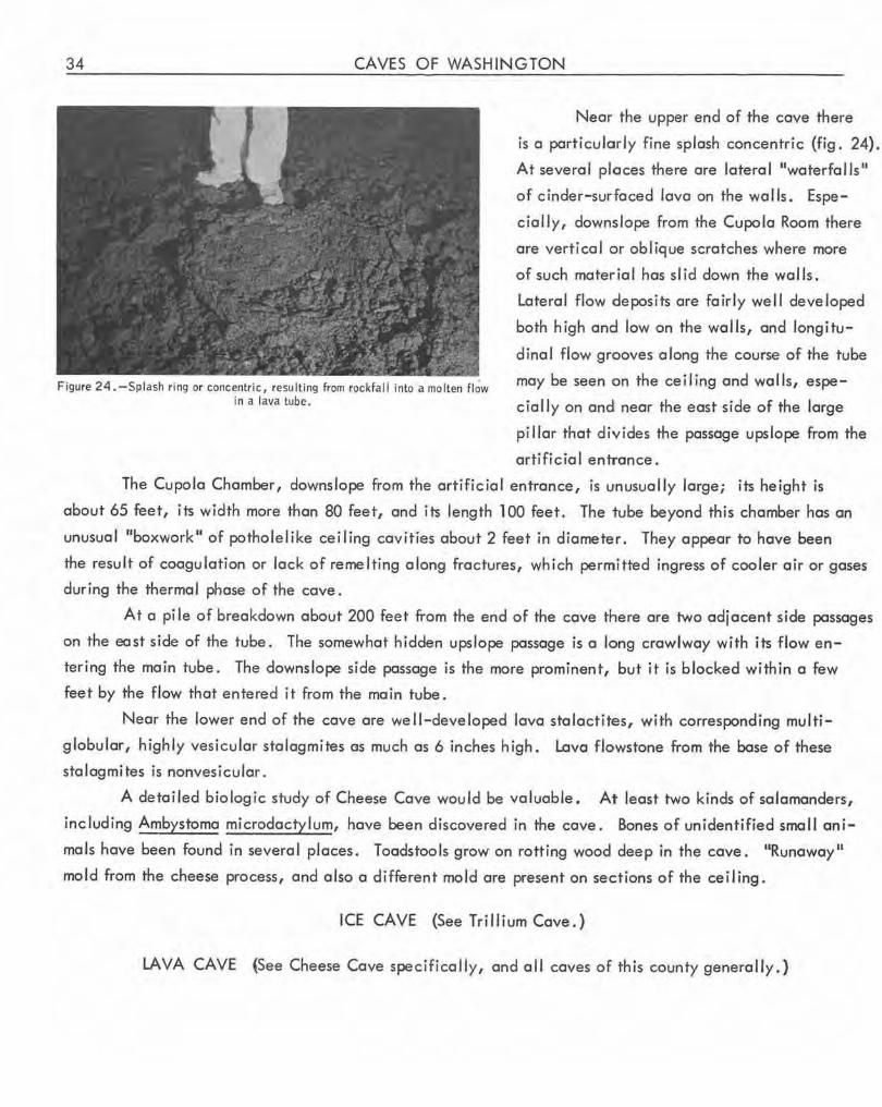
34 CAVES OF WASHINGTON
Figure 24 .-Splash ring or concentric, resu lting from rockfall into a molten flow in a lava lube.
Near the upper end of the cave there
is a particularly fine splash concentric (fig. 24).
At several places there are lateral "waterfalls"
of cinder-surfaced lava on the walls. Espe
cially, downslope from the Cupola Room there
are vertical or oblique scratches where more
of such material has slid down the walls.
Lateral flow deposits are fairly well developed
both high and low on the walls, and longitu
dinal flow grooves along the course of the tube
may be seen on the ceiling and walls, espe
cially on and near the east side of the large
pillar that divides the passage upslope from the
artificial entrance.
The Cupola Chamber, downslope from the artificia l entrance, is unusually large; its height is
about 65 feet, its width more than 80 feet, and its length 100 feet. The tube beyond this chamber has an
unusual 11boxwork 11 of potholelike ceiling cavities about 2 feet in diameter. They appear to have been
the result of coagulation or lack of remelting along fractures, which permitted ingress of cooler air or gases
during the thermal phase of the cave.
At a pi le of breakdown about 200 feet from the end of the cave there are two adjacent side passages
on the east side of the tube. The somewhat hidden upslope passage is a long crawlway with its flow en
tering the main tube. The downslope side passage is the more prominent, but it is blocked within a few
feet by the flow that entered it from the main tube.
Near the lower end of the cave are well-developed lava stalactites, with corresponding multi
globular, highly vesicular sta lagmites as much as 6 inches high. Lava flowstone from the base of these
stalagmites is nonvesicular.
A detailed biologic study of Cheese Cave would be va luable. At least two kinds of salamanders,
including Ambystoma microdactylum, have been discovered in the cave. Bones of unidentified small ani
mals have been found in several places. Toadstools grow on rotting wood deep in the cave. "Runaway"
mold from the cheese process, and also a different mold are present on sections of the ceiling.
ICE CAVE (See Trillium Cave . )
LA YA CAVE (See Cheese Cave specifically, and all caves of this county generally.)
KLICKITAT COUNTY 35
LAVA BRIDGE CAVES (21)
Sec. 31, T. 6 N., R. 10 E., Willard quadrangle. Elevation about 2,575 feet.
Several cavernous remnants of a mostly collapsed lava tube are about half a mi le east of the Ska
mania County line, north of Cave Creek. One of these, about 50 feet long, served as a natural bridge
for the old Trout Lake-Peterson Prairie road. Th is "bridge" is near the midpoint of a segment of lava
trench about 1,000 feet long, interrupted at intervals by short lengths of uncol lopsed tube. At each end
are longer segments of tube, the northernmost being about 275 feet long and terminating with a dirt fill.
A few flow grooves are in this breakdown-strewn segment of tube. The cove at the south end is more
extensive, with a slope length of about 365 feet. Its entrance section also contains much breakdown,
and its lower section possesses a beautifully convoluted lava flow and other interesting deposits. There is
a small amount of lava tube slime in the cave.
The Lava Bridge system is not a unitary tube, however. A short confluent passage is in the short
segment of tube upslope from the "bridge, 11 and there is a complex series of small sinks and short segments
of tubes about 100 feet east of the ma in tube in that genera I area .
MEAT CAVE (See Tri 11 i um Cave. )
RED CAVE (22) (Branching Cave, Spencer's Red Cove)
Approximately sec.28 or 29, T. 6 N., R. 10 E., Willard quadrangle.
Elevation about 2, 150 feet .
This little-known lava tube cavern is in a densely forested area of obscure landmarks and changing
logging roads. It has been explored principally by Homer I. Spencer. Only a smal I section of the .cave
was visited by the Survey, as rediscovery was not effected on a subsequent trip to the areo.
The main entrance sink is the lowermost of a series of col lapse sinks along a passage length of sev
eral hundred feet. From this sink four passages lead off. The main passage is upslope, leading roughly
north. The openings of the other three passages are roughly on the east, southeast, and south sides of the
sink.
It is reported that the lowest passage is a comparatively straight section of lava tube. The other
two side passages rejoin, and then join the lower passage. Unti I fi lied during logging operations, the
uppermost of these two side passages could be entered through a small collapse sink.
In the main tube, upslope, there are two additional small collapse sinks at intervals of about 100
feet. Farther north is a long, uninterrupted passage, with a double-level tube still farther upslope . It
is reported that each of these levels leads to a separate collapse sink. Detailed study of this cave will be
very instructive when it is found again.
Because of a great quantity of breakdown, the floor of much of the cave is very rough. In the
entrance section this rubble has a brick-red color, which gave the cave its name.
36 CAVES OF WASHINGTON
SPENCER'S CAVE (See Cheese Cave . )
SPENCER'S RED CAVE (See Red Cave, Klickitat County . )
STAIRWELL CAVE (23)
Sec. 21, T. 6 N . , R. 10 E., Willard quadrangle. Elevation about 2,100 feet.
Stairwell Cave (fig. 20, on p. 31) is an interesting but small lava tube complex about 1,000 feet
up the sinuous trench from the upper entrance of Butter Cave. Between the two caves are several sinks
and short segments of uncol lapsed tube.
The spacious first 170 feet of Stairwell Cave slopes downward over breakdown, even though the
trend is actually up- tube. At the end of the slope the cavern widens into what is termed ·the 11Main
Room, n which has a width of 40 feet and a ceiling height of 35 feet . In this sinuous main corridor, which
in this area trends roughly north, are two other tube openings. That on the east extends about 250 feet to
the domed "Bubble Chamber, 11 one of the few parts of the cave that are free of breakdown. Most of th is
side tube is spacious. Along its northern wall are two other branc_h tubes, the first of which rejoins the
main passage up-tube from the "Main Room. 11 It is noteworthy for its smooth clean pahoehoe floor. The
second side tube leads to a breakdown crawlway containing a lava spring. It is possible to return to the
side tube near the Bubble Chamber by passing through this breakdown.
On the west wall of the Main Room, about 25 feet above the floor, there is an opening of another
tube. About 10 feet high and 6 feet wide at first, the tube soon narrows in breakdown, then widens again .
About 150 feet from the entrance of this tube a side tube enters at a sharp angle from the right . It extends
about 50 feet to a point above the main route, to which it is connected by a circular opening reminiscent
of an old-fashioned stairwell. Beyond the junction with this upper side passage that leads to the stairwell,
the main upper passage continues about 75 feet and rejoins the main route about 125 feet below the upper
end of the cave, but maintains its identity for an additional 30 feet.
Beyond the Main Room the main passage of the cave pursues a sinuous course north, then east
for about 450 feet to a hole in breakdown through which light is visible. Most of the intervening passage
is spacious, but beyond the Stairwell is one crawlway section. Total passage length is about 1,350 feet.
Because of the complexity of Stairwell and Butter Caves, the speleogenesis of this area is a particularly
interesting problem .
TRILLIUM CAVE (24) (Ice Cave, Meat Cave)
Sec. 21, T. 6N., R. lOE . , Willard quadrangle. Elevationabout2,050feet.
This short length of lava tube served the pioneer immigrants of the Trout Lake area as a refriger
ator in which meat was stored. Its modern name arises from the cold-trapping action of the sink adjacent
to the entrance of the cave. The cold air trapped in the sink and cave causes retardation of plant growth,
so that the sink contains a profusion of blooming trilliums in midsummer.
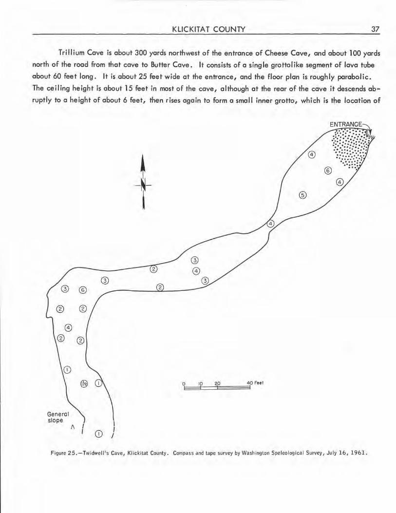
KLICKITAT COUNTY 37
Trillium Cave is about 300 yards northwest of the entrance of Cheese Cave, and about 100 yards
north of the road from that cave to Butter Cave. It consists of a single grottolike segment of lava tube
about 60 feet long. It is about 25 feet wide at the entrance, and the floor plan is roughly parabolic.
The ceiling height is about 15 feet in most of the cave, although at the rear of the cave it descends ab
ruptly to a height of about 6 feet, then rises again to form a small inner grotto, which is t~e location of
®
General slope
®
I\ I I
@
CD I I I
~ -N-I
Figure 2 5. -Twidwel I's Cave, Klickitat County. Compass and tape survey by Washington Speleological Survey, July 16, 1961.
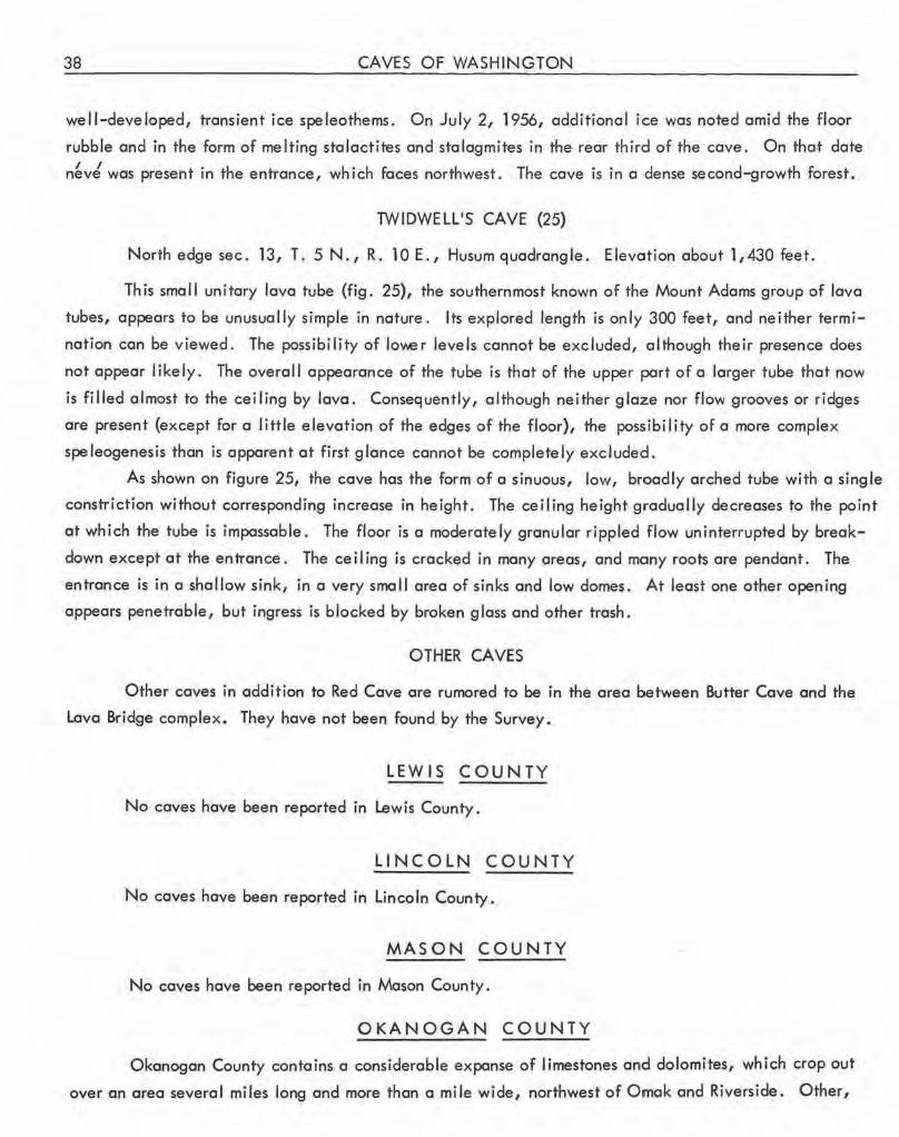
38 CAVES OF WASHINGTON
well-developed, transient ice speleothems . On July 2, 1956, additional ice was noted amid the floor
rubble and in the form of melting stalactites and stalagmites in the rear third of the cave. On tha,t date
n~v~ was present in the entrance, which faces northwest. The cave is in a dense second-growth forest.
TWIDWELL1S CAVE (25)
North edge sec . 13, T. 5 N., R. 10 E., Husum quadrangle. Elevation about 1,430 feet.
This small unitary lava tube (fig . 25), the southernmost known of the Mount Adams group of lava
tubes, appears to be unusually simple in nature. Its explored length is only 300 feet, and neither termi
nation can be viewed. The possibility of lower levels cannot be excluded, although their presence does
not appear I ikely . The overall appearance of the tube is that of the upper part of a larger tube that now
is filled almost to the ceiling by lava. Consequently, although neither glaze nor flow grooves or ridges
are present (except for a little elevation of the edges of the floor), the possibility of a more complex
speleogenesis than is apparent at first glance cannot be completely excluded.
As shown on figure 25, the cave has the form of a sinuous, low, broadly arched tube with a single
constriction without corresponding increase in height. The ceiling height gradually decreases to the point
at which the tube is impassable. The floor is a moderately granular rippled flow uninterrupted by break
down except at the entrance. The ceiling is cracked in many areas, and many roots ore pendant. The
entrance is in a shallow sink, in a very small area of sinks and low domes . At least one other opening
appears penetrable, but ingress is blocked by broken glass and other trash.
OTHER CAVES
Other caves in addition to Red Cave ore rumored to be in the area between Butter Cave and the
Lava Bridge complex. They have not been found by the Survey.
LEWIS COUNTY
No caves have been reported in Lewis County.
LINCOLN COUNTY
No caves have been reported in Lincoln County,
MASON COUNTY
No caves have been reported in Mason County.
OKANOGAN COUNTY
Okanogan County contains a considerable expanse of limestones and dolomites, which crop out
over an area several miles long and more than a mile wide, northwest of Omak and Riverside. Other,
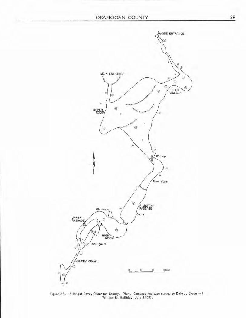
OKANOGAN COUNTY
MAIN ENTRANCE
io
II
j_ I
Figure 2 6. -Allbright Cav~, Okanogan County. Plan. Compass and tape survey by Dale J. Green and William R. Hall iday, July 1958 .
39
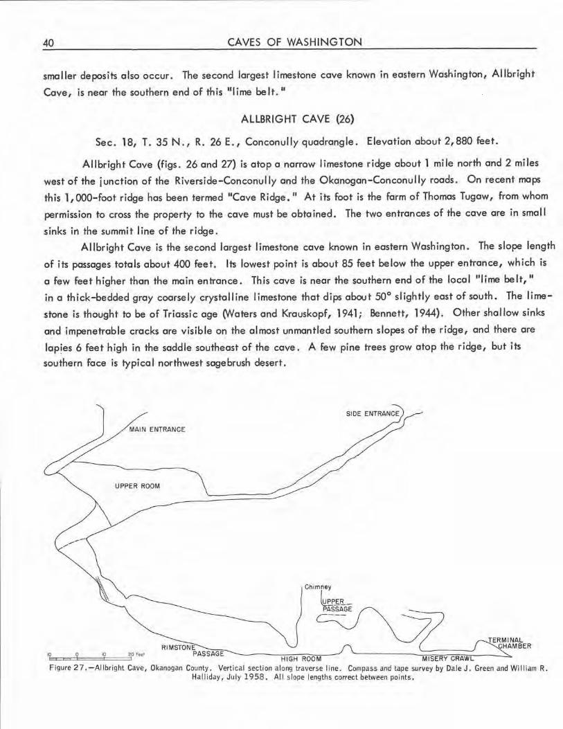
40 CAVES OF WASHINGTON
smaller deposits also occur. The second largest limestone cave known in eastern Washington, Allbright
Cave, is near the southern end of this "lime belt. 11
ALLBRIGHT CAVE (26)
Sec. 18, T. 35 N., R. 26 E., Conconully quadrangle. Elevation about 2,880 feet.
Allbright Cave (figs. 26 and 27} is atop a narrow limestone ridge about 1 mile north and 2 miles
west of the junction of the Riverside-Conconully and the Okanogan-Conconully roads. On recent maps
this 1,000-foot ridge has been termed 11Cave Ridge. 11 At its foot is the farm of Thomas Tugaw, from whom
permission to cross the property to the cave must be obtained . The two entrances of the cave are in small
sinks in the summit line of the ridge .
Allbright Cave is the second largest limestone cave known in eastern Washington. The slope length
of its passages totals about 400 feet . Its lowest point is about 85 feet below the upper entrance, which is
a few feet higher than the main entrance. This cave is near the southern end of the local "lime belt,"
in a thick-bedded gray coarsely crystal line I imestone that dips about 50° slightly east of south. The lime
stone is thought to be of Triassic age (Waters and Krauskopf, 1941 ; Bennett, 1944). Other shallow sinks
and impenetrable cracks are visible on the al most unman tied southern slopes of the ridge, and there are
lap!es 6 feet high in the saddle southeast of the cave. A few pine trees grow atop the ridge, but its
southern face is typical northwest sagebrush desert .
MAIN ENTRANCE
UPPER ROOM
10~=:::io====a:'°====f20 Fe11
Chimney
~EP£fi--PASSAGE
HI GH ROOM MISERY CRAWL
TERMI NAL CHAM BER
Figure 2 7. -Al I bright Cave, Okanogan County. Vertical section along traverse I ine. Compass and tape survey by Dale J. Green and Wi 11 iam R. Hal I iday, July 19 58 . Al I slope lengths correct between points.
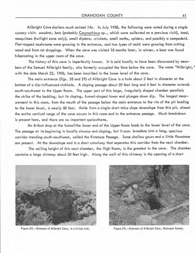
OKANOGAN COUNTY 41
Allbright Cave shelters much animal life. In July 1958, the following were noted during a single
cursory visit: woodrat, bats (probably Corynorhinus sp., which were collected on a previous visit), toad,
mosquitoes (twilight zone only), small diptera, crickets, small moths, spiders, and possibly a campodeid.
Flat-topped mushrooms were growing in the entrance, and two types of mold were growing from rotting
wood and from rat droppings. When the cave was visi ted 18 months later, in winter, a bear was found
hibernating in the upper room of the cave.
The history of this cave is imperfectly known. It is said locally to have been discovered by mem
bers of the Samuel Allbright family, who formerly occupi~d the form below the cave. The name "Allbright, 11
with the date March 22, 1903, has been inscribed in the lower level of the cave.
The main entrance (figs. 28 and 29) of Al I bright Cave is a hole about 3 feet in diameter at the
bottom of a dip-influenced sinkhole. A sloping passage about 20 feet long and 4 feet in diameter extends
south-southwest to the Upper Room. The upper part of this large, irregularly shaped chamber para I lels
the strike of the bedding, but its sloping, funnel-shaped lower end plunges down dip. The longest meas
urement in this r.oom, from the mouth of the passage below the main entrance to the rim of the pit leading
to the lower level, is nearly 80 feet. Aside from a sing le short talus slope downslope from this pit, almost
the entire vertical range of the cave occurs in th is room and in the entrance passage. Much breakdown
is present here, and there are no important speleothems.
An 8-foot drop at the funne 11 ike lower end of the Upper Room leads to the lower leve I of the cave.
The passage at its beginning is locally sinuous and sloping, but it.soon broadens into a long, spacious
corridor trending south-southwest, called the Rimstone Passage. Some shallow gours and a little flowstone
are present. At the downslope end is a short crawlway that separates this corridor from the next chamber.
The ceiling height of this next chamber, the High Room, is the greatest in the cave. The chamber
contains a large chimney about 30 feet high. Along the wall of this chimney is the opening of a short
Figure 28.-Entrance of Allbright Cave, in a hilltop sink. Figure 29. -Entrance of Allbright Cave, Okanogan County.
42 CAVES OF WASHINGTON
upper level, which is entered more conveniently by another chimney at the end of the next passage . The
floor of the High Room is level, and appears to have been deposited in quiet water. A water-level stain
is visible on the wall about a yard above the floor .
A clay bank about 3 feet high partially obstructs the entrance of the next passage, which is about
27 feet long . It is aligned with the Rimstone Passage, but is offset the breadth of the High Room. This
passage contains some small gours in which there are some small, rough pisoliths. A few tiny helictites
and some short tubular stalactites are also present.
At the downslope end of this passage a steep, bedding-plane side passage enters from the north
west. Atop a 20-foot ascent, a short upper level passage extends back to the 'large chimney mentioned
previously. A narrow opening from this bedding-plane passage also bypasses the entrance of the crawlway
at the downslope end of the section of the main passage just described.
This crawlway, Misery Crawl, about 18 inches in diameter and 20 feet long, is basically a con
tinuation of the main passage. It opens into a smal I bedding-plane-determined chamber that is the end
of the cave. A small hole at the chamber's south end serves as a swallet of a small seasonal stream, which
has left a channel in the dirt floor.
A second entrance to Allbright Cave consists of a narrow slotlike pit east of the main entrance.
It is most readily found from within the Upper Room. A low eastward extension of this room continues for
about 20 feet to the end of a narrow passage about 50 feet long, which slants down from the second en
trance. This passage contains a large quantity of rubble. A little weathered flowstone is on its walls.
The speleogens of Allbright Cave ore almost exclusively phreatic. There is a suggestion of a
steeply inclined, incised ceiling channel at the pit separating the two levels. J yst below this pit there
are a few perched remnants of a red clay fill similar to that in certain Missouri caves described by Bretz
(1956) . It is the only Washington cave in which such a red clay has been found. The vadose streams
that flushed this and other fills have not significantly modified the bedrock .
The cave developed mostly on vertical joints parallel to the strike, at successively lower levels
down dip. Development along the bedding plane and on dip and oblique joints is of lesser importance.
Breakdown has been great only in the Upper Room. Development of such a cave would seem to require
a deep phreatic circulation . Such circulation in this ridge-top cave, however, would indicate a rela
tionship of the cave either to a previous erosion cycle or to a time when the valleys on both sides of the
ridge were filled temporarily. Such·a situation conceivably might have arisen during Pleistocene glaci
ation, when there were ice-filled valleys within a few miles of Allbright Cave. However, no traces of
glacial action were noted on the ridgetop, and the cave does not show the massive fil I typical of the sub
glacial caverns of Washington, although if a cave were in proximity to the upper part of a thick glacier
instead of the lower, this fill would not necessarily be present. At this time, no conclusions can be drawn
about the relationship of Allbright Cave to Pleistocene glaciation. The cave appears wholly unrelated
to the stream (or possibly lacustrine) terraces of the surrounding valleys, which are hundreds of feet lower
than the cave.
OKANOGAN COUNTY 43
BOY SCOUT CAVE (27)
Sec. 8, T. 34N., R. 27E., Omak Lake quadrangle . Elevationaboutl,400feet.
This fissure cave in the gneissic and mylonitic facies of the Colville batholith (Waters and Krauskopf,
1941) was not examined by the Survey other than through field g lasses. It is visible from U.S. Highway
97 at a point about 4 miles north of Omak, and appears to be about 100 yards long. The cave is often
visited by local Boy Scouts, and local informants report that it consists of a deep, narrow passage with sev
eral successive vertical pitches and at least one larger chamber, entry into which requires a rope ladder.
The cave is probably the result of block slumping and (or) creep.
McLAUGHLIN CANYON CAVES (28)
Approximately sec. 33, T. 36 N., R. 27 E., Tonasket quadrangle. Elevation about 1, 800 feet.
A numberof partly roofed fissures of unusual extent are in the ridge just north of the mouth of
Mc l aughlin Canyon. The bedrock is a schistose facies of the Colville batholith, and the fissures appear
to have formed parallel to the dip and strike of the indistinct bedding, wh ich appears to dip gently to the
west. Some of the fissures are offset several feet along oblique fracture lines. Slickenslides are exposed
on several faces, and possible fault gouge was observed at one place. Nevertheless, the passages appear
to be primarily of fracture origin rather than due to faulting. Block creep and frost wedging may have
been important in their origin, which basically is a geological rather than speleological problem. Local
explanations of the origin of these fissures are varied (Anon., 1957).
The fissures and the ir caves vary in width from a few inches to many feet. Generally, those more
than 8 feet wide have lost their roofing. Vertical pitches of 20 feet are common, and some exceed 40
feet . In at least one area the fissures have formed a rectangular maze .~
Small deposits of ice were noted in some of the fissures in July 1957. N\ost of the ice was in talus.
A few smal l coralloids were the only calcareous speleothems noted. Severa l of the fissures have small
streamcourses, and one that was not visited by the Survey is locally said to contain a small lake.
MOUNT OLIVE CAVE (29) (Riverside Cave)
Sec. 36, T. 35 N., R. 26 E., Okanogan quadrangle. Elevation about 1,450 feet.
This tiny solution cavern is at the base of the low summit cliffs on the east side of N\ount Olive,
just west of Riverside. It is in a Triassic dolomite (Bennett, 1944) . Its double-barre led crawlway entrance
leads to a narrow chamber 15 feet high, 3 feet wide, and 15 feet long. This chamber contains a single
rough stalactite. The cave has been formed on a dip joint, and has the contour of a phreatic joint passage.
RlVERSIDE CAVE (See Mount Olive Cave.)
44 CAVES OF WASHINGTON
OTHER CAVES
There are local reports of a small cave in Shale Rock Point, near Omak. It was not found during
field work.
PACIFIC COUNTY
A littoral cave about 40 feet long and 15 feet in diameter at its entrance is near the Cape Disap
pointment lighthouse. The Washington State Division of Mines and Geology reports that it is in agglomerate
(written communication, 1959).
PEND OREi LLE COUNTY
The limestone deposits of Pend Oreille County are extensive, but contain relatively few known
caves. However, among limestone caves of the Pacific Northwest only the extensive Nakimu Caves of
British Columbia, 120 miles to the north, and Oregon Cave, near the Oregon-California border, exceed
the size of Gardner Cave. In this county other caves have been intersected in mines near Metaline Falls.
CRAWFORD CAVE (See Gardner Cave.)
GARDNER CAVE (30) (Crawford Cave, Lost Cave)
Sec. 4, T. 40N., R. 43E., Metaline quadrangle. Elevationabout2,900feet.
With a total slope length of about 1,050 feet, Gardner Cave (pl. l) is the largest limestone cave
in Washington. If the extreme southwest and southeast, respectively, of Oregon and Idaho are excluded,
this cave is the largest in the entire area of these three states. Since it is about half a mi le from the
Canadian border, it is probably the northernmost limestone cave in the contiguous part of the United
States. The cave is the feature of Crawford State Park, and was partially developed as a tourist attraction
in 1959. It is easily accessible, and has undergone considerable vandalism.
Gardner Cave is entered through a collapse sink atop a small hill in a densely forested area north
west of Z Canyon. The cave is reached by a dirt road that leaves State Highway 6 at the northern town
limits of Metaline. About 10 miles to the north, a side road leads north for 0.4 mile to a parking area.
A good trail continues north up the hill for about 200 yards to the main entrance of the cave.
The cave is in the Metaline Limestone, a thick-bedded formation of Cambrian age. Geologic
maps of the area indicate that the bedding dips about 21 ° SW. {Park and Cannon, 1943), but in the
entrance passage the dip appears to be slightly greater. The entrance passage parallels the strike, and has
a hanging wall ceiling. Argillaceous impurities are exposed in several places in this section of the cave.
No other karstic phenomena have been observed in the cave area, perhaps in part because of the
dense forest. The cave is at a relatively low altitude, and the climate is generally mild despite rather
PEND OREILLE COUNTY 45
severe winters. It is in foothills that have been subjected to much glacial activity, as discussed on page
48,
The history of Gordner Cave is not known sat isfactorily . Contemporary accounts indicate that the
cave was discovered in the summer of 1903 by Ed Gardner, who homesteaded a quarter section near the
cave (Steele, 1904; Anon . , 19180, 1918b). About 200 feet from the entrance, however, ore two nearly
illegible inscriptions with dates 1883 and 1888 . The quarter section around the cave was later acquired
by W. H. Crowford, a Metaline merchant. In October 1921, he deeded the 40 acres surrounding the
cave to the State for a State Park (Dingee, 1930).
Gordner Cave is of geological rather than biological importance. In contrast with the teeming
life of wormer Allbright Cave, in Okanogan County, Gardner Cave seems almost sterile. Aside from the
entrance zone, where moss, small-leafed plants, and a porcupine were observed, the only features of
biole1g ical interest noted in the cave were some tiny diptera, mold on rotting wooden steps, and a different
type of mold on rat droppings in the first 300 feet of the cave.
The main entrance of Gardner Cave is a vertical collapse sink about 10 feet wide and 12 feet deep.
A wooden ladder extends to the floor of the broad passage below. About 50 feet to the north is a smaller,
partially blocked second entrance, also in a collapse sink. The entire 820-foot length of the main passage
slopes downward at a surprisingly uniform angle of about 25°, although small local variations make this
less evident in the cave than on the map .
The high, broad section of the cave immediately downslope from the main entrance terminates at
a flowstone-splashed cliff about 50 feet south of the entrance, The rock cover over this part of the cave
is very thin, and a section of trail crossing it is resonant underfoot .
The next 120 feet of cavern consists of a h igh, fairly broad passage that is aligned from north to
south. Its walls ore richly decorated with flowstone, which appears to consist of both calcite ond -moon
milk. The latter is particularly prominent at the upper end of this section .
Several small stream channels open into this passage. The largest enters from the east at the bend
at the lower end of this section. Near this junction, several wide-based stalactites on a low overhang
have been truncated at on old water level. Prominent on the ceiling is an incised channel, which can be
traced to The Narrows, 200 feet beyond the end of th is section of the cave. At The Narrows, th is ceiling
channel forms the entire upper half of the passage. It is one of the most prominent features of the cave,
and is not limited to horizontal and near-horizontal sections of the ceiling; in several places it is inclined
quite steeply. The channel was carved by the flow of a stream atop fill that almost completely filled the
cave. The stream must have completely filled the tube that it occupied and enlarged.
Beyond the bend mentioned in the previous paragraph, the next 120 feet of the cave extends
southwest, and is similar in dimensions to the passage just described. It is featured by the presence of enor
mous gours (rimstone pools), and large dripstone and flowstone accumulations (fig. 30) that narrow the
passage in several places. A large column (fig . 31) in the center of the passage near the lower end of
this section is the most spectacular single speleothem in the Pacific Northwest. Unfortunately, it has
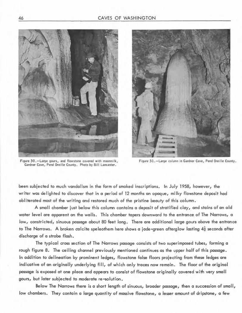
46 CAVES OF WASHINGTON
Figure 30. -Large gours, and flowstone covered with moonmi lk, Gardner Cave, Pend Oreille County. Photo by Bil l Lancaster.
Figure 31.-Large column in Gardner Cave, Pend Oreil le County.
been subjected to much vandalism in the form of smoked inscriptions. In July 1958, however, the
writer was delighted to discover that in a period of 12 months an opaque, milky flowstone deposit had
obliterated most of the writing and restored much of the pristine beauty of this column.
A small chamber just below th is column contains a deposit of stratified cloy, and stains of an old
water level are apparent on the walls. This chamber tapers downward to the entrance of The Narrows, a
low, constricted, sinuous passage about 80 feet long. There are additional large gours above the entrance
to The Narrows. A broken calcite speleothem here shows a jade-green afterglow lasting 4! seconds after
discharge of a strobe flash.
The typical cross section of The Narrows passage consists of two superimposed tubes, forming a
rough figure 8. The ceiling channel previously mentioned continues as the upper half of this passage.
In addition to delineation by prominent ledges, flowstone false floors projecting from these ledges are
indicative of an originally underlying fill, of which only traces now remain. The floor of the original
passage is exposed at one place and appears to consist of flowstone originally covered with very sma II
gours, but later subjected to moderate re-solution.
Below The Narrows there is a short length of sinuous, broader passage, then a succession of small,
low chambers. They contain a large quantity of massive flowstone, a lesser amount of dripstone, a few
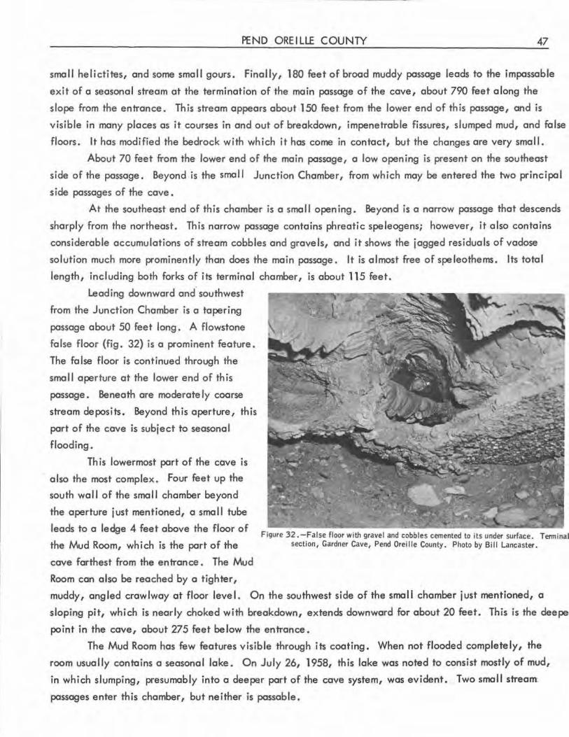
PEND OREILLE COUNTY 47
small helictites, and some small gours. Finally, 180 feet of broad muddy passage leads to the impassable
exit of a seasonal stream at the termination of the main passage of the cave, about 790 feet along the
slope from the entrance. This stream appears about 150 feet from the lower end of this passage, and is
visible in many places as it courses in and out of breakdown, impenetrable fissures, slumped mud, and false
floors. It has modified the bedrock with which it has come in contact, but the changes are very small.
About 70 feet from the lower end of the main passage, a low opening is present on the southeast
side of the passage. Beyond is the smal I Junction Chamber, from which may be entered the two principal
side passages of the cave •
At the southeast end of this chamber is a smal l opening. Beyond is a narrow passage that descends
sharply from the northeast. This narrow passage contains phreatic speleogens; however, it also contains
considerable accumulations of stream cobbles and grave ls, and it shows the jagged residuals of vadose
solution much more prominently than does the main passage. It is almost free of speleothems. Its total
length, including both forks of its terminal chamber, is about 115 feet.
Leading downward and° southwest
from the Junction Chamber is a tapering
passage about 50 feet long . A flowstone
false floor (fig. 32) is a prominent feature.
The false floor is continued through the
sma 11 aperture at the lower end of th is
passage. Beneath are moderately coarse
stream deposits . Beyond this aperture, this
part of the cave is subject to seasonal
flooding.
Th is lowermost part of the cave is
also the most complex. Four feet up the
south wall of the small chamber beyond
the aperture just mentioned, a sma II tube
leads to a ledge 4 feet above the floor of
the Mud Room, which is the part of the
cave farthest from the entrance. The Mud
Room can also be reached by a tighter,
Figure 32 .-False floor with gravel and cobbles cemented to its under surface. Terminal section, Gardner Cave, Pend Oreille County. Photo by Bill Lancaster.
muddy, angled crawlway at floor level. On the southwest side of the small chamber just mentioned, a
sloping pit, which is nearly choked with breakdown, extends downward for about 20 feet. This is the deepe
point in the cave, about 275 feet below the entrance.
The Mud Room has few features visible through its coating. When not flooded completely, the
room usually contains a seasonal lake. On July 26, 1958, this lake was noted to consist mostly of mud,
in which slumping, presumably into a deeper part of the cave system, was evident. Two small stream
passages enter th is chamber, but neither is passable.
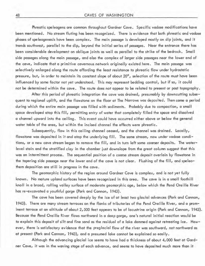
48 CAVES OF WASHINGTON
Phreatic speleogens are common throughout Gardner Cave. Specific vadose modifications have
been mentioned. No stream fluting has been recognized. There is evidence that both phreatic and vadose
phases of speleogenesjs have been complex. The main passage is developed mostly on dip joints, and it
trends southwest, parallel to the dip, beyond the initial series of passages. Near the entrance there hos
been considerable development on oblique joints as well as parallel to the strike of the bedrock. Small
side passages along the main passage, and also the complex of larger side passages near the lower end of
the cave, indicate that a primitive cavernous network originally existed here. The main passage was
selectively enlarged along the route affording the least resistance to phreatic flow under hydrostatic
pressure, but, in order to maintain its constant slope of about 20°, selection of the route must have been
influenced by some factor not yet understood. This may represent bedding control, but if so, it could
not be determined within the cave . The route does not appear to be related to present or past topography.
After this period of phreatic integration the cave was drained, presumably by downcutting subse
quent to regional uplift, and the flowstone on the floor at The Narrows was deposited . Then came a period
during which the entire main passage was filled with sediments. Probably due to compaction, a small
space developed atop this fill, permitting entry of water that completely filled the space and dissolved
a channel upward into the ceil ing. This event could have occurred either above or below the general
water table of the area, but within the incised channel the effects were phreatic.
Subsequently, flow in this ceiling channel ceased, and the channel was drained. Locally,
flowstone was deposited in it and atop the underlying fi II. The some stream, now under vadose condi
tions, or a new cove stream began to remove the fill, and in turn left some coarser deposits. The water
level stain and the stratified clay in the chamber just downslope from the great column suggest that this
was an intermittent process. The sequential position of a coarse stream deposit overlain by flowstone in
the tapering side passage near the lower end of the cave is not clear. Flushing of the fill, and speleo
them deposition are still in progress in the cave.
The geomorph i c history of the reg ion around Gordner Cave is complex, and is not yet fully
known. No mature upland surfaces hove been recognized in this area. The cave is in a small foothill
knoll in a broad, rolling valley surface of moderate geomorphic age, below which the Pend Orei lie River
hos re-excavated a youthful gorge (Park and Cannon, 1943).
The cave hos been covered deeply by the ice of at least two glacial advances (Pork and Cannon,
1943). There are many stream terraces on the flanks of tributaries of the Pend Oreille River, and a prom
inent terrace at an altitude of about 2,500 feet appears to be of locustrine origin {Park and Cannon, 1943).
Because the Pend Oreille River flows northward in a deep gorge, one's natural initial reaction would be
to explain this deposit of silt and fine sand as the residual of a lake dammed against retreating ice. How
ever, there is satisfactory evidence that the preg lacial flow of the river was southward, not northward as
at present (Pork and Cannon, 1943), and a presumed lake cannot be explained so easily .
Although the advancing glacial ice seems to have had a thickness of about 4,000 feet at Gard
ner Cove, it was in the woning stage of each advance, and seems to hove deposited much more than it
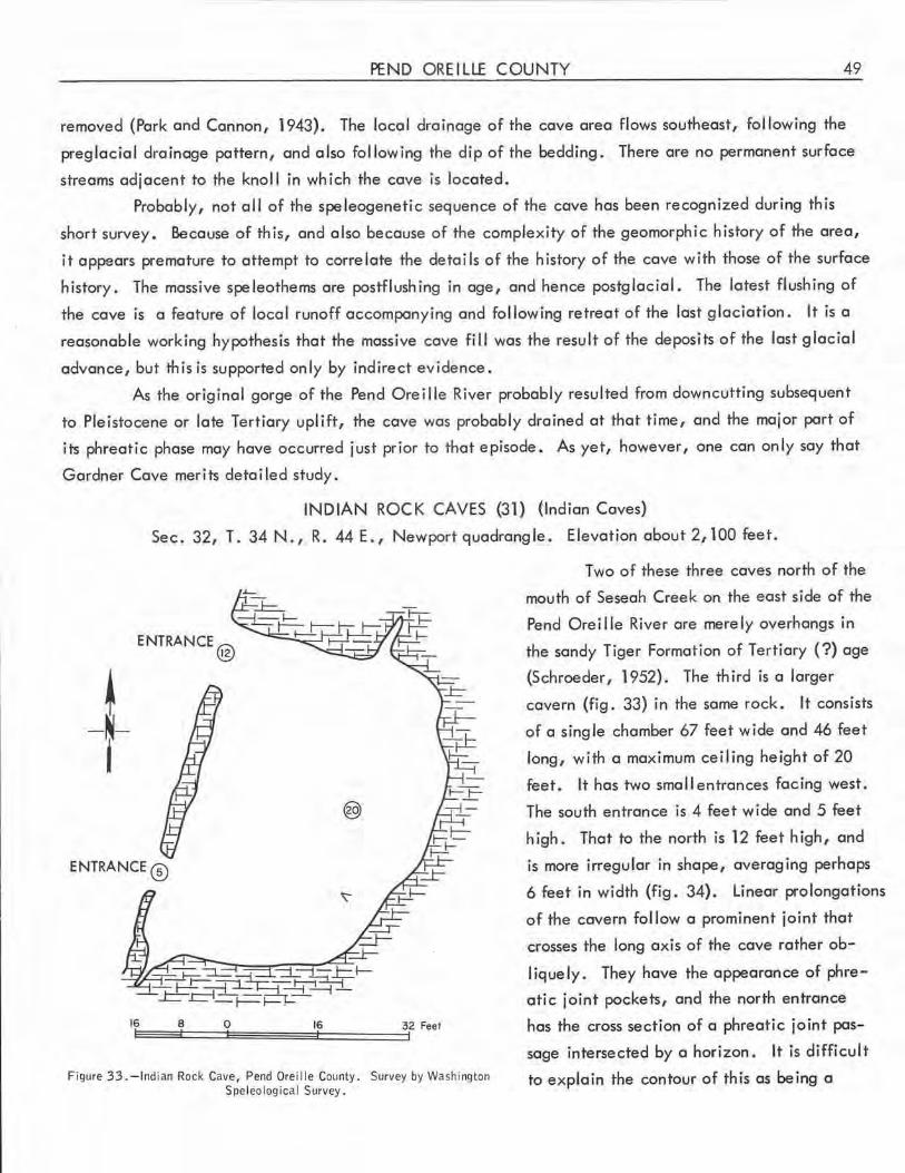
PEND OREILLE COUNTY 49
removed (Park and Cannon, 1943). The local drainage of the cave area flows southeast, fol lowing the
preglacial drainage pattern, and also following the dip of the bedding. There are no permanent surface
streams adjacent to the knoll in which the cave is located.
Probably, not all of the speleogenetic sequence of the cave has been recognized during this
short survey. Because of this, and also because of the complexity of the geomorphic history of the area,
it appears premature to attempt to correlate the detai ls of the history of the cave with those of the surface
history. The massive spe leothems are postflushing in age, and hence postglacial. The latest flushing of
the cave is a feature of local runoff accompanying and following retreat of the last glaciation. It is a
reasonable working hypothesis that the massive cave fill was the result of the deposits of the last glacial
advance, but this is supported only by indirect evidence.
As the original gorge of the Pend Oreille River probably resulted from downcutting subsequent
to Pleistocene or late Tertiary uplift, the cave was probably drained at that time, and the major part of
its phreatic phase may have occurred just prior to that episode. As yet, however, one can only say that
Gardner Cave merits detailed study.
INDIAN ROCK CAVES (31) (Indian Caves)
Sec. 32, T. 34N., R. 44E., Newport quadrangle. Elevationabout2,100feet.
~ - ~j
ENTRANCE @
16E::::::~:38::=::=::10~~~~=16t=::=::=::=:::::f32 Feet
Figure 33.-lndian Rock Cave, Pend Oreille County . Survey by Washington Speleo logical Survey.
Two of these three caves north of the
mouth of Seseah Creek on the east side of the
Pend Orei I le River are merely overhangs in
the sandy Tiger Formation of Tertiary (?)age
(Schroeder, 1952). The third is a larger
cavern (fig. 33) in the same rock. It consists
of a single chamber 67 feet wide and 46 feet
long, with a maximum ceiling height of 20
feet. It has two small entrances facing west.
The south entrance is 4 feet wide and 5 feet
high . That to the north is 12 feet high, and
is more irregular in shape, averaging perhaps
6 feet in width (fig. 34). Linear prolongations
of the cavern follow a prominent joint that
crosses the long axis of the cave rather ob:-
l ique ly. They have the appearance of phre
atic joint pockets, and the north entrance
has the cross section of a phreatic joint pas
sage intersected by a horizon. It is difficult
to explain the contour of this as being a
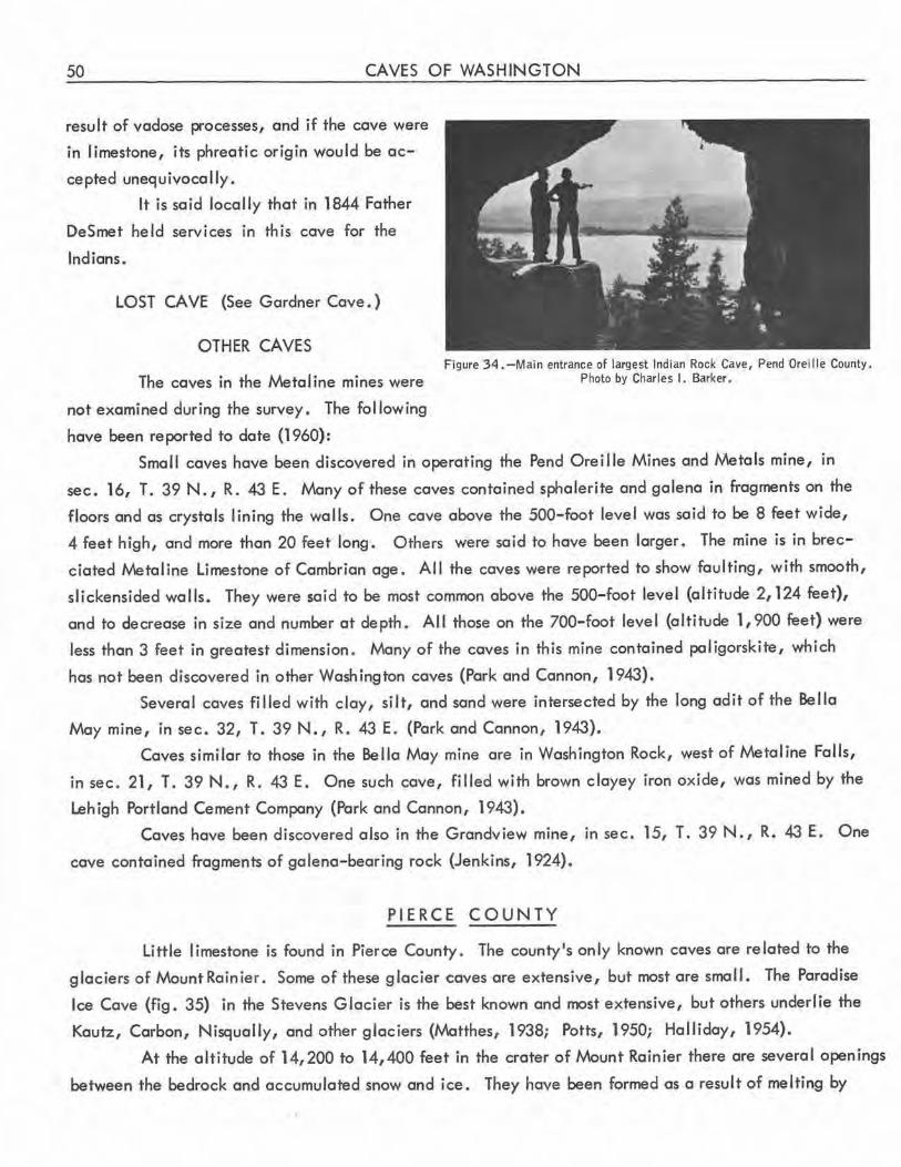
50 CAVES OF WASHINGTON
result of vadose processes, and if the cave were
in I imestone, its phreatic origin would be ac
cepted unequivocally.
It is said locally that in 1844 Father
DeSmet held services in this cave for the
Indians.
LOST CAVE (See Gardner Cave.)
OTHER CAVES Figure 34.-Main entrance of largest Indian Rock Cave, Pend Oreille County .
The caves in the Metaline mines were Photo by Charles I. Barker.
not examined during the survey. The following
have been reported to date (1960):
Small caves have been discovered in operating the Pend Oreille Mines and Metals mine, in
sec. 16, T. 39 N., R. 43 E. Many of these caves contained sphalerite and galena in fragments on the
floors and as crystals lining the walls. One cave above the 500-foot level was said to be 8 feet wide,
4 feet high, and more than 20 feet long. Others were said to have been larger. The mine is in brec
ciated Metaline Limestone of Cambrian age. All the caves were reported to show faulting, with smooth,
slickensided walls. They were said to be most common above the 500-foot level (altitude 2, 124 feet),
and to decrease in size and number at depth. All those on the 700-foot level (altitude 1,900 feet) were
less than 3 feet in greatest dimension. Many of the caves in this mine contained paligorskite, which
has not been discovered in other Washington caves (Park and Cannon, 1943).
Several caves filled with clay, silt, and sand were intersected by the long adit of the Bella
May mine, in sec. 32, T. 39N., R. 43E. (Park and Cannon, 1943).
Caves similar to those in the Bella May mine are in Washington Rock, west of Metaline Falls,
in sec. 21, T. 39 N., R. 43 E. One such cave, filled with brown clayey iron oxide, was mined by the
Lehigh Portland Cement Company (Park and Cannon, 1943).
Caves have been discovered also in the Grandview mine, in sec . 15, T. 39 N., R. 43 E. One
cave contained fragments of galena-bearing rock (Jenkins, 1924).
PIERCE COUNTY
Little limestone is found in Pierce County . The county's only known caves are related to the
glaciers of Mount Rainier. Some of these glacier caves are extensive, but most are small. The Paradise
Ice Cave (fig. 35) in the Stevens Glacier is the best known and most extensive, but others underlie the
Kautz, Carbon, Nisqually, and other glaciers (Matthes, 1938; Potts, 1950; Halliday, 1954).
At the altitude of 14,200 to 14,400 feet in the crater of Mount Rainier there are several openings
between the bedrock and accumulated snow and ice. They have been formed as a result of melting by
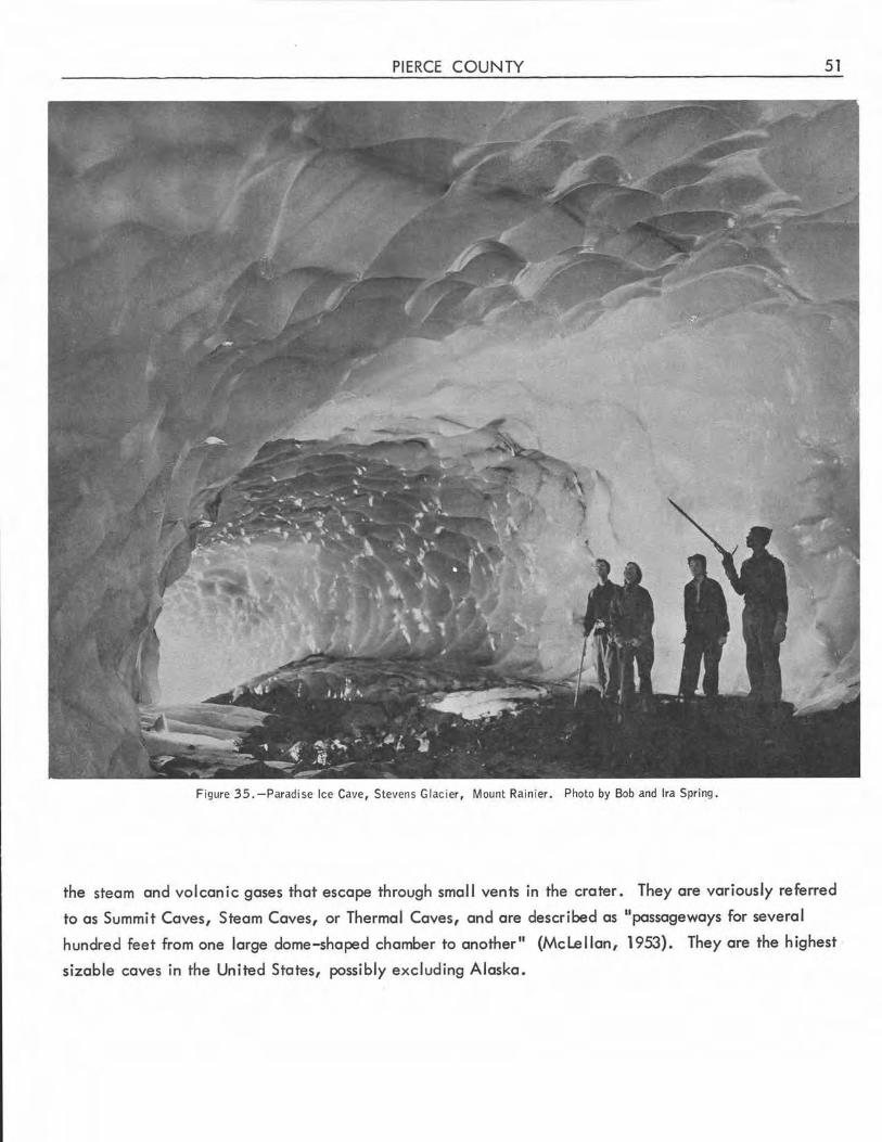
PIERCE COUNTY 51
Figure 35.-Paradise Ice Cave, Stevens Glacier, Mount Rainier. Photo by Bob and Ira Spring.
the steam and volcanic gases that escape through small vents in the crater. They are variously referred
to as Summit Caves, Steam Caves, or Thermal Caves, and are described as "passageways for several
hundred feet from one large dome-shaped chamber to another" (Mclellan, 1953). They are the highest
sizable caves in the United States, possibly excluding Alaska.
52 CAVES OF WASHINGTON
SAN JUAN COUNTY
Several types of caves, including littoral caves in various rocks, and solution caves in the nu
merous small limestone lenses of the islands, have been discovered in San Juan County. These I imestones
are believed to be of Devonian, Carboniferous, and Triassic age {Mclellan, 1927), and have been sub
jected to so much metamorphism that the dip and strike of the original beds can be determined only rarely.
The limestone caves of these islands are the lowest known in the western United States, possibly exclu
sive of Hawaii {Halliday, 1958) and Alaska {Hackman, 1949). Local stratigraphy and geomorphology
are complex. Multiple periods of glaciation and marine erosion have occurred. Although these caves
are relatively small, their features include indications of early random tridimensional joint-controlled
solution with subsequent shallow sub-water-table integration by selective flow. In this report each island
will be listed separately for geographic reasons. To date, it has not been possible to locate the "narrow
cave of fault origin, several hundred feet long" mentioned by Junius Henderson (1932) as being some
where in the San Juan Islands. Neither Henderson's published works nor his field notes at the University
of Colorado (Hugo Rodeck, written communication, 195.1) indicate its location more exactly, and no
cave resembling this description has been located by the Survey.
Guemes Island
There is at least one littoral cave on the east coast of Gue mes Island 0/V. R. Danner, oral
communication).
Henry Island
Littoral caves 20 to 40 feet long on the two south ends of Henry Island have been visited by
members of the Washington Foldboat Club.
Jones Island
In a deposit of limestone at tide level on the north side of the isthmus of Jones Island, water
gurgling in an inner chamber may be heard through cracks that show solutional features 0/V. R. Danner,
oral communication).
Lopez Island
tv\embers of the Washington Foldboat Club have noted the presence of littoral caves on the south
end of Lopez Island.
Orcas Island
Lenses of limestone occur in considerable numbers on Orcas Island, particularly in its west
central part. Originally, these lenses were considered as being in the Orcas Group of the San Juan Series
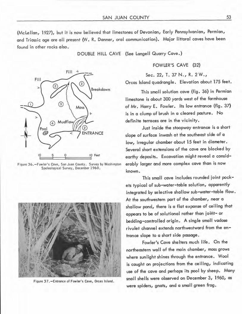
SAN JUAN COUNTY 53
(Mclellan, 1927), but it is now believed that limestones of Devonian, Early Pennsylvanian, Permian,
and Triassic age are all present (:Iv. R. Danner, oral communication). Major littoral caves have been
found in other rocks also .
DOUBLE HILL CAVE (See Langell Quarry Cave.)
~ ©
-N-i
10 5 0 10 Feet
Figure 36. - Fowler's Cave, San Juan County. Survey by Washington Speleological Survey, December 1960.
Figure 3 7. -Entrance of Fowler's Cave, Orcas Island .
FOWLER'S CAVE (32)
Sec. 22, T. 37 N., R. 2 W.,
Orcas Island quadrangle . Elevation about 175 feet.
This small solution cave (fig. 36) in Permian
limestone is about 300 yards west of the farmhouse
of Mr. Harry E. Fowler. Its low entrance (fig. 37)
is in a clump of brush in a cleared pasture . No
defin ite terraces are in the vicinity.
Just inside the stoopway entrance is a short
slope of surface inwash at the southeast side of a
low, irregular chamber about 15 feet in diameter .
Several short extensions of the cave are blocked by
earthy deposits. Excavation might reveal a consid
erably larger and more complex cave than is now
known.
This small cave includes rounded joint pock
ets typical of sub-water-table solution, apparently
integrated by selective shallow sub-water-table flow.
At the southwestern part of the chamber, near a
shallow pond, there is a flat expanse of ceiling that
appears to be of solutional rather than joint- or
bedding-controlled origin. A single small vadose
rivulet channel extends northwestward from the en
trance slope to a short side passage.
Fowler's Cave shelters much life. On the
northeastern wa II of the main chamber, moss grows
where sunlight shines through the entrance. Wool
is caught on projections from the ceiling, indicating
use of. the cave and perhaps its pool by sheep. Many
snail shells were observed on December 3, 1960, as
were spiders, gnats, and a smal I green frog.
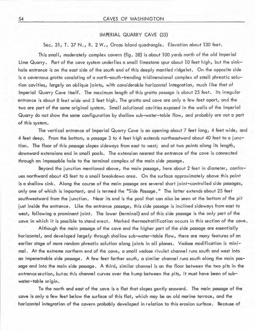
54 CAVES OF WASHINGTON
IMPERIAL QUARRY CAVE (33)
Sec. 31, T. 37 N., R. 2 W., Orcas Island quadrangle. Elevation about 130 feet.
This small, moderately complex cavern (fig. 38) is about 100 yards north of the old Imperial
Lime Quarry. Part of the cave system underlies a small limestone spur about 10 feet high, but the sink
hole entrance is on the east side of the south end of this deeply mantled ridge let. On the opposite side
is a cavernous grotto consisting of a north-south-trending tridimensional complex of small phreatic solu
tion cavities, largely on oblique joints, with considerable horizontal integration, much like that of
Imperial Quarry Cove itself. The maximum length of this grotto passage is about 25 feet. Its irregular
entrance is about 8 feet wide and 3 feet high. The grotto and cave are only a few feet apart, and the
two ore port of the same original system. Small solutional cavities exposed in the walls of the Imperial
Quarry do not show the same configuration by shallow sub-water-table flow, and probably ore not o port
of this system.
The vertical entrance of Imperial Quarry Cave is an opening about 7 feet long, 4 feet wide, and
4 feet deep. From the bottom, a passage 3 to 4 feet high extends northeastward about 40 feet to a j unc
tion. The floor of this passage slopes sideways from east to west; and at two points along its length,
downward extensions end in small pools. The extension nearest the entrance of the cave is connected
through an impassable hole to the terminal complex of the main side passage.
Beyond the junction mentioned above, the main passage, here about 2 feet in diameter, contin
ues northward about 45 feet to a small breakdown area. On the surface approximately above this point
is a shallow sink. Along the course of the main passage are several short joint-controlled side passages,
only one of which is important, and is termed the "Side Passage. 11 The latter extends about 25 feet
southwestward from the junction. Near its end is the pool that can also be seen at the bottom of the pit
j_ust inside the entrance. Like the entrance passage, this side passage is inclined sideways from east to
west, following a prominent joint. The lower (terminal) end of this side passage is the only part of the
cave in which it is possible to stand erect. Marked thermostratification occurs in this section of the cave.
Although the main passage of the cave and the higher port of the side passage are essentially
horizontal, and developed largely through shallow sub-water-table flow, there are many features of an
earlier stage of more random phreatic solution along joints in all planes. Vadose modification is mini
mal . At the extreme northern end of the cave, a small vadose rivulet channel runs south and west into
an impenetrable side passage. A few feet farther south, a similar channel runs south along the main pas
sage and into the main side passage. A third, similar channel is on the floor between the two pits in the
entrance section, but as this channel curves over the hump between the pits, it must have been of sub
water-table origin.
To the north and east of the cave is a flat that slopes gently seaward. The main passage of the
cave is only a few feet below the surface of this flat, which may be an old marine terrace, and the
horizontal integration of the cavern probably developed in relation to this erosion surface. Because of
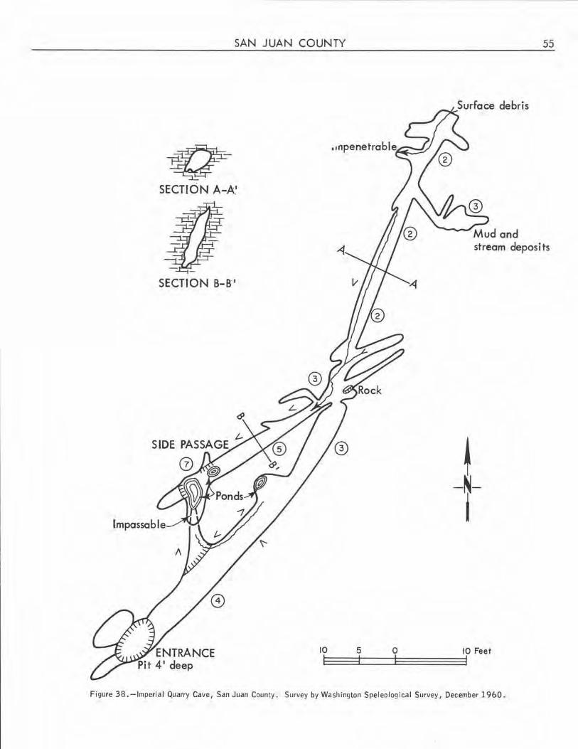
SAN JUAN COUNTY
-q SECTION A-A.'
SECTION B-B I
SIDE PASSAGE
Ci)
ENTRANCE Pit 4 1 deep
10
55
stream deposits
! -N-i
5 0 10 Feet
Figure 38. -Imperial Quarry Cave, San Juan County. Survey by Washington Speleological Survey, December 1960.
56 CAVES OF WASH INGTON
accumulated fi II in both the cave and the nearby grotto, it is not possible to determine the total depth
of sub-water-table solution at this locality.
On December 3, 1960, a considerable biota was noted, including many mosquitoes and spiders.
Speleothems were almost ni I, although a few patches of what appeared to be dry moonmi lk were noted .
LANGE LL QUARRY CAVE (34) (Double Hi II Cave)
Sec. 15, T. 37 N., R. 2 W., Orcas Island quadrangle. Elevation about 475 feet.
This small solution cavern (fig . 39) was intersected by minor quarrying in the saddle between
Lookout Mountain and Double Hill. Because of very dense brush, the little quarry is almost impossible
to find without a guide.
Most of the cave consists of a fairly brood crawlway leading westward from the partially blocked
entrance. There is a gentle upward slope from the entrance to the rear of the cave except at about the
midpoint, where there is a 2-foot shelf. At about this same place, the cei ling contour changes from a
flat water-table-determined pattern in the entrance section to a rounded phreatic pattern seen toward the
rear of the cave.
~ -~-
I
ENTRANCE
Figure 39. -Langel I Quarry Cave, San Juan County. Compass and tape survey by Washington Speleological Survey, 1961.
SAN JUAN COUNTY 57
Joint control is marked, and there are several side crawlways. Most of the ceiling and wall
surfaces ore covered with small flutes. No speleothems are present, but thin veinlets and larger masses
of noncalcareous impurities are prominent. In one side passage a steeply inclined vadose stream channel
enters through a pre-existing vertical solution tube . Most of the main passage is floored by silt that has
dried, leaving mud cracks on its surface. In the center is a channel in the si lt, but this may have been
produced by earlier explorers rather than by currents. Many roots and a moderate biota were observed.
There is some evidence that the cave fills to the level of the horizontal ceiling with the seasonal rise of
the local water table. The cave was studied during a time of unusual drouth.
The cave is near the base of a low knoll, which rises about 25 feet from a small area of gentle
topography perched above the steep slopes leading down to Fishing Bay. Development of the cave appears
to have been related to local ground-water conditions, with initial semirandom solution along joints,
fol lowed by shallow sub-water-table integration, and current or very recent modification in the zone of
fluctuation of the water table.
ORKILA CAVE {See Point Doughty Cave.)
POINT DOUGHTY CAVE (35) (Orkila Cave)
This small but well-known littoral cave is on the first small point southeast of Point Doughty, at
the northwest end of Orcas Island. It was developed by differential erosion along the strike of a formation
of thin-bedded shale and conglomerate that dips about 60° southward. Slumping of the hanging wall has
occurred at several places.
The cave is basically an angled slot 2 to 4 feet wide, having seaward and landward en1Tances.
The lowest part of the slot is within the tidal zone. Although the seaward entrance is blocked with. break
down, it permits entry of considerable illumination. The lower part of the cave slopes upward for about
30 feet, to a point where a vertica l pitch of about 10 feet separates the 20-foot landward part from the
seaward part of the cave. The cl ifftop (main) entrance is about 20 feet long, although partially blocked
by a large rock. Only a small part of the cave is in total darkness . Spiders and insects were noted in
July 1959, but no marine life was found. Tiny gours are present on the sloping lower wall of the cave .
OTHER CAVES
Other littoral caves occur southwest of West Beach 0/v. R. Danner, oral communication), and
reportedly elsewhere on the island. Quarry personnel state that solution caverns were encountered on
the shale-limestone contact at the Flaherty quarry, but no longer are present, and that a cave was en
countered at the south end of Dolphin Bay Quarry No . 3, but is now blocked.
A small vertical pit is in limestone near the new north shore road in sec. 17, T. 37 N., R. 1 W.
0/v. R. Danner, oral communication). There are local reports of limestone caves elsewhere on Orcas
Island, but no authentic information has been obtained about them.
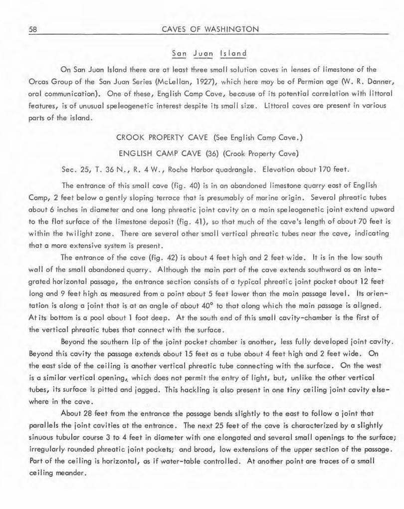
58 CAVES OF WASHINGTON
San Juan Island
On San Juan Island there are at least three small sol ution coves in lenses of limestone of the
Orcos Group of the Son Juan Series (Mc lei Ion, 1927), which here may be of Permian age (W. R. Danner,
oral communication). One of these, English Camp Cave, because of its potential correlation with littoral
features, is of unusual speleogenetic interest despite its small size. Littoral caves are present in various
parts of the island.
CROOK PROPERTY CAVE (See English Comp Cave.)
ENGLISH CAMP CAVE (36) (Crook Property Cave)
Sec. 25, T. 36N .. , R. 4W., Roche Harbor quadrangle. Elevationabout170feet.
The entrance of this small cave (fig. 40) is in on abandoned limestone quarry east of English
Camp, 2 feet below a gently sloping terrace that is presumably of marine origin . Several phreatic tubes
about 6 inches in diameter and one long phreatic joint cavity on a main spe leogenetic joint extend upward
to the flat surface of the limestone deposit (fig. 41), so that much of the cave's length of about 70 feet is
within the twilight zone. There are several other small vertical phreatic tubes near the cave, indicating
that a more extensive system is present.
The entrance of the cave (fig. 42) is about 4 feet high and 2 feet wide. It is in the low south
wall of the small abandoned quarry. Although the main part of the cave extends southward as an inte
grated horizontal passage, the entrance section consists of a typical phreati c joint pocket about 12 feet
long and 9 feet high as measured from a point about 5 feet lower than the main passage level. Its orien
tation is along a joint that is at an angle of about 40° to that along which the main passage is aligned.
At its· bottom is a pool about 1 foot deep. At the south end of this small cavity-chamber is the first of
the vertical phreatic tubes that connect with the surface.
Beyond the southern lip of the joint pocket chamber is another, less fully developed joint cavity.
Beyond this cavity the passage extends about 15 feet as a tube about 4 feet high and 2 feet wide. On
the east side of the ceiling is another vertical phreatic tube connecting with the surface. On the west
is a similar ve rtica l opening,, which does not permit the entry of light, but, unlike the other vertical
tubes, its surface is pitted and jagged . This hackling is also present in one tiny ceiling joint cavity else
where in the cave.
About 28 feet from the entrance the passage bends sl ightly to the east to follow a joint that
parallels the joint cavities at the entrance. The next 25 feet of the cave is characterized by a slightly
sinuous tubular course 3 to 4 feet in diameter with one elongated and several small openings to the surface;
irregularly rounded phreatic joint pockets; and broad, low extensions of the upper section of the passage.
Part of the ceiling is horizontal, as if water-table controlled. At another point ore traces of a smal I
ceiling meander .
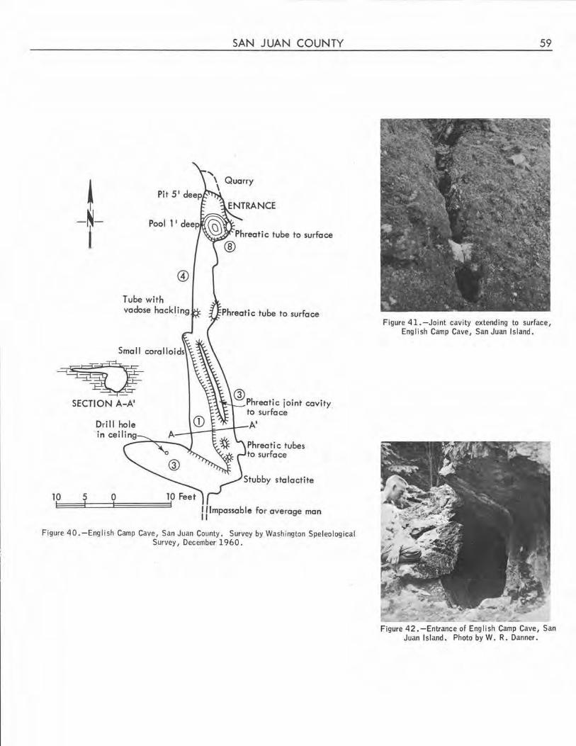
@
Tube with vadose hack[ing
~v SECTION A-A'
10 5 0
SAN JUAN COUNTY
Quarry
@ Ph t' · · · rea 1c 101nt cavity to surface
A'
Phreatic tubes to surface
Stubby stalactite
I !Impassable for average man 11
Figure 40.-English Camp Cave, San Juan County. Survey by Washington Speleological Survey, December 1960.
59
Figure 41.-Joint cavity extending to surface, English Camp Cave, San Juan Island.
Figure 42 .-Entrance of English Camp Cave, San Juan Island. Photo by W. R. Danner.
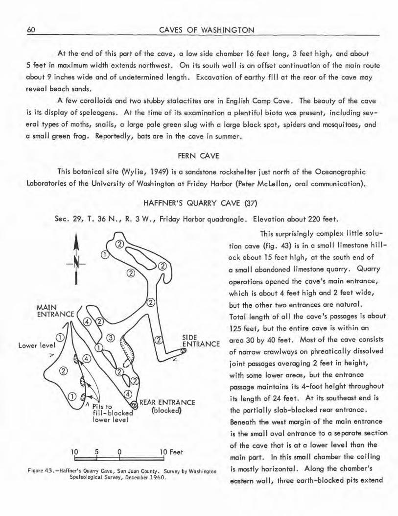
60 CAVES OF WASHINGTON
At the end of this port of the cave, a low side chamber 16 feet long, 3 feet high, and about
5 feet in maximum width extends northwest. On its south wall is an offset continuation of the main route
about 9 inches wide and of undetermined length. Excavation of earthy fill at the rear of the cave may
revea I beach sands.
A few coralloids and two stubby stalactites are in English Camp Cave. The beauty of the cave
is its display of speleogens. At the time of its examination a plentiful biota was present, including sev
eral types of moths, snails, a large pole green sJug with a large black spot, spiders and mosquitoes, and
a small green frog. Reportedly, bats are in the cave in summer.
FERN CAVE
This botanical site (Wylie, 1949) is a sandstone rockshelter just north of the Oceanographic
Laboratories of the University of Washington at Friday Harbor (Peter Mclellan, oral communication).
HAFFNER 1S QUARRY CAVE (37)
Sec. 29, T. 36 N., R. 3 W., Friday Harbor quadrangle. Elevation about 220 feet.
10
4
SIDE ENTRANCE
I\ Pits to !.'D REAR ENTRANCE fi 11- blocked (blocked) lower level
5 0 10 Feet
Figure 43. -Haffner's Quarry Cave, San Juan County. Survey by Washington Speleological Survey, December 1960.
This surprisingly complex little solu
tion cave (fig. 43) is in a smal I limestone hi I l
ock about 15 feet high, at the south end of
a smal I abandoned limestone quarry. Quarry
operations opened the cave's main entrance,
which is about 4 feet high and 2 feet wide,
but the other two entrances are natural.
Total length of all the cave's passages is about
125 feet, but the entire cave is within an
area 30 by 40 feet. Most of the cave consists
of narrow crawl ways on phreatical ly dissolved
joint passages averaging 2 feet in height,
with some lower areas, but the entrance
passage maintains its 4-foot height throughout
its length of 24 feet. At its southeast end is
the portia I ly slab-blocked rear entrance.
Beneath the west margin of the main entrance
is the small oval entrance to a separate section
of the cave that is at a lower leve I than the
main port. In this small chamber the ceiling
is mostly horizontal. Along the chamber's
eastern wall, three earth-blocked pits extend
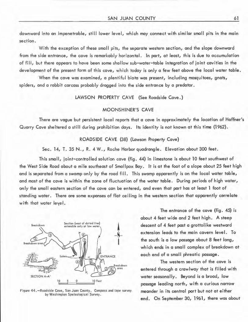
SAN JUAN COUNTY 61
downward into an impenetrable, still lower level, which may connect with similar small pits in the main
section.
With the exception of these smal I pits, the separate western section, and the slope downward
from the side entrance, the cave is remarkably horizontal . In part, at least, this is due to accumulation
of fill, but there appears to have been some shallow sub-water-table integration of joint cavities in _the
development of the present form of this cave, which today is only a few feet above the local water table.
When the cave was examined, a plentiful biota was present, including mosquitoes, gnats,
spiders, and a rabbit carcass probably dragged into the side entrance by a predator .
LAWSON PROPERTY CAVE (See Roadside Cave.)
MOONSHINER'S CAVE
There are vague but persistent local reports that a cave in approximately the location of Haffner 's
Quarry Cave sheltered a still during prohibition days. Its identity is not known at this time (1962).
ROADSIDE CAVE (38) (Lawson Property Cave)
Sec. 14, T. 35 N., R. 4 W., Roche Harbor quadrangle. Elevation about 300 feet.
This small, joint-controlled solution cave (fig. 44) in limestone is about 10 feet southwest of
the West Side Road about a mile southeast of Smallpox Bay. It is at the .foot of a slope about 25 feet high
and is separated from a swamp only by the road fill. This swamp apparently is on the local water table,
and most of the cave is within the zone of fluctuation of the water table. During periods of high water,
only the smal I eastern section of the cave can be entered, and even that part has at least 1 foot of
standing water. There are some expanses of flat ceiling in the western section that apparently correlate
with that water le'1el.
Breakdown
~ - ~-I
area
11:p =::tf==QE========='lQ Feet
Figure 44 . -Roadside Cave, San Juan County. Compass and tape survey by Washington Speleological Survey .
The entrance of the cave (fig. 45) is
about 4 feet wide and 2 feet high . A steep
descent of 4 feet past a grottolike westward
extension leads to the main cavern level. To
the south is a low passage about 8 feet long,
which ends in a small complex of breakdown at
each end of a sma 11 phreati c passage.
The western section of the cave is
entered through a crawlway that is filled with
water seasonally. Beyond is a broad, low
passage leading north, with a curious narrow
meander in its central part but not at either
end . On September 30, 1961, there was about
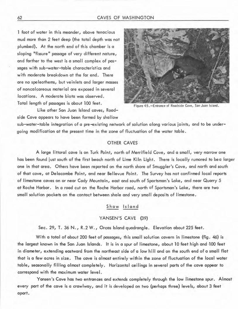
62 CAVES OF WASHINGTON
1 foot of water in th is meander, above tenacious
mud more than 2 feet deep (the total depth was not
plumbed). At the north end of th is chamber is a
sloping 11fissure II passage of very different nature,
and farther to the west is a small complex of pas
sages with sub-water-table characteristics and
with moderate breakdown at the far end. There
are no speleothems, but veinlets and larger masses
of noncalcareous material are exposed in several
locations. A moderate biota was observed.
Total length of passages is about 100 feet.
Like other San Juan Island caves, Road
side Cave appears to have been formed by shallow
Figure 45.-Entrance of Roadside Cave, San Juan Island.
sub-water-table integration of a pre-existing network of solution along various joints, and to be under
going modification at the present time in the zone of fluctuaHon of the water table.
OTHER CAVES
A large littoral cave is on Turk Point, north of Merrifield Cove, and a small, very narrow one
has been found just south of the first beach north of Lime Kiln Light. There is locally rumored to bea larger
one in that area. Others have been reported on the north shore of Smuggler's Cove , and north and south
of that cove, at Delacombe Point, and near Bellevue Point. The Survey has not confirmed local reports
of limestone caves on or near Cady Mountain, east and south of Sportsman's Lake, and near Quarry 5
at Roche Harbor . In a road cut on the Roche Harbor road, north of Sportsman 1s Lake, there are two
small solution pockets on the contact between shale and very small deposits of limestone.
Shaw Island
YANSEN'S CAVE (39)
Sec. 29, T. 36 N ., R. 2 W., Orcas Island quadrangle. Elevation about 225 feet.
With a total of about 200 feet of passages, this small solution cavern in limestone (fig. 46) is
the largest known in the San Juan Islands. It is in a spur of limestone, about 10 feet high and ·100 feet
in diameter, extending eastward from the northeast side of a low hill and on the south end of a small flat
that is a few acres in size. The cave is a'lmost entirely within the zone of fluctuation of the local water
table, seasonally filling almost completely. Horizontal ceilings in several parts of the cave appear to
correspond with the maximum water level.
Yansen's Cave has two entrances and extends completely through the low limestone spur. Almost
every part of the cave is a crawlway, and it is developed on two (perhaps three) levels, about 3 feet
apart.
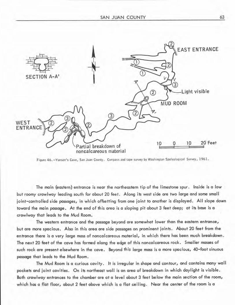
I-,
V SECTION A-A'
SAN JUAN COUNTY
j_ I
Partial breakdown of noncalcareous material
EAST ENTRANCE
Light visible
10 0 10 20 ·Feet
Figure 46.-Yansen's Cave, San Juan County . Compass and Lape survey by Washington Speleological Survey, 1961.
63
The main (eastern) entrance is near the northeastern tip of the limestone spur. Inside is a low
but roomy crawlway leading south for about 20 feet . Along its west side are two large and some smal I
joint-controlled side passages, in which offsetting from one joint to another is displayed. All slope down
toward the main passage. At the end of this area is a sloping pit about 3 feet deep; at its base is a
crawlway that leads to the Mud Room.
The western entrance and the passage beyond are somewhat lower than the eastern entrance,
but are more spacious. Also in this area are side passages on prominent joints. About 20 feet from the
entrance there is a very large mass of noncalcareous material, in which there has been much breakdown.
The next 20 feet of the cave has formed along the edge of this noncalcareous rock. Smaller masses of
such rock are present elsewhere in the cave. Beyond this large mass is a more spacious, 40-foot sinuous
passage that leads to the Mud Room.
The Mud Room is a curious cavity. It is irregular in shape and contour, and contains many wall
pockets and joint cavities . On its northeast wall is an area of breakdown in wh ich daylight is visible.
Both crawlway entrances to the chamber are at a level about 3 feet below the main section of the room,
which has a flat floor, about 2 feet above which is a flat ceiling. Near the center of the room is a
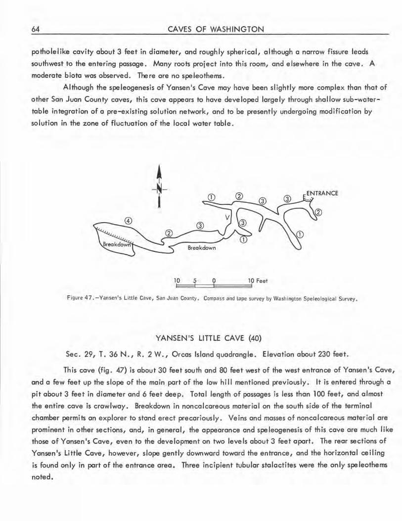
64 CAVES OF WASHINGTON
potholelike cavity about 3 feet in diameter, and roughly spherical, although a narrow fissure leads
southwest to the entering passage. Many roots project into this room, and elsewhere in the cove. A
moderate biota was observed. There ore no speleothems.
Although the speleogenesis of Yonsen's Cove may hove been slightly more complex than that of
other Son Juan County coves, this cove appears to hove developed largely through shallow sub-woter
toble integration of a pre-existing solution network, and to be presently undergoing modification by
solution in the zone of fluctuation of the local water table .
+ -~-I
@
Breakdown
Figure 4 7. - Yansen's Little Cave, San Juan County. Compass and tape survey by Washington Speleological Survey.
YANSEN'S LITTLE CAVE (40)
Sec. 29, T. 36 N., R. 2 W., Orcos Island quadrangle. Elevation about 230 feet.
This cove (fig. 47) is about 30 feet south and 80 feet west of the west entrance of Yonsen's Cove,
and a few feet up the slope of the main port of the low hi II mentioned previously. It is entered through a
pit about 3 feet in diameter and 6 feet deep. Total length of passages is less than 100 feet, and almost
the entire cove is crawlway. Breakdown in noncolcoreous material on the south side of the terminal
chamber permits on explorer to stand erect precariously. Veins and mosses of noncolcoreous material ore
prominent in other sections, and, in general, the appearance and speleogenesis of this cave are much like
those ofYonsen's Cove, even to the development on two levels about 3 feet apart. The rear sections of
Yansen's Little Cove, however, slope gently downward toward the entrance, and the horizontal ceiling
is found only in port of the entrance area. Three incipient tubular stalactites were the only speleothems
noted.
SAN JUAN COUNTY
OTHER CAVES
A pit 8 feet deep, about 25 feet southwest of the west entrance of Yansen 1s Cave, leads to a
breakdown passage in shale (?) about 15 feet long, terminating close to the main passage of Yansen's
Cave. There are other sma 11 sinks in th is same area.
Stewart Island
65
There are local reports of a cave on Stewart Island, but authentic information about it has not
been obtained.
Sucia Island
Rockshelters, locally termed "wind caves" are on Sucia Island near the isthmus near Fossil
Bay, andalso,reportedly, on the Finger Islands.
Woody Island
There are local reports of a littoral cave on the north side of a narrow inlet on the west side of
Woody Island.
SKAGIT COUNTY
Skagit County has scattered deposits of I imestone. Only in the Concrete area, however, ore
solution caves known, and these are very smal I. Other places where solution caves may be found even
tually are the limestone cliffs along the east and south sides of Washington Monument Peak; in the alpine
meadows along the trails to Dock Butte Lookout; and northeast of Blue Lake, where some sinks have been
noted (W. R. Danner, oral communication). The county also has littoral caverns, both Recent and ancient.
The Recent ones, between Deception Pass and Bizz Point, have been explored in the past 5 years by the
San Juan Reef Raiders, under the leadership of Jan Utterstrom and Dale Wood.
BAT CAVE
Sec. 22 (?), T. 36 N., R. 3 E., Bow quadrangle.
There is locally reported to be a small talus cave northeast of Edison in which bats often congre
gate. About 1940, a boy was fatally injured by a rockfall in this cave.
BECKLEY'$ CAVE (41) (Old Miller Place Cave, Pleasant Ridge Cave)
Sec. 9, T. 33 N., R. 3 E., Mount Vernon q·uadrangle.
This cavern, which was formed by collapse of part of the roof of a shallow littoral rockshelter
about 150 feet long, is at the foot of a sea cliff about a quarter of a mi le northwest of the Beckley farm
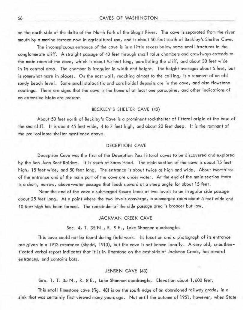
66 CAVES OF WASHINGTON
on the north side of the delta of the North Fork of the Skagit River. The cave is separated from the river
mouth by a marine terrace now in agricultural use, and is about 50 feet south of Beckley 1s Shelter Cave.
The inconspicuous entrance of the cave is in a little recess below some small fractures in the
conglomerate cliff. A straight passage of 40 feet through small talus chambers and crawlways extends to
the main room of the cave, which is about 95 feet long , paralleling the cliff, and about 30 feet wide
in its central area. The chamber is irregular in width and height. The height averages about 5 feet, but
is somewhat more in places . On the east wall, reaching almost to the ce i I ing, is a remnant of an old
sandy beach level. Some small stalactitic and coral.loidal deposits are in the cave, and also flowstone
coatings. There are signs that the cave is the home of at least one porcupine, and other indications of
an extensive biota are present.
BECKLEY'S SHELTER CAVE (42)
About 50 feet north of Beckley's Cave is a prominent rockshelter of littoral origin at the base of
the sea cliff. It is about 45 feet wide, 4 to 7 feet high, and about 20 feet deep. It is the remnant of
the pre-collapse shelter mentioned above .
DECEPTION CAVE
Deception Cave was the first of the Deception Pass littoral caves to be discovered and explored
by the San Juan Reef Raiders. It is south of Sores Head. The ma in sect ion of the cave is about 15 feet
high, 15 feet wide, and 50 feet long. The entrance is about twice as high and wide. About two-thirds
of the entrance and of the main part of the cave are under water. At the end of the main section there
is a short, narrow, above-water passage that leads upward at a steep angle for about 15 feet.
Near the end of the cave a submerged fissure leads at two levels to an irregular side passage
about 25 feet long. At a point where the two leve Is converge, a submerged room about 5 feet wide and
10 feet high has been formed. The remainder of the side passage area is broader but low.
JACKMAN CREEK CAVE
Sec. 4, T. 35 N., R. 9 E., Lake Shannon quadrangle .
This cave could not be found during field work. Its location and a photograph of its entrance
are given in a T913 reference {Shedd, 1913), but the cave is not known locally. A very old, unauthen
ticated verbal report indicates that it is in limestone on the east side of Jackman Creek, has several
entrances, and con ta ins bots.
' JENSEN CA VE (43)
Sec. 1, T. 35 N., R. 8 E., Lake Shannon quadrangle. Elevatio:n about 1,600 feet.
· This small limestone cave (fig. 48) is on the south edge of an abandoned railway grade, in a
sink that was certainly first viewed many years ago. Not until the autumn of 1951, however, when State
SKAGIT COUNTY
EXTENDED PROFILE
PLAN
Dry streamcourse
streamcourses
Figure 48 .-Jensen Cave, Skagi t County. Survey by Will iam R. Hal liday, Washington Speleo logical Survey, June 1956.
Forester Fred Jensen peered into the hole at its bottom, did anyone realize that it led into a cavern.
Jensen Cave is on a gently sloping bench on a heavily mantled and forested karstic hillside,
67
·1, 400 feet above the Skagit River and more than 3,000 feet below the summit of the ridge in which it is
located . Seasonal surface torrents occur a few hundred feet east of the cave, but to the west, the nearest
surface stream is more than a mi le away . It is possible thot the smal I stream that enters the cave flows
into a fairly extensive karst drainage that wholly or partially resurges at the spring about three-eighths
of a mile east of the cave, forming the small stream that parallels Franklin logging road for a few dozen
yards . Between the cave and the resurgence is a vertical hillside ponor sink, 15 feet in diameter, which
may also contribute to the resurgence.
68 CAVES OF WASHINGTON
The I imestone bedrock at Jensen Cave is intensely fractured and partially metamorphosed, so
that only a few fossi Is can be distinguished. It is believed to be of Permian age. At the cave, the dip
and strike are difficult to measure, but the dip appears to be southwest at about 25°. If this is true,
much of the ceiling of the Entrance Room is bedding-plane-determined . This room contains smooth ceiling
pendants that appear to be of phreatic origin.
Jensen Cave can be entered through a hole 4 feet in diameter, at the bottom of a brush-grown
conical sink 15 feet deep and 20 feet in diameter at the surface. The cave consists of two smal I chambers
connected by a crawlway.
The Entrance Room is a low, sloping chamber 17 feet long, 3 to 10 feet wide, and 3 to 6 feet
high. Along its wal Is are stratified clays and gravels. A projecting meander spur is near the entrance of
the crawlway . A debris level that appears very recent is about 4 feet above the floor at 'the lower end
of this room, indicating that most of the cave sometimes is filled with water. During two visits by spele
ologists to this cave, only a small trickling stream was flowing into the Entrance Room.
From the lower end of this room, a very tight crawlway 10 feet long passes north beneath meander
niches that must have been formed atop a fi II that is no longer present. The crawlway is now floored
chiefly with sand, which has a tendency to reaccumulate and must be re-excavated at each visit to the
cave.
At the end of this crawlway, a hole less than 1 foot in diameter opens into a short, narrow pas
sage 8 feet high that leads southwest to the northeast corner of the Waterfal I Room.
The Waterfall Room is about 17 feet long and 8 to 10 feet high. It is named for the seasonal
waterfall in the northwest corner of the room, which falls from a high, narrow chimney. Elsewhere in
this small room are other, irregular chirTY'leys and jogged limestone remnants showing the vertical groovings
of waterfalls. Small stream flutes ore present on several minor overhangs. At the lower end of this room
is a small, choked pit into which the waterfall stream disappears. A flosbbulb placed in this pit in 1951
was found on a ledge a foot above the floqr in 1.956.
No biota and no speleotherns hove been observed in Jensen Cove. It appears to be a cove of
phreatic origin with very marked vadose modification, and to be a functioning part of a small karstic
drainage system on on otherwise typical lowland Northwest hillside.
McQUEEN'S CAVE (See Three Mile Creek Cove.)
OLD MILLER PLACE CAVE (See Beckley's Cove.)
OTTER CAVE (44)
This littoral cave north of Rock and Surge Coves was discovered and explored by members of the
San Juan Reef Raiders in 1960. The name resulted from a close-range encounter with a sea otter within
the cave. At low tide the floor of the 75-foot entrance section is above water. This part of the cove is
SKAGIT COUNTY 69
about 10 feet high and 10 feet wide. Beyond this section, excavation of beach gravels in a low part is
necessary in order to crawl about 20 feet into a low terminal chamber about 10 feet long.
PLEASANT RIDGE CAVE (See Beckley's Cave.)
RA I DER CAVE (45)
At high tide the entrance of this littoral cave is almost completely submerged. The cave is on
the south side of a promontory south of Bizz Point, and was named by members of the San Juan Reef
Raiders for their organization. The cave is entered through a narrow passage about 2 feet high and 15
feet long, at the lower end of a fissure about 20 feet high. At the end of the narrow entrance section is
a chamber about 15 feet in diameter, with two narrow terminal branches about 15 feet long.
ROCK CAVE (46)
This littoral cave just north of Sores Head has not been completely explored and is extremely
dangerous because of heavy surge. About 40 feet from its half-submerged entrance, which is about 4 feet
wide and 20 feet high, the narrow passage is almost blocked by a rock with a clearance of about 2 feet.
The cave continues, but the only scuba diver to pass this point to date had a very difficult time with surge
and spray.
SURGE CAVE (47)
This dangerous littoral cave is between Rock and Otter Caves, north of Deception Pass . It has
been explored briefly on three occasions by members of the San Juan Reef Raiders, and is estimated to be
about 60 feet long. Two feet of the 7-foot high entrance is above water. The cave gradually ta~rs.
About 35 feet from the entrance, it is about 1! feet wide , and the ceiling descends to the water at this
place, although there is an air space beyond,. Wave surge in this cave is very strong, so that explorers
are usually swept in with one wave and out with the next - an extremely dangerous situation.
THREE MILE CREEK CAVE (48) (Weaver's Cave, McQueen's Cave)
Sec. 30, T. 36 N., R. 9 E., Lake Shannon quadrangle. Elevation about 3,000 feet.
Three Mi le Creek Cave (fig. 49) is on the steep slope east of Lake Shannon, about 2,500 feet
above the lake and about 500 feet lower than the Thunder Lakes fla_t to the northeast. It is reached by
way of the Thunder Creek and Section 19 logging roads, and is 0.7 mile from the latter on an abandoned
secondary logging road . The entrance of the cave is at the edge of a small marble quarry, which extends
about 100 feet into the sloping hillside in what was once typical heavily timbered upland cou~try.
Even though partially blocked by dirt and rubble, the solution-sculptured, walk-,in entrance is
6 feet high and 10 feet wide. The cave is not extensive, however. The single, roomy passage measures
about 70 feet in maximum length, although local rumor indicates that originally it was much longer.
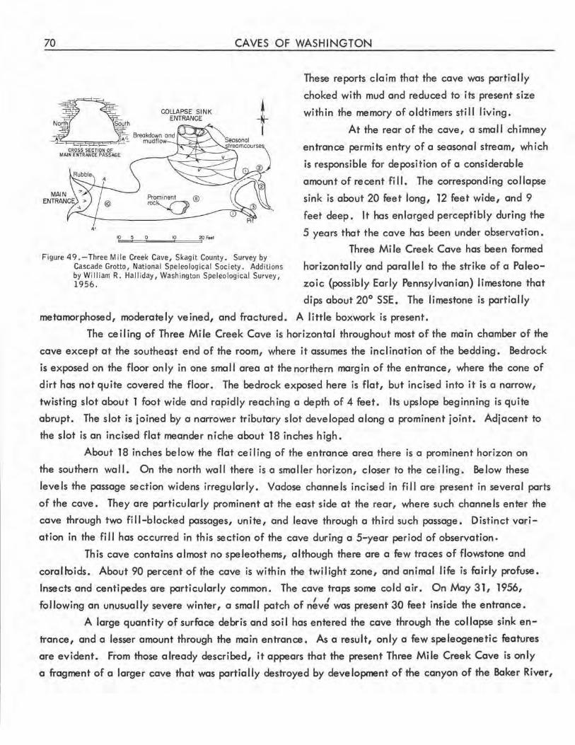
70 CAVES OF WASHINGTON
COLLAPSE SINK ENTRANCE
Prominent @ roc'Q
'°•-5=0 ___ 10====='20Ftel
-~ I
Figure 49.-Three Mile Creek Cave, Skagit County. Survey by Cascade Grotto, National Speleological Society. Additions by William R. Halliday, Washington Speleological Survey, 1956.
These reports claim that the cave was partially
choked with mud and reduced to its present size
within the memory of oldtimers still living.
At the rear of the cave, a small chimney
entrance permits entry of a seasonal stream, which
is responsible for deposition of a considerable
amount of recent fi 11. The corresponding col lapse
sink is about 20 feet long, 12 feet wide, and 9
feet deep. It has enlarged perceptibly during the
5 years that the cave has been under observation .
Three Mi le Creek Cave has' been formed
horizontally and para I lel to the strike of a Paleo
zoic (possibly Early Pennsylvanian) limestone that
dips about 20° SSE. The limestone is partially
metamorphosed, moderately veined, and fractured. A little boxwork is present.
The ceiling of Three Mile Creek Cave is horizontal throughout most of the main chamber of the
cave except at the southeast end of the room, where it assumes the inclination of the bedding. Bedrock
is exposed on the floor only in one small area at the northern margin of the entrance, where the cone of
dirt has not quite covered the floor. The bedrock exposed here is flat, but incised into it is a narrow,
twisting slot about 1 foot wide and rapidly reaching a depth of 4 feet. Its upslope beginning is quite
abrupt. The slot is joined by a narrower tributary slot developed along a prominent joint. Adjacent to
the slot is an incised flat meander niche about 18 inches high.
About 18 inches below the flat ceiling of the entrance area there is a prominent horizon on
the southern wall. On the north wall there is a smaller horizon, closer to the ceiling. Below these
levels the passage section widens irregularly. Vadose channels incised in fill are present in several parts
of the cave. They are particularly prominent at the east side at the rear, where such channels enter the
cave through two fill-blocked passages, unite, and leave through a third such passage. Distinct vari
ation in the fill has occurred in this section of the cave during a 5-year period of observation.
This cave contains almost no speleothems, although there are a few traces of flowstone and
corall-oids. About 90 percent of the cave is within the twilight zone, and animal life is fairly profuse.
Insects and centipedes are particularly common. The cave traps some cold air. On May 31, 1956,
following an unusually severe winter, a small patch of n~vJ was present 30 feet inside the entrance.
A large quantity of surface debris and soil has entered the cave through the collapse sink en
trance, and a lesser amount through the main entrance. As a result, only a few speleogenetic features
are evident. From those already described, it appears that the present Three Mile Creek Cave is only
a fragment of a larger cave that was partially destroyed by development of the canyon of the Baker River,
SKAGIT COUNTY 71
and partially blocked by recent fill. The small stream channels atop this fill do not appear to have had
any significant role in spe leogenesis except, perhaps, to distribute part of the fill. The vadose slot at
the entrance is the only evidence of vadose stream exit from the cave subsequent to the development of
the steep slope adjacent to the cave, and its shortness indicates that the resurgence was not of long
duration. An earlier vadose stage with a gentle gradient in this part of the cave system is suggested by
the entrance cross section, which is progressively wider near the floor. The flat ceiling suggests a still
earlier stage of water-table contro l of phreatic solution. As stream flutes are not present, the flow of
this phreatic water was probably not due to the sudden entry of flood waters into the water table at the
cave. The known part of the cave clearly developed through shallow sub-water-table flow. Excavation
of the fi II at the rear of th is cave might prove of unusual spe leologenetic interest.
WEAVER I S CAVE (See Three Mi le Creek Cave.)
OTHER CAVES
Other small littoral caves are known north of Deception Pass, on the south side of Cypress Island,
and on the southwest side of the southeast branch of Fida Igo Island 0N. R. Danner, oral communication).
Near the spectacular north cl iff of the island that bisects Deception Pass is an unusually accessible ex
ample of a small block creep cavern, a few yards east of the highway. The offset of the cliffward part is
slightly more than 1 foot. The cavernous fissure is about 15 feet long, and can be entered to a depth of
about 12 feet.
SKAMANIA COUNTY
Skamania County contains both a major Mount St. Helens pahoehoe lava flow and the western
part of the Mount Adams pahoehoe flows. These flows contain the largest and most important lava tubes
in the State of Washington. No limestone is known in this county, and the name of Marble Mountain is
a misnomer (Verhoogen, 1937).
APE CAVE (49)
Secs. 5 and 8, T. 7 N., R. 5 E., Mount St. Helen-s quadrangle.
Elevation of upper entrance 2,450 feet.
Ape Cave <Pl. 2) is the largest cave in Washington and is the longest unitary lava tube cave
known in the United States. Its slope length, measured by plastic tube, is about 11,215 feet, and it has
a descent of approximately 700 feet, as measured hydrostatically.
The odd name of the cave was chosen by its first explorers, a local group of young outdoorsmen
who call themselves the St. Helens Apes in memory of a widely publicized incident in which two
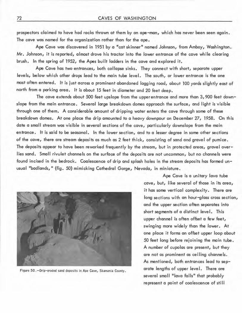
72 CAVES OF WASHINGTON
prospectors claimed to have had rocks thrown at them by an ape-man, which has never been seen again.
The cave was named for the organization rather than for the ape.
Ape Cave was discovered in 1951 by a "cat skinner" named Johnson, from Amboy, Washington.
Mr. Johnson, it is reported, almost drove his tractor into the lov,,,er entrance of the cave while clearing
brush. In the spring of 1952, the Apes bui It ladders in the cave and explored it.
Ape Cave has two entrances, both collapse sinks. They connect with short, separate upper
levels, below which other drops lead to the main tube level. The south, or lov,,,er entrance is the one
most often entered. It is just across a prominent abandoned logging road, about 100 yards slightly east of
north from a parking area. It is about 15 feet in diameter and 20 feet deep.
The cave extends about 500 feet upslope from the upper entrance and more than 3,900 feet down
slope from the main entrance. Several large breakdown domes approach the surface, and light is visible
through one of them. A considerable amount of dripping water enters the cave through some of these
breakdown domes. At one place the drip amounted to a heavy downpour on December 27, 1958. On this
date a small stream was visible in several sections of the cave, particularly downslope from the main
entrance. It is said to be seasonal. In the lower section, and to a lesser degree in some other sections
of the cave, there are stream deposits as much as 2 feet thick, consisting of sand and gravel of pumice.
The deposits appear to have been reworked frequently by the stream, but in protected areas, gravel over
lies sand. Small rivulet channels on the surface of the deposits are not uncommon, but no channels were
found incised in the bedrock. Coalescence of drip and splash holes in the stream deposits has formed un
usual "badlands, 11 (fig. 50) mimicking Cathedral Gorge, Nevada, in miniature.
Figure 50 .-Drip-eroded sand deposits in Ape Cave, Skamania County.
Ape Cave is a unitary lava tube
cave, but, like several of those in its area,
it has some vertical complexity. There are
long sections with an hour-glass cross section,
and the upper section often separates into
short segments of a distinct level. This
upper channel is often offset a few feet,
swinging more widely than the lower •. At
one place it forms an offset upper loop about
50 feet long before rejoining the main tube.
A number of cupolas are present, but they
are not as prominent as ceiling channels.
As menfioned, both entrances lead to sep
arate lengths of upper leve 1. There are
several small "lava falls" that probably
represent a point of coalescence of still
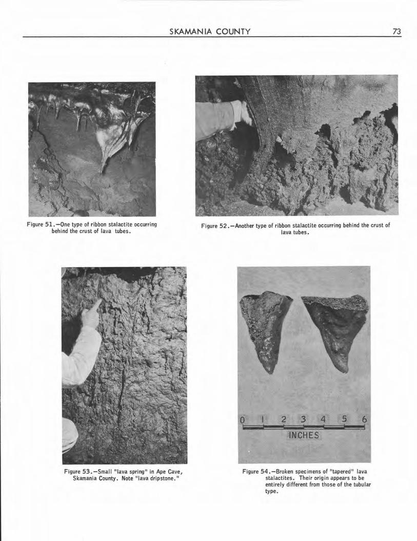
SKAMANIA COUNTY
Figure 51.-0ne type of ribbon stalactite occurring behind the crust of lava tubes.
Figure 53.-Small "lava spring" in Ape Cave, Skamania County. Note "lava dripstone."
Figure 52. - Another type of ribbon stalactite occurring behind the crust of lava tubes .
0 2 3 4 5 6
INCHES
Figure 54. -Broken specimens of "tapered" lava stalactites . Their origin appears to be entirely different from those of the tubular type.
73
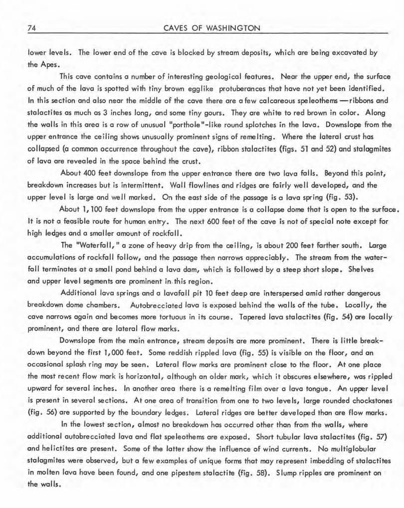
74 CAVES OF WASHINGTON
lower levels. The lower end of the cave is blocked by stream deposits, which are being excavated by
the Apes.
Th is cave contains a number of interesting geological features. Near the upper end, the surface
of much of the lava is spotted with tiny brown egglike protuberances tha1t have not yet been identified .
In this section and also near the middle of the cave there are a few calcareous speleothems -ribbons and
stalactites as much as 3 inches long, and some tiny gours. They are white to red brown in color. Along
the walls in this area is a row of unusual "porthole"-like round splotches iin the lava . Downslope from the
upper entrance the ceiling shows unusually prominent signs of remelting. Where the lateral crust has
collapsed {a common occurrence throughout the cave), ribbon sta lactites (figs. 51 and 52) and stalagmi.tes
of lava are revealed in the space behind the crust.
About 400 feet downslope from the upper entrance there are two lava falls. Beyond this point,
breakdown increases but is intermittent. Wall flowlines and ridges are fairly well developed, and the
upper level is large and we ll marked. On the east side of the passage is a lava spring (fig. 53).
About 1, 100 feet downslope from the upper entrance is a collapse dome that is open to the surface.
It is not a feasible route for human entry. The next 600 feet of the cave is not of special note except for
high ledges and a smaller amount of rockfa II.
The "Waterfall," a zone of heavy drip from the ceiling, is about 200 feet farther south. Large
accumulations of rockfall follow, and the passage then narrows appreciably. The stream from the water
fall terminates at a small pond behind a lava dam, which is followed by a steep short slope. Shelves
and upper level segments are prominent in. th is region.
Additional lava springs and a lavafall pit TO feet deep are interspersed amid rather dangerous
breakdown dome chambers. Autobrecciated lava is exposed behind the walls of the tube. Locally, the
cave narrows a.gain and becomes more tortuous in its course. Tapered lava stalactites (fig. 54) are locally
prominent, and there are lateral flow marks.
Downslope from .the main entrance, stream deposits are more prominent. There is little ~reak
down beyond the first 1,000 feet. Some reddish rippled lava (fig. 55) is visible on the floor, and an
occasional splash ring may be seen. Lateral flow marks are prominent close to the floor. At one place
the most recent flow mark is horizontal, although an older mark, which it obscures elsewhere, was rippled
upward for several inches . In another area there is a remelting film over a lava tongue. An upper level
is present in several sections. At one area of transition from one to two levels, large rounded chockstones
(fig. 56) are supported by the boundary ledges. Lateral ridges are better developed than are flow marks.
In the lowest section, almost no breakdown has occurred other than from the walls, where
additional autobrecciated lava and flat speleothems are exposed. Short tubular lava stalactites (fig. 57)
and helictites are present. Some of the latter show the influence of wind currents. No multig.lobular
stalagmites were observed, but a few examples of unique forms that may represent imbedding of sta lactites
in molten lava have been found, and one pipestem stalactite (fig. 58). Slump ripples are prominent on ·
the walls.
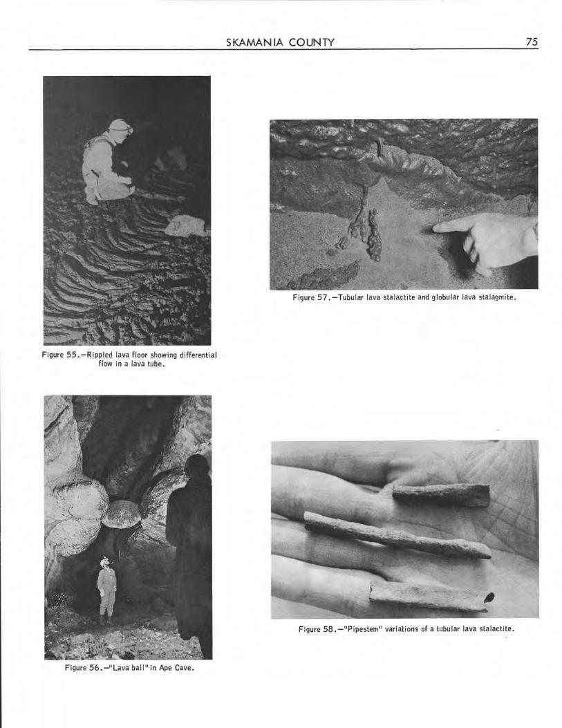
Figure 55. -Rippled lava floor showing differential flow in a lava tube.
Figure 56.-''Lava ball" in Ape Cave.
SKAMANIA COUNTY 75
Figure 57. -Tubular lava stalactite and globular lava stalagmite.
Figure 58. -"Pipestem" variations of a tubular lava st9lactite.
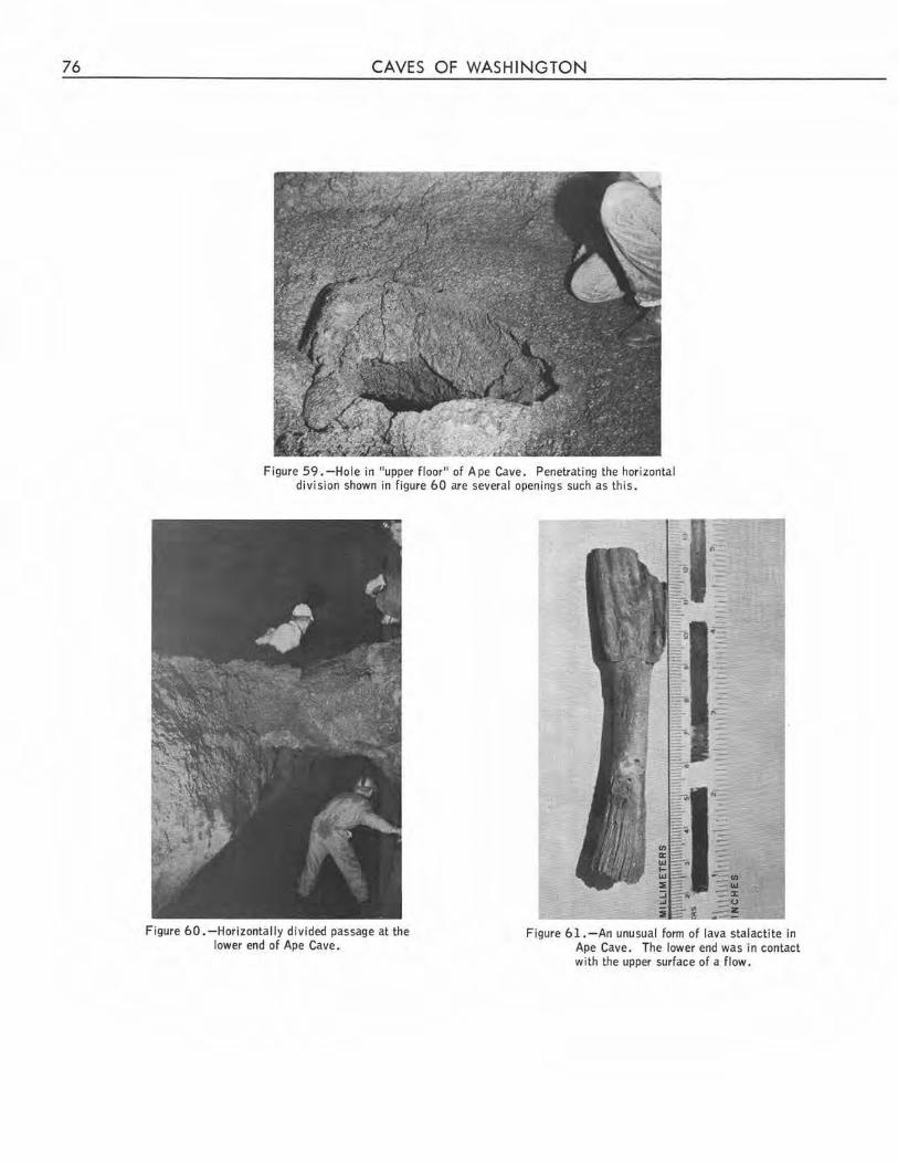
76 CAVES OF WASHINGTON
Figure 59. -Hole in "upper floor" of Ape Cave. Penetrating the horizontal division shown in figure 60 are several openings such as this .
Figure 60 . -Horizontally divided passage at the lower end of Ape Cave.
Figure 61.-An unusual form of lava stalactite in Ape Cave. The lower end was in contact with the upper surface of a flow.
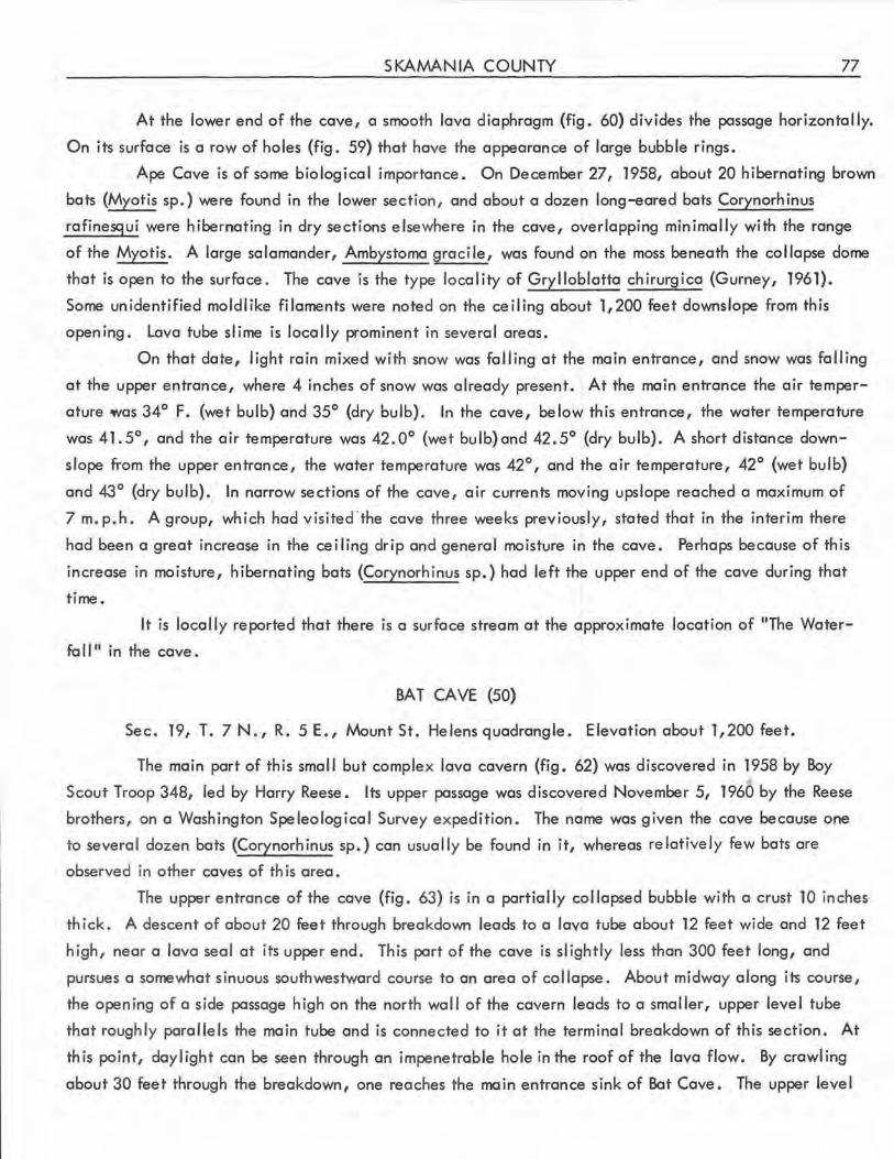
SKAMANIA COUNTY 77
At the lower end of the cave, a smooth lava diaphragm (fig. 60) divides the passage horizontally.
On its surface is a row of holes {fig. 59) that have the appearance of large bubble rings.
Ape Cave is of some biological importance. On December 27, 1958, about 20 hibernating brown
bats (Myotis sp.) were found in the lower section, and about a dozen long-eared bats Corynorh inus
rafinesqui were hibernating in dry sections e lsewhere in the cove, overlapping minimally with the range
of the Myotis. A large salamander, Ambystomo groci le, was found on the moss beneath the collapse dome
that is open to the surface. The cave is the type locality of Grylloblatta chirurgica (Gurney, 1961).
Some unidenti fied moldlike filaments were noted on the ceiling about 1,200 feet downslope from this
opening. Lava tube slime is locally prominent in several areas.
On that date, light rain mixed with snow was falling at the main entrance, and snow was falling
at the upper entrance, where 4 inches of snow was already present. At the main entrance the air temper
ature was 34° F. (wet bulb) and 35° (dry bulb). In the cave, below this entrance, the water temperature
was 41.5°, and the air temperature was 42.0° (wet bulb)and 42.5° (dry bulb). A short distance down
slope from the upper entrance, the water temperature was 42°, and the air temperature, 42° (wet bulb)
and 43° (dry bulb). In narrow sections of the cave, air currents moving upslope reached a maximum of
7 m.p.h. A group, which had visited .the cave three weeks previously, stated that in the interim there
had been a great increase in the ceiling drip and general moisture in the cave. Perhaps because of this
increase in moisture, hibernating bots (Corynorhinus sp.) had left the upper end of the cove during that
time.
It is locally reported that there is a surface stream at the approximate location of "The Water
fa 11 11 in the cave •
BAT CA VE (50)
Sec. 19, T. 7N., R. 5E., Mount St. Helensquadrangle. Elevation about 1,200feet.
The main part of this smal I but complex lava cavern (fig. 62) was discovered in 1958 by Boy
Scout Troop 348, led by Harry Reese. Its upper passage was discovered November 5, 1960 by the Reese
brothers, on a Washington Speleological Survey expedition . The name was given the cave because one
to several dozen bats (Corynorhinus sp.) can usually be found in it, whereas relatively few bats are
observed in other caves of this area.
The upper entrance of the cave (fig . 63) is in a partially collapsed bubble with a crust 10 inches
thick. A descent of about 20 feet through breakdown leads to a lava tube about 12 feet wide and 12 feet
high, near a lava seal at its upper end . This part of the cave is slightly less than 300 feet long, and
pursues a somewhat sinuous southwestward course to an area of collapse . About midway along its course,
the opening of a side passage high on the north wa II of the cavern leads to a sma lier, upper leve I tube
that roughly parallels the main tube and is connected to it at the terminal breakdown of this section. At
this point, daylight can be seen through an impenetrable hole in the roof of the lava flow. By crawling
about 30 feet through the breakdown, one reaches the main entrance sink of Bat Cave. The upper level
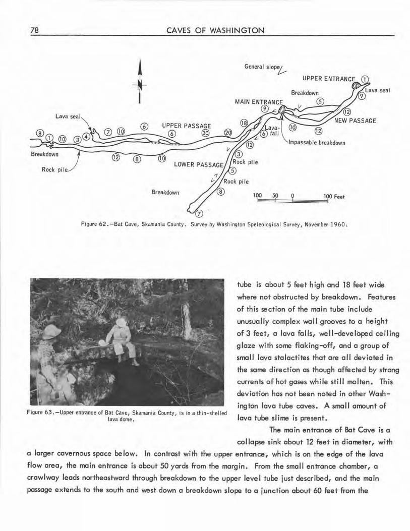
78
Lava seal
Breakdown
Rock pil
CAVES OF WASHINGTON
~ -~-j
General slop%-,
Impassable breakdown
@ ®
Breakdown 100 50 0
Figure 62. -Bat Cave, Skamania County. Survey by Washington Speleological Survey, November 1960.
tube is about 5 feet high and 18 feet wide
where not obstructed by breakdown. Features
of this section of the main tube include
unusually complex wall grooves to a height
of 3 feet, a lava falls, we ll-developed ceiling
glaze with some flaking-off, and a group of
small lava stalactites that are all deviated in
the same direction as though affected by strong
currents of hot gases while still molten. This
deviation has not been noted in other Wash
ington lava tube caves. A small amount of Figure 63. -Upper entrance of Bat Cave, Skamania County, is in a thin-shelled
lava dome. lava tube slime is present.
The main entrance of Bat Cave is a
collapse sink about 12 feet in diameter, with
a larger cavernous space be low. In contrast with the upper entrance, which is on the edge of the lava
flow area, the main entrance is about 50 yards from the margin . From the small entrance chamber, a
crawlway leads northeastward through breakdown to the upper level tube just described, and the main
passage extends to the south and west down a breakdown slope to a junction about 60 feet from the
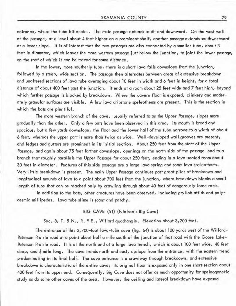
SKAMANIA COUNTY 79
entrance, where the tube bifurcates. The main passage extends south and downward. On the west wall
of the passage, at a level about 4 feet higher on a prominent shelf, another passage extends southwestward
at a lesser slope. It is of interest that the two passages are also connected by a smaller tube, about 3
feet in diameter, which leaves the more western passage just below the junction, to joint the lower passage,
on the roof of which it can be traced for some distance.
In the lower, more southerly tube, there is a short lava falls downslope from the junction,
followed by a steep, wide section. The passage then alternates between areas of extensive breakdown
and unaltered sections of lava tube averaging about 10 feet in width and 6 feet in height, for a total
distance of about 400 feet past the junction. It ends at a room about 25 feet wide and 7 feet high, beyond
which further passage is blocked by breakdown. Where the cavern floor is exposed, clinkery and moder
ately granular surfaces are visible . A few lava dripstone speleothems are present. This is the section in
which the bats are plentiful.
The more western branch of the cave, usually referred to as the Upper Passage, slopes more
gradually than the other. Onfy a few bats have been observed in this area. Its mouth is broad and
spacious, but a few yards downslope, the floor and the lower half of the tube narrows to a width of about
6 feet, whereas the upper part is more than twic~ as wide. Well-developed wall grooves are present,
and ledges and gutters are prominent in its initial section. About 250 feet from the start of the Upper
Passage, and again about 75 feet farther downslope, openings on the north side of the passage lead to a
branch that roughly parallels the Upper Passage for about 250 fee~, ending in a lava-sealed room about
30 feet in diameter. Features of this side passage are a large lava spring and some lava speleothems.
Very little breakdown is present. The main Upper Passage continues post great piles of breakdown and
longitudinal mounds of lava to a point about 700 feet from the junction, where breakdown blocks a small
length of tube that can be reached only by crawling through about 40 feet of dangerously loose rock.
In addition to the bats, other creatures have been observed, including gryl loblattids and poly
desmid millipedes. Lava tube slime is ~cant and patchy.
BIG CAVE (51) (Nielsen's Big Cave)
Sec. 8, T. 5 N., R. 9 E., Willard quadrangle. Elevation about 3,200 feet.
The entrance of this 2, 700-foot lava-tube cave {fig. 64) is about 100 yards west of the Willard
Peterson Prairie road at a point about half a mile south of the junction of that road with the Goose Lake
~terson Prairie road. It is at the north end of a large lava trench, which is about 100 feet wide, 40 feet
deep, and a mile long. The cave trends north and east, upslope from the entrance, with the eastern trend
predominating in its final half. The cave entrance is a crawlway through breakdown, and extensive
breakdown is characteristic of the entire cave; its original floor is exposed only in one short section about
400 feet from its upper end. Consequently, Big Cave does not offer as much opportunity for speleogenetic
study as do some other caves of the area. However, the ceiling and lateral breakdown have exposed
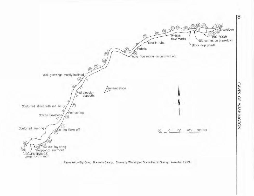
Woll groovings mostly inclined
®
~erol slope
~ -N-I Contorted strata with red silil (?).
'r jRed cei ling Calcite flows1ne /®
Contorted layering 10.£. E3 ~ 100 ~
Figure 64.-Big Cave, Skamania County. Survey by Washington Speleo logica l Survey, November 1959 .
Stalactites. on breakdown
3QO Feet
CX> 0
() }> < m Vl
0 .,, ~ }> Vl I
z G> -f 0 ,Z
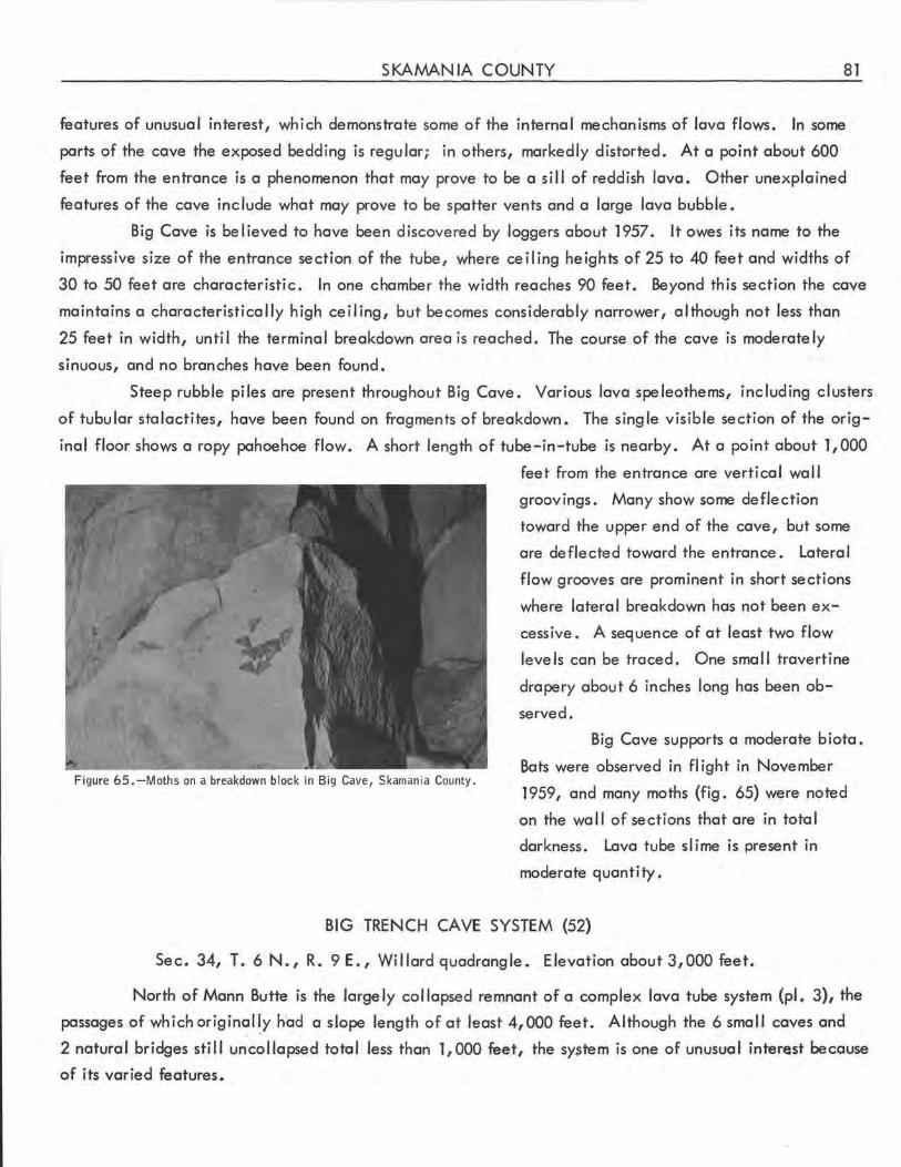
SKAMANIA COUNTY 81
features of unusual interest, which demonstrate some of the internal mechanisms of lava flows. In some
parts of the cave the exposed bedd ing is regular ; in o thers, markedly distorted. At a point about 600
feet from the entrance is a phenomenon that may prove to be a sill of reddish lava. Other unexplained
features of the cave include what may prove to be spatter vents and a large lava bubble.
Big Cave is believed to have been discovered by loggers about 1957. It owes its name to the
impressive size of the entrance section of the tube, where ceiling heights of 25 to 40 feet and widths of
30 to 50 feet are characteristic. In one chamber the width reaches 90 feet. Beyond this section the cave
maintains a characteristically high ceiling, but becomes considerably narrower, although not less than
25 feet in width, unti I the terminal breakdown area is reached. The course of the cave is moderately
sinuous, and no branches have been found.
Steep rubble piles are present throughout Big Cave. Various lava speleothems, including clusters
of tubular stalactites, have been found on fragments of breakdown. The single visible section of the orig
inal floor shows a ropy pahoehoe flow. A short length of tube-in-tube is nearby. At a point about 1,000
Figure 6 5 . -Moths on a breakdown block in Big Cave, Skamania County .
feet from the entrance are vertical wal I
groovings. Many show some deflection
toward the upper end of the cave, but some
are deflected toward the entrance. Lateral
flow grooves are prominent in short sections
where lateral breakdown has not been ex
cessive. A sequence of at least two flow
levels can be traced. One small travertine
drapery about 6 inches long has been ob
served.
Big Cave supports a moderate biota.
Bats were observed in flight in November
1959, and many moths (fig. 65) were noted
on the wall of sections that are in total
darkness . Lava tube slime is present in
moderate quantity .
BIG TRENCH CAVE SYSTEM (52}
Sec . 34, T. 6 N., R. 9 E. , Willard quadrangle. Elevation about 3,000 feet.
North of Mann Butte is the largely col lapsed remnant of a complex lava tube system (pl. 3), the
passages of whichoriginall.y had a slope length of at least 4,000 feet. Although the 6 small coves and
2 natural bridges sti II uncollopsed total less than 1,000 feet, the sy~tem is one of unusual interest because
of its varied features.
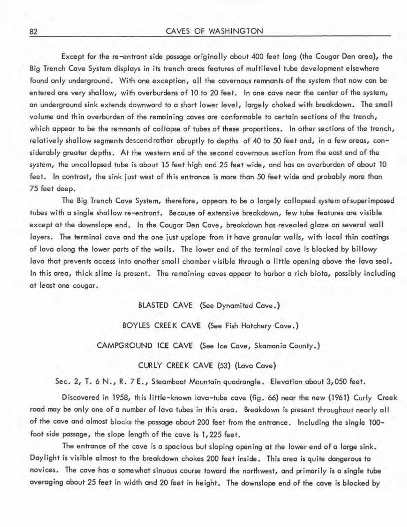
82 CAVES OF WASHINGTON
Except for the re-entrant.side passage originally about 400 feet long (the Cougar Den area), the
Big Trench Cave System displays in its trench areas features of multilevel tube development elsewhere
found only underground. With one exception, all the cavernous remnants of the system that now can be
entered are very shallow, with <:>verburdens of 10 to 20 feet. In one cave near the center of the system,
an underground sink extends downward to a short lower level, largely choked with breakdown. The small
volume and thin overburden of the remaining caves are conformable to certain sections of the trench,
which appear to be the remnants of col lapse of tubes of these proportions. In other sections of the trench,
relatively shallow segments descend rather abruptly to depths of 40 to 50 feet and, in a few areas, con
siderably greater depths. At the western end of the second cavernous section from the east end of the
system, the uncollapsed tube is about 15 feet high and 25 feet wide, and has an overburden of about 10
feet. In contrast, the sink just west of this entrance is more than 50 feet wide and probably more than
75 feet deep.
The Big Trench Cave System, therefore, appears to be a largely collapsed system of superimposed
tubes with a single shallow re-entrant. Because of extensive breakdown, few tube features are visible
except at the downslope end. In the Cougar Den Cave, breakdown has revealed glaze on several wall
layers. The terminal cave and the one just upslope from it have granular walls, with local thin coatings
of lava along the lower parts of the walls. The lower end of the terminal cave is blocked by billowy
lava that prevents access into another small chamber visible through a little opening above the lava seal.
In this area, thick slime is present. The remaining caves appear to harbor a rich biota, possibly including
at least one cougar.
BLASTED CAVE (See Dynamited Cave.)
BOYLES CREEK CAVE (See Fish Hatchery Cave.)
CAMPGROUND ICE CAVE (See Ice Cave , Skamania County.)
CURLY CREEK CAVE (53) (Lava Cave)
Sec. 2, T. 6 N., R. 7 E., Steamboat Mountain quadrangle. Elevation about 3,050 feet.
Discovered in 1958, this little-known lava-tube cave (fig. 66) near the new (1961) Curly Creek
road may be only one of a number of lava tubes in this area. Breakdown is present throughout nearly all
of the cave and almost blocks the passage about 200 feet from the entrance. Including the single TOO
foot side passage, the slope length of the cave is 1,225 feet.
The entrance of the cave is a spacious but sloping opening at the lower end of a large sink.
Daylight is visible almost to the breakdown chokes 200 feet inside. This area is quite dangerous to
novices. The cave has a somewhat sinuous course toward the northwest, and primarily is a single tube
averaging about 25 feet in width and 20 feet in height. The downslope end of the cave is blocked by
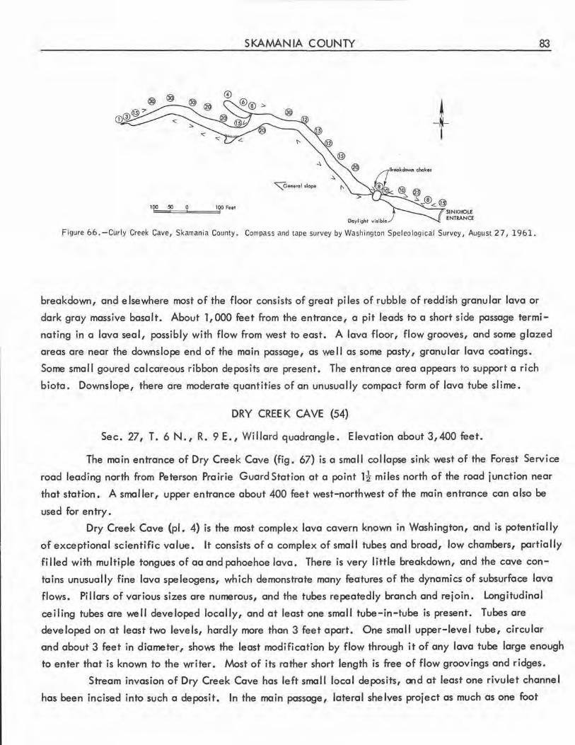
©
IQOIE~so===i? .......... .,;,i•OO Feel
SKAMANIA COUNTY
~enerol slope
SINKHOLE ENTRANCI:
Figure 66 . -Curly Creek Cave, Skamania County . Compass and tape survey by Washington Speleological Survey, August 2 7, 1961.
83
breakdown, and elsewhere most of the floor consists of great piles of rubble of reddish granular lava or
dark gray massive basalt. About 1,000 feet from the entrance, a pit leads to a short side passage termi
nating in a lava seal, possibly with flow from west to east. A lava floor, flow grooves, and some glazed
areas are near the downs lope end of the main passage, as we II as some pasty, granular lava coatings.
Some small goured calcareous ribbon deposits are present. The entrance area appears to support a rich
biota. Downslope, there ore moderate quantities of on unusually compact form of lava tube slime.
DRY CREEK CAVE (54)
Sec. 27, T. 6 N., R. 9 E., Willard quadrangle . Elevation about 3,400 feet.
The main entrance of Dry Creek Cave (fig . 67) is a small collapse sink west of the Forest Service
road leading north from Peterson Prairie Guard Station at a point 1! miles north of the rood junction near
that station. A smaller, upper entrance about 400 feet west-northwest of the main entrance can also be
used for entry.
Dry Creek Cave (pl. 4) is the most complex lava cavern known in Washington, and is potentially
of exceptional scientific value. It consists of a complex of small tube~ and brood, low chambers, partially
filled with multiple tongues of ao and pahoehoe lava . There is very little breakdown, and the cave con
tains unusua lly fine lava speleogens, which demonstrate many features of the dynamics of subsurface lava
flows. Pil lors of various sizes ore numerous, and the tubes repeatedly branch and rejoin. Longitudinal
ceiling tubes are well developed locally, and at least one small tube-in-tube is present. Tubes ore
developed on at least two levels, hardly more than 3 feet apart . One small upper-level tube, circular
and about 3 feet in diameter, shows the least modification by flow through it of any lava tube large enough
to enter that is known to the wri ter. Most of its rather short 1ength is free of flow groovings and ridges.
Stream invas ion of Dry Creek Cave has left small local deposits, a,d at least one rivulet channel
has been incised into such a deposit. In the main passage, lateral shelves project as much as one foot
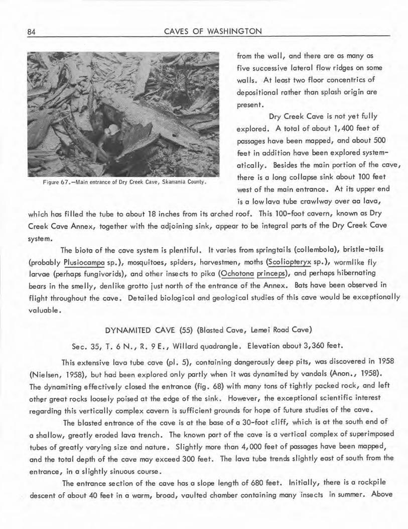
84 CAVES OF WASHINGTON
Figure 6 7. -Main entrance of Dry Creek Cave, Skamania County.
from the wal I, and there are as many as
five successive lateral flow ridges on some
walls. At least two floor concentrics of
depositional rather than splash origin are
present.
Dry Creek Cave is not yet fully
explored. A total of about 1,400 feet of
passages have been mapped, and about 500
feet in addition have been explored system
atically. Besides the main portion of the cave,
there is a long col lapse sink about 100 feet
west of the main entrance. At its upper end
is a low lava tube crawlway over aa lava,
which has filled the tube to about 18 inches from its arched roof. This 100-foot cavern, known as Dry
Creek Cave Annex, together with the adjoining sink, appear to be integral parts of the Dry Creek Cave
system .
The biota of the cave system is plentiful. It varies from springtai Is (collembola), bristle-tails
(probably Plusiocampa sp.), mosquitoes, spiders, harvestmen, moths (Scoliopteryx sp.), wormlike fly
larvae (perhaps fungivorids), and other insects to pika (Ochotona princeps), and perhaps hibernating
bears in the smelly, denlike grotto just north of the entrance of the Annex. Bats have been observed in
flight throughout the cave. Detailed biological and geological studies of this cave would be exceptionally
valuable.
DYNAMITED CAVE (55) (Blasted Cave, Lemei Rood Cave)
Sec. 35, T. 6 N., R. 9 E., Willard quadrangle. Elevation about 3,360 feet.
This extensive lava tube cave (pl. 5}, containing dangerously deep pits, was discovered in 1958
(Nielsen, 1958), but hod been explored only partly when it was dynamited by vandals (Anon., 1958).
The dynamiting effectively closed the entrance (fig. 68) with many tons of tightly packed rock, and left
oth~r great rocks loosely poised at the edge of the sink. However, the exceptional scientific interest
regarding this vertically complex cavern is sufficient grounds for hope of fu ture studies of the cave.
The blasted entrance of the cave is at the base of a 30-foot cliff, which is at the south end of
a shallow, greatly eroded lava trench. The known part of the cave is a vertical complex of superimposed
tubes of greatly varying size and nature. Slightly more than 4,000 feet of passages have been mapped,
and the total depth of the cave may exceed 300 feet. The lava tube trends slightly east of south from the
entrance, in a slightly sinuous course.
The entrance section of the cave has o slope length of 680 feet. Initially, there is a rockpi le
descent of about 40 feet in a worm, broad, vaulted chamber containing many ·insects in summer. Above
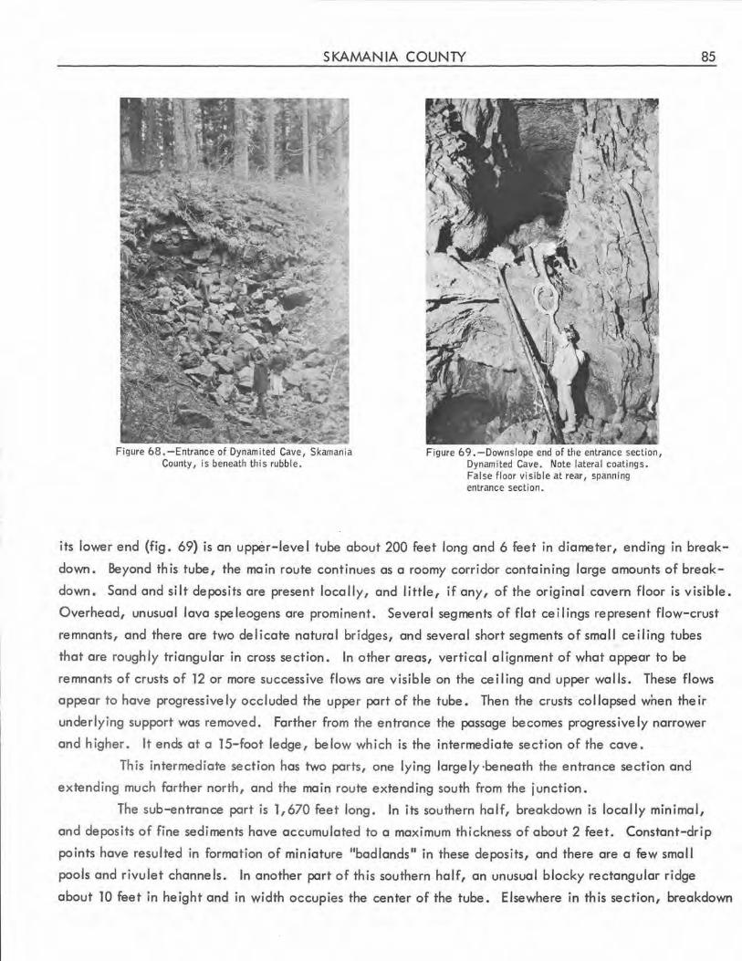
SKAMANIA COUNTY
Figure 68.-Entrance of Dynamited Cave, Skamania County, is beneath this rubble.
Figure 69. -Downslope end of the entrance section, Dynamited Cave. Note lateral coatings. False floor visible at rear, spanning entrance section.
85
its lower end (fig. 69) is an upper-leve I tube about 200 feet long and 6 feet in diameter, ending in break
down. Beyond this tube, the main route continues as a roomy corridor containing large amounts of break
down. Sand and silt deposits are present locally, and little, if any, of the original cavern floor is visible.
Overhead, unusual lava spe leogens are prominent. Several segments of flat ceilings represent flow-crust
remnants, and there are two delicate natural bridges, and several short segments of small ceiling tubes
that are roughly triangular in cross section. In other areas, vertical alignment of what appear to be
remnants of crusts of 12 or more successive flows are visible on the ceiling and upper walls. These flows
appear to have progressively occluded the upper part of the tube. Then the crusts col lapsed when their
underlying support was removed. Farther from the entrance the passage becomes progressively narrower
and higher. It ends at a 15-foot ledge, below which is the intermediate section of the cave.
This intermediate section has two parts, one lying largely ·beneath the entrance section and
extending much farther north, and the main route extending south from the junction.
The sub-entrance part is 1,670 feet long. In its southern half, breakdown is locally minimal,
and deposits of fine sediments have accumulated to a maximum thickness of about 2 feet. Constant-drip
points have resulted in formation of miniature "badlands" in these deposits, and there are a few small
pools and rivulet channels. In another part of this southern half, an unusual blocky rectangular ridge
about 10 feet in height and in width occupies the center of the tube. Elsewhere in th is section, breakdown
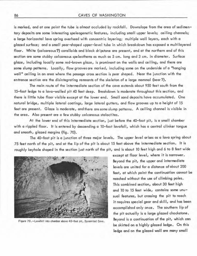
86 CAVES OF WASHINGTON
is marked, and at one point the tube is almost occluded by rockfal I. Downslope from the area of sedimen
tary deposits are some interesting speleogenetic features, including small upper levels; ceiling channels;
a large horizontal lava spring overhead with concentric layering; multiple wall layers, each with a
glazed surface; and a small pear-shaped upper-level tube in which breakdown has exposed a multi layered
floor. White (calcareous?) coralloids and black dripstone are present, and at the northern end of this
section are some stubby calcareous speleothems as much as 5 cm. long and 3 cm. in diameter. Surface
glaze, including locally some red-brown glaze, is prominent on the walls and ceiling, and there are
some slump patterns. Locally, flow grooves are marked, including some on the underside of a "hanging
wall" ceiling in an area where the passage cross section is pear shaped. Near the junction with the
entrance section are the disintegrating remnants of the skeleton of a large mammal (bear?).
The main route of the intermediate section of the cave extends about 950 feet south from the
15-foot ledge to a lava-walled pit 40 feet deep. Breakdown is moderate throughout this section, and
there is little tube floor visible except at the lower end . Small sand deposits have accumulated . One
natural bridge, multiple lateral coatings, large lateral gutters, and flow grooves up to a height of 15
feet are present. Glaze is moderate, and there are some slump patterns. A ceiling channel is visible in
the area. Also present are a few stubby calcareous stalactites.
At the lower end of this intermediate section, just before the 40-foot pit, is a small chamber
with a rippled floor. It is entered by descending a 10-foot lavafall, which has a central clinker tongue
and smooth, glazed margins (fig. 70).
The 40-foot pit is a junction of three major levels. The upper level arises as a lava spring about
75 feet north of the pit, and at the lip of the pit is about 15 feet above the intermediate section. It is
roughly keyhole shaped in the section just north of the pit, and is about 10 feet high and 6 to 8 feet wide
,· ~
~
Figure 70. -Lavafall into chamber above 40-foot pit, Dynamited Cave.
except at floor level, where it is narrower.
Beyond the pit, the upper and intermediate
levels are united for a distance of about 200
feet, at which point the continuation cannot be
reached without the use of climbing poles.
This combined section, about 30 feet high
and 10 to 15 feet wide, contains some unu
sual features, but crossing the pit to reach
it requires special gear and skill, and has been
accomplished only once. The southern lip of
the pit actually is a large glazed chocks tone .
Beyond is a continuation of the pit, which can
be skirted on a highly glazed ledge. On this
ledge and on the glazed wa 11 are many sma 11
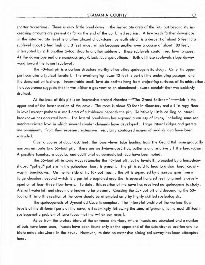
SKAMANIA COUNTY 87
spatter accretions. There is very little breakdown in the immediate area of the pit, but beyond it, in
creasing amounts are present as far as the end of the combined section. A few yards farther downslope
in the intermediate level is another glazed chockstone, beneath which is a descent of about 5 feet to a
sublevel about 5 feet high and 3 feet wide, which becomes smaller over a course of about 100 feet,
interrupted by still another 5-foot drop to another sublevel. These sublevels contain red lava tongues.
At the downslope end are numerous gray-black lava speleothems. Both of these sublevels slope down
ward toward the lowest sublevel.
The 40-foot pit is a curious structure worthy of detailed speleogenetic study. Only its upper
part contains a typical lavafall. The overhanging lower 12 feet is part of the underlying passage, and
the demarcation is sharp. Innumerable small lava stalactites hang from projecting surfaces of its midsection .
Its appearance suggests that it was either a gas vent or an abandoned upward conduit that was suddenly
drained.
At the base of this pit is an impressive arched chamber-"The Grand Bal lroomn-wh ich is the
upper end of the lov.e r section of the cave. The room is about 50 feet in diameter, and al I its ropy floor
is level except perhaps a small area of subsidence beneath the pit. Relatively little ceiling or lateral
breakdown has occurred here. The lateral breakdown has exposed a variety of lavas, including some red
autobrecciated lava in which several rivulet channels have developed. Large lateral ridges and gutters
are prominent. From their recesses, extensive irregularly contoured masses of reddish lava have been
extruded.
Over a course of about 650 feet, the lower-level tu~ leading from The Grand Ballroom gradually
narrows en route to a 55-foot pit. There are well-developed flow patterns and relatively little breakdown.
A possible tumulus, a cupola, and additional autobrecciated lava have been noted.
The 55-foot pit in some ways resembles the 40-foot pit, but a lavafall, preceded by a horseshoe
shaped "pulled" pattern in the pahoehoe floor, is present. The pit is said to lead to a short basal crawl
way in breakdown. On the far side of its 10-foot mouth, the pit is separated by a narrow span from a
large chamber, beyond which is a partially explored area that is several hundred feet long and is devel
oped on at least three flow levels. To date, this section of the cave has received no speleogenetic study.
A smal I waterfall and stream are known to be present. Crossing the 55-foot pit and descending the 50-
foot cliff into this section of the cave should be attempted only by highly skilled speleologists.
The speleogenesis of Dynamited Cave is complex. The interrelationship of the various flow
levels of the different parts of the cave, all seemingly following the same alignment, is the most difficult
speleogenetic problem of lava tubes that the writer can recall.
Aside from the profuse biota of the entrance chamber, where insects are abundant and a number
of bats have been seen, insects have been found only at the upper end of the subentrance section and no
bioto noted elsewhere in the cave. However, to date no extensive biological survey has been attempted
here.
88 CAVES OF WASHINGTON
FALLS CREEK CAVE (56) (Panther Creek Cave, Lava Caves)
Secs. 1 and 12, T. 5 N., R. 8 E., Wind River quadrangle. Elevation about 2,875 feet.
The entrances of this extensive and moderately complex lava-tube cave (pl. 6) are about half a
mi le north of the end of the Falls Creek road, in a forested area in which exploring parties have repeatedly
lost their way, particularly upon attempting to return to the road. Total slope length of the passages of
the cave is about 6,000 feet, about 4,300 feet of which is along the main passage, which follows a
sinuous course, roughly north to south from the Big Entrance to the terminal complex, although the un
mapped lowermost section of the cove seems to trend more to the west.
Actually, there are three separate ports to the cave system, separated by collapse sinks. The
two upper sections are very short, however.
The upper, northern end of the system consists of a grottolike chamber adjacent to, but not aligned
with, an additional sink with raised margins. At the lowest part of this spacious chamber, a thick ice
floor was found on July 23, 1960. The nearby additional sink just mentioned is much more eroded and
fi I led with vegetation than the two sinks of the cave system proper, and appears much older.
This northernmost chamber is at the north end of a collapse sink about 60 feet long. Along the
east wall of this sink is a smaller chamber, which is also a remnant of the original tube. At the south
end of the sink is the entrance of the second section of the system. Th is section, which resembles a nat
ural bridge, is about 150 feet long. At both ends, the floor is extremely steep and rough, due to break
down. A small amount of melting ice was found at its lowest point on July 23, 1960.
At the southwest end of this second section of the cove is the larger of the two sinks of the system.
At its southern end, about 4?0 feet from the northern end of the system, is the steep entrance of the main
passage. On the southwest wall of this larger sink is the entrance of another small passage, which extends
roughly southwest for about 500 feet. Because of logistic problems, the side passa~es off the main passage,
and the final 1,200-odd feet of the main passage itself have not been surveyed, but all penetrable open
ings of the cave system are believed to hove been explored.
Falls Creek Cave is of considerable geologic interest. Despite the occurrence of considerable
breakdown in the cove, there are many speleogenetic features indicative of a complex history. Both
re-entrant and non-re-entrant side tubes are present . Except at the points of re-entry, all are effluent.
Their entrances occur both at floor level and at high ledge levels, the lotter predominating . Within the
tube ore natural bridges and several superposed levels (fig. 71). The terminal complex of the cove partic
ularly merits detailed study. In this area it appears that the main tube originally continued at its accus
tomed leve I. Subsequently, a flow broke through from th is leve I to a lower chamber that now has a lava
seal. From the main level, two chimneys lead upward to a third level of small, irregular chambers and
passageways that was almost occluded in two locations by a flow of reddish lava.
The cross section of the cove, where not disrupted by breakdown, varies considerably. In the
section -south of the large sink the passage section is roughly rectangular and hos a copping flat arch. The
SKAMANIA COUNTY 89
Figure 71.-Lava cascade from an u~per level to the main passage in Falls Creek Cave. Photo by Peter Alburas .
walls here are vertical for a distance of more than 30 feet, and show particularly fine lateral flow grooves.
An area farther downslope has a cross section resembling a moorish dome pattern, but a broad, flat arch
is more common. Except in the stoopway just upslope from the terminal complex and in areas with massive
breakdown, the ceiling height of the main passage is rarely less than 15 feet, usually more than 25 feet,
and in places 50 feet or more. Similarly, this passage is rarely less than 15 feet in width, and usually 20
to 25 feet. The side passages are lower and narrower, but in general contain less breakdown.
A dark, brick-red lava flow can be seen on much of the original floor of the cave. In some
areas its surface is almost smooth; in other sections it is rippled, and locally shows buckling subsequent
to crusting . A few splash concentrics are present. In some places, large lateral ridges have been formed
of the same lava, and in a few areas there is a red glaze on the walls and ceiling instead of the commoner
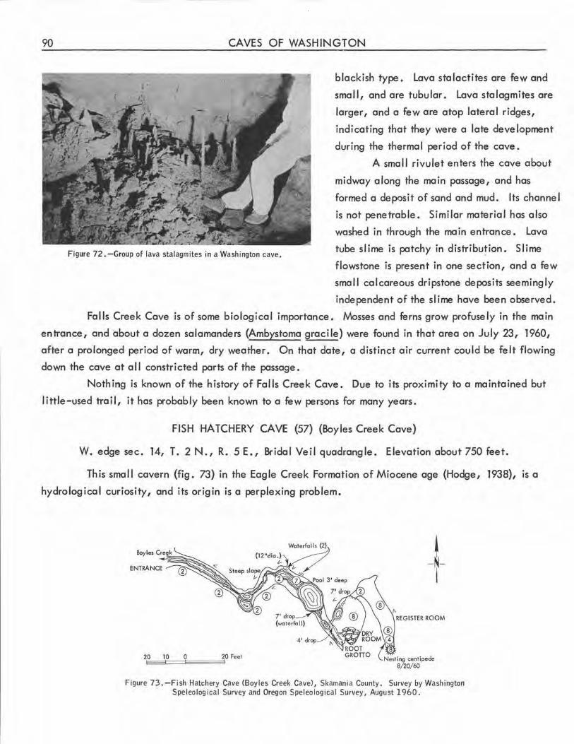
90 CAVES OF WASHINGTON
Figure 72 .-Group of lava stalagmites in a Washington cave.
blackish type. lava stalactites are few and
small, and are tubular. lava stalagmites are
larger, and a few are atop lateral ridges,
indicating that they were a late development
during the thermal period of the cave.
A smal I rivulet enters the cave about
midway along the main passage, and has
formed a deposit of sand and mud. Its channel
is not penetrable . Similar material has also
washed in through the main entrance. lava
tube slime is patchy in distribu~ion. Slime
flowstone is present in one section, and a few
smal I calcareous dripstone deposits seemingly
independent of the slime have been observed .
Falls Creek Cave is of some biological importance. Mosses and ferns grow profusely in the main
entrance, and about a dozen salamanders (Ambystoma gracile) were found in that area on July 23, 1960,
after a prolonged period of warm, dry weathe r . On that date, a distinct air current could be felt flowing
down the cave at a 11 constricted parts of the passage.
Nothing is known of the history of Falls Creek Cave. Due to its proximity to a maintained but
little-used trail, it has probably been known to a few persons for many years.
FISH HATCHERY CAVE (57) (Boyles Creek Cave)
W. edge sec. 14, T. 2 N., R. 5 E. , Bridal Veil quadrangle. Elevation about 750 feet.
This small cavern (fig. 73) in the Eagle Creek Formation of Miocene age (Hodge, 1938), is a
hydrological curiosity, and its origin is a perplexing problem.
~ -N-I
20
Figure 73 . -Fish Hatchery Cave <Boyles Creek Cave), Skamania County. Survey by Washington Speleological Survey and Oregon Speleological Survey, August 1960.
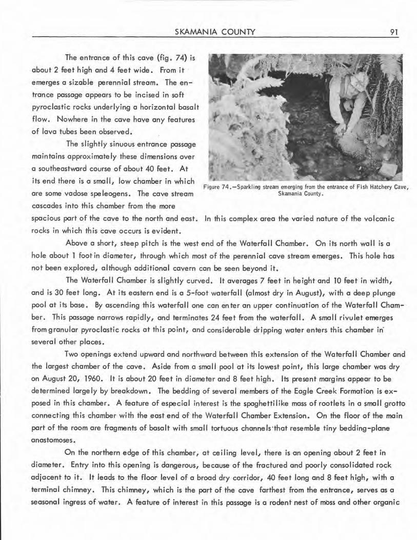
SKAMANIA COUNTY 91
The entrance of this cave (fig. 74) is
about 2 feet high and 4 feet wide. From it
emerges a sizable perennial stream. The en
trance passage appears to be incised in soft
pyroclastic rocks underlying a horizontal basalt
flow . Nowhere in the cave have any features
of lava tubes been observed.
The slightly sinuous entrance passage
maintains approx imately these dimensions over
a southeastward course of about 40 feet. At
its end there is a small, low chamber in which
are some vadose spe leogens. The cave stream
cascades into this chamber from the more
Figure 74 .-Sparkling stream emerging from the entrance of Fish Hatchery Cave, Skamania County.
spacious part of the cave to the north and east. In this complex area the varied nature of the volcanic
rocks in which this cave occurs is evident.
Above a short, steep pitch is the west end of the Waterfall Chamber . On its north wall is a
hole about 1 foot in diameter, through which most of the perennial cave stream emerges. This hole has
not been explored, although additional cavern can be seen beyond it.
The Waterfall Chamber is slightly curved. It averages 7 feet in height and 10 feet in width,
and is 30 feet long. At its eastern end is a 5-foot waterfall (almost dry in August), with a deep plunge
pool at its base. By ascending this waterfall one can enter an upper continuation of the Waterfall Cham
ber. This passage narrows rapidly, and terminates 24 feet from the waterfal I. A small rivulet emerges
from granular pyroclastic rocks at this point, and considerable dripping water enters this chamber in·
several other places.
Two openings extend upward and northward between this extension of the Waterfall Chamber and
the largest chamber of the cave. Aside from a small pool at its lowest point, th is large chamber was dry
on August 20, 1960. It is about 20 feet in diameter and 8 feet high. Its present margins appear to be
determined largely by breakdown. The bedding of several members of the Eagle Creek Formation is ex
posed in this chamber. A feature of especial interest is the spaghetti like mass of rootlets in a small grotto
connecting this chamb:er with the east end of the Waterfall Chamber Extension. On the floor of the main
part of the room are fragments of basalt with small tortuous channels-that resemble tiny bedding-plane
anastomoses.
On the northern edge of this chamber, at ceiling level, there is an opening about 2 feet in
diameter. Entry into this opening is dangerous, because of the fractured and poorly consolidated rock
adjacent to it. It leads to the floor level of a broad dry corridor, 40 feet long and 8 feet high, with a
terminal chimney. This chimney, which is the part of the cave farthest from the entrance, serves as a
seasonal ingress of water. A feature of interest in this passage is a rodent nest of moss and other organic
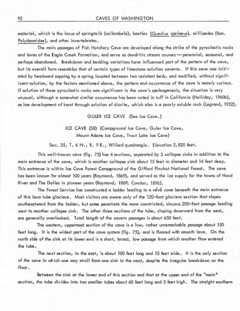
92 CAVES OF WASHINGTON
material, which is the locus of springtails (collembola), beetles (Quedius spelaeus), millipedes (fem.
Polydesmidae), and other invertebrates.
The main passages of Fish Hatchery Cave are developed along the strike of the pyroclastic rocks
and lavas of the Eagle Creek Formation, and serve as dendritic stream courses - perennial, seasonal, and
perhaps abandoned. Breakdown and bedding variations have influenced part of the pattern of the cave,
but. its overal I form resembles that of certain types of limestone solution caverns. If this cave was initi
ated by headword sapping by a spring located between two resistant beds, and modified, without signif
icant solution, by the factors mentioned above, the pattern and occurrence of the cave is merely curious .
If solution of these pyroclastic rocks was significant in the cave's speleogenesis, the situation is very
unusual, although a somewhat similar occurrence has been noted in tuff in California (Halliday, 1960b),
as has development of karst through solution of diorite, which also is a poorly soluble rock (Legrand, 1952).
GULER ICE CAVE (See Ice Cave.)
ICE CAVE (.58) (Campground Ice Cave, Guler Ice Cave,
Mount Adams Ice Cave, Trout Lake Ice Cave)
Sec. 35, T. 6 N., R. 9 E., Willard quadrangle. Elevation 2,820 feet.
This well-known cave (fig. 75) has 4 sections, separated by 3 collapse sinks in addition to the
main entrance of the cave, which is another collapse sink about 15 feet in qiameter and 14 feet deep.
This entrance is within Ice Cave Forest Campground of the Gifford Pinchot National Forest . The cave
has been known for almost 100 years (Raymond, 1869), and served as the ice supply for the towns of Hood
River and The Dalles in pioneer years (Raymond, 1869; Condon, 1896).
The Forest Service has constructed a ladder leading to a n~v~ cone beneath the main entrance
of th is lava tube glaciere. Most visitors are aware only of the 120-foot glaciere section that slopes
southeastward from the ladder, but some penetrate the more constricted, sinuous 200-foot passage leading
west to another collapse sink. The other three sections of the tube, sloping downward from the west,
are generally overlooked. Total length of the cavern passages is about 650 feet.
The western, uppermo.st section of the cave is a low, rather unremarkable passage about 150
feet long. It is the widest part of the cave system (fig. 75), and is floored with smooth lava. On the
north side of the sink at its lower end is a short, broad, low passage from which another flow entered
the tube.
The next section, to the east, is about 100 feet long and 15 feet wide. It is the only section
of the cave in which one may stroll from one sink to the next, despite the irregular breakdown on the
floor.
Between the sink at the lower end of this section and that at the upper end of the "main"
section, the tube divides into two smaller tubes about 60 feet long and 5 feet high. The straight southern
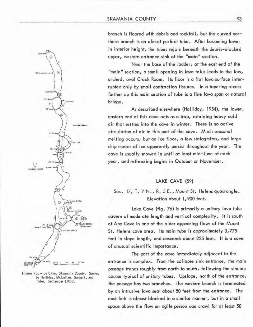
V
--k-l
V GENERAL SLOPE
20 ~ 60 ,. •••
Figure 75.-lce Cave, Skamania County. Survey by Halliday, Mclellan, Sargent, and Tyler; September 1950.
SKAMANIA COUNTY 93
branch is floored with debris and rock fa 11, but the curved nor
thern branch is an almost perfect tube. After becoming tower
in interior height, the tubes rejoin beneath the debris-blocked
upper, v,,estern entrance sink of the "main II section.
Near the base of the ladder, at the east end of the 11main 11 section, a small opening in lava talus leads to the low,
arched, oval Crack Room. Its floor is a flat lava surface inter
rupted only by small contraction fissures . In a tapering recess
farther up this main section of tube is a fine lava span or natural
bridge.
As described elsewhere (Halliday, 1954), the lower,
eastern end of this cave acts as a trap, retaining heavy cold
air that settles into the cave in winter . There is no active
circulation of air in this part of the cave. Much seasonal
melting occurs, but an ice floor, a few stalagmites, and large
drip masses of ice apparently persist throughout the year. The
cave is usually snowed in until at least mid-June of each
year, and refreezing begins in October or November.
LA KE CA VE (59)
Sec. 17, T. 7 N., R. 5 E., Mount St. Helens quadrangle.
Elevation about 1,900 feet.
Lake Cave (fig. 76) is primarily a unitary lava tube
cavern of moderate length and vertical complexity. It is south
of Ape Cave in one of the older appearing flows of the Mount
St. Helens cave area. Its main tube is approximately 3,775
feet in slope length, and descends about 225 feet. It is a cave
of unusual scientific importance.
The part of the cave immediately adjacent to the
entrance is complex. F~om the collapse sink entrance, the main
passage trends roughly from north to south, following the sinuous
course typical of unitary tubes . Upslope, north of the entrance,
the passage has two branches. The western branch is terminated
by an intrusive lava seal about 50 feet from the entrance. The
east fork is almost blocked in a similar manner, but in a smal I
space above the flow an agile person can crawl for at least 50
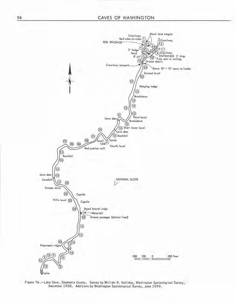
94
~ -N-i
CAVES OF WASHINGTON
RED
Broad loterol ridge ;-/
@) Third leve l
Breokdown @
@ Short lower level
Lovo dom
@Rockfoll
GENERAL SLOPE v
Block lovo tongue
Down 10' + 10' more to !odder
~Woterfoll @'""streom possoges (dotted lines)
200 100 0 200 Feet i::l---33::::::l:l=-3:3::::Jl~====::::::::ll
Figure 76.-Lake Cave, Skamania County. Survey by William R. Halliday, Washington Speleological Survey, December 1958. Additions by Washington Speleological Survey, June 1959.
SKAMANIA COUNTY 95
feet farther. The flows entering through the two passages were not simultaneous. That from the west
was the more recent, as it overlies and has partially remelted the margin of the flow from the east fork.
Another short side passage, the Red Passage, enters the cave from the west just south of the
entrance sink. At the junction it is at right angles to the main passage, but a little farther upslope
it turns to the north, paralleling the main passage for a short distance before angl ing northwest. At the
upper end of this side passage, local explorers have succeeded in forcing the first of two intrusive lava
seals, making the total penetrable length of this side passage about 100 feet. The most interesting feature
of this passage is the rather smooth, brilliantly brick-red lava flow that emerged from and lines it. Some
of this coloring is only a surface coating over gray-black lava, but much of it is inherent in the main
flow of this area. This flow appears to be the most recent in the cave. The coloring is identical with
that of the red crystalline autobrecciated lava exposed by lateral breakdown in the downslope parts of
the main tube.
Other interesting features of this side passage include a small pit at the first bend. Its narrow
tube descends about 10 feet; then turns upward, ascending almost to the passage level. A seasonal stream
drips through the roof in this area, carrying gravel. Its channel disappears in the niain tube. Small roots
emerge from part of the roof of the passage, and a reddish mold and an unidentified fungus were observed
on the ceiling on December 28, 1958.
About 100 feet south from the entrance of the cave, the broad but fairly low main passage
descends from the entrance level to a lower tube level. This lower tube extends back north beneath the
entrance passage for some distance, but it is almost occluded by a flow of rough lava that makes crawling
difficult.
A seasonal stream emerges from this low opening, carrying more water and sediments than that
of the Red Passage. This stream is visible intermittently as for as The Waterfall, about 2,500 feet from
the entrance, where it joins the larger seasonal stream that enters the cave at that point. The combined
stream then continues to a sediment- and gravel-impounded lake at the lower end of the cave. Sand and
gravel deposits occur along much o(the length of the cave, but are not as common as in the lower section
of nearby Ape Cave. Breakdown is widespread in the upper 2,000 feet of the cave, but is relatively
sparse below The Waterfall.
The upslope part of the second leve I of the cave consists of an impressive passage about 25 feet
high and 20 feet wide near the ceiling, although quite narrow at floor level. About 500 feet from the
entrance, beyond a massive overhang on the east, there is a descent of 8 feet to a third tube level. Its
upslope part is almost blocked by breakdown. In this area, several small chambers have formed where the
lateral crust of the tube has partly broken away. At least three layers of this crust can be distinguished
in some places.
About 250 feet from the beginnjng of this third level, an upper-level tube can be seen over the
main passage. Beyond an area of dangerous breakdown are three lava dams; between the first and second,
a pit leads down to a crawlway on the fourth level, but there is an easier descent on the for side of the
third dam.
96 CAVES OF WASHINGTON
Beyond this descent, red autobrecciated lava is locally exposed by lateral breakdown. An
interesting feature of this section is a miniature flow containing a tube about 8 inches in diameter, aligned
transversely to the axis of the possoge.
There ore many small lava springs along the lower wall of this part of the cove, and ribbon
stalactites occur behind the crust. Tubular stalactites ore common, but puddles are present rather than
multiglobulor stalagmites. In this area the ceiling height is approximately 30 feet-the greatest height
in the cove.
About 2, 100 feet from the entron·ce, a lava dam and a 6-foot lava falls lead down to the fifth
tube level. The cove stream is augmented by dripping water at this point, Two small cupolas ore present.
About 400 feet beyond the lava foils, a large opening in the east wall of the cove permits entry of a
seasonal 6-foot waterfall, which emerges from two confluent dendritic stream passages. These ore vodose
stream passages, which hove cut into partially weathered autobreccioted lava that underlies a compact
basalt flow. The undersurfoce of this flow is exposed along much of the 200-foot length of these crowl
woys. Horizontal and vertical tree costs are visible on this undersurface. In the walls of the vodose
passages is considerable charcoal in the shape of roots of plants that were growing on the surface at the
ti me the basa It flowed over it. The root stump of a large tree, exposed by the stream channe I, shows a
gradation from unchorred wood to very hard, dense charcoal resembling bituminous cool. Samples
submitted to Dr. Arthur Fairholl of the University of Washington for radiocarbon study were found in
pre I iminory studies to be about 2,250 ±150 years old {Arthur Foirholl, orall communication).
Beyond The Woterfal I, the sinuous passage is rather regular in out I ine. Woll ridges are prominent,
and little breakdown hos occurred. Despite the seasonally sizable stream, no channel hos been incised
in the floor. Under ordinary conditions the lake at the end of the cove has a maximum depth of 4 feet,
but a high-water mark 10 feet higher than the surface is present. The lake is about 50 feet long and
averages about 9 feet in width, filling the entire width of the tube at this point: The end of the cove
is not a siphon, being blocked with stream deposits.
Lake Cove was discovered and first explored in Apri I 1958, by a scouting party of the St. Helens
Apes (see Ape Cove) . It is in a densely forested region in which there ore many vertical tree costs as
much as 5 feet in diameter and 10 feet deep. The cove contains a conside,rable biota, including salamanders
(Ambystoma grocile and Ensatino escholtzii oregonensis), larvae of fungus gnats (fom. Fungivoridae), and
Grylloblatta chirurgico (Gurney, 1961) .
LAVA CAVE (See Ole's Cove and Curly Creek Cove.)
LAVA CAVES (See Falls Creek Cave.)
LEMEI ROAD CAVE (Lemei Cave) (See Dynamited Cave.)
SKAMANIA COUNTY 97
LITTLE RED RIVER CAVE (60)
Sec. 32, T. 8 N., R. 5 E., Mount St. Helens quadrangle.
Elevation of entrance about 2,800 feet .
Th is northernmost of the Mount St . He lens group of lav~tube caves (pl. 7) was discovered
September 15, 1960, by Bill Reese, Bob Kitch, and Gene McCune, while cave-hunting. Its total slope
length is about 3,865 feet, most of which is a unitary lava tube, and it terminates in a lake that, although
shallower, is larger than that of Lake Cave. The unusua l name of this cave is due to a reddish discolor
ation on the floor of the channe I of the rivulet that forms the lake.
The entrance of the cave is a collapse sink about 10 feet in diameter and 8 feet deep, at the
foot of a Doug las fir about 44 inches in diameter. A 15-foot snag projects upward from the bottom of
the small sink. The actual opening of the cave is a triangular space about 3 feet high and 10 feet wide,
below the north wall of the sink. Beyond is an irregular, spacious chamber, which is a junction of three
levels and several tubes. Just below and to the east of the triangular opening are remnants of a tube
about 4 feet in diameter leading south, including a fine span. To the north is the orifice of a larger tube,
from which flowed a lava that left a red glaze on :vval ls and floor . To the northeast, in the most spacious
part of the chamber, is a drop of about 20 feet to another tube level, which is the main route. It is
reached most conveniently by way of the tube with the red glaze mentioned above, at a point about 190
feet northeast of the entrance. Almost exactly beneath the I ip of t~e 20-foot dropoff at the lower,
southern end of the main passage level is a short crack about 1 foot wide, through which an overhanging
descent of 10 feet conducts the explorer doymward into a stream-eroded section of short passages and a
steeply sloping large breakdown chamber in what appears to be autobrecciated lava. The transition
from the short lava tube complex at the entrance is dramatic. One feature of interest is the exposure of
vertically laminated lava in the ceiling.
At the lower end of this breakdown area, a lower-level tube is encountered. For several hundred
feet it averages about 15 feet in width and 12 feet in height, following a sinuous course roughly southward.
The floor of its upslope part is covered with a thin coating of stream deposits, and little breakdown has
occurred. Slumping of its lateral glaze is apparent about 200 feet from the beginning of this section.
Farther along its course, lateral flow grooves are present to a height of 6, 7, and finally 9 feet above the
floor. Two large lava springs open into the passage at prominent shelves, and a short segment of an upper
tube opens in the ceiling along its course. Near the lower end of this section, the lava floor has been
markedly rippled, as if the flow had been partially obstructed by the narrowing of the passage that pre
cedes the descent to the lower leve I beyond.
At the end of this broad, pleasant passage, the character of the cave changes abruptly. Two
steep descents, separated by a short horizontal landing, extend downward at an angle of about 45° in a
narrow tube. The overal I descent is about 50 feet. The lower "slide" is the longer, measuring more than
75 feet in length. A number of features of interest are in the slide area. A small upper level complex,
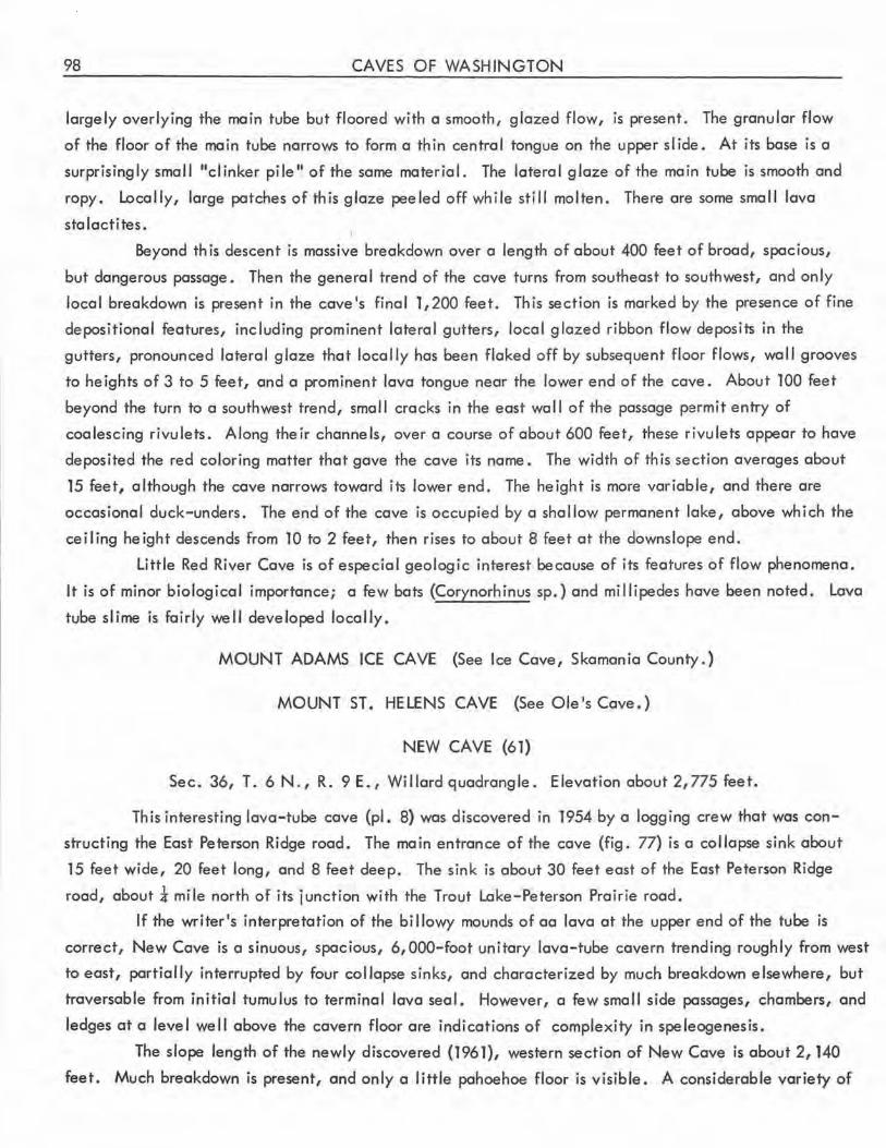
98 CAVES OF WASHINGTON
largely overlying the main tube but floored with a smooth, glazed flow, is present. The granular flow
of the floor of the main tube narrows to form a thin central tongue on the upper slide. At its base is a
surprisingly small "clinker pile" of the same material. The lateral glaze of the main tube is smooth and
ropy. Locally, large patches of this glaze peeled off while still molten. There are some small lava
stalactites.
Beyond th is descent is massive breakdown over a length of about 400 feet of broad, spacious,
but dangerous passage. Then the general trend of the cave turns from southeast to southwest, and only
local breakdown is present in the cave's final 1,200 feet. This section is marked by the presence of fine
depositional features, including prominent lateral gutters, local glazed ribbon flow deposits in the
gutters, pronounced lateral glaze that locally has been flaked off by subsequent floor flows, wall grooves
to heights of 3 to 5 feet, and a prominent lava tongue near the lower end of the cave . About 100 feet
beyond the turn to a southwest trend, small cracks in the east wall of the passage permit entry of
coalescing rivulets. Along their channels, over a course of about 600 feet, these rivulets appear to have
deposited the red coloring matter that gave the cave its name. The width of this section averages about
15 feet, although the cave narrows toward its lower end. The height is more variable, and there are
occasional duck-unders. The end of the cave is occupied by a shallow permanent lake, above which the
ceiling height descends from 10 to 2 feet, then rises to about 8 feet at the downslope end.
Little Red River Cave is of especial geologic interest because of its features of flow phenomena.
It is of minor biological importance; a few bats (Corynorhinus sp.) and millipedes have been noted. Lava
tube slime is fairly well developed locally.
MOUNT ADAMS ICE CAVE (See Ice Cave, Skamania County.)
MOUNT ST. HELENS CAVE {See Ole's Cave.)
NEW CAVE (61)
Sec. 36, T. 6 N., R. 9 E., Willard quadrangle. Elevation about 2,775 feet.
This interesting lava-tube cave (pl. 8) was discovered in 1954 by a logging crew that was con
structing the East Peterson Ridge road . The main entrance of the cave {fig. 77) is a collapse sink about
15 feet wide, 20 feet long, and 8 feet deep. The sink is about 30 feet east of the East Peterson Ridge
road, about :a- mile north of its junction with the Trout Lake-Peterson Prairie road .
If the writer's interpretation of the billowy mounds of aa lava at the upper end of the tube is
correct, New Cave is a sinuous, spacious, 6,000-foot unitary lava-tube cavern trending roughly from west
to east, partially interrupted by four collapse sinks, and characterized by much breakdown elsewhere, but
traversable from initial tumulus to terminal lava seal. However, a few small side passages, chambers, and
ledges at a level well above the cavern floor are indications of complexity in speleogenesis .
The slope length of the newly discovered {1961), western section of New Cave is about 2, 140
feet. Much breakdown is present, and only a little pahoehoe floor is visible . A considerable variety of
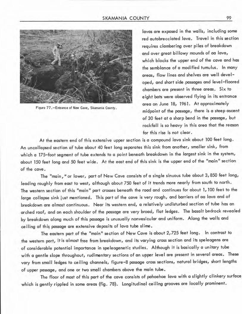
SKAMANIA COUNTY 99
Figure 77. -Entrance of New Cave, Skamania County.
lavas are exposed in the wa lls, including some
red autobrecciated lava. Travel in this section
requires clambering over piles of breakdown
and over great billowy mounds of aa lava,
which blocks the upper end of the cave and has
the semblance of a modified tumulus. In many
areas, flow lines and shelves are well devel
oped, and short side .passages and level-floored
chambers are present in three areas. Six to
eight bats were observed flying in its entrance
area on June 18, 1961 . At approximately
midpoint of the passage, there is a steep ascent
of 30 feet at a sharp bend in the passage, but
rockfall is so heavy in this area that the reason
for th is rise is not clear.
At the eastern end of th is extensive upper section is a compound lava sink about 100 feet long.
An uncollapsed section of tube about 40 feet long separates this sink from another, smaller sink, from
which a 175-foot segment of tube extends to a point beneath breakdown in the largest sink in the system,
about 150 feet long and 50 feet wide. At the east end of this sink is the upper end of the 11 main 11 section
of the cave.
The "main, 11 or lower, part of New Cave consists of a single sinuous tube about 3,850 feet long,
leading roughly from east to west, although about 750 feet of it trends more nearly from south to north.
The western section of this "main" part crosses beneath the road and continues for about 1, 100 feet to the
large collapse sink just mentioned. This port of the cave is very rough, and barriers of aa lava and of
breakdown are almost continuous. Near its western end, a relatively undisturbed section of tube has an
arched roof, and on each shoulder of the passage are very broad, flat ledges. The basalt bedrock revealed
by breakdown along much of this passage is unusually nonvesicular and uniform. Along the walls and
ceiling of thi~ passage are extensive deposits of lava tube slime.
The eastern part of the "main II section of New Cave is about 2,725 feet long. In contrast to
the western part, it is almost free from breakdown, and its varying cross section and its speleogens are
of considerable potential importance in speleogenetic studies. Although it is basically a unitary tube
with a gentle slope throughout, rudimentary sections of an upper level are present in several areas. These
vary from small ledges to ceiling channels, figure-8 passage cross sections, natural bridges, short lengths
of upper passage, and one or two small chambers above the main tube.
The floor of most of this part of the cave consists of pahoehoe lava with a slightly clinkery surface.
which is gently rippled in some areas (fig. 78). longitudinal ceiling grooves are locally prominent.
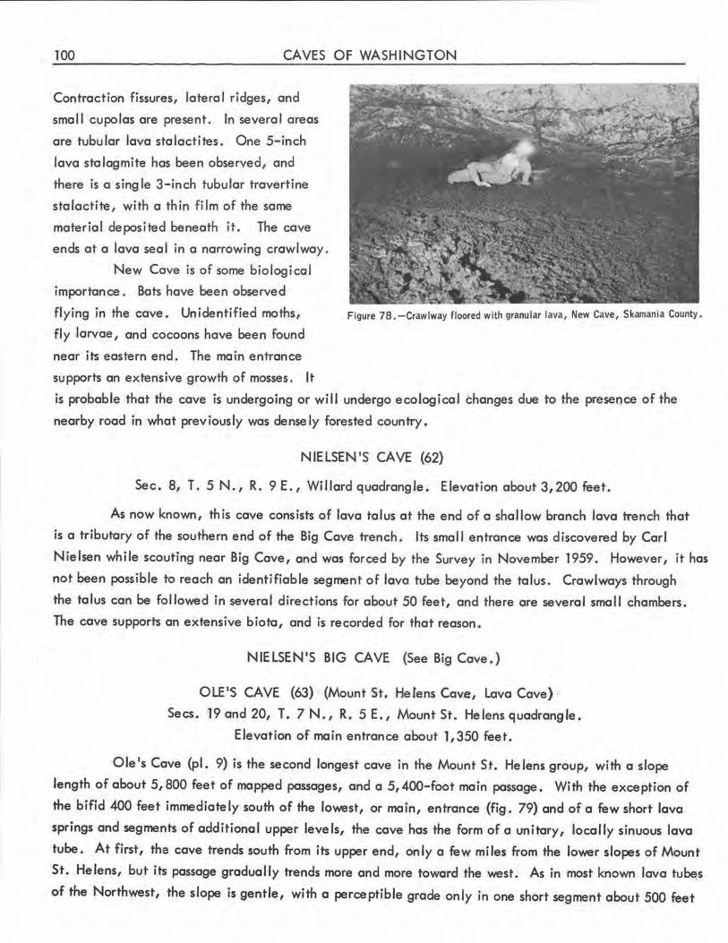
100 CAVES OF WASHINGTON
Contraction fissures, lateral ridges, and
sma 11 cupolas are present. In severe I areas
are tubular lava stalactites . One 5-inch
lava stalagmite has been observed, and
there is a single 3-inch tubular travertine
stalactite, with a thin film of the some
material deposited beneath it. The cove
ends at a lava seal in a narrowing crawlway,
New Cove is of some biological
importance. Bots have been observed
flying in the cove. Unidentified moths,
fly larvae , and cocoons hove been found
near its eastern end. The main entrance
supports an extensive growth of mosses. It
Figure 78. -Crawlway floored with granular lava, New Cave, Skamania County.
is probable that the cove is undergoing or will undergo ecological changes due to the presence of the
nearby road in what previously was densely forested country.
NIELSEN'S CAVE (62)
Sec. 8, T. SN., R. 9E., WillardquodrangJe . Elevationabout3,200feet.
As now known, this cave consists of lava talus at the end of a shallow branch lava trench that
is a tributary of the southern end of the Big Cave trench. Its small entrance was discovered by Corl
Nielsen while scouting near Big Cave, and was forced by the Survey in November 1959. However, it has
not been possible to reach on identifiable segment of lava tube beyond the talus. Crowlwoys through
the talus con be followed in several directions for about 50 feet, and there are several small chambers.
The cave supports on extensive biota, and is recorded for that reason .
NIELSEN'S BIG CAVE (See Big Cave . )
OLE'S CAVE (63) (Mount St. ·He fens Cov.e, Lava Cave) ..
Secs. 19ond20, T. 7N., R. SE., Mount St. Helens quadrangle,
Elevation of main entrance about 1,350 feet.
Ole's Cave (pl. 9) is the second longest cave in the Mount St. Helens group, with a slope
length of about 5,800 feet of mopped passages, and a 5, 400-foot main passage. With the exception of
the bifid 400 feet immediately south of the lowest, or main, entrance (fig, 79) and of a few short lava
springs and segments of additional upper levels, the cave has the form of a unitary, locally sinuous lava
tube. At first, the cave trends south from its upper end, only a few miles from the lower slopes of Mount
St. Helens, but its passage gradually trends more and more toward the west. As in most known lava tu~s
of the Northwest, the slope is gentle, with a perceptible gr~de only in one short segment about §00 feet
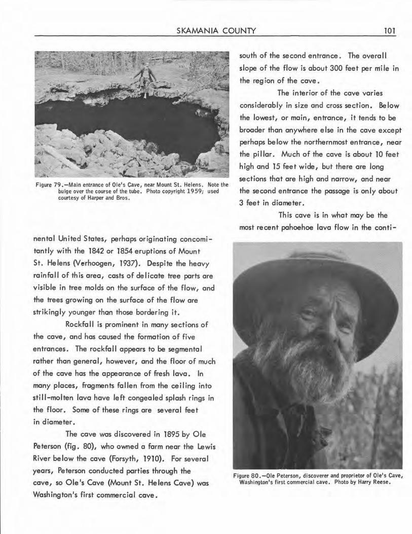
SKAMANIA COUNTY 101
Figure 79 .-Main entrance of Ole's Cave, near Mount St. Helens. Note the bulge over the course of the tube. Photo copyright 1959; used courtesy of Harper and Bros.
nental United States, perhaps originating concomi
tantly with the 1842 or 1854 eruptions of Mount
St. He lens (V erhoogen, 1937). Despite the heavy
rainfall of this area, casts of delicate tree parts are
visible in tree molds on the surface of the flow, and
the trees growing on the surface of the flow are
strikingly younger than those bordering it.
Rockfall is prominent in many sections of
the cave, and has caused the formation of five
entrances . The rockfall appears to be segmental
rather than general, however, and the floor of much
of the cave has the appearance of fresh lava. In
many places, fragments fallen from the ceiling into
still-molten lava have left congealed splash rings in
the floor . Some of these rings are several feet
in diameter .
The cave was discovered in 1895 by Ole
Peterson (fig. 80}, who owned a farm near the Lewis
River below the cave (Forsyth, 1910}. For several
years, Peterson conducted parties through the
cave, so Ole's Cave (Mount St. Helens Cave} was
Washington,'s first commercial cave.
south of the second entrance. The overal I
slope of the flow is about 300 feet per mi le in
the reg ion of the cave •
The interior of the cave varies
considerably in size and cross section. BeJow
the lowest, or main, entrance, it tends to be
broader than anywhere else in the cave except
perhaps below the northernmost entrance, near
the pi I lar. Much of the cave is about 10 feet
high and 15 feet wide, but there are long
sections that are high and narrow, and near
the second entrance the passage is only about
3 feet in diameter .
This cave is in what may be the
most recent pahoehoe lava flow in the conti-
Figure 80.-0le Peterson, discoverer and proprietor of Ole's Cave, Washington's first commercial cave. Photo by Harry Reese.
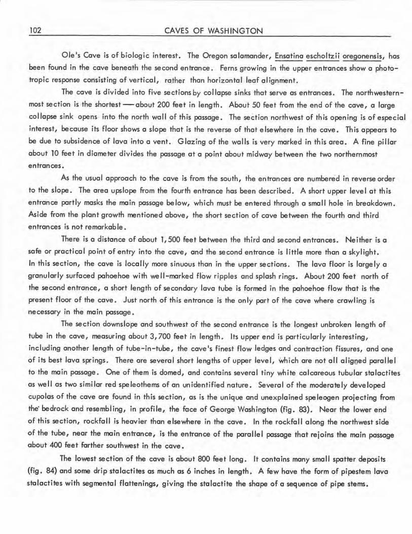
102 CAVES OF WASHINGTON
Ole 1s Cave is of biologic interest. The Oregon salamander, Ensatina escholtzii oregonensis, has
been found in the cave beneath the second entrance , Ferns growing in the upper entrances show a photo
tropic response consisting of vertical, rather than horizontal leaf alignment.
The cave is divided into five sections by col lapse sinks that serve as entrances. The northwestern
most section is the shortest-about 200 feet in length. About 50 feet from the end of the cave, a large
collapse sink opens· into the north wall of this passage. The section northwest of this opening is of especial
interest, because its floor shows a slope that is the reverse of that elsewhere in the cave. Th is appears to
be due to subsidence of lava into a vent. Glazing of the walls is very marked in th is area, A fine pillar
about 10 feet in diameter divides the passage at a point about midway between the two northernmost
entrances.
As the usual approach to the cave is from the south, the entrances are numbered in reverse order
to the slope . The area upslope from the fourth entrance has been described. A short upper level at this
entrance partly masks the main passage below, which must be entered through a small hole in breakdown.
Aside from the plant growth mentioned above, the short section of cave between the fourth and third
entrances is not remarkable .
There is a distance of about 1,500 feet between the third and second entrances. Neither is a
safe or practical point of entry into the cave, and the second entrance is little more than a skylight.
In this section, the cave is locally more sinuous than in the upper sections. The lava floor is largely a
granularly surfaced pahoehoe with we I I-marked flow ripples and splash rings. About 200 feet north of
the second entrance, a short length of secondary lava tube is formed in the pahoehoe flow that is the
present floor of the cave. Just north of this entrance is the only part of the cave where crawling is
necessary in the main passage.
The section downslope and southwest of the second entrance is the longest unbroken length of
tube in the cave, measuring about 3,700 feet in length. Its upper end is particularly interesting,
including another length of tube-in-tube, the cave's finest flow ledges and contraction fissures, and one
of its best lava springs. There are several short lengths of upper level, which are not all aligoed parallel
to the main passage. One of them is domed, and contains several tiny white calcareous tubular stalactites
as well as two similar red speleothems of an uni-dentified nature. Several of the moderately developed
cupolas of the cave are found in this section, as is the unique and unexplained speleogen projecting from
the· bedrock and resembling, in profile, the face of George Washington (fig. 83). Near the lower end
of this section, rockfall is heavier than elsewhere in the cave. In the rockfall along the northwest side
of the tube, near the main entrance, is the entrance of the parallel passage that rejoins the main passage
about 400 feet farther southwest in the cave.
The lowest section of the cave is about 800 feet long. It contains many small spatter deposits
(fig. 84) and some drip stalactites as much as 6 inches in length. A few have the form of pipestem lava
stalactites with segmental flattenings, giving the stalactite the shape of a sequence of pipe stems.
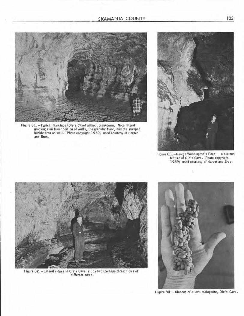
SKAMANIA COUNTY
Figure 81.-Typical lava tube (Ole's Cave) without breakdown . Note lateral groovings on lower portion of walls, the granular floor, and the slumped bubble area on wall. Photo copyright 1959; used courtesy of Harper and Bros.
Figure 82. -Lateral ridges in Ole's Cave left by two (perhaps three) flows of different sizes.
103
Figure 83.-George Washington's Face -a curious feature of Ole's Cave. Photo copyright 1959; used courtesy of Haroer and Bros.
Figure 84. -Closeup of a lava stalagmite, Ole's Cave.
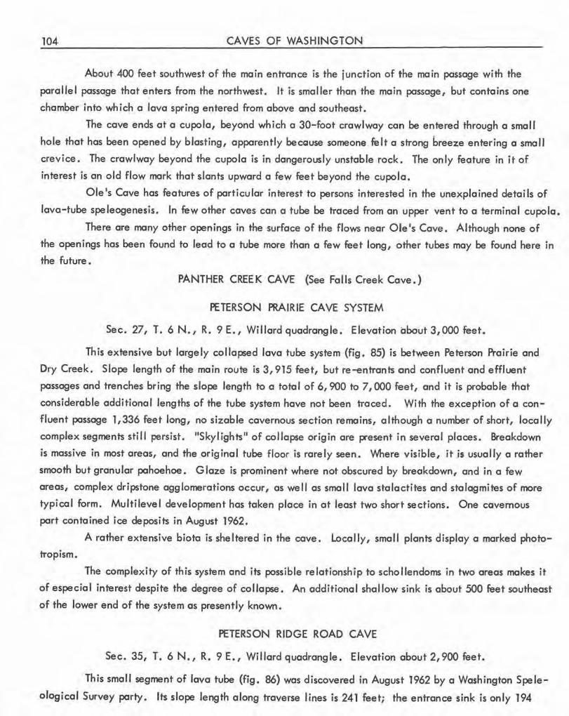
104 CAVES OF WASHINGTON
About 400 feet southwest of the main entrance is the junction of the main passage with the
parallel passage that e~ters from the northwest. It is smaller than the main passage, but contains one
chamber into which a lava spring entered from above and southeast.
The cave ends at a cupola, beyond which a 30-foot crawlway can be entered through a small
hole that has been opened by blasting, apparently becguse someone, felt a strong breeze entering a small
crevice. The crawlway beyond the cupola is in dangerously unstable rock. The only feature in it of
interest is an old flow mark that slants upward a few feet beyond the cupola.
Ole's Cave has features of particular interest to persons interested in the unexplained details of
lava-tube speleogenesis. In few other caves can o tube be traced from an upper vent to a terminal cupola.
There are many other openings in the surface of the flows near Ole's Cove. Although none of
the openings has been found to lead to a tube more than a few feet long, other tubes may be found here in
the future.
PANTHER CREEK CA VE (See Falls Creek Co1ve.)
PETERSON PRAIRIE CAVE SYSTEM
Sec. 27, T. 6 N., R. 9 E., Willard quadrangle. Elevation about 3,000 feet.
This extensive but largely collapsed lava tube system (fig. 85) is between Peterson Prairie and
Dry Creek . Slope length of the main route is 3,915 feet, but re-entrants ccnd confluent and effluent
passages and trenches bring the slope length to a total of 6,900 to 7,000 feet, and it is probable that
considerable additional lengths of the tube system hove not been traced. With the exception of a con
fluent passage 1,336 feet long, no sizable cavernous section remains, although a number of short, locally
complex segments still persist. "Skylights" of collapse origin are present in several places. Breakdown
is massive in most areas, and the original tube floor is rarely seen. Where visible, it is usually a rather
smooth but granular pahoehoe. Glaze is prominent where not obscured by breakdown, and in a few
areas, complex dripstone agglomerations occur, as well as small lava stalactites and stalagmites of more
typical form. Multilevel development hos token place in at least two short sections. One cavernous
part contained ice deposits in August 1962 .
A rather extensive biota is sheltered in the cave . Locally, small plants display a marked photo
tropism.
The complexity of this system and its possible relationship to schollendoms in two areas makes it
of especial interest despite the degree of collapse. An additional shallow sink is about 500 feet southeast
of the lower end of the system as presently known.
PETERSON RIDGE ROAD CAVE
Sec. 35, T. 6 N., R. 9 E., Willard quadrangle. Elevation about 2,900 feet.
This small segment of lava tube (fig. 86) was discovered in August 1962 by a Washington Spele
ological Survey party. Its slope length along traverse lines is 241 feet; the entrance sink is only 194
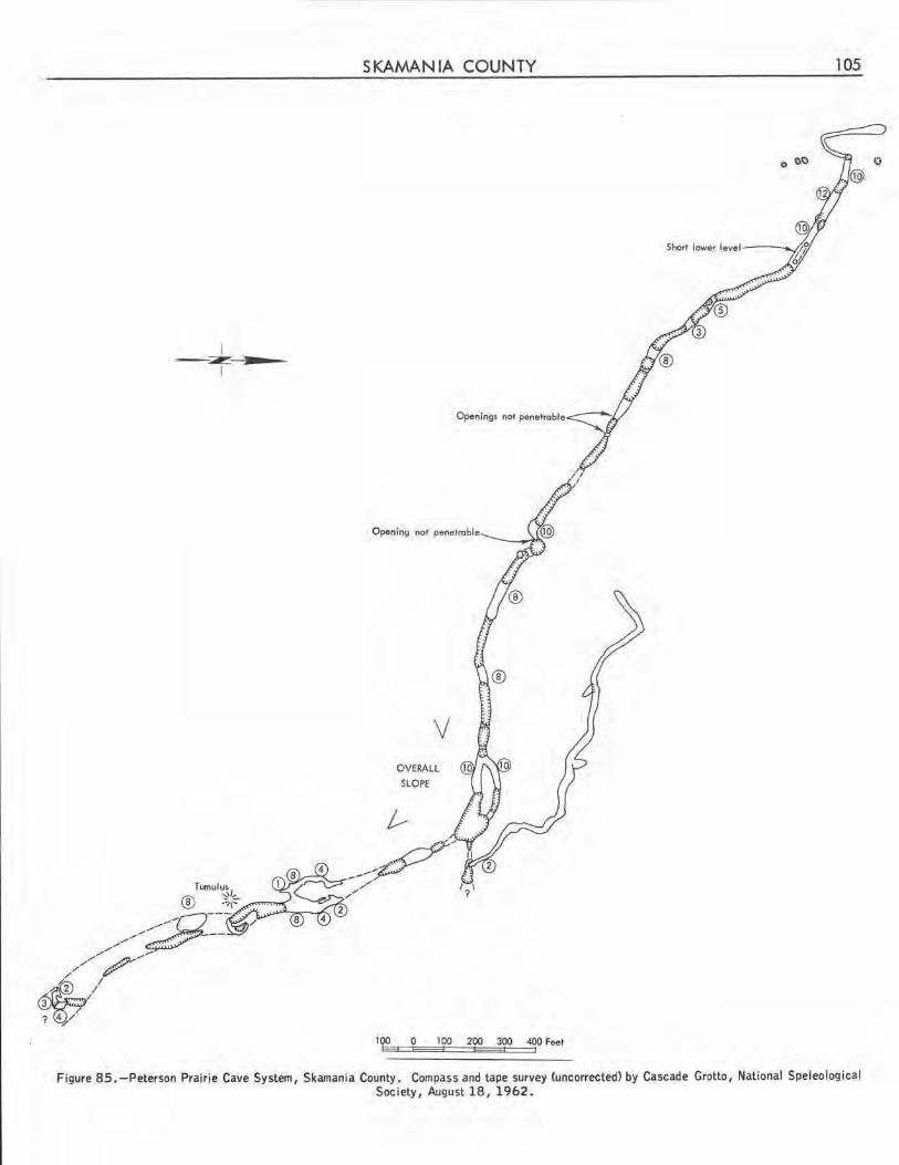
SKAMANIA COUNTY
I -~-.:i----
_..
1
Tumulu~/, ® ;:.,,::-
,,,,.,. ---,,,.,,. //,,,,,,,. /",,
# / I
7
Openings not penetrable
Opening not penetrable
........ v=,~--"--~-,,,,.,,,,,,,.,,,
V OVERALL
SLOPE
t--,"., fl
100 0 100 200 300 400 Feet
105
Short lower level---
Figure 85.-Peterson Prairie Cave System, Skamania County. Compass and tape survey (uncorrected) by Cascade Grotto, National Speleological Society, August 18, 1962.
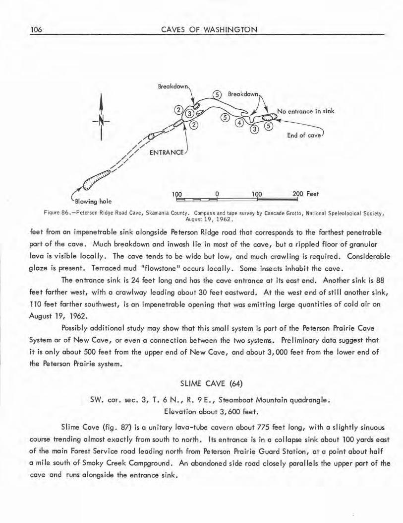
106 CAVES OF WASHINGTON
t -N-I
No entrance in sink
100 0 100 200 Feet EE-3=C:::EE33::=F----11':::::::,;t========:il;;;;:;;;;;:;;;;;:;;;;;:;~I
Figure 86. -Peterson Ridge Road Cave, Skamania County . Compass and tape survey by Cascade Grotto, National Speleological Society , August 19, 1962.
feet from an impenetrable sink alongside Peterson Ridge road that corresponds to the farthest penetrable
part of the cave. Much breakdown and inwosh lie in most of the cove, but a rippled floor of granular
lava is visible locally . The cave tends to be wide but low, and much crawling is required . Considerable
glaze is present. Terraced mud 11 flowstone 11 occurs locally . Some insects inhabit the cave .
The entrance sink is 24 feet long and has the cove entrance at its east end . Another sink is 88
feet farther west, with a crawlway leading about 30 feet eastward. At the west end of still another sink,
110 feet farther southwest, is an impenetrable opening that was emitting large quantities of cold air on
August 19, 1962.
Possibly additional study may show that this smal I system is part of the Peterson Prairie Cave
System or of New Cave, or even o connection between the two systems. Preliminary data suggest that
it is only about 500 feet from the upper end of New Cove, and about 3,000 feet from the lower end of
the Peterson Prairie system.
SLIME CAVE (64)
SW. cor. sec. 3, T. 6 N., R. 9 E., Steamboat Mountain quadrangle .
Elevation about 3 , 600 feet.
Slime Cave (fig. 87) is a unitary lava-tube cavern about 775 feet long, with a slightly sinuous
course trending almost exactly from south to north. Its entrance is in a collapse sink about 100 yards east
of the main Forest Service road leading north from Peterson Prairie Guard Station, at a point about half
a mile south of Smoky Creek Campground . An abandoned side road closely parallels the upper part of the
cave and runs alongside the entrance sink .
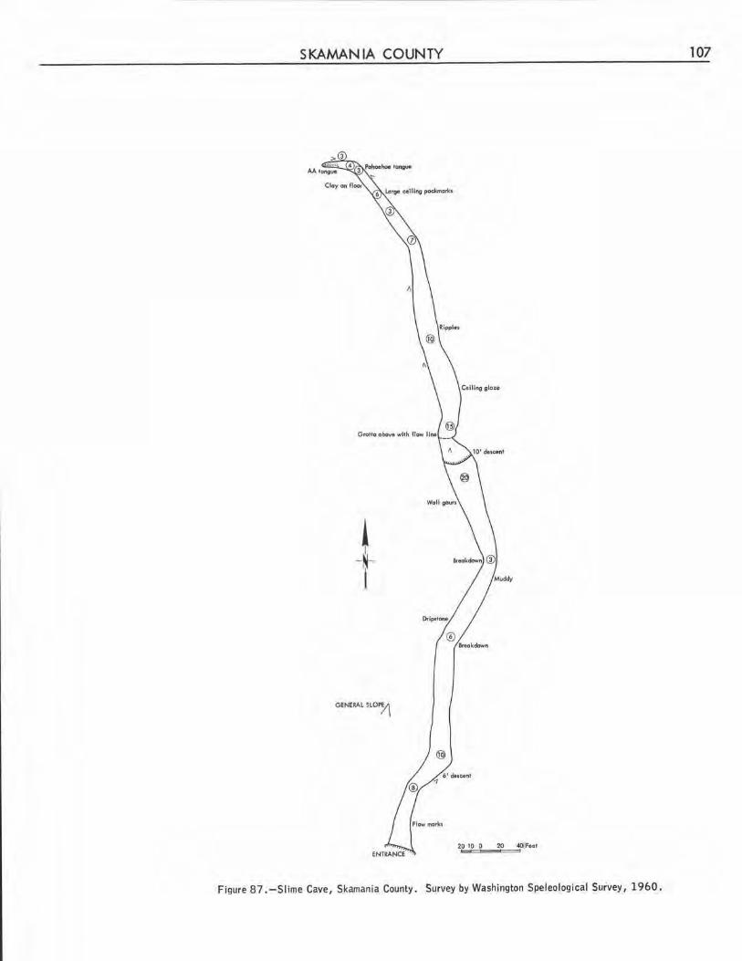
SKAMANIA COUNTY 107
Coiling glou
! -N-I
GENEAAl SLOP.?\
20 10 0 20 <40l1FeOI
Figure 8 7. -SI ime Cave, Skamania County . Survey by Washington Speleological Survey, 1960.
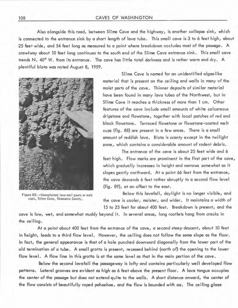
108 CAVES OF WASHINGTON
Also alongside this rood, between Slime Cove and the highway, is another collapse sink, which
is connected to the entrance sink by a short length of lava tube. This smol I cove is 3 to 6 feet high, about
25 feet wide, and 54 feet long as measured to a point where breakdown occludes most of the passage. A
crawlway about 10 feet long continues to the south end of the Slime Cove entrance sink. This small cove
trends N. 40° W. from its entrance. The cove hos little total darkness and is rather worm and dry. A
plentiful biota was noted August 8, 1959.
Slime Cove is named for on unidentified algae like
mater io I that is present on the ce i I ing and wo I ls in many of the
moist ports of the cove . Thinner deposits of simi lor material
hove been found in many lava tubes of the Northwest, but in
SI ime Cave it reaches a thickness of more than 1 cm. Other
features of the cave include smal I amounts of white calcareous
dripstone and flowstone, together with local patches of red and
block flowstone. Terraced flowstone or flowstone-coated melt
cups (fig. 88) are present in a few areas. There is a small
amount of reddish lava. Biota is scanty except in the twi I ight
zone, which contains a considerable amount of rodent debris .
The entrance of the cave is about 25 feet wide and 6
feet high. Flow marks are prominent in the first port of the cave,
which gradually increases in height and narrows somewhat as it
slopes gently northward. At a point 66 feet from the entrance,
the cave descends 6 feet rather abruptly to a second flow level
(fig. 89), at an offset to the east .
Figure 88 . -Unexplained Java wall gours or melt cups, Slime Cave, Skamania County .
Below this lavafall, daylight is no longer visible, and
the cave is cooler, moister, and wider. It maintains a width of
15 to 25 feet for about 400 feet. Breakdown is present, and the
cave is low, wet, and somewhat muddy beyond it. In several areas, long rootlets hang from cracks in
the ce i Ii ng •
At a point about 400 feet from the entrance of the cave, a second steep descent, about 10 feet
in lieight, leads to a third flow level. However, the ceiling does not follow the same slope as the floor.
In fact, the general appearance is that of a hole punched downward diagonally from the lower port of the
old termination of a tube. A small grotto is present, recessed behind (north of) the opening to the lower
flow level. A flow line in this grotto is at the same level as that in the main portion of the cave.
Below the se_cond lavafall the passageway is lofty and contains particularly well developed flow
patterns. Lateral grooves are evident as high as 6 feet above the present floor. A lava tongue occupies
the center of the passage but does not extend quite to the walls. A short distance onward, the center of
the flow consists of beautifully roped pohoehoe, and the flow is bounded with aa. The ceiling glaze
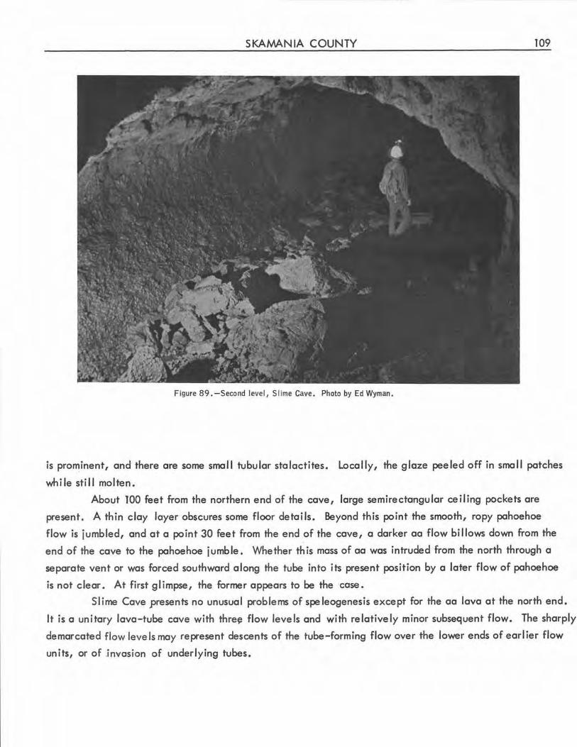
SKAMANIA COUNTY 109
Figure 89 .-Second level, Sl ime Cave. Photo by Ed Wyman.
is prominent, and there are some small tubular stalactites. Locally, the glaze peeled off in small patches
while still molten.
About TOO feet from the northern end of the cave, large semirectangular ceiling pockets are
present. A thin clay layer obscures some floor details. Beyond this point the smooth, ropy pahoehoe
flow is jumbled, and at a point 30 feet from the end of the cave, a darker aa flow billows down from the
end of the cave to the pahoehoe jumble. Whether this mass of aa was intruded from the north through a
separate vent or was forced southward along the tube into its present position by a later flow of pahoehoe
is not clear. At first glimpse, the former appears to be the case.
Slime Cave presents no unusual problems of speleogenesis except for the aa lava at the north end.
It is a unitary lava-tube cave with thre~ flow levels and with relatively minor subsequent flow. The sharply
demarcated flow levels may represent descents of the tube-forming flow over the lower ends of earlier flow
units, or of .invasion of underlying tubes.
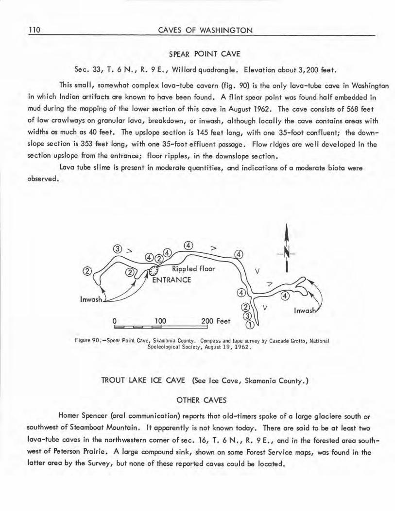
110 CAVES OF WASHINGTON
SPEAR POINT CAVE
Sec. 33, T. 6 N., R. 9E., Willard quadrangle. Elevation about3,200 feet.
This small, somewhat complex lava-tube cavern (fig. 90) is the only lava-tube cave in Washington
in which Indian artifacts are known to have been found. A flint spear point was found half embedded in
mud during the mapping of the lower section of this cave in August 1962. The cave consists of 568 feet
of low crawlways on granular la'va, breakdown, or inwash, although locally the cave contains areas with
widths as much as 40 feet. The upslope section is 145 feet long, with one 35-foot confluent; the down
slope section is 353 feet long, with one 35-foot effluent passage. Flow ridges are well developed in the
section upslope from the entrance; floor ripples, in the downslope section.
Lava tube slime is present in moderate quantities, and indications of a moderate biota were
observed.
V
0 100 200 Feet
Figure 90. -Spear Point Cave, Skamania County. Compass and tape survey by Cascade Grotto, National Speleological Society, August 19, 1962.
TROUT LAKE ICE CAVE (See Ice Cave, Skamania County.)
OTHER CAVES
Homer Spencer (oral communication) reports that old-timers spoke of a large glaciere south or
southwest of Steamboat Mountain. It apparently is not known today. There are said to be at least two
lava-tube caves in the northwestern corner of sec. 16, T. 6 N., R. 9 E., and in the forested area south
west of Peterson Prairie. A large compound sink, shown on some Forest Service maps, was found in the
latter area by the Survey, but none of these reported caves could be located.
SNOHOMISH COUNTY 111
SNOHOMISH COUNTY
Although there are a number of limestone outcrops in Snohomish County that possess karstic
characteristics, no limestone cave has been confirmed there. A small cave is said to have been encoun
tered in quarrying a I imestone lens near Arlington, but it was soon quarried away. A photograph i I lus
trating a University of Washington thesis (Norum, 1910) shows the ·apparent . entrance of a cave in another
limestone quarry east of Granite Falls. When the quarry was found, two small grottos there were found to
have phreatic characteristics, but neither was large enough to qualify as a cavern (Gibson, 1953) . Also,
there is rumored to be a cave in one of the small limestone pods along the west side of Proctor Creek
southeast of Gold Bar, but none was found in the field study for this report. The origin of the report may
have been one of the mines in that area. There are also some small karstic features in a creek bed on
the hillside high above Wallace River, and on the ridge crest east of Crystal Creek northeast of Wallace
Falls (W. R. Danner, oral communication).
BEAR CAVE
Sec. 13, T. 28 N., R. 9 E., Index quadrangle.
Bear Cave is a rockshelter in quartz diorite, extending into the cliff about 30 feet. It is of
some geologic interest, and may have been enlarged by prospectors (Carithers and Guard, 1945).
BIG FOUR ICE CAVE
Although this name apparently is also applied locally to a mine containing ice, in the same general
area, Big Four Ice Cave is a large glacier cave or snow cave southeast of the site of the former Big Four
Inn between Silverton and Monte Cristo. Its entrance is visible from the Barlow Pass road.
ICY WIND CAVE
It is sa id locally that formerly a sign on the road to the Boy Scout Camp near Silverton indicated
the entrance of a cave by this name. Field work and local inquiry in 1951 strongly suggested that the cave,
if one existed, was filled during logging operations. This is not a limestone area.
SPOKANE COUNTY
No limestone or pahoehoe lava is known within Spokane County, and only a few rockshelters and
talus caves have been reported.
112 CAVES OF WASHINGTON
ICE CAVE (Spokane Ice Cave)
Sec. 12, T. 26 N., R. 42 E., Deer Park quadrangle. Elevation about 1,900 feet.
This smal I rockshelter is only about 8 feet long but is of some note because of the artifacts found
in it (Bischoff, 1942). The Washington Division of Mines and Geology (written communication, 1959)
reports that the name is due to confusion with a nearby shaft in cold-trapping talus.
SPOKANE ICE CAVE (See Ice Cave.)
OTHER CAVES
There was a small rockshelter in granite on the south side of Minnehaha Hill in Spokane until
blasted shut by local authorities (Washington Division of Mines and Geology, written communication,
1962). Also, there is said to be a cave of undetermined type about a mile west of Dartford. It was not
found during field work for this report.
STEVENS COUNTY
Extensive but scattered deposits of I irnestone, marble, and dolomite occur in Stevens County,
but no caves have been reported there, with the exception of a block-creep cavern in basalt at the top
of a cliff in sec. 12, T. 28 N . , R. 39 E., (Washington Division of Mines and Geology, written commu
nication, 1959). On the saddle of Rabbit Mountain, shown in sec. 23, T. 37 N., R. 40 E., on the
Aladdin quadrangle map, there are said to be several sinks, one being about 30 feet deep.
THURSTON COUNTY
No caves have been reported in Thurston County.
WAHKIAKUM COUNTY
No caves have been reported in Wahkiakum County.
WALLA WALLA COUNTY
No true caves are known in Walla Walla County . Ash Cave is a large rockshelter in basalt,
about 17 miles north of Eureka (Butler, 1958).
WHATCOM COUNTY 113
WHATCOM COUNTY
Karst topography is a feature of several I imestone deposits in Whatcom County, and some small
caverns have been found in the Red Mountain deposits. Collapse sinks and ponors also occur in two lime
stone outcrops on the north side of Black Mountain, northeast of Maple Falls. Other types of caves are
also present in Whatcom County, including sandstone rockshelters reported near North Pass, southeast of
Sumas.
BIG SINKHOLE GROTTO
Sec. 14, T. 40 N., R. 5 E., Van Zandt quadrangle. Elevation about 1,900 feet.
This impressive karstic feature is some 50 to 100 yards east of the 1960 rim road of the Permanente
quarry, fairly close to its south end. From the hillside, the grotto has the appearance of an overhung
collapse sink about 40 feet in diameter and 70 feet deep at the uphill side and 50 feet deep at the southern,
downhill side. It is half filled (largely on the uphill side) by debris. At the bottom is an impenetrable
ponor in an impure limestone of Early Pennsylvanian age 0/v. R. Danner, oral communication).
Looking outward from this point, the yiewer obtains a thoroughly cavernous impre59fon. Aside
from a single small chimney, significant speleothems and speleogens are absent.
LARRABEE STATE PARK CAVE
On the north shore of the small cove immediately north of the main beach at Larrabee State Park
is a tunnel about 25 feet long, 3 feet wide, and 4 feet high. As the tunnel is aligned along a small vein
of vertically bedded coal, it is unclear whether this opening is an abandoned excavation or a littoral
cavern . This may or may not be the rum-runners' cave rumored in this vicinity.
SINKHOLE CAVE (65)
Sec. 14, T. 40N., R. 5E., Van Zandtquadrangle. Elevation about 1,900feet.
This small cave (fig. 91) is about 200 yards south-southeast of the parking area at the point where
the quarry rim road of the Permanente Red Mountain limestone quarry reaches the level of the rim. The
cave entrance is at the south end of an irregularly shaped sink between the quarry rim road and a recent
(1960) logging road. Also at the southern end of this sink are several other, impenetrable horizontal and
vertical openings . The cave entrance is several feet above the low point of the sink . In July 1960,
after a rainless month, a small rivulet from a pond in the northeastern part of the sink was observed entering
rubble a few feet below and northeast of the cave entrance. There is evidence that at high water a small
rivulet flows into the entrance of the cave and runs most of its length before vanishing into a small ponor.
However, flood debris at ceiling level indicates that the cave occasionally floods completely.
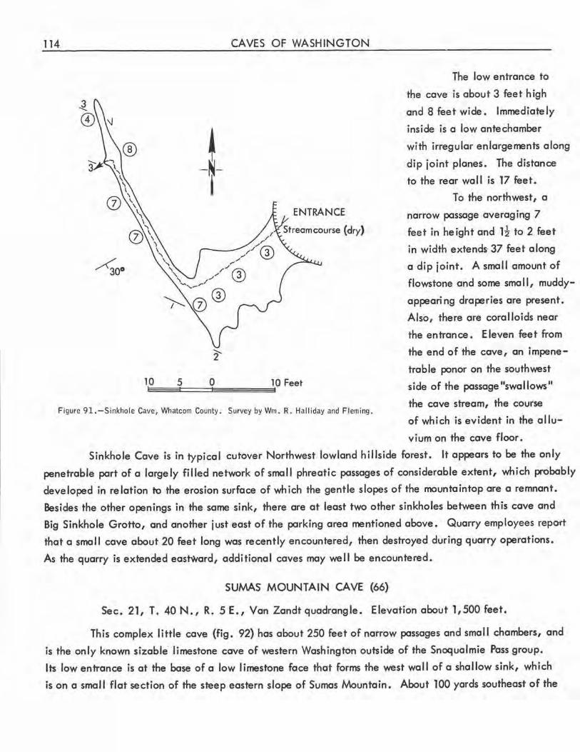
114 CAVES OF WASHINGTON
~ -N-i
ENTRANCE
Figure 91. -Sinkhole Cave, Whatcom County. Survey by Wm. R. Halliday and Flem ing.
The low entrance to
the cave is about 3 feet high
and 8 feet wide. Immediately
inside is a low antechamber
with irregular enlargements along
dip joint planes. The distance
to the rear wal I is 17 feet.
To the northwest, a
narrow passage averaging 7
feet in height and H to 2 feet
in width extends· 37 feet along
a dip joint . A small amount of
flowstone and some small , muddy
appearing draperies are present.
Also, there are coralloids near
the entrance . Eleven feet from
the end of the cave, an impene
trable ponor on the southwest
side of the passage "swallows"
the cave stream, the course
of which is evident in the a I lu
v ium on the cave floor.
Sinkhole Cave is in typical cutover Northwest lowland hillside forest. It appears to be the only
penetrable part of a largely filled network of small phreatic passages of considerable extent, which probably
developed in relation to the erosion surface of which the gentle slopes of the mountaintop are a remnant.
Besides the other openings in the same sink, there are at least two other sinkholes between this cave and
Big Sinkhole Grotto, and another just east of the parking area mentioned above. Quarry employees repo'ft
that a small cave about 20 feet long was recently encountered, then destroyed during quarry operations.
As the quarry is extended eastward, additional caves may well be encountered.
SUMAS MOUNTAIN CAVE (66)
Sec. 21, T. 40 N., R. 5 E., Van Zandt quadrangle. Elevation about 1,500 feet.
This complex little cave (fig. 92) has about 250 feet of narrow passages and small chambers, and
is the only known sizable· limestone cave of western Washington outside of the Snoqualmie Pass group.
Its low entrance is at the base of a low limestone face that forms the west wall of a shallow sink, which
is on a small flat section of the steep eastern slope of Sumas lv\ountain. About 100 yards southeast of the
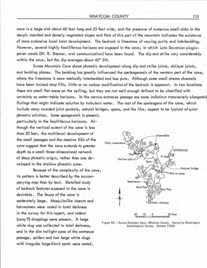
WHATCOM COUNTY 115
cave is a large sink about 60 feet long and 25 feet wide, and the presence of numerous small sinks in the
deeply mantled and densely vegetated slopes and flats of this part of the mountain indicates the existence
of more extensive local karst development. The bedrock is limestone of varying purity and interbedding.
However, several highly fossiliferous horizons ore exposed in the cave, in which Late Devonian plogio
poran corals (YI . R. Danner, oral communication) have been found. The dip and strike vary considerably
within the cove, but the dip averages about 45° SW.
Sumas Mountain Cave shows phreatic development along dip and strike joints, oblique joints,
and bedding planes. The bedding has greatly influenced the speleogenesis of the western part of the cave,
where the limestone is more markedly interbedded and less pure. Although some small stream channels
have been incised atop fills, little or no vadose modification of the bedrock is apparent. In two locations
th~e are small flat areas on the ceiling, but they ore not well enough defined to be classified with
certainty as water-table horizons. In the narrow entrance passage ore some indistinct transversely elongated
flutings that might indicate solution by turbulent water. The rest of the speleogens of the cove, which
inc1ude many rounded joint pockets, natural bridges, spans, and the like, appear to be typical of quiet
phreotic solution. Some sponge work is present,
particularly in the fossiliferous horizons. Al-
though the vertical extent of the cave is less
than 20 feet, the multilevel development of
the small passages and the massive fjj Is of the
cave suggest that the cave extends to greater
depth as a small three-dimensional network
of deep· phreatic origin, rather than one de
veloped in the shallow phreatic zone.
Because of the complexity of the cove,
its pattern is better described by the accom
panying map than by text . Detailed study
of bedrock features exposed in the cave is
desirable. The fauna of the cave is
moderately large. Mosquitolike insects and
harvestmen were noted in total darkness
in the survey for this report, and rodent
(cony?) droppings were present . A large
white slug was collected in total darkness,
and in the dim twi I ight zone of the entrance
passage, spiders and two large white slugs
with irregular large black spots were noted.
Pits to water
~ -~-I
20 10 0
Figure 92 .-Sumas Mountain Cave, Whatcom County. Survey by Washing.ton Speleolog ical Survey . October 1960.
116 CAVES OF WASHINGTON
OTHER CAVES
~
There is rumored to be o large cave entrance near the mouth of Sulfide Creek, in the cliffs east
of. the Baker River about 3 miles north of the Boker lake Bridge. Although there is a little limestone in
this general area, only rock overhangs were observed by the Survey.
WHITMAN COUNTY
The only coves reported in Whitman County are small rockshelters near Ewan, in the cliffs north
and west of Rock Lake (United States W. P. A . Federal Writers' Project, 1941}.
YAKIMA COUNTY
The northeastern part of the N\ount Adorns lava tube oreo extends into Yokimo County, ond there
ore local reports of one or two small lava tubes south of Bird Creek near Smith Butte. Their existence
has not been confirmed.
BOULDER CAVE (See Boulder Creek Cave . )
BOULDER CREEK CAVE (67) (Boulder Cove)
Sec. 21, T. 17 N., R. 14 E. , Mount Aix quadrangle. Elevation about 2,800 feet .
This impressive 400-foot cavern was cut by Boulder Creek after o slide dammed its canyon. The
imposing upper entrance is a I most 200 feet wide ond about 50 feet high. The lower entrance is o narrow
opening between the compacted slide ond the canyon wall. The cove follows o curved path, and is
actually o huge closed stream meander niche . Much of its length is in total darkness despite the immensity
of the entrance. It hos been known since 1901 (Anonymous, 1901), and is much visited by campers ot the
nearby Forest Campground across ond o short distance up the Naches .River from Cliffdell.
CRYSTAL CAVES
It is locally said that there are rockshelters near Priest Rapids on the Columbia River that hove
been given th is name •
INDIAN OCHER CAVE
There is said to be o small rockshelter near Satus Creek from which local Indians formerly obtained
ocher. Its existence hos not been verified.
OTHER CAVES
A legendary Dead ,\l\on 's Cave (Lynch, 1961) is locally believed by some to be on Hell Roaring
Ridge on the lower slopes of Mount Adams (Anonymous, 1961).

REFERENCES CITED
Anonymous, 1901, Big Cave in the Cascades: Spokane Spokesman-Review, p. 1, col. 7, Aug . 3, 1901.
1909a, Lost Cave [ photograph] : Spokane Spokesman-Review, sec. 3, p. 1, col . 5,
June 27, 1909.
1909b, Store produce in caves: Spokane Spokesman-Review, p. 5, col. 2, Oct. 28,
1909.
1918a, Not a whiff of nature faking in wonder cave near Spokane: Spokane Daily
Chronicle, p. 5, col. 3, Aug. 14, 1918.
------ 1918b, Wonder cave sets research men wondering how it was all done: Spokane Daily
Chronicle, p. 2, col. 4, Aug. 16, 1918.
------ 1941, Where could it have gone?: Wenatchee Daily World, p. 6, col. 4-5, Nov. 17,
1941.
------ 1957, Labyrinth of stone draws young cavemen: Omak Chronicle, p. 1, col. 2, Sept. 5,
1957.
------ 1958, Blast ruins cave entry : Portland Oregonian, [ title, contents, and paging vary with
edition], Dec. 11, 1958.
------ 1960, The unmarked shore : Sunset, v. 125, no. 2, p. 52.
------ 1961, Speleologists explore cave at scout camp: Mt. Adams Sun (Bingen), p. 3, col. 6,
July 27, 1961 .
Barr, T. C. , Jr., 1961, Caves of Tennessee: Tennessee Div. Geology Bull. 64, 567 p.
Bennett, W. A. G., 1944, Dolomite resources of Washington. Part 1, Preliminary report on Okanogan,
Lincoln, and Stevens Counties: Washington Div. Geology Rept. Inv . 13, pt . 1, 35 p.
Bischoff, Erwin, 1942, Newsletter no. 1 of the Committee on Exploration and Locations: Natl. Speleol.
Soc. Bull. 4, p. 37.
Bretz, J Harlen, 1956, Caves of Missouri : Missouri Div. Geol. Survey and Water Resources [Rept.],
v. 39, 2d ser . , 490 p.
Butler, B. R. , 1958, Ash Cave, a preliminary report : Washington Archeologist, v. 2, no. 12, p. 3.
Carithers, Ward, and Guard, A. K., 1945, Geology and ore deposits of the Sultan .Basin, Snohomish
County, Washington: Washington Div . Mines and Geology Bull. 36, p. 78.
117
118 CAVES OF WASHINGTON
Chappell, W. M. , Durham, J. W., and Savage, D. E., 1951, Moldofarhinocerosinbosalt, lower
Grand Coulee, Washington: Geol. Soc. America Bull., v. 62, no. 8, p. 907-918.
Condon, Thomas, 1896, Ice caves of Mount Adams: Mazama, v. 1, no. 1, p. 102.
Davies, W. E., 1952, The caves of Maryland: Mary land Dept. Geology, Mines, and Water Resources
Bull. 7, 75 p.
------1953, Geology of Pennsylvania caves: Natl. Speleol. Soc. Bull. 15, p. 3- 9.
------ 1955, Caves and related features of Michigan: Natl. Speleol. Soc. Bull. 17, p. 23-3:1.
------ 1958, Caverns of West Virginia: West Virginia Geol. and Econ . Survey Rept., v. 19(A),
330 p.
Dingee, R. L., 1930, Historical sketches of Pend Oreille County, Washington : [reprint from] Newport
Miner, p. 6-8.
Douglas, J . S., 1957, Caves of mystery . New York, Dodd, Mead, p. 11.
Doward, J . S., 1958, The beach at Elephant Rock : Seattle Times Pictorial Sec., p. 44-45, Sept. 14,
1958.
Folsom, Franklin, 1956, Exploring American caves -their history, geology, lore, and location -a
spelunker's guide. New York, Crown Publishers, 280 p.
Forsyth, C. E., 1910, Mount St. Helens Cave: Mountaineer Annual, v. 3, p. 58.
Foster, R. J., 1960, Tertiary geology of a portion of the central Cascade Mountains, Washington: Geol.
Soc. America Bull., v . 71, no . 2, p. 99-125.
Gallagher, Patrick, 1959, South Cave; a site in the lower Grand Coulee of central Washington:
Washington Archeologist, v. 3, no. 5, p. 3 .
Gibson, Warren, 1953, Thesis Cave: Natl. Speleol. Soc. , Cascade Grotto, Cascade Cave Report 6,
p. 1, July 24, 1953.
Gurney, A. B., 1961, Further advances in the taxonomy and distribution of the Grylloblattidae : Biol.
Soc. Washington Proceedings, v . 74, p. 67.
Hackman, R. S. , 1949, Speleology in southeastern Alaska : Natl. Speleol. Soc. ]ull. 11, p. 11.
Halliday, W.R. , 1954, Ice caves of the United States: Natl. Speleol. Soc. Bull. 16, p. 3.
------ 1955, A proposed classification of physical features found in caves: Natl. Speleol. Soc.
Bull. 17, p. 32-33.
------ 1958, An initial survey of the caves of the Hawaiian Islands: Natl. Speleol. Soc. Bull .
20, p. 58.
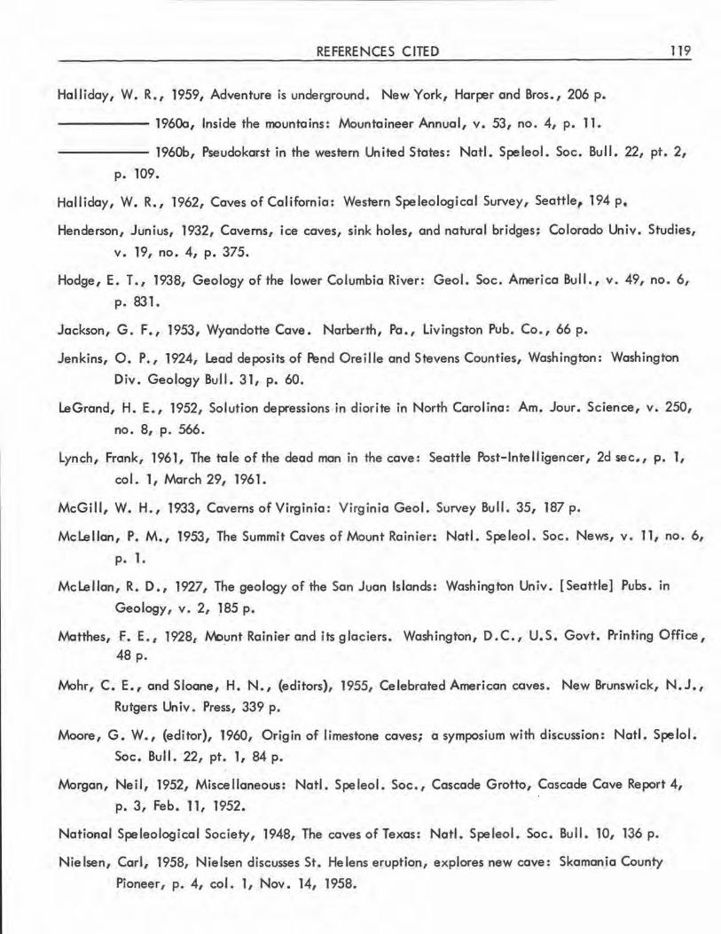
REFERENCES CITED
Halliday, W. R., 1959, Adventure is underground. New York, Harper and Bros., 206 p.
------ 1960a, Inside the mountains: Mountaineer Annual, v. 53, no. 4, p. 11.
119
------ 1960b, Pseudokarst in the western United States : Natl. Speleol. Soc. Bull. 22, pt. 2,
p. 109.
Halliday, W. R., 1962, Caves of California: Western Speleological Survey, Seattle, 194 p.
Henderson, Junius, 1932, Caverns, ice caves, sink holes, and natural bridges; Colorado Univ. Studies,
v. 19, no. 4, p. 375.
Hodge, E. T., 1938, Geology of the lower Columbia River: Geol. Soc. America Bull., v. 49, no. 6,
p. 831.
Jackson, G. F., 1953, Wyandotte Cave. Narberth, Pa., Livingston Pub. Co., 66 p.
Jenkins, O. P., 1924, Lead deposits of ~nd Oreille and Stevens Counties, Washington: Washington
Div. Geology Bull . 31, p. 60.
LeGrand, H. E., 1952, Solution depressions in diorite in North Carolina : Am. Jour. Science, v. 250,
no. 8, p. 566.
Lynch, Frank, 1961, The tale of the dead man in the cave: Seattle Post-Intelligencer, 2d sec., p. 1,
col. 1, March 29, 1961.
McGill, W. H., 1933, Caverns of Virginia : Virginia Geo I. Survey Bull. 35, 187 p.
Mclellan, P. M., 1953, The Summit Caves of Mount Rainier: Natl . Speleol. Soc. News, v. 11, no. 6,
p. 1.
Mclellan, R. D., 1927, The geology of the San Juan Islands: Washington Univ. [Seattle] Pubs. in
Geology, v. 2, J85 p.
Matthes, f. E., 1928, Wount Rainier and its glaciers. Washington, D.C., U.S. Govt. Printing Office, 48 p.
Mohr, C. E., and Sloane, H. N., (editors), 1955, Celebrated American caves. New Brunswick, N.J.,
Rutgers Un iv. Press, 339 p.
Moore, G. W., {editor), 1960, Origin of limestone caves; a symposium with discussion: Natl. Spelol .
Soc. Bull. 22, pt. 1, 84 p.
Morgan, Neil, 1952, Miscellaneous: Natl. Speleol. Soc., Cascade Grotto, Cascade Cave Report 4,
p. 3, Feb. 11, 1952.
National Speleological Society, 1948, The caves of Texas: Natl. Speleol. Soc. Bull. 10, 136 p.
Nielsen, Carl, 1958, Nielsen discusses St. Helens eruption, explores new cave: Skamania County
Pioneer, p. 4, col. 1, Nov. 14, 1958.
120 CAVES OF WASHINGTON
Norum, Birger, 1910, Geology of the southwestern portion of the Stilaguamish quadrangle, Washington:
Washington Univ. [ Seattle] B. S. thesis.
Osborne, Douglas, n.d. a., Owl Cave : Unpublished manuscript.
------ n.d . b . , Pictograph Cave: Unpublished manuscript.
Park, C . F., Jr., and Cannon, R. S., Jr ., 1943, Geology and ore deposits of the Metaline quadrangle,
Washington: U.S. Geol. Survey Prof. Paper 202, p. 38.
Perry, Clay [Clair Willard], 1946, New England 's buried treasure. New York, Stephen Day Press, 348 p.
------1948, Underground empire -wonders and tales of New York caves. New York, Stephen
Dciye Press, 221 p.
Potts, M. K., 1950, Mount Rainier's greatest ice cavern: Pacific Discovery, v . 111, no. 3, p. 5.
Raymond, R. W., 1869, The ice caves of Washington Territory: Overland Monthly, v. 3, no. 5, p. 421.
Schroeder, M. C., 1952, Geology of the Bead Lake district, Pend Oreille County, Washington:
Washington Div. Mines and Geology Bull. 40, 57 p.
Shedd, Solon, 1913, Cement materials and industry in Washington: Washington Geol . Survey Bull. 4,
p. 224.
Smith, G. 0., and Calkins, F. C., 1906, Snoqualmie foljo: U.S. Geol. Survey Geol. Atlas, Folio 139,
14 p.
Spangle, P. F. , (editor), 1960, Aguidebook to Carlsbad Caverns National Park. Vienna, Va., Natl.
Speleol. Soc., 43 p.
Spring, Bob, and Spring, Ira, 1953, Lava cave cures cheese: Seattle Times Pictorial Sec., p. 3-4,
June 21, 1953.
Steele, R. F., 1904, An illustrated history of Stevens, Ferry, Okanogan, and Chelan Counties, Washington
[ History of North Washington]. Spokane, Wash., Western Historical Publ. Co., 867 p.
Steinburn, Thomas, 1952, Mount Snoqualmie Caves: Natl. Speleol. Soc., Cascade Grotto, Cascade
Cave Report 5, p. 2-3, Dec. 29, 1952.
Stone, R. W., 1953a, Commercial caves of Pennsylvania: Natl. Speleol. Soc. Bull. 15, p. 39-50.
------1953b, Descriptions of Pennsylvania's undeveloped caves: Natl. Speleol. Soc. Bull. 15,
p. 51-137.
Swanson, Earl, and Bryan, Alan, 1954, An archeological survey of caves in Washington: Am. Antiquity,
v. 19, no. 4, p. 387.
REFERENCES CITED 121
United States Work Projects Administration. Federal Writers' Program, 1941, Washington, a guide to the
Evergreen State. Portland, Oreg., Bin fords and Mort, 687 p.
Verhoogen, Jean, 1937, Mount St. Helens, a recent Cascade volcano : California Univ. Dept. Geol.
Sciences BulL, v. 24, no. 9, p. 263.
Washington, N. W., 1958, Caves of the lower Grand Coulee : · Washington Archeologist, v. 3, no. 1,
p. 12.
Waters, A. C., and Krauskopf, Konrad, 1941, Protoclastic border of the Colville Batholith: Geol. Soc .
America Bull., v. 52, no. 9, p. 1355.
Wentworth, C. K. , and Macdonald, G. A., 1953, Structures and forms of basaltic rocks in Hawaii:
U.S. Geol. Survey Bull. 994, 98p.
Wylie, W. B., 1949, Variations in leaf structure among Adiatum pedatum growing in a rock cavern:
Am. Jour. Botany, v. 36, p. 282.
122 CAVES OF WASHINGTON
GLOSSARY
Ao, the rough, clinkery type of basalt flow in which lava tubes do not form.
Block creep cavern, a specific type of fissure cave, formed by a fracture parallel to the face of a cliff
with subsequent "creep" of the smaller fragment away from the main block.
Blowout, an opening from a lava tube to the surface, resulting from an explosion of the gases within the
tube during its thermal phase .
Boxwork, a petromorph of intersecting mineral blades projecting from the walls or ceiling of a limestone
cavern . A vaguely similar speleogen has been recorded in a Washington lava tube.
Breakdown, accumulation of rock, resulting from flaking off from or collapse of the walls or ceiling of
a cave.
Breakdown dome, a high, arched chamber or passage section in either a limestone cavern or a lava tube,
resulting from partial, usually intermittent, col lapse of the ceiling.
Cave, a natural subterranean opening large enough to enter, with some part in tote I darkness. The term
is applied loosely to a variety of other natural underground cavities.
Cavern, essentially the same as cave.
Ceiling channel, a distinct channel dissolved upward into the ceiling of a pre~xisting limestone cave,
or gouged into the ceiling of a lava tube .
Ceiling grooves, longitudinal scratch marks in the ceiling of a lava tube.
Ceiling pendant, a downward projection of limestone, various modifications of which are indicative of
spe leogeneti c factors .
Ceiling tube, a ceiling channel with a particularly tubular appearance.
Chockstone, a fragment of breakdown that has become wedged in a narrow passage instead of falling to
its floor.
Column, a gravitomorphic speleothe.m attached at both ends, usually as the result of fusion of a stalactite
and a stalagmite .
Concentric, in lava tubes, a "bull's-eye II pattern on the floor, usually resulting from rockfall into a
partially crusted flow ("splash concentric" or "splash ring"), but rarely by deposition of successive
lateral ridges around a small obstruction.
Contraction fissures, cracks found in the flows on the floors of lava tubes, presumably as a result of
contraction during cooling.
GLOSSARY 123
Cora lloid, a speleothem resembling branched globular corals or massed popcorn. Coralloids vary widely
in size, and both the calcareous and lava types probably originate in several ways.
Cupola, a smooth, domed upward expansion in a lava tube, resembling the inside of a huge gas bubble.
At times, this term has been applied to the opening of an upper-leve I tube into a lower-level
tube as seen from below, but th is usage probably should be discouraged.
Dome ei!, a specific vadose speleogen consisting of a shaft several feet in diameter with sheer, slightly
grooved wal Is and roughly circular cross section.
Dripstone, a popular or semitechnical group term including stalactites, stalagmites, columns, and similar
projecting speleothems, deposited from dripping water.
Duck-under, a sh°'t, low section between two more spacious areas of a cave.
False floor, in limestone caves, a thin deposit of flowstone over a fill that has subsequently compacted
or been washed away, leaving a space beneath an apparently sol id floor. Asimilar phenomenon
occurs less commonly in lava tubes, due to crusting.
Flow grooves, longitudinal grooves in the walls of lava tubes, seemingly incised by gouging during flow
through the tube.
Flow ledge, a large or small ledge on the wal l of a lava tube, extending longitudinally as though deposited
at the upper margin of a flow through the tube.
Flow line, an imprecise term applicable to indistinct flow grooves or ledges.
Flow mark, any longitudinal deposit or site of removal of materlal in a lava tube seemingly a result of
subsequent flow through the tube.
Flow shelf, a broad flow ledge.
Flowstone, a mineral deposit in a cave, resulting from deposition from water that trickles over a surface,
without dripping.
Glacier~, a cave developed by melting in or beneath a glacier.
Glaciere, a cave or other subterranean site in which ice forms and persists for considerable periods of
time (~ also ice cave).
Gour, a calcite-walled pool°' the space that a now-dry pool of this type once occupied.
Grotto, (l) a small side chamber of a cavem.
(2) a cavernous opening that extends only into the twilight zone.
(3) a local unit of the National Speleological Society.
Helictite, a specific nongravitomorphic axial speleothem . Most helictites are curved throughout, or at
some point in their length. Many lava helictites are not truly axial.
124 CAVES OF WASHINGTON
Horizon, a specific level of speleogenetic flow manifested in the cave walls.
Ice cave, a cove in which ice forms and persists for a considerable period (~ also glociere).
Joint eocket, a specific phreatic speleogen consisting of a rounded enlargement of a cavern space along
a joint.
Karst, a specific type of topography resulting from the solution of limestone bedrock and characterized
by the features of development of underground drainage at the expense of surface drainage.
Lapies, a low, narrow limestone ridge, usually representing the exposure of the strike of the beds in karst
topography.
Lateral ridge, a longitudinal floor deposit of a lava tube, apparently deposited at the margins of a flow
through the tube.
Lava dams, structures of some lava tubes that roughly resemble gours several fe·et high. They may prove
to be the snouts of flows, the still-molten core of which has drained to lower levels after the
dam has solidified.
Lavafall, a solidified cascade of lava.
Lava pillar, a short section of wal l dividing a lava tube passage.
Lava puddle, a deposit of smooth nonvesicular pohoehoe lava at the base of a lava speleothem or at the
outlet of a lava spring, without flow features .
Lava seal, a point where a smooth lava floor meets the cei ling of a lava tube.
Lava spring, a recess in the wall of a lava tube from which lava has flowed into the tube.
Lava tongue, a raised section of a flow within a lava tube .
Lava trench, an elongated depression of considerable length resulting from collapse of a section of lava
tube.
Lava tube, a long, near-surface, somewhat tubular cavern found in certain flows of pohoehoe lava.
lngressive or egressive branches are not uncommon, and considerable complexity is present in
some caverns.
Lava tube crust, a deposit lining lava tubes, of which lava tube glaze is a specific subtype.
Lava tube glaze, a thin smooth shiny nonvesicular form of lining of many lava tubes.
Lava tube slime, a curious and little-studied material found on the walls and ceiling of many lava tubes,
consisting of an amorphous, jellylike film. It may consist of a silica gel and (or) micro-organisms.
Littoral, pertaining to the zone of wave action.
GLOSSARY 125
tv\eander niche, a speleogen showing the characteristics of solution of the wall of a limestone cave by the
curve of a stream.
tv\elt cup, a lava speleothem resembling vertical terraced flowstone, seeming ly formed in the molten
phase, but not yet subjected to microscopic, petrographic, or mineralogical study.
M.oonmilk, a white, puttylike form of flowstone, formed of calcite, hydromagnesite, or dolomite.
Pahoehoe, a type of basalt flow characterized by marked fluidity, and subsequent smoothness.
Petromorph, a deposit formed within bedrock and subsequently exposed in the wall of a cave.
Phreatic, pertaining to the zone of water beneath a water table.
Pisolith, a rounded concretion of calcium carbonate.
Ponor, a point of piracy of a large or small strea,:n by underground drainage.
Resurgence, the point of emergence of a subterranean stream to the surface .
Rockshe lter, a cavernous natura I rock overhang.
Schollendom, the German term for tumulus, a low domelike protrusion in congealed lava flows.
Slime flowstone, a terraced flowstone, seemingly resulting from the action of, or coincidental with, lava
tube slime.
Slump~' a specific pattern of lava tube crust resulting from its irregular partial slumping.
Speleogen, a feature of the bedrock of a cave, resulting from removal of material therefrom.
Speleogenesis, the process of origin and development of caves.
Speleoliferous, containing caves.
Speleology, the study of caves and their contents .
Speleothem, a feature of a cave resulting from mineral deposition .
Splash concentric, "congealed ripples" resulting from the foll of an object into congealing lava . (See
concentric.)
Stalactite, an axial, gravitomorphic speleothe m directed downward.
Stalactite, tapered, a stalactite with a base larger than its lower end.
Stalactite, tubular, a thin-walled, hollow stalactite with a uniform diameter.
Stalagmite, an axial, gravitomorphic speleothem directed upward.
Stream flute, an elongated, cupped speleogen resulting from turbulent flow of water.
Swallet, same as ponor, but usually applied to streams or rivulets of some size.
126 CAVES OF WASHINGTON
Terraced flowstone, a specific form of flowstone on which small gours have developed.
Tree cast, a tubular (horizontal or vertical) imprint in lava of a tree trunk engulfed by the lava.
Tube-in-tube, a rudimentary lava tube inside a lava flow which itself is within a larger lava tube.
Tumulus, a low dome like protrusion in congealed lava flows.
Vadose, pertaining to the zone above a water table.
Vadose grooving, a specific speleogen consisting of fairly regular vertical grooving of I imestone walls
by solution of descending films of water. In Washington, it is seen predominantly in high
elevation caves.
Wall ridge, a longitudinal deposit on a lava tube wall, apparently deposited at the margin of a flow
through the tube. Probably should be superseded by the term "flow ledge . 11
Waterfall slot, an accentuated and regular form of vadose grooving limited to a small area as a result of
local concentration of descending water,
INDEX OF CAVES
Cave
Adair's Cave (See Prospector's Cave.) -------------------------
Agate Bay Caves-------------------------------------------
Al I bright Cave ---------------------------------------------
Ape Cove---------------------------------- ----------------
Arrow Shaft Cave -------------------------------------------
Ash Cove --------------------------------------------------
Bat Cave----------. ---------------------------------------
Bat Cave --------------------------------------------------
Bear Cave--------------------------------------------------
Beckley's Cave (Old Miller Place Cave, Pleasant Ridge Cave)----
Beckley's Shelter Cave--------------------------------------
Beverly Ice Cave (See Smyrna Ice Cave.) ---------------------
Big Cove (Nielsen's Big Cave) --------------------------------
Big Four Ice Cave------------------------------ -------------
Big Lava Cave (See Cheese Cave .) ---------------------------
Big Sinkhole Grotto --------------------------------:--------
Big Trench Cave System --------------------------------------
Black River Cave--------------------------------------------
Blasted Cave (See Dynamited Cave.) --------------------------
Blue Lake Cave---------------------------------------------
Blue Lake Rhino Cave (See Rhinoceros Cave.) -----------------
Boulder Cave (See Boulder Creek Cave.) ---------------------
Boulder Creek Cave (Boulder Cave)----------------------------
Boy Scout Cave --------------------------------------------
Boy Scout Cave---------------------------------------------
Boyles Creek Cave (See Fish Hatchery Cove.) -----------------
Branching Cave (See Red Cave, Klickitat County .) ------------
Breakdown Cave (See Danger Cave.) --------------------------
Butter Cave ------------------------------------------------
127
County Page
King
Clallam------------ 8
Okanogan ---------- 40
Skamania ---------- 71
Grant ------------- 10
Walla Walla-------- 112
Skagit ------------- 65
Skamania----------- 77
Snohomish ---------- 111
Skagit ------------- 65
Skagit ------------- 66
Grant
Skamania ---------- 79
Snohomish---------- 111
Klickitat
Whatcom----------- 113
Skamania ---------- 81
King-------------- 14
Skamania
Grant------------- 10
Grant
Yakima
Yakima ------------ 116
Grant------------- 11
Okanogan ---------- 43
Skamania
Klickitat
King
Klickitat----------- 30
128 CAVES OF WASHINGTON
Cave
Campground Ice Cave (See Ice Cave, Skamania County . ) --------
Carson Cave------------------------------------------------
Cheese Cave (Big Lava Cave, Lava Cave, Spencer's Cave) -------
Chelan Ice Cave-------------------------------------------
Clark's Cave----------------------------------------------
C Ii ff Cave ------------------------------------------------Cox Cave--------------------------------------------------
Crab Creek Cave (Wi Ison Creek Cave) ------------------------
Crawford Cave (See Ga~dner Cave.) -------------------------
Crook Property Cave (See Eng I ish Camp Cave.) -----------------
Crystal Caves ----------------------------------------------Curly Creek Cave (Lava Cave) --------------------------------
Danger Cave (Breakdown Cave)-------------------------------
Danger Cave Annex----------------------------------------
Dead N\an's Cave------------------------------------------
Deception Cave---------------------------------------------
Don 's Cave (Mount Issaquah Cave) ----------------------------
Don Ian's Cave----------------------------------------------
Double Hi 11 Cave (See Lange 11 Quarry Cave.) ---7--------------Dry Creek Cave---------------------------------------------
Dry Fol ls Cave ---------------------------------------------Dynamited Cave (Blasted Cave, Lemei Road Cave)---------------
East Lenore Caves -------------------------------------------
Eng I ish Camp Cave (Crook Property Cave) ----------------------
. Falls-Creek Cave (Panther Creek Cave, Lava Caves) -------------
Fern Cave -------------------------------------------------Fish Hatchery Cave (Boyles Creek Cave)------------------------
Fow ler 1s Cave ----------------------------------------------
Gardner Cave (Crawford Cave, Lost Cave) --------------------
Grotto Cave (See Lost Cave, King County.) ------------------
Guler Ice Cave (See Ice Cave, Skamania County.)--------------
County
Skamania
Clallam------------ 8
Klickitat----------- 31
Chelan------------ 8
King-------------- 14
King-------------- 14
Kittitas ------------ 30
Grant------------- 11
Pend Ore i I le
San Juan
Yakima------------ 116
Skamania ---------- 82
King-------------- 14
King-------------- 18
Yakima------------ 116
Skog it ------------- 66
King-------------- 18
King-------------- 18
San Juan
Skamania ----------
Grant-------------
Skamania ----------
Grant-------------
San Juan-----------
Skamania---------
San Juan ----------Skamania---------
San Juan-----------
Pend Ore i I le
King
Skamania
83
11
84
12
58
88
60
90
53
44
INDEX OF CAVES
Cave
Haffner's Quarry Cave ---------------------------------------
Hellhole Cave----------------------------------------------
Ho le-in-the - Wa 11 -------------------------------------------
Horse thief Cave ---------------------------------------------
Ice Cave (See Tri II ium Cave.) ------------------ ------------
Ice Cave (Campground Ice Cave, Guler Ice Cave, Mount Adams
129
County Page
San Juan------------ 60
King-------------- 18
Clallam------------ 8
Grant------------- 12
Klickitat
Ice Cave, Trout Lake Ice Cave) ------------------------ Skamania ---------- 92
Ice Cave (Spokane Ice Cave) --------------------------------- Spokane ----------- 112
Icy Wind Cave --------------------------------------------- Snohomish---------- 111
Imperial Quarry Cave---------------------------------------- San Juan----------- 54
Indian Cave------------------------------------------------ Grant------------- 12
Indian Ocher Cave ------------------------------------------ Yakima ------------ 116
Ind ion Rock Caves (Indian Caves)------------------------------ Pend Ore i lie ------- 49
Jackman Creek Cave-------------------- -------------------- Skagit------------- 66
Jasper Cave------------------------------------------------ Grant------------- 12
Jensen Cave------------------------------------------------ 'Skagit ------------- 66
Lake Cave------------------------------------------------- Skamania---------- 93
Lake Lena Caves -------------------------------------------- Jefferson----------- 14
Lange 11 Quarry Cave (Double Hi 11 Cave) ----------------------- San Juan ----------- 56
Larrabee State Park Cave ------------------------------------- Whatcom----------- 113
Lava Cave (See Cheese Cave specifically, and all caves of Klickitat
County generally. ) ----------------------------------- Klickitat
Lava Cave (See Ole's Cave and Curly Creek Cave.) -----------
Lava Caves (See Fol Is Creek Cave.) --------------------------
1..ava Bridge Caves ------------------------------------------1..awson Property Cave (See Roadside Cave.) --------------------
Ledge Pit--------------------------------------------------Lemei Road Cave (Lemei Cave) (See Dynamited Cave.) ----------
Little Red River Cave ---------------------------------------
Lookout Cave -----------------------------------------------
Lost Cave (Grotto Cave) -----------------------------------
Lost Cave (See Gardner Cave.)-------------------------------
Skamania
Skamania
Klickitat----------
San Juan
King--------------Skamania
Skamania ----------
King--------------
King --------------Pend Ore i I le
35
19
97
20
21
130 CAVES OF WASHINGTON
Cave
Mc laugh I in Canyon Caves-----------------------------------
McQueen 's Cave ( See Three Mi le Creek Cave . ) ---------------
Meat Cave (See Tri 11 ium Cave.} - - ----------------------------
Meyer Cave------------------------------------------------
County Page
Okanogan---------- 43
Skagit
Klickitat
Adams ------------- 7
Miner's Cave (See Prospector's Cave.)------------------------- King
Moonsh i'ner 's .Cave -----------------------------------------
Moonshiner's Caves -----------------------------------------
Mount Adams Ice Cave (See Ice Cave, Skamania County.) ------
Mount Issaquah Cave (See Don's Cave.) ----------------------
l'v\ount 01 ive Cave (Riverside Cave)---------------------------
Mount St. He lens Cave (See Ole's Cave.) --------------------
Mount Snoqualmie Caves -------------------------------------
New Cave------------------------------------------------
Newton Cave ----------------------------------------------
Nielsen's Cave ---------------------------------------------
Nielsen's Big Cave (See Big Cave.) ---------------------------
Old· Mi Iler Place Cave (See Beckley 's Cave.) -----------------
Ole 's Cave (Mount St. Helens Cave, Lava Cave)---------------
Orkila Cave (See Point Doughty Cave.) -----------------------
Otter Cave --------------------------------------- ---------
Owl Cave --------------------------------------------------
Panther Creek Cave (See Falls Creek Cave.) ------------------
Paradise Ice Cave ------------------------------------------
Peterson Prairie Cave System - -------------------------------
Peterson Ridge Road Cave ------------------------------------
Pictograph Cave--------------------------------------------
Pleasant Ridge Cave (See Beckley's Cave.) -------------------
Point Doughty Cave (Orkila Cave)----------------------------
Prospector's Cave (Miner's Cave, Steinbum's Cave, Adair's Cave) -
San Juan -----------
Grant-------------
Skamania
King
Okanogan ---------
Skamania
King--------------
Skamania ----------King --------------Skamania ----------Skamania
Skagit
Skamania ----------San Juan
Skagit -------------
Grant -------------
Skamania
Pierce -------------Skamania ----------Skamania ----------Grant -------------Skagit
San Juan -----------
King --------------
61
12
43
22
98
23 100
100
68
13
50 104 104
13
57 27
INDEX OF CAVES
Cave
Raider Cave---------------------------------------------
Red Cave------------------------------------------------
Red Cave (Branching Cave, Spencer's Red Cave) -------------
Rhinoceros Cave (Blue Lake Rhino Cave) --------------------
Riverside Cave (See Mount Olive Cave.)-------------------
Roadside Cave (Lawson Property Cave) -----------------------
Rock Cave-----------------------------------------------
Second Cave--------------------------------------------
Sinkhole Cave--------------------------------------------
Slime Cave ----------------------------------------------Smyrna Ice Cave (Beverly Ice Cave) -------------------------
County
Skagit-------------
King --------------Klickitat ----------
Grant-------------
Okanogan
San Juan ---------
Skagit-------------
King--------------Whatcom ----------
Skomon ia ---------
Grant
131
69
28
35
13
61
69
28
113
106
13
Snoqualmie Coves (See tv\ount SnoquaJmie Caves.) ------------ King
South Cove ----------------------------------------------Spear Point Cove -----------------------------------------
Spencer's Cove (See Cheese Cove.) ------------------------
Spencer's Red Cave (See Red Cove, Klickitat County.) ------
Spokane Ice Cove (See Ice Cove, Spokane County . ) ----------
Stai rwe 11 Cove -------------------------------------------
Steam Caves ---------------------------------------------Ste inburn 1s Cave (See Prospector's Cave or Second Cove.) -----
Ste inburn 's Caves (See Mount Snoqualmie Caves.) ------------
String Cave----------------------------------------------
Sumas tv\ountain Cave--------------------------------------
Summit Caves -------------------------------------------Surge Cove-----------------------------------------------
Thermal Caves --------------------------------------------
Three Mile Creek Cove (Weaver's Cave, McQueen's Cave) ----
Trillium Cave (Ice Cave, /v\eot Cave)------------------------
Trinidad Cave--------------------------------------------
Trout Lake Ice Cave (See Ice Cave, Skamania County.)--------
Twidwell 's Cave ------------------------------------------
Vantage Cave (See Cox Cave.) ----------------------------
Grant-------------
Skamania
Klickitat
Klickitat
Spokane
13
110
Klickitat----------- 36
Pierce ------------- 51
King
King
Cowlitz------------ 9
Whatcom ---------- 114
Pierce ------------- 51
Skog it ------------- 69
Pierce ------------- 51
Skagit------------- 69
Klickitat ---------- 36
Kittitas ------------ 30
Skamania
Klickitat 38
Kittitas

132 CAVES OF WASHINGTON
Cave
Weaver's Cave (See Three Mi le Creek Cave.) ------------------
West Lenore Caves ------------------------------------------
Wi Ison Creek Cave (See Crab Creek Cove.) --------------------
Yonsen's Cove---------------------------------------------
Yonsen 1s Little Cove ----------------------------------------
County
Skagit
Grant------------
Grant
Son Juan ---------
Son Juan ----------
13
62 64
WASHINGTON OEPARTMENT OF CONSERVATION OIVISION OF MINES ANO GEOLOGY
MUD ROOM
260 V, Seasonal muddy pond
i -N-I
PLAN VIEW
VERTICAL SECTION ALONG TRAVERSE LINE
2.,o-=oc:::io ..... - 2,.0==4""0""".,.60 Feet
GARDNER CAVE
INFORMATION CIRCULAR NO. 40 PLATE l
MAIN ENTRANCE
Ory stream channel
SECOND -- MAIN ENTRANCE ENTRANCE
---- G?::rS::::::i"
Survey by Washington Speleological Survey, 1958.
WASHINGTON DEPARTMENT OF CONSERVATION DIVISION DF MINES AND CEDLDGY
GENERAL SLOPE
V
~ -N-i
400 200 0 800
INFORMATION CIRCULAR NO. 40 PLATE 2
Low, broad potholes • gours (tiny) and stalactite
Pit 10' deep, lava springs on left
Serpentine
Drapery
UPPER
Passage width slightly exaggerated
Survey by Wm. R. Halliday, Washington Speleological Survey, December 1958.
APE CAVE
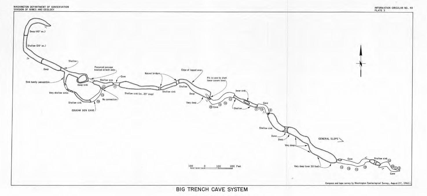
WASHINGTON DEPARTMENT OF CONSERVATION 'DIVISION OF MINES ANO GEOLOGY
Shallow sink (av. 20 ' deep)
·~····7
10ic0:e:E3c::E=o====l=Oisi0'======2~00 Feet
BIG TRENCH CAVE SYSTEM
~ - ~-
I
GENERAL SLOPE~
INFORMATION CIRCULAR NO. 40 PLATE 3
Cave
Compass and tape survey by Washington Speleological Survey, August 27, l 96Lj
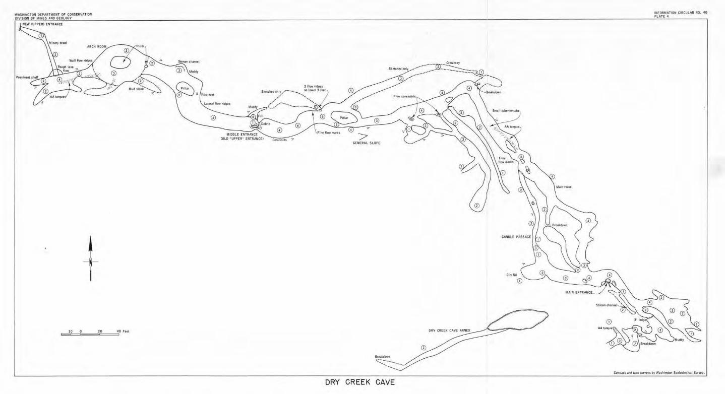
CONSERV.lTION• -------- - ---RTMEHT OF -WASHINGTON J1~~ ANO GEOLOGY
DIVISION OF > ENTRAHCE NEW (UPPER
j_ I
10 0 20 40 Fffl
Plb nut
Later,11 How , id9u
Corallold• "7
ORY
Bteakdown ,-----........ ...... _ .......... __
CREEK CAVE
NO 40 INFORMATION CIRCULAR • PLATE 4
MAIN ENTRAHCE
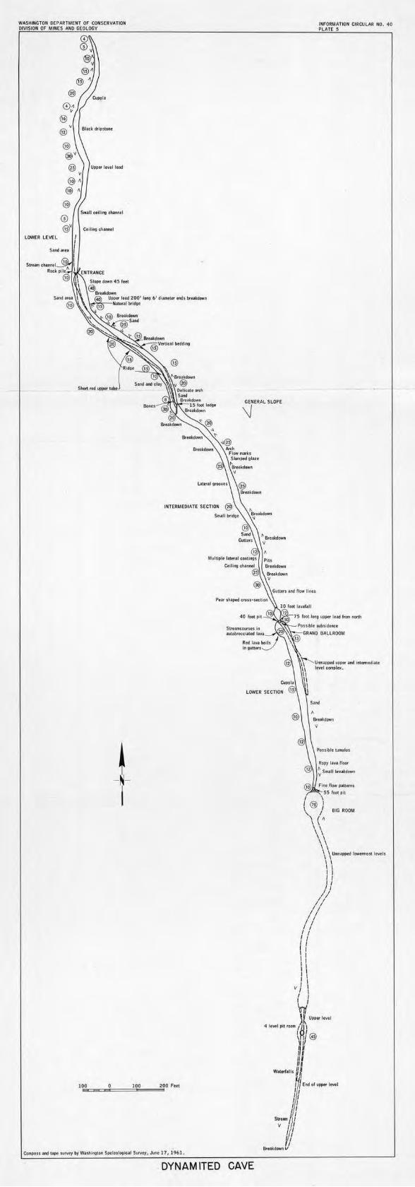
WASHINGTON DEPARTMENT OF CONSERVATION DIVISION OF MINES ANO CEOLOOY
Stnall ctlli"1 thaMtl
LOWER LEVEL
INFORMATION CIRCULAR NO, 40 PLATE 5
GENERAL SLOPE
\j
~ -N-i
10.~oa=l!!!C=o-=====10:;;o...,===5!i200 F•et
Compan and tape survey byWuhlngton Speleolo,;lul Survey, June 17, 1961.
DYNAMITED CAVE
I
Possfblt LUmului
Ropy fan floor
~ S111,II brc-akdown
Fint flow p.attem, 55 foot pit
{ @ BIG ROOM
'\ ( a
\\ \ \ \ \ \ \ \ \ Unmapped IOWfflllOs.t lhtlJ
) \ ))
!/ ;I ;/ // 1 I 1 I I I I I
V I \ / l
w }.t u .... 1 ... 1
4 1,..lptt,oom ~l@ 'IV II
I,, ,,
W1ttrl1lls un I J End of uppt< level
11 ,, ,, su.-. /i /
V / /
I I
&takdow.V
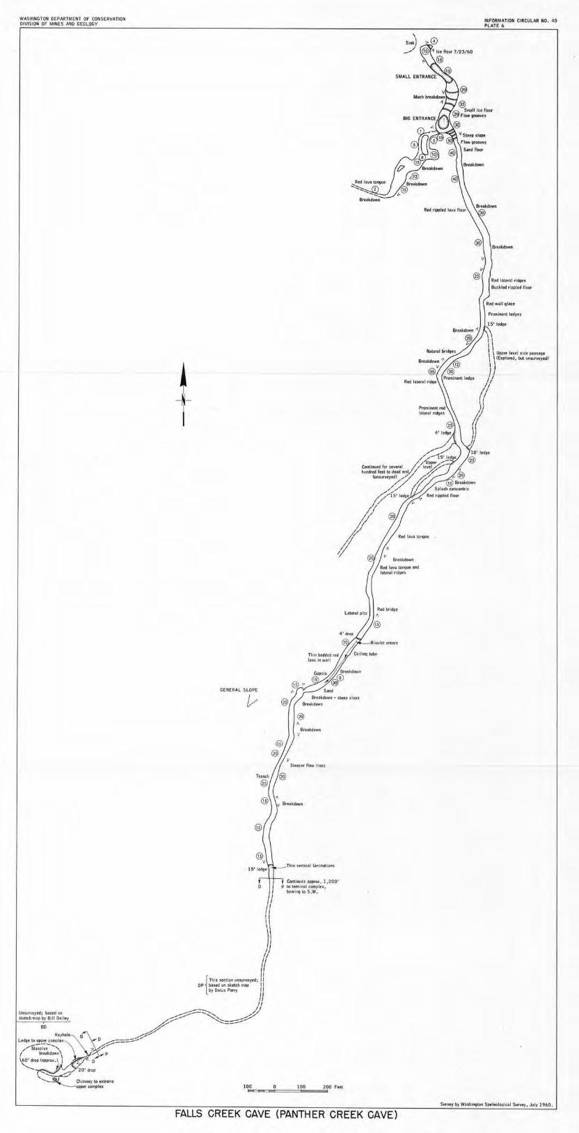
WASHINGTON OEPAATMENT OF CONSERVATION DIVISION OF MINES AfjD GEOLOGY
~ -N-I
GENERAL SLOPE
v ®
" B,e-.ttdow11 V
Cofltl i,.ies IJl)PfOX. } ,2001
p to lffflllMI comptu, bearing to S.W.
FALLS CREEK CAVE (PANTHER CREEK CAVE)
\ s,ric ) _/
Rf'd lateral ridge
INFORMATION CIRCULAR NO. 40 PLATE 6
Brtakdown
Rtd lllttll rldgu
Buclded , fpplfd floor
Redwall glau
Promlntnt ltdgts
IS' lod9t
1
\\ OPi!tr level side ~uagt . (Explored, but unsu,\ltytd)
1' I I , , 1,I
{ii y « '}
);
St.trvey by Wa.stilngton Spelrologlcal Survey,, July 1960.
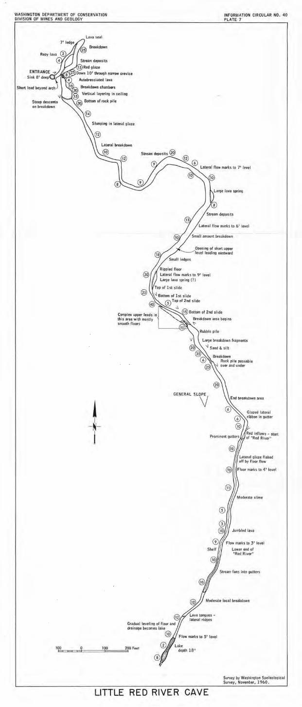
WASHINGTON DEPARTMENT OF CONSERVATION DIVISION OF MINES ANO GEOLOGY
ENTRANCE Sink 8' deep
Steep descents on breakdown
Lava seal
Slumping In lateral glaze
~ -N-I
Lateral breakdown
Complex upper leads In this area with mostly smooth floors
GENERAL SLV
INFORMATION CIRCULAR NO. 40 PLATE 7
Glazed lateral ribbon in gutter
@
©
Moderate slime
Jumbled Java
Flow marks to 3 ' level
Lower end of "Red River"
Moderate loca l breakdown
Gradual leveling of floor and drainage becomes lake
r.;;,.. ~ Flow marks to 5' level
100 200 Feet 13::::E3=ea======ee1 0 100 • @®/ Lake depth 18"
© V
LITTLE RED RIVER CAVE
Survey by Washington Speleological Survey, November, 1960.
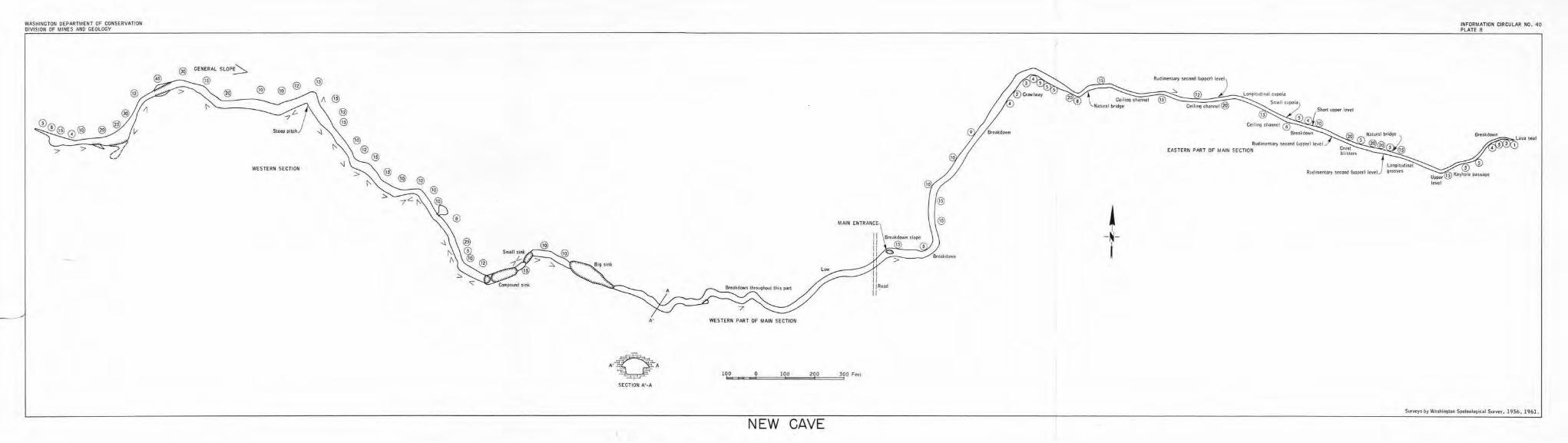
WASHINGTON OEPAATMENT OF CONSERVATION OIVISIOH OF MINES AND GEOLOGY
WESTERN SECTION
A'
A·O~ ~A
-p
SECTION A'·A
WESTERN PART OF MAIN SECTION
1oeoic""'=~o===1=0-o.,._ ... 2.o=o==:::53ooFffl
NEW CAVE
~ -N-j
INFORMATION CIRCULAR NO. ~0 PLATE 8
SurytyS by Washh,gton Ss>tteol09ic.al Survey, 1956, 1961.
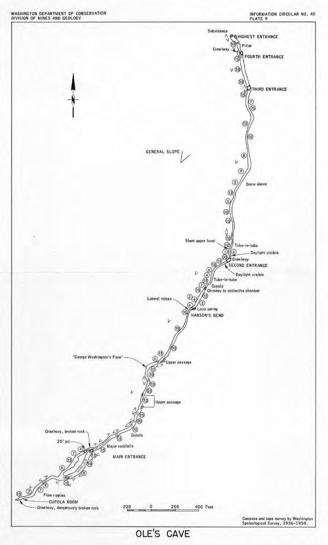
WASHINGTON DEPARTMENT OF CONSERVATION DIVISION OF MINES ANO GEOLOGY
~ -N-i
GENERAL SLOPE V
Lateral ridges
"George Washington's Face11
II
Crawlway, broken rock
MAIN ENTRANCE
Crawlway, dangerously broke<1 rock 200 0 200
OLE1S CAVE
Subsidence
" \J
Crawlway
400 Feel
INFORMATION CIRCULAR NO. 40 PLATE 9
THIRD ENTRANCE
Compass and tape survey by Washington Speleological Survey, 1951>-1958.