1
! 9 ! 9 ! 9 ! 9 ! 9 ! y ! | ! 5 ! | ! 5 ! y ! l ! 5 ! 9 ! y ! r ! l ! l ! 9 ! 9 ! 9 ! 9 ! 9 ! r ® s ® s ® s Æ R ! y ! n ! l ! r ! l ! i ! @ ! i ! i ! 9 ® s Æ R D D Island Lake Dam Recreation Area Hideaway Recreation Area Island Lake Park Cloquet River Abbott Road Boat Launch Rice Lake Road Co. Hwy. 4 Boulder Lake Rd. Nordberg Rd. Abbott Rd. East Trailhead (Winter access only) Boulder Lake Environmental Learning Center Bear Paw Campground (10 walk/ski in sites) Morgan Lake Apple Lake Fredenberg Lake Schultz Lake Jacobs Lake Horseshoe Lake Sunshine Lake Cooks Lake Cloquet River United Northern Sportsmen's Club Camping and Boat Launch (Fee) Island Lake Campground (Fee) Duluth South Trailhead North Trailhead Max. Depth (94') 0 Rice Lake Rd Normanna Rd Old Vermilion Tr Taft Rd Fish Lake Rd Turner Rd N Dike Rd Datka Rd Bear Island Rd Boulder Dam Rd Otter River Rd Abbott Rd Cannonball Lake Rd Church Rd Arnold Rd Andler Rd. 1st Ave Schultz Lake Rd Boulder Lake Rd Island Lake Rd Bergstrom Rd Birch Isle Rd Jean Duluth Rd E Cook Lake Rd Island Lake Dam Rd NW Island Lake Rd Fredenberg Lake Rd Island Lake Dr Old Taft Rd 8th Ave Haugen Rd Howard Gnesen Rd Nordberg Rd Sunsett Blvd Parson Pt Rd Miller La Normanna Rd. Lavaque Rd Crescent Dr Town Line Rd Olson Dr Forest Rd Beaver River Rd Sunshine Lake Rd Pine Shores Dr Tarnowski Rd Juten Dr Wood Duck Dr Tracy Rd Blackberry La Otter River 0 0 0 0 0 0 0 0 Reservoir Riders μ 0 1 2 0.5 Miles ISLAND LAKE RESERVOIR (WEST) Boulder Lake Reservoir St. Louis River Hydroelectric Project FERC Project No. 2360 St. Louis River Watershed 87.6 Megawatts Total Capacity ISLAND LAKE RESERVOIR For more information about Minnesota Power's hydroelectric projects, Boulder Lake Environmental Learning Center, Adopt an Island Program, or the ShoreLand Traditions lease program, please visit: www.mpland.com Public Recreation Map Key ! 9 Campsite ! : Group Campsite ® s ADA Accessibility ! y Boat Launch ! | Canoe portage/access ! @ Environmental Learning Center ! i Parking Snowshoe/Backcountry Ski Trail ! l Shore Fishing Snowmobile Trail X-Country Ski Trail ! n Dam Æ R RV Camping ISLAND LAKE RESERVOIR (EAST) ISLAND LAKE RESERVOIR FAST FACTS - Max. Depth: 94 ft. - Size: 10,800 acres - Miles of Mainland Shoreline: 70 miles - River System(s): Cloquet River (tributary to St. Louis River) - Dominant Game Fish Species: - Walleye - Black Crappie - Smallmouth Bass - Largemouth Bass - Northern Pike - Yellow Perch - Muskellunge (stocked) - Camping Opportunities: - 11 primitive campsites maintained by MP - 2 privately operated campgrounds - Island Lake Campground (Private) - United Northern Sportsmen's Club (Private) - Boat Access: - Island Lake Dam Recreation Area - Abbott Road - Hideaway Recreation Area - United Northern Sportsmen's Club (Private) Reservoir Riders

ÆR - Boulder Lake Environmental Learning Center Rec sites.pdfÆR D D Island Lake Dam Recreation Area Hideaway0 Recreation Area ... ISLAND LAKE RESERVOIR For more information about

  • Upload
    vannhan

  • View
    220

  • Download
    2

Embed Size (px)

Citation preview

!9

!9

!9

!9

!9

!y

!|!5

!|

!5

!y

!l!5

!9

!y

!r

!l

!l

!9

!9

!9

!9

!9

!r

®s

®s

®s

ÆR!y

!n

!l

!r

!l

!i

!@

!i

!i!9

®s

ÆR

D

D

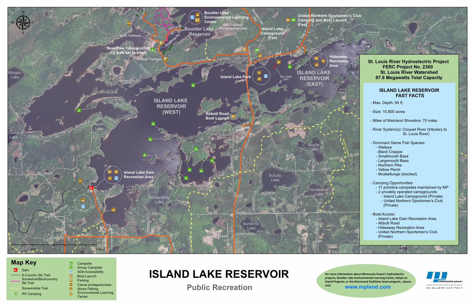
Island Lake DamRecreation Area

Hideaway Recreation Area

Island Lake Park

Cloquet River

Abbott Road Boat Launch

Rice L

ake R

oad

Co. H

wy. 4

Boulder Lake

Rd.

Nordberg Rd.

Abbott Rd.

East Trailhead(Winter access only)

Boulder Lake Environmental LearningCenter

Bear Paw Campground(10 walk/ski in sites)

Morgan Lake

Apple Lake

FredenbergLake

SchultzLake

Jacobs Lake

HorseshoeLake

Sunshine Lake

CooksLake

Cloquet River

United Northern Sportsmen's Club Camping and Boat Launch(Fee)

Island Lake Campground

(Fee)

Duluth

South Trailhead

North Trailhead

Max. Depth(94')

0

Rice L

ake R

d

Normanna Rd

Old V

ermilio

n Tr

Taft R

d

Fish Lake Rd

Turner Rd

N Dike Rd

Datka Rd

Bear Island Rd

Boulder Dam Rd

Otter River

Rd

Abbo

tt Rd

Cannonball Lake Rd

Churc

h Rd

Arno

ld Rd

Andler Rd.

1st Ave

Schu

ltz La

ke R

d

Boulder Lake Rd

Island Lake Rd

Bergs

trom

Rd

Birch Isle Rd

Jean

Dulu

th Rd

E Coo

k Lak

e Rd

Island Lake Dam Rd

NW Island Lake Rd

Frede

nberg

Lake

Rd

Island Lake Dr

Old T

aft R

d

8th Ave

Haug

en R

dHo

ward

Gnes

en R

d

Nordberg Rd

Sunsett Blvd

Parso

n Pt R

d

Miller La Normanna Rd.

Lava

que R

d

Crescent DrTo

wn Li

ne R

d

Olso

n Dr

Forest Rd

Beaver River Rd

Sunshine Lake Rd

Pine Shores Dr

Tarnowski Rd

Juten

Dr

Wood Duck Dr

Tracy

Rd

Blackb

erry L

a

Otter

River

0

0

0

0

0

0

0

0

Reservoir Riders

µ

0 1 20.5 Miles

ISLAND LAKE RESERVOIR

(WEST)

Boulder Lake Reservoir

St. Louis River Hydroelectric Project FERC Project No. 2360

St. Louis River Watershed87.6 Megawatts Total Capacity

ISLAND LAKE RESERVOIR For more information about Minnesota Power's hydroelectricprojects, Boulder Lake Environmental Learning Center, Adopt anIsland Program, or the ShoreLand Traditions lease program, pleasevisit: www.mpland.comPublic Recreation

Map Key !9 Campsite!: Group Campsite®s ADA Accessibility!y Boat Launch

!| Canoe portage/access

!@Environmental Learning Center

!i ParkingSnowshoe/Backcountry Ski Trail

!l Shore FishingSnowmobile Trail

X-Country Ski Trail!n Dam

ÆR RV Camping

ISLAND LAKE RESERVOIR

(EAST)ISLAND LAKE RESERVOIR

FAST FACTS- Max. Depth: 94 ft. - Size: 10,800 acres- Miles of Mainland Shoreline: 70 miles- River System(s): Cloquet River (tributary to St. Louis River)- Dominant Game Fish Species: - Walleye - Black Crappie - Smallmouth Bass - Largemouth Bass - Northern Pike - Yellow Perch - Muskellunge (stocked)- Camping Opportunities: - 11 primitive campsites maintained by MP - 2 privately operated campgrounds - Island Lake Campground (Private) - United Northern Sportsmen's Club (Private)- Boat Access: - Island Lake Dam Recreation Area - Abbott Road - Hideaway Recreation Area - United Northern Sportsmen's Club (Private)

Reservoir Riders