Embed Size (px)
Citation preview

architecture landscape architecture urban furniture lent space urban space landscape architecture public street art port cities water dependencies Barcellona Rio di Janeiro Hamburg Helsinki Zara-
goza city center water contemporary city groundfloor contemporary city groundfloor material city social city competing groundlevel fragments Europe creative cities interaction cre-
ativeness out of the box thinking urban invis ible towns Mediterranean Sea mobil ity Lake seasonal population surrounded by mountains Mobil ity infrustructure walls pendular passengers seasonal holiday town flexible town Garda lake Como lake landscape quality landscape observation European lakes
Mediterranean cl imate culture public opinion urban participation col laborative piazza Milan Switzerland Austria Germany mobil ity traffic
landscape observation urban pause performance urban participation public audience mobile audience seasonal audience artistic performance urban platform stage public policies participation groundfloor project public l ife project participation public street art l ife quality everyday l ife quality recreation promenade walking sightseeing stroll ing public l ife shopping admiring monuments
photos new local playing green space open space waterfront public l ife urban quality landscape omogeneity essence town omogeneity sightseeing quality landscape omo-
geneity essence town omogeneity sightseeing regeneration land mark place making l imited development adaptation landscape art architecture pino maritimo Mediterraneo Garda Cipress trees monumental buildings monumental trees landscape
natural assets quality mountains lake shore lake front conquer reflect sensorial experimentnew gener-ation urban regeneration sustainable requalif ication public space street museum storical buildings churches waterfront regeneration memory place-making new generation urban regeneration
sustainable sensorial experimentation re-qualif ication public space street museum historical buildings churches waterfront regen-
eration restoration street art groundfloor tradition memory placemaking man and environment ground-floor waterfront new & old pub-lic opinion seasonal population urban participation Milan Switzerland Austria Germany mobil ity traffic landscape observation urban pause promenade performance urban participation public
promenade audience mobile audience seasonal audience artistic performance urban platform territorial advantage Salo Desenzano Sirmione Riva Parco Alto Garda Bresciano nature love nature urban action collective l ife identity architecture landscape territorial marketing place advantage territorial advantage
architecture urban furniture lent space identity urban space landscape architecture public street art port cities. sense of place urban ac-
tion event place-making playful Riva Parco Alto Garda Bresciano nature love nature urban action architecture pino maritimo Mediterraneo Garda Cipress trees quality landscape omogeneity essence town omogeneity sightseeing landscape observation urban pause performance urban participation public audience mobile audience seasonal audience artistic performance ur-
ban platform stage public policies participation street art project public l ife project participation public groundfloor life quality everyday l ife quality recreation promenade walking sightseeing stroll ing public l ife shopping admiring monuments tradition memory placemaking man and environment ground-floor waterfront playing green
WATERFRONT CONSIDERATIONSTOSCOLANO MADERNO
RELATORE EMILIO FAROLDI
STUDENT LOURDES FOURCADE
POLITECNICO DI MILANOAA 2013-2014
SCUOLA DI ARCHITETTURA E SOCIETA’

Table of ContentsABSTRACT 5
PART IWATERFRONT 9SPACE POTENTIAL BETWEEN URBAN FABRIC AND BODIES OF WATER �����������������������9
THE IMPORTANCE OF CITY WATERSIDE REGIONS �����������������������������������������������������������������������������������������������9WATERFRONT DEVELOPMENT PROCESS ����������������������������������������������������������������������������������������������������������������11ITALIAN CONTEXT �����������������������������������������������������������������������������������������������������������������������������������������������������������������19WORLDWIDE EXAMPLES ������������������������������������������������������������������������������������������������������������������������������������������������23SUCCESFUL WATERFRONT DEVELOPMENTS? �������������������������������������������������������������������������������������������� 30
SPORTS AS A TURISM CATALIZER 35FROM HEALTH TO SOCIAL REINSERTION �������������������������������������������������������������������������������������������35
CONCEPT AND DEFINITION �������������������������������������������������������������������������������������������������������������������������������35SPORTS-LED REGENERATION �������������������������������������������������������������������������������������������������������������������������������36AN EMERGING MARKET ������������������������������������������������������������������������������������������������������������������������������������������������38IN ITALY ���������������������������������������������������������������������������������������������������������������������������������������������������������������������������������39VIRTUOS CIRCLE ��������������������������������������������������������������������������������������������������������������������������������������������������������������� 40COOPERATE AND CREATE SYSTEM ��������������������������������������������������������������������������������������������������������������������������������41
PART IITOSCOLANO MADERNO 47HISTORY, DEVELOPMENT AND ANALYSIS �������������������������������������������������������������������������������������������47
HISTORY AND URBAN DEVELOPMENT ��������������������������������������������������������������������������������������������������������������47MUNICIPAL AREA DESCRIPTION �������������������������������������������������������������������������������������������������������������������������������55AT THE WATERFRONT: PRESENT REGULATIONS, PLANNING, AND PROBLEMS ��������������������������58
PART IIISTRATEGICAL PLANNING 79
RE-THINK ABBANDONED AND AWKWARD SPACES ���������������������������������������������������������������������������������������������98
BIBLIOGRAPHY 104ONLINE SOURCES ��������������������������������������������������������������������������������������������������������������������������������������������������������������104BOOK SOURCES ��������������������������������������������������������������������������������������������������������������������������������������������������������������106

5
The first part confronts the subjects of waterfront, and sports tourism on a theoretic basis. Waterfront deals with the almost universal economic decline of older industrial river and port-side cities, the potential use of these spaces, and a study of some international, and national re-qualification cases of the water side areas where tourism and leisure opportunities manifest themselves as means of at least partially balancing the declining economy in these areas. Sports Tourism describes sports and recreation as a specific kind of tourism useful as a re-qualification strategy possibly impacting space, society and economy in different levels.
The second part is the case study of Toscolano Maderno, a town with little more than eight thousand people located in the province of Brescia, Italy, with a particular geography on a promontory, frontage to the lake of Gar-da, backside to the Alps, and a torrent crossing through it. The themes of the first part will be analyzed here considering the town’s touristic and industrial vocation on a specific context of urban form, culture and economy. Also the local urban plans and laws will be useful to define strategies useful for the further re-qualification of this particular waterfront.
The third part consists of a critical survey of the current situation and a uni-fication strategy for Toscolano Maderno’s waterfront through the creation of pedestrian and bycicle lanes intersecting public spaces as well as sport-tour-ism related infrastructures in the less developed waterfront area of Toscola-no. The objective is to explore design opportunities that may not yet have been considered, as well as to discover what impediments may lie in the way.
The intent of this thesis is to bring to public attention part of the vision that is already in place regarding the use of Toscolano Maderno’s Waterfront hop-ing to encourage universities, government agencies, civic groups, and prop-erty owners to undertake coordinated efforts to complete great civic places for the town and that benefit both the tourist economy and its inhabitants.
ABSTRACT

7
PART I

PART I WATERFRONT8 9
The landscape and leisure potential of these places and the mediatic revaluation of their symbolic value, augment the speculative character of the investments. The waterfronts of cities come to define the skylines dictated by new highly so-phisticated urbanistic wholes and to construct a new imagi-nary at an urban label.”
PORTAS, Nuno (1998) “Agua. Cidades e frentes de agua”
SPACE POTENTIAL BETWEEN URBAN FABRIC AND BODIES OF WATER
WATERFRONT
THE IMPORTANCE OF CITY WATERSIDE REGIONS
History tells us that water has always been a fundamental attraction for city developments. Since the earliest cities in Mesopotamia a major river was responsible for providing transport for building, materials, food, defense lines, a source of drinking water and even a means of power. In Europe practi-cally all the great cities have a close association with a river, an estuary, or the open sea. The industrial revolutions brought many dramatic changes to waterfronts in cities, however this did not free the cities from the confines of water. Many of the World’s greatest industrial cities in the nineteenth century such as London, New York, Buenos Aires, Cape Town, and Sydney, were lo-cated near the water (Briggs 1968 in Craig-Smith, Jonson 1995).
As we reach the end of the 20th century, the world’s cities are experiencing progressive tensions in urban use and structure. Despite gradual redevel-opment, many major cities are struggling to maintain functional efficiency while at the same time maintaining an acceptable quality of life. With the rehabilitation of urban waterfront areas an interesting opportunity for suc-cessful redevelopment has emerged.
These interventions are complex and involve contradictions and approach-es, notably the interplay of scales, territorial strategies, tools, financing, and other aspects tied to the transformation of port cities and urban waterfronts (Giovinazzi, Oriana 2008)
Image 1- Diyarbakir and Tigris River. Both Tigris & Euphrates Rivers ( Dicle and Firat ) meet in Central Turkey. Ancient Civilizations Developped Dams and Reservoirs on Tigris, Euphrates, Nile Rivers. Source: http://www.rodhandelan, http://www.ephesustoursguide.com/ancient-cities-of-turkey/tigris-euphra-tes-rivers-dicle-and-firat.html d.com/FreshWater/Class%20V%20-%20Savings.htm,

PART I WATERFRONT10 11
Image 2: Commercial and Industrial Port “Puerto Madero” in the 1920’s in Buenos Aires. View of the Docks along the canal. Souce: http://www.laribera.com.ar/historia-y-mapa/historia-de-puerto-madero_544.html
Image 3: The same port today subject to urban renewal recreational activities and competitions mixing old a new. Upper left corner: woman roller race along the neighbourhood’s main street and along the waterfront. lower left corner: Calatrava’s Woman Bridge; right: Historical boat-museum and former docks transformed into commerce and offices. Source: http://www.losmejoresdestinos.com/destinos/argentina/buenos_aires/buenos_aires_turismo_barrios_puerto_madero.htm
WATERFRONT DEVELOPMENT PROCESS
Waterbodies provide many functions generating uses and activities which affect the waterside development process. Water spaces offer a wide range of uses such as habitat in a river, estuary, sea, lake or ocean; a traffic ar-tery; frontage for industrial and commercial activities; landscape appeal; a residential limit; and a recreational resource. A variety of approaches ex-ist towards the interpretation and classification of waterside uses. The more traditional ones dividing into the specific categories of transport, industry, commerce, utilities, and recreation and others crossing information between different waterside land uses and “degree of integration with water” (Lynch, Spence, and Pearson, 1976 in Craig-Smith, Jonson 1995). This qualitative ap-proach serves to address the different purpose and perspectives of the client group or “use constituencies”. Two group categories can be identified regard-ing direct or indirect interest in the use of the resource.
The first group covers people who are directly interested in the use of water-side areas as places of work, for residence, or recreation and therefore associ-ated with waterside areas for housing, industry, commerce, transport, and a variety of leisure and recreational facilities. The second group concerns peo-ple who view waterside areas as public resources and are concerned about the quality and use of waterside areas even if they might not use directly the resource themselves.
The first group is more likely to refuse to share the limited water resource with other uses. Since each subgroup will attend its own land-use agenda. For example, if the main consideration is industrial use, the most relevant factors to think of will be about operational efficiency (size of land parcel, types of building accessibility, availability of parking, and serviceability by the basic utilities), if it is residential use- quality of life (visual environment quality, clean water, public safety, workplace accessibility, etc.), if the principal con-sideration is recreational use the main factors will be about environmental

PART I WATERFRONT12 13
quality(accessibility, parking, variety of open-space facilities, quality of the water and sports areas,etc), and so on.
For public purposes the second group is more significant for determining use as it is more inclined toward the use of the water-related corridor as a recre-ational and environmental resource (Fageance, 1991).
To further asess development water dependency breeds other three use cat-egories determined by Wrenn et al. (1983) as follows:
1� Water-dependent uses: fishing, transport, boat repair and construction yards as well as ferry slip, ports, morrings, docks and other marine terminals. A waterside location is necessary.
2� water-related uses: industrial processing plants, some storage and ware-house facilities, and some public utilities. While maximizing the advatages of riverside locations they may function efficiently if located away from the water’s edge.
3� water independent uses: residential accommodations, hotels, public parks and reserves, some retailing and service complexes. These uses will take ad-vantage of the environmental attraction but may be equally served by loca-tions away from the water’s edge.
The categories may often overlap and mix making it difficult to determine an exact classification they still prove relevant when deciding to make a wa-terfront development.
Wrenn (1983) also classified waterfronts according to their shoreline shape and how the urban area was located in relation to it.
1. located on peninsula,
2. located on a bay,
3. located on banks of a river,
Degree of integration with water
degree of integration with water living areas working areas leisure areas special areas
high Properties developed with a high regard for waterfront location, either by enhancing the riverscape or utilizing their river access
Industries pri-marily depen-dent on water for transport. Activities where water is essential to the operation
Areas in a natural state. Develped recreation areas that are physi-cally related to the water with jetties, steps , boat clubs, ramps and marinas
Areas in a natural state
medium Development orientated for the scenic qualities of the location but not physically using the river's potential
Industries that incidentally use water transport but could oper-ate elsewhere
Reserves or parks that are visually orientated inward the river but make no attempt to link the two recreation re-sources
Development that recogniz-es the visual advantages of riverside location
low Areas devel-oped with little concern for their riverine location
Activities that have no func-tional relation-ship with the river
Recreation areas that mitigate against water access through fencing or bound-ary walls
Table 1. Degree of Integration with water. source: L.Lynch, M.Spence, & W. Pearson (1976)

PART I WATERFRONT14 15
4. located on banks of intersecting rivers,
5. located on a large body of water.
Waterfront projects become more complex as the may include buildings and areas that are not directly bordering the water but are tied to it either visu-ally, historically or ecologically or are linked to it as part of a larger scheme (R. Sairinen, S. Kumpulainen, 2006).
Most authors agree that the urban waterfronts degenerated in the last two centuries together with the advancing of tecnology and an urban incapabili-ty of keeping up to the changes it generated most visible in the industrial and transportation sector. Craig-Smith and Jonson lists in detail these industrial and utilitarian activities and the space problems they represent
Port facilities: import and export of voluminous goods; ship maintenance, building and repair
Manufacturing industry: bulky materials used and produced; water shipment necessary; processes discharging significant amounts of solid, liquids and/or heat waste; water used in the production process
Boat building, repair, and maintenance
Watter supply: mainly “upstream” water barrages and reservoirs; some ‘downstream” treatment plants, or even smallscale supply sources (where the city reaches are tidal)
Drainage: Using natural tributaries and the river corridor; where natural drainage is increased by artificially made drains, complications may ensue from the inflow of pollutants, sediment, litter; Complications may follow changes to the natural syystem by dredging the construction of retaining walls, piers.
Sewage-treatment plants: refuse disposal, often as a prelude to reclamation before construction of roadways, park areas, or commercial development
Electricity power generation: The power generation plant, using water for cooling or to facilitate the transport of the generation fuel; the routes of py-lons�
To the decline of industry followed high unemployment rates and social com-plications. As a result, the closure of former waterside areas in urban spac-es has often been followed by urban-regeneration programs to resume the empty land and improve inner-city social conditions.
Scandinavian countries are pioneers in the Social dimensions of Urban Plan-ning. Taking in consideration the risks of social impact that new develop-ments played a key role in the water locations of Ruoholahti, Aurinkiolahti and Arabiananta regeneration in Helsinki.
The last fifty years that shaped waterfront redevelopment as we now it to-day mainly due to technological changes post World War II which led to abandonment and/or deterioration of thousands of acres of industrial land across waterfronts, an increased consiuousness towards historic preservation, heightened environmental awareness and water cleanup, a consistent pres-sure to redevelop central city areas and public (state, federal and municipal) urban renewal and related assistance (R. Sairinen, S. Kumpulainen).
There is no one way to structure the issue of recovery of the waterfront since each coastal urban area has a specific relationship between urban develop-ment and development-related functions to the waterside.
In particular two very different situations emerge (CENSIS, 2009): The first, typical of Northern Europe, relating to industrial areas / abandoned or un-derused ports, often covering large pieces of land, and placed peripherical-ly in relation to the city center. The second case, more Mediterranean and smaller in size, has the port and industrial sites inside or next to the city center and often highly integrated with the historical city.
During the last decades, the attraction of the urban coastline has been rec-ognized and numerous efforts have been made to preserve what is left of it.
Image 4: Ruoholahti, Finland. Jaalaranta Park marks the end of the waterfront park along the Canal The social structure of the dense residential housing area was carefully planned. Source: http://www.vihreatsylit.fi/en/?p=921
Image 5b: Ruoholahti, Finland . Same residential complex closing into the canal mouth where some industrial character remains. Source: http://www.vihreatsylit.fi/en/?p=921
Image 5a: Ruoholahti, Finland . Appartment buildings looking at the Jaalaranta Park. Source: http://www.vihreatsylit.fi/en/?p=921

PART I WATERFRONT16 17
Table 2. The Social dimensions of urban waterfront planning. Source: R.Sairinen, S.Kumpulamen/ Environ-mental Impact Assesment Review 26 (2006)
Table 3. Questions on Resources and identity on Social Dimension of urban waterfront planning. R.Sair-inen, S.Kumpulamen/ Environmental Impact Assesment Review 26 (2006)
It could be said that changes on the water borders today are as profound as eighteen and nineteen century developments. Laws have been passed and planning tools have been developed to regulate what can be built by the waterside; from brown fields, to green belts, piazzas, public walkways, com-mercial, resdential, work, and recreational areas.
According to Fageance these valuable areas require creative solutions that go beyond the traditional urban land-use planning concepts and experiences. A Land-use continuity may be achieved by linking waterfront development with inland uses. For a sustainable economic base, both the existing and the new land uses along the waterfront should be capable of creating diversity which add and consolidate markets which complement one another creat-ing “interdependencies” among otherwise nonsupporting functions and uses . In the first case the waterfront areas involve very large areas occupied by airports and docks, warehouses and the subject in recent years of large-scale urban projects volumetric measures of actual redevelopment similar to those implemented also in large enclosures brownfield .
Especially in northern Europe the former industrial port areas have rede-signed large portions of city, from almost nothing sometimes, with massive support for residential and commercial buildings . Some clear examples are Hamburg and HafenCity on the Elbe with 157 acres, with similar area the docklands of London in the eighties. and even Liverpool ( seafront). In these Interventions the modern city is proposed with its types : skyscrapers, shop-ping malls , residential areas in the green , etc. (see Table 4).

PART I WATERFRONT18 19
ITALIAN CONTEXT
Italian cities usually have a more complex and interesting urban develop-ment because more often the intervention is the heart of the city and over-looking the water. A more common reality in the in the cities of the Medi-terranean, where recovery is “often about the seat of the ancient port , or at least the areas near the historical settlement , with significant layers of differ-ent ages.” Areas are usually much more limited in terms of scope , because historical memory of the place has such a significant role with the buildings as actors containing historic, artistic or even documentary value it is not simple to recover them with new functions. and also where they remain in business port . In these cases, the removal of physical barrier search to allow the rejoin of the old town with the sea. These reasoning opens new perspectives where recovery of waterfront and land development are not only of the waterside area but more generally pointing to the regeneration of the city, mainly re-lated to tourism , culture and the environment.
In turn, Italy has been very slow in the undertaking of this kind of projects (unlike northern countries in Europe). The plan for the waterfront of Salerno Bofill is one of the few: in front of the sea between the beach of Santa Teresa and Molo Manfredi , released over the years by crumbling artifacts should be made a large building in a semicircle ( the Crescent ) on a large square un-derground parking, a covered area for events , a walk along the beach and the sea shore , with shops , bars, restaurants ;
Another is the redesign of the waterfront of La Spezia, subject to a major in-ternational competition organized by the port authority , to recover and en-hance the Descent of Paita port area that will be disposed in the near future. The design of the study Spanish Areas of Jose Maria Tomas Llavador was the winner in 2007. The project involves: 1. the construction of a cruise terminal that will allow the landing of 4,000 passengers 2.The construction of a new dock for boating ( 300 berths ) 3.recovery and regeneration of urban ar-
Table 4 . European Waterfronts. Recent and ongoing operations. Source: Cencis, 2009
Image 6: Salerno, Italy. Piazza della Liberta square and Crescent Complex by C. Lotti & Associati – Bofill Arquitectura S.L. Up: render of piazza and complex. Down: Bird view of ongoing construction. Source: http://www.crescent.salerno.it/architettura.aspx
Image 7: La Spezia Italia. Redisign of the Water-front coastline. Source: http://www.porto.laspezia.it/it/download/varie/presentazione-waterfront

PART I WATERFRONT20 21
Image 9: Rimini, Italy. Jean Neuvel winning design for the Rimini Marr=ina Center. http://aquilialberg.nova100.ilsole24ore.com/2008/09/16/citt-fluide/
eas� 4. Around 2km of green around the city’s waterfront 5. An auditorium, conference facilities and accommodation, 6. commercial and residential for approximately 45,000 square meters.
There is also the transformation of the waterfront of Reggio Calabria. Also in this case city launched an international design competition, this time won by architect Zaha Hadid. The project involves: the redevelopment and con-version of the coastal front of the city for tourism , office , office buildings, craft, and commercial. The new waterfront should be characterized by two buildings, the Museum of the Mediterranean and the Multipurpose Center, located near the central station.
In Rimini the design for the promenade of Marina center, for which the City has an international competition won again by an archistar, this time Jean Nouvel whose proposal searches to erase the limit between the beach, the waterfront, and the city.
In Italy however one of the most prominent and innovative examples is per-haps the port area in Genova; A driving force for the transformation of the city in the last 2 decades.
The International Exhibition of 1992 in occasion of the 500th anniversary of the discovery of America served as initial battery to fundamental operations that have returned the attention to the area of the ancient port city, through the recovery of cotton warehouses transformed into Convention Center, the construction of Aquarius, track skating and Bigo, with its panoramic lift rota-
Image 8: Reggio Calabria, Italy. “Regium Waterfront“ plan by Zaha Hadid Architects. Source: http://www.strettoweb.com/2013/02/regium-waterfront-aggiudicato-il-bando-per-i-lavori-ecco-le-immagini-del-la-citta-del-futuro/63723/

PART I WATERFRONT22 23
ry salt up to 40 meters in height, offering a unique view of the city.
Over the years, thanks to investments linked to the G8 (2001) and the cele-bration of Genoa European Capital of Culture (2004), the area of the an-cient port was further equipped with a marina for 280 seats, a multiplex nine movie theaters, the children’s City, the Museum of Antarctica, the museum of the Sea and Navigation and the biosphere (a kind of bubble which is sup-posed to play a large woodpecker of the rainforest)
With the planned intervention of Ponte Parodi (long overdue but not under discussion), the Old Port is expected to provide in the coming years also other new attraction such as a cruise terminal, a large fitness area, an auditorium and a wide number of stores related to sports and leisure (not in competition with the current Old Town, such as the Convention explicitly states), as well as a number of “reasonable” underground car parks.
WORLDWIDE EXAMPLES
the following cities demonstrate different approaches to Waterfront devel-opment. Some are worldwide known locations whereas others may be less known but still regarded by experts as successful examples.
BARCELLONA, Barceloneta and Port Vell
An important part of the strategy to revitalize the city was launched at the end of the 80s based on the complete transformation the old de-industrial-ized,shoreline which has allowed the creation of a new promenade and a new marina directly connected with the old district of Barceloneta. A neigh-borhood with plenty of problems of old disused docks, and social degradation (prostitution) and that after 1992, underwent massive intervention together with other parts of the city. The two “twin towers” MAPFRE and Hotel Arts, and also Frank Gehry’s famous fish are emblematic of this requalification.
Even the much more central area of Port Vell, the old port, just in front of the Rambla, underwent a profound conversion process during the works for the 1992 Olympics. What was once a place of sailors and fish markets, today is one of the liveliest and most popular areas of the city. The ancient medieval arsenals, the Drassanes Reials, now home to the Museum Maritim de Barce-lona, reflects the splendor of the trade maritime and naval Catalan in the Middle Ages. The most modern area begins with the Maremagnum shopping center connected to the water Rambla with a drawbridge, integrated with a play area that includes an Imax cinema and the Aquarium, one of the largest in Europe.
Image 10: Genova Port, Italy. Source: http://www.floornature.it/notizie-novita-panorama-architettura/news-renzo-piano-nuovo-padiglione-cetacei-acquario-genova-8814/
Image 12: Port Vell, Barcellona in the Olimpic Games of 1992. Source: http://www.academia.edu/4010447/Comparazione_realta_di_water-front_Baltimora_Barcellona_Bilbao_Genova
Image 11: Barcellona waterfront boardwalk. Source: http://www.willhiteweb.com/europe_trav-el/spain/barcelona_sights_006.htm

PART I WATERFRONT24 25
BILBAO, Guggenheim Museum
A culturally rich city with a unique tradition that had to transform in order to adapt to new social needs and market conditions. It was subject for a structural renewal of the industrial sector, with the ambitious goal to create a a post-industrial and modern Bilbao. The restructuring took place on issues of social, economic, physical and structural nature setting solutions on four main directions: increasing internal mobility of the metropolis and enhance the accessibility from the outside; urban and environmental regeneration; investment in human resources and technological development; centraliza-tion on the cultural aspect. The Guggenheim Museum was the face of this transformation unlike Barcellona where Gehry’s “Fish“is only one of many faces of the renewal.
HELSINKI Ruoholahti, Aurinkolahti and Arabianranta
In northern Europe, with cities such as Helsinki, Oslo, Stockholm, Reykjavik, Copenhagen and of course Amsterdam to collect 90 percent of the interven-tions on the waterfront.
The sea has always been an important element in Helsinki as a traffic artery, as well as an important part of the city’s identity and image. In recent years the city has beenstriving to open up its shores, and today almost the entire long coastline is accessible to the public. Waterfront redevelopment projects can help shape the image of the whole city,when old derelict areas on the waterfront are cleaned up and the presence of the sea is being utilized better.
The maritime character of Ruoholahti was generated by the canal that runs through the residential area and opens up to the Gulf of Finland, as well as by the nearby freight harbour. Ruoholahti tries to become a part of cen-tral Helsinki by extending the dense urban structure of the centre southwest. Another aim hasbeen to give all residents and visitors alike the possibility to enjoy the waterfront bycreating high quality public space on the shores of the canal. Cultural values arerepresented by the Cable Factory, which presently houses e.g. artists’ work rooms,galleries, a restaurant and museums.
Aurinkolahti is characterized by the versatile natural areas nearby: the sea, thearchipelago and the forests. The location by the sea has been taken into account well byleaving the waterfront open to everybody and by granting as many people as possible aview to the sea. A special characteristic is the public beach in front of the residential buildings.
Arabianranta is situated on the mouth of a river,not essentially maritime in character. However, many apartments have a view of thebay and peo-ple enjoy the pedestrian and bicycle ways on the waterfront and the near-bygreen areas and small islands. The art and culture-image has a strong historic basis, since Arabianranta is home to theArabia porcelain factory.
Image 13: Guggenheim museum of Bilbao. The construction of the Guggenheim on the river Nervion in an area degraded raised before the city’s image in the world. Source: [http://ilforumdellemuse.forumfree.it/?t=22287229]
Image 14: Arabiaranta, Helsinki. [http://webcache.googleusercontent.com/search?q=cache:http://www.ci.uri.edu/ciip/FallClass/Docs_2006/Urban-Waterfronts/Sairinen_Kumpulainen_2006.pdf]
Image 14: Ruoholahti, Helsinki. Source: google-maps.com

PART I WATERFRONT26 27
SAN SEBASTIAN Urumea River and Bay
A less known city is San Sebastian, 60 miles away from Bilbao, with 183000 inhabitants and a cultural activity unusual for its size. Its waterfront is com-posed by two white-sand crescents of beach bisected by the mouth of the Urumea River. is fringed by a promenade of parks, pavilions, and wide walk-ways. And right across the boulevard is a human-scaled assortment of shops, cafés, and hotels. The busy area remains the thriving heart of San Sebastián. Yet no city planners were involved in this success story: the old town was set-tled at the water’s edge and never lost its vital role as the marketplace, no matter how development sprawled away from the waterfront.
SYDNEY Circular Quay
On the other side of the planet, Sydney’s waterfront reveals another most-ly unplanned success. You’ll find icons like the Opera House and Harbour Bridge. Nearby Circular Quay is the city’s central transit hub for ferries, trains, and buses. Offices, restaurants, and trendy shops have taken up residence in renovated shipping warehouses. Airy, green parks and busy walking paths line the harbor. Sydney lives on the water, and the harbor is so fundamen-tal to the city’s character that it’s unfathomable to imagine visiting without riding the ferry or hoisting a pint in a docklands bar. Waterfronts like Syd-ney’s crowd the list of top waterfront cities compiled by the Project for Public Spaces
Images 15: San Sebastian Bay, Pearl of the Cantabraian. Night view, promenade, and aerial view. Source: [http://www.spaincoolcities.com/it/san-sebastian] [https://www.google.it/maps/place/San+Sebasti%C3%A1n/@43.307418,-1.979471,3a,75y,90t/data=!3m5!1e2!3m3!1s74164975!2e1!3e10!4m2!3m1!1s0xd51affe3b-68fe15:0xe43ec55994864649!6m1!1e1]
Image 16: Sydney Circular Quay Source; http://www.travelandleisure.com/articles/worlds-top-water-front-cities]

PART I WATERFRONT28 29
RIO DI JANEIRO, Copacabbana
This authentic urban project was designed by landscape architect Roberto Burle Marx who drew the design of the several kilometers of waterfront that separate the Museum of Modern Art with the Leblon beach, going to the beaches of Flamengo, Botafogo, Leme, Copacabana and Ipanema. Burle Marx has not only made the biggest urban landscape of the world, but has been able to give shape and particular place, planning the transition that connects the city to the ocean. The promenade of Burle Marx is the the inter-mediate space between the flow of cars, working life and swimwear, fun and body health care. On the one hand homes, offices, businesses newspapers of the day and on the other, the endless expanse of the sea with in the middle lies the beach and a promenade as a stage of entertainment.
Image 17: Copacabbana in Rio di Janerio, Burle Marx. Source: http://www.nytimes.com/imagepag-es/2009/01/21/arts/21burl_CA1.ready.html and http://www.flickr.com/phtos/8865243@N02/4062243066/
Image 18: Hafencity Geographical overview illustration. Source: http://www.hafencity.com/en/concepts/the-foundation-of-hafencity-the-masterplan.html
HAMBURG, HaffenCity
HafenCity is one of the most remarkable urban redevelopment schemes wa-ter situation worldwide today. Its trendsetting concept will see the area of Hamburg City Center enlarged by 40 percent, with the development spark-ing impulses not only for the existing city center, but also for the municipality with its 1.7 million inhabitants, as well as the surrounding metropolitan region, with an overall population of around five million. Hamburg’s identity as a maritime city is being further reinforced, while HafenCity becomes a blue-print for the development of the 21st century European city center. HafenCity is already regarded as a showcase for major international urban develop-ment projects, though its development timeframe extends to 2025.

PART I WATERFRONT30 31
SUCCESFUL WATERFRONT DEVELOPMENTS?
The ingredients of success may vary according to the specific circumstances of each case; however, the most important elements that may be considered include a judicious mix of commercial uses, the sympathetic treatment of heritage buildings to meet new commercial challenges, the adoption of a consistent commercial and aesthetic environment (specially the mix of new and historical buildings), the successful pedestrian linkage of the waterfront to nearby trafficked public areas, and the incorporation of leisure and com-mercial amenities. These ingredients that Smith and Fagence illustrate coin-cide with the ones recognized by Jane Jacobs as “vital urban spaces”.
In terms of real estate development a formula that combines conventional commercial retailing, heritage appreciation, and leisure facilities is more like-ly to give the higher returns as it will include three distinct consumer groups; shoppers, conservationists, and recreationists. This mix will allow to take ad-vantage of facilities and amenities to satisfy the interests of each group. A succesful mix will contribute significantly to the creation of a competitive ad-vantage (Craig-Smith, Fagence). The intention would be to capitalize on the uniqueness of character and location and to create a distinctive environ-ment. In only a few cases of waterfront revitalization recreational leisure-re-lated have been enough of a cattalyst for activity. Such narrow focus riks enduring regeneration in time. In some cases the creation of leisure and rec-reational activities in the waterfront are so dependent upon the location that without it they could no persist. What usually happens is that the waterfront will provide opportunities not available elsewhere allowing these activities to flourish and enhance the waterfront. There is evidence showing this category amorg the three suggested by Fagence gives the most return, and sports in particular, considered inside the recreational activities is the one generating most expenditure. In any case, a combined strategy is more likely to succeed.
Today waterfront development and regeneration projects represent an in-ternational undertaking inurban planning and politics they show also the his-toric alteration ofland and water uses along the edges of thousands of cities, large and small, throughout theworld. The planning for these areas require more than the attempt to create linear continuity along the waterfront and reflecting historical deelopment patterns. Land-use continuity may be also achieved by linking waterfront development with inland uses. Existing and new land uses along the waterfront should create a diversity that aggregates and consolidates markets by building interpendencies among otherwise non supporting functions and uses (Craig-Smith, Fagence p10).
The evolving concept of waterfront regeneration have meant an introduc-tion of broader ideas of environmental sustainability containing also the so-cial dimension and community targets.
Table 5: Elements for Succesful waterfont Development. (Yassin et al., 2012)
PART I WATERFRONT32 33
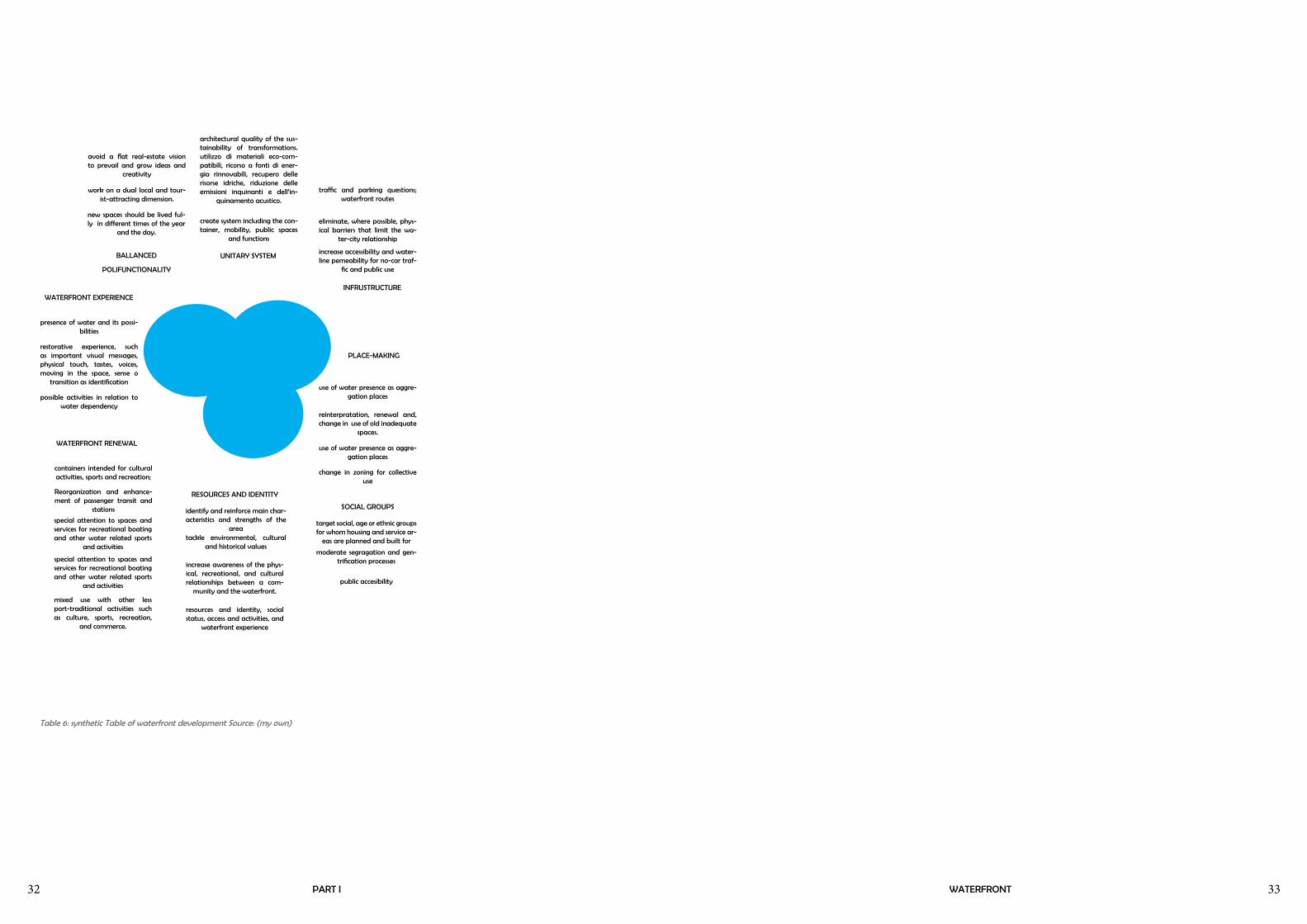
PUBLIC SPACE
CENTRALITY
INFRUSTRUCTURE
BALLANCED
POLIFUNCTIONALITY
new spaces should be lived ful-ly in different times of the year
and the day.
special attention to spaces and services for recreational boating and other water related sports
and activities
special attention to spaces and services for recreational boating and other water related sports
and activities
mixed use with other less port-traditional activities such as culture, sports, recreation,
and commerce.
possible activities in relation to water dependency
work on a dual local and tour-ist-attracting dimension.
Reorganization and enhance-ment of passenger transit and
stations
avoid a flat real-estate vision to prevail and grow ideas and
creativity
presence of water and its possi-bilities
restorative experience, such as important visual messages, physical touch, tastes, voices, moving in the space, sense o
transition as identification
create system including the con-tainer, mobility, public spaces
and functions
containers intended for cultural activities, sports and recreation;
increase awareness of the phys-ical, recreational, and cultural relationships between a com-
munity and the waterfront.
resources and identity, social status, access and activities, and
waterfront experience
WATERFRONT RENEWAL
RESOURCES AND IDENTITY
SOCIAL GROUPS
WATERFRONT EXPERIENCE
PLACE-MAKING
eliminate, where possible, phys-ical barriers that limit the wa-
ter-city relationship
traffic and parking questions; waterfront routes
increase accessibility and water-line pemeability for no-car traf-
fic and public use
use of water presence as aggre-gation places
architectural quality of the sus-tainability of transformations.utilizzo di materiali eco-com-patibili, ricorso a fonti di ener-gia rinnovabili, recupero delle risorse idriche, riduzione delle emissioni inquinanti e dell’in-
quinamento acustico.
use of water presence as aggre-gation places
change in zoning for collective use
reinterpratation, renewal and, change in use of old inadequate
spaces.
SOCIAL IMPACT
ATTRACTIVE
POLIFUNCTIONALITY
UNITARY SYSTEM
identify and reinforce main char-acteristics and strengths of the
areatarget social, age or ethnic groups for whom housing and service ar-
eas are planned and built for
moderate segragation and gen-trification processes
public accesibility
tackle environmental, cultural and historical values
Table 6: synthetic Table of waterfront development Source: (my own)

34 35PART I SPORTS AS TURISM CATALYZER
Sport is a universal language. At its best it can bring people together, no matter what their origin, background, religious beliefs or economic status. And when young people partici-pate in sports or have access to physical education, they can experience real exhilaration even as they learn the ideals of teAmwork and tolerance.
Kofi Annan,
New York city, 5 November 2004
FROM HEALTH TO SOCIAL REINSERTION
SPORTS AS A TURISM CATALIZER
CONCEPT AND DEFINITION
Sports Tourism is defined as a specific travel outside of the usual environment for either passive or active involvement in competitive sport where sport is the prime motivational reason for travel and the touristic or leisure element may act to reinforce the overall experience. Another definition worth noting explains sport tourism as a combination of sports activities and travel which from a sport marketing and sport management perspective, it consists of two broad categories of products (Pitts 1997, p31):
a) sports participation travel (travel for the purpose of participating in a sports, recreation, leisure or fitness activity);
b) sports spectatorial travel (travel for the purpose of spectating sports, rec-reation, leisure or fitness activities or events).
Image 19: Internazionale Triathlon Bardolino, Lago di Garda. City of the first Thriathlon in Italy 1984. Source: http://www.gardaplus.com/2011/06/international-triathlon-in-bardolino/

36 37
SPORTS-LED REGENERATION
Specifically from the late 1930’s, sports development was linked with com-munity development in school-building programmes in the United States which in turn had a positive influence on school-building in the post-World War II regeneration of the UK. This regeneration with its system-built schools became one of the first non-industrial types of buildings to express all the character and virtues of steel in many British schools paralleled to some of the works of Mies vand der Rohe (Culley, Pascoe, 2009, p69).
Sports facilities in schools and Universities as well as stand-alone structures continued to increase in importance highlighting the values of not only educational sectors but also comercial, recreational and well-being as the Post-Fordism society increseadly demanded additional sport spaces.
Fordist and Post-Fordist Regimes of Accumulation and Methods of Regulation
Fordism Post-Fordism
Local Government
Large-scale bureaucrat-ic corporate policy and management approach to social provision and accountability
Flexible forms of management and policy control introduction of area management decentralization: Enterprise zones, urban development corporations (UDCs) and compulsory competitive tenderig being with them new management approaches and structures
Orientation of Local Government Professionals
bureaucratic and (lib-eral welfare) profession-alism
Entrepreneurial and industrial, profession-alism (eg. Accountancy)
Central-Local Relations
Local determination and influence on local spending and taxation levels; local manage-ment and policy for ma-jor consumption services, central responsibility for economic planning
a) service provision, central control of minimalism policy (local concern for locally flexible and appropiate means of imple-mentation
b) Economic development, centrally devised policy implemented by local organs of the central state (eg. UDCs and enterprise zones)
c) Taxation levels, largely decided centrally
Leisure Policy Emphasis
Social democratic orientation; leisure opportunities are a right of citizenship; leisure investment may achieve externalities (reduce antisocial behavior and improve health)
- Provide cultural infrastructure to attract investment from new industries
- Generate tourism multiplier effect
- Provide infrastructure for new cultural industries (in some authorities)
- Provide safety net welfare service in inner city
- Minimize costs of achieving externalities
Leisure Policy Rationale
Largely social with some economic benefits
Largely economic with some social benefits
Table 7: Fordist and Post-Fordist Regimes of Accumulation and Methods of Regulation. Source: Adapted from J.Henry & P. Bramham, Leisure Policies and the Local State, Unpub lished manuscript, Department of Leisure, Recreation andd Physical Education, Loughborough University. Loughborough (1990) from Craigh, Smith
Image 20: Mega urban projects directly affecting the waterfront of Rio di Janeiro hosting the Panamer-ican Games, World Cup 2014, and 2016 Olympics. Top picture: Puerto Marevillha. Lower left: Design of the Rio de Janeiro Olympic Park, Barra, for the 2016 Olympics. Lower Right: Museu de Arte de Río y la Escola do Olhar
PART I SPORTS AS TURISM CATALYZER

38 39
AN EMERGING MARKET
Over the past twenty years, the interest in sport especially elite sporting events has grown at a phenomenal rate. With its remarkable growth, the World Tourism Organization (WTO) recognizes that sports tourism is now an emerging market. Sports tourism events at the international, national and regional levels have a double-barreled effect – the direct effect of the at-tendance of the competitors and/or spectators and accompanying persons, and the indirect effect of the marketing of the destination which lead to the subsequent tourism flows. This indirect effect can be very large – most of the tourism benefits of big sporting events are expected to be of this nature.
Today, tourism is the world’s number one industry while sports is regarded as the number one industry in the leisure sector. Sports is an integral part of all culture, and while often viewed as a separate activity, it is inextricably linked to tourism. Sports can now be viewed as an attraction within the broader tourism industry.
Major tourism destinations are developing tourism product concepts revolv-ing around pleasure sports. These concepts enable destinations to stand out amongst their competitors and increasing their competitive edge in the in-ternational arena, attracting consumers who are keen on getting in touch with nature, and interacting with the community to enjoy more healthy and interactive holidays. have given focus on achieving sports that would help work and build peace.
IN ITALY
“the business of the future” was how Andrea Muzzarelli called Sports Tur-ism. According to her article, despite the economic crisis over the past years, Italians have spent around 7.3 billion euro in sport tourism, an increase of 18% over the previous year. In addition, the journeys undertaken to actively practice a sport are much more numerous than those made to attend events (76% versus 24%).
Since the tourism and sport represent for Italy a resource of strategic impor-tance, these estimates -data taken from Observatory Econstat - should give confidence in the development of a sector with great potential.
In recent years, Italy, partly because of the severe economic crisis , has fallen to the fifth place among the favorite international tourist destinations . De-spite this , the numbers released by the Stock Exchange for the Sports Tourism (BTS ) on the occasion of the 2011 edition were promising : the annual turn-over is estimated at € 6.3 billion , spending dedicated to water sports such as sailing , canoeing diving and amounts to about 1.5 billion, while it is estimated that one in four Italian choose the destination for their holidays also because of the sports .
The forms of sport tourism in our Itlay , says BTS , are still rising : from fishing to hunting , from golf to cycling and excursions in the mountains, the facilities are preparing to meet the demands of tourists . In short , although the World Tourism Organization (WTO) does not consider it again in a completely in-dependent from the other tourist phenomena - in their own classification , the MTO places it in fact the category “ leisure, relaxation, vacation “ - sports tourism has become a real resource for marketers and operators of tourism and sports sectors .
Image 21: Caprino, Lago di Garda, Italy. Gardac-qua pool, beauty & Spa installatios. park of 7,000 square meters, with swimming pools for adults and children, whirlpools and water jets. A heated salt water completes the wellness area.. Source: http://www.professioneacqua.it/impianti-natatori/gar-dacqua-piscine-e-welnwss-sul-lago-di-garda.html
Image 22: Golf Club Bogliaco, Toscolano Maderno. Lago di Garda, Italy. Source: http://www.1golf.eu/en/club/golf-club-bogliaco/
Table 8: Tourism destinations. Growth over time. Source: [phillipines sport tourism plan 2010]
PART I SPORTS AS TURISM CATALYZER
40 41
VIRTUOS CIRCLE
The great potential of sports tourism have been well highlighted by Elena Tarfanelli , editor of the independent research and consulting Teamwork , Sport and Tourism in the book - How to do business with sports tourism (Franco Angeli , 2010).
In an interview granted to our editorial , Dr. Tarfanelli recalled that “ sports tourism is not only a great product, versatile and multifaceted , to increase business in many areas ( the hospitable food, from manufacturing to indus-trial ) , but it is also a powerful way to re-evaluate the area and improve the quality of life of the citizens themselves . “
We are therefore talking about a real “ catalyst capable of triggering a vir-tuous circle that allows you to promote a destination as a tourist destination, attracting people , improve range of accommodation , dining and shopping, redevelop and enhance the less developed areas .”
With respect to tourism , sport “ provides the seasonal adjustment of the de-mand , increasing the employment rate even during the most critical ,” while “ the tourist offer , especially the hotel , it can stimulate the flow of the sports segment .”
Not to mention “the return in terms of visibility that can lead not only sports clients , but also a real interest on the part of the organizers of the demon-strations of the industry.”
COOPERATE AND CREATE SYSTEM
But what are the sports that , in addition to athletics , would benefit from an alliance with tourism in the coming years ? According to Elena Tarfanelli, beyond the actual trends there are sports in our country that “have the po-tential for surprising development precisely because of our climate and due to the morphology of the territory: we’re talking cycling, hiking and activities related the sea. “
Not to mention golf , “until recently considered an elite sport , today is con-quering various segments of the market becoming a flagship product of many Italian cities and an important catalyst for their tourism development.”
Sofia Biancarosa , speaking specifically of Sicily, believes that all sports whose training requires practice outdoors can benefit from the synergies with the local tourism industry . The rest of Sicily, with its climate , “can make a great contribution in terms of quality of performance .”
Of course , the development of sports tourism - as we have already men-tioned - is linked to the actual capacity of all stakeholders to cooperate and create a system offering a high standard of professionalism. Elena Tarfanelli would emphasize that “in the near future there is a need to redesign the lively tourist dynamics thinking and creating authentic , innovative products that protect the cultural roots which are based on tourism and sport before then .”
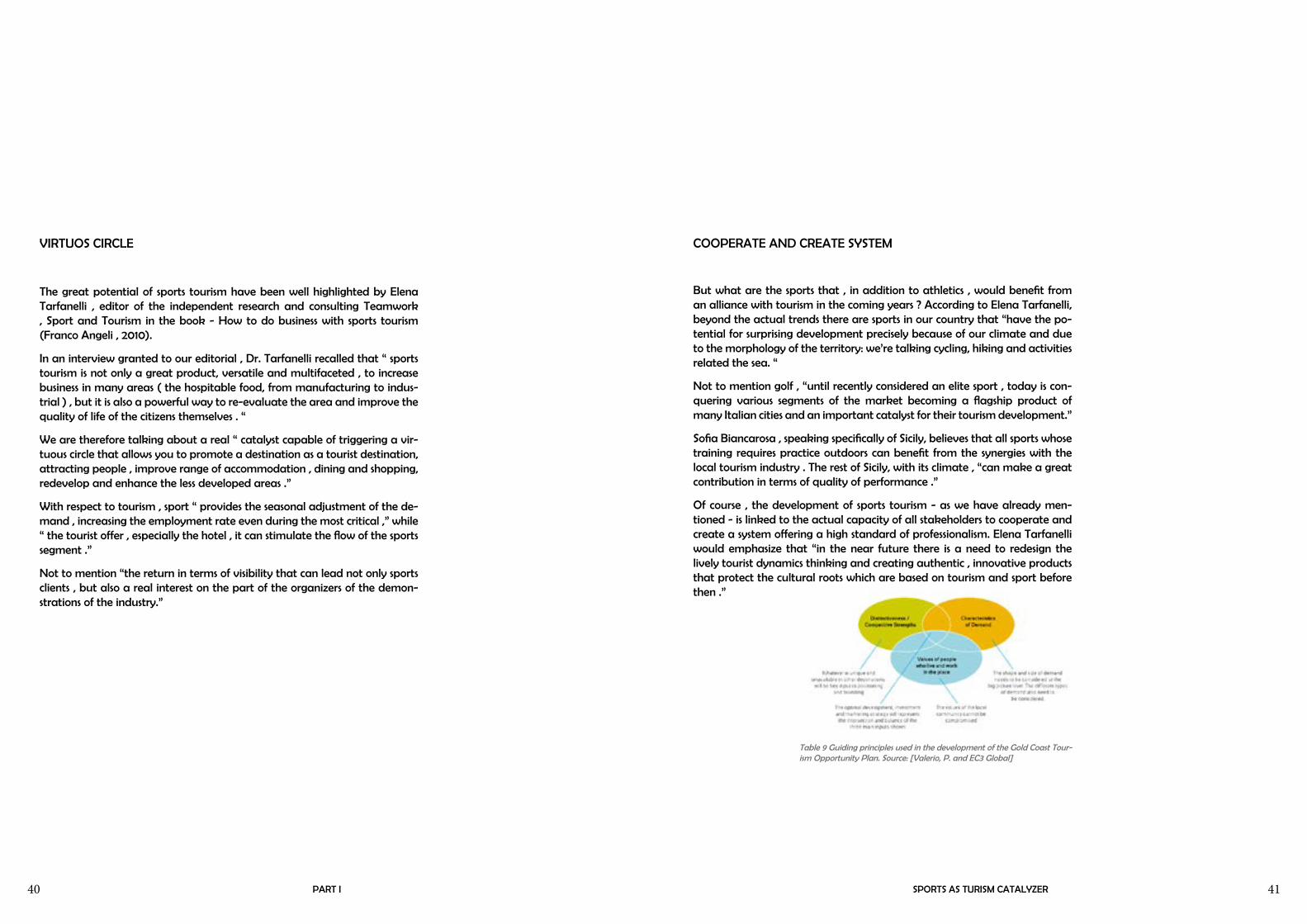
Table 9 Guiding principles used in the development of the Gold Coast Tour-ism Opportunity Plan. Source: [Valerio, P. and EC3 Global]
PART I SPORTS AS TURISM CATALYZER

42 43
PART II

PART I WATERFRONT44 45TOSCOLANO MADERNOPART II

PART I WATERFRONT46 47TOSCOLANO MADERNOPART II

PART I WATERFRONT48 49TOSCOLANO MADERNOPART II
50 51PART II
On Lake Maggiore and Lake Como this economic activity had already been implanted since the mid-800; instead on Lake Benaco it had to wait a few more years to see the start of tourism as a phenomenon with many visitors, although at nearby town Arco, Austrian Archduke Albert, used to spend some vacation time in a villa that was purposedly built in 1872�
De Rossi
Maderno e Toscolano, p184
TOSCOLANO MADERNO
HISTORY, DEVELOPMENT AND ANALYSIS
TOSCOLANO MADERNO
HISTORY AND URBAN DEVELOPMENT
Toscolano Maderno is an Italian comune of 8.101 inhabitants located in the Province o Brescia in the western bank of the Lake of Garda. The Lake en-joys a micro-climate quite specific and comparable to the Mediterranean climate. This and the fact that the lake was the only waterway connecting il Mincio and Po river with the Adriatic sea made the promontory, were Toscol-ano-Maderno is positioned, a strategic harbour zone for its first inhabitants already in ancient times.
Maderno and Toscolano are two distinct centers with different historical ori-gins. They share their location on the promontory and are separated by the Toscolano river. These two traditionally separated communities became a single entity together with other nearby and smaller fractions communities under a unique Town Council named Toscolano-Maderno in 1928 which con-tained also many other districts int the mountain. (De Rossi, Fava, 2003, p10,35)
Maderno’s history is ancient, dating back to the Etruscans and later as a mili-tary station in Roman times. It became an important port in the middle ages. For many centuries it was one of the most important political and economical centers of Lago di Garda because of its strategic position and its flourishing port which commerced the products obtained from the nearby lemon and olive tree plantations and most importantly the paper industries promoted by the Republic of Venice. The beauty of the corner of this lake was recog-nized by diverse novel families and politicians throughout history. Many of them built villas on the hill and at the lake side, further enhancing the land-scape and setting landmarks that remain still today. The town developed by the waterside and at the foot of the hills using the gulf as the natural harbor space. At the beginning of the century the road between Fasano and Toscolano was widened and lines for electric trams were installed. “The town square was improved and gradually shops, caffes, street lighting and public
Image 23: Promontory view from Maclino, Mader-no in the ‘30s. Source: (De Rossi 2003)
Image 24: Maderno Gulf beginning ‘900s. Source: (De Rossi 2003, Edit. Photoglob-Zurigo)
Image 25: Maderno Square 1910. Electric Tram Source: (De Rossi 2003, Ediz. Stengel e Co.Dresden)
Image 26: Maderno ‘900 Lago Zanardelli. Source: (De Rossi 2003)

52 53
Image 30: Comune di Toscolano Maderno hand drawn Map. Source: (Rossi p191-193)
PART II
benches appeared. The beach disappeared and with it the washer-women. The lakeside changed its aspect with monuments moved and new ones inau-gurated.” In the early years of the twentieth century Maderno had become a desirable and popular winter resort, especially for the Germans (De Rossi, Fava, 2003, p10) .
Toscolano’s origins go as far back as Maderno’s. Less than five kilometers away from the toscolano torrent’s end lies an archeological site with the re-mains of a Roman Villa two millenniums old belonging to a wealthy patri-cian family, the so called Nonni di Arria, in the time of Emperor Augustus. Also in Toscolano the first inhabitants concentrated at the port area with a piazza to which the villa and many public and private buildings faced. How-ever little remains of the original shape. The urban fabric extended at the foot of the hill and the promontory was exploited for mainly olive and lemon tree cultivation. Toscolano became well known for its papel mills which were “the motor of the local economy ever since the fourteenth century” (De Rossi, Fava, 2003, p10). The lake favoured the construction of numerous factories, oil and paper mills and up to 1948 even paper money was printed. At the be-ginning of the century electrical energy slowly substitued water as a mecani-cal force and the remaining factories and mills in the valley gradually moved to the more accessible promontary. The decline of industry in the last decades brought about the closure, abbandonment, and at times redevelopment of many paper mill areas.
The use of the lake as a place of pleasure and relaxation for the body is an ancient phenonmenom however only the previous century it has become a “comodity”, a source of income affecting the life of the coastal communities. A recent event nevertheless if compared with the lakes of Como and Mag-giore where tourism as an economic activity was already established since the 800’. Benaco’s (from latin Benacum for Lake of Garda) mild climate and banks adorned with delicate olive groves and geometric lemon plantations “limonaie“ along the mountains surrounding the lake, have long been an irresistible attraction for the inhabitants of the countries of Central Europe.
Image 31: Toscolano early ‘900s Source: (De Rossi 2003, Ediz. A. Giovanelli-Toscolano)
Image 32: Paper Mill valley in Toscolano torrent ‘800s Source: (De Rossi 2003)
Image 33: Ideal reconstruction of the Roman buildings in Toscolano IIIsec a.C (De Rossi 2003)
Image 34: Resturant/pension early 1900’s (De Ros-si, Fava 2003. Fondazione Negri)
TOSCOLANO MADERNO

54 55
Image 27a: Maderno ‘20s Ruina beach with washer women Source: (De Rossi 2003, Ediz G. de Lucia- Brescia)
Image 27b: friendly parking space Source: (my own)
Image 28b: Tram gone. SS45 in its place Source: (my own)
Image 28b: Two of these ships go out everyday taking passengers and cars accross the lake to Torri del Benaco
Image 28: early 900’s. Tram line and cart. Source: (De Rossi 2003, Edit. Brunner e C.Como)
Image 29: Maderno Gulf late 800’s. Source: (De Rossi 2003)
PART II
Image 35a: Toscolano around 1914. San Pietro e Paolo Church with newnearby Maffizzoli Paper mill behind and olive plantations on the Promontory. City center right. Source: (De Rossi, Fava 2003. Fondazione Negri)
Image 35b: Today. Promontory almost fully built. Source: (my own)
Image 36a: Resturant/pension early 1900’s Source: (De Rossi, Fava 2003. Fondazione Negri)
Image 36b: Today. most paper mill are in ruins. This was restored into a paper mill museum. Source: (my own)
Image 37a: Maffizzoli paper mill port around 1910. Source: (De Ros-si, Fava 2003. Fondazione Negri)
Image 37b: The paper mill port has no commercial use today and is in poor condition with algae growing all over. Moreover it is not visible for pedestirans Source: (my own)
TOSCOLANO MADERNO

56 57
Table 13: RAF Royal Airforce Inglese 1945Table 12: 1886 1’levata IGM
Table 14: Bing Maps 2014
Table 10: 1810 Catasto Napoleonico Maderno
Table 11: 1810 Catasto Napoleonico Toscolano
PART II
After the wars hotel activities in Toscolano-Maderno (specially Maderno) reached a considerable development becoming the main economic activity The quiet and classy winter turism (often connected to health motives) trans-formed into a more popular and massive summer holiday tourism.
In sinthesis, at an urbanistic level Toscolano-Maderno, since the unison of the two municpalities in 1928, has had a one-of-a-kind urban development due to its strategic position in the lake, also because of its rich and diversified territorial patrimony reaching from the lake to the far mountains, the lemon houses first, then the olive and wine cultivation and processing, and then, since hundreds of years the paper mills as prime industry and most recog-nizalble feature of Toscolano. Its primary road passing through both the his-torical centers and the only land route to get in and out of town, suffered a major change between the 800’s and the 900’s expanding from Gargnano to Riva, in this way it connected with the north allowing a two-way access. Later in the first half of the nineteenth century a newer, wider road was built , now know as ‘via Statale’ or SS45 which surrounds the lake. Its heavy traffic represents today a heavy burden for the town during the high season and somehow it also works as barrier between the new constructions from the 50’s on and the traditional historical centers, which works little as town center today since most activities are developed in the ‘newer’ side. The arrival of the TV, the massification of consumism and the division of property favored a fragmented and disorganized growth in the promontory often penalizing the magnificent scenery in a place where the gentle climate and the beauty of the landscape have always (even in ancient times, see the Roman Villa) favored tourism. At first high class and afterwards massive and popular.
TOSCOLANO MADERNO

58 59PART II
Table 15 Settlement development through out time
MUNICIPAL AREA DESCRIPTION
Like most municipalities that relate to the territorial system of lakes Toscol-ano Maderno’s morphological configuration of the area with the mountains, the lakeside, the river, and its vegetation give the area a character of great landscape and environmental significance.
The municipality or comune of Toscolano Maderno extends just over 7 km along an axis from northwest to southeast , while its extension from southeast to Northwest along the coast lakeside is about 6.8 km. The municipality has a total area of 56.73 km2.
The territorial system is clearly limited by the topography and its transport infrastructure. (Documento di piano - 1.4 PAESAGGIO “Differenti ambienti e paesaggi”p115).
Flat headlands : Mostly occupied by recent constructions that began expand-ing quickly and randomly in the 50’s with the conversion of agricultural land
Image 38: PAESAGGIO “Differenti ambienti e paesaggi”. Source: Documento di piano - 1.4 p115
TOSCOLANO MADERNO

60 61PART II
into building land. In the lake font there are rare monuments of interest such as the Gulf and the square of Maderno and some villas of significant land-scape value;
Foot of the hills: characterized by environmental and landscape resources of particular importance, including the historical centers of Toscolano and Maderno and some other storical-monumental patrimony constituted by vil-las, palaces, churches, parks, lake-front and lemon houses that deserve ad-equate levels of actions aimed at the protection and enhancement of the various components. The historical centers of Maderno and Toscolano are surrounded and enclosed by the 60’s development physically divided by the SS45 and the Toscolano Stream; further isolating the centers is its inadequate road infrastructure.
Steep slopes to the lake: characterized by steep walls that connect the head-land to higher hills to the lake. These areas are subject to landslides and unstable water-flows. From the late 800 till the beginning of the 900 these areas were often used for planting cypress trees making it still today a distin-guished landscape element.
Hill top : characterized only by small historical centers of which churches spring out with panoramic view of the lake. These isolated striking landscaped have been affected since the 50’s by a strong presence of mixed residential and tourist residential buildings surrounded by greenery in an attempt to not compromise the visual of hills;
Valley / river: Here are located the valleys of the Paper mills and Barracks, (valli delle Cartiere e delle Camerate), Valleys of Archesane, and valleys of Segrane. These location belongs to the exceptional natural environment Par-co del Alto Garda Bresciano making it an important asset for nature-related activities, in addition to the great historical value of the ruins and the muse-um in the valley of the paper; At the end the creek where the area becomes plains the territory is divided and characterized by this linear field ending in the lake;
Image 39: Lake perception. source:: Documento di Piano
TOSCOLANO MADERNO
Montano/Mountains: The most notoriuous are Mountains Pizzoccolo and Castello in the hinterland covered by forests and rocky slopes is the natural landscape framing scene of the hill;

62 63
AT THE WATERFRONT: PRESENT REGULATIONS, PLANNING, AND PROBLEMS
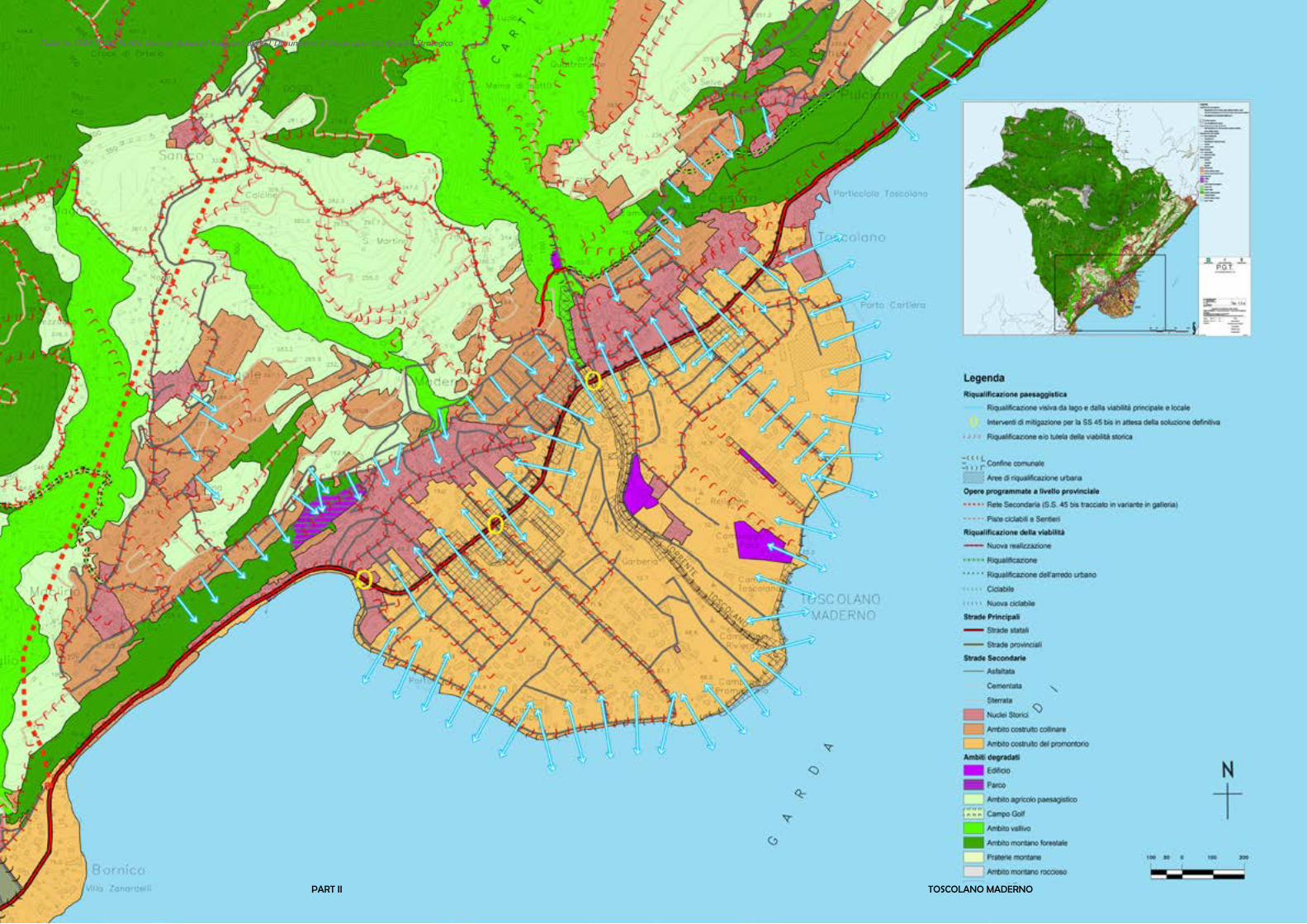
The P.G.T. as an urban tool of government of the territory confirms the logic of the development of tourism as a main in goal. Articulated in various plans and documents, the PGT aims to consolidate the visual and historical aspect of the buildings along the waterfront allowing an intense development in the inland of the promontory. Strong actions for urban and territorial regen-eration are promoted aiming to improve the quality of urban design and landscape. The ones regarding the lake side are the following:
- The reallocation of the current port for ferries along the lake due to the congestion of vehicular traffic whereas this valuable urban area should in-stead have low pedestrian/vehicular presence for the recreational use of the lake and a reduction of the traffic in the square of the Gulf of Maderno. The new location should have also a commercial vocation and the possibility of hosting adequate parking for the use of ferries, as well as some other port facilities for tourists or even emergencies , given the centrality of the Gulf of Maderno in the geographical area of Lake Garda .
- Location, perimeter, and services offered by lake areas affected directly or indirectly by the tourist port facilities, will be defined by ‘Il Piano direttore Generale’(masterplan). The new touristic-port-realities are a necessity for the development of tourism itself , given the presence of the various clubs and marinas already existing and under construction. In the sailing sector Garda lake is increasing both as a local and as an international location attracting high-level tourists.
- The lake’s waterfront has been subject to urban development in recent times. A general plan of rehabilitation is needed that unlocks the full poten-tial of this structure for the enhancement of the “lakeside tourist activity .
- The stream of Toscolano is currently a simple pretty landscape element in
PART II
the municipality. Its redevelopment should include, at the hilltop, a bicy-cle and pedestrian path that connects the lake along with the inside of the promontory, the municipal center and the Valley of the Paper mills to the center of the historical Paper mill. This could be done by proposing inter-ventions on different height levels, exchanging shores across the stream and creating spaces along the stream on both sides.
The dismissed areas that reenter in the waterfront area (lake and river) are the following:
- The lake side Paper Mill, nowadays reduced, with limited dimensions, diffi-culties with management and property borders.
-The Garda construction sites (former oil mill) of imposing dimensions and for which a project has already been submitted “pending approval by the Superintendecy” - Given the strategic location of the area the AC stimulates recovery, allowing new settlements in the free area behind it. the free capac-ity in view of the high costs of remediation of the site (former oil mill), the particular recovery of the house liberty and Opificio structures.
- The remains in the Paper Mill Valley
According to the PGT and reentering in the area of interest the requalifi-cation of the following urban and suburban areas are suggested in a step-by-step procedure from the feasibility study (also with international com-petitions, especially aimed at young architects) to the the formation of an Implementation Plan and the following activation of the works :
-Along the lake
- the state highway SS 45 bis;
-From the river mouth to the Paper mill Valley
-Green-energy-tourism project
-Degraded areas in the agricultural zone and woodland;
TOSCOLANO MADERNO
PART I WATERFRONT64 65TOSCOLANO MADERNOPART II
Table 16: STRATEGIC PLAN. Source:c Adapted fragment of PGT Documento di Piano plan 1.5a Quadro Strategico

PART I WATERFRONT66 67
Table 17. LANDSCAPE COMPONENTS: SYNTHESIS Source: Adapted fragment of PGT Documento di Piano plan 1.4d Sintesi dell componenti del paesaggio
PART II TOSCOLANO MADERNO

PART I WATERFRONT68 69PART II TOSCOLANO MADERNO
Table 18. PLAN PREVISIONS. Source: Adapted fragment of PGT Documento di Piano plan 1.5c2 Previsioni di Piano 5000

PART I WATERFRONT70 71
Table 19: PROGRAMATIC PLAN. Source: Adapted fragment of PGT Documento di Piano plan 1.5b Quadro Programmatico
PART II TOSCOLANO MADERNO

PART I WATERFRONT72 73
Table 20. LANDSCAPE SENSIBILITY CLASS. Source: Adapted fragment of PGT Documento di Piano plan 1.4g Classi di sensibilita paesistica
PART II TOSCOLANO MADERNO

PART I WATERFRONT74 75
Table 21: LANDSCAPE ELEMENTS. Source: Adapted fragment of PGT Documento di Piano plan 1.4c Caratteri Paesistici
PART II TOSCOLANO MADERNO

76 77PART II TOSCOLANO MADERNO
Table 22: PIANO DEL PAESSAGGIO. Source: Adapted fragment of PGT Documento di Piano plan 1.4a

PART I WATERFRONT78 79PART II TOSCOLANO MADERNO
Table 23: PIANO DEL PAESSAGGIO. Source: Adapted fragment of PGT Documento di Piano plan 1.4a

PART I80 81
A WALK THROUGH THE WATERFRONT
The following survey divides the waterfront into different paths. Each path regroups spatial characteristics and activities which give them a different character along the continuous lake shore. The purpose of this grouping is to identify emerging problems in the sequence.
TOSCOLANO MADERNOPART II
Table 24: PIANO DEI SERVIZI. Source: Adapted fragment of PGT piano dei Servizi
31
22
4354
65
76

PART I WATERFRONT82 83
PATH 1- Access Corridor
The State way passes through this section of the wa-terfront Connecting the town Fasano (fraction of Gargnano Comune) to Maderno (part of Toscola-no-Maderno Comune)(A).
In direction to Riva, this fraction works in landscape terms as a panoramic corridor preluding the gulf of Maderno and the Promontory. In the other di-rection the effect is similar, although less dramatic towards Fasano. In the northeast side the mountain slope is steep and the vegetation is rich. Only a few constructions face the street cut by the road and re-sulting in very limited accessibility. (A)
For this rather fast traffic zone, works are already in the way to improve the already existing single sidewalk facing the lake for lack of continuity and poor maintanance. Other problems are a some-times poor separation between road and sidewalk, no bike lane, lack of services and also lack of urban furniture, and beauty plants.
Some recent waterfront requalification include a new bar, shared deck for pedestrians and bycicles.
PATH 2- Panoramic Gulf
At this point the waterfront is turned into a Gulf (B) and becomes a very vital public space with two sidewalks surrounded by a more dense and histor-ical urban tissue, The nearby Maderno center (C), shops, piazzas, walkways and a natural port for boats�
The stateway changes course and separates itself from the shore line and in its place a slow traffic sin-gle lane continues to follow the waterfront (E)
The water fron there is better prepared for pedestri-ans and bikers . It includes a bike lane, urban furni-ture , decorative paving, plant and flower arrange-ments, etc. (D) Car traffic is sometimes a problem.
A
WAY TO FASANO
poor pedestrian lane, isolated buildings
RECREATIONAL/ COMMERCIAL GREEN
free green recreational space, used for events, managed by Carta Bianca bar.
B C
A
PEDESTRIAN DECK
Recent new walking deck. lack ing v i sua l barr ier for nearby cars.
OLD “LIMONAIE”
some remain empty whereas other s where turned into housing.
PARKING SPACE
panoramic views and some sitting spaces. Across the street isolated buidings, some of which in poor conditions and affecting the landscape.
DOCK & FERRY STATION
destinated for boats of private use. Next to it is the ferry Station with a few extra car parking spaces. Arriving ships t ransfer both people and vehicles. Parking area is too small. Activity saturates the already high traffic zone.
FERRY DOCK
Two ferry boats ‘sleep’ here at night. It is also u sed a s an in fo rmal place for receiving sun and taking pictures.
MADERNO GULF
services and public activities flood the groundfloor such a s c o m m e r c e , c h u r c h e s , piazzas and wide sidewalks. Exceptional landscape value of histor ical dense urban tissue. A linear market often takes place in white wooden houses at Maderno Square or across the lake front where the stateway separates from the lake front .
MADERNO
STORICAL CENTER
B
C
D
E
D E
12
32
3
PART I WATERFRONT84 85
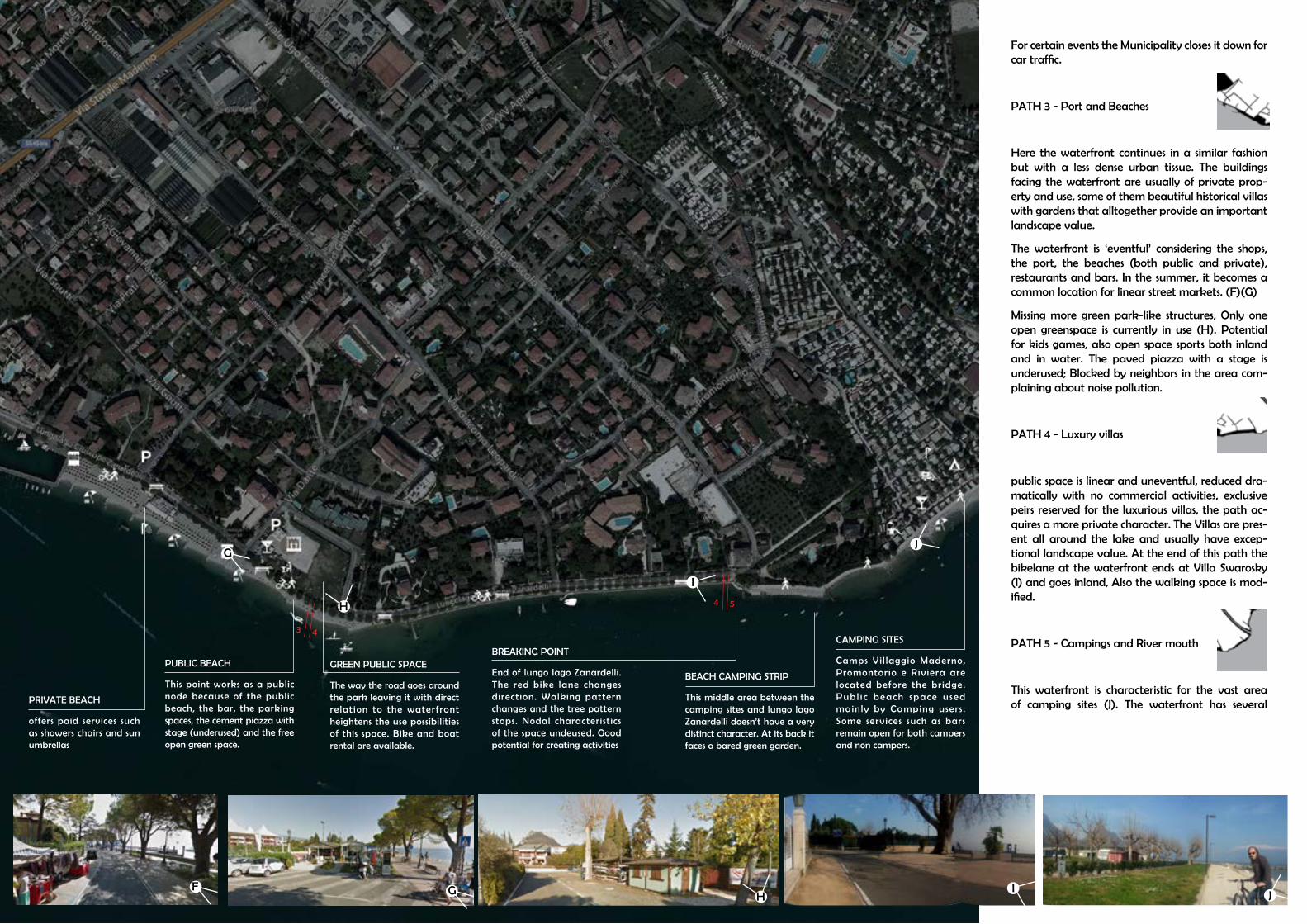
PUBLIC BEACH
This point works as a public node because of the public beach, the bar, the parking spaces, the cement piazza with stage (underused) and the free open green space.
GREEN PUBLIC SPACE
The way the road goes around the park leaving it with direct relation to the waterfront heightens the use possibilities of this space. Bike and boat rental are available.
BREAKING POINT
End of lungo lago Zanardelli. The red bike lane changes direction. Walking pattern changes and the tree pattern stops. Nodal characteristics of the space undeused. Good potential for creating activities
PRIVATE BEACH
offers paid services such as showers chairs and sun umbrellas
G
G
H
F
43
For certain events the Municipality closes it down for car traffic.
PATH 3 - Port and Beaches
Here the waterfront continues in a similar fashion but with a less dense urban tissue. The buildings facing the waterfront are usually of private prop-erty and use, some of them beautiful historical villas with gardens that alltogether provide an important landscape value.
The waterfront is ‘eventful’ considering the shops, the port, the beaches (both public and private), restaurants and bars. In the summer, it becomes a common location for linear street markets. (F)(G)
Missing more green park-like structures, Only one open greenspace is currently in use (H). Potential for kids games, also open space sports both inland and in water. The paved piazza with a stage is underused; Blocked by neighbors in the area com-plaining about noise pollution.
PATH 4 - Luxury villas
public space is linear and uneventful, reduced dra-matically with no commercial activities, exclusive peirs reserved for the luxurious villas, the path ac-quires a more private character. The Villas are pres-ent all around the lake and usually have excep-tional landscape value. At the end of this path the bikelane at the waterfront ends at Villa Swarosky (I) and goes inland, Also the walking space is mod-ified.
PATH 5 - Campings and River mouth
This waterfront is characteristic for the vast area of camping sites (J). The waterfront has several
BEACH CAMPING STRIP
This middle area between the camping sites and lungo lago Zanardelli doesn’t have a very distinct character. At its back it faces a bared green garden.
CAMPING SITES
Camps Vil laggio Maderno, Promontorio e Riviera are located before the bridge.Pub l i c beach space u sed mainly by Camping users . Some services such as bars remain open for both campers and non campers.
I
I
J
JH
54

PART I86 87
CAMPING SITES
Past the bridge the camping sites are less dense and informal mostly made up of mobile homes instead of tiny houses. Here lie Campings “Toscolano” and “la Foce”
BORGO +39
A r e a i n d e c a y . S o l d b y the previous municipality admini s t rat ion to pr ivate investor. Mixed use project currently blocked by current administration under the basis of interests contrary to global government plan.
SHIPYARD & CIRCOLO VELA
The shipyard makes for an interesting visual experience however current structures are inproper for client/ public/ commercial exchange
OLIVE YARD
This green open space remains testimony of a past reality in ol ive oi l production. Its surrounding infrustructure is quite informal (unpaved streets, nearby waste disposal center), informal parking.
GREEN WATERFRONT
A different kind of waterfront takes place. Its own quality on the mix of green and stones ending at the beach; Less urbanized than Maderno and less Turism related activities. Areas with productive, service and industrial zoning with poor relationship to the public spaces.
PEDESTRIAN BRIDGE
T h e n e w b r i d g e m a k e s an impor tant connect ion and may be considered as landmark for pedest r ians and bikers alike. River edge underused. Exclusive frontage to campings. No walking area. Not bathable area.
K
M
N
O
P
Q
L
65
beaches, most are used mainly by the campings that occupy the inland and represent a limit for non-campers.
The bridge passes over the Toscolano River (K) which separates Toscolano from Maderno for-mer municipality border (L). It also separates the camping site area West of the bridge (more fixed houses) while the camping area East of the river, is less dense, with more trees and space for campers and tents and less beach waterfront (M).
PATH 6- Lido degli Ulivi
The landuse of this part of the waterfront is mixed. Here lies the area Borgo +39 (N) which at the mo-ment remains unused, a decayed Shipyard area (O) with some improvised conference room, a boundary stone wall for the sports field, a green area filled with olives trees holding testimony of how once the promontory looked like and around it a differentiated disposal center, housing, and the paper industry.
Neither the walkway nor the green is very well cared for. The street in this area plays a key role on thursdays holding the weekly street market but otherwise it is widely underused. Unlike Lido di Maderno in this area the public green space has the street as a physical barrier separating it from the beach users (P).
On the other side of the Olive agglomeration lies ‘La Cartiera’ industry. The wall surrounding the paper industry isn’t very inviting. This is a sensitive point on the waterfront considering the beaches it has, the sport activities, the main street, the green open spaces and the available parking space
Both the disposal center and the Paper industry make noise pollution and have problems inte-grating with the rest of the Urban tissue. While the disposal center occupates the area that was once a road facing the Olive trees the Paper industry occupates a large portion of territory facing very
N
P
Q
O
M
K
L

PART I88 89
CARTIERA
LEMON HOUSES
This part of the waterfront is inaccessible for pedestrians. Although the lemon houses are very deteriorated and unused, they stil l make a beautiful landscape.
NO MAN’S WATERFRONT
This beach area is not very popular since it has few services , the coast is cliffy and it is enclosed by the paper industry.
WATERFRONT END
The walking path ends here w i t h a b a r e d g a t e t h a t prohibits the entrance to the Cartiera Port.
CARTIERA PORT
A secondary port formerly used for the commerce of paper. Today its use is limited to hosting smaller ships for personal recreational use, most belonging to the workers in the industry
PARKING PIAZZA
o p e n s p a c e i n v a l u a b l e location next to church, beach, statale, old city center, roman villa ruins, currently used for Cartiera worker parking
ROMAN VILLA DEI NONNI
Archeological site of a Roman Vil la. Open to public. Few tourists. Difficult access.
TOSCOLANO PORT
Once upon a time a flourishing port for the commerce of paper. Today its use is limited to hosting smaller ships for personal recreational use. Surrounded by the buildings of the old center of toscolano. D i f f i cu l t acces s . Very few tourists. Mostly residential.
DEPOSIT SPACE
Once an informal basketball court, today rests as an empty deposit area for the Paper industry.
BEACH
Few services infrustructures. Disturbed by nearby industry
Y
R
U
S
V
W
X
T
76
landscape sensitive areas along the waterfront.
The walking waterfront ends at the beach fac-ing the olive trees. An unpaved, and unfurnished walk-trough passes between the Cartiera wall and a private resort (Q) leading to an isoated hidden green and beach waterfront (R) with no service infrustructure but where any kind of spontanous activities are forbidden. Further access to the North waterfront is interrupted by the paper industry en-closed port. (S)
PATH 7- Toscolano Port
This part of the waterfront has several physical dis-continuities and difficulty of access due mainly to the Cartiera Port (U), the Cartiera parking space (V), walls and vegetation (Y).
The area’s strongest attributes are the beautiful Toscolano Port (X), The Archeological site of the Roman Villa (W), the beach, the religious com-plex and the park. However these valuable pub-lic spaces and containers are poorly connected by a fragmented waterfront and by the Industry’s parking space (V).
The Cartiera’s port current use doesn’t justify such a strong territorial disruption. Whereas the park-ing space in such sensitive position should be rede-signed or possibly relocated (T).
Y
U
R
X
W
V
T S

90 91
PART III

92 93STRATEGICAL PLANNINGPART III
Toscolano and Maderno developed historically as two separate centers around their ports and the base of the mountain slope each one in the corner of the promontory which is divIded in the middle by the river. The promon-tory was used for cultivation and in Toscolano’s case also for industries which continued up the river. The urban sprawl of the previous century brought the two towns together and along the promontory most of the parallel agricul-tural patterns became asphalt streets. Maderno was quicker than Toscolano to adapt its exceptional landscape to the new rising tourism economy in the Lake of Garda by furnishing its coast with hotels, promenades, and waterfront related services. Toscolano instead, remained industrial with a fragmented waterfront often giving its ‘back’ to the lake like a rough diamond polluted by industry. However the last two decades have seen a tourism increase also in Toscolano putting in evidence an increasing tensional relationship between the paper industry and its urban surrounding as well the need for a clearer layout of the coast making the Toscolano waterfront and its wastelands a most interesting area for requalification and development.
ANALYSIS AND STRATEGIES
STRATEGICAL PLANNING
TRENTINO
VERONA
BRESCIA
Parco Alto Garda Bresciano
Toscolano Maderno
Lago di GardaBENACUUM
SITUATION

94 95STRATEGICAL PLANNING
ABBANDONED BUILDINGS
ARCHEOLOGICAL SITE ARCHEOLOGICAL SITE LEMON HOUSES
PAPERMILL VALLEYNATURAL PUBLIC BEACH
FERRY BOATS
HISTORICAL BUILDINGS
TOSCOLANO PORT
PRIVATE BEACH
LUNGOLAGO ZANARDELLI PROMENADE GARDENS
EXCEPTIONAL LANDSCAPE
CAMPING
POOR PEDESTRIAN SPACEACCESSIBILITY
POOR MAINTENANCE
INADEQUATE DOCKS
ABBANDONED WATERFRONT
LACK OF CONTINUITYEMPTY LAND
POOR PUBLIC SPACE
FENCES AND BUFFER
BORDERS
WASTELAND
POOR FACILITIES
PROBLEMATIC INDUSTRIAL ZONING
NEGATIVES
POSITIVES
EMPTY BUILDINGS
PART III

PART I WATERFRONT96 97
PROBLEM MAP
STRATEGICAL PLANNINGPART III

98 99
Paper mill valley
Old bridge
Maderno Gulf
River mouth
Lido di Maderno
Lido Ulivi
Toscolano Port
Waterfront nodes
existing bike/pedestrian lane
existing pedestrian lane
project bike/pedestrian lane
project pedestrian lane
reinforce inner connections
existing
some problems
non existant or problematic
OBJECTIVE Give the waterfront continuity with pedestrian and bycicle lanesConnect, improve, and create areas of interest along this path. Identify and improve inner connections with visuals to the lake.
state highway
CORRIDOR AND PROMENADE

100 101
STRENGTHS
Waterfront locationRiver landscape value. Existing projectConcentration of valuable public spaces Nearby Toscolano road artery provides good accessibility and linear parking spaceNearby weekly market area provides urban density and visibilityolive spot facing the waterfront, town memory. archeological site of increasing importance. project in elaboration phasebeauty and importance of Tocolano Maderno Port. Requali-fication project followed. valuable Church of Toscolano port
OPPORTUNITIES
River as a communicator. linear riverfront park with bike/pedestrian connection to the papermill valley and regional mountian park and in-the-middle “stops” like historical city centers and public and private service areas.Olive spot as potential attractiveness and complementing connection to the waterfront. pedestrian connection improvement to Camping sites and Maderno Waterfrontabbandoned buildings or in decay belonging as possible development areasToscolano port area and sail center in decay requalificationFunding from higher degree organizations, private and public fundings.potential collaboration with the paper industry for the public use of private service facilities such as port, and recreational areas. potential connection to Archeological site and Toscolano Historical portflexible progressive project Development of nature-based attractionsEducation/interpretation of natural attractionsMarine infrastructureNight time entertainmentEvents infrastructureLeverage off World Heritage sitesNational Landscape opportunitiesSecure land for future tourism developmentIslands (access & connectivity)Master planning for major tourist precinctsDevelop 5-6* hotels and international brands to attract highyield visitorsNiche market development – sports tourism, medical, culturaltourism, food and wine, recreation, tracks & trails, adventureIntegrated Water transportUtilise new distribution networks (eg. Social networking sites,blogs)Hosting incoming eventsCapitalisation on resource boom (ride in/ride out)
WEAKNESSES
concentration of wasteland areas and edges in the waterfrontRiver as a limiting edge dividing developed from non-de-veloped waterfront. limited accessabilityconcentration of wasteland areas (disposal center)abbandoned buildings or in decay (circolo vela e area +39)port area and sail center in decaymany industrial zone edges and property issuesneglected public waterfront area in front of the industrial zonephysical barriers property of the paper industry interrupt-ing the waterfront. Original Paper industry port in decay. No longer need for immediate contact with water. olive spot in decay, unattractive, separated by road and parking from the waterfront. disposal center and paper industry blocking the road pattern continuity. Sail center in decay. Poor infrustructure for tourists
THREATS
Loss of land for future tourism developmentsEnvironmental degradation and poor environmental awarenessLoss of quality of lifeFailure to meet service standardsAccess and visitor infrastructure in National ParksWaterways redevelopmentNew/emerging competitor destinationsCommunity supportRising value of property tax for localsAirport curfews and air accessno nearby air accessuneven density generated and stole from competitive areas of urban value. Domestic holiday trends – Italy taking fewer holidays,for shorter periods and to overseas destinationsSkills and employment shortagesInternal transport congestion and parking problemsNeed for master planning for park assetsShortage of cultural/arts/entertainment activitiesCommunity support/understanding of tourism develop-mentInadequate provision of dedicated sites for tourism
Continuos and Secuential landscape along the waterfrontCapitalize on the uniqueness of character and location to create a distinctive environmentExploit waterfront revitalization through mixed use development recreational-leisureCreate quality urban spaces through adequate accesibility, density, mix of uses, integration, and vitalityIncrease landscape awareness
Admire and recognize the horizon. The lake and coastal space as a park.
Promontory walkthrough connecting the two traditional downtowns through the Waterfront.
Connect the fragmented waterfront of Toscolano to the continuous lungolago Zanardelli of Madern o with a pedestrian coastal road that connects existing and new centers of interest.
12 3End isolation of the Toscolano Port with bridges and water walkways connecting to the coastal road and reaching the beaches, the church, and the archeological site on the south. Also connecting the otherwise dead end old streets runningperpendicular to the waterfront. Expansion ofthe Harbour.
4
897
6
The coastal road at this point connects and gives value to the arche-ological site of the Roman Villa dei Nonni, the church, and the recre-ational area with beaches and bar/caffe besides the Paper Industry. Articulate space and road favouring views and height differences. Piazza space connecting SS45 and downtown.
Requalification of the Paper Industry port and thematization of the neglected area between the industry and the waterfront. Open green front. “Outdoor Gym”. Coastal road continuity of the beaches, port and the Lido degli Ulivi.
Lido degli Ulivi other focal point along the semicircular traffic axis. Interconnection with downtown and SS45. Sport Recreational Village development relating to existing infrustructures. Olive tree piazza.
Abilitate the river for pedestrian an bycicle traffic. Connect the River Mouth with the Paper Mill Valley.
Pedestrian/Bycicle horizontal connections and “stops” specially rein-forcing connections between downtowns and Lakefront.
5
STRATEGIES
SWOT
STRATEGICAL PLANNINGPART III

102 103
Both local and worldwide experiences demonstrate with facts there isn’t a single solution to approach waterfront renewal. In the case of Bilbao, the post-Industrial Guggenheim with its formal complexity and dimensions played a key role in the city’s branding strategy. In Barcellona, a totalizing renewal with many more transformations than just commerce in the ancient Port area. In Genoa a mix of traditional functions with new ones. In Rio di Janeiro a masterly use of landscaping tecniques, and so on. Each context en-compasses specific cultural and territorial caracteristics making the best out of them.
All the sights however do share something in common which is the will to ‘brand’ themselves for the sake of attracting people in addition to providing living, working, leisure or other special areas for the local community. and in this branding also temporary activities and great ‘events’ play a key role.
In spite of its dimensions Toscolano Maderno reenters perfectly in this reality. In its own scale Toscolano-Maderno’s economy grows everyday more depen-dant on a Tourism economy and is also running a branding race in the hope of attracting capital with nearby Garda lake towns as competitors but also as allies in a larger regional scheme. Understanding the need for a high in-tegration of the city with water, specially in a landscape jewel like the lake of Garda, is key for a strategical tourism-oriented development. During the Waterfront survey the clearest problems of integration with water emerged In the Northern side of the promontory between the River and the old Toscol-ano Port mainly in the working and leisure areas and only a few residential units. Clearly the most problematic is the paper industry considering its of-ten tensional relationship with the surrounding Urban tissue, the poor water frontage and the unused port. However many other nuisances such as ab-bandonded buildings, wastelands, emptiness and lack of maintenance were identified at the waterfront making it a most interesting area for requalifi-cation and development.
The strategical planning plans and tables aim for a general masterplan which not only gives continuity to the waterfront which also improves accessibility and urban quality of existing valuable environmental, cultural and historical assests such as the historical downtown, the roman villa, the river, the region-al natural park and the industrial archeology with sustainable, mix-use, and recreational oriented solutions that benefit both the tourist economy and its inhabitants.
PUBLIC SPACE
CENTRALITY
INFRUSTRUCTURE
BALLANCED POLIFUNCTIONALITY
new spaces should be lived ful-ly in different times of the year
and the day.
special attention to spaces and services for recreational boating and other water related sports
and activities
special attention to spaces and services for recreational boating and other water related sports
and activities
mixed use with other less port-traditional activities such as culture, sports, recreation,
and commerce.
possible activities in relation to water dependency
work on a dual local and tour-ist-attracting dimension.
Reorganization and enhance -ment of passenger transit and
stations
presence of water and its possi -bilities
restorative experience, such as important visual messages, physical touch, tastes, voices, moving in the space, sense o
create system including the con-tainer, mobility, public spaces
and functions
containers intended for cultural activities, sports and recreation;
increase awareness of the phys
-
ical, recreational, and cultural relationships between a com
-
munity and the waterfront.
resources and identity, social status, access and activities, and
waterfront experience
WATERFRONT RENEWAL
RESOURCES AND IDENTITYSOCIAL GROUPS
WATERFRONT EXPERIENCE
PLACE-MAKING
eliminate, where possible, phys-ical barriers that limit the wa-
ter-city relationship
waterfront routes
increase accessibility and water-line pemeability for no-car traf-
use of water presence as aggre
-
gation places
architectural quality of the sus-tainability of transformations.utilizzo di materiali eco-com-patibili, ricorso a fonti di energia rinnovabili, recupero delle risorse idriche, riduzione delle emissioni inquinanti e dell’inquinamento
acustico.
use of water presence as aggre
-
gation places
change in zoning for collective use
reinterpratation, renewal and, etauqedani dlo fo esu ni egnahc
spaces.SOCIAL IMPACT
ATTRACTIVE
POLIFUNCTIONALITY
UNITARY SYSTEM
PUBLIC SPACE
CENTRALITY
SOCIAL IMPACT
ATTRACTIVE
POLIFUNCTIONALITY
identify and reinforce main char
-
acteristics and strengths of the area
target social, age or ethnic groups for whom housing and service ar-
eas are planned and built for
moderate segragation and gen-
public accesibility
tackle environmental, cultural and historical values
BALLANCED POLIFUNCTIONALITY
INFRUSTRUCTURE
UNITARY SYSTEM
PLACE-MAKING
WATERFRONT EXPERIENCE
WATERFRONT RENEWAL
RESOURCES AND IDENTITYSOCIAL GROUPS
PUBLIC WATERFRONT CONCLUSION
STRATEGICAL PLANNINGPART III

PART I WATERFRONT104 105STRATEGICAL PLANNINGPART III

106 107
BOOK SOURCES
Rossi de A., Fava D., (2003) “Toscolano Maderno nelle immagini del fotografo Negri” Brescia, Fondazi-one Negri
Rossi de A., (1990) “Maderno e Toscolano: Frammenti di Storia, cultura ed Economia” Toscolano Maderno, Biblioteca Civica G.Rosmini.
Craig-Smith, Stephen J. Fagence, Michael. (1995) “Recreation and Tourism as a Catalyst for Urban Water-front Redevelopment: An International Survey”. Praeger
AA.VV., (2004), Remaking the urban waterfront, Washington, UIL – Urban Land Institute.
Autorità Portuale di Trieste, (2002), Il Porto di Trieste. Cronaca e storia delle costruzioni portuali, Trieste, edizioni Italo Svevo.
Baccarini A., Focaccia P., (2003), “Ravenna: la riqualificazione della Darsena di Città”, Urbanistica Infor-mazioni, no188, Roma, INU edizioni.
Breen A., Rigby D., (1996), The new waterfront. A worldwide urban success story, London, Thames and Hudson, 224 p.
Bruttomesso R., (1993) (a cura di), Waterfront. A new frontier for cities on water, Centro Internazionale Città d’Acqua, Venezia, Marsilio, 331 p.
Burdett R., (2000), “Un futuro per Salerno”, Domus no 829, Milano, Domus edizioni.
Città d’acqua e progetti sui waterfront portuali, Aquapolis, no1-2, marzo-giugno 2001, Centro Internazio-nale Città d’Acqua, Venezia, Marsilio.
Marshall R., (2001), Waterfront in post-industrial cities, New York, Spon Press.
Pogliani L., (2003), “Strategie e progetti per La Spezia”, in Urbanistica Informazioni, no188, Roma, INU edizioni.
BIBLIOGRAPHY
ONLINE SOURCES
Giovinazzi, Oriana « Citta’ portuali e waterfront urbani: costruire scenari di trasformazione in contesti di conflitto », Méditerranée [Online], 111 | 2008, Online since 01 June 2010, connection on 11 March 2014. URL : http://mediterranee.revues.org/2751
University of Miami, School of Architecture « On the Waterfront: Miami’s 15 mile Promenade» http://arc.miami.edu/images/uploads/UM_OnTheWaterfront.pdf
http://www.bresciaoggi.it/stories/500_la_tutela_del_territorio/124226__borgo_39_il_maxi-progetto_ha_il_via_libera/?refresh_ce&scroll=2000
http://www.sportindustry.com/site/Home/SportFitness/Sporteturismo/articolo1007140.html
http://landscapenotes.com/2013/01/15/parco-civicociani-lakeshore-promenade-lugano/
http://www.lagodigarda.com/toscolano.php
http://webcache.googleusercontent.com/search?q=cache:http://www.ci.uri.edu/ciip/FallClass/Docs_2006/UrbanWaterfronts/Sairinen_Kumpulainen_2006.pdf
http://webcache.googleusercontent.com/search?q=cache:http://www.ci.uri.edu/ciip/FallClass/Docs_2006/UrbanWaterfronts/Sairinen_Kumpulainen_2006.pdf
http://www.alexandrianews.org/2010/city-hall/on-the-waterfront/23024/
http://www.audis.it/binary_files/allegati_att_soci/Censis_waterfront_Pozzuoli_26131.pdf
http://www.sportindustry.com/site/Home/SportFitness/Mercatoimpiantisticasportiva/articolo1007139.html
Suhar, Madalina (1978-) Allestire il vento generando spazi sul waterfront di Matosinhos http://opac.biblio.polimi.it:80/SebinaOpac/Opac?tipoAut=AUL&localeSol=it_IT&action=search&TitoloBase-Id=0356492 2004 Politecnico
Giovinazzi, Oriana

108 109
Pensotti, Carlo Saverio Maria (1970-) Bathurst quay a Toronto : un insediamento mixed-use sul lago http://opac.biblio.polimi.it:80/SebinaOpac/Opac?tipoAut=AUL&localeSol=it_IT&action=-search&TitoloBaseId=0341499 1998 Politecnico
Loda, Stefano (1980-) Desenzano e il suo sviluppo urbano : dal mercato delle granaglie a polo evoluto del commercio http://opac.biblio.polimi.it:80/SebinaOpac/Opac?tipoAut=AUL&localeSol=it_IT&action=-search&TitoloBaseId=0360209 2006 Politecnico
Milone, Alessia (1973-) Elementi contaminati in spazi di contagio : progetto di riqualificazione del water-front di Arona http://opac.biblio.polimi.it:80/SebinaOpac/Opac?tipoAut=AUL&localeSol=it_IT&ac-tion=search&TitoloBaseId=0358140 2005 Politecnico
Bonato, Stefano (1972-) La citta' e il mare : rimodellazione del waterfront di La Spezia http://opac.biblio.polimi.it:80/SebinaOpac/Opac?tipoAut=AUL&localeSol=it_IT&action=search&TitoloBase-Id=0356398 2004 Politecnico
Arbuzzi, Marta (1977-) Un caso modello : il recupero del Porto antico di Genova http://opac.bib-lio.polimi.it:80/SebinaOpac/Opac?tipoAut=AUL&localeSol=it_IT&action=search&TitoloBase-Id=0353435 2002 Politecnico
Image 5b: Ruoholahti, Finland . Same residential complex clos-ing into the canal mouth where some industrial character re-mains. Source: http://www.vihreatsylit.fi/en/?p=921
Image 6: Salerno, Italy. Piazza della Liberta square and Cres-cent Complex by C. Lotti & Associati – Bofill Arquitectura S.L. Up: render of piazza and complex. Down: Bird view of ongoing construction. Source: http://www.crescent.salerno.it/architettu-ra.aspx
Image 7: La Spezia Italia. Redisign of the Waterfront coastline. Source: http://www.porto.laspezia.it/it/download/varie/presen-tazione-waterfront
Image 8: Reggio Calabria, Italy. “Regium Waterfront“ plan by Zaha Hadid Architects. Source: http://www.strettoweb.com/2013/02/regium-waterfront-aggiudicato-i l-ban-do-per-i-lavori-ecco-le-immagini-della-citta-del-futuro/63723/
Image 9: Rimini, Italy. Jean Neuvel winning design for the Ri-mini Marr=ina Center. http://aquilialberg.nova100.ilsole24ore.com/2008/09/16/citt-fluide/
Image 10: Genova Port, Italy. Source: http://www.floornature.it/notizie-novita-panorama-architettura/news-renzo-pia-no-nuovo-padiglione-cetacei-acquario-genova-8814/
Image 11: Barcellona waterfront boardwalk. Source: http://www.willhiteweb.com/europe_travel/spain/barcelona_sights_006.htm
Image 1- Diyarbakir and Tigris River. Both Tigris & Euphrates Rivers ( Dicle and Firat ) meet in Central Turkey. Ancient Civ-ilizations Developped Dams and Reservoirs on Tigris, Euphra-tes, Nile Rivers. Source: http://www.rodhandelan, http://www.ephesustoursguide.com/ancient-cities-of-turkey/tigris-euphra-tes-rivers-dicle-and-firat.html d.com/FreshWater/Class%20V%20-%20Savings.htm,
Image 2: Commercial and Industrial Port “Puerto Madero” in the 1920’s in Buenos Aires. View of the Docks along the canal. Souce: http://www.laribera.com.ar/historia-y-mapa/histo-ria-de-puerto-madero_544.html
Image 3: The same port today subject to urban renewal rec-reational activities and competitions mixing old a new. Upper left corner: woman roller race along the neighbourhood’s main street and along the waterfront. lower left corner: Calatrava’s Woman Bridge; right: Historical boat-museum and former docks transformed into commerce and offices. Source: http://www.losmejoresdestinos.com/destinos/argentina/buenos_aires/buenos_aires_turismo_barrios_puerto_madero.htm
Image 4: Ruoholahti, Finland. Jaalaranta Park marks the end of the waterfront park along the Canal The social structure of the dense residential housing area was carefully planned. Source: http://www.vihreatsylit.fi/en/?p=921
Image 5a: Ruoholahti, Finland . Appartment buildings look-ing at the Jaalaranta Park. Source: http://www.vihreatsylit.fi/en/?p=921
IMAGE INDEX
Image 12: Port Vell, Barcellona in the Olimpic Games of 1992. Source: http://www.academia.edu/4010447/Com-parazione_realta_di_waterfront_Baltimora_Barcellona_Bilbao_Genova
Image 13: Guggenheim museum of Bilbao. The construc-tion of the Guggenheim on the river Nervion in an area de-graded raised before the city’s image in the world. Source: [http://ilforumdellemuse.forumfree.it/?t=22287229]
Image 14: Ruoholahti, Helsinki. Source: googlemaps.com
Image 14: Arabiaranta, Helsinki. [http://webcache.goo-gleusercontent.com/search?q=cache:http://www.ci.uri.edu/ciip/FallClass/Docs_2006/UrbanWaterfronts/Sairinen_Kumpulainen_2006.pdf]
Images 15: San Sebastian Bay, Pearl of the Canta-braian. Night view, promenade, and aerial view. Source: [http://www.spaincoolcities.com/it/san-sebastian] [https://www.google.it/maps/place/San+Sebasti%C3%A1n/@43.307418,-1.979471,3a,75y,90t/data=!3m5!1e2!3m3!1s74164975!2e1!3e10!4m2!3m1!1s0xd51affe3b68fe15:0x-e43ec55994864649!6m1!1e1]
Image 16: Sydney Circular Quay Source; http://www.trav-elandleisure.com/articles/worlds-top-waterfront-cities]
Image 17: Copacabbana in Rio di Janerio, Burle Marx. Source: http://www.nytimes.com/imagepages/2009/01/21/arts/21burl_CA1.ready.html and http://www.flickr.com/phtos/8865243@N02/4062243066/
Image 18: Hafencity Geographical overview illustration. Source: http://www.hafencity.com/en/concepts/the-foun-dation-of-hafencity-the-masterplan.html
Image 19: Internazionale Triathlon Bardolino, Lago di Garda. City of the first Thriathlon in Italy 1984. Source: http://www.gardaplus.com/2011/06/international-triath-lon-in-bardolino/
Image 20: Mega urban projects directly affecting the wa-terfront of Rio di Janeiro hosting the Panamerican Games, World Cup 2014, and 2016 Olympics. Top picture: Puerto Marevillha. Lower left: Design of the Rio de Janeiro Olym-pic Park, Barra, for the 2016 Olympics. Lower Right: Museu de Arte de Río y la Escola do Olhar
Image 21: Caprino, Lago di Garda, Italy. Gardacqua pool, beauty & Spa installatios. park of 7,000 square me-ters, with swimming pools for adults and children, whirl-pools and water jets. A heated salt water completes the wellness area.. Source: http://www.professioneacqua.it/impianti-natatori/gardacqua-piscine-e-welnwss-sul-la-go-di-garda.html
Image 22: Golf Club Bogliaco, Toscolano Maderno. Lago di Garda, Italy. Source: http://www.1golf.eu/en/club/golf-club-bogliaco/
Image 23: Promontory view from Maclino, Maderno in the ‘30s. Source: (De Rossi 2003)
Image 24: Maderno Gulf beginning ‘900s. Source: (De Rossi
2003, Edit. Photoglob-Zurigo)
Image 25: Maderno Square 1910. Electric Tram Source: (De Rossi 2003, Ediz. Stengel e Co.Dresden)
Image 26: Maderno ‘900 Lago Zanardelli. Source: (De Ros-si 2003)
Image 30: Comune di Toscolano Maderno hand drawn Map. Source: (Rossi p191-193)
Image 31: Toscolano early ‘900s Source: (De Rossi 2003, Ediz. A. Giovanelli-Toscolano)
Image 32: Paper Mill valley in Toscolano torrent ‘800s Source: (De Rossi 2003)
Image 33: Ideal reconstruction of the Roman buildings in Toscolano IIIsec a.C (De Rossi 2003)
Image 34: Resturant/pension early 1900’s (De Rossi, Fava 2003. Fondazione Negri)
Image 27a: Maderno ‘20s Ruina beach with washer wom-en Source: (De Rossi 2003, Ediz G. de Lucia- Brescia)
Image 28: early 900’s. Tram line and cart. Source: (De Rossi 2003, Edit. Brunner e C.Como)
Image 29: Maderno Gulf late 800’s. Source: (De Rossi 2003)
Image 27b: friendly parking space Source: (my own)
Image 28b: Tram gone. SS45 in its place Source: (my own)
Image 28b: Two of these ships go out everyday taking passengers and cars accross the lake to Torri del Benaco
Image 35a: Toscolano around 1914. San Pietro e Paolo Church with newnearby Maffizzoli Paper mill behind and olive plantations on the Promontory. City center right. Source: (De Rossi, Fava 2003. Fondazione Negri)
Image 36a: Resturant/pension early 1900’s Source: (De Rossi, Fava 2003. Fondazione Negri)
Image 37a: Maffizzoli paper mill port around 1910. Source: (De Rossi, Fava 2003. Fondazione Negri)
Image 35b: Today. Promontory almost fully built. Source: (my own)
Image 36b: Today. most paper mill are in ruins. This was restored into a paper mill museum. Source: (my own)
Image 37b: The paper mill port has no commercial use today and is in poor condition with algae growing all over. Source: (my own)
Image 38: PAESAGGIO “Differenti ambienti e paesaggi”. Source: Documento di piano - 1.4 p115
Image 39: Lake perception. source:: Documento di Piano

110
Table 1. Degree of Integration with water. source: L.Lynch, M.Spence, & W. Pearson (1976) 13
Table 2. The Social dimensions of urban waterfront planning. Source: R.Sairinen, S.Kumpulamen/ Environmental Impact Assesment Review 26 (2006) 16
Table 3. Questions on Resources and identity on Social Dimension of ur-ban waterfront planning. R.Sairinen, S.Kumpulamen/ Environmental Impact Assesment Review 26 (2006) 16
Table 4 . European Waterfronts. Recent and ongoing operations. Source: Cencis, 2009 18
Table 5: Elements for Succesful waterfont Development. (Yassin et al., 2012) 31
Table 6: synthetic Table of waterfront development Source: (my own) 32
Table 7: Fordist and Post-Fordist Regimes of Accumulation and Meth-ods of Regulation. Source: Adapted from J.Henry & P. Bramham, Lei-sure Policies and the Local State, Unpub lished manuscript, Depart-ment of Leisure, Recreation andd Physical Education, Loughborough University. Loughborough (1990) from Craigh, Smith 37
Table 8: Tourism destinations. Growth over time. Source: [phillipines sport tourism plan 2010] 38
Table 9 Guiding principles used in the development of the Gold Coast Tourism Opportunity Plan. Source: [Valerio, P. and EC3 Global] 41
Table 10: 1810 Catasto Napoleonico Maderno 52
Table 12: 1886 1’levata IGM 52
Table 14: Bing Maps 2014 52
Table 11: 1810 Catasto Napoleonico Toscolano 52
Table 13: RAF Royal Airforce Inglese 1945 52
Table 15 Settlement development through out time 54
Table 16: STRATEGIC PLAN. Source:c Adapted fragment of PGT Doc-umento di Piano plan 1.5a Quadro Strategico 60
Table 17. LANDSCAPE COMPONENTS: SYNTHESIS Source: Adapted fragment of PGT Documento di Piano plan 1.4d Sintesi dell componen-ti del paesaggio 62
Table 18. PLAN PREVISIONS. Source: Adapted fragment of PGT Doc-umento di Piano plan 1.5c2 Previsioni di Piano 5000 64
Table 19: PROGRAMATIC PLAN. Source: Adapted fragment of PGT Documento di Piano plan 1.5b Quadro Programmatico 66
Table 20. LANDSCAPE SENSIBILITY CLASS. Source: Adapted frag-ment of PGT Documento di Piano plan 1.4g Classi di sensibilita paesis-tica 68
Table 21: LANDSCAPE ELEMENTS. Source: Adapted fragment of PGT Documento di Piano plan 1.4c Caratteri Paesistici 70
Table 22: PIANO DEL PAESSAGGIO. Source: Adapted fragment of PGT Documento di Piano plan 1.4a 72
Table 23: PIANO DEL PAESSAGGIO. Source: Adapted fragment of PGT Documento di Piano plan 1.4a 74
Table 24: PIANO DEI SERVIZI. Source: Adapted fragment of PGT pia-no dei Servizi 76
TABLE INDEX

PART I112
architecture landscape architecture urban furniture lent space urban space landscape architecture public street art port cities water dependencies Barcellona Rio di Janeiro Hamburg Helsinki Zara-
goza city center water contemporary city groundfloor contemporary city groundfloor material city social city competing groundlevel fragments Europe creative cities interaction cre-
ativeness out of the box thinking urban invis ible towns Mediterranean Sea mobil ity Lake seasonal population surrounded by mountains Mobil ity infrustructure walls pendular passengers seasonal holiday town flexible town Garda lake Como lake landscape quality landscape observation European lakes
Mediterranean cl imate culture public opinion urban participation col laborative piazza Milan Switzerland Austria Germany mobil ity traffic
landscape observation urban pause performance urban participation public audience mobile audience seasonal audience artistic performance urban platform stage public policies participation groundfloor project public l ife project participation public street art l ife quality everyday l ife quality recreation promenade walking sightseeing stroll ing public l ife shopping admiring monuments
photos new local playing green space open space waterfront public l ife urban quality landscape omogeneity essence town omogeneity sightseeing quality landscape omo-
geneity essence town omogeneity sightseeing regeneration land mark place making l imited development adaptation landscape art architecture pino maritimo Mediterraneo Garda Cipress trees monumental buildings monumental trees landscape
natural assets quality mountains lake shore lake front conquer reflect sensorial experimentnew gener-ation urban regeneration sustainable requalif ication public space street museum storical buildings churches waterfront regeneration memory place-making new generation urban regeneration
sustainable sensorial experimentation re-qualif ication public space street museum historical buildings churches waterfront regen-
eration restoration street art groundfloor tradition memory placemaking man and environment ground-floor waterfront new & old pub-lic opinion seasonal population urban participation Milan Switzerland Austria Germany mobil ity traffic landscape observation urban pause promenade performance urban participation public
promenade audience mobile audience seasonal audience artistic performance urban platform territorial advantage Salo Desenzano Sirmione Riva Parco Alto Garda Bresciano nature love nature urban action collective l ife identity architecture landscape territorial marketing place advantage territorial advantage
architecture urban furniture lent space identity urban space landscape architecture public street art port cities. sense of place urban ac-
tion event place-making playful Riva Parco Alto Garda Bresciano nature love nature urban action architecture pino maritimo Mediterraneo Garda Cipress trees quality landscape omogeneity essence town omogeneity sightseeing landscape observation urban pause performance urban participation public audience mobile audience seasonal audience artistic performance ur-
ban platform stage public policies participation street art project public l ife project participation public groundfloor life quality everyday l ife quality recreation promenade walking sightseeing stroll ing public l ife shopping admiring monuments tradition memory placemaking man and environment ground-floor waterfront playing green