Embed Size (px)
DESCRIPTION
Your use of this Ontario Geological Survey document
Citation preview
THESE TERMS GOVERN YOUR USE OF THIS DOCUMENT
Your use of this Ontario Geological Survey document (the “Content”) is governed by the
terms set out on this page (“Terms of Use”). By downloading this Content, you (the “User”) have accepted, and have agreed to be bound by, the Terms of Use.
Content: This Content is offered by the Province of Ontario’s Ministry of Northern Development and Mines (MNDM) as a public service, on an “as-is” basis. Recommendations and statements of opinion expressed in the Content are those of the author or authors and are not to be construed as statement of government policy. You are solely responsible for your use of the Content. You should not rely on the Content for legal advice nor as authoritative in your particular circumstances. Users should verify the accuracy and applicability of any Content before acting on it. MNDM does not guarantee, or make any warranty express or implied, that the Content is current, accurate, complete or reliable. MNDM is not responsible for any damage however caused, which results, directly or indirectly, from your use of the Content. MNDM assumes no legal liability or responsibility for the Content whatsoever. Links to Other Web Sites: This Content may contain links, to Web sites that are not operated by MNDM. Linked Web sites may not be available in French. MNDM neither endorses nor assumes any responsibility for the safety, accuracy or availability of linked Web sites or the information contained on them. The linked Web sites, their operation and content are the responsibility of the person or entity for which they were created or maintained (the “Owner”). Both your use of a linked Web site, and your right to use or reproduce information or materials from a linked Web site, are subject to the terms of use governing that particular Web site. Any comments or inquiries regarding a linked Web site must be directed to its Owner. Copyright: Canadian and international intellectual property laws protect the Content. Unless otherwise indicated, copyright is held by the Queen’s Printer for Ontario. It is recommended that reference to the Content be made in the following form:
Leahy,E.H., 1971. Geology of the Night Hawk Lake area, District of Cochrane; Ontario Dept. of Mines and Northern Affairs, GR96, 74p.
Use and Reproduction of Content: The Content may be used and reproduced only in accordance with applicable intellectual property laws. Non-commercial use of unsubstantial excerpts of the Content is permitted provided that appropriate credit is given and Crown copyright is acknowledged. Any substantial reproduction of the Content or any commercial use of all or part of the Content is prohibited without the prior written permission of MNDM. Substantial reproduction includes the reproduction of any illustration or figure, such as, but not limited to graphs, charts and maps. Commercial use includes commercial distribution of the Content, the reproduction of multiple copies of the Content for any purpose whether or not commercial, use of the Content in commercial publications, and the creation of value-added products using the Content. Contact:
FOR FURTHER INFORMATION ON PLEASE CONTACT: BY TELEPHONE: BY E-MAIL:
The Reproduction of Content
MNDM Publication Services
Local: (705) 670-5691 Toll Free: 1-888-415-9845, ext.
5691 (inside Canada, United States)
The Purchase of MNDM Publications
MNDM Publication Sales
Local: (705) 670-5691 Toll Free: 1-888-415-9845, ext.
5691 (inside Canada, United States)
Crown Copyright Queen’s Printer Local: (416) 326-2678 Toll Free: 1-800-668-9938
(inside Canada, United States)

ONTARIO DEPARTMENT OF MINES
AND NORTHERN AFFAIRS
Geological Report 96
Geology of the
Night Hawk Lake Area District of Cochrane
By
E. J . LEAHY
1971

ONTARIO DEPARTMENT OF MINES
AND NORTHERN AFFAIRS
HONOURABLE LEO BERNIER, Minister D. P . DOUGLASS, Deputy Minister J . E . THOMSON, Director, Geological Branch
Geology of the
Night Hawk Lake Area
District of Cochrane
By
E. J. Leahy
Geological Report 96
T O R O N T O
1971
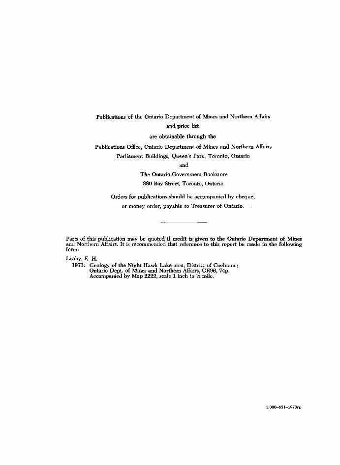
Publications of the Ontario Department of Mines and Northern Affairs
and price list
are obtainable through the
Publications Office, Ontario Department of Mines and Northern Affairs
Parliament Buildings, Queen's Park, Toronto, Ontario
and
The Ontario Government Bookstore
880 Bay Street, Toronto, Ontario.
Orders for publications should be accompanied by cheque,
or money order, payable to Treasurer of Ontario.
Parts of this publication may be quoted if credit is given to the Ontario Department of Mines and Northern Affairs. It is recommended that reference to *his report be made in the following form:
Leahy, E. H. 1971: Geology of the Night Hawk Lake area, District of Cochrane;
Ontario Dept. of Mines and Northern Affairs, GR96, 74p. Accompanied by Map 2222, scale 1 inch to Vz mile.
l,000-651-1970rp
CONTENTS PAGE
Abstract v n
Introduction j Historical Background * Previous Geological Work — • 2 Present Geological Survey 4 Acknowledgments 4 Means of Access 4 Topography j * Resources of Area "
General Geology ® Table of Lithologic Units '
Some Remarks on Stratigraphy 8 Volcanic Rocks | Mafic Intrusive Rocks °
Archean 9 Mafic to Intermediate Metavolcanics 9
Southwestern Carman Township 9 East and Central Night Hawk Lake Area 10 Northwestern Cody Township 11
Iron Formation 11 Intermediate to Felsic Metavolcanics 12 Older Metasediments and Tuffaceous Metasediments 13 Mafic and Ultramafic Intrusive Rocks 14 Younger Sedimentary Rocks 16 Felsic Intrusive Rocks 1® Extremely Altered Rocks and Carbonatized Rocks 18
Proterozoic 19 Mafic Intrusive Rocks 19
Matachewan-Type (?) 19 Younger Mafic Intrusive Rocks 21
Keweenawan-Type (?) 21 Cenozoic 22
Pleistocene 22 Pleistocene History 27 Economic Considerations 27
Structural Geology 31 Folding 31 Faulting 31 Unoonf ormity 34
Economic Geology 34 Description of Properties 36
Anvil Porcupine Gold Mines Limited [1947] (1) 36 Armonit Gold Mines Limited [circa 1942] (68) 36 Auconda Porcupine Gold Mines Limited [1945-1946] (28) 37 Bertram Porcupine Mines Limited (2) 37 Black Hawk Porcupine Mines Limited [1945] (3) 37 Black Hawk Porcupine Mines Limited [1946] (29) 37 Broulan Reef Mines Limited (4, 30) 38 Canadian Superior Exploration Limited (46) 38 Carshaw Porcupine Gold Mines Limited (47) 39 Clemens, J .F. , Estate [circa 1945] (31) 39 Cocallen Porcupine Gold Mines Limited [1944] (5) 39 Desaulnier, C. (6) 40 Dominion Gulf Company [1951] and Mespi Mines Limited [1966] (48) 40 Edgewater Porcupine Gold Mines Limited [1945-1946] (7, 49) 40 Falconbridge Nickel Mines Limited (8) 41 Forsell, Mrs. B. (9) 41 Francis, A.B. (10, 32) 41
Goldhawk, Lakefield, Gold Island 41 Gagne, A. (11) 42 Gallagher Estate (50) 43 Gord, L. (51) 43
iii
PAGE Granton Mining Syndicate (52) 43 Hill, Len (12) 43 Hollinger Consolidated Gold Mines Limited [1959-1960] (33) 44 Hydra Explorations Limited (13, 34) 44
Porcupine Peninsular Mine 44 International Nickel Company of Canada Limited, The [1966] (14) 46 Kensull Gold Mines Limited [1946] (53) 47 Kimasca Porcupine Gold Mines Limited [1946] (69) 47 Lang, B.W. (35) 47 Lang, F.D. (36) 47 LaSalle, Rev. R. (54) 48 Markay Mining Corporation Limited (70) 48 McCoy Gold Mines Limited [1946] (37) 49 Miller, W.H. (15) 49 Minedel Mines Limited (38) 49 Mining Corporation of Canada Limited, The [1944] (16) 50 Minithorn, Dr. H.L., Estate (55) 50
Carman Bay Group 50 Minthorn, Dr. H.L., Estate (56) 50
Carman-Langmuir Group 50 Moran, A.J. (39) 51 Muir Porcupine Gold Mines Limited [1937] (71) 51 Mulliette, Morley (57) 51 Noranda Exploration Company (58) 52 North, Miss M. (59) 52
Quirk Claims 52 Payette, Mrs. J . (60) 52 Pecore, J . J . (61) 53 Phelps Dodge Corporation of Canada Liniited [1965] (62, 72) 53 Porcupine MoNabb and Brisson Prospects [1938] (40) 53 Porcupine Paymaster Limited (17) 54 Ray, Gladstone (41) 55 Redstone Porcupine Gold Mines Limited [1945] (18) 55 Rio Algom Mines Limited (19) 55
Frederick House River Claims 55 Rio Algom Mines Limited (20) 55
North Peninsula Claims 55 Rio Algom Mines Limited [1967] (42) 56
Pardee Amalgamated Group 56 Robb Jr., J.M. (63) 58 Roma Lake Gold Mines Limited (21) 58 Ronnoco Gold Mines Limited (22, 43) 58 Shanwell Porcupine Mines Limited [1940] (23) 59 Tavane Explorations Limited (64) 60 Thomas Gold Mining Company Limited [1923] (73) 60 Trio Porcupine Mines Limited [1937] (65) 61
Carman Gold Syndicate 61 United Macfie Mines Limited (66) 61 Ventures Claims Limited (67) 62 Wellington, C.J. (24) 62 Whitco Porcupine Mining Syndicate [1944-1945] (25) 62 Wieland, H. (44) 62 Wilwood Gold Mines Limited (26, 45) 62 Young, J.W. [circa 1938-1940] (27) 63
Wineva Gold Mines Limited 63 Some Suggestions for Further Exploration 63
Gold 63 Base Metals 64 Mineralization Associated with Ultramafic Rocks 64
Information for Mineral Collectors 64 Appendix 65
List of Previously Published Photographs, in ODM Reports, Pertaining to the Night Hawk Lake Area 65
Selected References 67 Index 71
iv
Table
1 - Table of Lithologic Units PAGE . . . . 7
Figures
1 - Key map showing location of the Night Hawk Lake area vn 2 - Surficial geology 28 3 - Structural geology 30 4-Sketch map showing location of properties 35
Photographs
1 - Shoreline slumping of clay 5 2 - Fragmented metavolcanic, McLeod Island 11 3 - Jointing patterns in ultramafic rook 15 4-Quartz veins in carbonatized volcanic rock 20 5-Spheroidal weathering in diabase 21 6-Glacial striae 23 7-Glacial erratic boulders 23 8-Layered sands, silts, and clays 24 9 - Crumpling of varved clay 25
10 - Lower Sequence and Frederick House Sequence of varved clays, Matheson Township . 26 11 - Lower Sequence and Frederick House Sequence of varved clays, Thomas Township . .26
Map 2222 (coloured) - Night Hawk Lake area, Cochrane District. Scale, 1 inch to Vz mile.
Geological Map (back pocket)
v

A B S T R A C T
This geological report on the Night Hawk Lake area is the result of mapping of Cody, Macklem, Carman, and Thomas Townships, in the District of Cochrane. The area lies immediately east of the producing Porcupine gold area. Gold was discovered in the Night Hawk Lake area in 1907 and some production resulted directly from this discovery. Copper, zinc, and asbestos mineralization occur in the area but most exploration work has been directed in a search for gold.
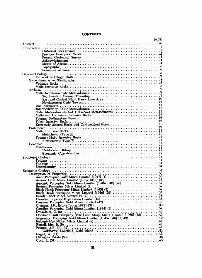
Figure 1 -Key map showing location of the Night Hawk Lake area. Scale, 1 inch equals 50 miles.
Volcanic flow rocks with associated pyroclastics and sedimentary rocks underlie most of the area and are progressively younger to the east. These have been intruded by mafic and ultramafic rocks, granitic rocks, and diabase dikes. Some of the volcanic and sedimentary rocks have been correlated with the Deloro Group rocks of the Porcupine area. The mafic and ultramafic intrusives appear to be older than Haileyburian in age.
Fold axes show two major trends. At least 3 major fold axes striking around N 7 0 E are found in the western half of the area; to the east a major synclinal structure predominates with an axis striking around N 7 0 W .
vii
Faulting in the area is complex but the resulting patterns are fairly regular. Five main systems of faulting appear to have occurred in the following order: a major set striking around N 7 0 E and dipping south, one fault of this set being the Destor-Porcupine Fault; a second set striking around N 5 5 W , these first two sets appear to be pre-gold mineralization; a third set striking around N 3 5 W and accentuated by later partial infilling by diabase dikes; a fourth set with strikes ranging from N 2 5 W to N 2 5 E and accentuated by some diabase dike infilling; and finally the youngest set striking around N70E, the same as the first set, but dipping north, and this system has supplied the fractures filled by the younger diabase dikes crossing the area. Recurrent movement has occurred at least on the third fault system, which is parallel to and part of the Montreal River-Englehart River Fault system.
viii
G e o l o g y
o f t he
N i g h t H a w k Lake A r e a
Distr ict o f C o c h r a n e
by
E. J. Leahy1
INTRODUCTION
The Night Hawk Lake area, in the District of Cochrane, includes the townships of Cody, Macklem, Carman, and Thomas. The centre of the area is 18 miles due east of Timmins. Gold production worth just over half a million dollars has come from two properties in the northern part; additional tonnages of possible gold ore are known to exist. Some exploration has been carried out for asbestos and base metals.
H I S T O R I C A L B A C K G R O U N D
The Night Hawk Lake area has a prominent place in the history of the development of the Porcupine gold camp. In 1896, E. M. Burwash examining outcrops along the just surveyed line that was later to become the line between Carman and Shaw Townships, found rocks that contained traces of gold. He mentioned in his report: "The district would be a promising one from a prospector's point of view were it not for the presence of the drift", (Burwash 1896, p . 1 8 1 ) . His report includes what might be the first published map of Night Hawk Lake and shows a Hudson Bay Company Post located on the western shore. There was a small permanent Indian camp there also. W . A. Parks, in 1899, further explored part of the area and described the portage route from Night Hawk Lake to Porcupine Lake (Parks 1899, p .175-177) . In 1904, G. F. Kay and T. D. Jarvis examined parts of the Night Hawk Lake area in their greater study of the Abitibi region (Kay 1904; Jarvis 1 9 0 4 ) . They reported on aspects of geology, geography, timber, wildlife, insects, and soils of the area. In their reports, mention is made of Dance Township and the report gives information on it, (Jarvis 1904, p. 1 3 0 ) . During the course of the present mapping an old round iron survey post was found in the extreme southwestern corner of the area, with the inscription: "-Nipissing C X I V M Algoma-Dance, Carman, Langmuir". It appears that Dance Township is what was a few years later to become Shaw Township (there is another Dance Township in Rainy River District) .
1 Geologist, Ontario Department of Mines and Northern Affairs, Timmins, Ontario. Manuscript accepted for publication by the Director, Geological Branch, 16 July 1969
1
Night Hawk Lake Area
2
In May 1905, Edward Orr Taylor staked the first recorded claim of the Porcupine area, somewhere on the southwestern shore of Night Hawk Lake (Brown 1967, p .4 ) . By 1906, a few prospectors were beginning to move into the general Porcupine area using the river systems from the Matachewan area and entering into Night Hawk Lake. In 1907, two Finnish prospectors, Victor Manson and Harry Benella discovered native gold on an island, off the eastern tip of the northern peninsula. This marked the first bona fide gold discovery of the Porcupine area. Other prospectors worked their way farther west and two years later, 1909, the important gold discoveries were being made that would eventually place the Porcupine among the leading gold producing areas of the world.
The actual land boundary surveys of the area were done as follows: west boundary by Niven in 1896 and 1898; north and east boundary by Speight in 1903; and the south boundary by Galbraith in 1903. In 1910, Fullerton surveyed Night Hawk Lake and the islands and established the lines dividing the area into four townships. According to the Ontario Department of Lands and Forests, in 1966, the origin of the township names are as follows: Cody Township after the Honorable Reverend H. J . Cody, M.A., D.D., former principal of the University of Toronto, Minister of Education, Member of Parliament for Toronto northeast, and Rector of St. Paul's Church in Toronto; Macklem Township named after the Reverend T. Street Macklem, D.D., who was Provost of Trinity College in Toronto; Carman Township was named after Reverend Alfred Carman, D.D., M.A., LL.D., one time Chancellor of Alberta College in Belleville, Bishop of the Methodist Episcopal Church of Canada, and General Superintendent of the Methodist Church in Canada; and Thomas Township named after the Reverend B . D. Thomas, D.D., a Baptist Minister of Toronto.
P R E V I O U S G E O L O G I C A L W O R K
In 1896, Burwash mapped the outcrops and reported on the geology along the survey line between Shaw and Carman Townships. At that time all the rocks encountered were classified as Huronian in age. The report includes descriptions of soil, clays, glacial features, and general geographical data (Burwash 1896, p .180-184) .
In 1898, Parks examined the survey line between Cody and Whitney Townships and reported on many features of the neighbouring area (Parks 1899, p .175-177) .
In 1903, Kay and Jarvis made an examination of the general Abitibi region. Their reports include rock descriptions and an analysis of a diabase from the Night Hawk Lake area (Kay 1904, p.104-121; Jarvis 1904, p .121-134) . Kay applied no definite age names to the rocks thinking there was not enough knowledge of them to do that. An interesting feature of this report was the classification of rocks by class, order, range, and subrange.
In 1907, W . G. Miller published a short paper on the gold occurrence found at Night Hawk Lake. For the first time, the rocks were classified as Keewatin in age; carbonate rocks of the area were considered to be derived from impure limestones (Miller 1907, p .219-220) .
The year 1910 saw the beginning of concentrated geological mapping in the Porcupine area. A. G. Burrows, in the period 1910 to 1912, published three maps and two reports on the Porcupine area (Burrows and Rogers 1910; Burrows 1911 and map; 1912 and map) . These maps, in turn, all show new data on the Night Hawk Lake area. The legends for the maps show the volcanic rocks as Keewatin in age, the granitic rocks as Laurentian in age, the sedimentary rocks first as Huronian (Burrows and Rogers 1910)
and later as Timiskaming (Burrows 1912, map) , and the diabases as later than all these. In 1915, Burrows issued his third report on the Porcupine area. Although the map
does not include Night Hawk Lake it covers the townships immediately west of it. Here the volcanic rocks are classified as Keewatin, the sedimentary rocks as Timiskaming, a new group of rocks called serpentines are designated as pre-Algoman, the granites classified as Algoman and the diabase as Keweenawan (Burrows 1915, map) .
In 1919, a map of the "Gold Area Between Lakes Abitibi and Night Hawk" follows generally the same rock classification as used in 1915 with the exception that the sedimentary rocks are now classified as Keewatin with a note suggesting that some of them may be Timiskaming (Knight et al. 1919, and map) .
In 1924, Burrows issued his fourth report on the Porcupine area. Again the map accompanying this report does not take in the Night Hawk Lake area but includes the townships immediately west of it. Once again the sedimentary rocks are classified as Timiskaming; the diabases are subdivided into Matachewan quartz diabase and Keweenawan olivine diabase. Here for the first time also, the serpentine rocks are classified as Haileyburian (Burrows 1 9 2 4 ) . The same year a report was issued on the gold occurrences of the Night Hawk Lake area (Hopkins 1924, p .27-36) .
In 1931, H. C Laird, reported on the German-Currie area, which included Macklem Township (Laird 1931, p. 1-22 and map) .
In 1936, E. D. Kindle produced a summary of data on the Night Hawk Lake area gold occurrences (Kindle 1936, p .87-90) .
During 1935, 1936, and 1937, M. E. Hurst remapped part of the Porcupine area. The map resulting from this work includes part of Cody and Carman Townships (Hurst 1 9 3 9 ) . For the first time the sedimentary rocks of the area were broken down into two groups: one group belonging to the Keewatin, the other belonging to the Timiskaming.
In 1939, L. G. Berry mapped the Langmuir-Sheraton area, including Carman and Thomas Townships (Berry 1940, p.1-21 and map) . This was the last outcrop map published for any part of the Night Hawk Lake area up until the time of the present survey.
In 1948, W . R. Dunbar published a paper on the "Structural Relations of the Porcupine Ore Deposits" (Dunbar 1948, p .442-456) . The map accompanying this paper, subdivided the volcanic rocks of the Keewatin into two groups, the Deloro Group and the Tisdale Group and shows his interpretation of this subdivision extending into the northern part of Cody and Macklem Townships. The sedimentary rocks were broken down into the Hoyle Sedimentary Series and the Timiskaming Series.
In 1950, Nelson Hogg, then Resident Geologist at Timmins for the Ontario Department of Mines, published a report on "The Porcupine Gold Area" (Hogg 1950, p. 102-1 0 6 ) . He adopted the classification of rock units established up to that time with a few exceptions; he placed the serpentine rocks in with the Keewatin as he found no evidence that would place them as Haileyburian, and he classified the sedimentary rocks in Cody Township as Deloro Group, and therefore older than the Hoyle Sedimentary Series.
In 1956, the Geological Survey of Canada published Aeromagnetic Maps covering the Night Hawk Lake area, (Geol. Surv. Canada 1956a, b, c, and d ) . These maps were published from data supplied by the Dominion Gulf Company from work done in the interval of 1947 to 1949.
In 1964, the Timmins-Kirkland Lake Compilation Map was issued, which included the Night Hawk Lake area (Ginn et al. 1 9 6 4 ) . It is a generalized map compiled from all maps, reports, and assessment work files available at that time.
3
Night Hawk Lake Area
From 1964 to the present time, new geological reports and maps have been issued on nearby parts of the Porcupine area (Carlson 1967; Ferguson 1968; George and Leahy 1967; Pyke 1 9 6 9 ) and more planned for the immediate future.
P R E S E N T G E O L O G I C A L S U R V E Y
Field work was started in the summer of 1964 and continued through the field season of 1965. An extensive rainy season in 1965 prevented completion of the project and about a week each in 1966, 1967, and 1968 were spent in additional mapping of the area.
Because of the nature of outcrop distribution and the topography, traverses for the most part were not run in a systematic pattern. Traversing was carried out by pace-and-compass methods using vertical air photographs for control. Counting the lake shoreline, approximately 370 miles of line were covered in the survey; in addition to this all islands were mapped, a fluxgate magnetometer survey was carried out along 3 miles of line in the northern part of the area, and several areas were rechecked for additional information. In addition all previous maps, reports, and assessment work files were used in preparing the final map.
A C K N O W L E D G M E N T S
The writer was assisted in 1964 by T. M. Seward, G. T. Hayes, G. R. Pope, and N. J . Brown. In 1965 the assistants were Roy Wares, G. T. Hayes, G. R. Pope and John Ponikvar. Messrs. Seward and Wares as senior assistants carried out independent mapping. Also G. T. Hayes, who had spent three summers as assistant with the writer, carried out some mapping.
Profitable discussions on the area were had with P. T. George, former Resident Geologist at Timmins, E. G. Bright, present Resident Geologist at Timmins, and D. R. Pyke, staff geologist with the Ontario Department of Mines and Northern Affairs.
Mr. and Mrs. Jack Hill, of Night Hawk Lake Marina, extended many courtesies to the party during the mapping of the area.
Letters were sent to all patented-claim owners in the area and others known to have worked in the area; some of them were able to supply additional information. The writer gratefully acknowledges much additional material obtained from E. L. Evans of Rio Tinto Canadian Explorations Limited; R. A. Dujardin of Canadian Superior Exploration Limited; W . H. Hansen of Hollinger Mines Limited; and E. M. Miller of Wilwood Gold Mines Limited.
M E A N S O F A C C E S S
Highway 101, between Matheson and Timmins passes just north of the map-area. Side roads from it gives access to eastern Macklem Township, northeastern Thomas Township, the North Peninsula and northwestern Cody Township. A road from South Porcupine is driveable to near the southwestern corner of Carman Township; from this, old lumbering roads and trails give access to the southwestern part of the township.
Travel by water gives best access to the Night Hawk Lake area. Large boats and motors can be used on the lake and main rivers emptying into it; the Porcupine River,
4
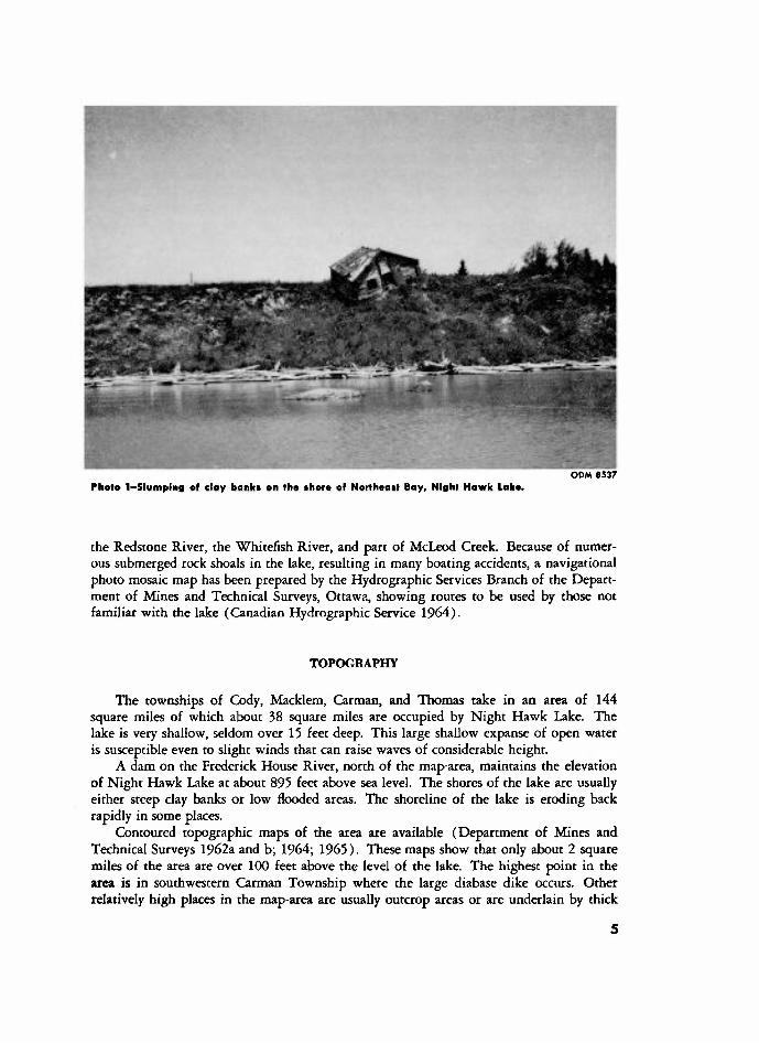
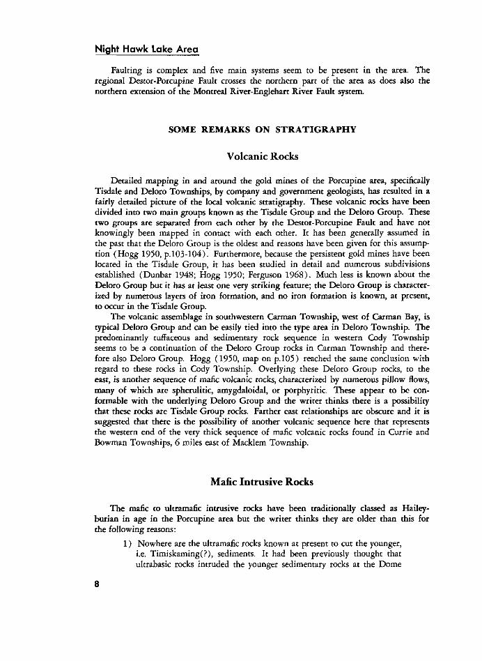
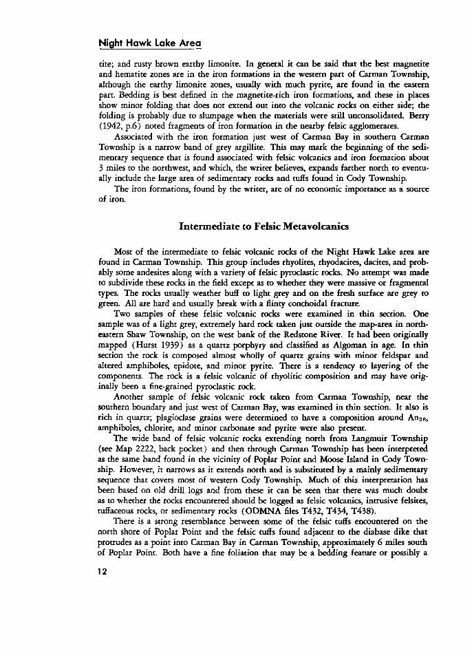
PHOTO 1-SLUMPING AF CLOY BANK* EN THE THERE OF NORTHEAST BAY, NIGHL HAWK LAKE. ODM 8537
the Redstone River, the Whitefish River, and part of McLeod Creek. Because of numerous submerged rock shoals in the lake, resulting in many boating accidents, a navigational photo mosaic map has been prepared by the Hydrographic Services Branch of the Department of Mines and Technical Surveys, Ottawa, showing routes to be used by those not familiar with the lake (Canadian Hydrographic Service 1 9 6 4 ) .
T O P O G R A P H Y
The townships of Cody, Macklem, Carman, and Thomas take in an area of 144 square miles of which about 38 square miles are occupied by Night Hawk Lake. The lake is very shallow, seldom over 15 feet deep. This large shallow expanse of open water is susceptible even to slight winds that can raise waves of considerable height.
A dam on the Frederick House River, north of the map-area, maintains the elevation of Night Hawk Lake at about 895 feet above sea level. The shores of the lake are usually either steep clay banks or low flooded areas. The shoreline of the lake is eroding back rapidly in some places.
Contoured topographic maps of the area are available (Department of Mines and Technical Surveys 1962a and b; 1964; 1 9 6 5 ) . These maps show that only about 2 square miles of the area are over 100 feet above the level of the lake. The highest point in the area is in southwestern Carman Township where the large diabase dike occurs. Other relatively high places in the map-area are usually outcrop areas or are underlain by thick
5
Night Hawk Lake Area
deposits of sand and gravel, as in the eastern side of Macklem Township. Over 50 percent of the land area is less than 50 feet above lake level. Drainage is poor and large areas of spruce and alder swamp are common. River banks are nearly always flooded and characterized by a thick growth of grassy marshland.
Night Hawk Lake has many islands. Nearly all of these have a rocky shoreline although the centre of the island is clay covered. Daily fluctuations in the water level of the lake by 1 or 2 feet are common during the summer. It is possible to map rock exposed on a shoreline one day only to have it below water level the next day. Thus in trying to gather geological data these changes in lake level are important.
R E S O U R C E S O F T H E A R E A
The eastern side of Macklem Township is sand covered and supports a good growth of jack pine. Several small clean kettle lakes are found in this area. Most of the remaining land area is clay covered, low and swampy with extensive cover of spruce, alder, and poplar trees with smaller areas of cedar.
During the survey, bears were noticed often in Carman and Macklem Township; moose often in Thomas and Carman. Pike and pickerel are caught in the lakes and rivers.
No permanent residents are located in the four townships but a few are found just outside the northern limit of the area. Although Night Hawk Lake is the largest lake within a 50-mile radius of Timmins, it is not used by many people for a vacation area. The low swampy ground, lack of beaches, the dirty water, and sudden high waves keep people away. There are about 15 camps scattered along the waterways in the southern part of the area.
GENERAL GEOLOGY
All known rock underlying the Night Hawk Lake area is Precambrian in age. Structural and stratigraphical relationships indicate that the oldest rocks of the area are mafic volcanic rocks with minor felsic volcanic flows in southwestern Carman Township. These are overlain conformably by a predominantly felsic volcanic sequence which, by facies change, grades into a tuffaceous and sedimentary rock sequence prominent in Cody Township. Overlying this conformably (and possibly unconformably in places) is another mafic volcanic sequence that takes in the greater proportion of volcanic rocks in the map-area. In general, as one goes eastward across the map-area, the volcanic rocks are successively younger.
A major regional fault, the Destor-Porcupine Fault, crosses the northern part of the map-area. Along its southern side, the volcanic, tuffaceous, and sedimentary rocks have been extremely altered. A belt of younger sedimentary rock lies parallel along the northern side of this fault; this younger sedimentary rock group unconformably overlies the volcanic rocks of the area.
Ultramafic, granitic, and diabasic intrusive rocks are fairly common throughout the Night Hawk Lake area.
Folding about northeasterly trending axes is predominant in the western part of the area. A northwesterly folding trend is apparent in the easterly part of the area and may be younger than the northeasterly trend.
6
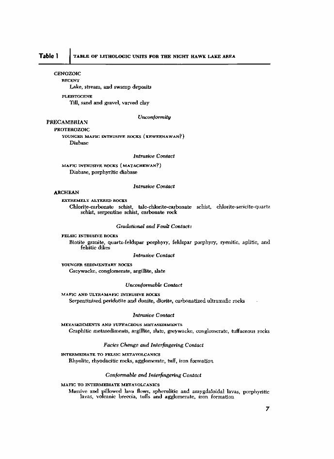
Table 1 TABLE OF LITHOLOGIC UNITS FOR THE NIGHT HAWK LAKE AREA
CENOZOIC RECENT
Lake, stream, and swamp deposits PLEISTOCENE
Till, sand and gravel, varved clay
Unconformity PRECAMBRIAN
PROTEROZOIC YOUNGER MAFIC INTRUSIVE ROCKS ( KEWEENAW AN? )
Diabase
Intrusive Contact
MAFIC INTRUSIVE ROCKS ( MATACHEWAN? ) Diabase, porphyritic diabase
Intrusive Contact ARCHEAN
EXTREMELY ALTERED ROCKS Chlorite-carbonate schist, talc-chlorite-carbonate schist, chlorite-sericite-quartz
schist, serpentine schist, carbonate rock
Gradational and Fault Contacts
FELSIC INTRUSIVE ROCKS Biotite granite, quartz-feldspar porphyry, feldspar porphyry, syenitic, aplitic, and
felsitic dikes Intrusive Contact
YOUNGER SEDIMENTARY ROCKS Greywacke, conglomerate, argillite, slate
Unconformable Contact
MAFIC AND ULTRAMAFIC INTRUSIVE ROCKS
Serpentinized peridotite and dunite, diorite, carbonatized ultramafic rocks
Intrusive Contact METASEDIMENTS AND TUFFACEOUS METASEDIMENTS
Graphitic metasediments, argillite, slate, greywacke, conglomerate, tuffaceous rocks
Facies Change and Interfingering Contact INTERMEDIATE TO FELSIC METAVOLCANICS
Rhyolite, rhyodacitic rocks, agglomerate, tuff, iron formation
Conformable and Interfingering Contact MAFIC TO INTERMEDIATE METAVOLCANICS
Massive and pillowed lava flows, spherulitic and amygdaloidal lavas, porphyritic lavas, volcanic breccia, tuffs and agglomerate, iron formation 7
NIGHT H A W K L A K E A R E A
Faulting is complex and five main systems seem to be present in the area. The regional Destor-Porcupine Fault crosses the northern part of the area as does also the northern extension of the Montreal River-Englehart River Fault system.
SOME REMARKS ON STRATIGRAPHY
Volcanic Rocks
Detailed mapping in and around the gold mines of the Porcupine area, specifically Tisdale and Deloro Townships, by company and government geologists, has resulted in a fairly detailed picture of the local volcanic stratigraphy. These volcanic rocks have been divided into two main groups known as the Tisdale Group and the Deloro Group. These two groups are separated from each other by the Destor-Porcupine Fault and have not knowingly been mapped in contact with each other. It has been generally assumed in the past that the Deloro Group is the oldest and reasons have been given for this assumption (Hogg 1950, p .103-104) . Furthermore, because the persistent gold mines have been located in the Tisdale Group, it has been studied in detail and numerous subdivisions established (Dunbar 1948; Hogg 1950; Ferguson 1 9 6 8 ) . Much less is known about the Deloro Group but it has at least one very striking feature; the Deloro Group is characterized by numerous layers of iron formation, and no iron formation is known, at present, to occur in the Tisdale Group.
The volcanic assemblage in southwestern Carman Township, west of Carman Bay, is typical Deloro Group and can be easily tied into the type area in Deloro Township. The predominantly tuffaceous and sedimentary rock sequence in western Cody Township seems to be a continuation of the Deloro Group rocks in Carman Township and therefore also Deloro Group. Hogg ( 1 9 5 0 , map on p. 105) reached the same conclusion with regard to these rocks in Cody Township. Overlying these Deloro Group rocks, to the east, is another sequence of mafic volcanic rocks, characterized by numerous pillow flows, many of which are spherulitic, amygdaloidal, or porphyritic. These appear to be conformable with the underlying Deloro Group and the writer thinks there is a possibility that these rocks are Tisdale Group rocks. Farther east relationships are obscure and it is suggested that there is the possibility of another volcanic sequence here that represents the western end of the very thick sequence of mafic volcanic rocks found in Currie and Bowman Townships, 6 miles east of Macklem Township.
Mafic Intrusive Rocks
The mafic to ultramafic intrusive rocks have been traditionally classed as Hailey-burian in age in the Porcupine area but the writer thinks they are older than this for the following reasons:
1 ) Nowhere are the ultramafic rocks known at present to cut the younger, i.e. Timiskaming(P), sediments. It had been previously thought that ultrabasic rocks intruded the younger sedimentary rocks at the Dome
8
Mine but such is not the case as reported by T. C. Holmes, mine geologist (Holmes, in Ferguson 1968, p. 89 ; also personal communication, 1 9 6 9 ) .
2 ) Naldrett and Mason (1968 , p. 1 3 5 ) studied a differentiated ultramafic sill in Dundonald and Clergue Townships, 7 miles north of the Night Hawk Lake area, and concluded that it intruded when the country rocks were horizontal or very nearly so, that is, pre-folding. A recent map of Tisdale Township (Ferguson 1968) shows mafic intrusives conformable to folding in the northwestern part, indicating sill-like intrusions folded with the enclosing volcanic rocks. Pyke (1969 , p. 3 4 ) suggested that serpentinized peridotites in Langmuir Township, immediately south of the Night Hawk Lake area, were intruded prior to or during the early stages of folding. I f the ultramafic rocks intruded prior to the folding then they are pre-Timiskaming in age.
3 ) Chromium-bearing micas are fairly common around the Porcupine area; commonly they are in what is called "green-carbonate rock". The writer thinks that the most likely source for the chromium is from preexisting ultramafic rocks that are known to be chromium-bearing in the area (see Naldrett and Mason 1968, p.130-131; Pyke 1969, p.102), and hydrothermal solutions cutting across ultramafic rocks might leach the chromium from them and deposit it elsewhere. Chromium mica-bearing pebbles are found in the younger sedimentary rocks of the Night Hawk Lake area, indicating that the chromium source is older than the sediments and if the source of the chromium is the ultramafic rocks, then they are not "Haileyburian" in age, but older. It is also noted here, from observations by the writer, that chromium-bearing mica fragments are found in the latite breccia unit of the Hoyle Series of Tisdale Township, indicating the chromium source to be older than the Hoyle Series. Hogg (1950 , p .104) suggested that ultramafic rocks of the Porcupine area were late Keewatin in age, not Haileyburian.
ARCHEAN
Mafic to Intermediate Metavolcanics
Approximately 70 percent of the Night Hawk Lake area is underlain by metavolcanics of mafic to intermediate composition. For purposes of discussion these will be grouped into three areas: southwestern Carman Township; east and central Night Hawk Lake area; and, northwestern Cody Township.
S O U T H W E S T E R N C A R M A N T O W N S H I P
A series of mafic volcanic flows, approximately V>A miles thick occurs in southwestern Carman Township. The majority of these flows are massive, pillowed lavas being only a small part of the sequence. The rocks vary from rusty brown to dark green
9
Niaht Hawk Lake Area on the weathered surfaces; the fresh surfaces are generally shades of dark green. Adjacent to the large diabase dikes the rocks are harder, black and flinty due to contact metamor-phism caused by the intruding dikes. Small lenses of felsic metavolcanics and minor bands of iron formation are found in this sequence. A felsic volcanic sequence separates this group of rocks from the next major group of mafic to intermediate volcanic rocks.
E A S T A N D C E N T R A L N I G H T H A W K L A K E A R E A
The mafic to intermediate metavolcanics in this group comprise the greatest abundance of rocks in the map-area. They cover a large area including: nearly all of Thomas Township; all of Macklem Township except the northwestern area; the southeastern quarter of Cody Township; and the northeastern section and extreme eastern part of Carman Township. Except for clusters of outcrop along the Thomas-Carman boundary and the Thomas-Macklem boundary, most of the rocks of this group are found as shoreline exposures along the lake and the islands.
As determined from outcrop and diamond drilling, this large group of rocks have characteristics that distinguish them from the southwestern Carman group of rocks. Pillow lavas make up a large proportion of this group; there are no known iron formations in this group; much of this rock type in southern Macklem Township consists of volcanic fragmental rocks ranging from fine-grained tuffs to coarse agglomerates; amyg-daloidal and spherulitic structures are not uncommon; weathered surfaces of these rocks, except where strongly carbonatized, are generally buff to dark green and on fresh surfaces the rocks are green to grey-green and generally harder than those of southwestern Carman Township, that is, many of these rocks are more intermediate in composition, probably andesite and dacites.
Pillow lavas showing almost perfect form are found on many of the islands in the lake. Those on the eastern shore of Crow Island are an example. The pillow structures as seen on some of the islands in Macklem Township are commonly bun-shaped, rarely mattress types. Some of these pillows contain numerous white spherules, which appear to be more numerous around their margins.
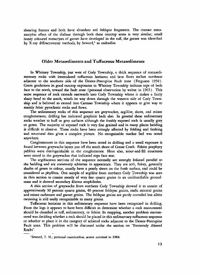
Volcanic fragmental rocks are prevalent in the outcrop area straddling the centre of the township line between Macklem and Thomas Townships, but their characteristics are masked by intense carbonate alteration. Better exposures for study are seen in the area of McLeod and Cindy Islands. These rocks have been mapped as tuffs, agglomerates, and breccias. The tuffs were observed on the northern point of Cindy Island and on the island VA miles south of Cindy Island and some of the islands east of them. They are grey-green in appearance, fine grained except for rare clusters of fragments up to VA inch in diameter that stand out on the weathered surface. One place showed graded bedding confirming tops to be in the same direction as determined by pillow structure. One section also showed a development of fracture cleavage, which indicated a sense of movement related directly to the interpreted folding in this area.
The agglomerates contain fragments up to 2 feet in length but more commonly range from 1 inch to 6 inches. These fragments are generally rounded, are lighter in colour than the dark green matrix, and usually contorted. In places the matrix is almost devoid of fragments and looks like a massive flow. McLeod Island and the large island about VA mile northeast of it have good exposures.
1 0
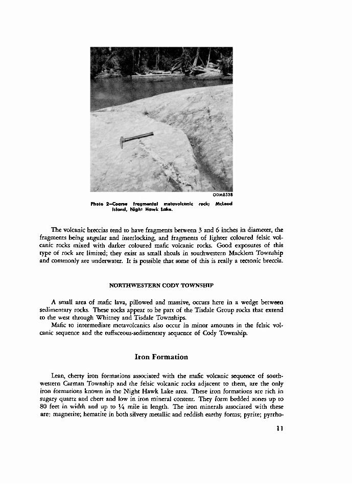
ODM8538
PHOTO 2-COORSE FRAGMENTAL METAVOLCANLC ROCK; MCLEOD ISLAND, NIGHT HAWK LAKE.
The volcanic breccias tend to have fragments between 3 and 6 inches in diameter, the fragments being angular and interlocking, and fragments of lighter coloured felsic volcanic rocks mixed with darker coloured mafic volcanic rocks. Good exposures of this type of rock are limited; they exist as small shoals in southwestern Macklem Township and commonly are underwater. It is possible that some of this is really a tectonic breccia.
N O R T H W E S T E R N C O D Y T O W N S H I P
A small area of mafic lava, pillowed and massive, occurs here in a wedge between sedimentary rocks. These rocks appear to be part of the Tisdale Group rocks that extend to the west through Whitney and Tisdale Townships.
Mafic to intermediate metavolcanics also occur in minor amounts in the felsic volcanic sequence and the tuffaceous-sedimentary sequence of Cody Township.
Iron Formation
Lean, cherry iron formations associated with the mafic volcanic sequence of southwestern Carman Township and the felsic volcanic rocks adjacent to them, are the only iron formations known in the Night Hawk Lake area. These iron formations are rich in sugary quartz and chert and low in iron mineral content. They form bedded zones up to 8 0 feet in width and up to V4 mile in length. The iron minerals associated with these are: magnetite; hematite in both silvery metallic and reddish earthy forms; pyrite; pyrrho-
1 1
Night Hawk Lake Area
tite; and rusty brown earthy limonite. In general it can be said that the best magnetite and hematite zones are in the iron formations in the western part of Carman Township, although the earthy limonite zones, usually with much pyrite, are found in the eastern part. Bedding is best defined in the magnetite-rich iron formations, and these in places show minor folding that does not extend out into the volcanic rocks on either side; the folding is probably due to slumpage when the materials were still unconsolidated. Berry (1942, p .6) noted fragments of iron formation in the nearby felsic agglomerates.
Associated with the iron formation just west of Carman Bay in southern Carman Township is a narrow band of grey argillite. This may mark the beginning of the sedimentary sequence that is found associated with felsic volcanics and iron formation about 3 miles to the northwest, and which, the writer believes, expands farther north to eventually include the large area of sedimentary rocks and tuffs found in Cody Township.
The iron formations, found by the writer, are of no economic importance as a source of iron.
Intermediate to Felsic Metavolcanics
Most of the intermediate to felsic volcanic rocks of the Night Hawk Lake area are found in Carman Township. This group includes rhyolites, rhyodacites, dacites, and probably some andesites along with a variety of felsic pyroclastic rocks. No attempt was made to subdivide these rocks in the field except as to whether they were massive or fragmental types. The rocks usually weather buff to light grey and on the fresh surface are grey to green. All are hard and usually break with a flinty conchoidal fracture.
Two samples of these felsic volcanic rocks were examined in thin section. One sample was of a light grey, extremely hard rock taken just outside the map-area in northeastern Shaw Township, on the west bank of the Redstone River. It had been originally mapped (Hurst 1 9 3 9 ) as a quartz porphyry and classified as Algoman in age. In thin section the rock is composed almost wholly of quartz grains with minor feldspar and altered amphiboles, epidote, and minor pyrite. There is a tendency to layering of the components. The rock is a felsic volcanic of rhyolitic composition and may have originally been a fine-grained pyroclastic rock.
Another sample of felsic volcanic rock taken from Carman Township, near the southern boundary and just west of Carman Bay, was examined in thin section. It also is rich in quartz; plagioclase grains were determined to have a composition around A n 2 8 , amphiboles, chlorite, and minor carbonate and pyrite were also present.
The wide band of felsic volcanic rocks extending north from Langmuir Township (see Map 2222, back pocket) and then through Carman Township has been interpreted as the same band found in the vicinity of Poplar Point and Moose Island in Cody Township. However, it narrows as it extends north and is substituted by a mainly sedimentary sequence that covers most of western Cody Township. Much of this interpretation has been based on old drill logs and from these it can be seen that there was much doubt as to whether the rocks encountered should be logged as felsic volcanics, intrusive felsites, tuffaceous rocks, or sedimentary rocks ( O D M N A files T 4 3 2 , T 4 3 4 , T 4 3 8 ) .
There is a strong resemblance between some of the felsic tuffs encountered on the north shore of Poplar Point and the felsic tuffs found adjacent to the diabase dike that protrudes as a point into Carman Bay in Carman Township, approximately 6 miles south of Poplar Point. Both have a fine foliation that may be a bedding feature or possibly a
1 2
shearing feature and both have abundant red feldspar fragments. The contact meta-morphic effect of the diabase through both these outcrop areas is very similar; small honey coloured metacrysts of garnet have developed in the tuff, the garnet was identified by X-ray diffractometer methods, by Seward, 1 as andradite.
Older M etasediments and Tuffaceous Metasediments
In Whitney Township, just west of Cody Township, a thick sequence of metasedi-mentary rocks with intercalated tuffaceous horizons and lava flows strikes northeast adjacent to the southern side of the Destor-Porcupine Fault zone (Ferguson 1 9 5 8 ) . Grain gradations in good outcrop exposures in Whitney Township indicate tops of beds face to the north, toward the fault zone (personal observation by writer in 1 9 6 5 ) . This same sequence of rock extends eastwards into Cody Township where it makes a fairly sharp bend to the south, winds its way down through the western side of Cody Township and is believed to extend into Carman Township where it appears to give way to mainly felsic pyroclastic rocks and flows.
The sedimentary rocks of this sequence are greywackes, argillite, slates, and minor <»nglomerates; drilling has indicated graphitic beds also. In general these sedimentary rocks weather to buff or grey surfaces although the freshly exposed rock is usually grey or green. The majority of exposed rock is very fine grained and in many places bedding is difficult to observe. These rocks have been strongly affected by folding and faulting and structural data gives a complex picture. No recognizable marker bed was noted anywhere.
Conglomerates in this sequence have been noted in drilling and a small exposure is found between greywacke layers just off the south shore of Goose Creek. Felsite porphyry pebbles were distinguishable in the conglomerate. Here also, scour-and-fill structures were noted in the greywackes that indicated tops face east.
The argillaceous sections of the sequence normally are strongly foliated parallel to the bedding and are commonly schistose in appearance. They are soft, flakey, generally shades of green in colour, usually have a pearly sheen on the fresh surface, and could be <»nsidered as phyllites. One sample of argillite from northern Cody Township was seen in thin section to consist mostly of very fine quartz grains in an unidentifiable ground-mass and it showed secondary fibrous amphiboles.
A thin section of greywacke from northern Cody Township showed it to consist of approximately 30 percent quartz grains, 4 0 percent feldspar grains, mafic mineral grains and minor carbonate and garnet grains. The feldspar grains are partly corroded but albite twinning is still easily recognizable in many grains.
Tuffaceous horizons in this sedimentary sequence have been recognized in drilling. From the logs it appears to have been difficult to determine whether a rock encountered should be classified as tuff, sedimentary, or felsite. In mapping, another problem encountered was deciding whether a rock should be placed in this sedimentary-tuffaceous sequence or whether to place it in the category of schisted rocks adjacent to the Destor-Porcupine Fault zone. This problem will be discussed under the section on "Extremely Altered Rocks".
1 3
1SEWARD, T . M., PERSONAL EXAMINATION, SENIOR ASSISTANT IN 1 9 6 4 .
Night Hawk Lake Area
In the Night Hawk Lake area all sedimentary rocks have been grouped into two main categories:
1 ) the older metasediments and tuffaceous metasediments, and
2 ) the younger sedimentary rocks.
These sedimentary rocks have presented difficulties for geological interpretation throughout the neighboring townships as well as at Night Hawk Lake. In general the following might be said: the older metasediments are usually fine grained, commonly green in colour, have minor interbedded tuffs and flows, and "look older". On the other hand the younger sedimentary rocks are usually coarse grained with conglomerates very common, are grey in colour, do not have interbedded associated tuffs and flows, and "look fresh".
Mafic and Ultramafic Intrusive Rocks
Rocks belonging to this group are found in Cody, Macklem, and Carman Townships. Most of these rocks are ultramafic varieties except for a small fringe of grey-green diorite at the extreme southeastern edge of the large ultramafic mass in Carman Township and extending into Langmuir Township. Thin section studies of two samples of this diorite show it to be strongly chloritized, and the feldspar grains appear to have a composition around An28-3o; quartz made up about 10 percent of the rock in one section studied and was not observed in the other section. Pyke has mapped the southward continuation of this diorite in Langmuir Township (Pyke 1969, p .35 -37) .
The shapes of the ultramafic bodies are variable. In Carman Township they are irregular in outline and commonly cut across strike of the enclosing volcanic flows so that they cannot be strictly considered as sills. In Macklem Township small sill-like bodies of ultramafic rock are found near East Peninsula. Farther north in Macklem Township and also in Cody Township, lens-shaped ultramafic bodies are indicated by geophysics and drilling to occur in the area of "extremely altered rocks" and adjacent to the Destor-Porcupine Fault zone. Much of the rock in the northern part of the map-area, near the Destor-Porcupine Fault zone and in the area of "extremely altered rocks" has been logged as "serpentines" but the present writer believes these "serpentines" to be altered volcanic rocks.
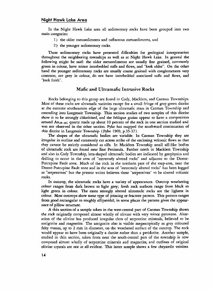
In outcrop, the ultramafic rocks have a variety of appearances. Outcrop weathering colour ranges from dark brown to light grey; fresh rock surfaces range from black to light green in colour. The more strongly altered ultramafic rocks are the lightest in colour. Most outcrops show some type of jointing or fracture pattern. This pattern ranges from good rectangular to roughly ellipsoidal; in some places the pattern gives the appearance of pillow structure.
A thin section of a sample taken in the west-central part of Carman Township shows the rock originally composed almost wholly of olivine with very minor pyroxene. Alteration of the olivine has produced irregular clots of serpentine minerals, believed to be antigorite and magnetite. The antigorite also is visible megascopically as grey coloured felty masses, up to 2 mm in diameter, on the weathered surface of the outcrop. The rock would appear to have been originally a dunite rather than a peridotite. Another sample, studied in thin section, taken from near the south-central part of the township is now composed almost wholly of serpentine minerals and magnetite, and outlines of original olivine crystals are not at all evident. This latter sample shows a few chrysotile veinlets.
1 4
ODM8539
PHOTO 3-JOIRTTING PATTERNS IN SERPENTINIIED PORLDOTITE; SOUTHWEST CARMAN TOWNSHIP. NET* RECTANGULAR PATTERN TO THE LEFT OF THE HAMMER VERTUT THE ROUGHLY ELLIPSOIDAL PATTERN ON THE RIGHT SIDE.
An interesting phase of the ultramafic group has been found in outcrop and drilling in central Carman Township. It is a very light green colour and crossed by irregular veinlets of white carbonate and talc, which weather to a rusty colour. The rock is very coarse grained as the original olivine crystal outlines are readily visible in hand specimen, and some specimens are up to Y2 inch in length. In thin section the rock is a serpen-tinized dunite. An uncommon mineral, identified as stichtite, by the Laboratory and Research Branch of the Ontario Department of Mines and Northern Affairs, was found in this rock. It occurs as sparsely disseminated mauve coloured grains and has the chemical formula M g 1 8 C r 6 ( O H ) 4 8 ( C 0 3 ) 3 1 2 H 2 0 .
A drill hole in Carman Township encountered a section of black ultramafic rock with a "feathery" or "lathlike" appearance, a type of rock described in detail by Pyke (1969, p .26-33) . Apparently the rock is composed of tabular or skeletal crystals of serpentinized olivine and pyroxene, the crystal structure being related to the rate of cooling of the original magma. This rock type was not encountered in outcrop in the map-area.
Tremolite veins, with hard brittle fibres up to 6 inches in length, were found in outcrop just south of the Redstone River on the western side of Carman Township.
For more detailed studies of the ultramafic rocks in this area, the reader is referred to papers by Naldrett ( 1 9 6 4 ; 1 9 6 6 ) , Naldrett and Mason ( 1 9 6 8 ) , and Fyke ( 1 9 6 9 ) .
1 5
Night H a w k l a k e A r e a
Younger Sedimentary Rocks
A belt of younger sedimentary rocks, striking about N 7 0 E crosses the northern part of the map-area. The southern boundary of this belt is along a fault zone, the Destor-Porcupine Fault; the northern boundary of the belt appears to lie in unconformable contact with older volcanic and sedimentary rocks.
Coarse greywackes and conglomerates make up a considerable proportion of this sedimentary belt. In places the greywackes are almost clean enough to be considered as quartzites; in other places the greywackes contain narrow lenses of coarser material containing numerous quartz pebbles up to 1 inch in diameter. These rocks contrast sharply with the "older sedimentary rocks" of the area.
Good exposures of conglomerate are found where the belt crosses the northern part of Macklem Township and in German Township just north of it (Laird 1 9 3 1 ) . McLaughlin ( 1 9 5 6 ) has published a good description of these rocks and an excellent photograph. In his paper he makes special reference to the pebbles of green "serpentine". These pebbles are numerous in places and are indicated in drill logs of holes along the belt. Two samples of these "serpentine" pebbles were submitted for analysis to D. A. Moddle 1 with the following results:
Your two samples . . . both give muscovite X-ray diffractometry patterns. The thin section . . . was found to be made up almost entirely of a fine-grained muscovite with minor chlorite and opaques. Spectrographic analysis of the two samples revealed approximately 2% chromium (3% Cr2Os). Both samples are green in colour.
From the above it appears that your suspicion, that fuchsite or mariposite is present, is well founded. The more suitable varietal name is fuchsite. Deer, Howie and Zussman (1962) , Rock Forming Minerals, Volume 3, Page 14, suggest "that the term mariposite be abandoned and that chromium-bearing potassium micas containing more than 1 percent C r 2 0 3 should be called fuchsite."
Other pebble types found in these younger sedimentary rocks are: pink felsite pebbles with small quartz eyes, which are fairly common; fragments of mafic volcanic rocks only common in places; two pebbles of older sedimentary rock; numerous quartz pebbles usually well rounded; various green to buff hard felsite pebbles; no granite pebbles were found although some drill logs from Cody Township indicate these were intercepted in drilling ( O D M N A file T l 3 3 ) .
Many rock outcrops along this sedimentary belt in the Night Hawk Lake area have been investigated by pits or trenches, because in Whitney Township, just west of the Night Hawk Lake area, important gold ores are associated with these rocks.
Felsic Intrusive Rocks
Various types of felsic intrusive rocks are found in all four townships of the map-area, the largest masses being found in Thomas Township. The rock in southeastern Thomas Township is a typical granite; the rocks of this group in west-central Thomas Township is mostly a quartz-feldspar porphyry; in the rest of the map-area the rocks belonging to this group are dike-like bodies of small dimension of feldspar porphyry, aplite, felsite, and syenite.
1Moddle, D. A.; Director, Laboratory and Research Branch, Ontario Department of Mines and Northern Affairs.
16
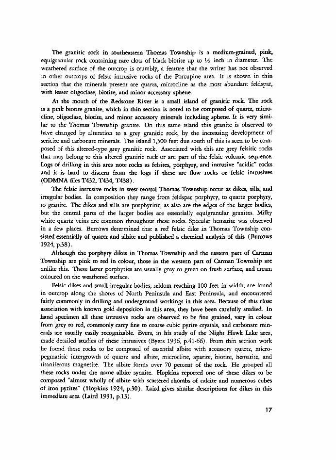
The granitic rock in southeastern Thomas Township is a medium-grained, pink, equigranular rock containing rare clots of black biotite up to Yi inch in diameter. The weathered surface of the outcrop is crumbly, a feature that the writer has not observed in other outcrops of felsic intrusive rocks of the Porcupine area. It is shown in thin section that the minerals present are quartz, microcline as the most abundant feldspar, with lesser oligoclase, biotite, and minor accessory sphene.
At the mouth of the Redstone River is a small island of granitic rock. The rock is a pink biotite granite, which in thin section is noted to be composed of quartz, microcline, oligoclase, biotite, and minor accessory minerals including sphene. It is very similar to the Thomas Township granite. On this same island this granite is observed to have changed by alteration to a grey granitic rock, by the increasing development of sericite and carbonate minerals. The island 1,500 feet due south of this is seen to be composed of this altered-type grey granitic rock. Associated with this are grey felsitic rocks that may belong to this altered granitic rock or are part of the felsic volcanic sequence. Logs of drilling in this area note rocks as felsites, porphyry, and intrusive "acidic" rocks and it is hard to discern from the logs if these are flow rocks or felsic intrusives (ODMNA files T432 , T434 , T 4 3 8 ) .
The felsic intrusive rocks in west-central Thomas Township occur as dikes, sills, and irregular bodies. In composition they range from feldspar porphyry, to quartz porphyry, to granite. The dikes and sills are porphyritic, as also are the edges of the larger bodies, but the central parts of the larger bodies are essentially equigranular granites. Milky white quartz veins are common throughout these rocks. Specular hematite was observed in a few places. Burrows determined that a red felsic dike in Thomas Township consisted essentially of quartz and albite and published a chemical analysis of this (Burrows 1924, p . 3 8 ) .
Although the porphyry dikes in Thomas Township and the eastern part of Carman Township are pink to red in colour, those in the western part of Carman Township are unlike this. These latter porphyries are usually grey to green on fresh surface, and cream coloured on the weathered surface.
Felsic dikes and small irregular bodies, seldom reaching 100 feet in width, are found in outcrop along the shores of North Peninsula and East Peninsula, and encountered fairly commonly in drilling and underground workings in this area. Because of this close association with known gold deposition in this area, they have been carefully studied. In hand specimen all these intrusive rocks are observed to be fine grained, vary in colour from grey to red, commonly carry fine to coarse cubic pyrite crystals, and carbonate minerals are usually easily recognizable. Byers, in his study of the Night Hawk Lake area, made detailed studies of these intrusives (Byers 1936, p .4 l -66) . From thin section work he found these rocks to be composed of essential albite with accessory quartz, micro-pegmatitic intergrowth of quartz and albite, microcline, apatite, biotite, hematite, and titaniferous magnetite. The albite forms over 70 percent of the rock. He grouped all these rocks under the name albite syenite. Hopkins reported one of these dikes to be composed "almost wholly of albite with scattered rhombs of calcite and numerous cubes of iron pyrites" (Hopkins 1924, p . 3 0 ) . Laird gives similar descriptions for dikes in this immediate area (Laird 1931, p. 13) .
17

Night H A W K L A K E A R E A
Extremely Altered Rocks and Carbonatized Rocks
A large lens-shaped mass of strongly altered and schistose rocks occurs in the northern part of the Night Hawk Lake area, adjacent to the southern side of the Destor-Porcupine Fault zone. These rocks vary in colour from dark green to light green, are very soft, are laced with veins of milky white quartz and rusty weathering white carbonates, and in many places are strongly foliated. Rock types included here are chlorite-carbonate schist, talcose chlorite-carbonate schist, chlorite-sericite-quartz schist, carbonatized rocks, rocks that have been called serpentine schist in drill logs, all of which seem to grade from one to the other. In the area of Squaw Island, original tuffaceous or sedimentary banding is evident, along with intercalated mafic volcanic flows and these rocks probably belong to the same rock sequence as that in western Cody Township; along the eastern shore of North Peninsula original pillow structures are still discernible in places and most of these rocks probably belong to the mafic volcanic sequence that covers most of the Night Hawk Lake area. It is difficult to place exact boundaries on a rock grouping of this nature because it grades gradually into the unaltered equivalents.
In the past, most of this large area of rocks has been described as probably derived from ultramafic rocks such as periodite (see Hopkins 1924, p.28, 29 ; Ginn et al. 1 9 6 4 ) . This does not seem to be the case, although there are bodies of serpentinized peridotite intruding these rocks that undoubtedly have had an effect on them.
A. R. Byers has carried out very detailed studies on the rocks of the north-central part of the Night Hawk Lake area (Byers 1936; 1940; 1941 ; 1 9 4 8 ) . He concluded that an albite-epidote-chlorite regional metamorphism or "upper low" grade zone had been followed by intense hydrothermal alteration that had produced large bodies of carbonatized rocks. The carbonates are ankerite, calcite, dolomite, and possibly some magnesite. Other common minerals in these rocks are sericite grading to fuchsite, pyrite, chlorite, quartz, albite, and leucoxene (Byers 1936, p .93-113) . His field observations produced the following facts (Byers 1936, p . 1 0 3 - 1 0 7 ) :
1. CARBONATIZATION OCCURS ONLY IN THE AREAS INTRUDED BY THE ALBITE-SYENITE AND ALBITE-SYENITE PORPHYRY DIKES.
2 . ALL THE ROCKS IN THE AREA HAVE SUFFERED THIS COMPLETE CARBONATIZATION IN ONE PLACE OR ANOTHER, WITH THE EXCEPTION OF THE DIABASE DIKES.
3 . THE CARBONATE IS NOT CONFINED TO ANY ONE TYPE OF ROCK BUT CUTS ACROSS BEDDING, FLOW AND INTRUSIVE CONTACTS.
4 . THE ROCK MAY BE COMPLETELY CARBONATIZED WHETHER SHEARED OR UNSHEARED, ALTHOUGH IT IS MORE COMMONLY ALTERED ALONG SHEAR ZONES.
5 . THE ANKERITIZATION OF NON-SHEARED ROCKS GENERALLY COMMENCES ALONG JOINTS AND CRACKS, ALONG WHICH NARROW ZONES OF ALTERATION OCCUR. AS THE JOINTS BECOME MORE NUMEROUS THE ALTERATION ZONES BECOME WIDER, UNTIL THE ENTIRE ROCK IS ALTERED. THE JOINTS MAY OR MAY NOT CONTAIN QUARTZ. IN THE CASE OF PILLOWED FLOWS THE ALTERATION TAKES PLACE FIRST AROUND THE CHILLED MARGIN OF THE PILLOWS.
6 . THE ORIGINAL ROCKS MAINTAIN THEIR MAJOR STRUCTURES EVEN IN THE HIGHEST TYPE OF ALTERATION, SO THAT THERE IS NO DOUBT OF THEIR ORIGINAL NATURE.
7. WHERE THE ACID [FELSIC] INTRUSIVES CUT THE ANKERITIZED ROCKS THERE ARE TWO CASES: (A) THE DIKE MAY BE COMPLETELY UNCARBONATIZED OR ONLY SLIGHTLY ALTERED ALONG THE EDGES. (B) THE DIKE MAY B E CARBONATIZED ALONG THE MARGINS, THE ALTERATION DECREASING IN
INTENSITY TOWARD THE CENTRE OF THE DIKE.
8. IN CASES WHERE THE ANKERITIZATION APPEARS TO BE ASSOCIATED WITH ACID [FELSIC] INTRUSIVES, THE COUNTRY ROCK IS MORE HIGHLY ALTERED ON THE FOOTWALL SIDE OF THE INTRUSIVE. THIS IS WELL SHOWN ON GOLD ISLAND AND ON THE MAINLAND DIRECTLY WEST OF ANNIVERSARY ISLAND. IN
1 8
BOTH CASES THE DIKES DIP SOUTH AND THE INTRUDED ROCK IS MORE HIGHLY ALTERED ON THE NORTH SIDE OF THE DIKES. THIS RELATIONSHIP WAS ALSO OBSERVED IN SEVERAL DRILL HOLES IN WHICH THE ATTITUDE OF THE DIKES CUT WAS KNOWN.
9 . THE ROCK MAY BE CARBONATIZED WITHOUT BEING CUT BY QUARTZ VEINS.
1 0 . GENERALLY THE MORE HIGHLY ALTERED PLACES CONTAIN MORE QUARTZ VEINS THAN THE LESS ALTERED ROCK.
1 1 . QUARTZ VEINS CROSS DIKE CONTACTS BUT BECOME NARROWER AND LESS PERSISTENT ON ENTERING THE DIKE ROCK.
1 2 . THE QUARTZ VEINS THAT CUT THE CARBONATIZED PORTION OF A ROCK MAY CONTINUE ON INTO RELATIVELY UNALTERED PORTIONS OF THE SAME ROCK.
1 3 . THE TYPICAL FUCHSITE ALTERATION IS CLOSELY ASSOCIATED WITH THE WHITE QUARTZ VEINS THAT CUT THE ANKERITIZED ROCKS. ON CALLINAN ISLAND A THIN QUARTZ VEIN V\ OF AN INCH IN WIDTH THAT CUTS THE CARBONATIZED ACID [FELSIC] DIKE HAS AN INTENSE FUCHSITE ZONE FOR 3 INCHES ON EITHER SIDE, WHICH GRADUALLY LESSENS FOR THE NEXT 1 0 INCHES, UNTIL ONLY THE ORDINARY CARBONATE ALTERATION REMAINS [THIS DIKE WAS NOT FOUND BY LEAHY].
1 4 . THE FUCHSITE ALTERATION ALSO OCCURS ALONG JOINTS WHICH CARRY NO QUARTZ.
From these and other observations, Byers concluded that the period of hydrothermal alteration was later than the intrusions of albite syenites and porphyries, but that they were of a common magma reservoir, and of Algoman age, (see Byers 1940, p.1011). The interested reader is referred to Byers' thesis of 1936 for more detailed descriptions.
Drilling on the properties of Roma Lake Gold Mines Limited (property 21 , Cody Township) and Wilwood Gold Mines Limited (properties 26 and 45 , Cody and Macklem Townships) has indicated many of these rocks as talcose chlorite-carbonate schists, but reference is made in the logs ( O D M N A files T 1 3 3 , T 1 9 3 ) , in a few places, to original bedding and fragmental characteristics indicating sedimentary or pyroclastic origins of the rocks. Paymaster (property 17 ) drill hole No. 5, in Cody Township just south of the Destor-Porcupine Fault shows a strong change in metamorphic effects progressively down the holes. At 162 feet the rock is a grey, well bedded argillite that in thin sections is seen to be composed of quartz, calcite, chlorite, biotite, hornblende, and magnetite ( O D M N A file T 2 2 8 ) . Much of the calcite seems to be primary as if the rock was originally a calcareous or limy mudstone. At 573 feet the rock is grey-green, bedding almost obscured but still evident, but the most prominent feature of the rock is the development of abundant unoriented actinolite metacrysts, up to LA inch long.
Carbonate alteration is characteristics of the outcrop on Radisson Creek, the outcrop area straddling the Macklem-Thomas township line, and also west-central Carman Township. These areas commonly display large barren white milky quartz veins and to the writer would appear to have been formed by "sweat out" of silica from the adjoining country rock.
PROTEROZOIC
Mafic Intrusive Rocks
M A T A C H E W A N - T Y P E ( ? )
Diabase dikes, either massive or porphyritic and generally striking between north and northwest, are found in the four townships. The greatest concentration of these, as seen in outcrop, is found along the western side of Cody and Carman Townships. All
1 9
Night Hawk Lake Area
OOM8540
Photo 4—Milky white, barren, ladder-like, quartz vein* in carbonatized mafic volcanic rock; southwest Carman Township.
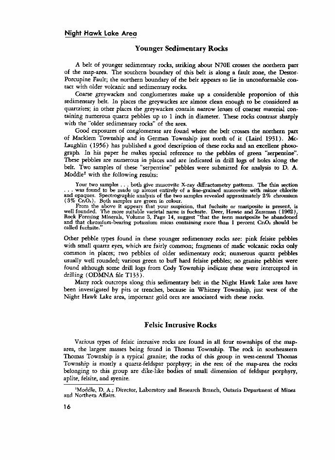
the north-south trending dikes observed were massive; the dikes trending around N 3 5 W are either massive or porphyritic.
In the map-area these dikes range in width from a few inches up to a maximum observed thickness of 220 feet. The dikes are dark to rusty brown on the weathered surface. Fresh surfaces are black and commonly show good diabasic texture. The feldspar phenocrysts of the porphyritic dikes usually are a waxy yellow-green in colour with poor crystal outlines, almost subrounded in form.
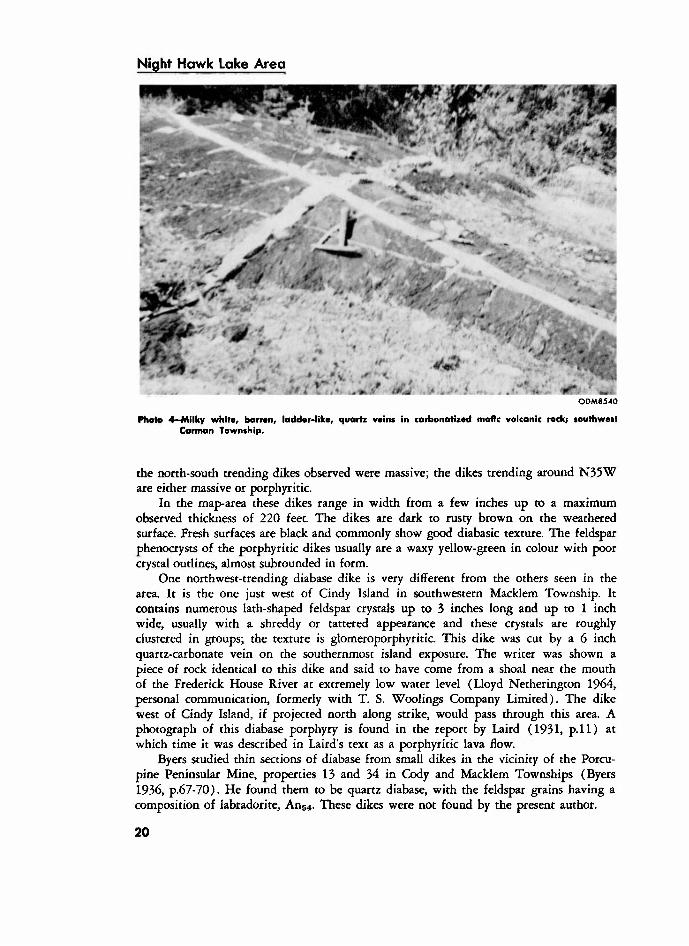
One northwest-trending diabase dike is very different from the others seen in the area. It is the one just west of Cindy Island in southwestern Macklem Township. It contains numerous lath-shaped feldspar crystals up to 3 inches long and up to 1 inch wide, usually with a shreddy or tattered appearance and these crystals are roughly clustered in groups; the texture is glomeroporphyritic. This dike was cut by a 6 inch quartz-carbonate vein on the southernmost island exposure. The writer was shown a piece of rock identical to this dike and said to have come from a shoal near the mouth of the Frederick House River at extremely low water level (Lloyd Netherington 1964, personal communication, formerly with T. S. Woolings Company Limited). The dike west of Cindy Island, if projected north along strike, would pass through this area. A photograph of this diabase porphyry is found in the report by Laird ( 1 9 3 1 , p . l l ) at which time it was described in Laird's text as a porphyritic lava flow.
Byers studied thin sections of diabase from small dikes in the vicinity of the Porcupine Peninsular Mine, properties 13 and 34 in Cody and Macklem Townships (Byers 1936, p .67-70) . He found them to be quartz diabase, with the feldspar grains having a composition of labradorite, A n 5 4 . These dikes were not found by the present author.
2 0
ODM854I
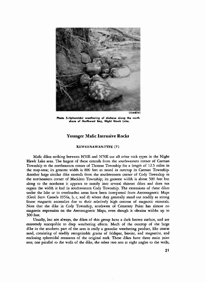
Photo 5—Spheroidal weathering of diabase along the north shore of Northwest Bay, Night Hawk Lake.
Younger Mafic Intrusive Rocks
K E W E E N A W A N - T Y P E ( ? )
Mafic dikes striking between N50E and N70E cut all other rock types in the Night Hawk Lake area. The largest of these extends from the southwestern corner of Carman Township to the northeastern corner of Thomas Township for a length of 12.5 miles in the map-area; its greatest width is 800 feet as noted in outcrop in Carman Township. Another large similar dike extends from the southwestern corner of Cody Township to the northeastern corner of Macklem Township; its greatest width is about 500 feet but along to the northeast it appears to tamify into several thinner dikes and does not regain the width it had in southwestern Cody Township. The extensions of these dikes under the lake or in overburden areas have been interpreted from Aeromagnetic Maps (Geol. Surv. Canada 1956a, b, c, and d) where they generally stand out readily as strong linear magnetic anomalies due to their relatively high content of magnetic minerals. Note that the dike in Cody Township, southwest of Cemetery Point has almost no magnetic expression on the Aeromagnetic Maps, even though it obtains widths up to 300 feet.
Usually, but not always, the dikes of this group have a dark brown surface, and are extremely susceptible to deep weathering effects. Much of the outcrop of the large dike in the southern part of the area is really a granular weathering product, like coarse sand, consisting of readily recognizable grains of feldspar, biotite, and magnetite, and enclosing spheroidal remnants of the original rock. These dikes have three main joint sets; one parallel to the walls of the dike, the other two sets at right angles to the walls,
2 1
Night H a w k L a k e A r e a
producing a rectangular jointing pattern; deep weathering in these joints produces the granular material enclosing harder spheroidal remnants. Where these dikes outcrop along the shore of Night Hawk Lake there is a tendency for wave action to remove the granular material and leave the remnants as an accumulation of rounded boulders along the shore. Also in these places, if there are logs along the shore, they act as a natural "riffle box" when the waves pass over them and large quantities of magnetite are separated out producing black sand beaches. This phenomenon is particularly noticeable along the northern shore of Northeast Bay.
The mineralogical composition of these dikes in the Night Hawk Lake area has been discussed by earlier workers in the area. Berry noted that the large dike in Carman and Thomas Townships has a central section of olivine gabbro although the outer margins are olivine diabase (Berry 1940, p.9). Laird noted that these dikes consist of olivine, plagioclase, and augite, with the olivine altered to magnetite and serpentine (Laird 1931, p. 16) . Hopkins noted that the dike on the northern shore of Northeast Bay is an olivine diabase (Hopkins 1924, p.31). The writer examined thin sections from two northeasterly trending dikes in the Night Hawk Lake area. The dike on the northern shore of Northeast Bay was observed in thin section to be an olivine-rkh rock and with plagioclase in the labradorite range. The other dike studied in thin section occurs in southwestern Carman Township, approximately 3,000 feet south of the large dike, and extends southwesterly into Langmuir Township. It appears in thin section to be a quartz-bearing diabase, the quartz content being less than 1 percent of the rock, and the main feldspar determined as labradorite. The pyroxene was identified as augite. From this it would appear that the northeasterly trending dikes can be either olivine diabase or quartz-bearing diabase. Kay did thin section work and analyses of samples of diabase in the Poplar Point area (Kay 1904, p. 117) . One was an olivine-rich diabase and the other was quartz bearing.
If all the northeasterly trending dikes in the Night Hawk Lake area are of approximately the same age they appear to be younger than the northerly trending diabase dikes. In southwestern Carman Township where the two dike trends intersect, the northeasterly dikes definitely cut through the northerly trending dikes. Ferguson discusses the age problem in his report of Tisdale Township (Ferguson 1968, p .4 l -43) .
C E N O Z O I C
Pleistocene
Of the 144 square miles of the Night Hawk Lake area, approximately 38 square miles are water covered, approximately 9 square miles are rock outcrop area and the rest, approximately 97 square miles, is covered by overburden of Pleistocene age. Drilling information indicates this overburden to reach thicknesses up to 300 feet in the northeastern part of the area, but this is exceptional.
One of the most noticeable features observed when travelling along the shore of Night Hawk Lake is the steep banks of layered or varved clays. On the exposed faces the clays are seen to consist of alternating bands or layers of dark brown clayey material and creamy buff silty material. The dark layers are usually thicker. The brown and buff
2 2
ODMS542
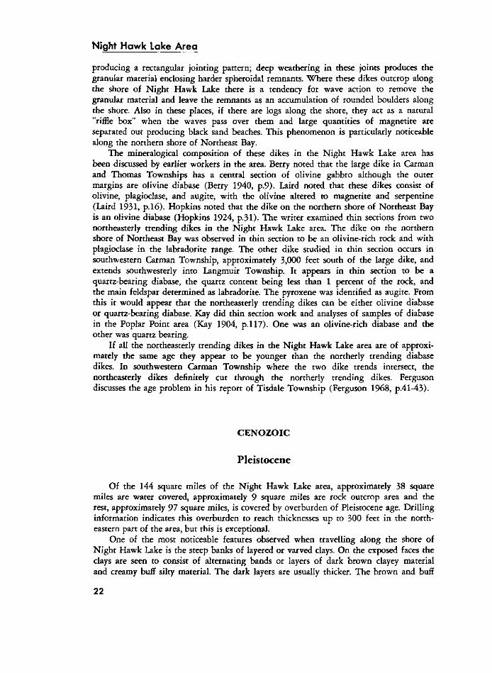
Photo 6-Glacial striao on island In Night Hawk Lake, Macklem Township.
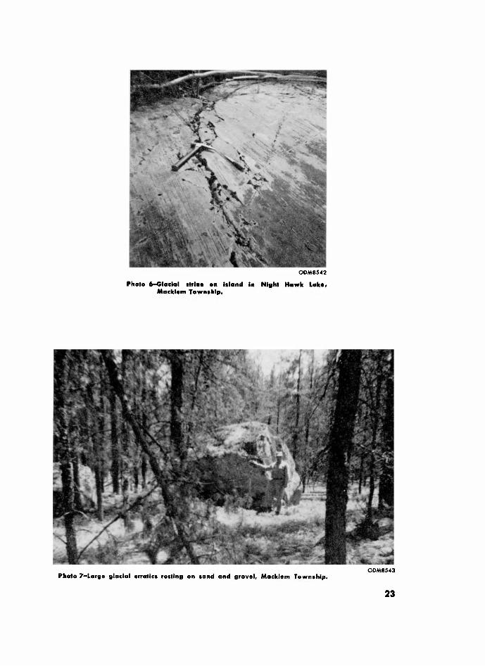
ODM6543 Photo 7-Large glacial erratics resting on sand and gravel, Macklem Township.
2 3
Night Howk Lake Area
OMM544
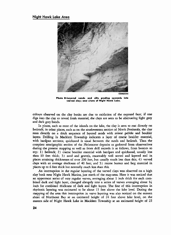
Photo (- layered sand* and tilts grading upwards Into varved clay; oast shore of Night Hawk Lake.
colours observed on the day banks are due to oxidation of the exposed face; if one digs into the clay to reveal fresh material, the clays are seen to be alternating light grey and dark grey bands.
In places, such as most of the islands on the lake, the clay is seen to rest directly on bedrock; in other places, such as on the southwestern section of North Peninsula, the clay rests directly on a thick sequence of layered sands with minor pebble and boulder layers. Drilling in Macklem Township indicates a layer of coarse boulder material, with hardpan sections; quicksand is usual between the sands and bedrock. Thus the complete srratigraphic section of the Pleistocene deposits as gathered from observations during the present mapping as well as from drill records is as follows, from bottom to top: 1 ) bedrock; 2 ) coarse boulder material with hardpan and quicksand, usually less than 10 feet thick; 3 ) sand and gravels, reasonably well sorted and layered and in places attaining thicknesses of over 200 feet, but usually much less than this; 4 ) varved clays with an average thickness of 40 feet; and 5 ) recent humus and bog material in places up to 6 feet thick but normally much less than this.
An interruption in the regular layering of the varved clays was observed on a high clay bank near Night Hawk Marina, just north of the map-area. Here ir was noticed that an uppermost series of very regular varves, averaging about 1 inch thick for each combined dark and light layer, changed abruptly into a series of varves averaging about VA inch for combined thickness of dark and light layers. The line o f this interruption in rhythmic layering was estimated to be about 15 feet above the lake level. During the mapping of the area this interruption in varve layering was also noticed on the eastern shore of Northeast Bay at an estimated height of 24 feet above lake level, on the eastern side of Night Hawk Lake in Macklem Township at an estimated height of 22
2 4
ODM8545
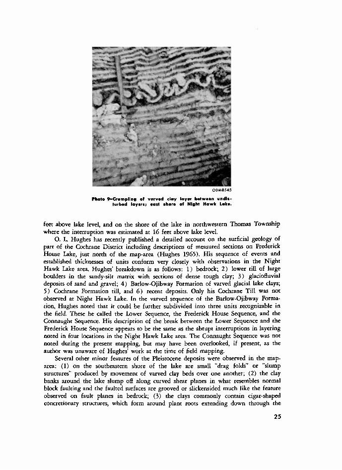
PHOTO 9-CRUMPLING OF VARVOD CLAY LAYER BETWEEN UNDISTURBED LAYERS; OAST (HERO OF NIGHT HAWK LAKE.
feet above lake level, and on the shore of the lake in northwestern Thomas Township where the interruption was estimated at 16 feet above lake level.
O. L. Hughes has recently published a detailed account on the surficial geology of part of the Cochrane District including descriptions of measured sections on Frederick House Lake, just north of the map-area (Hughes 1965) . His sequence of events and established thicknesses of units conform very closely with observations in the Night Hawk Lake area. Hughes' breakdown is as follows: 1 ) bedrock; 2 ) lower till of large boulders in the sandy-silt matrix with sections of dense tough clay; 3 ) glaciofluvial deposits of sand and gravel; 4 ) Barlow-Ojibway Formation of varved glacial lake clays; 5 ) Cochrane Formation till, and 6 ) recent deposits. Only his Cochrane Till was not observed at Night Hawk Lake. In the varved sequence of the Barlow-Ojibway Formation, Hughes noted that it could be further subdivided into three units recognizable in the field. These he called the Lower Sequence, the Frederick House Sequence, and the Connaught Sequence. His description of the break between the Lower Sequence and the Frederick House Sequence appears to be the same as the abrupt interruptions in layering noted in four locations in the Night Hawk Lake area. The Connaught Sequence was not noted during the present mapping, but may have been overlooked, if present, as the author was unaware of Hughes' work at the time of field mapping.
Several other minor features of the Pleistocene deposits were observed in the map-area: (1) on the southeastern shore of the lake are small "drag folds" or "slump structures" produced by movement of varved clay beds over one another; (2) the clay banks around the lake slump off along cutved shear planes in what resembles normal block faulting and the faulted surfaces are grooved or slickensided much like the feature observed on fault planes in bedrock; (3) the clays commonly contain cigar-shaped concretionary structures, which form around plant roots extending down through the
2 5
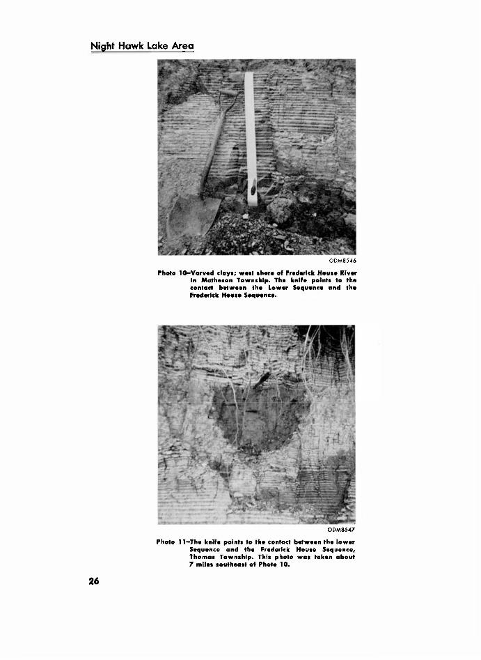
Night Hawk Lake Area
ODM8546
Phalo 10-VARVOD clays; wait thore of FREDERICK Horn* River in Motheson Township. The knife points to the contact between the Lower Sequence and the Frederick House Sequence.
ODM8547
Photo 11 -The knife points to the contact between the lower Sequence and the Frederick House Sequence, Thomas Township. This photo was taken about 7 miles southeast of Photo 10.
2 6
clay and upon erosion of the clays, these concretions are left in small accumulations along the shore; and (4) erratic boulders in places over 10 feet in diameter are common in the sand and gravel ridge extending down the eastern side of Macklem Township, and presumably were brought to their present locations by ice rafting.
Laird (1931 , p.16-19) gives a good description, with photographs, of many features of the Pleistocene deposits of the area.
P L E I S T O C E N E H I S T O R Y
The Night Hawk Lake area was overridden by a continental ice sheet during the Pleistocene Period. Glacial striae indicate the last ice movement over the Night Hawk Lake area was in a direction just east of south; this probably reflects the "Wisconsin Stage of glaciation. The bedrock was worn down and sculptured by the advancing ice and in places a thin boulder-clay till was laid down on the bedrock. Upon warming of the climate the glaciers retreated by melting and in places meltwater rivers formed in the ice. In the channels of these rivers great thicknesses of well sorted sand and gravels were laid down, such as that seen in Macklem Township (see Figure 2 ) . As the ice melted back a large glacial lake was forming along its front; this former lake is called Lake Barlow-Ojibway. Sediments were deposited in the lake in the form of varved clays that covered over most of the bedrock and at least partly covered the flanks of the thick sand and gravel deposits left by the former meltwater rivers. Hughes infers that each dark and light varve pair represent one year's deposition in Lake Barlow-Ojibway (Hughes 1965, p.559). He also calculated that the rate of retreat of the ice sheet was approximately 748 feet per year in this general area (Hughes 1965, p .56 l ) .
Hughes has published two maps of surficial geology that take in parts of the Night Hawk Lake area (Hughes 1960a and b) . More recently, A. N. Boissonneau, working for the Ontario Department of Lands and Forests, has published a map of surficial geology, which includes the Night Hawk Lake area (Boissonneau 1965) , and also a report on the glacial history of the region (Boissonneau 1966) .
E C O N O M I C C O N S I D E R A T I O N S
The sands and gravels in eastern Macklem Township are suited for construction uses but there are large gravel pits just north of the area that supply immediate demands. One small gravel pit exists a Yi mile southeast of Legare Lake but is now in disuse.
The clays have been tested for their economic potential. A sample of clay at a depth of 25 feet below surface, from the old Aquarius shaft, was submitted by N. Hogg, former Resident Geologist at Timmins, in 1946, to the Department of Mines and Resources, Ottawa, for testing. The following is taken directly from the report of the test (ODMNA file T 7 ) :
The clay is highly calcareous and requires 26.8% water for plasticity. When mixed with water it is very plastic and works well but cracks badly when dried at 85 °C. This clay has a softening point of Cone 3 (2093°F). Briquettes were made from the clay and fired to Cone 06 and Cone 03. The briquettes were of very poor colour and badly scummed.
Due to its highly calcareous nature, tendency to crack on drying, poor fired colour and short firing range this clay is not recommended as a material for brick making.
2 7
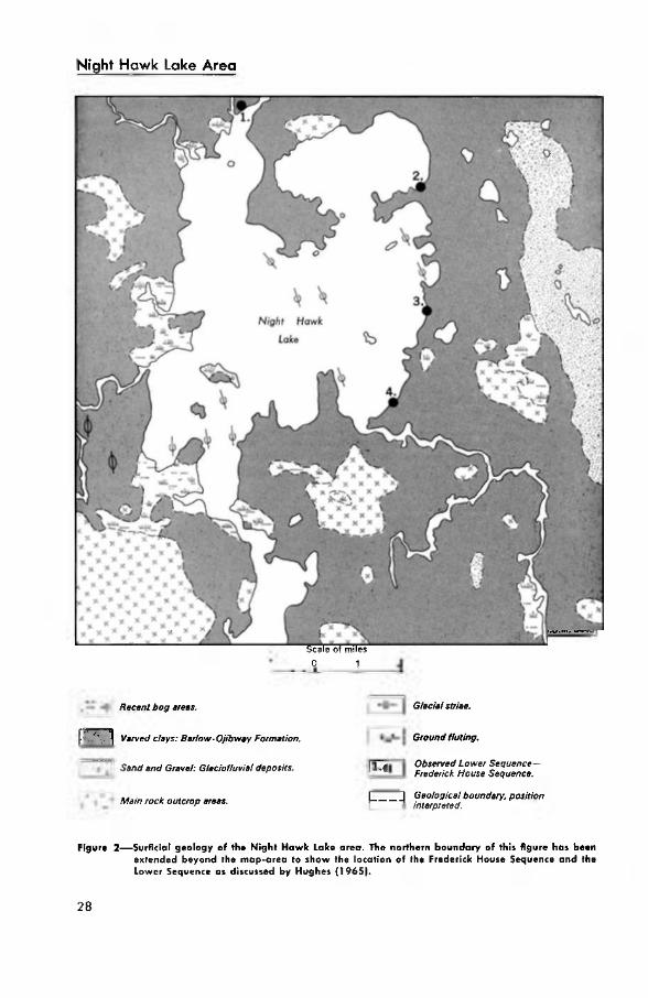
Night Hawk Lake Area
O.D.M. 6443
SCALE OF MILES 0 1
Recent bog areas.
| \ Varved clays: Barlow-OJibway Formation.
Sand and Gravel: Glaciolluvial deposits.
Main rock outcrop areas.
i
Glacial striae.
Ground fluting.
Observed Lower Sequence-Frederick House Sequence.
| | Geological boundary, position interpreted.
FIGURE 2—SURFLCIAL GEOLOGY OF THE NIGHT HAWK LAKE AREA. THE NORTHERN BOUNDARY OF THIS FIGURE HAS BEEN EXTENDED BEYOND THE MAP-AREA TO SHOW THE LOCATION OF THE FREDERICK HOUSE SEQUENCE AND THE LOWER SEQUENCE AS DISCUSSED BY HUGHES ( 1 9 6 5 ) .
2 8
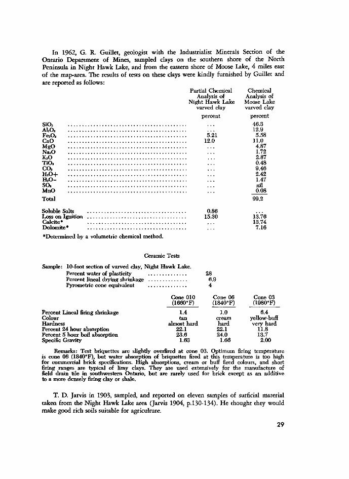
In 1962, G. R . Guillet, geologist with the Industrialist Minerals Section of the Ontario Department of Mines, sampled clays on the southern shore of the North Peninsula in Night Hawk Lake, and from the eastern shore of Moose Lake, 4 miles east of the map-area. The results of tests on these clays were kindly furnished by Guillet and are reported as follows:
PARTIAL CHEMICAL CHEMICAL ANALYSIS OF ANALYSIS OF
NIGHT HAWK LAKE MOOSE LAKE VARVED CLAY VARVED CLAY
PERCENT PERCENT
S I 0 2 . . . 4 6 . 3 ALOS . . . 1 2 . 9 F E 2 O S 5 . 2 1 5 . 5 8 CAO 1 2 . 0 1 1 . 0 MGO . . . 4 . 8 7 NA*0 . . . 1 . 7 2 K * 0 . . . 2 . 8 7 TIO* . . . 0 . 4 8 CO* . . . 9 . 4 6 H 2 0 + . . . 2 . 4 2 H . O - . . . 1 . 47 SO* . . . NIL MNO . . . 0 . 0 8
TOTAL 9 9 . 2
SOLUBLE SALTS 0 . 8 6 LOSS ON IGNITION 1 5 . 3 0 1 3 . 7 6 CALCITE* . . . 1 3 . 7 4 DOLOMITE* . . . 7 . 1 6
•DETERMINED BY A VOLUMETRIC CHEMICAL METHOD.
CERAMIC TESTS
SAMPLE: 10-FOOT SECTION OF VARVED CLAY, NIGHT HAWK LAKE. PERCENT WATER OF PLASTICITY 2 8 PERCENT LINEAL DRYING SHRINKAGE 6 . 9 PYROMETRIC CONE EQUIVALENT 4
CONE 0 1 0 CONE 0 6 CONE 0 3 ( 1 6 6 0 ° F ) ( 1 8 4 0 ° F ) ( 1 9 8 0 ° F )
PERCENT LINEAL FIRING SHRINKAGE 1 .4 1 .0 6 . 4 COLOUR TAN CREAM YELLOW-BUFF HARDNESS ALMOST HARD HARD VERY HARD PERCENT 2 4 HOUR ABSORPTION 2 2 . 1 2 2 . 1 1 1 . 8 PERCENT 5 HOUR BOIL ABSORPTION 2 3 . 6 2 4 . 0 1 3 . 7 SPECIFIC GRAVITY 1 . 6 3 1 . 6 6 2 . 0 0
REMARKS: TEST BRIQUETTES ARE SLIGHTLY OVERFIRED AT CONE 0 3 . OPTIMUM FIRING TEMPERATURE IS CONE 0 6 ( 1 8 4 0 ° F ) , BUT WATER ABSORPTION OF BRIQUETTES FIRED AT THIS TEMPERATURE IS TOO HIGH FOR COMMERCIAL BRICK SPECIFICATIONS. HIGH ABSORPTIONS, CREAM OR BUFF FIRED COLOURS, AND SHORT FIRING RANGES ARE TYPICAL OF LIMY CLAYS. THEY ARE USED EXTENSIVELY FOR THE MANUFACTURE OF FIELD DRAIN TILE IN SOUTHWESTERN ONTARIO, BUT ARE RARELY USED FOR BRICK EXCEPT AS AN ADDITIVE TO A MORE DENSELY FIRING CLAY OR SHALE.
T. D. Jarvis in 1903, sampled, and reported on eleven samples of surficial material taken from the Night Hawk Lake area (Jarvis 1904, p .130-134). He thought they would make good rich soils suitable for agriculture.
2 9
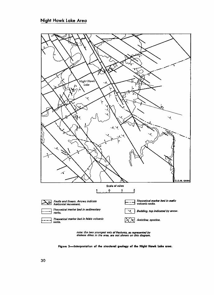
NIGHT H A W K L A K E A R E A
SCALE OF MILES
N ^ ^ J Faults and linears. Arrows indicate ^ X 5 ! horizontal movement.
] Theoretical marker bed in sedimentary "1 rocks.
I Theoretical marker bed in felsic volcanic J rocks.
Theoretical marker bed in mafic volcanic rocks.
Bedding, top indicated by arrow.
/^J^ Anticline; syncline.
note: the two youngest sets of fractures, as represented by diabase dikes in the area, are not shown on this diagram.
Figure 3—Interpretation of the structural geology of the Night Hawk Lake area.
3 0
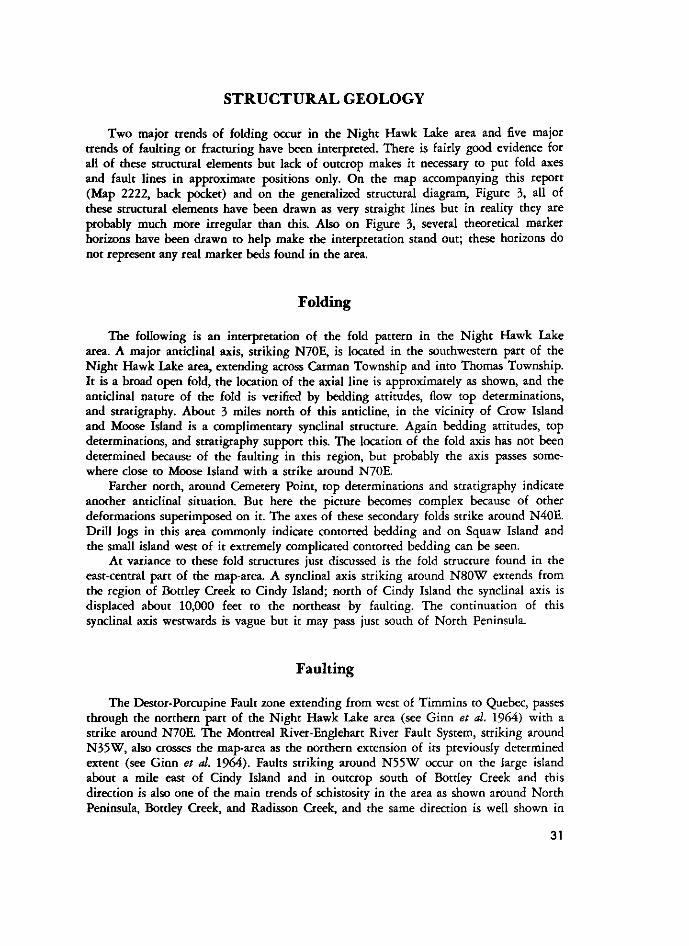
STRUCTURAL GEOLOGY
Two major trends of folding occur in the Night Hawk Lake area and five major trends of faulting or fracturing have been interpreted. There is fairly good evidence for all of these structural elements but lack of outcrop makes it necessary to put fold axes and fault lines in approximate positions only. On the map accompanying this report (Map 2222, back pocket) and on the generalized structural diagram, Figure 3, all of these structural elements have been drawn as very straight lines but in reality they are probably much more irregular than this. Also on Figure 3, several theoretical marker horizons have been drawn to help make the interpretation stand out; these horizons do not represent any real marker beds found in the area.
Folding
The following is an interpretation of the fold pattern in the Night Hawk Lake area. A major anticlinal axis, striking N70E, is located in the southwestern part of the Night Hawk Lake area, extending across Carman Township and into Thomas Township. It is a broad open fold, the location of the axial line is approximately as shown, and the anticlinal nature of the fold is verified by bedding attitudes, flow top determinations, and stratigraphy. About 3 miles north of this anticline, in the vicinity of Crow Island and Moose Island is a complimentary synclinal structure. Again bedding attitudes, top determinations, and stratigraphy support this. The location of the fold axis has not been determined because of the faulting in this region, but probably the axis passes somewhere close to Moose Island with a strike around N70E.
Farther north, around Cemetery Point, top determinations and stratigraphy indicate another anticlinal situation. But here the picture becomes complex because of other deformations superimposed on it. The axes of these secondary folds strike around N40E. Drill logs in this area commonly indicate contorted bedding and on Squaw Island and the small island west of it extremely complicated contorted bedding can be seen.
At variance to these fold structures just discussed is the fold structure found in the east-central part of the map-area. A synclinal axis striking around N 8 0 W extends from the region of Bottley Creek to Cindy Island; north of Cindy Island the synclinal axis is displaced about 10,000 feet to the northeast by faulting. The continuation of this synclinal axis westwards is vague but it may pass just south of North Peninsula.
Faulting
The Destor-Porcupine Fault zone extending from west of Timmins to Quebec, passes through the northern part of the Night Hawk Lake area (see Ginn et al. 1964) with a strike around N70E. The Montreal River-Englehart River Fault System, striking around N 3 5 W , also crosses the map-area as the northern extension of its previously determined extent (see Ginn et al. 1964) . Faults striking around N 5 5 W occur on the large island about a mile east of Cindy Island and in outcrop south of Bottley Creek and this direction is also one of the main trends of schistosity in the area as shown around North Peninsula, Bottley Creek, and Radisson Creek, and the same direction is well shown in
3 1
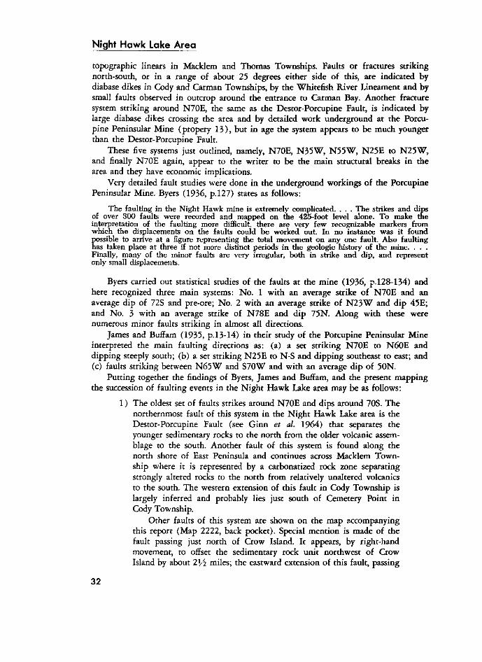
Night Hawk Lake Area topographic linears in Macklem and Thomas Townships. Faults or fractures striking north-south, or in a range of about 25 degrees either side of this, are indicated by diabase dikes in Cody and Carman Townships, by the Whitefish River Lineament and by small faults observed in outcrop around the entrance to Carman Bay. Another fracture system striking around N70E, the same as the Destor-Porcupine Fault, is indicated by large diabase dikes crossing the area and by detailed work underground at the Porcupine Peninsular Mine (propery 1 3 ) , but in age the system appears to be much younger than the Destor-Porcupine Fault.
These five systems just outlined, namely, N70E, N 3 5 W , N 5 5 W , N 2 5 E to N 2 5 W , and finally N 7 0 E again, appear to the writer to be the main structural breaks in the area and they have economic implications.
Very detailed fault studies were done in the underground workings of the Porcupine Peninsular Mine. Byers (1936, p.127) states as follows:
THE FAULTING IN THE NIGHT HAWK MINE IS EXTREMELY COMPLICATED. . . . THE STRIKES AND DIPS OF OVER 3 0 0 FAULTS WERE RECORDED AND MAPPED ON THE 425-FOOT LEVEL ALONE. TO MAKE THE INTERPRETATION OF THE FAULTING MORE DIFFICULT, THERE ARE VERY FEW RECOGNIZABLE MARKERS FROM WHICH THE DISPLACEMENTS ON THE FAULTS COULD B E WORKED OUT. IN NO INSTANCE WAS IT FOUND POSSIBLE TO ARRIVE AT A FIGURE REPRESENTING THE TOTAL MOVEMENT ON ANY ONE FAULT. ALSO FAULTING HAS TAKEN PLACE AT THREE IF NOT MORE DISTINCT PERIODS IN THE GEOLOGIC HISTORY OF THE MINE. . . . FINALLY, MANY OF THE MINOR FAULTS ARE VERY IRREGULAR, BOTH IN STRIKE AND DIP, AND REPRESENT ONLY SMALL DISPLACEMENTS.
Byers carried out statistical studies of the faults at the mine (1936, p.128-134) and here recognized three main systems: No. 1 with an average strike of N 7 0 E and an average dip of 72S and pre-ore; No. 2 with an average strike of N 2 3 W and dip 4 5 E ; and No. 3 with an average strike of N 7 8 E and dip 75N. Along with these were numerous minor faults striking in almost all directions.
James and BufFam (1935, p. 13-14) in their study of the Porcupine Peninsular Mine interpreted the main faulting directions as: (a) a set striking N 7 0 E to N 6 0 E and dipping steeply south; (b) a set striking N 2 5 E to N-S and dipping southeast to east; and (c) faults striking between N 6 5 W and S 7 0 W and with an average dip of 50N.
Putting together the findings of Byers, James and Buffam, and the present mapping the succession of faulting events in the Night Hawk Lake area may be as follows:
1 ) The oldest set of faults strikes around N 7 0 E and dips around 70S. The northernmost fault of this system in the Night Hawk Lake area is the Destor-Porcupine Fault (see Ginn et al. 1964) that separates the younger sedimentary rocks to the north from the older volcanic assemblage to the south. Another fault of this system is found along the north shore of East Peninsula and continues across Macklem Township where it is represented by a carbonatized rock zone separating strongly altered rocks to the north from relatively unaltered volcanics to the south. The western extension of this fault in Cody Township is largely inferred and probably lies just south of Cemetery Point in Cody Township.
Other faults of this system are shown on the map accompanying this report (Map 2222, back pocket). Special mention is made of the fault passing just north of Crow Island. It appears, by right-hand movement, to offset the sedimentary rock unit northwest of Crow Island by about 2Vi miles; the eastward extension of this fault, passing
3 2
just north of Cindy Island, offsets a synclinal structure about 2 miles in a right hand movement also (see Figure 3) .
The southernmost fault of this system is located in south-central Carman Township passing through the large body of ultramafic rocks, approximately Yi mile north of the Carman-Langmuir township line. It is quite probable that the eastern extension of this fault passes somewhere along McLeod Creek in Thomas Township but it has not been shown on Map 2222 (back pocket).
2 ) Faults striking around N 5 5 W may be approximately contemporaneous with the first set described. They are similar to the first set in that they are characterized by strong shear zones, which have been impregnated by much quartz and carbonate, usually accompanied by such minerals as tourmaline, axinite, fuchsite, and gold (shear zones are not shown on Map 2222, back pocket).
On the map accompanying this report (Map 2222, back pocket) the writer has strongly emphasized these first two fault sets by indicating many of them, often with little supporting evidence other than shearing or topographic linears. This is because the writer believes these two fault directions are pre-gold mineralization and some of these have served as loci of deposition for gold-bearing solutions. The remaining three faulting directions appear to be post-gold mineralization and are economically important only in that they make exploration more difficult and costly.
3 ) The faulting in a direction of around N 3 5 W appears to be the next major faulting direction in the area. It offsets the first faulting and all the major rock units of the area. Northwest-trending diabase dikes occupy parts of this fault system. This is the system that is parallel to and part of the Montreal River-Englehart River System (see Ginn et al. 1964) .
4 ) The next youngest faulting direction appears to be roughly north-south but including a range from about 25E to 2 5 W of north. Diabase dikes filling parts of this system pass through the northwest system as shown in southwestern Carman Township. Displacements along this system are of small order in the Night Hawk Lake area. The Whitefish River Lineament in Thomas Township probably belongs in this system.
5 ) The youngest faulting and fracture system is almost parallel to the first system but these faults generally dip to the north. This system includes the youngest faults as worked out by Byers (1936) and James and Buff am (1935) and it is probably this system that is represented by the large northeast-trending, usually olivine-bearing, diabase dikes of the area. This would explain why there appears to be little offsetting of these large diabase dikes although the adjacent and almost parallel system, as represented by the Destor-Porcupine Fault has large offsets on it. For this last system James and Buffam (1935) included faults striking in a range from N 7 0 E to S65E; this range would take in the strikes of the late diabase dikes and their apophyses.
Night Hawk Lake Area
Finally, there has probably been recurrent movement along some of these faults, especially the system striking around N 3 5 W . This is evidenced by a displacement of the olivine diabase dike crossing Carman Bay and by similar faulting in Paleozoic sedimentary rocks near New Liskeard (see Ginn et al. 1964) .
Unconformity
The younger belt of sedimentary rocks (Timiskaming?), crossing the northern part of the area, appears to overlie the volcanic rocks unconformably. Ferguson (1968, p.32-33) describes this unconformity in Tisdale Township. In the Night Hawk Lake area, the few top determinations made in these sedimentary rocks indicate this whole belt of rocks faces south. In northwestern Cody Township, these sedimentary rocks lie in contact, on their north side, with north-facing pillow lavas. There is no evidence of a fault through here. This would indicate that there is an unconformity here and that the pillow lavas were folded prior to the deposition of the younger sediments. The steep dips of the younger sedimentary rocks indicate them to be also folded at a later time. The field relationships would indicate that this later folding was synclinal in nature. The southern limb of this syncline has been faulted out of position by the Destor-Porcupine Fault and at the present time no trace of it has been found anywhere in the Porcupine area. Thus the rocks on the southern side of the Destor-Porcupine Fault must have been uplifted during faulting and the later erosion of this uplifted block has removed all traces of the south limb of the syncline.
ECONOMIC GEOLOGY
The Night Hawk Lake area has essentially been explored for gold because of its proximity to the Porcupine gold area. About 27,469 ounces of gold have been recovered from two properties (10 and 32, 13 and 34) on North Peninsula and some reserves of possible gold ore exist on these two properties. Other gold occurrences have been explored in all four townships. Quartz veins in the area are too numerous to show on the accompanying map (Map 2222, back pocket). Asbestos and minor base metal occurrences are also found in the area as well as sand and gravel.
The following section describes 34 currently held (1967) patented properties in the area as well as 31 properties held in the past or present, where exploration work was carried out (some of these properties have two property numbers as they extend into another township). Other companies, now mostly defunct, are known to have worked or held ground in the area but the writer has been unable to obtain information on these.
3 4
Figure 4—Sketch map showing the approximate locations of exploration areas and patented properties.
1. Anvil Porcupine 68. Armont 28. Auconda
2. Bertram Porcupine 3. Blackhawk Porcupine
29. Blackhawk Porcupine 4. 30. Broulan Reef
46. Canadian Superior 47. Carshaw Porcupine 31. Clemens 5. Cocallen Porcupine 6. Desaulnier
48. Dominion Gulf & Mespi 7. 49. Edgewater Porcupine 8. Falconbridge 9. Forsell
10. 32. Francis (Goldhawk) 11. Gagne 50. Gallagher 51. Gord 12. Hill 33. Hollinger
13, 34. Hydra (Porcupine Peninsular) 14.Inco 53. Kensull 69. Kimasca 35. Lang 36. Lang 54. LaSalle 70. Markay 37. McCoy 15. Miller 38. Minedel 16. Mining Corp. 55. Minthorn 56. Minthorn 39. Moran 71. Muir 57. Mulliette 58. Noranda 59. North 60. Payette 61. Pecore 72. Phelps-Dodge
40. Porcupine McNabb 17. Porcupine Paymaster 41. Ray 18. Redstone 19. Rio Algom 20. Rio Algom 42. Rio Algom 63. Robb 21. Roma Lake 22. 43. Ronnoco 23. Shanwell 64. Tavane 73. Thomas 65. Trio 66. United Macfie 67. Ventures 24. Wellington 25. Whitco 44. Wieland 45. Wilwood 27. Young
Notes: Properties 14, 27, 35 and 52 not indicated on map. The ruled lines shown on some properties are parallel to the grid direction used for geophysical surveys on the property. Solid lines outline patented properties; dotted lines outline exploration areas.
3 5
Night Hawk Lake Area
DESCRIPTION OF PROPERTIES
Anvil Porcupine Gold Mines Limited [1947]* (1)**
In 1947, two closely spaced groups of 6 claims and 3 claims respectively were held, by Anvil Porcupine Gold Mines Limited, in the western part of Cody Township. A magnetometer survey was undertaken on these groups and drilling was recommended, but it is not known if this drilling was ever done, ( O D M N A file T 1 8 6 ) . * * * Except for the diabase dikes on the two claim groups, magnetic readings over the property were generally low and the accompanying report ( O D M N A file T 1 8 6 ) suggests the claims to be underlain by pyroclastk rocks and sedimentary rocks.
Armont Gold Mines Limited [circa 1942] (68)
Berry (1940 , p . l l ) described this Thomas Township property as follows:
Armont Gold Mines, Limited, holds 6 patented claims (P. 17,888-17,891, 17,964, and 17,965), and 3 unsurveyed claims in Thomas township, and the north half of lot 12, concession II, and one claim in the south half of the same lot in Sheraton township. These claims were staked in 1931 and 1935. Outcrops are scarce on these claims. A few occur near Radis-son creek where it crosses the Sheraton-Thomas township line. The rocks consist of sheared and silicified Keewatin greenstone and chlorite schist. On the north half of lot 12, concession II of Sheraton township, stripping and trenching have uncovered an irregular quartz vein striking about N. 70°W. The vein has been traced about 700 feet along the strike and has a maximum width of about 1 foot. At the east end the vein contains coarse pyrite, carbonate, chlorite, and a little chalcopyrite. The greenstone wall rock is sheared and silicified. Near the Thomas-Sheraton township boundary stringers of quartz and black tourmaline and stringers of specularite were observed in the greenstone. On claim P. 17,891 a trench was dug on a 4-foot quartz-feldspar porphyry dike striking N. 55°W. The dike contains small cross-stringers of quartz with a little coarse pyrite. The wall rock is sheared and carbonatized. A picked sample of the quartz stringers in the porphyry taken by the writer gave a low assay in gold at the Provincial Assay office.
About 12 diamond-drill holes were put down to intersect the porphyry dike on claim P. 17,891, and several others were drilled to intersect the quartz vein in lot 12, concession II of Sheraton township. It is reported by the owners that no conclusive results were obtained by the diamond-drilling.
In 1923, a block of claims on this same location was known as the Trout Creek claims. Assays up to $8.20 per ton (gold at about $20.00 per ounce) were obtained (ODMNA file T 2 7 2 ) . In 1912, a claim in this same location was part of a group known as the Blanchette-Giroux group. Assays up to $10.40 per ton (gold at about $20.00 per ounce) were reported ( O D M N A file T 2 7 7 ) .
During the present survey some of the old trenching was located. Six grab samples, taken by the writer, of pyrite-bearing chlorite schist and carbonatized mafic volcanic rocks, gave the following assay results: trace, trace, trace, trace, 0.16, and 0.14 ounces of gold per ton. These assays were by the Laboratory and Research Branch of the Ontario Department of Mines and Northern Affairs.
*The date in square brackets refers to the date of the last major work. **The number in brackets refers to property number on Map 2222, back pocket. ***See Selected References for information regarding these files.
3 6
Auconda Porcupine Gold Mines Limited [1945-1946] (28)
In 1945-1946, Auconda Porcupine Gold Mines Limited held 30 claims and a water lot in Macklem Township in the area from Hand Island, in Night Hawk Lake, eastward to Tincan Lake. A northeasterly trending diabase dike and several areas, probably representing ultramafic intrusions, were outlined by a magnetometer survey; the rest o f the area was relatively uniform in magnetic expression. Ten drill holes with a combined length of 7,792 feet were put down. Four of these holes investigated a contact between metavolcanics and ultramafic rocks as outlined by the magnetometer survey; the remaining six holes investigated a 4,000-foot cross section of the metavolcanics near the lakeshore east of Hand Island. Assays from nil to 0.01 ounces gold per ton were reported ( O D M N A file T 9 ) .
Bertram Porcupine Mines Limited (2)
Bertram Porcupine Mines Limited held, in 1967, 8 patented claims in Cody Township, numbers P15034 to P15036, P15388V2, P15389K2, P20115 to P20116, and P25717. Five of these claims were held formerly by the Whitney Contact Syndicate who carried out surface work and also about 2,000 feet of drilling in the 1930s but no records are available of this. The present holder* reported that no further work has been done on these claims since that time.
The present mapping indicates these claims to be underlain by older sedimentary rocks and tuffs with intercalated mafic flows, bending around a northeasterly anticlinal axis trending diagonally across the property. Later diabase dikes trend northerly through these claims.
Black Hawk Porcupine Mines Limited [1945] (3)
In 1945, 3 drill holes, totalling 402 feet, were put down in west-central Cody Township by Black Hawk Porcupine Mines Limited. Slate and greywacke were encountered in the drilling, containing "scant pyrite, chalcopyrite, and pyrrhotite." Two assays of nil values in gold were reported (ODMNA file T 4 3 1 ) .
Black Hawk Porcupine Mines Limited [1946] (29)
In 1946, Black Hawk Porcupine Mines Limited held a group of 15 unpatented claims in southwestern Macklem Township. A magnetometer survey was carried out over the whole claim group; this survey showed little magnetic variation except for a northwesterly trending diabase dike known to occur in the southwestern corner of the group.
*Bertram Porcupine Mines Ltd.: H. Moscoe, 5 February 1965, personal communication by letter.
37
Night H a w k L a k e A r e a
Drilling was recommended but it is not known if this was ever undertaken, ( O D M N A f i l e T 4 3 9 ) .
A geological survey was also made in 1946 on a small part of the southwestern corner of the group, where the only outcrop is known to exist. The rocks were mapped as tuffs, massive lavas, and fragmentals, nearly all strongly carbonatized and sheared strongly in a northwesterly direction. Quartz carbonate stringers are common and a rusty gossan formed by weathering of iron carbonates. The geological map ( O D M N A file T 4 3 9 ) shows eight drill holes but it is not known if these were proposed or actually drilled. Some trenching was also done on this property.
Broulan Reef Mines Limited (4,30)
In the spring of 1965, Broulan Reef Mines Limited carried out a magnetometer survey, over the ice on Night Hawk Lake, of two large claim groups immediately west and east of North Peninsula in Cody and Macklem Townships.
The western group included 21 contiguous claims. Magnetic relief over this group was relatively low. Small magnetic-high areas were located at Cemetery Point, which are probably due to diabase intrusions. A very anomalously low area was located about 2,000 feet west of the western side of North Peninsula, which may indicate a felsic intru-tive body or possibly a faulted zone. No drilling is known to have been done on this group ( O D M N A file T i l 3 2 ) . The present writer believes this area to be underlain mainly by sedimentary rocks and tuffs with possible minor volcanic flows and the schisted derivatives of all these.
The eastern group consisted of 4 4 contiguous claims. Three northeasterly trending anomalous zones in the southeastern part of the map-area, as traced by the magnetometer survey, are probably indicative of diabase dikes. Several other irregularly shaped magnetic highs were located by the magnetometer survey, which are probably caused by small ultramafic intrusive bodies, and are indicated as such on the map accompanying this report (Map 2222, back pocket) .
Broulan Reef Mines Limited, also in 1965, drilled one hole each on the north shore and south shore of East Peninsula in the vicinity of the older Ronnoco Gold Mines Limited drilling on property 43 . These two holes had a combined total length of 8 7 0 feet. Another drill hole was attempted north of East Peninsula off the mouth of the creek flowing into Night Hawk Lake from Roundelay Lake; it was stopped after a vertical depth of over 200 feet in overburden had been obtained without reaching bedrock. In 1968, an 80-foot hole was drilled in mafic volcanic rocks on the small island off the southeastern shore of East Peninsula ( O D M N A file T 9 4 5 ) .
Canadian Superior Exploration Limited (46)
In 1965, Canadian Superior Exploration Limited held several blocks of claims in central Carman Township. Apparently these claim groups covered the locations of 8 airborne geophysical anomalies; groundwork follow-up, consisting of magnetometer and electromagnetic surveys, was then undertaken to investigate these anomalies.
3 8
The best conductors were located in and south of the large bay southwest of Gull Island. The conductors had strikes ranging from northeast, to southeast, to almost east-west. In 1965, these conductors were tested by four drill holes with a total combined length of 1,777 feet. The rock types encountered are variable; felsic volcanic rocks ranging from tuffs to agglomerates, rhyolite, and porphyries predominated. Associated with these were graphitic sedimentary rocks, cherty iron formation, mafic volcanic rocks, all intruded by porphyries and minor ultramafic rocks. Minor chalcopyrite along with pyrite and pyrrhotite was found. Assays and analyses were made for gold, silver, copper, lead, and zinc but all reported values were very low ( O D M N A file T 9 4 3 ) .
Another anomaly located about a mile to the southeast was drilled by one 505-foot hole in 1966. The conductor appeared to be due to shearing along the contact of felsic volcanic rocks and serpentinized peridotite ( O D M N A file T 9 4 3 ) .
Carshaw Porcupine Gold Mines Limited (47)
Carshaw Porcupine Gold Mines Limited held, in 1967, eleven patented claims in western Carman Township and four adjacent patented claims in Shaw Township. Of the Carman Township claims, one was formerly held by Carman Mines Limited, three were formerly the Brennan claims, and the remaining seven were known as the Dipaolo claims. A prospectus ( O D M N A file T 2 2 7 ) states that 5 drill holes and trenching were carried out by the former owner of the Brennan claims but no records are available of this work.
On the Shaw Township claims considerable development work has been carried out, in the form of drilling, trenching, and shaft sinking, with some high gold mineralization obtained. The Carman Township claims are, more or less, a protective group along strike of the structures found in Shaw Township. Considerable trenching and test pitting was observed on the Carman Township claims but no data is available concerning this work. The Carshaw Porcupine Gold Mines Limited claims were mapped in detail by Nelson Hogg, former Resident Geologist at Timmins, in 1948 ( O D M N A file T 2 2 7 ) .
J . F. Clemens Estate [circa 1945] (31)
The J . F. Clemens estate held, in 1967, six patented claims in Macklem Township, numbers P18373 to P18378 inclusive. In 1937, Mclntyre Porcupine Mines Limited, drilled two holes with a combined length of 1,088 feet on this property, encountering strongly schisted and carbonatized greenstones intruded by narrow felsic dikes. Only low gold assays were reported. In the mid 1940s the claims were optioned to Ronnoco Gold Mines Limited, who are believed to have drilled at least one hole on the Clemens ground.
Cocallen Porcupine Gold Mines Limited [1944] (5)
In 1944-1946, Cocallen Porcupine Gold Mines Limited held 7 claims and a water lot about a mile north of Poplar Point in Cody Township. In 1944, 3 drill holes, total-
3 9
Night H a w k L a k e A r e a
ling 1,928 feet were put down on this group on the western shore of the lake by Lake-field Porcupine Gold Mines Limited. Pyrite and pyrrhotite were noted in all these holes and traces of chalcopyrite in two of them ( O D M N A file T 4 3 2 ) . Assays for gold gave nil to trace amounts. Rocks encountered in this drilling were logged as grey to green "sediments", tuffs, and minor carbonatized lava.
C. Desaulnier (6)
Mr. C. Desaulnier held, in 1967, three patented claims in Cody Township, numbers P22355 to P22357 inclusive. The owner* reported that some drilling had been done on his claims but no records are available of this. During the present survey no outcrops were found on these claims but they are probably underlain by older sedimentary rocks with associated tuffs and mafic flows and intruded by northerly trending diabase dikes.
Dominion Gulf Company [1951] and Mespi Mines Limited [1966] (48)
In 1951, Dominion Gulf Company held four claims in southern Carman Township and two adjoining claims in Langmuir Township. These claims were explored by geological mapping, a magnetometer survey, and trenching ( O D M N A file T 4 8 0 ) . A report by J . D. Wright ( O D M N A file T 4 8 0 ) stated:
The work on the Garman-Langmuir claim group outlined a zone about 200 feet wide of serpentinized basic [mafic] rock carrying a variable asbestos content. The rock in this zone is fairly well fractured and the asbestos veinlets varying from Me to YA inch in width are confined to the northwesterly trending fractures. Asbestos fibre does not occur in the flat lying fractures.
At the time of the above report, work samples from the trenching were sent for analytical work but the results are not known.
In 1966, Mespi Mines Limited held the same ground plus additional adjoining claims. These claims were covered by magnetometer and electromagnetic surveys ( O D M N A file T 7 8 7 ) ; they had also been included in an aeromagnetic survey covering southern Carman Township and parts of Langmuir and Eldorado Townships ( O D M N A file T 7 8 7 ) . Two highly conductive zones, associated with magnetic highs, were outlined,, and explored by three drill holes with a total length of 1,358 feet. The anomalous zones were explained as due to magnetite stringers in the serpentinized ultramafic rocks.
Edgewater Porcupine Gold Mines Limited [1945-1946] (7, 49)
In 1945-1946, Edgewater Porcupine Gold Mines Limited held 15 claims and 2 water lots in northern Carman Township and southern Cody Township across the entrance of Carman Bay. A magnetometer survey was conducted over the water lot north
4 0
*C. Desaulnier, 3 February 1965, personal communication by letter.
and west of Crow Island and 13 drill holes totalling 6,417 feet completed. About 50 samples of drill core and sludge on assay indicated only nil to trace amounts of gold ( O D M N A file T 4 3 4 ) . Disseminated pyrite and pyrrhotite were commonly encountered in the drilling and several "scant" amounts of chalcopyrite. The drilling was done before the magnetometer survey and six holes were recommended as a result of the magnetometer survey but it is unknown if any of these were drilled. The magnetometer survey indicated several magnetic trends striking at N 6 0 E across the area.
Falconbridge Nickel Mines Limited (8)
Falconbridge Nickel Mines Limited held, in 1967, 14 contiguous patented claims and a triangular patented area in the northwestern corner of Cody Township. These were formerly held by Hoyle Mining Company Limited; earlier the southern block of the group had been held by Wineva Gold Mines Limited.
No written logs are available of work done on these claims; the drill holes shown on the map accompanying this report (Map 2222, back pocket) were taken from maps dated 1935, 1936, and 1937 ( O D M N A files T 2 3 4 and T 2 3 6 ) . Gold "values" were obtained near the base of the younger sedimentary rocks; this mineralized zone appears to be the eastern extension of the former producing Hoyle Gold Mine in Whitney Township.
Mrs. B. Forsell (9)
Mrs. B . Forsell held, in 1967, 5 patented claims in Cody Township, numbers P20048 to P20052 inclusive. The present owner* is unaware of any work done on these claims The present survey located no outcrops on this group but they probably are underlain by older sedimentary rocks with intercalated mafic flows striking in a southeasterly direction.
A. B. Francis (10,32)
G O L D H A W K , L A K E F I E L D , G O L D I S L A N D
A. B . Francis held, in 1967, eleven patented claims in Cody and Macklem Townships, one group of six occupying the eastern tip of North Peninsula and the other group of five occupying the western tip of East Peninsula. The claims are numbered H R 1 to HR4 , P12508 to P12509, P12578 to P12580, P12583, and P12679. Records available indicate all past work was done on the North Peninsula claims and adjoining islands; the following gives a history of this work as is known to the writer ( O D M N A file T 4 8 )
1907-Visible gold, in quartz veins cutting red aplite and rusty carbonatized rocks, was discovered on Gold Island by Victor Manson and Harry Benella. This was the site of the first bona fide gold discovery in the Porcupine area. In the immediate following years a 50-foot shaft was sunk on the island.
4 1
* B . FORSELL, 2 0 FEBRUARY 1 9 6 5 , PERSONAL COMMUNICATION BY LETTER.
Night H a w k L a k e A r e a
1 9 1 9 - A 50-foot shaft was sunk on Bald Island and from the bottom a crosscut was driven 50 feet north.
1923 to 1 9 2 4 - T h e claims, known as the Gold Island claims, were under option to the Night Hawk Peninsular Mines Limited who did some drilling.
1 9 3 0 -T he claims were optioned to one J . G. Cameron who sampled in bulk the red aplite and sent material for testing to the Mines Branch in Ottawa (see Laird 1931, p .20-21) .
1935—Hollinger Consolidated Gold Mines, under option, sunk a 184-foot shaft on the mainland southwest of Gold Island.
1940 to 1944? -The claims were optioned to Lakefield Porcupine Gold Mines Limited, during which time it is believed at least 23 holes were drilled on the property.
1945 to 1950 -T he property came under the name of Goldhawk Porcupine Mines Lim-ted. The old shaft was dewatered and 13 feet of crosscutting done on the 170-foot level; this shaft was not found by writer but is believed to be near the new shaft. A new shaft was sunk to 641 feet and levels established at 225 feet, 350 feet, 475 feet, and 600 feet. Considerable drilling was carried out underground and from surface during this six year period ( O D M N A file T 4 8 ) . In 1947, 636 tons of stockpiled material was milled at Broulan Reef Mines Limited yielding 53.211 ounces of gold with a value of $1,862.
I 9 6 0 to 1961-Under option, McWatters Gold Mines Limited drilled 17 holes (not shown on Map 2222, back pocket) with a total length of 5,886 feet on the claims (ODMNA file T 4 8 ) .
All of this drilling has indicated numerous gold intersections. It has been estimated that at least 275,000 tons grading 0.11 ounce gold per ton occur above the 225-foot level (Northern Miner 1 9 6 8 a ) .
Much of the gold here occurs in pink to grey felsite or porphyry dikes, generally parallel to the regional strike. This type occurrence is similar to that found on the Ron-noco property ( 4 2 ) to the east. Gold also occurs in quartz veins in strongly schisted volcanic rocks associated with grey and brown carbonates with green chrome micas. The largest occurrence of this second type occurs along the contact of andesites to the south and strongly schisted rocks to the north.
A. Gagne (11)
A. Gagne held, in 1967, three patented claims in Cody Township, numbers P20035 to P20037 inclusive. The present owner* reported that only surface pits and trenching had been carried out on the property; these pits were not found by the writer.
These claims appear to be completely underlain by older sedimentary rocks intruded by northerly trending diabase dikes.
4 2
*A. Gagne, 11 February 1965, personal communication by letter.
Gallagher Estate (50)
The Gallagher estate held, in 1967, three patented claims in Carman Township, numbers P7380 to P7382 inclusive. These claims are underlain by mafic and felsic volcanic rocks, in about equal amounts, which are intruded by feldspar porphyry dikes, ultramafic rocks, and diabase. At least five bands of lean iron formation are also found in this claim group. Small northwesterly trending faults cross the northeastern part of the claims and adjacent to them the rocks are carbonatized. Considerable old trenching was located in and adjacent to the iron formation. In neighbouring Shaw Township cross-cutting quartz veins in iron formation are known to be gold bearing and it seems probable that this fact promoted the trenching on the Gallagher claims. A grab sample of quartz vein with minor pyrite, in iron formation, taken by the writer, and assayed by the Laboratory and Research Branch of the Ontario Department of Mines and Northern Affairs gave a trace in gold. The executrix of the estate* was unable to supply further information.
L. Gord (51)
Mr. L. Gord held, in 1967, two patented claims, numbers P I 1914 and P I 1915, in southwestern Carman Township. A map dated 1916 indicates this group was formerly known as the McCreary claims ( O D M N A file T 2 9 8 ) . Almost 50 percent of this claim group is occupied by an easterly trending olivine diabase dike that intrudes northeasterly striking mafic and felsic volcanic rocks. The present holder** reports the claims were sampled but no information is available as to the results of this.
Granton Mining Syndicate (52)
The Granton Mining Syndicate held, in 1967, two patented claims in Carman Township, P30201 and P31315. The claims are almost entirely underlain by ultramafic rocks, much of which are strongly carbonatized ( O D M N A file T 5 1 ) .
LenHill(12)
In 1964, prospector Len Hill discovered and staked a small copper-zinc occurrence in Cody Township, on the north shore of Poplar Point. The mineralization occurs in felsic pyroclastic and massive rocks. Rock exposures are small and a wide northeasterly trending diabase dike occurs just south of the showing. Mr. Hill undertook test pitting and pack-sack diamond drilling on his claims; drilling a total of 791 feet spread over six holes, between 1964 and 1967 ( O D M N A file T 8 0 7 ) ; the writer did not find these holes.
* M . GAUTHIER, 5 JANUARY 1 9 6 6 , PERSONAL COMMUNICATION BY LETTER. * * L . GORD, 7 FEBRUARY 1 9 6 6 , PERSONAL COMMUNICATION BY LETTER.
4 3
Night Hawk Lake Area
In 1966, these claims were optioned to the Texas Gulf Sulphur Company who carried out an electromagnetic survey on a block of ground extending across the entrance to Goose Creek. Several conductors were indicated striking just east of north and west of north. Four holes totalling 1,430 feet were put down to test the conductors; graphitic argillite in the sedimentary rocks and possibly scattered pyrite in the metavolcanics appear to have caused the conductors ( O D M N A file T 1 2 2 7 ) .
At the time of writing, 1969, the claims were under option to Amax Exploration Incorporated, who carried out a magnetic and an electromagnetic survey of the property. This survey generally confirmed the conductors established by Texas Gulf Sulphur and located several additional ones. All these conductors are generally at variance to the strike of rock units as determined in the field.
Hollinger Consolidated Gold Mines Limited [ 1959-1960] (33)
In 1959-1960, Hollinger Consolidated Gold Mines Limited carried out magnetic and electromagnetic surveys on a block of 19 claims in northern Macklem Township, just east of Northeast Bay ( O D M N A file T 2 1 0 ) . Numerous cross-overs indicated by the electromagnetic survey were attributed to conducting materials in the overburden. Several magnetically anomalously high zones were also located; these have been attributed to a northeasterly trending diabase dike and an intrusive serpentinized peridotite body by the present writer. It was reported* to the writer that no drilling was undertaken by Hollinger in the Macklem claim group. The company, however, did some seismic work to estimate overburden depths, which is considerable in this area.
Hydra Explorations Limited (13, 34)
P O R C U P I N E P E N I N S U L A R M I N E
Hydra Explorations Limited held, in 1967, 14 patented claims and several water lots on the southern end of North Peninsula. These claims were the holdings of the former Porcupine Peninsular Gold Mines Limited from which a small amount of gold was produced. The history (mainly from O D M N A files) of this property is rather complex but appears to be as follows:
1907—The claims were staked by Charles Auer following a discovery of gold on Gold Island to the northeast. The claims are then believed to have been grouped under the name The Night Hawk Lake Mining Company Limited (incorporated 1907) , which later became the Porcupine-Night Hawk Mining Company Limited (incorporated 1916) .
1909-Hopkins ( 1 9 2 4 p . 3 1 - 3 2 ) reported as follows: Two years later, Rev. Mr. Paradis tried to facilitate prospecting on his claim, some
three miles to the north, by lowering the water on Night Hawk lake. This was accomplished by making a small cutting in the clay bank next [to] High falls (50 feet drop), in
*Hollinger Consolidated Gold Mines Limited; W. H. Hansen, 27 January 1967, personal communication by letter.
44
lot 8, CONCESSION I, MANN TOWNSHIP. As a RESULT HIGH falls WORE back far ENOUGH to drain the south half of FREDERICK HOUSE LAKE and to LOWER NIGHT Hawk lake at least three feet. THE CUTTING down of THE STREAM would HAVE EXTENDED back MUCH FARTHER TOWARDS NIGHT Hawk lake had not AN ARTIFICIAL dam been built ACROSS the FREDERICK HOUSE RIVER at CONNNAUGHT STATION TO PREVENT FURTHER WEARING back, and FOR THE PURPOSE of MAINTAINING THE UPPER FREDERICK HOUSE RIVER and NIGHT Hawk lake IN a NAVIGABLE CONDITION. DURING the INTERVAL, WHEN the WATER on NIGHT Hawk lake was somewhat LOWER, GOLD was found IN a QUARTZ VEIN WHERE THE shaft IS now located on the NO. 1 VEIN.
1917-The Porcupine-Night Hawk Mining Company sunk a vertical shaft to 90 feet with 380 feet of crosscutting and drifting, then suspended operations.
1921-Porcupine Peninsular Gold Mines Limited was incorporated, acquiring the property of the Porcupine-Night Hawk Mining Company and several other claims. The old shaft was deepened to 190 feet and a level opened at 180 feet. This work was done under option by the Callinan-McKay Exploration Company Limited and gold was encountered on the 180-foot level.
1922-The Night Hawk Peninsular Mines Limited was incorporated holding the property of the Porcupine Peninsular Gold Mine, several new claims to the north, and an option on the Gold Island claims. The shaft was deepended to 440 feet with levels established at 300 feet and 425 feet.
1 9 2 3 - A total of 2,859 feet of drifting and crosscutting was done. On the 425-foot level, and 240 feet southeast of the main shaft, a winze, inclined at 47 to the south, was sunk to 48 feet.
1924-The winze was inclined to 75 and deepened with levels established on it at 525 feet and 625 feet. Considerable drifting, crosscutting, and raising was carried out and 38,326 tons of ore treated and milled. The value of this production was $268,518.
1925-The winze was straightened out to vertical and considerable drifting, crosscutting, and raising completed. Milled ore totalled 39,758 tons, from which was recovered 9,460.11 ounces of gold and 2,019 ounces of silver with a value of $196,947.
1926-Operations continued until May of this year for which time 21,604 tons of ore were milled. From this 5,364.50 ounces of gold and 1,031 ounces of silver were obtained, with a value of $111,154.
1927-Some ore previously stockpiled was milled with a value of $166. Then all work ceased.
1933-AU the assets of the Night Hawk Peninsular Mines Limited were transferred to Porcupine Peninsular Gold Mines Limited. An option was taken by Anglo-Huronian Limited, who up until the end of 1934 completed about 30,000 feet of drilling. A detailed re-evaluation of the property consisting of detailed geological studies was also carried out at this time.
1940-Gold valued at $3,577 was recovered from previously mined ore, with 92.91 ounces recovered.
1944—2.58 ounces of gold and 2 ounces of silver and some high grade were recovered from some previously mined ore and valued at $100.00.
1945 to 1948-The surface buildings, etc., were repaired and a new winze (No. 2 Winze) collared on the 425-foot level at 600 feet east of the old winze started in 1923. The No. 2 Winze was sunk to a depth of 1,025 feet and levels established at 525 feet, 625 feet, 750 feet, 875 feet, and 1,000 feet. Considerable drifting, cross-
4 5
Night H a w k L a k e A r e a
cutting, and drilling were done during this period, until July 15, 1948, when the property closed down.
1953-Porcupine Peninsular Gold Mines Limited was changed to Brunhurst Mines Limited.
1959-Brunhurst Mines Limited was absorbed by Hydra Explorations Limited who has held the property since that time.
The total production of gold and silver from this property is valued at $580,462 from approximately 100,000 tons of ore. About 27,416 ounces of gold were produced. It is estimated (Northern Miner 1968b) that 1,480,000 tons of ore grading 0.123 ounces of gold per ton remain to the 675-foot level, plus an additional tonnage of probable and possible ore.
The geology of the mine area is rather complex. W . J . James and B . S. M Buffam carried out a detailed study in 1934-1935, including mapping, drill core logging, thin section studies, studies of rock alteration, and economic possibilities (James and Buffam 1935; O D M N A file T 1 0 7 ) . A. R. Byers, at the same time, also carried out similar studies for a Ph.D. thesis ( O D M N A file T 1 0 7 ) and this was followed by later papers dealing with geology (Byers 1936; 1940; 1 9 4 8 ) and with rock alteration (Byers 1 9 4 1 ) . In 1947, Nelson Hogg, former Resident Geologist at Timmins, did some mapping o f the newly opened mine workings and some of the older developments, and reported on his findings ( O D M N A file T 1 0 7 ) . In general the lower mine workings are in strongly contorted and intensely altered tuffs interbedded with andesites, basalt, and trachyte and in the writer's opinion these rocks are related to the mainly sedimentary and tuffaceous rock sequence found on the western side of Cody Township. The upper mine workings appear to be in mostly mafic volcanic rocks and these may be correlative with the volcanic rocks that overlie the sedimentary and tuffaceous group. The centre of the main ore zone is a chloritized trachyte porphyry or syenite (Byers 1948, p .567) believed to be intrusive, and which does not contain gold. The periphery of this intrusion as well as the enclosing volcanic flows and tuffs have been intensely carbonatized so as to make it almost impossible to recognize original rock types and it is in this carbonatized zone where most gold ore has been mined.
The interested reader is referred to the detailed papers by Byers, James and Buffam, and the files of the Resident Geologist, Timmins.
The International Nickel Company of Canada Limited [ 1966] (14)
In 1966, The International Nickel Company of Canada Limited drilled three holes in Cody Township. One hole was drilled on Night Hawk Lake approximately Vi nrile south of North Peninsula for a length of 416 feet; it intersected mafic volcanic rocks with hematite stringers ( O D M N A file T 1 2 2 6 ) . The second hole was drilled north o f the entrance bay to Goose Creek, for a length of 350 feet; it was reported to have intersected mostly felsic to intermediate metavolcanics locally mylonitized and graphitic with pyrite and pyrrhotite ( O D M N A file T 1 2 2 6 ) . The third hole was drilled just south o f the entrance to the Redstone River for a length of 4 6 4 feet; it was logged as alternating bands of amphibolite, tuffite, felsic to intermediate volcanic rocks, and metasediments,. locally graphitic and pyrite bearing ( O D M N A file T 1 2 2 6 ) .
4 6
Kensull Gold Mines Limited [1946] (53)
In 1946, Kensull Gold Mines Limited undertook a magnetometer survey of 14 claims in western Carman Township. The company also held additional adjoining claims in Shaw Township to the west, which were also surveyed at that time. No outcrops were found in the large section between the Redstone River and Night Hawk Lake, and except for the north-trending diabase dike indicated by the magnetic survey, the area was generally one of low magnetic susceptibility. It is probably underlain by tuffs, sedimentary rocks, and felsic intrusive rocks. The southwestern part of the property contained several outcrops of mafic lavas. Two drill holes were put down here with a combined length of 1,198 feet; only minor pyrite is noted in the log ( O D M N A file T 1 4 9 ) .
Kimasca Porcupine Gold Mines Limited [ 1946] (69)
In 1946, Kimasca Porcupine Gold Mines Limited held 20 claims and water lot No. 18 in the northwestern corner of Thomas Township. A magnetometer survey and 1,790 feet of drilling from 3 holes were completed in 1946. The drilling intersected mafic flows with interbedded pyroclastics intruded by numerous pink granitic dikes; 21 samples on assay gave only nil to trace amounts of gold. The magnetometer survey indicated a possible fault on the property but work was discontinued before this was verified ( O D M N A file T 6 2 3 ) .
B. W. Lang (35)
B . W . Lang held, in 1967, patented claim P26479 in Macklem Township on the southern shore of East Peninsula. The present mapping showed this claim to be underlain by east-west striking, south-facing, pillowed and massive mafic volcanic rocks. These are intruded by small bodies of ultramafic rock. No other information is available on this claim.
F. D. Lang (36)
R D. Lang held, in 1967, three patented claims in eastern Macklem Township, numbers P22977 to P22979 inclusive. Traversing, during the present survey, failed to indicate any outcrop on these claims. They are probably underlain by south-facing mafic volcanic rocks intruded by a northeasterly diabase dike in the northwestern corner. The owner reported* that no drilling has been done on these claims and considerable trenching failed to locate bedrock (the trenching was not found by the writer).
4 7
*F. D. Lang, 2 February 1965, personal communication by letter.
NIGHT H A W K L A K E A R E A
Rev. R. La Salle (54)
The Rev. R. La Salle held, in 1967, patented claim P I 5 9 6 2 in southwestern Carman Township. The claim is underlain by northeast-striking mafic and felsic metavolcanics. Several old pits were located on the claim and the pits in the felsic metavolcanics showed considerable disseminated pyrite. Two grab samples, from two different pits, taken by the writer, assayed trace and 0.01 ounces of gold per ton (assay by Laboratory and Research Branch, Ontario Department of Mines and Northern Affairs). The present claim holder* has no information on this old surface work. M. North reported** to the writer that assays done in 1933 of material from these claims gave extremely high assays in gold.
Markay Mining Corporation Limited (70)
In 1965, Markay Mining Corporation Limited undertook a magnetic and electromagnetic survey of 31 claims of a 33 claim group that was held in northern Thomas Township. This was followed by the drilling of three holes with a total length of 1,487 feet.
The magnetometer survey delineated diabase dikes on the property and the electromagnetic survey failed to indicate any well-defined conductive zones. The drilling intersected mostly strongly schisted and carbonatized lavas and pyroclastic rocks with considerable green chrome mica, sericite, quartz, tourmaline, and carbonate veining (ODMNA file T i l 3 3 ) . Several assays of nil values in gold were reported.
Part of this property was known formerly as the Foster Group. A map dated 1923 (ODMNA file T 2 7 2 ) of the Foster Group shows assays of gold up to $1.00 (gold at about $20.00 per ounce).
Berry (1940 , p. 12) describes approximately the same group of claims, then held by J . Leliever, as follows:
JOHN LELIEVER HOLDS a GROUP of ABOUT 28 CLAIMS NEAR THE NORTH BOUNDARY OF THOMAS TOWNSHIP, BETWEEN THE 3 - AND 5-MILE POSTS, AND a FEW ADJOINING CLAIMS IN MACKLEM TOWNSHIP. THE GROUP INCLUDES THREE SURVEYED CLAIMS ( P . 6 , 9 0 7 , 6 , 1 8 6 , AND 7 , 7 6 5 ) , WHICH WERE STAKED IN 1 9 1 2 to 1 9 1 7 BY FRANK RICH AND H . BRACKER. THE UNSURVEYED CLAIMS IN THE GROUP WERE STAKED IN 1 9 3 5 . THE ROCKS OUTCROPPING CONSIST of RUSTY-WEATHERING CARBONATE ROCK AND CARBONATIZED KEEWATIN LAVAS AND FRAGMENTALS, CUT BY a FEW NARROW DIKES of DARK-COLOURED FELSITE. THE FELSITE IS ALSO CONSIDERABLY CARBONATIZED. EXTENSIVE STRIPPING AND TRENCHING HAVE EXPOSED NARROW QUARTZ STRINGERS IN THE CARBONATE ROCK, AND IN THE FELSITE DIKES. MANY of THE QUARTZ STRINGERS CARRY BLACK TOURMALINE. SULPHIDES ARE OCCASIONALLY SEEN. NATIVE GOLD IS REPORTED TO HAVE BEEN FOUND IN A STRINGER IN a FELDSPAR PORPHYRY DIKE NEAR THE TOWNSHIP LINE. A GRAB SAMPLE TAKEN BY THE WRITER FROM an IRREGULAR QUARTZ VEIN IN a 400-FOOT TRENCH IN THE SOUTHEASTERN PART of THE GROUP YIELDED NO GOLD VALUES WHEN ASSAYED at THE PROVINCIAL ASSAY OFFICE. JOHN LELIEVER ALSO HOLDS ABOUT 2 1 UNSURVEYED CLAIMS IN THOMAS AND SHERATON TOWNSHIPS, ADJOINING THE PROPERTY OF ARMONT GOLD MINES, LIMITED. NO ROCK WAS FOUND OUTCROPPING ON THESE CLAIMS.
* R . LA SALLE, 3 1 MARCH 1 9 6 6 , PERSONAL COMMUNICATION BY LETTER. * * M . NORTH, 2 2 DECEMBER 1 9 6 5 , ADJACENT CLAIM HOLDER; PERSONAL COMMUNICATION BY LETTER.
4 8
McCoy Gold Mines Limited [1946] (37)
In 1946, McCoy Gold Mines Limited held a group of seven unpatented claims in the northeastern corner of Macklem Township. A magnetometer survey was undertaken on this group. Although results of this survey were inconclusive, because of little magnetic variation, the following were noted: 1 ) there was a slight magnetic trend about N 7 5 E across the whole property probably indicating strike of the rocks; 2 ) magnetic readings on the eastern side of the property were slightly higher than those on the western side and a fault was suggested having a strike about parallel to the survey lines, that is N 2 0 W ; and 3 ) no outcrop was found on the claim group and overburden of considerable thickness was indicated ( O D M N A file T 4 9 4 ) .
W. H. Miller (15)
Mr. W . H. Miller held, in 1967, 14 patented claims in Cody Township on the west-central shore of Night Hawk Lake. The claims are numbered P20030 to P20032 inclusive, and P27135 to P27145 inclusive.
In 1945, The Mining Corporation of Canada Limited carried out a magnetometer survey of this claim group ( O D M N A file T 4 3 6 ) . Magnetic relief over the property was low and fairly uniform with no definite trends indicated. Slightly higher readings were indicated right at the tip of Cemetery Point where, during the present mapping, several narrow dikes of diabase were noted intruding the sedimentary rocks. On the map accompanying this present report (Map 2222, back pocket) three drill holes are shown on the property; these were taken from a map in the Timmins Resident Geologist's office and are believed to have been drilled by The Mining Corporation in 1946 but no logs are available.
The claim group is probably underlain mainly by sedimentary rocks and intercalated tuffs intruded by diabase.
Minedel Mines Limited (38)
Minedel Mines Limited held, in 1967, 11 patented claims in Macklem Township, P27259 to P27269 inclusive. The present holders* have no records of any work done on these claims.
This claim group was traversed during the present mapping but no outcrop was found on them. The writer would interpret these claims to be underlain by south-facing, pillowed and massive, mafic metavolcanics, with the southeast corner of the group crossed by an olivine diabase dike striking N 8 0 E and probably also crossed by a northwesterly striking fault.
* Minedel Mines Ltd., R. A. Percy, 6 February 1965 and 17 December 1965, personal communication by letter.
4 9
Night H a w k L a k e A r e a
The Mining Corporation of Canada Limited [ 1944] (16)
In 1944, four drill holes with a combined length of 1,841 feet were drilled by The Mining Corporation of Canada Limited, in southwestern Cody Township. The holes intersected mostly sedimentary rocks with some tuffs; several bands of conglomerate were indicated in the sedimentary rocks. Quartz-carbonate veining was common in all these holes ( O D M N A file T 4 3 6 ) .
Dr. H. L. Minthorn Estate (55)
CARMAN BAY GROUP
The Dr. H. L. Minthorn estate held, in 1967, a block of four patented claims on the western shore of Carman Bay in Carman Township. These are claims numbered HS1182, HS1183, HS1184, and HS1185. Berry (1940, p.10-11) describes this group as follows:
Claims Nos. 11,237, 11,246-11,248, and 11,250 were staked in 1908 on the west shore of Carman bay in Carman township. . . . A prominent ridge of rock that outcrops on these claims consists of Keewatin lavas, tuffs, agglomerate, and iron formation and strikes about N. 20° E . On claim No. 11,246 the band of iron formation forms the east face of the ridge. A trench cut 15 feet into the iron formation at this point shows it to contain pyrrhotite and pyrite. A grab sample of the pyrrhotite taken by the writer and analysed by the Provincial Assay office yielded no trace of nickel. On claim No. 11,250, the northwest slope of the ridge consists of agglomerate. Several pits have been dug on a north-south rusty-weathering zone, in which both the fragments and the matrix of the agglomerate have been replaced by pyrite. A grab sample of the pyrite, taken by the writer and assayed by the Provincial Assay office, yielded a trace of gold. Several pits and trenches have been dug on small porphyry dikes containing quartz stringers.
Dr. H. L. Minthorn Estate (56)
CARMAN-LANGMUIR GROUP
The Dr. H. L. Minthorn estate held, in 1967, six patented claims in the south-central part of Carman Township and an additional adjoining claim in Langmuir Township. The claim numbers are HS1186, HS1187, HS1188, HS1190, HS1191 , and HS1192 in Carman Township and claim P11236V^ in Langmuir Township.
The claims are underlain by felsic metavolcanics with minor mafic flows and lean iron formation, with intrusive feldspar porphyry dikes. The flows strike N45E. The felsic metavolcanics consist of massive rhyolitic and dacitic rocks, agglomerate, and tuff. Some of the tuffs may be sedimentary. The cherty magnetic iron formation displays pyrite-bearing gossan zones, which have been trenched. Two grab samples of this material, taken during the present mapping, and assayed, by the Laboratory and Research Branch of the Ontario Department of Mines and Northern Affairs, gave a trace in gold. Several small faults trending N 5 0 W are found in the northern part of the outcrop area.
5 0
A. J . Moran (39)
A. J . Moran held, in 1967, 9 patented claims in the northeastern corner of Macklem Township, P18248 to P18252, P18261 to P18263 and P25560. No outcrops are known to occur here. Sometime in the 1930s Electra Porcupine Gold Mines Limited drilled on claim P18249. In 1944, the group was under option to Broulan Reef Mines Limited as part of a much larger area they were working at that time, known as the West Stock Group ( O D M N A file T 1 3 1 ) . A magnetometer survey was carried out and at least three drill holes, with a total length of 2,970 feet, were put down. Spherulitic pillowed ande-sites intruded by ultramafic rocks, felsite dikes, and diabase were encountered. Assays gave values from trace to 0.06 ounces gold per ton. The present owner* believed no work had been done on the claims since 1944.
Muir Porcupine Gold Mines Limited [1937] (71)
Berry (1940 , p.11-12) described this property as follows:
THE PROPERTY OF MUIR PORCUPINE GOLD MINES, LIMITED, CONSISTS OF 1 6 SURVEYED CLAIMS ( P . 9 4 6 , 9 4 7 , 1 , 2 6 5 , 1 , 2 6 6 , 7 , 5 3 3 - 7 , 5 3 5 , 7 , 6 3 4 , 7 , 6 3 5 , 7 , 6 5 0 , 7 , 6 8 5 , 7 , 6 8 6 , 8 , 0 3 1 , 8 , 2 9 3 , 8 , 3 2 7 , 8 , 3 2 8 ) , STAKED IN THE PERIOD FROM 1 9 1 1 TO 1 9 2 1 BY M . E . AND J . T . LINDSAY, W . A. MUIR, AND J . C . AND K. H . CLARKE. IT IS SITUATED ALONG THE WEST BOUNDARY OF THOMAS TOWNSHIP. OUTCROPS ARE NUMEROUS AND LARGE, AND THE ROCKS CONSIST OF KEEWATIN GREENSTONES AND PILLOW LAVAS, CUT BY NUMEROUS GRANITE, PORPHYRY, AND LAMPROPHYRE DIKES, QUARTZ VEINS, AND OLIVINE DIABASE DIKES. OLD PROSPECT PITS AND TRENCHES ARE TO BE FOUND ON MOST OF THE CLAIMS. THESE WORKINGS UNCOVERED NUMEROUS SMALL QUARTZ STRINGERS IN PORPHYRY DIKES. ON CLAIM P . 8 , 3 2 7 , SEVERAL SMALL PITS AND TRENCHES HAVE EXPOSED A NORTH-SOUTH SHEAR ZONE FOR ABOUT 1 5 0 FEET IN CARBONATIZED GREENSTONE CONTAINING DISSEMINATED PYRITE. AN IRREGULAR QUARTZ VEIN FOLLOWS THE SHEAR ZONE. ON CLAIM P . 7 , 5 3 5 A 30-FOOT SHAFT HAS BEEN SUNK ON A 10-FOOT QUARTZ VEIN, STRIKING N. 4 0 ° W . AND DIPPING 8 0 ° S .W. THE VEIN SPLITS AND PINCHES AWAY FROM THE SHAFT. A LITTLE PYRITE AND GALENA OCCUR ALONG THE WALL OF THIS VEIN. MOST OF THE GRANITE AND PORPHYRY DIKES OUTCROPPING ON THESE CLAIMS CONTAIN NUMEROUS IRREGULAR STRINGERS OF WHITE BARREN QUARTZ. BLACK SPECULAR HEMATITE, FILLING JOINT CRACKS IN GREENSTONE AS WIDE AS HALF AN INCH, OCCURS ON CLAIM P . 8 , 2 9 3 . NO WORK HAS BEEN DONE SINCE 1 9 2 8 . THE PROPERTY WAS EXAMINED BY TECK-HUGHES GOLD MINES, LIMITED, IN 1 9 3 7 . LOW ASSAYS IN GOLD ARE SAID TO HAVE BEEN OBTAINED.
A section of the 12-foot shaft and plan of the quartz veins nearby indicate only trace assays of gold ( O D M N A file T 2 3 8 ) .
Morley Mulliette (57)
Morley Mulliette held, in 1967, two patented claims numbered ED367 and ED370 along the western border of Carman Township. These claims are underlain by northeast-striking mafic and felsic metavolcanics intruded by diabase. The holder** knows of no drilling done in the past on either of these claims.
*A. J . MORAN, 1 1 DECEMBER 1 9 6 5 , PERSONAL COMMUNICATION BY LETTER. * * M . MUILLETTE, 1 5 APRIL, 1 9 6 6 , PERSONAL COMMUNICATION BY LETTER.
5 1
Night H a w k l a k e A r e a
Noranda Exploration Company (58)
In 1966-1967, Noranda Exploration Company held claims in southern Carman Township. Magnetic and electromagnetic surveys were undertaken on at least part of the group but details are not available. One northeast-striking conductor was investigated by a 415-foot drill hole. The conductor appeared to be the contact between ultramafic rocks to the north and felsic metavolcanics to the south ( O D M N A file T 1 3 4 4 ) . Felsic dikes were found intruding both the metavolcanics and the ultramafic rocks. On assay and analyses, by Noranda, these dikes indicated small to trace amounts of gold, silver, copper, and zinc. It is reported* that no other holes were put down on this claim group by the company.
Miss M. North (59)
QUIRK CLAIMS
Miss M North held, in 1967, two patented claims in Carman Township, P6378 and P6379- These were formerly known as the Quirk claims and were held back as far as 1913. The present claim holder** has supplied the writer with old assay certificates and a geological map. The claims are underlain by mafic volcanic rocks, with minor felsic horizons, striking northeast and crossed by quartz veins. A grab sample of a quartz vein with minor pyrite, taken by the writer, and assayed by the Laboratory and Research Branch of the Ontario Department of Mines and Northern Affairs, gave a trace in gold. The old assay certificates, dated 1915, and done by Northern Customs Concentrator Limited, give detailed sample locations and descriptions ( O D M N A file T 2 9 8 ) . The reported assay results, gold at about $20.00 per ounce, are as follows: $14.60, $14.00, $00.40, $48.00, $00.80, $06.00, $08.20, $01.20, $01.60, $00.80.
Mrs. J . Payette (60)
Mrs. J . Payette held, in 1967, patented claim P6403 in Carman Township. This claim was staked in 1913 (Berry 1940, p.10). The claim is believed to be underlain mainly by felsic metavolcanics with minor mafic metavolcanics. The present owner*** was unable to supply additional information on this claim.
*Noranda Explorations, E . Gallo, 4 October 1968, personal communication by letter. **M. North, 1 December 1965 and 22 December 1965, personal communication by letter.
***Mrs. J . Payette, 23 November 1965, personal communication by letter from Rev. La Salle.
5 2
J . J . Pecore (61)
J . J . Pecore held, in 1967, patented claim number P21284 in west-central Carman Township on which several outcrops of serpentinized peridotite occur. Talc-carbonate veins in the peridotite contain brittle, white, fibrous tremolite, with individual fibres up to 6 inches long. Some small old pits were noticed here but are not shown on Map 2222 (back pocket). No other work has been done on the claim*.
Phelps Dodge Corporation of Canada Limited [ 1965] (62, 72)
In 1965, Phelps Dodge drilled one hole for a length of 200 feet near the northern part of the Thomas-Carman township line. The hole intersected mainly mafic metavolcanics, slightly magnetic, with quartz carbonate veinlets and several narrow red felsic dikes (ODMNA file T 1 2 0 7 ) . The company reported** the hole was drilled to check a weak electromagnetic conductor picked up by a reconnaissance helicopter survey over the area.
Porcupine McNabb and Brisson Prospects [1938] (40)
Berry (1940 , p.16, 1 7 - 1 8 ) , with an accompanying detailed map, described the Porcupine McNabb Gold Mines Limited property as follows:
The property of Porcupine McNabb Gold Mines, Limited, consists of 3 surveyed claims (P. 7,764, 8,858, and 8,940) and 13 unsurveyed claims in the southern part of Macklem township and one claim in Thomas township. Most of the unsurveyed claims were staked by Dave and Angus McNabb, of Haileybury, in 1934. The rocks outcropping here consist of rusty-weathering carbonate rock, carbonatized pillow lava, and volcanic breccia intruded by several narrow, dark-coloured felsite dikes, 6 inches to 2 feet in width. Numerous quartz stringers occur at all angles in the carbonate rock. Ladder-like quartz stringers occur in the dikes. The dark-coloured felsite dikes are carbonatized and often faulted. The quartz stringers are of several types: pure white quartz, columnar growth of quartz and calcite, and white quartz containing abundant black tourmaline and pyrite. Chalcopyrite was also observed in the quartz. Many years ago two prospect shafts were sunk on narrow felsite dikes in carbonate on claim P. 8,858. [Leahy only found pits in this area]. Native gold was reported from this claim. In 1938 an extensive programme of diamond-drilling and bulk sampling was carried out, chiefly near the old workings, and a considerable amount of stripping and trenching were done on other parts of the property. It is reported by the company that the diamond-drilling gave irregular gold values and the bulk sampling very low gold values.
During the present survey visible gold was found on the old McNabb workings; this gold seemed to be associated with the rusty weathering iron carbonates rather than the quartz veins. A report (ODMNA file T 2 7 4 ) , dated 1938, on the property states:
At the present time a programme of bulk sampling is being carried out by the company itself. Using a gasoline compressor with one machine a sample 5 feet wide and 4 feet deep is being taken along the vein. This is cobbed free from rust, quartered and shipped to the Testing Laboratories at Cobalt.
* J . Pecore, May 1965, personal communication. **Phelps Dodge: D. A. Firth, 8 October 1968, a personal communication by letter.
5 3
NIGHT H A W K L A K E A R E A
The six Brisson claims were situated south and east, adjoining the Porcupine McNabb property. A report on this property ( O D M N A file T 1 4 6 5 ) , dated 1938, reported visible gold also and six other assays from trace to 0.40 pennyweight of gold.
The writer knows of no work done on these properties since 1938 except that they have been restaked by John Leliever.
Porcupine Paymaster Limited (17)
Porcupine Paymaster Limited and its subsidiary company Empire Gold Mines Limited, together held, in 1967, a block of 26 contiguous claims in northwestern Cody Township. Part of this group was formerly known as the Cook claims and another part known as the Huddlestone group.
In 1948, Paymaster Consolidated Mines Limited (now Porcupine Paymaster Limited) undertook a magnetometer survey of the claims, followed by geological mapping and drilling (ODMNA file T 2 2 8 ) . Eight drill holes were completed with a combined length of 5,561 feet.
The northern four drill holes were spotted to intersect the contact between the younger sedimentary rock (Timiskaming?) and the older metavolcanics and sedimentary rocks (Keewatin?) . Little reliable criteria were established to enable separation of the older and younger sedimentary rocks. Farther south, an irregular but northeasterly striking zone of higher magnetic intensity was located by the magnetometer survey. This was interpreted as representing mafic volcanic flows with associated ultramafic intrusions along the Destor-Porcupine Fault zone. Drilling south of the fault zone intersected mostly strongly altered chloritic sedimentary rocks; samples of this drilling are stored at the Resident Geologist's office in Timmins, and these rocks are similar to those found on the small island just west of Squaw Island, 2 miles to the east.
Gold assays were made of younger and older sedimentary rocks, mafic metavolcanics, and altered rocks, and several narrow felsite dikes; results of up to 0.2 ounces gold per ton were obtained in short sections but most assays were much lower than this. Sulphide mineralization noted in the drill logs consisted of pyrite, some pyrrhotite, and very minor sphalerite in one hole. The claim holders* reported no additional information was available.
When Paymaster carried out their work in 1948, the outcrops on the eastern side of the claim group (which were the claims formerly held by J . Huddlestone) were noted to be intensely carbonatized and laced with quartz veins; numerous old pits and trenches were also noted. The Royal Mint returns for 1923 and 1925 include small shipments of gold and silver from J . Huddlestone and P. Clyne and in one case reference is made directly to Cody Township ( O D M N A 1926, p.7). Riddell** researched this data for the writer but no specific additional information could be found to tie this gold production directly to these old workings in Cody Township.
*PORCUPINE PAYMASTER LIMITED: E . VUKOVICH, 2 0 DECEMBER 1 9 6 5 , PERSONAL COMMUNICATION BY LETTER.
**RIDDELL, G. S., SENIOR ENGINEER OF MINES, ONTARIO DEPARTMENT OF MINES AND NORTHERN AFFAIRS, 2 FEBRUARY 1 9 6 6 .
5 4

Gladstone Ray (41)
Gladstone Ray held, in 1967, patented claim P18593 in Macklem Township. Ray* reports that only surface pits and trenching were done on small quartz stringers. His claim is underlain by younger conglomerates and greywackes, cut by an olivine diabase dike. Small lag accumulations of magnetite-rich sand are found along the shoreline of this area, produced by the breakdown of the diabase dike.
Redstone Porcupine Gold Mines Limited [ 1945] (18)
In 1945, Redstone Porcupine Gold Mines Limited drilled one hole for a length of 9 7 0 feet on the northern shore of the Redstone River in Cody Township. Rocks encountered were sedimentary with associated quartz porphyry. Pyrite, pyrrhotite, and chalcopyrite were observed in small amounts. Assays of nil values in gold were reported (ODMNA file T 4 3 7 ) .
Rio Algom Mines Limited (19)
F R E D E R I C K H O U S E R I V E R C L A I M S
Rio Algom Mines Limited held, in 1967, four patented claims in Cody Township on the western side of Night Hawk Lake just as it enters the Frederick House River. These claims were formerly part of the holdings of Electra Porcupine Gold Mines Limited (later to become part of Pardee Amalgamated Mines Limited, which was absorbed by Rio Algom in 1961) . These claims are numbers P22497 to P22500 inclusive.
Previous to 1939, Electra drilled three holes on this group; no logs are available of this drilling but the information was found on an old map in the Timmins Resident Geologist's office.
Rio Algom Mines Limited (20)
N O R T H P E N I N S U L A C L A I M S
Rio Algom Mines held, in 1967, five patented claims on North Peninsula in Cody Township. These claims were formerly part of the holdings of New Electra Porcupine Gold Mines Limited (later to become part of Pardee Amalgamated Mines Limited, which was absorbed by Rio Algom in 1961) . The claims are numbers P18622 to P18626 inclusive.
In 1946, New Electra drilled five holes on this group with a total length of 5,618 feet. The southernmost two holes intersected mafic lavas with intercalated sedimentary rocks and tuffaceous sedimentary rocks; the northern three holes intersected mostly strongly altered rocks often described as "grey schisted lava" ( O D M N A file T 1 4 6 3 ) . The writer believes the rocks encountered here are part of the older sedimentary and
55
* G . RAY, 1 0 FEBRUARY 1 9 6 6 , PERSONAL COMMUNICATION BY LETTER.
Night H a w k L a k e A r e a
tuffaceous sequence found in western Cody Township. The short drill hole indicated on the western part of this claim group was taken from an old map in the Timmins Resident Geologist's office, and was believed drilled before 1939 by Electra Porcupine Gold Mines Limited (the predecessor to New Electra Porcupine).
It is noted here that in several places in the logs of the northern drill holes, chalcopyrite, sphalerite, and pyrrhotite are mentioned (ODMNA file T 1 4 6 3 ) , and in one place considerable visible gold is mentioned.
Rio Algom Mines Limited [1967] (42)
PARDEE AMALGAMATED GROUP
Rio Algom Mines Limited recently dropped a 22 patented claim group in northern Macklem Township that had formerly been held by Pardee Amalgamated Mines Limited,, which company had been absorbed by Rio Algom in 1961. Pardee Amalgamated Mines Limited held the former properties of New Electra Porcupine Gold Mines Limited (incorporated 1944) and Aquarius Porcupine Gold Mines Limited, (incorporated 1936) . New Electra Porcupine Gold Mines Limited was the former Electra Porcupine Gold Mines Limited (incorporated 1936) .
The area under discussion is completely devoid of rock outcrop. It is believed that the ground was originally staked as a good prospect for the eastward extension of the gold deposits at the North Peninsula of Night Hawk Lake. A prospectus ( O D M N A file T 7 ) indicates that previous to 1936 a geophysical survey had been carried out in Macklem and German Townships and the claims staked on this basis.
Extensive work was done on these two properties from sometime in the 1930s to 1948. Electra and New Electra drilled approximately 20 holes in Macklem Township but the writer has not been able to obtain locations and logs of all these. Aquarius drilled approximately 55 holes in Macklem but again position and logs of all these holes are not available. The combined surface drilling of these two companies was estimated at over 50,000 feet in Macklem Township. In 1946, a shaft was sunk on the Aquarius property, through 115 feet of overburden and continued down through bedrock to a depth of 525 feet. A level was established at 4 0 0 feet where about 300 feet of drifting and about 100 feet of crosscutting were done. Another level was established at 525 feet where about 4 0 0 feet of drifting and 600 feet of crosscutting were completed. Additional drilling with a combined length of about 4,500 feet was done underground on these two levels.
From company drill logs and reports ( O D M N A file T 7 ) gold "values" on this property were generally low and erratic in distribution. The carbonate rocks, where cut by aplite dikes, appeared most promising. The combined efforts of Electra and Aquarius provided a good picture of the geology in this area of no outcrop. The following is taken from a company report by Fred E. Towsley, dated November 11, 1940 ( O D M N A file T 7 ) , and provides a descriptive cross-section of the area:
The Aquarius claims are underlain by four distinct rock types or series. The northernmost being Timiskaming in age, the remaining three being Keewatin in age and consisting of highly altered and schisted serperitinous lavas . . . [carbonatized] lavas, and massive unaltered lavas, to the south.
5 6
The silicious Timiskaming greywacke and conglomerate lie in a synclinal fold which can be traced east from Timmins and along which are found many of the large gold producers of the Porcupine area. These sediments are from one to one-and-one-half miles in width and are standing nearly vertical. Steep dips to both the north and the south have been noted by the writer. The bedding of these sediments faces to the south although in a few isolated cases the bedding definitely faces to the north.
The sediments are fairly well mineralized. The mineralization is found predominandy in and adjacent to fractures and marginal to the pebbles in the conglomerate beds. It consists of pyrite and chalcopyrite in about equal amounts and small amounts of pyrrhotite. Gold values as a rule [are] very low although an occasional flake of free gold has been seen.
South of the Timiskaming sediments is a wide serpentinous lava mass. This body of serpentine is also from one mile to one mile and one-half in width. The serpentine has been cross-sectioned in various places from north to south by the following diamond drill holes: A-3; E-14; E-13; A-12 and A-13. The serpentine, highly altered and schisted, strikes roughly east-west and dips to the south at from 60° to 70°.
The serpentine is very scantily mineralized and gold values are rare. The mineralization is predominantly large cubes of pyrite which in some places have been crushed into irregular shaped blebs.
The serpentine is bounded on the south by . . . [cajiboamtized] lavas with, so far as is known, a maximum width of about 1000 feet. There is, however, no definite contact with the serpentine to the north but rather a gradational phase of about 50 feet between the two. The geology of this . . . [cartbonatized] zone, so far as is known, is identical with the geology of the Kerr-Addison Gold Mines in the Larder Lake area.
There are three distinct types of carbonates, the green carbonates (green dolomite), the ferro or rusty weathering carbonate, and the grey carbonate schist but here again no definite contact has been found between the types. These carbonates in places are split by small lenticular masses of serpentine from 25 feet to 75 feet in width. From our drill results it appears that these lenses are from 100 feet to at least 300 feet in length.
All of the carbonates have been intruded and impregnated by vein quartz and silicious pinkish aplite of Algoman age. Vein quartz stringers up to 2 feet in width have been noted in the core but are generally from %, inch to 2 inches in width and would probably make up 10% to 20% of the total rock. The aplite is present both as stringers and dikes up to 6 feet in width and also as an integral part of the rock giving a porphyritic appearance in many places.
The different carbonates have all been fairly well mineralized in all probability by the aplite. The mineralization is probably 95% pyrite, the remainder being chalcopyrite, sphalerite, pyrrhotite, galena, and an occasional flake of free gold. The mineralization in no case amounts to over 5% of the total rock.
The mineralization occurs as cubes, pyritohedrons, finely disseminated non-crystalline particles, and in minute sulphide veinlets, usually marginal to the quartz and aplite but in some cases in fractures in the quartz aplite. The gold, in the writer's [Towsley] opinion, occurs with the disseminated sulphides and with the sulphide veinlets.
The best mineralization occurs in a belt of about 125 feet to 150 feet in true width with a known length of 600 to 800 feet. This cannot be considered as all ore but sections throughout the zone, as determined by our diamond drilling, have commercial values. It is in this particular area that the drilling has been concentrated. Nine drill holes have cross-sectioned it over a length of 800 feet, 3 during the past summer and fall [1940] by Aquarius, 2 in 1937 by Aquarius and 4 in 1936 and 1937 by Electra. Work to date in this area has been done on the following four claims: P-20883; P-20888; P-20776 and P-20790. The various diamond drill holes and assays will be discussed later in this report.
South of the carbonates are found massive greenstones, (pillow lava, amygdaloidal greenstone, andesite, etc.). While there has been little or no work in this belt, the writer [Towsley] has traced these massive greenstones around the shore of Night Hawk Lake and has seen nothing to encourage prospecting in that belt.
In 1967, Gaspe Park Mines Limited carried out a Turam electromagnetic survey in part of this area, followed by three drill holes (two holes shown on Map 2222, back pocket) with a total reported length of 1,338 feet (ODMNA file T 1 3 6 3 ) .
5 7
Night Hawk Lake Area
J . M.RobbJr. (63)
J . M. Robb J r . held, in 1967, two patented claims in central Carman Township, numbers P6072i/^ and P6073V^- The claims are underlain by massive and pillowed mafic metavolcanics striking north to northwesterly, and intruded by serpentinized peridotite. No other data is available on this group.
Roma Lake Gold Mines Limited (21)
Roma Lake Gold Mines Limited held, in 1967, 30 patented claims in Cody Township. These claims are in one contiguous group, numbered as follows: P8969, P8971 , P9015 to P9019 inclusive, P9054 to P9055, P9080 to P9085 inclusive, P19762 to P19770 inclusive, and P20042 to P20047 inclusive. Eleven of these claims are believed to have been held before 1937 by the Clark-Porcupine Mining Syndicate. Before 1924 part of these claims were held by Night Hawk Central Mines Limited. In 1939, Erie Canadian Mines Limited (Sylvanite Gold Mines Limited) undertook work on this group (ODMNA file T 1 9 3 ) . This consisted of a magnetometer survey over 8 of the claims, some geological mapping, and seven drill holes totalling 3,065 feet. Numerous assays for gold in the sedimentary rocks, greenstones, and ultramafic rocks all give very low results.
On the map accompanying this report (Map 2222, back pocket) the writer has interpreted some of the rocks logged in drilling as serpentine, as probably belonging to the class of extremely altered rocks derived essentially from mafic metavolcanics and sedimentary rocks.
The present claim holder* was unable to furnish any additional information on this property.
Ronnoco Gold Mines Limited (22, 43)
Ronnoco Gold Mines Limited held, in 1967, two claim groups in the north-central part of the Night Hawk Lake area. The first group, located on North Peninsula consists of the following patented claims: P8721 , P8608, P7935, P7628, P16923, P6140 and P8609 from west to east and comprise property 22. The second group, located on East Peninsula, comprises two patented claims P8279 and P8280; these two claims have been known as the Red Dog claims.
Hopkins (1924, p.35) described part of the first group, then known as the O'Connor claims, as follows:
THESE CLAIMS were OPTIONED to the STERLING DEVELOPMENT COMPANY IN 1 9 2 3 , and 1,000 feet of DIAMOND DRILLING was DONE IN the VICINITY of a 40-foot SHAFT. . . . The SERPENTINE-CHLORITE-CARBONATE SCHISTS, WHICH ARE EXPOSED AS a FRINGE ALONG THE SHORE LINE, are HEAVILY IMPREGNATED WITH IRON PYRITES AND IN PLACES CUT BY a REGULAR STOCKWORK of QUARTZ VEINS, SOME of WHICH SHOW GOLD ON ANALYSIS. BISMUTHINITE WAS RECOGNIZED FROM a QUARTZ VEIN. . . .
*ROMA LAKE GOLD MINES LTD., D . CATTARELLO, 2 0 JANUARY 1 9 6 6 , PERSONAL COMMUNICATION BY LETTER.
5 8
A prospectus (ODMNA file T 1 1 0 ) , dated 1928, also describes this first group of claims as follows:
THERE IS A THIRTY-FOOT SHAFT, TWO TEN-FOOT PITS, AND a TRENCH ABOUT 8 0 FEET LONG. IN ALL THESE OPENINGS QUARTZ IS EXPOSED AND CERTAIN REMARKABLE VALUES HAVE BEEN OBTAINED IN THE SHAFT AND IN THE TRENCH, WHICH INDICATE THAT a VERY GOOD OREBODY MAY BE EXPOSED. A SCHISTED MINERALIZED VEIN OVER FIFTY FEET WIDE HAS BEEN UNCOVERED AND ASSAYS UP TO $ 1 3 . 2 0 [GOLD ABOUT $ 2 0 PER OUNCE] HAVE BEEN OBTAINED, AND COARSE GOLD CAN BE PANNED IN SEVERAL PLACES.
The same prospectus describes the second group as follows (ODMNA file T 1 1 0 ) :
THIS GROUP CONSISTS OF TWO CLAIMS KNOWN AS THE RED DOG CLAIMS AND ARE VERY WELL KNOWN. THEY WERE FORMERLY OWNED BY VISCOUNT LASCELLES, TAKEN UP BY CAPTAIN MANN, AND ARRANGEMENTS TO BUILD CAMPS AND DEVELOP THEM WERE BEING MADE IN THE SUMMER OF 1 9 1 4 WHEN THE WAR BROKE OUT AND OPERATIONS WERE NEGLECTED, BOTH OF THESE GENTLEMEN GOING TO WAR. A SHAFT HAS BEEN SUNK AND ASSAYS OF $ 1 1 . 0 0 [GOLD ABOUT $ 2 0 PER OUNCE] IN GOLD HAVE BEEN OBTAINED. WEST OF THE SHAFT, SAMPLES TAKEN BY A. G. BURROWS, PROVINCIAL GEOLOGIST, ASSAYED UP TO $ 1 4 . 4 0 . THERE IS ALSO A CHERT DYKE CUTTING THE KEEWATIN ROCKS, AND SAMPLES FROM THIS DYKE HAVE ASSAYED UP TO $ 6 3 . 0 0 , AND SEVERAL SHOWINGS OF FREE GOLD HAVE BEEN OBTAINED.
These two claim groups became incorporated as Ronnoco Go!d Mines Limited in 1928 (Ronnoco being O'Connor spelled backwards). In 1937, Erie Canadian Mines Limited, examined the property and obtained assays from trace to $3.20 (ODMNA file T 1 1 0 ) ; gold at about $35 per ounce. In the 1940s an intensive drilling program was undertaken on the Red Dog claim group. Thirty-eight holes were drilled. The writer does not have detailed data on this drilling but from a drill plan (ODMNA file T 1 1 0 ) estimates the combined drilling length to be about 11,500 feet.
Nelson Hogg, Resident Geologist at Timmins in 1946, on a brief visit to the property noted the following (ODMNA file T 1 1 0 ) :
SOME OF THE ORE-BEARING SECTIONS OF CORE WERE EXAMINED. VALUES ARE ASSOCIATED WITH a RED SYENITE PORPHYRY DIKE WHICH IS HIGHLY FRACTURED AND CARRIES COARSE CUBE PYRITE AND SOME PYRITE IN DISSEMINATED FORM, BUT NO PARTICULARLY NOTICEABLE QUARTZ OR CARBONATE STRINGERS. FREE GOLD CAN SOMETIMES BE SEEN ISOLATED IN THE PORPHYRY, AND ON THE COARSE PYRITE CUBES.
THE PORPHYRY DYKE AVERAGES ABOUT 5 5 ' IN THICKNESS AND DIPS ALMOST VERTICALLY. IT STRIKES EAST-WEST ALONG THE SOUTH SHORE OF THE NARROW PENINSULA ON THE EAST SHORE OF NIGHTHAWK [NIGHT HAWK] LAKE . . . ITS WESTERN LIMIT HAS NOT YET BEEN DETERMINED. [THIS DIKE WAS NOT FOUND BY LEAHY.]
In 1965-1968, Broulan Reef Mines Limited, undertook additional work consisting of a magnetometer survey and drilling adjacent to the Ronnoco claims (see Broulan Reef Mines).
Shanwell Porcupine Mines Limited [1940] (23)
In 1940, Shanwell Porcupine Mines Limited held 42 unpatented claims in southern Cody Township centred around Goose Creek. It is reported (ODMNA file T1466) that surface stripping and trenching had been done on these claims and assays up to 0.69 ounces of gold per ton obtained. Four shear zones trending N 7 0 E across the property were also indicated.
In 1936, 33 of these claims were held under the name of the Porcupine-Cody Gold Mining Syndicate. Four of these claims are presently held under patent by C. J . Wellington who was vice-president of Shanwell Porcupine Mines Limited; he reported* that
5 9
* C . J . WELLINGTON, 1 4 FEBRUARY 1 9 6 5 , PERSONAL COMMUNICATION BY LETTER.
NIGHT H A W K L A K E A R E A
there was some drilling done on these claims but no records are available. It was also reported that Burma Dip Gold Mines Limited carried out geophysical work on 28 claims of the Shan well group just south of Goose Creek, followed by drilling, but the present writer was unable to get information on this drilling.
Tavane Explorations Limited (64)
In 1965, M & M Porcupine Gold Mines Limited held 71 unpatented claims in western Carman Township. Airborne magnetic and electromagnetic surveys were carried out as a basis for further work. In 1966, the claims were optioned to McWatters Gold Mines Limited. This company conducted detailed ground magnetometer and electromagnetic surveys over the whole claim group; many conductors were indicated and drilling and trenching recommended. Thirteen holes with a combined total length of 4,910 feet were completed to check some of the conductors. Some of the holes indicated small amounts of disseminated pyrite and pyrrhotite and in places chalcopyrite. Analyses and assays reported for gold, silver, copper, and nickel were all low ( O D M N A file T 1 2 0 8 ) .
Late in 1966, McWatters exercised their option to acquire the Carman claims from M & M. A new company called Tavane Explorations Limited was formed, as a subsidiary to McWatters, to hold the property.
During the present survey, two small occurrences of base metal mineralization were noted and sampled. A small copper showing associated with banded iron formation and the enclosing mafic metavolcanics is located about 6,500 feet east and 700 feet north of the exact southwest corner of Carman Township. Some old pits and evidence of previous drilling was observed here but no details are available of this work. A grab sample taken by the writer gave on analyses 1.93 percent Cu, 0.30 ounces Ag and 0.02 ounces of gold per ton (analyses and assay by Laboratory and Research Branch, Ontario Department of Mines and Northern Affairs). It is reported ( O D M N A file T 1 2 0 8 ) that claims in this area were formerly held by Dumont Nickel Corporation and analyses of up to 1.15 percent Cu obtained along with small amounts of gold and silver.
In the northern part of the Tavane claims and about 7,500 feet east of the western Carman township line, quartz carbonate veins mineralized with small amounts of chalcopyrite, galena, and sphalerite were observed in old trenching, now collapsed and overgrown. Two grab samples of this vein material, taken by the writer assayed trace in gold, and 0.30 and 0.25 ounces silver per ton. About 2,000 feet southeast of this old trenching, 3 grab samples of mafic metavolcanics with quartz stringers and pyrite all yielded only trace amounts of gold on assay. Both assays by the Laboratory and Research Branch of the Ontario Department of Mines and Northern Affairs.
Thomas Gold Mining Company Limited [1923] (73)
Berry (1940, p. 11) described this property as follows: TWELVE PATENTED CLAIMS ( P . 7 , 4 7 8 , 7 , 5 8 3 , 8 , 1 8 0 - 8 , 1 8 3 , AND 8 , 2 2 5 - 8 , 2 3 0 ) WERE STAKED IN
1 9 1 6 TO 1 9 2 0 BY S. M . HYNES, A. AND T . H . CARVETH, AND F . A . MONK. THE CARVETH GOLD MINES COMPANY, LIMITED, WAS FORMED IN 1 9 2 0 AND WAS SUCCEEDED BY THE THOMAS GOLD MINING
6 0
COMPANY, LIMITED, IN 1 9 2 2 . THE PROPERTY IS SITUATED IN THE CENTRAL PART OF THOMAS TOWNSHIP, THREE-QUARTERS OF A MILE WEST OF THE WHITEFISH RIVER. PERCY E . HOPKINS VISITED THE PROPERTY DURING THE SUMMER OF 1 9 2 3 WHEN WORK WAS IN PROGRESS. H E DESCRIBES THE GEOLOGY BRIEFLY:—
'ON THE CARVETH CLAIM, NO. P . 7 , 5 8 3 IN THE CENTRAL PART OF THOMAS TOWNSHIP, a 25-FOOT SHAFT HAS BEEN SUNK ON a MINERALIZED FELSITE DIKE AND QUARTZ WHICH CUTS VARIOUS TYPES OF KEEWATIN ROCKS, NAMELY, GREEN BANDED DACITE TUFFS, CONTAINING BOMBS AND RESEMBLING GREYWACKE, AND GREEN CARBONATE-SERPENTINE-CHLORITE SCHISTS. THE SCHISTS HAVE ALSO BEEN IMPREGNATED BY QUARTZ AND PYRITE. MUCH DIAMOND-DRILLING HAS BEEN DONE.'
NO WORK HAS BEEN DONE IN RECENT YEARS AND THE COMPANY IS NOW INACTIVE.
During the present survey old pits and trenches were located on this property. The rocks are strongly carbonatized and quartz veins, tourmaline, and green chrome mica are not uncommon making these rocks very similar to those found farther north on the Thomas-Macklem boundary, and to those on Radisson Creek. A grab sample of pyritized carbonatized volcanic rock with quartz vein, collected by the field party and assayed by the Laboratory and Research Branch of the Ontario Department of Mines and Northern Affairs, gave a trace in gold.
Trio Porcupine Mines Limited [1937] (65)
C A R M A N G O L D S Y N D I C A T E
Berry (1940, p. 10) described this property as follows:
TRIO PORCUPINE MINES, LIMITED, HOLDS 1 5 UNSURVEYED CLAIMS ON THE EAST SHORE OF CARMAN BAY OF NIGHT HAWK LAKE IN CARMAN TOWNSHIP. THIS GROUP OF CLAIMS WAS STAKED IN 1 9 3 6 AND WAS OPERATED BY THE CARMAN GOLD SYNDICATE, WHICH WAS LATER AMALGAMATED WITH THE PRESENT COMPANY. A HEAVY MANTLE OF GLACIAL DRIFT COVERS THE BED ROCK EXCEPT ALONG THE SHORE OF THE BAY. THE ROCKS THAT OUTCROP ALONG THE SHORE CONSIST OF SHEARED AND CARBONATIZED GREENSTONES CUT BY NUMEROUS FELDSPAR PORPHYRY AND FELSITE DIKES STRIKING ABOUT N. 2 5 ° E . STRIPPING AND TRENCHING IN 1 9 3 6 UNCOVERED QUARTZ STRINGERS IN THE DIKES AND KEEWATIN SCHISTS. SINCE THIS WORK WAS DONE, THE WATER LEVEL IN NIGHT HAWK LAKE HAS BEEN RAISED AND HAS FLOODED MOST OF THE WORKINGS. PYRITE AND GALENA OCCUR IN THE QUARTZ STRINGERS, AND PYRITE IS DISSEMINATED THROUGH THE CARBONATE SCHIST. GOLD VALUES UP TO $ 6 . 0 0 PER TON [GOLD AT ABOUT $ 3 5 PER OUNCE] WERE REPORTED BY THE OWNERS IN THE SURFACE TRENCHES, AND SCATTERED GOLD VALUES WERE REPORTED IN SEVERAL DIAMOND-DRILL HOLES PUT DOWN FROM THE ICE OF THE BAY IN FEBRUARY, 1 9 3 7 .
A progress report of the Carman Gold Syndicate, dated 1937, indicates 2,017 feet of drilling was done over 6 holes. Assays in gold were reported from 20# to $15.60 (ODMNA file T 1 4 6 4 ) . The logs of these holes are not available.
United Macfie Mines Limited (66)
In 1966, United Macfie Mines Limited, held 6 claims in south-central Carman Township. The claims were covered by a magnetometer survey and an electromagnetic survey, and several small anomalous areas indicated. Three drill holes with a combined length of 1,074 feet were put down to investigate further. Drilling intersected iron formation, magnetite-bearing ultramafic rocks, and minor pyrite in mafic metavolcanics, which may have been responsible for the anomalous zones ( O D M N A file T 1 2 9 9 ) -
6 1
NIGHT H A W K L A K E A R E A
C. J . Wellington (24)
G J . Wellington held, in 1967, 4 patented claims in Cody Township, P20087 and P20090 to P20092 inclusive. These were part of a much larger group held by Shanwell Porcupine Mines Limited (circa 1940) , which were previously held under the name of The Porcupine-Cody Gold Mining Syndicate (circa 1937) , this latter was also known as the Cody Porcupine Syndicate.
The property is underlain by older sedimentary rocks and tuffaceous rocks intruded by feldspar porphyry and diabase. The present holder* reported that some drilling was done on the claims but no records are available of this.
Whitco Porcupine Mining Syndicate [1944-1945] (25)
In 1944-1945, the Whitco Porcupine Mining Syndicate held 13 claims and a water lot in southern Cody Township, just north of the Edgewater Porcupine Gold Mines claims (property 7 ) . Four holes totalling 2,060 feet were drilled. Assays indicated nil to trace amounts of gold. Pyrite and pyrrhotite were commonly encountered in the drilling and chalcopyrite indicated in the hole on the southern part of Poplar Point (ODMNA file T 4 3 8 ) .
H. Wieland (44)
H. Wieland held, in 1967, six patented claims in Macklem Township, P23050 to P23055 inclusive. Traversing during the present survey failed to locate any outcrop on these claims. They are probably underlain by south-facing mafic pillowed and massive volcanic rocks.
Wilwood Gold Mines Limited (26, 45)
Wilwood Gold Mines Limited held, in 1967, 17 contiguous patented claims in Cody and Macklem Townships, in the extreme north-central part of the map-area. These claims are numbered as follows: P18025, P18288, P18584 to P18589, P18659 to P18660, P20958 to P20960, P21825 to P21827, and P24577. The company also held, in 1967,
* C . J . WELLINGTON, 1 4 FEBRUARY 1 9 6 5 , PERSONAL COMMUNICATION BY LETTER.
6 2
Ventures Claims Limited (67)
This group of three patented claims in Garman Township, P30903 to P30905 inclusive, were formerly held by the Hoyle Mining Company Limited. In 1950, four short drill holes totalling 240 feet were put down in the ultramafic rocks ( O D M N A file T 4 1 0 ) . No other data is available on this group of claims.
adjoining claims in Matheson and German Townships to the north of Cody and Macklem Townships.
Prior to December 1936, five diamond drill holes with a total footage of 1,733 feet, were drilled on the property by Wood-Porcupine Syndicate. In 1937, Wilwood Gold Mines Limited drilled an additional 12 holes with a total length of 4,502 feet on the Cody Township claims. During 1945-1946 drilling was again undertaken with at least 14 more holes drilled on the Cody Township claims, including some drilling through the ice over the lake immediately south of the presently held claims. At least 9,949 feet of drilling was carried out in Cody Township at this time.
Thus from 1935 to 1946, 31 drill holes totalling 16,184 feet were put down on the Cody Township claims of Wilwood Gold Mines Limited; some of these holes are shown on Map 2222 (back pocket).
Economically, work on the property of Wilwood Gold Mines Limited has been disappointing to date. Hundreds of assays, made for the company, of both the sedimentary rocks and the talc-chlorite carbonate schists have indicated only very low gold "values". A large boulder of greywacke found on the lake shore of the property carried visible gold. Minor amounts of galena, sphalerite, and chalcopyrite are indicated in some of the drill logs in the younger sedimentary rocks (ODMNA file T 1 3 3 ) . At present (1969) the property is under option to Jorex Limited for geophysical work and drilling if warranted (Northern Miner 1968c).
J . W.Young [circa 1938-1940] (27)
W I N E V A G O L D M I N E S L I M I T E D
J . W . Young held several blocks of claims in western Cody Township, circa 1938-1940. The claims were mapped and some test pitting done. Assays for gold from trace to $4.20 were reported (ODMNA file T 2 3 4 ) ; gold at about $35 per ounce.
In 1936, Wineva Gold Mines Limited drilled three holes in this general area, with a total footage of 1,954 feet. Assays for gold ranged from nil to $9-10 per ton (ODMNA file T 2 3 4 ) ; gold about $35 per ounce.
SOME SUGGESTIONS FOR FURTHER EXPLORATION
Gold
The few small outcrops found on Radisson Creek near the eastern Thomas township line and the outcrop area straddling the Macklem-Thomas township line both have yielded interesting assays in gold. Both areas are strongly sheared, carbonatized, have quartz-tourmaline veins and minor fuchsite. The two areas are on structural strike with each other. Between them is a length of approximately 3 miles in which no outcrop is known to exist and to the writer's knowledge, no work in the form of geophysics or diamond drilling carried out. In the writer's opinion, it is a very interesting area. Overburden may not be too deep seeing as outcrop is found along three sides of this zone and the thick sand and gravel areas occur farther to the east.
6 3
Night Hawk Lake Area
Base Metals
Small amounts of chalcopyrite and sphalerite have been found on the northern side of Poplar Point in Cody Township. The writer believes the felsic volcanic horizon in which this is found continues down through Carman Township and into Langmuir Township. Logs of several drill holes {circa 1945) south of Poplar Point mention specks of chalcopyrite (ODMNA files T 4 3 4 and T 4 3 8 ) . Chalcopyrite is found in the extreme southern part of Carman Township adjacent to the mafic volcanic-felsic volcanic contact. This whole zone of felsic volcanic rocks may be worthy of further investigation.
Mineralization Associated with Ultramafic Rocks
As shown on the map accompanying this report (Map 2222, back pocket), asbestos is encountered in many places in the ultramafic rocks of Carman Township. T o the writer's knowledge, only the ultramafic rocks crossing the south Carman township line have had any detailed work done on them for asbestos.
Nickel occurs in ultramafic rocks in Langmuir Township immediately south of Carman Township. Nickel may occur in ultramafic rocks in Carman Township but the writer is unaware of this. The lens of ultramafic rocks that crosses the mouth of Carman Bay, and is indicated by an airborne magnetometer survey and one small outcrop, is interesting. I f the writer's interpretation of the geology in this area is correct, then this ultramafic lens is in about the same stratigraphic horizon as the known nickel-bearing ultramafic bodies in Langmuir Township to the south; in fact it may be part of the same intrusive body, but on the opposite side of the fold axis.
INFORMATION FOR MINERAL COLLECTORS
1. Axinite: mauve to almost white axinite is found on the old dump on the mainland west of Bald Island. It occurs in quartz-carbonate-tourmaline veins.
2. Fuchsite: emerald green fuchsite is found on the mine dumps on the southern shore of North Peninsula and in outcrop along the north shore of East Peninsula.
3. Stichtite: M g 6 C r 2 C o 3 ( O H ) i 6 4 H 2 0 small bright purple grains of stichtite are found, sparsely disseminated, in the light green phases of ultramafic rocks in southwestern Carman Township.
4. Tourmaline: black tourmaline occurs as irregular masses in quartz veins found in the mine dumps on North Peninsula. It also occurs as small nests of radiating needles in the chloritic schist samples from the same location.
5. Tremolite: white fibrous tremolite is found in outcrops of serpentinized peridotite just south of the Redstone River near where it crosses the west Carman township line. It is associated with pale green talc and white carbonate. Fibres attain lengths of over 6 inches.
6 4
APPENDIX
LIST OF PREVIOUSLY PUBLISHED PHOTOGRAPHS IN ODM REPORTS PERTAINING TO THE NIGHT HAWK LAKE AREA
1. View looking south over Northeast Bay of Night Hawk Lake. (Laird 1931, p.4).
2. Volcanic Fragmental, Night Hawk Lake at the south boundary of Macklem Township. (Laird 1931, p.10).
3. Volcanic breccia, southern part of Macklem Township. (Laird 1931, p.10).
4. Diabase porphyry, Island H. X X X I , Night Hawk Lake. (Laird 1931, p . l l ) .
5. High clay banks, east shore of Night Hawk Lake. (Laird 1931, p.17).
6. Varves of buff-coloured silt material thinning upwards into clay varves near the surface, east shore of Night Hawk Lake. (Laird 1931, p.18).
7. Disturbance in varved clay, east shore of Night Hawk Lake. (Laird 1931, p. 18) .
8. Granite erratics on the sand plain, southern part of Macklem Township. (Laird 1931, p.19).
9. Auriferous quartz stringers cutting green carbonate rock, Gold Island, Night Hawk Lake. (Laird 1931, p .20 ) .
10. Glaciated surface, Night Hawk Lake. (Hopkins 1924, p.28).
11. Ferruginous carbonate intersected by quartz stringers, Night Hawk Lake. (Hopkins 1924, p.29).
12. No. 1 shaft, Night Hawk Peninsular Mine, with mill under construction, September 1923. (Hopkins 1924, p.32).
13. Granite dike cut by quartz veins on the O'Connor claim, Night Hawk Lake. (Hopkins 1924, p.35).
14. Agglomerate enclosing a large chunk of banded chert and small fragments of white chert on claim No. 11,250, Carman Township. (Berry 1940, p.6).
15. Trench on a felsite dike showing white quartz on the broken exposed surface in carbonate wall rock, Porcupine McNabb Gold Mines, Limited. The hammer indicates the position of a fault that offsets the dike. (Berry 1940, p.17).
16. Summer residence of Chief Buffalo, Night Hawk Lake. (Burwash 1896, after p. 176) .
17. High water scene on Night Hawk Lake. (Parks 1899, after p.184).
18. Bernard McLeod, Trader, and Chief Buffalo, at Night Hawk Lake. (Parks 1899, after p. 184).
6 5
NIGHT H A W K L A K E A R E A
6 6
19. Drift boulders, south shore Night Hawk Lake. (Jarvis 1904, after p.128).
20. Indian hut and garden, Night Hawk Lake. (Jarvis 1904, after p.128) .
21 . Contorted laminated clay, south shore Night Hawk Lake. (Jarvis 1904, after p.128).
22. Glaciated surface, Night Hawk Lake. (Burrows 1911, p-5).
23. Glaciated surface, Night Hawk Lake. (Burrows 1911, p.7).
24. Indians on Night Hawk Lake. (Burrows 1911, p-9).
25. Ellipsoidal greenstone. Night Hawk Lake. (Burrows 1911, p.10).
26. Ferruginous carbonate intersected by quartz stringers. Night Hawk Lake. (Burrows 1911, p.12).
27. Ferruginous carbonate cut by quartz stringers. Night Hawk Lake. (Burrows 1911 , p.13).
28. Surface plant, Night Hawk Peninsular Mines, Limited. ( O D M 1923, p.60).
29. Night Hawk Peninsular Mine, showing mill on left, erected in 1923. ( O D M 1924, p.60).
SELECTED REFERENCES
Berry, L. G. 1939: Geology of the Bigwater Lake area; Ontario Dept. Mines, Vol. 48, pt. 12, l ip.
(published 1941). Accompanied by Map 48n, scale 1 inch to 1 mile. 1940: Geology of the Langmuir-Sheraton area; Ontario Dept. Mines, Vol. 49, pt. 4,
21p. (published 1942). Accompanied by Map 49h, scale 1 inch to 1 mile. Boissonneau, A. N.
1965: Algoma-Cochrane, surficial geology; Ontario Dept. Lands and Forests, Map S365, scale 1 inch to 8 miles. Geology 1962 to 1963.
1966: Glacial history of northeastern Ontario 1: The Cochrane-Hearst area; Canadian J. Earth Sciences, Vol. 3, No. 5, p.559-578.
Brown, L. Carson 1967: The Golden Porcupine; Ontario Dept. Mines, Miscellaneous Publication; reprinted
from Canadian Geographical J . , Jan. 1967, p.2-15. Burrows, A. G.
1911: The Porcupine gold area; Ontario Bur. Mines, Vol. 20, pt. 2, 39p. Accompanied by Map 20e, scale 1 inch to 1 mile.
1912: The Porcupine gold area, Second Report; Ontario Bur. Mines, Vol. 21, pt. 1, p.205-249. Accompanied by Map 21a, scale 1 inch to 1 mile.
1915: The Porcupine gold area, Third Report; Ontario Bur. Mines, Vol. 24, pt. 3, p.1-57. Accompanied by Map 24d, scale 1 inch to 2,000 feet.
1924: The Porcupine gold area, Fourth Report; Ontario Dept. Mines, Vol. 33, pt. 2, 112p. (published 1925, reprinted 1933). Accompanied by Map 33a, scale 1 inch to 2,000 feet.
Burrows, A. G., and Rogers, W. R. 1910: Map of the Porcupine gold area, Districts of Sudbury and Nipissing, Ontario;
Ontario Dept. of Mines, Map 19c, scale 1 inch to 1 mile. Map accompanied Vol. 19, pt. 1, back pocket.
Burwash, E . M. 1896: Geology of the Nipissing-Algoma line; Ontario Bur. Mines, Vol. 6, section V,
p.167-184, (published 1897). Accompanied by maps in text. Byers, A. Roddick
1936: The geology and mineral deposits of Night Hawk Lake area, Ontario; unpublished Ph.D. thesis, McGill University, Montreal, Quebec, 266p. (in ODMNA file T107).
1940: Geology of the Night Hawk Peninsular gold mine; J. Economic Geol., Vol. 35, No. 8, Dec, p.996-1011.
1941: Wall rock alteration at Night Hawk Peninsular Mine, Night Hawk Lake, Ontario; J . Geol., Vol. 49, No. 3, April-May, p 279-291.
1948: Porcupine Peninsular Mine; p.565-569 in Structural Geology of Canadian Ore Deposits, C.I.M. Symposium, 948p.
Cameron, Bill, Editor 1939: Porcupine Mines Manual, 1938-1939; Compiled and published by Northern Direc
tory Company, Timmins, Ontario. Canadian Hydrographic Service
1964: Night Hawk Lake; Canadian Hydrographic Service, Marine Sciences Branch, Navigational Map 6101.
Carlson, H. D. 1967: Geology of Ogden, Delora and Shaw Townships; Ontario Dept. Mines, Open File
Report 5012, 117p. Accompanied by Maps P.341, P.342, and P.343, scale 1 inch to Y4 mile.
Dept. of Mines and Technical Surveys 1962a: Watabeag River; Contoured Topographic Map 42 A/7W. 1962b: Pamour; Contoured Topographic Map 42 A/11E. 1964: Timmins; Contoured Topographic Map 42 A/6. 1965: Porquis Junction; Contoured Topographic Map 42 A/10W.
6 7
Night H a w k L a k e A r e a
6 8
Dunbar, W. Roy 1948: Structural relations of the Porcupine ore deposits; p.442-456 in Structural Geology
of Canadian Ore Deposits, C.I.M. Symposium, 948p. Ferguson, Stewart A.
1958: Whitney Township, Northwest Quarter; Ontario Dept. Mines, Prelim. Geol. Map P.9, scale 1 inch to 500 feet. Geol. compilation 1958.
1968: Geology and ore deposits of Tisdale Township; Ontario Dept. Mines, Geol. Rept. 58, 176p. Accompanied by 12 charts and Map 2075, scale 1 inch to 1,000 feet.
Geol. Surv. Canada 1956a: Timmins sheet, Timiskaming and Cochrane Districts, Ontario; Geophysical Paper
293, Aeromagnetic Map 293G, scale 1 inch to 1 mile. 1956b: Lipsett Lakes sheet, Cochrane and Timiskaming Districts, Ontario; Geophysical
Paper 294, Aeromagnetic Map 294G, scale 1 inch to 1 mile. 1956c: Porquis Junction sheet, Cochrane District, Ontario; Geophysical Paper 297, Aero
magnetic Map 297G, scale 1 inch to 1 mile. 1956d: Pamour sheet, Cochrane District, Ontario; Geophysical Paper 298, Aeromagnetic
Map 298G, scale 1 inch to 1 mile. George, P. T., and Leahy, E . J .
1967: The Timmins area, District of Cochrane; Ontario Dept. Mines, Prelim. Geol. Map P.425, scale 1 inch to 1 mile. Geol. compilation 1967.
Ginn, R. M., Savage, W. S., Thomson, R., Thomson, J . E., and Fenwick, K. G. 1964: Timmins-Kirkland Lake Sheet, Cochrane, Sudbury and Timiskaming Districts;
Ontario Dept. Mines, Geol. Compilation Series, Map 2046, scale 1 inch to 4 miles. Geol. compilation 1961, 1962.
Goodwin, A. M. 1965: Mineralized volcanic complexes in the Porcupine-Kirkland Lake-Noranda region,
Canada; J . Economic Geol., Vol. 60, p.955-971. Hogg, Nelson
1950: The Porcupine gold area; Canadian Mining J . , Vol. 71, No. 11, Nov., p.102-106. Hopkins, Percy E.
1924: Night Hawk Lake gold area; Ontario Dept. Mines, Vol. 33, pt. 3, p.27-36, (published 1927). Accompanied by Map 33c, scale 1 inch to Vz mile.
Hughes, O. L. 1960a: Surficial geology, Iroquois Falls, Ontario; Geol. Surv. Canada, Map 46-1959, scale
1 inch to 2 miles. 1960b: Surficial geology, Kirkland Lake, Ontario; Geol. Surv. Canada, Map 1-1960, scale
1 inch to 2miles. 1965: Surficial geology of part of the Cochrane District, Ontario, Canada; Geol. Soc.
America, Special Paper 84, p.535-565. Hurst, M. E.
1936: Recent studies in the Porcupine area; C.I.M. Trans., Vol. 39, p.448-458. Accompanied by sketch map.
1939: Porcupine area, District of Cochrane, Ontario; third edition, Ontario Dept. Mines, Map 47a, scale 1 inch to 2,000 feet. Geology 1935, 1936, 1937.
James, W. J . , and Buffam, B. S. M. 1935: Private geological report of Porcupine Peninsular Gold Mines, Cody Township,
Ontario; p.1-70 on file with Ontario Dept. Mines, (in ODMNA file T107). Jarvis, Tennyson D.
1904: Agricultural capabilities of Abibbi; Ontario Bur. Mines, Vol. 13, pt. 1, p. 121-134. Kalliokoski, J .
1968: Structural features and some metallogenic patterns in the southern part of the Superior Province, Canada; Canadian J . Earth Sci., Vol. 5, No. 5, p. 1199-1208.
Kay, George F . 1904: The Abitibi region; Ontario Bur. Mines, Vol. 13, pt. 1, p.104-121.
Kindle, E. D. 1936: Gold occurrences of Ontario east of Lake Superior; Geol. Surv., Canada, Mem.
192, 162p. Accompanied by sketch map.
Knight, C. W., Burrows, A. G., Hopkins, P. E., and Parsons, A. L. 1919: Abitibi-Night Hawk gold area; Ontario Bur. Mines, Vol. 28, pt. 2, p.1-70. Accom
panied by Map 28b, scale 1 inch to 2 miles. Laird, H. C.
1931: German-Currie area, District of Cochrane; Ontario Dept. Mines, Vol. 40, pt. 3, p. 1-22. Accompanied by Map 40b, scale 1 inch to 1 mile.
McLaughlin, D. B . 1956: Some unusual Pre-Cambrian exposures in Ontario; Papers of the Michigan
Academy of Science, Arts, and Letters, Vol. 41, p.233-245. Miller, Willet G.
1907: Lake Abitibi gold deposits; Ontario Bur. Mines, Vol. 16, pt. 1, p.219-220. Moore, E . S.
1953: The structural history of the Porcupine gold area, Ontario; Trans. Royal Society of Canada, Third Series, Section IV, Vol. 47, p.39-53.
Naldrett, A. J . 1964: Ultrabasic rocks of the Porcupine and related nickel deposits; unpublished Ph.D.
thesis, Queen's University, Kingston, Ontario. 1966: Talc-carbonate alteration of some serpentinized ultramafic rocks south of Timmins,
Ontario; J . of Petrology, Vol. 7, p.489-499. Naldrett, A. J . , and Mason, G. D.
1968: Contrasting Archean ultramafic igneous bodies in Dundonald and Clergue Townships, Ontario; Canadian J . Earth Sci., Vol. 5, No. 1, p.111-143.
Northern Miner 1968a: Many dormant gold mines await price hike: Goldhawk Porcupine Mines (article);
The Northern Miner Press, March 14, 1968, p.6 (246). 1968b: Many dormant gold mines await price hike: Hydra Explorations (article); The
Northern Miner Press, March 14, 1968, p.6 ( 246) . 1968c:Wilwood shareholders approve Jorex option (article); The Northern Miner Press,
December 19, 1968, p.13 (1253) . ODM
1923: Mines of Ontario; Ontario Dept. Mines, Vol. 32, pt. 6, 104p. 1924: Mines of Ontario; Ontario Dept. Mines, Vol. 33, pt. 7, p.6-98. 1926: Statistical Review of Ontario's Mineral Industry in 1925; Ontario Dept. Mines,
Vol. 35, pt. 1, 63p. Parks, William Arthur
1899: The Nipissing-Algoma boundary; Ontario Bur. Mines, Vol. 8, pt. 2, p.175-196. Accompanied by Map 8c, scale 1 inch to 8 miles.
Pyke, D. R. 1969: Geology of the Langmuir-Blackstock area; Ontario Dept. Mines, Open File Report
5027, 11lp. Accompanied by 2 maps, scale 1 inch to Yi mile. Scott, J . W.
1950: Report on parts of Shaw and Carman Townships, Porcupine District, Ontario; unpublished essay, University of Western Ontario, London, Ontario.
Files
in
Ontario Department of Mines and Northern Affairs, Resident Geologist's Office, Timmins, Ontario
T7: Pardee Amalgamated Mines Limited. Drill logs, sections, plans, reports, underground drill logs, plans.
T9: Auconda Gold Mines Limited. Magnetometer survey plan and report; drill hole sections.
T48: Greyhawk Uranium Mines Limited. Drill sections, logs, reports. T51: Granton Syndicate. Geological map.
6 9
Night Hawk Lake Area T 1 0 7 T 1 1 0 T 1 3 1 T 1 3 3 T 1 4 9 T 1 8 6
T 1 9 3 :
T 2 1 0 :
T 2 2 7 : T 2 2 8 :
T 2 3 4 T 2 3 6 T 2 3 8 T 2 6 3
T 2 7 2 T 2 7 4 T 2 7 7 T 2 9 8 T 4 1 0 T 4 3 1 T 4 3 2
T 4 3 4 : T 4 3 6 :
T 4 3 7 T 4 3 8 T 4 3 9
T 4 8 0 :
T 4 9 4 : T 7 8 7 :
T 8 0 7 T 9 4 3 T 9 4 5
T 1 1 3 2 T 1 1 3 3
T 1 2 0 7 : T 1 2 0 8 :
T 1 2 2 6 T 1 2 2 7 T 1 2 9 9 T 1 3 4 4 T 1 3 6 3 T 1 4 6 3 T 1 4 6 4 T 1 4 6 5 T 1 4 6 6
BRUNHURST MINES LIMITED. REPORTS, LEVEL PLANS, SECTIONS. RONNOCO GOLD MINES LIMITED. PROSPECTUS, CORRESPONDENCE, GEOLOGY AND DRILL PLAN. WEST STOCK. MORAN GROUP. MAGNETOMETER SURVEY, DRILL PLAN WITH GOLD ASSAYS. WILWOOD GOLD MINES LIMITED. DRILL LOGS, PLANS, ASSAYS. KENSULL GOLD MINES LIMITED. MAGNETOMETER SURVEY PLAN AND REPORT, DRILL LOGS. BURREX MINES LIMITED (ANVIL PORCUPINE GOLD MINES LIMITED). MAGNETOMETER
SURVEY PLAN AND REPORT. ROMA LAKE GOLD MINES LIMITED. MAGNETOMETER SURVEY, DRILL LOGS, PLAN AND
SECTIONS, GEOLOGICAL INTERPRETATIONS, ASSAYS. HOLLINGER CONSOLIDATED GOLD MINES LIMITED. GEOPHYSICAL MAPS, REPORT, INTER
PRETIVE GEOLOGICAL COMPILATION MAP. CARSHAW PORCUPINE GOLD MINES LIMITED. GEOLOGICAL MAPS, DRILL LOGS, PROSPECTUS. PAYMASTER CONSOLIDATED GOLD MINES LIMITED. (PORCUPINE PAYMASTER). DRILL LOGS
AND SECTIONS, MAGNETOMETER AND GEOLOGICAL MAP, REPORT. J . W . YOUNG. GEOLOGICAL AND DRILL PLAN AND SECTIONS. HOYLE MINING COMPANY LIMITED (FALCONBRIDGE NICKEL MINES LIMITED). DRILL PLANS. MUIR PORCUPINE. GEOLOGY AND ASSAY PLAN OF PIT. KIMASCA PORCUPINE GOLD MINES LIMITED. MAGNETOMETER SURVEY AND REPORT, DRILL
LOGS. FOSTER & TROUT CREEK CLAIMS. GEOLOGY AND ASSAY PLAN. PORCUPINE MCNABB MINING COMPANY. GEOLOGY MAP AND REPORTS. BLANCHETTE-GIROUX GROUP. ASSAY PLAN. QUIRK CLAIMS (NORTH CLAIMS). GEOLOGICAL MAP AND ASSAY CERTIFICATES. HOYLE MINING COMPANV. DRILL LOGS. BLACKHAWK PORCUPINE MINES LIMITED. DRILL LOGS. COCALLEN PORCUPINE GOLD MINES LIMITED (LAKEFIELD PORCUPINE GOLD MINES L I M
ITED ) . DRILL LOGS AND GEOLOGY MAP. EDGEWATER PORCUPINE GOLD MINES LIMITED. DRILL LOGS, MAGNETOMETER SURVEY PLAN. THE MINING CORPORATION OF CANADA LIMITED. MAGNETOMETER SURVEY OF MILLER
GROUP; DRILL LOGS OF OTHER WORK NEARBY. REDSTONE PORCUPINE GOLD MINES LIMITED. DRILL LOGS. WHITCO PORCUPINE MINING SYNDICATE. DRILL LOGS. BLACKHAWK PORCUPINE GOLD MINES LIMITED. MAGNETOMETER SURVEY PLAN AND REPORT:
GEOLOGICAL MAP. DOMINION GULF COMPANY. MAGNETOMETER SURVEY PLAN AND REPORT; GEOLOGICAL PLAN:
TRENCHING PLAN; GENERAL REPORT. MCCOY GOLD MINES LIMITED. MAGNETOMETER SURVEY PLAN AND REPORT, 1 9 4 6 . MESPI MINES LIMITED. MAGNETIC AND ELECTROMAGNETIC PLAN AND REPORT; AERO
MAGNETIC SURVEY; DRILL LOGS. L . HILL AND G. SUTHERLAND CLAIMS. DRILL LOGS. CANADIAN SUPERIOR EXPLORATION LIMITED. GEOPHYSICAL MAPS AND REPORT; DRILL LOGS. BROULAN REEF MINES LIMITED. MAGNETOMETER SURVEY PLAN AND REPORT; DRILL LOGS. BROULAN REEF MINES LIMITED. MAGNETOMETER SURVEY PLAN AND REPORT. MARKAY MINING CORPORATION LIMITED. MAGNETOMETER AND ELECTROMAGNETIC PLANS
AND REPORT; DRILL LOGS; PROSPECTUS. PHELPS-DODGE CORPORATION OF CANADA LIMITED. DRILL LOG. M & M PORCUPINE GOLD MINES LIMITED. AIRBORNE AND GROUND MAGNETIC AND
ELECTROMAGNETIC SURVEYS; DRILL LOGS. THE INTERNATIONAL NICKEL COMPANY OF CANADA LIMITED. DRILL LOGS. TEXAS GULF SULPHUR COMPANY. ELECTROMAGNETIC SURVEY PLAN, DRILL LOGS. UNITED MACFIE MINES LIMITED. GEOPHYSICAL SURVEY REPORT AND DRILL LOGS. NORANDA EXPLORATION LIMITED. DRILL LOG, SECTION, ASSAYS. GASPE PARK MINES LIMITED. ELECTROMAGNETIC SURVEY REPORT AND MAP, DRILL LOGS. NEW ELECTRA PORCUPINE GOLD MINES LIMITED. DRILL LOGS. CARMAN GOLD SYNDICATE. DRILL PLAN AND PROGRESS REPORT. J . BRISSON CLAIMS. MAP AND REPORT. WELLINGTON CLAIMS (SHANWELL PORCUPINE MINES LIMITED). INFORMATIONAL BULLETIN,
REPORTS.
7 0
I N D E X
PAGE ACCESS 4 - 5 ACKNOWLEDGMENTS 4 AGGLOMERATE 1 0 , 1 2 , 3 9 , 5 0 ALGOMAN ROCKS 3 AMAX EXPLORATION INC 4 4 AMPHIBOLIITE 4 6 ANALYSES, NOTES 3 9 , 6 0
MICROSCOPIC 1 4 , 1 5 , 1 6 , 17 , 2 2 ANDESITE 1 2 , 4 2 , 5 7 ANGLC-HURONIAN LTD 4 5 ANVIL PORCUPINE GOLD MINES LTD 3 6
IN FIGURE 3 5 APATITE 1 7 APKTE DIKES 4 1 , 5 6 AQUARIUS PORCUPINE GOLD MINES LTD 5 6 ARCHEAN ROCKS 9 - 1 9 ARGILLITE 1 3 ARMONT GOLD MINES LTD 3 6 , 4 8
IN FIGURE 3 5 ASBESTOS 4 0 ASSAY NOTES, GOLD 3 6 , 4 3 , 4 8 , 5 1 , 5 9 , 6 0 , 6 3 AUCONDA PORCUPINE GOLD MINES LTD 3 7
IN FIGURE 3 5 AUER, CHARLES 4 4 AXINITE 6 4
BALD ISLAND 4 2 BARLOW-OJIBWAY FORMATION 2 5 BENELLA, HARRY 2 , 4 1 BERTRAM PORCUPINE MINES LTD 3 7
IN FIGURE 3 5 BISSON CLAIMS 5 4 BLACK HAWK PORCUPINE MINES LTD 3 7
IN FIGURE 3 5 BLANCHETTE-GIROUX GROUP CLAIMS 3 6 BOTTLEY CREEK 3 1 BRACKER, H 4 8 BRENNAN CLAIMS 3 9 BROULAN REEF MINES LTD 3 8 , 4 2 , 5 1 , 5 9
IN FIGURE 3 5 BRUNHURST MINES LTD 4 6 BURMA DIP GOLD MINES LTD 6 0
CALCITE 1 8 , 1 9 CALLINAN-MCKAY EXPLORATION CO. LTD 4 5 CAMERON, J . G 4 2 CANADIAN SUPERIOR EXPLORATION LTD 3 8 CARBONATIZED ROCKS 1 8 - 1 9 , 5 6 , 5 7 CARMAN BAY 8 , 3 2 , 3 4 , 4 0 , 5 0 , 6 1 , 6 4 CARMAN BAY GROUP CLAIMS 5 0 CARMAN GOLD SYNDICATE 6 1 CARMAN-LANGMUIR GROUP CLAIMS 5 0 CARMAN TOWNSHIP 1, 2 , 5 , 6 , 9 - 1 0
CLAIMS IN 3 8 , 3 9 , 5 0 , 5 3 , 5 8 , 6 1 , 6 2 DIKES IN 2 2 , 3 2 , 4 3 FAULTS IN 3 3 METAVOLCANIC ROCKS IN 4 8 , 5 1 , 5 2 , 6 4
CARSHAW PORCUPINE GOLD MINES LTD 3 9 IN FIGURE 3 5
CARVETH, T . H 6 0 CARVETH GOLD MINES CO. LTD 6 0 CATTARELLO, D 58N CEMETERY POINT 2 1 , 3 1 , 3 2 , 3 8 , 4 9
PAGE
CENOZOIC 2 2 - 3 0 CERAMIC TESTS, TABLE 2 9 CHALCOPYRITE 5 5 , 5 6 , 5 7 , 6 0 , 6 3 , 6 4 CINDY ISLAND 1 0 , 3 1 , 3 3 CLAIMS:
BISSON 5 4 BLANCHETTE-GIROUX GROUP 3 6 BRENNAN 3 9 COOK 5 4 DIPAOLO 3 9 FOSTER GROUP 4 8 GALLAGHER 4 3 LELIEVER, JOHN 4 8 MCCREARY 4 3 O'CONNOR 5 8 PARDEE AMALGAMATED GROUP 5 6 QUIRK 5 2 RED DOG 5 8 , 5 9 SHANWELT GROUP 6 0 TROUT CREEK 3 6 WEST STOCK GROUP 5 1
CLARKE, J . C 5 1 CLARKE, K . H 5 1 CLARKE-PORCUPINE MINING SYNDICATE 5 8 CLAY 2
TESTING OF, NOTES & TABLE 2 7 , 2 9 CLEMENS, J . F . , ESTATE 3 9
IN FIGURE 3 5 CLYNE, P 5 4 COCALLEN PORCUPINE GOLD MINES LTD 3 9 - 4 0 COCHRANE FORMATION TILL 2 5 CODY PORCUPINE SYNDICATE 6 2 CODY TOWNSHIP 1, 2 , 4 , 5
CLAIMS IN 3 6 , 3 8 , 3 9 , 4 1 , 5 8 , 6 2 , 6 3 DIKES IN 1 9 , 2 1 , 3 2 SEDIMENTARY ROCKS IN 1 1 , 1 6 , 3 4 , 4 6 , 5 5
CONGLOMERATE 1 3 , 1 4 , 1 6 , 5 5 , 5 7 COOK CLAIMS 5 4 COPPER 3 9 , 5 2 , 6 0 COPPER-ZINC OCCURRENCE 4 3 CROW ISLAND 3 1 , 3 2 , 4 1
DACITE 1 2 , 6 1 DANCE TOWNSHIP (SHAW TOWNSHIP) 1 DELORO GROUP ROCKS 3 , 8 DESAULNIER, C. , PROPERTY 4 0
IN FIGURE 3 5 DESTOR-PORCUPINE FAULT . . 6 , 8 , 1 8 , 3 1 , 3 2 , 3 3 , 3 4 DIABASE 3 . 1 3 , 4 3 , 5 1
DIKES 5 , 3 3 , 3 6 , 3 7 , 4 0 , 4 4 , 4 7 MATACHEWAN-TYPE 1 9 OLIVINE 2 2 , 3 4 , 4 9 , 5 1 , 5 5
DIKES 5 1 , 5 3 , 5 4 , 5 6 , 6 1 DIABASE 5 , 3 3 , 3 6 , 3 7 , 4 0 , 4 4 , 4 7 GRANITE 4 7 LAMPROPHYRE 5 1 OLIVINE 2 2 , 3 4 , 4 9 , 5 1 , 5 5 PORPHYRY 1 7 , 1 8 , 3 6 , 4 2 , 4 3 , 5 0
DIPAOLO CLAIMS 3 9 DOLOMITE 1 8 DOMINION GULF CO 3 , 4 0
IN FIGURE 3 5 DRAINAGE 6
7 1
Night H a w k L a k e A r e a
PAGE
East Peninsula 17, 32, 38, 41, 58 Economic considerations 27 Economic geology 34-64 Edgewater Porcupine
Gold Mines Ltd 40-41, 62 In figure 35
Electra Porcupine Gold Mines Ltd. . .51, 55, 56 Empire Gold Mines Ltd 54 Englehart River-Montreal River
Fault System 8, 31, 33 Erie Canadian Mines Ltd 58, 59 Exploration, suggestions for 63
Falconbridge Nickel Mines Ltd 41 In figure 35
Faulting 31-34 Faults 13, 14, 16, 49
Destor-Porcupine 6, 8, 18, 31, 32, 33, 34 Montreal River-Englehart River 8, 31, 33
Felsic intrusive rocks 16-17 Felsic metavolcanic rocks 12-13, 52 Firth, DA 53n Flow rocks 8, 14, 38, 46 Folding 31 Forsell, Mrs. B., property 41
In figure 35 Foster group claims 48 Francis, A.B., property 41-42
In figure 35 Frederick House Lake 25, 45 Frederick House River 5, 45, 55 Frederick House River claims 55 Frederick House Sequence 25 Fuchsite 16, 18, 64
Gabbro, olivine 22 Gagne, A., property 42
In figure 35 Galena 51, 57, 60, 61, 63 Gallagher estate 43
In figure 35 Gallo, E 52n Gaspe Park Mines Ltd 57 Gauthier, M 43n General geology 6-31 Geology:
Economic 34-64 General 6-31 Structural 31-34
Figure 30 Geophysical surveys 37, 38, 40, 44, 52, 56 Glacial erratic, photo 23 Glacial striae, photo 23 Glaciofluvial deposits 25 Gold 2, 41, 45, 53, 54, 59, 63
Assays, notes 39, 50, 51, 52, 60 Goldhawk Porcupine Mines Ltd 42 Gold Island 41, 42, 44 Gold Island claims 42, 45 Goose Creek 13, 44, 46, 59 Gord, L. , property 43
In figure 35
PAGE
Granton Mining Syndicate 43 In figure 35
Gravel pits 27 See also: Sand and gravel.
Greywacke 13, 16, 37, 55, 57, 63 Haileyburian rocks 3, 8̂ Hand Island 37 Hansen, W.H 44n-Hematite 12, 46, 51 Hill, Len, property 4 3 Hollinger Consolidated Gold Mines Ltd. . .42, 44
In figure 35 Holmes, T.C., geologist 9 Hoyle Mining Co. Ltd 41, 62 Hoyle Sedimentary Series rocks 3 Huddlestone, J 54 Huddlestone group claims 54 Huronian rocks 2. Hydra Explorations Ltd 44
In figure 35 Hynes, S.M 60
International Nickel Co. of Canada Ltd., The 46 In figure 35
Intrusive rocks 6, 8-9, 47 Felsic 16-17 Mafic 14-15, 19-20, 21-22
Iron formation 11-12, 39, 43, 50, 61
Jointing, photo 15 Jorex Ltd 63
Keewatin rocks 2, 3, 61 Kensul Gold Mines Ltd 47
In figure 35 Kerr-Addison Gold Mines Ltd 57 Keweenawan-type rocks 3, 21-22 Kimasca Porcupine Gold Mines Ltd 47
In figure 35
Lake Barlow-Ojibway 27 Lakefield Porcupine Gold Mines Ltd 40, 42 Lang, B.W., property 47
In figure 35 Lang, F.D., property 47
In figure 35 LaSalle, Rev. R., property 48
In figure 35 Lascelles, Viscount, claims 59 Lava 13, 40, 50, 55
Pillow 34, 57 Lead 39 Legare Lake 27 Leuever, John 48, 54 Lindsay, J.T 51 Lindsay, M.E 51 Lithologic units, table of 7
McCoy Gold Mines Ltd 49 In figure 35
McCreary claims 43 Mclntyre Porcupine Mines Ltd 39
7 2
PAGE
Macklem Township 1, 5, 6, 14, 16, 55 Claims in 37, 44, 49, 56, 62 Sand and gravel in 27
McLeod Creek 5, 33 McLeod Island 10 McNabb, Angus 53 McNabb, Dave 53 McWatters Gold Mines Ltd 60 Mafic intrusive rocks 14-15, 19-20 Mafic metavolcanics 9-11, 52, 53, 61
Pillowed 58 Mafic volcanic rocks 39, 43, 46 Mafic volcanic flows 54 Magnesite 18 Magnetite 12, 14, 17, 19, 21, 22 M & M Porcupine Gold Mines Ltd 60 Mann, Captain, claims 59 Manson, Victor 2, 41 Markay Mining Co. Ltd 48
In figure 35 Matachewan-type rocks 19-20 Matheson, Town of 4 Mespi Mines Ltd 40
In figure 35 Metasediments 13-14, 46
See also: Semidentary rocks. Metavolcanics 12-13, 44, 49, 54, 58
Felsic 52 Mafic 9-11, 53, 61 Photo 11 See also: Volcanic rocks.
Microscopic analyses, notes . . 14, 15, 16, 17, 22 Miller, W.H., property 49
In figure 35 Mindel Mines Ltd 49
In figure 35 Mining Corp. of Canada Ltd., The 49, 50
In figure 35 Minthorn, Dr. H.L., estate 50
In figure 35 Monk, F.A 60 Montreal River-Englehart River Fault
System 8, 31, 33 Moose Island 12, 31 Moose Lake 29 Moran, A.J., property 51
In figure 35 Moscoe, H 37n Muir, W.A 51 Muir Porcupine Gold Mines Ltd 51
In figure 35 Mulliette, Morley, property 51
In figure 35
Natural resources 6 New Electra Porcupine Gold Mines Ltd. 55, 56 Nickel 60 Night Hawk Central Mines Ltd 58 Night Hawk Mining Co. Ltd., The 44, 45 Night Hawk Peninsular Mines Ltd 42, 45 Noranda Exploration Co 52
In figure 35 North, Miss M 48n, 52
In figure 35 Northeast Bay 22, 24, 44
PAGE
Northern Customs Concentrators Ltd 52 North Peninsula 4, 18, 31, 38, 46
Claims on 41, 58, 55 Clay on 24 Dikes on 17
O'Connor claims 58 Olivine 14, 15
Diabase 3, 22 Dikes 49, 51, 55
Gabbro 22 Paradis, Rev. Mr., claims 44 Pardee Amalgamated Mines Ltd 55, 56 Payette, Mrs. J . , property 52
In figure 35 Paymaster Consolidated Mines Ltd 54 Pecore, J.J . , property 53
In figure 35 Percy, R.A 49n Peridotite 18, 39, 44, 53, 58
In photo 15 Phelps Dodge Corp. of Canada Ltd 53
In figure 35 Pillowed rocks 8, 34, 49, 57, 58, 62 Pleistocene deposits 22-30
History 27 In figure 28
Poplar Point 12, 22, 39, 62, 64 Porcupine-Cody Gold Mining Syndicate . .59, 62 Porcupine-Destor Fault . .6, 8, 18, 31, 32, 33, 34 Porcupine McNabb and Bisson prospects 53
In figure 35 Porcupine McNabb Gold Mines Ltd 53 Porcupine-Night Hawk Mining Co. Ltd 44 Porcupine Paymaster Ltd 54
In figure 35 Porcupine Peninsular Gold Mines Ltd. . . 4 5 , 46 Porcupine Peninsular Mines Ltd 32, 44-46
In figure 35 Porcupine River 4 Porphyry 19, 39, 51, 59
Dikes 17, 18, 36, 42, 43, 50 Properties, description of 36-63 Proterozoic rocks 19-22 Pyrite 17, 18, 40, 46, 50, 53, 62 Pyrrhotite 40, 41, 46, 50, 56, 57, 62
Quartz diabase 3 Quartz porphyry 55 Quartz veins 34, 41, 42, 45, 52, 54, 58
Photo 20 Quirk claims 52
Radisson Creek 19, 31, 36, 61, 63 Ray, Gladstone, property 55
In figure 35 Red Dog claims 58, 59 Redstone Porcupine Gold Mines Ltd 55
In figure 35 Redstone River 5, 12, 15, 17, 46, 47, 55 Rhyolite 12, 39 Rich, Frank 48 Riddell, G.S 54n Rio Algom Mines Ltd 55-57
In figure 35
7 3
Night Hawk Lake Area PAGE
ROBB, J . M . , JR., PROPERTY 5 8 IN FIGURE 3 5
ROMA LAKE GOLD MINES LTD 1 9 , 5 8 IN FIGURE 3 5
RONNOCO GOLD MINES LTD 3 8 , 3 9 , 5 8 - 5 9 IN FIGURE 3 5
ROUNDELAY LAKE 3 8
SAND AND GRAVEL 6 , 2 4 , 3 4 See also: PLEISTOCENE DEPOSITS
SCHISTS 1 8 , 3 6 , 6 1 , 6 3 SEDIMENTARY ROCKS 3 , 6 , 3 9 , 5 0 , 5 4 , 6 2 , 6 3
See also: METASEDIMENTS. SHANWELL PORCUPINE MINES LTD 5 9 - 6 0 , 6 2
IN FIGURE 3 5 SHAW TOWNSHIP (DANCE TOWNSHIP) 1 SHAW TOWNSHIP 2 , 3 9 SILVER 3 9 , 4 5 , 5 2 , 6 0 SLATE 1 3 , 3 7 SOUTH PORCUPINE, VILLAGE OF 4 SPHALERITE 5 4 , 5 6 , 5 7 , 6 0 , 6 3 , 6 4 SPHENE 1 7 SQUAW ISLAND 1 8 , 3 1 , 5 4 STERLING DEVELOPMENT CO 5 8 STITCHTITE 6 4 STRUCTURAL GEOLOGY 3 1 - 3 4
IN FIGURE 3 0 SULPHIDE MINERALIZATION:
See: CHALCOPYRITE; GALENA; PYRITE; PYRRHOTITE; SPHALERITE
SURVEYS, NOTES 4 , 4 7 , 4 9 , 5 4 , 6 0 , 6 1 GEOPHYSICAL 3 7 , 3 8 , 4 0 , 4 4 , 5 2 , 5 6
SYLVANITE GOLD MINES LTD 5 8
TAVANE EXPLORATIONS LTD 6 0 IN FIGURE 3 5
TayloT, EDWARD ORR 2 TEXAS GULF SULPHUR CO 4 4
IN FIGURE 3 5 THOMAS GOLD MINING CO. LTD 6 0 - 8 1
IN FIGURE 3 5 THOMAS TOWNSHIP 1, 4 , 5 , 1 7 , 3 1 , 3 2 , 3 3
CLAIMS IN 3 6 , 4 8 DIKES IN 2 1 , 2 2
PAGE
TIMISKAMING ROCKS 3 , 5 7 TIMMINS, TOWN OF 4 TINCAN LAKE 3 7 TISDALE GROUP ROCKS 3 , 8 , 1 1 TOURMALINE 6 4 TOWSLEY, FIRED E 5 6 TREMOLITE 6 4 TRIO PORCUPINE MINES LTD 6 1
IN FIGURE 3 5 TROUT CREEK CLAIMS 3 6 TUFF 1 0 , 1 2 , 1 3 , 1 4 , 4 0 , 4 6 , 5 0
UNITED MACFIE MINES LTD 6 1 IN FIGURE 3 5
VARVED CLAY, NOTE AND PHOTOS 2 2 , 2 4 , 2 5 , 2 6 VEINS, QUARTZ 3 4 , 4 1 , 4 2 , 4 5 , 5 2 , 5 4 , 5 8 VENTURES CLAIMS 6 2
IN FIGURE 3 5 VOLCANIC ROCKS 6 , 8 , 9 , 3 8 , 4 2 , 4 6 , 5 4
IN PHOTO 2 0 See also: METAVOLCANICS.
VUKOVICH, E 54N
WELLINGTON, C . J . , PROPERTY 5 9 , 6 2 IN FIGURE 3 5
WEST STOCK GROUP CLAIMS 5 1 WHITCO PORCUPINE MINING SYNDICATE 6 2
LA FIGURE 3 5 WHITEFISH RIVER 5 , 6 1 WHITEFISH RIVER LINEAMENT 3 2 , 3 3 WHITNEY CONTACT SYNDICATE 3 7 WIELAND, H. , PROPERTY 6 2 WILWOOD GOLD MINES LTD 6 2 - 6 3
IN FIGURE 3 5 WINEVA GOLD MINES LTD 4 1 , 6 3 WOOD-PORCUPINE SYNDICATE 6 3
YOUNG, J . W . , PROPERTY 6 3 IN FIGURE 3 5
ZINC 3 9 , 5 2 ZINC-COPPER OCCURRENCE 4 3
7 4


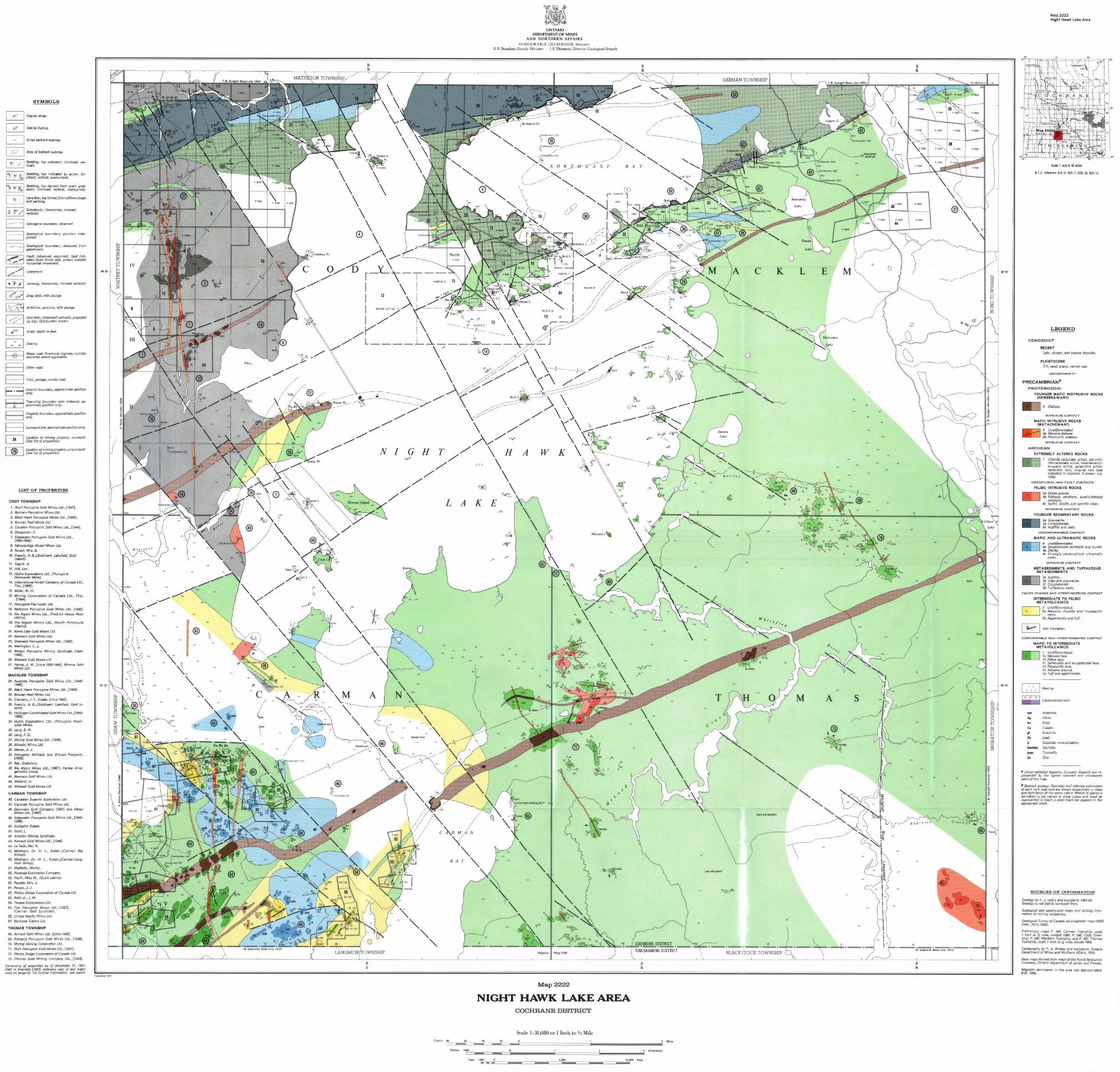


![H20youryou[2] · 2020. 9. 1. · 65 pdf pdf xml xsd jpgis pdf ( ) pdf ( ) txt pdf jmp2.0 pdf xml xsd jpgis pdf ( ) pdf pdf ( ) pdf ( ) txt pdf pdf jmp2.0 jmp2.0 pdf xml xsd](https://img.pdfslide.net/doc/110x75/60af39aebf2201127e590ef7/h20youryou2-2020-9-1-65-pdf-pdf-xml-xsd-jpgis-pdf-pdf-txt-pdf-jmp20.jpg)