1
1:100 000 scale topographical map of Fiji showing physical, transport, settlement and other key features Western Division Central Division Mare Koro Lewa Drala Navai Natoka Nadrau Nanoko Nadala Navala Naiyaca Rewasau Buyabuya Vanualevu Naqelewai Vugavugawa Nubutautau Sauvakarua Vatutokotoko Lutu Marou Nakito Naruyaruya Navuniyasi Tavua Navosa Magodro Wainimala Wainimala Saivou Matailobau Nalawa Ba Province Nadroga Province Naitasiri Province Naitasiri Province Ra Province 178°E 177°50'E 17°40'S 17°50'S 585000 590000 595000 600000 605000 610000 615000 8030000 8035000 8040000 8045000 8050000 9 8 7 6 5 4 3 2 11 20 21 22 23 24 25 26 28 29 30 32 33 34 35 36 37 38 39 40 41 42 43 44 45 46 47 48 50 51 52 53 55 56 57 10 59 60 61 62 63 64 65 66 67 68 69 70 71 73 74 75 76 78 79 80 81 82 83 84 85 86 87 88 89 90 91 92 93 18 17 16 15 14 13 12 58 31 54 72 77 27 49 19 ´ MA003_Central Viti Levu Data sources Fiji: Cyclone Winston- Topographical Ministry of Lands and Mineral Resources, Fiji 0 1 2 3 4 km 1: 100,000 (At A3) Produced by MapAction www.mapaction,org [email protected] The depiction and use of boundaries, names and associated data shown here do not imply endorsement or acceptance by MapAction. Supported by DFID and the Ministry of Foreign Affairs of the Netherlands. Created 23 February 2016 UTC+12:00 Map Document MA003_Location100000_A3 Projection & Datum WGS 1984 UTM Zone 60S / WGS 1984 Glide Number TC-2016-000014-FJI 52 Central Viti Levu Province Division Tikina " City " Village # Settlement Roads PoliceStations Schools Special Primary Secondary Hospital Health Centre Nursing Station Airport medium small Elevation Height (m) High : 1303 Low : 0

Ra Province Fiji: Cyclone Winston- Topographical

  • Upload
    others

  • View
    4

  • Download
    0

Embed Size (px)

Citation preview

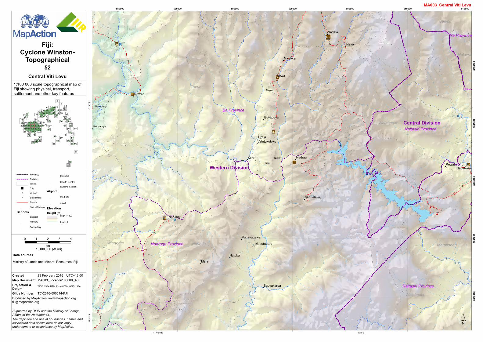
1:100 000 scale topographical map ofFiji showing physical, transport,settlement and other key features

Western Division

Central Division

Mare

Koro

Lewa

Drala

Navai

Natoka

Nadrau

Nanoko

Nadala

Navala

Naiyaca

Rewasau

Buyabuya

Vanualevu

Naqelewai

VugavugawaNubutautau

Sauvakarua

Vatutokotoko

Lutu

Marou

Nakito

Naruyaruya

Navuniyasi

Tavua

NavosaMagodro

Wainimala

Wainimala

Saivou

Matailobau

Nalawa

Ba Province

Nadroga Province

Naitasiri Province

Naitasiri Province

Ra Province

178°E177°50'E

17°4

0'S17

°50'S

585000 590000 595000 600000 605000 610000 615000

8030

000

8035

000

8040

000

8045

000

8050

000

987654

32

1120 21 22 23 24 25 26

28 29 3032 33 34 3536

37 3839 40 41 42 43 44 45 46 47 48

50 51 52 53 5556 57

10

5960 61 62 63 64 65 66 6768 69 70 71 73

74 75 7678 79 80 81

82 83 84 85 8687 88 89 90

91

9293

18171615141312

58

31

5472

77

27

49

19

´

MA003_Central Viti Levu

Data sources

Fiji:Cyclone Winston-

Topographical

Ministry of Lands and Mineral Resources, Fiji

0 1 2 3 4km

1: 100,000 (At A3)

Produced by MapAction www.mapaction,[email protected]

The depiction and use of boundaries, names andassociated data shown here do not implyendorsement or acceptance by MapAction.

Supported by DFID and the Ministry of ForeignAffairs of the Netherlands.

Created 23 February 2016 UTC+12:00Map Document MA003_Location100000_A3Projection &Datum WGS 1984 UTM Zone 60S / WGS 1984

Glide Number TC-2016-000014-FJI

52Central Viti Levu

ProvinceDivisionTikina

" City" Village# Settlement

RoadsPoliceStations

SchoolsSpecialPrimarySecondary

Hospital

Health CentreNursing Station

Airportmedium

smallElevationHeight (m)

High : 1303

Low : 0