Embed Size (px)
Citation preview

RADAR:An In-Building RF-based User Location and
Tracking System
Presented by:Michelle Torski
Paramvir Bahl and Venkata N. Padmanabhan

The Idea

Overview
Main Goal: Locate/Track users INSIDE a building
Method: Recording/Processing signal strength Overlapping Coverage triangulation
Motivation: Location aware services/applications

Previous Work
Focused on IR Limited range Does not allow for traditional transmitting of
data (aka limited to just locating people) Scales poorly Installation/maintenance limitations
Authors argue that RF solves problems above (range, scalability, deployment, maintenance)

Testing Process

Building Floor Layout Figure Notation
Black Dots = locations where empirical signal strength info was collected
Large Stars = Base Stations (BS)
Orientation – North (up); East (right)
Ranges Open along hallways w/
base stations (200m) Closes elsewhere (25m) Base stations overlap in
parts and cover the entire floor
Figure 1: Floor Layout

Information Collected
Use signal information Off-Line Phase
Construct/validate models for signal propagation Real-Time Phase
Infer location of user
Information Passed Signal strength (SS) Signal-to-noise ratio (SNR) SS is a stronger function of location; therefore
authors do not use SNR

Collection Process
Synchronize clocks on mobile host (MH) & BS MH broadcasts UDP packets BS records SS at (t, x, y, d)
Time stamp (t); direction user is facing (d); location (x,y)
If off-line, user indicates location by clicking map on floor
Signal strength varies w/i a single location based on d Offline phase: SS in each of the 4 d’s at 70
(x,y)

Signal Strength
Figure 2: Signal strength recorded at the BS as the user walks around the floor.
Why? Need
accurate SS to help determine location
How? Stronger
signal = closer to BS
Modeling (see next slide)

Model 1: Empirical

The Empirical Method
Empirical Use the data points gathered from off-line
phase to construct search space for NNSS Nearest Neighbor (NNSS)
User sends SS and t Search previous data for (x,y,d) that
corresponds
assumes user is stationary
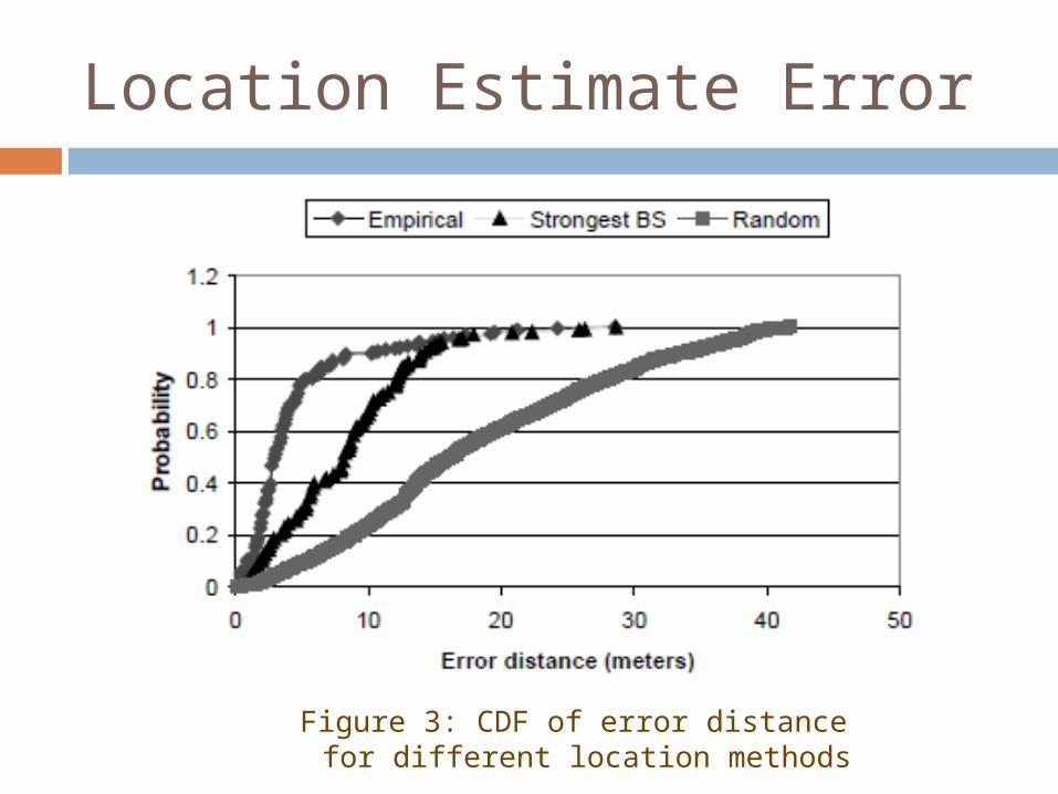
Location Estimate Error
Figure 3: CDF of error distance for different location methods

Multiple Nearest Neighbors
Do not limit to just nearest data point (neighbor) Expand to k neighbors
Figure 4: Example of how multiple nearest neighbors can be more accurate (k=3)
May not work well Next closest
“neighbors” may be same (x,y) but different d
Small k <2m change
Big k bad estimate If ignore d, could
work for small k, but still not significant enough (Figure 5)

Number of Data Points
Figure 6: Error Distance as a function of data points
Accuracy of 40 points ~= that of 70 points
Also better if points are uniformly distributed
x-axis scaled logarithmically

Tracking
4 SS samples/second Sliding window of 10 samples to
compute mean SS 19% worse than that of stationary

Limitations of Empirical Method Long time to gather all the empirical data
1 floor*= (70 locations) · (4 directions) · (20 samples)
No one wants to collect all that data for a whole office building
If BS moves, have to recollect all the data
~=*1000 square meters

Model 2: Radio Propagation

The Radio Propagation Method Create a search space for NNSS (to be
used in the same way as before) Reduce dependency on empirical data How?
Model of indoor signal propagation Compute (theoretically) SS data (similar to
empirical) for locations (x,y) spaced uniformly along the floor
Performance of method dependent of accuracy of model

Challenges to Creating Model Have to account for free-space loss / loss
due to obstructions Multipath Phenomenon
Signal arrives at user through multiple paths Depends on layout of building, construction
material, number/type of objects in the building Each building is different If a wall (etc) moves, has to be
recalculated

Chosen Model
Floor Attenuation Factor propagation models Accommodates different building layouts Accounts for large-scale path loss
Adaptations Do not care about attenuation due to floors Instead focus on walls
Esp. between transmitter and receiver Wall Attenuation Factor (WAF)
Testing “suggests that the entire system can be relocation to a different part of the building, but the same parameter values can be used” (p 9)

Propagation Model v. Empirical
Not as good as empirical
Better than Strongest BS and Random Methods Figure 9: Predicted verses measured signal strength

Final Thoughts

Future Work (as mentioned by authors)
User-mobility profiles Better tracking
Base station-based environmental profiling
Large-scale variations in the RF signal propagation environment
Multiple search spaces determined during different channel conditions
Probe channel to see current conditions and then use that search space

Paper Weaknesses
Are the future applications worth it? Mentioned printing to nearest printer and
navigating. What else? Power consumption Scalability?
Large floor larger search space Time/Space constraints More base stations may mean more complicated
Radio Propagation models How does clock synchronization work?

Paper Weaknesses cont.
Just because empirical/radio propagation models are more accurate than Strongest BS and Random does not make them accurate (bad comparisons)
Costs of finding the Radio Propagation parameter values
How does data get sent back to the user based on his location?
What if 2 locations have quite similar SS and t? Probability of this happening?
t depends on congestion as well