Embed Size (px)
Citation preview
Radar Characteristics of Tornado Producing Mini-Supercell in Tropical Storm Erin (2007)
Christina R. Holt National Weather Center Research Experiences for Undergraduates
University of Oklahoma, Norman, Oklahoma
Dr. Kevin Kloesel Associate Dean, College of Atmospheric and Geographic Sciences
National Weather Center University of Oklahoma, Norman, Oklahoma
ABSTRACT During the 2007 tropical season, Tropical Storm Erin re-strengthened over Oklahoma after making landfall along the coast of Texas. This tropical storm produced a total of seven tornadoes in Texas and Oklahoma. Its first tornado in Oklahoma was within the range of the Multifunction Phased Array Radar (MPAR) in Norman, OK. Using a scanning strategy that updates every 43 seconds with 14 elevation angles, the MPAR allowed us to measure the physical characteristics of a tornado producing mini-supercell in a tropical cyclone environment. The physical aspects of this mini-supercell include a shallow circulation only 4.5 km in diameter extending through a depth of 3 km. The reflectivity signatures were more subtle than typical Great Plains supercells and maximum reflectivity values of 50-54 dBZ extend over a small area. Based on these criteria, this cell is consistent with previous studies. The most noticeable difference form recorded events is the sampling of this storm at such a high temporal resolution. A rapid intensification to tornadic over a three-minute period exemplifies the need for up-to-the-minute radar data. Using better sampling strategies and higher resolution will lead to an increased understanding of the hurricane-spawned tornado and improved forecast and warning accuracy.
_____________________________________________ 1. INTRODUCTION
A recent American Meteorological Society
(2007) statement on hurricane forecasting put the need to understand the processes behind hurricane spawned tornadoes in perspective:
While hurricanes are most hazardous in coastal regions, their weakening, moisture-laden circulations can produce extensive, damaging floods and tornadoes hundreds of miles inland for days after the winds have subsided.
Tropical cyclone (TC) tornadoes do not only affect the coastal and inland regions after the hurricane makes landfall, but can also threaten the coastline well before the hurricane eyewall actually reaches land, making long-term forecasting an asset.
The National Hurricane Center only issues forecasts for storm surge, wind speed, and
minimum central pressure. Because our ability to anticipate which landfalling tropical cyclones will produce tornado outbreaks is not well developed, the TC tornado can prove to be one of the most difficult phenomena to predict. These tornadoes often are the offspring of parent mesocyclones that are much smaller than those observed outside the TC environment. McCaul and Weisman (1996) showed in their mesoscale simulation of a mini-supercell that the buoyancy found in a typical hurricane environment results in relatively weak low-level velocities, producing less pronounced radar signatures.
As more research has been completed on these mini-supercells, other precursors to TC tornadogenesis have been resolved using the Weather Surveillance Radar-1988 Doppler (WSR-88D). Operational meteorologists have guidelines for manual mesoscale detection, which outline the criteria for a mesocyclone typical of a Great Plains environment. These guidelines include:
1) A core diameter less than 9.5 km exhibiting a signature more rotational in nature than divergent
2) Extension of the rotational signature through a vertical depth of greater than 3.5 km.
3) Existence of the previous conditions for at least two volume scans (10-12 min)
These criteria are typical of a midlatitude
supercell, but this is not the case in a hurricane environment, and considerations should be made when forecasting in such a situation (Spratt et al., 1997). While these parameters are a place to start, their usability in tropical cases may limit detection of low-topped mini-supercells. Schneider and Sharp’s (2007) study gives three precursors to tornado development in hurricane environments. None of the following is meant to be used by themselves, but may aid in warning decisions:
1) A near gate-to-gate mesocyclone
rotational velocity of 10 m s-1 or greater 2) A hook or appendage signature in
reflectivity data 3) The presence of a VES of 15.5 m s-1 or
greater between 2.1 km and 4.2 km Dimensions of previously studied WSR-88D
cases were considerably smaller than classic Great Plains supercells. Characteristic rotational velocities of Tropical Storm Beryl’s long-lived supercells were in the 10-15 m s-1 range, occasionally reaching 20-25 m s-1 (McCaul et al., 2004). These storms are most likely near the top of the spectrum for such storms. North Carolina tornadic storms from 2004 had shallow rotation, often observed only in the lowest 1-2 radar elevation angles. Values of rotational velocity within these storms were consistent with the findings of McCaul et al. (2004) ranging from 7-12 m s-1.
2. MOTIVATION
The Center for the Collaborative Adaptive Sensing of the Atmosphere (CASA) is engaged in deploying low-cost networks of Doppler radars that operate at short range and provide up-to-the-second radar information. Because tropical cyclone tornadoes are such a widespread issue, especially along the Gulf of Mexico, we believe that a network such as the Distributed Collaborative Adaptive Sensing (DCAS) network will greatly benefit researchers interested in these extra-tropical phenomena.
Not only do we think this kind of network will benefit the understanding of the extra-tropical tornado producing environment, the National Oceanic and Atmospheric Administration’s (NOAA) Science Advisory Board (2006) recommended similar action, linked with modeling studies:
Recommendation 16: To assimilate all available radar data, including aircraft and land based, and use this as an input to the mesoscale modeling system. Further to conduct OSSE’s to determine optimal configurations for land-based radar systems, especially around the Gulf of Mexico, in support of the mesoscale modeling effort.
In an effort to determine how to best distribute and operate a DCAS network, a high-resolution radar study of a low-topped tropical tornado producing mini-supercell is needed. Analyzing such characteristics as size, depth, intensity, and temporal evolution will play a vital role in the DCAS policy. These characteristics will help determine what the end user needs are for organizations such as the Storm Prediction Center, the National Weather Service, emergency managers, and the media. It will also allow us to determine optimal temporal resolution, vertical and horizontal scanning strategies, and network spacing.
3. METHODOLOGY
Our initial intent of the study was to perform a climatological radar study of TC tornadoes using any available high-resolution radar datasets. These datasets would include events in which the Shared Mobile Atmospheric Research and Teaching Radars (SMART-R) were deployed, such as Tropical Storm Gabrielle (2001) and Hurricane Frances (2004). While the SMART-Rs obtained much useful data for their purposes (mostly boundary layer variability), little data was available in the way of mesocyclone circulation (Knupp et al., 2006).
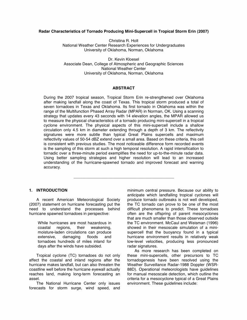
In the absence of the SMART-R datasets, the study was limited to a specific rare case. Tropical Storm Erin (2007) re-strengthened over Oklahoma after a season of higher than average rainfall. During its extra-tropical transition inland, Erin produced seven tornadoes in central Oklahoma (Figure 1). This rarity positioned one mini-supercell within range of the experimental
Multifunction Phased Array Radar (MPAR) in Norman, Oklahoma.
Figure 1: Tropical Storm Erin (2007) Storm Track (blue line) with Tornado Reports (red dots).
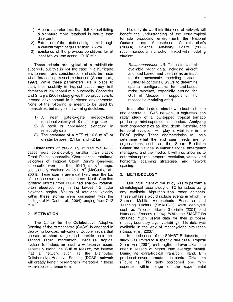
The MPAR offers the high temporal resolution
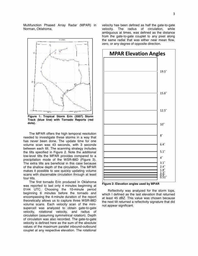
needed to investigate these storms in a way that has never been done. The update time for one volume scan was 43 seconds, with 3 seconds between each tilt. The scanning strategy includes the tilts specified in Figure 2. Note the additional low-level tilts the MPAR provides compared to a precipitation mode of the WSR-88D (Figure 3). The extra tilts are beneficial in this case because of the shallow depth of the circulation. The MPAR makes it possible to see quickly updating volume scans with discernable circulation through at least four tilts.
The first tornado Erin produced in Oklahoma was reported to last only 4 minutes beginning at 0144 UTC. Choosing the 10-minute period beginning 6 minutes before the tornado and encompassing the 4-minute duration of the report theoretically allows us to capture three WSR-88D volume scans. Each velocity scan of the mini-supercell was analyzed to obtain gate-to-gate velocity, rotational velocity, and radius of circulation (assuming symmetrical rotation). Depth of circulation was also recorded. The gate-to-gate velocity is defined here as the sum of the absolute values of the maximum parallel inbound-outbound couplet at any respective elevation. The rotational
velocity has been defined as half the gate-to-gate velocity. The radius of circulation, while ambiguous at times, was defined as the distance from the gate-to-gate couplet to any pixel along the same radial that was either near mean flow, zero, or any degree of opposite direction.
Figure 2: Elevation angles used by MPAR
Reflectivity was analyzed for the storm tops, which I defined as the last elevation that returned at least 45 dBZ. This value was chosen because the next tilt returned a reflectivity signature that did not appear significant.
4. Radar Results 4.1 CIRCULATION AND STORM DEPTH
Consistent with previous findings (McCaul et al, 2004; Schneider and Sharp, 2007; and Spratt et al., 1997), the circulation in the cell did not extend above approximately 3 km (see Figure 4a). Using the tilts available with PAR, the rotation could be observed through four consecutive elevation angles, which was 1.8˚. Rarely was the circulation evident in the 2.4˚ elevation, which would be the equivalent of three consecutive tilts, using 88D. The increased number of low-level scan elevations that the MPAR employs allows the observer to obtain a better understanding of the intensity and duration of the circulation.
The storm tops in reflectivity rarely exceeded 5 km in depth. Maximum reflectivity values for this
cell ranged from 50-54 dBZ and extended only over a very small area, consistent with previous findings (NWS Louisville KY WFO). The typical hook was not as prominent as in some instances, but a definite overhang was present, as indicated in Figures 4a-c. 4.2 CIRCULATION DIAMETER
The horizontal size of the circulation was also
noted to be much smaller than a typical mesocyclone associated with a Great Plains type supercell. Using the definition above, the circulation tended to be less than 4.5 km in diameter, assuming that the circulation was symmetrical. This finding is comparable to the results obtained by Schneider and Sharp (2007). Their 12 storms all exhibited rotations less than 5.5 km at the 0.5˚ elevation angle. At a distance of about 60 km from the radar using 0.5˚ beam width, 4.5 km is only about four pixels wide, requiring careful radar analysis. 4.3 CIRCULATION INTENSITY
Schneider and Sharp (2007) mention that
using a threshold value of 10.3 m s-1 as a precursor for tornadogenesis exclude two events in which tornadoes actually occurred in North Carolina. The first event they credit to the storm being nearly 170 km from the radar. Neighboring radar did find that the low levels of the storm exhibited rotational velocity above the threshold value, making data from adjacent radars crucial for sampling cells at great distances.
The second missed tornado exhibited only a 9.8 m s-1 rotational velocity before tornado touchdown. The authors of the paper attribute this to possible range folding, but mention that a hook was present at least 10 minutes before the tornado event.
In this event, higher temporal resolution could have played a significant role. The current study exhibits a very similar timeline of events. In Figure 4a, a vertical cross-section of the storm 4.8 minutes before the reported tornado shows a shallow rotation through 2.75 km, a lack of intensity compared to a typical midlatitude supercell, and an overhang in reflectivity, but no WER. The cell does not display a clear hook echo in reflectivity, but an appendage is apparent. The gate-to-gate velocity at this time is 23.5 m s-1. According to the guidelines for manual mesoscale detection, this cell would not be a threat.
Stepping forward in time 2.1 minutes, the rotation has deepened and intensified to 45.5 m s-1
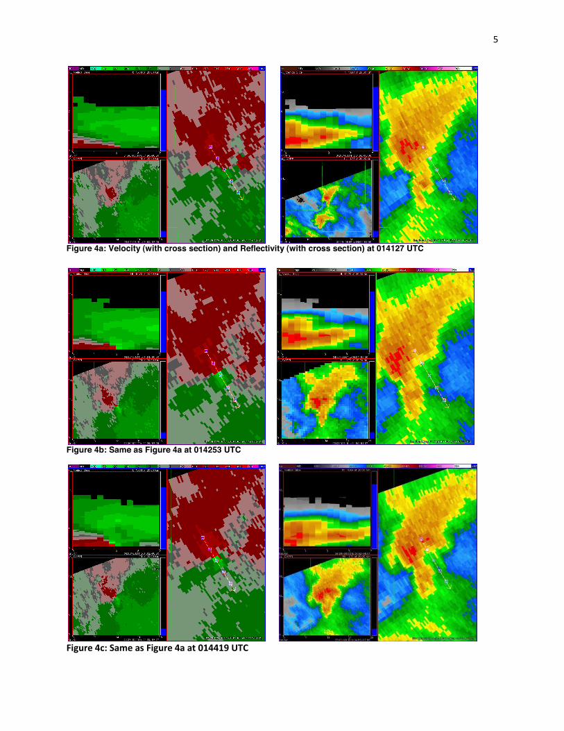
Figure 4a: Velocity (with cross section) and Reflectivity (with cross section) at 014127 UTC
Figure 4b: Same as Figure 4a at 014253 UTC
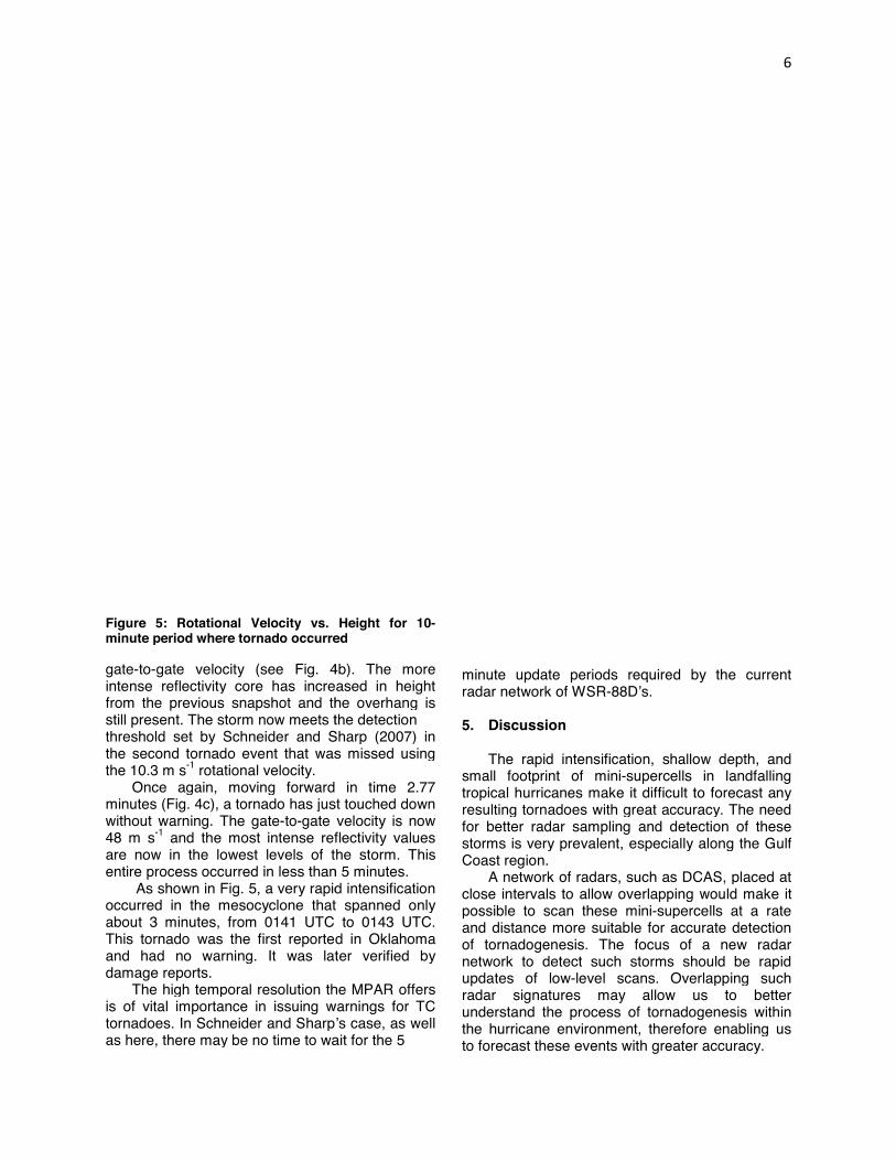
Figure 5: Rotational Velocity vs. Height for 10minute period where tornado occurred
gate-to-gate velocity (see Fig. 4intense reflectivity core has increased from the previous snapshot and the overhang is still present. The storm now meets the detection threshold set by Schneider and Sharp (2007) in the second tornado event that was missed using the 10.3 m s-1 rotational velocity.
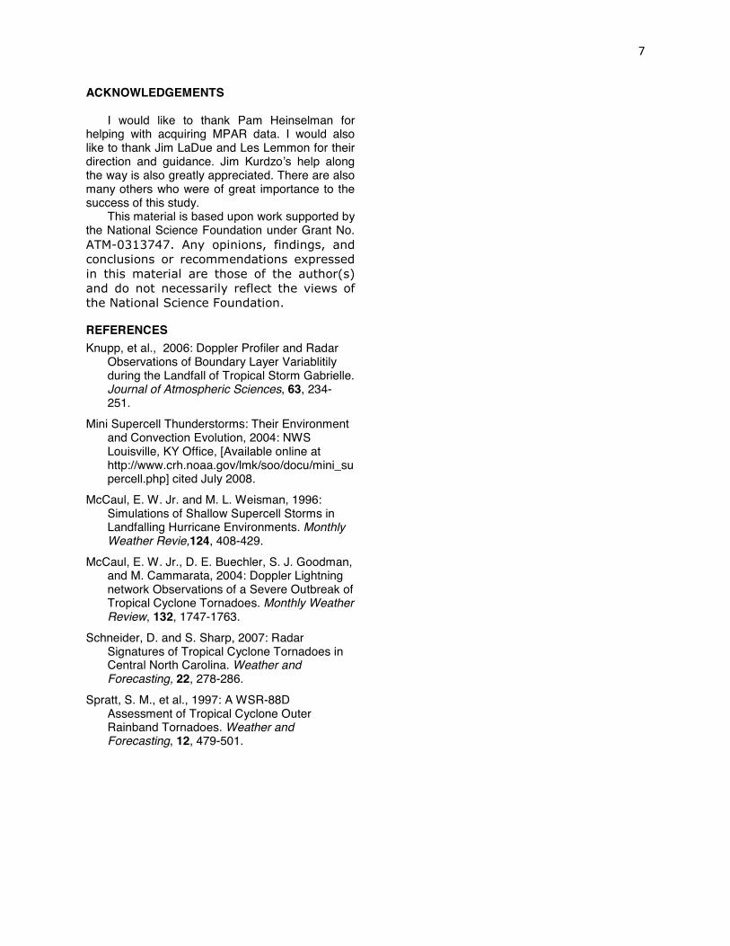
Once again, moving forward in time 2.77 minutes (Fig. 4c), a tornado has just touched down without warning. The gate-to-gate velocity is now 48 m s-1 and the most intense reflectivity values are now in the lowest levels of the storm. This entire process occurred in less than 5 minutes.
As shown in Fig. 5, a very rapid intensification occurred in the mesocyclone that spanned only about 3 minutes, from 0141 UTC to 0143 UTCThis tornado was the first reported in Oklahoma and had no warning. It was later verified by damage reports.
The high temporal resolution the is of vital importance in issuing warnings for TC tornadoes. In Schneider and Sharp’s case, as well as here, there may be no time to wait for the 5
: Rotational Velocity vs. Height for 10-minute period where tornado occurred
4b). The more intense reflectivity core has increased in height
shot and the overhang is still present. The storm now meets the detection hreshold set by Schneider and Sharp (2007) in
event that was missed using
Once again, moving forward in time 2.77 tornado has just touched down
gate velocity is now and the most intense reflectivity values
are now in the lowest levels of the storm. This occurred in less than 5 minutes.
, a very rapid intensification occurred in the mesocyclone that spanned only
0141 UTC to 0143 UTC. This tornado was the first reported in Oklahoma and had no warning. It was later verified by
The high temporal resolution the MPAR offers ng warnings for TC
n Schneider and Sharp’s case, as well as here, there may be no time to wait for the 5
minute update periods required by the current radar network of WSR-88D’s. 5. Discussion
The rapid intensification, shallow depth, and
small footprint of mini-supercellstropical hurricanes make it difficult to forecast any resulting tornadoes with great accuracyfor better radar sampling and detection of these storms is very prevalent, especially along the Gulf Coast region.
A network of radars, such as DCAS, placed at close intervals to allow overlapping would make it possible to scan these mini-supercells at a rate and distance more suitable for accurate dof tornadogenesis. The focus of network to detect such storms should updates of low-level scans. Overlapping such radar signatures may allow us to better understand the process of tornadogenesis within the hurricane environment, therefore enabling us to forecast these events with greater accuracy
required by the current
The rapid intensification, shallow depth, and supercells in landfalling
tropical hurricanes make it difficult to forecast any resulting tornadoes with great accuracy. The need
better radar sampling and detection of these storms is very prevalent, especially along the Gulf
such as DCAS, placed at close intervals to allow overlapping would make it
supercells at a rate and distance more suitable for accurate detection of tornadogenesis. The focus of a new radar
such storms should be rapid level scans. Overlapping such
radar signatures may allow us to better understand the process of tornadogenesis within
t, therefore enabling us with greater accuracy.
ACKNOWLEDGEMENTS
I would like to thank Pam Heinselman for helping with acquiring MPAR data. I would also like to thank Jim LaDue and Les Lemmon for their direction and guidance. Jim Kurdzo’s help along the way is also greatly appreciated. There are also many others who were of great importance to the success of this study.
This material is based upon work supported by the National Science Foundation under Grant No.
REFERENCES Knupp, et al., 2006: Doppler Profiler and Radar
Observations of Boundary Layer Variablitily during the Landfall of Tropical Storm Gabrielle. Journal of Atmospheric Sciences, 63, 234-251.
Mini Supercell Thunderstorms: Their Environment and Convection Evolution, 2004: NWS Louisville, KY Office, [Available online at http://www.crh.noaa.gov/lmk/soo/docu/mini_supercell.php] cited July 2008.
McCaul, E. W. Jr. and M. L. Weisman, 1996: Simulations of Shallow Supercell Storms in Landfalling Hurricane Environments. Monthly Weather Revie,124, 408-429.
McCaul, E. W. Jr., D. E. Buechler, S. J. Goodman, and M. Cammarata, 2004: Doppler Lightning network Observations of a Severe Outbreak of Tropical Cyclone Tornadoes. Monthly Weather Review, 132, 1747-1763.
Schneider, D. and S. Sharp, 2007: Radar Signatures of Tropical Cyclone Tornadoes in Central North Carolina. Weather and Forecasting, 22, 278-286.
Spratt, S. M., et al., 1997: A WSR-88D Assessment of Tropical Cyclone Outer Rainband Tornadoes. Weather and Forecasting, 12, 479-501.