Embed Size (px)
Citation preview
GUIDE TO ASSESSING HISTORIC
RADIUM, URANIUM AND VANADIUM
MINING RESOURCES
IN
MONTROSE AND SAN MIGUEL COUNTIES
COLORADO
MULTIPLE PROPERTY LISTING
Guide to Assessing Historic Radium, Uranium, and Vanadium Mining Resources in Montrose
and San Miguel Counties, Colorado_________________ Name of Multiple Property Listing State
_____________________________________________________________________________ Table of Contents for Written Narrative Provide the following information on continuation sheets. Cite the letter and title before each section of the narrative. Assign page numbers according to the instructions for continuation sheet in How to Complete the Multiple Property Documentation Form (National Register Bulletin 16B). Fill in page numbers for each section in the space below.
E. Statement of Historic Contexts………………………………………………………....…1 E 1: Introduction…………..………………………………………………………..…….1
E 1.1: Previous Radioactive Metals Mining Context Work………………………..3
E 2: The Physical Environment of Western Montrose and San Miguel Counties.……...4 E 3: The Economic Geology of Radioactive Metals Ores..………………………..…...11
E 4: History of Radioactive Metals Mining in Montrose and San Miguel Counties…..16
E 4.1: The Chrome Copper Discovery………...………………………………….16 E 4.2: The Radium Interest, 1898-1905………...………………………………..17 E 4.3: The Radium and Vanadium Boom, 1906-1922………...…………………23 E 4.4: The Quiet Years, 1923-1934……………………………………………..47 E 4.5: The Depression-Era Revival, 1935-1940…………….…………………...49 E 4.6: World War II, 1941-1945……………………………………………….53 E 4.7: The Atomic Era, 1946-1963…………………………...…………………62 E 4.8: The Transition Period, 1964-1973…………………………………..……82 E 4.9: The Last Boom, 1974-1980…………………………………...…………..86 E 4.10: Epilog……………………………………..…………………………..…92
E 5: Mining and Milling Technology, Methods, and Equipment……...……………....93 E 5.1: Introduction…………………….………………………………………….93 E 5.2: Carnotite and Roscoelite Mining……….………………………………….93 E 5.3: The Nature of Ore Concentration Mills……..…………………………....128
Guide to Assessing Historic Radium, Uranium, and Vanadium Mining Resources in Montrose
and San Miguel Counties, Colorado_________________ Name of Multiple Property Listing State
_____________________________________________________________________________ F. Associated Property Types…………………………………………………………….132
F 1: Introduction……………………………………………………………………...…132 F 1.1: Period of Significance Defined………………………………………….132 F 1.2: Applying Criterion G to Resources Less than 50 Years Old…………..…134
F 2: Property Type: Prospect…..……………………………………………………….136 F 2.1: Prospect Subtypes……………………………………………………….136 F 2.2: Prospect Significance……………………………………………………143 F 2.3: Prospect Registration Requirements……………………………………...144
F 3: Property Type: Mine……………..………………………………………………...147 F 3.1: Mine Subtypes……………………..…………………………………….148 F 3.2: Mine Significance……………………..…………………………………178 F 3.3: Mine Registration Requirements………….……………………………...182
F 4: Property Type: Ore Concentration Facility……………………………………..…196 F 4.1: Ore Concentration Facility Subtypes……………………..…………..…196 F 4.2: Ore Concentration Facility Significance……………………..…………..207 F 4.3: Ore Concentration Facility Registration Requirements………….……….208
F 5: Property Type: Mining Settlement and Residence………………………………...209 F 5.1: Mining Settlement and Residence Subtypes…………………………..…211 F 5.2: Mining Settlement and Residence Significance……………………..…....223 F 3.3: Mining Settlement and Residence Registration Requirements…………....227
F 6: Property Type: Rural Historic Landscape……….………………………………...234 F 6.1: Definition of Rural Historic Landscape…………………………………..234 F 6.2: Rural Historic Landscape Significance…………………………………...234 F 6.3: Rural Historic Landscape Registration Requirements…………………….235
G. Geographic Data…………………………………………………………………….…237 H. Summary of Identification and Evaluation Methods…………………………………237 I. Major Bibliographic References………………………………………………….……239
NPS Form 10-900-b OMB No.1024-0018 (Revised March 1992)
United States Department of the Interior National Park Service National Register of Historic Places Multiple Property Documentation Form This form is used for documenting multiple property groups relating to one or several historic contexts. See instructions in How to Complete the Multiple Property Documentation Form (National Register Bulletin 10-900-a). Use a typewriter, word processor, or computer to complete all items. _XX__ New Submission __ Amended Submission
______________________________________________________________________ SECTION A: NAME OF MULTIPLE PROPERTY LISTING Guide to Assessing Historic Radium, Uranium, and Vanadium Mining Resources in Montrose
and San Miguel Counties, Colorado
______________________________________________________________________ SECTION B: ASSOCIATED HISTORIC CONTEXTS (name each associated historic context, identifying theme, geographical area, and chronological period)
None
______________________________________________________________________ SECTION C: FORM PREPARED BY name/title_____Eric Twitty, historian, M.A._________________________________________
organization___Mountain States Historical (303)499-4334__ date____July 15, 2008______
street & number 3750 Darley Ave_____________________ telephone_(303)499-4334____
city or town___Boulder_____________ state_CO________zip code__80305______________
______________________________________________________________________ SECTION D: CERTIFICATION As the designated authority under the National Historic Preservation Act of 1966, I hereby certify that this documentation form meets the National Register documentation standards and sets forth requirements for listing of related properties consistent with the National Register criteria. This submission meets the procedural and professional requirements set forth in CFR Part 60 and the Secretary of the Interior’s Standards and Guidelines for Archaeology and Historic Preservation. (see continuation sheet for additional comments [ ] )
___________________________________State Historic Preservation Officer________________ Signature and title of certifying official date State Historic Preservation Office, Colorado Historical Society_____________________ State or Federal agency and bureau______________________________________________ I hereby certify that this multiple property documentation form has been approved as a basis for evaluating related properties for listing in the National Register. ______________________________________________________________________ Signature of the Keeper date of action
NPS Form 10-900-b OMB No.1024-0018
United States Department of the Interior National Park Service
National Register of Historic Places Continuation Sheet Section number E Page 1
Section E: Statement of Historic Contexts
E.1: INTRODUCTION
In terms of mining history, western Montrose and San Miguel counties rank among the
most important regions in the United States and the world. In 1898, Montrose County hosted
one of the world’s first radioactive metals discoveries in the form of carnotite ore. During the
late 1890s, the Curries and other leading scientists in Europe were only beginning their
experiments with radioactivity and prized carnotite for its metals content. Limited only to the
Colorado Plateau, carnotite had never been recognized or classified prior to the late 1890s and
was, in essence, a new mineral. European scientists found that carnotite carried uranium,
radium, and vanadium, all of which would figure prominently in national and world history.
Between 1899 and around 1910, Montrose and San Miguel counties were center to the
world’s most important radium mining industry. Radium was the first of several radioactive
metals in carnotite to come under measurable demand. European scientists wanted the metal for
research, and the medical industry used it for health applications. Because carnotite had the
highest radium content of known ores, the world turned to Montrose and San Miguel counties for
its radium. In association with this, the first radium mines and mills in the United States
operated in Montrose County.
Between 1910 and 1922, vanadium came under heavy demand as an alloy for steel. San
Miguel County offered the richest deposits in the form of roscoelite ore, with carnotite a close
second. As with radium, Montrose and San Miguel counties were among the world’s most
important sources of vanadium. The alloy metal factored heavily into the domestic steel
industry, as well as for weapons production among European nations embroiled in World War I.
While the above historical trends are obviously important, it was uranium mining that left
the greatest impact on Montrose and San Miguel counties. The Federal Government relied
heavily on carnotite for the Manhattan Project during World War II. Carnotite, principally from
the two counties, was the only significant domestic source of uranium for nuclear weapons
through the 1940s. Uranium was fundamental to the Cold War, and during the early 1950s, the
two counties remained among the most important centers of mining and milling. By the latter
half of the decade, other regions in the Southwest became as significant, but the counties
maintained their prominence.
From the late 1960s through the end of mining around 1980, Montrose and San Miguel
counties generated uranium for the nuclear power industry. Their production was substantial and
contributed to the viability of this alternative energy source. When uranium prices collapsed
around 1980, most of the mines closed and the region lost its economic foundation.
The importance of radioactive metals mining in Montrose and San Miguel counties
should not be underestimated. These two counties were the centers of radioactive metals mining
on the Colorado Plateau, which is an elevated landform of sedimentary geology in the Four
Corners region. By 1964, the Colorado Plateau yielded 70 percent of the uranium, 98 percent of
the vanadium, and nearly all of the radium produced within the United States, valued at $2
NPS Form 10-900-b OMB No.1024-0018
United States Department of the Interior National Park Service
National Register of Historic Places Continuation Sheet Section number E Page 2
billion. On a broader scale, the region also generated 44 percent of the world’s vanadium.1 A
considerable proportion of these figures came from Montrose and San Miguel counties.
Currently, a legacy of historic resources represents the fascinating and important mining
industry of the two counties. After abandonment, many of the mines, mills, and settlements were
impacted by scavenging, environmental remediation projects, and natural decay, leaving a
number of resources in various states of preservation. Those resources that still retain historical
integrity are endangered and now face the additional pressures of mine closures, more
environmental cleanup, and especially the resumption of uranium mining.
A consortium of organizations and government agencies local to Montrose and San
Miguel counties grew concerned over the gathering threats to the region’s historic mining
resources. The Bureau of Land Management (BLM) is one of the most active agencies, in large
part because it controls nearly all the land in the counties. Some BLM cultural resource
administrators forecasted that a wave of uranium mining activity could outpace the objective
inventory and eligibility assessments of historic mining resources. The Division of Reclamation,
Mining, and Safety (DRMS) is another principal agency and has an interest in seeing uranium
mining resources objectively recorded and assessed. The agency cooperates with the BLM and
the Environmental Protection Agency (EPA) on the closure and remediation of uranium mine
sites. Because the agency has a pro-preservation policy regarding mine closures, it tailors its
closure projects to minimize the impacts to historically important sites. The Rimrockers
Historical Society, based in Naturita, is a highly active organization in the region. Rimrockers
has a strong interest in preserving the region’s mining resources because it perceives the
resources as a foundation for heritage tourism. Many of the active members are also retired
uranium miners and wish to see their legacy preserved.
In 2006, these interests and private individuals came together and contributed to a project
that would address some of the pressures that the region’s uranium mining resources now and
will face in the future. With the financial and administrative backing of the BLM and DRMS,
the Western Colorado Interpretive Association (WCIA) applied to and was generously awarded a
grant by the State Historical Fund (SHF) with a match by the BLM for the project (2006-02-
032). WCIA then contracted with Mountain States Historical (MSH) to complete the work
because that firm has experience with both uranium mining resources and producing historic
mining contexts.
The project includes three products. The first is an inventory and significance assessment
of 65 radioactive metals mining resources. The second is a guide for assessing the significance
of these resources, and the third is a sister Multiple Property Documentation Form (MPDF). The
inventory of sites was designed to provide qualitative information for the guide and the MPDF.
1 Fischer, 1968:736; Metal Mining, 1961:5.

NPS Form 10-900-b OMB No.1024-0018
United States Department of the Interior National Park Service
National Register of Historic Places Continuation Sheet Section number E Page 3
E.1.1: Previous Radioactive Metals Mining Context Work
Little context work exists as of 2008 regarding radioactive metals mining in western
Colorado. Umetco Minerals Corporation published the only comprehensive work to date, which
John S. Hamrick, Diane E. Kocis, and Sue E. Shepard wrote in 2002. Uravan, Colorado: One
Hundred Years of History provides a well-researched history of uranium mining and milling as
related to the company town of Uravan. Umetco funded the context as part of its environmental
cleanup of Uravan and the Shamrock Group of mines above and south on Club Mesa. The
context, however, lacks reference to cultural resources and their evaluation.
For reference to cultural resources, we must turn to a handful of projects involving
uranium mine and mill sites. The firms of Andrews and Anderson, and Cultural Resource
Historians, completed one of the earliest qualitative projects in 1984. These two organizations
conducted Historic American Engineering Record (HAER) documentation of the Vanadium
Corporation of America’s Vancorum Mill site prior to environmental cleanup.2 As such
documentation requires, the firms produced a brief and accurate overview of radioactive metals
mining in the region.
In 2001, Kurt P. Schweigert with Associated Cultural Resources Experts documented the
Department of Energy’s Grand Junction Office according to HAER standards.3 The Department
of Energy transferred the office to private ownership and was therefore obligated to document
the facility. Schweigert wrote a narrative history of the office in relationship to historical trends
of the uranium mining industry.
Jonathan C. Horn of Alpine Archaeological Consultants completed several qualitative
projects that included historic uranium mining resources. In 2002, Horn and associates
conducted a preservation assessment of Calamity Camp on Calamity Mesa near the town of
Gateway, in Mesa County. Horn wrote a very detailed narrative site history, which he tied to
general trends of radioactive metals mining.4 In 2003, Horn also inventoried and evaluated five
uranium mines on La Sal Creek in both Montrose County and San Juan County, Utah. In his
report, Horn wrote another narrative of radioactive metals mining and detailed site histories.5
In 2005, Eric Twitty with Mountain States Historical recorded and evaluated 23 mining
resources on the northern portion of Long Park Mesa, Montrose County, in conjunction with a
closure and waste rock remediation project. Twitty produced an interpretive report that featured
a detailed account of mining in the region, as well as site histories.6
A few additional cultural resource projects involving historic uranium mining resources
have been carried out in Montrose and San Miguel counties. Most of this work, however, was of
a very general nature and lacked full narrative histories, in part because little information on
uranium mining history is readily available.
2 HAER CO-81.
3 HAER CO-87.
4 Firor and Horn, 2002.
5 Horn and Archimede, 2003.
6 Twitty, 2006.

NPS Form 10-900-b OMB No.1024-0018
United States Department of the Interior National Park Service
National Register of Historic Places Continuation Sheet Section number E Page 4
E 2: THE PHYSICAL ENVIRONMENT OF WESTERN MONTROSE AND SAN
MIGUEL COUNTIES
Few areas in Colorado are as rugged, arid, and desolate as the skirt of mesas and canyon
lands extending west from the Rocky Mountains to the Utah border. The canyon lands and
mesas are the northeastern portion of a landmass popularly known as the Colorado Plateau, and
the physical environment there presented great challenges to settlement and industry. One of
those industries, uranium and vanadium mining, thrived on the Colorado Plateau, and primarily
in western Montrose and San Miguel counties. While the region offered few resources for
agriculture and other traditional forms of economy, its canyon lands and mesas were, into the
1960s, one of the most important sources of uranium and vanadium in the United States.
Carnotite ore was the object of uranium and vanadium, and this important material
occurred in geological conditions specific to the Western Slope. Out of thousands of vertical feet
of sedimentary rock layers, only several closely spaced and well-defined beds of shale and
sandstone offered the right conditions. Further, these beds were exposed almost exclusively
within a narrow strip of territory along the Colorado-Utah border. The strip began in Mesa
County near the town of Gateway and extended south through Montrose, San Miguel, and
Dolores counties. Overall, the strip was as wide as 30 miles and as long as 80 miles and
overlapped west into Utah. Carnotite ore could be found anywhere within the strip, although the
richest and largest deposits were concentrated in an ovoid tract approximately 20 by 60 miles in
area. In 1943, the U.S. Geological Survey identified this concentration during intensive studies
of the region and termed it the Uravan Mineral Belt.7 The U.S. Geological Survey chose the
name because Uravan, Montrose County, was center to the most important and highest density of
carnotite formations within the mineral belt. In addition to the area around Uravan, western
Montrose and San Miguel counties claimed the mineral belt’s other significant concentrations of
carnotite ore bodies. In general, uranium mines and aspects of the uranium industry were
scattered throughout the western 25 miles of the counties, from Naturita to the state line.
The topography of the region featured a number of valleys elongated northwest-
southeast, and clusters of mesas and plateaus in between. From south to north, the principal
valleys included Disappointment Valley, Big Gypsum Valley, Dry Creek Basin, and the dramatic
Paradox Valley. The Dolores River wound its way north through the region regardless of the
topography and cut across instead of flowing along the valleys. This puzzled the region’s early
settlers, who were unaware that the Dolores existed prior to the valleys and incised its way
downward into its historic channel as tectonic activity slowly lifted the region. Expressing this,
the settlers named Paradox Valley after the river’s paradoxical course across instead of along the
landform. Like the Dolores River, the San Miguel River incised downward into its historic
channel as tectonic activity gently lifted the region. The San Miguel began in the San Juan
Mountains in eastern San Miguel County, flowed northwest, and joined the Dolores near Uravan.
7 Del Rio, 1960:335; Fischer, 1950:1; Fischer and Hilpert, 1952:3.
NPS Form 10-900-b OMB No.1024-0018
United States Department of the Interior National Park Service
National Register of Historic Places Continuation Sheet Section number E Page 5
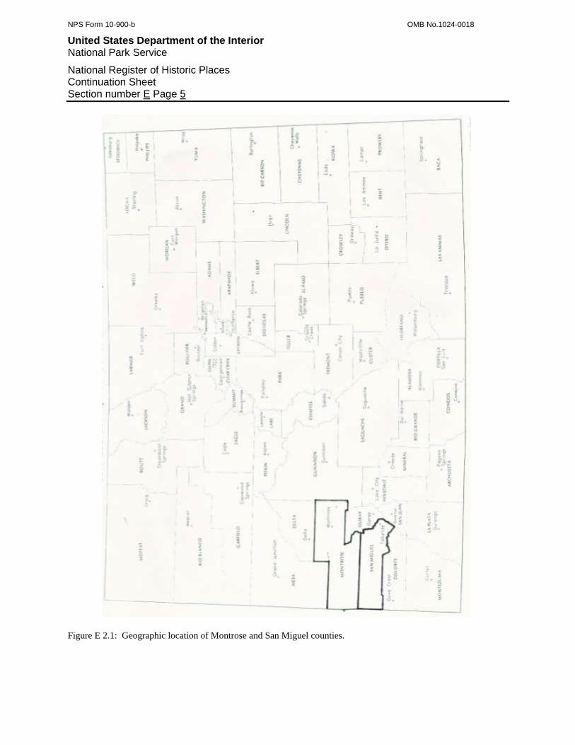
Figure E 2.1: Geographic location of Montrose and San Miguel counties.
NPS Form 10-900-b OMB No.1024-0018
United States Department of the Interior National Park Service
National Register of Historic Places Continuation Sheet Section number E Page 6
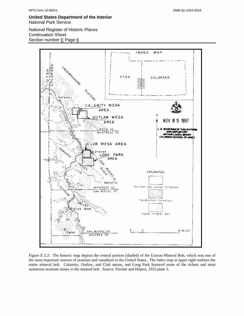
Figure E 2.2: The historic map depicts the central portion (shaded) of the Uravan Mineral Belt, which was one of
the most important sources of uranium and vanadium in the United States. The index map at upper right outlines the
entire mineral belt. Calamity, Outlaw, and Club mesas, and Long Park featured some of the richest and most
numerous uranium mines in the mineral belt. Source: Fischer and Hilpert, 1952:plate 3.

NPS Form 10-900-b OMB No.1024-0018
United States Department of the Interior National Park Service
National Register of Historic Places Continuation Sheet Section number E Page 7
Figure E 2.3: The topographic map shows the principal geographic points in western Montrose County and
southwestern Mesa County, at upper left. Gateway is at upper left, Uravan is center, and Naturita and Nucla are at
lower right. Club, Long Park, and Sawtooth mesas are unmarked immediately south of Uravan.

NPS Form 10-900-b OMB No.1024-0018
United States Department of the Interior National Park Service
National Register of Historic Places Continuation Sheet Section number E Page 8
Figure E 2.4: Principal geographic points in western Montrose and San Miguel counties. Roc Creek, site of North
America’s first uranium mine, is at upper left, and Slick Rock, site of the earliest commercial uranium mill, is at
lower left. Uravan, Vancorum, and Naturita lie along the San Miguel River at upper center. The highways are
products of the region’s Cold War uranium boom.

NPS Form 10-900-b OMB No.1024-0018
United States Department of the Interior National Park Service
National Register of Historic Places Continuation Sheet Section number E Page 9
Figure E 2.5: Principal geographic points within San Miguel County’s vanadium mining area.
The rivers, the valleys, and the clusters of mesas between, were important areas for the
uranium industry. The valleys featured most of the important towns. Slick Rock grew at the
NPS Form 10-900-b OMB No.1024-0018
United States Department of the Interior National Park Service
National Register of Historic Places Continuation Sheet Section number E Page 10
west end of Disappointment Valley and Basin was at the east end of Dry Creek Basin. Settlers
established Paradox at the west end of Paradox Valley, Bedrock was where the Dolores River
crossed the valley, and Coke Ovens lay at the valley’s east end. Standard Chemical developed
Uravan on the San Miguel River a short distance east of its confluence with the Dolores.
Pioneers founded Naturita in the San Miguel River valley around 20 miles to the east, and also
Nucla a short distance north of Naturita.
Nearly all the mines were located around the upper edges of the mesas and the incised
Dolores and San Miguel river channels. The reason is that this was where the above-mentioned
sedimentary rock layers were exposed and accessible. As the U.S. Geological Survey and the
mining companies discovered, some mesas featured particularly important concentrations of
carnotite deposits. The entire area south of Slick Rock was highly productive, and it was
dissected by Summit, Stevens, Bush, and other canyons. Wedding Bell and Radium mountains,
and Monogram and Davis mesas, between Big Gypsum and Paradox valleys, were heavily
mined. The Uravan Mining District, between Paradox Valley and the San Miguel River, may
have been the most important area. Long Park, Sawtooth, and Club mesas were within the
district. San Miguel Bench followed the north side of the San Miguel River from Tabeguache
Creek to the Dolores River, and then along the Dolores for a number of miles. Carpenter Flats
and adjoining Martin Mesa rose on the opposite, western side of the river, and they featured
numerous mines, as well.
San Miguel County featured a second historically important center of mining around 30
miles east of the Uravan Mineral Belt. Instead of carnotite, the area’s sandstone beds offered
roscoelite, which was a rare form of vanadium ore that carried minor amounts of uranium, as
well. The deposits were so large and rich that, during the 1910s, the area was one of the world’s
most important sources of vanadium. The small logging town of Saw Pit on the San Miguel
River was near the middle of the 8-by-8-mile area. Placerville existed several miles northwest
and down-gradient, and Vanadium, formerly Newmire, was several miles southeast and up-
gradient. These three towns were important to the vanadium industry as milling, residential, and
commercial nodes. Some of the most productive mines were located on Big Bear Creek
ascending south from Vanadium, on Fall Creek south of Saw Pit, and on Leopard Creek north of
Placerville.
The physical environment of western Montrose and San Miguel counties is a microcosm
of the greater Western Slope. As alluded to, mesas and canyon lands dominate the topography,
and they give way to plateaus and the foothills of the San Juan Mountains around Placerville.
The mesas rise in an almost stairstep manner from around 5,400 feet elevation near the rivers and
valley floors to around 7,000 feet. Distinct canyons separate the mesas, and they are usually
bordered by the steep slopes of soft, eroded mudstone and shale, and the vertical cliffs of
resistant sandstone, which often manifest in alternating series. The floor of the San Miguel River
canyon near Placerville is around 7,500 feet elevation, and on both sides, the walls climb steeply
to plateau land around 9,000 feet in elevation.
As can be surmised, climate of western Montrose and San Miguel counties is very arid,
although less so toward Placerville. The summers tend to be hot with temperatures commonly in
the high nineties, Fahrenheit, and the winters can force temperatures down into the single digits.
Wind is omnipresent, usually blows from the west, and can attain near-hurricane force with the
NPS Form 10-900-b OMB No.1024-0018
United States Department of the Interior National Park Service
National Register of Historic Places Continuation Sheet Section number E Page 11
arrival of powerful Pacific storms. Such weather fronts can deliver rain or snow, but usually in
limited quantities. Occasionally, weather fronts from the south carry enough moisture to provide
a rare and needed saturation, and such events tend to contribute enough water to cause highly
erosive runoff. During the summer, thunderhead clouds usually tower over the region, but the
topography influences the track that the cells follow and causes most to avoid the carnotite-
bearing area. Once the soil becomes wet, it turns to a heavy, clayey mud that sticks firmly on
contact. Historically, the mud was a significant problem for the uranium mining industry
because it rendered roads impassable. During prolonged wet periods, remote mines became
impossible to reach, and in preparation for this, workers living on-site often cached up to several
weeks of provisions.8
The region’s climate and the lack of surface water, even in the deep canyons, foster an
ecosystem typical of the high desert. An old-growth, juniper-pinion forest blankets the region,
and the trees are largest in the drainages. Open areas feature an understory of rabbit brush,
grasses, cacti, and yucca, and cryptobiotic soil is ubiquitous. The river valleys support oasis-like
riparian habitats of grasses, forbes, and brush shaded by mature cottonwoods, and similar but
reduced versions line the region’s few creeks. Among the mesas, springs are rare and can be
marked by grasses, green brush, and a few cottonwoods.
Overall, the region’s arid climate and hostile terrain discouraged permanent subsistence
and barely supported ranches. But, vehicles, modern conveniences, and rapid transportation
allowed a twentieth century uranium and vanadium boom to overcome the Western Slope’s
difficult environment.
E 3: ECONOMIC GEOLOGY OF RADIOACTIVE METAL ORES
Carnotite was unlike any other metal-bearing ore sought by the mining industry. The
ore’s content was one of its most unusual characteristics. Carnotite featured a blend of three
rare, radioactive metals, all of which were prized for their properties. Vanadium was highest in
percentage and was used as an alloy in hardened steel. The uranium content, when separated and
then enriched, became fission material for atomic weapons and fuel in nuclear powerplants.
Radium, present in miniscule amounts, offered medical benefits and saw application as a
luminous paint.
The ore’s geological occurrence was another characteristic that made it unique. In
general, the metal-bearing ores with which the mining industry was familiar were usually found
in metamorphic and igneous rock formations. Further, it was understood that, in Colorado, most
of these formations constituted the Rocky Mountains. As a result, metal mining came to be
associated with and even became a function of mountain geology. Not so with carnotite. In
contrast, carnotite occurred in sedimentary geology along the western skirt of the Rockies, where
no one initially expected to find important metal-bearing ores.
Carnotite ore was not limited exclusively to western Colorado and instead could be found
in specific areas on a landform known as the Colorado Plateau. Ovoid in shape, the Plateau was
8 Davis, 2007; Holland, 2007.
NPS Form 10-900-b OMB No.1024-0018
United States Department of the Interior National Park Service
National Register of Historic Places Continuation Sheet Section number E Page 12
an elevated layer-cake of sedimentary beds that radiated outward from the Four Corners, where
Colorado, New Mexico, Arizona, and Utah met. By far, the most productive and important
concentration of carnotite deposits was what the U.S. Geological Survey defined in 1943 as the
Uravan Mineral Belt, on the Plateau’s northeast portion. The Belt was approximately 20 miles
wide, 60 feet long, and extended south from the town of Gateway, Mesa County, through
Montrose, San Miguel, and Dolores counties, and into Utah. The Belt’s western portion went
across the Colorado state line into San Juan County, Utah.
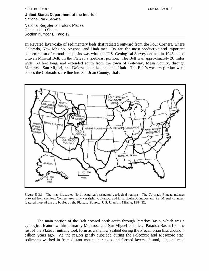
Figure E 3.1: The map illustrates North America’s principal geological regions. The Colorado Plateau radiates
outward from the Four Corners area, at lower right. Colorado, and in particular Montrose and San Miguel counties,
featured most of the ore bodies on the Plateau. Source: U.S. Uranium Mining, 1984:22.
The main portion of the Belt crossed north-south through Paradox Basin, which was a
geological feature within primarily Montrose and San Miguel counties. Paradox Basin, like the
rest of the Plateau, initially took form as a shallow seabed during the Precambrian Era, around 4
billion years ago. As the region gently subsided during the Paleozoic and Mesozoic eras,
sediments washed in from distant mountain ranges and formed layers of sand, silt, and mud

NPS Form 10-900-b OMB No.1024-0018
United States Department of the Interior National Park Service
National Register of Historic Places Continuation Sheet Section number E Page 13
5,000 feet in thickness. Time, mineral solutions, and compression solidified these layers into
sandstone, siltstone, and shale.9
Based on today’s stairstep mesas, incised stream canyons, and broad valleys, it is difficult
to perceive the original submarine sedimentary basin. This is because a sequence of events
radically changed the region, and the first was tectonic in origin. Around 16 million years ago,
the sedimentary basin began slowly ascending and tilting northward as one massive unit.
Geologists speculate on exactly what forces were responsible, but most agree that they were
probably related to the Laramide Revolution, which built the existing Rocky Mountains to the
east. When the sedimentary beds became exposed, erosion immediately began its attack from
two fronts. On the surface, rain and runoff planed off the soft, upper layers and incised stream
channels into the lower, harder beds. Deep underneath, slowly moving groundwater dissolved
massive salt deposits that formed when the basin was a shallow sea floor. The salt deposits were
elongated, trended northwest-southeast, and were miles in length. Once the salt and soft rocks
were gone, the overlying sedimentary beds collapsed and formed a number of linear synclines,
exemplified by Paradox, Big Gypsum, Dry Creek, and Sinbad valleys.10
As the climate dried toward present day and less surface water washed over the region,
the pattern of erosion changed. The universal sheet wash, planing down, and mass-wasting
slowed, and runoff emphasized the existing drainages, which increased in depth and vertical
relief. At the same time, because the softer shale and mudstone layers were susceptible to
erosion, they disintegrated faster than the harder sandstone beds. As a result, the mesas assumed
an appearance of alternating slopes and sandstone cliffs.
It was in one of these sandstone beds that prospectors found carnotite. During the 1910s,
the 1940s, and the 1950s, geologists classified nearly all the sedimentary layers comprising the
Colorado Plateau. They named the ore-bearing bed the Morrison Formation and divided it into
distinct sublayers known as members. The Salt Wash and Brushy Basin members formed the
upper portion of the Morrison Formation, and these hosted the region’s carnotite deposits.
In Montrose and San Miguel counties, the Salt Wash member features eight alternating
layers of sandstone and mudstone, which express themselves as cliffs, benches, and slopes in the
mesas. While the member ranges from 280 to 400 feet in thickness, mining companies found
nearly all the carnotite deposits in the upper 100 feet. The sandstone was slightly different in
appearance than the reddish Morrison material and instead was grayish-yellow to pale orange.
The Brushy Basin member, which overlay the Salt Wash, was similar in thickness and layering,
although the Brushy Basin member had more siltstone and shale beds.11
9 Baars, 2002:31; Fischer, 1950:6; Baars and Stevenson, 1981:23; Fischer, 1968:738; Joesting and Byerly, 1958:5.
10 Baars and Stevenson, 1981:30; Del Rio, 1960:336.
11 Baars, 2002:33; Boardman, 1956:15; Craig, 1955:157; Craig and Catigan, 1958:187, 190; Motica, 1968:808; Wood and Lekas, 1958:208.
NPS Form 10-900-b OMB No.1024-0018
United States Department of the Interior National Park Service
National Register of Historic Places Continuation Sheet Section number E Page 14
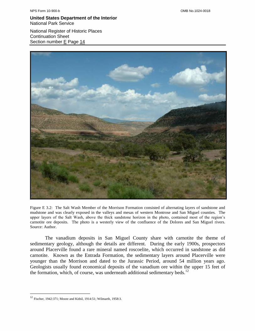
Figure E 3.2: The Salt Wash Member of the Morrison Formation consisted of alternating layers of sandstone and
mudstone and was clearly exposed in the valleys and mesas of western Montrose and San Miguel counties. The
upper layers of the Salt Wash, above the thick sandstone horizon in the photo, contained most of the region’s
carnotite ore deposits. The photo is a westerly view of the confluence of the Dolores and San Miguel rivers.
Source: Author.
The vanadium deposits in San Miguel County share with carnotite the theme of
sedimentary geology, although the details are different. During the early 1900s, prospectors
around Placerville found a rare mineral named roscoelite, which occurred in sandstone as did
carnotite. Known as the Entrada Formation, the sedimentary layers around Placerville were
younger than the Morrison and dated to the Jurassic Period, around 54 million years ago.
Geologists usually found economical deposits of the vanadium ore within the upper 15 feet of
the formation, which, of course, was underneath additional sedimentary beds.12
12
Fischer, 1942:371; Moore and Kithil, 1914:51; Wilmarth, 1958:3.
NPS Form 10-900-b OMB No.1024-0018
United States Department of the Interior National Park Service
National Register of Historic Places Continuation Sheet Section number E Page 15
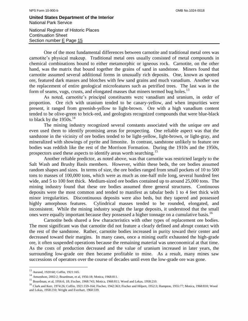
One of the most fundamental differences between carnotite and traditional metal ores was
carnotite’s physical makeup. Traditional metal ores usually consisted of metal compounds in
chemical combinations bound to either metamorphic or igneous rock. Carnotite, on the other
hand, was the matrix that bound together the grains of sand in sandstone. Miners found that
carnotite assumed several additional forms in unusually rich deposits. One, known as spotted
ore, featured dark masses and blotches with few sand grains and much vanadium. Another was
the replacement of entire geological microfeatures such as petrified trees. The last was in the
form of seams, vugs, crusts, and elongated masses that miners termed bug holes.13
As noted, carnotite’s principal constituents were vanadium and uranium, in order of
proportion. Ore rich with uranium tended to be canary-yellow, and when impurities were
present, it ranged from greenish-yellow to light-brown. Ore with a high vanadium content
tended to be olive-green to brick-red, and geologists recognized compounds that were blue-black
to black by the 1950s.14
The mining industry recognized several constants associated with the unique ore and
even used them to identify promising areas for prospecting. One reliable aspect was that the
sandstone in the vicinity of ore bodies tended to be light-yellow, light-brown, or light-gray, and
mineralized with showings of pyrite and limonite. In contrast, sandstone unlikely to feature ore
bodies was reddish like the rest of the Morrison Formation. During the 1910s and the 1950s,
prospectors used these aspects to identify areas worth searching.15
Another reliable predictor, as noted above, was that carnotite was restricted largely to the
Salt Wash and Brushy Basis members. However, within these beds, the ore bodies assumed
random shapes and sizes. In terms of size, the ore bodies ranged from small pockets of 10 to 500
tons to masses of 100,000 tons, which were as much as one-half mile long, several hundred feet
wide, and 5 to 100 feet thick. Medium-sized ore bodies contained up to around 25,000 tons. The
mining industry found that these ore bodies assumed three general structures. Continuous
deposits were the most common and tended to manifest as tabular beds 1 to 4 feet thick with
minor irregularities. Discontinuous deposits were also beds, but they tapered and possessed
highly amorphous features. Cylindrical masses tended to be rounded, elongated, and
inconsistent. While the mining industry sought the large deposits, it understood that the small
ones were equally important because they possessed a higher tonnage on a cumulative basis.16
Carnotite beds shared a few characteristics with other types of replacement ore bodies.
The most significant was that carnotite did not feature a clearly defined and abrupt contact with
the rest of the sandstone. Rather, carnotite bodies increased in purity toward their center and
decreased toward their margins. In many cases, once a mining outfit exhausted the high-grade
ore, it often suspended operations because the remaining material was uneconomical at that time.
As the costs of production decreased and the value of uranium increased in later years, the
surrounding low-grade ore then became profitable to mine. As a result, many mines saw
successions of operators over the course of decades until even the low-grade ore was gone.
13
Aurand, 1920:60; Coffin, 1921:165. 14
Amundson, 2002:2; Boardman, et al, 1956:18; Motica, 1968:811. 15
Boardman, et al, 1956:6, 18; Fischer, 1968:743; Motica, 1968:811; Wood and Lekas, 1958:210. 16
Clark and Kerr, 1974:26; Coffin, 1921:159-164; Fischer, 1942:363; Fischer and Hilpert, 1952:3; Hampton, 1955:77; Motica, 1968:810; Wood
and Lekas, 1958:210; Wright and Everhart, 1960:339.
NPS Form 10-900-b OMB No.1024-0018
United States Department of the Interior National Park Service
National Register of Historic Places Continuation Sheet Section number E Page 16
Roscoelite was a replacement deposit like carnotite, but the replacement occurred on a
mineral-specific basis. Specifically, vanadium replaced the aluminum content of muscovite
(white mica) that formed in metamorphic veins. Overall, the ore was light to dull green, and rich
material featured dark blotches of vanadium. Unlike the irregular carnotite beds, roscoelite ore
bodies tended to be well-defined and easy to track. Specifically, the roscoelite accompanied
several other minerals that filled faults that trended northwest in the Placerville area. These
characteristics made the ore relatively easy to find, develop, and exploit, which is why mining
maintained production for around 15 years.17
E 4: HISTORY OF RADIOACTIVE METALS MINING IN MONTROSE AND SAN
MIGUEL COUNTIES
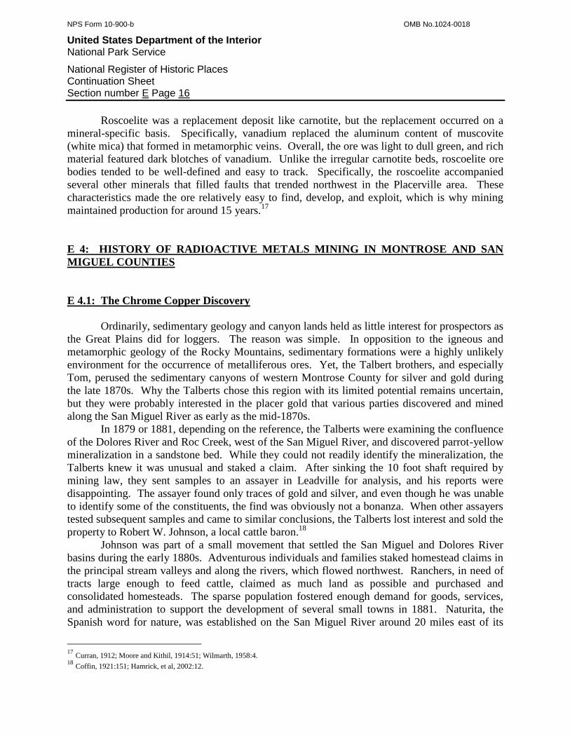
E 4.1: The Chrome Copper Discovery
Ordinarily, sedimentary geology and canyon lands held as little interest for prospectors as
the Great Plains did for loggers. The reason was simple. In opposition to the igneous and
metamorphic geology of the Rocky Mountains, sedimentary formations were a highly unlikely
environment for the occurrence of metalliferous ores. Yet, the Talbert brothers, and especially
Tom, perused the sedimentary canyons of western Montrose County for silver and gold during
the late 1870s. Why the Talberts chose this region with its limited potential remains uncertain,
but they were probably interested in the placer gold that various parties discovered and mined
along the San Miguel River as early as the mid-1870s.
In 1879 or 1881, depending on the reference, the Talberts were examining the confluence
of the Dolores River and Roc Creek, west of the San Miguel River, and discovered parrot-yellow
mineralization in a sandstone bed. While they could not readily identify the mineralization, the
Talberts knew it was unusual and staked a claim. After sinking the 10 foot shaft required by
mining law, they sent samples to an assayer in Leadville for analysis, and his reports were
disappointing. The assayer found only traces of gold and silver, and even though he was unable
to identify some of the constituents, the find was obviously not a bonanza. When other assayers
tested subsequent samples and came to similar conclusions, the Talberts lost interest and sold the
property to Robert W. Johnson, a local cattle baron.18
Johnson was part of a small movement that settled the San Miguel and Dolores River
basins during the early 1880s. Adventurous individuals and families staked homestead claims in
the principal stream valleys and along the rivers, which flowed northwest. Ranchers, in need of
tracts large enough to feed cattle, claimed as much land as possible and purchased and
consolidated homesteads. The sparse population fostered enough demand for goods, services,
and administration to support the development of several small towns in 1881. Naturita, the
Spanish word for nature, was established on the San Miguel River around 20 miles east of its
17
Curran, 1912; Moore and Kithil, 1914:51; Wilmarth, 1958:4. 18
Coffin, 1921:151; Hamrick, et al, 2002:12.

NPS Form 10-900-b OMB No.1024-0018
United States Department of the Interior National Park Service
National Register of Historic Places Continuation Sheet Section number E Page 17
confluence with the Dolores in 1881. Nucla grew on open terrain several miles to the north, and
Norwood became center to farms and ranches on plateau land approximately 15 miles to the
southeast. Settlers founded two more agricultural communities far to the west in Paradox Valley.
They organized the town of Paradox at the valley’s northwest end in 1882 and Bedrock on the
Dolores River the following year. The Paradox Valley was so named because it trended
northwest-southeast and featured a meager stream, while the substantial Dolores River cut
through the valley at around 90 degrees. The river, the local settlers observed, paradoxically did
not follow along the valley as it should have and instead cut across the valley.
The Talberts staked their claim on the lower reaches of Roc Creek, which was close to
and west of Johnson’s Club Ranch, located at the confluence of the San Miguel and Dolores
rivers. Johnson acquired the property in 1880 or 1881, organized the San Miguel Cattle
Company, and commuted seasonally between the ranch and his other interest in New Jersey, the
Johnson & Johnson Surgical Supply Company. While Johnson and the Talberts were unaware of
exactly what the yellow mineralization was, some of Johnson’s cowboys found more on Club
Mesa, which rose along the San Miguel’s southwest side, and other local residents noted similar
material around the rim of Paradox Valley.19
During the late 1880s, another party of prospectors took an interest in the yellow
mineralization. They relocated the Talberts’ claim, which Johnson let lapse, and named it the
Copper Prince. They chose this name on the presumption that the mineralization was a chromate
of copper, which seemed to be as likely an assumption as most other obscure minerals. The
problem, however, was that additional assays found no copper nor other profitable metals, and
the prospectors let the claim lapse.20
E 4.2: The Radium Interest, 1898-1905
In 1896, two events unfolded on opposite shores of the Atlantic Ocean, and they not only
addressed the mystery of the yellow mineralization, but also attached great significance to the
material. In Montrose County, prospector Tom Dullan relocated the abandoned claim and was
experienced enough to call upon experts to identify the yellow mineralization. Dullan appealed
to the scientific community instead of the industrial sector and sent samples to the Smithsonian
Institute in Washington, D.C., for assay. The samples perplexed the Smithsonian assayers, but
after extensive tests they confirmed that the mineralization was an extremely rare form of
uranium and vanadium ore. Dullan knew he had claim of scientific importance at the least and
maintained title, but was unsure how the uranium and vanadium could turn a profit.21
Meanwhile, on the opposite side of the Atlantic, French scientists Pierre and Marie Currie
and Antoine Henri Becuerel were conducting experiments with pitchblende specimens from
mines in eastern Germany. Marie found that pitchblende, an igneous rock, emitted energy rays,
and after experimentation, the three scientists named the energy radioactivity. Further, they
19
Coffin, 1921:150; Hamrick, et al, 2002:10. 20
Coffin, 1921:151. 21
Coffin, 1921:151; Hamrick, et al, 2002:12.

NPS Form 10-900-b OMB No.1024-0018
United States Department of the Interior National Park Service
National Register of Historic Places Continuation Sheet Section number E Page 18
identified uranium as the principal source, and news of the discovery quickly drifted to North
America. During the following two years, the Curries found that thorium was also radioactive;
they isolated radium from uranium and realized that radium had the potential to cure some forms
of cancer.22
The novelty, curiosity, and potential applications of radioactive minerals stimulated
interest among the scientific communities in both Europe and the United States. Scientists,
principally the Curries and Becuerel, sought uranium sources that were superior to those in
eastern Germany. They found them in the mines of Central City, Colorado, which passed
through zones of pitchblende, and sent samples to France in for further experimentation.23
Happenstance connected the Curries and fellow scientists with the Roc Creek ore.
Around 1897, California investors secured an option to buy the Copper Prince claim because
they were aware of the growing interest in uranium, and the investors entrusted William
Hamilton with the assessment work to retain title. Instead of completing his tasks, Hamilton
absconded with the funds and allowed the claim to revert back to public ownership. Jack
Manning immediately relocated the claim and named it the Rajah.24
At the same time, a group of Michigan investors acquired the Cashin Mine on La Sal
Creek, south and on the other side of Paradox Valley from Roc Creek. The investors hired
French metallurgist Charles Poulot to build a mill for the mine’s copper ore, and Poulot was
aware of the growing interest in radioactive ores in his homeland. While in Denver, Poulot made
the acquaintance of Gordon Kimball, who ran an ore-buying agency in Ouray. Poulot then
explained to Kimball his interest in rare metals and especially uranium, and he taught Kimball
distinguishing characteristics for identifying the metal. Kimball had long been aware of the Roc
Creek claim and its supposed chrome copper, which he now knew was a uranium compound, and
obtained samples from Manning.25
In 1898, Kimball sent some of the specimens to Poulot, who repeated the Smithsonian
Institute’s assays, and found that the ore not only offered uranium in commercial quantities, but
also in higher proportions than the pitchblende used up to that time. Excited, Poulot sent
samples to Prussian assayers M.M.C. Friedel and E. Cumenge, who named the ore carnotite after
compatriot Adolphe Carnot, and then forwarded some of the samples to the Curries. In an
attempt to include the American scientific community, Kimball sent samples to the Colorado
School of Mines, which conducted its own experiments.26
When the European scientists were able to isolate uranium and radium from the ore, their
interest was piqued. They probably conveyed the ore’s importance to Gordon Kimball, who then
leased the claim in 1898. Poulot offered Kimball an astounding $26,000 for 10 tons of ore,
which had to be shipped to France for treatment and isolation of radium. Kimball set about
developing the claim as the Roc Creek Mine and enjoyed handsome profits in part because the
ore cropped out on a sandstone ledge and required little capital to extract.27
22
Amundson, 2002:2; Bruyn, 1955:34-37; Coffin, 1921:151; Hamrick, et al, 2002:iv; "Radium" EMJ. 23
Bruyn, 1955:34-37. 24
Bruyn, 1955:31. 25
Kimball, 1904. 26
Bruyn, 1955:30; Coffin, 1921:150; Kimball, 1904; “Uranium in Colorado” EMJ. 27
Kimball, 1904.
NPS Form 10-900-b OMB No.1024-0018
United States Department of the Interior National Park Service
National Register of Historic Places Continuation Sheet Section number E Page 19
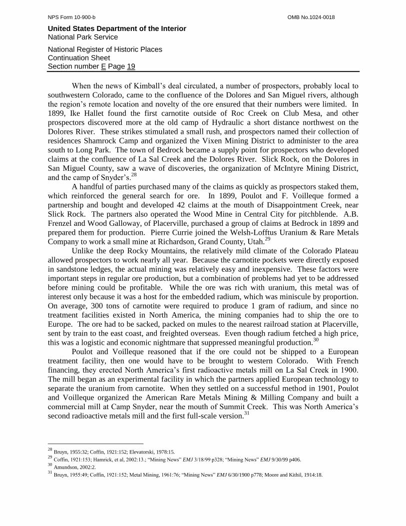
When the news of Kimball’s deal circulated, a number of prospectors, probably local to
southwestern Colorado, came to the confluence of the Dolores and San Miguel rivers, although
the region’s remote location and novelty of the ore ensured that their numbers were limited. In
1899, Ike Hallet found the first carnotite outside of Roc Creek on Club Mesa, and other
prospectors discovered more at the old camp of Hydraulic a short distance northwest on the
Dolores River. These strikes stimulated a small rush, and prospectors named their collection of
residences Shamrock Camp and organized the Vixen Mining District to administer to the area
south to Long Park. The town of Bedrock became a supply point for prospectors who developed
claims at the confluence of La Sal Creek and the Dolores River. Slick Rock, on the Dolores in
San Miguel County, saw a wave of discoveries, the organization of McIntyre Mining District,
and the camp of Snyder’s.28
A handful of parties purchased many of the claims as quickly as prospectors staked them,
which reinforced the general search for ore. In 1899, Poulot and F. Voilleque formed a
partnership and bought and developed 42 claims at the mouth of Disappointment Creek, near
Slick Rock. The partners also operated the Wood Mine in Central City for pitchblende. A.B.
Frenzel and Wood Galloway, of Placerville, purchased a group of claims at Bedrock in 1899 and
prepared them for production. Pierre Currie joined the Welsh-Lofftus Uranium & Rare Metals
Company to work a small mine at Richardson, Grand County, Utah.29
Unlike the deep Rocky Mountains, the relatively mild climate of the Colorado Plateau
allowed prospectors to work nearly all year. Because the carnotite pockets were directly exposed
in sandstone ledges, the actual mining was relatively easy and inexpensive. These factors were
important steps in regular ore production, but a combination of problems had yet to be addressed
before mining could be profitable. While the ore was rich with uranium, this metal was of
interest only because it was a host for the embedded radium, which was miniscule by proportion.
On average, 300 tons of carnotite were required to produce 1 gram of radium, and since no
treatment facilities existed in North America, the mining companies had to ship the ore to
Europe. The ore had to be sacked, packed on mules to the nearest railroad station at Placerville,
sent by train to the east coast, and freighted overseas. Even though radium fetched a high price,
this was a logistic and economic nightmare that suppressed meaningful production.30
Poulot and Voilleque reasoned that if the ore could not be shipped to a European
treatment facility, then one would have to be brought to western Colorado. With French
financing, they erected North America’s first radioactive metals mill on La Sal Creek in 1900.
The mill began as an experimental facility in which the partners applied European technology to
separate the uranium from carnotite. When they settled on a successful method in 1901, Poulot
and Voilleque organized the American Rare Metals Mining & Milling Company and built a
commercial mill at Camp Snyder, near the mouth of Summit Creek. This was North America’s
second radioactive metals mill and the first full-scale version.31
28
Bruyn, 1955:32; Coffin, 1921:152; Elevatorski, 1978:15. 29
Coffin, 1921:153; Hamrick, et al, 2002:13.; “Mining News” EMJ 3/18/99 p328; “Mining News” EMJ 9/30/99 p406. 30
Amundson, 2002:2. 31
Bruyn, 1955:49; Coffin, 1921:152; Metal Mining, 1961:76; “Mining News” EMJ 6/30/1900 p778; Moore and Kithil, 1914:18.
NPS Form 10-900-b OMB No.1024-0018
United States Department of the Interior National Park Service
National Register of Historic Places Continuation Sheet Section number E Page 20
Known as the American Rare Metals Mill, the facility was based on the patented
European Haynes-Engle process pioneered to concentrate radium. The ore was crushed, ground
in a ball mill, screened, reduced to a slurry in a second ball mill, and leached in sulfuric acid.
Workers decanted the liquor, precipitated the uranium with sodium carbonate, filtered the
concentrates, and dried then sacked them. As was common with mills, the spent liquor was
discharged as waste into the nearest drainage.32
The mills proved to be successes, but only with high-grade ore, and they produced
several hundred tons of concentrates that the company shipped to France. The impact to the
region was significant. It reinforced the value of carnotite ore, proved that profits could be
made, and served as local treatment facilities. The result was growth of the region’s carnotite
mining industry. With proof that carnotite was in demand, prospectors continued to search the
rims of the San Miguel and Dolores rivers and the major valleys such as Paradox and Big
Gypsum. The Roc Creek (Rajah) Mine sent ore to the mill, and this and other operations in the
canyon supported the town of Uranium, which received a post office in 1900. The camp of
Hydraulic, on the San Miguel River, followed a similar pattern. Mines there sent ore to the
American Rare Metals Mill, and the Postal Service recognized that settlement with a post office
in 1901. Elsewhere, and especially around Slick Rock, a number of small outfits found ore rich
enough either to sell to American Rare Metals or ship it in crude form to Europe. All the mines
were small, pocket operations, and their production should not be overstated. For context, only
375 tons of crude ore, which was nearly all the nation’s total, came from Montrose and San
Miguel counties during 1901.33
The following year, a young but genuine carnotite mining industry took shape. Both of
the American Rare Metals mills operated, mining outfits shipped ore to the railroad at
Placerville, and a number of camps grew near centers of activity. Hoping to capture some of the
ore bound for Europe, Colorado metallurgists Herman Fleck and Charles E. Carpenter leased the
Cashin Mill, which was apparently idle. They attempted to concentrate carnotite there but met
with failure because they lacked the experience of Poulot, who now focused on his successful
American Rare Metals company. During 1902, the interest in uranium spread throughout the
prospecting community, and individuals extended their search to other counties. Reports
circulated of carnotite in counties throughout the Western Slope, and even in El Paso and Teller
counties. Few if any of these, however, materialized into anything of substance.34
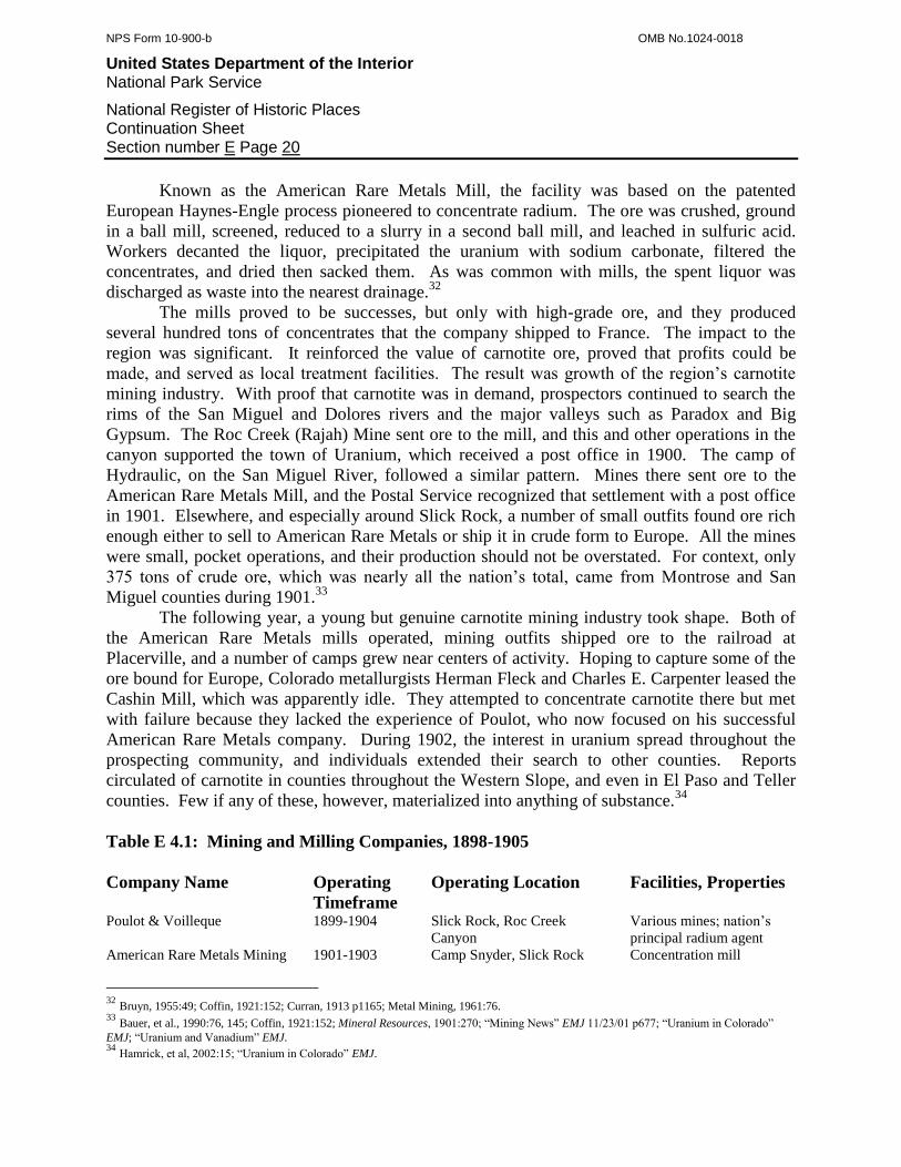
Table E 4.1: Mining and Milling Companies, 1898-1905
Company Name Operating
Timeframe
Operating Location Facilities, Properties
Poulot & Voilleque 1899-1904 Slick Rock, Roc Creek
Canyon
Various mines; nation’s
principal radium agent
American Rare Metals Mining 1901-1903 Camp Snyder, Slick Rock Concentration mill
32
Bruyn, 1955:49; Coffin, 1921:152; Curran, 1913 p1165; Metal Mining, 1961:76. 33
Bauer, et al., 1990:76, 145; Coffin, 1921:152; Mineral Resources, 1901:270; “Mining News” EMJ 11/23/01 p677; “Uranium in Colorado”
EMJ; “Uranium and Vanadium” EMJ. 34
Hamrick, et al, 2002:15; “Uranium in Colorado” EMJ.
NPS Form 10-900-b OMB No.1024-0018
United States Department of the Interior National Park Service
National Register of Historic Places Continuation Sheet Section number E Page 21
& Milling Company
Western Refining Company 1903-1904 Camp Snyder, Slick Rock Concentration mill
Dolores Refining Company 1904-1911 Camp Snyder, Slick Rock Concentration mill
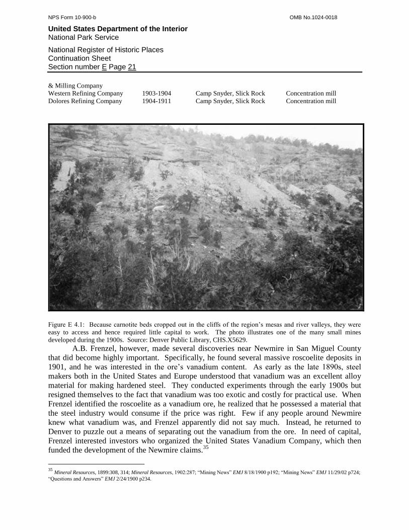
Figure E 4.1: Because carnotite beds cropped out in the cliffs of the region’s mesas and river valleys, they were
easy to access and hence required little capital to work. The photo illustrates one of the many small mines
developed during the 1900s. Source: Denver Public Library, CHS.X5629.
A.B. Frenzel, however, made several discoveries near Newmire in San Miguel County
that did become highly important. Specifically, he found several massive roscoelite deposits in
1901, and he was interested in the ore’s vanadium content. As early as the late 1890s, steel
makers both in the United States and Europe understood that vanadium was an excellent alloy
material for making hardened steel. They conducted experiments through the early 1900s but
resigned themselves to the fact that vanadium was too exotic and costly for practical use. When
Frenzel identified the roscoelite as a vanadium ore, he realized that he possessed a material that
the steel industry would consume if the price was right. Few if any people around Newmire
knew what vanadium was, and Frenzel apparently did not say much. Instead, he returned to
Denver to puzzle out a means of separating out the vanadium from the ore. In need of capital,
Frenzel interested investors who organized the United States Vanadium Company, which then
funded the development of the Newmire claims.35
35
Mineral Resources, 1899:308, 314; Mineral Resources, 1902:287; “Mining News” EMJ 8/18/1900 p192; “Mining News” EMJ 11/29/02 p724;
“Questions and Answers” EMJ 2/24/1900 p234.

NPS Form 10-900-b OMB No.1024-0018
United States Department of the Interior National Park Service
National Register of Historic Places Continuation Sheet Section number E Page 22
In 1903, Charles Poulot, the father of the American uranium mining industry, resigned
his various positions and probably returned to France. His sudden departure left a vacuum in
two key arenas. First, he no longer ran the American Rare Metals Mill, and second, Poulot &
Voilleque relinquished its role as the principal agent connecting American carnotite with the
European market. Frenzel quickly filled the latter void and assumed the role as the principal
buyer of uranium ore in the United States. At the same time, Charles E. Carpenter and Justin H.
Haynes took over the mill. Both were metallurgists, and Haynes was a valuable asset because he
helped develop the uranium recovery process that the mill employed. The partners organized the
Western Refining Company, bought the mill, and continued to treat ore.36
It appears that by 1903, the mill began to lose its efficiency. The Haynes-Engle process
was far from perfect, but it was the best method for separating uranium from carnotite at the
time. It may be that the process was not adaptable to ores of differing character, and it certainly
required the ore to be of a high grade. Whatever the problem, in 1904, Carpenter and Haynes
sold the mill to the Dolores Refining Company, which was interested in a complete mining and
milling operation. The Dolores company initially used the American Rare Metals Mill as a pilot
project for a larger facility, and when satisfied with tests, erected a better mill a short distance up
the Dolores River. To provide the new mill with plenty of ore, the company also purchased
Poulot & Voilleque’s scattered collection of mines. It remains unknown whether the company
continued to run the American Rare Metals Mill in conjunction with the new facility, which was
a complete success.37
In 1905, several factors stunted the young carnotite mining industry and prevented A.B.
Frenzel’s vanadium operation at Newmire from blossoming. The United States lacked the
experts and technology required to recover uranium and vanadium from any type of ore. Those
resources lay in Europe, but an enormous distance separated Europe from Montrose and San
Miguel counties. Because of this, carnotite mining outfits had great difficulty securing the
investments and technical assistance that they needed. In addition, the remote nature of the
carnotite region complicated operations and translated into high production costs. Under these
circumstances, Europe turned to the pitchblende ores of Joachimsthal and Schneeberg, Germany,
for its radium. In parallel with the loss of European support for carnotite mining, production in
Montrose and San Miguel counties collapsed to only around 4 tons of ore in 1905.38
First Period of Significance, 1898-1905
The temporary collapse of carnotite mining brought an end to the first Period of
Significance in Montrose and San Miguel counties. While carnotite ore was discovered around
1880, the first Period actually began in 1898 when the ore was recognized and purposefully
sought after for its radium content. A growing demand at first among the scientific community
and then the medical industry stimulated a minor wave of prospecting on the San Miguel and
36
Bruyn, 1955:50; Metal Mining, 1961:76; Moore and Kithil, 1914:18; "Questions and Answers" EMJ 3/14/03 p416. 37
Bruyn, 1955:50; Metal Mining, 1961:76; Mineral Resources, 1906:526; Moore and Kithil, 1914:18. 38
Mineral Resources, 1905:420.
NPS Form 10-900-b OMB No.1024-0018
United States Department of the Interior National Park Service
National Register of Historic Places Continuation Sheet Section number E Page 23
Dolores rivers. A nascent but important mining industry came of the interest, and it offered
several fundamental contributions. First, the world had never seen carnotite until 1897, and the
recognition of this rare mineral was a direct addition to science. Second, prospectors and mining
outfits began assembling a body of data regarding the distribution and occurrence of carnotite ore
formations. This would become highly important in later decades. Third, the first three uranium
mills in North America were built to process the ore. These mills pioneered uranium recovery
methods and established a technological foundation that would ultimately allow uranium and
vanadium mining to thrive.
E 4.3: The Radium and Vanadium Boom, 1906-1922
With carnotite mining in suspension, activity shifted over to Frenzel’s vanadium deposits
near Newmire, San Miguel County. The reason was that a few steel companies in Pennsylvania
finally began to imitate the European industry in the metallurgy of vanadium alloys. Because
vanadium was not widely available, these companies surveyed the potential sources and
identified two. One was the Minaragra Mine in Peru and the other was at Newmire, possibly
through Frenzel’s promotion. Around 1904, investors organized the Vanadium Alloys Company
to develop the Newmire roscoelite deposits into something usable by the steel industry. The
Vanadium Alloys venture was risky at the time because no precedent existed for winning
vanadium from roscoelite, and the company would have to develop effective separation methods
before it could offer anything to the steel industry. In 1904, manager William T. Rynard
purchased a number of claims near Newmire to provide ore while engineer H.A. Hillman
designed an experimental mill to test recovery methods.39
Hillman calculated that the Haynes-Engle process could separate vanadium from
roscoelite ore, with a few modifications. According to Hillman’s design, a jaw crusher reduced
crude ore to gravel, a device known as a crushing rolls pulverized it to sand, and then the
material was roasted with salt in a furnace. This converted the ore into a vanadium chloride,
which was water-soluble. Workers leached the ore in vats of water, decanted the liquid, and
added iron to precipitate out the vanadium. The workers then dried and sacked the concentrates
for shipment.40
Hillman finished the mill under great pressure in 1907 and must have felt relief when it
functioned correctly and proved his calculations correct. Following the original plan, Hillman
oversaw the construction of a commercial mill that employed the same process as the
experimental facility. With the new mill, Vanadium Alloys began production and assumed the
role of what was probably North America’s first vanadium operation.41
Vanadium Alloys was not alone in its attempt to produce vanadium during the mid-
1900s. Instead, the company was on the forefront of a larger movement. The American
Vanadium Company, the other major vanadium interest during this time, developed the
39
Daily Journal 1/26/05. 40
Mineral Resources, 1906:526; “Mining News” EMJ 4/14/06 p733. 41
Mineral Resources, 1907:721; Telluride Journal 1/23/08.
NPS Form 10-900-b OMB No.1024-0018
United States Department of the Interior National Park Service
National Register of Historic Places Continuation Sheet Section number E Page 24
Minaragra Mine in Peru and conducted its own processing experiments in Pennsylvania. This
was the beginning of competition from Peru, which would plague the American vanadium
industry in later years.
In 1909, four new vanadium ventures prepared for production. British investors
organized the General Vanadium Company to supply their steel mills in Liverpool. Instead of
targeting Newmire roscoelite, of which they knew little, the investors sought carnotite because it
was a more familiar a type of ore. The company then purchased the Jo Dandy, Valley View,
Canary Bird, and other mines on Monogram Mesa, on the south side of Paradox Valley. The
Primos Chemical Company, based in Pennsylvania, imitated the Vanadium Alloys strategy of
assembling a mining and milling operation. The company purchased a group of claims on Big
Bear Creek near Placerville, as well as the Vanadium Alloys experimental mill at Newmire, and
enlarged the mill to a commercial scale. At the same time, the firm of Wolcott & Waltemeyer
purchased a group of claims at Newmire and developed them for production. The Colorado
Vanadium Company lagged behind the others and established a lab in Boulder to study processes
for treating roscoelite. Even though Boulder was on the opposite side of the Rockies from
Newmire, the company probably chose Boulder because it was a center of tungsten mining,
which was another important and rare alloy metal.42
42
Coffin, 1921:152; Curran, 1913 p1165; Mineral Resources, 1909:584; Mineral Resources, 1910:759; “Mining News” EMJ 8/28/09 p431;
Moore and Kithil, 1914:19.
NPS Form 10-900-b OMB No.1024-0018
United States Department of the Interior National Park Service
National Register of Historic Places Continuation Sheet Section number E Page 25
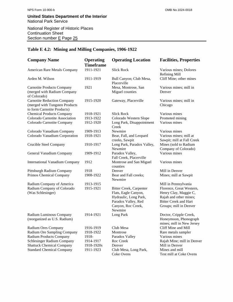
Table E 4.2: Mining and Milling Companies, 1906-1922
Company Name Operating
Timeframe
Operating Location Facilities, Properties
American Rare Metals Company 1911-1921 Slick Rock Various mines; Dolores
Refining Mill
Arden M. Wilson 1911-1919 Bull Canyon; Club Mesa,
Placerville
Cliff Mine; other mines
Carnotite Products Company
(merged with Radium Company
of Colorado)
1921 Mesa, Montrose, San
Miguel counties
Various mines; mill in
Denver
Carnotite Reduction Company
(merged with Tungsten Products
to form Carnotite Products)
1915-1920 Gateway, Placerville Various mines; mill in
Chicago
Chemical Products Company 1918-1921 Slick Rock Various mines
Colorado Carnotite Association 1913-1922 Colorado Western Slope Promoted mining
Colorado Carnotite Company 1912-1920 Long Park, Disappointment
Creek
Various mines
Colorado Vanadium Company 1909-1913 Newmire Various mines
Colorado Vanadium Corporation 1918-1921 Bear, Fall, and Leopard
creeks, Sawpit
Various mines; mill at
Sawpit; mill at Fall Creek
Crucible Steel Company 1910-1917 Long Park, Paradox Valley,
Newmire
Mines (sold to Radium
Company of Colorado)
General Vanadium Company 1909-1912 Paradox Valley,
Fall Creek, Placerville
Various mines
International Vanadium Company 1912 Montrose and San Miguel
counties
Various mines
Pittsburgh Radium Company 1918 Denver Mill in Denver
Primos Chemical Company 1908-1922 Bear and Fall creeks;
Newmire
Mines; mill at Sawpit
Radium Company of America 1913-1915 Mill in Pennsylvania
Radium Company of Colorado
(Was Schlesinger)
1915-1921 Bitter Creek, Carpenter
Flats, Eagle Canyon,
Hydraulic, Long Park,
Paradox Valley, Red
Canyon, Roc Creek,
Newmire
Florence, Great Western,
Henry Clay, Maggie C,
Rajah and other mines;
Bitter Creek and Hart
Groups; mill in Denver
Radium Luminous Company
(reorganized as U.S. Radium)
1914-1921 Long Park Doctor, Cripple Creek,
Honeymoon, Phonograph
mines; mill in New Jersey
Radium Ores Company 1916-1919 Club Mesa Cliff Mine and Mill
Radium Ore Sampling Company 1918-1922 Montrose Rare metals sampler
Radium Products Company 1918- Paradox Valley Various mines
Schlesinger Radium Company 1914-1917 Roc Creek Rajah Mine; mill in Denver
Shattuck Chemical Company 1918-1920s Denver Mill in Denver
Standard Chemical Company 1911-1923 Club Mesa, Long Park,
Coke Ovens
Mines and mill
Test mill at Coke Ovens
NPS Form 10-900-b OMB No.1024-0018
United States Department of the Interior National Park Service
National Register of Historic Places Continuation Sheet Section number E Page 26
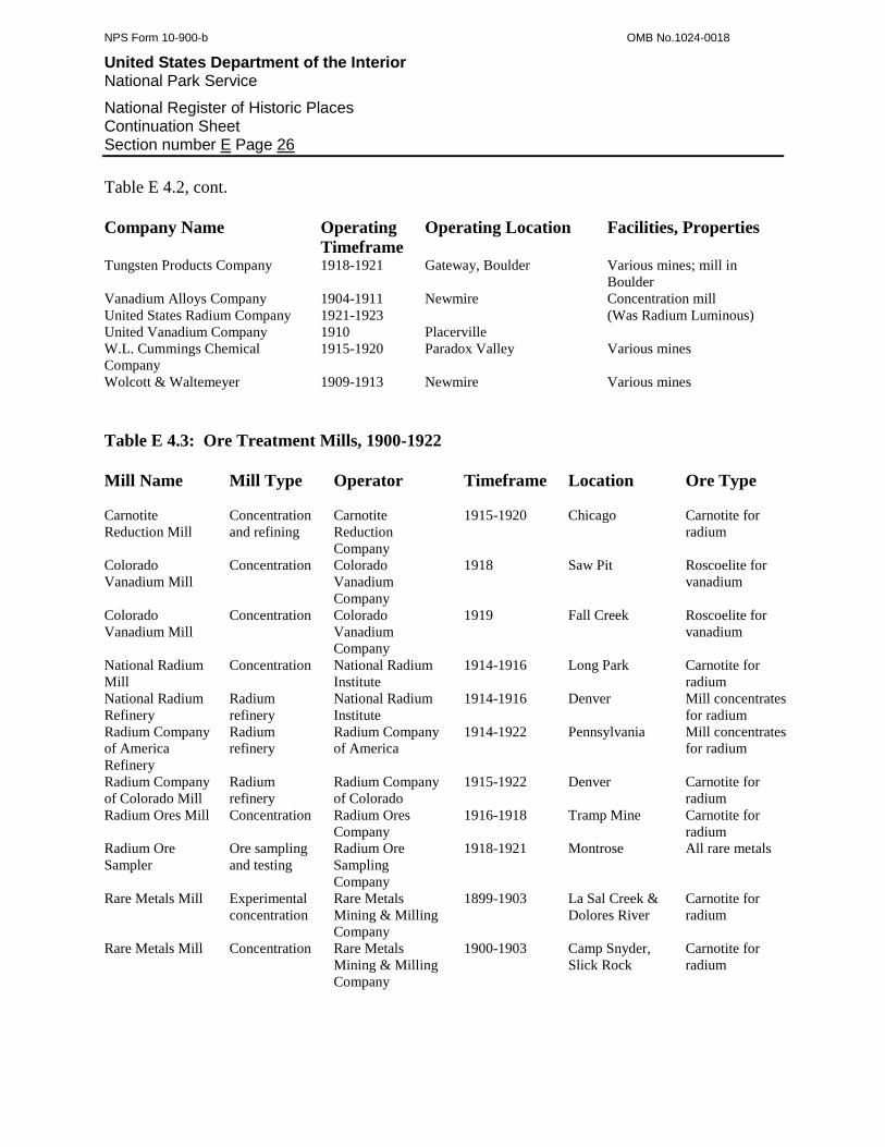
Table E 4.2, cont.
Company Name Operating
Timeframe
Operating Location Facilities, Properties
Tungsten Products Company 1918-1921 Gateway, Boulder Various mines; mill in
Boulder
Vanadium Alloys Company 1904-1911 Newmire Concentration mill
United States Radium Company 1921-1923 (Was Radium Luminous)
United Vanadium Company 1910 Placerville
W.L. Cummings Chemical
Company
1915-1920 Paradox Valley Various mines
Wolcott & Waltemeyer 1909-1913 Newmire Various mines
Table E 4.3: Ore Treatment Mills, 1900-1922
Mill Name Mill Type Operator Timeframe Location Ore Type
Carnotite
Reduction Mill
Concentration
and refining
Carnotite
Reduction
Company
1915-1920 Chicago Carnotite for
radium
Colorado
Vanadium Mill
Concentration Colorado
Vanadium
Company
1918 Saw Pit Roscoelite for
vanadium
Colorado
Vanadium Mill
Concentration Colorado
Vanadium
Company
1919 Fall Creek Roscoelite for
vanadium
National Radium
Mill
Concentration National Radium
Institute
1914-1916 Long Park Carnotite for
radium
National Radium
Refinery
Radium
refinery
National Radium
Institute
1914-1916 Denver Mill concentrates
for radium
Radium Company
of America
Refinery
Radium
refinery
Radium Company
of America
1914-1922 Pennsylvania Mill concentrates
for radium
Radium Company
of Colorado Mill
Radium
refinery
Radium Company
of Colorado
1915-1922 Denver Carnotite for
radium
Radium Ores Mill Concentration Radium Ores
Company
1916-1918 Tramp Mine Carnotite for
radium
Radium Ore
Sampler
Ore sampling
and testing
Radium Ore
Sampling
Company
1918-1921 Montrose All rare metals
Rare Metals Mill Experimental
concentration
Rare Metals
Mining & Milling
Company
1899-1903 La Sal Creek &
Dolores River
Carnotite for
radium
Rare Metals Mill Concentration Rare Metals
Mining & Milling
Company
1900-1903 Camp Snyder,
Slick Rock
Carnotite for
radium

NPS Form 10-900-b OMB No.1024-0018
United States Department of the Interior National Park Service
National Register of Historic Places Continuation Sheet Section number E Page 27
Table E 4.3, cont.
Mill Name Mill Type Operator Timeframe Location Ore Type Rare Metals Mill Concentration Western Refining
Company
1903-1904 Camp Snyder,
Slick Rock
Carnotite for
radium
Rare Metals Mill Concentration Dolores Refining
Company
1904-1909 Camp Snyder,
Slick Rock
Carnotite for
radium
Rare Metals Mill Concentration Rare Metals
Company
1911-1922 Camp Snyder,
Slick Rock
Carnotite for
radium
Schlesinger
Radium Mill
Concentration
and refining
Schlesinger
Radium Company
1914-1917 Denver Carnotite for
radium
Schlesinger
Radium Mill
Concentration
and refining
Radium Company
of Colorado
1917-1923 Denver Carnotite for
radium
Shattuck Mill Concentration
and refining
Shattuck Chemical
Company
1918-1922 Denver Carnotite for
radium
Standard
Chemical
Experimental Mill
Concentration Standard Chemical
Company
1910-1912 Coke Ovens,
western Paradox
Valley
Carnotite for
radium
Standard
Chemical
Experimental Mill
Concentration Standard Chemical
Company
1912-1914 Joe Jr. Camp Carnotite for
radium
Standard
Chemical
Experimental
Refinery
Radium
refining
Standard Chemical
Company
1910-1912 Canonsburg,
Pennsylvania
Mill concentrates
for radium
Standard
Chemical Mill
Concentration Standard Chemical
Company
1914-1923 Joe Jr. Camp,
Club Mesa
Carnotite for
radium and
vanadium
Standard
Chemical
Refinery
Radium
refining
Standard Chemical
Company
1912-1923 Canonsburg,
Pennsylvania
Mill concentrates
for radium
Vanadium Alloys
Experimental Mill
Experimental
concentration
Vanadium Alloys
Company
1906-1907 Vanadium Roscoelite for
vanadium
Vanadium Alloys
Experimental Mill
Experimental
concentration
Primos Chemical
Company
1908 Vanadium Roscoelite for
vanadium
Vanadium Alloys
Mill
Concentration Vanadium Alloys
Company
1909-1911 Vanadium Roscoelite for
vanadium
Vanadium Alloys
Mill
Concentration Primos Chemical
Company
1911-1922 Vanadium Roscoelite for
vanadium
During the next several years, Newmire became the center of vanadium mining in the United
States. An increase in demand for vanadium among steel makers coupled with successful
mining around Newmire and Placerville stimulated a small boom. This not only reinforced the
existing operations, but also drew additional companies and a wave of prospectors. In 1910 and
1911, the United Vanadium Company and the Crucible Steel Company of America (Crusca)
arrived with enough capital to develop several substantial mines. Colorado Vanadium finished
with its tests in Boulder and brought a mine into production, as well. The Primos Chemical
Company and General Vanadium, however, maintained title as the largest operations. In 1910,

NPS Form 10-900-b OMB No.1024-0018
United States Department of the Interior National Park Service
National Register of Historic Places Continuation Sheet Section number E Page 28
General Vanadium finally took an interest in roscoelite and purchased several groups of rich
claims on Fall Creek. Primos, which already operated a large mine on Bear Creek, added 2,000
acres of claims to its holdings, leased the second Vanadium Alloys Mill at Newmire, and
improved the facility. The activity was so pronounced that the mining industry began referring
to Newmire as Vanadium, which the Postal Service officially recognized in 1913.43
Figure E 4.2: The Rare Metals Mill, built in 1903, was North America’s first commercial uranium concentration
facility. A succession of companies operated the mill, which apparently burned during the 1920s. The exact date of
the photograph is unknown, although most likely during the 1910s. Source: Denver Public Library, X-61965.
43
Bauer, et al., 1990:146; Curran, 1911 p1287; Daily Journal 3/28/10; Daily Journal 5/26/11; Mineral Resources, 1911:949; Mineral Resources,
1913:364; “Mining News” EMJ 6/24/11 p1272; “Mining News” EMJ 3/30/12 p667.
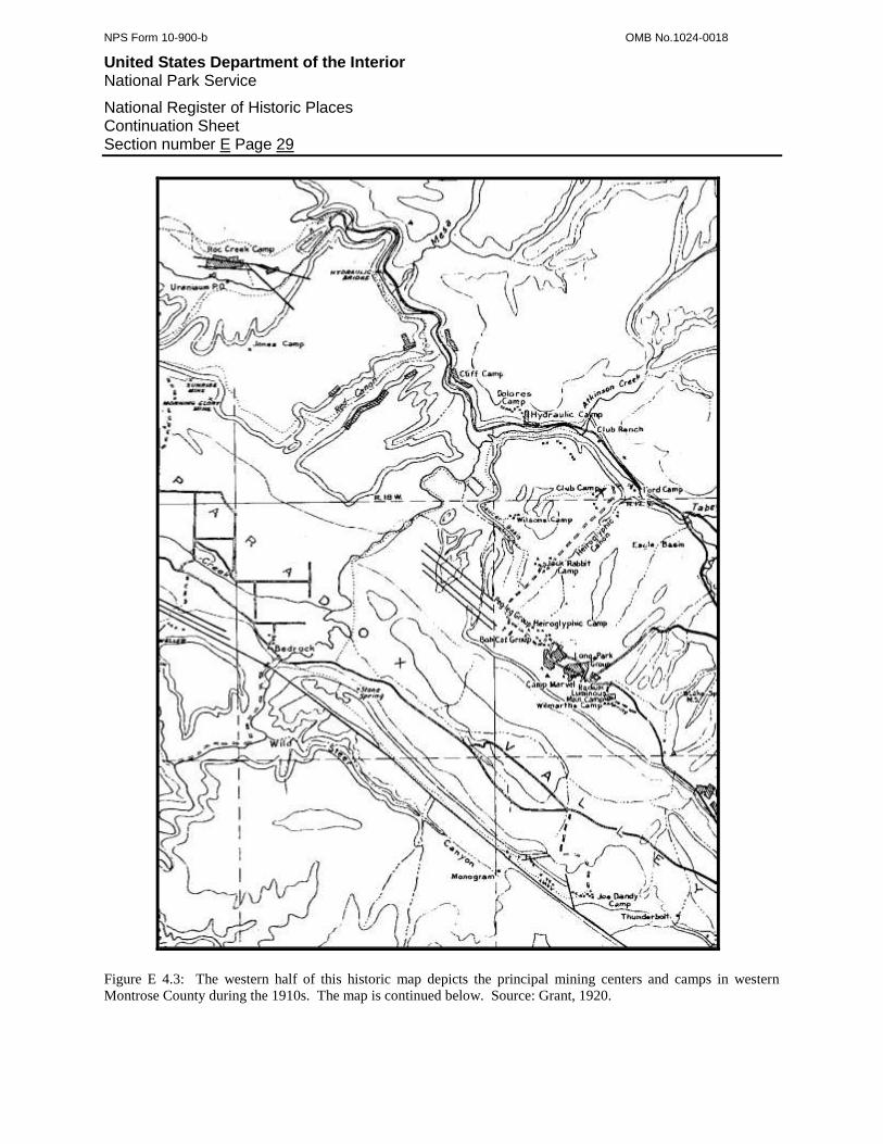
NPS Form 10-900-b OMB No.1024-0018
United States Department of the Interior National Park Service
National Register of Historic Places Continuation Sheet Section number E Page 29
Figure E 4.3: The western half of this historic map depicts the principal mining centers and camps in western
Montrose County during the 1910s. The map is continued below. Source: Grant, 1920.
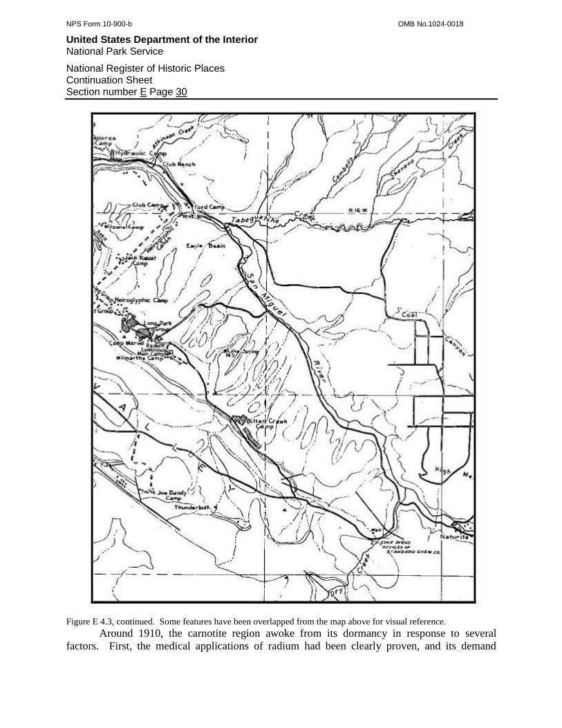
NPS Form 10-900-b OMB No.1024-0018
United States Department of the Interior National Park Service
National Register of Historic Places Continuation Sheet Section number E Page 30
Figure E 4.3, continued. Some features have been overlapped from the map above for visual reference.
Around 1910, the carnotite region awoke from its dormancy in response to several
factors. First, the medical applications of radium had been clearly proven, and its demand

NPS Form 10-900-b OMB No.1024-0018
United States Department of the Interior National Park Service
National Register of Historic Places Continuation Sheet Section number E Page 31
increased both in Europe and the United States. Second, a number of European firms developed
refining processes that were more effective than ever. Third, through its Monogram Mesa
operations, General Vanadium demonstrated that carnotite was rich with vanadium in addition to
radium. Last, several prominent individuals promoted carnotite and attempted to revive its
production in Colorado. In particular, Thomas F.V. Curran, manager for General Vanadium,
reminded European firms that carnotite was an economical alternative for radium to the
pitchblende ore mined in Germany. Thomas F. Walsh, who realized a fortune from the Camp
Bird Mine near Telluride, funded a program to encourage the awareness and discovery of radium
ores in Colorado.44
The revival began on a small scale on the mesas flanking Paradox Valley. On the cliffs
of Monogram Mesa, on the valley’s south side, General Vanadium invested in its Jo Dandy Mine
and prepared for increased production. The company erected a camp that featured bunkhouses
for an increased workforce and lab to test the richness of carnotite samples. In Long Park, on the
valley’s north side, Crusca acquired three claims rich with ore and developed them as the Maggie
C, Henry Clay, and Swindler (later known as the Vanadate).45
But the death of a young woman in Pennsylvania was the event that gave the greatest
momentum to the revival. The woman was sister to Joseph M. Flannery, who was connected to
the American Vanadium Company, and she died of cancer with little hope of survival because
therapeutic radium was scarce in the United States. Devastated by the loss, Flannery vowed to
make radium available for others and educated himself on the issues of radium production and
refining. Flannery realized that carnotite was the only domestic source and would not only
provide the curative material, but also vanadium for his company. He also understood that the
lack of adequate concentration and refining facilities were at the root of the supply problem, and
if a facility could be built, radium would be available.46
In 1910, Flannery devised an aggressive plan to develop effective concentration and
refining methods, and build a small radium empire. He started by organizing the Standard
Chemical Company for funding, moved on to an experimental radium refinery at Canonsburg,
Pennsylvania, and when this proved successful, Flannery built a full-scale version. At the same
time, Flannery dispatched expert engineers to Colorado to arrange for production and an ore
concentration facility. To provide ore, they secured several mines in Long Park and the
Thunderbolt Group adjacent to General Vanadium’s Jo Dandy Mine. To support mining and
house a workforce of 40 at the Thunderbolt, the engineers erected Camp Hequembourg, which
they equipped with an office, a lab, bunkhouses, and one of only several telephones in western
Montrose County. The engineers also constructed a pilot concentration mill at Coke Ovens in
the east end of Paradox Valley. According to the plan, ore from the Thunderbolt Group was
packed to the concentration mill, which was supposed to separate out waste, and the concentrates
could then be sent by railroad to the refinery at Canonsburg, which should have produced the
44
Curran, 1913, p1165; “Special Correspondence” EMJ 9/4/09 p477. 45
Coffin, 1921:152; Curran, 12/30/11. 46
Hamrick, et al, 2002:16.

NPS Form 10-900-b OMB No.1024-0018
United States Department of the Interior National Park Service
National Register of Historic Places Continuation Sheet Section number E Page 32
final radium. Flannery and associates spent most of 1911 testing this strategy to see if it was
both technologically feasible and economical.47
Even though Standard Chemical was not yet formally in production, Flannery’s major
interest and investment inspired confidence in the carnotite region. Prospectors returned and
made a number of discoveries on the San Miguel Bench near Hydraulic, in Long Park, on
Monogram Mesa, and in Bull Canyon. Many of these were developed on a small scale by
partnerships. At Slick Rock, the American Rare Metals Company purchased the idle Dolores
Refining Mill and refitted it to recover uranium in addition to vanadium. O. Barlow Wilmarth
and other investors organized the Colorado Carnotite Company primarily as an ore brokerage
firm. The company mined a few of its own claims but purchased most of its ore from
independent outfits at Slick Rock and in Long Park. One of the most promising operations was
the Radium Company of America, which imitated Flannery’s mining and refining strategy. Like
Flannery, the Radium Company erected a test refinery in Pennsylvania, and when the facility
was successful, began building another on a commercial scale. But because Standard Chemical
and the Radium Company were not yet ready to accept custom business, the various mining
outfits in the carnotite region had to ship their total of 1,515 tons of ore to Europe for treatment.48
The journey from western Montrose County to Europe had three segments that consumed
nearly all the profits and limited the mining outfits to the highest grades of ore. The ore had to
be hauled by wagon to the railroad at Placerville, which cost between $20 and $30 per ton. An
ore broker then received the payrock and loaded it onto rail cars for the trip to the New York
City waterfront for a fee of around $12 per ton. A shipping company completed the final leg of
the journey to Europe or England for an additional $15. After subtracting milling and other fees,
and the costs of operating in deep western Montrose County, the mining outfits had little money
left over. In general, the industry found that carnotite with less than two percent uranium content
was uneconomical to produce. Given this, it is obvious why the mining outfits eagerly waited
for Standard Chemical and the Radium Company to finish their refineries and reduce the
shipping expenses.49
Standard Chemical and the Radium Company had as much interest in completing their
refineries as did the mining outfits. Progress on the refineries was slow, however, because little
technological precedent existed for recovering radium, and carnotite was unlike any ore that the
mining industry had experience with. In 1912, Standard Chemical and the Radium Company
finally developed effective and economical methods not only for recovering radium, but also for
concentrating carnotite ore in the field. The next step for these companies was to apply their
theoretical practices on a commercial level, which would cause further delays. Meanwhile, the
mining outfits in Montrose and San Miguel counties continued to send their ore to Europe while
the overall industry stagnated, and radium remained scarce and costly in the United States.50
These trends and the European control over what could have been an American radium
industry deeply concerned private and government interests. In 1912, the U.S. Bureau of Mines
47
Bruyn, 1955:44; Coffin, 1921:152; Curran, 12/30/11; Hamrick, et al, 2002:16; Mineral Resources, 1910:760. 48
Alvord, 1956:5; Coffin, 1921:194; Daily Journal 3/31/11; Hamrick, et al, 2002:5; Metal Mining, 1961:79; “Mining News” EMJ 3/30/12 p667;
“Mining News” EMJ 9/28/12 p614; Moore and Kithil, 1914:19; Telluride Journal 12/14/11. 49
Moore and Kithil, 1914:34. 50
Mineral Resources, 1912:1008.
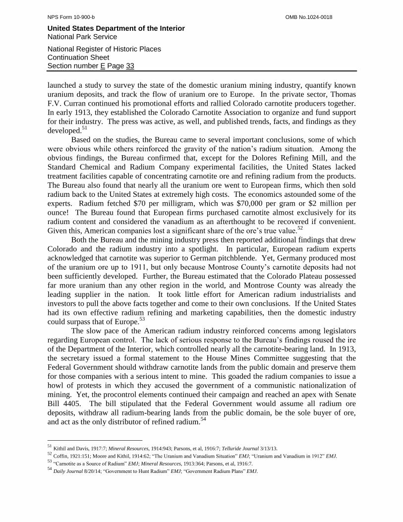
NPS Form 10-900-b OMB No.1024-0018
United States Department of the Interior National Park Service
National Register of Historic Places Continuation Sheet Section number E Page 33
launched a study to survey the state of the domestic uranium mining industry, quantify known
uranium deposits, and track the flow of uranium ore to Europe. In the private sector, Thomas
F.V. Curran continued his promotional efforts and rallied Colorado carnotite producers together.
In early 1913, they established the Colorado Carnotite Association to organize and fund support
for their industry. The press was active, as well, and published trends, facts, and findings as they
developed.51
Based on the studies, the Bureau came to several important conclusions, some of which
were obvious while others reinforced the gravity of the nation’s radium situation. Among the
obvious findings, the Bureau confirmed that, except for the Dolores Refining Mill, and the
Standard Chemical and Radium Company experimental facilities, the United States lacked
treatment facilities capable of concentrating carnotite ore and refining radium from the products.
The Bureau also found that nearly all the uranium ore went to European firms, which then sold
radium back to the United States at extremely high costs. The economics astounded some of the
experts. Radium fetched $70 per milligram, which was $70,000 per gram or $2 million per
ounce! The Bureau found that European firms purchased carnotite almost exclusively for its
radium content and considered the vanadium as an afterthought to be recovered if convenient.
Given this, American companies lost a significant share of the ore’s true value.52
Both the Bureau and the mining industry press then reported additional findings that drew
Colorado and the radium industry into a spotlight. In particular, European radium experts
acknowledged that carnotite was superior to German pitchblende. Yet, Germany produced most
of the uranium ore up to 1911, but only because Montrose County’s carnotite deposits had not
been sufficiently developed. Further, the Bureau estimated that the Colorado Plateau possessed
far more uranium than any other region in the world, and Montrose County was already the
leading supplier in the nation. It took little effort for American radium industrialists and
investors to pull the above facts together and come to their own conclusions. If the United States
had its own effective radium refining and marketing capabilities, then the domestic industry
could surpass that of Europe.53
The slow pace of the American radium industry reinforced concerns among legislators
regarding European control. The lack of serious response to the Bureau’s findings roused the ire
of the Department of the Interior, which controlled nearly all the carnotite-bearing land. In 1913,
the secretary issued a formal statement to the House Mines Committee suggesting that the
Federal Government should withdraw carnotite lands from the public domain and preserve them
for those companies with a serious intent to mine. This goaded the radium companies to issue a
howl of protests in which they accused the government of a communistic nationalization of
mining. Yet, the procontrol elements continued their campaign and reached an apex with Senate
Bill 4405. The bill stipulated that the Federal Government would assume all radium ore
deposits, withdraw all radium-bearing lands from the public domain, be the sole buyer of ore,
and act as the only distributor of refined radium.54
51
Kithil and Davis, 1917:7; Mineral Resources, 1914:943; Parsons, et al, 1916:7; Telluride Journal 3/13/13. 52
Coffin, 1921:151; Moore and Kithil, 1914:62; “The Uranium and Vanadium Situation” EMJ; “Uranium and Vanadium in 1912” EMJ. 53
“Carnotite as a Source of Radium” EMJ; Mineral Resources, 1913:364; Parsons, et al, 1916:7. 54
Daily Journal 8/20/14; “Government to Hunt Radium” EMJ; “Government Radium Plans” EMJ.
NPS Form 10-900-b OMB No.1024-0018
United States Department of the Interior National Park Service
National Register of Historic Places Continuation Sheet Section number E Page 34
When the bill came up for a vote in early 1914, it was naturally defeated because the
measures were perceived as too radical. The bill’s backers never expected it to pass and instead
merely used the bill as tool to frighten the radium industry into more action than it had taken up
to that time. The bill served its purpose, and the carnotite mining industry began to boom in
1914. Curiously, the bill was the Federal Government’s first attempt at influencing and even
controlling radioactive metals mining and was a portent of legislation to come.55
The government did not expect the private sector to bear the entire responsibility of
solving the technological problems that confounded the industry. Instead, the Bureau of Mines
established the National Radium Institute to identify the best practices for uranium and vanadium
ore mining and milling and to assist American companies in their application. In 1914, the
Institute began a multiyear study that focused on carnotite production and treatment. In terms of
treatment, the Institute designed two experimental facilities to reduce carnotite and then separate
out the radium content. Because Colorado was the domestic center of radium mining, the
Institute naturally sited the facilities in the state. One of the facilities was a small concentration
mill built in Long Park to be near the mines and the other was a refinery near the main office in
Denver. The Institute also leased the Vanadate, Maggie C, and Henry Clay mines from Crusca,
and when the Institute worked them, it used the opportunity to study mining methods.56
The private sector and the government consumed an entire year mobilizing, but by 1914,
they laid a foundation for a carnotite boom. Standard Chemical and the Radium Company were
on the forefront of the boom in large part because they finally finished their refining facilities.
Standard Chemical had the potential to greatly lower production costs because it was a local
operation. During 1911, Flannery acquired a large tract of the Club Ranch on the San Miguel
River and built another experimental mill, a laboratory, a boardinghouse, and a small tent colony
for workers, and he named the complex Joe Jr. Camp after his son. When the second mill
confirmed an effective process, Flannery moved quickly to build a full-scale facility at the camp.
By the middle of 1914, the Standard Chemical Mill began treating local carnotite while manager
J.J. Mullen encouraged mining outfits to send overflow ore directly to the refinery in
Pennsylvania.57
Three more companies in addition to Standard Chemical solicited carnotite ore for
treatment in 1914. One was American Rare Metals, which continued to operate its Dolores
Refining Mill on ore produced around Slick Rock. The Radium Company was the second, and it
solicited ore for its new Pennsylvania refinery. The last was Schlesinger Radium Company, a
Colorado startup organized in 1914 by university chemists William A. Schlesinger and Henry T.
Koenig. As the company name implies, Schlesinger was the outfit’s driving force and began in
the industry with a radium lab at Princeton University. With funding supplied by Victor C.
Thorne of New York City, Schlesinger built an effective refinery in Denver and then advertised
among the Montrose and San Miguel county carnotite producers for their ore.58
55
“Colorado's Radium” EMJ. 56
“Bureau of Mines Radium Production” EMJ; Hamrick, et al, 2002:16; Kithil and Davis, 1917:61; Parsons, et al, 1916:10. 57
Daily Journal 3/21/14; Daily Journal 7/17/14; Hamrick, et al, 2002:17; “Mining News” EMJ 11/21/14 p935. 58
Bruyn, 1955:66; Mineral Resources, 1915:832; “Mining News” EMJ 1/24/14 p252; Moore and Kithil, 1914:29, 74.
NPS Form 10-900-b OMB No.1024-0018
United States Department of the Interior National Park Service
National Register of Historic Places Continuation Sheet Section number E Page 35
Over the course of a year, the carnotite mining industry finally saw the number of
commercial ore treatment facilities quadruple. American Rare Metals and Standard Chemical
operated two local concentration mills, Schlesinger built its refinery in Denver, and Standard
Chemical and the Radium Company ran refineries in Pennsylvania. However, for the
independent mining outfits, the impact was not as grand as expected. The reason was that all the
above companies also had their own mines and treated the ore in-house. When Standard
Chemical was building its experimental mills, Flannery purchased around 300 claims, and by
1913, the company amassed around 1,100 acres in Montrose County. Similarly, the Radium
Company aggressively acquired mines to supply enough ore to keep its refinery busy. American
Rare Metals owned several mines on Disappointment Creek, and Thorne bought the Rajah Mine
on Roc Creek for the Schlesinger refinery.59
Naturally, the above companies treated their own ores first and accepted custom ores
from the independent outfits secondarily. The independent outfits realized that the milling
capacity available to them was limited, and while the outfits were free to send their ore to the
mills, some faced long delays in payment. The net result was twofold. First, the shortage of
milling capacity suppressed the growing carnotite boom, and second, those mining outfits in
need of regular income continued to ship their high-grade ore to Europe.
Another problem was that the refining companies designed their facilities to recover the
radium content of carnotite because radium fetched the highest price and enjoyed the greatest
demand. The refineries recovered none of the vanadium, which perpetuated the economic loss of
shipping the ore to the European firms. Of this trend, mining statisticians noted:
“Although carnotite contains three times as much uranium oxide as vanadium oxide, the Colorado
and Utah carnotite ores generally contain other vanadium minerals in quantity so large that the
vanadium oxide content of the ores is larger than that of uranium oxide. Little is paid for the
vanadium, however, as its separation from uranium is troublesome, and only a few thousand
dollars was received in 1914 by brokers or producers for the vanadium in the ores sold.”60
Overall, the Federal Government’s machinations, the Bureau of Mines’ efforts, and the
advances made by the private sector brought the slow and steady growth into a small boom. Ore
production almost doubled from 2,270 tons in 1913 to 4,300 tons during 1914, and nearly all of
this came from the Paradox Valley area.61
The increase in both production and interest in radium
and vanadium prompted records-keepers to state:
“The year 1914 was an eventful one in the industry of mining ores of radium, uranium, and
vanadium, and showed by far the largest annual output yet made, amounting to 4,294 short tons of
dry ore carrying 87.2 tons of uranium oxide, and 22.3 grams of metallic radium.”62
In less than one year after overcoming their most important problems, the intertwined
American radium and vanadium industries stalled in the face of a severe blow. By 1914, the
59
Bruyn, 1955:51, 66; Daily Journal 9/27/13; Mineral Resources, 1915:832; “Radium from American Carnotite” EMJ. 60
Mineral Resources, 1914:943. 61
EMJ 10/24/14; Mineral Resources, 1913:363; Mineral Resources, 1914:943; “Mining in Utah in 1914” EMJ. 62
Mineral Resources, 1914:943.
NPS Form 10-900-b OMB No.1024-0018
United States Department of the Interior National Park Service
National Register of Historic Places Continuation Sheet Section number E Page 36
vanadium industry, based on both Newmire roscoelite and carnotite, was second in world
importance only to American Vanadium’s Peru operations. Similarly, the radium industry was
second in importance to that of Europe and held the promise of surpassing Europe’s production
capacity. However, the American industries still relied to a great degree on Europe’s radium and
vanadium markets and on its ore treatment firms. When World War I erupted, the European
radium and vanadium markets collapsed, the economy soured, ore treatment facilities converted
to wartime needs, and shipping was interrupted. Now unable to rely on Europe, the American
radium and vanadium industries were threatened with implosion.63
The short-term response among both industries was turn to the domestic demand, which
was very limited. Within a short time, the national radium and vanadium markets approached
saturation, and in response, the industries scaled back operations. In 1915, San Miguel County
saw few if any new vanadium ventures, and production contracted to the large and entrenched
firms such as the Primos Chemical Company, the General Vanadium Company, and Crusca.
The carnotite operations split and went in two different directions. Most of the large
firms either reduced operations or suspended altogether, exemplified by Standard Chemical,
which shut down its new mill. However, some companies continued the momentum of 1914 and
carried their major projects to completion, despite the poor radium market. Sabin A. Von
Sochochy, of German origin, patented a glow-in-the-dark paint that utilized the luminous
properties of radium, and sold it for use on watches, instrument dials, and surveying equipment.
In 1914, he organized the Radium Luminous Company in New Jersey, built a refining mill, and
purchased several mines in Long Park. By 1915, the Radium Luminous Company had these
mines in production, established Radium Luminous Camp in Long Park as an administrative
center, and bought more claims. Dr. H.N. McCoy of the University of Chicago, and Galloway &
Belisle, organized the Carnotite Reduction Company and built a radium facility in Chicago. In
1915, the firm purchased carnotite that had been stockpiled at Placerville and acquired claims.
In the same timeframe, investors organized the Radium Company of Colorado and built
Denver’s second radium refinery. With seven radium mills in place, numerous mines at the
ready, and undeveloped ore deposits, the carnotite operations were poised for the radium revival
that was inevitable. While a revival was, in fact, inevitable, it was by no means immediate.64
Because vanadium was a key ingredient for the hardened steel alloys used in weapons
and armor, the vanadium industry was able to maintain a low level of production. Primos
employed a workforce of around 100 at its mines and mill, and General Vanadium operated
roscoelite mines at the town of Vanadium and several carnotite mines in the Paradox Valley.
The radium industry, however, declined through 1916. In hopes of bolstering the industry, the
National Radium Institute hastened its studies and planned to release the results in aid of private
industry. Thomas F.V. Curran continued his tireless promotion efforts and established the
Radium Ore Association in 1916. The organization, similar to his earlier Colorado Carnotite
Association, promoted carnotite, marketed the ore, and attempted to maintain high prices.65
63
Coffin, 1921:151; “Mining News” EMJ 8/22/14 p369; “Metal Mining in Colorado in 1914” EMJ; “Unusual Ores and Metals in 1917” EMJ. 64
Amundson, 2002:2; Aurand, 1920; Chenoweth, 1993:12; Grant, 1920; Mineral Resources, 1915:832; “Mining News” EMJ 4/30/21 p759. 65
“Mining News” EMJ 2/12/16 p333.

NPS Form 10-900-b OMB No.1024-0018
United States Department of the Interior National Park Service
National Register of Historic Places Continuation Sheet Section number E Page 37
Figure E 4.4: Several Radium Luminous Company cabins still stand at the Long Park headquarters site today. The
cabin illustrated may have been an office. Source: Author.
World War I, which brought the radium industry to the brink of ruin and suppressed the
vanadium industry, finally reversed the ill fortunes of western Montrose and San Miguel
counties. When Europe went to war in 1914, the various powers assumed that the conflict would
last no more than a year. Instead, the war dragged on and slowly drained Europe’s manpower
and resources. By 1917, Europe’s radium stores were gone and the arms manufacturers had
exhausted their alloy materials. The Allies naturally turned to the United States for alloy
vanadium, which was of the utmost importance, and also sought radium for those individuals still
able to afford medical care. At the same time, the Federal Government mobilized to supply arms
to the Allies and meet the needs of its own military.
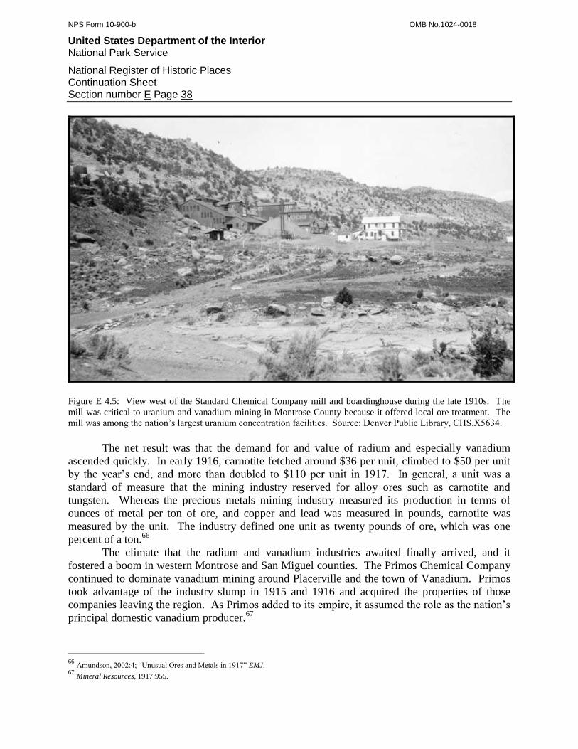
NPS Form 10-900-b OMB No.1024-0018
United States Department of the Interior National Park Service
National Register of Historic Places Continuation Sheet Section number E Page 38
Figure E 4.5: View west of the Standard Chemical Company mill and boardinghouse during the late 1910s. The
mill was critical to uranium and vanadium mining in Montrose County because it offered local ore treatment. The
mill was among the nation’s largest uranium concentration facilities. Source: Denver Public Library, CHS.X5634.
The net result was that the demand for and value of radium and especially vanadium
ascended quickly. In early 1916, carnotite fetched around $36 per unit, climbed to $50 per unit
by the year’s end, and more than doubled to $110 per unit in 1917. In general, a unit was a
standard of measure that the mining industry reserved for alloy ores such as carnotite and
tungsten. Whereas the precious metals mining industry measured its production in terms of
ounces of metal per ton of ore, and copper and lead was measured in pounds, carnotite was
measured by the unit. The industry defined one unit as twenty pounds of ore, which was one
percent of a ton.66
The climate that the radium and vanadium industries awaited finally arrived, and it
fostered a boom in western Montrose and San Miguel counties. The Primos Chemical Company
continued to dominate vanadium mining around Placerville and the town of Vanadium. Primos
took advantage of the industry slump in 1915 and 1916 and acquired the properties of those
companies leaving the region. As Primos added to its empire, it assumed the role as the nation’s
principal domestic vanadium producer.67
66
Amundson, 2002:4; “Unusual Ores and Metals in 1917” EMJ. 67
Mineral Resources, 1917:955.

NPS Form 10-900-b OMB No.1024-0018
United States Department of the Interior National Park Service
National Register of Historic Places Continuation Sheet Section number E Page 39
Figure E 4.6: During the latter half of the 1910s, the Primos Chemical Company operated North America’s largest
vanadium mill at the town of Vanadium. At the time, the vanadium mining industry experienced a boom due to a
heavy wartime demand for vanadium. Source: Denver Public Library, CHS.X5701.
Because carnotite carried both vanadium and radium, the ore enjoyed a demand that was
heavier than ever. This time, however, the roles of the metal constituents were reversed. In the
past, companies produced carnotite for its radium and considered the vanadium as an
afterthought. By 1917, the large companies refitted their mills to recover vanadium first and
radium only as a byproduct. In so doing, the companies found carnotite to be highly profitable
because the ore featured four times more vanadium than uranium.68
Repeating the pattern of the past carnotite excitements, the World War I boom provided
opportunities for both large companies and independent parties. Prospectors were quick to sense
the potential and congregated in the areas known for production. Some worked out of Standard
Chemical’s Joe Jr. and Ford camps, and others stayed in Julian Camp, on the San Miguel River
68
Amundson, 2002:4; Boardman, 1956, et al.:17.
NPS Form 10-900-b OMB No.1024-0018
United States Department of the Interior National Park Service
National Register of Historic Places Continuation Sheet Section number E Page 40
at the mouth of Tabegauche Creek. Further down the river, more prospectors occupied
Hydraulic Camp, at the abandoned hydraulic placer workings. On the west side of Hieroglyphic
Canyon, which was incised into Long Park Mesa, they established Jack Rabbit Camp, and more
lived in Hart Camp in nearby Eagle Canyon. On Monogram Mesa to the south, prospectors
contributed heavily to the formation of Monogram Mesa Camp and Wedding Bell Camp on the
west side of Wedding Bell Mountain. They also worked out of Bed Rock and Slick Rock. From
these bases of operation, both independent prospectors and professionals employed by the large
companies found additional ore deposits.
Ultimately, the carnotite boom remained the domain of the large, heavily capitalized
mining companies. Operating costs were high, freighting distances to the railroad at Placerville
were lengthy, the ore had to be handled in economies of scale, and ore processing was beyond
the means of the independent mining outfits. However, many independent outfits found a niche
among the large companies. Specifically, they focused on the ore pockets that were too small to
interest the large companies. In some cases, the large companies owned the claims and leased
them to the independent outfits, or the outfits acquired the properties themselves. In both cases,
the independent outfits began to thrive in 1917 and contributed a significant volume of ore on a
collective basis.
The large companies, which already controlled extensive tracts of claims, focused on the
richest ore bodies and developed them through groups of mines. Standard Chemical assumed the
role as the region’s leading producer because it had been acquiring claims since 1911 and ran the
mill at Joe Jr. Camp. By 1917, Standard Chemical operated the Outlaw Group of mines on
Outlaw Mesa, the Julian Group on Tabeguache Creek, the Wright Group, and the Shamrock
Group on Club Mesa above the mill. The company also worked the Sunny Jim Group in Long
Park and the Thunderbolt Group on Monogram Mesa. To improve the efficiency of such an
extensive operation, Standard Chemical graded roads from the various camps to its mill and
hauled ore in trucks. In so doing, Standard Chemical made the first major investment in the
region’s infrastructure.69
Long Park became a center of mining and prospecting, and it hosted a number of
independent outfits as well as several large companies. Besides Standard Chemical, the Radium
Luminous Company operated some of the richest mines including the Cripple Creek,
Honeymoon, and Doctor. In some cases, investors who came late to the region’s boom found
that nearly all the important ground had already been claimed, although not necessarily in
production. Their solution for joining the excitement was to purchase entire mining companies
that possessed sound assets. In 1917, the Radium Company of Colorado employed this strategy
and acquired the Schlesinger Radium Company and the claims owned by Crusca. In so doing,
the Radium Company of Colorado assumed ownership over some of the best groups of mines,
including those at Bitter Creek, Red Canyon, Hydraulic, Carpenter Flats, and Long Park.70
The mining industry employed a larger labor force than the region had ever seen, and all
the miners needed places of residence close to their points of work. Settlements that the industry
termed mining camps began to materialize on the mesas and in drainages near concentrations of
69
Coffin, 1921:203. 70
Bruyn, 1955:67; Colorado Mine Inspectors' Reports, Montrose County: Misc. C.

NPS Form 10-900-b OMB No.1024-0018
United States Department of the Interior National Park Service
National Register of Historic Places Continuation Sheet Section number E Page 41
rim deposits. Some of the camps were started by prospectors and partnerships working pocket
mines, and these settlements remained independent. Most of the camps, however, were company
affairs. Given the intensity of the boom, even the company camps hosted at least a few
unaffiliated prospectors and miners.
In general, the camps were loose collections of vernacular residences and had little
organization, few if any businesses, and no infrastructure. The camps were not established as a
uniform movement in 1917 and instead were products of localized claim development between
1900 and 1916. But nearly all were occupied by 1917. Long Park, the epicenter of the boom,
featured the highest number of settlements that included Wilmarth’s Camp established by the
Colorado Carnotite Company, the Radium Luminous Company’s camp, Standard Chemical’s
Sunny Jim Camp, the company establishment of Camp Marvel, and Long Park Camp. The San
Miguel River also had a high density of settlements, including Standard Chemical’s Joe Jr. and
Ford camps around the mill, Club Camp at the mines on Club Mesa, and Julian Camp at the
confluence of the San Miguel and Tabeguache Creek. Hydraulic Camp, established in 1900 at
the confluence of the San Miguel and Dolores rivers, became a base of operations for the
Radium Company of Colorado by 1917. Slick Rock was one of the principal settlements on the
Dolores River in San Miguel County and was center to several satellite camps including Camp
Snyder and Steven’s Camp, which was largely a function of the Rare Metals Mill. Other
company camps were scattered throughout the region.
As World War I dragged on into 1918, the demand for vanadium and radium increased.
By now, the United States was fully committed to the Allies in terms of not only arms and other
goods, but also direct military involvement. Vanadium continued to be a vital alloy material, and
radium saw increased industrial use as a luminous paint. Uranium, which the mills piped out as
waste, even came under demand as a secondary alloy metal. The war completely ruined
Europe’s ability to produce radium and refine vanadium ores, and the United States had more
than enough milling capacity to offset this loss. The war reversed the dependency that the
United States had on Europe for its ore treatment and markets, and Europe now relied on the
United States for refined radium and vanadium. The United States was the world’s center of
radium and uranium production and was as important as Peru in terms of vanadium.
Accordingly, a mining statistician observed: “One-half of the world's vanadium comes from
Peru. Most of the other half comes from the roscoelite and carnotite fields of southwestern
Colorado and southeastern Utah.”71
The above trends ensured that the boom in western
Montrose and San Miguel counties would continue.
During 1918, the heavy demand for ore, additional discoveries of carnotite and roscoelite,
and a general interest among investors fostered an expansion of the mining industry. The
existing companies enjoyed sound profitability as they increased production levels, and they
reinvested in additional ore-bearing claims. A number of new ventures arrived, as well. The
Colorado Vanadium Company purchased undeveloped roscoelite claims on Bear and Leopard
creeks, brought them into production, and treated the ore in a refitted mill at Saw Pit. The
Chemical Products Company of Denver and the Radium Products Company began mining
71
Mineral Resources, 1918:815.
NPS Form 10-900-b OMB No.1024-0018
United States Department of the Interior National Park Service
National Register of Historic Places Continuation Sheet Section number E Page 42
carnotite in San Miguel County, where undeveloped ore bodies still existed. The Tungsten
Products Company was one of the most important of the new arrivals, and it had extensive
experience producing alloy materials. Specifically, the company was among the principal
tungsten interests in Boulder County, which was the nation’s center of tungsten mining.
Tungsten Products purchased several mines on Calamity Mesa near Gateway and shipped the ore
to its mill in Boulder. The Shattuck Chemical Company saw opportunity in the increased
production among the independent outfits and built a radium refinery at its Denver complex.72
O. Barlow Wilmarth, who established the Colorado Carnotite Company in 1911,
organized one of the most unusual businesses to come of the World War I boom. In 1918, he
and fellow investors backed the Radium Ore Sampling Company, which built what was reported
to be the world’s only rare metals sampling facility. Located in Montrose, the company sampled
and assayed all types of rare metal ores, stockpiled small batches of ore, and shipped them to
appropriate treatment mills.73
Whereas World War I initially fostered the boom in Montrose and San Miguel counties,
it also was the boom’s undoing. When the Allies forced the Axis into an armistice on November
11, 1918, the United States and European nations suspended the manufacture of arms, which
caused the demand for vanadium to collapse. In parallel, the consumption of radium as an
industrial material declined, and the market for the metal then reverted to the medical industry,
which few individuals could afford to patronize in the confused economic climate of the war.
None of these trends, however, was permanent.74
Late 1918 and 1919 was a time of readjustment for the vanadium and radium industries.
Standard Chemical was one of the first companies to respond to the changed economic and
market conditions by suspending its mill. This caused a ripple effect in Montrose County
because many independent outfits came to rely on Standard Chemical as a buyer for their ores.
A few other substantial carnotite producers then lost confidence and left the business.75
The dark cloud for the vanadium and radium industries lasted only several months. Post-
war reconstruction, equipping exhausted military forces, and an arms buildup in the United
States revived a sound demand for vanadium. Similarly, the medical professions in both Europe
and the United States were able to turn their attention back to civilian work, which boosted the
need for radium. In response to the above, the Colorado Plateau maintained its role as the
world’s principal source of radium, and was still second in vanadium only to American
Vanadium’s Minaragra Mine in Peru.76
Despite the sound markets, the vanadium and radium industries still adjusted through
1919. Standard Chemical resumed its operations, but the Radium Ores Company shut down its
Tramp Mine, which was one of the largest carnotite producers around Long Park. Independent
outfits sent more ore than ever to the Shattuck Chemical Company in Denver and the Radium
72
Bruyn, 1955:98; Colorado Mine Inspectors' Reports, San Miguel County: Colorado Vanadium Corp.; Mineral Resources, 1919:727; “War
Minerals of Colorado” EMJ. 73
“Mining News” EMJ 9/14/18 p511; “Mining News” EMJ 8/2/19 p201. 74
“Vanadium in 1918” EMJ. 75
“Mining News” EMJ 1/25/19 p213. 76
Mineral Resources, 1919:728; Moore, 1920 p214.
NPS Form 10-900-b OMB No.1024-0018
United States Department of the Interior National Park Service
National Register of Historic Places Continuation Sheet Section number E Page 43
Ore Sampling Company in Montrose for treatment. The towns of Placerville and Vanadium saw
the most activity as a result of a strong interest in vanadium. The Colorado Vanadium Company
built a second concentration mill on Fall Creek, near its mines. The Primos Mill, the largest
vanadium concentration facility in Colorado, was lost to fire, and the company was so confident
in the vanadium market that it rebuilt the mill within the year.77
The Primos Chemical Company was premature in its optimism and investment in a new
mill. Primos was not alone. Early in 1920, the Radium Ore Sampling Company enlarged its
sampler to keep pace with the volume of ore submitted by the independent mining outfits. At the
same time, the Pittsburgh Radium Company purchased the Overland Mills in Denver and began
converting the complex into a radium refinery. But later in the year, a post World War I
depression finally caught up with the nation’s economy, and the demand for vanadium and
radium gradually declined. Carnotite mining suffered, and the Carnotite Reduction and the W.L.
Cummings Chemical companies, both large producers, suspended operations, and within a short
time, a number of smaller companies followed.78
Not only did the vanadium mining industry have to confront a tightening market, but also
new competition from within. In 1919, a group of powerful investors used the poor market and
economic conditions to gain control over steel alloys in general, which included the vanadium
industry. They started by organizing the Vanadium Corporation of America (VCA) as an
umbrella organization and then targeted the American Vanadium Company and the Primos
Chemical Company, which were the world’s two largest vanadium producers, for acquisition.
Primos was not only the most important vanadium company in the nation, but it also held the
richest tungsten mines in Boulder County. The American Vanadium Company, as noted above,
operated the Minaragra Mine in Peru and supplied around 60 percent of the world’s vanadium.79
VCA was relatively quiet about its transactions and kept Primos as an intact subsidiary.
VCA allowed Primos to continue operating in San Miguel County while it aggressively
developed the Minaragra Mine for heavy production in economies of scale. Then, in 1920, VCA
began shipping so much vanadium from Peru to the United States that VCA saturated the market
and caused vanadium prices to plummet. The vanadium industry understood that VCA
controlled Primos, but failed to make the connection with the Minaragra Mine. For this reason,
the mining industry press noted of the Primos operation in San Miguel County:
“The Vanadium Corporation of America has shut down its reduction plant and has laid off most of
its miners. It is reported that the company cannot market its product from this district in
competition with foreign vanadium products, which are richer than those mined in the United
States, and it appears that steel men are giving the foreign product a preference.”80
77
Colorado Mine Inspectors' Reports, Montrose County: Radium Ores Co.; Colorado Mine Inspectors' Reports, San Miguel County: Colorado
Vanadium Corp.; “Mining News” EMJ 5/3/19 p811; “Mining News” EMJ 6/14/19 p1063. 78
“Mining News” EMJ 3/6/20 p621; “Mining News” EMJ 4/3/20 p819; “Mining News” EMJ 12/25/20 p1237; Moore, 1921 p151. 79
Bruyn, 1955:97; Colorado Mine Inspectors' Reports, San Miguel County: Leopard Creek; Mineral Resources, 1919:727; Moore, 1921, p152. 80
“Mining News” EMJ 11/27/20 p1059.
NPS Form 10-900-b OMB No.1024-0018
United States Department of the Interior National Park Service
National Register of Historic Places Continuation Sheet Section number E Page 44
What the vanadium industry and the mining press missed was that VCA was the
organization responsible for importing and selling the foreign vanadium to the steel men.
Ultimately, VCA restarted the Primos mining and milling operation in 1921, but the other
vanadium companies in the area were unable to compete and closed. As VCA continued to
import vanadium from Peru at reduced costs, it saw no further need for the Primos operation. In
1922, VCA shut down the plant and with it, the last and greatest vanadium producer in the
United States. The Placerville area was devastated. Hundreds of workers were suddenly jobless
and left to find employment elsewhere. With a significant segment of the population gone,
businesses closed and towns such as Leopard Creek, Saw Pit, and Vanadium disintegrated.81
VCA’s takeover strategy not only affected the Placerville area, but also the carnotite
mining region. During World War I, many of the large companies came to rely on the vanadium
content of carnotite as much as the radium content. When vanadium became unprofitable, the
companies were forced to subsist on radium, and only extremely rich ore possessed enough
radium to support operations. High-grade ore was rare, and those companies that had none were
forced to close, leaving a handful of the largest operations. During 1921, some of the solvent
companies reorganized or merged in attempt to survive. The Radium Luminous Company was
in economic trouble and drew in new investors, who reorganized the outfit as the United States
Radium Company. The Tungsten Products Company merged with the Carnotite Reduction
Company to form the Carnotite Products Company. When this proved insufficient, the firm
merged again with the Radium Company of Colorado. Only Standard Chemical remained intact,
and this company initially responded to the collapse of vanadium prices by suspending its mill
and laying off most of its employees.82
Out of at least one dozen major companies, only the Radium Company of Colorado,
United States Radium, and Standard Chemical weathered 1921. Reliant on radium alone, these
companies paused and calculated the best course of action to remain solvent, which exacerbated
a growing economic crisis in the region. A U.S. Geological Survey regional expert noted: “The
Standard Chemical Co., the largest operator, closed its mines late in October. The Radium Co.
of Colorado closed its camp in Long Park early in the fall and carried on only minor operations
at its Calamity Creek camp.”83
Meanwhile, European geologists made a discovery in the Belgian Congo that shook the
radium industry to its core. In 1921, they discovered the world’s largest deposit of pitchblende,
which was rich with urananite ore. The Belgian government kept the find a secret while it
developed the formation and waited until its Shinkolobwe Mine was in production to release the
news. In 1922, Belgium then flooded the radium market and greatly undercut the price from
around $120,000 to $70,000 per gram. Unable to compete, the three American radium
companies suspended all operations and brought to an end what was the world’s most important
radium industry. Standard Chemical and the Radium Company of Colorado were the only
81
Metal Mining, 1961:80; Mineral Resources, 1922:579; "Producers of Radium-Bearing Ores and Radium" EMJ. 82
Chenoweth, 1993:12; Daily Journal 9/10/21; Mineral Resources, 1921:225; “Mining News” EMJ 4/30/21 p759. 83
Mineral Resources, 1921:225.
NPS Form 10-900-b OMB No.1024-0018
United States Department of the Interior National Park Service
National Register of Historic Places Continuation Sheet Section number E Page 45
survivors because they adapted to the new conditions. Ironically, they became the sole domestic
distributors of Belgian radium products.84
Second Period of Significance, 1906-1922
In 1922, the second Period of Significance for uranium and vanadium mining in western
Montrose and San Miguel counties came to an end. The Period began in 1906 when the
Vanadium Alloys Company built the first successful vanadium concentration mill in North
America, and possibly the world, at Newmire (renamed Vanadium). At the time, the steel
industry understood that vanadium was an excellent ingredient for hardened alloys, but
considered vanadium an exotic metal because no economical sources had yet been identified.
Within a few years, several companies proved commercial deposits around Newmire and nearby
Placerville and brought them into production. Between 1910 and 1922, the Placerville area rose
to prominence as the world’s second-most important center of vanadium mining and ore
concentration, with the Minaragra Mine in Peru as the most significant. From the start,
substantial companies dominated the vanadium mining industry because capital and large-scale
operations were required to produce enough roscoelite ore and concentrate it into an economical
commodity.
During the second Period of Significance, the vanadium mining industry around
Placerville became directly involved in trends that were important on several levels. On a broad
scale, the area was North America’s proving ground for vanadium recovery and was the site of
the first vanadium mills. Until 1922, the region was also North America’s principal source of
vanadium and hosted the largest producer, which was the Primos Chemical Company. The
Placerville area was vital to the steel industry because it yielded vanadium in quantities that were
large enough to make the metal an economical alloy material. With vanadium alloys,
manufacturers then produced durable goods and weaponry that were superior to versions made in
the past. This was particularly important during World War I and contributed to the victory of
the Allies over the Axis.
On a local level, the vanadium mining industry served as the Placerville area’s economic
cornerstone, supported several small towns, and drew a larger population than at any other time.
The population of Placerville soared from 100 in 1910 to 287 in 1920, and Saw Pit saw an
increase from 220 to 262 inhabitants. The town of Leopard Creek was a direct product of
mining, and its population increased from 130 in 1910 to 153 in 1920. The town of Newmire
was so integrally tied to vanadium mining that it was designated Vanadium by the Postal
Service. When the vanadium industry collapsed in the early 1920s, the region was devastated
and never attained the same status.85
Carnotite mining, distributed throughout western Montrose and San Miguel counties,
shared many trends with the vanadium industry. Carnotite rose in importance around 1910 as a
source of radium, which was in high demand in Europe. Germany was the world’s most
84
Daily Journal 11/27/22; Mineral Resources, 1921:225; Mineral Resources, 1922:576; Mineral Resources, 1923:244; “Radium Now $70,000
per Gram; Was $120,000” EMJ; “Radium Reported Discovered in Belgian Congo” EMJ. 85
Schulz, 1977:1910-16; Schulz, 1977:1920-11.
NPS Form 10-900-b OMB No.1024-0018
United States Department of the Interior National Park Service
National Register of Historic Places Continuation Sheet Section number E Page 46
important radium producer into 1914, and Montrose and San Miguel counties were second.
Were it not for a lack of ore treatment technology in the United States, the region had the
potential to become the world’s most significant source. World War I finally granted the two
counties this status because the war disrupted Europe’s ability to refine radium, forcing Europe
to turn to the United States. In 1915 and 1916, American companies refined carnotite into
radium and recovered little vanadium because the existing mills were poorly equipped. In 1917,
the demand for vanadium skyrocketed as the United States provided the Allies with arms and
materials, and then directly entered the war. Those companies with mills responded by
expanding their facilities to recover both the radium and vanadium content of carnotite. From
1917 until 1922, Montrose and San Miguel counties remained the world’s most important source
of radium and one of its most significant vanadium producers. In 1922, the counties lost their
status in both arenas to imported radium and vanadium.
The carnotite mining industry directly contributed to trends that were important on
national, statewide, and local levels. On a broad level, western Montrose and San Miguel
counties were the cradle of carnotite mining and milling. Both private industry and the Federal
Government developed efficient methods for finding and extracting the ore, and then
concentrating it for shipment to refineries. This would play a fundamental role for the nuclear
weapons programs of the 1940s and 1950s. Between 1910 and 1914, the two counties were the
world’s second-most important source of radium, with Germany the most significant. They
surpassed Germany in 1914 and retained the title of most important until Belgium flooded the
market with radium in 1922. In addition, the vanadium won from carnotite contributed to the
trends noted above for the Placerville area.
The radium that came from the two counties was vital to advances in several fields of
science. First was the medical industry, which used radium to treat cancer and other ailments.
The second was nuclear physics, in which radium played a key role in the understanding of
radiation and atomic theory. The last was mineralogy, and chemists and geologists used radium
and carnotite to characterize the properties of radioactive minerals.
The carnotite produced in the two counties was important to the Ally victory in World
War I. Luminous paint made from radium saw application on instrument dials, gunsights, and
surveying and navigation equipment. The vanadium recovered from carnotite was used for the
same purposes as the material produced in the Placerville area.
Carnotite mining belonged to a radium industry that involved greater Colorado. In
particular, some of the carnotite produced in Montrose and San Miguel counties went to radium
refineries in Boulder and Denver. Given this, the radium industry featured a statewide aspect,
which drew the world’s attention to Colorado.
On a local level, carnotite mining served as the economic cornerstone for western
Montrose and San Miguel counties. The mining industry provided jobs in and derived income
from regions that had few alternative forms of economy. The industry also drew a population to
portions of the counties that would have otherwise remained unsettled. The population consisted
of miners and others who lived in a number of camps scattered among centers of production and
milling. The increase in population and economic activity also affected the established towns.
The Postal Service opened post offices in Bedrock in 1911 and Sinbad during 1914. The number
of residents in Naturita climbed from 119 in 1900 to 134 in 1910, and then swelled to 326 by

NPS Form 10-900-b OMB No.1024-0018
United States Department of the Interior National Park Service
National Register of Historic Places Continuation Sheet Section number E Page 47
1920. The population of Paradox rose from 100 in 1900 to 235 in 1910 and jumped to 381 by
1920. The town of Disappointment Creek was a direct product of mining, and its population
more than doubled from 122 in 1910 to 229 in 1920. United States Vanadium established the
sister camps of Ford’s and Joe Jr. in 1912, and they became permanent with a combined
population of 119 mill workers and miners. When the vanadium and radium industries collapsed
in the early 1920s, the region was devastated and did not attain a similar status until 30 years
later.86
E 4.4: The Quiet Years, 1923-1934
The Colorado Plateau lay quiet through the 1920s, and yet the world, and especially the
United States, still hungered for radium and vanadium. Belgium continued to dominate the
radium market, and Standard Chemical and the Radium Company of Colorado remained the
domestic distributors for the Belgian products. VCA’s hold on the vanadium supply, however,
began to slip as its Minaragra Mine in Peru neared exhaustion, which made room for American
companies. Further, as the decade progressed, steel makers increasingly relied on alloys, which
strengthened the demand for vanadium.87
These conditions set the stage for a resumption of domestic vanadium production,
although the Minaragra Mine still presented stiff competition. In 1924, the United States
Vanadium Corporation (USV) was the first company to respond and developed a new mine and
mill at Rifle instead of the Colorado Plateau. Two years later, the Union Carbide & Carbon
Corporation surveyed the torpid American vanadium industry and planned to assemble a small
mining and milling empire from the best intact elements. In 1926, Union Carbide acquired USV
as the first piece of its empire and maintained the company as an independent subsidiary. Union
Carbide then identified Standard Chemical as the second component because Standard Chemical
still possessed its idle mill and camp at Joe Jr., and its quiltwork of carnotite-bearing claims. In
1928, Union Carbide then empowered USV to buy not only Standard Chemical, but also dozens
of claims owned by the defunct Vanadium Alloys Company. Through these acquisitions, Union
Carbide built a modest empire that included vanadium mines and a mill at Rifle, an extensive
assemblage of claims, camps, and the mill in western Montrose County, and a vanadium
distributorship.88
Unfortunately for Union Carbide, the Great Depression descended on the nation in 1929,
which confounded the final effort to challenge VCA for the vanadium market. As the nation’s
economy collapsed, manufacturing slowed and almost stopped, and steel makers cancelled their
orders for vanadium. Union Carbide was, however, diversified and strong enough to wait for the
economy to rebound. Little did the company directors know that they would wait for years.
Union Carbide was not the only company that rushed to fill the void in the vanadium
supply. The Rare Metals Company attempted a similar but reduced strategy in Montrose
86
Bauer, et al., 1990:19, 132; Schulz, 1977:1900-9; Schulz, 1977:1910-16; Schulz, 1977:1920-11. 87
Mineral Resources, 1922:576. 88
Amundson, 2002:5; Hamrick, et al, 2002:6, 28; Metal Mining, 1961:85; Mineral Resources, 1929:112.
NPS Form 10-900-b OMB No.1024-0018
United States Department of the Interior National Park Service
National Register of Historic Places Continuation Sheet Section number E Page 48
County. The company planned a mill at the confluence of Dry Creek and the San Miguel River,
around one mile west of Naturita, but before construction could begin, the Depression halted the
effort. In 1930, possibly based on a forecasted economic recovery, the company invested
$350,000 in the new mill and finished it within the year, much to the delight of the destitute
community. The company then leased nearly all the principal mines in Long Park from USV,
including the Colorado, Coloradium, Henry Clay, Maggie C, Tripod, and Vanadate, and obtained
rights to a few scattered properties such as the Rajah and Cliff Dweller. In addition, the
company built a camp at the Tripod that featured a centralized shop, a compressor station, ore
bins, and boardinghouses. To be self-sufficient, the company also purchased a coal mine for fuel
and a salt refinery to provide chemicals to the mill. Such an investment was nothing less than
impressive in the context of the Depression and imparted a sense of success to the region.
Before the mines were brought into meaningful production, however, the entire operation
collapsed. The company blamed its problems on the mill and at first claimed that the water
supply was inadequate. After engineers resolved this, the company then faulted the boilers.
When it was found that the boilers were functional, management finally admitted that the
underlying problem was financial. In the poor economic climate of the Depression, the monetary
issues were almost impossible to resolve, and this ensured that the company would generate no
vanadium.89
While the Depression discouraged mining in the short-run, it created conditions that
large, heavily capitalized companies used to their benefit. VCA was the most important of these
companies. Its directors realized that they had to steer operations back to Montrose County
because the Minaragra Mine was finished. Ironically, VCA helped to destroy carnotite mining
during the early 1920s, but returned ten years later as its salvation. VCA adopted the Rare
Metals template and assembled a local carnotite mining and milling operation. Around 1932,
VCA purchased the idle Rare Metals Mill near Naturita, refitted it, and began building the town
of Vancorum around the facility. To provide plenty of ore, VCA brought its capital to bear and
purchased a vast assemblage of claims from the United States Radium Corporation and the
Colorado Radium Company. VCA kept the mines and mill on standby and waited for the
vanadium market to improve.90
The North Continent Mines Company was the other principal outfit in the region that
used the Depression to advantage. During the early 1930s, the company purchased numerous
claims around Slick Rock and a site near the Dolores River for a mill. In 1934, North Continent
completed the mill, constructed a water infrastructure, and built a workers’ camp. Miners then
spent much of the year developing the claims but produced little ore as North Continent imitated
VCA and waited for a better economic climate.91
E 4.5: Depression-Era Revival, 1935-1940
89
Colorado Mine Inspectors' Reports, Montrose County: Rare Metals; Merritt, 1971:541; Metal Mining, 1961:87; Mineral Resources, 1929:112;
1930:134; 1931:185. 90
Amundson, 2002:5. 91
Colorado Mine Inspectors' Reports, Montrose County: North Continent.
NPS Form 10-900-b OMB No.1024-0018
United States Department of the Interior National Park Service
National Register of Historic Places Continuation Sheet Section number E Page 49
In 1935, the economic climate finally recovered enough to stimulate carnotite mining on
a limited scale. Due primarily to President Franklin Delano Roosevelt’s raft of public works
programs and secondarily to tepid manufacturing, a measurable demand for alloy metals
including vanadium returned. Even uranium now enjoyed a small market. Howard Balsley of
Moab organized a uranium ore brokerage company in 1935 and contracted with independent
miners on Colorado Plateau for ore. He bought the ore, stored it in warehouses in Grand
Junction, Montrose, Meeker, Naturita, Dove Creek, and Egnar, and shipped it to the Vitro
Manufacturing Company in Pennsylvania for use in glass and ceramic pigments.92
VCA was unsatisfied with the low vanadium prices in 1935 and still waited for
conditions to improve further. North Continent, however, began production and assumed the
role of San Miguel County’s principal operation. At this time, the Legin Group of mines,
southwest of Slick Rock, was brought back into meaningful production, most likely by North
Continent.93
USV, with its mines and mills at the ready, quickly became the most important entity in
Montrose County. So confident was the company in the potential of both its own abilities and
the vanadium market that, in 1935, it built a new mill at Joe Jr. Camp, rebuilt the camp as a
complete town, and moved its operations from Rifle. The mill went up on the river's southwest
side, houses were built across the river, and the company provided a theater, medical clinic,
store, community hall, churches, a school, and guest houses. Trucks brought supplies daily for a
unionized workforce of 250. The supplies, however, did not include alcohol because the town
was dry according to company policy, forcing workers to import their own liquor. Searching for
a name for the town, USV contracted the words uranium and vanadium into Uravan, which the
Postal Service formalized in 1936.94
The state-of-the-art mill at Uravan separated vanadium, radium, and uranium. The ore
was crushed, roasted with salt, and the high-grade was material leached in water to extract the
vanadium. The low-grade ore was leached in sulfuric acid to remove additional vanadium, as
well as uranium and radium. The vanadium was precipitated out as redcake, the radium was
precipitated separately, and the concentrates were washed in a filter press, dried, and sent to the
Shattuck Chemical Company in Denver for refining. Nearly all the uranium was discharged as
tailings, but some was saved for glaze pigment and experiments with steel alloys. To provide the
mill with the high volume of salt necessary for roasting, the company erected a brine evaporation
plant in Paradox Valley and piped the solution to Uravan. Ore came from a variety of mines
large and small within a 50 mile radius of the mill, and most were worked by the company while
independent operations contributed a significant proportion. USV rehabilitated the centralized
compressor station, shop, and boardinghouses at the Tripod Mine to support its operations in
Long Park, which was the center of ore production.95
By 1937, after a 15 year hiatus, the Colorado Plateau resumed its role as the world’s
leading vanadium supplier. The region, however, could not reclaim the title as the most
92
Amundson, 2002:5; Minerals Yearbook, 1935:557. 93
Bell, 1952:8. 94
Amundson, 2002:6; Bauer, et al., 1990:145; Hamrick, et al, 2002:29; Minerals Yearbook, 1937:664; Metal Mining, 1961:78. 95
Colorado Mine Inspectors' Reports, Montrose County: various; Hamrick, et al, 2002:6, 29; Gupta and Krishnamurthy, 1992:264.
NPS Form 10-900-b OMB No.1024-0018
United States Department of the Interior National Park Service
National Register of Historic Places Continuation Sheet Section number E Page 50
important uranium and radium source. The Shinkolobwe Mine in the Belgian Congo and a
pitchblende deposit developed as the Eldorado Mine in Canada in 1933, were richer.96
By the late 1930s, carnotite production began to exceed the capacity of the region’s only
two mills. USV’s Uravan mill was the largest and received ore from throughout western
Montrose County. USV operated the greatest number, the richest, and the most productive
mines, located primarily on Club and Long Park mesas. USV also brought additional mines into
production on the San Miguel Bench, which lined the northeast side of the San Miguel River
across from Uravan. USV was a driving force behind designating its unofficial territory the
Uravan Mining District to govern claim activity. At the same time, North Continent operated the
region’s second mill and continued its operations around Slick Rock, which was now center to
the Gypsum Valley, Slick Rock, and Dolores River mining districts. In addition to operating
their own mines, these two companies accepted ore from a number of independent outfits.97
The problem with only two mills in the region was that peripheral mining outfits had to
haul their ore a considerable distance. In some cases this distance was too great to justify
mining. A group of investors realized that a mill at Gateway could capture the business in
northern Montrose and Mesa counties, especially because Calamity Mesa in Mesa County
featured a number of rich mines that languished. In 1939, they organized Gateway Alloys,
Incorporated, and erected a concentration facility at Gateway. A year later, VCA responded to
the need for ore treatment and finally started its mill at Vancorum, much to the relief of Naturita,
which was the nearest commercial center. VCA then brought many of its idle mines into
production to provide a continuous feed of ore.98
96
Minerals Yearbook, 1939:629, 1941:635; Gabelman, 1974:73; Griffith, 1967:8. 97
Alvord, 1956:5; Colorado Mine Inspectors' Reports, San Miguel County: North Continent; Henderson, et al., 1940. 98
Merritt, 1971:541; Metal Mining, 1961:87; Minerals Yearbook, 1940:626, 634; “Vanadium for Victory” 1943; Wright and Everhart, 1960:333.

NPS Form 10-900-b OMB No.1024-0018
United States Department of the Interior National Park Service
National Register of Historic Places Continuation Sheet Section number E Page 51
Figure E 4.7: The Gateway Alloys mill began recovering vanadium from carnotite ore in 1939. By accepting ore
from independent companies, the mill directly supported mining in Montrose and Mesa counties. Source: Author.
Third Period of Significance, 1935-1940
In 1940, the third Period of Significance in western Montrose and San Miguel counties
came to an end. The Period began in 1935 when the national economy and manufacturing
recovered just enough to revive an interest in vanadium. The interest was minor at first and
gained momentum as the decade progressed. In addition to domestic consumption, European
nations also purchased some of the vanadium as they prepared for World War II. Increasing
numbers of mines were reopened through the decade, primarily by the region’s two principal
operators, which were the North Continent Mines Company and USV. At first, North Continent
and USV operated the region’s only two ore treatment mills. In 1939, Gateway Alloys,
Incorporated, built a third and smaller mill at Gateway to serve the northern mines, and a year
later, VCA brought its idle mill at Vancorum into operation. The region was once again of world
importance, due in part to a significant initial capital investment by a few large companies. The
demand for vanadium and the milling capacity offered by the large entities provided a foundation
for small, independent partnerships and mining companies, and even a minor amount of
prospecting. Just as World War I ushered in the 1910s boom, a similar event would radically

NPS Form 10-900-b OMB No.1024-0018
United States Department of the Interior National Park Service
National Register of Historic Places Continuation Sheet Section number E Page 52
change mining on the Colorado Plateau during the 1940s. That event was the Second World
War, and its beginning defines the end of the third Period of Significance.
During the third Period of Significance, western Montrose and San Miguel counties were
center to a number of important trends. On a broad scale, the counties were once again on the
forefront of vanadium recovery technology, as they were during the 1910s boom. USV, North
Continent, VCA, and Gateway Alloys erected mills designed to recover vanadium from
carnotite. Because most of the region’s high-grade ore had long been exhausted, these mills
treated medium- and low-grade ores. To do so, the mills were efficient, well-engineered, and
based on calculation and advanced chemistry. This became a key foundation for the recovery of
uranium, which contributed greatly to the success of the Manhattan Project and its nuclear
weapons programs during World War II.
The counties resumed their status as the world’s most important source of vanadium
during the 1930s and the principal domestic producer of radium. The vanadium became a direct
contribution to the steel industry, which manufactured hardware and equipment for the public
works projects that helped bolster the nation’s dismal economy. The medical industry used the
radium to treat illnesses such as cancer, just as the industry did during the 1910s.
The last broad-scale trend was the rise of a few large mining companies and their control
over the vanadium and radium industries. During the 1930s, USV, VCA, and North Continent
acquired most of the productive mines and operated the only mills. During the 1910s, a greater
number of companies constituted the vanadium and radium industries, and by the 1930s, this
figure fell to the three mentioned above. The economic conditions of the Great Depression
combined with the necessity of capital for successful operations shut out all but a handful of
companies, which dominated the industry.
On a local level, carnotite mining, while relatively limited, revived the region’s economy,
which was important given the poor climate of the Great Depression. Prior to 1935, the region
had few sources of income and no significant industries. Mining provided dearly needed jobs
and a stream of financial support that made its way into the local communities. In association
with this, the region’s population rebounded after the early 1920s collapse. Naturita’s population
increased from 199 people in 1930 to 302 by 1940. Paradox followed a like pattern, and its
population rose from 216 people in 1930 to 323 in 1940. The Nucla area’s inhabitants doubled
from around 400 to 935, and Norwood saw a major increase, as well. Placerville saw growth,
and its population tripled from 104 people to 300. The Cedar area, which included Slick Rock,
almost tripled from 129 to 312 people. While archival sources make little mention of mining
around Placerville, the dramatic increase in residents indicates that some of the vanadium mines
there were reopened. Uravan, established in 1936, was a direct product of the 1930s revival, and
by 1940, the town and surrounding camps were home to an impressive figure of 862 people.99
E 4.6: World War II, 1941-1945
99
Schulz, 1977:1930-16; Schulz, 1977:1940-14.
NPS Form 10-900-b OMB No.1024-0018
United States Department of the Interior National Park Service
National Register of Historic Places Continuation Sheet Section number E Page 53
In 1941, the United States entered World War II, and this reshaped the industrial,
political, and social fabric of the nation. The United States was completely unprepared and
lagged behind Europe in both involvement and preparation. Germany, which stormed Europe by
surprise, had already assembled a massive military machine and was on the cutting edge of
weapons development. The genius behind Germany’s military programs was nothing less than
impressive, and experts based a variety of weapons programs on advanced science. One of the
most important programs attempted to apply a decade of peaceful nuclear research toward
building an atomic bomb. In the early 1930s, physicists developed the hypothesis that splitting
atoms could produce intense energy. In 1934, Italian physicist Enrico Fermi postulated that
neutrons moving at high speeds could cause the split, free additional subatomic particles, and
cause a chain-reaction known as fission. Around the same time, Marie Currie’s daughter Irene
and husband Frederic Joliot calculated that uranium was the best material for fission. The Nazis
were quite interested in the energy potential of fission for the production of both power and
bombs, and they launched a secret program to bring fission into practicality. Albert Einstein, one
of the world’s leading nuclear physicists, was aware of these developments and grew deeply
concerned that if the Nazis successfully devised an atomic bomb, they might be unstoppable. In
1939, he sent a letter to President Franklin Delano Roosevelt warning of the Nazi effort and
suggested that the United States should consider pursuing a similar program.100
Because the United States had not yet entered the war at that time, Roosevelt postponed
direct action for several years, although he may have discussed the idea with advisors. The
Japanese attack on December 7, 1941, and the subsequent declaration of war against Germany
changed Roosevelt’s hesitation, although he was preoccupied for several months mobilizing
American’s military. In 1942, Roosevelt and advisors finally established a top-secret atomic
weapons program and entered the United States in a direct race against Germany. His advisors
placed the program in the hands of the Army Corps of Engineers, which then assigned it to the
Manhattan Engineer District (MED) under the name of Manhattan Project. The MED then
mapped out a strategy to gather top scientists, some of whom defected from Germany, and to
locate all potential sources of radioactive minerals, to produce uranium, and refine it into
material for experimentation and ultimately a bomb. Such a strategy naturally included the
Colorado Plateau because it was one of the world’s most important uranium sources, and the
MED knew this.
100
Amundson, 2002:7; Hamrick, et al, 2002:iv, 30.
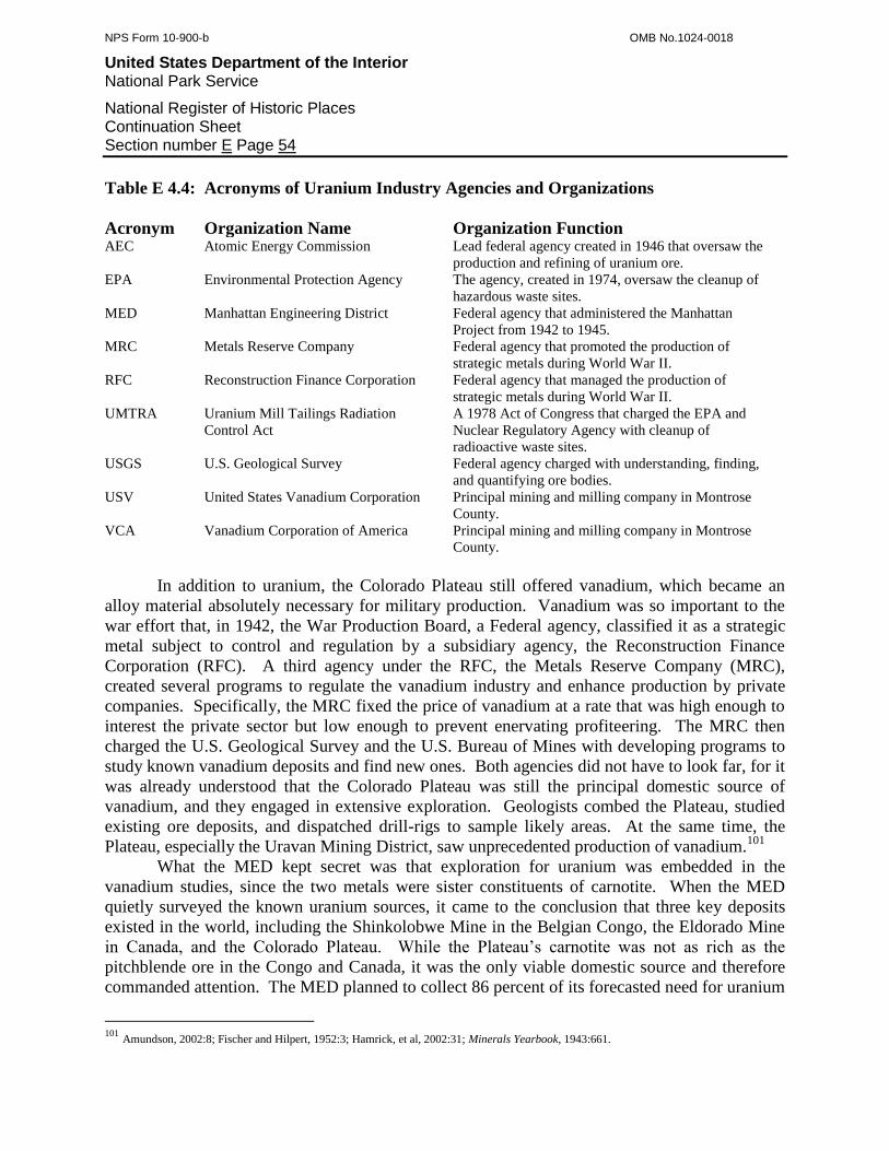
NPS Form 10-900-b OMB No.1024-0018
United States Department of the Interior National Park Service
National Register of Historic Places Continuation Sheet Section number E Page 54
Table E 4.4: Acronyms of Uranium Industry Agencies and Organizations
Acronym Organization Name Organization Function AEC Atomic Energy Commission Lead federal agency created in 1946 that oversaw the
production and refining of uranium ore.
EPA Environmental Protection Agency The agency, created in 1974, oversaw the cleanup of
hazardous waste sites.
MED Manhattan Engineering District Federal agency that administered the Manhattan
Project from 1942 to 1945.
MRC Metals Reserve Company Federal agency that promoted the production of
strategic metals during World War II.
RFC Reconstruction Finance Corporation Federal agency that managed the production of
strategic metals during World War II.
UMTRA Uranium Mill Tailings Radiation
Control Act
A 1978 Act of Congress that charged the EPA and
Nuclear Regulatory Agency with cleanup of
radioactive waste sites.
USGS U.S. Geological Survey Federal agency charged with understanding, finding,
and quantifying ore bodies.
USV United States Vanadium Corporation Principal mining and milling company in Montrose
County.
VCA Vanadium Corporation of America Principal mining and milling company in Montrose
County.
In addition to uranium, the Colorado Plateau still offered vanadium, which became an
alloy material absolutely necessary for military production. Vanadium was so important to the
war effort that, in 1942, the War Production Board, a Federal agency, classified it as a strategic
metal subject to control and regulation by a subsidiary agency, the Reconstruction Finance
Corporation (RFC). A third agency under the RFC, the Metals Reserve Company (MRC),
created several programs to regulate the vanadium industry and enhance production by private
companies. Specifically, the MRC fixed the price of vanadium at a rate that was high enough to
interest the private sector but low enough to prevent enervating profiteering. The MRC then
charged the U.S. Geological Survey and the U.S. Bureau of Mines with developing programs to
study known vanadium deposits and find new ones. Both agencies did not have to look far, for it
was already understood that the Colorado Plateau was still the principal domestic source of
vanadium, and they engaged in extensive exploration. Geologists combed the Plateau, studied
existing ore deposits, and dispatched drill-rigs to sample likely areas. At the same time, the
Plateau, especially the Uravan Mining District, saw unprecedented production of vanadium.101
What the MED kept secret was that exploration for uranium was embedded in the
vanadium studies, since the two metals were sister constituents of carnotite. When the MED
quietly surveyed the known uranium sources, it came to the conclusion that three key deposits
existed in the world, including the Shinkolobwe Mine in the Belgian Congo, the Eldorado Mine
in Canada, and the Colorado Plateau. While the Plateau’s carnotite was not as rich as the
pitchblende ore in the Congo and Canada, it was the only viable domestic source and therefore
commanded attention. The MED planned to collect 86 percent of its forecasted need for uranium
101
Amundson, 2002:8; Fischer and Hilpert, 1952:3; Hamrick, et al, 2002:31; Minerals Yearbook, 1943:661.
NPS Form 10-900-b OMB No.1024-0018
United States Department of the Interior National Park Service
National Register of Historic Places Continuation Sheet Section number E Page 55
from the two foreign sources and the rest from the Colorado Plateau, provided additional richer
deposits were not found.102
To obtain uranium from the Colorado Plateau, the MED was forced to divulge aspects of
its secret program to the United States Vanadium Corporation (USV) and the Vanadium
Corporation of America (VCA), the region’s two top producers. USV was the first to respond
and sent a proposal to the MED suggesting that USV act as the prime contractor in a joint
venture with VCA. The latter company balked and refuted that it should be the prime contractor
instead, and both companies were ultimately given separate contracts. Experts from the
companies and the MED then considered the data from the studies of local uranium sources and
came to the startling conclusion that, for a while, crude ore would not be needed. Instead, plenty
of unrefined uranium concentrates already existed in the form of tailings at every vanadium mill
in the region, and the material merely had to be collected and refined. The MED was satisfied
because the tailings could be converted into uranium quickly, and USV and VCA were pleased
because converting the tailings into uranium translated into substantial profits since most of the
processing had already been done. To maximize both uranium production and income, USV and
VCA wisely designed new ore treatment paths at their existing mills to recover uranium and
vanadium from crude ore, as well.
With an administrative structure in place, in 1942 the MED dispatched a team of agents
to the mills on the Colorado Plateau to secure their tailings under the auspices of an interest in
vanadium. Once this had been done, the MED quietly released the first contract in the United
States specifically for the production of uranium to VCA. To then meet its obligations, VCA
refitted its Vancorum mill with two separate recovery processes for uranium and for vanadium.
Almost at the same time, MED signed a second contract with USV to concentrate the uranium
tailings that already lay around at the Uravan Mill and began trucking additional tailings from
facilities at Vancorum, Loma, Gateway, Slick Rock, Durango, and Blanding, Utah. The tailings
taxed USV’s and VCA’s mills to capacity, and in response, MED authorized each company to
build one additional mill each. USV chose Durango because the town was proximal to several
new mining districts, and USV then purchased and refitted the idle American Smelting &
Refining smelter to process both crude ore and tailings. VCA sited a new mill at Monticello,
Utah, to capture Utah’s growing carnotite mining industry. Both companies obtained federal
funds for these facilities.103
Milling capacity was only one concern in a larger strategy that the MED implemented to
increase the production of both uranium and vanadium. Whereas the MED directly oversaw
milling, the agency placed the MRC in charge of mining and the handling of crude ore. One of
the first projects that the MRC undertook was a widespread improvement of the region’s
transportation infrastructure. As of 1942, western Montrose and San Miguel counties featured a
network of barely passable roads that dated to the 1920s and 1930s, and they restricted the
amount of ore flowing from the mines to the mills. The MRC obtained a lofty $500,000 from the
Federal Bureau of Roads to widen and surface Highway 141 from Naturita to Gateway, Highway
102
Amundson, 2002:8; Hamrick, et al, 2002:32. 103
Amundson, 2002:8; Colorado Mining Year Book 1944, p88; Merritt, 1971:41; “Vanadium Production in Colorado” 1942; “Vanadium
Production in Colorado” 1942.
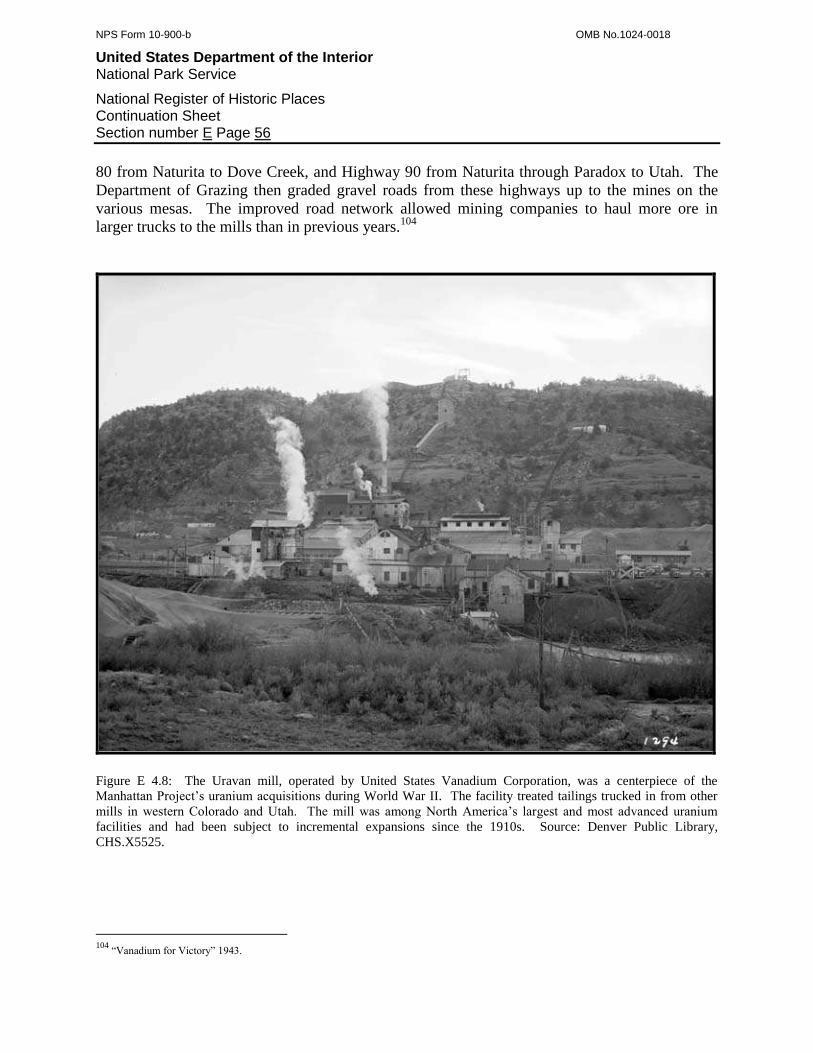
NPS Form 10-900-b OMB No.1024-0018
United States Department of the Interior National Park Service
National Register of Historic Places Continuation Sheet Section number E Page 56
80 from Naturita to Dove Creek, and Highway 90 from Naturita through Paradox to Utah. The
Department of Grazing then graded gravel roads from these highways up to the mines on the
various mesas. The improved road network allowed mining companies to haul more ore in
larger trucks to the mills than in previous years.104
Figure E 4.8: The Uravan mill, operated by United States Vanadium Corporation, was a centerpiece of the
Manhattan Project’s uranium acquisitions during World War II. The facility treated tailings trucked in from other
mills in western Colorado and Utah. The mill was among North America’s largest and most advanced uranium
facilities and had been subject to incremental expansions since the 1910s. Source: Denver Public Library,
CHS.X5525.
104
“Vanadium for Victory” 1943.
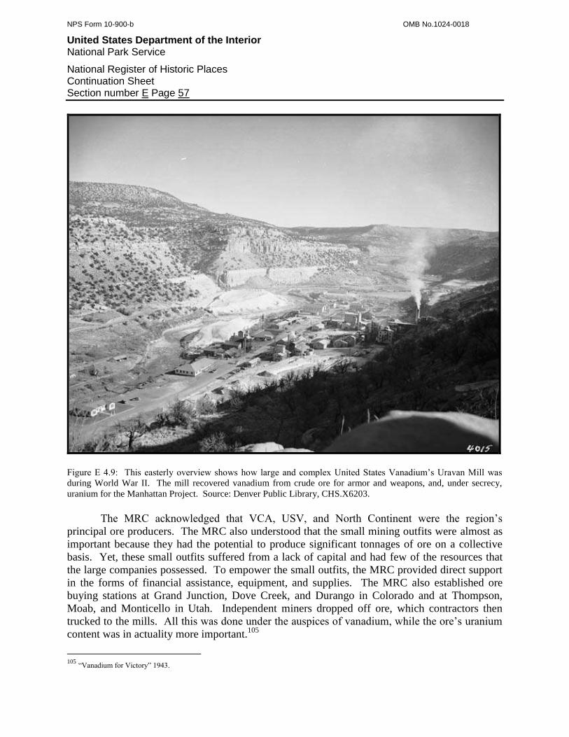
NPS Form 10-900-b OMB No.1024-0018
United States Department of the Interior National Park Service
National Register of Historic Places Continuation Sheet Section number E Page 57
Figure E 4.9: This easterly overview shows how large and complex United States Vanadium’s Uravan Mill was
during World War II. The mill recovered vanadium from crude ore for armor and weapons, and, under secrecy,
uranium for the Manhattan Project. Source: Denver Public Library, CHS.X6203.
The MRC acknowledged that VCA, USV, and North Continent were the region’s
principal ore producers. The MRC also understood that the small mining outfits were almost as
important because they had the potential to produce significant tonnages of ore on a collective
basis. Yet, these small outfits suffered from a lack of capital and had few of the resources that
the large companies possessed. To empower the small outfits, the MRC provided direct support
in the forms of financial assistance, equipment, and supplies. The MRC also established ore
buying stations at Grand Junction, Dove Creek, and Durango in Colorado and at Thompson,
Moab, and Monticello in Utah. Independent miners dropped off ore, which contractors then
trucked to the mills. All this was done under the auspices of vanadium, while the ore’s uranium
content was in actuality more important.105
105
“Vanadium for Victory” 1943.

NPS Form 10-900-b OMB No.1024-0018
United States Department of the Interior National Park Service
National Register of Historic Places Continuation Sheet Section number E Page 58
Figure E 4.10: During World War II, the Vanadium Corporation of America operated its mill at Vancorum. The
mill was built in 1930 to recover vanadium from crude ore, and it stood idle until the Vanadium Corporation of
America started it during the late 1930s. During the war, the facility not only produced vanadium as designed, but
also recovered uranium from crude ore and tailings brought in from other mills. Like the Uravan mill, the uranium
operations were secret. Source: Denver Public Library, CHS.X6201.
During 1943, the MED and the MRC completed additional projects that increased
vanadium and uranium production. USV and VCA continued to separate out the uranium
content of the tailings trucked in from elsewhere, and now North Continent did likewise with its
own tailings at Slick Rock. The product generated by these mills was far from refined uranium
and instead came in a form known as green sludge. To convert this into something usable, the
MED contracted with USV again in 1943 to erect and operate an advanced concentration facility
at Grand Junction. The end product was a radioactive uranium oxide powder known as
NPS Form 10-900-b OMB No.1024-0018
United States Department of the Interior National Park Service
National Register of Historic Places Continuation Sheet Section number E Page 59
yellowcake, which was compressed into pellets and shipped to the Manhattan Project’s top secret
laboratories.106
The MED forecasted that at some point, the tailings would be exhausted and uranium
would have to be recovered from crude ore instead. The MRC’s programs enhanced the
production from the existing mines, but they possessed finite ore bodies. To ensure an adequate
supply of ore in the future, the MED consulted with the U.S. Geological Survey (USGS) on a
large-scale exploration program. The USGS then began extensive drilling in the areas already
known to feature ore bodies, such as Long Park, Club Mesa, San Miguel Bench, and the Slick
Rock area. The USGS coordinated with VCA and USV, which sampled their groups of claims
by drilling. The program proved to be highly successful and cost-effective, and one ton of ore
was developed for every foot of hole bored.107
Ore production and milling were not the only arenas that the MED sought to improve.
The booming uranium and vanadium industries required a large workforce that lived primarily in
the established towns and secondarily in a few camps near the mines. As the populations of the
towns grew, the Federal Housing Authority erected 50 residences at Naturita and 68 at Uravan to
address a growing housing shortage. In response to the population pressure, USV, VCA, and the
MRC contributed to improvements such as water and sewer systems, which endeared the
companies to the local residents.108
In the beginning, 1944 showed signs of surpassing the previous year in terms of
production. The MRC’s projects to enhance mining were both a burden and a blessing because
they allowed the companies to deliver more ore than was otherwise possible. The increased
tonnages taxed the region’s mills, which translated into a need for even more milling capacity.
The MED targeted Uravan as the site of the next expansion and erected a second mill above the
original facility, and it was specifically designed to treat tailings. USV was then able to process
greater amounts of crude ore in the original facility below. The MED issued additional contracts
to several other companies such as North Continent to recover uranium concentrates from their
tailings.109
After two years of scraping, trucking, and processing, the deposits of mill tailings on the
Colorado Plateau showed signs of exhaustion. Even those at the Uravan Mill were almost
depleted, and in response, USV and VCA began emphasizing crude ore as a uranium source. For
USV, this meant increasing production from its most important mines, located primarily in Long
Park, on Club Mesa, and on San Miguel Bench. VCA responded similarly at its major mines
such as the Bitter Creek Group at the east end of Long Park Mesa and the Rajah (formerly Roc
Creek) in the Roc Creek drainage.
In mid-1944, the Federal Government reversed the upward trend that it initially fostered
in the vanadium and uranium mining industry. The MED informed USV and VCA that its
106
Amundson, 2002:8; Hamrick, et al, 2002:33; Metal Mining, 1961:79. 107
Hamrick, et al, 2002:31; USV, 1945; “Vanadium” 1944. 108
Holland, 2007; “Vanadium for Victory” 1943. 109
Amundson, 2002:8-11; Hamrick, et al, 2002:33; Metal Mining, 1961:89; Taylor and Yokell, 1979:23.

NPS Form 10-900-b OMB No.1024-0018
United States Department of the Interior National Park Service
National Register of Historic Places Continuation Sheet Section number E Page 60
uranium goals had been met, and the MRC publicly announced that it had stockpiled enough
vanadium for the war effort. Just as quickly as the government launched its uranium and
vanadium production programs, it repealed them. The private sector still purchased vanadium,
but more than enough was available due to overproduction of the metal. Uranium, by contrast,
was suddenly without any market at all, which was exclusively a function of the MED. The
result was an abrupt, painful halt to the World War II boom on the Colorado Plateau.110
Most of the small companies had to close their mines, and USV and VCA cut back their
operations significantly. USV and VCA survived by continuing to treat tailings and keeping
several of their mines in limited production. Companies such as Gateway Alloys, North
Continent, and the Blanding Mines Company did not fair as well and shut down their mills. But
the MRC paid these companies to keep their mills on standby because the agency still considered
vanadium to be a strategic metal whose demand could return at any time. This suggested to the
major companies that the Federal Government might soon reinstitute its demand for vanadium.
In 1945, however, the War Production Board sent the industry a clear message that this was not
to be. The Board repealed General Preference Order M-21, which strictly regulated the
production, sales, and distribution of vanadium. The metal was now officially on free market,
which was almost nonexistent. Western Montrose and San Miguel counties had grown used to
Federal assistance, full employment, and a sound economy, and they now braced for hard
times.111
Toward the end of 1945, the miners and mill workers who labored on the Colorado
Plateau finally realized the product of their efforts. On August 6, 1945, the United States
dropped the world’s first atomic bomb, Little Boy, on Hiroshima, and on August 7, detonated the
first plutonium bomb, Fat Man, over Nagasaki. Within one month, Japan surrendered and
brought World War II to an end. Many of the Colorado Plateau workers felt a sense of awe and
pride in their contributions to such a dramatic event. However, they also suffered under the
capriciousness of the MED, which left them jobless.
Western Montrose and San Miguel counties passed into 1946 with little economic
support. Nearly all the mines were silent, all the mills were idle, the ore buying stations were
gone, and the MED dismantled its tailings processing facilities. Even if demand for uranium and
vanadium existed, the ore bodies discovered in 1942 and 1943 had been exhausted, and no
tailings remained for reprocessing. Nuclear arms development was, however, by no means over,
and the Federal Government merely put its weapons programs on hold while it made adjustments
for a postwar world.
Fourth Period of Significance, 1941-1945
In 1945, the fourth Period of Significance for the uranium and vanadium mining
industries in western Montrose and San Miguel counties came to an end. The Period began in
1941 when the United States entered World War II and immediately designated vanadium a
110
Amundson, 2002:9, 11; Minerals Yearbook, 1944:642. 111
Amundson, 2002:9; Colorado Mining Year Book 1944, p88; Minerals Yearbook, 1944:642; Minerals Yearbook, 1945; “Vanadium” 1944.

NPS Form 10-900-b OMB No.1024-0018
United States Department of the Interior National Park Service
National Register of Historic Places Continuation Sheet Section number E Page 61
strategic metal for the war effort. From 1941 through 1945, the government aggressively
pursued vanadium production because the metal was a key alloy for weapons and armor.
Early in 1942, the Federal Government established the revolutionary and top-secret
Manhattan Project to race the Nazis for the atomic bomb. The government secured three sources
of uranium for its program, including the Shinkolobwe Mine in the Belgian Congo, the Eldorado
Mine in Canada, and the Colorado Plateau. While the Plateau satisfied only 15 percent of the
project’s uranium needs, the Plateau was extremely important because it was the third largest and
the only domestic source of uranium. Under the Manhattan Project, the government assumed
total control over the production, milling, refining, and use of uranium. This was done under the
guise of an interest in vanadium, which was allied with uranium in the Plateau’s carnotite ore.
At first, the government derived most of its uranium from mill tailings that were byproducts of
vanadium processing, and when these were exhausted, the government then turned to carnotite
ore. Once the government had amassed enough uranium and vanadium by the middle of 1944, it
suspended its purchase programs and effectively nullified the market for these metals. Without a
market or government support, the mining industry in the counties collapsed and ushered in a
region-wide depression.
Uranium and vanadium mining brought to western Montrose and San Miguel counties
several trends that were important on worldwide, national, and local levels. On a national level,
the counties were the most important domestic source of vanadium, which was a key alloy used
in weapons and armor. By producing vanadium, the region’s mines and mills contributed
directly to the war effort. While the largest mines and the mills are strongly associated with this
trend, the role of the small mines should not be discounted. They greatly outnumbered the large
mines and contributed a significant amount of ore on a cumulative basis.
On both national and worldwide levels, western Montrose and San Miguel counties were
directly involved in the Manhattan Project. These and small portions of surrounding counties
generated 15 percent of the Manhattan Project’s uranium. Most of the uranium came from mill
tailings that were a byproduct of vanadium concentration. When the tailings had been exhausted,
mining companies then recovered uranium directly from crude ore, which they produced from
the region’s mines. By producing uranium, the region’s mines and mills contributed directly to
the Manhattan Project, the development of the world’s first nuclear bombs, and the only
detonation of such weapons in history.
The uranium and vanadium mining industry played several fundamental roles on a local
level. During World War II, the industry was the region’s economic backbone and principal
employer. Because the industry required a substantial workforce, it affected the region’s
population. In 1940, at the end of the Great Depression, Naturita had a population of 300 people.
By 1950, the industry drew 183 more residents to the town. Nucla’s population increased by
around 150 people, and Uravan’s population increased slightly, as well. When VCA reopened
its Fall Creek Mine, the population of the Placerville area climbed beyond 300 people. This was
short-lived, however, and when VCA closed the mine around 1943, nearly all the residents
left.112
112
Schulz, 1977:1940-14; Schulz, 1977:1950-13.
NPS Form 10-900-b OMB No.1024-0018
United States Department of the Interior National Park Service
National Register of Historic Places Continuation Sheet Section number E Page 62
In support of the industry and its workers, the Federal Government instituted numerous
civic and infrastructure improvements, such as housing, community services, utilities,
communication, and roads. These aspects were not only important to uranium and vanadium
production during the 1940s, but also served as a foundation for the Cold War uranium boom of
the 1950s.
The uranium and vanadium mining industry shaped the cultural climate of the two
counties. The prosperity that the industry brought lifted the region out of the Great Depression
and improved the living conditions of the residents. The industry also unified the communities
because they embraced their role as direct contributors to the war effort. They understood that
their contribution was vanadium and only later realized that the uranium used in the atomic
bombs was a part of this.
E 4.7: The Atomic-Era, 1946-1963
When World War II ended, the Federal Government had no intention of canceling its
nuclear weapons programs. Further, the government was acutely aware that when the Soviet
Union invaded Germany, the Soviets captured some of the leading Nazi nuclear physicists. It
was therefore only a matter of time before the Soviets would develop their own atomic bomb.
The Federal Government prepared for this by reformatting its nuclear weapons programs during
a postwar adjustment period.
The government continued to refrain from purchasing uranium, but private industry was
now free to purchase vanadium because the government restored the metal to the free market.
Beginning in 1946, a demand for vanadium slowly returned as manufacturers responded to a
growing postwar consumerism. The demand, however, was too small to revive the mining
industry, and only USV and VCA showed any signs of life in western Colorado. Both
companies retained skeleton crews that maintained facilities and conducted minor development
in several of the largest mines.
All was not quiet, however, in Washington, D.C., and the Pacific Ocean during 1946.
Despite the two successful detonations in Japan, the atomic bomb was still in a developmental
state, and even though the government was reorganizing its nuclear weapons programs, the
military continued its own experiments. As part of this, it tested the first postwar device on
Bikini Atoll, overtly communicating to the world and especially the Soviets a continued interest
in nuclear arms.
In Washington, D.C., MED directors met with Congress and the Senate to discuss the
need for an agency to govern and control atomic energy for military and peaceful uses. Within
months, Congress and the Senate passed the Atomic Energy Act, which created the Atomic
Energy Commission (AEC). This new agency consisted of a civilian panel, and another panel of
senators and representatives who were the Joint Committee on Atomic Energy. While peaceful
uses of nuclear technology were discussed, military applications were actually the focus, and to
this end, the committee often met in secret. The Act placed all nuclear reactors, production
equipment, minerals, and prices under federal control, and the government could be the only
producer, refiner, and buyer for fissionable materials. Mining and ore concentration, however,

NPS Form 10-900-b OMB No.1024-0018
United States Department of the Interior National Park Service
National Register of Historic Places Continuation Sheet Section number E Page 63
were left to the private industry, but the government was the sole consumer and in this capacity
had total control over the industry.113
One of the new administration’s first tasks was to survey the state of the nuclear
production industry, which was based on mining, milling, and refining. The AEC realized that
most uranium came from Canada and the Congo, and that the United States was dependent on
foreign sources, which the AEC perceived as a threat to national security. Like previous studies,
the AEC determined that the Colorado Plateau was the world’s third most important and the only
meaningful domestic source of uranium at the time, which justified special action. In 1947, the
AEC took action to resuscitate the Colorado Plateau’s mining industry.114
The AEC’s first step was to reopen some of the mills, which were necessary to convert
crude carnotite ore into uranium concentrates known as yellowcake. In May of 1947, the AEC
signed the first post-war milling contract with VCA, which reopened its Vancorum facility. The
AEC then contracted with USV to restart the Rifle and Uravan mills, and USV then began
rehabilitating the town of Uravan for what would be a substantial workforce. At the same time,
the AEC also created the Colorado Raw Materials Agency, whose mission was to support the
small mining outfits. The agency administered to all of southwestern Colorado from its office in
Grand Junction. Last, the AEC commissioned the U.S.G.S. with finding, understanding, and
quantifying the uranium deposits on the Colorado Plateau. This was no small task and would
evolve over the course of more than a decade. The U.S.G.S. began an intensive drilling
campaign around the peripheries of ore-bearing areas to locate outlying carnotite beds. A small
army of U.S.G.S. geologists then clambered over the Plateau and commenced a protracted study
of the sedimentary layers, the Morrison Formation, and its carnotite occurrences.115
Once the AEC had these foundation elements in place, it was finally ready to revive the
entire mining industry. In 1948, the AEC launched a raft of programs intended to stimulate
prospecting, support mining, provide milling, control the resources, and administer to finances.
The AEC’s approach to prospecting and mining was simple, as one guidebook author noted:
“The door was opened to uranium prospecting on April 11, 1948 in an announcement by
the United States Atomic Energy Commission of a three-point program intended to stimulate the
discovery and production of domestic uranium by private competitive enterprises. This program
utilizes the most effective incentive known to humanity - money.”116
The AEC officially defined terms and conditions in a set of four Domestic Uranium
Program circulars published in April. Circular No.1 did not apply to carnotite and instead
guaranteed a minimum price for other types of uranium ore. Circular No.2 provided a bonus for
any type of high-grade ore, as well as mill concentrates derived from noncarnotite ore. The AEC
drafted Circulars No.1 and No.2 to encourage the discovery of pitchblende ore similar to that in
Canada and the Congo. As an added incentive, the AEC also offered a $10,000 reward. Circular
No.3 provided bonuses for high-grade ore, including carnotite, delivered to VCA’s mill at
113
Amundson, 2002:20; Nelson-Moore, 1978:1039. 114
Amundson, 2002:21. 115
Blackman, 1951:4; Craig, et al, 1955:127; Hamrick, et al, 2002:61; McWhorter, 1977:B-1; Nelson-Moore, 1978:1039. 116
Weiss and Orlandi, 1948:74.
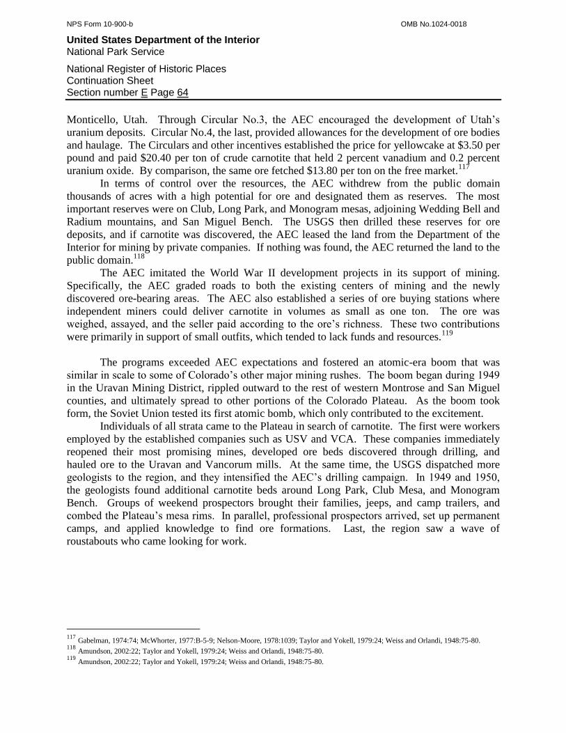
NPS Form 10-900-b OMB No.1024-0018
United States Department of the Interior National Park Service
National Register of Historic Places Continuation Sheet Section number E Page 64
Monticello, Utah. Through Circular No.3, the AEC encouraged the development of Utah’s
uranium deposits. Circular No.4, the last, provided allowances for the development of ore bodies
and haulage. The Circulars and other incentives established the price for yellowcake at $3.50 per
pound and paid $20.40 per ton of crude carnotite that held 2 percent vanadium and 0.2 percent
uranium oxide. By comparison, the same ore fetched $13.80 per ton on the free market.117
In terms of control over the resources, the AEC withdrew from the public domain
thousands of acres with a high potential for ore and designated them as reserves. The most
important reserves were on Club, Long Park, and Monogram mesas, adjoining Wedding Bell and
Radium mountains, and San Miguel Bench. The USGS then drilled these reserves for ore
deposits, and if carnotite was discovered, the AEC leased the land from the Department of the
Interior for mining by private companies. If nothing was found, the AEC returned the land to the
public domain.118
The AEC imitated the World War II development projects in its support of mining.
Specifically, the AEC graded roads to both the existing centers of mining and the newly
discovered ore-bearing areas. The AEC also established a series of ore buying stations where
independent miners could deliver carnotite in volumes as small as one ton. The ore was
weighed, assayed, and the seller paid according to the ore’s richness. These two contributions
were primarily in support of small outfits, which tended to lack funds and resources.119
The programs exceeded AEC expectations and fostered an atomic-era boom that was
similar in scale to some of Colorado’s other major mining rushes. The boom began during 1949
in the Uravan Mining District, rippled outward to the rest of western Montrose and San Miguel
counties, and ultimately spread to other portions of the Colorado Plateau. As the boom took
form, the Soviet Union tested its first atomic bomb, which only contributed to the excitement.
Individuals of all strata came to the Plateau in search of carnotite. The first were workers
employed by the established companies such as USV and VCA. These companies immediately
reopened their most promising mines, developed ore beds discovered through drilling, and
hauled ore to the Uravan and Vancorum mills. At the same time, the USGS dispatched more
geologists to the region, and they intensified the AEC’s drilling campaign. In 1949 and 1950,
the geologists found additional carnotite beds around Long Park, Club Mesa, and Monogram
Bench. Groups of weekend prospectors brought their families, jeeps, and camp trailers, and
combed the Plateau’s mesa rims. In parallel, professional prospectors arrived, set up permanent
camps, and applied knowledge to find ore formations. Last, the region saw a wave of
roustabouts who came looking for work.
117
Gabelman, 1974:74; McWhorter, 1977:B-5-9; Nelson-Moore, 1978:1039; Taylor and Yokell, 1979:24; Weiss and Orlandi, 1948:75-80. 118
Amundson, 2002:22; Taylor and Yokell, 1979:24; Weiss and Orlandi, 1948:75-80. 119
Amundson, 2002:22; Taylor and Yokell, 1979:24; Weiss and Orlandi, 1948:75-80.
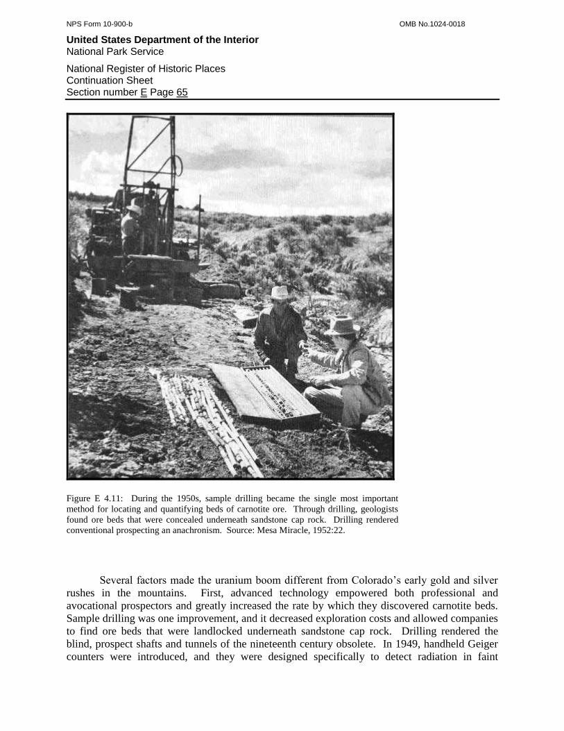
NPS Form 10-900-b OMB No.1024-0018
United States Department of the Interior National Park Service
National Register of Historic Places Continuation Sheet Section number E Page 65
Figure E 4.11: During the 1950s, sample drilling became the single most important
method for locating and quantifying beds of carnotite ore. Through drilling, geologists
found ore beds that were concealed underneath sandstone cap rock. Drilling rendered
conventional prospecting an anachronism. Source: Mesa Miracle, 1952:22.
Several factors made the uranium boom different from Colorado’s early gold and silver
rushes in the mountains. First, advanced technology empowered both professional and
avocational prospectors and greatly increased the rate by which they discovered carnotite beds.
Sample drilling was one improvement, and it decreased exploration costs and allowed companies
to find ore beds that were landlocked underneath sandstone cap rock. Drilling rendered the
blind, prospect shafts and tunnels of the nineteenth century obsolete. In 1949, handheld Geiger
counters were introduced, and they were designed specifically to detect radiation in faint
NPS Form 10-900-b OMB No.1024-0018
United States Department of the Interior National Park Service
National Register of Historic Places Continuation Sheet Section number E Page 66
emissions. Professional and avocational prospectors, and geologists, relied on Geiger counters to
identify invisible and concealed ore beds. These devices proved so important that a uranium
prospecting guidebook aptly noted: “History will probably record the fact that the Geiger
Counter instrument deserves foremost credit in the development of the atomic revolution in the
twentieth century.”120
With four-wheel drive vehicles, greater numbers of individuals traversed
more ground in much less time than in mining rushes of the past. Even more so, the AEC and
USGS mounted Geiger counters and scintillometers to light aircraft and flew transects over the
region to identify likely areas worthy of intense examination.121
The second factor was direct support by the Federal Government in addition to the
Circulars and programs outlined above. In particular, the AEC and the Colorado Raw Materials
Agency purposefully disseminated the results of drilling, air sorties, and geological studies in
hopes of advising prospectors. The two agencies updated exploration summaries on a biweekly
basis at the Naturita, Nucla, Uravan, Gateway, and Paradox post offices. The agencies also
published drilling reports and maps, printed guidebooks, and encouraged a flurry of articles in
the mining industry press.122
There were similarities, as well as differences, between the uranium boom and
Colorado’s early mining rushes. Prospectors still combed the region by foot and some engaged
in rim-walking, which was a pedestrian survey along the Morrison Formation’s cliffs and ledges.
Those prospectors who lacked Geiger counters employed the ages-old method of finding ore by
sight and picking at discolored sandstone. Because carnotite was slightly radioactive,
prospectors also tested samples with photography film. If a sample exposed the film, the
prospector knew it was most likely a form of ore.
At the same time that independent prospectors were rim-walking and traversing the
mesas in jeeps, the capitalized companies employed heavy machinery to find deep deposits
unavailable for surface examination. Following the lead of the USGS, private contractors bored
drill-holes on nearly every flat surface, and, similar to the 1910s exploration efforts, the
companies used rockdrills, diamond drills, and churn drills to exhume samples from underneath
sandstone cap layers. During the early 1950s, rotary drills became increasingly popular, and
although they were able to bore deeper holes faster than any other method, rotary drills were
costly. To maximize the acreage sampled and to minimize the costs, many companies employed
a three-tiered sampling strategy that began with drill-holes bored around 1,000 feet apart to
characterize an area’s geology. When a hole proved positive, workers drilled additional bores
according to a grid, and the holes were spaced 50 to 200 feet apart. After roughly defining the
ore body, the workers then peppered the area to clearly delineate its boundaries and find the
richest portions.123
At the same time that independent prospectors were rim-walking and traversing the
mesas in jeeps, the capitalized companies employed heavy machinery to find deep deposits
unavailable for surface examination. Following the lead of the USGS, private contractors bored
120
Weiss and Orlandi, 1948:47. 121
Hampton, 1955:18; Knoerr, 1955:135; Taylor and Yokell, 1979:27. 122
McKay, 1953:5; Taylor and Yokell, 1979:27. 123
Dare, et al, 1955:12; Fischer and Hilpert, 1952:1; Motica, 1968:812.

NPS Form 10-900-b OMB No.1024-0018
United States Department of the Interior National Park Service
National Register of Historic Places Continuation Sheet Section number E Page 67
drill-holes on nearly every flat surface, and, similar to the 1910s exploration efforts, the
companies used rockdrills, diamond drills, and churn drills to exhume samples from underneath
sandstone cap layers. During the early 1950s, rotary drills became increasingly popular, and
although they were able to bore deeper holes faster than any other method, rotary drills were
costly. To maximize the acreage sampled and to minimize the costs, many companies employed
a three-tiered sampling strategy that began with drill-holes bored around 1,000 feet apart to
characterize an area’s geology. When a hole proved positive, workers drilled additional bores
according to a grid, and the holes were spaced 50 to 200 feet apart. After roughly defining the
ore body, the workers then peppered the area to clearly delineate its boundaries and find the
richest portions.124
Drilling equipment required vehicles, trailers, and open ground, which only the mesa tops
offered. Therefore, mining companies used bulldozers to clear paths and drill pads, and
contractors conducted most work at a high profit. They charged $125 per mile to bulldoze roads
through gentle terrain and as much as $2,500 per mile to grade roads across ledges and through
boulder-ridden slopes. Hundreds of miles of crude roads were pushed across the Plateau, and
heavily drilled areas became scarred with web-like networks of swaths, cuts, and pads.125
The uranium boom shared with Colorado’s early rushes an atmosphere of haste,
competition, and speculation. Prospectors looked for hotspots of activity as much as they
searched for ore. Intense drilling and repeated low passes by aircraft tipped off observant
individuals to areas of interest, and they flocked in response. Small crowds gathered at the post
offices and awaited the biweekly exploration summaries. Prospectors rarely waited for
photographic film tests or assay results to stake claims, and instead, they did so merely on the
presumption of ore. To stake a claim, the atomic-era prospectors followed the same 1872 mining
laws that applied to hardrock ore formations, even though carnotite occurred in flat sandstone
beds. A claim had to be 300 feet on both sides of the discovery point and 1,500 feet long, and
the prospector was obligated to erect four corner posts and display a location notice. If the ore
deposit was not obvious, the prospector had to sink a 10 foot discovery shaft or adit and conduct
$100 worth of labor. Unlike most hardrock mining districts, prospectors on the Plateau could
stake as many claims as they wished.126
Once an ore body was discovered, the claim had to be developed for production, and the
methods depended on who found the formation and who owned the claim. If an independent
prospector found the ore and retained title to the claim, he often sold the property to a mining
company, since development usually required more capital than the prospector possessed. In a
few cases, prospectors formed partnerships for joint development, solicited capital from business
interests, and worked the claims themselves. Ultimately, however, the large companies acquired
most of the ore-bearing claims, leaving relatively few for the independent outfits. The
companies then usually leased the claims out to those independent outfits that lacked their own
properties. When necessary, the companies conducted the initial claim development and
124
Dare, et al, 1955:12; Fischer and Hilpert, 1952:1; Motica, 1968:812. 125
Hampton, 1955:43. 126
Hampton, 1955:60; Knoerr, 1955:56; Taylor and Yokell, 1979:27; Uranium Prospectors' Handbook, 1954:40; Weiss and Orlandi, 1948:99-
102.
NPS Form 10-900-b OMB No.1024-0018
United States Department of the Interior National Park Service
National Register of Historic Places Continuation Sheet Section number E Page 68
provided some equipment. USV in particular practiced this system and was loved by the
community for its perceived support and generosity. By 1952, USV leased claims to 50
independent parties, purchased ore from an additional 90 small outfits, and provided them with
most of the materials they needed. USV benefited, of course, because the outfits tended to work
deposits that were uneconomical for the large companies.127
The nature of the ore deposit and the claim owner governed how the ore was actually
mined. Where the ore body cropped out on a sandstone cliff or lay a short distance beyond,
miners preferred to develop the formation through a tunnel because it cost the least. Where the
ore body lay underneath sandstone cap rock, however, a shaft was necessary. If the vertical
distance was minor, companies drove what the industry recognized as an inclined adit, which
descended between 10 and 25 degrees. If the distance was great, an inclined shaft was
necessary. Where possible, companies preferred inclined adits because the gradient was gentle
enough to allow ordinary ore cars to be winched with a simple and inexpensive hoist and
uncoupled on the surface. Inclined shafts, however, required a stronger hoist fixed to a
structure.128
Underground, miners often adapted the room-and-pillar system of stoping from coal
mines, and used the same drilling and blasting methods employed in hardrock mines. For
horizontal work, they drilled blast-holes with jackleg drills, and used stopers for vertical work.
Even the largest mines had portable compressors to power the drills, draglines for scraping ore to
loading stations, and compressed air winches and hoists. Stationary compressors, substantial
shops, and aspects of the infrastructure found at metal mines were uncommon except at the
largest uranium operations. The size of the ore body determined how the ore was hauled out of
the mine. Large ore bodies justified ore trains pulled by compressed air locomotives. Capital-
poor operations continued to use ore cars and even horse-drawn carts on rubber tires.129
The boom intensified during the early 1950s, and the wave of exploration began to yield
tangible results. By 1950, the AEC and the USGS outlined a number of new ore beds on Club,
Long Park, and Monogram mesas, and around Slick Rock. Between 1951 and 1953, the USGS
bored 92,000 feet of sample holes on San Miguel Bench alone, many of which proved positive.
USV and VCA developed most of the discoveries, although they no longer held a monopoly over
the region. In 1950, the Climax Molybdenum Company and the Minerals Engineering
Company, of Grand Junction, organized the joint Climax Uranium Company. This new
organization had enough capital not only to purchase numerous groups of claims, but also to
build a uranium mill at Grand Junction. Within a short time, Climax Uranium became one of the
region’s top producers.130
USV, VCA, and Climax Uranium developed the discoveries and brought them into
production almost as quickly as they were found. The number of operating mines in the two
counties increased more than 100 percent. During the late 1940s, Montrose County featured 7
127
Mesa Miracle, 1952:29; ”Mesa, Montrose, and San Miguel Counties” 1952; “Uranium Activity on the Colorado Plateau” 1952; “Uranium
Mining Activity” 1953. 128
Dare, et al, 1955:21. 129
Clark and Kerr, 1974:26; Dare, et al, 1955:34, 38, 40, 44; Fischer, 1942:394. 130
Alvord, 1956:4; Bruyn, 1955:71; Fischer, 1950:6; Nelson-Moore, 1978:1040; Blackman, 1951:5.
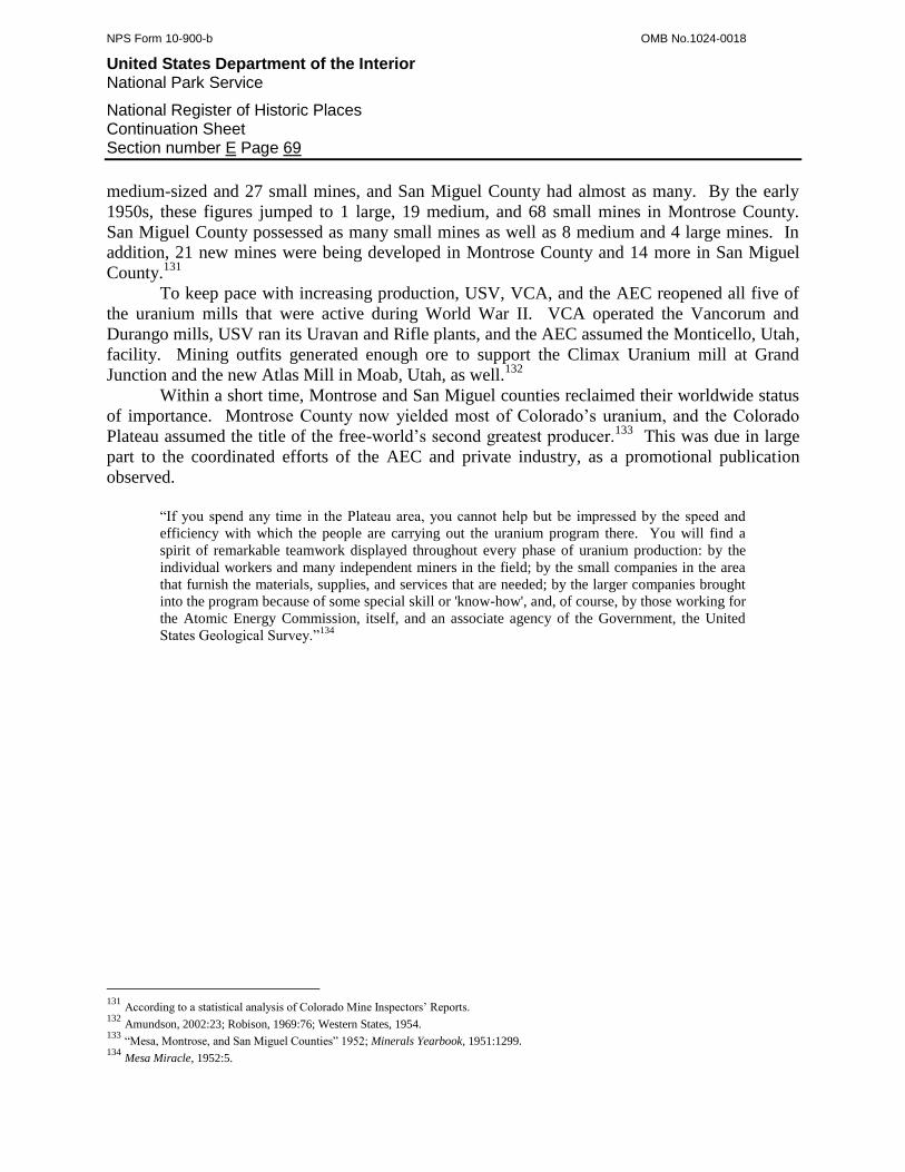
NPS Form 10-900-b OMB No.1024-0018
United States Department of the Interior National Park Service
National Register of Historic Places Continuation Sheet Section number E Page 69
medium-sized and 27 small mines, and San Miguel County had almost as many. By the early
1950s, these figures jumped to 1 large, 19 medium, and 68 small mines in Montrose County.
San Miguel County possessed as many small mines as well as 8 medium and 4 large mines. In
addition, 21 new mines were being developed in Montrose County and 14 more in San Miguel
County.131
To keep pace with increasing production, USV, VCA, and the AEC reopened all five of
the uranium mills that were active during World War II. VCA operated the Vancorum and
Durango mills, USV ran its Uravan and Rifle plants, and the AEC assumed the Monticello, Utah,
facility. Mining outfits generated enough ore to support the Climax Uranium mill at Grand
Junction and the new Atlas Mill in Moab, Utah, as well.132
Within a short time, Montrose and San Miguel counties reclaimed their worldwide status
of importance. Montrose County now yielded most of Colorado’s uranium, and the Colorado
Plateau assumed the title of the free-world’s second greatest producer.133
This was due in large
part to the coordinated efforts of the AEC and private industry, as a promotional publication
observed.
“If you spend any time in the Plateau area, you cannot help but be impressed by the speed and
efficiency with which the people are carrying out the uranium program there. You will find a
spirit of remarkable teamwork displayed throughout every phase of uranium production: by the
individual workers and many independent miners in the field; by the small companies in the area
that furnish the materials, supplies, and services that are needed; by the larger companies brought
into the program because of some special skill or 'know-how', and, of course, by those working for
the Atomic Energy Commission, itself, and an associate agency of the Government, the United
States Geological Survey.”134
131
According to a statistical analysis of Colorado Mine Inspectors’ Reports. 132
Amundson, 2002:23; Robison, 1969:76; Western States, 1954. 133
“Mesa, Montrose, and San Miguel Counties” 1952; Minerals Yearbook, 1951:1299. 134
Mesa Miracle, 1952:5.
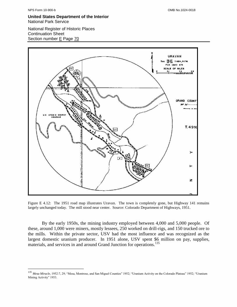
NPS Form 10-900-b OMB No.1024-0018
United States Department of the Interior National Park Service
National Register of Historic Places Continuation Sheet Section number E Page 70
Figure E 4.12: The 1951 road map illustrates Uravan. The town is completely gone, but Highway 141 remains
largely unchanged today. The mill stood near center. Source: Colorado Department of Highways, 1951.
By the early 1950s, the mining industry employed between 4,000 and 5,000 people. Of
these, around 1,000 were miners, mostly lessees, 250 worked on drill-rigs, and 150 trucked ore to
the mills. Within the private sector, USV had the most influence and was recognized as the
largest domestic uranium producer. In 1951 alone, USV spent $6 million on pay, supplies,
materials, and services in and around Grand Junction for operations.135
135
Mesa Miracle, 1952:7, 29; “Mesa, Montrose, and San Miguel Counties” 1952; “Uranium Activity on the Colorado Plateau” 1952; “Uranium
Mining Activity” 1953.
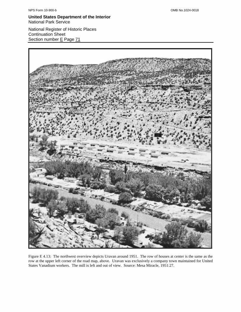
NPS Form 10-900-b OMB No.1024-0018
United States Department of the Interior National Park Service
National Register of Historic Places Continuation Sheet Section number E Page 71
Figure E 4.13: The northwest overview depicts Uravan around 1951. The row of houses at center is the same as the
row at the upper left corner of the road map, above. Uravan was exclusively a company town maintained for United
States Vanadium workers. The mill is left and out of view. Source: Mesa Miracle, 1951:27.
NPS Form 10-900-b OMB No.1024-0018
United States Department of the Interior National Park Service
National Register of Historic Places Continuation Sheet Section number E Page 72
The exponential rate of growth in the mining industry was still not enough for the AEC,
which pursued both long-term and short-run production strategies. To encourage immediate
development, the AEC opened 42 square miles of its carnotite-bearing reserves in 1951.
Independent and company-employed prospectors were on hand and rushed to stake claims. The
general excitement throughout the region threatened to exceed the AEC’s coordination abilities,
and in response, the AEC opened a central operations office in Grand Junction. During the early
1950s, the AEC also continued its original programs in preparation for long-term production. In
particular, the AEC invested around $2 million grading roads to the areas of high potential,
withdrew more land for its reserves, and released Domestic Uranium Program Circular No.6,
which provided additional bonuses for the development of ore beds.136
The towns of Naturita, Nucla, Gateway, and Paradox acutely felt the boom as their
populations grew, mining companies established offices, and commerce exploded. Naturita in
particular was completely swept up in the excitement, and an invasion of mining rush
participants shattered the town’s quiet atmosphere. When recently asked about how the boom
affected Naturita, long-time resident Anna Cotter answered simply: “nuts.”137
Naturita was the closest commercial center of importance to the uranium region in
western Montrose and San Miguel counties, and so the community assumed a central role in the
mining industry. The town was a congregation node for prospectors, miners, drilling outfits, and
mining companies, which came and went with frequency. An entire neighborhood was built at
the east end of town to accommodate the influx of workers who commuted to various mines on
the nearby mesas. The neighborhood attracted a demography characteristic of Colorado’s early
mining rushes, and the new residents tended to be transient, rough, and troublesome. Fights
were common, and in 1955, a miner shot at his own house-trailer thinking that his wife was at
home with another man. The trailer was empty at the time. Naturita’s established residents
informally designated the neighborhood as the Snake Pit and Nasty-rita.138
The growing population offered plenty of opportunity for new businesses. Entrepreneurs
opened several gasoline stations, grocery stores, hardware supplies, and clothing shops. Like
many of Colorado’s nineteenth century mining camps, Naturita’s bars became key community
centers where prospectors sold claims, miners found jobs, and speculators consummated deals.
Drinking was heavy, the town was wild on the weekends, and parties and cookouts were
common. Live bands played at dances every Saturday night, and the latest movies were shown
in the town hall three times per week. As the region’s largest employers, USV and VCA
contributed heavily to community improvements in an attempt to alleviate some of the
population pressures. In particular, they enlarged the town’s plumbing system and operated a
medical clinic.139
136
Gabelman, 1974:74; Hampton, 1955:63; Mesa Miracle, 1952:21; Nelson-Moore, 1978:1040. 137
Cotter, 2007. 138
Cotter, 2007; Davis, 2007; Moore, 2007. 139
Bonner, 2007; Casto, 2007; Davis, 2007; Holland, 2007.

NPS Form 10-900-b OMB No.1024-0018
United States Department of the Interior National Park Service
National Register of Historic Places Continuation Sheet Section number E Page 73
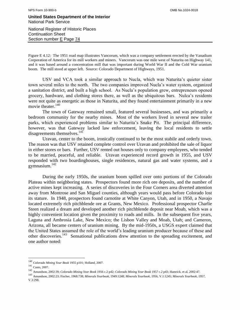
NPS Form 10-900-b OMB No.1024-0018
United States Department of the Interior National Park Service
National Register of Historic Places Continuation Sheet Section number E Page 74
Figure E 4.12: The 1951 road map illustrates Vancorum, which was a company settlement erected by the Vanadium
Corporation of America for its mill workers and miners. Vancorum was one mile west of Naturita on Highway 141,
and it was based around a concentration mill that was important during World War II and the Cold War uranium
boom. The mill stood at upper left. Source: Colorado Department of Highways, 1951.
USV and VCA took a similar approach to Nucla, which was Naturita’s quieter sister
town several miles to the north. The two companies improved Nucla’s water system, organized
a sanitation district, and built a high school. As Nucla’s population grew, entrepreneurs opened
grocery, hardware, and clothing stores there, as well as the ubiquitous bars. Nulca’s residents
were not quite as energetic as those in Naturita, and they found entertainment primarily in a new
movie theater.140
The town of Gateway remained small, featured several businesses, and was primarily a
bedroom community for the nearby mines. Most of the workers lived in several new trailer
parks, which experienced problems similar to Naturita’s Snake Pit. The principal difference,
however, was that Gateway lacked law enforcement, leaving the local residents to settle
disagreements themselves.141
Uravan, center to the boom, ironically continued to be the most stabile and orderly town.
The reason was that USV retained complete control over Uravan and prohibited the sale of liquor
in either stores or bars. Further, USV rented out houses only to company employees, who tended
to be married, peaceful, and reliable. Uravan experienced record growth in 1955, and USV
responded with two boardinghouses, single residences, natural gas and water systems, and a
gymnasium.142
During the early 1950s, the uranium boom spilled over onto portions of the Colorado
Plateau within neighboring states. Prospectors found more rich ore deposits, and the number of
active mines kept increasing. A series of discoveries in the Four Corners area diverted attention
away from Montrose and San Miguel counties, although years would pass before Colorado lost
its stature. In 1948, prospectors found carnotite at White Canyon, Utah, and in 1950, a Navajo
located extremely rich pitchblende ore at Grants, New Mexico. Professional prospector Charlie
Steen realized a dream and developed another rich pitchblende deposit near Moab, which was a
highly convenient location given the proximity to roads and mills. In the subsequent five years,
Laguna and Ambrosia Lake, New Mexico; the Lisbon Valley and Moab, Utah; and Cameron,
Arizona, all became centers of uranium mining. By the mid-1950s, a USGS expert claimed that
the United States assumed the role of the world’s leading uranium producer because of these and
other discoveries.143
Sensational publications drew attention to the spreading excitement, and
one author noted:
140
Colorado Mining Year Book 1955 p101; Holland, 2007. 141
Casto, 2007. 142
Amundson, 2002:39; Colorado Mining Year Book 1956 c.2 p42; Colorado Mining Year Book 1957 c.2 p43; Hamrick, et al, 2002:47. 143
Amundson, 2002:23; Fischer, 1968:738; Minerals Yearbook, 1949:1248; Minerals Yearbook, 1956, V.1:1245; Minerals Yearbook, 1957,
V.3:298.

NPS Form 10-900-b OMB No.1024-0018
United States Department of the Interior National Park Service
National Register of Historic Places Continuation Sheet Section number E Page 75
“Few people realize the vast extent of the uranium deposits on the Colorado Plateau. It is only a
matter of time until production will exceed that of the Belgian Congo and South Africa and the
United States will become entirely independent of foreign sources of atoms for war.”144
Such predictions finally came true in 1956 when the United States eclipsed the rest of the
free world in terms of uranium production. Western Montrose and San Miguel counties played
significant roles in this trend, primarily because the boom matured away from prospecting and
speculation to ore production and milling. As a direct reflection, the number of mines that were
active between 1956 and 1960 increased exponentially from the previous five years. In
Montrose County the small mines skyrocketed from 68 to 188, the medium-sized mines more
than doubled from 19 to 52, and the large mines mushroomed from 1 to 12. San Miguel County
experienced a like phenomenon. The small mines jumped from 67 to 107, the medium-sized
mines more than doubled from 8 to 19, and the large mines increased from 4 to 6.145
The explosive rate of ore production threatened to exceed the milling capacity offered by
USV and VCA. USV responded in 1956 by enlarging its Uravan mill with a new facility built
above the original complex. Known as B Plant, the new facility featured hot acid leaching that
prepared the carnotite for a revolutionary ion exchange process installed in the original mill. The
ion exchange recovered uranium, and a separate solvent extraction stage then stripped away the
vanadium. USV also added thickening tanks, better filters, and other equipment to enhance
metals recovery. At the same time, VCA increased the capacity of its Vancorum mill to
accommodate the ore generated from its mines. A year later, USV purchased the North
Continent mill at Slick Rock, used it to concentrate local ore, and sent the material to Uravan for
final treatment.146
Other aspects of the region’s industry continued to grow in tandem with mining and
milling. In 1956, the San Miguel Power Association began constructing an electrical grid in the
Paradox Valley area and extended lines to many of the principal mines. In search of ore beds,
private companies bored a record number of sample holes, which reached a peak of 9.2 million
feet in 1957. Grand Junction became the financial and organizational center of uranium mining
on the Colorado Plateau, mostly because it was the nearest city to Montrose and San Miguel
counties. The Colorado Raw Materials Agency, the AEC, and most of the largest mining
companies had their offices and laboratories in Grand Junction.147
The movement toward uranium production continued during the latter half of the decade,
and 1957 was a record year for Colorado with a jump of nearly 50 percent. Large companies
continued to dominate the industry, although small outfits still found opportunities to thrive.
USV, VCA, and Climax Uranium were the largest operators and enjoyed record expansions. In
San Miguel County, the Minerals Engineering Company, the Skidmore Mining Company, the La
Salle Mining Company, and the Gayno Mining Company were the most significant of the small
144
Look, 1955:120. 145
According to a statistical analysis of Colorado Mine Inspectors’ Reports. 146
Chenoweth, 1993:50; Colorado Mining Year Book 1956 c.2 p41; Hamrick, et al, 2002:48; Merritt, 1971:271; McWhorter, 1977:B-40;
Nelson-Moore, 1978:1042. 147
Chenoweth, 1993:35; Hampton, 1955:8; Mesa Miracle, 1952:7; McWhorter, 1977:B-16.
NPS Form 10-900-b OMB No.1024-0018
United States Department of the Interior National Park Service
National Register of Historic Places Continuation Sheet Section number E Page 76
operators. Montrose County was home to the Blake, Power, & Stocklass Company, Bunker &
Company, the Dulaney Mining Company, the Four Corners Uranium Corporation, and Golden
Cycle.148
In 1957, the Uravan Mining District hosted one of the Colorado Plateau’s last frenetic
rushes that provided equal opportunity for both independent miners and large companies. After
the USGS finished its exploration campaign in Long Park, the AEC opened the reserve to anyone
willing to stake a claim. Within days, hundreds of hopeful wealth-seekers flooded the area and
staked over 1,000 claims, most of which were ultimately acquired by the large companies.149
With their deep financial reserves, the large companies acquired a clear majority of the
productive mines throughout the region. Their dominance was, however, in ownership and
milling only, because they relied heavily on partnerships and small outfits to actually produce the
ore. The large companies found that the small ore deposits were too troublesome to directly
work themselves because of the logistics involved. The small deposits were scattered and
difficult to coordinate within the context of a large organization. As a result, the companies
increasingly relied on lessees to work the small deposits, but continued to operate the major
mines. This two-tiered system of mining proved beneficial for the industry because the lessees
collectively provided the companies with record production, and the companies offered the
lessees the potential to earn more money than daily wages as employees. For comparison,
company miners often received $3.00 per hour while lessees could bring in as much as $10.00
per hour if they were efficient and the ore high in grade. The lessees also enjoyed one additional
factor above company employees, which was a greater level of freedom and autonomy.150
One of the principal detriments for lessees was housing because they were responsible for
providing their own. Lessees preferred to live in the established towns to be with their families
and to enjoy community. But if the roads to the mines were poor and the commute longer than
one hour, the lessees usually lived near their points of work. In such cases, those lessees with
families faced the difficult choice of either billeting their wives and children in town or
providing them with acceptable housing at the mines. The preferred alternative was for the
family to stay with local relatives, and when this was not an option, the miner had to pay his
family’s lodging, as well as his own. According to retired miners David Chiles and Michael
Holland, lessees commonly lived in the field during the weekdays and returned to family on
weekends.151
Another alternative that some miners practiced was to split up the family. The children
stayed with relatives in town, while the husband and wife lived together at the mine. In so doing,
the children had access to school, the couple could enjoy their companionship, and they formed a
team that eased the burdens of life in the field. While the miner worked, the wife attended to
domestic duties that not only included preparing meals and cleaning, but also hauling water and
chopping wood. In some senses, the lifestyles of many uranium miners changed little from
nineteenth century practices.152
148
Colorado Mine Inspectors' Reports: various; Colorado Mining Year Book 1956 c.2 p91, 97, 105, 125, 177. 149
Minerals Yearbook, 1957, V.3:298. 150
Ringholz, 1989:87. 151
Chiles, 2007; Cotter, 2007; Holland, 2007; McLeroy, 2007; Moore, 2007. 152
Holland, 2007; Moore, 2007.

NPS Form 10-900-b OMB No.1024-0018
United States Department of the Interior National Park Service
National Register of Historic Places Continuation Sheet Section number E Page 77
The best alternative to living in town was a place in one of the many mining camps that
grew on the mesas. When a cluster of mines or a large operation had enough of a workforce, the
miners usually arranged their residences together to form a camp. Some of the camps were
company affairs, most were established by one or more parties of lessees, and they were usually
no more than collections of simple dwellings. Because company camps were built in a single
episode, they tended to be somewhat organized in terms of the orientation and spacing of
residences. The lessee camps, by contrast, were often haphazard because specific parties came
and went with frequency.
The camps were important social institutions, which is why they were the most desirable
alternative to living in town. Miners had a much easier time accommodating their families in the
camps than at the individual mines for several reasons. The women and children had social
opportunities, developed relationships, and provided each other with support. At least on Long
Park and Monogram mesas, buses picked up children and delivered them to schools in Paradox
and Naturita. During adverse times such as isolation due to impassable roads, the residents came
together as a community, pooled their resources, and saw to everyone’s needs. The camps also
allowed single miners and families to save income because nearly all of the settlements except
for Long Park Camp lacked businesses. For this reason, camp residents usually trekked to town
once per week to purchase food and clean laundry.153
Because of their remoteness and impermanence, the mines and the camps offered
primitive housing and few amenities. Wall tents and trailers were popular among lessees
because these types of residences were inexpensive and portable. The well-developed camps
tended to feature frame buildings, and a few even had running water, septic systems, and
electricity, although these were by far in the minority. At the camps without power, the residents
relied on gas lanterns for light, propane stoves for cooking, and propane refrigerators to keep
food.154
Such conditions forced the residents to consume a limited diet of preserved foods that
required no refrigeration. Canned meat, soup, stew, vegetables, and fruit were the foundation of
most meals, which the residents supplemented with potatoes, corn, apples, and other types of
produce that stored well. Those households with power or propane appliances were able to enjoy
a wider variety of fresh foods, although these were limited to items that would keep between the
weekly journeys to market. Preserved liquids proved very popular because of the region’s
aridity and hot summers. Canned soft drinks were universal among workers and their families,
and juice and broth were popular, as well. Coffee was another beverage of choice, especially
during winter. Alcohol was as common at the mines and camps as it was in the towns, although
few residents drank to excess. Beer was a favorite because it was cold and satisfying, and liquor
was a second choice due to its high cost. Alcohol was a lubricant of uranium mining, and
Uravan may have been the only settlement where it was banned.
The demography of the workforce amid the mines and camps was the uranium industry’s
truly unique aspect. As the uranium boom spread into the Four Corners region during the early
1950s, mining companies found that particularly important ore deposits lay on reservations
153
Davis, 2007. 154
Davis, 2007; McLeroy, 2007.
NPS Form 10-900-b OMB No.1024-0018
United States Department of the Interior National Park Service
National Register of Historic Places Continuation Sheet Section number E Page 78
inhabited by Navajo, Hopi, and Ute Indian tribes. Because these tribes were sovereign and
controlled the reservation lands, the mining companies had to negotiate prior to exploration and
claim development. The tribes exacted several agreements from the mining companies,
including a stipulation that the companies hire and train tribal members as surface workers and
miners. This became a gateway through which primarily Navajo and secondarily the Ute Indians
established a strong presence in the uranium mining industry.
The importance of Indian workers is often overlooked, but the industry came to depend
on them. Similarly, the industry was a significant agent of change for the tribes, and this trend
has received little attention, as well. Specifically, uranium mining was the first heavy industry to
become deeply involved with the tribes, became a major employer, and introduced many
members to the wage economy. In essence, uranium mining provided many Indians with
opportunities to learn industrial trades and to transition away from poverty and a subsistence
lifestyle. This came at a price, however. Uranium mining also brought grave health and
environmental problems, and the benefits lasted only as long as the mines operated.155
Indians began their presence in the uranium mining during the early 1950s when a
relatively small number of workers were hired at the mines and mills on the reservations. The
companies had difficulty with this initial wave of employees because they were new to industry
and the concept of wage labor. These early workers proved to be unreliable, failed to show at
times, and stayed in their positions only until they satisfied their immediate needs and then
quit.156
However, this trend reversed itself within a few years, due in large part to a contingent of
dedicated and reliable individuals. They imparted their understanding of the industrial work
ethic to others, whom the companies then hired and trained primarily as miners. Through a
combination of training and experience, the Indians, mostly Navajos, gained a reputation
throughout the uranium industry as experts underground. As word of their capabilities spread,
companies outside of the reservations began to actively recruit them until, by the latter half of the
1950s, around 2,500 of the 10,000 miners employed across the Colorado Plateau were
Navajos.157
As early as the mid-1950s, mining companies in Montrose and San Miguel counties
actively recruited Navajos, drawing them northward. In the mines, the Indians were a minority
but were usually considered equal to Whites because of their skill and efficiency. Retired miner
Robert W. McLeroy jokingly observed that he never caught a Navajo in the act of working, but
that they always finished their tasks ahead of schedule. Due to cultural differences and a
language barrier, the Navajos tended to be clannish. Retired miner Ralph Casto recounted how
interpreters often accompanied parties of Navajo workers, and some White miners like him
learned to speak a little Navajo. Most Indian miners lived on-site among the Whites and
returned to their reservations for the weekends. In general, Indians maintained their presence in
the uranium industry into the 1970s.158
155
Brugge and Goble, 2002:1411. 156
Eichstaedt, 1994:44. 157
Brugge and Goble, 2002:1417. 158
Anderson, 2007; Casto, 2007; Holland, 2007; McLeroy, 2007.

NPS Form 10-900-b OMB No.1024-0018
United States Department of the Interior National Park Service
National Register of Historic Places Continuation Sheet Section number E Page 79
While the Navajos were contributing to the increase of ore production during the 1950s,
the AEC was already laying the groundwork to at first slow and then end the uranium boom.
The AEC realized that several of its fundamental goals had been met due to the success of its
programs. There were now enough ore bodies either in production or within the strategic
reserves to satisfy the Department of Defense in the coming years. In addition, the industry was
on solid footing and was capable of meeting short-term and long-term demands. The AEC
decided that the time was right to stop throwing money at the industry and discourage over-
production. In 1956, the AEC announced that it would no longer purchase crude ore and instead
would only buy yellowcake produced by the mills.159
This policy increased the dominance of the large companies, which operated all the mills.
Many of the small mining outfits were dependent on the AEC’s generous ore prices and now had
to sell their ore to the large companies instead. But, the large companies paid much less for the
ore, which rendered some of the small operations profitless. As a result, the small companies
either sold their properties and became lessees, or focused their efforts on only the highest grades
of carnotite. The captains of the uranium industry understood that AEC’s abrupt change was a
portent of decisions to come, and they steeled themselves for further cutbacks. Any doubts were
dispelled in 1957 when Jessie C. Johnson, director of the Colorado Division of Raw Materials,
announced at the Atomic Industrial Forum in New York City that it was no longer in the interest
of the Federal Government to continue increasing the rate of production.160
The uranium industry, the direct product of AEC programs, was rattled again in 1958 by
two more announcements from the Federal Government. The Department of Defense declared
that its uranium stockpile goals were within sight and would end its purchases in the future.
Acting on this, Congress authorized a cutback on acquisitions, which was influenced by a
nuclear test ban treaty with the Soviet Union. Congress even held discussions of limiting the
number of yellowcake producers. In response, the AEC announced that it would only purchase
yellowcake produced from deposits discovered prior to 1958 and no material from any new
discoveries. The AEC then claimed that it would no longer guarantee prices for crude ore and
cancelled its exploration campaigns. As a result, the demand for uranium slowed, and a sense of
insecurity crept over the mining industry.161
Aware that the changes would prove detrimental to the uranium mining industry, the
AEC took remedial action. In an attempt to simulate the use of uranium for nuclear power,
Congress and the AEC loosened the restrictions for corporations to own and use nuclear material
and reactors. The problem with this, however, was a considerable lag between 1958 and when
nuclear powerplants would create enough demand to support mining. To help mining and
milling companies weather the transition, the AEC introduced its stretch-out program in 1960,
which extended the deadlines for delivering tonnages of yellowcake specified by contract. In
essence, companies were able to extend their contract income into the late 1960s, and while they
would have to reduce their operations, the companies, it was hoped, would survive until the
159
Amundson, 2002:106; Gabelman, 1974:76. 160
Nelson-Moore, 1978:1043. 161
McWhorter, 1977:A-3, B-7; Minerals Yearbook, 1958, V.1:1102; Minerals Yearbook, 1959, V.1:1131; Robison, 1969:76; Taylor and Yokell,
1979:31.

NPS Form 10-900-b OMB No.1024-0018
United States Department of the Interior National Park Service
National Register of Historic Places Continuation Sheet Section number E Page 80
demand for uranium returned. Last, the AEC protected the existing uranium demand by shutting
out foreign competition except from Canada.162
The AEC’s sweeping changes impacted mining on the Colorado Plateau in several ways,
although the full effects were delayed by several years. Union Carbide, which absorbed its
subsidiary USV, responded at first to the announcements and slumping demand by reducing its
ore production. Even more so, VCA suspended its Vancorum mill in 1958, but maintained the
offices and shops there. These reactions were short-lived, however, and the mining industry
produced record tonnages of ore in 1959 and 1960. From outward appearances, the boom on the
Plateau showed few signs of abating.163
The uranium industry experts were not fooled and were instead acutely aware of an
impending slowdown. Their forecasts manifested during the early 1960s, when several factors
came together and brought the uranium boom to an end. The first was a slump in the vanadium
market, which occurred in 1961. As demand for the alloy metal decreased, so did prices, and
hence, the profitability of ore production and milling. In the following year, the AEC dismantled
more of its industry support program. Specifically, in 1962, the AEC allowed Domestic
Uranium Program Circular No.5 to expire, which offered production incentives and high prices
for carnotite. At the same time, the AEC also allowed the mining leases on its uranium reserves
to lapse, effectively taking a number of mines out of action. In 1963, the AEC dealt the uranium
industry another blow. The agency announced that it would no longer purchase the vanadium
byproduct of uranium production, forcing the metal to respond to free-market conditions.
Originally, the AEC purchased vanadium in support of uranium production because the two
metals were sister constituents of carnotite ore. By allowing vanadium to revert to the free
market, which paid lower prices for the metal, the AEC hoped that uranium production would
decrease in tandem.164
On the Colorado Plateau, the boom did not implode abruptly and instead gradually
disintegrated. As a reflection of this, Montrose and San Miguel counties featured more than
twice as many mines between 1961 and 1965 than during the first years of the boom. In
addition, most of the mills on the Plateau still treated ore. While Union Carbide closed the North
Continent mill at Slick Rock in 1961, VCA reopened its Vancorum mill as a vanadium
concentration facility.165
The mining industry continued to contract through the rest of the early 1960s as the AEC
incrementally repealed its programs. In 1963, VCA closed its Vancorum and Durango mills in
favor of a new facility at Ship Rock, New Mexico. Union Carbide reduced its ore production
and revised its milling processes to emphasize vanadium instead of uranium and sent the
concentrates to the Rifle plant for refining into redcake and yellowcake. The long shipping
distances to Ship Rock and Rifle rendered marginal ores uneconomical, which forced many
162
Gabelman, 1974:76; Minerals Yearbook, 1960, V.1:1153, 1181; Taylor and Yokell, 1979:33. 163
Amundson, 2002:119; Gabelman, 1974:76; Merritt, 1971:542; Minerals Yearbook, 1958, V.3:215; Minerals Yearbook, 1960, V.1:1153, 1181;
Robison, 1969:76; Wright and Everhart, 1960:333. 164
Hamrick, et al, 2002:48; Nelson-Moore, 1978:1046; Minerals Yearbook, 1963, V.1:1195. 165
Colorado Mine Inspectors' Reports, Montrose County: Foote Mineral; McWhorter, 1977:B-40; Merritt, 1971:542; Minerals Yearbook, 1960,
V.3:243; the numbers of mines were derived from Colorado Mine Inspectors’ Reports.
NPS Form 10-900-b OMB No.1024-0018
United States Department of the Interior National Park Service
National Register of Historic Places Continuation Sheet Section number E Page 81
mines to close. In the Uravan district, USV focused on the higher grades of ore in its mines, and
the profit margin for lessees shrank again.166
Three principal reasons explain the boom’s gradual dissipation instead of an abrupt
collapse. First, the AEC’s stretch-out program supported a continuous but reduced level of
mining because companies were able to mete out their production quotas over the course of ten
years. Second, the large companies were deeply invested in mining and milling and were
unwilling to simply shut down operations. Last, the numerous leasing parties had nowhere to go,
were dependent on the income from mining, and were willing to make the necessary adjustments
to survive. And many would do just that until another boom developed ten years later.
Fifth Period of Significance, 1946-1963
In 1963, the fifth Period of Significance for the uranium mining industry in western
Montrose and San Miguel counties came to an end. The Period began in 1947 when the Federal
Government formulated a strategy to stimulate the discovery, production, and milling of uranium
ore. When the Soviet Union detonated its first bomb, the Federal Government responded with a
raft of programs that ushered in a Cold War boom on the Colorado Plateau. The uranium mining
industry was completely dependent on the government, which strictly regulated the exploration,
production, purchase, concentration, and refining of ore. This dependency became painfully
apparent during the early 1960s when the Department of Defense’s needs approached
fulfillment. The AEC repealed its support programs and reduced acquisitions, which forced the
mining industry to contract gradually. By 1963, the boom was not only over, but also the mining
industry entered a transition period rife with uncertainty.
During the fifth Period, the mining industry in western Montrose and San Miguel
counties became associated with trends that were important on worldwide, national, and local
levels. On a national level, the counties were among the most important domestic sources of
vanadium, which the Department of Defense still sanctioned as a key strategic metal. As in the
past, weapons and armor manufacturers used vanadium to make hardened steel alloys. By
producing vanadium, the region’s mines and mills contributed directly to the nation’s arsenal of
conventional weapons, which were important during the Cold War. While the largest mines and
the mills are strongly associated with this trend, the role of the small mines should not be
discounted. They greatly outnumbered the large mines and contributed a significant amount of
ore on a cumulative basis.
On both national and worldwide levels, western Montrose and San Miguel counties were
directly involved in the AEC’s Cold War nuclear weapons programs. During the first half of the
1950s, the two counties constituted one of the most important sources of uranium in the free
world. During the latter half of the decade, the counties shared this status with other regions on
the Colorado Plateau but remained vitally important. Nearly all the uranium ultimately came
from crude ore. Large companies and a preponderance of small lessees produced the ore from
the region’s mines, and Union Carbide, VCA, and Climax Uranium then concentrated the
material into yellowcake in their mills. The AEC purchased all the yellowcake and used most of
166
Hamrick, et al, 2002:48; McWhorter, 1977:B-40; Merritt, 1971:542; Minerals Yearbook, 1963, V.1:1195; Nelson-Moore, 1978:1046.

NPS Form 10-900-b OMB No.1024-0018
United States Department of the Interior National Park Service
National Register of Historic Places Continuation Sheet Section number E Page 82
the material for the development of the nation’s Cold War nuclear arsenal. By producing
uranium, the region’s mines and mills contributed directly to the development of nuclear
weapons, the Cold War, and the resultant impacts on the world’s social and political structures.
The uranium and vanadium mining industry established trends and events that were
important on statewide and local levels. First, western Montrose and San Miguel counties were
the epicenter of a boom that lasted through the decade of the 1950s. The boom was so intense
that it rivaled most of Colorado’s past mineral excitements and brought explosions in population,
commerce, community growth, income, popular culture, and social issues. In 1950, at the
boom’s beginning, Naturita had a population of 483 adults. By 1960, the number of people
doubled. Uravan’s population increased from 628 adults in 1950 to 1,005 in 1960. These
figures only account for permanent residents and fail to include the boom’s transient
participants.167
In the second trend, the AEC and private industry shaped the cultural geography of the
Colorado Plateau and left a permanent imprint in Montrose and San Miguel counties. In support
of mining, the Federal Government and industry improved the highway system, graded over
1,000 miles of gravel roads, expanded the electrical grid, completed civic improvements,
provided medical services, and built schools. Industry invaded most of the formerly empty
mesas, and mining camps and isolated residences became home to a disbursed population of
workers.
Third, the Federal Government and the mining industry provided some stability to the
fluctuations of the boom. Specifically, the industry was the region’s economic backbone and
principal employer. The economy prospered as never before, and the employment rate remained
high.
Last, the Federal Government and private industry created a variety of environmental
problems that would last into the present. Massive waste rock dumps at the mines began eroding
into drainages and contributed radioactive metals to the San Miguel and Dolores rivers. The
millsites became centers of hazardous waste compounded by tailings, chemicals, and heavy
metals. Some of this material became airborne while much made its way into local streams and
rivers. Ultimately, this contributed to passage of modern environmental legislation.
E 4.8: The Transition Period, 1964-1973
During the mid-1960s, a ray of optimism lifted the mining industry out of its gathering
gloom, even though the uranium market remained relatively stagnant. The reasons were twofold.
First, the demand for vanadium rebounded and continued upward as national prosperity and
consumerism fostered manufacturing. Vanadium was one of the principal constituents of the
Colorado Plateau’s carnotite ore. Second and most important, nuclear power came close to
becoming a reality.
Nearly ten years passed since 1957 when the first commercial nuclear power plant went
online at Shippingport, Pennsylvania. By the mid-1960s, the technology was finally advanced
167
Schulz, 1977:1950-13; Schulz, 1977:1960-12.
NPS Form 10-900-b OMB No.1024-0018
United States Department of the Interior National Park Service
National Register of Historic Places Continuation Sheet Section number E Page 83
enough to deliver on its promise of widespread application, giving the mining industry its
renewed optimism. Nuclear power plants required uranium for fuel, which meant that the new
demand for uranium would offset the AEC’s acquisition cutbacks. Further, the new demand
would be long-term because utility companies sought fuel contracts in five- and ten-year
increments for power plants that were designed to last for decades. To help push the uranium
demand from weapons over to power, Congress amended the Atomic Energy Act in 1964 to ease
some of the Federal control. The Private Ownership of Special Nuclear Materials Act allowed
private companies to purchase uranium directly from domestic mills and mines for energy use.
The purchases were on paper only, and the AEC still regulated the actual materials-handling and
conducted all enrichment of yellowcake into fuel-grade uranium. The Act also prevented the
Federal Government from enriching any foreign uranium, thereby protecting the domestic
mining industry from competition.168
Despite the genuine movement toward an alternative uranium market, the mining
industry faced one major problem. Years would pass before the utility companies were ready for
uranium shipments because the complex power plants required time to permit and then construct.
Regardless, many of the large uranium companies prepared for the future demand by launching
exploration campaigns. The Colorado Plateau became busy with drill-rigs, bulldozers, and
geologists locating and defining ore formations and preparing them for mining. At the same
time, some uranium production continued as the large companies fulfilled their extended AEC
contracts and supplied fuel to the few existing nuclear power plants.
Had anyone looked beneath the optimism, however, they would have perceived a mining
industry still in immediate trouble. Few independent mining companies existed and even the
lessees working corporate claims struggled. As a symptom of the industry’s poor state, both
overall uranium production and the number of active mines decreased a substantial 30 percent.
Between 1961 and 1965, Montrose County had 137 small, 36 medium, and 12 large mines. By
the late 1960s, these figures fell to 103 small, 24 medium, and 10 large operations. Similarly,
between 1961 and 1965, San Miguel County featured 66 small, 9 medium, and 3 large mines.
By the late 1960s, the numbers fell to 50 small, 4 medium, and 3 large mines. Most of these
mines produced ore to fulfill the AEC’s extended stretch-out contracts and not the nascent
nuclear power industry.169
The large companies continued their trend of domination as many of the remaining small
outfits sold their interests. In particular, a handful of massive corporations used the poor climate
to gain a considerable share of the industry. Acutely aware that uranium mining would
eventually rise out of the doldrums, Exxon, Gulf Oil, Kerr-McGee, and others that could afford a
lengthy wait bought uranium assets and evolved into energy companies. By 1970, oil companies
had acquired 50 percent of the best reserves, 70 percent of the low-grade reserves, and 50 percent
of the mills on an industry-wide basis. In Montrose and San Miguel counties, however, Union
Carbide, Climax Uranium, the Foote Mineral Company, and VCA were still the principal
companies, and they leased out all but their most productive mines. Independent outfits and
partnerships worked the small pockets of ore while a few leasing companies operated the
168
Minerals Yearbook, 1964, V.3:1120; Taylor and Yokell, 1979:33; United States Uranium Mining, 1984:1, 7. 169
Minerals Yearbook, 1965, V.3:187; the number of mines was derived from Colorado Mine Inspectors’ Reports.

NPS Form 10-900-b OMB No.1024-0018
United States Department of the Interior National Park Service
National Register of Historic Places Continuation Sheet Section number E Page 84
medium-sized mines. Of these, the E.J. Johannsen Mining Company of Nucla and the Dade &
Shumway Mining Company were the most important.170
In 1967, VCA, one of the oldest and largest companies on the Colorado Plateau,
succumbed to the uranium industry’s dismal climate. The company directors grew discouraged
with the stagnant market and proposed a merger with the Foote Mineral Company, which
operated throughout the Four Corners region. By merging, the two companies pooled their
resources, streamlined their overhead, and strengthened their ability to wait for conditions to
improve. The company retained the name of Foote Mineral, leased nearly all the VCA
properties in Montrose and San Miguel counties to Climax Uranium, and based its central offices
and shops at the Vancorum mill. What amounted to the loss of VCA contributed to a dour
atmosphere in western Montrose and San Miguel counties.171
During the early 1970s, the uranium mining industry lost the last vestiges of its optimism
as market conditions declined from bad to worse, due to a harmonic convergence of factors.
First, most of the AEC’s stretch-out contracts expired, and the agency made no provisions for
additional uranium purchases. The uranium market was now a function of the nuclear power
industry, as a government report summarized in retrospect: “Since 1971, the domestic market
demand for uranium has come exclusively from utilities for generating electricity with nuclear
power.”172
What the report failed to mention was that nuclear power constituted a very limited
market.
The second factor that was detrimental to the mining industry explains why the market
was limited. Specifically, during the late 1960s, utility companies tantalized the mining industry
by placing a number of orders for nuclear power plants, but then cancelled most of these by
1970. Unanticipated costs and passage of the National Environmental Policy Act discouraged
the utility companies from building the power plants that they initially ordered.173
The third factor was more of a psychological blow than an actual impact. The AEC and
Department of Defense turned from mining industry supporter into potential competitors. Until
1970, the Department of Defense had been stockpiling uranium as a strategic material, but now
began consuming its reserves instead of soliciting more from the mining industry. In addition,
the AEC proposed releasing some of the uranium onto the free market, which would drive prices
down farther than they already were. Overall, the uranium mining industry was in its worst state
since 1946, which was the last time that the Federal Government stopped its acquisitions.174
The Colorado Plateau took the brunt of the mining industry’s problems and went bust.
Workers lost their jobs as companies closed the marginal mines in favor of the large operations
that could produce ore in economies of scale. The low uranium prices offered little incentive for
companies to risk capital on exploration and development, which kept the industry from finding
ore deposits rich enough to justify production. More than one-half of the mines in Montrose and
170
Amundson, 2002:111, 136; Clark and Kerr, 1974:20; Colorado Mine Inspectors' Reports: various. 171
Colorado Mine Inspectors' Reports, Montrose County: Foote Mineral. 172
United States Uranium Mining, 1984:7. 173
Amundson, 2002:111; Colorado Mining Year Book 1970 c.2 p5; Minerals Yearbook, 1970, V.1:1139; Taylor and Yokell, 1979:34. 174
Colorado Mining Year Book 1970 c.2 p5; U.S. Department of Energy, 1984:7; United States Uranium Mining, 1984:3.
NPS Form 10-900-b OMB No.1024-0018
United States Department of the Interior National Park Service
National Register of Historic Places Continuation Sheet Section number E Page 85
San Miguel counties closed in 1971, and only one-half of this reduced number continued
operations into 1973. The total number of mines that were active in Montrose County
plummeted from 137 in the late 1960s down to a mere 32 by 1973. San Miguel County suffered
a similar trend. As a result, the lack of employment forced many of the region’s miners to leave
in an exodus. In 1960, approximately 2,900 permanent adults lived in Naturita, Nucla, and
Uravan, and by 1970, only 1,700 of these people remained. The economy was devastated and a
depression swept the region. Numerous businesses closed and local governments cut back their
services for want of tax revenue.175
Decisions made by the directors of Climax Uranium played heavily into the wave of mine
closures and growing unemployment. Climax Uranium closed nearly all its mines and shuttered
the Grand Junction mill in 1970. These mines were now unavailable for lease, and Union
Carbide’s Uravan mill and Foote Mineral’s Vancorum station became the only local ore
receiving stations available to miners in Montrose and San Miguel counties.176
Unlike Climax Uranium, Union Carbide had no intention of exiting the mining industry
and was financially equipped to wait for the market to improve. The company directors
understood that nuclear power and its uranium demand would come of age in the near future, and
confirming this, utility companies placed a wave of power plant orders during the early 1970s.
In preparation, Union Carbide used its resources to strengthen its position in Montrose and San
Miguel counties. In late 1970 and 1971, the company took over Climax Uranium’s mines, leased
some out, but kept many idle for later production. All was not well for Union Carbide in the
short-term, however. The limited uranium market forced Union Carbide to close one of its two
mills, and the company chose to suspend the Rifle plant instead of Uravan. The reason was that
the company’s mines generated enough ore to keep the Uravan mill operating, and this mill
would be center to the coming revival. In 1973, Union Carbide shut down its Eula Belle Mine
on the San Miguel Bench, pulled the pumps, and allowed the underground workings to flood.
The mine had been one of the company’s largest and most important producers, and the
workplace of around 50 miners who lived in nearby Uravan. Union Carbide allowed the Eula
Belle to flood because after decades of heavy production, the ore bodies were finally exhausted.
This not only reminded the region of the mining industry’s abysmal state, but also that the
bellwether mines had limited lives.177
After reviewing reports and attending meetings with mining industry experts, the AEC
realized that the entire domestic uranium industry was on the brink of collapse. Even though the
situation was a product of AEC policy, the agency took action to manipulate the uranium market
yet again and save the industry. In 1972, the AEC met with Congress and passed another
embargo on foreign uranium that minimized competition, which was perceived as a cornerstone
of the industry’s problems. Much to the relief of the industry, the action ultimately resulted in a
revival, but not in the manner expected.178
175
“Mineral Activities in Colorado - 1970”; “Mineral Activities in Colorado - 1973”; Schulz, 1977:1960-12; Schulz, 1977:1970-13. 176
McWhorter, 1977:B-43; “Mineral Activities in Colorado - 1970”. 177
Colorado Mine Inspectors' Reports, Montrose County: Eula Belle; Colorado Mining Year Book 1970 c.2 p5; McWhorter, 1977:B-21, B-43;
“Mineral Activities in Colorado - 1970”. 178
Taylor and Yokell, 1979:55.
NPS Form 10-900-b OMB No.1024-0018
United States Department of the Interior National Park Service
National Register of Historic Places Continuation Sheet Section number E Page 86
When the embargo was announced, foreign uranium producers reacted angrily and
petitioned their home governments to block American uranium imports. When this had been
done, the principal producers in Australia, Great Britain, and South Africa formed a secret cartel
to dominate the international uranium market, control the world supply, and set prices to their
liking. Through cooperation, the cartel members succeeded in constricting the global uranium
supply and drove prices up, which both increased their profits and inadvertently delivered the
American uranium industry from ruin instead of furthering its demise.179
As world uranium prices rose, the increase crept into the American market and caused the
value of domestic uranium to ascend in tandem, which benefited the American uranium industry
in two principal ways. First, utility companies quickly secured long-term fuel contracts with
uranium mining companies before the prices increased significantly. Over the course of five to
ten years, the typical timespan for contracts, even small price increases translated into lost profits
for the utility companies. Their rush for contracts in essence restored a domestic demand for
uranium. Second, the overall increase in prices finally rendered American uranium competitive
with foreign sources, and the American companies could again operate at a profit.
E 4.9: The Last Boom, 1974-1980
Just as the uranium market began to rematerialize and prices returned to levels conducive
to mining, several additional events created the conditions for a boom. In 1974, the Organization
of Petroleum Exporting Countries instituted an oil embargo against the United States, which
created oil shortages and forced prices to record levels. Suddenly, the nation viewed nuclear
power not only as an economic alternative to oil, but also as a domestic power source not subject
to the vagaries of foreign entities. As a result, utility companies placed even more orders for
nuclear power plants, and to ensure that the move held some permanency, the Federal
Government required utility companies both in the United States and abroad to secure long-term
contracts for uranium fuel. By 1978, a total of 78 nuclear power plants operated in the United
States alone.180
High times returned to the uranium mining industry and the dependent communities on
the Colorado Plateau. The value of yellowcake surged from $8 to $40 per pound in 1974 and
kept climbing to $60 by 1976. At such prices, low-grade carnotite was economical to produce,
and medium-grade material was now bonanza-quality ore. The large mining companies such as
Union Carbide and Foote Mineral brought their principal mines back into full production while a
wave of lessees reopened many of the lesser operations. Independent partnerships focused on
the small ore pockets, while a handful of substantial companies worked the medium-sized mines.
In Montrose and San Miguel counties, the Sage & Sage Mining Company, the Mendisco Mining
Company, and Cleghorn & Washburn were the most important of these outfits, and each held
multiple leases. Long Park, Monogram Mesa, and Bull Canyon were the busiest areas on the
Plateau during the revival’s first several years. As a reflection of this, the number of active
179
Amundson, 2002:139; Taylor and Yokell, 1979:57. 180
Amundson, 2002:137; McWhorter, 1977:B-23; National Energy Administration, 1984:7; Taylor and Yokell, 1979:6, 9.

NPS Form 10-900-b OMB No.1024-0018
United States Department of the Interior National Park Service
National Register of Historic Places Continuation Sheet Section number E Page 87
mines in Montrose County more than doubled from 32 in 1973 to 79 by 1975. San Miguel
County was not as fortunate, and the number of active mines only increased from 20 to 26.181
Union Carbide was finally rewarded for its patience and saw its long-term plans come to
fruition during the revival. By keeping the Uravan mill open during the last several years, Union
Carbide became the region’s principal ore buyer. The company not only set records for
yellowcake production at Uravan, but also reopened its Rifle mill to receive Uravan’s overflow
carnotite. General Electric assumed the role of the region’s second-most important ore buyer. In
1975, the electrical giant organized the Plateau Uranium Operations division and leased the ore
buying station at the old Vancorum mill from Foote Mineral. The mill remained idle, but Plateau
Uranium used the station as a staging area to ship ore to an efficient treatment facility
elsewhere.182
The Eula Belle Mine, closed by Union Carbide in 1973, had been a bellwether for one
significant problem that began to undermine the boom. Specifically, the principal ore bodies
neared exhaustion after around 25 years of mining. A few industry experts conducted studies
and came to the alarming conclusion that the uranium reserves known to exist as of 1974 would
not fulfill the long-term demands of nuclear power. Companies resumed intensive exploration
during the revival and bored a record number of sample holes, but found relatively few ore
deposits of significance. According to projected ore production, the American uranium industry
ultimately would be able to meet only one-half of the needs of nuclear power. As a result, in
1977, the Federal Government began to phase out its recently instituted embargo on foreign
uranium to make up for the shortfall. In so doing, the Federal Government opened a gate for
foreign competition.183
Environmental regulations were another issue that undermined the uranium boom.
Between the 1930s and the 1960s, Union Carbide, VCA, North Continent, and Gateway Alloys
exercised minimal controls over the waste from their mills. Most of the waste was in the form of
fine tailings, while the rest was either liquid or dry dust released by ore treatment and handling.
The volume of waste was staggering. Treatment of one ton of ore generated approximately
1,960 pounds of solid waste, primarily tailings, as well as 1,000 gallons of water and spent acid.
According to conventional milling methods and policies, the companies shunted this effluent
either into unlined tailings ponds or directly onto open ground.184
181
Amundson, 2002:137, 140, 142; Colorado Mine Inspectors' Reports: various; McWhorter, 1977:A-5, B-23; “Mineral Activities in Colorado -
1973”; “Mineral Activities in Colorado - 1975”; United States Uranium Mining, 1984:41. 182
Amundson, 2002:150; Colorado Mine Inspectors' Reports: Foote Mineral; “Mineral Activities in Colorado - 1975” ; “Mineral Activities in
Colorado - 1976”. 183
Gabelman, 1974:78; Rodgers, 1974:84; Taylor and Yokell, 1979:9; U.S. Department of Energy, 1984:7, 10; United States Uranium Mining,
1984:19. 184
Clark and Kerr, 1974:50, 63, 67.
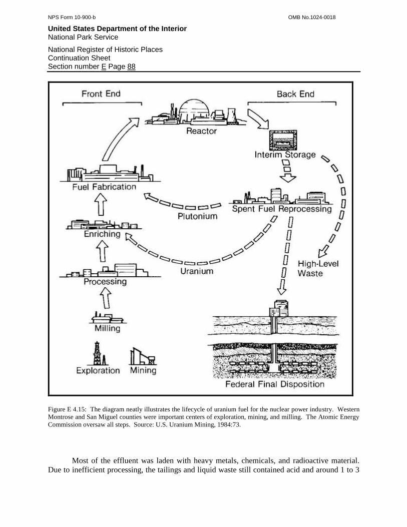
NPS Form 10-900-b OMB No.1024-0018
United States Department of the Interior National Park Service
National Register of Historic Places Continuation Sheet Section number E Page 88
Figure E 4.15: The diagram neatly illustrates the lifecycle of uranium fuel for the nuclear power industry. Western
Montrose and San Miguel counties were important centers of exploration, mining, and milling. The Atomic Energy
Commission oversaw all steps. Source: U.S. Uranium Mining, 1984:73.
Most of the effluent was laden with heavy metals, chemicals, and radioactive material.
Due to inefficient processing, the tailings and liquid waste still contained acid and around 1 to 3

NPS Form 10-900-b OMB No.1024-0018
United States Department of the Interior National Park Service
National Register of Historic Places Continuation Sheet Section number E Page 89
percent of the ore’s uranium content. Even when stored in the tailings ponds, the waste made its
way into the region’s rivers and was mobilized by the wind when dry. As a result, the river
corridors and milling communities became heavily contaminated, and the effects were tangible.
Effluent from the Durango mill destroyed aquatic life along several miles of the Animas River.
At Vancorum, dust that escaped the VCA mill stained rocks and brush carnotite yellow within a
one-half mile of the plant. During the 1960s and 1970s, Naturita residents Louise Schad and
Ralph Casto saw fish with sores and lumps in the San Miguel and Dolores rivers. Further,
Schad’s son developed sores after swimming repeatedly in the San Miguel. The communities in
western Montrose and San Miguel counties were aware of the radioactive contamination but
accepted it because they depended on the mining industry.185
The residents of Grand Junction, however, felt otherwise. During the 1960s and 1970s,
tailings from the Climax Uranium and other mills were used to backfill utility trenches, and as
sand in concrete and construction mortar. After studies found that Grand Junction featured a
handful of 5,000 sites that were radioactive, Congress passed the Uranium Mill Tailings
Radiation Control Act (UMTRA) in 1978. UMTRA charged the EPA with regulating and
cleaning up mill tailings, and required the Department of Energy to publish a list of contaminated
sites and identify repositories for the waste. The Federal Government accepted responsibility for
the millsites abandoned prior to 1971 and burdened the mining industry with those active
afterward. In addition, uranium mining companies had to comply with strict waste disposal
regulations beginning in 1981.186
While the regulation and cleanups were good for the public, they saddled the mining
industry with new layers of costs and complicated their operations. For example, Uravan was
engulfed in tailings ponds and Union Carbide ran out of space for more tailings there. During
the late 1970s, company engineers designed an innovative pumping system to lift additional
tailings up to ponds on edge of Club Mesa, immediately above town. Federal inspectors,
however, ordered Union Carbide to stop the practice and find an alternative, which forced the
company to suspend the mill for several days. Around the same time, the EPA determined that
the entire town of Uravan was radioactive with wind-blown tailings and radon gas wafting off
the surrounding ponds, and Union Carbide then had to spend $12 million on tailings stabilization
efforts.187
Vancorum was only slightly better off, and the river floor around the VCA mill there
featured tailings ponds similar to those at Uravan. The tailings, though, were even more
radioactive because they retained a higher proportion of uranium and vanadium. This was
perceived as a problem until engineers and metallurgists employed by the Ranchers’ Exploration
& Development Corporation used the uranium as the basis for a solution. The company
proposed to recover the uranium still remaining in the tailings, much like the MED had done for
the Manhattan Project during World War II. From 1977 through 1979, the Durita Development
185
Bonner, 2007; Casto, 2007; Clark and Kerr, 1974:50, 63; Eichstaedt, 1994:58; McLeroy, 2007; Schad, 2007. 186
Eichstaedt, 1994:128; Hamrick, et al, 2002:50; Jackson, et al, 1979:39. 187
Amundson, 2002:160.

NPS Form 10-900-b OMB No.1024-0018
United States Department of the Interior National Park Service
National Register of Historic Places Continuation Sheet Section number E Page 90
Corporation, a subsidiary, moved the tailings to new ponds and treated them with a heap-leach
process. The project was heralded as an innovative success when finished.188
In 1979, a gathering undercurrent of problems surfaced and brought Colorado’s last
uranium boom to an end. One of the subtlest and yet most significant to Montrose and San
Miguel counties was the exhaustion of known ore reserves. After almost 30 years of production,
mining companies gutted the premier ore beds and were unable to find more that were equal in
size and richness. The high uranium prices of the 1970s boom provided mining companies with
a strong incentive to produce as much carnotite ore as possible. But because many of the ore
bodies were exhausted, the two counties featured only a fraction of the mines that were active
during the slump of the 1960s.
The cost of producing and milling ore was another problem that affected the uranium
industry during the late 1970s. Compliance with environmental and safety regulations consumed
manpower and increased production costs beyond those that the mining industry expected. At
the same time, uncontrolled inflation reduced profits significantly, despite soaring uranium
prices. Because of these factors, foreign uranium producers were once again competitive with
the domestic companies, which were slowly squeezed out of the market.
As if foreign competition was not enough, the domestic mining industry saw the uranium
market contract. At first, utility companies cancelled some of their orders for nuclear
powerplants due to unforeseen operating costs and inflation, which reduced the demand for
uranium. Then, in 1979, a meltdown at the Three Mile Island power plant shook public and
government confidence in nuclear power to the core, and utility companies canceled power plant
orders outright, even in the face of contract penalties. This devastated the mining industry
because it lost both short-run and long-term uranium sales. The utility companies already had
more than enough yellowcake to meet their short-run needs and consumed their existing
stockpiles, and then dumped the surplus material on an already depressed market, forcing
uranium prices down even farther. With few nuclear powerplants expected in the future, the
long-term market assumed a bleak appearance, as well. Validating this, the utility companies
released only a handful of ten-year contracts for yellowcake, which the mining industry had
relied on for stability, and instead solicited five-year contracts and on-demand purchases.
Exacerbating a downward spiral, the utility companies increasingly courted foreign producers for
immediate sales. The net result was that the price of yellowcake toppled from $60 to only $25
per pound by 1981.189
On the Colorado Plateau, the mining industry contracted one last, painful time in a broad
sweep. Companies closed most of the marginal mines, scaled back production at the large
operations, and shut down one-half of the mills. Montrose and San Miguel counties in particular
lost more than one-half of their operating mines by 1981, and around 40 percent of the survivors
were abandoned the following year. Union Carbide closed the Uravan mill for the first time in
188
Colorado Mine Inspectors' Reports, Montrose County: Foote Mineral; “Mineral Activities in Colorado - 1977”; Zambrana and Heath,
1980:141. 189
Amundson, 2002:142; Hearing, 1985:107; U.S. Department of Energy, 1984:10; United States Uranium Mining, 1984:9, 39, 41, 45.

NPS Form 10-900-b OMB No.1024-0018
United States Department of the Interior National Park Service
National Register of Historic Places Continuation Sheet Section number E Page 91
40 years and laid off almost half of its workforce, then tried reopening the mill in 1981 and again
in 1983, but the price for yellowcake remained too low to sustain operations. Union Carbide
closed the mill permanently, which had a profound and compounded effect on the region. With
no place to ship ore, most of the remaining mining outfits ceased ore production and suspended
exploratory drilling. The lack of jobs stimulated an exodus of workers and their families, who
left the region in a depression from which it never recovered.190
By the early 1980s, the domestic uranium mining industry was in ruins, and its captains
pleaded with the Federal Government for assistance. In response, the government conducted a
survey of the industry and found that it was so troubled after uranium prices fell that it was no
longer a viable force. Instead of help and protection, however, the government reduced
restrictions on foreign uranium to ensure that utilities had enough fuel and that electricity
consumers would not, in essence, pay high rates to subsidize the very domestic uranium industry
that the government created. The uranium industry had passed the point of a return to prosperity,
and on the Colorado Plateau, only 3 of what had been 25 mills treated ore from a handful of
mines. Colorado also had the Cotter Mill at Canon City, but this was too far away. In Montrose
and San Miguel counties, activity shifted away from uranium production and over to the
environmental legacy left from 80 years of mining. The counties featured a number of sites that
required environmental cleanup, and heavily contaminated Uravan was the most egregious. In
1984, Union Carbide, its successor Umetco, and the EPA hammered out a 15 year cleanup plan
to move and seal the mill, the buildings, and 12.5 million tons of mill tailings. The town’s last
resident was removed in 1986, all surface manifestations except for the USV boardinghouse
were dismantled, and the very ground on which the town stood was scraped away. The VCA
mill at Vancorum and the North Continent mill at Slick suffered similar fates. The other
communities that had been dependent on uranium, including Naturita, Nucla, Paradox, and
Gateway, reverted to their ranching roots and turned toward tourism, which celebrated in part the
uranium mining industry.191
Sixth Period of Significance, 1974-1980
In 1980, the last Period of Significance for western Montrose and San Miguel counties
came to an end. Beginning in 1974, the Period saw the uranium mining industry experience a
brief boom as the nation looked toward nuclear power as an energy alternative to foreign oil.
Rapid increases in uranium prices and the popularity of nuclear power delivered the flagging
industry from the brink of failure and into a substantial boom. The Colorado Plateau, and
Montrose and San Miguel counties in particular, rose out of a depression and returned to a state
of prosperity. The boom was, however, short-lived and collapsed by 1980. In Montrose and San
Miguel counties, the largest and richest ore bodies were exhausted after 30 years of continuous
mining, and exploratory drilling found few replacements despite the fact that a record number of
sample-holes were bored. At the same time, utility companies cancelled orders for nuclear
190
Amundson, 2002:151, 160; Hamrick, et al, 2002:49; “Mineral Activities in Colorado - 1980”; “Mineral Activities in Colorado - 1981”;
“Mineral Activities in Colorado - 1982”. 191
Amundson, 2002:143; Hamrick, et al, 2002:50; Hearing, 1985:7, 8, 100.
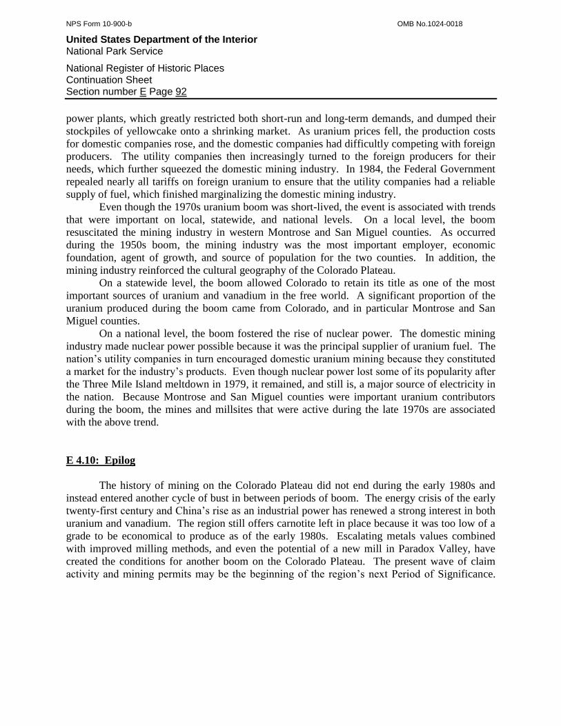
NPS Form 10-900-b OMB No.1024-0018
United States Department of the Interior National Park Service
National Register of Historic Places Continuation Sheet Section number E Page 92
power plants, which greatly restricted both short-run and long-term demands, and dumped their
stockpiles of yellowcake onto a shrinking market. As uranium prices fell, the production costs
for domestic companies rose, and the domestic companies had difficultly competing with foreign
producers. The utility companies then increasingly turned to the foreign producers for their
needs, which further squeezed the domestic mining industry. In 1984, the Federal Government
repealed nearly all tariffs on foreign uranium to ensure that the utility companies had a reliable
supply of fuel, which finished marginalizing the domestic mining industry.
Even though the 1970s uranium boom was short-lived, the event is associated with trends
that were important on local, statewide, and national levels. On a local level, the boom
resuscitated the mining industry in western Montrose and San Miguel counties. As occurred
during the 1950s boom, the mining industry was the most important employer, economic
foundation, agent of growth, and source of population for the two counties. In addition, the
mining industry reinforced the cultural geography of the Colorado Plateau.
On a statewide level, the boom allowed Colorado to retain its title as one of the most
important sources of uranium and vanadium in the free world. A significant proportion of the
uranium produced during the boom came from Colorado, and in particular Montrose and San
Miguel counties.
On a national level, the boom fostered the rise of nuclear power. The domestic mining
industry made nuclear power possible because it was the principal supplier of uranium fuel. The
nation’s utility companies in turn encouraged domestic uranium mining because they constituted
a market for the industry’s products. Even though nuclear power lost some of its popularity after
the Three Mile Island meltdown in 1979, it remained, and still is, a major source of electricity in
the nation. Because Montrose and San Miguel counties were important uranium contributors
during the boom, the mines and millsites that were active during the late 1970s are associated
with the above trend.
E 4.10: Epilog
The history of mining on the Colorado Plateau did not end during the early 1980s and
instead entered another cycle of bust in between periods of boom. The energy crisis of the early
twenty-first century and China’s rise as an industrial power has renewed a strong interest in both
uranium and vanadium. The region still offers carnotite left in place because it was too low of a
grade to be economical to produce as of the early 1980s. Escalating metals values combined
with improved milling methods, and even the potential of a new mill in Paradox Valley, have
created the conditions for another boom on the Colorado Plateau. The present wave of claim
activity and mining permits may be the beginning of the region’s next Period of Significance.

NPS Form 10-900-b OMB No.1024-0018
United States Department of the Interior National Park Service
National Register of Historic Places Continuation Sheet Section number E Page 93
E 5: MINING AND MILLING TECHNOLOGY, METHODS, AND EQUIPMENT
E 5.1: Introduction
Western Montrose and San Miguel counties were celebrated as some of the world’s most
important sources of radium, uranium, and vanadium. These radioactive metals occurred
together in carnotite ore, which was largely an altered form of sandstone. Roscoelite, also in
sandstone, carried high proportions of vanadium and small amounts of uranium, and it was
limited primarily to the area around Placerville in San Miguel County. The host sandstone beds
for both types of ore were geologically similar to the conditions associated with coal beds. They
were relatively flat and predictable, and they lay underneath layers of cap rock. Because of this,
mining companies adapted coal mining methods to develop and extract carnotite deposits from
the beginning of uranium production in the 1900s. However, carnotite and roscoelite mines
tended to be simpler, smaller, and equipped with lighter duty facilities than coal mines. The
methods used to produce carnotite and concentrate the radioactive content were fairly universal
and saw broad application across the Colorado Plateau. Below is a discussion of the general
methods and technologies used to find, extract, and concentrate carnotite and roscoelite ore.
E 5.2: Carnotite and Roscoelite Mining
E 5.2.1: Prospecting for Carnotite Ore
Finding beds of carnotite was the first step in uranium mining, and three methods were
used, depending on timeframe. Between the late 1890s and the early 1920s, prospectors adapted
traditional methods to the sedimentary geology of Montrose and San Miguel counties. During
the late 1890s and early 1900s, the first years of uranium exploration, prospectors learned to
identify carnotite ore by its canary-yellow appearance. At the same time, assayers became aware
that uranium was the principal constituent of interest in carnotite and tested samples for the
metal. Through visual conformation and submitting samples to assayers, prospectors discovered
a number of carnotite ore formations exposed in the sandstone cliffs and ledges of the region’s
mesas. Within a short time, they realized that the distribution of the formations followed a
predictable pattern. Specifically, the deposits were limited to what geologists later termed the
Salt Wash Member (component) of the Morrison Formation, which was a sandstone layer well-
defined in the region’s mesas.
Once prospectors identified this pattern, they knew to limit their searches to the
horizontal Morrison Formation. Further, educated individuals also understood that beds of green
shale sandwiched the ore-bearing portion of the Salt Wash Member, and they restricted their
examinations to this stratum. Because the Morrison Formation was well-exposed, the
prospectors merely had to clamber along its cliffs and ledges and watch for the yellow staining of
carnotite or the dark gray of vanadium oxide.192
192
Coffin, 1921:188.

NPS Form 10-900-b OMB No.1024-0018
United States Department of the Interior National Park Service
National Register of Historic Places Continuation Sheet Section number E Page 94
When prospectors encountered color, they applied traditional nineteenth century methods
to determine the ore body’s size and quality, and track its extent. Specifically, the prospectors
used picks to pry loose overlying sandstone slabs and dynamite to blast exploratory pits and
trenches into solid rock. When these excavations proved positive, the prospectors may have
driven short adits into the cliff to probe the ore body’s horizontal extent. If the ore body was
large, as every prospector hoped, the party abandoned the adits, moved some distance away from
the cliff, and sank shallow shafts through the overlying sandstone cap rock. With the shafts, the
prospectors were able to track the ore body and find its limits.193
During the 1900s and 1910s, the prospectors employed conventional drilling and blasting
practices to drive the underground workings. After clearing away as much fractured, loose
bedrock as possible with pick and shovel, a pair of prospectors began boring blast-holes with a
hammer and drill-steels. They often bored between 12 and 18 holes, 18 to 24 inches deep, in a
special pattern designed to maximize the force of the explosive charges they loaded. Some
parties used blasting powder because it was effective in sandstone and inexpensive, and most
relied on stronger but more costly dynamite. Until the party confirmed that the ore body
possessed carnotite in economic volumes, the operation was classified as a prospect.
Individuals and small parties were by no means alone in the search for carnotite. Large
companies such as the Radium Company of Colorado and Standard Chemical hired professional
prospectors and engaged in systematic explorations of both their existing claims and new ground.
Company geologists reasoned that carnotite deposits were not limited to cliffs and ledges and
instead occurred throughout the Salt Wash Member, even when underneath cap rock. During the
vanadium boom of the 1910s, they began strategic drilling and sampling in Long Park, on claims
where ore-bearing sandstone was not exposed. As expected, drilling crews encountered ore, and
the companies then carried this new prospecting method to other mesas in the region.194
The companies used four general methods to bore sample holes, depending on anticipated
depth and location. For depths less than 15 feet, workers manually bored holes with drill-steels
or weighted chisels suspended on ropes. Most companies, however, used rockdrills.
Conventional drills had depth limitations of 35 feet and required the support of trailer-mounted,
portable air compressors. Gasoline-powered units could bore deeper holes but consumed water,
which was in short supply on the arid mesas. The companies used churn drills and diamond
drills for deep exploration, and these apparatuses provided positive samples from measurable
depths. In most cases, companies planned the holes according to a grid so that the exact shape,
size, and hence volume of the ore body could be accurately measured. In all cases, workers
watched the drill-cuttings for color as they came out of the holes.195
193
Kithil and Davis, 1917:18. 194
Coffin, 1921:191; Mineral Resources, 1918:812. 195
Coffin, 1921:191.
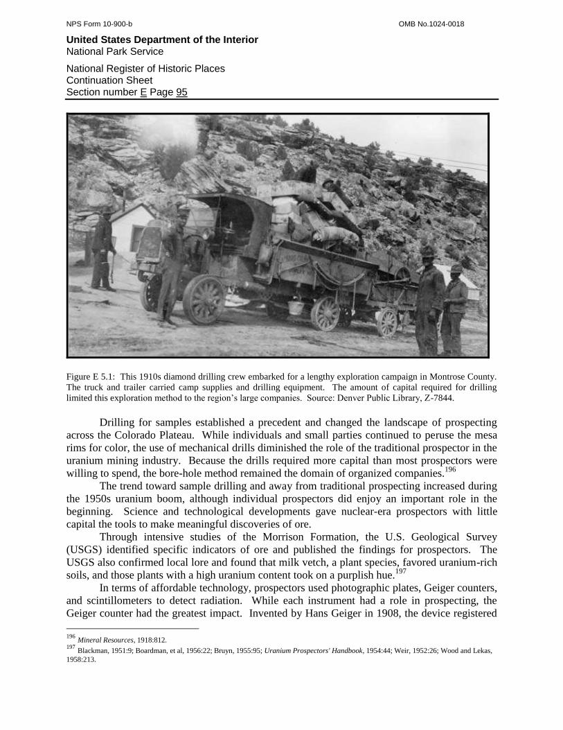
NPS Form 10-900-b OMB No.1024-0018
United States Department of the Interior National Park Service
National Register of Historic Places Continuation Sheet Section number E Page 95
Figure E 5.1: This 1910s diamond drilling crew embarked for a lengthy exploration campaign in Montrose County.
The truck and trailer carried camp supplies and drilling equipment. The amount of capital required for drilling
limited this exploration method to the region’s large companies. Source: Denver Public Library, Z-7844.
Drilling for samples established a precedent and changed the landscape of prospecting
across the Colorado Plateau. While individuals and small parties continued to peruse the mesa
rims for color, the use of mechanical drills diminished the role of the traditional prospector in the
uranium mining industry. Because the drills required more capital than most prospectors were
willing to spend, the bore-hole method remained the domain of organized companies.196
The trend toward sample drilling and away from traditional prospecting increased during
the 1950s uranium boom, although individual prospectors did enjoy an important role in the
beginning. Science and technological developments gave nuclear-era prospectors with little
capital the tools to make meaningful discoveries of ore.
Through intensive studies of the Morrison Formation, the U.S. Geological Survey
(USGS) identified specific indicators of ore and published the findings for prospectors. The
USGS also confirmed local lore and found that milk vetch, a plant species, favored uranium-rich
soils, and those plants with a high uranium content took on a purplish hue.197
In terms of affordable technology, prospectors used photographic plates, Geiger counters,
and scintillometers to detect radiation. While each instrument had a role in prospecting, the
Geiger counter had the greatest impact. Invented by Hans Geiger in 1908, the device registered
196
Mineral Resources, 1918:812. 197
Blackman, 1951:9; Boardman, et al, 1956:22; Bruyn, 1955:95; Uranium Prospectors' Handbook, 1954:44; Weir, 1952:26; Wood and Lekas,
1958:213.
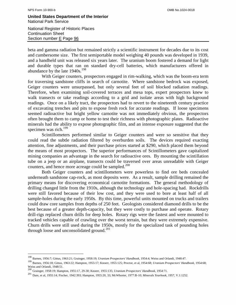
NPS Form 10-900-b OMB No.1024-0018
United States Department of the Interior National Park Service
National Register of Historic Places Continuation Sheet Section number E Page 96
beta and gamma radiation but remained strictly a scientific instrument for decades due to its cost
and cumbersome size. The first semiportable model weighing 40 pounds was developed in 1939,
and a handheld unit was released six years later. The uranium boom fostered a demand for light
and durable types that ran on standard dry-cell batteries, which manufacturers offered in
abundance by the late 1940s.198
With Geiger counters, prospectors engaged in rim-walking, which was the boom-era term
for traversing sandstone cliffs in search of carnotite. Where sandstone bedrock was exposed,
Geiger counters were unsurpassed, but only several feet of soil blocked radiation readings.
Therefore, when examining soil-covered terraces and mesa tops, expert prospectors knew to
walk transects or take readings according to a grid and isolate areas with high background
readings. Once on a likely tract, the prospectors had to revert to the nineteenth century practice
of excavating trenches and pits to expose fresh rock for accurate readings. If loose specimens
seemed radioactive but bright yellow carnotite was not immediately obvious, the prospectors
often brought them to camp or home to test their richness with photographic plates. Radioactive
minerals had the ability to expose photographic film, and an intense exposure suggested that the
specimen was rich.199
Scintillometers performed similar to Geiger counters and were so sensitive that they
could read the subtle radiation filtered by overburden soils. The devices required exacting
attention, fine adjustments, and their purchase prices started at $290, which placed them beyond
the means of most prospectors. The superior performances of Scintillometers gave capitalized
mining companies an advantage in the search for radioactive ores. By mounting the scintillation
tube on a jeep or an airplane, transects could be traversed over areas unreadable with Geiger
counters, and hence more acreage could be sampled.200
Both Geiger counters and scintillometers were powerless to find ore beds concealed
underneath sandstone cap-rock, as most deposits were. As a result, sample drilling remained the
primary means for discovering economical carnotite formations. The general methodology of
drilling changed little from the 1910s, although the technology and hole-spacing had. Rockdrills
were still favored because of their low cost, and they were used to bore at least half of all
sample-holes during the early 1950s. By this time, powerful units mounted on trucks and trailers
could draw core samples from depths of 250 feet. Geologists considered diamond drills to be the
best because of a greater depth-capacity, but they were costly to purchase and operate. Rotary
drill-rigs replaced churn drills for deep holes. Rotary rigs were the fastest and were mounted to
tracked vehicles capable of crawling over the worst terrain, but they were extremely expensive.
Churn drills were still used during the 1950s, mostly for the specialized task of pounding holes
through loose and unconsolidated ground.201
198
Barnes, 1956:7; Gittus, 1963:21; Grainger, 1958:19; Uranium Prospectors' Handbook, 1954:4; Weiss and Orlandi, 1948:47. 199
Barnes, 1956:18; Gittus, 1963:22; Hampton, 1955:17; Knoerr, 1955:125; Proctor, et al, 1954:68; Uranium Prospectors' Handbook, 1954:68;
Weiss and Orlandi, 1948:51. 200
Grainger, 1958:19; Hampton, 1955:17, 29-30; Knoerr, 1955:135; Uranium Prospectors' Handbook, 1954:71. 201
Dare, et al, 1955:14; Fischer, 1942:393; Hampton, 1955:20, 33; McWhorter, 1977:B-10; Minerals Yearbook, 1957, V.1:1252.
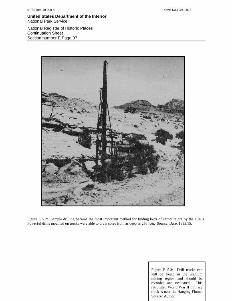
NPS Form 10-900-b OMB No.1024-0018
United States Department of the Interior National Park Service
National Register of Historic Places Continuation Sheet Section number E Page 97
Figure E 5.2: Sample drilling became the most important method for finding beds of carnotite ore by the 1940s.
Powerful drills mounted on trucks were able to draw cores from as deep as 250 feet. Source: Dare, 1955:15.
Figure E 5.3: Drill trucks can
still be found in the uranium
mining region and should be
recorded and evaluated. This
retrofitted World War II military
truck is near the Hanging Flume.
Source: Author.
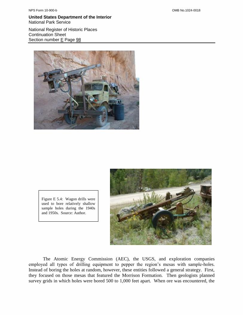
NPS Form 10-900-b OMB No.1024-0018
United States Department of the Interior National Park Service
National Register of Historic Places Continuation Sheet Section number E Page 98
The Atomic Energy Commission (AEC), the USGS, and exploration companies
employed all types of drilling equipment to pepper the region’s mesas with sample-holes.
Instead of boring the holes at random, however, these entities followed a general strategy. First,
they focused on those mesas that featured the Morrison Formation. Then geologists planned
survey grids in which holes were bored 500 to 1,000 feet apart. When ore was encountered, the
Figure E 5.4: Wagon drills were
used to bore relatively shallow
sample holes during the 1940s
and 1950s. Source: Author.
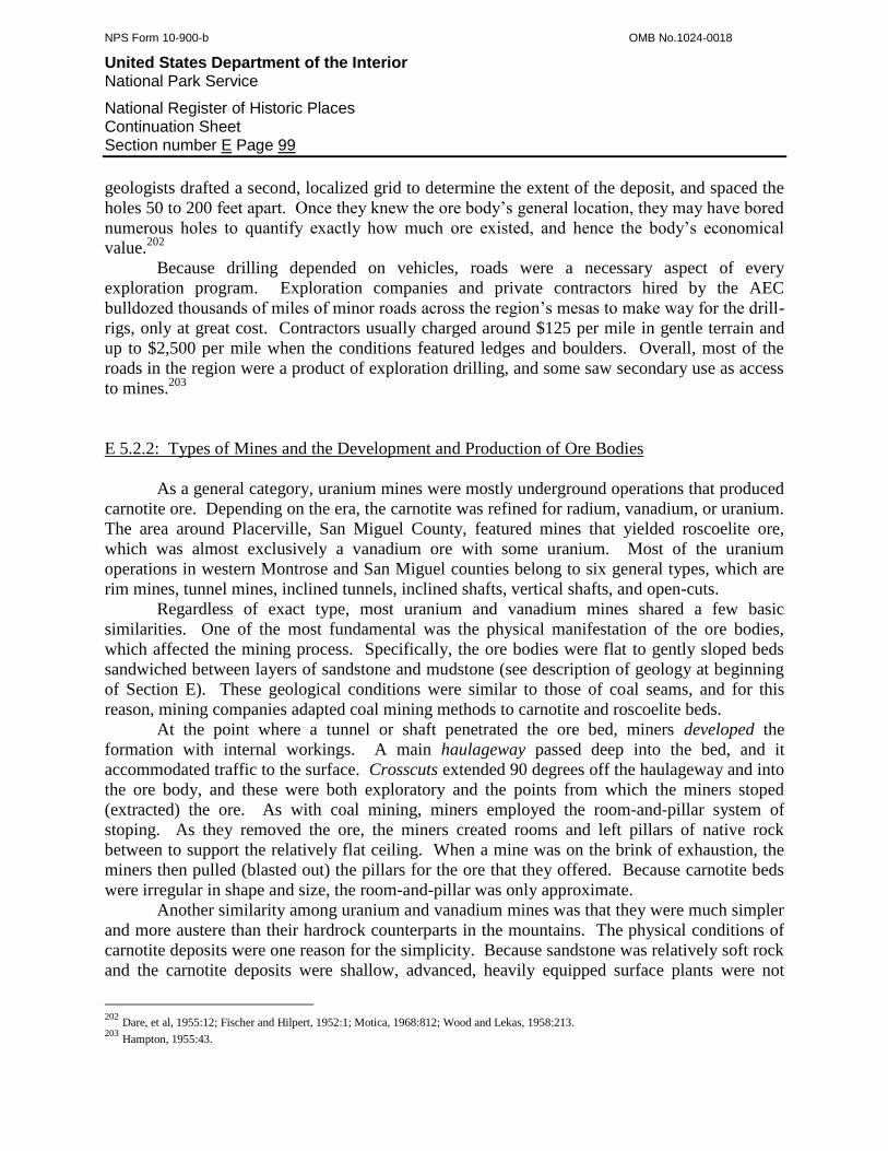
NPS Form 10-900-b OMB No.1024-0018
United States Department of the Interior National Park Service
National Register of Historic Places Continuation Sheet Section number E Page 99
geologists drafted a second, localized grid to determine the extent of the deposit, and spaced the
holes 50 to 200 feet apart. Once they knew the ore body’s general location, they may have bored
numerous holes to quantify exactly how much ore existed, and hence the body’s economical
value.202
Because drilling depended on vehicles, roads were a necessary aspect of every
exploration program. Exploration companies and private contractors hired by the AEC
bulldozed thousands of miles of minor roads across the region’s mesas to make way for the drill-
rigs, only at great cost. Contractors usually charged around $125 per mile in gentle terrain and
up to $2,500 per mile when the conditions featured ledges and boulders. Overall, most of the
roads in the region were a product of exploration drilling, and some saw secondary use as access
to mines.203
E 5.2.2: Types of Mines and the Development and Production of Ore Bodies
As a general category, uranium mines were mostly underground operations that produced
carnotite ore. Depending on the era, the carnotite was refined for radium, vanadium, or uranium.
The area around Placerville, San Miguel County, featured mines that yielded roscoelite ore,
which was almost exclusively a vanadium ore with some uranium. Most of the uranium
operations in western Montrose and San Miguel counties belong to six general types, which are
rim mines, tunnel mines, inclined tunnels, inclined shafts, vertical shafts, and open-cuts.
Regardless of exact type, most uranium and vanadium mines shared a few basic
similarities. One of the most fundamental was the physical manifestation of the ore bodies,
which affected the mining process. Specifically, the ore bodies were flat to gently sloped beds
sandwiched between layers of sandstone and mudstone (see description of geology at beginning
of Section E). These geological conditions were similar to those of coal seams, and for this
reason, mining companies adapted coal mining methods to carnotite and roscoelite beds.
At the point where a tunnel or shaft penetrated the ore bed, miners developed the
formation with internal workings. A main haulageway passed deep into the bed, and it
accommodated traffic to the surface. Crosscuts extended 90 degrees off the haulageway and into
the ore body, and these were both exploratory and the points from which the miners stoped
(extracted) the ore. As with coal mining, miners employed the room-and-pillar system of
stoping. As they removed the ore, the miners created rooms and left pillars of native rock
between to support the relatively flat ceiling. When a mine was on the brink of exhaustion, the
miners then pulled (blasted out) the pillars for the ore that they offered. Because carnotite beds
were irregular in shape and size, the room-and-pillar was only approximate.
Another similarity among uranium and vanadium mines was that they were much simpler
and more austere than their hardrock counterparts in the mountains. The physical conditions of
carnotite deposits were one reason for the simplicity. Because sandstone was relatively soft rock
and the carnotite deposits were shallow, advanced, heavily equipped surface plants were not
202
Dare, et al, 1955:12; Fischer and Hilpert, 1952:1; Motica, 1968:812; Wood and Lekas, 1958:213. 203
Hampton, 1955:43.
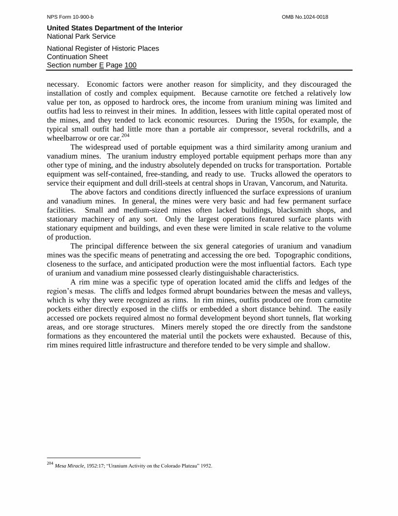
NPS Form 10-900-b OMB No.1024-0018
United States Department of the Interior National Park Service
National Register of Historic Places Continuation Sheet Section number E Page 100
necessary. Economic factors were another reason for simplicity, and they discouraged the
installation of costly and complex equipment. Because carnotite ore fetched a relatively low
value per ton, as opposed to hardrock ores, the income from uranium mining was limited and
outfits had less to reinvest in their mines. In addition, lessees with little capital operated most of
the mines, and they tended to lack economic resources. During the 1950s, for example, the
typical small outfit had little more than a portable air compressor, several rockdrills, and a
wheelbarrow or ore car.204
The widespread used of portable equipment was a third similarity among uranium and
vanadium mines. The uranium industry employed portable equipment perhaps more than any
other type of mining, and the industry absolutely depended on trucks for transportation. Portable
equipment was self-contained, free-standing, and ready to use. Trucks allowed the operators to
service their equipment and dull drill-steels at central shops in Uravan, Vancorum, and Naturita.
The above factors and conditions directly influenced the surface expressions of uranium
and vanadium mines. In general, the mines were very basic and had few permanent surface
facilities. Small and medium-sized mines often lacked buildings, blacksmith shops, and
stationary machinery of any sort. Only the largest operations featured surface plants with
stationary equipment and buildings, and even these were limited in scale relative to the volume
of production.
The principal difference between the six general categories of uranium and vanadium
mines was the specific means of penetrating and accessing the ore bed. Topographic conditions,
closeness to the surface, and anticipated production were the most influential factors. Each type
of uranium and vanadium mine possessed clearly distinguishable characteristics.
A rim mine was a specific type of operation located amid the cliffs and ledges of the
region’s mesas. The cliffs and ledges formed abrupt boundaries between the mesas and valleys,
which is why they were recognized as rims. In rim mines, outfits produced ore from carnotite
pockets either directly exposed in the cliffs or embedded a short distance behind. The easily
accessed ore pockets required almost no formal development beyond short tunnels, flat working
areas, and ore storage structures. Miners merely stoped the ore directly from the sandstone
formations as they encountered the material until the pockets were exhausted. Because of this,
rim mines required little infrastructure and therefore tended to be very simple and shallow.
204
Mesa Miracle, 1952:17; “Uranium Activity on the Colorado Plateau” 1952.
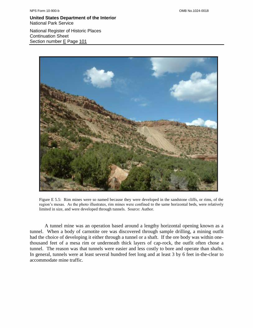
NPS Form 10-900-b OMB No.1024-0018
United States Department of the Interior National Park Service
National Register of Historic Places Continuation Sheet Section number E Page 101
Figure E 5.5: Rim mines were so named because they were developed in the sandstone cliffs, or rims, of the
region’s mesas. As the photo illustrates, rim mines were confined to the same horizontal beds, were relatively
limited in size, and were developed through tunnels. Source: Author.
A tunnel mine was an operation based around a lengthy horizontal opening known as a
tunnel. When a body of carnotite ore was discovered through sample drilling, a mining outfit
had the choice of developing it either through a tunnel or a shaft. If the ore body was within one-
thousand feet of a mesa rim or underneath thick layers of cap-rock, the outfit often chose a
tunnel. The reason was that tunnels were easier and less costly to bore and operate than shafts.
In general, tunnels were at least several hundred feet long and at least 3 by 6 feet in-the-clear to
accommodate mine traffic.

NPS Form 10-900-b OMB No.1024-0018
United States Department of the Interior National Park Service
National Register of Historic Places Continuation Sheet Section number E Page 102
Figure E 5.6: The Rex No.38 Mine in Eagle Canyon is a sound example of a tunnel operation. Distinguishing
characteristics include a lengthy tunnel, a voluminous waste rock dump, an ore bin, and a trestle. Source: Author.
An inclined shaft mine was an operation based around a shaft that descended
underground at a steep but not vertical angle. The uranium mining industry distinguished an
inclined shaft by the pitch of descent, which had to be 25 degrees or more.205
Inclined shafts
were a product of exploratory drilling, and mining outfits sank them to develop ore beds
landlocked underneath layers of sandstone cap-rock. Mining outfits chose inclined shafts over
horizontal tunnels and vertical shafts due to economic and environmental conditions. Vertical
205
Dare, et al, 1955:21.
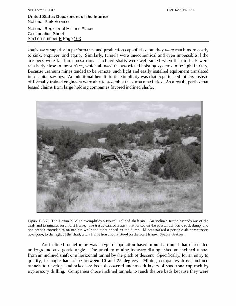
NPS Form 10-900-b OMB No.1024-0018
United States Department of the Interior National Park Service
National Register of Historic Places Continuation Sheet Section number E Page 103
shafts were superior in performance and production capabilities, but they were much more costly
to sink, engineer, and equip. Similarly, tunnels were uneconomical and even impossible if the
ore beds were far from mesa rims. Inclined shafts were well-suited when the ore beds were
relatively close to the surface, which allowed the associated hoisting systems to be light in duty.
Because uranium mines tended to be remote, such light and easily installed equipment translated
into capital savings. An additional benefit to the simplicity was that experienced miners instead
of formally trained engineers were able to assemble the surface facilities. As a result, parties that
leased claims from large holding companies favored inclined shafts.
Figure E 5.7: The Donna K Mine exemplifies a typical inclined shaft site. An inclined trestle ascends out of the
shaft and terminates on a hoist frame. The trestle carried a track that forked on the substantial waste rock dump, and
one branch extended to an ore bin while the other ended on the dump. Miners parked a portable air compressor,
now gone, to the right of the shaft, and a frame hoist house stood on the hoist frame. Source: Author.
An inclined tunnel mine was a type of operation based around a tunnel that descended
underground at a gentle angle. The uranium mining industry distinguished an inclined tunnel
from an inclined shaft or a horizontal tunnel by the pitch of descent. Specifically, for an entry to
qualify, its angle had to be between 10 and 25 degrees. Mining companies drove inclined
tunnels to develop landlocked ore beds discovered underneath layers of sandstone cap-rock by
exploratory drilling. Companies chose inclined tunnels to reach the ore beds because they were
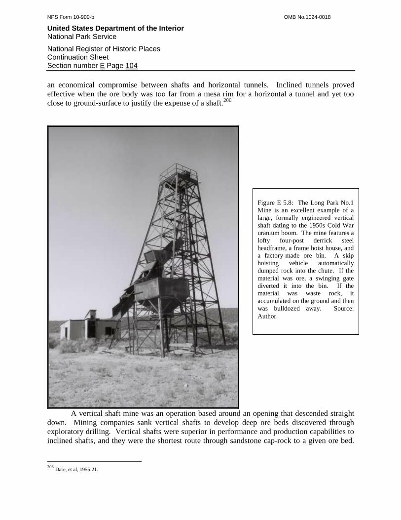
NPS Form 10-900-b OMB No.1024-0018
United States Department of the Interior National Park Service
National Register of Historic Places Continuation Sheet Section number E Page 104
an economical compromise between shafts and horizontal tunnels. Inclined tunnels proved
effective when the ore body was too far from a mesa rim for a horizontal a tunnel and yet too
close to ground-surface to justify the expense of a shaft.206
A vertical shaft mine was an operation based around an opening that descended straight
down. Mining companies sank vertical shafts to develop deep ore beds discovered through
exploratory drilling. Vertical shafts were superior in performance and production capabilities to
inclined shafts, and they were the shortest route through sandstone cap-rock to a given ore bed.
206
Dare, et al, 1955:21.
Figure E 5.8: The Long Park No.1
Mine is an excellent example of a
large, formally engineered vertical
shaft dating to the 1950s Cold War
uranium boom. The mine features a
lofty four-post derrick steel
headframe, a frame hoist house, and
a factory-made ore bin. A skip
hoisting vehicle automatically
dumped rock into the chute. If the
material was ore, a swinging gate
diverted it into the bin. If the
material was waste rock, it
accumulated on the ground and then
was bulldozed away. Source:
Author.

NPS Form 10-900-b OMB No.1024-0018
United States Department of the Interior National Park Service
National Register of Historic Places Continuation Sheet Section number E Page 105
Because vertical shafts required formal engineering and were much more costly to sink,
engineer, and equip, they were the domain of large, well-capitalized companies.
Figure E 5.9: The photo illustrates a surface plant typical of medium-sized and large mines. The mine in the photo
may be either a horizontal or inclined tunnel operation. The surface plant features several frame buildings, an ore
bin and trestle, and a portable air compressor. Note the small sizes and simplicity of the buildings, which appear to
be of frame construction sided with tarpaper. Dare, 1955:22.
NPS Form 10-900-b OMB No.1024-0018
United States Department of the Interior National Park Service
National Register of Historic Places Continuation Sheet Section number E Page 106
E 5.2.3: The Mine Surface Plant
Driving underground workings required support from on-site facilities. Known among
miners and engineers as the surface plant, these facilities were equipped to meet the needs of the
work underground. Regardless of whether the operation was small or large, the surface plant had
to meet several fundamental needs. First, the plant had to provide a stable and unobstructed
entry into the underground workings. Second, it had to allow for the transportation of materials
into and waste rock out of the underground workings. Third, the workings had to be ventilated,
and fifth, the plant had to facilitate the storage of up to hundreds of tons of ore between
shipments. Productive mines had additional needs that depended on the type of entry bored into
the ore bed.
The surface plants for the six general types of mines shared many of the same
components. Rim and tunnel mines possessed the simplest surface plants, and their facilities
were universal. The principal difference with inclined tunnels and shafts was their additional
need for hoisting systems. Following is a list and description of the principal components found
at most uranium and vanadium mines. The definitions are based on standards recognized by the
hardrock mining industry.
E 5.2.3.1: The Tunnel Portal
The tunnel portal was a primary component of rim and tunnel mines. Professionally
trained engineers recognized a difference between prospect adits and production-class tunnels.
Height and width were the primary defining criteria. A production-class tunnel was wide enough
to permit an outgoing ore car to pass an in-going miner, and headroom had to be ample enough
to house compressed air lines and ventilation tubing. By the 1910s, most mining engineers
defined production-class tunnels as being at least 3½ to 4 feet wide and 6 to 6½ feet high.
Anything smaller, they claimed, was merely a prospect adit.207
Mining engineers paid due attention to the tunnel portal because it guarded against cave-
ins of loose rock and soil. Engineers recognized cap-and-post timber sets to be best suited for
supporting both the portal and areas of fractured rock further in. This ubiquitous means of
support consisted of two upright posts and a cross-member. To assemble the set, miners cut
square notches into the posts, nailed on the cap, and raised the set into place. Afterward, the
miners hammered wooden wedges between the cap and the tunnel ceiling to make the set
weight-bearing.
207
Twitty, 2002:25, 36.

NPS Form 10-900-b OMB No.1024-0018
United States Department of the Interior National Park Service
National Register of Historic Places Continuation Sheet Section number E Page 107
E 5.2.3.2: Mine Transportation
Miners working underground generated tons of waste rock that had to be hauled out,
while tools, timbers, and explosives had to be brought in. As a result, mining companies had to
rely on some form of a transportation system. The smallest and most primitive operations
employed wheelbarrows, which were inexpensive but offered a limited carrying capacity. Ore
cars on steel rails were the most common system from the 1900s through the 1970s. In mines
with extensive underground workings and high volumes of production, some outfits used
compressed air-powered locomotives to pull trains of ore cars to the surface. Battery and trolley
locomotives, however, saw little use because of their broad gauge and need for large-radius
curves.208
Figure E 5.10: Wheelbarrows were among the most commonly used conveyance for hauling rock out of small
mines. Wheelbarrows were inexpensive and maneuverable but had a limited carrying capacity. Source: Dare:
1955:39.
Ore cars ran on rails that mine supply houses sold in a variety of standard sizes. The
units of measure were based on the rail’s weight-per-yard. Light-duty rail ranged from 6 to 12
pounds-per-yard, medium-duty weight rails included 12, 16, 18, and 20 pounds-per-yard, and
heavy rail weighed from 24 to 50 pounds-per-yard. Leasing outfits usually purchased light-duty
rail because of its transportability and low cost. Mining engineers erecting production-class
transportation systems had used at least medium-duty rail because it lasted longer.209
208
Dare, et al, 1955:40; Fischer, 1942:394; Wood and Lekas, 1958:215. 209
Twitty, 2002:37, 114, 116.

NPS Form 10-900-b OMB No.1024-0018
United States Department of the Interior National Park Service
National Register of Historic Places Continuation Sheet Section number E Page 108
Figure E 5.11: Ore cars were the most popular means used to haul rock out of productive mines during the uranium
industry’s history. They carried between one and two tons of material. Mesa Miracle, 1951:6.
Trackless haulage vehicles were a popular alternative to the ore cars in uranium mines.
Equipment manufacturers offered a few models of vehicles during the 1940s, and as the variety
increased through the 1950s, uranium mining companies began adopting the technology. By the
1960s, the mining industry made extensive use of several basic types of vehicles. One was a
self-contained buggy with three or four tires, a dumping bed for the ore, and a driver’s seat.
Another was a small tractor that pulled trailers with dumping beds. A third was a low truck with
four wheels and a large bed that dumped. All four types of vehicles held distinct advantages
over traditional ore cars. Because they were not limited to tracks, miners could drive them
throughout underground workings. In addition, the vehicles could easily be relocated to another
mine once a property had been exhausted. However, the vehicles were not economical for small
operations because they were costly, required maintenance, and fouled mine atmospheres with
exhaust, which then required ventilation systems to mitigate. In addition, a mine’s underground
workings had to be wide enough to allow the vehicles’ passage, which increased the initial costs
of underground development. Tunnels had to be at least 6 feet wide and 6 feet high, and their
floors smooth.210
210
Casto, 2007; Chenoweth, 1993:34; Dare, et al, 1955:44; Dare, 1959:9; Perry, 1981:120.
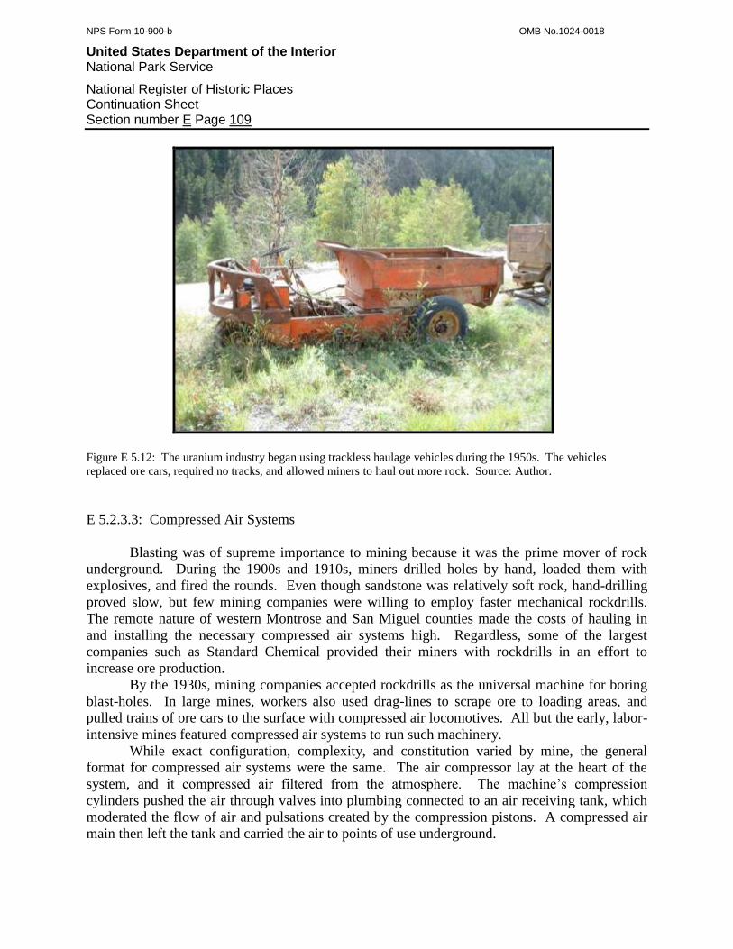
NPS Form 10-900-b OMB No.1024-0018
United States Department of the Interior National Park Service
National Register of Historic Places Continuation Sheet Section number E Page 109
Figure E 5.12: The uranium industry began using trackless haulage vehicles during the 1950s. The vehicles
replaced ore cars, required no tracks, and allowed miners to haul out more rock. Source: Author.
E 5.2.3.3: Compressed Air Systems
Blasting was of supreme importance to mining because it was the prime mover of rock
underground. During the 1900s and 1910s, miners drilled holes by hand, loaded them with
explosives, and fired the rounds. Even though sandstone was relatively soft rock, hand-drilling
proved slow, but few mining companies were willing to employ faster mechanical rockdrills.
The remote nature of western Montrose and San Miguel counties made the costs of hauling in
and installing the necessary compressed air systems high. Regardless, some of the largest
companies such as Standard Chemical provided their miners with rockdrills in an effort to
increase ore production.
By the 1930s, mining companies accepted rockdrills as the universal machine for boring
blast-holes. In large mines, workers also used drag-lines to scrape ore to loading areas, and
pulled trains of ore cars to the surface with compressed air locomotives. All but the early, labor-
intensive mines featured compressed air systems to run such machinery.
While exact configuration, complexity, and constitution varied by mine, the general
format for compressed air systems were the same. The air compressor lay at the heart of the
system, and it compressed air filtered from the atmosphere. The machine’s compression
cylinders pushed the air through valves into plumbing connected to an air receiving tank, which
moderated the flow of air and pulsations created by the compression pistons. A compressed air
main then left the tank and carried the air to points of use underground.
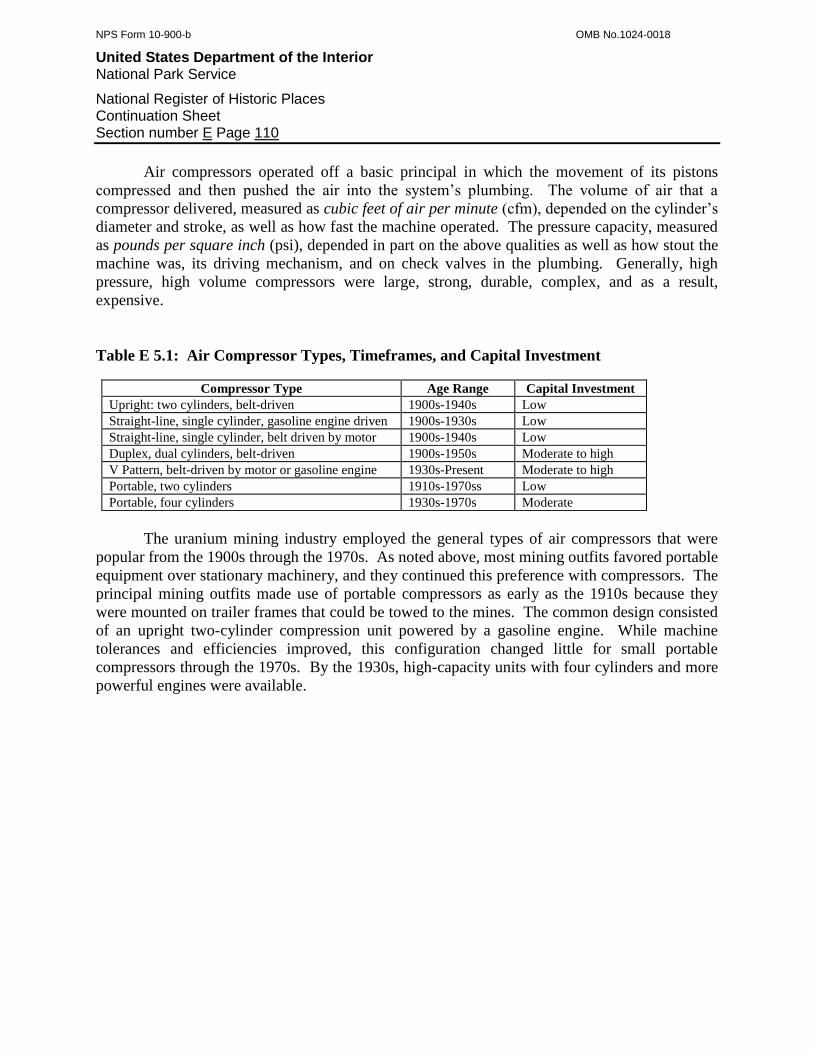
NPS Form 10-900-b OMB No.1024-0018
United States Department of the Interior National Park Service
National Register of Historic Places Continuation Sheet Section number E Page 110
Air compressors operated off a basic principal in which the movement of its pistons
compressed and then pushed the air into the system’s plumbing. The volume of air that a
compressor delivered, measured as cubic feet of air per minute (cfm), depended on the cylinder’s
diameter and stroke, as well as how fast the machine operated. The pressure capacity, measured
as pounds per square inch (psi), depended in part on the above qualities as well as how stout the
machine was, its driving mechanism, and on check valves in the plumbing. Generally, high
pressure, high volume compressors were large, strong, durable, complex, and as a result,
expensive.
Table E 5.1: Air Compressor Types, Timeframes, and Capital Investment
Compressor Type Age Range Capital Investment
Upright: two cylinders, belt-driven 1900s-1940s Low
Straight-line, single cylinder, gasoline engine driven 1900s-1930s Low
Straight-line, single cylinder, belt driven by motor 1900s-1940s Low
Duplex, dual cylinders, belt-driven 1900s-1950s Moderate to high
V Pattern, belt-driven by motor or gasoline engine 1930s-Present Moderate to high
Portable, two cylinders 1910s-1970ss Low
Portable, four cylinders 1930s-1970s Moderate
The uranium mining industry employed the general types of air compressors that were
popular from the 1900s through the 1970s. As noted above, most mining outfits favored portable
equipment over stationary machinery, and they continued this preference with compressors. The
principal mining outfits made use of portable compressors as early as the 1910s because they
were mounted on trailer frames that could be towed to the mines. The common design consisted
of an upright two-cylinder compression unit powered by a gasoline engine. While machine
tolerances and efficiencies improved, this configuration changed little for small portable
compressors through the 1970s. By the 1930s, high-capacity units with four cylinders and more
powerful engines were available.
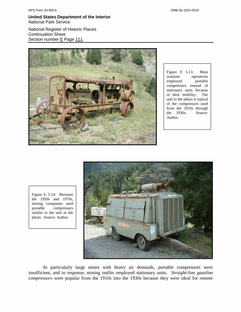
NPS Form 10-900-b OMB No.1024-0018
United States Department of the Interior National Park Service
National Register of Historic Places Continuation Sheet Section number E Page 111
At particularly large mines with heavy air demands, portable compressors were
insufficient, and in response, mining outfits employed stationary units. Straight-line gasoline
compressors were popular from the 1910s into the 1930s because they were ideal for remote
Figure E 5.13: Most
uranium operations
employed portable
compressors instead of
stationary units because
of their mobility. The
unit in the photo is typical
of the compressors used
from the 1910s through
the 1930s. Source:
Author.
Figure E 5.14: Between
the 1950s and 1970s,
mining companies used
portable compressors
similar to the unit in the
photo. Source: Author.

NPS Form 10-900-b OMB No.1024-0018
United States Department of the Interior National Park Service
National Register of Historic Places Continuation Sheet Section number E Page 112
operations. These machines consisted of a large horizontal compression cylinder linked to a
single cylinder gas engine, which required a substantial foundation capable of withstanding
intense vibration. Large gasoline machines were capable of producing up to 150 cubic feet of air
at 90 pounds per square inch, which permitted mining companies to run up to two small
rockdrills.211
At the same time, an upright two-cylinder compressor with valves and a crankshaft like
an automobile engine became popular. These units were inexpensive, adaptable to any form of
power, and weighed little. Further, mining machinery makers had mounted them onto simple
wood frames for mobility.
Between the 1900s and 1950s, duplex compressors were the most popular stationary units
at medium-sized and large mines because of their high air capacity. These machines featured
dual compression cylinders in a parallel configuration. A main driveshaft with a massive
flywheel linked the cylinders, and a belt passed around the flywheel to the drive engine.
The popularization of the automobile engine gave rise to several alternative forms of
compressors based on engine mechanics. V-cylinder compressors, also known as feather valve
compressors, were adaptations of large-displacement truck engines and featured three to eight
cylinders arranged in a “V” configuration. This design, which gained popularity during the
1930s, relied on a grossly enlarged radiator for cooling and was powered by a gasoline engine or
electric motor.
E 5.2.3.4: Ore Storage
Ore production was the principal purpose behind uranium mining. When miners brought
ore out of a mine, they rarely dumped it directly on the ground because it was difficult to load into
trucks for shipment and became mixed with waste. Instead, mining companies erected storage
structures that neatly contained the ore and facilitated its transfer. The uranium mining industry
employed four general storage structures, and the specific type depended on production levels, the
mine’s transportation system, and era.
The ore platform was the simplest, least costly, and can usually be found at small, rim
mines. The platform was little more than a plank floor elevated over a road, and miners input ore
by dumping wheelbarrows. Because platforms contained only small volumes of ore, they reflect
minor production.
The ore chute was another primitive structure usually found at rim mines. A chute
consisted of a floor and two walls supported by joists and posts, and miners input ore by emptying
wheelbarrows or ore cars into the top. The chute descended down to a road for unloading into a
parked truck. In some cases, a chute merely directed ore down into a bin.
Most mines with meaningful production featured ore bins, and they were always elevated
over a road so ore could be transferred into a truck. Ore bins saw extensive use at all types of
uranium mines, and they reflect the use of either rail systems or trackless haulage vehicles.
Ore dumps were almost exclusively associated with heavy equipment. Trackless haulage
vehicles dumped the ore and front-end loaders scooped it into trucks for shipment. To allow the
211
Twitty, 2002:311.

NPS Form 10-900-b OMB No.1024-0018
United States Department of the Interior National Park Service
National Register of Historic Places Continuation Sheet Section number E Page 113
vehicles to deposit payrock, ore dumps were at or slightly below ground-level. Plank borders,
walls, or backstops retained the ore from spreading when scooped by the front-end loaders.
Figure E 5.15. Capitalized mining companies often erected formally designed and well-built sloped-floor bins, such
as the one at the Republican Mine in Long Park. Miners input ore by pushing ore cars across the trestle and
dumping them directly into the bin. A truck parked underneath the chutes to receive loads of ore for shipment. The
sloped floor allowed the ore to pour into the truck with minimal handling. Source: Author.
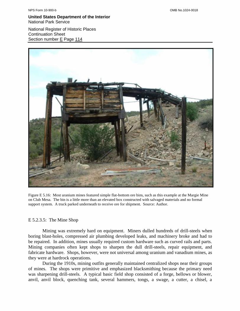
NPS Form 10-900-b OMB No.1024-0018
United States Department of the Interior National Park Service
National Register of Historic Places Continuation Sheet Section number E Page 114
Figure E 5.16: Most uranium mines featured simple flat-bottom ore bins, such as this example at the Margie Mine
on Club Mesa. The bin is a little more than an elevated box constructed with salvaged materials and no formal
support system. A truck parked underneath to receive ore for shipment. Source: Author.
E 5.2.3.5: The Mine Shop
Mining was extremely hard on equipment. Miners dulled hundreds of drill-steels when
boring blast-holes, compressed air plumbing developed leaks, and machinery broke and had to
be repaired. In addition, mines usually required custom hardware such as curved rails and parts.
Mining companies often kept shops to sharpen the dull drill-steels, repair equipment, and
fabricate hardware. Shops, however, were not universal among uranium and vanadium mines, as
they were at hardrock operations.
During the 1910s, mining outfits generally maintained centralized shops near their groups
of mines. The shops were primitive and emphasized blacksmithing because the primary need
was sharpening drill-steels. A typical basic field shop consisted of a forge, bellows or blower,
anvil, anvil block, quenching tank, several hammers, tongs, a swage, a cutter, a chisel, a

NPS Form 10-900-b OMB No.1024-0018
United States Department of the Interior National Park Service
National Register of Historic Places Continuation Sheet Section number E Page 115
hacksaw, snips, a small drill, a workbench, iron stock, hardware, and basic woodworking tools.
Prior to the 1910s, some mining outfits working deep in the backcountry dispensed with factory-
made forges, both to save money and because they were cumbersome to pack, and used local
building materials to make vernacular forges. The most popular type of custom-made forge
consisted of a gravel-filled dry-laid rock enclosure usually 3 by 3 feet in area and 2 feet high. A
tuyere, often made of a 2 foot length of pipe with a hole punched through the side, was carefully
embedded in the gravel, and its function was to direct the air blast from the blower or bellows
upward into the fire in the forge.
Figure E 5.17. During the 1910s, mining outfits tended to construct basic shops such as the one illustrated. These
shops usually consisted of little more than a forge, an anvil, and hand-tools, which restricted the type of work that
the blacksmith could accomplish. Source: Drew, 1910:1.
By the 1940s, advances in technology, truck transportation, and centralization among a
few large companies reduced shop workloads. Mining equipment was more reliable, and drill-
steels now featured either replaceable or tungsten-carbide bits, which lasted longer. As a result,
shops were unnecessary at all but the largest mines, which fostered enough demand for on-site
services to justify dedicated facilities. Some medium-sized mining outfits had very simple repair
facilities such as a workbench and tools. Most companies, however, trucked their drill-steels and
equipment to centralized shops maintained by USV in Long Park and Uravan, or by VCA at
Bitter Creek Camp and Vancorum. Those companies that relied on USV and VCA often had no
shop facilities of their own.
The Long Park, Bitter Creek, and similar field shops featured blacksmithing equipment,
machining appliances, and compressed air-powered drill-steel sharpeners. USV’s Uravan shop
was part of the milling complex there, and it was equipped for advanced machine work, repair,
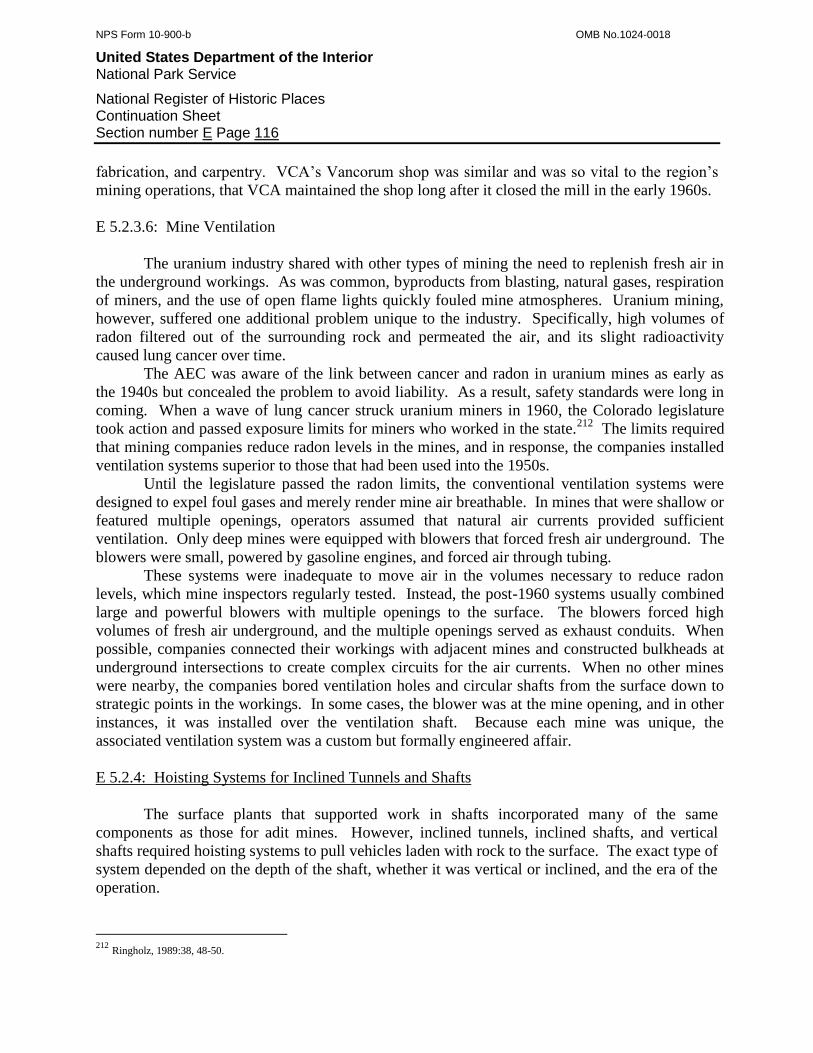
NPS Form 10-900-b OMB No.1024-0018
United States Department of the Interior National Park Service
National Register of Historic Places Continuation Sheet Section number E Page 116
fabrication, and carpentry. VCA’s Vancorum shop was similar and was so vital to the region’s
mining operations, that VCA maintained the shop long after it closed the mill in the early 1960s.
E 5.2.3.6: Mine Ventilation
The uranium industry shared with other types of mining the need to replenish fresh air in
the underground workings. As was common, byproducts from blasting, natural gases, respiration
of miners, and the use of open flame lights quickly fouled mine atmospheres. Uranium mining,
however, suffered one additional problem unique to the industry. Specifically, high volumes of
radon filtered out of the surrounding rock and permeated the air, and its slight radioactivity
caused lung cancer over time.
The AEC was aware of the link between cancer and radon in uranium mines as early as
the 1940s but concealed the problem to avoid liability. As a result, safety standards were long in
coming. When a wave of lung cancer struck uranium miners in 1960, the Colorado legislature
took action and passed exposure limits for miners who worked in the state.212
The limits required
that mining companies reduce radon levels in the mines, and in response, the companies installed
ventilation systems superior to those that had been used into the 1950s.
Until the legislature passed the radon limits, the conventional ventilation systems were
designed to expel foul gases and merely render mine air breathable. In mines that were shallow or
featured multiple openings, operators assumed that natural air currents provided sufficient
ventilation. Only deep mines were equipped with blowers that forced fresh air underground. The
blowers were small, powered by gasoline engines, and forced air through tubing.
These systems were inadequate to move air in the volumes necessary to reduce radon
levels, which mine inspectors regularly tested. Instead, the post-1960 systems usually combined
large and powerful blowers with multiple openings to the surface. The blowers forced high
volumes of fresh air underground, and the multiple openings served as exhaust conduits. When
possible, companies connected their workings with adjacent mines and constructed bulkheads at
underground intersections to create complex circuits for the air currents. When no other mines
were nearby, the companies bored ventilation holes and circular shafts from the surface down to
strategic points in the workings. In some cases, the blower was at the mine opening, and in other
instances, it was installed over the ventilation shaft. Because each mine was unique, the
associated ventilation system was a custom but formally engineered affair.
E 5.2.4: Hoisting Systems for Inclined Tunnels and Shafts
The surface plants that supported work in shafts incorporated many of the same
components as those for adit mines. However, inclined tunnels, inclined shafts, and vertical
shafts required hoisting systems to pull vehicles laden with rock to the surface. The exact type of
system depended on the depth of the shaft, whether it was vertical or inclined, and the era of the
operation.
212
Ringholz, 1989:38, 48-50.
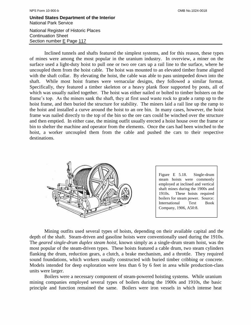
NPS Form 10-900-b OMB No.1024-0018
United States Department of the Interior National Park Service
National Register of Historic Places Continuation Sheet Section number E Page 117
Inclined tunnels and shafts featured the simplest systems, and for this reason, these types
of mines were among the most popular in the uranium industry. In overview, a miner on the
surface used a light-duty hoist to pull one or two ore cars up a rail line to the surface, where he
uncoupled them from the hoist cable. The hoist was mounted to an elevated timber frame aligned
with the shaft collar. By elevating the hoist, the cable was able to pass unimpeded down into the
shaft. While most hoist frames were vernacular designs, they followed a similar format.
Specifically, they featured a timber skeleton or a heavy plank floor supported by posts, all of
which was usually nailed together. The hoist was either nailed or bolted to timber bolsters on the
frame’s top. As the miners sank the shaft, they at first used waste rock to grade a ramp up to the
hoist frame, and then buried the structure for stability. The miners laid a rail line up the ramp to
the hoist and installed a curve around the hoist to an ore bin. In many cases, however, the hoist
frame was nailed directly to the top of the bin so the ore cars could be winched over the structure
and then emptied. In either case, the mining outfit usually erected a hoist house over the frame or
bin to shelter the machine and operator from the elements. Once the cars had been winched to the
hoist, a worker uncoupled them from the cable and pushed the cars to their respective
destinations.
Mining outfits used several types of hoists, depending on their available capital and the
depth of the shaft. Steam-driven and gasoline hoists were conventionally used during the 1910s.
The geared single-drum duplex steam hoist, known simply as a single-drum steam hoist, was the
most popular of the steam-driven types. These hoists featured a cable drum, two steam cylinders
flanking the drum, reduction gears, a clutch, a brake mechanism, and a throttle. They required
sound foundations, which workers usually constructed with buried timber cribbing or concrete.
Models intended for deep exploration were less than 6 by 6 feet in area while production-class
units were larger.
Boilers were a necessary component of steam-powered hoisting systems. While uranium
mining companies employed several types of boilers during the 1900s and 1910s, the basic
principle and function remained the same. Boilers were iron vessels in which intense heat
Figure E 5.18. Single-drum
steam hoists were commonly
employed at inclined and vertical
shaft mines during the 1900s and
1910s. These hoists required
boilers for steam power. Source:
International Text Book
Company, 1906, A50:8.
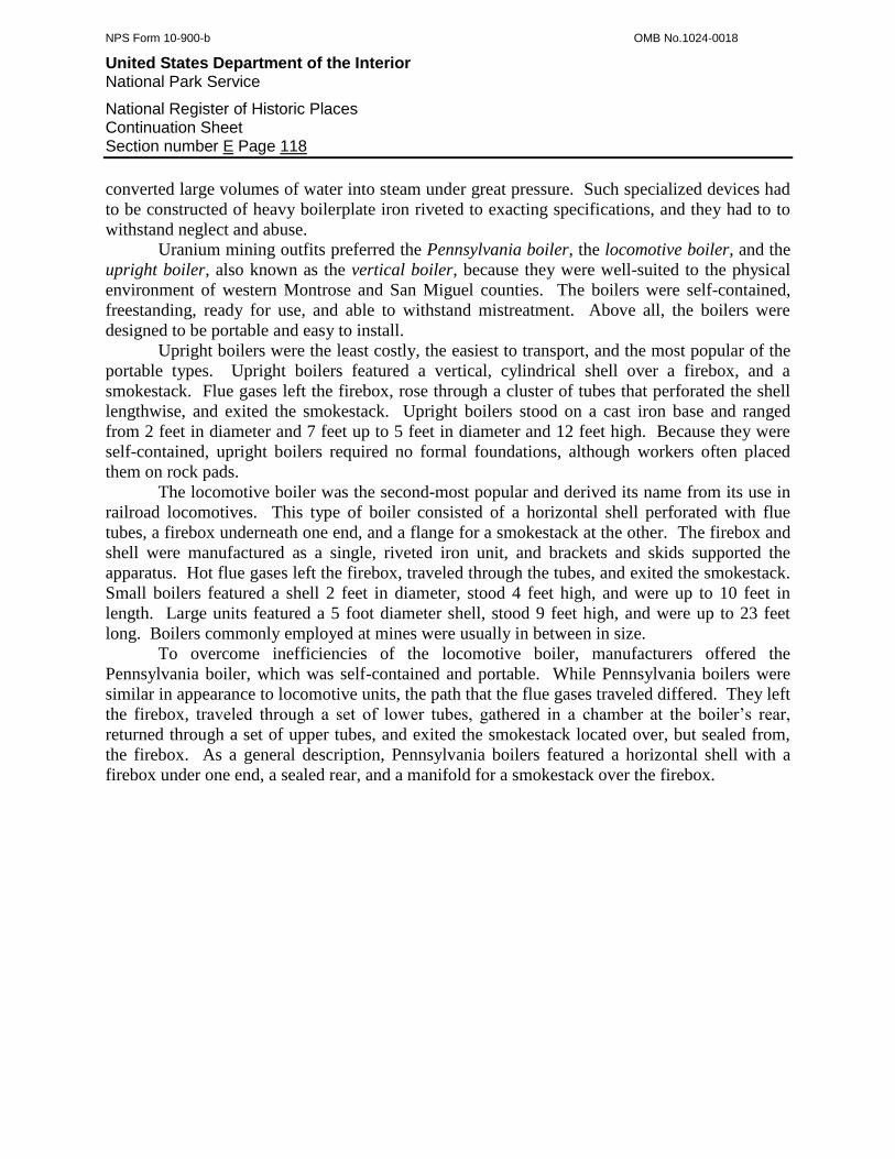
NPS Form 10-900-b OMB No.1024-0018
United States Department of the Interior National Park Service
National Register of Historic Places Continuation Sheet Section number E Page 118
converted large volumes of water into steam under great pressure. Such specialized devices had
to be constructed of heavy boilerplate iron riveted to exacting specifications, and they had to to
withstand neglect and abuse.
Uranium mining outfits preferred the Pennsylvania boiler, the locomotive boiler, and the
upright boiler, also known as the vertical boiler, because they were well-suited to the physical
environment of western Montrose and San Miguel counties. The boilers were self-contained,
freestanding, ready for use, and able to withstand mistreatment. Above all, the boilers were
designed to be portable and easy to install.
Upright boilers were the least costly, the easiest to transport, and the most popular of the
portable types. Upright boilers featured a vertical, cylindrical shell over a firebox, and a
smokestack. Flue gases left the firebox, rose through a cluster of tubes that perforated the shell
lengthwise, and exited the smokestack. Upright boilers stood on a cast iron base and ranged
from 2 feet in diameter and 7 feet up to 5 feet in diameter and 12 feet high. Because they were
self-contained, upright boilers required no formal foundations, although workers often placed
them on rock pads.
The locomotive boiler was the second-most popular and derived its name from its use in
railroad locomotives. This type of boiler consisted of a horizontal shell perforated with flue
tubes, a firebox underneath one end, and a flange for a smokestack at the other. The firebox and
shell were manufactured as a single, riveted iron unit, and brackets and skids supported the
apparatus. Hot flue gases left the firebox, traveled through the tubes, and exited the smokestack.
Small boilers featured a shell 2 feet in diameter, stood 4 feet high, and were up to 10 feet in
length. Large units featured a 5 foot diameter shell, stood 9 feet high, and were up to 23 feet
long. Boilers commonly employed at mines were usually in between in size.
To overcome inefficiencies of the locomotive boiler, manufacturers offered the
Pennsylvania boiler, which was self-contained and portable. While Pennsylvania boilers were
similar in appearance to locomotive units, the path that the flue gases traveled differed. They left
the firebox, traveled through a set of lower tubes, gathered in a chamber at the boiler’s rear,
returned through a set of upper tubes, and exited the smokestack located over, but sealed from,
the firebox. As a general description, Pennsylvania boilers featured a horizontal shell with a
firebox under one end, a sealed rear, and a manifold for a smokestack over the firebox.
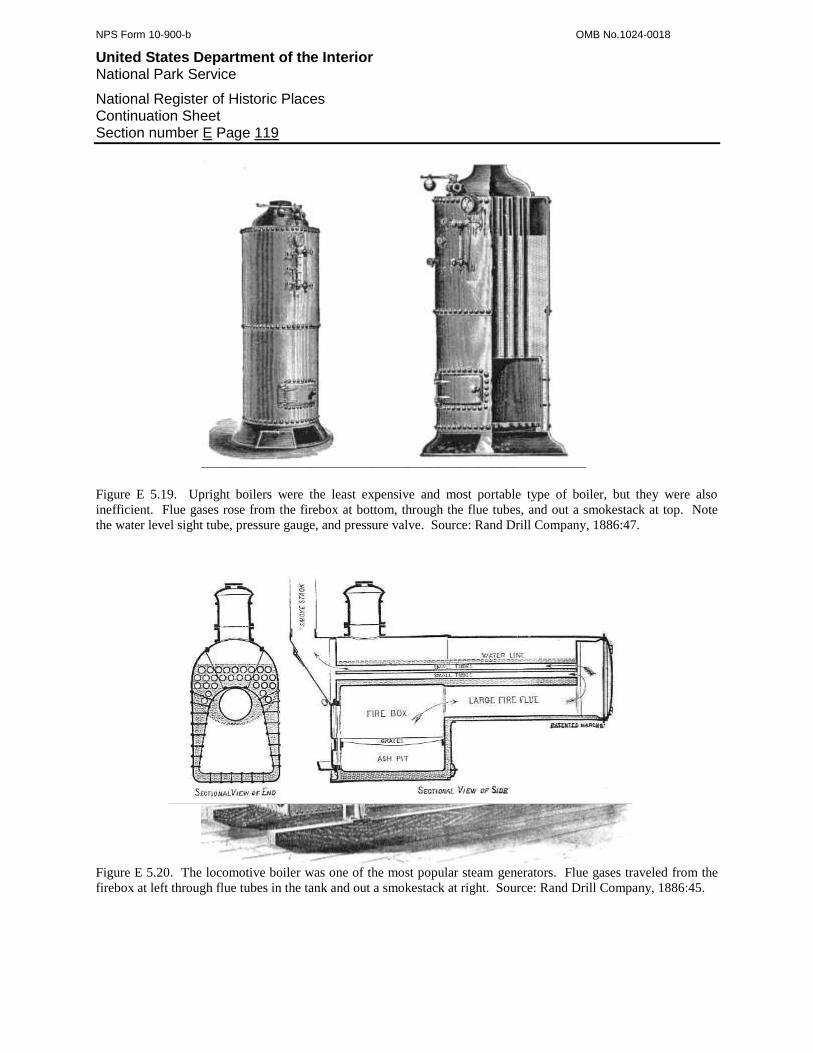
NPS Form 10-900-b OMB No.1024-0018
United States Department of the Interior National Park Service
National Register of Historic Places Continuation Sheet Section number E Page 119
Figure E 5.19. Upright boilers were the least expensive and most portable type of boiler, but they were also
inefficient. Flue gases rose from the firebox at bottom, through the flue tubes, and out a smokestack at top. Note
the water level sight tube, pressure gauge, and pressure valve. Source: Rand Drill Company, 1886:47.
Figure E 5.20. The locomotive boiler was one of the most popular steam generators. Flue gases traveled from the
firebox at left through flue tubes in the tank and out a smokestack at right. Source: Rand Drill Company, 1886:45.

NPS Form 10-900-b OMB No.1024-0018
United States Department of the Interior National Park Service
National Register of Historic Places Continuation Sheet Section number E Page 120
Figure E 5.21. The Pennsylvania boiler was portable, stood on skids, and provided greater fuel economy than the
locomotive type. Note the path traveled by the flue gases, which prolonged contact with the boiler surfaces.
Source: Rand Drill Company, 1886:46.
Figure E 5.22. Donkey hoists combined a hoist and upright boiler on a common bedplate. They were self-contained
and required little site preparation other than a flat area. Source: Mining & Scientific Press 1881.
While steam hoists were fairly inexpensive, easy to operate, and readily available, their
boilers required consumed water and bulky fuel. Water was precious on the mesas, and along
with boiler fuel, was costly to haul. For this reason, mining outfits employed factory-made
gasoline hoists as frequently if not more often. The petroleum hoists were self-contained and
relatively simple. A large single cylinder engine was fixed to the rear of a heavy cast iron frame
and its piston rod connected to a heavy crankshaft located in the frame’s center. Manufacturers
located the cable drum, turned by reduction gearing, at the front, and the hoistman stood to one
side and operated the controls. Because the early petroleum engines were incapable of starting
and stopping under load, they had to run continuously, requiring the hoistman to delicately work
the clutch when hoisting and to disengage the drum and lower the ore bucket via the brake.
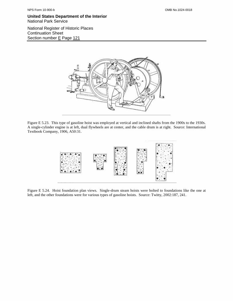
NPS Form 10-900-b OMB No.1024-0018
United States Department of the Interior National Park Service
National Register of Historic Places Continuation Sheet Section number E Page 121
Figure E 5.23. This type of gasoline hoist was employed at vertical and inclined shafts from the 1900s to the 1930s.
A single-cylinder engine is at left, dual flywheels are at center, and the cable drum is at right. Source: International
Textbook Company, 1906, A50:31.
Figure E 5.24. Hoist foundation plan views. Single-drum steam hoists were bolted to foundations like the one at
left, and the other foundations were for various types of gasoline hoists. Source: Twitty, 2002:187, 241.

NPS Form 10-900-b OMB No.1024-0018
United States Department of the Interior National Park Service
National Register of Historic Places Continuation Sheet Section number E Page 122
By the 1930s, the mining industry employed different types of hoists, although the
template for the overall hoisting systems remained unchanged. At shallow shafts, mining
companies now employed compressed air hoists known as tuggers. These machines were
compact and much lighter than the older hoists, and they could easily be mounted on structures
such as ore bins. Their winding power was limited but sufficient for short inclined shafts and
tunnels.
For deeper shafts, mining outfits favored custom-made gasoline hoists cobbled together
from odd and unlikely pieces of machinery. A favorite version involved coupling a factory-
made cable drum to a salvaged automobile engine. Another type consisted of a steam hoist,
stripped of everything except for the cable drum and controls, geared to a retrofitted engine.
Slow, noisy, and of questionable reliability, these contraptions worked well enough to allow
many mining operations to turn a small profit. Lacking money and possibly the knowledge of
how to construct proper foundations, miners simply bolted these contraptions to flimsy timber
frames nailed to the hoist platform. Some mining outfits with capital were able to afford factory-
made gasoline hoists. The typical version consisted of a small utility engine geared to a cable
drum, all of which was bolted to a common frame.
Figure E 5.24. The Mary Ann Mine on Davis Mesa featured a factory-made gasoline hoist. The cable drum, left, and
engine mount, right, were bolted to a steel frame. The engine, now gone, turned the drum via the reduction gearing.
Source: Author.
E 5.2.5: Hoisting Systems for Vertical Shafts
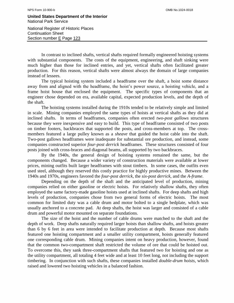
NPS Form 10-900-b OMB No.1024-0018
United States Department of the Interior National Park Service
National Register of Historic Places Continuation Sheet Section number E Page 123
In contrast to inclined shafts, vertical shafts required formally engineered hoisting systems
with substantial components. The costs of the equipment, engineering, and shaft sinking were
much higher than those for inclined entries, and yet, vertical shafts often facilitated greater
production. For this reason, vertical shafts were almost always the domain of large companies
instead of lessees.
The typical hoisting system included a headframe over the shaft, a hoist some distance
away from and aligned with the headframe, the hoist’s power source, a hoisting vehicle, and a
frame hoist house that enclosed the equipment. The specific types of components that an
engineer chose depended on era, available capital, expected production levels, and the depth of
the shaft.
The hoisting systems installed during the 1910s tended to be relatively simple and limited
in scale. Mining companies employed the same types of hoists at vertical shafts as they did at
inclined shafts. In terms of headframes, companies often erected two-post gallows structures
because they were inexpensive and easy to build. This type of headframe consisted of two posts
on timber footers, backbraces that supported the posts, and cross-members at top. The cross-
members featured a large pulley known as a sheave that guided the hoist cable into the shaft.
Two-post gallows headframes were inadequate for substantial ore production, and instead, some
companies constructed superior four-post derrick headframes. These structures consisted of four
posts joined with cross-braces and diagonal beams, all supported by two backbraces.
By the 1940s, the general design of hoisting systems remained the same, but the
components changed. Because a wider variety of construction materials were available at lower
prices, mining outfits built larger headframes with stout timbers. In some cases, the outfits even
used steel, although they reserved this costly practice for highly productive mines. Between the
1940s and 1970s, engineers favored the four-post derrick, the six-post derrick, and the A-frame.
Depending on the depth of the shaft and the anticipated level of production, mining
companies relied on either gasoline or electric hoists. For relatively shallow shafts, they often
employed the same factory-made gasoline hoists used at inclined shafts. For deep shafts and high
levels of production, companies chose from two general forms of electric hoists. The most
common for limited duty was a cable drum and motor bolted to a single bedplate, which was
usually anchored to a concrete pad. At deep shafts, the hoist was larger and consisted of a cable
drum and powerful motor mounted on separate foundations.
The size of the hoist and the number of cable drums were matched to the shaft and the
depth of work. Deep shafts naturally required larger hoists than shallow shafts, and hoists greater
than 6 by 6 feet in area were intended to facilitate production at depth. Because most shafts
featured one hoisting compartment and a smaller utility compartment, hoists generally featured
one corresponding cable drum. Mining companies intent on heavy production, however, found
that the common two-compartment shaft restricted the volume of ore that could be hoisted out.
To overcome this, they sank three-compartment shafts that featured two for hoisting and one as
the utility compartment, all totaling 4 feet wide and at least 10 feet long, not including the support
timbering. In conjunction with such shafts, these companies installed double-drum hoists, which
raised and lowered two hoisting vehicles in a balanced fashion.
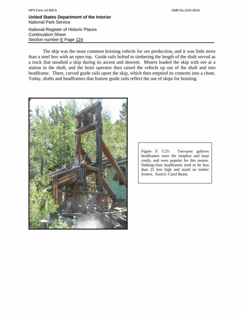
NPS Form 10-900-b OMB No.1024-0018
United States Department of the Interior National Park Service
National Register of Historic Places Continuation Sheet Section number E Page 124
The skip was the most common hoisting vehicle for ore production, and it was little more
than a steel box with an open top. Guide rails bolted to timbering the length of the shaft served as
a track that steadied a skip during its ascent and descent. Miners loaded the skip with ore at a
station in the shaft, and the hoist operator then raised the vehicle up out of the shaft and into
headframe. There, curved guide rails upset the skip, which then emptied its contents into a chute.
Today, shafts and headframes that feature guide rails reflect the use of skips for hoisting.
Figure E 5.25: Two-post gallows
headframes were the simplest and least
costly, and were popular for this reason.
Sinking-class headframes tend to be less
than 25 feet high and stand on timber
footers. Source: Carol Beam.
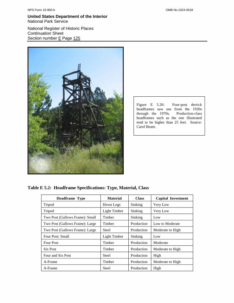
NPS Form 10-900-b OMB No.1024-0018
United States Department of the Interior National Park Service
National Register of Historic Places Continuation Sheet Section number E Page 125
Table E 5.2: Headframe Specifications: Type, Material, Class
Headframe Type Material Class Capital Investment
Tripod Hewn Logs Sinking Very Low
Tripod Light Timber Sinking Very Low
Two Post (Gallows Frame): Small Timber Sinking Low
Two Post (Gallows Frame): Large Timber Production Low to Moderate
Two Post (Gallows Frame): Large Steel Production Moderate to High
Four Post: Small Light Timber Sinking Low
Four Post Timber Production Moderate
Six Post Timber Production Moderate to High
Four and Six Post Steel Production High
A-Frame Timber Production Moderate to High
A-Frame Steel Production High
Figure E 5.26: Four-post derrick
headframes saw use from the 1930s
through the 1970s. Production-class
headframes such as the one illustrated
tend to be higher than 25 feet. Source:
Carol Beam.
NPS Form 10-900-b OMB No.1024-0018
United States Department of the Interior National Park Service
National Register of Historic Places Continuation Sheet Section number E Page 126
Figure E 5.27. The illustrated headframe is a production-class two-post gallows structure made of steel. These
headframes were usually tall, well-built, and stood over deep shafts. Source: Twitty, 2002:233.
E 5.2.6: Mine Architecture
Uranium mines were not celebrated for their architectural grandeur. Further, most of the
small mines, no matter the exact type, completely lacked buildings of any sort. The medium-
sized and large operations often included buildings amid their surface plants, but the buildings
were few in number, small, and utilitarian. Mining companies intended for their buildings to
serve two broad purposes. One was to provide for the physical needs of the mine crew, and the
other was to shelter facilities that were intolerant of or performed poorly when exposed to
adverse weather.
Professionally trained mining engineers considered four basic factors that influenced the
type, size, and constitution of the buildings they chose to erect. First, time had to be spent
designing the structure. Second, construction materials had to be purchased and some items
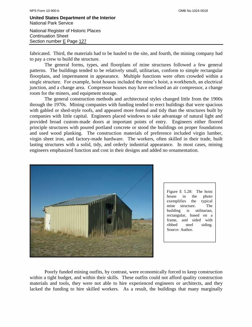
NPS Form 10-900-b OMB No.1024-0018
United States Department of the Interior National Park Service
National Register of Historic Places Continuation Sheet Section number E Page 127
fabricated. Third, the materials had to be hauled to the site, and fourth, the mining company had
to pay a crew to build the structure.
The general forms, types, and floorplans of mine structures followed a few general
patterns. The buildings tended to be relatively small, utilitarian, conform to simple rectangular
floorplans, and impermanent in appearance. Multiple functions were often crowded within a
single structure. For example, hoist houses included the mine’s hoist, a workbench, an electrical
junction, and a change area. Compressor houses may have enclosed an air compressor, a change
room for the miners, and equipment storage.
The general construction methods and architectural styles changed little from the 1900s
through the 1970s. Mining companies with funding tended to erect buildings that were spacious
with gabled or shed-style roofs, and appeared more formal and tidy than the structures built by
companies with little capital. Engineers placed windows to take advantage of natural light and
provided broad custom-made doors at important points of entry. Engineers either floored
principle structures with poured portland concrete or stood the buildings on proper foundations
and used wood planking. The construction materials of preference included virgin lumber,
virgin sheet iron, and factory-made hardware. The workers, often skilled in their trade, built
lasting structures with a solid, tidy, and orderly industrial appearance. In most cases, mining
engineers emphasized function and cost in their designs and added no ornamentation.
Poorly funded mining outfits, by contrast, were economically forced to keep construction
within a tight budget, and within their skills. These outfits could not afford quality construction
materials and tools, they were not able to hire experienced engineers or architects, and they
lacked the funding to hire skilled workers. As a result, the buildings that many marginally
Figure E 5.28: The hoist
house in the photo
exemplifies the typical
mine structure. The
building is utilitarian,
rectangular, based on a
frame, and sided with
ribbed steel siding.
Source: Author.
NPS Form 10-900-b OMB No.1024-0018
United States Department of the Interior National Park Service
National Register of Historic Places Continuation Sheet Section number E Page 128
funded companies erected tended to be small, low, made with high proportions of salvaged
materials, and poorly constructed overall. Such buildings were personal and unique to each
mining operation, being a true expression of the outfit’s nature, and assembled as the builder saw
fit.
The structures erected by poorly capitalized mining companies can be divided into two
categories. Small outfits with at least some capital and a crew with modest carpentry skills built
structures that consisted of a crude but sound frame, often of the post-and-girt variety, sided with
salvaged, mismatched lumber and sheet iron. Doors and windows also were salvaged from
elsewhere such as abandoned residences. Some structures even had mismatched walls, each face
of the building having been sided differently from the others. Overall, these buildings appeared
rough and battered even when relatively new, but they were fairly well-built and offered miners
and equipment shelter.
For the second category, the mine buildings appeared even cruder, were poor quality, and
had dubious structural integrity. Laborers frequently constructed such buildings with no formal
frames. Instead, the workers often preassembled the walls, stood them up, and nailed them
together, or established four corner-posts, added cross braces, and fastened siding to the boards.
The builders may have used a patchwork of planks and sheet iron for siding, which was often
layered to prevent being ripped apart by high winds. Many mining outfits favored the shed
structural style, which featured four walls and a roof that slanted from one side of the building to
the other, because it was simplest to erect. The architectural style of the mine buildings erected
by such mining companies may be termed uranium mining vernacular.
E 5.3: The Nature of Ore Concentration Mills
One of the main objectives of uranium and vanadium mining was to recover metals from
carnotite and roscoelite ore. Facilities technically termed concentration mills, and informally
known as uranium and vanadium mills, separated as much waste as possible and concentrated the
ore’s metal-bearing constituents. The end-products of milling were yellowcake and redcake,
which were uranium and vanadium concentrates, respectively. The radioactive yellowcake was
shipped to Atomic Energy Commission facilities and refined into pure uranium. Steel companies
were the principal consumers of redcake for use in alloy steels, although the Department of
Defense purchased and stockpiled a huge proportion as a strategic metal.
In overview, the concentration process began when mining companies delivered crude ore
to the mill and dumped the material into piles of differing purity, or grade. Workers input the ore
into a receiving bin at the head of the mill, and then fed the material into a series of crushers.
These devices physically reduced the ore to sand and slurry, which descended down to revolving
screens. Particles that were too big for the screens returned to the crushers, and those that passed
through proceeded on to concentration. In this processing phase, a combination of equipment and
chemical reactions separated waste from the ore’s uranium and vanadium content, leaving liquid
solutions. At the process end, additional chemical reactions precipitated out yellowcake and
redcake, which furnaces dried for shipment.

NPS Form 10-900-b OMB No.1024-0018
United States Department of the Interior National Park Service
National Register of Historic Places Continuation Sheet Section number E Page 129
Concentration mills ranged in scale from small facilities to sprawling industrial
complexes, and the size depended on treatment capacity and the sophistication of the processes.
In the Uravan Mineral Belt, the Uravan Mill, operated by USV, was by far the largest, and the
Gateway Alloys Mill at Gateway was the smallest. All the mills followed a similar design that
relied on gravity to draw the ore through the various stages of treatment. To facilitate this, the
mills were built on stairstep foundations with the first stages of processing at the top and the final
stages at the bottom. Conveyors and bucket-lines elevated the ore for reprocessing in some cases.
While the ore treatment process seems simple in overview, it was actually complex and
specific to carnotite and roscoelite. Western Montrose and San Miguel counties were the cradle
of uranium and vanadium milling, and they hosted the first processes developed by European
chemists and metallurgists. The theory behind the early processes was so sound that, while the
technology improved over time, the basic chemistry remained the same for more than 70 years.
The American Rare Metals Mill near Slick Rock in San Miguel County was the first
commercial application of uranium-specific recovery processes in North America, if not the
world. The process, as built in 1901, began when wagons delivered crude ore and miners sorted it
by grade. The ore was crushed with conventional equipment, ground to a slurry in a ball mill
(type of crusher), and screened. The fine material passed into a series of leaching tanks filled
with sulfuric acid, which dissolved the uranium content. Workers tapped the resultant liquor into
a set of precipitating tanks and added sodium carbonate (a form of lime) to force the uranium out
of solution. Workers then discharged the exhausted solution into the Dolores River and dried the
uranium concentrates for shipment to Europe.213
While the American Rare Metals Mill was effective, its process was highly inefficient and
lost a substantial proportion of the uranium. Around 1903, chemists Justin H. Haynes and W.D.
Engle developed the Haynes-Engle process and installed it in the American Rare Metals Mill.
The crushed ore was boiled in an alkaline solution while churning in a revolving steel cylinder,
which dissolved the uranium and vanadium content. Workers tapped the solution into tanks and
added sodium hydroxide, which precipitated out the uranium as sodium uranate. The solution
was decanted into another set of tanks where workers precipitated out the vanadium by adding
lime. Supposedly, this method recovered 85 percent of the uranium as yellowcake and 65 percent
of the vanadium as redcake, and because of this, the method saw use into the 1910s.214
In 1907, Herman Fleck, William G. Haldane, and Edwin L. White, Colorado chemists,
improved the process with an important addition that continues to this day. They mixed the
crushed ore with salt and roasted it, which increased the solubility of the uranium and vanadium
constituents. During the 1910s, other chemists patented variations of the above treatment
methods, and all relied on either hot acid or basic solutions to leach out the metals, and the
addition of chemicals, mostly basic, to precipitate out the uranium and vanadium separately.
Some of the methods, such as the Bleeker Process, were intended to extract vanadium from both
carnotite and the roscoelite ores of the Placerville area.215
213
Metal Mining, 1961:77; Moore and Kithil, 1914:74. 214
Metal Mining, 1961:76; Mineral Resources, 1906:531; Moore and Kithil, 1914:72; Parsons, et al, 1916:18. 215
Moore and Kithil, 1914:70; Parsons, et al, 1916:18.
NPS Form 10-900-b OMB No.1024-0018
United States Department of the Interior National Park Service
National Register of Historic Places Continuation Sheet Section number E Page 130
The National Radium Institute, a subsidiary of the U.S. Bureau of Mines, took a different
approach to treating carnotite ore. Because the chemical-intensive methods required a continuous
supply of water, the mills had to be located near reliable streams. This saddled the mining
companies with the high costs of transporting tons of crude ore down from the mesas to mills in
the river valleys. In response, the Institute developed a method of concentrating the carnotite
content of ore into a powder that was easier to ship down to the mills for final processing. In
1914, the Institute built an experimental mill in remote Long Park, and it relied on mechanical
means to separate the carnotite off the sand grains of sandstone. One method that required no
water began with gentle crushing, which liberated some of the carnotite while preserving the
integrity of the sand grains. After the sand was screened, it entered a series of rotating discs that
slowly ground and scrubbed more carnotite off the grains. All the while, blowers created a
vacuum that sucked away the carnotite dust as it was produced and forced the material into
collection filters. The various steps were fully enclosed to retain the fine carnotite dust. The
Institute developed a second, wet process that relied on conventional milling equipment.
Specifically, agitation tanks worked the sand, and the constant tumbling and abrading ground off
the carnotite, which settled to the bottom. While the Institute’s hypothesis of mechanical
concentration was a good one, it proved ineffective for ores outside of Long Park.216
Among all the milling companies on the Colorado Plateau, USV can be credited with the
principal improvements to the ore treatment processes following the 1910s. During World War
II, the AEC required that USV simultaneously produce both redcake and yellowcake at its Uravan
mill. Further, USV had to do so from low-grade ore and depleted mill tailings, which required the
mill to be highly efficient. To meet the challenge, USV improved its processes with AEC
assistance, and other companies in the region, including VCA at Vancorum and North Continent
Mines at Slick Rock, then followed.
According to the revised process, trucks delivered crude ore from the mines to a receiving
station at the head of the mill. The trucks were weighed, the tonnage credited to the producer
(mine lessee), and the ore was dumped into the mill’s receiving bins. Machinery fed the crude ore
into a series of crushers that reduced it to sand and gravel, which workers mixed with salt. The
blend was transferred into a large, rotary kiln for roasting and heated to temperatures above 800
degrees, Centigrade. This step was critical and required constant supervision because if the
temperature dropped below 700 degrees, the entire batch had to be thrown out as insoluble. USV
chose a rotary kiln because it was a continuous feed apparatus. Crushed ore entered the top end,
tumbled and roasted, and trickled out the bottom end. While still superheated, the material was
quenched in a basic solution that dissolved most of the vanadium. Like the early processes, the
liquor was then tapped into precipitation tanks and the redcake recovered, while the solid
compounds were leached in agitation tanks filled with hot acid to dissolve the uranium. Workers
then precipitated out the uranium by adding agents.217
While highly simplified above, the process was complex and temperamental, it required
vigilance, and it offered numerous opportunities for error. Hence, Union Carbide, which
216
Kithil and Davis, 1917:62. 217
Clark and Kerr, 1974:41; Gittus, 1963:28; Gupta and Krishnamurthy, 1992:211; Merritt, 1971:50; Mesa Miracle, 1952:23; Metal Mining,
1961:93.
NPS Form 10-900-b OMB No.1024-0018
United States Department of the Interior National Park Service
National Register of Historic Places Continuation Sheet Section number E Page 131
absorbed USV, took an interest in the revolutionary, new ion exchange process shortly after its
development in South Africa in 1952. Ion exchange was an efficient alternative to the touchy
stage of precipitation, and it relied on columns of resin to strip the uranium molecules dissolved in
the acid solution. VCA was the first company in North America to try ion exchange at its Shop
Rock mill in 1954, and Union Carbide installed the process in the Uravan Mill the following year.
Union Carbide continued to precipitate out the vanadium with the traditional method into the
1960s, when it used ion exchange for that metal, as well.218
218
Chenoweth, 1993:50; Merritt, 1971:138, 470; McGinley, 1958:218.


![Resort Municipality Initiative - Radium Hot Springs 2014 Annual RMI... · Resort nicipal Initiative Report for Year 2014 - Village of Radium Hot Springs - [1] Radium Resort Municipality](https://img.pdfslide.net/doc/110x75/5b880db67f8b9a3d028c72be/resort-municipality-initiative-radium-hot-2014-annual-rmi-resort-nicipal.jpg)