Embed Size (px)
Citation preview
DriDanube – Drought Risk in the Danube Region Project co-funded by European Union funds (ERDF, IPA)
RAINFALLS AND TEMPERATURES
IN SERBIA1961-2010
Source: CarpatClim & DanubeClim
B. Srdjevic and FAUNS TeamFaculty of Agriculture, University of Novi Sad
Department of Water ManagementNovi Sad, Serbia
RAINFALLS
1961-2010
Source: CarpatClim & DanubeClim

Copyright ©FAUNS, Dept. of Water Management, Serbia
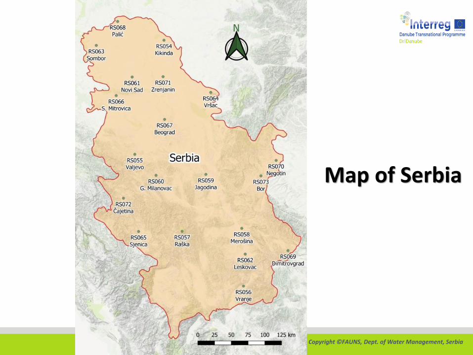
Map of Serbia
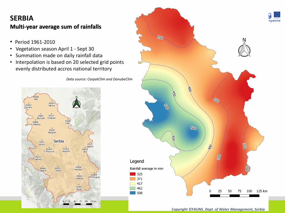
SERBIAMulti-year average sum of rainfalls
• Period 1961-2010• Vegetation season April 1 - Sept 30• Summation made on daily rainfall data• Interpolation is based on 20 selected grid points
evenly distributed accros national territory
Data source: CarpatClim and DanubeClim
Copyright ©FAUNS, Dept. of Water Management, Serbia
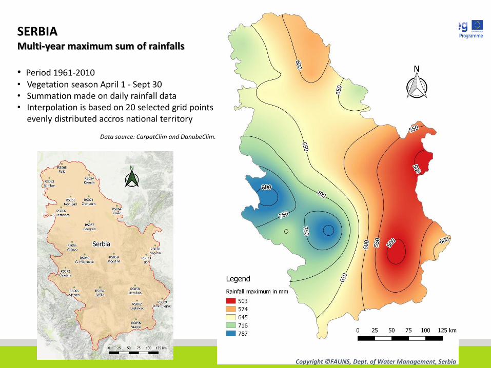
SERBIAMulti-year maximum sum of rainfalls
• Period 1961-2010• Vegetation season April 1 - Sept 30• Summation made on daily rainfall data• Interpolation is based on 20 selected grid points
evenly distributed accros national territory
Data source: CarpatClim and DanubeClim.
Copyright ©FAUNS, Dept. of Water Management, Serbia

SERBIAMulti-year minimum sum of rainfalls
• Period 1961-2010• Vegetation season April 1 - Sept 30• Summation made on daily rainfall data• Interpolation is based on 20 selected grid points
evenly distributed accros national territory
Data source: CarpatClim and DanubeClim.
Copyright ©FAUNS, Dept. of Water Management, Serbia
TEMPERATURES
1961-2010
Source: CarpatClim & DanubeClim
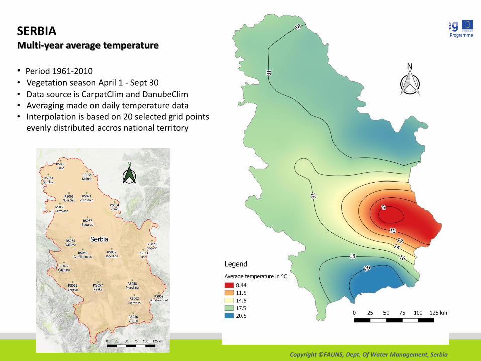
SERBIAMulti-year average temperature
• Period 1961-2010• Vegetation season April 1 - Sept 30• Data source is CarpatClim and DanubeClim• Averaging made on daily temperature data• Interpolation is based on 20 selected grid points
evenly distributed accros national territory
Copyright ©FAUNS, Dept. Of Water Management, Serbia

SERBIAMulti-year maximum temperature
• Period 1961-2010• Vegetation season April 1 - Sept 30• Data source is CarpatClim and DanubeClim• Averaging made on daily temperature data• Interpolation is based on 20 selected grid points
evenly distributed accros national territory
Copyright ©FAUNS, Dept. Of Water Management, Serbia

SERBIAMulti-year minimum temperature
• Period 1961-2010• Vegetation season April 1 - Sept 30• Data source is CarpatClim and DanubeClim• Averaging made on daily temperature data• Interpolation is based on 20 selected grid points
evenly distributed accros national territory
Copyright ©FAUNS, Dept. Of Water Management, Serbia

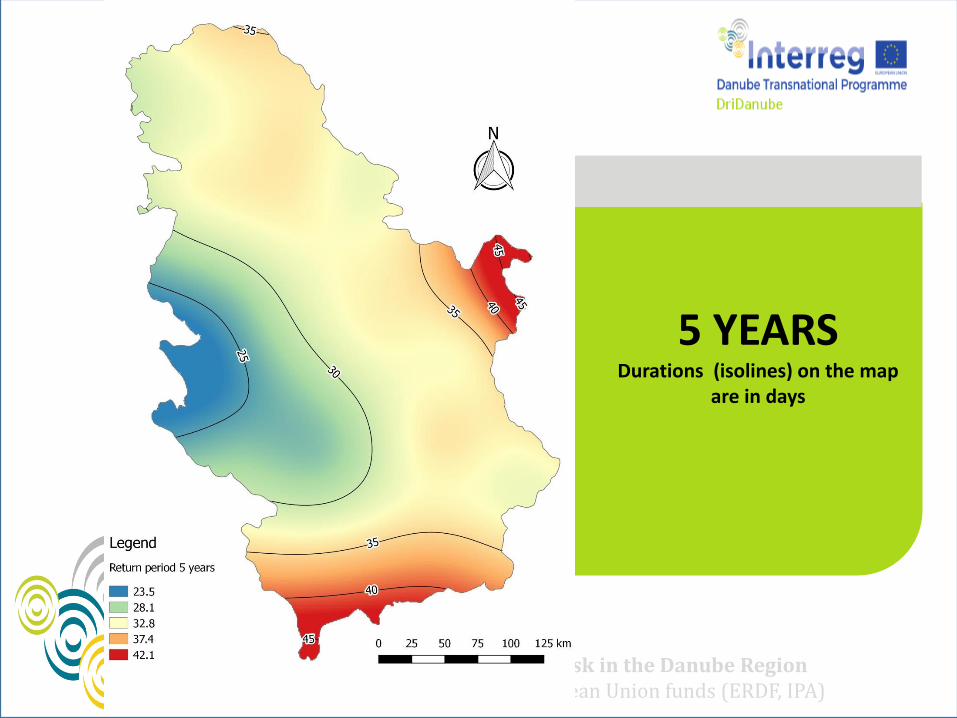
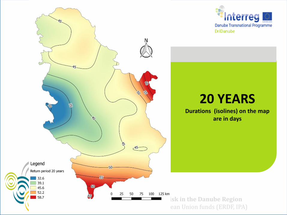
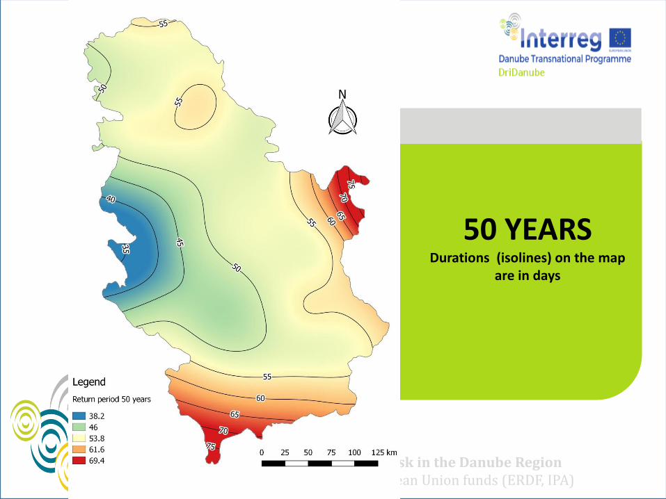
6 MAPS FOR DIFFERENT RETURN PERIODS OF EXTREME RAINLESS PERIODS FOR SERBIA ZT METHOD STOCHASTIC ANALYSIS OF RAINLESS PERIODS IN
HISTORIC INTERVAL 1961-2010. (50 YEARS)
Copyright ©FAUNS, Dept. of Water Management, Serbia
Map of Serbia

DriDanube – Drought Risk in the Danube Region Project co-funded by European Union funds (ERDF, IPA)
2 YEARSDurations (isolines) on the map
are in days
DriDanube – Drought Risk in the Danube Region Project co-funded by European Union funds (ERDF, IPA)
5 YEARSDurations (isolines) on the map
are in days

DriDanube – Drought Risk in the Danube Region Project co-funded by European Union funds (ERDF, IPA)
10 YEARSDurations (isolines) on the map
are in days
DriDanube – Drought Risk in the Danube Region Project co-funded by European Union funds (ERDF, IPA)
20 YEARSDurations (isolines) on the map
are in days
DriDanube – Drought Risk in the Danube Region Project co-funded by European Union funds (ERDF, IPA)
50 YEARSDurations (isolines) on the map
are in days
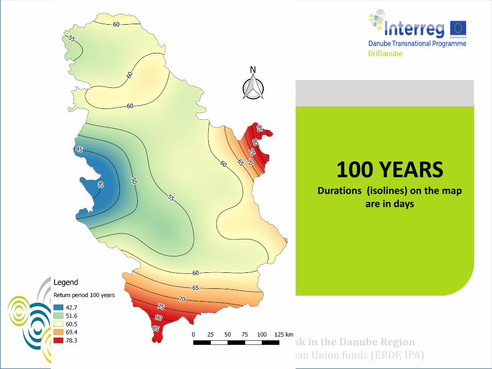
DriDanube – Drought Risk in the Danube Region Project co-funded by European Union funds (ERDF, IPA)
100 YEARSDurations (isolines) on the map
are in days

Thanks!