Embed Size (px)
Citation preview

New York StateDepartment of Environmental Conservation
ANDREW CUOMO, Governor JOSEPH MARTENS, Commissioner
ROBERT K. DAVIES, State Forester
Division of Lands & Forests
RAPID WATERSUNIT MANAGEMENT PLAN
FINAL
Towns of Candor & Spencer, Tioga County andTowns of Danby & Caroline, Tompkins County
December 2012
NYS Department of Environmental ConservationRegion 7 Sub Office
1285 Fisher Ave.Cortland, NY 13045-1090
607-753-3095

ANDREW M. CUOMO
GOVERNOR
TO:
FROM:
DATE:
SUBJECT:
*.. ~. -
1 .
STATE OF NEW YORK
DEPARTMENT OF ENVIRONMENTAL CONSERVATION
ALBANY, NEW YORK 12233-1010
MEMORANDUM
The Record
Final Rapid Waters UMP
JOE MARTENS
COMMISSIONER
The Unit Management Plan for the Rapid Waters Unit has been completed. The Plan isconsistent with Department policy and procedure, involved public participation and is consistentwith the Environmental Conservation Law, Rules and Regulations. The plan includesmanagement objectives for a ten year period and is hereby approved and adopted.

Rapid Waters Unit Management Plan
A Unit Management Plan Consisting of Two State Forests encompassing about 12,624 acres in
New York’s Central-Southern Tier.
Prepared by the Rapid Waters Unit Management Plan Contributors:
John Clancy, Forester 1 - Team Leader and Principal Author Mark Zubal, Forester 1 - Principal Author
Tom Bell, Biologist 1 (Wildlife) Linda Collart, Minerals Resources Supervisor
Joan Oldroyd, Forest Ranger Jeff Robins, Biologist 1 (Aquatic)
Thomas Swerdan, Conservation Operations Supervisor 3
Additional Assistance Provided By:
David Barkley, Seasonal Forestry Technician DEC Adopt-A-Natural Resource Volunteers
John Dempsey, Principal Forestry Technician (Retired) Wayne Lanning, Conservation Operations Supervisor 2
John Graham, Forester 1 Patricia Hazard, Secretary 1
Paul Moore, Fisheries Technician 2 (Retired) Brendan Murphy, Seasonal Forestry Technician Evin Munson, Recreation Intern, SUNY Cortland
Nanette Nelson, Mined Land Reclamation Specialist Richard Pancoe, Forester 2
Jeff Perrault, History Intern, SUNY Cortland Joseph Yarosz, Minerals Resource Specialist
New York State Department of Environmental Conservation Division of Lands and Forests
Bureau of State Land Management 1285 Fisher Avenue
Cortland, New York 13045 (607) 753-3095
www.dec.ny.gov/
i
Table of Contents Location Map .............................................................................................................................. iii Select photos from the unit ...................................................................................................... iv Preface ......................................................................................................................................... v Green Certification of State Forests ........................................................................................ vi The Unit Management Plan Process ......................................................................................... 1 Historical Background ................................................................................................................ 3 INFORMATION ON THE UNIT ..................................................................................................... 7
A. Geographic Information ........................................................................................................ 7 B. Geological Information .......................................................................................................... 9 C. Mineral Resources .............................................................................................................. 11 D. Landscape Analysis ............................................................................................................ 13 E. Wetland and Water Resources ........................................................................................... 19 F. Wildlife Resources .............................................................................................................. 21 G. Endangered, Threatened, Special Concern and Significant Species ................................. 30 H. Cultural Resources ............................................................................................................ 34 I. Roads .................................................................................................................................. 35 J. Recreational Assets ............................................................................................................. 36 K. Facilities that Require Maintenance .................................................................................... 39 L. Property Use Agreements ................................................................................................... 42 M. Resource Demands ............................................................................................................ 48 N. Public Use and Facility Demands on the Unit ..................................................................... 48 O. Management Challenges on the Unit ................................................................................. 49
LANDSCAPE MANAGEMENT STRATEGIES - UNIT GOALS, OBJECTIVES AND ACTIONS .................................................................................................................................................... 51
GOAL 1. Provide Healthy, Sustainable, and Biologically Diverse Forest Ecosystems. ........... 51 GOAL 2. Provide Forest Based Recreational Opportunities ................................................... 66 GOAL 3. Provide Economic Benefits to Local Communities and to the State of New York .... 72 GOAL 4 Provide Sound Stewardship of the State Forest ....................................................... 76
APPENDICES ............................................................................................................................. 78 A-1. Management Action Schedules ....................................................................................... 78 A-2. Facility Maintenance and Improvement Projects by Priority ............................................ 96 A-3. Amphibians and Reptiles ................................................................................................ 99 A-4. Mammals ...................................................................................................................... 100 A-5. Birds .............................................................................................................................. 101 A-6. Breeding Bird Atlas Data .............................................................................................. 105 A-7. Possible Sites for Vernal Pool Creation ........................................................................ 109 A-8. Streams in the Rapid Waters Unit with Fisheries Index Numbers ................................ 110

ii
A-9. Taxes Paid on the Unit’s State Forests ......................................................................... 111 A-10. Previous Owners of the State Forests in Rapid Waters Unit ....................................... 112 A-12. Tree Planting Summary by Species ............................................................................ 117 A-13. Department Rules, Regulations, Laws, and Policies ................................................... 118 A-14. Roads Open to Public Use in the Unit ......................................................................... 119 A-15. Special Management Zones (SMZ’s) ......................................................................... 120 A-16 – EIS ............................................................................................................................. 125
Unit Management Plan Glossary of Terms ........................................................................... 126 Glossary References .............................................................................................................. 136 Unit Management Plan References ....................................................................................... 138 Public Comment Summary and Response Document ........................................................ 146 Background ............................................................................................................................. 146 Initial Public Participation ...................................................................................................... 146 Comments on the Draft Unit Management Plan (UMP) ....................................................... 150 Maps ......................................................................................................................................... 159

iii
Location Map

iv
Select photos from the unit
Rattlesnake Plantain is an interesting plant found on the Unit. DEC photo
Bald Hill School House on the Danby State Human made vernal pool on the Forest c. 1936 Danby State Forest Library of Congress photo Upper Susquehanna Watershed Coalition photo
Cycle CNY Shindagin Trail Committee volunteers upgrading a section of trail on the Shindagin Hollow State Forest DEC photo
The Northern Harrier has been observed on the Unit’s Landscape Courtesy of Hart Ruge
v
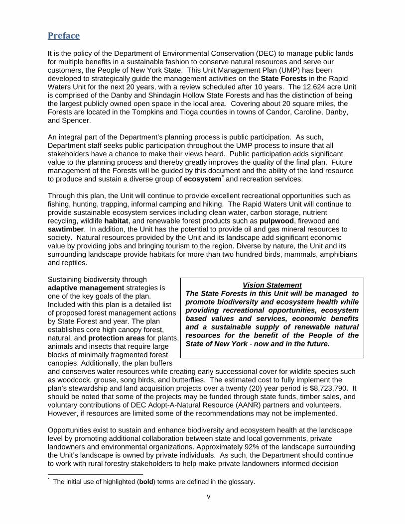
Preface It is the policy of the Department of Environmental Conservation (DEC) to manage public lands for multiple benefits in a sustainable fashion to conserve natural resources and serve our customers, the People of New York State. This Unit Management Plan (UMP) has been developed to strategically guide the management activities on the State Forests in the Rapid Waters Unit for the next 20 years, with a review scheduled after 10 years. The 12,624 acre Unit is comprised of the Danby and Shindagin Hollow State Forests and has the distinction of being the largest publicly owned open space in the local area. Covering about 20 square miles, the Forests are located in the Tompkins and Tioga counties in towns of Candor, Caroline, Danby, and Spencer. An integral part of the Department’s planning process is public participation. As such, Department staff seeks public participation throughout the UMP process to insure that all stakeholders have a chance to make their views heard. Public participation adds significant value to the planning process and thereby greatly improves the quality of the final plan. Future management of the Forests will be guided by this document and the ability of the land resource to produce and sustain a diverse group of ecosystem* and recreation services. Through this plan, the Unit will continue to provide excellent recreational opportunities such as fishing, hunting, trapping, informal camping and hiking. The Rapid Waters Unit will continue to provide sustainable ecosystem services including clean water, carbon storage, nutrient recycling, wildlife habitat, and renewable forest products such as pulpwood, firewood and sawtimber. In addition, the Unit has the potential to provide oil and gas mineral resources to society. Natural resources provided by the Unit and its landscape add significant economic value by providing jobs and bringing tourism to the region. Diverse by nature, the Unit and its surrounding landscape provide habitats for more than two hundred birds, mammals, amphibians and reptiles. Sustaining biodiversity through adaptive management strategies is one of the key goals of the plan. Included with this plan is a detailed list of proposed forest management actions by State Forest and year. The plan establishes core high canopy forest, natural, and protection areas for plants, animals and insects that require large blocks of minimally fragmented forest canopies. Additionally, the plan buffers and conserves water resources while creating early successional cover for wildlife species such as woodcock, grouse, song birds, and butterflies. The estimated cost to fully implement the plan’s stewardship and land acquisition projects over a twenty (20) year period is $8,723,790. It should be noted that some of the projects may be funded through state funds, timber sales, and voluntary contributions of DEC Adopt-A-Natural Resource (AANR) partners and volunteers. However, if resources are limited some of the recommendations may not be implemented. Opportunities exist to sustain and enhance biodiversity and ecosystem health at the landscape level by promoting additional collaboration between state and local governments, private landowners and environmental organizations. Approximately 92% of the landscape surrounding the Unit’s landscape is owned by private individuals. As such, the Department should continue to work with rural forestry stakeholders to help make private landowners informed decision * The initial use of highlighted (bold) terms are defined in the glossary.
Vision Statement The State Forests in this Unit will be managed to promote biodiversity and ecosystem health while providing recreational opportunities, ecosystem based values and services, economic benefits and a sustainable supply of renewable natural resources for the benefit of the People of the State of New York - now and in the future.

makers. The Rapid Waters Unit is administered locally by the DEC, Division of Lands and
Forests Office in Cortland, New York, which manages approximately 90,000 acres of public
State Forests, Multiple Use and Unique Areas in six Central New York counties. Additionally,
Department forestry staff also provides forest stewardship assistance to 1.1 million acres of
privately owned forest land and 146 communities in the region.
Forest Certification of State Forests
In 2000, New York State DEC-Bureau of State Land Management received Forest
Stewardship Council® (FSC®) certification under an independent audit conducted by the National
Wildlife Federation - SmartWood Program. This certification included 720,000 acres of State Forests
in DEC Regions 3 through 9 managed for water quality protection, recreation, wildlife habitat, timber
and mineral resources (multiple-use). To become certified, the Department had to meet more than 75
rigorous criteria established by FSC. Meeting these criteria established a benchmark for forests
managed for long-term ecological, social and economic health. The original certification and contract
was for five years.
By 2005 the original audit contract with the SmartWood Program expired. Recognizing the
importance and the value of dual certification, the Bureau sought bids from prospective auditing firms
to reassess the Bureaus State Forest management system to the two most internationally accepted
standards - FSC and the Sustainable Forestry Initiative® (SFI®) program. However, contract delays
and funding shortfalls slowed the Departments ability to award a new agreement until early 2007.
Following the signed contract with NSF-International Strategic Registrations and Scientific
Certification Systems, the Department was again audited for dual certification against FSC and
additionally the SFI program standards on over 762,000 acres of State Forests in Regions 3 through 9.
This independent audit of State Forests was conducted by these auditing firms from May until July
2007 with dual certification awarded in January 2008.
State Forests continue to maintain certification under the most current FSC and SFI standards.
Forest products derived from wood harvested off State Forests from this point forward may now be
labeled as “certified” through chain-of-custody certificates. Forest certified labeling on wood
products may assure consumers that the raw material was harvested from well-managed forests.
The Department is part of a growing number of public, industrial and private forest land
owners throughout the United States and the world whose forests are certified as sustainably
managed. The Department’s State Forests can also be counted as part a growing number of working
forest land in New York that is third-party certified as well managed to protect habitat, cultural
resources, water, recreation, and economic values now and for future generations.
vi

1
The Unit Management Plan Process What is a Unit Management Plan (UMP)? A UMP assesses the natural and physical resources on land managed by the Department and makes informed State Forest land use decisions by applying an ecosystem science-based philosophy called ecosystem management. This philosophy balances public needs with the ability of the land to provide ecological, economic, and recreational services. Recommended land management actions are consistent with stakeholder needs, Department policies, the Unit’s natural resources, and the Department’s stewardship capabilities. In essence, the UMP is a strategic plan that guides the Department’s land management activities for a twenty-year period.
Who Writes the Unit Management Plan? State Forest UMPs are written by the Division of Lands and Forests with input from the Division of Fish, Wildlife, and Marine Resources, the Division of Operations, the Division of Mineral Resources, and the Division of Forest Protection and Fire Management. A description of each Division’s responsibilities is listed below as paraphrased from the Department’s website. Division of Lands and Forests The Division of Lands and Forests is responsible for the stewardship, management, protection, and recreational use of State Forest lands, the concern of the people who use these lands, and the acquisition of additional lands to conserve unique and significant resources. The Division also provides forestry leadership by providing technical assistance to private forest landowners and the forest products industry. Division of Fish, Wildlife, and Marine Resources The Division of Fish, Wildlife, and Marine Resources serves the public by using their collective skills to describe, understand, manage and perpetuate a healthy and diverse assemblage of fish, wildlife, and ecosystems. Division of Operations The Division of Operations provides technical services, facilities’ management, and maintenance of physical assets to insure effective and efficient operation of the Department and safe public use of Department lands and facilities. Division of Mineral Resources The Division of Mineral Resources is responsible for ensuring the environmentally sound economic development of New York’s non-renewable energy and mineral resources for the benefit of current and future generations. Division of Forest Protection and Fire Management The Division of Forest Protection and Fire Management is responsible for the preservation, protection and enhancement of the state’s forest resources, and the safety and well-being of the public using these resources.

2
How is a Unit Management Plan Developed? Unit Management Plan Development Steps A unit management plan is developed in a series of eight steps: Step 1: Conduct a natural resource inventory of the Unit. Step 2: Solicit written and verbal input from the public through press releases, newspaper
articles, the Department’s web site, a direct mailing, a field tour and a public meeting. Step 3: Develop a draft UMP. Step 4: Internal review and approval of the UMP. Step 5: Release draft UMP and conduct public meeting(s), press releases and direct mailings to
gather public comments on the draft plan. Step 6: Address additional land management opportunities and challenges as identified by the
public participation process; refine the draft plan (as required) and develop a final UMP. Step 7: Comply with State Environmental Quality Review (SEQR). Step 8: DEC Commissioner approves final UMP and implementation begins.

3
Historical Background State Forest History The forest lands outside the Adirondack and Catskill regions owe their present character, in large part, to the impact of European pioneer settlement. After the Revolutionary War, increased pressure for land encouraged westward expansion. Up to 91% of woodlands were cleared for cultivation and pasture. Early farming efforts met with limited success. As the less fertile soils proved unproductive, farms were abandoned and settlement was attempted elsewhere. The stage of natural succession was set and new forests of young saplings re-occupied the once cleared ground. The State Reforestation Law of 1929 and the Hewitt Amendment of 1931 set forth the legislation that authorized the Conservation Department to acquire land, by gift or by purchase, for reforestation areas. These State Forests, consisting of not less than 500 acres of contiguous land, were to be “forever devoted to reforestation and the establishment and maintenance thereon of forests for watershed protection, the production of timber and for recreation and kindred purposes” (Article 9, Title 5, Environmental Conservation Law). In 1930, Forest Districts were established and the tasks of land acquisition and reforestation were started. In 1933, the Civilian Conservation Corps (CCC) began. Thousands of young men were assigned to plant millions of trees on the newly acquired State Forests. In addition to tree planting, these men were engaged in road and trail building, erosion control, watershed restoration, forest protection and other projects. During the war years of 1941-1945 very little was accomplished on the reforestation areas. Further planning, construction, facility maintenance and similar tasks were curtailed. However, through postwar funding, conservation projects once again received needed attention. The Park and Recreation Land Acquisition Act of 1960 – and the Environmental Quality Bond Acts of 1972 and 1986 contained provisions for the acquisition of State Forest lands. These lands would serve multiple purposes involving the conservation and development of natural resources, including the preservation of scenic areas, watershed protection, forestry and recreation. Today there are more than 770,000 acres of State Forest land throughout New York State. The use of these lands for a wide variety of purposes such as forest products, hiking, skiing, fishing, trapping and hunting is of tremendous importance economically, and to the health and well-being of the people of the State. Local History The State Forests of the unit are on the Allegheny Plateau, which is made of uplifted sedimentary rock that formed about 350 million years ago when the region was covered by a warm ancient sea. Geologists believe that the plateau was formed as the continents of North America and Africa pushed against each other from 250 to 330 million years ago. As the continents slid past each other, the bedrock was tilted and uplifted. Most recently, the landscape has been shaped by the advance and retreat of continental ice sheets (glaciers) and the constant weathering of the uplifted bedrock. The last glacier reached its peak about 21,750 years ago. Archeological evidence suggests that the earliest humans in the planning area were nomadic peoples whose ancestors had entered North America across the Bering Strait during the last ice age. These Native American peoples eventually established small communities and raised beans, corn, and squash in the area for thousands of years.

4
This unit management plan has been named “Rapid Waters” after a DEC history intern from SUNY Cortland found evidence that the word “Shindagin” is likely derived from the Native American word “Shindaken”, which is translated to mean “Rapid Waters.” The name “Rapid Waters” is appropriate because several of the streams on the unit have small waterfalls which are especially prevalent during the spring snowmelt (Mix Kone, 1994). Before Europeans arrived, the lands of the Rapid Waters Unit were home to the Cayuga Nation of the Iroquois Confederacy (also called Haudenosaunee). The Haudenosaunee was founded roughly in 1570 under the influence of the legendary Chief Hiawatha. Inspired by the region’s natural resources, the Iroquois believed that the Finger Lakes were formed when the Great Spirit placed his hand on some of the most beautiful land ever created. American Colonists were inspired by the Iroquois Confederacy and included elements of its structure in the U.S. Constitution. By all accounts, the Cayuga, who were the main inhabitants of Tompkins County, did not heavily develop the land. Archeological evidence shows us that they had semi-permanent dwellings placed near freshwater sources, which allowed them to remain extremely mobile. Mobility was important for the Cayuga to locate and transport game, even though they preferred to travel by land. The locations of the villages near water sources also allowed the Cayuga to irrigate and cultivate crops. It is believed that villages were moved every 10 to 20 years, which kept areas under cultivation more productive as the land would lay fallow for a number of years between settlement periods. The American Revolution signaled great changes in the social, political, economic, and physical landscape of the region. During the Revolutionary War, the Cayuga, along with the entire Iroquois Confederacy, sided with Great Britain because of a previously established trade agreement. Great Britain also promised to stop European settlers from moving into Iroquois lands upon defeat of the American Colonists. In retaliation to the British/Iroquois alliance, George Washington ordered Major John Sullivan to remove the Confederacy and all its members from Central New York in 1779. This military campaign later became known as the “Sullivan Expedition.” Locally, Sullivan promptly directed Colonel Henry Dearborn and William Butler to move along the edges of Cayuga Lake with the order to destroy every Native village (Ellis, 1967). Based on historical evidence, the Sullivan Expedition was brutal but successful. It drove the Cayuga, and the majority of the Iroquois Nations, out of New York State and into Canada or westward towards Ohio. The area cleared by the Sullivan Expedition during the Revolutionary War was largely incorporated into the “New Military Tract” in 1789. The New Military Tract was designed during the American Revolutionary War by New York State as a means of enticing New York residents to fight for freedom. Soldiers were offered a total of 600 acres each with officers receiving proportionally larger offers. By 1872, a tract of land totaling over 1.5 million acres was set aside across the Finger Lakes Region. The northern most part of Tompkins County was included in the military tracts. However, the lands that today comprise much of southern Tompkins County were not included (Dieckman, 1968). The lands of southern Tompkins County and of the Rapid Waters Unit were part of the Watkins – Flint Purchase of 1794. New York City resident John W. Watkins, a lawyer, and Royal W. Flint and associates, purchased about 363,000 acres of land near what is now Candor, New York for three shillings and four pence (or about 25 cents) an acre. The land was purchased for investment purposes and sold to settlers. Most of the Rapid Waters Unit is in what today is called Tompkins County. Formed in 1817 from a part of Montgomery County, Tompkins County was named after Daniel D. Tompkins who was governor of New York from 1807 to 1817. Governor Tompkins also served as the sixth Vice

5
Year1934
19351936
19381951
19521954
19551956
19571958
19591960
19621963
19661967
0
200
400
600
800
1000
1200
Trees Planted
1934 - 1967 Trees Planted on the Rapid Waters
President of the United States from 1817 to 1825. As European settlers arrived in ever increasing numbers, they cleared forests, built communities, and farmed the land. As a result, much of the landscape was transformed from forests to fields and pastures. Today, foundations, family cemeteries and old fruit orchards of the early homesteaders can still be found throughout the Unit’s State Forests (Kammen, 2003). The invention of the steam engine and automobile brought further change to the region, as settlers moved west to farm the fertile soils of the Midwestern U.S., and the railroads connected farm products with markets across the nation. As time progressed, the thin upland soils of the northeastern United States became less productive and could not compete with the thick rich farmlands of the Midwest. Adding insult to injury, harsh economic times ushered in by the Great Depression drove many upland farmers into bankruptcy, greatly impacting rural economies and the quality of life. In an effort to improve the land, provide jobs, and stabilize the tax base, then Governor Franklin Delano Roosevelt (FDR) led the charge to establish the State Reforestation Act (of 1929) and the Hewitt Amendment (of 1931) that established New York as a leader in forest policy and natural resource conservation. The State Reforestation Law and the Hewitt Amendment of 1931 provided funding to acquire abandoned farmland and create State Reforestation areas. Because of the past farming on steep, sloping ground, soil erosion was a serious problem on the newly acquired lands. To solve this problem, a massive tree planting campaign began. After being elected as U.S. President in 1932, Franklin D. Roosevelt initiated conservation policies very similar to what he had established in New York State. Once President, he led the charge to establish the Civilian Conservation Corps (CCC) with the goal of creating jobs and improving public lands and parks. The labor used to establish plantations of trees on the Rapid Waters Unit was provided by Civilian Conservation Corps (CCC) camps SP-48 and S-81, located at Cornell University and 7 miles north of Van Etten, respectively. Additional information on the history and legacy of the CCC is available at http://www.nyscccmuseum.com/index.html and http://www.cccalumni.org/. Although the Hewitt Amendment was a major land acquisition catalyst throughout New York State, about 10,000 acres of the Rapid Waters Unit (nearly 80%) was acquired from the federal government in January of 1956. From 1933 to 1937, as part of the Roosevelt Administration’s New Deal, the federal government purchased about eight million acres in the Southern Appalachians through what was called the “submarginal” land purchase program. The program purchased land with limited crop production capacity and in some cases promoted the “resettlement” of farm families whose lands had been bought by the federal government. This concept was especially supported by Rexford Tugwell, undersecretary of the United States Department of Agriculture, who believed that American agriculture needed to be restructured by transferring small inefficient farmers working poor land to more productive employment. Initially established under the Federal Emergency Relief Administration (FERA), the program was headed by Harry L. Hopkins. Interestingly, Hopkins headed similar relief work when Roosevelt was governor of New York (Roth et al., 2002).

6
After the Unit’s lands were acquired by the state and federal governments, about 4.5 million trees were planted from 1934 to 1967. As shown by figure 1, tree planting activity was greatest in 1935, diminished during the second World War and peaked once again in 1952. In later years, trees were planted by New York State Conservation Department staff and Camp MacCormick youth. According to planting records on file, red pine (35%), eastern white pine (24%) Norway spruce (10%), white spruce (9%) and Japanese larch (6%) were the top 5 tree species planted. Softwoods such as these accounted for 95% of the tree species planted. The remaining 5% of trees planted were hardwoods; black locust, northern red oak, sugar maple and white oak. A summary table of the trees planted on the Unit is in the appendix of this plan. Danby State Forest The Danby State Forest lands (Tompkins No. 1) were acquired from 1933 to 1997, with the most significant acquisition taking place in January of 1956 when about 6,200 acres were acquired from the federal government. Chiefly former farms, the federal lands were acquired during the previously mentioned sub-marginal land purchase program. The lands that comprise the Danby State Forest of today were farms that once formed a small rural farming community. In total, about 50 farms were acquired, with an average land parcel size of about 150 acres. The 1860 Historical and Statistical Gazetteer of New York State lists grain, butter, apples and potatoes as the top agricultural and dairy products produced in the Town of Danby. A list of the former farms and landowners is included in the appendix of this plan.
At one time the Bald Hill area of the Danby State Forest was a small farming community. Evidence of the Bald Hill farming community still exists today. For example, the foundation of the Bald Hill Road school house and six family cemeteries provide a glimpse of rural life on the land that would eventually become State Forest. Real Property records on file at the Syracuse DEC office make reference to four schoolhouses and five cemeteries on the Danby State Forest. Family cemeteries on the Danby State Forest include: the Fisher Settlement Cemetery (Ward/Theron Family), the Grant Farm Cemetery, the Green and Mettler Cemetery, the Larue Hill Farm Burying Ground (Bogert/McGowen Family) and the Ryant Family Burial Ground (also called the McFall Family Burial Ground). Burials in these cemeteries took place from as early as 1821 to as late as 1918 (http://www.nytompki.org/tcem.htm, 2008). It should be noted that the Friends of Bald Hill, a DEC AANR Partner, have extensively researched the rich history of Bald Hill. As such, the group has located and mapped many of the former farm buildings, sawmill locations and school foundations on the State Forest. The Danby State Forest has a history of forest fires. On November 10, 1931, a serious forest fire broke out and burned over 2,000 acres of the “wildest sections of Bald Hill.” An article from the Ithaca Journal reports that over 200 volunteers, county workers and State Troopers battled the fire which burned mostly second growth timber. On November 12, 1931 an article in the Elmira Advertiser stated that “already the fire had licked up thousands of young pine and elm trees in one of the richest strips of tree country in the Southern Tier.” Reports indicated that the fire may have started from careless hunters or from the railroad as it passed through West Danby at the base of Bald Hill. Shindagin Hollow State Forest Shindagin Hollow State Forest has an agricultural past very similar to the Danby State Forest. The lands that comprise the forest of today were once small farms. About 3,850 acres (73%) of the State Forest were initially acquired by the federal government under the sub-marginal land purchase program. In January of 1956, the New York State Conservation Department took title to the Federal Lands.

7
Early homesteaders worked hard to transform the forest into fields, and found their final resting place on the State Forest. The Brearley, Carl and Hamilton family burial plots are all on the State Forest and were active from 1821 until 1875. The average age of those resting in the family plots is 34 years, which shows how difficult and short life was for the homesteaders. Brearley Road is said to be named after eight year old Hattie Brearley who died after being dragged down the road by a horse (http://www.nytompki.org/cemeteries/brearley_cem.htm, 2008). Foundations of farm houses and barns along with orange tiger lilies, old fruit trees and creeping myrtle planted by early homesteaders can still be found throughout the State Forest. Additionally, the Shindagin Hollow State Forest was once home to a small schoolhouse and a Methodist Church. Of interest, an 1853 map shows the Brearley, Carl and Hamilton homestead locations (www.nytompki.org/hecht_index.htm, 2008). Given the forested nature of the area today, it is difficult to believe that Shindagin Hollow State Forest was once largely farmland. Interestingly, the 1853 map also shows that a large portion of land between Brearley and Shindagin Hollow roads was once called “Suniner’s Hunting Ground.” Today, the Finger Lakes trail passes by many of the old farm foundations and through Suniner’s Hunting Ground. As with the Danby State Forest, a list of past farms and landowners is included in the appendix of this plan.
INFORMATION ON THE UNIT
A. Geographic Information Location The Rapid Waters Management Unit is located about eight miles southeast of the city of Ithaca, 20 miles southwest of Cortland, and about 25 miles northwest of the Triple Cities of Endicott, Binghamton, and Johnson City. New York State Route 79 bisects the Unit and provides excellent access to local roads that serve the State Forests in the Unit. The Unit includes two State Forests encompassing 12,624 acres and lies within the Appalachian Plateau-Central Appalachian ecozone and in the Cayuga Inlet, Catatonk Creek and Owego Creek sub-watersheds. Most of the Unit drains into the Upper Susquehanna watershed of the greater Susquehanna River Basin. However, a small part of the Unit drains to the north into the Lake Ontario Basin. Elevation ranges from 1,200 to 1,800 feet above mean sea level. Not surprisingly, the lowest elevations are found along streams in valleys and hollows. The highest elevations are Bald Mountain on Shindagin Hollow State Forest (nearly 1,900 feet) and Thatcher’s Pinnacle on Danby State Forest (nearly 1,750 feet). Table 1 provides additional information on the State Forests in the Unit. The landscape immediately surrounding the Unit is a mosaic of forests, farms and residential dwellings. The nearest community centers to the Unit are the hamlets of Brooktondale, Caroline, Candor, Danby, Slaterville Springs, Speedsville, Spencer, and Willseyville. Most of these small communities are anchored by a post office and are within five miles of the Unit. Each hamlet has a mixture of historic and modern architecture and its own unique rural character. The vast acreage within the unit pays both town and school taxes and lies within the Candor, Ithaca, Newark Valley, or Spencer Van-Etten school districts.

8
Year1820
18401860
18801900
19201940
19601980
20000
20000
40000
60000
80000
100000
County
Tioga Tompkins
1820 - 2000Population by County
Table 1 – State forests in the Rapid Waters Unit Management Plan Administrative Name
Common Name
County and Town
Acres
Tompkins No. 1 Danby State Forest Tioga and Tompkins, Cortland Counties Towns of Candor, Danby and Spencer
7,337
Tompkins No. 3 Shindagin Hollow State Forest Tioga and Tompkins Counties Towns of Candor and Caroline
5,287
Total Unit Acreage 12,624
Demographics During the past 150 years the landscape of the region and the Unit has been significantly altered by human settlement. Data from the New York State Department of Economic Development illustrate that from 1820 to 2000, Tioga and Tompkins counties grew by 205% and 367%, respectively. Recently, however, population growth has slowed. Figure 2 shows nearly level population growth trend lines for Tioga County from 1980 to 2000. During the same period, the graph shows that the population of Tompkins County continued to grow, but at a slower pace (New York State Department of Economic Development, 2000). In the year 2000, the combined population of the two counties that encompass the Rapid Waters Unit was estimated to be 148,285. As shown in Figure 2, Tompkins county posted an estimated 2.6% growth in population from 1990 to 2000. The population of Tioga County decreased slightly during the same period. It is important to note that the nearest urban centers are the cities of Cortland and Ithaca, with estimated populations of 18,870 and 29,287, respectively. Both the cities of Cortland and Ithaca posted population losses (an estimated 5.6 and 0.9% respectively) from 1990 to 2000 (U.S Census Bureau, 2000). Local census tract data was also analyzed for the Unit. The Unit is within four U.S. Census tracts that cover about 312 square miles with an estimated population of 18,649 people. The average family size is 3 people, with a median age of 37. About 60 people per square mile (11 acres per person) live in an estimated 7,936 housing units on the lands surrounding the Unit. About 71% of housing units are owner occupied. As a comparison and for reference sake, New York State covers about 47,214 square miles and during the last U.S. census had an estimated population of 18,976,457 people. Thus, at the statewide level, the average population density is about 402 people per square mile (or about 1.59 acres of land per person). Subdivision Trends Although the human population in the Unit’s municipalities has decreased slightly or remained stable for the past decade, records obtained from the New York State Office of Real Property Services (ORPS) show that between Figure 2 – Historic Population by County 1998 and 2006 the number of real property land parcels in the two county

9
Unit area combined have increased by about 2.6%. On a related front, the average real property parcel size decreased by an estimated 2.5% during the same period. This data illustrates that the rural landscape surrounding the Unit is gradually being divided into smaller ownerships. Table 2 – Land Subdivision Trend Data, Rapid Waters Planning Area County Estimated
Acres No. of
Parcels (1998)
No. of Parcels (2006)
Change in Parcel No.
Percent Change (Parcels)
Average Parcel Size
(1998)
Average Parcel Size
(2006)
Percent Change(Size)
Tioga 334,373 24,250 25,397 1,147 4.73 13.79 13.17 -4.52 Tompkins 314,414 33,000 33,145 145 0.44 9.53 9.49 -0.44 Based on these trends, it is reasonable to expect that land parcel size will continue to decrease in Tioga and Tompkins counties. As a result, the landscape of the future will be managed by a greater number of private landowners. It is important to note that private landowners currently own about 95% of the landscape in Tompkins and Tioga Counties. As such, the short and long term land use decisions made by private landowners will greatly influence the character and health of the Unit’s ecosystems. Moreover, continued subdivision will likely increase the demand for forestry and agriculture related technical assistance and educational outreach services. Similarly, demand for recreation and forest based products/services is likely to increase, placing additional pressure on the Unit’s forest ecosystems. Land subdivision associated with development will also place additional demands on roads, schools, public safety agencies and sanitary sewer systems. Local Climate The local climate is humid continental, as the summers are warm and the winters are cold. Additionally, the climate is strongly influenced by the Finger Lakes, Lake Ontario, Lake Erie and the Atlantic Ocean. The average annual rainfall averages 35 inches and historically has ranged from 26 to 47 inches. Annual snowfall averages 70 inches, with the greatest snowfall taking place during the months of January and February, as the area receives an average of 16.9 and 14.7 inches of snow, respectively. Lake effect snow from Lake Erie, Lake Ontario and Cayuga Lake is common, particularly during the early winter months when the lake temperatures are warm relative to the surrounding air. In terms of total precipitation, January, February and March are the driest months, as the area receives an average of 1.8, 2.0, and 2.3 inches of precipitation each month respectively. Precipitation is well distributed throughout the remaining months of the year, averaging 2.9 inches each month. The average annual temperature is approximately 46 degrees Fahrenheit. In terms of temperature extremes, the highest temperature on record is 103 degrees, and the record low is -35 degrees Fahrenheit. The month of July is the warmest month with an average temperature of 68.5 degrees Fahrenheit. Not surprisingly, January is the coldest month with an average temperature of 21.5 degrees Fahrenheit. The annual growing season is approximately 152 days (Northeast Regional Climate Center, 1995).
B. Geological Information 1. Surface Geology Most surface geology in the Finger Lakes region and Allegheny Plateau of the Southern Tier of New York was influenced by the processes of glaciation that occurred during the Pleistocene Epoch. Ice sheets from the last glaciation episode (Wisconsinan glaciation episode) retreated from the area about ten thousand (10,000) years ago. Glacial activity left behind numerous

10
sedimentary deposits and surficial features. These included elongate scour features. Weathering and erosion by streams and rivers has continued to sculpt the surface geology of the Allegheny Plateau to present day, resulting in the hills and valleys prevalent throughout the region. Some features filled with water creating numerous small and large lakes. A number of these lakes to the West and Northwest of this area are now called the Finger Lakes. Most soils and sediments in the region are related to past glacial activity, and subsequent weathering and erosion processes over the last 20,000 years. The underlying parent rocks (rocks that were subjected to the processes of glaciation, weathering and erosion) of this region are sedimentary rocks; specifically shale, sandstone and minor limestone that were deposited in shallow seas that existed in this region during the Devonian Period of the Paleozoic Era, about 370 million years ago. Any post Devonian rocks have been eroded from the region. The presence of rounded igneous and metamorphic clasts are indicative of past glacial activity transporting material into the region from the Canadian Shield to the north. The resulting surface geology of the State lands included in this unit management plan are similar due to their close proximity. Danby State Forest and Shindagin Hollow State Forest include surface geology consisting of glacial till as the dominant deposit in the area. There are minor intermittent areas in stream valleys where sand and gravel deposits exist as a result of fluvial deposition at the glacier front (glacial outwash) and deposition at the ice margin during deglaciation (kame moraine). Bedrock outcrops and subcrops of Devonian shales, siltstones, and sandstones are located intermittently on the sides and crests of ridges and hills in these areas, most likely due to the erosion of overlying glacial till, causing the exposure of the bedrock (see table 2). Further information on the surface geology of the region is provided by the: Surficial Geologic Map of New York, New York State Museum - Geologic Survey - Map and Chart series #40, 1986. Table 3 – Surficial Geologic Material
Name: Surficial Material: Danby State Forest (Tompkins 1)
Glacial till: Deposition beneath glacial ice (predominant material) Glacial outwash and kame moraine: Sands & gravels deposited next to glacial ice by meltwater (minor) Bedrock: Shales, siltstones, and sandstones of the Upper Devonian Sonyea and West Falls Groups (minor outcrops)
Shindagin Hollow State Forest (Tompkins 3)
Glacial till: Deposition beneath glacial ice (predominant material Kame moraine: Sands & gravels deposited next to the glacial ice by meltwater (very minor in southwest corner only of the state forest) Dedrock: Sales, siltstones, and sandstones of the Upper Devonian Sonyea and West Falls Groups (minor outcrops)
2. Soils of the Rapid Waters Unit The USDA Natural Resources Conservation Service (NRCS) soil type map identifies five major soil types on the Unit. The five soils on the Unit are: Bath channery silt loam, the Bath and Valois channery silt loam soil combination, Lordstown channery silt loam, and Mardin channery silt loam. These soils are common throughout the Rapid Waters Unit area and tend to be moderately deep, gently to moderately sloping, and are medium textured with a high clay content. Soils in the Unit typically formed in very low lime glacial till that was derived from local shale and sandstone rocks. The local shale and sandstone tends to be acid; as a result the soil is correspondingly moderately to strongly acid. Many of the soils have a fragipan that restricts plant root growth, water movement, and overall site productivity.

11
Overall, most of these soils have major limitations for intensive crop production including a seasonally high water table, low fertility, moderate to high acidity, and erodibility on steep slopes. However, many of the soils in the Unit and the surrounding landscape are well suited to growing cool season grasses, shrubs and trees. Additional information on soils in the region is available in the United States Soil Conservation Service (NRCS) soil surveys of Tioga and Tompkins counties (1953 and 1965, respectively). 3. Bedrock Geology Bedrock underlying the Finger Lakes region and Allegheny Plateau of the Southern Tier of New York is inclusive of sedimentary rock units deposited in association with ancient seas and their marine-fluvial-deltaic environments of deposition during the Cambrian [550-500 million years ago (mya)], Ordovician (500-440 mya), Silurian (440-400 mya) and Devonian (400-350 mya) Periods of the Paleozoic Era. Younger bedrock units deposited during the post-Devonian periods (such as Mississippian and Pennsylvanian periods) have been subsequently eroded away by erosional and glacial processes. Underlying the Paleozoic rocks are pre - Paleozoic Era rocks or Pre-Cambrian rocks generally considered to be composed of igneous and metamorphic rocks. These rocks are generally referred to as “basement” rocks. Rock units (bedrock) outcropping or subcropping at the surface in the Danby State Forest and Shindagin Hollow State Forest of the Allegheny Plateau in the southern tier of New York are shales, and intermittent siltstones and sandstones of the West Falls Group and Sonyea Group that were deposited during the Upper Devonian Period (see table 5). Further information on the bedrock geology of the region is provided by the: Geologic Map of New York - Finger Lake Sheet - New York State Museum and Science Service - Map and Chart #15, 1970. 4. Geologic Structure Subsurface rock formations dip (become deeper) to the south-southwest at an average dip angle of about one (1) degree, or deepen 100 feet per each mile traveled to the south-southwest. The Geologic map of New York - Finger Lakes Sheet #15, 1970, depicts progressively older rock units outcropping farther to the north, confirming the southerly dip of strata in the region. Geologic structural features in the region generally trend in a northeast to southwest direction. North-south trending faults have also been identified in the region. Structural reference is available at the Preliminary Brittle Structures Map of New York, New York State Museum-Map and Chart Series No.31E, 1974.
C. Mineral Resources Article 23, Title 11, Section 23-1101 of the Environmental Conservation Law and State Finance Law authorizes the Department of Environmental Conservation to make leases on behalf of the State for exploration, production and development of oil and gas on State lands. In all areas covered by this Unit Management Plan, New York State manages the surface estate through the NYS DEC Division of Lands and Forests, and the mineral estate is managed through the NYS DEC Division of Mineral Resources. It is NYS DEC policy to recommend excluding operations in surface areas with sensitive habitats (stream banks, wetlands, steep slopes, rare communities etc.) or intensive recreational use. Any proposal for mineral development other than oil and gas would require SEQR review.
12
1. Historical Drilling and Production The drilling of the first commercial oil and natural gas well in the United States occurred in northwestern Pennsylvania during the middle 1800s. The results of this drilling activity carried over into neighboring New York State. Eventually this activity extended from western New York to areas surrounding what is now the Rapid Waters Unit. Drilling activity occurred as early as 1900 in the area with the drilling of the Sawyer #1 well to a depth of 1350 ft. in the Hamilton Shale in the town of Candor, Tioga County approximately three and one half miles from the southern boundary of Danby State Forest. In the late 1930s and 1940s, a number of wells were drilled in the area surrounding the UMP lands targeting the Oriskany Sandstone at depths ranging from approximately 2500 ft. north of the UMP area to 3500 ft. south of the UMP area. None of these Oriskany wells were commercially produced. In 1963, Bentley, et al drilled the Turk #1 well adjacent to the northwest corner of Danby State Forest in the Town of Danby, Tompkins County. This well was plugged as a dry hole. In the early 1960s, NYS Natural Gas and others drilled a number of Oriskany wells in the Town of Van Etten, Chemung County approximately seven miles southwest of Danby State Forest. 2. Recent Drilling and Production A number of wells have been drilled into the subsurface in the areas surrounding the Rapid Waters Unit during the past few years. The closest commercial natural gas production is from a well located in the Town of Van Etten, Chemung County in the Hulbert Hollow Field approximately two miles southwest of Danby State Forest. The Lucas #1 well was drilled in 2007 to a total depth of 9433 ft. by Fortuna Energy Inc. and is producing from the Black River formation. This well produced 49 MMCF in 2008. Approximately two miles due west of Danby State Forest is the Albanese (#1-C) well located in the Town of Newfield, Tompkins County. This well was originally drilled in 2002 by Phillips Production Company to a depth of 8940 ft. in the Black River. The Black River section was plugged and three additional directional boreholes off of the original vertical wellbore (sidetracks) in the Black River were drilled by Phillips Production Company and its successor, Columbia Natural Resources, L.L.C., from 2003 through 2005. Chesapeake Appalachia, L.L.C. is the current well owner and the well is temporarily abandoned awaiting a decision to drill another Black River sidetrack or complete an up-hole zone. A number of wells have been drilled targeting the Black River formation in the Town of Van Etten, Chemung County and the Town of Spencer, Tioga County during the past few years several miles south and west of the UMP area. Several wells drilled by Fortuna Energy Inc. in 2007 in the Town of Spencer have been temporarily abandoned pending decisions to test up-hole zones or drill additional sidetracks in the Black River formation. The Stoscheck #1 well drilled by Fortuna Energy in 2005 produced almost four billion cubic feet of gas during 2006, almost four billion cubic feet in 2007, and 1.5 billion cubic feet in 2008. This well is the discovery well for the Darling Creek Field located approximately seven miles southwest of the UMP area in the Town of Van Etten. Just to the west of the Stoscheck well is established Black River production from wells in the Langdon Hill Field located approximately nine miles southwest of Danby State Forest in the Towns of Erin and Van Etten, Chemung County. 3. Recent Leasing Activity An initial title review indicates New York State and the Federal Government own the mineral rights under State Land areas covered by this Unit. The above statement is made with the qualification that mineral reservations may exist and no expressed or implied warranty of title is being offered in this document. Both State Forests in the Rapid Waters Unit are not currently under oil/gas lease contracts.

13
4. Future Leasing Activity Due to recent drilling and production activity in the western New York and the Finger Lakes Regions, the State may again receive requests to nominate lands for leasing. For further information on lease procedures, well drilling permitting procedures, historical and statistical information go to the Department’s website at http://www.dec.ny.gov/energy/205.html or contact the NYS DEC Mineral Resource staff at (585) 226-5376 or by mail at Region 8, 6274 East Avon-Lima Road, Avon, New York 14414-9591. Additional contacts include; New York State Department of Environmental Conservation-Division of Mineral Resources- Bureau of Oil and Gas Regulation, 3rd Floor, 625 Broadway, Albany, New York 12233 (518) 402-8056. 5. Gravel & Hard Rock Mining Gravel and hard rock resources in the Unit are limited. Currently there are no active shale pits on the State Forests within the Unit. There are no current mining contracts, permits, or operations on any areas in this Unit. Under Article 7 of the New York Consolidated Laws / Public Lands, any citizen of the United States may apply for permission to explore and/or extract any mineral on State lands. However, current Department policy is to decline any commercial mining application(s) pertaining to any lands covered by this plan. The Department may occasionally mine small quantities of shale rock or gravel for use on state facilities such as access roads, parking lots or recreational trails. Should those actions be anticipated there will be an evaluation regarding the need for a permit. Further information may be found at the Department’s website or with the Division of Mineral Resources.
D. Landscape Analysis Landscape Ecology Assessment Ongoing research by universities and public environmental agencies suggests that ecosystem health is strongly related to biological diversity. As such, promoting and sustaining biodiversity has become the cornerstone of public land management. Biodiversity is the term used by conservation biologists to describe the entire diversity of life - encompassing all the species, genes, and ecosystems on earth (Perlman and Midler, 2005). Having a wide range of plant and animal species, land types, and ecosystems in a landscape increases biodiversity and ecosystem resiliency. Sustainable landscapes are connected to different land types by natural habitat features at many different scales and have core blocks of minimally fragmented habitat. To assess the landscape surrounding the Unit, Department foresters utilized the United States Geological Survey (USGS) Land Use and Land Cover data set from the DEC Master Habitat Database (MHDB). The data was spatially analyzed using the Environmental Systems Research Institute’s (ESRI’s) ArcGIS version 9.2 geographic information system (GIS) software. The landscape within a radius of the Rapid Waters Unit is chiefly comprised of rural forests (60%) and agriculture (25%). Forests are clearly the most connected and most extensive landscape type in the planning unit and, as such, play a dominant role in the function of the landscape (Forman and Godron, 1986). This landscape matrix is connected to other landscape types by natural features such as stream corridors, hedgerows and wetlands. Historically, much of the land that is currently forest was once cleared for pasture and cropland. Early farmers quickly learned that the thin, fine textured upland soils within the Unit would not support intensive agriculture. Many of the uplands in the Unit have reverted back into forest through the process of natural succession over the past 100 years. Today, land use conversion, subdivision and landscape fragmentation is greatest within and in close proximity to the cities of Ithaca and Cortland. However, gradual residential and commercial development of agricultural and forested lands will continue to fragment the landscape and likely negatively impact the health, function and biodiversity of the region’s ecosystems. Conversion of agricultural land to commercial or residential use typically reduces and/or fragments critical habitat components such as forests, hedgerows, wetlands and stream corridors. In addition, conversion of natural landscapes to residential and commercial land use

14
typically impacts watershed (hydrologic) function by reducing water quality and increasing streamflows. Table 4 lists the land use cover types by area and relative percentage within the three sub watersheds from which surface water originating on Unit’s land flows. Table 4 – Land Cover Types in the Rapid Waters Watersheds Note: Data is from the 2001 national land Cover Database – Zone 63 Land Cover Type Acres Percentage Deciduous Forest 105,416 33.68 Mixed Forest 64,929 20.74 Pasture/Hay 56,640 18.10 Cultivated Crops 22,894 7.31 Evergreen (Conifer) Forest 17,515 5.60 Young Trees, Shrubs and Brush (Early Successional) 13,358 4.27 Woody Wetlands 13,230 4.23 Developed Open Space 11,016 3.52 Developed, Low Intensity land Use 2,436 0.78 Grassland/Herbaceous Lands 2,398 0.77 Developed, Medium Intensity land Use 1,099 0.35 Herbaceous Wetlands 853 0.27 Open Water 648 0.21 Developed, High Intensity 325 0.10 Bedrock, Sand or Clay 249 0.08 313,006 100.00 Table 4 illustrates that only 1% of the landscape is covered by grasslands. In addition, only about 4% of the landscape is in the early sucessional stage of succession. About 5% of the landscape is considered developed. No extensive tracts of old growth forests are known to exist, however, about 60% of the landscape is forested. Pasture, hay or cultivated crops represent about 25% of the landscape. Thus, forests and agricultural lands are the dominant land cover types within the three sub- watersheds of the Rapid Waters Unit. Critical Landscape Components Young seedling/sapling and brush areas are often called early successional forests or mixed shrubland. This vegetation type is gradually disappearing from the landscape as farms naturally revert back into forest, and fields are developed into building lots. Early successional forests with thick shrubby areas are important habitat for many wildlife species. For example, field nesting species such as pheasant use these areas for winter cover. Similarly, the golden-winged warbler, yellow warbler, field sparrow and small mammals use these sites for nesting and cover. Low swampy thickets or abandoned farmland harbor species such as the American woodcock or common snipe. Swampy thickets also provide cover for wintering mammals. The 2001 GAP analysis of New York found that shrublands comprise only 2% of the State, with “successional shrub fields accounting for most of the cover.” Most of the upland shrubland is privately owned state wide. However, 16% of the shrub swamp and salt shrub/maritime types are managed by state agencies. Eastern old growth forests are conceptually described as being relatively old and relatively undisturbed by humans (Hunter, 1989). Some definitions describe old growth as a forest with trees older than 150 years with little or no human-caused disturbance in the forest understory

15
during the past 80 to 100 years (Frelich, 1986). The Minnesota Department of Natural Resources defines old growth as forests defined by age, structural characteristics, and relative lack of human disturbance. These forests are essentially free from catastrophic disturbances, contain old trees (generally over 120 years old), large snags, and downed trees (1994). Experts estimate that approximately 251,000 acres (1.4% of the landscape) of old growth forest exist in New York State. These old growth forests are chiefly located in remote areas of the Adirondacks, Catskills, and western New York (Leopold, 1996). The DEC recognizes that Old-Growth Forest involves a convergence of many different, yet interrelated criteria. Each of these criteria can occur individually in an area that is not old growth. However, it is the presence of many factors that when combined, differentiate Old-Growth Forest from other forested ecosystems. These factors include: an abundance of late successional tree species, at least 180-200 years of age, a contiguous forested landscape that has evolved and reproduced itself naturally (with the capacity for self perpetuation) which is arranged in a stratified forest structure consisting of multiple growth layers throughout the canopy and forest floor. Other features include: (1) canopy gaps formed by natural disturbances creating an uneven canopy, and (2) a conspicuous absence of multiple stemmed trees originating from stumps, rocks, or branches. Old growth forest sites typically (1) are characterized by an irregular forest floor containing an abundance of coarse woody material, which are often covered by mosses and lichens; (2) show limited signs of human disturbance since European settlement; and (3) have distinct soil horizons that include definite organic, mineral, illuvial accumulation, and unconsolidated layers. The forest understory displays well developed and diverse surface herbaceous layers. Biological legacy trees are defined as trees that are of significant size and age, strategically left after harvesting, or are trees that survive natural disturbances such as wind or ice events. Biological legacies grow to full maturity and die naturally, thereby providing coarse woody material, seed, cavities for wildlife, and aesthetic value. Leaving biological legacy trees adds to the natural (http://www.tnc-ecomanagement.org/images/FBChap4.pdf,and structural diversity of the forest ecosystem (http://www.nature.org, 2008). Biological legacy trees are lacking at the landscape level because forest ecosystems were significantly altered during European settlement of the region. Additionally, many privately owned forests are purposely managed to grow trees to an economic value or economic (not biologic) maturity which maximizes economic return to the landowner to help offset ownership costs such as real property taxes. Most of the private forested areas surrounding the State Forests in this Unit are harvested on a periodic basis, and most of the landscape was cleared by early European settlers for agriculture. Therefore, the landscape lacks forest cover types that demonstrate old growth characteristics such as biological legacies. Geographic analysis of the landscape paints a clear picture; the Unit’s landscape clearly lacks early successional (seedling/sapling), old growth forest types biological legacies. However, the public owns only a fraction of the Unit’s landscape. New York State efforts to enhance biodiversity can be significantly enhanced by informing, educating and assisting adjacent private landowners. Private and public land stakeholder organizations such as the USDA Natural Resource Conservation Service (NRCS), the Nature Conservancy (TNC), the Finger Lakes Land Trust and Cornell Cooperative Extension can provide valuable information and education to rural forest landowners. Additionally, the DEC has a long history of providing technical assistance to forest landowners through its Cooperative Forest Management (CFM) program. All of these organizations can provide information on critical components missing in the landscape.

16
Landscape Challenges There are three significant long term challenges to maintaining biodiversity and the existing landscape matrix at the landscape level. First, residential and commercial development, if not properly planned, will continue to subdivide and fragment land cover on the landscape. Subdivision and conversion of rural forests and fields to other land uses will reduce available wildlife habitat and likely disrupt existing wildlife travel corridors. Second, non-native forest insects and diseases such as gypsy moth and chestnut blight, respectively, have historically damaged forest ecosystems. Introduction of new non-native insects and diseases through global trade is a significant threat to the region’s forest ecosystem health. Third, many credible researchers believe that rapid global climate change related to increased global greenhouse gas emissions (largely carbon dioxide and methane) created by the burning of fossil fuels by humans will likely impact forest ecosystem health and productivity this century. State Forest Assessment To provide updated data for informed decision making at the State Forest level, both State Forests in the Rapid Waters Unit were reinventoried during 2003 and 2004. State Forest inventory data was collected on tree species, tree diameter, tree height, density, visible defect, forest type, topography and soil drainage. Additionally, in May of 2005, the New York Natural Hertitage Program completed a Biodiversity Inventory of all State Forests in the region. Data from the project was used during the development of this plan. The DEC Region 7 Cortland Forestry Office also developed and implemented a supplemental inventory datasheet to capture natural resource features not typically collected during a forest inventory. Supplemental inventory attribution guidelines were also developed and implemented to insure that the data was organized in a consistent manner. Table 5 illustrates the supplemental attributes collected during the State Forest inventory. Table 5 – Supplemental Inventory Data Attributes
Natural Resource Attribute/Feature Description
Hydrology Identifies various hydrologic resources at the forest stand level such as wetlands, ponds, streams spring seeps, waterfalls, erosion issues, and beaver dams.
Herbaceous Plants Identifies herbaceous plants observed in a forest stand related to site potential such as sensitive ferns, horsetails, blue cohosh, maiden-hair fern, trout lily, and orchids. Also notes the presence of rare and endangered plants.
Forest Health Identifies general forest health observed in a stand; specifically stand decline, blowdown, crown damage, or ensect/disease issues.
Recreation Identifies recreational activity in a forest stand. Specifically, informal camping, formal camp sites, mountain bike trails, trails for individuals with CP-3 permits, e-country ski trails, hiking trails, multiple use trails, and informal trail use.
Forest Treatment Recommendations
Specifies recommended treatment based on field observations at the stand level.
Safety Identifies a public safety hazard at the stand level such as open water wells.
Forest Treatment Interval
Specifies a treatment interval in years for a given forest stand.
Forest Treatment Priority
Prioritizes stand level treatment needs.
Stand Age Structure (Present and Future)
Specified observed stand structure at the time of inventory; even-aged, uneven-aged, or two-aged. Also provides a field for future (desired) age structure.
Wildlife Observations Describes wildlife observed in the stand during the inventory/field inspection.

17
Evidence of Past Management
Identifies any past management activity in the stand as indicated by old stumps, tops, skid trails, or tree marking paint.
Protection Zones Identifies areas that should be considered as a special ecosystem protection zone that has the potential to develop into old growth forest or provide critical habitat for wildlife and herbaceous plant species.
Early Successional Habitats
Identifies areas that could be managed for species requiring early successional habitat.
Oil and Gas Conflicts Describes potential oil and gas exploration conflicts; specifically hydrologic/wetland, recreation, unique natural areas, archeological, steep slopes, or highly erodible soils.
Archeological Resources Identifies archeological resources at the forest stand level; specifically features such as old foundations, stone walls, or artifacts that appear over 75 years old.
It should be noted that not all the attributes listed in Table 5 were measured or observed when the inventory was completed. Much of the inventory was conducted during fall, winter and spring. However, the supplemental inventory database will be updated during each 10-year forest inventory cycle, or when a forest stand is actively managed. Prior to managing a forest stand, DEC forestry staff collects new data in order to develop tree marking prescriptions. Spatial Analysis Spatial analysis may be defined as a process to analyze various sets of geographic based data - typically using a computer based Geographic Information System (GIS). Spatial analysis can be highly technical and mathematical or very simple and intuitive (Goodchild, 2001). The information provided by the GIS helps DEC staff make informed land management decisions at the landscape scale. Many sources of data (information) were used to develop this plan. Specifically, data from the state forest inventory database, the supplemental natural resource data presented in Table 4, the New York GAP Analysis Project and DEC’s Master Habitat Database were used. Spatial analysis was conducted using ArcGIS version 9.2 GIS software in order to assess land cover types on the 12,624 acre Unit. Results of the analysis are shown in Table 6. Table 6 shows that only about 3% (345 acres) of the Rapid Waters Unit is characterized by early successional sapling sized forest. Similarly, only about 2% percent (283 acres) of the Unit’s landscape is characterized by forest stands with trees measuring eighteen (18) inches or greater in diameter at breast height (dbh). Forest stands with large diameter long lived trees such as eastern hemlock and eastern white pine have the greatest potential to provide late successional characteristics such as large coarse woody material and den trees. Thus, the Unit’s landscape is chiefly comprised of young to middle aged forest stands that are between 6 and 17 inches in dbh. Table 6 shows that much of the Unit’s landscape was used to produce crops such wheat, oats, potatoes and fruit. For the past five to seven decades the old fields have grown back to forest through deliberate tree planting and through the natural process of succession. However, as with the surrounding landscape, the State Forests in the Unit clearly lack two important land cover types for wildlife: 1) early successional forest (with very young and small trees typically less than 40 years of age) and, 2) late successional forests with old growth characteristics (with trees 180 to 200 years of age).

18
Table 6 – Present Land Uses and Cover Types by Forest Stand Diameters
Major Size Class
1-5” Saps
6-11” Poles
12-17” Small
Sawtimber
18”+ Med. and
L. Sawtimber
Land Classification* (No. of Features)
Total Acres
Acres Acres Acres Acres Total %
Cemeteries (9) Mac Cormick Secure Facility (1) Pond (1) Roads (20) Shale Pit (1) Utility Lines (4) Wetlands – (1) NYS DEC Class 1
- (55) National (Palustrine)
- (8) Not Classified Natural Conifer (21) Conifer Plantations (92) Conifer Plantations Mixed with Natural Hardwood (105) Natural Hardwood/Conifer (282) Natural Hardwood (230)
3.1 18.5 1.0
193.7 1.5 8.0
228.0
112.0 78.0
250.1 2,112.3
1,913.3
4,235.6
3,468.9
0.02 0.15 0.01 1.53 0.01 0.06 1.81
0.89 0.62 1.98 16.73
15.16
33.55
27.48
19.3 79.2
47.1
44.8
174.4
173.7 1,788.3
1,721.0
2,760.0
2,371.8
53.8 244.8
145.2
1,220.7
856.9
3.3 0.0
0.0
210.1
65.8
Percent of Total 100.0 2.9 69.8 20.0 2.2 100.00
TOTAL ACRES 12,624.0 364.8 8,814.8 2,521.4 279.2
*Notes on Land Classifications
Roads include town roads, seasonal town roads and public forest access roads.
The sapling size class represents early successional communities commonly containing small trees and shrubs.
Wetlands are areas that are classified as State and/or National wetlands and include additional small wetlands identified by DEC forestry staff during the forest inventory process. Wetlands are typically wet meadows with cattail rushes and sedges, shrubs, or forested lands along streams. Some of the wetlands on the Unit are forested with trees such as red maple and ash that tolerate low oxygen conditions, but most are best described as shrub/scrub wetlands along and connected to nearly flat or gently sloping stream corridors.
Natural Conifers are stands that have been established without direct human intervention.
Conifer Plantations contain trees that have been established by direct human action and are composed of species such as red pine, white pine, Scotch pine, Norway spruce, white spruce, white cedar, and larch (Japanese and European).
Conifer Plantations w/ Hardwood are conifer plantations with a significant hardwood component.
Natural Hardwood/Conifer are mixed stands that have been established without direct human intervention
Natural Hardwood stands have also been established without direct human intervention, but consist almost entirely of hardwood species such as sugar maple, red maple, red oak, beech, white ash, and black cherry. Detailed information about plant communities can be found in the publication entitled Ecological Communities of New York State (Edinger 2002).

19
Forest Stand Structure The updated forest inventory data was spatially analyzed to establish the existing age structure of each stand on the forest, and to predict future stand structure. Each stand was classified as even-aged, uneven-aged or other.
Table 7 – Present Forest Stand Structure No. of Stands/Features Structure Acres Percentage
539 113
87
32
Even-aged Uneven-aged Protection (Even And Uneven-aged) Nonforested
9,371 2,074
964
215
74.3 16.4 7.6
1.7
TOTAL 771 12,624 100.0 Table 7 illustrates that presently about: 74.3% of the Unit’s land cover is even-aged forest; 16.4% of the Unit’s land cover is uneven-aged forest; 7.6% of the Unit’s land cover is even or uneven-aged protection forest; 1.7% of the Unit’s land cover is nonforested.
E. Wetland and Water Resources Watershed Characteristics About 11,895 acres (94%) of the Rapid Waters Unit lie within the Upper Susquehanna watershed which is a part of the greater Susquehanna River basin. Of this, nearly 10,795 acres (85%) of water flowing from the land drain into Catatonk Creek, and 1,100 acres (9%) of the Unit drain into Owego Creek. Rain and snowmelt originating on the remaining 708 acres of the Unit flow north into Cayuga Inlet and into the greater Lake Ontario drainage basin. Of interest, the Susquehanna River basin covers some 4,500 square miles within New York State and contains about 5,500 miles of rivers and streams. It is the second largest river basin east of the Mississippi River and the largest on the Atlantic seaboard (DEC Division of Water, 2001). Due to the primarily rural-agricultural character of the Susquehanna River Drainage Basin, most water quality issues in the basin tend to be the result of agricultural activities and other nonpoint sources that are becoming a growing concern all across the state and throughout the country. Within the basin, streambank erosion and various agricultural activities result in riparian buffer loss and excessive nutrient and sediment loading to tributary watersheds. The 1999 Susquehanna River Basin Waterbody Inventory and Priority Waterbodies List, published in August of 2001 by DEC’s Division of Water, provides additional detail on individual watersheds in the basin. Significant in size, the Lake Ontario drainage basin covers about 18,000 square miles (38%) of New York State. However, the U.S. Environmental Protection Agency (EPA) reports that approximately 80 % of the water flowing into Lake Ontario comes from Lake Erie through the Niagara River. The remaining flow comes from Lake Ontario basin tributaries (14%) and precipitation (7%). About 93% of the water in Lake Ontario flows out to the St. Lawrence River; the remaining 7% leaves through evaporation. Since Lake Ontario is the downstream Great Lake; it is impacted by human activities occurring throughout the Lake Superior, Michigan, Huron, and Erie basins (http://epa.gov/greatlakes/ontario.html, 2008). Streams Clearing of the landscape and plowing of the ground by early settlers reduced water quality as rates of soil erosion, sedimentation and stream temperatures increased. Consequently, dissolved oxygen levels decreased, resulting in decreased habitat quality for cold water species,

20
particularly wild brook trout. Additionally, streams such as Michigan Creek in Michigan Hollow were dammed to harness energy from the flowing water to run sawmills. Remnants of the dams can be found today. With time, water quality in Unit’s streams has gradually improved with the return of the forest. Today, about 36 miles of consistent (flow most of the year) streams are within the Unit; of these, about 25.5 miles are Class C waters, 10.0 miles are class C(t) trout waters and 0.5 mile(s) are Class A high quality trout waters. Also, about seven miles of inconsistent (seasonal flow) streams are on the Unit; of these, 5.2 miles are Class C waters and 1.8 miles are class C(t) trout waters. Fishing for wild brook trout on the small headwater streams of the Unit is limited but probably does occur. Historically, protected status was given to streams where trout had been collected or were considered, by observation, to be suitable for trout at the time the DEC Protection of Waters Program began. Protected status can be attained for unprotected streams now supporting trout following an evaluation of the stream by DEC Bureau of Fisheries staff. DEC Bureau of Fisheries electrofishing surveys have not been conducted on waters in the Unit itself, but sections of three streams in the Unit have been surveyed downstream of the Unit. In 1978, Shindagin Hollow Creek was electrofished near its junction with Willseyville Creek. In 1954, the West Branch Owego Creek tributary that originates near Smith Road was electrofished near Speedsville. In 1967, the West Branch Owego Creek tributary that originates near Ekroos Road was electrofished near the Tompkins-Tioga line. The Shindagin Hollow Creek survey yielded minnows, sculpins and suckers but no trout. The other two surveys yielded minnows, sculpins, sunfish, suckers and wild brook trout. As such, survey results suggest other unsurveyed streams in the Unit may support wild brook trout. Peak streamflows typically occur during the spring. With the exception of rapid snowmelt or heavy rain events, the majority of precipitation that falls on the Unit does not reach the stream channels by flowing over the land (overland flow). Rather, precipitation from storm events is absorbed into the soil profile as subsurface water and flows into the areas immediately surrounding the small streams on the property. The thick layer of organic material on the forest floor acts as a giant sponge absorbing, filtering and storing tremendous amounts of water. Ponds The Unit has one shallow pond about one acre in size, located on the Shindagin Hollow State Forest south of Smith Rd., and .5 miles east of Camp MacCormick. This pond does not have a Watershed Index Number (WIN) and has not been surveyed by the Bureau of Fisheries. Since ponds usually require continued stocking to support trout, it is highly unlikely that trout are present in this pond. If the pond supports fish, the species present are probably warmwater speices such as bullhead, largemouth bass, golden shiners and sunfish. However, the pond provides good habitat for snakes, salamanders, frogs and aquatic invertebrate insects such as dragonflies. Freshwater Wetlands The Unit has one NYS DEC Class 1 (high quality) wetland, covering about 228 acres, in the Michigan Hollow area of the Danby State Forest. Additionally, there are several national wetlands, which include the DEC wetland and cover an additional 112 acres. The national wetlands are relatively small - and average about 5 acres in size. Most of these small wetlands are classified as Palustrine Wetlands in the National Wetlands Inventory. Palustrine wetlands are low places that collect water to a depth of only a few inches or feet. The Palustrine System was developed to group the vegetated wetlands traditionally called by such names as marsh, swamp, bog, fen and prairie, which are found throughout the United States (Cowardin et al. U.S. Fish and Wildlife Service, 1979). Such wetlands are often dry during a portion of the year. Most of these wetlands exist along the floodplains of small stream channels and within Michigan and Shindagin Hollows. In addition, DEC forestry staff identified 78 acres of scrub-shrub, emergent

21
and forested wetlands in the Unit while conducting forest inventory. Thus, in total, the Unit has about 418 acres of wetlands. Wetlands significantly impact how water moves within a watershed by absorbing, storing and slowing down the movement of rain and melt water, thereby minimizing flooding and stabilizing streamflow. In many cases, wetlands serve as groundwater recharge and discharge sites. In doing so, wetlands help maintain water levels in streams, rivers, ponds and lakes - especially during the summer months. Additionally, wetlands are one of the most productive habitats for feeding, nesting, spawning, resting and cover for fish and wildlife, including many rare and endangered species http://www.dec.ny.gov/lands/4937.html, 2008). Spring Seeps Many spring seeps and some vernal pools can be found on the property. These spring seeps and vernal pools enhance the biodiversity of the entire parcel as they enhance wildlife habitat. Spring seeps are broad shallow flows that occur where groundwater emerges on sloping terrain usually on the lower slopes of hillsides and mountains. Spring seeps are valuable to wildlife, particularly wild turkey in severe winters because the emerging groundwater provides snow-free feeding sites in winter and are among the first sites to provide green plants in spring. Spring seeps are used by amphibians such as the Jefferson salamander, spotted salamander and by neotropical migratory birds such as the veery and wood thrush. Vernal Pools and Ponds Vernal pools and ponds are small areas that are wet in the spring of the year. Vernal pools and ponds derive their name from vernalis, the Latin word for spring, because they result from various combinations of snowmelt, precipitation, and high water tables associated with the spring season. The ponds tend to occur in small depressions and while many dry up in late summer, a few have water year round. By definition, vernal pools and ponds are free of fish and can support a rich community of amphibians and invertebrates that would be difficult to sustain if fish were present (http://www.na.fs.fed.us/spfo/pubs/n_resource/wetlands/index.htm 2008).
F. Wildlife Resources The State Forests of the Rapid Waters Unit and the surrounding landscape are home to a wide range of wildlife. As previously mentioned, the State Forest inventory procedure was enhanced to include collection of data related to wildlife resources. DEC has also relied on several peer reviewed resources and surveys to predict which species can be potentially found on and near the Unit. The New York GAP Analysis Project (NY GAP), a project led by United States Geological Survey, New York Herp Atlas, and Breeding Bird Atlas studies were combined with state forest inventory and field observations to help obtain a “snap-shot” of the wildlife that potentially frequent the State Forests and surrounding landscape. The United States Geological Survey (USGS) states that “GAP analysis is a scientific means for assessing to what extent native animal and plant species are being protected. It can be done at a state, local, regional, or national level.” GAP analysis is a coarse filter approach to biodiversity protection. “The land cover types mapped in GAP analysis serve directly as a coarse filter, the goal being to assure adequate representation of all native vegetation community types in biodiversity management areas” (Smith et. al, 2001). The goal of GAP analysis is to maintain the highest level of biodiversity possible by protecting habitats that support rare and endangered species and hot spots of species richness in a network of conservation areas. In addition, GAP analysis strives to “keep common species common” by identifying those species and plant communities that are not adequately

22
represented in existing conservation lands. Common species are those not currently threatened with extinction. By identifying their habitats, GAP analysis gives land managers, planners, scientists, and policy makers the information they need to make better-informed decisions when identifying priority areas for conservation. NY GAP came out of the realization that an ecosystem based land management strategy at the landscape level is an effective way to address loss of biodiversity. Many researchers believe that a species-by-species approach to conservation is not effective because it does not address the continual loss and fragmentation of natural landscapes. “Only by protecting regions already rich in habitat, can we adequately protect the animal species that inhabit them” http://gapanalysis.nbii.gov(http://www.gap.uidaho.edu/about/what_is_gap_analysis.htm,, 2008). NY GAP, which was developed as part of a nationwide initiative by the University of Idaho, uses predictive modeling to map species that breed or use habitats in a given landscape. To predict their distributions, species are associated with mapped habitat characteristics using computerized GIS tools. The resulting maps are checked for accuracy against verified checklists and public reports of species occurrences and peer reviewed by experts species by species. The ability to successfully map natural communities and species in terrestrial as well as aquatic environments is the result of recent advances in science, technology, and effective partnering of federal, state and private conservation agencies. To help assess biodiversity, NY GAP uses the U.S. EPA’s Environmental Monitoring and Assessment Program (EMAP) hexagon mapping unit. EMAP is a national research program that is developing the tools necessary to monitor and assess the status and trends of national ecological resources. EMAP's goal is to develop the scientific understanding for translating environmental monitoring data from multiple spatial and temporal scales into assessments of current ecological condition and forecasts of future risks to our natural resources. EMAP aims to advance the science of ecological monitoring and ecological risk assessment, guide national monitoring with improved scientific understanding of ecosystem integrity and dynamics, and demonstrate multi-agency monitoring through large regional projects. EMAP develops indicators to monitor the condition of ecological resources. EMAP also investigates designs that address the acquisition, aggregation, and analysis of multiscale and multilayer data (http://www.epa.gov/emap/, 2008). About 60% (7,582 acres) of the Unit lies within EPA EMAP hexagon 420, and about 37% (4,706 acres) lies with hexagon 453. The remaining 3% (315 acres) lies within EPA EMAP hexagon 450. The EMAP hexagon is based on the EPA’s global hexagonal grid system. Each hexagon is approximately 160,200 acres in size, or about 250 square miles. The number and type of species predicted or confirmed by NY GAP is very consistent in all of the hexagons that cover the Rapid Waters Unit. This makes sense as the lands within hexagons are similar in terms of geologic (and human) history, soils, land cover, habitats and historic land uses. Reptiles and Amphibians The New York Gap Analysis Project confirmed or predicted 40 species of reptiles and amphibians within EMAP hexagons 420, 450 and 453. Confirmed species are known to exist within the EMAP hexagon; occurrence of predicted species is forecasted by the NY GAP model. Predicted species have not been confirmed on the ground within the hexagon. Appendix A-1 lists amphibians and reptiles predicted or confirmed by NY GAP in EMAP hexagons 420, 450 and 453. Additionally, the New York State Amphibian and Reptile (also called herps) Atlas lists seven reptiles and amphibians known to occur within the USGS Willseyville and Speedsville quadrangle maps that cover the Unit.

23
Amphibians and reptiles are vertebrates like birds and mammals, but they are fundamentally different in one important way. Herps are cold blooded, whereas birds and mammals are warm blooded. Warm blooded animals must eat regularly to fuel the biochemical mechanisms producing body heat. As such, most warm blooded animals are active year round (Partners in Amphibians and Reptile Conservation, 2003). In contrast, cold blooded animals such as salamanders and turtles are only active during the late spring, summer and early fall during warmer temperatures. Amphibians do not have scales, feathers or fur to insulate their bodies, so they are especially sensitive to changes in temperature and humidity. Most amphibians require moist habitats such as a shaded forest floor. Reptiles are covered in scales and are therefore less vulnerable to changes in temperature and humidity. While encounters with some herps, such as frogs or toads can heighten some people’s trips afield, the herps as a group include many species, which often go unnoticed other than to those specifically looking for them. Despite this, herps are an important group, as their presence, absence and relative abundance are an indicator of the ecological health of a site. Naturalists, scientists and land managers agree that local habitat destruction is the primary cause of reptile and amphibian declines in the northeast. Activities such as poorly planned agriculture and timber harvesting, urbanization, wetland destruction and stream channelization are the primary causes of habitat destruction and loss. Principal Reptile and Amphibian Habitats Provided by the Rapid Waters Unit Late Successional Forest Habitat - The Unit provides extensive forest cover with late successional characteristics such as coarse woody material, moderate to heavy shade and cool moist forest floor conditions. Amphibians such as the red backed salamander, northern dusky salamander, spotted, and marble salamander require this type of habitat. The red backed can reach very high densities in northeastern hardwood forests. The biomass (combined weight of all individuals) can be more than all the mammals combined and equal to all the birds combined (Partners in Amphibian and Reptile Conservation, 2003). Salamanders are of vital importance to the ecosystem as a whole because they consume invertebrates and serve as prey for other vertebrates (Crawford and Semlitsch, 2007). Appendix A-1 summarizes the specific species confirmed or predicted to occur within and near the Unit. Ponds, Vernal Pools/Ponds, Wetlands, Seepages, Spring and Stream Habitats - The lands of the Unit also provide about 42 miles of headwater stream corridors, 418 acres of wetlands, many seepages and scattered vernal pools/ponds that provide valuable habitat for several species of salamanders, frogs, snakes, and turtles. Appendix A-1 summarizes the specific species confirmed or predicted to occur within and near the Unit. Mammals The NY GAP predicts or confirms 52 species of mammals on the Unit’s landscape. Adaptive forest management that provides young, middle, and old-aged forests will help diversify the landscape and contribute toward maintaining a diverse population of mammals. State Forests are home to the majority of Norway spruce plantations of Upstate New York’s rural landscape, which provide unique habitats for mammals such as the red squirrel. Large blocks (500 acres or more) of high canopy forest provide unique habitats for mammals such as silver-haired bat, eastern red bat, and hoary bat, northern flying squirrel and black bear. The Rapid Waters Unit and the private lands that surround it provide a matrix of different landscape and cover types for a wide range of mammals. Appendix A-2 lists the mammals predicted or confirmed by NY GAP in EMAP hexagons 420, 450 and 453.

24
Principal Mammal Habitats Provided by the Rapid Waters Unit Late Successional Forest Habitat - The State Forests in the Unit provide a substantial block of late successional forest habitat. Late successional forest habitat provides important open space and habitat for mammals that require connected blocks of high canopy forest cover (with 65% or greater average canopy closure) such as the black bear, bobcat, fisher, smokey shrew, pygmy shrew and northern flying squirrel. This type of forest cover also provides hollow trees and snags that act as homes for animals such as the gray squirrel, red squirrel, northern flying squirrel, Keen’s myotis (bat), Indiana myotis (bat), little brown myotis (bat), silver-haired bat, red bat, hoary bat and raccoon. Long-Lived Conifer Forest Habitat - The State Forests in the Unit provide significant long term critical open space habitat for mammals that require conifer cover in the form of Norway spruce, white spruce, red pine, larch and white pine plantations. The Unit also has areas of natural eastern white pine and eastern hemlock. Conifer forests moderate temperature extremes and thereby provide winter thermal cover. Mammals that require or benefit from conifer cover include the red squirrel, snowshoe hare, white tailed deer and bobcat. Early Successional Forest Habitat - The State Forests in the Unit provide critical early successional forest (seedling/sapling and brush growth) that provides habitat for mammals that require brushy habitats. Many mammals benefit from a variety of habitats and edges with adjacent cover types. Species that use brushy areas include the red fox, gray fox, white tailed deer, eastern cottontail, woodland vole, eastern chipmunk, woodchuck, southern bog lemming and meadow jumping mouse. Early successional forests are disappearing from the surrounding landscape as forests grow and mature in the landscape. Ponds, Vernal Pools/Ponds, Wetlands, Seepages, Spring and Stream Habitats The 418 acres of wetlands, 42 miles of headwater streams and 1 pond on the Shindagin Hollow State Forest provide valuable shallow freshwater habitats and travel corridors for mammals that live, visit and reproduce on the State Forests. Birds One of the best available inventories of bird populations is the NYS Breeding Bird Atlas (BBA). The BBA is a comprehensive, statewide survey that reveals the current distribution of breeding birds in New York. The New York State Ornithological Association and the DEC sponsor the project in cooperation with the New York Cooperative Fish and Wildlife Research Unit at Cornell University, Cornell University Department of Natural Resources, Cornell Laboratory of Ornithology, and Audubon New York. The backbone of the atlas is a dedicated group of volunteers who do the actual on the ground survey. Originally conducted from 1980 to 1985, the 2000 BBA shows a change in bird occurrence in parts of the state. The breeding bird survey areas are organized into ten regions based upon the "Kingbird" reporting regions for the New York State Ornithological Association. One or two Regional Coordinators are responsible for seeing that all of the blocks in their region are surveyed. Each block measures 5 x 5 km (3 x 3 mi); there are 5,335 blocks in the entire state. BBA volunteers visit various habitats within their assigned block(s) and record evidence of breeding for the birds they see, using defined breeding codes. The State Forests in the Rapid Waters Unit fall within BBA blocks 3767A, 3768A, 3768B, 3768C, 3768D, 3868A, 3868B, 3868C, 3868D and 3869C. In 1985, 148 different bird species were observed in the BBA blocks that intersect the State Forests of the Rapid Waters Unit; of these, 118 species of birds were classified as confirmed breeding. When the BBA was updated in 2000, 129 different bird species were observed; of these 107 species were confirmed breeding. As an additional measure of bird species diversity, the NY GAP estimates 173 bird species use the habitats within and surrounding the Unit. A complete list of these birds and their respective levels of state and federal protection is provided in the appendix of this plan.
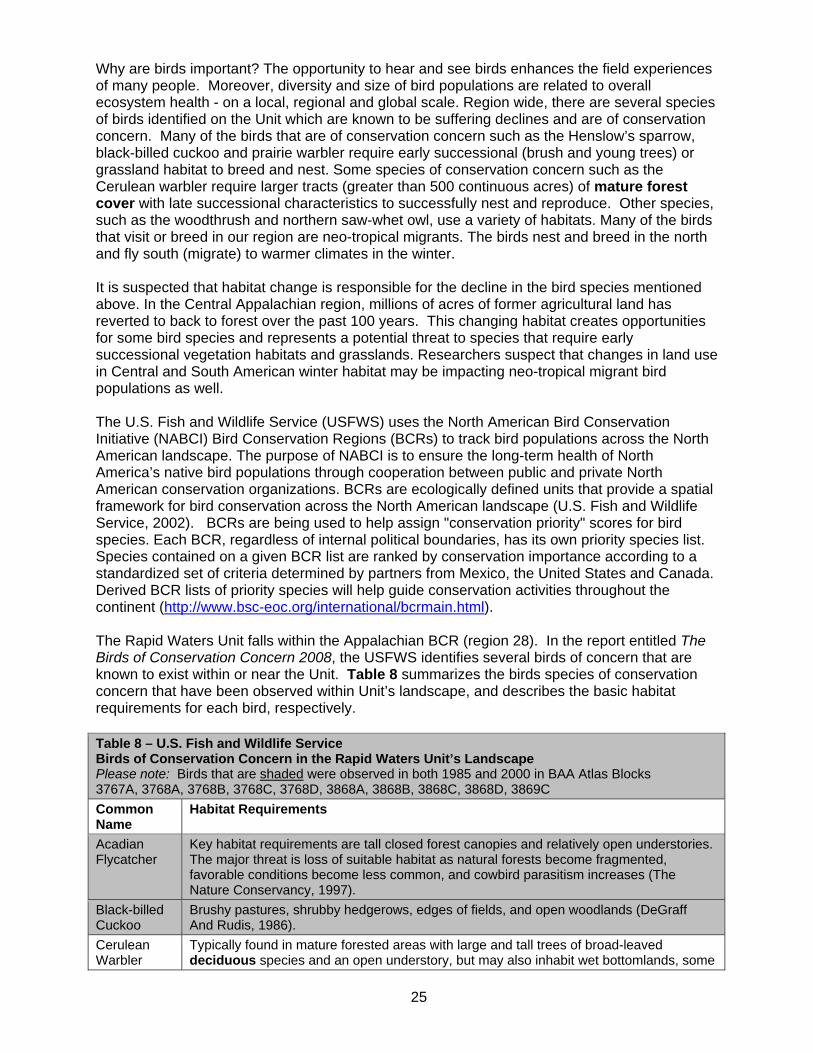
25
Why are birds important? The opportunity to hear and see birds enhances the field experiences of many people. Moreover, diversity and size of bird populations are related to overall ecosystem health - on a local, regional and global scale. Region wide, there are several species of birds identified on the Unit which are known to be suffering declines and are of conservation concern. Many of the birds that are of conservation concern such as the Henslow’s sparrow, black-billed cuckoo and prairie warbler require early successional (brush and young trees) or grassland habitat to breed and nest. Some species of conservation concern such as the Cerulean warbler require larger tracts (greater than 500 continuous acres) of mature forest cover with late successional characteristics to successfully nest and reproduce. Other species, such as the woodthrush and northern saw-whet owl, use a variety of habitats. Many of the birds that visit or breed in our region are neo-tropical migrants. The birds nest and breed in the north and fly south (migrate) to warmer climates in the winter. It is suspected that habitat change is responsible for the decline in the bird species mentioned above. In the Central Appalachian region, millions of acres of former agricultural land has reverted to back to forest over the past 100 years. This changing habitat creates opportunities for some bird species and represents a potential threat to species that require early successional vegetation habitats and grasslands. Researchers suspect that changes in land use in Central and South American winter habitat may be impacting neo-tropical migrant bird populations as well. The U.S. Fish and Wildlife Service (USFWS) uses the North American Bird Conservation Initiative (NABCI) Bird Conservation Regions (BCRs) to track bird populations across the North American landscape. The purpose of NABCI is to ensure the long-term health of North America’s native bird populations through cooperation between public and private North American conservation organizations. BCRs are ecologically defined units that provide a spatial framework for bird conservation across the North American landscape (U.S. Fish and Wildlife Service, 2002). BCRs are being used to help assign "conservation priority" scores for bird species. Each BCR, regardless of internal political boundaries, has its own priority species list. Species contained on a given BCR list are ranked by conservation importance according to a standardized set of criteria determined by partners from Mexico, the United States and Canada. Derived BCR lists of priority species will help guide conservation activities throughout the continent (http://www.bsc-eoc.org/international/bcrmain.html). The Rapid Waters Unit falls within the Appalachian BCR (region 28). In the report entitled The Birds of Conservation Concern 2008, the USFWS identifies several birds of concern that are known to exist within or near the Unit. Table 8 summarizes the birds species of conservation concern that have been observed within Unit’s landscape, and describes the basic habitat requirements for each bird, respectively. Table 8 – U.S. Fish and Wildlife Service Birds of Conservation Concern in the Rapid Waters Unit’s Landscape Please note: Birds that are shaded were observed in both 1985 and 2000 in BAA Atlas Blocks 3767A, 3768A, 3768B, 3768C, 3768D, 3868A, 3868B, 3868C, 3868D, 3869C Common Name
Habitat Requirements
Acadian Flycatcher
Key habitat requirements are tall closed forest canopies and relatively open understories. The major threat is loss of suitable habitat as natural forests become fragmented, favorable conditions become less common, and cowbird parasitism increases (The Nature Conservancy, 1997).
Black-billed Cuckoo
Brushy pastures, shrubby hedgerows, edges of fields, and open woodlands (DeGraff And Rudis, 1986).
Cerulean Warbler
Typically found in mature forested areas with large and tall trees of broad-leaved deciduous species and an open understory, but may also inhabit wet bottomlands, some
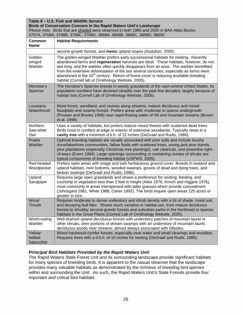
26
Table 8 – U.S. Fish and Wildlife Service Birds of Conservation Concern in the Rapid Waters Unit’s Landscape Please note: Birds that are shaded were observed in both 1985 and 2000 in BAA Atlas Blocks 3767A, 3768A, 3768B, 3768C, 3768D, 3868A, 3868B, 3868C, 3868D, 3869C Common Name
Habitat Requirements second-growth forests, and mesic upland slopes (Audubon, 2005).
Golden- winged Warbler
The golden-winged Warbler prefers early successional habitats for nesting. Recently abandoned farms and regeneration harvests are ideal. These habitats, however, do not last long, and the warbler often quickly disappears from an area. The warbler benefitted from the extensive deforestation of the last several centuries, especially as farms were abandoned in the 20th century. Return of forest cover is reducing available breeding habitat (Cornell lab of Ornithology Website, 2005).
Henslow’s Sparrow
The Henslow's Sparrow breeds in weedy grasslands of the east-central United States. Its population numbers have declined steadily over the past few decades, largely because of habitat loss (Cornell Lab of Ornithology Website, 2005).
Louisiana Waterthrush
Moist forest, woodland, and ravines along streams; mature deciduous and mixed floodplain and swamp forests. Prefers areas with moderate to sparse undergrowth (Prosser and Brooks 1998) near rapid-flowing water of hill and mountain streams (Brown et al. 1999).
Northern Saw-whet Owl
Uses a variety of habitats, but prefers mature mixed forests with scattered dead trees. Birds roost in conifers at edge or interior of extensive woodlands. Typically nests in a cavity tree with a minimum d.b.h. of 12 inches (DeGraaf and Rudis, 1986).
Prairie Warbler
Optimal breeding habitats are usually associated with poor soils and include brushy dune/lakeshore communities, fallow fields with scattered trees, young jack pine stands, pine plantations (especially Christmas tree plantings), oak clearcuts, and powerline right-of-ways (Evers 1994). Large openings surrounding or containing clumps of shrubs are typical components of breeding habitat (USFWS, 2005).
Red-headed Woodpecker
Prefers open areas with snags and lush herbaceous ground cover. Breeds in lowland and upland habitats, river bottoms, wooded swamps, groves of dead and dying trees, and beaver swamps (DeGraaf and Rudis, 1986).
Upland Sandpiper
Requires large open grasslands and shows a preference for nesting, feeding, and courtship in vegetation less than 2 feet in height (Ailes 1976, Kirsch and Higgins 1976), most commonly in areas interspersed with taller grasses which provide concealment (Johnsgard 1981, White 1988, Carter 1992). The birds require open areas 125 acres or greater in size.
Wood Thrush
Requires moderate to dense understory and shrub density with a lot of shade, moist soil, and decaying leaf litter. Shows much variation in habitat use, from mature deciduous forests to shrubby second-growth forests and suburban parks in the Northeast to riparian habitats in the Great Plains (Corned Lab of Ornithology Website, 2005).
Worm-eating Warbler
Well-drained upland deciduous forests with understory patches of mountain laurel or other shrubs, drier portions of stream swamps with an understory of mountain laurel, deciduous woods near streams; almost always associated with hillsides.
Yellow-bellied Sapsucker
Mixed hardwood-conifer forests, especially near water and small clearings and woodlots. Requires trees with a d.b.h. of 10 inches for nesting (DeGraaf and Rudis, 1986).
Principal Bird Habitats Provided by the Rapid Waters Unit The Rapid Waters State Forest Unit and its surrounding landscape provide significant habitats for many species of breeding birds. It is apparent to the casual observer that the landscape provides many valuable habitats as demonstrated by the richness of breeding bird species within and surrounding the Unit. As such, the Rapid Waters Unit’s State Forests provide four important and critical bird habitats.

27
Late Successional Forest Habitat - The Unit has high canopy forest, natural and protection areas that provide significant blocks of continuous forest canopy with late successional forest characteristics (with 65% or greater average canopy closure). This type of cover provides habitat for neotropical migrant birds that are moderate to high in conservation priority in the region such as the wood thrush, scarlet tanager, Canada warbler, Louisiana waterthrush and black-throated blue warbler. Other birds that prefer mature deciduous and mixed coniferous-deciduous forests include the red-eyed vireo, veery, American redstart, ovenbird, blue headed-vireo, black throated green warbler and yellow-bellied sapsucker. Additionally, habitats with late successional characteristics - when compared to other forest cover - will tend to have higher densities of live or dead hollow trees greater than 10 inches in diameter at breast height that provide homes and/or forage areas for cavity nesting birds such as the northern flicker, yellow-bellied sapsucker, black-capped chickadee, downy woodpecker, hairy woodpecker, red-bellied woodpecker, eastern screech owl, great crested flycatcher, wood duck and pileated woodpecker. The high canopy forest also provides nesting habitat for raptors (birds of prey) that require extensive forested areas such as the northern goshawk. Long-lived Conifer Habitat - The long-lived conifers on the Rapid Waters Unit provide important habitat for a suite of bird species requiring conifers such as the Magnolia warbler, Blackburnian warbler, pine warbler, yellow-rumped warbler, red-breasted nuthatch and black throated green warbler. Mature tall conifers also provide important nesting habitat for raptors such as the northern goshawk and sharp shinned hawk. Early Successional Forest Habitat- Early successional seedling/sapling sized forest provides critical habitat for a suite of birds that require young dense vegetation for breeding, nesting, and foraging. Bird species that require such habitat include the ruffed grouse, American woodcock, white-throated sparrow, American goldfinch, rufous-sided towhee, chestnut sided warbler, yellow warbler, blue winged warbler, white-eyed vireo, alder flycatcher, willow flycatcher, least flycatcher, hermit thrush, brown thrasher, Indigo bunting and gray catbird. Ponds, Vernal Pools/Ponds, Wetlands, Seepages, Spring and Stream Habitats. The 42 miles of headwater streams, 1 pond and 418 acres of Palustrine wetlands provide habitat for birds that require water in close proximity for breeding, nesting, or foraging. Specifically, the pond and shallow wetland waters provide habitats for birds such as the tree swallow, wood duck, hooded merganser, mallard, American black duck, blue wing teal, green heron and Canada goose. Major Game Species Several game or furbearer species exist on the Unit. A few species of high importance with regards to use demands, habitat management needs, or impact to forest ecosystems are discussed below. White-tailed Deer White-tailed deer are an important component of the Unit’s fauna, both for their recreational value and their capacity to impact other resources and human activities and interests. Deer numbers on the upland forests surrounding the Unit are relatively low due to the fact that the pole and sawtimber dominated site provides limited food and cover resources for deer. Deer populations in the state are managed in Wildlife Management Units (WMUs). The entire Rapid Waters Unit is part of Wildlife Management Unit 7R. DEC utilizes Citizen Task Forces (CTF) to set a WMU’s deer population objective. The CTF process convenes representatives from various community interests, i.e. farming, forestry, hunting, highway safety, ecology, and small businesses. The task force provides a way for these potentially affected interest groups to share interests and concerns, and ultimately make a recommendation on the desired deer population for a more, less, or the same. This process seeks to obtain a community view on

28
Year1997
19981999
20002001
20022003
20042005
20062007
0200400600800
10001200
TownCandor CarolineDanby
Deer Take by Towns in the Unit
Year1997
19981999
20002001
20022003
20042005
20062007
012345
Bucks Per Sq. Mile Actual TakeObjective Take
WMU 7R - Objective vs. Actual Buck Take
appropriate deer numbers and requires compromise by many participants, since all interests cannot be fully satisfied.
Deer management permits are issued by the Department’s Division of Fish and Wildlife, Bureau of Wildlife, to control the number of female deer taken by hunters in each Unit. Citizen Task Forces are formed in each WMU to represent the various community interests in deer management. Task forces consider hunting and agricultural interests, the number of deer/auto collisions, damage to residential landscaping, and any other impacts deer have on society. They then make a recommendation as to how many deer they want to see in any given Wildlife Management Unit – more, less, or the same. The Department’s Bureau of Wildlife then sets the quota of deer management Figure 3A – Deer Take by town in the Unit permits that will be issued to move the deer population in the direction recommended by the task force. The most recent CTF to update deer population objectives was completed during the winter of 2003-2004. In WMU 7R, the CTF recommended the population be reduced 35%. The Unit’s new Buck Take Objective (BTO) is 2.7 bucks per square mile (DEC Bureau of Wildlife). The BTO is the average number of bucks per square mile expected to be taken when the deer population is at the level recommended by the task force. The Department’s Bureau of Wildlife monitors the deer population and annually adjusts the quota of deer management permits available to hunters striving to maintain a Unit’s deer population at the level recommended by a task force. The deer herd is somewhat uniformly distributed throughout the Rapid Waters Unit although more deer are probably found at the lower elevations Figure 3B – Objective Vs. Actual Take WMU 7R in vally bottomlands where agricultural activities are concentrated. Figure 3A shows the deer take in the three town that comprise the Rapid Waters Unit from 1997 to 2007. Figure 3B compares the actual buck take to the BTO in WMU 7R for the same period. The Department’s Wildlife Biologists monitor and manage wildlife populations in the State. Until recently, deer population levels were generally on the increase. Over the past decade, this increase was attributed to: 1) a number of winters with favorable conditions for deer survival 2) an overall decline in the number of hunters 3) large
29
private parcels being subdivided and sold resulting in fragmentation of habitat, and 4) more private landowners posting their property against hunting. Research on the Allegheny National Forest has shown that high deer populations over an extended period of time can negatively impact species richness and the overall productivity and health of forest ecosystems. In portions of the Allegheny National Forest in northwestern Pennsylvania with excessive deer populations, researchers have noted changes in the forest understory associated with excessive deer browse. In some areas, specific trees, shrubs, and herbaceous plants, which are preferred browse sources for deer (including birch, ash, witch hobble, sumac, wild raisin, blueberry, wintergreen) have become scarce in the forest understory. Lack of a herbaceous/shrub layer leads to higher nest predation of ground-nesting and shrub-nesting birds. It also directly alters the habitat and food sources for small mammals. Today, and for the near term, deer populations within the Rapid Waters Unit’s immediate landscape are being managed within reasonable limits and appear to be trending slightly downward. However, in the long term, deer populations may trend upward as the land is gradually developed and habitat changes. Wild Turkey Wild turkey can be found throughout the Unit as the forests and fields found in the landscape provide excellent food and cover. In the spring and summer of the year, adult wild turkeys feed on wild leeks, roots, fruits, grasshoppers, dragonflies and snails. During the winter the animals feed on acorns, seeds and left over fruits. In agricultural areas, they also feed on manure, silage and any residual grains. The bird has made a remarkable recovery after disappearing from the State around the mid-1840s as the landscape was cleared for farmland. As farming declined on the infertile hilltops, the land gradually reverted back into brush and forest. By the late 1940's, much of New York’s southern tier was again capable of supporting turkeys. Around 1948, wild turkeys from a small remnant population in northern Pennsylvania crossed the border into western New York. These were the first birds in the State after an absence of 100 years. In 1959, these natural populations were supplemented by a trap and release program begun by the then New York State Conservation Department (DEC Bureau of Wildlife, NYS Chapter of the National Wild Turkey Federation, 2004). Humans have been an important predator of wild turkeys for many thousands of years and are part of the region’s natural heritage. This wonderful bird is now legally protected as a game species by spring and fall turkey hunting seasons, which are closely monitored by State biologists. This management has helped increase the number of turkeys throughout most of the State. Ruffed Grouse and Woodcock In the 20th century, farm abandonment and the recovery of forests from unregulated logging and fires produced habitats which probably resulted in the greatest abundance of ruffed grouse in recent times in most of the northern and northeastern United States. But as forests mature under protection from fire and regeneration cutting, they lose the habitat qualities ruffed grouse require. Continued loss of early successional forest habitats are likely on private forest lands as ownership parcelization increases and average parcel size decreases. Ruffed grouse and American woodcock depend on shrub-dominated and young forest habitats (Dessecker, McAuley). The high tree and shrub densities characteristic of these habitats protect them from predators and enable local populations to attain levels substantially greater than on landscapes dominated by mature forest (Sepik and Dwyer, 1982). In many regions, Ruffed grouse and woodcock numbers have declined as forests have become more extensive and older.

30
Ruffed grouse and woodcock are both listed as species of “greatest conservation need” in the State’s Comprehensive Wildlife Conservation Strategy (NYSDEC, 2006). They are two of the many species which would benefit from the creation and maintenance of early successional habitats. Their numbers can often be readily enhanced or restored by creating habitat through heavy forest regeneration cutting on a regular basis or through the use of prescribed fire to allow open habitats for young growing grouse to feed on insects, a high protein source. Forest stands with low to moderately low potential productivity, that have aspen as an existing component, are good candidates for grouse and woodcock habitat management. The overall goal is to provide a diversity of age classes of aspen to meet the food and cover requirements in a manner consistent with their limited mobility (The Ruffed Grouse Society, 2005). Eastern Cottontail Rabbit New York’s cottontail rabbit population was relatively small prior to European settlement when forests covered much of the State. By the early 20th century, most of New York’s forests had been cleared. Formerly cleared areas grew back to brush and young forests, providing excellent habitat for rabbits for several decades. Today, young early successional cover has declined as the forests have matured. Management techniques such as periodic mowing, brushing, or regeneration cutting help provide brushy cover. Additionally, maintenance of existing old field grass, goldenrod, and aster habitats by annual mowing to prevent succession is recommended. Black Bear The Rapid Waters Unit is within black bear range and bear are becoming more common. More sightings have been reported in recent years and the number of nuisance complaints has risen as well. Black bear require large blocks of remote mature forest cover with a thick forest understory. They also require abundant sources of hard and soft mast from plants such as northern red oak, chestnut oak, white oak, wild blueberry, elderberries and blackberries. These large mammals have returned with the natural reestablishment of large blocks of upland transitional oak and northern hardwood forest in the region. Beaver Beaver populations in New York are abundant and their populations are secure. The Department regulates trapping seasons to ensure the continued security of New York's furbearer populations (DEC Division of Fish and Wildlife, 2005). Beaver require small to large slowly flowing brooks, streams or rivers that are usually, but not necessarily, bordered by woodland (DeGraff and Rudis, 1986). The west branch of Owego Creek and its associated floodplain provides good beaver habitat. Trapping provides important benefits for New Yorkers including: control of nuisance wildlife damage, economic benefits to trappers and people involved in the fur industry, and recreation for trappers. The colonization of a site by beavers often results in the flooding of an area and subsequent changes in wildlife habitats. Most of the changes related to beaver flooding create new habitat opportunities for other plant and animal species. However, flooding can impact trout habitat, forest health and highways.
G. Endangered, Threatened, Special Concern and Significant Species As previously illustrated, the Rapid Waters Unit is located in a diverse landscape that is dominated by forest cover and open farmland, with some residential development. Analysis of the Breeding Bird Atlas and the New York GAP model data illustrate that the landscape potentially supports about 275 species of birds, mammals, fish, reptiles and amphibians. Additionally, the landscape is the home to many species of invertebrate animals such as dragonflies, skippers and butterflies. Important Species within the Unit and at the Landscape Level The Environmental Conservation Law of New York, Section 11-0535 and 6 NYCRR (New York Code of Rules and Regulations) Part 182 authorizes the Department to list and protect endangered, threatened and special concern wildlife species. Table 9 lists the threatened,

31
endangered, or rare plant and wildlife species recorded within or immediately adjacent to the State Forests that comprise the Rapid Waters Unit at the time of this writing. Table 9 – Rare Species and Natural Communities Documented in the Rapid Waters Unit Source: State Lands Assessment Project: Biodiversity Inventory of Region 7 State Forests New York Natural Heritage Program 2005
Scientific Name Common Name Description New York Status
State Rank
Global Rank
Last Obs.
Ammodramus henslowii Henslow’s Sparrow Vertebrate Animal Threatened S3B G4 1984
Calamagrostis perplexa Wood Reedgrass Vascular Plant Endangered S1 G1 1993
Chamaelirium luteum Fairy Wand Vascular Plant Threatened S1S2 G5 1983
Circus cyaneus Northern Harrier Vertebrate Animal Threatened S3BS3N G5 2003
Cordulegaster obliqua Arrowhead Spiketail Invertebrate Animal Unlisted S2S3 G4 2004
Rich Hemlock Hardwood Peat Swamp
Rich Hemlock Hardwood Peat Swamp Community Unlisted S2S3 G3G4 2004
Platanthera hookeri Hooker’s Orchid Vascular Plant Endangered S1 G4 1990
Poa paludigena Slender Marsh Bluegrass Vascular Plant Endangered S1 G3 1989
Shallow emergent marsh Shallow emergent marsh Community Unlisted G5 G5 2004
Trollius laxus Spreading Globeflower Vascular Plant Rare S3 G3 1977
Additionally, at the larger landscape level outside of the Unit, several animals listed in New York State as endangered, threatened or special concern species have been recorded by the 1985 and 2000 breeding bird atlas census, New York Natural Heritage Program staff - and/or confirmed or predicted by the New York GAP Analysis Model. Table 10 lists these species and their required habitats.
Table 10 – Endangered, Threatened and Special Concern Species at the Landscape Level Common Name
Habitat Requirements Record Source
NY Status
Henslow’s Sparrow
Henslow’s sparrows historically bred in native tallgrass prairie habitat; in the East grasslands maintained by natural disturbances or fires set by Native Americans provided habitat (Burhans, 2002)
BBA 1995 2000 NY GAP MODEL (CONF)
E
Indiana Myotis (bat)
Females congregate in nursery colonies under the loose bark of dead trees. Only a handful of such colonies have ever been discovered. These trees are located along the banks of streams or lakes in forested habitat. In New York State, these bats are known to winter in only seven caves or mines, with nearly one-half of the world’s population being found in only two caves. Even though other populations have been discovered in recent years, the additions have not offset the losses recorded over the full extent of the species range (DEC Endangered Species Unit, 1999).
E
Loggerhead Shrike
A small gray, black, and white bird of open areas, the Loggerhead Shrike hardly appears to be a predator. But it uses its hooked beak to kill insects, lizards, mice, and birds, and then impales them on thorns to hold them while it rips them apart. Once abundant, but declined drastically through last half of 20th century
NY GAP MODEL (PRED)
E
Short-eared A bird of open grasslands, the Short-eared Owl is one of the most NY GAP E

32
Table 10 – Endangered, Threatened and Special Concern Species at the Landscape Level Common Name
Habitat Requirements Record Source
NY Status
Owl widely distributed owls in the world – but is endangered in New York State. It is distributed across North America, South America and Eurasia. The bird is common in northern portion of breeding range, but populations fluctuate greatly along with prey population cycles (Cornell lab of Ornithology, 2008).
MODEL (PRED)
Upland Sandpiper
Breeds in wide open pastures or grassy fields, often hayfields with alfalfa or clover, occasionally in forest openings. Winters in South America (DeGraff and Rudis, 1986).
BBA 1985 NYGAP MODEL (CONF)
E
Northern Harrier
Nest on ground in swamps, cut-over areas, swamps with low shrub and clearings, sometimes built up over water on a stick foundation, sedge tussock or willow clump (DeGraff and Rudis, 1986).
NYNHP NY GAP MODEL (CONF)
TH
Pied-billed Grebe
Breeds on seasonal or permanent ponds with dense stands of emergent vegetation, bays and sloughs. Uses most types of wetlands in winter. Winters in central and southern United States Southward to Central America, wherever open water can be found. Also in Caribbean and South America (Cornell lab of Ornithology, 2005).
BBA 1985 2000 NY GAP MODEL (CONF)
TH
Timber Rattlesnake
Timber rattlesnakes are generally found in deciduous forests in rugged terrain. In the summer, gravid (pregnant) females seem to prefer open, rocky ledges where temperatures are higher, while the males and non-gravid females seem to prefer cooler, thicker woods where the forest canopy is more closed. Rattlers generally migrate from 1.3 to 2.5 miles (2 to 4 km) from their den each summer, with a maximum movement of 4.5 miles (7.2 km) observed (NYSDEC, 2008).
NY GAP MODEL (PRED)
TH
Barn Owl Breeds and winters almost anywhere in open country but prefers vicinity of farms and villages. Avoids woodlands and higher elevations (DeGraff and Rudis, 1986).
BBA 1985 2000
PSC
Cerulean Warbler
Breeds in forests with tall deciduous trees and open understory, such as wet bottomlands and dry slopes. Winters in broad-leaved, evergreen forests in mountains of northern South America (Cornell Lab of Ornithology, 2005).
NY GAP MODEL (CONF)
PSC
Common Nighthawk
Breeding in open areas such as plowed fields, gravel beaches, barren areas with rocky soil, railroad right of ways, large woodland clearings, and cities. Winters in South America (DeGraff and Rudis, 1986).
BBA 1985 NY GAP MODEL (CONF)
PSC
Cooper’s Hawk
Breeds and winters in extensive deciduous or mixed woodlands that are dense or in open, scattered woodlots interspersed with open fields (DeGraff and Rudis, 1986).
BBA 1985 2000 NY GAP MODEL (CONF)
PSC
Eastern Box Turtle
Woodlands, old fields, powerline clearings, field edges, thickets, marshes, bottomlands and streambanks (DeGraff and Rudis, 1986).
NY GAP MODEL (CONF)
PSC
Jefferson Found in undisturbed damp, shady deciduous or mixed woods, BBA TH

33
Table 10 – Endangered, Threatened and Special Concern Species at the Landscape Level Common Name
Habitat Requirements Record Source
NY Status
Salamander bottomlands, swamps, moist pastures, or lakeshores. Requires temporary ponds with a pH greater than 5 (DeGraff and Rudis, 1986).
1985 2000 NY GAP MODEL (CONF)
Northern Goshawk
Breeds and winters in interiors of remote and heavily forested areas of coniferous and mixed forests (DeGraff and Rudis, 1986).
BBA 1985 2000 NY GAP MODEL (CONF)
PSC
Red-Shouldered Hawk
Breeds and winters in moist hardwood or mixed woodlands, wooded swamps, bottomlands, and wooded margins often close to cultivated fields (DeGraff and Rudis, 1986).
BBA 1985 2000 NY GAP MODEL (CONF)
PSC
Sharp-skinned Hawk
Breeds and winters in open mixed or coniferous woodlands, clearings, and edges. A bird of cold-temperate conifer forest and temperate deciduous woodlands (DeGraff and Rudis, 1986).
BBA 1985 2000 NY GAP MODEL (CONF)
PSC
Spotted Turtle
Requires unpolluted, small, shallow bodies of water such as woodland streams, wet meadows, bog holes, small ponds, marshes, swamps, and roadside ditches (DeGraff and Rudis, 1986).
NY GAP MODEL (PRED)
PSC
Vesper Sparrow
Found in various open habitats with grass, including prairie, sagebrush steppe, meadows, pastures, and roadsides. Winters in the southern United States from South Carolina to southern California, southward to southern Mexico (Cornell Lab of Ornithology, 2005).
BBA 1985 NY GAP MODEL (CONF)
PSC
Wood Turtle Frequents slow-moving, meandering streams with sandy bottoms and overhanging alders. Disperses from water sources during summer months to fields, woods and roadsides (DeGraff and Rudis, 1986).
NY GAP MODEL (PRED)
PSC
Yellow-breasted Chat
Breeds in dense thickets around wood edges, riparian areas, and in overgrown clearings. In the eastern and southern portions of the range, abandoned agricultural fields left unmanaged for 10 years and the removal of trees and encouragement of a shrub layer in powerline rights-of-way will create suitable chat habitat. Wherever marginal cropland is abandoned, the species should benefit before canopy closure (Nature Conservancy, 1998).
BBA 1985 NY GAP MODEL (CONF)
PSC
Key to Codes BBA - Breeding Bird Atlas (1985, 2000) TH - Threatened Species (New York) E - Endangered Species (New York) (PRED) - Predicted Species PSC - Protected, Special Concern Species (New York) (CONF) - Confirmed Species NYNHP - New York Natural Heritage Program

34
Additional Natural Heritage Program Listings Interestingly, in June 2004, New York Natural Heritage staff observed the Arrowhead Spiketail dragonfly (Cordulegaster obliqua) in the southeastern portion of the Shindagin Hollow State Forest (Tompkins No. 3). As a group, dragonflies are excellent biological indicators as they reproduce and feed in shallow seepage areas that feed into streams. The seepage areas often have dense growth of ferns and other herbaceous plants (Novak, 2005). Biological indicator species are unique environmental indicators as they offer a signal of the biological condition in a watershed. Groups of bioindicators species can be used to detect pollution or changes in ecosystem health within a watershed (U.S. EPA, 2005). Because of their specific habitat requirements, conspicuous nature, and their position as top invertebrate predators, these insects help enhance public awareness of the links between land use, water supplies, and biodiveristy (SaintOurs, 2002). The Arrowhead Spiketail is not protected by Environmental Conservation Law. Keystone Species Keystone species are species that play roles affecting many other organisms in an ecosystem (Miller, 2004). Keystone species are organisms whose health is often linked to the health of an entire ecosystem. A keystone species creates habitat that is required by other species. Therefore, the presence, absence, increase or decrease of a keystone species across a landscape is an indicator of ecosystem health. Examples of Central Appalachian ecozone keystone species found on the Unit include the American chestnut, Eastern white pine, Eastern hemlock, pileated woodpecker and beaver. Beginning in 1904, chestnut blight, a non-native disease, effectively eliminated American chestnut from the ecozone’s landscape. By 1950 (except for the shrubby root sprouts the species continually produces and which also quickly become infected) this keystone species disappeared from its 200 million acre range (http://www.acf.org/history.php 2008).
H. Cultural Resources The term cultural resources encompasses a number of categories of human created resources including structures, archaeological sites and related resources. The Department is required by the New York State Historic Preservation Act (SHPA) (PRHPL Article 14) and SEQR (ECL Article 8) to include such resources in the range of environmental values that are managed on public lands. On lands managed by the Department’s Region 7 Division of Lands and Forests Office, the number of standing structures is minimal. Statewide, those structures that remain are related to the Department’s land management activities such as fire towers, “ranger” cabins, maintenance facilities, and related resources. Fire towers, as a class of resources, have been the subject of considerable public interest over the last decade. The majority of surviving fire towers have been found eligible for inclusion on the State and National Registers of Historic Places and a number of towers were formally listed in the Registers in 2001. For state agencies, Register listing or eligibility are effectively the same; obligating the Department to treat these resources appropriately and requiring that special procedures be followed should it be necessary to remove or affect these resources. While conducting forest inventory, Department forestry staff made note of cultural resources such as cemeteries, foundations, stone walls, cisterns and former water well sites. As a part of the inventory effort associated with the development of this plan, Department staff reviewed the archaeological site inventories maintained by the New York State Museum and the Office of Parks, Recreation and Historic Preservation to identify known archaeological resources that might be located within or near the Unit. The two inventories overlap to an extent, but do not entirely duplicate one another. The purpose of this effort was to identify any known sites that might be affected by actions proposed within the Unit and to assist in understanding and characterizing past human use and occupation of the Unit. No such sites are known to exist on the Unit.

35
The quality of the site inventory information varies a great deal in all respects. Very little systematic archaeological survey has been undertaken in New York State. Therefore, all current inventories must be considered incomplete. Even fewer sites have been investigated to any degree that would permit their significance to be evaluated. Many reported site locations result from 19th century antiquarian information artifact collector reports that have not been field verified. Often very little is known about the age, function or size of these sites. This means that reported site locations can be unreliable and encompass a large area. Should systematic archaeological inventory be undertaken at some point in the future, it is very likely that additional archeological resources will be identified. Archaeological Site Protection The archaeological sites located within this Unit and any unrecorded sites that may exist on the property are protected by the provisions of the New York State Historic Preservation Act (SHPA - Article 14 PRHPL), Article 9 of Environmental Conservation Law and Section 233 of Education Law. No actions that would impact these resources are proposed in this Unit Management Plan. Should any such actions be proposed in the future they will be reviewed in accordance with SHPA. Unauthorized excavation and removal of materials from any of these sites is prohibited by Article 9 of Environmental Conservation Law and Section 233 of Education Law. Archaeological sites are locations where materials (artifacts and ecofacts) or modifications to the landscape reveal evidence of past human activity. This includes resources that range from Native American camps and villages to farm homesteads established by European immigrants during the nineteenth and early twentieth centuries. Such sites can be entirely subsurface or can contain above ground remains such as foundation walls or earthwork features. Old homestead foundations, water wells, stone walls and barbed wire attest to the agricultural history of the Unit and its landscape. Archeological sites within the State date back as far as 12,000 years and are located in a wide variety of settings, from forests and flood plains to waterways and mountain tops (NYS Office of Parks, Recreation, and Historic Preservation, 2005). Archaeological Research The archaeological sites located on this land Unit as well as additional unrecorded sites that may exist on the property will be made available for appropriate research. All future archaeological research to be conducted on the property will be accomplished under the auspices of all appropriate permits. Research permits will be issued only after consultation with the New York State Museum and the Office of Parks, Recreation and Historic Preservation (OPRHP). Extensive excavations are not contemplated as part of any research program in order to assure that the sites are available to future researchers who are likely to have more advanced tools and techniques as well as different research questions.
I. Roads A 36.3 mile network of town, county and state roads provides access to, from and through the State Forests on the Unit. These roads are critical assets in that they provide access to the Unit for recreationists, DEC land managers and forest harvesting equipment. As a whole, roads maintained by the towns of Caroline and Danby provide most of the access to the Unit; town roads represent about 33.6 miles (93%) of the road network. About 19.5 miles (54%) of the town roads are classified as seasonal, and, as such, are not plowed or sanded. Plowed town roads cover about 14.1 miles (39%). State and county roads comprise 7% of the road network; all of the state and county roads are plowed and sanded and/or salted. Table 11 on the following page lists the roads that are currently open to public use in the Unit. The State Forest Road System provides both public and administrative access to the Unit. PFARs are constructed by the Department to standards that will provide reasonably safe travel and keep maintenance costs at a minimum. These roads are not normally plowed or sanded.

36
There are three types of roads that provide interior access to the State Forests in the Unit: public forest access roads, (formerly called truck trails), haul roads and access trails. These roads provide different levels of access depending on the level of standards to which they were constructed. Public forest access roads are permanent, unpaved roads. These roads are open for the public use unless the road is gated and/or signed to prohibit use. The roads may be designed for all/weather use depending on their respective location and surfacing. These roads provide primary access to the Unit. The standards for these roads are those of the Class A and Class B access roads as described in the Department’s Forest Road Handbook (Swartz, et al. 2004). The speed limit is 25 miles per hour. The 1.6 mile Ekroos Rd. on the Shindagin Hollow State Forest is the Unit’s single public forest access road. It is currently maintained (and plowed) through a Temporary Revocable Permit (TRP) cooperatively with the town of Caroline Highway Department. Haul roads are permanent, unpaved roads, but are not designed for all weather use. They are constructed primarily for the removal of forest products and provide only limited access to the Unit. As such, most of these roads are not open for motor vehicle use by the public and are blocked by berms, rocks, or gates to prevent unauthorized motor vehicle use. The standards for these roads are those of a Class C road as described in the Department’s Forest Road Handbook. There is 1.0 miles of haul roads on the Unit. These roads are blocked from vehicular access. Access trails may be permanent, are unpaved, and do not provide all weather access on the Unit. These trails are originally designed for removal of forest products and may be used to meet other management objectives such as recreational trails. These trails are constructed according to best management practices and are designed for temporary use. Approximately 19 miles of access trails are located throughout the Unit. The vast majority of these access trails are blocked by berms or gates to prevent unauthorized motor vehicle use. There are no designated off-road motor vehicle trails on this Unit. Off-road vehicle travel by all terrain vehicles (ATV’s) or four wheel drive trucks is prohibited except where otherwise specifically posted for ATV use by people with qualifying disabilities who have obtained a Permit from the Department. It should be noted that ATV use by the general public is prohibited on the 1.6 mile Ekroos public forest access road on the Shindagin Hollow State Forest.
J. Recreational Assets Historically, State Forests have provided open space for outdoor recreational activities that require minimal facilities. Such activities include hunting, fishing, trapping, hiking, nature observation, picnicking, mountain biking, snowshoeing, snowmobiling and cross country skiing. In the past, the intensity of recreational use was low. This resulted in low environmental impacts and few user conflicts. However, during the 1990s, demand for recreational trails increased substantially (DEC Region 7 Draft Recreation Plan, 2001). Adopt-A-Natural Resource Program To help meet the increasing demand for recreation, the Department increasingly depends on partnerships with recreation groups to help maintain, enhance, and construct recreational assets. Partnerships between recreation groups and the Department are formalized through the Department’s Adopt a Natural Resource program (AANR). The AANR program is authorized by Section 9-0113 of the Environmental Conservation Law. The statute authorizes the Department to use a stewardship agreement for activities it approves for the preservation, maintenance, or enhancement of state-owned natural resources. Volunteerism is the cornerstone of the AANR program. It is a means for completing work that helps preserve, maintain and enhance natural resources at minimum cost to the State.

37
Individuals and groups interested in providing volunteer services are afforded a formal opportunity to propose activities that meet management needs of state-owned natural resources. Such activities may involve remediating vandalism, establishing or maintaining access or nature trails, building camping sites, providing interpretive services for school groups and other citizens, managing fish and wildlife habitats, and otherwise providing positive benefits to the natural resource. The AANR program has been very successful in Region 7. The Unit’s volunteer stewards are listed in Table 11 below. Since the inception of the program, volunteers have built several lean-tos, cleared miles of trails from ice storm damage, have built and maintained miles of new trail, groomed snowmobile trails and have removed large volumes of trash. These volunteer construction and maintenance activities are of great value to the State Forest system and the people it serves. Vitally important assets, the Department’s AANR partners are strongly committed to enhancing and protecting natural resources on the Unit. Not surprisingly, AANR partners have developed a strong sense of ownership, are advocates, and are very interested in the planning and natural resource management activities that take place on the State Forests in the Unit. Table 11 – Adopt-A-Natural Resources Volunteer Stewards AANR Volunteer Stewards State Forest Bethel Grove Bible Church Shindagin Hollow Candor Valley Riders Snowmobile Club Shindagin Hollow Cayuga Trails Club Danby and Shindagin Hollow Cycle-CNY Shindagin Trail Committee Shindagin Hollow Finger Lakes Trail Conference Danby and Shindagin Hollow Friends of Bald Hill Danby Spencer-Van Etten Snowmobile Club Danby Popular Activities Hiking historically has been a popular recreational activity on the Unit, and, based on casual observations and reports from recreationists, likely draws some of the greatest numbers of visitors to the Unit’s State Forests. The Cayuga Trails Club (CTC), affiliated with the Finger Lakes Trail Conference (FLTC), has been building and maintaining hiking trails throughout the Unit planning area and Finger Lakes Region since the early 1960's (http://www.cayugatrailsclub.org/about/history.php, 2008). Today, the Rapid Waters Unit has nearly 22 miles of hiking trails, built and maintained entirely by volunteers. Additionally, FLTC and CTC volunteers maintain three lean-tos and the Thatcher’s Pinnacle Scenic Vista. The Finger Lakes Trail (FLT) System is the main hiking trail from the Pennsylvania-New York border in Allegany State Park to the Long Path in the Catskill Forest Preserve. The main FLT is 562.9 miles long. There also are five branch trails and 15 loop trails that extend from the main FLT. These branch and loop trails currently total about 236 miles. Incredibly, the trail system has been and is being built and maintained by 20 organizational and 38 individual and family trail sponsors. All of these groups and individuals are volunteers, except for personnel of the U.S. Forest Service who maintain the 12-mile-long Interloken Trail, one of the FLT System's branch trails. The FLTC was organized in 1962 to promote and coordinate the building, maintenance, and protection of the FLT System. The trail system is located almost equally on private and public land. There are currently over 450 private landowners who allow the trail to be on their land. Several sections of the main FLT have been certified by the National Park Service as official components of the North Country National Scenic Trail. When completed, the North Country Trail will extend 4,600 miles across seven states between eastern New York and central North Dakota (http://www.fingerlakestrail.org/, 2008).

38
Shindagin Hollow State Forest receives significant and increasing recreational use by bicyclists. The 16 mile mountain bike trail system is very popular with local mountain bike enthusiasts, and is frequented by local residents, Cornell University and Ithaca College students, as well as visitors from outside the immediate area. Built and maintained mostly by volunteers, the trail system is a cooperative effort between Cycle-CNY, a club affiliated with the International Mountain Bicycling Association (IMBA), and the DEC. In an effort to train and educate trail stakeholders, Cycle-CNY, IMBA, Cornell University and DEC hosted a trail building workshop in September of 2006. The event was organized and implemented by Cycle-CNY volunteers and was a great success. As a result, volunteer stewardship, trail advocacy and use continue to grow. As time progresses, trail use and wear will increase, and a greater number of trained volunteers and trail maintenance resources (such as geoxtextile fabric and gravel) will be needed. Membership in Cycle-CNY is open to anyone who lives in or rides in central New York (http://www.cycle-cny.com/about.php, 2008). Snowmobiling continues to be a popular activity on the Unit as well. Corridor snowmobile trail development and maintenance activities across the State are promoted and funded via a local grant program administered by the New York State Office of Parks, Recreation and Historic Preservation (OPRHP). Approximately $1.1 million per year is distributed to counties, towns and villages. Much of this money is passed on to the clubs that do the actual work. There are approximately 8,500 miles of funded trails in New York State. The Candor Valley Riders and Spencer Van-Etten Snowmobile Clubs corridor trails are funded in part by the program. Both clubs groom their respective trail networks on a regular basis. About nine miles of snowmobile trail are currently on the Unit. As this plan was developed, the Department sought and encouraged public participation through an open-house style informational meeting, direct mailings, field tours, a radio interview and newspaper articles. Based on feedback provided by stakeholders during the initial public participation process, the public is interested in a wide range of recreational activities such as mountain bike riding, camping, horseback riding, wildlife observation, cross country skiing, snowshoeing, hunting, trapping and fishing. Many of these recreation activities do not require a formal trail network or significant infrastructure improvements and, as such, have historically taken place throughout the Unit. Organized Events and Temporary Revocable Permits The Rapid Waters Unit continually provides opportunities for organized group events such as trail runs, bike races, ski races or orienteering club meets. Group events involving 21 or more individuals and all competitive events or activities require a Temporary Revocable Permit (TRP). Such organized events often require resources such as additional parking, portable toilets and emergency medical support services. To protect public health, public safety and the environment, the Department has developed four types of TRPs, three of which apply to the Twin Sheds Unit. These three types are: 1) expedited TRPs, 2) routine TRPs and 3) non-routine TRPs. Expedited TRPs are issued when events are non-competitive and the group size is between 21 to 50 individuals. Generally, no permit is required for non-competitive events or group activities of 20 individuals or less. Expedited TRP’s do not require an application fee or proof of liability insurance and are issued by regional DEC staff as designated by the Regional Manager. Routine permits apply to applications for group events of over 51 and up to 100 individuals. All competitive activities and any group event involving more than 100 individuals require a non-routine TRP which must be approved in Albany. There is currently a $25.00 non-refundable application fee for routine and non-routine TRP’s. Routine and non-routine TRPs may also be subject to additional fees necessary to cover costs incurred by the Department directly associated with permit administration, use of facilities and/or oversight. Routine and non-routine TRP applicants must provide a certificate of liability insurance to indemnify The People of the State of New York against any and all claims for injury to property or person or
39
death arising out of or relating to the operations of the applicant. Routine and non-routine TRP applications must be submitted to the Cortland Lands and Forest sub-office, including proof of insurance, at least 30 days prior to the requested use date. . For more complete information on the Department’s most current TRP policies, applicability, application process, insurance requirements and applicable fees, please contact the Lands and Forests Office at (607) 753-3095 ext. 217. TRP applications are available on-line at www.dec.ny.gov/docs/lands_forests_pdf/trpapppermitform.pdf . Applicants are encouraged to contact the DEC Lands and Forests Cortland Office to check if their respective event requires a TRP before filing an application. ATV Use Issues Illegal ATV use is an issue that faces many private and public landowners in the region. Use of the machines to reach remote outdoor destinations is increasing at a rapid pace. To prevent chronic adverse environmental impacts associated with frequent use, ATV trails open for use for the general public must be properly designed and maintained, be situated on relatively well drained ground, and be placed in blocks of open space 5,000 acres or more in size. Many of the soils in the Rapid Waters Unit are wet with seasonally high water tables. Damage from chronic illegal ATV use includes: rutting, soil erosion and sedimentation of streams. Often, unregulated ATV use conflicts with other sanctioned recreational activities such as hunting, horseback riding, hiking, mountain biking, running, wildlife observation and cross-country skiing. To prevent excessive trail damage and user conflicts, general policy has been to restrict ATV use by the general public. The Department's Motorized Access Program for People with Disabilities (MAPPWD) permits qualifying people with disabilities to use motor vehicles along specific routes for access to programs, such as hunting and fishing, on state lands. These routes are provided to facilitate access to these traditional programs and not for the support of ORV or ATV riding activities. This program provides access to significant recreational opportunities throughout the state and is one more way that New York is opening the outdoors to people with disabilities. This permit program is maintained pursuant to DEC Commissioner’s Policy 3 (CP‐3). Additional information on DEC Commissioner’s Policy 3 can be found at: http://www.dec.ny.gov/regulations/64558.html Recreational Asset Summary In summary, the Unit’s recreational assets significantly add to the quality of life and to the overall value of the Unit’s land to the People of the State of New York. Long term, as subdivision, fragmentation and posting of the privately owned landscape continues it is expected that the Rapid Waters Unit will increasingly provide significant and highly valued recreational opportunities for a diverse group of stakeholders. As demand increases, the Department will seek to improve or maintain recreational services while balancing stakeholder interests with the overall ecosystem based management goals, objectives and actions discussed later in this plan. One thing is for certain - volunteers will continue to be a key asset in terms of providing trail system maintenance, advocacy and support. Increased recreational use on the State Forests in the Unit will likely benefit local economies as well. A specific list of recreational facilities follows in section K and maps are included at the end of this plan.
K. Facilities that Require Maintenance Table 12 lists facilities that require maintenance on the Unit.

40
Table 12 - Facilities on the Rapid Waters Unit Boundary Lines State Forest Miles Tompkins No. 1 Danby 40.4 Tompkins No. 3 29.1 Total 69.5 Signs and Registers State Forest Type No. Comments Tompkins No. 1 (Danby)
Identification Sign 1 Maintained by DEC.
Tompkins No. 1 (Danby)
Finger Lakes hiking trail register
2 Maintained by the Cayuga Trails Club and FLTC through a DEC AANR agreement.
Tompkins No. 3 (Shindagin Hollow)
Identification Sign 1 Maintained by the DEC.
Parking Lots State Forest Location Cars Geographic
Coordinates Tompkins No. 1 (Danby)
Intersection of Comfort Rd. and Bald Hill Rd. 5 LATITUDE: 42.32617 LONGITUDE: -76.49826
Tompkins No. 1 (Danby)
2/10ths of a mile south of the intersection of Comfort Rd. and Bald Hill Rd. on the east side of Bald Hill Rd.
1 LATITUDE: 42.32423 LONGITUDE: -76.49818
Tompkins No. 1 (Danby)
Bald Hill Rd. 0.5 of a mile south of the intersection of Ball Hill Rd. and Station Rd.(seasonal access only)
3 LATITUDE: 42.31139 LONGITUDE: -76.49333
Tompkins No. 1 (Danby)
South Danby Rd., about 0.3 of a mile south of the intersection of S. Danby Rd. and Fisher Settlement Rd.
8 LATITUDE: 42.30902 LONGITUDE: -76.44314
Tompkins No. 3 (Shindagin Hollow)
Bald Hill School Rd., about ¾ miles west of the intersection of Bald Hill School Rd. and Brearley Hill Rd.
2 LATITUDE: 42.34706 LONGITUDE: -76.36472
Tompkins No. 3 (Shindagin Hollow)
Brearley Hill Rd. (mountain bike trail head), about 0.5 of a mile south of the intersection of Shindagin Hollow Rd. and Brearley Hill Rd.
8 LATITUDE: 42.34499 LONGITUDE: -76.35005
Tompkins No. 3 (Shindagin Hollow)
Brearley Hill Rd., about 1.3 miles south of the intersection of Shindagin Hollow Rd. and Brearley Hill Rd.
2 LATITUDE: 42.33387 LONGITUDE: -76.35081
Tompkins No. 3 (Shindagin Hollow)
Brearley Hill Rd., about 1.5 miles south of the intersection of Shindagin Hollow Rd. and Brearley Hill Rd.
5 LATITUDE: 42.32994 LONGITUDE: -76.35066
Tompkins No. 3 (Shindagin Hollow)
Shindagin Hollow Rd., east side, about 1.4 miles south of the intersection with Brearley Rd. (seasonal access only)
2 LATITUDE: 42.33532 LONGITUDE: -76.33895
Tompkins No. 3 (Shindagin Hollow)
Intersection of Shindagin Hollow Rd. and Gulf Creek Rd. (seasonal access only)
2 LATITUDE: 42.32367 LONGITUDE: -76.33293
Roads State Forest Location Length Comments Tompkins No. 3 (Shindagin Hollow)
Section of Ekroos Rd. that passes through State Land; connects Honeypot Rd. to
1.6 (miles)
Plowed and maintained by the town of Caroline Highway Department.

41
Table 12 - Facilities on the Rapid Waters Unit Seventy-Six Rd.
Utility Lines State Forest Type No. Size Comments Tompkins 1 (Danby) Gas pipeline 2 6.0 ac. Maintained by the utility company
through a TRP. Tompkins 3 (Shindagin Hollow)
Electric power 2 2.0 ac.
Maintained by the utility company through a TRP.
Recreation State Forest Type Quantity Comments Tompkins 1 (Danby) Finger Lakes hiking trail (including
the Abbott Loop). 16.2
(miles) Maintained by the Cayuga
Trails Club and FLTC through a DEC AANR.
Tompkins No. 1 (Danby)
Snowmobile trail. 5.0 (miles) Maintained by the Spencer-Van Etten Snowmobile Club
through a DEC AANR. Tompkins No. 1 (Danby)
MAPPWD trail for people with disabilities permit issued by DEC.
0.3 (miles) Maintained by DEC.
Tompkins No. 1 (Danby)
Finger Lakes hiking trail Michigan Hollow foot bridge (Diane’s crossing)
1 Maintained by the Cayuga Trails Club and FLTC through a DEC AANR
Tompkins No. 1 (Danby)
Chestnut lean-to (east of Bald Hill Rd) and outhouse
1 (ea.) Maintained by the Cayuga Trails Club and FLTC through a DEC AANR.
Tompkins No. 1 (Danby)
Tamarack lean-to (east of Travor Rd.) and outhouse
1 (ea.) Maintained by the Cayuga Trails Club and FLTC through a DEC AANR.
Tompkins No. 1 (Danby)
Thatcher’s Pinnacles scenic vista. 1 View maintained by the Cayuga Trails Club and FLT
through a DEC AANR Tompkins No. 1 (Danby)
Finger Lakes hiking trail register. 2 Maintained by the Cayuga Trails Club and FLTC through a DEC AANR.
Tompkins No. 3 (Shindagin Hollow)
Mountain bike trail (primary use). 16.0 (miles)
Maintained by Cycle-CNY, an IMBA affiliated club through a DEC AANR.
Tompkins No. 3 (Shindagin Hollow)
Finger Lakes Hiking trail. 5.7 (miles) Maintained by the Cayuga Trails Club and FLTC through a DEC AANR.
Tompkins No. 3 (Shindagin Hollow)
Snowmobile trail.
4.0 (miles)
Maintained by the Candor Valley Riders Snowmobile
Club through a DEC AANR. Tompkins No. 3 (Shindagin Hollow)
MAPPWD trail for people with disabilities under permit issued by DEC.
2.5 (miles)
Maintained by the DEC.
Tompkins No. 3 (Shindagin Hollow)
Finger Lakes Trail Shindagin Hollow foot bridge
1 Maintained by the Cayuga Trails Club and FLTC through a DEC AANR.
Tompkins No. 3 (Shindagin Hollow)
Lean-to and outhouse. 1 (ea) Maintained by the Cayuga Trails Club and FLTC.
Shale Pit State Forest Location Size Comments Tompkins No. 3 (Shindagin Hollow)
South of Ekroos Rd. 1.5 (acres)
Maintained by DEC and the town of Caroline Highway Department through a DEC AANR agreement.

42
Table 12 - Facilities on the Rapid Waters Unit Key: AANR – Adopt-A-Natural Resource Agreement, FLTC – Finger Lakes Trail Conference TRP – Temporary Revocable Permit
L. Property Use Agreements The following information was gathered from the records in the Real Property office in Syracuse. The State Forests on this Unit are subject to the following deed restrictions and easements. Michigan Hollow Multiple Use Area (MUA): 323.49± acres • Project: Tompkins 7.14 and 7.15 (Michigan Hollow MUA) The majority of the multiple use area is in need of a contract survey. This project area is now administered with the Tompkins RFA No. 1 (Danby State Forest). Tompkins RFA No. 1 (Danby State Forest): 7,010.71± acres - plus an existing 38.26± acre conservation easement Outstanding survey requests • Proposal F - (Both sides of Rt. 96B) Estimated cost of consultant survey for the entire
parcel. Field reconnaissance of proposal boundary may decrease the scope of survey. Poor mathematical closure of original proposal. Proposal needs to be re-surveyed and mapped.
• Proposal G - (John Hill Road) Proposal was acquired without a field survey. Survey
required. • Proposal H - (Heisey & Eastman Hill Roads) Detached parcel never surveyed. Survey
required. • Proposal I - (Curtis Road & Fisher Settlement Road) Rights reserved via Agreement,
included, but not limited to, mowing part of this proposal. Such rights were valid until December 27, 2000. Per the agreement, these rights could be extended in five year increments and application to extend must have been made at least 6 months prior to the termination date. Our records to not reveal whether or not any extension had ever been applied for or granted. Small unknown owner parcel on the north side of this road intersection needs to be researched as to its historic ownership. This small parcel was reported to be a school house lot but Town atlas does not confirm that.
• Tract 40 and 48 (West of Bald Hill Road) Request for survey staff to recover surveyed
monumentation and mark westerly boundary lines. • Tract 74 - (Both sides of Rte. 96B) Parcel surveyed and blazed in the past. Field
reconnaissance of the area by survey staff is necessary to recover/verify boundary line evidence.
Deed review - Reservations, subject to's, exceptions, etc.: Michigan Hollow MUA • Tompkins 7.14 - L 453 P 604 Subject to the rights of the public in & over highway leading
from Danby to Spencer. Also, subject to an oil & gas lease per L 424 P399. 47% of income derived from said oil & gas lease was assigned and payable to The People of the State of New York. Original lease assigned to Columbian Fuel Corporation January 2.

43
1963. Company ceased paying quarterly payments April 10, 1964 and release their rights per L 450 P 246 (copy of release not found in the files).
Tompkins RFA No.1: • Tracts 1, 1A, 2, 5, 7, 7A, 13, 14, 15, 20, 21, 22, 22A, 23, 23A, 24, 27, 28, 30, 31, 32, 33,
34, 34A, 35, 36, 37, 37A, 39, 40, 41, 42, 43, 44, 44A, 45, 46, 48, 49, 50, 57, 58, 59, 61, 62, 63, 63A, 63B, 64, 64A, 69, 82, 83, 84, 1500, 1501, 1507, 1515, 1516, 1533, 1546, 1547, & 1550; USA to NY State - "Site 1" L 385 P 38 - Excepts & reserves undivided 3/4 interest in all coal, oil, gas & other minerals, including sand, gravel, stone, clay & similar materials, together with mining rights powers and privileges, including right of entry to exercise such rights. Subject to the lease between the USA and NY State executed by the parties April 16, 1941 and November 27 1940. Also, subject to the condition that should the land cease to be used for public purposes, it shall revert to and become revested in the United States.
• Tracts 18, 19, 74, 1549 (formerly 87) - USA to NY State - L 385 P 46 (Same Exceptions &
Reservations as L 385 P 38 above) • Tract 7 - L 454 P 385 - Quitclaim Deed from County of Tompkins (to acquire clear title to
State land). • Tract 999 acquired via Transfer of Jurisdiction from New York Department of State,
Division of the Land Office. • Pro. B - L 231 P311 - Subject to terms and conditions of oil & gas lease recorded in L 222
P 384. • Pro. F - L 449 P 299 - Subject to rights granted to NYSE&G Corp. By L 241 P 259 and
rights granted to Socony-Vacuum Oil Co., Inc. in L 259 P 184 (right of way for gas pipeline and petroleum pipeline).
• Pro. H - L 443 P 483 - conveyed together with oil & gas lease recorded in L 421 P 182. • Pro I -
a) L 614 P 513 - Excepts & reserves 38.26 acres (Private inholding). Excepts & reserves "old school house lot" 0.9± acres. b) L 614 P 521 - Grants easement over 38.26 acres (above mentioned private inholding) See document for terms, conditions provisions, covenants, etc.). c) L 614 P 518 Quit Claim - unconditional gift of 0.9± acres known as "old school House lot".
• Pro K - L 802 P 292 - (30± acres) reserves 5 acres for a 25 year term
L 804 P 209 - Quit Claim of 5 acres/25 year term parcel reserved in L 802 P 292 above. Deeds into USA - Reservations, subject to's, exceptions, etc.: • Tract 1550 a/k/a Tract 17 -
a) subject to reserve of gold & silver mines by the State of New York in its Patent to John Watkins in 1794. b) subject to easement of the public in & to roads & highways. • Tract 1516 a/k/a Tract 29 - L 249 P 949 a) subject to public road crossing lands, reversion to run to the USA.

44
b) subject to reserve of gold & silver mines by the State of New York in its Patent to John Watkins in 1794.
• Tract 1515 a/k/a Tract 29A - L 250 P 344 a) subject to public road crossing lands, reversion to run to the USA.
b) subject to reserve of gold & silver mines by the State of New York in its Patent to John Watkins in 1794.
• Tract 1500 a/k/a Tract 38 - L 248 P 288
a) Gold & silver mines reserved to NY State in Letters Patent Book 18 of Patents at Page 48 to J. Watkins in 1794. b) Subject to flowage rights in connection with saw mill dam as reserved in Book 60 of Deeds at Page 453.
c) Excepting the right to maintain & keep up dam as contained in L 58 P 98. • Tract 1501 a/k/a Tract 38A - L 250 P 177. Excepts gold & silver mines to New York State
per Letters Patent Book 18 Page 45. • Tract 1507 a/k/a Tract 56 - L 250 P 335. Excepts gold & silver mines to New York State
per Letters Patent Book 18 Page 45. • Tract 1533 a/k/a Tract - L 251 P 493
a) Subject to rights of public to use road, reversion shall vest in the United States. b) Excepts gold & silver mines to New York State per Letters Patent Book 18 Page 45.
• Tract 1547 a/k/a Tract 85 - L 257 P 388 a) Excepts gold & silver mines to New York State per Letters Patent Book 18 Page 45.
b) subject to easement of the public in all roads & highways now along or upon said tract. c) subject to right of way & easement of New York Telephone Co. along the highway which runs through said tract.
• Tract 1549 a/k/a Tract 87 - L 260 P 228 and L 258 P125
a) Excepts gold & silver mines to New York State per Letters Patent Book 18 Page 45.
b) subject to easement to the public in all roads & highways along or upon said tract. • Tract 74 - L 243 P 474 -
a) Excepts & reserves to the grantor a 2.42± acres parcel along Ithaca-Owego Highway, State Highway No. 5213 (This reserve is shown upon the map attached to this deed). b) subject to a pipeline right of way & easement for the transmission of petroleum products to Socony-Vacuum Oil Company, Inc. (2nd described parcel).
• Tract 74 and Pro. F - Dept. of State Miscellaneous Deeds Volume 40 Page 136 dated
July 1988: Easement to NYSE&G Corp. for a natural gas transmission line right of way & easement.
• Tract 1546 a/k/a Tract 7A - L 256 P 40

45
a) Excepts gold & silver mines to New York State per patent to John Watkins dated June 25, 1794 (Letters Patent Book 18 Page 45). b) subject to easement to the public for all roads & highways along or upon said tract. All reversionary rights shall vest in the United States of America. c) subject to the rights of the vendors (LaRue), and their heirs as descendant of the families of LaRue and Bogart, and the rights of other descendants of the family of Bogart to visit the family cemetery (which is described in the deed) to care for the graves and headstones, and to remove the bodies from the family cemetery, together with the right of ingress and egress from the public road (LaRue Road) to the family cemetery. Fee title to the cemetery was acquired by the USA but should not have passed to the State of New York, although no mention was made excepting same in deed to NY.
Road status: • See road inventory record (attached) and Danby Town Board Resolution, dated
February 22, 1932, regarding road discontinuance. No known outstanding access issues for this area. Note: Smiley Hill Road not shown upon acquisition map nor mentioned in L 239 P 491 (Tract 28 reference deed). Road does appear in place on the Dryden Quadrangle – map edition of October 1900, reprinted 1932.
Cemeteries: • Tract 1546 (a/k/a Tract 7A) – USA reference deed L256 P 40 – USA appears to have
taken fee title to cemetery, reserving rights to the same to the LaRue & Bogart families. USA conveys to the State Tract 1546 reserving rights to the LaRue and Bogart families to visit, care for, remove bodies from the family cemetery together with access to the cemetery from LaRue Road. The State of New York would not normally take title to any cemetery lands, but the deed from USA into the State identifies Tract 1546 and doesn’t specifically exclude the cemetery lands.
• Tract 48 – USA reference deed L 240 P 134 – Map attached to & referenced in deed
shows cemetery fronting on Bald Hill Road. Deed description includes the cemetery, does not make reference to it nor is the cemetery specifically reserved from the acquisition. USA conveys to the State Tract 48. Deed does not specifically reserve the cemetery from the acquisition. It is the State’s policy not to acquire cemeteries.
• Tract 1547 (a/ka Tract 85) – USA referenced deed L 257 P 388 – referenced deed into USA excepts and reserves an old (Ward) family cemetery and the deed provides a description of the cemetery bounds. Cemetery lies on the northwest side of & fronting on Irish Settlement Road (formerly Ward Road).
• Proposal B – USA reference deed L 231 P 311 – Proposal excludes cemetery. Description runs around cemetery (approximately 165 feet x 132 feet in size). Cemetery corners marked with iron pipes per the 1932 survey.
School House Lots – Per Town of Danby Atlas Map dated 1866: • Tract 45 & Tract 44 – map and description omits a parcel of land sized 1 chain x 1.710
chains x 1.284 chains x 1.353 chains. Deeds did not mention school house lot. School House Lot No. 14 shown upon atlas map in the approximate position of the above omitted parcel.
• Tract 50 - School House Lot No. 17, per the 1866 Atlas. – School House shown on atlas
map at the southwest corner of the intersection of Bald Hill Road and an abandoned town road. No exception nor mention of the school in USA reference deed description or upon Tract Map No. 50 (Note: Tract 36 reference deed L 238 P 330 makes reference to a school in the area).

46
• Tract No. 14 - School House No. 7 per the 1866 Atlas map - USA reference deed L 242
P190. Not mentioned or reserved in the primary deed description but is shown as an exception upon the referenced and attached map. School lot is located at the intersection of Fisher Settlement Road (formerly known as Ward Road) and an abandoned or discontinued road. As shown on map attached to said deed and upon the atlas map.
• Proposal I - L 614 P 513 and L 614 P 518 - both deeds make reference to a 0.9± acre
school house lot at the northwest corner of the intersection of Irish Settlement Road (formerly Ward Road) and Curtis Road ( formerly known as Brown - Dorn Road). No school house shown at this location upon the 1866 Atlas map. Additional research may be necessary to verify title issues on this parcel.
County Line Position: • County boundary line position on the ground may become an issue relative to the
exterior State Forest property boundary location. Tompkins Reforestation Area 3 (Shindagin Hollow State Forest) Outstanding Survey Requests: Survey 7-54-44 (1976) - Request to survey the south line of tracts 49 and 50.
Apparently, a 1.28 chain long jog in the boundary was not marked in the field. A survey of the private lands to the south in 1988 agrees with the State's mapped lines. Status of this line as marked in the field is unknown.
Survey 7-54-471 (1991) - Request to survey the south lines of tracts 84 and 85 to
determine existence or extent of encroachment by private adjoiner. Field reconnaissance is necessary to determine the amount of survey work needed.
Survey 7-55-523 (1992 - ongoing) - Survey file created to manage the survey needs of a
land exchange with Cornell University. Cornell was granted an R.O.W. easement along the west line of Proposal G on 2/22/2007, but a recorded copy of this grant has not been obtained. Coordination with forestry managers will be necessary before determining how this easement will be marked in the field. See DEC Map No. 11317.
Survey No. 7-55-588 (2002) - Survey initiated by NYS Office of General Services to delineated the area occupied by the MacCormick Secure Center. See DEC Map No. 11734. It appears that a MOU was drafted, but an executed copy is not in our files.
Other Land Surveying Concerns: Proposal E (Braley Hill Road) - Question on the position of the county line and property
line will have to be researched in DEC and public records. A subsequent field survey may be necessary.
School Lot/Church Lot - This apparent exception to State ownership has come up several times over the years. Located on Braley Hill Road, on the east side of tract 25, the ownership of these lots is under question because of reversion clauses included in the conveyances to the school or church organizations. The school lot reversion is clear and title should have passed to NYS. The northerly church lots are not as clear and guidance has been requested from General Counsel in Albany. The church lots are actively claimed by a private individual.

47
Deed Exceptions and Reservations: Tracts 9, 10, 12, 14, 15, 16, 22, 23, 24, 25, 26, 33, 34, 11A, 27, 28, 29, 30, 31,
31A, 32, 37, 38, 38A, 42, 46, 47, 52, 33, 56 & 65 Deed 385/38 USA to NYS July 25, 1955 Filed @ Tompkins CC "Excepting and Reserving to the United States of America and its assigns an undivided three-fourths interest in all coal, oil, gas, and other minerals, including sand, gravel, stone, clay and similar materials..." This deed also included wording asserting a right of reversion to USA if the land is not used for public purposes.
Tracts 49, 50 & 1542 Deed 585/46 USA to NYS July 25, 1955 - Filed @ Tompkins CC
Same exception as above, same reversion. Tracts 49, 50 & 1542 Deed 259/502 USA to NYS July 25, 1955 - Filed @ Tioga CC
Same exception as above, same reversion. Tracts 66, 67 & 76 Deed 259/497 USA to NYS July 25, 1955 - Filed @ Tioga CC Same
exception as above, same reversion. Tracts 84 & 85 Deed 259/499 USA to NYS July 25, 1955 - Filed @ Tioga CC Same exception as above, same reversion. Proposal A - Deed 235/57 Subject to a lease given by Grace M. Lasby to J.E. Trainer,
dated August, 13, 1930 and recorded in Tompkins County Clerk's Office in book 224 of Deeds at Page 196. We have no record of this lease in this office.
Proposal B - Deed 235/323 ".... reserving to the party of the first part hereto the right to the use of the premises for grazing purposes until the plantable portion of said premises is planted to trees by the Conservation Department when such grazing right shall cease." This right is assumed to be extinguished.
Review of the deeds into the USA resulted in the following Exceptions and Reservations: Tract 14 - Deed 250/323 into USA Excepts an easement in the public for a highway over
and across said land, as now existing, the reversion vesting in the United States of America. See DEC Map No. 4157 for the probable location of this road.
Tract 25 & 26 - Deed 251/491 into USA Claims any interest the grantors have in the
church lot and school lot. Subject to the public road with reversion rights to USA. Tract 11A - Deed 250/259 into USA Subject to an easement of public highways, the
rights of reversion to USA. Subject to an easement to the New York Telephone Company over and across said land as described in that certain lease from Mason J. Clark, dated October 17, 1910, and recorded March 28, 1911, in Book 174 of Deeds, page 473, Tompkins County. We have no record of this lease in this office.
Tract 1542 - formerly 51 - Deed 244/275 Subject to the easement of public roads or highways now along or upon said tract.
Old maps indicate the presence of historic public roads passing through the State lands in this management unit. All of the roads discovered are shown on DEC Map Nos. 4157 and 4158 with the exception of a road crossing tract 76 (south of the creek). Real Property records do not show any unsettled claims of access by private parties along these routes.

48
Please note that the Abstracts of Title for the tracts/proposals in these Areas were not reviewed. Real Property office records are not complete. Additional research and field inspections may be necessary to resolve specific issues and unresolved questions.
M. Resource Demands The demand for traditional and non-traditional forest products, ecosystem based services and mineral resources on the State Forests of the Unit have as a whole, increased over-time. To help assess the current demand for these products and services, written and verbal comments concerning the development of this plan and the Unit’s resources were requested and gathered from the public through: 1) direct contact with DEC AANR volunteers, 2) press releases, 3) newspaper articles in the Ithaca Journal 4) a field tour 5) a direct mailing to about 975 landowners that own 36,771 acres (57 square miles) around the Unit and 6) two public information meetings, held in Candor (October 2007) and Brooktondale (December 2007). Forest Product Demands The following is a list of forest products and associated demand trends that State foresters and the public have observed in the Rapid Waters Unit. Product Trend Firewood Increased Softwood Sawtimber Increased Hardwood Sawtimber Increased Hardwood Pulpwood Increased Softwood Pulpwood Variable Wood chips Increased Mushrooms Increased Maple Syrup Stable Medicinal Plants Increased Ginseng Increased Honey Decreased Fence Posts Decreased Fossil Fuel Demands Global demand for fossil fuels such as coal, oil and natural gas is increasing rapidly as world population and infrastructure development exponentially increases in nations such as China and India. Improved exploration and drilling technologies coupled with increased demand has renewed interest in South-Central New York’s deep (greater than 6,000 feet below ground) natural gas resources in the Marcellus shale and Trenton-Black River dolostone/limestone formations. For further discussion of this topic, please refer to Chapter 5 of the Strategic Plan for State Forest Management, available online at http://www.dec.ny.gov/lands/64567.html. Demands for Ecosystem Based Products, Services and Values Diverse ecosystems and ecosystem based products, services, and values are very important to the public. During the initial public input phase, stakeholders provided comments and suggestions concerning the ecosystem based products, values, and services of the Unit. A summary of public comments and the department’s responses to them will be included in the final UMP.
N. Public Use and Facility Demands on the Unit Recreational Uses Based on casual observations, surveys and reports from recreational groups, demand for recreational opportunities and related services continues to increase in the Unit, and, as such, is

49
a long term management challenge. The following lists a variety of recreational pursuits and their estimated trends based on observations by Department foresters during the past 10 years: USE TREND Hunting Decreased Trapping Decreased Fishing Stable Horseback Riding Increased Hiking Increased Camping Increased Snowmobiling Increased Cross-Country Skiing Increased Mountain Biking Increased Geocaching Increased Illegal ATV Use Increased Nature Observation Increased Recreational Facility Demands Demands for the following facilities have been expressed through public comment index cards, emails, letters, phone calls and informal dialogue. Additional detail is available in the Rapid Waters Unit Management Plan Initial Public Information Meetings Public Comment Summary (DEC, January 2008).
Provide all-terrain vehicle (ATV)/off-road vehicle (ORV) trails. Provide cross-country ski trails. Maintain and enhance snowmobile trails. Maintain and enhance hiking trails. Consider building a horse trail system and formal camping area. Please don’t build any additional trails. Preserve the view from Thatcher Pinnacles. Build a trail to connect Thatcher's Pinnacles and Lindsey Biodiversity Preserve. Keep horseback riding at Shindagin Hollow and Jenksville State Forest Rebuild the Chestnut and the Tamarack on the Danby State Forest. Create a connecting trail between the Finger Lakes Trail (FLT) and Jennings Pond (part of
Buttermilk Falls) State Park. Encourage the town to resurface Michigan Hollow and Traver Rd to connect recreational trails and
user friendly rural roads. Establish parking areas for a least four vehicles at each FLT trail road crossing with emphasis on the
most popular trail heads Formal development of horse trails is not necessary as long as state lands remain open to horseback
riding in the Rapid Waters Plan Consider building a freeride/skill trail for mountain bikes. The DEC could develop guidelines and
partner with local advocates to manage/maintain such an area Eliminate target shooting on the Rapid Waters Unit. Build more trail for mountain bikes; consider building stacked loop models for the southeast portion
of the Shindagin Hollow State Forest. Partner with the town of Danby and Cayuga Trails Club to put up kiosks and to develop brochures
to encourage town and county tourism. Develop interpretive trails that describe the Unit’s unique history.
O. Management Challenges on the Unit Physical Challenges The following factors create physical management challenges for the Unit’s lands and waters: steep slopes; soil characteristics; recreational trails; potential insect and disease infestations; potential oil and gas exploration and drilling; climate change; exponential global human population increases; fluctuations in wood markets; global economic change; limited access; presence of rare or endangered species; presence of cultural resources; proximity of the Unit’s forests; presence of county, town, and state roads; electrical transmission lines, telephone lines,

50
and oil and gas pipelines; easements; and exotic (non-native) conifer species planted on incompatible soils. Administrative Challenges The following factors are administrative limitations on the management of the Unit: increased illegal ATV use, limited budgets, limited program staffing, limited enforcement staffing, increased recreational demand, changing forest product market conditions, increased fuel and material costs, introduction of new invasive plant and insect species requiring additional staff resource time, periodic unscheduled natural disturbances such as insect defoliation, ice and wind storms - and reduced availability of inmate work crews. Societal Challenges Changing public opinion and values about public forest land impact how forest ecosystem management is practiced on the Unit. The State Forests have traditionally produced a sustainable supply of forest products - and have also been used for outdoor recreation such as trapping, hunting, and hiking. As large open space gradually becomes developed, the forests of the Unit are increasingly valued for the recreational services they provide. As previously mentioned, activities such as mountain-biking, snowshoeing, snowmobiling, geo-caching, bird watching and cross country skiing are becoming increasingly popular. Moreover, many people value the forest as a place for reflection, relaxation and spiritual values. Ecosystem management activities such as patch cutting to create early successional wildlife habitat and natural disturbances caused by ice or wind events can impact aesthetics. However, aesthetic impacts caused by such disturbances don’t last very long, as our temperate forest typically reestablishes itself within 10 to 15 years of disturbance events. Thus, as the Unit receives a greater number of visitors, Department forest land managers must continuously adapt and balance ecosystem management goals, objectives and practices with the changing demands on the Unit. Departmental Rules, Regulations, Laws, and Policies Please refer to the appendix of this plan for a list Department Rules, Regulations, Environmental Conservation Laws, and Policies governing the management activities on the Unit.

51
LANDSCAPE MANAGEMENT STRATEGIES UNIT GOALS, OBJECTIVES AND ACTIONS
GOAL 1. Provide Healthy, Sustainable, and Biologically Diverse Forest Ecosystems. Background The Department’s principal goal is to provide healthy, sustainable and biologically diverse forest ecosystems using the principles of ecosystem management. Ecosystem management is a process that considers the total environment - including all living and non-living components. It requires the skillful use of ecological, economic, social, political, managerial and leadership principles to produce, restore, or sustain ecosystem integrity and desired conditions, uses, products, values and services over the long term. Ecosystem management recognizes that people and their social and economic needs are an integral part of ecological systems (Bureau of Land Management, 1994). One of the simplest definitions of ecosystem management points out the complexity of understanding and managing an ecosystem. That definition is in the form of a slogan on a United States Forest Service poster promoting ecosystem management. The slogan simply defines ecosystem management as “Considering All Things.” This approach asks that management decisions consider all living things from soil micro-organisms to large mammals, including their complex interrelationships and habitat requirements; all non-living components of the ecosystem, including physical, natural, and geological components; and all social, cultural, and economic factors as well. As ecosystem management is conceptually applied through the actions recommended in this plan, the Department will strive to strike a balance between human needs and ecosystem health. To achieve this goal, this plan recommends actions that promote biodiversity at the landscape level, and healthy, productive, sustainable forest ecosystems. The cornerstone of ecosystem management is promotion of a biologically diverse landscape. As previously mentioned, the landscape includes the Unit’s State Forests and the surrounding geographical area. Biodiversity refers to the variety and abundance of living things, their habitats, and their interdependence in a given area or “landscape.” Ecosystem integrity cannot be sustained or enhanced without considering land uses and cover types beyond the State Forests of the Unit. For example, important landscape features such as grasslands and forests need to be present in relatively large blocks and be connected to one another by hedgerows, riparian zones, or wetlands to be completely functional. Biodiversity, by definition, is greater when there are many species of plants and animals present in the landscape. It is further enhanced if each respective population has a wide range of genetic variability and ages. Having many different habitats also contributes to greater biodiversity. Peer reviewed scientific studies strongly suggest that diverse ecosystems are more resilient to environmental stresses, human impacts, and attacks by insects and disease. Diversity within the Unit can be broadly measured and interpreted by assessing the variety of species and the range of land cover types and forest development stages present. Maintaining and enhancing such diversity will require a number of specific objectives and actions. The biodiversity objective can be achieved through both passive and active management strategies. Foresters employ passive management strategies through designation of natural and protection areas - and use of riparian buffers. When actively managing forest ecosystems to produce forest products, foresters employ two silvicultural systems which mimic natural disturbance patterns and help promote biodiversity. The two systems are referred to as even-aged and uneven-aged management. Trees in an even-aged stand originated at approximately

52
the same time, either naturally or by planting. They grow, are cared for, and may undergo various intermediate improvement thinnings during their development. Ultimately, trees are removed in one or more major harvest cuts after which a new stand is released or established. Such a stand, consequentially, has a beginning and an ending point in time. The even-aged management system is an important land management tool because it creates early forest developmental stages necessary for the survival of many plant and animal species. It favors the establishment of shade intolerant tree species such as aspen, black cherry, pin cherry, red oak, white oak, chestnut oak, shagbark hickory, tulip poplar and white ash. These species have significant environmental, biological and financial values. Additionally, even-aged management favors the establishment of many tree species that produce mast, such as black cherry, white oak, chestnut oak and northern red oak. These mast producing species provide valuable food for wildlife. Over the years, the availability of hard mast producing trees has declined in the landscape as a result of diseases which have severely impacted beech and butternut trees and caused the virtual extinction of the American chestnut. The uneven-aged management system differs from the even-aged system in several important ways. Instead of maintaining one dominant age condition in the stand, this system establishes and maintains at least three or more age groups (cohorts) ranging from seedlings and saplings to very large, mature trees. Uneven-aged management uses two different methods: single tree selection and group selection. Single tree selection is used to maintain a relatively closed forest canopy as desired in the uneven-aged high canopy forest areas. Group selection is used to create openings for the regeneration of shade-intolerant species such as white ash, red oak, white oak, and black cherry and enhances species diversity within the stand. The uneven-aged single tree system tends to favor shade tolerant tree species such as Eastern hemlock, American beech and sugar maple. Many of these species are long-lived. Through this system a vertical layering of the forest canopy is created with multiple crown classes. Each layer of vegetation provides distinct habitat niches. Uneven-aged management promotes a relatively continuous tree crown canopy and provides late successional habitat characteristics such as large diameter trees and a moist forest floor. More than 74% of the Rapid Waters Unit is comprised of even-aged forest stands as a result of land clearing during European settlement of the area. To promote biodiversity and create additional blocks of continuous high canopy forest conditions, some even-aged stands will be converted to uneven-aged stands through single tree and group selection silviculture. This strategy will help minimize the size of openings in the canopy, and thereby help establish and retain a relatively continuous closed tall (high) forest canopy. Continuous high canopy forests 500 acres or greater in size are environmentally significant as they provide habitat for wildlife species such as the Northern goshawk, black bear, wood thrush, scarlet tanager, Canada warbler, Louisiana waterthrush and black-throated blue warbler. Additionally, high canopy forests provide effective wildlife travel corridors between adjacent habitats on public and private lands. High canopy forest areas typically have many late successional forest characteristics such as larger diameter trees, greater amounts of coarse woody material on the forest floor, and greater numbers of living, or dead hollow trees. In many ways, uneven-aged silviculture mimics the natural process by which older trees grow to maturity, die, and are gradually replaced by young seedlings and saplings. The process to convert an even-aged forest to an uneven-aged forest structure typically takes more than 100 years. In this plan, recommendations to convert even-aged stands to uneven-aged stands are made where forest conditions are suitable and other objectives are not significantly compromised. Stands that are good candidates for long term uneven-aged management are typically located on productive ground that is capable of growing shade

53
tolerant long lived tree species - chiefly sugar maple, American beech, and Eastern hemlock. It should be noted that some stands outside the core high canopy forests areas will continue to be managed on an even-aged basis in an effort to diversify wildlife habitat, contribute hard mast, and provide early successional forest types. This plan provides a framework to strategically apply adaptive even-aged and uneven-aged forest ecosystem management techniques that help create or maintain diverse ecosystems, stages of succession and forest stand structures. Forest ecosystem management activities may vary due to DEC staff capabilities, newly identified threatened or endangered species, unplanned natural disturbances such as ice storms, insect and disease outbreaks, and changing market demands - particularly for low grade forest products. Objective 1.1: Apply a Landscape and Ecosystem Health Perspective to Decision Making. The management actions recommended by this plan identify and focus on opportunities to sustain or increase the biodiversity of the Rapid Waters Unit’s landscape. These actions will be balanced with other economic, social, recreational and ecosystem management goals. The long term public ownership of State Forests provides exciting opportunities to contribute unique landscape components that are more difficult to provide from private lands with shorter term ownership patterns. Specifically, the State Forests of the Rapid Waters Unit will be managed to provide forests that have early successional, mid-successional, late successional and old growth characteristics. Ecosystems are very complex systems where almost all life forms are interrelated in some manner. Managing an ecosystem on a species-by-species basis is a difficult task. Typically, enhancements made to the ecosystem to benefit one species will invariably affect numerous other species as well, in both a positive and negative fashion. It is impossible to determine and rank the value of all the common species present on the forest in order to choose which populations should be helped at the expense of others. For these reasons, this plan strategically promotes biodiversity and sustains ecosystem health through diversification of horizontal and vertical forest structure, conservation of gene pools, establishment of natural and protection areas - and protection of water resources. Adaptive forest management will be applied to sustain and enhance ecosystems (and the services provided by them) for a suite of wildlife indicator species, particularly neo-tropical migrant songbirds, reptiles, and amphibians. Department land managers will employ land planning and management strategies to create, maintain, or enhance high canopy forest areas with appropriate special management zones that buffer streams, wetlands and vernal pools. Natural and protection areas will be strategically linked with high canopy forest, uneven-aged forest, and riparian zone protection areas. Action 1.1.1: Apply adaptive ecosystem management using GIS technology. Geographic Information Systems (GIS) and GAP analysis tools are increasingly used by conservation organizations to develop appropriate landscape level management strategies, goals, objectives, and actions. As previously mentioned, GIS technologies use computer-based mapping and databases to assist with decision-making and spatial analysis. GIS technologies will be continually employed to make informed ecosystem based decisions at the landscape level. Use of improving GIS technologies will help Department foresters continue to create and maintain a variety of ecosystems and associated wildlife habitats. Additionally, Department staff will seek additional opportunities to collaborate and share this plan and its associated GIS data sets with municipal land use planners and land conservation organizations. Action 1.1.2: Establish special management zones (SMZ’s), natural and protected areas. Special management zones will be established along stream banks, wetlands, spring seeps, vernal pools as described by the DEC Division of Lands and Forests Management Rules for Special Management Zones on State Forests. To help conserve, enhance and protect ecosystem function, stream habitats and overall surface water quality, natural and protection

54
areas have been established with special management zones along the estimated 42 linear miles of streams, 224 forest stands comprising 2,638 acres of natural and protection areas, wetlands and one small pond. Riparian buffer zones will have an average buffer strip of 100 feet on each side of the stream. Buffer strips may be larger, depending on the nature of the asset being protected. In addition, streambanks will be protected so that mechanical disturbance does not cause excessive soil movement, mineral soil exposure, erosion, and degradation of water quality. Any newly constructed forest access roads, haul roads, or work associated with oil and gas development will avoid these areas as well. Action 1.1.3: Promote forest health with biomass and coarse wood material retention. Promote forest health by leaving selected co-dominant and dominant high quality trees with favorable and diverse genetics for seed source whenever possible. Coarse woody material such as limbs, stems, tree tops, den, snag and living reserve trees (either singly or in patches) will be left to minimize losses of important soil nutrients such as calcium, magnesium, nitrogen, phosphorus and potassium. Recent research conducted by forestry agencies, conservation organizations, and universities demonstrate that coarse woody material is an important component of a forest ecosystem. Coarse woody material stores moisture, cycles nutrients as it decays, and provides habitat niches for insects, reptiles, plants, and fungi. Coarse wood material naturally occurs when limbs break, trees are blown over, or dead trees (snags) fall. Coarse woody material will be provided as follows:
tops of felled trees will not be sold for firewood following sawtimber harvests, except along travel corridors or where aesthetics are important;
some non-commercial logs will be left in the woods during harvesting; minimum utilization limits will generally not be required in timber harvests; snags and natural coarse woody material will be retained, especially in no cut
protection zones.
Den and snag trees will be retained whenever possible during forest ecosystem management activities. This will provide foraging, perching, and nesting opportunities for cavity nesting birds (woodpeckers, owls, wrens, nuthatches, vultures, ducks) and cavity nesting mammals (raccoons, squirrels, bats, mice, opossum, black bear, porcupine) as well as insects. Snags will eventually become coarse woody material. To enhance existing and provide additional wildlife habitat, den and snag trees will be left near water, fields, and edges when possible. This wildlife management strategy will be applied in both even-aged and uneven-aged systems. In many instances, den trees and snags are not present (i.e. red pine plantations). If den trees and snags do not exist, they will not be created. Declining trees are typically retained to become future den and snag trees as needed to meet the Department’s retention policy. Additional information on retention is provided by the Strategic Plan for State Forest Management and the Department’s retention policy on State Forests, both of which can be found at http://www.dec.ny.gov/lands/64567.htm The Federal Occupational Safety and Health Administration (OHSA) consider snag trees to be an occupational hazard. During harvesting operations, loggers are required to stay two (2) tree lengths away from hazard trees, or fell the tree(s) to the ground. As such, it is challenging to retain snag trees across every acre of managed forest. However, high concentrations of snag trees will naturally develop in the Unit’s designated natural, protected, and riparian buffer areas as time passes.
55
Action 1.1.4: Prohibit whole tree harvesting. Whole tree harvesting removes the entire tree stem and crown. Some refer to this practice as forest biomass harvesting, the practice of removing the entire above-ground portions of trees by harvest machines. Studies conducted over the past two decades in the U.S. at places such as the Hubbard Brook Experimental Forest, and in the United Kingdom have concluded that repeated whole tree harvesting significantly impacts nutrient cycling and significantly depletes important nutrients such as calcium, magnesium, nitrogen, phosphorus and potassium. Long term nutrient loss from whole tree harvesting is of special concern on sites that naturally have low fertility such as glacial outwash sands, wet or shallow-to-bedrock soils (Pierce et al., 1993). The vast majority of the forests in and outside of the Unit are second or third growth forest as most of the landscape was intensively cleared, burned and farmed during European settlement. Clearing and farming of the land, particularly on the hilltops, resulted in significant soil nutrient losses and the forest soils continue to evolve and recover. Action 1.1.5: Retain healthy tree species threatened by serious and potentially catastrophic insect and disease. Beech, white ash and butternut trees have been declining in recent years. Beech bark disease has damaged and killed many of the oldest beech trees. The disease is a pathogen complex involving a scale insect and a nectria fungus. The insect pierces the bark to feed, creating a place for the fungus to enter at a later date. The fungus begins to grow within the bark, resulting in round scars. Fungal activity interrupts the tree's normal physiological processes and a severely infected tree will most likely die. Trees that do not die will remain weak and become more susceptible to wind damage. Ash decline has been used to describe the decline and death of ash trees by unknown pathogens. Some pathogens may include diseases, poor soil/sites, cankers, insects, winter injury, or drought. Ash yellows and ash anthracnose are two (2) additional diseases that negatively impact ash tree health. The discovery of the emerald ash borer in Cattaraugus County in 2009, and in Genesee, Greene, Monroe, Steuben and Ulster counties in 2010 will likely accelerate the loss of ash. Presently, many healthy white ash trees can still be found within the Unit and the surrounding landscape. The forests in the Unit and its landscape are within the native range of butternut, but this species is rarely observed during forest inventory or casual observation. Unfortunately, Butternut is dying throughout its range as the result of infection by a fungus that researchers believe was introduced from outside North America. Initially, the disease, called butternut canker, infects trees through buds, leaf scars, and possibly insect wounds or other openings in the bark. Next, the fungus rapidly kills small branches and spreads throughout the tree. Fortunately, Butternut is the only natural host known to be killed by the fungus. However, the fungus can survive on dead trees for at least two years. Forest tent caterpillar outbreaks historically have defoliated many acres on private and public lands. Forest tent caterpillars feed chiefly on sugar maple, and sometimes on white ash and northern red oak. The insects are native, and outbreaks are typically cyclical in nature, occurring every ten years. Historically, populations build for a year or two and then subside naturally. Recently, however, forest tent caterpillar outbreaks have lasted longer than typically expected, resulting in patches of forest mortality, particularly on drier hilltop sites. It is suspected that these drier sites make sugar maple trees more susceptible to being stressed by drought, and consequently insect damage. At the time of this writing, the Department has no plans to apply pesticides to control forest tent caterpillar outbreaks. Generally, trees with greater than 50% live crown canopy will be left as seed source when affected stands are salvaged.

56
Forest ecosystem management activities will retain potentially resistant trees using the following guidelines:
1. Retain trees with more than 70% live crown and with less than 20% of the combined circumference of the stem and root flares affected by symptoms;
2. Retain some dead or declining trees for their wildlife value (snags and/or coarse woody material);
3. Retain trees free of symptoms with at least 50% live crown and growing among diseased trees. These trees may be resistant and have value for the gene pool.
Forest tent caterpillar outbreaks historically have defoliated many acres on private and public lands. Forest tent caterpillars feed chiefly on sugar maple, and sometimes on white ash and northern red oak. The insects are native, and outbreaks are typically cyclical in nature, occurring about every ten years. Historically, populations build for a year or two and then subside naturally. Recently, however, forest tent caterpillar outbreaks have lasted longer than typically expected, resulting in patches of forest mortality, particularly on drier hilltop sites. It is suspected that these drier sites make sugar maple trees more susceptible to being stressed by drought, and consequently insect damage. At the time of this writing, the Department has no plans to apply pesticides to control forest tent caterpillar outbreaks. Generally, trees with greater than 50% live crowns are left as seed source when affected stands are salvaged. Since this plan is based on an adaptive management approach, a proposed management action may be altered in the event that exotic pests species such as Asian long-horned beetle (Anoplophora glabripennis), hemlock wooly adelgid (Adelges tsugae) and wood wasps (sirex noctilio) invade the Unit. For example, emerald ash borer (Agrilus planipennis), is getting closer to the Unit every year. Therefore, when possible, forest management activities will parallel guidelines outlined in the Department’s Emerald Ash Borer Management Response Plan available at http://www.dec.ny.gov/animals/7253.html. Hemlock wooly adelgid has been found in Tompkins County. As a result, the Department will monitor the Unit for the adelgid and, if found, will consider the control options available at that time. Action 1.1.6 Monitor forest health and control invasive exotic species. Forest health is monitored on the ground by Department staff and during annual aerial forest health surveys. Aerial forest health surveys are conducted with small fixed wing aircraft and are primarily intended to cost effectively detect forest defoliation and mortality at the landscape scale. Additionally, the Department plans to protect aquatic and terrestrial ecosystems by monitoring and controlling invasive exotic species as available resources permit. Initially, control efforts will focus on exotic invasive species that immediately threaten specific habitats of threatened, endangered, or special concern species. Herbicides may be used to control invasive exotic (non-native) plants and insects as per the guidelines provided by the Strategic Plan for State Forest Management. Natural control methods will be employed when possible and practical. Integrated pest management (IPM) will also be used. IPM is a comprehensive approach to controlling insects, weeds, and plant pathogens with environmentally and economically sound practices that minimize risks to people and the environment. Promoting animal and plant species diversity, habitat diversity, and good forest health are cornerstones of IPM on the Unit, as healthy forest ecosystems are better able to resist insect and disease outbreaks. In addition, the Department will continue to collaborate with the Federal Animal and Plant Health Inspection Service (APHIS), the New York State Department of Agriculture and Markets and universities such as the SUNY College of Environmental Science and Forestry and the New York State College of Agriculture and Life Sciences at Cornell University in an effort to seek effective control solutions, grant funding and student internships. Additional information regarding

57
pesticide/herbicide use in available starting on page 96 in Chapter 2 of the Strategic Plan for State Forest Management located at: http://www.dec.ny.gov/lands/64567.html Objective 1.2: Conserve, Protect and Enhance Wildlife Habitat Action 1.2.1: Diversify the Unit’s landscape. Manage for a variety of forest habitats at the early, mid and late stages of forest succession to promote biodiversity and for entire suites of plant and animal species. This adaptive ecosystem management approach will help common species remain common and provide opportunities for less common species to become more prevalent. Specifically, over the next two to three decades, this plan manages 7,355 acres (58%) of the Unit for late successional habitat, 2,592 acres (21%) as mid-successional habitat and eventually 2,464 acres (20%) of early successional wildlife habitat. Action 1.2.2: Use a shifting mosaic concept to manage forest habitats. The Shifting Mosaic Project, as developed by the Manomet Center Conservation Sciences, proposes to shift habitats across the landscape, over the decade’s scale, in a configuration that allows plant and animal populations to "track" suitable habitat (Hagan and Whittman, 2004). Animal and plant habitats shift over time due to natural and human-induced disturbances. The shifting mosaic concept recognizes this, and attempts to provide a variety of habitats by shifting them across the landscape over many years. In the Rapid Waters Unit, core habitats with late successional characteristics will be established, built around sensitive areas such as steep slopes, wetlands, and stream corridors. Early successional habitats will be created around this core as time progresses, often in poor quality red pine plantations and natural hardwood forests. Over a very large time scale (say hundreds of years) portions of the late successional core area will be subject to natural disturbance events, such as wind and ice storms and insect damage, resulting in new early successional habitat. Adaptively, new late successional core areas will need to be added when unplanned natural disturbance events turn planned late successional habitats into early successional habitats. Maps of the Unit’s habitats, including natural and protection areas are included at the end of this plan. Long term, as previously mentioned in action 1.2.1, the Unit is planned to be managed as follows: 7,355 acres (58%) of the Unit for late successional habitat, 2,592 acres (21%) as mid successional habitat and eventually 2,464 acres (20%) of early successional wildlife habitat. Both early and late successional habitat types are needed in the Unit and its surrounding landscape to maintain and promote biodiversity. Stands managed as high canopy areas, or those that are classified as natural or protection areas provide late successional forest habitat characteristics such as course woody material, large diameter shade tolerant trees and snag trees over a sliding scale. Early successional stands are purposefully created through even-aged forest management or by natural distubances. Mid-successional forests, the most common cover type, dominate the Unit, and are maintained through periodic partial cutting. Action 1.2.3: Manage 35 to 40% of the Unit to provide long term conifer cover. Analysis of the landscape shows that State Forests have the highest percentage of conifer cover in the Unit’s watersheds. Since this important habitat type is less abundant across the landscape, about 37% of the Unit will be managed for long term conifer cover. This will be accomplished by the gradual, sustainable harvest of forest products in 263 stands comprising an estimated 4,680 acres of long-lived conifers. Long-lived conifer stands also comprise an important part of the Unit’s high canopy area. For purposes of this plan, long term conifers are defined as long-lived species - specifically eastern hemlock, eastern white pine, white cedar and Norway spruce.

58
Specifically, the stands that will be managed for long term conifer cover include 123 stands that cover about 2,449 acres with hardwoods mixed with eastern hemlock.
Provide an eastern white pine component by managing 106 stands covering about 1,577 acres with hardwoods mixed with white pine.
Manage 30 stands that cover about 628 acres with Norway spruce as the dominant species, and 4 stands that cover about 26 acres with white cedar as the dominant species. Conifer stands provide valuable habitat for many groups of wildlife species, particularly white-tailed deer, grouse and wild turkey. As such, long term conifer stands and retention areas were identified through the forest inventory process because this cover type is especially important to wildlife, aesthetics, recreation, and for biodiversity. For example, in native eastern hemlock stands, total wildlife species richness increases with age (DeGraff et. al.,1986). Historically, under State and Federal policy guidelines, previously abandoned agricultural lands were replanted with pine and spruce by the Civilian Conservation Corps.(CCC) in the 1930s and 1940s. The Conservation Department continued reforesting newly acquired lands until as recently as the late 1960s. Norway spruce, a non-native tree species, can be managed for the long term - potentially as long as 150 years on better sites. Additionally, some natural regeneration of Norway spruce has been observed. Conversely, plantation conifer species such as red pine and Scots pine don’t live as long in this region, and typically fail to regenerate in sufficient numbers to function as a long term conifer component. Norway spruce, which is a non-native species, will be considered a long term conifer species because it has proven well suited to the heavy clay soils of Central New York and produces large and predictable seed crops for wildlife (Young, 2006). Also, it is a desirable forest product, regenerates more readily than most native conifers, is relatively disease resistant, and has proven to be a valuable substitute for natural species. Action 1.2.4: Maintain an oak component on the State Forests in the Unit. The oak types in the region are often called transition oak types, since the percentage of oak declines as shade tolerant species occupy the site. Heavy overstory removal actions, either natural or human-implemented, favor the perpetuation of oak species provided that interfering species have not become heavily established. Partial cutting tends to favor shade tolerant non-oak species such as sugar maple, American beech, eastern hemlock and red maple. As such, deliberate planting of oak in tree shelters, limited deer fencing, mechanical cutting of competing vegetation and herbicides may be employed on a case by case basis to help reestablish oak.
Manage 28 stands of oak and transition hardwoods (Northern Hardwoods-Oak) comprising 732 acres using an even-aged management strategy on a 20 to 40 year cutting interval.
Manage 45 stands of oak mixed with northern hardwoods, eastern hemlock and eastern white pine comprising 808 acres using an uneven-aged management strategy on 15 to 30 year cutting intervals.
Designate 23 stands of oak mixed with northern hardwoods and eastern hemlock comprising 264 acres as natural areas. These natural areas will not be managed for the production of forest products. Some of the individual dominant oak trees will likely grow to biological maturity and have the opportunity to become biological legacies and snag trees for wildlife.
Through these actions, the oak component of these sites will be maintained and in some instances enhanced. Red, chestnut and white oaks are a highly valued food source for wildlife.

59
Additionally, oaks are long lived and capable of growing to 36 inches in diameter at breast height on good growing sites. Large, long lived trees provide a wide range of environmental and aesthetic values. Action 1.2.5: Provide late successional habitats and old growth forest characteristics Presently, there are no known old growth forests in the landscape surrounding the State Forest. The long term public ownership of State Forests in the Unit presents options to contribute to needed landscape components such as late successional habitats that sustain and enhance biodiversity. As such, 224 forest stands comprising about 2,638 acres (about 21%) of the Unit have been designated as natural or protection areas. The establishment of these areas coupled with managed high canopy forests will provide significant blocks of late successional habitat. Some of these habitats, in the absence of catastrophic natural disturbances, will develop old growth forest characteristics as time progresses. Natural areas are defined as areas left in a natural condition, usually without human intervention, to attain and sustain a climax condition, the final stage of succession. By management direction, these areas are not managed for the production of wood products or mineral resources. Protection areas are defined as land excluded from most active management to protect sensitive sites. Exclusions include: wood product management, oil and gas exploration and development, and some recreational activities. These sites most often include steep slopes, wet woodlands and riparian zones along stream corridors. Action 1.2.6: Address forest fragmentation by identifying, establishing and connecting forest stands that currently demonstrate or have potential to develop late successional characteristics. Areas with continuous closed canopy conditions over 500 acres in size are noticeably lacking in the surrounding landscape. Private land development in the future will likely cause additional subdivision and forest fragmentation. The following management strategies will be employed to provide large blocks of continuous closed canopy forest that will over time develop attributes of old growth forests.
Designate 224 stands totaling about 2,638 acres, (about 21% of the Unit) as natural and protection areas.
Forested natural and protection areas both provide late successional forest characteristics with relatively continuous closed canopy conditions. As such, they provide some old growth forest characteristics – such as large trees, snags, den trees, canopy gaps and coarse woody material.
To promote biodiversity the Unit will have several high canopy forest areas. As such, 110 stands totaling 1,959 acres (about 16% of the Unit) will be managed as high canopy forest areas. High canopy forest areas were strategically selected to complement and build upon riparian buffers, natural and protection areas.
High canopy forest areas are actively managed portions of the Unit that will be dedicated to establishing and maintaining forest stands with an average canopy closure of 65%. These managed forests will be adaptively managed to provide late successional habitat. Such areas will be created and retained to provide habitat for wildlife species that require mature forest cover with minimal fragmentation of the forest canopy surrounding landscape matrix. As time progresses, the high canopy forest areas will likely develop into either northern hardwood or northern hardwood-hemlock-Eastern white pine forest ecosystems. Global climate

60
change will likely impact the distribution of the northern hardwood forest type in the region. Transitional hardwood types (a mixture of northern hardwoods and oak types) may replace the northern hardwood type. Trees in the high canopy area will be grown to a large size and old age; therefore, long lived species such as sugar maple, eastern hemlock, white oak, chestnut oak, black oak, northern red oak, shagbark hickory, bitternut hickory, pignut hickory, and American beech will be encouraged. Uneven-aged forest management strategies will minimize fragmentation of the forest canopy. Northern hardwood and transitional hardwood stands, managed uneven-aged, will be part of the high canopy forest area. Some trees will be grown to biologic maturity and left as biological legacies. Over time these trees will develop into den trees, snags and coarse woody material. High canopy stands will be managed on a long rotation (120 to 150 years) and a periodic cutting cycle of 15 to 25 years. A combination of single and group selection silviculture will be used to maintain a relatively continuous forest canopy and reestablish new cohorts. In an effort to diversify vertical and horizontal forest structure, group selection will be employed on a case by case basis. Patches created by group selection will typically be 1/4 to 1/2 acre in size. While employing this strategy, mast producing trees like oak, cherry, hickory and healthy beech will be maintained in the stand as long as possible. However, with the passing of time, the shade intolerant oaks, black cherry, white ash, tulip tree and hickories will naturally be replaced by shade tolerant sugar maple, American beech and Eastern hemlock. Some of the high canopy forest area stands are immature hardwoods or plantations. Although currently even-aged in structure, some of these plantations will be managed to develop into a high canopy forest area. Most of the short lived red and scotch pine conifer plantations will be naturally regenerated to natural northern hardwood stands over time. In contrast, most Norway spruce plantations will be managed as a mix of naturalized Norway spruce and natural hardwoods. Longer lived Norway spruce plantations will often be managed in a similar fashion as uneven-aged northern hardwood stands. For example, silvicultural treatments will be predominately single tree selection with a minimum residual basal area of 120 to 170 square feet. Forest canopy closure will range between 60% and 90% as measured with a densiometer. Group selection may also be done with groups no larger than ½ acre. Storm damage and insect or disease infestation in a high canopy forest area may be salvaged or left as coarse woody material. Similarly, natural disturbances such as light storm damage or insect infestation may help create den trees, snags and coarse woody material. Catastrophic damage from weather events or insect and disease infestation may be salvaged for forest health purposes and to reduce fire danger. When salvaging wood products from a natural catastrophic event, damaged and undamaged trees may be strategically left to help create den trees, snags and coarse woody material for wildlife.
Manage 178 stands totaling 2,750 acres (about 22% of the Unit) using uneven-aged management. These stands will be similar to the high canopy forest areas in that they will provide continue closed canopy conditions as well as den trees, snags and coarse woody material. However, they will differ in that they will be managed on (100 to 120 years) rotations with a periodic cutting cycle of 15 to 20 years. Also, group selection will be more extensively employed with group size ranging from ½ to 2 acres in size. As a result, forest canopy closure will range between 50% and 80%.
As a result of the three management strategies employed, about 58% of the Unit will be managed to provide large blocks of continuous closed canopy forest.

61
Action 1.2.7: Use a shifting mosaic concept to manage 20% of the Unit to provide early successional habitat and 21% of the Unit to provide mid successional habitat.
Address changes in forest structure by increasing young early successional forest acreage through natural regeneration harvests. The long term goal will be to maintain 20% of the Unit in an early successional forest stage. Young early successional forests provide critical habitat for a suite of wildlife species that require early successional cover such as the ruffed grouse, American woodcock, white-throated sparrow, chestnut side warbler, yellow warbler, Adler flycatcher, brown thrasher, gray catbird and white tailed deer. Decisions concerning the management of early successional habitat on the Unit were made in consideration of both current and historic population levels of these species, public input during the development of this plan and within the context of the amount of early successional habitat on other lands in the surrounding landscape as described in Chapter 2 of Statewide Landscape Assessment of the Strategic Plan for State Forest Management available at http://www.dec.ny.gov/lands/64567.html
Over the next 20 years, about 209 acres of even-aged early successional forests will be created through even-aged regeneration harvests. These harvests will strategically promote plant species that require high amounts of sunlight, such as aspen, red oak, chestnut oak, white ash, black cherry, pin cherry. Larger stands may be converted to natural hardwoods with a series of smaller regeneration harvests over time, instead of one large regeneration harvest. Most regeneration harvests will vary from 1 to 25 acres in size.
Designate 120 stands totaling about 2,534 acres to be managed on a 60-year rotation to
provide early successional habitat.
Over the next 20 years, about 903 acres of these stands (45 acres per year) will be regenerated. Many of these stands contain aspen and will be managed to perpetuate aspen. Aspen is a relatively short-lived tree with an average life span of about 60 to 80 years. It can be a prolific seeder with good germination given the proper conditions. The preferred method of aspen regeneration is by even-aged management. Aspen is well known for its sprouting capabilities. Cutting stands to induce regeneration by sprouts is known as the coppice method. The conditions created in this approach provide important habitat for many species, most notably woodcock and ruffed grouse. The regenerated aspen thickets provide ideal brood cover while older trees provide good winter food. Aspen management may be accomplished as a trade-off with a commercial forest products sale that is conducted in the vicinity of these stands. Large stands may be converted to early successional habitat with a series of smaller regeneration harvests over time. Most regeneration harvests will vary from 1 to 15 acres in size.
Over the next 20 years, about 504 acres of early successional forests (25 acres per year)
will be created through the uneven-aged group selection method. Group selection is the selection of a group of trees up to two acres in size for harvest. This method is used to create openings for the regeneration of shade-intolerant species such as black cherry, red oak and white ash. Group selection allows for greater species diversity in uneven-aged stands. While openings of 1 to 2 acres in size may not provide early successional habitat for song birds, it will help provide habitat for grouse and white-tailed deer.
In total, 1,112 acres (9%) of the Unit is scheduled for even-aged regeneration harvests. These regeneration harvests are scheduled evenly throughout a 20 year cutting cycle so as to provide a shifting mosaic of early successional habitat. The size and shape of these harvests will mimic natural disturbances such as heavy wind and ice events. Most of the stands that will be regenerated are softwood plantations that have received little or no past treatment. Some of these stands are beginning to decline. Therefore these softwood plantations will be salvaged before they decline and will be regenerated to natural

62
hardwoods. Also, 498 acres or 4% of the Unit is scheduled for group selection cuts. The regeneration harvests and group selection cutting combined with the existing early successional habitat will result in a total of 15% of the Unit in early successional forest at the end of this planning period.
Mid successional habitat is a relatively long stage in the progression of succession. It
represents the time period between early and late successional stages of growth. The long term goal will be to maintain 21% of the Unit in a mid successional forest stage. Stands that have been regenerated will over time grow from early to mid successional habitat. As such, there will be a shifting mosaic of both early and mid successional habitat on the Unit over time
Objective 1.3: Protect, Endangered, Threatened and Special-Concern Species. Protection of endangered, threatened and special-concern species by conserving, protecting or creating new habitats is a priority. Historically, plants such as Hooker’s orchid, Fairy Wand, Slender Marsh Bluegrass and Spreading Globeflower have been observed on the Unit, but were not observed by New York Natural Heritage staff during a 2005 biodiversity survey (Evans, et al.) In 2003, Northern Harrier, a bird listed as threatened in New York State, was observed on Danby State Forest landscape. At the landscape scale, several threatened and special-concern animal species are known or predicted to occur by DEC’s Master Habitat Database and the New York Gap Analysis Model. Several of these species are raptors (birds of prey) such as the Northern Harrier, Sharp-shinned hawk and Northern Goshawk, or birds such as Henslow’s sparrow and the golden-winged warbler. Some of the animals are amphibians and birds that require blocks of forest and mid to late successional habitat, such as the Jefferson salmander and Cerulean warbler, respectively. In its’ entirety, this plan seeks to provide a diverse suite of early, mid and late successional habitats for many species. It should also be noted that the Natural Heritage Program observed the arrowhead spiketail dragonfly (Cordulegaster obliqua) on the Shindagin Hollow State Forest during the New York Natural Heritage Biodiversity Survey published in 2005. The New York Natural Heritage Program has recorded this species in approximately 16 locations in 11 separate counties across a broad extent of the southern tier, Finger Lakes and Hudson Valley, and a number of these locations have been found in the past 5 to 10 years. The Natural Heritage Program reports that the habitat is not uncommon within the broad range occupied by the species and many additional populations will undoubtedly be discovered as a result of more extensive survey efforts. However, there are a number of potentially significant threats to the habitat required by these dragonflies and populations at individual sites are not expected to be large (http://www.acris.nynhp.org/guide). Habitat may be lost as wet grassy sites revert back into forest or are developed. Action 1.3.1: Identify the locations of endangered, threatened, and special-concern species. Continue to collaborate with the New York Natural Heritage Program, SUNY ESF, Cornell University and the public to identify any endangered, threatened or special-concern species on the Unit. If additional species are found, adaptive ecosystem management strategies will be employed to conserve, enhance, or protect habitats based on the best scientific information available. Overall, this document provides management actions and guidelines that diversify, conserve and protect wildlife habitats across the entire Unit and connecting landscape. Action 1.3.2: Manage for a distribution of early (20%), mid (21%) and late (58%) successional wildlife habitats as described by action 1.2.2 of this plan.

63
Action 1.3.3: Build vernal pools/ponds. Build 40 to 50 small vernal pools/ponds, 300 to 3,000 square feet in size. Some of the pools may be carefully built in natural or protection areas. The pools will create additional habitat for species such as the Jefferson salamander, blue spotted salmander and woodfrog. Based on GIS based analysis of soils and topography, an estimated 22 sites covering about 105 acres of suitable woodland sites exist on the Unit. This project would require use of a small track-hoe excavator and/or bulldozer. Team up with DEC Bureau of Wildlife, Upper Susquehanna Watershed Coalition and U.S. Fish and Wildlife service for technical assistance and funding whenever possible. Some of this work may be accomplished during other forest ecosystem management activities such as timber harvesting. A list and map of possible sites are included in the appendix of this plan. In 2005, the DEC successfully collaborated with the Upper Susquehanna Watershed Coalition and U.S. Fish and Wildlife Service to build several vernal pools on the Danby State Forest. Action 1.3.4: Protect active nesting sites for raptors listed as Threatened, Endangered or Special Concern. Many raptors in New York are listed as species of special concern. Within the Unit, these include: Northern Harrier, Sharp-shinned Hawk, Cooper's Hawk, Northern Goshawk and Red-shouldered Hawk. Each species has specific habitat requirements when nesting. Birds may occupy territory seasonally, or return to the same location yearly. During breeding season, usually between April and July, human activity near nests may disrupt breeding or cause the adult birds to abandon their young. DEC Bureau of Wildlife staff will be consulted and management activities will be adapted to minimize disturbance to birds that are known to be nesting on the Unit. Adaptive management strategies and actions will be developed and applied on a case by case basis. These strategies may place restrictions on timber harvesting and gas exploration activities and could include: setbacks, no-cut or no disturbance zones, or seasonal restrictions. For recreational uses, actions may include trail closures or rerouting of trails. When specific management strategies for individual species are developed, they will be incorporated into the management plan. Action 1.3.4 a: Falconry. Licensed falconers will be permitted to remove raptors from the Unit, in compliance with ECL Article 11, Title 10 and 6 NYCRR Part 173. Action 1.3.4 b: Monitoring and Research. The Department will encourage monitoring and research on the status of northern goshawks to ensure sustainable populations, and to ensure that our knowledge of the natural history and ecology of these raptors continues to increase Action 1.3.5: Monitor and address changing deer populations. The Department’s Wildlife Biologists manage deer populations through public education, citizen participation task forces and by issuing an appropriate number of antlerless deer hunting permits in the 720 square mile Wildlife Management Unit (WMU) 7R. Excessively high deer populations have a detrimental effect on species richness and natural reproduction of herbaceous and woody vegetation, such as: orchids, large white trillium, Canada mayflower, eastern hemlock, sugar maple, white ash, cucumber magnolia, northern red oak and eastern white pine (Rhoads, 2005). Objective 1.4: Protect Soil and Water Resources. Sustainability of a forest ecosystem largely depends on the protection of soil and water resources. The aquatic, riparian, and wetland ecosystems on the Unit and its landscape provide food, breeding areas, and cover for numerous plant and animal species. These water resources

64
are an integral part of the larger hydrologic cycle (the route water takes from rainfall to evaporation through condensation to rainfall again) providing sediment filters, regulating runoff and recharging aquifers. Reducing and preventing soil erosion and sedimentation caused by water flowing over bare mineral soil throughout the Unit and its landscape is of critical importance. 1.4.1: Apply best management practices (BMPs). Apply BMPs on all State Forest land management operations including timber harvesting, the development of recreational facilities, and oil or gas exploration and/or development. Continue to encourage the voluntary use of BMPs on private lands through the Department’s Division of Lands and Forests, Bureau of Private Land Services, Cooperative Forest Management (CFM) program. Harvesting and construction activities are not a major cause of water quality problems when properly managed. When minimally disturbed, forest soils retain their capacity to absorb tremendous amount of water. However, construction of skid trails, roads, log landings, well pads, parking lots, and any large scale earth moving project has the potential to become a source of erosion, sedimentation and siltation. Such water quality issues are primarily caused by water flowing over the surface of disturbed mineral soil during heavy rain or snowmelt events. Sedimentation and turbidity (cloudiness) is caused when eroded soil gets into a stream, wetland, pond, or lake. This condition can damage fish habitat, spawning areas, and make the water unsuitable for other uses downstream. Severe erosion moves large quantity of soil and can negatively impact ecosystems. The key to protecting water quality is proper planning and the appropriate use of BMPs. These simple, often low-cost practices and techniques are incorporated into timber harvests and construction projects. BMPs keep water clean, maintain the productivity of the forest, improve public confidence in logging, and maintain public support for activities which are essential for sustainable forest management. Forestry BMPs will be followed for all construction, maintenance, logging, log landings and mineral extraction projects. All main skid trails will be located by Department Foresters prior to harvesting. BMP recommendations for road placement, grading, water diversion devices and culverts will be followed. Whenever possible, log landings will be located at least 250 feet away from water bodies. If any log landings are located closer than 250 feet, additional sediment control methods will be employed (including straw bales and silt fences) to prevent sedimentation and minimize erosion. Cutting and filling on roads and trails will be limited. Goal No. 3, Objective 3.2 of this plan details specific buffer guidelines for extraction of minerals on the Rapid Waters Unit. Upon completion of a logging job, the log landing will typically be back-bladed and seeded with an appropriate conservation seed mixture of appropriate grasses and legumes and/or mulched with hay or straw at a rate of about 2 tons per acre (approximately 2 ½ 40 pound bales per 1,000 square feet) (NYS Forestry BMP Field Guide, 2011). The grass seed mix may include up to 20% (by weight) of annual ryegrass as a cover crop. Alternatively, a mix of native, warm- season grass may be used if the landing is large enough and the soil type is appropriate. The warm-season grass species may include big bluestem (Andropogon gerardi) var. ‘Niagara’, little bluestem (Schizachyrium scoparium), switchgrass (Panicum virgatum), eastern gamma grass (Tripsacum dactyloides) and/or Tioga deer tongue (Panicum clandestinum). Depending on the species used, seedling rates may range from 10 pounds to 25 pounds per acre. New York’s BMPs are consistent with the United States Environmental Protection Agency approved Non-Point Source Pollution Management Plan. The 2011 Edition of the BMP Field Guide is available at http://www.dec.ny.gov/lands/37845.html

65
1.4.2: Establish special management zones (SMZ). Establish and implement in the field SMZs as described by DEC Division of Lands and Forests Management Rules for Establishment of Special Management Zones on State Forests (2008). 1.4.3: Protect aquatic ecosystems by controlling invasive exotic species. Control invasive species in aquatic ecosystems described in action 1.1.6 as resources allow. 1.4.4: Pick up litter. Collaborate with DEC AANR volunteer partners and the towns of Caroline and Danby highway departments to keep the Unit free of litter. 1.4.5: Communicate and enforce regulations. Collaborate with DEC Forest Rangers and Environmental Conservation Officers to reduce illegal ATV and 4x4 vehicle use on the Unit through education and enforcement of regulations. Post appropriate notices and signs to educate the Unit’s visitors. 1.4.6: Block facilities from illegal vehicle use. Block selected fire lanes, shale pits, skid trail and haul roads with rocks and gate to prevent illegal traffic, soil erosion and dumping. A list of these areas is shown in the stewardship needs map at the end of this plan. Objective 1.5: Conduct Periodic Forest and Natural Resources Inventories. Action 1.5.1: Update forest inventory. The State Forest Information Database (SFID) has been updated and continues to collect and manage natural resource information at the stand level (stands average about 17 acres in size). The updated software provides improved data storage and sharing capabilities. As such, it supports ecosystem based planning initiatives. Action 1.5.2: Inventory the forest on a regular schedule. Forest inventory will be conducted according to the following schedule: Table 13 – State forest Inventory Schedule
State Forest State Forest Name
Acres Last Inventory
Inventory Update
Next Inventory
Tompkins 1 Tompkins 3
Danby Shindagin Hollow
7,337 5,287
2004 2003
Periodic Periodic
2019 2018
12,624 Objective 1.6: Conserve, Protect and Enhance Ecosystem Connectivity. Action 1.6.1: Areas with continuous closed canopy conditions over 500 acres in size are noticeably lacking in the surrounding landscape. Future development of private land will likely cause additional subdivision and forest fragmentation. To promote biodiversity and to fill this habitat gap, this plan manages 7,355 acres (58%) of the Unit for late successional habitat characteristics that promote a minimally fragmented forest canopy. Action 1.6.2: Address subdivision of the landscape. As previously mentioned, records from the New York State Office of Real Property Services, show that the Unit’s landscape is gradually being divided into smaller parcels. Subdivision often negatively impacts rural ecosystems as habitat becomes increasingly fragmented from new building construction and related infrastructure development. In the long term, the ability of rural watersheds to absorb, filter and transmit surface and ground water is impacted as well.

66
To help address subdivision, the Department will continue to build relationships and offer management advice free of charge to private forest landowners. Additionally, the Department will seek opportunities to conserve ecosystem connectivity to adjacent private lands by collaborating with land conservation and planning organizations such as the Finger Lakes Land Trust, Finger Lakes Trail Conference, Nature Conservancy and Tompkins County Planning Department as part of the Emerald Necklace Project as listed in the New York State Open Space Plan (2009). On a voluntary basis, this plan seeks to conserve and enhance ecosystem connectivity on adjacent private land parcels through fee simple acquisition or conservation easements from willing sellers. The New York State Open Space Conservation Plan is available at: http://www.dec.ny.gov/lands/47990.html It is recognized that the conceptual land acquisition proposed here is indeed ambitious, and that partnerships between non-governmental organizations and local governments is a necessary ingredient for this vision to be achieved, especially under current local, state, national and global financial constraints. Action 1.6.3: Consider Tompkins County Unique Natural Areas Resource Values When possible and compatible, incorporate the natural resource values identified by Tompkins County Unique Natural areas (UNA) 171, 173, 182 and 183 into ecosystem management planning efforts on the Unit. As a guide to landowners, municipal governing, and town planning boards, the Environmental Management Council of Tompkins County (EMC) created the Unique Natural Areas (UNA) inventory. This inventory identifies areas in the county that are special, and, in many respects, contain one-of-a kind natural features. The UNA inventory was started in 1973. It was greatly expanded and updated in 1990, and it recently has been revised. Currently, within Tompkins County there are 192 UNAs. These sites were included in the inventory based on the work of ecologists, botanists, animal scientists, geologists, and wetland specialists who surveyed many of these sites on foot. Other parcels that were not field-visited were surveyed from the road or adjacent parcels, or by using topographic maps and aerial photography (http://www.tompkins-co.org/emc/docs/11_una_brochure.pdf, 2009). The goals, objectives and actions of this plan, the Strategic Plan for State Forest Management and the Department’s retention policy in fact conserve, protect or enhance most of the values identified by the Tompkins County Environmental Management Council’s Unique Natural Area project. Objective 1.7: Monitor Ecosystem Health and Plan Progress Action 1.7.1: Design and implement a monitoring program Encourage design and development of a method to monitor the effectiveness of adaptive ecosystem management principles and strategies outlined by this plan. Embrace opportunities to collaborate with educational institutions to develop and employ internships for qualified undergraduate and graduate students in an ecosystem monitoring project at the Unit level. Monitoring at the larger landscape scale will continue through the New York Natural Heritage Program.
GOAL 2. Provide Forest Based Recreational Opportunities Our goal is to provide a variety of rustic, forest-based recreational opportunities that are sustainable and compatible with forest resources. Trails are designed for family enjoyment for beginner to intermediate-level users. New recreational facilities will be designed to provide access for people with disabilities as required by the Americans with Disabilities Act (ADA). Construction will be guided by the Principles of Universal Design.

67
Compatible recreation is a mainstay in a use-oriented land management plan. Outdoor activities are widely enjoyed by millions of Americans. State Forests provide opportunities for both active and passive forms of recreation. Some of the important attributes that contribute to pleasurable recreational experiences include public safety, accessibility, aesthetic character and quality of facilities. It should be noted that a landscape perspective was applied when evaluating recreational resources, opportunities and demands on the State Forests of the Rapid Waters Unit. The natural resources of the Unit sustain several types of rustic outdoor recreation, such as snowshoeing, informal camping, wild berry picking, hiking, fishing, hunting, trapping, bird watching, mountain biking, horse-back riding and snowmobiling. The Department strives to provide quality multiple use opportunities throughout the Unit and the larger region on the land that it administers. Additional recreational opportunities can be found at private and public facilities throughout the region. Objective 2.1: Maintain Existing Recreation Trails and Facilities. The Department will focus resources on the maintenance of existing trail systems in a way that protects the resource and maintains the rural, rustic character of the State Forests in the Rapid Waters Unit. To achieve this objective, the Department will continue to work cooperatively with user groups through AANR Agreements to maintain existing trails. Volunteers with Cycle-CNY, the Finger Lakes Trail Conference and Dryden-Caroline Drifters Snowmobile Club devote countless hours to maintenance of the trail systems on the Unit. The current trail systems would not be possible without their dedicated support and commitment. No new significant trail networks are currently planned on the Unit. Building trails without authorization from the Department is prohibited. Trail re-routes are sometimes necessary due to natural weather events or forest management activities. Trail relocation requests will be considered on a case-by-case basis. Action 2.1.1: Maintain Finger Lakes Trail (FLT) assets and replace the Chestnut Lean-to. Maintain about 22 miles of the FLT, Chestnut, Tamarack and Shindagin lean-tos, and hiking trail structures (such as bridges, the Thatcher’s Pinnacles vista, waterbars, dips and rock armoring) with volunteers under the DEC’s AANR Resource program. As previously mentioned, separate AANR agreements currently exist with the Finger Lakes Trail Conference and Cayuga Trails Club. The entire trail network is maintained by volunteers in cooperation with Department staff. Support the Cayuga Trail Club and Finger Lakes Trail Conference to rebuild the Chestnut lean-to (currently scheduled for 2014). The Shindagin lean-to and outhouse was rebuilt by the Finger Lakes Trail Alley Cat crew and Cayuga Trail Club in cooperation with the DEC in 2005. Similarly, the Tamarack lean-to and outhouse was rebuilt in 2010. Action 2.1.2: Maintain mountain bike trails. Maintain the existing 16 mile DEC designated mountain bike trail network on the Shindagin Hollow State Forests in cooperation with Cycle-CNY Shindagin trails committee, a DEC AANR partner. Although the trail system is primarily for mountain bikes, other compatible use such as snowshoeing will be allowed during the off season (periods of snowcover). Allow for up to an additional 4 miles of new trail to be built with DEC approval and project oversight. As such, the maximum mountain bike trail mileage will be 20 miles. Cycle-CNY has worked hard to inform and educate trail users, train volunteers, improve trail drainage and repair sections of the trail network with natural materials such as flat stone. Additionally, the group is beginning to install bank run gravel, flat rock armoring and geotextile fabric along select sections of trail B-4. Additional gravel and fabric will be needed as time progresses.

68
During a trail inventory conducted by DEC staff in 2005, about 4 miles (25%) of the designated mountain bike trails had moderate erosion of the trail tread. Overall, the average slope of the trail tread segments with moderate erosion was 8%. In many instances, illegal ATV and off-road motorcycle use was accelerating erosion of the trail tread. Not surprisingly, the DEC trail inventory found a correlation with the degree of erosion and slope of the trail tread, as the trail segments with the most significant erosion had an average slope of 13%. Long term, if erosion continues, portions of trail network may need to be rerouted, resurfaced with bank run gravel and geo-textile fabric, or closed. Based on changing environmental conditions, trail locations may occasionally shift due to weather conditions, trail wear, windfall from storm events or ecosystem management activities. In cases of extreme weather events such as heavy rain associated with tropical systems, temporary trail closures may be necessary. Additional trail development and/or relocations will require a written amendment to the AANR agreement. As such, any new trail construction must be pre-approved in writing by an authorized DEC representative. Structures such as bridges and jumps are not allowed unless specifically approved in writing by the Department. Action 2.1.4: Maintain snowmobile trails. The Department has an AANR agreement with the Spencer-Van Etten Snowmobile Club on the Danby State Forest and the Candor Valley Riders Snowmobile Club on the Shindagin Hollow State Forest to groom and maintain about nine miles of trail on the Unit. Routine trail maintenance is performed by volunteers in cooperation with Department foresters under AANR agreements. Funding for these activities is provided in part by the Snowmobile Trail Fund administered by OPRHP. Snowmobiles primarily use corridor trails which pass through the State Forests in the Unit. Requests for additional corridor trail connections will be considered on a case-by-case basis through the AANR agreement process. Action 2.1.5: Allow opportunities for dispersed horseback riding. Allow local horse riding enthusiasts to use informal routes or riding paths on the Danby State Forest. Horseback riding will not be allowed on the formal narrow track hiking or mountain bike trails on the Unit. Horses will be allowed on the Unit from May 1 to October 31 to limit soil damage. Horses are heavy animals. A 1,800 lb. horse can generate ground pressures of 75 to 125 pounds per inch (depending of the rider’s weight, hoof size and horseshoe size) and can significantly impact wet soils. Action 2.1.6: Buffer designated recreational trails. Buffer zones of minimally disturbed vegetation will be left along DEC designated recreational trails to minimize the aesthetic impacts associated with ecosystem management and silvicultural activities. When possible, clear cutting will be avoided over and across any designated recreational trail. Whenever harvesting close to or over a designated recreational trail, contact must be made with representatives of known trail adopter or user groups to explain the rationale for the harvest. Exceptions will be made for scenic vistas and selected ecosystem management demonstration areas and stands managed for early successional wildlife habitat. In some cases, trails may be relocated to minimize aesthetic impacts from ecosystem and silvicultural management actions or weather events. As always, the DEC will work with AANR partners when planning and conducting ecosystem management projects and silvicultural activities along designated trails. In terms of oil and gas exploration and development, buffers will be established along DEC designated recreational trails to minimize aesthetic impacts associated with oil and gas exploration and development. Surface disturbance related to oil and gas exploration and development will be avoided within 250 feet of designated trails. Please refer to objective 3.2

69
for additional information on buffers and the site assessment classification system for oil and natural gas exploration and drilling. Objective 2.2: Enhance Public Information and Access. Action 2.2.1: Install or replace signage. Install and/or replace large wooden State Forest identification signs; maintain four large signs on each State Forest on the Unit (please see the Stewardship Needs maps for specific locations). Action 2.2.2: Construct informational kiosks. Construct two informational kiosks (one per State Forest) with maps on information about the Unit. Include information such as: emergency contacts, ecosystem/wildlife habitat management, silviculture, local history, state forest rules and regulations, volunteer stewardship organizations and volunteer opportunities. Two panel kiosks are scheduled to be constructed and installed on Shindagin Hollow State Forest in 2012 and on Danby State Forest in 2013. Action 2.2.3: Provide additional parking. Partner with the Finger Lakes Trail Conference, Cayuga Trails Club and town officials to provide additional parking. On the Danby State Forest, gravel the surface of the parking lot on the west side of Bald Hill Rd, south of the Green family cemetery. Construct a 5 to 10 car gravel parking lot at Diane’s Crossing on the west side of Michigan Hollow Rd. and a 3 to 4 car gravel parking lot about 1 mile north of the intersection of Michigan Hollow and Bald Hill roads to serve the south section of the Abbott Loop. The parking lot locations are shown in the Stewardship Needs map at the end of this plan. Final parking lot locations will be coordinated with the trail clubs and town officials. Objective 2.3: Restrict ATV (All Terrain Vehicle) Use to Protect Forest Sustainability. Action 2.3.1: Restrict ATV use to routes designated for use by DEC-issued MAPPWD. Based on evaluation of past efforts to accommodate ATV use and the many impacts and constraints associated with off road vehicles as outlined in the Strategic Plan for State Forest Management, the Department does not permit public ATV use on State Forests, except;
as may be considered to accommodate a public “connector trail” through Unit Management Planning or a similar public process; and;
on those specific routes designated for use by DEC‐issued Motorized Access Permit for People with Disabilities (MAPPWD). Per DEC policy, a connector trail through a portion of State Land could be considered through the unit management plan process. However, a connector trail was not considered in this plan for the following reasons:
there is no public trail in the area;
according to the USDA soil survey, about 50% of the soils on the Unit are fine textured, have a high clay content are imperfectly or poorly drained and therefore cannot sustainably support intense ATV use;

70
maintenance and enforcement funds must exist to ensure that trails are maintained to prevent chronic environmental damage or development of hazardous trail conditions; currently, DEC resources for construction and maintenance are very limited;
an ATV system for the general public would require additional resources from DEC’s Office
of Public Protection and/or local police agencies;
portions of the Unit, through several small headwater streams, drain into the West Branch of Owego Creek, an important trout fishery that is stocked by the Department and the County Sportsman Federation; large scale public ATV use throughout the Unit could impact water quality and subsequently fish and wildlife habitat;
a viable ATV trail system must include at least 40 miles of trails; none of the State Forests
in the Unit have enough gentle to moderately sloping ground to sustainably support such a system with the current level of DEC staffing and support resources;
the environmental impacts (including noise), intensity, and nature of both legal and illegal
ATV use has been shown to cause other recreational uses to decline, and in some cases completely cease, once an area is opened for ATV use.
For additional information on ATV use, please refer to Chapter 5, page 213 of the Strategic Plan for State Forest Management available at: http://www.dec.ny.gov/docs/lands_forests_pdf/spsfmfinal3.pdf Objective 2.4: Provide Recreational Opportunities Through Universal Design The following is a summary of the Americans with Disabilities Act (ADA) and its influence on management actions for recreation and related facilities. The Americans with Disabilities Act (ADA), along with the Architectural Barriers Act of 1968 (ABA) and the Rehabilitation Act of 1973; Title V, Section 504, have had a profound effect on the manner by which people with disabilities are afforded equality in their recreational pursuits. The ADA is a comprehensive law prohibiting discrimination against people with disabilities in employment practices, use of public transportation, use of telecommunication facilities and use of public accommodations. The full text of the ADA is online at www.ada.gov/pubs/ada.htm. Those wishing to request a paper copy of the act may call the Access Board at (800) 872-2253 (voice) or (800) 993-2822 (TTY), or request a copy via email at [email protected]. When the Department is planning the construction of new recreational facilities, assets that support recreational facilities, or is considering an alteration of existing recreational facilities or the assets supporting them, it considers providing access to the facilities or elements for people with disabilities. Pursuant to the ADA, this UMP incorporates an inventory of all the recreational facilities or assets supporting the programs and services available on the unit, and an assessment of the programs, services and facilities on the unit to determine the level of accessibility provided. In conducting this assessment, DEC employs specific guidelines which ensure that buildings, facilities, programs and vehicles as addressed by the ADA are accessible in terms of architecture and design, transportation and communication to individuals with disabilities. A federal agency known as the Access Board has issued the ADAAG for this purpose. The Department of Justice Rule provides authority to these guidelines. The full text of the ADAAG can be found online at www.access-board.gov/ada . Those wishing to request a paper copy of the act may call the Access Board at (800) 872-2253 (voice) or (800) 993-2822 (TTY), or request a copy via email at [email protected].

71
Currently adopted ADAAG address the built environment: buildings, ramps, sidewalks, and rooms within buildings. Boating and fishing facilities are addressed under ADA/ABA amendments of 2004. The Access Board has proposed guidelines to expand the ABA to cover outdoor developed facilities: trails, campgrounds, picnic areas and beaches on Federal lands. The proposed guidelines are contained in the October 19, 2009 Draft Final Accessibility Guidelines for Outdoor Developed Areas. Although these guidelines have not yet been adopted, they constitute the best information available, and DEC will use them to achieve modifications to trails, picnic areas, campgrounds, campsites and beaches in order to obtain programmatic compliance with the ADA. The assessment conducted in this development of this UMP established the need for new or upgraded facilities or assets necessary to meet ADA mandates. The Department is not required to make each of its existing facilities and assets accessible. New facilities, assets and accessibility improvements to existing facilities or assets proposed in this UMP are identified in the AProposed Management Actions@ section. Action 2.4.1: Employ the Principles of Universal Design. Taking ADAAG one step further is the application of the Principles of Universal Design. Universal Design makes products and environments usable by all people, to the greatest extent possible, without the need for adaptation or specialized design. The intent of Universal Design is to make things easily usable by as many people as possible at little or no extra cost. Universal Design benefits people of all ages and abilities (Ron Mace, founder and program director of The Center for Universal Design, North Carolina State University, and Raleigh, North Carolina). When possible, all new construction of facilities and trails on the forests will follow ADA requirements, the Principles of Universal Design, and the ADAAG. Action 2.4.2: Maintain existing MAPPWD trails. Inspect trails 3.2 miles of trail annually and replace trail signage; smooth and drain portions of the trail periodically (as required) to help maintain the trail tread.

72
GOAL 3. Provide Economic Benefits to Local Communities and to the State of New York Ecotourism State Forests provide a base for eco-tourism business. Individuals using the forests for recreational purposes also frequent local businesses for other needs. Thus, the recreational services provided by the lands in the Rapid Waters Unit benefits the service and retail sectors of the local economy. Renewable Resources Well managed forests produce sustainable forest products. Properly designed prescriptions and harvest plans promote biodiversity and forest health. At the same time, the State Forests of the Unit provide jobs and locally produced natural material to support the local economy. Mineral Resources The leasing and development of natural gas and oil resources can provide jobs and income to the State while increasing domestic energy supplies. Oil and natural gas are valuable resources which can provide energy and revenue, as well as the opportunity for improvements to the existing infrastructure of the Rapid Waters Unit (such as improving safe and restricted access through upgrading existing roads, culverts and gates) and creation of additional early successional wildlife habitat which may or may not enhance habitat diversity. As with any other human activity on State lands, oil and natural gas exploration and development can impact the environment. Most impacts are short term and occur during the siting and drilling phases of a well. Natural gas is a cleaner energy alternative to fossil fuels such as coal and diesel fuel. Objective 3.1: Provide a Steady Flow of Forest Products to Generate Income to the State of New York, Raw Materials to the Forest Products Industry, and Create Local Jobs while Protecting Sensitive Areas and Other Management Objectives. Action 3.1.1: Manage forest ecosystems. Schedule about 6,857 acres (54%) of the Unit for sustainable forest management and harvesting using science-based silvicultural systems over a 20 year period. About 9,763 acres (77%) of the Unit is managed working forest. About 2,638 acres (21%) of the Unit are natural and protection areas that will not be managed for production of forest products. The remaining 223 acres (2%) are non forested areas such as roads, Camp MacCormick Secure Center, small ponds and utility corridors. Action 3.1.2: Salvage forest products. Salvage forest stands that are destroyed or severely damaged by natural events before they lose significant value from decay and insect infestation. Leave some snag trees and coarse woody material for wildlife and conservation of soil nutrients during salvage operations. Action 3.1.3: Employ Best Management Practices (BMPs). Reduce impacts related to timber harvesting on natural resources by employing BMPs as described by action 1.4.1. Objective 3.2: Provide for Potential Mineral Resource Exploration and Development while Protecting Natural Resources and Sustaining Quality Recreation Opportunities. Action 3.2.1: Prohibit surface disturbance associated with high-volume hydraulic fracturing. Disturbance associated with high-volume hydraulic fracturing is inconsistent with the purposes for which the lands within the Unit were acquired. This prohibition is subject to change if the

73
Draft Supplemental Generic Environmental Statements regarding Well Permit Issuance for Horizontal Drilling and High-Volume Fracturing to Develop the Marcellus Shale and Other Low- Permeability Gas Reservoirs is amended during finalization processes. Action 3.2.2: Restrict surface mining Restrict surface mining of shale, sand, gravel or other aggregate and underground mining of "hard rock" minerals such as metal ores, gem minerals, and salt. The Department's current policy is to decline any commercial mining application(s) pertaining to any lands covered by this UMP as these activities are not compatible with the purposes for which State Forests were acquired. Maintain eight shale pits across the Unit for infrastructure purposes. These existing surface mines will occasionally be used for road and parking area maintenance and construction activities. Action 3.2.3: Consider leasing the State Forests for oil and natural gas exploration and development. Consider leasing. The Unit cannot be leased until it is nominated. If nominated, limit the cultural, environmental and physical impacts from geophysical, geochemical and/or surface sampling procedures for the exploration of mineral resources with an approved lease. Once nominated, and before the Unit is leased, a public meeting would be held to provide information about natural gas development specific to the Unit and to receive public comments. A 30-day public comment period would follow. The Department would consider all comments and conduct an oil and gas exploration and development tract assessment with the most up to date cultural, environmental and physical information on the Unit prior to making a decision. If the Department decided to pursue a lease, the Division of Lands and Forests would collaborate with the Division of Mineral Resources to incorporate special conditions into the proposed lease. These conditions would include, but not be limited to, criteria for site selection, mitigation of impacts and land reclamation upon completion of drilling. Any parcel designated as a non-surface entry lease will no longer be subject to the process detailed above due to the prohibition of surface disturbance(s). In addition to an approved lease, a Temporary Revocable Permit (TRP) is also needed to explore State Forest land for mineral resources. For additional information see the Guidelines for Seismic Testing on DEC Administered State Land. These guidelines are available at www.dec.ny.gov/docs/lands_forests_pdf/sfseismic.pdf Future assessments and final decisions regarding the leasing of oil and gas resources other than high-volume hydraulic fracturing would be based on the most current technologies, public policies, regulations, public feedback and the potential for cultural, environmental and physical impacts. Assessments and decisions would not be made until the Unit is nominated. Possible future outcomes include: no leasing, non-surface occupancy leasing or surface occupancy leasing with significant safeguards and restrictions. The tract assessment process described by action 3.2.5 (below) may change if additional analysis, protective measures, new technology, rules, public policy, law or regulations or other emerging issues warrant a change to the compatibility status of an area. Action 3.2.4: Minimize well pad density. If leasing occurs, the Division of Lands and Forests recommends that well density does not exceed one well pad per 320 acres. Consistent with the Strategic Plan for State Forest Management, this requirement will be included in any lease that is approved for the Rapid Waters Unit. Additional well pad development beyond the 1:320 ratio would be required to be compatible with oil and gas exploration and development tract assessments conducted in association with the lease and the goals and objectives of this plan.

74
Action 3.2.5*: Develop and implement a four category site assessment classification system for oil and natural gas exploration and drilling. If the State Forests in the Unit are nominated for leasing by the oil and gas industry, the Department would develop an oil and gas lease tract assessment. A hierarchical approach would conceptually be used as illustrated below to focus surface disturbances on the least sensitive areas of the unit and to exclude the highly sensitive areas. As technology changes, elements of this approach may require modification to best protect the unit’s cultural, physical and environmental resources and assets. Conceptually, the hierarchical approach would classify the unit’s surface lands into four possible categories:
Category A - Compatible with well pad, road, and utility development. Defined as areas compatible for pipelines, access roads and associated well pad development on slopes between 0 and 10%. These areas include existing shale pits and land within 250 feet of existing public highways and public forest access roads. Category A areas are the least sensitive to surface disturbances and should be considered first for well placement to limit the overall environmental impact of roads and pipeline development. Any areas within this 250 foot zone that have limitations related to soils, slope, streams and wetlands as well as high use recreational areas are excluded from this classification. Also excluded are high forest canopy areas, wetlands, homestead foundations and cemeteries - as well as natural and protection areas. The intent is to focus any future surface disturbances in this zone to reduce environmental impacts.
Category B - High forest canopy areas with one well pad per State Forest. These areas will be managed to maintain or develop a high forest canopy through uneven-aged silvicultural methods. To reduce fragmentation of the canopy and limit disturbance of the soil profile, only one well pad per State Forest will be permitted in this category unless otherwise approved by the Department. Only roads and pipelines servicing category B wells will be permitted.
Category C - 250 foot stream and designated recreational trail buffers. Not compatible with well pad development; may be compatible with road and utility development. This category includes the following: - streams and a 250-foot buffer - designated and signed recreational trails and a 250 foot buffer.
Category D - Not compatible with well pad, road, or utility development. This category includes: - Wetlands and a 250-foot buffer - Slope greater than 10% - Archeological and cultural concern - Rare and endangered species (New York Natural Heritage database occurrences) - Natural and protection areas not related to buffers and slope - Spring seeps, vernal pools and an appropriate buffer (determined in the field). -
Action 3.2.6**: Minimize environmental impacts from pipelines. Pipelines may be constructed on State Forest lands only if a portion of the mineral resources to be transported was extracted from State lands. Pipeline and road development must be in compliance with State Forest tract assessments, the Strategic Plan for State Forest Management, and the Generic Environmental Impact Statement and Supplemental Generic Environmental Impact Statement on the Oil, Gas and Solution Mining Regulatory Program.
75
Pipelines will be located immediately adjacent to Public Forest Access Roads. The location of the roads and pipelines will be in compliance with tract assessments. Pipelines may be located in stands managed for closed canopy conditions only along pre-existing roads that intersect such area. Additional surface disturbance associated with such construction will be considered only in areas other than stands which are managed for relatively unbroken canopy conditions. Areas managed for unbroken canopy conditions may be referred to using various terms such as “uneven-aged,” “uneven-aged variable retention,” “all aged,” “high canopy,” “closed canopy” or others. Pipeline development on State land will not be permitted if the Department determines that it creates a significant long-term conflict with any management activities or public use of the State Forests, or with other management objectives in this plan. All pipelines will be gated to restrict motorized access, and if necessary hardened crossings or bridges will be installed, to allow heavy equipment access across pipelines. These requirements will be satisfied by the Lessee. Exceptions to the above guidance must be approved by the Division of Lands and Forests, in consultation with the Division of Mineral Resources. Action 3.2.7**: New road development or rehabilitation. Any new roads built to access well sites will be located based on the four category tract assessment classification system previously outlined for oil and natural gas exploration and drilling, with the intent of protecting the Unit’s natural resources and to limit the impacts on other forest uses and values. Access roads associated with well sites will not exceed 14' in width between ditches and will be designed to maintain closed canopy conditions, where appropriate. On turns and intersections, roads will not exceed a total cleared width of 36 feet. Roads will be constructed with gravel over filter fabric to minimize soil disturbance. Regardless of the spacing unit, State land which is not leased or leased with no surface occupancy, road development will not be permitted on State land. Upon completion of drilling, access roads may be closed to the public and will be reclaimed to a condition capable of supporting both vegetation and periodic access to maintain the well site. Site restoration will be a condition of the lease and will be authorized by a Temporary Revocable Permit (TRP). Note 1*: Where criteria for these categories overlap, the most restrictive classification would be applied. Note 2**: The Department will allow access to State Forest land in the Unit from adjacent private lands when access is required to drill or develop wells and associated infrastructure. This will only be permitted when written permission is provided from the private landowner granting access. The lessee will be required to build a gate to Department specifications at the state boundary line and must maintain the gate for the duration of the lease. Access to private land across State Land will not be permitted. Objective 3.3: Provide Property Tax Income to Local Governments and Schools. Action 3.3.1: Pay real property taxes. The State Forests are subject to town, school and fire district property taxes, but are exempted from county taxes. State Forest land is taxed at the same rate as private forest land. Appendix A-9 of this plan estimates the Real Property taxes paid by the State Forests in the Unit.

76
GOAL 4 Provide Sound Stewardship of the State Forest Objective 4.1: Protect the Cultural Resources on the State Forests. Action 4.1.1: Protect stone walls and old foundations. Stone walls and old foundations on the State Forests will be protected during management activities and recreational trail development. Should stone wall disturbances be necessary for access during forest product sales or oil and gas development, the contract will require that the structures be returned to their pre-impact condition. Objective 4.2: Protect the Natural Resources on the State Forests. Action 4.2.1: Protect the natural resources from wildfire. A program of protection from wildfire will be maintained to assure minimum risk of loss to humans, structures, and forest resources. This program is the responsibility of Forest Rangers from the Department’s Division of Forest Protection and Fire Management. Action 4.2.2: Protect natural resources from insects, disease, and invasive species. The protection of resources from injurious insects, diseases and invasive exotic (non-native) species will be accomplished through a program of integrated pest management. This program includes elements of reconnaissance, analysis and determination of thresholds and controls when necessary. Action 4.2.3: Prohibit target shooting on the Unit. Target shooting takes place at shale pits or at log landings and leaves litter in the form of spent shell casings and targets. Trees and signs are often damaged as well. As such, target shooting reduces the quality of outdoor recreation provided by the natural resources of the Unit. Rod and gun clubs provide safe and appropriate target shooting facilities. As such, the DEC recommends that people join a fish or game club and/or target shoot at an appropriate facility. The Travor Road (Danby) and Ekroos Road (Shindagin) shale pits will be posted to prohibit target shooting. Objective 4.3: Prevent Illegal Activities on the State Forests. Action 4.3.1: Patrol and enforce State and local regulations on the Unit. Communicate closely with the Department’s Forest Rangers and Conservation Officers to provide routine patrols and identify specific enforcement needs on the Unit. Encourage the public and DEC AANR partners to report specific information on illegal activities they observe to the DEC Forest Ranger and land manager. Objective 4.4: Maintain Access Trails and Haul Roads. Forest product access trails are not built to public forest access road (PFAR) standards. They endure less travel and, therefore, require less maintenance, sufficient only to keep the road passable unless scheduled for an upgrade. Haul roads, used at the time of forest product sales, are maintained during forest product sales. Action 4.4.1: Maintain forest access trails and haul roads during forest product sales. Sale contracts will be written to include terms for road protection, repair, and maintenance. Objective 4.5: Maintain Boundary Lines and Identify State Land to Users. Timber theft is a significant threat to the natural resource assets of the Unit. Properly marked and maintained boundary lines deter timber trespass. Periodic maintenance of the 68.4 miles of boundary lines on the Rapid Waters Unit combined with surveying when necessary will maintain the integrity of the property lines.

77
Action 4.5.1: Maintain boundary lines. Post State Forest signs every 0.1 mile along public roads passing through the State Forests in the Unit and repaint all 69.5 miles of boundary lines every seven years according to the following schedule: Table 13 – State Forest Boundary Line Maintenance Schedule State Forests Boundary Line
(Miles) Last Year
Painted/Signed Next Year
Painted/Signed Tompkins No. 1 (Danby) 40.4 2011 2018 Tompkins No. 3 (Shindagin Hollow) 29.1 2011 2018 Total 69.5 Objective 4.6: Maintain Usable Shale Pit. All former shale and sand/gravel areas have been blocked to prevent illegal use and trash dumping. Action 4.6.1: Maintain the Ekroos PFAR shale pit in cooperation with the Town of Caroline. Shale from this pit may be used to repair and resurface the PFAR, to build and maintain parking lots and maintain recreational trails on the Unit. Each time a shale pit is used the active face will restored to a slope of 2:1 upon completion of use. The Regional Mined Land Reclamation Specialist will be notified and given the opportunity to make an assessment of materials that will be extracted to determine if a mined land use permit is required. The town will need a TRP to remove shale from the pit.

78
APPENDICES
A1. Management Action Schedules Maps of existing and proposed management directions are at the end of this plan. A. Key to Land Management Action Schedules The following table presents the 20-year schedule of planned management actions referenced by stand number and year of management. Maps showing the specific stand locations are available for viewing at the Department’s Cortland office. Abbreviations used in the management table are listed below. Please note: Stand acreages in the following tables were generated by geographical information system (GIS) computations which potentially could vary as much as 2% from land record or deed acreages. These differences could be caused by cumulative errors in deed or GIS calculations, and/or rounding errors. This slight variation does not affect management decision making. State Forest Codes: Definition: Tompkins 1 Danby State Forest Tompkins 3 Shindagin Hollow State Forest Forest Type Codes: Definition: 10 Natural: Northern Hardwood 11 Natural: Northern Hardwood-Hemlock 12 Natural: Northern Hardwood-White Pine 14 Natural: Pioneer Hardwood 15 Natural: Swamp Hardwood 16 Natural: Oak 17 Natural: Black Locust 18 Natural: Oak-Hickory 19 Natural: Oak-Hemlock 20 Natural: Hemlock 21 Natural: White Pine 22 Natural: White Pine-Hemlock 30 Natural: Oak-Pine 31 Natural: Transition Hardwood 32 Natural: Other 40 Plantation: Red Pine 41 Plantation: White Pine 42 Plantation: Scotch Pine 43 Plantation: Austrian Pine 45 Plantation: Norway Spruce 47 Plantation: Japanese Larch 48 Plantation: European Larch 49 Plantation: White Cedar 51 Plantation: Balsam Fir 52 Plantation: Black Locust 53 Plantation: Pitch Pine 54 Plantation: Miscellaneous Pure Species

79
Forest Type Codes: Definition: 60 Plantation: Red Pine-White Pine 61 Plantation: Red Pine-Spruce 62 Plantation: Red Pine-Larch 63 Plantation: White Pine-Spruce 64 Plantation: White Pine-Larch 68 Plantation: Bucket Mix 70 Plantation: Pine-Natural Species 71 Plantation: Spruce-Natural Species 99 Non-forest Management Codes: Definition: EA Even-aged EAES Even-aged Early Successional 60 Year Rotation EUA Even-aged or Uneven-aged NA Natural Area PA Protection Area UAHC Uneven-aged High Canopy Forest UA Uneven-aged Treatment Codes: Definition: ATR Apple Tree Release BHM Brush hog/mow FSI Forest Stand Improvement GS Group Selection ICT Intermediate Commercial Thinning NTR No Treatment Recommended RCH Regeneration Cuts for Habitat SST Shelterwood/Seed Tree Cut STGS Single Tree and/or Group Selection Treatment Period Years A 2012-2016 B 2017-2021 C 2022-2026 D 2027-2031

80
Tompkins No. 1 – Danby State Forest State Forest Stand Acres Forest
Type Management Primary Treat.
Treat. Period
Treat. Acres
Tompkins 1 A-01 10 70 EAES RCH A 3 Tompkins 1 A-01 “ “ 70 EAES RCH C 2 Tompkins 1 A-02 15 71 EA ICT A 12 Tompkins 1 A-03 22 70 EA ICT A 20 Tompkins 1 A-04 17 70 EAES RCH C 4 Tompkins 1 A-04 “ “ 70 EAES RCH D 4 Tompkins 1 A-05 24 45 EA ICT D 25 Tompkins 1 A-06 64 16 EA ICT C 66 Tompkins 1 A-07 22 70 EAES RCH B 6 Tompkins 1 A-08 22 61 EA ICT A 22 Tompkins 1 A-09 17 31 UAHC STGS A 16 Tompkins 1 A-10 17 71 UAHC STGS D 17 Tompkins 1 A-11 3 99 PA NTR Tompkins 1 A-12 20 11 UAHC STGS A 19 Tompkins 1 A-13 15 63 UAHC STGS A 15 Tompkins 1 A-14 17 16 NA NTR Tompkins 1 A-15 12 12 UAHC STGS A 12 Tompkins 1 A-16 26 12 UAHC STGS D 20 Tompkins 1 A-17 6 12 UAHC STGS A 6 Tompkins 1 A-18 8 12 UAHC STGS C 6 Tompkins 1 A-19 4 45 UAHC STGS D 3 Tompkins 1 A-20 6 10 UAHC G C 4 Tompkins 1 A-21 9 18 NA NTR Tompkins 1 A-22 17 18 UAHC STGS C 15 Tompkins 1 A-23 9 11 UAHC STGS C 9 Tompkins 1 A-24 28 16 UAHC STGS C 28 Tompkins 1 A-25 9 70 UAHC STGS B 9 Tompkins 1 A-26 10 14 UAHC STGS B 10 Tompkins 1 A-27 25 16 EA ICT C 25 Tompkins 1 A-28 53 71 EA ICT B 40 Tompkins 1 A-29 14 16 NA NTR Tompkins 1 A-30 6 70 UA STGS B 6 Tompkins 1 A-31 8 31 UA STGS A 8 Tompkins 1 A-32 77 16 EA ICT C 77 Tompkins 1 A-33 28 31 UA STGS A 25 Tompkins 1 A-34 36 16 EA ICT C 36 Tompkins 1 A-35 14 52 EA ICT D 14 Tompkins 1 A-36 32 60 EAES RCH A 8 Tompkins 1 A-36 “ “ 60 EAES RCH D 8 Tompkins 1 A-37 58 19 UA STGS D 58 Tompkins 1 A-38 8 11 UA STGS D 8 Tompkins 1 A-39 23 10 UA STGS C 23 Tompkins 1 A-40 12 16 EA ICT D 12 Tompkins 1 A-41 13 19 NA NTR Tompkins 1 A-42 7 32 EAES RCH A 2 Tompkins 1 A-42 “ “ 32 EAES RCH D 1 Tompkins 1 A-43 14 31 EAES RCH A 4 Tompkins 1 A-43 “ “ 31 EAES RCH D 3 Tompkins 1 A-44 6 12 EAES RCH A 2 Tompkins 1 A-44 “ “ 12 EAES RCH D 1

81
Tompkins No. 1 – Danby State Forest State Forest Stand Acres Forest
Type Management Primary Treat.
Treat. Period
Treat. Acres
Tompkins 1 A-45 11 70 EA ICT A 11 Tompkins 1 B-01 13 12 EAES RCH D 3 Tompkins 1 B-02 15 21 UA STGS A 15 Tompkins 1 B-03 102 22 NA NTR Tompkins 1 B-04 19 10 PA ATR A 10 Tompkins 1 B-05 15 52 EA ICT D 15 Tompkins 1 B-06 8 10 UA STGS A 8 Tompkins 1 B-07 43 11 UA STGS A 43 Tompkins 1 B-08 13 11 UA STGS A 13 Tompkins 1 B-09 10 71 EA ICT A 8 Tompkins 1 B-10 9 21 EA SST A 6 Tompkins 1 B-11 5 70 EA NTR Tompkins 1 B-12 5 31 EA ICT D 5 Tompkins 1 B-13 27 16 UA STGS D 27 Tompkins 1 B-14 11 19 NA NTR Tompkins 1 B-15 12 30 UA STGS D 12 Tompkins 1 B-16 15 11 UA STGS D 12 Tompkins 1 B-17 17 31 UA STGS D 14 Tompkins 1 B-18 24 16 UA STGS A 24 Tompkins 1 B-19 21 11 NA NTR Tompkins 1 B-20 71 99 PA NTR Tompkins 1 B-21 28 12 PA ATR A 10 Tompkins 1 B-22 6 12 UA STGS A 6 Tompkins 1 B-23 5 22 UA STGS A 5 Tompkins 1 B-24 14 10 UA STGS A 14 Tompkins 1 B-25 52 61 EA RCH D 26 Tompkins 1 B-26 30 16 EA ICT A 30 Tompkins 1 B-27 8 31 UA STGS D 8 Tompkins 1 B-28 25 11 UA STGS D 23 Tompkins 1 B-29 4 30 NA NTR Tompkins 1 B-30 7 40 PA ATR A 4 Tompkins 1 B-31 13 40 NA NTR Tompkins 1 B-32 29 16 UA STGS A 29 Tompkins 1 B-33 21 70 EA SST C 21 Tompkins 1 B-34 7 10 EA ICT C 7 Tompkins 1 B-35 8 31 UA STGS B 8 Tompkins 1 B-36 118 31 EA ICT B 110 Tompkins 1 B-37 23 12 EUA ICT D 21 Tompkins 1 B-38 11 71 NA NTR Tompkins 1 B-39 3 71 NA NTR Tompkins 1 B-40 14 11 UAHC STGS D 10 Tompkins 1 B-41 24 10 UAHC STGS B 20 Tompkins 1 B-42 29 11 NA NTR Tompkins 1 B-43 5 12 NA NTR Tompkins 1 B-44 6 16 EA ICT A 6 Tompkins 1 B-45 12 11 UA STGS A 8 Tompkins 1 B-46 10 12 NA NTR Tompkins 1 B-47 2 19 NA NTR Tompkins 1 B-48 12 16 UAHC STGS C 10 Tompkins 1 B-49 20 71 UAHC STGS B 18

82
Tompkins No. 1 – Danby State Forest State Forest Stand Acres Forest
Type Management Primary Treat.
Treat. Period
Treat. Acres
Tompkins 1 B-50 22 11 UAHC STGS A 20 Tompkins 1 B-51 17 19 NA NTR Tompkins 1 B-52 26 11 NA NTR Tompkins 1 B-53 101 19 NA NTR Tompkins 1 B-54 110 19 UAHC STGS D 110 Tompkins 1 B-55 33 11 NA NTR Tompkins 1 B-56 12 45 UAHC STGS B 10 Tompkins 1 B-57.1 89 70 EA NTR Tompkins 1 B-57.2 43 32 EA NTR Tompkins 1 B-58 8 12 NA NTR Tompkins 1 B-59 11 12 UA STGS A 8 Tompkins 1 B-60 6 10 NA NTR Tompkins 1 B-61 10 12 UA STGS C 10 Tompkins 1 B-62 5 10 EA ICT C 5 Tompkins 1 B-63 5 17 NF NTR Tompkins 1 B-64 4 10 EA ICT C 4 Tompkins 1 B-65 9 60 EA ICT C 9 Tompkins 1 C-01 13 12 UAHC STGS B 10 Tompkins 1 C-02 8 10 UAHC STGS B 6 Tompkins 1 C-03 5 10 UAHC STGS B 3 Tompkins 1 C-04 19 11 UAHC STGS B 19 Tompkins 1 C-05 14 70 UAHC STGS B 13 Tompkins 1 C-06 16 19 UAHC STGS B 12 Tompkins 1 C-07 14 16 UAHC STGS B 14 Tompkins 1 C-08 5 31 UAHC STGS B 5 Tompkins 1 C-09 11 70 UAHC STGS B 11 Tompkins 1 C-10 5 17 UA STGS C 5 Tompkins 1 C-11 6 11 UAHC STGS B 6 Tompkins 1 C-12 65 70 EAES SST A 15 Tompkins 1 C-12 “ ” 70 EAES SST D 15 Tompkins 1 C-13 6 21 UAHC STGS B 6 Tompkins 1 C-14 32 31 UAHC STGS B 32 Tompkins 1 C-15 14 19 UAHC STGS B 14 Tompkins 1 C-16 5 19 UAHC STGS B 4 Tompkins 1 C-17 5 16 UAHC STGS B 5 Tompkins 1 C-18 10 31 UAHC STGS B 10 Tompkins 1 C-19 53 19 NA NTR Tompkins 1 C-20 3 12 UAHC STGS B 2 Tompkins 1 C-21 11 12 EAES RCH A 2 Tompkins 1 C-21 “ ” 12 EAES RCH D 2 Tompkins 1 C-22 3 21 NA NTR Tompkins 1 C-23 9 10 NA NTR Tompkins 1 C-24 13 11 NA NTR Tompkins 1 C-25 32 14 EAES RCH A 8 Tompkins 1 C-25 “ ” 14 EAES RCH D 8 Tompkins 1 C-26 33 71 EAES RCH A 8 Tompkins 1 C-26 “ ” 71 EAES RCH D 8 Tompkins 1 C-27 5 17 EAES ICT B 5 Tompkins 1 C-28 47 12 NA NTR Tompkins 1 C-29 11 31 NA NTR Tompkins 1 C-30 12 10 NA NTR

83
Tompkins No. 1 – Danby State Forest State Forest Stand Acres Forest
Type Management Primary Treat.
Treat. Period
Treat. Acres
Tompkins 1 C-31 68 19 NA NTR Tompkins 1 C-32 22 11 UAHC STGS C 22 Tompkins 1 C-33 24 11 UAHC STGS C 24 Tompkins 1 C-34 10 11 NA NTR Tompkins 1 C-35 8 11 NA NTR Tompkins 1 C-36 42 70 EAES SST A 11 Tompkins 1 C-36 “ ” 70 EAES SST D 10 Tompkins 1 C-37 7 10 NA NTR Tompkins 1 C-38 15 10 NA NTR Tompkins 1 C-39 21 21 EAES RCH A 3 Tompkins 1 C-39 “ ” 21 EAES RCH D 2 Tompkins 1 C-40 9 14 EAES RCH A 2 Tompkins 1 C-40 “ ” 14 EAES RCH D 3 Tompkins 1 C-41 11 11 NA NTR Tompkins 1 C-42 30 31 UAHC STGS B 30 Tompkins 1 C-43 19 11 NA NTR Tompkins 1 C-44 8 12 UAHC STGS D 8 Tompkins 1 C-45 12 31 UAHC STGS D 12 Tompkins 1 C-46 16 11 NA NTR Tompkins 1 C-47 4 16 UAHC STGS B 4 Tompkins 1 C-48 12 70 UAHC STGS B 12 Tompkins 1 C-49 23 11 NA NTR Tompkins 1 C-50 8 12 UAHC STGS D 8 Tompkins 1 C-51 27 19 UAHC STGS B 27 Tompkins 1 C-52 8 70 UAHC STGS B 8 Tompkins 1 C-53 57 60 EAES RCH C 14 Tompkins 1 C-54 6 10 UA STGS B 3 Tompkins 1 C-54 “ ” 10 UA STGS C 3 Tompkins 1 C-55 9 10 UAHC STGS B 9 Tompkins 1 C-56 25 12 EAES RCH C 7 Tompkins 1 C-57 21 60 EAES RCH C 5 Tompkins 1 C-58 13 11 UA STGS B 10 Tompkins 1 C-59 13 12 PA ATR B 5 Tompkins 1 C-60 7 21 EA ICT C 7 Tompkins 1 C-61 18 21 EA ICT C 15 Tompkins 1 C-62 4 10 NA NTR Tompkins 1 C-63 3 10 UA STGS B 3 Tompkins 1 C-64 20 70 EA ICT C 20 Tompkins 1 D-01 6 10 UA STGS D 4 Tompkins 1 D-02 6 70 UA STGS D 4 Tompkins 1 D-03 4 12 PA ATR A 2 Tompkins 1 D-04 23 40 EAES SST A 6 Tompkins 1 D-04 “ ” 40 EAES SST D 5 Tompkins 1 D-05 10 10 EAES RCH A 3 Tompkins 1 D-05 “ ” 10 EAES RCH D 2 Tompkins 1 D-06 13 70 EAES SST A 3 Tompkins 1 D-06 “ ” 70 EAES SST A 3 Tompkins 1 D-07 5 12 EAES RCH A 1 Tompkins 1 D-07 “ ” 12 EAES RCH D 2 Tompkins 1 D-08.1 4 10 NA NTR

84
Tompkins No. 1 – Danby State Forest State Forest Stand Acres Forest
Type Management Primary Treat.
Treat. Period
Treat. Acres
Tompkins 1 D-08.2 4 10 NA NTR Tompkins 1 D-09 6 70 NA NTR Tompkins 1 D-10 8 68 EAES RCH A 2 Tompkins 1 D-10 “ ” 68 EAES RCH D 2 Tompkins 1 D-11 20 10 UA STGS A 16 Tompkins 1 D-12 20 11 UA STGS D 20 Tompkins 1 D-13.1 30 70 EAES RCH A 8 Tompkins 1 D-13.1 “ ” 70 EAES RCH D 7 Tompkins 1 D-13.2 3 70 PA NTR Tompkins 1 D-14 12 11 UA STGS D 9 Tompkins 1 D-15 15 12 UA STGS D 12 Tompkins 1 D-16 11 10 UA STGS A 6 Tompkins 1 D-16 “ ” 10 UA STGS B 5 Tompkins 1 D-17 5 32 PA NTR Tompkins 1 D-18 22 12 EA ICT A 22 Tompkins 1 D-19 4 10 UA STGS B 4 Tompkins 1 D-20 13 10 NA NTR Tompkins 1 D-21 67 40 EAES RCH B 17 Tompkins 1 D-22.1 34 70 EA SST B 34 Tompkins 1 D-22.2 4 70 NA NTR Tompkins 1 D-23 10 71 EUA ICT B 10 Tompkins 1 D-24 11 42 EAES RCH B 3 Tompkins 1 D-25 6 70 EAES RCH B 2 Tompkins 1 D-26 16 10 NA NTR Tompkins 1 D-27.1 33 11 UA STGS C 33 Tompkins 1 D-27.2 3 11 NA NTR Tompkins 1 D-28 11 70 EAES SST B 11 Tompkins 1 D-29 23 10 UA STGS C 23 Tompkins 1 D-30 8 12 EAES RCH B 2 Tompkins 1 D-31 10 11 UA STGS C 10 Tompkins 1 D-32.1 21 11 NA NTR Tompkins 1 D-32.2 6 11 NA NTR Tompkins 1 D-33 36 61 EA NTR Tompkins 1 D-34 32 70 EA NTR Tompkins 1 D-35 11 12 EAES NTR Tompkins 1 D-36 11 12 EAES BHM A 4 Tompkins 1 D-36 “ ” 12 EAES BHM C 3 Tompkins 1 D-37 30 60 EAES RCH C 8 Tompkins 1 D-38.1 11 14 NA NTR Tompkins 1 D-38.2 4 14 NA NTR Tompkins 1 D-39 33 11 UA STGS A 33 Tompkins 1 D-40 6 10 UA STGS A 6 Tompkins 1 D-41 25 40 EAES RCH D 6 Tompkins 1 D-42 22 63 EA NTR Tompkins 1 D-43 8 70 NA NTR Tompkins 1 D-44 4 10 EAES ATR D 4 Tompkins 1 D-45 14 45 EA NTR Tompkins 1 D-46 8 11 NA NTR Tompkins 1 D-47 8 11 NA NTR Tompkins 1 D-48 15 31 UA STGS A 15
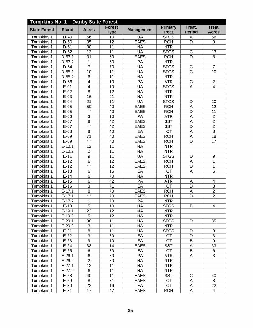
85
Tompkins No. 1 – Danby State Forest State Forest Stand Acres Forest
Type Management Primary Treat.
Treat. Period
Treat. Acres
Tompkins 1 D-49 56 10 UA STGS A 56 Tompkins 1 D-50 35 12 EAES RCH D 9 Tompkins 1 D-51 30 11 NA NTR Tompkins 1 D-52 13 11 UA STGS C 13 Tompkins 1 D-53.1 31 60 EAES RCH D 8 Tompkins 1 D-53.2 1 60 PA NTR Tompkins 1 D-54 7 70 UA STGS C 7 Tompkins 1 D-55.1 10 11 UA STGS C 10 Tompkins 1 D-55.2 6 11 NA NTR Tompkins 1 D-56 4 10 PA ATR C 2 Tompkins 1 E-01 4 10 UA STGS A 4 Tompkins 1 E-02 8 12 NA NTR Tompkins 1 E-03 16 21 NA NTR Tompkins 1 E-04 21 11 UA STGS D 20 Tompkins 1 E-05 50 40 EAES RCH A 12 Tompkins 1 E-05 “ ” 40 EAES RCH D 11 Tompkins 1 E-06 3 10 PA ATR A 2 Tompkins 1 E-07 8 42 EAES SST A 2 Tompkins 1 E-07 “ ” 42 EAES SST D 2 Tompkins 1 E-08 8 40 EA ICT A 8 Tompkins 1 E-09 71 40 EAES RCH A 18 Tompkins 1 E-09 “ ” 40 EAES RCH D 17 Tompkins 1 E-10.1 12 11 NA NTR Tompkins 1 E-10.2 2 11 NA NTR Tompkins 1 E-11 9 11 UA STGS D 9 Tompkins 1 E-12 6 12 EAES RCH A 1 Tompkins 1 E-12 “ ” 12 EAES RCH D 1 Tompkins 1 E-13 6 16 EA ICT A 6 Tompkins 1 E-14 6 70 NA NTR Tompkins 1 E-15 6 42 PA ATR A 4 Tompkins 1 E-16 3 71 EA ICT D 3 Tompkins 1 E-17.1 8 70 EAES RCH A 2 Tompkins 1 E-17.1 “ ” 70 EAES RCH D 2 Tompkins 1 E-17.2 1 70 PA NTR Tompkins 1 E-18 5 10 UA STGS B 4 Tompkins 1 E-19.1 23 12 NA NTR Tompkins 1 E-19.2 5 12 NA NTR Tompkins 1 E-20.1 38 11 UA STGS D 35 Tompkins 1 E-20.2 3 11 NA NTR Tompkins 1 E-21 8 11 UA STGS D 8 Tompkins 1 E-22 3 70 EA ICT D 3 Tompkins 1 E-23 9 10 EA ICT B 9 Tompkins 1 E-24 33 14 EAES SST A 33 Tompkins 1 E-25 6 70 EA ICT B 6 Tompkins 1 E-26.1 6 30 PA ATR A 3 Tompkins 1 E-26.2 2 30 NA NTR Tompkins 1 E-27.1 12 11 NA NTR Tompkins 1 E-27.2 6 11 NA NTR Tompkins 1 E-28 40 11 EAES SST C 40 Tompkins 1 E-29 8 71 EAES ICT A 8 Tompkins 1 E-30 22 16 EA ICT A 22 Tompkins 1 E-31 17 47 EAES RCH A 4

86
Tompkins No. 1 – Danby State Forest State Forest Stand Acres Forest
Type Management Primary Treat.
Treat. Period
Treat. Acres
Tompkins 1 E-31 “ ” 47 EAES RCH D 4 Tompkins 1 E-32 22 41 UA STGS D 22 Tompkins 1 E-33 8 14 NA NTR Tompkins 1 E-34 17 11 UA STGS C 17 Tompkins 1 E-35 12 70 EAES RCH A 3 Tompkins 1 E-35 “ ” 70 EAES RCH D 3 Tompkins 1 E-36 6 10 UA STGS C 6 Tompkins 1 E-37 18 63 EUA ICT A 18 Tompkins 1 E-38 10 14 PA ATR C 5 Tompkins 1 E-39 16 21 EUA ICT D 15 Tompkins 1 E-40 4 21 EAES RCH D 2 Tompkins 1 E-41 5 21 EAES BHM A 2 Tompkins 1 E-41 “ ” 21 EAES BHM C 1 Tompkins 1 F-01 35 71 EUA ICT D 35 Tompkins 1 F-02 10 63 NA NTR Tompkins 1 F-03 2 21 PA ATR B 1 Tompkins 1 F-04 11 12 NA NTR Tompkins 1 F-05 43 40 EAES RCH A 11 Tompkins 1 F-06 7 10 PA ATR B 4 Tompkins 1 F-07 14 45 EUA ICT B 14 Tompkins 1 F-08 21 11 NA NTR Tompkins 1 F-09 35 11 UA STGS C 30 Tompkins 1 F-10 9 10 PA NTR Tompkins 1 F-11 29 60 EAES RCH A 10 Tompkins 1 F-12 4 11 UA STGS C 4 Tompkins 1 F-13 12 14 NA NTR Tompkins 1 F-14 12 12 NA NTR Tompkins 1 F-15 6 11 NA NTR Tompkins 1 F-16 15 11 UA STGS C 15 Tompkins 1 F-17 48 11 UA STGS C 48 Tompkins 1 F-18 37 10 UA STGS C 37 Tompkins 1 F-19 42 70 EAES RCH B 10 Tompkins 1 F-20 7 10 NA NTR Tompkins 1 F-21 41 47 EA ICT B 36 Tompkins 1 F-22 1 10 NA NTR Tompkins 1 F-23 9 11 UA STGS D 9 Tompkins 1 F-24 3 16 EA ICT A 3 Tompkins 1 F-25 18 41 EAES RCH D 5 Tompkins 1 F-26 4 12 NA NTR Tompkins 1 F-27 29 11 NA NTR Tompkins 1 F-28 27 11 UA STGS C 25 Tompkins 1 F-29 9 12 UA STGS C 9 Tompkins 1 F-30 43 12 EUA ICT B 40 Tompkins 1 F-31 11 11 NA NTR Tompkins 1 F-32 3 11 NA NTR Tompkins 1 F-33 13 70 EAES RCH B 3 Tompkins 1 F-34 3 10 NA NTR Tompkins 1 F-35 2 11 NA NTR Tompkins 1 F-36 29 12 UA STGS D 29 Tompkins 1 F-37 50 63 EA RCH B 25 Tompkins 1 F-38 19 60 EAES RCH B 10 Tompkins 1 F-39 19 11 EAES RCH B 9
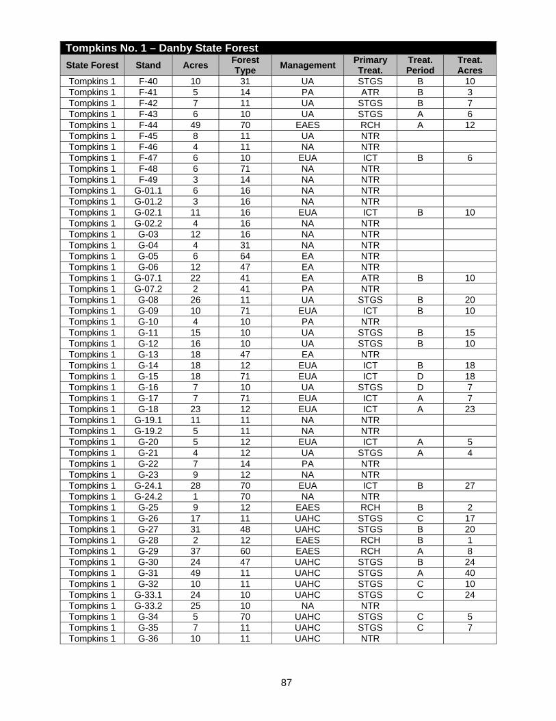
87
Tompkins No. 1 – Danby State Forest State Forest Stand Acres Forest
Type Management Primary Treat.
Treat. Period
Treat. Acres
Tompkins 1 F-40 10 31 UA STGS B 10 Tompkins 1 F-41 5 14 PA ATR B 3 Tompkins 1 F-42 7 11 UA STGS B 7 Tompkins 1 F-43 6 10 UA STGS A 6 Tompkins 1 F-44 49 70 EAES RCH A 12 Tompkins 1 F-45 8 11 UA NTR Tompkins 1 F-46 4 11 NA NTR Tompkins 1 F-47 6 10 EUA ICT B 6 Tompkins 1 F-48 6 71 NA NTR Tompkins 1 F-49 3 14 NA NTR Tompkins 1 G-01.1 6 16 NA NTR Tompkins 1 G-01.2 3 16 NA NTR Tompkins 1 G-02.1 11 16 EUA ICT B 10 Tompkins 1 G-02.2 4 16 NA NTR Tompkins 1 G-03 12 16 NA NTR Tompkins 1 G-04 4 31 NA NTR Tompkins 1 G-05 6 64 EA NTR Tompkins 1 G-06 12 47 EA NTR Tompkins 1 G-07.1 22 41 EA ATR B 10 Tompkins 1 G-07.2 2 41 PA NTR Tompkins 1 G-08 26 11 UA STGS B 20 Tompkins 1 G-09 10 71 EUA ICT B 10 Tompkins 1 G-10 4 10 PA NTR Tompkins 1 G-11 15 10 UA STGS B 15 Tompkins 1 G-12 16 10 UA STGS B 10 Tompkins 1 G-13 18 47 EA NTR Tompkins 1 G-14 18 12 EUA ICT B 18 Tompkins 1 G-15 18 71 EUA ICT D 18 Tompkins 1 G-16 7 10 UA STGS D 7 Tompkins 1 G-17 7 71 EUA ICT A 7 Tompkins 1 G-18 23 12 EUA ICT A 23 Tompkins 1 G-19.1 11 11 NA NTR Tompkins 1 G-19.2 5 11 NA NTR Tompkins 1 G-20 5 12 EUA ICT A 5 Tompkins 1 G-21 4 12 UA STGS A 4 Tompkins 1 G-22 7 14 PA NTR Tompkins 1 G-23 9 12 NA NTR Tompkins 1 G-24.1 28 70 EUA ICT B 27 Tompkins 1 G-24.2 1 70 NA NTR Tompkins 1 G-25 9 12 EAES RCH B 2 Tompkins 1 G-26 17 11 UAHC STGS C 17 Tompkins 1 G-27 31 48 UAHC STGS B 20 Tompkins 1 G-28 2 12 EAES RCH B 1 Tompkins 1 G-29 37 60 EAES RCH A 8 Tompkins 1 G-30 24 47 UAHC STGS B 24 Tompkins 1 G-31 49 11 UAHC STGS A 40 Tompkins 1 G-32 10 11 UAHC STGS C 10 Tompkins 1 G-33.1 24 10 UAHC STGS C 24 Tompkins 1 G-33.2 25 10 NA NTR Tompkins 1 G-34 5 70 UAHC STGS C 5 Tompkins 1 G-35 7 11 UAHC STGS C 7 Tompkins 1 G-36 10 11 UAHC NTR

88
Tompkins No. 1 – Danby State Forest State Forest Stand Acres Forest
Type Management Primary Treat.
Treat. Period
Treat. Acres
Tompkins 1 G-37.1 53 11 NA NTR Tompkins 1 G-37.2 7 11 NA NTR Tompkins 1 G-38.1 40 63 EUA ICT C 40 Tompkins 1 G-38.2 5 63 NA NTR Tompkins 1 G-39 12 14 EAES RCH C 3 Tompkins 1 G-40.1 27 54 EA ICT D 25 Tompkins 1 G-40.2 2 54 PA NTR Tompkins 1 G-41.1 13 70 EAES ICT/RCH B 4 Tompkins 1 G-41.2 2 70 EAES NTR Tompkins 1 G-41.3 3 70 EAES NTR Tompkins 1 G-41.4 11 70 PA NTR Tompkins 1 G-42.1 68 40 EA ICT/RCH B 68 Tompkins 1 G-42.2 23 40 EA NTR Tompkins 1 G-42.3 4 40 PA NTR Tompkins 1 G-42.4 3 40 EA NTR Tompkins 1 G-43 3 12 UAHC STGS B 3 Tompkins 1 G-44 30 40 UAHC ICT B 30 Tompkins 1 G-45 21 11 NA NTR Tompkins 1 G-45.1 2 11 NA NTR Tompkins 1 G-46.1 12 11 NA NTR Tompkins 1 G-46.2 1 11 PA NTR Tompkins 1 G-47 10 12 NA NTR Tompkins 1 G-48 30 12 EUA ICT D 28 Tompkins 1 G-49 16 22 NA NTR Tompkins 1 G-50 42 60 EAES RCH D 10 Tompkins 1 G-51 8 11 UA STGS B 8 Tompkins 1 G-52 3 10 UAHC STGS D 3 Tompkins 1 G-53 8 10 NA NTR Tompkins 1 G-54 33 41 UAHC STGS B 30 Tompkins 1 G-55 5 47 EUA ICT D 5 Tompkins 1 G-56 14 60 EAES RCH D 3 Tompkins 1 G-57 15 11 UA STGS B 15 Tompkins 1 G-58 11 71 UAHC STGS C 10 Tompkins 1 G-59 3 10 UAHC STGS C 3 Tompkins 1 G-60.1 22 11 UAHC STGS B 20 Tompkins 1 G-60.2 1 11 NA NTR Tompkins 1 G-61 27 11 UAHC STGS B 25 Tompkins 1 G-62.1 6 60 EUA NTR Tompkins 1 G-62.2 3 60 EUA NTR Tompkins 1 G-62.3 27 60 EUA ICT/RCH B 25 Tompkins 1 G-62.4 46 60 EUA ICT/RCH B 10 Tompkins 1 G-63 12 41 EUA ICT/RCH B 12 Tompkins 1 G-64 6 22 UA STGS C 6 Tompkins 1 G-65 15 12 EUA ICT C 15 Tompkins 1 G-66 30 12 EAES RCH C 8 Tompkins 1 G-67.1 8 11 UA STGS C 7 Tompkins 1 G-67.2 9 11 NA NTR Tompkins 1 G-68 14 11 UA STGS C 12 Tompkins 1 G-69 20 12 EAES RCH C 5 Tompkins 1 G-70 3 12 UA STGS C 3 Tompkins 1 NF 87 99
Total 7,337 4,163

89
Tompkins No. 3 – Shindagin Hollow State Forest
State Forest
Stand Acres Forest Type
Management Primary Treat.
Treat. Period
Treat. Acres
Tompkins 3 A-01 14 12 EUA ICT B 14 Tompkins 3 A-02.1 14 10 UA STGS B 14 Tompkins 3 A-02.2 4 10 NA NTR Tompkins 3 A-03 4 70 UA STGS B 4 Tompkins 3 A-04.1 16 70 UA STGS D 16 Tompkins 3 A-04.2 16 70 UA STGS D 16 Tompkins 3 A-05 9 71 UA STGS A 9 Tompkins 3 A-06 11 10 UA STGS B 11 Tompkins 3 A-07.1 16 12 EAES RCH A 4 Tompkins 3 A-07.1 “ ” 12 EAES RCH D 4 Tompkins 3 A-07.2 1 12 NA NTR Tompkins 3 A-08.1 11 12 EAES RCH A 3 Tompkins 3 A-08.2 1 12 NA NTR Tompkins 3 A-08.3 1 12 NA NTR Tompkins 3 A-09 21 10 UA STGS A 21 Tompkins 3 A-10 6 10 UA NTR Tompkins 3 A-11 35 16 EA ICT D 35 Tompkins 3 A-12 16 14 UA STGS A 16 Tompkins 3 A-13 27 12 UA STGS A 27 Tompkins 3 A-14 15 31 UA STGS B 15 Tompkins 3 A-15 8 71 UA STGS A 8 Tompkins 3 A-16 24 31 EA FSI C 24 Tompkins 3 A-17 22 32 UA STGS C 15 Tompkins 3 A-18 16 10 UA STGS D 12 Tompkins 3 A-19 39 10 UA STGS A 30 Tompkins 3 A-20.1 28 70 UA STGS C 24 Tompkins 3 A-21 10 12 NA NTR Tompkins 3 A-22 4 16 EA ICT A 4 Tompkins 3 A-23 28 16 EA ICT A 21 Tompkins 3 A-24 22 31 EUA ICT A 16 Tompkins 3 A-25 4 60 EUA ICT C 3 Tompkins 3 A-26 12 70 EUA ICT C 8 Tompkins 3 A-27 8 22 UA FSI C 5 Tompkins 3 A-28 19 70 EUA ICT C 15 Tompkins 3 A-29 18 14 UA STGS A 12 Tompkins 3 A-30 3 21 EUA ICT C 2 Tompkins 3 A-31 6 11 NA NTR Tompkins 3 A-32.1 29 61 EUA ICT C 20 Tompkins 3 A-32.2 2 61 UA STGS D 2 Tompkins 3 A-33.1 50 10 UA STGS D 40 Tompkins 3 A-33.2 1 10 NA NTR Tompkins 3 A-34 6 11 UA FSI A 4 Tompkins 3 A-35 25 16 EA ICT B 20 Tompkins 3 A-36 63 70 NA NTR Tompkins 3 A-37 19 19 UA STGS D 14 Tompkins 3 A-38 7 14 UA STGS B 7 Tompkins 3 A-39 18 70 UA STGS A 10 Tompkins 3 A-40 62 16 EUA ICT B 32 Tompkins 3 A-41 31 47 EAES RCH A 6 Tompkins 3 A-41 “ ” 47 EAES RCH D 6 Tompkins 3 A-42 33 40 EA SST A 13 Tompkins 3 A-42 “ ” 40 EA SST D 12 Tompkins 3 A-43 15 10 UA STGS A 10

90
Tompkins No. 3 – Shindagin Hollow State Forest State
Forest Stand Acres Forest
Type Management Primary
Treat. Treat. Period
Treat. Acres
Tompkins 3 A-44 24 12 EUA ICT A 18 Tompkins 3 A-45 20 60 EAES RCH D 4 Tompkins 3 A-46 11 19 NA NTR Tompkins 3 A-47 6 14 UA STGS A 4 Tompkins 3 A-48 24 47 EUA ICT A 18 Tompkins 3 A-49 4 14 EUA ICT A 2 Tompkins 3 A-50 9 12 EUA ICT A 7 Tompkins 3 A-51 4 10 NA NTR Tompkins 3 A-52 64 16 EUA ICT B 48 Tompkins 3 A-53 12 14 EA ICT A 8 Tompkins 3 A-54 43 40 EAES RCH D 8 Tompkins 3 A-55 4 12 EUA ICT A 2 Tompkins 3 A-56 5 10 EUA ICT B 3 Tompkins 3 A-57 32 47 EAES RCH D 8 Tompkins 3 A-57 1 99 NF NTR Tompkins 3 B-01 33 45 EUA ICT/RCH B 25 Tompkins 3 B-02 19 10 UA STGS D 18 Tompkins 3 B-03.1 52 41 EAES RCH D 10 Tompkins 3 B-03.2 5 41 UA STGS A 5 Tompkins 3 B-04 52 31 UA STGS A 40 Tompkins 3 B-05 9 70 UA STGS A 7 Tompkins 3 B-06 26 70 EAES RCH B 5 Tompkins 3 B-07 9 10 UA STGS D 9 Tompkins 3 B-08.1 5 45 NA NTR Tompkins 3 B-08.2 7 45 UAHC STGS B 7 Tompkins 3 B-09 10 10 UAHC STGS A 7 Tompkins 3 B-10 9 10 UAHC STGS B 7 Tompkins 3 B-11 24 31 UAHC STGS B 18 Tompkins 3 B-12 10 70 UAHC NTR Tompkins 3 B-13 11 22 UAHC STGS C 8 Tompkins 3 B-14.1 10 10 UAHC STGS A 8 Tompkins 3 B-14.2 3 10 NA NTR Tompkins 3 B-15 68 10 UAHC STGS D 60 Tompkins 3 B-16 11 70 UAHC STGS A 8 Tompkins 3 B-17 14 10 UAHC STGS A 10 Tompkins 3 B-18.1 3 47 NA NTR Tompkins 3 B-18.2 6 47 NA NTR Tompkins 3 B-18.3 1 47 NA NTR Tompkins 3 B-19.1 36 62 UA GS A 30 Tompkins 3 B-19.2 28 62 UAHC GS B 20 Tompkins 3 B-20 14 10 UAHC STGS A 10 Tompkins 3 B-21 5 10 NA NTR Tompkins 3 B-22 16 12 UAHC GS B 10 Tompkins 3 B-23 23 12 UAHC GS B 15 Tompkins 3 B-24 16 12 UAHC STGS A 10 Tompkins 3 B-25 11 10 PA ATR A 4 Tompkins 3 B-26 23 12 UAHC GS B 15 Tompkins 3 B-27 34 11 NA NTR Tompkins 3 B-28.1 52 41 UAHC GS C 40 Tompkins 3 B-28.2 10 41 UA GS C 8 Tompkins 3 B-28.3 22 41 UA GS C 18 Tompkins 3 B-28.4 2 41 NA NTR Tompkins 3 B-29 10 11 UAHC STGS B 8 Tompkins 3 B-30 13 31 UAHC STGS B 10

91
Tompkins No. 3 – Shindagin Hollow State Forest State
Forest Stand Acres Forest
Type Management Primary
Treat. Treat. Period
Treat. Acres
Tompkins 3 B-31 37 70 UAHC GS C 28 Tompkins 3 B-32 20 10 UAHC STGS B 15 Tompkins 3 B-33 5 10 UAHC STGS B 3 Tompkins 3 B-34 8 12 PA NTR Tompkins 3 B-35 6 12 NA NTR Tompkins 3 B-36.1 5 61 UA STGS C 5 Tompkins 3 B-36.2 11 61 UA STGS C 11 Tompkins 3 B-37 17 10 NA NTR Tompkins 3 B-38 42 19 NA NTR Tompkins 3 B-39 10 12 NA NTR Tompkins 3 B-40 19 31 UAHC STGS B 15 Tompkins 3 B-41 6 70 NA NTR Tompkins 3 B-42 8 12 NA NTR Tompkins 3 B-43 3 10 UA STGS C 3 Tompkins 3 B-44 20 10 UA STGS C 20 Tompkins 3 B-45 16 11 NA NTR Tompkins 3 B-46 8 12 UA STGS C 8 Tompkins 3 B-47 12 12 UA STGS C 12 Tompkins 3 B-48 17 12 EAES RCH A 4 Tompkins 3 B-48 “ ” 12 EAES RCH D 4 Tompkins 3 B-49 19 10 EAES RCH A 5 Tompkins 3 B-49 “ ” 10 EAES RCH D 5 Tompkins 3 B-50 “ ” 12 EAES RCH A 1 Tompkins 3 B-50 4 12 EAES RCH D 1 Tompkins 3 B-51 12 12 EAES RCH A 3 Tompkins 3 B-51 “ ” 12 EAES RCH D 3 Tompkins 3 B-52 28 10 UA NTR Tompkins 3 B-53 7 10 UA STGS B 7 Tompkins 3 B-54 7 32 EAES RCH A 2 Tompkins 3 B-54 “ ” 32 EAES RCH D 1 Tompkins 3 B-55 7 12 EAES RCH A 2 Tompkins 3 B-55 “ ” 12 EAES RCH D 2 Tompkins 3 B-56 36 31 UA STGS D 36 Tompkins 3 B-57 10 31 UA STGS D 7 Tompkins 3 B-58 7 12 UA STGS D 7 Tompkins 3 B-59.1 2 12 NA NTR Tompkins 3 B-59.2 12 12 NA NTR Tompkins 3 B-60 14 12 NA NTR Tompkins 3 C-01 4 31 UA STGS B 4 Tompkins 3 C-02 7 12 UA STGS B 7 Tompkins 3 C-03.1 9 14 EAES RCH B 2 Tompkins 3 C-03.2 1 14 NA NTR Tompkins 3 C-03.3 6 14 EAES RCH B 2 Tompkins 3 C-04.1 12 10 EAES RCH B 3 Tompkins 3 C-04.2 2 10 NA NTR Tompkins 3 C-05.1 8 19 EA ICT B 8 Tompkins 3 C-05.2 1 19 NA NTR Tompkins 3 C-06 80 12 EAES RCH B 20 Tompkins 3 C-07 9 10 UA STGS B 9 Tompkins 3 C-08 6 14 PA ATR B 3 Tompkins 3 C-09 24 22 NA NTR Tompkins 3 C-10 6 70 NA NTR Tompkins 3 C-11 13 31 NA NTR Tompkins 3 C-12 82 11 NA NTR

92
Tompkins No. 3 – Shindagin Hollow State Forest State
Forest Stand Acres Forest
Type Management Primary
Treat. Treat. Period
Treat. Acres
Tompkins 3 C-13 9 12 UAHC STGS B 7 Tompkins 3 C-14 6 10 UAHC NTR Tompkins 3 C-15 24 14 UAHC STGS B 20 Tompkins 3 C-16 19 60 UAHC STGS A 15 Tompkins 3 C-17 35 48 UAHC STGS A 30 Tompkins 3 C-18 26 10 UAHC NTR Tompkins 3 C-19 8 51 NA NTR Tompkins 3 C-20 12 40 NA NTR Tompkins 3 C-21 18 14 NA NTR Tompkins 3 C-22 3 11 PA NTR Tompkins 3 C-23 4 12 NA NTR Tompkins 3 C-24 1 11 NA NTR Tompkins 3 C-25 2 31 NA NTR Tompkins 3 C-26 3 40 NA NTR Tompkins 3 C-27 4 45 NA NTR Tompkins 3 C-28 5 10 NA NTR Tompkins 3 D-01 16 43 UAHC STGS A 16 Tompkins 3 D-02 36 70 UAHC STGS B 36 Tompkins 3 D-03 7 21 NA NTR Tompkins 3 D-04.1 6 20 NA NTR Tompkins 3 D-04.2 3 20 NA NTR Tompkins 3 D-04.3 6 20 NA NTR Tompkins 3 D-05 6 32 NA NTR Tompkins 3 D-06 14 49 NA NTR Tompkins 3 D-07 8 68 EUA NTR Tompkins 3 D-08 3 12 UAHC STGS B 3 Tompkins 3 D-09 19 11 NA NTR Tompkins 3 D-10 13 22 NA NTR Tompkins 3 D-11 12 21 NA NTR Tompkins 3 D-12 14 11 UAHC STGS C 14 Tompkins 3 D-13 19 10 UA STGS B 19 Tompkins 3 D-14 12 99 NF NTR Tompkins 3 D-15 9 16 UAHC STGS B 9 Tompkins 3 D-16 38 11 NA NTR Tompkins 3 D-17 40 10 UAHC STGS C 40 Tompkins 3 D-18 6 10 UAHC STGS C 6 Tompkins 3 D-19 18 68 UAHC NTR Tompkins 3 D-20 4 15 NA NTR Tompkins 3 D-21 5 49 NA NTR Tompkins 3 D-22 11 16 NA NTR Tompkins 3 D-23 9 32 PA ATR B 3 Tompkins 3 D-24 14 19 NA NTR Tompkins 3 D-25 3 10 NA NTR Tompkins 3 D-26 55 11 UAHC STGS C 50 Tompkins 3 D-27 55 71 UAHC STGS A 55 Tompkins 3 D-28 12 10 UAHC STGS C 12 Tompkins 3 D-29 7 42 NA NTR Tompkins 3 D-30 29 32 PA ATR A 10 Tompkins 3 D-31 4 12 NA NTR Tompkins 3 D-32 4 14 NA NTR Tompkins 3 D-33 12 70 NA NTR Tompkins 3 D-34 9 14 NA NTR Tompkins 3 D-35 7 31 NA NTR Tompkins 3 D-36 11 11 NA NTR

93
Tompkins No. 3 – Shindagin Hollow State Forest State
Forest Stand Acres Forest
Type Management Primary
Treat. Treat. Period
Treat. Acres
Tompkins 3 D-37 5 31 NA NTR Tompkins 3 D-38 22 19 UAHC STGS C 22 Tompkins 3 D-39 27 40 EUA NTR Tompkins 3 D-40 20 11 NA NTR Tompkins 3 D-41 91 14 EAES RCH A 20 Tompkins 3 D-41 “ ” 14 EAES RCH D 20 Tompkins 3 D-42 13 11 UA STGS B 13 Tompkins 3 D-43 4 31 EA NTR Tompkins 3 D-44 16 70 EAES RCH A 4 Tompkins 3 D-44 " “ 70 EAES RCH D 4 Tompkins 3 D-45 11 31 EA ICT B 11 Tompkins 3 D-46 4 10 UA STGS B 4 Tompkins 3 D-47 4 14 EAES RCH A 1 Tompkins 3 D-47 “ ” 14 EAES RCH D 1 Tompkins 3 D-48 24 70 UA STGS A 24 Tompkins 3 D-49 9 14 EAES RCH A 2 Tompkins 3 D-49 “ ” 14 EAES RCH D 2 Tompkins 3 D-50 7 12 EAES RCH A 2 Tompkins 3 D-50 “ ” 12 EAES RCH D 2 Tompkins 3 D-51 6 11 UA STGS B 6 Tompkins 3 D-52 9 12 UA STGS B 9 Tompkins 3 D-53 10 12 UA STGS B 10 Tompkins 3 E-01 72 61 EA SST C 16 Tompkins 3 E-02.1 60 10 UA STGS A 60 Tompkins 3 E-02.2 20 10 UA ICT C 20 Tompkins 3 E-02.3 1 10 UA STGS D 1 Tompkins 3 E-03.11 9 14 EAES RCH C 3 Tompkins 3 E-03.12 1 14 UA STGS C 1 Tompkins 3 E-03.2 1 14 PA NTR Tompkins 3 E-04 10 71 EUA ICT C 10 Tompkins 3 E-05.1 1 10 EA NTR Tompkins 3 E-05.2 1 10 NA NTR Tompkins 3 E-05.3 4 10 EA NTR Tompkins 3 E-06.1 14 70 EAES SST C 4 Tompkins 3 E-06.2 2 70 NA NTR Tompkins 3 E-06.3 15 70 EAES SST C 4 Tompkins 3 E-07 8 14 EAES RCH C 2 Tompkins 3 E-08.1 17 14 EAES NTR Tompkins 3 E-08.2 7 40 EAES RCH C 2 Tompkins 3 E-09 8 10 EAES RCH C 2 Tompkins 3 E-10.1 40 70 EAES SST C 10 Tompkins 3 E-10.2 1 14 UA NTR Tompkins 3 E-10.3 1 14 UA NTR Tompkins 3 F-01 23 45 EUA ICT D 23 Tompkins 3 F-02 5 10 UA STGS A 3 Tompkins 3 F-02 “ ” 10 UA STGS B 2 Tompkins 3 F-03.1 9 70 EAES NTR Tompkins 3 F-03.2 1 70 NA NTR Tompkins 3 F-03.3 5 70 EAES NTR Tompkins 3 F-04.1 32 40 EAES RCH D 4 Tompkins 3 F-04.2 21 14 EAES NTR Tompkins 3 F-04.3 3 14 EAES NTR Tompkins 3 F-05 45 61 EUA NTR Tompkins 3 F-06 8 53 EUA ICT B 8

94
Tompkins No. 3 – Shindagin Hollow State Forest State
Forest Stand Acres Forest
Type Management Primary
Treat. Treat. Period
Treat. Acres
Tompkins 3 F-07 20 10 UA STGS C 20 Tompkins 3 F-08 15 14 EAES RCH A 4 Tompkins 3 F-08 “ ” 14 EAES RCH D 4 Tompkins 3 F-09.1 7 70 EAES RCH A 2 Tompkins 3 F-09.1 “ ” 70 EAES RCH D 2 Tompkins 3 F-09.2 37 70 EAES RCH A 9 Tompkins 3 F-09.2 “ ” 70 EAES RCH D 9 Tompkins 3 F-10 12 10 UA STGS A 12 Tompkins 3 F-11 27 10 NA NTR Tompkins 3 F-12 7 14 UA STGS D 7 Tompkins 3 F-13.1 34 10 UA STGS A 34 Tompkins 3 F-13.2 13 10 UA NTR Tompkins 3 F-14 3 10 UA STGS A 3 Tompkins 3 F-15 12 70 UA STGS C 6 Tompkins 3 F-16 2 12 UA STGS C 2 Tompkins 3 F-17 11 12 UA STGS C 11 Tompkins 3 F-18 23 11 NA NTR Tompkins 3 F-19 18 14 EAES RCH A 5 Tompkins 3 F-19 “ ” 14 EAES RCH D 4 Tompkins 3 F-20 27 10 UA STGS C 27 Tompkins 3 F-21 7 10 UA STGS C 7 Tompkins 3 F-22 9 70 EAES RCH A 2 Tompkins 3 F-22 “ ” 70 EAES RCH D 2 Tompkins 3 F-23 4 10 UA NTR Tompkins 3 F-24 5 31 EA SST D 5 Tompkins 3 F-25.1 108 10 UA STGS D 10 Tompkins 3 F-25.2 11 10 UA NTR Tompkins 3 F-25.3 3 10 UA NTR Tompkins 3 F-25.4 7 10 UA NTR Tompkins 3 F-26 14 70 EAES RCH A 4 Tompkins 3 F-26 “ ” 70 EAES RCH D 3 Tompkins 3 F-27 27 31 EA ICT B 27 Tompkins 3 F-28 46 31 UA STGS B 46 Tompkins 3 F-29 18 22 NA NTR Tompkins 3 F-30.1 2 10 UA STGS D 5 Tompkins 3 F-30.2 3 10 UA NTR Tompkins 3 F-31 15 31 EA ICT D 15 Tompkins 3 F-32 6 11 UA NTR Tompkins 3 F-33 6 22 UA NTR Tompkins 3 F-34 36 70 EAES RCH A 9 Tompkins 3 F-34 “ ” 70 EAES RCH D 9 Tompkins 3 F-35 22 14 EAES RCH A 6 Tompkins 3 F-35 “ ” 14 EAES RCH D 5 Tompkins 3 F-36 10 14 EAES RCH A 3 Tompkins 3 F-36 “ ” 14 EAES RCH D 2 Tompkins 3 F-37 20 14 EAES RCH A 5 Tompkins 3 F-37 “ ” 14 EAES RCH D 5 Tompkins 3 F-38 7 10 UA STGS C 7 Tompkins 3 F-39 8 12 UA STGS C 8 Tompkins 3 F-40 11 10 UA STGS C 11 Tompkins 3 F-41 10 12 EAES RCH A 3 Tompkins 3 F-41 “ ” 12 EAES RCH D 2 Tompkins 3 F-42 24 31 UA STGS C 20 Tompkins 3 F-43 9 21 UA STGS D 6

95
Tompkins No. 3 – Shindagin Hollow State Forest State
Forest Stand Acres Forest
Type Management Primary
Treat. Treat. Period
Treat. Acres
Tompkins 3 F-44 12 10 NA NTR Tompkins 3 F-45 27 12 EAES RCH A 4 Tompkins 3 F-45 “ ” 12 EAES RCH D 3 Tompkins 3 F-46 5 10 UA STGS C 5 Tompkins 3 F-47 14 10 UA STGS C 14 Tompkins 3 F-48 6 10 EAES RCH D 3 Tompkins 3 G-01 6 42 EUA ICT D 5 Tompkins 3 G-02 4 10 UA STGS B 4 Tompkins 3 G-03 25 11 NA NTR Tompkins 3 G-04 5 10 UA STGS B 5 Tompkins 3 G-05 4 31 NA NTR Tompkins 3 G-06 5 70 UA STGS B 5 Tompkins 3 G-07 7 11 NA NTR Tompkins 3 G-08 12 12 UA STGS B 12 Tompkins 3 G-09 3 10 NA NTR Tompkins 3 G-10 3 12 NA NTR Tompkins 3 G-11 7 10 NA NTR Tompkins 3 G-12 6 11 NA NTR Tompkins 3 G-13.1 5 11 NA NTR Tompkins 3 G-13.2 10 11 NA NTR Tompkins 3 G-14 10 11 NA NTR Tompkins 3 G-15 9 11 NA NTR Tompkins 3 G-16 8 31 UA STGS B 8 Tompkins 3 G-17 11 70 EAES NTR Tompkins 3 G-18.1 39 60 EAES RCH D 10 Tompkins 3 G-18.2 10 60 EAES NTR Tompkins 3 G-19 2 99 NF NTR Tompkins 3 G-20 19 14 EAES RCH D 5 Tompkins 3 G-21.1 12 10 UA STGS B 14 Tompkins 3 G-21.2 3 10 UA NTR Tompkins 3 G-22.1 31 10 UA STGS B 30 Tompkins 3 G-22.2 2 10 UA NTR Tompkins 3 G-23.1 4 10 UA STGS B 4 Tompkins 3 G-23.2 19 10 UA NTR Tompkins 3 G-24.1 6 10 UA STGS B 6 Tompkins 3 G-24.2 17 10 UA NTR Tompkins 3 G-25.1 6 10 UA STGS B 6 Tompkins 3 G-25.2 2 10 UA NTR Tompkins 3 G-26 22 10 UA STGS B 22 Tompkins 3 G-27 32 15 NA NTR Tompkins 3 G-28 7 14 EUA ICT D 6 Tompkins 3 G-29 35 14 EAES RCH D 9 Tompkins 3 NF 87 99 NF
Total 5,287 2,694

96
A2. Facility Maintenance and Improvement Projects by Priority – (20 Year Planning Period)
Project Description Year(s) EstimatedTotal Cost Priority L&F
Days Ops. Days
Vol. Days
Other Days
Annual Projects Mark and inspect homeowner firewood, commercial product sales and wildlife habitat improvement projects as staff, markets and weather permit (averaging about 343 acres per year if the plan is fully implemented).
Annually Not applicable 1 3,350.0
Coordination with DEC ANNR volunteer partners.
Annually 1 30.0 15.0
Coordination with other agencies or DEC Division, including DEC Forest Rangers, Environmental Conservation Officers, and highway departments.
Annually 1 40.0 10.0
Monitor forest health, including participating in the annual aerial survey over the region.
Annually 1 40.0 10.0
Administration of temporary revocable permits (TRP’s) for special events.
Annually 1 60.0 20.0
Inspect and maintain the FLT and Abbott Loop; clear downfall; inspect and repair trail registers; maintain the scenic vista at Thatcher’s Pinnacles (Danby State Forest)
Annually (Volunteers) 1 10.0 250.0
Maintain the FLT and Chestnut/Tamarack/Shindagin lean-tos.
Annually (Volunteers) 1 10.0 400.0
Inspect and maintain the mountain bike trail network on Shindagin Hollow, clear brush and clear deadfall.
Annually (Volunteers) 1 20.0 10.0 825.0
Inspect, maintain and groom the snowmobile trail network; clear deadfall.
Annually (Volunteers) 1 0.0 800.0
Trash pickup on the Unit (each spring). Continue to work with AANR volunteer partners, town highway departments and correction camp crews to pick up trash.
Annually (Volunteers) (Town)
(Camp Crews)
1 10.0 20.0 40.0 40.0
Remove trash from staging areas (typically town facilities).
Annually $15,000 1 20.0
Mow the 3.2 miles of road shoulder of Ekroos Rd. on Shindagin Hollow
Annually (Town) 1 0.0 40.0
Plow the 1.6 mile Edroos Rd. PFAR Annually (Town) 1 0.0 200.0 Grade the 1.6 mile Edroos Rd PFAR Annually (Town) 1 0.0 20.0 Annual Project Total $15,000.00 3,550.0 125.0 2,315.
0 300.0
Acquisition Projects Fee simple acquisition and/or purchase of development rights through conservation easements to consolidate boundary lines and/or to provide landscape connectivity for wildlife and recreationists as described by the Emerald necklace in the New York State 2006 Open Space Plan
Multiple $8,403,540.00 2 400.0 2,000.0
New Projects State Forest Project Description Tompkins 3 Install waterbars and broad-
based dips as shown on the Stewardship Needs Map with a trail dozer (SWECO) or similar machine
2012 $5,000.00 1 2.0 3.0

97
A-2. Facility Maintenance and Improvement Projects by Priority – (20 Year Planning Period)
Project Description Year(s) EstimatedTotal Cost Priority L&F
Days Ops. Days
Vol. Days
Other Days
Tompkins 3 Design, develop and install a two panel kiosk with input from AANR volunteers at the northern most Brearley Hill Rd. parking lot; develop a brochure. Install 1 (new) and replace 1 large State Forest identification signs.
2012
$7,500.00 1 7.0 2.0 2.0 2.0
Tompkins 1 Create a 2,500 foot trail by-pass to take the Spencer-Van Etten snowmobile trail off of the shoulder of Heisy Rd. Work will be done as an amendment to the snowmobile club’s AANR. Consult with neighbors and the town supervisor before building the reroute.
2013 (Volunteers) 2 2.0 10.0
Tompkins 1 Upgrade Diane’s Crossing parking lot; build a two or three panel kiosk and design interpretive panel with input from AANR volunteers. Install 2 (new) and replace 1 large State Forest identification sign.
2013 $8,500.00 1 5.0 4.0 2.0
Tompkins 1 Build a new 3 to 4 car parking lot on Michigan Hollow Rd. to serve the south section of the Abbott Loop (see Stewardship Needs Map).
2013 $4,000.00 3 0.5 2.0
Tompkins 1 Replace the Chestnut lean-to (DEC to provide support with materials and technical staff).
2014 $5,250.00 1 2.0 10.0 100.0
Tompkins 1 Build and install 6 heavy duty gates – 15 feet wide – to restrict ATV and 4x4 traffic, especially on the snowmobile trail network (see the Stewardship Needs Map for locations). Large 3 to 4 ton rocks may be needed in some instances to supplement the gates.
2015 $15,000.00 3 1.0 15.0
Tompkins 3 Rehabilitate and resurface the 1.6 mile Ekroos Rd.
2023 $100,000.00 1 2.0 45.0
New Project Total $145,250.00 21.5 81.0 114.0 2.0Periodic Projects Tompkins 1 Tompkins 3
Paint and maintain 68.4 miles of boundary lines; replace small State Forest ID signs along maintained roads, spacing signs at about 660 feet apart. Replace witness posts as needed.
2018 2026
$20,000.00 1 2.0 150.0
Tompkins 1 Tompkins 3
Address the outstanding survey requests as described in section L. of this plan as resources allow.
2012-2026
$50,000.00 2 5.0 40.0
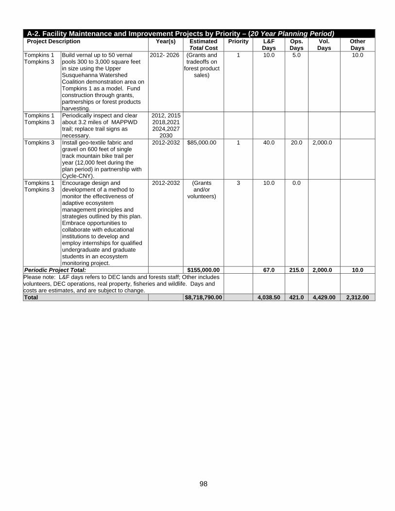
98
A-2. Facility Maintenance and Improvement Projects by Priority – (20 Year Planning Period) Project Description Year(s) Estimated
Total Cost Priority L&F
Days Ops. Days
Vol. Days
Other Days
Tompkins 1 Tompkins 3
Build vernal up to 50 vernal pools 300 to 3,000 square feet in size using the Upper Susquehanna Watershed Coalition demonstration area on Tompkins 1 as a model. Fund construction through grants, partnerships or forest products harvesting.
2012- 2026
(Grants and tradeoffs on
forest product sales)
1 10.0 5.0 10.0
Tompkins 1 Tompkins 3
Periodically inspect and clear about 3.2 miles of MAPPWD trail; replace trail signs as necessary.
2012, 2015 2018,2021 2024,2027
2030
Tompkins 3 Install geo-textile fabric and gravel on 600 feet of single track mountain bike trail per year (12,000 feet during the plan period) in partnership with Cycle-CNY).
2012-2032 $85,000.00 1 40.0 20.0 2,000.0
Tompkins 1 Tompkins 3
Encourage design and development of a method to monitor the effectiveness of adaptive ecosystem management principles and strategies outlined by this plan. Embrace opportunities to collaborate with educational institutions to develop and employ internships for qualified undergraduate and graduate students in an ecosystem monitoring project.
2012-2032 (Grants and/or
volunteers)
3 10.0 0.0
Periodic Project Total: $155,000.00 67.0 215.0 2,000.0 10.0Please note: L&F days refers to DEC lands and forests staff; Other includes volunteers, DEC operations, real property, fisheries and wildlife. Days and costs are estimates, and are subject to change.
Total $8,718,790.00 4,038.50 421.0 4,429.00 2,312.00

99
A3. Amphibians and Reptiles Predicted or Confirmed by the NY GAP Analysis Program New York GAP Analysis Data – EMAP Hexagons 420, 423, 450 & 453 HERP Atlas Data – Willseyville and Speedsville Quads (shaded) Ref. No. Nature Conservancy Name Scientific Name Model Status
1 Allegheny Dusky Salamander Desmognathus ochrophaeus Confirmed & Predicted 2 Black Rat Snake Elaphe o. obsolete Confirmed & Predicted 3 Bullfrog Rana catesbeiana Confirmed & Predicted 4 Common Map Turtle Graptemys geographica Predicted 5 Common Mudpuppy Necturus maculosus Predicted 6 Common Snapping Turtle Chelydra s. serpentine Confirmed & Predicted 7 E. Ribbon Snake Thamnophis sauritus Predicted 8 Eastern American Toad Bfo a americanus Confirmed & Predicted 9 Eastern Milk Snake Lampropeltis t. triangulum Confirmed & Predicted 10 Gray Treefrog Hyla versicolor Confirmed & Predicted 11 Green Frog Rana clamitans melanota Confirmed & Predicted 12 Jefferson Salamander Ambystoma jeffersonianum Confirmed & Predicted 13 Jefferson Salamander Complex Amby stoma jeffersonianum x
laterale Predicted
15 Longtail Salamander Eurycea l. longicauda Predicted 16 N. Red Salamander Psaudotriton r. ruber Confirmed & Predicted 17 Northern Black Racer Coluber c. constrictor Predicted 18 Northern Brown Snake Storeria d. dekayi Confirmed & Predicted 19 Northern Coal Skink Eumeces a. anthracinus Confirmed & Predicted 20 Northern Dusky Salamander Desmognathus fuscus Confirmed & Predicted 21 Northern Leopard Frog Rana pipiens Confirmed & Predicted 22 Northern Redback Salamander Plethodon c. incereus Confirmed & Predicted 23 Northern Redbelly Snake Storeria o. occipitomaculata Confirmed & Predicted 24 Northern Ringneck Snake Diadophis punctatus edwardsii Confirmed & Predicted 25 Northern Slimy Salamander Plethodon glutinosus Confirmed & Predicted 26 Northern Spring Peeper Pseudacris c. crucifer Confirmed & Predicted 27 Northern Spring Salamander Gyrinophilus p. porphyriticus Confirmed & Predicted 28 Northern Tow-lined Salamander Eurycea bislineata Confirmed & Predicted 29 Northern Water Snake Nerodia s. sipedon Confirmed & Predicted 30 Painted Turtle Chrysemys picta Confirmed & Predicted 31 Pickerel frog Rana palustris Confirmed & Predicted 32 Ribbon Snake Thamnophis s. sauritus Confirmed & Predicted 33 Red-spotted Newt Notophthalmus v. viridescens Confirmed & Predicted 34 Smooth Green Snake Liochlorophis vernalis Confirmed & Predicted 35 Spotted Salamander Ambystoma maculatum Confirmed & Predicted 36 Spotted Turtle Clemmys guttata Predicted 37 Timber Rattlesnake Crotalus horridus Predicted 38 Western Chorus Frog Pseudacris triseriata Predicted 39 Wood Frog Rana sylvatica Confirmed & Predicted 40 Wood Turtle Clemmys insculpta Confirmed & Predicted
Please note: Shaded species are found in the Wilseyville and Speedsville USGS quadrangles of the New York State Reptile and Amphibian Reptile (also known as HERP Atlas Project. Additionally, data from the NY GAP project was reviewed with regional wildlife biologists and edited based on their recommendations. Additional information on the HERP Atlas Project is available at http://www.dec.ny.gov/animals/7140.html.

100
A4. Mammals Predicted or Confirmed by the New York GAP Analysis Data New York GAP Analysis Data – EMAP Hexagons 420, 423, 450 & 453 Ref. No. Nature Conservancy Name Scientific Name Model Status
1 American Beaver Castor canadensis Confirmed & Predicted 2 Big Brown Bat Eptesicus fuscus Confirmed & Predicted 3 Black Bear Ursus americanus Predicted 4 Bobcat Lynx rufus Predicted 5 Common Muskrat Ondatra zibethicus Confirmed & Predicted 6 Common Raccoon Procyon lotor Confirmed & Predicted 7 Coyote Canis latrans Confirmed & Predicted 8 Deer Mouse Peromyscus maniculatus Confirmed & Predicted 9 E. small-footed Myotis Myotis leibii Predicted 10 Eastern Chipmunk Tamias striatus Confirmed & Predicted 11 Eastern Cottontail Sylvilagus floridanus Confirmed & Predicted 12 Eastern Gray Squirrel Sciurus carolinensis Confirmed & Predicted 13 Eastern Pipistrelle Pipistrellus subflavus Predicted 14 Eastern Red Bat Lasiurus borealis Confirmed & Predicted 15 Fisher Martes pennanti Predicted 16 Fox Squirrel Sciurus niger Confirmed & Predicted 17 Gray Fox Urocyon cinereoargentus Confirmed & Predicted 18 Hairy-tailed Mole Parascalops breweri Confirmed & Predicted 19 Hoary Bat Lasiurus cinereus Confirmed & Predicted 20 House Mouse Mus musculus Confirmed & Predicted 21 Indiana Myotis Myotis sodalis Predicted 22 Least Shrew Cryptotis parva Predicted 23 Little Brown Myotis Myotis lucifugus Confirmed & Predicted 24 Long-tailed Weasel Mustela frenata Confirmed & Predicted 25 Masked Shrew Sorex cinereus Confirmed & Predicted 26 Meadow Jumping Mouse Zapus hudsonius Confirmed & Predicted 27 Meadow Vole Microtus pennsylvanicus Confirmed & Predicted 28 Mink Mustela vison Confirmed & Predicted 29 N. Short-tailed Shrew Blarina brevicauda Confirmed & Predicted 30 Northern Flying Squirrel Glaucomys sabrinus Confirmed & Predicted 31 Northern Myotis (Keen's) Myotis Myotis septentrionalis Confirmed & Predicted 32 Norway Rat Rattus norvegicus Confirmed & Predicted 33 Porcupine Erethizon dorsatum Predicted 34 Pygmy Shrew Sorex hoyi Predicted 35 Red Fox Vulpes vulpes Confirmed & Predicted 36 Red Squirrel Tamiasciurus hudsonicus Confirmed & Predicted 37 River Otter Lutra canadensis Confirmed & Predicted 38 Short-tailed Weasel (Ermine) Mustela erminea Confirmed & Predicted 39 Silver-haired Bat Lasionycteris noctivagans Confirmed & Predicted 40 Smoky Shrew Sorex fumeus Confirmed & Predicted 41 Snowshoe Hare Lepus americanus Confirmed & Predicted 42 Southern Bog Lemming Synaptomys cooperi Confirmed & Predicted 43 Southern Flying Squirrel Glaucomys volans Confirmed & Predicted 44 Southern Red-backed Vole Clethrionomys gapperi Confirmed & Predicted 45 Star-nosed Mole Condylura cristata Confirmed & Predicted 46 Striped Skunk Mephitis mephitis Confirmed & Predicted 47 Virginia Opossum Didelphis virginiana Confirmed & Predicted 48 White-footed Mouse Peromyscus leucopus Confirmed & Predicted 49 White-tailed Deer Odocoileus virginianus Confirmed & Predicted 50 Woodchuck Marmota monax Confirmed & Predicted 51 Woodland Jumping Mouse Napaeozapus insignis Confirmed & Predicted 52 Woodland Vole Microtus pinetorum Confirmed & Predicted

101
A5. Birds Predicted or Confirmed by the New York GAP Analysis Data New York GAP Analysis Data – EMAP Hexagons 420, 423, 450 & 453 Ref. No. Nature Conservancy Name Scientific Name Model Status
1 Acadian Flycatcher Empidonax virescens Confirmed and Predicted 2 Alder Flycatcher Empidonax alnorum Confirmed and Predicted 3 American Bittern Botaurus lentiginosus Confirmed and Predicted 4 American Black Duck Anas rubripes Confirmed and Predicted 5 American Coot Fulica americana Confirmed and Predicted 6 American Crow Corvus brachyrhynchos Confirmed and Predicted 7 American Goldfinch Carduelis tristis Confirmed and Predicted 8 American Kestrel Falco sparverius Confirmed and Predicted 9 American Redstart Setophaga ruticilla Confirmed and Predicted 10 American Robin Turdus migratorius Confirmed and Predicted 11 American Wigeon Anas americana Predicted 12 American Woodcock Scolopax minor Confirmed and Predicted 13 Bald Eagle Haliaeetus leucocephalus Predicted 14 Baltimore Oriole Icterus galbula Confirmed and Predicted 15 Bank Swallow Riparia riparia Confirmed and Predicted 16 Barn Swallow Hirundo rustica Confirmed and Predicted 17 Barred Owl Strix varia Confirmed and Predicted 18 Belted Kingfisher Ceryle alcyon Confirmed and Predicted 19 Black Tern Chlidonias niger Confirmed and Predicted 20 Black-and-white Warbler Mniotilta varia Confirmed and Predicted 21 Black-billed Cuckoo Coccyzus erythropthalmus Confirmed and Predicted 22 Blackburnian Warbler Dendroica fusca Confirmed and Predicted 23 Black-capped Chickadee Parus atricapillus Confirmed and Predicted 24 Black-Crowned Night-Heron Nycticorax nycticorax Confirmed and Predicted 25 Black Blue Warbler Dendroica caerulescens Confirmed and Predicted 26 Blue Jay Cyanocitta cristata Confirmed and Predicted 27 Blue-Gray Gnatcatcher Polioptila caerulea Confirmed and Predicted 28 Blue-headed Vireo Vireo solitarus Confirmed and Predicted 29 Blue-winged Teal Anas discors Confirmed and Predicted 30 Blue-winged Warbler Vermivora pinus Confirmed and Predicted 31 Bobolink Dolichonyx oryzivorus Confirmed and Predicted 32 Broad-winged Hawk Buteo platypterus Confirmed and Predicted 33 Brown Creeper Certhia americana Confirmed and Predicted 34 Brown Thrasher Toxostoma rufum Confirmed and Predicted 35 Brown-headed Cowbird Molothrus ater Confirmed and Predicted 36 Canada Goose Branta canadensis Confirmed and Predicted 37 Canada Warbler Wilsonia canadensis Confirmed and Predicted 38 Carolina Wren Thryothorus ludovicianus Confirmed and Predicted 39 Cedar Waxwing Bombycilla cedrorum Confirmed and Predicted 40 Cerulean Warbler Dendroica cerulea Confirmed and Predicted 41 Chestnut-sided Warbler Dendroica pensylvanica Confirmed and Predicted 42 Chimney Swift Chaetura pelagica Confirmed and Predicted 43 Chipping Sparrow Spizella passerina Confirmed and Predicted 44 Cliff Swallow Hirundo pyrrhonota Confirmed and Predicted 45 Common Barn-Owl Tyto alba Confirmed and Predicted 46 Common Grackle Quiscalus quiscula Confirmed and Predicted 47 Common Merganser Mergus merganser Confirmed and Predicted 48 Common Moorhen Gallinula chloropus Confirmed and Predicted 49 Common Nighthawk Chordeiles minor Confirmed and Predicted

102
A-5. Birds Predicted or Confirmed by the New York GAP Analysis Data New York GAP Analysis Data – EMAP Hexagons 420, 423, 450 & 453 Ref. No. Nature Conservancy Name Scientific Name Model Status
50 Common Raven Corvus corax Confirmed and Predicted 51 Common Snipe Gallinago gallinago Confirmed and Predicted 52 Common Yellowthroat Geothlypis trichas Confirmed and Predicted 53 Cooper's Hawk Accipiter cooperii Confirmed and Predicted 54 Dark-eyed Junco Junco hyemalis Confirmed and Predicted 55 Downy Woodpecker Picoides pubescens Confirmed and Predicted 56 Eastern Bluebird Sialia sialis Confirmed and Predicted 57 Eastern Kingbird Tyrannus tyrannus Confirmed and Predicted 58 Eastern Meadowlark Sturnella magna Confirmed and Predicted 59 Eastern Phoebe Sayornis phoebe Confirmed and Predicted 60 Eastern Screech-Owl Otus asio Confirmed and Predicted 61 Eastern Towhee Pipilo erythrophthalmus Confirmed and Predicted 62 Eastern Wood-Pewee Contopus virens Confirmed and Predicted 63 European Starling Sturnus vulgaris Confirmed and Predicted 64 Evening Grosbeak Coccothraustes verspertinus Confirmed and Predicted 65 Field Sparrow Spizella pusilla Confirmed and Predicted 66 Fish Crow Corvus ossifragus Confirmed 67 Gadwall Anas strepera Confirmed and Predicted 68 Golden-crowned Kinglet Regulus satrapa Confirmed and Predicted 69 Golden-winged Warbler Vermivora chrysoptera Confirmed and Predicted 70 Grasshopper Sparrow Ammodramus savannarum Confirmed and Predicted 71 Gray Catbird Dumetella carolinensis Confirmed and Predicted 72 Great Blue Heron Ardea herodias Confirmed and Predicted 73 Great Crested Flycatcher Myiarchus crinitus Confirmed and Predicted 74 Great Horned Owl Bubo virginianus Confirmed and Predicted 75 Green Heron Butorides virescens Confirmed and Predicted 76 Green-winged Teal Anas crecca Predicted 77 Hairy Woodpecker Picoides villosus Confirmed and Predicted 78 Henslow's Sparrow Ammodramus henslowii Confirmed and Predicted 79 Hermit Thrush Catharus guttatus Confirmed and Predicted 80 Hooded Merganser Lophodytes cucullatus Confirmed and Predicted 81 Hooded Warbler Wilsonia citrina Confirmed and Predicted 82 Horned Lark Eremophila alpestris Confirmed and Predicted 83 House Finch Carpodacus mexicanus Confirmed 84 House Sparrow Passer domesticus Confirmed and Predicted 85 House Wren Troglodytes aedon Confirmed and Predicted 86 Indigo Bunting Passerina cyanea Confirmed and Predicted 87 Kentucky Warbler Oporornis formosus Confirmed 88 Killdeer Charadrius vociferus Confirmed and Predicted 89 King Rail Rallus elegans Confirmed and Predicted 90 Least Bittern Ixobrychus exilis Confirmed and Predicted 91 Least Flycatcher Empidonax minimus Confirmed and Predicted 92 Loggerhead Shrike Lanius ludovicianus Predicted 93 Long-eared Owl Asio otus Predicted 94 Louisiana Waterthrush Seiurus motacilla Confirmed and Predicted 95 Magnolia Warbler Dendroica magnolia Confirmed and Predicted 96 Mallard Anas platyrhynchos Confirmed and Predicted 97 Marsh Wren Cistothorus palustris Confirmed and Predicted 98 Mourning Dove Zenaida macroura Confirmed and Predicted 99 Mourning Warbler Oporornis philadelphia Confirmed and Predicted
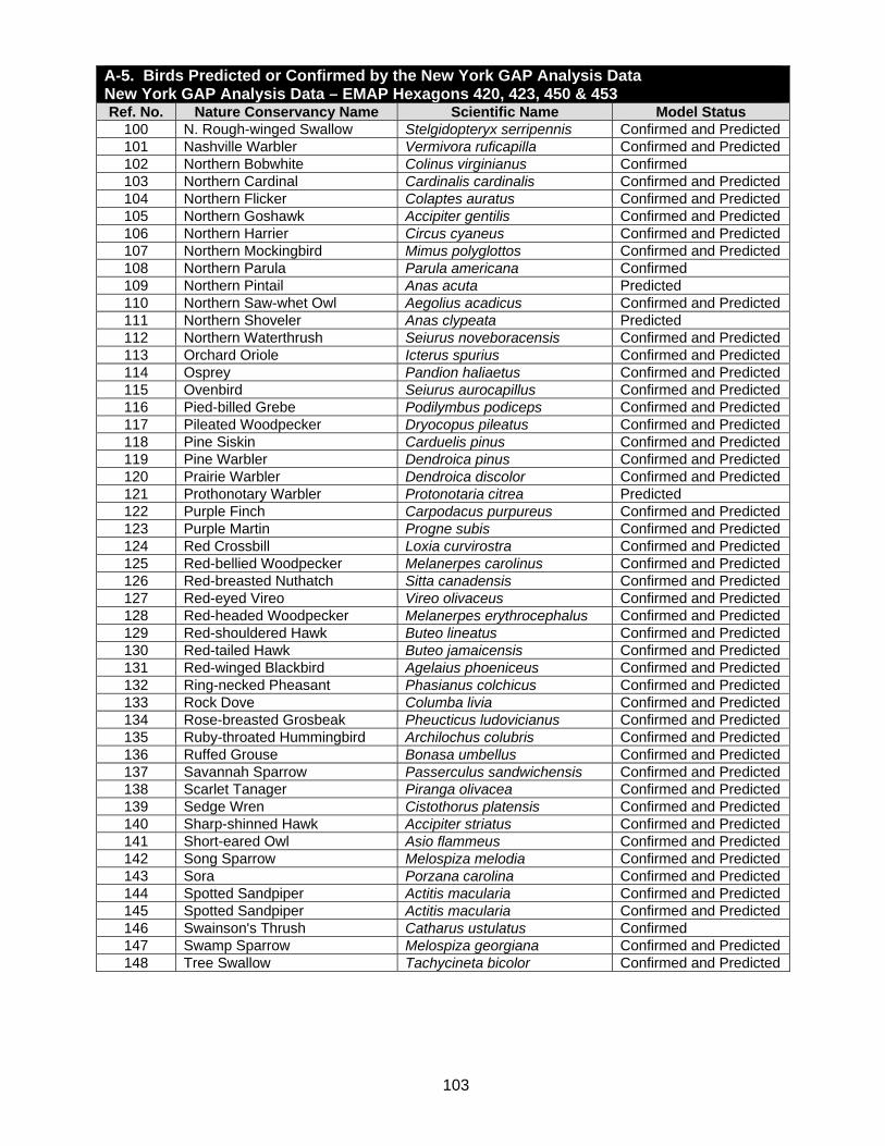
103
A-5. Birds Predicted or Confirmed by the New York GAP Analysis Data New York GAP Analysis Data – EMAP Hexagons 420, 423, 450 & 453 Ref. No. Nature Conservancy Name Scientific Name Model Status
100 N. Rough-winged Swallow Stelgidopteryx serripennis Confirmed and Predicted 101 Nashville Warbler Vermivora ruficapilla Confirmed and Predicted 102 Northern Bobwhite Colinus virginianus Confirmed 103 Northern Cardinal Cardinalis cardinalis Confirmed and Predicted 104 Northern Flicker Colaptes auratus Confirmed and Predicted 105 Northern Goshawk Accipiter gentilis Confirmed and Predicted 106 Northern Harrier Circus cyaneus Confirmed and Predicted 107 Northern Mockingbird Mimus polyglottos Confirmed and Predicted 108 Northern Parula Parula americana Confirmed 109 Northern Pintail Anas acuta Predicted 110 Northern Saw-whet Owl Aegolius acadicus Confirmed and Predicted 111 Northern Shoveler Anas clypeata Predicted 112 Northern Waterthrush Seiurus noveboracensis Confirmed and Predicted 113 Orchard Oriole Icterus spurius Confirmed and Predicted 114 Osprey Pandion haliaetus Confirmed and Predicted 115 Ovenbird Seiurus aurocapillus Confirmed and Predicted 116 Pied-billed Grebe Podilymbus podiceps Confirmed and Predicted 117 Pileated Woodpecker Dryocopus pileatus Confirmed and Predicted 118 Pine Siskin Carduelis pinus Confirmed and Predicted 119 Pine Warbler Dendroica pinus Confirmed and Predicted 120 Prairie Warbler Dendroica discolor Confirmed and Predicted 121 Prothonotary Warbler Protonotaria citrea Predicted 122 Purple Finch Carpodacus purpureus Confirmed and Predicted 123 Purple Martin Progne subis Confirmed and Predicted 124 Red Crossbill Loxia curvirostra Confirmed and Predicted 125 Red-bellied Woodpecker Melanerpes carolinus Confirmed and Predicted 126 Red-breasted Nuthatch Sitta canadensis Confirmed and Predicted 127 Red-eyed Vireo Vireo olivaceus Confirmed and Predicted 128 Red-headed Woodpecker Melanerpes erythrocephalus Confirmed and Predicted 129 Red-shouldered Hawk Buteo lineatus Confirmed and Predicted 130 Red-tailed Hawk Buteo jamaicensis Confirmed and Predicted 131 Red-winged Blackbird Agelaius phoeniceus Confirmed and Predicted 132 Ring-necked Pheasant Phasianus colchicus Confirmed and Predicted 133 Rock Dove Columba livia Confirmed and Predicted 134 Rose-breasted Grosbeak Pheucticus ludovicianus Confirmed and Predicted 135 Ruby-throated Hummingbird Archilochus colubris Confirmed and Predicted 136 Ruffed Grouse Bonasa umbellus Confirmed and Predicted 137 Savannah Sparrow Passerculus sandwichensis Confirmed and Predicted 138 Scarlet Tanager Piranga olivacea Confirmed and Predicted 139 Sedge Wren Cistothorus platensis Confirmed and Predicted 140 Sharp-shinned Hawk Accipiter striatus Confirmed and Predicted 141 Short-eared Owl Asio flammeus Confirmed and Predicted 142 Song Sparrow Melospiza melodia Confirmed and Predicted 143 Sora Porzana carolina Confirmed and Predicted 144 Spotted Sandpiper Actitis macularia Confirmed and Predicted 145 Spotted Sandpiper Actitis macularia Confirmed and Predicted 146 Swainson's Thrush Catharus ustulatus Confirmed 147 Swamp Sparrow Melospiza georgiana Confirmed and Predicted 148 Tree Swallow Tachycineta bicolor Confirmed and Predicted

104
A-5. Birds Predicted or Confirmed by the New York GAP Analysis Data New York GAP Analysis Data – EMAP Hexagons 420, 423, 450 & 453 Ref. No. Nature Conservancy Name Scientific Name Model Status
149 Tufted Titmouse Parus bicolor Confirmed and Predicted 150 Turkey Vulture Cathartes aura Confirmed and Predicted 151 Upland Sandpiper Bartramia longicauda Confirmed and Predicted 152 Veery Catharus fuscescens Confirmed and Predicted 153 Vesper Sparrow Pooecetes gramineus Confirmed and Predicted 154 Virginia Rail Rallus limicola Confirmed and Predicted 155 Warbling Vireo Vireo gilvus Confirmed and Predicted 156 Whip-poor-will Caprimulgus vociferus Confirmed and Predicted 157 White-breasted Nuthatch Sitta carolinensis Confirmed and Predicted 158 White-eyed Vireo Vireo griseus Confirmed and Predicted 159 White-throated Sparrow Zonotrichia albicollis Confirmed and Predicted 160 White-winged Crossbill Loxia leucoptera Confirmed 161 Wild Turkey Meleagris gallopavo Confirmed 162 Willow Flycatcher Empidonax traillii Confirmed 163 Winter Wren Troglodytes troglodytes Confirmed 164 Wood Duck Aix sponsa Confirmed 165 Wood Thrush Hylocichla mustelina Confirmed 166 Worm-eating Warbler Helmitheros vermivorus Confirmed 167 Yellow Warbler Helmitheros vermivorus Confirmed 168 Yellow-bellied Sapsucker Sphyrapicus varius Confirmed 169 Yellow-billed Cuckoo Coccyzus americanus Confirmed 170 Yellow-breasted Chat Icteria virens Confirmed 171 Yellow-rumped Warbler Dendroica coronata Confirmed 172 Yellow-throated Vireo Vireo flavifrons Confirmed 173 Yellow-throated Warbler Dendroica dominica Predicted

105
A6. Breeding Bird Atlas Data Blocks 3768A, 3768B, 3768C, 3768D, 3868A, 3868B, 3868C, 3868D
Common Name Scientific Name Breed Class
New York Status
Global Rank*
State Rank**
Acadian Flycatcher Empidonax viresens X1 Protected G5 Alder Flycatcher Empidonax alnorum D2 Protected G5 American Bittern Botaurus lentiginosus S2 Protected-
Special Concern G4
American Black Duck Anas rubripes P2 Game Species G4 American Coot Fulica americana X1 Game Species G5 American Crow Corvus brachyrhynchos FL Game Species G5 American Goldfinch Carduelis tristis NY Protected G5 American Kestrel Falco sparverius ON Protected G5 American Redstart Setophaga ruticilla FL Protected G5 American Robin Turdus migratorius NY Protected G5 American Woodcock Scolopax minor ON Game Species G5 Baltimore Oriole Icterus galbula FL Protected G5 Bank Swallow Riparia riparia ON Protected G5 Barn Swallow Hirundo rustica NY Protected G5 Barred Owl Strix varia T2 Protected G5 Belted Kingfisher Ceryle alcyon ON Protected G5 Black-and-white Warbler Mniotilta varia FL Protected G5 Black-billed Cuckoo Coccyzus rethropthalmus DD Protected G5 Black-capped Chickadee Poecile atricapillus FL Protected G5 Black-throated Blue Warbler
Dendroica caerulescens NE Protected G5
Black-throated Green Warbler
Dendroica virens FL Protected G5
Blackburnian Warbler Dendroica fusca DD Protected G5 Blue Jay Cyanocitta cristata FL Protected G5 Blue-gray Gnatcatcher Polioptila caerulea S2 Protected G5 Blue-headed Vireo Vireo solitarius FL Protected G5 Blue-winged Warbler Vermivora pinus FL Protected G5 Bobolink Dolichonyx oryzivorus FY Protected G5 Broad-winged Hawk Buteo platypterus FL Protected G5 Brown Creeper Certhia americana DD Protected G5 Brown-headed Cowbird Molothrus ater FL Protected G5 Brown Thrasher Toxostoma rufum DD Protected G5 Canada Goose Branta canadensis FL Game Species G5 Canada Warbler Wilsonia canadensis FY Protected G5 Carolina Wren Thryothorus ludovicianus S2 Protected G5 Cedar Waxwing Bombycilla cedrorum FY Protected G5 Chestnut-sided Warbler Dendroica pensylvanica FL Protected G5 Chimney Swift Chaetura pelagica N2 Protected G5 Chipping Sparrow Spizella passerina FL Protected G5 Common Grackle Quiscalus quiscula FL Protected G5 Common Moorhen Gallinula chloropus S2 Games Species G5 Common Raven Corvus corax FL Protected G5 Common Yellowthroat Geothlypis trichas FL Protected G5 Cooper's Hawk Accipiter cooperii FL Protected-
Special Concern G4

106
A-6. Breeding Bird Atlas Data Blocks 3768A, 3768B, 3768C, 3768D, 3868A, 3868B, 3868C, 3868D
Common Name Scientific Name Breed Class
New York Status
Global Rank*
State Rank**
Dark-eyed Junco Junco hyemalis FL Protected G5 S5 Downy Woodpecker Picoides pubescens FL Protected G5 S5 Eastern Bluebird Sialia sialis FL Protected-
Special Concern G5 S5
Eastern Kingbird Tyrannus tyrannus FL Protected G5 S5 Eastern Meadowlark Sturnella magna T2 Protected G5 S5 Eastern Phoebe Sayornis phoebe FL Protected G5 S5 Eastern Screech-Owl Megascops asio T2 Protected G5 S5 Eastern Towhee Pipilo erythrophthalmus FY Protected G5 S5 Eastern Wood-Pewee Contopus virens FL Protected G5 S5 European Starling Sturnus vulgaris FL Unprotected G5 SE Field Sparrow Spizella pusilla FL Protected G5 S5 Golden-crowned Kinglet Regulus satrapa FL Protected G5 S5 Gray Catbird Dumetella carolinensis FL Protected G5 S5 Great Blue Heron Ardea herodias ON Protected G5 S5 Great Crested Flycatcher Myiarchus crinitus ON Protected G5 S5 Great Horned Owl Bubo virginianus FL Protected G5 S5 Green Heron Butorides virescens P2 Protected G5 S5 Hairy Woodpecker Picoides villosus FL Protected G5 S5 Hermit Thrush Catharus guttatus DD Protected G5 S5 Hooded Merganser Lophodytes cullatus FL Games Species G5 S4 Hooded Warbler Wilsonia citrina DD Protected G5 S5 Horned Lark Eremophila alpestris ON Protected-
Special Concern G5 S5
House Finch Carpodacus mexicanus FL Protected G5 SE House Sparrow Passer domesticus FL Unprotected G5 SE House Wren Troglodytes aedon NY Protected G5 S5 Indigo Bunting Passerina cyanea FL Protected G5 S5 Killdeer Charadrius vociferus NY Protected G5 S5 Least Flycatcher Empidonax minimus FY Protected G5 S5 Louisiana Waterthrush Seiurus motacilla DD Protected G5 S5 Magnolia Warbler Dendroica magnolia FL Protected G5 S5 Mallard Anas platyrhynchos FL Game Species G5 S5 Mourning Dove Zenaida macroura FL Protected G5 S5 Mourning Warbler Oporornis philadelphia DD Protected G5 S5 Nashville Warbler Vermivora ruficapilla FY Protected G5 S5 Northern Cardinal Cardinalis cardinalis FL Protected G5 S5 Northern Flicker Colaptes auratus FL Protected G5 S5 Northern Harrier Circus cyaneus FL Threatened G5 S3 Northern Mockingbird Mimus polyglottos X1 Protected G5 S5 Northern Rough-winged Swallow
Stelgidopteryx serripennis X1 Protected G5 S5
Northern Saw-whet Owl Aegolious acadicus FL Protected G5 S3 Northern Waterthrush Seiurus noveboracensis FL Protected G5 S5 Osprey Pandion haliaetus X1 Protected-
Special Concern G5 S4
Ovenbird Seiurus aurocapillus FL Protected G5 S5 Pied-billed Grebe Podilymbus podiceps FL Threatened G5 S3

107
A-6. Breeding bird Atlas Data Blocks 3768A, 3768B, 3768C, 3768D, 3868A, 3868B, 3868C, 3868D
Common Name Scientific Name Breed Class
New York Status
Global Rank*
State Rank**
Pileated Woodpecker Dryocopus pileatus FY Protected G5 S5 Pine Siskin Carduelis pinus X1 Protected G5 S5 Praire Warbler Dendroica discolor FL Protected G5 S5 Purple Finch Carpodacus purpureus NY Protected G5 S5 Red-bellied woodpecker Melanerpes carolinus FL Protected G5 S5 Red-eyed Vireo Vireo olivaceus FL Protected G5 S5 Red-shouldered Hawk Buteo lineatus FL Threatened G5 S4 Red-tailed Hawk Buteo jamaicensis FL Protected G5 S5 Red-winged Blackbird Agelaius phoeniceus FL Protected G5 S5 Ring-necked Pheasant Phasianus colchicus S2 Game Species G5 SE Rock Pigeon Columba livia FY Unprotected G5 SE Rose-breasted Grosbeak Pheucticus ludovicianus FL Protected G5 S5 Ruby-throated Hummingbird
Archilochus colubris ON Protected G5 S5
Ruffed Grouse Bonasa umbellus FL Game Species G5 S5 Savannah Sparrow Passerculus sandwichensis FL Protected G5 S5 Scarlet Tanager Piranga olivacea DD Protected G5 S5 Sharp-shinned Hawk Accipiter striatus FL Protected G5 S4 Song Sparrow Melospiza melodia FL Protected G5 S5 Spotted Sandpiper Actitis macularia P2 Protected G5 S5 Swamp Sparrow Melospiza georgiana FL Protected G5 S5 Tree Swallow Tachycineta bicolor FL Protected G5 S5 Tufted Titmouse Baeolophus bicolor FL Protected G5 S5 Turkey Vulture Cathartes aura P2 Protected G5 S4 Veery Catharus fuscescens FL Protected G5 S5 Virginia Rail Rallus limicola X1 Game Species G5 S5 Warbling Vireo Vireo gilvus DD Protected G5 S5 White-breasted Nuthatch Sitta carolinensis FL Protected G5 S5 White-throated Sparrow Zonotrichia albicollis DD Protected G5 S5 Wild Turkey Meleagris gallopavo FL Game Species G5 S5 Willow Flycatcher Empidonax traillii DD Protected G5 S5 Winter Wren Troglodytes troglodytes FL Protected G5 S5 Wood Duck Aix sponsa FL Game Species G5 S5 Wood Thrush Hylocichla mustelina FL Protected G5 S5 Worm-eating Warbler Helmitheros vermivorus FY Protected G5 S4 Yellow-bellied Sapsucker Sphyrapicus varius FL Protected G5 S5 Yellow-billed Cuckoo Coccyzus americanus X1 Protected G5 S5 Yellow-rumped Warbler Dendroica coronata FL Protected G5 S5 Yellow-throated Vireo Vireo flavifrons T2 Protected G5 S5 Yellow Warbler Dendroica petechia FY Protected G5 S5
108
Key to Breeding Bird Atlas Field Codes Protection Status (Federal) - Federal legal status as of January 1994. MBTA - Migratory Bird Treaty Act. Protection Status (State of New York) - New York State legal status as of January 1994.
Game Species - (defined in Environmental Conservation Law section 11-0103): any of a variety of big game or small game species as stated in the Environmental Conservation Law; many normally have an open season for at least part of the year, and are protected at other times.
Protected - (defined in Environmental Conservation Law section 11-0103): wild game, protected wild birds, and endangered species of wildlife. Protected - Special (Concern) - those species which are not yet recognized as endangered or threatened, but for which documented concern exists for their continued welfare in New York. Unlike the first two categories, species of special concern receive no additional legal protection under Environmental Conservation Law section 11-0535 (Endangered and Threatened Species).
Global and State Ranks Each element has a global and state rank as determined by the New York Natural Heritage Program. These ranks carry no legal weight. The global rank reflects the rarity of the element throughout the world and the state rank reflects the rarity within New York State. Infraspecific taxa are also assigned a taxon rank to reflect the infraspecific taxon's rank throughout the world. Global Rank - New York Natural Heritage program global rank as of January 1994. G1: Critically imperiled; typically 5 or fewer occurences or 1,000 or fewer individuals G2: Imperiled; typically 6 to 20 occurrences or 1,000 to 3,000 individuals G3 Rare or uncommon but not imperiled; typically 21 to 100 occurrences or 3,000 to 10,000 individuals G4 Uncommon but not rare; apparently secure, but with cause for some long-term concern; usually more than 100 occurrences or 10,000 individuals G5 Common; demonstrably widespread, abundant, and secure. G3: Rare or uncommon but not imperiled; typically 21 to 100 occurrences or 3,000 to 10,000 individuals. G4: Uncommon but not rare; apparently secure, but with cause for some long-term concern; usually more than 100 occurrences or 10,000 individuals G5: Common; demonstrably widespread, abundant, and secure. State Rank - The state rank reflects the rarity of the animal within New York State S1: Typically 5 or fewer occurrences, very few remaining individuals, acres, or miles of stream, or some factor of its biology making it especially vulnerable in New York State. S2: Typically 6 to 20 occurrences, few remaining individuals, acres, or miles of stream, or factors demonstrably making it very vulnerable in New York State. S3: Typically 21 to 100 occurrences, limited acreage, or miles of stream in New York State. S4: Apparently secure in New York State. S5: Demonstrably secure in New York State. SE: Exotic, not native to New York State.

109
A7. Possible Sites for Vernal Pool Creation
Unit Stand Forest Type Soil type X Y
Tompkins 1 F30 12 Tuller channery silt loam 380777 4681775Tompkins 1 F30 12 Tuller channery silt loam 380833 4682054Tompkins 1 D36 12 Volusia channery silt loam 379939 4682520Tompkins 1 D21 40 Volusia channery silt loam 378858 4683321Tompkins 1 G66 12 Volusia channery silt loam 382993 4683321Tompkins 1 D22 70 Lordstown soils, 379063 4683395Tompkins 1 C12 70 Mardin channery silt loam 378393 4684047Tompkins 1 G42 40 Mardin channery silt loam 382155 4684867Tompkins 1 C12 70 Mardin channery silt loam 378393 4684978Tompkins 1 E10 11 Volusia channery silt loam 379585 4685072Tompkins 1 G47 12 Lordstown soils 383235 4685072Tompkins 1 G46 11 Mardin channery silt loams 383049 4685109Tompkins 1 G37 11 Volusia channery silt loam 383030 4685407Tompkins 1 G31 11 Volusia channery silt loam 382714 4685537Tompkins 1 G37 11 Volusia channery silt loam 382956 4685574Tompkins 1 G27 48 Lordstown soils 382453 4685835Tompkins 1 A13 63 Bath channery silt loam 376624 4685984Tompkins 1 A10 71 Bath channery silt loam 376512 4686133Tompkins 1 B34 12 Volusia channery silt loam 376866 4686524Tompkins 1 B29 30 Chenango gravelly loam 378076 4686599Tompkins 1 B18 31 Bath and Valois soils 377666 4687139Tompkins 1 G07 41 Chenango gravelly loam 382825 4687325Tompkins 1 A03 70 Bath channery silt loam 376381 4687344Tompkins 3 F-41 12 Volusia channery silt loam 393725 4685337Tompkins 3 F-38 10 Volusia channery silt loam 393585 4685570Tompkins 3 F-22 70 Mardin channery silt loam 392731 4685757Tompkins 3 F-08 14 Volusia channery silt loam 391939 4686269Tompkins 3 F-10 10 Tuller channery silt loam 392390 4686331Tompkins 3 F-09.2 70 Volusia channery silt loam 392172 4686393Tompkins 3 F-01 45 Volusia channery silt loam 391737 4686657Tompkins 3 E-10.1 70 Tuller channery silt loam 393057 4686719Tompkins 3 E-08.1 14 Volusia channery silt loam 392793 4686844Tompkins 3 E-03.1 14 Volusia channery silt loam 392219 4686937Tompkins 3 E-01 61 Volusia channery silt loam 391582 4686952Tompkins 3 E-01 61 Tuller channery silt loam 391644 4687170Tompkins 3 C-17 48 Volusia channery silt loam 390278 4687729Tompkins 3 B-15 10 Volusia channery silt loam 389160 4688133Tompkins 3 A-33 10 Volusia channery silt loam 388244 4688164Tompkins 3 B-03 41 Volusia channery silt loam 388880 4688614Tompkins 3 A-21 12 Volusia channery silt loam 388709 4688847Tompkins 3 A-14 31 Volusia channery silt loam 388259 4689421Notes: Stand G37 (shaded) is the site of the Upper Susquehanna Vernal Pool Creation Project Forest Type Codes are the same as the treatment table.

110
A8. Streams in the Rapid Waters Unit with Fisheries Index Numbers Fisheries Index Number Stream Name Length (Miles) Braided Channel 0.3 ONT-66-12-P296-75-40A Unnamed Water 0.0 ONT-66-12-P296-75-5-38-2 Unnamed Water 0.5 SR-16-4-16-2 Unnamed Water 2.8 SR-16-4-16-2-10 Unnamed Water 0.4 SR-16-4-16-2-11 Unnamed Water 0.8 SR-16-4-16-2-13 Unnamed Water 0.3 SR-16-4-16-2-8 Unnamed Water 2.5 SR-16-4-16-2-8-2 Unnamed Water 0.0 SR-16-4-16-2-8-6 Unnamed Water 0.6 SR-16-4-16-2-8-8 Unnamed Water 0.3 SR-16-4-16-2-9 Unnamed Water 1.8 SR-16-4-16-2-9-1 Unnamed Water 0.2 SR-16-4-16-2-9-3 Unnamed Water 0.4 SR-16-4-16-4 Danby Creek 0.5 SR-16-4-16-4-4 Unnamed Water 0.2 SR-16-4-16-4-5A Unnamed Water 0.2 SR-16-4-16-4-7 Unnamed Water 0.0 SR-16-4-16-4-7A Unnamed Water 0.6 SR-16-4-16-4-9 Unnamed Water 0.1 SR-16-4-16-6-1 Unnamed Water 0.0 SR-16-4-25 Sulphur Springs Creek 0.8 SR-16-4-25-5 Sulphur Springs Creek 1.0 SR-16-4-25-5-A Unnamed Water 0.1 SR-16-4-25-6 Unnamed Water 0.3 SR-16-4-25-6A Unnamed Water 0.1 SR-16-4-28 Miller Creek 2.7 SR-16-4-28-1 Unnamed Water 1.5 SR-16-4-28-10 Unnamed Water 0.4 SR-16-4-28-1-3 Unnamed Water 2.0 SR-16-4-28-1-3-1 Unnamed Water 0.5 SR-16-4-28-4 Unnamed Water 0.2 SR-16-4-28-6 Unnamed Water 2.2 SR-16-4-28-6-1 Unnamed Water 0.9 SR-16-4-28-8 Unnamed Water 0.3 SR-16-4-P13-1 Michigan Creek 4.5 SR-16-4-P13-1-2 Unnamed Water 1.5 SR-16-4-P13-1-3 Unnamed Water 0.4 SR-16-4-P13-1-4 Unnamed Water 0.7 SR-16-4-P13-1-5 Unnamed Water 0.0 SR-16-4-P13-1-6 Unnamed Water 0.1 SR-16-4-P13-1-7 Unnamed Water 0.3 SR-16-7-11-4 Unnamed Water 0.9 SR-16-7-11-4-2 Unnamed Water 0.5 SR-16-7-11-6 Unnamed Water 0.1 SR-16-7-9 Unnamed Water 1.2 SR-16-7-9-5 Unnamed Water 0.5

111
A9. Taxes Paid on the Unit’s State Forests (2006 Tax Roll)
Town State Forest Acres Assessment Town Taxes
(Jan 07) School
Taxes (Sept 06)
Special District Taxes (Jan 07)
Candor Tompkins 1 25.75 $1,039.00 $82.00 $306.00 $29.00 Tompkins 3 587.35 $76,388.00 Caroline Tompkins 3 1419.55 $1,728,720.00 $12,716.00 $34497.00 $3,009.00 Spencer Tompkins 1 330.99 $61,764.00 $1,669.00 $4,826.00 $111.00 Danby Tompkins 1 6487.04 $5,637,600.00 $38,295.00 $110,920.00 $9,237.00 Total $8,850.68 $7,505,781.00 $57,533.00 $167,011.00 $14,085.00

112
A10. Previous Owners of the State Forests in Rapid Waters Unit Date
Acquired Acreage Former Owner(s) Town
2/20/1933 49.78 C. Manning Danby 2/20/1933 104.15 M. Wilcox Danby 2/20/1933 260.22 J.A. Weeks Danby 3/11/1933 58.80 E. Miller Danby 3/11/1933 78.03 S.S. Jones Danby 2/4/1948 60.00 OGS to DEC Danby 1/24/1956 180.58 USA-E. Traver Danby 1/24/1956 138.11 USA-E. Traver Danby 1/24/1956 198.40 USA-1st National Bank Danby 1/24/1956 183.00 USA-A. Garwood Danby 1/24/1956 122.80 USA-L. Elia Danby 1/24/1956 69.90 USA-M .& J.D. Reardon Danby 1/24/1956 109.58 USA-A.D. Traver Danby 1/24/1956 73.01 USA-A. & Q.R. Luoma Danby 1/24/1956 16.89 USA-A. & Q.R. Luoma Danby 1/24/1956 24.91 USA-A. & Q.R. Luoma Danby 1/24/1956 66.81 USA-P. Paajenen Danby 1/24/1956 12.00 USA-P. Paajenen Danby 1/24/1956 92.25 USA-L. & M. Harmon Danby 1/24/1956 50.00 USA-C.D. LaRue Est. Danby 1/24/1956 101.63 USA-C.L. LaRue Danby 1/24/1956 62.61 USA-J. Helbling Danby 1/24/1956 54.63 USA-M. L. Mosher Danby 1/24/1956 50.00 USA-F.& M.D. Martin Danby 1/24/1956 100.50 USA- .& I. Launon Danby 1/24/1956 100.00 USA- A.J. Scott Danby 1/24/1956 303.28 USA-T.S. Ward Danby 1/24/1956 103.00 USA-M.& L.A. Hill Danby 1/24/1956 108.02 USA-M. Crasper Danby-47.00, Candor-61.02
1/24/1956 191.32 USA-E. Bowan Danby-108.00, Spencer-83.32
1/24/1956 56.07 USA-H.& G. Burdick Danby-12.00, Spencer-44.07
1/24/1956 230.00 USA-M. Allen Danby-26.40, Spencer-203.60
1/24/1956 79.00 USA-M. Allen Danby 1/24/1956 25.59 USA-F.& E. Testut Danby 1/24/1956 45.58 USA- Farmer & Merchants National Bank Danby 1/24/1956 203.49 USA- Farmer & Merchants National Bank Danby

113
A-10. Previous Owners of the State Forests in the Rapid Waters Unit
Date Acquired Acreage Former Owner(s) Town
1/24/1956 54.88 USA-F.& E. McFall Danby 1/24/1956 52.01 USA-F.& E. McFall Danby 1/24/1956 88.90 USA-E.R. Granger Danby 1/24/1956 104.40 USA-E.R. Granger Danby 1/24/1956 78.80 USA -G.& M. Hulbert Danby 1/24/1956 144.33 USA-E. Dorn Danby
1/24/1956 188.59 USA- O. Ostrander & C.J. Grover Danby
1/24/1956 39.00 USA- . Smiley Danby 1/24/1956 33.94 USA-D.& M. Powers Danby 1/24/1956 85.96 USA-F.& F. Mettler Danby 1/24/1956 114.00 USA-H. Swayze Danby
1/24/1956 78.00 USA-.G. Head & J.C. Knuttunen Danby
1/24/1956 50.86 USA-G. Bastian Danby 1/24/1956 106.46 USA-F.& A. Parshall Danby 1/24/1956 35.29 USA-F.& A. Parshall Danby 1/24/1956 99.24 USA-R.& D. Cowles Danby 1/24/1956 134.60 USA-M. O’Brien Est. Danby 1/24/1956 50.88 USA-S. Alfred Seely Co. Danby 1/24/1956 123.96 USA- M. Bell Danby 1/24/1956 119.24 USA- .& H. Gulick Danby 1/24/1956 150.43 USA-C.& G. Grover Danby 1/24/1956 75.35 USA-A.J. Chase Danby 1/24/1956 50.82 USA-A.C.& M.E. Grant Danby 1/24/1956 51.71 USA-.C.& M.E. Grant Danby 1/24/1956 50.00 USA-R.& E. Longhouse Danby 1/24/1956 121.00 USA-R. L. Maxness Danby 1/24/1956 46.48 USA-M. Chaffee Danby 1/24/1956 37.99 USA-M. Chaffee Danby 1/24/1956 30.50 USA-S.B. Slighter Danby 1/24/1956 13.50 USA-S.B. Slighter Danby 1/24/1956 90.65 USA-R.W.& D. Loomis Danby 1/24/1956 144.00 USA-G.L. Baker Danby 1/24/1956 129.90 USA O.& J. Hutt Danby 1/24/1956 53.00 USA-O.M. Cummings Danby 1/24/1956 45.78 USA-E.S. Grant Ex. Danby 1/24/1956 120.79 USA-C.& E. Spongberg Danby

114
A-10. Previous Owners of the State Forests in the Rapid Waters Unit
Date Acquired Acreage Former Owner(s) Town
2/4/1960 -1.06 DEC to DOT Danby 1/17/1963 79.00 T. Heisey Danby 4/4/1963 100.00 W. J. Sedorus Danby 1/23/1964 147.49 V. Sprague Danby 12/27/85 174.36 Schlensinger Danby
12/30/1987 26.24 Glowacki Candor 8/20/1997 30.00 Lieberman Danby 8/20/1997 22.00 Lieberman Danby
Total Acres 7,337.21 Danby State Forest 6/26/1934 495.44 F.C. Cornell Caroline 6/26/1934 67.32 M. Quick Caroline 9/6/1934 237.32 E.L. Godfrey Caroline 9/6/1934 86.58 A.C. Tennant Caroline 7/10/1934 240.73 L. Swimelar Caroline 7/10/1934 106.05 R. Leonard Caroline 7/10/1934 47.13 Lee & Collens Caroline 7/10/1934 138.98 C.C. Stanley Caroline 1/24/1956 103.79 USA- Stickler Caroline 1/24/1956 51.04 USA-J.M.& W.M. Davis Caroline 1/24/1956 122.70 USA-A.J.&M. Weber Caroline 1/24/1956 93.70 USA-J.&F. Schmidt Caroline 1/24/1956 102.25 USA - .&M. Swimelar Caroline 1/24/1956 159.73 USA-A. & M. Stein Caroline 1/24/1956 264.99 USA-A.D.& E. M. Preston Caroline 1/24/1956 76.69 USA-L.L. Watkins Caroline 1/24/1956 96.61 USA-S.R. James Caroline 1/24/1956 221.74 USA-P. Symons Caroline 1/24/1956 161.00 USA-N. Symons Caroline 1/24/1956 145.41 USA-E. Harwardt Caroline 1/24/1956 86.04 USA-E.& S. May Caroline 1/24/1956 115.00 USA-J. Gee Caroline 1/24/1956 98.86 USA-E.G.& A. M. Barnum Caroline
1/24/1956 190.00 USA-Farmers & Traders Insurance Company Caroline
1/24/1956 100.00 USA-D.D. Mulholland Caroline 1/24/1956 128.07 USA-D.D. Mulholland Caroline 1/24/1956 24.28 USA-G. Brown Caroline

115
A-10. Previous Owners of the State Forests in the Rapid Waters Unit
Date Acquired Acreage Former Owner(s) Town
1/24/1956 37.01 USA-G. Brown Caroline 1/24/1956 53.55 USA-C.C. Vandermark Caroline 1/24/1956 100.10 USA-W.M. Quick Caroline 1/24/1956 121.05 USA-W. Hurd Est. Caroline 1/24/1956 50.37 USA-W. Hurd Est. Caroline 1/24/1956 17.96 USA-C. Legge Caroline 1/24/1956 51.22 USA-M.W. Chace Caroline 1/24/1956 12.06 USA-A. Travelli Caroline 1/24/1956 102.00 USA-F. Pratt Caroline 1/24/1956 36.13 USA-A.M. Foote Caroline 1/24/1956 73.75 USA-O. Cornelius Caroline 1/24/1956 61.96 USA-H. Eighmey Caroline 1/24/1956 204.88 USA-F.W. Hurd Candor-19.00, Caroline-185.88 1/24/1956 99.14 USA-S. Wood Candor-40.00, Caroline-59.14 1/24/1956 48.00 USA-L.D. Vandermark Candor-19.00, Caroline-185.88 1/24/1956 159.45 USA-A.M.& H.W. Foote Candor 1/24/1956 165.00 USA-L.C.& A.B. Millage Caroline 1/24/1956 37.56 USA-K. Cotter Caroline 1/24/1956 48.08 USA-.W. Fuller Caroline 1/24/1956 25.13 USA-R.& S. Dykeman Caroline 12/9/2010 21.00 Finger Lakes Land Trust (Gift) Caroline
Total Acres 5,286.85 Shindagin Hollow State Forest

116
A-11. Stratigraphic Profile of Southwestern New York (Modified after Van Tyne and Copley)
PERIOD GROUP UNIT LITHOLOGY
Pennsylvanian Pottsville Olean
quartz pebble conglomerate and sandstone, quartz pebble, conglomerate, sandstone, and minor shale
Mississippian Pocono Knapp
Devonian
Upper
Conewango shale and sandstone scattered conglomerates
Conneaut Chadakon shale and sandstone scattered conglomerates
Canadaway Undifferentiated oil/gas shale and siltstone
Perrysburg oil/gas minor sandstone
West Falls Java Nunda Rhinestreet
shale and siltstone apollaceous limestone
Sonyea Middlesex gas shale and siltstone
Genesee shale with minor siltstone and limestone
Middle
Tully gas limestone with minor siltstone and sandstone
Hamilton
Moscow Ludlowville Skaneateles Marcellus
gas
shale with minor sandstone and conglomerate
Onondaga oil/gas limestone
Lower Tristates Oriskany gas sandstone
Helderberg
Manlius Rondout limestone and
dolostone
Silurian
Upper
Akron oil/gas dolostone
Salina Camilus Syracuse Vernon
shale, siltstone, anhydrite, and ahlite
Lockport Lockport gas limestone and
dolostone
Clinton
Rochester Irondequoit Shale and sandstone
Lower
Sodus Reynales Thorold
Limestone and dolostone
Medina Grimsby Whirlpool
gas gas
sandstone and shale quartz sandstone

117
A-11. Stratigraphic Profile of Southwestern New York (Modified after Van Tyne and Copley)
PERIOD GROUP UNIT LITHOLOGY
Ordovician Upper
Queenston Oswego Lorraine Utica
gas gas
shale and siltstone with minor sandstone
Middle Trenton- Black River
Trenton Black River gas limestone and minor
dolostone
Cambrian Upper
Little Falls Galway (Theresa) Potsdam
gas gas
quartz sandstone and dolostone; sandstone and sandy dolostone; conglomerate base
Precambrian Gneiss, Marble, Quartzite
Metamorphic and igneous rocks
A12. Tree Planting Summary by Species – Rapid Waters Unit, 1934 to 1967
HARDWOODS SOFTWOODS Species Number Species Number Percentage
Black locust 153,300 Austrian pine 43,000 0.9Northern red oak 52,685 Balsam fir 34,600 0.8White oak 3,000 European larch 60,000 1.3Sugar maple 3,000 Eastern hemlock 30,000 0.7Total 211,985 Japanese larch 250,900 5.5Percentage 4.9 Jack pine 21,000 0.5 Norway spruce 453,825 10.0
TOP TEN SPECIES Red pine 1,574,100 35.0Species Rank Scotch pine 224,900 5.0
Red pine 1 Short leaf pine 13,000 0.3White pine 2 White cedar 122,850 2.7Norway spruce 3 White pine 1,062,745 23.7White spruce 4 White spruce 390,700 8.7Japanese larch 5 Scotch pine 6 White cedar 7 European larch 8 Austrian pine 9 Balsam fir 10 Total 4,281,620 95.1

118
A13. Department Rules, Regulations, Laws, and Policies A. New York Code Rules and Regulations Title 6 Chapter I Fish and Wildlife Chapter II Lands and Forests Chapter III Air Resources Chapter IV Quality Services Chapter V Resource Management Services Chapter VI State Environmental Quality Review Chapter VII Sub-Chapter A - Implementation of Environmental Quality Bond Act of
1972 Chapter X Division of Water Resources B. Environmental Conservation Laws ECL Article 8 Environmental Quality Review ECL Article 9 Lands and Forests ECL Article 11 Fish and Wildlife ECL Article 15 Water Resources ECL Article 23 Mineral Resources ECL Article 24 Freshwater Wetlands ECL Article 33 Pesticides ECL Article 51 Implementation of Environmental Quality Bond Act/1972 ECL Article 52 Implementation of Environmental Quality Bond Act/1972 ECL Article 71 Enforcement C. Other Laws New York State Historic Preservation Act Article 14 PRHPL Education Law Section 233 State Museum Collections D. Department Policies Public Use Prescribed Fire Temporary Revocable Permits State Forest Master Plan Motor Vehicle Use Inventory Timber Management Acquisition Unit Management Planning Road Construction Pesticides Recreational Use ATV use by People with CP-3 (MAPPWD) Permits

119
A14. Roads Open to Public Use in the Unit Road Name Road Jurisdiction and Type Mileage Danby State Forest Bald Hill Rd. Town - Public Road (Seasonal) 2.6 Comfort Rd. Town - Public Road (Plowed) 0.4 Curtis Rd. Town - Public Road (Seasonal) 1.5 Durfee Hill Rd. Town - Public Road (Seasonal) 0.7 Eastman Hill Rd. Town - Public Road (Seasonal) 0.4 Fisher Settlement Rd. Town - Public Road (Plowed) 2.0 Heisey Rd. Town - Public Road (Plowed) 0.1 Heisey Rd. Town - Public Road (Seasonal) 0.1 Hill Rd. Town - Public Road (Seasonal) 2.9 John Hill Rd. Town - Public Road (Seasonal) 0.3 John Hill Rd. Town - Public Road (Plowed) 0.1 La Rue Rd. Town - Public Road (Plowed) 0.5 La Rue Rd. Town - Public Road (Seasonal) 0.1 Michigan Hollow Rd. Town - Public Road (Plowed) 3.9 Peters Rd. Town - Public Road (Plowed) 0.2 Signor Hill Rd. Town - Public Road (Plowed) 0.8 Smiley Hill Rd. Town - Public Road (Seasonal) 0.5 South Danby Rd. County - Public Road (Plowed) 0.8 State Highway 96B State - Public Road (Plowed) 0.3 Station Rd. Town - Public Road (Plowed) 1.4 Travor Rd. Town - Public Road (Seasonal) 1.5
Shindagin Hollow State Forest
Bald Hill School House Rd. Town - Public Road (Seasonal) 1.4 Brearley Hill Rd. Town - Public Road (Plowed) 2.5 Bush Rd. Town - Public Road (Plowed) 0.3 Downy Rd. Town - Public Road (Seasonal) 0.7 Ekroos Rd. DEC - Public Access Road
(PFAR - Plowed through a TRP). 1.6
Gulf Creek Rd. Town - Public Road (Seasonal) 1.1 Honey Pot Rd. Town - Public Road (Plowed) 0.4 Hurd Hill Rd. Town - Public Road (Seasonal) 0.9 Leonard Rd. Town - Public Road (Seasonal) 0.5 Shindagin Hollow Rd. Town - Public Road (Seasonal) 3.0 Smith Rd. Town - Public Road (Seasonal) 1.3 South Rd. Town - Public Road (Plowed) 1.5
Total 36.3

120
A15. Special Management Zones (SMZ’s)
DEC Division of Lands and Forests Management Rules for Establishment of Special Management Zones on State Forests
Version: June 2008
Streams, Wetlands, Ponds, Lakes & Spring Seeps
Streams include naturally occurring perennial2 and intermittent1 drainages having defined channels . Special management zone4 widths are from the edge of high water channels or, for wetlands6, the edge of seasonally saturated soils. A spring seep is a permanent spring where water emerges from the ground and flows across the soil surface without defined bed and banks. The limits of the seep are demarked by the extent of surface water. All distances are in horizontal feet.
Activity Guidelines Mineral Exploration and Development
• Mineral Exploration: Refer to Guidelines for Seismic Testing on DEC Administered State Land Draft 12/20/07.
• Development Surface disturbance prohibited within 250’.
Silviculture • Spring Seeps and DEC Classified, Federally Classified, and Unclassified Wetlands6. No timber harvesting equipment allowed in any wetland or spring seep. Maintain at least 75% of pre-harvest basal area evenly spread throughout both the wetland or spring seep and 100’ Special Management Zone4 surrounding wetland or spring seep.
• Ponds & Lakes: 50’ Protection Buffer3* next to water body & additional 100’ Special Management Zone retaining at least 75% of pre-harvest basal area.
• Perennial Streams2: 100’ Special Management Zone on each side of stream. First 50’ next to stream is a Protection Buffer*. The next 50’ – maintain at least 75% of pre-harvest basal area.
• Intermittent Streams1: 100’ Special Management Zone on each side of naturally occurring intermittent streams. Maintain at least 75% of pre-harvest basal area within Special Management Zone.
Skid Trails • Keep skid trails at least 100’ from wetlands and water bodies and at least 150’ away when adjoining slopes are greater than 10%.
• No skidding through spring seep origin. Where roads and trails must cross spring seeps, locate them as far from the origin as possible and ensure that crossings are at right angles to the spring seep.
• Must follow guidelines presented in New York State Forestry BMP’s for Water Quality Field Guide (BMP Field Guide) and stream crossing permit.
Haul Roads** • Avoid construction within 250’ of wetlands. Must follow BMP Field Guide. Log decks and Landings
• Must follow BMP field Guide • Keep log decks and landings at least 250’ from all wetlands, streams and ponds.

121
Vernal Pools7
The Vernal Pool Depression* consists of the area fully covered by water at maximum capacity (usually during spring thaw), which may not always be wet during the period when timber is being harvested. During the dry season, the high-water mark can often be determined by the presence of blackened, water-or silt-stained leaves, aquatic debris along the edges, or a clear change in topography from the pool depression to the adjacent upland. (Phillip G. deMaynadier and Jeffry E. Houlahan, “Conserving Vernal Pool Amphibians in Managed Forests,” Science and Conservation of Vernal Pools in Northeastern North America, CRC Press, Boca Raton, FL, 2008, p. 269) Mineral Exploration and Development
• Mineral Exploration: Refer to Guidelines for Seismic Testing on DEC Administered State Land Draft 12/20/07.
• Development Surface disturbance prohibited within 250’ of the vernal pool depression.
Silviculture • No disturbance, including tree cutting and use of timber harvesting equipment, is allowed within the Vernal Pool depression*.
• Establish Special Management Zone at least 100’ side (if possible, wider is better) around perimeter of vernal pool depression*. Maintain at least 75% crown cover and minimize disturbance of leaf litter and soil. In Special Management Zone, avoid using heavy machinery when possible and restrict logging to frozen or dry ground conditions if necessary. Do not create ruts deeper than 6 inches. If rutting begins, immediately suspend operations. Any ruts must be leveled.
Main Skid Trails • Keep main trails out of the 100’ wide Special Management Zone. Haul Roads** and Landings • Avoid construction within 250’ of Vernal Pool depression*.
Recreation Trails
Mineral Exploration and Development
• Mineral Exploration: Refer to Guidelines for Seismic Testing on DEC Administered State Land Draft 12/20/07.
• Development Surface disturbance prohibited within 250’ of trails.
Silviculture • Where possible, avoid clear cutting over and across an recreation trail. • Whenever harvesting close to or over a recreational trail, contact must be made with
representatives of known trail adopter or trail user groups to explain the rationale for the harvest. Additionally, educational or interpretive signs explaining the rationale for the harvest must be installed on site. Tops and slash must be kept at least 25’ back from the edge of trails.
*All perimeters of Protection Buffers and Vernal Pool depressions will be designated on the
ground with flagging or paint. For Harvests, buffers and depressions will be identified on sale maps and equipment restrictions will be listed in the Notice of Sale.
**Haul roads refer to permanent, unpaved roads which are not designed for all weather travel, but
may have hardened or improved surfaces with artificial drainage. [“Unpaved Forest Road Handbook” NYS DEC Bureau of State Land Management. 30 August 2004.]

122
POSSIBLE SILVICULTURAL EXEMPTION CONSIDERATIONS (All Exemptions must be approved by Central Office and documented in the Stand Prescription)
1. Habitat Improvement: Deviations from any guidelines may be undertaken to improve
habitat for specific species. 2. Control of Invasive Species: Deviations from any guidelines may be undertaken in order
to control or eradicate invasive species. 3. Equipment Access: Equipment may be allowed in otherwise restricted areas when:
• Ground is frozen and can support equipment without breaking ice and disturbing the soil and vegetation.
• Ground is dry and can support equipment without creating mud, ruts or significantly*** disturbing the vegetation.
• BMPs can be used – only if the BMPs can support equipment without significantly*** disturbing the soil and vegetation. On temporary routes, BMP’s must be removed, leaving behind minimal evidence of access.
• Using existing roads which are in stable condition or may be improved to a condition with less site impact than if the road where to be relocated.
4. Buffer Restoration and Plantation Conversion: Deviations from any guidelines may be undertaken when (in addition to Possible Exemption Considerations #1 & 2) equipment can be used according to Exemption #3 and:
• A weather event has occurred which has jeopardized the health and integrity of the forest. Trees may be removed if it is determined their mortality may: a) Negatively impact the ecological function of the wetland, Protection Buffer,
and Special Management Zone or hinder natural stand regeneration. Consultation with DEC biologists and/or ecologists is recommended prior to making management decisions.
b) Negatively impact the safety of the site, creating hazardous conditions during public recreation and administrative activities.
• A regeneration inventory is completed with adequate natural regeneration established (with documentation) and over 25% of the existing basal area of trees 6” DBH and larger are made up of plantation softwood species which are: a) Mature or over-mature and in decline, or b) At risk from wind-throw, or c) At risk of mortality due to insect or disease
5. Other: Any other activity proposed to be undertaken within a Vernal Pool or Special Management Zone must be approved by Central Office on a case-by-case basis.
***The DEC Regional Forester or his designee (Supervising Forester, Senior Forester, Forester Trainee or Forestry Technician) will determine what is or is not significant, and may consult with other DEC staff within the Region and Central Office when necessary.

123
DEFINITIONS 1. Intermittent Stream – A naturally occurring watercourse that periodically goes dry to
that has a stream flow of less than .01 cubic feet per second, as estimated using a method or methods generally accepted and in common use and practice at the relevant time. Intermittent Steams should have definable bands and bed with widths between bans greater than 12” and a depth from high water mark to the bed greater than 4”.
2. Perennial Stream – That portion of any fresh surface watercourse for which the New York State Department of Environmental Conservation (DEC) has adopted or may hereafter adopt pursuant to applicable law or regulation, the following classifications or standards: AA, AA (T), AA (TS), A, A (T), A (TS), B, B (T), B (TS), C (T), C (TS), or D and appearing on maps (USGS or otherwise) maintained and on file with the DEC, or portions of such streams if the classification is verified in the field, or by similar method, by the DEC.
3. Protection Buffer – A vegetation strip or management zone a minimum of fifty feet
wide maintained to mitigate the impacts of actions on adjacent lands, to enhance aesthetic values, or as a best management practice. No vehicular, construction or harvesting equipment will be allowed to operate within Protection Buffers, unless at designated crossings to access other management areas. Protection Buffers will not be considered for active commercial forest management or salvage and should be generally allowed to develop naturally. Any vegetation to be removed or disturbed within Protection Buffers for any purpose must have appropriate justification with documentation in a approved Conceptual Approval Form. Intervention will be considered to protect forest health (e.g. fire or invasive plant or animal control), to protect, restore or enhance significant habitats, to develop recreational opportunity and public access and to mitigate erosion potential. Protection Buffers will be installed around designated streams, wetlands, ponds and lakes as described by the DEC Division of Lands and Forests, Management Rules for Establishment of Special Management Zones on State Lands, and any other land feature requiring protection. The external boundary for Protection Buffers, defining the border with adjacent land, will be designated with flagging or paint that can be discernable from other markings during active management. Widths will be measured to the accuracy of a pace and may vary based on terrain and other limiting factors. Protection Buffers may be part of a Special management Zone.
4. Special Management Zone – A vegetation strip or management zone extending from wetland boundaries, high-water marks on perennial and intermittent streams, Vernal Pool depression, spring seeps, ponds and lakes, recreational trails, camp grounds and other land features requiring special consideration. Portions of a Special Management Zone may include Protection Buffers where applicable as described in the DEC Division of Lands and Forests, Management Rules for Establishment of Special Management Zones on State Lands.

124
5. Riparian Area – the area of land and water forming a transition from aquatic to terrestrial ecosystems along streams, lakes, ponds, wetlands and Vernal Pools.
6. Wetland – (Federal) Those areas that are inundated or saturated by surface or ground water at a frequency and duration sufficient to support, and that under normal circumstances do support, a prevalence of vegetation typically adopted for life in saturated soil conditions (40 CFR 230.3[t]). Wetlands generally include swamps, marshes, bogs, sloughs, flats and similar areas. Three features must be present for an area to be declared a wetland; 1) hydrology, 2) wetland-dependent vegetation; and 3) soil types associated with water saturated conditions (USEPA Clean Water Act). DEC classified wetlands or ‘freshwater wetlands’ are a) lands and submerged lands…supporting aquatic or semi-aquatic vegetation; b) containing the remnants of any vegetation that is not aquatic or semi-aquatic that has died because of wet conditions over a sufficiently long period, provided that such wet conditions do not exceed a maximum seasonal water depth of six feet and that such conditions can be expected to persist indefinitely baring human intervention; c) lands and water substantially enclosed by aquatic or semi-aquatic vegetation as per a) and b); and d) the waters overlying the areas set forth in a) and b) and the lands underlying c) [N.Y. Environmental Conservation Law Section 24-0107(1)]. DEC classified wetlands generally are 12.4 acres (5 hectares) or larger in size or, if deemed to be of unusual local importance, wetlands smaller than 12.4 acres.
7. Vernal Pool – A seasonal body of standing water that typically forms in the spring from melting snow and other runoff, usually dries in the hotter months of summer, and often refills in the autumn. They normally are free of fish and provide important breeding habitat for many terrestrial or semi-aquatic species such as frogs, salamanders, and turtles [“Vernal Pool.” The American Heritage Science Dictionary. Houghton Mifflin Company. 03 Jun. 2007.] Vernal Pools capable of sustaining populations of indicator species generally have a water depth of 18 inches or more at the deepest point within the depression when at full capacity (usually during the spring thaw). Current science on amphibian use of Vernal Pools has identified zones in an attempt to help managers make decisions while protecting the different components of the vernal pool system (shading, species development, breeding, foraging, etc.). Although each zone contains valuable components for the life-cycle of amphibians using vernal pools, land managers have to incorporate these components into the many other uses on the land (under multiple use management and landscape ecology) and rate or prioritize these values against one another. Beyond the Special Management Zone surrounding vernal pools, staff may wish to establish further protection of the terrestrial non-breeding habitat utilized by amphibians depending on the relative value of the Vernal Pool compared to the other demands on the landscape. [For further guidance on management recommendations beyond the Special Management Zone, see Table 13.2 (page 270) in “Conserving Vernal Pool Amphibians in Managed Forests,” by Phillip G. deMaynadier and Jeffry E. Houlahan found in Science and Conservation of Vernal Pools in Northeastern North America, 2008.]

125
A16 – EIS This Unit Management Plan (UMP) does not propose any clearcuts of 40 acres or larger, pesticide applications of more than 40 acres, or prescribed burns in excess of 100 acres. Therefore the actions in the plan do not exceed the thresholds set forth in the Strategic Plan/Generic Environmental Impact Statement for State Forest Management. This Unit Management Plan also does not include any of the following: 1. Forest management activities occurring on acreage occupied by protected species ranked
S1, S2, G1, G2 or G3 2. Pesticide applications adjacent to plants ranked S1, S2, G1, G2 or G3 3. Aerial pesticide spraying by airplane or helicopter 4. Development of facilities with potable water supplies, septic system supported restrooms,
camping areas with more than 10 sites or development in excess of other limits established in this plan
5. Well drilling plans 6. Well pad densities of greater than one well pad in 320 acres or non-compliance with
limitations identified through a tract assessment 7. Carbon injection and storage or waste water disposal Therefore the actions proposed in this UMP do not require any separate site specific environmental review. Actions not covered by the Strategic Plan/Generic Environmental Impact Statement Any action taken by the Department on this unit that is not addressed in this Unit Management Plan and is not addressed in the Strategic Plan/Generic Environmental Impact Statement may need a separate site specific environmental review.

126
Unit Management Plan Glossary of Terms Access trails - temporary, unpaved roads which do not provide all weather access within the Unit. They are not designed for long term and repeated use by heavy equipment. These corridors were originally constructed for the seasonal removal of forest products by skidding to log landings or other staging areas. Constructed according to best management practices, these trails may be used to support other management objectives such as recreational access corridors. Maintenance is limited to activities which minimally support seasonal access objectives. (L) Adaptive management - a dynamic approach to forest management in which the effects of treatments and decisions are continually monitored and used, along with research results, to modify management on a continuing basis to ensure that objectives are being met. (E) Aesthetics - forest value, rooted in beauty and visual appreciation and providing a distinct visual quality. (G) Age class(es) - trees of a similar size and/or age originating from a single natural event or regeneration activity. All-aged - a condition of a forest or stand that contains trees of all or almost all age classes. (B) Apple tree release - a management action; the act of removing an overstory of trees and/or competing vegetation that are shading and potentially inhibiting apple tree growth and fruit production. (G) Ash decline - the progressive loss of vigor and health causing the death of ash trees by a combination of factors. Some factors may include diseases, poor soil/sites, cankers, insects, winter injury, or drought. (G) Basal area - the cross sectional area, measured in square feet, of a single stem, including the bark, measured at breast height (4.5 ft above the ground). (E) Beech bark disease - a insect and disease pathogen complex involving a scale insect (Cryptococcus fagi) and a nectria fungus (Nectria coccinea var. faginata). The insect pierces the bark to feed, allowing a place for the fungus to enter the tree. Fungal activity interrupts the tree's normal physiological processes and a severely infected tree will most likely die. (G) Best Management Practices (BMP) - a practice or a combination of practices that are designed for the protection of water quality of water bodies and riparian areas, and determined to be the most effective and practicable means of controlling water pollutants. (E) Biological diversity (Biodiversity) - the variety, abundance and interactions of life forms found in areas ranging in size from local through regional to global. Biodiversity also encompasses processes - both ecological and evolutionary that allow organisms to keep adapting and evolving. Genetic diversity (unique combinations of genes found within and among organisms), species diversity (number of species in an area), ecological diversity (organization of species into natural communities and the interplay of these communities with the physical environment - interactions among organisms and between organisms and their environment is the key here). Landscape diversity (refers to the geography of different ecosystems across large areas and the connections between them). (M)

127
Biological legacy - an organism, living or dead, inherited from a previous ecosystem - note: biological legacies often include large trees, snags, and down logs left after timber harvesting. (E) Blowdown - tree or trees felled or broken off by wind. (E) Browse - portions of woody plants including twigs, shoots, and leaves consumed by animals such as deer. (G) Buffer zone(s)/buffer strip - a vegetation strip or management zone of varying size, shape, and character maintained along a stream, lake, road, recreation site, or other vegetative zone to mitigate the impacts of actions on adjacent lands, to enhance aesthetic values, or as a best management practice. (E) Butternut canker - a disease of butternut trees caused by a fungus (Sirococcus clavigignenti-juglandacearum) that most often kills the tree. (G) Cavity tree/den tree - a tree containing an excavation sufficiently large for nesting, dens or shelter; tree may be alive or dead. (G) Clast(s) - A fragment of a pre-existing rock or fossil embedded within another rock Climax forest - an ecological community that represents the culminating stage of a natural forest succession for its locality / environment. (E) Coarse filter approach - a strategy for conserving biodiversity that involves maintaining a variety of native ecosystems within a landscape context. A coarse filter approach would ensure the availability of grasslands, shrublands, open wetlands, forest wetlands, riparian zones, northern hardwood forest and mixed northern hardwood/conifer forest in various stages of successional development. This approach assumes that a representative array of native ecosystems will contain the vast majority of species in a region. (G) Coarse Woody Material (CWM) - any piece(s) of dead woody material on the ground in forest stands or in streams. (E) Cohort - a population of trees that originate after some type of disturbance. (G) Community - 1, an assemblage of plants and animals interacting with one another, occupying a habitat, and often modifying the habitat; a variable assemblage of plant and animal populations sharing a common environment and occurring repeatedly in the landscape. 2, A gr loup of people living in a particular local area. (H) (T) Conifer - a cone-bearing tree, also referred to as softwood; note: the term often refers to gymnosperms in general. (E) Conversion - a change from one silvicultural system to another or from one tree species to another. (E) Coppice – to cut the main stem (particularly of broadleaved species) at the base or to injure the roots to stimulate the production of new shoots for regeneration. (E) Corridor(s) - a linear strip of land identified for the present or future location of a designed use within its boundaries. Examples: recreational trails, transportation or utility rights-of-way. When referring to wildlife, a corridor may be a defined tract of land connecting two or more areas of

128
similar management or habitat type through which a species can travel from one area to another to fulfill any variety of life-sustaining needs. (E) Cover type(s) - the plant species forming a majority of composition across a given area. (E) CP-3 (DEC Commissioner Policy three). A temporary revocable permit (TRP) that provides a qualified person with a certified disability access to State land by a suitable motor vehicle, where either the desired location is closed to motor vehicles or is open to certain motor vehicles, but not the type of motor vehicle desired to be used by that person. By DEC policy, the CP-3 permit allows individuals to operate a motor vehicle as designated in the permit on all roads, trails and geographical areas designated by the Department for such use and elsewhere as specifically approved, consistent with current law and rules and regulations. (G) Crown - the part of a tree or woody plant bearing live branches and foliage. (E) Crown class - a category of tree based on its crown position relative to those of adjacent trees. Examples:
dominant: a tree whose crown extends above the general level of the main canopy and receives full light from above and partial to full light from the sides. co-dominant: a tree whose crown helps to form the general level of the main canopy and receives full light from above and comparatively little from the sides. intermediate: a tree whose crown extends into the lower portion of the main canopy and receives little direct light from above and none from the sides. suppressed / overtopped: a tree whose crown is completely overtopped by the crowns of one or more neighboring trees and receives little or no direct sunlight. (E)
Crown closure - the stage in the development of a forest stand at which the branches of adjacent trees touch. (G) Cultural resources - significant historical or archaeological assets on sites as a result of past human activity which are distinguishable from natural resources. (G) Cutting interval - the number of years between harvest or regeneration cuts in a stand. (G) Deciduous - tree and shrub species that lose their leaves or needles in autumn. (G) Densitometer - a tool with a mirror that is used to measure forest canopy closure (G). Designated recreational trail(s) - a Department authorized recreational trail that is signed and/or mapped. (G) Diameter (at) Breast Height (DBH) - the diameter of the stem of a tree (outside bark) measured at breast height (4.5 ft) from the ground. (E) Disturbance - a natural or human-induced environmental change that alters one or more of the floral, faunal, and microbial communities within an ecosystem. Timber harvesting is the most common human disturbance. Wind or ice storms are examples of natural disturbance. (A)

129
Early successional wildlife habitat(s) - wildlife habitats which have early vegetative stages such as grass, shrubs or aspen. (G) Ecosystem - a spatially explicit, relatively homogeneous unit of the earth that includes all interacting organisms and components of the abiotic environment within its boundaries - note: an ecosystem can be of any size, e.g., a log, pond, field, forest or the earth’s biosphere. (E) Ecosystem management - the appropriate integration of ecological, economic, and social factors in order to maintain and enhance the quality of the environment to best meet our current and future needs. Involves management at the landscape level, prompting the biodiversity of natural communities of plants, animals, and seeking to maintain healthy and productive environments. (D) Edge(s) - the more or less well-defined boundary between two or more elements of the environment, e.g., a field adjacent to a woodland or the boundary of different silvicultural treatments. (E) Endangered species - any species of plant or animal defined through the Endangered Species Act of 1976 as being in danger of extinction throughout all or a significant portion of its range, and published in the Federal Register. (E) Even-aged - a class of forest or stand composed of trees of about the same age. The maximum age difference is generally 10-20 years. (J) Even-aged (silviculture) - a program of forest management directed to the establishment and maintenance of stands of trees having relatively little (10-20 yrs) variation in ages. The guidelines to be applied in using this system at all stages of tree development are uniquely different from the uneven-aged system. (G) Exotic - any species introduced from another country or geographic region outside its natural range. (E) Flood plain(s) - the level or nearly level land with alluvial soils on either or both sides of a stream or river that is subject to overflow flooding during periods of high water level. (E) Forestry - the profession embracing the science, art, and practice of creating, managing, using, and conserving forests and associated resources for human benefit and in a sustainable manner to meet desired goals, needs, and values. (E) Forest/Stand development stages - the various stages of forest stand growth and development ranging from a stand initiation (seedling establishment) stage to an old-growth stage. ( I ) Forest type(s) - a community of trees defined by its vegetation, particularly its dominant vegetation as based on percentage cover of trees. (E) Forested wetland - an area characterized by woody vegetation where soil is periodically saturated with or covered by water. (G) Fragipan - a dense and brittle layer of soil. Its hardness results mainly from extreme density or compactness rather than from high clay content. The material may be dense enough to restrict root, nutrient, and water penetration. (G)

130
Fragmentation - 1.) the condition by which a landscape is broken into small islands of forest within a mosaic of other forms of land use or ownership. 2.) islands of a particular age class that remain in areas of younger-aged forest. (E) Gaps - communities, habitats, successional stages, or organisms which have been identified as lacking in the landscape. (G) Gap Analysis - a methodology for prioritizing land protection needs by identifying biologically valuable lands that are threatened by development or degradation. (U) Geocaching - a high-tech, hide and seek, outdoor activity for utilizing the Global Positioning System (GPS). (G) Geographic Information System (GIS) - an organized collection of computer hardware, software, geographic and descriptive data, personnel, knowledge and procedures designed to efficiently capture, store, update, manipulate, analyze, report and display the forms of geographically referenced information and descriptive information. (E) Grassland(s) - land on which the vegetation is dominated by grasses, grasslike plants, or forbs. (E) Group selection - a type of uneven-aged forest management used to create openings in the forest canopy to promote future stand diversity and the establishment of shade intolerant species. New age classes are established in place of the small groups of trees that were removed. (G) Suite - species similar in their habitat needs which may respond similarly to habitat changes. (A) Habitat - the geographically defined area where environmental conditions (e.g., climate, topography, etc.) meet the life needs (e.g., food, shelter, etc.) of an organism, population, or community. (A) Hardwoods - broad-leafed, deciduous trees belonging to the botanical group Angiospermae. (E) Haul roads - permanent, unpaved roads which are not designed for all-weather travel, but may have hardened or improved surfaces with artificial drainage. They are constructed according to best management practices primarily for the removal of forest products, providing limited access within the Unit by log trucks and other heavy equipment. These roads may or may not be open for public motor vehicle use, depending on management priorities and objectives. They may serve as recreational access corridors, but are not maintained according to specific standards or schedules. (N) Herbicide(s) - a chemical used for killing or controlling the growth of plants. (E) High canopy forest - a portion of a State Forest that will be dedicated to establishing and maintaining managed forest stands with high canopy cover. The areas will be created to provide habitat for wildlife species that require mature forests - with late successional characteristics such as course woody material, snags, and larger diameter trees. These areas will be strategically managed using uneven-aged management systems. Management will be predominately single tree selection. Group selection may also be done on a limited basis to regenerate sunlight demanding mast producing trees like oak, cherry and hickory. The areas will be managed to limit the size of human made forest canopy openings to no greater than ½ acre
131
in size. Ecosystem management strategies will include retention of biological legacy trees, den trees, snags and course woody material. Overall canopy density will typically be 65% or greater. Homocline - A general term for a series of rock strata having the same dip, e.g., one limb of a fold, a tilted fault block . (T) Improvement thinning(s) - the removal of less desirable trees of any species in a stand of poles or larger trees, primarily to improve composition and quality. (E) Indicator species - species with such specialized ecological needs that they can be used for assessing the quality, condition, or extent of an ecosystem on the basis of their presence and density, or the accumulation and effect of materials in their tissues. (A) Invasive species - species that have become established outside their natural range which spread prolifically, displacing other species, and sometimes causing environmental damage. see exotic (G) Keystone species - a plant or animal species that strongly influences that functioning of an entire ecosystem. For example, the way beaver influence wetlands. (G) Landscape Matrix - the most extensive and connected landscape element type present, which plays the dominant role in landscape functioning. For example, New York’s South-Central Highlands (Central Appalachian) landscape is dominantly forest cover; thus, the landscape matrix is forest cover. (Q) Large poles - trees that are 9 to 11 inches in diameter at breast height. (G) Large sawtimber - trees that are 24 inches or greater in diameter at breast height. ( Late successional forest - a forest beyond the age of economic maturity, generally beyond 100 years of age. These forests are older, have larger trees, and have more structural complexity than mature forest, and they are either are in the process of or have developed old characteristics. They may exhibit evidence of past human or natural disturbances. These forests may exist as entire stands or as smaller patches within younger stands. (P) Lean-to - a small, open fronted log shelter used for overnight camping. (G) Log landing(s)/(Log deck) - a cleared area to which logs are skidded and are temporarily stored before being loaded onto trucks for transport. (G) Long-lived conifers - conifers that are capable of living 135 years or more on forest sites in Central New York. Tree species typically include eastern hemlock, eastern white pine, Norway spruce and northern white cedar. (G) MAPPWD (Motorized Access Permit for People with Disabilities)-a temporary revocable permit (TRP) that provides a qualified person with a certified disability access to State land by a suitable motor vehicle, where either the desired location is closed to motor vehicles or is open to certain motor vehicles, but not the type of motor vehicle desired to be used by that person. By DEC policy, the MAPPWD permit allows individuals to operate a motor vehicle as designated in the permit on all roads, trails and geographical areas designated by the Department for such use and elsewhere as specifically approved, consistent with present law and rules and regulations. (G)

132
Mast - all fruits of trees and shrubs used as food for wildlife. Hard mast includes nut-like fruits such as acorns, beechnuts and chestnuts. Soft mast includes the fleshy fruits of black cherry, dogwood and serviceberry. (A) Mature forest cover - pertaining to an even-aged stand that has attained most of its potential height growth, or has reached merchantability standards. Within uneven-aged stands, individual trees may become mature but the stand itself consists of trees of diverse ages and stages of development. (E) Medium sawtimber - trees that are 18-23 inches in diameter at breast height. (G) Mesic - of sites or habitats characterized by intermediate moisture conditions, i.e., neither decidedly wet nor dry. (E) Multiple use - a strategy of land management fulfilling two or more objectives, e.g. forest products removal and recreation. (G) Native animal and plant species - an indigenous species that is normally found as part of a particular ecosystem. (E) Natural area(s) - an area left in a natural condition, usually without direct human intervention, to attain and sustain a climax condition, the final stage of succession. By management direction, these areas are not managed for the production of wood products or mineral resources. (G) Natural regeneration - the establishment of a forest stand from natural seeding, sprouting, suckering or layering. (E) Neotropical migratory birds - birds that breed in Canada and the United States and spend our winter in Mexico, Central America, South America or the Caribbean islands. These species represent more than 50% (340 of the 600 species) of North American birds. (G) Nonpoint Source (pollution) - pollution that arises from an ill-defined and diffuse source, such as runoff from cultivated fields, agricultural lands, urban areas or forests and wildlands (E) Northern hardwood forest - a forest type usually made up of sugar and red maple, American beech, yellow birch, and to a lesser extent black cherry and white ash. This type represents about 70 percent of all forests in New York State. (A) Old growth - an abundance of late successional tree species, at least 180 - 200 years of age in a contiguous forested landscape that has evolved and reproduced itself naturally, with the capacity for self perpetuation, arranged in a stratified forest structure consisting of multiple growth layers throughout the canopy and forest floor, featuring canopy gaps formed by natural disturbances creating an uneven canopy, and a conspicuous absence of multiple stemmed trees. Old growth forest sites typically are characterized by an irregular forest floor containing an abundance of coarse woody materials which are often covered by mosses and lichens; show limited signs of artificial disturbance and have distinct soil horizons. The understory displays well developed and diverse surface herbaceous layers. Single, isolated trees may be considered as old growth if they meet some of the above criteria. (G) Overstory - that portion of the trees in a forest forming the upper or uppermost canopy layer. (E)

133
Pioneer Hardwood- a plant capable of invading bare sites (newly exposed soil) and persisting there or colonizing them until supplanted by successional species. (E) Plantation(s) - a stand composed primarily of trees established by planting or artificial seeding - a plantation may have tree or understory components that have resulted from natural regeneration. (E) Poletimber - trees that are generally 6-11 inches diameter at breast height. (G) Protection area(s) - land excluded from most active management to protect sensitive sites. Exclusions include: wood product management, oil and gas exploration and development and some recreational activities. These sites most often include steep slopes, wet woodlands and riparian zones along stream corridors. (G) Public Forest Access Roads (PFAR)- permanent, unpaved roads which may be designed for all-weather use depending upon their location, surfacing and drainage. These roads provide primary access for administration and public use within the Unit. The design standards for these roads are those of the Class A and Class B access roads as provided in the Unpaved Forest Road Handbook (8/74). As a general guideline, sufficient access is typically achieved when 1 mile of PFAR is developed for each 500 acres of state land, and no position within the Unit lies more than 1 half mile from a PFAR or public highway. (L) (N) Pulpwood - low grade or small diameter logs used to make paper products, wood chips, etc. (G) Reforestation - the re-establishment of forest cover by natural or artificial means. (A) Regeneration - seedlings or s Release - 1.) a treatment designed to free trees from undesirable, usually overtopping, competing vegetation. (E) 2.) a treatment designed to free young trees not past the sapling stage from undesirable competing vegetation that overtops or closely surrounds them. (F) Riparian buffer (zone) - areas of transition between terrestrial and aquatic ecological systems. They are characterized as having soils and vegetation analogous to floodplains, or areas transitional to upland zones. These areas help protect the water by removing or buffering the effects of excessive nutrients, sediments, organic matter, pesticides, or pollutants. (A) Rotation - the period of years between stand establishment and timber harvest as designated by management decisions. (M) Salvage cutting - the removal of dead trees or trees damaged or dying because of injurious agents other than competition, to recover economic value that would otherwise be lost. (E) Sapling - a small tree, usually defined as being between 1 and 5 inches diameter at breast height. (G) Sawtimber - trees that are generally 12 inches and larger diameter at breast height. (G) Seedling(s) - a young tree originating from seed that is less than1 inch in diameter. (A) Seedling(s)/sapling(s) - trees less than 6 inches diameter at breast height. (G)

134
Seed tree reserves cut/method - the removal of the mature timber in one cutting, except for a small number of trees left singly, or in small groups, as a source of seed for natural regeneration. ( I ) Selection cut – a method of regenerating and maintaining a multi-aged structure by removing some trees in all size classes either singly, in small groups, or in strips. (E) Shade tolerance - the ability of a tree species to germinate and grow at various levels of shade. Shade tolerant: having the capacity to compete for survival under shaded conditions Shade intolerant: having the capacity to compete for survival only under direct sunlight conditions; light demanding species. (E) (G) Shelterwood cut/method - a regeneration action designed to stimulate reproduction by implementing a series of cuts over several years that will gradually remove the overstory trees. Gradual reduction of stand density protects understory trees and provides a seed source for stand regeneration. (A) Silviculture - the art and science of controlling the establishment, growth, composition, health, and quality of forests and woodlands to meet the diverse needs and values of landowners and society on a sustainable basis. (E) Site - the area in which a plant or forest stand grows, considered in terms of its environment, particularly as this determines the type and quality of the vegetation the area can support. (E) Skid trail(s) - a temporary or permanent trail used to skid or forward felled trees from the stumps to the log landing. (G) Small poles - trees 6-8 inches diameter at breast height. (G) Small sawtimber - trees 12-17 inches in diameter at breast height. (G) Snags - standing, dead trees, with or without cavities; function as perches, foraging sites and/or a source of cavities for dens, roosting and/or nesting for wildlife. (G) Softwoods - generally refers to needle and/or cone bearing trees (conifers) belonging to the botanical group Gymnospermae. (G) Spatial analysis - an examination of data in the context of where it occurs geographically or “on the ground”. This is usually accomplished by tying database information to GIS based maps. (G) Species - the main category of taxonomic classification into which genera are subdivided, comprising a group of similar interbreeding individuals sharing a common morphology, physiology and reproductive process. (E) Species richness - the number of different species present within a defined area. (A) Stand(s) - a contiguous group of trees sufficiently uniform in age-class distribution, composition and structure, and growing on a site of sufficiently uniform quality, to be a distinguishable unit. (E) Stand structure - the horizontal and vertical distribution of components of a forest stand including the height, diameter, crown layers and stems of trees, shrubs, herbaceous understory, snags and down woody materials. (E)

135
State Forest / State Reforestation Area - lands owned by the State of New York, administered by the Department of Environmental Conservation Division of Lands & Forests, and authorized by Environmental Conservation Law to be devoted to the establishment and maintenance of forests for watershed protection, the production of timber and other forest products, and for recreation and kindred purposes. These forests shall be forever devoted to the planting, growth, and harvesting of such trees (Title 3 Article 9-0303 ECL). (G) Stocking - the activity of supplying a stock of something; "he supervised the stocking of the stream with trout". (T) Succession - the natural series of replacements of one plant community (and the associated fauna) by another over time and in the absence of disturbance. (A) Sustainable forest management - management that maintains and enhances the long-term health of forest ecosystems for the benefit of all living things, while providing environmental, economic, social and cultural opportunities for present and future generations. (A) Temporary revocable permit (TRP)- a Department permit which authorizes the use of State land for a specific purpose for a prescribed length of time. (G) Thinning(s) - a silvicultural treatment made to reduce stand density of trees primarily to improve growth of remaining trees, enhance forest health, or recover potential mortality. (E) Threatened species - a species likely to become endangered in the foreseeable future, throughout all or a significant portion of its range, unless protected. (A) Timber Stand Improvement (TSI) - pre-commercial silvicultural treatments, intended to regulate stand density and species composition, while improving wood product quality and fostering individual tree health and vigor through the removal of undesirable trees. (G) Understory - the smaller vegetation (shrubs, seedlings, saplings, small trees) within a forest stand, occupying the vertical zone between the overstory and the herbaceous plants of the forest floor. (A) Uneven-aged system - a planned sequence of treatments designed to maintain and regenerate a stand with three or more age classes. (E) Uneven-aged stand/forest - a stand with trees of three or more distinct age classes, either intimately mixed or in small groups. (E) Universal Design - Universal design is the design of products and environments to be usable by all people, to the greatest extent possible, without the need for adaptation or specialized design. For additional information, see http://www.design.ncsu.edu/cud/about_ud/about_ud.htm (S) Variable patch retention (harvest system) - an approach to harvesting based on the retention of structural elements or biological legacies (trees, snags, logs, etc.) from the harvested stand for integration into the new stand to achieve various ecological objectives. (E) Watershed - a region or area defined by a network of stream drainage. A watershed includes all the land from which a particular stream or river is supplied. (G)

136
Wetland(s) - a transitional area between aquatic and terrestrial ecosystems that is inundated or saturated for periods long enough to produce hydric soils and support hydrophytic vegetation. (E)
Glossary References (A). Audubon-New York. Wildlife and Forestry in New York Northern Hardwoods: A Guide for Forest Owners and Managers. Audubon-New York. Albany, NY. (B). Burns, R.M., and B.H. Honkala (Eds). 1990. Silvics of North America. Volume 1, Conifers. Volume 2, Hardwoods. USFS, Agric. Handbk. 654. (C). Chambers, Robert. Integrating Timber and Wildlife Management Handbook. Chapter 1. (D). Gelburd, Diane. Implementing Ecosystem Based Assistance for the Management of Natural Resources in the Soil Conservation District. USDA SCS. (E). Helms, John A. 1998. The Dictionary of Forestry. Society of American Foresters, Bethesda, MD. (F). Nyland, Ralph D. 2002, 1996. Silviculture: Concepts and Applications. 2nd ed. Mcgraw-Hill. New York, NY. (G). New York State Department of Environmental Conservation (NYSDEC). Division of Lands and Forests. Internal references. (H). Reshke, Carol. 1990. Ecological Communities of New York State. NYSDEC. ( I ). Smith, D.M., B.C. Larson, M.J. Kelty, P.M.S. Ashton. 1997. The Practice of Silviculture. 9th ed. John Wiley & Sons, Inc., New York. ( J ). United States Forest Service (USFS). Silvicultural Systems for the Major Forest Types of the United States. USFS, Agric. Handbk. 445. (K). Woolf, H.B. (Ed.). 1977. Webster’s New Collegiate Dictionary. G. & C. Merriam Co. Springfield, Mass. (L.) Swartz, Kurt C., Editor. 2004. State Forest Infrastructure Development Handbook. NYS DEC, Bureau of State Land Management. (M). Biodiversity Project Working Group 2004, Terms and definitions. (N). Swartz, Kurt C., Editor. 2004. Unpaved Forest Road Handbook. NYS DEC, Bureau of State Land Management. (P). The Net:Geographic Resource Solutions. 2005. Available World Wide Web, www.hrsgis.com/densitometer/how.html. (Q). Forman, Richard and Godron, Michel. 1986. Landscape Ecology. John Wiley and Sons, New York. (R). The Finger National Forest Land and Resource Management Plan. 2006. USDA Forest Service, Green Mountain and Finger Lakes National Forests, Rutland, VT.

137
(S). Mace, Ron. The Center of Universal Design. (2007_. North Carolina State University. Available World Wide Web http://www.design.ncsu.edu/cud/about_ud/about_ud.htm (T). Webster’s on-line dictionary. Available World Wide Web http://www.websters-online-dictionary.org/definition/english/ (U). Perlman, D.L and Milder, J.C. (2005). Practical Ecology for Planners, Developers,and Citizens. The Lincoln Institute of Land Policy. Island Press, Washington, D.C.

138
Unit Management Plan References Ailes, I.W. (1976). Ecology of the Upland Sandpiper in Central Wisconsin. MS thesis, Univ. of Wisconsin, Stevens Point, WI. 55p. Barnes, Thomas G. (2000). Landscape Ecology and Ecosystems Management. University of Kentucky, College of Agriculture Report FOR-76, Lexington, Kentucky. Bell, Thomas (2008). Personal communication. New York State DEC, Bureau of Wildlife, Cortland, New York. Biebighauser, Thomas R. (2003). A Guide to Creating Vernal Pools. Available worldwide web: http://www.fs.fed.us/r8/boone/documents/resources.vernal.pdf Birds of Conservation Concern (2002). U.S. Fish and Wildlife Service, Division of Migratory Bird Management, Arlington, Virginia. Birch, Thomas W. (1994). Private Forest Landowners of the Northern United States. USDA Forest Service Technical Report RB-NE-136, Radnor, PA. Blum, Andrew and Owens, Greg (2005). Five Streams Unit management Plan (Draft) – A Management Unit Consisting of Three State Forests in Western Chenango County. Brierley, Euan et al. (2004). Environmental Impacts of the Extraction of Forestry Residues. A report prepared for Cranfield Unifersity with the Macaulay Land Use Research Institute (MLURI), UK. Brown, B., M. Koenen and D.W. Mehlman. 1999. Species Management Abstract: Louisiana Waterthrush (Seiurus motacilla). THE NATURE CONSERVANCY, 3245 North Fairfax Drive, Suite 100, Arlington, VA 2220. Durhans, Dirk E. (2002) Conservation Assessment – Hanslow’s Sparrow Ammodramus henslowii. U.S. Forest Service North Central Research Station General Technical Report NC-226. Carter, J.W. (1992). Upland sandpiper. Pp. 235-252 in Schneider, K. J. and D. M. Pence (eds.) Migratory Nongame Birds of Management Concern in the Northeast. U.S. Fish and Wildlife Service, Newton Corner, MA. 400p. Clancy, John M. and Zubal, Mark L. (2008). Rapid Waters Unit Management Plan Initial Public Information Meetings Public Comment Summary. New York State DEC, Cortland, New York. Clements, Kathy, Johnson, Robert, Myers, Wayne and Snyder, Robert (2006). Friends of Bald Hill, personal communication. Collart, Linda. New York State DEC Division of Mineral Resources (2007). Avon, New York. Cowardin, Lewis M. et al. (1979). Classification of Wetlands and Deepwater Habitats of the United States. U.S. Fish and Wildlife Service, Office of Biological Services, Washington, DC. Crawford, John A., and Semlitsch, Raymond D. (2007). Estimation of Core Terrestrial Habitat for Stream-Breeding Salamanders and Delineation of Riparian Buffers for Protection of Biodiversity. Conservation Biology Volume 21, No. 1, 152-158.

139
Davis, Mary, B. and Davis, John (1996). Eastern Old Growth Forests - Prospects for Rediscovery and Recovery. Island Press, Washington, DC. DeGraff, Richard M., and Rudis, Deborah D. (1986). New England Wildlife: Habitat, Natural History, and Distribution. USDA Northeastern Forest Experiment Station General Technical Report NE-108. Dessecker, Daniel R., and McAuley, Daniel G. (2001). Importance of Early Successional Grouse Habitat to Ruffed Grouse and American Woodcock. Wildlife Society Bulletin 29 (2):456-465. Dieckman, Jane, Marsh (1968). , A Short History of Tompkins County, DeWitt Historical Society of Tompkins County, Ithaca. Draft Habitat Management Guidelines for Amphibians and Reptiles of the Northeastern United States (2003). Partners for Amphibian and Reptile Conservation (PARC). Draft Recreation Master Plan for DEC Region 7 State Forests (2001). New York State Department of Environmental Conservation, Cortland, New York. Driscoll, Melanie (2001). Landscape and Edge Effects on the Distribution Abundance and Nesting Success of Wood Thrushes in Central New York. M.S. Thesis, SUNY College of Environmental Science and Forestry. Dwyer, T.J., G.F. Sepik, E.L. Derleth, and D.G. McAuley. (1982). Demographic characteristics of a Maine woodcock population and effects of habitat management. U.S. Fish and Wildlife Service, Fish and Wildlife Research Report 4. Edinger, G.J., et. al (2002). Ecological Communities of New York State, Second Edition. New York Natural Heritage Program. New York State Department of Environmental Conservation, Albany, New York. Ellis, David M., et.al. (1967). A History of New York State. Cornell University Press, Ithaca New York. Evans, D.J. et al. (2005). State Lands Assessment Project: Biodiversity Inventory of Region 7 State Forests. New York State Natural Heritage Program, Albany, NY. Evers, D.C. (1994). Endangered and Threatened Wildlife of Michigan. Michigan State University Press, East Lansing, Michigan. Fire Sweeping Choice Timber (November 12, 1931). The Elmira Advertiser. Franzreb, K. et. al. (2004). Management Strategies for the Conservation of Forest Birds. USDA Forest Service, Southern Research Station, Department of Forest Resources, Clemson University, Clemson, South Carolina. Frelich, L. E. (1986). Natural Disturbance Frequencies in the Hemlock-Hardwood Forests of the Upper Great Lakes Region. University of Wisconsin-Madison. 222 p. Ph.D. dissertation, Madison, Wisconsin. Forman, R. T. and M. Godron (1986). Landscape Ecology. John Wiley, New York. Grant, Joan (2006). Danby Town Historian - “Fire Rages Thru Tompkins Woods in Danby Section.”

140
Graham, J.J., et al. (2004). Tioga Draft Unit Management Plan. New York State Department of Environmental Conservation, Cortland, New York. Hagan, J. M. and Grove, S. L. (1999). Bird Abundance and Distribution in Managed and Old-Growth Forest in Maine. The Manomet Center for Conservation Sciences, Report No. MM-9901, Brunswick, Maine. Hagan, J. M. and Whitman, A.A. (2004). Late Successional Forest: A Disappearing Age Class and Implications for Biodiversity. Forest Mosaic Science Notes. The Manomet Center for Conservation Sciences. FMSN-2004-2. Historical and Statistical Gazetter of New York State (1860). RP Smith Publishing Company, 8 S. Salina Street, Syracuse, New York. Homer, C. et al (2007). Completion of the 2001 National Land Cover Database for the Conterminous United States. Photogrammetric Engineering and Remote Sensing. Vol. 73, No. 4, April 2007 pp. 337-341. Hornbeck, J. W. and Swank, W. T. (1992). Watershed Ecosystem Analysis as a Basis for Multiple-Use Management of Eastern Forests. Ecological Applications, 2(3), 1992, pp. 238-247. Hunter, M.L.(1989). What Constitutes an Old-Growth Stand? Journal of Forestry. 87(8):33-35. Isachsen, Y.W. et al, editors (2000). Geology of New York: A Simplified Account, 2nd Edition. New York State Musuem, Albany, New York. Jenks, D. L., and Gotie, R. F. (2004). Personal communication. NYS DEC Division of Fish and Wildlife, Bureau of Wildlife, Cortland, New York. Johnsgard, P.A. (1981). The Plovers, Sandpipers and Snipes of the World. University of Nebraska Press. Lincoln, NE. Kammen, C. (2003). History of Tompkins County. Tompkins County, New York. Kirsch, L.M. and K.F. Higgins (1976). Upland sandpiper nesting and management in North Dakota. Wildlife Soc. Bull 4(1):16-20. Kelty, M.J., and Kittredge, D.B. (2003). The Conversion of Even-aged Stands to Uneven-Aged Structure in Southern New England. Northern Journal of Applied Forestry. 20:109-116. Leopold, Aldo (1948). A Sand County Almanac, and Sketches Here and There. Oxford University Press, New York, New York. Leopold, Donald J. (1997). Personal communication. New York State College of Environmental Science and Forestry, Syracuse, New York. Leak, W.B. (2003). Regeneration of Patch Harvests in Even-Aged Northern Hardwoods in New England. Northern Journal of Applied Forestry: 20:188-189. Litvaitis, J. A. (2003). Shrublands and Early Successional Forests: Critical Habitats Dependent on Disturbance in the Northeastern United States. Forest Ecology and Management 185: 1-4. Miller, G. Tyler Jr. (2004). Environmental Science - Working with the Earth, 10th Edition (Pacific Grove, CA:Thomson Learning).

141
Mix Kone, B. B. (1994). A History of the Town of Caroline, Tompkins County, New York, United States of America: “People, Progress, Pride 1794-1994.” Slaterville Springs, Town of Caroline Bicentennial Committee. New York State of Economic Development, State Data Center (2000). Population of New York State by County 1790 to 1990. New York State Forestry Best Management Practices for Water Quality Field Guide (2007). New York State Department of Environmental Conservation, Albany, New York. New York State Geological Highway Map (1990). New York State Geological Survey, New York State Museum, Cultural Education Center, Albany, New York 12230. New York State Museum - Geologic Survey. Surficial Geologic Map of New York (1986). Map and Chart series #40. New York State Museum - Geologic Survey (1974). Map No.31E, Preliminary Brittle Structures Map of New York. New York State Office of Parks, Recreation, and Historic Preservation (2005), Albany, New York. Perlman, D. L., and Midler, J. (2005). Practical Ecology for Planners, Developers, and Citizens (Washington: Island Press). Pierce, R. S et al. (1993). Whole-tree Clearcutting in New England: Manager’s Guide to Impacts on Soils, Streams, and Regeneration. U.S. Forest Service Northeastern Experiment Station General Technical Report NE-172. Prossner, D., and R. Brooks (1998). A Verified Habitat Suitability Index for the Louisiana Waterthrush. Journal of Field Ornithology 69: 288-298. Riehlman, D. (2007). Personal communication. New York State DEC, Bureau of Wildlife, Cortland, New York. Roads, A.F. (2005). Deer Impact on Herbaceous Plants and Shrubs in the Forest. Morris Arboretum, University of Pennsylvania. World Wide Web www.audubon.org/chapter/pa/pa/Rhoads.htm Robins, J. (2007). Personal communication. New York State DEC, Bureau of Fisheries, Cortland, New York. Roth, D. et al (2002). Federal Rural Policy Development in the Twentieth Century. USDA Economic Research Service. SaintOurs, F.H. (2002). Conservation Perspectives: Drainage to Dragonflies: Conservation of Aquatic Invertebrates in Rivers and Streams of Eastern Massachusetts. Department of Biology, University of Massachusetts Boston. Sepik, G. F., R. B. Owen, Jr., and M. W. Coulter (1981). A Landowner's Guide to Woodcock Management in the Northeast. University of Maine Agricultural Experiment Station Misc. Rep. 253. 23 pp. World Wide Web: http://cecommerce.uwex.edu/pdfs/G3578.PDF Seymour, R. S. et. al. (2002). Natural Distrubance Regimes in Northern North America - Evaluating Silvicultural Systems using Natural Scales and Frequencies. Forest Ecology and Management. 155:357-367.

142
Smith, C.R., et. al. (2001). A GAP Analysis of New York, NY-GAP. Final Report and Data. U.S. Geological Survey, Biological Resources Division, National GAP Office, Moscow, Idaho. Soil Survey of Tioga County, New York (1953). Series 1938, Number 20. United States Department of Agriculture Soil Conservation Service, Washington, D.C. Soil Survey of Tompkins County, New York (1965). Series 1961, Number 25. United States Department of Agriculture Soil Conservation Service, Washington, D.C. Staples, J. (2008). New York State DEC Forest Ranger. Personnel communication. Swartz, K.C., editor (2004). Unpaved Forest Road Handbook. New York State DEC Bureau of State Land Management, Albany, New York. Talbott, S. C. and Yahner, R. H. (2003). Temporal and Spatial Use of Even-Aged Reproduction Stands by Bird Communities in Central Pennsylvania. Northern Journal of Applied Forestry. 20:117-122. Timber Ablaze Levels Woods in West Danby (November 11, 1931). The Ithaca Journal. The 1999 Susquehanna River Basin Waterbody Inventory and Priority Waterbodies List (2001). New York State DEC Division of Water. Tompkins, K. (2005). Real Property Analyst - New York State Department of Equalization and Assessment (personal communication with UMP team member Dan Sawchuck). Nyland, R. D. (2003). Even-to uneven-aged: the Challenges of Conversion. Forest Ecology and Management: 172:291-300. Tyrrell, L. E. et al. (1998). Information About Old Growth for Selected Forest Type Groups in the Eastern United States. USDA Forest Service General Technical Report NC-197, St. Paul, Minnesota. Ward, J.S. (2002). Crop Tree Release Increases Growth of Mature Red Oak Sawtimber. Northern Journal of Applied Forestry: 19:149-154. White, R.P. (1988). Wintering grounds and migration patterns of the upland sandpiper. American Birds 42(5):1247-1253. Yanai, R. D. et al. (2005). New Insights into Calcium Depletion in Northeastern Forests. Journal of Forestry, January/February 2005. Yanai, R.D (1998). The Effect of Whole-Tree Harvest on Phosphorus Cycling in a Northern Hardwood Forest. Forest Ecology and Management 104:281-295. Young, M. (2006). Personal communication.

143
Web Resources The Net: Achieving the Policies of the Tompkins County Comprehensive Plan (2006). World Wide Web: http://www.co.tompkins.ny.us/planning/IndicatorsofSuccess.htm The Net: Arctic Climate Impact Assessment (2004). World Wide Web: http://www.acia.uaf.edu/ The Net: Cornell Lab of Orthinology (2005). World Wide Web: http://www.birds.cornell.edu The Net: Early Montgomery History. Available World Wide Web http://www.hopefarm.com/montgony.htm The Net: Ecological Resource of Tompkins County by Tompkins County Planning (2008). World Wide Web: http://www.co.tompkins.ny.us/planning/NRI/eco_resources_page.htm The Net: Federal Rural Development Policy in the Twentieth Century (2002). World Wide Web: www.nal.usda.gov/ric/ricpubs/rural_development_policy.html The Net: Finger Lakes Trail Conference. World Wide Web: http://www.fingerlakestrail.org/ The Net: Finger Lakes Land Trust - Preserved Lands (2008). World Wide Web: http://www.fllt.org/protected_lands/index.php The Net: Fish, Wildlife, and Marine Resources Publications (2005). New York State DEC Division of Fish Wildlife, and Marine Resources.World Wide Web: http://www.dec.state.ny.us/website/locator/fwmr.html#hunting The Net: Forest Operations Manual - The Nature Conservancy of Virginia (2004). Available World Wide Web: http://www.nature.org/wherewework/northamerica/states/virginia/misc/art8139 The Net: The GAP Analysis Program, Striving to Keep Common Species Common (2004). Available World Wide Web: http://gapanalysis.nbii.gov/portal/server.pt The Net: Global Perspectives on Neotropical Migratory Bird Conservation in the Northeast: Long-term Responsibility Vs. Immediate Concern (2004). World Wide Web http://birds.cornell.edu/pifcapemay/rosenburg_wells.htm The Net: Goodchild on Spatial Analysis (2004). World Wide Web: http://www.csiss.org/learning-resources/content/good_sa The Net: Hayword Brook Watershed Study: Breeding Birds (1998). Faculty of Forestry and Environmental Management at the University of New Brunswick, Canada. World Wide Web: http://www.unbf.ca/forestry/centers/cwru/soe/bredbird.htm The Net: History of Candor, NY. Available World Wide Web http://www.history.rays-place.com/ny/candor-ny.html The Net: The History of New York State Book VII, Chapter VII, Editor Dr. James Sullivan. Available World Wide Web http://www.usgennet.org/usa/ny/state/his/bk7/ch7.html The Net: History of Settlement. Available World Wide Web http://www.tompkins-co.org/planning/compplan/3%20overview.pdf The Net: History of Tompkins County. Available World Wide Web http://www.co.tompkins.ny.us/guide/history.html.

144
The Net: Hunting Wild Turkey (2005). New York York State DEC, Division of Fish, Wildlife, and Marine Resources. World Wide Web: http://www.dec.state.ny.us/website/dfwmr/wildlife/turkey/index.html The Net: Index of Bill Hecht's Scanned Images for Tompkins County (2008). World Wide Web: www.nytompki.org/hecht_index.htm The Net: Is Acid Rain Killing Off Wood Thrushes? (2002). Winkler, Robert. The National Geographic News. World Wide Web: http://news.nationalgeographic.com/news/2002/08/0813_020813_acidrain.html The Net: Lake Ontario -Physical and Environmental Features of the Lake Ontario Basin (2008). U.S. Environmental Protection Agency http://epa.gov/greatlakes/ontario.html The Net: Land Manager’s Guide to Improving Habitat for Scarlet Tanagers and other Forest-Interior Birds (2004). World Wide Web: http://birds.cornell.edu/conservation/tanager/appalachian.html The Net: Legacy: Conserving New York State’s Biodiversity (2006). The New York State Biodiversity Project. World Wide Web: http://www.nysm.nysed.gov/bri/publications/legacy.html The Net: Manomet Forest Conservation Program - Patch Retention Project (2003). World Wide Web: http://www.manomentmaine.com/patch.html The Net: Manoment Forest Conservation Program - The Shifting Mosaic Project (2008). World Wide Web: http://www.manometmaine.org/shiftmosaic.html The Net: MRLC Consortium, National Land Cover Database 2001. World Wide Web: http://www.mrlc.gov The Net: National Audubon Society’s Forest Biodiversity Research Project (2004). World Wide Web: http://ny.audubon.org/FOREST/index.html The Net: The Nature Conservancy (2005). World Wide Web: http://tnc-ecomanagement.org/ The Net: New York State DEC (2008). World Wide Web: http://www.dec.ny.gov The Net: The New York State Amphibian and Reptile (HERP) Atlas Project (2009). World Wide Web: http://www.dec.ny.gov/animals/7140.html The Net: New York State Office of Real Property Services (2008). World Wide Web: http://www.orps.state.ny.us/ The Net: New York State Parks, Recreation, and Historic Preservation (2004). World Wide Web: http://www.dec.ny.gov The Net: Northeast Regional Climate Center, Climate of Ithaca, New York (2005). World Wide Web: http://met-www.cit.cornell.edu/climate/ithaca/ The Net: Ruffed Grouse Facts from the Ruffed Grouse Society (2005). World Wide Web: http://www.ruffedgrousesociety.org/ruffed_facts.asp

145
The Net: Stage One: Separate Worlds. Available World Wide Web http://www.ainc-inac.gc.ca/ch/rcap/sg/cg4_e.pdf The Net: Status of U.S. Species: Setting Conservation Priorities (2005). World Wide Web: http://biology.usgs.gov/s+tnoframe/u175.htm. The Net: Strategic Plan for State Forest Management (2010). World Wide Web: http://www.dec.ny.gov/lands/64567.html The Net: Tompkins County Conservation Plan (2007). World Wide Web: http://www.co.tompkins.ny.us/planning/nri/nri.htm The Net: Tompkins County Forest Management Plan (2007). World Wide Web: http://www.co.tompkins.ny.us/planning/Rural%20Resources/index.htm The Net: Tompkins County Environmental Management Council (2008). World Wide Web: http://www.co.tompkins.ny.us/emc/educational_materials.htm The Net: Tompkins County New York Cemetery Records (2008). World Wide Web: http://www.nytompki.org/tcem.htm The Net:: Unique Natural Areas of Tompkins County Brochure (2009). World Wide Web: http://www.tompkins-co.org/emc/docs/11_una_brochure.pdf The Net: Upper Susquehanna Watershed Coalition (2008). World Wide Web: http://www.u-s-c.org/html/Aboutus.htm The Net: U.S. EPA Environmental Monitoring and Assessment Program (EMAP) (2004). Available World Wide Web: http://www.epa.gov/emap/ The Net: U.S. Census Bureau Factfinder (2005). World Wide Web: http://factfinder.census.gov/ The Net: Who We Are, How We Got Here. Available World Wide Web http://www.ithacajournal.com/communities/tompkinsindex/whoweare.html

146
Public Comment Summary and Response Document
Background Public participation is an important and necessary part of the planning process. The DEC manages State Forests for many recreational and ecosystem based values and services such as biodiversity, clean water, and carbon sequestration. Prior to the completion of the draft plan, the public was invited to participate through public information notices, press releases, newspaper articles, radio, and direct mailing to about 1,300 potentially affected interests such as nearby residents, town officials, hunting and fishing clubs, recreational trail advocacy groups and DEC Adopt-A-Natural Resource volunteers. In February of 2011 the draft Rapid Waters plan was completed and placed on the DEC’s web site. An open house followed by a public meeting was held on the evening April 14, 2011 from 6:30 to 9 PM to accept public comments on the draft plan. Additional detail regarding the public input and comment sessions is provided below. Initial Public Participation On September 22, 2007 a field tour was held in the town of Caroline on the Shindagin Hollow State Forest to show participants DEC’s management philosophy on the ground and to create effective dialogue between the participants and DEC’s forest managers in a small group setting. Eight people attended the field tour. Open house style meetings were held on October 25 at the Candor High School Auditorium and on December 6 at the Brooktondale Community Center in Caroline. About 65 people attended the Candor High School meeting and 6 attended the community center meeting. To gather public comments during the open houses, a public comment card was provided to attendees. During the initial public participation outreach phase, the majority of potentially affected interests provided their formal comments and suggestions using the public comment card provided by the DEC. A total of 60 index cards were returned; some provided specific comments, some did not. The DEC also received 2 letters and 2 emails addressing the Rapid Waters Unit. The top ten general stakeholder interests reported to the DEC on the public comment cards included: hiking (14%), camping (12%), horse trails (10%), wildlife habitat (10%), cross country skiing (9%), ecosystem management (8%), biodiversity (7%), history (7%), hunting/trapping (6%) and mountain biking (5%). These interests totaled 88%. The remaining 12% included interests such as fishing, firewood cutting, geo-caching and bird watching. Written comments from the initial public participation process are listed in the table below. Initial Public Participation - Ideas and Thoughts by General Topic
Topic: Aesthetics
Preserve the view from Thatcher Pinnacles.
Topic: Ecosystem Management
A recent problem is all the blow-down from the 2003 ice storm.
Concerned with invasive species.
Consider using prescribed burns while protecting homes in the area.
Continue to remove all the old Civilian Conservation Corps. (CCC) European evergreen stock that have outlived their usefulness.
DEC should be leading the way in showing the world why and how we all should grow more trees and use more wood. Thanks for the opportunity.
Find the money to demonstrate cutting practices, including well designed clear cuts, patch cuts, strip cuts, etc. without apologizing for their producing valuable sawtimber.

147
Initial Public Participation - Ideas and Thoughts by General Topic
Flying squirrels need high canopy old pine trees.
I am in favor of DEC trying to promote the growth of beeches, butternuts, cucumber magnolias and species in decline in appropriate parts of the Danby State Forest; this could be a good youth project.
I do not approve of falconry and would not approve of any raptor chicks being removed from State Forests.
I don't approve of the planting of non-native trees such as European/Japanese larch, Norway spruce and Scots pine.
I don't see the diversity of plant life at all levels of the forest canopy that I would expect.
I see very little crayfish, invertebrates or good pool riffle/run structures in the streambeds on the Danby State Forest.
In my opinion, these forests are small enough and such a small part of the regional landscape that they should only be logged if the foresters believe it is the only way to improve the long term health and viability of the ecosystem.
Interested in wildlife habitat; the state should cut trees more often to provide improved habitat.
Keep the land healthy while looking as if people were never there.
Natural fires should be allowed to burn but prescribed burns and herbicides are not needed to reestablish oaks. Red and gray squirrels are needed to bury oak acorns; put up squirrel boxes (instead).
Place additional restrictions on the degree of slope loggers are allowed to operate on; I have seen a lot of erosion caused by rains and the soils are poor.
Place demonstration harvests where people can see them; along hiking, biking, snowmobile and horse trails.
Promote a wide variety of forest vegetation such as trees, shrubs, vines and wildflowers.
Protect the cranberry bog on Travor Rd. (Danby State Forest).
Purchase the Spencer Lake property and building in order to create an environmental education center similar to DEC's Rogers Environmental Education Center in Sherburne, New York.
Require that more timber harvests occur only during frozen ground conditions as the soils are poor and thin and need all the help they can get to recover from past agricultural practices.
Seed log landings.
State forests should model sustainable forestry practices to encourage private landowners to manage lands similarly.
Stream pools need to be deeper with some cover from the forest canopy to keep the water cooler in summer and stop erosion.
Take steps to significantly reduce the deer herd in the Rapid Waters Unit Management Plan area.
The Danby State Forest is more of an "industrial forest" and could use a little more management for wildlife and soil erosion control; with a more diverse and complex canopy.
The Northeastern USA grows some of the best cherry, oak, maple, ash and other species in the world and the DEC should be showcasing techniques available to grow them.
A number of orchids and other native wildflowers have been on the decline for many years for many reasons.
Use cutting practices that integrate commercial forest production and other goals.
We often hike in Shindagin and enjoy bird watching there, especially for spring migrants.
Evergreen plantations contribute nothing to wildlife habitat.

148
Initial Public Participation - Ideas and Thoughts by General Topic
Protect water quality on the Rapid Waters Unit.
Topic: General
I enjoy Shindagin Hollow regularly for hunting and peace and quiet away from ATV's.
I prefer these areas to have the limited use that they currently have.
Thank you for the job you have done so far in maintaining and preserving this beautiful space in our ever developing area.
Would like someone to come to the fire station and talk to us on fighting forest fires.
Topic: Oil and Gas Exploration/Drilling (Minerals)
As a hiker, naturalist, birder, camper, and skier my greatest concern is any plans to do resource extraction and any increase in harvesting resources through gas drilling or logging.
Allowing drilling for oil or gas reserves in our beautiful and dwindling natural places should be avoided at all costs.
There is no reason to extract any more fossil fuels resources; instead we should be focused on alternative energy sources such as wind or solar.
Would you drill for oil under Disneyland? For the local and nature lovers, the local big block of State Lands are better than Disneyland.
Topic: Recreation
A sign in sheet would be a good idea for the FLT, bike trails, and major trail heads.
All terrain vehicles (ATV's) are destructive.
All trails should be clearly identified; other trails that cross or utilize a portion of the FLT should be separately and clearly identified to avoid confusion by trail users.
Although logging may be in the DEC/Forest interest, it seems to be fairly destructive and should be monitored carefully.
Another drawback of motorized use of the forest (both ATV's and snowmobiles) is night time disturbance that causes dogs to bark.
Ban all terrain vehicles (ATV's).
Build a trail and create a scenic vista of Bald Hill Rd. to view Michigan Hollow.
Build a trail to connect Thatcher's Pinnacles and Lindsey Biodiversity Preserve.
Build kiosks at the most heavily used road trail heads to explain proper trail and forest use and promote the forest, FLT, and the Cayuga Trails Club (CTC).
Citizen's Advisory Group is interested extending Ithaca's South Hill recreation way from Burns Road to the Finger Lakes Trail and Shindagin Hollow State Forest.
Close all small roads through the Danby State Forest to motorized vehicles and turn them into hiking, jogging (not mountain biking), cross-country skiing and possible horseback riding trails.
Concerned that ATV's are causing much damage in the forest including noise and large puddles.
Connect the Spencer Lake property to the Lindsay Biodiversity Preserve via the Danby State Forest.
Consider building a free-ride/skill trail for mountain bikes. The DEC could develop guidelines and partner with local advocates to manage/maintain such an area.
Create a connecting trail between the Finger Lakes Trail (FLT) and Jennings Pond (part of Buttermilk Falls) State Park.

149
Initial Public Participation - Ideas and Thoughts by General Topic
Create a model that does not exist; progress the way trails are built and maintained.
Cycling is a growing sport and is progressing toward bigger and better things.
Devise and enforce a camping policy. Trailers and truck campers are appropriate for parks but not the state forest; they create ruts, encourage ATV's, trash and fragment the forest.
Formal development of horse trails is not necessary as long as state lands remain open to horseback riding in the Rapid Waters plan.
Encourage the town to resurface Michigan Hollow and Traver roads to connect recreational trails and user friendly rural roads.
Establish parking areas for a least four vehicles at each FLT trail road crossing with emphasis on the most popular trail heads: Bald Hill Rd., Michigan Hollow Rd., South Danby Road, Route 96B, Brearley Hill Rd., Shindagin Hollow Rd. and South Rd. The parking lots should be surfaced with gravel.
Finger Lakes Trail System needs to back off.
Horses should be allowed to ride at Oakley Corners.
I am supportive of more trails for hiking and biking.
I build trails with Cycle-CNY and am thankful for the opportunity to do so.
I do not approve of snowmobiles in any State Forest, especially Danby and Shindagin Hollow.
I support elimination of target shooting on the Rapid Waters Unit.
If the DEC works with local mountain bike enthusiasts, why not local horse enthusiasts?
Keep at least 15% of the land "hard to get to" to offer people a place to hunt away from where the crowds gather.
Large maps of the forest would be helpful and maybe a source of revenue for the DEC.
More trail building for mountain bikes; consider building stacked loop models for the southeast portion of the forest.
No forest can be everything to everyone. People need to understand that. The DEC is not obligated to provide recreational opportunities at the expense of the forest.
Our club, Twin Tiers Riding Club, is interested in the Adopt-A-Natural Resource Agreement.
Our tax money supports upkeep and your wages. Therefore, we as horseback riders (as well as everyone else) should be allowed to use all state and federal lands.
Partner with the town of Danby and Cayuga Trails Club to put up kiosks and to develop brochures relevant to town and county tourism.
Please maintain restrictions on ATV use.
Produce large topographic maps for the public.
Provide kiosks and trail registers for the Shindagin Hollow State Forest including formal maps; improve parking area.
Replace the Shindagin Hollow FLT trail bridge.
Restrict deer hunting on the Danby State Forest.
Restrict hand gliding on Thatcher's Pinnacles.
The Chestnut and Tamarack lean-to should be rebuilt on the Danby State Forest. The fire rings at the lean-tos and nearby camping areas need to be replaced with steel fire rings and concrete foundations.
150
Initial Public Participation - Ideas and Thoughts by General Topic
The Finger Lakes Trail (FLT) is a foot path and all other uses should be prohibited. The trail rules should be clearly identified with appropriately placed and/or aesthetically designed signs.
The Finger Lakes Trail (FLT) should be protected from disruption during any timber harvests, oil and gas exploration and drilling.
The Finger Lakes Trail Conference (FLTC), a totally volunteer organization, feels privileged to have use of public lands for the FLT, and, over the years and enjoyed a very productive relationship with the DEC personnel in charge of the Shindagin Hollow and Danby State Forests.
The International Mountain Biking Association sponsored trail building event was very successful. It is good to have these events so trails are built sustainably and knowledge is shared.
The most important thing to me is horseback riding privileges.
The trash is getting deep; old tires, beer bottles and general mayhem occur in certain spots. Police the area more.
Very concerned with keeping horseback riding at Shindagin Hollow and Jenksville State Forest.
We urge that the State pursue the acquisition of properties adjacent to the State Forest, as identified in the Emerald Necklace Project, from willing sellers.
We very much enjoy riding (horses) on the State Lands and feel that bikers/hikers have a monopoly on the trail system.
Would it be possible to designate one area for "no hunting" so that those of us who trail ride have somewhere to ride during deer season?
Comments on the Draft Unit Management Plan (UMP) In February of 2011 the Rapid Waters Draft UMP was completed and placed on the DEC’s web site. In March of 2011, a public meeting was scheduled for April 7th. Soon thereafter, the meeting date was changed to April 14th because of a scheduling conflict with a public meeting in the town of Danby. The April 14th meeting date was advertised through a press release and a notice in DEC’s Environmental Notice Bulletin. Additionally, public meeting notices were directly sent to about 80 email addresses which included key potentially affected interests, DEC Adopt-A-Natural Resource partners, local libraries, town offices and to people that had attended the initial open houses and tour held in Brooktondale, Caroline and Candor in the fall of 2007. About 90 people attended the public comment meeting for the draft plan. Thirty one people registered to speak. A total of 29 people spoke for 1 hour and 25 minutes, speaking about 9,500 words in total. Each speaker was given 3 minutes to speak, and most people finished within the 3 minute timeframe. As such, everyone that chose to speak had an opportunity to do so. Many of the speakers were local residents that live near and/or recreate on the Unit’s State Forests. Speakers also represented municipal governments, forest industry and organized recreational groups, such as DEC Adopt-A-Natural Resource volunteer Stewards. The issue of oil and gas drilling, particularly hydraulic fracturing, dominated the public comment session. Hydraulic fracturing (often called hydro-fracking) uses a liquid (typically water with sand and chemical additives) at high pressure to force open small cracks in deep underground sedimentary rock to extract oil and gas trapped in the rock layers. Twenty three of the 29 people that spoke (79%) stated that they were local residents. Twenty seven of the people that spoke (93%) expressed strong opposition to oil and gas drilling, particularly hydraulic fracturing, on the Rapid Waters Unit. Fourteen of the speakers (52%) mentioned that they use and/or value the Unit’s recreational assets. Based on public feedback received through the planning process, the State Forests are clearly a recreational asset to the surrounding community. Seven of the speakers (24%) specifically asked all types of oil and gas drilling to be completely removed from the Rapid Waters Draft Unit Management Plan. Eleven of

151
the speakers (38%) specifically stated that oil and gas exploration and drilling is incompatible with many of the goals stated in the draft plan, especially goal 1: to provide healthy, sustainable, and biologically diverse forest ecosystems. People also expressed concerns related to hydraulic fracturing including: habitat fragmentation, negative impacts to water quality, increased truck traffic, negative economic impacts, negative aesthetic impacts and the potential for ecosystem damage. The DEC Division of Lands and Forests Office in Cortland also received 267 written comment documents totaling 400 pages during the 30 day comment period that followed the public meeting on the Draft Rapid Waters Unit Management Plan. One of the written comment documents was a single page letter with 92 signatures. The written comments came from individuals, DEC Adopt-A-Natural Resource volunteer groups, food cooperatives, recreation clubs, land trusts, bird clubs, conservation advocates and local governments. Two hundred thirty six of the comment documents (88%) were submitted via email. Twenty eight (10%) of the written comment documents were submitted on paper. The clear message expressed by the written comment documents mirrored those presented verbally at the draft plan meeting; the DEC should not allow oil and gas drilling or exploration, particularly in the form of high volume hydraulic fracturing, to take place on the Rapid Waters Unit. Potentially affected interests were clearly concerned about long term impacts to recreational assets, water quality, wildlife, air quality, noise and aesthetics, biodiversity, quality of life in their respective communities, potential human impacts to human health, subsurface, aesthetics, ecosystem services, habitat fragmentation, pipelines and truck traffic. The table lists the written comment subject area (and context), number of occurrences of comment, and the percentage of occurrences in the written comments received.
Comment Subject Area and (Context) Occurrences % High Volume Hydraulic Fracturing (HVHF) (Opposed) 251 94% Local Resident (Explicitly Stated or as Indicated by Residential Address) 193 72% Recreational Assets in General (Valued and Concerned with Potential HVHF Impacts) 144 54% Water Quality (Valued and Concerned with Potential HVHF Impacts) 122 46% Wildlife (Valued and Concerned with Potential HVHF Impacts) 113 42% Habitat Fragmentation (Concerned with Potential HVHF Impacts) 79 30% Air Quality (Valued and Concerned with Potential HVHF Impacts) 72 27% Noise (Concerned with Potential HVHF Impacts) 65 24% Aesthetics (Concerned with Potential HVHF Impacts) 65 24% Hiking (Valued and Concerned with Potential HVHF Impacts) 64 24% Traffic (Concerned with Potential HVHF Impacts) 60 22% Wastewater (Concerned with Potential HVHF Impacts) 48 18% Biodiversity (Valued and Concerned with Potential HVHF Impacts) 45 17% Oil and Gas Exploration and Drilling (Incompatible with Other Unit Management Objectives)
39 15%
Communities (Valued and Concerned with Potential HVHF Impacts) 37 14% Birds (Valued and Concerned with Potential HVHF Impacts) 36 13% Spiritual Assets (Valued and Concerned with Potential HVHF Impacts) 33 12% Ecosystem Management (Valued and Concerned with Potential HVHF Impacts) 29 11% Mountain Bikes (Support the Use of Mountain Bikes on the Rapid Waters Unit) 28 10% Economic Liability (Associated with HVHF) 25 9% Cross Country Skiing (Valued and Concerned with Potential HVHF Impacts) 25 9% Old Growth Forest Types (Encourage and Conserve on the Unit, Concerned with Potential HVHF and Forest Ecosystem Management Impacts)
22 8%
Camping (Valued and Concerned with Potential HVHF Impacts) 18 7% Hunting (Valued and Concerned with Potential HVHF Impacts) 18 7% Tourism (Support and Concerned with Potential HVHF Impacts) 17 6% Remove Oil and Gas Exploration and Drilling Completely from the Draft Rapid Waters Plan
17 6%
Invasive Species (Concerned with Potential HVHF and Early Successional 17 6%

152
Comment Subject Area and (Context) Occurrences % Habitat/and Forest Ecosystem Management Impacts) Fishing (Valued and Concerned with Potential HVHF Impacts) 16 6% Wildflowers (Valued and Concerned with Potential HVHF and Forest Management Impacts)
15 6%
Early Successional Forest Types (Oppose but Support Transformation of the Unit into Old Growth Forest)
11 4%
Butterflies (Valued and Concerned with Potential HVHF and Forest Ecosystem Management Impacts)
9 3%
Stewardship 7 3% Sustainable Forest Products Production (Support and Viewed as Compatible with Other Forest Uses)
7 3%
Endangered, Threatened and Sp. Concern Species (Concerned with HVHF Impacts) 5 2% Snowshoeing (Valued and Concerned with Potential HVHF Impacts) 5 2% Economic Asset (Associated with HVHF) 4 2% Horses (Support Horseback Riding on the Unit) 4 1% Historical (Appreciate the Historical Part of the Draft Rapid Waters Plan) 3 1% ATV’s (Oppose General ATV Riding on the Rapid Waters Unit) 3 1% Trash (Concerned with Trash being Dumped on the Rapid Waters Unit) 2 1% Mountain bikes (Oppose Use on the Rapid Waters Unit) 2 1% Green Certification (Support Continued Certification of the Unit) 2 1% Snowmobile (Oppose Use on the Rapid Waters Unit) 1 1% Horses (Oppose Off Road Use on the Rapid Waters Unit) 1 1% Oil and Gas Exploration and Development (Support Safe Development on the Unit) 1 1% Geo-caching (Supports the Activity on the Unit) 1 1% The following is a summary of the written and verbal comments received during the public meeting and a response to them. With a transcript of nearly 10,000 spoken words and over 400 pages of written comments, it is difficult to respond in detail to each and every written or spoken comment in this venue. However, many of the comments, particularly concerning potential impacts related to hydraulic fracturing and oil and gas development, were very similar in nature and context. A copy is the public meeting voice transcript is available upon request from the DEC Lands and Forests office in Cortland by calling (607) 753-3095 ext. 217.

153
Public Comment Session on the Draft Rapid Waters UMP - Summary and Response Speaker Comment(s) Response(s) Topic: Oil and Gas Drilling
The draft plan was written in 2007 before hydraulic fracturing become prevalent and is wholly inadequate in addressing the scope of cumulative impacts that comes with this extremely intensive (hydraulic fracturing) process.
Although I understand that there
has been no leasing so far and that there is no specific nomination for oil and gas exploration and development, I would urge a revision of this management plan to explicitly prohibit such uses of these forest lands indefinitely.
I think any possibility of oil and gas
development and the new kind of hydraulic fracturing which is going on in Pennsylvania and out West is completely incompatible with all the other goals and users of the Unit.
There are four goals stated in this
plan. The first one is to provide healthy, sustainable and biologically diverse forest ecosystems. If we are exploring for gas and oil, that hinders that goal.
The stated goals of the plan are to
manage the State Forest in a sustainable manner by promoting ecosystem health, enhancing landscape biodiversity, protecting soil productivity and water quality, and leaving these lands in better condition for the next generation then they are today. We believe, however, that these goals are incompatible with the leasing of forest lands for shale gas extraction as described in the current draft of the UMP and ask the DEC to remove such activities from the final management plan.
Section 1.7.14 of the Revised Draft of the Supplemental Generic Environmental Impact Statement (SGEIS) on the Oil, Gas and Solution Mining Regulatory Program, completed in September, 2011, states that surface disturbance associated with high-volume hydraulic fracturing will not be allowed on State Forests because it is inconsistent with the suite of purposes for which those lands were acquired. This surface disturbance prohibition does not include accessing subsurface resources located within these areas from adjacent private lands. With the surface disturbance restriction in place, the Department concludes that impacts to the specified state-owned lands from high-volume hydraulic fracturing would be minimized. It is unclear to the Division of Lands and Forests whether pipelines from oil or gas wells outside State Forests would constitute surface disturbance. The revised draft SGEIS is available at: http://www.dec.ny.gov/energy/75370.html Completely removing the option to lease the oil and gas resources on the Unit from the draft plan is not possible at this time. On the former USA tracts that comprise most of the present day Danby and Shindagin Hollow State Forests, the USA excluded and reserved an undivided ¾ interest in all coal, oil, gas and other minerals including sand, gravel stone, clay and similar materials. As such, the State of New York does not have the sole authority to prohibit the USA from removing oil and natural gas from the former USA tracts on the Rapid Waters Unit. The final decision on future oil and gas exploration and development per se will not be decided by the Rapid Waters UMP. The Draft Rapid Waters UMP is a land stewardship and management document that is guided by State law, applicable DEC regulations and policies, procedures and public participation. Decisions regarding oil and gas exploration drilling are also guided by applicable laws, regulations, policies and procedures, and, in terms of hydraulic fracturing, the recently released Revised Draft SGEIS.
I’m a scientist with the Cornell Lab of Ornithology and I study impacts of noise on animals. Studies show
The September 2011 Revised Draft SGEIS recognizes the potential impacts of noise associated with hydraulic fracturing on State Forest lands. In

154
Public Comment Session on the Draft Rapid Waters UMP - Summary and Response Speaker Comment(s) Response(s)
that noise from compressor sites on producing gas wells causes reduced breeding success for a number of song bird species, and a change in bird species community composition. These studies are in their infancy and it is quite likely that as we learn more we will discover that there are more pervasive impacts on the wildlife communities in these areas. As a resident of this area, I would like to not see those studies of impacts done in our local State Forests.
I live in the town of Dryden and I
come to you tonight as the president of Cayuga Bird Club representing over 200 members and as an avid local birder. It is our view that gas and oil development is incompatible with several of the State’s goals for management of this forest. We are also concerned about noise from drilling, trucks compressor stations and forest fragmentation.
I celebrate the ecosystem
management proposal that we’ve seen. It is absolutely wonderful, in all ways, except for this sudden turn of events when it seems as though a boon or bust enterprise could topple all the rest of the ambitions that are listed there. The forest is not secondary. It is as primary water and air.
The DEC’s own Comprehensive
Wildlife Conservation Strategy (CWCS) of 2003 recognized that the top three threats to wildlife are habitat loss and fragmentation, various types of air water and air pollution and invasive species. Drill pads, toxic lagoons, roads, pipelines and truck traffic destroy and fragment habitat.
terms of high-volume hydraulic fracturing, the SGEIS states that no surface disturbance will take place on State Forests. Drilling and energy technologies, scientific knowledge and public policies change with time. As such, assessments and decisions regarding the leasing of oil and gas resources using technologies other than high-volume hydraulic fracturing will be based on the most current technologies, public policies, regulations, public feedback and the potential for environmental impacts. The September 2011 Revised Draft SEGIS acknowledges that increased light and noise levels would be likely to have significant impacts on local wildlife populations, including impacts on breeding, feeding and migration. The activities creating these impacts could take place for up to 3 years at any one site, depending on how many wells are drilled from a particular well pad. The local wildlife populations could take years or even decades to recover. Again, the Revised Draft SEGIS states that “with the surface disturbance restriction in place, the Department concludes that impacts to the specified state-owned lands from high-volume hydraulic fracturing would be minimized.” The plan uses an ecosystem management approach to balance the many values and ecosystem services that the Unit’s State Forests provide such as clean air and water, a place to recreate and sustainable forest products such as firewood, pulpwood and quality sawlogs. The CWCS does recognize those as the top three threats to wildlife. The September 2011 Revised Draft SGEIS recognizes the threat to habitat fragmentation on State Forests and restricts disturbance associated with hydraulic fracturing on the Unit’s State Forests.
Truck traffic from one hydraulically fractured well adds up to more than
Section 7.11 starting on page 7-135 of the Revised Draft SEGIS addresses transportation mitigation

155
Public Comment Session on the Draft Rapid Waters UMP - Summary and Response Speaker Comment(s) Response(s)
1,000 trips placing a strain on town roads and bridges.
measures.
What I’m telling you and what the taxpayers and citizens are telling you is this loud and clear: no one is going to want oil and gas drilling on their State Forests.
Respectfully, the authors of the oil
and gas development and exploration portion of the draft appear to be more interested in promoting gas than being the professional stewards that they are supposed to be.
The DEC really isn’t really saying
that they are in favor of drilling for natural gas. If you look at their principal charges, the vast majority of it is preserving the natural environment, not exploiting it.
A 250 foot buffer is just a symbolic thing.
Taxpayers and citizens views about oil and gas drilling associated with hydraulic fracturing have been heard as reflected in the Department’s recent recommendation in the Revised SGEIS not to allow surface disturbances associated with hydraulic fracturing on State Forests. Assessments and decisions regarding the leasing of oil and gas resources other than high-volume hydraulic fracturing would be based on the most current technologies, public policies, regulations, public feedback and the potential for environmental impacts. Assessments and decisions would not be made until the Unit is nominated. Possible future outcomes include: no leasing, non-surface occupancy leasing or surface occupancy leasing with significant safeguards and restrictions. Oil and gas drilling on State Forests has historically taken place in western New York. Article 23, Title 11, Section 23-1101 of the Environmental Conservation Law and State Finance Law authorizes the Department of Environmental Conservation to make leases on behalf of the State for exploration, production and development of oil and gas on State lands. From a visual, aesthetic and water quality standpoint, a 250 foot buffer is adequate for most situations. The DEC Division of Lands and Forests has developed statewide management rules for establishment of Special Management Zones (SMZ’s) on State Forests. A variety of references were consulted to develop the SMZs. Additionally, many other scientific based references were consulted during the development of the UMP. Although nearly everyone agrees stream and water resource protection is important, there are many different recommendations for buffer (setback) distance based on scientific findings. Wider and shorter buffers are considered if deemed necessary on a case by case basis.

156
Public Comment Session on the Draft Rapid Waters UMP - Summary and Response Speaker Comment(s) Response(s) Topic: Ecosystem Management
Forest managers always want to take their piece of land and break it up into a checkerboard pattern, so that they can claim to have, and would have, as much biodiversity as possible in their chunk of land.
It is very rare that you have a
private landowner that has any sizeable chunk of land that is ever allowed to become truly old growth. So, it seems to me the most precious thing that we could do with the Shindagin and the Danby State Forests would be to let them become as old as they can be until eventually they are truly defined as old growth forests, unique and precious in Upstate New York and in fact throughout the United States.
The Unit’s State Forests should be
allowed to revert back to old growth forest.
I do appreciate the fact that timber
harvesting is a part of the plan here. There are a lot of jobs at stake with this. At 12,600 acres, I was real disappointed to see how little timber harvesting is part of the plan. I think it should be a larger component.
In order to be careful stewards of
the earth, I believe it is best to follow the precautionary principle.
By Law (Hewitt Amendment) these State Forest were acquired for the production of forest products, protection of water quality, recreation and other kindred uses. The Draft Rapid Water Management Plan meets the stipulations of that law. The plan does not break the State Forests into a square checkerboard pattern. Rather, as illustrated by the Existing and Proposed Habitat Maps in the Draft Rapid Waters UMP, core connected areas of late successional habitat is being conserved and created, often along natural headwater stream corridors. Long term, the Draft Rapid Waters UMP does seek to provide many attributes of old growth forest. The plan seeks to manage 58% of the Unit for late successional habitat characteristics. Late successional habitat has many of the attributes of old growth forest such as large long lived trees, den trees and coarse woody material (decaying branches and logs). Department land managers will employ land planning and management strategies to create, maintain or enhance uneven-aged forest areas with late successional characteristics and with appropriate special management zones that buffer and connect streams, wetlands and vernal pools. To help conserve, enhance and protect ecosystem function, stream habitats and overall surface water quality, natural and protection areas have been established with special management zones (SMZ’s) along the estimated 42 linear miles of headwater streams and 418 acres of wetlands. About 2,638 acres of natural and protection areas (about 21% of the Unit) have been established, often complementing the SMZs and connecting the Unit’s landscape to privately owned lands for wildlife. The natural and protection areas will not be actively managed to produce forest products and will likely become old growth forests in character.

157
Public Comment Session on the Draft Rapid Waters UMP - Summary and Response Speaker Comment(s) Response(s)
The Unit provides valuable habitat for interesting plants and animals such as the Rattlesnake Plantain orchid, Early Hairstreak butterfly Canadian Tiger Swallowtail and West Virginia White moth.
These forests are very well
managed right now for wildlife, and especially birds, and should be preserved intact.
We don’t need to create woodcock
habitat in the forest.
There is a lot of stand work that needs to be done to keep healthy forests, and there is a number of looming invasive insects that are going to be at the forefront. That very possibility might make this gas thing look pretty paltry.
The harvesting plan is based on an ecosystem management approach. Using this approach, the Draft Rapid Waters UMP schedules about 6,857 acres (54%) of the Unit for sustainable management and buffers streams and wetlands while creating natural and protection areas. Slopes greater than 40% comprise a significant part of the protection areas and also reduce the acreage available for sustainable management and timber harvesting. Decisions concerning the management of early successional habitat on the Unit were made in consideration of both current and historic population levels of these species, public input during the development of this plan and within the context of the amount of early successional habitat on other lands in the surrounding landscape. Only about 4% of the landscape surrounding the Unit is in the early successional stage of succession, so this habitat is needed. The 2003 DEC Comprehensive Wildlife Conservation Strategy (CWCS) lists species that require early successional habitat such as American woodcock, ruffed grouse, golden winged warbler and black billed cuckoo as species of Greatest Conservation Need. This list is provided in Appendix D1 of the CWCS at http://www.dec.ny.gov/animals/30483.html Invasive insects such as Emerald Ash Borer and Hemlock Woolly Adelgid certainly pose a significant risk. The Department will continue to collaborate with state, federal, educational and volunteer organizations to monitor forest health, identify emerging risks, and, as discussed in the Draft Rapid Waters UMP, may conduct salvage harvests or use tools such as integrated pest management, potentially including pesticides, to reduce the spread of invasive insects.

158
Public Comment Session on the Draft Rapid Waters UMP - Summary and Response Speaker Comment(s) Response(s) Topic: Recreation
Shindagin Hollow (State Forest), as the Department recognized five years ago, is a prime recreational spot. It is a nationally recognized mountain bike location.
I the last 5 years, our group has
partnered and done an Adopt-A-Natural Resource Agreement with the DEC. We’ve logged about 1,500 hours of trail work on our trail system and are very proud of the effort and the support that the DEC has given us throughout this.
We certainly support the idea of a
formal map and a kiosk installed at the (Shindagin Hollow State Forest Brearley Hill Road) parking area.
The popularity of Shindagin Hollow continues to grow with mountain bike enthusiasts. The relationship and collaboration between Cycle-CNY and the Department has been very productive. The DEC appreciates the stewardship, advocacy and hard work of Adopt-A-Natural Resource Volunteers.
We’ve looked at some of the other Part 190 regulations for how the State Forest is used, and have some concerns that the plan restricts mountain bikes to just specifically marked trail systems.
Chapter II of DEC Lands and Forests regulations, Part 190.8 s. states: “no person shall operate or possess a bicycle on forest access roads, truck trails, roads, trails or other areas on State lands outside of the forest preserve which are posted or designated by the Department as closed to bicycle use.” However, use of specifically marked trails systems is strongly encouraged on the Rapid Waters Unit as the trails are maintained by DEC Adopt-A-Natural Resource volunteers. New trail construction and/or clearing of vegetation to ride a mountain bike are prohibited, except by DEC authorization. Additional information on Part 190 regulations is available at: http://www.dec.ny.gov/regs/4081.html#13005
We were pleased to see horse riding mentioned in the goal for recreational opportunities. We have other areas further away that provide camping and other amenities, but most times we want to ride close to home to save on gas and time spent traveling. Thank you for remembering us in the UMP.
While no formal horse trails or parking facilities are planned, the Danby State Forest has many miles of seasonal town roads and logging roads suitable for dispersed horseback riding.

159
Public Comment Session on the Draft Rapid Waters UMP - Summary and Response Speaker Comment(s) Response(s) Topic: General
I think most of what is reflected in this plan is really a lot of great work; it represents the values that I share.
The plan contains many positive
elements integrating the multiple uses of recreation, hunting, fishing and wildlife habitat preservation.
I’d like to thank everybody at the
DEC Region 7 Office and in Albany who put this plan together. Obviously we don’t agree with everything in it, but they put a lot of effort into it and I think that they need a round of applause.
We did our best to balance the many values, assets and uses of the Unit’s State Forests. The Unit’s State Forests are “working forests” providing a wide range of uses, values and opportunities for people and wildlife. With so many values and services provided by the State Forests, it is a challenge to meet the many needs and expectations that we all have of public forest land.
Maps