Embed Size (px)
Citation preview

Animas Valley Watershed (HUC8 15040003)
1
Rapid Watershed Assessment Animas Valley Watershed

Animas Valley Watershed (HUC8 15040003)
2
The U.S. Department of Agriculture (USDA) prohibits discrimination in all its programs and activities on the basis of race, color, national origin, age, disability, and where applicable, sex, marital status, familial status, parental status, religion, sexual orientation, genetic information, political beliefs, reprisal, or because all or a part of an individual's income is derived from any public assistance program. (Not all prohibited bases apply to all programs.) Persons with disabilities who require alternative means for communication of program information (Braille, large print, audiotape, etc.) should contact USDA's TARGET Center at (202) 720-2600 (voice and TDD). To file a complaint of discrimination write to USDA, Director, Office of Civil Rights, 1400 Independence Avenue, S.W., Washington, D.C. 20250-9410 or call (800) 795-3272 (voice) or (202) 720-6382 (TDD). USDA is an equal opportunity provider and employer.

Animas Valley Watershed (HUC8 15040003)
Table of Contents Overview ......................................................................................................................................... 5 Physical Setting ............................................................................................................................... 7 Precipitation .................................................................................................................................. 10 Land Ownership ............................................................................................................................ 11 Land Use / Land Cover ................................................................................................................. 13 Hydrology ..................................................................................................................................... 17 Threatened and Endangered Species ............................................................................................ 21 Invasive Species ............................................................................................................................ 22 Common Resource Areas ............................................................................................................. 23 Conservation ................................................................................................................................. 25 Soil Resource Inventory ................................................................................................................ 27 Socioeconomic Data (2010) .......................................................................................................... 31 References ..................................................................................................................................... 32
List of Tables
Table 1. Animas Valley Watershed acreage distribution. ......................................................................6 Table 2. Land ownership in the Animas Valley Watershed. ...............................................................12 Table 3. Extent of NLCD classes in the Animas Valley Watershed. .................................................14 Table 4. SW Region Gap analysis ecosystem acreages. .....................................................................16 Table 5. NHD Water Course Type and Extents ...................................................................................18 Table 6. Threatened and Endanged Plant and Animal Species.......................................................... 21 Table 7. Invasive Species Recognized by the SWEMP and AZFD ...................................................22 Table 8. 5 year Trends in Applied Conservation Practices. Reported in Acres. ................................25 Table 9. 5 Year Trends in Location Specific Applied Conservation Practices. Reported in Feet if Linear (i.e. Fence) ................................................................................................................................26 Table 10. Criteria Used for Soil Erosion Susceptibility Model. ..........................................................28 Table 11. Soil Erosion Potential Model Results. A greater rank indicates greater potential for erosion..............................................................................................................................................................30 Table 12. Socioeconomic Data of the Counties in the Watershed (2010). ........ Error! Bookmark not defined.

Animas Valley Watershed (HUC8 15040003)
List of Figures Figure 1 Animas Valley Watershed Overview ............................................................................. 5 Figure 2. Animas Valley Hydrologic Soil Group .......................................................................... 8 Figure 3. Animas Valley Watershed Shaded Relief. ..................................................................... 9 Figure 4. Animas Valley Watershed Annual Precipitation. ....................................................... 110 Figure 5. Animas Valley Watershed Land Ownership. ............................................................... 11 Figure 6. Subset of the National Land Cover Dataset in the Animas Valley Watershed. ............ 13 Figure 7. Subset of the SWREGAP over the Animas Valley Watershed. The 10 dominant ecosystems are displayed in the legend. ....................................................................................... 15 Figure 8. National Hydrologic Dataset (NHD) of the Animas Valley Watershed. ..................... 17 Figure 9. Declared Groundwater Basins of the Animas Valley ..................................................20 Figure 10. Common Resource Areas of the Animas Valley ....................................................... 23 Figure 11. National Cooperative Soil Survey coverage of the Animas Valley Watershed. ........ 27 Figure 12. Animas Valley Watershed Erosion Potential. ............................................................ 29

Animas Valley Watershed (HUC8 15040003)
5
Overview
Figure 1 Animas Valley Watershed Overview
.

Animas Valley Watershed (HUC8 15040003)
Overview The Animas Valley Watershed is located in southwestern New Mexico and in extremely southeastern Arizona covers 1,452,110 total acres (5,877 sq. km). Portions of the Animas Valley Watershed are in the Grant, Hidalgo, and Luna in New Mexico and Cochise, and Greenlee counties in Arizona. Table 1 summarizes the distribution of the Animas Valley Watershed.
Table 1. Animas Valley Watershed acreage distribution.
County County Acres Total Acres in HUC % of HUC in
County % of County in
HUC
Grant, NM
2,543,536
431,401 30 17
Hidalgo, NM
2,210,400
987,447 68 45
Luna, NM
1,899,442
22,075 2 1
Cochise, AZ
3,978,378
9,294 1 030
Greenlee, AZ 1,182,841 1,893 0 0
Sum (∑) -- 1,452,110 100 --
Animas Valley Watershed (HUC8 15040003)
7
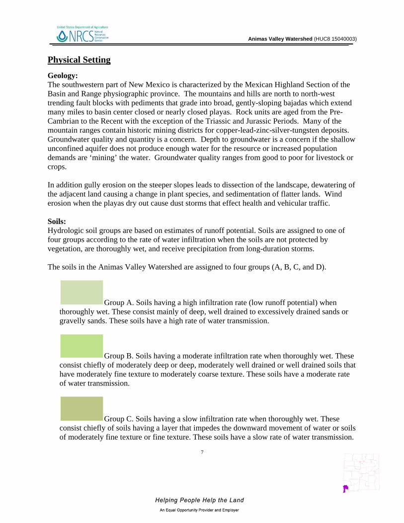
Physical Setting Geology: The southwestern part of New Mexico is characterized by the Mexican Highland Section of the Basin and Range physiographic province. The mountains and hills are north to north-west trending fault blocks with pediments that grade into broad, gently-sloping bajadas which extend many miles to basin center closed or nearly closed playas. Rock units are aged from the Pre-Cambrian to the Recent with the exception of the Triassic and Jurassic Periods. Many of the mountain ranges contain historic mining districts for copper-lead-zinc-silver-tungsten deposits. Groundwater quality and quantity is a concern. Depth to groundwater is a concern if the shallow unconfined aquifer does not produce enough water for the resource or increased population demands are ‘mining’ the water. Groundwater quality ranges from good to poor for livestock or crops. In addition gully erosion on the steeper slopes leads to dissection of the landscape, dewatering of the adjacent land causing a change in plant species, and sedimentation of flatter lands. Wind erosion when the playas dry out cause dust storms that effect health and vehicular traffic. Soils: Hydrologic soil groups are based on estimates of runoff potential. Soils are assigned to one of four groups according to the rate of water infiltration when the soils are not protected by vegetation, are thoroughly wet, and receive precipitation from long-duration storms. The soils in the Animas Valley Watershed are assigned to four groups (A, B, C, and D).
Group A. Soils having a high infiltration rate (low runoff potential) when thoroughly wet. These consist mainly of deep, well drained to excessively drained sands or gravelly sands. These soils have a high rate of water transmission.
Group B. Soils having a moderate infiltration rate when thoroughly wet. These consist chiefly of moderately deep or deep, moderately well drained or well drained soils that have moderately fine texture to moderately coarse texture. These soils have a moderate rate of water transmission.
Group C. Soils having a slow infiltration rate when thoroughly wet. These consist chiefly of soils having a layer that impedes the downward movement of water or soils of moderately fine texture or fine texture. These soils have a slow rate of water transmission.

Animas Valley Watershed (HUC8 15040003)
Group D. Soils having a very slow infiltration rate (high runoff potential) when thoroughly wet. These consist chiefly of clays that have a high shrink-swell potential, soils that have a high water table, soils that have a claypan or clay layer at or near the surface, and soils that are shallow over nearly impervious material. These soils have a very slow rate of water transmission.
Figure 2. Animas Valley Watershed Hydrologic Soil Group

Animas Valley Watershed (HUC8 15040003)
Figure 3. Animas Valley Watershed Shaded Relief

Animas Valley Watershed (HUC8 15040003)
Precipitation 1
Figure 4. Animas Valley Watershed Annual Precipitation.

Animas Valley Watershed (HUC8 15040003)
Land Ownership 2
Figure 5. Animas Valley Watershed Land Ownership.

Animas Valley Watershed (HUC8 15040003)
12
Land Ownership
COUNTY BLM Private State-AZ State - NM
USDA Forest Service
Grant, NM 91,914 116,406 171,070 52,011
Hidalgo, NM 375,124 352,995 226,597 32,730
Luna, NM 9,121 6,952 6,002
Cochise, AZ 7,690 1,327 14 283
Greenlee, AZ 1,893 1
Watershed (∑)
393,828
477,681
14
403,669
85,024
%
Watershed
27% 33% <1% 28% 6%
Table 2. Land ownership in the Animas Valley Watershed.
Animas Valley Watershed (HUC8 15040003)
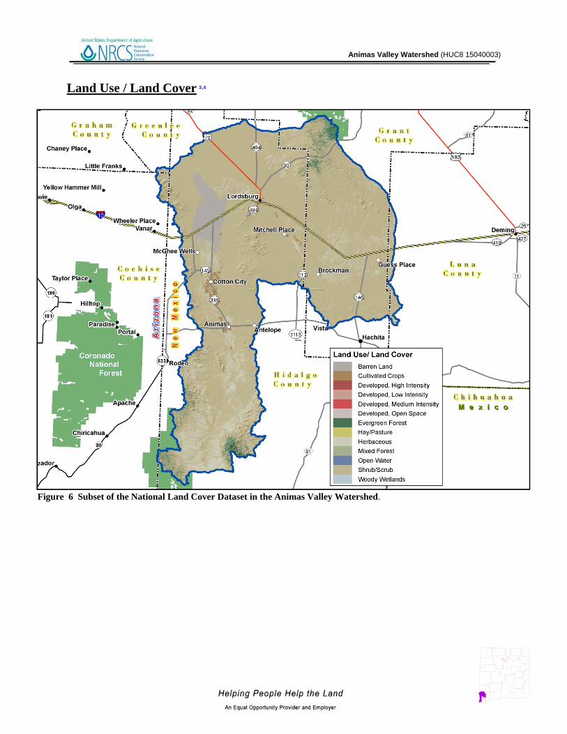
Land Use / Land Cover 3,4
Figure 6 Subset of the National Land Cover Dataset in the Animas Valley Watershed.

Animas Valley Watershed (HUC8 15040003)
14
Land Use / Land Cover
Table 3. Extent of NLCD classes in the Animas Valley Watershed.
Land Use/ Land Cover Acres % of Watershed
Shrub/Scrub 1,236,654 85%
Herbaceuous 122,201 8%
Barren Land 48,327 3%
Evergreen Forest 27,844 2%
Cultivated Crops 8,901 1%
Developed, Open Space 5,906 < 1%
Developed, Low Intensity 1,272 < 1%
Mixed Forest 370 < 1%
Developed, Medium Intensity 275 < 1%
Hay/Pasture 255 < 1%
Open Water 50 < 1%
Developed, High Intensity 33 < 1%
Woody Wetlands 31 < 1%
The U.S. Geological Survey (USGS) produced the National Land Cover Dataset (NLCD) as part of a cooperative project between the USGS and the U.S. Environmental Protection Agency (USEPA). The goal of this project was to produce a consistent land cover data layer for the conterminous United States. The Multiresolution Land Characterization (MRLC) Consortium collected the data used to compile the NLCD. The MRLC Consortium is a partnership of Federal agencies that produce or use land cover data; partners include the UNITED STATES GEOLOGICAL SURVEY (National Mapping, Biological Resources, and Water Resources Divisions), USEPA, the U.S. Forest Service, and the National Oceanic and Atmospheric Administration.
Animas Valley Watershed (HUC8 15040003)
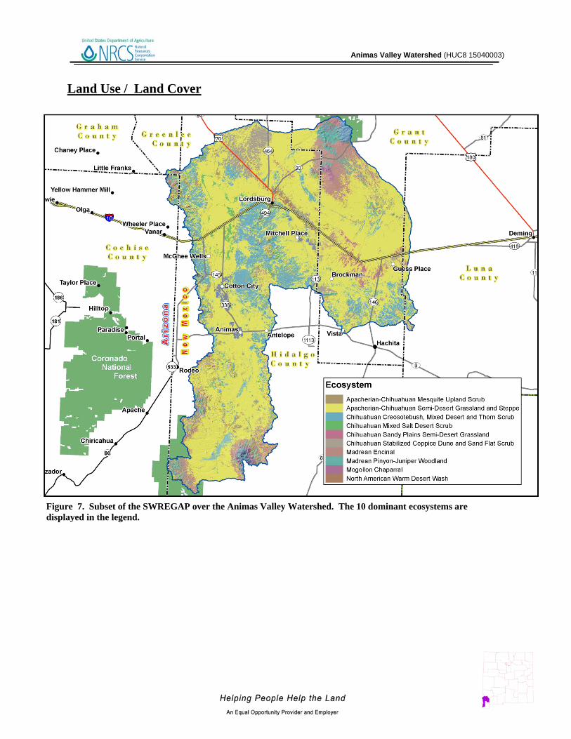
Land Use / Land Cover
Figure 7. Subset of the SWREGAP over the Animas Valley Watershed. The 10 dominant ecosystems are displayed in the legend.

Animas Valley Watershed (HUC8 15040003)
16
Land Use / Land Cover
ECOSYSTEM Acres % of Watershed Apacherian-Chihuahuan Semi-Desert Grassland and Steppe 940,476 65% Chihuahuan Creosotebush, Mixed Desert and Thorn Scrub 189,449 13% Madrean Encinal 95,360 7% Chihuahuan Stabilized Coppice Dune and Sand Flat Scrub 54,629 4% Madrean Pinyon-Juniper Woodland 39,759 3% Apacherian-Chihuahuan Mesquite Upland Scrub 22,474 2% Chihuahuan Mixed Salt Desert Scrub 22,217 2% Chihuahuan Sandy Plains Semi-Desert Grassland 18,540 1% Mogollon Chaparral 11,943 1% North American Warm Desert Wash 8,469 1%
Table 4. SW Region Gap analysis ecosystem acreages.
The land cover mapping effort for the Southwest Region Gap Analysis Project was a coordinated multi-institution endeavor. This dataset was created for regional terrestrial biodiversity assessment. Additional objectives were to establish a coordinated mapping approach to create detailed, seamless maps of land cover, all native terrestrial vertebrate species, land stewardship, and management status, and to analyze this information to identify those biotic elements that are underrepresented on lands managed for their long term conservation.

Animas Valley Watershed (HUC8 15040003)
Hydrology 5,6,7,8,9,10,11 The National Hydrography Dataset (NHD) is a comprehensive set of data that encodes information about naturally occurring and constructed bodies of water, paths through which water flows, and related entities. The NHD identifies 6,474 miles (10,420 km) of water courses in the Animas Valley Watershed. The majority of these courses typically flow intermittently in summer months during periods associated with high intensity convective thunderstorms.
Figure 8. National Hydrologic Dataset (NHD) of the Animas Valley Watershed.

Animas Valley Watershed (HUC8 15040003)
Water Course Type Miles
Artificial Path 177
Canal / Ditch 46
Connector 1
Intermittent Stream / River 6,262
Perennial Stream / River 5
Sum (∑) 6,474 Table 5. NHD Water Course Type and Extents
Animas Valley Watershed (HUC8 15040003)
Hydrology
Gauging Stations: There are no Gauging stations for this watershed New Mexico Water Quality Control Commission (NMWQCC):
Under section 303(d) of the Clean Water Act, states, territories, and authorized tribes, are required to develop lists of impaired waters. These are waters for which technology-based regulations and other required controls are not stringent enough to meet the water quality standards set by states. The law requires that states establish priority rankings for waters on the lists and develop Total Maximum Daily Loads (TMDLs), for these waters. A TMDL is a calculation of the maximum amount of a pollutant a water body can receive and still safely meet water quality standards.
There are no designated impaired streams or water bodies for the Animas Valley Watershed.
Arizona Department of Water Resources (ADWR):
The Arizona Department of Water Resources (ADWR) is the issuing agency of water quality standards for interstate and intrastate waters in Arizona. The ADWR has defined the Animas Valley watershed as part of the Duncan Valley Basin and San Bernardino Valley within the Southeastern Arizona Planning Area in Greenlee and Cochise counties.
There are no designated water bodies for the Animas Valley Watershed as of March 19, 2012.

Animas Valley Watershed (HUC8 15040003)
Figure 9. Declared Groundwater Basins of the Animas Valley.
A declared groundwater basin is an area of the state proclaimed by the State Engineer to be underlain by a groundwater source having reasonably ascertainable boundaries. By such proclamation, the State Engineer assumes jurisdiction over the appropriation and use of groundwater from the source. There are 11 declared groundwaters in the Animas Valley watershed: Animas, Cloverdale, Gila San Francisco, Hatchita, Lordsburg, Mimbres, Playas and San Simon Underground Water Basin, and while in Arizona portions are in the Duncan Valley, Safford and San Bernardino Valley. The surface watershed part in extremely southwestern New Mexico covers 1,441,032 acres while in southeastern Arizona portion covers 11,251 acres and the approximately million of the 102,696,228 acres of the underground water basin in both Arizona and New Mexico.

Animas Valley Watershed (HUC8 15040003)
Threatened and Endangered Species 12,13
Endangered species are those that are at risk of extinction throughout all or a significant portion of its native range. A threatened species is one that is likely to become endangered in the foreseeable future. The New Mexico Natural Heritage and the Arizona Game and Fish Department program track the status of threatened and endangered species which are listed on both federal and state lists. Table 6 lists those species which are currently listed and tracked in the Animas Valley Watershed.
Common Name Scientific Name Tax Class Family Federal Status
State Status
Bald Eagle Haliaeetus leucocephalus Aves Accipitridae T Chiricahua Leopard Frog Rana chiricahuensis Amphibia Ranidae LT Common Black-Hawk Buteogallus anthracinus Aves Accipitridae T Common Ground-Dove Columbina passerina Aves Columbidae E
Duncan's Corycactus Escobaria dasyacantha var. duncanii
Dicotyledoneae Cactaceae E
Gray Redhorse Scartomyzon congestus Actinopterygii Catostomidae E Mexican Spotted Owl Strix occidentalis lucida Aves Strigidae LT Mineral Creek Mountainsnail Oreohelix pilsbryi T
Table 6 . Threatened and Endangered Plant and Animal Species.

Animas Valley Watershed (HUC8 15040003)
Invasive Species 14,15 Invasive species are those which have been introduced into a region or ecosystem and have the ability to out-compete native species for resources (i.e. water, nutrients, sunlight, etc.) The Southwest Exotic Plant Mapping Program (SWEMP) is a collaborative effort between the United States Geological Survey and federal, tribal, state, county and non-government organization partners in the southwest which maintains ongoing efforts to compile and distribute regional data on the occurrence of non-native invasive plants in the southwestern United States. Within the Animas Valley Watershed, the SWEMP has identified 5 species of invasive plants (Table 7). Each of these species is defined as non-native by the USDA PLANTS database.
Scientific Name Common Name
Zygophyllaceae (Caltrop Family) African Rue
Scrophulariaceae (Figwort Family) Dalmatian Toadflax
Brassicaceae (Mustard Family) Hoary Cress (Whitetop)
Lythraceae (Loosestrife Family) Purple Loosestrife
Asteraceae (Sunflower Family) Yellow Starthistle
Table 7. Invasive Species Recognized by the SWEMP and AZFD.

Animas Valley Watershed (HUC8 15040003)
Common Resource Areas15 A Common Resource Area (CRA) is defined as a geographical area where resource concerns, problems, or treatment needs are similar. It is considered a subdivision of an existing Major Land Resource Area (MLRA) designation. Landscape conditions, soil, climate, human considerations, and other natural resource information are used to determine the geographic boundaries of a Common Resource Area. Each Common Resource Area will have multiple Conservation System Guides associated with it. A Conservation System Guide associates, for a given CRA and land use, different components of Resource Management Systems and their individual effect on conserving soil and water resources.
Figure 10. Common Resource Areas of the Animas Valley Watershed.

Animas Valley Watershed (HUC8 15040003)
Common Resource Areas 38.2 - Interior Chaparral - Woodlands This unit occurs within the Transition Zone Physiographic Province and is characterized by canyons and structural troughs or valleys. Igneous, metamorphic and sedimentary rock occurs on rough mountainous terrain. Elevations range from 4000 to 5500 feet. Precipitation averages 16 to 20 inches per year. The soil temperature regime ranges from thermic to mesic. The soil moisture regime is aridic ustic. Vegetation includes turbinella oak, silktassel, juniper, pinyon, sugar sumac, and bullgrass. 41.1 Mexican Oak-Pine Forest and Oak Savannah This unit occurs within the Colorado Plateau Physiographic Province and is characterized by volcanic fields and gently dipping sedimentary rocks eroded into plateaus, valleys and deep canyons. Elevations range from 7000 to 12500 feet. Precipitation averages 20 to 35 inches per year. The soil temperature regime ranges from mesic to frigid. The soil moisture regime ranges from typic ustic to udic ustic. Vegetation includes ponderosa pine, Gambel oak, Arizona walnut, sycamore, and Douglas fir. 41.2 Chihuahuan – Sonoran Desert Shrubs This unit occurs within the Basin and Range Physiographic Province and is characterized by valley plains, alluvial fans, and mountains. Sediments are from fluvial, lacustrine, colluvial and alluvial deposits. Igneous and metamorphic rock dominate the mountain ranges. Elevations range from 2600 to 4000 feet. Precipitation ranges from 8 to 12 inches per year. The soil temperature regime is thermic and the soil moisture regime is typic aridic. Vegetation includes mesquite, catclaw acacia, whitethorn, bush muhly and threeawns. 42.2 Chihuahuan Desert Shrubs This unit occurs within the Basin and Range Physiographic Province and is characterized by valley plains, alluvial fans, and mountains. Sediments are from fluvial, lacustrine, colluvial and alluvial deposits. Igneous and metamorphic rock dominate the mountain ranges. Elevations range from 3800 to 5200 feet. Precipitation ranges from 8 to 10 inches per year. The soil temperature regime is thermic. The soil moisture regime is typic aridic. Vegetation includes Creosote, tarbush, soaptree yucca, torrey yucca, tobosa, and alkali sacaton.

Animas Valley Watershed (HUC8 15040003)
Conservation 16
The USDA-Natural Resources Conservation Service (NRCS) focuses on the development and delivery of high quality products and services that enable people to be good stewards of our Nation’s soil, water, and related natural related resources on non-Federal lands. The Natural Resources Conservation Service’s conservation programs aid agricultural producers in their efforts to reduce soil erosion, enhance water supplies, improve water quality, increase wildlife habitat, and reduce damages caused by floods and other natural disasters. Public benefits include enhanced natural resources that help sustain agricultural productivity and environmental quality while supporting continued economic development, recreation, and scenic beauty.
Conservation Practice
2007 2008 2009 2010 2011 TOTAL
# Acres # Acres # Acres # Acres # Acres # Acres
Access Control 1 858 1 858
Brush Management 1 8,214 1 4,435 1 20,965 1 7,053 1 4,988 5 45,655
Conservation Crop Rotation 2 844 2 717 3 412 1 668 1 543 9 3,184
Integrated Pest Management (IPM) 2 777 2 717 3 412 1 668 2 705 10 3,279
Irrigation System, Microirrigation 1 515 1 947 2 177 1 668 5 2,308
Irrigation System, Sprinkler 2 272 1 123 1 235 1 696 5 1,326
Irrigation Water Management 2 933 2 717 3 765 2 666 2 905 11 3,986
Nutrient Management 2 894 2 717 3 412 3 765 2 705 12 3,493
Prescribed Grazing 2 15,532 2 15,135 2 88,238 1 32,503 2 96,934 9 248,342
Residue Management, Seasonal 2 815 2 717 3 412 2 688 1 433 10 3,065
Upland Wildlife Habitat Management 6 34,729 5 24,152 2 60,983 3 20,708 2 75,124 18 215,696
Wetland Enhancement 1 858 1 858
Wetland Restoration 1 858 1 858
SUM (∑) 22 63,525 20 48,378 23 173,009 17 66,104 15 181,891 97 532,907 Table 8 . 5 year Trends in Applied Conservation Practices. Reported in Acres.

Animas Valley Watershed (HUC8 15040003)
Table 9. 5 Year Trends in Location Specific Applied Conservation Practices. Reported in Feet if Linear (i.e. Fence)
Conservation Practice
2007 2008 2009 2010 20111 TOTAL
# Feet # Feet # Feet # Feet # Feet # Feet
Fence 1 2,890 1 25,259 1 1,241 1 1,554 4 30,944
Irrigation Water Conveyance, Pipeline, High-Pressure, Underground, Plastic
1 235 1 116 1 110 3 461
Irrigation Water Conveyance, Pipeline, Steel 2 334 1 116 3 451
Pipeline 1 1,620 1 42,185 2 57,759 1 18,534 2 10,475 7 130,574
Streambank and Shoreline Protection 1 858 1 858
Windbreak/Shelterbelt Establishment 1 241 1 241
SUM (∑) 5 5,079 1 42,185 6 83,493 3 20,633 4 12,139 19 163,529
Animas Valley Watershed (HUC8 15040003)
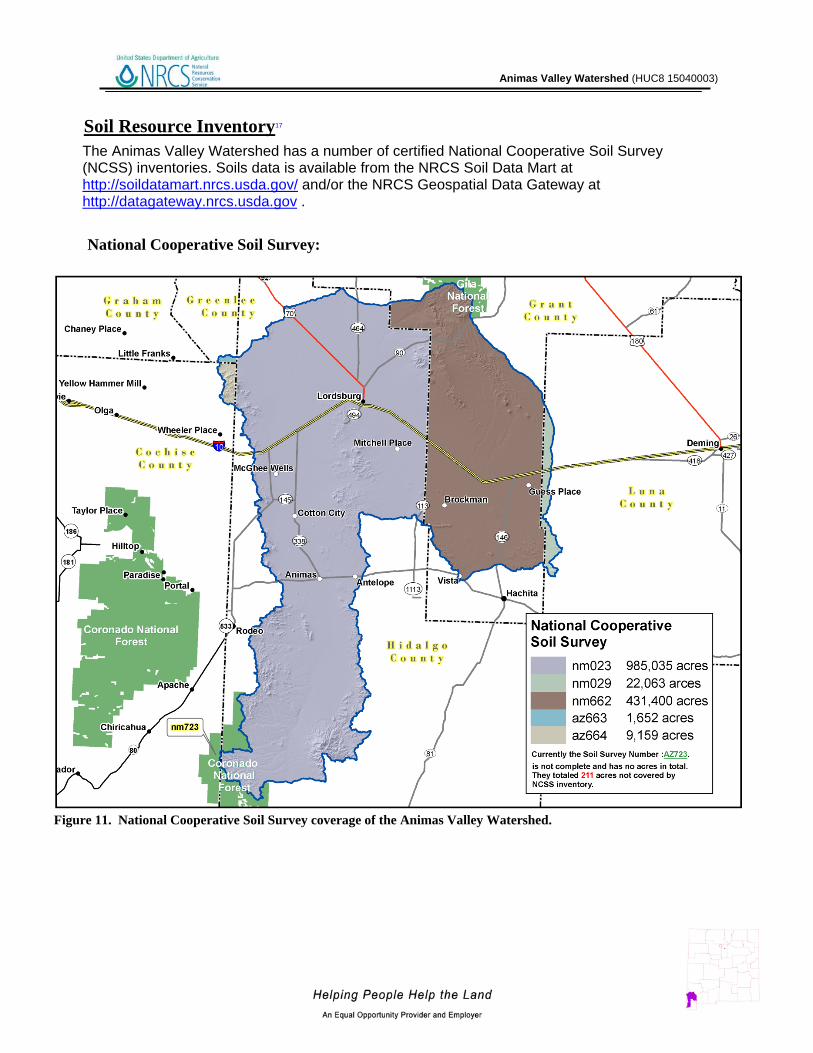
Soil Resource Inventory17
Figure 11. National Cooperative Soil Survey coverage of the Animas Valley Watershed.
The Animas Valley Watershed has a number of certified National Cooperative Soil Survey (NCSS) inventories. Soils data is available from the NRCS Soil Data Mart at http://soildatamart.nrcs.usda.gov/ and/or the NRCS Geospatial Data Gateway at http://datagateway.nrcs.usda.gov . National Cooperative Soil Survey:

Animas Valley Watershed (HUC8 15040003)
28
Soil Resource Inventory In order to evaluate the susceptibility of erosion within the Animas Valley Watershed, a model was developed using Soil Survey Geographic Database (SSURGO) information. The soil properties saturated hydraulic conductivity, soil loss tolerance, and wind erodibility group were used in conjunction with slope to assess soil map unit potential for erosion. Saturated hydraulic conductivity and slope are reported in SSURGO databases as interval/ratio data whereas wind erodibility and soil loss tolerance are ordinal data. Data transformations for the model are listed -
Table 10. Criteria Used for Soil Erosion Susceptibility Model.
SSURGO Value Nominal Description Model Rank
Saturated Hydraulic Conductivity
µm / s 705.0 - 100.0 Very High 0 99.9 - 10.0 High 1
9.9 - 1.0 Moderately High 2 0.9 - 0.1 Moderately Low 3
0.09 - 0.01 Low 4 Slope %
0 - 5 0 6 - 10 1
11 - 15 2 16 - 25 3
> 25 4 Soil Loss Tolerance
5 High Tolerance For loss 0 4 ↓ 1 3 ↓ 2 2 ↓ 3 1 Low Tolerance For Loss 4
Wind Erodibility Group 1 Very High 4 2 Very High 4 3 High 3 4 High 3 4L High 3 5 Moderate 2 6 Moderate 2 7 Moderate 1 8 Slight 0

Animas Valley Watershed (HUC8 15040003)
29
Soil Resource Inventory For each soil map unit (discrete delineation), the soil properties (named above) of the dominant soil type was used as the condition to be evaluated in the susceptibility to erosion model. Miscellaneous areas such as gravel pits, water, riverwash, etc. were excluded from evaluation. Possible range of values for each map unit are 0 – 16. Increasing values represent a higher susceptibility to soil erosion.
Figure 12. Animas Valley Watershed Erosion Potential.

Animas Valley Watershed (HUC8 15040003)
30
Soil Resource Inventory
Table 11. Soil Erosion Potential Model Results. A greater rank indicates greater potential for erosion.
Rank Acres
3 1,484 4 119,689 5 170,785 6 26,852 7 13,911 8 99,044 11 12,659
Sum( ∑) 444,423

Animas Valley Watershed (HUC8 15040003)
31
Socioeconomic Data 2010 18
Table 12. Socioeconomic Data of the Counties in the Watershed (2010).
COUNTY
Total population:
Total
Total population: Hispanic or Latino
Total population: White alone
Total population:
Black or African
American alone
Total population: American Indian and
Alaska Native alone
Total population: Asian alone
Total population: Native Hawaiian and Other
Pacific Islander alone
Total population: Some other race alone
Total population:
Two or more races
Families: Median family
income adj. 2010
Grant, NM 29,514 14,252 25,058 255 400 123 22 2,837 819 44,360
Hidalgo, NM 4,894 2,769 4,177 29 41 23 2 536 86 41,594
Luna, NM 25,095 15,423 19,511 288 317 119 19 4,176 665 33,312
Cochise,
AZ
131,346 42,543 103,085 5,465 1,589 2,525 418 12,,989 5,275 45,213
Greenlee,
AZ
8,437 4,040 6,517 89 195 46 5 1,268 320 51,729

Animas Valley Watershed (HUC8 15040003)
32
References 1. Parameter-elevation Regressions on Independent Slopes Model (PRISM).PRISM is a unique knowledge-based system that uses point measurements of precipitation, temperature, and other climatic factors to produce continuous, digital grid estimates of monthly, yearly, and event-based climatic parameters. http://www.prism.oregonstate.edu/ 2. Bureau of Land Management – New Mexico State Office. - http://www.blm.gov/nm/st/en/prog/more/geographic_sciences/spatial_data_metadata.html 3. UNITED STATES GEOLOGICAL SURVEY - National Land Cover Dataset. http://landcover.United States Geological Survey.gov/ 4. Southwest Regional Gap Analysis Project (SWReGAP). http://earth.gis.usu.edu/swgap/ 5. UNITED STATES GEOLOGICAL SURVEY – National Hydrography Dataset. http://nhd.United States Geological Survey.gov/ 6. UNITED STATES GEOLOGICAL SURVEY - http://waterdata.usgs.gov/nwis/rt 7. State of New Mexico Environment Department - Clean Water Act 303(d)/305(b) Integrated Report ftp://ftp.nmenv.state.nm.us/www/swqb/303d-305b/2010/USEPA-Approved303dList.pdf 8. Arizona Department of Environmental Quality (ADEQ) - http://www.azdeq.gov/ 9. United States Environmental Protection Agency - http://cfpub.epa.gov/surf/huc.cfm?huc_code=15040003 10. New Mexico - Office of the State Engineer- http://www.ose.state.nm.us/water_info_data.html 11. Arizona Department of Water Resources- http://www.azwater.gov/azdwr/default.aspx 12. New Mexico Natural Heritage Program - http://nhnm.unm.edu/ 13. Arizona Game and Fish Department - http://www.azgfd.gov/ 14. Southwest Exotic Plant Mapping Program - http://www.invasiveweeds.com/mapping/welcome.html 15. Natural Resources Conservation Service – National Coordinated Common Resource Area (CRA) Geographic Database http://soils.usda.gov/survey/geography/cra.html 16. Natural Resources Conservation Service – Performance Results System http://ias.sc.egov.usda.gov/PRSHOME/

Animas Valley Watershed (HUC8 15040003)
17. Natural Resources Conservation Service – Soil Data Mart http://soildatamart.nrcs.usda.gov/ 18. United States Census Bureau - http://factfinder2.census.gov/faces/nav/jsf/pages/index.xhtml