Embed Size (px)
Citation preview

MINERALEXPLORATIONOVERVIEW
NORTHWEST TERRITORIES
Updated February 2018 Prepared by: Northwest Territories Geological Survey H. Falck, S. Cairns, M. Robb, and L. Powell
RAPPORT SUR LES ACTIVITÉS D’EXPLORATION MINIÈRE
TERRITOIRES DU NORD-OUEST
Mis à jour en février 2018 Commission géologique des Territoires du Nord-OuestH. Falck, S. Cairns, M. Robb, et L. Powell

Northwest Territories Mining and Exploration Overview: February 2018 2
© 2018 Northwest Territories Geological Survey
This document contains information provided to the Northwest Territories Geological Survey (NTGS) by third parties. All information is provided “as is” without warranty of any kind. The Government of the Northwest Territories (GNWT) and its agents do not accept any responsibility or liability for
the accuracy, timeliness, completeness, or reliability of the information contained in this document. Mineral exploration and extraction are inherently risky ventures and the GNWT and its agents will not be held liable for any loss or damage resulting directly or indirectly from reliance on any
information or representations contained in this document.
Distributed byNorthwest Territories Geological Survey
Department of Industry, Tourism and Investment Government of Northwest Territories
P.O. Box 1320, 4601-B 52nd Avenue Yellowknife, Northwest TerritoriesCanada X1A 2L9
867-767-9211www.nwtgeoscience.ca
AuthorsH. Falck, S. Cairns, M. Robb,
and L. PowellNorthwest Territories Geological Survey
Corresponding authorH. Falck
Northwest Territories Geological Survey [email protected]
Recommended citationFalck, H., Cairns, S., Robb, M. and Powell, L., 2018. 2017 Northwest Territories Mineral Exploration
Overview: February 2018; Northwest TerritoriesGeological Survey. 30 pages

Northwest Territories Mining and Exploration Overview: February 2018 3
Executive SummaryAn increase in claim staking combined with a decrease in the rate of claims lapsing provides hints of an upswing for the mineral industry in the Northwest Territories (NWT) in 2017.
As diamonds are the only commodity currently mined in the NWT, global changes in diamond markets can have appreciable impacts in the North. In November 2016, the Indian Government enacted a demonetization program for 500 and 1000 Rupee banknotes. While the rationale for the action was to curtail the shadow economy and crack down on the use of illicit and counterfeit cash to fund illegal activity and terrorism, it severely impacted Indian diamantaires in the pursuit of their diamond trading activities. The result was an immediate drop in the demand and price of smaller diamonds. Over the summer, this disruption to diamond trading had abated and full activity returned to all segments of the diamond market. The weaker Canadian dollar has also strengthened the projections of the mines whose products are quoted in US dollars.
Despite tough market conditions, NWT mineral producers continued to advance projects in 2017. In mining news, De Beers and Mountain Province completed the first year of operation at Gahcho Kué Mine in September. Both Diavik and Ekati mines are proceeding with major mine expansions, which will increase their longevity. An estimated 10.5 million carats worth $1.27 billion of diamonds were produced in the NWT in 2016. Production for 2017 should be significantly higher as Ekati is mining the high-grade Misery Pipe and the Gahcho Kué mine has reported its first full year of production. Based on reported production, the NWT total diamond production should exceed 19 million carats in 2017.
Outlooks for other commodities have improved throughout 2017. Copper and zinc prices have steadily increased since the summer of 2017. Gold prices have held relatively constant. Overall, this has translated into an increase in staking activity in the NWT. While 85 claims covering 42 000 hectares were staked in 2016, over 224 claims covering 165 000 hectares have been staked in 2017 (Feb. 13, 2018; NWT Mining Recorder). The enthusiasm must be tempered by the number of cancelled claims (456 covering 406 075 hectare), which exceeds the staked claims (Figure 1). Much of this can be attributed to the release of uranium prospects located west of the Thelon Game Sanctuary.

Northwest Territories Mining and Exploration Overview: February 2018 4
Explorers have seen the investment landscape gradually improve. The territory saw activity at several diamond, gold, base metal and lithium exploration projects. Canadian Zinc published a positive feasibility study for Prairie Creek. Kennady Diamonds received promising new results on their Kennady North property.
Nighthawk completed work to expand the resources at Colomac with an extensive drill program. Closer to Yellowknife, TerraX continued drilling gold and base metal targets on their enlarged Yellowknife Gold Project with good results.
In 2016-2017, the Government of Northwest Territories Mining Incentive Program provided $400,000 to ten exploration projects. Fiscal year 2017-2018 saw the program budget increased to $1 million; this funding has been dispersed to 14 exploration projects.

Northwest Territories Mining and Exploration Overview: February 2018 5
RésuméL’augmentation des jalonnements de claims et la diminution du nombre de claims devenant caducs sont des indicateurs du regain économique du secteur minier aux Territoires du Nord-Ouest (TNO) en 2017.
Les diamants étant les seules ressources actuellement exploitées aux TNO, les variations du cours du diamant ont de sérieuses répercussions dans le Nord. En novembre 2016, le gouvernement indien a mis en œuvre un programme de démonétisation pour les billets de 500 et de 1 000 roupies. L’objectif initial était de contrer l’économie parallèle et de sévir contre le recours aux espèces illicites ou contrefaites qui servaient à financer des activités illégales ou terroristes. Toutefois, cette mesure a durement touché les diamantaires indiens dans le cadre de leurs activités commerciales, ce qui a provoqué une baisse immédiate de la demande et du prix des petits diamants. Les perturbations du marché du diamant se sont estompées au cours de l’été, et les activités commerciales ont repris dans tous les secteurs du marché du diamant. La faible valeur du dollar canadien a aussi permis de renforcer les prévisions économiques des mines dont les produits sont cotés en dollars américains.
En dépit des conditions difficiles du marché financier, les producteurs miniers des TNO continuent sur leur lancée en 2017. Au chapitre des nouvelles du secteur minier, De Beers et Mountain Province ont franchi le cap de la première année d’exploitation de la mine Gahcho Kué en septembre. Les mines Diavik et Ekati continuent leurs importants travaux d’expansion qui visent à prolonger la durée de vie de ces mines. En 2016, les TNO ont produit environ 10,5 millions de carats, ce qui représente une valeur de 1,27 milliard de dollars au total. La production de 2017 devrait s’avérer encore plus importante, étant donné que la mine Ekati exploite le puits Misery – de grande qualité – et que Gahcho Kué termine sa première année d’exploitation. D’après lesestimations basées sur les chiffres actuels, la production totale de diamants en 2017 devraitdépasser les 19 millions de carats.

Northwest Territories Mining and Exploration Overview: February 2018 6
Les perspectives économiques pour d’autres produits miniers s’avèrent de plus en plus intéressantes au fur et à mesure que l’année avance. Le prix du cuivre a régulièrement augmenté au cours de l’été 2017, à l’instar du prix du zinc, et le prix de l’or reste relativement stable. Dans l’ensemble, cela s’est traduit par une augmentation des jalonnements aux TNO. Alors qu’en 2016, nous comptions 85 claims jalonnés pour 42 000 hectares, nous sommes arrivés à 224 claims pour 165 000 hectares dans 2017 (chiffres fournis par le Bureau du registraire des mines le 13 février 2018). Ces constatations doivent être tempérées par le nombre de claims annulés (456 pour 406 075 hectares) qui dépasse largement les jalonnements de claims (voir figure 1). La plupart des zones libérées concerne la prospection d’uranium, à l’ouest du refuge faunique Thelon.
Les prospecteurs ont réussi à rassembler de plus en plus de fonds pour mener leurs activités. Des projets d’exploration ont été menés pour trouver des diamants, de l’or, du métal de base et du lithium sur tout le territoire. Canadian Zinc a publié une étude de faisabilité positive pour la mine Prairie Creek. Kennady Diamonds a reçu de nouveaux résultats prometteurs pour sa propriété dans le Nord. Nighthawk a terminé des travaux, notamment un important programme de forage, pour augmenter ses ressources à Colomac. Plus près de Yellowknife, TerraX a poursuivi ses forages à la recherche d’or et de métal de base dans le cadre du projet élargi Yellowknife Gold, et les résultats sont concluants.
En 2016-2017, le programme de mesures incitatives visant les activités minières du gouvernement des Territoires du Nord-Ouest a dégagé 400 000 $ pour financer dix projets d’exploration. L’exercice financier 2017-2018 a vu son budget augmenter d’un million de dollars, et ces fonds ont été reversés pour financer 14 projets d’exploration (sept projets menés par des prospecteurs individuels et sept projets menés par des entreprises).
Northwest Territories Mining and Exploration Overview: February 2018 7
Northwest Territories Mining2017 saw major changes in the Ekati and Diavik diamond mines, culminating in the sale of Dominion Diamond Corporation to Northwest Acquisitions ULC, an entity affiliated with The Washington Companies.
The sale to the Washington Companies, a privately held group of North American mining, industrial and transportation businesses founded by Dennis R. Washington, is expected to be concluded in November 2017, and many changes have already been initiated. Dominion’s corporate headquarters has moved from Yellowknife to Calgary and Patrick Evans has been announced as the new CEO for the company. As the new company is privately held, there are no public reporting requirements. No news releases pertaining to Dominion’s mine production and exploration activities have been released since November 1, 2017, including quarterly production statements for the Ekati Mine.
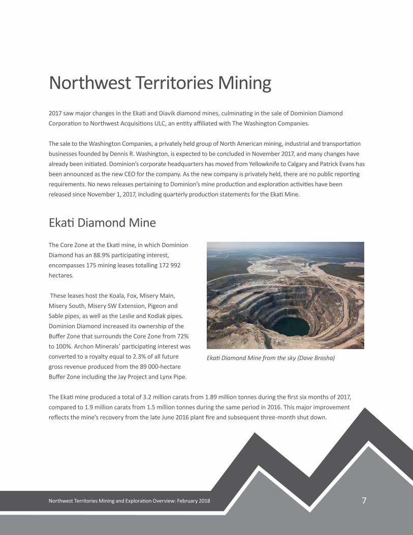
Ekati Diamond MineThe Core Zone at the Ekati mine, in which Dominion Diamond has an 88.9% participating interest, encompasses 175 mining leases totalling 172 992 hectares.
These leases host the Koala, Fox, Misery Main, Misery South, Misery SW Extension, Pigeon and Sable pipes, as well as the Leslie and Kodiak pipes. Dominion Diamond increased its ownership of the Buffer Zone that surrounds the Core Zone from 72% to 100%. Archon Minerals’ participating interest was converted to a royalty equal to 2.3% of all future gross revenue produced from the 89 000-hectare Buffer Zone including the Jay Project and Lynx Pipe.
The Ekati mine produced a total of 3.2 million carats from 1.89 million tonnes during the first six months of 2017, compared to 1.9 million carats from 1.5 million tonnes during the same period in 2016. This major improvement reflects the mine’s recovery from the late June 2016 plant fire and subsequent three-month shut down.
Ekati Diamond Mine from the sky (Dave Brosha)

Northwest Territories Mining and Exploration Overview: February 2018 8
The Jay Project contains an estimated 79 million carats in 44.7 million tonnes of kimberlite. Jay received approval for a water license in late May, one of the final regulatory steps before construction and production. Due to a revision of the life-of-mine plan to allow for underground mining of the lower part of the Misery kimberlite, the schedule for the Jay Project has been extended by one year. Dike construction is scheduled to begin in July 2019 and continue till 2022, when dewatering and stripping will begin.
A positive pre-feasibility study of the Misery Deep Project at Ekati was followed by the decision by the company to extend the mining of the Misery pipe. The Probable Mineral Reserves contain 8.7 million carats in 1.8 million tonnes. Based on a similar approach to that for the Misery Deep Project, a preliminary economic assessment on Fox Deep Project using underground incline caving mining is projected to produce 31.3 million tonnes and recover 11.0 million carats. The modified production plan, which includes the defined Jay, Misery and Fox resources, has extended Ekati’s current estimated mine life to 2041.
In May, Dominion Diamonds announced an Inferred Mineral Resource estimation for the Leslie kimberlite comprising 51 million tonnes of kimberlite containing 16 million carats of diamond, or 0.3 carats per tonne. The Leslie pipe was originally included in the Ekati mine plan that was reviewed as part of the environmental assessment in the 1990s. The Leslie kimberlite was replaced by the Sable, Pigeon and Beartooth kimberlites shortly after production commenced in 1998.
Summer exploration on the Ekati leases included ground geophysics, airborne magnetic surveys using an Unmanned Aerial Vehicle and diamond drilling. One drill hole on the Kodiak pipe recovered 530 kilograms of kimberlite, which has been submitted for microdiamond analysis. Two other exploration targets were drilled but failed to intersect kimberlite.
Diavik Diamond MineAt the Diavik Diamond Mine, —60% owned by Rio Tinto and 40% by Dominion Diamond Corporation — production continued from the A-154 South, A-154 North and A-418 underground operations. A larger proportion of higher-grade A-418 ore resulted in increased production of 7.49 million carats recovered from 2.19 million tonnes of kimberlite in 2017.
Development of the A-21 pipe continues with the completion of the dike anticipated by late 2017. Ore processing is expected to commence by mid-2018. On the Diavik lease block, Dominion drilled three kimberlites: C42, T29 and A61. Samples from these pipes have been submitted for microdiamond analysis.

Northwest Territories Mining and Exploration Overview: February 2018 9
On the LDG (Lac de Gras) joint venture between Dominion Diamond Corporation and North Arrow Minerals, Dominion completed a 5567 line-kilometre helicopter-borne magnetic/electromagnetic survey in addition to 22 ground geophysical grids. Follow-up drilling is planned during 2018.
Gahcho Kué Diamond MineSeptember 2017 marked the end of the first full year of operations at the Gahcho Kué Diamond Mine. The mine is operated by the De Beers Group of Companies (51%) and Mountain Province Diamonds (49%). It opened two months ahead of schedule and during 2016, produced 847 000 carats from 515,000 tonnes of kimberlite. The declaration ofcommercial production was made at the beginning of March 2017 with mine operations performing well and the diamond recovery plant running at nameplate capacity.
The total production for 2017 was 5.93 million carats from 3.51 million tonnes of kimberlite, well in excess of its projected production of 4.5 million carats a year. This year’s production has a grade of 2.14 carats per tonne, further proving its reputation as the world’s largest new diamond mine.
The Gahcho Kué mine plan for its 12-year mine life includes a cluster of four diamondiferous kimberlites, three of which have Probable Mineral Reserves of 34.3 million tonnes grading 1.57 carats per tonne for total diamond content of 53.7 million carats.
A ground gravity survey was conducted on the area between the 5034 and Hearne pipes, referred to as the Southwest Corridor as well as, between the Tuzo and Tesla pipes. The survey was to explore extension of diamondiferous kimberlite, which had not been included in resource statements, but was discovered during waste stripping operations. A 17-hole exploration drill program, based on a 50 metre by 50 metre spacing plan, commenced in November. Six holes were completed in 2017 and all contained kimberlite intersections. The ground gravity survey has also identified an additional target in the corridor between Tesla and Tuzo, which is scheduled to be tested in 2018.
Mine operations at Gahcho Kué Diamond Mine (Courtesy De Beers Group)

Northwest Territories Mining and Exploration Overview: February 2018 10
Snap Lake Diamond MineProduction at De Beers Canada’s Snap Lake Mine ceased in December 2015. After efforts to find a buyer failed, flooding of the mine commenced in January 2017. The now-completed flooding was undertaken to minimise holding costs while preserving the long-term viability of the remaining orebody. Approximately $30 million of mining and construction equipment was auctioned off in August.
Figure 1: Northwest Territories Mineral Tenure acquisition and lapsing for 2017.

Northwest Territories Mining and Exploration Overview: February 2018 11
Northwest Territories ExplorationDiamond and mineral exploration projects are summarized in Table 1 locations are shown in Figure 2.
Table 1: Summary of Northwest Territories Mineral and Diamond Exploration Projects for 2017
1
Table 1: Summary ofNorthwestTerritoriesMineralandDiamondExploration Projects for 2017
Operator/Partners
Property Commodity Drilling Geophysics SamplingandOtherWork
StudiesandPermitting
ArcticStarExplorationCorp./MargaretLakeDiamonds
Diagras Diamond Groundmag129line-km;23line-kmgravity,22line-kmEM
BNTResources
FoxLake Gold/Diamond
836soil,6tillsamples
CanadianZincCorporation
PrairieCreek
Zn-Pb-Ag Feasibilitystudy
DeBeersGroupofCompanies,MountainProvinceDiamonds
GahchoKue Diamond 6holes/935m
Gravitysurveycompletebetween5034/Hearne
DominionDiamondCorporation
Diavik Diamond 3holesonkimberlites
MicrodiamondanalysisC42,T29andA61kimberlites
DominionDiamondCorporation
Ekati Diamond 3holesonthreetargets
Groundgeophysics,airbornemagneticsviaUAV
Microdiamondanalysis
DominionDiamondCorporation/NorthArrow
LDG Diamond 5,567line-kmheli-bornemag/EMsurvey,22groundgeophysicalgrids
Microdiamondanalysis
EquitorialExplorationCorp.
LNPG Li,Cs,Ta Mapping,Prospecting,Channelsampling
NI43-101reportMar.2017
Kendrick Hangstone Au GrabsamplesKennadyNorth
KennadyNorth
Diamond 75 largediameterholes for565.4tonnesamples;9HQ holesfor 2766 m
Mini-bulksampling andFaradayInferredMineralResource
Margaret Lake Margaret Diamond GroundGravity Bathymetric

Northwest Territories Mining and Exploration Overview: February 2018 12
Table 1: Summary of Northwest Territories Mineral and Diamond Exploration Projects for 2017 (continued)
1
Table 1: Summary ofNorthwestTerritoriesMineralandDiamondExploration Projects for 2017
Operator /Partners
Property Commodity Drilling Geophysics Sampling andOther Work
Studies andPermitting
Arctic StarExplorationCorp./Margaret LakeDiamonds
Diagras Diamond Ground mag129 line-km;23line-km gravity,22 line-km EM
BNTResources
FoxLake Gold/Diamond
836 soil,6 tillsamples
Canadian ZincCorporation
PrairieCreek
Zn-Pb-Ag Feasibilitystudy
DeBeersGroup ofCompanies,MountainProvinceDiamonds
Gahcho Kue Diamond 6 holes /935 m
Gravitysurveycompletebetween5034/Hearne
DominionDiamondCorporation
Diavik Diamond 3 holes onkimberlites
Microdiamondanalysis C42,T29and A61kimberlites
DominionDiamondCorporation
Ekati Diamond 3 holes onthreetargets
Groundgeophysics,airbornemagneticsviaUAV
Microdiamondanalysis
DominionDiamondCorporation/North Arrow
LDG Diamond 5,567 line-kmheli-bornemag/EMsurvey, 22groundgeophysicalgrids
Microdiamondanalysis
EquitorialExplorationCorp.
LNPG Li,Cs,Ta Mapping,Prospecting,Channelsampling
NI 43-101report Mar2017
Kendrick Hangstone Au GrabsamplesKennadyNorth
KennadyNorth
Diamond 75largediameterholesfor565.4tonnesamples;9HQholesfor2766m
Mini-bulksamplingandFaradayInferredMineralResource
MargaretLake Margaret Diamond GroundGravity Bathymetric
2
Lake andOhmMapperon9grids
surveys
NighthawkGoldCorp
IndinLake Au 27,168min76holes
Lidarsurveyofproperty,groundmagandIP
PinePointMiningLtd.
PinePoint Zn,Pb 111holes 50.7line-kmgroundgravity,709line-kmheli-bournegravity
PreliminaryEconomicAnalysis
Nickerson Aye1/Handle1
Au Trenching,minibulksample
NinetyTwoResourceLtd.
HiddenLake Li, Ta Prospecting,grabandchannelsampling
Flotationandconcentrationtesting
NorthArrowMinerals
Loki Diamond 302LinekmhelibourneVTEM,TDEM,mag;fourgroundmaggrids
RoverMetalsCorp
UpTownGold
Au 803min14holes
FortuneMineralsLtd.
NICO Bi, Au, Co, Cu
Environmentalsampling
TerraXMineralsInc.
YellowknifeGold
Au 43holes14,689m
350km2Lidar,3200airborneMag,EM,Radiometricsurvey
Prospecting,sampling(5600+samples),tillandlakesedimentsampling

Northwest Territories Mining and Exploration Overview: February 2018 13
DiamondsKennady North Diamond Project
Kennady Diamonds carried out significant work to advance their Kennady North Diamond Project. In January, Kennady reported an initial resource estimate for the Kelvin kimberlite, reporting 8.5 million tonnes of kimberlite grading 1.6 carat per tonne, with a diamond valuation of US$63 per carat.
Following up on promising microdiamond results from 2016 diamond drilling on the Faraday 1, 2, and 3 kimberlites, Kennady commissioned a large diameter drilling project to collect mini-bulk samples of each body. Seventy-five large diameter holes were used to collect 565.4 tonnes of kimberlite. Results are summarised in Table 2 below.
Table 2: Summary of 2017 Faraday Large Diameter Drilling
* Sample tonnage is calculated from caliper measurement of drill hole and model of bulk kimberlite density.** Total carats as reported from diamond valuation parcel.
Several large stones were recovered in the sampling including a 7.78 carat sawable octahedron valued at US$2,967 per carat from Faraday 3, and a 4.72 carat sawable octahedron valued at US$1,667 per carat from Faraday 2.
Summer drilling on the property saw the completion of nine HQ diameter holes totalling 2766 metres. The drilling extended the strike length of the Faraday 2 kimberlite body by 150 metres to approximately 600 metres. The drilling also revealed that the Faraday 1 and 3 kimberlites are connected at depth.
In early October, Kennady released an initial Inferred Mineral Resource for the Faraday kimberlites of3.27 million tonnes grading 1.54 carats per tonne with an estimated value of US$98 per carat. Details are summarised in Table 3.

Northwest Territories Mining and Exploration Overview: February 2018 14
Table 3: October 2017 Faraday Maiden Inferred Mineral Resource estimate
Figure 2: Locations of Mines and Mineral Exploration projects active in the Northwest Territories, 2017
Loki Project
The Loki Project, operated by North Arrow Minerals Inc., is located southwest of the Diavik and Ekati diamond mines and consists of two claims (Loki South and Loki East) totalling 8607 hectares. Loki East has five known kimberlites: EG01N, EG01S, EG02, EG05, and EG130.
In early September, North Arrow engaged Geotech Ltd. to complete the helicopter-borne VTEM Plus time domain electromagnetic and magnetic survey over the known kimberlites and several additional targets. Four ground magnetic surveys were completed by North Arrow over six priority targets in the Loki South area.
The targets covered by the ground surveys are located at or near the interpreted termination of a KIM train. The results of the geophysical surveys will be used to plan a winter 2018 drill program to test the targets and delineate the EG05 kimberlite.

Northwest Territories Mining and Exploration Overview: February 2018 15
Diagras Property
Arctic Star Exploration Corp. (40%) and Margaret Lake Diamonds Inc. (60%) completed ground geophysical surveys over their Diagras Property this summer. The Diagras Property is located 22 kilometres NNE of the Diavik Diamond Mine. It consisting of 23 contiguous claims covering 18 699 hectares that contain thirteen known kimberlites including the Jack Pine and Black Spruce kimberlites.
Field crews completed eleven ground magnetic (129 line-kilometres), ground gravity (23 line-kilometres), and ground electromagnetic (22 line-kilometres) surveys on several target areas. In the Jack Pine area, a new 500-metre long, north-trending anomaly referred to as Sequoia was outlined.
Margaret Lake Property
In June 2017, the Margaret Lake Diamonds completed a set of geophysical surveys on the Margaret Lake Property. The property, comprised of nineteen mineral claims (19 716.37 hectares), is located 300 kilometres east-northeast of Yellowknife and it borders to the north and west on the Kennady North Project.
Ground gravity and OhmMapper (ground electromagnetics) surveys were conducted over nine targets identified based on a previously flown airborne gravity gradiometer survey. Physical bathymetric surveys complemented the ground gravity surveys. The geophysical survey results included three targets that displayed a combination of a gravity low and/or a conductor. Drilling is planned to commence in 2018.

Northwest Territories Mining and Exploration Overview: February 2018 16
GoldIndin Lake Property
Nighthawk Gold Corp. has continued its highly successful exploration efforts on the Indin Lake Property. The 899 square kilometre property contains numerous gold showings and five main deposits: Colomac (Zone 1.5 and 2.0), Goldcrest and Grizzly Bear (24 and 27) with a total inferred resource of 2.1 million ounces (ca. 60,000 kilograms) of gold in 39.8 million tonnes for an ore grade of1.64 grams per tonne.
In 2017, 76 holes were drilled for a total of 26 168 metres to enhance the Colomac resource with a focus on Zone 1.5 and its possible connection to Zone 2.0. Additional holes were drilled to test other regional targets on the property including the Inca zone and Goldcrest. Prospecting and mapping developed a drill target on the newly-identified Nice Lake Sill. Magnetic and induced polarization ground geophysics surveys were performed and a LIDAR survey was flown over the entire property.
The Colomac Sill is a medium-grained quartz diorite/quartz gabbro of dioritic to trondhjemitic composition. The sill ranges in width from 40–200 metres and averages 100 metres wide along its six kilometres of drill-tested strike length. Of this, the quartz diorite portion is 9–60 metres wide. The sill is oriented 010/80° in the north and 023/80° in the south. Brittle deformation of the sill produced fracture stockworks and auriferous quartz-veined zones that are highly altered and carbonatized.
In 2017, twelve drill holes (4759 metres) defined and expanded the high-grade portion of Zone 1.5 and identified additional gold mineralization between Zone 1.5 and Zone 2.0 to the south. Together, these two zones outlined a domain of continuous gold mineralization from surface to 600 metres depth over a strike length of 400 metres. Drill hole C17-17B from the northern portion of Zone 2.0 returned 89.10 metres (50.00 metre true width) grading 1.52 grams of gold per tonne (g/t Au), including 12.00 metres of 5.02 g/t Au and 6.40 metres of 8.61 g/t Au. Hole C17-25 intersected 38.45 metres (32.00 metre true width) of 1.31 g/t Au, including 15.85 metres of 2.60 gpt Au, and 6.20 metres of 5.37 g/t Au.
In Zone 1.5, hole C17-28 was drilled down plunge within the high-grade core of Zone 1.5. It intersected several regions of continuous mineralization over the 780.61 metre hole. Significant intersections include 152.00 metres of 2.47 g/t Au containing 34.70 metres of 4.27 g/t Au, and 9.65 metres of 6.90 g/t Au; and 185.05 metres of 1.13 g/t Au, containing 38.30 metres of 1.69 g/t Au, and 7.70 metres of 4.82 g/t Au. Additionally, hole C17-27B intersected 57.85 metres (10.00 metre true width) of 2.08 g/t Au, including 15.30 metres of 4.06 g/t Au, and 6.75 metres of 5.35 g/t Au. Based on the results, Zone 1.5 has been extended 300 metres in strike length and to a vertical depth

Northwest Territories Mining and Exploration Overview: February 2018 17
of 660 metres. A true width of the zone has been constrained to 30 - 60 metres near surface and widening to 155 metres at depth.
Drilling has also extended the depth of Zone 1.0. Drill hole C17-19 from this zone returned 48.50 metres (45.00 metres true width) grading 1.88 g/t Au, including 20.00 metres of 3.07 g/t Au and 9.85 metres of 5.08 g/t Au.
Thirteen holes (3,308 metres) were completed to test the Goldcrest sill. Goldcrest is a differentiated igneous intrusion parallel to, and believed to be co-magmatic with the Colomac Main sill, located 400 metres to the east. Both sills intruded the mafic volcanic package and were folded such that tops face steeply to the east. Gold mineralization is mainly restricted to the more silica-rich upper portions of the sill. Highlights include Hole G17-09 intersections of 22.40 metres of 5.40 g/t Au, including 10.20 metres of 8.48 g/t Au, and 5.80 metres of 13.68 g/t Au; and Hole G17-02B containing 9.50 metres of 22.41 g/t Au, including 5.35 metres of 39.42 g/t Au. The new drill holes have extended the Goldcrest mineralized zone to a strike length of 2.5 kilometres and increased its known depth.
Two holes were also completed at the Grizzly Bear deposit. The Grizzly Bear zone is four kilometres south-southwest of Colomac with a historical resource of 807 000 tonnes at 1.04 g/t Au for a resource of 765 kg Au (27 000 ounces). It is hosted by mafic metavolcanic and metasedimentary rocks that enclose a felsic lapilli tuff horizon. The mineralization consists of quartz-veins, disseminated sulphides and gold in a trend subparallel to the bedding. Previous drilling defined the mineralized zone over a one kilometre strike length with widths of 24-61 metres.
The two 2017 holes were completed in the central portion of the deposit in order to confirm near surface mineralization reported in historical holes. Holes GB17-01 and GB17-01B intersected mineralization 60 metres below the previously reported results, extending the zone to almost 100 metres depth. The shallower hole GB17-01 intersected 11.30 metres of 1.91 g/t Au, including 3.80 metres of 3.87 g/t Au, while the steeper hole GB17-01B intersected 12.60 metres of 4.96 g/t Au, including 8.00 metres of 7.32 g/t Au, and 4.00 metres of 13.40 g/t Au.
Four holes were also drilled at North Inca in the West Zone section, to test a gap between holes NI11-02 and NI-03. NI17-01 intersected 13.20 metres of 2.24 g/t Au, including 8.50 metres of 3.24 g/t Au, extending mineralization to a depth of 70 metres. Holes NI17-02 and NI17-02B cross cut three subvertical vein systems and filled a gap between the NI11-04 and NI11-05 series holes. Both holes intersected mineralization with NI17-02 returning 9.55 metres of 4.03 g/t Au, including 3.00 metres of 8.14 g/t Au.
Aye 1 and Handle 1 Claims
Prospector Dave Nickerson continued to explore on his wholly-owned Aye 1 and Handle 1 claims near the Ingraham Trail turnoff (NWT Highway 3 and Highway 4 junction) in Yellowknife. Each claim hosts a narrow shear-zone cutting mafic volcanic rocks with a central quartz vein containing high-grade gold mineralization.

Northwest Territories Mining and Exploration Overview: February 2018 18
Over the summer and fall of 2017, Mr. Nickerson was able to remove material from a small trench on the Fox vein (located on the Aye 1 claim). During this time a mini-bulk sample of the No. 9 vein on the Handle Property was also completed.
Mr. Nickerson reports an average grade of 59.7 grams of gold per tonne for the Fox vein and 36.9 grams of gold per tonne (including some dilution) for the No. 9 vein. Mr. Nickerson is considering his options for milling based on these results and looks forwards to conducting further work in the spring of 2018.
Hangstone Claims
Prospector Wayne Kendrick continued to explore his Hangstone claims centered on Sito Lake, located 47 kilometres north of Yellowknife. Grab samples from his latest work continue to outline high-grade gold mineralization and included assays of 210, 26.5, and 23.5 grams of gold per tonne.
Mr. Kendrick plans to follow up this work with biogeochemical and magnetic surveys to be conducted during the winter of 2017-2018. If the results from these surveys are encouraging, Mr. Kendrick hopes to carry out a drill program on the property during the summer of 2018.
Yellowknife City Gold Project
TerraX Minerals Inc. continued a vigorous exploration program on its Yellowknife City Gold Project. The project was expanded and now consists of a 418 square kilometre property with over 45 kilometres of strike length of the Yellowknife Volcanic Belt.
Many of the added claims focused on the sedimentary basin to the east of the belt, including the past- producing Burwash Mine. TerraX completed a winter and summer exploration program of diamond drilling, sampling, and other investigations.
In 2017, a total of 43 holes comprising 14 689 metres were drilled. Six holes (1774 metres) were drilled at Dave’s Pond to extend the known length of a high-grade shear zone. Sixteen holes (5432 metres) were drilled on areas to the east, north and south of Mispickel to test a set of high-grade quartz veins. Fifteen holes were drilled on the Northbelt Property (Sam Otto, Banting Lake and Jackson Lake target areas), and six holes were drilled on the Southbelt Property to test the high-grade Con Shear and New Vein targets.
During the summer, TerraX completed a high-resolution airborne Lidar and ortho-photo survey covering approximately 350 square kilometres. Approximately 3200 line kilometres of airborne geophysical surveys, comprising electromagnetic, magnetic and radiometric surveys, were conducted over areas of the project that had not previously been surveyed.

Northwest Territories Mining and Exploration Overview: February 2018 19
In the Homer Lake area of the volcanic belt, prospecting and mapping has traced mineralized structures along more that two kilometres of strike length. Mineralization is present in all intersected rock types including mafic volcanics, mafic intrusives, granitic intrusives, felsic volcanics, and quartz veins. A total of 567 samples were collected in the Homer Lake area, including 217 channel and chip samples. Highlights from outcrop samples include:60 samples greater than 1 g/t Au, and 192 samples of 567 samples grading greater than 0.10 g/t Au.Channel sampling results included:
3.00 metres containing 2.00 g/t Au, 44 g/t Ag, 1.99% Pb, and 7.94% Zn in felsic volcanic host rock 3.00 metres of 0.88 g/t Au, 90 g/t Ag, 4.55% Pb, and 2.22% Zn in felsic volcanic host rock6.95 metres with 0.11 g/t Au, 16 g/t Ag, 1.12% Pb, and 0.55% Zn in mafic volcanic host rock and 5.70 metres 1.00 g/t Au, 7 g/t Ag in a granitic intrusion.
Prospecting and lake sediments sampling also extended the total length of mineralization in the Walsh Lake zone to six kilometres. Grab samples from the zone, which includes the previously-drilled Mispickel showing, returned up to 22.3 g/t Au, and 17.9 g/t Au accompanied by 68.2 g/t Ag, 2.0% lead and 1.3% zinc.
Prospecting also demonstrated an extension to the strike length of the Sam Otto zone, which now has been identified over a distance of five kilometres. Channel sample results from the Sam Otto South zone on Screamer Island suggest that mineralization of the Sam Otto South is along trend from the main Sam Otto. The widest channel sampling area assayed 0.80 g/t Au over 17.50 metres, including 11.0 metres with 1.09 g/t Au. Importantly, this channel ended in 3.40 metres of mineralization containing 1.31 g/t Au at the edge of the outcrop. Other results originated from outcrops 350 meters to the south with channel samples 2.7 metre long containing 0.97 g/t Au and 2.00 metres with 0.81 g/t Au. Both ends of the channel were truncated by the edge of the outcrop while still returning assays of one gram per tonne. In total, the separate channel segment widths with significant assay values extend over 100 meters across strike, which are comparable to the width and grade of the Sam Otto Main zone.
Exploration activities also defined the surface extent of polymetallic mineralization associated with the Ryan Lake intrusion. A total of 230 surface outcrop samples were collected in the Ryan Lake area with assay results up to 97.7 g/t Au, 32.4 g/t Ag, 2.09% Cu, and 0.32% Mo. The surface expression of gold mineralization extends for 3.8 kilometres along the eastern contact with the Ryan Lake intrusion, with high-grade molybdenum mineralization overlapping the gold enriched zone for three kilometres. The new sampling suggests that the gold trend appears to connect with Shear 17, two kilometres north of its previously sampled extent.
At Duck Lake on the east side of Yellowknife Bay, initial prospecting results identified gold in flat-dipping quartz veins ranging up to one metre thick with a strike length of at least 500 meters. Additional prospecting and mapping programs have traced the gold mineralization from the vein set in metasedimentary rocks, two kilometres south of the original discovery, into the main granite intrusive areas and three kilometres east into a narrow neck of granite intrusion. The results from 159 outcrop grab samples demonstrated that the

Northwest Territories Mining and Exploration Overview: February 2018 20
quartz veins (flat veins) hosted in granites (31 samples) with graded up to 1.21 g/t Au, while the composite quartz vein and granite samples (34 samples) contained up to 6.19 g/t Au. Those samples collected from granite proximal to quartz veins (26 samples) had grades up to 1.09 g/t Au but the flat veins within metamorphic sediments (68 samples) returned the highest values with grades up to 35.4 g/t Au.
To test whether the gold is restricted to quartz veins or is also present in the altered contacts, 71 one-metre channel samples were cut from a 500-metre zone of flat veins. Quartz veins (26 samples) graded up to 15.5 g/t Au, with 12 samples greater than 1 g/t Au and mixed quartz vein and wall rock samples (18 samples) contained grades up to 13.75 g/t Au, with 9 samples greater than 1 g/t Au. Wall rock samples proximal to the flat veins (27 samples) included up to 7.20 g/t Au, with 7 samples returning greater than 1 g/t Au, demonstrating that the gold extend into the wallrock beyond the veins.
TerraX Minerals Inc. also announced it had negotiated an option to acquire the historic Burwash Mine property (252 hectares), immediately adjacent to its Eastbelt property, east of Yellowknife. The Burwash mine, discovered in 1935, was the first gold producer in the Yellowknife district. A pit and shallow shaft (40 metres) were excavated to mine a gold bearing quartz vein in turbiditic metasediments. Approximately 450 ounces of gold were produced at a grade of 13.6 ounces per tonne (466 grams of gold per tonne). An initial sampling program consisting of 85 grab samples was completed.
Highlights of the sampling include 201 grams of gold per tonne and 23.2 grams of silver per tonne from a sample near the Burwash shaft, and 2.87 grams of gold per tonne, 16.2 grams of silver per tonne, 5.55% zinc and 0.68% lead from a grab sample collected 1.1 kilometres south of the shaft.
Additional work initiated in fall of 2017 included extensive ground magnetic and induced polarization surveys and comprehensive biogeochemical surveys over portions of the property covered by swamps and overburden. Results are still pending from over 3500 samples as well as biogeochemical and lake sediment surveys completed across the property.
Up Town Gold Project
Rover Metals is evaluating the Up Town Gold Project, a high-grade Archean lode gold prospect adjoining the former Giant Mine in Yellowknife. The property consists of six claims covering 3227 hectares. It is centred approximately 6 kilometres north of downtown Yellowknife and adjoins the Yellowknife City Gold Project (see above). Gold was discovered on the property in 1960 and two targets were explored intensively from 1963 to 1966. Small-scale mining was conducted at the Rod Vein in 1979.
Northwest Territories Mining and Exploration Overview: February 2018 21
In 2011, the property was restaked by Panarc Resources Ltd. and since then has been explored by Panarc, Manson Creek Resources Ltd. and North Sur Resources Ltd. who mapped, sampled, conducted geophysical surveys and drilled nine shallow (Winkie) drill holes into three of the targets. Silver Range Resources purchased the property in 2016 and recently completed systematic, property-wide lithogeochemical sampling, alteration mapping and airborne total magnetic field and radiometric surveys. The property was optioned to Rover Metals in late 2016.
The Up Town Gold Project covers eight gold showings, collectively defining two corridors of structurally- hosted high-grade gold mineralization that are subparallel to the shear zone hosting the Giant Mine deposit. The Fox South Shear consists of a reverse shear zone 10 to 70 metres wide mapped over a strike length of 400 metres.
To the west, seven showings define a 4.5 kilometre long, 500-metre wide corridor of structurally-hosted gold occurrences, including the Rod Vein. The Rod Vein is a laminated quartz vein carrying disseminated pyrite, galena, chalcopyrite and free gold hosted in a NNE-striking, moderately SSE-dipping reverse shear. The vein is 100 metres long at surface, up to 3 metres wide and rakes moderately NNE in the plane of the shear.
In August and September 2017, Rover completed 14 drill holes (803 metres). Drilling at the Rod Zone (10 holes / total 528 metres) intersected short intervals of high-grade gold with lower grade halos. Gold assay highlights from the Rod Zone include 3.3 metres averaging 3.73 g/t Au (including 0.3 metres of 35.00 g/t Au) where drilling intersected quartz veins. In addition to testing the known mineralization at Rod, a second structure (Rod West) was intersected at depth and returned best results of 0.6 metres containing 15.20 g/t Au in hole ROD-17-004.
At Fox South, drilling focused on testing the shear zone south of the known mineralization. The results of this work (4 holes / total 275 metres) extended the strike length of drilled mineralization to 250 metres. Intersections from the Fox South Zone included 7.1 metres averaging 0.62 g/t Au (including 0.3 metres of 5.12 g/t Au) where drilling intersected a number of chloritic shear zones.
Fox Lake Property
A geochemical soil survey and a kimberlite indicator mineral till survey were conducted on the Fox Lake Property by BNT Gold Resources Ltd. The property is located approximately 290 kilometres northeast of Yellowknife and 45 kilometres northwest of the Gahcho Kué Mine. A total of 836 soil samples, with 18 field duplicates, were collected. The A/B horizon samples were submitted for 50-element ICP analysis by aqua regia digestion. Results are pending. Additionally, six till samples were collected for kimberlite indicator minerals in order to confirm historical results for kimberlite indicator minerals on the property, and to test two new locations identified in a recent NTGS aeromagnetic survey.

Northwest Territories Mining and Exploration Overview: February 2018 22
LithiumLPNG Property
Equitorial Exploration Corp. continued to explore their LNPG property located near the Yukon border, 37 kilometres northwest of the Cantung Mine. Their 2016 program consisted of mapping, prospecting and channel sampling the Little Nahanni Pegmatite Group, a suite of lithium-cesium-tantalum pegmatite dykes that have been traced for over 13 kilometres. Grab samples from spodumene-bearing pegmatites assayed up to 3.77% Li2O. Channel sampling from pegmatite boulders and outcrop have returned up to 10.35 metres of 1.13% Li2O with significant tantalum and tin values. The work, managed by Archer, Cathro & Associates (1981) Limited, was reported to include diamond drilling, channel sampling, resampling of 2007 drill core, and geological mapping and prospecting.
The results of sampling were summarized in an NI 43-101 report that was released in March 2017. Channel sampling across one exposure of the Great Wall of China returned a weighted average grade of 0.38% Li2O, 20.7 g/t Ta2O5 and 0.01% SnO2 over 52.60 metres, while the best individual dyke channel yielded 1.67% Li2O, 45 g/t Ta2O5 and 0.03% SnO2 over 3.75 metres.
Core resampling conducted in 2017 from five holes (1,120 metres) drilled previously returned:• 1.47% Li2O, 39 g/t Ta2O5, and 0.0% SnO2 over 9.66 metres• 1.03% Li2O, 31 g/t Ta2O5, and 0.02% SnO2 over 17.96 metres• 1.04% Li2O, 319 g/t Ta2O5, and 0.07% SnO2 over 1.76 metres• 0.84% Li2O, 38 g/t Ta2O5, and 0.02% SnO2 over 3.68 metres.
Hidden Lake Property
92 Resources Ltd. has continued exploring granitic pegmatite dykes on its Hidden Lake property located approximately 40 kilometres east of Yellowknife. In the first beneficiation test on the pegmatites comprising the Hidden Lake Project, the company successfully produced a mineral concentrate of 6.16% Li2O at 79% recovery.
The test was conducted on a composite sample that had been collected in 2016 and used a standard spodumene flotation flowsheet. Flotation tests have been completed and a peak spodumene concentrate grade of 6.85% Li2O has been achieved. Additional tests to estimate dense media separation performance were completed on the 0.85 mm fraction. These returned a concentrate grade of 6.3% Li2O with a lithium loss of only 7% to the tailings. Although sufficient middlings were not available for flotation test work with that fraction several flotations tests completed on the whole rock material returned high grade concentrates of 6.2% to 6.5% Li2O with an overall recovery of 82% to 85%.

Northwest Territories Mining and Exploration Overview: February 2018 23
A total of ~400 kilograms of composited, whole rock pegmatite material from Hidden Lake (pegmatites HL1, HL3, HL4, and D12) was processed during the pilot, producing over 40 kilograms of spodumene concentrate averaging 6.11% Li2O.
These results support the favourable liberation characteristics of the Hidden Lake pegmatites and their amenability to conventional spodumene mineral-processing methods. As follow-up to the beneficiation work, several lithium extraction scoping tests were completed, with an overall extraction of 97% indicating that industry-standard lithium extraction techniques can be applied to concentrates produced from the Hidden Lake pegmatites.
A two-week fall field program included regional prospecting to identify additional pegmatite occurrences and detailed prospecting between the HL6 and D12 pegmatites. The extent of the HL6 pegmatite is not fully delineated and it may represent a 1.2 kilometre extension to the D12 pegmatite. Channel samples were also collected from HL1, HL3, HL4, and D12 pegmatites to support metallurgical testing. This work included mapping and channel sampling of the HL6 and HL8 pegmatite bodies.
Eight channel samples from the HL6 pegmatite assayed over 1.00% Li2O, to a peak of 2.57% Li2O.Although less lithium was sampled from the HL8 pegmatite compared to HL6, the HL8 pegmatite returned signification grades of tantalum up to 233 ppm Ta2O5, with a 5.1 metre channel grading 162 ppm Ta2O5.
A new lithium-bearing pegmatite was identified on the Property (HL13) with 0.48% Li2O returned from initial sampling. This new pegmatite is relatively large with an approximate length of 200 metres.
ZincPine Point Project
Darnley Bay Resources Limited, now renamed Pine Point Mining Ltd., acquired a 100% interest in the Pine Point zinc and lead project near Hay River in December 2016. The company staked an additional eight claims adjoining the property, adding 3,490 hectares to the approximately 18 000 hectare property. Currently there are 54 undeveloped lead-zinc deposits on the property, of which 15 have been defined to NI 43-101 standards and the rest classified as historical resources.
Pine Point Mining has opted to purchase a 50% undivided interest in the 3% net smelter return royalty held by Karst Investments LLC. on the project.

Northwest Territories Mining and Exploration Overview: February 2018 24
Pine Point has completed 111 drill holes thus far in 2017 to upgrade some of the historical resources to current standards. Additional targets were identified to explore for new deposits in several underexplored portions of the property. Some material was drilled to collect samples for metallurgical testing required for a feasibility study. The initial assay results for the first two holes confirmed high- grade zinc and lead mineralization with good continuity along with high gallium and germanium values at the W85 deposit.
Following the drilling on the W85 deposit, a total of 56 holes (5906 metres) were completed by mid- August at L65 to compliment the 29 holes previously drilled by former operators Cominco and Tamerlane. The new drill holes demonstrated an extension of the L65 deposit to the west towards the K68 and M67 deposits over a strike length of 1,300 metres. It appears the L65 zone mineralization is part of a continuous system connecting all four deposits (M62/63, M64, M67, and K68) with less concentrated weaker mineralization between deposits. Intersections include 7.50 metres containing 10.9% zinc and 1.03% lead which included 4.2 metres of 18.4% zinc and 1.80% lead and 10.6 metres with 3.44% zinc and 2.81% lead.
In addition to testing the L65 deposit, a 23-hole confirmation program to validate historical resources on five other deposits was completed. The program involved the twinning of a number of historical drill-holes in the Mill Site area in order to include these deposits as additional resources in the next technical report. The historical resource was estimated by previous owner Cominco Ltd. at 2 694 120 tonnes of indicated resources grading 4.37%zinc and 1.86% lead, and an additional 4 166 500 tonnes of inferred resources grading 2.78% zinc and 0.83% lead. The deposits are located at depths of less than 50 metres.
On April 2017, Pine Point Mining released a Preliminary Economic Analysis (PEA) examining the economics of constructing a mine with a 13-year mine life based on: 25.8 million tonnes of Measured and Indicated Resources grading 2.94% zinc and 1.12% lead, and an additional 3.7 million tonnes of Inferred Resources grading 2.90% zinc and 0.77% lead.
The PEA shows a robust economic return with a relatively low capital cost compared to similar projects and an after-tax payback of 1.8 years. Table 4 shows the summary of resources reported in the study.

Northwest Territories Mining and Exploration Overview: February 2018 25
Table 4: Summary of Open Pit Resources included in 2017 Pine Point Mining Preliminary Economic Assessment
Quantec Geoscience has completed a 97 line-kilometre ground gravity survey over several portions of the property. The survey was planned with a 100-metre line spacing, and a follow-up with 50 metre spaced lines over any identified anomalies. Two gravity anomalies have been identified along strike to the east of the N-42 deposit as well as a strong gravity response that requires further definition at the north end of the grid. An additional anomaly in the southeast corner of the grid shows a strike length of more than 400 metres and lies on strike with the past-producing South Trend X- 15, W-17 and T-58 deposits.
In November, a helicopter-borne gravity gradiometer survey was conducted in the western portion of the North Trend, covering an additional 709 line-kilometres at 50-metre line spacing.
In December, Osisko Metals Incorporated and Pine Point Mining Limited announced that Osisko Metals has agreed to acquire the Pine Point Project.
Measured and Indicated Inferred
Pit Feed (kt) Pb (%) Zn (%) Pb (MLb)
Zn (MLb)
Feed (kt) Pb (%) Zn (%)
Pb (MLb)
Zn (MLb)
J68 304 2.25 4.9 15 33 - - - - - HZ 1,549 2.76 3.58 94 122 - - - - - W85 3,983 1.98 3.46 174 304 - - - - - X65 5,430 0.8 2.41 95 288 56 0 3.67 0 5 o533 81 0.91 2.9 2 5 121 0.83 2.79 2 7 N204 10,005 0.8 2.98 177 657 3,527 0.78 2.89 61 224 M67 1,365 0.84 3.55 25 107 - - - - - K68 1,193 0.81 2.77 21 73 - - - - - L65 1,578 0.7 1.95 25 68 - - - - - M62/63 352 1.42 2.13 11 16 - - - - - Total 25,841 1.12 2.94 640 1674 3,703 0.77 2.9 63 236

Northwest Territories Mining and Exploration Overview: February 2018 26
Prairie Creek Project
Canadian Zinc Corp. focused efforts on completing a Feasibility Study (September 28, 2017) for the Prairie Creek Zinc-Lead-Silver Project in the Mackenzie Mountains northwest of Nahanni Butte. The study was led by AMC Mining Consultants (Canada) Inc. and Ausenco Engineering Canada Inc. The optimization work has suggested improvements to many aspects of the Prairie Creek Mine, resulting in only a modest increase in the capital cost over previous estimates. Key changes from the 2016 study were: an increased mining rate (+18.5% to 1600 tonnes per day) and an increased mill throughput after dense media separation processing (+25% to 1200 tonnes per day), resulting in a lower operating cost (-2.6% to $223 per tonne mined, including transport).
The Feasibility Study included a new (August 2017) Mineral Reserve estimate of 8.1 million tonnes of Proven and Probable Reserves at a combined grade of 16.75% lead and zinc plus 124 grams of silver per tonne, which represents a 6% increase in reserve tonnage over the 2016 calculations. The estimate was prepared by H. A. Smith of Associated Mining Consultants (Canada) Ltd. and is based upon a Measured and Indicated Resource of 8.7 million tonnes grading 9.5% zinc, 8.9% lead, and 136 grams of silver per tonne. An additional Inferred Mineral Resource of 7.0 million tonnes grading 11.3% zinc, 7.7% lead, and 166 grams of silver per tonne has the potential to be upgraded and to increase the current anticipated mine life of 15 years.
The expanded mill throughput would result in an average annual metal production of 95x106 pound (43x106 kilograms) of zinc in 64 800 tonnes of zinc concentrates and 105x106 pounds (47x106 kilograms) of lead contained in 71 600 tonnes of lead concentrates. These concentrates would include2.1 million ounces of silver. The Prairie Creek Mine will be an underground operation, based primarily on the Main Quartz Vein (MQV) and on mining an average of 1600 tonnes per day over a 15-year mine life. During full production, approximately 584 000 tonnes of ore per year will be mined.
Mining will require the modification of the existing adits on all three levels (970 930 and 883 metre levels). Access will be through an enlarged 883 metre level portal and adit with secondary access at the 930 metre level. Initial mining will be entirely from the MQV ore. As mining progresses, this will be supplemented by ore from the deeper Stratabound Massive Sulphide (SMS) deposit. Both deposits will be
Prairie Creek site from above.

Northwest Territories Mining and Exploration Overview: February 2018 27
accessed by development of a common ramp. Mining of the MQV will be done by longhole open stoping with paste backfill. Mechanized drift-and-fill will be used for the SMS ore, also with paste fill using flotation tailings as backfill.
The Feasibility Study concludes that the cumulative net revenue over the life of the mine would be $3 billion at a base case metal prices of zinc = US$1.10 per pound (US$2.20 per kilogram), lead = US$1.00 per pound (US$2.20 per kilogram), and silver = US$19.00 per ounce. The pre-tax net present value (NPV), discounted at 8%, is $344 million, with an internal rate of return (IRR) of 23.8%, while the post- tax NPV and royalties, discounted at 8%, would return $188 million with an IRR of 18.4%.
The capital cost for the project is estimated at $279 million including contingency, with a post-tax payback period of 4.6 years from mill start-up.
With the recent recommendations from the Mackenzie Valley Environmental Impact Review Board for approval of the all-season road, Canadian Zinc now awaits the Indian and Northern Affairs Canada Ministers’ decision on the Report of Environmental Assessment. There have been additional information requests, pursuant to section 130 (4.06) of the Act, to ensure that the Crown has discharged its legal duty to consult by meaningfully and completely consulting with impacted indigenous groups.
CobaltNICO Project
Fortune Minerals Limited (Fortune) continued efforts to bring the NICO deposit to production. NICO is an iron oxide-copper-gold (IOCG) deposit located in the southern Bear Province approximately 160 kilometres northwest of Yellowknife. Ore is hosted in three stratabound lenses of brecciated ironstone up to 1.3 kilometre long and 550 metres wide, with individual lenses up to70 metres thick that dip 40˚ to 50 .
Fortune has completed the winter, spring and summer phases of field activities at the NICO mine site that were required by Wek’eezhii Land and Water Board prior to the commencement of construction of the mine. This additional baseline monitoring consisted of collecting water quality, sediment, benthic invertebrate and fish population data.
Fortune also improved and expanded roads and lay-down areas at the mine site in preparation for the arrival of supplies and materials on the winter ice road. The Government of the Northwest Territories (“GNWT”) Department of Transportation is constructing a new all-weather gravel road to Whati. Fortune will construct a 50-kilometre gravel spur road to connect with the government road as part of its development. Fortune and the GNWT are also negotiating a Socio-Economic Agreement.

Northwest Territories Mining and Exploration Overview: February 2018 28
Other HighlightsDuring 2017, the NWT mineral exploration and development sectors witnessed several advancements. The Government of Northwest Territories investment in grassroots mineral exploration through the Mining Incentive Program more than doubled from $400,000 to $1 million annually. This funding has been dispersed to 14 exploration projects comprising seven prospectors and seven companies (Table 5.1, 5.2), with a total of $991,054.53 paid out.
Table 5.1: Government of Northwest Territories Mining Incentive Program – 2017 recipients (Prospectors)
Table 5.2: Government of Northwest Territories Mining Incentive Program – 2017 recipients (Corporate)
Lithium

Northwest Territories Mining and Exploration Overview: February 2018 29
The territory experienced renewed staking in the Slave Geological Province and Mackenzie Mountains, sparked in part by the release of two airborne geophysical surveys of a high mineral potential area of the Slave Geological Province. The reports were released by the Northwest Territories Geological Survey (NTGS; Government of Northwest Territories).
The NTGS also opened a Geological Materials Storage Facility in Yellowknife that houses an extensive mineral drill core collection for the NWT. More details about this facility can be obtained from the NTGS website (nwtgeoscience.ca)
All smiles at the opening of the Geological Materials Storage Facility in Yellowknife. From Left: Mohan Denetto of INAC; Prospector Dave Nickerson; Minister of Industry, Tourism and Investment Wally Schumann; Prospector Walt Humphries.

Northwest Territories Mining and Exploration Overview: February 2018 30
More InformationFurther information on mining and mineral exploration in the NWT can be obtained from:
Hendrik Falck, Mineral Deposits Geologist, Northwest Territories Geological Survey Department of Industry, Tourism and Investment, Government of Northwest Territories P.O. Box 1320, 4601-B 52nd Avenue, Yellowknife NT, X1A 2L9 867-767-9211 (Extension 63222)[email protected]
Barrett Elliott, Diamond Geologist, Northwest Territories Geological Survey Department of Industry, Tourism and Investment, Government of Northwest Territories P.O. Box 1320, 4601-B 52nd Avenue, Yellowknife NT, X1A 2L9 867-767-9211 (Extension 63210)[email protected]
Mining Recorder’s Office Mineral Resources DivisionDepartment of Industry, Tourism and Investment, Government of Northwest Territories P.O. Box 1320, 4923, 52nd Street (1st Floor, Gallery Building), Yellowknife, NT, X1A 2L9 [email protected]
Menzie McEachern, Director, Mineral Resources Division Department of Industry, Tourism and Investment, Government of Northwest Territories, P.O. Box 1320, 800, 5102-50th Avenue (8th Floor, Scotia Building), Yellowknife, NT, X1A 2L9 867-767-9209 (Extension 63161)[email protected]