Embed Size (px)
Citation preview
Collaborative Research: Upper-Mantle Structure Beneath the Gulf ofCalifornia
James B. Gaherty, LDEO, Columbia Univ.; A. Collins, Woods HoleOceanographic Institution
RCL
7/1/03 – 6/30/08 EAR 03-05454
Project Summary
Intellectual Merit: We propose a passive seismic experiment to evaluate the degree towhich mantle processes control lithospheric rupture and the initiation of seafloorspreading in the Gulf of California (GoC). We will deploy, for 15 months, 18 wide-bandocean bottom seismographs (OBS) in the GoC. The data from these stations, inconjunction with observations from the MARGINS-funded NARS-Baja experiment, willbe used to image mantle structure beneath the Gulf and the surrounding region. We willspecifically address two questions that are important for achieving the goals of theRifting Continental Lithosphere science plan:
o Is the upper-mantle directly underlying GoC extension anomalously hot? Thisquestion is critical to understanding the magmatic budget of GoC extension, and therole of this magmatism on strain localization and partitioning. The GoC lies on abroad region of very low seismic velocities, implying that temperatures in the uppermantle are elevated. Volcanism associated with rifting, however, appears to be quitemodest in the region compared to many rifted margins. The OBS deployment willallow us to image structure directly beneath the Gulf and its margins, betterconstraining thermal processes in the region.
o To what extent do North-South variations in extensional style correlate withupper-mantle velocity variations? Addressing this question will allow us toevaluate the importance of mantle state in controlling or modulating rift extension.Despite nearly constant total extension all along the rift axis over the past 5 Ma, thestyle of extension changes dramatically from continental extension in the north, tosea-floor spreading in the south. Mantle thermal and rheological properties probablymodulate this process. The OBS deployment will allow us to image along-axisvariations in mantle structure, placing better constraints on the impact of thisstructure on rifting.
The deployment builds upon the NARS-Baja backbone, placing 6 OBS at ~100-150 kmspacing down the southern Gulf axis. In addition, two 6-station subarrays span theGuaymas and Alarcon spreading centers, providing the means to image the mantlebeneath two of the crustal transects shot by the Lizarralde et al. active-sourceexperiment. We will measure Rayleigh-wave velocities, P and S delay times, andattenuation structure in order to provide estimates of mantle temperature variations. Wewill map mantle flow patterns by measuring the magnitude and orientation of azimuthalanisotropy using SKS and SKKS phases and inter-station Rayleigh wave dispersion.Azimuthal anisotropy will be further constrained by Pn and Sn travel times from regionalevents. We will use receiver functions to map the depth to both mantle transition zoneand shallow mantle discontinuities, thereby providing additional constraints on thermal,compositional and mechanical structure. If useable Love waves are recorded, we willconstrain radial anisotropy, which could place important constraints on local mantlebuoyancy.
constrain radial anisotropy, which could place important constraints on local mantlebuoyancy.
Broader Impacts: A full-time graduate student will be supported on this project, andsome of the work proposed here will likely form the primary content of the student’sthesis. The project also has strong international collaboration. The improved locations ofseismicity within the Gulf will lead to better assessment of the natural hazardsenvironment of the Gulf of California. Following OBSIP guidelines, the unique ocean-bottom seismic data collected in this experiment will be available to any interestedinvestigator 2 years following instrument recovery through the IRIS DMC. Finally, theproject closely builds on previously funded MARGINS experiments, furthering the returnon the investment made in those programs.
C.1 Introduction
The MARGINS initiative on Rupturing Continental Lithosphere (RCL) is focused onunderstanding the process of continental rifting and its evolution into sea-floor spreading.The bulk of this effort will rightly focus on crustal processes, specifically the mechanismsof strain localization, modes of crustal extension, and the role of volcanism, fluids, andsedimentation in rift evolution. A critical component must also focus on mantleprocesses, however; stresses associated with mantle flow likely drive the rifting process[e.g., Ruppel, 1995], and the thermal and compositional state of the mantle establish theenvironment within which the crustal deformation takes place. Earthquake-sourceseismology provides the most direct means to image mantle deformation andtemperature beneath continental rifts.
The Gulf of California (GoC) focus area provides an excellent opportunity to evaluatemantle control on the rifting process. It is within teleseismic distance of a largepercentage of Earth’s seismicity, so a relatively short-duration, passive-sourcebroadband experiment will provide adequate data for assessing the bulk velocity,anisotropy, discontinuity, and anelastic structure beneath the rift. The high rate ofseismicity on the Pacific/North America plate boundary provides an excellent laboratoryfor evaluating fault distribution and deformation rates throughout the extensional region.While permanent broadband station coverage within the GoC region is poor, coverageon a larger regional scale (California through Mexico) is excellent, so a temporary GoCarray can be placed in a regional context. These issues are somewhat in contrast to theRed Sea focus area, which is far from the abundant western Pacific seismicity and lacksdense regional station coverage in the surrounding area.
For these reasons, NSF has chosen to support the NARS-Baja experiment, an 18-station broadband seismic deployment in Baja and along the Sonora coast (Clayton andothers, co-PIs). Deployed in the spring and fall of 2002, this experiment will providebroad station coverage of the GoC region for a 5-year period, and will generate anexcellent data set for studying mantle processes associated with rifting. However, asdiscussed below, the NARS-Baja array cannot address a number of critical issuesspecifically raised in the RCL science plan because it does not include instruments in theGulf itself. Therefore, we propose to augment this array with a deployment of 18 broad-band ocean-bottom seismometers (OBS) (Figure 1). This OBS array is designed tocomplement both NARS-Baja and the recent active-source crustal study (Lizarralde andothers) such that the goals regarding mantle control of continent rifting can be achieved.
C.2 Scientific Motivation
The rifting of continental lithosphere represents the initial stages of continental breakup,one of the great remaining problems in plate tectonics and continental evolution. Therifting process initiates with the application of extensional stress, which subsequentlyleads to strain localization, lithospheric rupture, and ultimately sea-floor spreading. Thisprocess is probably driven by mantle convection. In particular, extension is likely initiatedby one or more dynamic processes. Classical end-member models of the rifting processfocus on two regimes: (1) “passive” rifting, where the extension is driven by tensilestresses on the lithosphere applied far from the rift location; and (2) “active” or “buoyant”rifting, in which extension is driven by thermal uplift and associated buoyant flow directlybeneath the rift (note that this model of active rifting is more general than the concept of
one of the great remaining problems in plate tectonics and continental evolution. Therifting process initiates with the application of extensional stress, which subsequentlyleads to strain localization, lithospheric rupture, and ultimately sea-floor spreading. Thisprocess is probably driven by mantle convection. In particular, extension is likely initiatedby one or more dynamic processes. Classical end-member models of the rifting processfocus on two regimes: (1) “passive” rifting, where the extension is driven by tensilestresses on the lithosphere applied far from the rift location; and (2) “active” or “buoyant”rifting, in which extension is driven by thermal uplift and associated buoyant flow directlybeneath the rift (note that this model of active rifting is more general than the concept ofbuoyancy-driven flow proposed for the sea-floor spreading environment [e.g., Langmuiret al., 1993], which only considers buoyancy forces associated with the melting process).Furthermore, the localization of strain to the ultimate rift location is probably modulatedby mantle conditions. For example, rifting might be more likely to initiate in regionswhere the lithosphere is weakened by anomalously hot or volatile-rich mantle and thepresence of associated volcanics.
In the case of the Gulf of California, the region underwent broad, Basin-and-Range(B&R) extension in the ENE direction during the final stages of Farallon subduction.When subduction ceased beneath Baja at ~12 Ma, the relative motion along the newlyformed Pacific-North America (P-NA) plate boundary was accommodated by continuedENE extension in the proto-gulf in conjunction with dextral transform faulting along theformer trench west of Baja [e.g., Atwater, 1989; Stock and Lee, 1994; Axen et al., 2000].This combination of off-shore transform faulting and NE extension probably continueddespite a clockwise rotation of the Pacific-North America relative motion to a NNWdirection at about 8 Ma. However, by ~5 Ma, slip on the transforms west of Baja largelystopped, and a large percentage of P-NA relative motion was transferred to new NNW-trending dextral transform faults and associated pull-apart basins within the Gulf (e.g.,Nagy and Stock, 1995). At present the NNW extension within the Gulf accommodates~45-50 mm/yr of relative motion, out of a total of ~52 mm/yr [e.g., Demets, 1995]. Thisextension appears to fall close to the “non-volcanic” endmember of rifted-marginclassification [e.g., Holbrook and Kelemen, 1993].
While the total amount of extension is roughly constant along the length of the Gulf, themode of extension changes dramatically. In the southern Gulf (e.g., the Alarcon Basin,Fig. 1) extension localized to spreading centers by ~3.5 Ma, while the northern Gulf(e.g., the Delfin Basin, Fig. 1) has been characterized by distributed continentalextension throughout the same period [e.g., Nagy and Stock, 2000]. The centrallylocated Guaymas Basin (Fig. 1) falls between these extensional endmembers, withmagmatic overlapping spreading centers embedded within a zone of distributedextension [e.g., Lonsdale, 1989]. These differences presumably result from the complexinterplay of a variety of factors, including thickness of the initial continental crust,temperature and rheology of the continental lithosphere and underlying asthenosphere,magma flux, and sediment loading. Understanding the role that these factors play inrifting lies at the heart of the RCL initiative.
The recent (partially) completed active-source investigation in the Gulf of California isdesigned to address many of these issues. There are several questions that cannot beaddressed without complementary knowledge of mantle structure. In particular, thethermal and compositional (volatile) state of the upper mantle will control a number ofthe factors necessary to understand extensional mechanisms, including local buoyancyforces, magmatism, and lithospheric rheology. Upper-mantle shear velocities, inconjunction with estimates of seismic anisotropy and mantle discontinuities, provide themost direct means to evaluate mantle conditions. For these reasons, the RCL scienceplan makes a clear justification for a passive-source experiment as a critical componentof this Margins program. Our experiment is focused on addressing two fundamentalquestions:
most direct means to evaluate mantle conditions. For these reasons, the RCL scienceplan makes a clear justification for a passive-source experiment as a critical componentof this Margins program. Our experiment is focused on addressing two fundamentalquestions:
1. Is the upper-mantle directly underlying GoC extension anomalously hot?Answering this question is critical to understanding the magmatic budget of GoCextension, and the role of this magmatism on strain localization and partitioning.It has been noted that the Gulf sits astride one of the largest upper-mantlevelocity anomalies on Earth, a low-velocity region that spans all of western NorthAmerica and the East Pacific Rise [e.g., Grand, 1994; Ekstrom and Dziewonski,1998; Ritsema et al., 2000; Ritzwoller et al., 2002]. Even within this extensivelow-velocity region, the Gulf region is distinctly slow (Fig. 2). If these lowvelocities reflect the thermal structure, then one might expect substantialvolcanism throughout the GoC region, yet Gulf extension has been relatively“non-volcanic”. One possible explanation is that Gulf volcanism has beenunderestimated; preliminary evidence from initial shipboard stacks of MCSreflection data suggest that this is not the case (Lizarralde, personalcommunication). Alternatively, it may be that the large-scale low-velocity anomalyimaged in global models does not accurately characterize upper-mantlevelocities beneath the Gulf proper. These models can only resolve velocityvariations with length scales of 1000’s of km and larger, much broader than theextent of Gulf extension. Thus, it is conceivable that the upper-mantle beneaththe GoC is not anomalously slow, and is therefore consistent with modestmagmatism. We will test this hypothesis by evaluating upper-mantle shearvelocity variations over length scales of a few hundred km or less.
2. To what extent do North-South variations in extensional style correlate withupper-mantle velocity variations? Addressing this question will allow us toevaluate the importance of mantle state in controlling or modulating rift extension.This includes possible asthenosphere temperature variations beneath the rift axisthat might be associated with along-axis variation in buoyancy forces, as well aspossible North-South lithospheric temperature and/or thickness variations thatremain recorded in the rift margins. The current class of seismic models cannotaddress these issues due to lack of resolution (Fig. 2). We will evaluate thesehypotheses by imaging upper-mantle shear velocity variations across and alongthe rift axis over length scales of a few hundred km or less. Furthermore, we willevaluate detailed velocity structure (10’s km length scale) across two riftsegments with distinct extensional histories, and we will utilize shear-wavesplitting observations and azimuthal anisotropy estimates to characterize along-axis variations in mantle flow.
As discussed below, we feel that addressing these critical questions requires theproposed OBS complement to NARS-Baja. We are confident that the proposeddeployment can address these questions, even accounting for conservative estimates ofOBS data quality (i.e. high noise at short-periods and on long-period horizontalcomponents: see section C.4 below). In the event that data are delivered that arecomparable to other recent OBS experiments (e.g., MELT, OSN), we expect to addressan additional question of importance to understanding continental rifting:
1. Is the GoC rifting predominantly passive (driven by far-field tensional stresses),or is it driven by buoyant upwelling beneath the Gulf? We are struck by the factthat the Gulf sits precisely at the intersection between a region where (1)continental extension appears to be at least strongly modulated by active upper-mantle uplift and flow (the B&R; e.g., Jones et al., 1996; Sheehan and Savage,2000), and (2) a region where oceanic extension is proceeding in an entirelypassive manner (the EPR; e.g., Forsyth et al, 1998; Wolfe and Solomon, 1998).Does Gulf extension represent the on-shore extension of passive EPRspreading? Or does it retain a buoyant, southern B&R-like character as well? Thebuoyant scenario is intriguing in that such forces could serve not only to thin andweaken the lithosphere [e.g., Ruppel, 1995], but might strengthen (and thus turnoff) the now- inactive western transforms by increasing the normal stress across

continental extension appears to be at least strongly modulated by active upper-mantle uplift and flow (the B&R; e.g., Jones et al., 1996; Sheehan and Savage,2000), and (2) a region where oceanic extension is proceeding in an entirelypassive manner (the EPR; e.g., Forsyth et al, 1998; Wolfe and Solomon, 1998).Does Gulf extension represent the on-shore extension of passive EPRspreading? Or does it retain a buoyant, southern B&R-like character as well? Thebuoyant scenario is intriguing in that such forces could serve not only to thin andweaken the lithosphere [e.g., Ruppel, 1995], but might strengthen (and thus turnoff) the now- inactive western transforms by increasing the normal stress acrossthem. If the Gulf rifting is passive, is there anything "special" about the Gulflithosphere that caused it to fail when other extended, volcanic regions to theeast and north did not? While it is possible that the velocity imaging will addresssome of these issues, fully evaluating these scenarios probably requiresestimates of radial seismic anisotropy (e.g., Gaherty, 2001) that hinges onrecording intermediate-period tangential-component data.
C.3 The OBS Deployment
We propose to deploy 18 broadband ocean bottom seismographs (OBS) for a durationof 15 months to map upper mantle structure beneath the Gulf of California (GoC) (Fig.1). The OBS deployment is designed to complement and exploit the data provided bytwo MARGINS-funded GoC experiments. First, it fills critical off-shore gaps in the NARS-Baja array, a 5-year deployment of 18 broadband seismographs along the Baja-California peninsula and the Sonora province of Mexico (Fig. 1). The NARS-Baja projectis a collaboration between Caltech, CICESE, and the University of Utrecht, and all datafrom this array will be made available to all interested research groups immediatelyfollowing recording and archiving. We will make heavy use of this data. Second, theOBS deployment includes two dense subarrays that are located along therefraction/reflection lines that were successfully shot during the curtailed Lizarralde et al.active source experiment (Fig. 1). The active source-experiment will deliver preciseestimates of crustal structure beneath our stations, improving our ability to model upper-most mantle structure in these areas. Furthermore, the information that we deliver onmantle structure beneath these subarrays will aid interpretation of the crustal transects.As an added benefit, the location of instruments directly on two GoC spreadingsegments, and within ~50 km of 7 distinct transform segments, provides anunprecedented opportunity to monitor seismicity associated with Gulf extension.
While NARS-Baja provides an excellent framework for seismic analyses in the Gulfregion, the on-shore stations cannot resolve detailed structure beneath the area of most-active recent extension. While many of the benefits of an OBS complement are detailedin the Scientific Analysis section that follows, it is instructive to consider the improvedcoverage of the GoC region that will be attained by an OBS deployment.
Figure 3 displays representative inter-station surface-wave paths for the NARS-Baja andOBS arrays that can be expected over the timeframe of the respective experiments.Surface-wave dispersion measurements will allow estimates of S velocity structure in thecrust, lithosphere, and asthenosphere along the paths, and azimuthal and (possibly)radial variations in anisotropy as a function of period and hence depth within the region.Inter-station or array analyses are critical for localizing structure within the receiverregion. The coverage of the pan-Gulf region by the NARS-Baja deployment should bequite good, but contains two critical shortcomings. First, coverage of the southern third ofthe Gulf is quite poor (Fig. 3a). This will impair an analysis of upper-mantle structurebeneath the Gulf extension (questions 1 and 3), and will prevent a robust analysis ofalong-Gulf variation in mantle structure (question 2). The OBS complement greatlyenhances the intra-array coverage of the southern Gulf (Fig. 3b). Second, the location ofNARS-Baja stations on shore implies that all paths contain significant percentage of"continental" propagation, which means that the velocity of surface waves in the 20-50 speriod band are strongly affected by continental crust. Because the crust-mantle velocitycontrast is so strong (~10%) compared to likely thermal and/or anisotropic effects in theadjacent Gulf mantle (<5%), any analysis of upper-mantle structure must by necessitysolve for variations in crustal structure as well. The OBS experiment will greatly improveresolution of the ocean-continent transition by providing paths restricted to the Gulf axis,
along-Gulf variation in mantle structure (question 2). The OBS complement greatlyenhances the intra-array coverage of the southern Gulf (Fig. 3b). Second, the location ofNARS-Baja stations on shore implies that all paths contain significant percentage of"continental" propagation, which means that the velocity of surface waves in the 20-50 speriod band are strongly affected by continental crust. Because the crust-mantle velocitycontrast is so strong (~10%) compared to likely thermal and/or anisotropic effects in theadjacent Gulf mantle (<5%), any analysis of upper-mantle structure must by necessitysolve for variations in crustal structure as well. The OBS experiment will greatly improveresolution of the ocean-continent transition by providing paths restricted to the Gulf axis,with minimal contamination from continental crust on the Gulf margins (Fig. 3c). Inaddition to improving the likelihood of robustly addressing questions 1-3, the resultingcrustal model will augment the analyses of the active-source experiment.
The OBS complement will also significantly improve body-wave analyses of upper-mantle structure. At each NARS-Baja and OBS station, we (in cooperation with theNARS-Baja PI’s and collaborators) will measure P and S delay times, determine themagnitude and orientation of azimuthal anisotropy via SKS splitting analysis, and usereceiver functions to map the depth to the Moho, both mantle transition zonediscontinuities, and shallow mantle reflectors such as the Gutenberg discontinuity thatmarks the lithosphere/asthenosphere boundary. If broad-band instrumentation in theregion is limited to continental areas of the rift, then there will be a roughly 200 km-widegap in the station coverage that spans the center of the rift (Fig. 1). The station analyseswill not be able to detect and delineate the thermal and flow properties over most of theregion of recent (<5 Ma) extension. In contrast, we will deploy the OBS in subarrays of 6across two major spreading segments: the Guaymas Basin in the central Gulf and theAlarcon Basin in the south. In both regions, we expect to image the velocity structure inthe upper 100 km associated with the seafloor spreading segments [e.g., Toomey et al.,1998], as well as the mantle flow characteristics associated with the extension [e.g.,Wolfe and Solomon, 1998]. These can be compared to other extensional regions(addressing questions 1 and 3), as well as to each other (addressing question 2). We willalso probe for discontinuity variation associated with compositional layering [Zhu, 2000;Collins et al., 2002], mantle shear zones [e.g., Bostock, 1997], and deep thermalvariations [e.g., Shen et al., 1998; Collins et al., 2002] beneath the rift.
We wish to emphasize that this relatively modest OBS deployment is only possiblebecause the NARS-Baja backbone already exists. NARS-Baja provides critical samplingof the rift margins, and it provides a regional context for an OBS deployment. We plan tomake full use of the NARS-Baja data (which will be available in near-real time) in ouranalyses, and likewise our data will be available for use by the NARS-Baja PIs (seesupporting letter in supplemental information) and other researchers as requested priorto release at the DMC. However, we strongly feel that to understand the localization ofextension within the modern Gulf and its evolution into sea-floor spreading, MARGINSmust invest in a broad-band experiment that can resolve rift features within the Gulfitself. Our deployment is designed to provide such knowledge at minimal cost.
C.4 Analysis Plan
Our analyses will include both station-specific (travel-time, shear-wave splitting, receiverfunction) and along-path (surface-wave dispersion, Rayleigh-wave azimuthal anisotropy,radial anisotropy, Pn/Sn travel times, attenuation) methodologies. These analysistechniques are all routinely applied to seismic data collected with land seismometers. Ofcourse, compared with land deployments, the ocean floor can be a difficult environmentin which to do seismology [Webb, 1998; Wilcock, 2000; Collins, 2001]. In particular,short-period noise levels can be very high, thereby limiting the efficacy of P-wavetomography studies. In addition, tilting of the seismometer by even modest seafloorcurrents (~1 cm/s) results in long-period (T > ~20 s), horizontal-component data being oflimited usefulness for teleseismic studies. Over specific frequency bands, however, OBScan record three-component data with sufficient fidelity that we can meet the scientificobjectives of this proposal. This is evident from the success of (i) the MELT experiment,a 6 month deployment of 51 OBS to investigate upper mantle beneath the East Pacific
course, compared with land deployments, the ocean floor can be a difficult environmentin which to do seismology [Webb, 1998; Wilcock, 2000; Collins, 2001]. In particular,short-period noise levels can be very high, thereby limiting the efficacy of P-wavetomography studies. In addition, tilting of the seismometer by even modest seafloorcurrents (~1 cm/s) results in long-period (T > ~20 s), horizontal-component data being oflimited usefulness for teleseismic studies. Over specific frequency bands, however, OBScan record three-component data with sufficient fidelity that we can meet the scientificobjectives of this proposal. This is evident from the success of (i) the MELT experiment,a 6 month deployment of 51 OBS to investigate upper mantle beneath the East PacificRise [Forsyth et al., 1998b], (ii) the SWELL experiment, a year-long deployment of 8long-period pressure sensors to investigate the structure of the Hawaiian swell [Laske etal., 1999; Laske and Orcutt, 2000], and (iii) the Ocean Seismic Network Pilot Experiment(OSNPE), a 4 month test deployment of broadband OBS off Hawaii [Collins et al., 2001;2002].
Using data recorded on both vertical-component seismometers and long-period pressuresensors, Forsyth et al. [1998a] analyzed Rayleigh Waves at periods of 20 to 60 s (Fig. 4)and presented lateral variations in azimuthal anisotropy at 25 s. Using pressure dataonly, Laske et al. [1999] measured Rayleigh-wave phase velocities at periods between15 and 70 s, and Laske and Orcutt [2000] showed azimuthal anisotropy of Rayleighwaves at periods as long as 70 s, which integrate the structure to depths of ~200 km.Their data were of sufficient quality to allow for a depth-dependent analysis ofanisotropic structure. Both the MELT and OSNPE data have been used to measureshear-wave splitting (Fig. 5) [Wolfe and Solomon, 1998; Collins et al., 2002], and todetect and estimate depths of upper-mantle and transition-zone discontinuities [Shen etal., 1998; Collins et al., 2002] via receiver functions. Collins et al. [2002] noted clearconversions from the upper-mantle discontinuities on 17 individual receiver functions(usually stacking is needed to resolve such conversions). Also, despite extremely highshort-period noise levels at the MELT site, P- and S- delay times were used to constrainthe isotropic [Toomey et al., 1998] and anisotropic velocity structure of the upper mantle[Hammond and Toomey, 2002]. Intermediate-period (< 30 s) Love waves from regionalevents recorded by the MELT array have also been used to determine both 1-D [Webband Forsyth, 1998] and 2-D [Dunn and Forsyth, 2001, 2002] SH velocity structure of theupper mantle beneath the EPR.
Of course, the Gulf of California, being a narrow semi-enclosed sea, is a very differentenvironment from the deep ocean floor. Strong currents in such regions might have adetrimental effect on the quality of seismic data acquired by OBS sitting on the seafloor.Tidal currents in the northern Gulf and in the archipelago at 29°N range up to 150 cm/s,but are much less, ~10 cm/s, in the southern Gulf [Marinone, 1998]. Clearly, current-induced tilting of the seismometer might be an issue for OBS deployments in thenorthern Gulf and in the island archipelago. For this reason, all of our OBS stations arein deep (> 1000 m) water in the southern or central GoC where direct measurementsshow that currents speeds are modest to low. In the Guaymas Basin, the location of ournorthern profile, Merrifield and Winant [1989] report that current speeds measured overa six-month period fall off to 5 cm/s at a depth of 850 m; presumably, current speedsabove the seafloor in the deeper waters of the center of the basin are less. In thesouthern Gulf, all but one of our stations are in water depths of 2000 m or more, and atthese depths Collins et al. [1997] report speeds of << 5 cm/s. These current speeds arecomparable to those observed at OSNPE (2±1 cm/s), so we expect long-period data ofcomparable quality to the surface-deployed seismometer in that experiment [Collins etal., 2001]. The analysis plan presented here is based on this expectation.
al., 2001]. The analysis plan presented here is based on this expectation.
The 3-component seismometers that we will use in this experiment will have better long-period response than the 1-Hz seismometers used in the MELT experiment, and theOBS will also carry a pressure sensor identical to that used in the MELT and SWELLstudies. The OBS will be provided by the U.S. National Ocean Bottom SeismicInstrumentation Pool (OBSIP: see http://www.obsip.org). In accordance with OBSIPpolicy, we will archive data with the IRIS DMC for others to use.
C.4.1 Rayleigh-wave Velocities. We will use Rayleigh waves to map lateral variation inS-wave velocity structure throughout the Gulf. Rayleigh waves are well recorded onvertical-component seismometers and long-period pressure gauges of OBS, and candeliver well-constrained models of upper-mantle velocities, providing the primary meansto address questions 1-3. Assuming a representative set of large (Mw >=6.5)earthquakes at teleseismic distances, the distribution of two-station paths recorded onthe NARS-Baja/OBS deployment should provide excellent resolution of upper-mantlestructure beneath the region (Fig. 3b). Fundamental-mode data is sensitive to the upper200 km, while higher-modes sample down to 400-km depth. Intra-array Rayleigh wavephase delays will be measured across a wide frequency band (~10-50 MHz) using array-processing techniques [Forsyth, et al., 1998; Freybourger et al., 2001]. Array processinglocalizes the structure to the near-receiver region, facilitates the measurement of higher-mode phase delays, and allows us to estimate and account for variations in incomingazimuth and other non-plane-wave behavior.
These phase-delay observations can be applied to a number of modeling studies. Theywill be inverted for lateral variations in upper-mantle shear velocities [e.g., Forsyth et al.,1998; Katzman et al., 1998; Gupta and Gaherty, 2000] and crustal thickness [e.g., Dasand Nolet, 1998]. The velocity models resulting from this inversion will provide the mostrobust and direct means to address questions 1 and 2, i.e. the thermal structure of theGulf and its along-axis variation. The crustal thickness models will be constrained bylocal observations obtained via active-source and receiver-function studies, and willprovide a map of the ocean-continent transition that will be useful for addressing anumber of RCL goals associated with crustal structure. We will also use the Rayleigh-wave observations to constrain azimuthal anisotropic structure beneath the Gulf (Fig. 4)[e.g., Forsyth et al., 1998]. Such observations provide important constraints on flow-induced mantle fabric within the region, which will help address questions 2 and 3 (seesection C.4.2 for additional discussion of mantle fabric).
C.4.2 Shear-wave Splitting. We will analyze SKS/SKKS phases to determineparameters of shear-wave splitting. Splitting will be particularly important for evaluatingvariations in mantle fabric associated with different modes of extension (question 2), aswell as probing for anisotropic fabric diagnostic of active and/or passive extensionalregimes (question 3). It is possible that the splitting observations in the region will becomplex due to vertical variations in anisotropy. One can envision three likelycontributors to mantle fabric: asthenospheric flow, geologic fabric within the continentallithosphere, and localized flow associated with extension. The continental lithospherefabric is the most difficult to predict from simple models, and thus the splitting from theonshore NARS-Baja stations may be difficult to interpret. The OBS stations shouldoverlie minimal continental lithosphere, partially avoiding this complexity. Figure 6displays predicted shear-wave splitting parameters (fast direction and split times) acrossthe Pacific region, from a global model of azimuthal anisotropy [Montagner, 2002].Large-scale asthenospheric flow would be expected to generate a roughly EW or NE-SW fast direction in vertical shear waves recorded in the GoC region [Montagner, 2002;Silver and Holt, 2002]. In contrast, localized fabric associated with rifting might beexpected to be extension-parallel (NW-SE), especially in the case of passive extension[e.g., Ruppel, 1995; Wolfe and Solomon, 1998]. The combination of the regional andlocalized fabric is likely to produce complex splitting observations that are dependent
displays predicted shear-wave splitting parameters (fast direction and split times) acrossthe Pacific region, from a global model of azimuthal anisotropy [Montagner, 2002].Large-scale asthenospheric flow would be expected to generate a roughly EW or NE-SW fast direction in vertical shear waves recorded in the GoC region [Montagner, 2002;Silver and Holt, 2002]. In contrast, localized fabric associated with rifting might beexpected to be extension-parallel (NW-SE), especially in the case of passive extension[e.g., Ruppel, 1995; Wolfe and Solomon, 1998]. The combination of the regional andlocalized fabric is likely to produce complex splitting observations that are dependentupon back-azimuth or initial polarization [e.g., Silver and Savage, 1994; Rumpker andSilver, 1998; Saltzer et al., 2000]. The distribution of likely SKS/SKKS (85-125o) eventsis sufficient to resolve such vertical variations in fabric (Figure 7), and the extensionalsignal can be inferred. We are particularly interested in searching for variations insplitting parameters within 50-km of the rift axis that are most diagnostic of passiveand/or buoyant scenarios [e.g., Blackman and Kendall, 2002]. The two 6-stationsubarrays will allow us to evaluate subtle variations in splitting across the Guaymas andAlarcon rift basins. If appropriate we will use the stacking algorithm of Wolfe and Silver[1998]. The multi-layer analysis may also provide a means to evaluate splittingassociated with lower-crustal anisotropy, which is a stated goal of the RCL science plan.An alternative is discussed in the next section.
C.4.3 Delay times. We will measure P and S delay times of teleseismic arrivals at eachOBS. These delay times will be used in a regional high-frequency tomographic analysis[e.g., VanDecar, 1991] using data from all available stations, but because of therelatively large station spacing (with the exception of the subarrays), we will not be ableto resolve the upper 100 km or so of mantle structure [e.g., Wolfe et al., 1998]. However,we will calculate station averages, which integrate the upper ~200 km beneath thestation. Because the OBS subarrays will be deployed along the shooting lines of theactive-source experiment, the crustal velocity and thickness variations measured by thislatter experiment will provide crustal static corrections for this study. The station spacingalong the 6-station subarrays varies from 15-25 km, with a total aperture of 100 km.Using the dominant 1-s period body waves, these corrected delay times should providerobust estimates of mean shallow mantle velocity structure. Comparison of P and Sanomalies should allow us to separate anisotropic and thermal effects [e.g., Toomey etal., 2001]. The resulting velocity estimates can be compared to other extensional regions(addressing question 1 and 3), while the differences between the two subarrays willconstrain along-axis variations (addressing question 2).
C4.4 Receiver Functions. We will calculate receiver functions to study phasesconverting at sharp velocity boundaries throughout the upper mantle and transition zone(TZ). As demonstrated by Shen et al. [1998], Gilbert et al., [2001], and Collins et al.[2002], P-to-S conversions from both the 410- and 660-km discontinuities have beenrecorded on OBS (Figure 8). Travel-times of these converted phases provide a robustestimate of transition zone thickness, which is related to transition-zone temperature. Bycomparing the TZ thickness beneath the GoC with the global average, we will determinewhether the extensional region is associated with excess transition zone temperatures.This can be compared to the transition zone temperatures beneath the MELT area andIceland, which are inferred to be approximately equal to and hotter than average,respectively [Shen et al., 1998, 1999]. With regard to shallow depths, Revenaugh andJordan [1991a,b,c] documented the existence of three reflectors in the upper mantle: (1)a positive impedance contrast at a depth of ~60 km, the Hales (H) discontinuity,interpreted as the seismic expression of the spinel to garnet facies boundary and seeneverywhere except where overwhelmed by (2) a negative impedance contrast also at adepth of ~60-70 km, the Gutenberg (G) discontinuity, interpreted as the fossilizedinterface between relatively wet and dry mantle conditions [Gaherty et al., 1999]; and (3)a positive impedance contrast at ~200 km, the Lehmann (L) discontinuity, associated
respectively [Shen et al., 1998, 1999]. With regard to shallow depths, Revenaugh andJordan [1991a,b,c] documented the existence of three reflectors in the upper mantle: (1)a positive impedance contrast at a depth of ~60 km, the Hales (H) discontinuity,interpreted as the seismic expression of the spinel to garnet facies boundary and seeneverywhere except where overwhelmed by (2) a negative impedance contrast also at adepth of ~60-70 km, the Gutenberg (G) discontinuity, interpreted as the fossilizedinterface between relatively wet and dry mantle conditions [Gaherty et al., 1999]; and (3)a positive impedance contrast at ~200 km, the Lehmann (L) discontinuity, associatedwith anisotropic (fabric) transitions that may be subduction related [e.g., Bostock, 1998].A common component of these discontinuities is that they probably do not arise due tothermal structure, and thus they provide unique information on the mechanical state andcomposition of the upper mantle. We recognize that exploiting receiver functions to inferstructure in this depth range is difficult, but conversions consistent with the Gdiscontinuity were identified in the OSNPE data set (Fig. 9) [Collins et al., 2002].
Receiver functions also provide an estimate of crustal thickness. This will not be a majorfocus of our OBS analysis because the Lizarralde et al. active-source experiment willmore precisely measure crustal thickness beneath many of our stations. However, forstations where crust is of sufficient thickness, we will analyze the receiver functions forsigns of shear-wave splitting within the (lower) crust [e.g., Levin and Park, 1998]. Thismay be another means to address the extent of lower-crustal flow within the region
C.4.5 Pn and Sn Velocities. We will record the high-frequency head-waves Pn and Snfrom regional events with a range of azimuths (Fig. 1). These recordings should allowinferences of velocity and possibly azimuthal anisotropy for propagation within theshallowest levels of the mantle just beneath the Moho [e.g., Beghoul and Barazangi,1990; Galea, 1993; Hearn, 1984; Smith and Ekström, 1999]. When taken in combinationwith observations of vertically averaged structure (splitting, delay times, long-periodsurface waves), these highly localized, horizontally propagating waves provide uniqueconstraints on vertical variations in velocity and anisotropy. These will assist inaddressing questions 1-3.
C.4.6 Seismicity Studies. A major objective of the NARS-Baja array is to improve ourunderstanding of the fault distribution and deformation rates throughout the region byproviding for much more complete record and improved location of small (m < 4)seismicity. An important question for understanding Gulf evolution is what thepartitioning of slip is between the primary central-Gulf plate boundary faults andsecondary faults distributed across the broader zone of extension [e.g., Nagy and Stock,1998]. Quantification of the earthquake slip budget on these systems provides onemeans to evaluate this question, but doing so on the primary plate boundary may provedifficult because most segments of the boundary are at least 60-80 km from the neareston-shore broadband station, and the additional stations necessary to locate andpotentially model the events are substantially more distant (Figure 1). The plateboundary faults are very poorly characterized using standard seismicity catalogs (Figure1). The OBS deployment provides an opportunity to substantially improve our ability tomonitor and characterize seismicity along the primary plate-boundary for a 15-moperiod. The deployment will place instruments directly on two GoC spreading segments,and within ~50 km of 7 transform segments. This nearby coverage should substantiallyimprove detection and location of Gulf seismicity. Co-PI Rebollar will integrate the OBSdata with NARS-Baja and permanent stations to provide the most complete recordpossible of earthquake slip in the GoC region.
data with NARS-Baja and permanent stations to provide the most complete recordpossible of earthquake slip in the GoC region.
C.4.7 Attenuation. Anelasticity provides an independent means to probe the thermalstructure beneath the GoC. Our Mexican co-PI, C. Rebollar, has substantial experiencemodeling attenuation (both bulk and scattering) in the Baja region [e.g., Rebollar et al.,1985; Romero et al., 1997; Wong et al., 2001]. The OBS deployment, with tight spacingaround the Gulf spreading segments, will provide a unique dataset for using spectralbody-wave techniques to probe the anelastic structure of the shallow mantle beneath therift. These studies will assist in assessing the overall thermal structure of the Gulf(question 1), as well as the along-axis variations (question 2).
C.4.8 Love-Wave Velocities. Because of the uncertainty of recording intermediate-period Love waves on the OBS, we do not emphasize this component of our analysis.However, if we are fortunate to record some Love waves from at least a few events onthe OBS, we will invert for radially anisotropic structure along the axis of the Gulf (Fig.10), and compare this to radial anisotropy observed off-axis and in other extensionalenvironments [e.g., Nishimura and Forsyth, 1989; Webb and Forsyth, 1998; Gaherty,2001]. Radial anisotropy appears to be highly diagnostic of buoyancy-driven upwellingand extension [Gaherty, 2001], and if successful this analysis would probably allow us toaddress question 3. Because the velocity of Love and Rayleigh waves are affectedsimilarly by thermal structure, but behave quite independently due to anisotropy [e.g.,Montagner and Tanimoto, 1991], Love waves are also valuable for reducing the trade-offbetween anisotropic and thermal structure [e.g., Gupta and Gaherty, 2000]. We arehopeful of recording Love waves from regional events (e.g., the Mw 6 event this fall),and in regions with thin (<10 km) crust, 15-20 s Love waves that were well recordedduring MELT will provide important constraints on mantle structure. In the worst-casescenario, Love waves will be available from the NARS-Baja stations, providing broadcoverage of the Gulf as a whole.
C.5 Schedule
Gaherty, Collins and Rebollar and a GIT graduate student will deploy the OBS array inthe first year and recover them in the second; cruise durations will be 17 days each. Withregard to data analysis, Gaherty will lead on the surface-wave analyses, Collins will leadon the body-wave studies, and Rebollar will lead on attenuation and seismicity. All of ushave strong interests and considerable expertise in other areas, so levels of interactionwill be high. Of course, once we have the data and see what opportunities they offer,including those we have not anticipated, we will be flexible and work as effectively aspossible as a group.
C.6 Broader Impacts
This experiment will produce broadband seismic data that will be made available to theMARGINS and broader Earth Science communities through the IRIS Data ManagementCenter, an established data archive with excellent technical support and accessibility.Ocean-bottom seismic data is still a relatively rare resource, and the utility of this dataextends far beyond the scope of this proposal. The scientific contribution of this study tothe MARGINS effort is also important. The deployment is specifically designed tocomplement and exploit existing MARGINS projects in the GoC (NARS-Baja andLizarralde et al.). It is also complementary to the one other passive-source proposal thatwe are aware of (Vernon, Pavlis, Magistrale, and Day), which is designed for a detailedbody-wave imaging study of the central Gulf (Pavlis, personal communication). Theresults will include seismic models of crust and upper-mantle structure that will bedistributed via publication and the PI’s websites. Gaherty has a history of distributingmodels in this fashion, and this has resulted in their direct use in a number of publishedresearch studies [e.g., Hirth and Kohlstedt, 1996; Karato and Jung, 1998; Levin andPark, 1999; Collins et al., 2002]. The results of the proposed work will have directconsequences for several other NSF-sponsored programs including RIDGE and Ocean
Lizarralde et al.). It is also complementary to the one other passive-source proposal thatwe are aware of (Vernon, Pavlis, Magistrale, and Day), which is designed for a detailedbody-wave imaging study of the central Gulf (Pavlis, personal communication). Theresults will include seismic models of crust and upper-mantle structure that will bedistributed via publication and the PI’s websites. Gaherty has a history of distributingmodels in this fashion, and this has resulted in their direct use in a number of publishedresearch studies [e.g., Hirth and Kohlstedt, 1996; Karato and Jung, 1998; Levin andPark, 1999; Collins et al., 2002]. The results of the proposed work will have directconsequences for several other NSF-sponsored programs including RIDGE and OceanMantle Dynamics.
A Ph.D. student will be supported by this project. In addition, the PI’s have a history ofincorporating undergraduate interns into their research. Two undergraduate students(Steve Scharf and Fatimah Raheem) participated in the 5-week seismic research cruiseco-PI’ed by Gaherty and Collins in 2001. Both presented results at a Georgia Techundergraduate research symposium. J. Gaherty advised A. Hutko (now a PhD student atUCSC) on a project imaging large-scale anisotropic structure beneath North America,work that culminated in an AGU presentation by the student [Hutko and Gaherty, 2000].For this project students will be chosen from the GT, NSF, and/or IRIS education andoutreach programs.
Finally, this project will foster collaboration between US and Mexican scientists. Theparticipating Mexican institution, CICESE, is an outstanding research organization withworld-class scientists and unique data and expertise on seismicity and deformation inthe Gulf and surrounding region. Improving research relationships with Mexicancolleagues will be particularly important for future efforts to understand the nature ofdeformation along the western North American plate boundary.
Figures and Captions
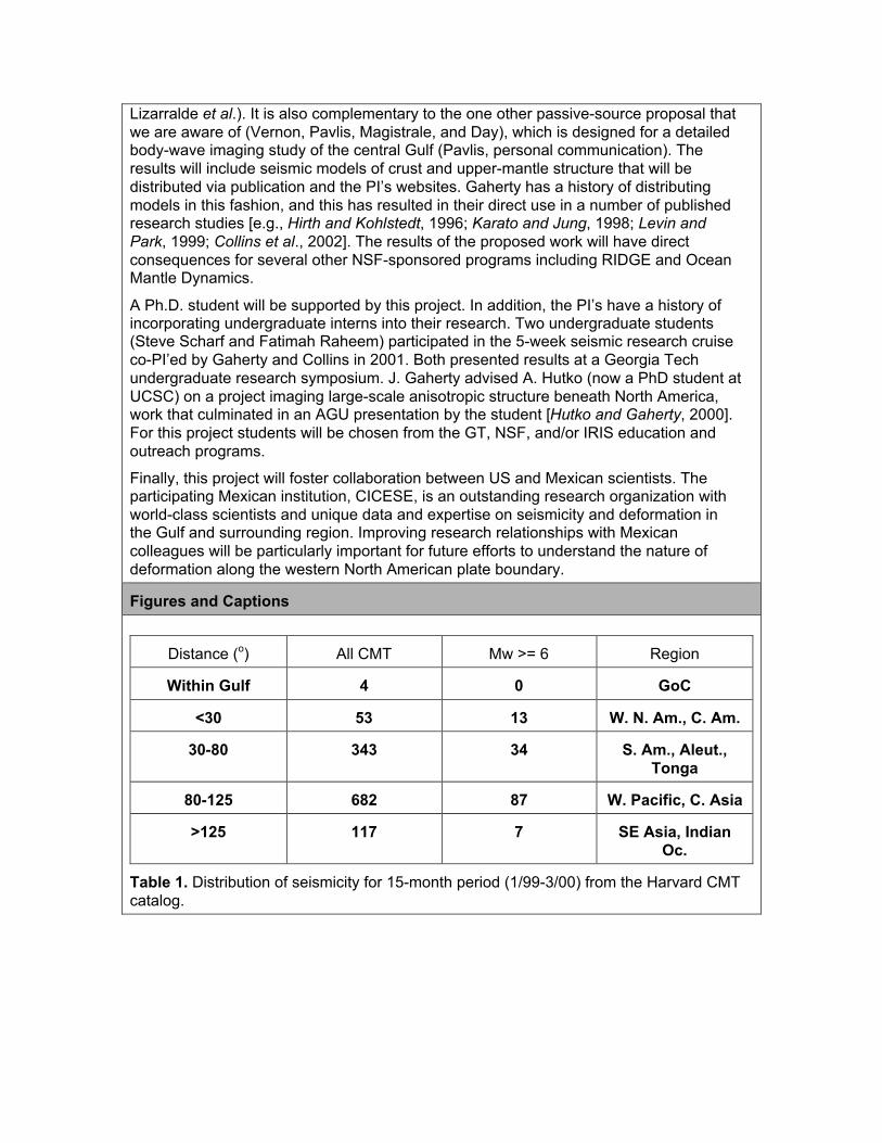
Distance (o) All CMT Mw >= 6 Region
Within Gulf 4 0 GoC
<30 53 13 W. N. Am., C. Am.
30-80 343 34 S. Am., Aleut.,Tonga
80-125 682 87 W. Pacific, C. Asia
>125 117 7 SE Asia, IndianOc.
Table 1. Distribution of seismicity for 15-month period (1/99-3/00) from the Harvard CMTcatalog.
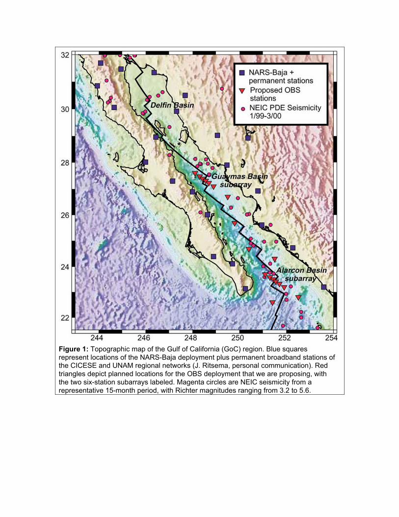
Figure 1: Topographic map of the Gulf of California (GoC) region. Blue squaresrepresent locations of the NARS-Baja deployment plus permanent broadband stations ofthe CICESE and UNAM regional networks (J. Ritsema, personal communication). Redtriangles depict planned locations for the OBS deployment that we are proposing, withthe two six-station subarrays labeled. Magenta circles are NEIC seismicity from arepresentative 15-month period, with Richter magnitudes ranging from 3.2 to 5.6.
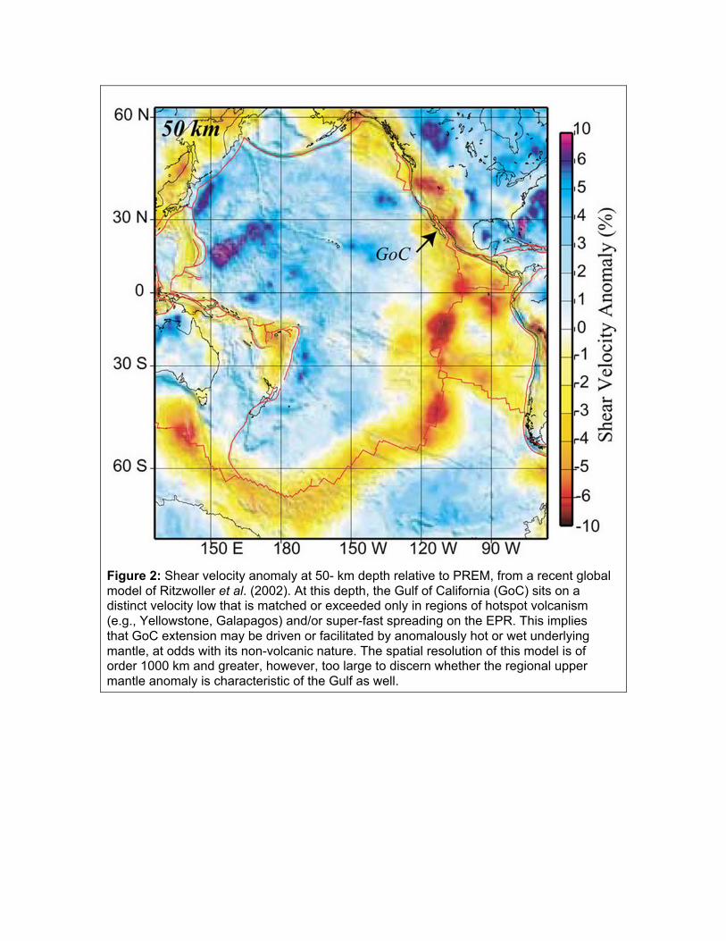
Figure 2: Shear velocity anomaly at 50- km depth relative to PREM, from a recent globalmodel of Ritzwoller et al. (2002). At this depth, the Gulf of California (GoC) sits on adistinct velocity low that is matched or exceeded only in regions of hotspot volcanism(e.g., Yellowstone, Galapagos) and/or super-fast spreading on the EPR. This impliesthat GoC extension may be driven or facilitated by anomalously hot or wet underlyingmantle, at odds with its non-volcanic nature. The spatial resolution of this model is oforder 1000 km and greater, however, too large to discern whether the regional uppermantle anomaly is characteristic of the Gulf as well.
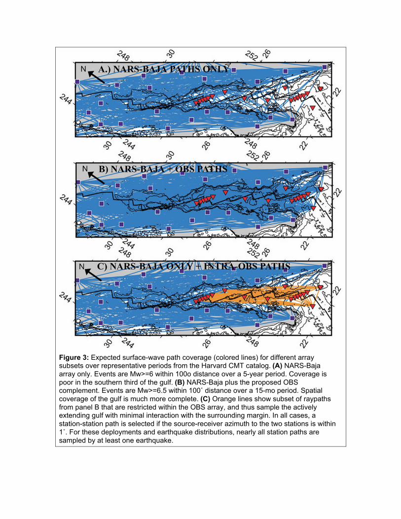
Figure 3: Expected surface-wave path coverage (colored lines) for different arraysubsets over representative periods from the Harvard CMT catalog. (A) NARS-Bajaarray only. Events are Mw>=6 within 100o distance over a 5-year period. Coverage ispoor in the southern third of the gulf. (B) NARS-Baja plus the proposed OBScomplement. Events are Mw>=6.5 within 100˚ distance over a 15-mo period. Spatialcoverage of the gulf is much more complete. (C) Orange lines show subset of raypathsfrom panel B that are restricted within the OBS array, and thus sample the activelyextending gulf with minimal interaction with the surrounding margin. In all cases, astation-station path is selected if the source-receiver azimuth to the two stations is within1˚. For these deployments and earthquake distributions, nearly all station paths aresampled by at least one earthquake.
References
Atwater, T., Plate tectonic history of the northeast Pacific and western North America, inThe eastern Pacific Ocean and Hawaii, edited by E.L. Winterer, D.M. Hussong, andR.W. Decker, Geological Society of America, Boulder, Colorado, p. 21-72, 1989.
Axen, G.J., M. Grove, D. Stockli, O.M. Lovera, D.A. Rothstein, J.M. Fletcher, K. Farley,and P.L. Abbott, Thermal evolution of Monte Blanco dome: Low-angle normal faultingduring Gulf of California rifting and late Eocene denudation of the eastern PeninsularRanges, Tectonics, 19, 197-212, 2000.
Beghoul, N., and M. Barazangi, Azimuthal anisotropy of velocity in the mantle beneaththe Basin and Range Province, Nature, 348, 536-538, 1990.
Bostock, M. G., Anisotropic upper-mantle stratigraphy and architecture of the Slavecraton, Nature, 390, 392-395, 1997.
Bostock, M.G., Mantle stratigraphy and evolution of the Slave province, J. Geophys.Res., 103, 21183-21200, 1998.
Castro, R., Rebollar, C.J. L. Inzunza, L. Orozco, J. Sánchez, O. Gálvez, F.J. Farfán andI. Méndez. "Direct body-wave Q estimates in northern Baja California, México". Physicsof the Earth and Planetary Interiors, Vol. 103, pp. 33-38, 1997.
Collins, C. A., N. Garfield, A. S. Mascarenhas, M. G. Spearman, and T. A. Rago, Oceancurrents across the mouth of the Gulf of California, J. Geophys. Res., 102,20927–20936, 1997.
Collins, J. A., F. L. Vernon, J.A. Orcutt, R.A. Stephen, K.R. Peal, F. B. Wooding, F. N.Spiess, and J. A. Hildebrand, Broadband seismology in the oceans: lessons from theOcean Seismic Network Pilot Experiment, Geophys. Res. Lett., 28, 49-52, 2001.
Collins, J.A., F. L. Vernon, J. A. Orcutt, and R. A. Stephen, Upper mantle structurebeneath the Hawaiian swell: constraints from the Ocean Seismic network PilotExperiment, Geophys. Res. Lett., 29(11), 10.1029/2001GL013302, 2002.
Das, T. and G. Nolet, Crustal thickness map of the western US by partitioned waveforminversion, J. Geophys. Res., 103, 30,021-30,038, 1998.
DeMets, C.A., Reappraisal of seafloor spreading lineations in the Gulf of California:Implications for the transfer of Baja California to the Pacific plate and estimates ofPacific-North America motion, Geophy. Res. Let., 22, 3545-3548, 1995.
Dunn, R., and D. W. Forsyth, Short-period Love waves reveal the transition from broadmantle upwelling to the narrow crustal magmatic system beneath the southern EastPacific Rise, Eos. Trans. AGU, 82(47), Fall Meeting Suppl., Abstract T12A-0898, 2001.
Dunn, R., and D. W. Forsyth, Imaging the transition between the region of mantle meltgeneration and the crustal magma chamber beneath the southern East Pacific Rise withshort-period Love waves, submitted to J. Geophys. Res., September, 2002.
Ekström, G., and A. M. Dziewonski, The unique anisotropy of the Pacific, Nature, 394,168, 1998.
Forsyth, D. W., S. C. Webb, L. M. Dorman, and Y. Shen, Phase velocities of Rayleighwaves in the MELT experiment on the East Pacific Rise, Science, 280, 1235-1238,1998a.
Forsyth, D. W., D. S. Scheirer, S. C. Webb, L. M. Dorman, J. A. Orcutt, A. J. Harding, D.K. Blackman, J. Phipps Morgan, R. S. Detrick, Y. Shen, C. J. Wolfe, P. Canales, D. R.Toomey, A. F. Sheehan, S. C. Solomon, and W. S. D. Wilcock, Imaging the deepstructure beneath a mid-ocean ridge: Overview of the seismological component of theMELT experiment, Science, 280, 1215-1218, 1998b.
MELT experiment, Science, 280, 1215-1218, 1998b.
Freybourger, M., J.B. Gaherty, and T.H. Jordan, Upper-mantle structure of the Kaapvaalcraton from surface-wave analysis, Geophys. Res. Lett., 28 , 2489, 2001.
Gaherty, J.B., Seismic evidence for hotspot-driven buoyant upwelling beneath theReykjanes Ridge, Science, 293, 1645-1647, 2001.
Gaherty, J. B., and T. H. Jordan, Lehmann discontinuity as the base of an anisotropiclayer beneath continents, Science, 268, 1468-1471, 1995.
Gaherty, J. B., T. H. Jordan, and L. S. Gee, Seismic structure of the upper mantle in thecentral Pacific corridor, J. Geophys. Res., 101, 22,291-22,309, 1996.
Gaherty, J. B., M. Kato, and T. H. Jordan, Seismological structure of the upper mantle: aregional comparison of seismic layering, Phys. Earth Planet. Int., 110, 21-41, 1999.
Gaherty, J.B., D. Lizarralde, J.A. Collins, and G. Hirth, Far-offset Airgun Imaging of theMantle: Lithospheric Anisotropy of the North Atlantic, EOS Trans, 82, F1113, fall meetingsuppl., 2001.
Galea, P., Upper mantle anisotropy in the south-west Pacific from earthquake travel timeanalysis, Phys. Earth Planet. Inter., 76, 229-239, 1993.
Gee, L. S., and T. H. Jordan, Generalized seismological data functionals, Geophys. J.Int., 111, 363-390, 1992.
Gilbert, Hersh J., A. F. Sheehan, D. A. Wiens, K. G. Dueker, L. M. Dorman, J.Hildebrand, and S.Webb, Upper mantle discontinuity structure in the region of the TongaSubduction Zone, Geophys. Res. Lett., 28, 1855-1858, 2001.
Gupta, P. and J.B. Gaherty, Upper-mantle anisotropy beneath California and thesurrounding region, EOS Trans, 81, fall meeting supplement, 2000.
Hammond, W. C. and D. R. Toomey, Seismic velocity anisotropy and heterogeneitybeneath the MELT region of the East Pacific Rise from analysis of P and S body waves,J. Geophys Res., submitted, 2002.
Hearn, T. M., Pn Travel times in southern California, J. Geophys. Res., 89, 1843-1855,1984.
Holbrook, W.S. and P.B. Keleman, Large igneous province on the US-Atlantic Marginand implications for magmatism during continental breakup, Nature, 364, 433-436, 1993.
Hutko, A. and J.B. Gaherty, Upper-mantle anisotropy beneath North America:Comparing active and stable tectonic regimes, EOS Trans, 81, spring meetingsupplement, 2000.
Jones, C.J., J.R. Unruh, and L.. Sonder, The role of gravitational potential energy inactive deformation in the southwestern US, Nature, 381, 37-41, 1996.
Langmuir, C.H., E.M. Klein, and T. Plank, Petrological systematics of mid-ocean ridgebasalts: Constraints on melt generation beneath ocean ridges, in J.P. Morgan, D.K.Blackman, and J.M. Sinton, Eds., Mantle Flow and Melt Generation at Mid-OceanRidges, Geophysical Monograph 71, American Geophysical Union, 183-281,1993.
Laske, G.J., J. Phipps Morgan, and J. Orcutt, First results from the Hawaiian SWELLpilot experiment, Geophys. Res. Lett., 26 (22), 3397-3400, 1999.
Laske, G.J. and J. Orcutt, The Hawaiian SWELL experiment: An example for the need ofbroad-band ocean bottom seismograms, in Fall A.G.U. Meeting, pp. F819, Eos,Transactions, American Geophysical Union (Supplement), San Francisco, CA, 2000.
Lizarralde, D., J.B. Gaherty, J.A. Collins, and G. Hirth, Far-offset Airgun Imaging of theMantle: Lithospheric velocity structure of the North Atlantic, EOS Trans, 82, F1113, fallmeeting suppl., 2001.
meeting suppl., 2001.
Lonsdale, P., Geology and tectonic history of the Gulf of California, in, Winterer, E. L., etal., eds., The eastern Pacific Ocean and Hawaii: Boulder, Colorado, Geological Societyof America, Geology of North America, v. N, p. 499–521, 1989.
Katzman, R., L. Zhao, and T.H. Jordan, High-resolution, 2D vertical tomography of thecentral-Pacific mantle using ScS reverberations and frequency-dependent travel times.J. Geophys. Res., 103: 17,933-17,971, 1998.
Marinone, S. G., Effect of the topographic stress on the tide- and wind-induced residualcurrents in the Gulf of California, J. Geophys. Res., 103, 18437-18446, 1998.
Merrifield, M. A., and C. D. Winant, Shelf circulation in the Gulf of California: Adescription of the variability, J. Geophys. Res., 94, 18133-18160, 1989.
Montagner, J.-P., Upper mantle low anisotropy channels below the Pacific plate, EarthPlanet Sci. Lett., 6320, 1-12, 2002.
Montagner, J.-P. and T. Tanimoto, Global upper-mantle tomography of seismic velocitiesand anisotropy, J. Geophys. Res., 96, 20,337-20,351, 1991.
Levin, V., and J. Park, Quasi-Love phases between Tonga and Hawaii: Observations,simulations, and explanations, J. Geophys. Res., 103, 24321-24331, 1998.
Nagy, E.A., and J.M. Stock, Structural controls on the continent-ocean transition in thenorthern Gulf of California, J. Geophys. Res., 105, 16,251-16,269, 2000.
Nishimura, C.E. and D.W. Forsyth, The anisotropic structure of the upper mantle in thePacific, Geophys. J., 96, 203-229, 1989.
Rebollar, C.J., Traslosheros, C. and Alvarez, R., "Estimates of Seismic WaveAttenuation in Northern Baja California". Bulletin of the Seismological Society ofAmerica, Vol. 75. 5, pp. 1371-1382, 1985.
Revenaugh, J., and T. H. Jordan, Mantle layering from ScS reverberations, 1. Waveforminversion of zeroth-order reverberations, J. Geophys. Res., 96, 19,749-19,762, 1991a.
Revenaugh, J., and T. H. Jordan, Mantle layering from ScS reverberations, 2. Thetransition zone, J. Geophys. Res., 96, 19,763-19,780, 1991b.
Revenaugh, J., and T. H. Jordan, Mantle layering from ScS reverberations, 3. The uppermantle, J. Geophys. Res., 96, 19,781-19,810, 1991c.
Ritsema, J., and H.-J. van Heijst ,Seismic imaging of structural heterogeneity in Earth'smantle: Evidence for large-scale mantle flow, Science Progress, 83, 243-259, 2000.
Ritzwoller, M.H., Shapiro, N.M., Barmin, M.P., and Levshin, A.L., Global surface wavediffraction tomography, J. Geophis. Res., submitted, 2002
Rumpker, G. and P.G. Silver, Apparent shear-wave splitting parameters in the presenceof vertically varying anisotropy, Geophys. J. Int., 135, 790, 1998.
Ruppel, C., Extensional processes in continental lithosphere, J. Geophys. Res., 100,24,187-24,215, 1995.
Savage, M. K., and A. F. Sheehan, Seismic anisotropy and mantle flow from the GreatBasin to the Great Plains, western United States, J. Geophys.Res., 105, 13715-13734,2000.
Savage, M., and P. G. Silver, Mantle deformation and tectonics: constraints from seismicanisotropy in the western United States, Phys. Earth Planet. Int., 78, 207-227, 1993.
Sheehan, A. F., Mantle discontinuity structure beneath the southern East Pacific Rise(MELT experiment region) from P-to-S converted phases, RIDGE Mantle Flow and MeltGeneration beneath Ocean Ridges: Constraints from MELT and other ExperimentsWorkshop (invited), Brown University, Providence, Rhode Island, October 1997.
Workshop (invited), Brown University, Providence, Rhode Island, October 1997.
Shen, Y., A. Sheehan, K. Dueker, C. de Groot-Hedlin, and H. Gilbert, Mantlediscontinuity structure beneath the southern East Pacific Rise (MELT experiment region)from P-to-S converted phases, Science, 280, 1232-1235, 1998.
Silver, P. G. and W. E. Holt, The mantle flow field beneath western North America,Science, 295, 1054-1057, 2002.
Silver, P. G., and M. K. Savage, The interpretation of shear-wave splitting parameters inthe presence of two anisotropic layers, Geophys. J. Int., 119, 949-963, 1994.
Smith, G. P, and G. Ekström, A global study of Pn anisotropy beneath continents, J.Geophys. Res., 104, 963-980, 1999.
Stock, J.M., and J. Lee, Do microplates in subduction zones leave a geological record?,Tectonics, 13, 1472-1488, 1994.
Tarantola, A. and B. Valette, Generalized nonlinear inverse problems solved using theleast squares criterion, Revs. Geophys. Space Phys., 20, 219-232, 1982.
Toomey, D.R., W.S.D. Wilcock, S.C. Solomon, W.C. Hammond, and J.A. Orcutt, Mantleseismic structure beneath the MELT region of the East Pacific Rise from P and S wavetomography, Science, 280, 1224, 1998
VanDecar, J.C., Upper-Mantle Structure of theCascadia Subduction Zone from Non-Linear Teleseismic Travel-Time Inversion, Ph.D. thesis, University of Washington,Seattle, 165 pp., 1991.
Walker, D., High-frequency Pn and Sn phases recorded in the western Pacific, J.Geophys. Res., 82, 1977.
Webb, S. C., Broadband seismology and noise under the ocean, Rev. Geophys., 36,105-142, 1998
Wilcock, W. S. D., S. C. Webb, and I. T. Bjarnson, The effect of local wind on seismicnoise near 1 Hz at the MELT site and in Iceland, Bull. Seismo. Soc. Am., 89, 1543-1557,1999.
Wolfe, C. J., and P. G. Silver, Seismic anisotropy of oceanic lithosphere: Shear-wavesplitting methodologies and observations, J. Geophys. Res., 103, 749-771, 1998.
Wolfe, C. J., and S. C.. Solomon, Shear-wave splitting and implications for mantle flowbeneath the MELT region of the East Pacific Rise, Science, 280, 1230-1232, 1998.
Wong, V.,C.J. Rebollar and L. Munguía. “Attenuation of coda waves at the TresVirgenes Volcanic area, Baja California Sur, México”. Bull. Seis. Soc. Am., 91, 683-693,2001.
Zhu, L, Crustal structure across the San Andreas Fault, southern California fromteleseismic converted waves, Earth Planet. Sci. Lett., 179, 183-190, 2000.