Embed Size (px)
Citation preview

RD_Desc RD_Locality RD_Town RD_Adoption_
Status
RD_Whole_R
d
WD_DESC WD_NAME USRN
A81 from A811 to A821 <none> Balfron/Aberfoyle Public Road Yes From the A811 Stirling - Dumbarton Road
to the A821 Aberfoyle - Trossachs -
Callander Road.
A81 from A811 to
A821
38008045
A81 from A821 to Port of
Menteith
<none> by Port of Menteith Public Road Yes From the A821 Aberfoyle - Trossachs -
Callander Road to the A873
Blairdrummond - Thornhill - Aberfoyle
Road.
A81 from A821 to
Port of Menteith,
by Port of
Menteith
38008034
A81 from Port of Menteith
to A873
<none> by Port of Menteith Public Road Yes From Port of Menteith to the A873
Blairdrummond - Thornhill - Aberfoyle
Road.
A81 from Port of
Menteith to A873,
by Port of
Menteith
38002371
A81 from A873 to Callander <none> By Callander Public Road Yes From the A873 Blairdrummond - Thornhill -
Aberfoyle Road to Callander.
Road Past
McLaren High
School, by
Callander
38008033
A81 from A875 to B834 <none> Balfron Station Public Road Yes From the A875 Dumgoyne - Kepculloch
Road to the B834 Finnich Toll Road.
A81 from A875 to
B834, Balfron
Station
38008066
A81 from B834 to A811 <none> by Killearn Public Road Yes From the B834 Finnich Toll - Killearn Road
to the A811 Stirling - Dumbarton Road.
A81 from B834 to
A811, by Killearn
38008046
A81 from Council Boundary
to Strathblane
<none> by Strathblane Public Road Yes From the Council Boundary near
Craigmaddie House to Strathblane.
A81 from Council
Boundary to
Strathblane, by
Strathblane
38008068
A81 from Strathblane to
A875
<none> by Strathblane Public Road Yes From Strathblane to the A875 Dumgoyne -
Kepculloch Road.
A81 from
Strathblane to
A875, by
Strathblane
38008067
A811 from Ballat X-Roads
to Council Boundary
<none> by Buchlyvie Public Road Yes From Ballat Cross-Roads to the Council
Boundary near Kilmarnock House
(Badshalloch) 1.7 km west of the A809
Glasgow - Drymen Road.
A811 from Ballat
X-Roads to
Council
Boundary, by
Buchlyvie
38008042
20/04/2018 Page 1 of 185

RD_Desc RD_Locality RD_Town RD_Adoption_
Status
RD_Whole_R
d
WD_DESC WD_NAME USRN
A811 from Buchlyvie to
Ballat X-Roads
<none> by Buchlyvie Public Road Yes From Buchlyvie to Ballat Crossroads. A811 from
Buchlyvie to
Ballat X-Roads,
by Buchlyvie
38008043
A811 from Stirling to
Buchlyvie
<none> Stirling Public Road Yes From Stirling to Buchlyvie. A811 from Stirling
to Buchlyvie,
Stirling /
Buchlyvie
38008047
A820 from Dunblane to
Doune
<none> By Dunblane Public Road Yes From Dunblane to Doune. A820 from
Dunblane to
Doune, by
Dunblane
38008087
A821 from Aberfoyle to A81 <none> Aberfoyle Public Road Yes From Main Street A821 at the entrance to
"Dounans Camp" to the A81 Glasgow –
Aberfoyle - Callander Road at the Rob Roy
Hotel.
A821 from
Aberfoyle to A81,
Aberfoyle
38002367
A821 from Aberfoyle to
A84T
<none> by Aberfoyle Public Road Yes From Aberfoyle to the A84T Stirling -
Lochearnhead Road.
A821 from
Aberfoyle to
A84T, by
Aberfoyle
38008032
A827 from A85T at Lix Toll
to Killin
<none> By Killin Public Road Yes From the A85T Lochearnhead - Crianlarich
Road at Lix Toll to Killin.
A827 from
Junction A85T at
Lix Toll to Killin,
by Killin
38008013
A827 from Killin to Council
Boundary
<none> By Killin Public Road Yes From Killin Village to the Council Boundary
near Killin Power Station 1348 metres east
of Killin.
A827 from Killin to
Council
Boundary, by
Killin
38008012
A82T from A85T Tyndrum
to Council Boundary
Maintained by Highland
<none> by Tyndrum Trunk Road Yes From the A85T north of Tyndrum to the
Council Boundary at Blackmount North of
Tyndrum. Note:- This section of road is
maintained by Highland Council.
Tyndrum - Clifton
Road, by
Tyndrum
38008000
A82T from A85T/A82T
Crianlarich to A85T
Tyndrum
<none> By Crianlarich Trunk Road Yes From the C33 Braes of Balquhidder Road
to A84T / A85T at Lochearnhead.
A84T from C33 to
A84T/A85T
junction, by
Lochearnhead
38008001
20/04/2018 Page 2 of 185
RD_Desc RD_Locality RD_Town RD_Adoption_
Status
RD_Whole_R
d
WD_DESC WD_NAME USRN
A82T from Council
Boundary to A85T/A82T
Crianlarich
<none> By Crianlarich Trunk Road Yes From Council Boundary near Inverarnan
Inn to A85T / A82T in Crianlarich Village.
A82T from
Council Boundary
to A85T / A82T,
by Crianlarich
38008002
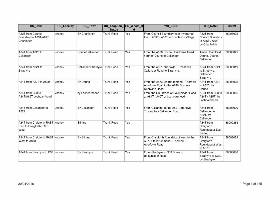
A84T from A820 to
Callander
<none> Doune/Callander Trunk Road Yes From the A820 Doune - Dunblane Road
north of Doune to Callander
Trunk Road Past
Doune, Doune /
Callander
38008021
A84T from A821 to
Strathyre
<none> Callander/Strathyre Trunk Road Yes From the A821 Aberfoyle - Trossachs -
Callander Road to Strathyre.
A84T from A821
to Strathyre,
Callander /
Strathyre
38008019
A84T from A873 to A820 <none> By Doune Trunk Road Yes From the A873 Blairdrummond - Thornhill -
Aberfoyle Road to the A820 Doune –
Dunblane Road.
A84T from A873
to A820, by
Doune
38008022
A84T from C33 to
A84T/A85T Lochearnhead
<none> by Lochearnhead Trunk Road Yes From the C33 Braes of Balquhidder Road
at A84T / A85T at Lochearnhead.
A84T from C33 to
A84T / A85T, by
Lochearnhead
38008005
A84T from Callander to
A821
<none> By Callander Trunk Road Yes From Callander to the A821 Aberfoyle -
Trossachs - Callander Road.
A84T from
Callander to
A821, by
Callander
38008020
A84T from Craigforth RABT
East to Craigforth RABT
West
<none> Stirling Trunk Road Yes A84T from
Craigforth
Roundabout East,
Stirling
38002288
A84T from Craigforth RABT
West to A873
<none> By Stirling Trunk Road Yes From Craigforth Roundabout west to the
A873 Blairdrummond --Thornhill –
Aberfoyle Road.
A84T from
Craigforth
Roundabout West
to A873
38008023
A84T from Strathyre to C33 <none> By Strathyre Trunk Road Yes From Strathyre to C33 Braes of
Balquhidder Road.
A84T from
Strathyre to C33,
by Strathyre
38008006
20/04/2018 Page 3 of 185

RD_Desc RD_Locality RD_Town RD_Adoption_
Status
RD_Whole_R
d
WD_DESC WD_NAME USRN
A85T from A84T at
Lochearnhead to A827
<none> by Lochearnhead Trunk Road Yes From the A84T Stirling - Lochearnhead
Road at Lochearnhead to the A827 Killin –
Aberfeldy Road at Lix Toll.
A85T from A84T
Junction at
Lochearnhead to
A827, by
Lochearnhead
38008004
A85T from Council
Boundary to A84T/A85T
Lochearnhead
<none> by Lochearnhead Trunk Road Yes From the Council Bounary near "Derry" /
Derrywood to the A84T/ A85T at
Lochearnhead.
A85T from
Council Boundary
to A84T / A85T,
by Lochearnhead
38008011
A85T from the A82T at
Tyndrum to Council
Boundary
<none> by Tyndrum Trunk Road Yes From the A82T at Clifton, Tyndrum to the
Council Boundary. Note:- This section of
road is maintained by Highland Council.
A85T from the
A82T at Clifton,
by Tyndrum
38002372
A872 from Bannockburn
Interchange to Milton
Terrace Stirling
<none> By Stirling Public Road Yes From Bannockburn Interchange (Pirnhall)
to Milton Terrace, Stirling.
A872 from
Bannockburn
Interchange to
Milton Terrace,
Stirling, by Stirling
38008110
A872 from Council
Boundary near Northfield
Road to Bannockburn
RABT
<none> by Bannockburn Public Road Yes From the Council Boundary 200 metres
south of Northfield Road to Bannockburn
Interchange (Pirnhall).
A872 from
Council Boundary
near Northfield
Road to
Bannockburn
Roundabout, by
Bannockburn
38008105
A873 from A84T to
Thornhill
<none> by Thornhill Public Road Yes From the A84T Stirling - Lochearnhead
Road to Thornhill.
A873 from
Junction A84T to
Thornhill, by
Thornhill
38008031
A873 from Thornhill to A81 <none> by Thornhill Public Road Yes From Thornhill to the A81 Glasgow -
Aberfoyle - Callander Road.
A873 from
Thornhill to A81,
by Thornhill
38008030
A875 from A811 to Balfron <none> By Balfron Public Road Yes From the A811 Stirling - Dumbarton Road
to Balfron.
A875 from A811
to Balfron, by
Balfron
38008016
20/04/2018 Page 4 of 185

RD_Desc RD_Locality RD_Town RD_Adoption_
Status
RD_Whole_R
d
WD_DESC WD_NAME USRN
A875 from Balfron to
Killearn
<none> By Balfron Public Road Yes From Balfron Village to Killearn Village. A875 from Balfron
to Killearn, by
Balfron
38008015
A875 from Killearn to A81 <none> by Killearn Public Road Yes From Killearn to the A81 Glasgow -
Aberfoyle - Callander Road.
A875 from
Killearn to A81, by
Killearn
38008065
A891 from Council
Boundary to Strathblane
<none> by Strathblane Public Road Yes From the Council Boundary near Ballagan
Farm to Strathblane.
A891 from
Council Boundary
to Strathblane, by
Strathblane
38008064
A9 from Bridge of Allan to
Keir Roundabout
<none> By Bridge of Allan Public Road Yes From Bridge of Allan to Keir Roundabout. A9 from Bridge of
Allan to Keir
Roundabout, by
Bridge of Allan
38008077
A9 from Council Boundary
(near C65 Bogend Road) to
Plean
<none> By Plean Public Road Yes From the Council Boundary (near C65
Bogend Road) to Plean.
A9 from Council
Boundary (near
C65 Bogend
Road) to Plean,
by Plean
38008103
A9 from Plean to
Bannockburn
<none> by Bannockburn Public Road Yes From Plean to Bannockburn, plus access
to Muirpark Garage.
A9 from Plean to
Bannockburn, by
Bannockburn
38008102
A905 from Council
Boundary near Throsk to
Throsk
<none> by Throsk Public Road Yes From the Council Boundary near
"Poppletrees" 500 metres east of the South
Alloa Road junction to Throsk.
A905 from
Council Boundary
near Throsk to
Throsk, by Throsk
38008101
A905 from Fallin to Millhall
Roundabout
<none> by Fallin Public Road Yes From Fallin to Millhall Roundabout A91. A905 from Fallin
to Millhall
Roundabout, by
Fallin
38008099
A905 from Throsk to Fallin <none> by Fallin Public Road Yes From Throsk to Fallin. A905 from Throsk
to Fallin, by Fallin
38008100
20/04/2018 Page 5 of 185
RD_Desc RD_Locality RD_Town RD_Adoption_
Status
RD_Whole_R
d
WD_DESC WD_NAME USRN
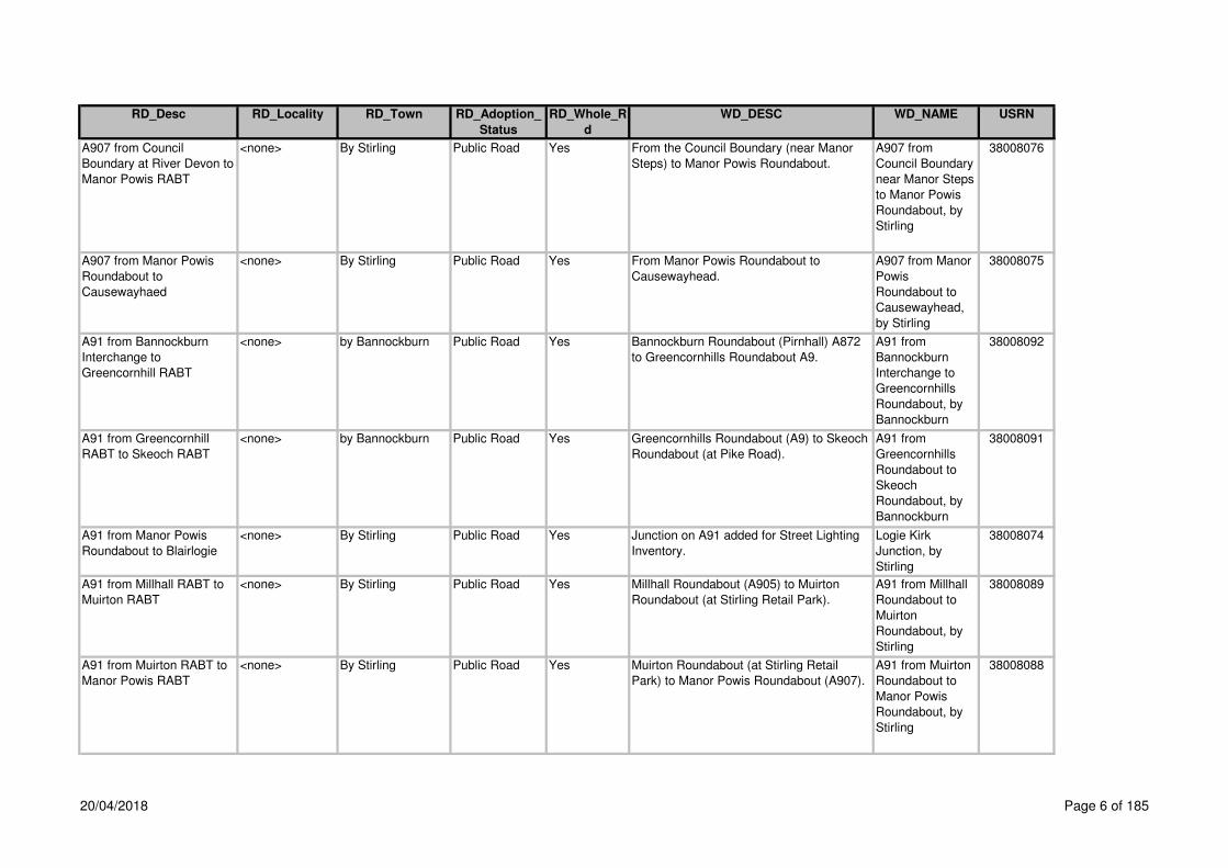
A907 from Council
Boundary at River Devon to
Manor Powis RABT
<none> By Stirling Public Road Yes From the Council Boundary (near Manor
Steps) to Manor Powis Roundabout.
A907 from
Council Boundary
near Manor Steps
to Manor Powis
Roundabout, by
Stirling
38008076
A907 from Manor Powis
Roundabout to
Causewayhaed
<none> By Stirling Public Road Yes From Manor Powis Roundabout to
Causewayhead.
A907 from Manor
Powis
Roundabout to
Causewayhead,
by Stirling
38008075
A91 from Bannockburn
Interchange to
Greencornhill RABT
<none> by Bannockburn Public Road Yes Bannockburn Roundabout (Pirnhall) A872
to Greencornhills Roundabout A9.
A91 from
Bannockburn
Interchange to
Greencornhills
Roundabout, by
Bannockburn
38008092
A91 from Greencornhill
RABT to Skeoch RABT
<none> by Bannockburn Public Road Yes Greencornhills Roundabout (A9) to Skeoch
Roundabout (at Pike Road).
A91 from
Greencornhills
Roundabout to
Skeoch
Roundabout, by
Bannockburn
38008091
A91 from Manor Powis
Roundabout to Blairlogie
<none> By Stirling Public Road Yes Junction on A91 added for Street Lighting
Inventory.
Logie Kirk
Junction, by
Stirling
38008074
A91 from Millhall RABT to
Muirton RABT
<none> By Stirling Public Road Yes Millhall Roundabout (A905) to Muirton
Roundabout (at Stirling Retail Park).
A91 from Millhall
Roundabout to
Muirton
Roundabout, by
Stirling
38008089
A91 from Muirton RABT to
Manor Powis RABT
<none> By Stirling Public Road Yes Muirton Roundabout (at Stirling Retail
Park) to Manor Powis Roundabout (A907).
A91 from Muirton
Roundabout to
Manor Powis
Roundabout, by
Stirling
38008088
20/04/2018 Page 6 of 185

RD_Desc RD_Locality RD_Town RD_Adoption_
Status
RD_Whole_R
d
WD_DESC WD_NAME USRN
A91 from Skeoch RABT to
Millhall RABT
<none> By Stirling Public Road Yes From Skeoch Roundabout (at Pike Road)
to Millhall Roundabout (A905).
A91 from Skeoch
Roundabout to
Millhall
Roundabout, by
Stirling
38008090
A9T from A820 to B8033 <none> By Dunblane Trunk Road Yes From the A820 Doune - Dunblane Road to
the B8033 Kinbuck - Braco Road.
A9T from A820 to
B8033, by
Dunblane
38008079
A9T from B8033 to Council
Boundary
<none> By Dunblane Trunk Road Yes From the B8033 Kinbuck - Braco Road to
the Council Boundary at Balhaldie.
A9T from B8033
to Council
Boundary, by
Dunblane
38008078
A9T from Keir Roundabout
to A820
<none> By Dunblane Trunk Road Yes From Keir Roundabout to the A820 Doune -
Dunblane Road.
A9T from Keir
Roundabout to
A820, by
Dunblane
38008080
Abbey Mill <none> Stirling Public Road Yes From Abbey Road forming a cul-de-sac 89
metres. Also from the above road forming
a cul-de-sac for 9 metres.
Abbey Mill,
Stirling
38001554
Abbey Road (C11) Riverside Stirling Public Road Yes From Forth Crescent / Millar Place to the
boundary fence at River Forth east of
Queenshaugh Drive.
Abbey Road,
Stirling
38000607
Abbey Road Place Riverside Stirling Public Road Yes Off the south side of Abbey Road opposite
Meadow Place.
Abbey Road
Place, Stirling
38000606
Abbey View Causewayhead Stirling Private Road Yes Off the east side of Logie Road B998, 43m
south of Hillfoots Road B998, opposite
Graham Avenue
Abbey
View,Stirling,
38001245
Abbeycraig Court Causewayhead Stirling Private Road Yes Abbey Craig
Court,Stirling,
38003207
Abbot Road <none> Stirling Public Road Yes From Broom Road forming a cul-de-sac. Abbot Road,
Stirling
38000608
Abbotsford Place <none> Stirling Public Road Yes From Millar Place (heel kerbline) to
Waverley Crescent (heel kerb line).
Abbotsford Place,
Stirling
38000609
Abercromby Drive <none> Bridge of Allan Public Road Yes Off the north side of Kenilworth Road
opposite Coneyhill Road to Sunnylaw
Road.
Abercromby
Drive, Bridge of
Allan
38000352
20/04/2018 Page 7 of 185

RD_Desc RD_Locality RD_Town RD_Adoption_
Status
RD_Whole_R
d
WD_DESC WD_NAME USRN
Abercromby Place Kings Park Stirling Public Road Yes From Clarendon Place to Glebe Avenue. Abercromby
Place, Stirling
38000610
Abercromby Place Lane <none> Stirling Private Road Yes Off the west side of Glebe Avenue south of
No. 4 forming a dead end
Abercrombie
Place
Lane,Stirling,
38001246
Aberfoyle – Kilmahog Road
by Aberfoyle
<none> Public Road Yes From the A81 Glasgow - Callander Road at
Braeval via Aberfoyle Main Street, Dukes
Pass, Brig O'Turk to A84T Stirling -
Lochearnhead Road at Kilmahog. Also
road from the above to Loch Katrine Pier.
Also footpath Brig O'Turk
Aberfoyle -
Kilmahog Road by
Aberfoyle
38001504
Aboyne Avenue Causewayhead Stirling Public Road Yes Off the west side of Dunster Road forming
a cul-de-sac.
Aboyne Avenue,
Stirling
38000353
Academy Place <none> Bannockburn Public Road Yes From West Murrayfield forming a cul-de-
sac with turning area.
Academy Place,
Bannockburn
38000611
Academy Road <none> Stirling Private Road No Off the west side of Spittal Street forming a
cul-de-sac at the Highland Hotel,
Academy
Road,Stirling,
38001529
Achray Avenue <none> Callander Public Road Yes From Lubnaig Drive forming a cul-de-sac
with turning area.
Achray Avenue,
Callander
38000040
Achray Drive Cornton Stirling Public Road Yes Off the east side of Strathmore Drive
forming a cul-de-sac.
Achray Drive,
Stirling
38000354
Adamson Place Cornton Stirling Public Road Yes Off the east side of Johnstone Avenue to
Edzell Drive.
Adamson Place,
Stirling
38000355
Afton Court <none> Stirling Public Road Yes From Linden Avenue forming a cul-de-sac. Afton Court,
Stirling
38000613
Airth Drive <none> Stirling Public Road Yes From Gillies Drive forming a cul-de-sac
with turning area 118m and cul-de-sac with
turning area 39m.
Airth Drive,
Stirling
38000614
20/04/2018 Page 8 of 185

RD_Desc RD_Locality RD_Town RD_Adoption_
Status
RD_Whole_R
d
WD_DESC WD_NAME USRN
Airth Station – Gallamuir -
Cowie – Bannockburn
Road
<none> Public Road Yes From the A905 Stirling – Edinburgh Low
Road via Falkirk - South Alloa Road C3,
Gallamuir Farm, Main Street, Cowie (part),
Bannockburn Road to the A91 Stirling
Eastern Distributor Road. Also the section
of old road from Gallamuir Road to
entrance to Plean Station, now closed to
vehicular traffic is a footpath.
Airth Station -
Gallamuir - Cowie
- Bannockburn
Road
38001440
Airthrey Avenue <none> Bridge of Allan Public Road Yes From the A81 Glasgow – Aberfoyle Road
south forming a cul-de-sac.
Ballewan
Crescent,
Blanefield
38000356
Airthrey Avenue <none> Bridge of Allan Public Road Yes Off the east side of Forglen Road to Anne
Drive.
Airthrey Avenue,
Bridge of Allan
38000356
Airthrey Road (A9) Causewayhead Stirling Public Road Yes From Causewayhead Road A9 Edinburgh -
Perth Road at Causewayhead Roundabout
to Henderson Street A9 Edinburgh - Perth
Road at the west side of the bridge at the
Railway Station. Also bellmouth access at
Monument Court, Causewayhead.
Airthrey Road,
Stirling
38000357
Airthrey Road RABT <none> Bridge of Allan Public Road No From Causewayhead Road A9 Edinburgh -
Perth Road at Causewayhead Roundabout
to Henderson Street A9 Edinburgh - Perth
Road at the west side of the bridge at the
Railway Station. Also bellmouth access at
Monument Court, Causewayhead.
Airthrey Road,
Stirling
38003111
Aitken Crescent <none> Whins of Milton Public Road Yes From Brock Place forming a cul-de-sac
with turning circle.
Aitken Crescent,
Whins of Milton
38000615
Albert Place <none> Stirling Public Road Yes From Dumbarton Road (East) to
Dumbarton road (West). Part of C121
Stirling – Dumbarton Road
Albert Place,
Stirling
38000616
Albert Street <none> Dunblane Public Road Yes Off the south side of Old Doune Road
opposite Cawdor Crescent to Roman Way.
Albert Street,
Dunblane
38000358
20/04/2018 Page 9 of 185

RD_Desc RD_Locality RD_Town RD_Adoption_
Status
RD_Whole_R
d
WD_DESC WD_NAME USRN
Alder Crescent <none> Killearn Public Road Yes Off the north side of Beech Drive 116
metres west of Main Street A875 forming a
cul-de-sac. Also from the above road
forming a cul-de-sac.
Alder Crescent,
Killearn
38000208
Alexander Drive <none> Bridge of Allan Public Road Yes Off the west side of Well Road forming a
cul-de-sac with turning circle including a
short spur.
Alexander Drive,
Bridge of Allan
38000359
Alexander McLeod Place <none> Fallin Public Road Yes From its junction with A905 in a southerly
direction forming a cul-de-sac. The cul-de-
sac is formed as conventional carriageway
aand footway which included a bellmouth
access only to a cul-de-sas in an easterly
direction also a shared surface with
delineated service strip. Phase 3 adopted 1
September 2010
Alexander
McLeod
Place,Fallin,
38002270
Alexandra Place <none> Stirling Public Road Yes From Argyll Avenue to Dean Crescent. Alexandra Place,
Stirling
38000617
Allan Park <none> Stirling Public Road Yes From King's Park C4 to Dumbarton Road
A811 Stirling - Dumbarton Road 270m.
Also a cul-de-sac off Allan Park 39m. Note:-
The section of road from Port Street A811
to the Cinema is split into two and is called
Allan Park C4 and King's Park Road C4
36m.
Allan Park,
Stirling
38000618
Allan Road <none> Killearn Public Road Yes From Napier Road to Endrick Road. Note:-
Endrick Road is Private.
Allan Road,
Killearn
38000209
Allan Walk <none> Bridge of Allan Public Road Yes Off west side of Blairforkie Drive. Allan Walk,
Bridge of Allan
38001577
Allan Walk Court <none> Bridge of Allan Private Yes off Allan Walk - Cal a Homes New
Development
Allan Walk Court,
Bridge of Allan
38005705
Allan Water Gardens <none> Bridge of Allan Public Road Yes From Well Road forming a cul-de-sac with
turning area.
Allan Water
Gardens, Bridge
of Allan
38000360
Allanbank Road <none> Kinbuck Public Road Yes From the B8033 Kinbuck – Braco Road
forming two culs-de-sac.
Allanbank Road,
Kinbuck
38000361
20/04/2018 Page 10 of 185

RD_Desc RD_Locality RD_Town RD_Adoption_
Status
RD_Whole_R
d
WD_DESC WD_NAME USRN
Allanvale Road <none> Bridge of Allan Public Road No From Union Street B823 Stirling - Bridge of
Allan Road at the leisure centre to Cornton
Road B823 Stirling - Bridge of Allan Road
58m north of the Fire Station.
Allanvale Road,
Bridge of Allan
38000363
Allanvale Road <none> Bridge of Allan Public Road No From Allanvale Road B823 Stirling - Bridge
of Allan Road at the leisure centre forming
a cul-de-sac. Also the steps leading to
Henderson Street.
Allanvale Road,
Bridge of Allan
(unclassified)
38000363
Allanvale Road <none> Bridge of Allan Private Road No Off the east side of Allanvale Road, fronting
onto houses Nos. 37 to 51
Allanvale
Road,Bridge of
Allan,
38000363
Allanview <none> Ashfield Private Road Yes From the north side of Railway Bridge
running along the north side of the village
Allan
View,Ashfield,
38001248
Allanwood Court <none> Bridge of Allan Public Road Yes Off the south side of Abercromby Drive, 71
metres west of Mine Road forming a cul-de-
sac.
Allanwood Court,
Bridge of Allan
38000364
Alloa Road (A907) Causewayhead Stirling Public Road Yes From the A9 at the eastern side of
Causewayhead Roundabout to the Stirling
Burgh Boundary at Logie Burn. Also
footway on south side, east of the A907
from the boundary of No. 48 for 89 metres.
Note:- Nos. 29, 27 and part of 23 Alloa
Road is Private. Note:- Waiting decision
from Scottish Office re-classify to A907.
Alloa Road,
Stirling
38000365
Alloway Drive <none> Cowie Public Road Yes From Burns Terrace to Mount Oliphant. Alloway Drive,
Cowie
38001062
Alloway Drive To Mount
Oliphant
<none> Cowie Public Road Yes Link footpath off the west side of Alloway
Drive at house No. 47 to the south side of
Mount Oliphant at house No. 40
Alloway Drive to
Mount
Oliphant,Cowie,
38001412
Almond Court <none> Stirling Public Road Yes From Springfield Road in a northerly and
westerly direction forming a cul-de-sac.
Almond Court,
Stirling
38000619
20/04/2018 Page 11 of 185

RD_Desc RD_Locality RD_Town RD_Adoption_
Status
RD_Whole_R
d
WD_DESC WD_NAME USRN
Alpin Drive <none> Dunblane Public Road Yes Easterly off Wedderburn Road for a
distance of 287m rejoining Wedderburn
Road. Also east and south cul-de-sacs
76m and 66m respectfully.
Alpin
Drive,Dunblane,
38003189
Ancaster Road <none> Callander Public Road Yes From Station Road to Bracklinn Road. Ancaster Road,
Callander
38000041
Ancaster Square North <none> Callander Public Road Yes Off the north side of Main Street A84T
Stirling - Lochearnhead Road. Also from
Square to Glenartney Street. Also car park
to rear of Rob Roy Centre. Note:-
Frontage to the Rob Roy Centre is Private.
Ancaster Square
North, Callander
38001523
Ancaster Square South <none> Callander Public Road Yes From Main Street A84T Stirling –
Lochearnhead Road to Main Street A84T
Stirling – Lochearnhead Road.
Ancaster Square
South, Callander
38000042
Anchorscross <none> Dunblane Public Road Yes Off the west side of Wallace Road. Also 2
footpaths from Anchorscross to Wallace
Road 38 metres and 52 metres.
Footpaths from Anchorscross to
Coldstream Avenue 58 metres. Footpaths
from Anchorscross to Bruce Avenue 37
metres.
Anchorscross,
Dunblane
38000367
Anderson Court <none> Dunblane Public Road Yes From Anderson Street forming a cul-de-sac
with turning area.
Anderson Court,
Dunblane
38000368
Anderson Place <none> Stirling Public Road Yes From Torbrex Road to St Valery Drive. Anderson Place,
Stirling
38000620
Anderson Street <none> Dunblane Public Road Yes From Ardoch Crescent and Well Place
forming a cul-de-sac. Note:- The
remainder of the street is Private.
Anderson Street,
Dunblane
38000369
Anne Drive <none> Bridge of Allan Public Road Yes Off the east side of Mayne Avenue to
Airthrey Avenue.
Anne Drive,
Bridge of Allan
38000370
Anne Street <none> Dunblane Public Road Yes Off the east side of Albert Street to Charles
Street.
Anne Street,
Dunblane
38000371
Annfield Drive <none> Stirling Public Road Yes From Linden Avenue to Muirend Road. Annfield Drive,
Stirling
38000621
20/04/2018 Page 12 of 185

RD_Desc RD_Locality RD_Town RD_Adoption_
Status
RD_Whole_R
d
WD_DESC WD_NAME USRN
Annfield Gardens <none> Stirling Public Road Yes Off the east side of Livilands Lane 59
metres north of Annfield Grove forming two
culs-de-sac.
Annfield Gardens,
Stirling
38001317
Annfield Grove <none> Stirling Public Road Yes Off the east side of Livilands Lane forming
a cul-de-sac.
Annfield Grove,
Stirling
38001318
Arbroath Crescent Causewayhead Stirling Public Road Yes From Lothian Crescent forming a cul-de-
sac. Also the slabbed path east of
Arbroath Crescent.
Arbroath
Crescent, Stirling
38000372
Arcade <none> Stirling Private Road Yes Pedestrian area off the west side of Murray
Place opposite Station Road to King Street
Arcade,Stirling, 38001249
Archers Avenue <none> Stirling Public Road Yes From Broom Road forming two culs-de-sac
with turning areas.
Archer's Avenue,
Stirling
38000622
Archie Bone Way <none> Fallin Public Road Yes South of Stirling Road, Forming a cul-de-
sac.
Archie Bone Wy,
Fallin
38005668
Ardgowan Place <none> Cowie Public Road Yes East of Fincastle Place for 151m Ardgowan Place,
Cowie
38003240
Ardleighton Court <none> Dunblane Private Road No Ardleighton
Court,Dunblane,
38003026
Ardmore Gardens <none> Drymen Public Road Yes Off the south side of Stirling Road B858,
forming two culs-de-sac . Also the short
section of footpath at south east corner of
site connecting cul-de-sac to public
footpath 33 metres. Also the short section
of footpath at the north west corner
connecting the cul-de-sac to Stirling Road
14 metres. Note:- The access roads to the
garages are Private.
Ardmore
Gardens, Drymen
38000155
Ardnablane <none> Dunblane Public Road Yes Ardnablane – From its Junction with
Leewood Park in an easterly
direction forming a cul-de-sac. Including
shared surface, traffic calming,
footways, bellmouth accesses, service
strips and associated parking
Ardnablane,
Dunblane
38004127
20/04/2018 Page 13 of 185

RD_Desc RD_Locality RD_Town RD_Adoption_
Status
RD_Whole_R
d
WD_DESC WD_NAME USRN
Ardoch Crescent <none> Dunblane Public Road No From Atholl Place to Well Place / Anderson
Street. Note:- Nos 1 - 11 are Private.
Ardoch Crescent,
Dunblane
38000373
Ardoch Crescent <none> Dunblane Private Road No 1 - 11 Private Ardoch
Crescent,Dunblan
e,
38000373
Ardochbank (A820) <none> Doune Public Road Yes From the A820 Doune – Dunblane Road at
the B824 to Main Street A820 Doune -
Dunblane at Queen Street.
Ardochbank,
Doune
38000043
Argyle Grove <none> Dunblane Public Road Yes From Argyle Terrace forming two culs-de-
sac with turning areas.
Argyle Grove,
Dunblane
38000374
Argyle Park <none> Dunblane Public Road Yes From Argyle Way forming a cul-de-sac with
turning area. Also the pedestrian link to
Braemar Avenue.
Argyle Park,
Dunblane
38000375
Argyle Terrace <none> Dunblane Public Road Yes From Argyle Way to Argyle Way including
cul-de-sac with turning circle.
Argyle Terrace,
Dunblane
38000376
Argyle Way <none> Dunblane Public Road Yes From Roman Way to Argyle Way including
2 culs-de-sac. Note:- The carriageway ex
adverso Nos. 10 to 16 is Private.
Argyle Way,
Dunblane
38000377
Argyll Avenue (C11) <none> Stirling Public Road Yes From Forrest Road to Millar Place. Argyll Avenue,
Stirling
38000623
Armour Avenue <none> Cowie Public Road Yes From Alloway Drive to Brig O'Doon Grove. Armour Avenue,
Cowie
38001063
Arnprior Road <none> By Arnprior Public Road Yes Off the south side of the A811 Stirling -
Dumbarton Road 83 metres west of the
B8034 to the A811 Stirling - Dumbarton
Road.
Arnprior Road, by
Arnprior
38000156
Aros Lane <none> Callander Public Road Yes From Main Street A84T Stirling -
Lochearnhead Road to Pearl Street.
Aros Lane,
Callander
38000044
Ash Terrace Torbrex Stirling Public Road Yes From Cedar Avenue forming a cul-de-sac.
Note:- Footpath leading from Ash Terrace
to Torbrex Lane beside the Inn is Private.
Ash Terrace,
Stirling
38000624
Ashbrae Gardens <none> Whins of Milton Public Road No Three footpaths from Milton Brae to the
frontage of each block of flats. Note:-
Carriageway and parking is Private.
Ashbrae Gardens,
Whins of Milton
38001319
20/04/2018 Page 14 of 185

RD_Desc RD_Locality RD_Town RD_Adoption_
Status
RD_Whole_R
d
WD_DESC WD_NAME USRN
Ashbrae Gardens <none> Whins of Milton Private Road No Off the north side of Milton Brae, `Ashbrae
Gardens,Whins of
Milton,
38001319
Ashfield Road <none> Ashfield Public Road Yes From the B8033 Kinbuck - Braco Road to
the west side of Railway Bridge at Ashfield.
Also the surfacing on bridge leading to
Ashfield. Note:- The structure of bridge is
Private, maintained by Railtrack.
Ashfield Road,
Ashfield
38000378
Ashmill Road <none> Deanston Private Road Yes Off the south side of the western end of
Deanston View, south of B8032 (South
Road).
Ashmill
Road,Deanston,
38001152
Atholl Court <none> Dunblane Public Road Yes From Atholl Place north eastwards forming
a cul-de-sac.
Atholl Court,
Dunblane
38000379
Atholl Place <none> Dunblane Public Road Yes Off the north side of Old Doune Road
forming a cul-de-sac. Also the link footpath
across the open space for 58 metres.
Atholl Place,
Dunblane
38000380
Atholl Place Raploch Stirling Private Yes Under - Redeveloping Atholl Place Atholl Place,
Raploch, Stirling
38005710
Auchenbowie <none> Stirling Public Road Yes C55 – From A872 to Chartershall Auchenbowie
Stirling
Auchinlay Road <none> Dunblane Public Road Yes From Kilbryde Crescent via Lower
Auchinlay, Woodend Cottage, Crofts of
Cromlix, Hutchison and Waterside to the
B8033 Kinbuck - Braco Road.
Auchinlay Road,
Dunblane
38000381
20/04/2018 Page 15 of 185

RD_Desc RD_Locality RD_Town RD_Adoption_
Status
RD_Whole_R
d
WD_DESC WD_NAME USRN
Auchinteck Road <none> By Doune Public Road Yes Off the north side of Argaty Road C83
Doune - Argaty Road 29 metres west of the
A820 Doune – Dunblane Road via
Auchinteck, Kilbryde and Brack Road near
to Nether Grainston and the former
Grainston. Note:- There is some doubt as
to the section north of the crossroads.
Research has failed so far to find any
stopping-up order or similar. Accordingly
responsibility for maintenance was re-
assumed from Spring 1995 until such times
as documentary evidence can be found.
p.s. Fax from Tayside shows same length
as quoted over.
Auchinteck Road,
by Doune
38000045
Auchlyne Road <none> By Killin Public Road Yes From the A85T Lochearnhead - Crainlarich
at Ledcharry via Auchlyne, Croftchose,
Bovain to Craignavie Road.
Auchlyne Road,
by Killin
38000001
Auchraw Brae <none> Lochearnhead Public Road Yes From it's junction with north side of A85 for
a distance of 150 m to it's junction with the
road running in an easterly direction,
distance 87m including turning head, road
running in a westerly direction distance 192
m including turning head. 429m
carriageway length, 726m footway length,
174m verge length. Note:- The vegetation
within the verge of the west turning head is
private.
Auchraw Brae,
Lochearnhead
38001139
Auchraw Terrace <none> Lochearnhead Public Road Yes From the A85T Lochearnhead - Perth Road
to the A85T Lochearnhead - Perth Road.
Auchraw Terrace,
Lochearnhead
38000002
Auction Mart Road <none> Killin Public Road Yes This consists of Station Road and part of
Lyon Road from Main Street A827 (Killin -
Aberfeldy Road) to No. 1 Lyon Cottages in
Lyon Road.
Auction Mart
Road, Killin
38000003
20/04/2018 Page 16 of 185

RD_Desc RD_Locality RD_Town RD_Adoption_
Status
RD_Whole_R
d
WD_DESC WD_NAME USRN
Auld School Wynd Cambusbarron Public Road Yes Off north side of St Ninians Road forming a
cul-de-sac for a distance of 120m
Auld School
Wynd,
Cambusbarron
38003191
Aveland Park Road <none> Callander Public Road Yes From Aveland Road forming a cul-de-sac. Aveland Park
Road, Callander
38000046
Aveland Road <none> Callander Public Road No From Bracklinn Road easwards to a turning
area at the Golf Course.
Aveland Road,
Callander
38000047
Aveland Road <none> Callander Private Road No From Aveland Park eastwards to end of
CDS
Aveland
Road,Callander,
38000047
Avenue Park <none> Bridge of Allan Public Road Yes From Inverallan Road forming cul-de-sacs
67 metres and 45 metres. Note:- The
parking areas are Private.
Avenue Park,
Bridge of Allan
38000382
B8032 from A84T to B822 <none> Doune/Callander Public Road Yes From the A84T Stirling - Lochearnhead
Road south of bridge over the River Teith
to the B822 Callander – Kirkintilloch Road.
B8032 from
Junction A84T to
B822, Doune /
Callander
38008028
B8033 from Dunblane to
Council Boundary north of
Kinbuck
<none> By Dunblane Public Road Yes From Dunblane to the Council Boundary
near "Mid Cambushinnie Farm" north of
Kinbuck.
Main Road
Through Kinbuck,
by Dunblane
38008084
B8033 from Keir
Roundabout to Fourways
Roundabout
<none> By Dunblane Public Road Yes From Keir Roundabout to the Fourways
Roundabout.
B8033 from Keir
Roundabout to
Fourways
Roundabout, by
Dunblane
38008085
B8034 from A81 to A811 <none> By Arnprior Public Road Yes From the A81 Glasgow - Aberfoyle –
Callander Road at Port of Menteith to the
A811 Stirling - Dumbarton Road at
Arnprior.
Arnprior to Port of
Menteith, by
Arnprior
38008018
B8037 from Kippen to A811 <none> By Kippen Public Road Yes From Kippen to the A811 Stirling –
Dumbarton Road.
B8037 from
Kippen to A811,
by Kippen
38008063
B8075 from A84T to A811 <none> by Gargunnock Public Road Yes From the B8075 Kirk Lane - Gargunnock -
Blairdrummond Road to the A811 Stirling -
Dumbarton Road.
B8075 from A84T
to A811, by
Gargunnock
38008017
20/04/2018 Page 17 of 185

RD_Desc RD_Locality RD_Town RD_Adoption_
Status
RD_Whole_R
d
WD_DESC WD_NAME USRN
B818 from Council
Boundary east of
Carronbridge to Fintry
<none> Carron'br/Fintry Public Road Yes From the Council Boundary 650 metres
east of Carronbridge at the bridge over the
River Carron to Fintry.
B818 from
Council Boundary
east of
Carronbridge to
Fintry,
Carronbridge /
Fintry
38008048
B818 from Fintry to A875 <none> by Fintry Public Road Yes From Fintry to the A875 Dumgoyne –
Kepculloch.
B818 from Fintry
to A875, by Fintry
38008062
B821 from Blanefield to
A809
<none> by Blanefield Public Road Yes From the A81 Glasgow - Aberfoyle Road at
Blanefield to the A809 Glasgow - Drymen
Road.
Blanefield -
Craigmore, by
Blanefield
38008061
B822 from A873 to A81 <none> by Thornhill Public Road Yes From the A873 Blairdrummond - Thornhill -
Aberfoyle Road to the A81 Glasgow -
Aberfoyle - Callander Road.
B822 from
junction A873 to
A81, by Thornhill
38008027
B822 from Council
Boundary to B818
<none> by Fintry Public Road Yes From the Council boundary near Muir Toll
at the source of the River Carron to the
B818 Falkirk - Fintry – Killearn Road.
B822 from
Council Boundary
to B818, by Fintry
38008060
B822 from Fintry to Kippen <none> Fintry/Kippen Public Road Yes From Fintry to Kippen. B822 from Fintry
to Kippen, Fintry /
Kippen
38008059
B822 from Kippen to
Thornhill
<none> By Kippen Public Road Yes From Kippen Village to Thornhill Village. B822 from Kippen
to Thornhill, by
Kippen
38008014
B824 from Keir Roundabout
to A820
<none> By Dunblane Public Road Yes From its junction with Edinburgh - Perth
Road A9 at Keir Roundabout to its junction
with Doune – Dunblane Road A820.
Hill of Row Road,
by Dunblane
38008083
B826 from A84T to A873 <none> Doune/Thornhill Public Road Yes From the A84T Stirling - Lochearnhead
Road to the A873 Blairdrummond -
Thornhill - Aberfoyle Road.
B826 from
junction A84T to
junction A873,
Doune / Thornhill
38008026
20/04/2018 Page 18 of 185

RD_Desc RD_Locality RD_Town RD_Adoption_
Status
RD_Whole_R
d
WD_DESC WD_NAME USRN
B829 from Aberfoyle to C68 <none> by Aberfoyle Public Road Yes From Aberfoyle to the C68 Inversnaid
Road.
B829 from
Aberfoyle to C68,
by Aberfoyle
38008044
B834 from A809 to Killearn <none> by Killearn Public Road Yes From the A809 Glasgow - Drymen
(Stockiemuir) Road to Killearn.
B834 from A809
to Killearn, by
Killearn
38008058
B835 from A81 to A811
Buchlyvie
<none> by Buchlyvie Public Road Yes From the A81 Glasgow - Aberfoyle –
Callander Road to Buchlyvie.
B835 from A81 to
A811 Buchlyvie,
by Buchlyvie
38008057
B837 from Drymen to
Milton of Buchanan
<none> by Drymen Public Road Yes From Drymen to Milton of Buchanan. B837 from
Drymen to Milton
of Buchanan, by
Drymen
38008041
B837 from Milton of
Buchanan to Balmaha at
Balmaha Pier
<none> by Balmaha Public Road Yes From Milton of Buchanan to Balmaha. B837 from Milton
of Buchanan to
Balmaha, by
Balmaha
38008040
B858 (Main Street Stirling
Road)
<none> Drymen Public Road Yes Off the north side of the A811 Stirling –
Dumbarton Road at Drymen Primary
School via Stirling Road B858 and Main
Street B858 to the A811 Stirling -
Dumbarton Road south of Drymen at
"Mansefield".
B858, Drymen 38002286
B858 Main Street & Stirling
Road, Drymen
<none> Public Road Yes From it's junction with Stirling – Dumbarton
Road A811 via Stirling Road and Main
Street, Drymen to it's junction with Drymen
By-pass (Stirling - Dumbarton Road) A811.
Note:- Drymen Square including the
parking area and picnic area is Private.
B858 Main Street
& Stirling Road,
Drymen
38002286
B9124 from A91 to Cowie <none> by Cowie Public Road Yes From the A91 Stirling - Cupar Road) to
Cowie.
B9124 from A91
to Cowie, by
Cowie
38008098
20/04/2018 Page 19 of 185

RD_Desc RD_Locality RD_Town RD_Adoption_
Status
RD_Whole_R
d
WD_DESC WD_NAME USRN
B9124 from Cowie to
Council Boundary
<none> by Cowie Public Road Yes From Cowie to the Stirling Council
Boundary 250 metres east of Powbridge
Farm.
B9124 from
Cowie to Council
Boundary, by
Cowie
38008097
B998 from Hillfoots Road
Causewayhead to A91
<none> By Stirling Public Road Yes From Hillfoots Road, Causewayhead to the
A91 Stirling - Cupar Road.
B998 from
Hillfoots Road
Causewayhead to
A91, by Stirling
38008073
Back Loan <none> Thornhill Public Road Yes From Kippen Road B822 Callander –
Kirkintilloch Road to Main Street A873
Blairdrummond - Aberfoyle Road.
The Loan,
Thornhill
38003060
Back O’ Hill Industrial
Estate
<none> Stirling Private Road Yes Off the north side of Back O' Hill Road
109m east of Glendevon Drive
Back O' Hill
Industrial
Estate,Stirling,
38001250
Back O'Hill Road Raploch Stirling Public Road Yes From Lower Bridge Street unclassified from
the north building line of No. 57 Lower
Bridge Street to Raploch Road B8051 .
Note:- Industrial Estate is Private.
Back O'Hill Road,
Stirling
38000625
Back Road Cauldhame Kippen Private Road No Off the north side of Snowdon Place west
of house No. 4 to Park Terrace between
No. 1 Park Terrace and St Columba's
Church
Gladstone Place
Lane,Stirling,
38002319
Back Walk High Top of the Town Stirling Public Road No From Corn Exchange Road C77 in a north
westerly direction 30 metres. Also from
Dumbarton Road A811 in a north westerly
direction 110 metres. The remainder of
Back Walk (High) is a footpath.
Back Walk (High),
Stirling
38000626
Back Walk Low <none> Stirling Public Road Yes From Corn Exchange Road C77 at Albert
Hall and at Monument via Butt Well to
Ballengeich Road.
Back Walk (Low)
Footpath, Stirling
38000627
20/04/2018 Page 20 of 185

RD_Desc RD_Locality RD_Town RD_Adoption_
Status
RD_Whole_R
d
WD_DESC WD_NAME USRN
Back Yetts <none> Thornhill Public Road No From the west end of Low Town to the
north end of No. 12 Back Yetts. Note:-
The footpath from Back Yetts to the A873
Blairdrummond - Aberfoyle Road is a Right
of Way, maintained by Stirling Council.
Note:- The footpath ex adverso Nos. 14 &
16 (from Low Town) on west side of Back
Yetts is Private.
Back Yetts,
Thornhill
38000048
Back Yetts <none> Thornhill Private Road No Footway on the west side, from the west
end of Low Town to the north boundary of
house No 16, ex adverso house Nos. 14
and 16
Back
Yetts,Thornhill,
38000048
Backcroft <none> Dunblane Public Road Yes From Ramoyle C85 to Bogside at the bend
adjacent to House Nos. 17/19.
Backcroft,
Dunblane
38000383
Badshalloch Road <none> By Croftamie Public Road Yes From Badshalloch Road in West
Dumbartonshire at Nannie's Burn to
Finnary Road C117.
Badshalloch
Road, by
Croftamie
38000158
Bailie Nicol Jarvie Court <none> Aberfoyle Private Road Yes Off the north side of Lochard Road, west of
A821
Bailie Nicol Jarvie
Court,Aberfoyle,
38001156
Baillie Waugh Road <none> Stirling Public Road Yes From Broom Road forming a cul-de-sac. Baillie Waugh
Road, Stirling
38000628
Baker Street <none> Stirling Public Road Yes From Friars Street / King Street to Bow
Street.
Baker Street,
Stirling
38000629
Balfour Court <none> Plean Private Road Yes Off the east side of Balfour Crescent, 65m
north of Carbrook Drive
Balfour
Court,Plean,
38001413
Balfour Crescent <none> Plean Public Road Yes Off the south end of Carbrook Drive
forming a loop to Carbrook Drive 367
metres. Also a short cul-de-sac south
serving House Nos. 1 - 4
Balfour Crescent,
Plean
38001064
Balfour Street Raploch Stirling Public Road Yes From Drip Road to Hawthorn Crescent. Balfour Street,
Stirling
38000630
Balfour Street <none> Whins of Milton Public Road Yes From Johnston Street via junction with
Davidson Street to form a cul-de-sac with
turning area.
Balfour Street,
Whins of Milton
38000631
20/04/2018 Page 21 of 185

RD_Desc RD_Locality RD_Town RD_Adoption_
Status
RD_Whole_R
d
WD_DESC WD_NAME USRN
Balfron Road (A875) <none> Killearn Public Road Yes From Main Street A875 Dumgoyne –
Kepculloch Road at Drumbeg Loan to the
A875 Dumgoyne - Kepculloch Road, 500
metres north of Glengoyne Distillery.
Balfron Road,
Killearn
38000210
Balfunning Crescent <none> Balfron Public Road Yes Off the north side of Indians Road C21, 24
metres east of the A81 Glasgow -
Aberfoyle - Callander Road forming a cul-
de-sac.
Balfunning
Crescent, Balfron
38000211
Balfunning Road
(Unclassified)
<none> By Balfron Public Road Yes From the A81 Glasgow - Aberfoyle Road
opposite Drumtian Road to Balfunning
Road C21 north of Balfunning House
Lodge for 585 metres. Note:- See
Balfunning Road C21.
Balfunning Road,
by Balfron
38000212
Balgair Road <none> Buchlyvie Public Road Yes From the A811 Stirling - Dumbarton Road
to the bridge over the burn at Badenkep
Farm.
Balgair Road,
Buchlyvie
38000213
Balgair Road <none> Balfron Public Road Yes From Roman Road C23 Lernock Road
forming 2 cul-de-sac.
Balgair Road,
Balfron
38000214
Balgibbon Drive <none> Callander Public Road Yes From Glen Gardesn eastwards to form a
cul-de-sac with turning area.
Balgibbon Drive,
Callander
38000049
Balglass Drive <none> Balfron Private Road Yes New Cala Development Balglass Drive
Balfron
38005712
Balkerach Street (A820) <none> Doune Public Road Yes From the A84T Stirling - Lochearnhead
Road to Main Street A820 Doune -
Dunblane Road at the Cross.
Balkerach Street,
Doune
38000050
Ballater Drive Causewayhead Stirling Public Road Yes From Easter Cornton Road to Dunster
Road.
Ballater Drive,
Stirling
38000384
Ballechroisk <none> Killin Public Road Yes From Lyon Road forming a cul-de-sac,
includes 3 no. visitors parking spaces at
end of road. Also remote footpaths to
house nos. 17 - 26 and No. 26/
Ballechroisk, Killin 38000004
Ballechroisk Court <none> Killin Public Road Yes Off the south east end of Ballechroisk Ballechroisk
Court,Killin,
38001140
Ballechroisk Terrace <none> Killin Public Road Yes Off the east side of Ballechroisk, south of
Lyon Road
Ballechroisk
Terrace,Killin,
38001141
20/04/2018 Page 22 of 185

RD_Desc RD_Locality RD_Town RD_Adoption_
Status
RD_Whole_R
d
WD_DESC WD_NAME USRN
Ballengeich Pass Top of the Town Stirling Public Road Yes From Back Walk and Bellengeich Road to
Upper Castlehill at south west boundary
wall of Ballengeich Cemetery.
Ballengeich Pass,
Stirling
38000632
Ballengeich Road Raploch Stirling Public Road Yes From Back O'Hill Road to Back Walk and
Ballengeich Pass. Note:- House Nos. 9, 10
and 11 are Private.
Ballengeich Road,
Stirling
38000633
Ballewan Crescent <none> Blanefield Public Road Yes From the a81 Glasgow – aberfoyle Road
soutgh forming a cul-de-sac
Ballewan
Crescent
38000215
Ballinton Road <none> Thornhill Public Road Yes From Coldoch Road B8031 to the A873
Blairdrummond - Thornhill - Aberfoyle
Road.
Ballinton Road,
Thornhill
38000052
Balmaha Road <none> Drymen Public Road Yes Off the west side of Main Street B858 /
Drymen Moor Road 96 metres north of The
Cross to the B837 145 metres north of
Winnock Court. Also a cul-de-sac to
House No. 14.
Balmaha Road,
Drymen
38000159
Balmoral Court <none> Dunblane Public Road Yes From Roman Way to Edward Street 290
metres. Also connection to Albert Street,
30 metres and a short cul-de-sac . Note:-
The garage accesses are Private.
Balmoral Court,
Dunblane
38000385
Balmoral Place Kings Park Stirling Public Road Yes From Queen's Road to Victoria Place. Balmoral Place,
Stirling
38000634
Balmyle Grove <none> Dunblane Public Road Yes Cul-de-sac from end of Tannahill Terrace in
an easterly and northerly direction also
including 2 m wide footpath / designated
service strips and 4 No. parking bays.
Balmyle Grove,
Dunblane
38002093
Balquhidder Station
Cottages
<none> Balquhidder Public Road Yes Off the west side of the A84T Stirling –
Lochearnhead Road at "Kingshouse Hotel"
to Inverlochlarig forming a cul-de-sac.
Braes of
Balquhidder
Road, by
Balquhidder
38000005
Balquhidderock Balquhidderock Stirling Public Road Yes From Archers Avenue forming a cul-de-sac
with turning area.
Balquhidderock,
Stirling
38000635
20/04/2018 Page 23 of 185
RD_Desc RD_Locality RD_Town RD_Adoption_
Status
RD_Whole_R
d
WD_DESC WD_NAME USRN
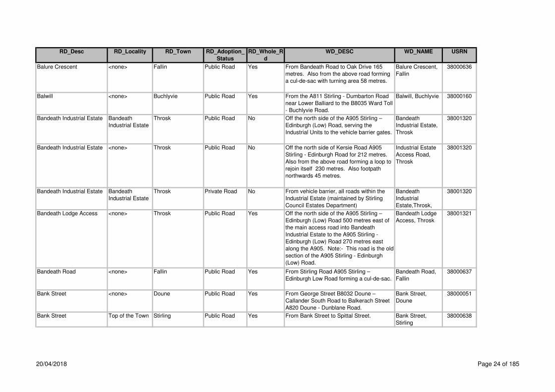
Balure Crescent <none> Fallin Public Road Yes From Bandeath Road to Oak Drive 165
metres. Also from the above road forming
a cul-de-sac with turning area 58 metres.
Balure Crescent,
Fallin
38000636
Balwill <none> Buchlyvie Public Road Yes From the A811 Stirling - Dumbarton Road
near Lower Balliard to the B8035 Ward Toll
- Buchlyvie Road.
Balwill, Buchlyvie 38000160
Bandeath Industrial Estate Bandeath
Industrial Estate
Throsk Public Road No Off the north side of the A905 Stirling –
Edinburgh (Low) Road, serving the
Industrial Units to the vehicle barrier gates.
Bandeath
Industrial Estate,
Throsk
38001320
Bandeath Industrial Estate <none> Throsk Public Road No Off the north side of Kersie Road A905
Stirling - Edinburgh Road for 212 metres.
Also from the above road forming a loop to
rejoin itself 230 metres. Also footpath
northwards 45 metres.
Industrial Estate
Access Road,
Throsk
38001320
Bandeath Industrial Estate Bandeath
Industrial Estate
Throsk Private Road No From vehicle barrier, all roads within the
Industrial Estate (maintained by Stirling
Council Estates Department)
Bandeath
Industrial
Estate,Throsk,
38001320
Bandeath Lodge Access <none> Throsk Public Road Yes Off the north side of the A905 Stirling –
Edinburgh (Low) Road 500 metres east of
the main access road into Bandeath
Industrial Estate to the A905 Stirling -
Edinburgh (Low) Road 270 metres east
along the A905. Note:- This road is the old
section of the A905 Stirling - Edinburgh
(Low) Road.
Bandeath Lodge
Access, Throsk
38001321
Bandeath Road <none> Fallin Public Road Yes From Stirling Road A905 Stirling –
Edinburgh Low Road forming a cul-de-sac.
Bandeath Road,
Fallin
38000637
Bank Street <none> Doune Public Road Yes From George Street B8032 Doune –
Callander South Road to Balkerach Street
A820 Doune - Dunblane Road.
Bank Street,
Doune
38000051
Bank Street Top of the Town Stirling Public Road Yes From Bank Street to Spittal Street. Bank Street,
Stirling
38000638
20/04/2018 Page 24 of 185

RD_Desc RD_Locality RD_Town RD_Adoption_
Status
RD_Whole_R
d
WD_DESC WD_NAME USRN
Bankend <none> Strathblane Public Road Yes From the A81 Glasgow - Aberfoyle Road
north of Craigmaddie Road to Mugdock
Road.
Bankend,
Strathblane
38000216
Bankers Brae <none> Balfron Public Road Yes From Dunmore Street C24 Laigh Road to
Strathview Terrace. Also the footpath on
the east side of Bankers Brae from
Strathview Terrace south for 79 metres.
Bankers Brae,
Balfron
38000217
Bannock Road <none> Fallin Public Road Yes From Stirling Road Service Road forming a
cul-de-sac with turning area.
Bannock Road,
Fallin
38000639
Bannockburn Hospital
Access
<none> Bannockburn Public Road Yes From the A9 Edinburgh - Perth Road to the
bellmouth at the access to Bannockburn
Hospital.
Bannockburn
Hospital Access,
Bannockburn
38000640
Bannockburn Interchange <none> Bannockburn Public Road Yes From its junction with Stirling –
Dennyloanhead Road A872 at north
eastside of Bannockburn Interchange to its
junction with Edinburgh - Stirilng Road A9
at west side of Greencornhills Roundabout.
Note:- Road re-classified 29/06/88 from
A99 to A91.
Bannockburn
Interchange,
Bannockburn
38002298
Bannockburn Interchange -
Greecornhills Roundabout
<none> Public Road Yes From it's junction with the Stirling –
Dennyloanhead Roa A872 at the north
eastern side of Bannockburn Interchange
to it's junction with the Edinburgh - Stirling
Road A9 at the western side of
Greencornhills Roundabout.
Bannockburn
Interchange -
Greecornhills
Roundabout
38008092
Bannockburn Interchange
(M9, A91 and A872)
<none> By Stirling Trunk Road Yes At the M9 Motorway Edinburgh - Perth
Road, A91 Stirling - Cupar Road and the
A872 Stirling – Dennyloanhead Road.
Bannockburn
Interchange, by
Stirling
38002298
Bannockburn Road <none> Bannockburn Public Road Yes From its junction with New Road
(Edinburgh - Perth Road) at The Cross via
Main Street , The Brae, The Old Town ,
The Path to its junction with New Road
(Edinburgh – Perth Road) A9. Note:-
There is no vehicle access from New Road
to The Path.
Bannockburn
Road,
Bannockburn
38000643
20/04/2018 Page 25 of 185

RD_Desc RD_Locality RD_Town RD_Adoption_
Status
RD_Whole_R
d
WD_DESC WD_NAME USRN
Bannockburn Road (A9) <none> Stirling Public Road Yes From the boundary between No. 57 The
Firs and No. 174 Bannockburn Road (159
metres North of Firs Entry) to the A872 at
the east side of St Ninians Roundabout.
Bannockburn
Road, Stirling
38000641
Bannockburn Road (B9124) <none> Cowie Public Road Yes From Main Street B9124 Airth Station –
Bannockburn Road to the B9124 Airth
Station - Gallamuir - Cowie – Bannockburn
Road. Note:- Footpath outside Lismore for
a distance of 57 metres (adopted 1/3/00).
Bannockburn
Road, Cowie
38001065
Barbour Avenue <none> Stirling Public Road Yes From Broom Road forming a cul-de-sac 60
metres. Also from the above road forming
a cul-de-sac 100 metres. Note:- The car
park is Private.
Barbour Avenue,
Stirling
38000645
Barbush <none> Dunblane Public Road Yes From Barbush Roundabout to Wedderburn
Road
Barbush,Dunblan
e,
38003028
Barclay Place <none> Dunblane Public Road Yes From its junction east of Barbush Forming
2 cul-de-sacs
Barclay
Place,Dunblane,
38003029
Barn Road <none> Stirling Public Road Yes From Upper Bridge Street to Crofthead
Road and Lower Castlehill. Also 16 metres
of the access to No. 9 Upper Bridge Street
from Barn Road (including the footway and
the three parking bays).
Barn Road,
Stirling
38000646
Barnford Road <none> Gartness Public Road Yes From Gartness Road C31 to south of the
access to "Castle Mills" Note:- Section
leading to A81 removed 1990.
Barnford Road,
Gartness
38000218
Barnford Road <none> Gartness Public Road Yes From Main Street to Chestnut Avenue.
Also parking lay-by and 2 metre wide
footway to Abbeyfield House located on the
south side of Beech Drive for 35 metres.
Beech Drive,
Killearn
38000218
20/04/2018 Page 26 of 185
RD_Desc RD_Locality RD_Town RD_Adoption_
Status
RD_Whole_R
d
WD_DESC WD_NAME USRN
Barnsdale Road St Ninians Stirling Public Road Yes From Glasgow Road A872 forming a cul-de-
sac to a point 60 metres south west of
Newpark Crescent Nos. 50-88. Note:- The
cul-de-sac off Barnsdale Road behind the
flats on Glasgow Road is 'named' Glasgow
Road and is Private.
Barnsdale Road,
Stirling
38000648
Barnton Street <none> Stirling Public Road Yes From Friars Street / Maxwell Place to
Cowane Street unclassified (Queen Street /
Goosecroft Road). Note:- Viewfield Place
is part of Barnton Street.
Barnton Street,
Stirling
38000647
Barnwell Drive <none> Balfron Public Road Yes From its junction with Donaldson Way for a
distance of 165m
Barnwell Drive,
Balfron
38003211
Barnwell Road Causewayhead Stirling Public Road Yes From Lothian Crescent forming a cul-de-
sac.
Barnwell Road,
Stirling
38000386
Baron Court <none> Buchlyvie Public Road Yes From the A811 Stirling - Dumbarton Road
forming a cul-de-sac. Also a footpath and
footbridge over the stream adajcent to the
A811 Stirling - Dumbarton Road.
Baron Court,
Buchlyvie
38000161
Barony Court <none> Cambusbarron Prospective
Public Road
Yes (CC No 94/23 Avonside Homes) off the
north side of Main Street, Touch Road C5,
84m west of Mill Hill. Also footway fronting
Barony Court, from the west boundary of
house No. 38 Main Street, west for a
distance of 21m
Barony
Court,Cambusbar
ron,
38001414
Batterflats Gardens <none> Stirling Public Road Yes Off Polmaise Road C7 115 metres south of
Dalmorglen Park.
Batterflats
Gardens, Stirling
38001590
Baxter Street <none> Fallin Public Road Yes From Bandeath Road to Hirst Crescent
extension of Baxter Street to Hirst Crescent
for a distance of 112 metres was adopted
8/01/01 also footpath to the rear of private
parking courtNote:- The lock-up access in
the older part of Baxter Street is Private.
Baxter Street,
Fallin
38000649
20/04/2018 Page 27 of 185

RD_Desc RD_Locality RD_Town RD_Adoption_
Status
RD_Whole_R
d
WD_DESC WD_NAME USRN
Bayne Street <none> Stirling Public Road Yes Off the west side of Bruce Street forming a
cul-de-sac. Also the footway on the north
side only and the steps to Lower Bridge
Street.
Bayne Street,
Stirling
38001324
Beacon Croft <none> Bridge of Allan Public Road Yes From Wellgate for a distance of 115m Beacon
Croft,Bridge of
Allan,
38003031
Bearside Road St Ninians Stirling Public Road Yes From Cultenhove Road to a point of 229
metres south of Cultenhove Road.
Bearside Road,
Stirling
38000650
Beaton Avenue <none> Whins of Milton Public Road Yes Off the south side of Davidson Street 66
metres east of Milton Road forming a cul-
de-sac with turning area.
Beaton Avenue,
Whins of Milton
38000651
Beatty Avenue Raploch Stirling Public Road Yes From Drip Road to Woodside Road. Beatty Avenue,
Stirling
38000652
Beda Place <none> Fallin Public Road Yes From Polmaise Crescent forming a cul-de-
sac.
Beda Place, Fallin 38000653
Beech Avenue <none> Plean Public Road Yes From Carbrook Drive forming a cul-de-sac
with turning area.
Beech Avenue,
Plean
38001066
Beech Court <none> Doune Public Road No From Fir Road forming a cul-de-sac, also
the footpath to the A84T. Note:- The
carriageway, footpath and garage access
ex adverso Nos. 6 and 13 are Private.
Beech Court,
Doune
38000053
Beech Court <none> Doune Private Road No Off the north side of Fir Road, 1st cul-de-
sac on the left, 69m east of the access
road from the A84T.
Beech
Court,Doune,
38000053
Beech Court <none> Dunblane Private Road No Terrace block on the north side of Beech
Road
Beech
Court,Dunblane,
38003032
Beech Drive <none> Killearn Public Yes From Main Street to Chestnut Avenue.
Also parking lay-by and 2m wide footway to
abbeyfield House located on the southside
of Beech Drive for 35m
Beech Drive,
Killearn
38000219
Beech Gardens <none> Stirling Private Road Yes Off the north side of Batterflats Gardens,
18m west of Polmaise Road
Beech
Gardens,Stirling,
38001325
20/04/2018 Page 28 of 185

RD_Desc RD_Locality RD_Town RD_Adoption_
Status
RD_Whole_R
d
WD_DESC WD_NAME USRN
Beech Lane Causewayhead Stirling Public Road Yes Off the south side of Easter Cornton Road
forming a cul-de-sac also turning head.
Note:- The car park / footway perimeter is
Private.
Beech Lane,
Stirling
38002380
Beech Road (B8064) <none> Dunblane Public Road Yes From Perth Road B8033 Edinburgh – Perth
Road to High Street B8064 High Street.
Beech Road,
Dunblane
38000387
Beechwood Gardens <none> Stirling Public Road Yes From Newhouse Service Road junction in a
southerly then westerly direction for 190 m
includes Car Park. Footpath fronting
Beechwood House and 3 Block of Flats
143 metres also new footway on the north
side of Newhouse Service Road.
Beechwood
Gardens, Stirling
38002400
Bellenden Grove <none> Dunblane Public Road Yes Off the south side of Barbush Bellenden
Grove,Dunblane,
38003030
Bellfield Road <none> Stirling Public Road Yes From Randolph Terrace / Newhouse (St
Ninians Roundabout - Wallace Street
Roundabout) B8052 to the Infirmary
Entrance at Livilands Gate.
Bellfield Road,
Stirling
38000654
Ben Lomond Drive Cornton Stirling Public Road Yes From its junction with John Cowane Row Ben Lomond
Drive,Cornton,Stir
ling,
38003049
Bennetts Way <none> Gargunnock Private Road Yes Footpath off the north side of Leckie Road
C22, 82m north of The Square via the
Telephone Exchange to Station Road 44m
south of Charles Street
Bennetts
Way,Gargunnock,
38001205
Bennie Wynd Causewayhead Stirling Private Road Yes Wallace High New Development Bennie Wynd,
Causewayhead,
Stirling
38005650
Bentheads <none> Bannockburn Public Road Yes From Newlands Road to Milnepark Road. Bentheads,
Bannockburn
38000655
20/04/2018 Page 29 of 185
RD_Desc RD_Locality RD_Town RD_Adoption_
Status
RD_Whole_R
d
WD_DESC WD_NAME USRN
Benview <none> Bannockburn Public Road No From Morrison Drive C48 Milton Road –
Morrison Drive to the entrance to
Bannockburn Secondary School 105
metres. Also a cul-de-sac from the above
road with turning area 27 metres.
Extension to Benview in a westerly
direction also forming 3 culs-de-sac for a
distance of 334 metres, also footpath from
Benview leading to Crum Crescent for 82
metres. New extension private.
Benview,
Bannockburn
38000656
Berkeley Street <none> Stirling Public Road Yes From Williamfield Avenue to a point 20
metres north of Lennox Avenue.
Berkeley Street,
Stirling
38000657
Berryhill <none> Cowie Public Road Yes From Mount Oliphant Berryhill, Cowie 38001067
Berryhill To Scotstoun
Road
<none> Cowie Public Road Yes Link footpath off the north west cul-de-sac
of Berryhill between house Nos. 26 and 24
to Scotstoun Road between house Nos. 2
and 2a, opposite Park Street
Berryhill to
Scotstoun
Road,Cowie,
38001415
Birch Avenue Torbrex Stirling Public Road Yes From Cedar Avenue forming 3 cul-de-sac’s Birch Avenue,
Stirling
38000658
Birch Court <none> Doune Public Road Yes From Larch Crescent forming a cul-de-sac. Birch Court,
Doune
38000054
Birch Road <none> Killearn Public Road Yes Off the north side of Beech Drive Birch Road,
Killearn
38000220
Birkhill Road (C4) <none> Stirling Public Road Yes From Park Place C4 Cambusbarron –
Stirling Road at Douglas Terrace to the
east side of the bridge over the M9
Motorway.
Birkhill Road,
Stirling
38000659
Birkhill Road (C4) <none> Cambusbarron Public Road Yes From Touch Road C5 to the east side of
the bridge over the M9 Motorway.
Birkhill Road,
Cambusbarron
38001068
Bishops Gardens <none> Dunblane Private Road Yes Off the east side of The Haining 50m south
of Buccleuch Court at house No 4, serving
house Nos. 5 and 6 forming a dead end
Bishops
Gardens,Dunblan
e,
38000388
20/04/2018 Page 30 of 185

RD_Desc RD_Locality RD_Town RD_Adoption_
Status
RD_Whole_R
d
WD_DESC WD_NAME USRN
Blackburn Road <none> Killearn Public Road Yes Off the east side of Main Street A875
Dumgoyne - Kepculloch Road 24 metres
north of Graham Road forming a cul-de-
sac.
Blackburn Road,
Killearn
38000221
Blairdrummond - Thornhill –
Aberfoyle
<none> Public Road Yes From the A84 Stirling - Lochearnhead at
Blairdrummond via Thornhill Main Street,
Ruskie, Blairhoyle to the A81 Glasgow -
Aberfoyle at Hammersmith.
Blairdrummond -
Thornhill -
Aberfoyle
38001495
Blairforkie Drive <none> Bridge of Allan Public Road Yes From Henderson Street A9 Edinburgh –
Perth Road to Glen Road (formerly C35).
Also footway fronting 17B, footway fronting
No. 21 and adjoining part of the frontage of
No. 19 43 metres.
Blairforkie Drive,
Bridge of Allan
38000389
Blairlogie Village Road <none> Blairlogie Public Road Yes From the A91 Stirling - Cupar Road to "The
Square". Note:- "The Square" is Private.
Blairlogie Village
Road, Blairlogie
38000390
Blane Avenue <none> Blanefield Private Road Yes Off the south side of Station Road B821,
35m east of Cuilt Place
Blane
Avenue,Blanefield
,
38001206
Blane Crescent <none> Blanefield Public Road Yes Off the south side of Station Road B821
Strathblane - Craigimore Road 240 metres
west of A81 forming a cul-de-sac.
Blane Crescent,
Blanefield
38000222
Blane Place <none> Blanefield Private Road Yes Off the north end of the Cul-de-sac of
Blane Crescent between house Nos. 15
and 17
Blane
Place,Blanefiled,
38001207
Blane Smithy Road <none> Killearn Public Road Yes Off the north side of the B834 Finnich Toll -
Killearn Road 60 metres west of the A81
Glasgow – Aberfoyle - Callander Road
forming a cul-de-sac.
Blane Smithy
Road, Killearn
38000223
Blane Smithy Roundabout
(A81 and B834)
<none> by Killearn Public Road Yes At the B834 Blane Smiddy, 1.0 kilometre
southwest of Killearn Village.
Blane Smithy
Roundabout, by
Killearn
38002383
Blenheim Court Causewayhead Stirling Public Road Yes From its junction with Causewayhead Road
forming a cul-de-sac for a distance of 65m.
The parking areas are private
Blenheim Court,
Causewayhead,
Stirling
38003204
20/04/2018 Page 31 of 185

RD_Desc RD_Locality RD_Town RD_Adoption_
Status
RD_Whole_R
d
WD_DESC WD_NAME USRN
Bluebell Wood <none> Doune Public Road Yes of Station wynd in a northerly direction Bluebell Wood,
Doune
38005627
Bobbin Wynd Cambusbarron Public Road Yes off the north side of Mill Road west of
Grierson Crescent
Bobbin Wynd,
Cambusbarron,
38002308
Boe Court <none> Dunblane Private Road Yes New development off Springfield Terrace
(Old Council Yard)
Boe
Court,Dunblane,
38002385
Bogend Road <none> Bannockburn Public Road Yes From the A9 Edinburgh - Perth Road to
Milnepark Road forming 3 cul-de-sacs
Bogend Road,
Bannockburn
38000660
Bogside <none> Dunblane Public Road Yes From House Nos. 17/19 at Backcroft to
Perth Road B8033.
Bogside,
Dunblane
38000391
Bohun Court Balquhidderock Stirling Public Road No Off the west side of Pike Road forming a
turning head. Also from outside No. 8
Bohun Court to end forming a turning head
Bohun Court,
Stirling
38001565
Borestone Court St Ninians Stirling Private Road Yes Off the east side of Borestone Place, 63m
north of McLachlan Avenue
Borestone
Court,Stirling,
38001253
Borestone Crescent
(B8051)
<none> Stirling Public Road Yes From the west side of St Ninians
Roundabout to Weaver Row / Main Street.
Note:- Road re-classified from B8052 to
B8051 on 30/09/87.
Borestone
Crescent, Stirling
38000661
Borestone Place St Ninians Stirling Public Road Yes Off the west side of Glasgow Road A872
77 metres south of Barnsdale Road
forming a cul-de-sac with turning area 52
metres south of Carron Place. Also the
footway on the east side at House Nos. 13,
37, 39A to 41. Also footpath ex adverso
Nos. 13, 15, 16A, 17, 25, 29, 31, 34, 35,
37, 39 and vacant plot No. 43 not adopted.
Borestone Place,
Stirling
38000662
Borestone Roundabout (A9
and A872)
<none> Stirling Public Road Yes Roundabout at the A9 Edinburgh - Perth
Road and A872 Stirling - Dennyloanhead
Road.
Borestone
Roundabout,
Stirling
38001525
Borrowlea Road Springkerse
Indust Estate
Stirling Public Road Yes From Middlemuir Road forming a cul-de-
sac with turning head and footpath round
the front of the houses.
Borrowlea Road,
Stirling
38000663
Borrowmeadow Road Springkerse
Indust Estate
Stirling Public Road Yes From Whitehouse Road to Munro Road. Borrowmeadow
Road, Stirling
38000664
20/04/2018 Page 32 of 185

RD_Desc RD_Locality RD_Town RD_Adoption_
Status
RD_Whole_R
d
WD_DESC WD_NAME USRN
Borrows Gate Cornton Stirling Public Road Yes South of Westhaugh Road Borrows Gate,
Cornton, Stirling
38004110
Bow Street Top of the Town Stirling Public Road Yes From Baker Street to St Mary's Wynd. Bow Street,
Stirling
38000665
Bracken Lane Cornton Stirling Public Road Yes From the junction with Cornton Road in a
northerley direction including turning head
and adjacent parking spaces
Bracken Lane,
Cornton, Stirling
38003212
Bracklinn Road <none> Callander Public Road Yes Off the north side of Main Street A84T
Stirling - Lochearnhead Road, 205 metres
west of Murdiston Avenue to Braes of Leny
Road. Also the footpath ex adverso
Broomfield and Arden House . Note:- See
also Braes of Leny Road.
Bracklinn Road,
Callander
38000055
Braehead <none> Doune Private Road Yes Off the north side of Main Street A820, 45m
west of Queen Street
Braehead,Doune, 38001159
Braehead Road St Ninians Stirling Public Road Yes From Bannockburn Road A9 to McLaren
Terrace.
Braehead Road,
Stirling
38000666
Braemar Avenue <none> Dunblane Public Road Yes From Old Doune Road to Braemar Avenue. Braemar Avenue,
Dunblane
38001544
Braemar Grove <none> Dunblane Public Road Yes From Braemar Avenue forming a cul-de-
sac. Also the footpath linking Braemar
Grove and Braemar Park.
Braemar Grove,
Dunblane
38000392
Braemar Park <none> Dunblane Public Road Yes From Braemar Avenue forming a cul-de-
sac. Also the link footpath from Braemar
Grove to Braemar Park 65 metres and the
footpath linking this path to Highfields 113
metres.
Braemar Park,
Dunblane
38000393
Braeport (C85) <none> Dunblane Public Road Yes From Kirk Street / Meeting House Close to
Ramoyle at Tannahill Terrace.
Braeport,
Dunblane
38000394
Braes of Balquhidder Road,
by Balquhidder
<none> Public Road Yes From the A84T Stirling - Lochearnhead
Road at Kinghouse Inn via Balquhidder,
Tulloch and Rhuveag to the ford east of
Inverlochlarig House.
Braes of
Balquhidder
Road, by
Balquhidder
38001460
20/04/2018 Page 33 of 185

RD_Desc RD_Locality RD_Town RD_Adoption_
Status
RD_Whole_R
d
WD_DESC WD_NAME USRN
Braes Of Leny Road <none> Callander Public Road Yes Off the north west end of Bracklinn Road to
ford over burn west of Thomasgreen Farm.
Also the footpath leading to Bracklinn Falls
is a Right of Way maintained by Stirling
Council. Note:- See also Bracklinn Road.
Braes of Leny
Road, Callander
38000056
Braeval <none> Aberfoyle Private Road Yes Off the south side of the A81 east of the
A821
Braeval,Aberfoyle
,
38001158
Braidgate <none> Strathblane Private Road Yes Cala New Development Briadgate,
Strathblane
38005718
Branziert Road <none> Killearn Public Road Yes Off the east side of the A875 Dumgoyne -
Kepculloch Road 67 metres south of
Drumbeg Loan C60 to Branziert Road
North.
Branziert Road,
Killearn
38000224
Branziert Road North <none> Killearn Public Road Yes Off the north end of Branziert Road forming
a loop.
Branziert Road
North, Killearn
38000225
Brentham Avenue <none> Stirling Private Road Yes Off the east side of Livilands Lane, 70m
north of Brentham Crescent
Brentham
Avenue,Stirling,
38001329
Brentham Crescent <none> Stirling Private Road Yes Off the east side of Livilands Lane 18m
north of Clifford Road
Brentham
Crescent,Stirling,
38001330
Bridge of Allan – Lecropt -
Doune Road, by Bridge of
Allan
<none> Public Road Yes From the A9 at Lecropt Church via
Knockhill, Craigdownings Old Keir,
Craigarnhall, Easter Row and Greystone to
the B824 North of Inverardoch Mains.
Note:- The section of road opposite
Knockhill via flight of steps to the A9 is on
List of Roads as "Lecropt Kirk Cemetery
Road" Unclassified.
Bridge of Allan -
Lecropt - Doune
Road, by Bridge
of Allan
38001446
Bridge Street (A81) <none> Callander Public Road Yes From Main Street A8 Stirling –
Lochearnhead Road to Bridgend A81
Glasgow - Callander Road.
Bridge Street,
Callander
38000058
Bridgehaugh Road <none> Stirling Public Road Yes From posts at Old Stirling Bridge to
Cornton Road, Stirling B823. Note:- Bridge
is maintained by Property Services Agency
(P.S.A.).
Bridgehaugh
Road, Stirling
38000395
20/04/2018 Page 34 of 185

RD_Desc RD_Locality RD_Town RD_Adoption_
Status
RD_Whole_R
d
WD_DESC WD_NAME USRN
Bridgend <none> Dunblane Public Road Yes From Station Road to Stirling Road. Note:-
There are no footpaths on this road. Note:-
The footpath and fences bordering footpath
and bridge from Caledonian Place to
Bridgend are Private, maintained by
Railtrack.
Bridgend,
Dunblane
38000396
Bridgend (A81) <none> Callander Public Road Yes From Bridge Street A81 Glasgow –
Callander Road at the centre of the bridge
over the River Teith to the A81 Glasgow -
Callander Road at the C114 Invertrossachs
Road.
Bridgend,
Callander
38000057
Bridgend Road Chartershall Stirling Public Road Yes Off the east side of Chartershall and Fairhill
Road C55 at the Bannock Burn forming a
cul-de-sac.
Bridgend Road,
by Whins of
Milton
38001070
Brig O'Doon Grove <none> Cowie Public Road Yes From Armour Avenue forming a cul-de-sac. Brig O'Doon
Grove, Cowie
38001071
Broad Street Top of the Town Stirling Public Road Yes From Bow Street to Mar Place. Note:-
Kelly Court off Broad Street opposite Jail
Wynd is Private.
Broad Street,
Stirling
38000668
Broadleys Road Springkerse
Indust Estate
Stirling Public Road Yes From Whitehouse Road forming a cul-de-
sac.
Broadleys Road,
Stirling
38000667
Broadleys Roundabout
(A905)
Broadleys
Industrial Park
Stirling Public Road Yes At Kerse Road A905 Stirling - Edinburgh
Low Road and Kerse Road unclassified.
Broadleys
Roundabout,
Stirling
38001562
Brock Place <none> Whins of Milton Public Road Yes From Milton Brae forming a cul-de-sac with
turning area.
Brock Place,
Whins of Milton
38000669
Broom Court <none> Stirling Public Road No From Elgin Drive forming a cul-de-sac.
Note:- The off-street parking courts are
Private.
Broom Court,
Stirling
38000397
Broom Road <none> Stirling Public Road Yes From the Bannockburn Road A9 to
Colquhoun Street / Linden Avenue.
Broom Road,
Stirling
38000670
Broomhill Court Cornton Stirling Public Footpath No Remote footpath leading to numbers 1 - 25
from turning head on Bracken Lane onl;y
adopted
Broomhill Court,
Cornton, Stirling
38003213
Broomhill Place <none> Stirling Public Road Yes From St. Thomas's Place in an easterly
direction forming a cul-de-sac with turning
head.
Broomhill Place,
Stirling
38000671
20/04/2018 Page 35 of 185

RD_Desc RD_Locality RD_Town RD_Adoption_
Status
RD_Whole_R
d
WD_DESC WD_NAME USRN
Broompark <none> Gargunnock Public Road Yes From McNeil Crescent to Millbrae. Broompark,
Gargunnock
38000226
Broomridge Road St Ninians Stirling Public Road Yes From McLaren Terrace to McLaren
Terrace.
Broomridge Road,
Stirling
38000672
Brown Avenue Causewayhead Stirling Public Road Yes From Buchanan Drive forming a cul-de-
sac.
Brown Avenue,
Stirling
38000398
Bruce Avenue <none> Dunblane Public Road Yes From Wallace Road forming a cul-de-sac. Bruce Avenue,
Dunblane
38000399
Bruce Crescent <none> Plean Public Road Yes From Bruce Street to Bruce Street. Bruce Crescent,
Plean
38001072
Bruce Drive <none> Fallin Public Road Yes From Polmaise Crescent forming a cul-de-
sac with turning area.
Bruce Drive,
Fallin
38000673
Bruce Street <none> Stirling Public Road Yes From Douglas Street to Union Street. Bruce Street,
Stirling
38000674
Bruce Street <none> Bannockburn Public Road Yes From Station Road B9124 Bannockburn -
Cowie Road to Bannockburn Cemetery
Gates.
Bruce Street,
Bannockburn
38000675
Bruce Street <none> Plean Public Road Yes Off the east side of Wallace Crescent to
Cushenquarter Drive / Wallace Crescent.
Note:- End of parking in play park opposite
Nos. 47 - 53 is Private.
Bruce Street,
Plean
38001073
Bruce Terrace <none> Cambusbarron Public Road Yes From Underwood Cottages forming a cul-
de-sac.
Bruce Terrace,
Cambusbarron
38001074
Bruce View <none> Whins of Milton Public Road Yes Off the west side of Milton Terrace Service
Road forming a cul-de-sac.
Bruce View,
Whins of Milton
38001332
Bryden Road <none> Whins of Milton Public Yes From the top of Colliers Brae going north
and south forming a loop for a distance of
496m
Bryden Road,
Whins of Milton
38005308
Buccleuch Court <none> Dunblane Public Road Yes From The Haining forming a cul-de-sac.
Note:- The car ports are Private. Note:-
The car parks, the only footpaths are those
contiguous with the road. The footpaths to
the rear of Nos. 1, 3, 4, 5, 6, 7, 8, 9, 10, 11,
12, 13, 14 and 16 and footpaths to Nos. 2,
13, 15, 17 & 18 are Private.
Buccleuch Court,
Dunblane
38000400
Buchan Drive <none> Dunblane Public Road Yes Off Wallace Road Buchan Drive,
Dunblane
38000401
20/04/2018 Page 36 of 185

RD_Desc RD_Locality RD_Town RD_Adoption_
Status
RD_Whole_R
d
WD_DESC WD_NAME USRN
Buchanan Court <none> Balfron Public Road Yes Off the east side of Buchanan Street A875,
86 metres north of Dunmore Street forming
a cul-de-sac. Also the link footpath to
Buchanan Street.
Buchanan Court,
Balfron
38000227
Buchanan Crescent <none> Croftamie Public Road Yes From the A809 Glasgow - Drymen Road
forming a cul-de-sac.
Buchanan
Crescent,
Croftamie
38000162
Buchanan Drive Causewayhead Stirling Public Road Yes From the A9 forming a cul-de-sac with
turning area.
Buchanan Drive,
Stirling
38000402
Buchanan Place <none> Callander Public Road Yes From it's junction with Pearl Street Buchanan Place,
Callander
38002389
Buchanan Road <none> Killearn Public Road Yes From Crosshead Road to Graham Road. Buchanan Road,
Killearn
38000228
Buchanan Smithy Terrace <none> Buchanan Smithy Public Road Yes From Coldrach Road forming a cul-de-sac
and turning head.
Buchanan Smithy
Terrace,
Buchanan Smithy
38000163
Buchanan Street (A875) <none> Balfron Public Road Yes From Printers Row A875 Dumgoyne -
Kepculloch Road 129 metres west of the
bowling club access to Station Road C21
Indians Road. Also the lay-by providing
parking for 2 cars. Also the 2 metre wide
footway on the west side of Buchanan
Street fronting House Nos. 93 - 105 for 36
metres. Note:- Footpaths ex adverso
House Nos. 10 - 24 are Private.
Buchanan Street,
Balfron
38000229
Buntine Crescent St Ninians Stirling Public Road Yes From Cultenhove Road forming a cul-de-
sac.
Buntine Crescent,
Stirling
38000676
Burghmuir Road (A9) <none> Stirling Public Road Yes From Bannockburn Road A9 Edinburgh -
Perth Road at St Ninians Roundabout to
Causewayhead Road A9 Edinburgh - Perth
Road at the Clock Roundabout at the east
end of Union Street.
Burghmuir Road,
Stirling
38000677
Burn Drive <none> Stirling Public Road Yes From Keith Avenue forming a cul-de-sac
with turning area.
Burn Drive,
Stirling
38000678
20/04/2018 Page 37 of 185

RD_Desc RD_Locality RD_Town RD_Adoption_
Status
RD_Whole_R
d
WD_DESC WD_NAME USRN
Burns Begg Crescent <none> Balfron Public Road Yes From Roman Road forming a cul-de-sac
with turning area 176 metres. Also the two
culs-de-sac from the above road for 51
metres and 62 metres. Also the footway
along the frontage of the site and adjacent
to Roman Road for 97 metres.
Burns Begg
Crescent, Balfron
38000231
Burns Street Raploch Stirling Public Road Yes From Haig Avenue forming a cul-de-sac. Burns Street,
Stirling
38000679
Burns Terrace <none> Cowie Public Road Yes From Main Street B9124 Airth Station -
Gallamuir Road to the Factory Entrance.
Burns Terrace,
Cowie
38001075
Burngreen <none> Kippen Public Road Yes From its junction with Oakwood/Castlehill
Loan for a distance of 270m. Please note
the parking area at No 25 -39 is private
Burngreen,
Kippen
38003249
Burnside <none> Balfron Public Road Yes From Spokers Loan C23 Lernock Road
forming a cul-de-sac.
Burnside, Balfron 38000230
Burnside <none> Kippen Public Road Yes Off the south side of Main Street / Station
Road B822 Callander - Kirkintilloch at The
Cross to "Kennel Cottage". Also from
"Tirranmuir" to Dasher Farm Road 276
metres. Note:- Excluding a 120 metre
section from "Kennel Cottage" to
"Tirranmuir".
Burnside, Kippen 38000232
Burnside <none> Kippen Public Road No Footway only private at new development Burnside,Kippen, 38000232
Burnside At Clachan Burn <none> Balfron Public Road Yes Footpath off Spokers Loan on the north
side of Clachan Burn opposite Burnside
Burnside at
Clachan
Burn,Balfron,
38001209
Burnside Crescent <none> Plean Public Road Yes From Main Street A9 Stirling - Edinburgh
Road to Main Street A9 Stirling - Edinburgh
Road. Also at Burnside Crescent to the A9
Stirling - Edinburgh Road
Burnside
Crescent, Plean
38001076
Burnside Street <none> Stirling Public Road Yes From Colquhoun Street forming a cul-de-
sac.
Burnside Street,
Stirling
38000680
20/04/2018 Page 38 of 185

RD_Desc RD_Locality RD_Town RD_Adoption_
Status
RD_Whole_R
d
WD_DESC WD_NAME USRN
Burnside Terrace <none> Buchlyvie Private Road Yes Off the south side of Main Street A811
Stirling - Dumbarton Road, 115m west of
Baron Court
Burnside
Terrace,Buchlyvie
,
38001196
C10 from C55 Whins of
Milton to B818
<none> By Stirling Public Road Yes From Chartershall to the B818 (Falkirk -
Fintry - Killearn Road) junction.
C10 from C55
Whins of Milton to
B818, by Stirling
38008093
C106 from A84T to Council
Boundary
<none> by Lochearnhead Public Road Yes From the A84T Stirling - Lochearnhead
Road to the Council Boundary near
Ardvorlich Coll.
C106 from
Junction A84T to
Council
Boundary, by
Lochearnhead
38008010
C107 from A827 to Council
Boundary
<none> By Killin Public Road Yes From the A827 Killin - Aberfeldy Road to
the Council Boundary near "Margbeg" 1.5
kilometres east of Ardeonaig.
C107 from
junction A827 to
Council
Boundary, by
Killin
38008009
C113 from A9 to B9124 <none> By Plean Public Road Yes From the A9 Edinburgh - Perth Road to the
B9124 Airth Station - Gallamuir - Cowie -
Bannockburn Road junction.
C113 from A9 to
B9124, by Plean
38008096
C114 from A821 to A81 <none> By Callander Public Road Yes From the A821 Aberfoyle - Trossachs -
Callander Road to the A81 Glasgow -
Aberfoyle - Callander Road.
C114 from
junction with A821
to A81, by
Callander
38008112
C118 from A809 to Council
Boundary
<none> By Croftamie Public Road Yes Off the west side of the A809 Canniesburn -
Drymen Road 95 m west of Cattermills via
Shandon and Cattermuir Crossing to the
Council Boundary at "Meikle Finnary".
C118 from the
A809 to Council
Boundary, by
Croftamie
38002368
C21 from A81 to Balfron <none> By Balfron Public Road Yes From the A81 Glasgow - Aberfoyle -
Callander Road.
C21 from A81 to
Balfron, by
Balfron
38002370
C21 from A811 to A81 <none> By Balfron Public Road Yes From the A811 Stirling - Dumbarton Road
to the A81 Glasgow - Aberfoyle - Callander
Road.
C21 from A811 to
A81, by Balfron
38002369
C22 from A811 to
Gargunnock
<none> by Gargunnock Public Road Yes From the A811 Stirling - Dumbarton Road
to Gargunnock.
C22 from A811 to
Gargunnock, by
Gargunnock
38008056
20/04/2018 Page 39 of 185

RD_Desc RD_Locality RD_Town RD_Adoption_
Status
RD_Whole_R
d
WD_DESC WD_NAME USRN
C22 from Gargunnock to
A811
<none> by Gargunnock Public Road Yes From Gargunnock to the A811 Stirling -
Dumbarton Road.
C22 from
Gargunnock to
A811, by
Gargunnock
38008055
C23 from B818 to Balfron <none> By Balfron Public Road Yes From the B818 Falkirk - Fintry - Killearn
Road to Balfron.
C23 from B818 to
Balfron, by
Balfron
38008113
C3 (Falkirk to South Alloa
Road)
<none> By Plean Public Road Yes Off the north side of North Broomage
Roundabout - Bellsdyke Roundabout A88
via Drum of Kinnaird, Junction with B9124,
South Doll, North Doll to the A905 Stirling -
Edinburgh Low Road A905. Note:
Replaced section of road on North side of
M9 is Private.
Falkirk - South
Alloa Road, by
Plean
38002258
C3 from Council Boundary
to Council Boundary, North
section
<none> By Plean Public Road Yes From Council Boundary near Bridgend
Farm, Letham Moss to Council Boundary
near North Doll Farm (Northern Section).
C3 from Council
Boundary to
Council Boundary
- North Section,
by Plean
38008120
C3 from Council Boundary
to Council Boundary, South
section
<none> By Plean Public Road Yes From Council Boundary (near Mossneuk,
Letham Moss) to Council Boundary (near
Bridgend Farm, Letham Moss) (Southern
Section).
C3 from Council
Boundary to
Council Boundary
- South Section,
by Plean
38008119
C31 from A81 to A811 <none> by Drymen Public Road Yes From the A81 Glasgow - Aberfoyle -
Callander Road to the A811 Stirling -
Dumbarton Road.
C31 from A81 to
A811, by Drymen
38008039
C33 from A84T to
Inverlochlarig
<none> By Balquhidder Public Road Yes Off west side of the A84T 1.5 km north of
the C33 Braes of Balquhidder Road at the
"Kingshouse Hotel".
Balquhidder
Station Cottages,
Balquhidder
38008008
C34 from A9 to B824 <none> Bridge of Allan Public Road Yes From the A9 Edinburh - Perth Road south
of Lecropt Church to the B824 Hill of Row
Road west of Keir Roundabout A9.
C34 from A9 to
B824, Bridge of
Allan / Doune
38008071
20/04/2018 Page 40 of 185

RD_Desc RD_Locality RD_Town RD_Adoption_
Status
RD_Whole_R
d
WD_DESC WD_NAME USRN
C35 from Bridge of Allan to
Dunblane
<none> By Bridge of allan Public Road From Bridge of Allan to Dunblane. Note:-
The section of Glen Road between A9
Bridge of Allan and C86 Sheriffmuir Road
has now been de-classified.
C35 from Bridge
of Allan to
Dunblane, Bridge
of Allan /
Dunblane
38008070
C36 from A811 to B822 <none> By Arnprior Public Road Yes From the A811 Stirling - Dumbarton Road
to the B822 Callander - Kirkintilloch Road.
C36 from A811 to
B822, by Arnprior
38008053
C40 from A84T to B8075 <none> By Stirling Public Road Yes From the A84T Stirling - Lochearnhead
Road to the B8075 Kirk Lane - Gargunnock
- Blairdrummond Road.
C40 from A84T to
B8075, by Stirling
38008025
C41 from B818 to Council
Boundary
<none> by Carronbridge Public Road Yes From the B818 Falkirk - Killearn Road at
Carronbridge to the Council Boundary at
the bridge over the River Carron.
Tak'Me Doon
Road, by
Dunipace
38008052
C5 from Cambusbarron to
A811
<none> by Cambusbarron Public Road Yes From Cambusbarron to the A811 Stirling -
Dumbarton Road.
C5 from
Cambusbarron to
A811, by
Cambusbarron
38008109
C54 from A875 to C21 <none> by Killearn Public Road Yes From the A875 Dumgoyne - Kepculloch
Road at the B818 Falkirk - Fintry - Killearn
Road to Indians Road C21.
Ballochruin, by
Killearn
38008051
C56 from A81 to Council
Boundary
<none> by Strathblane Public Road Yes From the A81 Glasgow - Aberfoyle -
Callander Road to the Council Boundary at
Allander Water.
C56 from A81 to
Council
Boundary, by
Strathblane
38008050
C57 from A81 to Gartmore <none> by Gartmore Public Road Yes From the A81 Glasgow - Aberfoyle -
Callander Road to Gartmore.
C57 from A81 to
Gartmore, by
Gartmore
38008038
C57 from A81 to Gartmore
(south)
<none> by Gartmore Public Road Yes From the A81 Glasgow - Aberfoyle -
Callander Road to south of Gartmore
Village (south).
C57 from A81 to
Gartmore (south),
by Gartmore
38008036
C57 from Gartmore to A81 <none> by Gartmore Public Road Yes From Gartmore to the A81 Glasgow -
Aberfoyle - Callander Road.
C57 from
Gartmore to A81,
by Gartmore
38008037
20/04/2018 Page 41 of 185

RD_Desc RD_Locality RD_Town RD_Adoption_
Status
RD_Whole_R
d
WD_DESC WD_NAME USRN
C58 from A811 to C31 <none> by Drymen Public Road Yes Off the east side of the A811 Stirling -
Dumbarton Road 352 metres west of
Stirling Road B858 via Drumhead,
Gartacharn Farm, Upper Gartness to the
C31 Drumquhassle and Gartness Road in
Killearn.
Gartocharn Road,
by Drymen
38008049
C6 from Balmaha to end at
Rowardennan
<none> by Balmaha Public Road Yes From Balmaha to Rowardennan. C6 from Balmaha
to end at
Rowardennan, by
Balmaha
38008035
C63 from A905 to Cowie <none> by Cowie Public Road Yes From A905 Stirling - Edinburgh Low Road
to Cowie.
C63 from A905 to
Cowie, by Cowie
38008095
C64 from Plean to Council
Boundary
<none> By Plean Public Road Yes From Plean to the Council Boundary at
Dales Wood near "Langlands" Farm. Also
1.8 metres wide 320 metres long footway
on the south side west of Touchill
Crescent.
C64 from Plean to
Council
Boundary, by
Plean
38008116
C68 from B829 to end at
Inversnaid
<none> by Aberfoyle Public Road Yes From Stronachlachar Road B829 near Loch
Arklet via Corriearklet to Inversnaid Pier.
Also the car park at Inversnaid. Note:-
The road from the B829 to Stronachlachar
is Private. Note:- The pier is Private.
Inversnaid Road,
by Aberfoyle
38008024
C83 from Doune to A820 <none> By Doune Public Road Yes From Doune to the A820 Doune - Dunblane
Road junction.
C83 from Doune
to A820, by
Doune
38008117
C86 from C35 to Council
Boundary
<none> By Dunblane Public Road Yes From the C35 Glen Road, Dunblane to the
Council Boundary near "Harperstone Farm"
north east of the junction with the C87.
C86 from C35 to
Council
Boundary, by
Dunblane
38008082
C87 from C86 to Council
Boundary
<none> By Dunblane Public Road Yes From the C86 Dunblane - Sheriffmuir -
Blackford Road to the Council Boundary
near "Harperstone Farm" north west of the
junction with the C86.
C87 from C86 to
Council
Boundary, by
Dunblane
38008081
20/04/2018 Page 42 of 185

RD_Desc RD_Locality RD_Town RD_Adoption_
Status
RD_Whole_R
d
WD_DESC WD_NAME USRN
C9 from A872 to Council
Boundary
<none> By Plean Public Road Yes From the A872 (Stirling - Dennyloanhead
Road) to the Council Boundary near
"Glenside" 1 kilometres north of the A9
junction.
C9 from A872 to
Council
Boundary, by
Plean
38008118
Cadell Loan <none> Doune Public Road Yes Off the east side of Station Wynd, north of
Balkerach Street A820 Doune - Dunblane
Road.
Cadell Loan,
Doune
38001162
Cadgers Loan -
Woodcockfauld, by Plean
<none> Public Road Yes From the A872 Stirling - Dennyloanhead
Road at Dunipace via Thornedyke Quarry,
Woodcockfaulds, Roman Road C9 and
President Kennedy Drive, C64 Cadgers
Loan to the A9 Stirling - Edinburgh Road.
Cadgers Loan -
Woodcockfauld,
by Plean
38002111
Cairnoch Way <none> Bannockburn Public Road Yes From Ochilmount forming a cul-de-sac. Cairnoch Way,
Bannockburn
38000681
Calder Court <none> Stirling Public Road Yes From Springfield Road forming a cul-de-
sac.
Calder Court,
Stirling
38000682
Calderwood Place <none> Dunblane Private Road Yes Off the north side of A820 Doune Road,
37m south of Springbank Crescent
Calderwood
Place,Dunblane,
38001256
Caledonian Place <none> Dunblane Public Road No From Springfield Terrace A820 to
Springfield Terrace A820. Also the road ex
adverso "Calderwood House". Also the
footpath on the north side of the road from
Doune Road to the footbridge over the
railway. Note:- The footpath and fences
bordering footpath and bridge from
Caledonian Place to Bridgend are Private,
maintained by Railtrack.
Caledonian Place,
Dunblane
38000403
Caledonian Place <none> Dunblane Public Road No Railtrack Footbridge between Caledonian
Place and Bridgend
Caledonian Place
(Rail/bridge,Dunbl
ane
38000403
20/04/2018 Page 43 of 185

RD_Desc RD_Locality RD_Town RD_Adoption_
Status
RD_Whole_R
d
WD_DESC WD_NAME USRN
Callander – Kirkintilloch <none> Public Road Yes From the A81 Glasgow - Callander Road at
Braes of Greenock to the A873 Thornhill -
Aberfoyle Road at north end of Thornhill.
From the A873 Thornhill - Aberfoyle Road
at Main Street, Thornhill via various streets
to the B818 Falkirk - Killearn Road East of
Fintry to Council Boundary at Muir Toll
.Note 1:- The B822 does not include
sections of the B818 at Fintry and the A873
at Thornhill. Also footpath on south side
and footpath on the north side 2 metres
from the building.Note 2:- The rest is
private.Note 3:- Footway adjacent to
Stoneshiel, Turnbrig and Greenhills, 66 m
Adopted on 1 December 2000.
Callander -
Kirkintilloch
38001436
Calton Crescent <none> Stirling Public Road No Off the north side of Shirra's Brae Road 70
metres west of Melfort Drive to the line of
the eastern boundary of House No. 17.
Note:- The cul-de-sac including the section
of carriageway and footways east of
eastern boundary of No. 17 are Private.
Calton Crescent,
Stirling
38000683
Caltrop Place Balquhidderock Stirling Public Road Yes Off the west side of Pike Road. Caltrop Place,
Stirling
38001536
Cambusbarron – Stirling
Road
<none> Public Road Yes From Port Street A811 at Black Boy
Fountain via Allan Park C4 / Kings Park
Road C4, Park Place, Birkhill Road to Main
Street, C5 Touch Road, Cambusbarron.
Cambusbarron -
Stirling Road
38001463
Cameron Court <none> Locheranhead Public Road Yes Off westside of A85(T) forming 2 cul-de-
sacs
Cameron
Court,Lochearnhe
ad,
38003035
Cameron Crescent <none> Kippen Public Road Yes Off the north side of Burnside Road 126
metres south of Station Road B822 forming
a cul-de-sac.
Cameron
Crescent, Kippen
38000233
20/04/2018 Page 44 of 185

RD_Desc RD_Locality RD_Town RD_Adoption_
Status
RD_Whole_R
d
WD_DESC WD_NAME USRN
Cameron Muir Road <none> Killearn Private Road Yes Off the A809 Glasgow - Drymen Road
opposite the B834 Finnich Toll - Killearn
Road
Cameron Muir
Road,Killearn,
38001210
Cameronian Street <none> Stirling Public Road Yes From Upper Craigs unclassified forming a
cul-de-sac 52 metres. Also a short spur
34 metres.
Cameronian
Street, Stirling
38000684
Camp Place <none> Callander Public Road Yes From Stirling Road Service Road each
carriageway 52 metres. Also from
Willoughby Place forming a cul-de-sac 189
metres.
Camp Place,
Callander
38000059
Campbell Court <none> Callander Public Road No Footpaths only adopted Campbell Court,
Callander
38001163
Campbell Court St Ninians Stirling Public Road Yes From Cultenhove Road forming two culs-de-
sac. Note:- The access roads to garages
is Private.
Campbell Court,
Stirling
38000685
Campbell Court <none> Callander Private Road No (Footpath only adopted) Campbell
Court,Callander,
38001163
Campsie Dene Road <none> Blanefield Private Road Yes Off the north side of Glasgow Road A81
opposite Wood Place
Campsie Dene
Road,Blanefield,
38001211
Campsie Road (A891) <none> Strathblane Public Road Yes From Glasgow Road A81 Glasgow -
Callander Road 108 metres north of
Dumbrock Road to the A89 Kilsyth -
Strathblane Road 244 metres east of
Dunglass View.
Campsie Road,
Strathblane
38000234
Campsie View Drive <none> Strathblane Public Road Yes Off the west end of Southview Road, north
of Southview Drive forming a cul-de-sac.
Campsie View
Drive, Strathblane
38000235
Canavan Court <none> Stirling Public Road Yes From Murnin Court forming a cul-de-sac.
Also the vehicle emergency / footpath link
from Canavan Court to Ewing Court 53
metres.
Canavan Court,
Stirling
38000686
Canglour Chartershall Stirling Public Road Yes From Craigend Road to the access road to
Hallquarter Farm.
Canglour,
Chartershall
38001077
Car Park Allan Park <none> Stirling Private Road Yes Off the north side of Allan Park, 18m west
of the Kings Park Road C4.
Car Park - Allan
Park,Stirling,
38001335
20/04/2018 Page 45 of 185

RD_Desc RD_Locality RD_Town RD_Adoption_
Status
RD_Whole_R
d
WD_DESC WD_NAME USRN
Car Park Burghmuir Road <none> Stirling Private Road Yes Off the west side of Linden Avenue
Roundabout, into Viewforth grounds
Car Park -
Burghmuir
Road,Stirling,
38001526
Car Park Pitt Terrace &
Wellgreen
<none> Stirling Private Road Yes South of Wellgreen and to the east of Pitt
Terrace
Car Park Pitt
Terrace/Wellgree
n,Stirling,
38001336
Carbrook Drive <none> Plean Public Road Yes From Burnside Crescent to Balfour
Crescent and with Main Street A9 Stirling -
Edinburgh Road.
Carbrook Drive,
Plean
38001078
Cardross, By Arnprior <none> Public Road Yes Off the north side of the A811 Stirling -
Dumbarton at Arnprior Village via
Dykehead, Lochend to the A81 Glasgow -
Callander Road at Port of Menteith.
Cardross, By
Arnprior
38001511
Cardrowan <none> Plean Private Road Yes Off the east side of the A9 Edinburgh -
Perth Road opposite East Plean Road at
the South end of Plean Village
Cardrowan,Plean, 38001419
Carey Court <none> Plean Private Road Yes Off the east side of Main Street A9, 50m
north of Wallace Crescent
Carey
Court,Plean,
38001420
Carlie Avenue <none> Bridge of Allan Public Road Yes From Churchill Drive to Pullar Avenue. Carlie Avenue,
Bridge of Allan
38000404
Carmichael Court <none> Bridge of Allan Private Road Yes Off the north side of Keir Street, 28m west
of Keir Court
Carmichael
Court,Bridge of
Allan,
38001257
Carnock Road <none> Plean Public Road Yes From Gallamuir Road B9124 Airth Station -
Bannockburn Road to Hillhead Farm
Access Road.
Carnock Road,
Plean
38001080
Carnock Street <none> Cowie Public Road Yes From Hilton to Hilton. Carnock Street,
Cowie
38001079
Carrick Court <none> Stirling Public Road Yes Off the south side of Springfield Road s
east of Calder Court forming two culs-de-
sac in a southerly direction and south
westerly 130 metres, also a south easterly
and south westerly direction 110 metres
Carrick Court,
Stirling
38000687
Carron Place St Ninians Stirling Public Road Yes From Borestone Place east forming a cul-
de-sac with turning area.
Carron Place,
Stirling
38000688
20/04/2018 Page 46 of 185

RD_Desc RD_Locality RD_Town RD_Adoption_
Status
RD_Whole_R
d
WD_DESC WD_NAME USRN
Carsaig Court <none> By Bridge of Allan Private Road Yes Off the east side of B823 Cornton Road
38m north of the Railway Level Crossing
Carsaig Court,By
Bridge of Allan,
38001553
Carse of Lecropt Road
(Unclassified)
<none> By Bridge of Allan Public Road Yes From Inverallan Road (unclassified) via
Netherton, Greenocks and Heathershot to
the C34 Bridge of Allan - Carse of Lecropt -
Doune Road.
Carse of Lecropt,
by Bridge of Allan
38000405
Carseview <none> Bannockburn Public Road Yes From Manse Place forming a cul-de-sac
200 metres. Also cul-de-sacs, 37 metres,
226 metres, and 70 metres.
Carseview,
Bannockburn
38000689
Cask Crescent Riverside Stirling Public Road Yes From junction with Cooperage Quay in a
westerly direction 180m
Cask
Crescent,Riversid
e,Stirling,
38003108
Castle Business Park Raploch Stirling Public Road No Off the east side of Castle Business Park
Roundabout to a turning circle. Note:-
Footpath is Private.
Castle Business
Park, Stirling
38001542
Castle Business Park Raploch Stirling Private Road No Castle Business
Park,Stirling,
38001542
Castle Court <none> Stirling Private Road Yes Off the south side of Barn Road opposite
Crofthead Road (flats backing onto
Kingstables Lane)
Castle
Court,Stirling,
38003036
Castle Crescent <none> Doune Public Road Yes From Castlehill forming a cul-de-sac. Note:-
The garage court is Private.
Castle Crescent,
Doune
38000060
Castle Gardens Ballikinrain Balfron Public Road Yes Off the south side of the B818 Falkirk -
Fintry - Killearn Road at Ballikinrain.
Castle Gardens,
Ballikinrain,
Balfron
38002278
Castle Grove <none> Callander Public Road Yes From the A81 Callander - Aberfoyle Road
forming a cul-de-sac.
Castle Grove,
Callander
38000061
Castle Road <none> Doune Public Road Yes From Main Street A820 Doune - Dunblane
Road to Old Newton and Castle Farms
access roads.
Castle Road,
Doune
38000072
Castle Road Causewayhead Stirling Public Road Yes From Causewayhead Road A9 Edinburgh -
Perth Road to Easter Cornton Road. Also
footways.
Castle Road,
Stirling
38000406
20/04/2018 Page 47 of 185

RD_Desc RD_Locality RD_Town RD_Adoption_
Status
RD_Whole_R
d
WD_DESC WD_NAME USRN
Castle Vale Cornton Stirling Public Road Yes From Cornton Road B823 forming a cul-de-
sac with turning area. Note:- The garage
accesses and car parking areas are
Private.
Castle Vale,
Stirling
38000407
Castle Wynd Top of the Town Stirling Public Road Yes From Mar Place to the southern end of the
Castle Esplanade and Upper Castlehill.
Castle Wynd,
Stirling
38000690
Castlehill <none> Doune Public Road Yes From Main Street A820 Doune - Dunblane
Road soutwards to the entrance to the
Primary School 153 metres to Castle
Crescent and eastwards forming a cul-de-
sac 325 metres.
Castlehill, Doune 38000062
Castlehill (B822) <none> Kippen Public Road Yes From Main Street B822 / Castlehill Loan to
Fintry Road B822 at Oakwood, opposite
the Primary School.
Castlehill, Kippen 38000236
Castlehill Court <none> Doune Private Road No Part of Castlehill fronting onto house Nos. 1
to 5 between Park Land and Castlehill
east/west
Castlehill
Court,Doune,
38001164
Castlehill Loan <none> Kippen Public Road Yes From Castlehill B822 / Main Street B822
opposite Hillview Cottage to Oakwood.
Also includes "Hanover Court" cul-de-sac
off the west side (Hanover Housing
Association House Nos. 1 - 19). Also
extension to Burngreen for 100m
Castlehill Loan,
Kippen
38000237
Castleview <none> Fallin Private Road No Off the north side of Stirling Road A905,
111m east of Hirst Crescent
Castle
View,Fallin,
38003077
Castleview Drive <none> Bridge of Allan Public Road Yes From Westerton Drive to Forglen Road. Castleview Drive,
Bridge of Allan
38000408
Cathedral Square (C85) <none> Dunblane Public Road Yes From High Street to Kirk Street. Also the
area between the heel of the footpath and
face of the buildings of the Council
Chambers.
Cathedral Square,
Dunblane
38000409
Catherine Street <none> Bannockburn Public Road Yes From Hillpark Crescent forming a cul-de-
sac with turning area.
Catherine Street,
Bannockburn
38000691
20/04/2018 Page 48 of 185

RD_Desc RD_Locality RD_Town RD_Adoption_
Status
RD_Whole_R
d
WD_DESC WD_NAME USRN
Cattermills <none> Croftamie Public Road Yes From A809 Glasgow - Drymen Road in a
southerly direction to the start of rumble
area for a distance of 36m. Also the
hammerhead to the west for a distance of
27 meters. New extension’s for a distance
of 255m and 70m
Catermills,
Croftamie
38001199
Cauldhame Crescent <none> Cambusbarron Public Road Yes From Old Drove Road forming a cul-de-
sac.
Cauldhame
Crescent,
Cambusbarron
38001081
Causewayhead Road (A9) Causewayhead Stirling Public Road Yes From Airthrey Road A9 Edinburgh - Perth
Road at Causewayhead Roundabout to
Burghmuir Road A9 Edinburgh - Perth
Road at the Clock Roundabout at the east
end of Union Street.
Causewayhead
Road, Stirling
38000410
Causewayhead
Roundabout (A9, A907 and
B998)
<none> Stirling Public Road Yes At the A9 Edinburgh - Perth Road and the
A907 Stirling - Dunfermline Road at
Causewayhead.
Causewayhead
Road
Roundabout,
Stirling
38002291
Cawder Gardens <none> Bridge of Allan Public Road Yes From Cawder Road forming an oval. Also
the footpath connection to Station Road.
Cawder Gardens,
Bridge of Allan
38000411
Cawder Road <none> Bridge of Allan Public Road No From Inverallan Road to Station Road. Cawder Road,
Bridge of Allan
38000412
Cawder Road <none> Bridge of Allan Private Road No Off the west side of Cawder Road 123m
north of Inverallan Road forming a Cul-de-
sac serving house Nos. 24 - 46
Cawder
Road,Bridge of
Allan,
38000412
Cawdor Crescent <none> Dunblane Public Road Yes From Old Doune Road opposite Albert
Street to the entrance to Dunblane Primary
School.
Cawdor Crescent,
Dunblane
38000413
Cayzer Court <none> Gartmore Public Road Yes From Station Road for 113 metres. Also a
cul-de-sac for 41 metres.
Cayzer Court,
Gartmore
38000164
Cecil Street <none> Stirling Public Road Yes From Linden Avenue to Annfield Drive. Cecil Street,
Stirling
38000693
Cedar Avenue Torbrex Stirling Public Road Yes From Torbrex Road C5 to Springwood
Avenue. Also forming two culs-de-sac
Cedar Avenue,
Stirling
38000692
20/04/2018 Page 49 of 185

RD_Desc RD_Locality RD_Town RD_Adoption_
Status
RD_Whole_R
d
WD_DESC WD_NAME USRN
Cedar Court <none> Doune Public Road Yes From Larch Crescent forming a cul-de-sac. Cedar Court,
Doune
38000063
Cedar Road <none> Killearn Public Road Yes Off the south side of Beech Drive forming a
cul-de-sac.
Cedar Road,
Killearn
38000238
Cemetery Road <none> Dunblane Public Road Yes From Perth Road A9 at Whitecross to the
cemetery.
Cemetery Road,
Dunblane
38000414
Cemetery Road <none> Dunblane Public Road Yes From Perth Road (A9) at Whitecross to the
Cemetery (New houses fronting road
known as Daniel Avenue)
Cemetery
Road,Dunblane,
38000414
Chalmers Court <none> Bridge of Allan Private Road Yes Off Henderson Street, serving new
development at the old church
Chalmers Court,
Bridge of Allan
38005321
Chalmerston Road <none> Stirling Public Road Yes Part of the C40 Chalmerston
Road, by Stirling
38002228
Chalmerston Road, by
Stirling
<none> Public Road Yes Off the east side of Kirk Lane B8075 105
metres south of "North Farm Cottage" via
Westwood Lane, Robertson Lane and
Rossburn Lane, to the A84T Stirling -
Lochearnhead Road 167 metres west of
the River Forth at Drip Bridge.
Chalmerston
Road, by Stirling
38001478
Chalton Court <none> Bridge of Allan Private Road Yes Off the south side of Chalton Road, 87m
east of Abercromby Drive
Chalton
Court,Bridge of
Allan,
38001258
Chalton Road <none> Bridge of Allan Public Road Yes From Mine Road to Kenilworth Road. Chalton Road,
Bridge of Allan
38000415
Chamfron Gardens Balquhidderock Stirling Public Road Yes From its junction with Targe Wynd forming
a cul-de-sac. Note:- The footpath along the
north and east boundary remains Private.
Chamfron
Gardens, Stirling
38002094
Chandlers Court <none> Stirling Private Road Yes New Development of Forthside Way
(Gladedale)
Chandlers Court,
Stirling
38005320
Chapelcroft Cambusbarron Stirling Public Road Yes From junction with The Brae in a easterley
direction forming a cul-de-sac, including
parking areas and link footpath for a
distance of 80m (Footpath 40m)
Chaplecroft,
Cambusbarron
38004120
20/04/2018 Page 50 of 185

RD_Desc RD_Locality RD_Town RD_Adoption_
Status
RD_Whole_R
d
WD_DESC WD_NAME USRN
Charles Avenue <none> Bridge of Allan Public Road Yes From Queens Avenue to Mayne Avenue. Charles Avenue,
Bridge of Allan
38000416
Charles Crescent <none> Drymen Public Road Yes From Drymen Moor Road (Old Gartmore
Road) eastwards for 133 metres then
southwards and westwards to Drymen
Moor Road (Old Gartmore Road). Also cul-
de-sac with turning head
Charles Crescent,
Drymen
38000166
Charles Rodger Place <none> Bridge of Allan Public Road Yes From Hume Crescent to Pullar Avenue. Charles Rodger
Place, Bridge of
Allan
38000417
Charles Street <none> Gargunnock Public Road Yes From Station Road / Dasherhead Road
C22 forming a cul-de-sac 93 metres with
Service Road 54 metres. Also extension.
Charles Street,
Gargunnock
38000239
Charles Street <none> Dunblane Public Road Yes From George Street to Anne Street and
Edward Street.
Charles Street,
Dunblane
38000418
Charles Street <none> Stirling Public Road Yes From Ogilvie Road to Whitehall Place. Charles Street,
Stirling
38000695
Charter Street St Ninians Stirling Public Road Yes From Newpark Road to Newpark Road. Charter Street,
Stirling
38000696
Chartershall and Fairhill
Road, by Whins of Milton
<none> Public Road Yes From the A872 Stirling - Dennyloanhead
Road at Whins of Milton via Fairhill Road,
Chartershall Village, Pirnhall Road West at
Gateside, Chartershall Road, Cauldbarns
Farm, Craigend Road, Auchenbowie to the
A872 Stirling - Dennyloanhead Road 900
metres south of Bannockburn Interchange
at Auchenbowie.
Chartershall and
Fairhill Road, by
Whins of Milton
38001466
Chartershall Road <none> Whins of Milton Public Road Yes From Chartershall and Fairhill Road C55
westwards northwards to the Access Road
to Chartershall House.
Chartershall
Road, Whins of
Milton
38001082
20/04/2018 Page 51 of 185

RD_Desc RD_Locality RD_Town RD_Adoption_
Status
RD_Whole_R
d
WD_DESC WD_NAME USRN
Chartershall Road (C55) Chartershall Stirling Public Road Yes From Fairhill Road at Borestone Place at
the Bowling Club to the A872 Stirling -
Dennyloanhead Road at Auchenbowie.
Also the access road to Chartershall House
to the Farm 63 metres. Also access road
to Bridge.
Chartershall
Road, by Whins
of Milton
38000697
Chattan Avenue Causewayhead Stirling Public Road Yes From Munro Avenue north- west forming a
cul-de-sac with turning area 105 metres.
Also in a south-east forming a cul-de-sac
318 metres.
Chattan Avenue,
Stirling
38000419
Chestnut Avenue <none> Killearn Public Road Yes Off the south side of Beech Drive forming a
cul-de-sac. Also the link footpath from the
north end of the cul-de-sac Beech Drive.
Chestnut Avenue,
Killearn
38001212
Chisholm Avenue <none> Dunblane Public Road Yes Off the north side of Ramoyle 51 metres
west of Perth Road B8033 forming a cul-de-
sac.
Chisholm Avenue,
Dunblane
38000420
Chisholm Avenue Causewayhead Stirling Public Road Yes From Munro Avenue north forming a cul-de-
sac 31 metres. Also from Munro Avenue
south to Chattan Avenue 332 metres.
Chisholm Avenue,
Stirling
38000421
Churchill Drive <none> Bridge of Allan Public Road Yes From the A811 Stirling - Dumbarton Road
at Inch of Leckie to the B822 Callander -
Kirkintilloch Road near Rasgiehall Farm.
Glinns Road, by
Kippen
38000422
Churchill Drive <none> Bridge of Allan Public Road Yes From Pullar Avenue forming a cul-de-sac
with turning area.
Churchill Drive,
Bridge of Allan
38000422
Citizen Jaffray Court Cambusbarron Stirling Private Road Yes Ogilvie New Development Citizen Jaffray
Court,
Cambusbarron
Clairinch Way <none> Drymen Public Road Yes From Drymen Moor Road (Old Gartmore
Road) forming a cul-de-sac.
Clairinch Way,
Drymen
38000167
Claredon Place (A820) <none> Dunblane Public Road No From Stirling Road B8033 to Springfield
Terrace A820 Doune - Dunblane Road.
Claredon Place,
Dunblane
38000424
Claredon Place (A820) <none> Dunblane Public Road No From Claredon Place A820 Doune -
Dunblane Road south forming a cul-de-sac.
Claredon Place,
Dunblane
38000424
20/04/2018 Page 52 of 185

RD_Desc RD_Locality RD_Town RD_Adoption_
Status
RD_Whole_R
d
WD_DESC WD_NAME USRN
Claremont Dr <none> Bridge of Allan Public Road No From Abercromby Drive to the boundary of
House Nos. 9A and 9.
Claremont Drive,
Bridge of Allan
38000423
Claremont Dr <none> Bridge of Allan Private Road No Off the east end of Claremont Drive from
the boundary of house Nos. 9A/9 to the end
Claremont
Drive,Bridge of
Allan,
38000423
Clarendon Place Kings Park Stirling Public Road Yes From Albert Place A811 Stirling -
Dumbarton Road to Park Avenue.
Clarendon Place,
Stirling
38000698
Clarendon Place Lane Kings Park Stirling Private Road Yes Off the west side of Clarendon Place
between house Nos. 24 and 26 forming a
dead end
Clarendon Place
Lane,Stirling,
38002327
Clarendon Road <none> Stirling Public Road Yes From Albert Place A811 Stirling -
Dumbarton Road to Greenwood Avenue.
Clarendon Road,
Stirling
38000699
Clark Street St Ninians Stirling Public Road Yes From Morrison Drive C48 to McLaren
Terrace 730 metres. Also cul-de-sac with
turning area 46 metres. Also access road
and car parking areas serving House Nos.
42-56.
Clark Street,
Stirling
38000701
Claycrofts Place <none> Stirling Public Road No From Newpark Road to Newpark Road. Charter Street,
Stirling
38001569
Claycrofts Place <none> Stirling Private No Off the south side of Colquhoun Street only
first 15 m of entrance to bellmouth and all
footpaths.
Claycrofts Place,
Stirling
38001569
Claycrofts Place <none> Stirling Private Road No Footway adopted only Claycrofts
Place,Stirling,
38001569
Clayfaulds Road <none> Buchlyvie Public Road Yes Off the south side of Main Street A811
Stirling - Dumbarton Road 61 metres east
of The Loan B835. Also the widening of
carriageway and the provision of footway
and lay-by 50 metres, serving "Scatness"
and "Corraich". Note:- The last 580
metres to Whiteleys Farm is Private.
Clayfaulds Road,
Buchlyvie
38004108
Claylands Road <none> Kippen Public Road Yes From Woodstone Road near Claylands
Farm to B822 Callander - Kirkintilloch
Road.
Claylands Road,
Kippen
38000241
20/04/2018 Page 53 of 185

RD_Desc RD_Locality RD_Town RD_Adoption_
Status
RD_Whole_R
d
WD_DESC WD_NAME USRN
Clayhills Drive Cambusbarron Stirling Prospective
Public
Yes New Development off St. Ninians Road Clayhills Drive,
Cambusbarron,
Stirling
38003560
Claymore Drive Balquhidderock Stirling Public Road Yes Off the west side of Pike Road then north
of Caltrop Place.
Claymore Drive,
Stirling
38001338
Cleuch Road Causewayhead Stirling Public Road Yes From Causewayhead Road A9 eastwards
forming a cul-de-sac.
Cleuch Road,
Stirling
38000426
Clifford Road <none> Stirling Public Road Yes From St Ninians Road B8052 St Ninians
Roundabout - Wallace Street Roundabout
to Randolph Road.
Clifford Road,
Stirling
38000702
Clifton Road <none> Tyndrum Private Road Yes Off the south side of the A82T at the bridge
in Tyndrum Village
Clifton
Road,Tyndrum,
38001142
Coal Wynd <none> Bannockburn Public Road Yes From Main Street / The Brae south for 73
metres south to Maitland Avenue.
Coal Wynd,
Bannockburn
38000703
Cockalane View <none> Strathblane Public Road No Off Campsie Road (parking areas private) Cockalane
View,Strathblane,
38003199
Cockburn Avenue <none> Dunblane Public Road Yes Off the south side of Wedderburn road for
a distance of 244m. also the west cul-de-
sac for a distance of 73m
Cockburn
Avenue,
Dunblane
38003218
Coldach, Kippen <none> Public Road Yes From the B822 Callander - Kirkintilloch
near Powblack via Coldach to the A873
Blairdrummond - Aberfoyle Road at
Burnbank.
Coldach, Kippen 38001498
Coldarach Road <none> Buchanan Smithy Public Road No From the B837 Drymen - Balmaha Road
north east at Buchanan Smithy.
Coldarach Road,
Buchanan Smithy
38000169
Coldstream Avenue <none> Dunblane Public Road Yes From Wallace Road forming a cul-de-sac
96 metres and cul-de-sac for 78 metres.
Also the footpath to Anchorscross 58
metres.
Coldstream
Avenue,
Dunblane
38000427
Colliers Road <none> Fallin Public Road Yes Off the east side of Hirst Crescent 36
metres north of Stirling Road A905. Note:-
Turning area extension adopted 4
December 2006.
Colliers Road,
Fallin
38002062
Colliers Way <none> Whins of Milton Public Road Yes off the north east of Milton for a distance of
184m
Colliers Way,
Whins of Milton
38005307
20/04/2018 Page 54 of 185

RD_Desc RD_Locality RD_Town RD_Adoption_
Status
RD_Whole_R
d
WD_DESC WD_NAME USRN
Collymoon Road <none> By Arnprior Public Road Yes From Cardross Road B8034 688 metres
south of Gartur Road, 3 kilometres north of
Arnpior to Collymoon.
Collymoon Road,
by Arnprior
38000170
Colquhoun Street <none> Stirling Public Road Yes From Linden Avenue / Broom Road forming
a cul-de-sac. Also footpath and lay-by on
southside ex adverso Nos. 1 - 8.
Colquhoun Street,
Stirling
38000704
Colquhoun Terrace <none> Stirling Public Road Yes Off the south side of Colquhoun Street 53
metres east of Claycrofts Place. Also 4
parking bays on the north side of the
access road. Also the emergency access
leading to the pend at No. 8 43 metres.
Colquhoun
Terrace, Stirling
38000705
Coneyhill Road <none> Bridge of Allan Public Road Yes From Henderson Street A9 Edinburgh -
Perth Road opposite Keir Street to
Kenilworth Road opposite Abercromby
Drive.
Coneyhill Road,
Bridge of Allan
38000428
Coneypark <none> Stirling Public Road Yes From Birkhill Road C4 Cambusbarron -
Stirling Road forming a cul-de-sac 310
metres. Also from the above road forming
a cul-de-sac 98 metres. Also the footpath
to Dalmorglen Park.
Coneypark,
Stirling
38000707
Conic Way <none> Drymen Public Road Yes From Muirpark Way forming a cul-de-sac.
Note:- The garage area is Private.
Conic Way,
Drymen
38000171
Cononish Road <none> by Tyndrum Public Road No Off the west side of the A82T Glasgow -
Fort Willliam Road 2 km south of Tyndrum
to the old unclassifield Glasgow - Fort
William Road.
Cononish Road,
by Tyndrum
38000006
Cononish Road <none> by Tyndrum Private Road No Off Cononish Road on the west side of the
A82T approx 2km south of Tyndrum, near a
house called "Ardormie".
Cononish
Road,By
Tyndrum,
38000006
Constable Road <none> Stirling Public Road Yes Off the north side of Cecil Street forming a
cul-de-sac with turning head.
Constable Road,
Stirling
38000706
20/04/2018 Page 55 of 185

RD_Desc RD_Locality RD_Town RD_Adoption_
Status
RD_Whole_R
d
WD_DESC WD_NAME USRN
Cooperage Quay Riverside Stirling Public Road Yes From junction with Abbey Road in a
southerly dirtection for 220m also remote
footpath off Cooperage Quay for a distance
of 200m turning circle Note: Parking bays
remain private
Cooperage
Quay,Riverside,St
irling,
38003065
Corbiewood Drive <none> Bannockburn Public Road Yes Off the west side of Myreton Drive 128
metres south of Gartclush Gardens.
Corbiewood
Drive,
Bannockburn
38001339
Cordiner Close Raploch Stirling Public Road Yes Off the north side of Huntly Crescent to its
junction with Waulker Avenue for a
distance of 87m
Cordiner close,
Raploch, Stirling
38003184
Corn Exchange Road (C77) <none> Stirling Public Road Yes From Albert Place A811 Stirling -
Dumbarton Road to King Street C77 /
Spittal Street.
Corn Exchange
Road, Stirling
38000708
Corn Exchange Road,
Stirling
<none> Public Road Yes Albert Place to Goosecroft Road B8052. Corn Exchange
Road, Stirling
38001486
Cornhill Crescent <none> Stirling Public Road Yes From Mayfield Street to Bannockburn Road
A9.
Cornhill Crescent,
Stirling
38000709
Cornton Crescent <none> Bridge of Allan Public Road Yes From Cornton Road B823 Stirling - Bridge
of Allan Road opposite Westerton Drive to
Cornton Road B823 Stirling - Brdige of
Allan Road.
Cornton Crescent,
Bridge of Allan
38000429
Cornton Road (B823 and
Unclassified)
Cornton Stirling Public Road No There are two sections off the east side of
Cornton Road B823. An access road 84
metres south of Johnston Avenue serving
two culs-de-sac, one to the east 43 metres
and to the west 51 metres each with a
turning head. Also from Strathmore Drive
(No. 97) serving House Nos. 80 - 96 to
Cornton Road B823 opposite Cornton
Primary School.
Cornton Road,
Stirling
38000431
Cornton Road (B823) <none> Bridge of Allan Public Road Yes From Allanvale Road B823 Stirling - Bridge
of Allan Road 58 metres north of the Fire
Station to the B823 Stirling - Bridge of Allan
Road to Cornton Primary School.
Cornton Road,
Bridge of Allan
38000430
20/04/2018 Page 56 of 185

RD_Desc RD_Locality RD_Town RD_Adoption_
Status
RD_Whole_R
d
WD_DESC WD_NAME USRN
Cornton Road (B823) <none> Bridge of Allan Public Road Yes Off the west side of Causewayhead Road
A9 48 metres south of the railway bridge to
the Burgh Boundary at Cornton Primary
School.
Cornton Road,
Stirling
38000430
Cory's Court <none> Fallin Private Road No Off the north side of Stirling Road A905,
111m east of Hirst Crescent
Castle
View,Fallin,
38003217
Cotton Street <none> Balfron Public Road Yes Off the east side of Buchanan Street A875
to Spoker's Loan C23 Lernock Road. Also
a short cul-de-sac off the north side with
turning head
Cotton Street,
Balfron
38000242
Cowane Street (B8052 and
Unclassified)
<none> Stirling Public Road No From Lower Bridge Street to Goosecroft
Road / Cowane Street unclassified. Note:-
Cowane Street unclassified comprises the
area runs from the north kerb line of Queen
Street to the radius at the junction of
Goosecroft Road. And the line of the west
kerb of Cowane Street B8052 near the
junction of Goosecroft Road B8052
(Triangular in Shape).
Cowane Street,
Stirling
38000710
Cowane Street (B8052 and
Unclassified)
<none> Stirling Public Road No From its junction with Cowane Street
B8052 to its junction with Barnton Street.
Cowane Street,
Stirling
38000710
Cowane Street Lane
(Service Road)
<none> Stirling Public Road Yes From Bayne Street to Douglas Street.
Note:- This is a Service Road or Lane lying
between Bruce Street and Cowane Street.
Cowane Street
Lane (Service
Road), Stirling
38000712
Cowie - Fallin Road, by
Cowie
<none> Public Road Yes Off the north side of Bannockburn Road
B9124 / Main Street, B9124 Airth Station -
Gallamuir Road via Cowiehall Road,
Tibbies Brae to the A905 Stirling -
Edinburgh Road, 300 metres west of
Throsk Village.
Cowie - Fallin
Road, by Cowie
38001484
Cowie Road <none> Bannockburn Public Road No From Station Road to the access road to
the new housing development. Note:- The
road was de-classified on 31/5/98 from the
B9124 to unclassified.
Cowie Road,
Bannockburn
38000713
20/04/2018 Page 57 of 185

RD_Desc RD_Locality RD_Town RD_Adoption_
Status
RD_Whole_R
d
WD_DESC WD_NAME USRN
Cowiehall Road (C63) <none> Cowie Public Road Yes From Bannockburn Road B9124 Airth
Station - Bannockburn Road to Scotstoun
Road.
Cowiehall Road,
Cowie
38001083
Coxburn Brae <none> Bridge of Allan Public Road Yes Off the east side of Glen Road 63 metres
north of Fishers Green forming a cul-de-
sac with turning head.
Coxburn Brae,
Bridge of Allan
38000433
Coxithill Road St Ninians Stirling Public Road Yes From Weaver Row C5 to Cultenhove Road. Coxithill Road,
Stirling
38000714
Coxithill Road <none> by Cambusbarron Public Road Yes From Polmaise Road C37 200 metres east
of Graystale Farm via Bridge over M9
Motorway to Graystale Road at the mid
point of the parking area west of No. 35
Graystale Road.
Coxithill Road, by
Cambusbarron
38000715
Craggan Road <none> Lochearnhead Public Road Yes Off the west side of the A84T Stirling -
Lochearnhead Road, 242 metres south of
Kendrum Road at St Angus Episcopal
Church to the west side of the former
railway bridge.
Craggan Road,
Lochearnhead
38000007
Craig Court <none> Bridge of Allan Public Road Yes From Churchill Drive forming a cul-de-sac
with turning head.
Craig Court,
Bridge of Allan
38000434
Craig Crescent Causewayhead Stirling Public Road Yes From Alloa Road A91 to Wallace Gardens,
also from Wallace Gardens forming a cul-
de-sac
Craig Crescent,
Stirling
38000435
Craig Leith Road Broadleys
Industrial Park
Stirling Public Road Yes Off the south side of Broadleys
Roundabout A905 also off the west side of
Craig Leith Roundabout. Also access to
Menzie's Motors.
Craig Leith Road,
Stirling
38001580
Craig Leith Roundabout Broadleys
Industrial Park
Stirling Public Road Yes On Craig Leith Road 240 metres south of
Broadleys Roundabout A905 at Glen Tye
Road.
Craig Leith
Roundabout,
Stirling
38002390
Craigard Road <none> Callander Public Road Yes Off the east side of North Church Street to
Bracklinn Road. Note:- Gartland Cottages
is Private. Note:- Extension of 89 m north
side opposite school - adopted 1 March
2000.
Craigard Road,
Callander
38000064
20/04/2018 Page 58 of 185

RD_Desc RD_Locality RD_Town RD_Adoption_
Status
RD_Whole_R
d
WD_DESC WD_NAME USRN
Craigend – Craigallian, by
Mugdock
<none> Public Road Yes From the A81 Glasgow - Aberfoyle Road
near Mugdock via Old Mugdock Road at
Craigalloch and Craigend Castle to the
Council Boundary at Craigallian Bridge,
Allander Water.
Craigend -
Craigallian, by
Mugdock
38001481
Craigend Road Auchenbowie Stirling Public Road Yes From Chartershall and Fairhill Road C55
via Craigend Farm to New Line Road C10.
Craigend Road,
by Stirling
38000717
Craigend Road St Ninians Stirling Public Road Yes From Barnsdale Road to west end of the
short cul-de-sac, 30m west of its
intersection with Buntine Crescent 335m.
Craigend Road,
St. Ninians,
Stirling
38000716
Craigenlay Avenue <none> Blanefield Public Road Yes Off the north side of Southburn Road
forming a cul-de-sac with turning head.
Craigenlay
Avenue,
Blanefield
38000244
Craigfern Drive <none> Strathblane Public Road Yes From Southburn Road forming a cul-de-sac
for 158 metres. Also from the above road
forming a cul-de-sac for 50 metres.
Craigfern Drive,
Strathblane
38000243
Craigfoot Terrace <none> Aberfoyle Private Road Yes Off the north side of B829 Lochard Road,
230m west of Aberfoyle Parish Church
Craigfoot
Terrace,Aberfoyle
,
38001186
Craigford Drive <none> Bannockburn Public Road Yes Off the south side of Murrayfield Terrace
opposite West Murrayfield forming a cul-de-
sac.
Craigford Drive,
Bannockburn
38000718
Craigforth Crescent Raploch Stirling Public Road Yes From Craighall to Raploch Road Service
Road.
Craigforth
Crescent, Stirling
38000719
Craigforth Roundabout East
(A84T and A84)
<none> Stirling Trunk Road Yes At Drip Road A84 / A84T Stirling -
Lochearnhead Road and Raploch By-Pass.
Craigforth
Roundabout East,
Stirling
38002287
Craigforth Roundabout
West (A84T)
<none> Stirling Trunk Road Yes Roundabout formed at the A84T Stirling -
Lochearnhead Road and M9 Motorway Slip
Roads at Scottish Amicable Building.
Craigforth
Roundabout
West, Stirling
38001524
Craighall Court Raploch Stirling Public Road Yes Extension to Craighall Street Craighall Court,
Raploch, Stirling
38005722
20/04/2018 Page 59 of 185

RD_Desc RD_Locality RD_Town RD_Adoption_
Status
RD_Whole_R
d
WD_DESC WD_NAME USRN
Craighall Street Raploch Stirling Public Road Yes From Raploch Road Service Road to
Raploch Road Service Road including cul-
de-sac.
Craighall Street,
Stirling
38000720
Craiglea Causewayhead Stirling Public Road Yes From its junction south of Causewayhead
Road
Craiglea,Causew
ayhead,Stirling,
38003190
Craigmarloch View <none> Blanefield Private Road Yes Off the south side of the Glasgow Road
A81, 86m east of Campsie Dene Road
Craigmarloch
View,Blanefield,
38001213
Craigmore View <none> Aberfoyle Private Road No Craigmore
View,Aberfoyle,
38003223
Craignavie Road <none> Killin Public Road Yes From Main Street, A827 Killin - Aberfeldy
Road to the western boundary of
"Springburn".
Craignavie Road,
Killin
38000010
Craigs Roundabout -
Wallace Street Roundabout
<none> Public Road Yes From the A9 at Craigs Roundabout via
Goosecroft Road 870 metres, Cowane
Street 360 metres, Lower Bridge Street 90
metres and Union Street 222 metres to
Burghmuir Road A9 Edinburgh - Perth
Road.
Craigs
Roundabout -
Wallace Street
Roundabout
38001501
Craigs Roundabout (A9,
A811 and A905)
<none> Stirling Public Road Yes At the A9 Edinburgh - Perth Road, A811
Stirling - Dumbarton Road and A905
Stirling - Edinburgh Low Road.
Craigs
Roundabout,
Stirling
38001537
Credon Way <none> Drymen Public Road Yes From Clairinch Way forming a cul-de-sac. Credon Way,
Drymen
38000172
Creity Hall Drive <none> Milton of Buchanan Public Road Yes From Crietyhall Road forming a cul-de-sac. Creity Hall Drive,
Milton of
Buchanan
38000173
Creity Hall Road <none> Milton of Buchanan Public Road Yes From the B837 Drymen - Balmaha Road to
the access to Creityhall.
Creity Hall Road,
Milton of
Buchanan
38000174
Cringate Gardens <none> Bannockburn Public Road Yes From Ochilmount forming 2 cul-de-sacs. Cringate
Gardens,
Bannockburn
38000721
Crofthead Court Top of the Town Stirling Private Road Yes Off the west side of Crofthead Road 42m
north of Barn Road
Crofthead
Court,Stirling,
38001341
20/04/2018 Page 60 of 185

RD_Desc RD_Locality RD_Town RD_Adoption_
Status
RD_Whole_R
d
WD_DESC WD_NAME USRN
Crofthead Road and Public
Lane
<none> Stirling Public Road Yes Off the north side of Barn Road / Lower
Castlehill to Glencoe Road. Note:-
Vehicular access is only available for the
first 54 metres, the remainder is a public
footpath.
Crofthead Road
and Public Lane,
Stirling
38000722
Cromlix Crescent <none> Dunblane Public Road Yes Off the north side of Old Doune Road to
Kinnoull Avenue.
Cromlix Crescent,
Dunblane
38000436
Crosbies Court <none> Stirling Private Road No Allan Park new development. Please note
some of road adopted. Please contact
office for confirmation
Crosbie
Court,Stirling,
38003098
Cross Street <none> Callander Public Road Yes From Main Street A84T Stirling -
Lochearnhead Road forming a cul-de-sac.
Cross Street,
Callander
38000065
Crosshead Road <none> Killearn Public Road Yes From The Square forming a cul-de-sac. Crosshead Road,
Killearn
38000245
Cruachan Avenue Cornton Stirling Public Road Yes From Strathmore Drive forming a cul-de-
sac. Also footpath connection to
Johnstone Avenue.
Cruachan
Avenue, Stirling
38000437
Cruckburn Wynd Torbrex Stirling Public Road Yes off the south side of Roundhouse, 55m
east of Wordie Road
Cruckburn
Wynd,Stirling,
38002097
Cruive Dykes Raploch Stirling Public Road Yes off thenorth side of a84T roundabout at
Drip road, (Highland Gate)
Cruive Dykes,
Raploch Stirling
38009006
Crum Crescent St Ninians Stirling Public Road Yes From Braehead Road to Braehead Road. Crum Crescent,
Stirling
38000723
Cuilt Place <none> Blanefield Public Road Yes From Station Road B821 Strathblane -
Craigmore Road north then west forming a
cul-de-sac.
Cuilt Place,
Blanefield
38000246
Culbowie Crescent <none> Buchlyvie Public Road Yes From Culbowie Road forming a cul-de-sac
182 metres. Also from the above road
forming a cul-de-sac 53 metres. Also the
footpath to Clayfaulds Road 30 metres.
Note:- The road and footpath ex adverso
Nos. 25, 27, 29, 31 and part of No. 23 are
Private.
Culbowie
Crescent,
Buchlyvie
38000175
20/04/2018 Page 61 of 185

RD_Desc RD_Locality RD_Town RD_Adoption_
Status
RD_Whole_R
d
WD_DESC WD_NAME USRN
Culbowie Road <none> Buchlyvie Public Road Yes Off the south side of Main Street A811
Stirling - Dumbarton Road, southwards to
the access to Wester Culbowie Farm.
Note:- The remainder of this road is
Private.
Culbowie Road,
Buchlyvie
38000177
Culcreuch Avenue <none> Fintry Public Road Yes Off the east side of the B822 Callander -
Kirkintilloch Road forming a cul-de-sac.
Also parking areas located within verge.
Culcreuch
Avenue, Fintry
38000249
Cultenhove Crescent St Ninians Stirling Public Road Yes From Cultenhove Road to Cultenhove
Road.
Cultenhove
Crescent, Stirling
38000724
Cultenhove Place St Ninians Stirling Public Road Yes Off the west side of Cultenhove Road
forming a cul-de-sac.
Cultenhove Place,
Stirling
38000725
From Barnsdale Road to Coxithill Road,
also west of Cultenhove Road linking to
Cultenhove Crescent.
Six parking spaces at new extension are
private.
Cunison Crescent Causewayhead Stirling Private No Wallace High School New Development Cunison
Crescent,
Causewayhead,
Stirling
38005639
Cunningham Road Springkerse
Indust Estate
Stirling Public Road Yes From Whitehouse Road to Munro Road
including the cul-de-sac to the south.
Cunningham
Road, Stirling
38000727
Cushenquarter Drive <none> Plean Public Road Yes From Bruce Street forming a cul-de-sac
with turning area.
Cushenquarter
Drive, Plean
38001084
Customs Roundabout (A9,
A84 and B8052 )
<none> Stirling Public Road Yes At the A9 / B8052 / A84. Customs
Roundabout,
Stirling
38001530
Cuthill Court <none> Plean Private Road Yes off Wallace Crescent, New Development Cuthill Court,
Plean
Dalgleish Court <none> Stirling Public Road Yes From Baker Street leading to a car park
and private parking forecourt.
Dalgleish Court,
Stirling
38000728
Dalmary Road (C57) <none> Gartmore Public Road Yes See Gartmore Road C57. Dalmary Road,
Gartmore
38000178
38000726Cultenhove Road St Ninians Stirling Public Road Yes Cultenhove Road,
Stirling
20/04/2018 Page 62 of 185

RD_Desc RD_Locality RD_Town RD_Adoption_
Status
RD_Whole_R
d
WD_DESC WD_NAME USRN
Dalmorglen Park <none> Stirling Public Road Yes Off the west side of Polmaise Road forming
a cul-de-sac with a turning circle.
Dalmorglen Park,
Stirling
38000729
Dalvey Road <none> By Callander Public Road Yes Off the north side of the Drumloist Road, 87
metres north of Mollendhu Road via Dalvey
to the bridge over Brackland Burn.
Dalvey Road, by
Callander
38000066
Dargai Terrace <none> Dunblane Public Road Yes From Braeport forming a cul-de-sac. Dargai Terrace,
Dunblane
38000438
Darnley Street Top of the Town Stirling Public Road Yes Off the east side of St. Mary's Wynd
forming a cul-de-sac.
Darnley Street,
Stirling
38000730
Dasherhead / Old
Dumbarton Road (part), by
Gargunnock
<none> Public Road Yes Off the south side of the A811 Stirling -
Dumbarton Road opposite the entrance to
Nethercarse Farm via Leckie Road, The
Square and Station Road to the A811
Stirling - Dumbarton Road at Dasherhead
Farm.
Dasherhead / Old
Dumbarton Road
(part), by
Gargunnock
38001444
David Avenue Torbrex Stirling Private Yes Ogilvie site at Torbrex David Avenue,
Torbrex, Stirling
38005618
Davidson Lea Cauldhame Kippen Public Road Yes Off the east side of Redgate Hill Road
forming an access road to two culs-de-sac.
Davidson Lean,
Kippen
38001214
Davidson Street <none> Whins of Milton Public Road Yes From Milton Road C48 to Balfour Street
449 metres. Also a cul-de-sac from the
above road with turning area 67 metres.
Also parking area.
Davidson Street,
Whins of Milton
38000731
De Moray Court Cornton Stirling Public Road Yes Off east side of Westhaugh Road linking
John Cowane Row . The parking area is
private
De Moray Court,
Cornton, Stirling
38003216
Dean Crescent Riverside Stirling Public Road Yes Off the west end of Queenshaugh Drive /
Millar Place to Forth Street at James
Street.
Dean Crescent,
Stirling
38000732
Deanston Gardens <none> Deanston Public Road Yes From Deanston Village Road to Leny Road.
Also three culs-de-sac and the bellmouth
access at Leny Road into Road No. 4.
Deanston
Gardens,
Deanston
38000067
20/04/2018 Page 63 of 185

RD_Desc RD_Locality RD_Town RD_Adoption_
Status
RD_Whole_R
d
WD_DESC WD_NAME USRN
Deanston Road <none> Deanston Public Road Yes From the B8032 Doune - Callander Road at
the Bridge of Teith to the east end of Leny
Road.
Deanston Road,
Deanston
38000068
Deanston View <none> by Deanston Public Road Yes Off the south side of the B8032 Doune -
Callander South Road forming a cul-de-sac
500 metres west of the A84T Stirling -
Lochearnhead Road.
Deanston View,
by Deanston
38000069
Deanston Village Road <none> Deanston Public Road Yes From the B8032 Doune - Callander South
Road to Leny Road.
Deanston Village
Road, Deanston
38000070
Denovan Crescent Cauldhame Kippen Public Road Yes Off the south side of Fintry Road B822
Callander - Kirkintilloch Road, opposite The
Old Vinery forming a cul-de-sac with
turning area. Also the footway from the
private road to Fintry Road 60 metres.
Also footway along the east side of the
private 35 metres. Note:- Spur Road is
Private.
Denovan
Crescent, Kippen
38000250
Dermoch Drive <none> Dunblane Public Road Yes Off the west side of Cromlix Crescent
forming a cul-de-sac with turning area.
Dermoch Drive,
Dunblane
38000439
Deroran Place Torbrex Stirling Public Road Yes From Cedar Avenue forming a loop
including cul-de-sac in a north easterly
direction with turning area.
Deroran Place,
Stirling
38000733
Devlin Court <none> Whins of Milton Public Road Yes From the A872 Stirling - Dennyloanhead
Road forming a cul-de-sac.
Devlin Court,
Whins of Milton
38000734
Dochart Road (A827) <none> Killin Public Road Yes From Gray Street, A827 Killin - Aberfeldy
Road at the boundary of No. 8 Gray Street /
No. 1 Dochart Road to the A827 Killin -
Aberfeldy Road at the western boundary of
"Rowanbank", opposite the War Memorial.
Dochart Road,
Killin
38000011
Off the north side of Doig Street for a
distance of 74m
Any enquiries on Doig Place, please
contact Caroline Stewart 01786 442864
Doig Park <none> Thornhill Public Road Yes Doig Park,
Thornhill
38004113
20/04/2018 Page 64 of 185

RD_Desc RD_Locality RD_Town RD_Adoption_
Status
RD_Whole_R
d
WD_DESC WD_NAME USRN
Doig Place <none> Thornhill Private Road Yes Off the north side of Doig Street forming a
cul-de-sac, 202m west of Kippen Road
B822
Doig
Place,Thornhill,
38001166
Doig Street <none> Thornhill Public Road Yes From Kippen Road B822 Callander -
Kirkintilloch Road to the access road to the
sewage works 238 metres. Also from the
above road forming a cul-de-sac 34
metres.
Doig Street,
Thornhill
38000071
Dominie Park <none> Balfron Public Road Yes From its junction with Roman Road in a
south westerly direction for 141m
Dominie
Park,Balfron,
38003226
Donaldson Place <none> Cambusbarron Public Road Yes From Stewart Street forming a cul-de-sac. Donaldson Place,
Cambusbarron
38001085
Donaldson Way <none> Balfron Public Road Yes From junction north of Endrick Gardens for
a distance of 185m only. Also forming 2
cul-de-sacs. Footpath linking the 2 cul-de-
sacs, footpath leading to Greek Thomson
Way and Endrick Road also adopted.
Donaldson Way,
Balfron
38003192
Dougal Court <none> Dunblane Public Road Yes From Wedderburn Road in a westerly
direction for 65m
Dougal court,
Dunblane
38003220
Douglas Drive <none> Stirling Public Road Yes From Archer's Avenue forming a cul-de-sac
with turning area.
Douglas Drive,
Stirling
38000735
Douglas Place <none> Dunblane Public Road Yes From south side of Montgomery Crescent
forming a cul-de-sac.
Douglas Place,
Dunblane
38002386
Douglas Street <none> Stirling Public Road Yes From Wallace Street to Cowane Street
B8052.
Douglas Street,
Stirling
38000736
Douglas Street <none> Bannockburn Public Road Yes From Bruce Street (Cemetery Road) to
Manse Place.
Douglas Street,
Bannockburn
38000737
Douglas Terrace <none> Stirling Public Road Yes From Birkhill Road / Park Place to the
footbridge over the M9 Motorway.
Douglas Terrace,
Stirling
38000738
Doune – Argaty Road, by
Doune
<none> Public Road Yes From the A820 Doune - Dunblane Road at
King Street via King Street, Lerrocks Road
End and Auchinteck Road End to the A820
Doune – Dunblane Road at 2 mile
milestone.
Doune - Argaty
Road, by Doune
38001472
20/04/2018 Page 65 of 185

RD_Desc RD_Locality RD_Town RD_Adoption_
Status
RD_Whole_R
d
WD_DESC WD_NAME USRN
Doune – Callander (South
Road)
<none> Public Road Yes From the A84T Stirling - Lochearnhead to
the B822 Callander - Kirkintilloch Road.
Also from the A84T Stirling - Lochearnhead
Road at Woodside Hotel via George Street
to the A820 Doune - Dunblane Road at The
Cross.
Doune - Callander
(South Road)
38001510
Doune – Callander south
road (B8032)
<none> By doune Public Road Yes From it's junction with the A84 at Bridge of
Teith, Doune to it's junction with the B822
at Braes of Greenock via Lanrich.
Doune - Callander
(S) Road, by
Doune
38002186
Doune - Dunblane <none> Public Road Yes From the A84T Stirling – Lochearnhead
Road at Doune, via Doune, Balkerach
Street, The Cross, Main Street,
Ardochbank, Doune & Springfield Terrace,
Sunnyside & Clarendon Place, Dunblane to
the B8033 Kinbuck - Braco Road. Note:-
In Dunblane access from the A820 to the
B8033 is via Sunnyside while access from
the B8033 to the A820 is via Clarendon
Place.
Doune - Dunblane 38001492
Doune Road (A820) <none> Dunblane Public Road Yes From Springfield Terrace / Atholl Place to
the western Burgh Boundary of Dunblane
107 metres west of Grant Drive. Note:-
Springfield Court is Private.
Doune Road,
Dunblane
38000440
Doune Road Service Road <none> Dunblane Public Road Yes Off the north side of the A820 Doune -
Dunblane Road forming a cul-de-sac 236
metres west of Grant Drive serving "The
Knowe".
Doune Road
Service Road,
Dunblane
38000441
Dowan Place <none> Stirling Public Road Yes Off the south side of Douglas Terrace
comprising an access road 40 metres and
a turning circle.
Dowan Place,
Stirling
38000739
Dr Campbell Avenue <none> Cowie Public Road Yes Off west side of C63 Cowiehall – Fallin
Road for a distance of 265m, also footpath
to Farm Road 20m
Dr Campbell
Avenue,Cowie,
38003041
20/04/2018 Page 66 of 185

RD_Desc RD_Locality RD_Town RD_Adoption_
Status
RD_Whole_R
d
WD_DESC WD_NAME USRN
Dr Porter Gardens <none> Fallin Public Yes From Hirst Crescent in a South Easterley
direction for 90m also forming a cul-de-sac
including parking bays 54m
Dr Porter
Gardens, Fallin
38004109
Raploch Road - St Ninians
Road
<none> Public Road Yes From Bannockburn Road A9 Edinburgh -
Perth Road via Borestone Crescent, Main
Street, Randolph Terrace, Newhouse, St
Ninians Road, Snowdon Place, Drummond
Place, Victoria Place and Queens Road to
the A811 Stirling - Dumbarton Road. Also
from the A811 Stirling – Dumbarton Road
via Raploch Road to Millennium Way A84.
Raploch Road -
St Ninians Road
38001512
Drip Road Raploch Stirling Public Road Yes From Edinburgh - Perth Road A9 at
Wallace Street Roundabout to Drip Road
A84T Stirling – Lochearnhead Road at the
Burgh Boundary. Also footway fronting
Mogil Motors. Note:- Footpath ex adverso
Nos. 45-49 are Private.
Drip Road, Stirling 38000741
Drip Road East <none> Stirling Public Road Yes Off the north side of the A84T Stirling -
Lochearnhead Road 84 metres west of
Craigforth East Roundabout forming an
access road with one road with turning
circle to the west, to the boundary of the
M9 Motorway and a road to the east
forming a dead end, to Craigforth Cottage
Service Road also connecting to new
section of A84 and westwards to a point 55
metres east of West Haugh Service Road
with connection to new section of A84.
Drip Road
(East)Stirling
38000742
Drip Road RABT Raploch Stirling Public Road Yes Drip Road, Stirling 38003018
20/04/2018 Page 67 of 185
RD_Desc RD_Locality RD_Town RD_Adoption_
Status
RD_Whole_R
d
WD_DESC WD_NAME USRN
Drip Road West <none> Stirling Public Road Yes Off the north side of the A84T Stirling -
Lochearnhead Road 127 metres west of
Craigforth East Roundabout forming a cul-
de-sac to M9 Motorway Boundary. Note:-
There is an additional access to this lay-by
(an old section of the A84).
Drip Road (West),
Stirling
38000743
Drumbeg Loan (C60) <none> Killearn Public Road Yes From its junction with Dumgoyne -
Kepculloch Road A875 near its junction
with Branziert Road to its junction with
Glasgow - Aberfoyle Road A81 near its
junction with Drumbeg Road, unclass at
Killearn Saw Mill.
Drumbeg Loan,
Killearn
38002156
Drumbeg Loan (C60) <none> Killearn Public Road Yes Off the west side of the A875 Dumgoyne -
Kepculloch Road, 67 metres north of
Branziert Road to the A81 Glasgow -
Aberfoyle Road 71 metres north of
Drumbeg Road at Killearn Saw Mill.
Drumbeg Loan,
Killearn
38002156
Drumbeg Road <none> Killearn Public Road Yes Off the west side of the A81 Glasgow -
Aberfoyle Road at Killearn Saw Mill 71
metres south of Drumbeg Loan via Moss
Bridge to the road leading to Blaneswell
and Gillieston Farms.
Drumbeg Road,
Killearn
38000252
Drumcastle Court <none> Dunblane Public Road Yes From Claredon Place forming a cul-de-sac.
Also the link footpath to Hillside Avenue.
Drumcastle Court,
Dunblane
38000442
Drumloist Road <none> By Callander Public Road Yes From the A84T Stirling – Lochearnhead
Road at Burn of Cambus via Upper Coilen
Towie, Drumloist, Upper Drumbane to the
A84T Stirling - Lochearnhead Road at
Dalvorich.
Drumloist Road,
by Callander
38000074
Drummond Lane Kings Park Stirling Private Road Yes Off the north side of Drummond Place west
of house No. 3, 47m south of Park Terrace
to the west side of Gladstone Place south
of house No. 4
Drummond
Lane,Stirling,
38002323
Drummond Place <none> Callander Public Road Yes From Glen Gardens forming a cul-de-sac
with turning area.
Drummond Place,
Callander
38000075
20/04/2018 Page 68 of 185

RD_Desc RD_Locality RD_Town RD_Adoption_
Status
RD_Whole_R
d
WD_DESC WD_NAME USRN
Drummond Place <none> Gargunnock Public Road Yes From Main Street forming a 'spine' road
leading to two culs-de-sac Also the small
cul-de-sac on the north side. Also
footpaths connecting Stevenson Street and
the public park.
Drummond Place,
Gargunnock
38000253
Drummond Place (B8051) Kings Park Stirling Public Road Yes From Snowdon Place to King's Park Road. Drummond Place,
Stirling
38000744
Drummond Place Lane Kings Park Stirling Private Road Yes Off the north side of Snowdon Place, 122m
east of Park Terrace at house No 36 to the
south side of Drummond Place, 48m east
of Park Terrace at house No. 4
Drummond Place
Lane,Stirling,
38002324
Drummond Rise <none> Dunblane Public Road Yes Off the south side of High Street 71 metres
south of Fourways Roundabout B8033
forming a cul-de-sac with turning area.
Drummond Rise,
Dunblane
38000443
Drumore Road <none> Killearn Private Road Yes Off the north side of Station Road B834,
opposite Endrick Road
Drumore
Road,Killearn,
38001215
Drumpark Street <none> Stirling Public Road Yes From Mayfield Street to Mayfield Street. Drumpark Street,
Stirling
38000745
Drumquhassle & Gartness
Road (C31)
<none> Drymen Public Road Yes From its junction with Stirling - Drymen
Road A811 (Drymen By-Pass) via
Gartness Road, Drymen, Gartness Bridge,
Gartness, Gartness Road, Killearn to its
junction with Finnich Toll - Killearn Road
B834 at Station Road.
Drumquhassle -
Gartness Road,
Drymen
38002229
Drumquhassle and
Gartness, Drymen / Killearn
<none> Public Road Yes Off the east side of Drymen By-Pass A811
Stirling - Dumbarton Road 352 metres west
of Stirling Road B858 via Gartness Bridge,
Gartness, Gartness Road, Killearn to
Station Road B834, Killearn, Finnoch Toll -
Killearn Road 280 metres west of Balfron
Road A875.
Drumquhassle
and Gartness,
Drymen / Killearn
38001447
20/04/2018 Page 69 of 185

RD_Desc RD_Locality RD_Town RD_Adoption_
Status
RD_Whole_R
d
WD_DESC WD_NAME USRN
Drumtian Road <none> Killearn Public Road No From the A81 Glasgow – Callander Road
opposite Balfunning Road unclassified to
the entrance to Drumtain development, 899
metres. Also from the access road to
Carbeth House to the A875 Dumgoyne -
Kepculloch Road, 1370 metres. Note:-
The road from the entrance to Drumtain
Development via the ford to the access to
Carbeth House 690 metres is Private.
Drumtain Road,
Killearn
38000254
Drumtian Road <none> Killearn Private Road No From Drumtian Development via the ford to
the access at Carbeth House
Drumtian
Road,Killearn,
38000254
Drymen - Balmaha, by
Drymen
<none> Public Road Yes From the A811 Stirling – Dumbarton Road
at Drymen via Buchanan Smithy, Milton of
Buchanan and Balmaha to Balmaha Pier.
Also the Board Walk in Balmaha,
maintained by Stirling Council
(Environmental Services Department).
Note:- Balmaha Pier is Private.
Drymen -
Balmaha, by
Drymen
38001452
Drymen Moor Road <none> Drymen Public Road Yes From Gartmore Road (Dalmary) C57 to
Main Street (unclassified).
Drymen Moor
Road, Drymen
38000180
Duchray Road <none> Aberfoyle Public Road No Junction with Manse Road to junction with
private road leading to Duchray Castle
Duchray Road,
Aberfoyle
38000076
Duckburn Park Ind Estate
Road
<none> Dunblane Public Road Yes From the B8033 Kinbuck - Braco Road to
the B8033 Kinbuck - Braco Road. Also
junction with loop road.
Duckburn Park
Industrial Estate
Road, Dunblane
38000444
Duff Crescent Raploch Stirling Public Road Yes From Hope Street to Huntley Crescent. Duff Crescent,
Stirling
38000746
Duke Street <none> Whins of Milton Public Road Yes From Morrison Drive C48 to Milton
Gardens 185 metres. Also cul-de-sac for
55 metres. Includes 6 parking areas
between the carriageway and footway in
cul-de-sac.
Duke Street,
Whins of Milton
38000747
Dukes Court <none> Aberfoyle Private Road Yes Off the Riverside car park adjacent to the
west side of the Fire Station
Dukes
Court,Aberfoyle,
38001167
20/04/2018 Page 70 of 185

RD_Desc RD_Locality RD_Town RD_Adoption_
Status
RD_Whole_R
d
WD_DESC WD_NAME USRN
Dumbarton Road East
(C121)
<none> Stirling Public Road Yes From Port Street (C121) to Glebe
Avenue/Albert Place (C121)
Dumbarton Road
East, Stirling
38000748
Dumbarton Road West
(A811)
Dumbarton Road West
(B8051)
<none> Stirling Public Road Yes From King's Knot Roundabout to the
eastern side of the bridge over the M9
Motorway at the Burgh Boundary also
forms part of the B8051 from Alberts Place
(C121)/Quens Road (B8051) to Kings Knot
Roundabout
Dumbarton Road
West Stirling
Dumbrock Crescent <none> Strathblane Public Road Yes Off the west side of Kirkburn Road to
Dumbrock Drive.
Dumbrock
Crescent,
Strathblane
38000255
Dumbrock Drive <none> Strathblane Public Road Yes Off the north side of Dumbrock Road
forming a cul-de-sac.
Dumbrock Drive,
Strathblane
38000256
Dumbrock Road <none> Strathblane Public Road Yes From the A81 Glasgow - Aberfoyle Road
forming a cul-de-sac. Also the 2 metre
wide footway on the north side between the
Health Centre and House No. 8.
Dumbrock Road,
Strathblane
38000257
Dumgoyne - Kepculloch, by
Killearn
<none> Public Road Yes From the A81 Glasgow - Aberfoyle Road at
Dumgoyne via Main Street and Balfron
Road, Killearn and Printers Row and
Buchanan Street, Killearn and Kepculloch
Road to the A811 Stirling - Dumbarton
Road at Kepculloch.
Dumgoyne -
Kepculloch, by
Killearn
38001507
Dumyat Road Causewayhead Stirling Public Road Yes From Causewayhead Road A9 forming a
cul-de-sac.
Dumyat Road,
Stirling
38000445
20/04/2018 Page 71 of 185

RD_Desc RD_Locality RD_Town RD_Adoption_
Status
RD_Whole_R
d
WD_DESC WD_NAME USRN
Dunblane - Kinbuck - Braco
Road, Dunblane
<none> Public Road Yes Off the north side of Keir Roundabout A9
via Fourways Roundabout, Dunblane,
Kinbuck, Stirling Road and Perth Road,
Dunblane to Council Boundary, 1113
metres north of the Allan Water Bridge
near Mid Cambushinnie, 8005 metres.
Also from the A9T to the B8033 Kinbuck -
Braco Road, 120 metres. Also from A9T to
the B8033 Kinbuck - Braco Road, 390
metres.
Dunblane -
Kinbuck - Braco
Road, Dunblane
38001499
Dunblane - Ramoyle,
Dunblane
<none> Public Road Yes From High Street B8064 via The Cross,
Kirk Street, Braeport and Ramoyle to the
A9 near Anchorfield. Note:- Few houses in
Ramoyle have a footpath ex adverso.
Dunblane -
Ramoyle,
Dunblane
38001487
Dunblane - Sheriffmuir -
Blackford, by Dunblane
<none> Public Road Yes From the C35 Glen Road at Kippenross
Home Farm via Stonehill, Sheriffmuir Inn
and Lairhill to the Council Boundary at
Geordie's Burn near "Harperstone" Farm,
north east of the C87 Sheriffmuir -
Greenloaning Road.
Dunblane -
Sheriffmuir -
Blackford, by
Dunblane
38001473
Duncan Buchanan Court Raploch Stirling Private Road Yes Off the west side of Ivanhoe Place opposite
McPherson Drive
Duncan
Buchanan
Court,Stirling,
38001342
Duncan Place Raploch Stirling Private Road Yes Barrett Development Duncan Place,
Raploch, Stirling 38005727
Duncraggan Road Brig O'Turk By Callander Private Road Yes Off the south side of the A821 Aberfoyle -
Trossachs - Callander Road opposite the
Post Office, 94m east of Glenfinglas Road
Duncraggan
Road,By
Cvallander,
38002316
Dundas Road Causewayhead Stirling Public Road Yes From Munro Avenue south to Chattan
Avenue.
Dundas Road,
Stirling
38000446
20/04/2018 Page 72 of 185

RD_Desc RD_Locality RD_Town RD_Adoption_
Status
RD_Whole_R
d
WD_DESC WD_NAME USRN
Dunglass View <none> Strathblane Public Road Yes Off the north side of Strathblane Road
A891, 335 metres east of Glasgow Road
A81 forming a cul-de-sac. Also two culs-de-
sac off the former. Also the footpath on the
western side to Southburn Road. Also a
service strip over the length of road which
has no footway.
Dunglass View,
Strathblane
38001591
Dunibert Drive <none> Balfron Private Road Yes Off the north side of Station Road, 316m
west of the A875 Dumgoyne - Kepculloch
Road
Dunibert
Drive,Balfron,
38001218
Dunkeld Court <none> Balfron Public Road Yes Off the west side of Buchanan Street A875
Dumgoyne - Kepculloch opposite Hillhead
Brae to Buchanan Street A875 Dumgoyne -
Kepculloch opposite Buchanan Court. Also
a short cul-de-sac on west side. Also
footpath leading from Buchanan Street for
52 metres.
Dunkeld Court,
Balfron
38000258
Dunmore Gardens <none> Fintry Public Road Yes From its junction with Main Street forming a
cul-de-sac to the boundary with 29 & 20 for
a distance of 177 metres, also from
Dunmore Gardens forming 2nd cul-de-sac
for a distance of 46 metres.
Dunmore
Gardens, Fintry
38002279
Dunmore Street (C24) <none> Balfron Public Road Yes Off the east side of Buchanan Street /
Printers Row A875 Dumgoyne - Kepculloch
Road to Lernock Road C23. Note:-
Footpaths ex adverso Nos. 16 - 44 are
Private.
Dunmore Street,
Balfron
38000259
Dunster Road Causewayhead Stirling Public Road Yes From Dumyat Road to Airthrey Road A9
Edinburgh - Perth Road.
Dunster Road,
Stirling
38000447
Dunvegan Drive Causewayhead Stirling Public Road Yes From Brown Avenue to Buchanan Drive. Dunvegan Drive,
Stirling
38000448
Dykedale <none> Dunblane Public Road Yes From Ochiltree forming a cul-de-sac. Also
the footpaths from Dykedale to Newton
Crescent 68 metres and from Dykedale to
Ochiltree 58 metres.
Dykedale,
Dunblane
38000449
20/04/2018 Page 73 of 185

RD_Desc RD_Locality RD_Town RD_Adoption_
Status
RD_Whole_R
d
WD_DESC WD_NAME USRN
Earlsburn Avenue St Ninians Stirling Public Road Yes From Cultenhove Road forming a cul-de-
sac.
Earlsburn
Avenue, Stirling
38000749
Earlshill Drive <none> Bannockburn Public Road Yes From Ochilmount forming a cul-de-sac. Earlshill Drive,
Bannockburn
38000750
East Murrayfield <none> Bannockburn Public Road Yes From Quakerfield A9 Edinburgh - Perth
Road to Murrayfield Terrace. Note:- No. 7
East Murrayfield is accessed from a private
access off East Murrayfield.
East Murrayfield,
Bannockburn
38000751
East Plean Road <none> By Plean Public Road Yes From the A9 Stirling - Edinburgh Road at
the east end of Plean to Roman Road C9
near Glen Bridge.
East Plean Road,
by Plean
38001089
Easter Cornton Road Causewayhead Stirling Public Road Yes From Causewayhead Road A9 to the east
side of the Railway and from the west side
of the railway to Cornton Road
(unclassified) at House No. 163 107 metres
west of the Railway. Note:- The Level
Crossing is closed to vehicles and is for
Pedestrians Only. Note:- The footpaths of
No. 15 & 17 Easter Cornton Road in Castle
Road are Private.
Easter Cornton
Road, Stirling
38000450
Easter Livilands Braehead Stirling Private Road Yes Off the north end of Melfort Drive at the
north boundary of house No. 13 Melfort
Drive, 78m north of Pelstream Avenue
Easter
Livilands,Stirling,
38001343
Easterton Crescent <none> Cowie Public Road Yes From Easterton Drive to Easterton Gardens
200 metres. Also from Easterton Crescent
forming a cul-de-sac to 25 metres.
Easterton
Crescent, Cowie
38001086
Easterton Drive <none> Cowie Public Road Yes From Mount Oliphant forming a cul-de-sac. Easterton Drive,
Cowie
38001087
Easterton Grove <none> Cowie Public Road Yes From Easterton Drive forming a cul-de-sac. Easterton Grove,
Cowie
38001088
Easton Court Raploch Stirling Public Road Yes From Ochil Crescent eastwards forming a
cul-de-sac. Note:- The car parking area
and the staff parking area are Private.
Easton Court,
Stirling
38000752
20/04/2018 Page 74 of 185

RD_Desc RD_Locality RD_Town RD_Adoption_
Status
RD_Whole_R
d
WD_DESC WD_NAME USRN
Eccles Court <none> Stirling Private Road Yes Off the south side of Williamfield Avenue,
30m west of Randolph Road, comprises
Flat Nos.. 1 to 46 (Shltered Hosuing
Development)
Eccles
Court,Stirling,
38002102
Edenkiln Place <none> Strathblane Public Road Yes Off the east side of Edenkiln Road (Old
Mugdock Road) forming a cul-de-sac.
Note:- Garage access is Private.
Edenkiln Place,
Strathblane
38000260
Edenkiln Road <none> Strathblane Public Road Yes Off the south side of DumbrockRoad 86
metres west of Milngavie Road A81 via Old
Mugdock Road / Milndavie Road to
Craigend Road C56.
Edenkiln Road,
Strathblane
38000261
Edinburgh - Perth <none> Public Road Yes From the A9 Edinburgh - Perth Road at
Keir Roundabout via Dunblane By-pass A9
to the Council Boundary at Balhaldie at
North carriageway South carriageway.
Also Balhaldie Service Station southbound
acceleration lane.
Edinburgh - Perth 38002072
Edinburgh - Perth Road <none> Public Road Yes From the Council Boundary at Torr Burn
near Torwood via Main Street, Plean,
Greencornhills Roundabout, Newmarket,
Quakerfield, The Firs, Bannockburn Road,
St Ninians Roundabout, Craigs
Roundabout, Burghmuir Road, Wallace
Street Roundabout, Causewayhead Road,
Airthrey Road, Henderson Street, Bridge of
Allan to the A9 Edinburgh - Perth Road
A9T / M9 at Keir Roundabout.
Edinburgh - Perth
Road
38001508
Edinburgh - Perth, by
Stirling
<none> Public Road Yes From the M9 (Lothian Section) at the
bridge over the River Avon via Lathallan,
Cadgers Brae, Earlsgate, Kinnaird House,
Hill of Kinnaird, Pirnhall (Bannockburn)
Interchange, and Craigforth Interchange to
the A9T at Junction 11 Keir Roundabout
south of Dunblane.
Edinburgh - Perth,
by Stirling
38002067
20/04/2018 Page 75 of 185

RD_Desc RD_Locality RD_Town RD_Adoption_
Status
RD_Whole_R
d
WD_DESC WD_NAME USRN
Edward Avenue Riverside Stirling Public Road Yes From Alexandra Place to Millar Place. Edward Avenue,
Stirling
38000754
Edward Place <none> Dunblane Public Road Yes From Edward Street forming a cul-de-sac
with turning area.
Edward Place,
Dunblane
38000451
Edward Road <none> Stirling Public Road Yes From Forth Street to Forrest Road. Edward Road,
Stirling
38000755
Edward Street <none> Dunblane Public Road Yes From Albert Street to Charles Street. Edward Street,
Dunblane
38000452
Edzell Drive Cornton Stirling Public Road Yes From Johnston Avenue to Adamson Place Edzell Drive,
Cornton, Stirling
38004132
Elder Road <none> Killearn Public Road Yes Off the south side of Cedar Road forming a
cul-de-sac.
Elder Road,
Killearn
38000262
Elgin Drive <none> Stirling Public Road Yes Off the south side of Broom Road 100
metres east of Ballie Waugh Road to form
a cul-de-sac 244 metres. Also a cul-de-sac
from 9 64 metres. Also the footpath from
Broom Road to Barbour Avenue and Elgin
Drive 79 metres. Also the footpath from
Elgin Drive cul-de-sac to Barbour Avenue
114 metres. Also the footpath from Elgin
Drive cul-de-sac via boundary of school
playing field Elgin Drive 124 metres. Also
the footpath from Elgin Drive / Barbour
Avenue to school playing field fence 26
metres. Note:- The car park is Private.
Elgin Drive,
Stirling
38000756
Elizabeth Street Torbrex Stirling Public Road Yes From Springwood Avenue to Ogilvie Road. Elizabeth Street,
Stirling
38000757
Elm Court <none> Doune Public Road Yes From Larch Crescent forming a cul-de-sac. Elm Court, Doune 38000077
Elm Road <none> Killearn Public Road Yes Off the south side of Cedar Road forming a
cul-de-sac.
Elm Road,
Killearn
38000263
Elm Street Raploch Stirling Public Road Yes From Craighall Street to Craigforth
Crescent.
Elm Street,
Stirling
38000759
Elmbank Road St Ninians Stirling Public Road Yes From Gateside Road to Graystale Road. Elmbank Road,
Stirling
38000758
20/04/2018 Page 76 of 185

RD_Desc RD_Locality RD_Town RD_Adoption_
Status
RD_Whole_R
d
WD_DESC WD_NAME USRN
Endrick Gardens <none> Balfron Public Road Yes From Endrick Road east, forming 4 No.
culs-de-sac. Cul-de-sac No. 1 north for 38
metres, between House Nos. 8 & 10 (to
Phase 5). Cul-de-sac No. 2 north between
House Nos. 22 & 24. Also parking areas
and footpath east of House Nos. 24 - 40.
Cul-de-sac No. 3 east to House No. 54.
Cul-de-sac No. 4 south to form a
hammerhead. Also footpath from
hammerhead to rear of House No. 19 to
east of House No. 1. Also from the traffic
calming at No. 21 for a distance of 86
metres.
Endrick Gardens,
Balfron
38001219
Endrick Place St Ninians Stirling Public Road Yes From William Booth Place forming a cul-de-
sac. Also in an easterly direction forming a
cul-de-sac.
Endrick Place,
Stirling
38000760
Endrick Road <none> Balfron Public Road Yes Off the south end of Dunkeld Court forming
a cul-de-sac.
Endrick Road,
Balfron
38000264
Endrick Road <none> Killearn Private Road Yes Off the south side of B834 Station Road
opposite Drumore Road
Endrick
Road,Killearn,
38001550
Endrick Way <none> Croftamie Public Road Yes Off the west side of the A809 Glasgow -
Drymen Road to the entrance with the
School.
Endrick Way,
Croftamie
38001201
Erskine Street St. Ninians Stirling Private Road Yes Under Construction by Ogilvie Homes Erskine Street, St.
Ninians, Stirling
38005635
Esher Crescent <none> Callander Public Road Yes Off the north side of Stirling Road A84T
Stirling - Lochearnhead Road 158 metres
west of Lagrannoch Crescent at the
boundary between House Nos. 6 and 7
forming a curved section of footpath
fronting House Nos. 1 - 12.
Esher Crescent,
Callander
38000078
Esplanade Lane Top of the Town Stirling Public Road Yes From Upper Castlehill to Castle Esplanade. Esplanade Lane,
Stirling
38000761
Etive Place Cornton Stirling Public Road Yes From Strathmore Drive to Johnstone
Avenue 142 metres. Also from Etive Place
to Cruachan Avenue 44 metres.
Etive Place,
Stirling
38000453
20/04/2018 Page 77 of 185

RD_Desc RD_Locality RD_Town RD_Adoption_
Status
RD_Whole_R
d
WD_DESC WD_NAME USRN
Ewing Court <none> Stirling Public Road Yes From Murnin Court forming a cul-de-sac.
Also the parking court serving House Nos.
1-4.
Ewing Court,
Stirling
38000762
Fairfield Road <none> Kippen Public Road Yes Off the north side of Strewiebank Road,
212 metres east of Kippen Road B8034 to
the A811 Stirling - Dumbarton Road
opposite Fairfield Farm.
Fairfield Road,
Kippen
38000265
Fairgreen Place <none> Bannockburn Public Road Yes From Bogend Road forming a cul-de-sac
66 metres. Also a cul-de-sac from the
above road 63 metres.
Fairgreen Place,
Bannockburn
38000763
Fairhill Road (C55) <none> Whins of Milton Public Road Yes From Glasgow Road A872 Stirling -
Dennyloanhead Road opposite Devlin
Court to Borestone Place at the Bowling
Green 200 metres north of Chartershall
Village.
Fairhill Road,
Whins of Milton
38000764
Falconer Court <none> Stirling Public Road Yes Off the east side of Baillie Waugh Road
forming a cul-de-sac. Also turning heads
and footpaths. Note:- The parking areas
are Private.
Falconer Court,
Stirling
38000765
Falkirk - Fintry - Killearn
Road
<none> Public Road Yes From the Bridge over the River Carron 650
metres east of Carron Bridge, Carron
Reservoir, Fintry (Main Street), Netherton
and Claylands to the A875 Dumgoyne -
Kepculloch Road at "Redyett" Note:- The
layby fronting Forestry Commission
Houses at Carron Bridge is Private.
Falkirk - Fintry -
Killearn Road
38001435
Falkirk Road (A9) <none> Bannockburn Public Road Yes From Greencornhills Roundabout to
Bogend Road.
Falkirk Road,
Bannockburn
38000766
Farm Road <none> Cowie Public Road Yes From Bannockburn Road B9124 Airth
Station - Bannockburn Road to Westerton
Farm Access Road.
Farm Road,
Cowie
38001090
Farm Road <none> Fallin Private Road Yes Off the north end of Bandeath Road
running east/west, 52m north of Oak Drive
Farm Road,Fallin, 38001345
Ferguson Street Raploch Stirling Public Road Yes From Woodside Road to Menzies Drive. Ferguson Street,
Stirling
38000768
20/04/2018 Page 78 of 185

RD_Desc RD_Locality RD_Town RD_Adoption_
Status
RD_Whole_R
d
WD_DESC WD_NAME USRN
Fernbank Cornton Stirling Public Road Yes From its junction with Bracken Lane in a
southerly direction including turning head
and adjacent parking spaces
Ferbank Cornton,
Stirling
38003214
Ferndene Terrace <none> Bannockburn Public Road Yes Off the south side of Firs Crescent forming
a cul-de-sac.
Ferndene
Terrace,
Bannockburn
38000767
Ferniebank Brae <none> Bridge of Allan Public Road Yes From Sunnylaw Road to Blairforkie Drive. Ferniebank Brae,
Bridge of Allan
38000454
Ferry Court <none> Stirling Public Road Yes From south side of Westhaugh road for a
distance of 130m
Ferry
Court,Cornton,Stir
ling,
38003066
Ferry Orchard Cambuskenneth By Stirling Public Road Yes From North Street to Ladysneuk Road. Ferry Orchard, by
Stirling
38000455
Ferry Road Cambuskenneth By Stirling Public Road Yes From North Street to South Street. Ferry Road, by
Stirling
38000456
Fincastle Place <none> Cowie Public Road Yes East of C63 Cowie Road for a distance of
305
Fincastle Place,
Cowie
38003236
Fingal Road <none> Killin Public Road Yes From Stewart Road forming two culs-de-
sac, extension for 358m adopted August
2006
Fingal Road, Killin 38000012
Finglas Gardens <none> Callander Public Road No Off Vorlich Crescent Finglas
Gardens,Callande
r,
38002398
Finnary Road <none> By Croftamie Public Road Yes From its junction with Canniesburn -
Drymen Road A809 via Shandon,
Cattermuir Crossing to its junction with
Finnary Road Class III at Regional
Boundary.
Finnary Road, by
Croftamie
38002173
Finnary Road, by Croftamie <none> Public Road Yes Off the west side of the A809 Canniesburn -
Drymen Road 95 metres west of
Cattermills via Shandon and Cattermuir
Crossing to the Council Boundary at
Finnary Road at "Meikle Finnery".
Finnary Road, by
Croftamie
38002070
20/04/2018 Page 79 of 185

RD_Desc RD_Locality RD_Town RD_Adoption_
Status
RD_Whole_R
d
WD_DESC WD_NAME USRN
Finnich Toll - Killearn Road,
Killearn
<none> Public Road Yes Off the east side of the A809 Glasgow -
Drymen Road at Finnich Toll via it's
crossing of the A81 Glasgow - Aberfoyle
Road at Blane Smithy, Blane Bridge and
Station Road, Killearn to the A875
Dumgoyne - Kepculloch Road at Killearn.
Finnich Toll -
Killearn Road,
Killearn
38001451
Fintry Road (B822) <none> Kippen Public Road Yes From Castlehill B822 at Oakwood opposite
the Primary School to the B822 Callander -
Kirkintilloch Road at "Woodend Cottage"
130 metres south of Denovan Crescent.
Fintry Road,
Kippen
38000266
Fir Road <none> Doune Public Road Yes From the A84T Stirling - Lochearnhead
Road to Rowan Court for 311 metres. Also
a short length from the above 27 metres.
Fir Road, Doune 38000079
Firpark Terrace <none> Cambusbarron Public Road Yes From Quarry Road forming a crescent. Firpark Terrace,
Cambusbarron
38001092
Firs Crescent <none> Bannockburn Public Road Yes From The Firs A9 Edinburgh - Perth Road
to New Road A9 Edinburgh - Perth Road.
Also 2 cul-de-sacs, Also the Crescent
Service Road and Bus Turning Area at the
eastern end.
Firs Crescent,
Bannockburn
38000769
Firs Entry (C48) <none> Bannockburn Public Road Yes From Morrison Drive C48 to The Firs A9
Edinburgh - Perth Road.
Firs Entry,
Bannockburn
38000770
Firs Road (C36) <none> Kippen Public Road Yes From the A811 Stirling - Dumbarton Road
at Arnprior via Hardiston to the B822
Callander - Kirkintilloch Road at Kippen
Muir.
Firs Road, Kippen 38002145
Firs Road, Kippen <none> Public Road Yes From the A811 Stirling - Dumbarton Road
at Arnprior via Hardiston to the B822
Callander - Kirkintilloch Road at Kippen
Muir.
Firs Road, Kippen 38001476
20/04/2018 Page 80 of 185
RD_Desc RD_Locality RD_Town RD_Adoption_
Status
RD_Whole_R
d
WD_DESC WD_NAME USRN
Fisher Place <none> Buchlyvie Public Road Yes Off the south end of Station Road
(unclassified) at the boundary of No. 49
Station Road and No. 2 Fishers Place
forming a cul-de-sac. Also the footpath
fronting Nos. 10 - 14 Fisher Place for 58
metres.
Fisher Place,
Buchlyvie
38000182
Fisher Row Raploch Stirling Public Road Yes From its junction with Drip Road in a
southerly direction forming a cul-de-sac
Fisher Row,
Raploch, Stirling
38005362
Fishermans Walk <none> Stirling Prospective
Public Road
No Fishermans
Walk,Cornton,Stirl
ing
38003097
Fishers Green <none> Bridge of Allan Public Road No From Glen Road C35 forming a cul-de-sac
215 metres. Also 2nd cul-de-sac 55
metres off the east side 136 metres from
Glen Road junction serving House Nos. 18
to 24. Note:- The footpath on the north
side from Glen Road to 1st cul-de-sac is
Private.
Fishers Green,
Bridge of Allan
38000457
Fishers Green <none> Bridge of Allan Private Road No 1st cul-de-sac, 32m off the north side
serving houses 1 to 4, 38m west of Glen
Road junction, also footway on north side
between Glen Road and 1st cul-de-sac
Fishers
Green,Bridge of
Allan,
38000457
Fleurs Park Cornton Stirling Public Road Yes East off Borrows Gate forming a loop to
Borrows Gate
Fleurs Park,
Cornton, Stirling
38004111
Flint Crescent <none> Cowie Public Road Yes Flint Crescent adopted on 15/5/00 for a
distance of 303 metres. Also link footpath
between Nos. 30 & 32 leading to Farm
Road for a distance of 32 metres.
Flint Crescent,
Cowie
38001573
Fore Road (B8037) <none> Kippen Public Road Yes From Main Street / Station Road B822
Callander - Kirkintilloch Road to the
western boundary of "Craigiebank" at
restriction sign. Note:- The footway on the
south side is Private.
Fore Road,
Kippen
38000268
20/04/2018 Page 81 of 185

RD_Desc RD_Locality RD_Town RD_Adoption_
Status
RD_Whole_R
d
WD_DESC WD_NAME USRN
Forglen Crescent <none> Bridge of Allan Public Road Yes From Forglen Road to Forglen Road. Forglen Crescent,
Bridge of Allan
38000458
Forglen Road <none> Bridge of Allan Public Road Yes From Pullar Avenue / Forglen Crescent to
Keir Street.
Forglen Road,
Bridge of Allan
38000460
Forrest Road (C11) Riverside Stirling Public Road No From Roseberry Place C11 to Argyll
Avenue C11.
Forrest Road,
Stirling
38000771
Forrest Road (C11) Riverside Stirling Public Road No From its junction with Argyll Avenue C11 to
its junction with Dean Crescent.
Forrest Road,
Stirling
38000771
Forsyth Lane <none> Whins of Milton Public Road Yes West of Colliers Way for a distance of 74m Forsyth Lane,
Whins of Milton
38005306
Forth Court Riverside Stirling Private Road Yes On the east side of Forth Street, 28m north
of Edward Road
Forth
Court,Stirling,
38001346
Forth Crescent Riverside Stirling Public Road Yes From Millar Place to Forth Street. Forth Crescent,
Stirling
38000773
Forth Park <none> By Bridge of Allan Public Road Yes From its junction with the B823 Cornton
Road in a north westerly direction including
the roundel to form a cul-de-sac, also
including 2 m wide permanently delineated
service strip for a distance of 463 metres.
Also footpath in a northerly loop serving
play area. Note:- The footpath linking Forth
Park to Cornton Road is Private.
Forth Park, Bridge
of Allan
38001589
Forth Place Riverside Stirling Private Road Yes Off the north side of Seaforth Place, 18m
west of Forth Street, parallel to Seaforth
Place
Forth
Place,Stirling,
38001347
Forth Street <none> Fallin Public Road Yes From Stirling Road A905 Stirling -
Edinburgh Low Road to Hawthorne Drive.
Forth Street,
Fallin
38000774
Forth Street (C11) Riverside Stirling Public Road Yes From Forth Crescent C11 to Roseberry
Place C11. Also footpaths from Shore
Road to the entrance to the ten pin bowling
30 metres. Note:- Footpath on west side
(railway side of the road) from Shore Road
to opposite south boundary of bus garage
is Private.
Forth Street,
Stirling
38000775
20/04/2018 Page 82 of 185
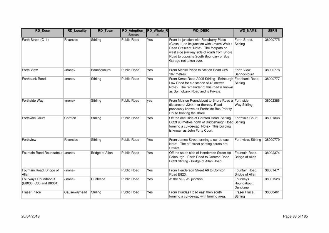
RD_Desc RD_Locality RD_Town RD_Adoption_
Status
RD_Whole_R
d
WD_DESC WD_NAME USRN
Forth Street (C11) Riverside Stirling Public Road Yes From its junction with Roseberry Place
(Class III) to its junction with Lovers Walk /
Dean Crescent. Note:- The footpath on
west side (railway side of road) from Shore
Road to opposite South Boundary of Bus
Garage not taken over.
Forth Street,
Stirling
38000775
Forth View <none> Bannockburn Public Road Yes From Manse Place to Station Road C25
167 metres.
Forth View,
Bannockburn
38000778
Forthbank Road <none> Stirling Public Road Yes From Kerse Road A905 Stirling - Edinburgh
Low Road for a distance of 43 metres.
Note:- The remainder of this road is known
as Springbank Road and is Private.
Forthbank Road,
Stirling
38000777
Forthside Way <none> Stirling Public Road yes From Muirton Roundabout to Shore Road a
distance of 2244m or thereby, Road
previously known as Forthside Bus Priority
Route fronting the shore
Forthside
Way,Stirling,
38002388
Forthvale Court Cornton Stirling Public Road Yes Off the east side of Cornton Road, Stirling
B823 90 metres north of Bridgehaugh Road
forming a cul-de-sac. Note:- This building
is known as John Forty Court.
Forthvale Court,
Stirling
38001348
Forthview Riverside Stirling Public Road Yes From James Street forming a cul-de-sac.
Note:- The off-street parking courts are
Private.
Forthview, Stirling 38000779
Fountain Road Roundabout <none> Bridge of Allan Public Road Yes Off the south side of Henderson Street A9
Edinburgh - Perth Road to Cornton Road
B823 Stirling - Bridge of Allan Road.
Fountain Road,
Bridge of Allan
38002374
Fountain Road, Bridge of
Allan
<none> Public Road Yes From Henderson Street A9 to Cornton
Road B823.
Fountain Road,
Bridge of Allan
38001471
Fourways Roundabout
(B8033, C35 and B8064)
<none> Dunblane Public Road Yes At the M9 / A9 junction. Fourways
Roundabout,
Dunblane
38001528
Fraser Place Causewayhead Stirling Public Road Yes From Dundas Road east then south
forming a cul-de-sac with turning area.
Fraser Place,
Stirling
38000461
20/04/2018 Page 83 of 185
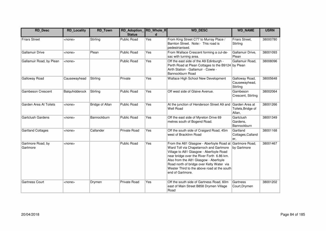
RD_Desc RD_Locality RD_Town RD_Adoption_
Status
RD_Whole_R
d
WD_DESC WD_NAME USRN
Friars Street <none> Stirling Public Road Yes From King Street C77 to Murray Place /
Barnton Street. Note:- This road is
pedestrianised.
Friars Street,
Stirling
38000780
Gallamuir Drive <none> Plean Public Road Yes From Wallace Crescent forming a cul-de-
sac with turning area.
Gallamuir Drive,
Plean
38001093
Gallamuir Road, by Plean <none> Public Road Yes Off the east side of the A9 Edinburgh -
Perth Road at Plean Cottages to the B9124
Airth Station - Gallamuir - Cowie -
Bannockburn Road
Gallamuir Road,
by Plean
38008096
Galloway Road Causewayhead Stirling Private Yes Wallace High School New Development Galloway Road,
Causewayhead,
Stirling
38005648
Gambeson Crescent Balquhidderock Stirling Public Road Yes Off west side of Glaive Avenue. Gambeson
Crescent, Stirling
38002064
Garden Area At Toilets <none> Bridge of Allan Public Road Yes At the junction of Henderson Street A9 and
Well Road
Garden Area at
Toilets,Bridge of
Allan,
38001266
Gartclush Gardens <none> Bannockburn Public Road Yes Off the east side of Myreton Drive 69
metres south of Bogend Road.
Gartclush
Gardens,
Bannockburn
38001349
Gartland Cottages <none> Callander Private Road Yes Off the south side of Craigard Road, 45m
west of Bracklinn Road
Gartland
Cottages,Calland
er,
38001168
Gartmore Road, by
Gartmore
<none> Public Road Yes From the A81 Glasgow - Aberfoyle Road at
Ward Toll via Chapelarroch and Gartmore
Village to A81 Glasgow - Aberfoyle Road
near bridge over the River Forth 6.86 km.
Also from the A81 Glasgow - Aberfoyle
Road north of bridge over Kelty Water via
Wester Third to the above road at the south
end of Gartmore.
Gartmore Road,
by Gartmore
38001467
Gartness Court <none> Drymen Private Road Yes Off the south side of Gartness Road, 60m
east of Main Street B858 Drymen Village
Road
Gartness
Court,Drymen
38001202
20/04/2018 Page 84 of 185

RD_Desc RD_Locality RD_Town RD_Adoption_
Status
RD_Whole_R
d
WD_DESC WD_NAME USRN
Gartness Road <none> Drymen Public Road Yes Off the east side of Main Street B858
Drymen Village Road opposite Balmaha
Road B837 forming a cul-de-sac.
Gartness Road,
Drymen
38000270
Gartness Road (C31) <none> Killearn Public Road Yes Off the north side of Station Road B834
280 metres west of Balfron Road A875.
Gartness Road,
Killearn
38000269
Gartur Road <none> By Arnprior Public Road Yes From Cardross Road B8034 Cardross
Road via Arnvicar to Gartur Farm.
Gartur Road, by
Arnprior
38000184
Gateside Road St Ninians Stirling Public Road Yes From Bearside Road to Graystale Road. Gateside Road,
Stirling
38000782
Geisher Road <none> Callander Public Road No From A84T in a southerly direction for
172m the remainder of road is private
Geisher Road,
Callander
38001541
Geisher Road <none> Callander Private Road No The first 172m of road is adopted from the
A84T the remainder is private
Geisher
Road,Callander,
38001541
George Street <none> Dunblane Public Road Yes From Old Doune Road to Claredon Place
A820 Doune - Dunblane Road. Also to
Hillside Avenue.
George Street,
Dunblane
38000462
George Street (B8032) <none> Doune Public Road Yes From the A84T Stirling - Lochearnhead
Road at the Woodside Hotel to the A820
Doune - Dunblane Road at The Cross.
George Street,
Doune
38000080
George Terrace <none> Balfron Public Road Yes Off the east end of Hillhead Brae to Roman
Road C23 Lernock Road. Also the service
road on south side opposite Lomond
Terrace for 46 metres. Also footway
upgraded at Strathendrick House.
George Terrace,
Balfron
38000271
Gerchew (C23) <none> By Balfron Public Road Yes From the C23 Lernock Road and Lernock
Road at Honeyholm Bridge to the B818
Falkirk - Fintry - Killearn Road.
Gerchew, by
Balfron
38001458
Gibson Grove <none> Dunblane Public Road Yes From its junction with Leewood Road for a
distance of 170m
Gibson
Grove,Dunblane,
38003044
Gilbert Grove <none> Doune Public Road Yes From Fir Road south-west forming a cul-de-
sac.
Gilbert Grove,
Doune
38000081
20/04/2018 Page 85 of 185

RD_Desc RD_Locality RD_Town RD_Adoption_
Status
RD_Whole_R
d
WD_DESC WD_NAME USRN
Gilles Hill To Wallace Place <none> Cambusbarron Public Road Yes Link footpath off Gilles Hill between house
Nos. 35 & 37 to Wallace Place between
house Nos. 10 & 12
Gilles Hill to
Wallace
Place,Cambusbar
ron,
38001421
Gillespie Place <none> Whins of Milton Public Road Yes Off the east side of Glasgow Road A872 89
metres south of Chartershall Road at
Whins of Milton forming a cul-de-sac 48
metres. Also a cul-de-sac south from the
above cul-de-sac for 66 metres. Note:-
The parking area and shop access are
Private.
Gillespie Place,
Whins of Milton
38000784
Gillespie Terrace <none> Plean Public Road Yes From the east of Main Street forming a cul-
de-sac, includes all parking bays,
hammerhead and footpaths.
Gillespie Terrace,
Plean
38002381
Gillies Drive <none> Stirling Public Road Yes From Broom Road to Shirra's Brae Road. Gillies Drive,
Stirling
38000785
Gillies Hill <none> Cambusbarron Public Road Yes From Murray Place at Wallace Place 541
metres. Also service road forming two
sides of a triangle opposite Gillieshill /
Underwood Cottages 80 metres.
Gillies Hill,
Cambusbarron
38001094
Gladstone Place <none> Stirling Public Road Yes From Park Terrace to Snowdon Place. Gladstone Place,
Stirling
38000786
Gladstone Place Lane Kings Park Stirling Private Road Yes Off the north side of Snowdon Place west
of house No. 4 to Park Terrace between
No. 1 Park Terrace and St Columba's
Church
Gladstone Place
Lane,Stirling,
38002322
Glaive Avenue Balquhidderock Stirling Public Road Yes Off the west side of Claymore Drive
forming a cul-de-sac.
Glaive Avenue,
Stirling
38002074
Glasgow - Aberfoyle -
Callander
<none> Public Road Yes From the A81 Glasgow - Callander Road at
Stirling Council boundary near Craigmaddie
House via Strathblane, Blanefield, Ballat
Crossroads, Braeval, by Aberfoyle, Port of
Menteith, Bridge Street, Callander to Main
Street A84 Stirling - Lochearnhead Road.
Note:- Some footways in Strathblane, on
the south side are Private.
Glasgow -
Aberfoyle -
Callander
38001491
20/04/2018 Page 86 of 185

RD_Desc RD_Locality RD_Town RD_Adoption_
Status
RD_Whole_R
d
WD_DESC WD_NAME USRN
Glasgow - Drymen
(Stockiemuir)
<none> Public Road Yes From the Council Boundary at Garvel
Bridge over Allander Water, 700 metres
south of B821 Strathblane --Craigmore
Road via Finnoch Toll, Croftamie to the
A811 Dumbarton Road, 1 kilometre south
of Drymen Village. Also 1.8 metre wide
footway ex adverso Drymen Motor
Company premises in Croftamie. Note:-
The remaining width of footpath to the
building in Croftamie is Private.
Glasgow -
Drymen
(Stockiemuir)
38001502
Glasgow - Fort William <none> Public Road Yes From the Council Boundary at Inverarnan
Bridge via Glen Falloch, Crianlarich to the
Council Boundary at Blackmount, 2.5 km
north of Tyndrum (Towards Fort William)
Glasgow - Fort
William
38002073
Glasgow - Stirling, by
Bannockburn
<none> Public Road Yes From the northbound exit slip road at
Haggs Interchange generally northwards to
the M9 Edinburgh - Perth Motorway, at a
point on the southbound carriageway 125
metres south of the centre line of New Line
Road Overbridge and at a point of the
northbound carriageway NS79218980, 405
metres north of the centre line of New Line
Road Overbridge, a mean distance of
10749 metres or thereby in the parishes of
Denny, Denny & Dunipace, Dunipace and
St Ninians. Total length of Motorway
excluding slip roads 9829 metres. Total
length of slip roads (Pirnhall Interchange)
1466 metres.
Glasgow - Stirling,
by Bannockburn
38002068
Glasgow Road (A81) <none> Blanefield Public Road Yes From the A81 Glasgow - Aberfoyle Road at
Ballewan Crescent to Milngavie Road A81
Glasgow - Aberfoyle Road at Dumbrock
Road.
Glasgow Road,
Blanefield
38000272
20/04/2018 Page 87 of 185

RD_Desc RD_Locality RD_Town RD_Adoption_
Status
RD_Whole_R
d
WD_DESC WD_NAME USRN
Glasgow Road (A872) St Ninians Stirling Public Road No From the A9 Edinburgh - Perth Road at St
Ninians Roundabout to Milton Terrace
A872 at Borestone Monument. Note:-
House Nos. 62, 64 & 76 (part) 115. Also
the cul-de-sac off Barnsdale Road behind
the flats on Glasgow Road is 'named'
Glasgow Road are Private.
Glasgow Road,
Stirling
38000787
Glasgow Road (A872) <none> Whins of Milton Public Road Yes Off the south side of Borestone
Roundabout A9 / B8051 to Milton Terrace
A872 35 metres south of the Service Road
access / Bruce View.
Glasgow Road,
Whins of Milton
38000788
Glasgow Road (A872) St Ninians Stirling Private Road No Nos. 2 to 24 Glasgow Road, cul-de-sac off
the west side of Barnsdale Road 59m west
of the A872Note 1: Nos. 62, 64and 76
(part) road on the west side 14m north of
the footpath leading to McLachlan Avenue.
Note 2: N0. 115 off Glasgow Road on the
east side bes
Glasgow
Road,Stirling,
38000787
Glassingall Road <none> Dunblane Private Road Yes New Development 2014 Glassingall, Road,
Dunblane
38005713
Glebe Avenue Kings Park Stirling Public Road Yes Off the south side of Dumbarton Road
A811 / Albert Place A811 to the south side
of Windsor Place at the southern boundary
of No. 21 Glebe Avenue.
Glebe Avenue,
Stirling
38000789
Glebe Crescent Kings Park Stirling Public Road Yes From the south side of Windsor Place at
the south boundary of No. 21 Glebe
Avenue to Park Avenue / Kings Park Road
opposite Gladstone Place.
Glebe Crescent,
Stirling
38000790
Glen Court <none> Dunblane Public Road Yes From The Crescent forming a cul-de-sac
with turning area.
Glen Court,
Dunblane
38000464
20/04/2018 Page 88 of 185
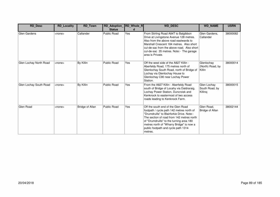
RD_Desc RD_Locality RD_Town RD_Adoption_
Status
RD_Whole_R
d
WD_DESC WD_NAME USRN
Glen Gardens <none> Callander Public Road Yes From Stirling Road A84T to Balgibbon
Drive at Livingstone Avenue 128 metres.
Also from the above road eastwards to
Marshall Crescent 184 metres. Also short
cul-de-sac from the above road. Also short
cul-de-sac 35 metres. Note:- The garage
area is Private.
Glen Gardens,
Callander
38000082
Glen Lochay North Road <none> By Killin Public Road Yes Off the west side of the A827 Killin -
Aberfeldy Road, 175 metres north of
Glenlochay South Road, north of Bridge of
Lochay via Glenlochay House to
Glenlochay C90 near Lochay Power
Station.
Glenlochay
(North) Road, by
Killin
38000014
Glen Lochay South Road <none> By Killin Public Road Yes From the A827 Killin - Aberfeldy Road
south of Bridge of Locahy via Daldraraig,
Lochay Power Station, Duncroisk and
Kenknock to eastermost of two access
roads leading to Kenknock Farm.
Glen Lochay
South Road, by
Killinq
38000015
Glen Road <none> Bridge of Allan Public Road Yes Off the south end of the Glen Road
footpath / cycle path 142 metres north of
"Drumdruills" to Blairforkie Drive. Note:-
The section of road from 142 metres north
of "Drumdruills" to the turning area 180
metres north of "Wharry Bridge" is now a
public footpath and cycle path 1314
metres.
Glen Road,
Bridge of Allan
38002144
20/04/2018 Page 89 of 185

RD_Desc RD_Locality RD_Town RD_Adoption_
Status
RD_Whole_R
d
WD_DESC WD_NAME USRN
Glen Road (C35) <none> Dunblane Public Road No From Perth Road B8033 Kinbuck - Braco
Road at the Fourways Roundabout to Glen
Road C35 105 metres south of the
Leewood Road to the south boundary of
"Applegarth". Footway fronting Kippenross
Farm Northside. Pisgah Development
adopted - off junction with Glen oad in a
north easterly then easterly direcion for
approx 202m includes turning area and
footway but not service strip,
Glen Road,
Dunblane
38000467
Glen Road (Unclassified) <none> Bridge of Allan Public Road Yes From Glen Road (formerly C35) at the
north end of Blairforkie Drive to Sunnylaw
Road / Ferniebank Brae.
Glen Road,
Bridge of Allan
38000466
Glen Road, <none> Dunblane Public Road Yes Off the east side of the Fourways
Roundabout B8033 in Dunblane to the C86
Dunblane - Sheriffmuir Road at
"Kippenross". Note:- Public Footpath /
Cycle Patch the section of road from the
turning area to 142 metres north of
"Drumdruills". Note:- The section of road
from the C68 at "Kippenross" to the turning
area, 180 metres north of "Wharry Bridge"
also the section from 142 metres north of
"Drumdruills" Farm access to Henderson
Street A9, 1728 metres are now de-
classified. Note:- The grass verge on
north side of Glen Road from Leewood to
the east boundary of "Applegarth" is
Private.
Glen Road,
Dunblane
38001461
Glen Tye Road Broadleys
Industrial Park
Stirling Public Road Yes Off the east side of Craig Leith
Roundabout, 236 metres south of
Broadleys Road A905.
Glen Tye Road,
Stirling
38001579
Glenallan Court <none> Dunblane Private Road Yes Off the south end of Claredon Place at
John R Gray Road forming a Cul-de-sac
(Retirement Homes)
Glenallan
Court,Dunblane,
38002107
Glenartney Court <none> Callander Private Road Yes Off the north end of Ancaster Square
(North)
Glenartney
Court,Callander,
38001169
20/04/2018 Page 90 of 185

RD_Desc RD_Locality RD_Town RD_Adoption_
Status
RD_Whole_R
d
WD_DESC WD_NAME USRN
Glenartney Road <none> Callander Public Road Yes Off the east side of Cross Street to North
Church Street. Also the section of footway
fronting House Nos. 1 - 4. Note: All other
footways and the parking area fronting
House Nos. 1 - 4 are Private.
Glenartney Road,
Callander
38000083
Glenbuckie Road <none> By Balquhidder Public Road Yes From Stroneslaney Road near Calair
Bridge in a southerly direction to the bridge
over Calair Burn at Ballimore 576 metres
south of Balquhidder Village.
Glenbuckie Road,
by Balquhidder
38000013
Glencairn Street <none> Stirling Public Road Yes From Cornhill Crescent forming a cul-de-
sac in an easterly direction.
Glencairn Street,
Stirling
38000791
Glencoe Road Public Lane <none> Stirling Public Road Yes From Upper Bridge Street to Lower Bridge
Street (Public Lane).
Glencoe Road,
Stirling
38000792
Glendevon Drive Raploch Stirling Public Road Yes From Drip Road A84 to Back O'Hill Road.
Note:- Footpath ex adverso Millars Garage
is Private.
Glendevon Drive,
Stirling
38000793
Glenfalloch Road <none> Crianlarich Public Road Yes From A82T to A82T at new roundabout Glenfalloch Road,
Crianlarich
38005753
Glenfinglas Road <none> By Callander Public Road Yes From the A821 Aberfoyle - Kilmahog at the
Post Office to the ford over the River Turk.
Glenfinglas Road,
by Callander
38000084
Glengyle Place <none> Callander Public Road Yes Off Lendrick Avenue Glengyle
Place,Callander,
38002397
Glentirran, <none> Kippen Public Road Yes From the B822 Callander - Kirkintilloch
Road via Westerton Farm and Burnside
Road to the eastern edge of Redbrae
Wood.
Glentirran, by
Kippen
38000273
Gogar Place St Ninians Stirling Public Road Yes From Braehead Road to Crum Crescent. Gogar Place,
Stirling
38000794
Gogar Road <none> Blairlogie Public Road Yes From the A91 Stirling - Cupar Road at
Cotkerse to the A907 Stirling - Dunfermline
Road at Blackgrange.
Gogar Road,
Blairlogie
38000468
20/04/2018 Page 91 of 185

RD_Desc RD_Locality RD_Town RD_Adoption_
Status
RD_Whole_R
d
WD_DESC WD_NAME USRN
Goosecroft Road <none> Stirling Public Road Yes From the A9 Edinburgh - Perth Road at
Craigs Roundabout to Cowane Street at
No. 14 Barnton Street. Note:- Road
leading into Post Office Premises on the
west side near the roundabout over
footway area is Private.
Goosecroft Roa,
Stirling
38000795
Gordon Crescent <none> Bridge of Allan Public Road Yes From Hopetoun Drive forming a cul-de-sac. Gordon Crescent,
Bridg eof Allan
38000469
Gordon Square Raploch Stirling Public Road Yes From its junction with Drip Road in a
southerly direction forming a cul-de-sac
Gordon Square,
Raploch, Stirling
38005364
Gowanhill Gardens Raploch Stirling Public Road Yes From Glendevon Drive forming a cul-de-
sac with turning area 313 metres. Also the
loop road serving House Nos. 23 - 42 126
metres. Also cul-de-sac with turning area
from above road 38 metres. Also the spur
from the above road to Back O'Hill 48
metres.
Gowanhill
Gardens, Stirling
38000797
Gracie Crescent <none> Fallin Public Road Yes From Baxter Street forming a cul-de-sac
with turning area. Note:- The lock-up
access road is Private.
Gracie Crescent,
Fallin
38000798
Graham Avenue <none> Dunblane Public Road Yes East of Wedderburn Road for a distance of
94m
Graham
Avenue,Dunblane
,
38003104
Graham Avenue Causewayhead Stirling Private Road Yes Off the west side of Logie Road B998, 46m
south of the east end of Hillfoots Road
(unclassified) to Hillfoots Road
(unclassified) 63m west of Spittal Hill
Graham
Avenue,Stirling,
38001269
Graham Road <none> Killearn Public Road Yes Off the west side of Main Street A875
Dumgoyne - Kepculloch Road to Buchanan
Road.
Graham Road,
Killearn
38000275
Graham Street <none> Doune Public Road Yes Off the south side of George Street B8034
at The Cross to Castlehill 83 metres west
of Castlehill Court.
Graham Street,
Doune
38000085
Graham Street <none> Bridge of Allan Public Road Yes From Henderson Street A9 to Keir Street. Graham Street,
Bridge of Allan
38000470
20/04/2018 Page 92 of 185

RD_Desc RD_Locality RD_Town RD_Adoption_
Status
RD_Whole_R
d
WD_DESC WD_NAME USRN
Graham Street <none> Kippen Private Road Yes Off the north side Fore Road B8037, 100m
west of Kippen Parish Church
Graham
Street,Kippen,
38001221
Grampian Road <none> Stirling Public Road Yes From Birkhill Road C5 Cambusbarron -
Stirling Road forming a cul-de-sac 375ms.
A cul-de-sac from above road southwest
44. A cul-de-sac from above road
southwest to 51m. A cul-de-sac from above
road southwest. A cul-de-sac from above
road 43ms. A cul-de-sac from above road
northeast to 58m. A cul-de-sac from above
road northeast to 44m. A cul-de-sac from
above road to northeast.
Grampian Road,
Stirling
38000799
Grange Gardens <none> Bridge of Allan Public Road Yes From Sheriffmuir Road forming a cul-de-
sac with turning head.
Grange Gardens,
Bridge of Allan
38000471
Grange Road <none> Stirling Public Road Yes Off the south side of Alloa Road A907 394
metres east of Ladysneuk Road C96 to the
access road to West Grange Farm.
Grange Road,
Stirling
38001270
Grant Court <none> Callander Private Road Yes Off the east side of Bridgend opposite
Oakbank
Grant
Court,Callander,
38001170
Grant Drive <none> Dunblane Public Road No From Doune Road A820 forming a cul-de-
sac. Extension to Grant Drive also adopted
for 402m
Grant Drive,
Dunblane
38000472
Grant Drive <none> Dunblane Private Road No (CC/96/41/D - A & L King) Grant
Drive,Dunblane,
38000472
Grant Place Causewayhead Stirling Public Road Yes From Chisholm Avenue west then North
forming a cul-de-sac with turning head.
Grant Place,
Stirling
38000473
Gray Street (A827) <none> Killin Public Road Yes From Main Street, A827 Killin - Aberfeldy
Road on the south side of Dochart Bridge
to Dochart Road A827 Killin - Aberfeldy
Road at the boundary of House Nos. 1
Dochart Road / No. 8 Gray Street.
Gray Street, Killin 38000016
Grays Loan <none> Thornhill Private Road No Grays
Loan,Thornhill,
38003046
20/04/2018 Page 93 of 185

RD_Desc RD_Locality RD_Town RD_Adoption_
Status
RD_Whole_R
d
WD_DESC WD_NAME USRN
Graystale Road St Ninians Stirling Public Road Yes From Bearside Road to Gateside Road. Graystale Road,
Stirling
38000801
Greathill Road <none> By Stirling Public Road Yes From New Line Road C10 at Canglour
Wood to Polmaise Road at the northwest
end of North Third Reservoir.
Greathill Road, by
Stirling
38000802
Greek Thomson Road <none> Balfron Public Road Yes From its junction with Dunkeld Court in a
westerly direction for 230m
Greek Thomson
Road, Balfron
38003193
Greenacre Court <none> Bannockburn Public Road Yes From Greenacre Place forming a cul-de-
sac.
Greenacre Court,
Bannockburn
38000803
Off the south side of Quakerfield A9
Edinburgh - Perth Road 55m south of
Station Road to Bentheads. Also from the
above road forming 2 cul-de-sac.
Note:- The access to the library and to the
rear of the shops is Private, maintained by
Stirling Council.
Greencornhills Roundabout
(A91and A9)
<none> By Stirling Public Road Yes At the A9 Edinburgh - Perth Road and the
A91 Stirling - Cupar Road south of
Bannockburn.
Greencornhills
Roundabout, by
Stirling
38002289
Greenend Lane <none> Killearn Private Road Yes Off the south side of Balfron Road A875,
26m east of Drumtian Road
Greenend
Lane,Killearn,
38001222
Greenend Road <none> Killearn Private Road Yes Off the south side of A875 Balfron Road,
97m east of Drumtian Road
Greenend
Road,Killearn,
38001223
Greenfield Court <none> Balfron Public Road Yes Off the south side of Strathview Terrace
forming a cul-de-sac.
Greenfield Court,
Balfron
38000276
Greenwood Avenue <none> Stirling Public Road Yes From Clarendon Road to Royal Gardens. Greenwood
Avenue, Stirling
38000805
Greenyards Farm Road <none> Bannockburn Public Road Yes From the B9124 to a point 30m west of the
access to Greenyards Farm.
Greenyards Farm
Road,
Bannockburn
38000806
From Snowdon Place forming a cul-de-sac.
Please note: On street parking is adopted
and maintained.
Grendon Court <none> Stirling Public Road 38000807
Greenacre Place <none> Bannockburn Public Road Yes 38000804
Grendon Court,
Stirling
Greenacre Place,
Bannockburn
Yes
20/04/2018 Page 94 of 185

RD_Desc RD_Locality RD_Town RD_Adoption_
Status
RD_Whole_R
d
WD_DESC WD_NAME USRN
Off Street parking a is private, this includes
the parking court at Grendon Gardens.
Grierson Crescent <none> Cambusbarron Public Road Yes From Mill Road forming a cul-de-sac 170m.
Also 2 culs-de-sac on the east side 30m
and 22m.
Grierson
Crescent,
Cambusbarron
38001095
Grierson Drive <none> Deanston Public Road Yes Off the south side of Leny Road opposite
Primary School Car Park
Grierson Drive,
Deanston
38001171
Gullipen View <none> Callander Public Road Yes From Geisher Road for a distance of 240m Gullipen
View,Callander,
38001563
Haig Avenue Raploch Stirling Public Road Yes From Beatty Avenue to a point 92 metres
north of Ochil Crescent and Hazelbank
Gardens.
Haig Avenue,
Stirling
38000808
Halberts Crescent St Ninians Stirling Public Road Yes Off the west side of Glasgow Road A872
forming a cul-de-sac.
Halberts
Crescent, Stirling
38000809
Haldane Avenue <none> Bridge of Allan Public Road Yes From Pullar Avenue to Churchill Drive. Haldane Avenue,
Bridge of Allan
38000475
Hall Lane <none> Doune Public Road Yes From Main Street A820 Doune - Dunblane
Road to Northlea.
Hall Lane, Doune 38000086
Hamilton Drive Causewayhead Stirling Public Road Yes From Easter Cornton Road to Lothian
Crescent.
Hamilton Drive,
Stirling
38000476
Hanover Court <none> Dunblane Private Road Yes Off the north side of Sunnyside opposite
Claredon Place
Hanover
Court,Dunblane,
38001271
Hardie Court <none> Stirling Public Road Yes From Ross Court forming a cul-de-sac. Hardie Court,
Stirling
38000810
Hardie Crescent <none> Fallin Public Road Yes From Hawthorne Drive to Polmaise
Crescent 157 metres. Also from the above
road forming a cul-de-sac with turning area
37 metres. Also from Hardie Crescent at
forming a cul-de-sac with turning area 48
metres.
Hardie Crescent,
Fallin
38000811
Harpers Road <none> Killearn Public Road Yes Off the south side of Beech Drive forming a
cul-de-sac. Note:- The access to garages
is Private.
Harpers Road,
Killearn
38000278
Hart Wynd <none> Bannockburn Public Road Yes From Ochilmount forming a cul-de-sac. Hart Wynd,
Bannockburn
38000812
20/04/2018 Page 95 of 185

RD_Desc RD_Locality RD_Town RD_Adoption_
Status
RD_Whole_R
d
WD_DESC WD_NAME USRN
Harvest Street Cornton Stirling Public Road Yes From its junction with John Cowane Row
for a distance of 208m. The accesses to
the rear of No. 10 – 15 and 20 – 22 are
privateThe accesses to the rear
Harvest
Street,Cornton,Sti
rling,
38003069
Harvey Wynd <none> Stirling Public Road Yes From Upper Bridge Street forming a cul-de-
sac.
Harvey Wynd,
Stirling
38000813
Haugh Road Cornton Stirling Public Road Yes From Cornton Road forming an access to a
square. Note:- The footpaths to both Lock-
up Garages are Private.
Haugh Road,
Stirling
38000477
Hawthorn Crescent Raploch Stirling Public Road Yes From Woodside Road to Woodside Road
including spur
Hawthorn
Crescent, Stirling
38000814
Hawthorne Crescent <none> Fallin Public Road Yes Off the east end of Polmaise Crescent at
Weir Drive to Bandeath Road 137 metres.
Also from the above road forming a cul-de-
sac with turning area 34 metres. Also
footpath between Hawthorne Crescent and
Weir Drive.
Hawthorne
Crescent, Fallin
38000815
Hawthorne Drive <none> Fallin Public Road Yes Off the east side of Polmaise Crescent 104
metres west of Beda Place to Weir Drive
opposite Hawthorne Crescent.
Hawthorne Drive,
Fallin
38000816
Hayford Mills <none> Cambusbarron Public Road Yes From its junction with Kerebonny Road for
a distance of 3882m, also upgraded
footway joining network
Hayford
Mills,Cambusbarr
on,
38003047
Hayford Place <none> Cambusbarron Public Road Yes From Stewart Street south forming a cul-de-
sac.
Hayford Place,
Cambusbarron
38001096
Hays Hill <none> Kippen Public Road Yes Off the south side of Burnside forming a cul-
de-sac. Also the elevated footpath.
Hays Hill, Kippen 38000279
Hazelbank Gardens Raploch Stirling Public Road Yes From Ferguson Street to Haig Avenue. Hazelbank
Gardens, Stirling
38000817
Headrigg Square <none> Killearn Private Road Yes Off the south side of A875 Main Street east
of The Square
Headrigg
Square,Killearn,
38002090
Hedges Loan <none> Bannockburn Private Road No Footpath connecting Bentheads and
Rowan Court
Hedges
Loan,Bannockbur
n,
38003048
20/04/2018 Page 96 of 185

RD_Desc RD_Locality RD_Town RD_Adoption_
Status
RD_Whole_R
d
WD_DESC WD_NAME USRN
Henderson Place <none> Plean Public Road Yes South off Munnoch Way for a distance of
109m
Henderson Place,
Plean
38004131
Henderson Street (A9) <none> Bridge of Allan Public Road Yes From Airthrey Road A9 Edinburgh - Perth
Road 36 metres south of Kenilworth Road
Eastern burgh boundary to the A9
Edinburgh - Perth Road at the north side of
the Railway Bridge at western burgh
boundary. We have higher level only. Also
area fronting No. 15. Note:- The lower
level parts of the footpath on the south side
between House Nos. 26-34 Union Street
and New Street.
Henderson Street,
Bridge of Allan
38000478
Hepburn Court <none> Dunblane Public Road Yes North of Wedderburn Road for a distance
of 72m
Hepburn
Court,Dunblane,
38003103
High Street (B8064) <none> Dunblane Public Road Yes From Beech Road B8064 High Street to
Perth Road B8033 Dunblane - Kinbuck -
Braco Road at the Fourways Roundabout.
Also both of the passageways leading from
High Street to Mill Row. Also the area
between the heel of footpath and face of
the Burgh Chambers and the Sheriff Court
Buildings.
High Street,
Dunblane
38000479
Highfields <none> Dunblane Public Road Yes From Old Doune Road forming a cul-de-
sac 285 metres. Also from the above road
forming a cul-de-sac 56 metres. Also the
link footpath from Highfields to Braemar
Grove.
Highfields,
Dunblane
38000480
Hill Street St Ninians Stirling Public Road Yes From Maitland Crescent to Bannockburn
Road A9.
Hill Street, Stirling 38000818
Hillfoots Road (B998 and
Unclassified)
Causewayhead Stirling Public Road No From Airthrey Road A9 to B998 Logie Road
B998. Also bellmouth access on north side
and 18 metres of footway to the east of
access
Hillfoots Road,
Stirling
38000483
Hillfoots Road (B998 and
Unclassified)
Causewayhead Stirling Public Road No This record is for Hillfoots Road B998 from
Logie Road B998 to the Burgh Boundary at
Craigton Farm.
Hillfoots Road,
Stirling
38000483
20/04/2018 Page 97 of 185

RD_Desc RD_Locality RD_Town RD_Adoption_
Status
RD_Whole_R
d
WD_DESC WD_NAME USRN
Hillhead Brae <none> Balfron Public Road Yes Off the east side of Buchanan Street A875
Dumgoyne - Kepculloch Road opposite the
north access to Dunkeld Court to George
Terrace, also upgraded footway at
Strathendrick House.
Hillhead Brae,
Balfron
38000280
Hillpark Crescent <none> Bannockburn Public Road Yes Off the south side of Firs Entry 32 metres
west of Hillpark Drive to Morrison Drive
C48 81 metres north of Clark Street 273
metres. Also from the above road forming
a cul-de-sac with turning area 67 metres.
Hillpark Crescent,
Bannockburn
38000819
Hillpark Drive <none> Bannockburn Public Road Yes Off the south side of Morrison Drive C48 at
Firs Entry forming a cul-de-sac with turning
area.
Hillpark Drive,
Bannockburn
38000820
Hillside Avenue <none> Dunblane Public Road Yes From Claredon Place A820 Doune -
Dunblane Road to George Street.
Hillside Avenue,
Dunblane
38000481
Hillside Of Row <none> By Dunblane Public Road Yes Off the south side of the C34 Bridge of
Allan - Carse of Lecropt - Doune Road 2.3
kilometres west of Keir Roundabout A9 at
Easter Row Farm to the B824 Hill of Row
Road near the Old Quarry.
Hillside of Row,
Dunblane
38000087
Hillview Drive <none> Bridge of Allan Public Road Yes From Strathallan Road to Orchard Road. Hillview Drive,
Bridge of Allan
38000484
Hillview Place <none> Fallin Private Road Yes Short cul-de-sac off the west end of Stirling
Services Road (South), 65m west of
Bannock Road
Hillview
Place,Fallin,
38001354
Hilton <none> Cowie Public Road Yes From Cowiehall Road to Cowiehall Road
713 metres. Also from the above road
forming cul-de-sacs 27 metres and 37
metres.
Hilton, Cowie 38001097
Hilton Terrace <none> Fallin Public Road Yes From Bannock Road forming a cul-de-sac
with turning area.
Hilton Terrace,
Fallin
38000821
Hilton To Scotstoun Road <none> Cowie Private Road Yes At the east end of both roads between Nos.
72 and 74 Hilton through the garage lock-
ups and between Nos. 65 and 67
Scotstoun Road
Hilton to
Scotstoun
Road,Cowie,
38001423
20/04/2018 Page 98 of 185

RD_Desc RD_Locality RD_Town RD_Adoption_
Status
RD_Whole_R
d
WD_DESC WD_NAME USRN
Hirst Court <none> Fallin Public Road Yes Off Hirst Crescent forming a cul-de-sac. Hirst Court, Fallin 38001566
Hirst Crescent <none> Fallin Public Road Yes Off the north side of Stirling Road A905. Hirst Crescent,
Fallin
38002303
Holmehill Court <none> Dunblane Public Road Yes From Smithy Loan forming a cul-de-sac. Holme Hill Court,
Dunblane
38000485
Home Farm Road Cambusbarron Stirling Prospective
Public
Yes New Development off St. Ninians Road Home Farm
Road,
Cambusbarron
Stirling
38003559
Homesteads <none> By Stirling Private Road Yes Off the south side of the A811 Stirling -
Dumbarton Road, 300m east of the bridge
over the M9 Motorway ,777m west of
Raploch Road B8051. Note: Added for
Street Lighting Inventory
Homesteads,By
Stirling,
38001547
Hope Street Raploch Stirling Public Road Yes From Atholl Place to Duff Crescent. Hope Street,
Stirling
38000822
Hopetoun Drive <none> Bridge of Allan Public Road Yes From Alexander Drive forming a cul-de-
sac.
Hopetoun Drive,
Bridge of Allan
38000486
Howlands Road St Ninians Stirling Public Road Yes From Cultenhove Road to Gateside Road. Howlands Road,
Stirling
38000823
Hume Court <none> Bridge of Allan Public Road Yes From Hume Crescnt forming a cul-de-sac
with turning head.
Hume Court,
Bridge of Allan
38000488
Hume Crescent <none> Bridge of Allan Public Road Yes From Pullar Avenue to Pullar Avenue. Hume Crescent,
Bridge of Allan
38000487
Huntly Crescent Raploch Stirling Public Road Yes From Raploch Road B8051 to Glendevon
Drive.
Huntly Crescent,
Stirling
38000824
Hyslop Way Causewayhead Stirling Private Yes Wallace High School New Development Hyslop Way,
Causewayhead,
Stirling
38005643
Ian Urquhart Way Stirling Retail
Park
Stirling Private Road Yes Off the Roundabout near Safeway into
Safeway car park at Springkerse Retail
Park
Ian Urguhart
Way,Stirling,
38001355
Ibert Road <none> Killearn Private Road Yes Off the north side of A875 Main Street
opposite Wellgreen
Ibert
Road,Killearn,
38001225
20/04/2018 Page 99 of 185

RD_Desc RD_Locality RD_Town RD_Adoption_
Status
RD_Whole_R
d
WD_DESC WD_NAME USRN
Indians Road <none> Balfron Public Road Yes From its junction with Dumgoyne -
Kepculloch Road A875 at The Clachan,
Buchanan Street, Balfron via Station Road,
Balfron to its junction with Glasgow -
Aberfoyle Road A81 at Balfron Station.
Indians Road,
Balfron
38002136
Indians Road, by Balfron <none> Public Road Yes Off the west side of the A875 Dumgoyne -
Kepculloch Road at The Clachan,
Buchanan Street, Balfron via Station Road,
Balfron to the A81 Glasgow - Aberfoyle
Road at Balfron Station.
Indians Road, by
Balfron
38001457
Indiansdorp <none> Balfron Public Road Yes Off the north side of Indians Road C21, 105
metres east of the A81 Glasgow -Aberfoyle
- Callander Road forming a cul-de-sac.
Indians Dorp,
Balfron
38000281
Ingram Drive <none> Dunblane Public Yes Off west side of Barbush forming a cul-de-
sac
Ingram
Drive,Dunblane,
38003102
Ingram Road <none> Raploch Private Road Yes Barratt New Development Ingram Road,
Raploch, Stirling 38005729
Innovation Park Causewayhead Stirling Public Road No Off the north side of the Hillfoots Road
B998 263 metres east of the access to the
Wallace Monument Car Park northwards
for 160 metres. Road 2 from its junction
with Road 1 for 280 metres forming a loop.
Road 3 junction of Road 1 for 70 metres
forming a cul-de-sac.
Innovation Park,
Stirling
38000826
Inverallan Court <none> Bridge of Allan Public Road Yes From Station Road forming a cul-de-sac. Inverallan Court,
Bridge of Allan
38000489
Inverallan Drive <none> Bridge of Allan Public Road Yes From Inverallan Road forming a cul-de-sac
with turning head. Also the footpath
connection to Station Road.
Inverallan Drive,
Bridge of Allan
38000490
Inverallan Road <none> Bridge of Allan Public Road Yes From Henderson Street A9 Edinburgh -
Perth Road to Carse of Lecropt Road.
Inverallan Road,
Bridge of Allan
38000491
20/04/2018 Page 100 of 185

RD_Desc RD_Locality RD_Town RD_Adoption_
Status
RD_Whole_R
d
WD_DESC WD_NAME USRN
Inverhervie <none> By Crianlarich Public Road Yes Off the west side of the A82T Glasgow -
Fort William Road, 1.5 kilometres north of
Crianlarich to the access to Alltchaorain
Farm.
Inverhervie, by
Crianlarich
38000017
Invertrossachs Road
(unclassified)
<none> By Callander Public Road Yes Off the west side of the C114
Invertrossachs Road 337 metres south of
the A821 at Gartchonzie Bridge via East
Lodge.
Invertrossachs
Road, by
Callander
38000088
Invertrossachs Road, by
Callander
<none> Public Road Yes From the A821 near Coilantogle 336
metres north of Gartchonzie Bridge to the
A81 at Bridgend, Callander via Callander
Hydropathic, Coilhallan Wood.
Invertrossachs
Road, by
Callander
38008112
Irvine Place <none> Stirling Public Road Yes From Barnton Street 244 metres to St
Mary's Wynd . Also from Irvine Place
forming a cul-de-sac. Also from Irvine
Place forming a cul-de-sac 47 metres.
Also footways from Barnton Street to No.
14 and No. 21 Irvine Place.
Irvine Place,
Stirling
38000827
Ivanhoe Place Raploch Stirling Public Road Yes From Woodside Road forming a cul-de-
sac. The cul-de-sac serving 5 and 7 has
been adopted 19/07/2011
Ivanhoe Place,
Stirling
38000828
Jail Wynd Top of the Town Stirling Public Road Yes From Broad Street to St. John Street. Jail Wynd, Stirling 38000829
James Street Riverside Stirling Public Road Yes Off the north side of Roseberry Place
opposite Ronald Place to Dean Crescent.
Also two block of three storeys Nos. 59 to
95 Odd Nos. Note:- Link Housing Car
Park is Private.
James Street,
Stirling
38000830
James Street <none> Whins of Milton Public Road Yes From Davidson Street to Randolph
Crescent.
James Street,
Whins of Milton
38000831
Jellicoe Avenue <none> Gartmore Public Road Yes Off the east side of Gartmore Road C57 in
Gartmore Village forming a cul-de-sac 157
metres. Also the turning head at the
northern end of the above road 31 metres.
Also a cul-de-sac in a southerly direction
for 66 metres.
Jellicoe Avenue,
Gartmore
38000185
20/04/2018 Page 101 of 185

RD_Desc RD_Locality RD_Town RD_Adoption_
Status
RD_Whole_R
d
WD_DESC WD_NAME USRN
Jenny Gunns Loan Boquhan By Balfron Private Road Yes Off the west side of the A875 Dumgoyne -
Kepculloch Road at the north end of
Boquhan, 1km south of Balfron
Jenny Gunns
Loan,By Balfron,
38002317
John Cowane Row <none> Stirling Public Road Yes From north side of Westhaugh road for a
distance of 139m
John Cowane
Row,Cornton,Stirli
ng
38003021
John Murray Drive <none> Bridge of Allan Public Road No From Hopetoun Drive forming a cul-de-sac
with turning area. Also a short spur to an
open space area.
John Murray
Drive, Bridge of
Allan
38000492
John Rushforth Place Raploch Stirling Public Road Yes From Woodside Road forming a cul-de-
sac.
John Rushford
Place, Stirling
38000832
Johnston Avenue Cornton Stirling Public Road Yes From Cornton Road B823 forming a cul-de-
sac with turning circle 416 metres. Also cul-
de-sacs for 55 metres and 60 metres. Also
pedestrian section fronting Achray Drive
122 metres. Upgrading of Shopping Area -
Adopted 17/4/01.
Johnston Avenue,
Stirling
38000493
Johnston Street <none> Whins of Milton Public Road Yes From Davidson Street to Randolph
Crescent 192 metres. Also from the above
road forming a cul-de-sac with turning area
to 46 metres.
Johnston Street,
Whins of Milton
38000833
Julia Cottages <none> Callander Private Road Yes Off the south side of the west end of
Oakbank (Bridgend)
Julia
Cottages,Calland
er,
38001172
Katrine Crescent <none> Callander Public Road Yes From Mollands Road to Lubnaig Drive. Katrine Crescent,
Callander
38000089
Keip Road <none> Strathyre Public Road No Off the west side of Stronslaney Road 247
metres west of the A84T Stirling -
Lochearnhead Road to Kippen.
Keip Road,
Strathyre
38000020
Keip Road <none> Strathyre Private Road No Off Keip road servicing 1 to 12 forming a
loop
Keip Road,
Strathyre
38000020
Keir Avenue Raploch Stirling Public Road Yes From Ochil Crescent to Haig Avenue. Keir Avenue,
Stirling
38000834
Keir Court <none> Bridge of Allan Public Road Yes From Keir Street forming a cul-de-sac. Keir Court, Bridge
of Allan
38000494
20/04/2018 Page 102 of 185

RD_Desc RD_Locality RD_Town RD_Adoption_
Status
RD_Whole_R
d
WD_DESC WD_NAME USRN
Keir Gardens <none> Bridge of Allan Private Road Yes Off the north side of Keir Street, 112m east
of Fountain Road
Keir
Gardens,Bridge of
Allan,
38001275
Keir Roundabout (M9, A9T,
A9 and B8033)
<none> By Dunblane Trunk Road Yes Keir Roundabout,
by Dunblane
38000835
Keir Street <none> Bridge of Allan Public Road Yes From Henderson Street A9 Edinburgh -
Perth Road near to Union Street B823
Cornton Road.
Keir Street,
Bridge of Allan
38000495
Keir Street <none> Dunblane Public Road Yes From Old Doune Road forming a cul-de-
sac to the south boundary of "Keirmount".
Keir Street,
Dunblane
38000496
Keith Avenue <none> Stirling Public Road Yes From Broom Road forming a cul-de-sac
with turning area.
Keith Avenue,
Stirling
38000836
Kellie Wynd <none> Dunblane Public Road Yes From its junction with Kippendavie Road for
a distance of 626m, includdes Bus Turning
Area 64m. Also remote footpath leading to
Menteith View 97m
Kellie
Wynd,Dunblane,
38003052
Keltie Bridge <none> Callander Public Road Yes From the A84T Stirling - Lochearnhead
Road forming a cul-de-sac with turning
head.
Keltie Bridge,
Callander
38000092
Keltie Place <none> Deanston Public Road Yes From Leny Road forming a cul-de-sac. Keltie Place,
Deanston
38000090
Kendrum Road <none> Lochearnhead Public Road Yes From the A84T Stirling - Lochearnhead
Road, forming a cul-de-sac 233 metres
south of Ravenscroft Road.
Kendrum Road,
Lochearnhead
38000018
Kenilworth Court <none> Bridge of Allan Private Road Yes Off the North side Kenilworth Road, 58m
east of Abercromby Drive
Kenilworth
Court,Bridge of
Allan,
38001276
Kenilworth Road <none> Bridge of Allan Public Road Yes From Henderson Street A9 Edinburgh -
Perth Road to Well Road.
Kenilworth Road,
Bridge of Allan
38000497
20/04/2018 Page 103 of 185

RD_Desc RD_Locality RD_Town RD_Adoption_
Status
RD_Whole_R
d
WD_DESC WD_NAME USRN
Kenningknowes Road <none> Stirling Public Road Yes From Polmaise Road forming a cul-de-sac
with turning area to. To Kenningknowes
Road forming a cul-de-sac with turning
area 140 metres. Also from
Kenningknowes Road forming a cul-de-sac
with turning area 120 metres. Also from
Kenningknowes Road forming a cul-de-sac
with turning area. Note:- Off-street parking
areas are Private.
Kenningknowes
Road, Stirling
38000837
Kennock Lubchurran Road <none> Killin Private Road Yes Extension of C90 Glen Lochay Road from
Kennock to Lubchurran
Kennock
Lubchurran
Road,Killin,
38001143
Kent Road <none> Stirling Public Road Yes From Cecil Street to Muirend Road. Kent Road,
Stirling
38000838
Kepdowrie <none> Buchlyvie Public Road Yes From the B835 Ward Toll - Buchlyvie Road
to the access road over Kepdowrie Farm.
Note:- The remainder of this road is
Private.
Kepdowrie,
Buchlyvie
38000186
Kersemill <none> Stirling Public Road Yes From junction at Halfway House to Kerse
Mill House for a distance of 472m
Kersemill, Stirling 38004128
Kerse Road (A905 and
Unclassified)
<none> Stirling Public Road Yes From the A9 at Craigs Roundabout to
where Kerse Road unclassified meets
Kerse Road A905 395 metres east of
Broadleys Roundabout near Kerse Mill
House.
Kerse Road,
Stirling
38000839
20/04/2018 Page 104 of 185

RD_Desc RD_Locality RD_Town RD_Adoption_
Status
RD_Whole_R
d
WD_DESC WD_NAME USRN
Kerse Road (A905 and
Unclassified)
<none> Stirling Public Road Yes Off the north side of Broadleys Roundabout
to Halfway House. Also a section of the
south side of the A905 Stirling - Edinburgh
Low Road 70 metres east of Millhall Road
forming an access road 113 metres and
two culs-de-sac, one to the east 69 metres
to a gate. Also from the gate to the fence
line of the A91 Stirling - Cupar Road 98
metres and one to the west forming a
turning area and vehicular access to
Millhall Cottage 96 metres. Please note
section of road from Halfway House to
Kerser Mill House, now known as
Kersemill. (See Entry for Kersemill)
Kerse Road,
Stirling
38000839
Kerse Road RABT <none> Stirling Public Road Yes From the A9 at Craigs Roundabout to
where Kerse Road unclassified meets
Kerse Road
Kerse Road,
Stirling
38003023
Kersebonny Road <none> Cambusbarron Public Road Yes From The Brae / North End Road to the
A811 Stirling - Dumbarton Road.
Kersebonny Road
(Mill Road),
Cambusbarron
38001098
Kersie Road (A905) <none> Throsk Public Road Yes Off the A905 Stirling - Edinburgh Low Road
180 metres east of the C63 Cowie - Fallin
Road at the Community Centre to the A905
Stirling - Edinburgh Low Road 209 metres
east of the access to Bandeath. Note:-
The house Nos. 1, 2 and 11-29 do not front
onto Kersie Road.
Kersie Road,
Throsk
38000841
Kilbryde and Brack Road <none> By Doune Public Road Yes From the A820 Doune - Dunblane Road via
Nether Glastry to near Dalbrack.
Kilbryde and
Brack, Doune
38000091
Kilbryde Court <none> Dunblane Private Road Yes Off the west side of Kilbryde Crescent
opposite the north end of Springbank
Crescent
Kilbryde
Court,Dunblane,
38001278
20/04/2018 Page 105 of 185
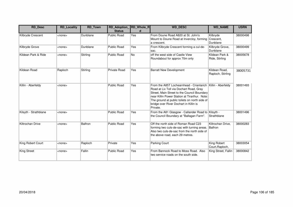
RD_Desc RD_Locality RD_Town RD_Adoption_
Status
RD_Whole_R
d
WD_DESC WD_NAME USRN
Kilbryde Crescent <none> Dunblane Public Road Yes From Doune Road A820 at St. John's
Mount to Doune Road at Invercloy, forming
a crescent.
Kilbryde
Crescent,
Dunblane
38000498
Kilbryde Grove <none> Dunblane Public Road Yes From Kilbryde Crescent forming a cul-de-
sac.
Kilbryde Grove,
Dunblane
38000499
Kildean Park & Ride <none> Stirling Public Road No off the west side of Castle View
Roundabout for approx 70m only
Kildean Park &
Ride, Stirling
38005678
Kildean Road Raploch Stirling Private Road Yes Barratt New Development Kildean Road,
Raploch, Stirling38005731
Killin - Aberfeldy <none> Public Road Yes From the A85T Lochearnhead - Crianlarich
Road at Lix Toll via Dochart Road, Gray
Street, Main Street to the Council Boundary
near Killin Power Station at Tirarthur. Note:-
The ground at public toilets on north side of
bridge over River Dochart in Killin is
Private.
Killin - Aberfeldy 38001493
Kilsyth - Strathblane <none> Public Road Yes From the A81 Glasgow - Callander Road to
the Council Boundary at "Ballagan Farm".
Kilsyth -
Strathblane
38001496
Kiltrochan Drive <none> Balfron Public Road Yes Off the north side of Roman Road C23
forming two culs-de-sac with turning areas.
Also two culs-de-sac from the north side of
the above road, each 29 metres.
Kiltrochan Drive,
Balfron
38000283
King Robert Court <none> Raploch Private Yes Parking Court King Robert
Court,Raploch,
38003054
King Street <none> Fallin Public Road Yes From Bannock Road to Moss Road. Also
two service roads on the south side.
King Street, Fallin 38000842
20/04/2018 Page 106 of 185

RD_Desc RD_Locality RD_Town RD_Adoption_
Status
RD_Whole_R
d
WD_DESC WD_NAME USRN
King Street (C77) <none> Stirling Public Road Yes From Port Street - Murray Place
(unclassified) to Corn Exchange Road C77
/ Spittal Street and Baker Street (which
starts at the north kerbline of Friars Street)
NS79559349. Note:- Nos. 11, 17, 27, 33,
45, 49 do not front onto King Street.
King Street,
Stirling
38000843
King Street (C83) <none> Doune Public Road Yes From Main Street A820 Doune - Dunblane
Road to Queen Street.
King Street,
Doune
38000093
King Street To Stirling Road <none> Fallin Public Road Yes Link footpath off the north side of King
Street between house Nos. 44 and 46
Stirling Road (Services) between house
Nos. 39 and 41 opposite Ochil Street
King Street to
Stirling
Road,Fallin,
38001358
King Strreet To Hilton <none> Fallin Public Road Yes Link footpath off the western Crescent of
King Street between house Nos. 77 and 79
to the east end of Hilton Terrace between
house Nos. 29 and 31
King Street to
Hilton,Fallin,
38001357
Kings Park Road (C4) Kings Park Stirling Public Road Yes From the A811 at St Ninians Road / Port
Street to Park Place / Polmaise Road.
Note:- North side of Kings Park Road from
the B8052 to Allan Park is Allan Park.
Kings Park Road,
Stirling
38000844
Kingshouse Hotel Road <none> Balquhidder Public Road Yes From the C33 Braes of Balquhidder Road
at Kingshouse Hotel to a dead end at the
forestry gates. Note:- Formerly part of the
A84T (De-classified in 1990).
Kingshouse Hotel
Road,
Balquhidder
38000019
Kingstables Lane Top of the Town Stirling Public Road Yes Off the west side of St Mary's Wynd south
of the Irvine Place to Upper Castlehill
opposite No. 29.
Kingstables Lane,
Stirling
38000845
Kingswood <none> Dunblane Prospective
Public Road
Yes (CC No 98/98 Bryant Homes, Kippendavie
Estates Ltd) off the south side of C35 Glen
Road just west of Sheriffmuir Road C86
Kingswood,Dunbl
ane,
38001279
Kinnoull Avenue <none> Dunblane Public Road Yes From Cawdor Crescent forming a cul-de-
sac.
Kinnoull Avenue,
Dunblane
38000500
20/04/2018 Page 107 of 185
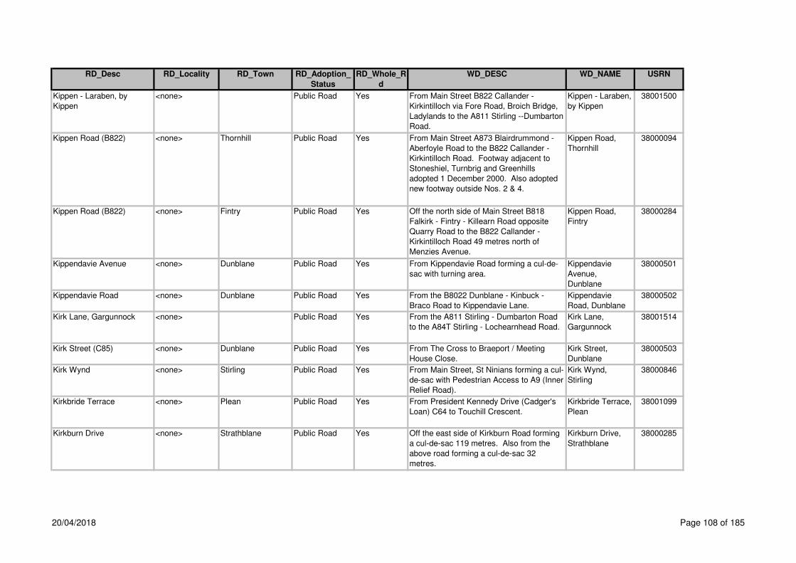
RD_Desc RD_Locality RD_Town RD_Adoption_
Status
RD_Whole_R
d
WD_DESC WD_NAME USRN
Kippen - Laraben, by
Kippen
<none> Public Road Yes From Main Street B822 Callander -
Kirkintilloch via Fore Road, Broich Bridge,
Ladylands to the A811 Stirling --Dumbarton
Road.
Kippen - Laraben,
by Kippen
38001500
Kippen Road (B822) <none> Thornhill Public Road Yes From Main Street A873 Blairdrummond -
Aberfoyle Road to the B822 Callander -
Kirkintilloch Road. Footway adjacent to
Stoneshiel, Turnbrig and Greenhills
adopted 1 December 2000. Also adopted
new footway outside Nos. 2 & 4.
Kippen Road,
Thornhill
38000094
Kippen Road (B822) <none> Fintry Public Road Yes Off the north side of Main Street B818
Falkirk - Fintry - Killearn Road opposite
Quarry Road to the B822 Callander -
Kirkintilloch Road 49 metres north of
Menzies Avenue.
Kippen Road,
Fintry
38000284
Kippendavie Avenue <none> Dunblane Public Road Yes From Kippendavie Road forming a cul-de-
sac with turning area.
Kippendavie
Avenue,
Dunblane
38000501
Kippendavie Road <none> Dunblane Public Road Yes From the B8022 Dunblane - Kinbuck -
Braco Road to Kippendavie Lane.
Kippendavie
Road, Dunblane
38000502
Kirk Lane, Gargunnock <none> Public Road Yes From the A811 Stirling - Dumbarton Road
to the A84T Stirling - Lochearnhead Road.
Kirk Lane,
Gargunnock
38001514
Kirk Street (C85) <none> Dunblane Public Road Yes From The Cross to Braeport / Meeting
House Close.
Kirk Street,
Dunblane
38000503
Kirk Wynd <none> Stirling Public Road Yes From Main Street, St Ninians forming a cul-
de-sac with Pedestrian Access to A9 (Inner
Relief Road).
Kirk Wynd,
Stirling
38000846
Kirkbride Terrace <none> Plean Public Road Yes From President Kennedy Drive (Cadger's
Loan) C64 to Touchill Crescent.
Kirkbride Terrace,
Plean
38001099
Kirkburn Drive <none> Strathblane Public Road Yes Off the east side of Kirkburn Road forming
a cul-de-sac 119 metres. Also from the
above road forming a cul-de-sac 32
metres.
Kirkburn Drive,
Strathblane
38000285
20/04/2018 Page 108 of 185

RD_Desc RD_Locality RD_Town RD_Adoption_
Status
RD_Whole_R
d
WD_DESC WD_NAME USRN
Kirkburn Road <none> Strathblane Public Road Yes Off the south side of Glasgow Road A81
Glasgow - Aberfoyle Road 67 metres east
of Kirkhouse Road to Dumbrock Road.
Kirkburn Road,
Strathblane
38000286
Kirkhouse Avenue <none> Strathblane Public Road Yes Off the west side of Kirkhouse Road
forming a cul-de-sac. Also the footpath link
to Kirkhouse Crescent and Kirkhouse
Road.
Kirkhouse
Avenue,
Strathblane
38000287
Kirkhouse Crescent <none> Strathblane Public Road Yes From Kirkhouse Road to Kirkhouse Road.
Also the footpath link to Kirkhouse Avenue
to Kirkhouse Road.
Kirkhouse
Crescent,
Strathblane
38000288
Kirkhouse Road <none> Strathblane Public Road Yes Off the north side of Glasgow Road A81
Glasgow - Aberfoyle Road 67 metres west
of Kirkburn Road forming a cul-de-sac.
Also the footpath link to Kirkhouse
Crescent and Kirkhouse Avenue.
Kirkhouse Road,
Strathblane
38000289
Kirkhouse Road <none> Killearn Private Road Yes Off the west side of A875 Main Street,
149m south of Beech Drive
Kirkhouse
Road,Killearn,
38001227
Kirkland Avenue <none> Strathblane Public Road Yes Off the east side of Kirkhouse Road to
Craigenlay Avenue. Also from the above
road forming a cul-de-sac 67metres.
Kirkland Avenue,
Strathblane
38000290
Kirkmill Road <none> Balfron Public Road Yes Off the south side of Hillhead Brae forming
a cul-de-sac with turning area.
Kirkmill Road,
Balfron
38000291
Kirkside Crescent <none> Stirling Public Road Yes From its junction with Springfield Road for
a distance of 239m. Also 3 small footpaths
and the footway linking onto the main
network
Kirkside
Crescent,Braehea
d,Stirling,
38003109
Kyle Avenue <none> Cowie Public Road Yes From Mount Oliphant forming a cul-de-sac. Kyle Avenue,
Cowie
38001100
Laburnum Grove Torbrex Stirling Public Road Yes From Springwood Avenue to Ash Terrace
474 metres. Also three culs-de-sacs
Laburnum Grove,
Stirling
38000847
Lademill <none> Whins of Milton Public Road Yes Off the east side of Milton Road. Lademill, Whins
of Milton
38002352
Ladies' Vennel <none> Stirling Public Road Yes From Baker Street to Spittal Street. Note:-
This is a right of way and maintained by
Stirling Council.
Ladies' Vennel,
Stirling
38000848
20/04/2018 Page 109 of 185

RD_Desc RD_Locality RD_Town RD_Adoption_
Status
RD_Whole_R
d
WD_DESC WD_NAME USRN
Ladyland Road <none> By Arnprior Public Road Yes From the A811 Kippen - Laraben Road via
A811 Stirling - Dumbarton Road to Poldar
Bridge. Note:- Poldar Bridge is Private.
Ladyland Road,
by Arnprior
38000187
Ladysneuk Road (C96) <none> Stirling Public Road No From Ladysneuk Road C96 forming a cul-
de-sac with turninghead.
Ladysneuk Road,
Stirling
38000505
Ladysneuk Road (C96) <none> Stirling Public Road No From Alloa Road A91 Stirling - Cupar Road
to the entrance to Cambuskenneth Abbey.
Ladysneuk Road,
Stirling
38000505
Ladysneuk Road, by
Stirling
<none> Public Road Yes Off the south side of the A907 Stirling -
Dunfermline Road 105 metres east of Craig
Crescent to Cambuskenneth Abbey. Note:-
The cul-de-sac at Cambuskenneth Abbey
is unclassified.
Ladysneuk Road,
by Stirling
38001489
Ladywell Road (Public
Footpath)
<none> Bannockburn Public Road Yes Link Footway off the north side of Main
Street 65 metres west of West Murrayfield
around Murrayfield UF Church to New
Road A9 14 metres south of Telford Court.
Ladywell
Footpath,
Bannockburn
38001359
Laggan Road <none> Strathyre Private Road Yes Off Keip Road Laggan Road 38003228
Lagrannoch Crescent <none> Callander Public Road Yes From the A84T Stirling - Lochearnhead
Road forming a cul-de-sac with turning
area.
Lagrannoch
Crescent,
Callander
38000096
Lagrannoch Drive <none> Callander Public Road No Off the east side of Lagrannoch Crescent,
100 metres north of Stirling Road A84T
forming a cul-de-sac. Also from the above
road at forming a cul-de-sac. Also the
small cul-de-sac from the above road at
House Nos. 30 - 32 59 metres.
Lagrannoch
Drive, Callander
38000095
Lagrannoch Way <none> Callander Public Road Yes From Lagrannoch Crescent forming a cul-
de-sac with turning area.
Lagrannoch Way,
Callander
38000097
Laidlaw Street Raploch Stirling Private Road Yes Barratt New Development Laidlaw Street,
Raploch, Stirling 38005733
20/04/2018 Page 110 of 185

RD_Desc RD_Locality RD_Town RD_Adoption_
Status
RD_Whole_R
d
WD_DESC WD_NAME USRN
Laigh Road, Balfron <none> Public Road Yes From Buchanan Street A875 Dumgoyne -
Kepculloch Road to Lernock Road C23.
Note: Footpaths ex adverso House Nos.
16 - 44 are Private.
Laigh Road,
Balfron
38001185
Laighill Place <none> Dunblane Public Road Yes From Ramoyle C85 to the east boundary
wall of Shaw's Building (last house in cul-
de-sac). Also the footpath northwards from
right angle bend in Laighill Place leading to
the burn is a right of way, maintained by
Stirling Council. Note:- There are no
footways in Laighill Place.
Laighill Place,
Dunblane
38000506
Lambert Crescent Raploch Stirling Private Road Yes Barratt New Development Lambert
Crescent,
Raploch, Stirling 38005736
Lamberton Avenue <none> Stirling Public Road Yes From Broom Road forming a cul-de-sac for
254 metres. Also cul-de-sacs for 60
metres and 163 metres. Also including the
grass strips of all roads. Note:- Off-street
parking is Private.
Lamberton
Avenue, Stirling
38000849
Lamont Crescent <none> Fallin Public Road Yes From Polmaise Crescent to Oak Drive 189
metres. Also a short spur leading to Fallin
Primary School.
Lamont Crescent,
Fallin
38000850
Lampson Lane <none> Killearn Public Road Yes Off the south side of Lampson Road west
of Napier Road forming a cul-de-sac.
Lampson Lane,
Killearn
38000292
Lampson Loan <none> Killearn Public Road Yes Off the west side of Lamspon Road forming
a cul-de-sac with turning area.
Lampson Loan,
Killearn
38000293
Lampson Road <none> Killearn Public Road Yes Off the south side of Station Road B834
Finnich Toll - Killearn Road forming a cul-
de-sac with turning area. Also from the
above road forming a cul-de-sac with
turning area.
Lamspon Road,
Killearn
38000294
Laighparks Roundabout
A81
Killearn
Laighparks
Roundabout
38005323Public Road Yes Construction of new roundabout at A81
Garden Centre 120m
<none> Killearn
20/04/2018 Page 111 of 185
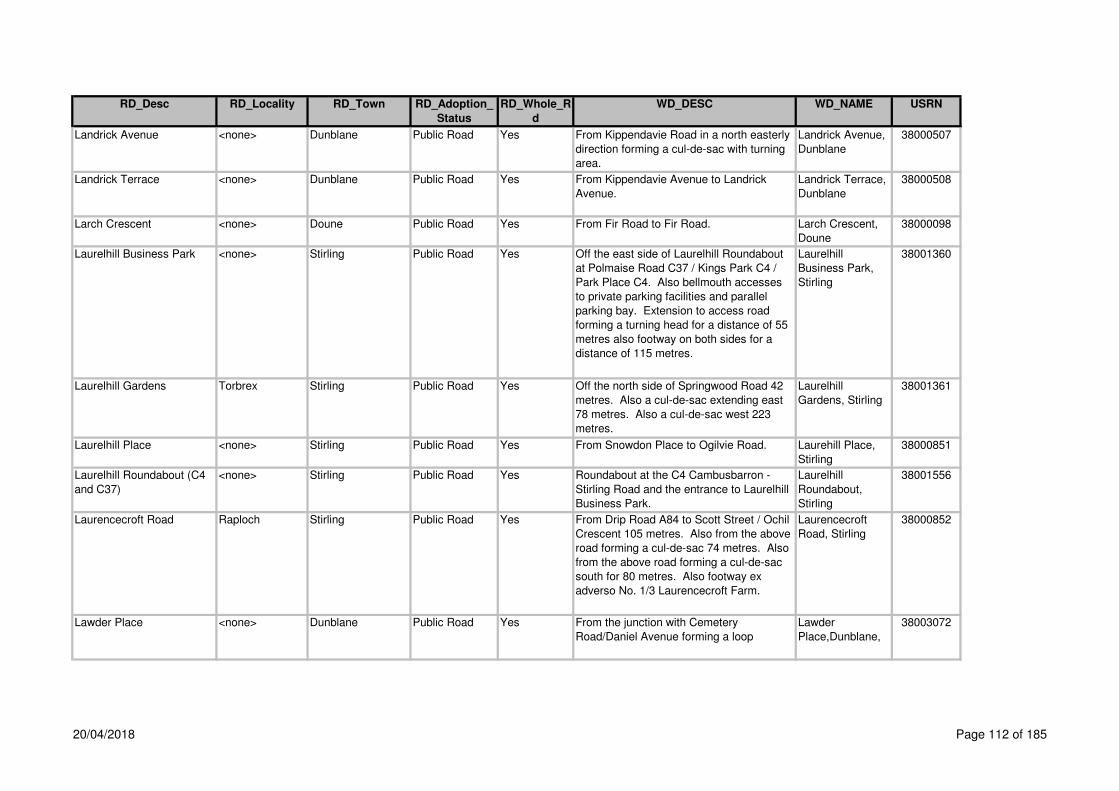
RD_Desc RD_Locality RD_Town RD_Adoption_
Status
RD_Whole_R
d
WD_DESC WD_NAME USRN
Landrick Avenue <none> Dunblane Public Road Yes From Kippendavie Road in a north easterly
direction forming a cul-de-sac with turning
area.
Landrick Avenue,
Dunblane
38000507
Landrick Terrace <none> Dunblane Public Road Yes From Kippendavie Avenue to Landrick
Avenue.
Landrick Terrace,
Dunblane
38000508
Larch Crescent <none> Doune Public Road Yes From Fir Road to Fir Road. Larch Crescent,
Doune
38000098
Laurelhill Business Park <none> Stirling Public Road Yes Off the east side of Laurelhill Roundabout
at Polmaise Road C37 / Kings Park C4 /
Park Place C4. Also bellmouth accesses
to private parking facilities and parallel
parking bay. Extension to access road
forming a turning head for a distance of 55
metres also footway on both sides for a
distance of 115 metres.
Laurelhill
Business Park,
Stirling
38001360
Laurelhill Gardens Torbrex Stirling Public Road Yes Off the north side of Springwood Road 42
metres. Also a cul-de-sac extending east
78 metres. Also a cul-de-sac west 223
metres.
Laurelhill
Gardens, Stirling
38001361
Laurelhill Place <none> Stirling Public Road Yes From Snowdon Place to Ogilvie Road. Laurehill Place,
Stirling
38000851
Laurelhill Roundabout (C4
and C37)
<none> Stirling Public Road Yes Roundabout at the C4 Cambusbarron -
Stirling Road and the entrance to Laurelhill
Business Park.
Laurelhill
Roundabout,
Stirling
38001556
Laurencecroft Road Raploch Stirling Public Road Yes From Drip Road A84 to Scott Street / Ochil
Crescent 105 metres. Also from the above
road forming a cul-de-sac 74 metres. Also
from the above road forming a cul-de-sac
south for 80 metres. Also footway ex
adverso No. 1/3 Laurencecroft Farm.
Laurencecroft
Road, Stirling
38000852
Lawder Place <none> Dunblane Public Road Yes From the junction with Cemetery
Road/Daniel Avenue forming a loop
Lawder
Place,Dunblane,
38003072
20/04/2018 Page 112 of 185

RD_Desc RD_Locality RD_Town RD_Adoption_
Status
RD_Whole_R
d
WD_DESC WD_NAME USRN
Leckie Road (C22) <none> Gargunnock Public Road No Off the west side of The Square to
"Garthdee" 54 metres west of Charlie's
Loan.
Leckie Road,
Gargunnock
38000296
Lecropt Kirk Cemetry Road <none> Bridge of Allan Public Road Yes From the A9 Edinburgh - Perth Road east
of Lecroft Kirk via Lecropt Kirk Lodge to the
top of the flight of steps leading to the
Bridge of Allan – Carse of Lecropt - Doune
Road.
Lecropt Kirk
Cemetery Road,
Bridge of Allan
38000509
Ledcameroch Gardens <none> Dunblane Public Road Yes Off east side of B8033 Perth Road in an
easterly then northerly direction forming a
cul-de-sac including parking areas. Also
footpath/cycleway from the end of the
turning head to link with B88032
Ledcameroch
Gardens,Dunblan
e,
38002182
Ledi Court <none> Callander Public Road Yes Off the west side of Cross Street opposite
Glenartney Road. Also road and footway
from flats Nos. 14 - 19 to 20 - 29, 46
metres. Note:- Car Parking areas are
Private.
Ledi Court,
Callander
38000100
Ledi View Cornton Stirling Public Road Yes From Johnston Avenue forming a cul-de-
sac.
Ledi View, Stirling 38000510
Leewood Park <none> Dunblane Public Road Yes From St Margaret's Drive forming a cul-de-
sac.
Leewood Park,
Dunblane
38000511
Leewood Road <none> Dunblane Public Road Yes From St Margaret's Drive to Glen Road
C35.
Leewood Road,
Dunblane
38000512
Leighton Avenue <none> Dunblane Public Road Yes From Newton Crescent forming a cul-de-
sac with turning head.
Leighton Avenue,
Dunblane
38000513
Leighton Court <none> Dunblane Public Road Yes From Leighton Avenue forming a cul-de-
sac with turning area.
Leighton Court,
Dunblane
38000514
Leighton Place <none> Callander Private Road Yes Off the south side of Main Street A84T
between south Church Street and Bracklin
Road
Leighton
Place,Callander,
38001175
Lendrick Avenue <none> Callander Public Road Yes Off Vorlich Crescent Lendrick
Avenue,Callander
,
38002399
Lennox Avenue <none> Stirling Public Road Yes From Berkeley Street to Randolph Terrace
B8051.
Lennox Avenue,
Stirling
38000853
20/04/2018 Page 113 of 185

RD_Desc RD_Locality RD_Town RD_Adoption_
Status
RD_Whole_R
d
WD_DESC WD_NAME USRN
Leny Feus <none> Callander Public Road Yes Off the north side of Leny Road A84T 131
metres west of Tulipan Crescent to Leny
Road A84T 346 metres west of 1st access.
Also a branch off the north side to
Arnacraggan at "Inverlenny".
Leny Feus Road,
Callander
38000099
From Teith Road at the west end of the
village to Deanston Road at the east end of
the village.
Upgrading of existing carriageway (105m
and new footway 220m adopted August
2006
Leny Road (A84T) <none> Callander Trunk Road Yes From Main Street A84T Stirling -
Lochearnhead Road at Station Road to the
A84T Stirling - Lochearnhead Road at Leny
Feus.
Leny Road,
Callander
38000101
Lernock Road (C23 and
Unclassified)
<none> Balfron Public Road Yes From the B822 Callander - Kirkintilloch
Road to Lernock Road C23.
Lernock Road,
Balfron
38002138
Lernock Road (C23 and
Unclassified)
<none> Balfron Public Road No From C23 Lernock Road to the B822
Callander - Kirkintilloch Road.
Lernock Road
(unclassified),
Balfron
38002138
Lernock Road, by Balfron <none> Public Road Yes Off the east side of the A875 Dumgoyne -
Kepculloch Road at Clachan, Balfron via
Spoker's Loan, Roman Road, Laigh Road
C24, Woodend Farm, Dalfoil Farm,
Lernock Road Unclassified at Honeyholm
Bridge to the B818 Falkirk - Fintry - Killearn
Road.
Lernock Road, by
Balfron
38001593
Lerrocks Road <none> By Doune Public Road Yes Off the east side of Argaty Road C83 at
"Cornton Bungalow" to Lerrocks Farm
Access Road.
Lerrocks Road, by
Doune
38000103
Limecraig Avenue <none> Aberfoyle Public Road Yes From Duke's Pass A821 Aberfoyle -
Kilmahog Road to the A821 Duke's Pass
Aberfoyle - Kilmahog Road. Note:- The
access road to and the car parking area
north of Limecraig Avenue are Private.
Limecraig
Avenue, Aberfoyle
38000104
Leny Road,
Deanston
Leny Road <none> Deanston Public Road Yes 38000102
20/04/2018 Page 114 of 185
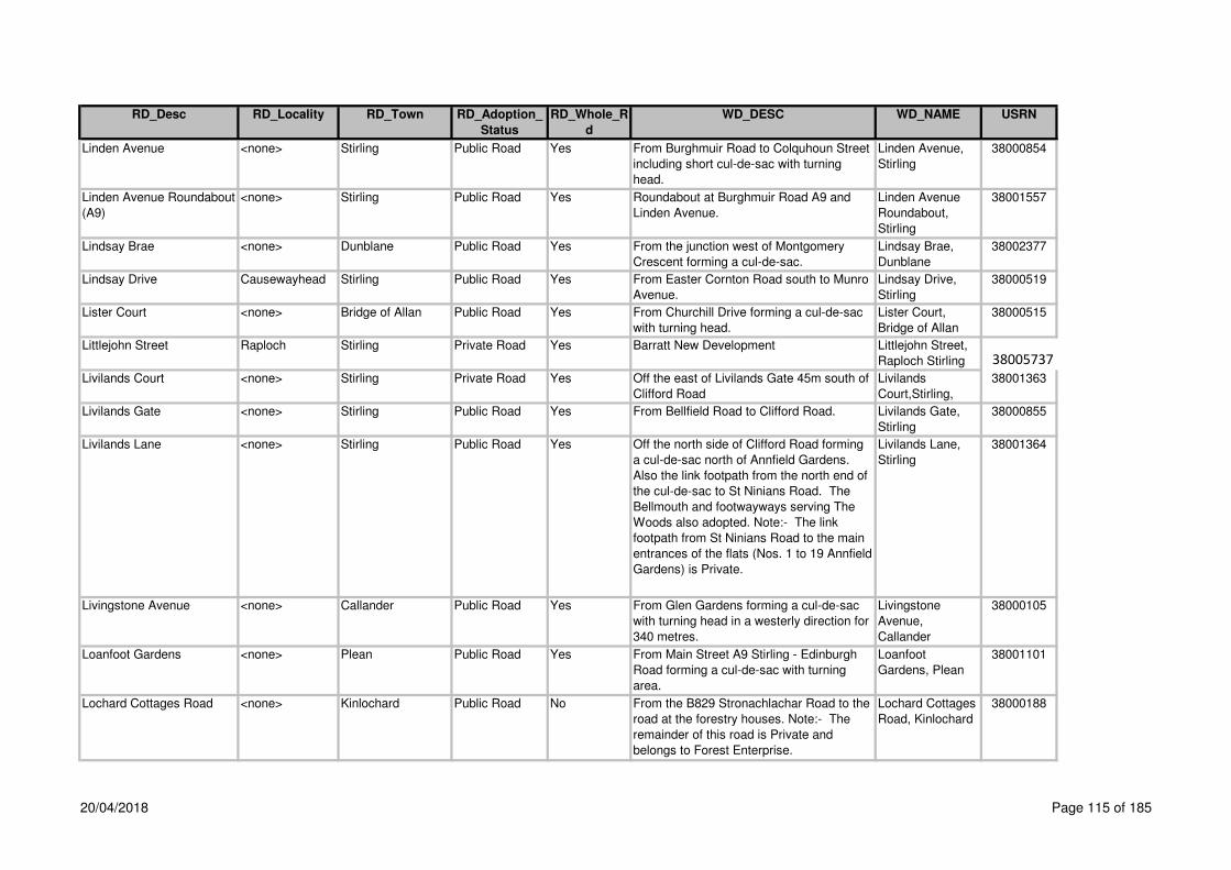
RD_Desc RD_Locality RD_Town RD_Adoption_
Status
RD_Whole_R
d
WD_DESC WD_NAME USRN
Linden Avenue <none> Stirling Public Road Yes From Burghmuir Road to Colquhoun Street
including short cul-de-sac with turning
head.
Linden Avenue,
Stirling
38000854
Linden Avenue Roundabout
(A9)
<none> Stirling Public Road Yes Roundabout at Burghmuir Road A9 and
Linden Avenue.
Linden Avenue
Roundabout,
Stirling
38001557
Lindsay Brae <none> Dunblane Public Road Yes From the junction west of Montgomery
Crescent forming a cul-de-sac.
Lindsay Brae,
Dunblane
38002377
Lindsay Drive Causewayhead Stirling Public Road Yes From Easter Cornton Road south to Munro
Avenue.
Lindsay Drive,
Stirling
38000519
Lister Court <none> Bridge of Allan Public Road Yes From Churchill Drive forming a cul-de-sac
with turning head.
Lister Court,
Bridge of Allan
38000515
Littlejohn Street Raploch Stirling Private Road Yes Barratt New Development Littlejohn Street,
Raploch Stirling 38005737
Livilands Court <none> Stirling Private Road Yes Off the east of Livilands Gate 45m south of
Clifford Road
Livilands
Court,Stirling,
38001363
Livilands Gate <none> Stirling Public Road Yes From Bellfield Road to Clifford Road. Livilands Gate,
Stirling
38000855
Livilands Lane <none> Stirling Public Road Yes Off the north side of Clifford Road forming
a cul-de-sac north of Annfield Gardens.
Also the link footpath from the north end of
the cul-de-sac to St Ninians Road. The
Bellmouth and footwayways serving The
Woods also adopted. Note:- The link
footpath from St Ninians Road to the main
entrances of the flats (Nos. 1 to 19 Annfield
Gardens) is Private.
Livilands Lane,
Stirling
38001364
Livingstone Avenue <none> Callander Public Road Yes From Glen Gardens forming a cul-de-sac
with turning head in a westerly direction for
340 metres.
Livingstone
Avenue,
Callander
38000105
Loanfoot Gardens <none> Plean Public Road Yes From Main Street A9 Stirling - Edinburgh
Road forming a cul-de-sac with turning
area.
Loanfoot
Gardens, Plean
38001101
Lochard Cottages Road <none> Kinlochard Public Road No From the B829 Stronachlachar Road to the
road at the forestry houses. Note:- The
remainder of this road is Private and
belongs to Forest Enterprise.
Lochard Cottages
Road, Kinlochard
38000188
20/04/2018 Page 115 of 185

RD_Desc RD_Locality RD_Town RD_Adoption_
Status
RD_Whole_R
d
WD_DESC WD_NAME USRN
Lochard Cottages Road <none> Kinlochard Private Road No Off the east side of Lochard Cottages
Road, 93m south of Water of Chon forming
a cul-de-sac serving house Nos. 13 to 24.
Also 160m south of Water of Chon forming
a Crescent serving house Nos. 2 to 12
Lochard Cottages
Road,Kinlochard,
38000188
Lochard Road (B829) <none> Aberfoyle Public Road Yes From Main Street A821 Aberfoyle -
Kilmahog Road to the B829 Pass of
Aberfoyle - Stronachlacher Road at Milton.
Lochard Road,
Aberfoyle
38000106
Lochay Road <none> Killin Private Road Yes New Development 2014 Lochay Road,
Killin
38005716
Lochearnhead - Crianlarich <none> Public Road Yes From the A84T at Lochearnhead
northwards via Lix Toll, Ardchyle to the
A82T Glasgow - Fort William Road in
Crianlarich. Also the short section from the
A82T north of Clifton in Tyndrum to the
Council Boundary (towards Oban). Also
from the A84T in Lochearnhead, east to the
Council Boundary (towards St Fillans /
Creiff).
Lochearnhead -
Crianlarich
38002065
Loftbrae Park <none> Gargunnock Public Road No From Main Street north / east forming a cul-
de-sac with turning area. Note:- The cul-de-
sac running east / west is Private.
Loftbrae Park,
Gargunnock
38000298
Loftbrae Road <none> Gargunnock Private Road No Off the west side of the north end of
Loftbrae Road
Loftbraw
Road,Gargunnock
,
38000298
Logie Lane <none> Bridge of Allan Private Road Yes Off the east side of Pathfoot Drive, 36m
north of Pathfoot Avenue to Sherriffmuir
Road
Logie Lane,Bridge
of Allan,
38002375
Logie Lane Causewayhead Stirling Private Road Yes Off the east side of Logie Road B998, 67m
north of Tower Place (Hanover Court) to
Hillfoots Road B998, 14m west of the
access to the Vetrinary Surgery
Logie
Lane,Stirling,
38001281
Logie Road (B998) Causewayhead Stirling Public Road Yes From the A9 at Causewayhead
Roundabout to Hillfoots Road B998.
Logie Road,
Stirling
38000516
20/04/2018 Page 116 of 185

RD_Desc RD_Locality RD_Town RD_Adoption_
Status
RD_Whole_R
d
WD_DESC WD_NAME USRN
Lomond Court <none> Aberfoyle Public Road Yes Off the south side of the A821 Main Street
105m east of the Fire Station
Lomond
Court,Aberfoyle,
38001176
Lomond Crescent Cornton Stirling Public Road Yes From Easter Cornton Road in south
easterly direction for 256 metres also two
square court access 70 metres.
Lomond
Crescent, Stirling
38000517
Lomond Drive <none> Bannockburn Public Road Yes From Bruce Street (Cemetery Road) to
Manse Place.
Lomond Drive,
Bannockburn
38000856
Lomond Terrace <none> Balfron Public Road Yes Off the south side of Cotton Street to
George Street.
Lomond Terrace,
Balfron
38000299
Lothian Crescent Causewayhead Stirling Public Road Yes From Hamilton Drive to Hamilton Drive 776
metres. Cul-de-sac form 34 metres, 44
metres and 61 metres. Note:- Garage
access is Private.
Lothian Crescent,
Stirling
38000518
Lovers Walk Riverside Stirling Public Road Yes From Roundabout at Wallace Street to
James Street / Dean Crescent.
Lovers Walk,
Stirling
38000857
Low Town <none> Thornhill Public Road Yes From Kippen Road B822 Callander -
Kirkintilloch Road to Back Yetts 231
metres. Also from above road forming a
cul-de-sac 27 metres. Note:- The area
shaded green on reverse is maintained by
Stirling Council.
Low Town,
Thornhill
38000107
Lower Bridge Street (B8052
and Unclassified)
<none> Stirling Public Road No From its junction with Lower Bridge Street
B8052 to its junction with Back O'Hill Road
at the north building line of No. 57 Lower
Bridge Street 100 metres. Also spur to Old
Railway cutting past Orchard House
Hospital 128 metres.
Lower Bridge
Street, Stirling
38000859
Lower Bridge Street (B8052
and Unclassified)
<none> Stirling Public Road No From Cowane Street B8052 at Upper
Bridge Street to Union Street B8052.
Lower Bridge
Street, Stirling
38000859
Lower Castlehill Top of the Town Stirling Public Road Yes From Crofthead Road to Upper Castlehill. Lower Castlehill,
Stirling
38000860
Lubnaig Drive <none> Callander Public Road No Off the west side of the A81 Glasgow –
Aberfoyle - Callander Road 102 metres
south of the access to McLaren High
School to Venacher Avenue.
Lubnaig Drive,
Callander
38000108
20/04/2018 Page 117 of 185

RD_Desc RD_Locality RD_Town RD_Adoption_
Status
RD_Whole_R
d
WD_DESC WD_NAME USRN
Lubnaig Drive <none> Callander Private Road No Off the north side of Lubnaig Drive, 25m
west of Katrine Crescent. Also off the
south side of Lubnaig Drive, 21m east of
Venacher Avenue.
Lubnaig
Drive,Callander,
38000108
Lyon Crescent <none> Bridge of Allan Public Road Yes Off the east side of Cornton Road B823
132 metres south of Allanvale Road B823.
Also the loop road with service strips and 8
visitor parking spaces. Also a short cul-de-
sac with a turning head and two visitor
parking spaces running in a westerly
direction from the loop road for 39 metres.
Also cul-de-sac from its junction with Lyon
Crescent in a southerly direction for 52
metres, includes footpaths serving House
Nos. 43-83.
Lyon Crescent,
Bridge of Allan
38001581
Lyon Road <none> Killin Public Road No From Station Road to Main Street A827
Killin - Aberfeldy Road. Note:- A section of
this road from No. 1 Lyon Cottages to
Station Road is also known as Auction Mart
Road.
Lyon Road, Killin 38000021
Lyon Road <none> Killin Prospective
Public Road
No Part Private Lyon Road,Killin, 38000021
M80 from Council Boundary
to Junction 9 Bannockburn
<none> by Bannockburn Trunk Road Yes From Council Boundary to Junction 9
(Bannockburn Interchange).
M80 from Council
Boundary to
Junction 9
Bannockburn, by
Bannockburn
38008108
M80 from Junction 9 to
M80 / M9 Intersection
<none> by Bannockburn Trunk Road Yes From Junction 9 (Bannockburn
Interchange) to Junction M80 / M9.
M80 from
Junction 9 to M80
/ M9 Intersection,
by Bannockburn
38008107
20/04/2018 Page 118 of 185

RD_Desc RD_Locality RD_Town RD_Adoption_
Status
RD_Whole_R
d
WD_DESC WD_NAME USRN
M9 from Council Boundary
to Junction 9 Bannockburn
including slip roads
<none> by Bannockburn Trunk Road Yes From the Council Boundary near "Tor Burn"
to Junction 9 (Bannockburn Interchange
(Pirnhall)).
M9 from Council
Boundary to
Junction 9
Bannockburn, by
Bannockburn
38008094
M9 from Junction 9
Bannockburn to Junction 10
Craigforth including slip
roads
<none> By Stirling Trunk Road Yes From Junction 9 (Bannockburn Interchange
/ Pirnhall) to Junction 10 (Craigforth
Interchange).
M9 from Junction
9 Bannockburn to
Junction 10
Craigforth, by
Stirling
38008106
M9 from Junction10
Craigforth to junction 11
Keir Roundabout including
slip roads
<none> By Stirling Trunk Road Yes From Junction 10 Bannockburn
Interchange to Keir Roundabout Junction
11.
M9 from Junction
10 Craigforth to
Junction 11 Keir
Roundabout, by
Stirling
38008072
Macdonald Drive St Ninians Stirling Public Road Yes From Cultenhove Road to Buntine
Crescent inlcuding 2 culs-de-sac, one with
turning head.
Macdonald Drive,
Stirling
38000861
Mace Court Balquhidderock Stirling Public Road Yes Off the east side of Pottis Road. Mace Court,
Stirling
38001366
Macpherson Drive Raploch Stirling Public Road Yes From Beatty Avenue to Ivanhoe Place. Macpherson
Drive, Stirling
38000862
Main Road (A81) <none> Port of Menteith Public Road Yes From Primary Schhol – Currach Cottage
(A81)
Main Road, Port
of Menteith
38000116
Main Street <none> Gargunnock Public Road Yes Off the south side of the The Square C22
Dasherhead and Old Dumbarton Road to
the east boundary of "Woodside". Note:-
The footway on the north side from "The
Haven" to "Belton Cottage" is Private.
Main Street,
Gargunnock
38000305
Main Street <none> Bannockburn Public Road Yes From New Road A9 to The Brae. Main Street,
Bannockburn
38000866
20/04/2018 Page 119 of 185

RD_Desc RD_Locality RD_Town RD_Adoption_
Status
RD_Whole_R
d
WD_DESC WD_NAME USRN
Main Street (A811) <none> Buchlyvie Public Road Yes From the A811 Stirling - Dumbarton Road
at War Memorial to the A811 Stirling -
Dumbarton Road at Wes End Garage.
Also footpath along the frontage of the Red
Lion Public House.
Main Street,
Buchlyvie
38000165
Main Street (A820) <none> Doune Public Road Yes From Balkerach Street A820 Doune –
Dunblane and George Street B8032 at The
Cross to Queen Street. Note:- No. 1
Braehead is Private. Note:- Braehead
houses are Nos. 69 - 75 Main Street.
Main Street,
Doune
38000109
Main Street (A821) <none> Aberfoyle Public Road Yes From the A821 Aberfoyle - Kilmahog Road
at Dounan's Camp to Stronachlachar Road
B829 at the Baillie Nicol Jarvie Hotel.
Main Street,
Aberfoyle
38000111
Main Street (A827) <none> Killin Public Road Yes From Gray Street A827 Killin – Aberfeldy
Road on the south side of the Dochart
Bridge to the A827 Killin - Aberfeldy Road,
91 metres south of The Glebe.
Main Street, Killin 38000022
Main Street (A84T) <none> Strathyre Trunk Road Yes From the A84T Stirling – Lochearnhead to
the A84T Stirling - Lochearnhead. Note:-
The footway on the east side is Private.
Main Street,
Strathyre
38000023
Main Street (A84T) <none> Callander Trunk Road Yes From Stirling Road A84T Stirling –
Lochearnhead Road 70 metres east of
Bracklinn Road to Leny Road A84T Stirling -
Lochearnhead Road at Station Road.
Main Street,
Callander
38000110
Main Street (A873) <none> Thornhill Public Road Yes From the A873 Blairdrummond – Aberfoyle
Road to Gartincaber Road B826.
Main Street,
Thornhill
38000112
Main Street (A875) <none> Killearn Public Road No From the A875 Dumgoyne - Kepculloch
Road at Drumbeg Loan to Balfron Road
A875 Dumgoyne - Kepculloch Road at the
War Memorial / The Square.
Main Street,
Killearn
38000307
20/04/2018 Page 120 of 185

RD_Desc RD_Locality RD_Town RD_Adoption_
Status
RD_Whole_R
d
WD_DESC WD_NAME USRN
Main Street (A9) <none> Plean Public Road Yes Off the A9 Edinburgh - Perth Road at
Burnside Crescent to Plean Primary
School.
Main Street,
Plean
38001102
Main Street (A905) <none> Fallin Public Road Yes From Stirling Road A905 from the east
boundary of the property on the north side
of the road, opposite Bandeath House to
the A905 Stirling - Edinburgh Low Road to
the east boundary of the garage premises
opposite Fallin Parish Church.
Main Street, Fallin 38000865
Main Street (B8051 and
Unclassified)
St Ninians Stirling Public Road No From Randolph Terrace B8051 to
Borestone Crescent B8051. Also a 2 metre
wide section of footway along the frontage
of Somerfield. Note:- The remainder of the
footway from the 2 metre line to the
building is Private.
Main Street,
Stirling
38000863
Main Street (B8051 and
Unclassified)
St Ninians Stirling Public Road No Off the east side of Borestone Crescent
B8052 42 metres south of Weaver Row
forming two culs-de-sac with turning area.
North cul-de-sac House Nos. 13 to 29
including the Post Office and the south cul-
de-sac leading to House Nos. 31 to 88.
Note: Includes The Glebe. The Glebe is a
terraced block Nos. 1b to 3b in Randolph
Terrace.
Main Street,
Stirling
38000863
Main Street (B818) <none> Fintry Public Road Yes From the B818 Falkirk - Fintry - Killearn
Road at the east boundary of "Abriachan"
to the B818 Falkirk - Fintry - Killearn Road
46 metres west of the west boundary of
House No. 121. Also the footway fronting
50 Main Street. Also the footway fronting
"Rowanbank". Note:- The fence is Private.
Main Street,
Fintry
38000304
20/04/2018 Page 121 of 185

RD_Desc RD_Locality RD_Town RD_Adoption_
Status
RD_Whole_R
d
WD_DESC WD_NAME USRN
Main Street (B822) <none> Kippen Public Road Yes From Station Road B822 at Kippen Cross
to Castlehill B822 at the junction of
Castlehill Loan. Also the 1.82 metre
remote footpath on the north side fronting
the buildings Note:- The unsurfaced
footway on the south side between The
Cross and Castlehill Loan is Private.
Main Street,
Kippen
38000306
Main Street (B858 and
Unclassified)
<none> Drymen Public Road No From Drymen Moor Road / Balmaha Road
to Main Street B858 at The Square.
Main Street,
Drymen
38000191
Main Street (B858 and
Unclassified)
<none> Drymen Public Road No From Stirling Road B858 Drymen Village
Road at The Cross to Drymen By-Pass
A811 Stirling – Dumbarton Road south of
Drymen at "Mansewood".
Main Street,
Drymen
38000191
Main Street (B9124 and
Unclassified)
<none> Cowie Public Road No From Bannockburn Road B9124 Airth
Station - Bannockburn Road to the B9124
Airth Station – Gallamuir - Cowie -
Bannockburn Road. Also bus lay-bys at
Cowie Square and bus turning bay west
side, south of Cowie Village (at Cowie
Woodcutters).
Main Street,
Cowie
38001104
Main Street (B9124 and
Unclassified)
<none> Cowie Public Road No From Main Street B9124 Airth Station -
Bannockburn to Station Road.
Main Street,
Cowie
38001104
Main Street (C5) <none> Cambusbarron Public Road Yes From St Ninians Road C5 / Birkhill Road
C4 to Touch Road C5 38 metres west of
Barony Court. Also a section of footway
along the north side from the west
boundary of No. 36 to Barony Court 21
metres.
Main Street,
Cambusbarron
38001103
20/04/2018 Page 122 of 185

RD_Desc RD_Locality RD_Town RD_Adoption_
Status
RD_Whole_R
d
WD_DESC WD_NAME USRN
Main Street (C57) <none> Gartmore Public Road Yes Main Street through Gartmore Village.
Gartmore Road from the A81 Glasgow -
Aberfoyle Road at Ward Toll via
Chaplarroch, Gartmore Village to the A81
Glasgow - Aberfoyle Road at Gartmore
Station. Also from the A81 Glasgow -
Aberfoyle Road north of the bridge over
Kelty Water via Wester Third to the A81
Glasgow - Aberfoyle Road. Note:- Also
known as Chapeleroch Road.
Main Street,
Gartmore
38002294
Mains Old Dumbarton Road <none> Gargunnock Public Road Yes From the A811 Stirling – Dumbarton Road
opposite the access road to Mesklewood
via Mains of Gargunnock, Manse Brae to
Dasherhead and Old Dumbarton Road C22
at The Square.
Mains Old
Dumbarton Road,
Gargunnock
38000308
Maitland Avenue <none> Bannockburn Public Road Yes From Milton View (Coal Wynd) to
Newlands Road.
Maitland Avenue,
Bannockburn
38000867
Maitland Crescent St Ninians Stirling Public Road Yes From Glasgow Road A872 to McLaren
Terrace.
Maitland
Crescent, Stirling
38000868
Manor Powis Roundabout
(A907 and A91)
<none> By Stirling Public Road Yes At the A91 Stirling - Cupar Road and A907
Stirling - Dunfermline Road.
Manor Powis
Roundabout, by
Stirling
38001546
Manor Road (C61) <none> Blairlogie Public Road Yes Off the south side of the A91 Stirling -
Cupar Road at Blairlogie via Blairmains
Farm and Manor Farm to the A907 Stirling -
Alloa Road.
Manor Road,
Blairlogie
38002157
Manse Brae <none> Gargunnock Public Road Yes From Mains and Old Dumbarton Road 88
metres east of Moray Place to The Square.
Manse Brae,
Gargunnock
38000309
Manse Crescent <none> Stirling Public Road Yes From Randolph Terrace B8052 forming a
cul-de-sac with turning head.
Manse Crescent,
Stirling
38000869
20/04/2018 Page 123 of 185

RD_Desc RD_Locality RD_Town RD_Adoption_
Status
RD_Whole_R
d
WD_DESC WD_NAME USRN
Manse Lane <none> Callander Public Road Yes Off the east side of Bridgend A81 Glasgow -
Aberfoyle - Callander Road 47 metres north
of Grant Court to the entrance to the
Manse.
Manse Lane,
Callander
38000113
Manse Place <none> Bannockburn Public Road Yes From Station Road C25 to Carseview. Manse Place,
Bannockburn
38000870
Manse Road <none> Killin Public Road Yes From Main Street A827 Killin – Aberfeldy
Road to Craignavie Road.
Manse Road,
Killin
38000024
Manse Road <none> Aberfoyle Public Road Yes Off the south side of the B829 Stronlachar
Road 28 metres west of Duke's Pass A821
to the entrance to the Manse. Note:-
Kirkton Road is part of Manse Road.
Manse Road,
Aberfoyle
38000114
Mansefield <none> Tyndrum Public Road Yes Off the east side of the A82T Glasgow -
Fort William Road opposite the Little Chef.
Also 16 No. parking bays and footways
including remote footpaths to House Nos.
2, 7, 18 and to Rear Boundary Fence
adjacent to House No. 6.
Mansefield,
Tyndrum
38001144
Maple Crescent <none> Killearn Public Road Yes Off the south side of Beech Drive forming a
cul-de-sac.
Maple Crescent,
Killearn
38000310
Mar Place Top of the Town Stirling Public Road Yes From St John Street to Castle Wynd. Note:-
This road fronts Mars works.
Mar Place, Stirling 38000872
Margaret Road <none> Whins of Milton Public Road Yes From Duke Street to Queen Street. Margaret Road,
Whins of Milton
38000871
Market Street Raploch Stirling Private Yes Barratt New Development Market Street,
Raploch, Stirling 38005739
Marlborough Drive Causewayhead Stirling Public Road Yes From Dunster Road forming a cul-de-sac. Marlborough
Drive, Stirling
38000521
Marschal Court Balquhidderock Stirling Public Road Yes Off west side of Claymore Drive forming a
cul-de-sac.
Marschal Court,
Stirling
38001365
Marshall Crescent <none> Callander Public Road Yes From Glen Gardens forming a cul-de-sac
with turning area.
Marshall
Crescent,
Callander
38000117
Marsden Court Causewayhead Stirling Public Road Yes Off Hillfoots Road Marsden Court
Stirling
38004126
20/04/2018 Page 124 of 185
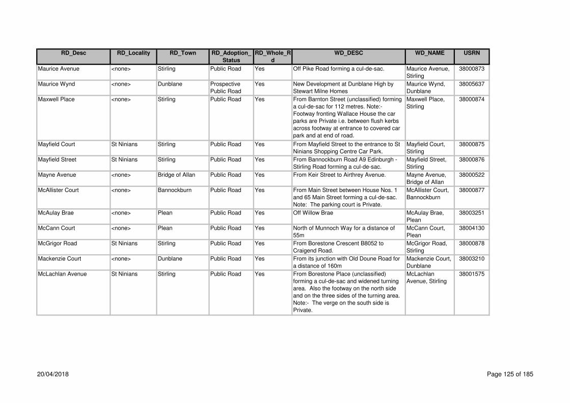
RD_Desc RD_Locality RD_Town RD_Adoption_
Status
RD_Whole_R
d
WD_DESC WD_NAME USRN
Maurice Avenue <none> Stirling Public Road Yes Off Pike Road forming a cul-de-sac. Maurice Avenue,
Stirling
38000873
Maurice Wynd <none> Dunblane Prospective
Public Road
Yes New Development at Dunblane High by
Stewart Milne Homes
Maurice Wynd,
Dunblane
38005637
Maxwell Place <none> Stirling Public Road Yes From Barnton Street (unclassified) forming
a cul-de-sac for 112 metres. Note:-
Footway fronting Wallace House the car
parks are Private i.e. between flush kerbs
across footway at entrance to covered car
park and at end of road.
Maxwell Place,
Stirling
38000874
Mayfield Court St Ninians Stirling Public Road Yes From Mayfield Street to the entrance to St
Ninians Shopping Centre Car Park.
Mayfield Court,
Stirling
38000875
Mayfield Street St Ninians Stirling Public Road Yes From Bannockburn Road A9 Edinburgh -
Stirling Road forming a cul-de-sac.
Mayfield Street,
Stirling
38000876
Mayne Avenue <none> Bridge of Allan Public Road Yes From Keir Street to Airthrey Avenue. Mayne Avenue,
Bridge of Allan
38000522
McAllister Court <none> Bannockburn Public Road Yes From Main Street between House Nos. 1
and 65 Main Street forming a cul-de-sac.
Note: The parking court is Private.
McAllister Court,
Bannockburn
38000877
McAulay Brae <none> Plean Public Road Yes Off Willow Brae McAulay Brae,
Plean
38003251
McCann Court <none> Plean Public Road Yes North of Munnoch Way for a distance of
55m
McCann Court,
Plean
38004130
McGrigor Road St Ninians Stirling Public Road Yes From Borestone Crescent B8052 to
Craigend Road.
McGrigor Road,
Stirling
38000878
Mackenzie Court <none> Dunblane Public Road Yes From its junction with Old Doune Road for
a distance of 160m
Mackenzie Court,
Dunblane
38003210
McLachlan Avenue St Ninians Stirling Public Road Yes From Borestone Place (unclassified)
forming a cul-de-sac and widened turning
area. Also the footway on the north side
and on the three sides of the turning area.
Note:- The verge on the south side is
Private.
McLachlan
Avenue, Stirling
38001575
20/04/2018 Page 125 of 185

RD_Desc RD_Locality RD_Town RD_Adoption_
Status
RD_Whole_R
d
WD_DESC WD_NAME USRN
McLaren Terrace <none> Callander Private Road Yes Mclaren Terrace has only private car
parking. The footway fronting the
properties onto Stirling Road are adopted
and the footway/cycletrack running parrell
onto the link cycleway at Robertson Way
also adopted
McLaren Terrace,
Callander
38005609
McLaren Terrace St Ninians Stirling Public Road Yes From Maitland Crescent to Whins Road. McLaren Terrace,
Stirling
38000879
McLaren's Park <none> Gargunnock Public Road Yes From Moray Place forming a cul-de-sac for
108 metres. Also from the above road
forming a cul-de-sac for 76 metres. Also
the footpath on west side only, and the link
footpath joining both culs-de-sac.
McLaren's Park,
Gargunnock
38000300
McLean Court <none> Stirling Public Road Yes From Murnin Court forming a cul-de-sac to
35 metres. Also the vehicle emergency
footpath link from McLean Court to Hardie
Court 22 metres.
McLean Court,
Stirling
38000880
McNaughton Court Torbrex Stirling Private Yes Ogilvie Site at Torbrex McNaughton
Court, Torbrex,
Stirling
38005622
McNeil Crescent <none> Gargunnock Public Road Yes Off the south side of Main Street to Main
Street.
McNeil Crescent,
Gargunnock
38000301
McSherry Court <none> Cowie Public Road No off the Main Street for a distance of 77m.
Please note parking areas are private
McSherry Court,
Cowie
38005685
Meadow Grove <none> Crianlarich Public Road Yes Off A85 Main Street, running northerly then
easterly for a distance of 117m
Meadow Grove,
Crianlarich
38001587
Meadow Grove <none> Crianlarich Private Road No (CC No. 95/32 Archibald Russell) off A85T
opposite the Police Station.
Meadow
Grove,Crianlarich,
38001587
Meadow Place Riverside Stirling Public Road Yes From Abbey Road to Waverly Crescent. Meadow Place,
Stirling
38000882
Meadowforth Road <none> Stirling Public Road No Off the north side of Kerse Road A905 53
metes west of the access to the Further
Education College to the north side of
Middlemuir Road.
Meadowforth
Road, Stirling
38000881
20/04/2018 Page 126 of 185
RD_Desc RD_Locality RD_Town RD_Adoption_
Status
RD_Whole_R
d
WD_DESC WD_NAME USRN
Meadowforth Road <none> Stirling Private Road No Off Meadowforth Road in a northerly
direction from Middlemuir Road to end
Meadowforth
Road,Stirling,
38000881
Meadowland Road <none> Bridge of Allan Public Road Yes From Forglen Crescent to Forglen Road. Meadowland
Road, Bridge of
Allan
38000524
Meeting House Close <none> Dunblane Public Road Yes From Kirk Street / Braeport to The Haining
which starts at the 90 degree bend at the
west corner of the car park. Also the
footpath on the north side.
Meeting House
Close, Dunblane
38000525
Meiklejohn Street Causewayhead Stirling Private No Wallace High School New Development Meiklejohn Street,
Causewayhead,
Stirling
38005652
Melfort Drive <none> Stirling Public Road No Off the south side of Shirra's Brae Road to
Pelstream Avenue. Also forms 2 cul-de-
sacs
Melfort Drive,
Stirling
38000883
Melfort Drive <none> Stirling Private Road No Off the west side of Melford Drive 29m
south of Shirras Brae Road forming a cul-
de-sac serving house Nos. 2, 4 and 6
Melfort
Drive,Stirling,
38000883
Melville Place <none> Bridge of Allan Public Road Yes From Henderson Street A9 Edinburgh -
Perth Road to Westerton Drive.
Melville Place,
Bridge of Allan
38000528
Melville Terrace <none> Stirling Public Road Yes Off the south side of Park Terrace to 101
metres south of Snowdon Place at the
pedestrian footpath fronting the DHSS
Building.
Melville Terrace,
Stirling
38000884
Menteith Crescent <none> Callander Public Road No From Stirling Road A84T to Stirling Road
A84T. Also from the above road forming a
cul-de-sac south west. Note:- There is no
footpath ex adverso Nos. 1 - 6. Note:- The
off-street parking area and the turning
circle south of house nos. 62 and 63 are
Private.
Menteith
Crescent,
Callander
38000118
Menteith Crescent <none> Kippen Public Road Yes Off the south side of Burnside (Kippen
Road) forming a cul-de-sac.
Menteith
Crescent, Kippen
38000311
20/04/2018 Page 127 of 185

RD_Desc RD_Locality RD_Town RD_Adoption_
Status
RD_Whole_R
d
WD_DESC WD_NAME USRN
Menteith Crescent <none> Callander Private Road No Round turning circle south of house Nos.
62 and 63 and off street parking areas.
Menteith
Crescent,Calland
er,
38000118
Menteith Road Cornton Stirling Public Road Yes From Vorlich Place forming a cul-de-sac. Menteith Road,
Stirling
38000526
Menteith View <none> Dunblane Public Road Yes From Ochiltree south / east forming a cul-
de-sac including 3 culs-de-sac on the east
side 680 metres. Also cul-de-sac and link
footpath on west side 170 metres.
Menteith View,
Dunblane
38000527
Menzies Avenue <none> Fintry Public Road Yes Off the east side of Kippen Road B822
Callander - Kirkintilloch Road to Menzies
Drive.
Menzies Avenue,
Fintry
38000312
Menzies Crescent <none> Fintry Public Road Yes Off the east side of Menzies Avenue to
Menzies Terrace.
Menzies
Crescent, Fintry
38000313
Menzies Drive <none> Fintry Public Road Yes Off the north end of Menzies Avenue
forming a cul-de-sac for 43 metres. Also
from Menzies Avenue forming a cul-de-sac
for 158 metres.
Menzies Drive,
Fintry
38000314
Menzies Drive Raploch Stirling Public Road Yes From Woodside Road forming a cul-de-
sac.
Menzies Drive,
Stirling
38000885
Menzies Terrace <none> Fintry Public Road Yes Off the east side of Menzies Avenue
forming a cul-de-sac.
Menzies Terrace,
Fintry
38000315
Middlemuir Road <none> Stirling Public Road Yes From Meadowforth Road forming a cul-de-
sac.
Middlemuir Road,
Stirling
38000886
Middleton Road <none> By Arnprior Public Road Yes From the A811 Stirling - Dumbarton Road
to Causewayhead Farm.
Middleton Road,
by Arnprior
38000192
Mill Hill <none> Cambusbarron Public Road Yes From Touch Road C5 to The Brae. Mill Hill,
Cambusbarron
38001106
Mill of Airthrey Court <none> Bridge of Allan Private Road No Mill of Aithrey
Court,Bridge of
Allan,
38003015
Mill Quadrant <none> Croftamie Public Road Yes From Finnary Road C118 forming a cul-de-
sac.
Mill Quadrant,
Croftamie
38000194
Millar Place (C11 and
Unclassified)
Riverside Stirling Public Road No From Sutherland Avenue to Dean Crescent
/ Queenshaugh Drive.
Millar Place,
Stirling
38000888
Millar Place (C11 and
Unclassified)
Riverside Stirling Public Road No From Forth Crescent / Abbey Road to
Sutherland Avenue.
Millar Place,
Stirling
38000888
20/04/2018 Page 128 of 185
RD_Desc RD_Locality RD_Town RD_Adoption_
Status
RD_Whole_R
d
WD_DESC WD_NAME USRN
Millbank Road <none> Kinbuck Public Road Yes From the B8033 Kinbuck - Braco Road
forming a cul-de-sac.
Millbank Road,
Kinbuck
38000529
Millbrae <none> Gargunnock Public Road Yes west boundary of Broompark forming a cul-
de-sac for a distance of 350m
Mill
Brae,Gargunnock,
38001231
Millennium Way Raploch Stirling Public Road Yes From Craigforth East Roundabout A84 /
A84T to Castle Business Park Roundabout.
Includes the Roundabout.
Raploch By-Pass,
Stirling
38003013
Millhall Road <none> Stirling Public Road Yes From the A905 Edinburgh - Stirling Road
generally westwards and southwards via
level crossing to Broom Road in Stirling
Burgh NS80419184. Note:- The road is
stopped up to vehicular traffic (pedestrian
passage preserved) at the level crossing
(Stopping-Up Order 1986).
Millhall Road,
Stirling
38000889
Millhall Roundabout ( A91
and A905)
<none> By Stirling Public Road Yes At the A905 Stirling - Edinburgh Low Road
and the A91 Stirling - Cupar Road south
east of Stirling Retail Park.
Millhall
Roundabout
(A905), by Stirling
38002299
Millrow <none> Dunblane Public Road Yes From Stirling Road B8064 High Street to
High Street B8064. Also two pedestrian
passageways from Mill Row to High Street.
Millrow, Dunblane 38000530
Milndavie Crescent <none> Strathblane Public Road Yes Off the west side of Edenkiln Road (Old
Mugdock Road) to Edenkiln Road (Old
Mugdock Road).
Milndavie
Crescent,
Strathblane
38000316
Milndavie Road <none> Strathblane Public Road No Off the west side of the A81 Glasgow -
Abefoyle Road to Edenkiln Road (Old
Mugdock Road). Note:- The section of
Road to the west of Edenkiln Road is
Private.
Milndavie Road,
Strathblane
38000317
Milndavie Road <none> Strathblane Private Road No Off the west side of Edenkiln Road (Old
Mugdock Road) 110m south of Milndavie
Crescent
Milndavie
Road,Strathblane,
38000317
20/04/2018 Page 129 of 185
RD_Desc RD_Locality RD_Town RD_Adoption_
Status
RD_Whole_R
d
WD_DESC WD_NAME USRN
Milnepark Road <none> Bannockburn Public Road No From Bogend Road to Bentheads 167
metres. Also from Bogend Road in a
southerly direction forming a cul-de-sac for
a distance of 165 metres, remote footpath
from Milnepark to Myreton Drive for 54
metres. New Footways fronting Nos 49-52
and Nos 40 - 43.
Milnepark Road,
Bannockburn
38000890
Milngavie Road (A81) <none> Strathblane Public Road Yes From Glasgow Road A81 Glasgow -
Aberfoyle Road at Dumbrock Road to the
A81 Glasgow - Aberfoyle Road at Milndavie
Road.
Milngavie Road,
Strathblane
38000318
Milton <none> Whins of Milton Public Road Yes From Glasgow Road A872 Stirling -
Dennyloanhead Road to Glasgow Road
A872 Stirling - Dennyloanhead Road. Note:-
Section of footway shaded blue is Private.
Extension cul-de-sac for 44 m with turning
head. Footpath outside Nos. 1 & 3
adopted. Parking areas Private.
Milton, Whins of
Milton
38000891
Milton Brae <none> Whins of Milton Public Road No From Clark Street to Glasgow Road A872.
Extension adopted 10 October 2009 for
78m, please note the parking area is
private
Milton Brae,
Whins of Milton
38000894
Milton Crescent <none> Whins of Milton Public Road Yes From Milton Road C48 forming a cul-de-
sac with turning area.
Milton Crescent,
Whins of Milton
38000892
Milton Gardens <none> Whins of Milton Public Road Yes From Milton Road C48 to Clark Street 431
metres. Also from the above road forming
a cul-de-sac with turning area 62 metres.
Milton Gardens,
Whins of Milton
38000893
Milton Road (C48) <none> Whins of Milton Public Road Yes From Morrison Drive C48 to Milton Terrace. Milton Road,
Whins of Milton
38000895
Milton Roundabout (A872) <none> Whins of Milton Public Road Yes On the A872 Stirling - Dennyloanhead
Road at Ogilvie Builders Yard, Pirnhall
Estate.
Milton
Roundabout
(A872), Whins of
Milton
38002300
20/04/2018 Page 130 of 185
RD_Desc RD_Locality RD_Town RD_Adoption_
Status
RD_Whole_R
d
WD_DESC WD_NAME USRN
Milton Terrace (A872) <none> Whins of Milton Public Road Yes From Glasgow Road A872 Stirling -
Dennyloanhead Road 36 metres south of
Bruce View to Glasgow Road A872 Stirling
– Dennyloanhead Road 75metres south of
Milton Road.
Milton Terrace,
Whins of Milton
38000896
Milton Terrace Service
Road
<none> Whins of Milton Public Road Yes Off the west side and parallel to Milton
Terrace A872 Stirling – Dennyloanhead
Road at the entrance to Bruce View to
Milton Terrace A872 Stirling -
Dennyloanhead Road opposite Milton
Road.
Milton Terrace
Service Road,
Whins of Milton
38000897
Mine Road <none> Bridge of Allan Public Road Yes From Kenilworth Road to Abercromby
Drive.
Mine Road,
Bridge of Allan
38000531
Modan Road St Ninians Stirling Public Road Yes From Craigend Road to Cultenhove Road. Modan Road,
Stirling
38000899
Molendhu Road <none> By Callander Public Road Yes From Drumloist near Dalvorich Farm
westwards forming a cul-de-sac. Also
footway on the south side. Note:- There is
no footway on the north side.
Molendhu Road,
by Callander
38000119
Mollands Road <none> Callander Public Road Yes From Lubnaig Drive forming a cul-de-sac
for 136 metres. Also from Lubnaig Drive
forming a cul-de-sac 134 metres.
Mollands Road,
Callander
38000120
Monemore <none> Killin Public Road Yes From Craignavie Road forming a cul-de-
sac 71 metres. Also from the above road
forming a cul-de-sac 70 metres.
Monemore, Killin 38000025
Montgomery Crescent <none> Dunblane Public Road Yes From the southside of Highfields forming a
circle with 3 culs-de-sac leading off for a
distance of 740 metres also a footpath
leading to Lindsay Brae for 46 metres, also
footpath to Reservoir for 113 metres.
Montgomery
Crescent,
Dunblane
38002376
Montgomery Place <none> Buchlyvie Public Road Yes From Station Road B835 Ward Toll -
Buchlyvie forming a cul-de-sac and the
east end of existing Montgomery Place.
Extension adopted 31st March 2009
Montgomery
Place, Buchlyvie
38000195
Montgomery Way <none> Stirling Public Road Yes Link Footpath off the north side of
Adamson Place to the end of Adamson
Place
Montgomery
Way,Stirling,
38001372
20/04/2018 Page 131 of 185

RD_Desc RD_Locality RD_Town RD_Adoption_
Status
RD_Whole_R
d
WD_DESC WD_NAME USRN
Montrose Road <none> Aberfoyle Public Road Yes From Main Street A821 Aberfoyle -
Kilmahog Road forming a cul-de-sac.
Montrose Road,
Aberfoyle
38000121
Montrose Road Causewayhead Stirling Public Road Yes From Lothian Crescent forming a cul-de-
sac.
Montrose Road,
Stirling
38000533
Montrose Way <none> Drymen Public Road Yes From Old Gartmore Road (Drymen Moor
Road) forming a cul-de-sac.
Montrose Way,
Drymen
38000196
Montrose Way <none> Dunblane Public Road Yes From Grant Drive forming a cul-de-sac
336 metres. Also a short cul-de-sac 34
metres.
Montrose Way,
Dunblane
38000534
Monument Court Causewayhead Stirling Private Road Yes Off the north side of Airthrey Road A9
opposite Dunster Road
Monument
Court,Stirling,
38001285
Monument View Raploch Stirling Private Road Yes Footway only adopted Monument
View,Stirling,
38003096
Moor Road <none> Balfron Public Road Yes Off the east side of Roman Road C23
opposite Cotton Street. The footpath on
north-west side is adopted for a further 6
metres to the entrance to No. 27 Moor
Road.
Moor Road,
Balfron
38000320
Moor Road <none> Balfron Private Road No Off the north end of Moor Road, in line with
the north side of house No. 27 to the end
Moor
Road,Balfron,
38000320
Moor Road <none> Strathblane Private Road Yes Off the west side of Edenkiln Road (Old
Mugdock Road) 175m south of Punchbow
Dam
Moor
Road,Strathblane,
38001234
Moray Place <none> Gargunnock Public Road Yes Off the south side of Manse Brae (Mains
and Old Dumbarton Road) forming a cul-de-
sac.
Moray Place,
Gargunnock
38000319
Moray Street <none> Doune Public Road No Off the north side of Main Street A820
Doune – Dunblane Road 20 metres west of
King Street to the north side of North Lea.
Note:- The continuation of Moray Street
north of North Lea for 155 metres is Private
and is maintained by Railtrack.
Moray Street,
Doune
38000122
Moray Street <none> Doune Private Road No From north side of Northlea to endNote: it
is possible that this section of road is called
Wardhead Road (to be confirmed, 30 April
1998)
Moray
Street,Doune,
38000122
20/04/2018 Page 132 of 185

RD_Desc RD_Locality RD_Town RD_Adoption_
Status
RD_Whole_R
d
WD_DESC WD_NAME USRN
Morgan Court <none> Stirling Public Road Yes From Ross Court forming a cul-de-sac Morgan Court,
Stirling
38000900
Moreland Place Causewayhead Stirling Private Yes Wallace High School New Development Moreland Place,
Causewayhead,
Stirling
38005641
Morley Crescent St Ninians Stirling Public Road Yes From Barnsdale Road forming a loop. Morley Crescent,
Stirling
38000901
Morris Terrace Top of the Town Stirling Public Road Yes From Baker Street forming a cul-de-sac. Morris Terrace,
Stirling
38000902
Morrison Drive - Milton
Road - Firs Entry, Whins of
Milton
<none> Public Road Yes Off the east side of Milton Terrace A872
Stirling - Dennyloanhead Road via Milton
Road, Morrison Drive and Firs Entry to
Bannockburn Road, A9 Edinburgh - Stirling
Road.
Morrison Drive -
Milton Road - Firs
Entry, Whins of
Milton
38001479
Morrison Drive (C48) <none> Whins of Milton Public Road Yes From Milton Road C48 to Firs Entry /
Hillpark Drive 475 metres. Also a short cul-
de-sac unclassified for 27 metres. Also
car park between public footways.
Morrison Drive,
Whins of Milton
38000903
Morrison Place <none> Dunblane Public Road Yes Off Wedderburn road in a easterly direction
for 112m
Morrison Place,
Dunblane
38003219
Moss Road <none> Fallin Public Road Yes From Stirling Road Service Road South
forming a cul-de-sac.
Moss Road, Fallin 38000906
Mossgeil Avenue <none> Cowie Public Road Yes From Alloway Drive to Mount Oliphant 198
metres. Also forming cul-de-sacs 45
metres and 24 metres.
Mossgeil Avenue,
Cowie
38001107
Mossgiel Avenue Raploch Stirling Public Road Yes From MacPherson Drive to Hazelbank
Gardens.
Mossgiel Avenue,
Stirling
38000907
Mosshouse Torbrex Stirling Public Road Yes off the east side of Wordie Road, 174m
south of Torbrex Road
Mosshouse,Stirlin
g,
38002098
Moubrey Row <none> Cowie Public Road Yes Northwest of Fincastle Place for a distance
of 105m
Moubrey Row,
Cowie
38003237
Mount Oliphant <none> Cowie Public Road Yes From Main Street B8124 Airth Station -
Bannockburn Road to Ochilview.
Mount Oliphant,
Cowie
38001108
Mowbrey Court Balquhidderock Stirling Public Road Yes Off the west side of Claymore Drive
forming a cul-de-sac.
Mowbrey Court,
Stirling
38001373
20/04/2018 Page 133 of 185

RD_Desc RD_Locality RD_Town RD_Adoption_
Status
RD_Whole_R
d
WD_DESC WD_NAME USRN
Mugdock Road <none> Strathblane Public Road Yes From the C56 Craigend Road opposite
Edenkiln Road to Council Boundary at the
path to Mugdock Village.
Mugdock Road,
Strathblane
38000321
Muir Crescent <none> Doune Public Road No From George Street B8032 tot he A84T
Stirling – Lochearnhead Road. Note:- The
grass verge on the west side is Private.
Muir Crescent,
Doune
38000123
Muirend Road <none> Stirling Public Road Yes From Cecil Street to Annfield Drive. Muirend Road,
Stirling
38000908
Muirpark Way <none> Drymen Public Road Yes From Montrose Way forming a cul-de-sac. Muirpark Way,
Drymen
38000197
Muirton Road Springkerse
Indust Estate
Stirling Private Road No Off the south side of Springkerse Retail
Park Road 'C' and running parallel to it, in
front of the houses, to the gas valve
station, opposite B & Q Store
Muirton
Road,Stirling,
38000909
Muirton Roundabout (A91) <none> By Stirling Public Road Yes At the A91 Stirling - Cupar Road and
Stirling Retail Park Road "D" at Safeway
Superstore north east of Stirling Retail
Park.
Muirton
Roundabout, by
Stirling
38001531
Munnoch Way <none> Plean Public Road Yes Wesfrom its junction with Loanfoot
Roundabout A9
Munnoch Way,
Plean
38004129
Munro Avenue Causewayhead Stirling Public Road Yes From Chisholm Avenue west and south to
Chattan Avenue.
Munro Avenue,
Stirling
38000532
Munro Road Springkerse
Indust Estate
Stirling Public Road Yes From Kerse Road to Springkerse
Roundabout. Also the west access road
leading to Unit 21
Munro Road,
Stirling
38000904
Murdiston Avenue <none> Callander Public Road Yes From Stirling Road A84T Stirling -
Lochearnhead Road to Livingstone Avenue
273 metres. Also forming cul-de-sacs 199
metres and 30 metres. Also the grass
verges and on-street parking areas.
Murdiston
Avenue,
Callander
38000124
Murdoch Terrace <none> Dunblane Public Road Yes From Kinnoull Avenue to Wallace Road
248 metres. Also forming 3 short cul-de-
sac each 30metres.
Murdoch Terrace,
Dunblane
38000535
20/04/2018 Page 134 of 185

RD_Desc RD_Locality RD_Town RD_Adoption_
Status
RD_Whole_R
d
WD_DESC WD_NAME USRN
Murnin Court <none> Stirling Public Road Yes From Baillie Waugh Road forming a cul-de-
sac. Also the vehicle emergency / footpath
link from Murnin Court to Glencairn Street
49 metres.
Murnin Court,
Stirling
38000910
Murray Court <none> Fallin Private Yes off Main Street, Fallin - New Development
at Former Ice Cream Factory
Murray Court,
Fallin
38005707
Murray Place <none> Cambusbarron Public Road Yes From Main Street C5 Touch Road to
Gillieshill.
Murray Place,
Cambusbarron
38001109
Murray Row <none> Cowie Public Road Yes North east of Fincastle Place for 103m Murray Row,
Cowie
38003238
Murray Place (C77 and
Unclassified)
<none> Stirling Public Road Yes From Station Road to Maxwell Place /
Barnton Street.
Murray Place
(Station Road -
Maxwell Place),
Stirling
38000911
Murray Place (C77 and
Unclassified)
<none> Stirling Public Road Yes From King Street C77 to Station Road.
Includes a 2 metre wide footpath along the
frontage of the northern entrance to the
Thistle Centre. Note:- The area from the
back of the 2 metre wide footway to the
buildings is Private.
Murray Place
(King Street -
Station Road),
Stirling
38000911
Murrayfield Place <none> Bannockburn Public Road Yes From Coal Wynd forming a cul-de-sac with
turning area.
Murrayfield Place,
Bannockburn
38000913
Murrayfield Terrace <none> Bannockburn Public Road Yes From Coal Wynd (Milton View) to
Newlands Road.
Murrayfield
Terrace,
Bannockburn
38000914
Murrayshall Road St Ninians Stirling Public Road Yes From Broomridge Road to Broomridge
Road.
Murrayshall Road,
Stirling
38000915
Mye Road <none> Buchlyvie Public Road Yes From the A811 Stirling - Dumbarton Road
via Mains of Buchlyvie, Easter Myre, Mid
Offerance to Nether Easter Offerance
Farm.
Mye Road,
Buchlyvie
38000198
Myreton Drive <none> Bannockburn Public Road Yes Off the south side of Bogend Road 94
metres east of Milnepark Road.
Myreton Drive,
Bannockburn
38001376
Nailer Road St Ninians Stirling Public Road Yes From Borestone Place to Newpark Road. Nailer Road,
Stirling
38000916
20/04/2018 Page 135 of 185

RD_Desc RD_Locality RD_Town RD_Adoption_
Status
RD_Whole_R
d
WD_DESC WD_NAME USRN
Napier Road <none> Killearn Public Road Yes Off the south side of Station Road B834
Finnich Toll - Killearn Road to Lampson
Road.
Napier Road,
Killearn
38000322
Neilstone Burnside Kippen Private Road Yes Off the west side of Burnside opposite
Cameron Crescent
Neilstone,Kippen, 38001236
Nelson Place <none> Stirling Public Road Yes Off the east side of Burghmuir Road A9 75
metres south of the Craigs Roundabout A9
forming a cul-de-sac. Also footpath ex
adverson 7, 8, 9, 17, 19, 21, 23, 26, 27, 28.
Nelson Place,
Stirling
38000917
Netherblane <none> Blanefield Public Road Yes Off the south side of Glasgow Road A81
two culs-de-sac. Note:- The garage areas
are Private.
Netherblane,
Blanefield
38000323
New City Row <none> Blanefield Private Road Yes From Wood Place to end New City
Row,Blanefield,
38001237
New Endrick Road <none> Killearn Public Road Yes Off the east side of Lampson Road 59
metres south of Napier Road forming a cul-
de-sac with turning area at the east
boundary of House No. 14.
New Endrick
Road, Killearn
38000324
New Line Road, by
Bannockburn
<none> Public Road Yes Off the south side of the C55 Chartershall
and Fairhill Road at Whins of Milton via
Pirnhall Road East and West, Chartershall
and Fairhill Road and Greathill Road to the
B818 Falkirk – Fintry - Killearn Road at
Carron Bridge.
New Line Road,
by Bannockburn
38001441
New Street <none> Bridge of Allan Public Road Yes From Henderson Street A9 to Allanvale
Road.
New Street,
Bridge of Allan
38000536
Newhouse (B8051) <none> Stirling Public Road Yes From St Ninians Road at Clifford Road to
Randolph Terrace at Bellfield Road.
Newhouse,
Stirling
38000919
Newhouse Service Road
East
<none> Stirling Public Road Yes Off the east side of Newhouse B8051 60
metres south of Newhouse Service Road
West. Note:- The east part of the garage
area is Private.
Newhouse
Service Road
East, Stirling
38002392
20/04/2018 Page 136 of 185
RD_Desc RD_Locality RD_Town RD_Adoption_
Status
RD_Whole_R
d
WD_DESC WD_NAME USRN
Newhouse Service Road
West
<none> Stirling Public Road Yes Road 1 on east side of Newhouse Road
B8051 opposite Beechwood House 66
metres (not including garage area). Road
2 on west side of NewhouseRoad B8051
also the entrance to Beechwood House
forming a cul-de-sac 189 metres. Note:-
Footpath link at north east corner leading to
Newhouse is part of Torbrex Lane.
Newhouse
Service Road
West, Stirling
38000920
Newlands Road <none> Bannockburn Public Road Yes From Bentheads to Maitland Avenue. Newlands Road,
Bannockburn
38000921
Newmarket (A9) <none> Bannockburn Public Road Yes From Bogend Road to the centreline of the
road from the diagonal drawn from the east
boundary of the Primary School to the east
boundary of the Police Station.
Newmarket,
Bannockburn
38000922
Newpark Crescent St Ninians Stirling Public Road Yes From Bearside Road to Newpark Road. Newpark
Crescent, Stirling
38000923
Newpark Road St Ninians Stirling Public Road Yes From Barnsdale Road to Barnsdale Road.
Also the footpaths ex adverso Nos. 8 to 20
and 80 to 90 Newpark.
Newpark Road,
Stirling
38000924
Newton Crescent <none> Dunblane Public Road Yes From St Margaret's Drive at St Margaret's
Loan to Ochiltree 848 metres. Also the
garage accesses over the grass verge in
the short cul-de-sac. Also the footpath
from Newton Crescent to Dykedale 68
metres.
Newton Crescent,
Dunblane
38001520
Newton Loan <none> Dunblane Public Road Yes From Perth Road A9 near Dunblane Hydro
to the rear entrance to Dunblane Hydro at
Newton Lodge. Also as a public footpath to
join Ochiltree.
Newton Loan,
Dunblane
38000537
Norrieston Place <none> Thornhill Private Road Yes Off the North side of A873 Main Street
forming a cul-de-sac, 43m east of the
Hotel, near the Bowling Green
Norrieston
Place,Thornhill,
38001182
20/04/2018 Page 137 of 185
RD_Desc RD_Locality RD_Town RD_Adoption_
Status
RD_Whole_R
d
WD_DESC WD_NAME USRN
North Church Street <none> Callander Public Road Yes From Main Street A84T to Glenartney
Street.
North Church
Street, Callander
38000125
North End <none> Cambusbarron Public Road Yes From Mill Road (Kersebonny Road) to the
Footbridge Over M9 Motorway.
North End Road,
Cambusbarron
38001110
North Lea <none> Doune Public Road Yes From Moray Street to Hall Lane 198
metres. Also a cul-de-sac from North Lean
to the Bowling Green 80 metres. Also a cul-
de-sac from North Lea to Houses metres.
North Lea, Doune 38000127
North Street Cambuskenneth By Stirling Public Road Yes From Ladysneuk Road to Ferry Road. North Street, by
Stirling
38000538
Northfield Road (C67) <none> By Stirling Public Road No From the Council Boundary near the
entrance to Northfield Quarry to the A872
(Stirling - Dennyloanhead Road) junction.
C67 from Council
Boundary to
A872, by
Dunipace
38002257
Northfield Road, by
Dunipace
<none> Public Road Yes Off the west side of the A872 Stirling -
Dennyloanhead Road, 156 metres north of
the Council Boundary to the Council
Boundary at Northfield Farm.
Northfield Road,
by Dunipace
38002257
O' Hanlon Way Raploch Stirling Public Road Yes Off the south side of Weir Street at
Raploch Road
O'Hanlon
Way,Stirling,
38001378
Oak Crescent <none> Plean Public Road Yes From Carbrook Drive to Carbrook Drive. Oak Crescent,
Plean
38001111
Oak Drive <none> Fallin Public Road Yes From Bandeath Road to Lamont Crescent. Oak Drive, Fallin 38000925
Oak Place <none> Killearn Public Road Yes From Beech Drive forming a cul-de-sac. Oak Place,
Killearn
38001238
Oak Street Raploch Stirling Public Road Yes From Craigforth Crescent to Craighall
Street.
Oak Street,
Stirling
38000926
Oakbank <none> Callander Private Road No Off the west side of Bridgend A81 opposite
Grant Court
Oakbank,Calland
er,
38003051
Oakwood <none> Kippen Public Road Yes From Castlehill B822 Callander -
Kirkintilloch Road to Castlehill B822. Also
a short cul-de-sac.
Oakwood, Kippen 38000325
20/04/2018 Page 138 of 185

RD_Desc RD_Locality RD_Town RD_Adoption_
Status
RD_Whole_R
d
WD_DESC WD_NAME USRN
Ochil Crescent Raploch Stirling Public Road Yes From Haig Avenue to Scott Street. Ochil Crescent,
Stirling
38000927
Ochil Road Causewayhead Stirling Public Road Yes From Dunster Road forming a cul-de-sac. Ochil Road,
Stirling
38000539
Ochil Street <none> Fallin Public Road Yes From Stirling Road A905 Stirling -
Edinburgh Low Road to Hawthorne Drive.
Ochil Street,
Stirling
38000928
Ochilmount <none> Bannockburn Public Road Yes From Cowie Road forming two culs-de-sac. Ochilmount,
Bannockburn
38000929
Ochiltree <none> Dunblane Public Road Yes From Newton Crescent to Kippendavie
Road. Also cul-de-sacs for 150 metres, 60
metres, 50 metres, 90 metres, 70 metres,
and 50 metres.
Ochiltree,
Dunblane
38000540
Ochiltree Court <none> Dunblane Public Road Yes From Ochiltree forming a cul-de-sac. Ochiltree Court,
Dunblane
38000541
Ochilview <none> Cowie Public Road Yes From Mount Oliphant south eastwards. Ochilview, Cowie 38001112
Ochilview <none> Ashfield Private Road Yes From Rail Bridge running along the South
East side of the village
Ochilview,Ashfield
,
38001289
Ochlochy Park <none> Dunblane Public Road Yes Off the south side of Glen Road C35 42
metres east of Fourways Roundabout
B8033 to Glen Road C35 81 metres north
of Leewood Road. Note:- The grassed
areas on either side at junction with Glen
Road near The Crescent is maintained by
Stirling Council. The grassed area on west
side of junction belongs to "Toward"
(sources:- EX. Burgh Surveyor of
Dunblane).
Ochlochy Park,
Dunblane
38000542
Ochre Crescent <none> Cowie Public Road Yes Off the west side of Roundhouse for a
distance of 275 metres. Plus footpath from
No. 24 to Roundhouse for a distance of 45
metres.
Ochre Crescent,
Cowie
38002084
Ogilvie Place <none> Bridge of Allan Public Road Yes From Churchill Drive forming a cul-de-sac
with turning head.
Ogilvie Place,
Bridge of Allan
38000543
Ogilvie Road Torbrex Stirling Public Road Yes From the entrance to Stirling High School
to Torbrex Lane.
Ogilvie Road,
Stirling
38000930
20/04/2018 Page 139 of 185

RD_Desc RD_Locality RD_Town RD_Adoption_
Status
RD_Whole_R
d
WD_DESC WD_NAME USRN
Old Bridge Wynd Cornton Stirling Public Road Yes From north side of Westhaugh Road for a
distance of 104m
Old Bridge
Wynd,Cornton,Sti
rling,
38003070
Old Doune Road <none> Dunblane Public Road No From the A820 Doune - Dunblane Road at
Springfield Terrace to the middle of the
tennis courts just west of the access into
the High School. Note:- Section from mid
point of tennis courts to Greenyards Farm
removed from List of Roads on 09/04/89
(1074 metres). Note:- Dunblane Primary
School Crossing Patrol at Albert Street.
Old Doune Road,
Dunblane
38000544
Old Doune Road <none> Dunblane Private Road Yes From the mid point of the High School
tennis courts, 30m west of the school
access to Greenyards FarmNote: Public
pedestrian access maintained
Old Doune
Road,Dunblane,
38000544
Old Drove Road <none> Cambusbarron Public Road Yes The Yetts to Quarry Road 262 metres.
Also the centre section which is a footway
from the east side of The Yetts past the
Primary School to the west side of
Thompson Place.
Old Drove Road,
Cambusbarron
38002275
Old Drove Road <none> Cambusbarron Private Road Yes Footpath from the east side of The Yetts
past the School to the west side of
Thomson Place
Old Drove
Road,Cambusbar
ron,
38002275
Old Kirk Loan <none> Aberfoyle Public Road Yes From its junction with Manse road for a
distance of 200m, also the upgrading of
footway fronting Craigmore View for a
distance of 135m
Old Kirk
Loan,Aberfoyle,
38003088
Old Mart <none> Killin Prospective
Public Road
No Old Mart,Killin, 38003196
Old Military Rd off the
A84T, A85T and A82T
<none> <none> Public Road No From the A82T immediately west of bridge
over Crom Allt at Tyndrum. Also a section
from the C33 Braes of Balquhidder road
along the front of the Kingshouse Hotel to
the Forestry gates, 92 metres. Note:- The
remainder of Old Military Road is Private.
Old Military Road 38001146
20/04/2018 Page 140 of 185

RD_Desc RD_Locality RD_Town RD_Adoption_
Status
RD_Whole_R
d
WD_DESC WD_NAME USRN
Old Military Rd off the
A84T, A85T and A82T
<none> <none> Private Road Yes From Strathyre to Tyndrum parallel to the
A84T, A85T and A82T roads. The section
immediately west of the bridge over Crom
Alt at Tyndrum. Also the section of road in
front of the Kingshouse Hotel, Balquhidder,
to the forestry gates.
Old Military Road, 38001146
Old Town <none> Bannockburn Public Road Yes From Old Town to The Path. Old Town,
Bannockburn
38000931
Old Vinery Cauldhame Kippen Public Road Yes Off the north side of Fintry Road B822
Callander - Kirkintilloch Road opposite
Denovan Crescent forming a cul-de-sac
with turning area. Also the footpath from
the turning head to Fintry Road, 70 metres.
Old Vinery,
Kippen
38000326
Oliphant Court <none> Stirling Private Road No Footpaths only adopted Oliphant
Court,Riverside,St
irling,
38003056
Orchard Road <none> Bridge of Allan Public Road Yes From Cornton Road B823 to Hillview Drive. Orchard Road,
Bridge of Allan
38000545
Park Avenue Kings Park Stirling Public Road Yes Off the north side of Kings Park Road 80
metres east of Glebe Crescent to Park
Place on the north side of Laurelhill
Roundabout.
Park Avenue,
Stirling
38000932
Park Avenue <none> Gartmore Private Road Yes Off the east side of Gartmore Road C57 at
the right angle bend 90m east of Cayzer
Court
Park
Avenue,Gartmore
,
38001534
Park Crescent <none> Bannockburn Public Road Yes From Park Drive to Park Drive. Park Crescent,
Bannockburn
38000933
Park Drive <none> Bannockburn Public Road Yes From The Firs A9 Edinburgh - Perth Road
to Firs Crescent.
Park Drive,
Bannockburn
38000934
Park Gardens <none> Bannockburn Public Road Yes From Park Drive forming a cul-de-sac with
turning area.
Park Gardens,
Bannockburn
38000936
Park Lane <none> Doune Public Road Yes Off the south side of Main Street east of
Castlehill to the east side of Castlehill 51
metres south of Main Street A820.
Park Lane, Doune 38000129
20/04/2018 Page 141 of 185

RD_Desc RD_Locality RD_Town RD_Adoption_
Status
RD_Whole_R
d
WD_DESC WD_NAME USRN
Park Lane <none> Stirling Public Road Yes Off Wallace Street east of Goosecroft Road
forming a cul-de-sac. The footpath on
north side of road, fronting nos. 3, 5, 7 only.
Also the steps leading from Park Lane to
Viewfield Place.
Park Lane,
Stirling
38000937
Park Place <none> Strathblane Public Road Yes Off the west side Dumbrock Drive forming
a cul-de-sac with parking area.
Park Place,
Strathblane
38000327
Park Place (C4) <none> Stirling Public Road Yes From Birkhill Road C4 at Douglas Terrace
to Kings Park Road C4. Note:- Footways
on the south side are Private.
Park Place,
Stirling
38000938
Park Street <none> Cowie Public Road Yes From Scotstoun Road to Hilton. Park Street,
Cowie
38001114
Park Terrace Kings Park Stirling Public Road Yes From Melville Terrace at Black Boy
Fountain to Laurelhill Lane at the entrance
to Laurelhill House.
Park Terrace,
Stirling
38000939
Parkdyke <none> Stirling Public Road Yes From Douglas Terrace forming cul-de-sacs
219 metres, 25 metres, 42 metres, 52
metres, 75 meters and 81 metres.
Parkdyke, Stirling 38000935
Parkside Court <none> Plean Public Road Yes Off the north side of President Kennedy
Drive 87 metres west of Touchill Crescent.
Please note Parking Court is private.
Parkside Court,
Plean
38001426
Pat Kelly Avenue St Ninians Stirling Public Road Yes From Cultenhove Road linking to Campbell
Court, Includes 7 parking bay. Footpath
only adopted between No 12 and N0 18 for
44m
Pat Kelly Avenue,
St Ninians,
Stirling
38004137
Paterson Place <none> Bridge of Allan Public Road Yes From Pullar Avenue to Hume Crescent. Paterson Place,
Bridge of Allan
38000546
Pathfoot Avenue <none> Bridge of Allan Private Road Yes Off the east side of Pathfoot Drive, 120m
north of Sheriffmuir Road
Pathfoot
Avenue,Bridge of
Allan,
38001290
Pathfoot Drive <none> Bridge of Allan Private Road Yes Off the north side of Sheriffmuir Road, 74m
east of Grange Gardens
Pathfoot
Drive,Bridge of
Allan,
38001291
Pearl Street <none> Callander Public Road Yes From South Church Street to Aros Lane. Pearl Street,
Callander
38000130
20/04/2018 Page 142 of 185

RD_Desc RD_Locality RD_Town RD_Adoption_
Status
RD_Whole_R
d
WD_DESC WD_NAME USRN
Pelstream Avenue <none> Stirling Public Road Yes Off the south end of Melfort Drive forming
two culs-de-sac, one west for 194 metres
at House No. 1 and the other east for 184
metres to House No. 39.
Pelstream
Avenue, Stirling
38000940
Pendreich Road <none> Bridge of Allan Public Road Yes Off the west side of Sheriffmuir Road 60
metres north of the Rock Cut, via
Drumbrae Farm, T-junction Pendreich
Farm Road end, Water Filter Station,
Sunnylaw Farm to Upper Glen Road 75
metres north of Glen Road. Also from the
T-junction south of Pendreich Farm to
Pendreich Farm 708 metres.
Pendreich Road,
Bridge of Allan
38000547
Perth Road (B8033) <none> Dunblane Public Road Yes From Stirling B8033 Kinbuck - Braco Road
to the B8033 Kinbuck - Braco Road. Also
the access th House Nos. 60 - 66 Perth
Road is unclassified off the west side 69
metres north of Bogside.
Perth Road,
Dunblane
38000548
Peterswell Brae <none> Bannockburn Public Road Yes Off the south side of Cowie Road for 60
metres via a rumble strip. Also onto shared
surface for 90 metres. Also turning heads
at the south end 12 metres.
Peterswell Brae,
Bannockburn
38001558
Pier Road <none> Killin Public Road Yes From Main Street A827 Killin - Aberfeldy
Road to the entrance to Killin Pier Station.
Pier Road, Killin 38000027
Pike Road Balquhidderock Stirling Public Road Yes Off the east side of Broomridge
Roundabout at Broom Road to Skeoch
Roundabout at the A91 Stirling - Cupar
Road.
Pike Road,
Stirling
38002063
Pine Court <none> Doune Public Road Yes From Larch Crescent forming a cul-de-sac
for 160 metres. Also from the above road
forming a cul-de-sac to for 88 metres.
Pine Court,
Doune
38000131
20/04/2018 Page 143 of 185
RD_Desc RD_Locality RD_Town RD_Adoption_
Status
RD_Whole_R
d
WD_DESC WD_NAME USRN
Pirnhall Road (C38) <none> by Bannockburn Public Road Yes Off the east side of the A872 Stirling -
Dunipace - Dennyloanhead Road 340
metres north of Bannockburn Interchange
at Pirnhall Inn via Hillhead Farm, the lodge
for Bannockburn House and Muiralehouse
Road to the A91 Stirling - Cupar Road at
the north side of Corbiewood Stadium.
Pirnhall Road,
Bannockburn
38002395
Pirnhall Road East <none> by Bannockburn Public Road Yes Off the west side of New Line Road C10 to
the A872 Stirling - Dennyloanhead Road
344 metres north of Bannockburn
Interchange.Note: See Pirnhall Road C10.
Pirnhall Road
(East), by Stirling
38000941
Pirnhall Road West <none> By Stirling Public Road Yes From New Line Road C10 to Chartershall
and Fairhill Road C55. Note:- See Pirnhall
Road C10.
Pirnhall Road
(West), by Stirling
38000942
Pirnhall Works access
Road
<none> Whins of Milton Public Road Yes From Milton Roundabout A872 Stirling -
Dennyloanhead Road to end.
Pirnhall Works
Access Road,
Whins of Milton
38002310
Pistolmakers Row <none> Doune Public Road Yes Off the west side of Station Wynd 39 m
north of A84T Stirling - Lochearnhead
Road.
Pistolmakers
Row, Doune
38001184
Pitt Terrace <none> Stirling Public Road Yes From 22 metres north of the main entrance
to Stirling Council Offices, Viewforth to
Wellgreen Road 240 metres. Also the
pedestrian area from Wellgreen to Port
Street 60 metres.
Pitt Terrace,
Stirling
38000943
Players Road, Stirling <none> Stirling Public Road Yes from its junction with Forthside Way in a
southerly direction to its junction with
Springbank road for a distance of 320m,
includes the 2m pedestrian walkway on the
east side
Players road,
Stirling
38005720
Plean Mill Road <none> By Plean Public Road Yes From Rosehill Road to Gallamuir Road
B9124 Airth Station - Bannockburn Road.
Plean Mill Road,
by Plean
38001115
20/04/2018 Page 144 of 185

RD_Desc RD_Locality RD_Town RD_Adoption_
Status
RD_Whole_R
d
WD_DESC WD_NAME USRN
Poldar Road <none> by Thornhill Public Road Yes Off the west side of the B822 Callander -
Kirkintilloch Road at Littleward Farm
forming a cul-de-sac 2.5 km south of
Thornhill. Note:- From Easter Poldar
access this road is a dirt track. The
adopted length could be 1000 metres to the
gate immediately beyond the bridge to the
south east of Easter Poldar or 1090 metres
to the junction of the dirt track or 1174
metres to the farm. The former would be
best and seems to have been accepted by
the lawyer from the property, Dundas and
Wilson (see their letter of 31/10/95 file
DC/2). The bridge referred to is maintained
by the Roads Authority.
Poldar Road, by
Thornhill
38000132
Polmaise Avenue St Ninians Stirling Public Road Yes From Bannockburn Road to Broomridge
Road.
Polmaise Avenue,
Stirling
38000944
Polmaise Court St Ninians Stirling Public Road Yes From Polmaise Avenue forming a cul-de-
sac. Note:- Off-street parking is Private.
Polmaise Court,
Stirling
38000945
Polmaise Crescent <none> Fallin Public Road Yes From Stirling Road Service Road north to
Hawthorne Drive. Also two short culs-de-
sacs with turning area.
Polmaise
Crescent, Fallin
38000946
Polmaise Road (C37) <none> Stirling Public Road Yes Off the south side of Laurehill Roundabout
at Kings Park Road C4 / Park Place C4 to
Touch Road C5 at the north side of the
bridge over the M9 Motorway 84 metres
south of Kenningknowes Road near
Gateside.
Polmaise Road,
Stirling
38000947
Polmaise Road to Carron
Reservoir
<none> By Stirling Public Road Yes From the centre line of the bridge over the
M9 Motorway at the junction with Touch
Road C5 east of Cambusbarron via
Wallstale, North Third, Cairnoch Lodge to
its junction with the B818 Falkirk --Fintry -
Killearn Road at the west end of Carron
Reservoir.
Polmaise Road,
Stirling to Carron
Reservoir, by
Stirling
38000948
20/04/2018 Page 145 of 185

RD_Desc RD_Locality RD_Town RD_Adoption_
Status
RD_Whole_R
d
WD_DESC WD_NAME USRN
Polmaise Road, Stirling <none> Public Road Yes From Kings Park Road C4 / Park Place C4
to Touch Road C5, at the bridge over the
M9 Motorway near a house called
Gateside.
Polmaise Road,
Stirling
38001462
Pont Crescent <none> Dunblane Public Road Yes West of Wedderburn Road for a distance of
148m
Pont
Crescent,Dunblan
e,
38003105
Port Street <none> Stirling Public Road Yes From Dumbarton Road A811 to Murray
Place / King Street. Note:- This length of
road is pedestrianised.
Port Stret
(Pedestrian Part),
Stirling
38000950
Port Street <none> Stirling Public Road Yes From Kings Park Road C4 to Dumbarton
Road East C121.
Port Street
(C121), Stirling
38000950
Porter Avenue Cornton Stirling Public Road Yes From Johnston Avenue to Westwood
Crescent
Porter Avenue,
Cornton, Stirling
38004133
Pottis Road Balquhidderock Stirling Public Road Yes Off the east side of Claymore Drive. Pottis Road,
Stirling
38001382
Powis Loan <none> Stirling Public Road Yes Off the north side of Manor Powis
Roundabout A907 Stirling - Dunfermline
Road to the A91 Stirling - Cupar Road 148
metres east of Hillfoots Road B998 at Logie
Villa.
Powis Loan by
Causewayhead,
by Stirling
38000951
President Kennedy Drive
(C64)
<none> Plean Public Road Yes From Main Street A9 Stirling - Edinburgh
Road to Touchill Crescent.
President
Kennedy Drive,
Plean
38001116
Princes Street <none> Stirling Public Road No From Barnton Street for 128 metres. Note:-
Areas fronting No. 12 and the short cul-de-
sac are Private.
Princes Street,
Stirling
38000952
Printer's Row (A875) <none> Balfron Public Road Yes From the A875 Dumgoyne - Kepculloch
Road at the west boundary of House No. 1
to Buchanan Street A875 at the west
boundary of No. 2 Buchanan Street 129
metres west of the bowling green access.
Printer's Row,
Balfron
38000328
Pullar Avenue <none> Bridge of Allan Public Road Yes From Cornton Road B823 Stirling - Bridge
of Allan Road to Forglen Road. Also the
footpath at 3a Pullar Avenue.
Pullar Avenue,
Bridge of Allan
38000549
20/04/2018 Page 146 of 185

RD_Desc RD_Locality RD_Town RD_Adoption_
Status
RD_Whole_R
d
WD_DESC WD_NAME USRN
Pullar Court <none> Bridge of Allan Public Road Yes From Pullar Avenue forming a cul-de-sac
with turning head. Also the verge on the
south side and two parking spaces.
Pullar Court,
Bridge of Allan
38000550
Quakerfield (A9) <none> Bannockburn Public Road Yes From the east boundary of the Primary
School to Main Street. Also access road /
car park area serving new flats including
rumble strip, also footway parallel to Nos.
66 & 68 upto entrance 45 metres. Also
footpath either side of junction 16 metres.
Quakerfield,
Bannockburn
38000953
Quarry Knowe <none> Bannockburn Public Road Yes From Newlands Road forming a cul-de-sac
with turning area.
Quarry Knowe,
Bannockburn
38000954
Quarry Road <none> Fintry Prospective
Public Road
Yes (CC No 97/19 Endrick Homes) Off Main
Street opposite B822 Kippen Road
Quarry
Road,Fintry,
38001239
Quarry Road <none> Cambusbarron Public Road yes Off the south side of Touch Road C5 to Old
Drove
Quarry
Road,Cambusbar
ron,
38001428
Queen Street <none> Doune Public Road Yes From Main Street A820 to King Street at
Mains of Doune.
Queen Street,
Doune
38000134
Queen Street <none> Fallin Public Road Yes From Moss Road forming a cul-de-sac. Queen Street,
Fallin
38000955
Queen Street <none> Stirling Public Road Yes From Barnton Street to Upper Bridge Street
189 metres. Also from the above road to
Upper Bridge Street 30 metres. Note:- The
triangular area in front of the Scout Hall is
Private.
Queen Street,
Stirling
38000956
Queen Street <none> Whins of Milton Public Road Yes From Morrison Drive C48 to Milton
Gardens.
Queen Street,
Whins of Milton
38000958
Queen's Avenue <none> Bridge of Allan Public Road Yes From Airthrey Avenue to Stanley Drive. Queen's Avenue,
Bridge of Allan
38000551
Queens Court <none> Bridge of Allan Private Road Yes Housing block off the west end of Queens
Lane with pedestrian access to Allanvale
Road
Queens
Court,Bridge of
Allan,
38001292
20/04/2018 Page 147 of 185
RD_Desc RD_Locality RD_Town RD_Adoption_
Status
RD_Whole_R
d
WD_DESC WD_NAME USRN
Queens Crescent <none> Aberfoyle Public Road Yes Off the north side of Main Street A821
Aberfoyle - Kilmahog Road 1330 metres
south of Montrose Road forming two culs-
de-sac one 46 metres to the north and one
77 metres to the east.
Queen Crescent,
Aberfoyle
38000133
Queens Lane <none> Bridge of Allan Public Road Yes Off the south side of Henderson Street A9
37 metres east of New Road to Allanvale
Road 95 metres north of Union Street.
Also a short cul-de-sac serving Queens
Court. Note:- 21 Queens Lane (Queens
Lane Terrace) parking court is Private.
Queens Lane,
Bridge of Allan
38000552
Queens Road (B8051) <none> Stirling Public Road Yes From Dumbarton Road to Victoria Place. Queens Road,
Stirling
38000957
Queenshaugh Drive Riverside Stirling Public Road Yes From Millar Place / Dean Crescent to
Riverside Drive.
Queenshaugh
Drive, Stirling
38000959
Railway Cottages <none> Aberfoyle Private Road Yes Off the south side of Main Street A821 east
of Montrose Road
Railway
Cottages,Aberfoyl
e,
38001445
Ramoyle (C85) <none> Dunblane Public Road Yes From Perth Road A9 Edinburgh - Perth
Road to Braeport / Tannahill Terrace.
Note:- New lay-by in front of new block of
flats and the footpath from new block of
flats to 28/30 Tannahill Terrace are Private.
Ramoyle,
Dunblane
38000553
Ramsay Drive <none> Dunblane Public Road Yes North of Kellie Wynd/Kippendavie including
Cul-de-sac
Ramsay
Drive,Dunblane,
38003053
Ramsay Place Raploch Stirling Public Road Yes Off the west side of Laurencecroft 30
metres north of Drip Road A84 forming a
dead end.
Ramsay Place,
Stirling
38000960
Randolph Court <none> Stirling Public Road Yes From Randolph Road forming a cul-de-sac
with turning head.
Randolph Court,
Stirling
38000961
Randolph Crescent <none> Whins of Milton Public Road Yes From Morrison Drive C48 to Morrison Drive
C48. Also both service roads.
Randolph
Crescent, Whins
of Milton
38000962
20/04/2018 Page 148 of 185

RD_Desc RD_Locality RD_Town RD_Adoption_
Status
RD_Whole_R
d
WD_DESC WD_NAME USRN
Randolph Place <none> Whins of Milton Public Road Yes From Randolph Crescent forming a cul-de-
sac with turning area.
Randolph Place,
Whins of Milton
38000963
Randolph Place To
Catherine Street
<none> Bannockburn Public Road Yes Link footpath off the north end of Randolph
Place to the west end of Catherine Street
Randolph Place
to Catherine
Street,Bannockbu
rn,
38001383
Randolph Road <none> Stirling Public Road Yes From Clifford Road forming a cul-de-sac
with turninghead.
Randolph Road,
Stirling
38000964
Randolph Terrace (B8051) <none> Stirling Public Road No Off the south end of Newhouse B8051 at
the north side of Bellfield Road to Main
Street B8051 56 metres north of Weaver
Row at the pend between No. 30 Randolph
Road and No. 3 Main Street. Note:- The
first 2 metres width of footway to the heel
kerb line ex adverso House Nos. 6, 8, 10 ,
12, 14 and 16 between Lennox Avenue and
Williamfield Avenue is adopted. The
remaining part of the footway to the
property boundaries is Private. Note:- The
full footway width between the north
boundary of House No. 20 and the
boundary between Nos. 26 and 32 is
Private.
Randolph
Terrace, Stirling
38000965
Raploch Road (A811)
Clasified Section
Raploch Stirling Public Road Yes From Dumbarton Road/Kings Knot
Roundabout to Raploch Road Roundabout
(A84)
Raploch Road,
Stirling
38000966
Raploch Road
(Unclassified)
Raploch Stirling Public Road Yes From Back O' Hill at Fire Station to Drip
Road
Raploch Road,
Stirling
38004118
Raploch Road Service
Road
Raploch Stirling Public Road Yes From 28 metres north Craighall Street
northmost section to Craigforth Crescent.
Raploch Road
(Service Road),
Stirling
38000967
Ravenscroft Road <none> Lochearnhead Public Road Yes Off the west side of the A84T Stirling -
Lochearnhead Road forming a cul-de-sac,
84 metres south of the A85T to St Fillans.
Also from the above road forming a cul-de-
sac.
Ravenscroft
Road,
Lochearnhead
38000026
20/04/2018 Page 149 of 185

RD_Desc RD_Locality RD_Town RD_Adoption_
Status
RD_Whole_R
d
WD_DESC WD_NAME USRN
Redgate Hill Cauldhame Kippen Public Road Yes Off the south side of Fintry Road B822 84
metres east of Denovan Crescent.
Redgate Hill,
Kippen
38001552
Renfrew Court Causewayhead Stirling Private Road Yes Wallace High School New Development Renfrew Court,
Causewayhead,
Stirling
38005654
Richard Quinn Street <none> Cowie Public Road Yes Off west side of Dr Campbell Avenue for a
distance of 880m
Richard Quinn
Street,Cowie,
38003041
Ringans Lane Torbrex Stirling Public Road Yes Off Wordie Road for a distance of 254m Ringans Lane,
Torbex, Stirling
38005318
Ritchie Court <none> Dunblane Private Road Yes Off the north side of the Doune Road A820
opposite Well Place
Ritchie
Court,Dunblane,
38001293
Ritchie Place <none> Callander Public Road Yes Off the north side of Gullipen View Ritchie
Place,Callander,
38001570
River View Riverside Stirling Private Yes New Development River View, Forth
/street, Stirling
not on
Roadnet
River Wynd Cornton Stirling Public Road Yes From its junction north off Westhaugh Road
for a distance of 202m
River
Wynd,Cornton,Sti
rling,
38003186
Riverbank View <none> Stirling Public Road Yes From Forth Crescent forming a cul-de-sac.
Also a short cul-de-sac to the south west.
Also the link footpath to the west of the
visitors parking area to Shore Road. Note:-
The visitors parking bays on the north west
of the latter culs-de-sac and the link
footpath towards the river and the footpath
forming Riverside Walkway are Private.
Riverbank View,
Stirling
38001576
Riverside <none> Callander Public Road Yes From Pearl Street to the footpath at the
River Teith.
Riverside,
Callander
38000135
Riverside Car Park <none> Aberfoyle Public Road Yes Off the south side of A821 Main Street,
67m west of the Fire Station
Riverside Car
Park,Aberfoyle,
38001538
Riverside Drive (C11) Riverside Stirling Public Road Yes From Sutherland Avenue to Queenshaugh
Drive including a cul-de-sac 23 metres.
Riverside Drive,
Stirling
38000969
Riverside Drive (C11) Riverside Stirling Public Road Yes From Abbey Road to Sutherland Avenue. Riverside Drive,
Stirling
38000969
20/04/2018 Page 150 of 185

RD_Desc RD_Locality RD_Town RD_Adoption_
Status
RD_Whole_R
d
WD_DESC WD_NAME USRN
Riverside, Stirling <none> Public Road Yes From Goosecroft Road B8078 near
Railway Station via Seaforth Place, Shore
Road, Forth Street, Roseberry Place,
Forrest Road, Argyll Avenue, Sutherland
Avenue, Riverside Drive, Abbey Road and
Millar Place to Argyll Avenue and
Sutherland Avenue.
Riverside, Stirling 38001455
Robertson Place St Ninians Stirling Public Road Yes From Polmaise Avenue to Maitland
Crescent.
Robertson Place,
Stirling
38000970
Robertson Road <none> Dunblane Public Road Yes Continuation off Kellie Wynd for a distance
of 57m
Robertson
Road,Dunblane,
38003107
Robertson Way <none> Callander Public Road Yes Notrthwest of Stirling Road for approx
187m forming a cul-de-sac, also road
leading off Robertson Way Northerly
forming a cul-de-sac for approx 90m.
Robertson Way,
Callander
38005611
Rollock Street Torbrex Stirling Private Road Yes Ogilvie Site at Torbrex Rollock Street,
Torbrex, Stirling
38005620
Roman Road (C23) <none> Balfron Please note
cycleway/footpa
th also adopted
Yes From Spoker's Loan C23 at Cotton Street /
Moor Road to Dunmore Street C24 Laigh
Road.
Roman Road,
Balfron
38000329
Roman Road, by
Bannockburn
<none> Public Road Yes From the Council Boundary at Glen Bridge,
Torwood Glen, 91 metres east of the A9
Edinburgh - Perth Road via East Plean
Road, Glenside Farm, C64 Cadger's Loan -
Thorneydyke - Woodcockfaulds Road to
the A872 Stirling - Dennyloanhead Road,
451 metres south of Bannockburn
Interchange.
Roman Road, by
Bannockburn
38002112
Roman Way <none> Dunblane Public Road Yes From Hillside Avenue / George Street to
Old Doune Road.
Roman Way,
Dunblane
38000554
Ronald Place Riverside Stirling Public Road Yes From Forth Crescent to Roseberry Place. Ronald Place,
Stirling
38000971
Rosebery Place (C11) Riverside Stirling Public Road Yes From Forth Street to Forrest Road. Also
lay-by. Note:- Nos. 8-26 known as
Roseberry Terrace.
Roseberry Place,
Stirling
38000972
20/04/2018 Page 151 of 185

RD_Desc RD_Locality RD_Town RD_Adoption_
Status
RD_Whole_R
d
WD_DESC WD_NAME USRN
Rosehill Road Tower <none> Plean Public Road Yes From the C3 Falkirk - South Alloa Road to
Bogend Road.
Rosehill Road
(Tower), Plean
38001117
Ross Court <none> Stirling Public Road Yes From Baillie Waugh Road forming a cul-de-
sac
Ross Court,
Stirling
38000973
Roughburn Road <none> Bridge of Allan Public Road Yes From Forglen Crescent to Forglen Road. Roughburn Road,
Bridge of Allan
38000555
Roundhouse <none> Cowie Public Road Yes From its junction with Bannockburn Road. Roundhouse,
Cowie
38001571
Rowallan Drive <none> Bannockburn Public Road Yes Off the south side of Stein Square forming
a cul-de-sac. Also a loop road connecting
with the above cul-de-sac at both ends.
Also the footpath from the western corner
of the loop road to Falkirk Road A9.
Rowallan Drive,
Bannockburn
38001592
Rowan Court <none> Doune Public Road Yes From Fir Road north east and north west to
form cul-de-sac and turning area. Also the
footpath to the A84T. Note:- There is no
footpath ex adverso No. 7. There is not
carriageway or footpath ex adverso No. 14.
Note:- The garage access to Nos. 7 and
14 is Private.
Rowan Court,
Doune
38000138
Rowan Court <none> Bannockburn Private Road Yes Off the west side of Greenacre Place on
the south side of the library opposite
Station Road
Rowan
Court,Bannockbur
n,
38001385
Rowan Crescent <none> Killearn Public Road Yes Off the north side of Beech Drive 80 metres
east of Oak Place forming a cul-de-sac.
Rowan Crescent,
Killearn
38000330
Rowardennan Road, by
Balmaha
<none> Public Road Yes From the B837 Drymen - Balmaha Road at
Pass of Balmaha via Pass of Balmaha,
Rowardennan Forest and Rowardennan
Hotel to Rowardennan Pier. Note:-
Rowardennan Pier is Private and is owned
by Sal Hotels Ltd, let to Rowardennan Ltd,
4 Carrick Street, Ayr.
Rowardennan
Road, by
Balmaha
38001468
20/04/2018 Page 152 of 185

RD_Desc RD_Locality RD_Town RD_Adoption_
Status
RD_Whole_R
d
WD_DESC WD_NAME USRN
Roxburgh Row <none> Cowie Public Road Yes North of Fincastle Place for a distance of
78m
Roxburgh Row,
Cowie
38003238
Royal Gardens <none> Stirling Public Road Yes From Albert Place to Greenwood Avenue. Royal Gardens,
Stirling
38000974
Royal Gardens Lane Kings Park Stirling Private Road Yes From the east side of No. 42 Albert Place
to Greenwood Avenue at the east side of
No. 11 Royal Gardens
Royal Gardens
Lane,Stirling,
38001387
Royal Stuart Way <none> Stirling Private Road Yes From Forthside Way serving New St
Modans School and Stirling Cricket Ground
Royal Stuart Way,
Stirling
38005322
Ruskie Avenue <none> Callander Public Road Yes From Lubnaig Drive forming a cul-de-sac. Ruskie Avenue,
Callander
38000139
Ruskie Road Cornton Stirling Public Road Yes From Vorlich Place to Johnston Avenue. Ruskie Road,
Stirling
38000556
Rutherford Court <none> Bridge of Allan Public Road Yes From Hopetoun Drive forming a cul-de-sac. Rutherford Court,
Bridge of Allan
38001521
Rylands Avenue <none> Dunblane Public Road No From Rylands Road forming a cul-de-sac.
Note:- Off-street parking area is Private.
Rylands Avenue,
Dunblane
38000557
Rylands Road <none> Dunblane Public Road No From Kippendavie Road forming a cul-de-
sac. Note:- Off-street parking area is
Private.
Rylands Road,
Dunblane
38000558
Sauchie Court <none> Stirling Public Road Yes From Baker Street to the entrance to the
Day Nursery.
Sauchie Court,
Stirling
38000986
Sauchie Court <none> Bannockburn Public Road Yes From Ochilmount forming a cul-de-sac. Sauchie Court,
Bannockburn
38000987
Sauchie Street St Ninians Stirling Public Road Yes Off the south side of Barnsdale Road 62
metres west of Newpark Crescent.
Sauchie Street,
Stirling
38001388
Schiltron Way Balquhidderock Stirling Public Road Yes Off the east side of Claymore Drive. Schiltron Way,
Stirling
38001389
School Lane <none> Callander Private Road Yes Off the north side of Main Street A84T
opposite Aros Lane to Craigard Road
School
Lane,Callander,
38001187
School Road <none> Lochearnhead Public Road Yes From Auchraw Terrace forming a cul-de-
sac.
School Road,
Lochearnhead
38000029
Scotstoun Road <none> Cowie Public Road Yes From Cowiehall Road C63 Cowie - Fallin
Road to 140 metres east of Berryhill.
Scotstoun Road,
Cowie
38001122
20/04/2018 Page 153 of 185

RD_Desc RD_Locality RD_Town RD_Adoption_
Status
RD_Whole_R
d
WD_DESC WD_NAME USRN
Scott Brae <none> Kippen Public Yes From junction with Castlehill, forming 2 cul-
de-sacs
Scott
Brae,Kippen,
38002092
Scott Drive <none> Dunblane Public Road Yes From Wallace Road to Bruce Avenue. Scott Drive,
Dunblane
38000559
Scott Street Raploch Stirling Public Road Yes From Burns Street to Ochil Crescent. Also
footpath ex adverso Nos. 3 - 5.
Scott Street,
Stirling
38000988
Seaforth Place (C11) Riverside Stirling Public Road Yes From Goosecroft Road B8052 to Shore
Road C11.
Seaforth Place,
Stirling
38000989
Selbie Place Raploch Stirling Private Road Yes Barratt New Development Selbie Place,
Raploch, Stirling38005741
Seton Drive <none> Stirling Public Road Yes From Archers Avenue forming a cul-de-sac
with turning area.
Seton Drive,
Stirling
38000990
Sheriffmuir - Greenloaning,
by Dunblane
<none> Public Road Yes From the C86 Dunblane - Sheriffmuir –
Blackford Road south west of Harperstone
Farm to the Council Boundary at Geordie's
Burn.
Sheriffmuir -
Greenloaning, by
Dunblane
38001488
Sheriffmuir Branch Road <none> Bridge of Allan Public Road Yes From the B998 Stirling - Logie Crossroads
to Sheriffmuir Road C86.
Sheriffmuir
Branch Road,
Bridge of Allan
38000561
Sheriffmuir Road <none> Bridge of Allan Public Road Yes From Kenilworth Road in Bridge of Allan via
Cauldhame to the C86 Dunblane -
Sheriffmuir - Blackford Road south of
Sheriffmuir Inn.
Sheriffmuir Road,
Bridge of Allan
38000560
Sheriffmuirlands Causewayhead Stirling Private Road Yes Off the east side of Causewayhead Road
A9, 68m south of Easter Cornton Road
Sheriffmuirlands,
Stirling,
38001297
Shiphaugh Place Riverside Stirling Public Road Yes From Sutherland Avenue C11 to
Queenshaugh Drive.
Shiphaugh Place,
Stirling
38000991
Shirra's Brae Road <none> Stirling Public Road Yes From Burghmuir Road A9 Stirling -
Edinburgh Road forming a cul-de-sac.
Shirra's Brae
Road, Stirling
38000992
Shore Road (C11 and
Unclassified)
Riverside Stirling Public Road No From Shore Road C11 to Forth Crescent.
Note:- See Shore Road C11.
Shore Road,
Stirling
38000994
Shore Road (C11 and
Unclassified)
Riverside Stirling Public Road No From Seaforth Place C11 to Forth Street
C11.
Shore Road,
Stirling
38000994
Sharps Court <none> Cowie Prospective
Public Road
Yes Sharps Court,
Cowie
38004116
20/04/2018 Page 154 of 185

RD_Desc RD_Locality RD_Town RD_Adoption_
Status
RD_Whole_R
d
WD_DESC WD_NAME USRN
Sinclair Court <none> Bannockburn Public Road Yes From Forthview forming a cul-de-sac with
turning head.
Sinclair Court,
Bannockburn
38000995
Sinclair Drive <none> Fallin Public Road Yes From Bandeath Road to Gracie Crescent. Sinclair Drive,
Fallin
38000996
Sinclair Street <none> Dunblane Public Road Yes From Kirk Street to High Street at St
Blanes Kirk 97 metres. Also
pedestrianised section of Sinclair Street
from behind St Blanes Kirk to Smithy Loan
for 85 metres.
Sinclair Street,
Dunblane
38000562
Skeoch Roundabout (A91
and Pike Road)
<none> By Stirling Public Road Yes At the A91 Stirling - Cupar Road and Pike
Road.
Skeoch
Roundabout, by
Stirling
38001527
Smillie Terrace Cornton Stirling Public Road Yes From Edzell Drive to Porter Avenue,
includes parking areas
Smillie Terrace,
Cornton, Stirling
38004134
Smithy Loan <none> Dunblane Public Road Yes From Perth Road B8033 Edinburgh - Perth
Road to High Street B8064.
Smithy Loan,
Dunblane
38000563
Snabhead Road East <none> By Plean Public Road Yes From the A9 Edinburgh - Perth Road 600
metres north of the B9124 to the eastern
boundary of the M9 Edinburgh - Stirling
Motorway. Note:- Roads to Holdings Nos.
1-7 and No. 9 are Private.
Snabhead Road
(East), by Plean
38001118
Snabhead Road West <none> By Plean Public Road Yes From the A872 Stirling - Dennyloanhead
Road 257 metres south of Bannockburn
Interchange to the Western Boundary of
the M9 Motorway (Edinburgh - Stirling) at
Sauchenford Smallholdings.
Snabhead Road
(West), by Plean
38001119
Snowdon Place (B8051 and
Unclassified)
Kings Park Stirling Public Road No From Drummond Place to Park Terrace. Snowdon Place,
Stirling
38000998
Snowdon Place (B8051 and
Unclassified)
Kings Park Stirling Public Road No From Melville Terrace to Drummond Place. Snowdon Place,
Stirling
38000998
Snowdon Place Lane Kings Park Stirling Private Road Yes Off the west end of Park Terrace at
Laurelhill Roundabout to the west side of
No. 10 Laurelhill Place
Snowdon Place
Lane,Stirling,
38001391
Snowdon Road Top of the Town Stirling Public Road Yes From Upper Back Walk to the Castle
Esplanade. Note:- This is the access road
to Snowdon Cemeteries.
Snowdon Road,
Stirling
38000999
20/04/2018 Page 155 of 185
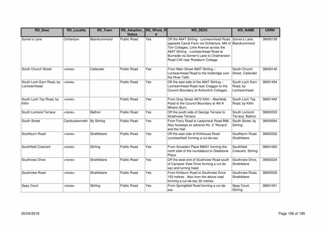
RD_Desc RD_Locality RD_Town RD_Adoption_
Status
RD_Whole_R
d
WD_DESC WD_NAME USRN
Somer's Lane Ochtertyre Blairdrummond Public Road Yes Off the A84T Stirling - Lochearnhead Road
opposite Carrat Farm via Ochtertyre, Mill of
Torr Cottages, Lime Avenue across the
A84T Stirling - Lochearnhead Road at
Burnside via Somer's Lane to Chalmerston
Road C40 near Rossburn Cottage.
Somer's Lane,
Blairdrummond
38000128
South Church Street <none> Callander Public Road Yes From Main Street A84T Stirling –
Lochearnhead Road to the footbridge over
the River Teith.
South Church
Street, Callander
38000140
South Loch Earn Road, by
Lochearnhead
<none> Public Road Yes Off the east side of the A84T Stirling –
Lochearnhead Road near Creggan to the
Council Boundary at Ardvorlich Cottages.
South Loch Earn
Road, by
Lochearnhead
38001454
South Loch Tay Road, by
Killin
<none> Public Road Yes From Gray Street A872 Killin - Aberfeldy
Road to the Council Boundary at Allt A
Mheinn Burn.
South Loch Tay
Road, by Killin
38001442
South Lomond Terrace <none> Balfron Public Road Yes Off the south side of George Terrace to
Strathview Terrace.
South Lomond
Terrace, Balfron
38000333
South Street Cambuskenneth By Stirling Public Road Yes From Ferry Road to Ladysneuk Road B96.
Also footways ex adverso No. 2 "Novara"
and the Hall.
South Street, by
Stirling
38000564
Southburn Road <none> Strathblane Public Road Yes Off the east side of Kirkhouse Road
(unclassified) forming a cul-de-sac.
Southburn Road,
Strathblane
38000332
Southfield Crescent <none> Stirling Public Road Yes From Snowdon Place B8051 forming the
north side of the roundabout to Gladstone
Place.
Southfield
Crescent, Stirling
38001000
Southview Drive <none> Strathblane Public Road Yes Off the west end of Southview Road south
of Campsie View Drive forming a cul-de-
sac and turning head.
Southview Drive,
Strathblane
38000334
Southview Road <none> Strathblane Public Road Yes From Kirkburn Road to Southview Drive
153 metres. Also from the above road
forming a cul-de-sac 32 metres.
Southview Road,
Strathblane
38000335
Spey Court <none> Stirling Public Road Yes From Springfield Road forming a cul-de-
sac.
Spey Court,
Stirling
38001001
20/04/2018 Page 156 of 185

RD_Desc RD_Locality RD_Town RD_Adoption_
Status
RD_Whole_R
d
WD_DESC WD_NAME USRN
Spinners Street <none> Balfron Public Road Yes Off the east side of Buchanan Street A875
Dumgoyne - Kepculloch Road to Banker's
Brae.
Spinners Street,
Balfron
38000336
Spittal Hill Causewayhead Stirling Private Road Yes Off the north side of Hillfoots Road
(unclassified) 63m east of the north end of
Graham AvenueNote: This is the access to
Stirling University student accommodation
Spittal Hill,Stirling, 38001298
Spittal Street <none> Stirling Public Road Yes From Corn Exchange Road C77 / King
Street C77 to St. John's Street at Academy
Road.
Spittal Street,
Stirling
38001002
Spoker's Loan (C23) <none> Balfron Public Road Yes Off the east side of Buchanan Street A875
Dumgoyne - Kepculloch Road at The
Clachan to Roman Road C23 at Cotton
Street / Moor Road.
Spoker's Loan,
Balfron
38000337
Springbank Crescent <none> Dunblane Public Road Yes From Doune Road A820 Doune - Dunblane
Road to Kilbryde Crescent.
Springbank
Crescent,
Dunblane
38000565
Springbank Gardens <none> Dunblane Public Road Yes Off the north side of Auchinlay Road 32
metres east of Strathmore Avenue. Road 1
26 metres, Road 2 68 metres in an easterly
direction and 122 metres in a westerly
direction. From Road 2, Court 1 32 metres.
From Road 2, Court 2, 34 metres. From
Road 2, Court 3 25 metres.
Springbank
Gardens,
Dunblane
38000566
Springbank Road <none> Doune Public Road Yes off the junction with Station Wynd south
east direction. Please not parking areas are
private
Springbank Road,
Doune
38005633
Springbank Road Springkerse
Indust Estate
Stirling Public Road Yes Continuation of Forthbank Road. Springbank Road,
Stirling
38001392
Springfield Road <none> Stirling Public Road Yes From Annfield Drive to Broom Road. Also
3 culs-de-sac 132 metres. Short Cul-de-
sac serviing No 58 – 70 also adopted
Springfield Road,
Stirling
38001003
20/04/2018 Page 157 of 185
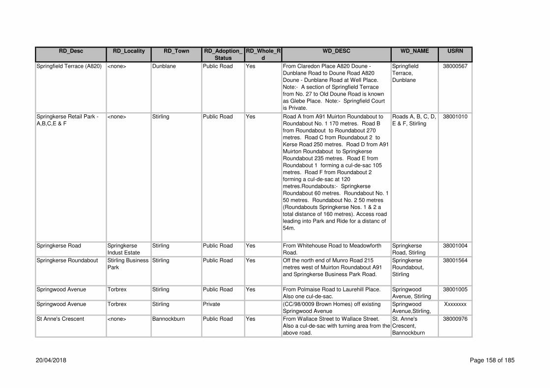
RD_Desc RD_Locality RD_Town RD_Adoption_
Status
RD_Whole_R
d
WD_DESC WD_NAME USRN
Springfield Terrace (A820) <none> Dunblane Public Road Yes From Claredon Place A820 Doune -
Dunblane Road to Doune Road A820
Doune - Dunblane Road at Well Place.
Note:- A section of Springfield Terrace
from No. 27 to Old Doune Road is known
as Glebe Place. Note:- Springfield Court
is Private.
Springfield
Terrace,
Dunblane
38000567
Springkerse Retail Park -
A,B,C,E & F
<none> Stirling Public Road Yes Road A from A91 Muirton Roundabout to
Roundabout No. 1 170 metres. Road B
from Roundabout to Roundabout 270
metres. Road C from Roundabout 2 to
Kerse Road 250 metres. Road D from A91
Muirton Roundabout to Springkerse
Roundabout 235 metres. Road E from
Roundabout 1 forming a cul-de-sac 105
metres. Road F from Roundabout 2
forming a cul-de-sac at 120
metres.Roundabouts:- Springkerse
Roundabout 60 metres. Roundabout No. 1
50 metres. Roundabout No. 2 50 metres
(Roundabouts Springkerse Nos. 1 & 2 a
total distance of 160 metres). Access road
leading into Park and Ride for a distanc of
54m.
Roads A, B, C, D,
E & F, Stirling
38001010
Springkerse Road Springkerse
Indust Estate
Stirling Public Road Yes From Whitehouse Road to Meadowforth
Road.
Springkerse
Road, Stirling
38001004
Springkerse Roundabout Stirling Business
Park
Stirling Public Road Yes Off the north end of Munro Road 215
metres west of Muirton Roundabout A91
and Springkerse Business Park Road.
Springkerse
Roundabout,
Stirling
38001564
Springwood Avenue Torbrex Stirling Public Road Yes From Polmaise Road to Laurehill Place.
Also one cul-de-sac.
Springwood
Avenue, Stirling
38001005
Springwood Avenue Torbrex Stirling Private (CC/98/0009 Brown Homes) off existing
Springwood Avenue
Springwood
Avenue,Stirling,
Xxxxxxxx
St Anne's Crescent <none> Bannockburn Public Road Yes From Wallace Street to Wallace Street.
Also a cul-de-sac with turning area from the
above road.
St. Anne's
Crescent,
Bannockburn
38000976
20/04/2018 Page 158 of 185

RD_Desc RD_Locality RD_Town RD_Adoption_
Status
RD_Whole_R
d
WD_DESC WD_NAME USRN
St Blanes Road <none> Dunblane Private Road Yes Off the west side of Perth Road B8033 at
the south side of the Police Station
St Blanes
Road,Dunblane,
38001302
St Clement Avenue <none> Dunblane Public Road Yes From St. Laurence Avenue to Roman Way. St. Clement
Avenue,
Dunblane
38000571
St James Orchard Cambuskenneth By Stirling Public Road Yes From Ladysneuk Road C96 forming a cul-
de-sac.
St. James
Orchard, by
Stirling
38000573
St John Street Top of the Town Stirling Public Road Yes From Spittal Street / Academy Road to Mar
Place 186 metres. Also a short cul-de-sac
for 73 metres.
St. John Street,
Stirling
38000977
St Lawrence Avenue <none> Dunblane Public Road Yes From Roman Way to Old Doune Road. St. Lawrence
Avenue,
Dunblane
38000574
St Margaret's Drive <none> Dunblane Public Road Yes From The Crescent and St.Mary's Drive to
Leewood Road 450 metres. Also from
Inverawe to Newton Crescent 60 metres.
Also the footpath ex adverso "Dundarroch".
Note:- The carriageway ex adverso
"Dundarroch" is Private.
St. Margaret's
Drive, Dunblane
38000575
St Margaret's Loan <none> Dunblane Public Road Yes Off the north side of Newton Crescent 90
metres west of Ochiltree forming a cul-de-
sac. Also the footpath / lane extending
northwards between House Nos. 19 and 21
to Ochiltree 92 metres.
St. Margaret's
Loan, Dunblane
38000576
St Mary's Court <none> Dunblane Public Road Yes From High Street forming a cul-de-sac. St. Mary's Court,
Dunblane
38000577
St Mary's Drive <none> Dunblane Public Road Yes From Perth Road B8033 to The Crescent /
St. Margaret's Drive.
St. Mary's Drive,
Dunblane
38000578
St Mary's Wynd Top of the Town Stirling Public Road Yes From Broad Street / Bow Street to Barn
Road / Upper Bridge Street.
St. Mary's Wynd,
Stirling
38000978
St Ninians Road (C121,
B8051 and C79)
<none> Stirling Public Road No From Wellgreen Road C121 to Port Street
C121 at Kings Park Road.
St. Ninians Road,
Stirling
38000979
St Ninians Road (A811,
B8051 and C79)
<none> Stirling Public Road No From Newhouse Road B8051 to St.
Ninians Road C79.
St. Ninians Road,
Stirling
38000979
St Ninians Road (A811,
B8051 and C79)
<none> Stirling Public Road No From St. Ninians Road B8051 to Wellgreen
Road C121.
St. Ninians Road,
Stirling
38000979
20/04/2018 Page 159 of 185

RD_Desc RD_Locality RD_Town RD_Adoption_
Status
RD_Whole_R
d
WD_DESC WD_NAME USRN
St Ninians Road (C5) <none> Cambusbarron Public Road Yes From Main Street C5 Touch Road at
Birkhill Road C3 to Touch Road C5.
St Ninians Road,
Cambusbarron
38001121
St Ninians Road, Stirling <none> Public Road Yes Off the north side of Snowdon Place B8051
to Wellgreen C121 at the Black Boy
Fountain.
St Ninians Road,
Stirling
38002264
St Thomas Well <none> Stirling Public Road Yes From Dougals Terrace forming a cul-de-
sac 283 metres. Also from the above road
forming a cul-de-sac 109 metres. Note:-
Service Strips are Private.
St. Thomas Well,
Stirling
38000983
St Thomas's Place <none> Stirling Public Road Yes Off the north side of Douglas Terrace 86
metres west of Dowan Place forming a cul-
de-sac with turninghead.
St. Thomas's
Place, Stirling
38000982
St Valery Court St Ninians Stirling Public Road Yes From St. Valery Drive forming a cul-de-sac
with turninghead.
St. Valery Court,
Stirling
38000984
St Valery Drive St Ninians Stirling Public Road Yes From Torbrex Road C5 forming a cul-de-
sac with turninghead also 2 cul-de-sacs
St. Valery Drive,
Stirling
38000985
Staball – Ard <none> Aberfoyle Public Road Yes From its junction with Trossachs road for a
distance of 80m
Staball – Ard,
Aberfoyle
38004119
Stank Road <none> By Callander Public Road Yes Off the west side of A84T Stirling -
Lochearnhead Road 1370 metres south of
Loch Lubnaig to the gate at Railway
Cottage.
Stank Road, by
Callander
38000142
Stanley Drive <none> Bridge of Allan Public Road Yes From Mayne Avenue to Forglen Road. Stanley Drive,
Bridge of Allan
38000568
Stark Street <none> Gargunnock Public Road Yes Off the east side of Stevenson Street
forming a cul-de-sac.
Stark Street,
Gargunnock
38000338
Station Lofts <none> Strathblane Private Road No Station
Lofts,Strathblane,
38003200
Station Road <none> Crianlarich Public Road No From the A85T Lochearnhead - Crianlarich
to the south end of the parking area. Also
the car parking area. Note:- The remainder
of Station Road is Private and belongs to
British Rail.
Station Road,
Crianlarich
38000030
20/04/2018 Page 160 of 185
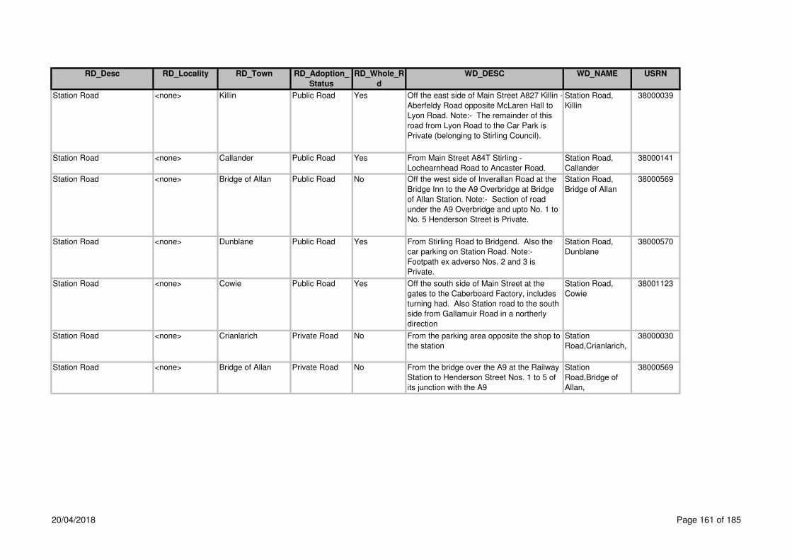
RD_Desc RD_Locality RD_Town RD_Adoption_
Status
RD_Whole_R
d
WD_DESC WD_NAME USRN
Station Road <none> Killin Public Road Yes Off the east side of Main Street A827 Killin -
Aberfeldy Road opposite McLaren Hall to
Lyon Road. Note:- The remainder of this
road from Lyon Road to the Car Park is
Private (belonging to Stirling Council).
Station Road,
Killin
38000039
Station Road <none> Callander Public Road Yes From Main Street A84T Stirling -
Lochearnhead Road to Ancaster Road.
Station Road,
Callander
38000141
Station Road <none> Bridge of Allan Public Road No Off the west side of Inverallan Road at the
Bridge Inn to the A9 Overbridge at Bridge
of Allan Station. Note:- Section of road
under the A9 Overbridge and upto No. 1 to
No. 5 Henderson Street is Private.
Station Road,
Bridge of Allan
38000569
Station Road <none> Dunblane Public Road Yes From Stirling Road to Bridgend. Also the
car parking on Station Road. Note:-
Footpath ex adverso Nos. 2 and 3 is
Private.
Station Road,
Dunblane
38000570
Station Road <none> Cowie Public Road Yes Off the south side of Main Street at the
gates to the Caberboard Factory, includes
turning had. Also Station road to the south
side from Gallamuir Road in a northerly
direction
Station Road,
Cowie
38001123
Station Road <none> Crianlarich Private Road No From the parking area opposite the shop to
the station
Station
Road,Crianlarich,
38000030
Station Road <none> Bridge of Allan Private Road No From the bridge over the A9 at the Railway
Station to Henderson Street Nos. 1 to 5 of
its junction with the A9
Station
Road,Bridge of
Allan,
38000569
20/04/2018 Page 161 of 185

RD_Desc RD_Locality RD_Town RD_Adoption_
Status
RD_Whole_R
d
WD_DESC WD_NAME USRN
Station Road ( C25 and
Unclasified )
<none> Bannockburn Public Road Yes Off the east side of Quakerfield A9
Edinburgh - Perth Road to 65 metres north
of the north boundary of House No. 112.
Also from the above road forming a cul-de-
sac and turning area serving House Nos. 1
- 17. This section of road is also known as
Downie Place and the two metre wide
footpath around the turning area, 113
metres. Also from the above road at
forming a cul-de-sac serving House Nos.
19 - 23, 27 metres.
Station Road,
Bannockburn
38002140
Station Road (B821) <none> Blanefield Public Road Yes Off the south side of Glasgow Road A81
Glasgow - Aberfoyle Road 194 metres east
of Ballewan Crescent to Blane Crescent.
Station Road,
Blanefield
38000339
Station Road (B822) <none> Kippen Public Road Yes From Cutherberton Burn Bridge 264 metres
east of Kippen Cross to Main Street B822
Callander - Kirkintilloch Road at Kippen
Cross.
Station Road,
Kippen
38000341
Station Road (B834) <none> Killearn Public Road Yes From Balfron Road A875 Dumgoyne -
Kepculloch Road to Killearn Station
(disused).
Station Road,
Killearn
38000343
Station Road (B835) <none> Buchlyvie Public Road Yes From Main Street A811 Stirling -
Dumbarton Road to the Old Railway
Station 600 metres west of Buchlyvie.
Station Road,
Buchlyvie
38000200
Station Road (B835) <none> Buchlyvie Public Road No Off the west side of Station Road B835
Ward Toll - Buchlyvie Road 394 metres
north of Main Street A811 to Fisher Place
at the boundary of No. 49 Station Road and
No. 2 Fisher Place.
Station Road,
Buchlyvie
38000200
Station Road (C21) <none> Balfron Public Road Yes From Buchanan Street A875 Dumgoyne -
Kepculloch Road at The Clachan to Indians
Road C21 at the Old Manse 86 metres
west of the Cemetery.
Station Road,
Balfron
38000340
Station Road (C22) <none> Gargunnock Public Road Yes From Leckie Road at The Square to
Charles Street.
Station Road,
Gargunnock
38000342
20/04/2018 Page 162 of 185

RD_Desc RD_Locality RD_Town RD_Adoption_
Status
RD_Whole_R
d
WD_DESC WD_NAME USRN
Station Road (C77) <none> Stirling Public Road Yes From Murray Place Roundabout to
Goosecroft Road Roundabout.
Station Road,
Stirling
38001007
Station Road Lower <none> Tyndrum Public Road No Off the A84T Stirling - Lochearnhead Road
at the Royal Hotel.
Station Road
Lower, Tyndrum
38001147
Station Road Lower <none> Tyndrum Private Road No From Station Road Lower to the endNote:
The first 44m of Station Road (Lower) from
the A82T is adopted
Station Road
Lower,Tyndrum,
38001147
Station Road Roundabout
(B8052 and C77)
<none> Stirling Public Road Yes Roundabout at Stirling Railway Station. Station Road
Roundabout,
Stirling
38002373
Station Road Upper <none> Tyndrum Private Road Yes Off the east side of the A84T south of the
entrance to the Royal Hotel
Station Road
Upper,Tyndrum,
38002315
Station Road, Bannockburn <none> Public Road Yes From the A91 Stirling Eastern Distributor
Road 400 metres east of Skeoch
Roundabout to the A905 Stirling -
Edinburgh Low Road 660 metres west of
Fallin Village.
Station Road,
Bannockburn
38001459
Off the north side of Balkerach Street 548m
at the A84T Stirling - Lochearnhead Road.
Stein Square <none> Bannockburn Public Road Yes From the A9 Edinburgh - Perth Road to a
point 60 metres west of the access road to
Greenyards Farm. Also lay-by and footway
adjacent to No. 6 60 metres.
Stein Square,
Bannockburn
38001008
Steuart Road <none> Bridge of Allan Prospective
Public Road
Yes Off the east side of Inverallan Road, 96m
east of the south end of Cawder Road
Steuart
Road,Bridge of
Allan,
38001301
Stevenson Court <none> Bridge of Allan Public Road Yes From Churchill Drive forming a cul-de-sac
with turning head.
Stevenson Court,
Bridge of Allan
38000572
Stevenson Street <none> Gargunnock Public Road Yes Off the south side of Main Street forming a
cul-de-sac.
Stevenson Street,
Gargunnock
38000344
Stewart Road <none> Killin Public Road Yes From Manse Road to Fingal Road. Stewart Road,
Killin
38000031
Yes Station Wynd,
Doune
38001188Station Wynd <none> Doune Public Road
20/04/2018 Page 163 of 185

RD_Desc RD_Locality RD_Town RD_Adoption_
Status
RD_Whole_R
d
WD_DESC WD_NAME USRN
Stewart Square Raploch Stirling Public Road Yes From Menzies Drive forming a cul-de-sac. Stewart Square,
Stirling
38001014
Stewart Street <none> Cambusbarron Public Road Yes From North End Road to Cambusbarron
Road C5.
Stewart Street,
Cambusbarron
38001124
Stirling - Bridge of Allan
Road
<none> Public Road Yes From Causewayhead Road A9 Edinburgh -
Perth Road to Cornton Road B823 in
Bridge of Allan
Stirling - Bridge of
Allan Road
38001449
Stirling - Craigforth
Interchange
<none> Public Road Yes From the A9 Edinburgh - Perth at Wallace
Street Roundabout south via Drip Road,
Stirling to the A84T Stirling - Lochearnhead
Road at eastern end of Craigforth Eastern
Roundabout. Also footway fronting Mogil
Motors. Note:- Footpaths ex adverso
House Nos. 45 - 49 are Private.
Stirling -
Craigforth
Interchange
38001505
Stirling - Cupar Road <none> Public Road Yes Off the north side of Bannockburn
Interchange M9 via Greencornhill
Roundabout, Stirling Eastern Distributor
Road, Skeoch Roundabout, Millhall
Roundabout, Muirton Roundabout, Manor
Powis Roundabout, Powis Loan, Logie
Crossroads, Blairlogie to the Council
Boundary at the access to Blairlogie House
Hotel, 164 metres east of Gogar Road.
Stirling - Cupar
Road
38001509
Stirling - Dennyloanhead,
by Stirling
<none> Public Road Yes From the Council Boundary 157 metres
south of Northfield Road, Bannockburn
Interchange, Whins of Milton - Glasgow
Road, Milton Terrace, St Ninians - Glasgow
Road to Burghmuir Road, A9 Edinburgh -
Perth Road.
Stirling -
Dennyloanhead,
by Stirling
38001506
20/04/2018 Page 164 of 185

RD_Desc RD_Locality RD_Town RD_Adoption_
Status
RD_Whole_R
d
WD_DESC WD_NAME USRN
Stirling - Dumbarton Road <none> Public Road Yes From the A9 Edinburgh - Perth Road at
Craigs Roundabout via Stirling (Wellgreen
Road, St Ninians Road, Port Street,
Dumbarton Road, Albert Place, Main
Street, Arnprior, Main Street, Buchlyvie,
Ballat Crossroads, Drymen By-pass to the
Council Boundary at Nannie's Burn. Also
the Old Road at Falleninch Farm due to PU
Services. Also lay-bys East of Buchlyvie (2
No.) and West of Touch Road.
Stirling -
Dumbarton Road
38001503
Stirling - Dunfermline Road <none> Public Road Yes Off the east side of Causewayhead
Roundabout, A9 Edinburgh - Perth Road to
the Council Boundary, 506 metres east of
Manor Loan.
Stirling -
Dunfermline Road
38001497
Stirling - Edinburgh (Low) <none> Public Road Yes From the A9 Edinburgh - Stirling Road at
Craigs Roundabout, Stirling via Millhall,
Main Street and Stirling Road, Fallin,
Kersie Road, Throsk to the Council
Boundary at Kersie Bridge, 1324 metres
east of Throsk.
Stirling -
Edinburgh (Low)
38002071
Stirling - Lochearnhead <none> Public Road Yes Off the west side of Craigforth East
Roundabout at the A84, Stirling, via Doune,
Callander and Strathyre to the A85T
Lochearnhead - Crianlarich Road at
Lochearnhead.
Stirling -
Lochearnhead
38002066
Stirling - Logie Crossroads <none> Public Road Yes From the A9 Edinburgh - Perth Road at
Causewayhead Roundabout via Logie
Road B998 and Hillfoots Road B998 to the
A91 Stirling - Cupar Road at Logie
Crossroads. Also bus lay-bys near the
entrance to Stirling University.
Stirling - Logie
Crossroads
38001453
20/04/2018 Page 165 of 185

RD_Desc RD_Locality RD_Town RD_Adoption_
Status
RD_Whole_R
d
WD_DESC WD_NAME USRN
Stirling Business Park
Road D
Stirling Business
Park
Stirling Public Road Yes Off the west side of Muirton Roundabout
A91 to Springkerse Roundabout. Also
extension from Roundabout forming a
turning head for a distance of 150 metres
seving the Holiday Inn.
Springkerse
Business Park,
Stirling
38001574
Stirling Place <none> Plean Public Road Yes Off the south side of Main Street (A9
Edinburgh - Perth Road) forming 2 cul-de-
sacs.
Stirling Place,
Plean
38002280
Stirling Retail Park Service
Road
Stirling Retail
Park
Stirling Public Road Yes Off the east side of Munro Road 50 metres
north of Cunningham Road forming a cul-
de-sac.
Stirling Retail
Park Service
Road, Stirling
38001011
Stirling Road - Beech Road -
High Street, Dunblane
<none> Public Road Yes Off the west side of Perth Road B8033 via
Stirling Road and High Street to Perth
Road 780 metres. Also from B8033
opposite Lodge to Stirling Road B8064 96
metres.
Stirling Road -
Beech Road -
High Street,
Dunblane
38001513
Stirling Road (A84T) <none> Callander Trunk Road Yes From Main Street A84T Stirling -
Lochearnhead Road 70 metres east of
Bracklinn Road to the A84T Stirling -
Lochearnhead Road at Erskine Cottage
and the Chalet Park boundary. Note:- The
footway between Myrtle Cottage and Roslin
Cottage is Private.
Stirling Road,
Callander
38000144
Stirling Road (A905) <none> Fallin Public Road Yes From the A905 Stirling - Edinburgh Low
Road from the line of the west kerb of
Hillview Place to Main Street A905 at the
east boundary of Dunblane Light
Engineering on the north side of the road
opposite Bandeath House. Also shops
forecourt 40-46.
Stirling Road,
Fallin
38001009
Stirling Road (B8033 and
B8064)
<none> Dunblane Public Road Yes From Perth Road B8033 and Stirling Road
B8064 to the Southern Burgh Boundary.
Note:- Re-classified from A9T to B8033 on
17/08/92.
Stirling Road,
Dunblane
38000579
20/04/2018 Page 166 of 185

RD_Desc RD_Locality RD_Town RD_Adoption_
Status
RD_Whole_R
d
WD_DESC WD_NAME USRN
Stirling Road (B858 and
Unclassified)
<none> Drymen Public Road Yes From Stirling Road B858 Drymen Village
Road 40 metres north of the A811 Drymen
By-Pass forming a cul-de-sac to Drymen
Primary School. Also access road with two
culs-de-sac serving House Nos. 25 - 43.
Stirling Road,
Drymen
38002284
Stirling Road (B858 and
Unclassified)
<none> Drymen Public Road Yes Off the east side of Main Street B858 at
The Cross to Drymen By-Pass A811
Stirling - Dumbarton Road 80 metres west
of Drymen Primary School. Note:- Drymen
Square including the parking area and
picnic area are Private.
Stirling Road
(B858), Drymen
38002284
Stirling Road Service Road <none> Callander Public Road Yes Off the south side and parallel to Stirling
Road A84T Stirling - Lochearnhead Road
opposite the "Woolsley Park" hotel forming
a cul-de-sac north westwards parallel to
A84T and eastwards to Willoughby Place.
Stirling Road
Service Road,
Callander
38000143
Stirling Road Service Road
North
<none> Fallin Public Road Yes From the Stirling Road A905 Stirling -
Edinburgh Low Road eastwards parallel to
Stirling Road forming a cul-de-sac with
turning area for 110 metres. Also
westwards parallel to Stirling Road forming
a cul-de-sac with turning head for 87
metres.
Stirling Road
(Service Road
North), Fallin
38001012
Stirling Road Service Road
South
<none> Fallin Public Road Yes From Hillview Place parallel to and on
south side of Stirling Road A905 Stirling -
Edinburgh Low Road 33 metres east of
Moss Road including 3 accesses to Stirling
Road A905.
Stirling Road
(Service Road
South), Fallin
38001013
Strathallan Court <none> Bridge of Allan Private Road Yes Off the north side of Orchard Road 52 Strathallan
Court,Bridge of
Allan,
38001303
Strathallan Road <none> Bridge of Allan Public Road Yes From Castleview Drive to Orchard Road. Strathallan Road,
Bridge of Allan
38000582
20/04/2018 Page 167 of 185
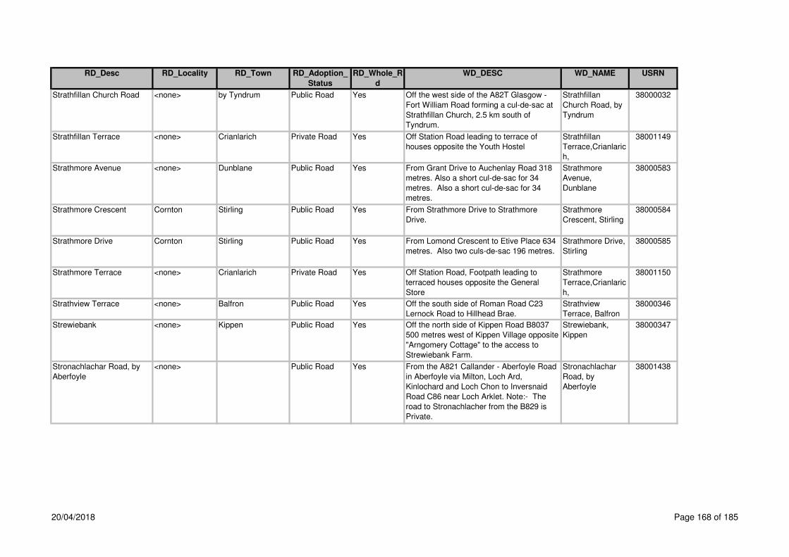
RD_Desc RD_Locality RD_Town RD_Adoption_
Status
RD_Whole_R
d
WD_DESC WD_NAME USRN
Strathfillan Church Road <none> by Tyndrum Public Road Yes Off the west side of the A82T Glasgow -
Fort William Road forming a cul-de-sac at
Strathfillan Church, 2.5 km south of
Tyndrum.
Strathfillan
Church Road, by
Tyndrum
38000032
Strathfillan Terrace <none> Crianlarich Private Road Yes Off Station Road leading to terrace of
houses opposite the Youth Hostel
Strathfillan
Terrace,Crianlaric
h,
38001149
Strathmore Avenue <none> Dunblane Public Road Yes From Grant Drive to Auchenlay Road 318
metres. Also a short cul-de-sac for 34
metres. Also a short cul-de-sac for 34
metres.
Strathmore
Avenue,
Dunblane
38000583
Strathmore Crescent Cornton Stirling Public Road Yes From Strathmore Drive to Strathmore
Drive.
Strathmore
Crescent, Stirling
38000584
Strathmore Drive Cornton Stirling Public Road Yes From Lomond Crescent to Etive Place 634
metres. Also two culs-de-sac 196 metres.
Strathmore Drive,
Stirling
38000585
Strathmore Terrace <none> Crianlarich Private Road Yes Off Station Road, Footpath leading to
terraced houses opposite the General
Store
Strathmore
Terrace,Crianlaric
h,
38001150
Strathview Terrace <none> Balfron Public Road Yes Off the south side of Roman Road C23
Lernock Road to Hillhead Brae.
Strathview
Terrace, Balfron
38000346
Strewiebank <none> Kippen Public Road Yes Off the north side of Kippen Road B8037
500 metres west of Kippen Village opposite
"Arngomery Cottage" to the access to
Strewiebank Farm.
Strewiebank,
Kippen
38000347
Stronachlachar Road, by
Aberfoyle
<none> Public Road Yes From the A821 Callander - Aberfoyle Road
in Aberfoyle via Milton, Loch Ard,
Kinlochard and Loch Chon to Inversnaid
Road C86 near Loch Arklet. Note:- The
road to Stronachlacher from the B829 is
Private.
Stronachlachar
Road, by
Aberfoyle
38001438
20/04/2018 Page 168 of 185

RD_Desc RD_Locality RD_Town RD_Adoption_
Status
RD_Whole_R
d
WD_DESC WD_NAME USRN
Stroneslaney Road <none> By Strathyre Public Road Yes From the A84T Stirling - Lochearnhead
Road A84T in Strathyre Village via the
Bridge over the River Balvaig, Stroneslaney
to the Braes of Balquhidder Road C33 in
Balquhidder Village. Parking places
adopted 1st November 2010
Stroneslaney
Road, by
Strathyre
38000033
Stuart Drive <none> Drymen Public Road Yes From Charles Crescent forming a cul-de-
sac with turning area. Also extension.
Stuart Drive,
Drymen
38000202
Subway Craigs
Roundabout
<none> Stirling Public Road Yes Footpath Subway-Craigs
Roundabout,Stirli
ng,
38001395
Subway Drip Road <none> Stirling Public Road Yes Footpath Subway-Drip
Road,Stirling,
38001394
Subway Relief Road <none> Stirling Public Road Yes Footpath Subway-Relief
Road,Stirling,
38001397
Subway St Ninians
Roundabout
St Ninians Stirling Public Road Yes Footpath Subway-St
Ninians
Roundabout,Stirli
ng,
38001398
Subway Union Street
Roundabout
<none> Stirling Public Road Yes Footpath Subway-Union
Street
Roundabout,Stirli
ng,
38001393
Sunnybank Road <none> Stirling Public Road Yes From Mayfield Street forming a cul-de-sac. Sunnybank Road,
Stirling
38001015
Sunnylaw Road <none> Bridge of Allan Public Road Yes From the east end of Ferniebank Road to
Well Road opposite the west end of
Kenilworth Road.
Sunnylaw Road,
Bridge of Allan
38000586
Sunnyside St Ninians Stirling Public Road Yes From Weaver Row C5 forming a cul-de-
sac.
Sunnyside,
Stirling
38001016
Sunnyside (A820) <none> Dunblane Public Road Yes From Stirling Road B8033 to Claredon
Place A820 Doune - Dunblane Road.
Sunnyside,
Dunblane
38000587
Sunnyside Place Cornton Stirling Public Road Yes From its junction north off Westhaugh Road
for a distance of 91m
Sunnyside
Place,Cornton,Stir
ling,
38003185
20/04/2018 Page 169 of 185

RD_Desc RD_Locality RD_Town RD_Adoption_
Status
RD_Whole_R
d
WD_DESC WD_NAME USRN
Surcoat Loan Balquhidderock Stirling Public Road Yes Off the east side of Caltrop Place. Surcoat Loan,
Stirlng
38001551
Sutherland Avenue (C11) Riverside Stirling Public Road Yes From Argyll Avenue / Millar Place to
Riverside Drive.
Sutherland
Avenue, Stirling
38001017
Suttie Way <none> Bridge of Allan Public Road Yes Cul-de-sac off Henderson Street in an
easterly direction including 2 metre service
strip and adjacent car parking bays.
Suttie Way,
Bridge of Allan
38002105
Sycamore Place Torbrex Stirling Public Road Yes From Cedar Avenue forming a cul-de-sac
with turning circle.
Sycamore Place,
Stirling
38001018
Symon Field <none> Dunblane Public Road Yes Continutation from Newton Crescent. Symon Field,
Dunblane
38002106
Tam O'Shanter Drive <none> Cowie Public Road Yes From Burns Terrace to Armour Avenue. Tam O'Shanter
Drive, Cowie
38001125
Tannahill Terrace <none> Dunblane Public Road No Off the north side of Ramoyle 59 metres
north of Dargai Terrace to the private
section of Tannahill Terrace 108 metres.
Also from west side of the above road
forming a cul-de-sac 133 metres. Note:-
The carriageway, footpaths and parking
areas for Nos. 28/30 Tannahill Terrace,
also the footpath from Nos. 28/30 Tannahill
Terrace to Ramoyle are Private.
Tannahill Terrace,
Dunblane
38000588
Tannahill Terrace <none> Dunblane Private Road No Off the east side of Tannahill Terrace,
100m north of Braeport/Ramoyle forming a
parking/turning area serving house Nos. 28
and 30
Tannahill
Terrace,Dunblane
,
38000588
Tannery Lane <none> Stirling Public Road Yes Off Cowane Street B8051 to Queen Street.
Also the pedestrian steps leading to Queen
Street. Note:- There is no vehicular access
to Queen Street. Also new bellmouth from
Cowane Street, upgrading of Tannery Lane
(lower) and access to parking which
remains private for a distance of 55
metres).
Tannery Lane,
Stirling
38001019
20/04/2018 Page 170 of 185

RD_Desc RD_Locality RD_Town RD_Adoption_
Status
RD_Whole_R
d
WD_DESC WD_NAME USRN
Targe Wynd Balquhidderock Stirling Public Road Yes From its junction with Pike Road forming a
cul-de-sac. Also footpaths.
Targe Wynd,
Stirling
38002101
Teith Court <none> Callander Private Road Yes Off the south side of the A84 T Stirling -
Lochearnhead Road, east of the Fire
Station
Teith
Court,Callander,
38001190
Teith Road <none> Deanston Public Road Yes Off the west side of Leny Road at the
Primary School to the refuse tip road at the
west end of the village including a short
section of this road at T.C. Box for 12
metres. Also a short section off this road at
westend of Playground / Memorial for 18
metres. Also the footbridge over Mill Lade.
Teith Road,
Deanston
38000145
Telford Court <none> Bannockburn Public Road Yes off the west side of New Road A9, 165m
north of Main Street
Telford
Court,Bannockbur
n,
38001399
The Acres <none> Kippen Public Yes From Burnside in an easterly direction The
Acres,Kippen,
38003074
The Avenue <none> Bridge of Allan Public Road Yes Pedestrian access is off the south side of
Henderson Street A9 for 37 metres to the
vehicular access off the north side of Keir
Street 45 metres east of Union Street.
Note:- A vehicular right of access exists for
delivery vehicles to Co-op.
The Avenue,
Bridge of Allan
38000589
The Avenue <none> Fallin Public Road Yes From Bandeath Road to entrance to
parking area.
The Avenue,
Fallin
38001020
The Avenue <none> Ashfield Private Road Yes Off the west side of Ochilview 116m south
of The Square
The
Avenue,Ashfield,
38001305
The Brae <none> Bannockburn Public Road Yes From Main Street / Coal Wynd to Old
Town.
The Brae
(Bannockburn
Road),
Bannockburn
38001021
The Brae <none> Cambusbarron Public Road Yes From Kersebonny Road forming a cul-de-
sac.
The Brae,
Cambusbarron
38001126
20/04/2018 Page 171 of 185

RD_Desc RD_Locality RD_Town RD_Adoption_
Status
RD_Whole_R
d
WD_DESC WD_NAME USRN
The Brae To Birkhill Road <none> Cambusbarron Public Road Yes Link Footpath The Brae to
Birkhill
Road,Cambusbar
ron,
38001430
The Clachan <none> Ashfield Private Road Yes Off the south side of Ashfield Road The
Clachan,Ashfield,
38001306
The Cottages <none> Deanston Public Road Yes From Deanston Road forming a cul-de-sac. The Cottages,
Deanston
38000148
The Cottages <none> Ashfield Private Road Yes Off the west side at the south end of the
Steading, 90m south of The Avenue
The
Cottages,Ashfield,
38001307
The Crescent <none> Dunblane Public Road Yes From Perth Road B8033 to Glen Road
C35.
The Crescent,
Dunblane
38000590
The Crofts <none> Doune Public Road Yes from Station Wynd in a southerly direction
for 57m
The Crofts,
Doune
38005625
The Cross (A820 and
B8032)
<none> Doune Public Road Yes At Main Street A820 Balkerach Street and
George Street B8032.
The Cross, Doune 38000146
The Cross (C85) <none> Dunblane Public Road Yes From High Street B8064 at the boundary
between the Bank House and the Manse to
Kirk Street at the line of the east kerb line
of The Cross. Also the area of footway
between the heel of the footway and the
face of the building at the Council
Chambers.
The Cross,
Dunblane
38000591
The Drovers <none> Doune Public Road Yes off Station Wynd in a southerly direction,
please note parking areas are private
The Drovers,
Doune
38005629
The Esplanade Stirling
Castle
<none> Stirling Private Road Yes Stirling Castle Esplanade The Esplanade
Stirling Castle,
Stirling,
38001400
The Firs (A9) <none> Bannockburn Public Road Yes From the boundary of No. 68A New Road
to No. 2 The Firs 122 metres south of Firs
Entry to a point 159 metres north of Firs
Entry at the boundary between No. 57 The
Firs and No. 174 Bannockburn Road.
The Firs,
Bannockburn
38001022
20/04/2018 Page 172 of 185

RD_Desc RD_Locality RD_Town RD_Adoption_
Status
RD_Whole_R
d
WD_DESC WD_NAME USRN
The Glebe <none> Killin Public Road Yes From the A827 Killin - Aberfeldy Road
forming a cul-de-sac.
The Glebe, Killin 38000036
The Glebe <none> Gargunnock Public Road Yes Off the north side of Manse Brae 58 metres
east of The Square. Also the footpath from
the north end of The Glebe to the garages
at the east end of Charles Street. The path
from NS70759446 to NS70779454.
The Glebe,
Gargunnock
38000348
The Glebe <none> Thornhill Private Road Yes Forth Housing Development The Glebe,
Thornhill
The Haining <none> Dunblane Public Road Yes From Meeting House Close at the 90
degree bend at the west corner of the car
park to the entrance to Laigh Hill near the
footbridge over the River Allan. Note:-
Nos. 1 - 4 Bishop Garden are part of The
Haining. Note:- Nos. 5 and 6 Bishop
Garden are Private.
The Haining,
Dunblane
38000474
The Hedges <none> Bannockburn Private Road No Footpath off the north side of Bentheads to
Rowan Court
The
Hedges,Bannock
burn,
38001401
The Hill <none> Thornhill Public Road Yes From Main Street A873 Blairdrummond -
Aberfoyle Road to Back Yetts 217 metres.
Also from the above road forming a cul-de-
sac to 48 metres.
The Hill, Thornhill 38000147
The Kirklands Torbrex Stirling Public Road Yes Off the north side of Wordie Road forming
2 cul-de-sacsfor a distance of 222m
The Kirklands,
Torbrex, Stirling
38005317
The Meadows Cornton Stirling Public Road Yes From its junction with Bracken Lane in a
easterly direction including turning head
and adjacent parking spaces
The Meadows,
Cornton, Stirling
38003215
The Oaks <none> Killearn Public Road Yes From the junction with Beech Drive running
in a northerly then westerly direction
forming a cul-de-sac.
The Oaks,
Killearn
38001240
The Old Mart <none> Killin Public Road Yes From its junction north of Lyon Road for a
distance of 77m
The Old Mart,
Killin
38003196
20/04/2018 Page 173 of 185

RD_Desc RD_Locality RD_Town RD_Adoption_
Status
RD_Whole_R
d
WD_DESC WD_NAME USRN
The Path <none> Bannockburn Public Road Yes From Old Town to New Road A9 The Path
(Bannockburn
Road),
Bannockburn
38001023
The Quarry <none> Doune Public Road Yes off Station Wynd in a southerly direction,
parking areas are private
The Quarry,
Doune
38005631
The Square <none> Killearn Public Road No From the A875 Dumgoyne - Kepculloch
Road via Crosshead Road to the A875
Dumgoyne - Kepculloch Road. Note:- The
gravel footway from the west boundary of
House No. 5 along the frontage of House
No. 9 for 81 metres is Private.
The Square,
Killearn
38000349
The Square <none> Drymen Private Road Yes Off the west side of Main Street B858
Drymen Village Road to the west side of
Old Gartmore Road
The
Square,Drymen,
38001204
The Square <none> Blairlogie Private Road Yes The
Square,Blairlogie,
38003095
The Square <none> Ashfield Private Road Yes Off the west side of Ochilview 81m south of
the Railway Bridge
The
Square,Ashfield,
38001308
The Steadings <none> Ashfield Private Road Yes Off the south end of Ochilview/The
Steadings to The CottagesNote: This road
is a continuation of Ochilview
The
Steadings,Ashfiel
d,
38001309
The Woodlands <none> Stirling Private Road Yes The Woodlands,
Stirling
38004115
The Yetts <none> Cambusbarron Public Road Yes From Old Drove Road forming a cul-de-sac
including turning head with parking area.
The Yetts,
Cambusbarron
38001127
Thistle Place Raploch Stirling (CC No 00/18 Forth Housing) Thistle
Place,Stirling,
38003187
Thistle Road <none> Stirling Public Road Yes From its junction with Goosecroft Road and
A9 Burghmuir Road. Note:- The footpath
on the north side from the ramped area into
the Bus Station Access is Private.
Thistle Road,
Stirling
38003013
20/04/2018 Page 174 of 185

RD_Desc RD_Locality RD_Town RD_Adoption_
Status
RD_Whole_R
d
WD_DESC WD_NAME USRN
Thomson Place <none> Cambusbarron Public Road Yes Off the west side of Murray Place opposite
Woodside Court to Drove Road.
Thomson Place,
Cambusbarron
38001128
Thornycroft Terrace <none> Plean Public Road Yes Off Willow Brae junction Thornycroft
Terrace, Plean
38003194
Tibbies Loan <none> Cowie Public Road Yes Off east side of Dr Campbell Avenue for a
distance of 95m, also link footpath to
Cowiehall Road 45m
Tibbies
Loan,Cowie,
38003042
Torbrex Torbrex Stirling Public Road Yes From Torbrex Road to Torbrex Farm Road.
Note:- The footway opposite Nos. 13, 15,
17, 19 and Rushmere is Private.
Torbrex Village
Road, Stirling
38001027
Torbrex Farm Road Torbrex Stirling Public Road Yes From Torbrex Road C4 to Torbrex Lane. Torbrex Farm
Road, Stirling
38001024
Torbrex Lane Torbrex Stirling Public Road Yes Off Torbrex Road C5 east of Cedar Road
(past Stirling High School) to No. 10
Newhouse Road B8052 south of Clifford
Road.
Torbrex Lane,
Stirling
38001025
Torbrex Lane To Ash
Terrace
Torbrex Stirling Private Road Yes Link Footpath off Torbrex Lane on the east
side of No. 20 (Public House) to Ash
Terrace between house Nos. 15 & 17
Torbrex Lane to
Ash
Terrace,Stirling,
38001402
Torbrex Road (C5) Torbrex Stirling Public Road Yes From Weaver Row C5 to Touch Road C5 /
Polmaise Road to Carron Reservoir Road
at the west side of the bridge over the M9
Motorway.
Torbrex Road,
Stirling
38001026
Torburn Avenue <none> Plean Public Road Yes From Cushenquarter Drive forming a cul-de-
sac.
Torburn Avenue,
Plean
38001129
Touch Reservoir Road <none> by Cambusbarron Private Road Yes Off the south side of Touch Road C5, 500m
west of Cambusbarron Village
Touch Reservoir
Road,By
Cambusbarron,
38001432
Touch Road (C5) <none> Cambusbarron Public Road Yes Off the west end of Main Street C5 38
metres west of Barony Court to the A811
Stirling - Dumbarton Road 3.5 km west of
Cambusbarron.
Touch Road,
Cambusbarron
38002130
20/04/2018 Page 175 of 185

RD_Desc RD_Locality RD_Town RD_Adoption_
Status
RD_Whole_R
d
WD_DESC WD_NAME USRN
Touch Road, Stirling <none> Public Road Yes From the B8051 St Ninians via Weaver
Row, Torbrex Road across the M9 (the
bridge is part of Touch Road), St Ninians
Road, Cambusbarron, Woodside Place,
Cambusbarron, Main Street,
Cambusbarron, Touch Road,
Cambusbarron and Johnny's Bridge to the
A811 Stirling - Dumbarton Road.
Touch Road,
Stirling
38001465
Touchhill Crescent <none> Plean Public Road Yes From President Kennedy Drive C64
Cadgers Loan to Main Street A9 Edinburgh
- Perth Road.
Touchill Crescent,
Plean
38001131
Touchhill Roundabout <none> Plean Public Road Yes Part of A9 Touchhill
Roundabout,
Plean
Plean Causewayhead Stirling Private Road Yes Off the east side of Logie Road B998
leading to Hanover Court, 56m north of
Causewayhead Roundabout
Tower
Place,Stirling,
38001403
Town Burn Torbrex Stirling Public Road Yes off the north side of Mosshouse, 30m east
of Wordie Road
Town
Burn,Stirling,
38002099
Trossachs Road (A821) <none> Aberfoyle Public Road Yes From Main Street A821 Aberfoyle -
Kilmahog Road to the A821 Aberfoyle -
Kilmahog Road 61 metres north of
Limecraig Avenue at Keith House.
Trossachs Road,
Aberfoyle
38000151
Tulipan Crescent <none> Callander Public Road Yes East of the A84T Stirling - Lochearnhead
Road to the end
Tullipan
Crescent,Calland
er,
38000152
Turnbull Way Raploch Stirling Private Road Yes Barratt New Development Turnbull Way,
Raploch, tirling 38005743
Tyndrum Terrace <none> Crianlarich Public Road Yes From the A82T Glasgow - Fort William
Road at the east boundary of House. No. 1
to the A82T at the west boundary of House
No. 11, 75 metres north of the Railway
Bridge.
Tyndrum Terrace,
Crianlarich
38000034
Underwood Cottages <none> Cambusbarron Public Road Yes From Gillies Hill to Wallace Place. Underwood
Cottages,
Cambusbarron
38001132
20/04/2018 Page 176 of 185

RD_Desc RD_Locality RD_Town RD_Adoption_
Status
RD_Whole_R
d
WD_DESC WD_NAME USRN
Underwood Road <none> Cambusbarron Public Road Yes From St Ninians Road C5 Touch Road to
Underwood Cottages.
Underwood Road,
Cambusbarron
38001133
Union Street (B8052) <none> Stirling Public Road Yes From Lower Bridge Street B8052 to
Wallace Street Roundabout.
Union Street,
Stirling
38001028
Union Street (B823) <none> Bridge of Allan Public Road Yes From Henderson Street A9 Edinburgh -
Perth Road opposite Well Road to
Allanvale Road B823 Stirling - Bridge of
Allan Road at the Leisure Centre.
Union Street,
Bridge of Allan
38000592
Upper Bridge Street <none> Stirling Public Road No From St. Mary's Wynd to Cowane Street /
Lower Bridge Street. Also access to No. 9
Upper Bridge Street (from Barn Road).
Upper Bridge
Street, Stirling
38001029
Upper Bridge Street <none> Stirling Private Road No No. 9 is located near the west end of St
Marys RC Church access to No. 9 is taken
off the north side of Barn Road
Upper Bridge
Street (No
9),Stirling,
38001029
Upper Castlehill Top of the Town Stirling Public Road Yes From Castle Wynd to South Western
Boundary Wall of Ballengeich Cemetery.
Upper Castlehill,
Stirling
38001030
Upper Craigs <none> Stirling Public Road Yes From A811 Port Street forming a turning
area to Wellgreen Place. Also pend from
Nos. 58 / 60 Upper Craigs to Wellgreen
Carpark.
Upper Craigs,
Stirling
38001031
Upper Glen Road <none> Bridge of Allan Public Road Yes From Glen Road to Glen Road. Upper Glen Road,
Bridge of Allan
38000594
Vale Grove <none> By Bridge of Allan Public Road Yes Off the west side of Forth Park to the
Roundabout.
Vale Grove,
Bridge of Allan
38001578
Valley Lane Cemetery
Road
Top of the Town Stirling Public Road Yes Off the west side of Castle Wynd on the
south side of the Portcullis Hotel to
Snowdon Road Public Lane to 25 metres
north of the Back Walk (High Level). Note:-
This road connects The Valley and
Snowdon Cemeteries.
Valley Lane
(Cemetery),
Stirling
38001032
Valleyfield Place <none> Stirling Public Road Yes From Colquhoun Street to Linden Avenue.
Note:- The footpath ex adverso 25 Linden
Avenue (shop) is Private.
Valleyfield Place,
Stirling
38001033
20/04/2018 Page 177 of 185

RD_Desc RD_Locality RD_Town RD_Adoption_
Status
RD_Whole_R
d
WD_DESC WD_NAME USRN
Venacher Avenue <none> Callander Public Road Yes From Lubnaig Drive forming a cul-de-sac. Venacher
Avenue,
Callander
38000153
Victoria Court <none> Callander Private Road Yes Off the south side of Main Street A84T
adjacent to the Fire Station, 89m east of
South Church Street
Victoria
Court,Callander,
38001192
Victoria Place (B8051) Kings Park Stirling Public Road No From Queens Road B8051 / Victoria Place
(unclassified) 202 metres south of Balmoral
Place to Kings Park Road C4 at the main
gates to the Kings Park.
Victoria Place,
Stirling
38001034
Victoria Place (B8051) Kings Park Stirling Public Road No From the south side of Albert Place to the
north side of Victoria Square and from the
south side of Victoria Square to Victoria
Place B8051 / Queens Road.
Victoria Place,
Stirling
38001034
Victoria Road Kings Park Stirling Public Road Yes From Albert Place to Greenwood Avenue. Victoria Road,
Stirling
38001036
Victoria Square Kings Park Stirling Public Road Yes Off the west side of Clarendon Place
opposite Abercromby Place to Victoria
Place / Balmoral Place to Victoria Place
back to Clarendon Place 71 metres south
of Abercromby Place.
Victoria Square,
Stirling
38001037
Viewfield Place <none> Stirling Public Road Yes From Barnton Street / Viewfield Street to
Barnton Street
Viewfield Place,
Stirling
38001038
Viewfield Street <none> Stirling Public Road Yes From the south boundary of Sheriff Court
Buildings to Maxwell Place.
Viewfield Street,
Stirling
38001039
Voil Road Cornton Stirling Public Road Yes From Vorlich Place to Strathmore Drive. Voil Road, Stirling 38000595
Vorlich Crescent <none> Callander Public Road Yes South of Stirling road for a distance of
410m
Vorlich
Crescent,Calland
er,
38002396
Vorlich Place Cornton Stirling Public Road Yes From Voil Road forming 2 culs-de-sacs
with turning heads.
Vorlich Place,
Stirling
38000596
20/04/2018 Page 178 of 185

RD_Desc RD_Locality RD_Town RD_Adoption_
Status
RD_Whole_R
d
WD_DESC WD_NAME USRN
Vorlich Road <none> Lochearnhead Public Road Yes From Auchraw Terrace forming a cul-de-
sac 69 metres. Also Nos. 19, 21, 23 and
25 eastwards from the existing road at the
turning area for 31 metres. Extension at the
east end forming a cul-de-sac for a
distance of 72m adopted August 2006
Vorlich Road,
Lochearnhead
38000035
Wallace Court <none> Stirling Private Road Yes Off the west side of Wallace Street, 117m
north of Cowane Street B8052 to Smileys
Exhaust Centre
Wallace
Court,Stirling,
38001405
Wallace Crescent <none> Plean Public Road Yes From Burnside Crescent to Bruce Street
544 metres. Also a short cul-de-sac with
turning area from above road for 41
metres.
Wallace
Crescent, Plean
38001134
Wallace Gardens Causewayhead Stirling Public Road No Off the south side of Alloa Road A907 90
metres east of Causewayhead Roundabout
forming a cul-de-sac.
Wallace Gardens,
Stirling
38000597
Wallace Gardens Causewayhead Stirling Private Road No Off the north side of the east end at house
Nos. 27/29 serving the garage area to end
at house No. 37
Wallace Gardens, 38000597
Wallace Gate Riverside Stirling Private Road No off Forth Street Wallace
Gate,Riverside,Sti
rling
38003075
Wallace Place <none> Fallin Public Road Yes From Forth Street to Weir Drive. Wallace Place,
Fallin
38001040
Wallace Place <none> Cambusbarron Public Road Yes From Gillieshill to Underwood Cottages. Wallace Place,
Cambusbarron
38001135
Wallace Road <none> Dunblane Public Road Yes From Doune Road A820 Doune - Dunblane
Road to Old Doune Road. Also two
footpaths from Wallace Road to
Anchorscross 38 metres and 52 metres
and footpaths from Wallace Road to
Kinnoull Avenue 22 metres.
Wallace Road,
Dunblane
38000598
20/04/2018 Page 179 of 185

RD_Desc RD_Locality RD_Town RD_Adoption_
Status
RD_Whole_R
d
WD_DESC WD_NAME USRN
Wallace Street <none> Bannockburn Public Road Yes Off the south side of Cowie Road 10
metres east of Station Road to 62 metres
south of St. Anne's Crescent forming a cul-
de-sac with turning head. Note:- The
access road off the west side south of
House No. 3 to House Nos. 3A, 3B, 3C and
3D are Private.
Wallace Street,
Bannockburn
38001041
Wallace Street <none> Stirling Public Road Yes From Cowane Street B8052 St Ninians
Roundabout - Wallace Street Roundabout
forming a cul-de-sac.
Wallace Street,
Stirling
38001042
Wallstale Road St Ninians Stirling Public Road Yes From Cultenhove Road to William Booth
Place.
Wallstale Road,
Stirling
38001043
Ward Toll - Buchlyvie <none> Public Road Yes From the A81 Glasgow - Aberfoyle Road at
Ward Toll via Gartinstarry and Station
Road to Main Street A811 Stirling -
Dumbarton Road.
Ward Toll -
Buchlyvie
38001439
Waterfront Way <none> Stirling Public Road Yes From south side of Westhaugh Road for a
distance of 215m. also foopath leading to
Ferry Court
Waterfront
Way,Cornton,Stirli
ng,
38003106
Waulker Avenue Raploch Stirling Public Road Yes Off the north side of Huntly Crescent
turning 90o easterly to junction with
Cordiner Close a distance of 156m
Waulker Avenue,
Raploch, Stirling
Waverley Crescent Riverside Stirling Public Road Yes From Riverside Drive to Riverside Drive
with cul-de-sac.
Waverley
Crescent, Stirling
38001044
Waverley Drive <none> Callander Private Road Yes Off the east side of Glen Gardens 29m
north of the A84T Stirling - Lochearnhead
Road opposite Willoughby Place
Waverley
Drive,Callander,
38001193
Weaver Row (C5) St Ninians Stirling Public Road No From Coxithill Road to Main Street B8051.
Note:- Footpaths ex adverso The
Supermarket Store are Private.
Weaver Row,
Stirling
38001045
Weavers Winnel <none> Balfron Public Road Yes Off the north side of Cotton Street to
Spokers Loan C23 Lernock Road opposite
Burnside.
Weavers Winnel 38000350
Wedderburn Road <none> Dunblane Public Road Yes From its junction with Barbush east and
west for a distance 450m
Wedderburn road,
Dunblane
38003102
20/04/2018 Page 180 of 185

RD_Desc RD_Locality RD_Town RD_Adoption_
Status
RD_Whole_R
d
WD_DESC WD_NAME USRN
Weir Drive <none> Fallin Public Road Yes From Hawthorne Drive to The Avenue. Weir Drive, Fallin 38001046
Weir Street Raploch Stirling Public Road yes off the east side of Raploch Road, includes Weir Street,
Stirling
38001047
Well Place <none> Dunblane Public Road Yes From Doune Road A820 to Anderson
Street / Ardoch Crescent.
Well Place,
Dunblane
38000599
Well Road <none> Bridge of Allan Public Road Yes To Henderson Street A9 Edinburgh - Perth
Road to Mine Road.
Well Road, Bridge
of Allan
38000600
Wellgate Drive <none> Bridge of Allan Private Road No Off the north side of Kenilworth Road
opposite No. 50 Kenilworth Road west of
the vehicular access into Beaconhurst
School
Wellgate
Drive,Bridge of
Allan,
38001311
Wellgate Drive To Pathfoot
Drive
<none> Bridge of Allan Private Road Yes Link footpath from Wellgate
Drive/Kenilworth Road along the west and
north boundaries of No. 47 Kenilworth
Road to the South side of No. 1 Pathfoot
Drive
Wellgate Drive to
Patrhfoot
Drive,Bridge of
Allan,
38001312
Wellgreen (C121) <none> Stirling Public Road No From the A9 Edinburgh - Perth Road at
Craigs Roundabout to St Ninians Road C79
/ Port Street C121. Note:- 78/80 Upper
Craigs should be advised of the existence
of the obstruction notice, see letter in DC/1
file. Wellgreen Court.
Wellgreen,
Stirling
38001048
Wellgreen (C121) <none> Stirling Public Road No From Pitt Terrace to Wellgreen Road. Also
pedestrian access from Pitt Terrace 74
metres. Note:- Footpaths running west to
east are Private.
Wellgreen
(unclassified),
Stirling
38001048
Wellgreen Place <none> Stirling Private Road Yes Footpath north of and parallel to Wellgreen
between Upper Craigs and the multi storey
car park
Wellgreen
Place,Stirling,
38001407
Wellgreen Road (C121) <none> Stirling Public Road Yes From Goosecroft Road B8052 to the C121
Wellgreen Road.
Wellgreen Road,
Stirling
38002173
Wellpark Crescent Torbrex Stirling Public Road Yes From Torbrex Road C5 forming a cul-de-
sac.
Wellpark
Crescent, Stirling
38001050
Welsh Gardens <none> Bridge of Allan Public Road Yes From Hopetoun Drive forming a cul-de-sac. Welsh Gardens,
Bridge of Allan
38000601
20/04/2018 Page 181 of 185

RD_Desc RD_Locality RD_Town RD_Adoption_
Status
RD_Whole_R
d
WD_DESC WD_NAME USRN
West Carse Cottages <none> Gargunnock Public Road Yes Off the south side of the A811 Stirling -
Dumbarton Road, 1 kilometre west of
Touch Road C5 opposite West Carse Farm
forming a short access road and cul-de-
sac. Footpath on short access road from
Stirling - Dumbarton Road on east side
only. Footpath on south side of cul-de-sac
only. Note:- Access to "Garshelloch" is off
the turning head.
West Carse
Cottages,
Gargunnock
38000331
West Murrayfield <none> Bannockburn Public Road Yes From Main Street A9 Edinburgh - Perth
Road to Murrayfield Terrace.
West Murrayfield,
Bannockburn
38001051
West Row <none> Blanefield Private Road Yes From Wood Place to New City Row West
Row,Blanfield,
38001242
Wester Leddigreen Road <none> Strathblane Private Road Yes Off the north side of the A821 Glasgow
Road adjacent to the Bowling Club
Wester
Leddigreen
Road,Strathblane,
38001243
Westerlands Drive <none> Stirling Private Road Yes Off the south side of Bellfield Road, 35m
west of Stirling Royal Infirmary Access
Road
Westerlands
Drive,Stirling,
38001408
Westerlea Court <none> Bridge of Allan Public Road Yes Off the north side of Westerlea Drive 50
metres east of Cornton Road forming a cul-
de-sac with turning area.
Westerlea Court,
Bridge of Allan
38000602
Westerlea Court to
Westerlea Drive
<none> Bridge of Allan Public Road Yes Link footpath off the east side of Westerlea
Court to the west cul-de-sac of Westerlea
Drive
Westerlea
Avenue -
Westerlea
Drive,Bridge of
Allan,
38001313
Westerlea Drive <none> Bridge of Allan Public Road Yes Off the east side of Cornton Road B823
Stirling - Bridge of Allan Road forming two
culs-de-sac, one to the west for 61 metres
and one to the east for 300 metres.
Westerlea Drive,
Bridge of Allan
38000603
20/04/2018 Page 182 of 185

RD_Desc RD_Locality RD_Town RD_Adoption_
Status
RD_Whole_R
d
WD_DESC WD_NAME USRN
Westerton <none> Cowie Public Road Yes From Cowiehall Road C63 Cowie - Fallin
Road forming a cul-de-sac 102 metres.
Also from the above road forming a cul-de-
sac to 56 metres. Also from service road
with above road forming a cul-de-sac 51
metres.
Westerton, Cowie 38001136
Westerton Drive <none> Bridge of Allan Public Road Yes From Keir Street to Fountain Road at the
Fountain.
Westerton Drive,
Bridge of Allan
38000604
Westhaugh Road Cornton Stirling Public Road Yes West of Westhaugh Roundabout to link
with De Moray Court
Westhaugh
Road,Cornton,Stir
ling,
38003020
Westwood Crescent Cornton Stirling Public Road Yes From Adamson Place/Edzell Drive forming
a cul-de-sac
Westwood
Crescent,
Cornton, Stirling
38004135
Whins Road St Ninians Stirling Public Road Yes From McLaren Terrace to Crum Crescent. Whins Road,
Stirling
38001053
Whinwell Road <none> Stirling Private Road Yes Off the west side of Upper Bridge Street,
34m south of Harvey Wynd
Whinwell
Road,Stirling,
38001409
Whitecross Avenue <none> Dunblane Public Road Yes From the A9 at the Northern Burgh
Boundary of Dunblane forming a cul-de-
sac.
Whitecross
Avenue,
Dunblane
38000605
Whitehill Place <none> Stirling Public Road No From Laurelhill Place to Laurelhill Place. Whitehill Place,
Stirling
38001054
Whitehouse Road Springkerse
Indust Estate
Stirling Public Road No From Kerse Road to Borrowmeadow Road. Whitehouse
Road, Stirling
38001055
Whiteleys Road <none> Buchlyvie Public Road Yes Off the south side of Main Street A811
Stirling - Dumbarton Road 58 metres east
of The Loan B835. Also the lay-by and
footway, 50 metres at "Scatness" and
"Corraich". Note:- The last 580 metres to
Whiteleys Farm is Private.
Whiteleys Road,
Buchlyvie
38000206
From MacDonald Drive forming a cul-de-
sac.
New extension incorporating 5 parking
bays
38001056Yes William Booth
Place,Stirling
William Booth Place St Ninians Stirling Public Road
20/04/2018 Page 183 of 185
RD_Desc RD_Locality RD_Town RD_Adoption_
Status
RD_Whole_R
d
WD_DESC WD_NAME USRN
Williamfield Avenue <none> Stirling Public Road Yes From Randolph Terrace B8052 St Ninians
Roundabout - Wallace Street Roundabout
to Berkeley Street.
Williamfield
Avenue, Stirling
38001057
Willoughby Place <none> Callander Public Road Yes From Stirling Road Service Road forming a
cul-de-sac with turning area for 116 metres.
Also a short spur to Camp Place 35
metres. Also the footpath links to Nos. 66
and 68 to Stirling Place.
Willoughby Place,
Callander
38000154
Willow Brae <none> Crianlarich Public Road Yes From the A82T Glasgow - Fort William
Road to Willow Square.
Willow Brae,
Crianlarich
38000037
Willow Brae <none> Plean Public Road Yes off A9 Main Street Willow
Brae,Plean,
38003182
Willow Square <none> Crianlarich Public Road Yes From Willow Brae forming a cul-de-sac. Willow Square,
Crianlarich
38000038
Wilson Drive <none> Bannockburn Public Road Yes From Hillpark Drive forming a cul-de-sac. Wilson Drive,
Bannockburn
38001058
Winchel Place Raploch Stirling Public Road Yes From its junction with Drip road in a
southerly direction forming a cul-de-sac
Winchel Place,
Raploch, Stirling
38005360
Windsor Place Kings Park Stirling Public Road Yes From Glebe Avenue forming a cul-de-sac. Windsor Place,
Stirling
38001059
Windsor Place Lane Kings Park Stirling Private Road Yes Off Windsor Place from the north side of
No. 2 forming a cul-de-sac
Windsor Place
Lane,Stirling,
38001411
Wingate Row Raploch Stirling Private Road Yes Barratt New Development Wingate Row,
Raploch, Stirling 38005746
Winnock Court <none> Drymen Public Road Yes Off the west side of the B837 Drymen -
Balmaha Road 109 metres west of Main
Street B858 forming a cul-de-sac to the
rumble strip leading to the garage
forecourt.
Winnock Court,
Drymen
38000207
Wishart Drive <none> Stirling Public Road Yes From Broom Road forming a cul-de-sac.
Note:- The off-street parking is Private.
Wishart Drive,
Stirling
38001052
Wood Place <none> Blanefield Private Road Yes Off the south side of the Glasgow road A81
opposite Campsie Dene Road to West Row
Wood
Place,Blanefield,
38001244
20/04/2018 Page 184 of 185

RD_Desc RD_Locality RD_Town RD_Adoption_
Status
RD_Whole_R
d
WD_DESC WD_NAME USRN
Woodside Court <none> Cambusbarron Public Road Yes From Murray Place forming a cul-de-sac. Woodside Court,
Cambusbarron
38001137
Woodside Place <none> Fallin Public Road Yes From Ochil Street to Forth Street. Woodside Place,
Fallin
38001060
Woodside Road Raploch Stirling Public Road Yes From Drip Road to Haig Avenue. Woodside Road,
Stirling
38001061
Woodstone Road <none> Kippen Public Road Yes From Fintry Road B822 Callander -
Kirkintilloch via Claylands Road, Arnprior
Road, Jennywoodston Farm to Firs Road
C36.
Woodstone Road,
Kippen
38000351
Woolcarder's Court <none> Cambusbarron Public Road Yes From its junction with Kersbonny road (Mill
Road) for a distance of 270m
Woolcarders
Court,Cambusbar
ron,
38003181
Wordie Road Torbrex Stirling Public Road Yes off the south of Torbrex Road, for a
distance of 1209m. Please note parking
area to the rear of No 10 is private
Wordie Road,
Torbrex, Stirling,
38002100
Young Road <none> Dunblane Private Road Yes Dunblane Business Park – Construction
Consent CC/08/08
Young Road,
Dunblane
20/04/2018 Page 185 of 185