Embed Size (px)
Citation preview

AR. DAKSHA SHROFF TUSHAR PAITHANKAR TUSHAR PAITHANKAR 1P a g e
RE-IMAGINING URBAN STREETS WITH WELL-
INTEGRATED CYCLING NETWORK IN AURANGABAD
AR. DAKSHA SHROFF
M.Arch – Urban Design,
Dept. of Architecture,
MIT College, Aurangabad
(MS) INDIA
KULDEEP BHATIA
Professor & H.O.D.,
Dept. of Architecture,
MIT College, Aurangabad
(MS) INDIA
TUSHAR PAITHANKAR
Assistant Professor
Dept. of Architecture,
MIT College, Aurangabad
(MS) INDIA
Rapid growth in urbanization increased urban population. The growing urban population
places a significant burden on civic infrastructure and service like sanitation, water, sewage,
housing, electricity and public transport. Large share of road is used by vehicular traffic
which leads to increase in carbon footprints, road accidents, traffic congestion, pollution,
etc. To overcome all such problems, we need to push ourselves towards clean, healthier and
more efficient mode of transport. The use of bicycle is being gradually promoted by urban
designers and planners. In order to increase the bicycle share and to provide safer, faster
and more direct routes, a bicycle infrastructure is proposed for urban areas in a city of
Aurangabad. The study identifies the potential of increase in bicycle use and will resolve
traffic problems, reduces emissions and increase accessibility. Integrating cycling into
everyday life provides a promising approach to improve urban streets and create liveable
integrated communities, increase physical activity promotion and social interaction.
Key Words: Urban Streets, cycle use, bicycle infrastructure.
1.0 INTRODUCTION –
Global world is changing due to urbanisation. According to United Nation forecasts, more
than 70% of population will live in cities by 2050 (UNPD 2006). The present proportion of

AR. DAKSHA SHROFF TUSHAR PAITHANKAR TUSHAR PAITHANKAR 2P a g e
the people living in urban areas is 1:2, i.e., one of two persons live in the cities. Migration is a
major reason as 75% of global economic production is done in cities by World Bank study.
India is one of the fast developing countries. Census of India 2011 data reveals that 377
million Indians live in urban areas; the number further expected will be 600 million by 2030
(HPEC Report 2011). This indirectly brings tremendous pressure on the urban infrastructural
services such as water, drainage, electrical, road, housing, etc. To cater to the population, the
current public transport is insufficient. Hence, people started using their own vehicles which
increased the ownership of vehicles. Indirectly the public transport suffered as people who
could not afford vehicles started using bicycles or adopted walking, to reach their
destinations. The number of private motorised vehicle increased rapidly which resulted into
air pollution, accidents and wastage of time in traffic congestion which disturbs city
environment and social balance. Many cities in the world are proposing NMT (Non-
Motorised Transport) today. Providing safe and easily accessible NMT facilities as an
alternative means of transport will develop a greater number of sustainable and liveable cities
and well integration of transport and land use at city level. Non-Motorised Transport is a
sustainable mode of transport which includes walking, cycling, cycle rickshaws and other
forms of mobility. These types of modes are cost effective and have many benefits such as
less energy consumption, low carbon footprint and are not dependent on fossil fuel.
National Urban Transport Policy of India, 2006 clearly lists out the role of NMT as a last
mile connector for the urban transport systems and as an independent mode for short
distances (NUTP 2006). The share of NMT in early 1980 in Indian cities was 40 to 60%
which recently is declining because of motorization. Even the bicycle ownership has also
declined in India from 46% in Census 2001 to 41.90% in Census 2011.
Jan Gehl in one of his books, ‘Cities for People’ has quoted that “the city is for the people
and not for cars”. He successfully promoted cycling in Copenhagen. Through research, Gehl
found that what people want and what creates life in the city is social interaction. There are
two types of interaction – Direct and Indirect – in which direct is verbal and indirect is non-
verbal communication. Hamilton-Baillie (2004) juxtaposes these two design logics as traffic
zone for car space, which is the domain of traffic engineers and social zone for sidewalk
space which is the domain of urban designers.
Marathwada Region is one of the 5 divisions of Maharashtra State. Aurangabad is the
administrative headquarters of Aurangabad district and is the largest city in the Marathwada
region (Aurangabad, Wikipedia). Consisting of the population of 11.75 lakhs, according to
the 2011 Indian Census, Aurangabad is the fourth most populous urban area in Maharashtra.
Aurangabad is one of the major tourist cities and industrial cities in Maharashtra. It has a vast
history of heritage; it is also known as the ‘City of Gates’ on account of the presence of many
historic gates in the city. In 2019, Aurangabad Industrial City (AURIC) became the first

AR. DAKSHA SHROFF TUSHAR PAITHANKAR TUSHAR PAITHANKAR 3P a g e
Greenfield industrial smart city under the Smart Cities Mission. Aurangabad Municipal
Corporation (AMC) and the Aurangabad Smart City Development Corporation Limited
(ASCDCL) are also planning to develop cycle tracks in the city under the Smart Cities
initiative and coining it the phrase “Cycles4Change”.
In this case of urban design, to achieve an excellent road infrastructure, we must invest into
making ‘Complete Streets.’ A Complete Street is multi-modal which means the street section
consists of all users of the street, i.e. pedestrians, cyclists, public transit and motorists. Thus,
the goal is to integrate pedestrians, cyclists, transit users, and scooters, without increasing
traffic conflict.
2.0 NEED OF THE RESEARCH –
Bicycle is a sustainable low-carbon transport mode. However, insufficient or unplanned
infrastructure leads to decrease in the share of bicycle in many Indian two tier cities. In order
to increase the bicycle share and to provide safer, faster and more direct routes, a
development of bicycle infrastructure is proposed in Aurangabad under smart city mission.
Physically segregated high-quality bicycle lanes will attract non cyclist and tourist also. New
bicycle infrastructure is identified all over city. Constructing new cycling routes, with pause
space, green space, will reduce the carbon emission as well as carbon footprint in turn we will
get safe and healthier environment.
3.0 LITERATURE REVIEW –
3.0 Literature Reviews – Reviews of books, journal articles, research papers, magazines,
Etc.
a. Urban Streets – What are the variables for an efficient urban tissue to be well-integrated
within the neighbourhood to neighbourhood?
Promotion of cycling as an efficient mode of transportation
Unity in any urban fabric of a city is determined on the form of the layout adopted and its
connectivity and consistency within itself. That means the emphasis is on the streets as they
carry the movement between places and are the main interface for social interaction as well.
As Jane Jacobs states, “If the city’s streets look interesting, the city looks interesting and if
they look dull, then the city looks dull.”
Thus, for an active transportation, these streets need to be self-regulating. A city street not
dominated by the motorcar but one where movement is largely by public transport, or on
AR. DAKSHA SHROFF TUSHAR PAITHANKAR TUSHAR PAITHANKAR 4P a g e
foot, or by bicycle, opens up a whole new prospect for the design of public space. 1And with
the ever increasing environmental issues there needs to be a possible modal change.
If the bicycle infrastructure in a city is working effectively, it encourages more people to use
the cycle. The countries like the Netherlands, Denmark and Germany are one of the leading
countries in making cycling safe and to promote the use of it.
The main reason for it is that the Government has increased the cost of cars and car spaces.
Also there are policies implemented further increasing the taxes and other restrictions with
the use of cars. This, thus, makes the citizens turn to the other modes of transport, especially
the public mode of transport. The Government then has made better connectivity and
enhancing cycle accessibility. The better the public transport, the more people shift from
private vehicles to public transport and non-motorised vehicles.
When it comes to cycling, the safety part of it comes at the foremost of the setup. Due to the
increase in traffic and traffic congestion, the important determinant for an increase in cycling
as a mode of transport is safety concern. Consistency and continuity of bike lanes makes it
easier to move through these cities as continuous bicycle tracks are effectively for a better
cycling experience. When bicycle infrastructure is infused with pedestrian infrastructure, it
enhances the usability of both.
Urban designers have started showing keen interest in the development of pedestrian-oriented
street networks since faster modes of transport like cars and bikes have put a tremendous
pressure on the streets with the ever increasing traffic congestion, air pollution by CO2
emissions and general lack of safety on the roads. We as urban designers have to understand
that cyclists or bicycle users have needs that differ from pedestrians, motorists or transit
users. They stand as a complete different category as they cannot be included in the
pedestrian category as a faster pedestrian or in the motorist category as a vehicular user.
Thus, it is necessary to acknowledge their perception and role as cyclists when it comes to
them being a distinctive category of a street user.
3.1 AIM -
To understand the character of Indian urban streets for people and bicycle infrastructure.
3.2 OBJECTIVES -
a. To develop cycling infrastructure that integrates in the urban fabric of the city.
b. To create a toolkit that enhances the street section with the insertion of bicycle
infrastructure.
1 Moughtin, C. (2003). Urban Design – Street and Square, Architectural Press, Elsevier Science, Third Edition.

AR. DAKSHA SHROFF TUSHAR PAITHANKAR TUSHAR PAITHANKAR 5P a g e
3.3 RESEARCH QUESTIONS -
a. What is the potential of bicycle infrastructure in a Tier II city of Aurangabad?
b. What implications will the urban fabric of the city go through so as to insert a cycling
network?
3.4 SCOPE –
This research will focus on the urban streets walking and cycling network in urban fabric of
Aurangabad city.
3.5 LIMITATION –
This research will be limited to the proposed infrastructure for people along urban street and
the installation of cycle tracks in the city of Aurangabad.
4.0 RESEARCH METHODOLOGY
The research is both a qualitative and quantitative research concerned with and verifiable by
study, observation and experience from the study area of the city of Aurangabad.
The data collected is based on primary and secondary data collection. Primary data will be
collected based on observations and analysis of the current cycle use in the urban context.
Secondary data by studying Indian and Foreign case studies, literature reviews and
observations, findings and analysis respectively.
This approach to collecting data will enable a holistic understanding of the potential of
bicycle network and infrastructure as a mode of transport in a tier-two city of Aurangabad.
The research methodology contains the following parts –
4.1 Understanding the context.
a. Aurangabad Smart City Mission (ASCDCL) to develop to 17km cycle tracks in the city.
- Identifying the 5 roads selected for the implementation.
4.2 Case Studies
a. Study different types of bicycle tracks projects in Indian and Foreign Cities.
4.3 Comparative Analysis of the Case Studies
4.4 Findings and Inferences
4.1 UNDERSTANDING THE CONTEXT - STUDY AREA –

AR. DAKSHA SHROFF TUSHAR PAITHANKAR TUSHAR PAITHANKAR 6P a g e
Aurangabad Municipal Corporation (AMC) has cleared a 17km cycle track as a part of the
Cycles4Change initiative under the Smart Cities Mission projects. To develop a pollution-
free environment and encourage the trend of bicycle riding in the city, the Aurangabad Smart
City Development Corporation Limited (ASCDCL) will be developing the cycle tracks under
Phase I in the city (Lokmat, Oct 2020).
Live sites under Smart City Proposal –
Five roads are identified for cycling track –
1. Cidco Bus Stand to Harsool T – Point. – 4.9km
2. Harsool T- Point to Delhi Gate. – 2.3km
3. Delhi Gate to Bibi ka Maqbara. – 3.4km
4. Taj Hotel to Central Naka passing through Seven Hills. – 7.3km
5. Railway Station to Airport passing through Kranti Chowk. – 10.4km
The project looks for better connectivity within the city with eco-friendly dedicated cycle
track.
Figure 1 Five roads
It is not just the question about laying down physical demarcations or separations in the urban
tissue that counts as successful implementation. Improvements like these need due thinking
and detailed planning beforehand. The cycling infrastructure should be planned in connection
with the municipal master plan and local plans.
4.2 CASE STUDIES –

AR. DAKSHA SHROFF TUSHAR PAITHANKAR TUSHAR PAITHANKAR 7P a g e
Figure 2 Jangli Maharaj Road Figure 3 Fergusson College Road
For this research work, 2 cities (Pune and Copenhagen) are selected which have implemented
bicycle infrastructure partly or completely in their road systems. The bicycle infrastructures
in these cities are studied based on the parameters such as its significance, scale of the project
implemented, people it caters and social importance in today’s context.
Along with the use of these systems, these urban public spaces provide a range of people’s
activities as well as a range of urban design components and physical features.
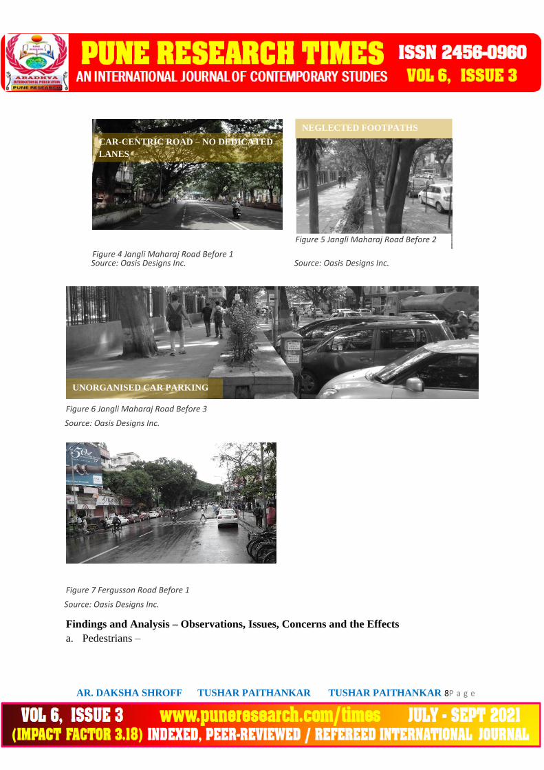
4.2.1 Jangli Maharaj Road and Fergusson College Road, Pune
Jangli Maharaj (JM) Road and Fergusson College (FC) Road are important arterial
roads in Pune. These roads run north-south and connect the Shivajinagar and Ganeshkhind
areas to the Deccan Gymkhana and old city areas. The area has a number of educational,
commercial and recreational establishments making these two roads one of the busiest in the
city.
Before
In February 2009, a one-way plan was proposed on these roads and was implemented
after a few months. Inadequate development of public transport infrastructure in the city had
resulted in rapid increase in the number of private vehicles and overall traffic congestion.
This resulted in a number of traffic jams which in turn made way for the one-way scheme to
improve the condition. But there was still a concern that this strategy would create even more
problems for all kinds of road users except motorists. The more space given to private
vehicles the more their number would increase on the street.
Source: Oasis Designs Inc.
Source: Oasis Designs Inc.
Source: Oasis Designs Inc.
Source: Oasis Designs Inc.
Source: Oasis Designs Inc.
Source: Oasis Designs Inc.
Source: Oasis Designs Inc.
Source: Oasis Designs Inc.
AR. DAKSHA SHROFF TUSHAR PAITHANKAR TUSHAR PAITHANKAR 8P a g e
Figure 4 Jangli Maharaj Road Before 1
Figure 5 Jangli Maharaj Road Before 2
Figure 6 Jangli Maharaj Road Before 3
Figure 7 Fergusson Road Before 1
Findings and Analysis – Observations, Issues, Concerns and the Effects
a. Pedestrians –
Source: Oasis Designs Inc.
Source: Oasis Designs Inc.
Source: Oasis Designs Inc.
Source: Oasis Designs Inc.
Source: Oasis Designs Inc.
Source: Oasis Designs Inc.
Source: Oasis Designs Inc.
Source: Oasis Designs Inc.
Source: Oasis Designs Inc.
Figure 6 Jangli Maharaj
Road Before 3Source: Oasis
Designs Inc.
Figure 6 Jangli Maharaj
Road Before 3Source: Oasis
Designs Inc.
Figure 7 Jangli Maharaj
Road Before 3Source: Oasis
Designs Inc.
CAR-CENTRIC ROAD – NO DEDICATED
LANES
Figure 2 Jangli Maharaj Road Before 1CAR-
CENTRIC ROAD – NO DEDICATED
LANES
Figure 4 Jangli Maharaj Road Before 1CAR-
CENTRIC ROAD – NO DEDICATED
LANES
Figure 3 Jangli Maharaj Road Before 1CAR-
CENTRIC ROAD – NO DEDICATED
LANES
NEGLECTED FOOTPATHS
Figure 4 Jangli Maharaj Road Before
2NEGLECTED FOOTPATHS
Figure 5 Jangli Maharaj Road Before
2NEGLECTED FOOTPATHS
Figure 5 Jangli Maharaj Road Before
2NEGLECTED FOOTPATHS
UNORGANISED CAR PARKING
UNORGANISED CAR PARKING
UNORGANISED CAR PARKING
UNORGANISED CAR PARKING
Source: Oasis Designs Inc.
Source: Oasis Designs Inc.
Source: Oasis Designs Inc.
Source: Oasis Designs Inc.

AR. DAKSHA SHROFF TUSHAR PAITHANKAR TUSHAR PAITHANKAR 9P a g e
i. Since the roads were made one-way, the dividers were demolished to make way
for more vehicles to pass unobstructed through the carriageway. This resulted in
continuous traffic flow at very higher speeds.
ii. The removal of dividers in the middle of the road endangered pedestrians further
since it removed the pedestrian refuge islands that earlier existed on the roads. At
crossings or intersections, it was of very little use.
b. Cyclists –
i. Cycle tracks were provisioned but were never included into the street section.
ii. Therefore, there was no distinctive space for cyclists and hence, they either had to
travel with the motorists or not use cycles at all.
iii. This increased the lack of safety and thus cyclists deemed the scheme undesirable
to commute.
c. Bus Users –
i. One-way traffic scheme increased the distance between two bus stops. Hence, the
bus commuters or any public transport users had to walk long distances to get to
the next bus stop.
ii. The old bus stops present when the roads were two-way became redundant on the
opposite side of one-way traffic, thus obstructing the pedestrian movement.
d. Motorists –
i. The speeds of the vehicles began to increase causing more fatalities on the roads.
ii. Even of the traffic police imposed the speed limit to 30km/hr, this was seldom
followed.
iii. The ever increasing use of private vehicles caused even more traffic congestion
than solve the existing one as predicted.
After
Under the Pune Streetscape Programme (PSP), complete reclamation of the streets
was carried out by Ar.Prasanna Desai Architects, Pune. With the one-way scheme still going
on, the streets have been reclaimed with space along the roads and repositioned them as
destination public spaces. The roads were designed to create cycle track and wide pedestrian
plaza spaces to allow people to walk around safely. Each street was being treated as a public
open space to integrate with all the public land uses adjoining the street be it a park, religious
plaza, destination places, landmark buildings, heritage objects, retail shops, etc. to create a
cohesive, all-inclusive connected public realm for the city. (Oasis Designs. Inc.) Pune is now
the first city to have a Comprehensive Bicycle Plan that was approved by the City’s
Municipal Council in 2017.

AR. DAKSHA SHROFF TUSHAR PAITHANKAR TUSHAR PAITHANKAR 10P a g e
Figure 8 Jangli Maharaj Road After 1 Figure 9 Jangli Maharaj Road After 2
Figure 10 Jangli Mahraj Road After 3
Figure 11 Fergusson Road After
Findings and Analysis – Observations, Issues,
Concerns and the Effects
a. Pedestrians –
i. Increased widths of footpaths along with various activities encouraging social
interaction, facilitated the feeling of safety and comfort for the pedestrians.
ii. These pathways and sidewalks are thus, adequate in catering to the future needs of
the people using them.
b. Cyclists –
i. Dedicated bike lanes and infrastructure facilitated the use of more bicycles and
thus led to a positive attitude towards the use of cycles.
ii. Large portions of ‘unbuilt’ reclaimed into available space for streetscape.
c. Bus Users –
i. Bus Stops and Bus lanes efficiently created that do not obstruct the flow of traffic
as well not hamper the pedestrian or the cycle track space.
ii. Safe refuge stops for bus commuters not in the way of the carriageway.
d. Motorists –
i. Sufficient parking for incoming vehicles provided.
ii. Clearly defined road edges and signages for road safety, and facilitate smooth
flow of vehicular traffic.
Source: Oasis Designs Inc.
Source: Oasis Designs Inc.
Source: Oasis Designs Inc.
Source: Oasis Designs Inc.
Source: Oasis Designs Inc.
Source: Oasis Designs Inc.
Source: Oasis Designs Inc.
Source: Oasis Designs Inc.
Source: Oasis Designs Inc.
Source: Oasis Designs Inc.
Source: Oasis Designs Inc.
Source: Oasis Designs Inc.
NEW MULTI-UTILITY ZONE
NEW MULTI-UTILITY ZONE
NEW MULTI-UTILITY ZONE
NEW MULTI-UTILITY ZONE
CYCLE TRACKS
CYCLE TRACKS
CYCLE TRACKS
CYCLE TRACKS
Source: Oasis Designs Inc.
Source: Oasis Designs Inc.
Source: Oasis Designs Inc.
Source: Oasis Designs Inc.

AR. DAKSHA SHROFF TUSHAR PAITHANKAR TUSHAR PAITHANKAR 11P a g e
Figure 12 Street Section
Figure 13 Copenhagen Cycle Track City Plan
4.2.2 Copenhagen
Cycling is an important means of transportation in Denmark. When the City of Copenhagen
introduced its Cycle Policy 2002-12, it had already introduced priority cycle lanes and green
cycle routes (Cycling infrastructure in Copenhagen, Centre for Public Impact). Cycle
planning is now a vital feature of urban development in Copenhagen.
In the 21st century city plans dealing specifically with cycling include –
The Copenhagen Cycle Policy (2002-2012).
The Copenhagen Transport and Environment Plan 2004.
Copenhagen Bicycle Strategy (2011-2025).
The Copenhagen Cycle Priority Plan (2006-2016).
(Urban Sustainability Exchange – Cycling in Copenhagen)
Source: Oasis Designs Inc.
Source: Oasis Designs Inc.
Source: Oasis Designs Inc.
Source: Oasis Designs Inc.

AR. DAKSHA SHROFF TUSHAR PAITHANKAR TUSHAR PAITHANKAR 12P a g e
Figure 14 Traditional Copenhagen Cycle Track Figure 15 Cycle Lane
The main principle for Copenhagen cycling infrastructure is that they have established cycle
tracks on both sides of all major roads. This means that cyclists have been allotted their own
dedicated space next to the footpaths and pavements. Cars are also parked on the outside of
the cycle tracks.
The very first cycle track in Copenhagen was established in 1905.2 Bicycle infrastructure in
Copenhagen currently includes approximately 350 kilometres of curb segregated cycle tracks,
23 kilometres of on-street cycle lanes and 43 kilometres of off-street green bicycle routes
running through parks and other green areas.
2 Jensen, N. (2013). Planning a Cycling Infrastructure, Cyclists & Cyclists around the World, Creating Liveable and Bikeable Cities
Source: Cyclists & Cycling Around the World –
Creating Liveable and Bikeable Cities
Source: Cyclists & Cycling Around the World –
Creating Liveable and Bikeable Cities
Source: Cyclists & Cycling Around the World –
Creating Liveable and Bikeable Cities
Source: Cyclists & Cycling Around the World –
Creating Liveable and Bikeable Cities
Source: Cyclists & Cycling Around the World –
Creating Liveable and Bikeable Cities
Source: Cyclists & Cycling Around the World –
Creating Liveable and Bikeable Cities
Source: Cyclists & Cycling Around the World –
Creating Liveable and Bikeable Cities
KERBS SEPARATE TRACKS
FROM PEDESTRIANS AND
MOTORISTS
KERBS SEPARATE TRACKS
FROM PEDESTRIANS AND
MOTORISTS
KERBS SEPARATE TRACKS
FROM PEDESTRIANS AND
MOTORISTS
KERBS SEPARATE TRACKS
FROM PEDESTRIANS AND
MOTORISTS
1.5M WIDE CYCLE LANE
SAFE AND SECURE
INTERSECTIONS
1.5M WIDE CYCLE LANE
SAFE AND SECURE
INTERSECTIONS
1.5M WIDE CYCLE LANE
SAFE AND SECURE
INTERSECTIONS
1.5M WIDE CYCLE LANE
SAFE AND SECURE
INTERSECTIONS
Source: Cyclists & Cycling Around the World –
Creating Liveable and Bikeable Cities
Source: Cyclists & Cycling Around the World –
Creating Liveable and Bikeable Cities
Source: Cyclists & Cycling Around the World –
Creating Liveable and Bikeable Cities
AR. DAKSHA SHROFF TUSHAR PAITHANKAR TUSHAR PAITHANKAR 13P a g e
Chart 1 Copenhagen Cycle Infrastructure
Chart 2 Copenhagen Modal Share
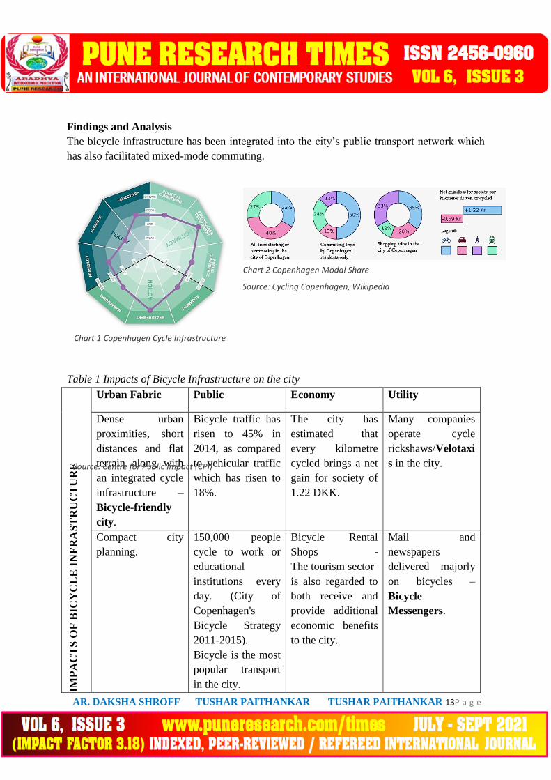
Findings and Analysis
The bicycle infrastructure has been integrated into the city’s public transport network which
has also facilitated mixed-mode commuting.
Table 1 Impacts of Bicycle Infrastructure on the city
IMP
AC
TS
OF
BIC
YC
LE
IN
FR
AS
TR
UC
TU
RE
Urban Fabric Public Economy Utility
Dense urban
proximities, short
distances and flat
terrain along with
an integrated cycle
infrastructure –
Bicycle-friendly
city.
Bicycle traffic has
risen to 45% in
2014, as compared
to vehicular traffic
which has risen to
18%.
The city has
estimated that
every kilometre
cycled brings a net
gain for society of
1.22 DKK.
Many companies
operate cycle
rickshaws/Velotaxi
s in the city.
Compact city
planning.
150,000 people
cycle to work or
educational
institutions every
day. (City of
Copenhagen's
Bicycle Strategy
2011-2015).
Bicycle is the most
popular transport
in the city.
Bicycle Rental
Shops -
The tourism sector
is also regarded to
both receive and
provide additional
economic benefits
to the city.
Mail and
newspapers
delivered majorly
on bicycles –
Bicycle
Messengers.
Source: Centre for Public Impact (CPI)
Source: Centre for Public Impact (CPI)
Source: Centre for Public Impact (CPI)
Source: Centre for Public Impact (CPI)
Source: Cycling Copenhagen, Wikipedia
Source: Centre for Public Impact (CPI)
Source: Centre for Public Impact (CPI)
Source: Centre for Public Impact (CPI)

AR. DAKSHA SHROFF TUSHAR PAITHANKAR TUSHAR PAITHANKAR 14P a g e
Figure 16 Cycle Tracks at Crossings 1 Figure 17 Cycle Tracks at Crossings 2
With the advent of the use of cycles in Copenhagen, the Government and other officials have
successfully incorporated the cycling infrastructure into the city’s planning. The upgradation
and maintenance has led to the expansion of the cycling infrastructure into the most sought
after and chosen mode of transport for the citizens.
5.0 COMPARATIVE ANALYSIS –
Table 2 Comparative Analysis of Case Studies
PUNE COPENHAGEN
3-4M WIDE CYCLE TRACKS
BLUE STRIP INDICATES
EXPANSION OF TRACK
3-4M WIDE CYCLE TRACKS
BLUE STRIP INDICATES
EXPANSION OF TRACK
3-4M WIDE CYCLE TRACKS
BLUE STRIP INDICATES
EXPANSION OF TRACK
3-4M WIDE CYCLE TRACKS
BLUE STRIP INDICATES
EXPANSION OF TRACK
Source: Cyclists & Cycling Around the World –
Creating Liveable and Bikeable Cities
Source: Cyclists & Cycling Around the World –
Creating Liveable and Bikeable Cities
Source: Cyclists & Cycling Around the World –
Creating Liveable and Bikeable Cities
Source: Cyclists & Cycling Around the World –
Creating Liveable and Bikeable Cities
DANISH LEFT TURNING RULE
KEEPS CYCLIST TO THE
RIGHT BEFORE TURNING
LEFT.
DANISH LEFT TURNING RULE
KEEPS CYCLIST TO THE
RIGHT BEFORE TURNING
LEFT.
DANISH LEFT TURNING RULE
KEEPS CYCLIST TO THE
RIGHT BEFORE TURNING
LEFT.
DANISH LEFT TURNING RULE
KEEPS CYCLIST TO THE
RIGHT BEFORE TURNING
LEFT.
Source: Cyclists & Cycling Around the World –
Creating Liveable and Bikeable Cities
Source: Cyclists & Cycling Around the World –
Creating Liveable and Bikeable Cities
Source: Cyclists & Cycling Around the World –
Creating Liveable and Bikeable Cities
Source: Cyclists & Cycling Around the World –
Creating Liveable and Bikeable Cities

AR. DAKSHA SHROFF TUSHAR PAITHANKAR TUSHAR PAITHANKAR 15P a g e
PR
EC
INC
T
F.C. Road and J.M. Road
Entire City
PE
RC
EN
TA
GE
OF
CY
CL
IST
S
AR
EA
S
Jangli Maharaj (JM) Road – 1.87 Km.
Fergusson College Road –
2.4 Km.
Entire City
Approximately 350 kilometres of
curb segregated cycle tracks, 23
kilometres of on-street cycle lanes and
43 kilometres of off-street green bicycle
routes running through parks and other
green areas.
There are 675,000 bicycles and just
120,000 cars in Copenhagen, meaning
bikes outnumber cars by more than
five-to-one.
There are 675,000 bicycles and just
120,000 cars in Copenhagen, meaning
bikes outnumber cars by more than
five-to-one.
There are 675,000 bicycles and just
120,000 cars in Copenhagen, meaning
bikes outnumber cars by more than
five-to-one.
There are 675,000 bicycles and just
120,000 cars in Copenhagen, meaning
bikes outnumber cars by more than
Only 18% of the people use cycle
tracks in the city. The cycle culture has
begun to take effect in the city and
needs to expand extensively.
Only 18% of the people use cycle
tracks in the city. The cycle culture has
begun to take effect in the city and
needs to expand extensively.
Only 18% of the people use cycle
tracks in the city. The cycle culture has
begun to take effect in the city and
needs to expand extensively.
Only 18% of the people use cycle
tracks in the city. The cycle culture has
begun to take effect in the city and

AR. DAKSHA SHROFF TUSHAR PAITHANKAR TUSHAR PAITHANKAR 16P a g e
IMP
AC
TS
IN
UR
BA
N F
AB
RIC
The new development has caused
increase in footfall with the
reclamation of the edge of the roads.
Recreational hub, educational hub,
commercial hub.
New infrastructure acts as a catalyst
for urban change.
Dense urban proximities, short
distances and flat terrain along with
an integrated cycle infrastructure –
Bicycle-friendly city.
Compact city planning.
5.1 FINDINGS AND INFERENCES –
From the above case studies, integration of pedestrians, cyclists, transit users and
motorists in a balanced manner without increasing any traffic conflict is essential for a
successful facilitation of transport planning. Even though bicycles have existed for a long
time, it took until 1970s for transportation authorities to inculcate and embrace cycling
infrastructure as part of the comprehensive road strategy.
Multi-Utility Zone –
The concept of Multi-Utility Zone seems to have been successfully implemented in
these cities. All the elements on the street are organised in a dedicated space which results in
obstruction-free streets.
Table 3 Multi-Utility Zone
Verge Greens and Pavements (with parking) Greens and Pavements (without
parking)
Width 3M wide footpath.
2.5M wide cycle track.
MUZ parking at intervals.
3M wide footpath.
2.5M wide cycle track.
AR. DAKSHA SHROFF TUSHAR PAITHANKAR TUSHAR PAITHANKAR 17P a g e
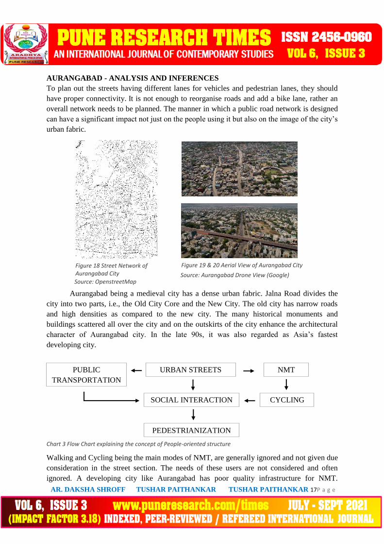
Figure 18 Street Network of Aurangabad City
Figure 19 & 20 Aerial View of Aurangabad City
AURANGABAD - ANALYSIS AND INFERENCES
To plan out the streets having different lanes for vehicles and pedestrian lanes, they should
have proper connectivity. It is not enough to reorganise roads and add a bike lane, rather an
overall network needs to be planned. The manner in which a public road network is designed
can have a significant impact not just on the people using it but also on the image of the city’s
urban fabric.
Aurangabad being a medieval city has a dense urban fabric. Jalna Road divides the
city into two parts, i.e., the Old City Core and the New City. The old city has narrow roads
and high densities as compared to the new city. The many historical monuments and
buildings scattered all over the city and on the outskirts of the city enhance the architectural
character of Aurangabad city. In the late 90s, it was also regarded as Asia’s fastest
developing city.
Walking and Cycling being the main modes of NMT, are generally ignored and not given due
consideration in the street section. The needs of these users are not considered and often
ignored. A developing city like Aurangabad has poor quality infrastructure for NMT.
Source: OpenstreetMap
Source: OpenstreetMap
Chart 3 Flow Chart
explaining the concept of
People-oriented
structureSource:
OpenstreetMap
Source: OpenstreetMap
Source: Aurangabad Drone View (Google)
Source: Aurangabad Drone View (Google)
Source: Aurangabad Drone View (Google)
Source: Aurangabad Drone View (Google) URBAN STREETS
URBAN STREETS
URBAN STREETS
URBAN STREETS
SOCIAL INTERACTION
SOCIAL INTERACTION
SOCIAL INTERACTION
SOCIAL INTERACTION
PEDESTRIANIZATION
PEDESTRIANIZATION
PEDESTRIANIZATION
PEDESTRIANIZATION
PUBLIC
TRANSPORTATION
PUBLIC
TRANSPORTATION
PUBLIC
TRANSPORTATION
PUBLIC
TRANSPORTATION
NMT
NMT
NMT
NMT
CYCLING
CYCLING
CYCLING
CYCLING
Chart 3 Flow Chart explaining the concept of People-oriented structure

AR. DAKSHA SHROFF TUSHAR PAITHANKAR TUSHAR PAITHANKAR 18P a g e
Figure 21 Jalna Road, Aurangabad Figure 22 Kranti Chowk FlyOver, Aurangabad
Dedicated corridors are largely absent, and where they exist, they are often at high risks of
being encroached upon for commercial purposes or used for the widening of motorised
carriageways.3 Although it is agreeable that what has been implemented in one place may not
necessarily work here or elsewhere. Thus, instead of implementing the network as a whole,
an incremental or piecemeal approach as a mobility plan can be taken into action. Active
transportation will only then occur when emphasis is made on the smooth movement between
places by any mode of transport.
Even a Tier II city of Aurangabad, priority to transport infrastructure that may help in
decongesting the city should be effectively given, or else migration from these type of small
towns to Tier I cities may cause them to suffer from inadequateness of infrastructure. While
different kinds of infrastructure are required to facilitate efficient running of the urban areas,
it is largely the transportation sector that makes or mars quality of life of city dwellers.4
Instead of road widening or building flyovers which means adding to the already existing
congestion, following the National Urban Transport Policy (NUTP) of minimizing use of
personal motorised vehicles can be one of the first steps to decongestion on the streets. There
is rapid urbanisation happening all over the world and Aurangabad is no exception to the
effect. The right approach is to provide for an improved public transport and NMT mobility.
In the old core of the city, with the dense fabric of narrow roads and high density, traffic
congestion arises as the roads are not able to move a large number of vehicles during the
major part of the day. Furthermore, lack of proper pedestrian facilities and bus lanes cause an
additional chaos as all the users merge into one carriageway. Vehicular parking obstructs the
movement as well. But these compact urban blocks with high density are suitable for the
implementation of the NMT as they provide the ideal distances for walking and bicycling.
The argument then remains of how can the excess traffic be minimized so as to improve the
existing mobility conditions of the old city.
3 Singh, K. (Oct 2018). Mobility & NMT in Sustainable Urban Development – Role of City Developers, Eleventh Regional EST Forum in Asia (Mongolia). 4 Badami, S. (Jan 2012). Inherent competitive advantage Tier 2 and Tier 3 cities possess, MoneyLife, CITIZENS'
ISSUES.
Source: Google
Source: Google
Source: Google
Source: Google
Source: Google
Source: Google
Source: Google
Source: Google
AR. DAKSHA SHROFF TUSHAR PAITHANKAR TUSHAR PAITHANKAR 19P a g e
Figure 23 Traffic Chaos - No organization or dedicated lanes. - Aurangabad
Figure 24 Motorists taking up the majority of the road. - Aurangabad
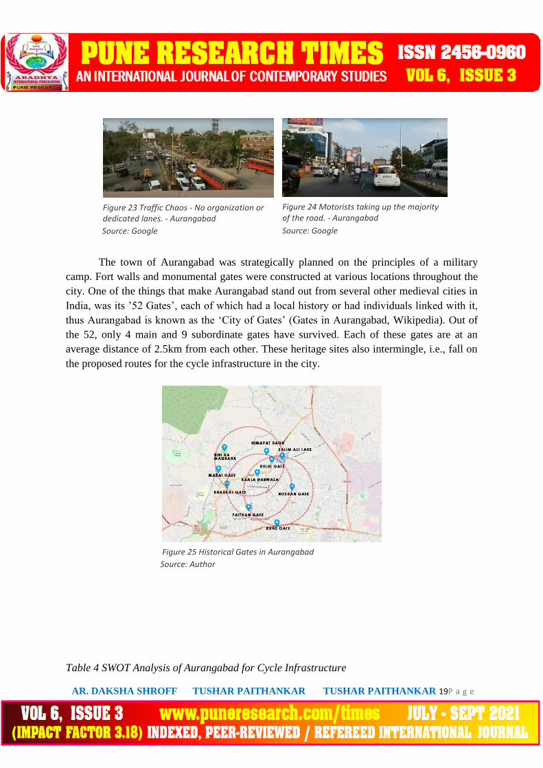
Figure 25 Historical Gates in Aurangabad
The town of Aurangabad was strategically planned on the principles of a military
camp. Fort walls and monumental gates were constructed at various locations throughout the
city. One of the things that make Aurangabad stand out from several other medieval cities in
India, was its ’52 Gates’, each of which had a local history or had individuals linked with it,
thus Aurangabad is known as the ‘City of Gates’ (Gates in Aurangabad, Wikipedia). Out of
the 52, only 4 main and 9 subordinate gates have survived. Each of these gates are at an
average distance of 2.5km from each other. These heritage sites also intermingle, i.e., fall on
the proposed routes for the cycle infrastructure in the city.
Table 4 SWOT Analysis of Aurangabad for Cycle Infrastructure
Source: Google
Source: Google
Source: Google
Source: Google
Source: Google
Figure 8 Historical Gates in
AurangabadSource: Google
Source: Author

AR. DAKSHA SHROFF TUSHAR PAITHANKAR TUSHAR PAITHANKAR 20P a g e
STRENGTHS WEAKNESSES
Strong industrial base – 4 MIDC areas –
Waluj, Chikalthana, Shendra and
Railway Station.
IT Parks and Special Economic Zones
(SEZ) creating huge employment
opportunities.
Gateway to UNESCO Heritage Sites
and forms a part of ‘Mega Tourism
Circuit’.
Urban mobility heavily dependent on
private vehicles, giving significant rise
to chaos on urban roads.
Lack of pedestrian infrastructure and
public transport.
Uncontrolled and unplanned
development of the urban sprawl.
OPPORTUNITIES THREATS
The Nagpur-Aurangabad-Mumbai super
corridor project under implementation
will boost regional connectivity and
economic development.
Implementation of better public
transport will improve urban mobility.
Maintenance and upgradation of the
developing infrastructure.
Might increase the probability of
migration to other developed urban
areas.
To have self-regulating streets will also decide where our urban mobility is headed. Since
cycling has a close to zero environmental impact and provides cost mobility, the following
table shows an assessment of the condition of cycle as a mode of transport in the city of
Aurangabad and relevant recommendations are provided to cater to the issues and concerns
for improving and executing an effective cycle-inclusive planning.
Table 5 Assessment of the condition of cycle as a mode of transport
OWNERSHIP OF BICYCLES
PROBLEM Affordability issue for low
income households. Finance
for purchase of cycles is not
available. – Decline in
ownership of cycles.
Source: Aurangabad Smart City Plan (Round 2)

AR. DAKSHA SHROFF TUSHAR PAITHANKAR TUSHAR PAITHANKAR 21P a g e
RECOMMENDATION Government schemes
with exemption of taxes
on the purchase of
cycles to the low income
groups.
Increase ownership of
cycles by school
children – easy access to
bicycles and promotion
of sustainable mode if
transport as well as cost
effective.
USE OF BICYCLES
PROBLEM Lack of safety, lack of
innovative cycle schemes,
bike culture – use of cycles
limited – seen as only a poor
man’s mode of transport –
Decline in the use of
bicycles.
RECOMMENDATION Promotion of cycle
infrastructure – cycle
tracks on all arterial and
sub-arterial roads along
with a safe interface
with the motorists.
Ensure that road design
and city mobility
networks include cycle
tracks as a key element.
FUNDING AND POLICIES
PROBLEM Policies and Schemes
implemented, yet cycle
infrastructure not given due
recognition into the urban
planning.
Inadequate funding from the

AR. DAKSHA SHROFF TUSHAR PAITHANKAR TUSHAR PAITHANKAR 22P a g e
Government.
RECOMMENDATION Make NMT a mandatory
requirement – through
schemes like JNNURM,
NUTP Policy, ensure
provision of cycle
infrastructure
imperative.
Urban Transport related
projects – NMT costs
included into the overall
costs of the projects.
AWARENESS CAMPAIGNS AND PROMOTIONS
PROBLEM Cycle is still seen as a low
income group mode of
transport. Bike culture
limited to certain percentage
of the population.
RECOMMENDATION Mass Awareness
Campaigns can be held
by State Governments
explaining the benefits
of cycling – health and
welfare, environmental,
social and economic.
Change of modal choice.
6.0 CONCLUSION
This study will help us to design bicycle track and pedestrization for any tier two cities in
India. Study will help us to understand the people and urban fabric of the city. After studying
these points success rate of any project will be maximum.
Source: TERI

AR. DAKSHA SHROFF TUSHAR PAITHANKAR TUSHAR PAITHANKAR 23P a g e
REFERENCES
(TOI), T. o. (2017, February 12). AMC to build 1.5 km long cycle track. Retrieved from
Times News Network (TNN): https://timesofindia.indiatimes.com/city/aurangabad/amc-to-
build-1-5-km-long-cycle-track/articleshow/57102274.cms
Angela Hull, C. O. (October 2014). Bicycle infrastructure: can good design encourage
cycling? Urban, Planning and Transport Research, 39.
Ann Forsyth, K. K. (November 2011). Urban Design: Is There a Distinctive View from the
Bicycle? Journal of Urban Design, Vol. 16. No. 4, 531–549, 19.
Badami, S. (2012, January 11). Inherent competitive advantage Tier 2 and Tier 3 cities
possess. Retrieved from Moneylife.in: https://www.moneylife.in/article/inherent-competitive-
advantage-tier-2-and-tier-3-cities-possess/22869.html
Bloomingrock. (2017). 7 Reasons to Fund Bicycle Infrastructure. Retrieved from
Smartcitiesdive: https://www.smartcitiesdive.com/ex/sustainablecitiescollective/7-reasons-
fund-bicycle-infrastructure/268971/
Cycling infrastructure. (2020, December 1). Retrieved from Wikipedia:
https://en.wikipedia.org/wiki/Cycling_infrastructure#searchInput
Government, E. (2020, October 12). Aurangabad pedals cycle track project into fast lane
under Smart Cities Mission. Retrieved from ETGovernment.com:
https://government.economictimes.indiatimes.com/news/smart-infra/aurangabad-pedals-
cycle-track-project-into-fast-lane-under-smart-cities-mission/78617034
Group, U. D. (2018). Streetscapes. Urban Design Group Journal, 60.
Hampus Ekblad, Å. S. (2016). Bicycle planning in an urban context - A literature review.
Lund: Lund University.
Innovative Transport Solutions (iTrans), P. D. (December 2017). Urban Cycling Design
Guidelines (UCDG). Pune: Pune Municipal Corporation (PMC).
Institute for Transportation & Development Policy (ITDP), P. F. (2016). Urban Street Design
Guidelines (USDG). Pune: Pune Municipal Corporation (PMC).
Institute, T. -T. (2014). Pedalling towards a Greener India - A report on promoting cycling in
the country. New Delhi: TERI - The Energy and Resources Institute.

AR. DAKSHA SHROFF TUSHAR PAITHANKAR TUSHAR PAITHANKAR 24P a g e
Kumar, M. P. (2018, August 18). Bike sharing is good, but will big city residents risk cycling
to their destinations? Retrieved from Citizen Matters: https://citizenmatters.in/nmt-cycling-
safety-cars-bike-sharing-7150
Lutogniewska, E. (2014). Developing Bicycle Culture in a city prioritizing automobiles.
Malmö: Faculty of Culture and Society - Department of Urban Studies, Malmö University.
Meschik, M. (2012). Reshaping City traffic towards sustainability. Vienna: Procedia - Social
and Behavioral Sciences.
R.U.Kharat, D. (March 2018). Spatio-Temporal Analysis of Urban Population Growth and
Distribution in Aurangabad City. Internation Jounral of Research in Social Sciences - Vol.8,
Issue 3, 13.
RelianceFoundryCo.Ltd. (n.d.). Bike Infrastructure: An Essential Guide. Retrieved from
RelianceFoundryCo.Ltd:
https://www.reliance-foundry.com/blog/bikeways-bike-infrastructure#gref
Singh, K. (October 2018). Mobility and NMT in Sustainable Urban Development - Role of
City Developers. Mongolia: Eleventh Regional EST Forum in Asia.
Troels Andersen, O. M. (2019, May 9). Cycling infrastructure – planning for the future of
cyclists in your city. Retrieved from Cycling Embassy of Denmark:
https://cyclingsolutions.info/cycling-infrastructure-planning-for-the-future-of-cyclists-in-
your-city/
Vaidya, J. (2020, October 7). Conservation of Streets-Reaffirming Sense of Place: Mathura.
Retrieved from KRVIA:
https://betweenarchitectureandurbanism.com/2020/10/07/conservation-of-streets-reaffirming-
sense-of-place-mathura/
Wikipedia. (2019, September 4). Gates in Aurangabad. Retrieved from Wikipedia:
https://en.wikipedia.org/wiki/Gates_in_Aurangabad#searchInput