Embed Size (px)
Citation preview
January 19, 2018 via e-mail ([email protected]) CCTA File 114239 Sam Greenwood Greenwood Aggregates 205467 County Road 109 Amaranth, ON L9W 0V1 Re: Violet Hill Pit – Part Lots 30, 31, 32, Concession 4 E.H.S., Town of Mono Erosion Hazard Study - Update Dear Sam:
C.C. Tatham & Associates Ltd. (CCTA) has been retained by Greenwood Construction to establish the
erosion hazard limit associated with the watercourses and steep slopes on the proposed Violet Hill Pit
property. In June 2015, CCTA prepared an Erosion Hazard Study identifying the erosion hazard limit
and consequently the limit of extraction along the westerly boundary of the subject lands. It is understood
that R.J. Burnside has reviewed the Erosion Hazard Study on behalf of the Town of Mono and were in
agreement with its conclusions. However, the report was prepared prior to the relocation of the proposed
access roadway off of 3rd Line and R.J. Burnside have requested a review and comment on the potential
impacts of the new entrance on the erosion hazards.
We understand the proposed access roadway is to be an 8.0 m paved roadway that will enter the site
off 3rd Line in the northwest corner of the property. The roadway will run southeast to the proposed
stationary crushing and screening area through a natural draw in the topography. The roadway will be
constructed from the 3rd Line to an elevation of 424 m; equal the bottom of the first lift of excavation; as
per the plans attached.
To construct the roadway, there will be areas requiring fill and cut to achieve the optimum design grades.
In areas where fill is required to achieve grade, the existing slope will be maintained. In areas of cut,
excavation will occur to construct the roadway and 3:1 (horizontal:vertical) stable slopes will be
constructed from the roadway to existing grade. The constructed stable cut/fill slopes will be protected
from erosion to the satisfaction of the Town of Mono.
As the access roadway is being constructed through a natural draw, surface runoff is expected to drain
toward the roadway. As such, ditches are proposed on both sides of the roadway to convey surface
runoff off-site. The ditches will be armoured as required to prevent erosion to the satisfaction of the
Sam Greenwood Greenwood Aggregates
Page 2 of 2 January 19, 2018
Town of Mono. It is noted that the ditches will only convey surface runoff off-site from the existing draw
outside the extraction limit. All surface runoff from the proposed pit (within the extraction limit) will drain
internally.
We have updated our erosion hazard study to account for the proposed access roadway and constructed
stable slopes. In areas requiring fil, the existing slope will be maintained along with the existing erosion
hazard limit. In areas of cut, the roadway is lower than existing grade and the constructed stable slope
will extend further inland towards the proposed extraction area. As such, the erosion hazard limit has
the potential to change depending on the location of the roadway. The same methodology previously
applied to the site was used to establish the new erosion hazard limit.
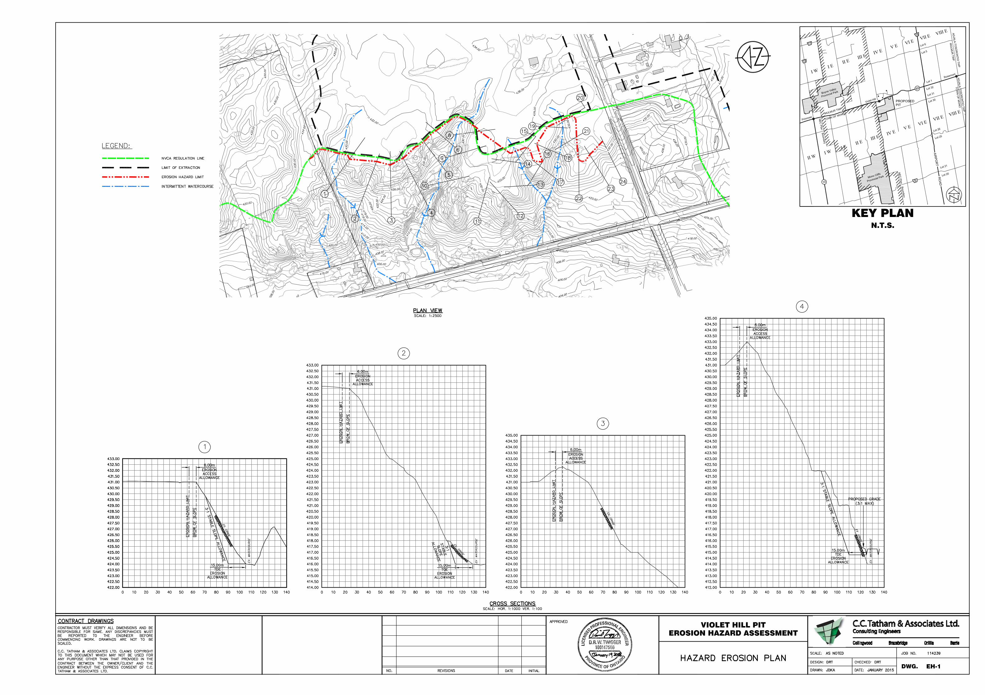
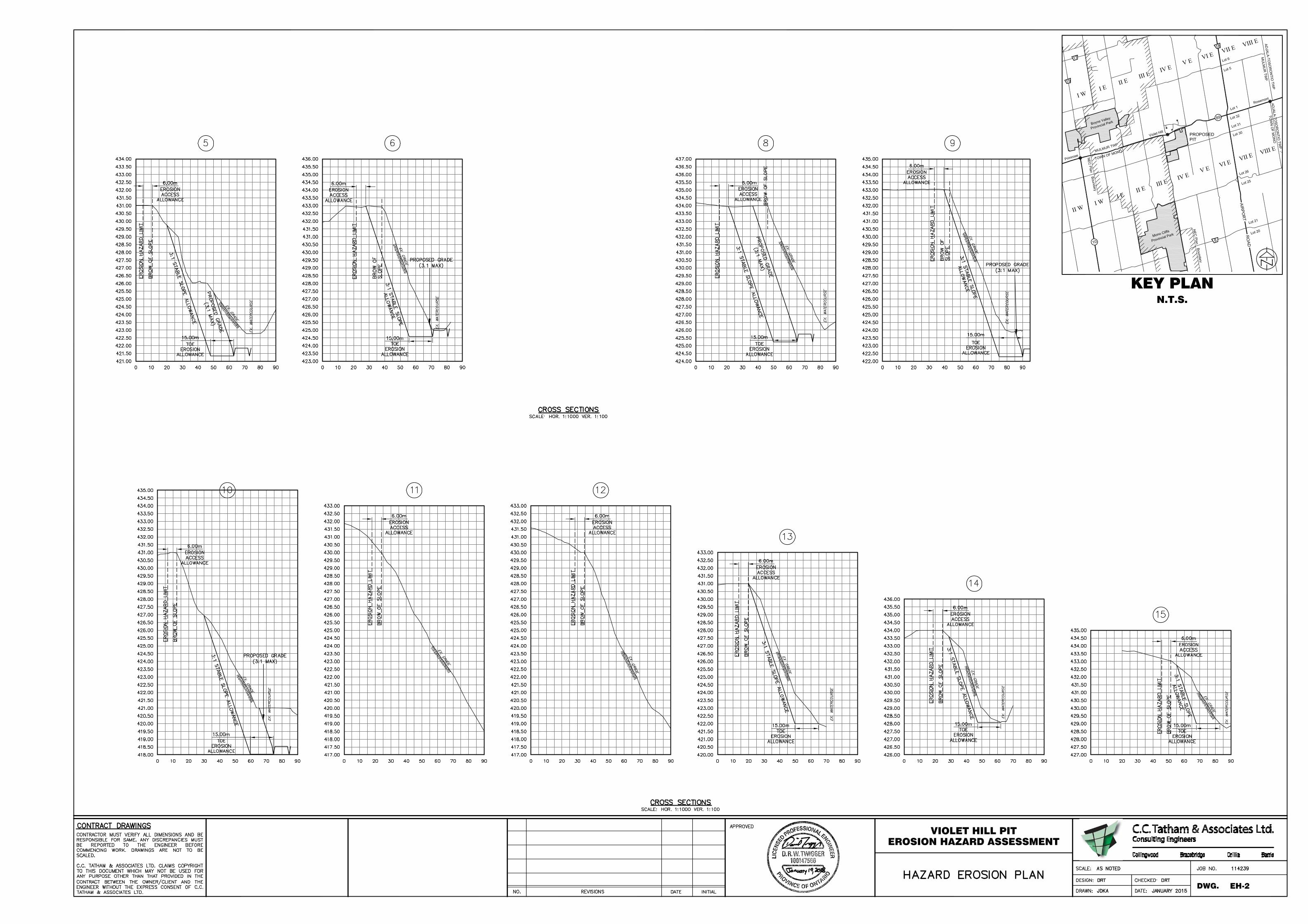
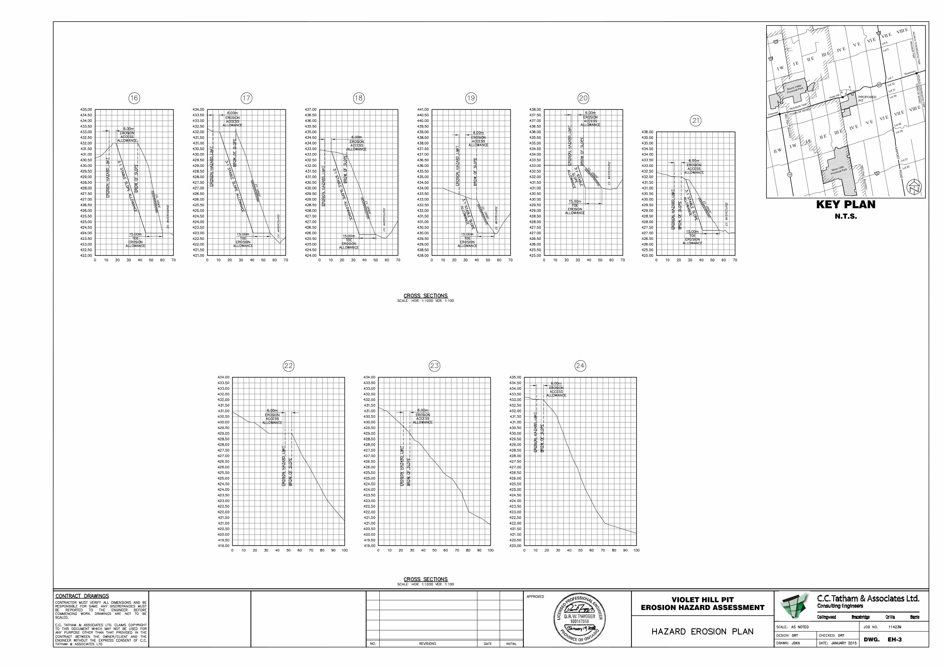
Borehole logs for the site indicate that the site soils are primarily sand. Given the site soils, a
conservative toe erosion allowance of 15.0 m was applied. The stable slope allowance for this
assessment has been defined as a horizontal distance equal to three (3) times the height of slope
measured farther landward from the toe erosion allowance. Similarly, a 6 m erosion access allowance
has been used at the top of slope for this assessment as recommended in the Technical Guide. For
many of the cross-sections, the existing slope was shallower than the stable slope and the brow of slope
was beyond the stable slope allowance. To be conservative, the 6 m erosion access allowance was
added to the brow of the existing stable slope. Delineation of the revised erosion hazard limit to reflect
the new entrance location is illustrated on the Erosion Hazard Plans (Drawings EH-1 to EH-3) enclosed.
We trust that this Erosion Hazard Assessment and the enclosed Erosion Hazard Plans (Drawings EH-1
to EH-3) is sufficient for NVCA review and approval. In the meantime, if you have questions or concerns,
please do not hesitate to contact the undersigned.
Yours truly, C.C. Tatham & Associates Ltd. Daniel Twigger, B.Sc.Eng., P.Eng. Senior Engineer, Project Manager DRT:df
I:\2014 Projects\114239 - Violet Hill, Mono Twp\Documents\Correspondence\L002 - Erosion Hazard Assessment - Violet Hill.docx
April 20, 2018 via e-mail ([email protected]) CCTA File 114239 Sam Greenwood Greenwood Aggregates 205467 County Road 109 Amaranth, ON L9W 0V1 Re: Violet Hill Gravel Pit, Part Lots 30, 31, 32, Concession 4EHS, Town of Mono Third Line Entrance Drainage Review Dear Sam:
As requested, C.C. Tatham & Associates Ltd. (CCTA) has completed an assessment of the potential drainage implications associated with constructing the access road to the pit as proposed off Concession 3. The plan and profile and road cross-section for this access road construction has previously been submitted in support of the pit application and is enclosed.
We note that the design and construction of the access road should be completed in such a manner that drainage patterns are generally maintained and that drainage is conveyed to the same outlets that it does during existing conditions. Furthermore, the drainage design should be implemented to ensure that erosion is not exasperated and an appropriate level of treatment is provided.
Site Location
The development site is located on the south side of Highway 89 between 3rd Line East and 4th Line East in the Town of Mono, Dufferin County. The site is bounded by each of the noted roads and is also bisected by 30 Sideroad. The site constitutes part lots 30, 31 and 32 of Concession 4. Access to the site has been identified off Concession 3 approximately 480 m south of Highway 89.
Existing Drainage Conditions
Drainage in the area of the proposed access road drains east to west via overland flow through a natural draw in the topography to Concession 3. A culvert conveys the surface runoff under Concession 3 and the surface runoff ultimately drains into Sheldon Creek to the east.
Sam Greenwood Greenwood Aggregates
Page 2 of 3 April 20, 2018
The subject property is separated from Sheldon Creek by Concession 3 and is not located in the floodplain of Sheldon Creek (a permanent watercourse). Further, in consultation with the Niagara Escarpment Commission, it was confirmed that the east boundary of their plan area coincides with the west right-of-way of 3rd Line east. As a result, there are no changes proposed to the lands under the jurisdiction of the Niagara Escarpment Commission.
Proposed Condition
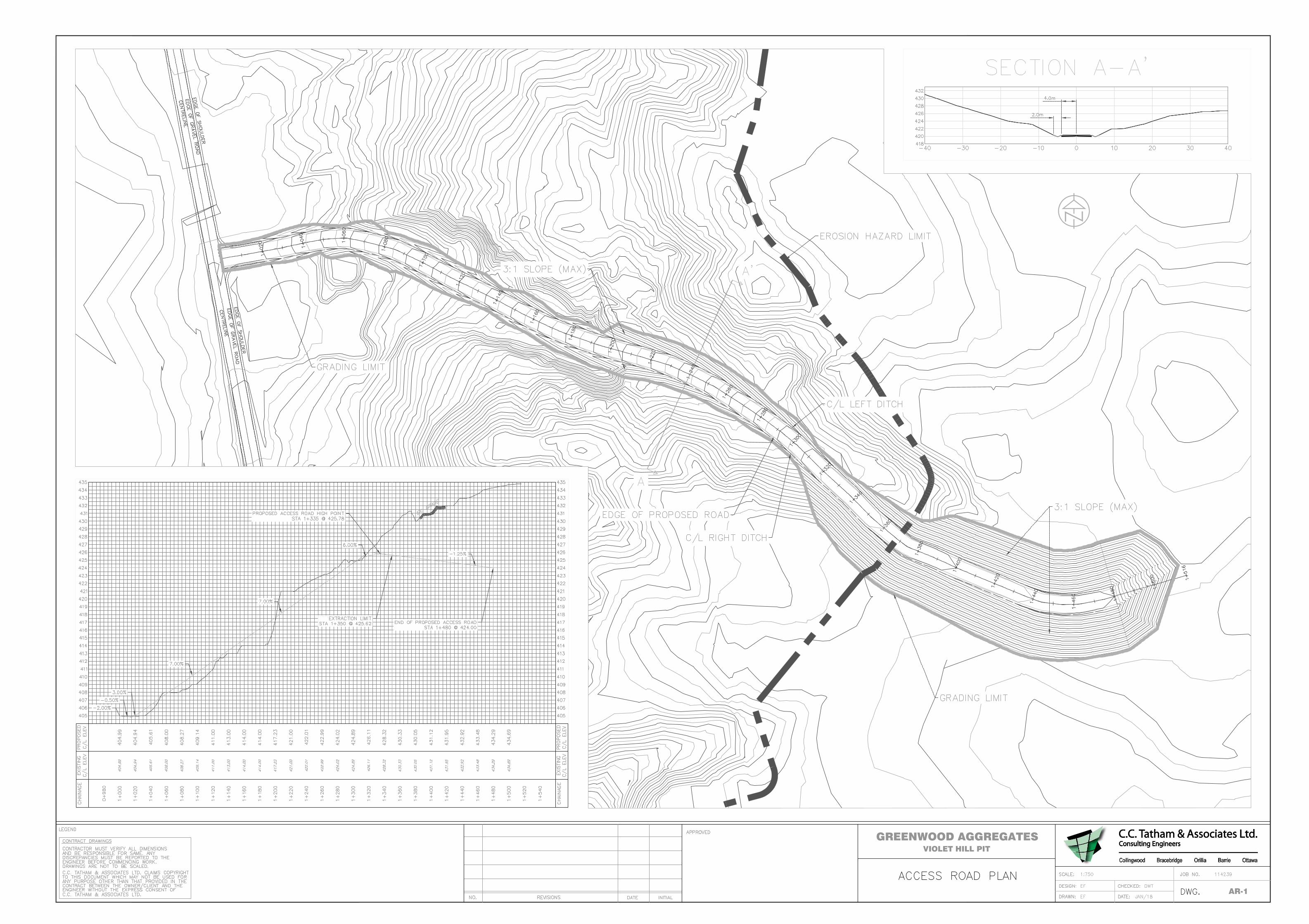
The design of the access road has been completed by CCTA and is illustrated on the Access Road Plan (Drawing AR-1) enclosed. The access road enters the site and traverses up the natural draw in the topography at a slope of approximately 7% until it reaches the floor of the first phase of extraction.
Drainage from the area of the access roadway will continue to be directed from east to west down the natural draw in the topography through constructed swales/ditches adjacent to the access roadway towards Concession 3 as it does currently. The surface runoff will continue to drain to the culvert under Concession 3 and ultimately to Sheldon Creek in a manner mimicking existing conditions. The total drainage area draining to the culvert will be less under proposed conditions than existing conditions due to the proposed access road construction.
The driveway location has been selected to follow the natural draw in the topography. This location was selected because there is already an existing entrance constructed off Concession 3 and driveway has been partially constructed through the natural draw.
To ensure no erosion occurs along the driveway path, appropriate erosion control measures will be installed in the roadside ditches along the access roadway. Where necessary rip-rap protection in the ditches will be provided to prevent erosion and grassed ditches will be stabilized with seed, mulch and erosion control matting to ensure no erosion occurs. The establishment of a vegetated and stable grassed slope adjacent to the driveway will be important to ensure the maintenance of the drainage condition in a manner that protects existing water quantity and quality.
There is not expected to be an increase in the quantity of drainage to Concession 3 as the overall drainage are is reduced under proposed conditions. Nonetheless, an additional measure is proposed to provide further erosion and quantity control. This includes installing rock check dams in the ditches as per OPSD 219.21 (approximately every 20 m or as required) to promote the filtration of water and reduce the velocities and volumes of runoff. This will further ensure runoff is conveyed to the Concession 3 ditch in a manner that mimics existing conditions.
Summary
Based on our review, the entrance road can be implemented in a manner that does not adversely affect the area surface water resources provided proper implementation of erosion control measures occurs during construction. In closing, we trust that the above has confirmed that drainage generated
Sam Greenwood Greenwood Aggregates
Page 3 of 3 April 20, 2018
from the proposed access road will not adversely affect the adjacent drainage systems. If you have any questions or comments on the above please do not hesitate to contact the undersigned.
Yours truly, C.C. Tatham & Associates Ltd.
For: Dan Hurley, B.A.Sc., P.Eng., LEED AP Vice President, Manager – Water Resources Engineering DJH:rlh Copy: Craig Laing, Aggregate Management Services, via e-mail ([email protected]) I:\2014 Projects\114239 - Violet Hill, Mono Twp\Documents\Correspondence\L - Greenwood001 - Entrance Drainage Review.doc
VIOLET HILL PITGREENWOOD AGGREGATES
AR-1

![Telecommunication Products - Trendtek jointing pits.pdf · [01] UG2006 - P6 Pit UG2007 - P7 Pit UG2008 - P8 Pit UG2900 - P9 Pit UG2001 - P1 Pit UG2002 - P2 Pit UG2003 - P3 Pit UG2004](https://img.pdfslide.net/doc/110x75/5a7969077f8b9ab9308d3433/telecommunication-products-jointing-pitspdf01-ug2006-p6-pit-ug2007-p7-pit.jpg)