Embed Size (px)
Citation preview
RE-VISION PROSPECT PLAZAA COMMUNITY PLANNING WORKSHOP | JUNE 2010
RE-VISION PROSPECT PLAZAA COMMUNITY PLANNING WORKSHOP | JUNE 2010
A COMMUNITY PLANNING WORKSHOP | JUNE 2010RE-VISION PROSPECT PLAZA
saturday june 5 | monday june 7 | tuesday june 8
ocean hill – brownsville, brooklyn
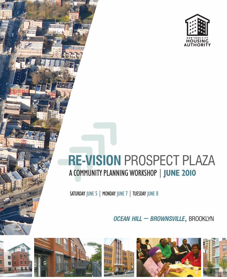
Workshop Program
All programmed activities will be held at Van Dyke Community Center, 392 Blake Avenue, Brooklyn
DAY 1 SATURDAY, JUNE 5Morning Session: 9:00 AM - 12:30 PM
• Registration and Breakfast• Overview of the Day• Welcoming Remarks (NYCHA Leadership and Elected Officials)• Site Tour
Lunch: 12:30 PM – 1:00 PM
Afternoon Session: 1:00 PM – 5:00 PM
• Re-Vision Prospect Plaza – Introduction• Workshop Structure• Workshop Session I• Presentations and Discussion• Conclusions
DAY 2 MONDAY, JUNE 7Evening Session: 5:00 pm – 9:00 pm (food and refreshments will be provided)
• Presentation of Preliminary Design Options• Workshop Session II• Presentations and Discussion• Summary
DAY 3 TUESDAY, JUNE 8Evening Session: 6:00 pm - 8:00 pm (food and refreshments will be provided)
• Preferred Design Option - Final Presentation to Stakeholders• Comments and Closing Remarks
Table of Contents
Introduction: Re-Vision Prospect Plaza ............................................ 1 - 2
Ocean Hill – Brownsville History ...................................................... 3
New York City Housing Authority (NYCHA) in Brooklyn’s Community District 16 ................................................ 4
New Affordable Housing 1988 - 2009 .............................................. 5 - 6
HOPE VI Program ............................................................................. 7
Prospect Plaza HOPE VI Plan ........................................................... 8
Prospect Plaza HOPE VI Plan - Completed Phases .......................... 9 - 10
Land Use .......................................................................................... 11 - 12
Zoning .............................................................................................. 13 - 14
Community Resources ..................................................................... 15 - 16
Public Transportation ....................................................................... 17
Major Traffic Routes ......................................................................... 18
Demographics & General Housing Data ........................................... 19
Acknowledgements .......................................................................... 20
1
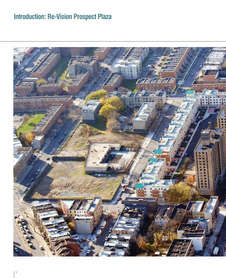
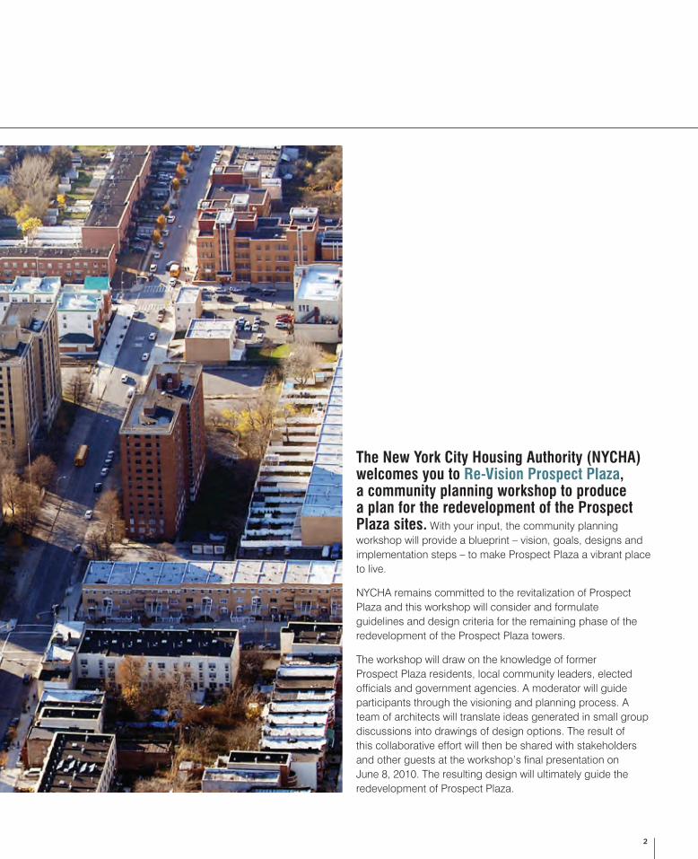
Introduction: Re-Vision Prospect Plaza
2
The New York City Housing Authority (NYCHA) welcomes you to Re-Vision Prospect Plaza, a community planning workshop to produce a plan for the redevelopment of the Prospect Plaza sites. With your input, the community planning workshop will provide a blueprint – vision, goals, designs and implementation steps – to make Prospect Plaza a vibrant place to live.
NYCHA remains committed to the revitalization of Prospect Plaza and this workshop will consider and formulate guidelines and design criteria for the remaining phase of the redevelopment of the Prospect Plaza towers.
The workshop will draw on the knowledge of former Prospect Plaza residents, local community leaders, elected officials and government agencies. A moderator will guide participants through the visioning and planning process. A team of architects will translate ideas generated in small group discussions into drawings of design options. The result of this collaborative effort will then be shared with stakeholders and other guests at the workshop’s final presentation on June 8, 2010. The resulting design will ultimately guide the redevelopment of Prospect Plaza.
3
Ocean Hill – Brownsville History
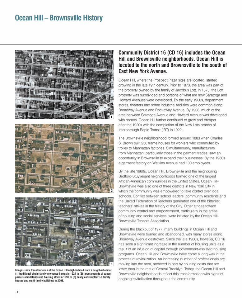
Community District 16 (CD 16) includes the Ocean Hill and Brownsville neighborhoods. Ocean Hill is located to the north and Brownsville to the south of East New York Avenue.
Ocean Hill, where the Prospect Plaza sites are located, started growing in the late 19th century. Prior to 1873, the area was part of the property owned by the family of Jacobus Lott. In 1873, the Lott property was subdivided and portions of what are now Saratoga and Howard Avenues were developed. By the early 1900s, department stores, theaters and some industrial facilities were common along Broadway Avenue and Rockaway Avenue. By 1908, much of the area between Saratoga Avenue and Howard Avenue was developed with homes. Ocean Hill further continued to grow and prosper after the 1920s with the completion of the New Lots branch of Interborough Rapid Transit (IRT) in 1922.
The Brownsville neighborhood formed around 1883 when Charles S. Brown built 250 frame houses for workers who commuted by trolley to Manhattan factories. Simultaneously, manufacturers from Manhattan, particularly those in the garment trades, saw an opportunity in Brownsville to expand their businesses. By the 1980s a garment factory on Watkins Avenue had 100 employees.
By the late 1960s, Ocean Hill, Brownsville and the neighboring Bedford-Stuyvesant neighborhoods formed one of the largest African-American communities in the United States. Ocean Hill-Brownsville was also one of three districts in New York City in which the community was empowered to take control over local schools. Conflict between school leaders, community residents and the United Federation of Teachers generated one of the bitterest teachers’ strikes in the history of the City. Other strides toward community control and empowerment, particularly in the areas of housing and social services, were initiated by the Ocean Hill-Brownsville Tenants Association.
During the blackout of 1977, many buildings in Ocean Hill and Brownsville were burned and abandoned, with many stores along Broadway Avenue destroyed. Since the late 1980s, however, CD 16 has seen a significant increase in the number of housing units as a result of an infusion of capital through government-assisted housing programs. Ocean Hill and Brownsville have come a long way in the process of revitalization. An increasing number of professionals are moving into the area, attracted in part by housing costs that are lower than in the rest of Central Brooklyn. Today, the Ocean Hill and Brownsville neighborhoods reflect this transformation with signs of ongoing revitalization throughout the community.
Images show transformation of the Ocean Hill neighborhood from a neighborhood of (1) traditional single-family rowhouse homes in 1924 to (2) large amounts of vacant parcels and deteriorated housing stock in 1996 to (3) newly constructed 1-2 family houses and multi-family buildings in 2008.
1
2
3
4
New York City Housing Authority (NYCHA) in Brooklyn’s Community District 16
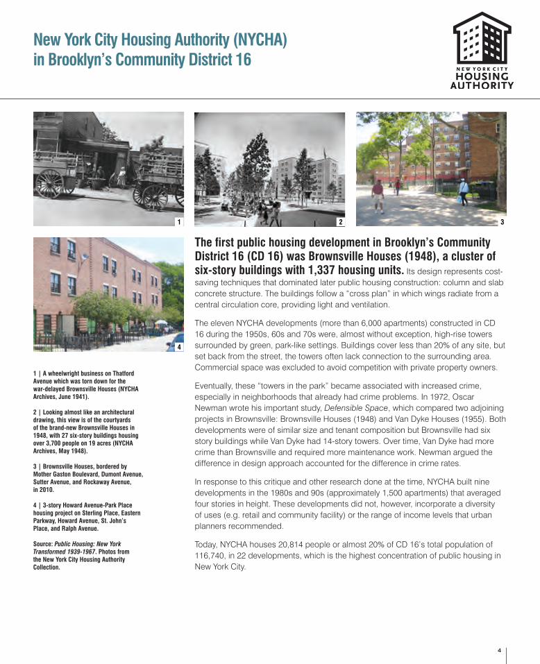
The first public housing development in Brooklyn’s Community District 16 (CD 16) was Brownsville Houses (1948), a cluster of six-story buildings with 1,337 housing units. Its design represents cost-saving techniques that dominated later public housing construction: column and slab concrete structure. The buildings follow a “cross plan” in which wings radiate from a central circulation core, providing light and ventilation.
The eleven NYCHA developments (more than 6,000 apartments) constructed in CD 16 during the 1950s, 60s and 70s were, almost without exception, high-rise towers surrounded by green, park-like settings. Buildings cover less than 20% of any site, but set back from the street, the towers often lack connection to the surrounding area. Commercial space was excluded to avoid competition with private property owners.
Eventually, these “towers in the park” became associated with increased crime, especially in neighborhoods that already had crime problems. In 1972, Oscar Newman wrote his important study, Defensible Space, which compared two adjoining projects in Brownsville: Brownsville Houses (1948) and Van Dyke Houses (1955). Both developments were of similar size and tenant composition but Brownsville had six story buildings while Van Dyke had 14-story towers. Over time, Van Dyke had more crime than Brownsville and required more maintenance work. Newman argued the difference in design approach accounted for the difference in crime rates.
In response to this critique and other research done at the time, NYCHA built nine developments in the 1980s and 90s (approximately 1,500 apartments) that averaged four stories in height. These developments did not, however, incorporate a diversity of uses (e.g. retail and community facility) or the range of income levels that urban planners recommended.
Today, NYCHA houses 20,814 people or almost 20% of CD 16’s total population of 116,740, in 22 developments, which is the highest concentration of public housing in New York City.
1 | A wheelwright business on Thatford Avenue which was torn down for the war-delayed Brownsville Houses (NYCHA Archives, June 1941).
2 | Looking almost like an architectural drawing, this view is of the courtyards of the brand-new Brownsville Houses in 1948, with 27 six-story buildings housing over 3,700 people on 19 acres (NYCHA Archives, May 1948).
3 | Brownsville Houses, bordered by Mother Gaston Boulevard, Dumont Avenue, Sutter Avenue, and Rockaway Avenue, in 2010.
4 | 3-story Howard Avenue-Park Place housing project on Sterling Place, Eastern Parkway, Howard Avenue, St. John’s Place, and Ralph Avenue.
Source: Public Housing: New York Transformed 1939-1967. Photos from the New York City Housing Authority Collection.
1 2 3
4
5
New Affordable Housing 1988 - 2009
E 98 ST
THOMAS S. BOYLAN
D STREET
THOMAS S. BOYLAN
D STREET
THOM
AS S
. BOY
LAND
STR
EET
JUNIUS ST
DEAN ST
LIRR BAY
RIDGE LINE
LOTT AV
LIVONIA AV
CHESTER ST
BROADWAY
BRISTOL ST
STRAUSS ST
ROCKAWAY AV
LEGION ST
BERGEN ST
VAN SIN
DEREN AV
SUTTER AV
EASTERN PKWY EX
FULTON ST
SARATOGA AV
NEWPORT ST
PARK PL
LIND
EN YARD
RALP
H AV
HOWARD AV
HERKIMER ST
HERZL ST
HEGEMAN AV
GRAFTON ST
LINDEN BLVD
PROSPECT PL
ST MARK'S AV
PACIFIC ST
SOMERS ST
AMBOY ST
OSBORN ST
MARION ST
HULL ST
SACKMAN
ST
MOTHER GASTON
BLVDPOW
ELL ST
SUMPTER ST
UNION
ST
STERLING PL
CHRISTOPHER AV
TAPSCOTT ST
RIVERDALE AV THATFORD AV
MAC DOUGAL ST
ST JOHN'S PL
LIBERTY AV
TRUXTON ST
DECATUR ST
BELMONT AVLINCOLN PL
BAINBRIDGE ST
ALLEY
CHAUNCEY ST
MACON ST
DITMAS AV
WATKIN
S ST
DUMONT AV
MAC DONOUGH ST
PITKIN AV
HALSEY ST
GLENMORE AV
RAD
DE
PL
HAVE
NS
PL
MAR
CON
I PL
GUN
THER
PL
SHER
LOCK
PL
ROOS
EVEL
T PL
NEW LOTS AV
E NEW YORK AV
SARATOGA AV
E 98 ST
VAN
SIN
DER
EN A
V
PITKIN AV
HERZL ST
SACK
MAN
ST
AMBOY ST
OSBORN ST
WATKIN
S ST
OSBORN ST
THATFORD AV
ALLEY
PACIFIC ST
ATLANTIC AV
LINDEN BLVD
SACKMAN
ST
ATLANTIC AV
Occupancy TypeRental
Senior
Homeownership
Occupancy Type Rental Senior Homeownership
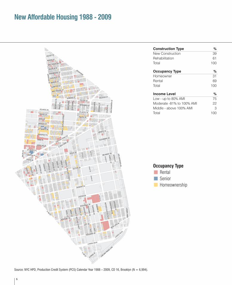
Construction Type %New Construction 39Rehabilitation 61Total 100
Occupancy Type %Homeowner 31Rental 69Total 100
Income Level %Low - up to 80% AMI 75Moderate -81% to 100% AMI 22Middle - above 100% AMI 3Total 100
Source: NYC HPD, Production Credit System (PCS) Calendar Year 1988 – 2009, CD 16, Brooklyn (N = 6,994).
6
In the last two decades Brooklyn’s Community District 16 has seen a significant expansion in the number of affordable housing units, along with a large infusion of capital by the City for development of affordable, subsidized housing. Since 1988, the New York City Department of Housing Preservation and Development (HPD) has created or preserved 6,994 units of affordable housing in CD 16. While most HPD projects have yielded rental housing, significant efforts also have been made to increase opportunities for affordable homeownership. Approximately 2,169 or 31% of the units are government-subsidized for homeownership and are owned by low- and moderate-income families.
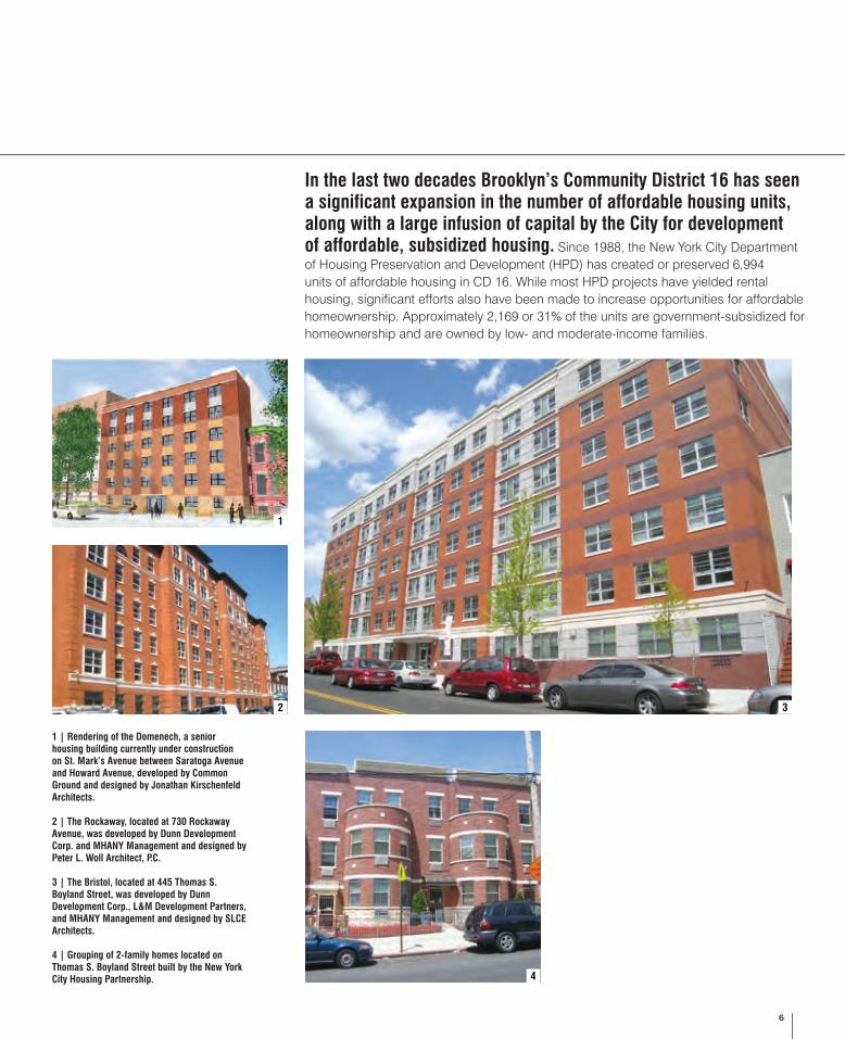
1 | Rendering of the Domenech, a senior housing building currently under construction on St. Mark’s Avenue between Saratoga Avenue and Howard Avenue, developed by Common Ground and designed by Jonathan Kirschenfeld Architects.
2 | The Rockaway, located at 730 Rockaway Avenue, was developed by Dunn Development Corp. and MHANY Management and designed by Peter L. Woll Architect, P.C.
3 | The Bristol, located at 445 Thomas S. Boyland Street, was developed by Dunn Development Corp., L&M Development Partners, and MHANY Management and designed by SLCE Architects.
4 | Grouping of 2-family homes located on Thomas S. Boyland Street built by the New York City Housing Partnership.
1
2 3
4
7
HOPE VI Program
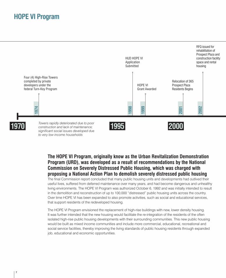
The HOPE VI Program, originally know as the Urban Revitalization Demonstration Program (URD), was developed as a result of recommendations by the National Commission on Severely Distressed Public Housing, which was charged with proposing a National Action Plan to demolish severely distressed public housing The final Commission report concluded that many public housing units and developments had outlived their useful lives, suffered from deferred maintenance over many years, and had become dangerous and unhealthy living environments. The HOPE VI Program was authorized October 6, 1992 and was initially intended to result in the demolition and reconstruction of up to 100,000 “distressed” public housing units across the country. Over time HOPE VI has been expanded to also promote activities, such as social and educational services, that support residents of the redeveloped housing.
The HOPE VI Program envisioned the replacement of high-rise buildings with new, lower density housing. It was further intended that the new housing would facilitate the re-integration of the residents of the often isolated high-rise public housing developments with their surrounding communities. This new public housing would be built as mixed income communities and include more commercial, educational, recreational and social service facilities, thereby improving the living standards of public housing residents through expanded job, educational and economic opportunities.
Four (4) High-Rise Towers completed by private developers under the federal Turn-Key Program
1970 1995 2000
HUD HOPE VI Application Submitted
HOPE VI Grant Awarded
Relocation of 365 Prospect Plaza Residents Begins
RFQ issued for rehabilitation of Prospect Plaza and construction facility space and rental housing
Towers rapidly deteriorated due to poor construction and lack of maintenance; significant social issues developed due to very low-income households
1974
1998
1999
2001
2002
8
Prospect Plaza HOPE VI Plan
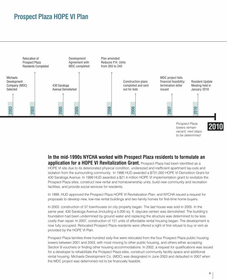
In the mid-1990s NYCHA worked with Prospect Plaza residents to formulate an application for a HOPE VI Revitalization Grant. Prospect Plaza had been identified as a HOPE VI site due to its deteriorated physical condition, undersized and inefficient apartment lay-outs and isolation from the surrounding community. In 1998 HUD awarded a $731,000 HOPE VI Demolition Grant for 430 Saratoga Avenue. In 1999 HUD awarded a $21.4 million HOPE VI implementation grant to revitalize the Prospect Plaza sites, construct new rental and homeownership units, build new community and recreation facilities, and provide social services for residents.
In 1999, HUD approved the Prospect Plaza HOPE VI Revitalization Plan; and NYCHA issued a request for proposals to develop new, low-rise rental buildings and two-family homes for first-time home buyers.
In 2003, construction of 37 townhouses on city property began. The last house was sold in 2005. In the same year, 430 Saratoga Avenue (including a 5,000 sq. ft. daycare center) was demolished. The building’s foundation had been undermined by ground water and replacing the structure was determined to be less costly than repair. In 2007, construction of 151 units of affordable rental housing began. The development is now fully occupied. Relocated Prospect Plaza residents were offered a right of first refusal to buy or rent as provided by the HOPE VI Plan.
Prospect Plaza families three hundred sixty-five were relocated from the four Prospect Plaza public housing towers between 2001 and 2003, with most moving to other public housing, and others either accepting Section 8 vouchers or finding other housing accommodations. In 2002, a request for qualifications was issued for a developer to rehabilitate the Prospect Plaza sites, construct community facility space and additional rental housing. Michaels Development Co. (MDC) was designated in June 2003 and defaulted in 2007 when the MDC project was determined not to be financially feasible.
2010
Michaels Development Company (MDC) Selected
Relocation of Prospect Plaza Residents Completed
Prospect Plaza towers remain vacant; next steps to be determined
MDC project fails financial feasibility; termination letter issued
Resident UpdateMeeting held in January 2010
Construction plans completed and sent out for bids
430 Saratoga Avenue Demolished
Development Agreement with MDC completed
Plan amended: Reduces P.H. Units from 365 to 240
2003
2003
2005
2005
2006
2006
2007
2010
9
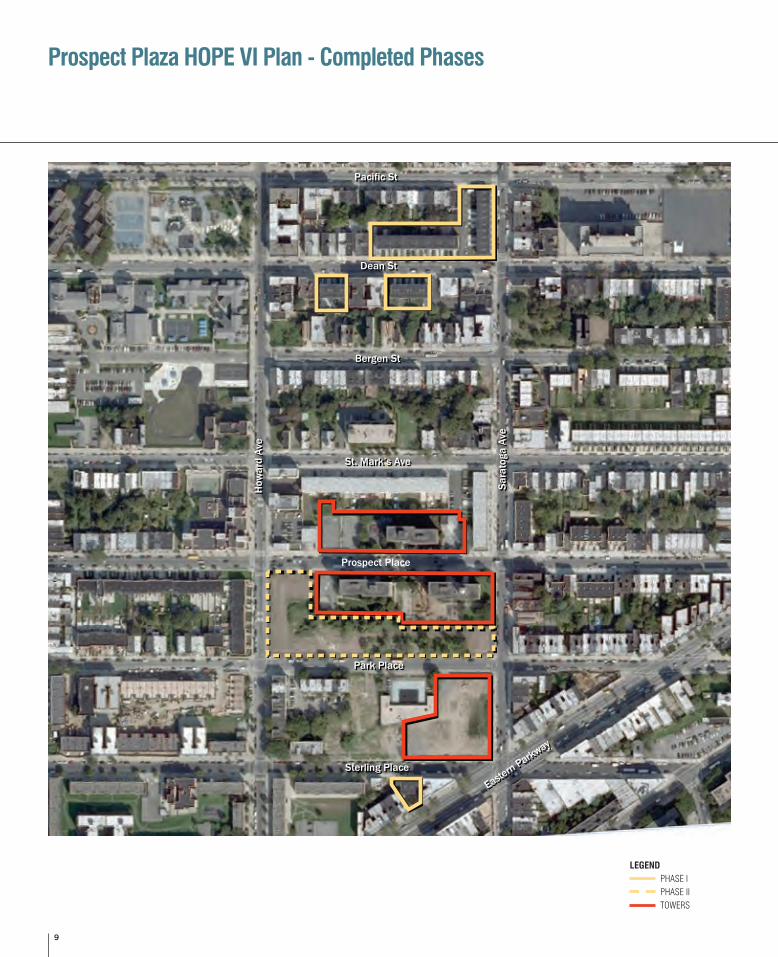
Prospect Plaza HOPE VI Plan - Completed Phases
Prospect Place
Sterling PlaceSterling Place
St. Mark’s AveSt. Mark’s Ave
How
ard
Ave
How
ard
Ave
Sara
toga
Ave
Sara
toga
Ave
Eastern Parkway
Eastern Parkway
Park PlacePark Place
Bergen StBergen St
Dean StDean St
Pacific StPacific St
LEGEND PHASE I PHASE II TOWERS
10
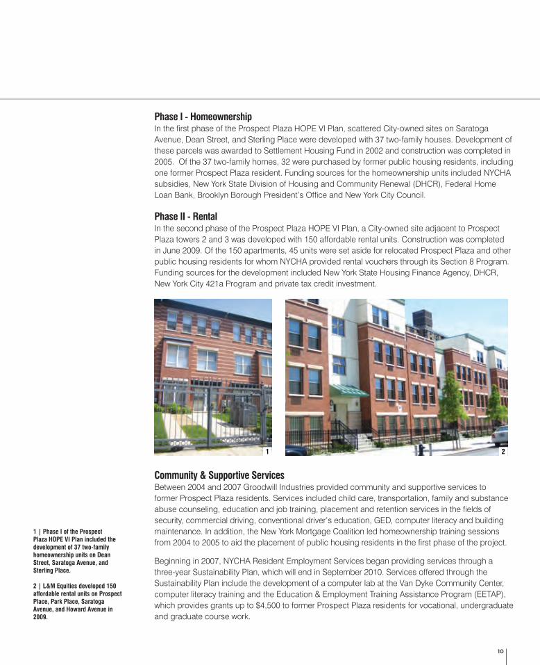
Phase I - HomeownershipIn the first phase of the Prospect Plaza HOPE VI Plan, scattered City-owned sites on Saratoga Avenue, Dean Street, and Sterling Place were developed with 37 two-family houses. Development of these parcels was awarded to Settlement Housing Fund in 2002 and construction was completed in 2005. Of the 37 two-family homes, 32 were purchased by former public housing residents, including one former Prospect Plaza resident. Funding sources for the homeownership units included NYCHA subsidies, New York State Division of Housing and Community Renewal (DHCR), Federal Home Loan Bank, Brooklyn Borough President’s Office and New York City Council.
Phase II - RentalIn the second phase of the Prospect Plaza HOPE VI Plan, a City-owned site adjacent to Prospect Plaza towers 2 and 3 was developed with 150 affordable rental units. Construction was completed in June 2009. Of the 150 apartments, 45 units were set aside for relocated Prospect Plaza and other public housing residents for whom NYCHA provided rental vouchers through its Section 8 Program. Funding sources for the development included New York State Housing Finance Agency, DHCR, New York City 421a Program and private tax credit investment.
Community & Supportive ServicesBetween 2004 and 2007 Groodwill Industries provided community and supportive services to former Prospect Plaza residents. Services included child care, transportation, family and substance abuse counseling, education and job training, placement and retention services in the fields of security, commercial driving, conventional driver’s education, GED, computer literacy and building maintenance. In addition, the New York Mortgage Coalition led homeownership training sessions from 2004 to 2005 to aid the placement of public housing residents in the first phase of the project.
Beginning in 2007, NYCHA Resident Employment Services began providing services through a three-year Sustainability Plan, which will end in September 2010. Services offered through the Sustainability Plan include the development of a computer lab at the Van Dyke Community Center, computer literacy training and the Education & Employment Training Assistance Program (EETAP), which provides grants up to $4,500 to former Prospect Plaza residents for vocational, undergraduate and graduate course work.
1 | Phase I of the Prospect Plaza HOPE VI Plan included the development of 37 two-family homeownership units on Dean Street, Saratoga Avenue, and Sterling Place.
2 | L&M Equities developed 150 affordable rental units on Prospect Place, Park Place, Saratoga Avenue, and Howard Avenue in 2009.
1 2
11
Land UseR
ALPH
AV
RAL
PH A
V
PARK PL
DEAN ST
BERGEN ST
PACIFIC ST
HOW
ARD
AV
HOW
ARD
AV
SAR
ATO
GA
AV
SAR
ATO
GA
AV
ATLANTIC AV
ST MARKS AV
PROSPECT PL
EASTERN PY EX
STERLING PL
EAST NEW YORK AV
LINCOLN PL
AMB
OY ST
PITKIN AV
STRAU
SS ST
HER
ZL ST
RAD
DE
PL
LOU
IS P
L
DEW
EY P
L
RO
OSE
VELT
PL
SARATOG
A AV
HOW
ARD
AV
ST JOHNS PL
PITKIN AV
RALP
H AV
BANC
ROFT
PL
PREC
OTT
PL
THOM
AS S. BOYLAN
D ST
THO
MAS
S. B
OYLA
ND
ST
THOM
AS S
. BOY
LAND
ST
LegendStudy Area - NYCHA ParcelsCIty Owned Parcel
Public Facilities and Institutions
Vacant / Unclassified / No Data
Multi-family BuildingsOne & Two Family BuildingsMixed Residential / Commercial
Transportation and UtilityParking
Commercial / OfficeIndustrial / Manufacturing
NYC Open Space
New York City Housing AuthorityMap of Prospect Plaza and Surrounding Area
Land Use
2010.03.17
ZION TRIANGLE
WEEKSVILLE PLGD
PACIFIC PLAYGROUND
SARATOGA BALLFIELDS
N
0.05 0.1Miles
0.0250
RAL
PH A
V
RAL
PH A
V
PARK PL
DEAN ST
BERGEN ST
PACIFIC ST
HOW
ARD
AV
HOW
ARD
AV
SAR
ATO
GA
AV
SAR
ATO
GA
AV
ATLANTIC AV
ST MARKS AV
PROSPECT PL
EASTERN PY EX
STERLING PL
EAST NEW YORK AV
LINCOLN PL
AMB
OY ST
PITKIN AV
STRAU
SS ST
HER
ZL ST
RAD
DE
PL
LOU
IS P
L
DEW
EY P
L
RO
OSE
VELT
PL
SARATOG
A AV
HOW
ARD
AV
ST JOHNS PL
PITKIN AV
RALP
H AV
BANC
ROFT
PL
PREC
OTT
PL
THOM
AS S. BOYLAN
D ST
THO
MAS
S. B
OYLA
ND
ST
THOM
AS S
. BOY
LAND
ST
LegendStudy Area - NYCHA ParcelsCIty Owned Parcel
Public Facilities and Institutions
Vacant / Unclassified / No Data
Multi-family BuildingsOne & Two Family BuildingsMixed Residential / Commercial
Transportation and UtilityParking
Commercial / OfficeIndustrial / Manufacturing
NYC Open Space
New York City Housing AuthorityMap of Prospect Plaza and Surrounding Area
Land Use
2010.03.17
ZION TRIANGLE
WEEKSVILLE PLGD
PACIFIC PLAYGROUND
SARATOGA BALLFIELDS
N
0.05 0.1Miles
0.0250
LEGEND
STUDY AREA – NYCHA PARCELS
CITY – OWNED PARCEL
NYC OPEN SPACE
MULTI-FAMILY BUILDINGS
ONE & TWO FAMILY BUILDINGS
MIXED RESIDENTIAL / COMMERCIAL
PUBLIC FACILITIES / INSTITUTIONS
COMMERCIAL / OFFICE
INDUSTRIAL / MANUFACTURING
TRANSPORTATION AND UTILITY
PARKING
VACANT / UNCLASSIFIED / NO DATA
12
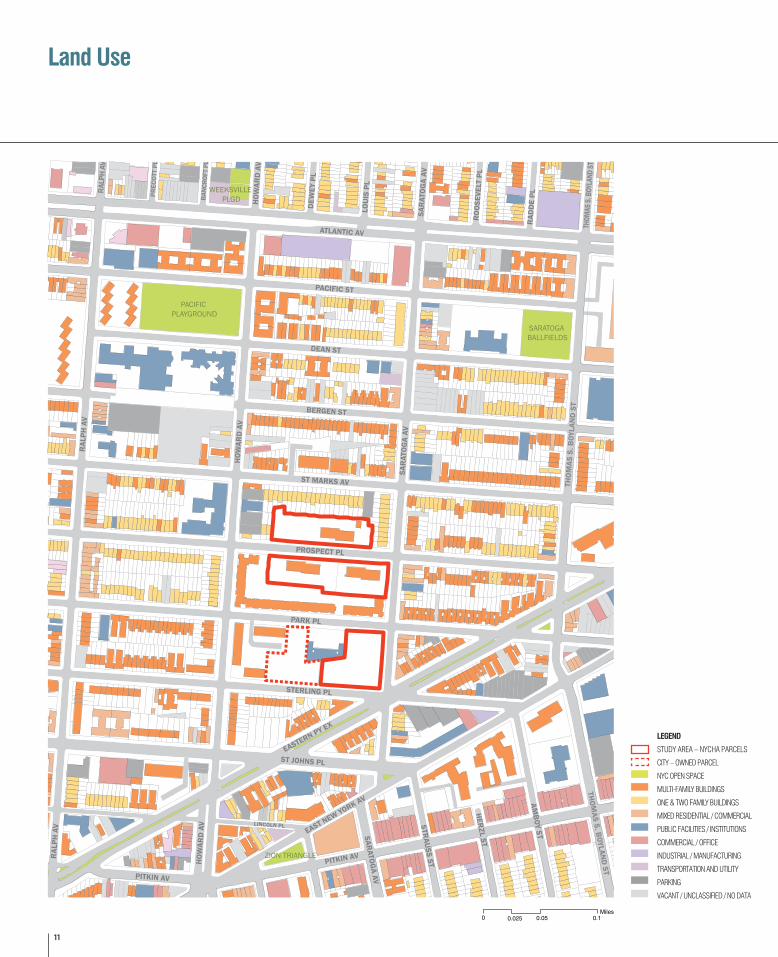
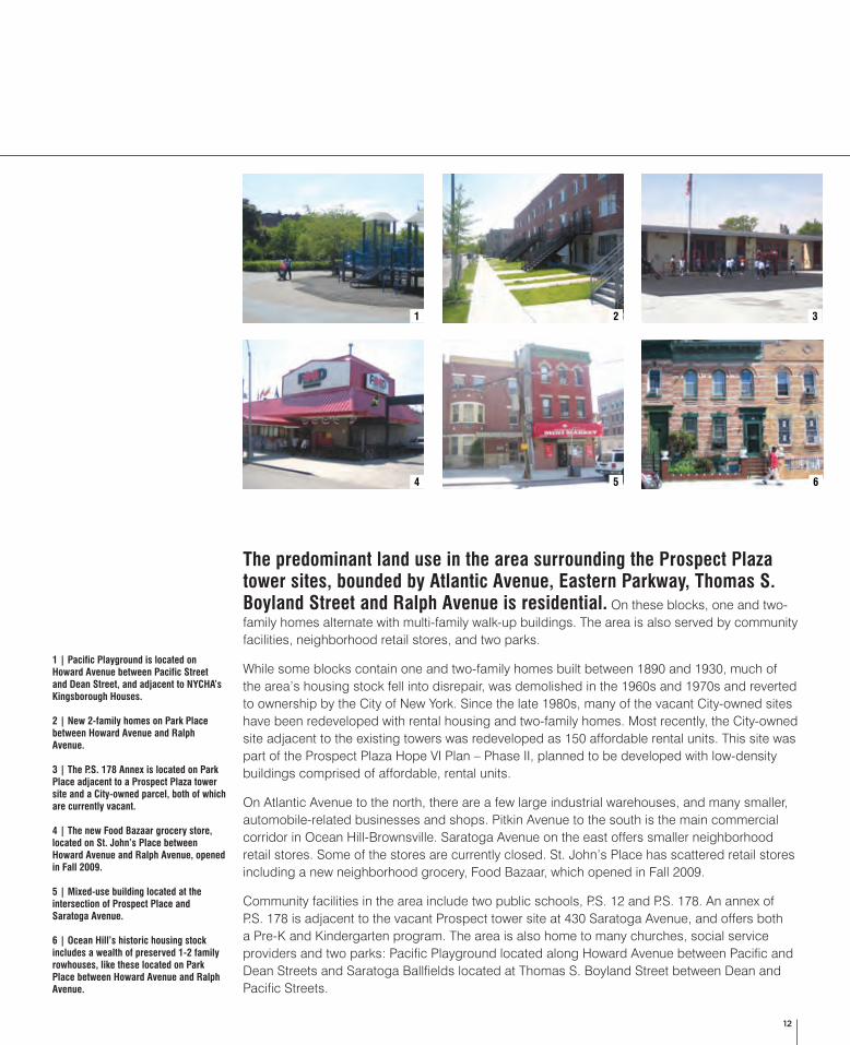
The predominant land use in the area surrounding the Prospect Plaza tower sites, bounded by Atlantic Avenue, Eastern Parkway, Thomas S. Boyland Street and Ralph Avenue is residential. On these blocks, one and two-family homes alternate with multi-family walk-up buildings. The area is also served by community facilities, neighborhood retail stores, and two parks.
While some blocks contain one and two-family homes built between 1890 and 1930, much of the area’s housing stock fell into disrepair, was demolished in the 1960s and 1970s and reverted to ownership by the City of New York. Since the late 1980s, many of the vacant City-owned sites have been redeveloped with rental housing and two-family homes. Most recently, the City-owned site adjacent to the existing towers was redeveloped as 150 affordable rental units. This site was part of the Prospect Plaza Hope VI Plan – Phase II, planned to be developed with low-density buildings comprised of affordable, rental units.
On Atlantic Avenue to the north, there are a few large industrial warehouses, and many smaller, automobile-related businesses and shops. Pitkin Avenue to the south is the main commercial corridor in Ocean Hill-Brownsville. Saratoga Avenue on the east offers smaller neighborhood retail stores. Some of the stores are currently closed. St. John’s Place has scattered retail stores including a new neighborhood grocery, Food Bazaar, which opened in Fall 2009.
Community facilities in the area include two public schools, P.S. 12 and P.S. 178. An annex of P.S. 178 is adjacent to the vacant Prospect tower site at 430 Saratoga Avenue, and offers both a Pre-K and Kindergarten program. The area is also home to many churches, social service providers and two parks: Pacific Playground located along Howard Avenue between Pacific and Dean Streets and Saratoga Ballfields located at Thomas S. Boyland Street between Dean and Pacific Streets.
1 | Pacific Playground is located on Howard Avenue between Pacific Street and Dean Street, and adjacent to NYCHA’s Kingsborough Houses.
2 | New 2-family homes on Park Place between Howard Avenue and Ralph Avenue.
3 | The P.S. 178 Annex is located on Park Place adjacent to a Prospect Plaza tower site and a City-owned parcel, both of which are currently vacant.
4 | The new Food Bazaar grocery store, located on St. John’s Place between Howard Avenue and Ralph Avenue, opened in Fall 2009.
5 | Mixed-use building located at the intersection of Prospect Place and Saratoga Avenue.
6 | Ocean Hill’s historic housing stock includes a wealth of preserved 1-2 family rowhouses, like these located on Park Place between Howard Avenue and Ralph Avenue.
1
4
2 3
5 6
13
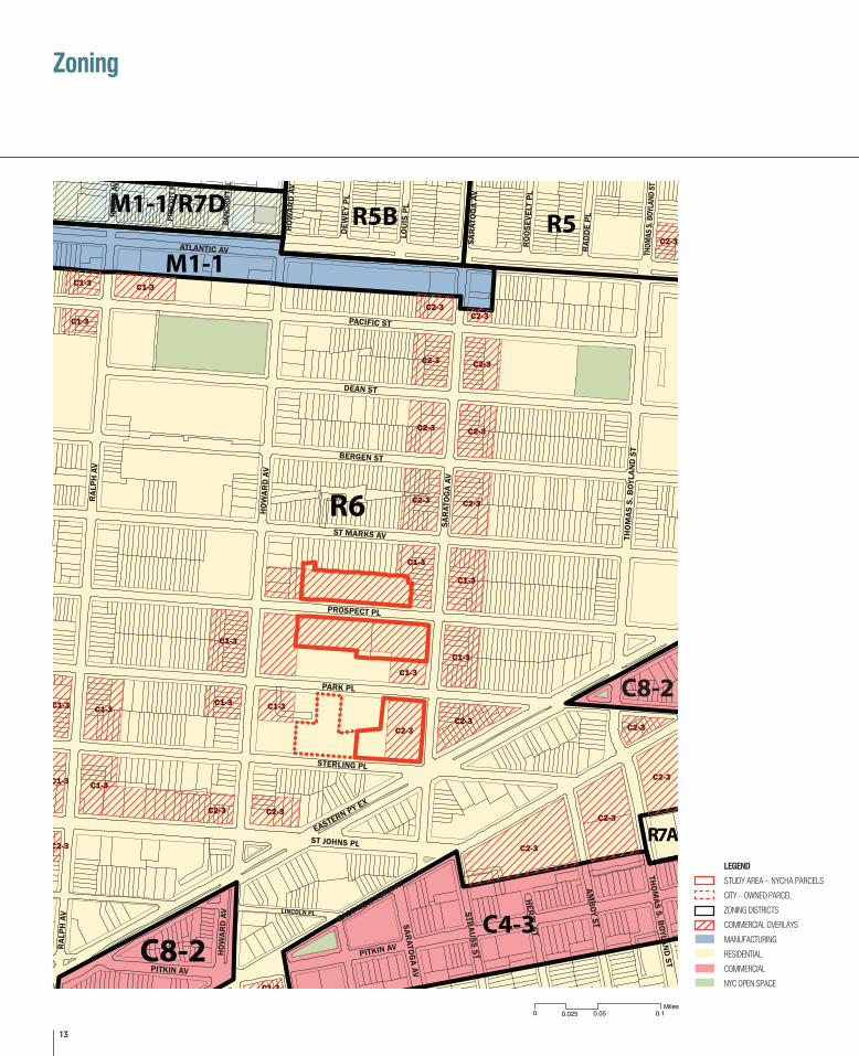
Zoning
C1-3
C1-3
C2-3
C2-3C2-3
C2-3
C2-3C2-3
C1-3
C1-3
C1-3
C2-3
C1-3
C2-3
C2-3C2-3
C2-3 C2-3
C1-3
C1-3
C2-3
C1-3 C1-3 C1-3
C2-3
C1-3
C1-3
C2-3
C2-3
C1-3
C2-3
C1-3
C2-3
R6
C4-3
R5R5B
M1-1
C8-2
M1-1/R7D
C8-2
R7A
RAL
PH A
V
RAL
PH A
V
PARK PL
DEAN ST
BERGEN ST
PACIFIC ST
HOW
ARD
AV
HOW
ARD
AV
SAR
ATO
GA
AV
SAR
ATO
GA
AV
ATLANTIC AV
ST MARKS AV
PROSPECT PL
EASTERN PY EX
STERLING PL
EAST NEW YORK AV
LINCOLN PL
AMB
OY ST
PITKIN AV
STRAU
SS ST
HER
ZL ST
RAD
DE
PL
LOU
IS P
L
DEW
EY P
L
RO
OSE
VELT
PL
SARATOG
A AV
HOW
ARD
AV
ST JOHNS PL
PITKIN AV
THOM
AS S. BOYLAN
D ST
THO
MAS
S. B
OYLA
ND
ST
THOM
AS S
. BOY
LAND
ST
RALP
H AV
BANC
ROFT
PL
PREC
OTT
PL
LegendStudy Area - NYCHA ParcelsCity Owned ParcelZoning Districts February 2010Zoning Commercial Overlays February 2010Zoning Manufacturing 2010Zoning ResidedentialZoning CommercialNYC Open Space 2007
New York City Housing Authority
Map of Prospect Plaza
Zoning MapIncludes Zoning Districts, Special Districts, & Commercial Overlays
Data Source: NYC Department of Planning, Bytes of the Big Apple Download 2010.03.23
Date of Data: February 2010Date of Most Recent City Council Adoptions Included in Data: 2010.02.03
2010.03.23
N
0.05 0.1Miles
0.0250
C1-3
C1-3
C2-3
C2-3C2-3
C2-3
C2-3C2-3
C1-3
C1-3
C1-3
C2-3
C1-3
C2-3
C2-3C2-3
C2-3 C2-3
C1-3
C1-3
C2-3
C1-3 C1-3 C1-3
C2-3
C1-3
C1-3
C2-3
C2-3
C1-3
C2-3
C1-3
C2-3
R6
C4-3
R5R5B
M1-1
C8-2
M1-1/R7D
C8-2
R7A
RAL
PH A
V
RAL
PH A
V
PARK PL
DEAN ST
BERGEN ST
PACIFIC ST
HOW
ARD
AV
HOW
ARD
AV
SAR
ATO
GA
AV
SAR
ATO
GA
AVATLANTIC AV
ST MARKS AV
PROSPECT PL
EASTERN PY EX
STERLING PL
EAST NEW YORK AV
LINCOLN PL
AMB
OY ST
PITKIN AV
STRAU
SS ST
HER
ZL ST
RAD
DE
PL
LOU
IS P
L
DEW
EY P
L
RO
OSE
VELT
PL
SARATOG
A AV
HOW
ARD
AV
ST JOHNS PL
PITKIN AV
THOM
AS S. BOYLAN
D ST
THO
MAS
S. B
OYLA
ND
ST
THOM
AS S
. BOY
LAND
ST
RALP
H AV
BANC
ROFT
PL
PREC
OTT
PL
LegendStudy Area - NYCHA ParcelsCity Owned ParcelZoning Districts February 2010Zoning Commercial Overlays February 2010Zoning Manufacturing 2010Zoning ResidedentialZoning CommercialNYC Open Space 2007
New York City Housing Authority
Map of Prospect Plaza
Zoning MapIncludes Zoning Districts, Special Districts, & Commercial Overlays
Data Source: NYC Department of Planning, Bytes of the Big Apple Download 2010.03.23
Date of Data: February 2010Date of Most Recent City Council Adoptions Included in Data: 2010.02.03
2010.03.23
N
0.05 0.1Miles
0.0250
LEGEND
STUDY AREA – NYCHA PARCELS
CITY – OWNED PARCEL
ZONING DISTRICTS
COMMERCIAL OVERLAYS
MANUFACTURING
RESIDENTIAL
COMMERCIAL
NYC OPEN SPACE
14
The New York City Zoning Resolution controls land use, building size, height and setback restrictions, and open space and parking requirements. The City is divided into three basic zoning districts: residential, commercial and manufacturing. These three basic categories are further subdivided into lower, medium and higher density residential, commercial and manufacturing districts.
The primary zoning for the area including the Prospect Plaza tower sites is residential (R6) with commercial overlays (C1-3 and C2-3). The two Prospect Plaza sites located along Prospect Place are zoned R6 with 130-foot wide C1-3 commercial overlays. The site located along Saratoga Avenue between Park Place and Sterling Place is zoned R6 with a 150-foot wide C2-3 overlay. Saratoga Avenue, the north-south street to the east of the Prospect Plaza tower sites is zoned R6/C1-3 and C2-3. Buildings along Saratoga Avenue have small retail spaces on the ground floor and residential uses above.
Residential R6 zoning districts are widely mapped in built-up, medium-density areas in Brooklyn. A typical R6 residential building usually has 3 to12 stories. The Zoning Resolution permits developers to build under Height Factor or Quality Housing regulations. Height factor regulations encourage small apartment buildings on small zoning lots; and on larger lots, tall and narrow buildings that are set back from the street. The quality housing alternative results in lower buildings with more lot coverage.
Commercial overlays as C1-3 and C2-3 are mapped along streets that serve the local retail needs of the surrounding residential neighborhood, and are found primarily throughout the City’s lower- and medium-density areas, and occasionally in higher-density districts. Typical uses include grocery stores, small dry cleaners, restaurants, and beauty parlors catering to the immediate neighborhood. In buildings with residential uses, commercial uses are limited to one or two floors and must always be located below the residential use.
Source: New York City Department of City Planning Zoning Handbook
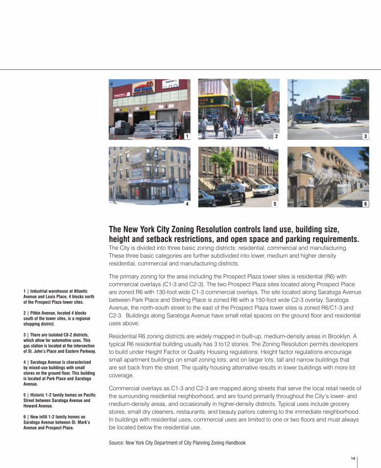
1 | Industrial warehouse at Atlantic Avenue and Louis Place, 4 blocks north of the Prospect Plaza tower sites.
2 | Pitkin Avenue, located 4 blocks south of the tower sites, is a regional shopping district.
3 | There are isolated C8-2 districts, which allow for automotive uses. This gas station is located at the intersection of St. John’s Place and Eastern Parkway.
4 | Saratoga Avenue is characterized by mixed-use buildings with small stores on the ground floor. This building is located at Park Place and Saratoga Avenue.
5 | Historic 1-2 family homes on Pacific Street between Saratoga Avenue and Howard Avenue.
6 | New infill 1-2 family homes on Saratoga Avenue between St. Mark’s Avenue and Prospect Place.
1
4 5 6
2 3
15
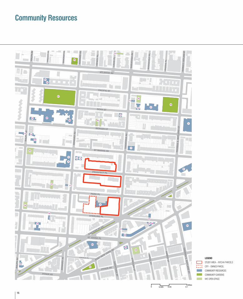
Community Resources
Study Area - NYCHA ParcelsCity-Owned Parcel
2. PS 178 SAINT CLAIR MCKELWAY SCHOOL
1. BROOKLYN COLLEGIATE
3. PS 12
5. PS 178 ANNEX
6. MT ARARAT PRES CHURCH SENIOR CENTER8. SARATOGA WOMEN’S CENTER9. THE FAMILY AND LIFE CENTER OF MT.ARARAT -I/T
10. THE FAMILY AND LIFE CENTER OF MT.ARARAT - P/S11. DEAN STREET
13. GLOVER MEMORIAL14. SHIRLEY CHISHOLM DAY CARE CENTER #1
12. INNER HEALING CHRISTIAN ACADEMY SCHOOL
15. SHIRLEY CHISHOLM DAY CARE #2(PRESCHOOL)16. GOD'S DELIVERANCE TEMPLE17. ST. MARK'S CHURCH OF CHRIST18. EBENEEZER FRENCH SDA CHURCH
19. UNIQUE START INC. 20. SMILING FACES CHRISTIAN DAY CARE CENTER - I/T
21. THE RENAISSANCE22. HOLY HOUSE OF PRAYER
24. ZION GOSPEL TABERNACLE
25. UNITY TEMPLE BAPTIST CHURCH
23. 1381 EAST NY AVE.4. RONALD EDMONDS LEARNING CTR II
28. PSCH-HORIZON PROJECT I
30. INTERFAITH MEDIAL CTR.
29. PSCH-HORIZON PROJECT II
26. BROOKLYN CHILDREN'S PSYCH CTR
27. BROOKLYN CHILDREN'S DAY TREATMENT CENTER
31. BROOKLYN CHILDREN'S CENTER COMMUNITY RESIDENCE
32. 73RD PRECINCT/SERVICE STATION #3
36. FARMERS GARDEN
33. LOUIS PLACE FRIENDS COMMUNITY GARDEN
38. PRESTON COMM. GARDEN
34. WEEKSVILLE PLAYGROUND
39. STERLING COMMUNITY GROUP
35. COMMUNITY GARDEN
37. ST. MARK'S BLOCK ASSOCIATION
40. MARCUS GARVEY TENATNS ASSOCIATION GARDEN
43. ZION PARK (LOEW SQUARE)
41. KINGSBOROUGH HOUSES PLGD
42. SARATOGA/PS 178 PLAYGROUND
44. ENGINE 227
37
38
39
40
41
42
43
32
12
13
14
15
16
17
18
34
35
36
2
3
4
5
6
7
9
10
11
1
20
21
22
23
24
25
26
27
28
29
30
31
3319
8
Schools
Social ServicesHeath Services
Police Stations
Community Gardens
NYC Open Space
Fire Houses
RAL
PH A
V
RAL
PH A
V
PARK PL
DEAN ST
BERGEN ST
PACIFIC ST
HOW
ARD
AV
HOW
ARD
AV
SAR
ATO
GA
AV
SAR
ATO
GA
AV
ATLANTIC AV
ST MARKS AV
PROSPECT PL
EASTERN PY EX
STERLING PL
EAST NEW YORK AV
LINCOLN PL
AMB
OY ST
PITKIN AV
STRAU
SS ST
HER
ZL ST
RAD
DE
PL
LOU
IS P
L
DEW
EY P
L
RO
OSE
VELT
PL
SARATOG
A AV
HOW
ARD
AV
ST JOHNS PL
PITKIN AV
RALP
H AV
BANC
ROFT
PL
PREC
OTT
PL
THOM
AS S. BOYLAN
D ST
THO
MAS
S. B
OYLA
ND
ST
THOM
AS S
. BOY
LAND
ST
1
2
3
4
5
6
7
8 9
10
11
12
13
14
15 16
17
18
19
20
21
22
23
24
2532
30
26
33
40
34
35
41
42
43
36
37
38
39
27 2831
29
N
0.05 0.1Miles
0.0250
LEGEND
STUDY AREA – NYCHA PARCELS
CITY – OWNED PARCEL
COMMUNITY RESOURCES
COMMUNITY GARDENS
NYC OPEN SPACE
16
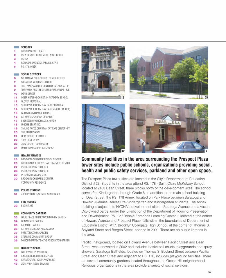
SCHOOLS1 BROOKLYN COLLEGIATE2 P.S. 178 SAINT CLAIR MCKELWAY SCHOOL3 P.S. 124 RONALD EDMONDS LEARNING CTR II5 P.S. 178 ANNEX
SOCIAL SERVICES6 MT ARARAT PRES CHURCH SENIOR CENTER7 SARATOGA WOMEN’S CENTER8 THE FAMILY AND LIFE CENTER OF MT.ARARAT -I/T9 THE FAMILY AND LIFE CENTER OF MT.ARARAT - P/S10 DEAN STREET11 INNER HEALING CHRISTIAN ACADEMY SCHOOL12 GLOVER MEMORIAL13 SHIRLEY CHISHOLM DAY CARE CENTER #114 SHIRLEY CHISHOLM DAY CARE #2(PRESCHOOL)15 GOD’S DELIVERANCE TEMPLE16 ST. MARK’S CHURCH OF CHRIST17 EBENEEZER FRENCH SDA CHURCH18 UNIQUE START INC.19 SMILING FACES CHRISTIAN DAY CARE CENTER - I/T20 THE RENAISSANCE21 HOLY HOUSE OF PRAYER22 1381 EAST NY AVE.23 ZION GOSPEL TABERNACLE24 UNITY TEMPLE BAPTIST CHURCH
HEALTH SERVICES25 BROOKLYN CHILDREN’S PSYCH CENTER26 BROOKLYN CHILDREN’S DAY TREATMENT CENTER27 PSCH-HORIZON PROJECT I28 PSCH-HORIZON PROJECT II29 INTERFAITH MEDIAL CTR.30 BROOKLYN CHILDREN’S CENTER COMMUNITY RESIDENCE
POLICE STATIONS31 73RD PRECINCT/SERVICE STATION #3
FIRE HOUSES32 ENGINE 227
COMMUNITY GARDENS33 LOUIS PLACE FRIENDS COMMUNITY GARDEN34 COMMUNITY GARDEN35 FARMERS GARDEN36 ST. MARK’S BLOCK ASSOCIATION37 PRESTON COMM. GARDEN38 STERLING COMMUNITY GROUP39 MARCUS GARVEY TENATNS ASSOCIATION GARDEN
NYC OPEN SPACE40 WEEKSVILLE PLAYGROUND41 KINGSBOROUGH HOUSES PLGD42 SARATOGA/P.S. 178 PLAYGROUND43 ZION PARK (LOEW SQUARE)
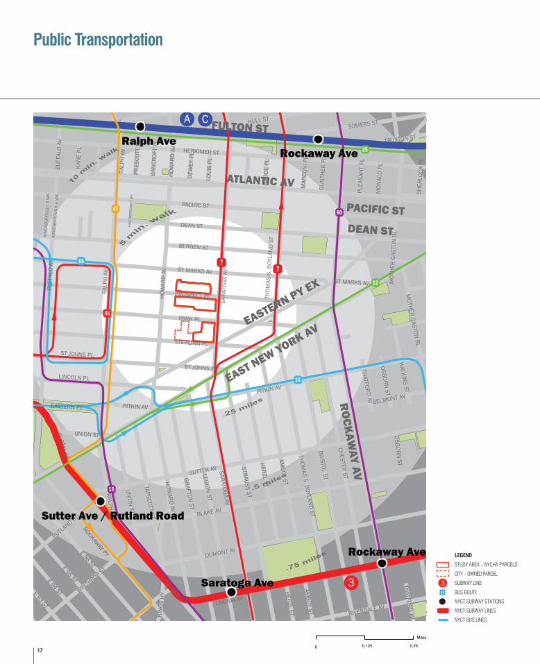
Community facilities in the area surrounding the Prospect Plaza tower sites include public schools, organizations providing social, health and public safety services, parkland and other open space.
The Prospect Plaza tower sites are located in the City’s Department of Education District #23. Students in the area attend P.S. 178 - Saint Claire McKelway School, located at 2163 Dean Street, three blocks north of the development sites. The school serves Pre-Kindergarten through Grade 8. In addition to the main school building on Dean Street, the P.S. 178 Annex, located on Park Place between Saratoga and Howard Avenues, serves Pre-Kindergarten and Kindergarten students. The Annex building is adjacent to NYCHA’s development site on Saratoga Avenue and a vacant City-owned parcel under the jurisdiction of the Department of Housing Preservation and Development. P.S. 12 / Ronald Edmonds Learning Center II, located at the corner of Howard Avenue and Prospect Place, falls within the boundaries of Department of Education District #17. Brooklyn Collegiate High School, at the corner of Thomas S. Boyland Street and Bergen Street, opened in 2009. There are no public libraries in the area.
Pacific Playground, located on Howard Avenue between Pacific Street and Dean Street, was renovated in 2002 and includes basketball courts, playgrounds and spray showers. Saratoga Ballfields, located on Thomas S. Boyland Street between Pacific Street and Dean Street and adjacent to P.S. 178, includes playground facilities. There are several community gardens located throughout the Ocean Hill neighborhood. Religious organizations in the area provide a variety of social services.
252
42 7
17
LEGEND
STUDY AREA – NYCHA PARCELS
CITY – OWNED PARCEL
SUBWAY LINE
BUS ROUTE
NYCT SUBWAY STATIONS
NYCT SUBWAY LINES
NYCT BUS LINES
Public Transportation
")
")
")
")
")
")60
25
12
14
3
A C
77
47
45
65
15
DEAN ST
BERGEN ST
PARK PL
BLAKE AV
SUTTER AV
HERKIMER ST
E 98 ST
BRISTOL ST
CHESTER ST
PACIFIC ST
E 96 ST
PROSPECT PL
ST MARKS AV
LEGION ST
DUMONT AV
STRAUSS ST
LIVONIA AV
BUFF
ALO
AV
AMBOY ST
STERLING PLGRAFTON
ST
SARATOGA AV
HERZL ST
E 95 ST
HULL ST
ROCKAWAY PY
LINCOLN PL
UNION
ST
SOMERS ST
ST JOHNS PL
E 94 ST
HOWARD AV
RIVERDALE AV
WINTHROP ST
TAPSCOTT ST
RALPH AV
WATKIN
S ST
RUTLAND RD
MOTHER GASTON
BL
BELMONT AV
E 93 ST
PORTAL ST
EASTERN PY
OSBORN ST
KIN
GS H
Y
PITKIN AV
THATFORD AV
KAN
E PL
LOUI
S PL
TRUXTON ST
RAD
DE
PL
DEW
EY P
L
MON
ACO
PL
MAR
CON
I PL
GUN
THER
PL
PLEA
SAN
T PL
PRES
COTT
PL
SHER
LOCK
PL
BAN
CROF
T PL
KIN
GSB
OROU
GH
4 W
K
KIN
GSB
OROU
GH
3 W
K
KIN
GSB
OROU
GH
7 W
K
MOT
HER
GAS
TON
BL
HOW
ARD
AV
UNION ST
THATFORD AV
HOW
ARD
AV
BUFF
ALO
AV
HERZL ST
AMBOY ST
RALP
H AV
RALP
H AV
OSBORN ST
SARA
TOG
A AV
ST JOHNS PL
ST MARKS AV
PITKIN AV
FULTON ST
ATLANTIC AV
PACIFIC STDEAN ST
EASTERN PY EX
EAST NEW YORK AV
RO
CKAWAY AV
THOMAS S. BOYLAN
D ST
THOM
AS S
. BOY
LAN
D S
T
Ralph Ave
Rockaway Ave
Rockaway Ave
Sutter Ave / Rutland Road
Saratoga Ave
314
Legend
Bus Route
Subway Line
NYCT Subway Stations
NYCT Subway LinesNYCT Bus Lines
10 m
in. w
alk
New York City Housing AuthorityMap of Prospect Plaza and Surrounding Area
Car and Bike Circulation
Study Area - NYCHA Parcels
City-Owned Parcel
N
0.125 0.25
Miles
0
")
")
")
")
")
")60
25
12
14
3
A C
77
47
45
65
15
DEAN ST
BERGEN ST
PARK PL
BLAKE AV
SUTTER AV
HERKIMER ST
E 98 ST
BRISTOL ST
CHESTER ST
PACIFIC ST
E 96 ST
PROSPECT PL
ST MARKS AV
LEGION ST
DUMONT AV
STRAUSS ST
LIVONIA AV
BUFF
ALO
AV
AMBOY ST
STERLING PL
GRAFTON ST
SARATOGA AV
HERZL ST
E 95 ST
HULL ST
ROCKAWAY PY
LINCOLN PL
UNION
ST
SOMERS ST
ST JOHNS PL
E 94 ST
HOWARD AV
RIVERDALE AV
WINTHROP ST
TAPSCOTT ST
RALPH AV
WATKIN
S ST
RUTLAND RD
MOTHER GASTON
BL
BELMONT AV
E 93 ST
PORTAL ST
EASTERN PY
OSBORN ST
KIN
GS H
Y
PITKIN AV
THATFORD AV
KAN
E PL
LOUI
S PL
TRUXTON ST
RAD
DE
PL
DEW
EY P
L
MON
ACO
PL
MAR
CON
I PL
GUN
THER
PL
PLEA
SAN
T PL
PRES
COTT
PL
SHER
LOCK
PL
BAN
CROF
T PL
KIN
GSB
OROU
GH
4 W
K
KIN
GSB
OROU
GH
3 W
K
KIN
GSB
OROU
GH
7 W
K
MOT
HER
GAS
TON
BL
HOW
ARD
AV
UNION ST
THATFORD AV
HOW
ARD
AV
BUFF
ALO
AV
HERZL ST
AMBOY ST
RALP
H AV
RALP
H AV
OSBORN ST
SARA
TOG
A AV
ST JOHNS PL
ST MARKS AV
PITKIN AV
FULTON ST
ATLANTIC AV
PACIFIC STDEAN ST
EASTERN PY EX
EAST NEW YORK AV
RO
CKAWAY AV
THOMAS S. BOYLAN
D ST
THOM
AS S
. BOY
LAN
D S
T
Ralph Ave
Rockaway Ave
Rockaway Ave
Sutter Ave / Rutland Road
Saratoga Ave
314
Legend
Bus Route
Subway Line
NYCT Subway Stations
NYCT Subway LinesNYCT Bus Lines
10 m
in. w
alk
New York City Housing AuthorityMap of Prospect Plaza and Surrounding Area
Car and Bike Circulation
Study Area - NYCHA Parcels
City-Owned Parcel
N
0.125 0.25
Miles
0
314
18
Public Transportation Major Traffic Routes
")
")
")
")
")
")DEAN ST
BERGEN ST
PARK PL
THOMAS S. BOYLAN
D STBLAKE AV
SUTTER AV
HERKIMER ST
E 98 ST
BRISTOL ST
CHESTER STPACIFIC ST
E 96 ST
PROSPECT PL
ST MARKS AV
LEGION ST
DUMONT AV
STRAUSS ST
LIVONIA AV
BUFF
ALO
AV
AMBOY ST
STERLING PLGRAFTON
ST
SARATOGA AV
HERZL ST
E 95 ST
HULL ST
ROCKAWAY PY
LINCOLN PL
UNION
ST
SOMERS ST
ST JOHNS PL
E 94 ST
HOWARD AV
RIVERDALE AV
WINTHROP ST
TAPSCOTT ST
RALPH AV
WATKIN
S ST
RUTLAND RD
MOTHER GASTON
BL
BELMONT AV
E 93 ST
PORTAL ST
EASTERN PY
OSBORN ST
KIN
GS H
Y
PITKIN AV
THATFORD AV
KAN
E PL
LOUI
S PL
TRUXTON ST
RAD
DE
PL
DEW
EY P
L
MON
ACO
PL
MAR
CON
I PL
GUN
THER
PL
PLEA
SAN
T PL
PRES
COTT
PL
SHER
LOCK
PL
BAN
CROF
T PL
KIN
GSB
OROU
GH
4 W
K
KIN
GSB
OROU
GH
3 W
K
KIN
GSB
OROU
GH
7 W
K
MOT
HER
GAS
TON
BL
HOW
ARD
AV
UNION ST
THATFORD AV
HOW
ARD
AV
BUFF
ALO
AV
HERZL ST
AMBOY ST
RALP
H AV
RALP
H AV
OSBORN ST
SARA
TOG
A AV
THOM
AS S
. BOY
LAN
D S
T
ST JOHNS PL
ST MARKS AV
PITKIN AV
SARA
TOG
A AV
ROOS
EVEL
T PL
THOM
AS S.
BOYL
AND S
T
FULTON ST
ATLANTIC AVPACIFIC STDEAN ST
EASTERN PY EX
EAST NEW YORK AV
RO
CKAWAY AV
RO
CKAW
AY AV
Legend
Study Area - NYCHA Parcels
City-Owned Parcel
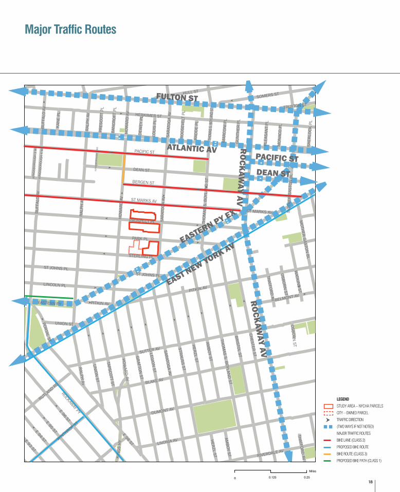
Major traffic routes
Traffic direction (two ways if not noted)
Bike Lane (Class 2)Proposed Bike Route
Bike Route (Class 3)
Proposed Bike Path (Class 1)
New York City Housing AuthorityMap of Prospect Plaza and Surrounding Area
Car and Bike Circulation
N
0.125 0.25
Miles
0
")
")
")
")
")
")DEAN ST
BERGEN ST
PARK PL
THOMAS S. BOYLAN
D STBLAKE AV
SUTTER AV
HERKIMER ST
E 98 ST
BRISTOL ST
CHESTER ST
PACIFIC ST
E 96 ST
PROSPECT PL
ST MARKS AV
LEGION ST
DUMONT AV
STRAUSS ST
LIVONIA AV
BUFF
ALO
AV
AMBOY ST
STERLING PL
GRAFTON ST
SARATOGA AV
HERZL ST
E 95 ST
HULL ST
ROCKAWAY PY
LINCOLN PL
UNION
ST
SOMERS ST
ST JOHNS PL
E 94 ST
HOWARD AV
RIVERDALE AV
WINTHROP ST
TAPSCOTT ST
RALPH AV
WATKIN
S ST
RUTLAND RD
MOTHER GASTON
BL
BELMONT AV
E 93 ST
PORTAL ST
EASTERN PY
OSBORN ST
KIN
GS H
Y
PITKIN AV
THATFORD AV
KAN
E PL
LOUI
S PL
TRUXTON ST
RAD
DE
PL
DEW
EY P
L
MON
ACO
PL
MAR
CON
I PL
GUN
THER
PL
PLEA
SAN
T PL
PRES
COTT
PL
SHER
LOCK
PL
BAN
CROF
T PL
KIN
GSB
OROU
GH
4 W
K
KIN
GSB
OROU
GH
3 W
K
KIN
GSB
OROU
GH
7 W
K
MOT
HER
GAS
TON
BL
HOW
ARD
AV
UNION ST
THATFORD AV
HOW
ARD
AV
BUFF
ALO
AV
HERZL ST
AMBOY ST
RALP
H AV
RALP
H AV
OSBORN ST
SARA
TOG
A AV
THOM
AS S
. BOY
LAN
D S
T
ST JOHNS PL
ST MARKS AV
PITKIN AV
SARA
TOG
A AV
ROOS
EVEL
T PL
THOM
AS S.
BOYL
AND S
T
FULTON ST
ATLANTIC AVPACIFIC STDEAN ST
EASTERN PY EX
EAST NEW YORK AV
RO
CKAWAY AV
RO
CKAW
AY AV
Legend
Study Area - NYCHA Parcels
City-Owned Parcel
Major traffic routes
Traffic direction (two ways if not noted)
Bike Lane (Class 2)Proposed Bike Route
Bike Route (Class 3)
Proposed Bike Path (Class 1)
New York City Housing AuthorityMap of Prospect Plaza and Surrounding Area
Car and Bike Circulation
N
0.125 0.25
Miles
0
LEGEND
STUDY AREA – NYCHA PARCELS
CITY – OWNED PARCEL
TRAFFIC DIRECTION
(TWO WAYS IF NOT NOTED)
MAJOR TRAFFIC ROUTES
BIKE LANE (CLASS 2)
PROPOSED BIKE ROUTE
BIKE ROUTE (CLASS 3)
PROPOSED BIKE PATH (CLASS 1)
19
Demographics & General Housing Data
NYCHA Housing in
CD 16CD16
2006 - 2008Brooklyn
2006 - 2008NYC
2006 - 2008
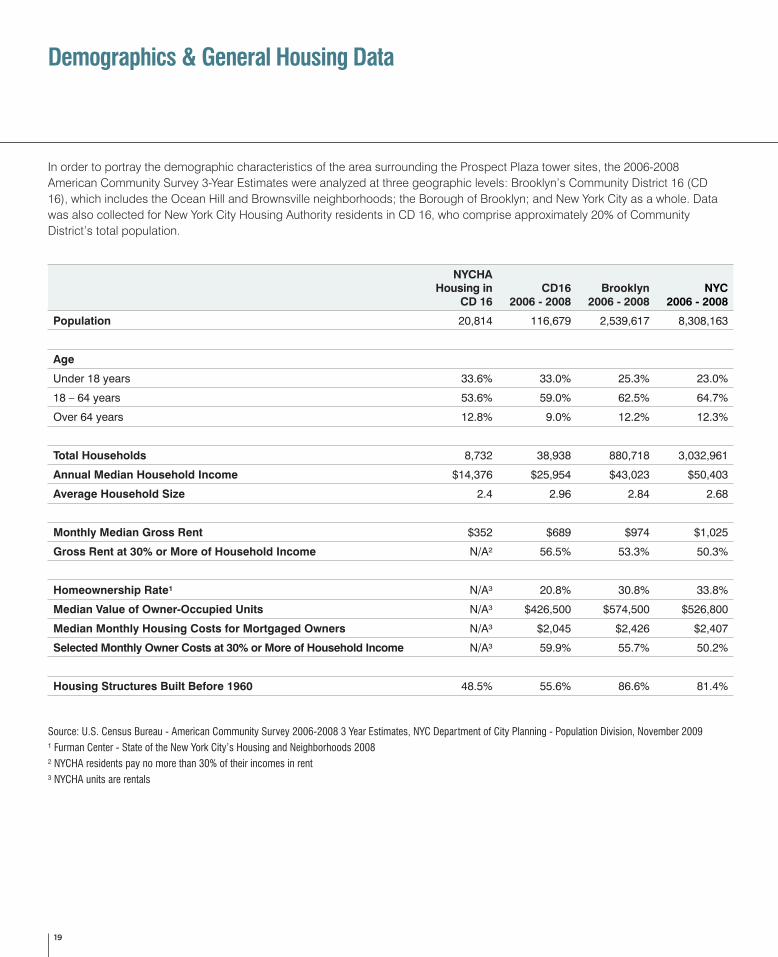
Population 20,814 116,679 2,539,617 8,308,163
Age
Under 18 years 33.6% 33.0% 25.3% 23.0%
18 – 64 years 53.6% 59.0% 62.5% 64.7%
Over 64 years 12.8% 9.0% 12.2% 12.3%
Total Households 8,732 38,938 880,718 3,032,961
Annual Median Household Income $14,376 $25,954 $43,023 $50,403
Average Household Size 2.4 2.96 2.84 2.68
Monthly Median Gross Rent $352 $689 $974 $1,025
Gross Rent at 30% or More of Household Income N/A² 56.5% 53.3% 50.3%
Homeownership Rate¹ N/A³ 20.8% 30.8% 33.8%
Median Value of Owner-Occupied Units N/A³ $426,500 $574,500 $526,800
Median Monthly Housing Costs for Mortgaged Owners N/A³ $2,045 $2,426 $2,407
Selected Monthly Owner Costs at 30% or More of Household Income N/A³ 59.9% 55.7% 50.2%
Housing Structures Built Before 1960 48.5% 55.6% 86.6% 81.4%
Source: U.S. Census Bureau - American Community Survey 2006-2008 3 Year Estimates, NYC Department of City Planning - Population Division, November 2009
¹ Furman Center - State of the New York City’s Housing and Neighborhoods 2008
² NYCHA residents pay no more than 30% of their incomes in rent
³ NYCHA units are rentals
In order to portray the demographic characteristics of the area surrounding the Prospect Plaza tower sites, the 2006-2008 American Community Survey 3-Year Estimates were analyzed at three geographic levels: Brooklyn’s Community District 16 (CD 16), which includes the Ocean Hill and Brownsville neighborhoods; the Borough of Brooklyn; and New York City as a whole. Data was also collected for New York City Housing Authority residents in CD 16, who comprise approximately 20% of Community District’s total population.
The U.S. Department of Housing and Urban Development (HUD) provided support for this community planning workshop.
CONSULTANTS
ACP places citizens at the heart of physical planning, helping diverse interests and stakeholders find a common path toward community improvement. The result? Broadly-supported plans that reflect locally-defined needs and lead to implementation.
PKSB Architects is recognized as an award-winning full-service firm with a long history of completing projects of every scale and scope. Celebrating over 40 years in practice, PKSB has been creating architecture and interior spaces with an ever-expanding range – including academic, preservation, institutional, residential, hospitality, public housing, infrastructure, public art, civic memorials and houses of worship. PKSB’s efforts have been rewarded with numerous design awards, most recently with the AIA 2010 Honor Award for Architecture.
SOURCES
Jackson, Kenneth T. “The Encyclopedia of New York City.” Yale University Press; the New York Historical Society, 1995.
Plunz, Richard. “A History of Housing in New York City.” Columbia University Press, 1990.
Pritchett, Wendell. “Brownsville, Brooklyn – Blacks Jews and the Changing Face of the Ghetto.” The University of Chicago Press, 2002.
PHOTOS
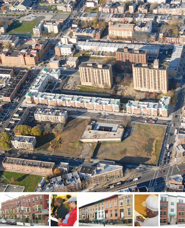
Cover and Page 2-3: Aerial image courtesy of the Local Development Corporation of East New York & Jackson Development Group
Page 3: Photos 1-3: Historic images courtesy of NYCityMap, New York City Department of Information Technology and Telecommunications, City-Wide GIS
Page 6: Photos 2 & 3: Courtesy of the New York City Department of Housing Preservation and Development
Photo 4: Source: Common Ground www.commonground.org
20
Acknowledgements
1