Embed Size (px)
Citation preview
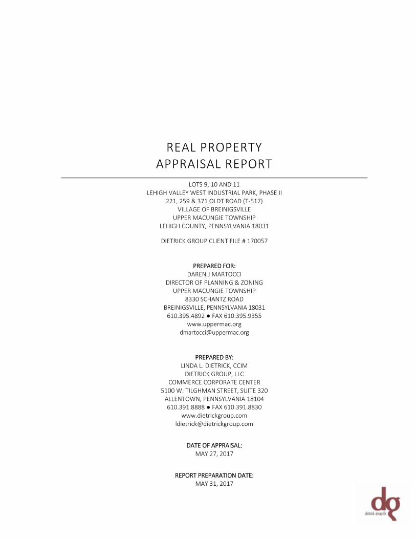
REAL PROPERTY APPRAISAL REPORT
LOTS 9, 10 AND 11
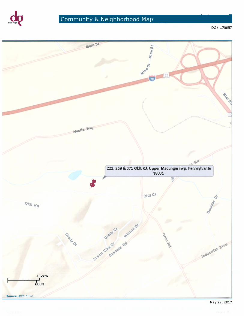
LEHIGH VALLEY WEST INDUSTRIAL PARK, PHASE II 221, 259 & 371 OLDT ROAD (T-517)
VILLAGE OF BREINIGSVILLE UPPER MACUNGIE TOWNSHIP
LEHIGH COUNTY, PENNSYLVANIA 18031
DIETRICK GROUP CLIENT FILE # 170057
PREPARED FOR: DAREN J MARTOCCI
DIRECTOR OF PLANNING & ZONING UPPER MACUNGIE TOWNSHIP
8330 SCHANTZ ROAD BREINIGSVILLE, PENNSYLVANIA 18031
610.395.4892 ● FAX 610.395.9355 www.uppermac.org
PREPARED BY: LINDA L. DIETRICK, CCIM
DIETRICK GROUP, LLC COMMERCE CORPORATE CENTER
5100 W. TILGHMAN STREET, SUITE 320 ALLENTOWN, PENNSYLVANIA 18104 610.391.8888 ● FAX 610.391.8830
www.dietrickgroup.com [email protected]
DATE OF APPRAISAL: MAY 27, 2017
REPORT PREPARATION DATE: MAY 31, 2017
May 31, 2017 Mr. Daren J Martocci Director of Planning & Zoning Upper Macungie Township 8330 Schantz Road Breinigsville, Pennsylvania 18031 [email protected] RE: Market Value Appraisal Report Lots, 9, 10 and 11, Phase II, Lehigh Valley West II Industrial Park 221, 259 & 371 Oldt Road (T-517) Village of Breinigsville, Upper Macungie Township, Lehigh County, Pennsylvania 18031 Dietrick Group Client File #: 170057
Dear Mr. Martocci: Dietrick Group LLC is pleased to submit the accompanying appraisal of the above referenced properties. The purpose of the appraisal is to develop opinions of market value for each of the properties in fee simple title. The client and intended user of this report is Upper Macungie Township and/or affiliates, successors, assigns and any additional users including participants specified herein. The intended use of the report is for potential acquisition decisions in conjunction with a land ‘trade’ of acreage along Twin Ponds Road in Upper Macungie Township, Lehigh County, Pennsylvania. The appraisal is intended to conform to the Uniform Standards of Professional Appraisal Practice (USPAP), the Code of Professional Ethics and Standards of Professional Appraisal Practice of the Appraisal Institute, and applicable state appraisal regulations. The appraisal is also prepared in accordance with the appraisal regulations issued in connection with the Financial Institutions Reform, Recovery and Enforcement Act (FIRREA) and the Interagency Appraisal and Evaluation Guidelines issued December 10, 2010. This report is prepared under the appraisal report option of Standards Rule 2-2 of the 2016-2017 Edition of Uniform Standards of Professional Appraisal Practice (USPAP). Because USPAP gives appraisers the flexibility to vary the level of information in an appraisal report depending on the intended use and intended users of the appraisal, I selected Dietrick Group LLC’s internal criteria for a standard format appraisal report. This type of report has a moderate level of detail. It summarizes the information analyzed, the appraisal methods employed and the reasoning that supports the analyses, opinions and conclusions.
Commercial Real Estate Appraisal, Advisory Valuation & Consultation Services
5100 Tilghman Street, Suite 320 Allentown, PA 18104 p: 610.391.8888 f: 610.391.8830 www.dietrickgroup.com
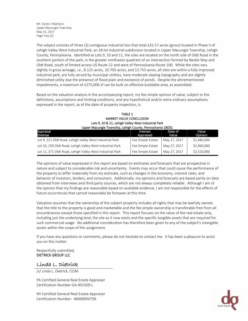
Mr. Daren J Martocci Upper Macungie Township May 31, 2017 Page Two (2) The subject consists of three (3) contiguous industrial lots that total ±32.57-acres (gross) located in Phase II of Lehigh Valley West Industrial Park, an 18-lot industrial subdivision located in Upper Macungie Township, Lehigh County, Pennsylvania. Identified as Lots 9, 10 and 11, the sites are located on the north side of Oldt Road in the southern portion of the park, in the greater northwest quadrant of an intersection formed by Nestle Way and Oldt Road, south of limited access US Route 22 and west of Pennsylvania Route 100. While the sites vary slightly in gross acreage, i.e., 8.115-acres, 10.703-acres, and 13.753-acres, all sites are within a fully improved industrial park, are fully served by municipal utilities, have moderate sloping topography and are slightly diminished utility due the presence of flood plain and existence of ponds. Despite the aforementioned impediments, a maximum of ±275,000-sf can be built on effective buildable area, as assembled. Based on the valuation analysis in the accompanying report, my fee simple opinion of value, subject to the definitions, assumptions and limiting conditions, and any hypothetical and/or extra-ordinary assumptions expressed in the report, as of the date of property inspection, is:
TABLE 1 MARKET VALUE CONCLUSION
Lots 9, 10 & 11, Lehigh Valley West Industrial Park Upper Macungie Township, Lehigh County, Pennsylvania 18031
Appraisal Premise
Interest Appraised
Date of Value
Value Opinion
Lot 9, 221 Oldt Road, Lehigh Valley West Industrial Park Fee Simple Estate May 27, 2017 $1,480,000
Lot 10, 259 Oldt Road, Lehigh Valley West Industrial Park Fee Simple Estate May 27, 2017 $1,960,000
Lot 11, 371 Oldt Road, Lehigh Valley West Industrial Park Fee Simple Estate May 27, 2017 $2,520,000
The opinions of value expressed in this report are based on estimates and forecasts that are prospective in nature and subject to considerable risk and uncertainty. Events may occur that could cause the performance of the property to differ materially from my estimate, such as changes in the economy, interest rates, and behavior of investors, lenders, and consumers. Additionally, my opinions and forecasts are based partly on data obtained from interviews and third party sources, which are not always completely reliable. Although I am of the opinion that my findings are reasonable based on available evidence, I am not responsible for the effects of future occurrences that cannot reasonably be foreseen at this time. Valuation assumes that the ownership of the subject property includes all rights that may be lawfully owned, that the title to the property is good and marketable and the fee simple ownership is transferable free from all encumbrances except those specified in this report. This report focuses on the value of the real estate only, including just the underlying land, the site as it now exists and the specific tangible assets that are required for such commercial usage. No additional consideration has therefore been given to any of the subject's intangible assets within the scope of this assignment. If you have any questions or comments, please do not hesitate to contact me. It has been a pleasure to assist you on this matter. Respectfully submitted, DIETRICK GROUP LLC
Linda L. Dietrick /s/ Linda L. Dietrick, CCIM PA Certified General Real Estate Appraiser Certification Number GA-001509-L NY Certified General Real Estate Appraiser Certification Number: 46000050756
TABLE OF CONTENTS
SECTION 1: GENERAL INFORMATION ................................................................................................................................................... 2
PROPERTY IDENTIFICATION ............................................................................................................................................................................................... 2 CURRENT OWNERSHIP & SALES HISTORY ....................................................................................................................................................................... 2 PURPOSE OF THE APPRAISAL ............................................................................................................................................................................................. 2 DEFINITION OF MARKET VALUE ....................................................................................................................................................................................... 3 DEFINITION OF ‘AS IS’ MARKET VALUE ............................................................................................................................................................................ 3 DEFINITION OF EFFECTIVE DATE OF APPRAISAL ............................................................................................................................................................ 3 DEFINITION OF PROPERTY RIGHTS APPRAISED .............................................................................................................................................................. 3 INTENDED USE AND USER ................................................................................................................................................................................................. 3 APPLICABLE REQUIREMENTS ............................................................................................................................................................................................ 4 REPORT FORMAT ................................................................................................................................................................................................................ 4 PRIOR SERVICES ................................................................................................................................................................................................................... 4 EXPOSURE TIME & MARKETING TIME ............................................................................................................................................................................. 4 EXTRAORDINARY ASSUMPTIONS ...................................................................................................................................................................................... 5 HYPOTHETICAL CONDITIONS ............................................................................................................................................................................................ 5 SCOPE OF WORK .................................................................................................................................................................................................................. 5 VALUATION PROCESS & METHODOLOGY ....................................................................................................................................................................... 6 METHODOLOGY FOR VALUATION OF THE SUBJECT PROPERTIES .............................................................................................................................. 7
SECTION 2: SURROUNDING AREA ANALYSIS ......................................................................................................................................... 9
LOCATION – UPPER MACUNGIE TOWNSHIP, LEHIGH COUNTY, PENNSYLVANIA .................................................................................................... 9 ACCESS & LINKAGES ................................................................................................................................................................................. 9 DEMOGRAPHIC FACTORS ......................................................................................................................................................................... 10 DEMAND GENERATORS ........................................................................................................................................................................... 11 AERIAL PHOTOGRAPH ............................................................................................................................................................................. 12 OUTLOOK AND CONCLUSIONS .................................................................................................................................................................. 12
SECTION 3: OVERALL & INDIVIDUAL PROPERTY DESCRIPTIONS ........................................................................................................... 14
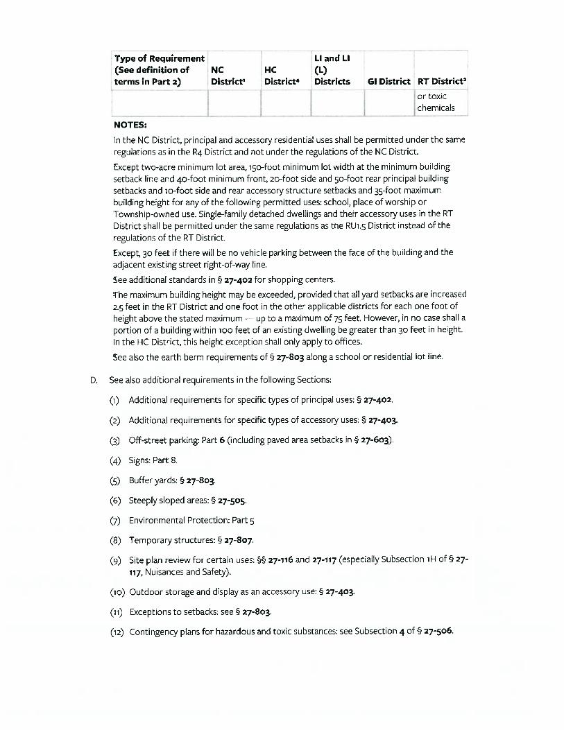
GENERAL DESCRIPTION .................................................................................................................................................................................................... 14 CENSUS TRACT/BLOCK ............................................................................................................................................................................ 14 PARCEL/TAX IDENTIFICATIONS .................................................................................................................................................................. 14 LAND AREA ............................................................................................................................................................................................ 14 CONFIGURATION, TOPOGRAPHY & TERRAIN ............................................................................................................................................... 14 SOIL GEOLOGY ....................................................................................................................................................................................... 14 EASEMENTS, NUISANCES, HAZARDS OR ENCROACHMENTS ........................................................................................................................... 14 COVENANTS, CONDITIONS & RESTRICTIONS ............................................................................................................................................... 15 ACCESS/LINKAGE .................................................................................................................................................................................... 15 UTILITIES ............................................................................................................................................................................................... 15 SITE IMPROVEMENTS .............................................................................................................................................................................. 15 ZONING CODE ........................................................................................................................................................................................ 15 TAXES & ASSESSMENT............................................................................................................................................................................. 16 FLOOD MAP ID ....................................................................................................................................................................................... 16 ENVIRONMENTAL STATUS ........................................................................................................................................................................ 16 DESCRIPTION OF LOTS ............................................................................................................................................................................. 16 LOT 9 ................................................................................................................................................................................................... 17 LOT 10 ................................................................................................................................................................................................. 17 LOT 11 ................................................................................................................................................................................................. 18 CONCLUSION ......................................................................................................................................................................................... 18
SECTION 4: SUBJECT PHOTOGRAPHS .................................................................................................................................................. 20
SECTION 5: HIGHEST AND BEST USE .................................................................................................................................................... 22
SECTION 6: SALES COMPARISON (MARKET) APPROACH ..................................................................................................................... 24
SELECTION OF THE COMPARABLES ................................................................................................................................................................................ 24 DIRECT SALES ANALYSIS .................................................................................................................................................................................................... 25
PROPERTY RIGHTS .................................................................................................................................................................................. 25 FINANCING ............................................................................................................................................................................................ 25 CONDITIONS OF SALE .............................................................................................................................................................................. 25 EXPENDITURES AFTER THE PURCHASE ....................................................................................................................................................... 26 MARKET CONDITIONS ............................................................................................................................................................................. 26
LOCATION ............................................................................................................................................................................................. 27 LOT SIZE/SITE UTILITY .............................................................................................................................................................................. 27 UTILITY PROVISION/TOPOGRAPHY/CONFIGURATION AND ZONING ................................................................................................................ 27
FINAL VALUE INDICATIONS .............................................................................................................................................................................................. 28
CERTIFICATION ..................................................................................................................................................................................... B
ASSUMPTIONS, LIMITING CONDITIONS AND CONTINGENCIES .............................................................................................................. C
QUALIFICATIONS OF LINDA L. DIETRICK, CCIM .......................................................................................................................................F
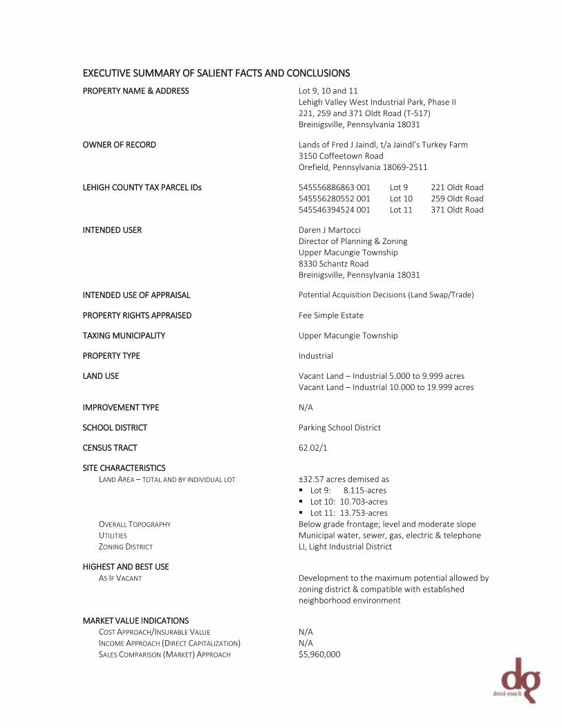
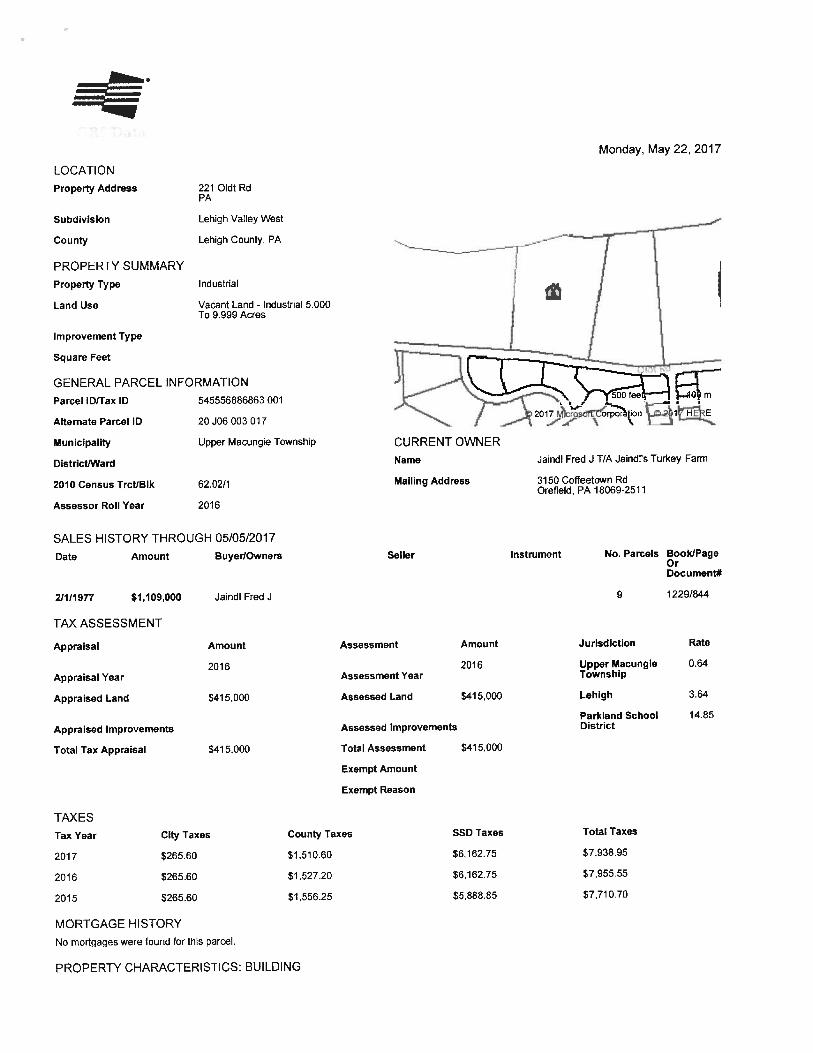
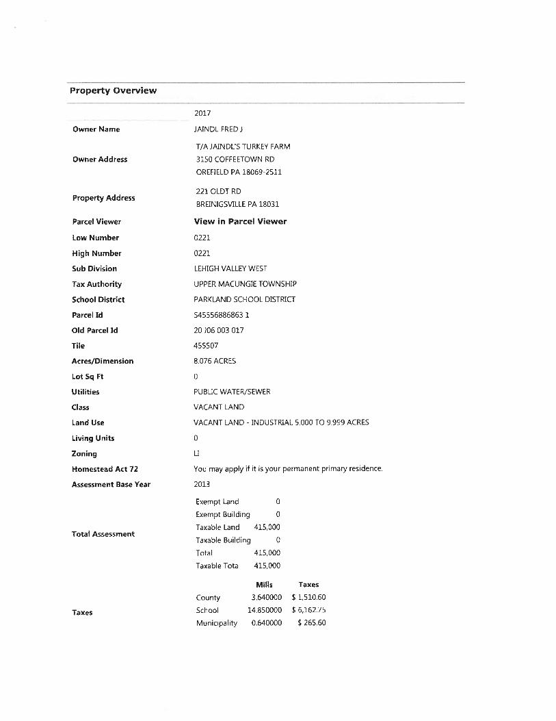
EXECUTIVE SUMMARY OF SALIENT FACTS AND CONCLUSIONS PROPERTY NAME & ADDRESS Lot 9, 10 and 11
Lehigh Valley West Industrial Park, Phase II 221, 259 and 371 Oldt Road (T-517) Breinigsville, Pennsylvania 18031
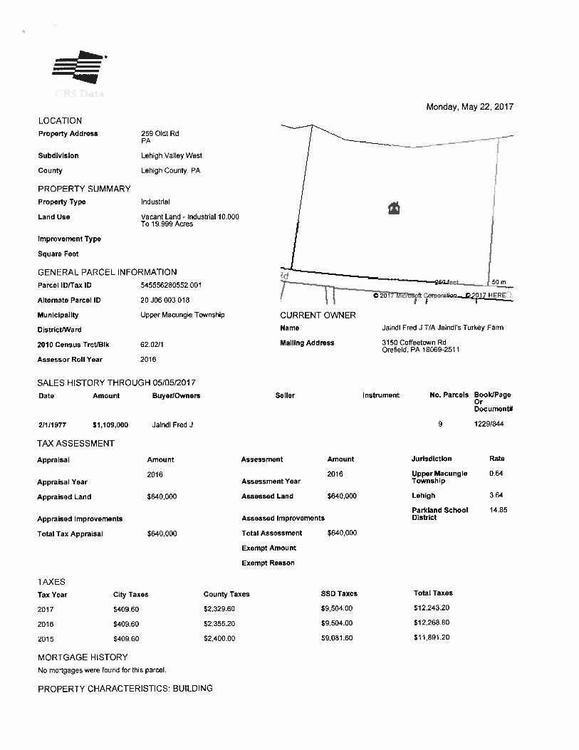
OWNER OF RECORD Lands of Fred J Jaindl, t/a Jaindl’s Turkey Farm
3150 Coffeetown Road Orefield, Pennsylvania 18069-2511
LEHIGH COUNTY TAX PARCEL IDs 545556886863 001 Lot 9 221 Oldt Road 545556280552 001 Lot 10 259 Oldt Road 545546394524 001 Lot 11 371 Oldt Road INTENDED USER Daren J Martocci
Director of Planning & Zoning Upper Macungie Township 8330 Schantz Road Breinigsville, Pennsylvania 18031
INTENDED USE OF APPRAISAL Potential Acquisition Decisions (Land Swap/Trade) PROPERTY RIGHTS APPRAISED Fee Simple Estate TAXING MUNICIPALITY Upper Macungie Township PROPERTY TYPE Industrial LAND USE Vacant Land – Industrial 5.000 to 9.999 acres
Vacant Land – Industrial 10.000 to 19.999 acres IMPROVEMENT TYPE N/A SCHOOL DISTRICT Parking School District CENSUS TRACT 62.02/1 SITE CHARACTERISTICS LAND AREA – TOTAL AND BY INDIVIDUAL LOT ±32.57 acres demised as Lot 9: 8.115-acres Lot 10: 10.703-acres Lot 11: 13.753-acres OVERALL TOPOGRAPHY Below grade frontage; level and moderate slope UTILITIES Municipal water, sewer, gas, electric & telephone ZONING DISTRICT LI, Light Industrial District HIGHEST AND BEST USE AS IF VACANT Development to the maximum potential allowed by
zoning district & compatible with established neighborhood environment
MARKET VALUE INDICATIONS COST APPROACH/INSURABLE VALUE N/A INCOME APPROACH (DIRECT CAPITALIZATION) N/A SALES COMPARISON (MARKET) APPROACH $5,960,000
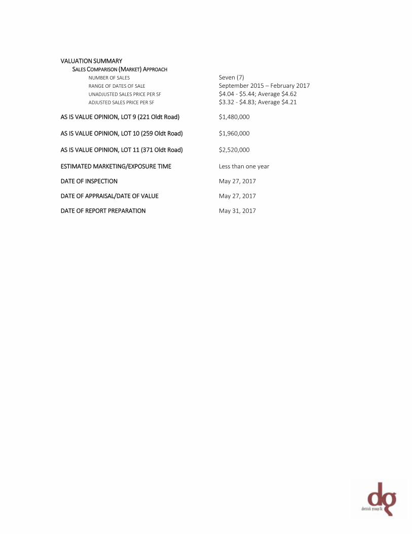
VALUATION SUMMARY SALES COMPARISON (MARKET) APPROACH NUMBER OF SALES Seven (7) RANGE OF DATES OF SALE September 2015 – February 2017 UNADJUSTED SALES PRICE PER SF $4.04 - $5.44; Average $4.62 ADJUSTED SALES PRICE PER SF $3.32 - $4.83; Average $4.21 AS IS VALUE OPINION, LOT 9 (221 Oldt Road) $1,480,000 AS IS VALUE OPINION, LOT 10 (259 Oldt Road) $1,960,000 AS IS VALUE OPINION, LOT 11 (371 Oldt Road) $2,520,000 ESTIMATED MARKETING/EXPOSURE TIME Less than one year DATE OF INSPECTION May 27, 2017 DATE OF APPRAISAL/DATE OF VALUE May 27, 2017 DATE OF REPORT PREPARATION May 31, 2017

~ 1 ~
DG# 170057 SECTION 1: GENERAL INFORMATION
~ 2 ~
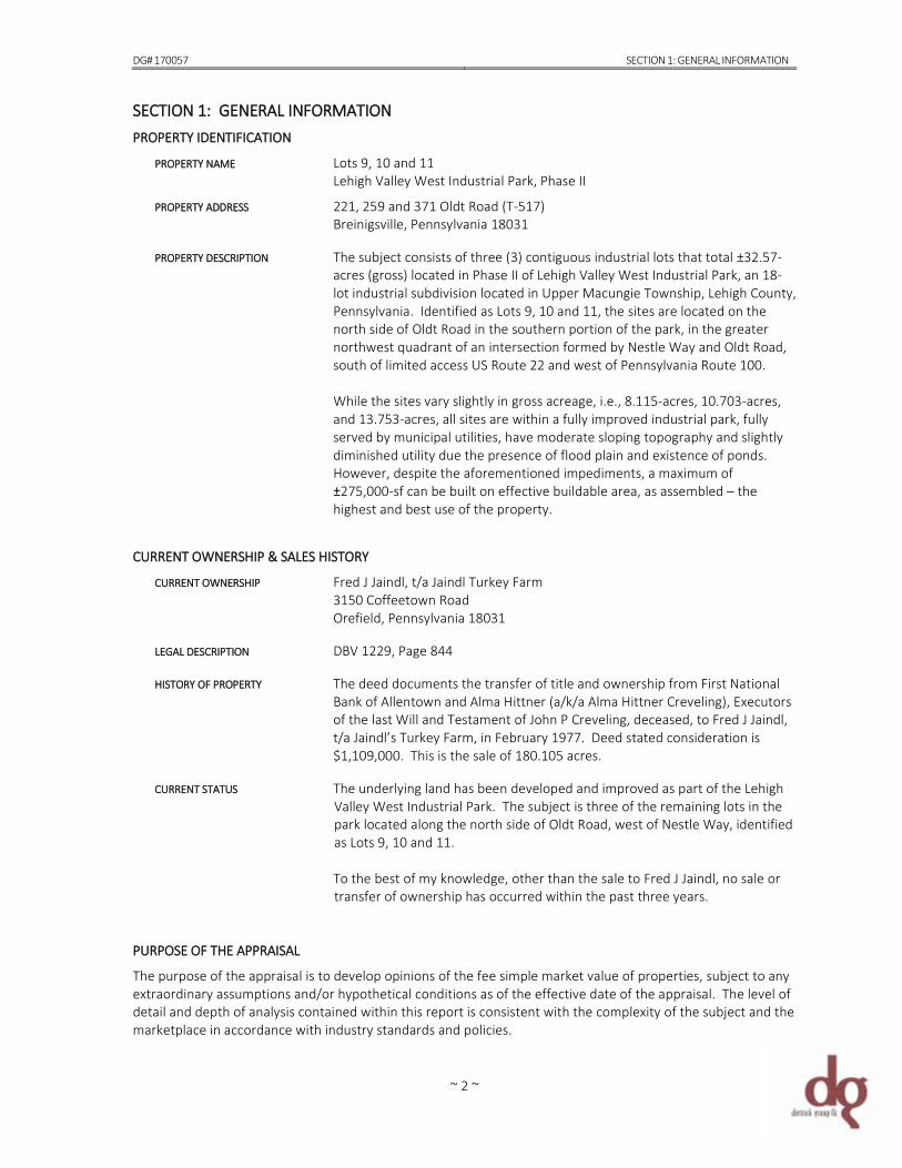
SECTION 1: GENERAL INFORMATION PROPERTY IDENTIFICATION PROPERTY NAME Lots 9, 10 and 11
Lehigh Valley West Industrial Park, Phase II PROPERTY ADDRESS 221, 259 and 371 Oldt Road (T-517)
Breinigsville, Pennsylvania 18031 PROPERTY DESCRIPTION The subject consists of three (3) contiguous industrial lots that total ±32.57-
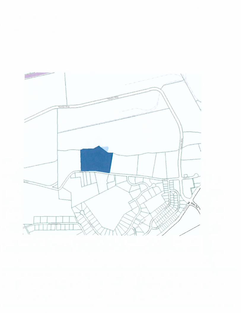
acres (gross) located in Phase II of Lehigh Valley West Industrial Park, an 18-lot industrial subdivision located in Upper Macungie Township, Lehigh County, Pennsylvania. Identified as Lots 9, 10 and 11, the sites are located on the north side of Oldt Road in the southern portion of the park, in the greater northwest quadrant of an intersection formed by Nestle Way and Oldt Road, south of limited access US Route 22 and west of Pennsylvania Route 100. While the sites vary slightly in gross acreage, i.e., 8.115-acres, 10.703-acres, and 13.753-acres, all sites are within a fully improved industrial park, fully served by municipal utilities, have moderate sloping topography and slightly diminished utility due the presence of flood plain and existence of ponds. However, despite the aforementioned impediments, a maximum of ±275,000-sf can be built on effective buildable area, as assembled – the highest and best use of the property.
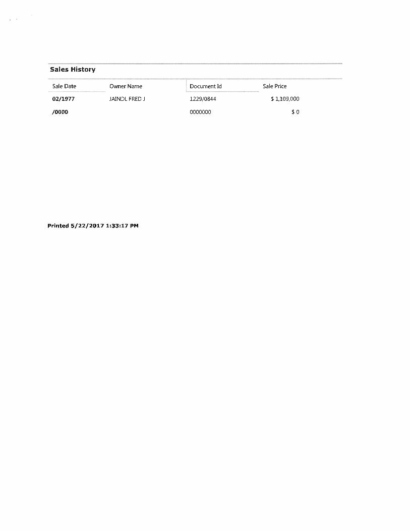
CURRENT OWNERSHIP & SALES HISTORY CURRENT OWNERSHIP Fred J Jaindl, t/a Jaindl Turkey Farm
3150 Coffeetown Road Orefield, Pennsylvania 18031
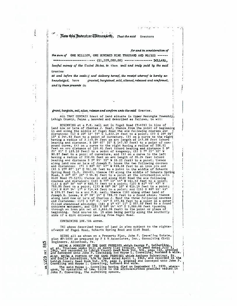
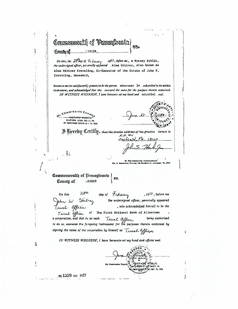
LEGAL DESCRIPTION DBV 1229, Page 844 HISTORY OF PROPERTY The deed documents the transfer of title and ownership from First National
Bank of Allentown and Alma Hittner (a/k/a Alma Hittner Creveling), Executors of the last Will and Testament of John P Creveling, deceased, to Fred J Jaindl, t/a Jaindl’s Turkey Farm, in February 1977. Deed stated consideration is $1,109,000. This is the sale of 180.105 acres.
CURRENT STATUS The underlying land has been developed and improved as part of the Lehigh
Valley West Industrial Park. The subject is three of the remaining lots in the park located along the north side of Oldt Road, west of Nestle Way, identified as Lots 9, 10 and 11. To the best of my knowledge, other than the sale to Fred J Jaindl, no sale or transfer of ownership has occurred within the past three years.
PURPOSE OF THE APPRAISAL The purpose of the appraisal is to develop opinions of the fee simple market value of properties, subject to any extraordinary assumptions and/or hypothetical conditions as of the effective date of the appraisal. The level of detail and depth of analysis contained within this report is consistent with the complexity of the subject and the marketplace in accordance with industry standards and policies.
DG# 170057 SECTION 1: GENERAL INFORMATION
~ 3 ~
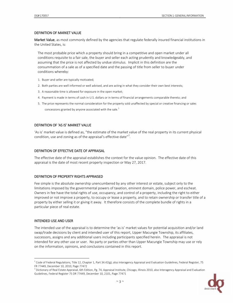
DEFINITION OF MARKET VALUE Market Value, as most commonly defined by the agencies that regulate federally insured financial institutions in the United States, is:
The most probable price which a property should bring in a competitive and open market under all conditions requisite to a fair sale, the buyer and seller each acting prudently and knowledgeably, and assuming that the price is not affected by undue stimulus. Implicit in this definition are the consummation of a sale as of a specified date and the passing of title from seller to buyer under conditions whereby: 1. Buyer and seller are typically motivated;
2. Both parties are well informed or well advised, and are acting in what they consider their own best interests;
3. A reasonable time is allowed for exposure in the open market;
4. Payment is made in terms of cash in U.S. dollars or in terms of financial arrangements comparable thereto; and
5. The price represents the normal consideration for the property sold unaffected by special or creative financing or sales
concessions granted by anyone associated with the sale.1
DEFINITION OF ‘AS IS’ MARKET VALUE ‘As is’ market value is defined as, “the estimate of the market value of the real property in its current physical condition, use and zoning as of the appraisal’s effective date”2. DEFINITION OF EFFECTIVE DATE OF APPRAISAL The effective date of the appraisal establishes the context for the value opinion. The effective date of this appraisal is the date of most recent property inspection or May 27, 2017. DEFINITION OF PROPERTY RIGHTS APPRAISED Fee simple is the absolute ownership unencumbered by any other interest or estate, subject only to the limitations imposed by the governmental powers of taxation, eminent domain, police power, and escheat. Owners in fee have the total rights of use, occupancy, and control of a property, including the right to either improved or not improve a property, to occupy or lease a property, and to retain ownership or transfer title of a property by either selling it or giving it away. It therefore consists of the complete bundle of rights in a particular piece of real estate. INTENDED USE AND USER The intended use of the appraisal is to determine the ‘as is’ market values for potential acquisition and/or land swap/trade decisions by client and intended user of this report, Upper Macungie Township, its affiliates, successors, assigns and any additional users including participants specified herein. The appraisal is not intended for any other use or user. No party or parties other than Upper Macungie Township may use or rely on the information, opinions, and conclusions contained in this report.
1 Code of Federal Regulations, Title 12, Chapter 1, Part 34.42(g); also Interagency Appraisal and Evaluation Guidelines, Federal Register, 75 FR 77449, December 10, 2010, Page 77472 2 Dictionary of Real Estate Appraisal, 6th Edition, Pg. 74, Appraisal Institute, Chicago, Illinois 2010, also Interagency Appraisal and Evaluation Guidelines, Federal Register 75 DR 77449, December 10, 2101, Page 77471
DG# 170057 SECTION 1: GENERAL INFORMATION
~ 4 ~
APPLICABLE REQUIREMENTS The appraisal is intended to conform to the requirements of the following: • Uniform Standards of Professional Appraisal Practice (USPAP),
• Code of Professional Ethics and Standards of Professional Appraisal Practice of the Appraisal Institute,
• Applicable state appraisal regulations
• Appraisal requirements of Title XI of the Financial Institutions Reform, Recovery and Enforcement Act of 1989 (FIRREA);
revised June 7, 1994;
• Interagency Appraisal and Evaluation Guidelines issued December 10, 2010.
REPORT FORMAT This report is prepared under the appraisal report option of Standards Rule 2-2 of the 2016-2017 edition of Uniform Standards of Professional Appraisal Practice (USPAP), the generally recognized ethical and performance standards for the appraisal profession in the United States. Adopted by Congress in 1989, USPAP contains standards for all types of appraisal services, including real estate, personal property, business and mass appraisal. Because USPAP gives appraisers the flexibility to vary the level of information in an appraisal report depending on the intended use and intended users of the appraisal, I selected Dietrick Group LLC’s internal criteria for a standard format appraisal report. This type of report has a moderate level of detail. It summarizes the information analyzed, the appraisal methods employed and the reasoning that supports the analyses, opinions and conclusions. PRIOR SERVICES USPAP requires appraisers to disclose to the client any other services they have provided in connection with the subject property in the prior three years, including valuation, consulting, property management, brokerage, or any other services. Dietrick Group LLC has not performed any services, as appraisers or in any other capacity, regarding the property that is the subject of this report within the three-year period immediately preceding acceptance of this assignment. EXPOSURE TIME & MARKETING TIME The exposure time associated with a market value opinion can affect the value opinion. The length of time that a property is exposed in the market impacts the number of potential buyers for the property. Longer exposure to the market typically results in more potential buyers, and shorter exposure to the market typically results in fewer potential buyers. The number of potential buyers who are aware of a property’s availability can influence the sale price. It follows then that when a value opinion is based on market exposure that is inadequate or excessive, the value opinion is not market-oriented. Improper identification of the reasonable exposure time in a market value opinion can lead to a value conclusion that is not credible. The First Quarter 2017 PwC Real Estate Investor Survey was referenced for the national land development marketing times. Strategies are quite diverse among investors in the national land development market for the year ahead and include buying, selling and holding as the real estate recovery continues. While investors may be divided when it comes to which land type to pursue, they unanimously see positive opportunities for this sector over the near term. Construction activity across all major property types continues to increase driven by the ongoing recovery in the economy and commercial real estate fundamentals. Looking ahead over the next
DG# 170057 SECTION 1: GENERAL INFORMATION
~ 5 ~
12 months, surveyed investors unanimously forecast property values in the national development land market to increase. This, coupled with an investigation of local and regional activity, I believe that a marketing period of less than one year is reasonably appropriate and probable for the subject properties. This, of course, further assumes reasonable marketing effort and projected pricing in line with my final opinion of market value. EXTRAORDINARY ASSUMPTIONS An extraordinary assumption is one directly related to a specific assignment, which if found to be false, could alter the conclusion. The value conclusion in this report is subject to the extraordinary assumptions listed below.
1. The physical description of the property is based upon the on-site inspection performed May 2017 and the various public records obtained from Lehigh County and Upper Macungie Township. As such, all information is assumed to be accurate and correct. However, should further data not discovered by the research become available, or misrepresentations or inaccuracies become known, I retain the right to review and/or revise my final value opinions.
2. Valuation assumes that the ownership of the subject property includes all rights that may be lawfully owned, that the title to
the property is good and marketable and the fee simple ownership is transferable free from all encumbrances except those specified in this report.
3. The gross acreage was determined from Lehigh County assessment property cards (public record) and cross referenced with
the revised final land development plan of Lehigh Valley West Industrial Subdivision (March 1993) provided by Upper Macungie Township. The net useable (buildable) acreage due to flood plain and existing ponds was estimated using 2017 Courthouse Retrieval System (CRS) data. In the event that this information is incorrect or additional data not discovered by the research become available, or misrepresentations or inaccuracies become known, I retain the right to review and/or revise my final value opinions.
HYPOTHETICAL CONDITIONS A hypothetical condition is one that is known to be contrary to what exists, but is supposed for the purposes of analysis. The appraisal of the subject property does not incorporate any hypothetical conditions. SCOPE OF WORK To determine the appropriate scope of work for this assignment, I considered the intended use of the appraisal, the needs of the user, the complexity of the property and other pertinent factors. My concluded scope of work is described as follows. In preparing this appraisal, an inspection of the properties and the surrounding environs was conducted on May 27, 2017. The physical description of the properties has relied upon the on-site inspection, various public records obtained from Lehigh County (recorder of deeds and assessment), Upper Macungie Township (zoning and planning) and the final land development plan of Lehigh Valley West Industrial Park prepared by Pidcock Company. Site reconnaissance and photographs were helpful in determining more specific property information such as overall lot size, configuration and other physical detail as well as predominant immediate and extended neighborhood characteristics. The zoning district was confirmed by Upper Macungie Township zoning ordinance and corresponding zoning map. Municipal utility provision was confirmed by the applicable authorities; soil geology was determined by the Soil Survey of Lehigh County and cross referenced with the final land development plan. Gross land measures correspond with those found on public record and the land development; effective buildable area was estimated using 2017 Courthouse Retrieval System (CRS) data. Property lines, areas, etc. are assumed correct.

DG# 170057 SECTION 1: GENERAL INFORMATION
~ 6 ~
No opinion is rendered as to property title, which is assumed good and marketable. Unless otherwise stated, no consideration is given to liens or encumbrances against the property. Sketches, maps, photos, or other graphic aids included in this report are intended to assist the reader in ready identification and visualization of the property and are not included for technical purposes. Valuation assumes that entitlements and other regulatory agency approvals can be obtained and that all required licenses and/or permits, consents or other legislative or administrative authority for any local, state, or national governmental or private entity or organizations can be obtained for development of these sites. The type and extent of my research and analysis is detailed throughout the report. Consideration and conclusion(s) in this appraisal report are based upon regional and local market data obtained and developed by Dietrick Group LLC. Such information is gathered from a variety of sources, i.e. physical inspections, public records, Co-Star, CCIM SiteToDoBusiness, Lehigh Valley Multiple Listing Service (LVARMLS), industry publications, market surveys, and interactions with various buyers, sellers, brokers, appraisers and other related real estate professionals. Although I make an effort to confirm the arms-length nature of each sale with a party to the transaction, it is sometimes necessary to rely on secondary verification from sources deemed reliable. All market data is assembled in a proprietary database owned, managed, and maintained by Dietrick Group LLC. VALUATION PROCESS & METHODOLOGY The appraisal process strives to develop a well-supported opinion of a defined value based on the analysis of pertinent general and specific data relative to the market and the particular subject property. Three approaches to value are generally considered when developing a market value opinion for real property. The three traditional methods of processing this data into an appropriate value indication include the:
Cost Approach Income Approach Sales Comparison Approach
The cost approach is based on the premise that assumes "a prudent buyer would pay no more for a property than the cost to acquire a similar site and construct improvements of equivalent desirability and utility without undue delay."3 This approach derives fee simple value by estimating the current cost to construct a reproduction of, or replacement for, an existing structure, including entrepreneurial incentive, deducting all accrued depreciation, and adding the estimated value of the underlying land. It is generally considered most applicable in valuing relatively new or proposed construction when the improvements represent the highest and best use of the land and estimates of land value and depreciation can be well supported. It is also especially useful when valuing unique and/or special-purpose properties, where income is unavailable and little to no comparable sale data exists. The income approach develops a value indication for an income-producing property by analyzing its capacity to generate future benefits and capitalizing that income stream into an opinion of present value via direct capitalization or by discounting its annual cash flows. It therefore is intended to reflect the market relationship between a property's income potential and overall leased fee value. The sales comparison approach is a "set of procedures in which value is derived by comparing the property being appraised to similar properties that have been sold recently, then applying appropriate units of comparison and making adjustments to the sale prices of the comparable sales based on the elements of comparison."4 This technique is used to indicate the value established by informed buyers and sellers in the open real estate market. It is based on the principle of substitution, whereas the value of a property tends to be set by the price that would be paid to acquire an equally desirable property with the same utility.
3 The Appraisal of Real Estate, 13th Edition, Pg. 380 4 The Dictionary of Real Estate Appraisal, 4th Edition, Pg. 255
DG# 170057 SECTION 1: GENERAL INFORMATION
~ 7 ~
The three approaches are rarely independent and, in fact, are interrelated valuation procedures with a common objective of arriving at a convincing and reliable estimate of value. Once the applicable approaches are completed, the appraiser reconciles the facts as represented by the individual approaches into a final value estimate. METHODOLOGY FOR VALUATION OF THE SUBJECT PROPERTIES Dietrick Group LLC analyzed the data gathered using appropriate and accepted appraisal methodology to arrive at a probable value indication via each applicable approach to value. All three traditional approaches to value were considered but only one approach - the sales comparison approach - has been developed to provide ‘as is’ fee simple market value opinions as of the date of most recent inspection, May 27, 2017. The sales comparison approach is an analysis of comparison of the sales or offerings of similar properties within a general area of the subject. This approach is considered to be the most appropriate and preferred method of valuing land that is essentially vacant. It is also the most commonly understood of the appraisal processes in that there are no formulae necessary for its basic interpretation. In developing this approach, an opinion of market value is developed by comparing properties similar to the subject property that have recently sold, are listed for sale, or are under contract. The major premise of this approach is that the market value of a property is related to the prices of comparable, competitive properties. This approach is applicable to all types of real property interests when there are sufficient recent, reliable transactions to indicate value patterns or trends in the market. When data is available, this is the most straightforward and simple way to explain and support a value opinion. Therefore, in accord with your engagement and the scope of work previously defined, the complete appraisal process is considered to have been performed.
~ 8 ~
DG #170057 SECTION 2: SURROUNDING AREA ANALYSIS
~ 9 ~
SECTION 2: SURROUNDING AREA ANALYSIS
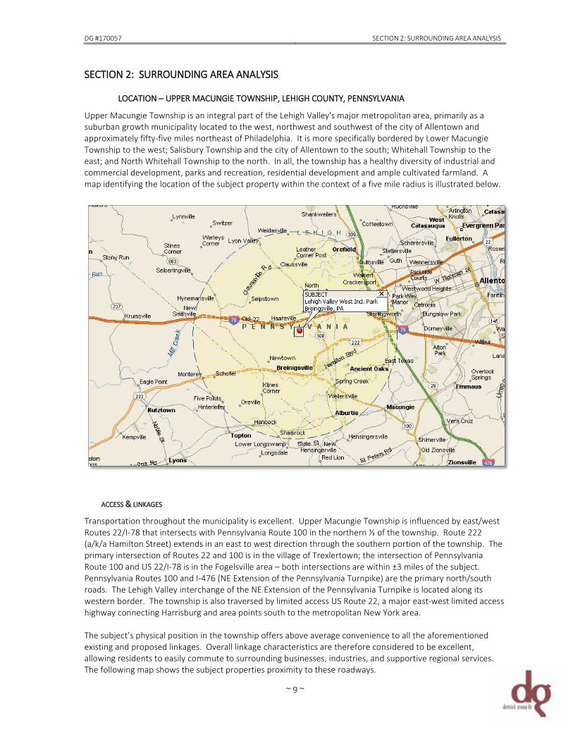
LOCATION – UPPER MACUNGIE TOWNSHIP, LEHIGH COUNTY, PENNSYLVANIA Upper Macungie Township is an integral part of the Lehigh Valley's major metropolitan area, primarily as a suburban growth municipality located to the west, northwest and southwest of the city of Allentown and approximately fifty-five miles northeast of Philadelphia. It is more specifically bordered by Lower Macungie Township to the west; Salisbury Township and the city of Allentown to the south; Whitehall Township to the east; and North Whitehall Township to the north. In all, the township has a healthy diversity of industrial and commercial development, parks and recreation, residential development and ample cultivated farmland. A map identifying the location of the subject property within the context of a five mile radius is illustrated below.
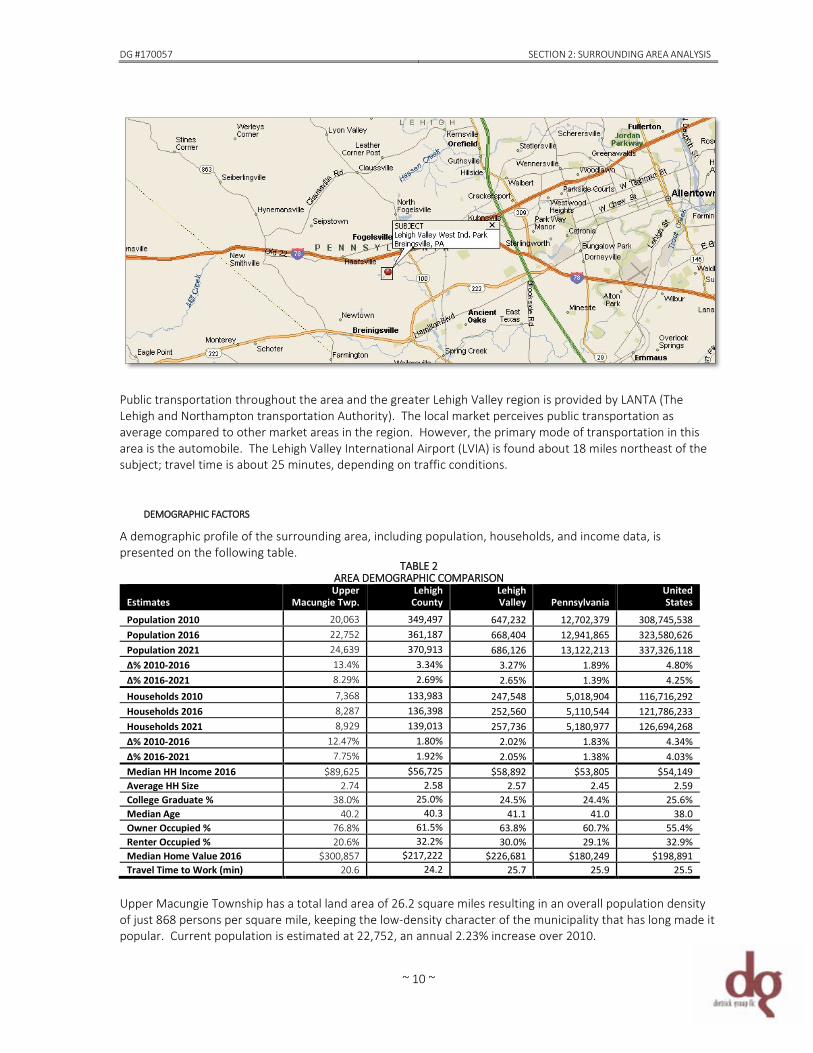
ACCESS & LINKAGES Transportation throughout the municipality is excellent. Upper Macungie Township is influenced by east/west Routes 22/I-78 that intersects with Pennsylvania Route 100 in the northern ⅓ of the township. Route 222 (a/k/a Hamilton Street) extends in an east to west direction through the southern portion of the township. The primary intersection of Routes 22 and 100 is in the village of Trexlertown; the intersection of Pennsylvania Route 100 and US 22/I-78 is in the Fogelsville area – both intersections are within ±3 miles of the subject. Pennsylvania Routes 100 and I-476 (NE Extension of the Pennsylvania Turnpike) are the primary north/south roads. The Lehigh Valley interchange of the NE Extension of the Pennsylvania Turnpike is located along its western border. The township is also traversed by limited access US Route 22, a major east-west limited access highway connecting Harrisburg and area points south to the metropolitan New York area. The subject’s physical position in the township offers above average convenience to all the aforementioned existing and proposed linkages. Overall linkage characteristics are therefore considered to be excellent, allowing residents to easily commute to surrounding businesses, industries, and supportive regional services. The following map shows the subject properties proximity to these roadways.
DG #170057 SECTION 2: SURROUNDING AREA ANALYSIS
~ 10 ~
Public transportation throughout the area and the greater Lehigh Valley region is provided by LANTA (The Lehigh and Northampton transportation Authority). The local market perceives public transportation as average compared to other market areas in the region. However, the primary mode of transportation in this area is the automobile. The Lehigh Valley International Airport (LVIA) is found about 18 miles northeast of the subject; travel time is about 25 minutes, depending on traffic conditions.
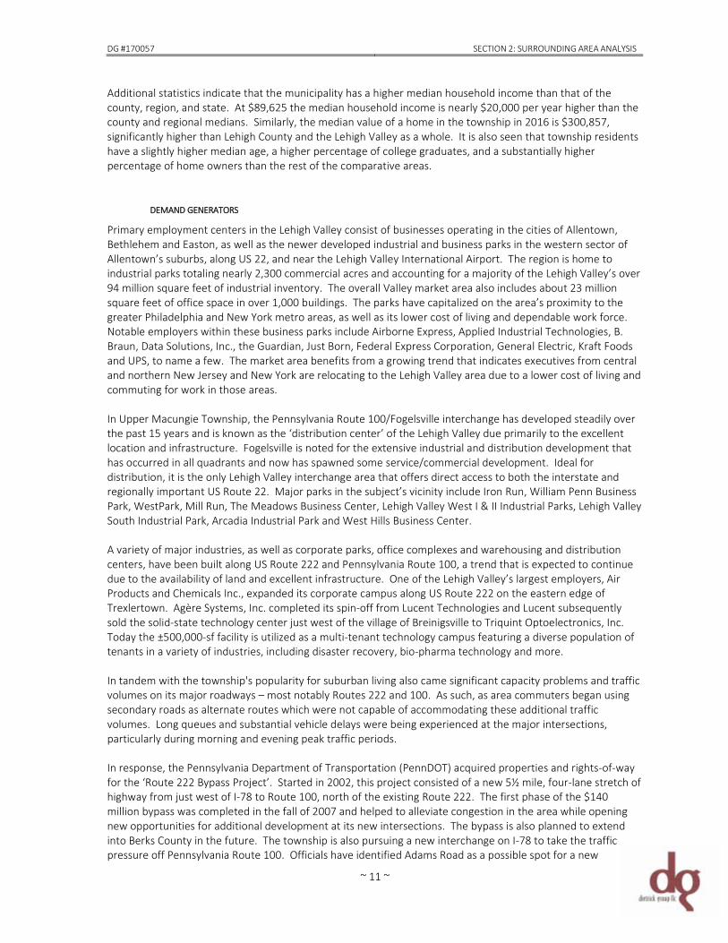
DEMOGRAPHIC FACTORS A demographic profile of the surrounding area, including population, households, and income data, is presented on the following table.
TABLE 2 AREA DEMOGRAPHIC COMPARISON
Estimates
Upper Macungie Twp.
Lehigh County
Lehigh Valley
Pennsylvania
United States
Population 2010 20,063 349,497 647,232 12,702,379 308,745,538 Population 2016 22,752 361,187 668,404 12,941,865 323,580,626 Population 2021 24,639 370,913 686,126 13,122,213 337,326,118 ∆% 2010-2016 13.4% 3.34% 3.27% 1.89% 4.80% ∆% 2016-2021 8.29% 2.69% 2.65% 1.39% 4.25% Households 2010 7,368 133,983 247,548 5,018,904 116,716,292 Households 2016 8,287 136,398 252,560 5,110,544 121,786,233 Households 2021 8,929 139,013 257,736 5,180,977 126,694,268 ∆% 2010-2016 12.47% 1.80% 2.02% 1.83% 4.34% ∆% 2016-2021 7.75% 1.92% 2.05% 1.38% 4.03% Median HH Income 2016 $89,625 $56,725 $58,892 $53,805 $54,149 Average HH Size 2.74 2.58 2.57 2.45 2.59 College Graduate % 38.0% 25.0% 24.5% 24.4% 25.6% Median Age 40.2 40.3 41.1 41.0 38.0 Owner Occupied % 76.8% 61.5% 63.8% 60.7% 55.4% Renter Occupied % 20.6% 32.2% 30.0% 29.1% 32.9% Median Home Value 2016 $300,857 $217,222 $226,681 $180,249 $198,891 Travel Time to Work (min) 20.6 24.2 25.7 25.9 25.5
Upper Macungie Township has a total land area of 26.2 square miles resulting in an overall population density of just 868 persons per square mile, keeping the low-density character of the municipality that has long made it popular. Current population is estimated at 22,752, an annual 2.23% increase over 2010.
DG #170057 SECTION 2: SURROUNDING AREA ANALYSIS
~ 11 ~
Additional statistics indicate that the municipality has a higher median household income than that of the county, region, and state. At $89,625 the median household income is nearly $20,000 per year higher than the county and regional medians. Similarly, the median value of a home in the township in 2016 is $300,857, significantly higher than Lehigh County and the Lehigh Valley as a whole. It is also seen that township residents have a slightly higher median age, a higher percentage of college graduates, and a substantially higher percentage of home owners than the rest of the comparative areas.
DEMAND GENERATORS Primary employment centers in the Lehigh Valley consist of businesses operating in the cities of Allentown, Bethlehem and Easton, as well as the newer developed industrial and business parks in the western sector of Allentown’s suburbs, along US 22, and near the Lehigh Valley International Airport. The region is home to industrial parks totaling nearly 2,300 commercial acres and accounting for a majority of the Lehigh Valley’s over 94 million square feet of industrial inventory. The overall Valley market area also includes about 23 million square feet of office space in over 1,000 buildings. The parks have capitalized on the area’s proximity to the greater Philadelphia and New York metro areas, as well as its lower cost of living and dependable work force. Notable employers within these business parks include Airborne Express, Applied Industrial Technologies, B. Braun, Data Solutions, Inc., the Guardian, Just Born, Federal Express Corporation, General Electric, Kraft Foods and UPS, to name a few. The market area benefits from a growing trend that indicates executives from central and northern New Jersey and New York are relocating to the Lehigh Valley area due to a lower cost of living and commuting for work in those areas. In Upper Macungie Township, the Pennsylvania Route 100/Fogelsville interchange has developed steadily over the past 15 years and is known as the ‘distribution center’ of the Lehigh Valley due primarily to the excellent location and infrastructure. Fogelsville is noted for the extensive industrial and distribution development that has occurred in all quadrants and now has spawned some service/commercial development. Ideal for distribution, it is the only Lehigh Valley interchange area that offers direct access to both the interstate and regionally important US Route 22. Major parks in the subject’s vicinity include Iron Run, William Penn Business Park, WestPark, Mill Run, The Meadows Business Center, Lehigh Valley West I & II Industrial Parks, Lehigh Valley South Industrial Park, Arcadia Industrial Park and West Hills Business Center. A variety of major industries, as well as corporate parks, office complexes and warehousing and distribution centers, have been built along US Route 222 and Pennsylvania Route 100, a trend that is expected to continue due to the availability of land and excellent infrastructure. One of the Lehigh Valley’s largest employers, Air Products and Chemicals Inc., expanded its corporate campus along US Route 222 on the eastern edge of Trexlertown. Agère Systems, Inc. completed its spin-off from Lucent Technologies and Lucent subsequently sold the solid-state technology center just west of the village of Breinigsville to Triquint Optoelectronics, Inc. Today the ±500,000-sf facility is utilized as a multi-tenant technology campus featuring a diverse population of tenants in a variety of industries, including disaster recovery, bio-pharma technology and more. In tandem with the township's popularity for suburban living also came significant capacity problems and traffic volumes on its major roadways – most notably Routes 222 and 100. As such, as area commuters began using secondary roads as alternate routes which were not capable of accommodating these additional traffic volumes. Long queues and substantial vehicle delays were being experienced at the major intersections, particularly during morning and evening peak traffic periods. In response, the Pennsylvania Department of Transportation (PennDOT) acquired properties and rights-of-way for the ‘Route 222 Bypass Project’. Started in 2002, this project consisted of a new 5½ mile, four-lane stretch of highway from just west of I-78 to Route 100, north of the existing Route 222. The first phase of the $140 million bypass was completed in the fall of 2007 and helped to alleviate congestion in the area while opening new opportunities for additional development at its new intersections. The bypass is also planned to extend into Berks County in the future. The township is also pursuing a new interchange on I-78 to take the traffic pressure off Pennsylvania Route 100. Officials have identified Adams Road as a possible spot for a new
DG #170057 SECTION 2: SURROUNDING AREA ANALYSIS
~ 12 ~
interchange. Adams Road is just west of the PA Route 100 interchange in a less congested area. It also has an existing overpass at I-78. Also in continuing the efforts to reduce truck traffic created due to the industrial park/distribution development, the township is moving forward on barring tractor-trailers from certain stretches of roads within the municipality. The state plans to add an auxiliary lane to both sides of I-78 between Route 100 and Ruppsville Road, a project that will give motorists more time to enter and exit the highway in one of the most congested sections of the township. The $5.1 million project will involve adding an auxiliary lane on I-78 eastbound and extending the existing auxiliary lane on I-78 westbound between Route 22 and Route 100, adding a full lane on each side between the interchanges. This project is unrelated to a proposal to add an interchange to I-78 at Adams Road.
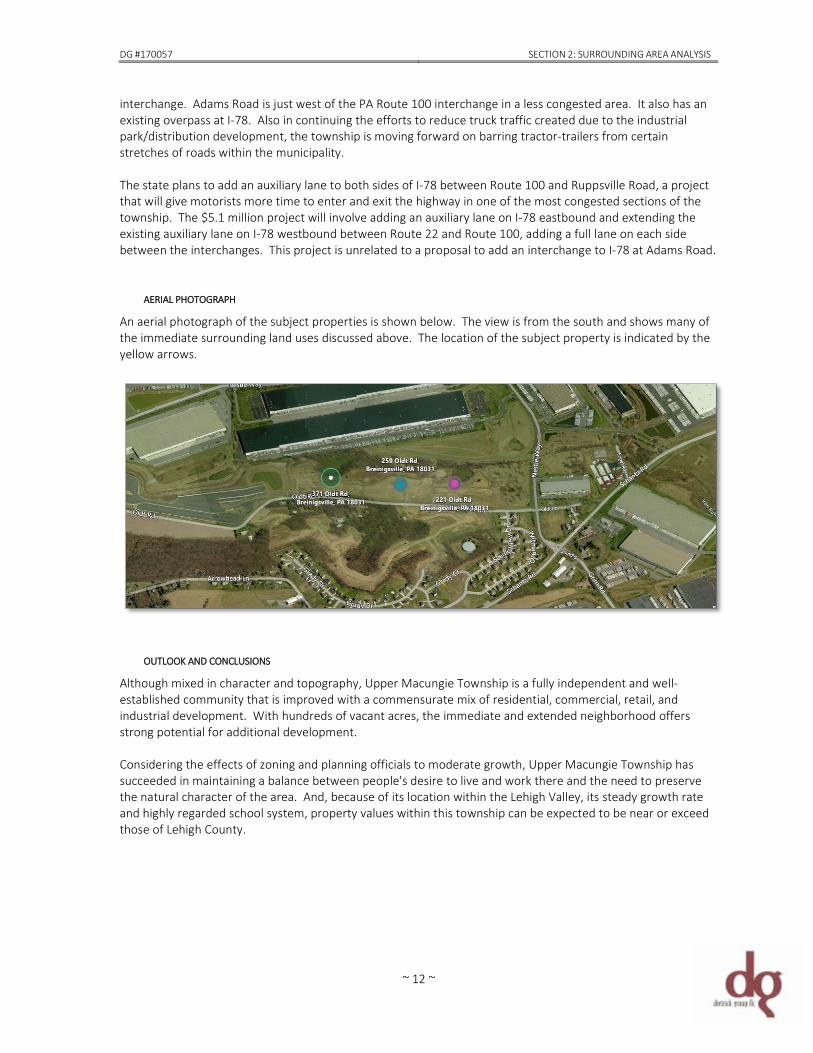
AERIAL PHOTOGRAPH An aerial photograph of the subject properties is shown below. The view is from the south and shows many of the immediate surrounding land uses discussed above. The location of the subject property is indicated by the yellow arrows.
OUTLOOK AND CONCLUSIONS Although mixed in character and topography, Upper Macungie Township is a fully independent and well-established community that is improved with a commensurate mix of residential, commercial, retail, and industrial development. With hundreds of vacant acres, the immediate and extended neighborhood offers strong potential for additional development. Considering the effects of zoning and planning officials to moderate growth, Upper Macungie Township has succeeded in maintaining a balance between people's desire to live and work there and the need to preserve the natural character of the area. And, because of its location within the Lehigh Valley, its steady growth rate and highly regarded school system, property values within this township can be expected to be near or exceed those of Lehigh County.

~ 13 ~
DG #170057 SECTION 3: OVERALL & INDIVIDUAL PROPERTY DESCRIPTIONS
~ 14 ~
SECTION 3: OVERALL & INDIVIDUAL PROPERTY DESCRIPTIONS The general location of the subject sites is indicated on the aerial map below. The following outline provides the most relevant information and commentary regarding the site characteristics, both as assembled and individually. The comments are based on my physical description of the properties as a result of the on-site field inspection, various public records obtained from Lehigh County and Upper Macungie Township and the final land development plan for Lehigh Valley West Industrial subdivision.
GENERAL DESCRIPTION
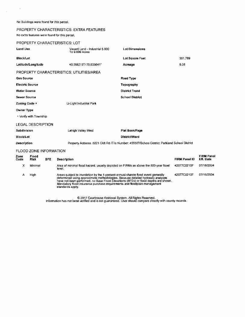
CENSUS TRACT/BLOCK 62.02/1 PARCEL/TAX IDENTIFICATIONS 545556886863 001 Lot 9 221 Oldt Road 545556280552 001 Lot 10 259 Oldt Road 545546394524 001 Lot 11 371 Oldt Road LAND AREA As indicated above, the subject sites are contiguous along the north side of
Oldt Road (T-517). Combined, total land area is ±32.57-acres (gross) individually, Lot 8 measures ±8.115-acres, Lot 9 is ±10.703-acres and Lot 10 is ±13.753-acres. However, due to the intrusion of the flood plain caused by the Iron Run tributary and presence of two ponds, net useable (buildable) acreage is diminished.
CONFIGURATION, TOPOGRAPHY &
TERRAIN Each parcel is moderately irregular in configuration. All three lots are open and cleared with moderately sloping topography that is slightly below grade with their frontages along the north side of Oldt Road. Elevation difference is estimated between 10’ to 30’ over demised area.
SOIL GEOLOGY Although no soil report was provided for this analysis, it is assumed that the
soils throughout this section of Lehigh Valley are of load-bearing capacity sufficient to support future development of the site. However, Dietrick Group LLC will assume no responsibility for and make no representation as to soil conditions.
EASEMENTS, NUISANCES,
HAZARDS OR ENCROACHMENTS There are no known or apparent adverse easements or encroachments affecting the subject property except the typical drainage and utility easements associated with such suburban development.
Lot 11 371 Oldt Rd Lot 10
259 Oldt Rd Lot 9 221 Oldt Rd
DG #170057 SECTION 3: OVERALL & INDIVIDUAL PROPERTY DESCRIPTIONS
~ 15 ~
However, the investigation of easements, nuisances, hazards and encroachments did not include a title search or detailed investigation beyond the sources presented in this report. If undisclosed easements, nuisances, hazards, restrictions or encroachments are present, their impact on value has not been considered within the scope of this report.
COVENANTS, CONDITIONS &
RESTRICTIONS Other than the covenants of the Lehigh Valley West park, there are no known or apparent covenants, conditions or restrictions impacting the site that are considered to affect the marketability or highest and best use. While it is possible that certain covenants may burden title to this plat, Dietrick Group LLC will assume no responsibility for and make no representation or warranty as to the accuracy of any restriction.
ACCESS/LINKAGE The site is located in the greater northwest quadrant of an intersection
formed by Nestle Way and Oldt Road. Surrounding streets are primarily township and state roadways, which are important arterial and access roads for the traffic generated from the surrounding industrial park and residential development. Overall, the sites are well-located, easily accessible to major suburban employment centers, nearby industrial parks, retail activity and community services in Upper Macungie Township and surrounding municipalities. Linkage is considered good.
UTILITIES Each site can be fully served by municipal water, sewer and gas; electric and
telephone are also available. Utility providers are listed on the table below.
TABLE 3 MUNICIPAL UTILITY PROVIDERS
Utility Provider Electric Pennsylvania Power & Light (PPL) Telephone Verizon of PA Natural Gas UGI Water Lehigh County Authority Sewer Upper Macungie Township Authority
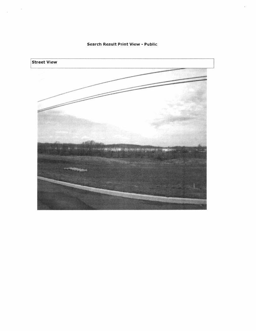
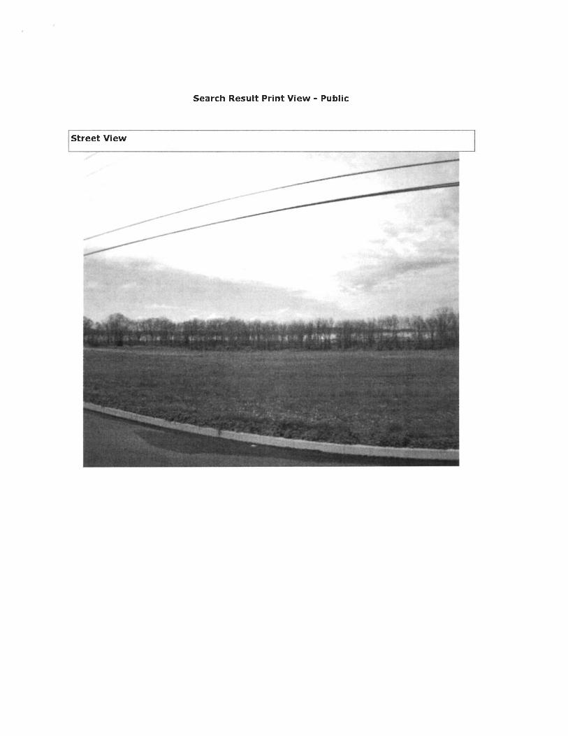
SITE IMPROVEMENTS Clearly evident in the photographs presented in SECTION 4, the sites are
vacant improved building lots. Ground cover appears to be wooded outcrops, grass and green vegetation (unknown variety). Site improvements include curbing and municipal extension of utility lines along Oldt Road. Drainage is assumed adequate.
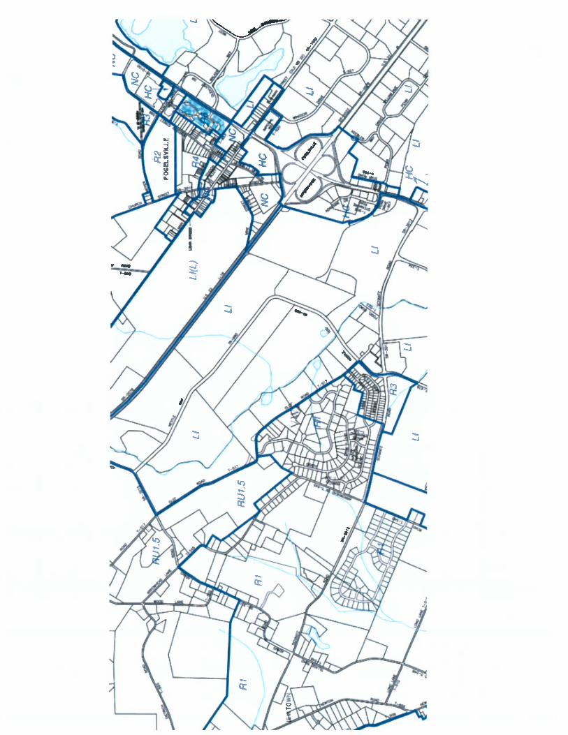
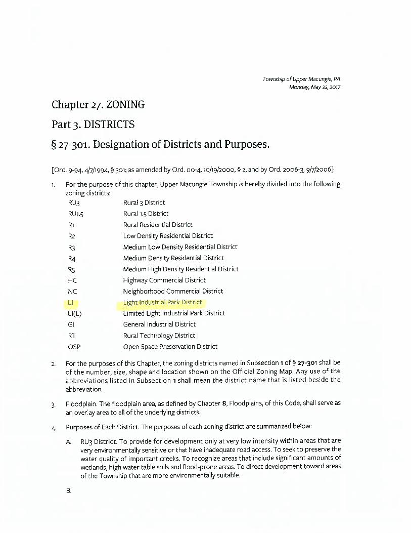
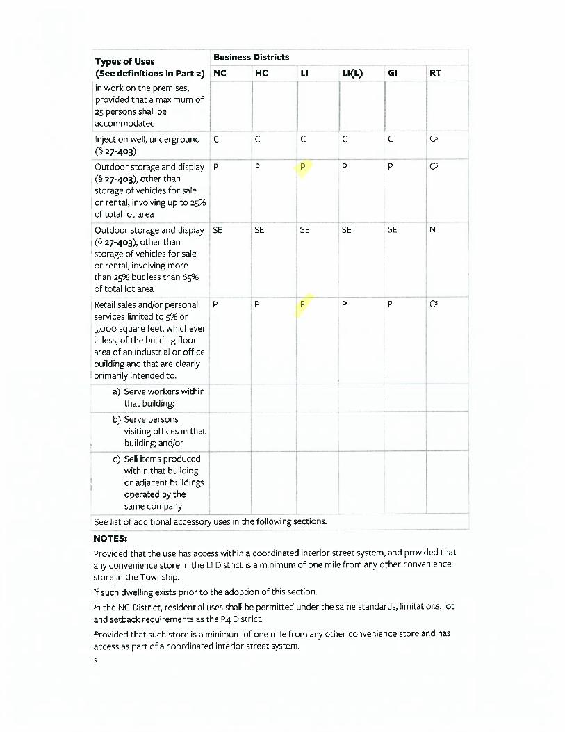
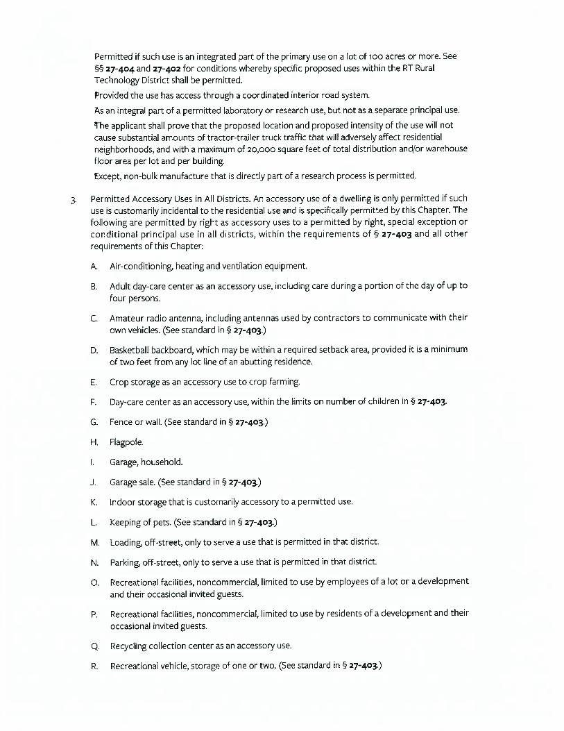
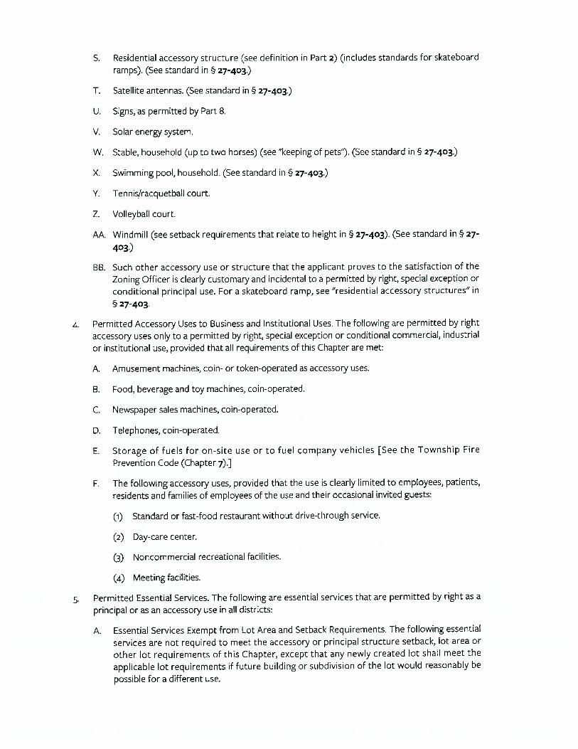
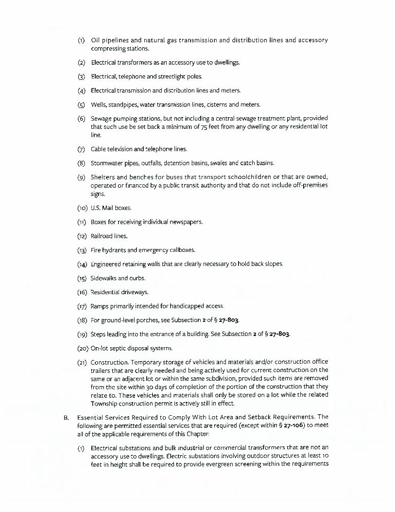
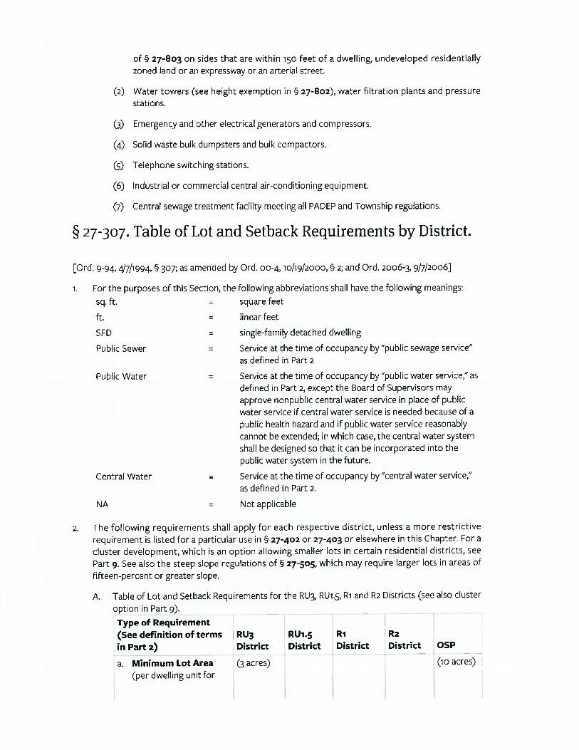
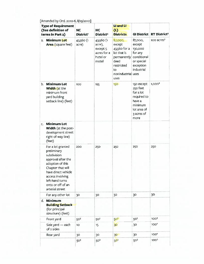
ZONING CODE According to the zoning map, the site are located in the LI, Light Industrial
District of Upper Macungie Township. The purpose of the LI District5 is to (a) provide sufficient space in appropriate locations to meet current and anticipated future regional needs for light industries, offices and limited types of related commercial development; (b) to carefully control uses to protect the public health and safety, (c) to maintain an attractive physical environment with a campus-like setting that will aid in attracting new businesses; (d) to encourage development that follow an overall plan with common design and landscaping plans; (e) to seek a unified and well planned system of providing vehicular access to avoid many individual unplanned driveways entering onto arterial streets, and (f) to
5 Chapter 27, §27-301, Designation of Districts and Purposes and §27-306, Table of Permitted Uses by District; the LI zoning ordinance is included in the addendum
DG #170057 SECTION 3: OVERALL & INDIVIDUAL PROPERTY DESCRIPTIONS
~ 16 ~
encourage industries to develop within industrial parks with owner-established deed restrictions.
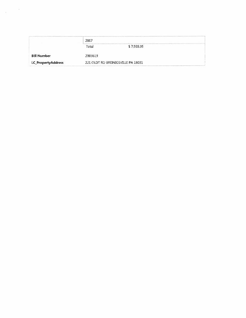
TAXES & ASSESSMENT The subject parcels have a combined 2017 assessment of $1,812,000. Based
upon the Lehigh County common level ratio of 99%, as determined by the State Tax Equalization Board of the Pennsylvania Department of Revenue for the period July 1, 2016 through June 30, 2017, the implied market value is $1,830,120.
TABLE 4 2017 TAXES AND ASSESSMENTS
Assessed Land
Assessed Improvements
Total Assessment
RE Tax Liability
Lot 9, 221 Oldt Road $ 415,000 $0.00 $ 415,000 $ 7,938.95 Lot 10, 259 Oldt Road $ 640,000 $0.00 $ 640,000 $12,243.20 Lot 11, 371 Oldt Road $ 757,000 $0.00 $ 757,000 $14,481.41 $1,812,000 $0.00 $1,812,000 $34,663.56
Application of all current millage rates for Upper Macungie Township (0.01913000) results in an annual property tax liability of $34,663.56 for the three properties. Individual lot assessments and taxes are also shown on the chart above.
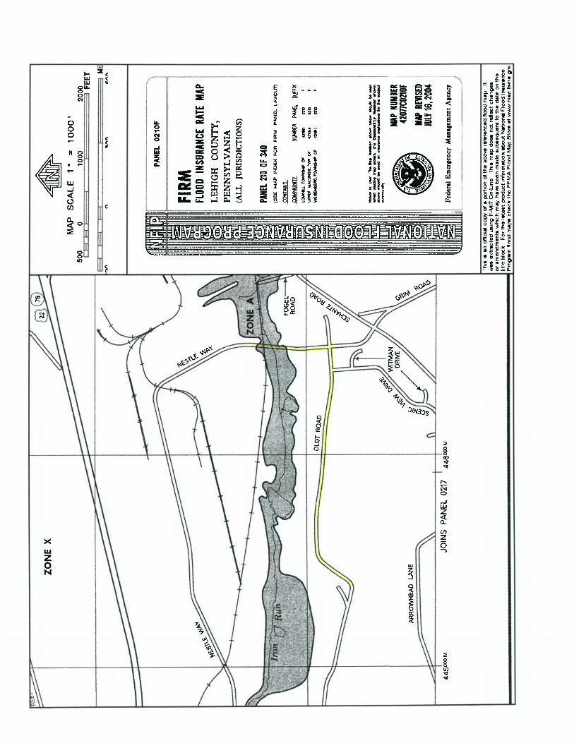
FLOOD MAP ID The property is identified on community map panel 42077C0210F of the
National Flood Insurance Program Map series, dated July 16, 2004. The land is located in Zone “X”, an area generally designated as being clear of flood hazards outside the 100 and 500-year flood plains with some acreage in Zone “A”, an area of high flood risk. Mandatory flood insurance purchase requirements and floodplain management standards apply.
ENVIRONMENTAL STATUS The value opinions provided for the subject properties are based on the
assumption that they are not affected by the existence of any hazardous substance or detrimental environmental condition. In this report, the subject sites have been analyzed assuming a 'clean' environmental status.
DESCRIPTION OF LOTS The following is a brief description of each lot. These drawings were taken
from the revised final land development plan of Lehigh Valley West Industrial subdivision prepared by Pidcock Co. Gross acreage is indicated on each lot; the approximate edge of the flood plain is highlighted on each lot.
Lot 11: ±13.753-acres Lot 10:
±10.703-acres Lot 9: ±8.115 acres
DG #170057 SECTION 3: OVERALL & INDIVIDUAL PROPERTY DESCRIPTIONS
~ 17 ~
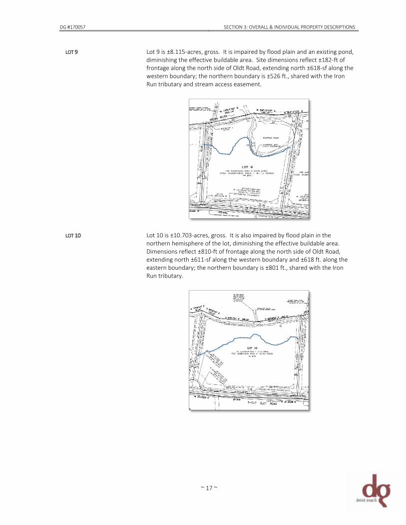
LOT 9 Lot 9 is ±8.115-acres, gross. It is impaired by flood plain and an existing pond, diminishing the effective buildable area. Site dimensions reflect ±182-ft of frontage along the north side of Oldt Road, extending north ±618-sf along the western boundary; the northern boundary is ±526 ft., shared with the Iron Run tributary and stream access easement.
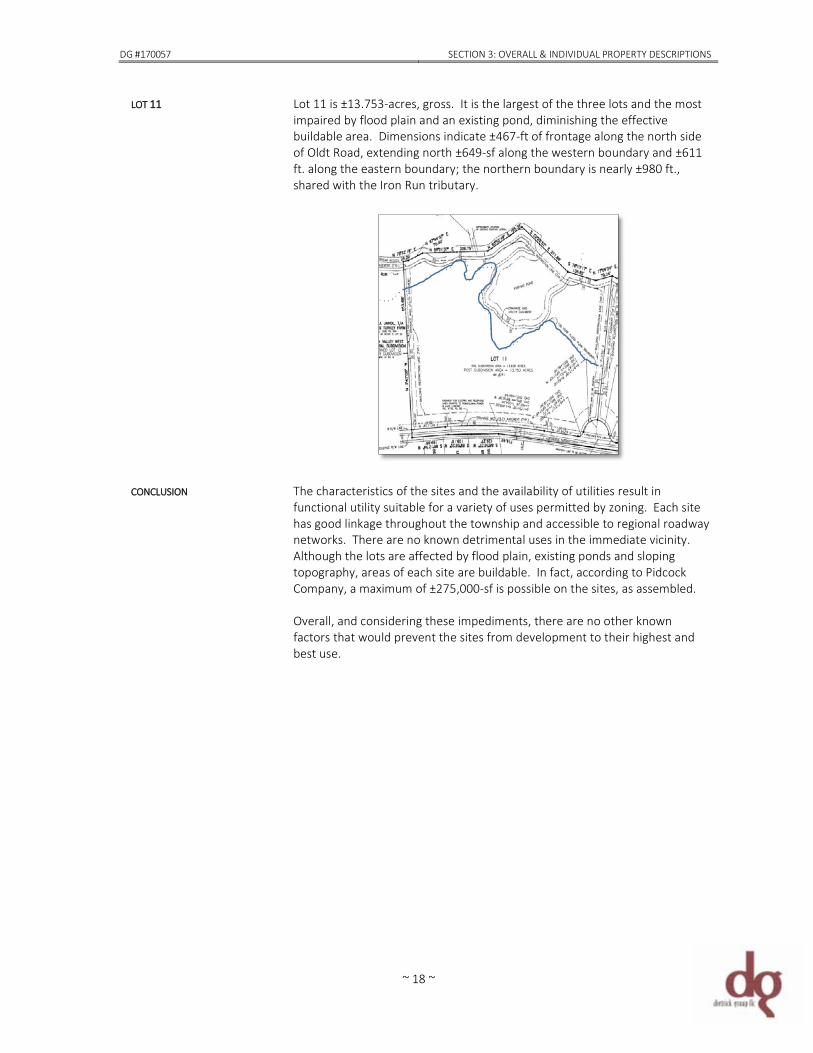
LOT 10 Lot 10 is ±10.703-acres, gross. It is also impaired by flood plain in the
northern hemisphere of the lot, diminishing the effective buildable area. Dimensions reflect ±810-ft of frontage along the north side of Oldt Road, extending north ±611-sf along the western boundary and ±618 ft. along the eastern boundary; the northern boundary is ±801 ft., shared with the Iron Run tributary.
DG #170057 SECTION 3: OVERALL & INDIVIDUAL PROPERTY DESCRIPTIONS
~ 18 ~
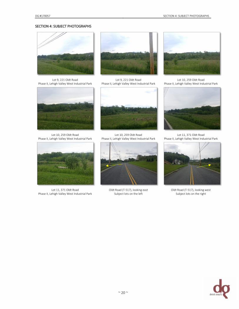
LOT 11 Lot 11 is ±13.753-acres, gross. It is the largest of the three lots and the most impaired by flood plain and an existing pond, diminishing the effective buildable area. Dimensions indicate ±467-ft of frontage along the north side of Oldt Road, extending north ±649-sf along the western boundary and ±611 ft. along the eastern boundary; the northern boundary is nearly ±980 ft., shared with the Iron Run tributary.
CONCLUSION The characteristics of the sites and the availability of utilities result in
functional utility suitable for a variety of uses permitted by zoning. Each site has good linkage throughout the township and accessible to regional roadway networks. There are no known detrimental uses in the immediate vicinity. Although the lots are affected by flood plain, existing ponds and sloping topography, areas of each site are buildable. In fact, according to Pidcock Company, a maximum of ±275,000-sf is possible on the sites, as assembled. Overall, and considering these impediments, there are no other known factors that would prevent the sites from development to their highest and best use.

~ 19 ~
DG #170057 SECTION 4: SUBJECT PHOTOGRAPHS
~ 20 ~
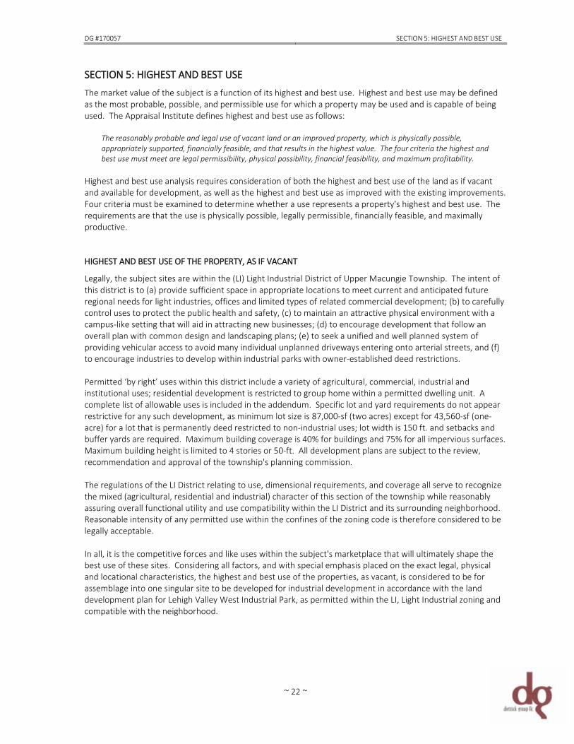
SECTION 4: SUBJECT PHOTOGRAPHS
Lot 9, 221 Oldt Road
Phase II, Lehigh Valley West Industrial Park Lot 9, 221 Oldt Road
Phase II, Lehigh Valley West Industrial Park Lot 10, 259 Oldt Road
Phase II, Lehigh Valley West Industrial Park
Lot 10, 259 Oldt Road
Phase II, Lehigh Valley West Industrial Park Lot 10, 259 Oldt Road
Phase II, Lehigh Valley West Industrial Park Lot 11, 371 Oldt Road
Phase II, Lehigh Valley West Industrial Park
Lot 11, 371 Oldt Road
Phase II, Lehigh Valley West Industrial Park Oldt Road (T-517), looking east
Subject lots on the left Oldt Road (T-517), looking west
Subject lots on the right

~ 21 ~
DG #170057 SECTION 5: HIGHEST AND BEST USE
~ 22 ~
SECTION 5: HIGHEST AND BEST USE The market value of the subject is a function of its highest and best use. Highest and best use may be defined as the most probable, possible, and permissible use for which a property may be used and is capable of being used. The Appraisal Institute defines highest and best use as follows:
The reasonably probable and legal use of vacant land or an improved property, which is physically possible, appropriately supported, financially feasible, and that results in the highest value. The four criteria the highest and best use must meet are legal permissibility, physical possibility, financial feasibility, and maximum profitability.
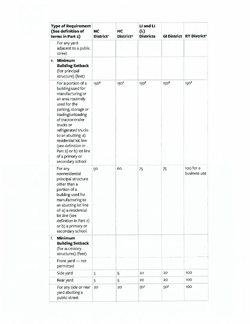
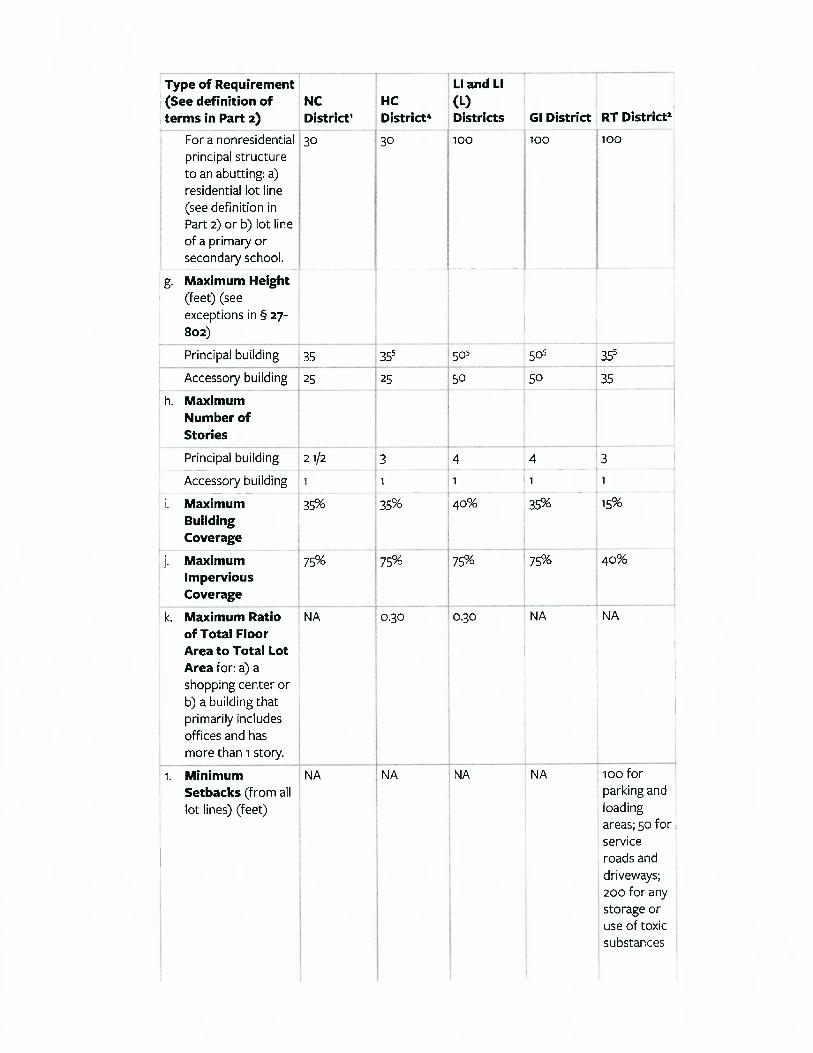
Highest and best use analysis requires consideration of both the highest and best use of the land as if vacant and available for development, as well as the highest and best use as improved with the existing improvements. Four criteria must be examined to determine whether a use represents a property's highest and best use. The requirements are that the use is physically possible, legally permissible, financially feasible, and maximally productive. HIGHEST AND BEST USE OF THE PROPERTY, AS IF VACANT Legally, the subject sites are within the (LI) Light Industrial District of Upper Macungie Township. The intent of this district is to (a) provide sufficient space in appropriate locations to meet current and anticipated future regional needs for light industries, offices and limited types of related commercial development; (b) to carefully control uses to protect the public health and safety, (c) to maintain an attractive physical environment with a campus-like setting that will aid in attracting new businesses; (d) to encourage development that follow an overall plan with common design and landscaping plans; (e) to seek a unified and well planned system of providing vehicular access to avoid many individual unplanned driveways entering onto arterial streets, and (f) to encourage industries to develop within industrial parks with owner-established deed restrictions. Permitted ‘by right’ uses within this district include a variety of agricultural, commercial, industrial and institutional uses; residential development is restricted to group home within a permitted dwelling unit. A complete list of allowable uses is included in the addendum. Specific lot and yard requirements do not appear restrictive for any such development, as minimum lot size is 87,000-sf (two acres) except for 43,560-sf (one-acre) for a lot that is permanently deed restricted to non-industrial uses; lot width is 150 ft. and setbacks and buffer yards are required. Maximum building coverage is 40% for buildings and 75% for all impervious surfaces. Maximum building height is limited to 4 stories or 50-ft. All development plans are subject to the review, recommendation and approval of the township's planning commission. The regulations of the LI District relating to use, dimensional requirements, and coverage all serve to recognize the mixed (agricultural, residential and industrial) character of this section of the township while reasonably assuring overall functional utility and use compatibility within the LI District and its surrounding neighborhood. Reasonable intensity of any permitted use within the confines of the zoning code is therefore considered to be legally acceptable. In all, it is the competitive forces and like uses within the subject's marketplace that will ultimately shape the best use of these sites. Considering all factors, and with special emphasis placed on the exact legal, physical and locational characteristics, the highest and best use of the properties, as vacant, is considered to be for assemblage into one singular site to be developed for industrial development in accordance with the land development plan for Lehigh Valley West Industrial Park, as permitted within the LI, Light Industrial zoning and compatible with the neighborhood.

~ 23 ~
Prep
ared
by
Diet
rick
Gro
up, L
LC51
00 W
Tilg
hman
Str
eet
Alle
ntow
n, P
A 18
104
Diet
rick
Grou
p Fi
le #
1700
57Lo
ts 9
, 10
11Le
high
Val
ley
Wes
t
Prop
erty
Loc
atio
nG
rant
orPr
op. R
ight
sSa
le P
rice
Acre
age
Loca
tion
Zoni
ng$/
Acre
No.
Tax
ID/D
ata
Com
p #
Gra
ntee
Cond
. Sal
eD
ate
SF o
f Lan
dTo
pogr
aphy
Util
ities
$/SF
Lan
dCo
mm
ents
Cole
broo
k Pr
oper
tyM
anag
emen
t, LL
CFe
e Si
mpl
e$1
,200
,000
5.79
9Co
mm
erci
alPa
rkU
tiliti
es$2
06,9
32
Rick
y Ku
lik R
eal E
stat
e, L
LCAr
m's
Leng
thFe
b-17
252,
604
Leve
l;M
od S
lope
Mun
icip
al$4
.75
Dav
id M
Jain
dlFe
e Si
mpl
e$1
1,76
2,80
058
.814
Subu
rban
Park
HI-S
C$2
00,0
00
Libe
rty
Prop
erty
LP
Arm
's Le
ngth
Oct
-16
2,56
1,93
8G
en. L
evel
Mun
icip
al$4
.59
Davi
d M
& M
ark
W Ja
indl
& Jo
hn
Lisi
cky,
Co-
Exec
utor
s,Es
tate
of F
rede
rick
J Jai
ndl
Fee
Sim
ple
$3,3
99,5
5014
.337
Subu
rban
Park
I$2
37,1
17
Scho
enec
k Ro
ad
Dev
elop
men
t, LP
Arm
's Le
ngth
Oct
-16
624,
520
Leve
l;M
od S
lope
Mun
icip
al$5
.44
JERC
Par
tner
s XX
II, L
LCFe
e Si
mpl
e$6
,282
,216
28.3
89In
terc
hang
eH
I$2
21,2
90
Win
d G
ap L
ogist
ics
Cent
er O
wne
r, LL
CAr
m's
Leng
thFe
b-16
1,23
6,62
5Le
vel &
Mod
Slo
peM
unic
ipal
$5.0
8
MFS
, Inc
.Fe
e Si
mpl
e$2
,400
,000
13.6
50Su
burb
an P
ark
IN$1
75,8
24
Rive
r Birc
h Re
alty
, LLC
Arm
's Le
ngth
Dec
-15
594,
594
Leve
lM
unic
ipal
$4.0
4
Davi
d M
Jain
dl, M
ark
W Ja
indl
, Jo
hn F
Lis
icky
, co
exec
utor
s,Es
tate
of F
red
Jain
dlFe
e Si
mpl
e$8
,563
,095
46.2
87Su
burb
anPa
rkH
I-SC
$185
,000
Libe
rty
Prop
erty
LP
Arm
's Le
ngth
Oct
-15
2,01
6,26
2Le
vel
Mun
icip
al$4
.25
Muk
esh
& C
hetn
a Ka
dhiw
ala
Fee
Sim
ple
$875
,000
4.76
3Su
burb
anIC
I$1
83,7
08
Mar
tin P
Mar
iano
&Be
verly
A M
aria
noAr
m's
Leng
thSe
p-15
207,
476
Leve
lM
unic
ipal
$4.2
2
Subj
ect P
rope
rty
----
-32
.57
Subu
rban
Par
kLI
----
---
---
1,41
8,74
9Le
vel/
Slop
eM
unic
ipal
----
-Su
rvey
Min
imum
$875
,000
4.76
3--
---
---
$175
,824
Surv
ey M
axim
um$1
1,76
2,80
058
.814
---
----
-$2
37,1
17Su
rvey
Ave
rage
$4,9
26,0
9424
.577
---
----
-$2
01,4
10Su
rvey
Min
imum
Sep-
1520
7,47
6Le
vel
Mun
icip
al$4
.04
Surv
ey M
axim
umFe
b-17
2,56
1,93
8M
od S
lope
Mun
icip
al$5
.44
Surv
ey A
vera
geAp
r-16
1,07
0,57
4Le
vel
Mun
icip
al$4
.62
Know
n as
Lot
8 o
f Spr
ing
Cree
k Pr
oper
ties
subd
ivisi
on -
now
kno
wn
as L
iber
ty B
usin
ess
Cent
er II
- is
loca
ted
on th
e W
/S o
f Rou
te 1
00, n
orth
of t
he b
orou
gh o
f Alb
urtis
, LC.
The
46.
287-
acre
site
is lo
cate
d at
861
5 Co
ngdo
n H
ill D
rive
in L
ower
Mac
ungi
e To
wns
hip.
The
par
cel w
as a
cqui
red
for c
onst
ruct
ion
of
an in
dust
rial b
uild
ing
. Th
e sit
e is
zone
d H
I-SC
(Hig
hway
Inte
rcha
nge
- Spr
ing
Cree
k D
istric
t) a
nd fu
lly
serv
ed b
y al
l mun
icip
al u
tiliti
es.
6
8615
Con
gdon
Hill
Driv
eLo
wer
Mac
ungi
e To
wns
hip
Lehi
gh C
ount
y, P
AD
C# 1
544
This
prop
erty
is lo
cate
d at
102
76 H
ausm
an R
oad
in S
outh
Whi
teha
ll To
wns
hip,
LC.
The
pro
pert
y co
nsist
s of
4.7
63 a
cres
zon
ed IC
I, In
dust
rial.
The
Bur
eau
of L
iquo
r Con
trol
Enf
orce
men
t has
sub
mitt
ed
plan
s fo
r an
one-
stor
y 18
,575
-sf b
uild
ing
that
wou
ld in
clud
e ve
hicl
e ba
ys a
nd o
ffic
e sp
ace.
The
land
is
leve
l and
fully
ser
ved
by a
ll m
unic
ipal
util
ities
. Th
is sa
le is
con
tinge
nt u
pon
rece
ipt o
f all
mun
icip
al,
gove
rnm
enta
l and
regu
lato
ry a
ppro
vals.
7
1027
Hau
sman
Roa
dSo
uth
Whi
teha
ll To
wns
hip
Lehi
gh C
ount
y, P
A 18
104
DC#
156
2
5
955
& 1
125
East
on R
oad
City
of B
ethl
ehem
Nor
tham
pton
Cou
nty,
PA
DC#
168
4
Loca
ted
at 9
55 a
nd 1
125
East
on R
oad,
this
13.6
50-a
cre
site
is pa
rt o
f Leh
igh
Valle
y In
dust
rial P
ark
VII
in th
e ci
ty o
f Bet
hleh
em, N
C. Z
oned
IN, I
ndus
tria
l, th
e sit
e is
gene
rally
leve
l and
full
serv
ed b
y al
l m
unic
ipal
util
ities
. Th
e la
nd w
as p
urch
ased
for i
ndus
tria
l dev
elop
men
t.
3
3262
Sch
oene
ck R
oad
Low
er M
acun
gie
Tow
nshi
pLe
high
Cou
nty,
PA
DC#
168
1
Prop
erty
is lo
cate
d at
326
2 Sc
hoen
eck
Road
in L
ower
Mac
ungi
e To
wns
hip,
LC.
The
site
con
sists
of
14.3
37-a
cre
with
2 s
tora
ge w
areh
ouse
s to
talin
g 12
,970
-sf.
The
war
ehou
ses
will
be
raze
d an
d a
210,
000-
sf w
areh
ouse
with
truc
k lo
ad d
ocks
will
be
built
. Th
e sit
e is
zone
d I (
Indu
stria
l) an
d ca
n be
fu
lly s
erve
d by
all
mun
icip
al u
tiliti
es.
4
1380
Jaco
bsbu
rg R
oad
Plai
nfie
ld T
owns
hip
Nor
tham
pton
Cou
nty,
PA
DC#
173
1
This
prop
erty
, to
be k
now
n as
the
Win
d G
ap L
ogist
ics
Cent
er, i
s lo
cate
d at
138
0 Ja
cobs
burg
and
Kr
omer
Roa
ds in
Pla
infie
ld T
owns
hip,
NC.
The
28.
389-
acre
site
is z
oned
HI (
Hig
hway
Inte
rcha
nge)
and
fu
lly s
erve
d by
all
mun
icip
al u
tiliti
es.
Build
er/d
evel
oper
JG P
etru
cci i
s pl
anni
ng to
bui
ld a
352
,000
-sf
build
ing
on 's
pec'
with
com
men
sura
te lo
adin
g an
d pa
rkin
g.
2
8449
Con
gdon
Hill
Driv
eLo
wer
Mac
ungi
e To
wns
hip
Lehi
gh C
ount
y, P
AD
C# 1
698
This
prop
erty
is lo
cate
d at
844
9 Co
ngon
Hill
Driv
e in
Low
er M
acun
gie
Tow
nshi
p, L
C. I
t is
part
of t
he
Sprin
g Cr
eek
Prop
ertie
s su
bdiv
ision
. Kn
own
as L
ot 9
in th
e Li
bert
y Bu
sines
s Ce
nter
II, t
he p
rope
rty
was
pur
chas
ed fo
r dev
elop
men
t of a
n in
dust
rial b
uild
ing.
The
site
is z
oned
HI-S
C (H
ighw
ay In
dust
rial -
Sp
ring
Cree
k D
istric
t) a
nd fu
lly s
erve
d by
all
mun
icip
al u
tiliti
es.
VACA
NT
IND
UST
RIAL
LAN
D S
ALES
Lo
ts 9
, 10,
and
11
Lehi
gh V
alle
y W
est I
ndus
tria
l Par
k, P
hase
IIU
pper
Mac
ungi
e To
wns
hip,
Leh
igh
Coun
ty, P
enns
ylva
nia
1
6503
Low
er M
acun
gie
Road
Low
er M
acun
gie
Tow
nshi
pLe
high
Cou
nty,
PA
DC#
174
3
This
prop
erty
is lo
cate
d at
650
3 Lo
wer
Mac
ungi
e Ro
ad in
Low
er M
acun
gie
Tow
nshi
p, L
C. T
he p
rope
rty
cons
ists
of 5
.799
acr
es a
nd w
ill b
e de
velo
ped
for t
hree
, tw
o-st
ory
med
ical
off
ice
build
ings
, eac
h co
ntai
ning
20,
000-
sf.
DG# 170057 SECTION 6: SALES COMPARISON APPROACH
~ 24 ~
SECTION 6: SALES COMPARISON (MARKET) APPROACH The sales comparison approach is an analysis of comparison of the sales or offerings of similar properties within a general area of the subject. The market relies on the principal of substitution, which states that "an informed buyer will normally pay no more for a building than it would cost to obtain an equally desirable substitute." The sales comparison approach is also the most commonly understood of the appraisal processes in that there are no formulae necessary for its basic interpretation. In its application, major elements of comparison include the property rights conveyed, financial terms of the transaction, the market conditions and conditions of sale at the time of transfer, the location of the real estate, and its physical and economic characteristics. After these adjustments are made, the sales provide a range of value for the subject property, which is then reconciled into a final value estimate.
SELECTION OF THE COMPARABLES Research conducted throughout the greater Lehigh Valley for land sales purchased for office and/or industrial development produced seven (7) sales for direct comparison to the subject sites using location, site, and physical characteristics as basic search criteria. In total, the comparable sales date from September 2015 to February 2017 and range in acreage from the smallest at ±4.763-acres to the largest at ±58.814-acres. Unadjusted price per acre ranges from $175,824 to $237,117 – which is the equivalent of $4.04-sf to $5.44-sf. Average lot size is 24.577-acres and average pricing is $201,410 per acre or $4.62-sf. For this analysis, I used price per square foot of land as the appropriate unit of comparison because market participants, developers and investors typically compare sales prices and property values on this basis. The sales are summarized on the facing page profile grid and are shown on the map on the following page.
Following the adjustment grid is a discussion of the individual adjustments necessary for a value indication utilizing this approach.
Prep
ared
for
Upp
er M
acun
gie
Tow
nshi
p83
30 S
chan
tz R
oad
Brei
nigs
ville
, PA
1803
1
Diet
rick
Gro
up F
ile #
170
057
Lots
9, 1
0 11
Lehi
gh V
alle
y W
est
No.
$/SF
Dat
ePr
oper
tyRi
ghts
Fina
ncin
gCo
nditi
ons
of S
ale
Exp.
Aft
erPu
rcha
seM
arke
t*Co
nditi
ons
Subt
otal
Loca
tion
Parc
el
Size
Util
ityPr
ovis
ion
Conf
igur
atio
nTo
pogr
aphy
Zoni
ngAd
j. $/
SFN
et A
dj.
Ove
rall
$4.7
5Fe
e Si
mpl
eCa
sh E
quiv
alen
tAr
m's
Leng
thN
one
Sim
ilar
$4.7
5Si
mila
rSm
alle
rSi
mila
rSu
perio
rSi
mila
r$3
.56
Supe
rior
2/17
0.0%
0.0%
0.0%
0.0%
0.0%
0.0%
0.0%
-20.
0%0.
0%-5
.0%
0.0%
-25.
0%$4
.59
Fee
Sim
ple
Cash
Equ
ival
ent
Arm
's Le
ngth
Non
eSi
mila
r$4
.59
Sim
ilar
Larg
erSi
mila
rSu
perio
rSi
mila
r$4
.82
Infe
rior
10/1
60.
0%0.
0%0.
0%0.
0%0.
0%0.
0%0.
0%10
.0%
0.0%
-5.0
%0.
0%5.
0%$5
.44
Fee
Sim
ple
Cash
Equ
ival
ent
Arm
's Le
ngth
Non
eSi
mila
r$5
.44
Sim
ilar
Smal
ler
Sim
ilar
Supe
rior
Sim
ilar
$4.6
3Su
perio
r10
/16
0.0%
0.0%
0.0%
0.0%
0.0%
0.0%
0.0%
-10.
0%0.
0%-5
.0%
0.0%
-15.
0%$5
.08
Fee
Sim
ple
Cash
Equ
ival
ent
Arm
's Le
ngth
Non
eSi
mila
r$5
.08
Sim
ilar
Sim
ilar
Sim
ilar
Supe
rior
Sim
ilar
$4.8
3Su
perio
r2/
160.
0%0.
0%0.
0%0.
0%0.
0%0.
0%0.
0%0.
0%0.
0%-5
.0%
0.0%
-5.0
%$4
.04
Fee
Sim
ple
Cash
Equ
ival
ent
Arm
's Le
ngth
Non
eIn
ferio
r$4
.24
Sim
ilar
Smal
ler
Sim
ilar
Supe
rior
Sim
ilar
$3.6
0Su
perio
r12
/15
0.0%
0.0%
0.0%
0.0%
5.0%
5.0%
0.0%
-10.
0%0.
0%-5
.0%
0.0%
-15.
0%$4
.25
Fee
Sim
ple
Cash
Equ
ival
ent
Arm
's Le
ngth
Non
eIn
ferio
r$4
.46
Sim
ilar
Larg
erSi
mila
rSu
perio
rSi
mila
r$4
.68
Infe
rior
10/1
50.
0%0.
0%0.
0%0.
0%5.
0%5.
0%0.
0%10
.0%
0.0%
-5.0
%0.
0%5.
0%$4
.22
Fee
Sim
ple
Cash
Equ
ival
ent
Arm
's Le
ngth
Non
eIn
ferio
r$4
.43
Sim
ilar
Smal
ler
Sim
ilar
Supe
rior
Sim
ilar
$3.3
2Su
perio
r9/
150.
0%0.
0%0.
0%0.
0%5.
0%5.
0%0.
0%-2
0.0%
0.0%
-5.0
%0.
0%-2
5.0%
Pric
e Ra
nge
Una
dj. $
/SF
Adj.
$/SF
Low
$4.0
4$3
.32
Hig
h$5
.44
$4.8
3Av
erag
e$4
.62
$4.2
1
Low
-25.
0%H
igh
5.0%
$4.2
0x
1,4
18,7
49Fi
nal V
alue
Opi
nion
$5,9
58,7
47Ro
unde
d to
$5,9
60,0
006
43 5 6
SUM
MAR
Y
Net
Adj
ustm
ents
CON
CLU
SIO
N
Indi
cate
d Va
lue
per S
quar
e Fo
ot o
f Lan
dLa
nd A
rea
in S
quar
e Fe
et
7VACA
NT
INDU
STRI
AL L
AND
SALE
S AD
JUST
MEN
T G
RID
Lots
9, 1
0 an
d 11
Lehi
gh V
alle
y W
est I
ndus
tria
l Par
k, P
hase
IIU
pper
Mac
ungi
e To
wns
hip,
Leh
igh
Coun
ty, P
enns
ylva
nia
ECO
NO
MIC
AD
JUST
MEN
TSPR
OPE
RTY
CHAR
ACTE
RIST
IC A
DJU
STM
ENTS
1 2
*Mar
ket C
ondi
tions
Adj
ustm
ent
Date
of V
alue
(for
adj
ustm
ent c
alcu
latio
ns):
5/27
/201
7
DG# 170057 SECTION 6: SALES COMPARISON APPROACH
~ 25 ~
DIRECT SALES ANALYSIS The availability of good quality comparable data drives the application of the sales comparison approach. This sales data is most useful when the comparable properties are similar to the subject in size, quality, function and locational characteristics. As illustrated on the accompanying adjustment grid, each of the sales has been compared to the subject’s useable acreage and analyzed on the basis of their property rights conveyed, financing, market conditions and conditions of sale, as well as appropriate location, physical, and economic characteristics.
PROPERTY RIGHTS In general, title to real property can be held by a single person, by more than one owner, or by a third party (e.g., a trustee). The form of ownership for particular industrial property may depend on the availability of capital for the typical user and the attractiveness of the property as an investment. Private individuals, unless they are the sole owner of a company that occupies the industrial building, do not usually have access to the amount of capital required to develop and maintain a modern industrial facility. More common forms of ownership in this sector include corporate ownership (including joint ventures, partnerships and limited liability corporations), REIT ownership, and condominium ownership. The property interest appraised within the scope of this valuation is that of the fee simple estate, reflecting the absolute ownership of a property unencumbered by any other interest, and subject only to the limitations imposed by governmental powers of taxation, eminent domain, police power and escheat. As such, it consists of the complete bundle of rights in a particular piece of real estate. A review of the comparable sales indicates that all sales are fee simple acquisitions by owner/users and/or developers and therefore no adjustments are needed to any of the sales.
FINANCING The financing utilized in the acquisition of real property can also affect its sales price when based on non-market terms. In most acquisitions, buyers obtain financing from conventional lenders and then combine the debt (mortgage funds) with equity (down payment) to finalize the transaction. Market value assumes that payment is made in cash or its equivalent and represents a normal consideration for the property sold, unaffected by special financing amounts or terms, services, fees, costs or credits incurred in the transaction. If it is determined that the terms of sale did not meet the above-noted criteria, an adjustment must be made. Upon consideration, each of the sales does, in fact, represent cash equivalent transfers acquired with either cash or market-oriented financing, precluding the need for adjustment.
CONDITIONS OF SALE The ‘conditions of sale’ adjustment considers any abnormal market circumstances in the sale. If the buyer or seller is unusually compelled or motivated to make the transaction, then an adjustment is required. For instance, a seller facing imminent foreclosure could be excessively compelled to sell. Or, the price of a transaction between related parties (family members and partnerships or corporations with common principals) may not be ‘arm’s length transactions’ or represent market value. Further, portfolio sales often sell at a significant premium in bull markets and at a discount in bear markets. Portfolio transactions may involve price allocations to the individual facilities that may not represent the market values because the allocated prices may serve various taxes, reimbursement and other business interests. A review of the selected sales indicates that all sales reflect market-oriented, arm's length transactions between knowledgeable participants with no distress, precluding the need for adjustment.
DG# 170057 SECTION 6: SALES COMPARISON APPROACH
~ 26 ~
EXPENDITURES AFTER THE PURCHASE A knowledgeable buyer considers any expenditure that will have to be made upon the purchase of a property because these costs will ultimately affect the price the buyer agrees to pay. Such expenditures may include costs to cure deferred maintenance, costs to demolish and remove any portion of the improvements, costs to petition for a zoning change, or costs to remediate environmental contamination. In the sales comparison analysis, costs included by the new owners of comparable properties are reflected as positive adjustments to the sales prices of those properties. Any immediate repairs or improvements or corrections to an impairment that a buyer makes – and that the buyer factors into the calculation of an appropriate sale price – must be accounted for with an adjustment. With improved properties, the price may require additional adjustment for extensive capital improvements and combine those expenses with the purchase price. Or, the price may require additional adjusting for extensive capital improvements to reposition the property in the market. Since each site was purchased for its ultimate redevelopment, it is reasonable to anticipate on- and off-site improvements will be required as a condition to all municipal, governmental and other regulatory agency entitlements. These may include, but are not limited to, licenses and/or permits, consents or other legislative or administrative authority for any local, state, or national governmental or private entity or organizations, traffic impact fees, road widening and/or enhancement to intersections, curbing, contribution to a signalized intersection, etc. Typical for subdivision and lot creation, all of the buyers incurred some costs to develop their properties subsequent to acquisition and therefore no adjustments are applicable to any of the selected sales. It is assumed that any needed demolition, cost of engineering and entitlements, and site work is factored into the individual sales prices and therefore no adjustments are needed to any of the sales.
MARKET CONDITIONS Comparable sales that occurred under market conditions different from those applicable to the subject on the effective date of value require adjustment for any differences that affect their value. An adjustment for market conditions is warranted if general property values have increased or decreased since the transaction dates. And, although the adjustment for market conditions is often referred to as a 'time' adjustment, time is not the cause of the adjustment. Market conditions that change over time create the need for an adjustment, not time itself. For certain property types, changes in health care laws, licensing laws, tax laws and/or inflation are some of the important external forces that affect values. Major changes in any of these external forces can have a broad effect on the value of a property, so any major change warrants examination. Also, changes in the cost of capital (equity and debt) tend to have a universal impact on valuation. Changes in interest rates and equity returns may not have a one-to-one relationship with value. Simply adjusting a sale price to reflect the difference in the cost of capital between the date of the comparable sales and the effective date of the appraisal may not accurately characterize the change in value. However, if other significant factors in the market have remained fairly stable over this time space, then the change in the cost of capital provides an indication of the general trend in value. The valuation date for this analysis is May 27, 2017 – the date of most recent property inspection. The acquisition dates for the comparable sales range from the oldest transferring in September 2015 to the most recent in February 2017. The development of industrial land market is very strong, evidenced by the amount of construction taking place in the Lehigh Valley. There continues to be a growing demand for well-located sites that are fully served, zoned, and/or are ready to build.
DG# 170057 SECTION 6: SALES COMPARISON APPROACH
~ 27 ~
Increased construction continues to put upward pressure on commercial land prices and the Lehigh Valley market posted significant increases in land value in the last several years. Because of the lack of available sites and sustained improvement in the land market, upward time adjustments are needed to Sales 5, 6 and 7, all transferring in 2015.
LOCATION The subject’s physical location is in Phase II of the Lehigh Valley West Industrial Park located in Upper Macungie Township, Lehigh County, Pennsylvania. This places the lots on the north side of Oldt Road in the southern portion of the park in the greater northwest quadrant of an intersection formed by Nestle Way and Oldt Road, south of limited access US Route 22 and west of Pennsylvania Route 100. As with much of this part of the township, the immediate subject area is defined by an intensive degree of industrial activity, surrounded by distribution buildings, primarily north of Oldt Road and west of Pennsylvania Route 100 but inclusive of the southwest quadrant of I/78 and Pennsylvania Route 100. On the south side of Oldt Road, directly south of the subject lots is the single-family detached subdivision known as Valley West Estates. All of the selected sales are also considered to be in good locations for their eventual commercial and/or industrial development. These sales have equivalent locational identities, proximity to major infrastructure and use cohesion which manifest in comparable land prices and rental rates for development. As such, these sales have not been adjusted.
LOT SIZE/SITE UTILITY The physical characteristics of land include size, shape, frontage, view, and topographical characteristics such as contours, grade and drainage, etc. Analysis of a property's tract size and development density serves to quantify the effects of its overall site utility, including its parking adequacy, access and interior movement. Land size and the land-to-building ratio are interrelated. Locally there is a demonstrated relationship between the size of a site and its unit rate, i.e., price per acre or price per square foot of land area. Due to economies of scale, larger properties in fact tend to sell at lower unit rates and, conversely, smaller properties tend to sell at higher unit rates. A review of the selected sales indicates a range in size from 4.763-acres to 58.814-acres; the subject sites collectively total 32.57-acres. A review of the comparable sales indicates that only Sale 4 is considered to reasonably resemble the subject's land area. It is therefore considered capable of attracting the same level of investor and/or developer interest, precluding the need for adjustment. Sales 2, 3, 5 and 7 require downward adjustments commensurate with their smaller lot sizes and conversely, Sales 1 and 6 are larger and therefore require upward adjustments.
UTILITY PROVISION/TOPOGRAPHY/CONFIGURATION AND ZONING The physical and legal characteristics of land can affect its ultimate use and value. The subject property is located in an area of industrial activity in Lehigh Valley West Industrial Park, in reasonable proximity to I-78 and Pennsylvania Route 100, and its interchange at I-78 and 100. Its zoning designation permits a variety of commercial, industrial and institutional either by right, condition or special exception. The extension of full municipal services also favorably serve the subject sites and should not restrict its ultimate approved development. However, the topography is slightly below grade with its frontage along the north side of Oldt Road and steadily slopes downward to the north, toward the Iron Run tributary. Additionally, a portion of each lot is affected by flood plain. All selected comparable sales maintain full municipal services and have generally level to modestly sloping topographies, which will require only typical site preparation for their development. Additionally, all reflect
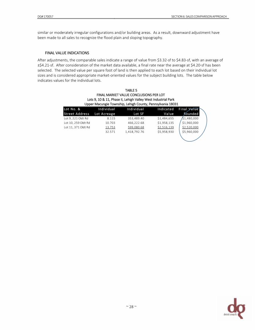
DG# 170057 SECTION 6: SALES COMPARISON APPROACH
~ 28 ~
similar or moderately irregular configurations and/or building areas. As a result, downward adjustment have been made to all sales to recognize the flood plain and sloping topography.
FINAL VALUE INDICATIONS After adjustments, the comparable sales indicate a range of value from $3.32-sf to $4.83-sf, with an average of ±$4.21-sf. After consideration of the market data available, a final rate near the average at $4.20-sf has been selected. The selected value per square foot of land is then applied to each lot based on their individual lot sizes and is considered appropriate market-oriented values for the subject building lots. The table below indicates values for the individual lots.
TABLE 5 FINAL MARKET VALUE CONCLUSIONS PER LOT
Lots 9, 10 & 11, Phase II, Lehigh Valley West Industrial Park Upper Macungie Township, Lehigh County, Pennsylvania 18031
Individua l Lot Acreag e
Individua lLot SF
IndicatedVa lue
F ina l Va lueRounded
8.115 353,489.40 $1,484,655 $1,480,00010.703 466,222.68 $1,958,135 $1,960,00013.753 599,080.68 $2,516,139 $2,520,00032.571 1,418,792.76 $5,958,930 $5,960,000
Lot No. &Street AddressLot 9, 221 Oldt RdLot 10, 259 Oldt RdLot 11, 371 Oldt Rd

~ a ~
~ b ~
CERTIFICATION The undersigned certifies that on May 31, 2017, the date of final report preparation, to the best of my knowledge and belief, and except as otherwise noted in this appraisal report: 1. The statements of fact contained in this report are true and correct. 2. The reported analyses, opinions and conclusions are limited only by the reported assumptions and limiting
conditions and is our personal, unbiased professional analyses, opinions and conclusions. 3. I have no present or prospective interest in the property that is the subject of this report, and we have no
personal interest with respect to the parties involved. 4. I have no bias with respect to the property that is the subject of this report or to the parties involved with this
assignment. 5. My engagement in this assignment was not contingent upon developing or reporting predetermined results. 6. The person(s) signing this report has not appraised the subject property in the three years prior to accepting
this assignment. 7. My compensation for completing this assignment is not contingent upon the development or reporting of a
predetermined value or direction in value that favors the cause of the client, the amount of the value opinion, the attainment of a stipulated result, or the occurrence of a subsequent event directly related to the intended use of this appraisal.
8. The reported analyses, opinions, and conclusions were developed, and this report has been prepared, in
conformity with the requirements of the Uniform Standards of Professional Appraisal Practice (USPAP) and the Code of Professional Ethics and Standards of Professional Appraisal Practice of the Appraisal Institute.
9. The use of this report is subject to the requirements of the Appraisal Institute relating to review by its duly
authorized representatives. 10. Linda L. Dietrick made an inspection and photographed the subject property on May 27, 2017. 11. No one other than the undersigned provided significant real property appraisal assistance to the persons
signing this certification. Gina Novak assisted in verifying deeds, tax assessment data, zoning, census, flood maps and information relative to the site for this report.
12. As of the date of this report, Linda L. Dietrick is current with the requirements of the continuing education
program of the Pennsylvania State Board of Certified Real Estate Appraisers. Linda L. Dietrick has also completed the Standards and Ethics Education Requirement of the Appraisal Institute for Associate Members.
13. The appraisers have the knowledge and experience with this property type and the qualifications needed to
produce a credible appraisal in accordance with all previously stated standards and has taken the necessary steps in order to comply with the Competency Rule of USPAP.
Linda L. Dietrick
/s/ Linda L. Dietrick, CCIM PA Certified General Real Estate Appraiser Certification Number GA-001509-L NY Certified General Real Estate Appraiser Certification Number: 46000050756
~ c ~
ASSUMPTIONS, LIMITING CONDITIONS AND CONTINGENCIES The appraiser whose signature appears on the Certificate of Appraisal does hereby certify that, except as otherwise noted in this appraisal report: 1. This report is prepared under the appraisal report option of Standards Rule 2-2 of the 2016-2017 edition of
Uniform Standards of Professional Appraisal Practice (USPAP). Because USPAP gives appraisers the flexibility to vary the level of information in an appraisal report depending on the intended use and intended users of the appraisal, I selected Dietrick Group LLC’s internal criteria for a standard format appraisal report. This type of report has a moderate level of detail. It summarizes the information analyzed, the appraisal methods employed and the reasoning that supports the analyses, opinions and conclusions.
2. I have no present or contemplated future interest in the real estate that is the subject of this appraisal
report. 3. I have no personal interest or bias with respect to the subject matter of this appraisal report or the parties
involved. 4. To the best of my knowledge and belief, the statements of fact contained in this appraisal report, upon
which the analysis, opinions, and conclusions expressed herein are based, are true and correct. 5. This appraisal is to be used in whole and not in part. No part of it shall be used in conjunction with any
other appraisal. 6. The information on which this appraisal is based has been obtained from sources normally used by the
appraiser and is considered to be reliable, but it is in no sense guaranteed. 7. No opinion of a legal or engineering nature is intentionally expressed or implied and no responsibility is
assumed for matters of this nature. 8. Load bearing capacity of subsoil is assumed to be adequate for the present utilization, but no borings or
engineering studies have been made especially for this appraisal and the value conclusion could be affected by such information.
9. The property has been appraised as though under responsible ownership and competent, aggressive
management. 10. The appraiser assumes there are no hidden or unapparent conditions of the property, subsoil or otherwise,
which would render it more or less valuable. The appraisers assume no responsibility for such conditions or for engineering, which might be required to discover such factors.
11. In this assignment, the existence of potentially hazardous material used in the construction or maintenance
of any building, such as the presence of asbestos, urea formaldehyde foam insulation and/or existence of toxic waste, which may or may not be present on the property, has not been considered. The consultants are not qualified to detect such substances. The client is urged to retain an expert in this field, if desired.
12. The appraiser assumes no responsibility for matters of a legal nature affecting the property or the title
thereto. Nor does the appraiser render any opinion as to title, which is assumed to be good and marketable.
13. The appraiser is not required to give testimony or appear in court because of having made this appraisal
with reference to the property in question, unless arrangements have been previously made therefore. The fee charged for this appraisal does not include payment for court testimony or further consultation.
~ d ~
14. Unless otherwise stated, no consideration in the valuation process has been given to mineral deposits (oil, gas, coal, gravel, etc.) or timber, if any, that may be found on the subject.
15. Disclosure of the contents of the appraisal is governed by the Bylaws and Regulations of the professional
organizations with which the appraisers are affiliated. 16. The appraiser reserves the right to alter her opinion of value on the basis of information withheld or not
discovered in the normal course of a diligent investigation. 17. The type and extent of my research and analysis is detailed in the sales comparison approach section of the
report. Although I made an effort to confirm the arm’s length nature of each sale with a party to the transaction, it is sometimes necessary to rely on secondary verification from sources deemed reliable.
18. The field inspection, site reconnaissance and photographs were helpful in determining more specific
property information such as overall parcel size, configuration and other physical detail as well as predominant immediate and extended neighborhood characteristics. Municipal utility provision was confirmed by the applicable authorities; soil geology was determined by the Soil Survey of Lehigh County.
19. Valuation assumes that the ownership of the subject property includes all rights that may be lawfully
owned and that ownership is transferable free from all encumbrances except those specified in this report. This appraisal focuses on the real estate only, which includes the underlying land, dwelling and site improvements. Therefore, within the scope of this assignment, no additional value has been given to personal property.
20. No opinion is rendered as to property title, which is assumed good and marketable. Unless otherwise
stated, no consideration is given to liens or encumbrances against the property. Sketches, maps, photos, or other graphic aids included in this report are intended to assist the reader in ready identification and visualization of the property and are not included for technical purposes.
21. Dietrick Group LLC does not conduct or provide environmental liability assessments of any kind in
performing its appraisals so that our opinion of the appraised value will not reflect any actual or contingent environmental liabilities except to the extent we are provided with a specific monetary assessment of such liabilities in writing. In any event, Dietrick Group LLC will not verify such monetary assessment and will offer no warranty or representation as to its accuracy or completeness.
22. Dietrick Group LLC has performed numerous appraisals and reviews of appraisals on properties such as the
subject, in the Lehigh Valley and its surrounding municipalities. Competency has been established in both the property types and geographical area of the subject either through previous engagements or through current research of germane market trends. We therefore possess the knowledge and experience to conduct the inspections, analyses and reasoning necessary to accurately estimate the value of the appraised interest in the subject.
23. Various area investors, owners and market participants were interviewed in order to provide the necessary
background to perform this appraisal. Information furnished by others is presumed to be accurate and reliable, and where so specified in the report, has been independently verified. No single item of information was completely relied upon to the exclusion of other information. Supporting documentation may be retained in my file memoranda.
24. Disclosure of the contents of this appraisal report shall be governed by the terms and conditions stated
herein, provided, however, that anything contained herein before or hereinafter to the contrary notwithstanding, title ownership may distribute copies of this appraisal report to such third parties as may be selected by it, and provided further that neither all nor any part of this appraisal report shall be disseminated to the general public by the use of advertising media, public relations media, news media, or
~ e ~
other media for public communications without prior written consent of the signatories of this appraisal report.
25. Acceptance of and/or use of this report constitutes acceptance of these assumptions and conditions.
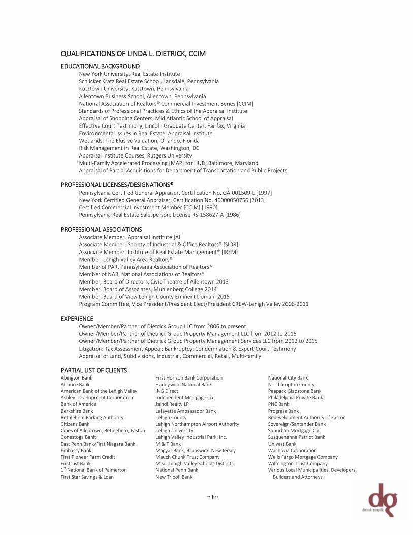
~ f ~
QUALIFICATIONS OF LINDA L. DIETRICK, CCIM EDUCATIONAL BACKGROUND New York University, Real Estate Institute Schlicker Kratz Real Estate School, Lansdale, Pennsylvania Kutztown University, Kutztown, Pennsylvania Allentown Business School, Allentown, Pennsylvania National Association of Realtors® Commercial Investment Series [CCIM] Standards of Professional Practices & Ethics of the Appraisal Institute Appraisal of Shopping Centers, Mid Atlantic School of Appraisal Effective Court Testimony, Lincoln Graduate Center, Fairfax, Virginia Environmental Issues in Real Estate, Appraisal Institute Wetlands: The Elusive Valuation, Orlando, Florida Risk Management in Real Estate, Washington, DC Appraisal Institute Courses, Rutgers University Multi-Family Accelerated Processing [MAP] for HUD, Baltimore, Maryland Appraisal of Partial Acquisitions for Department of Transportation and Public Projects PROFESSIONAL LICENSES/DESIGNATIONS® Pennsylvania Certified General Appraiser, Certification No. GA-001509-L [1997] New York Certified General Appraiser, Certification No. 46000050756 [2013] Certified Commercial Investment Member [CCIM] [1990] Pennsylvania Real Estate Salesperson, License RS-158627-A [1986] PROFESSIONAL ASSOCIATIONS Associate Member, Appraisal Institute [AI] Associate Member, Society of Industrial & Office Realtors® [SIOR] Associate Member, Institute of Real Estate Management® [IREM] Member, Lehigh Valley Area Realtors® Member of PAR, Pennsylvania Association of Realtors® Member of NAR, National Associations of Realtors® Member, Board of Directors, Civic Theatre of Allentown 2013 Member, Board of Associates, Muhlenberg College 2014 Member, Board of View Lehigh County Eminent Domain 2015 Program Committee, Vice President/President Elect/President CREW-Lehigh Valley 2006-2011 EXPERIENCE Owner/Member/Partner of Dietrick Group LLC from 2006 to present Owner/Member/Partner of Dietrick Group Property Management LLC from 2012 to 2015 Owner/Member/Partner of Dietrick Group Property Management Services LLC from 2012 to 2015 Litigation: Tax Assessment Appeal; Bankruptcy; Condemnation & Expert Court Testimony Appraisal of Land, Subdivisions, Industrial, Commercial, Retail, Multi-family PARTIAL LIST OF CLIENTS Abington Bank First Horizon Bank Corporation National City Bank Alliance Bank Harleysville National Bank Northampton County American Bank of the Lehigh Valley ING Direct Peapack Gladstone Bank Ashley Development Corporation Independent Mortgage Co. Philadelphia Private Bank Bank of America Jaindl Realty LP PNC Bank Berkshire Bank Lafayette Ambassador Bank Progress Bank Bethlehem Parking Authority Lehigh County Redevelopment Authority of Easton Citizens Bank Lehigh Northampton Airport Authority Sovereign/Santander Bank Cities of Allentown, Bethlehem, Easton Lehigh University Suburban Mortgage Co. Conestoga Bank Lehigh Valley Industrial Park, Inc. Susquehanna Patriot Bank East Penn Bank/First Niagara Bank M & T Bank Univest Bank Embassy Bank Magyar Bank, Brunswick, New Jersey Wachovia Corporation First Pioneer Farm Credit Mauch Chunk Trust Company Wells Fargo Mortgage Company Firstrust Bank Misc. Lehigh Valley Schools Districts Wilmington Trust Company 1st National Bank of Palmerton National Penn Bank Various Local Municipalities, Developers, First Star Savings & Loan New Tripoli Bank Builders and Attorneys