Embed Size (px)
Citation preview
International Symposium on Geoinformatics for Spatial Infrastructure Development in Earth and Allied Sciences 2008
REAL-TIME MONITORING OF FARMLAND IN ASIA USING FIELD SERVER
Masaru Mizoguchi1, Shoichi Mitsuishi2, Tetsu Ito2, Seishi Ninomiya3, Masayuki
Hirafuji3, Tokihiro Fukatsu3, Takuji Kiura3, Kei Tanaka3, Hitoshi Toritani4, Hiromasa Hamada5, and Kiyoshi Honda6
1 Interfaculty Initiative in information Studies, The University of Tokyo
1-1Yayoi, Bunkyo-ku, Tokyo 113-8657, Japan Email: [email protected]
2 Department of Global Agricultural Science, The University of Tokyo 1-1Yayoi, Bunkyo-ku, Tokyo 113-8657, Japan
3 National Agriculture and Food Research Organization 3-1-1 Kannondai, Tsukuba, Ibaraki 305-8517, Japan
4 National Institute for Agro-Environmental Sciences 3-1-3 Kannondai, Tsukuba 305-8604, Japan
5 Japan International Research Center for Agricultural Sciences 1-1 Ohwashi,Tsukuba,Ibaraki 305-8686, Japan
6 School of Engineering and Technology, Asian Institute of Technology P.O.Box 4, Klong Luang Pathumthani, 12120, Thailand
Email: [email protected]
ABSTRACT
Integration and analysis of earth observation data are required for assessing impacts of land use and management on soil quality over large area. In order to validate soil moisture data obtained by satellite remote-sensing for direct measurement of soil moisture, we are testing real-time monitoring of soil information in a rain-fed field in Northeast Thailand using Field Server with soil moisture sensors. In this study, we outline this new monitoring system and discuss the problems that we must solve. 1. INTRODUCTION
Spatial and temporal soil monitoring is required for assessing impacts of land use and
management on soil quality over large area. Although remote-sensing techniques by satellite are often used for such soil monitoring, it gives us information on only the surface but not the inside of soil. On the other hand, soil scientists survey soil profiles and measure soil physical properties with some sensors at a point site. However, the selected point is not guaranteed to be representative. In order to validate soil moisture data obtained by satellite remote-sensing for direct measurement of soil moisture, we are testing real-time monitoring of soil information in a rain-fed field Khon Kaen in Northeast Thailand using Field Server. In this study, we outline this new monitoring system and discuss the possibilities of the system. 2. EXPERIMENTAL METHODS 2.1 Field Server
Field Server (FS) is an automatic monitoring system, which consists of CPU (Web server), AD converter, DA converter, Ethernet controller, high intensity LED lighting and sensors such as air temperature, relative humidity, solar radiation (PPFD), soil moisture, soil
Real-Time Monitoring of Farmland in Asia using Field Server
temperature, electrical conductivity, leaf wetness, infra-red sensor, CMOS/CCD camera. (NARO, 2007) The Field Servers are interconnected by Wireless LAN (Wi-Fi, IEEE802.11b). Digital cameras and Web cameras can be connected, and high-resolution pictures of fields are transferred through Wi-Fi broadband networks, and stored on Web servers. The cameras can be remotely controlled by a web browser.
Figure 1. Field Server installed by Asian Figure 2. Field Server installed
team on December 25, 2006. on December 24, 2007. 2.2 Soil information monitoring system
Figure 3 shows diagram of real-time soil information monitoring system. The system we used composed of a Field Server, a solar panel, a router, an agent box (in-site data logger).
RS 232C
Em50Soil moisture sensors
M eshnet router
AIT
OpenVPN
DW L-2100AP
WiFi fo r comm unity
MicroC lient JR (FSAB)
DSL-520T
ADSL Int ernet
Pac ket iX
UT
MeshNet
FS 02FS11
DWL-210 0AP
WDSRS 232C
Em50Soil moisture sensorsEm50Soil moisture sensors
M eshnet routerM eshnet router
AITAIT
OpenVPN
DW L-2100APDW L-2100AP
WiFi fo r comm unity
MicroC lient JR (FSAB)MicroC lient JR (FSAB)
DSL-520TDSL-520T
ADSL Int ernet
Pac ket iX
UTUT
MeshNet
FS 02FS11
DWL-210 0APDWL-210 0AP
WDS
Figure 3. Real-time soil information monitoring system.
2.3 Experimental site
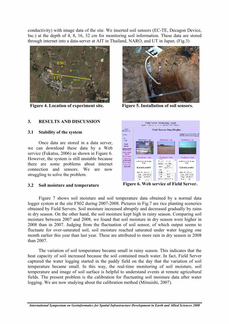
We installed a Field server on December 25, 2006 and three Field servers on December 24, 2007 in a rain-fed field in Khon Kaen, Northeast Thailand (16o27.657 N, 102 o 32.443 E; Fig.4) to get meteorological data (air temperature, humidity, radiation, wind velocity, precipitation) and soil information (soil moisture content, soil temperature, electrical
International Symposium on Geoinformatics for Spatial Infrastructure Development in Earth and Allied Sciences 2008
conductivity) with image data of the site. We inserted soil sensors (EC-TE, Decagon Device, Inc.) at the depth of 4, 8, 16, 32 cm for monitoring soil information. These data are stored through internet into a data-server at AIT in Thailand, NARO, and UT in Japan. (Fig.3)
735 m
FS02
FS11
Figure 4. Location of experiment site. Figure 5. Installation of soil sensors.
3. RESULTS AND DISCUSSION 3.1 Stability of the system
Once data are stored in a data server, we can download these data by a Web service (Fukatsu, 2006) as shown in Figure 6. However, the system is still unstable because there are some problems about internet connection and sensors. We are now struggling to solve the problem. 3.2 Soil moisture and temperature
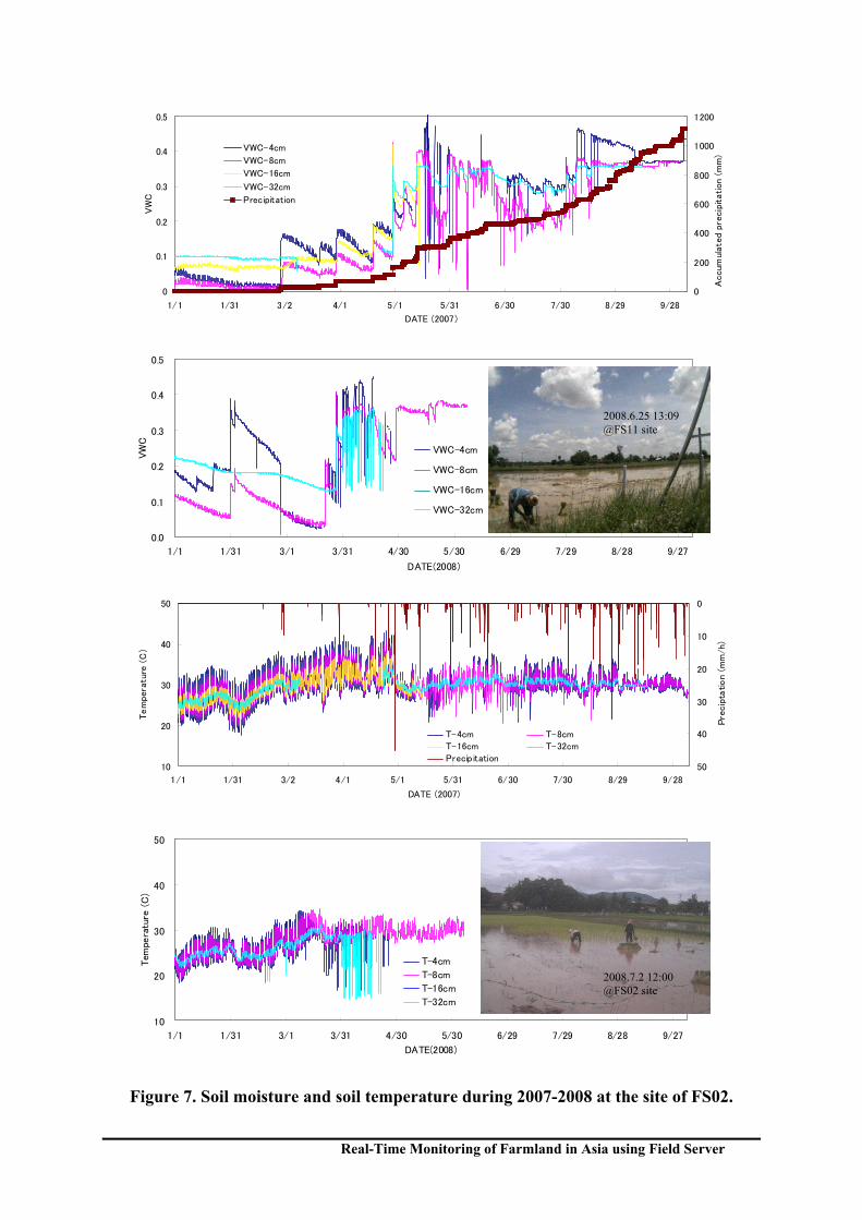
Figure 7 shows soil moisture and soil temperature data obtained by a normal data logger system at the site FS02 during 2007-2008. Pictures in Fig.7 are rice planting sceneries obtained by Field Servers. Soil moisture increased abruptly and decreased gradually by rains in dry season. On the other hand, the soil moisture kept high in rainy season. Comparing soil moisture between 2007 and 2008, we found that soil moisture in dry season were higher in 2008 than in 2007. Judging from the fluctuation of soil sensor, of which output seems to fluctuate for over-saturated soil, soil moisture reached saturated under water logging one month earlier this year than last year. These are attributed to more rain in dry season in 2008 than 2007.
The variation of soil temperature became small in rainy season. This indicates that the heat capacity of soil increased because the soil contained much water. In fact, Field Server captured the water logging started in the paddy field on the day that the variation of soil temperature became small. In this way, the real-time monitoring of soil moisture, soil temperature and image of soil surface is helpful to understand events at remote agricultural fields. The present problem is the calibration for fluctuating soil moisture data after water logging. We are now studying about the calibration method (Mitsuishi, 2007).
Figure 6. Web service of Field Server.
Real-Time Monitoring of Farmland in Asia using Field Server
0
0.1
0.2
0.3
0.4
0.5
1/1 1/31 3/2 4/1 5/1 5/31 6/30 7/30 8/29 9/28
DATE (2007)
VW
C
0
200
400
600
800
1000
1200
Accum
ula
ted
pre
cip
itation
(m
m)
VWC-4cm
VWC-8cm
VWC-16cm
VWC-32cm
Precipitation
0.0
0.1
0.2
0.3
0.4
0.5
1/1 1/31 3/1 3/31 4/30 5/30 6/29 7/29 8/28 9/27
DATE(2008)
VW
C
VWC-4cm
VWC-8cm
VWC-16cm
VWC-32cm
10
20
30
40
50
1/1 1/31 3/2 4/1 5/1 5/31 6/30 7/30 8/29 9/28
DATE (2007)
Tem
pera
ture
(C
)
0
10
20
30
40
50
Pre
cip
tation (
mm
/h)
T-4cm T-8cm
T-16cm T-32cm
Precipitation
10
20
30
40
50
1/1 1/31 3/1 3/31 4/30 5/30 6/29 7/29 8/28 9/27
DATE(2008)
Tem
pera
ture
(C
)
T-4cm
T-8cm
T-16cm
T-32cm
Figure 7. Soil moisture and soil temperature during 2007-2008 at the site of FS02.
2008.7.2 12:00 @FS02 site
2008.6.25 13:09 @FS11 site
International Symposium on Geoinformatics for Spatial Infrastructure Development in Earth and Allied Sciences 2008
3.3 Other monitoring of farmlands in Asia
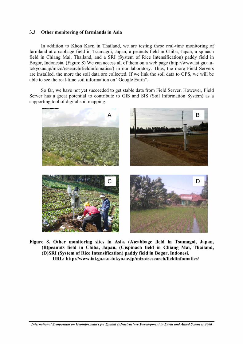
In addition to Khon Kaen in Thailand, we are testing these real-time monitoring of farmland at a cabbage field in Tsumagoi, Japan, a peanuts field in Chiba, Japan, a spinach field in Chiang Mai, Thailand, and a SRI (System of Rice Intensification) paddy field in Bogor, Indonesia. (Figure 8) We can access all of them on a web page (http://www.iai.ga.a.u-tokyo.ac.jp/mizo/research/fieldinfomatics/) in our laboratory. Thus, the more Field Servers are installed, the more the soil data are collected. If we link the soil data to GPS, we will be able to see the real-time soil information on “Google Earth”.
So far, we have not yet succeeded to get stable data from Field Server. However, Field Server has a great potential to contribute to GIS and SIS (Soil Information System) as a supporting tool of digital soil mapping.
Figure 8. Other monitoring sites in Asia. (A)cabbage field in Tsumagoi, Japan, (B)peanuts field in Chiba, Japan, (C)spinach field in Chiang Mai, Thailand, (D)SRI (System of Rice Intensification) paddy field in Bogor, Indonesi. URL: http://www.iai.ga.a.u-tokyo.ac.jp/mizo/research/fieldinfomatics/
A B
C D
Real-Time Monitoring of Farmland in Asia using Field Server
4. CONCLUSIONS
The Field Server with soil sensors is a quite promising tool for field science in Asia because it detects both real-time images and meteorological data including soil moisture. However, there are some problems about its stability. In addition, it is difficult to get electric power and internet infrastructure in most unexplored territories in Asia. We need further studies to get stable data from all over the world.
ACKNOWLEDGEMENT
This work was partially supported by "Data Integration & Analysis System" in the National Key Technology (DIAS, 2008), Ministry of Education, Culture, Sports, Science and Technology.
REFERENCES Decagon Devices, 2008. Soil Water Conten, http://www.decagon.com/.
DIAS, 2008. Creating global knowledge and awareness to support better management of one precious Earth. http://www.editoria.u-tokyo.ac.jp/dias/english/index.html
Fukatsu, T., 2006. Field Server Monitoring Agent. http://fsds.dc.affrc.go.jp/data2/KhonKaen/.
Mitsuishi, S., and Mizoguchi, M., 2007. Effects of Dry Bulk Density and Soil Type on Soil Moisture Measurement using ECH2O-TE Probe. The ASA-CSSA-SSSA International Annual Meetings, http://a-c-s.confex.com/crops/2007am/techprogram/P36281.HTM.
Masaru Mizoguchi, Shoichi Mitsuishi, Tetsu Ito, Kazuo Oki, Seishi Ninomiya, Masayuki Hirafuji, Tokihiro Fukatsu, Takuji Kiura, Kei Tanaka, Hitoshi Toritani, Hiromasa Hamada, and Kiyoshi Honda, 2008. Real-time monitoring of soil information in agricultural fields in Asia using Field server. Proceedings of 1st Global workshop on High Resolution Digital Soil Sensing and Mapping, 2:19-24.
Mizoguchi, M., Mitsuishi, S., Ito, T., Ninomiya, S., Hirafuji, M., Fukatsu, T., Kiura, T., Tanaka, K., Toritani, H., and Honda, K., 2007. Soil Information Monitoring using Field Server at Agricltural Fields in Asia. Proceedings of Eighth Conference of the East and Southeast Asian Federation of Soil Science, ESAFS 8 , 275.
Mizoguchi, M., 2007. Real-time Monitoring of Agricultural Field using Field Server. http://www.iai.ga.a.u-tokyo.ac.jp/mizo/research/fieldinfomatics/.
NARO(National Agriculture and Bio-oriented Research Organization), 2007. Field Server. http://model.job.affrc.go.jp/FieldServer/FieldServerEn/default.htm.