Embed Size (px)
Citation preview

Landslides (2011) 8:485–497DOI 10.1007/s10346-011-0269-5Received: 27 November 2010Accepted: 12 April 2011Published online: 3 May 2011© Springer-Verlag 2011
Chuan Tang I Jing Zhu I Jun Ding I Xiaofei Cui I Lei Chen I Jianshi Zhang
Catastrophic debris flows triggered by a 14 August2010 rainfall at the epicenter of the Wenchuanearthquake
Abstract The Wenchuan earthquake of May 12, 2008 producedlarge amounts of loose material (landslide debris) that are stillpresent on the steep slopes and in the gullies. This loose materialcreates an important hazard as strong rainfall can cause thedevelopment of devastating debris flows that will endanger theresettled population and destroy the result of reconstructionefforts. On 14 August 2010, a total of 21 debris flows were triggeredby heavy rainfall around the town of Yingxue, located near theepicenter of the Wenchuan earthquake. One of these debris flowsproduced a debris dam, which then changed the course of theriver and resulted in the flooding of the newly reconstructedYinxue town. Prior to this catastrophic event, debris flow hazardhad been recognized in the region, but its potential for suchwidespread and devastating impacts was not fully appreciated.Our primary objective for this study was to analyze the character-istics of the triggering rainfall and the sediment supply conditionsleading to this event. Our field observations show that even smalldebris flow catchment areas have caused widespread sedimentdeposition on the existing fans. It is concluded that the whole ofthe area shaken by the Wenchuan earthquake is more susceptibleto debris flows, initiated by localized heavy rainfall, than had beenassumed earlier. The results of this study contribute to a betterunderstanding of the conditions leading to catastrophic debrisflow events in the earthquake-hit area. This is essential for theimplementation of proper early warning, prevention, and miti-gation measures as well as a better land use planning in this area.
Keywords Debris flows . Intense rainfall . Seismic landslides .
Basin topography . Debris dam . Wenchuan earthquake China
IntroductionA catastrophic earthquake usually intensively disturbs the slopebedrock and creates an abundance of loose landslide debris onthe slopes. This affects the stability of these slopes for a longperiod of time. The debris serves as source material for rainfall-induced debris flows (Lin et al. 2006; Tang et al. 2009). Debrisflows are triggered by a combination of three essential factors:sufficient available loose material, surface runoff, and steepness ofthe drainage channels on the slopes (Takahashi 1981). The relationbetween rainfall intensity and the initiation of debris flows hasbeen well examined in the past, but less attention has been paid tothe sediment supply factor. Landslides caused by the earthquakeincrease the amount of loose (slope debris) material in thedrainage channels and change the sediment supply condition (Liuet al. 2008). The impact of the Chi-Chi earthquake (Taiwan, 1999)on subsequent rainfall-induced debris flows has been studied byvarious authors (Lin et al. 2006; Chen and Petley 2005). Dong etal. (2009) used a discriminant model, which takes account of thedebris budget, to study the influence of earthquakes on thesubsequent occurrence of debris flows. Their study showed
quantitatively that the occurrence of the 1999 Chi-Chi earthquakehad significant impact on the debris flow occurrence duringsubsequent typhoons. Bovis and Jakob (1999) and Jakob et al.(2005) highlighted the importance of sediment supply on thefrequency and magnitude of debris flows. Loose sedimentmaterial can be derived from channel fill, from new landslideson the slopes, or from the erosion of existing landslides (Cannonet al. 2001; Dong et al. 2009). Strong earthquakes can play a majorrole in contributing to the accumulation of sediment supply onhillslope and in channels (Lin et al. 2006, 2008; Koi et al. 2008).
Debris flow initiation can occur from failure of bedrock,colluvium, or alluvium (Costa 1984). Debris flows most com-monly initiate in landslide deposits, when rainfall increases thepore pressure and adds weight to the slope, causing failure(Varnes 1978; Caine 1980; Wieczorek 1987). Based on our fieldobservations, two debris flow initiation processes could bedistinguished: (1) initiation by shallow landsliding, (2) initiationon large landslide deposits through mobilization of loose materialin channel rills. Previous studies have demonstrated that land-slides can be transformed into debris flows while they movedownslope (e.g., Fleming et al. 1989; Dai et al. 1999; Montgomeryet al. 2000; Marchi et al. 2002; Guzzetti et al. 2004). Themechanism by which rainfall infiltration initiates a shallowlandslide is well-known (Campbell 1975; Reid et al. 1988; Iverson1997, 2000). Field evidence for shallow landslide initiationincludes steep, planar failure surfaces, and exposed underlyingbedrock.
During the 2 years after the May 12, 2008 Wenchuanearthquake, heavy rain events have induced massive debris flowsresulting in many problems in the reconstruction of the earth-quake-affected area. Seventy-two gully debris flows were causedby a severe rainfall event on September 24, 2008 in BeichuanCounty, close to the earthquake epicenter, and caused the deathsof 42 people as well as serious damage to roads and the relocationareas for the earthquake-struck people (Tang et al. 2009). Morerecently, a giant debris flow burst on August 8, 2010 in ZhouquCity, which is also in the earthquake-affected area, that claimed1,434 lives with a further 331 listed as missing. This catastrophicdebris flow was following an intense local rainstorm and led tothe destruction of more than 5,500 houses along its flow path. Inaddition, a heavy rainstorm on August 13–14, 2010 around thetown of Yingxiu, located near the epicenter of the Wenchuanearthquake, triggered many hillslope and channelized debrisflows. Among them, the Hongchun gully debris flow transportedhuge amounts of sediment to the Minjiang River to form a debrisdam, which then changed the course of the river and resulted inthe flooding of the newly reconstructed Yingxiu.
This shows that debris flows, with their ability to rapidlyerode and transport large amounts of material, have the potentialfor massive destruction and probably is the most hazardous
Landslides 8 & (2011) 485
Recent Landslides
consequence of earthquake-related erosion. To explore the spatialdistribution and the characteristic features of the debris flowstriggered by the heavy rainfall occurring on 14 August 2010 in theWenchuan region, an intensive field investigation was undertakenalong the roads and the Minjiang River. Our primary purpose ofthis study was to identify and describe the locations of debrisflows that occurred in the Yingxiu area and to analyze the role ofthe triggering rainfall and the sediment supply condition on theinitiation and depositional processes of debris flows.
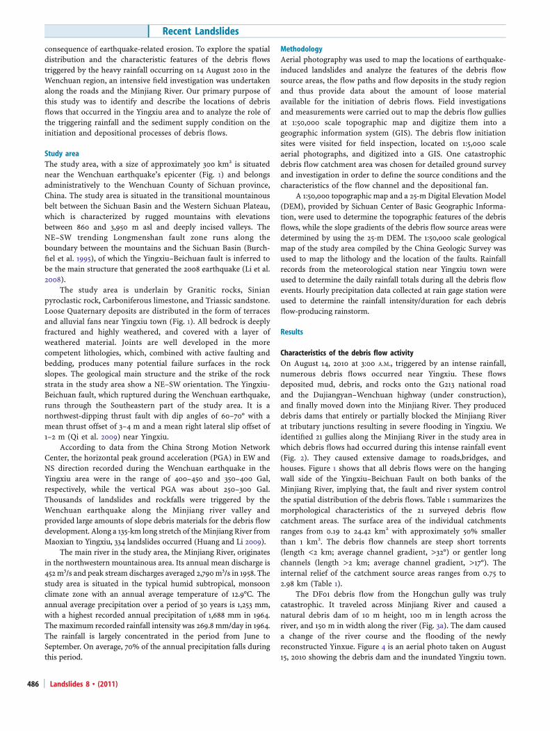
Study areaThe study area, with a size of approximately 300 km2 is situatednear the Wenchuan earthquake’s epicenter (Fig. 1) and belongsadministratively to the Wenchuan County of Sichuan province,China. The study area is situated in the transitional mountainousbelt between the Sichuan Basin and the Western Sichuan Plateau,which is characterized by rugged mountains with elevationsbetween 860 and 3,950 m asl and deeply incised valleys. TheNE–SW trending Longmenshan fault zone runs along theboundary between the mountains and the Sichuan Basin (Burch-fiel et al. 1995), of which the Yingxiu–Beichuan fault is inferred tobe the main structure that generated the 2008 earthquake (Li et al.2008).
The study area is underlain by Granitic rocks, Sinianpyroclastic rock, Carboniferous limestone, and Triassic sandstone.Loose Quaternary deposits are distributed in the form of terracesand alluvial fans near Yingxiu town (Fig. 1). All bedrock is deeplyfractured and highly weathered, and covered with a layer ofweathered material. Joints are well developed in the morecompetent lithologies, which, combined with active faulting andbedding, produces many potential failure surfaces in the rockslopes. The geological main structure and the strike of the rockstrata in the study area show a NE–SW orientation. The Yingxiu-Beichuan fault, which ruptured during the Wenchuan earthquake,runs through the Southeastern part of the study area. It is anorthwest-dipping thrust fault with dip angles of 60–70° with amean thrust offset of 3–4 m and a mean right lateral slip offset of1–2 m (Qi et al. 2009) near Yingxiu.
According to data from the China Strong Motion NetworkCenter, the horizontal peak ground acceleration (PGA) in EW andNS direction recorded during the Wenchuan earthquake in theYingxiu area were in the range of 400–450 and 350–400 Gal,respectively, while the vertical PGA was about 250–300 Gal.Thousands of landslides and rockfalls were triggered by theWenchuan earthquake along the Minjiang river valley andprovided large amounts of slope debris materials for the debris flowdevelopment. Along a 135-km long stretch of theMinjiang River fromMaoxian to Yingxiu, 334 landslides occurred (Huang and Li 2009).
The main river in the study area, the Minjiang River, originatesin the northwestern mountainous area. Its annual mean discharge is452m3/s and peak stream discharges averaged 2,790m3/s in 1958. Thestudy area is situated in the typical humid subtropical, monsoonclimate zone with an annual average temperature of 12.9°C. Theannual average precipitation over a period of 30 years is 1,253 mm,with a highest recorded annual precipitation of 1,688 mm in 1964.The maximum recorded rainfall intensity was 269.8 mm/day in 1964.The rainfall is largely concentrated in the period from June toSeptember. On average, 70% of the annual precipitation falls duringthis period.
MethodologyAerial photography was used to map the locations of earthquake-induced landslides and analyze the features of the debris flowsource areas, the flow paths and flow deposits in the study regionand thus provide data about the amount of loose materialavailable for the initiation of debris flows. Field investigationsand measurements were carried out to map the debris flow gulliesat 1:50,000 scale topographic map and digitize them into ageographic information system (GIS). The debris flow initiationsites were visited for field inspection, located on 1:5,000 scaleaerial photographs, and digitized into a GIS. One catastrophicdebris flow catchment area was chosen for detailed ground surveyand investigation in order to define the source conditions and thecharacteristics of the flow channel and the depositional fan.
A 1:50,000 topographic map and a 25-m Digital Elevation Model(DEM), provided by Sichuan Center of Basic Geographic Informa-tion, were used to determine the topographic features of the debrisflows, while the slope gradients of the debris flow source areas weredetermined by using the 25-m DEM. The 1:50,000 scale geologicalmap of the study area compiled by the China Geologic Survey wasused to map the lithology and the location of the faults. Rainfallrecords from the meteorological station near Yingxiu town wereused to determine the daily rainfall totals during all the debris flowevents. Hourly precipitation data collected at rain gage station wereused to determine the rainfall intensity/duration for each debrisflow-producing rainstorm.
Results
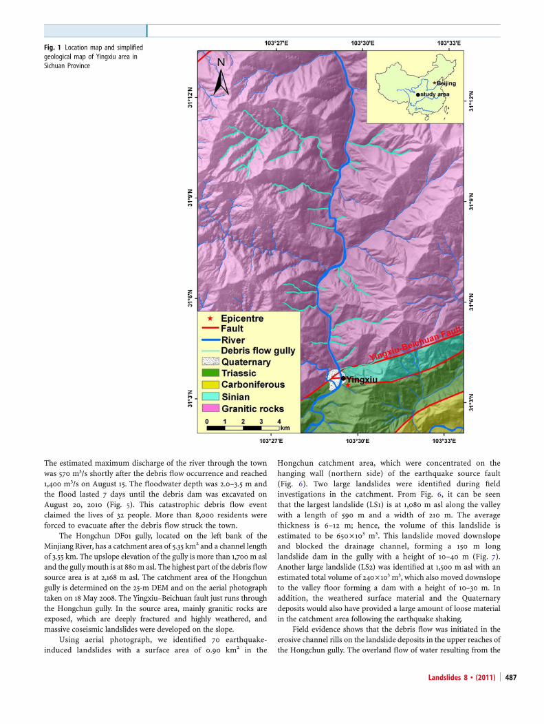
Characteristics of the debris flow activityOn August 14, 2010 at 3:00 A.M., triggered by an intense rainfall,numerous debris flows occurred near Yingxiu. These flowsdeposited mud, debris, and rocks onto the G213 national roadand the Dujiangyan–Wenchuan highway (under construction),and finally moved down into the Minjiang River. They produceddebris dams that entirely or partially blocked the Minjiang Riverat tributary junctions resulting in severe flooding in Yingxiu. Weidentified 21 gullies along the Minjiang River in the study area inwhich debris flows had occurred during this intense rainfall event(Fig. 2). They caused extensive damage to roads,bridges, andhouses. Figure 1 shows that all debris flows were on the hangingwall side of the Yingxiu–Beichuan Fault on both banks of theMinjiang River, implying that, the fault and river system controlthe spatial distribution of the debris flows. Table 1 summarizes themorphological characteristics of the 21 surveyed debris flowcatchment areas. The surface area of the individual catchmentsranges from 0.19 to 24.42 km2 with approximately 50% smallerthan 1 km2. The debris flow channels are steep short torrents(length <2 km; average channel gradient, >32°) or gentler longchannels (length >2 km; average channel gradient, >17°). Theinternal relief of the catchment source areas ranges from 0.75 to2.98 km (Table 1).
The DF01 debris flow from the Hongchun gully was trulycatastrophic. It traveled across Minjiang River and caused anatural debris dam of 10 m height, 100 m in length across theriver, and 150 m in width along the river (Fig. 3a). The dam causeda change of the river course and the flooding of the newlyreconstructed Yinxue. Figure 4 is an aerial photo taken on August15, 2010 showing the debris dam and the inundated Yingxiu town.
Recent Landslides
Landslides 8 & (2011)486
The estimated maximum discharge of the river through the townwas 570 m3/s shortly after the debris flow occurrence and reached1,400 m3/s on August 15. The floodwater depth was 2.0–3.5 m andthe flood lasted 7 days until the debris dam was excavated onAugust 20, 2010 (Fig. 5). This catastrophic debris flow eventclaimed the lives of 32 people. More than 8,000 residents wereforced to evacuate after the debris flow struck the town.
The Hongchun DF01 gully, located on the left bank of theMinjiang River, has a catchment area of 5.35 km2 and a channel lengthof 3.55 km. The upslope elevation of the gully is more than 1,700 m asland the gullymouth is at 880m asl. The highest part of the debrisflowsource area is at 2,168 m asl. The catchment area of the Hongchungully is determined on the 25-m DEM and on the aerial photographtaken on 18 May 2008. The Yingxiu–Beichuan fault just runs throughthe Hongchun gully. In the source area, mainly granitic rocks areexposed, which are deeply fractured and highly weathered, andmassive coseismic landslides were developed on the slope.
Using aerial photograph, we identified 70 earthquake-induced landslides with a surface area of 0.90 km2 in the
Hongchun catchment area, which were concentrated on thehanging wall (northern side) of the earthquake source fault(Fig. 6). Two large landslides were identified during fieldinvestigations in the catchment. From Fig. 6, it can be seenthat the largest landslide (LS1) is at 1,080 m asl along the valleywith a length of 590 m and a width of 210 m. The averagethickness is 6–12 m; hence, the volume of this landslide isestimated to be 650×103 m3. This landslide moved downslopeand blocked the drainage channel, forming a 150 m longlandslide dam in the gully with a height of 10–40 m (Fig. 7).Another large landslide (LS2) was identified at 1,500 m asl with anestimated total volume of 240×103 m3, which also moved downslopeto the valley floor forming a dam with a height of 10–30 m. Inaddition, the weathered surface material and the Quaternarydeposits would also have provided a large amount of loose materialin the catchment area following the earthquake shaking.
Field evidence shows that the debris flow was initiated in theerosive channel rills on the landslide deposits in the upper reaches ofthe Hongchun gully. The overland flow of water resulting from the
Fig. 1 Location map and simplifiedgeological map of Yingxiu area inSichuan Province
Landslides 8 & (2011) 487

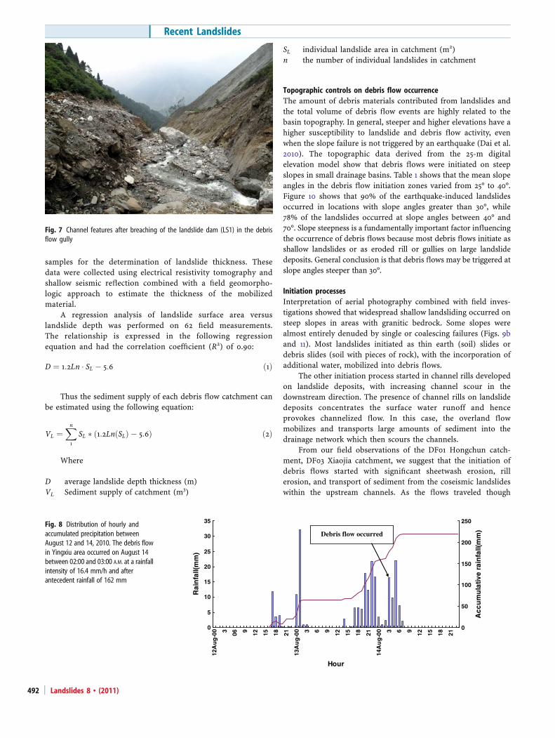
intense rainfall eroded the loose sediment material to move into thegully. When the incipient debris flow reached the landslide dam at1,080 m asl, it caused the failure of the landslide dams and produceda fast increase in the flow discharge and the transported debrisvolume (Fig. 7).
Triggering rainfallRainfall is one of the most important triggering factors forinitiating landslides and debris flows. Characterization of land-slide-triggering rainfall has been used to establish the relationbetween rainfall and landslides in various parts of the world.Cepeda et al. (2010) demonstrated that a clear connectionbetween rainfall thresholds and levels of landslide susceptibility.This connection provided the basis for a conceptual frameworkwith susceptibility-based rainfall thresholds. The comparisonbetween pre-earthquake and post-earthquake critical values forprecipitation and rainfall intensity which would cause debrisflows indicates that the strong earthquake has modified theconditions (Jan and Chen 2005; Shieh et al. 2009; Chen 2009; Tang
et al. 2009). After the Chi-Chi earthquake, maximum hourlyrainfall intensity and critical accumulated precipitation necessaryto initiate debris flow reduced to as low as 1/3 of the pre-earthquake (Lin et al. 2003).
A rain gage station at Yingxiu town records hourly rainfalldata, which gives a good ground-based record of the rainfall. Thisstation located about 600 m from the debris flow alluvial fan withelevation of 880 m asl (see Fig. 4). Precipitation generallyincreases with elevation. In our study area, most debris flowcatchments have the elevation lower than 2,000 m asl. In thisaltitude, the elevation and orographic effects have little influenceson rainfall amount and intensity. This suggests that the rainfalldata obtained from rain gage station at Yingxiu town are likely tobe representative for most debris flow catchments. However, itneeds more closely spaced rain gages in the source area of debrisflow catchments with an elevation of more than 2,000 m asl todefine climatic thresholds for debris flow occurrence. Figure 8shows the hourly and cumulative rainfall for August 12–14, 2010recorded at this station. On 12 August 2010, 2 days before the
Fig. 2 Twenty-one debris flowcatchments in the Yingxiu quadrangle.Debris flow gullies are marked ingreen; the catchment areas(encircled by black line) and codenumber for each debris flow gully areshown. Brown landslides triggered bythe Wenchuan earthquake
Recent Landslides
Landslides 8 & (2011)488
debris flows occurred, 19.9 mm of rainfall was recorded between1700 and 2400 hours. A total of 126.8 mm was recorded on theentire day of 13 August. For 14 August, 23.4 mm of precipitationwas recorded between 00:00 and 02:00 A.M.
A total of accumulated rainfall of 162.1 mm in 33 h wasrecorded from 17:00 P.M. on 12 August, until 02:00 A.M. on 14August. The rainfall intensity that induced the debris flowsoccurred between 02:00 and 03:00 A.M.; 16.4 mm/h was recordedduring that time period. Many eyewitnesses said that the mostimportant debris flows started around 03:00 A.M. and ended at04:30 A.M. After that, flooding was reported in a few long channelsuntil 9:00 A.M. on August 14, 2010.
Debris flows usually occur at a combination of highaccumulated rainfall and very high rainfall intensity (Crosta1998). In this event, however, the peak hourly rainfall (August 13,0100–0200; 32 mm/h) and the highest concentrations of debris flowswere not temporally coincident. This observation indicates thatother variables, such as the amount of accumulated antecedentrainfall and the characteristics of the hillside materials, in addition totopography, influenced the initiation of the debris flow activity.
Rainfall intensity–duration thresholds for triggering of land-slides have been widely identified in many different climates andgeologic settings. Regional rainfall thresholds for triggering land-slides and debris flows for China have been proposed by Jibson
(1989), Tan and Hen (1992), and Lan et al. (2003, 2004). Forintermediate rainfall intensity, the thresholds for the August 14, 2010event are lower than Jibson (1989) thresholds, but higher than theworldwide rainfall threshold values for landslide occurrencesestablished by Caine (1980).
The intensity of rainfall necessary to initiate debris flowsin the Yingxiu area is poorly known. Previous studies in theLongmenshan area (Tan and Hen 1992) have reported rainfallthat initiates debris flows to have intensities greater than 30–50 mm/h with a total rainfall of at least 80–100 mm. Lan et al.(2003) examined rainfall amount 110 mm/day as the rainfallthresholds for the occurrence of past landslide events in theXiaojiang watershed, southwestern China. Comparing thecharacteristics of the triggering rainfall with these thresholdsreported for China in the literature, the August 14 eventindicated that post-earthquake debris flows in the Yingxiu areacan be triggered by longer duration, lower intensity rainfall.
The recurrence interval for the August 13–14, 2010 rainfallevent, calculated using the available 1-day storm precipitationdata from “Hydrologic Manual of Sichuan Province of China”edited by Sichuan Department of Water Resources, is approximately5 years. Historical recurrence for debris flows along the MinjiangRiver was estimated from existing records to be one eventevery 20–50 years (Liu et al. 2004). This comparison showed
Table 1 Morphological characteristics of the 21 debris flow gullies and sediment supply condition
Gullycode
Gully name Basinarea(km2)
Channellength(km)
Basinrelief(km)
Channelgradient(o)
Slope ofinitiationzones (o)
Sediment supply (coseismic landslide)Number Area
(km2)Volume(106
m3)
DF01 Hongchun 5.35 3.55 1.26 19.5 30.6 85 0.90 3.84
DF02 Shaofang 0.71 1.74 1.04 33.0 34.1 11 0.25 2.38
DF03 Xiaojia 0.49 1.64 1.07 33.0 36.9 12 0.13 0.64
DF04 Baijialin 0.60 1.52 0.98 32.9 33.9 17 0.21 1.08
DF05 Wangyimiao 0.47 1.39 1.00 35.7 38.4 8 0.20 1.20
DF06 Mozi 5.33 4.23 1.60 20.7 23.8 64 1.21 6.90
DF07 Laohuzui 0.36 1.15 0.94 39.4 39.7 7 0.14 0.75
DF08 Douyaping 2.73 2.57 1.74 34.1 35.6 35 0.62 3.46
DF09 Mayangdian 2.02 2.59 1.82 35.1 40.5 27 0.72 4.63
DF10 Maliuwan 0.43 1.30 1.12 40.7 42.8 12 0.13 0.64
DF11 Santaidi 0.19 1.09 0.75 34.5 35.3 3 0.04 0.18
DF12 Dagou 1.03 2.02 0.90 23.6 25.4 6 0.10 0.55
DF13 Dacaotou 3.99 3.78 1.54 22.1 24.2 12 0.16 0.82
DF14 Zaojiaowan 2.88 2.40 1.71 35.4 42.2 15 0.62 4.46
DF15 Heicaotou 0.34 1.14 1.98 40.6 43.1 5 0.12 0.68
DF16 Xingwenping 1.71 2.44 2.02 39.7 45.9 12 0.39 2.53
DF17 Yiwanshui 7.18 4.82 2.48 27.2 34.7 43 2.72 16.33
DF18 Yeliu 24.42 9.47 2.98 17.5 26.0 117 6.34 26.35
DF19 Supodian 2.81 2.74 1.44 27.7 28.7 35 0.44 2.30
DF20 Maojiawan 0.43 1.30 1.12 38.7 41.7 14 0.13 0.64
DF21 Yinxingping 7.06 4.41 2.00 24.1 31.0 60 1.79 10.85
Landslides 8 & (2011) 489

that there is a general increase of debris flow susceptibility after theWenchuan earthquake followed by a large precipitation event. Thisresult is also consistent with Dadson et al. (2004) who found an
increase in landslide and debris flow occurrences mapped in Taiwanafter a typhoon following an earthquake compared to the number oflandslides mapped just after the earthquake and after a typhoon thatoccurred several years before the earthquake.
To further compare the rainfall conditions for the triggeringevent with extreme precipitation, we use rainfall data from theYingxiu rain gage station and publicly available data from ETCCDIClimate Extreme Indices dataset and data of Daily PrecipitationExtremes over China (Zhai et al. 2005). The maximum dailyprecipitation recorded 269.8 mm (data recorded from 1962 to2004) for Yingxiu station and 233.8 mm (data recorded from 1954to 2003) for Dujiangyan station, which is the closest to Yingxiu(~22 km from Yingxiu). The rainfall amount of only 138.8 mm in 24 hwas recorded in Yingxiu station prior to debris flow occurrence at03:00 A.M. on August 14, 2010. It demonstrated that this debris flowoccurrence was not induced by extreme rainfall event of this area.
Sediment supply conditionsField observations in the study area showed that an abundance ofloose landslide debris was present on the slopes after theWenchuan earthquake. This debris served as source material forrainfall-induced debris flows or shallow landslides. The compar-ison between remote sensing imagery before and after the heavyrainfall event showed that earthquake shaking had severelydisturbed surface strata, posing a potential landslide hazard inthe region, as the slopes are very susceptible to future debris flowsunder heavy rainfall conditions. Due to fresh traces of runofferosion and displaced landslides on the slopes after the August13–14 rainstorm, debris flows were easily identified in the images.Shallow landslides on steep, natural slopes, and in steep, road cutswere ubiquitous. Some of the landslides coalesced to formlandslide clusters. Figure 9 shows imagery of three datasets thatillustrate landslide development and evolution in the debrisflow catchments along the Minjiang River before and after theWenchuan earthquake. These images also reflect the greatimpact of the earthquake and the subsequent heavy rains ondebris flow occurrence.
The volume of debris from landslides and the amount ofsediments in the channels are difficult to quantify specially fora steep mountain catchment (Schuerch et al. 2006), but can be
The Yingxiu town was flooded
Debris-flow dam
Original river channel
Hongchun gully(DF1)
Shaofang gully(DF2)
Rain-gauge station
Fig. 4 Aerial photo taken on August15, 2010 showing the Hongchun debrisflow (DF01) fan, the debris flow dam,and the inundated area in the newlyreconstructed town of Yingxiu (Photoprovided by the Sichuan Institute ofGeological Environmental Monitoring)
Fig. 3 Depositional fan of the Hongchun gully (DF01) prior to b and after a thedebris flow occurrence (a debris dam which blocked Minjiang river-course andburied the road; b pre-existing alluvial fan)
Recent Landslides
Landslides 8 & (2011)490

estimated using empirical relationships to link the volume ofindividual landslides to the dimensions of the landslides in thefield (Guzzetti et al. 2009). The volume of a landslide isestimated by multiplying the area covered by the landslidedeposit with an estimated average depth (Martin et al. 2002).The average landslide depth in this study was defined as theslope–normal thickness of the landslide deposit under homo-geneous conditions. Geomorphologic considerations suggestedthat the measurement of landslide volume from aerial photo-graphs and field surveys was sufficiently accurate for thepurpose of our work.
Post-earthquake aerial photographs taken on May 18, 2008,with a resolution of 0.3 m, could be used to identify thelandslide deposits with a minimum size of 10 m2. The shapes,dimensions, and types of the post-earthquake landslide debriscould be interpreted and delineated on the aerial photographs.Table 1 and Fig. 2 shows the areas covered with earthquake-induced landslides of various dimensions in each debris flowbasin. They occupy 24.9% of the total surface area of the 21debris flow catchment areas of 69.8 km2. The landslide coveredareas in the DF05 Wangyimiao gully, DF07 Laohuzui gully, andDF02 Shaofang gully account to 42.5%, 38.9%, and 35.2%,respectively, of those catchment areas. This shows that theWenchuan earthquake has caused widespread slope instabilityand consequently provided extremely rich source materials forthe debris flow development.
The photo interpretation can only provide information onthe landslide surface area, so a relational model between thelandslide area and its average thickness is required todetermine the volume of the landslide debris. Informationconcerning coseismic landslide thickness was derived from thedata in the report: “The investigation report on debris flowhazard in the Hongchun gully of the Yingxiu town after theWenchuan earthquake”, published by the Guanghan Instituteof Geological Engineering Investigations of Sichuan Province.Sixty-two landslides of different sizes in the Hongchun andShaofang gully catchments near Yingxiu were selected as
LS2
LS1
Fig. 6 Aerial photograph taken onMay 18, 2008 (immediately after theWenchuan earthquake) showing thecatchment area of the DF01Hongchuen debris flow with theearthquake induced landslides
Fig. 5 Newly reconstructed Yingxiu town was flooded due to a debris flow dam.The floodwater depth was 2.0–3.5 m and the flood lasted 7 days (a shows thatfloodwater runs through the town and flows back into the original river channel;b shows how the floodwater with a high concentration of sediment flowed intothe buildings and streets of the inner town)
Landslides 8 & (2011) 491
samples for the determination of landslide thickness. Thesedata were collected using electrical resistivity tomography andshallow seismic reflection combined with a field geomorpho-logic approach to estimate the thickness of the mobilizedmaterial.
A regression analysis of landslide surface area versuslandslide depth was performed on 62 field measurements.The relationship is expressed in the following regressionequation and had the correlation coefficient (R2) of 0.90:
D ¼ 1:2Ln � SL � 5:6 ð1Þ
Thus the sediment supply of each debris flow catchment canbe estimated using the following equation:
VL ¼Xn
1
SL � 1:2LnðSLÞ � 5:6ð Þ ð2Þ
Where
D average landslide depth thickness (m)VL Sediment supply of catchment (m3)
SL individual landslide area in catchment (m2)n the number of individual landslides in catchment
Topographic controls on debris flow occurrenceThe amount of debris materials contributed from landslides andthe total volume of debris flow events are highly related to thebasin topography. In general, steeper and higher elevations have ahigher susceptibility to landslide and debris flow activity, evenwhen the slope failure is not triggered by an earthquake (Dai et al.2010). The topographic data derived from the 25-m digitalelevation model show that debris flows were initiated on steepslopes in small drainage basins. Table 1 shows that the mean slopeangles in the debris flow initiation zones varied from 25° to 40°.Figure 10 shows that 90% of the earthquake-induced landslidesoccurred in locations with slope angles greater than 30°, while78% of the landslides occurred at slope angles between 40° and70°. Slope steepness is a fundamentally important factor influencingthe occurrence of debris flows because most debris flows initiate asshallow landslides or as eroded rill or gullies on large landslidedeposits. General conclusion is that debris flows may be triggered atslope angles steeper than 30°.
Initiation processesInterpretation of aerial photography combined with field inves-tigations showed that widespread shallow landsliding occurred onsteep slopes in areas with granitic bedrock. Some slopes werealmost entirely denuded by single or coalescing failures (Figs. 9band 11). Most landslides initiated as thin earth (soil) slides ordebris slides (soil with pieces of rock), with the incorporation ofadditional water, mobilized into debris flows.
The other initiation process started in channel rills developedon landslide deposits, with increasing channel scour in thedownstream direction. The presence of channel rills on landslidedeposits concentrates the surface water runoff and henceprovokes channelized flow. In this case, the overland flowmobilizes and transports large amounts of sediment into thedrainage network which then scours the channels.
From our field observations of the DF01 Hongchun catch-ment, DF03 Xiaojia catchment, we suggest that the initiation ofdebris flows started with significant sheetwash erosion, rillerosion, and transport of sediment from the coseismic landslideswithin the upstream channels. As the flows traveled though
0
5
10
15
20
25
30
35
12A
ug
-00 3 06 9 12 15 18 21
13A
ug
-00 3 6 9 12 15 18 21
14A
ug
-00 3 6 9 12 15 18 21
Hour
Rai
nfa
ll(m
m)
0
50
100
150
200
250
Acc
um
ula
tive
rain
fall(
mm
)Debris flow occurredFig. 8 Distribution of hourly andaccumulated precipitation betweenAugust 12 and 14, 2010. The debris flowin Yingxiu area occurred on August 14between 02:00 and 03:00 A.M. at a rainfallintensity of 16.4 mm/h and afterantecedent rainfall of 162 mm
Fig. 7 Channel features after breaching of the landslide dam (LS1) in the debrisflow gully
Recent Landslides
Landslides 8 & (2011)492

channel of the lower reaches of the gully, discharges increased asrunoff and additional eroded material that was incorporated from
the sideslopes and tributary channels and from shallow landslideson the hillslopes. Larger sediment material stored within thechannel was also incorporated into the flows and subsequentlyflushed out of the catchment mouths as boulder-sized material inan abundant fine-grained matrix. Figure 9c shows that sedimentsupply derived from coseismic landslides and other mass-wastingprocesses are located the upstream area of the debris flowcatchment. This is a very important aspect towards recommen-dations for implementation of early warning systems.
Debris flow fansDebris flows are one of the most dangerous geomorphologicprocesses that occur in mountainous areas (Alexander 1989;Hürlimann et al. 2006). Because the main damage occurs in thedepositional zone of the debris flows, detailed hazard assessmentsare necessary for the fan areas in order to protect people andinfrastructure against future debris flows and to manage the riskmore effectively (Hürlimann et al. 2006; Prochaska et al. 2008). In
0 0.5 1.0km
DF6DF3DF5
DF2DF1
DF4
a
DF6DF3
DF5
DF2
DF1
DF4b
0 0.5 1.0km
DF2Shaofang gully
DF3Xiaojia gully DF5
Wangyimiao gullyDF6
Mozi gully
DF1Hongchun gully
DF4Baijialin gully
c
Fig. 9 RS Imagery from three differentdata shows the landslide and debrisflow development along Minjiang river(a TM image taken on March 31, 2006before the Wenchuan earthquake; baerial photograph taken on May 18,2008 after the May 12 Wenchuanearthquake; c low-altitude aerial phototaken on August 15, 2010 after theAugust 14 rainstorm event)
Slope angle (degrees)
Per
cent
age
of la
ndsl
ide
area
(%
)
Fig. 10 Plot of the landslide density in areas with different slope angles
Landslides 8 & (2011) 493

the study area, most debris flows reached the Minjiang River,depositing the poorly sorted sediment including boulders with asize of up to 2 m in diameter both into the river and on top of theexisting debris fans (Fig. 12). These fans produced debris damsthat entirely or partially blocked the Minjiang River at tributaryjunctions, raising the riverbed until the river removes orrepositions the boulders and removes the finer-grained particles.The debris flow materials deposited on top of the fans aretypically an unsorted deposit of fines, sand, and gravel, mixedwith boulders and wood debris.
A quick field measurement with handheld GPS and laserrangefinders were conducted on the debris flow fans to estimatetheir volume and the dimensions of their runout zones. Theoutlines of the debris flow fans were determined from surveydata. The results of these measurements at the 21 fan locations aregiven in Table 2. The maximum runout distances on the fansvaried between 0.07 and 0.39 km and the maximum lateral widthsbetween 0.06 and 0.35 km (Table 2). A larger sediment availabilityin the debris flow source areas (see Table 1) resulted in largerdebris flow volumes (see Table 2) and peak discharges that, inturn, were associated with longer runout distances on fan. Thevolumes of deposits on fans were estimated using the methodssuggested by Stoffel (2010). After the earthquake, landslides thatoccurred in the debris flow source areas contributed extensivelyto the volume and runout extent of the debris flows. The smallestdeposits identified have volumes of 3×10³ m3 and the largestdeposit accounts for 711×103 m3. The mean volume was 70×103 m3.The volume of all new debris flow deposits on the fans amounted tomore than 1,466×103 m3. The mean surface slope angle of the newlydeposited materials ranged between 4° and 25°. The smaller debrisflow catchment areas with steep short channels tend to have a higherfan deposit gradient (Table 2).
Zhang and Xie (2008) indicated that peak discharges of eightdebris flow events along the Minjiang River prior to the Wenchuanearthquake have the value between 21 and 463 m3/s, while thesedebris flows generally have event volumes between 2×10³ and 30×103 m3. Comparing the August 2010 debris flows with earlier events,this debris flow event volumes dramatically increased. Table 2 showsthat even small debris flow catchment areas had a much largerdischarge capacity than usual under the same rainfall conditions and
caused more widespread sediment deposition on the fans. Notably,most debris flow events prior to the event of 14 August 2010 did notleave any deposition on the existing fans. The wide volume range inTable 2 is likely related to a combination of several factors includingthe abundant supply of landslide debris, the size of the catchmentarea, the length of the eroded channel, and the volume of the surfacewater runoff.
DiscussionThe recent catastrophic events described in this paper demon-strate that in the area highly affected by the Wenchuan earth-quake, debris flows occurred much more frequently andtransported much larger amounts of debris out of the sourceareas, posing a serious threat to the restoration and recon-struction efforts. Our investigation indicates that the August 14debris flow occurred after rainfall with an exceptionally longperiod of over 33 h (Fig. 8), rather than an exceptionally highpeak rainfall intensity of short duration. Prolonged rainfall canact in numerous ways on the stability of slopes. It may cause asaturated zone, with elevated pore water pressures, andcontributed to the initiation of a landslide and subsequentdevelopment into debris flows (Cojean 1994; Chen et al. 2006).Coseismic landslide deposits are highly permeable and mayfacilitate this process. As the minimum rainfall intensity andduration needed to trigger such debris flow events varies fromregion to region, the general conditions for the area describedin this paper should be determined, because rainstormforecasts can be used for early warning in exposed areaswithin a few hours (Campbell et al. 1989).
The present study has shown that the Wenchuan earth-quake-triggered landslides provide tremendous volumes ofloose landslide debris to the debris flow source areas. Theanalysis of the collected field data suggests that the character-istics and the spatial distribution of the earthquake-triggeredlandslides and the steep topography controlled the location ofthe initiation zones of debris flows. Our findings indicate thatthe runoff in the catchment areas was sufficient to mobilize a
Fig. 12 Photograph showing debris flow fans with the poorly sorted sedimentincluding many coarse boulders and woods. Postdebris flow flooding removedmost of finer debris flow matrix from the upper part of the boulder deposit.Photograph taken on August 16, 2010
Fig. 11 Erosion due to overflow on a large landslide deposit (LS1) in theHongchun gully (DF01)
Recent Landslides
Landslides 8 & (2011)494

large amount of loose debris material from the widespreadlandslides, and transform them into the debris flows. Thismechanism has been suggested elsewhere by Montgomery et al.(2000), Marchi et al. (2002), and Chen et al. (2006).
Prior to this catastrophic event, debris flows had beenrecognized locally in the region, but their potential forwidespread and devastating impacts was not fully appreciated.The assessment of debris flow hazard in the Yingxiu area hadlargely overlooked the effects of cascading natural disasterchains, such as the formation of debris dams, dammed lake,and flood. Thus, the newly reconstructed town of Yingxiu wasnot prepared for the sudden and devastating impact of debrisflows after a rainstorm of not so extreme intensity. The eventon 14 August 2010 indicates that debris flows are likely tospecially develop in the near future in the regions that arehighly affected by the Wenchuan earthquake, thereby alteringthe landform and simultaneously resulting in disastrous events.It should be noted that identification of the areas that might beinundated by future debris flows and estimates of flow volumeare required to quantify debris flow hazard and allow foradequate land use planning. Because many pre-existing alluvialfans are being utilized or considered as resettlement areas inthe Wenchuan earthquake region, the risk due to debris flowshas dramatically increased. For mitigation of debris flows riskin the Wenchuan earthquake area, apart from engineering
measures, also non-engineering measures are required such asland use zoning to regulate and restrict the use of hazardousareas and relocation to safer places of people currently livingin areas susceptible to debris flows and related flooding.
ConclusionsFrom observations and the data collected following the debrisflow events on 14 August 2010, the following conclusions can bedrawn:
1. A rainfall intensity of 16.4 mm/h on 14 August 2010 incombination with antecedent rainfall of 162.1 mm in 2 daystriggered 21 debris flows around the town of Yinxue, locatednear the epicenter of the Wenchuan earthquake. A cata-strophic debris flow originated in the Hongchun gully catch-ment area. It transported a large amount of debrisdownstream to form a debris dam in the Minjiang River,which then resulted in the flooding of the newly reconstructedYinxue town. Field measurement revealed that the totalvolume and peak discharge of the debris flow were unusuallyhigh as compared with earlier debris flows in this region.
2. Three essential factors: intensive rainfall, abundant sedimentsupply, and steep catchment topography contributed to theinitiation of the debris flows. Field investigations indicate thatthe sediment supply was mainly derived from: shallow land-
Table 2 Data collected in the field on the debris flow fan deposits
Gullycode
Gully name Max. Length ofdeposit on fan(km)
Max. width ofdeposit on fan(km)
Averagedepositthickness (m)
Mean surfacegradient ofdeposit (o)
Volume ofdeposits on fans(103 m3)
DF01 Hongchun 0.39 0.35 5.5 8 711
DF02 Shaofang 0.21 0.24 5.9 10 76
DF03 Xiaojia 0.17 0.26 6.5 9 83
DF04 Baijialin 0.07 0.17 8.2 15 62
DF05 Wangyimiao 0.22 0.19 7.2 12 104
DF06 Mozi 0.23 0.27 6.3 15 158
DF07 Laohuzui 0.19 0.17 2.5 25 32
DF08 Douyaping 0.15 0.17 1.5 18 20
DF09 Mayangdian 0.18 0.14 2.2 15 22
DF10 Maliuwan 0.09 0.07 2.0 22 8
DF11 Santaidi 0.15 0.12 2.1 22 16
DF12 Dagou 0.09 0.09 3.0 12 12
DF13 Dacaotou 0.13 0.09 2.0 15 7
DF14 Zaojiaowan 0.10 0.14 1.5 4 11
DF15 Heicaotou 0.10 0.15 3.0 23 20
DF16 Xingwenping 0.18 0.20 3.5 10 43
DF17 Yiwanshui 0.24 0.20 2.5 8 37
DF18 Yeliu 0.12 0.08 1.0 5 3
DF19 Supodian 0.15 0.07 2.0 10 6
DF20 Maojiawan 0.08 0.06 1.0 20 5
DF21 Yinxingping 0.20 0.12 3.0 8 30
Landslides 8 & (2011) 495

slides, channel rill erosion on large landslide deposits, alluviumalong the channel, and colluvium from the channel banks.
3. Catchment topography is an important factor for the spatialdistribution and the initiation of debris flows. The analysisshows that the majority of the earthquake-triggered landslidesoccurred on slopes steeper than 30°, while 78% of suchlandslides occurred at slope angles ranging from 40° to 70°.
4. Two initiation processes for post earthquake debris flows havebeen identified: (1) initiation by shallow landsliding and (2)initiation on large landslide deposits through sedimentmobilization in channel rills. Coseismic landslide depositsforming dams in the gullies may temporarily block new debrisflows, but when these are breached there is an instantaneousincrease in the flow discharge. Larger sediment supply alsoresulted in larger debris flow volumes that, in turn, resulted inlonger travel distances on fans. It was found that even smalldebris flow catchment areas reached a much larger dischargecapacity than usual under the same rainfall conditions andcaused more widespread sediment deposition on the fans.
5. The occurrence of disastrous debris flows triggered by theintense rainfall of 14 August indicates that the WenchuanEarthquake areas are prone and will most probably remainprone to debris flows for a very long time. As a consequence,it is necessary to reinforce the debris flow risk management ofcities and towns in the whole earthquake-affected zone. It isrequired to regulate and restrict the use of the hazardousareas susceptible to debris flows and debris floods, and torelocate to safer places the people currently living in suchareas. Monitoring and early warning systems should beimplemented in the potentially high-risk areas.
AcknowledgmentsThis work was supported by the 973 program (no. 2011CB409903),Program of Changjiang Scholars and Innovative Research Team inUniversity (no. IRT0812), and Key Projects in the National Science& Technology Pillar Program (No. 2011BAK12B01). We express ourgratitude to Prof. Niek Rengers (ITC) for his comments andsuggestions on earlier versions of the manuscript.
References
Alexander D (1989) Urban landslides. Prog Phys Geogr 13:157–191Bovis MJ, Jakob M (1999) The role of debris supply conditions in predicting debris flow
activity. Earth Surf Process Land 24:1039–1054Burchfiel BC, Chen Z, Liu Y, Royden LH (1995) Tectonics of the Longmen Shan and
adjacent regions. Int Geol Rev 37:661–735Caine N (1980) The rainfall intensity–duration control of shallow landslides and debris
flows. Geogr Ann 62A:23–27Campbell RH (1975) Soil slips, debris flows and rainstorms in the Santa Monica
Mountains and vicinity. Southern California, US Geological Survey Professional papervol.851, US Geological Survey, Washington, DC
Campbell RH, Fleming RW, Prior DB, Nichols DJ, Hampton MA, Sangrey DA, Brabb EE (1989)Landslide classification for identification of mud flows and other landslides. In: Sadler PM,Morton DM (eds) Landslides in a semiarid environment, Publications of the InlandGeological Society, 2nd edn. University of California, California, pp 1–27
Cannon SH, Kirkham RM, Parise M (2001) Wildfire-related debris flow initiationprocesses, Storm King Mountain, Colorado. Geomorphology 39:171–188
Cepeda J, Høeg K, Nadim F (2010) Landslide-triggering rainfall thresholds: a conceptualframework. Q J Eng Geol Hydrogeol 43:69–84
Chen CY (2009) Sedimentary impacts from landslides in the Tachia River Basin.Geomorphology 105:355–365
Chen H, Petley DN (2005) The impact of landslides and debris flows triggered byTyphoon Mindulle in Taiwan. Q J Eng Geol Hydrogeol 38:301–304
Chen H, Dadson S, Chi YG (2006) Recent rainfall-induced landslides and debris flow innorthern Taiwan. Geomorphology 77:112–125
Cojean R (1994) Role of groundwater as a triggering factor for landslides and debrisflow, Proc Int Workshop on flood and inondations related to large earth movements,Trento, Italy A13:1–19
Costa JE (1984) Physical geomorphology of debris flows. In: Costa JE, Fleisher PJ (eds)Chapter 9 of development and application of geomorphology. Springer, New York,pp 268–371
Crosta G (1998) Regionalization of rainfall thresholds: an aid to landslide hazardevaluation. Environ Geol 35:131–145
Dadson SJ, Hovius N, Chen H, Dade WB, Lin JC, Hsu ML, Lin CW, Horng MJ, Chen TC,Milliman J, Stark CP (2004) Earthquake-triggered increase in sediment delivery froman active mountain belt. Geology 32:733–736
Dai F, Lee CF, Wang S (1999) Analysis of rainstorm-induced slide-debris flows on naturalterrain of Lantau Island, Hong Kong. Eng Geol 51:279–290
Dai FC, Xu C, Yao X, Xu L, Tu XB, Gong QM (2010) Spatial distribution of landslidestriggered by the 2008 Ms 8.0 Wenchuan earthquake, China. J Asian Earth Sci.doi:10.1016/j.jseaes.2010.04.010
Dong JJ, Lee CT, Tung YH, Liu CN, Lin KP, Lee JJ (2009) The role of the sediment budget inunderstanding debris flow susceptibility. Earth Surf Process Landforms 34:1612–1624
Fleming RW, Ellen SD, Algus MA (1989) Transformation of dilative and contractivelandslide debris into debris flows an example from Marin County, California. EngGeol 27:201–223
Guzzetti F, Cardinali M, Reichenbach P, Cipolla F, Sebastian C, Galli M, Salvati P (2004)Landslides triggered by the 23 November 2000 rainfall event in the ImperiaProvince, Western Liguria, Italy. Eng Geol 73:229–245
Guzzetti F, Ardizzone F, Cardinali M, Rossi M, Valigi D (2009) Landslide volumes and landslidemobilization rates in Umbria, central Italy. Earth Planet Sci Lett 279:222–229
Huang RQ, Li WL (2009) Analysis of the geo-hazards triggered by the 12 May 2008Wenchuan Earthquake, China. Bull Eng Geol Environ 68:363–371
Hürlimann M, Copons R, Altimir J (2006) Detailed debris flow hazard assessment inAndorra, a multidisciplinary approach. Geomorphology 78:359–372
Iverson RM (1997) The physics of debris flows. Rev Geophys 35:245–296Iverson RM (2000) Landslide triggering by rain infiltration. Water Resour Res 36:1897–
1910Jakob M, Bovis M, Oden M (2005) The significance of channel recharge rates for
estimating debris-flow magnitude and frequency. Earth Surf Process Land 30:755–766
Jan CD, Chen CL (2005) Debris flows caused by typhoon herb in Taiwan. In: Jakob M,Hungr O (eds) Debris flow hazards and related phenomena. Springer, Berlin, pp 363–385
Jibson RW (1989) Debris flow in southern Porto Rico. In: Schultz AP, Jibson RW (eds)Landslide Processes of the Eastern United States and Puerto Rico. Geological Societyof America Special Paper, 236th edn., pp 29–55
Koi T, Hotta N, Ishigaki I, Matuzaki N, Uchiyama I, Suzuki M (2008) Prolonged impact ofearthquake-induced landslides on sediment yield in a mountain watershed, TheTanzawa region, Japan. Geomorphology 101:692–702
Lan HX, Wu FQ, Zhou CH, Wang LJ (2003) Spatial hazard analysis and prediction onrainfall-induced landslide using GIS. Chinese Science Bulletin 48:703–708
Lan HX, Zhou CH, Wang LJ, Zhang HY, Li RH (2004) Landslide hazard spatial analysisand prediction using GIS in the Xiaojiang watershed, Yunnan, China. EngineeringGeology 76:109–128
Li H, Fu X, van der Woerd J, Si J, Wang Z, Hou L, Qiu Z, Li N, Wu F, Xu Z, Tapponnier P(2008) Co-seisimic surface rupture and dextral-slip oblique thrusting of the Ms 8. 0Wenchuan earthquake. Acta Geol Sin 82(12):1623–1643
Lin CW, Shieh CL, Yuan BD (2003) Impact of Chi-Chi earthquake on the occurrence oflandslides and debris flows: example from the Chenyulan River watershed, Nantou,Taiwan. Eng Geol 71:49–61
Lin CW, Liu SH, Lee SY, Liu CC (2006) Impacts on the Chi-Chi earthquake on subsequentrain-induced landslides in central Taiwan. Eng Geol 86:87–101
Lin GW, Chen H, Chen YH, Horng MJ (2008) Influence of typhoons and earthquakes onrainfall-induced landslides and suspended sediments discharge. Eng Geol 97:32–41
Liu XL, Wang QC, Kong JM, He SM, Su PC (2004) Hazard assessment of debris flows andtheir developing trend along Dujiangyan–Wenchuan highway. J Disast PreventMitigat Eng 24:41–46, in Chinese
Recent Landslides
Landslides 8 & (2011)496

Liu CN, Huang HF, Dong JJ (2008) Impacts of September 21, 1999 Chi-Chi earthquake onthe characteristics of gully-type debris flows in central Taiwan. Nat Hazards 4:349–368
Marchi L, Arattano M, Deganutti AM (2002) Ten years of debrisflow monitoring in theMoscardo, Torrent Italian Alps. Geomorphology 46:1–17
Martin Y, Rood K, Schwab JW, Church M (2002) Sediment transfer by shallow landsliding inthe Queen Charlotte Islands, British Columbia. Can J earth Sci 39:189–205
Montgomery DR, Schmidt KM, Greenberg HM, Dietrich WE (2000) Forest clearing andregional landsliding. Geology 28:311–314
Prochaska AB, Santia PM, Higgins JD, Cannon SH (2008) Debris-flow runout predictionsbased on the average channel slope (ACS). Eng Geol 98:29–40
Qi SW, Xu Q, Lan HX, Zhang B, Liu JY (2009) Spatial distribution analysis of landslidestriggered by 2008. 5.12 Wenchuan Earthquake, China. Eng Geol. doi:10.1016/j.enggeo.2010.07.011
Reid ME, Nielsen HP, Dreiss SJ (1988) Hydrologic factors triggering a shallow hillslopefailure. Bull Assoc Eng Geol 25:349–361
Schuerch P, Densmore AL, McArdell BW, Molnar P (2006) The influence of landslidingon sediment supply and channel change in a steep mountain catchment.Geomorphology 78:222–235
Shieh CL, Chen YS, Tsai YJ, Wu JH (2009) Variability in rainfall threshold for debris flowafter the Chi-Chi earthquake in central Taiwan, China. Int J Sediment Res 24:177–188
Stoffel M (2010) Magnitude–frequency relationships of debris-flows—a case studybased on field surveys and tree-ring records. Geomorphology 116:67–76
Takahashi T (1981) Estimation of potential debris flows and their hazardous zones. J NatDisaster Sci 3:57–89
Tan WP, Hen QY (1992) Study on regional critical rainfall induced debris flow in SichuanProvince. Journal of Catastrophology 7:37–42 (in Chinese)
Tang C, Zhu J, Li WL (2009) Rainfall triggered debris flows after Wenchuan earthquake.Bull Int Assoc Eng Geol 68:187–194
Varnes DJ (1978) Slope movement types and processes. In: Schuster RL, Krizek RJ (eds)Landslides analysis and control. Transportation research board special report, vol,176. National Research Council, Washington, DC, pp 11–33
Wieczorek GF (1987) Effect of rainfall intensity and duration on debris flows in centralSanta Cruz Mountains, California. In: Costa JE, Wieczorek GF (eds) Debris flows/avalanches, process, recognition and mitigation, Geological Society of America,Reviews in Engineering Geology, 7th edn., pp 93–104
Zhai PM, Zhang XB, Wan H, Pan XH (2005) Trends in total precipitation and frequencyof daily precipitation extremes over China. J Climate 18:1096–1108
Zhang JS, Xie H (2008) Study on factors affecting the river-blocking due to debris flowsin the upper reaches of Minjiang River. Resources and Environment in the YangtzeBasin 17:651–655 (in Chinese)
C. Tang ()) : J. Zhu : J. Ding : X. Cui : L. Chen : J. ZhangState Key Laboratory of Geo-Hazard Prevention and Geo-Environment Protection,Chengdu University of Technology,Chengdu 610059, Chinae-mail: [email protected]
Landslides 8 & (2011) 497