Embed Size (px)
Citation preview
V olu m e 18 (2017)
Reclaiming Social Equityin Land Use Planning for
Sustainable Cities
KRISTIAN KARLO C. SAGUIN*,CHRISTOPHER JOHN CHANCO, AILDRENE ISRAEL S. TAN,
and ARNISSON ANDRE C. ORTEGA
Abstract
The rapid growth of Philippine cities has brought a host of problems andchallenges, including sprawl, environmental degradation, unemployment, lackof adequate housing, increased vulnerability to hazards, and an overall declinein the quality of life of urban residents. As Mega Manila expands, its peri-urbanfringes face the pressure of conversion to urban land uses, while core urbanareas grapple with various urban issues on zoning and land use change. Giventhese issues, land use plans and policies serve as important sites of interventionin moving toward urban sustainability. Beyond issues of enforcement on theground, this paper argues for the need to examine, evaluate, and refine theguiding framework for land use planning.
We propose three ways of approaching urban land use planning andpolicy based on a review of relevant documents and field research in twocase study sites. First, we emphasize the need to broaden sustainability as aguiding framework for land use planning by emphasizing social equity andjustice as a crucial component of sustainable development. Considering thesemay promote community interests that do not necessarily fit within aneconomic growth or ecological integrity imperative. Second, we advocatebuilding on efforts to improve community participation in land use planning.Our field accounts suggest opportunities for further participation of
Keywords: land use, sustainability, urbanization, spatial practices
* Corresponding author. Email: [email protected]
P u b l i c P o l i c y
communities in crafting land use plans and related projects. Third, wesuggest including other spatial approaches and imaginaries practiced by localcommunities in everyday life. We identify the merits of a deeper engagementwith communities and use the example of community mapping as a tool forplanning land use. Increasing community participation and incorporatingother planning methods will contribute to better realizing social equity inplanning for just sustainability in cities.
Introduction
The rapid growth of Philippine cities has brought a host of problems andchallenges including sprawl, environmental degradation, unemployment, lack ofadequate housing, increased vulnerability to hazards, and an overall decline inthe quality of life for urban residents. These problems are often attributed to poorplanning, regulation, and governance of urban processes, which often magnifyinequality and undermine urban sustainability. As Mega Manila expands, its peri-urban fringes face the pressure of conversion to urban land uses while core urbanareas grapple with emergent forms of land use transformations. Land use plansand policies remain important sites of intervention to address urban challengesand move toward urban sustainability. However, beyond issues of enforcementon the ground, we argue for the need to examine, evaluate, and refine the guidingframework for land use planning. Despite their limitations, sustainability andsustainable development continue to be a relevant and appropriate framework forurban governance.
Our goal in this paper is to contribute to urban land use planning and policyin three ways. First, we emphasize the need to broaden sustainability as a guidingframework for land use planning practice and policy beyond current iterations.We call for stronger incorporation of the social equity and justice component ofsustainable development as a way to safeguard and promote community intereststhat do not fit within an economic growth or ecological protection imperative.Second, we seek to build on efforts to strengthen community participation as animportant component of land use planning. Third, we suggest extending landuse planning methods to include other spatial approaches and imaginariespracticed by communities in everyday life. We identify the merits of a deeperengagement with communities and use the example of community mapping as atool for planning land use. Increasing community participation in land useplanning process and incorporating other planning methods will contribute tobetter realizing social equity in planning for just sustainability in cities.
Saguin, Chanco, Tan, and Ortega
100
V olu m e 18 (2017)
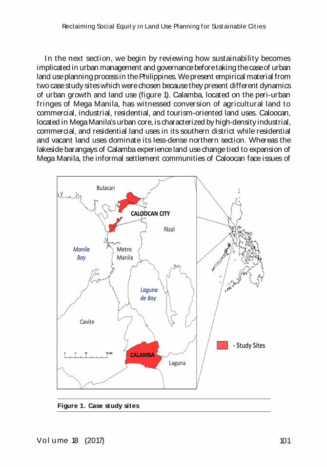
In the next section, we begin by reviewing how sustainability becomesimplicated in urban management and governance before taking the case of urbanland use planning process in the Philippines. We present empirical material fromtwo case study sites which were chosen because they present different dynamicsof urban growth and land use (figure 1). Calamba, located on the peri-urbanfringes of Mega Manila, has witnessed conversion of agricultural land tocommercial, industrial, residential, and tourism-oriented land uses. Caloocan,located in Mega Manila’s urban core, is characterized by high-density industrial,commercial, and residential land uses in its southern district while residentialand vacant land uses dominate its less-dense northern section. Whereas thelakeside barangays of Calamba experience land use change tied to expansion ofMega Manila, the informal settlement communities of Caloocan face issues of
Reclaiming Social Equity in Land Use Planning for Sustainable Cities
Figure 1. Case study sites
101
P u b l i c P o l i c y
land tenure insecurity, poor access to social services, and threats of eviction. Byfocusing on a peri-urban fishing community in Calamba and settlements withconflicting land ownership claims in Caloocan, we wish to highlight aspects ofland use change often overlooked or ignored in discussions of urban planningand sustainability. We do not seek to generalize for Philippine cities or toundertake a thorough review of the land use planning process in the Philippines.Rather, we use the two case studies to focus on specific issues that can cast lighton the strengths and limitations of land use planning at the national and locallevels.
We collected national and local policies and plans related to land use, includingproposed bills in Congress and various land use documents and regional masterplans from national government agencies (e.g., Housing and Land Use RegulatoryBoard [HLURB] Guidelines for Comprehensive Land Use Planning [2001], a moreexpanded version in its revised 2006 Guidebook, and the National Frameworkfor Physical Planning 2001-2030 [NFPP]). We examined the ComprehensiveLand Use Plans (CLUPs) and relevant zoning ordinances of our two case cities.In our analysis, we parsed the patterns of meanings that underlie these documentsand identify strategic shifts in language in relation to sustainability, sustainabledevelopment, equity and participation. Between August and December 2015, weundertook fieldwork in four barangays of Calamba and Caloocan, conductingtwenty-five interviews with thirty-six barangay officials, homeowner associationofficials, and residents engaged in various livelihood activities. In Calamba, wetalked to fisherfolk, fish vendors, farmers, and others who depend on nearbyLaguna Lake, as well as those engaged in the hot spring resort economy. InCaloocan, we interviewed residents and neighborhood associations in barangayswith pressing housing and land tenure issues. In both case studies, the questionswe posed involved everyday livelihood activities, patterns of mobility, placehistories and narratives, and perceptions about land use issues. While we alsotalked to local planning officers, our intention during fieldwork was to bring outcommunity perceptions and activities in relation to land use within and beyondthe formal planning process.
We collected spatial data produced by the government, including zoningmaps, and conducted community mapping exercises to identify overlaps anddivergence between spatial practices and visions of communities with officialland use maps. The goal of the mapping activities was threefold. First, we sawmapping as a way to elicit narratives about the lived spaces of communities thatmay complement or conflict with official government narratives and maps.Second, the process of mapping enabled residents to understand the spatialities
102
Saguin, Chanco, Tan, and Ortega

V olu m e 18 (2017)
of government projectsand plans, a process thatimproved communityengagement with stateplans. Third, themapping activityprovided a venue forresidents to recall pastevents, discuss currentissues, and envisionalternative communityfutures. We printedsatellite images of ourfield sites, which werelaid over or placed next toimages of official landuse maps and shown toparticipants. Participantswere asked to point and draw on these maps the places of most relevance tothem, and to note and recall historical changes in these places. This was doneboth with the fisherfolk in Calamba and the residents and homeownerassociation officers in Caloocan. In both cases, our participants were selectedthrough snowball sampling, starting from the informal networks of barangayofficials and local community organizers.
Defining Sustainability in Urban Governanceand Land Use Planning
With the increasing rate and complexity of urbanization and associatedenvironmental transformations, sustainability and sustainable development haveemerged as key concepts in urban governance (Seto, Sanchez-Rodriguez, andFragkias 2010; Bulkeley and Betsill 2005; Biermann and Pattberg 2008). Despitethe slipperiness and contentions surrounding both terms (Sneddon 2000;Mansfield 2009; Marcuse 1998; Campbell 2013), they have been applied widely asguiding policy framework for the development of urban futures (Hopwood,Mellor, and O’Brien 2005; Jordan 2008). Goal 11 of the United Nations SustainableDevelopment Goals, for example, aims to make cities inclusive, safe, resilient, andsustainable. Sustainability applied to cities seeks to address the tripartite concernin sustainable development for ecological integrity, economic growth, and social
Figure 2. Community mapping exercise inCalamba City
103
Reclaiming Social Equity in Land Use Planning for Sustainable Cities
P u b l i c P o l i c y
equity (Campbell 1996). Sustainable cities may then be defined as urban areas thatare simultaneously green, growing, and just.
Land use planning is a key component of sustainability transitions in cities(Owens and Cowell 2002). For example, in the context of climate changemitigation, a compact urban form contributes to energy efficiency that decreasescarbon emissions (Bulkeley 2010; Lebel et al. 2007). Land use planning also playsan important role in reducing vulnerability and increasing resilience of cities aspart of their climate change adaptation measures (Jabareen 2013; Godschalk 2003;Nolon 2006; Frazier, Wood, and Yarnal 2010). However, while oftenacknowledged, land use planning’s explicit links with its role in addressing theconcerns of marginalized and poorer sectors of the population remain relativelyunderstudied.
Scholars have noted constraints in operationalizing sustainability in policy. Thethree components are not addressed equally, with issues of equity being the mostdifficult to define and develop (Pearsall and Pierce 2010; Campbell 2013;Agyeman, Bullard, and Evans 2003). While the green and growth componentsare often prioritized in policy-making, efforts to plan for sustainable cities fallshort in the third criterion of equity. Equity in sustainable development mayinclude several principles, such as futurity or intergenerational equity, socialjustice or intragenerational equity, and procedural equity or fair treatment ofpeople (Hopwood, Mellor, and O’Brien 2005). In this paper, we will focus on socialjustice or intragenerational equity and procedural equity to highlight those usuallyleft out in sustainability discourses in land use planning and to consider ways tobuild greater community participation.
Building on these observations, we argue that issues of social equity and justicecan be better articulated and emphasized by expanding the suite of land useplanning methods, and by improving the degree of participation of communitiesin land use planning processes. The recent move toward sustainable developmentand greater community participation beginning in the 1990s has presentedopportunities for foregrounding issues of social and environmental justice. Whilesustainable development is often defined in the context of intergenerationalequity or sustainability for future generations, it also enables discussion of otherprinciples of equity such as intragenerational equity or contemporary socialjustice and procedural equity or meaningful involvement of people (Agyeman andEvans 2003; Haughton 1999). A focus on social justice maps uneven developmentand uneven distribution of benefits and access, as well as costs and harms, withinsociety. More importantly, it seeks to examine the underlying, systemic cause ofsuch patterns beyond concerns for redistribution (Haughton 1999). Sustainable
104
Saguin, Chanco, Tan, and Ortega
V olu m e 18 (2017)
development with a clear social justice orientation can therefore promotetransformative change (Hopwood, Mellor, and O’Brien 2005) by targeting thesystemic roots of inequality while also opening up avenues for procedural equitythrough greater participation of people in decision making. In the context of landuse planning, this task requires examining the underlying philosophy orframework that guides state policies and practices.
The politics of conflicts and contestations in meanings and definitions ofsustainability and sustainable development in policy have repercussions for on-the-ground realities that shape urban land use(Sneddon, Howarth, and Norgaard2006). How these differing ideas about sustainability play out in the land usepolicy and planning arenas deserve further attention (Owens and Cowell 2002;Godschalk 2003; Campbell 1996). Authors like Watson (2009a, 2009b) also suggestthat planning frameworks need to be sensitive to the dynamics of urbanizationin countries like the Philippines, which is driven mostly by rural-urban migrationand great inequalities between and within cities. Planning paradigms, based ona modernist or Cartesian ethos that tends to lean toward utilitarian views of spaceand preference for the formal economy, are often poorly suited to addressproblems that result from cycles of urban informality (Watson 2009a, 2009b; Roy2005, 2009). Resolving conflicting demands for space in rapidly growing citiesrequires planners and policymakers to pay better attention to the lived realitiesof people in place - that is, to the multiple informal institutions, politicaleconomies, and social networks by which people negotiate their lives (Watson2009a, 2009b). A view of space that is relational and multiply-produced (Massey2005) provides an alternative way of promoting sustainability and equity in landuse planning that is sensitive to the complexities of urban development. In otherwords, there is a need for urban planning that addresses the particularities ofcities and their inhabitants. By contrast, planning methods and strategiesuncritically adopted from best practices elsewhere tend to be incompatible withthe “fragile, fluid, improvised and temporary practices needed to survive” in thecities of the global South (Watson 2009a, 187). We therefore see the need toinclude other methods that may better capture these dynamics.
Current land use planning practice relies on consultants gathering data throughrapid appraisals, sieve analysis using a few spatial layers, and collection of secondarydata available to the planner. The scale and the historical and qualitative depth ofdata used to make planning decisions tend to be constrained by the planningpractice’s short timeline and limited resources, as well as the realities of dealingwith political interests and bureaucratic processes at the local government level.However, ethnographic approaches could complement traditional planning
105
Reclaiming Social Equity in Land Use Planning for Sustainable Cities
P u b l i c P o l i c y
methods by taking into account the social complexity embedded in environmental(and urban land use) change (Fabinyi, Knudsen, and Segi 2010). Communitymapping or counter-mapping exercises also enable other spatial imaginaries andways of seeing land and resources from the perspective of communities (Peluso 1995;Hodgson and Schroeder 2002). These methods are time-consuming and are notwithout their limitations, but they do enable a holistic understanding of local issues.Community mapping also improves the participation of communities by increasingawareness of local processes and projects, and engaging residents in collectivedecision-making and planning for their future.
Sustainability, Social Equity, and Participationin Land Use Planning in the Philippines
Serote’s book (2004) has provided a comprehensive review of the land useplanning process in the Philippines (see chapters 3 and 4). For this section, weread instead government policies and frameworks on land use planning forthemes of sustainability and sustainable development, particularly on issuesrelating to land use conflicts, social equity, and participation. The aim is toidentify discourses and philosophies that underpin—explicitly or otherwise—theformulation and implementation of land use plans.
Sustainable development and social equity figure prominently in the statedvision of national development in the National Framework for Physical Planningor NFPP. The vision embodies the intergenerational meaning of sustainabledevelopment that emphasizes future generations benefiting from sustainable useof resources at the present. The different principles that underpin the nationalvision range from promoting food security, ecological integrity, and equitableresource access to encouraging public-private partnership and recognizing marketinterplay with ecological and intergenerational aspects of sustainabledevelopment. Less articulated in the NFPP is the philosophy of dealing withconflicting elements of these principles or components. The encompassing andrather vague use of the term “sustainable development” in the document allows itto bypass potentially conflicting policy strategies and to prioritize economicgrowth—often market-led—as the primary driving force of planning.
The UN Sustainable Development Goal on urban sustainability explicitly refersto the role of participatory planning toward inclusive and sustainableurbanization. Ensuring authentic participation from all stakeholders during theplanning process is a key step in moving toward sustainable cities that are alsoequitable and just. In the Philippine context, consultation and participatoryplanning is facilitated mostly through intermediaries such as nongovernment
106
Saguin, Chanco, Tan, and Ortega
V olu m e 18 (2017)
organizations, civil society organizations, people’s organizations, and otherpolitical and sector-specific movements. In principle, these groups represent therespective communities they serve, and voice out their concerns, especially duringinterfaces with the government. Civil society movements in the Philippines arevibrant and have shown considerable influence in policy making (Gera 2016).However, as argued by Cariño and Corpuz (2009), participation of NGOs andother organizations is often “perfunctory” or subsumed within certain “vestedinterests.” Their contribution to planning is little and tends to be limited toseeking support for specific projects.
In its 1987 Constitution, the Philippine government explicitly stated itsresponsibility to promote distributive justice for the common good:
The use of property bears a social function and all economic agents shallcontribute to the common good. Individuals and private groups,including corporations, cooperatives, and similar collectiveorganizations, shall have the right to own, establish and operateeconomic enterprises, subject to the duty of the State to promotedistributive justice and to intervene when the common good sodemands. (Article XII, Section 6).
Adhering to this responsibility, Philippine legislation does not fall short inproviding a strong institutional framework in the context of public participationand decision-making. The 1987 Constitution recognizes the right of people’sorganizations to “effective and reasonable participation at all levels of social,political, and economic decision-making,” and the responsibility of the State to“facilitate the establishment of adequate consultation mechanisms” with theseorganizations (Article XIII, Section 15-16).
In theory, development plans by the State are to be formed at the local leveland are consulted with all key stakeholders. In the Local Government Codeof 1991 (Republic Act 7160), mechanisms for the active participation of civilsociety groups are prescribed at the local planning level. It calls for theformation of Local Development Councils, which shall have significantrepresentation from NGOs. The LDCs craft Comprehensive Land Use Plansfor their respective cities and municipalities, which serve as blueprints forthe sustainable use of land resources, and the basis of local zoning ordinancesto guide future developments in their jurisdiction. In line with the bottom-up approach to planning, the Local Government Code of 1991 also tasksbarangay development councils to prepare barangay development plans, whichmay be integrated into city and municipal plans.
107
Reclaiming Social Equity in Land Use Planning for Sustainable Cities
P u b l i c P o l i c y
Despite these provisions, Gera (2016) described multiple challenges andconstraints in generating public participation in planning, especially in thecontext of the Philippine political system. For instance, CLUPs, which supposedlyresult from multi-stakeholder consultations, are rendered irrelevant when zoningordinances are passed before they are actually finalized. Furthermore, CLUPs inseveral local governments are mere “mirror images of one another” (Navarro 2014,13) as various parts of the plan are unclear and tend to mimic plans of other citiesand municipalities. The limited financial capacity and the time-consumingprocess of consultations amid a fast changing urban landscape may lead localgovernment units to hasten passage of plans and ordinances without fullyengaging in participative processes. Local planning also tends to prioritizeprograms that align with key local government officials whose terms only last forthree years, illustrating tensions between technocrats and politicians in thedevelopment of land use plans (Serote 2004; Navarro 2014). Well-meaningorganizations find themselves stuck in the politics of engagement with thegovernment, undermining their capacity to represent their respective interests,and emphasizing the dominant role of the state in such consultations.Furthermore, planning in several local governments have focused on “piece-mealzoning” and conversion of land (Navarro 2014, 13). Despite having institutionalbacking at the legislative level, there are still many challenges that need to beovercome to achieve meaningful participation in land use planning for sustainablecities. The normative promise of participatory governance is to transform existingasymmetries in decision-making through the active involvement of participants,and not just to provide an instrumentalist or managerial tool for implementation(Blackstock et al. 2015).
The institutional and practical limitations of current land use planning shouldpush us to consider various ways of building stronger participatory urbangovernance. Improving our understanding of local context and issues that involvecommunities is a necessary intervention despite the challenges that such anundertaking requires. This is especially important given the state’s responsibilityto secure social welfare through a tricky balancing act between conflictinginterests (Serote 2004). Thus, relations of power need to be acknowledged andidentified while recognizing voices and interests at the social margins—two keyelements highlighted by casting attention to intragenerational equity or socialjustice.
The problem of dealing with conflicting elements of sustainable developmentcan also be seen in other national planning documents. A key starting pointportrays land as a scarce resource owing to the pressures posed by an expanding
108
Saguin, Chanco, Tan, and Ortega
V olu m e 18 (2017)
population and growing cities due to rural to urban migration (HLURB 2006).Urban expansion consequently requires more judicious use of land throughzoning for commercial, industrial, or agrarian purposes. Local governments areseen as functioning to meet rising demand for land through “strategic planning”despite an admittedly limited supply of financing to address gaps betweenplanning and implementation (HLURB 2001). While commercial developmentin the form of malls or central business districts is increasingly perceived aspivotal to sustained economic growth, it is also regarded as potentially problematicin its side effects (i.e., traffic, pollution, migration pulls), while land use foragriculture and industrial manufacturing are prioritized in regional developmentplans in a kind of growth-first model for rapidly developing metropolises. Thisemphasis on economic growth emerges more pointedly in land use conflicts.
Potential land use conflicts between various claimants are to be resolvedthrough provisions for consultation mechanisms conducted with potentiallyimpacted communities—only one among a differentiated set of stakeholderswhich includes the private sector. Consultations should provide for thedissemination of important information, while giving communities reasonabletime to review, comment on, or reject proposals through public hearings.Consultation then becomes the primary mechanism for community participationin land use governance. The role of community consultations in the land useplanning process is to ensure that a system of checks and balances is in place toensure transparency and accountability at all stages of the approval process.However in the flurry of time-consuming exchanges between agencies andindividuals, it is unclear whether the insights of communities are retained ortaken into account in their original form. Community consultations are doneprior to the review and approval process during which time all stakeholdersinvolved are defined through bodies organized by the LGU and on terms set bythe LGU in advance. There is also no provision for a civil society oversight bodyto mitigate against the possibility of losing sight of the related objective ofmaximizing community participation.
Crucially, the HLURB Guidebook provides for broadly defined “non-negotiables” during these consultations, which can be a bit of a non-starter:
These non-negotiable aspects shall be made clear at the beginning of theconsultation. It is important to define what the consultation is aboutand what it is not about. For instance, the government may have alreadydecided that a dumping site within a City/Municipality with significantnumber of informal settlers will be redeveloped for medium densityhousing. The purpose of the consultation process is not to seek feedback
109
Reclaiming Social Equity in Land Use Planning for Sustainable Cities
P u b l i c P o l i c y
on whether the community agrees with that decision, but rather to seektheir views on issues that need to be addressed in the actualredevelopment of the area, as well as options for the development.(HLURB 2006, 128; emphasis in original)
At the community or barangay level, the results of land use consultationprocesses may take the form of comprehensive People’s Plans generated throughthe facilitation of selected People’s Organizations (PO) and neighborhoodassociations. No specific prescriptions or formats are required of People’s Plans,except that they ought to contain a site development plan, including the homesof all PO members, and may include non-physical developments such as livelihoodand training.
Similar contradictions are evident in the fact that while rights to adequatehousing and security of tenure, justified through clear reference to socialjustice—a term ritually declared if vaguely defined—such rights take on areactive tenor, evident only in the context of resistance to evictions andresettlement. For instance, a recent DILG Memorandum Circular (“CHR Advisoryon the Right to Adequate Housing and Humane Treatment of Informal Settlers”)speaks of social justice, but only in the context of eviction, demolition, andresettlement of informal settlers. While describing the potential for “safe,affordable, decent, and humane relocation” through the people’s planning process,concrete guidelines for the latter are lacking. Justifications for eviction tend tobe arbitrary, ranging from concerns over the safety of informal settlers living indanger zones to multiple claims by private individuals contesting land whoseactual owners are unclear or which have for decades been understood by settlersto be government or public property. The majority of informal settlers do not haveproperty titles, and for this reason security of tenure is a major political issue. Inaddition, mandatory consultations with communities prior to eviction have attimes become pro forma affairs with promised resettlement areas located far fromsocial services and sources of livelihood.
With the asymmetrical state emphasis on economic growth and the limitedparticipation of communities in land use planning, operationalizing social justicebecomes an even more contentious issue. Reducing the undue influence ofpowerful interests in the formulation of land use plans and major publicinfrastructure projects while ensuring genuine community participation,transparency, and accountability at all stages is but one small, if crucial, step inthat direction. This is particularly significant where private interests maydominate the planning process over concerns for social welfare (Serote 2004). Weargue that clearer frameworks for social justice in the context of the right to
110
Saguin, Chanco, Tan, and Ortega
V olu m e 18 (2017)
adequate housing and meaningful public participation in land use planning canfacilitate a more holistic approach to policy making for development in both urbanand rural settings. Case studies in the next sections illustrate the need toemphasize social equity, improve participation and broaden methods in the landuse planning process.
Calamba City: Infrastructure Projects, Livelihoods,and Land Use Change
Calamba with a 2010 population of 389,377 is the largest city in Laguna. Thecity has emerged as a regional commercial, industrial, and administrative center,serving as a crucial node in the Calabarzon and Metro CALA urban-industrialprojects. Despite rapid industrial and urban population growth, Calamba stillhosts lands devoted to agricultural (20 % of total area), forest conservation, andtourism uses. The recent rapid growth and changing mosaic of land uses presentchallenges for local government planning. These broader dynamics, however, needto be placed in the context of the spatialities and histories of everyday livedgeographies of city dwellers and communities dealing with urbantransformations.
Located in the midst of Metro Manila’s expanding peri-urban fringe, Calamba’sland use changes and challenges link closely with developments in Metro Manila.This city-fringe connection is forged through explicit state policies that shapeurban spatial development. The Canlubang Urban Development, for example,formed as a result of state thrusts to disperse industries away from Metro Manila.The Laguna Lakeshore Expressway Dike (LLEDP), showcased as the Aquinoadministration’s largest private-public partnership project, is viewed as aninfrastructural solution to ease flows from Metro Manila and flooding along thelake shoreline. The connections between policies and spatial development, on theone hand, and spatial development and effects on communities, on the other,deserve further attention.
Two land use plans guided local land use and development planning inCalamba: the 1980 and the 2000 Comprehensive Land Use Plans. The plansdiffered in approach, reflecting their temporal and institutional contexts. The1980 plan embodied a threefold goal of conserving prime agricultural lands,controlling development in environmentally critical areas, and protecting thewater quality of Laguna Lake. The goal was in the context then of emergingCalamba industrialization, which the conversion of the Canlubang Sugar Estateto an urban development zone initiated. Industrial land use became the dominantuse in Calamba along with residential and commercial land uses. The primary
111
Reclaiming Social Equity in Land Use Planning for Sustainable Cities
P u b l i c P o l i c y
development thrust was to make Calamba the industrial center outside MetroManila. The plan suggested a radial-circumferential urban pattern as a spatialstrategy, and targeted industrial centers as a self-contained community withresidential, commercial, and institutional land uses complementing industrialuses. Tourism was already a thriving activity in barangays with hot spring resorts.The plan wished to retain and develop these attractions.
The 2000 Comprehensive Land Use and Development Plan (CLUDP) wasformulated by Urbis Philippines, Inc., a consultancy firm that also prepared thebroader Metro CALA Land Management and Development Strategy for highlyurbanizing and rapidly growing cities in Cavite and Laguna. This version of theplan deviated from the demand-driven and prescriptive approach of the 1980CLUP to create flexibility and address future uncertainties amid rapid land usechanges. The CLUDP authors acknowledged several limitations of thepredetermination and fixed land use specifications of the earlier plan. Theyargued that these mechanisms may not necessarily ensure land use compatibilityand may not properly direct urban growth. Urban fringe development in Calambahas been sporadic and uneven, driven by speculation and private interestdecisions. Instead, they called for a policy-driven approach with an ecologicalframework that is “ecologically-based, growth oriented and emphasizes socially-responsible development” (Calamba 2000, 4-4). Regulating land use would alsoentail rolling back local government functions to being an enabler, facilitator, andregulator of land development as a means of recognizing the role that privatesector serves in driving growth of the city. One thing to take note of would be theinstitutional context of the plan’s formulation during a decade that saw a movetoward decentralization and state devolution of central state powers to localgovernment.
The fifteen-year plan set an overall development goal for Calamba as a regionalgrowth center with “a well-balanced economy focusing on trade and industrystrengthening” while enhancing the agricultural and tourism sectors andpromoting “people-centered growth” and sustainable development. The strategyis three-pronged, acknowledging the three dominant sectors in the city: industry,agriculture, and tourism. The plan expects tourism growth to continue althoughit promotes the need to make it more attractive to international tourists.Agriculture, a sector in decline owing to land conversion and other forms ofagrarian transformations, is expected to remain important. The plan stressed theneed to intensify and maintain high agricultural productivity through statesupport.
112
Saguin, Chanco, Tan, and Ortega
V olu m e 18 (2017)
Industry is expected to continue to be the driving force of growth in the city.This industrial-led development thrust is supported and echoed by several regionaland provincial plans formulated in the 1990s, including the Calabarzon Master Plan,Southern Tagalog Regional Development Plan and Provincial Physical FrameworkPlan. All plans acknowledge the need to support the shift from agriculture toindustry and services through appropriate management and planning.
Within the city, the goal of increased mobility is also incorporated in thephysical development strategy. The plan prefers a multipolar spatial structure forthe city to spread growth out of congested centers. Several industrial estates,logistics, and service facilities have colocated in Calamba since the 1970s. Thisgrowth, however, has not been accompanied by corresponding investments inroad infrastructure, leading to heavy traffic congestion. Although not includedin the two land use plans, the national government sees the Laguna LakeshoreExpressway Dike Project as one of the infrastructural solutions to the problem ofcongestion in Calamba, the western Laguna industrial region, and the southernMetro Manila. The project also seeks to address recurrent flooding along theshoreline, which has become especially problematic since 2009.
The Calamba development framework seeks to play up the relationship betweenstate, market, and civil society. The relative emphasis and importance todevelopment of these three sectors, however, are asymmetrical. The frameworkhighlights the market as the primary driver of growth. The task of the newly-empowered local government is to ensure that this private-sector led growth is“socially responsible” and would work with civil society in a “mutually beneficialmanner” (Calamba 2000, 1-9). In order for this to succeed through a tricklingdown of benefits to communities, the plan pushes the state to formulate clear plansand policies, provide venues for regular dialogues between the two sectors,resemble the organizational efficiency of private sector corporations, and createa feedback and monitoring system.
However, the tripartite model is hinged on economic growth as the ultimatesource of development. This adheres to an economistic-centered view ofsustainable development—one supported by the move toward market-orientedpolicies for land. The strategy of multipolar physical development suggests thatland use changes will continue. The task of the local government is to ensure thatthese would not adversely impact both people and environment. We argue thatthe focus on economic growth while attempting to rein in its negativeconsequences will not adequately address issues of communities on the ground,specifically if their interests and needs do not match state or private sector visionsof growth-oriented land use.
113
Reclaiming Social Equity in Land Use Planning for Sustainable Cities
P u b l i c P o l i c y
There is neither adequate discussion nor proper mechanism in the plan on howto address fundamental conflicts in land use and development. This becomescontemporarily relevant in the case of coastal barangays that will experiencesignificant changes as a result of the spatial strategy that makes way for certaininfrastructure projects. Based on the development strategy and plan objectives,communities will have no choice but to accept projects like the LLEDP because itwill contribute to easing of congestion and improvement of accessibility of thecity to Metro Manila, thereby increasing its attractiveness as an industrial andtourism center. The LLEDP, made priority at the national level, is one of the “non-negotiables” identified in the previous section. The best that the local governmentcan provide in this context would be to ensure that mechanisms and safeguardsare put in place to minimize or ameliorate harm to the communities. The rootcause of the conflict, however, will not be addressed and there are no discussionsof alternatives to the mega-infrastructure project beyond token participatorydialogues. There is therefore a limitation to sustainable development as aneconomic strategy even if it is couched in the language of “socially-responsible”growth that maintains “environmental integrity.”
The consultants described the Calamba CLUDP as a “product of an extensiveconsultation process” that involved primarily meetings with local governmentofficials as members of the technical working group (Calamba 2000, 1-1). Theextent of engagement with other sectors took the form of consultations withbusinesses and members of civic organizations. Structurally, there were noopportunities for specific communities to actively participate in forming theirown development visions, land-use-related or otherwise, apart fromrepresentation by elected officials and through NGOs. In the case of Calamba,constraints to participation not only include the market-oriented focus of the landuse plan but the structure of the land use planning process itself. This lack ofactive participation deepens the mismatch between state land use visions andcommunity spatial practices.
We can observe the intersections of land use conflicts, state infrastructureprojects, and local livelihoods in the Laguna Lake coastal communities of Calamba.Interviews and community mapping with community members brought outpressing concerns that reflect limited participation of the communities in matterspertaining to their land and livelihoods, especially when these pertain to “non-negotiable” state decisions such as the proposed LLEDP. A section of the dike isplanned to be constructed several hundred meters off the shores of Calamba andnearby towns. While one resident we interviewed regarded the project as a markerof modernization for the community, most were opposed to it. One fisherfolk read
114
Saguin, Chanco, Tan, and Ortega
V olu m e 18 (2017)
the LLEDP as the state’s way of profiteering from the lake at their expense. Theonly benefit they see is temporary: being hired to work in the construction of thedike. For them, this benefit however is tempered by the possibility that the projectwill not hire locals and will exclude older fisherfolk.
Calamba fisherfolk anticipate potential negative impacts of the dike on theirlivelihoods and ecologies. The most severe impacts for them are decreased andobstructed access to fishing grounds, and intensified shoreline flooding.Fisherfolk fear that when the dike is constructed with its current design, theywill have to spend more time and effort to get to the open waters of the lake wherethey fish. This poses a problem as most fisherfolk use oars and boats without motorengines. Flooding and the risk of structural failures are also major concerns.Fisherfolk explain that water from the uplands of Calamba eventually drain intothe lake. For them, the proposed dike will obstruct water flow and causeaccumulation of stormwater along the shore that will lead to floods as bad as orworse than those that submerged their community in 2009, 2012, and 2013. Theinfrastructure will also disrupt fish reproduction near the shore.
We conducted a community mapping exercise with Calamba fisherfolk toidentify the places that they consider important and to map the activities(livelihood-related or otherwise) that they perform on a regular basis. The idea isto engage residents in the production of alternative spaces that are lived andgrounded on everyday activities of people. The map produced through this processis not meant to be fixed nor definitive but aims to counter dominantrepresentations about space divorced from processes on the ground.
The community mapping activity, supported by interviews, showed how thelake is very much alive and serves as a source of living for Calamba residents. Thus,any attempts to drastically change social and ecological conditions in the lakeshould be carefully considered and decision-making needs to actively involve andlearn from local residents. The mapping activity illustrated the multiple spatialitiesthat are often rendered invisible or simplified in official land use plans andcartographic representations. Bringing out these narratives enables us to posequestions regarding equity and justice, such as: who will benefit from these large-scale projects, and who will bear the burden?
The case of lakeshore Calamba illustrates the need to incorporate social equityand justice more explicitly in land use planning and practice. Concerns aboutlivelihoods dependent on access to the lake and free from risk of future hazardsare components of sustainability that may not necessarily coincide with thepromise of economic growth (through industrial or infrastructural projects).
115
Reclaiming Social Equity in Land Use Planning for Sustainable Cities
P u b l i c P o l i c y
Sustainability here means that residents should continue to have the capabilityto earn a living out of their environment. An emphasis on social justice wouldsuggest that this capability should not be undermined by state projects aimed atpromoting economic growth for other actors. While other ways of engagementwith such issues may be pursued, land use planning—with its inherently spatialand developmental orientation—remains an important space for discussion anddialogues about development futures.
Caloocan City: Informal Settlements, Ambiguous Tenure,and Land Use Plans
Caloocan is the third most populous city in Metro Manila, divided into twosections that have different land use patterns, history, and characteristics ofurbanization. North Caloocan land use is dominated by residential and vacantlands while South Caloocan is a mix of residential, industrial, and commercial.South Caloocan experienced rapid urbanization during the postwar decades,whereas North Caloocan’s urban growth is relatively recent. For both sections ofthe city, land use change has seen a shift toward commercial, residential, andindustrial land uses at the expense of vacant lands and agro-industrial uses.
Caloocan’s CLUP aims for sustainability through an emphasis on economicgrowth mixed with ecological protection. The plan sees an orderly communityand healthy environment as a result of an investor-friendly environment andpublic-private partnership (Caloocan 2003, 1-4). Caloocan affords interestingcomparisons in the local government’s differing treatment of the city’s two halves,owing to recent transformations in policies governing land use on one hand, andhistorical trends in settlement patterns on the other. While in the South, someresidents face threats of displacement from the latest in a series of pendingeviction drives, the relatively larger area of North Caloocan has for decades madeit a choice site for government housing projects for the urban poor.
North Caloocan is a viable case study for observing tensions between stateplanning narratives and the often messy nature of informal settlement patternson lands of ambiguous ownership status. Spatial representations in localgovernment planning documents reflect a desire for a distinct sort of urbandevelopment capable of negotiating the challenges posed by population growthowing to past rural-urban migration flows. South Caloocan’s proposed zoning map(Caloocan SEP, III:91) reveals the bulk of an old cemetery overlapping with a mixof residential, industrial, and commercial areas. Newly declared commercial andindustrial zones represent spaces transitioning from predominantly residentialuse to mixed land use locales. A strategy of urban concentration and segregation
116
Saguin, Chanco, Tan, and Ortega
V olu m e 18 (2017)
is hoped to bring about a kind of decongested form of growth, which would allowfor the protection of residents from industrial pollutants, encourage investmentin renewal areas, and manage industrial and commercial developments in allottedurban growth control areas.
As a strategy for promoting and concentrating urban growth, old subdivisionshave become target Areas for Priority Development. The goal is to allow for a moreclearly defined spatial segregation of residential from industrial and commercialland use areas while increasing overall commercial land availability in both Northand South Caloocan. This is to be achieved through the merging of neighboringresidential blocks into a series of exclusive housing community complexes or“superblocks,” while South Caloocan’s urban core is transformed into a CentralBusiness District, with more open spaces and provisions for pedestrian flows(Caloocan 2003a). Flooding has been seen as a major problem in South Caloocan.There are plans to target the tributaries of Estero de Maypajo, Navotas River, andCasili Creek for slum upgrading and the clearing of river easements of illegalstructures and informal settlers deemed to be a major cause of flooding. In sum,while state plans for South Caloocan reveal a concern for urban decongestion andenvironmental risk mitigation for informal settlement families living alongdanger zones, the North’s zoning policies appear distinctly opposed: activelyseeking growth while concentrating “development” in specially allotted urbancenters.
Caloocan’s Social and Economic Profile (SEP) points to the need to expandindustrial, and in particular, commercial growth in order to mitigate the after-effects of decades of population growth from migration flows and governmentresettlement projects. The SEP posits a mismatch between “supply and demand”for the city’s public service and employment opportunities—the struggle to keepup with rising population growth amid a scarcity of jobs, commercial activities,and public services, with residents often compelled to travel long distances on adaily basis. This has become an added burden on public transport infrastructurewhile entailing lost revenue for the city in terms of economic opportunity costs.
As a solution to this, the city’s physical framework plan proposes thedevelopment of urban cores or hubs strategically located between nodes and sub-centers that link the core to the centers of neighboring cities and municipalities.The goal is to facilitate commerce between these points while “the hub at the sametime shall be an urban promotion area, requiring immediate utilization of specialzoning and urban management systems that are appropriate for its long-termdevelopment” (Caloocan 2003a, 13). In North Caloocan, future major centersinclude the Camarin and near-Camarin areas, including the Susano-Zabarte road
117
Reclaiming Social Equity in Land Use Planning for Sustainable Cities
P u b l i c P o l i c y
intersection, while proposed subcenters include the Deparo-Susano andCongressional-Susano Road Intersections, a commercial site at Bagumbong Road,and the Quirino-Malaria Road intersection.
We conducted a series of interviews and a participatory mapping exercises withleaders and members of organizations of two barangays in Caloocan. Much ofthe North Caloocan study site was initially devoted to agricultural uses or vacantlands until the 2000s, but it experienced a steady stream of migrants from ruralareas who bought informal rights to settle and build houses. The barangay ischaracterized by the strong and active presence of homeowners associations(HOA). Street names, for example, are set not by national government officialsbut by the residents themselves, names often associated with their respectiveHOAs. Some of these have been formalized and recognized at least at the barangaylevel. The absence of specific street names is a reflection of the fluidity of propertyownership rights in general, something that has been a source of insecurity for anumber of these groups.
The biggest source of insecurity for residents is the fact that their barangayfalls under the Tala Estate. During the Spanish colonial period, Tala Estate was apart of friar-owned lands that spanned over 7,000 hectares. These lands were laterfurther divided up between a handful of private individuals in a mass buy-out ofgovernment properties in the years following the Second World War. While manyresidents today are first- or second-generation rural migrants, others resettledthere through government public housing projects. Yet access to water, electricity,and basic health services, the construction of concrete roads, as well as a localbasketball court, were realized only largely through their pooled resources.Residents note few opportunities for formal work within the city which meansmost commute long hours every day to earn a living.
It is amid this backdrop of insecure land tenure, poor access to social services,and multiple conflicting claims on land that residents have expressed concernsover zoning categories and future government projects. The proposed land usezoning maps identifies much of the southern section of the barangay—currentlyunder residential use—as industrial. Parts of the barangay along majorintersections were also designated as commercial zones. While such a designationdoes not automatically prohibit residential uses, a long history of land conflictsand their degree of informality both instill fear among residents of possibledisplacement to give way for industrial and commercial activities in the area.
Leaders of a HOA enrolled in a Community Mortgage Program (CMP) areparticularly worried about more than a decade’s worth of their mortgage
118
Saguin, Chanco, Tan, and Ortega
V olu m e 18 (2017)
payments. This concern is on top of the constant challenges of delivering timelypayments and settling interests that have accumulated over time. The problem ofdelayed mortgage payments is a result of the uneven capacity of communitymembers to pay, which the CMP fails to seriously consider. Most members—working informally or paid low wages—find it nearly impossible to allot part oftheir income for regular mortgage contributions.
The industrial-commercial thrust of the local government unit, manifested inproposed land use zoning of their barangay, may deliver economic growth in theform of tax revenues and employment opportunities. However, residents whoparticipated in the community mapping exercise expressed much more simpledesires. Their vision of development is formal recognition of their rights to landand improved access to social services. The possibility of industrial andcommercial growth in their barangay increases uncertainty about their tenureand may not necessarily lead to improved access to services. This vision contrastswith government land use plans which operate with a different assumption aboutthe relationships between economic growth, land use, and development. In thecase of North Caloocan, sustainability that emphasizes social equity would meanthat the ability of residents to determine their own land use features and meettheir desired development goals will not be undermined by local governmentemphasis on commercial and industrial growth.
Conclusions and Recommendations
We set out to contribute to land use planning policy for urban sustainabilityin the Philippines in three ways: (1) by emphasizing social equity and justice insustainable development guiding framework; (2) by considering how communityparticipation may be improved in land use governance; and (3) by proposingplanning methods that enable planning to be more sensitive to the needs,contexts, and practices of people on the ground. Discussions of sustainabilityoften turn to two pillars of the concept—economic growth and ecological integritythrough more recent iterations such as the green economy and green growth.We took a different course to highlight the often overlooked element ofsustainable development discussions: social equity. We argued that land useplanning and policy-making is a crucial venue for bringing attention to issues ofsocial equity or justice and addressing many of problems associated withurbanization. Utilizing more participatory mechanisms and expanding land useplanning methods may lead to land use planning that takes into accountprocedural equity concerns. Cities that are not inclusive, equitable, and justcannot be sustainable in the long run.
119
Reclaiming Social Equity in Land Use Planning for Sustainable Cities
P u b l i c P o l i c y
An analysis of national land use policies and specific CLUPs of two localgovernment units show that these documents contain elements of sustainabilitythinking although the social equity component is less clearly articulated, especiallywhen in conflict with economic growth imperatives. Building participation ofcommunities in governance and planning, on the other hand, is already in placein several laws and policies but could be strengthened further through betterimplementation on the ground.
In Calamba, urban land use change driven by weakly-regulated economicgrowth has created conflicts and compatibilities between commercial, residential,industrial and agricultural activities. Problems associated with urban growth suchas traffic congestion have justified large-scale infrastructure projects that coulddisproportionately impact particular groups of people who depend on Laguna Lakefor their livelihood. Bringing social equity to the fore in this context meansattention to the right of shoreline communities to sustained lake-based livelihoodamid urbanization, and to the consideration of who bears the burden and costsof such developments. In Caloocan, land tenure issues with deep historical rootscontinue to create uncertainty for many residents in the informal settlements.They encounter land use zoning and maps as products divorced from their dailyconcerns and see them as tools that may be used to justify future evictions. Anapproach sensitive to issues of social equity would pay careful attention to thetypes of zoning and land uses that best addresses the concerns of marginalizedgroups with ambiguous housing tenure while delivering their basic needs forsocial services. Asking who will bear the burdens and costs of large-scaleinfrastructure projects and industrial-commercial developments while discussingalternative futures refocuses the issue away from solely economic growth andenvironmental integrity concerns.
In order to address the apparent lack of community participation in planning,this study employed technologies of participation, such as network mapping andcommunity mapping, in our case study sites. The community mapping exercisewe conducted provided a way to understand and translate onto a map theimportant spaces and practices that produce the everyday lives of city dwellers. Itis a venue for residents to see their places and communities in a different lightwhile bringing them together to talk about issues and how to address them. Thecommunity maps produced can be a tool to show planners, technocrats, andgovernment officials the everyday spaces and activities that are often renderedinvisible or are routinely ignored.
Several institutional, political, and structural factors in the land use planningprocess constrain effective planning for sustainability. For example, the short
120
Saguin, Chanco, Tan, and Ortega
V olu m e 18 (2017)
CLUP production time and financial constraints limit the kinds of data that canbe collected for assessment and evaluation. Bottom-up and participatoryapproaches, such as community mapping exercises and ethnographic work, tendto be time- and resource-consuming, especially for large and populous localgovernment units. The mismatch in the scales of planning, participation, andsocial and ecological processes of urbanization may also limit the applicabilityand effectiveness of such efforts. However, building the capacity of localgovernments at different levels (municipal and barangay) to conduct theseactivities may help in facilitating participatory processes in particular scales.
The interface between land use planning and the practices of city dwellers isan important site of intervention in creating better policies. It seeks tocomplement the role of the state and the experts in planning spaces and opens uppossibilities for learning and innovation in planning practices through adaptivegovernance through stronger community engagement. We therefore suggest thefollowing policy or policy-relevant recommendations that can guide policy-making at the local and national levels:
Articulate, define, and emphasize social equity and social justice in land usepolicies. While economic growth and environmental integrity have beenprioritized in Philippine land use policies, social equity has relatively been poorlydefined and mobilized. We recommend a stronger emphasis on the concept anda clearer articulation and operationalization of social equity in land use planning,especially as it relates with the other components of sustainable development.Intragenerational equity or social justice could serve as a guiding concept forequity in planning that needs to be explicitly stated and defined in policies andlegislation. The proposed National Land Use Act, which seeks to integratedisparate policies on land use, could explicitly contain a “social philosophy of land”(Serote 2004) that will guide the planning process in the Philippines.
Expand methods and spatial imaginaries of land use planning. Urban landuse planning currently relies on consultants and local governments collecting andcollating secondary data about cities while employing spatial overlays to assesscurrent and future land use needs. The objective and scientific land use planningapproach may not necessarily capture issues of equity and social justice, and mayprovide partial understanding of community dynamics. We recommendextending approaches toward a broader and deeper knowledge of communitiesto include histories, mobilities, constructions of the environment, and visionsof the future, among others. We suggest that ethnographic methods, focus groupdiscussions, network mapping, and community mapping be actively included inthe toolkits of land use planners. Volume 1 of the CLUP Guidebook (HLURB 2006)
121
Reclaiming Social Equity in Land Use Planning for Sustainable Cities
P u b l i c P o l i c y
provides some illustrations, and step-by-step instructions on how to activelyconsult stakeholders in the planning process. Beyond a concern for assuringefficient allocation of land, we also advocate a more relational and open view ofspace, one that is sensitive to multiple practices and production.
Democratize land use planning and improve local planning capacities.Beyond strengthening community participation, a broader goal to address socialequity should be to mix the practice of top-down land use planning and thelimited actors involved in the process with bottom-up and participatoryapproaches that include more participants. While local government units andconsultants may be better equipped and situated at a more appropriate scale tomake particular land use decisions, a democratized planning system that givespower to those whose lives are being planned may provide some checks andbalances to the political, bureaucratic and institutional limitations of top-downplanning. This fits with the spirit and specific targets of the SustainableDevelopment Goal that promote participatory and inclusive planning for moresustainable cities and communities. Challenges will include reconcilingconflicting plans between communities on cross-scalar issues, recognizingdifferences and power relations within even the smallest unit of planning, andimproving the limited capacity of participants to gather data, conduct mappingactivities, and create their own plans.
Use community mapping as a tool for community engagement. Maps arepowerful tools which can present information to suit a particular purpose. Whenused properly, maps can also tell the stories of communities, be a liberating toolto engage communities, and question assumptions made by state planners.Community mapping can be further institutionalized as a more immersive andinteractive form of consultation with the residents of a community. This processgives the opportunity to the community to become experts in their own locality.By plotting their inside knowledge on a map, this platform provides them a spacewhere they can freely share their opinions and insights on the challenges andissues they face in their community. The process produces a tangible outputwhose participants can already see and claim as theirs, giving them voice andleverage in the planning process, and starting the conversation between the stateand its constituents.
Recognize and empower intermediaries that facilitate regular feedbackmechanisms between the state and its constituents. Intermediaries, such as civilsociety organizations, nongovernment organizations, and sector-specificorganizations (e.g., church, women’s, or senior citizen groups), are importantlinks between the government and its constituents. Because of their organic
122
Saguin, Chanco, Tan, and Ortega
V olu m e 18 (2017)
composition, the social support they provide, and the active role they play in thecommunity, intermediaries are in the best position to know and assess the issuesof their members. When intermediaries are recognized and sustained, people aregiven the chance to raise their most important issues. Committed intermediaries,especially those who have already been deeply embedded in the communities theyserve, provide a sustainable and meaningful platform for feedback andconsultation. In this case, the advantages of plural governance could be tappedto safeguard and promote interests of the marginalized groups.
Make use of resources and technical expertise from other governmentagencies. The planning process need not be undertaken solely by the localgovernment. National and other government agencies can provide technicalexpertise if needed, and the resources they freely share may be of great use tolocal government units and community groups. Volume 1 of the CLUP Guidebook(HLURB 2006) can be a good starting point. It contains a twelve-step process forthe preparation, implementation, and monitoring of the comprehensive land useplan. More importantly, it includes steps and recommendations for involving thecommunity through technologies of participation and a visioning exercise withall stakeholders.
References
Agyeman, Julian, Robert D. Bullard, and Bob Evans, eds. 2003. Just Sustainabilities:Development in an Unequal World. London: Earthscan.
Agyeman, Julian, and Bob Evans. 2003. “Toward Just Sustainability in UrbanCommunities: Building Equity Rights with Sustainable Solutions.” The Annals ofthe Academy of Political and Social Science 590: 35-53.
Biermann, F., and P. Pattberg. 2008. “Global Environmental Governance: Taking Stock,Moving Forward.” Annual Review of Environment and Resources 33: 277-94.
Blackstock, Kirsty, Liz Dinnie, Rachel Dilley, Keith Marshall, Jill Dunglinson, HamishTrench, Katie Harper, Katriona Finan, Julia MacPherson, Eilidh Johnston, andAnna Griffin. 2015. “Participatory Research to Influence Participatory Governance:Managing Relationships with Planners.” Area 47, no.3: 254-60.
Bulkeley, Harriet. 2010. “Cities and the Governing of Climate Change.” Annual Reviewof Environment and Resources 35: 229-53.
Bulkeley, Harriet, and M. M. Betsill. 2005. “Rethinking Sustainable Cities: MultilevelGovernance and the ‘Urban’ Politics of Climate Change.” Environmental Politics 14,no. 1: 42-63.
Calamba City Government. 2000. Calamba Comprehensive Land Use and Development Plan.Calamba: Calamba City Government.
123
Reclaiming Social Equity in Land Use Planning for Sustainable Cities
P u b l i c P o l i c y
Caloocan City Government. 2003a. Comprehensive Land Use Plan Report, City of Caloocan1995-2020. Caloocan: Caloocan City Government.
———. 2003b. Ordinance No. 0369, s. 2013. “An Ordinance Enacting theComprehensive Zoning Ordinance for Caloocan City in the Implementation of theComprehensive Land Use Plan and for Other Purposes.” Caloocan: Caloocan CityGovernment.
———. 2008. Barangay 165-18-2008 Household Census Maps. Caloocan: Caloocan CityGovernment.
———. 2015. Caloocan City Socio-Economic Profile. Caloocan City Government.Caloocan: Caloocan City Government.
Campbell, Scott. 1996. “Green Cities, Growing Cities, Just Cities?: Urban Planning andthe Contradictions of Sustainable Development.” Journal of the American PlanningAssociation 62, no. 3: 296-312.
———. 2013. “Sustainable Development and Social Justice: Conflicting Urgencies andthe Search for Common Ground in Urban and Regional Planning.” Michigan Journalof Sustainability 1: 75-91.
Cariño, Benjamin, and Arturo Corpuz. 2009. “Toward a Strategic Urban Developmentand Housing Policy for the Philippines.” Philippine Institute for DevelopmentStudies Discussion Paper Series No. 2009-21. http://dirp4.pids.gov.ph/ris/dps/pidsdps0921.pdf.
Fabinyi, Michael, Magne Knudsen, and Shio Segi. 2010. “Social Complexity,Ethnography and Coastal Resource Management in the Philippines.” CoastalManagement 38, no. 6: 617-32.
Frazier, Tim G., Nathan Wood, and Brent Yarnal. 2010. “Stakeholder Perspectives onLand-use Strategies for Adapting to Climate-change-enhanced Coastal Hazards:Sarasota, Florida.” Applied Geography 30, no. 4: 506-17.
Gera, Weena. 2016. “Public Participation in Environmental Governance in thePhilippines: The Challenge of Consolidation in Engaging the State.” Land UsePolicy 52: 501-10.
Godschalk, David R. 2003. “Urban Hazards Mitigation: Creating Resilient Cities.”Natural Hazards Review 4, no. 3: 136-43.
Haughton, Graham. 1999. “Environmental Justice and the Sustainable City.” Journalof Planning Education and Research 18, no. 3: 233-43.
Housing and Land Use Regulatory Board (HLURB). 2001. Planning Strategically:Guidelines for the Application of the Strategic Planning Process in the Preparation of theComprehensive Land Use Plan (CLUP) and to Important Urban Area Issues and Problems.Quezon City: Housing and Land Use Regulatory Board.
———. 2006. CLUP Guidebook: A Guide to Comprehensive Land Use Plan Preparation Volume1. Quezon City: Housing and Land Use Regulatory Board.
124
Saguin, Chanco, Tan, and Ortega
V olu m e 18 (2017)
Hodgson, Dorothy L., and Richard A. Schroeder. 2002. “Dilemmas of Counter-mapping Community Resources in Tanzania.” Development and Change 33: 79-100.
Hopwood, Bill, Mary Mellor, and Geoff O’Brien. 2005. “Sustainable Development:Mapping Different Approaches.” Sustainable Development 13: 38-52.
Jabareen, Yosef. 2013. “Planning the Resilience City: Concepts and Strategies forCoping with Climate Change and Environmental Risk.” Cities 31: 220-29.
Jordan, Andrew. 2008. “The Governance of Sustainable Development: Taking Stockand Looking Forwards.” Environment and Planning C 26: 17-33.
Lebel, Louis, Po Garden, Ma. Regina N. Banaticla, Rodel D. Lasco, Antonio Contreras,A. P. Mitra, Chhemendra Sharma, Hoang Tri Nguyen, Giok Ling Ooi, and AgusSari. 2007. “Integrating Carbon Management into the Development Strategiesof Urbanizing Regions in Asia.” Journal of Industrial Ecology 11, no. 2: 61-81.
Local Government Code of 1991. Republic Act 7160. 10 October 1991.Mitra, Chhemendra Sharma, Hoang Tri Nguyen, Giok Ling Ooi, and Agus Sari. 2007.
“Integrating Carbon Management into the Development Strategies of UrbanizingRegions in Asia.” Journal of Industrial Ecology 11, no.2: 61-81.
Mansfield, Becky. 2009. “Sustainability.” In A Companion to Environmental Geography,edited by N. Castree, D. Demeritt, D. M. Liverman, and B. Rhoads, 37-49. Malden,MA: Blackwell.
Marcuse, Peter. 1998. “Sustainability Is Not Enough.” Environment & Urbanization 10,no. 2: 103-11.
Massey, Doreen. 2005. For Space. London: Sage.Navarro, Adoracion M. 2014. “Scrutinizing Urbanization Challenges in the Philippines
through the Infrastructure Lens.” Philippine Institute for Development StudiesDiscussion Paper Series No. 2014-37. http://dirp3.pids.gov.ph/webportal/CDN/PUBLICATIONS/pidsdps1437.pdf
Nolon, John R. 2006. “Disaster Mitigation through Land Use Strategies.” PaceEnvironmental Law Review 23, no. 3: 959-86.
Owens, Susan, and Richard Cowell. 2002. Land and Limits: Interpreting Sustainabilityin the Planning Process. London: Routledge.
Pearsall, Hamil, and Joseph Pierce. 2010. “Urban Sustainability and EnvironmentalJustice: Evaluating the Linkages in Public Planning/Policy Discourse.” LocalEnvironment 15, no. 6: 569-80.
Peluso, Nancy Lee. 1995. “Whose Woods Are These? Counter-mapping ForestTerritories in Kalimantan, Indonesia.” Antipode 27: 383-406.
Roy, Ananya. 2005. “Urban Informality: Toward an Epistemology of Planning.” Journalof the American Planning Association 71, no. 2: 147-58.
———. 2009. “Why India Cannot Plan Its Cities: Informality, Insurgence and the Idiomof Urbanization.” Planning Theory 8, no. 1: 76-87.
125
Reclaiming Social Equity in Land Use Planning for Sustainable Cities
P u b l i c P o l i c y
Serote, Ernesto M. 2004. Property, Patrimony & Territory: Foundations of Land UsePlanning in the Philippines. Quezon City: SURP and PLANADES.
Seto, Karen C., Roberto Sanchez-Rodriguez, and Michail Fragkias. 2010. “The NewGeography of Contemporary Urbanization and the Environment.” Annual Reviewof Environment and Resources 35: 167-94.
Sneddon, Chris. 2000. “‘Sustainability’ in Ecological Economics, Ecology andLivelihoods: A Review.” Progress in Human Geography 24, no. 4: 521-49.
Sneddon, Chris, Richard B. Howarth, and Richard B. Norgaard. 2006. “SustainableDevelopment in a Post-Brundtland World.” Ecological Economics 57: 253-68.
Watson, Vanessa. 2009a. “‘The Planned City Sweeps the Poor Away...’: UrbanPlanning and 21st Century Urbanization.” Progress in Planning 72: 151-93.
———. 2009b. “Seeing from the South: Refocusing Urban Planning on the Globe’sCentral Urban Issues.” Urban Studies 46, no. 1: 2259-75.
126
Saguin, Chanco, Tan, and Ortega