Embed Size (px)
Citation preview

KIRKWOOD PEDESTRIAN AND BICYCLE MASTER PLAN
pg 31 RECOMMENDATIONS: ROUTES AND PRIORITIZATIONS
Bicycle PrioritizationThe proposed bicycle improvements in Kirkwood are broken into three phases. Each phase is presented as a coherent set of projects that will provide connectivity to important destinations, and build upon one another.
The first phase focuses on connecting parks and regional trails in Kirkwood, in addition to connecting existing bicycle infrastructure. The first phase is the largest, as it establishes a network for bicycling in Kirkwood, that can be built upon in the future. The total mileage for Phase 1 is 10.8 miles with an estimated cost of approximately $930,900 (see Figure 12).
The second phase focuses on connecting neighborhoods to the bicycling network. The total mileage is 9.3, with an estimated cost of approximately $1,148,200 (See Figure 13). The third phase expands the network to enhance connectivity. This is the smallest phase with a total length of 4.1 miles and an estimated cost of approximately $530,200 (See Figure 14). The recommended improvements along routes owned by MoDOT and St. Louis County make up 10.5 miles and are estimated to cost $842,300. The majority of these projects involve restriping and should be considered when the streets are scheduled for routine maintenance. The recommendations for Manchester will require right of way acquisition, and are part of the Gateway Bike Plan.
Recommendations for BicyclingArgonne DriveBicycle lanes are recommended on Argonne Drive. The street is wide enough to accommodate bicycle lanes, but the current angled parking would make traditional, right-side bicycle lanes dangerous. The bicycle lanes must be accompanied by a conversion to back-in angled parking, in order to reduce the chance of crashes. Alternatively, left-side bicycle lanes could be installed adjacent to the existing medians once the turn-arounds are closed to car traffic. See the pedestrian recommendations for Argonne Drive (pg ?), for more information.
Bike St. Louis in Kirkwood signage helps mark the bicycling route from Grant’s Trail to Downtown Kirkwood.
The trailhead for Grant’s Trail, one of the region’s most popular biking corridors, is in Kirkwood.

KIRKWOOD PEDESTRIAN AND BICYCLE MASTER PLAN
Figure 13:
RECOMMENDATIONS: BICYCLE ROUTES AND PRIORITIZATIONS
¹º
¹º
¹º
¹º
¹º
¹º
¹º
¹º
¹º
¹º
¹º
¹º
¹º
¹º
¹º
¹º
¹º
¹º
¹º
¹º
¹º
¹º
¹º
¹º
¹º
H U N T L E I G HH U N T L E I G H
F E N T O NF E N T O N
W A R S O NW A R S O NW O O D SW O O D S
S U N S E TS U N S E TH I L L SH I L L S
C R E S T W O O DC R E S T W O O D
F R O N T E N A CF R O N T E N A C
L A D U EL A D U E
D E SD E SP E R E SP E R E S
St. ClementGrade School
St. Gerard MajellaGrade School
St. Justin MartyrGrade School
St. Peter Grade School
Ste GenevieveDu Bois School
St. John VianneyHigh School
UrsulineAcademy
Rohan WoodsSchool
Christ CommunityLutheran School
St. Paul’s EarlyChildhood Center
St. Paul'sLutheran School
KirkwoodChildren's House
Villa Di MariaMontessori School
KirkwoodSr. High
NipherMiddle
North KirkwoodMiddle
W. W. Keysor Elem.
George R. Robinson Elem.
F. P. TillmanElem.
WestchesterElem.
TrumanElem.
South CountyTechnical
MANCHESTER RD
N K
IRK
WO
OD
RD
S K
IRK
WO
OD
RD
MARSHALL
ADAMS
JEFFERSON
WASHINGTON
TRAILCREST
MONROE
IDLEWILD
KIRKWOOD
ESSEX
ROSE HILL
ESSEX
WOODBINE WOODBINE
GEY
ER
MAPLE
ARGONNE
CLA
Y
DOUGHERTY FERRY
OLDBIGBEND
WO
OD
LAW
N
HA
RR
ISO
N
PROSPECT
BIG BEND
CHESTER
SARAH
WILSONMANLYN
LOC
KET
TTWIN
PIN
E
MADISON
LUTH
ER
BROOKCREEK
HUNTLEIGH
STAT
ION
BEN
D
QUAN
WO
OD
GAT
E
BIG BEND
TIMBERVIEW
HA
RR
ISO
N
LONGVIEW
CLAYBINE
LARK
WO
OD
CO
ULT
ER
ANN
CRAIG
OR
CH
AR
D
ALT
US
EMM
ERSO
N
BER
NIC
E
LYNKIRK
CRAGWOLD
FILL
MO
RE
MCCULLOUGH
MIN
NIE
ROCK
RIDG
E
LISA
NORTHLIN
GILL
VAN
BU
REN
JILL
NO
RTO
N
OR
LEA
NS
LINDGATE
KINYON
LEMP
KNIERIM
SMIT
H
MOZART
GRASSY RIDGE
LYN
CH
ESTE
R
AR
T
ALFRED
TOLS
TOI
ALEXANDRA
CENTRAL
GABRIEL
ASC
OT
BELVA
CLU
B
ROBINHOOD
MA
RIED
ALE
FRANCES
KIRKSHIRE
LINWOOD
ASHWOOD
BELSONDRURY
OR
MO
ND
GREENLEAF
GRANDVIEW
SANTE
VIRGINIA
RO
MIN
E
AR
MIN
DA
BRIDLEBROO
K
BOUYER
JASMIN
MISTLETOE
BLAC
KTWIG
WINESAP
LILLIAN
BARTER
AVERY
SCOTT
BOAZ
PEEKE
JANET
EAR
L
MODOC
BRY
AN
BEN DAVISGIRARD
ATTUCKS
POIN
SETT
A
DULEY
LYN
DA
WH
ITSO
N
COMMERCE
CLA
RK
MIS
SOU
RI
MA
GN
OLI
A
AD
AM
S
ENOLA
MEACHAM
NIRK
NEW YORK
FINLAY
HANDY
PEA
RL
QU
AN
AL
CHERRY
FRIE
DA
POR
TER
WOODARD
JOE
NEL
DA
LAVI
NIA
KIMKIRK
BOXWOOD
DUBRAY
FAIRWOOD
EAST
VIEWFERNCLIFF
ELLIOTT
SHANDS
OAKLEY
GORDON
GRAND
PLA
ZA
GIL
BER
T
BARRY WOODSIDE
RO
BER
T
DUBOIS
DOORACK
REEDWAY
OAKTIMBER
PIN
EGAT
E
CR
EST
HA
RVE
Y
HU
NTW
OO
D
REG
ENT
ERB
ER
REARDON
WOODDELLSY
LVA
N
GARDENDOUGHERTY
STUR
GIS
EVA
NS
CLE
VELA
ND
SIM
MO
NS
BR
IAR
FAR
M
FLORIST
EMB
ASS
Y
LAVENDEL
MAPLE HILL
ELMTREE
HOFFMAN
CLA
RID
GE
BA
RB
Y
CORNHILL
ALSOBROOK
SARATOGA
BROOKHAVEN
MCKINLEY
THO
RN
BER
RY
BODLEY
WINDRUSH
PAR
KW
OO
DS
ORRICK
ELECTRIC
CHICAGO
MEMPHIS
MEY
ER
WAY
CRAG KNOB
HIL
LCR
EST
GASLITE
CU
RR
AN
HEEGE
WARRENTON
MERMOD
GLE
ND
OW
ER
LAR
KSP
UR
SILVER
SWAN
CA
RO
LIN
E
HOLLYWOOD
MORNINGSIDE
LILY
MEN
DEL
SOH
N
GLE
NFO
RD
LAN
YAR
D
AN
GEN
ETTE
HOM
EWOO
D
DO
ERW
OO
D
HUTH
MAK
ER
MIR
IAM
MARCO
WESTVIEW
OAKBLUFF
GREENPOINT
WINDY HILL
ALI
CE
MIDWAY
ROSEWOOD
STABLE
RID
GE
CHARMWOOD
JULIAN
SEEKAMP
BU
RN
S
NORFOLK
DOVERGATE
LON
GFE
LLO
W
WINDSOR
DIC
KEN
SIRIS
ROSE
MCLAIN
TIMBERCREST
PAMELA
FOREST GLEN
SCOTTSDALE
PAR
WHITECLIFF
FAIRWAY
BOGEY
BAMBURY
LEEAN
DR
EWS
AM
PHIT
HEA
TER
SIGNAL HILLS
LIN
DEM
AN
OAKSHIRE
THURSBY
CO
UC
H
LEFFINGWELL
BARBERRY
TAYL
OR
BALLAS
DIC
KSO
N
DIC
KSO
N
HILL
RAYNER
BRIARGATE
GO
ETHE
TIMBERBROOK
KR
AU
SWO
OD
FOR
EST
GEO
RG
E
HEATH
ERB
RO
OK
BACH
BEDFORD OAKS
PRIV
ATE
CRAI
GWOO
DS
NEFFWO
LD
LEWISTON
MIL
WA
UK
EE
PONCA
RU
TH
CLA
Y
CHELSEA
CHOPIN
WILCOX
KIN
GS
CLI
FF
APPLEWOOD
WIN
DG
RO
VE
SWEETBRIAR
SUNNY
VIEW
WOODS
EDN
AR
IETH
CULLODEN
SHERILIN
MA
RYH
UR
ST
FOLG
ER
THORNCLIFF
OAKSIDE
OH
LMA
N
BOX
ELDER
FRIAR
CLE
MEN
S
BEE
THO
VEN
GREENGLEN
WIL
TON
SOUTHLIN
GREENING
CH
EVIOT
WOODRIDGE
CLINTON
CRANBROOK
RIFLE
RANGE
MAYBROOK
GEYER FOREST
JEWEL
ROCHDALE
WILDWOOD
HORSESHOE
ST GILES
DELCHESTER
MONFORTMEMORIAL PARK
FIREMAN'SPARK
FAMILYGOLFPLEX
KHOURYBALL PARK
THE SUNSET HILLSBALL FIELD
SPELLMANPARK
HARWOODPARK
EBSWORTHPARK
DES PERESPARK/CITY HALL
HISTORIC QUINETTECEMETERY
FILLMOREPARK
WALKERPARK
RAYBURNPARK
MPRD OPENSPACE
FENTONOPEN SPACE
MITCHELLPARK
SOUTH COUNTY TECHHS ATHLETIC FIELDS
NORTH KIRKWOOD MSATHLETIC FIELDS
ROBINSON ES PLAYGROUND& OPEN SPACE
SLCC - MERAMECATHLETIC FIELDS
NIPHER MSATHLETIC FIELD
NORTH GLENDALEES OPEN SPACE
MCENTEEMEMORIAL PARK
UNGERCOUNTY PARK
ST LOUISSOCCER PARK
SIMPSONCOUNTY PARK
BACKSTOPPERSPARK/GRANT'S TRAIL
WATSONTRAIL PARK
RECREATION STATIONAQUATIC PARK
POWDER VALLEYCONSERVATION NATURE CTR
TILLMAN ESOPEN SPACE
EMMENEGGERNATURE PARK
GREENBRIARHILLS CC
GREENTREEPARK
LAUMEIERCOUNTY PARK
TRUMAN ESATHLETIC FIELDS
SUGARCREEK PARK
KIRKWOODCITY PARK
MEACHAM PARKMEMORIAL PARK
LYNSTONEPARK
KIRKWOOD SR HSATHLETIC FIELDS
GRANT'STRAIL
PIONEERPARK
VIANNEY HSATHLETIC FIELDS
Simpson Park Trail
Grant's
Trail
Greentree Park
Unger Park
§̈¦270
§̈¦44
MO 366
WATSON RD
NO HIGHWAY DR
SO HIG
HWAY
DR
MANCHESTER RD
MANCHESTER RD
NO
KIR
KW
OO
DAV
ELI
ND
BER
GH
BLV
DSO
KI R
KW
OO
DA V
E
LINDBERGH BLVD
DEE KOESTERING PARK
DEE KOESTERING PARK
LegendRecommened Phases
Phase 1
±
0 ½¼Miles
Bicycle Priority Phasing: Phase 1Kirkwood, MO
Produced by HeartLands Conservancy December 2014. Data courtesy of East West Gateway, the City of Kirkwood, St. Louis County, Trailnet, and Great Rivers Greenway.
Existing Trail
¹º Schools
Railroad
Rivers & Lakes
Commercial Area
Parks & Open Space
Kirkwood City Boundary
Existing Bike Lane

KIRKWOOD PEDESTRIAN AND BICYCLE MASTER PLAN
RECOMMENDATIONS: BICYCLE ROUTES AND PRIORITIZATIONS

KIRKWOOD PEDESTRIAN AND BICYCLE MASTER PLAN
Figure 14:
RECOMMENDATIONS: BICYCLE ROUTES AND PRIORITIZATIONS
¹º
¹º
¹º
¹º
¹º
¹º
¹º
¹º
¹º
¹º
¹º
¹º
¹º
¹º
¹º
¹º
¹º
¹º
¹º
¹º
¹º
¹º
¹º
¹º
¹º
H U N T L E I G HH U N T L E I G H
F E N T O NF E N T O N
W A R S O NW A R S O NW O O D SW O O D S
S U N S E TS U N S E TH I L L SH I L L S
C R E S T W O O DC R E S T W O O D
F R O N T E N A CF R O N T E N A C
L A D U EL A D U E
D E SD E SP E R E SP E R E S
St. ClementGrade School
St. Gerard MajellaGrade School
St. Justin MartyrGrade School
St. Peter Grade School
Ste GenevieveDu Bois School
St. John VianneyHigh School
UrsulineAcademy
Rohan WoodsSchool
Christ CommunityLutheran School
St. Paul’s EarlyChildhood Center
St. Paul'sLutheran School
KirkwoodChildren's House
Villa Di MariaMontessori School
KirkwoodSr. High
NipherMiddle
North KirkwoodMiddle
W. W. Keysor Elem.
George R. Robinson Elem.
F. P. TillmanElem.
WestchesterElem.
TrumanElem.
South CountyTechnical
MANCHESTER RD
N K
IRK
WO
OD
RD
S K
IRK
WO
OD
RD
MARSHALL
ADAMS
JEFFERSON
WASHINGTON
TRAILCREST
MONROE
IDLEWILD
KIRKWOOD
ESSEX
ROSE HILL
ESSEX
WOODBINE WOODBINE
GEY
ER
MAPLE
ARGONNE
CLA
Y
DOUGHERTY FERRY
OLDBIGBEND
WO
OD
LAW
N
HA
RR
ISO
N
PROSPECT
BIG BEND
CHESTER
SARAH
WILSONMANLYN
LOC
KET
TTWIN
PIN
E
MADISON
LUTH
ER
BROOKCREEK
HUNTLEIGH
STAT
ION
BEN
D
QUAN
WO
OD
GAT
E
BIG BEND
TIMBERVIEW
HA
RR
ISO
N
LONGVIEW
CLAYBINE
LARK
WO
OD
CO
ULT
ER
ANN
CRAIG
OR
CH
AR
D
ALT
US
EMM
ERSO
N
BER
NIC
E
LYNKIRK
CRAGWOLD
FILL
MO
RE
MCCULLOUGH
MIN
NIE
ROCK
RIDG
E
LISA
NORTHLIN
GILL
VAN
BU
REN
JILL
NO
RTO
N
OR
LEA
NS
LINDGATE
KINYON
LEMP
KNIERIM
SMIT
H
MOZART
GRASSY RIDGE
LYN
CH
ESTE
R
AR
T
ALFRED
TOLS
TOI
ALEXANDRA
CENTRAL
GABRIEL
ASC
OT
BELVA
CLU
B
ROBINHOOD
MA
RIED
ALE
FRANCES
KIRKSHIRE
LINWOOD
ASHWOOD
BELSONDRURY
OR
MO
ND
GREENLEAF
GRANDVIEW
SANTE
VIRGINIA
RO
MIN
E
AR
MIN
DA
BRIDLEBROO
K
BOUYER
JASMIN
MISTLETOE
BLAC
KTWIG
WINESAP
LILLIAN
BARTER
AVERY
SCOTT
BOAZ
PEEKE
JANET
EAR
L
MODOC
BRY
AN
BEN DAVISGIRARD
ATTUCKS
POIN
SETT
A
DULEY
LYN
DA
WH
ITSO
N
COMMERCEC
LAR
K
MIS
SOU
RI
MA
GN
OLI
A
AD
AM
S
ENOLA
MEACHAM
NIRK
NEW YORK
FINLAY
HANDY
PEA
RL
QU
AN
AL
CHERRY
FRIE
DA
POR
TER
WOODARD
JOE
NEL
DA
LAVI
NIA
KIMKIRK
BOXWOOD
DUBRAY
FAIRWOOD
EAST
VIEWFERNCLIFF
ELLIOTT
SHANDS
OAKLEY
GORDON
GRAND
PLA
ZA
GIL
BER
T
BARRY WOODSIDE
RO
BER
T
DUBOIS
DOORACK
REEDWAY
OAKTIMBER
PIN
EGAT
E
CR
EST
HA
RVE
Y
HU
NTW
OO
D
REG
ENT
ERB
ER
REARDON
WOODDELLSY
LVA
N
GARDENDOUGHERTY
STUR
GIS
EVA
NS
CLE
VELA
ND
SIM
MO
NS
BR
IAR
FAR
M
FLORIST
EMB
ASS
Y
LAVENDEL
MAPLE HILL
ELMTREE
HOFFMAN
CLA
RID
GE
BA
RB
Y
CORNHILL
ALSOBROOK
SARATOGA
BROOKHAVEN
MCKINLEY
THO
RN
BER
RY
BODLEY
WINDRUSH
PAR
KW
OO
DS
ORRICK
ELECTRIC
CHICAGO
MEMPHIS
MEY
ER
WAY
CRAG KNOB
HIL
LCR
EST
GASLITE
CU
RR
AN
HEEGE
WARRENTON
MERMOD
GLE
ND
OW
ER
LAR
KSP
UR
SILVER
SWAN
CA
RO
LIN
E
HOLLYWOOD
MORNINGSIDE
LILY
MEN
DEL
SOH
N
GLE
NFO
RD
LAN
YAR
D
AN
GEN
ETTE
HOM
EWOO
D
DO
ERW
OO
D
HUTH
MAK
ER
MIR
IAM
MARCO
WESTVIEW
OAKBLUFF
GREENPOINT
WINDY HILL
ALI
CE
MIDWAY
ROSEWOOD
STABLE
RID
GE
CHARMWOOD
JULIAN
SEEKAMP
BU
RN
S
NORFOLK
DOVERGATE
LON
GFE
LLO
W
WINDSOR
DIC
KEN
SIRIS
ROSE
MCLAIN
TIMBERCREST
PAMELA
FOREST GLEN
SCOTTSDALE
PAR
WHITECLIFF
FAIRWAY
BOGEY
BAMBURY
LEEAN
DR
EWS
AM
PHIT
HEA
TER
SIGNAL HILLS
LIN
DEM
AN
OAKSHIRE
THURSBY
CO
UC
H
LEFFINGWELL
BARBERRY
TAYL
OR
BALLAS
DIC
KSO
N
DIC
KSO
N
HILL
RAYNER
BRIARGATE
GO
ETHE
TIMBERBROOK
KR
AU
SWO
OD
FOR
EST
GEO
RG
E
HEATH
ERB
RO
OK
BACH
BEDFORD OAKS
PRIV
ATE
CRAI
GWOO
DS
NEFFWO
LD
LEWISTON
MIL
WA
UK
EE
PONCA
RU
TH
CLA
Y
CHELSEA
CHOPIN
WILCOX
KIN
GS
CLI
FF
APPLEWOOD
WIN
DG
RO
VE
SWEETBRIAR
SUNNY
VIEW
WOODS
EDN
AR
IETH
CULLODEN
SHERILIN
MA
RYH
UR
ST
FOLG
ER
THORNCLIFF
OAKSIDE
OH
LMA
N
BOX
ELDER
FRIAR
CLE
MEN
S
BEE
THO
VEN
GREENGLEN
WIL
TON
SOUTHLIN
GREENING
CH
EVIOT
WOODRIDGE
CLINTON
CRANBROOK
RIFLE
RANGE
MAYBROOK
GEYER FOREST
JEWEL
ROCHDALE
WILDWOOD
HORSESHOE
ST GILES
DELCHESTER
MONFORTMEMORIAL PARK
FIREMAN'SPARK
FAMILYGOLFPLEX
KHOURYBALL PARK
THE SUNSET HILLSBALL FIELD
SPELLMANPARK
HARWOODPARK
EBSWORTHPARK
DES PERESPARK/CITY HALL
HISTORIC QUINETTECEMETERY
FILLMOREPARK
WALKERPARK
RAYBURNPARK
MPRD OPENSPACE
FENTONOPEN SPACE
MITCHELLPARK
SOUTH COUNTY TECHHS ATHLETIC FIELDS
NORTH KIRKWOOD MSATHLETIC FIELDS
ROBINSON ES PLAYGROUND& OPEN SPACE
SLCC - MERAMECATHLETIC FIELDS
NIPHER MSATHLETIC FIELD
NORTH GLENDALEES OPEN SPACE
MCENTEEMEMORIAL PARK
UNGERCOUNTY PARK
ST LOUISSOCCER PARK
SIMPSONCOUNTY PARK
BACKSTOPPERSPARK/GRANT'S TRAIL
WATSONTRAIL PARK
RECREATION STATIONAQUATIC PARK
POWDER VALLEYCONSERVATION NATURE CTR
TILLMAN ESOPEN SPACE
EMMENEGGERNATURE PARK
GREENBRIARHILLS CC
GREENTREEPARK
LAUMEIERCOUNTY PARK
TRUMAN ESATHLETIC FIELDS
SUGARCREEK PARK
KIRKWOODCITY PARK
MEACHAM PARKMEMORIAL PARK
LYNSTONEPARK
KIRKWOOD SR HSATHLETIC FIELDS
GRANT'STRAIL
PIONEERPARK
VIANNEY HSATHLETIC FIELDS
Simpson Park Trail
Grant's
Trail
Greentree Park
Unger Park
§̈¦270
§̈¦44
MO 366
WATSON RD
NO HIGHWAY DR
SO HIG
HWAY
DR
MANCHESTER RD
MANCHESTER RD
NO
KIR
KW
OO
DAV
ELI
ND
BER
GH
BLV
DSO
KI R
KW
OO
DA V
E
LINDBERGH BLVD
DEE KOESTERING PARK
DEE KOESTERING PARK
LegendRecommened Phases
Phase 1
Phase 2
±
0 ½¼Miles
Bicycle Priority Phasing: Phase 2Kirkwood, MO
Produced by HeartLands Conservancy December 2014. Data courtesy of East West Gateway, the City of Kirkwood, St. Louis County, Trailnet, and Great Rivers Greenway.
Existing Trail
¹º Schools
Railroad
Rivers & Lakes
Commercial Area
Parks & Open Space
Kirkwood City Boundary
Existing Bike Lane

KIRKWOOD PEDESTRIAN AND BICYCLE MASTER PLAN
RECOMMENDATIONS: BICYCLE ROUTES AND PRIORITIZATIONS

KIRKWOOD PEDESTRIAN AND BICYCLE MASTER PLAN
Figure 15:
RECOMMENDATIONS: BICYCLE ROUTES AND PRIORITIZATIONS
¹º
¹º
¹º
¹º
¹º
¹º
¹º
¹º
¹º
¹º
¹º
¹º
¹º
¹º
¹º
¹º
¹º
¹º
¹º
¹º
¹º
¹º
¹º
¹º
¹º
H U N T L E I G HH U N T L E I G H
F E N T O NF E N T O N
W A R S O NW A R S O NW O O D SW O O D S
S U N S E TS U N S E TH I L L SH I L L S
C R E S T W O O DC R E S T W O O D
F R O N T E N A CF R O N T E N A C
L A D U EL A D U E
D E SD E SP E R E SP E R E S
St. ClementGrade School
St. Gerard MajellaGrade School
St. Justin MartyrGrade School
St. Peter Grade School
Ste GenevieveDu Bois School
St. John VianneyHigh School
UrsulineAcademy
Rohan WoodsSchool
Christ CommunityLutheran School
St. Paul’s EarlyChildhood Center
St. Paul'sLutheran School
KirkwoodChildren's House
Villa Di MariaMontessori School
KirkwoodSr. High
NipherMiddle
North KirkwoodMiddle
W. W. Keysor Elem.
George R. Robinson Elem.
F. P. TillmanElem.
WestchesterElem.
TrumanElem.
South CountyTechnical
MANCHESTER RD
N K
IRK
WO
OD
RD
S K
IRK
WO
OD
RD
MARSHALL
ADAMS
JEFFERSON
WASHINGTON
TRAILCREST
MONROE
IDLEWILD
KIRKWOOD
ESSEX
ROSE HILL
ESSEX
WOODBINE WOODBINE
GEY
ER
MAPLE
ARGONNE
CLA
Y
DOUGHERTY FERRY
OLDBIGBEND
WO
OD
LAW
N
HA
RR
ISO
N
PROSPECT
BIG BEND
CHESTER
SARAH
WILSONMANLYN
LOC
KET
TTWIN
PIN
E
MADISON
LUTH
ER
BROOKCREEK
HUNTLEIGH
STAT
ION
BEN
D
QUAN
WO
OD
GAT
E
BIG BEND
TIMBERVIEW
HA
RR
ISO
N
LONGVIEW
CLAYBINE
LARK
WO
OD
CO
ULT
ER
ANN
CRAIG
OR
CH
AR
D
ALT
US
EMM
ERSO
N
BER
NIC
E
LYNKIRK
CRAGWOLD
FILL
MO
RE
MCCULLOUGH
MIN
NIE
ROCK
RIDG
E
LISA
NORTHLIN
GILL
VAN
BU
REN
JILL
NO
RTO
N
OR
LEA
NS
LINDGATE
KINYON
LEMP
KNIERIM
SMIT
H
MOZART
GRASSY RIDGE
LYN
CH
ESTE
R
AR
T
ALFRED
TOLS
TOI
ALEXANDRA
CENTRAL
GABRIEL
ASC
OT
BELVA
CLU
B
ROBINHOOD
MA
RIED
ALE
FRANCES
KIRKSHIRE
LINWOOD
ASHWOOD
BELSONDRURY
OR
MO
ND
GREENLEAF
GRANDVIEW
SANTE
VIRGINIA
RO
MIN
E
AR
MIN
DA
BRIDLEBROO
K
BOUYER
JASMIN
MISTLETOE
BLAC
KTWIG
WINESAP
LILLIAN
BARTER
AVERY
SCOTT
BOAZ
PEEKE
JANET
EAR
L
MODOC
BRY
AN
BEN DAVISGIRARD
ATTUCKS
POIN
SETT
A
DULEY
LYN
DA
WH
ITSO
N
COMMERCEC
LAR
K
MIS
SOU
RI
MA
GN
OLI
A
AD
AM
S
ENOLA
MEACHAM
NIRK
NEW YORK
FINLAY
HANDY
PEA
RL
QU
AN
AL
CHERRY
FRIE
DA
POR
TER
WOODARD
JOE
NEL
DA
LAVI
NIA
KIMKIRK
BOXWOOD
DUBRAY
FAIRWOOD
EAST
VIEWFERNCLIFF
ELLIOTT
SHANDS
OAKLEY
GORDON
GRAND
PLA
ZA
GIL
BER
T
BARRY WOODSIDE
RO
BER
T
DUBOIS
DOORACK
REEDWAY
OAKTIMBER
PIN
EGAT
E
CR
EST
HA
RVE
Y
HU
NTW
OO
D
REG
ENT
ERB
ER
REARDON
WOODDELLSY
LVA
N
GARDENDOUGHERTY
STUR
GIS
EVA
NS
CLE
VELA
ND
SIM
MO
NS
BR
IAR
FAR
M
FLORIST
EMB
ASS
Y
LAVENDEL
MAPLE HILL
ELMTREE
HOFFMAN
CLA
RID
GE
BA
RB
Y
CORNHILL
ALSOBROOK
SARATOGA
BROOKHAVEN
MCKINLEY
THO
RN
BER
RY
BODLEY
WINDRUSH
PAR
KW
OO
DS
ORRICK
ELECTRIC
CHICAGO
MEMPHIS
MEY
ER
WAY
CRAG KNOB
HIL
LCR
EST
GASLITE
CU
RR
AN
HEEGE
WARRENTON
MERMOD
GLE
ND
OW
ER
LAR
KSP
UR
SILVER
SWAN
CA
RO
LIN
E
HOLLYWOOD
MORNINGSIDE
LILY
MEN
DEL
SOH
N
GLE
NFO
RD
LAN
YAR
D
AN
GEN
ETTE
HOM
EWOO
D
DO
ERW
OO
D
HUTH
MAK
ER
MIR
IAM
MARCO
WESTVIEW
OAKBLUFF
GREENPOINT
WINDY HILL
ALI
CE
MIDWAY
ROSEWOOD
STABLE
RID
GE
CHARMWOOD
JULIAN
SEEKAMP
BU
RN
S
NORFOLK
DOVERGATE
LON
GFE
LLO
W
WINDSOR
DIC
KEN
SIRIS
ROSE
MCLAIN
TIMBERCREST
PAMELA
FOREST GLEN
SCOTTSDALE
PAR
WHITECLIFF
FAIRWAY
BOGEY
BAMBURY
LEEAN
DR
EWS
AM
PHIT
HEA
TER
SIGNAL HILLS
LIN
DEM
AN
OAKSHIRE
THURSBY
CO
UC
H
LEFFINGWELL
BARBERRY
TAYL
OR
BALLAS
DIC
KSO
N
DIC
KSO
N
HILL
RAYNER
BRIARGATE
GO
ETHE
TIMBERBROOK
KR
AU
SWO
OD
FOR
EST
GEO
RG
E
HEATH
ERB
RO
OK
BACH
BEDFORD OAKS
PRIV
ATE
CRAI
GWOO
DS
NEFFWO
LD
LEWISTON
MIL
WA
UK
EE
PONCA
RU
TH
CLA
Y
CHELSEA
CHOPIN
WILCOX
KIN
GS
CLI
FF
APPLEWOOD
WIN
DG
RO
VE
SWEETBRIAR
SUNNY
VIEW
WOODS
EDN
AR
IETH
CULLODEN
SHERILIN
MA
RYH
UR
ST
FOLG
ER
THORNCLIFF
OAKSIDE
OH
LMA
N
BOX
ELDER
FRIAR
CLE
MEN
S
BEE
THO
VEN
GREENGLEN
WIL
TON
SOUTHLIN
GREENING
CH
EVIOT
WOODRIDGE
CLINTON
CRANBROOK
RIFLE
RANGE
MAYBROOK
GEYER FOREST
JEWEL
ROCHDALE
WILDWOOD
HORSESHOE
ST GILES
DELCHESTER
MONFORTMEMORIAL PARK
FIREMAN'SPARK
FAMILYGOLFPLEX
KHOURYBALL PARK
THE SUNSET HILLSBALL FIELD
SPELLMANPARK
HARWOODPARK
EBSWORTHPARK
DES PERESPARK/CITY HALL
HISTORIC QUINETTECEMETERY
FILLMOREPARK
WALKERPARK
RAYBURNPARK
MPRD OPENSPACE
FENTONOPEN SPACE
MITCHELLPARK
SOUTH COUNTY TECHHS ATHLETIC FIELDS
NORTH KIRKWOOD MSATHLETIC FIELDS
ROBINSON ES PLAYGROUND& OPEN SPACE
SLCC - MERAMECATHLETIC FIELDS
NIPHER MSATHLETIC FIELD
NORTH GLENDALEES OPEN SPACE
MCENTEEMEMORIAL PARK
UNGERCOUNTY PARK
ST LOUISSOCCER PARK
SIMPSONCOUNTY PARK
BACKSTOPPERSPARK/GRANT'S TRAIL
WATSONTRAIL PARK
RECREATION STATIONAQUATIC PARK
POWDER VALLEYCONSERVATION NATURE CTR
TILLMAN ESOPEN SPACE
EMMENEGGERNATURE PARK
GREENBRIARHILLS CC
GREENTREEPARK
LAUMEIERCOUNTY PARK
TRUMAN ESATHLETIC FIELDS
SUGARCREEK PARK
KIRKWOODCITY PARK
MEACHAM PARKMEMORIAL PARK
LYNSTONEPARK
KIRKWOOD SR HSATHLETIC FIELDS
GRANT'STRAIL
PIONEERPARK
VIANNEY HSATHLETIC FIELDS
Simpson Park Trail
Grant's
Trail
Greentree Park
Unger Park
§̈¦270
§̈¦44
MO 366
WATSON RD
NO HIGHWAY DR
SO HIG
HWAY
DR
MANCHESTER RD
MANCHESTER RD
NO
KIR
KW
OO
DAV
ELI
ND
BER
GH
BLV
DSO
KI R
KW
OO
DA V
E
LINDBERGH BLVD
DEE KOESTERING PARK
DEE KOESTERING PARK
LegendRecommened Phases
Partnership Routes to be Completed as Feasible
Phase 1
Phase 2
Phase 3
Grant’s Trail Connection
Existing Trail
¹º Schools
Railroad
Rivers & Lakes
Commercial Area
Parks & Open Space
Kirkwood City Boundary
±
0 ½¼Miles
Bicycle Priority Phasing: Phase 3Kirkwood, MO
On-Street Route to Grant’s Trail Connection
Produced by HeartLands Conservancy December 2014. Data courtesy of East West Gateway, the City of Kirkwood, St. Louis County, Trailnet, and Great Rivers Greenway.
Existing Bike Lane

KIRKWOOD PEDESTRIAN AND BICYCLE MASTER PLAN
RECOMMENDATIONS: BICYCLE ROUTES AND PRIORITIZATIONS

KIRKWOOD PEDESTRIAN AND BICYCLE MASTER PLAN
RECOMMENDATIONS: BICYCLE ROUTES AND PRIORITIZATIONS
Figure 16:
¹º
¹º
¹º
¹º
¹º
¹º
¹º
¹º
¹º
¹º
¹º
¹º
¹º
¹º
¹º
¹º
¹º
¹º
¹º
¹º
¹º
¹º
¹º
¹º
JaJa
Ja
JaJaJaJaJaJa
Ja Ja Ja Ja
Ja
Ja
Ja
Ja
Ja Ja JaJa
Ja
JaJa
JaJaJaJa
Ja
Ja
Ja
Ja
Ja
Ja
Ja
Ja
Ja
Ja
Ja
Ja
Ja
Ja
Ja
Ja
Ja
JaJa
Ja
Ja
Ja
Ja
Ja
Ja
Ja
Ja
Ja
Ja
Ja
Ja
Ja
Ja
JaJaJa
Ja
Ja
Ja Ja Ja Ja Ja Ja Ja
Ja
Ja
Ja
Ja Ja Ja Ja JaJaJaJaJaJa
Ja
Ja
Ja
Ja
JaJaJaJaJaJaJaJa
Ja
Ja
Ja
Ja
JaJa Ja
JaJa
JaJa
Ja JaJa
Ja
Ja
Ja
JaJaJa
Ja
JaJa
JaJa
Ja
Ja
JaJa Ja Ja Ja Ja Ja Ja Ja Ja
Ja
Ja
JaJaJa
Ja
JaJaJaJaJaJaJaJa
JaJa
Ja
H U N T L E I G HH U N T L E I G H
F E N T O NF E N T O N
W A R S O NW A R S O NW O O D SW O O D S
S U N S E TS U N S E TH I L L SH I L L S
C R E S T W O O DC R E S T W O O D
O A K L A N DO A K L A N D
L A D U EL A D U E
D E SD E SP E R E SP E R E S
St. Gerard MajellaGrade School
St. Justin MartyrGrade School
St. Peter Grade School
Ste GenevieveDu Bois School
St. John VianneyHigh School
UrsulineAcademy
Rohan WoodsSchool
Thomas JeffersonSchool
Christ CommunityLutheran School
St. Paul’s EarlyChildhood Center
St. Paul'sLutheran School
KirkwoodChildren's House
Villa Di MariaMontessori School
KirkwoodSr. High
NipherMiddle
North KirkwoodMiddle
W. W. Keysor Elem.
North GlendaleElem.
George R. Robinson Elem.
F. P. TillmanElem.
WestchesterElem.
TrumanElem.
South CountyTechnical
N K
IRK
WO
OD
RD
S K
IRK
WO
OD
RD
MANCHESTER RD
MANCHESTER RD
GLENW
OO
D
MARSHALL
ADAMS
JEFFERSON
WASHINGTON
TRAILCREST
MONROE
IDLEWILD
KIRKWOOD
ESSEX
ROSE HILL
ESSEX
WOODBINEWOODBINE
GEY
ER
MAPLE
ARGONNE
CLA
Y
DOUGHERTY FERRY
OLDBIG
BEND
WO
OD
LAW
N
HA
RR
ISO
N
PROSPECT
BIG BEND
CHESTER
SARAH
WILSONMANLYN
LOC
KET
TTWI N
PIN
E
MADISON
LUTH
ER
BROOKCREEK
HUNTLEIGH
QUAN
WO
OD
GAT
E
BIG BEND
TIMBERVIEW
HA
RR
ISO
N
LONGVIEW
CLAYBINE
LARK
WO
OD
REPETTO
CO
ULT
ER
TAYL
OR
ANN
CRAIG
OR
CH
AR
D
ALT
US
EMM
ERSO
N
BER
NIC
E
LYNKIRK
PLAYGR
OU
ND
CRAGWOLD
FILL
MO
RE
MCCULLOUGH
MIN
NIE
ROCK
RIDG
E
LISA
NORTHLIN
GILL
VAN
BU
REN
JILL
NO
RTO
N
OR
LEA
NS
LINDGATE
KIN
YON
LEMP
KNIERIM
SMIT
H
MOZART
GRASSY RIDG
E
LYN
CH
ESTE
R
AR
T
ALFRED
TOLS
TOI
ALEXANDRA
CENTRAL
GABRIEL
ASC
OTBELVA
CLU
B
ROBINHOOD
MA
RIED
ALE
TAMAN
FRANCES
KIRKSHIRE
LINWOOD
ASHWOOD
BELSONDRURY
WIL
LOW
VIE W
OR
MO
ND
GREENLEAF
GRANDVIEW
SANTE
VIRGINIA
RO
MIN
E
AR
MIN
DA
BR
IDLEB
RO
OK
BOUYER
JASMIN
MISTLETOE
BLAC
KTWIG
WINESAP
LILLIAN
BARTER
AVERY
SCOTT
BOAZ
PEEKE
JANET
EAR
L
MODOC
BRY
AN
BEN DAVISGIRARD
ATTUCKS
POIN
SETT
A
DULEY
LYN
DA
COMMERCE
CLA
RK
MIS
SOU
RI
MA
GN
OLI
A
AD
AM
S
ENOLA
MEACHAM
NIRK
FINLAY
HANDY
PEA
RL
QU
AN
AL
CHERRY
FRIE
DA
POR
TER
WOODARD
JOE
NEL
DA
LAVI
NIA
KIMKIRK
BOXWOOD
DUBRAY
FAIRWOODEA
STVI
EWFERNCLIFF
ELLIOTT
SHANDS
OAKLEY
GORDON
GRAND
PLA
ZA
GIL
BER
T
BARRY
WOODSIDE
RO
BER
T
DUBOIS
DOORACK
REEDWAY
OAKTIMBER
PIN
EGAT
E
CR
EST
HEM
AN
HA
RVE
Y
HU
NTW
OO
D
REG
ENT
ERB
ER
REARDON
WOODDELL
SYLV
AN
GARDENDOUGHERTY
STUR
GIS
EVA
NS
CLE
VELA
ND
SIM
MO
NS
BR
IAR
FAR
M
FLORISTEM
BA
SSY
MEADOW
RIDGE
LAVENDEL
ELMTREE
HOFFMAN
CLA
RID
GE
BA
RB
Y
CORNHILL
ALSOBROOK
SARATOGA
BROOKHAVEN
MCKINLEY
THO
RN
BER
RY
BODLEY
WINDRUSH
PAR
KW
OO
DS
ORRICK
ELECTRIC
CHICAGO
MEMPHIS
MEY
ER
WAY
CRAG KNOB
HIL
LCR
EST
GASLITE
CU
RR
AN
HEEGE
WARRENTON
MERMOD
GLE
ND
OW
ER
LAR
KSP
UR
SILVER
SWAN
CA
RO
LIN
E
HOLLYWOODMORNINGSIDE
LILY
MEN
DEL
SOH
N
GLE
NFO
RD
LAN
YAR
D
AN
GEN
ETTE
HOM
EWOO
D
DO
ERW
OO
D
HUTH
MAK
ER
MIR
IAM
MARCO
WESTVIEW
OAK
BLUFF
GREENPOINT
WINDY HILL
ALI
CE
MIDWAY
ROSEWOOD
STABLE
RID
GE
CHARMWOOD
JULIAN
SEEKAMP
BU
RN
S
NORFOLK
DOVERGATE
LON
GFE
LLO
W
WINDSOR
DIC
KEN
SIRIS
ROSE
MCLAIN
TIMBERCREST
PAMELA
FOREST GLEN
SCOTTSDALE
PAR
WHITECLIFF
FAIRWAY
BOGEY
BAMBURY
LEEAN
DR
EWS
AM
PHIT
HEA
TER
SIGNAL HILLS
LIN
DEM
AN
OAKSHIRE
THURSBY
CO
UC
H
LEFFINGWELL
BARBERRY
TAYL
OR
BALLAS
DIC
KSO
N
DIC
KSO
N
HILL
RAYNER
GO
ETHE
TIMBERBROOK
KR
AU
SWO
OD
FOR
EST
GEO
RG
E
HEATH
ERB
RO
OK
BACH
BEDFORD OAKS
PRIV
ATE
CRAI
GWOO
DS
NEFFWO
LD
LEWISTON
MIL
WA
UK
EE
PONCA
RU
TH
CLA
Y
CHELSEA
CHOPIN
WILCOX
KIN
GS
CLI
FF
APPLEWOOD
WIN
DG
RO
VE
SWEETBRIAR
SUNNY
VIEW
WOODS
EDN
AR
IETH
CULLODEN
SHERILIN
MA
RYH
UR
ST
FOLG
ER
THORNCLIFF
OAKSIDE
OH
LMA
N
BOX
ELDER
FRIAR
CLE
MEN
S
BEE
THO
VEN
GREENGLEN
WIL
TON
SOUTHLIN
GREENING
CH
EVIOT
WOODRIDGE
CLINTON
CRANBROOK
RIFLE
RANGE
MAYBROOK
GEYER FOREST
JEWEL
ROCHDALE
WILDWOOD
HORSESHOE
ST GILES
DELCHESTERB
ALL
AS
MONFORTMEMORIAL PARK
FIREMAN'SPARK
FAMILYGOLFPLEX
KHOURYBALL PARK
THE SUNSET HILLSBALL FIELD
SPELLMANPARK
HARWOODPARK
EBSWORTHPARK
DES PERESPARK/CITY HALL
HISTORIC QUINETTECEMETERY
FILLMOREPARK
WALKERPARK
RAYBURNPARK
MPRD OPENSPACE
FENTONOPEN SPACE
MITCHELLPARK
TAPPAWINGO CC
SOUTH COUNTY TECHHS ATHLETIC FIELDS
NORTH KIRKWOOD MSATHLETIC FIELDS
ROBINSON ES PLAYGROUND& OPEN SPACE
SLCC - MERAMECATHLETIC FIELDS
NIPHER MSATHLETIC FIELD
NORTH GLENDALEES OPEN SPACE
MCENTEEMEMORIAL PARK
UNGERCOUNTY PARK
ST LOUISSOCCER PARK
SIMPSONCOUNTY PARK
BACKSTOPPERSPARK/GRANT'S TRAIL
WATSONTRAIL PARK
RECREATION STATIONAQUATIC PARK
POWDER VALLEYCONSERVATION NATURE CTR
TILLMAN ESOPEN SPACE
EMMENEGGERNATURE PARK
GREENBRIARHILLS CC
GREENTREEPARK
LAUMEIERCOUNTY PARK
TRUMAN ESATHLETIC FIELDS
SUGARCREEK PARK
KIRKWOODCITY PARK
MEACHAM PARKMEMORIAL PARK
LYNSTONEPARK
KIRKWOOD SR HSATHLETIC FIELDS
GRANT'STRAIL
PIONEERPARK
VIANNEY HSATHLETIC FIELDS
Mer
amec
Gre
enw
ayTr
ail
Simpson Park Trail
Grant's
Trail
Greentree Park
Unger Park
§̈¦270
§̈¦44
MO 366
WATSON RD
NO HIGHWAY DR
SO HIG
HWAY
DR
MANCHESTER RD
MANCHESTER RD
Lindbergh
LIN
DB
ERG
H B
LVD
LINDBERGH BLVD
DEE KOESTERING PARK
DEE KOESTERING PARK
LegendRecommended Bike Routes
Bike Lane
Bike Lane with Road Diet
Existing Bike Lane
Existing Trail
Ja Metro Transit Stop
¹º Schools
Existing Sidewalks
Railroad
Streams
Rivers & Lakes
Commercial Area
Parks & Open Space
Kirkwood City Boundary
±
0 ½¼Miles
Recommended Bicycle Routes: Bike Lanes & Road DietsKirkwood, MO
Produced by HeartLands Conservancy December 2014. Data courtesy of East West Gateway, the City of Kirkwood, St. Louis County, Trailnet, and Great Rivers Greenway.

KIRKWOOD PEDESTRIAN AND BICYCLE MASTER PLAN
RECOMMENDATIONS: BICYCLE ROUTES AND PRIORITIZATIONS

KIRKWOOD PEDESTRIAN AND BICYCLE MASTER PLAN
RECOMMENDATIONS: BICYCLE ROUTES AND PRIORITIZATIONS
Figure 17:
¹º
¹º
¹º
¹º
¹º
¹º
¹º
¹º
¹º
¹º
¹º
¹º
¹º
¹º
¹º
¹º
¹º
¹º
¹º
¹º
¹º
¹º
¹º
¹º
JaJa
Ja
JaJaJaJaJaJa
Ja Ja Ja Ja
Ja
Ja
Ja
Ja
Ja Ja JaJa
Ja
JaJa
JaJaJaJa
Ja
Ja
Ja
Ja
Ja
Ja
Ja
Ja
Ja
Ja
Ja
Ja
Ja
Ja
Ja
Ja
Ja
JaJa
Ja
Ja
Ja
Ja
Ja
Ja
Ja
Ja
Ja
Ja
Ja
Ja
Ja
Ja
JaJaJa
Ja
Ja
Ja Ja Ja Ja Ja Ja Ja
Ja
Ja
Ja
Ja Ja Ja Ja JaJaJaJaJaJa
Ja
Ja
Ja
Ja
JaJaJaJaJaJaJaJa
Ja
Ja
Ja
Ja
JaJa Ja
JaJa
JaJa
Ja JaJa
Ja
Ja
Ja
JaJaJa
Ja
JaJa
JaJa
Ja
Ja
JaJa Ja Ja Ja Ja Ja Ja Ja Ja
Ja
Ja
JaJaJa
Ja
JaJaJaJaJaJaJaJa
JaJa
Ja
H U N T L E I G HH U N T L E I G H
F E N T O NF E N T O N
W A R S O NW A R S O NW O O D SW O O D S
S U N S E TS U N S E TH I L L SH I L L S
C R E S T W O O DC R E S T W O O D
O A K L A N DO A K L A N D
L A D U EL A D U E
D E SD E SP E R E SP E R E S
St. Gerard MajellaGrade School
St. Justin MartyrGrade School
St. Peter Grade School
Ste GenevieveDu Bois School
St. John VianneyHigh School
UrsulineAcademy
Rohan WoodsSchool
Thomas JeffersonSchool
Christ CommunityLutheran School
St. Paul’s EarlyChildhood Center
St. Paul'sLutheran School
KirkwoodChildren's House
Villa Di MariaMontessori School
KirkwoodSr. High
NipherMiddle
North KirkwoodMiddle
W. W. Keysor Elem.
North GlendaleElem.
George R. Robinson Elem.
F. P. TillmanElem.
WestchesterElem.
TrumanElem.
South CountyTechnical
N K
IRK
WO
OD
RD
S K
IRK
WO
OD
RD
MANCHESTER RD
MANCHESTER RD
GLENW
OO
D
MARSHALL
ADAMS
JEFFERSON
WASHINGTON
TRAILCREST
MONROE
IDLEWILD
KIRKWOOD
ESSEX
ROSE HILL
ESSEX
WOODBINEWOODBINE
GEY
ER
MAPLE
ARGONNE
CLA
Y
DOUGHERTY FERRY
OLDBIG
BEND
WO
OD
LAW
N
HA
RR
ISO
N
PROSPECT
BIG BEND
CHESTER
SARAH
WILSONMANLYN
LOC
KET
TTWI N
PIN
E
MADISON
LUTH
ER
BROOKCREEK
HUNTLEIGH
QUAN
WO
OD
GAT
E
BIG BEND
TIMBERVIEW
HA
RR
ISO
N
LONGVIEW
CLAYBINE
LARK
WO
OD
REPETTO
CO
ULT
ER
TAYL
OR
ANN
CRAIG
OR
CH
AR
D
ALT
US
EMM
ERSO
N
BER
NIC
E
LYNKIRK
PLAYGR
OU
ND
CRAGWOLD
FILL
MO
RE
MCCULLOUGH
MIN
NIE
ROCK
RIDG
E
LISA
NORTHLIN
GILL
VAN
BU
REN
JILL
NO
RTO
N
OR
LEA
NS
LINDGATE
KIN
YON
LEMP
KNIERIM
SMIT
H
MOZART
GRASSY RIDG
E
LYN
CH
ESTE
R
AR
T
ALFRED
TOLS
TOI
ALEXANDRA
CENTRAL
GABRIEL
ASC
OTBELVA
CLU
B
ROBINHOOD
MA
RIED
ALE
TAMAN
FRANCES
KIRKSHIRE
LINWOOD
ASHWOOD
BELSONDRURY
WIL
LOW
VIE W
OR
MO
ND
GREENLEAF
GRANDVIEW
SANTE
VIRGINIA
RO
MIN
E
AR
MIN
DA
BR
IDLEB
RO
OK
BOUYER
JASMIN
MISTLETOE
BLAC
KTWIG
WINESAP
LILLIAN
BARTER
AVERY
SCOTT
BOAZ
PEEKE
JANET
EAR
L
MODOC
BRY
AN
BEN DAVISGIRARD
ATTUCKS
POIN
SETT
A
DULEY
LYN
DA
COMMERCE
CLA
RK
MIS
SOU
RI
MA
GN
OLI
A
AD
AM
S
ENOLA
MEACHAM
NIRK
FINLAY
HANDY
PEA
RL
QU
AN
AL
CHERRY
FRIE
DA
POR
TER
WOODARD
JOE
NEL
DA
LAVI
NIA
KIMKIRK
BOXWOOD
DUBRAY
FAIRWOODEA
STVI
EWFERNCLIFF
ELLIOTT
SHANDS
OAKLEY
GORDON
GRAND
PLA
ZA
GIL
BER
T
BARRY
WOODSIDE
RO
BER
T
DUBOIS
DOORACK
REEDWAY
OAKTIMBER
PIN
EGAT
E
CR
EST
HEM
AN
HA
RVE
Y
HU
NTW
OO
D
REG
ENT
ERB
ER
REARDON
WOODDELL
SYLV
AN
GARDENDOUGHERTY
STUR
GIS
EVA
NS
CLE
VELA
ND
SIM
MO
NS
BR
IAR
FAR
M
FLORISTEM
BA
SSY
MEADOW
RIDGE
LAVENDEL
ELMTREE
HOFFMAN
CLA
RID
GE
BA
RB
Y
CORNHILL
ALSOBROOK
SARATOGA
BROOKHAVEN
MCKINLEY
THO
RN
BER
RY
BODLEY
WINDRUSH
PAR
KW
OO
DS
ORRICK
ELECTRIC
CHICAGO
MEMPHIS
MEY
ER
WAY
CRAG KNOB
HIL
LCR
EST
GASLITE
CU
RR
AN
HEEGE
WARRENTON
MERMOD
GLE
ND
OW
ER
LAR
KSP
UR
SILVER
SWAN
CA
RO
LIN
E
HOLLYWOODMORNINGSIDE
LILY
MEN
DEL
SOH
N
GLE
NFO
RD
LAN
YAR
D
AN
GEN
ETTE
HOM
EWOO
D
DO
ERW
OO
D
HUTH
MAK
ER
MIR
IAM
MARCO
WESTVIEW
OAK
BLUFF
GREENPOINT
WINDY HILL
ALI
CE
MIDWAY
ROSEWOOD
STABLE
RID
GE
CHARMWOOD
JULIAN
SEEKAMP
BU
RN
S
NORFOLK
DOVERGATE
LON
GFE
LLO
W
WINDSOR
DIC
KEN
SIRIS
ROSE
MCLAIN
TIMBERCREST
PAMELA
FOREST GLEN
SCOTTSDALE
PAR
WHITECLIFF
FAIRWAY
BOGEY
BAMBURY
LEEAN
DR
EWS
AM
PHIT
HEA
TER
SIGNAL HILLS
LIN
DEM
AN
OAKSHIRE
THURSBY
CO
UC
H
LEFFINGWELL
BARBERRY
TAYL
OR
BALLAS
DIC
KSO
N
DIC
KSO
N
HILL
RAYNER
GO
ETHE
TIMBERBROOK
KR
AU
SWO
OD
FOR
EST
GEO
RG
E
HEATH
ERB
RO
OK
BACH
BEDFORD OAKS
PRIV
ATE
CRAI
GWOO
DS
NEFFWO
LD
LEWISTON
MIL
WA
UK
EE
PONCA
RU
TH
CLA
Y
CHELSEA
CHOPIN
WILCOX
KIN
GS
CLI
FF
APPLEWOOD
WIN
DG
RO
VE
SWEETBRIAR
SUNNY
VIEW
WOODS
EDN
AR
IETH
CULLODEN
SHERILIN
MA
RYH
UR
ST
FOLG
ER
THORNCLIFF
OAKSIDE
OH
LMA
N
BOX
ELDER
FRIAR
CLE
MEN
S
BEE
THO
VEN
GREENGLEN
WIL
TON
SOUTHLIN
GREENING
CH
EVIOT
WOODRIDGE
CLINTON
CRANBROOK
RIFLE
RANGE
MAYBROOK
GEYER FOREST
JEWEL
ROCHDALE
WILDWOOD
HORSESHOE
ST GILES
DELCHESTERB
ALL
AS
MONFORTMEMORIAL PARK
FIREMAN'SPARK
FAMILYGOLFPLEX
KHOURYBALL PARK
THE SUNSET HILLSBALL FIELD
SPELLMANPARK
HARWOODPARK
EBSWORTHPARK
DES PERESPARK/CITY HALL
HISTORIC QUINETTECEMETERY
FILLMOREPARK
WALKERPARK
RAYBURNPARK
MPRD OPENSPACE
FENTONOPEN SPACE
MITCHELLPARK
TAPPAWINGO CC
SOUTH COUNTY TECHHS ATHLETIC FIELDS
NORTH KIRKWOOD MSATHLETIC FIELDS
ROBINSON ES PLAYGROUND& OPEN SPACE
SLCC - MERAMECATHLETIC FIELDS
NIPHER MSATHLETIC FIELD
NORTH GLENDALEES OPEN SPACE
MCENTEEMEMORIAL PARK
UNGERCOUNTY PARK
ST LOUISSOCCER PARK
SIMPSONCOUNTY PARK
BACKSTOPPERSPARK/GRANT'S TRAIL
WATSONTRAIL PARK
RECREATION STATIONAQUATIC PARK
POWDER VALLEYCONSERVATION NATURE CTR
TILLMAN ESOPEN SPACE
EMMENEGGERNATURE PARK
GREENBRIARHILLS CC
GREENTREEPARK
LAUMEIERCOUNTY PARK
TRUMAN ESATHLETIC FIELDS
SUGARCREEK PARK
KIRKWOODCITY PARK
MEACHAM PARKMEMORIAL PARK
LYNSTONEPARK
KIRKWOOD SR HSATHLETIC FIELDS
GRANT'STRAIL
PIONEERPARK
VIANNEY HSATHLETIC FIELDS
Mer
amec
Gre
enw
ayTr
ail
Simpson Park Trail
Grant's
Trail
Greentree Park
Unger Park
§̈¦270
§̈¦44
MO 366
WATSON RD
NO HIGHWAY DR
SO HIG
HWAY
DR
MANCHESTER RD
MANCHESTER RD
Lindbergh
LIN
DB
ERG
H B
LVD
LINDBERGH BLVD
DEE KOESTERING PARK
DEE KOESTERING PARK
LegendRecommended Bike Routes
Shared Lane Marking
Existing Bike Lane
Existing Trail
Ja Metro Transit Stop
¹º Schools
Existing Sidewalks
Railroad
Streams
Rivers & Lakes
Commercial Area
Parks & Open Space
Kirkwood City Boundary
±
0 ½¼Miles
Recommended Bicycle Routes: Shared Lane MarkingsKirkwood, MO
Produced by HeartLands Conservancy December 2014. Data courtesy of East West Gateway, the City of Kirkwood, St. Louis County, Trailnet, and Great Rivers Greenway.

KIRKWOOD PEDESTRIAN AND BICYCLE MASTER PLAN
RECOMMENDATIONS: BICYCLE ROUTES AND PRIORITIZATIONS
KIRKWOOD PEDESTRIAN AND BICYCLE MASTER PLAN
RECOMMENDATIONS: BICYCLE ROUTES AND PRIORITIZATIONS
Figure 18:
¹º
¹º
¹º
¹º
¹º
¹º
¹º
¹º
¹º
¹º
¹º
¹º
¹º
¹º
¹º
¹º
¹º
¹º
¹º
¹º
¹º
¹º
¹º
¹º
JaJa
Ja
JaJaJaJaJaJa
Ja Ja Ja Ja
Ja
Ja
Ja
Ja
Ja Ja JaJa
Ja
JaJa
JaJaJaJa
Ja
Ja
Ja
Ja
Ja
Ja
Ja
Ja
Ja
Ja
Ja
Ja
Ja
Ja
Ja
Ja
Ja
JaJa
Ja
Ja
Ja
Ja
Ja
Ja
Ja
Ja
Ja
Ja
Ja
Ja
Ja
Ja
JaJaJa
Ja
Ja
Ja Ja Ja Ja Ja Ja Ja
Ja
Ja
Ja
Ja Ja Ja Ja JaJaJaJaJaJa
Ja
Ja
Ja
Ja
JaJaJaJaJaJaJaJa
Ja
Ja
Ja
Ja
JaJa Ja
JaJa
JaJa
Ja JaJa
Ja
Ja
Ja
JaJaJa
Ja
JaJa
JaJa
Ja
Ja
JaJa Ja Ja Ja Ja Ja Ja Ja Ja
Ja
Ja
JaJaJa
Ja
JaJaJaJaJaJaJaJa
JaJa
Ja
H U N T L E I G HH U N T L E I G H
F E N T O NF E N T O N
W A R S O NW A R S O NW O O D SW O O D S
S U N S E TS U N S E TH I L L SH I L L S
C R E S T W O O DC R E S T W O O D
O A K L A N DO A K L A N D
L A D U EL A D U E
D E SD E SP E R E SP E R E S
St. Gerard MajellaGrade School
St. Justin MartyrGrade School
St. Peter Grade School
Ste GenevieveDu Bois School
St. John VianneyHigh School
UrsulineAcademy
Rohan WoodsSchool
Thomas JeffersonSchool
Christ CommunityLutheran School
St. Paul’s EarlyChildhood Center
St. Paul'sLutheran School
KirkwoodChildren's House
Villa Di MariaMontessori School
KirkwoodSr. High
NipherMiddle
North KirkwoodMiddle
W. W. Keysor Elem.
North GlendaleElem.
George R. Robinson Elem.
F. P. TillmanElem.
WestchesterElem.
TrumanElem.
South CountyTechnical
N K
IRK
WO
OD
RD
S K
IRK
WO
OD
RD
MANCHESTER RD
MANCHESTER RD
GLENW
OO
D
MARSHALL
ADAMS
JEFFERSON
WASHINGTON
TRAILCREST
MONROE
IDLEWILD
KIRKWOOD
ESSEX
ROSE HILL
ESSEX
WOODBINEWOODBINE
GEY
ER
MAPLE
ARGONNE
CLA
Y
DOUGHERTY FERRY
OLDBIG
BEND
WO
OD
LAW
N
HA
RR
ISO
N
PROSPECT
BIG BEND
CHESTER
SARAH
WILSONMANLYN
LOC
KET
TTWI N
PIN
E
MADISON
LUTH
ER
BROOKCREEK
HUNTLEIGH
QUAN
WO
OD
GAT
E
BIG BEND
TIMBERVIEW
HA
RR
ISO
N
LONGVIEW
CLAYBINE
LARK
WO
OD
REPETTO
CO
ULT
ER
TAYL
OR
ANN
CRAIG
OR
CH
AR
D
ALT
US
EMM
ERSO
N
BER
NIC
E
LYNKIRK
PLAYGR
OU
ND
CRAGWOLD
FILL
MO
RE
MCCULLOUGH
MIN
NIE
ROCK
RIDG
E
LISA
NORTHLIN
GILL
VAN
BU
REN
JILL
NO
RTO
N
OR
LEA
NS
LINDGATE
KIN
YON
LEMP
KNIERIM
SMIT
H
MOZART
GRASSY RIDG
E
LYN
CH
ESTE
R
AR
T
ALFRED
TOLS
TOI
ALEXANDRA
CENTRAL
GABRIEL
ASC
OTBELVA
CLU
B
ROBINHOOD
MA
RIED
ALE
TAMAN
FRANCES
KIRKSHIRE
LINWOOD
ASHWOOD
BELSONDRURY
WIL
LOW
VIE W
OR
MO
ND
GREENLEAF
GRANDVIEW
SANTE
VIRGINIA
RO
MIN
E
AR
MIN
DA
BR
IDLEB
RO
OK
BOUYER
JASMIN
MISTLETOE
BLAC
KTWIG
WINESAP
LILLIAN
BARTER
AVERY
SCOTT
BOAZ
PEEKE
JANET
EAR
L
MODOC
BRY
AN
BEN DAVISGIRARD
ATTUCKS
POIN
SETT
A
DULEY
LYN
DA
COMMERCE
CLA
RK
MIS
SOU
RI
MA
GN
OLI
A
AD
AM
S
ENOLA
MEACHAM
NIRK
FINLAY
HANDY
PEA
RL
QU
AN
AL
CHERRY
FRIE
DA
POR
TER
WOODARD
JOE
NEL
DA
LAVI
NIA
KIMKIRK
BOXWOOD
DUBRAY
FAIRWOODEA
STVI
EWFERNCLIFF
ELLIOTT
SHANDS
OAKLEY
GORDON
GRAND
PLA
ZA
GIL
BER
T
BARRY
WOODSIDE
RO
BER
T
DUBOIS
DOORACK
REEDWAY
OAKTIMBER
PIN
EGAT
E
CR
EST
HEM
AN
HA
RVE
Y
HU
NTW
OO
D
REG
ENT
ERB
ER
REARDON
WOODDELL
SYLV
AN
GARDENDOUGHERTY
STUR
GIS
EVA
NS
CLE
VELA
ND
SIM
MO
NS
BR
IAR
FAR
M
FLORISTEM
BA
SSY
MEADOW
RIDGE
LAVENDEL
ELMTREE
HOFFMAN
CLA
RID
GE
BA
RB
Y
CORNHILL
ALSOBROOK
SARATOGA
BROOKHAVEN
MCKINLEY
THO
RN
BER
RY
BODLEY
WINDRUSH
PAR
KW
OO
DS
ORRICK
ELECTRIC
CHICAGO
MEMPHIS
MEY
ER
WAY
CRAG KNOB
HIL
LCR
EST
GASLITE
CU
RR
AN
HEEGE
WARRENTON
MERMOD
GLE
ND
OW
ER
LAR
KSP
UR
SILVER
SWAN
CA
RO
LIN
E
HOLLYWOODMORNINGSIDE
LILY
MEN
DEL
SOH
N
GLE
NFO
RD
LAN
YAR
D
AN
GEN
ETTE
HOM
EWOO
D
DO
ERW
OO
D
HUTH
MAK
ER
MIR
IAM
MARCO
WESTVIEW
OAK
BLUFF
GREENPOINT
WINDY HILL
ALI
CE
MIDWAY
ROSEWOOD
STABLE
RID
GE
CHARMWOOD
JULIAN
SEEKAMP
BU
RN
S
NORFOLK
DOVERGATE
LON
GFE
LLO
W
WINDSOR
DIC
KEN
SIRIS
ROSE
MCLAIN
TIMBERCREST
PAMELA
FOREST GLEN
SCOTTSDALE
PAR
WHITECLIFF
FAIRWAY
BOGEY
BAMBURY
LEEAN
DR
EWS
AM
PHIT
HEA
TER
SIGNAL HILLS
LIN
DEM
AN
OAKSHIRE
THURSBY
CO
UC
H
LEFFINGWELL
BARBERRY
TAYL
OR
BALLAS
DIC
KSO
N
DIC
KSO
N
HILL
RAYNER
GO
ETHE
TIMBERBROOK
KR
AU
SWO
OD
FOR
EST
GEO
RG
E
HEATH
ERB
RO
OK
BACH
BEDFORD OAKS
PRIV
ATE
CRAI
GWOO
DS
NEFFWO
LD
LEWISTON
MIL
WA
UK
EE
PONCA
RU
TH
CLA
Y
CHELSEA
CHOPIN
WILCOX
KIN
GS
CLI
FF
APPLEWOOD
WIN
DG
RO
VE
SWEETBRIAR
SUNNY
VIEW
WOODS
EDN
AR
IETH
CULLODEN
SHERILIN
MA
RYH
UR
ST
FOLG
ER
THORNCLIFF
OAKSIDE
OH
LMA
N
BOX
ELDER
FRIAR
CLE
MEN
S
BEE
THO
VEN
GREENGLEN
WIL
TON
SOUTHLIN
GREENING
CH
EVIOT
WOODRIDGE
CLINTON
CRANBROOK
RIFLE
RANGE
MAYBROOK
GEYER FOREST
JEWEL
ROCHDALE
WILDWOOD
HORSESHOE
ST GILES
DELCHESTERB
ALL
AS
MONFORTMEMORIAL PARK
FIREMAN'SPARK
FAMILYGOLFPLEX
KHOURYBALL PARK
THE SUNSET HILLSBALL FIELD
SPELLMANPARK
HARWOODPARK
EBSWORTHPARK
DES PERESPARK/CITY HALL
HISTORIC QUINETTECEMETERY
FILLMOREPARK
WALKERPARK
RAYBURNPARK
MPRD OPENSPACE
FENTONOPEN SPACE
MITCHELLPARK
TAPPAWINGO CC
SOUTH COUNTY TECHHS ATHLETIC FIELDS
NORTH KIRKWOOD MSATHLETIC FIELDS
ROBINSON ES PLAYGROUND& OPEN SPACE
SLCC - MERAMECATHLETIC FIELDS
NIPHER MSATHLETIC FIELD
NORTH GLENDALEES OPEN SPACE
MCENTEEMEMORIAL PARK
UNGERCOUNTY PARK
ST LOUISSOCCER PARK
SIMPSONCOUNTY PARK
BACKSTOPPERSPARK/GRANT'S TRAIL
WATSONTRAIL PARK
RECREATION STATIONAQUATIC PARK
POWDER VALLEYCONSERVATION NATURE CTR
TILLMAN ESOPEN SPACE
EMMENEGGERNATURE PARK
GREENBRIARHILLS CC
GREENTREEPARK
LAUMEIERCOUNTY PARK
TRUMAN ESATHLETIC FIELDS
SUGARCREEK PARK
KIRKWOODCITY PARK
MEACHAM PARKMEMORIAL PARK
LYNSTONEPARK
KIRKWOOD SR HSATHLETIC FIELDS
GRANT'STRAIL
PIONEERPARK
VIANNEY HSATHLETIC FIELDS
Mer
amec
Gre
enw
ayTr
ail
Simpson Park Trail
Grant's
Trail
Greentree Park
Unger Park
§̈¦270
§̈¦44
MO 366
WATSON RD
NO HIGHWAY DR
SO HIG
HWAY
DR
MANCHESTER RD
MANCHESTER RD
Lindbergh
LIN
DB
ERG
H B
LVD
LINDBERGH BLVD
DEE KOESTERING PARK
DEE KOESTERING PARK
LegendRecommended Bike Routes
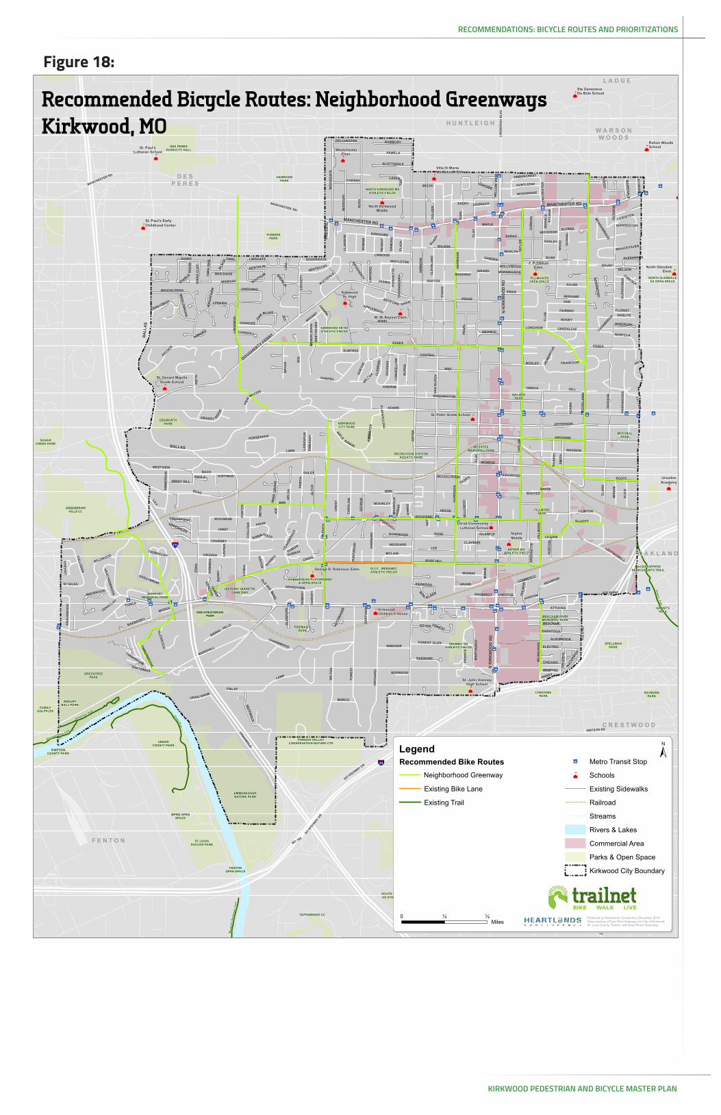
Neighborhood Greenway
Existing Bike Lane
Existing Trail
Ja Metro Transit Stop
¹º Schools
Existing Sidewalks
Railroad
Streams
Rivers & Lakes
Commercial Area
Parks & Open Space
Kirkwood City Boundary
±
0 ½¼Miles
Recommended Bicycle Routes: Neighborhood GreenwaysKirkwood, MO
Produced by HeartLands Conservancy December 2014. Data courtesy of East West Gateway, the City of Kirkwood, St. Louis County, Trailnet, and Great Rivers Greenway.

KIRKWOOD PEDESTRIAN AND BICYCLE MASTER PLAN
RECOMMENDATIONS: BICYCLE ROUTES AND PRIORITIZATIONS
KIRKWOOD PEDESTRIAN AND BICYCLE MASTER PLAN
pg 44DESIGN GUIDELINES
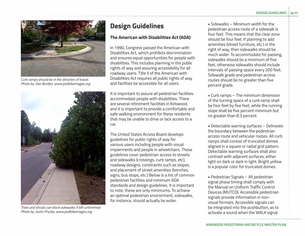
Design GuidelinesThe American with Disabilities Act (ADA)
In 1990, Congress passed the American with Disabilities Act, which prohibits discrimination and ensures equal opportunities for people with disabilities. This includes planning in the public rights of way and assuring accessibility for all roadway users. Title II of the American with Disabilities Act requires all public rights of way and facilities be accessible for all users.
It is important to assure all pedestrian facilities accommodate people with disabilities. There are several retirement facilities in Kirkwood, and it is important to provide a comfortable and safe walking environment for these residents that may be unable to drive or lack access to a car.
The United States Access Board develops guidelines for public rights of way for various users including people with visual impairments and people in wheelchairs. These guidelines cover pedestrian access to streets and sidewalks (crossings, curb ramps, etc), roadway designs, constraints such as slopes, and placement of street amenities (benches, signs, bus stops, etc.) Below is a list of common pedestrian facilities and minimum ADA standards and design guidelines. It is important to note, these are only minimums. To achieve an optimal pedestrian environment, sidewalks, for instance, should actually be wider.
• Sidewalks – Minimum width for the pedestrian access route of a sidewalk is four feet. This means that the clear zone should be four feet. If planning to add amenities (street furniture, etc.) in the right of way, then sidewalks should be much wider. To accommodate for passing, sidewalks should be a minimum of five feet, otherwise sidewalks should include intervals of passing space every 200 feet. Sidewalk grade and pedestrian access routes should be no greater than five percent grade.
• Curb ramps – The minimum dimension of the turning space of a curb ramp shall be four feet by five feet, while the running slope shall be five percent minimum but no greater than 8.3 percent.
• Detectable warning surfaces – Delineate the boundary between the pedestrian access route and vehicular routes. All curb ramps shall consist of truncated domes aligned in a square or radial grid pattern. Detectable warning surfaces shall also contrast with adjacent surfaces, either light on dark or dark in light. Bright yellow is a popular color for truncated domes.
• Pedestrian Signals – All pedestrian signal phase timing shall comply with the Manual on Uniform Traffic Control Devices (MUTCD). Accessible pedestrian signals provide information in non-visual formats. Accessible signals can be integrated into the pushbutton, as to activate a sound when the WALK signal
Curb ramps should be in the direction of travel.Photo by: Dan Burden, www.pedbikeimages.org
Trees and shrubs can block sidewalks if left untrimmed.Photo by: Justin Pryzby, www.pedbikeimages.org

KIRKWOOD PEDESTRIAN AND BICYCLE MASTER PLAN
pg 45
activates. Signal standards and designs must follow MUTCD guidelines, which can be found here: http://mutcd.fhwa.dot.gov/htm/2009/part4/part4e.htm.
There are many resources available to ensure pedestrian facilities are complying with ADA guidelines and regulations. All federally funded projects including new and altered facilities must comply with ADA guidelines.
Resources
• United States Access Board: Proposed Guidelines for Pedestrian Facilities in the Public Right-of-Way: http://www.access-board.gov/guidelines-and-standards/streets-sidewalks/public-rights-of-way/proposed-rights-of-way-guidelines
• Federal Highway Administration: Americans with Disabilities Act/ Section 504 of the Rehabillitation Act of 1973 (504): http://www.fhwa.dot.gov/civilrights/programs/ada.cfm
• Federal Highway Administration: Designing Sidewalks and Trails for Access: http://www.fhwa.dot.gov/environment/bicycle_pedestrian/publications/sidewalks/index.cfm
• United States Access Board ADA Standards: http://www.access-board.gov/guidelines-and-standards/buildings-and-sites/about-the-ada-standards/ada-standards
• US Department of Transportation: Bicycles and Pedestrians: http://www.dot.gov/bicycles-pedestrians
• United States Access Board Public Rights-of-Way Resources: http://www.access-board.gov/guidelines-and-standards/streets-sidewalks/public-rights-of-way/other-prow-resources
• Accessible Pedestrian Signals: A Guide to Best Practics: http://www.apsguide.org/index.cfm
• US Department of Transportation: Accessible Sidewalks and Street Crossings: http://www.bikewalk.org/pdfs/sopada_fhwa.pdf
• Federal Highway Administration: Manual on Uniform Traffic Control Devices: http://mutcd.fhwa.dot.gov/index.htm
DESIGN GUIDELINES

KIRKWOOD PEDESTRIAN AND BICYCLE MASTER PLAN
pg 46DESIGN GUIDELINES
At Grade Railroad CrossingsWhatWhen a street or trail crosses a railroad track, the crossing must be safe for all modes. For years, railroads and the Department of Transportation have worked to close at grade railroad crossings to increase safety and efficiency. At grade crossings for light rail (e.g. MetroLink) and heavy rail (e.g. freight or Amtrak trains) have different challenges and regulations due to speed and size of the trains; pedestrian at grade crossings for light rail are more common and easily accomodated than at grade crossings for heavy rail.
WhyFor people walking and biking, smooth surface treatments at crossings are very important to prevent bicycles and other wheeled vehicles from getting stuck in the tracks.
WhenAt Grade Railroad Crossings are used when it is impractical to provide underpasses or overpasses for people walking, bicycling, or driving across the railroad tracks. When there is frequent trespassing, either providing a crossing or channelization should be considered to increase safety.
If there are no safe, nearby crossings to channelize pedestrians toward, a railroad crossing should be considered. Any new crossing must be approved by the railroad company and the Missouri Department of Transportation. At Grade Railroad Crossings
should NOT be considered when a crossing would be dangerous due to sight lines or speed and volume of train traffic, or when trainsare frequently stopped in the crossing area.
HowEvery railroad crossing provides unique challenges. The design should be based on engineering judgment and close collaboration between the railroad and the agency that owns the roadway or path crossing the railroad. In Designing Sidewalks and Trails for Access, the FHWA provides the following best practices:
• Approaches to the track and the area between the tracks should be raised to the level of the top of the rail because rail ties that are not flush with the travel surface create a tripping hazard in addition to the gap hazard. A surface material that will not buckle, expand, or contract significantly (e.g., textured rubber railroad crossing pads) should be used;
• Approaches to the track should ramped with minimal grades and should be flatfor a distance of 1.525 m (5 feet) on either side of the tracks, free of obstacles, and have a firm and stable surface;
• For recreation trails, the trail surface should be hardened to reduce the debris that scatters over the tracks as users pass;
• Sight lines and signage should ensure that all users, and particularly those with disabilities affecting hearing, vision, or
Gaps between the roadway and rail can pose a danger to people walking, biking, or using mobility devices.
Railroad crossings can be a challenge for people traveling by bicycle.

KIRKWOOD PEDESTRIAN AND BICYCLE MASTER PLAN
pg 47 DESIGN GUIDELINES
mobility impairments, have adequatewarning about the intersection;
• Signals and/or gates should be considered to warn trail users of the rail crossing.
The gap between the roadway and the rail, called the flangeway, can be dangerous for people walking, biking, or using wheeled devices. For light rail trains, a rubber flangeway filler can improve safety and access. However, there are no flangeway fillers currently available for heavy rail. In order to mitigate danger, paths and sidewalks should direct pedestrians and bicyclists across railroad tracks at 90 degrees.
Using the streetAll users should check for trains and pay attention to signage and active warningdevices. Bicyclists and wheeled devices should cross tracks at a 90 degree angle.
Resources
• Compilation of Pedestrian Safety Devices In Use at Grade Crossings (Federal Rail Administration, 2008): https://www.fra.dot.gov/eLib/Details/L02732
• Designing Sidewalks and Trails for Access, Part II of II: Best Practices Design Guide (FHWA, Updated 02/10/2014): http://www.fhwa.dot.gov/environment/bicycle_pedestrian/publications/sidewalk2/sidewalks216.cfm
• Guidance on Traffic Control Devices at Highway-Rail Grade Crossings (FHWA,2002) http://safety.fhwa.dot.gov/media/twgreport.htm.
• Guide for the Development of Bicycle Facilities (American Association of StateHighway and Transportation Officials, 2012):4.12.1 Railroad Grade Crossings
• Manual on Uniform Traffic Control Devices (US Department of Transportation, 2009):Section 8D. Pathway Grade Crossings
• Rails-with-Trails: Lessons Learned (FHWA, Updated: 02/11/2014)
SECTION IV: Legislation, Liability, and Insurance: Crossings: https://www.fhwa.dot.gov/environment/recreational_trails/publications/rwt/page18.cfm#s4i
SECTION V: Design: Crossings https://www.fhwa.dot.gov/environment/recreational_trails/publications/rwt page22.cfm#s5f
An employee at the store adjacent to the informal railroad crossing reported seeing students walk across the railroad tracks daily.
The path to the railroad tracks is well defined at Fillmore.

KIRKWOOD PEDESTRIAN AND BICYCLE MASTER PLAN
pg 48DESIGN GUIDELINES
Bicycle LanesWhatBicycle lanes are defined by solid white lines 5’ or more from the edge of the roadway. Painted bicycle symbols show the lanes are reserved for the exclusive use of bicyclists.
WhyBicycle lanes improve safety and create a comfortable space for bicyclists of all levels. Cities in the United States with more developed bike lane networks tend to have higher rates of cycling and lower bicycle crash rates.
WhenBicycle lanes are most useful on streets with volumes over 3,000 ADT and speed limits under 35 mph. They should not be placed to the right of right turn lanes.
HowBicycle lanes should be 5’ or wider. They are defined by solid white lines with bicycle markings and arrows placed in the lanes. Bike lanes can be continued through intersections using dotted lines. They should not be placed to the right of right turn only lanes.
Bicycle lanes can be retrofitted onto existing streets that are below capacity through narrowing traffic lanes (a lane diet), or removing traffic lanes (a road diet).
Using the streetMotorists may not drive in the bicycle lanes. Motorists should check for bicyclists when
turning turning left or right.
Bicyclists should be aware of motor vehicles turning at intersections. Bicyclists are not required to ride in the bicycle lanes.
Resources
• Manual on Uniform Traffic Control Devices, 2009 (US Department of Transportation):Section 9C.04 Markings for Bicycle Lanes
• Guide for the Development of Bicycle Facilities, Fourth Edition (American Association of State Highway and Transportation Officials):
4.6 Bicycle Lanes4.7 Bicycle Lane Markings and Signs4.8 Bicycle Lane at Intersections4.9 Retrofitting Bicycle Facility on Existing Streets and Highways
• Urban Bikeway Design Guide, Second Edition (National Association of City Transportation Officials) http://nacto.org/cities-for-cycling/design-guide/bike-lanes
Bicycle LanePhoto by: Jennifer Campos, www.pedbikeimages.org
Figure 19: Example Bicycle Lane
KIRKWOOD PEDESTRIAN AND BICYCLE MASTER PLAN
pg 49 DESIGN GUIDELINES
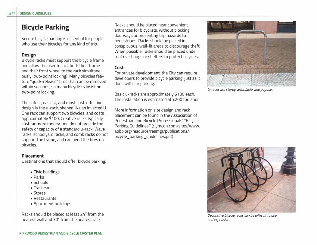
Bicycle Parking Secure bicycle parking is essential for people who use their bicycles for any kind of trip.
DesignBicycle racks must support the bicycle frame and allow the user to lock both their frame and their front wheel to the rack simultane-ously (two-point locking). Many bicycles fea-ture “quick-release” tires that can be removed within seconds, so many bicyclists insist on two-point locking.
The safest, easiest, and most cost-effective design is the u-rack, shaped like an inverted U. One rack can support two bicycles, and costs approximately $100. Creative racks typically cost far more money, and do not provide the safety or capacity of a standard u-rack. Wave racks, schoolyard racks, and comb racks do not support the frame, and can bend the tires on bicycles.
PlacementDestinations that should offer bicycle parking:
• Civic buildings• Parks• Schools• Trailheads• Stores• Restaurants• Apartment buildings
Racks should be placed at least 24” from the nearest wall and 30” from the nearest rack.
Racks should be placed near convenient entrances for bicyclists, without blocking doorways or presenting trip hazards to pedestrians. Racks should be placed in conspicuous, well-lit areas to discourage theft. When possible, racks should be placed under roof overhangs or shelters to protect bicycles.
CostFor private development, the City can require developers to provide bicycle parking, just as it does with car parking.
Basic u-racks are approximately $100 each. The installation is estimated at $200 for labor.
More information on site design and rack placement can be found in the Association of Pedestrian and Bicycle Professionals’ “Bicycle Parking Guidelines.” (c.ymcdn.com/sites/www.apbp.org/resource/resmgr/publications/bicycle_parking_guidelines.pdf)
U-racks are sturdy, affordable, and popular.
Decorative bicycle racks can be difficult to use and expensive.

KIRKWOOD PEDESTRIAN AND BICYCLE MASTER PLAN
pg 50DESIGN GUIDELINES
Designated Route SignageWhatDesignated route signs help guide people walking and biking along safer, lower-traffic streets. Signs should include information on popular destinations and distance. Well-designed signs can enhance the aesthetics and sense of place.
WhyThe best routes for driving are not necessarily the best routes for walking and biking. Many residents may not be familiar with navigating local streets beyond their own neighborhood. Wayfinding signs raise awareness of walking and biking as an option, and help people find destinations through local streets.
WhenRoute signs should be placed along safe streets for biking and walking. The frequency of signs depends on the number of turns in the designated route. At a minimum, signs should be placed before and after every turn or junction to ensure people are able to navigate the routes.
HowThe Manual on Uniform Traffic Control Devices contains Bicycle Route signs (Section 9B.21). These signs can contain destination and distance information. Many cities choose to create customized signs, which enhance local identity, and/or contain pedestrian information as well. The Bike St. Louis wayfinding signs are a local example of custom wayfinding.
Using the streetRoute signs do not alter how people driving, walking, or biking use the street.
Resources
• Manual on Uniform Traffic Control Devices, 2009 (US Department of Transportation):Section 9B.20 Bicycle Guide Signs
• Wayfinding System Study (City of Portland, Maine, 2008): http://www.portlandmaine.gov/planning/wayfindingreport.pdf
• Urban Bikeway Design Guide, Second Edition (National Association of City Transportation Officials): http://nacto.org/cities-for-cycling/design-guide/bikeway-signing-marking/bike-route-wayfinding-signage-and-markings-system/
Figure 20: Wayfinding can be incorporated into Bike Route Signs
Unique signs can help brand the neighborhood greenwaysPhoto by: Adam Fukushima, www.pedbikeimages.org

KIRKWOOD PEDESTRIAN AND BICYCLE MASTER PLAN
pg 51 DESIGN GUIDELINES
IntersectionsThroughout the public engagement process, Kirkwood residents expressed interest in enhanced intersection design to increase safety and comfort. At intersections, people walking, biking, and driving have to negotiate with traffic coming from multiple directions. The complexity of intersections necessitates a careful design approach taking into account volume, lane configuration, and speeds. The following treatments are recommended as potential solutions for intersections in Kirkwood.
High visibility crosswalksCrosswalks with thick lines perpendicular to the pedestrian’s path, as opposed to the traditional parallel lines, increase visibility for people driving. High Visibility Crosswalks are appropriate for any place where crosswalks should be used. High visibility crosswalks should be used near schools, and other destinations that draw a high volume of pedestrians. High visibility crosswalks can be used at signalized intersections, at mid-block crossings, and at stop-controlled intersections. On streets with more than three lanes, or with high volumes or speed, crosswalks alone will not improve safety.
Pedestrian safety islandsOn streets with more than two lanes, pedestrian safety islands, or medians, can enhance safety and allow pedestrians to cross the street in two stages. Safety islands are especially important for intersections nears schools, childcare facilities, and retirement homes, or other locations that are likely to
attract pedestrians that may walk more slowly than the general population. Medians can also help to calm traffic by narrowing the lane width. The pedestrian safety island should be defined by concrete, but the area where the pedestrians stand does have to be raised above street level.
Restrict right turn on redRestricting right turns on red signals improves pedestrian safety with relatively low costs. Right turns on red can increase pedestrian crashes, as drivers may not yield to the pedestrians, though they are legally required to do so. The restriction should be considered as a possible solution near schools or other locations where there are a high number of pedestrians.
Right-sizing intersectionsSafety for all users can be improved by retrofitting intersections to include more pedestrian space and a context-sensitive design speed. Intersections that have excess space for motor vehicles, such as wide lanes and corner radii designed for high speeds, encourage fast driving. In residential neighborhoods and in Downtown Kirkwood, intersections with wide corner radii and long pedestrian crossing distances offer an opportunity to improve safety and increase compliance with traffic laws at a relatively low cost. Every intersection is unique and will have a different solution; all road projects in residential neighborhoods or downtown should be seen as an opportunity to right-size intersections. Tools include pedestrian safety islands and curb extensions (pg xx).
On streets with existing medians, the median
Safe intersection design can encourage walkingPhoto by: Dan Burden, www.pedbikeimages.org
Right turn on red restrictions can increase

KIRKWOOD PEDESTRIAN AND BICYCLE MASTER PLAN
pg 52DESIGN GUIDELINES
should be extended to the crosswalk in order to provide protection for people walking and to encourage drivers to drive carefully through the intersection. A pedestrian safety island can be created by adding a curb to the opposite side of the crosswalk.
Signal timingSignal timing offers an inexpensive way of enhancing walking and biking safety and comfort. Signals should be timed to provide adequate time for pedestrians to cross the street. The MUTCD requires a minimum of 7 seconds for the initial walk phase. The entire walk phase should allow a pedestrian to cross the street at an average of 3.5 seconds or less (4E.06). Lower speed calculations should be used near schools, retirement homes, or other places where pedestrians may walk more slowly than the general population.
Resources
• The Urban Street Design Guide• http://nacto.org/usdg/intersection-design-elements/crosswalks-and-crossings/conventional-crosswalks/• http://nacto.org/usdg/pedestrian-safety-islands/ • http://nacto.org/usdg/intersection-design-elements/corner-radii/
• The FHWA Pedestrian Safety and Countermeasure Selection System: http://www.pedbikesafe.org/PEDSAFE/countermeasures_detail.cfm?CM_NUM=49
Mid Block CrossingsWhatA mid block crossing is a safe pedestrian or bicycle crossing that is not at an intersection used by motor vehicles.
WhyMid-block crossings improve safety in places where it is likely that people walking will want to cross the street. When people are walking across the street frequently without a crossing, it can create danger and uncertainty for all road users. Long blocks and infrequent crossings can also cause minutes of delay for people walking out of their way to use a crossing signal.
WhenMid-block crossings are appropriate in places where a pedestrian “desire line” crosses the street in the middle of the block. Common pedestrian destinations including schools, parks, libraries, bus stops, and shops often entice pedestrians to cross the street away from a crossing. In areas of town with longer blocks (over 400 ft long), mid-block crossings should be considered to provide pedestrians with a safe way to cross the street.
HowOn low traffic, residential streets a high visibility crosswalk may be sufficient. On higher volume or higher speed streets, mid-block crossings should be designed to ensure safety for all users. Options include:
Decorative raised crossing.Photo by: Kristen Langford, www.pedbikeimages.org
Mid block crossings can improve safety.Photo by: Lyubov Zuyeva, www.pedbikeimages.org

KIRKWOOD PEDESTRIAN AND BICYCLE MASTER PLAN
pg 53 DESIGN GUIDELINES
Raised crossings, which improve visibility of pedestrians, while also slowing car traffic. Raised crossings are appropriate on neighborhood streets. Their design must take into account drainage and emergency access.
Pedestrian safety islands, which allow people to cross in two phases. These are appropriate on higher traffic streets, and can also have a traffic calming effect. For more information, see pg 43.
Rectangular rapid flash beacons (RRFB), which are appropriate for streets with higher traffic volumes. An RRFB consists of two poles with flashing lights activated by a pedestrian. The RRFB signals drivers to yield to the pedestrian. The drivers can proceed once the pedestrian has cleared the intersection.
High intensity crosswalk beacons (HAWK), which are appropriate on the busiest and fastest streets. A HAWK or Pedestrian Hybrid Beacon, is hung overhead, like a traffic signal, and is based on beacons used at railroad crossings. When a pedestrian activates a HAWK, it flashes yellow and then turns solid red, as the pedestrian crosses the street. The HAWK continues to flash red as the pedestrian crosses, allowing drivers to proceed through the intersection once it is cleared, as opposed to a traditional signal.
Using the streetPeople walking should check for traffic before entering the street; drivers should yield to people in the crossing.
Resources
• Urban Street Design Guide (National Association of City Transportation Officials): http://nacto.org/usdg/intersection-design-elements/crosswalks-and-crossings/midblock-crosswalks/
• Manual on Uniform Traffic Control Devices (US Department of Transportation, 2009):Chapter 4F: Pedestrian Hybrid BeaconsInterim approval for RRFBs: http://mutcd.fhwa.dot.gov/resources/interim_approval/ia11/fhwamemo.htm
High Intensity Crosswalk BeaconsPhoto by: Mike Cynecki, www.pedbikeimages.org
High Intensity Crosswalk BeaconsPhoto by: Micheal Frederick, www.pedbikeimages.org

KIRKWOOD PEDESTRIAN AND BICYCLE MASTER PLAN
pg 54DESIGN GUIDELINES
Neighborhood GreenwaysWhatNeighborhood greenways, or bicycle boulevards, are streets that are designed for people biking and driving to share the street safely. They are neighborhood streets with low volume and low speed where signs and traffic calming help people to feel safe walking and biking.
WhyMany neighborhood streets already serve as popular walking and biking routes. Neighborhood greenways are a low-cost way to leverage these existing routes into a safe, connected network for people of all ages and abilities.
WhenNeighborhood greenways are most appropriate for local streets with less than 3,000 vehicles per day. Ideally traffic will be less than 1,5000 vehicles per day. The street should have good pavement and should be prioritized for repaving, as the quality of pavement impacts bicyclists.
HowThe essential features of a neighborhood greenway are signs and pavement markings to designate the route and a posted speed of 20 mph, with traffic calming designed to reduce speeds to 20 mph. Traffic diversion can be used to ensure traffic volumes under 3,000 vehicles per day. At intersections with neighborhood streets, a two-way stop should be used,
giving priority to the neighborhood greenway in order to allow bicyclists to proceed safely and comfortably. At intersections with major streets, protected crossing treatments should be used for safety and convenience.
Using the streetDrivers should use the street for local travel only and respect the priority of bicyclists.
Resources
• Urban Bikeway Design Guide, Second Edition (National Association of City Transportation Officials): http://nacto.org/cities-for-cycling/design-guide/bicycle-boulevards/
Neighborhood GreenwaysPhotos by: Greg Raisman

KIRKWOOD PEDESTRIAN AND BICYCLE MASTER PLAN
pg 55 DESIGN GUIDELINES
Pedestrian PlazasWhatPedestrian plazas create space for people to walk, socialize, and enjoy the public realm. In cities across the US, pedestrian plazas are being created in underutilized street space with low-cost and attractive infrastructure, including large planters, paint, and seats. In Kirkwood, a pop-up pedestrian plaza was installed on Argonne and was well received by residents and visitors alike.
WhyPedestrian plazas can enhance the sense of community by creating informal places for socialization. They can also bolster sales at local businesses, by creating comfortable places for people to linger and eat donuts or drink coffee. Plazas that are designed to have a traffic-calming impact can also reduce speeding and help pedestrians to cross the street safely, by reducing their exposure to traffic.
WhenPedestrian plazas are typically placed in sections of the street that have low vehicle traffic and are not necessary for safe and efficient operating of motor vehicles. Pedestrian plazas should be considered for streets with existing pedestrian demand or in places where they can improve pedestrian safety and accessibility. Argonne in Kirkwood is an example. HowPedestrian plaza design varies greatly, as they
are often placed in “reclaimed” space. They are typically created using low-cost but attractive planters, paint, chairs and tables. A pedestrian plaza must follow three guidelines:
• Parking not allowed;• ADA compliant design with tactile warning strips at crosswalks;• Defined and strong edge using striping, bollards and fixed objects.
In addition, a pedestrian plaza should be designed to create a place for people; chairs, tables, and umbrellas are one of the most popular additions to pedestrian plazas.
Using the streetPedestrians should enjoy the new space. Motor vehicles should not drive or park in the plaza. Bicyclists should dismount in the plaza
Resources
• Urban Street Design Guide (National Association of City Transportation Officials):http://nacto.org/usdg/interim-design-strategies/interim-public-plazas/
Pedestrian PlazasPhoto by: Laura Sandt, www.pedbikeimages.org

KIRKWOOD PEDESTRIAN AND BICYCLE MASTER PLAN
pg 56DESIGN GUIDELINES
Road dietWhyA road diet allows for easier left turns for people driving, reduces the number of motor vehicles exceeding the speed limit, increases safety for all modes, and makes room for people walking and biking.
WhatFour lanes of traffic are restriped to create two through lanes of traffic. Kirkwood Rd. in downtown Kirkwood is an example.
WhenOn four-lane roads with less than 20,000 ADT, a three lane road diet can improve traffic flow through the center turn lane, while giving room to people biking and walking
HowA four lane roadway can be restriped to two throughways. This creates room for parking and left turn lanes at intersections.
Shared lane markingsWhatA white bicycle and two chevron arrows are painted in the middle of the traffic lane. The shared lane markings are applied along the entire bicycle route to help guide cyclists.
WhyShared lane markings alert drivers to the presence of cyclists. The markings indicate proper lane position to cyclists and to drivers.
WhenShared lane markings should be used on street with speeds under 30 mph and with less than 3,000 ADT. Streets with shared lane markings should not have centerlines, as they discourage the sense of shared space.
HowShared lane markings should be placed every 100 to 250 feet or more along a street. More frequent placing is used to guide cyclists along higher traffic routes or as wayfinding along routes with frequent turns.
Using the streetMotorists should give cyclists room to operate safely. If there is no opposing traffic, they may pass on the left, giving cyclists at least 3 feet of passing distance.
Cyclists should position themselves over the shared lane markings to increase safety, visibility, and predictabilityShared Lane Markings
Photo by: Greg Raisman, xx
Figure 21: Example Road Diet & Shared Lane Markings (Sharrow)

KIRKWOOD PEDESTRIAN AND BICYCLE MASTER PLAN
pg 57 DESIGN GUIDELINES
Resources
• Manual on Uniform Traffic Control Devices, 2009 (US Department of toTransportation):Section 9C.07 Shared Lane Marking
• Guide for the Development of Bicycle Facilities, Fourth Edition (American Association of State Highway and Transportation Officials): 4.4 Marked Shared Lanes
• Urban Bikeway Design Guide, Second Edition (National Association of City Transportation Officials): http://nacto.org/cities-for-cycling/design-guide/bikeway-signing-marking/shared-lane-markings/
Shared Use PathWhatShared use paths are for people walking, bicycling, skating, or using other forms of nonmotorized transportation. Paths can be in a separated right-of-way, such as Grant’s Trail, or adjacent to a roadway.
WhyShared use paths create dedicated space for pedestrians and bicyclists. Shared use pathscomplement the on-street system by providing connectivity to destinations and sense of buildings or other destinations to increase safety for many users.
WhenShared use paths can be used to provide convenient access to destinations, such asparks and schools. Paths can be popular recreation destinations as well. However,acquiring the right-of-way and funding needed for paths can be quite challenging.
HowThe design of the path should be based on the expected users and should be compliant with the Americans with Disabilities Act (ADA). For paths that are adjacent to a roadway, the path can follow the slope of the roadway. Trail crossing signs (MUTCD W11-15 and W11-15p) should be used in advance of all intersections. The Guide for the Development of Bicycle Facilities, Fourth Edition (AASHTO) provides a detailed engineering guide for the construction of paths. Shared Use Path
Figure 22 : Example Multi-Use Path
Using the streetMotorists must watch for through traffic coming from the left and right when making turns.
Pedestrians have the right of way, but should be aware of bicyclists They must be careful when crossing streets and driveways.
Bicyclists must yield to pedestrians and give audible signal when passing. They must becareful when crossing streets and driveways.

KIRKWOOD PEDESTRIAN AND BICYCLE MASTER PLAN
pg 58DESIGN GUIDELINES
SidewalksWhatSidewalks are elevated from the roadway by several inches, separated from the street by a curb, and made of concrete.
WhySidewalks improve safety and comfort for pedestrians.
WhenSidewalks give pedestrians safe and comfortable space on virtually any roadway.
HowSidewalks should be a minimum of 5’ wide. Street furniture or light posts should be placed to preserve at least a 48” continuous through path. Each intersection should have a sidewalk ramp (see ADA guidelines for more information). When possible, sidewalks should be on both sides of the street. If it is only possible to provide sidewalks on one side of the street, it is important to ensure that the sidewalk is provided on the same side along the length of the street. Every time a pedestrian crosses the street, it increases the chances of a crash.
Resources
• Urban Street Design Guide (National Association of City Transportation Officials): http://nacto.org/usdg/street-design-elements/sidewalks/
Sidewalks and ramps make it easier to families to travel safely.
Kirkwood has an extensive network of sidewalks, but utili-ties and trash receptacles can block the sidewalks.
Sidewalks support foot traffic in Kirkwood’s vibrant downtown.

KIRKWOOD PEDESTRIAN AND BICYCLE MASTER PLAN
pg 59 DESIGN GUIDELINES
Traffic calmingTraffic calming can improve safety, reduce noise in neighborhood streets, and enhance walking and biking friendliness when there is not enough right-of-way to add separate facilities. During public meetings, and through the public survey, several residents reported that they felt drivers were speeding on neighborhood streets. The perception that people are driving dangerously fast on local streets can prevent people from walking or biking for transportation or recreation.
Well-designed traffic calming should be implemented as the last step in a phased approach to lowering speeds on neighborhood streets. The following process outlines steps that should be taken before considering traffic calming:
1. Establish need: If residents perceive speeding on their streets, the first step is to establish that drivers are exceeding the speed limit. Speed should be monitored during peak hours and off-peak hours to determine if speeds exceed the speed limit, and by how much.
2. Speed monitor trailer: If speeding is determined to be a problem, the City should place their speed monitor trailer along the street, in order to raise awareness of speeding behavior. The trailers allow drivers to monitor their own speed and self-correct. The speed monitor can be placed on the street for as long as the City and the neighbors feel it is appropriate. Three
months after the speed trailer is removed, speeds should be monitored to determine if the trailer had a lasting effect.
3. Neighborhood efforts: If speeding persists on the street, the City should encourage residents to raise awareness of speeding issues by placing signs in their yards asking drivers to slow down. Ready-made signs can be purchased if the neighborhood wants a uniform look. However, homemade signs can offer more variety and may slow traffic more effectively by increasing intrigue, as drivers slow to look at the individual signs. Again, speeds should be monitored three months after the signs were installed to determine if they have had a lasting effect.
4. Spot enforcement: If speeding persists, an officer should monitor speeds on the street, and issue warnings or tickets as necessary. Speeds should be monitored three months after the spot enforcement activities in order to determine if they have had a lasting effect.
5. Traffic calming: If the previous steps have not had a lasting impact in reducing speeds, physical traffic calming should be considered. Traffic calming generally works to slow speeds by diverting drivers from a straight line of travel, either horizontally (like speed tables) or vertically (like an extra curve). This guide will list a number of possible traffic calming techniques that can be used. Many communities have Speed cushions for designed for emergency vehicle access
Photo by: Dan Burden, www.pedbikeimages.org
This bumpout in front of the Kirkwood Library helps to narrow the roadway and calm traffic.
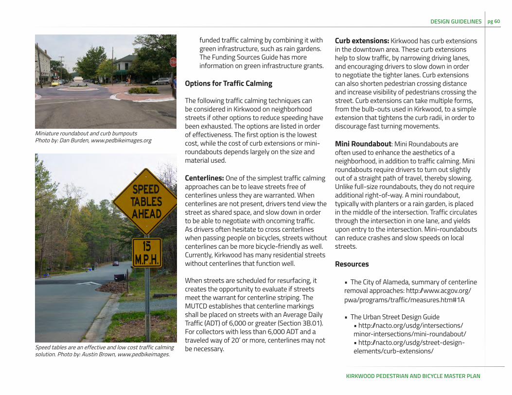
KIRKWOOD PEDESTRIAN AND BICYCLE MASTER PLAN
pg 60
funded traffic calming by combining it with green infrastructure, such as rain gardens. The Funding Sources Guide has more information on green infrastructure grants.
Options for Traffic Calming
The following traffic calming techniques can be considered in Kirkwood on neighborhood streets if other options to reduce speeding have been exhausted. The options are listed in order of effectiveness. The first option is the lowest cost, while the cost of curb extensions or mini-roundabouts depends largely on the size and material used.
Centerlines: One of the simplest traffic calming approaches can be to leave streets free of centerlines unless they are warranted. When centerlines are not present, drivers tend view the street as shared space, and slow down in order to be able to negotiate with oncoming traffic. As drivers often hesitate to cross centerlines when passing people on bicycles, streets without centerlines can be more bicycle-friendly as well. Currently, Kirkwood has many residential streets without centerlines that function well.
When streets are scheduled for resurfacing, it creates the opportunity to evaluate if streets meet the warrant for centerline striping. The MUTCD establishes that centerline markings shall be placed on streets with an Average Daily Traffic (ADT) of 6,000 or greater (Section 3B.01). For collectors with less than 6,000 ADT and a traveled way of 20’ or more, centerlines may not be necessary.
Curb extensions: Kirkwood has curb extensions in the downtown area. These curb extensions help to slow traffic, by narrowing driving lanes, and encouraging drivers to slow down in order to negotiate the tighter lanes. Curb extensions can also shorten pedestrian crossing distance and increase visibility of pedestrians crossing the street. Curb extensions can take multiple forms, from the bulb-outs used in Kirkwood, to a simple extension that tightens the curb radii, in order to discourage fast turning movements.
Mini Roundabout: Mini Roundabouts are often used to enhance the aesthetics of a neighborhood, in addition to traffic calming. Mini roundabouts require drivers to turn out slightly out of a straight path of travel, thereby slowing. Unlike full-size roundabouts, they do not require additional right-of-way. A mini roundabout, typically with planters or a rain garden, is placed in the middle of the intersection. Traffic circulates through the intersection in one lane, and yields upon entry to the intersection. Mini-roundabouts can reduce crashes and slow speeds on local streets.
Resources
• The City of Alameda, summary of centerline removal approaches: http://www.acgov.org/pwa/programs/traffic/measures.htm#1A
• The Urban Street Design Guide • http://nacto.org/usdg/intersections/minor-intersections/mini-roundabout/• http://nacto.org/usdg/street-design-elements/curb-extensions/
Miniature roundabout and curb bumpoutsPhoto by: Dan Burden, www.pedbikeimages.org
DESIGN GUIDELINES
Speed tables are an effective and low cost traffic calming solution. Photo by: Austin Brown, www.pedbikeimages.

KIRKWOOD PEDESTRIAN AND BICYCLE MASTER PLAN
pg 61
Evaluation and ImplementationEvaluation is an essential part of planning, as it allows the City to see if the recommendations are achieving the desired goals, and make changes as needed. The evaluation and implementation process starts as part of the planning process, and the following recommendations have been integrated into the planning work.
Annual bike walk counts
Biking and walking counts are an annual inventory of how many people are using active transportation in the community and can track progress over time. The national American Community Survey contains some data on transportation, but it is infrequent and the margin of error increases in communities with smaller populations. The National Project for Bicycle and Pedestrian Documentation coordinates an annual nation wide count. The methodology has been designed to be easy for volunteers to use. Counting locations and protocol for Kirkwood will be created as part of the planning process.
Walk and bike audits
Both a walk audit and bike audit were conducted with City staff as part of the planning process. The staff was provided with walk and bike audit tools in order to perform audits before any planned street
work. The purpose of the audits are to look for opportunities to improve walking and/or biking access along streets.
Designate a bicycle and pedestrian coordinator on City staff
The bicycle and pedestrian coordinator serves as the central point for coordinating information about bicycling and walking, especially in regards to implementation of the plan. The main staff contact for coordinating the planning process should remain the main staff contact for implementation. Coordination duties for a plan of this size are estimated to take approximately 10 hours per month, which would not justify additional staff. The coordinator will perform the following tasks:
• Be prepared to be the go-to person for biking and walking questions within the community• Monitor Local Government Briefings for regional and federal grant opportunities, check for potential projects and submit applications as appropriate• Monitor street maintenance and repair; when streets are scheduled for repaving, look for opportunities to implement plan• When Saint Louis County or MoDOT facilities within the City bounds are set for repaving, contact the appropriate agency to see how plan can be implemented during the restriping process
Seek Bicycle Friendly Community and
Walking Friendly Community status
The Bicycle Friendly and Walk Friendly program are free and help the communities receive national and regional attention for their achievements. Both programs honor cities with different levels of awards: Bronze, Silver, Gold, or Platinum, and honorable mentions. The Bicycle Friendly program has recently introduced Diamond level as the highest level possible. The programs are designed to be easy to use for the communities, with comprehensive websites and online applications. Feedback is tailored to help communities identify the most important steps to take to advance rankings.
To apply for a Bicycle or Walk Friendly Designation, the bicycle and pedestrian coordinator should:
• Review the application online, and decide which objectives need to be completed before the community will be ready to go for bronze• When the community is ready, the bicycle and pedestrian coordinator will complete and submit the application.
Updates to City Code
Updating the City Code to be supportive of all modes of transportation will help the City of Kirkwood to implement the recommendations in the plan and to ensure that street design and law enforcement are supportive of walking
RECOMMENDATIONS: EVALUATION AND IMPLEMENTATION

KIRKWOOD PEDESTRIAN AND BICYCLE MASTER PLAN
pg 62RECOMMENDATIONS: EVALUATION AND IMPLEMENTATION
and biking. The plan recommends considering revisiting the following provisions in the Kirkwood City Code.
The Kirkwood City Code includes an entire section devoted to bicycles, Chapter 4 1/2. The Code differs from Missouri State Law in two ways:
1. The requirements for retroreflective material on the pedals and wheels of a bicycle are much more specific than those of the Missouri State Statutes. Currently the Kirkwood City Code requires reflectors on both sides of the pedals in addition to reflectors on both the rims and spokes of both sides of bicycle tires (Section 4 ½ - 3 P. 4).
While it would be ideal for all bicyclists to have such reflectors, it may be easier to enforce a law that follows the Missouri States Statutes, which require reflectors on moving parts, but do not specify color, location, and size with such detail.
2. The City Code requires bicyclists to use paths adjacent to streets or highways when they have been officially designated (4 ½ - 5). Typically, bicyclists do use the paths, when they are available.
Similar laws across the country have been controversial, as they can be difficult to interpret and enforce, especially if there is glass, standing water, driveways, parked cars, or some other hazards for cyclists in or near the designated path.
Updating these two ordinances will bring Kirkwood’s laws in line with those of the state of Missouri and many surrounding communities. This will reduce confusion when the laws are enforced.
Complete Streets
The City Council should consider Complete Streets for the City of Kirkwood. A Complete Streets policy ensures that all modes of transportation are considered equally when transportation decisions are made. Enacting Complete Streets does not require additional funding, instead it works to shift priorities so that existing funds are spent in a way that addresses a wider variety of transportation needs. Several municipalities in the region and St. Louis County have a Complete Streets policy that can serve as the basis for the City of Kirkwood. In 2012, Clayton’s Complete Streets policy was selected as one of the ten best policies in the United States.
Resources
• The League of American Bicyclists report on the importance of bicycle and pedestrian staff in communities:http://www.advocacyadvance.org/site_images/content/why_bike_ped_staff_april_2010.pdf
• League of American Bicyclists Bicycle Friendly Program: http://www.bikeleague.org/content/communities
• Walk Friendly Communities: http://www.walkfriendly.org/
• The National Complete Streets Coalition, including sample policies, available: http://www.smartgrowthamerica.org/complete-streets

KIRKWOOD PEDESTRIAN AND BICYCLE MASTER PLAN
pg 63
Pre-Engineering Opinion of Pedestrian Facilities CostThe following information provides a general opinion of probable construction costs for the recommended pedestrian facilities. Costs are based on conceptual design evaluation of the facilities and pre-engineering design development. The unit cost numbers are based on cost data in Trailnet’s Streets For Everyone (2013) and FHWA’s Costs for Pedestrian and Bicyclist Infrastructure Improvements (2013). The costs were adjusted for inflation to reflect the year 2016 construction market. They are subject to traditional market place fluctuations.
The following costs estimates are based on adding curb and sidewalk to identified sidewalk gaps. They do not include an estimate of land acquisition, due to the high variability of costs. The cost estimates also include the costs associated with replacing all the sidewalks along recommended walking routes to meet ADA compliance. Many of these priority corridors already have full or partial sidewalks, at least along one side. As the scope of the project did not include a detailed, sidewalk assessment, this cost estimate is based on the worst-case scenario. The engineering phase of any sidewalk project should start by inspecting the sidewalk for ADA compliance.
Finally, the railroad crossing at Fillmore and the Grant’s Trail extension calls for a detailed engineering feasibility study in order to produce a credible cost estimate. Pedestrian bridges over railroads can range from $1 million to
Infrastructure Type Description Cost Cost Unit
Pedestrian Crosswalk $3,3000 each
Pedestrian Curb Ramp $800 each
Pedestrian Sidewalk + curb $952,300 mile
Pedestrian Pedestrian Route with crosswalks and signage
$61,500 mile
Pedestrian Crossing Island $11,100 each
Pedestrian Ped/bike push button $300 each
Pedestrian Raised Crossing $7,600 each
Pedestrian Pedestrian Plaza $25,000 each
Traffic Calming Traffic circle $28,900 each
Traffic Calming Curb extension $10,800 each
Traffic Calming Speed table $2,300 each
Figure 23: Cost Estimates of Pedestrian Facilities
several million, based on design, width, and right-of-way constraints. The Grant’s Trail extension is based on cost estimates from national and local sources, however every site is unique and will require detailed engineering estimates.
Recommendation Cost Estimate Length (mi)
High priority sidewalk gaps $1,018,400 1.1
Additional sidewalks to complete one side network
$4,769,800 5.0
Sidwalks needed to complete two sided network $21,215,600 22.3
Paths, connections, lane diets, and road diets. $2,385,600 3.2
Total: $29,389,400 31.6
Figure 24: Pedestrian Recommendations
* All cost estimates based on Cost for Pedestrian and Bicyclist Infrastructure
RECOMMENDATIONS: EVALUATION AND IMPLEMENTATION - PEDESTRIAN COST ESTIMATES

KIRKWOOD PEDESTRIAN AND BICYCLE MASTER PLAN
pg 64
Streets Recommendation Length (mi)
Cost Estimate (sidewalks per side)
Kirkwood Sidewalk 0.10 $92,600
Manchester Sidewalk 0.08 $77,300
Big Bend Sidewalk 0.35 $336,000
Jefferson Sidewalk 0.07 $64,400
Fillmore south of railroad tracks
Sidewalk 0.08 $76,300
Fillmore at Madison
Sidewalk 0.07 $70,100
Ballas Sidewalk 0.32 $301,700
Essex Sidewalk 0.17 $159,100
Longview Sidewalk 0.45 $429,400
Clark Sidewalk 0.07 $69,100
Milwaukee Sidewalk 0.09 $83,400
Van Buren Sidewalk 0.13 $122,000
Madison Sidewalk 0.57 $546,900
Southbrook Sidewalk 0.10 $91,500
Timberbrook Sidewalk 0.10 $91,800
Monroe Sidewalk 0.38 $358,600
Rifle Range Sidewalk 0.27 $261,200
Bodley Sidewalk 0.27 $260,800
Brownell Sidewalk 0.37 $354,800
Wilson Sidewalk 0.34 $326,700
Lindeman Sidewalk 0.37 $354,100
Glenwood Sidewalk 0.59 $560,900
Highland Sidewalk 0.73 $699,500
Total 6.08 $5,788,200
Figure 25: Cost Estimates of Sidewalks with Gaps in Recommended Network (Listed in order of Priority)
Streets Recommendation Length (mi) Cost Estimate(to add sidewalks on second side)
Kirkwood Sidewalk 0.32 $309,100
Big Bend Sidewalk 0.51 $487,400
Geyer Sidewalk 0.61 $578,900
Manchester Sidewalk 0.64 $608,300
Adams Sidewalk 0.32 $305,400
Ballas Sidewalk 2.09 $1,994,000
Couch Sidewalk 0.31 $290,700
Dougherty Ferry between Ballas and Geyer
Sidewalk 0.81 $775,100
Dougherty Ferry at i-270 Sidewalk 0.25 $237,000
Rose Hill east of Kirkwood Sidewalk 0.26 $247,400
Rose Hill at Couch Sidewalk 0.13 $123,300
Essex at Dougherty Ferry Sidewalk 0.42 $404,000
Essex east of Woodlawn Sidewalk 0.16 $151,300
Woodlawn Sidewalk 0.25 $239,400
Clay Sidewalk 0.10 $94,200
Craig Sidewalk 0.34 $322,700
Jefferson Sidewalk 0.39 $370,500
Peeke Sidewalk 0.15 $139,500
Harrison south of Essex Sidewalk 0.15 $139,000
Harrison north of Monroe Sidewalk 0.09 $81,800
Harrison south of Woodbine Sidewalk 0.18 $175,500
Madison Sidewalk 0.13 $119,800
Taylor Sidewalk 0.19 $183,100
Fillmore Sidewalk 0.44 $422,100
Scott Sidewalk 0.05 $45,400
Figure 26: Cost Estimates for Sidewalks with One Side Sidwalk (Listed in order of Priority)
Cont. on next pg.
RECOMMENDATIONS: EVALUATION AND IMPLEMENTATION - PEDESTRIAN COST ESTIMATES

KIRKWOOD PEDESTRIAN AND BICYCLE MASTER PLAN
pg 65
Streets Recommendation Length (mi)
Cost Estimate(to add sidewalks on second side)
Argonne Sidewalk 0.31 $292,200
Monroe Sidewalk 0.43 $411,700
Washington Sidewalk 0.13 $121,800
Meacham Sidewalk 0.11 $106,900
Memphis Sidewalk 0.12 $115,500
Orleans north of Memphis Sidewalk 0.05 $43,800
Orleans south of Attucks Sidewalk 0.09 $86,800
Van Buren Sidewalk 0.26 $247,800
Alsobrook Sidewalk 0.24 $224,900
Attucks Sidewalk 0.12 $114,700
Bodley Sidewalk 0.18 $172,700
Milwaukee Sidewalk 0.14 $129,800
Tolstoi Sidewalk 0.09 $83,900
Lindeman Sidewalk 0.70 $667,000
Ann Sidewalk 0.38 $361,500
Dickson Sidewalk 0.92 $878,200
Dickson Sidewalk 0.09 $88,500
Holmes Sidewalk 1.09 $1,038,600
Lockett Sidewalk 0.43 $409,500
Quan Sidewalk 0.26 $248,500
Scottsdale Sidewalk 0.09 $86,400
Timberbrook Sidewalk 0.52 $491,300
Wilson Sidewalk 0.17 $160,100
Total: (to add to streets that currently have sidewalks on one side)
16.20 $15,427,400
Total: (for entire recommended net-work to have sidewalks on both sides)
21.82 $20,786,200
Figure 26 cont.: Cost Estimates for Sidewalks with One Side Sidwalk (Listed in order of Priority)
Streets Recommendation Length (mi)
Cost Estimate
Fillmore Ped Rail Crossing 0.03 $292,200
Kirkwood Road Diet / On-Street Parking
1.28 $411,700
Marshall Meramec Greenway Connection
0.06 $121,800
Ballas Restriped Shoulder 0.45 $106,900
Adams Restriped Shoulder 1.41 $115,500
Total: 3.24 $2,385,600
Figure 27: Cost Estimates for other connections (Listed in order of Priority)
RECOMMENDATIONS: EVALUATION AND IMPLEMENTATION - PEDESTRIAN COST ESTIMATES

KIRKWOOD PEDESTRIAN AND BICYCLE MASTER PLAN
pg 66
Pre-Engineering Opinion of Bicycle Facilities CostThe following information provides a general opinion of probable construction costs for the recommended bicycle facilities in the Kirkwood Pedestrian and Bicycle Master Plan. See Page 54 for a description of the sources used in the cost estimates.
For corridors marked “As Feasible,” several of the changes could come through restrip-ing during routine mill and overlay. The cost is calculated based on painting the street after a routine mill and overlay and does not include the cost of grinding out the existing strip-ing pattern, as grinding out existing lanes for changes is not recommended by the plan.
Infrastructure Type Description Cost Cost Unit
Bicycles Bicycle lane $95,000 mile
Bicycles Buffered Bicycle Lane* $122,100 mile
Bicycles Signed route $28,900 mile
Bicycles Shared lane markings $200 each
Bicycles Signed route with SLM every 250 ft
$32,500 mile
Bicycles Shared use path $276,900 mile
Bicycles Neigherhood Greenway* $137,300 mile
Traffic Calming Traffic Circle $28,900 each
Traffic Calming Curb extension $10,800 each
Traffic Calming Speed table $2,300 each
Figure 28: Cost Estimates for Bicycle Facilities
Recommendation Cost Estimate Length (mi)
Phase 1 $930,900 10.8
Phase 2 $1,148,200 9.3
Phase 3 $530,200 4.1
As Feasible $1,026,800 10.5
Grants Trail Connection $471,700 0.7
Total: $4,107,800 35.3
Figure 29: Bicycle Recommendations
All cost estimates based on Cost for Pedestrian and Bicyclist Infrastructure * Cost estimate based on Streets For Everyone (Trailnet, 2014)
RECOMMENDATIONS: EVALUATION AND IMPLEMENTATION - BICYCLE COST ESTIMATES

KIRKWOOD PEDESTRIAN AND BICYCLE MASTER PLAN
pg 67
Corridor Recommended Facility
Length (mi)
Phase Cost Estimate (per mile)
Total Cost Estimate
Dougherty Ferry
Bike Lane 1.73 Phase 1 $95,000 $164,100
Fillmore Neighborhood Greenway 0.41 Phase 1 $137,300 $56,300
Fillmore Neighborhood Greenway 0.60 Phase 1 $137,300 $82,800
Geyer Shared Lane Marking 3.26 Phase 1 $5,280 $17,200
Glenwood Neighborhood Greenway 0.77 Phase 1 $137,300 $106,100
Highland Neighborhood Greenway 0.72 Phase 1 $137,300 $99,000
Holmes Shared Lane Marking 0.36 Phase 1 $5,280 $2,000
Monroe Neighborhood Greenway 0.24 Phase 1 $137,300 $32,700
Rose Hill Neighborhood Greenway 0.74 Phase 1 $137,300 $102,200
Rose Hill Neighborhood Greenway 0.75 Phase 1 $137,300 $103,100
Scott Neighborhood Greenway 0.32 Phase 1 $137,300 $44,300
Timberbrook Neighborhood Greenway 0.43 Phase 1 $137,300 $59,300
Woodlawn Neighborhood Greenway 0.45 Phase 1 $137,300 $61,800
Total Phase 1: 10.79
Ann Neighborhood Greenway 0.51 Phase 2 $137.300 $70,700
Ballas Shared Lane Marking 0.93 Phase 2 $5,280 $5,000
Couch Neighborhood Greenway 1.09 Phase 2 $137,300 $150,300
Essex Neighborhood Greenway 1.47 Phase 2 $137,300 $202,100
Harrison Neighborhood Greenway 2.02 Phase 2 $137,300 $277,200
Longview Neighborhood Greenway 0.45 Phase 2 $137,300 $61,800
Taylor Neighborhood Greenway 0.12 Phase 2 $137,300 $16,100
Woodbine Neighborhood Greenway 1.26 Phase 2 $137,300 $173,200
Woodlawn Neighborhood Greenway 1.40 Phase 2 $137,300 $191,800
Total Phase 2: 9.26 $1,148,200
Figure 30: Cost Estimates for Bicycle Facilities (Listed in order of Priority)
Corridor RecommendedFacility
Length (mi)
Phase Cost Estimate (per mile)
Total Cost Estimate
Argonne Neighborhood Greenway 0.37 Phase 3 $137,300 $51,000
Argonne Bike Lane 0.63 Phase 3 95,000 $60,200
Lindeman Neighborhood Greenway 1.34 Phase 3 137,300 $184,500
Taylor Neighborhood Greenway 1.71 Phase 3 $137,300 $234,500
Total As Phase 3: 4.06 $530,200
Adams Lane Diet 1.45 as Feasible $95,000 $137,500
Adams Shared Lane Marking 0.74 as Feasible $5,280 $4,000
Adams Bike Lane 0.58 as Feasible $95,000 $54,900
Ballas Lane Diet 0.49 as Feasible $95,000 $47,000
Ballas Bike Lane w/ Road Diet 1.38 as Feasible $95,000 $130,800
Big Bend Bike Lane w/ Road Diet 2.74 as Feasible $95,000 $260,400
Manchester Bike Lane 3.05 as Feasible $95,000 $289,400
Connection to Meramec Greenway
Shared Use Path 0.07 as Feasible $1,500,000 $102,800
Total As Feasible: 10.49 $1,026,800
Elliot Neighborhood Greenway 0.41 Phase 2 $137.300 $56,700
Planned Connection
Shared Use Path 0.28 Phase 2 $1,500,000 $415,000
Total Connection: 0.69 $471,700
Total for recommended improvements $4,107,800
RECOMMENDATIONS: EVALUATION AND IMPLEMENTATION - BICYCLE COST ESTIMATES

KIRKWOOD PEDESTRIAN AND BICYCLE MASTER PLAN
pg 68
Funding SourcesBicycle and pedestrian improvements can be funded through a variety of federal and local sources. Federal funds are well suited to higher cost infrastructure projects, such as sidewalks or the Grant’s Trail Extension. Improvements that involve mainly paint, such as Shared Lane Markings, could be implemented through routine maintenance, set-aside funds, or grouped as one federal funding application. The City of Kirkwood should plan for the cost of ongoing maintenance for maintenance and paint, as grants for maintenance are rare.
Federal funding sources
The current transportation bill, Moving Ahead for Progress in the 21st Century, MAP-21, has since been extended through May 31, 2015. It is possible that a new funding bill will replace MAP-21, instituting new rules for funding. It is reasonable to expect that many of the same funding opportunities will exist under a new transportation bill, however the names or performance measures may change slightly. In addition to funding sources through Map-21, there are other federal funding options. Federal funding sources are described below in more detail, including contact information for each source.
Federal funding opportunities administered by East West Gateway Council of Governments
As part of the Transportation Improvement
Plan, East West Gateway Council of Governments (East West Gateway), administers several federal transportation funds. The programs are described below.
Congestion Mitigation and Air Quality Improvement Program (CMAQ)
The CMAQ Program is a flexible funding source to State and local governments for transportation projects and programs to help meet the requirements of the Clean Air Act. Projects eligible for CMAQ include walking and biking transportation infrastructure and programs encouraging walking and biking. In order to apply for the funding, an agency must demonstrate a project’s impact on emissions. Applications are made available in December and are due in February on an annual basis.
Surface Transportation Program (STP)
The Surface Transportation Program provides flexible funding that may be used by States and localities for projects to preserve or improve conditions and performance on any Federal-aid highway, bridge projects on any public road, facilities for nonmotorized transportation, transit capital projects and public bus terminals and facilities. The funds can be used for walking and biking infrastructure, including on local roads. Applications are made available in December and are due in February on an annual basis.
• http://www.ewgateway.org/TIPAppInfo/tipappinfo.htm
RECOMMENDATIONS: EVALUATION AND IMPLEMENTATION - FUNDING SOURCES
• http://www.fhwa.dot.gov/map21/stp.cfm
Transportation Alternatives Program (TAP)
The Transportation Alternatives Program is a new funding program under MAP-21. TAP provides for a variety of alternative transportation projects that were previously eligible activities under separately federally funded programs. This program is funded at a level equal to two percent of the total of all MAP-21 authorized Federal-aid highway and highway research funds, with the amount for each State set aside from the State’s formula apportionments. Pedestrian, bicycle, trails, and safe routes to school programs are eligible for TAP funding. Specifically:
• Construction, planning, and design of on-road and off-road trail facilities for pedestrians, bicyclists, and other nonmotorized forms of transportation
• Construction, planning, and design of infrastructure-related projects and systems that will provide safe routes for non-drivers, including children, older adults, and individuals with disabilities to access daily needs
East West Gateway typically does not have adequate funding to distribute TAP funds every year. As a round of TAP funding will be obligated in October 2015, the next round of applications for TAP funding should be expected in 2017.
• http://www.fhwa.dot.gov/map21/tap.cfm

KIRKWOOD PEDESTRIAN AND BICYCLE MASTER PLAN
pg 69
• http://ewgateway.org/TransAlternatives/transalternatives.htm
Safe Routes to School Program (SRTS)
The SRTS Program was formerly an independent funding round focused on safe walking and bicycling to schools. With MAP 21, the program was rolled into the Transportation Alternatives Program as a potential funding category.
• http://www.fhwa.dot.gov/map21/tap.cfm
• http://www.modot.org/safety/SafeRoutestoSchool.htm
Federal funding opportunities administered by state and federal agencies
Highway Safety Improvement Program (HSIP)
The HSIP emphasizes a data-driven, strategic approach to improving highway safety on all public roads that focuses on performance. Eligible projects include safety improvements for all roadway users.
• http://www.fhwa.dot.gov/map21/hsip.cfm
The Missouri Department of Transportation oversees the distribution of HSIP funds, with an emphasis on proactive, system wide improvements. Projects should align with Missouri’s Blueprint to Arrive Alive (Strategic
RECOMMENDATIONS: EVALUATION AND IMPLEMENTATION - FUNDING SOURCES
Highway Safety Plan). In 2014, MoDOT worked with St. Louis County to create a County-level Strategic Highway Safety Plan. The final document will include pedestrian safety improvements that align with MoDOT’s overall Strategic Highway Safety Plan.
• http://epg.modot.org/index.php?title=907.1_Safety_Program_Guidelines
State and Community Highway Safety Grant Program (Section 402)
Section 402 funds are used to support State and community programs to reduce deaths and injuries. Pedestrian safety has been identified as a national priority. Section 402 funds can be used for a variety of safety initiatives including conducting data analyses, developing safety education programs, and conducting community-wide pedestrian safety campaigns. The funds must be consistent with the State Highway Safety Plan
• http://safety.fhwa.dot.gov/policy/section402/
• http://epg.modot.mo.gov/index.php?title=132.4_Highway_Safety_Plan_and_Performance_Plan
Recreational Trails Program (RTP)
The RTP is a program incorporated into the MAP-21, Transportation Alternatives Program. However, funding for this program is administered by the Missouri Department
of Natural Resources, a division of the State Parks. Grants are available for trail development and renovation. Projects require a minimum of a 20% local match.
• http://www.fhwa.dot.gov/environment/recreational_trails/
• http://www.mostateparks.com/page/55065/outdoor-recreation-grants
Environmental Protection Agency
The Environmental Protection Agency offers a variety of grants that address community health. Grants may help fund green infrastructure that can also be used enhance walkability and bikeability. These broad-based community grants require significant collaboration with local coalitions. Trailnet is available to partner and help with community engagement on this type of grant. As grants opportunities are always evolving, the EPA website should be checked regularly.
• http://www.grants.gov/web/grants/view-opportunity.html?oppId=252553
Learn more about federal funding here:
• http://bikewalkalliance.org/resources/reports/advocacy-advance-reports/64-understanding-federal-funding-for-biking-and-walking-projects-and-programs

KIRKWOOD PEDESTRIAN AND BICYCLE MASTER PLAN
pg 70RECOMMENDATIONS: EVALUATION AND IMPLEMENTATION - FUNDING SOURCES
Local funding sources
Local funding for bicycle and pedestrian projects and programs is an important component when considering developing new facilities. Many federal programs require a local match, the funding sources below can be used to fund projects in full or to be used as a local match when using federal funds.
Local Option Economic Development Sales Taxes
Cities in the State of Missouri have the option to impose a local sales tax of no greater than one half per cent. This sales tax can be used to fund projects including pedestrian improvements related to stormwater management (sidewalks, curbs, gutters, etc.)
Capital Improvement Budget Set-Aside
Kirkwood could make a policy decision to set-aside a percentage of capital improvement budget to fund bicycle and pedestrian projects. These projects could be incorporated into other road work being done (complete streets) or stand-alone projects. These funds can be leveraged as a local match to secure federal funds.
Other Local Options
A few other local funding options including the creation of a Community Improvement or Neighborhood Improvement District or assessing development fees are also possible to fund improvements. Information on these
funding options can be found at:
• http://www.missouridevelopment.org/community%20services/Local%20Finance%20Initiatives.html
Private funding sources
Several national and state foundations provide grants for pedestrian and bicycle projects. These grants can play a significant role in funding projects and providing match for federal funds.
Bikes Belong Grant Program
Bikes Belong is a national organization dedicated to putting more people on bikes. The organization funds multi-use trails with a strong desire to leverage federal funding.
• http://www.bikesbelong.org/grants/
Robert Wood Johnson Foundation (RWJF)
The RWFJ offers a wide range of funding opportunities to promote healthy and active living. The website offers details on various grants and calls for proposals.
• http://www.rwjf.org/applications/solicited/cfplist.jsp

KIRKWOOD PEDESTRIAN AND BICYCLE MASTER PLAN
pg 71 RECOMMENDATIONS: EVALUATION AND IMPLEMENTATION - FUNDING SOURCES
TAP CMAQ STP HSIP RTP SECTION 402
Bicycle lane X X X X
Shared lane marking X X X X
Signed bike route X X X
Shared use path X X X X
Sidewalks X X X X
Crosswalks X X X X
Signals X X X X
Trails X X X X
Curb cuts and ramps X X X X
Traffic calming X X X
Bike racks X X X
Educational safety brochure
X X
Training X X X
Technical Assistance X X X X
Figure 31: Potentially eligible pedestrian and bicycle projects under federal highway programs
ProgramsTAP = Transportation Alternative ProgramCMAQ = Congestion Mitigation and Air Quality ImprovementSTP = Surface Transportation ProgramHSIP = Highway Safety Improvement ProgramRTP = Recreational Trails ProgramNHPP = National Highway Performance ProgramSection 402 = State and Community Highway Safety Grant Program

KIRKWOOD PEDESTRIAN AND BICYCLE MASTER PLAN
pg 72
Analysis of SurveysSummary
Two community surveys were used in Kirkwood during the planning process, using different methodology in order to capture a greater variety of responses. Neither survey is representative of residents of Kirkwood. A one-page survey focused on transportation habits and community priorities was mailed with utility bills. Residents could mail in their responses, scan and email them, or hand them in directly. One hundred seventy residents responded to the mail survey.
The mail-in survey results suggested that walking and bicycling are already an integral part of transportation for Kirkwood residents responding to the survey based on these findings:
• Almost 9 out of 10 respondents reported walking at least a few times a week• Over half of respondents would like to bike more, and 70% would like to walk more, while almost half would like to drive less.
Transportation habits
Driving was the most frequently used form of transportation, with 83% of respondents reporting that they drive daily. Walking was also common, with about half of respondents reporting walking daily, and another 40% reporting walking a few times a week. While only 1% of respondents bicycle daily, over
one quarter of respondents report bicycling a few times a month or more. Transit was the least common form of transportation, with 63% of respondents reporting that they never use transit. The survey also asked about park usage. The majority of respondents did report visiting parks at least a few times a month, and 3% visit parks in Kirkwood daily.
Transportation preferences
Respondents were asked if they would like to change anything in their transportation habits looking forward 10 years. Almost half (48%) indicated they would like to drive a car less, while only 5% wanted to drive more. This is in strong contrast with other modes, where 70% of respondents wanted to walk more, 55% wanted to bicycle more, and 46% wanted to take transit more. Visiting parks was the most alluring option, with 72% of respondents expressing a desire to visit parks more often, and only 1% wanting to visit less. This suggests that respondents are eager for more transportation options, this in concert with our findings from the other survey and public engagement. Transportation priorities
Survey respondents were asked to rank six transportation priorities for Kirkwood, using percentages. Safety was the number one priority by far, with a median score of 30%. Walking options (20%) and biking options (15%) were next the two most popular. The top three priorities are complementary in many ways, as well designed pedestrian and bicycle
APPENDIX A: COMMUNITY SURVEYS AND ANALYSIS
Figure A-1: Survey Summary
Figure A-2: Transportation Preferences
APPENDICIES
Figure A-3: Transportation Priorities

KIRKWOOD PEDESTRIAN AND BICYCLE MASTER PLAN
pg 73 APPENDIX A: COMMUNITY SURVEYS AND ANALYSIS
Walking environment
Overwhelmingly, respondents felt that walking in Kirkwood is safe, easy, and enjoyable. The responses in the online survey echo the sentiment that the planning team has heard throughout the outreach process- Kirkwood residents enjoy walking and they appreciate the walking opportunities in their town.
When the respondents were asked why they walk, the top three answers were recreational. At the same time, going to school, transit, and work were the least common reasons for walking. This suggests that for the respondents, walking is currently a form of recreation, rather than transportation for meeting daily needs. However, 180 of the 379 respondents reported walking to local stores, indicating that for some residents, walking is a way of getting to local destinations.
Encouraging Walking
When asked what their barriers were to walk-ing lack of sidewalks, uneven sidewalks, and crossing busy roads were the in the top five reasons. Lack of time and weather were also common barriers to walking. While the City of Kirkwood cannot address weather and time, improving sidewalk connectivity and crossing opportunities is feasible. When asked what changes could help them to walk more, 72% of respondents indicated more walking and biking paths, and 52% indicated more sidewalks.
infrastructure can reduce injury and fatal crashes across all modes by calming traffic speeds and increasing driver attentiveness. The least important priority was speed (5%), suggesting the respondents would trade a reduction in speeds for increased safety and transportation options.
Park priorities
Finally, the survey asked about priorities for walking and biking in and near parks. Trails were by far the highest priority, with paved trails and nature trails being equally weighted with a median score of 25%. Walking routes to parks were the third highest priority, with a median value of 15%. Bike routes (10%), accessible ramps (10%), and bike racks (5%) were the least highly ranked. Each of these features are important, but generally appeal to certain groups of the population, as opposed to a trail that serves people of all ages and abilities.
Online survey
An online survey was made available on the Kirkwood website and Trailnet website. Paper copies were also available during public outreach events. The questions focused on transportation preferences. Overall, 387 responses were received. Due to the collection method, the survey is not representative of Kirkwood residents.
Figure A-4: Park Priorities
Figure A-5: Walking Environment
72 67
124
165
187
166
60 54
43
11 12 14
44
33
16 19 17 8 8 9 6
It is easy to walk in Kirkwood.!
It is safe to walk in Kirkwood.!
It is enjoyable to walk in Kirkwood.!
How do you feel about the following statements? !Strongly agree! Agree! Slightly agree! Neutral! Slightly disagree! Disagree! Strongly disagree!

KIRKWOOD PEDESTRIAN AND BICYCLE MASTER PLAN
pg 74APPENDIX A: COMMUNITY SURVEYS AND ANALYSIS
Figure A-6: Encouraging Walking
Figure A-7: Walking Accessories
Figure A-8: Bicycling Respondents were also asked what events and programs would be good for walking in their community. The most popular response was programs that encourage people to walk to local businesses (205 respondents) followed by community walks and fun runs (175) and pro-grams encouraging children to walk to school (169). Each of these types of programs has been successful in similar communities, and can be considered during the planning process and beyond.
Walking Accessories
Respondents were asked whether they used canes, wheelchairs, strollers, or other walking accessories and their experience using such devices. People using such devices are often a vulnerable population, including those who cannot walk without some form of assistance. Of respondents, 64 indicated using a device, and strollers were the most common accessory. Overall, the respondents slightly agreed or were neutral, that it was easy to use their walking accessories in Webster Groves. Respondents were more likely to agree that it was safe and pleasant to use their walking accessory or mobility device. Sidewalk ramps and busy roads were highlighted as problems in the open-ended questions.
Bicycling
Compared to walking, respondents were much less likely to view bicycling as easy, safe, or enjoyable in Kirkwood. Many of Kirkwood’s streets were built when walking was a primary

KIRKWOOD PEDESTRIAN AND BICYCLE MASTER PLAN
pg 75
mode of transportation, and feature sidewalks. However, there is only one street with infrastructure where bicycles are separated from traffic.
Similar to walking, the most often cited reasons were recreational, including for fun or fitness. Again, going to local stores was a popular destinations, an indication of Kirkwood’s strong downtown retail sector.
Encouraging bicycling
When asked what prevents them bicycling more now, respondents identified physical barriers, similar to the walking responses. Lack of bicycle infrastructure was the top barrier, with 193 respondents saying it prevented them from bicycling more. Lack of time and weather did not make it into the top five barriers, suggesting that physical changes would help respondents to bicycle more.
Finally, when asked where bicycle racks could help encourage bicycling, over half of respondents (104) indicated stores. Parks, community centers, and schools were all indicated by more than 30% of the respondents. Having a secure place to lock a bicycle is essential for bicycling for transportation. The survey suggests that Webster Groves does not have enough bike parking to meet demand near businesses.
These answers were echoed when respondents were asked what changes would help them to bicycle more. More biking and walking paths, and more bike lanes, were the most popular answers in the survey.
Figure A-9: Encouraging BicyclingFinally, respondents were asked what events and programs would be good for bicycling in their community. Similar to walking, respondents identified community bike rides, programs that encourage people to bike to stores, and programs that encourage children to bike to school. Frequently, walking and bicycling encouragement programs are combined in schools. Bicycling encouragement programs at local stores are often times easier to administer than walking programs, as helmets offer “proof” that customers arrived by bike.

KIRKWOOD PEDESTRIAN AND BICYCLE MASTER PLAN
pg 76
Tell us about walking and bicycling in Kirkwood! The City of Kirkwood is partnering with Trailnet to create a Pedestrian and Bicycle Master Plan. The plan will look at how Kirkwood can improve walking and bicycling opportunities in Kirkwood over the next 10 years. You can help us make a plan that suits the community by answering this five-minute survey and returning it with your utility bill, dropping it off at City Hall (139 S. Kirkwood Rd.) or emailing your answers or a scanned copy to [email protected]. All results will be recorded and reported anonymously. In this survey, "walking" refers to any kind of traveling that is usually done on a sidewalk, including using a walker, a wheelchair, or any mobility device. "Biking" refers to using a bicycle, handcycle, tricycle, or recumbent.
Imagine your life in ten years- is there anything you would you like to change in terms of transportation?
Less Neither more
nor less More I would like to walk ☐ ☐ ☐ I would like to bike ☐ ☐ ☐ I would like to transit ☐ ☐ ☐ I would like to drive a car ☐ ☐ ☐ I would like to visit parks ☐ ☐ ☐
When it comes to transportation decisions in Kirkwood over the next ten years, what should be the highest priorities? Please use a percentage to indicate the importance of each of the following priorities. Together, the importance for all six priorities should add up to 100%.
Priority Importance Making trips as safe as possible for everyone on the road % Maintaining the current transportation system % More walking options % More biking options % Keeping transportation costs in check % Making trips as fast as possible %
When it comes to biking and walking in Kirkwood’s parks, what would you like to see more of in the next ten years? Please use a percentage to indicate the importance of each of the following priorities. Together, the importance for all six priorities should add up to 100%.
Priority Importance Nature trails for walking % Paved trails for biking and walking % Bike racks % Accessible ramps % Walking routes to the parks % Biking routes to the parks %
What is your gender? ___________________ What is your age? _________
Daily A few times
a week A few times
a month A few times
a year Never How often do you walk? ☐ ☐ ☐ ☐ ☐ How often do you bike? ☐ ☐ ☐ ☐ ☐ How often do you take transit? ☐ ☐ ☐ ☐ ☐ How often do you drive a car? ☐ ☐ ☐ ☐ ☐ How often do you visit parks in Kirkwood? ☐ ☐ ☐ ☐ ☐
APPENDIX A: COMMUNITY SURVEYS AND ANALYSIS

KIRKWOOD PEDESTRIAN AND BICYCLE MASTER PLAN
pg 77 APPENDIX A: COMMUNITY SURVEYS AND ANALYSIS
Page 2Page 1

KIRKWOOD PEDESTRIAN AND BICYCLE MASTER PLAN
pg 78
Page 4Page 3
APPENDIX A: COMMUNITY SURVEYS AND ANALYSIS

KIRKWOOD PEDESTRIAN AND BICYCLE MASTER PLAN
pg 79
Page 6Page 5
APPENDIX A: COMMUNITY SURVEYS AND ANALYSIS

KIRKWOOD PEDESTRIAN AND BICYCLE MASTER PLAN
pg 80
Planning Advisory CommitteeMeeting #1: April 28, 2014Draft Summary Notes
Location: Kirkwood Recreation Center
Attendees:
Name AffiliationSteve Coates Kirkwood Park Board David Eagleton Kirkwood ResidentAlan Hopefl Kirkwood Park BoardNancy Luetzow Kirkwood CouncilMadt Mallinckrodt Kirkwood Planning and Zoning Commission Donna Muellner Kirkwood ResidentRyan Moore Kirkwood ResidentJames Myers Kirkwood resident/ Board of AdjustmentRobert Trottmann Kirkwood ResidentFrank Wentz Kirkwood Resident
Bill Bensing City of Kirkwood Public ServicesMurray Pounds City of Kirkwood Parks and RecreationRyan Spencer City of Kirkwood Zoning
Carey Bundy Great Rivers GreenwayKim Fitzgerald St. Louis Community College – MeramecTobi Moriarty St. Louis County Highways and TrafficMichelle Voegele MoDOT Area Engineer
Marielle Brown TrailnetCindy Mense Trailnet
Summary:
The Honorable Art McDonnell, Mayor of Kirkwood, opened the meeting and welcomed the committee members. After introductions from the committee members, Marielle Brown, Trailnet Transportation Planning
Manager, led a presentation on the planning process and the public engagement strategy.
The presentation began with a discussion on what makes a place walkable and bikeable. The committee mentioned the following:
Walkability
• Sidewalks- existing, safe• Downtown- destinations• Street grids• Parks• Destinations• Accessibility• Wayfinding and signs
Bikeability
• Grant’s Trailnet Trail from Creve Coeur• Bike Lanes on Wydown
The presentation continued with an overview of how the planning process could help enhance walking and biking in Kirkwood. The need for being aware of costs and balancing them with the vision was also discussed.
The public engagement strategy will focus on tabling at community events in order to inform residents, get their input, and build enthusiasm for walking and biking. When discussing public outreach, the committee raised the following questions and suggestions:
Public outreach
• How to reach out to schools?• Kirkwood School District Facebook page?• Before and after pictures for infrastructure• Posts on Kirkwood’s Facebook page• Information on infrastructure changes at planning events
APPENDIX B: PLANNING ADVISORY COMMITTEE MEETING SUMMARIES

KIRKWOOD PEDESTRIAN AND BICYCLE MASTER PLAN
pg 81
The planning team will work to address these suggestions. Ryan Spencer will look into posting on the Kirkwood Facebook page. Marielle Brown will develop additional literature for the public outreach events.
The committee also discussed existing conditions in Kirkwood, including popular destinations and barriers. Committee members and the planning team wrote and drew on a map of Kirkwood to help create the existing conditions maps and report, with the following notes:
Map Comments: Destinations
• Regional attraction: Powder Valley Conservation Center• Nice Trail: Greentree Park• Bread Co moving next to Schnuck’s on Manchester, increasing ped demand• Business district• Keysor Elementary• Ballas and Dougherty Ferry: Popular route for joggers and bikers• Connect Kirkwood park to Meramec Greenway• Adams to Webster Groves• Robinson Elementary• Kirkwood Park
Map Comments: Barriers
• Steep Hill: Marshall under 270• Intersection of Craig and Old Big Bend• Intersection and RR crossing Geyer and Big Bend• Milwaukee and RR- no crossing • Kirkwood and Woodbine• Kirkwood and Argonne- Dark crossing, no lights on street• Holmes Ave• Scott Ave• Bad drain at Manchester and Kirkwood• Dougherty Ferry and Kirkwood• Overall, LOTS of interest in Grant’s Trail access• Manchester and Kirkwood• Manchester and Dickson
Overall, the committee members were enthusiastic about the possibilities for improvement in Kirkwood. Trail access is a major concern for walking and biking, and especially for families. The numerous railroad crossings in Kirkwood are a special challenge for walking and biking access. During and after the mapping exercise, the following concerns were also mentioned in conversation:
• Connections from Meacham to Nipher Middle School (and the rest of town)• Kirkwood road connecting to Meacham lacks sidewalks• RR Crossing at Argonne• Kirkwood is a rail road Quiet Zone, and pushing the railroad too hard could endanger the quiet zone• Big Bend and South Geyer intersection difficult for walking and biking• Create a strong connection between downtown Kirkwood and downtown Webster• There is a bike unfriendly drain at the southwest corner of Geyer and Manchester. Bicyclists are trying to ride to the right, and they are confronted with a fore/aft slotted drain.• Cut thru from Pamela lane (north Kirkwood) to the walking path would be a great improvement. There was an unofficial cut thru for years, but a new owner shut it down. This allowed kids to get to both North middle school and Westchester grade school• Encouraging walking and biking through incentive programs at local businesses for people arriving on foot and on bikeThe meeting ended with a brief discussion of early action projects. Marielle Brown will share additional information about potential early action projects with the committee in order to discuss the project at the next meeting. As the meeting was closing, members emphasized the importance of prioritizing school and trail access, reaching out to children, and ensuring improvements are family friendly.
APPENDIX B: PLANNING ADVISORY COMMITTEE MEETING SUMMARIES

KIRKWOOD PEDESTRIAN AND BICYCLE MASTER PLAN
pg 82
Kirkwood Planning Advisory CommitteeMeeting #2: June 23, 2014Summary
Attendance:Community members:Steve CoatesDavid EagletonAlan HopeflNancy LuetzowMarcia MardenRyan MooreJames MyersRobert Trottman
Technical members:Michelle Voegele, MoDOTTobi Moriarty, St. Louis County Highways & TrafficCarey Bundy, Great Rivers GreenwayJohn Wagner, Metro Transit (Bi-State Development Agency)
City of Kirkwood:Bill Bensing, Public ServicesMurray Pounds, Parks & RecreationRyan Spencer, Engineering/ Planning & Zoning
Trailnet:Marielle BrownMelissa Chapnick
Meeting summaryThe meeting started with speakers: Donna Poe, of the Kirkwood Small Business District., and the Reilly family, speaking about walking and biking to school in Kirkwood. Donna Poe spoke about the importance of walking and biking for a vibrant business district. Bicycle parking racks have recently been installed in downtown, and she believes that there may still be demand for more racks. Committee members
asked questions about high priority intersections and planning for bicycle parking. Following the meeting, Donna Poe submitted the following additional comments:
1. We are very interested in some sort of bike sharing program. We have talked about testing it with reclaimed bikes and possibly having a corporate sponsor as some other cities have done. We think there are good opportunities for circulation between Kirkwood Park and downtown Kirkwood in addition to around the business district.
2. There is a limit to the amount of funding we have for bike racks and appropriate places for them—but we don’t believe we have exhausted the supply of appropriate locations.
3. The SBD has a significant investment in the plantings and street furniture that make our district pedestrian friendly. We believe there are significant opportunities for improvement on the north end of the SBD. Sidewalk maintenance/tree roots are issues along with the some dangerous places as discussed last night.
4. From a resident’s perspective, there are several neighborhoods in Kirkwood that have walking paths already through them and leading to schools and other neighborhoods. Some of these paths need maintenance and rehabilitation. It would be a good thing to find out where all of these existing paths are located and work on marking them to increase use. Several in the Greenbriar/Osage Hills neighborhood are not marked or maintained.
Jan Reilly and her two sons spoke about getting to school on foot and on bicycle. The family chose to live in Kirkwood in part because of the active lifestyle. Currently, her sons are able to walk to school as they live a few blocks away. However, in the fall the oldest son will be starting at North Kirkwood Middle School, which is 1.4 miles from their house. The family does not feel safe crossing Kirkwood Road. Crossing Manchester can also be difficult.
After the guest speakers, Marielle Brown presented the results of the public outreach. The main objective of the meeting was to identify
APPENDIX B: PLANNING ADVISORY COMMITTEE MEETING SUMMARIES

KIRKWOOD PEDESTRIAN AND BICYCLE MASTER PLAN
pg 83
community priorities for the plan. The priorities are meant to guide decisions made during the planning process and beyond. Committee members were asked to create a set of up to 5 community priorities based on the input from the public outreach and surveys, in addition to their experiences and knowledge of Kirkwood. Committee members were asked to write down priorities on sticky notes during the discussion of public outreach results.
The presentation focused on the poster poll, the online survey, and the mail-in survey. Committee members questioned the reliability of the surveys. None of the surveys used a random sample. It was possible for non-residents to take the online poll, or for someone to take the survey multiple times by clearing their internet browser, or using a different computer. Due to the weaknesses with online surveys, including self-selection, the planning team also sent out a survey with utility bills and performed public outreach at community events to get a wider group of responses. When looking at the results, the results can not be extended to all Kirkwood residents.
Respondents across all three surveys tended to favor safety over speed and convenience for driving. Respondents were interested in walking and bicycling, and many expressed the desire to increase their walking and bicycling. A full summary of the survey results will be made available to the public as part of the planning process.
After the presentation, the committee members were given several minutes to write notes on priorities. They were then broken into two smaller groups to discuss their priorities and come to a consensus on up to five priorities. Finally, the two groups shared their priorities, and combined them into one list. Throughout the process there were several recurring themes, including safety, connecting popular destinations, and promoting Kirkwood’s reputation for being walkable and bikeable. Technical members and Kirkwood staff participated in the conversation as well.
Priorities:
The first group to present was facilitated by Melissa Chapnick, and the
members wereDavid Eagleton, Alan Hopefl, Nancy Luetzow, Robert Trottman, Ryan Moore, James Myers Tobi Moriarty, and Carey Bundy. The priorities they reported out were:
• Traffic calming, especially along major intersections and major roads• Share the Road education• Connectivity between trails, schools, downtown, and other cities• Infrastructure, including sidewalks and crosswalks• Normalization of walking and bicycling• Kirkwood should be promoted as a bicycle friendly destination• Responsible funding for implementation
The second group, facilitated by Marielle Brown, included Steve Coates, Marcia Marden, Ryan Moore, Michelle Voegele, John Wagner, Bill Bensing, and Murray Pounds. The group had similar priorities, with the additions of:
• Accessibility for people of all ages and abilities• Showcasing Kirkwood’s greenspace
The group focused on concepts, rather than refining the language. Combining the two lists, the draft priorities were:
1. Safely connecting schools, businesses, and parks2. Traffic calming infrastructure that supports walking, biking and accessibility for people of all ages and abilities3. Education and promotion of walking, biking, and greenspace in Kirkwood4. Financial responsibility and consideration of multiple funding sources
The committee was supposed to brainstorm Early Action Projects, but ran out of time. The Early Action Project brainstorm will take place on line.
The next meeting will take place in September. Once the date is scheduled, the information will be available online.
APPENDIX B: PLANNING ADVISORY COMMITTEE MEETING SUMMARIES

KIRKWOOD PEDESTRIAN AND BICYCLE MASTER PLAN
pg 84
Kirkwood Planning Advisory CommitteeMeeting #3: July 16, 2014Summary
Attendance:Community members:David EagletonKim FitzgeraldCarol Gilster, via phoneNancy LuetzowRyan MooreJames MyersDonna PoeRobert Trottman
Technical members:Tobi Moriarty, St. Louis County Highways & TrafficCarey Bundy, Great Rivers Greenway
City of Kirkwood:Bill Bensing, Public ServicesTodd Rehg, EngineeringRyan Spencer, Engineering/ Planning & Zoning
Trailnet:Marielle BrownMelissa Chapnick
Meeting SummaryThe meeting focused on determining a feasible Early Action Project. Marielle Brown reviewed the reasons for an Early Action Project- mainly to demonstrate a walkable and bikeable place, and to create enthusiasm for improved walking and biking in Kirkwood. The group then set about brainstorming ideas for an Early Action Project, along with possible locations and times.
Marielle Brown reviewed the previously described the previously
mentioned ideas: intersection repair or painting, Open Streets, and Park(ing) Day. The committee agreed the project should reflect the themes of the plan, including safety.Carol Gilster noted the importance of focusing on fixing existing infrastructure, especially sidewalks and sidewalk ramps that cause problems for people using mobility devices or pushing strollers. The committee agreed to the high priority of addressing infrastructure during the implementation phase.
The possibility of a bike lane along Scott Avenue, to connect to Grant’s Trail, was brought up by David Eagleton. He supplied supporting documents, including an email from Ryan Moore, another committee member. The committee agreed that finding a safe connection to Grant’s Trail should be a high priority for the implementation phase.
Open Streets with model infrastructure would allow the bike lane to be piloted for the day without the need to pass an ordinance before the event. The committee expressed support for an Open Streets event that would incorporate education by displaying temporary pilots of bicycle infrastructure. The two locations discussed were either near Scott Avenue, or near Keysor Elementary School to coincide with an annual bike event hosted by the school. The committee ultimately decided Scott Avenue was a better choice, as it would appeal to the larger community, and would help demonstrate safe access to Grant’s Trail.
Pedestrian audits were discussed, as well as ways to educate people at the event about inadequate curb cuts. Melissa Chapnick circulated a sample pedestrian audit form that could be made available to residents if they would like to perform pedestrian audits independently. Educational flyers could also be created for the Open Streets event.
The last weekend in September and the first weekend in October were considered. Donna Poe noted there would be events in Downtown Kirkwood both weekends if we would like to cross-promote. Marielle Brown will meet with the City of Kirkwood staff to figure out the exact location and date that is the most feasible.
The meeting adjourned at 7:00 pm.
APPENDIX B: PLANNING ADVISORY COMMITTEE MEETING SUMMARIES

KIRKWOOD PEDESTRIAN AND BICYCLE MASTER PLAN
pg 85
Kirkwood Planning Advisory CommitteeMeeting #4: August 28, 2014Summary
Attendance:
Community members:David EagletonAlan HopeflMadt MallinckrodtDonna MuellnerDonna Poe
Technical members:Carey Bundy, Great Rivers GreenwayTobi Moriarty, St. Louis County Highways & TrafficJohn Wagner, Metro Transit (Bi-State Development Agency)
City of Kirkwood:Bill Bensing, Public ServicesRyan Spencer, Engineering/ Planning & Zoning
Trailnet:Marielle BrownCindy Mense
Meeting SummaryThe meeting focused on promoting the upcoming public review opportunities and reviewing the Draft Plan and its presentation.
Marielle Brown started the meeting by reviewing the location and activities planned for Bike Walk Play Kirkwood! and soliciting volunteers from the Committee. She also asked the committee members to help promote the plan review at the Greentree festival and at Bike Walk Play Kirkwood! The committee brainstormed multiple ways to promote the activities, and potential partners. The committee also discussed handing out bicycle safety equipment such as mirrors at the event. David
Eagleton will work with Marielle to find partners and to promote Bike Walk Play Kirkwood!
The second part of the meeting was devoted to discussion of the draft plan. The committee agreed that the maps were confusing, and did not give a clear picture of the proposals, especially the pedestrian maps. Marielle and Cindy will work to improve and revise the map presentation before the first public review event. Bill Bensing suggested adding the classification of roads, to help distinguish those that are eligible for federal funding. The committee would also like to see sample pictures of crosswalks that could be considered in Kirkwood.
In terms of the proposed bicycle route alternatives, the following issues were raised:
• Taylor should be included in the plan, as should Clinton between Fillmore and Leffingwell• Adams and Ballas are an important route and need safe infrastructure• Kirkwood Road is unpleasant to bike on and almost never used; however extending the current road diet could improve walking and commerce along Kirkwood Road
The pedestrian map needed lots of clarification, and the committee agreed that the current color scheme was not useful. Committee members identified the following areas as high priority:
• Ballas and Adams in Sugar Creek Valley• Dougherty Ferry from Essex to Geyer, and Essex from Dougherty Ferry to Geyer• Kirkwood Road south of Big Bend• The railroad tracks at Fillmore where students cross to get to school
APPENDIX B: PLANNING ADVISORY COMMITTEE MEETING SUMMARIES

KIRKWOOD PEDESTRIAN AND BICYCLE MASTER PLAN
pg 86
Kirkwood Planning Advisory CommitteeMeeting #5: November 18, 2014Summary notes
Attendees:
Steve Coates Park BoardDavid Eagleton ResidentAlan Hopefl Former Park Board MemberNancy Luetzow City CouncilMadt Mallinckrodt Planning and ZoningJames Meyers Board of AdjustmentTobi Moriarty St. Louis County Traffic and HighwaysDonna Muellner ResidentDonna Poe Downtown KirkwoodRobert Trottman ResidentMichelle Voegele MoDOTDenise Whitworth Resident
Bill Bensing Kirkwood Public ServicesMurray Pounds Kirkwood Parks and RecreationRyan Spencer Kirkwood Planning
Marielle Brown TrailnetCindy Mense Trailnet
The Planning Advisory Committee met to review public comments and the proposed changes to that will be included in the final version of the Pedestrian and Bicycle Master Plan.
The meeting started with a review of the Early Action Project and the public comment received at the event. The pop-up crosswalk was generally well received by the public and there is interest in a permanent crosswalk being installed on Argonne. The planning team and volunteers talked to dozens of people at the event. The feedback largely supported earlier outreach efforts, with general support for the plan and increased walkability and bikeability.
The following intersections were also considered high priority:
• Manchester at the following intersections: Woodlawn, Kirkwood, Geyer, and the crossing in front of North Kirkwood Middle School• Kirkwood at Manchester, Essex, and Big Bend• Geyer at Manchester, Peeke/Dougherty Ferry, Essex, Adams, Jefferson, and Big Bend• Taylor at Argonne, Adams, and Quan
In terms of overall priorities, the committee discussed the need for the downtown grid to be walkable, and for streets near schools to have sidewalks on both sides. The committee also discussed the need for prioritization of key north/south and east/west corridors.
APPENDIX B: PLANNING ADVISORY COMMITTEE MEETING SUMMARIES

KIRKWOOD PEDESTRIAN AND BICYCLE MASTER PLAN
pg 87 APPENDIX B: PLANNING ADVISORY COMMITTEE MEETING SUMMARIES
identified, but rather that it would be reserved through redevelopment with right of way dedications where applicable. Any reduction in the number of existing through lanes must be documented with further analysis and supported in a traffic impact study.
The final version of the plan will correct these mistakes, and it will reflect the Gateway Bike Plan, without reference to a road diet.
The final plan will include prioritization based on the principles identified by the committee, along with cost estimates. The planning team will also include a recommendation for Kirkwood to consider a Complete Streets policy and an ongoing Pedestrian and Bicycle Committee.
The Committee suggested several things should be added to the plan, including:
• Crossing improvements Manchester and Woodlawn• Library crosswalk• Examples of crosswalks• Argonne crossings• Railroad crossings• Definitions/ glossary• Graphics• Details on potential Grant’s Trail connections
The final Planning Advisory Committee Meeting will take place on December 10th. Prior to the meeting, the Committee will receive the final content for the plan, though the layout will not be finished until January. At that meeting, the Committee will discuss next steps for walking and biking in Kirkwood.
The planning team will present the plan during a Council Work Session in January or February. The plan will be made available to the public before it is presented to City Council.
The planning team did not collect demographic information at the event, and the public outreach has not included a statistically valid sample. There is concern that the public outreach does not accurately reflect the residents of Kirkwood. While a statistically valid sample was not feasible for the budget of this project, the planning team sought public outreach opportunities where they could talk to a larger group of people than those that might already be involved in walking or biking issues.
Both at the event and through emails, some residents expressed concern over the shared use paths that were included as alternatives for Marshall Road and Adams Road. The planning team proposed the final recommendation for access to Meramec Greenway to be along Timberbrook Drive, rather than Marshall Road. There is the potential to connect the existing greenway to the intersection of Timberbrook Drive and Marshall via the land owned by the City of Kirkwood Utilities.
The proposed final recommendation for Adams will be to reduce the width of the lanes, based on engineering judgment and St. Louis County Highways and Traffic Policy, when the road is repaved next. This will increase space for walking and biking, without adding any additional pavement. There is a potential that a “lane diet” (narrowing the lanes), will reduce traffic speeds slightly. At this time, there are no plans to repave this section of Adams, but it is conceivable that it will happen within the next 15 years.
The alternatives that were listed as neighborhood greenways were largely unpopular, and will not be in the final plan, with the exception of the Timberbrook Drive route. There is no clear alternative to the Manchester route because of lack of connectivity along neighborhood streets.
Michelle Voegele of MoDOT spoke to the sections of MO 100 (Manchester Rd) and Lindbergh/Kirkwood Rd under MoDOT jurisdiction. MoDOT does support the Gateway Bike Plan. Kirkwood Rd/Lindbergh is identified as a “share the road” facility not road diet on the draft map. MO 100 is shown as ‘bike lane’ on the Gateway Bike Plan but that does not mean that it will be a road diet as the draft plan and map incorrectly

KIRKWOOD PEDESTRIAN AND BICYCLE MASTER PLAN
pg 88APPENDIX B: PLANNING ADVISORY COMMITTEE MEETING SUMMARIES
Kirkwood Pedestrian and Bicycle Master PlanPlanning Advisory CommitteeDecember 10, 2014Meeting Summary
Committee members in attendance:
Carey Bundy Great Rivers GreenwayDavid Eagleton ResidentAlan Hopefl Former Park Board MemberNancy Luetzow City CouncilMadt Mallinckrodt Planning and Zoning Tobi Moriarty St. Louis County Highways and TrafficDonna Muellner ResidentRobert Trottmann ResidentMichelle Voegele MoDOTJohn Wagner MetroFrank Wentz Resident
Bill Bensing City of KirkwoodMurray Pounds City of KirkwoodRyan Spencer City of Kirkwood
Marielle Brown TrailnetCindy Mense Trailnet
Community members in attendance:
Ed Bovier ResidentJohn Klinger ResidentWes Ridgeway Missouri Bicycle and Pedestrian Federation
Summary:The objectives of the meeting were to review the final recommendation based on committee and public feedback and to discuss next steps for implementation. Marielle Brown presented the final recommendations, which can be reviewed in the accompanying presentation.
The final recommendations for walking and biking routes follow what was discussed in the previous meeting. Marshall Road will not have any recommended changes. The recommended route for accessing the Meramec Greenway will be Timberbrook Drive. In Sugar Creek Valley, W Adams and N Ballas are recommended for a “lane diet,” or lane narrowing, the next time the road is repaved. The travel lanes may be able to be striped more narrowly, to create additional room in the shoulders without expanding the pavement. Ultimately, the width of the lanes should be determined by the St. Louis County Highways and Traffic engineering expertise.
The final recommendation for access to Grant’s Trail comprises two phases- a first phase of Shared Lane Markings along Holmes and a Neighborhood Greenway on Scott. At the same time, the City should continue working with Great Rivers Greenway to collaborate on a separated trail along the old railroad spur.
The committee discussed bicycle signage for Kirkwood. Trailnet recommends that the signage be consistent, with wayfinding information for destinations and routes on all signs. Donna Muellner pointed out that Bike St. Louis in Kirkwood and the Kirkwood routes serve different functions. The City of Kirkwood will have to decide on the type of signage they will use to establish the wayfinding system, based on whether they want locally unique signs or standard signs that are eligible for federal grants.
The draft recommendations for encouragement, education, enforcement, and evaluation have been carried forward into the final plan recommendations. Several of the recommendations, including a bike audit for the staff, will be initiated as part of the planning process, in order to jump start implementation. The final plan recommends updating City Code to support walking and biking, including a Complete Streets Policy to assure that future street improvements accommodate all users.
The next steps in the planning process are two neighborhood walks and tours of planned improvements on Saturday, January 24, and a presentation of the recommendations to the City Council during a work session. The work session date will be announced when it is finalized.
KIRKWOOD PEDESTRIAN AND BICYCLE MASTER PLAN
pg 89
First Round of Public OutreachThe first round of public outreach for the Kirkwood Pedestrian and Bicycle Master Plan took place from April 1, 2014 through June 14, 2014. The public outreach consisted of two surveys and four pop-up tabling events.
The first round of public outreach emphasized gathering comments and opinions from the public to better understand community values and priorities for transportation in Kirkwood. The pop-up tabling events captured public comments in the following ways:
• poster poll of six questions• maps of Kirkwood, for residents to draw favorite routes and barriers on• comment cards• paper copies of the online surveys• surveys designed for children 6 through 16
In addition to capturing public comments, the public was able to talk to the planning team about the process. We provided fliers on the process itself, and fliers with information about different forms of walking and biking infrastructure. Overall, we interacted with over 90 people, based on the number of stickers on the poster polls. The results from the process are summarized below.
EventsThe pop-up tabling events were conceived as a chance to take the materials typically found in an Open House to public events, in order to get both a larger and wider audience for the public outreach. The tabling events were publicized online (on Trailnet’s website and Kirkwood’s website), as well as in the Webster-Kirkwood Times. The pop-up tabling events took place at popular social events in Kirkwood, which gave us the chance to talk with residents who may not have otherwise come to a traditional Open House. The events were:
• Kirkwood Chamber of Commerce Expo, April 1
• Kirkwood Mayfest, May 10• Kirkwood Summer Concert, June 5• Magic House Good To Grow Festival in Kirkwood, June 14
The Chamber Expo was an excellent opportunity to speak with retired residents. Mayfest and the Summer Concert Series both drew residents of all ages, and from all over Kirkwood. We chose to table at The Good To Grow Festival in the hopes of speaking to families with children in Kirkwood. While the festival was well attended by families with children, few of them were from Kirkwood, so very few responses were gathered.
Poster poll
The informal poster poll asked residents to place stickers along a scale with 7 marks between two opposite choices. Each choice was illustrated with a photo. At the end of the event, the stickers were counted, and were assigned to the mark it was closest to. When the stickers were halfway between two marks, they were assigned to the mark to the right on the poster (lower on the scale on these graphs). Both the survey collection and counting methodology can only give a general impression of the opinions expressed. They do not represent a rigorous survey process.
Mapping comments
Residents were invited to give written comments through a map of Kirkwood and through comment cards. When residents were hesitant to draw on the maps, the planning team recorded the residents’ comments on the maps. At the Chamber Expo, the table was narrow, which discouraged residents from drawing on the map. In order to improve clarity, residents were asked to use color-coded markers at the last two events.
APPENDIX C: PUBLIC OUTREACH EVENT SUMMARIES
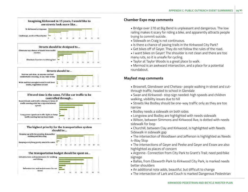
KIRKWOOD PEDESTRIAN AND BICYCLE MASTER PLAN
pg 90
Chamber Expo map comments
• Bridge over 270 at Big Bend is unpleasant and dangerous. The low railing makes it scary for riding a bike, and apparently attracts people trying to commit suicide. • Sidewalk on Craig is not continuous.• Is there a chance of paving trails in the Kirkwood City Park?• Get bikes off of Geyer. They do not follow the rules of the road. • I want bikes on Geyer! The shoulder is not clean and there are too many ruts, so it is unsafe for cycling. • Taylor at Taylor Woods is a great place to walk.• Mermod is an awkward intersection, and a place for a potential roundabout.
Mayfest map comments
• Brownell, Glendower and Chelsea- people walking in street and cut-through traffic; headed to school in Glendale• Swan and Kirkwood- stop sign needed: high speeds and children walking, visibility issues due to hill• Streets like Bodley should be one-way traffic only as they are too narrow• Bodley needs a sidewalk on both sides• Longview and Bodley are highlighted with needs sidewalk• Wilson, between Simmons and Kirkwood Ave, is dotted with needs sidewalk for loop• Churchill, between Clay and Kirkwood, is highlighted with Needs Sidewalk in sidewalk gap• The intersection of Woodlawn and Jefferson is highlighted as Needs 4-Way Stop• The intersections of Geyer and Peeke and Geyer and Essex are also highlighted as places of concern• Argonne- Connection from City Park to Grant’s Trail; need ped/bike signage • Ballas, from Ebsworth Park to Kirkwood City Park, is marked needs better shoulders• An additional note adds, beautiful, but difficult to change• The intersection of Lark and Couch is marked Dangerous Pedestrian
APPENDIX C: PUBLIC OUTREACH EVENT SUMMARIES

KIRKWOOD PEDESTRIAN AND BICYCLE MASTER PLAN
pg 91
Crossing• Marshall Road- Narrow, trucks• Sidewalk in need of repair on Lee Ave, speed bump would be helpful- cut thru is too fast• Need crosswalk on Big Bend and Geyer on east side over railroad tracks• Sidewalks only one side of Geyer between City boundaries and Geyer Forest and no shoulders; there are no crosswalks on Geyer along the same stretch• I want my child to bicycle to the park is also noted at this intersection• Bike lanes along Rose Hill are so comfortable for riding• Multiple blind spots along Geyer headed out of Kirkwood are noted• The land between Greentree Park and Emmenegger Nature Park is highlighted as private property.• Signage is important for proper entrance to Emennegger Park is noted along the north side of the park• The area around Greentree park is noted Safe connection to Grant’s Trail• Big Bend between the city limits and 270 is noted needs better shoulders• Big Bend, where it crosses 270, is noted as a dangerous intersection.• An additional note says “Need a bridge here like on Clay and Argonnne for pedestrians”
Concert Series mapThe following corridors are highlighted in red for danger:
• Geyer, between Rose Hill and 44• Marshall from Greentree Park to Big Bend• Big Bend from City limits to Marshall• N Kirkwood Rd from Washington to Swan• Taylor, from Adams to Nipher Middle School• Fillmore from Adams to the train tracks, along with a note- need to make sidewalk connections• Adams, north of Kirkwood park, with a sign that says Speed limit
needed, people too fast.The following intersections are highlighted in red for danger:• Intersection of Old Big Bend and Craig is highlighted in red with the note “still dangerous for bicyclists.”• The intersection of Dougherty Ferry and 270• The intersection of Dougherty Ferry and Ballas
Additional comments:
• A note on Ballas says “Neighborhood opposed to widening.”• The intersection of Argonne and Van Buren is highlighted with “Should be a stop sign.” Also traffic is too fast on Argonne is noted. • Dougherty Ferry, Peeke, and Essex were all highlighted in green by a man who wanted to mark where he saw cyclists. • Geyer and Harrison are marked in blue with the note No Full Sidewalk
Good to Grow Festival Map• Manchester is too busy for walking. It needs real crosswalks.• Woodard and Geyer are marked “Feels safe going from Woodard to City Park.”
Children’s surveys
Children were asked to fill out a survey that consisted of one question, “How would you make Kirkwood a better place to walk and bike?” The survey provided several lines for text, in addition to a space for drawing a picture. Markers and crayons were provided for filling out the surveys. Children were asked to write down their age, and some did. Many also wrote down their names. To protect their anonymity, the names have not been included. No children filled out a survey at the Chamber Event.
Mayfest children’s surveys
• I propose that we make a bike riding course to bike around the neighborhood.• Hi. I’m L____. I am 8. I think flat spaces would make Kirkwood a
APPENDIX C: PUBLIC OUTREACH EVENT SUMMARIES

KIRKWOOD PEDESTRIAN AND BICYCLE MASTER PLAN
pg 92
better place to walk and bike. (Drawing features picture of girl biking on a flat line with a tree in the background).• I would like to see more trails and more bike paths. Also more plants and trees along all paths. (Drawing features trees and flowers with the words “Need” and “Flowers” repeated multiple times).• My name is L____. I am 9. I think we should have trails and more roads. Thank you! (Drawing features several roads with the word roads).• I think that it would be nice if there were more trails and places to ride. (Drawing features a bike on a flat line with a frowny face. A bike near a hill has a smiley face). • I would like to see more trails in Kirkwood and bike routes. (Drawing has trail, bike rack, and tree, all labeled). • I would like to see that there are more bikeriding and walking trails. (Drawing has boys, girls, and bikes along multiple trails).
Good to Grow Festival children’s surveys
• Make lights for bikes so people can see us. Illustrated with a bicycle and lights.• Birds. Illustrated with a bird.• Illustration of flowers.• I think a way people could make Kirkwood a better place to walk and bike is to make sure all of the sidewalks are even to build more parks and natures reserves. Thanks.
Comment cards
Comment cards were provided at all of the events. For the most part, residents preferred to note their comments on the maps. We received no comment cards at the Chamber Expo, nor at the Good To Grow Festival. Several residents at the Concert Series added bullet points and numbers within their comments, so the overall comments are lettered for clarity.
Mayfest comment cards
• Public awareness and encouragement to support “Good Neighbor” relationships with private landowner neighbors. Appreciate and respect each others rights. The “few” ruin for the majority. Self police and awareness to correct the few.• Comments regarding sidewalks for pedestrians and w/c [wheelchair] users- uneven sidewalks ramps between Woodlawn and Walgreens to Finch.
Concert series
A.• Kirkwood need to create a single lane of traffic from Essex South to Woodbine. Add street parking with added landscape also promote shops and restaurants to use the added space as street shopping and dining (outdoor).• Kirkwood need to reduce the traffic (auto) speed through downtown- from Woodbine to Manchester to 20 mph. This would help reduce excess through traffic.• Shops need to address the street front and parking needs to be behind shops and stores to help create a community experience.
B. • I am passionately opposed to any bike/hike trail development through Emmenegger Nature Park, our legacy nature park deserves preservation and restoration, not recreational development, aka WRECK-REATION.• The Sugar Creek Valley area of West Adams/ Ballas is a natural treasure and its ambience should not be destroyed by street widening or sidewalks. Respect the signs: “Entering Sugar Creek Valley. Preserve its beauty and wildlife.”
C. • Please provide dedicated bike lanes that will connect Grants Trail with Fenton trails• Improve quality of roads. Kirkwood roads are full of potholes (much worse than Webster).
APPENDIX C: PUBLIC OUTREACH EVENT SUMMARIES

KIRKWOOD PEDESTRIAN AND BICYCLE MASTER PLAN
pg 93
D. • Good- excellent bike parking, locking, protection in downtown area as well as other strategic areas.• Very safe obvious dedicated bike/walk connection from downtown (train station) to Grant’s Trailhead with signage at the trail head and downtown to let people know what’s available. (such as a list of amenities in downtown Kirkwood. Also makes Holmes safer for bikes (very sad that wasn’t addressed during recent improvements). • I personally think with handicaps and elderly people can ride their electric transportation. There are an increasing number and this would profoundly increase their ability to transport and enjoy the outdoors.• I Getting annual weekends where Kirkwood partners with towns that Amtrak stops at near Katy Trail and connect with each other.
APPENDIX C: PUBLIC OUTREACH EVENT SUMMARIES

KIRKWOOD PEDESTRIAN AND BICYCLE MASTER PLAN
pg 94APPENDIX D: PEDESTRIAN PRIORITIZATION TABLE
Street Name:
Recommended improvement:
Length (miles):
Estimated Cost:
Existing sidewalk? (No = 0, One Side = 1, Two Sides = 2, Path = 3)
Prioritization Criteria Score Weight Weighted Score
1.1 Number of Public and Private Schools (k-12 and Community College) near route
30
1.2 Direct access to a transit stop (yes=1; no=0) 15
1.3 Direct access to a commercial area (yes=1; no=0) 20
1.4 Number of public facilities (city hall, library, etc.) near route
10
1.5 Number of parks with direct access 25
2.1 Connects existings sidewalks (yes=1; no=0) 25
2.2 Access to a regional multi-use path (yes=1; no=0) 25
2.3 Improves pedestrian access along or across a major road (yes=1; no=0)
25
2.4 Crosses freeway or railroad tracks (yes=1; no=0) 25
3.1 Recommended by community feedback (1 = maximum support; 0 = little to no support)
60
3.2 Recommended by agency feedback (1 = maximum support; 0=little to no support)
60
3.3 Multiple funding sources possible 15
3.4 Cost (4 = under $80,000; 3 = $80,001 to $160,000; 2 = $160,001 to $320,000; 1 = $320,001 to
$640,000; 0 = over $640,000)
30
Figure D-1 :Sample Pedestrian Prioritization Table
Total Score