Embed Size (px)
Citation preview
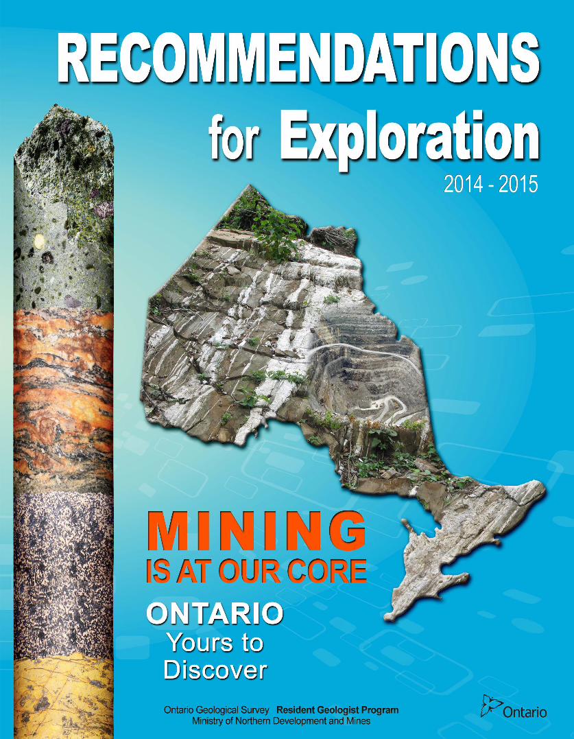

Recommendations for Exploration
2014-2015
LAKE SUPERIOR
LA
KE
HU
RO
N
LA KE E RI E
LA K E ON T A R IO
Attawapiskat
2 1 Moosonee
Red Lake
4 Kenora 5
3 6 Geraldton
7 8 Thunder Bay
Timmins
Wawa
10 Kirkland Lake
Sault Ste. Marie
9
Sudbury
Cobalt
12 11
Ottawa
13 14
15 Tweed
General Area that is Toronto Recommended for
Mineral Exploration London
Windsor
Photo courtesy of Karen Labonte
Ontario Geological Survey Resident Geologist Recommendations for Exploration
The Ontario Geological Survey is pleased to issue its 2014
Recommendations for Exploration. These recommendations are the
product of the Ministry’s dedicated and knowledgeable staff located across
the province.
Each year recommendations are developed based on the wealth of
geological and exploration data available to our staff (and you) and any
new information or concepts derivative from the current year’s activities.
Please review our current recommendations and feel free to discuss these
in detail with any of our geoscientists.
Rob Ferguson
Senior Manager
Resident Geologist Program
Ontario Geological Survey
Ministry of Northern Development and Mines
5520 Highway 101 E
Timmins, Ontario P0N 1H0
Tel. 705-235-1622
E-mail: [email protected]
Visit Geology Ontario http://www.geologyontario.mndm.gov.on.ca to see
what else is available
Published October 2014
About the Resident Geologist
Program
Resident Geologists are the stewards of public
geological and mineral exploration information
for their districts. They provide a broad range
of advisory services on geological topics of
interest to the public, municipal governments,
and the mineral industry.
They are the local experts on why geoscience
information is important, what information is
available and what’s been happening in
exploration.
The program provides primary client services
through a network of 8 field offices
strategically located across the province.
Services include:
collecting and maintaining geological
data
monitoring exploration activity
conducting property examinations
providing geological and exploration
advice
We provide geoscience information to support:
public safety
environmental planning
land use planning
mineral sector investment and economic
development
We provide information and training to First
Nation Communities regarding prospecting,
mineral exploration and mining.

Contents
Gold in the Historic Red Lake Camp ...............................................................................................................1
Gold Potential at the Sor Lake and Altered Zone Properties; Lang-McVicar Greenstone Belt.......................2
Gold-Sulphide Association and Pre-Orogenic Model for Mineralization........................................................4
Targeting Gold and Base Metals in BIF and Ultramafic Volcanic Rocks; Western Caribou Lake
Greenstone Belt ..............................................................................................................................................7
Cu-Ni-PGE and Ti-V Potential in the Mesoproterozoic Badwater Intrusive Complex; Armstrong, Ontario ........................................................................................................................................9
Exploration Potential of the Garden Lake Area .............................................................................................11
Copper, Nickel and Platinum Group Element Potential in the Atikokan—Quetico Area .............................14
Amethyst Potential Near the North Shore of Lake Superior ..........................................................................17
Cu-Zn-Pb-Cd Mineralization. A Possible VMS-Deposit Setting in the Batchawana Greenstone Belt? .......21
The Westward Continuation of the Porcupine Destor Fault Through the Northern Swayze Geenstone
Belt, Abitibi Subprovince ............................................................................................................................24
Temagami – An Area with Past Producing Mines but Little Recent Exploration .........................................27
Offset Dikes – PGM, Nickel, Copper – Building Stone in the Sudbury Area ..............................................29
Critical Minerals: A Southern Ontario Perspective ........................................................................................31
Titanium and Vanadium in Southeastern Ontario – Metals of the Future .....................................................35
Gold Mineralization in the Marmora-Madoc-Harlowe Area, Southeastern Ontario .....................................38

2014-2015 Recommendations for Mineral Exploration ~ Ontario 1
Gold in the Historic Red Lake Camp HIGHLIGHTS
New discoveries in the
shadows of
headframes ...
Recent exploration
discoveries show that
the Red Lake camp still
has life
Contact: Carmen Storey
(807) 727-3284 Ph.
Andreas Lichtblau
[email protected] (807) 727-2464 Ph.
Red Lake is a gold camp and gold exploration and production has long been the
mainstay of the local economy. The discovery of the High Grade Zone at the
Goldcorp Red Lake Gold Mines in 1995 emphasized the fact that there are significant
discoveries yet to be made and it revitalized exploration in Red Lake. Recent
exploration by Goldcorp Red Lake Gold Mines has expanded known resources and
has made new discoveries within the mine envelope maintaining a high level of
interest in the Red Lake Camp. Diamond drilling on the H.G. Young property
adjacent to the Campbell Complex (the former Placer-Dome Campbell Mine) has
returned high grade intercepts (www.goldcorp.com News Release Goldcorp
Announces Strong Second Quarter Financial Results) indicating a possible new high
grade resource. Goldcorp is working at their Bruce Channel Discovery (purchased
from Gold Eagle Mines Ltd.) under Red Lake and close to the past producing
Cochenour-Willans Mine. Rubicon Minerals Corporation is continuing development
of its Phoenix Project F2 Zone (Rubicon Minerals Intersects136.5 grams per tonne
Au) with production expected in 2015. The Phoenix Property (also known as the
McFinley) was first discovered in 1926. These discoveries were made in a mature
camp and indicate that there is still potential for more high grade gold.
Little of the Red Lake camp has been explored below the 500 metre level and
deserves continued exploration for gold using the most modern exploration theories
and methods. There are many historic gold properties that are under explored and
offer excellent potential for high grade gold mineralization. In addition to the Red
Lake greenstone belt, the Birch-Uchi greenstone belt and the Northern greenstone
belts all have properties that deserve re-evaluation (for example the Sandy Lake Belt
where Goldeye Explorations Ltd is working on the Weebigee project. http://
www.goldeye.ca/ ).
1

2014-2015 Recommendations for Mineral Exploration ~ Ontario 2
Gold Potential at the Sor Lake and Altered Zone Properties; Lang-McVicar Greenstone Belt
HIGHLIGHTS
Two key properties, the
Sor Lake and Altered
Zone, both with
potential for significant
gold mineralization,
remain open for staking
Several key occurrences
throughout the LMGB
with favourable geology
for precious and base
metal mineralization,
remain open for staking
Contact: Robert Cundari
(807) 475-1101 Ph.
Gerry White
[email protected] (807) 475-1105 Ph.
The Lang-McVicar Lake greenstone belt (LMGB) is located approximately 80 km
west of the town of Pickle Lake and 20 km southeast of the First Nation community
of Cat Lake. The LMGB is accessible by fixed-wing aircraft or helicopter. A winter
road from Pickle Lake to Cat Lake is situated 3 km south of the belt where a backhoe
trail leads north to the central portion of the belt.
The LMGB is approximately 40 km long and varies in width from 8 to 11 km (Sage
and Breaks 1982). Stott and Corfu (1991) describe the LMGB as being dominated
by tholeiitic basalt flows and calc-alkaline pyroclastic deposits, with the eastern
portion of the belt containing a significant metasedimentary package hosting iron
formation horizons. The entire belt has been folded into an east trending and east
plunging syncline (Thomas 1988). Late stage intrusive rocks intrude older, folded
rocks and comprise a large, elongated mafic sill in the Sor-McVicar Lakes area. A
north trending felsic intrusion in the Shonia-McVicar Lakes area divides the mafic
intrusion into two parts (Sage and Breaks 1982). The dominant structural feature in
the region is the Bear Head Fault Zone, a northwest-southeast striking, regional scale
dextral shear zone located in the southwest portion of the belt (Stott and Corfu 1991).
Splays off the Bear Head fault are interpreted to be the main controls on gold
mineralization in the Lang-McVicar greenstone belt (S. Magnus, Ontario Geological
Survey, personal communication, September 2014). Thomas (1988) interpreted the
LMGB to originally be part of the Meen-Dempster belt (to the south) which was
rafted away due to late stage extensional tectonics.
The Lang-McVicar greenstone belt is currently being mapped by the Earth Resources
and Geoscience Mapping Section (ERGMS) of the Ontario Geological Survey which
will provide insights into the general geology, litho-tectonic evolution and mineral
potential of the belt. The staff of the Resident Geologist’s program visited the
LMGB with the ERGMS crew in August of 2014. Several occurrences in the belt
were visited and traverses were conducted to study the general geology of the area.
Of particular interest were two significant properties which remain open for staking;
the Sor Lake property and the Altered Zone property. The Sor Lake property ( see
map) is approximately 100 to 300 m wide and up to 2 km in length and contains the
Sor Lake Sill occurrences, the Jay Zone and the Sor Lake Sill Shear. The
occurrences are hosted within the Sor Lake sill which is a variably altered and
deformed tonalite intrusion with alteration consisting of Ca- and Fe-rich carbonate,
sericite and silicification (McKay 2004). Mineralization occurs within quartz veins
and shears where the most significant assay results returned 3.20 g/t Au over 1.0 m
from a quartz vein (channel sample; referred to as occurrence #6 by McKay (2004))
and 122.94 g/t Au from a shear located ~1 km east of occurrence #6, (grab sample;
referred to as occurrence #10 by McKay (2004)). The Altered Zone prospect ( see
map) is located at the eastern end of McVicar Lake and is hosted within a northwest-
trending ductile shear zone. Gold mineralization at the Altered Zone is present
within a dilation zone associated with the faulting. Gold occurs in lenticular quartz ±
iron carbonate veins with minor pyrite and rare chalcopyrite within mafic
metavolcanic and gabbroic rocks. Channel sampling returned values up to 12.77 g/t
Au over 0.8 m. The most significant historical drill intersections are reported as 14.4
g/t Au and 33.0 g/t Au over 4.63 m and 1.87 m, respectively (McKay 2004).
2

2014-2015 Recommendations for Mineral Exploration ~ Ontario
Gold Potential at the Sor Lake and Altered Zone Properties; Lang-McVicar Greenstone Belt …cont’d
Figure: Geology map showing Mineral Deposit Inventory (MDI) points, Lang-McVicar Lake greenstone belt (NAD 83, Zone 15; claim
units as of September 2, 2014; bedrock geology from OGS 2003)
McKay, D.B. 2004. Report on the 2003 overburden stripping, geological mapping and sampling program conducted on the
McVicar Lake property for Continuum Resources Ltd. and Prospector Consolidated Resources Inc.; unpublished
report, Thunder Bay Resident Geologist’s office, assessment file AFRI# 52O11SW2003, 57p.
Ontario Geological Survey 2003. 1:250 000-scale bedrock of Ontario; Ontario Geological Survey, Miscellaneous Release –
Data 126.
Sage, R.P. and Breaks, F.W. 1982. Geology of the Cat Lake-Pickle Lake area, district of Kenora and Thunder Bay; Ontario
Geological Survey, Report 207, 238p.
Stott, G.M. and Corfu, F. 1991. Uchi Subprovince; in Geology of Ontario, Ontario Geological Survey, Special Volume 4,
Part 1, p.145-236.
Thomas, R.N. 1988. McVicar Lake Project (1446) report on diamond drilling work, McVicar Lake area, Patricia Mining
Division, NTS: 52O/11 and 52O/12; unpublished report, Thunder Bay Resident Geologist’s office, assessment file
AFRI# 52O/11SW-0050, 54p.
3

2014-2015 Recommendations for Mineral Exploration ~ Ontario 3
Gold-Sulphide Association and Pre-Orogenic Model for Mineralization
HIGHLIGHTS
3 gold deposits in the
Kenora District present
unique styles of
mineralization
An early mineralizing
event may be obscured
by later alteration and
metamorphism
Multiple generations on
pyrite may be present
Contact: Craig Ravnaas
(807) 468-2819 Ph.
Unique styles of gold mineralization, situated in different geological settings have
been identified at three gold deposits in the southwestern part of the western
Wabigoon Subprovince; a) the Angel Hill Gold Zone deposit is hosted in mafic
intrusive rocks (Secord 2011); b) the Cameron Lake deposit is hosted in mafic
volcanic rocks (Melling, Taylor and Watkinson 1988); and c) the Rainy River deposit
is hosted in sedimentary and pyroclastic rocks (Wartman 2011).
Gold-pyrite association at deposits
Stable isotope geochemistry of gold-bearing rocks from these deposits, indicates the
initial precipitation of gold is closely linked to a specific generation of pyrite. Gold
may occur along pyrite grain boundaries, within individual grains and along
intergranular fractures in pyrite (Wyman, Kerrich and Fryer 1986). The studies on
these three deposits suggest that not all pyrite is associated with gold, and that there
may be multiple generations of pyrite. A common feature of the three deposits is that
a specific silica-dominated quartz event(s) is related to the precipitation of gold and
could also be linked to the formation of sulphide minerals.
Pre-orogenic atypical greenstone belt gold model
The paragenetic sequence relative to gold deposition interpreted for these three gold
deposits is atypical of common greenstone hosted gold deposits. Groves et al. (2003)
mention “these types of [atypical] deposits form prior to the major phase(s) of
orogenesis, involving compressional to transpressional deformation, regional
metamorphism, and postvolcanic granitoid magmatism during which the orogenic
gold deposits form”. Robert and Poulson (2001), Groves et al. (2003), Robert et al.
(2005, 2007) provide detailed descriptions of the geological setting of atypical
greenstone hosted gold deposits and their affiliation with orogenic settings.
A pre-orogenic depositional environment must have had original permeability in the
rocks and some structural deformation for the percolation of fluids. Stratabound
permeability would be relatively high in fragmental rock units as opposed to massive
flows. Wartman (2011) noted that in the Rainy River deposits “zones of higher
permeability (i.e. flow tops and breccia related to dacitic lava flows) and areas of
intense deformation have elevated gold values, up to 10,000 times greater than gold
values in surrounding rocks”.
There is the possibility of pre-orogenic mineralizing events, commonly related to
atypical greenstone belt gold model, existing at the three gold deposits.
Post orogenic mineralizing events at deposits
The term orogenic used in this recommendation is restricted to deposits composed of
quartz-carbonate veins and associated wallrock replacement associated with
compressional or transpressional geological structures such as reverse faults and
folds. This mineralizing events overprint pre-existing deformation, alteration,
metamorphism and especially any pre-orogenic mineralization (Robert et al. 2005,
2007). Two of the three gold deposits discussed in this article, the Cameron Lake
Deposit (Ball, 2012) and Rainy River Deposit (Hardie et al., 2012 and Schandl,
2005) have overprinting post-orogenic mineralizing events, the typical setting of lode
-gold greenstone belts models. 4
2014-2015 Recommendations for Mineral Exploration ~ Ontario
Gold-Sulphide Association and Pre-Orogenic Model for Mineralization …cont’d
Recommendation
A key to success when examining the mineral potential is to understand and detect the different types of gold mineralizing
events. Most gold occurrences consist of a single style of mineralization but Robert et al. (2007) indicates at several
deposits that “the diversity of styles of mineralization, wall-rock alteration assemblages, and overprinting relationships
require more than one episode of gold mineralization and more than one ore-forming process”.
The composition of the of the host rocks is important to the formation of sulphides. At the Cameron Lake gold zones
Melling et al. (1988) noted “magnetite, although an abundant accessory mineral in the host rock of the deposit, is rarely
present within the altered gold-bearing zones … the fluid-wall rock reactions which led to gold deposition involved
sulfidization of the Fe-bearing mineral, especially magnetite”. Sulphide-bearing rocks, which are overprinted by quartz
veins, could have a pyrite-gold association. Scanning electron microscope analysis of gold-bearing rocks is a good method
to determine if there is a gold-sulphide association.
Pre-orogenic atypical greenstone belt gold mineralization is nonetheless difficult to recognize due to the overprinting
effects of subsequent orogenic-related metamorphism, deformation and alteration. Secord (2011) mentions stable isotope
geochemistry is used “to investigate if the texturally distinct sulphide minerals and fluid phases represented separate
isotopically distinct generations and to gain insight into the relationship between mineralizing fluids and ore forming
minerals”. Oxygen isotope compositions of hydrothermal minerals can provide information on the temperature of
mineralization and the source of ore-forming fluids. Sulphur isotope compositions can yield constraints on the source
rocks from which these fluids were derived (McCuaig and Kerrich, 1998).
The application of specialized analytical techniques is not always available or practical. Examination of slab -cut rock
samples could display unique sulphide – silica relations that could suggest the existence of an atypical mineralizing event.
The fabric of the sulphide grains could illustrate evidence on multiple formation generations. The gold mineralizing event
(s) could be associated with a specific formation of sulphide. If possible estimate the paragenesis of silica events,
especially quartz veins and formation of sulphide – this could be also related to the introduction of mineralization.
Ball P., 2012. Independent Technical Report on the Cameron Gold Project; unpublished report, Coventry Resources
Limited., 143p.
Groves D.I., Goldfarb R.J., Robert, F., and Hart C.J.R., 2003, Gold Deposits in Metamorphic Belts: Overview of Current
Understanding, Outstanding Problems, Future Research, and Exploration Significance: Society of Economic
Geologist, Economic Geology, Vol. 98, 1-29.
Hardie, C., Runnels, D., Daniel. S., Ritchie D., Cole, D., El-Rassi, D. and Tolfree, D. 2012. Independent Preliminary
Economic Assessment update on the Rainy River Gold Property, Ontario, Canada; unpublished report, Rainy River
Resources Limited., 430p.
Melling, D.R. 1988. Geological Setting Structure and Alteration Associated with Gold -Pyrite Mineralization in Mafic
Volcanic rocks at Cameron Lake, Wabigoon Subprovince, Northwestern Ontario; Ontario Geological Survey, Open
File Report 5689, 112p.
Melling, D.R., Taylor, R.P., and Watkinson, D. H., 1988. Lithogeochemistry and light stable isotope (Carbon, Oxygen and
Sulphur) geochemistry of hydrothermal alteration and breccia veins from the Cameron Lake gold deposit,
northwestern Ontario, Ontario Ministry of Northern Development and Mines, Ontario Geological Survey,
Miscellaneous Paper 140, p. 239-251.
McCuaig, T.C. and Kerrich, R., 1998. P-T-t-deformation-fluid characteristics of lode gold deposits: evidence from
alteration systematics: Journal for Comprehensive Studies of Ore Genesis and ore Exploration, Ore Geology Reviews
12.Vol 6, p. 381-353.
Robert, F., Poulsen, K.H., Cassidy, K.F., and Hodgson, C. J., 2005, Gold Metallogeny of the Superior and Yilgarn Cratons:
Society of Economic Geologist, Economic Geology, Vol. 100, p. 1001-1033. 5
2014-2015 Recommendations for Mineral Exploration ~ Ontario
Gold-Sulphide Association and Pre-Orogenic Model for Mineralization …cont’d
Robert, F., Brommecker, R., Bourne, B. T., Dobak, P. J., McEwan, C. J., Rowe, R. J., and Zhou, X., 2007. Models and
Exploration Methods for Major Gold Deposit Types, Ore deposits and Exploration Technology in Milkereit, B., ed.,
Proceedings of Exploration 07, p. 691-711.
Robert, F., and Poulsen, K.H., 2001, Vein Formation and Deformation in Greenstone Gold Deposits, in Society of
Economic Geologists, Reviews in Economic Geology 14, p. 111-155.
Secord S.R. 2011. Geochemistry and Au Mineralization within the Kakagi-Rowan Lakes Greenstone Belt: a Study of the
Angel Hill Gold Zone; unpublished MSc. thesis, Lakehead University, Thunder Bay, Ontario, 111p.
Schandl, E.S. June 2006. Petrographic and mineralogical study of the Rainy River Au prospect, Ricardson TP.Ontario.
prepared by Geoconsult. Internal report for Rainy River Resources Ltd. 129 pages.
Wartman, J.M., 2011 - Physical Volcanology and Hydrothermal Alteration of the Rainy River Gold Project, northwest
Ontario; unpublished MSc. thesis, University of Minnesota, Ottawa, Ontario 154 pages.
Wyman, D.A., Kerrich, R. and Fryer, B.J. 1986. Gold mineralization overprinting iron formation at the Agnico –Eagle
Deposit, mineralogical, microstructural and geochemical evidence; in Proceedings of Gold ’86, an International
Symposium on the Geology of Gold, Toronto, 1986, p.118–123.
6

2014-2015 Recommendations for Mineral Exploration ~ Ontario 4
Targeting Gold and Base Metals in BIF and Ultramafic Volcanic Rocks; Western Caribou Lake Greenstone Belt
HIGHLIGHTS
The western portion of
the Caribou Lake
greenstone belt
represents an under
explored belt with
potential for significant
iron formation-hosted
gold as well as copper-
lead-zinc mineralization
Several key occurrences
within areas of
favourable geology for
precious and base metal
mineralization remain
open for staking
Contact: Robert Cundari
(807) 475-1101 Ph.
Gerry White
[email protected] (807) 475-1105 Ph.
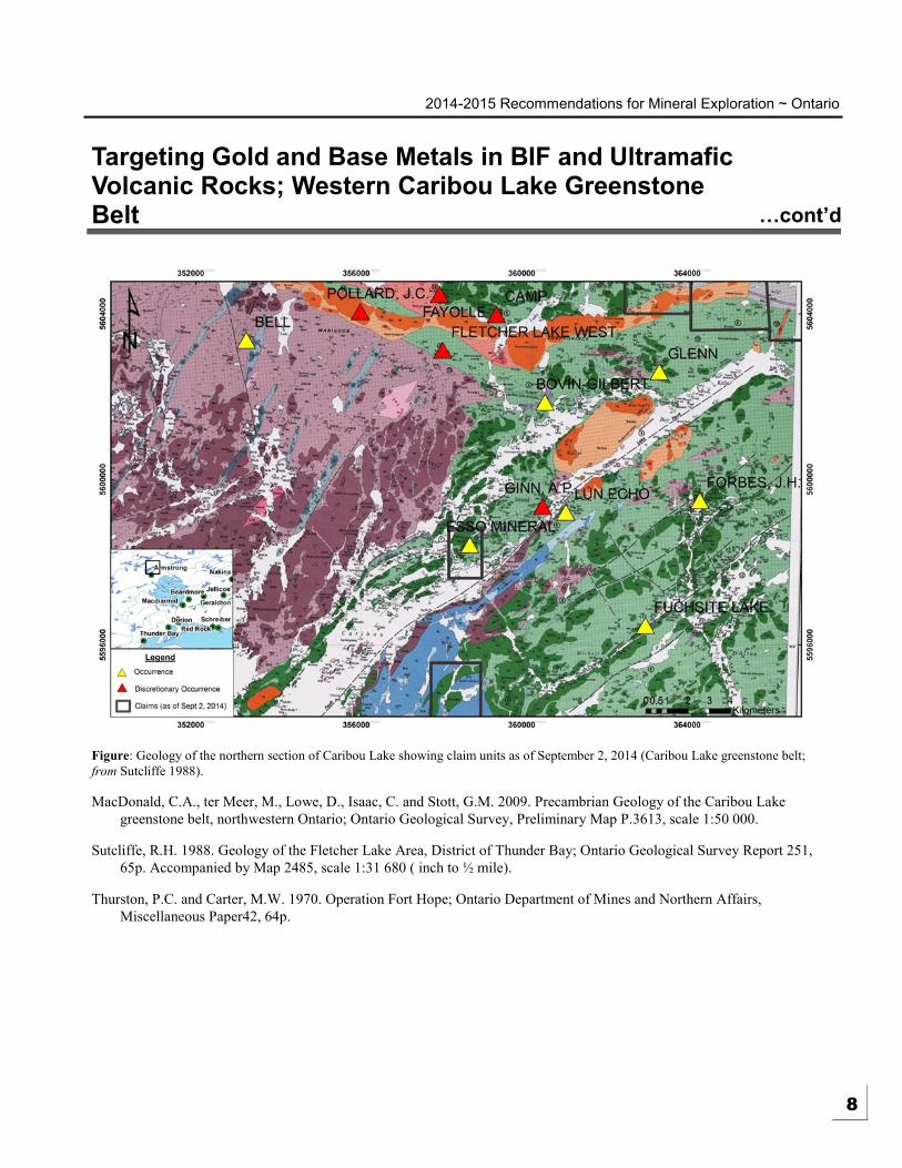
The Caribou Lake greenstone belt (CLGB) is located approximately 20 km north of
Armstrong, Ontario and is bound by Caribou Lake to the west and the Summit Lake
area to the east. The east-central portion of the CLGB is accessible by the Airport
Road or Jackfish Logging Road east of Armstrong as well as a network of older
logging roads. The western portion of the belt is accessible via Caribou Lake by
boat, float-plane, helicopter or sled in winter.
The CLGB ranges from 3.5 to 15 km wide and extends from Caribou Lake, 80 to 100
km eastward where it merges with the Onaman-Tashota greenstone belt (MacDonald
et al., 2009). The area recommended for exploration lies within the western portion
of the belt around Caribou Lake proper. The supracrustal rocks in this part of the belt
were mapped by Sutcliffe (1988) and consist of (1) ultramafic to mafic metavolcanic
rocks; (2) clastic metasedimentary rocks ranging from argillite to metaconglomerate;
(3) chert and ironstone with interbedded metavolcanic and metasedimentary rocks;
and (4) metamorphosed subvolcanic to volcanic felsic rocks. The supracrustal rocks
were intruded by several phases of intrusive rocks including (1) early felsic to
intermediate plutonic rocks, dominantly biotite tonalite; (2) northeast trending
amphibolite and gabbro dykes; (3) the gabbroic Caribou Lake Pluton; and (4) late
felsic to intermediate plutonic rocks, dominantly granite.
In June of 2014, the staff of the Resident Geologist’s Program visited the Caribou
Lake greenstone belt focussing on the western portion of the belt around Caribou
Lake. A traverse was conducted around the Fletcher Lake anticline which is host to
the Bovin-Gilbert occurrence. The Fletcher Lake anticline is an iron formation unit
composed of chert to magnetite-amphibole ironstone (Sutcliffe 1988). Outcrops in
the area are generally small with several historical pits located towards the east end
(fold nose) of the unit along a hillside. Quartz veining (up to 40 cm wide), sulphide
mineralization and iron carbonate alteration are present throughout the unit
suggesting the Fletcher Lake anticline is a favourable environment for iron formation
-hosted gold mineralization. High grade lead and silver mineralization have been
previously reported at three locations within the Fletcher Lake anticline with assay
results yielding 47.3% Pb and 98.44 oz/ton Ag from a high grade galena vein
(Thurston and Carter 1970). Samples were taken from one of these locations with
material consisting of approximately 15-20% massive galena and 3-5% sphalerite
within an iron formation host rock. Assay results for samples taken during this field
work are pending.
The Cumaway Lake area, east of Caribou Lake hosts favourable geology for both
gold and copper-lead-zinc mineralization. Ultramafic rocks in this area are
associated with zones of deformation and alteration, likely related to two sets of
intersecting faults as mapped by Sutcliffe (1988). Mineralization previously reported
at the J.H. Forbes occurrence (Lett occurrence) is present within a 25 m wide fault
breccia consisting of angular country rock fragments cemeted by quartz-calcite with
disseminated and/or massive chalopyrite, sphalerite and galena (Sutcliffe 1988).
Two grab samples (1105 and 1006) from this area taken in 1988 by the OGS yielded;
Au = 0.05 oz/ton, Ag = 12.03 oz/ton, Cu = 2.0%, Zn = 11.05%, Pb = 2.10% and Au
= 0.04 oz/ton, Ag = 0.46 oz/ton, Cu = 0.73%, Zn = 0.15%, Pb = 0.02%, respectively.
Further work is warranted in this area to evaluate the potential for both precious and
base metal mineralization within the fault-breccia zone described above as well as in
the surrounding metamorphosed and altered ultramafic-mafic volcanic rocks. 7
2014-2015 Recommendations for Mineral Exploration ~ Ontario
Targeting Gold and Base Metals in BIF and Ultramafic Volcanic Rocks; Western Caribou Lake Greenstone Belt …cont’d
Figure: Geology of the northern section of Caribou Lake showing claim units as of September 2, 2014 (Caribou Lake greenstone belt;
from Sutcliffe 1988).
MacDonald, C.A., ter Meer, M., Lowe, D., Isaac, C. and Stott, G.M. 2009. Precambrian Geology of the Caribou Lake
greenstone belt, northwestern Ontario; Ontario Geological Survey, Preliminary Map P.3613, scale 1:50 000.
Sutcliffe, R.H. 1988. Geology of the Fletcher Lake Area, District of Thunder Bay; Ontario Geological Survey Report 251,
65p. Accompanied by Map 2485, scale 1:31 680 ( inch to ½ mile).
Thurston, P.C. and Carter, M.W. 1970. Operation Fort Hope; Ontario Department of Mines and Northern Affairs,
Miscellaneous Paper42, 64p.
8
2014-2015 Recommendations for Mineral Exploration ~ Ontario
Cu-Ni-PGE and Ti-V Potential in the Mesoproterozoic Badwater Intrusive Complex; Armstrong, Ontario
5
HIGHLIGHTS
The Badwater gabbro
represents an easily
accessible, layered mafic
intrusive complex
entirely open for staking
The Badwater gabbro
has potential to host Cu-
Ni-PGE and/or Ti-V
deposits
Contact: Robert Cundari
(807) 475-1101 Ph.
Gerry White
[email protected] (807) 475-1105 Ph.
The Mesoproterozoic Badwater Intrusive Complex (a.k.a. Waweig Troctolite
Complex; cf. Borradaile and Middleton 2006) intrudes Archean Wabigoon
Subprovince country rocks, 13 km southwest of Armstrong, Ontario. The complex
comprises the Badwater Gabbro (BG) and the Badwater Syenite (BS). It is believed
to form a multi-phase, intrusive complex which is expressed by a circular magnetic
anomaly 12 km in diameter (Middleton and Bennett 2008). Initial mapping by
MacDonald (2004) identified a variety of intrusive rocks, ranging from gabbro to
quartz monzonite and syenite. High-precision U-Pb dating of baddeleyite yielded an
emplacement age of 1598.7 ± 1.1 Ma for the BG and a U-Pb zircon age of 1590.1 ±
0.8 Ma for the BS, which supports observed cross-cutting relationships (Heaman et
al. 2007). They are unconformably overlain and largely obscured by Pillar Lake
volcanic rocks which were possibly erupted at 1129 ± 4.6 Ma (U-Pb age from
titanite; Heaman et al. 2007; Smyk et al. 2011).
The poorly exposed BG was first recognized in 2000 by East West Resources Corp.
(Middleton 2004) and was tested for PGE mineralization in drilling campaigns
carried out in 2004 and 2008. The BG is described as a layered troctolite-gabbro
complex consisting of olivine gabbro, anorthosite, troctolite, glomeroporphyritic
rocks and layers of magnetite with sulphides (Middleton and Bennett 2008). Minor
ultramafic mafic lithologies have also been reported from drill-core. Magmatic
layering dips ~45° to ~55° southeast. Modal mineralogy for typical olivine gabbro is
listed as: plagioclase (labradorite/bytownite) 55%; clinopyroxene (augite?) 25%;
biotite 10%; olivine (partly relict) 3%; talc/sericite (after olivine) 2%; amphibole
(secondary actinolite) 2%; opaque (magnetite? pyrrhotite?) 2%; clay?/sericite (after
plagioclase) trace (Middleton and Bennett 2008). The BG is undeformed and
displays generally fresh plagioclase and relatively unaltered olivine.
Although no appreciable assay results have been reported for the Badwater gabbro,
potential for the unit to host significant Cu-Ni-PGE and/or Ti-V mineralization
remains high. Several holes have been drilled into select parts of the layered gabbro
complex (see figure) however several areas of the complex remaining untested. The
Badwater gabbro is poorly understood and insights into the intrusive history and
structural control of the unit should aid in developing targets for mineralization.
Ground and bore-hole geophysical methods are recommended in addition to further
drilling to test previously undrilled areas of the unit as well as any newly identified
targets. The majority of drill-core recovered from previous campaigns is currently
held at the MNDM’s off-site core storage facility in Comnee Township west of
Thunder Bay and is available for viewing.
9
2014-2015 Recommendations for Mineral Exploration ~ Ontario
Cu-Ni-PGE and Ti-V Potential in the Mesoproterozoic Badwater Intrusive Complex; Armstrong, Ontario …cont’d
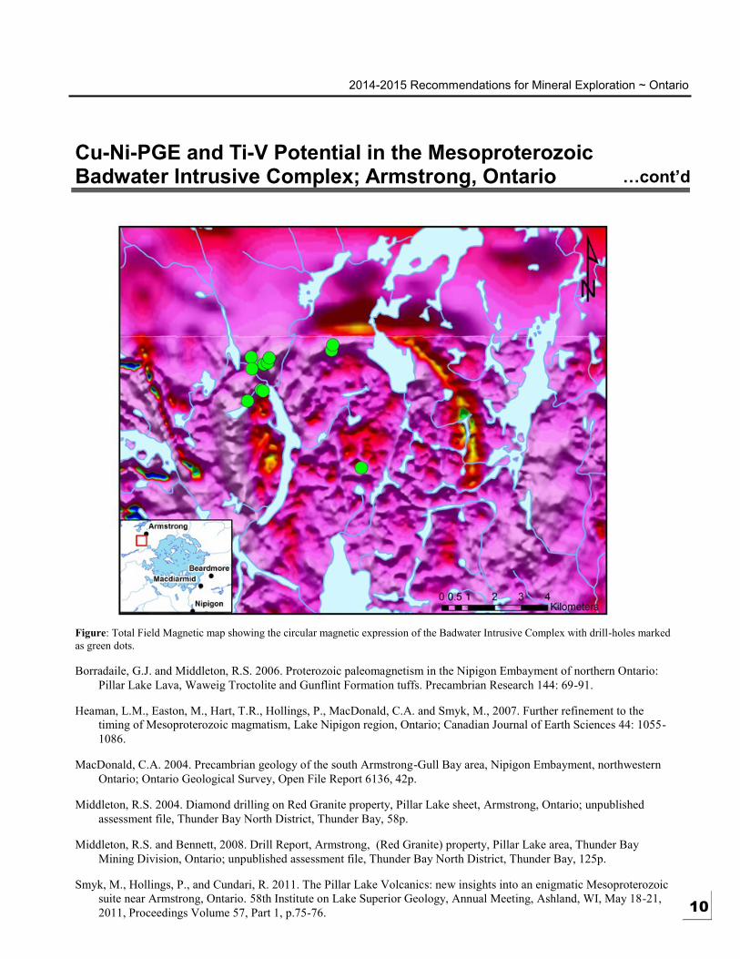
Figure: Total Field Magnetic map showing the circular magnetic expression of the Badwater Intrusive Complex with drill-holes marked
as green dots.
Borradaile, G.J. and Middleton, R.S. 2006. Proterozoic paleomagnetism in the Nipigon Embayment of northern Ontario:
Pillar Lake Lava, Waweig Troctolite and Gunflint Formation tuffs. Precambrian Research 144: 69-91.
Heaman, L.M., Easton, M., Hart, T.R., Hollings, P., MacDonald, C.A. and Smyk, M., 2007. Further refinement to the
timing of Mesoproterozoic magmatism, Lake Nipigon region, Ontario; Canadian Journal of Earth Sciences 44: 1055 -
1086.
MacDonald, C.A. 2004. Precambrian geology of the south Armstrong-Gull Bay area, Nipigon Embayment, northwestern
Ontario; Ontario Geological Survey, Open File Report 6136, 42p.
Middleton, R.S. 2004. Diamond drilling on Red Granite property, Pillar Lake sheet, Armstrong, Ontario; unpublished
assessment file, Thunder Bay North District, Thunder Bay, 58p.
Middleton, R.S. and Bennett, 2008. Drill Report, Armstrong, (Red Granite) property, Pillar Lake area, Thunder Bay
Mining Division, Ontario; unpublished assessment file, Thunder Bay North District, Thunder Bay, 125p.
Smyk, M., Hollings, P., and Cundari, R. 2011. The Pillar Lake Volcanics: new insights into an enigmatic Mesoproterozoic
suite near Armstrong, Ontario. 58th Institute on Lake Superior Geology, Annual Meeting, Ashland, WI, May 18-21,
2011, Proceedings Volume 57, Part 1, p.75-76. 10
2014-2015 Recommendations for Mineral Exploration ~ Ontario 6
Exploration Potential of the Garden Lake Area
HIGHLIGHTS
The Garden Lake area
has potential for the
discovery of lode gold,
volcanogenic massive
sulphide (VMS)-type
copper-zinc and mafic
to ultramafic intrusion-
hosted copper-nickel-
PGE mineralization
Historic gold
occurrences near
Kearns, Conick and
Ruffo Lakes are open
for staking
A historic copper
occurrence north of
Garden Lake is also
open for staking
Contact: Mark Puumala
(807) 475-1649 Ph.
Dorothy Campbell
[email protected] (807) 475-1102 Ph.
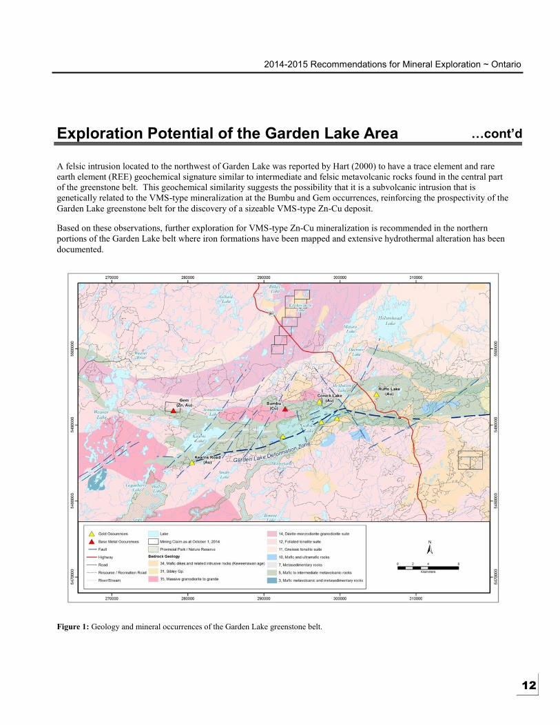
The Garden Lake greenstone belt has seen sporadic mineral exploration activity since
the initial discovery of gold on the east shore of Conick Lake in the late 1930s (Milne
1964). During the 1940s, Little Long Lac Gold Mines discovered additional gold
showings along the shore of Garden Lake (Phelan 1947), and the majority of
subsequent exploration activity in the belt (mostly between 1983 and 2000) has been
focussed on gold in the immediate vicinity of Garden Lake (Hart 2000).
The Garden Lake belt has also seen periodic exploration for volcanogenic massive
sulphide (VMS)-type zinc-copper deposits. VMS exploration commenced in the
early 1960s, when Ruffo Lake Mines and Inco carried out geophysical surveys and
diamond drilling programs (Hart 2000). Subsequent exploration programs were
carried out by Weaver Lake Resources in the early 1990s (Pitman 1991) and in 2007
by Benton Resources Ltd. (Byrnes 2008).
Historic exploration programs and government surveys have resulted in the
identification of eight significant mineral occurrences in the Garden Lake greenstone
belt. The locations of these occurrences are shown on Figure 1. Note that three of
the historic occurrences are now located within a Provincial Park. However, as of
October 1, 2014, the Kearns Road, Bumbu, Conick Lake and Ruffo Lake occurrences
are available for staking.
Gold Potential
The primary commodity of interest that has been identified at six of the historic
occurrences in the Garden Lake greenstone belt is gold. Most of these gold
occurrences are located in close proximity to the Garden Lake deformation zone (see
Figure 1), which was previously identified as a favourable gold exploration target by
Hart (2000). The Kearns Road gold occurrence is one example of a location where
mineralization is believed to be associated with the Garden Lake deformation zone.
Hart (2000) reported a grab sample assay of 0.69 oz/ton Au from the Kearns Road
occurrence. The gold mineralization was hosted in sheared mafic metavolcanic rocks
mineralized with 2 to 3% very fine grained pyrite. No significant exploration work is
known to have occurred in the area of the Kearns Road occurrence since its
discovery. As a result, this area is recommended for further exploration to follow-up
upon the previously reported gold potential.
VMS-type Zinc-Copper Potential
Zinc and copper occurrences with characteristics consistent with the VMS-type
mineralization model have been reported in the northern portions of the Garden Lake
greenstone belt. These occurrences, known as the Bumbu and Gem, were discovered
in extensively altered metavolcanic rocks that have a close spatial association with
iron formation horizons (Pitman 1991, Hart 2000, Byrnes 2008).
Copper mineralization at the Bumbu showing was interpreted to be associated with a
chloritized and brecciated VMS-type stringer sulphide zone at the contact between
mafic and felsic metavolcanic rocks (Pitman 1991).
11
2014-2015 Recommendations for Mineral Exploration ~ Ontario
Exploration Potential of the Garden Lake Area …cont’d
A felsic intrusion located to the northwest of Garden Lake was reported by Hart (2000) to have a trace element and rare
earth element (REE) geochemical signature similar to intermediate and felsic metavolcanic rocks found in the central part
of the greenstone belt. This geochemical similarity suggests the possibility that it is a subvolcanic intrusion that is
genetically related to the VMS-type mineralization at the Bumbu and Gem occurrences, reinforcing the prospectivity of the
Garden Lake greenstone belt for the discovery of a sizeable VMS-type Zn-Cu deposit.
Based on these observations, further exploration for VMS-type Zn-Cu mineralization is recommended in the northern
portions of the Garden Lake belt where iron formations have been mapped and extensive hydrothermal alteration has been
documented.
Figure 1: Geology and mineral occurrences of the Garden Lake greenstone belt.
12

2014-2015 Recommendations for Mineral Exploration ~ Ontario
Exploration Potential of the Garden Lake Area …cont’d
Copper-Nickel-PGE Potential
Although significant mafic intrusion-hosted Cu-Ni-PGE occurrences have yet to be documented in the Garden Lake
greenstone belt, the possibility of locating such a deposit should not be overlooked. As noted by Hart (2000), the late
gabbroic intrusions located along the Mooseland River in the eastern portion of the belt, and the pyroxenite intrusion west
of Garden Lake require additional prospecting and sampling to properly establish their Cu -Ni-PGE potential.
Additionally, the Garden Lake greenstone belt is located near the western margin of the Mesoproterozoic Nipigon
Embayment, which forms part of the Midcontinent Rift igneous province. Recent Cu-Ni-PGE exploration in the Thunder
Bay area has resulted in the discovery of a number of mineralized mafic-ultramafic intrusive complexes (e.g., Thunder Bay
North, Steepledge Lake and Sunday Lake igneous complexes) that formed during the development of the Midcontinent
Rift. These and other mafic-ultramafic intrusions in the Nipigon Embayment typically occur at or near the intersections of
major deep-seated fault structures (Hart and MacDonald 2007), with pre-existing Archean faults playing a major role in
their emplacement (Hollings et al. 2010; Heggie et al. 2012). The area in the vicinity of the intersection between the
Archean Garden Lake Deformation Zone and a northwest-striking fault immediately east of Garden Lake is considered to
be an especially favourable location to prospect for Cu-Ni-PGE mineralized Midcontinent Rift-related mafic-ultramafic
intrusions (Puumala et al. 2012).
Byrnes, K. 2008. Assessment report on the 2007 trenching and prospecting program at the Gem property; Thunder Bay
South District, Assessment Files, AFRI report number 20000003878.
Hart, T.R. and MacDonald, C.A. 2007. Proterozoic and Archean geology of the Nipigon Embayment: Implications for
emplacement of the Mesoproterozoic Nipigon diabase sills and mafic to ultramafic intrusions; Canadian Journal
of Earth Sciences v.44, p.1021-1040.
Hart, T.R. 2000. Precambrian geology, Garden Lake area; Ontario Geological Survey, Open File Report 6037, 82p.
Heggie, G., MacTavish, A., Johnson, J., Weston, R. And Leon, M.A. 2012. Structural control on the emplacement of the
TBN-Igneous Complex; in Proceedings and Abstracts, Part 1, 58th Institute on Lake Superior Geology, Annual
Meeting, Thunder Bay, Ontario, v.58, pt.1, p.37-38.
Hollings, P., Smyk, M., Heaman, L.M., and Halls, H. 2010. The geochemistry, geochronology, and paleomagnetism of
dikes and sills associated with the Mesoproterozoic Midcontinent Rift near Thunder Bay, Ontario, Canada;
Precambrian Research, v.183, issues 3, p.553-571.
Milne, V.G. 1964. Geology of the Garden Lake area, District of Thunder Bay; Ontario Department of Mines, Geological
Report 25, 21p.
Phelan, L.G. 1947. Report on the Garden Lake property for Little Long Lac Gold Mines Ltd.; Thunder Bay South District,
Assessment Files, AFRI report number 52H12SE0011.
Pitman P. 1991. A Geological Appraisal, Weaver Lake Resources Corporation Mineral Properties, Garden Lake Area;
Thunder Bay South District, Assessment Files, AFRI report number 52H12SE0002.
Puumala, M.A., Campbell, D.A., Cundari, R.M., Zurevinski, S.E., Tuomi, R.D., Lockwood, H.C., Debicki, R.L., Moses,
P., Brunelle, M.R. and Pelaia, R. 2012. Report of Activities 2012, Resident Geologist Program, Thunder Bay
South Regional Resident Geologist Report: Thunder Bay South District; Ontario Geological Survey, Open File
Report 6285, 67p.
13
2014-2015 Recommendations for Mineral Exploration ~ Ontario 7
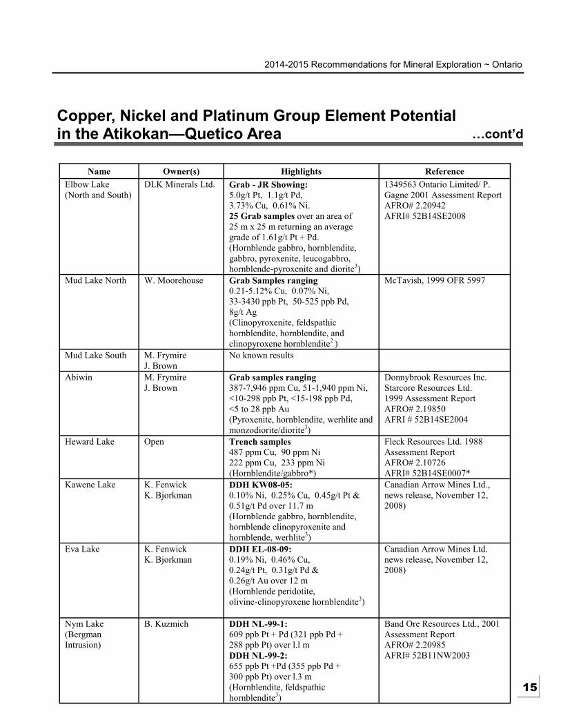
Copper, Nickel and Platinum Group Element Potential in the Atikokan—Quetico Area
HIGHLIGHTS
Mafic-ultramafic
Quetico intrusions have
potential to host Cu-Ni-
PGE mineralization
Almost all of the
Quetico mafic-
ultramafic intrusions
are available for option
from local Thunder Bay
-Atikokan area
prospectors and several
are open for staking
Contact: Mark Puumala
(807) 475-1649 Ph.
Dorothy Campbell
[email protected] (807) 475-1102 Ph.
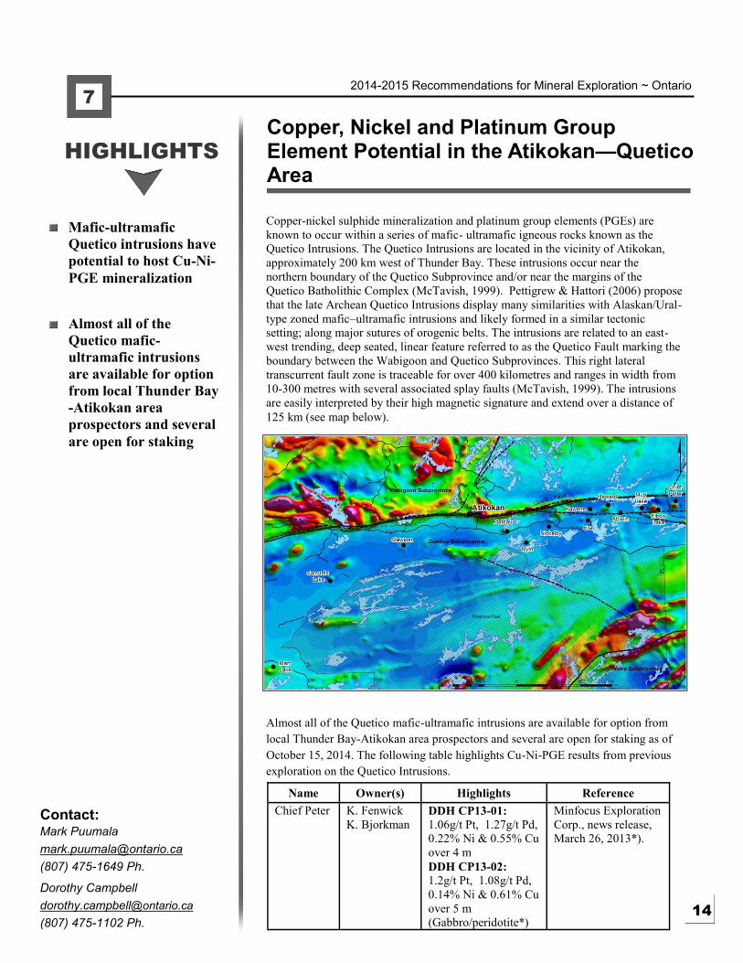
Copper-nickel sulphide mineralization and platinum group elements (PGEs) are
known to occur within a series of mafic- ultramafic igneous rocks known as the
Quetico Intrusions. The Quetico Intrusions are located in the vicinity of Atikokan,
approximately 200 km west of Thunder Bay. These intrusions occur near the
northern boundary of the Quetico Subprovince and/or near the margins of the
Quetico Batholithic Complex (McTavish, 1999). Pettigrew & Hattori (2006) propose
that the late Archean Quetico Intrusions display many similarities with Alaskan/Ural-
type zoned mafic–ultramafic intrusions and likely formed in a similar tectonic
setting; along major sutures of orogenic belts. The intrusions are related to an east-
west trending, deep seated, linear feature referred to as the Quetico Fault marking the
boundary between the Wabigoon and Quetico Subprovinces. This right lateral
transcurrent fault zone is traceable for over 400 kilometres and ranges in width from
10-300 metres with several associated splay faults (McTavish, 1999). The intrusions
are easily interpreted by their high magnetic signature and extend over a distance of
125 km (see map below).
Almost all of the Quetico mafic-ultramafic intrusions are available for option from
local Thunder Bay-Atikokan area prospectors and several are open for staking as of
October 15, 2014. The following table highlights Cu-Ni-PGE results from previous
exploration on the Quetico Intrusions.
Name Owner(s) Highlights Reference
Chief Peter K. Fenwick
K. Bjorkman DDH CP13-01:
1.06g/t Pt, 1.27g/t Pd,
0.22% Ni & 0.55% Cu
over 4 m
Minfocus Exploration
Corp., news release,
March 26, 2013*).
DDH CP13-02:
1.2g/t Pt, 1.08g/t Pd,
0.14% Ni & 0.61% Cu
over 5 m
(Gabbro/peridotite*) 14
2014-2015 Recommendations for Mineral Exploration ~ Ontario
Copper, Nickel and Platinum Group Element Potential in the Atikokan—Quetico Area …cont’d
Name Owner(s) Highlights Reference
Elbow Lake
(North and South)
DLK Minerals Ltd. Grab - JR Showing:
5.0g/t Pt, 1.1g/t Pd,
3.73% Cu, 0.61% Ni.
25 Grab samples over an area of
25 m x 25 m returning an average
grade of 1.61g/t Pt + Pd.
(Hornblende gabbro, hornblendite,
gabbro, pyroxenite, leucogabbro,
hornblende-pyroxenite and diorite3)
1349563 Ontario Limited/ P.
Gagne 2001 Assessment Report
AFRO# 2.20942
AFRI# 52B14SE2008
Mud Lake North W. Moorehouse Grab Samples ranging
0.21-5.12% Cu, 0.07% Ni,
33-3430 ppb Pt, 50-525 ppb Pd,
8g/t Ag
(Clinopyroxenite, feldspathic
hornblendite, hornblendite, and
clinopyroxene hornblendite2 )
McTavish, 1999 OFR 5997
Mud Lake South M. Frymire
J. Brown
No known results
Abiwin M. Frymire
J. Brown Grab samples ranging
387-7,946 ppm Cu, 51-1,940 ppm Ni,
<10-298 ppb Pt, <15-198 ppb Pd,
<5 to 28 ppb Au
(Pyroxenite, hornblendite, werhlite and
monzodiorite/diorite3)
Donnybrook Resources Inc.
Starcore Resources Ltd.
1999 Assessment Report
AFRO# 2.19850
AFRI # 52B14SE2004
Heward Lake Open Trench samples
487 ppm Cu, 90 ppm Ni
222 ppm Cu, 233 ppm Ni
(Hornblendite/gabbro*)
Fleck Resources Ltd. 1988
Assessment Report
AFRO# 2.10726
AFRI# 52B14SE0007*
Kawene Lake K. Fenwick
K. Bjorkman DDH KW08-05:
0.10% Ni, 0.25% Cu, 0.45g/t Pt &
0.51g/t Pd over 11.7 m
(Hornblende gabbro, hornblendite,
hornblende clinopyroxenite and
hornblende, werhlite3)
Canadian Arrow Mines Ltd.,
news release, November 12,
2008)
Eva Lake K. Fenwick
K. Bjorkman DDH EL-08-09:
0.19% Ni, 0.46% Cu,
0.24g/t Pt, 0.31g/t Pd &
0.26g/t Au over 12 m
(Hornblende peridotite,
olivine-clinopyroxene hornblendite3)
Canadian Arrow Mines Ltd.
news release, November 12,
2008)
Nym Lake
(Bergman
Intrusion)
B. Kuzmich DDH NL-99-1:
609 ppb Pt + Pd (321 ppb Pd +
288 ppb Pt) over l.l m
DDH NL-99-2:
655 ppb Pt +Pd (355 ppb Pd +
300 ppb Pt) over l.3 m
(Hornblendite, feldspathic
hornblendite3)
Band Ore Resources Ltd., 2001
Assessment Report
AFRO# 2.20985
AFRI# 52B11NW2003
15

2014-2015 Recommendations for Mineral Exploration ~ Ontario
Copper, Nickel and Platinum Group Element Potential in the Atikokan—Quetico Area …cont’d
Name Owner(s) Highlights Reference
Nickelby Open 6 DDHs
No assays reported
(Sheared gabbro*)
E. Corrigan 1957 Assessment
Report MEI#
52B11NW003*
Plateau Lake M. Frymire DDH-1 Sample yielded >2% Cu,
7,688pm Ni
(Pyroxenite*)
OPAP 1992 Report by C.
Hicks, Project# OP92-481
AFRO# 52B14SE0019*
Stawson
(Bill Lake,
McQuat Lake)
Open Grab samples:
2.0g/t Pt + Pd
(Clinopyroxenite3)
East West Resources Ltd.
2001Assessment Report
AFRO# 2.22321
AFRI# 52B12NW2003
Samuels Lake Pro Am Explorations
Corp.
DDH SL-08-13: 0.39% Ni, 0.85%
Cu over 14.3m
DDH SL-08-14 : 0.21% Ni, 0.30%
Cu over 33.5m
DDH SL-08-15: 0.23% Ni, 0.52%
Cu over 15.2m
(Gabbro, clinopyroxenite,
hornblendite, werhlite and
monzodiorite/diorite2)
Teck Cominco Limited 2008
Assessment Report AFRO#
2.40694
AFRI# 20000003942
Marr Lake A. Onchulenko
B. Kuzmich
P. Gehrels
3 Grab Samples
Averaging 1.2% Cu, 0.2% Ni,
1.3g/t Pt, 1.3g/t Pd, 6g/t Ag,
0.4g/t Au
(Pyroxenite*)
W.C. Hood 2005 Assessment
Report AFRO# 2.35117
AFRI# 20000002182*
1MacTavish, A.D. 1999. The mafic-ultramafic intrusion of the Atikokan-Quetico area, northwestern Ontario; Ontario
Geological Survey. Open File Report 5997, 154p.
2Pettigrew, N.T., Hattori, K.H. 2006. The Quetico Intrusions of Western Superior Province: Neo -Archean examples of
Alaskan/Ural-type mafic–ultramafic intrusions. Precambrian Research. 149, 21- 428.
3Vaillancourt, C., Sproule, R.A., MacDonald, C.A. and Lesher, C.M. 2003. Investigation of mafic -ultramafic intrusions in
Ontario and implications for platinum group element mineralization: Operation treasure Hunt; Ontario Geological
Survey, Open File Report 6102, 335p.
16

2014-2015 Recommendations for Mineral Exploration ~ Ontario 8
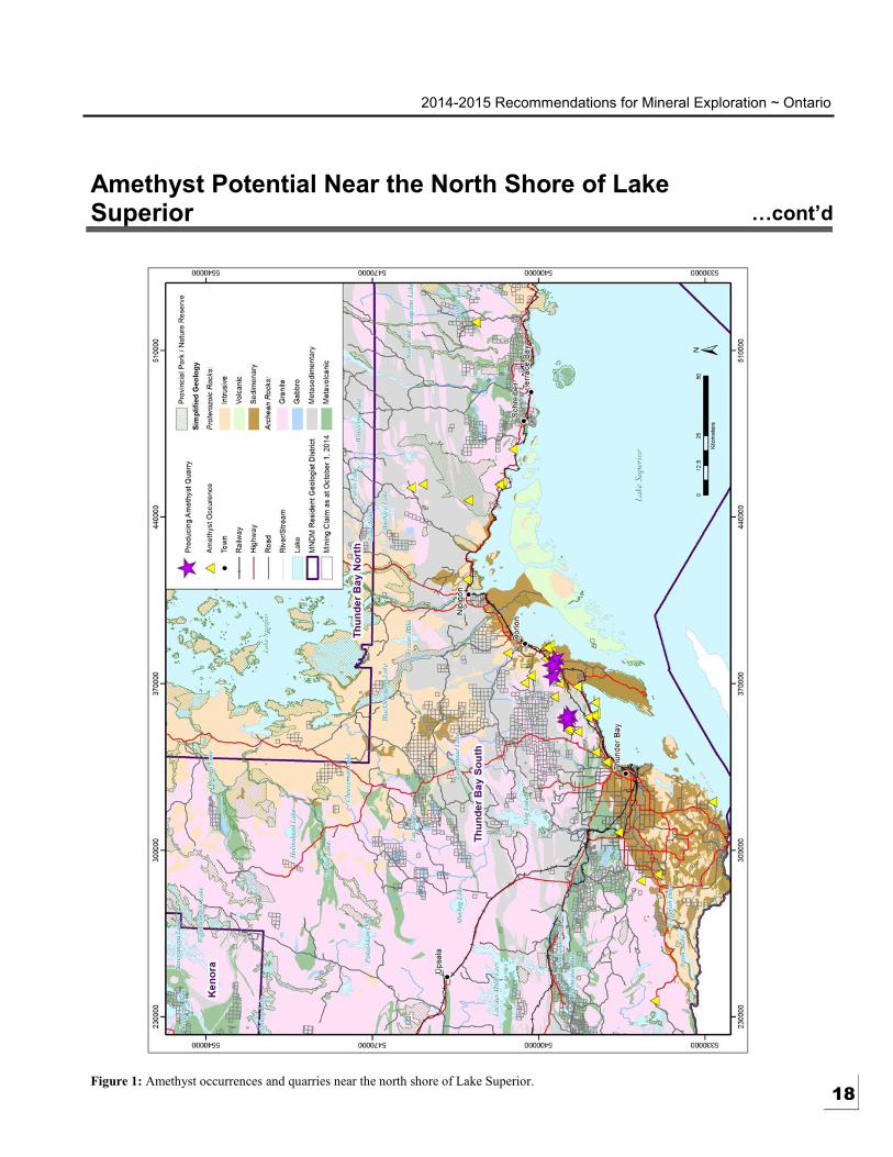
Amethyst Potential Near the North Shore of Lake Superior
HIGHLIGHTS
Amethyst deposits near
the north shore of Lake
Superior occur in close
proximity to the
Archean/Proterozoic
unconformity and
northeast-striking fault
zones
Prospecting potential
exists in an area
extending from the
Ontario-Minnesota
border to Marathon
where several known
amethyst occurrences
are open for staking
Contact: Mark Puumala
(807) 475-1649 Ph.
Dorothy Campbell
[email protected] (807) 475-1102 Ph.
The Thunder Bay area has long been known for its amethyst deposits. Currently,
there are a number of small-scale amethyst quarries operating immediately east of the
City of Thunder Bay in the Tartan Lake Area and McTavish Township. These
quarries are largely focused on the supply of mineral specimens and ornamental
stone, with much of this material marketed to tourists. Although current production
is occurring in a relatively small area covering only two geographic townships,
amethyst is known to occur across a much wider area extending from the
international border southwest of Thunder Bay and across the north shore of Lake
Superior almost to Marathon. The locations of known amethyst occurrences in the
Thunder Bay South Resident Geologist District, including the current producing
quarries, are shown on Figure 1.
Amethyst in the Thunder Bay area most commonly occurs in veins and/or breccia
zones that occur within northeast-striking fault zones that were active during the
Mesoproterozoic (ca. 1100 Ma) Midcontinent Rift event. The most significant
amethyst deposits tend to occur where two fault systems intersect. This is due to the
interaction between multiple faults allowing for the development of more open
spaces (i.e., vugs) for amethyst crystals to grow (Garland 1994).
Amethyst occurs in a variety of rock types. However, all deposits are located in
close proximity to the unconformity between Archean age granitic rocks and
Proterozoic age sedimentary rocks of the Animike and Sibley Groups. The location
of the Archean/Proterozoic unconformity is shown on Figure 2. Note that major
northeast striking fault zones have also been mapped in close proximity to the
unconformity. Therefore, it is recommended that prospecting for amethyst focus on
areas that are in close proximity to both the unconformity and northeast-striking fault
zones.
Figure 2 also shows the locations of a number of known amethyst occurrences that
were open for staking as of October 1, 2014. Table 1 provides a listing of Ontario
Geological Survey (OGS) information sources for these occurrences, including
Mineral Deposit Inventory records (MDI), mineral exploration Assessment Files
(AFRI), and the Resident Geologist’s files. The MDI and AMIS records can be
accessed on-line through Geology Ontario, while the Resident Geologist’s files are
only available in hard copy at the Thunder Bay Office. Geological descriptions of
the Mount Baldy, Little Bear Quarry and Walkinshaw occurrences are also provided
in Garland (1994).
17
2014-2015 Recommendations for Mineral Exploration ~ Ontario
Amethyst Potential Near the North Shore of Lake Superior …cont’d
Figure 1: Amethyst occurrences and quarries near the north shore of Lake Superior. 18

2014-2015 Recommendations for Mineral Exploration ~ Ontario
Amethyst Potential Near the North Shore of Lake Superior …cont’d
Figure 2: Map illustrating the Archean/Proterozoic unconformity, major faults and the locations of amethyst occurrences open for
staking as of October 1, 2014. 19

2014-2015 Recommendations for Mineral Exploration ~ Ontario
Amethyst Potential Near the North Shore of Lake Superior …cont’d
Occurrence Name MDI File No. AFRI File Nos. Resident Geologist’s File
Holzem NA NA 52B07SE, Holzem Occurrence
Marks Township NA 52A05SW2003 NA
Silver Valley MDI52A05SW00009 NA 52A05SW, Silver Valley
Occurrence
Mount Baldy NA 52A11SE2002
52A11SE2005
52A11SE0001
52A11SE, Mount Baldy
Occurrence
Walkinshaw 02 MDI000000001234 52A11NE0004
20002132
NA
Belletini MDI000000001238 52A10NW2003 NA
Stenlund MDI52H01SE00008 NA 52H01SE, Stenlund Occurrence
Little Bear Amethyst Quarry MDI42E04NE00003 42E04NE0009
42E04NE0008
42E04NE, Little Bear Amethyst
Quarry
Vos MDI42E04NE00008 NA NA
Kilometre 23 MDI42D15NE00005 NA 42D15NE, Km 23 Occurrence
Bayco MDI52A15SE00023 52A15SE0019 NA
Table 1: Amethyst occurrences open for staking as of October 1, 2014.
Garland, M.I., 1994. Amethyst in the Thunder Bay area; Ontario Geological Survey, Open File Report 5891, 197 p.
20

2014-2015 Recommendations for Mineral Exploration ~ Ontario 9
Cu-Zn-Pb-Cd Mineralization; A Possible VMS-Deposit Setting in the Batchawana Greenstone Belt?
HIGHLIGHTS
The survey revealed
significant anomalies in
Zn, Cd, and Cu,
suggesting the
underlying stratigraphy
is consistent with metal
association typical of
Archean volcanic-
associated massive
sulphide deposits
The adjacent host rocks
display variable
chlorite, biotite, sericite
and silica alteration that
is consistent with a VMS
setting
Contact: Anthony Pace
(705) 945-6931 Ph.
Over the last several years, exploration for new gold deposits has dominated the
work done in greenstone belt terrains. There has been little focus on exploring for
volcanogenic massive sulphide (VMS) deposits. The Batchawana Greenstone Belt
has historically been underexplored. To date, there have been no VMS deposits
delineated in it, but numerous base metal showings have been discovered (Grunsky,
1991). The Batchawana Greenstone Belt should therefore be considered an
exploration target for VMS deposits.
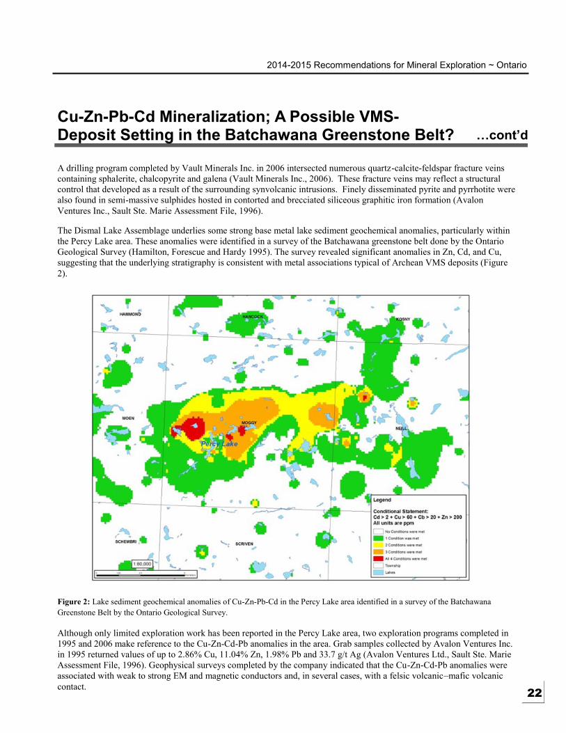
The Percy Lake area is situated within the Dismal Lake Assemblage, in the northeast
section of the Batchawana Greenstone Belt. It underlies the central portion of Moggy
Township (Figure 1). The Dismal Lake metavolcanic sequence (2700 to 2698 Ma)
consists of a calc-alkalic mafic to felsic metavolcanic sequence of rocks (Grunsky,
1991).
Figure 1: Location of the Percy Lake property in the Dismal Assemblage of the Batchawana
Greenstone Belt
The Percy Lake property is underlain by interbedded tholeiitic to calc-alkalic mafic
volcanic flows and volcaniclastics. The mafic flows are locally interbedded with
intermediate to felsic flows and synvolcanic intrusions that vary from aphanitic to
quartz-feldspar porphyry. The volcaniclastic units include tuff breccia, lapilli tuff,
amphibole crystal tuff, and ash tuff. Minor argillaceous, silty, and lean oxide iron
formation units are locally interbedded with the mafic flows.
A regional-scale east-northeast-trending syncline has been identified west of the
Percy Lake area (Wilson, 1983). It may have attributed to the small-scale folding
ranging from crenulation cleavage over a few centimetres to larger folds with
amplitudes of a few metres in the metavolcanic rocks. 21
2014-2015 Recommendations for Mineral Exploration ~ Ontario
Cu-Zn-Pb-Cd Mineralization; A Possible VMS-Deposit Setting in the Batchawana Greenstone Belt? …cont’d
A drilling program completed by Vault Minerals Inc. in 2006 intersected numerous quartz -calcite-feldspar fracture veins
containing sphalerite, chalcopyrite and galena (Vault Minerals Inc., 2006). These fracture veins may reflect a structural
control that developed as a result of the surrounding synvolcanic intrusions. Finely disseminated pyrite and pyrrhotite were
also found in semi-massive sulphides hosted in contorted and brecciated siliceous graphitic iron formation (Avalon
Ventures Inc., Sault Ste. Marie Assessment File, 1996).
The Dismal Lake Assemblage underlies some strong base metal lake sediment geochemical anomalies, particularly within
the Percy Lake area. These anomalies were identified in a survey of the Batchawana greenstone belt done by the Ontario
Geological Survey (Hamilton, Forescue and Hardy 1995). The survey revealed significant anomalies in Zn, Cd, and Cu,
suggesting that the underlying stratigraphy is consistent with metal associations typical of Archean VMS deposits (Figure
2).
Figure 2: Lake sediment geochemical anomalies of Cu-Zn-Pb-Cd in the Percy Lake area identified in a survey of the Batchawana
Greenstone Belt by the Ontario Geological Survey.
Although only limited exploration work has been reported in the Percy Lake area, two exploration programs completed in
1995 and 2006 make reference to the Cu-Zn-Cd-Pb anomalies in the area. Grab samples collected by Avalon Ventures Inc.
in 1995 returned values of up to 2.86% Cu, 11.04% Zn, 1.98% Pb and 33.7 g/t Ag (Avalon Ventures Ltd., Sault Ste. Marie
Assessment File, 1996). Geophysical surveys completed by the company indicated that the Cu-Zn-Cd-Pb anomalies were
associated with weak to strong EM and magnetic conductors and, in several cases, with a felsic volcanic –mafic volcanic
contact. 22

2014-2015 Recommendations for Mineral Exploration ~ Ontario
Cu-Zn-Pb-Cd Mineralization; A Possible VMS-Deposit Setting in the Batchawana Greenstone Belt? …cont’d
In 2006, as follow up to the work completed by Avalon Ventures Ltd., Vault Minerals Inc., completed the only diamond
drilling program in the area. It intersected several exhalite-bearing horizons containing anomalous Zn, Pb, Cu, and Cd
values. The adjacent host rocks display variable chlorite, biotite, sericite and silica alteration that is consistent with a VMS
setting (Vault Minerals Inc., Sault Ste. Marie Assessment Files, 2006).
The Percy Lake area contains key geological, geophysical, and geochemical features that indicate the potential for
volcanogenic massive sulphide style mineralization.
Bain, D., 1996. Report on the Economic Potential for Cu-Pb-Zn carried out on the Percy Lake Property. Avalon Ventures
Ltd., Assessment File, SSMP Moggy-06.
Grunsky, C.E. 1991. Geology of the Batchawana Area, District of Algoma; Ontario Geological Survey, Open File Report
5791.
Hamilton, S.M., Fortescue, J.A.C. and Hardy, A.S. 1995. A Zinc-Cadmium-Copper Anomaly: Preliminary Results of the
Cow River Geochemical Mapping Project, Batchawana Greenstone Belt; Ontario Geological Survey, Open File
Report 5917.
Lengyel, P.W.J., 2006. Report on the 2006 Diamond Drilling Program carried out on the Percy Lake Property. Vault
Minerals Inc., Assessment File SSMP Moggy-05.
Wilson, B.C., 1983. Geology of the Rotunda Lake–Percy Lake Area. Districts of Algoma and Sudbury; Ontario Geological
Survey, Report 229.
23

2014-2015 Recommendations for Mineral Exploration ~ Ontario 10
The Westward Continuation of the Porcupine Destor Fault Through the Northern Swayze Greenstone Belt, Abitibi Subprovince
HIGHLIGHTS
Porcupine Destor Fault
Zone, one of the most
prolific gold bearing
faults in Ontario
Contact: Brian Atkinson
(705) 235-1619 Ph.
The Porcupine Destor Fault Zone (PDFZ) is one of the most important crustal
structures controlling gold mineralization in the Abitibi subprovince. In Ontario,
over 70 million ounces of gold have been mined along the fault from Timmins to the
Quebec border. As such, it presents one of the most obvious exploration targets for
Archean lode gold deposits. The PDFZ is in part delineated by the presence of syn-
orogenic clastic sediments that are locally referred to as “Timiskaming sediments.”
Such sediments include distinctive clast-supported polymictic conglomerates and
these rock types are readily identifiable in the field by the Prospector. (See Photo 1 as
an example).
Photo 1: Interbedded clastic metasediments of possible Timiskaming affinity in Penhorwood
Township. Note the development of the strong deformational fabric that has transposed
bedding.
Many attempts have been made to trace the PDFZ westward beyond the Timmins
West Mine in Bristol Township where supracrustal rocks of the Abitibi greenstone
belt are intruded and interrupted by the Kenogamissi Batholith. Discontinuous septa
of greenstone in Denton and Keefer townships retain possible vestiges of the PDFZ,
and link the structure to a west-trending structure in the northern Swayze greenstone
belt.
Rocks, including polymictic cobble conglomerate with well-preserved cross-bedding
and fining upward, south facing sequences, occur in Penhorwood Township (Milne,
1972, Ayer, 1995, Bleeker et al 2014). These rocks are possibly correlative with
Timiskaming sediments at Timmins and may be used to delineate the PDFZ through
the northern Swayze greenstone belt (See Figure 1). In the Timmins area,
Timiskaming sediments are prolific gold hosts. Elsewhere in Archean greenstone
belts throughout the Superior Province, similar rocks both define crustal scale
structures that are prerequisite to large gold deposits and often comprise gold ore. 24

2014-2015 Recommendations for Mineral Exploration ~ Ontario
The Westward Continuation of the Porcupine Destor Fault Through the Northern Swayze Greenstone Belt, Abitibi Subprovince …cont’d
Figure 1: General geology of the western Abitibi greenstone belt showing the westward projection of the Porcupine Destor Fault Zone
through the northern Swayze greenstone belt to the Ivanhoe Lake Fault that marks the east boundary of the Kapuskasing Structu ral Zone.
The yellow star identifies the location of possible Timiskaming clastic sediments in Penhorwood Township depicted in Photo 1. (Figure
from Bleeker et al 2014).
Evidence that the PDFZ might continue westward on the north side of the Kenogamissi Batholith and into the northern
Swayze greenstone belt include strongly deformed clastic, syn-orogenic sediments that are tentatively correlated with
Timiskaming sediments in Timmins. In Penhorwood township, the presence of talc+magnesite+chlorite+carbonate schists
at the Penhorwood Mine may be part of a large-scale hydrothermal alteration event that exploited the PDFZ as a fluid
conduit. Consequently, the area extending westward through Penhorwood, Keith, Foleyet and Ivanhoe townships to the
Ivanhoe Lake Fault Zone that delimits the east boundary of the Kapuskasing Structural Zone warrant careful examination
for Archean lode gold deposits.
25

2014-2015 Recommendations for Mineral Exploration ~ Ontario
The Westward Continuation of the Porcupine Destor Fault Through the Northern Swayze Greenstone Belt, Abitibi Subprovince …cont’d
Ayer, J.A., 1995. Precambrian geology northern Swayze greenstone belt. Ontario Geological Survey, Report 297, 57p.
Bleeker, W., 2012. Targeted Geoscience Initiative (TGI-4) Lode Gold Deposits in Ancient Deformed and Metamorphosed
Terranes: The role of extension in the formation of Timiskaming basins and large gold deposits, Abitibi greenstone
belt—a discussion. Summary of Field Work and Other Activities, 2012, Ontario Geological Survey, Open File Report
6280, p. 47-1 to 47-12.
Bleeker, W., Atkinson, B.T. and Stalker, M. 2014 (in press) Summary of Field Work: 43. A “New” Occurrence of
Timiskaming Sedimentary Rocks in the Northern Swayze Greenstone Belt, Abitibi Subprovince−With Implications
for the Western Continuation of the PDFZ and Nearby Gold Mineralization. Ontario Geological Survey, Open File
Report.
Milne, V.G., 1972a. Geology of the Kukatush-Sewell Lake area District of Sudbury; Ontario Division of Mines,
Geological Report 97, 116p.
26
2014-2015 Recommendations for Mineral Exploration ~ Ontario 11
Temagami – An Area with Past Producing Mines but Little Recent Exploration
HIGHLIGHTS
Past producing iron,
copper-nickel and
copper mines
Numerous gold deposits
Little recent exploration
Contact: Dave Guindon
(705) 568-4518 Ph.
The discovery of mineralized rocks, claim staking and exploration has been going on
in the Temagami area since the early 1900s. Prospectors came to the area when it
was opened up for lumbering and the development of the railway from North Bay to
Cochrane. The area has also had its share of producing mines, both large and small,
and a variety of commodities. These included iron ore from the Sherman Mine
(MDI31M04SW00025), copper, gold silver and nickel from the Temagami Copper
Mine (MDI41I16NE00004), copper, nickel, gold and PGE from the Kanichee Mine
(MDI31M04SW00022). The area also contains a number of properties with historic
resources. These include the Diadem (MDI31M04SW00077), a Cu-Ni deposit, the
Cominco South (MDI31M04SW00021) gold deposit, the Leckie
(MDI31M04SW00090) gold deposit and the Kokoko (MDI31M04SW00096) iron
deposit.
Exploration in the area has challenges, past and present. Not all of the land is open to
exploration and other parts have special requirements for exploration. Temagami
Lake is an attractive tourist region resulting in the potential for stakeholder conflict.
Portions of the area are overlain by thick sequences of Huronian Supergroup
sedimentary rocks, creating exploration challenges and the area of the Temagami
greenstone belt that is exposed is relatively small. Over the past 15 years only about
$5 million of assessment work has been approved for the Temagami Lake region.
Fyon and Crocket (1986) published a report on the mineral potential in the Strathy
Township portion of the area. They identified volcanogenic massive sulphide (VMS)
potential of copper-zinc mineralization based on felsic vents, sulphide rich clasts in
subaqueous pyroclastic rocks, low base metal values in stratabound zones near the
vents and distinctive rare-earth element patterns in felsic pyroclastic rocks. A
subsequent discovery of mineralization with VMS characteristics (Hook property)
was made in northern Strathy and Best townships (Guindon et al. 2012). Many of the
gold occurrences display a strong structural control. The linear and apparent
structural control of the gold occurrences and deposits was also noted by Bennett
(1978). A vein copper-gold mineral occurrence was discovered in northern Strathy
Township (Owaissa property). Mineralization is related to Nipissing Diabase dikes.
The Northeast Arm Deformation Zone and a band of volcanic and mafic intrusive
rocks underlie and parallel the Northeast Arm of the lake. The volcanic rocks host the
Temagami Copper Mine that contain elevated gold and PGE levels in the high grade
copper ore. The mafic intrusive rocks contain copper-nickel mineralization with
elevated PGE values (Meyer et al. 2000, Meyer at al. 2001, Guindon et al. 2010).
The Sherman Mine was an iron ore producer for close to 30 years. About 1 million
tons of pellets were produced yearly and shipped to Hamilton by rail. The mine
closed about 1991 due to the drop in iron prices and declining reserves. The Kokoko
(MDI31M04SW00096) property is located west of the mine in Cynthia Township.
An in-house estimate in 1964 placed the resources at 93.7 million tons of 25% iron or
37 million tons of concentrate at 64% iron.
Diamond exploration has taken place in the area over the past 30 years since the
discovery of diamondiferous kimberlite pipes in the New Liskeard area, with only
limited exploration in the past 5 or so years. In January 2005, both Temex Resources
Corp. and Tres-Or Resources Ltd. reported the recovery of an alluvial diamond in the
Temagami area (Temex Resources Corp., press release, January 17, 2005 and Tres-
Or Resources Ltd., press release, January 31, 2005).
27

2014-2015 Recommendations for Mineral Exploration ~ Ontario
Temagami – An Area with Past Producing Mines but Little Recent Exploration …cont’d
The area contains favourable geology, past producing mines, deposits with resources and limited modern exploration, it
deserves another look.
Figure: Temagami area showing Mineral Deposit Inventory (MDI) points on a geology background from MRD 214.
Ayer, J.A, Chartrand, J.E., Grabowski, G.P.D., Josey, S., Rainsford, D. and Trowell, N.F. 2007. GIS Compilation of the
Cobalt–Temagami Area, Abitibi Greenstone Belt; Ontario Geological Survey, Miscellaneous Release—Data 214.
Guindon, D.L., Grabowski, G.P.B., Wilson, A.C. and van Zeyl, D.P. 2010. Report of Activities 2009, Resident Geologist
Program, Kirkland Lake Regional Resident Geologist Report: Kirkland Lake District; Ontario Geological Survey,
Open File Report 6248, 54p.
Guindon, D.L., Grabowski, G.P.B., Sabiri, N., Wilson, A.C. and Debicki, R.L. 2012. Report of Activities 2011, Resident
Geologist Program, Kirkland Lake Regional Resident Geologist Report: Kirkland Lake District; Ontario Geological
Survey, Open File Report 6275, 60p.
Meyer, G., Cosec, M., Grabowski, G.P.B., Guindon, D.L., Chaloux, E.C. and Charette, M. 2000. Report of Activities 1999,
Resident Geologist Program, Kirkland Lake Regional Resident Geologist Report: Kirkland Lake and Sudbuy
Districts; Ontario Geological Survey, Open File Report 6007, 91p.
Meyer, G., Cosec, M., Grabowski, G.P.B., Guindon, D.L., Hailstone, M., Stephenson, C., Wallace, L.M., Debicki, R. and
Yule, G. 2001. Report of Activities 2000, Resident Geologist Program, Kirkland Lake Regional Resident Geologist
Report: Kirkland Lake and Sudbuy Districts; Ontario Geological Survey, Open File Report 6051, 113p.
Meyer, G., Grabowski, G.P.B., Guindon, D.L. and Chaloux, E.C. 2005. Report of Activities 2004, Resident Geologist
Program, Kirkland Lake Regional Resident Geologist Report: Kirkland Lake and Sudbuy Districts; Ontario
Geological Survey, Open File Report 6150, 56p. 28

2014-2015 Recommendations for Mineral Exploration ~ Ontario 12
Offset Dikes – PGM, Nickel, Copper – Building Stone in the Sudbury Area
HIGHLIGHTS
Areas of Offset Dikes in
the North Range
available for exploration
Areas of Cu-Ni-PGE
potential away from the
Sudbury Igneous
Complex
New veneer stone
production methods
may offer new
opportunities
Contact: Dan Farrow
(705) 670-5714 Ph.
Nickel, Copper and Platinum Group Elements in Offset Dikes
Several producing mines in the Sudbury camp have been established in offset dikes,
essentially Sublayer intrusive rocks penetrating the footwall of the Sudbury Igneous
Complex (SIC), and accordingly these dikes have been popular exploration targets
since the earliest days of mining in Sudbury. Offset dikes either radiate outward from
the base of the SIC or occur in footwall rocks parallel to the SIC contact.
Sudbury Breccia, a pseudotachylite of varying composition, occurs around the
Sudbury Basin in both radial and concentric patterns as well, and has been identified
as far as 80 km from the basin in the northeast. Many offset dikes are associated with
Sudbury Breccia. Radial offsets project outward from embayments along fractures
which are often filled with Sudbury Breccia, and the Frood-Stobie offset is entirely
within Sudbury Breccia.
In the highly-staked ground surrounding the Sudbury Basin, one of the last areas
affording unstaked Crown Land is found in the north range and townships northeast
of the basin. Proximal to the prolific Foy offset, these areas contain little-documented
occurrences of Sudbury Breccia which warrant further examination for possible
offset dikes of both radial and concentric nature.
Platinum Group Metals (PGM), Nickel and/or Copper Potential
Exploration for platinum group metals has been the dominant activity in the Sudbury
District for the past several seasons. The majority of exploration is being conducted
on differentiated mafic intrusive rocks of the East Bull Lake suite (2.45 Ga) of rocks
that include the River Valley, Agnew, and East Bull Lake complexes. Work has also
been carried out on Nipissing gabbro intrusive rocks (2.22 Ga), both east and west of
Sudbury.
Much of this ground is held in good standing under the Mining Act as claims, leases,
and patents, with a substantial amount of assessment work yet to be applied. As such,
opportunities for land acquisition on ground underlain by these mafic intrusive rocks
are limited. However, several marginal areas of mafic intrusive rocks may also be
prospective for platinum group metals. These include, but are not restricted to the
following:
Mafic intrusive rocks north of the East Bull Lake complex. Prospective
areas for PGE exist outside currently explored ground and areas explored
only for Ni-Cu mineralization. Exploration for offset dikes is
recommended. Flagstone being economically mined in the district
warrants further development work in Lockeyer and Mandamin townships.
Mafic intrusive rocks, particularly those currently considered as Nipissing
gabbro west of Sudbury to Elliot Lake and hosted in Huronian Supergroup
metasedimentary rocks of the Penokean Fold Belt.
Archean mafic intrusive rocks hosted within the Benny greenstone belt.
29

2014-2015 Recommendations for Mineral Exploration ~ Ontario
Offset Dikes – PGM, Nickel, Copper – Building Stone in the Sudbury Area …cont’d
Mafic intrusive complexes hosted within the Central Gneiss Belt (i.e. the towns of Arnstein, Whitestone and Eau
Claire; and in Mattawan and McConkey townships).
Areas within the Grenville Front Tectonic Zone east of the River Valley complex (Flett, Angus, and Parkman
townships). Targets to consider include known Ni-Cu occurrences, previously considered uneconomic, with
emphasis on platinum group metals.
Dimension Stone
Changes in the dimension stone industry have increased the potential for the development of new deposits in the Sudbury
District. Trends in the residential construction market toward the use of resin-stone composites and thin stone veneer
(TSV), which do not require large quarry blocks for production, have increased the economic potential of a wide variety of
limestone, dolostone, granite, gneiss and marble deposits found in the Sudbury District.
Many occurrences of marble and gneiss previously considered to be unsuitable for dimension stone production, based upon
low potential for large quarry block extraction, may be suitable for the production of thin stone veneer and decorative
stone. Such deposits, including granites, should be re-examined as potential sources of stone for cultured marble and
granite, which may contain approximately 80% stone particles in a polyester resin matrix.
Thin stone veneer is natural, split-face stone cut to a thickness of 2 to 4 cm that gives the appearance of rough-cut stone at a
much lower cost and weight than standard 10 to 15 cm thick ashlar. It can be applied to an existing wall using a standard
mortar mix over a metal mesh backing, and does not require extra footings and wall ties as do conventional, full -thickness
veneer products. The ideal stone for TSV fabrication is 4 to 8 cm thick with 2 split faces. The slab is fed into a veneer saw
and sliced into 2 pieces, each 2 to 4 cm thick with a sawn back and split face. Limestone, dolostone, and granitic gneiss, al l
of which have been quarried in Sudbury District, are well suited to the production of TSV. The following areas are
recommended for further research:
Gneissic rocks in the Parry Sound–Muskoka area are quarried in several locations for flagstone. Fouts and
Marmont (1989) describe the quarries and the potential of the area for flagstone production. Easton and Fyon
(1992) suggest that domain and terrane boundaries in the Central Gneiss Belt are primary target areas for
flagstone deposits.
Limestone and dolostone-derived marble of the Proterozoic Espanola Formation has been quarried northwest of
Wanapitei Lake. The formation also occurs north and east of Wanapitei Lake in Clary, Demorest, Grigg and
Fraleck townships and west of the Sudbury Basin north of Agnew Lake.
Easton, R.M. 1992. The Grenville Province and the Proterozoic history of central and southern Ontario; in Geology of
Ontario, Ontario Geological Survey, Special Volume 4, Part 2, p.714-904.
Fouts, C R. and Marmont, C 1989. Gneisses of the Parry Sound-Muskoka Area: Flagstone Resources; Ontario Geological
Survey, Open File Report 5725, lip.
30

2014-2015 Recommendations for Mineral Exploration ~ Ontario 13
Critical Minerals: A Southern Ontario Perspective
HIGHLIGHTS
Carbonatite and Alkalic
complexes are potential
sources of rare earth
elements
Brucite is a potentially
important source of
magnesium
Critical infrastructure
renewal requires local
sources of aggregate and
other structural
minerals
Contact: Pam Sangster
(613) 478-5238 Ph.
Peter LeBaron
[email protected] (613) 478-2195 Ph.
Existing and emerging technologies are generating unprecedented demand for lesser
known minerals bearing elements such as lithium (Li), indium (In), tellurium (Te),
gallium (Ga), antimony (Sb), beryllium (Be), rare earth elements (REE) and high -
purity silica. Many jurisdictions including the United States, the European Union,
India and Japan have each developed a listing of minerals they consider to be
“Critical”.
To determine which minerals are critical to a specific jurisdiction, the importance of
that mineral to a given economy is considered relative to the risk that the supply of
that mineral will be disrupted. Of particular concern are those commodities for which
a jurisdiction has no domestic supply, particularly if the supply is from a single
offshore source.
Some of the commodities identified include antimony, beryllium, cobalt, fluorspar,
gallium, germanium, graphite, indium, lithium, magnesium, niobium, platinum group
metals, rare earth elements, rhenium, tantalum, tellurium and tungsten.
Historically, there has been limited exploration for sources of minerals bearing these
elements. Until the burgeoning development of new technologies and analytical
methods, many elements had limited applications or were seen as scientific
curiosities. There are resulting gaps in our knowledge of the occurrence, resource
inventory, methods of extraction, and environmental behavior and management of
these elements.
Ontario potential for new discoveries of many of these critical minerals is
documented in Ontario Geological Survey publications, in the Mineral Deposit
Inventory database and in donated and unique information available through the
Resident Geologist Offices.
Ontario Potential – Rare Earth Elements
Carbonatite and alkaline intrusive complexes have the highest potential for hosting
many of these critical elements including rare earth elements. From 1982 to 1987, the
Ontario Geological Survey mapped, researched and published 25 reports on these
occurrences across the province (See Map Below). In the intervening decades since
these studies were completed, there have been new discoveries made and new
analytical methods developed that have resulted in a better understanding of this type
of deposit. There are new demands and markets for the minerals they potentially
contain. Further examination of Ontario carbonatite and alkaline intrusive complexes
as potential sources of rare earth elements and other critical minerals is
recommended.
31

2014-2015 Recommendations for Mineral Exploration ~ Ontario
Critical Minerals: A Southern Ontario Perspective …cont’d
Figure: Carbonatite–alkalic complexes in
Ontario and mafic complexes in the James Bay
Lowlands (modified from Sage 1987).
Ontario Potential – Magnesium
Global consumption of magnesium metal
reached a new high in 2012 at 1.2 Mt, with
demand growing 5.5% a year over the past
decade. Increases in auto sales,
particularly in China, and the trend toward
producing lightweight vehicles has led
Roskill Information Services to predict an
annual 5% growth in magnesium metal
consumption through 2017 (Topf 2013).
Brucite, Mg(OH)2, has a much higher
content of MgO (69.1 weight %) or Mg
(41.6 weight %) than any other naturally
occurring magnesium compound, except
the high-temperature metamorphic mineral
periclase (MgO), which is rare in nature as
it retrogrades to brucite in the presence of
water. In comparison, the main currently
exploited magnesium-bearing minerals—
magnesite and dolomite—contain 28.8 and
12.6 weight % Mg, respectively. Brucite
has the additional advantage, in both
energy consumption and environmental
considerations, of producing no CO2
during the calcining process and,
therefore, is a mineral of considerable
interest as an alternative raw material for production of MgO and elemental magnesium.
As an industrial mineral, brucite can be used for magnesia production, in flame retardants, electric wire insulation, carpet
backing, agricultural feed, specialty cements and as a functional filler in plastic compounds (Simandl, Paradis and Irvine
2007). There has been no production of magnesium metal in Canada since the closure of the Timminco Metals dolomite -
based magnesium plant (Haley Station, southeastern Ontario) in 2007.
Southern Ontario Brucite
Most brucite deposits of economic interest are associated with shallow-level, low-quartz, igneous intrusions into high-
purity dolomite or magnesite-bearing sedimentary rocks. In southeastern Ontario, brucite occurrences have been
documented within high-purity dolomitic marble adjacent to syenitic intrusive rocks in Hinchinbrooke and Marmora
townships (See Map Below).
The Hinchinbrooke occurrences, described by Harding (1951), are hosted by a series of narrow marble units surrounded by
granite and syenite. These occurrences consist of up to 20% brucite disseminated within white, calcitic marble. and were
discovered about 1940 by the Consolidated Mining and Smelting Company during exploration of the marble belt for lead -
zinc mineralization. The company did minor surface exploration, including trenching, but considered the brucite zones to
be too small and too low grade for development. 32
2014-2015 Recommendations for Mineral Exploration ~ Ontario
Critical Minerals: A Southern Ontario Perspective cont’d
The Marmora occurrence, is a brucitic marblethat is currently being quarried for decorative aggregate.The quarry exposes a
150 by 250 m zone in white, dolomitic marble containing pervasive brucite mineralization, which on the weathered
surface, has been altered to white, chalky hydromagnesite. Brucite content appears to be between 20 and 30%. Detailed
geological mapping by MacKinnon (1990) indicates that the zone extends along strike to the north and south of the quarry
for a total length of about 1 km.
A sample from the Marmora quarry, analyzed by X-ray diffraction for mineral identification and semi-quantitative
analysis, was estimated to contain 57% calcite, 12% dolomite and 27% brucite by weight.
Brucite has not been the focus of any significant exploration in southeastern Ontario and may have been overlooked during
previous mapping and sampling of the marble belts. Dolomitic marble near the margins of syenitic, dioritic and gabbroic intrusive rocks may host additional deposits of brucite. The presence of wollastonite -bearing skarns associated with calcitic
marble adjacent to intrusive rocks may indicate favourable conditions for the formation of brucite if dolomitic marble is
also present. Both periclase and wollastonite can form in relatively high-temperature, low-pressure, inner-contact
metamorphic zones of high-level intrusions. The Marmora brucite occurrence is located less than 5 km north of the Platinova–Cominco wollastonite deposit.
The geology and geochemistry of Grenville marble belts and specific prospects are documented in the following Ontario
Geological Survey reports:
Geochemistry of Grenville Marble in Southeastern Ontario (Grant, Papertzian and Kingston 1989)
Precambrian Dolomite Resources in Southeastern Ontario (LeBaron and MacKinnon 1990)
High-Purity Calcite and Dolomite Resources of Ontario (Kelly 1996)
Figure: Brucite occurrences and marble belts, southeastern Ontario. Geology from Ontario Geological Survey (2006). 33

2014-2015 Recommendations for Mineral Exploration ~ Ontario
Critical Minerals: A Southern Ontario Perspective …cont’d
Minerals for Infrastructure
Although not generally considered as “Critical Minerals”, a domestic supply of a wide range of structural commodities
including sand, gravel, crushed stone aggregate, cement, clay and lime is essential. By their nature, these high volume –low
value raw materials cannot economically be transported over long distances or from offshore sources. In 2013, Ontario
production of these commodities was valued at over $1.8 billion.
Roads, bridges, water and waste-water systems are assets owned by the public and require constant attention and
reinvestment. Federal, provincial and municipal governments are the largest consumers of these commodities.
For example, in April 2013, Toronto announced that the city would spend $155 million on roads and bridges, as part of
$2.9 billion program over the next 10 years. In addition, the City could invest another $17 million on repairing the Gardiner
Expressway. To complete these and other projects, a reliable supply of raw materials is required. The supply of aggregate
for the Greater Toronto Area is at capacity. Further exploration of new Ontario sources of these minerals for infrastructure
is recommended.
Grant, W.T., Papertzian, V.C., and Kingston, P.W. 1989. Geochemistry of Grenville marble in southeastern Ontario;
Ontario Geological Survey, Mineral Deposits Circular 28, 266p.
Harding, W.D. 1951. Geology of the Olden-Bedford area; Ontario Department of Mines, Annual Report 1947, v.56, pt.6,
100p.
Kelly, R.I. 1996. High-purity calcite and dolomite resources of Ontario; Ontario Geological Survey, Open File Report
5954, 39p.
LeBaron, P.S. and MacKinnon, A. 1990. Precambrian dolomite resources in southeastern Ontario; Ontario Geological
Survey, Open File Report, 5712, 134p.
MacKinnon, A. 1990. Wollastonite in Ontario; Ontario Geological Survey, Open File Report 5715, 289p.
Simandl, G.J., Paradis, S. and Irvine, M. 2007. Brucite - industrial mineral with a future; Geoscience Canada v.34, no.2,
p57-64.
Topf, A. 2013. Lighter vehicles, Chinese auto sales driving magnesium demand; www.magnesiuminvestingnews.com, July
25, 2013.
34

2014-2015 Recommendations for Mineral Exploration ~ Ontario 14
Titanium and Vanadium in Southeastern Ontario – Metals of the Future
HIGHLIGHTS
Ti and V demand
expected to increase 5%
per year, used in high-
strength steel
Grenville Province
contains most of
Canada’s titanium- and
vanadium-bearing iron
deposits
Target magnetite/
ilmenite deposits hosted
by anorthositic gabbro
intrusions
Contact: Peter LeBaron
(613) 478-2195 Ph.
Titanium and vanadium are important components of high-strength steel alloys. With
the trend to creating lighter weight, fuel efficient vehicles and lowering costs by
improving the strength to weight ratio of material used in construction projects, the
demand for both metals is forecast to increase by 5% to 6% per year to 2018.
Titanium is used primarily in the aircraft and aerospace industries, while 40% of
global steel production is now high-strength, low-alloy vanadium (HSLA-V) steel
(www.chcfcapital.com).
The use of vanadium flow batteries is also expected to rise as intermittent energy
producers such as solar and wind farms seek ways to store energy for use during
times of low production (“Vanadium battery technology could transform power
grids”, CBC news, Sept 1, 2014, www.cbc.ca).
Titanium dioxide represents around 94% of the total demand for titanium. TiO2
pigment is used in the paint, coatings, paper, plastics, automobile, and consumer
packaging industries, and its demand is also forecast to grow at 5% per year for the
next 2 years (www.chcfcapital.com).
E.R. Rose of the Geological Survey of Canada, in his report “Geology of Titanium
and Titaniferous Deposits of Canada”, stated that “most of Canada’s titaniferous
deposits lie in the immense anorthositic massifs of the Grenville structural province
in Quebec and Ontario” (Rose 1969). In a subsequent report on vanadium
occurrences in Canada, he stated that “Vanadium is a notable constituent of
titaniferous magnetite in which it occurs in solid solution. Large deposits of
vanadium-bearing titaniferous magnetite are distributed in the Canadian Shield,
particularly in the Grenville Province, associated with the gabbroic phase of
anorthositic intrusions” (Rose 1973).
Carter (1984) lists 26 documented iron-titanium occurrences in the Grenville
Province of southeastern Ontario, all of which are hosted by gabbroic to syenitic
intrusive rocks. The highest titanium content is associated with magnetite/ ilmenite
mineralization within anorthositic phases of gabbroic intrusions of the 1250-1240 Ma
Lavant suite (Easton 1992). Two of the most significant prospects are the Newboro
iron deposit in North Crosby and South Crosby townships and the Trigan Resources
ilmenite deposit in Methuen Township, described below.
The Newboro deposit consists of two separate zones, known as the Matthews and
Chaffey iron mines, which produced a total of about 20,000 tonnes of iron ore
between 1858 and 1871. Total estimated reserves (non-NI-43-101-compliant) within
the two deposits are 45 million tonnes averaging 26% Fe and 6.6% TiO2 (Carter
1984). Samples of ore material from rock dumps were reported to contain 0.1% V2O5
(Robinson 1922 ).
The Methuen township deposit, formerly known as the Twin Lakes ilmenite deposit
and currently owned by Trigan Resources Ltd., consists of a zone of massive ilmenite
within the cumulate zone of an anorthositic gabbro body about 4km x 2km in surface
area. Exploration of the deposit in the 1980s by the Canadian Nickel Company
defined reserves of 13.2 million tonnes averaging 21.7% TiO2 to a depth of 165m
(Sangster et al 1999). A sample of massive ilmenite collected by staff of the Tweed
Resident Geologist Office in 2011contained greater than 1000 ppm V2O5.
35
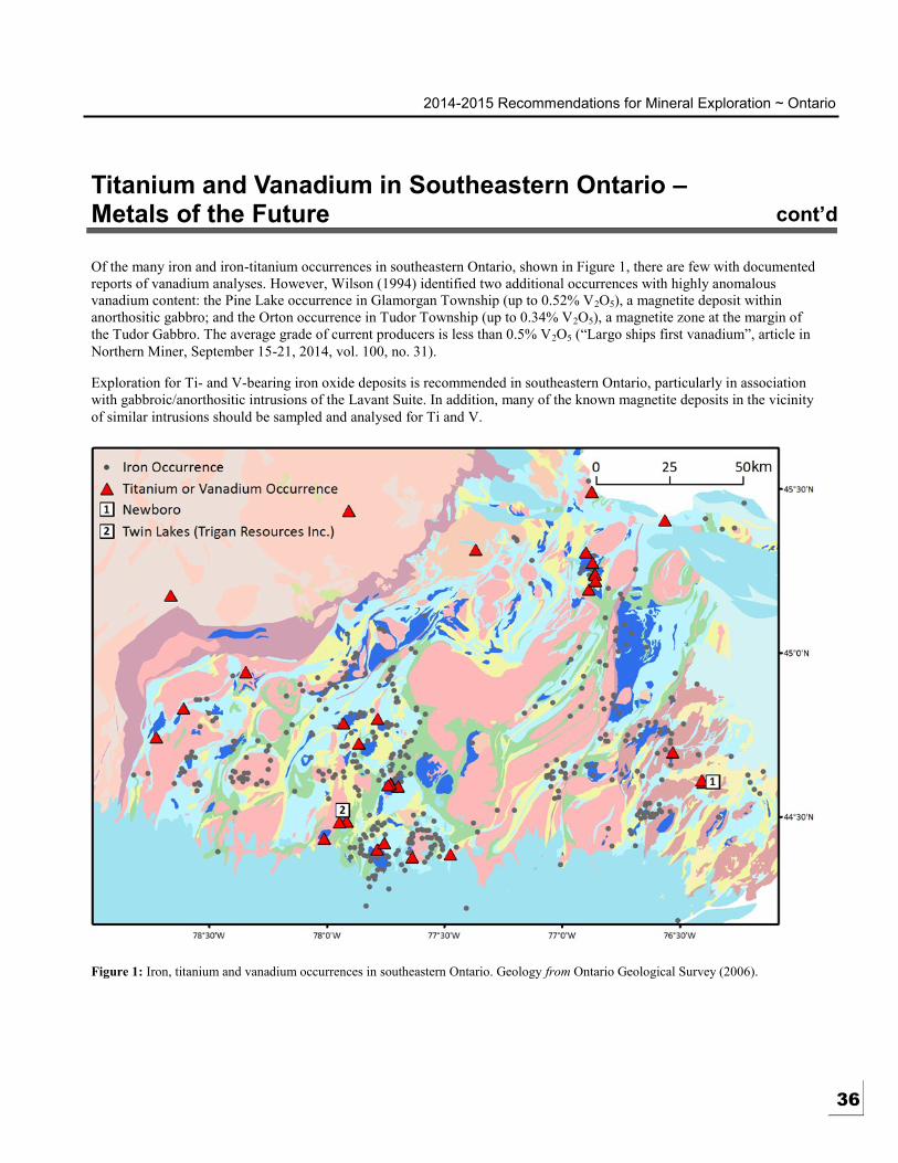
2014-2015 Recommendations for Mineral Exploration ~ Ontario
Titanium and Vanadium in Southeastern Ontario –Metals of the Future cont’d
Of the many iron and iron-titanium occurrences in southeastern Ontario, shown in Figure 1, there are few with documented
reports of vanadium analyses. However, Wilson (1994) identified two additional occurrences with highly anomalous
vanadium content: the Pine Lake occurrence in Glamorgan Township (up to 0.52% V2O5), a magnetite deposit within
anorthositic gabbro; and the Orton occurrence in Tudor Township (up to 0.34% V 2O5), a magnetite zone at the margin of
the Tudor Gabbro. The average grade of current producers is less than 0.5% V2O5 (“Largo ships first vanadium”, article in
Northern Miner, September 15-21, 2014, vol. 100, no. 31).
Exploration for Ti- and V-bearing iron oxide deposits is recommended in southeastern Ontario, particularly in association
with gabbroic/anorthositic intrusions of the Lavant Suite. In addition, many of the known magnetite deposits in the vicinity
of similar intrusions should be sampled and analysed for Ti and V.
Figure 1: Iron, titanium and vanadium occurrences in southeastern Ontario. Geology from Ontario Geological Survey (2006).
36

2014-2015 Recommendations for Mineral Exploration ~ Ontario
Titanium and Vanadium in Southeastern Ontario –Metals of the Future cont’d
Carter, T.R. 1984. Metallogeny of the Grenville Province, southeastern Ontario; Ontario Geological Survey, Open File
Report 5515, 422p.
Ontario Geological Survey 2006. 1:250 000 scale bedrock geology of Ontario; Ontario Geological Survey, Miscellaneous
Release—Data 126—Revised.
Robinson, A.H.A. 1922. Titanium; Canada Department of Mines, Mines Branch Report no. 579, 127p.
Rose, E.R. 1969. Geology of titanium and titaniferous deposits of Canada; Geological Survey of Canada, Economic
Geology Report no. 25, 177p.
——— 1973. Geology of vanadium and vanadiferous deposits of Canada; Geological Survey of Canada, Economic
Geology Report no. 27, 130p.
Sangster, P.J., McGuinty, W.J., Papertzian, V.C., Steele, K.G., Lee, C.R., Laidlaw, D.A., Stewart, J.M. and Carter, T.R.
1999. Report of Activities, 1998, Resident Geologist Program, Southern Ontario Regional Resident Geologist Report:
Southeastern and Southwestern Districts, Mines and Minerals Information Centre, and Petroleum Resources Centre;
Ontario Geological Survey, Open File Report 5992, 76p.
Wilson, G.C. 1994. Mafic-ultamafic intrusions, base-metal sulphides, and platinum group element potential of the
Grenville Province in southeastern Ontario; Ontario Geological Survey, Open File Report 5880, 196p.
37

2014-2015 Recommendations for Mineral Exploration ~ Ontario 15
Gold Mineralization in the Marmora-Madoc-Harlowe Area, Southeastern Ontario
HIGHLIGHTS
Ontario’s first gold
mining area (1866). New
deposits were
discovered more than
100 years later
New discoveries contain
more than 10 times the
total past production of
gold in S. Ontario
3 distinct settings for
gold mineralization,
spatially related to a
significant volcanic-
sedimentary contact
Contact: Peter LeBaron
(613) 478-2195 Ph.
Exploration for gold in southeastern Ontario began with the discovery of Ontario’s
first gold mine, the Richardson mine at Eldorado, in August of 1866 and the
subsequent increase in prospecting activity in the area resulted in new discoveries in
the following years. Between 1895 and 1908, 12 gold mines operated, the most
important of which were the Deloro mine producing about 10,000 ounces of gold
from 40,000 tons of ore, and the Cordova mine producting 23,000 ounces of gold
from 120,000 tons of ore. A Provincial Assay Office was opened in the city of
Belleville in 1898 to service the new mining area. The total past production of all
southern Ontario gold mines is about 40,000 ounces.
With the discovery of the rich deposits of gold and silver in northern Ontario in the
early 1900s, the focus of exploration shifted away from southern Ontario. However,
as the price of gold increased to over $800 per ounce in 1980, interest in the old gold
mines of southern Ontario was renewed and a significant amount of exploration was
done throughout the 1980s. That work resulted in two new discoveries in 1985 – the
Mono Gold Mines property near Bannockburn in Madoc Township and the Dingman
deposit near Malone in Marmora Township. Based on diamond drilling to date, the
Mono deposit contains about 135,000 ounces of gold and the Dingman deposit
contains about 360,000 ounces. Both properties have changed ownership several
times and continue to be active projects.
The gold exploration programs of the 1980s on 23 properties are documented in
LeBaron (1991). Since that time, significant exploration has been done on a few of
the prospects and is described in Sangster et al (2014).
Figure 1 shows the geology and gold occurrences of the Marmora-Madoc-Harlowe
area and the general location of the favourable contact between metavolcanics of the
Tudor Formation and overlying metasedimentary rocks of the Dungannon Formation,
in addition to intrusive contacts that host many of the occurrences.
Three distinct styles of gold mineralization can be identified.
1. Intrusive margin
The mines at Cordova and Deloro are quartz vein-type deposits that formed along the
margins of the Cordova gabbro and the Deloro granite. Gold that was present in
rocks near the volcanic-sedimentary contact may have been remobilized and
deposited in fractures associated with shearing and faulting along the edges of the
intrusions. The veins include other minerals typical of lode gold deposits such as
pyrite, chalcopyrite, arsenopyrite, tourmaline, and iron-bearing carbonates.
2. Volcanic-sedimentary contact
The Sophia, Mono and Tudor gold deposits occur in both volcanic and sedimentary
rocks associated with fault and/or fold-related shear zones. These probably represent
a concentration of gold that occurred from a combination of hydrothermal activity
and erosion of the volcanic pile during the final stages of volcanic activity, followed
by remobilization during Grenvillian deformation and deposition into structural traps.
Mineralization appears to be restricted to quartz veins containing various
assemblages of sulphides, arsenopyrite, ankerite and rare native gold.
38

2014-2015 Recommendations for Mineral Exploration ~ Ontario
Gold Mineralization in the Marmora-Madoc-Harlowe Area, Southeastern Ontario …cont’d
3 Flinton Group Unconformity
The Addington and Ore Chimney mines and the Harlowe area occurrences represent concentrations of gold near the base
of the Flinton Group (conglomerates, quartzites and pelitic schists) which unconformably overlie the older metavolcanic
and metasedimentary rocks along the along the northern margin of the Northbrook granodioritic pluton.
A spatial association of gold mineralization with the basal Flinton Group unconformity in Kaladar, Barrie and Kennebec
townships has been recognized by Moore and Morton (1986) and others. The occurrences are hosted by either: 1) mafic
schist of the Ore Chimney Formation, interpreted as a paleoregolith that locally lies at the unconformity between
underlying mafic metavolcanics rocks and overlying conglomerates and quartzites of the Flinton Group. Examples are the
Ore Chimney and Addington deposits to the west of the Harlowe area in Barrie and Kaladar townships, respectively, which
host gold mineralization in quartz veins with tourmaline, pyrite, chalcopyrite, galena and sphalerite; or 2) narrow bands of
dolomitic marble below the unconformity, as at the Dome, Pay Rock and Gold Base occurrences in the Harlowe area,
which host auriferous quartz veins, generally with minor sulphides (pyrite, chalcopyrite, tetrahedrite).
Outlook
Since the late 1980s, sporadic exploration for gold in southeastern Ontario has continued by a few local prospectors. The
current downturn in mineral exploration and difficulties in raising exploration funding by junior mining companies has
resulted in a generally low level of gold exploration activity in southern Ontario in recent years. However, as the
discoveries of the mid-1980s proved, despite over 150 years of prospecting, there is potential for the discovery of new gold
deposits in southeastern Ontario.
Figure 1: Geology and gold occurrences in the Marmora-Madoc-Harlowe area, southeastern Ontario. Geology from Ontario Geological
Survey (2006). 39
2014-2015 Recommendations for Mineral Exploration ~ Ontario
Gold Mineralization in the Marmora-Madoc-Harlowe Area, Southeastern Ontario …cont’d
LeBaron, P.S. 1991. Exploration for gold in southeastern Ontario, 1980-1990; Ontario Geological Survey, Open File
Report 5808, 147p.
Moore, J.M., Jr. and Morton, R.L. 1986. Geology of the Marble Lake area, counties of Frontenac and Lennox and
Addington; Ontario Geological Survey Report 238, 63 p., accompanied by Map 2499, scale 1:31 680.
Ontario Geological Survey 2006. 1:250 000 scale bedrock geology of Ontario; Ontario Geological Survey, Miscellaneous
Release—Data 126—Revised.
Sangster, P.J., LeBaron, P.S., Charbonneau, S.J., Laidlaw, D.A., Debicki, R.L., Wilson, A.C., Halet, S.E., Carter, T.R. and
Fortner, L. 2014. Report of Activities, 2013, Resident Geologist Program, Southern Ontario Regional Resident
Geologist Report: Southeastern Ontario and Southwestern Ontario Districts and Petroleum Resources Operations;
Ontario Geological Survey, Open File Report 6296, 83p.
40