Embed Size (px)
Citation preview
1
RECOMMENDATIONS OF THE COMMISSION ON THE LIMITS OF THE CONTINENTAL SHELF (CLCS) IN REGARD TO THE SUBMISSION MADE BY NEW ZEALAND 19 APRIL 2006
Recommendations prepared by the Subcommission established for the consideration of the Submission
made by New Zealand.
Adopted by the Subcommission on 2 April 2008, and submitted to the Chairman of the Commission on
the Limits of the Continental Shelf for consideration and approval by the Commission.
Adopted by the Commission on 22 August 2008
2
TABLE OF CONTENTS
I. Introduction ........................................................................................................................ 5
II. Examination of the Submission by the Subcommission .................................................... 7
A. Examination of the format and completeness of the Submission .................................. 7
B. Preliminary analysis of the Submission ......................................................................... 7
C. Main scientific and technical examination of the submission........................................ 8
III. General principles on which these recommendations are based .................................... 8
IV. Recommendations .......................................................................................................... 8
A. Northern Region............................................................................................................. 9
1. Geographical region description ................................................................................ 9
2. Notes verbales submitted by other States................................................................. 10
3. Submarine prolongation of landmass and entitlement to the continental shelf beyond
200 M ............................................................................................................................... 11
4. Recommendations regarding the determination of foot of the continental slope .... 13
4.1 Considerations.................................................................................................. 13
4.2 Recommendations ............................................................................................ 13
5. Recommendations regarding the establishment of the outer edge of the continental
margin............................................................................................................................... 14
5.1 The application of the 60 M distance criterion ................................................ 14
6. Recommendations regarding the establishment of the outer limits of the continental
shelf .................................................................................................................................. 14
6.1 The application of constraint criteria ............................................................... 14
6.1.1 The construction of the distance criterion line ......................................... 14
6.1.2 The construction of the depth criterion line ............................................. 14
6.1.3 Consideration and classification of submarine highs............................... 15
6.1.4 The application of the combination of the distance and the depth constraint
criteria .................................................................................................................. 15
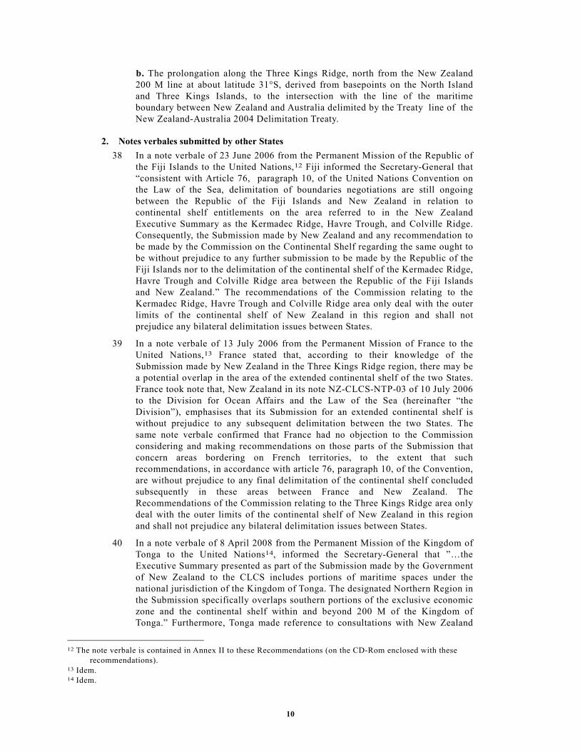
6.2 The outer limits of the continental shelf........................................................... 15
6.3 Recommendations ............................................................................................ 15
B. Eastern Region ............................................................................................................. 17
1. Geographical region description .............................................................................. 17
2. Notes verbales submitted by other States................................................................. 17
3. Submarine prolongation of landmass and entitlement to the continental shelf beyond
200 M ............................................................................................................................... 17
4. Recommendations regarding the determination of foot of the continental slope .... 18
4.1 Considerations.................................................................................................. 19
4.2 Recommendations ............................................................................................ 20
5. Recommendations regarding the establishment of the outer edge of the continental
margin............................................................................................................................... 20
5.1 The application of the 60 M distance criterion ................................................ 20
5.2 The application of the sediment thickness criterion......................................... 20
5.3 Recommendations ............................................................................................ 20
6. Recommendations regarding the establishment of the outer limits of the continental
shelf .................................................................................................................................. 20
6.1 The application of constraint criteria ............................................................... 21
6.1.1 The construction of the distance criterion line ......................................... 21

3
6.1.2 The construction of the depth criterion line ............................................. 21
6.1.3 Consideration and classification of submarine highs............................... 21
6.1.4 The application of the combination of the distance and the depth constraint
criteria .................................................................................................................. 21
6.2 The outer limits of the continental shelf........................................................... 22
6.3 Recommendations ............................................................................................ 22
C. Southern Region........................................................................................................... 24
1. Geographical region description .............................................................................. 24
2. Notes verbales submitted by other States................................................................. 24
3. Submarine prolongation of landmass and entitlement to the continental shelf beyond
200 M ............................................................................................................................... 24
4. Recommendations regarding the determination of foot of the continental slope .... 25
4.1 Considerations.................................................................................................. 25
4.2 Recommendations ............................................................................................ 26
5. Recommendations regarding the establishment of the outer edge of the continental
margin............................................................................................................................... 26
5.1 The application of the 60 M distance criterion ................................................ 26
6. Recommendations regarding the establishment of the outer limits of the continental
shelf .................................................................................................................................. 26
6.1 The application of constraint criteria ............................................................... 26
6.1.1 The construction of the distance criterion line ......................................... 27
6.1.2 The application of the of the constraint criteria ....................................... 27
6.2 The outer limits of the continental shelf........................................................... 27
6.3 Recommendations ............................................................................................ 27
D. Western Region ........................................................................................................... 28
1. Geographical region description .............................................................................. 28
2. Notes verbales submitted by other States................................................................. 29
3. Submarine prolongation of landmass and entitlement to the continental shelf beyond
200 M ............................................................................................................................... 29
4. Recommendations regarding the determination of foot of the continental slope .... 31
4.1 Considerations.................................................................................................. 31
4.2 Recommendations ............................................................................................ 31
5. Recommendations regarding the establishment of the outer edge of the continental
margin............................................................................................................................... 31
5.1 The application of the 60 M distance criterion ................................................ 32
5.2 The application of the sediment thickness criterion......................................... 32
5.3 Recommendations ............................................................................................ 32
6. Recommendations regarding the establishment of the outer limits of the continental
shelf .................................................................................................................................. 32
6.1 The application of constraint criteria ............................................................... 32
6.1.1 The construction of the distance criterion line ......................................... 33
6.1.2 The construction of the depth criterion line ............................................. 33
6.1.3 Consideration and classification of submarine highs............................... 33
6.1.4 The application of the combination of the distance and the depth constraint
criteria .................................................................................................................. 33
6.2 The outer limits of the continental shelf........................................................... 33
6.3 Recommendations ............................................................................................ 33

4
Summary .................................................................................................................................. 35
5
INTRODUCTION
1 New Zealand transmitted a Submission to the Commission on the Limits of the
Continental Shelf (hereinafter “the Commission”), through the Secretary-General
of the United Nations (hereinafter “the Secretary-General”), on
19 April 2006 by note verbale NZ-CLCS-TPN-01. This Submission was made
pursuant to the provisions contained in article 76, paragraph 8, and article 4 of
Annex II to the 1982 United Nations Convention on the Law of the Sea
(hereinafter “the Convention”). References to article 76 and paragraphs therein
shall be understood to mean article 76 of the Convention. The Submission
contained: Part I - Executive Summary; Part II – Main Body which is the
analytical and descriptive part and Part III- Scientific and Technical Data.1
2 On 19 April 2006 New Zealand also transmitted note verbale NZ-CLCS-TPN-02
relating to the part of the Submission concerning Antarctica, indicating that “New
Zealand makes a partial submission […] not including areas of continental shelf
appurtenant to Antarctica, for which a submission may be made later”.2
3 On 21 April 2006 the Secretary-General gave due publicity to the Executive
Summary of the Submission in accordance with rule 50 of the rules of procedure
of the Commission on the Limits of the Continental Shelf (CLCS/40) (hereinafter
"the rules of procedure") through Continental Shelf Notification
CLCS.05.2006.LOS.3 The consideration of the Submission made by New Zealand
was included in the agenda of the eighteenth session of the Commission, in
conformity with rule 51 of the rules of procedure.
4 On 31 May 2006 New Zealand integrated the Submission providing missing
copies of certain documents which had been originally provided either only in
hard copy or only in electronic copy. On the same date, New Zealand also
submitted corrigenda to the Executive Summary as well as to certain parts of the
Main Body of the Submission.4 On 31 July 2006 New Zealand provided a new
corrigendum replacing the hard copy of the corrected coordinates for the fixed
points of the outer limits of the extended continental shelf for the Northern
Region.
5 On 7 August 2006 the Secretary-General gave due publicity to the corrigendum to
the Executive Summary through Continental Shelf Notification
CLCS.05.2006.Corr.1.LOS.5
6 The presentation on the Submission of New Zealand was made on
21 August 2006, during the first part of the plenary of the eighteenth session, by
Gerard van Bohemen, International Legal Adviser and Director of the Legal
Division of the Ministry of Foreign Affairs and Trade. The delegation of New
Zealand also included a number of scientific, technical and legal advisers. In
addition to elaborating on substantive points of the Submission, he indicated that
no current members of the Commission had assisted New Zealand in the
1 The list of the materials included in the Submission is contained in Annex I to these Recommendations (on the CD-Rom
enclosed with these recommendations). 2 NZ-CLCS-TPN-02, available in the CD-Rom enclosed with these recommendations. 3 CLCS.05.2006.LOS is available in the directory Annex_IV\DOALOS_Letters_NVs of the CD-Rom enclosed with these
recommendations. 4 The Corrigenda is included in the directory Annex_IV\Corrigenda_to_Submission\NZ-CLCS-CD_DVD-01-Add.2 of the
CD-Rom enclosed with these recommendations. 5 CLCS.05.2006.Corr.1.LOS is available in the directory Annex_IV\DOALOS_Letters_NVs of the CD-Rom enclosed with
these recommendations.

6
preparation of the Submission. Following the presentation, the representatives of
New Zealand responded to questions asked by the members of the Commission.
7 The Commission addressed the modalities for the consideration of the
Submission. It decided that, as provided for in article 5 of Annex II to the
Convention and in rule 42 of the rules of procedure of the Commission
(CLCS/40), the Submission of New Zealand would be addressed through the
establishment of a subcommission.
8 The following members of the Commission were elected as members of the
Subcommission for consideration of the Submission made by New Zealand:
Alexandre Tagore Medeiros de Albuquerque, Harald Brekke, Peter F. Croker,
Fernando Manuel Maia Pimentel, Kensaku Tamaki, Naresh Kumar Thakur and
Yao Ubuènalè Woeledji. The Subcommission elected Mr. Brekke as its Chairman,
and Mr. Albuquerque and Mr. Tamaki as its Vice-Chairmen.
9 The Commission took note of the above-mentioned Note Verbale NZ-CLCS-TPN-
02 from New Zealand on the issue of Antarctica. The Commission also took note
of Note Verbale SC/06/459, dated 28 June 2006, from the Permanent Mission of
Japan to the United Nations addressed to the Secretary-General in connection
with this issue. In this context, the Commission also took note of the contents of
Note Verbale DJZ-IR 178/2006 subsequently received from the Permanent
Mission of the Kingdom of the Netherlands to the United Nations on
19 December 2006.6
10 The Commission took note of the contents of the following Notes Verbales
concerning the existence of ongoing negotiations on maritime delimitation and
overlapping claims related to the Submission: Note Verbale No. NY 6/10/8/5 from
the Fiji Mission to the United Nations dated 23 June 2006; Note Verbale NZ-
CLCS-TPN-03 from the Permanent Mission of New Zealand to the United
Nations dated 10 July 2006; Note Verbale 422 from the Permanent Mission of
France to the United Nations dated 13 July 2006.7 The Commission decided to
refer the matter to the Subcommission appointed to examine the Submission made
by New Zealand.
11 The Subcommission met immediately to conduct its preliminary examination of
the Submission and the data accompanying it. It was decided that given the
volume and nature of the data contained in the Submission, the Subcommission
would require additional time for the consideration of the Submission as well as
intersessional meetings.
12 The Subcommission also prepared a set of procedures for meetings with the
Delegation. During its preliminary examination of the Submission, the
Subcommission held two meetings with the delegation of New Zealand, to ask
questions and receive further clarifications.
13 At the twentieth session, in the light of the partial change in membership of the
Commission, which resulted from the elections of members of the Commission
held at the seventeenth Meeting of States Parties, it became necessary to fill
certain vacancies in the Subcommission. Sivaramakrishnan Rajan and Michael
Anselme Marc Rosette were appointed to replace Naresh Kumar Thakur and Yao
Ubuènalè Woeledji.
6 The notes verbales from Japan and the Netherlands are available in the directory Annex_II of the CD-Rom enclosed with
these Recommendations. 7 The note verbale from New Zealand is available in the directory Annex_IV\Delegation_Letters and the notes verbales
from Fiji and France are available in the directory Annex_II of the CD-Rom enclosed with these Recommendations.

7
14 The Subcommission carried out its examination of the Submission during the
following sessions: nineteenth, twentieth, resumed twentieth and twenty-first.
During these sessions, as well as intersessionally the Subcommission held 11
meetings with the New Zealand Delegation in which it presented 4 preliminary
considerations and posed 9 questions 8 in writing. In response, the new Zealand
Delegation provided to the Subcommission 11 documents (with enclosures),9 12
PowerPoint presentations10 as well as 16 CD/DVD-Roms.11 In addition, the
Commission held two meetings with the Delegation.
15 The Commission makes these Recommendations to New Zealand in fulfilment of
its mandate established in article 76, paragraph 8, and articles 3 and 5 of Annex II
to the Convention and in accordance with article 76.
16 The Commission prepared these Recommendations taking into consideration the
internal procedures and the methodology outlined in article 5 of Annex II to the
Convention, and in the following official documents of the Commission: rules of
procedure; The Scientific and Technical Guidelines (CLCS/11 and
CLCS/11/Add.1 – hereinafter “the Guidelines”).
17 The Commission makes its Recommendations recognizing the fact that the outer
limits of the continental shelf as established by a coastal State on the basis of its
Recommendations shall be final and binding according to article 76, paragraph 8.
I. EXAMINATION OF THE SUBMISSION BY THE SUBCOMMISSION
A. Examination of the format and completeness of the Submission
18 Pursuant to Annex III, section III of the rules of procedure, the Subcommission
examined and verified the format and completeness of the Submission.
B. Preliminary analysis of the Submission
19 Pursuant to paragraph 5 of Annex III to the rules of procedure, the
Subcommission undertook a preliminary analysis of the Submission, in
accordance with article 76 and the Guidelines and concluded as follows:
20 The outer edge of the continental margin as defined by both the 1 per cent
sediment thickness and foot of slope plus 60 M formulae lies beyond 200 M, and
therefore the test of appurtenance was satisfied by New Zealand;
21 The outer limit of New Zealand’s extended continental shelf consists of a
combination of a 1 per cent sediment thickness point and foot of slope plus 60 M
points;
22 The construction of the outer limits contains straight lines not longer than 60 M;
23 The advice of an expert in geodesy from the Commission should be sought;
24 Additional time would be required to review all data and to prepare the
recommendations to the Commission during the following sessions of the
Commission. An estimation of the time required would be reported to the
Commission at a later stage.
8 See the directory Annex_IV\Subcommission_Questions_to_Delegation in the CD-Rom enclosed with these
Recommendations. 9 See the directory Annex_IV\Delegation_Documents in the CD-Rom enclosed with these Recommendations. 10 See the directory Annex_IV\Delegation_Presentations in the CD-Rom enclosed with these Recommendations. 11 See CD-Rom enclosed with these Recommendations.

8
C. Main scientific and technical examination of the Submission
25 The Subcommission examined the Submission through the following processes:
26 Detailed examination of the data and information supporting every of the foot of
the continental slope (hereinafter “FOS”) point, selected for the delineation of the
proposed outer limits;
27 Raising questions on points for clarification for response by the delegation of
New Zealand, and continuing to examine parts of the Submission and any further
clarifications by the Delegation;
28 Requesting technical support from the GIS staff of DOALOS; and
29 Preliminary conclusions on all regions were presented to the New Zealand
Delegation.
30 The processes described above were carried out for the four regions described in
the sections below.
II. GENERAL PRINCIPLES ON WHICH THESE RECOMMENDATIONS ARE BASED
31 It is hereby reiterated that the examination of New Zealand’s Submission by the
Commission have been made in accordance with the mandate contained in article
76 and Annex II of the Convention. The examination of the Submission and the
Recommendations of the Commission are based on the scientific and technical
data provided by New Zealand in the application of article 76. The
Recommendations of the Commission only deal with issues related to article 76
and Annex II to the Convention and are without prejudice to matters relating to
delimitation between States or application of other parts of the Convention or any
other treaties.
III. RECOMMENDATIONS
32 New Zealand’s Submission has been divided into four regions (Fig.1 ):
33 Northern (which covers the Three Kings Ridge, Colville Ridge, and northern
Kermadec Ridge and Kermadec Trench);
34 Eastern (which covers the southern Kermadec Ridge and Kermadec Trench,
Hikurangi Plateau, Chatham Rise, Bounty Trough, and northern Campbell Plateau);
35 Southern (which covers the southern margin of the Campbell Plateau); and
36 Western (which covers the southern Norfolk Ridge System, New Caledonia Basin,
Challenger Plateau, Lord Howe Rise, and the Macquarie Ridge Complex).

9
Fig. 1. Regional subdivision and main geomorphological elements of the New Zealand continental
margin
A. Northern Region
1. Geographical region description
37 The Northern Region covers the continental margin north of New Zealand, from
the Kermadec Trench in the east to the Three Kings Ridge in the west. The region
comprises two areas, which together are part of the same continental margin (Fig
1):
a. The prolongation along the Kermadec and Colville ridges, north of the line 200
nautical miles (hereinafter “M”) from the New Zealand territorial sea baseline
(derived from basepoints on Raoul Island) to the intersection with the lines 200 M
from the territorial sea baselines of Fiji and Tonga;
10
b. The prolongation along the Three Kings Ridge, north from the New Zealand
200 M line at about latitude 31°S, derived from basepoints on the North Island
and Three Kings Islands, to the intersection with the line of the maritime
boundary between New Zealand and Australia delimited by the Treaty line of the
New Zealand-Australia 2004 Delimitation Treaty.
2. Notes verbales submitted by other States
38 In a note verbale of 23 June 2006 from the Permanent Mission of the Republic of
the Fiji Islands to the United Nations,12 Fiji informed the Secretary-General that
“consistent with Article 76, paragraph 10, of the United Nations Convention on
the Law of the Sea, delimitation of boundaries negotiations are still ongoing
between the Republic of the Fiji Islands and New Zealand in relation to
continental shelf entitlements on the area referred to in the New Zealand
Executive Summary as the Kermadec Ridge, Havre Trough, and Colville Ridge.
Consequently, the Submission made by New Zealand and any recommendation to
be made by the Commission on the Continental Shelf regarding the same ought to
be without prejudice to any further submission to be made by the Republic of the
Fiji Islands nor to the delimitation of the continental shelf of the Kermadec Ridge,
Havre Trough and Colville Ridge area between the Republic of the Fiji Islands
and New Zealand.” The recommendations of the Commission relating to the
Kermadec Ridge, Havre Trough and Colville Ridge area only deal with the outer
limits of the continental shelf of New Zealand in this region and shall not
prejudice any bilateral delimitation issues between States.
39 In a note verbale of 13 July 2006 from the Permanent Mission of France to the
United Nations,13 France stated that, according to their knowledge of the
Submission made by New Zealand in the Three Kings Ridge region, there may be
a potential overlap in the area of the extended continental shelf of the two States.
France took note that, New Zealand in its note NZ-CLCS-NTP-03 of 10 July 2006
to the Division for Ocean Affairs and the Law of the Sea (hereinafter “the
Division”), emphasises that its Submission for an extended continental shelf is
without prejudice to any subsequent delimitation between the two States. The
same note verbale confirmed that France had no objection to the Commission
considering and making recommendations on those parts of the Submission that
concern areas bordering on French territories, to the extent that such
recommendations, in accordance with article 76, paragraph 10, of the Convention,
are without prejudice to any final delimitation of the continental shelf concluded
subsequently in these areas between France and New Zealand. The
Recommendations of the Commission relating to the Three Kings Ridge area only
deal with the outer limits of the continental shelf of New Zealand in this region
and shall not prejudice any bilateral delimitation issues between States.
40 In a note verbale of 8 April 2008 from the Permanent Mission of the Kingdom of
Tonga to the United Nations14, informed the Secretary-General that ”…the
Executive Summary presented as part of the Submission made by the Government
of New Zealand to the CLCS includes portions of maritime spaces under the
national jurisdiction of the Kingdom of Tonga. The designated Northern Region in
the Submission specifically overlaps southern portions of the exclusive economic
zone and the continental shelf within and beyond 200 M of the Kingdom of
Tonga.” Furthermore, Tonga made reference to consultations with New Zealand
12 The note verbale is contained in Annex II to these Recommendations (on the CD-Rom enclosed with these
recommendations). 13 Idem. 14 Idem.
11
and stated that “... the Government of the Kingdom of Tonga does not wish to
jeopardize or to hamper in any way the consideration by the CLCS of the
Submission made by New Zealand in the Northern Region. The Kingdom of
Tonga takes this action also fully aware of the fact that the position of the
Government of New Zealand is consistent with its interpretation of article 76,
paragraph 10, in the sense that notwithstanding the outcome of the
Recommendation made by the CLCS and the outer limit determined by the
Government of New Zealand on those Recommendations, the delimitation of the
exclusive economic zone and the continental shelf shall be effected by agreement
on the basis of international law, as referred to in Article 38 of the Statute of the
international Court of Justice, in order to achieve an equitable solution.”
41 In a note verbale of 31 July 2008, the Permanent Mission of New Zealand to the
United Nations15 stated: “The Permanent Mission wishes further to reaffirm that,
consistent with article 76, paragraph 10, of the Convention, the New Zealand
submission has been made without prejudice to the eventual delimitation of
boundaries between New Zealand and Tonga and without prejudice to Tonga’s
right to make its own submission to the Commission on the Limits of the
Continental Shelf pursuant to article 76, paragraph 8, of the Convention. The
Permanent Mission accordingly welcomes Tonga’s confirmation that it has no
objection to the Commission considering and making recommendations on the
New Zealand submission on that basis.”
42 It is reiterated, in relation to the above notes verbales from Tonga and New
Zealand, that the recommendations of the Commission relating to the Kermadec
Ridge, Havre Trough and Colville Ridge area only deal with the outer limits of
the continental shelf of New Zealand in this region and shall not prejudice any
bilateral delimitation issues between States.
3. Submarine prolongation of landmass and entitlement to the continental shelf beyond 200 M
43 The outer edge of the continental margin, as generated from the foot of the
continental slope of the Northern Region by applying the provisions of article 76,
paragraph 4, extends beyond the 200 M limits of New Zealand. On this basis, the
Commission recognises the legal entitlement of New Zealand to establish
continental shelf beyond its 200 M limits in this region (Figure. A.1).
15 Idem.

12
Figure A.1. Overview of the FOS points and the associated formula points that are the basis for
demonstrating the submerged prolongation of the landmass of New Zealand and establishing the
outer edge of its continental margin in the Northern Region. White line (stippled) is the 200 M
line from the territorial sea baseline of New Zealand, Red circles and squares are critical and
relevant FOS points, red line is arc of Hedberg points, purple circles are Gardiner points.
Three Kings Ridge
Kermadec Ridge
Colville Ridge
Fantail Terrace

13
4. Recommendations regarding the determination of foot of the continental slope
44 The foot of the continental slope should be established in accordance with article
76, paragraph 4(b).
4.1 Considerations
45 FOS points that generate formula points beyond 200 M in the Northern Region
are found along the eastern and western flanks of the Kermadec and Colville
Ridge pair on the eastern side of South Fiji Basin, and along the eastern flank of
the Three Kings Ridge on the western.
46 The Kermadec and Colville Ridges form a set of coalesced ridges with the
Kermadec Ridge facing the Pacific Ocean to the east and the Colville Ridge
facing the South Fiji Basin to the west. The Kermadec Trough is the oceanic
subduction zone along the eastern flank of the Kermadec Ridge. The eastern
continental slope of the Kermadec Ridge is steep and the base of the slope, being
the base of the subduction trough, is readily identified on a morphological basis.
Accordingly, the eastern flank of the Kermadec Ridge may be readily delineated
by its foot of the continental slope envelope and the Commission agrees with the
way the foot of the continental slope is established by New Zealand in this area.
47 The location of the base of the continental slope towards the South Fiji Basin, i.e.
the transition from the slope of the Colville to the deep ocean floor of the South
Fiji Basin is generally easily identified on a morphological basis. Subcommission
agreed in general with the way the foot of the continental slope is established by
New Zealand in this area, except for the FOS points TKR-398, TKR-357, and
TKR-110. These FOS points seemed to be established on the basis of features that
are morphologically detached from the continental slope. The Subcommission
conveyed its view to New Zealand. In its response contained in NZ-CLCS-DOC-
08 New Zealand reported that the three points TKR-398, TKR -357, and TKR-110
should be deleted and replaced by the already existing points TKR-293, TKR-188
and TKR-328, respectively. They also reported that, as a consequence, point TKR
399 should also be deleted.
48 The Three Kings Ridge is an ancient island arc ridge extending northward from
the North Island between the South Fiji Basin to the east and the Norfolk Basin to
west. The northern end of the Three Kings ridge is dominated by the deeper
Fantail Terrace. The location of the base of the continental slope, i.e. the
transition from the slope to the deep ocean floor of the South Fiji Basin is
identified on a morphological basis, recognising that the Fantail Terrace is an
integral part of the Three King Ridge system. Accordingly, the eastern flank of the
Three King Ridge may be readily delineated by its foot of the continental slope
envelope and the Commission agrees with the way the foot of the continental
slope is established by New Zealand in this area. The western flank is on the
Australian side of the treaty line and is not dealt with in the Submission.
4.2 Recommendations
49 Based on its consideration of the technical and scientific documentation contained
in the Submission of 19 April 2006 and the information provided in document
NZ-CLCS-DOC-08, the Commission concludes that, in the Northern Region, the
FOS points listed in Table 1.A, Annex III, fulfil the criteria in accordance with
article 76 and Chapter 5 of the Guidelines. The Commission recommends that
these FOS points should form the basis for the establishment of the outer edge of
the continental margin of New Zealand, for the purposes of the Convention, in the
Northern Region.
14
5. Recommendations regarding the establishment of the outer edge of the continental margin
50 The outer edge of the continental margin of New Zealand in the Northern Region
should, for the purposes of the Convention, be established in accordance with
article 76, paragraphs 4 and 7.
5.1 The application of the 60 M distance criterion
51 In the Northern Region, the outer edge of the continental margin is based on
points on arcs constructed at 60 M distance from the FOS points (Table 1.A,
Annex III) in accordance with the provision contained in article 76, paragraph
4(a)(ii) (Fig. A.1). The Commission agrees with the way these points have been
established by New Zealand and recommends that they are used as the basis for
establishing the outer limit of the continental shelf in this region.
6. Recommendations regarding the establishment of the outer limits of the continental shelf
52 The outer limits of the continental shelf should be based on the established outer
edge of the continental margin and taking into consideration the constraints
provided in article 76, paragraphs 2, 5 and 6.
6.1 The application of constraint criteria
53 The outer limits of the continental shelf cannot extend beyond the constraints as
per the provisions of article 76, paragraphs 5 and 6. Accordingly, the provision
that the outer limits of the continental shelf may not exceed 350 M distance from
the territorial sea baselines (the distance criterion constraint) may be applied in all
cases. Alternatively, the provision that the outer limits of the continental shelf
may not exceed 100 M distance from the 2500 meters isobath (the depth criterion
constraint) may be applied for those parts of the continental margin that are
classified as natural components of that margin.
54 The application of the constraint criteria involves, firstly, the construction of the
constraint line based on the distance criterion and the constraint line based on the
depth criterion. Secondly, it involves the combination of these two constraint lines
to establish a final combined constraint line to be applied in accordance with the
provisions contained in article 76, paragraphs 5 and 6.
55 For the outer limits of the continental shelf in the Northern Region, New Zealand
has invoked a combination of the distance criterion constraint and the depth
criterion constraint. In the view of the Commission, the consideration of the
application of depth criterion constraint involves the examination of whether the
relevant seafloor highs in the Northern Region may be considered natural
components of the continental margin. For the remaining parts of the outer limits
the consideration involves an examination of the construction of the distance
criterion constraint line.
6.1.1 The construction of the distance criterion line
56 The distance criterion constraint line submitted by New Zealand is constructed by
arcs at 350 M distance from the territorial sea baselines included in the
Submission. The Commission agrees with the procedure and methods applied by
New Zealand in the construction of this constraint line.
6.1.2 The construction of the depth criterion line
57 The 2500 meters isobaths on which the depth criterion constraint line is based are
located along the Colville Ridge and the Three Kings Ridge including the Fantail
Terrace. Since all these isobaths are landward of the foot of the continental slope,
15
they conform to the general outline of the continental margin as defined for the
purposes of the Convention. Therefore, the application of these isobaths as basis
for the depth criterion constraint is in accordance with the Convention and with
paragraphs 4.4.1 and 4.4.2 of the Guidelines and the Commission recommends
that the depth criterion constraint line is constructed as submitted by New
Zealand.
6.1.3 Consideration and classification of submarine highs
58 Based on the literature and the evidence in the Submission, the Commission
agrees that the Kermadec and Colville Ridge system, as well as the Three Kings
Ridge with the Fantail Terrace are natural components of the continental margin
of the North Island of New Zealand and may be classified as submarine elevations
in the sense of article 76, paragraph 6. Hence, the depth constraint line originating
from these elevations may be applied as submitted by New Zealand.
6.1.4 The application of the combination of the distance and the depth constraint criteria
59 In the Northern Region, New Zealand has applied a constraint line based on the
combination of lines constructed by the application of both the distance and depth
criteria contained in article 76, paragraph 5 (see sections 6.1.1 and 6.1.2 above).
The Commission agrees with the way this combined constraint line has been
applied.
6.2 The outer limits of the continental shelf
60 The outer limits of the continental shelf in the Northern Region as submitted by
New Zealand in its Submission of 19 April 2006 and revised in NZ-CLCS-DOC-
08 consist of fixed points connected by straight lines not exceeding 60 M in
length (Fig. A.2). The fixed points are listed in Table 2, Annex III as submitted on
27 March 2008. The fixed points are formula points established by the provisions
contained in article 76, paragraph 4(a) or points on the constraint line where the
outer edge of the continental margin extends beyond the constraints. One point,
N001 is located on the 200 M line of New Zealand; one point, N064 is located on
the 200 M line of the Kingdom of Tonga; one point, N065, is located on the 200
M line of the Republic of the Fiji Islands; and one point, N284, is located on the
treaty line with Australia (Fig. A.2).
6.3 Recommendations
61 The Commission agrees with the determination of the fixed points listed in Table
1.A, Annex III, delineating the outer edge of the continental margin of New
Zealand. However, the Commission does not agree to include the whole of that
part of the South Fiji Basin that is located to the south of points N177 and N178
in Table 2, Annex III as part of the continental shelf of New Zealand. The
Commission recommends that the delineation of the outer limit of the continental
shelf in the South Fiji Basin be conducted in accordance with article 76,
paragraph 7, by straight lines not exceeding 60 M in length, connecting fixed
points, defined by coordinates of latitude and longitude. The establishment of the
final outer limits of the continental shelf of New Zealand in this region may
depend on delimitation between States. The Commission recommends, taking into
consideration article 9 of Annex II, that New Zealand proceeds to establish the
outer limits of the continental shelf in the Northern Region on the basis of the
outer edge of the continental margin recommended in paragraph 50 and in
accordance with article 76, paragraphs 7, 8, 9 and 10.

16
Figure A.2. Final outer limit of the continental shelf in the Northern Region as submitted by New
Zealand as at 27 March 2008. The outer limit fixed points are shown as white circles with black
rims, the continental shelf outer limit line is shown in green, the 350 M constraint line in blue
(stippled), the 2500 m isobath + 100 M constraint in yellow, the New Zealand-Australian
Delimitation Treaty line in orange, and the 200 M lines of New Zealand and neighbouring States
in white.
Three Kings Ridge
Kermadec Ridge
Colville Ridge

17
B. Eastern Region
1. Geographical region description
62 The Eastern Region covers the southern Kermadec Ridge and Kermadec Trench,
Hikurangi Plateau, Chatham Rise, Bounty Trough, and northern Campbell Plateau
(Fig 1).
2. Notes verbales submitted by other States
63 No note verbale relating to the Eastern Region has been submitted by any State.
3. Submarine prolongation of landmass and entitlement to the continental shelf beyond 200 M
64 The outer edge of the continental margin, as generated from the foot of the
continental slope of the Eastern Region by applying the provisions of article 76,
paragraph 4, extends beyond the 200 M limits of New Zealand. On this basis, the
Commission recognises the legal entitlement of New Zealand to establish
continental shelf beyond its 200 M limits in this region (Fig. B.1).

18
Figure B.1. Overview of the FOS points and the associated formula points that are the basis for
demonstrating the submerged prolongation of the landmass of New Zealand and establishing the
outer edge of its continental margin in the Eastern Region. White line (stippled) is the 200 M line
from the territorial sea baseline of New Zealand, Red circles and squares are critical and
relevant FOS points, red line is arc of Hedberg points, purple circles are Gardiner points.
4. Recommendations regarding the determination of foot of the continental slope
65 The foot of the continental slope should be established in accordance with article
76, paragraph 4(b).
Chatham Rise
Hikurangi Plateau
Campbell Plateau
Bounty Trough
KermadecTrench
Kermadec Ridge
Bollons Seamount
Wishbone Ridge
Southern Chatham Terrace

19
4.1 Considerations
66 FOS points that generate formula points beyond 200 M in the Eastern Region are
found along the Hikurangi Plateau, Chataham Rise and north Campbell Plateau
areas. The character of the continental slope varies between these three areas of
the Eastern Region.
67 The Hikurangi Plateau is a northward sloping plateau situated east of the North
Island and north of the Chatham Rise. The location of the base of the continental
slope, i.e. the transition from the slope to the deep ocean floor to the north of the
Hikurangi Plateau is distinct and easily identified on a morphological basis.
Accordingly, the plateau may be readily delineated by its foot of the continental
slope envelope and the Subcommission agreed in general with the way this foot of
the continental slope is established by New Zealand, except in the cases of FOS
points CH-209 at the margin of the Hikurangi Plateau and CH-238 adjacent to the
Wishbone Ridge. CH-209 is placed on the seaward side of a local high and does
not seem to be in the area of the base of the slope, while the CH-238 seemed to be
based on an erroneous spike in the data. The Subcommission conveyed its view to
New Zealand. In its response contained in NZ-CLCS-DOC-05 of 15 December
2006, New Zealand reported that it had found data problems also with point CH-
99, and that the three points CH-209, CH-238 and CH-99 should be deleted.
Points CH-238 and CH-99 were replaced by already existing points CH-162 and
CH-218.
68 The eastern end of the Chatham Rise is dominated by the Weta Seamount,
separated from the rise to the west by a saddle area. The location of the base of
the continental slope of the Weta Seamount and other seamounts in the area is
distinct and easily identified on a morphological basis. Accordingly, the seamount
area may be readily delineated by its foot of the continental slope envelope and
the Subcommission agreed in general with the way this foot of the continental
slope is established by New Zealand, except in the cases of FOS point CH-262
which seemed to be established on a feature not attached to the adjacent
seamount.
69 The Southeast Chatham Terrace is situated along the south-eastern flank of the
Chatham Rise, and defined in the Submission as a 100-200 km wide area at 4000
– 4800 m depth, separating the Chatham Rise main slope from abyssal water
depths (i.e. >5000 m). New Zealand argues that the Southeast Chatham Terrace is
part of the continental slope so that the FOS points in this area should be located
along the seaward side of the terrace. The terrace is generally low lying with an
outer slope of 300 - 1000 meters drop in elevation. In a series of exchanges of
communications, the Subcommission wanted to satisfy itself that the areas of the
relevant FOS points could be justified to represent the base of the continental
slope by the bathymetric and geo-scientific data provided. Based on the
Submission and the further information contained in documents NZ-CLCS-DOC-
05, NZ-CLCS-DOC-07, NZ-CLCS-DOC-08 and NZ-CLCS-DOC-09, the
Subcommission agreed with New Zealand that FOS points CH-80, -160, -247, -
251, -262 and CH_G-3 should be deleted, and that the outer limit in the area
should be established based on points CH-72, -129, -154, -217, -248, -263, -264
and CH-287.
70 The Campbell Plateau is a submarine high that extends about 1000 km south and
900 km east of the South Island. It is separated from the Chatham Rise by the
Bounty Trough. The location of the base of the continental slope of the northern
Campbell Plateau, including the Bollons Seamount, is distinct and easily
identified on a morphological basis. The saddle area between the plateau and the

20
Bollons Seamount is significantly shallower than the surrounding deep seafloor,
and allows the seamount to be included in the foot of the continental slope
envelope. Accordingly, the plateau may be readily delineated by its foot of the
continental slope envelope and the Commission agrees in general with the way
this foot of the continental slope is established by New Zealand.
4.2 Recommendations
71 Based on its consideration of the technical and scientific documentation contained
in the Submission of 19 April 2006 and the information provided in documents
NZ-CLCS-DOC-05, NZ-CLCS-DOC-07, NZ-CLCS-DOC-08 and NZ-CLCS-
DOC-09, the Commission concludes that, in the Eastern Region, the FOS points
listed in Table 1.B, Annex III, fulfil the criteria in accordance with article 76 and
Chapter 5 of the Guidelines. The Commission recommends that these FOS points
should form the basis for the establishment of the outer edge of the continental
margin of New Zealand for the purposes of the Convention in the Eastern
Region.
5. Recommendations regarding the establishment of the outer edge of the continental margin
72 The outer edge of the continental margin of New Zealand in the Eastern Region
should, for the purposes of the Convention, be established in accordance with
article 76, paragraphs 4 and 7.
5.1 The application of the 60 M distance criterion
73 In the Eastern Region, the outer edge of the continental margin is partly based on
points on arcs constructed at 60 M distance from the FOS points (Table 1.B,
Annex III) in accordance with the provision contained in article 76, paragraph
4(a)(ii). The Commission agrees with the way these points have been established
by New Zealand.
5.2 The application of the sediment thickness criterion
74 In the Eastern Region adjacent to the Hikurangi Plateau, New Zealand has
submitted 12 fixed points based on the sediment thickness provision of article 76,
paragraph 4 (a)(i). New Zealand has established these sediment thickness points
based on the seismic lines HKDC-1, -3, -4, -6, HKS-1A, CR3057-8B,
-3, WB1A, WB1E and WB2A. The Commission agrees with the procedure
applied by New Zealand to establish the sediment thickness points based on the
FOS points contained in Table 1.B, Annex III, including the data provided, the
seismic interpretation, the methods of depth conversion, and the distance
calculations.
5.3 Recommendations
75 In the Eastern Region, the outer edge of the continental margin beyond 200 M is
based on the arcs and points described in sections 5.1 and 5.2 above in accordance
with article 76, paragraphs 4(a) and 7 (see Fig. B.1). The Commission
recommends that these arcs and points are used as the basis for establishing the
outer limit of the continental shelf in this region.
6. Recommendations regarding the establishment of the outer limits of the continental shelf
76 The outer limits of the continental shelf should be based on the established outer
edge of the continental margin and taking into consideration the constraints
contained in article 76, paragraphs 2, 5 and 6.
21
6.1 The application of constraint criteria
77 The outer limits of the continental shelf cannot extend beyond the constraints as
per the provisions contained in article 76, paragraphs 5 and 6. Accordingly, the
provision that the outer limits of the continental shelf may not exceed 350 M
distance from the territorial sea baselines (the distance criterion constraint) may
be applied in all cases. Alternatively, the provision that the outer limits of the
continental shelf may not exceed 100 M distance from the 2500 meters isobath
(the depth criterion constraint) may be applied for those parts of the continental
margin that are classified as natural components of that margin.
78 The application of the constraint criteria involves, firstly, the construction of the
constraint line based on the distance criterion and the constraint line based on the
depth criterion. Secondly, it involves the combination of these two constraint lines
to establish a final combined constraint line to be applied in accordance with the
provisions contained in article 76, paragraphs 5 and 6.
79 For the outer limits of the continental shelf in the Eastern Region, New Zealand
has invoked a combination of the distance criterion constraint and the depth
criterion constraint. In the view of the Commission, the consideration of the
application of depth criterion constraint involves the examination of whether the
relevant seafloor highs in the Eastern Region may be considered natural
components of the continental margin. For the remaining parts of the outer limits
the consideration involves an examination of the construction of the distance
criterion constraint line.
6.1.1 The construction of the distance criterion line
80 The distance criterion constraint line submitted by New Zealand is constructed by
arcs at 350 M distance from the territorial sea baselines included in the
Submission. The Commission agrees with the procedure and methods applied by
New Zealand in the construction of this constraint line.
6.1.2 The construction of the depth criterion line
81 The 2500 meters isobath on which the depth criterion constraint line is based are
located along the Wishbone Ridge and the Chatham Bank including the Weta
Seamount area. Since all these isobaths are landward of the foot of the continental
slope, they conform to the general outline of the continental margin as defined for
the purposes of the Convention. Therefore, the application of these isobaths as
basis for the depth criterion constraint is in accordance with the Convention and
with paragraphs 4.4.1 and 4.4.2 of the Guidelines and the Commission
recommends that the depth criterion constraint line is constructed as submitted by
New Zealand.
6.1.3 Consideration and classification of submarine highs
82 Based on the literature and the evidence in the Submission, including the
additional material provided in NZ-CLCS-DOC-05 and NZ-CLCS-DOC-07, the
Commission agrees that the Wishbone Ridge is a natural component of the
continental margin and may be classified as a submarine elevation in the sense of
article 76, paragraph 6. Hence, the depth constraint line originating from the
Wishbone Ridge may be applied as submitted by New Zealand.
6.1.4 The application of the combination of the distance and the depth constraint criteria
83 In the Eastern Region New Zealand has applied a constraint line based on the
combination of lines constructed by the application of both the distance and depth
criteria contained in article 76, paragraph 5 (see sections 6.1.1 and 6.1.2 above).
22
The Commission agrees with the way this combined constraint line has been
applied (Fig. B.2).
6.2 The outer limits of the continental shelf
84 The outer limits of the continental shelf in the Eastern Region as submitted by
New Zealand in its Submission of 19 April 2006 and revised in NZ-CLCS-DOC-
09 of 13 March 2008 consist of fixed points connected by straight lines not
exceeding 60 M in length (Fig. B.2). The fixed points are listed in Table 2, Annex
III, as submitted on 27 March 2008. The fixed points are formula points
established by the provisions contained in article 76, paragraph 4(a), or points on
the constraint line where the outer edge of the continental margin extends beyond
the constraints. Two points E001 and E886 are located on the 200 M limit line
(Fig. B.2).
6.3 Recommendations
85 The Commission agrees with the principles applied in establishing the outer limits
of the continental shelf in the Eastern Region, including the determination of the
fixed formula points listed in Table 2, Annex III, and the construction of the
straight lines connecting those points. The Commission recommends that New
Zealand proceeds to establish the outer limits of the continental shelf in the
Eastern Region accordingly. Further, the Commission also recommends that New
Zealand includes in its continental shelf the seabed and subsoil of the polygon
located beyond 200 M on the Chatham Rise as the natural prolongation of its land
territory.

23
Figure B.2. Final outer limit of the continental shelf in the Eastern Region as submitted by New
Zealand as at 27 March 2008. The outer limit fixed points are shown as white circles with black
rims, the continental shelf outer limit line where based on Hedberg points is shown in green, the
continental shelf outer limit line where based on Gardiner points is shown in purple, the 350 M
constraint line in blue (stippled), the 2500 m isobath + 100 M constraint in yellow, and the 200 M
lines of New Zealand in white.
Chatham Rise
Hikurangi Plateau
Campbell Plateau

24
C. Southern Region
1. Geographical region description
86 The Southern Region covers the southern margin of the Campbell Plateau (Fig.
A.1), from its intersection with the negotiated maritime boundary with Australia in
the west to the intersection with the line 200 M from New Zealand’s territorial sea
baseline at about 177°E longitude (Fig. 1).
2. Notes verbales submitted by other States
87 No note verbale relating to the Southern Region has been submitted by any State.
3. Submarine prolongation of landmass and entitlement to the continental shelf beyond 200 M
88 The outer edge of the continental margin, as generated from the foot of the
continental slope of the Southern Region by applying the provisions of article 76,
paragraph 4, extends beyond the 200 M limits of New Zealand. On this basis, the
Commission recognises the legal entitlement of New Zealand to establish
continental shelf beyond its 200 M limits in this region (Fig. C.1).

25
Figure C.1. Overview of the FOS points and the associated formula points that are the basis for
demonstrating the submerged prolongation of the landmass of New Zealand and establishing the
outer edge of its continental margin in the Southern Region. White line (stippled) is the 200 M
line from the territorial sea baseline of New Zealand, Red circles and squares are critical and
relevant FOS points, red line is arc of Hedberg points, purple circles are Gardiner points.
4. Recommendations regarding the determination of foot of the continental slope
89 The foot of the continental slope should be established in accordance with article
76, paragraph 4(b).
4.1 Considerations
90 The location of the base of the continental slope of the southern Campbell Plateau
is distinct and easily identified on a morphological basis. Accordingly, the plateau
may be readily delineated by its foot of the continental slope envelope and the
Commission agrees in general with the way this foot of the continental slope is
established by New Zealand, except for the FOS points RMC-17, -92, -20, and -
16. The Subcommission was concerned that the bathymetric profiles on which
Campbell Plateau
Macquarie Ridge

26
these points were based, were too short to prove the continuity of this area with
the continental slope. The Subcommission conveyed its view to New Zealand. In
its response contained in NZ-CLCS-DOC-05 of 15 December 2006, New Zealand
provided further data and information. Based on the data provided, the
Subcommission then agreed with the establishment of the FOS points RMC-8, -
17, -92, -20, and -16.
4.2 Recommendations
91 Based on its consideration of the technical and scientific documentation contained
in the Submission of 19 April 2006 and the information provided in documents
NZ-CLCS-DOC-05, the Commission concludes that, in the Southern Region, the
FOS points listed in Table 1.C, Annex III, fulfil the criteria in accordance with
article 76 and Chapter 5 of the Guidelines. The Commission recommends that
these FOS points should form the basis for the establishment of the outer edge of
the continental margin of New Zealand for the purposes of the Convention in the
Southern Region.
5. Recommendations regarding the establishment of the outer edge of the continental margin
92 The outer edge of the continental margin of New Zealand in the Southern Region
should, for the purposes of the Convention, be established in accordance with
article 76, paragraphs 4 and 7.
5.1 The application of the 60 M distance criterion
93 In the Southern Region, the outer edge of the continental margin is based on
points on arcs constructed at 60 M distance from the FOS points (Table 1.C,
Annex III) in accordance with the provision contained in article 76, paragraph
4(a)(ii) (see Fig. C.1). The Commission agrees with the way these points have
been established by New Zealand, and recommends that they are used as the basis
for establishing the outer limit of the continental shelf in this region.
6. Recommendations regarding the establishment of the outer limits of the continental shelf
94 The outer limits of the continental shelf should be based on the established outer
edge of the continental margin and taking into consideration the constraints
contained in article 76, paragraphs 2, 5 and 6.
6.1 The application of constraint criteria
95 The outer limits of the continental shelf cannot extend beyond the constraints as
per the provisions contained in article 76, paragraphs 5 and 6. Accordingly, the
provision that the outer limits of the continental shelf may not exceed 350 M
distance from the territorial sea baselines (the distance criterion constraint) may
be applied in all cases. Alternatively, the provision that the outer limits of the
continental shelf may not exceed 100 M distance from the 2500 meters isobath
(the depth criterion constraint) may be applied for those parts of the continental
margin that are classified as natural components of that margin.
96 The application of the constraint criteria involves, firstly, the construction of the
constraint line based on the distance criterion and the constraint line based on the
depth criterion. Secondly, it involves the combination of these two constraint lines
to establish a final combined constraint line to be applied in accordance with the
provisions contained in article 76, paragraphs 5 and 6.
97 For the outer limits of the continental shelf in the Southern Region, New Zealand
has invoked the distance criterion constraint only.
27
6.1.1 The construction of the distance criterion line
98 The distance criterion constraint line submitted by New Zealand is constructed by
arcs at 350 M distance from the territorial sea baselines included in the
Submission. The Commission agrees with the procedure and methods applied by
New Zealand in the construction of this constraint line.
6.1.2 The application of the of the constraint criteria
99 In the Southern Region New Zealand has applied a constraint line based on the
distance criterion contained in article 76, paragraph 5 (see section 6.1.1 above).
The Commission agrees with the way this constraint line has been applied (Fig.
C.2).
6.2 The outer limits of the continental shelf
100 The outer limits of the continental shelf in the Eastern Region as submitted by
New Zealand in its Submission of 19 April 2006 consist of fixed points connected
by straight lines not exceeding 60 M in length (Fig. C.2). The fixed points are
listed in Table 2, Annex III, as submitted on 27 March 2008. The fixed points are
formula points established by the provisions contained in article 76, paragraph
4(a) or points on the constraint line where the outer edge of the continental
margin extends beyond the constraints. One point, S455, is located on the 200 M
limit line, and one point, S001, is located on the treaty line with Australia (Fig.
C.2).
6.3 Recommendations
101 The Commission agrees with the principles applied in establishing the outer limits
of the continental shelf in the Southern Region, including the determination of the
fixed formula points listed in Table 2, Annex III, and the construction of the
straight lines connecting those points. The Commission recommends that New
Zealand proceeds to establish the outer limits of the continental shelf in the
Southern Region accordingly. Further, the Commission also recommends that
New Zealand includes in its continental shelf the seabed and subsoil of the
polygon located beyond 200 M on the Campbell Plateau as the natural
prolongation of its land territory.

28
Figure C.2. Final outer limit of the continental shelf in the Southern Region as submitted by New
Zealand as at 27 March 2008. The outer limit fixed points are shown as white circles with black
rims, the continental shelf outer limit line is shown in green, the 350 M constraint line in blue
(stippled), the 2500 m isobath + 100 M constraint in yellow, the New Zealand-Australian
Delimitation Treaty line in orange, and the 200 M lines of New Zealand and neighbouring States
in white.
D. Western Region
1. Geographical region description
102 The Western Region covers the southern Norfolk Ridge System, New Caledonia
Basin, Challenger Plateau, Lord Howe Rise, and the Macquarie Ridge Complex and
may be subdivided into the two main areas (Fig. 1):
a. The area along the southwest margin of the Challenger Plateau, Lord Howe
Rise, New Caledonia Basin and the Norfolk Ridge System, from New Zealand’s
200 M line at about 172°E longitude to the New Zealand–Australia 2004
Delimitation Treaty line, and then along this treaty line to the intersection of the
Campbell Plateau
Macquarie Ridge

29
New Zealand and Australian 200 M lines near 166°E longitude.
b. The area along the western margin of the Macquarie Ridge Complex, beyond
the 200 nautical M lines of New Zealand and Australia.
2. Notes verbales submitted by other States
103 No note verbale relating to the Western Region has been submitted by any State.
3. Submarine prolongation of landmass and entitlement to the continental shelf beyond 200 M
104 The outer edge of the continental margin, as generated from the foot of the
continental slope of the Western Region by applying the provisions of article 76,
paragraph 4, extends beyond the 200 M limits of New Zealand. On this basis, the
Commission recognises the legal entitlement of New Zealand to establish
continental shelf beyond its 200 M limits in this region (Fig. D.1).

30
Figure D.1. Overview of the FOS points and the associated formula points that are the basis for
demonstrating the submerged prolongation of the landmass of New Zealand and establishing the
outer edge of its continental margin in the Western Region. White line (stippled) is the 200 M
line from the territorial sea baseline of New Zealand, Red circles and squares are critical and
relevant FOS points, red line is arc of Hedberg points, purple circles are Gardiner points.
Gilbert Seamount
Macquarie Ridge
Challenger Plateau
Lord Howe Rise

31
4. Recommendations regarding the determination of foot of the continental slope
105 The foot of the continental slope should be established in accordance with article
76, paragraph 4(b).
4.1 Considerations
106 FOS points that generate formula points beyond 200 M in the Western Region are
found along the western flanks of the Lord Howe Rise and the Challenger Plateau,
including the Gilbert Seamount, and along the north-western flank of the
Macquarie Ridge.
107 The Lord Howe Rise and the Challenger Plateau form a continuous continental
slope adjacent to the Tasman Basin. The base of this continental slope is in
general distinct and easily identified on a morphological basis, except in the area
of the Gilbert Seamount. Accordingly, the Lord Howe Rise and the Challenger
Plateau may be readily delineated by their foot of the continental slope envelope
outside of the Gilbert Seamount area. In the view of the Subcommission, the
establishment of the base of the continental slope along the flank of the Gilbert
Seamount needed further supportive geological and geophysical data and
information, especially with respect to the Gilbert saddle area. Such data and
information was provided in documents NZ-CLCS-DOC-07, NZ-CLCS-DOC-08,
and NZ-CLCS-DOC-09. After considering this supplementary data and
information, the Subcommission accepted the establishment of the base of the
continental slope along the flank of the Gilbert Seamount as submitted.
Accordingly, the Commission agrees with the way this foot of the continental
slope is established by New Zealand in the whole of this area of the Western
Region.
108 The Macquarie Ridge Complex is a transform ridge system that extends
southwards from the South Island. The base of the continental slope along the
western flank of the Macquarie Ridge Complex is in general distinct and easily
identified on a morphological basis. Accordingly, the western flank may readily
be delineated by its foot of the continental slope envelope and the Commission
agrees with the way the foot of the continental slope is established by New
Zealand, except for the point RM-132. In the view of the Subcommission, the
submarine high at which this point was established cannot be proven to be
morphologically attached to the continental slope based on the data provided. In
its communication NZ-CLCS-DOC-09 of 13 March 2008, New Zealand reported
that the FOS point RM-132 shall be deleted and replaced by the already existing
point RM-285.
4.2 Recommendations
109 Based on its consideration of the technical and scientific documentation contained
in the Submission of 19 April 2006 and the information provided in document
NZ-CLCS-DOC-07, NZ-CLCS-DOC-08 and NZ-CLCS-DOC-09 the Commission
concludes that, in the Western Region, the FOS points listed in Table1.D, Annex
III, fulfil the criteria provided for by article 76 and Chapter 5 of the Guidelines.
The Commission recommends that these FOS points should form the basis for the
establishment of the outer edge of the continental margin of New Zealand for the
purposes of the Convention in the Western Region.
5. Recommendations regarding the establishment of the outer edge of the continental margin
110 The outer edge of the continental margin of New Zealand in the Western Region
should, for the purposes of the Convention, be established in accordance with
article 76, paragraphs 4 and 7.
32
5.1 The application of the 60 M distance criterion
111 In the Western Region, the continental margin is partly based on points on arcs
constructed at 60 M distance from the FOS points (Table 1.D, Annex III) in
accordance with the provision contained in article 76, paragraph 4(a)(ii)
(Fig.D.1). The Commission agrees with the way these points and lines have been
established by New Zealand.
5.2 The application of the sediment thickness criterion
112 In the Western Region adjacent to the Lord Howe Rise and the Challenger
Plateau, New Zealand has submitted 9 fixed points based on the sediment
thickness provision of article 76, paragraph 4 (a)(i) (Fig. D.1). New Zealand has
established these sediment thickness points based on the seismic lines LHR-1, -2,
-5, NZ-A, -J, -K, -L, -M, and TAS-94. The Commission agrees with the procedure
applied by New Zealand to establish the sediment thickness points based on the
FOS points contained in Table 1.D, Annex III, including the data provided, the
seismic interpretation, the methods of depth conversion, and the distance
calculations.
5.3 Recommendations
113 In the Western Region, the outer edge of the continental margin beyond 200 M is
based on the arcs and points described in sections 5.1 and 5.2 above in accordance
with article 76, paragraphs 4(a) and 7 (see Fig. B.1). The Commission
recommends that these arcs and points are used as the basis for establishing the
outer limit of the continental shelf in this region.
6. Recommendations regarding the establishment of the outer limits of the continental shelf
114 The outer limits of the continental shelf should be based on the established outer
edge of the continental margin and taking into consideration the constraints
contained in article 76, paragraphs 2, 5 and 6.
6.1 The application of constraint criteria
115 The outer limits of the continental shelf cannot extend beyond the constraints as
per the provisions contained in article 76, paragraphs 5 and 6. Accordingly, the
provision that the outer limits of the continental shelf may not exceed 350 M
distance from the territorial sea baselines (the distance criterion constraint) may
be applied in all cases. Alternatively, the provision that the outer limits of the
continental shelf may not exceed 100 M distance from the 2500 meters isobath
(the depth criterion constraint) may be applied for those parts of the continental
margin that are classified as natural components of that margin.
116 The application of the constraint criteria involves, firstly, the construction of the
constraint line based on the distance criterion and the constraint line based on the
depth criterion. Secondly, it involves the combination of these two constraint lines
to establish a final combined constraint line to be applied in accordance with the
provisions contained in article 76, paragraphs 5 and 6.
117 For the outer limits of the continental shelf in the Western Region, New Zealand
has invoked a combination of the distance criterion constraint and the depth
criterion constraint. In the view of the Commission, the consideration of the
application of depth criterion constraint involves the examination of whether the
relevant seafloor highs in the Western Region may be considered natural
components of the continental margin. For the remaining parts of the outer limits
the consideration involves an examination of the construction of the distance
criterion constraint line.

33
6.1.1 The construction of the distance criterion line
118 The distance criterion constraint line submitted by New Zealand is constructed by
arcs at 350 M distance from the territorial sea baselines included in the
Submission. The Commission agrees with the procedure and methods applied by
New Zealand in the construction of this constraint line.
6.1.2 The construction of the depth criterion line
119 The 2500 meters isobath on which the depth criterion constraint line is based are
located along the Challenger Plateau and the Lord Howe Rise, including the
Gilbert Seamount. Since all these isobaths are landward of the foot of the
continental slope, they conform to the general outline of the continental margin as
defined for the purposes of the Convention. Therefore, the application of these
isobaths as basis for the depth criterion constraint is in accordance with the
Convention and with paragraphs 4.4.1 and 4.4.2 of the Guidelines, and the
Commission recommends that the depth criterion constraint line is constructed as
submitted by New Zealand.
6.1.3 Consideration and classification of submarine highs
120 Based on the literature and the evidence in the Submission, the Commission
agrees that the Challenger Plateau and the Lord Howe Rise, including the Gilbert
Seamount, are natural components of the continental margin of New Zealand and
be classified as submarine elevations in the sense of article 76, paragraph 6.
Hence, the depth constraint line originating from these elevations may be applied
as submitted by New Zealand.
6.1.4 The application of the combination of the distance and the depth constraint criteria
121 In the Western Region New Zealand has applied a constraint line based on the
combination of lines constructed by the application of both the distance and depth
criteria contained in article 76, paragraph 5 (see sections 6.1.1 and 6.1.2 above).
The Commission agrees with the way this combined constraint line has been
applied (Fig. D.2).
6.2 The outer limits of the continental shelf
122 The outer limits of the continental shelf in the Western Region as submitted by
New Zealand in its Submission of 19 April 2006 and revised in NZ-CLCS-DOC-
09 consist of fixed points connected by straight lines not exceeding 60 M in
length (Fig. D.2). The fixed points are listed in Table 2, Annex III as submitted on
27 March 2008. The fixed points are formula points established by the provisions
contained in article 76, paragraph 4(a), or points on the constraint line where the
outer edge of the continental margin extends beyond the constraints. Two points,
W101 and W102 are located on the 200 M line of New Zealand and two points,
W001 and W190, are located on the treaty line with Australia.(Fig. D.2).
6.3 Recommendations
123 The Commission agrees with the principles applied in establishing the outer limits
of the continental shelf in the Western Region, including the determination of the
fixed formula points listed in Table 2, Annex III, and the construction of the
straight lines connecting those points. The Commission recommends that New
Zealand proceeds to establish the outer limits of the continental shelf in the
Western Region accordingly.
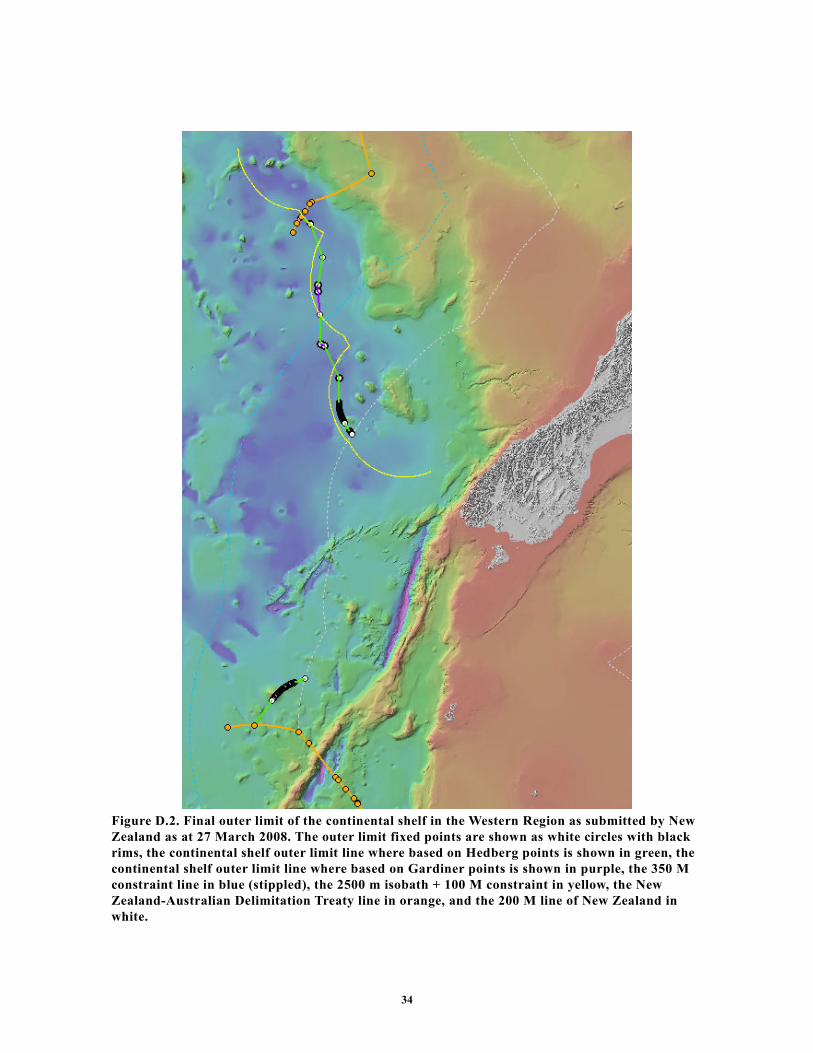
34
Figure D.2. Final outer limit of the continental shelf in the Western Region as submitted by New
Zealand as at 27 March 2008. The outer limit fixed points are shown as white circles with black
rims, the continental shelf outer limit line where based on Hedberg points is shown in green, the
continental shelf outer limit line where based on Gardiner points is shown in purple, the 350 M
constraint line in blue (stippled), the 2500 m isobath + 100 M constraint in yellow, the New
Zealand-Australian Delimitation Treaty line in orange, and the 200 M line of New Zealand in
white.

35
SUMMARY OF THE RECOMMENDATIONS OF THE COMMISSION ON THE LIMITS OF THE CONTINENTAL SHELF (CLCS) IN REGARD TO THE SUBMISSION MADE BY NEW ZEALAND 19 APRIL 2006 16
Adopted by CLCS on 22 August 2008
16 The aim of this summary is to provide information which is not of confidential or proprietary nature in order to facilitate
the function of the Secretary-General in accordance with CLCS/40/Rev. 1, Annex III, Part V, Rule 11.3. The summary
is based on excerpts of these Recommendations and should be made public together with the tables contained in
Annex III of these Recommendations.Only additions to excerpted text are paragraph 126 and Figures 2 and 3.

36
TABLE OF CONTENTS
I. Introduction ............................................................................................................................38
II. General principles on which these recommendations are based ............................................38
III. Recommendations ..............................................................................................................38
A. Northern Region.................................................................................................................39
1. Geographical region description ....................................................................................39
2. Submarine prolongation of landmass and entitlement to the continental shelf beyond
200 M .....................................................................................................................................40
3. Recommendations regarding the determination of foot of the continental slope ..........42
3.1 Considerations........................................................................................................42
3.2 Recommendations ..................................................................................................42
4. Recommendations regarding the establishment of the outer edge of the continental
margin - The application of the 60 M distance criterion........................................................42
5. Recommendations regarding the establishment of the outer limits of the continental
shelf ........................................................................................................................................43
5.1 The application of constraint criteria .....................................................................43
5.1.1 The construction of the distance criterion line ...............................................43
5.1.2 The construction of the depth criterion line ...................................................43
5.1.3 Consideration and classification of submarine highs.....................................43
5.1.4 The application of the combination of the distance and the depth constraint
criteria ........................................................................................................................43
5.2 The outer limits of the continental shelf.................................................................43
5.3 Recommendations ..................................................................................................44
B. Eastern Region ...................................................................................................................46
1. Geographical region description ....................................................................................46
2. Submarine prolongation of landmass and entitlement to the continental shelf beyond
200 M .....................................................................................................................................46
3. Recommendations regarding the determination of foot of the continental slope ..........48
3.1 Considerations........................................................................................................48
3.2 Recommendations ..................................................................................................48
4. Recommendations regarding the establishment of the outer edge of the continental
margin.....................................................................................................................................49
4.1 The application of the 60 M distance criterion ......................................................49
4.2 The application of the sediment thickness criterion...............................................49
4.3 Recommendations ..................................................................................................49
5. Recommendations regarding the establishment of the outer limits of the continental
shelf ........................................................................................................................................49
5.1 The application of constraint criteria .....................................................................49
5.1.1 The construction of the distance criterion line ...............................................49
5.1.2 The construction of the depth criterion line ...................................................50
5.1.3 Consideration and classification of submarine highs.....................................50
5.1.4 The application of the combination of the distance and the depth constraint
criteria ........................................................................................................................50
5.2 The outer limits of the continental shelf.................................................................50
5.3 Recommendations ..................................................................................................50
C. Southern Region.................................................................................................................52

37
1. Geographical region description ....................................................................................52
2. Submarine prolongation of landmass and entitlement to the continental shelf beyond
200 M .....................................................................................................................................53
3. Recommendations regarding the determination of foot of the continental slope ..........53
3.1 Considerations........................................................................................................53
3.2 Recommendations ..................................................................................................53
4. Recommendations regarding the establishment of the outer edge of the continental
margin - The application of the 60 M distance criterion........................................................53
5. Recommendations regarding the establishment of the outer limits of the continental
shelf ........................................................................................................................................53
5.1 The application of constraint criteria .....................................................................53
5.1.1 The construction of the distance criterion line ...............................................53
5.1.2 The application of the of the constraint criteria .............................................53
5.2 The outer limits of the continental shelf.................................................................54
5.3 Recommendations ..................................................................................................54
D. Western Region .................................................................................................................55
1. Geographical region description ....................................................................................55
2. Submarine prolongation of landmass and entitlement to the continental shelf beyond
200 M .....................................................................................................................................57
3. Recommendations regarding the determination of foot of the continental slope ..........57
3.1 Considerations........................................................................................................57
3.2 Recommendations ..................................................................................................57
4. Recommendations regarding the establishment of the outer edge of the continental
margin.....................................................................................................................................58
4.1 The application of the 60 M distance criterion ......................................................58
4.2 The application of the sediment thickness criterion...............................................58
4.3 Recommendations ..................................................................................................58
5. Recommendations regarding the establishment of the outer limits of the continental
shelf ........................................................................................................................................58
5.1 The application of constraint criteria .....................................................................58
5.1.1 The construction of the distance criterion line ...............................................58
5.1.2 The construction of the depth criterion line ...................................................58
5.1.3 Consideration and classification of submarine highs.....................................58
5.1.4 The application of the combination of the distance and the depth constraint
criteria ........................................................................................................................59
5.2 The outer limits of the continental shelf.................................................................59
5.3 Recommendations ..................................................................................................59

38
IV. INTRODUCTION
124 New Zealand transmitted a Submission to the Commission on the Limits of the
Continental Shelf (hereinafter “the Commission”), through the Secretary-General
of the United Nations (hereinafter “the Secretary-General”), on
19 April 2006 by note verbale NZ-CLCS-TPN-01. This Submission was made
pursuant to the provisions contained in article 76, paragraph 8, and article 4 of
Annex II to the 1982 United Nations Convention on the Law of the Sea
(hereinafter “the Convention”). References to article 76 and paragraphs therein
shall be understood to mean article 76 of the Convention. The Submission
contained: Part I - Executive Summary; Part II – Main Body which is the
analytical and descriptive part and Part III- Scientific and Technical Data.
125 The Subcommission carried out its examination of the Submission during the
following sessions: nineteenth, twentieth, resumed twentieth and twenty-first.
During these sessions, as well as intersessionally the Subcommission held 11
meetings with the New Zealand Delegation in which it presented 4 preliminary
considerations and posed 9 questions in writing. In response, the New Zealand
Delegation provided to the Subcommission 11 documents (with enclosures), 12
PowerPoint presentations as well as 16 CD/DVD-Roms. In addition, the
Commission held two meetings with the Delegation.
126 The Commission took note of the notes verbales regarding possible overlapping
continental shelf areas emanating from the Submission of New Zealand,
submitted to the Secretary-General by the Republic of Fiji, France, the Kingdom
of Tonga, and New Zealand. The notes verbale are posted on the website of the
Commission.
V. GENERAL PRINCIPLES ON WHICH THESE RECOMMENDATIONS ARE BASED
127 It is hereby reiterated that the examination of New Zealand’s Submission by the
Commission have been made in accordance with the mandate contained in article
76 and Annex II of the Convention. The examination of the Submission and the
Recommendations of the Commission are based on the scientific and technical
data provided by New Zealand in the application of article 76. The
Recommendations of the Commission only deals with issues related to article 76
and Annex II to the Convention and are without prejudice to matters relating to
delimitation between States or application of other parts of the Convention or any
other treaties.
VI. RECOMMENDATIONS
128 New Zealand’s submission has been divided into four regions (Fig.1 ):
129 Northern (which covers the Three Kings Ridge, Colville Ridge, and northern
Kermadec Ridge and Kermadec Trench);
130 Eastern (which covers the southern Kermadec Ridge and Kermadec Trench,
Hikurangi Plateau, Chatham Rise, Bounty Trough, and northern Campbell Plateau);
131 Southern (which covers the southern margin of the Campbell Plateau); and
132 Western (which covers the southern Norfolk Ridge System, New Caledonia Basin,
Challenger Plateau, Lord Howe Rise, and the Macquarie Ridge Complex).

39
Fig. 1. Regional subdivision and main geomorphological elements of the New Zealand continental
margin
A. Northern Region
1. Geographical region description
133 The Northern Region covers the continental margin north of New Zealand, from
the Kermadec Trench in the east to the Three Kings Ridge in the west. The region
comprises two areas, which together are part of the same continental margin (Fig
1):
a. The prolongation along the Kermadec and Colville ridges, north of the line 200
nautical miles (hereinafter “M”) from the New Zealand territorial sea baseline
(derived from basepoints on Raoul Island) to the intersection with the lines 200 M
from the territorial sea baselines of Fiji and Tonga:

40
b. The prolongation along the Three Kings Ridge, north from the New Zealand
200 M line at about latitude 31°S, derived from basepoints on the North Island
and Three Kings Islands, to the intersection with the line of the maritime
boundary between NewZealand and Australia delimited by the Treaty line of the
New Zealand-Australia 2004 Delimitation Treaty.
2. Submarine prolongation of landmass and entitlement to the continental shelf beyond 200 M
134 The outer edge of the continental margin, as generated from the foot of the
continental slope of the Northern Region by applying the provisions of article 76,
paragraph 4, extends beyond the 200 M limits of New Zealand. On this basis, the
Commission recognises the legal entitlement of New Zealand to establish
continental shelf beyond its 200 M limits in this region (Figure. A.1).
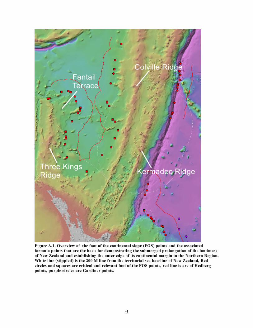
41
Figure A.1. Overview of the foot of the continental slope (FOS) points and the associated
formula points that are the basis for demonstrating the submerged prolongation of the landmass
of New Zealand and establishing the outer edge of its continental margin in the Northern Region.
White line (stippled) is the 200 M line from the territorial sea baseline of New Zealand, Red
circles and squares are critical and relevant foot of the FOS points, red line is arc of Hedberg
points, purple circles are Gardiner points.
Three Kings Ridge
Kermadec Ridge
Colville Ridge
Fantail Terrace

42
3. Recommendations regarding the determination of foot of the continental slope
3.1 Considerations
135 FOS points that generate formula points beyond 200 M in the Northern Region
are found along the eastern and western flanks of the Kermadec and Coville
Ridge pair on the eastern side of South Fiji Basin, and along the eastern flank of
the Three Kings Ridge on the western.
136 The Kermadec and Colville Ridges form a set of coalesced ridges with the
Kermadec Ridge facing the Pacific Ocean to the east and the Colville Ridge
facing the South Fiji Basin to the west. The Kermadec Trough is the oceanic
subduction zone along the eastern flank of the Kermadec Ridge. The eastern
continental slope of the Kermadec Ridge is steep and the base of the slope, being
the base of the subduction trough, is readily identified on a morphological basis.
Accordingly, the eastern flank of the Kermadec Ridge may be readily delineated
by its foot of the continental slope envelope and the Commission agrees with the
way the foot of the continental slope is established by New Zealand in this area.
137 The location of the base of the continental slope towards the South Fiji Basin, i.e.
the transition from the slope of the Colville to the deep ocean floor of the South
Fiji Basin is generally easily identified on a morphological basis.
138 The Three Kings Ridge is an ancient island arc ridge extending northward from
the North Island between the South Fiji Basin to the east and the Norfolk Basin to
west. The northern end of the Three Kings ridge is dominated by the deeper
Fantail Terrace. The location of the base of the continental slope, i.e. the
transition from the slope to the deep ocean floor of the South Fiji Basin is
identified on a morphological basis, recognising that the Fantail Terrace is an
integral part of the Three King Ridge system. Accordingly, the eastern flank of the
Three King Ridge may be readily delineated by its foot of the continental slope
envelope and the Commission agrees with the way the foot of the continental
slope is established by New Zealand in this area. The western flank is on the
Australian side of the treaty line and is not dealt with in the Submission.
3.2 Recommendations
139 Based on its consideration of the technical and scientific documentation contained
in the Submission of 19 April 2006 and the information provided in document
NZ-CLCS-DOC-08, the Commission concludes that, in the Northern Region, the
FOS listed in Table 1.A, Annex III, fulfil the criteria in accordance with article 76
and Chapter 5 of the Scientific and Technical Guidelines (hereinafter the
“Guidelines”). The Commission recommends that these FOS points should form
the basis for the establishment of the outer edge of the continental margin of New
Zealand, for the purposes of the Convention, in the Northern Region.
4. Recommendations regarding the establishment of the outer edge of the continental margin - The
application of the 60 M distance criterion
140 In the Northern Region, the outer edge of the continental margin is based on
points on arcs constructed at 60 M distance from the FOS points (Table 1.A,
Annex III) in accordance with the provision contained in article 76, paragraph
4(a)(ii) (Fig. A.1). The Commission agrees with the way these points have been
established by New Zealand and recommends that they are used as the basis for
establishing the outer limit of the continental shelf in this region.

43
5. Recommendations regarding the establishment of the outer limits of the continental shelf
141 The outer limits of the continental shelf should be based on the established outer
edge of the continental margin and taking into consideration the constraints
provided in article 76, paragraphs 2, 5 and 6.
5.1 The application of constraint criteria
142 The outer limits of the continental shelf cannot extend beyond the constraints as
per the provisions of article 76, paragraphs 5 and 6. Accordingly, the provision
that the outer limits of the continental shelf may not exceed 350 M distance from
the territorial sea baselines (the distance criterion constraint) may be applied in all
cases. Alternatively, the provision that the outer limits of the continental shelf
may not exceed 100 M distance from the 2500 meters isobath (the depth criterion
constraint) may be applied for those parts of the continental margin that are
classified as natural components of that margin.
5.1.1 The construction of the distance criterion line
143 The distance criterion constraint line submitted by New Zealand is constructed by
arcs at 350 M distance from the territorial sea baselines included in the
Submission. The Commission agrees with the procedure and methods applied by
New Zealand in the construction of this constraint line.
5.1.2 The construction of the depth criterion line
144 The 2500 meters isobaths on which the depth criterion constraint line is based are
located along the Colville Ridge and the Three Kings Ridge including the Fantail
Terrace. Since all these isobaths are landward of the foot of the continental slope,
they conform to the general outline of the continental margin as defined for the
purposes of the Convention. Therefore, the application of these isobaths as basis
for the depth criterion constraint is in accordance with the Convention and with
paragraphs 4.4.1 and 4.4.2 of the Guidelines and the Commission recommends
that the depth criterion constraint line is constructed as submitted by New
Zealand.
5.1.3 Consideration and classification of submarine highs
145 Based on the literature and the evidence in the Submission, the Commission
agrees that the Kermadec and Colville Ridge system, as well as the Three Kings
Ridge with the Fantail Terrace are natural components of the continental margin
of the North Island of New Zealand and may be classified as submarine elevations
in the sense of article 76, paragraph 6. Hence, the depth constraint line originating
from these elevations may be applied as submitted by New Zealand.
5.1.4 The application of the combination of the distance and the depth constraint criteria
146 In the Northern Region New Zealand has applied a constraint line based on the
combination of lines constructed by the application of both the distance and depth
criteria contained in article 76, paragraph 5 (see sections 6.1.1 and 6.1.2 above).
The Commission agrees with the way this combined constraint line has been
applied.
5.2 The outer limits of the continental shelf
147 The outer limits of the continental shelf in the Northern Region as submitted by
New Zealand in its Submission of 19 April 2006 and revised in NZ-CLCS-DOC-
08 consist of fixed points connected by straight lines not exceeding 60 M in
length (Fig. A.2). The fixed points are listed in Table 2, Annex III as submitted on

44
27 March 2008. The fixed points are formula points established by the provisions
contained in article 76, paragraph 4(a) or points on the constraint line where the
outer edge of the continental margin extends beyond the constraints. One point,
N001 is located on the 200 M line of New Zealand; one point, N064 is located on
the 200 M line of the Kingdom of Tonga; one point, N065, is located on the 200
M line of the Republic of the Fiji Islands; and one point, N284, is located on the
treaty line with Australia.(Fig. A.2 ).
5.3 Recommendations
148 The Commission agrees with the determination of the fixed points listed in Table
1.A, Annex III, delineating the outer edge of the continental margin of New
Zealand. However, the Commission does not agree to include the whole of that
part of the South Fiji Basin that is located to the south of points N177 and N178
in Table 2, Annex III as part of the continental shelf of New Zealand. The
Commission recommends that the delineation of the outer limit of the continental
shelf in the South Fiji Basin be conducted in accordance with article 76,
paragraph 7, by straight lines not exceeding 60 M in length, connecting fixed
points, defined by coordinates of latitude and longitude. The establishment of the
final outer limits of the continental shelf of New Zealand in this region may
depend on delimitation between States. The Commission recommends, taking into
consideration article 9 of Annex II, that New Zealand proceeds to establish the
outer limits of the continental shelf in the Northern Region on the basis of the
outer edge of the continental margin recommended in paragraph 140 and in
accordance with article 76, paragraphs 7, 8, 9 and 10.

45
Figure A.2. Final outer limit of the continental shelf in the Northern Region as submitted by New
Zealand as at 27 March 2008. The outer limit fixed points are shown as white circles with black
rims, the continental shelf outer limit line is shown in green, the 350 M constraint line in blue
(stippled), the 2500 m isobath + 100 M constraint in yellow, the New Zealand-Australian
Delimitation Treaty line in orange, and the 200 M lines of New Zealand and neighbouring States
in white.
Three Kings Ridge
Kermadec Ridge
Colville Ridge

46
B. Eastern Region
1. Geographical region description
149 The Eastern Region covers the southern Kermadec Ridge and Kermadec Trench,
Hikurangi Plateau, Chatham Rise, Bounty Trough, and northern Campbell Plateau
(Fig 1).
2. Submarine prolongation of landmass and entitlement to the continental shelf beyond 200 M
150 The outer edge of the continental margin, as generated from the foot of the
continental slope of the Eastern Region by applying the provisions of article 76,
paragraph 4, extends beyond the 200 M limits of New Zealand. On this basis, the
Commission recognises the legal entitlement of New Zealand to establish
continental shelf beyond its 200 M limits in this region (Fig. B.1).

47
Figure B.1. Overview of the FOS points and the associated formula points that are the basis for
demonstrating the submerged prolongation of the landmass of New Zealand and establishing the
outer edge of its continental margin in the Eastern Region. White line (stippled) is the 200 M line
from the territorial sea baseline of New Zealand, Red circles and squares are critical and
relevant FOS points, red line is arc of Hedberg points, purple circles are Gardiner points.
Chatham Rise
Hikurangi Plateau
Campbell Plateau
Bounty Trough
KermadecTrench
Kermadec Ridge
Bollons Seamount
Wishbone Ridge
Southern Chatham Terrace

48
3. Recommendations regarding the determination of foot of the continental slope
3.1 Considerations
151 FOS points that generate formula points beyond 200 M in the Eastern Region are
found along the Hikurangi Plateau, Chataham Rise and north Campbell Plateau
areas. The character of the continental slope varies between these three areas of
the Eastern Region.
152 The Hikurangi Plateau is a northward sloping plateau situated east of the North
Island and north of the Chatham Rise. The location of the base of the continental
slope, i.e. the transition from the slope to the deep ocean floor to the north of the
Hikurangi Plateau is distinct and easily identified on a morphological basis.
Accordingly, the plateau may be readily delineated by its foot of the continental
slope envelope and the Subcommission agreed in general with the way this foot of
the continental slope is established by New Zealand.
153 The eastern end of the Chatham Rise is dominated by the Weta Seamount,
separated from the rise to the west by a saddle area. The location of the base of
the continental slope of the Weta Seamount and other seamounts in the area is
distinct and easily identified on a morphological basis. Accordingly, the seamount
area may be readily delineated by its foot of the continental slope envelope and
the Subcommission agreed in general with the way this foot of the continental
slope is established by New Zealand, except in the cases of FOS point CH-262
which seemed to be established on a feature not attached to the adjacent
seamount.
154 The Southeast Chatham Terrace is situated along the south-eastern flank of the
Chatham Rise, and defined in the Submission as a 100-200 km wide area at 4000
– 4800 m depth, separating the Chatham Rise main slope from abyssal water
depths (i.e. >5000 m). New Zealand argues that the Southeast Chatham Terrace is
part of the continental slope so that the FOS points in this area should be located
along the seaward side of the terrace. The terrace is generally low lying with an
outer slope of 300 - 1000 meters drop in elevation. In a series of exchanges of
communications, the Subcommission wanted to satisfy itself that the areas of the
relevant FOS points could be justified to represent the base of the continental
slope by the bathymetric and geo-scientific data provided. Based on the
Submission and the further information the Subcommission agreed with New
Zealand that FOS points CH-80, -160, -247, -251, -262 and CH_G-3 should be
deleted, and that the outer limit in the area should be established based on points
CH-72, -129, -154, -217, -248, -263, -264 and CH-287.
155 The Campbell Plateau is a submarine high that extends about 1000 km south and
900 km east of the South Island. It is separated from the Chatham Rise by the
Bounty Trough. The location of the base of the continental slope of the northern
Campbell Plateau, including the Bollons Seamount, is distinct and easily
identified on a morphological basis. The saddle area between the plateau and the
Bollons Seamount is significantly shallower than the surrounding deep seafloor,
and allows the seamount to be included in the foot of the continental slope
envelope. Accordingly, the plateau may be readily delineated by its foot of the
continental slope envelope and the Commission agrees in general with the way
this foot of the continental slope is established by New Zealand.
3.2 Recommendations
156 Based on its consideration of the technical and scientific documentation contained
in the Submission of 19 April 2006 and the information provided in documents

49
NZ-CLCS-DOC-05, NZ-CLCS-DOC-07, NZ-CLCS-DOC-08 and NZ-CLCS-
DOC-09, the Commission concludes that, in the Eastern Region, the FOS points
listed in Table 1.B, Annex III, fulfil the criteria in accordance with article 76 and
Chapter 5 of the Guidelines. The Commission recommends that these FOS points
should form the basis for the establishment of the outer edge of the continental
margin of New Zealand for the purposes of the Convention in the Eastern
Region.
4. Recommendations regarding the establishment of the outer edge of the continental margin
4.1 The application of the 60 M distance criterion
157 In the Eastern Region, the outer edge of the continental margin is partly based on
points on arcs constructed at 60 M distance from the FOS points (Table 1.B,
Annex III) in accordance with the provision contained in article 76, paragraph
4(a)(ii). The Commission agrees with the way these points have been established
by New Zealand.
4.2 The application of the sediment thickness criterion
158 In the Eastern Region adjacent to the Hikurangi Plateau, New Zealand has
submitted 12 fixed points based on the sediment thickness provision of article 76,
paragraph 4 (a)(i). The Commission agrees with the procedure applied by New
Zealand to establish the sediment thickness points based on the FOS points
contained in Table 1.B, Annex III, including the data provided, the seismic
interpretation, the methods of depth conversion, and the distance calculations.
4.3 Recommendations
159 In the Eastern Region, the outer edge of the continental margin beyond 200 M is
based on the arcs and points described in sections 4.1 and 4.2 above in accordance
with article 76, paragraphs 4(a) and 7 (see Fig. B.1). The Commission
recommends that these arcs and points are used as the basis for establishing the
outer limit of the continental shelf in this region.
5. Recommendations regarding the establishment of the outer limits of the continental shelf
160 The outer limits of the continental shelf should be based on the established outer
edge of the continental margin and taking into consideration the constraints
contained in article 76, paragraphs 2, 5 and 6.
5.1 The application of constraint criteria
161 The outer limits of the continental shelf cannot extend beyond the constraints as
per the provisions contained in article 76, paragraphs 5 and 6. Accordingly, the
provision that the outer limits of the continental shelf may not exceed 350 M
distance from the territorial sea baselines (the distance criterion constraint) may
be applied in all cases. Alternatively, the provision that the outer limits of the
continental shelf may not exceed 100 M distance from the 2500 meters isobath
(the depth criterion constraint) may be applied for those parts of the continental
margin that are classified as natural components of that margin.
5.1.1 The construction of the distance criterion line
162 The distance criterion constraint line submitted by New Zealand is constructed by
arcs at 350 M distance from the territorial sea baselines included in the
Submission. The Commission agrees with the procedure and methods applied by
New Zealand in the construction of this constraint line.

50
5.1.2 The construction of the depth criterion line
163 The 2500 meters isobath on which the depth criterion constraint line is based are
located along the Wishbone Ridge and the Chatham Bank including the Weta
Seamount area. Since all these isobaths are landward of the foot of the continental
slope, they conform to the general outline of the continental margin as defined for
the purposes of the Convention. Therefore, the application of these isobaths as
basis for the depth criterion constraint is in accordance with the Convention and
with paragraphs 4.4.1 and 4.4.2 of the Guidelines and the Commission
recommends that the depth criterion constraint line is constructed as submitted by
New Zealand.
5.1.3 Consideration and classification of submarine highs
164 Based on the literature and the evidence in the Submission, including the
additional material provided, the Commission agrees that the Wishbone Ridge is a
natural component of the continental margin and may be classified as a submarine
elevation in the sense of article 76, paragraph 6. Hence, the depth constraint line
originating from the Wishbone Ridge may be applied as submitted by New
Zealand.
5.1.4 The application of the combination of the distance and the depth constraint criteria
165 In the Eastern Region New Zealand has applied a constraint line based on the
combination of lines constructed by the application of both the distance and depth
criteria contained in article 76, paragraph 5 (see sections 5.1.1 and 5.1.2 above).
The Commission agrees with the way this combined constraint line has been
applied (Fig. B.2).
5.2 The outer limits of the continental shelf
166 The outer limits of the continental shelf in the Eastern Region as submitted by
New Zealand in its Submission of 19 April 2006 and revised in NZ-CLCS-DOC-
09 of 13 March 2008 consist of fixed points connected by straight lines not
exceeding 60 M in length (Fig. B.2). The fixed points are listed in Table 2, Annex
III, as submitted on 27 March 2008. The fixed points are formula points
established by the provisions contained in article 76, paragraph 4(a), or points on
the constraint line where the outer edge of the continental margin extends beyond
the constraints. Two points E001and E886 are located on the 200 M limit line
(Fig. B.2).
5.3 Recommendations
167 The Commission agrees with the principles applied in establishing the outer limits
of the continental shelf in the Eastern Region, including the determination of the
fixed formula points listed in Table 2, Annex III, and the construction of the
straight lines connecting those points. The Commission recommends that New
Zealand proceeds to establish the outer limits of the continental shelf in the
Eastern Region accordingly. Further, the Commission also recommends that New
Zealand includes in its continental shelf the seabed and subsoil of the polygon
located beyond 200 M on the Chatham Rise as the natural prolongation of its land
territory.

51
Figure B.2. Final outer limit of the continental shelf in the Eastern Region as submitted by New
Zealand as at 27 March 2008. The outer limit fixed points are shown as white circles with black
rims, the continental shelf outer limit line where based on Hedberg points is shown in green, the
continental shelf outer limit line where based on Gardiner points is shown in purple, the 350 M
constraint line in blue (stippled), the 2500 m isobath + 100 M constraint in yellow, and the 200 M
lines of New Zealand in white.
Chatham Rise
Hikurangi Plateau
Campbell Plateau
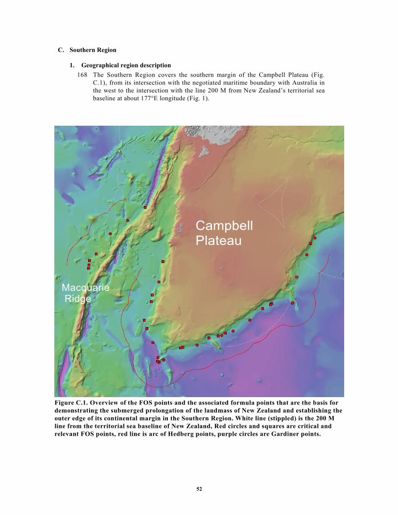
52
C. Southern Region
1. Geographical region description
168 The Southern Region covers the southern margin of the Campbell Plateau (Fig.
C.1), from its intersection with the negotiated maritime boundary with Australia in
the west to the intersection with the line 200 M from New Zealand’s territorial sea
baseline at about 177°E longitude (Fig. 1).
Figure C.1. Overview of the FOS points and the associated formula points that are the basis for
demonstrating the submerged prolongation of the landmass of New Zealand and establishing the
outer edge of its continental margin in the Southern Region. White line (stippled) is the 200 M
line from the territorial sea baseline of New Zealand, Red circles and squares are critical and
relevant FOS points, red line is arc of Hedberg points, purple circles are Gardiner points.
Campbell Plateau
Macquarie Ridge

53
2. Submarine prolongation of landmass and entitlement to the continental shelf beyond 200 M
169 The outer edge of the continental margin, as generated from the foot of the
continental slope of the Southern Region by applying the provisions of article 76,
paragraph 4, extends beyond the 200 M limits of New Zealand. On this basis, the
Commission recognises the legal entitlement of New Zealand to establish
continental shelf beyond its 200 M limits in this region (Fig. C.1).
3. Recommendations regarding the determination of foot of the continental slope
3.1 Considerations
170 The location of the base of the continental slope of the southern Campbell Plateau
is distinct and easily identified on a morphological basis. Accordingly, the plateau
may be readily delineated by its foot of the continental slope envelope and the
Commission agrees in general with the way this foot of the continental slope is
established by New Zealand.
3.2 Recommendations
171 Based on its consideration of the technical and scientific documentation contained
in the Submission of 19 April 2006 and the information provided the Commission
concludes that, in the Southern Region, the FOS points listed in Table 1.C, Annex
III, fulfil the criteria in accordance with article 76 and Chapter 5 of the
Guidelines. The Commission recommends that these FOS points should form the
basis for the establishment of the outer edge of the continental margin of New
Zealand for the purposes of the Convention in the Southern Region.
4. Recommendations regarding the establishment of the outer edge of the continental margin - The
application of the 60 M distance criterion
172 In the Southern Region, the outer edge of the continental margin is based on
points on arcs constructed at 60 M distance from the FOS points (Table 1.C,
Annex III) in accordance with the provision contained in article 76, paragraph
4(a)(ii) (see Fig. C.1). The Commission agrees with the way these points have
been established by New Zealand, and recommends that they are used as the basis
for establishing the outer limit of the continental shelf in this region.
5. Recommendations regarding the establishment of the outer limits of the continental shelf
173 The outer limits of the continental shelf should be based on the established outer
edge of the continental margin and taking into consideration the constraints
contained in article 76, paragraphs 2, 5 and 6.
5.1 The application of constraint criteria
174 For the outer limits of the continental shelf in the Southern Region, New Zealand
has invoked the distance criterion constraint only.
5.1.1 The construction of the distance criterion line
175 The distance criterion constraint line submitted by New Zealand is constructed by
arcs at 350 M distance from the territorial sea baselines included in the
submission. The Commission agrees with the procedure and methods applied by
New Zealand in the construction of this constraint line.
5.1.2 The application of the of the constraint criteria
176 In the Southern Region New Zealand has applied a constraint line based on the
distance criterion contained in article 76, paragraph 5 (see section 5.1.1 above).

54
The Commission agrees with the way this constraint line has been applied (Fig.
C.2).
5.2 The outer limits of the continental shelf
177 The outer limits of the continental shelf in the Southern Region as submitted by
New Zealand in its Submission of 19 April 2006 consist of fixed points connected
by straight lines not exceeding 60 M in length (Fig. C.2). The fixed points are
listed in Table 2, Annex III. as submitted on 27 March 2008. The fixed points are
formula points established by the provisions contained in article 76, paragraph
4(a), or points on the constraint line where the outer edge of the continental
margin extends beyond the constraints. One point, S455, is located on the 200 M
limit line, and one point, S001, is located on the treaty line with Australia (Fig.
C.2).
5.3 Recommendations
178 The Commission agrees with the principles applied in establishing the outer limits
of the continental shelf in the Southern Region, including the determination of the
fixed formula points listed in Table 2, Annex III, and the construction of the
straight lines connecting those points. The Commission recommends that New
Zealand proceeds to establish the outer limits of the continental shelf in the
Southern Region accordingly. Further, the Commission also recommends that
New Zealand includes in its continental shelf the seabed and subsoil of the
polygon located beyond 200 M on the Campbell Plateau as the natural
prolongation of its land territory.

55
Figure C.2. Final outer limit of the continental shelf in the Southern Region as submitted by New
Zealand as at 27 March 2008. The outer limit fixed points are shown as white circles with black
rims, the continental shelf outer limit line is shown in green, the 350 M constraint line in blue
(stippled), the 2500 m isobath + 100 M constraint in yellow, the New Zealand-Australian
Delimitation Treaty line in orange, and the 200 M lines of New Zealand and neighbouring states
in white.
D. Western Region
1. Geographical region description
179 The Western Region covers the southern Norfolk Ridge System, New Caledonia
Basin, Challenger Plateau, Lord Howe Rise, and the Macquarie Ridge Complex and
may be subdivided into the two main areas (Fig. 1):
a. The area along the southwest margin of the Challenger Plateau, Lord Howe
Rise, New Caledonia Basin and the Norfolk Ridge System, from New Zealand’s
200 M line at about 172°E longitude to the New Zealand–Australia 2004
Delimitation Treaty line, and then along this treaty line to the intersection of
Campbell Plateau
Macquarie Ridge

56
Figure D.1. Overview of the FOS points and the associated formula points that are the
basis for demonstrating the submerged prolongation of the landmass of New Zealand
and establishing the outer edge of its continental margin in the Western Region. White
line (stippled) is the 200 M line from the territorial sea baseline of New Zealand, Red
circles and squares are critical and relevant FOS points, red line is arc of Hedberg
points, purple circles are Gardiner points.
the New Zealand and Australian 200 M lines near 166°E longitude.
b. The area along the western margin of the Macquarie Ridge Complex, beyond
the 200 M lines of New Zealand and Australia.
Gilbert Seamount
Macquarie Ridge
Challenger Plateau
Lord Howe Rise

57
2. Submarine prolongation of landmass and entitlement to the continental shelf beyond 200 M
180 The outer edge of the continental margin, as generated from the foot of the
continental slope of the Western Region by applying the provisions of article 76,
paragraph 4, extends beyond the 200 M limits of New Zealand. On this basis, the
Commission recognises the legal entitlement of New Zealand to establish
continental shelf beyond its 200 M limits in this region (Fig. D.1).
3. Recommendations regarding the determination of foot of the continental slope
181 The foot of the continental slope should be established in accordance with article
76, paragraph 4(b).
3.1 Considerations
182 FOS points that generate formula points beyond 200 M in the Western Region are
found along the western flanks of the Lord Howe Rise and the Challenger Plateau,
including the Gilbert Seamount, and along the north-western flank of the
Macquarie Ridge.
183 The Lord Howe Rise and the Challenger Plateau form a continuous continental
slope adjacent to the Tasman Basin. The base of this continental slope is in
general distinct and easily identified on a morphological basis, except in the area
of the Gilbert Seamount. Accordingly, the Lord Howe Rise and the Challenger
Plateau may be readily delineated by their foot of the continental slope envelope
outside of the Gilbert Seamount area. In the view of the Subcommission, the
establishment of the base of the continental slope along the flank of the Gilbert
Seamount needed further supportive geological and geophysical data and
information, especially with respect to the Gilbert saddle area. Such data and
information was provided. After considering this supplementary data and
information, the Subcommission accepted the establishment of the base of the
continental slope along the flank of the Gilbert Seamount as submitted.
Accordingly, the Commission agrees with the way this foot of the continental
slope is established by New Zealand in the whole of this area of the Western
Region.
184 The Macquarie Ridge Complex is a transform ridge system that extends
southwards from the South Island. The base of the continental slope along the
western flank of the Macquarie Ridge Complex is in general distinct and easily
identified on a morphological basis. Accordingly, the western flank may readily
be delineated by its foot of the continental slope envelope and the Commission
agrees with the way the foot of the continental slope is established by New
Zealand.
3.2 Recommendations
185 Based on its consideration of the technical and scientific documentation contained
in the Submission of 19 April 2006 and the information provided the Commission
concludes that, in the Western Region, the FOS points listed in Table1.D, Annex
III, fulfil the criteria provided for by article 76 and Chapter 5 of the Guidelines.
The Commission recommends that these FOS points should form the basis for the
establishment of the outer edge of the continental margin of New Zealand for the
purposes of the Convention in the Western Region.
58
4. Recommendations regarding the establishment of the outer edge of the continental margin
4.1 The application of the 60 M distance criterion
186 In the Western Region, the continental margin is partly based on points on arcs
constructed at 60 M distance from the FOS points (Table 1.D, Annex III) in
accordance with the provision contained in article 76, paragraph 4(a)(ii)
(Fig.D.1). The Commission agrees with the way these points and lines have been
established by New Zealand.
4.2 The application of the sediment thickness criterion
187 In the Western Region adjacent to the Lord Howe Rise and the Challenger
Plateau, New Zeland has submitted 9 fixed points based on the sediment thickness
provision of article 76, paragraph 4 (a)(i) (Fig. D.1). The Commission agrees with
the procedure applied by New Zealand to establish the sediment thickness points
based on the FOS points contained in Table 1.D, Annex III, including the data
provided, the seismic interpretation, the methods of depth conversion, and the
distance calculations.
4.3 Recommendations
188 In the Western Region, the outer edge of the continental margin beyond 200 M is
based on the arcs and points described in sections 4.1 and 4.2 above in accordance
with article 76, paragraphs 4(a) and 7 (see Fig. B.1). The Commission
recommends that these arcs and points are used as the basis for establishing the
outer limit of the continental shelf in this region.
5. Recommendations regarding the establishment of the outer limits of the continental shelf
189 The outer limits of the continental shelf should be based on the established outer
edge of the continental margin and taking into consideration the constraints
contained in article 76, paragraphs 2, 5 and 6.
5.1 The application of constraint criteria
5.1.1 The construction of the distance criterion line
190 The distance criterion constraint line submitted by New Zealand is constructed by
arcs at 350 M distance from the territorial sea baselines included in the
Submission. The Commission agrees with the procedure and methods applied by
New Zealand in the construction of this constraint line.
5.1.2 The construction of the depth criterion line
191 The 2500 meters isobath on which the depth criterion constraint line is based are
located along the Challenger Plateau and the Lord Howe Rise, including the
Gilbert Seamount. Since all these isobaths are landward of the foot of the
continental slope, they conform to the general outline of the continental margin as
defined for the purposes of the Convention. Therefore, the application of these
isobaths as basis for the depth criterion constraint is in accordance with the
Convention and with paragraphs 4.4.1 and 4.4.2 of the Guidelines, and the
Commission recommends that the depth criterion constraint line is constructed as
submitted by New Zealand.
5.1.3 Consideration and classification of submarine highs
192 Based on the literature and the evidence in the Submission, the Commission
agrees that the Challenger Plateau and the Lord Howe Rise, including the Gilbert

59
Seamount, are natural components of the continental margin of New Zealand and
be classified as submarine elevations in the sense article 76, paragraph 6. Hence,
the depth constraint line originating from these elevations may be applied as
submitted by New Zealand.
5.1.4 The application of the combination of the distance and the depth constraint criteria
193 In the Western Region New Zealand has applied a constraint line based on the
combination of lines constructed by the application of both the distance and depth
criteria contained in article 76, paragraph 5 (see sections 5.1.1 and 5.1.2 above).
The Commission agrees with the way this combined constraint line has been
applied (Fig. D.2).
5.2 The outer limits of the continental shelf
194 The outer limits of the continental shelf in the Western Region as submitted by
New Zealand in its Submission of 19 April 2006 and revised in NZ-CLCS-DOC-
09 consist of fixed points connected by straight lines not exceeding 60 M in
length (Fig. D.2). The fixed points are listed in Table 2, Annex III as submitted on
27 March 2008. The fixed points are formula points established by the provisions
contained in article 76, paragraph 4(a), or points on the constraint line where the
outer edge of the continental margin extends beyond the constraints. Two points,
W101 and W102 are located on the 200 M line of New Zealand and two points,
W001 and W190, are located on the treaty line with Australia.(Fig. D.2).
5.3 Recommendations
195 The Commission agrees with the principles applied in establishing the outer limits
of the continental shelf in the Western Region, including the determination of the
fixed formula points listed in Table 2, Annex III, and the construction of the
straight lines connecting those points. The Commission recommends that New
Zealand proceeds to establish the outer limits of the continental shelf in the
Western Region accordingly.
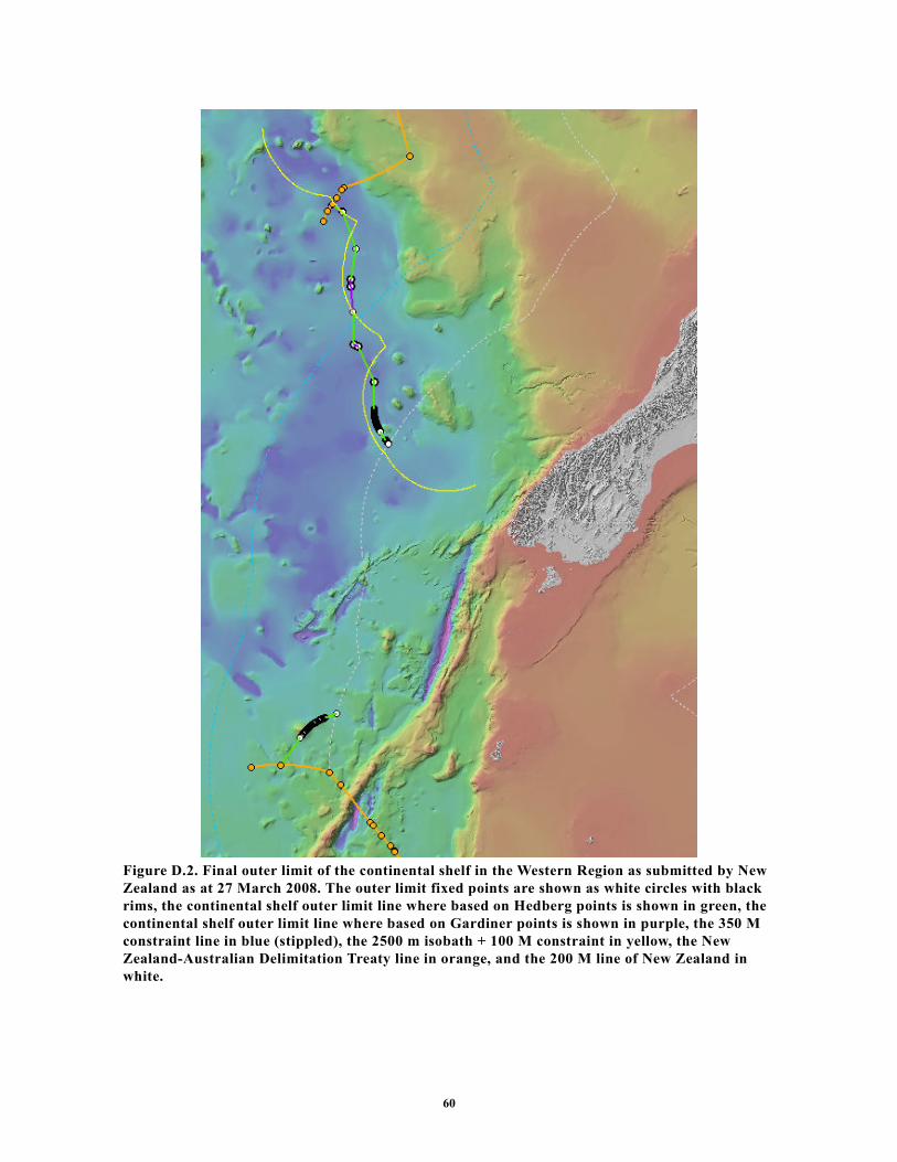
60
Figure D.2. Final outer limit of the continental shelf in the Western Region as submitted by New
Zealand as at 27 March 2008. The outer limit fixed points are shown as white circles with black
rims, the continental shelf outer limit line where based on Hedberg points is shown in green, the
continental shelf outer limit line where based on Gardiner points is shown in purple, the 350 M
constraint line in blue (stippled), the 2500 m isobath + 100 M constraint in yellow, the New
Zealand-Australian Delimitation Treaty line in orange, and the 200 M line of New Zealand in
white.

61
Figure 2. Outer limits of the continental shelf of New Zealand as submitted 19 April 2006

62
Figure 3. Outer limits of the continental shelf of New Zealand reflecting the recommendations of the
Commission adopted 22 August 2008. The outer limit fixed points are shown as white circles with
black rims, the continental shelf outer limit line where based on Hedberg points is shown in green, the
continental shelf outer limit line where based on Gardiner points is shown in purple,at 60 M distance
from the foot of the continental slope in red, the 200 M lines of New Zealand and neighbouring states
in white, and treaty lines with Australia in orange.
Area in the South Fiji basin referred to
in paragraph 148 of this summary