Embed Size (px)
Citation preview

Record 2001/12
JIMPERDING AND CHITTERINGMETAMORPHIC BELTS,SOUTHWESTERN YILGARN CRATON,WESTERN AUSTRALIA— A FIELD GUIDE
by
S. A. Wilde1
1 Curtin University of Technology, Western Australia
GEOLOGICAL SURVEY OF WESTERN AUSTRALIA
Perth 2001

ii
MINISTER FOR STATE DEVELOPMENTHon. Clive Brown MLA
DIRECTOR GENERALDEPARTMENT OF MINERAL AND PETROLEUM RESOURCESJim Limerick
DIRECTOR, GEOLOGICAL SURVEY OF WESTERN AUSTRALIATim Griffin
Notice to users of this guide:This field guide is one of a series published by the Geological Survey of Western Australia (GSWA)for excursions conducted as part of the 4th International Archaean Symposium, held in Perth on24–28 September 2001. Authorship of these guides included contributors from AGSO, CSIRO,tertiary academic institutions, and mineral exploration companies, as well as GSWA. Editing ofmanuscripts was restricted to bringing them into GSWA house style. The scientific content of eachguide, and the drafting of the figures, was the responsibility of the authors.
REFERENCEThe recommended reference for this publication is:WILDE, S. A., 2001, Jimperding and Chittering Metamorphic Belts, southwestern Yilgarn Craton, Western
Australia — a field guide: Western Australia Geological Survey, Record 2001/12, 24p.
National Library of Australia Card Number and ISBN 0 7307 5700 5
Grid references in this publication refer to the Australian Geodetic Datum 1984 (AGD84). Locationsmentioned in the text are referenced using Australian Map Grid (AMG) coordinates, Zone 50. Alllocations are quoted to at least the nearest 100 m.
Printed by Image Source, Perth, Western Australia
Published 2001 by Geological Survey of Western Australia
Copies available from:Information CentreDepartment of Mineral and Petroleum Resources100 Plain StreetEAST PERTH, WESTERN AUSTRALIA 6004Telephone: (08) 9222 3459 Facsimile: (08) 9222 3444This and other publications of the Geological Survey of Western Australia are available onlinethrough dme.bookshop at www.dme.wa.gov.au

iii
Contents
Introduction ...................................................................................................................................................................... 1Geological setting ............................................................................................................................................................ 1
Crustal evolution of the southwestern Yilgarn Craton ............................................................................................. 1The Yilgarn Craton ................................................................................................................................................... 1
Southwestern Yilgarn Craton ............................................................................................................................. 2Major geological units .................................................................................................................................. 2Terrane model .............................................................................................................................................. 2
Geochronology of the southwestern Yilgarn Craton ................................................................................................ 5Overview ............................................................................................................................................................ 5Recent geochronological data ............................................................................................................................ 8
Terrane geology ........................................................................................................................................................ 9Balingup Terrane ............................................................................................................................................... 9Boddington Terrane ......................................................................................................................................... 10Lake Grace Terrane ......................................................................................................................................... 12Murchison Terrane ........................................................................................................................................... 13
Terrane assembly .................................................................................................................................................... 13Excursion localities ........................................................................................................................................................ 16
Balingup Terrane ..................................................................................................................................................... 16Chittering Metamorphic Belt ........................................................................................................................... 16
Locality 1: Kyanite schist, South Chittering .............................................................................................. 16Locality 2: Granofels, Chittering Lake ...................................................................................................... 16
Boddington Terrane ................................................................................................................................................ 18Jimperding Metamorphic Belt ......................................................................................................................... 18
Locality 3: Windmill Hill railway cutting, Toodyay ................................................................................. 18Locality 4: Poison Creek, Toodyay ............................................................................................................ 19Locality 5: Andalusite schist, Lovers Lane ................................................................................................ 19Locality 6: Morangup Greenstone Belt, Morangup Hill ............................................................................ 19Locality 7: Mountain Quarry, Boya ........................................................................................................... 20
Acknowledgements ........................................................................................................................................................ 21References ...................................................................................................................................................................... 22
Figures
1. Regional geology of the southwestern Yilgarn Craton, showing location of the geophysicaltraverse line ............................................................................................................................................................ 3
2. Line diagram of major reflection events from the deep seismic traverse, simplified to showthe preferred interpretation of the deep seismic data ............................................................................................. 4
3. Terranes of the southwestern Yilgarn Craton ........................................................................................................ 64. Simplified geological map of the PERTH 1:250 000 sheet, showing the excursion localities .............................. 17
Tables
1. Characteristic features of the Balingup, Boddington, and Lake Grace Terranes .................................................. 72. Timing of major Archaean events in the southwestern Yilgarn Craton within the Balingup,
Boddington, Lake Grace, and Murchison Terranes ............................................................................................ 15

Hooper Complex
Rudall Complex
Musgrave Complex
GascoyneComplex
NorthamptonComplex
Canning Basin
Eucla Basin
Perth B
asin
BirrinduduBasin
YeneenaBasin
Hamersley Basin
AmadeusBasin
Officer Basin
Ashburton Basin
Edmund Basin
Yerrida BasinEaraheedy
Basin
P I L B A R A C R A T O N
Y I L G A R N C R A T O N
HA
LL
S
CR
EE
K
OR
OG
EN
LeeuwinComplex
OfficerBasinGunbarrel
Basin
0
1000
2000
3000
Age (Ma)
PHANEROZOIC
NEOPROTEROZOIC
MESOPROTEROZOIC
PALAEOPROTEROZOIC
ARCHAEAN
Sedim
enta
ry a
nd vo
lcanic
rock
s
0 500 km
4000
BonaparteBasin
Collier
Basin
Northern CarnarvonBasin
Northern CarnarvonBasin
OrdBasin
KING LEOPOLDOROGEN
Lamboo Complex
CENTRALIANSUPERBASIN
PA
TE
RS
ON
OR
OG
ENC
AP
R
I CO R N
O R O G E N
PINJARRAOROGEN
OnshoreBremer Basin
North PilbaraTerrain
Southern CarnarvonBasin
Granites–Tanami
Complex
Kimberley andSpeewah Basins
Biranup and NornalupComplexes
Igne
ous a
ndm
etam
orph
ic ro
cks
Gran
ite–g
reen
stone
san
d gn
eisse
s
Bryah andPadbury Basins
A L B A N Y – F R A S E R
27.07.01
O R O G E N
ARUNTAOROGEN
4IAS SAW
Record 2001/12Jimperding and Chittering Metamorphic Belts Excursion

GSWA Record 2001/12
1
Jimperding and Chittering MetamorphicBelts, southwestern Yilgarn Craton,Western Australia — a field guide
by
S. A. Wilde1
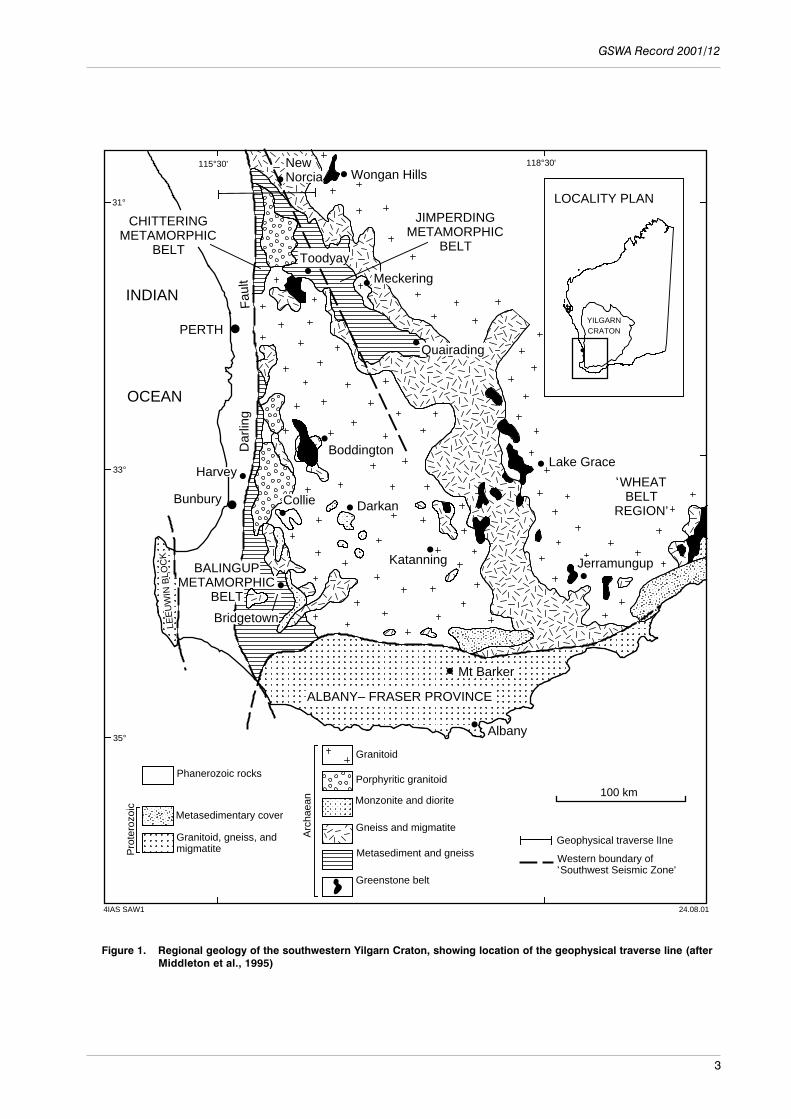
IntroductionThe aim of this excursion is to examine some of the diagnostic features of the Chitteringand Jimperding Metamorphic Belts, which are exposed close to the western margin ofthe Yilgarn Craton in Western Australia (Fig. 1). In order that these outcrops may beappreciated within their regional context, a brief overview of the geological evolutionof southwestern Australia is also provided. This is based largely on the review by Wildeet al. (1996).
Geological setting
Crustal evolution of the southwestern Yilgarn Craton
This excursion guide provides an update on our geological knowledge of the area, basedon a review of the previous literature and incorporating major advances in the periodsince the 3rd International Archaean Symposium (Wilde, 1990). The modern view ofthe regional geology for this area commenced with mapping by the author between1972 and 1976 for the Geological Survey of Western Australia (Wilde, 1980, 1981,1990, 1994). Two major studies have been undertaken since the 3rd InternationalArchaean Symposium field excursion in 1990: a geochronological investigation of theDarling Range Batholith (Nemchin, 1996; Nemchin and Pidgeon, 1997) and theacquisition of a deep seismic traverse that crossed all major crustal components(Middleton et al., 1995), thus leading to the establishment of a terrane-accretion model(Wilde et al, 1996).
The Yilgarn Craton
The Yilgarn Craton was originally subdivided by Gee et al. (1981) into four distinctregions: an older, polymetamorphic, high-grade domain along the western margin (theWestern Gneiss Terrain) and three younger, low-grade granite–greenstone terranes tothe east (the Murchison, Southern Cross, and Eastern Goldfields Provinces). The latterwere considered to have developed, at least in part, on an older gneissic basement andto have been deposited within ensialic basins. The Western Gneiss Terrain was
1 Curtin University of Technology, P.O. Box U 1987, Perth, W.A. 6845

Jimperding and Chittering Metamorphic Belts, southwestern Yilgarn Craton, W.A. — a field guide
2
considered to extend beneath the granite–greenstone provinces (Groves and Batt, 1984;Hallberg, 1986; Blake and Groves, 1987; Campbell and Hill, 1988). The model of Geeet al. (1981) implied that the Yilgarn Craton had essentially been in existence from atleast 3.0 Ga, finally becoming cratonized by the emplacement of voluminous granitoidsat c. 2660 Ma.
The identification of older inherited zircons within the greenstone sequences of theeastern part of the Yilgarn Craton (Compston et al., 1985; Campbell and Hill, 1988)apparently substantiated the presence of an older granitic basement. However, detailedmapping of the Eastern Goldfields region (Swager et al., 1990), and the applicationelsewhere of Phanerozoic-style plate-tectonic models to the Archaean (Hoffman, 1988),led to a re-evaluation of the available evidence and to the development of an alternativemodel. Myers (1993) presented evidence for terrane accretion in all the Precambrianareas of Western Australia, including the Yilgarn Craton. A number of discrete terraneswere identified within the northern and eastern portions of the craton and this approachhas been extended into the southwest by Wilde et al. (1996), based on new U–Pb zircondata, evidence from the deep-crustal geophysical survey, and a re-evaluation of theregional geology.
Southwestern Yilgarn CratonMajor geological units
The area lies within the Western Gneiss Terrane of Gee et al. (1981), which is terminatedto the west by the Darling Fault, a major crustal feature extending 1000 km along thewestern margin of Australia. The area is characterized by discrete, linear metamorphicbelts enveloped by diffuse areas of migmatite, and all intruded by later granitoids(Wilde, 1994). The present distribution of gneiss and migmatite is largely controlledby the emplacement of the late Archaean granitoids. The granitoids in the west formseveral batholiths, the largest of which is the Darling Range Batholith (Wilde and Low,1978), which post-dates metamorphism and regional tectonism. Granitoids in the eastlie within the ‘Wheat Belt’ region and include charnockites. The high-grade gneissesand supracrustal rocks have been grouped into three units: the Jimperding, Chittering,and Balingup Metamorphic Belts (Wilde, 1980, 1990). There are two low-gradegreenstone sequences in the southwestern Yilgarn Craton (the Saddleback andMorangup Greenstone Belts), as well as a number of high-grade rocks in the east ofthe area (Fig. 1) that are interpreted to be remnants of former greenstones (Wilde, 1994;Wilde et al., 1996). Migmatite is locally developed at the margins of all thesemetamorphic belts and also forms more extensive areas in the eastern part of the region.All sequences are intruded by a variety of granitoids, which include charnockites inthe east.
Terrane model
A deep seismic-reflection survey was carried out approximately 110 km north of Perth,near New Norcia (Middleton et al., 1993). The seismic data revealed a multitude ofshallow east-dipping reflectors that, on further enhancement, led to the identificationof seven major zones (Fig. 2), based on reflection character and supplemented bymodelling of ground magnetics. Within the Yilgarn Craton, one of the most significantfeatures is the three-layered nature of the crust, substantiating the results of an earliersurvey by Mathur (1974). The transition to the upper mantle occurs between 30 and40 km depth and shows a marked easterly dip (Fig. 2). This passes upward into thelower crustal component, which has previously been considered to be intermediategranulite in character (Mathur, 1974; Gee et al., 1981). This component also containssome easterly dipping reflectors, which may represent ductile shear zones.
GSWA Record 2001/12
3
Figure 1. Regional geology of the southwestern Yilgarn Craton, showing location of the geophysical traverse line (afterMiddleton et al., 1995)
Wongan Hills
Meckering
Quairading
Lake Grace
JerramungupKatanning
DarkanCollieBunbury
PERTH
Mt Barker
WHEATBELT
REGION’
JIMPERDINGMETAMORPHIC
BELT
CHITTERINGMETAMORPHIC
BELTToodyay
BALINGUPMETAMORPHIC
BELT
LEE
UW
IN B
LOC
KNewNorcia
Dar
ling
Fau
lt
INDIAN
OCEAN
LOCALITY PLAN
YILGARNCRATON
Metasedimentary cover
Granitoid, gneiss, andmigmatite
Granitoid
Monzonite and diorite
Gneiss and migmatite
Metasediment and gneiss
Greenstone belt
100 km
Geophysical traverse lIne
4IAS SAW1 24.08.01
115°30' 118°30'
Pro
tero
zoic
Arc
haea
n
Albany
31°
33°
35°
Boddington
Phanerozoic rocks
ALBANY– FRASER PROVINCE
,
,Western boundary of Southwest Seismic Zone'
Bridgetown
Harvey
Porphyritic granitoid

Jimperding and Chittering Metamorphic Belts, southwestern Yilgarn Craton, W.A. — a field guide
4
The overlying intermediate crustal layer is believed to consist chiefly of graniticrocks and is separated from the upper and lower crustal layers by major décollements.There is also a lens-like unit within this zone that is characterized by strong reflectorsthat are coincident in the east with two distinct magnetic bodies identified by the groundmagnetics, and these have been interpreted as part of a large, layered mafic intrusion(Middleton et al., 1993).
Close to the Darling Fault, there is a distinctive segment that has virtually no seismicresponse. It may lie in the ‘shadow zone’ of the Phanerozoic Darling Fault, where noseismic energy can penetrate (Middleton et al., 1993), or it may be the result of extremedeformation associated with the Archaean–Proterozoic proto-Darling Fault Zone (Blightet al., 1981; Wilde, 1990) that outcrops in this area and is characterized by subverticalductile structures.
Detailed geological mapping along the seismic traverse line (Fig. 1) by Morawa(1992) has shown that a number of reflections, which are interpreted as thrust faults,have surface expression (Fig. 2), including major faults that appear to define the junction
Figure 2. Line diagram of major reflectors from the deep seismic traverse, simplified to show thepreferred interpretation of the deep-seismic data. There are seven zones of distinct seismicreflection character: 1) Perth Basin; 2) Western Gneiss Terrane (Gee et al., 1981), YilgarnCraton; 3) an intermediate crustal zone within the Yilgarn Craton; 4) a zone of strongreflections interpreted as a layered mafic intrusion; 5) a deep crustal zone that containsseveral easterly dipping reflection events; 6) the Moho Zone, which is interpreted to be thereflection package that forms the transition from crust into upper mantle; 7) the ‘proto-Darling Fault’, which is a zone of non-reflection (modified from Middleton et al., 1995)
4IAS SAW4 23.08.01
0
1
2
3
4
5
6
7
8
9
10
11
12
10
20
30
40
App
roxi
mat
e de
pth
(km
)
Sec
onds
2
31
4
5
6
7
ChitteringMetamorphic
Belt
JimperdingMetamorphic
Belt
WheatBelt
region
WEST EAST20 km

GSWA Record 2001/12
5
between the Chittering and Jimperding Metamorphic Belts and between the Jimperdingbelt and the Wheat Belt region. These faults dip steeply at the surface and then ‘bottom-out’ onto a basal detachment in the vicinity of 2 to 3 seconds (about 7 to 9 km deep).The continuity of this detachment surface suggests that this zone was formed by ‘thin-skinned’ compressional tectonics, with the major crustal components (the Chittering,Jimperding and Wheat Belt regions) transported to their present positions as thrust slices(Fig. 2). Significantly, the boundary between the Jimperding and Wheat Belt regionsalso corresponds with a marked fall in gravity values (Fraser and Pettifer, 1980). Inaddition, the décollement surface appears to have been locally displaced by normalfaulting (Fig. 2), suggesting reactivation under an extensional regime. This may haveaccompanied mafic dyke emplacement during the Proterozoic or else be associated withPhanerozoic tectonism that resulted in the development of the Perth Basin and/or itssubsequent dismemberment during the Cretaceous episode of continental dispersal.
The recognition that shear zones at the surface can be correlated with major, shalloweast-dipping seismic reflectors in the subsurface is of major significance. The reflectorsare present throughout the total thickness of continental crust in the southwestern YilgarnCraton and imply a uniformity in crustal construction in this region.
The coincidence of shear zones and seismic reflectors with the boundary betweenthe Chittering and Jimperding Metamorphic Belts, and between the latter and the WheatBelt region, implies that these areas are separate crustal segments that have been broughtinto their present position by transport along major east-dipping thrusts. The JimperdingMetamorphic Belt – Wheat Belt boundary is also marked by a fall in the gravity values(Middleton et al., 1993), the position of which also corresponds with a regional changein the Bouguer anomalies recognized by Fraser and Pettifer (1980). The Avon GravityHigh in the west gives way sharply to a region of intermediate gravity referred to asthe Narambeen Gravity Shelf (Fraser and Pettifer, 1980). Similarly, Everingham (1968)postulated that this change in gravity is centred along the currently active SouthwestSeismic Zone and is related to a major change in the deep crustal structure.
When the events are considered in the light of the recently acquired geochronologicaldata, it is possible to apply an alternative evolutionary model to that of Gee et al. (1981)to the southwestern Yilgarn Craton.
If evidence obtained along the geophysical traverse line is extended southward, itis possible to delimit the main crustal components in the southwestern Yilgarn Craton.This leads to the recognition of at least three separate terranes that, from west to east,are referred to as the Balingup, Boddington, and Lake Grace Terranes (Wilde et al.,1996; Fig. 3). In addition, a small portion of the Murchison Terrane (Myers, 1993) ispresent in the north around Wongan Hills. The characteristics of the newly definedterranes are summarized in Table 1 and discussed below, based on information presentedin Wilde et al. (1996).
Before considering the geology in more detail, it is pertinent to review thegeochronological evidence, since this also appears to substantiate the terrane model.
Geochronology of the southwestern Yilgarn Craton
Overview
The antiquity of the Western Gneiss Terrain was first established by Arriens (1971),who obtained a number of ages in excess of 3.0 Ga from gneisses using Rb–Srtechniques. A Rb–Sr study by de Laeter et al. (1981) identified gneissic rocks at least3.3 billion years old in the northwestern part of the Western Gneiss Terrain near MountNarryer. This led to extensive investigations within the Narryer Gneiss Complex (Myers,

Jimperding and Chittering Metamorphic Belts, southwestern Yilgarn Craton, W.A. — a field guide
6
Figure 3. Terranes of the southwestern Yilgarn Craton (after Wilde et al., 1996).
Wongan Hills
Meckering
Quairading
Lake Grace
JerramungupKatanning
DarkanCollieBunbury
PERTH
Mt Barker
Toodyay
NewNorcia
Dar
ling
Fau
lt
INDIAN
OCEAN
100 km
4IAS SAW2
115°30' 118°30'
Chittering
BALINGUPTERRANE LAKE GRACE TERRANE
BODDINGTON
TERRANEBalingup
LEE
UW
IN C
OM
PLE
X
Albany
PERTHBASIN
MURCHISION TERRANE
Granitoid, gneiss, andmigmatite
Granitoid
Monzonite and diorite
Gneiss and migmatite
Metasediment and gneiss
Greenstone belt
Pro
tero
zoic
Terrane boundary
Phanerozoic rocks
Arc
haea
n
Boddington
31°
33°
35°
ALBANY– FRASER PROVINCE
17.08.01
York

GSWA Record 2001/12
7
1988) using Rb–Sr, Sm–Nd, Pb–Pb (de Laeter et al., 1985; Fletcher et al., 1988) andU–Pb zircon (Kinny et al., 1988, 1990; Pidgeon and Wilde, 1998) techniques. The oldestrocks so far identified in the area are gneisses that are 3730 m.y. old (Kinny et al., 1988),based on sensitive high-resolution ion microprobe (SHRIMP) U–Pb–Th data. Detritalzircons as old as 4.18 Ga (Froude et al., 1983) have been identified at Mount Narryer,and as old as 4.27 Ga (Compston and Pidgeon, 1986) and 4.4 Ga (Wilde et al., 2001)from Jack Hills. The mature clastic sedimentary rocks that contain the ancient zirconsalso contain considerably younger detrital zircons and, based on an evaluation of these,the age of deposition at both Jack Hills and Mount Narryer is considered to be c. 3.1 Ga(Compston and Pidgeon, 1986; Kinny et al., 1990).
Nieuwland and Compston (1981) obtained c. 3.3 Ga detrital multigrain zircon agesfrom mature orthoquartzites in the Toodyay area of the southwestern Yilgarn Craton,which were believed to be intruded by granite approximately 3.25 billion years ago.These rocks of the Jimperding Metamorphic Belt (Fig. 1) near Toodyay are the oldestknown crustal components in the southwestern Yilgarn. Indeed, P. D. Kinny (quotedin Wilde, 1990) has identified a range of zircon ages up to 3735 Ma from the WindmillHill quartzite.
The earliest granitoids in the region were the protoliths of the orthogneisses thatintrude quartzites of the Jimperding Metamorphic Belt at Toodyay. These were emplacedapproximately 3250 m.y. ago (Nieuwland and Compston, 1981) and appear to haveoriginally been porphyritic granites (Wilde and Low, 1978). No other granitoids of thisage are known from the region. However, in the southwestern Yilgarn, granitoid activitywith an age of approximately 2.8 Ga is recorded for the Gibralter Quartz Monzonitenear Bridgetown (Fig. 1), where Fletcher et al. (1983) obtained a Sm–Nd TCHUR modelage of 2.74 ± 0.09 Ga. This age, although rather imprecise, is nonetheless in agreementwith the Rb–Sr model age of Rosman et al. (1980).
The bulk of the granitoids across the Yilgarn Craton belong to the major c. 2660 Maevent, which was first identified by the early Rb–Sr study of Wilson et al. (1960) andlater substantiated by Arriens (1971). Geochronological results up to January 1980 weresummarized and evaluated by de Laeter et al. (1981). A number of more recent studiesusing U–Pb zircon dating reveal a spectrum of granitoid ages from 2670 to 2587 Ma.Granitoids that intrude into the Jimperding Metamorphic Belt at Toodyay were datedby conventional multigrain U–Pb methods by Nieuwland and Compston (1981). TheMortigup granodiorite has an isochron age of 2677 +50/–43 Ma and the Monday Hilladamellite an age of 2642 +315/–166 Ma. Regression of both data sets gives an age of2670 ± 45 Ma for granitoid crystallization in the Toodyay district. McCulloch et al.(1983) undertook a Sm–Nd study of both these rock types and calculated TCHUR modelages of 2777 and 2680 Ma for the Mortigup and Monday Hill intrusives respectively(both with analytical errors of approximately ± 40 Ma).
Table 1. Characteristic features of the Balingup, Boddington, and Lake Grace Terranes
Balingup Boddington Lake Grace
Trough sediments Shelf sediments Shelf sedimentsMedium-pressure metamorphism Low-pressure metamorphism Low-pressure metamorphismNo greenstone belts Low-grade greenstones High-grade greenstonesDuctile deformation extensive Nappes and brittle faults Upright folds; steep plunges2612–2527 Ma granitoids 2677–2640 Ma granitoids 2640 and 2587 Ma granitoidsGranitoids; greenschist facies Granitoids; greenschist facies Granitoids (2640 Ma); granulite facies
SOURCE: Wilde et al. (1996)

Jimperding and Chittering Metamorphic Belts, southwestern Yilgarn Craton, W.A. — a field guide
8
Porphyritic granite that intrudes into the approximately three billion-year-old WonganHills Greenstone Belt gave an isochron age of 2651 ± 4 Ma, using combinedion microprobe and conventional single-grain U–Pb results on zircon (Pidgeon et al.,1990). Further south near Boddington (Fig. 1), monzogranite that intrudes theyounger Saddleback Greenstone Belt gave a conventional multigrain isochron age of2640 + 26/–24 Ma (Wilde and Pidgeon, 1986).
Slightly younger ages have been reported from the porphyritic adamellites andgranites of charnockitic affinity from the Wheat Belt region (Wilde and Pidgeon, 1987).Using conventional multigrain zircon methods, Wilde and Pidgeon (1987) obtainedU–Pb ages of 2652 ± 24 Ma on a sample from near Lake Grace (Fig. 1) and 2639 ± 19and 2634 ± 18 Ma on granitoids from Badgebup, near Katanning. These results, whencombined with a more intensely deformed variant from Badgebup, gave a pooledisochron age of 2627 ± 12 Ma.
The porphyritic Logue Brook Granite (Blight et al., 1981) near Harvey (Fig. 1) gavea Sm–Nd TCHUR model age of 2905 ± 35 Ma (Fletcher et al., 1985). Although this wasnot necessarily considered to be the age of emplacement, it was significantly older thanmost other Sm–Nd model ages from Yilgarn granitoids. However, an ion microprobeU–Pb zircon study by Compston et al. (1986) established that the crystallization agewas considerably younger at 2612 ± 5 Ma.
The youngest granitoids identified in the southwestern Yilgarn Craton are presentin the Wheat Belt region and along the western margin of the craton in the BalingupMetamorphic Belt. Late, medium- to coarse-grained granodiorite and adamelliteintrusions post-date granulite-facies metamorphism and have been emplaced into boththe migmatite and granite terranes in the Wheat Belt region. Two samples from nearDumbleyung and Jerramungup gave conventional multigrain U–Pb zircon ages of2576 ± 54 and 2595 ± 65 Ma, respectively (Wilde and Pidgeon, 1987). These give apooled isochron age of 2587 ± 25 Ma that, although it overlaps with younger membersof the general 2660 Ma granitoid suite, is nonetheless considered significant since therocks are post-metamorphic and clearly later than the charnockitic granitoids of theWheat Belt.
In the Balingup Metamorphic Belt, a SHRIMP zircon study of the Logue BrookGranite, located east of Bunbury (Fig. 1), by Compston et al. (1986) established acrystallization age at 2612 ± 5 Ma. In the Greenbushes area, north of Bridgetown(Fig. 1), ages of approximately 2577 Ma were recorded for the Cowan Brook Dam andMillstream Dam granitoids, whereas the Greenbushes Pegmatite has an age of 2527 Ma(Partington et al., 1986). All these rocks have undergone ductile deformation, withportions of the Logue Brook Granite infolded with paragneisses of the Balingup belt(Wilde and Walker, 1982). The Greenbushes Pegmatite is a late-stage granitoid thatwas emplaced synkinematically into a major sinistral shear zone under medium-pressure, amphibolite-facies conditions (Partington et al., 1986).
Recent geochronological data
A comprehensive review of the available geological and geochronological data for thesouthwestern Yilgarn has previously been undertaken by Wilde (1990, 1994). The maindifferences since the last review are discussed below.
The main changes from those presented by Wilde (1994) relate to furthergeochronological work undertaken on the Jimperding Metamorphic Belt in the Toodyayand Wheat Belt areas, and in the Darling Range Batholith. A SHRIMP study of theWindmill Hill quartzite (P. D. Kinny quoted in Wilde, 1990) gave a spectrum of agesfrom 3735 to 3177 Ma. Unpublished work on granitic sheets (orthogneisses) intruding

GSWA Record 2001/12
9
into the quartzites indicates that the age of intrusion was c. 2.6 Ga and that the 3250 Maage obtained by Nieuwland and Compston (1981) was most likely the result ofincorporation of significant amounts of detrital zircon from digestion of older quartzitexenoliths (Kinny, P. D., 1998, pers. comm.). Whereas the depositional age of thequartzites still appears to be greater than 3.0 Ga, there is no evidence for an early pre-3.0 Ga granite-forming event in the region.
Work on the Katrine Syenite near Northam by Pidgeon et al. (1996) defined acrystallization age of 2654 ± 5 Ma. The rock did, however, contain older zircon grainsand cores with an age of c. 3250 Ma, similar to the age of granitic gneisses obtained afew kilometres to the north near Toodyay by Nieuwland and Compston (1981) usingmultigrain zircon techniques.
New evidence on the age and metamorphism of the metasedimentary sequencecomes from a conventional, single-grain U–Pb zircon study of mafic granulites (high-grade greenstones) in the Wheat Belt region southeast of Toodyay (Nemchin et al.,1994). Granulite-facies metamorphism took place between 2649 and 2640 m.y. ago,which is significantly younger than the age of 2671 to 2654 Ma recorded from thegreenschist-facies Saddleback Greenstone Belt (Wilde and Pidgeon, 1986) to the westnear Boddington (Fig. 1). As suggested by Wilde (1990), this implies a separateevolution for these adjoining regions.
A detailed study of the Darling Range Batholith by Nemchin (1996) identifiedzircons cores with ages of 2690–2650 Ma, which were interpreted as dating either thesource rocks or various stages of isotopic resetting due to recrystallization and meltingof the protolith (Nemchin and Pidgeon, 1997). The cores are surrounded by oscillatoryzoned rims with ages of 2648–2626 Ma, interpreted as resulting from extendedcrystallization of the granite magma. The youngest zircon ages of 2628–2616 Ma wereobtained from unzoned to weakly zoned outer rims that transgress the earlier zirconstructures and appear to be the result of corrosion and recrystallization during slowcooling of the magma. These ages are similar to that obtained from the Logue BrookGranite (Compston et al., 1986).
Terrane geology
Balingup Terrane
The Balingup Terrane (Fig. 3) is a narrow, north-trending belt delimited to the west bythe Darling Fault and less precisely defined in the east by later intrusive granitoids(Wilde et al., 1996). The terrane consists of the Balingup and Chittering MetamorphicBelts, which are characterized by turbiditic sediments and intensely deformedorthogneisses. The age of sedimentation is not precisely constrained, with Sm–Nd modelages (Fletcher et al., 1985) suggesting that the Balingup belt was deposited between3.07 and 2.83 Ga and the Chittering belt after 2.89 Ga (Wilde, 1990).
The rocks were metamorphosed under medium-pressure, amphibolite-faciesconditions, with the development of kyanite, sillimanite, and staurolite in metapelitesbeing diagnostic. Metamorphism in the Balingup Metamorphic Belt has possibly beendated by the Rb–Sr age of c. 2838 Ma obtained near Bridgetown by D. A. Nieuwland(quoted in Wilde, 1980) from a quartz–feldspar–biotite gneiss; there are no comparabledata for the Chittering Metamorphic Belt.
Strong ductile deformation is prominent along the western boundary of this terraneand is associated with periodic movement along the Darling Fault Zone, commencingabout 2577 m.y. ago (Blight et al., 1981). The eastern boundary is defined in the extremesoutheast by the Gibralter Quartz Monzonite (Wilde and Walker, 1982, 1984). This is

Jimperding and Chittering Metamorphic Belts, southwestern Yilgarn Craton, W.A. — a field guide
10
a metamorphic tectonite believed to have been emplaced during the peak of regionalmetamorphism. The Sm–Nd model age of 2.74 ± 0.09 Ga (Fletcher et al., 1983) andRb–Sr model age of c. 2828 Ma (Rosman et al., 1980), although not precise, are withinerror of D. A. Nieuwland’s Rb–Sr isochron age.
Granitoids associated with the Balingup Terrane are younger than in most other partsof the Yilgarn Craton. An ion microprobe U–Pb–Th zircon study of the Logue BrookGranite, located east of Bunbury (Fig. 1), by Compston et al. (1986) established acrystallization age of 2612 ± 5 Ma. In the Greenbushes area, north of Bridgetown(Fig. 1), ages of c. 2577 Ma were recorded for the Cowan Brook Dam and MillstreamDam granitoids, whereas the Greenbushes Pegmatite has an age of 2527 Ma (Partingtonet al., 1986). All these rocks have undergone ductile deformation, with portions of theLogue Brook Granite infolded with paragneisses of the Balingup belt (Wilde andWalker, 1982). The Greenbushes Pegmatite is a late-stage granitoid that was emplacedsynkinematically into a major sinistral shear zone under medium-pressure, amphibolite-facies conditions (Partington et al., 1986).
The Chittering Metamorphic Belt, which will be visited on the excursion, iscomposed of quartz–feldspar–biotite gneiss with interleaved metamorphosed pelite,semi-pelite, and greywacke. Banded iron-formation and quartzite are notably absentand this association was interpreted to be the result of rapid, trough-style sedimentationalong a continental margin (Gee et al., 1981; Wilde, 1990). Both the Chittering andBalingup Metamorphic Belts are chiefly at amphibolite facies and have undergonemoderate-pressure Barrovian-type metamorphism (Wilde, 1990). This appears to becontrolled in part by their location, with the higher pressure assemblages present alongthe western margin of the Yilgarn Craton, and associated with ductile shear zones relatedto early movement along the Darling Fault Zone (Blight et al., 1981; Bretan, 1985).This zone has been reactivated at several later periods, resulting in local retrogressionto greenschist-facies assemblages.
Boddington Terrane
The Boddington Terrane (Fig. 3) is separated in the north from the Balingup Terraneby a 2 km-wide shear zone characterized by phyllonite and quartz boudins, markingthe junction of the Chittering and Jimperding Metamorphic Belts (Middleton et al.,1995). Further south, the original line of contact appears to have been obliterated bylater granite intrusion (stitching plutons), which includes three porphyritic graniteplutons (Wilde, 1990), the most southerly being the 2612 Ma Logue Brook Granite,which implies that the two terranes were in contact at this time (Wilde et al., 1996).The Boddington Terrane is only about 10 km wide in the north, but widens to around120 km in the south (Fig. 3).
The Boddington Terrane includes the northern part of the Jimperding MetamorphicBelt. Further south, the major gravity change previously discussed occurs within thisbelt, and the Boddington Terrane is defined to include only the western, flat-lyingportion near Toodyay and York (Fig. 3). The dominant rock type is quartz–feldspar–biotite gneiss interleaved with aluminous schist, orthoquartzite, banded iron-formation,and rare calc-silicate rocks. Some units are paragneiss and show gradations to arkosicquartzite and quartz–mica schist. This association is a characteristic feature of theJimperding Metamorphic Belt east and southeast of Toodyay and has been interpretedas indicating stable shelf sedimentation on a pre-existing sialic basement (Gee et al.,1981; Wilde, 1990). The metapelites contain andalusite, sillimanite, and cordierite,indicating low-pressure, high-temperature metamorphic conditions. The Jimperdingmetasediments in the Boddington Terrane form part of a major nappe that has beenstrongly refolded (Wilde and Low, 1978), with metamorphic grade increasing eastward

GSWA Record 2001/12
11
from lower amphibolite to amphibolite–granulite transition facies, with andalusite andiron-rich cordierite indicating low-pressure conditions. It appears from the detrital zirconsuite that the orthoquartzites were deposited between 3.1 and 3.0 Ga (Wilde, 1990).However, the oldest zircons are c. 3735 Ma and were interpreted by P. D. Kinny (Wilde,1990) as being derived from a granite–gneiss terrane. Although there is no otherevidence of crust of this age in the southwestern Yilgarn Craton, it has been identifiedin the Narryer Gneiss Complex, some 800 km to the north (Kinny et al., 1990; Pidgeonand Wilde, 1998).
The Saddleback and Morangup Greenstone Belts form part of the BoddingtonTerrane and consist of mafic and felsic lavas and pyroclastic rocks, with minor amountsof sediment metamorphosed to low-pressure greenschist facies and largely downfaultedagainst adjacent gneiss and granitoid. The Saddleback belt formed between 2671 and2654 Ma (Wilde and Pidgeon, 1986) and the Morangup sequence near Toodyay (Fig. 1)is considered to be of similar age (Wilde and Pidgeon, 1990). The geochemical natureof both sequences is consistent with either a mature island arc or a continental Andean-type magmatic arc setting (Wilde, 1990, 1994).
Granitoids in the Boddington Terrane appear to have developed within a short timespan between 2677 and 2640 Ma (Wilde, 1990; Wilde et al., 1996). Conventionalmultigrain U–Pb dating of zircons gave ages from 2677 to 2642 Ma for granitoidsintruding the Jimperding Metamorphic Belt at Toodyay (Nieuwland and Compston,1981). Further south near Boddington (Fig. 1), monzogranite intruding the SaddlebackGreenstone Belt gave a conventional multigrain isochron age of 2640 +26/–24 Ma(Wilde and Pidgeon, 1986). This age pattern is supported by the work of Nemchin andPidgeon (1997), although some recrystallization of zircon continued untilapproximately 2616 Ma, which is similar to the crystallization age of the Logue BrookGranite in the Balingup Terrane to the west. The granitoids of the Darling RangeBatholith are quite diverse and show considerable textural variation. They range incomposition from granodiorite to granite; the compositional variations being commonlyindependent of textural changes. Where cross-cutting relations can be identified,granodiorite is generally the earliest phase. Most granitoids are undeformed, althoughplutons of porphyritic granite that are present close to the eastern boundaries ofthe Chittering and Balingup Metamorphic Belts show evidence of intense ductileshearing.
There are also a number of small bodies of quartz-poor granitoids of dioritic,monzonitic, and syenitic affinity within the granite batholiths of the Boddington Terrane.More extensive areas of quartz monzonite are present south of Darkan (Fig. 1) andthese are rich in amphibolite xenoliths.
Migmatites form significant areas in the Boddington Terrane (Fig. 3). They arecomposed of earlier gneissic rocks invaded by younger, less deformed,unmetamorphosed granitoid components. They are developed at the margins of themetamorphic belts, with much of the gneissic palaeosome derived from reworking ofthe metamorphic rocks. Some granitic neosomes appear to have been formed by insitu partial melting of the gneisses (Wilde, 1990).
The eastern boundary of the Boddington Terrane is clearly defined by gravity dataand coincides with the Yandanooka – Cape Riche Lineament of Everingham (1968),and the boundary between the Avon Regional Gravity High in the west and theNarembeen Regional Gravity Shelf to the east, as defined by Fraser and Pettifer (1980).Significantly, this zone is also the focus of present-day seismic activity and has beenreferred to as the ‘Southwest Seismic Zone’ (Doyle, 1971).

Jimperding and Chittering Metamorphic Belts, southwestern Yilgarn Craton, W.A. — a field guide
12
Lake Grace Terrane
The Lake Grace Terrane (Fig. 3) extends east from the major change in gravity discussedabove for almost 200 km and corresponds closely with the area originally referred toas the ‘Wheat Belt’ region by Wilson (1958). It narrows markedly in the north, whereit comes into contact with the Murchison Terrane (Fig. 3). The nature of this boundaryis uncertain and may need to be revised in the light of future work. The eastern boundaryof the Lake Grace Terrane is not precisely defined, owing to a lack of detailed geologicalmapping. The terrane is characterized by sediments, greenstones, granitoids, andmigmatite, mostly at granulite facies.
Included within the terrane is the eastern portion of the Jimperding MetamorphicBelt and isolated outcrops of metamorphic rocks incorporated in the migmatite zonethat extends south from near Meckering to the southern limit of the Yilgarn Craton(Fig. 3); this is the most extensive zone of gneiss and migmatite in the southwesternYilgarn. The metamorphic rocks consist of thin units of orthoquartzite, arkosicparagneiss, and banded iron-formation, interleaved with a variety of garnetiferousorthogneiss and ultramafic units, and all enclosed within granitoids. All rocks aremetamorphosed to granulite facies, with the local development of cordierite inmetapelites indicating low-pressure conditions. The boundary within the JimperdingMetamorphic Belt is marked by the easterly change from amphibolite–granulitetransition facies to granulite-facies metamorphism and the structural change from flat-lying nappes in the west to north-plunging upright folds in the east (Wilde and Low,1978).
A number of greenstone remnants are present within the Lake Grace Terrane (Fig. 3),with ages up to c. 2790 Ma (Wilde and Pidgeon, 1987; Nemchin et al., 1994). Thesewere interpreted as ‘keels’ of original greenstone belts by Wilson (1969). Themineralogical features indicate that this whole area underwent low- to moderate-pressuregranulite-facies metamorphism and the enclosing granitoids commonly includehypersthene-bearing charnockites (Wilde, 1990). A two-pyroxene mafic granulite fromBadgebup, 33 km northeast of Katanning (Fig. 3), has been interpreted as an originalbasalt (Wilde and Pidgeon, 1987) and has a concordant, conventional multigrain zirconU–Pb isochron age of 2798 ± 16 Ma. Felsic gneisses associated with the mafic granulitegive a comparable, though less precise, age of 2750 ± 130 Ma. A felsic granulite fromwest of Lake Grace (Fig. 3) has a poorly constrained, discordant isochron age ofc. 2780 Ma (Wilde and Pidgeon, 1987) and a TCHUR Sm–Nd model age of 2.77 ± 0.04 Ga(Fletcher, I. R., 1987, written comm.). The consistency of these ages across the LakeGrace Terrane and their similarity to the 2795 ± 38 Ma age for the lower successionKathleen Valley greenstones of the Eastern Goldfields Province (Cooper and Dong,1983) supports the view of Wilson (1969) that these granulites represent upliftedportions of the lower ‘root’ zones of greenstone belts. Nemchin et al. (1994) alsoidentified zircon components in the mafic granulites with ages of 2649 to 2640 Ma.These are ascribed to later zircon growth during the regional granulite-faciesmetamorphism.
The earliest granitoids within the Lake Grace Terrane are hypersthene-bearingcharnockites (Wilde and Pidgeon, 1987). Reaction textures indicate that hyperstheneand subsequent mafic minerals followed a magmatic crystallization sequence and thatthese charnockites are of igneous origin. Conventional multigrain U–Pb zircon agesof 2652 ± 24 Ma were obtained near Lake Grace and ages of 2639 ± 19 and2634 ± 18 Ma were recorded from Badgebup, 33 km northeast of Katanning (Fig. 3).These results, when combined with a more intensely deformed variant, give a pooledisochron age of 2627 ± 12 Ma. More precise single-zircon data from some of the samesamples gave a consistent age of 2640 Ma (Nemchin, A. A., 1998, pers. comm.),

GSWA Record 2001/12
13
considered to reflect zircon growth during peak regional metamorphism which, for theserocks, is believed to be coincident with their emplacement (Wilde and Pidgeon, 1987).These high-grade charnockitic rocks formed at the same time as ‘normal’ monzograniteswere intruding the Saddleback Greenstone Belt in the Boddington Terrane to the west,again indicating the fundamental nature of the boundary between these two terranes.Younger granitoids are also present in the Lake Grace Terrane, with medium- to coarse-grained granodiorite and monzogranite cutting the charnockites and post-datinggranulite-facies metamorphism. These give a pooled multigrain zircon U–Pb isochronage of 2587 ± 25 Ma (Wilde and Pidgeon, 1987).
Granulite facies metamorphism in the Lake Grace Terrane was of regional extentand took place at relatively low pressure, with the local development of sapphirine andcordierite suggesting pressures below 6 kb (Wilde and Pidgeon, 1987). Estimates ofpeak metamorphic temperatures also indicate a uniformity across the area. Wilde andPidgeon (1987) calculated a temperature of approximately 700°C at Lake Grace, basedon limited two-pyroxene geothermometry. Lindsley (1983) calculated meantemperatures of 740 ± 45°C (clinopyroxene) and 693 ± 28°C (orthopyroxene) for rocksat Quairading (Fig. 3), using the pyroxene analyses of Davidson (1968). Similarly,temperature estimates by Wilson and Green (1971), based on the fractionation ofO18/O16 in coexisting mineral pairs from South Quairading, gave a maximumtemperature of 695 ± 15°C. All these data support the idea that a portion of intermediatecrust was transported to the surface along the thrust zone identified in a previous sectionof this report, and marked by the major change in gravity signature. The timing of thisevent is unknown but, since there is no evidence of the c. 2640 Ma granulite-faciesmetamorphic event in the Boddington Terrane to the west, it must have occurred after2640 Ma.
Murchison Terrane
A small portion of the Murchison Terrane (Myers, 1993) lies within the southwesternYilgarn Craton and is represented by the 3008 Ma Wongan Hills Greenstone Belt(Pidgeon et al., 1990). The age of many greenstone sequences in the Murchison Terraneis 3.0 Ga and they are distinctly older than similar lithologies to the south and east(Pidgeon and Wilde, 1990). Closely associated with the greenstone volcanics aregranitoids with an age of 2800 ± 9 Ma, based on zircon xenocrysts in a migmatite southof Wongan Hills (Pidgeon et al., 1990; Wilde, 1990).
Terrane assembly
The above data have been integrated with the terrane model of Myers (1993), and theresults have been presented in Wilde et al. (1996). The Lake Grace Terrane is unique,being the only region characterized by charnockitic granitoids. Its relationship to theMurchison Terrane is unclear, since it appears to cut across this terrane at a high angleclose to the Wongan Hills Greenstone Belt (Fig. 3). However, it may be significantthat both these terranes show evidence of migmatization, regional metamorphism, andpossibly granitic intrusion at c. 2.8 Ga (Wilde, 1990). The major difference is that thegreenstone sequences in the Lake Grace Terrane formed in the interval 2.8 to 2.7 Ga,whereas those in the Murchison chiefly formed at 3.0 Ga (Pidgeon and Wilde, 1990)and are amongst the oldest in the craton.
The Lake Grace Terrane has close similarities with the Yellowdine and BarleeTerranes to the east, in what was originally referred to as the Southern Cross Provinceby Gee et al. (1981). The youngest greenstones in the Yilgarn Craton (2.7 to 2.65 Ga)are present both in the Boddington Terrane in the southwest and further east within

Jimperding and Chittering Metamorphic Belts, southwestern Yilgarn Craton, W.A. — a field guide
14
the Kalgoorlie, Kurnalpi, and Gindalbie Terranes (the Norseman–Wiluna Belt of Geeet al., 1981). There is thus a repetition of greenstone ages across the craton, contradictingthe earlier view of Gee et al. (1981) that implied eastward younging of events awayfrom the western margin.
There are insufficient precise dates available on granitoids throughout the YilgarnCraton to make meaningful comparisons regarding the nature and timing of granitemagmatism in the different terranes. However, it is pertinent to note that the youngestArchaean granitoids in the Yilgarn Craton crystallized at about 2580 Ma and have sofar been identified in the Balingup Terrane (Partington, 1990) and in the Lake GraceTerrane (Wilde and Pidgeon, 1987). In the Balingup Terrane, there are also large plutonsof porphyritic granite, including the Logue Brook Granite with a U–Pb zircon age of2612 ± 5 Ma (Compston et al., 1986), which is considerably younger than dates so farobtained from the bulk of the granitoids elsewhere in the craton. The view was originallyput forward by Gee et al. (1981) that there was a widespread granite emplacement eventat about 2660 Ma that led to cratonization of the Yilgarn Craton. This must now bequestioned, since U–Pb zircon data from Nemchin and Pidgeon (1997) showed a rangeof crystallization ages from 2690 to 2616 Ma. Furthermore, there is a marked contrastbetween granites of the same age, with 2640 Ma high-grade charnockitic granitoids inthe Lake Grace Terrane and c. 2640 Ma ‘low-grade’ to unmetamorphosed granites inthe Boddington Terrane.
The existence of major terrane boundaries in the southwestern Yilgarn Craton canalso be used to explain the apparent paradox regarding the timing of high-grademetamorphism in the region. Upper amphibolite- to granulite-facies metamorphism tookplace at 3180 Ma in the Jimperding Metamorphic Belt near Toodyay (Nieuwland andCompston, 1981), at approximately 2800 Ma at Wongan Hills (Pidgeon et al., 1990),and at 2640 Ma near Lake Grace (Wilde and Pidgeon, 1987; Nemchin et al., 1994). Ithas long been an enigma as to why regional metamorphism at such high grades wasapparently localized and had no apparent effect on adjacent areas. Evidence discussedhere indicates that these events took place within separate terranes (the Boddington,Murchison and Lake Grace Terranes, respectively) that had independent histories priorto collision and accretion during the Late Archaean.
The exact timing of terrane accretion is not precisely constrained at present. Thesimplest interpretation of the geophysical data presented in Figure 2 is that the terraneswere successively thrust from east to west over an earlier granitic basement (Middletonet al., 1995). The marked contrast between the Lake Grace and Boddington Terranesindicates they did not attain their present relative configuration until after the 2640 Magranulite-facies event. The boundary between the Boddington and Balingup Terranesis more difficult to define, since the relationship is obscured by Tertiary laterite.However, it is defined in the extreme south by a linear belt of quartz monzonite (Fig. 3),which is over 100 km long and less than 10 km in width (Wilde, 1990). It appears thatthe three large bodies of porphyritic granite lie close to this boundary and the age of2612 ± 5 Ma for the Logue Brook Granite (Compston et al., 1986) may provide theminimum age for accretion. The boundary shown in Figure 3 corresponds closely witha line separating Rb–Sr biotite ages of 500 to 430 Ma in the west from 2600 to 2300 Maages to the east, as determined by Libby and de Laeter (1979) and de Laeter and Libby(1993). The mineral ages are not reflected in the Rb–Sr whole-rock ages, which areconsistently greater than 2300 Ma, even at the western edge of the craton. De Laeterand Libby (1993) interpreted this change in mineral age as being the result of coolingduring uplift in the Early Palaeozoic. However, they did recognize that it could haveresulted from the presence of a major crustal boundary.

GSWA Record 2001/12
15
Crustal assembly of the eastern Yilgarn Craton was completed prior to 2411 Ma,since this is the age of the major east–west Widgemooltha Dyke Suite (Fletcher et al.,1987; Nemchin and Pidgeon, 1998). Mafic dykes in this suite traverse the Gindalbie,Kalgoorlie, Barlee, and Yellowdine Terranes (Myers, 1993). One of these dykes, theBinneringee Dyke (Wilde and Walker, 1982), extends through into the Lake Grace andBoddington Terranes, but appears to terminate abruptly to the southeast of Collie. Itmight be terminated by later Proterozoic strike-slip faulting or, alternatively, it couldterminate at the boundary between the Boddington and Balingup Terranes. A summaryof the timing of major events in the various terranes, based on Wilde et al. (1996), ispresented in Table 2.
Table 2. Timing of major Archaean events in the southwestern Yilgarn Craton within the Balingup,Boddington, Lake Grace, and Murchison Terranes
Age (Ma) Event
BALINGUP TERRANE2527 Emplacement of Sn–Ta–Li Greenbushes Pegmatite during amphibolite-
facies metamorphism and sinistral shearing along Darling Fault Zone2577 Amphibolite-facies metamorphism and shearing (dextral ?) along Darling
Fault Zone, plus local granitoid emplacement2612 Emplacement of Logue Brook Granite near Darling Fault2740 Emplacement of Gibralter Quartz Monzonite along eastern margin of the
Balingup Terrane2838 Medium-pressure amphibolite-facies metamorphism3070–2830 Development of Chittering and Balingup Metamorphic Belts. Trough
sedimentation along evolving continental margin
BODDINGTON TERRANE2560–2530 Static upper amphibolite-facies metamorphism in the Jimperding
Metamorphic Belt at Toodyay2677–2640 Emplacement of main ‘Darling Range’ granitoids2671–2654 Formation of Saddleback Group greenstonesc. 2800 Low-pressure metamorphism3177–3100 Deposition of shelf sediments in Jimperding Metamorphic Belt3735–3340 Early Archaean craton. Variety of granitoid source rocks contributing
zircons to Jimperding quartzites near Toodyay
LAKE GRACE TERRANE2587 Post-tectonic granitoid emplacement2640 Emplacement of charnockitic granitoids2649–2640 Granulite-facies metamorphism in the Lake Grace Terrane2790 Earliest development of greenstones
MURCHISON TERRANE2800 Granitic activity near Wongan Hills, possibly associated with
migmatization and upper amphibolite-facies metamorphism3008 Development of greenstones at Wongan Hills, possibly accompanied by
granitoid emplacement
SOURCE: Modified from Wilde et al. (1996)

Jimperding and Chittering Metamorphic Belts, southwestern Yilgarn Craton, W.A. — a field guide
16
Excursion localitiesThe excursion will examine aspects of the Balingup and Boddington Terranes, includingthe Chittering and Jimperding Metamorphic Belts, the Morangup Greenstone Belt, andthe post-tectonic granitoids. The excursion route and localities are shown on Figure 4,which is a simplified geological sketch map of the PERTH* 1:250 000 geological mapsheet (Wilde and Low, 1978).
Balingup Terrane
Chittering Metamorphic BeltLocality 1: Kyanite schist, South Chittering
One of the characteristic features of the Balingup Terrane is the development ofmedium-pressure Barrovian metamorphic assemblages in the pelitic units. Kyanite,staurolite, and sillimanite are widely distributed, particularly in the southern part ofthe Chittering Metamorphic Belt where pelitic schists are best developed. Much of thebelt is composed of schist and granofels tectonically interleaved with orthogneiss. Thesequence has been interpreted as resulting from trough-style sedimentation, possiblyalong a developing continental margin (Wilde, 1990).
It appears likely that medium-pressure metamorphism was associated with latertectonism related to the evolving western margin of the Yilgarn Craton. Blight et al.(1981) and Bretan (1985) have presented evidence for Archaean transcurrent movementalong the ‘proto-Darling Fault’, an ancient deformation zone lying subparallel to thepresent Darling Fault. Evidence for this is present along the western margin of theChittering Metamorphic Belt where metamorphic minerals, including garnet andamphibole, overprint the mylonitic fabric (Wilde and Low, 1978).
The unit of kyanite schist at this locality in South Chittering (AMG 414600E6501700N) is lensoid and cannot be traced for more than a few kilometres to the northand south. The schistosity has a general trend of 170°, with a steep lineation plungingapproximately 76° to the south. The rock is fine grained and composed mainly of quartz(60%), with biotite and kyanite making up most of the remainder. The proportion ofbiotite varies across the unit and shows an inverse relationship with kyanite, whichforms ragged porphyroblasts. The biotite is a pale bleached variety with some alterationto chlorite and muscovite. Rounded detrital zircons are a common accessory mineraland there are also thin fibres of sillimanite (fibrolite) developed adjacent to the biotiteflakes.
Locality 2: Granofels, Chittering Lake
Whereas schistose units are best developed in the southern part of the ChitteringMetamorphic Belt, more massive granofels units are prominent in the central area,where they are locally interleaved with quartz–feldspar–biotite gneiss and thin layersof biotite-rich schist. The rock has been interpreted as an original greywackemetamorphosed to amphibolite facies (Wilde, 1990).
This disused quarry overlooking Chittering Lake (AMG 412900E 6522000N)demonstrates the main features of the granofelses in the area. It is a massive, bluishquartz–feldspar–biotite granofels, with a weak foliation trending 009/33°W. However,the foliation is indistinct and subordinate to a strong lineation that trends 001° andplunges 5°S. The rock is composed of an equigranular mosaic of microcline, andesine–
* Capitalized names refer to standard 1:250 000 map sheets, unless otherwise indicated.

GSWA Record 2001/12
17
Figure 4. Simplified geological map of the PERTH 1:250 000 sheet, showing the excursion localities (adapted fromWilde and Low, 1978, and Wilde, 1990)
vv
vv
vv v
v v
v v
4IAS SAW329.08.01
Mogumber Calingiri
Bolgart
Konnongorring
Goomalling
Bejoording
Meckering
YorkChidlow
Clackline
Northam
Toodyay34
Midland
Bindoon
Chittering2
61
Dar
ling
Fau
lt
BullsbrookEast
PERTHBASIN
31°00'
115°
55'
117°
00'
32°00'
Granitic rocks
Migmatite
Morangup Greenstone Belt
Chittering Metamorphic Belt
Jimperding Metamorphic Belt
Geological boundary
Anticlinal fold axes
Synclinal fold axes
Faults
Trend lines
Shear zone
Excursion route
220 km Excursion locality
5
7

Jimperding and Chittering Metamorphic Belts, southwestern Yilgarn Craton, W.A. — a field guide
18
oligoclase, and quartz, with small interstitial flakes of dark-brown biotite that are alignedin the lineation. There are also some larger flakes of biotite and scattered hornblendecrystals. Locally, there are bands richer in biotite and these help to define the weakfoliation. There are also variations in the relative proportions of the two feldspars, withmuch of the plagioclase being untwinned. Pyrite is also present.
Boddington Terrane
Jimperding Metamorphic BeltLocality 3: Windmill Hill railway cutting, Toodyay
A strongly weathered sequence of schist, gneiss and amphibolite is present at the easternend of the cutting (AMG 454100E 6507500N). This passes westward into quartzitewith a foliation trending 170/45°E. The quartzite consists of alternating flaggy and moremassive units, with foliation surfaces sparsely coated with green chrome muscovite(fuchsite). There are some thicker layers up to 1 cm wide composed largely of fuchsitewith minor sillimanite. Continuing westward, a 35 m-thick unit of well-foliatedamphibolite is concordant within the quartzites. This rock is composed of a xenoblasticaggregate of calcic plagioclase and hornblende, with some quartz and biotite (showingchlorite alteration).
Further west, the quartzite is more flaggy and has a prominent lineation. There aresome transgressive quartz and pegmatite veins, many of which are subhorizontal. Someexcellent examples of herringbone cross-bedding are preserved in the quartzite closeto where the cutting is widest and these indicate that the sequence is the correct wayup. Note this area is classified as a Geological Monument Site under the HeritageAct and the site must not be damaged or samples removed.
An extensively weathered ultramafic intrusion, approximately 15 m wide, is presentto the west. This rock is particularly unstable and collapsed during construction of thecutting. A subvertical dolerite dyke cuts the quartzites to the west and isunmetamorphosed. At the extreme western end, granitic gneiss is faulted against thequartzite.
Fifty individual zircon grains were analysed using the SHRIMP method from asample of fuchsitic quartzite collected from the northern side of this railway cutting(P. D. Kinny quoted in Wilde, 1990). Zircons from this unit had previously been studiedby Nieuwland and Compston (1981) using multigrain techniques. From analyses offour grain-size fractions, Nieuwland and Compston (1981) obtained a discordia linewith an upper intercept age of 3341 +133/–73 Ma. They interpreted the good alignmentof the analyses on the concordia diagram as indicating that the range in ages of rocksin the source area was rather small. However, it is clear from the ion microprobeanalyses that the provenance ages span at least 550 m.y. and a heterogeneousprovenance for the quartzite is indicated. Two-thirds of the detrital zircon populationshave 207Pb/206Pb ages in the range 3350 to 3200 Ma (median 3270 Ma), whereas theremaining one third are older, having 207Pb/206Pb ages up to 3500 Ma. Additionally, onegrain yielded an age of 3735 ± 10 Ma (2σ). Using these results, the positions of thefour multigrain analyses of Nieuwland and Compston (1981) can be explained readilyin terms of the admixture of all the above components identified by the ion probe,allowing for higher relative proportions of radiogenic Pb in the multigrain analyses tohave been derived from discordant high-U zircon (P. D. Kinny quoted in Wilde, 1990).
The youngest concordant analysis of low-U zircon provides an upper limit to thetime of deposition of the quartzite at 3177 ± 15 Ma (2σ). This is consistent with thec. 3100 Ma upper limit for the deposition of the Mount Narryer quartzite, Jack Hills

GSWA Record 2001/12
19
metaconglomerate, and related metasedimentary rocks from the northern part of theWestern Gneiss Terrain (Compston and Pidgeon, 1986; Kinny et al., 1990; Wilde et al.,2001), and suggests that the quartzites of the Jimperding Metamorphic Belt may becontemporaneous.
Locality 4: Poison Creek, Toodyay
The area was first mapped and described by Prider (1934). Later work (Prider, 1944)extended the mapping to include most of the Toodyay region, including the previouslocality of Windmill Hill. Rocks from the Poison Creek section (AMG 439900E6505600N) were also sampled by Nieuwland (1980) and are critical to Nieuwland andCompston’s (1981) interpretation of their U–Pb zircon data.
Poison Creek is partially controlled by a fault line. The exposed rocks consist of asequence of quartzites and orthogneisses. Within the quartzites are thin schistose units,some of which contain abundant sillimanite. There are also thin layers of bandedamphibolite in which amphibole is far in excess of plagioclase.
The quartzites are fine to medium grained, with a xenoblastic granular texture.Accessory amounts of muscovite (locally fuchsite) and feldspar (both microcline andoligoclase) are present. The orthogneisses are medium to coarse grained, with variationsin the intensity of the gneissic foliation. Most have an augen texture, with porphyroclastsof microcline strongly aligned in the fabric. The original rock was a porphyritic granite,as microcline is in excess of plagioclase. Biotite is the mafic mineral phase and iscommonly altered to chlorite.
One of the most important features of the Poison Creek section is the exposed contactbetween orthogneiss and quartzite. The orthogneiss is intrusive, being discordant tothe bedding and extending as veins into the quartzite. In addition, xenoliths of quartziteare present within the orthogneiss close to the contact. Later deformation has lessenedthe discordance and the contact is now subparallel to bedding in the quartzite. Thegranite appears to have been intruded as sheets (Prider, 1944).
Using conventional multigrain zircon U–Pb isotopic data, Nieuwland and Compston(1981) defined an age of c. 3250 Ma for the igneous precursor of the orthogneiss Thiswould constrain the minimum depositional age of the supracrustal succession. However,unpublished data of P. D. Kinny (1998, pers. comm.) indicates that this age is mostlikely the result of contamination by older quartzite xenoliths and the true age ofintrusion is c. 2.6 Ga.
Locality 5: Andalusite schist, Lovers Lane
This locality (AMG 439900E 6503700N) provides an excellent example of andalusiteschist within the Jimperding Metamorphic Belt. In this region it is associated with unitsof quartzite and banded iron-formation. The rock is composed of large, bluishporphyroblasts of andalusite up to 2 cm in length, set in a reddish matrix rich in mica,with quartz and minor feldspar and sillimanite. The rock has a strong schistosity thattrends 092/10°S. The presence of andalusite plus sillimanite in the JimperdingMetamorphic Belt contrasts with the kyanite–sillimanite assemblage that characterizesthe aluminous pelites in the Chittering Metamorphic Belt. The low-pressuremetamorphic conditions in the Jimperding Metamorphic Belt have resulted in the localdevelopment of cordierite at several localities near Toodyay.
Locality 6: Morangup Greenstone Belt, Morangup Hill
The Morangup Greenstone Belt was discovered in 1989 by S. A. Wilde and is a furtherextension of Late Archaean mafic and felsic volcanism in the western part of the Yilgarn
Jimperding and Chittering Metamorphic Belts, southwestern Yilgarn Craton, W.A. — a field guide
20
Craton (Wilde and Pidgeon, 1990). It closely resembles the Saddleback Group atBoddington, with both sequences being metamorphosed to greenschist facies.
The belt is extremely poorly exposed, with this outcrop (AMG 433600E 6498100N)being the largest known. It is composed of fine-grained, blue-grey metabasalt with abrown weathering rind. The rock consists of tremolite–actinolite, albite, and epidote,with accessory opaque oxides and titanite. The texture is variable, ranging from static(relict igneous) to more dynamic with strongly aligned blades of amphibole. Mostamphibole laths are ragged and show acicular growth into neighbouring epidote. Theopaque oxides and titanite are present as small granules preferentially associated withtremolite–actinolite. Where relict igneous textures are preserved, granular epidotepseudomorphs the original plagioclase. Small quartz–epidote veins are abundant in themetabasalt and are accompanied by brecciation in small outcrops to the east ofMorangup Hill.
The mineralogy of the basalts is consistent with greenschist-facies metamorphismand the rocks are thus at a lower grade than those in the Jimperding Metamorphic Belta few kilometres to the north and east. The exact nature of the contact between thetwo belts is unknown but, based on an analogy with the Saddleback Group atBoddington and photo-interpretation, it is likely that the Morangup Greenstone Belthas been downfaulted into the older Archaean basement.
Locality 7: Mountain Quarry, Boya
Quarries in the Boya–Darlington area were amongst the earliest to be opened up inthe Darling Range to supply aggregate for the Perth market. All have been abandonedfor many years and the exposed surfaces are variously discoloured.
The rocks are typical of the large Darling Range Batholith (Wilde and Low, 1978;Nemchin, 1996) located near the western margin of the Yilgarn Craton. A detailedexamination reveals that a number of textural phases are present. The earliest is a fine-grained, grey, mesocratic granodiorite composed of plagioclase, quartz, and microcline,with ragged interstitial biotite. The plagioclase is andesine to oligoclase in compositionand has been sericitized. The quartz has undulose strain extinction and has alsoundergone marginal granulation. Microcline forms large anhedral crystals that encloseboth the quartz and plagioclase.
The grey granodiorite is cut by a medium- to coarse-grained, leucocratic granitoidthat ranges from granodiorite to monzogranite in composition. This tends to be slightlyfiner grained near the contacts and also encloses xenoliths of the earlier granodiorite.The younger granitoids are richer in microcline, which is present as more subhedral,poikilitic crystals enclosing plagioclase and quartz. The quartz has a strong unduloseextinction, but is generally devoid of marginal granulation. The amount of biotite variesand allows two subtypes to be identified: a leucocratic variety with only minorchloritized biotite and a more mesocratic type containing flakes and aggregates ofgreenish biotite. These subtypes are locally in sharp contact and may form subhorizontalbands and schlieren. A few thin, subhorizontal pegmatite veins are also present andappear to have been emplaced along joints.
Wilson et al. (1960) obtained a Rb–Sr whole-rock age of 2700 Ma from theMountain Quarry (AMG 411800E 6468400N), whereas biotite separates gave a rangeof ages from 548 to 452 Ma (Libby and de Laeter, 1979). The younger biotite agesindicate resetting, possibly related to dolerite dyke emplacement. The age of doleriteintrusion is not precisely known, although palaeomagnetic evidence presented byGiddings (1976) indicates at least three periods of intrusion in the Boya area. Theearliest set of dykes was emplaced more than 1700 m.y. ago and these have been

GSWA Record 2001/12
21
partially remagnetized by a later set that were emplaced approximately 1500 m.y. ago.In these quarries, the youngest suite was emplaced between 750 and 700 m. y. ago.
AcknowledgementsThe author acknowledges the support provided by the Australian Research Council forboth the geochronological work and the acquisition of the deep-seismic crustal profile.

Jimperding and Chittering Metamorphic Belts, southwestern Yilgarn Craton, W.A. — a field guide
22
ReferencesARRIENS, P. A., 1971, The Archaean geochronology of Australia: Geological Society of Australia, Special Publication
no. 3, p. 11–23.
BLAKE, T. S., and GROVES, D. I., 1987, Continental rifting and the Archaean–Proterozoic transition: Geology, v. 15,p. 229–232.
BLIGHT, D. F., COMPSTON, W., and WILDE, S. A., 1981, The Logue Brook Granite: age and significance ofdeformation zones along the Darling Scarp: Western Australia Geological Survey, Annual Report for 1980,p. 72–80.
BRETAN, P. G., 1985, Deformation processes within mylonite zones associated with some fundamental faults:University of London, PhD thesis (unpublished).
CAMPBELL, I. H., and HILL, R. I., 1988, A two-stage model for the formation of the granite–greenstone terrains ofthe Kalgoorlie–Norseman area, Western Australia: Earth and Planetary Science Letters, v. 90, p. 11–25.
COMPSTON, W., and PIDGEON, R. T., 1986, Jack Hills, a further occurrence of very old detrital zircons in WesternAustralia: Nature, v. 321, p. 766–769.
COMPSTON, W., WILLIAMS, I. S., CAMPBELL, I. H., and GRESHAM, J. J., 1985, Zircon xenocrysts from theKambalda volcanics: age constraints and direct evidence for older continental crust below the Kambalda–Norsemangreenstones: Earth and Planetary Science Letters, v. 76, p. 299–311.
COMPSTON, W., WILLIAMS, I. S., and McCULLOCH, M. T., 1986, Contrasting zircon U–Pb and model Sm–Ndages from the Archaean Logue Brook Granite: Australian Journal of Earth Sciences, v. 33, p. 193–200.
COOPER, J. A., and DONG, Y. B., 1983, Zircon age data from a greenstone of the Archaean Yilgarn Block, Australia:Contributions to Mineralogy and Petrology, v. 82, p. 397–402.
DAVIDSON, L. R., 1968, Variations in ferrous iron-magnesium distribution coefficients of metamorphic pyroxenesfrom Quairading, Western Australia: Contributions to Mineralogy and Petrology, v. 19, p. 239–259.
de LAETER, J. R., FLETCHER, I. R., BICKLE, M. J., MYERS, J. S., LIBBY, W. G., and WILLIAMS, I. R., 1985,Rb–Sr, Sm–Nd and Pb–Pb geochronology of ancient gneisses from Mt Narryer, Western Australia: AustralianJournal of Earth Sciences, v. 32, p. 349–358.
de LAETER, J. R., FLETCHER, I. R., ROSMAN, K. J. R., WILLIAMS, I. R., GEE, R. D., and LIBBY, W. G., 1981,Early Archaean gneisses from the Yilgarn Block, Western Australia: Nature, v. 292, p. 322–324.
de LAETER, J. R, and LIBBY, W. G., 1993, Early Palaeozoic biotite Rb–Sr dates in the Yilgarn Craton near Harvey,Western Australia: Australian Journal of Earth Sciences, v. 40, p. 445–453.
DOYLE, H. A., 1971, Seismicity and structure in Australia: Royal Society of New Zealand, Bulletin 9, p. 149–152.
EVERINGHAM, I. B., 1968, Seismicity of Western Australia: Bureau of Mineral Resources, Report 1968/132, 21p.
FLETCHER, I. R., LIBBY, W. G., and ROSMAN, K. J. R., 1987, Geological Note: Sm–Nd dating of the 2411 MaJimberlana dyke, Yilgarn Block, Western Australia: Australian Journal of Earth Sciences, v. 34, p. 523–525.
FLETCHER, I. R., ROSMAN, K. J. R., and LIBBY, W. G., 1988, Sm–Nd, Pb–Pb and Rb–Sr geochronology of theManfred Complex, Mount Narryer, Western Australia: Precambrian Research, v. 38, p. 343–354.
FLETCHER, I. R., WILDE, S. A., LIBBY, W. G., and ROSMAN, K. J. R., 1983, Sm–Nd model ages across themargins of the Archaean Yilgarn Block, Western Australia — II; Southwest transect into the Proterozoic Albany–Fraser Province: Geological Society of Australia, Journal, v. 30, p. 333–340.
FLETCHER, I. R., WILDE, S. A., and ROSMAN, K. J. R., 1985, Sm–Nd ages across the margins of the ArchaeanYilgarn Block, Western Australia — III; the Western margin: Australian Journal of Earth Sciences, v. 32,p. 73–82.
FRASER, A. R., and PETTIFFER, G. R., 1980, Reconnaissance gravity surveys in WA and SA, 1969–1972: AustraliaBMR, Bulletin 196, 60p.
FROUDE, D. O., IRELAND, T. E., KINNY, P. D., WILLIAMS, I. S., COMPSTON, W., WILLIAMS, I. R., andMYERS, J. S., 1983, Ion microprobe identification of 4100–4200 Myr-old terrestrial zircons: Nature, v. 304,p. 616–618.
GEE, R. D., BAXTER, J. L., WILDE, S. A., and WILLIAMS, I. R., 1981, Crustal development in the Archaean YilgarnBlock, Western Australia: Geological Society of Australia, Special Publication no. 7, p. 43–56.
GIDDINGS, J. W., 1976, Precambrian palaeomagnetism in Australia 1: Basic dykes and volcanics from the YilgarnBlock: Tectonophysics, v. 30, p. 91–108.
GROVES, D. I., and BATT, W. D., 1984, Spatial and temporal variations of Archaean metallogenic associations interms of evolution of granitoid–greenstone terrains with particular emphasis on the Western Australian Shield, inArchaean Geochemistry edited by A. KRONER, G. N. HANSON, and A. M. GOODWIN: Berlin, Springer-Verlag,p. 73–98.
HALLBERG, J. A., 1986, Archaean basin development and crustal extension in the northeastern Yilgarn Block, WesternAustralia: Precambrian Research, v. 31, p. 133–156.
HOFFMAN, P. F., 1988, United Plates of America, the birth of a craton: Early Proterozoic assembly amd growth ofLaurentia: Annual Review of Earth and Planetary Science, v. 16, p. 543–603.

GSWA Record 2001/12
23
KINNY, P. D., WIJBRANS, J. R., FROUDE, D. O., WILLIAMS, I. S., and COMPSTON, W., 1990, Age constraintson the geological evolution of the Narryer Gneiss Complex, Western Australia: Australian Journal of Earth Sciences,v. 37, p. 51–69.
KINNY, P. D., WILLIAMS, I. S., FROUDE, D. O., IRELAND, T. R., and COMPSTON, W., 1988, Early Archaeanzircon ages from orthogneisses and anorthosites at Mount Narryer, Western Australia: Precambrian Research, v. 38,p. 325–341.
LIBBY, W. G., and de LAETER, J. R. 1979, Biotite dates and cooling history at the Western margin of the YilgarnBlock: Western Australia Geological Survey, Annual Report for 1978, p. 79–87.
LINDSLEY, D. H., 1983, Pyroxene Thermometry: American Mineralogist, v. 68, p. 477–493.
MATHUR, S. P., 1974, Crustal structure in southwestern Australia from seismic and gravity data: Tectonophysics, v.24, p. 151–182.
MIDDLETON, M. F., WILDE, S. A., EVANS, B. J., LONG, A., and DENTITH, M., 1993, A preliminary interpretationof deep seismic reflection and other geophysical data from the Darling Fault Zone, Western Australia: ExplorationGeophysics, v. 24, p. 711–718.
MIDDLETON, M. F., WILDE, S. A., EVANS, B. J., LONG, A., DENTITH, M., and MORAWA, M. A., 1995,Implications of a geoscientific traverse over the Darling Fault Zone, Western Australia: Australian Journal ofEarth Sciences, v. 42, p. 83–93
MORAWA, M. A., 1992, Explanatory notes for the ARC Darling Fault seismic traverse: Perth, Western Australia,Curtin University of Technology, Postgraduate Diploma thesis, (unpublished).
MYERS, J. S., 1988, Early Archaean Narryer Gneiss Complex, Yilgarn Craton, Western Australia: PrecambrianResearch, v. 38, p. 297–307.
MYERS, J. S., 1993, Precambrian history of the West Australian craton and adjacent orogens: Annual Review ofEarth and Planetary Science, v. 21, p. 453–485.
NEMCHIN, A. A., 1996, Origin and evolution of granitoids of the Darling Range Batholith, Southwestern YilgarnCraton: Implications for Late Archaean processes: Curtin University of Technology, PhD thesis (unpublished).
NEMCHIN, A. A., and PIDGEON, R. T., 1997, Evolution of the Darling Range Batholith, Yilgarn Craton, WesternAustralia: Journal of Petrology, v. 38, p. 625–649.
NEMCHIN, A. A., and PIDGEON, R. T., 1998, A precise conventional and SHRIMP baddeleyite U–Pb age for theBinneringie Dyke, near Northam, Western Australia: Australian Journal of Earth Sciences, v. 45, p. 673–675.
NEMCHIN, A. A., PIDGEON, R. T., and WILDE, S. A. 1994, Timing of Late Archaean granulite facies metamorphismin the southwestern Yilgarn Craton of Western Australia: evidence from U–Pb ages of zircons from mafic granulites:Precambrian Research, v. 68, p. 307–321.
NIEUWLAND, D. A., 1980, Structural geology and geochronology of the Toodyay district, Western Australia:Australian National University, PhD thesis (unpublished).
NIEUWLAND, D. A., and COMPSTON, W., 1981, Crustal evolution in the Yilgarn Block near Perth, WesternAustralia: Geological Society of Australia, Special Publication no. 7, p. 159–171.
PARTINGTON, G. A., 1990, Geology of the Southwestern Yilgarn and Greenbushes Pegmatite Group, in ThirdInternational Archaean Symposium, Perth, W.A., 1990, Excursion Guidebook edited by S. E. HO, J. E. GLOVER,J. S. MYERS, and J. R. MUHLING: University of Western Australia, Geology Department and UniversityExtension, Publication no. 21, p. 124–143.
PARTINGTON, G. A., McNAUGHTON, N. J., KEPERT, D. A., COMPSTON, W., and WILLIAMS, I. S., 1986,Geochronology of the Balingup Metamorphic Belt: constraints on the temporal evolution of the GreenbushesPegmatite District: Australia BMR, Record 1986/10, p. 55–56.
PIDGEON, R. T., FURFARO, D., BOSCH, D., and BRUGUIER, O., 1996, Inherited zircon and titanite in the ArchaeanKatrine Syenite, southwestern Yilgarn Craton, Western Australia: Earth and Planetary Science Letters, v. 141,p. 187–198.
PIDGEON, R. T., and WILDE, S. A., 1990, The distribution of 3.0 Ga and 2.7 Ga volcanic episodes in the YilgarnCraton of Western Australia: Precambrian Research, v. 48, p. 309–325.
PIDGEON, R. T., and WILDE, S. A., 1998, The interpretation of complex zircon U–Pb systems in Archaean granitoidsand gneisses from the Jack Hills, Narryer Gneiss Terrane, Western Australia: Precambrian Research, v. 91,p. 309–332.
PIDGEON, R. T., WILDE, S. A., COMPSTON, W., and SHIELD, M. W., 1990, Archaean evolution of the WonganHills Greenstone Belt, Yilgarn Craton, Western Australia: Australian Journal of Earth Sciences, v. 37,p. 279–292.
PRIDER, R. T., 1934, The geology and physiography of the Jimperding area: Royal Society of Western Australia,Journal, 20, p. 1–16.
PRIDER, R. T., 1944, The geology and petrology of part of the Toodyay district, Western Australia: Royal Society ofWestern Australia, Journal, v. 28, p. 83–137.
ROSMAN, K. J. R., WILDE, S. A., LIBBY, W. G., and de LAETER, J. R., 1980, Rb–Sr dating of granitic rocks inthe Pemberton area: Western Australia Geological Survey, Annual Report for 1979, p. 97–100.
Jimperding and Chittering Metamorphic Belts, southwestern Yilgarn Craton, W.A. — a field guide
24
SWAGER, C., WITT, W. K., GRIFFIN, T. J., AHMAT, A. L., HUNTER, W. M., McGOLDRICK, P. J., andWYCHE, S. 1990, Regional overview of the Later Archaean granite–greenstones of the Kalgoorlie Terrane, inThird International Archaean Symposium, Perth, 1990, Excursion Guidebook edited by S. E. HO, J. E. GLOVER,J. S. MYERS, and J. R. MUHLING: University of Western Australia, Geology Department and UniversityExtension, Publication no. 21, p. 205–220.
WILDE, S. A., 1980, The Jimperding Metamorphic Belt in the Toodyay area and the Balingup Metamorphic Belt andassociated granitic rocks of the Southwestern Yilgarn Block: Geological Society of Australia; 2nd InternationalArchaean Symposium, Perth, W.A., 1980, Excursion Guide, 41p.
WILDE, S. A., 1981, A brief review of the geology of Southwestern Australia, in Mineral Fields of the Southwest,Western Australia edited by T. E. JOHNSTON: Geological Society of Australia, 5th Geological Convention, Perth,W.A., Field Excursion Guidebook, p. 2–21.
WILDE, S. A., 1990, Geology and crustal evolution of the southwestern Yilgarn Craton, in Third International ArchaeanSymposium, Perth, W.A., 1990, Excursion Guidebook edited by S. E. HO, J. E. GLOVER, J. S. MYERS, andJ. R. MUHLING: University of Western Australia, Geology Department and University Extension, Publicationno. 21, p. 97–122.
WILDE, S. A., 1994, Crustal evolution of the Southwestern Yilgarn Craton: Geological Society of Australia, 12thAustralian Geological Convention, Perth, W.A., 1994, Excursion Guide, 18p.
WILDE, S. A., and LOW, G. H., 1978, Perth, W.A.: Western Australia Geological Survey, 1:250 000 GeologicalSeries Explanatory Notes, 36p.
WILDE, S. A., MIDDLETON, M. F., and EVANS, B. J., 1996, Terrane accretion in the Southwestern Yilgarn Craton:evidence from a deep seismic crustal profile: Precambrian Research, v. 78, p. 179–196.
WILDE, S. A., and PIDGEON, R. T., 1986, Geology and geochronology of the Saddleback Greenstone Belt in theArchaean Yilgarn Block, southwestern Australia: Australian Journal of Earth Sciences, v. 33, p. 491–501.
WILDE, S. A., and PIDGEON, R. T., 1987, U–Pb geochronology, geothermometry and petrology of the main areasof gold mineralization in the ‘Wheat Belt’ region of Western Australia: Western Australian Minerals and PetroleumResearch Institute, Project 30, Final Report, 171p.
WILDE, S. A., and PIDGEON, R. T., 1990, The Morangup Greenstone Belt: a further discovery of Late Archaeanvolcanic rocks in the southwestern Yilgarn Craton, Western Australia: Geoconferences Pty Ltd, Third InternationalArchaean Symposium, Perth, W.A., 1990, Abstracts, p. 205–206.
WILDE, S. A., VALLEY, J. W., PECK, W. H., and GRAHAM, C. M., 2001, Evidence from detrital zircons for theexistence of continental crust and oceans on the Earth 4.4 Gyr ago: Nature, v. 409, p. 175–178.
WILDE, S. A., and WALKER, I. W., 1982, Collie, Western Australia: Western Australia Geological Survey, 1:250 000Geological Series Explanatory Notes, 39p.
WILDE, S. A., and WALKER, I. W., 1984, Pemberton–Irwin Inlet, W.A.: Western Australia Geological Survey,1:250 000 Geological Series Explanatory Notes, 37p.
WILSON, A. F., 1958, Advances in the knowledge of the structure and petrology of the Precambrian rocks ofsouthwestern Australia: Royal Society of Western Australia, Journal, v. 41, p. 57–83.
WILSON, A. F., 1969, Granulite terrains and their tectonic setting and relationship to associated metamorphic rocksin Australia: Geological Society of Australia, Special Publication no. 2, p. 243–258.
WILSON, A. F., COMPSTON, W., JEFFREY P. M., and RILEY, G. H., 1960, Radioactive ages from the Precambrianrocks of Australia: Geological Society of Australia, Journal, v. 6, p. 179–195.
WILSON, A. F., and GREEN, D. C., 1971, The use of oxygen isotopes for geothermometry of Proterozoic and Archaeangranulites: Geological Society of Australia, Special Publication no. 3, p. 389–400.