Embed Size (px)
Citation preview
2
RECORDING AND SHARING INFORMATION ABOUT THE MALHAM
TARN AREA The Malham Tarn Research Seminar
16 - 18 November 2007
3
CONTENTS
Page
Foreword 3
Acknowledgements 3
Rationale 4
Programme 5
Proceedings:
The History of Malham Tarn Paul Bradley 6
The National Trust Water Policy Denise Loten 13
Tarn Moss, Malham; can’t we just enjoy it? Roger Meade 15
National Trust Regional Nature Conservation Strategy Stephen Morley 19
Thoragill - Where Next ? Douglas Richardson 20
Comparative chemistry of water from the Malham Tarn system A Markwick, S Nandhra,
& D Hodgson 22
Quartz in Gordale Allan Pentecost 25
Glaciation of the Yorkshire Dales Wishart Mitchell 26
Scoska Cave – a unique biological site in the Dales David Hodgson 30
Geodiversity and Geoconservation – Relevance for limestone pavements
Cynthia V Burek 34
Relationships between karst and glaciation in the Yorkshire Dales and Northwest England
Helen Goldie 37
The Holistic Classification and Management of Limestone Pavements - An Endangered Habitat’
Sue Willis 39
Sharing data and promoting collaboration A Markwick & S Nandhra 41
Sixty years of environmental issues. Should we be looking back to guide us forward?
D Hodgson 42
Authors’ Contacts 44
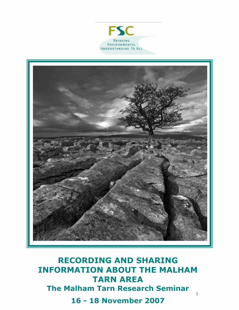
Cover photograph: Winskill Tree by Robin Sutton
4
FOREWORD
Once again the Malham Tarn Research Seminar provided a fascinating set of talks discussions and
displays. The theme of recording and sharing information was touched on by several speakers
and in the informal discussions that took place. As a theme it still needs further discussion and
development, before an improved system is developed for holding onto and using the vast
amount of information that is known about this unique location.
A recurrent strand in the Research Seminar has been how important professional, amateur and
research workers are in developing the understanding of a location such as Malham Tarn. At the
Field Centre we see all of these strands at work and the Seminar is one way to keep everyone in
contact. Each time we have new work and findings to report and discuss. One of the permanent
challenges is to know what is happening in your own and other fields of interest.
The 2007 seminar proceedings have a wide span: opening with Paul Bradley’s summary of the
history of Malham Tarn then coming quickly to new information about quartz deposition from
Allan Pentecost to re-interpretation of the glacial history of the Dales by Wishart Mitchell. David
Hodgson reports on new findings in caves and Helen Goldie shed new light on post-glacial karst
development. These show our understanding can always be developed through observation. The
contributions from Denise Loten, Stephen Morley, Cynthia Burek and Roger Meade raised
questions about the purpose and practise in landscape management. Sue Willis is working on
ways to understand Limestone Pavement. The work of Andy Markwick, Satvinder Nadhu, David
Hodgson and Douglas Richardson records what is there and raises questions about what to study
next. Finally David Hodgson presented a very personal view on some of the large issues affecting
us in the world today.
Recent or impending publications about the Dales Landscape and History of Ingleborough, by
Tony Waltham and David Johnson, respectively have shown a way forward and I look forward to
publication of a text on the Landscape and Natural History of the area around Malham Tarn. As
far as I know this has not been planned but it would be a good thing to discuss at the next
Malham Tarn Research Seminar in November 2009. I hope to see you there: hopefully we can
come up with some answers to the question of ‘What do we already know, what do we need to
know and how can future findings be recorded in an accessible manner’?
Adrian Pickles
October 2008
ACKNOWLEDGEMENTS
All contributors and attendees
Keith Orrell for chairing the sessions
Malham Tarn Field Centre Staff for looking after us so well
Robin Sutton for the cover photograph
Elizabeth Judson for compiling proceedings and co-ordinating the weekend
5
The Fifth Malham Tarn Research Seminar
RECORDING AND SHARING INFORMATION
ABOUT THE MALHAM TARN AREA
Friday 16 – Sunday 18 November 2007
A series of talks, displays and discussions about landscape, conservation and the future, hosted
and supported by the Field Studies Council at Malham Tarn Field Centre.

6
PROGRAMME
Friday
4.30 - Arrivals
7.00pm Dinner
8.00pm Poster Displays and Informal Discussion
Saturday
8.30 am Breakfast
9.15 am Welcome and Introduction - Adrian Pickles, Keith Orrell
Malham Tarn - perspectives on change– Paul Bradley
Water Resources - the future; a National Trust perspective – Denise Loten
10.45 am Coffee
11.00am Another Favourable Condition on Tarn Moss - Roger Meade
National Trust Regional Nature Conservation Strategy and the Yorkshire Dales
- Stephen Morley
12.30pm Lunch
1.15 pm Thoragill Plantation; an update - Douglas Richardson
Comparative Water analysis of Malham Tarn Springs
- Andy Markwick & Satvinder Nandhra
Quartz at Gordale – Allan Pentecost
Glaciation of the Yorkshire Dales - Wishart Mitchell
The Challenge of Karst Publications – Margaret Marker
Scoska Cave – David Hodgson
3.30 pm Tea
3.45pm Geodiversity and Geoconservation – Cynthia Burek
Surface Karst and Glaciation in Northern England - Helen Goldie
Classification and Management of Limestone Pavements - Sue Willis
Recording and Sharing Information about the Malham Tarn area – Adrian Pickles
5.45pm Sherry
6.00pm Dinner
7.00pm 60 years of environmental issues around Malham Tarn – David Hodgson
Discussion
Sunday
8.30am Breakfast
Depending upon response, site visits and/or additional talks and discussion
12.30pm Lunch
7
The History of Malham Tarn
Paul Bradley
Introduction
Malham Tarn is a largely natural headwater lake, with its top water level at an altitude of about
376.6m. Principally fed by an inflow stream at the northwest corner, the tarn has a relatively
small catchment. At the end of the Late-glacial, the tarn extended to almost twice its present area,
across Ha Mire and Tarn Moss (Pigott & Pigott, 1959). An earlier overflow channel discharged
southeastwards from the area now occupied by Ha Mire, through a small limestone gorge below
Great Close Plantation and over Gordale Scar. This outlet had ceased by around 11-13,000 years
ago, after which the present southern route was taken, greatly reducing the size of the tarn.
Subsequent silting and hydroseral succession have further reduced the depth and area of the tarn.
Until relatively recently, the outflow stream from Malham Tarn discharged over Malham Cove.
During the 18th Century, the outflow stream began to take an underground course, but accounts of
the stream spectacularly overflowing Malham Cove during wet weather continue into the early
19th Century (Anon, 1833). Seasonal flow variations remain, but the outflow stream now usually
flows only about 500m above ground before sinking into the Great Scar limestone.
Man’s influence in the area dates back at least as far as Mesolithic hunter-gatherers, 10,800-6,000
years ago, to whom it would have been an obvious attraction (Raistrick & Holmes, 1962). Fish
scales have been found amongst Mesolithic finds at Chapel Cave, less than 1km west of Malham
Tarn (H. Russ, pers. comm.), but there is currently no firm evidence of fish or fishing at Malham
Tarn during that period. Malham Moor is thought to have been settled, at least seasonally, since
at least the Bronze Age, 4,500-2,500 years ago (Raistrick & Holmes, 1962).
Despite a long history of landuse modifications in the catchment, the earliest available evidence of
man’s influence on the tarn itself is not until the 12th century. Following a presentation to the 4th
Malham Tarn Research Seminar on 17th November 2007, this paper reviews the known history of
Malham Tarn.
Norman Conquest and Monastic tenure (1066-1539)
Malham Moor had been settled by the Norse during the 10th century. Following the Conquest
(1066) Malham Tarn and its surrounding lands were granted to Norman nobles. Between 1164
and 1175, the tarn, together with its fishing rights, was granted to Fountains Abbey by William de
Percy. The Norse inhabitants of Malham Moor continued to farm the catchment under monastic
rule.
The tarn was highly regarded as a fishery by the Norman nobles and by the monks of Fountains
Abbey. Percy and his son-in-law the Earl of Warwick retained the right to extract fish from the
tarn whenever they were in the area. For the monks of Fountains Abbey, fish was an important
part of their Cistercian diet, especially on feast days and during festive periods. Fish from
Malham Tarn were transported to the Abbey by established monastic routeways (Mitchell, 1990).
The Cistercians put great efforts into modifying water courses and creating fish rearing ponds
elsewhere on their lands. In the North and West Ridings, it was Fountains Abbey that was the
main monastic pioneer in developing fisheries of all sorts (McDonnell, 1981). It is likely that
Malham Tarn would have been actively managed to improve the fishery. However, there are
8
currently no recognised modifications to Malham Tarn or its associated watercourses during the
Cistercians’ 364 year tenure.
Holmes (1956) thought it likely that brown trout (Salmo trutta) and perch (Perca fluviatilis) were
introduced to Malham Tarn during the 12th century, around the start of the Cistercian’s tenure.
But the long history of human activity on Malham Moor suggests there would likely to have been
earlier introductions of e.g. brown trout and bullhead (Cottus gobio) from local water courses.
From Dissolution to Walter Morrison (1539-1921)
The survey made at the Dissolution of Fountains Abbey in 1539 indicates that the tarn remained
actively fished at that time. After the Dissolution, the Fountains estates on Malham Moor
changed hands many times. Initially, the fishing passed into the hands of the Clifford family,
who had an extensive estate across the Dales (Davidson, 1985; White, 2002). An early account of
brown trout in Malham Tarn appears as an entry in an account book for 1606, which recorded
payment to a keeper watching for poaching of trout that were coming up the short inflow stream
to spawn (Holmes, 1956). The first reference to trout stocking (supplementing the tarn’s ‘natural’
recruitment) is not until the early 1800s.
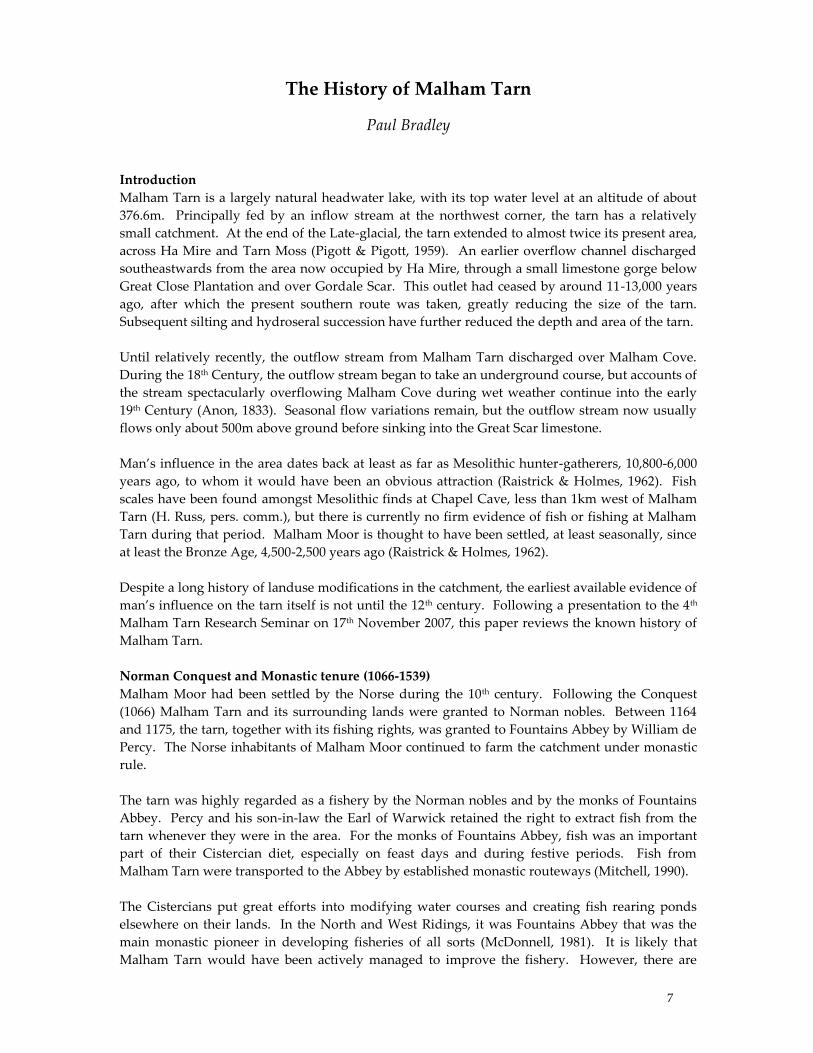
The map is © and reproduced with permission from Digital Archives
Figure 1 Jefferys Map of Yorkshire, 1771
The earliest known map of Malham Tarn appears to be that of Thomas Jefferys’ (1771) (Figure 1),
coarsely depicting a much more irregular margin than the present day. At that time, Malham
Tarn appears to have been a relatively unproductive water body, with low phytoplankton
production. In the 18th century it was said that ‚on a still day, you may see the white chalky bottom,
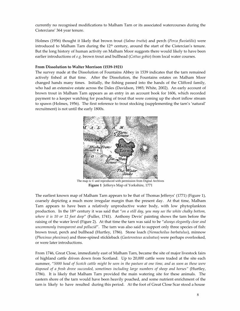
where it is 10 or 12 foot deep‛ (Fuller, 1741). Anthony Devis’ painting shows the tarn before the
raising of the water level (Figure 2). At that time the tarn was said to be ‚always elegantly clear and
uncommonly transparent and pellucid‛. The tarn was also said to support only three species of fish:
brown trout, perch and bullhead (Hurtley, 1786). Stone loach (Nemacheilus barbatulus), minnow
(Phoxinus phoxinus) and three-spined stickleback (Gasterosteus aculeatus) were perhaps overlooked,
or were later introductions.
From 1746, Great Close, immediately east of Malham Tarn, became the site of major livestock fairs
of highland cattle driven down from Scotland. Up to 20,000 cattle were traded at the site each
summer, ‚5000 head of Scotch cattle might be seen in the pasture at one time, and as soon as these were
disposed of a fresh drove succeeded, sometimes including large numbers of sheep and horses” (Hurtley,
1786). It is likely that Malham Tarn provided the main watering site for these animals. The
eastern shore of the tarn would have been heavily poached, and some nutrient enrichment of the
tarn is likely to have resulted during this period. At the foot of Great Close Scar stood a house
9
© Kirbymalham.info
Figure 2 Malham Tarn 1786. From Thomas Hurtley’s ‚Natural Curiosities of the Environs of Malham‛
(since demolished) that served as an alehouse for drovers and traders - such was the intensity of
human activity. The sales of Scottish cattle on Great Close are believed to have continued for
some time, but by the early 19th century Great Close had been reduced to a fattening ground for
cattle and sheep bound for October fairs held at Malham or Boss Moor.
During the 1780s Thomas Lister (later to become Lord Ribblesdale) began constructing a hunting
lodge on the site of the present day Tarn House. The hunting lodge was constructed over the
foundations and ground floor of an earlier building of the period 1570-1630 (Raistrick & Gilbert,
1963). It is not known whether this was the location of Malwaterhouse, first mentioned in the
memorandum book of Fountains Abbey in 1454.
In 1791 the tarn was artificially enlarged, with the construction of an embankment and sluice gate
at tarn foot, raising the tarn level by about 1.2m (Holmes 1956). One of the maps from the estate
rent books for the period 1760-1780, reproduced by Pentecost (2000), appears to show the planned
water level. The East Boathouse was already in place on the north shore at that time. Prior to
1791 the margin at Tarn Moss might have extended up to 50-80m further into the tarn, perhaps
fringed by reedswamp (Pentecost, 2000). Raising of the water level partially reflooded margins
that had not been under water since the Late-glacial (Pigott & Pigott, 1959).
Lister's Malham Moor estate was offered for sale in 1831. An advertisement published in The
Times refers to the lake “…well stocked with trout and perch of large size…”. In 1852 the estate was
purchased by James Morrison, a self-made man of Scottish decent. By the time of his death in
1857, James Morrison was believed to be the richest commoner in Great Britain. Malham Tarn
Estate was inherited by the fifth of his seven sons, Walter Morrison, who held tenure for 64 years
until his death in 1921. Lister’s house was badly damaged by fire in 1873. Rebuilding by Walter
Morrison largely produced the present day Tarn House.
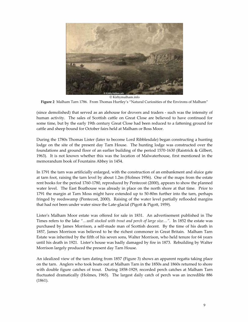
An idealized view of the tarn dating from 1857 (Figure 3) shows an apparent regatta taking place
on the tarn. Anglers who took boats out at Malham Tarn in the 1850s and 1860s returned to shore
with double figure catches of trout. During 1858-1929, recorded perch catches at Malham Tarn
fluctuated dramatically (Holmes, 1965). The largest daily catch of perch was an incredible 886
(1861).
10
© Motco Enterprises Limited, ref: www.motco.com
Figure 3. Rock & Co. London. No. 3331 Malham Tarn, Yorkshire. 25 Mar 1857.
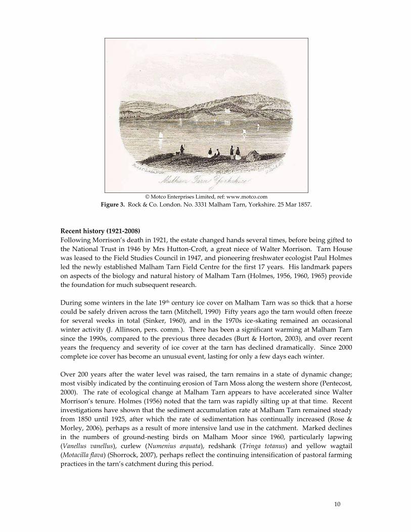
Recent history (1921-2008)
Following Morrison’s death in 1921, the estate changed hands several times, before being gifted to
the National Trust in 1946 by Mrs Hutton-Croft, a great niece of Walter Morrison. Tarn House
was leased to the Field Studies Council in 1947, and pioneering freshwater ecologist Paul Holmes
led the newly established Malham Tarn Field Centre for the first 17 years. His landmark papers
on aspects of the biology and natural history of Malham Tarn (Holmes, 1956, 1960, 1965) provide
the foundation for much subsequent research.
During some winters in the late 19th century ice cover on Malham Tarn was so thick that a horse
could be safely driven across the tarn (Mitchell, 1990) Fifty years ago the tarn would often freeze
for several weeks in total (Sinker, 1960), and in the 1970s ice-skating remained an occasional
winter activity (J. Allinson, pers. comm.). There has been a significant warming at Malham Tarn
since the 1990s, compared to the previous three decades (Burt & Horton, 2003), and over recent
years the frequency and severity of ice cover at the tarn has declined dramatically. Since 2000
complete ice cover has become an unusual event, lasting for only a few days each winter.
Over 200 years after the water level was raised, the tarn remains in a state of dynamic change;
most visibly indicated by the continuing erosion of Tarn Moss along the western shore (Pentecost,
2000). The rate of ecological change at Malham Tarn appears to have accelerated since Walter
Morrison’s tenure. Holmes (1956) noted that the tarn was rapidly silting up at that time. Recent
investigations have shown that the sediment accumulation rate at Malham Tarn remained steady
from 1850 until 1925, after which the rate of sedimentation has continually increased (Rose &
Morley, 2006), perhaps as a result of more intensive land use in the catchment. Marked declines
in the numbers of ground-nesting birds on Malham Moor since 1960, particularly lapwing
(Vanellus vanellus), curlew (Numenius arquata), redshank (Tringa totanus) and yellow wagtail
(Motacilla flava) (Shorrock, 2007), perhaps reflect the continuing intensification of pastoral farming
practices in the tarn’s catchment during this period.
11
There has clearly been a long history of fish management at Malham Tarn, dating back to at least
the 12th century. Stocking with brown trout has taken place intermittently from at least 1860, but
since 1994 the National Trust has managed the tarn as a more naturally recruiting brown trout
fishery. Stocking of the tarn is now considered inconsistent with the site’s high conservation
status (Maitland, 1996). Much of the pre-1791 shoreline of Malham Tarn was exposed in 1972,
when repairs to the spillway required lowering of the water level by about a metre (Disney, 1972;
1975). A subsequent fish survey found severely suppressed recruitment of perch that year
(Burrough & Kennedy, 1978), as a consequence of the summer drawdown.
White-clawed crayfish (Austropotamobius pallipes) occurred at very high density at Malham Tarn
during the 1960s (Holmes, 1965; O.L. Gilbert pers. comm.), having apparently been introduced to
the Dales (River Ure) from the south of England in the 16th century (Camden, 1607; Holmes, 1956).
Crayfish (along with fish) were a valued meat substitute during monastic periods of fasting
(Swahn, 2004), and it is perhaps likely that white-clawed crayfish were introduced to Malham
Tarn prior to Dissolution (1539). The population of white-clawed crayfish crashed at Malham
Tarn during the 1970s, but the magnitude of decline and the now perilous status of the species at
Malham Tarn did not become apparent until the turn of the century (Bradley, 2001).
Over the last decade water transparency at Malham Tarn has often been poor in late summer
(pers. obs. & (Hinton, 2001), and there is evidence of increased phytoplankton densities since the
1980s (A. Pentecost, pers. comm.). Annual variations in the relative distribution of aquatic plant
species since 1994 (Hinton, 2001, 2003, 2005) suggest a community response to ecological change.
Core sample analysis shows a sharply defined increase in organic matter in the tarn sediment,
apparently coinciding with the 1791 raising of the water level (Coletta, 2005; Pentecost, 2000).
However, the total phosphorus profile in sediments suggests a much longer history of human
influence (nutrient enrichment) at Malham Tarn, perhaps dating back to the 17th century
(Pentecost, 1998), before the Great Close cattle fairs.
Conservation challenge (2008 onwards)
During these early years of the new millennium Malham Tarn remains proudly watched over by
one of the FSC’s longest established field centres, set within one of the best studied karst
landscapes. The tarn’s conservation interest is recognised by an impressive array of national and
international designations, and much of the tarn’s small catchment is in the control of the National
Trust, Natural England and the Yorkshire Dales National Park Authority.
Looking ahead, the tarn appears likely to experience additional species introductions. The
appearance of the small snail Hydrobia jenkinsi in 1950 and of Canadian pondweed (Elodea
canadensis) in 1962 were likely to have been unintended student introductions (Holmes, 1965).
The tarn now faces a much more serious threat. Since the 1980s a combination of accidental and
malicious introductions has led to the establishment of the extremely invasive American signal
crayfish (Pacifastacus leniusculus) in four major river systems of the Yorkshire Dales. During 2008,
the Environment Agency is expected to attempt biocide eradication of the nearest known
population. The ecological consequences of signal crayfish invasions are only now beginning to
be appreciated, and appear to be particularly pronounced in closed systems. If this species were
to arrive at Malham Tarn, it could achieve a dominant ecological position that would represent
the most devastating change in the site’s recorded history. Less than 10 years after its
introduction to a small water body in the Ure catchment, no fish or aquatic macrophytes were
found to have survived, and the previously clear water was found to be brown and turbid (pers.
obs.).
12
Malham Tarn is still considered to be the best example of a clear-water upland stonewort Chara-
dominated lake in England (JNCC, 2008). Threatened by species invasions, sedimentation,
nutrient enrichment and climate change, the challenge for conservation agencies will be to
manage and control the continuing change, to retain the tarn’s natural character, and to maintain
its capacity for self-renewal well into this new millennium.
Acknowledgements
Particular thanks are due to David Johnson and Alan Pentecost for kindly commenting on an
earlier draft of this paper, and also to Elizabeth Judson and Adrian Pickles for their continuing
support. This research was also assisted by many other participants of the FSC’s biennial Malham
Tarn research seminars, which continue to provide essential forums for those working in the area.
References
Anon (1833) Malham Cove, Yorkshire. The Saturday Magazine, 33.
Bradley, P. (2001) White-clawed crayfish (Austropotamobius pallipes) at Craven Limestone Complex
SAC, North Yorkshire. In Past, Present, Future. Monitoring and managing change at
Malham Tarn. 2nd Malham Tarn Research Seminar, pp. 6-9. Field Studies Council,
Malham Tarn Field Centre.
Burrough, R.J. & Kennedy, C.R. (1978) Observations on the brown trout (Salmo trutta) and perch
(Perca fluviatilis) of Malham Tarn, North Yorkshire. Field Studies, 4(5), 631-643.
Burt, T.P. & Horton, B.P. (2003) The climate of Malham Tarn. Field Studies, 10, 635-652.
Camden, W. (1607) Britannia (p.729) F. Kingston, R. Young and I. Legat (William Aspley 1637
English edition).
Coletta, P. (2005) Sedimentary cores from Malham Tarn: a record of environmental change. In
How Much is there Still to Learn? 4th Malham Tarn Research Seminar, pp. 28-29. Field
Studies Council, Malham Tarn Field Centre.
Disney, H. (1972). Malham Tarn Field Centre: Warden's Report. In Field Studies Council Annual
Report 1971/2, pp. 22-23. Field Studies Council, Shrewsbury.
Disney, R.H.L. (1975) Review of management policy for the Malham Tarn estate. Field Studies,
4(2), 223-242.
Fuller, J., jun. (1741) A description of a large lake called Malholm Tarn, near Skipton in Craven, in
the county of Yorkshire. Phil. Trans. R. Soc. Lond., 41, 612-614.
Hinton, G. (2001) Aquatic macrophyte surveys of Malham Tarn: 1994 to 2001. In Past, Present,
Future. Monitoring and managing change at Malham Tarn. 2nd Malham Tarn Research
Seminar, pp. 14-19. Field Studies Council, Malham Tarn Field Centre.
Hinton, G. (2003) Aquatic macrophyte ecology of Malham Tarn: 1994 to 2003. In Life in a
Limestone Landscape. 3rd Malham Tarn Research Seminar, pp. 14-16. Field Studies
Council, Malham Tarn Field Centre.
Hinton, G. (2005) Aquatic macrophyte ecology of Malham Tarn from 1994 to 2005. Possible link to
North Atlantic Oscillation. In How Much is there Still to Learn? 4th Malham Tarn
Research Seminar, pp. 14-19. Field Studies Council, Malham Tarn Field Centre.
Holmes, P.F. (1956) Malham Tarn. A background for freshwater biologists. Field Studies Council
Annual Report, 1954-55, 48-57.
Holmes, P.F. (1960) The brown trout of Malham Tarn, Yorkshire. Salmon and Trout Magazine, 159,
127-145.
Holmes, P.F. (1965) The natural history of Malham Tarn. Field Studies, 2(2), 199-223.
13
Hurtley, T. (1786) A concise account of some natural curiosities in the environs of Malham in Craven,
Yorkshire Robson & Longman, London.
JNCC (2008) Craven Limestone Complex SAC.
http://www.jncc.gov.uk/protectedsites/sacselection/sac.asp?EUcode=UK0014776. Accessed 31 March
2008.
Maitland, P.S. (1996). The brown trout of Malham Tarn: a strategy for fish and fishery
management. Report to the National Trust. Fish Conservation Centre, Haddington.
McDonnell, J. (1981) Inland Fisheries in Medieval Yorkshire 1066-1300.
Mitchell, W.R. (1990) Walter Morrison: A Millionaire at Malham Tarn W.R. Mitchell, Settle, North
Yorkshire.
Pentecost, A. (1998) Phosphorus fractionation in the sediments of Malham Tarn, North Yorkshire.
Field Studies, 9(2), 337-342.
Pentecost, A. (2000) Some observations on the erosion of tarn moss by the waters of Malham Tarn.
Field Studies, 9(4), 569-581.
Pigott, M.E. & Pigott, C.D. (1959) Stratigraphy and pollen analysis of Malham Tarn and Tarn
Moss. Field Studies, 1(1), 84-101.
Raistrick, A. (1983) Malham and Malham Moor The Dalesman Publishing Company, Lancaster.
Raistrick, A. & Gilbert, O.L. (1963) Malham Tarn House: its building materials, their weathering
and colonisation by plants. Field Studies 1(5), 89-115.
Raistrick, A. & Holmes, P.F. (1962) Archaeology of Malham Moor. Field Studies 1(4), 73-100.
Rose, N. & Morley, D. (2006). Sediment accumulation rate changes in European lakes: A first
report. Deliverable No.89. Integrated Project to evaluate the Impacts of Global Change
on European Freshwater Ecosystems. Environmental Change Research Centre, University
College London.
Shorrock, B. (2007) The Birds of Malham Moor. Changes in status 1960-2006. Field Studies Council,
Malham Tarn Field Centre.
Sinker, C.A. (1960) The vegetation of the Malham Tarn area. Proceedings of the Leeds Philosophical
and Literary Society, 8, 139-175.
Swahn, J.-Ö. (2004) The cultural history of crayfish. Bulletin Français de la Pêche et de la Pisciculture,
372-373, 243-251.

14
National Trust Water Policy
Denise Loten
The following policy sets out the National Trust’s aspirations for the management and use of
water resources by itself and by others. The Trust seeks to implement this policy alongside its
other commitments and is keen to share its experience with others.
The Trust’s approach
The Trust will take a comprehensive, long-term and strategic approach to the protection of
water resources and all water-dependent aspects of the natural and cultural environment.
The Trust will manage its own affairs to minimise the demand for water and production of
waste water and to minimise the negative impacts of its activities on the water environment.
The Trust will develop a decision-making process for site and business management based on
the principles and practices of Catchment Management and River Basin Planning, to
integrate water resource conservation into all its activities and to maximise the benefits of
working in partnership.
The Trust will promote the protection and enhancement of water resources based on its own
experience of water management and conservation of water-dependent features.
Our Management Principles
1. Working with natural processes
The Trust will work to enable the natural functioning of water-dependent geomorphological and
biological features and encourage landscapes and ecosystems to be dynamic and responsive to
natural processes and sustain the hydrological cycle. This includes water underground, at the
surface and in the atmosphere.
2. Sustainable use of water
The Trust will safeguard the quality and quantity of water resources in its use for any purpose.
3. Healthy water for healthy people and sustainable economy
The Trust will improve provision of high quality potable water, the treatment to the best
practicable standard of its used waters, and the protection of its coastal and inland waters for
recreation and health.
4. Heritage water
Valued cultural features and water dependent habitats threatened by change will be conserved
and enhanced as far as practicable within the scope of the hydrological cycle and enabled to adapt
to climate change. Where assets cannot be protected indefinitely, the Trust will ensure such
features are properly recorded before they are lost and/or will consider relocation or re-creation
elsewhere.
5. Access to water
The Trust will actively promote public access to water, subject to conservation and safety
considerations, in order to provide public enjoyment and recreational opportunities and to
develop understanding of the role of water in our environment and livelihoods.
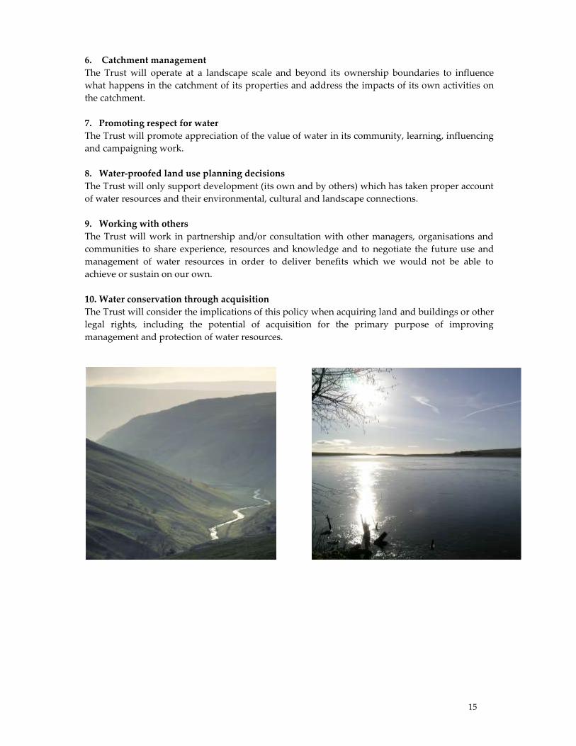
15
6. Catchment management
The Trust will operate at a landscape scale and beyond its ownership boundaries to influence
what happens in the catchment of its properties and address the impacts of its own activities on
the catchment.
7. Promoting respect for water
The Trust will promote appreciation of the value of water in its community, learning, influencing
and campaigning work.
8. Water-proofed land use planning decisions
The Trust will only support development (its own and by others) which has taken proper account
of water resources and their environmental, cultural and landscape connections.
9. Working with others
The Trust will work in partnership and/or consultation with other managers, organisations and
communities to share experience, resources and knowledge and to negotiate the future use and
management of water resources in order to deliver benefits which we would not be able to
achieve or sustain on our own.
10. Water conservation through acquisition
The Trust will consider the implications of this policy when acquiring land and buildings or other
legal rights, including the potential of acquisition for the primary purpose of improving
management and protection of water resources.

16
Tarn Moss, Malham; can’t we just enjoy it?
Roger Meade
The peat bog to the west of Malham Tarn is of great antiquity. It has developed over former
shallow water and reedbed into a dome of peat up to six metres thick, over a period of several
thousands of years. Our approach to conserving such features in the UK, and in the European
Union, is based on knowing what it is, what it should look like, and how it needs to change to
achieve what is known as ‘favourable condition’. The processes to be gone through in making the
judgement are described in this paper, and an opinion offered as to whether Tarn Moss is in
favourable condition.
Tarn Moss is not just any old peat bog. It is within a Site of Special Scientific Interest (SSSI, a UK
designation) and within a Special Area of Conservation (SAC, a EU designation).
It is part of the:
Malham-Arncliffe SSSI
Craven Limestone Complex SAC
National Trust estate
According to the EU Habitats Directive, SACs must be maintained in favourable condition, or
restored to achieve it; within the UK and irrespective of SAC status, SSSIs must be restored to and
maintained in favourable condition.
Defining Favourable Condition
Many categories of semi-natural habitat are recognised in the UK and in Europe. Those relevant
to Tarn Moss are blanket mire and active raised bog. Although these overlap in terms of structure
and function, the category chosen for Tarn Moss determines which particular set of tests are
applied to report on its condition. While some sites fit easily into a category, Tarn Moss has
characteristics of both blanket mire, and ‘lowland’ raised bog. The former creates a ‘blanket’ of
peat over flat and sloping ground and is confined to the uplands in England, while the second
forms gentle domes of peat over former basins and or plateaux, usually though not exclusively in
the lowlands. Tarn Moss is mostly formed over a basin, but the peat also covers sloping ground
around the original basin; it is also at a higher altitude (approx 380m AOD) than what would
normally be thought of as a lowland site. The difference is of consequence, in that the outcome of
the condition assessment may be dependent on whether the lowland or upland test is applied.
Measuring Favourable Condition
The condition assessment method used as guidance in the UK (JNCC 2005) takes account of
habitat extent and its quality. It subdivides broad habitats into sub-components for separate
assessment, such as lagg and mire expanse. Most raised bogs can be divided in this way, the fen
around the edge forming the lagg, the greater part forming the mire expanse, and the two being
separated by a steeper edge slope, known as the rand. The assessments presented here concentrate
on the mire expanse, which is based on the following attributes.
Lowland raised bog assessment method:
Is based on detailed lists of ‘indicator’ vascular plants and Sphagnum species.
Lists are sub-divided, applying specific frequency and cover criteria for each group of species.
17
Assumes NVC community M18 (Erica tetralix-Sphagnum papillosum raised and blanket mire),
but similar tests have been devised here for e.g. M19 (Calluna vulgaris-Eriophorum vaginatum
blanket mire).
Includes a detailed list of negative species, alien to raised bog, including tall fen plants and
trees.
Upland bog assessment method:
Uses long species lists, inc. generic Sphagnum presence rather than individual species.
Has less division into species groups.
Similar tests are applied – frequency, cover.
Has negative species criteria linked to dominance.
An additional complication arises from the assumption in the lowland bog test that the plant
community must be M18 (see above); as a relatively upland example, the justification for
expecting M18 to predominate is less valid, and even M19 (see above) might be considered to fall
within the favourable condition range. A test has been devised here for M19 and is applied below
to see if the lowland method would deliver a favourable condition conclusion if a more relaxed
approach was adopted to the component plant community.
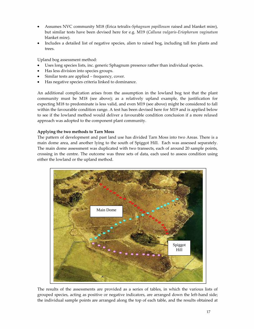
Applying the two methods to Tarn Moss
The pattern of development and past land use has divided Tarn Moss into two Areas. There is a
main dome area, and another lying to the south of Spiggot Hill. Each was assessed separately.
The main dome assessment was duplicated with two transects, each of around 20 sample points,
crossing in the centre. The outcome was three sets of data, each used to assess condition using
either the lowland or the upland method.
The results of the assessments are provided as a series of tables, in which the various lists of
grouped species, acting as positive or negative indicators, are arranged down the left-hand side;
the individual sample points are arranged along the top of each table, and the results obtained at
Spiggot
Hill
Main Dome
18
each of these points entered within the matrices. It is not intended that the detail of the forms
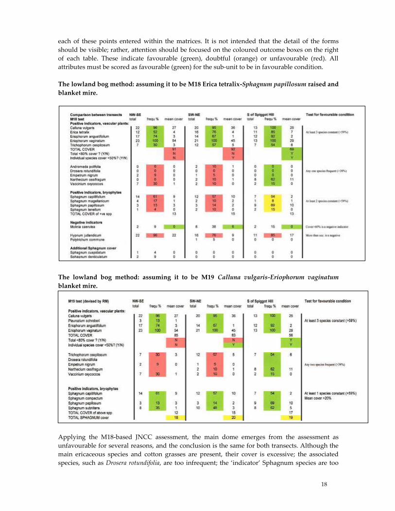
should be visible; rather, attention should be focused on the coloured outcome boxes on the right
of each table. These indicate favourable (green), doubtful (orange) or unfavourable (red). All
attributes must be scored as favourable (green) for the sub-unit to be in favourable condition.
The lowland bog method: assuming it to be M18 Erica tetralix-Sphagnum papillosum raised and
blanket mire.
The lowland bog method: assuming it to be M19 Calluna vulgaris-Eriophorum vaginatum
blanket mire.
Applying the M18-based JNCC assessment, the main dome emerges from the assessment as
unfavourable for several reasons, and the conclusion is the same for both transects. Although the
main ericaceous species and cotton grasses are present, their cover is excessive; the associated
species, such as Drosera rotundifolia, are too infrequent; the ‘indicator’ Sphagnum species are too
19
infrequent. The cover of the negative mosses are too high. By contrast, the unit south of Spiggot
Hill passes on most attributes, though the Sphagnum frequency is borderline and the negative
bryophytes have too high a cover.
Low frequencies of associate higher plant species also leads to a conclusion of unfavourable
condition when the specially-designed M19-based test is applied. The failure is less severe than
with the M18-based test, because the Sphagnum threshold is not so stringent. Once again, the unit
south of Spiggot Hill fares better than the main dome, and could be deemed to be in favourable
condition.
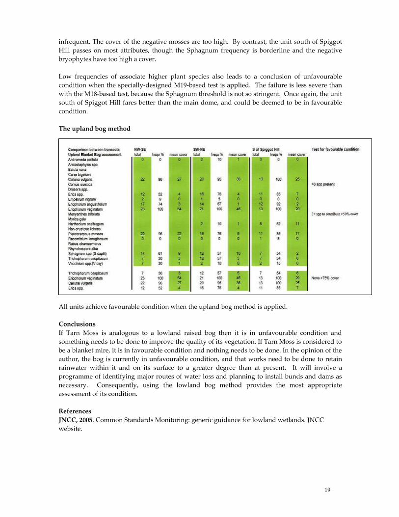
The upland bog method
All units achieve favourable condition when the upland bog method is applied.
Conclusions
If Tarn Moss is analogous to a lowland raised bog then it is in unfavourable condition and
something needs to be done to improve the quality of its vegetation. If Tarn Moss is considered to
be a blanket mire, it is in favourable condition and nothing needs to be done. In the opinion of the
author, the bog is currently in unfavourable condition, and that works need to be done to retain
rainwater within it and on its surface to a greater degree than at present. It will involve a
programme of identifying major routes of water loss and planning to install bunds and dams as
necessary. Consequently, using the lowland bog method provides the most appropriate
assessment of its condition.
References
JNCC, 2005. Common Standards Monitoring: generic guidance for lowland wetlands. JNCC
website.

20
National Trust Regional Nature Conservation Strategy
Stephen Morley
The National Trust is one of the largest nature conservation charities in Europe with holdings of
nearly 250,000ha. Founded in 1895, enshrined by the National Trust Act 1907 with explicit
responsibility for conservation of lands "<for the preservation of their natural aspect, features
and animal and plant life."
The new Regional Strategy, published July 2007, mirrors the Trust’s National strategy
and aims to:
• highlight the biodiversity within the National Trust’s Yorkshire & North East Region
• consider the vulnerability of habitats and species due to varied and often considerable threats
and pressures
• influence property and Regional planning
• guide and support practical conservation management to maximise biodiversity
The strategy has been produced against the background of the Trust’s policy framework
(incorporating policies on agriculture, forestry, access, nature conservation and other disciplines
and land-uses, underpinned by the National Trust Act 1907) and the external legislative
framework including both national and international site and species protection. Much of our
current conservation work is driven by the UK ‘Biodiversity Action Plan’ process.
Priority Habitats and Species
The habitats and species of most importance to the Trust in the Region are identified, defined and
described. These are ‘Priority’ habitats and species, as defined by the UK Biodiversity Action
Plan, with additions regarded as of importance to the Trust. 16 habitats or suites of habitats, and
32 species or groupings of species, are included. For each, there is an analysis of the current
threats and the key actions the Trust needs to take to ensure their conservation. Geodiversity
conservation (geology, landforms and soils) is also covered. The threats posed by invasive species
of plants, animals and fungi are addressed.
Priority Nature Conservation Issues and Actions
The priority issues and actions are identified as:
optimising the environmental potential of intensively farmed and forested land
ensuring appropriate forms of management for conserving priority habitats and species
protecting all remnants of semi-natural habitat, expanding and linking them;
ensuring that all leases (farm, building and shooting leases) incorporate and protect
biodiversity and that appropriate surveys are done prior to any building or property work
controlling invasive species
restoring natural hydrology
managing on a landscape scale to allow for species movement and ecosystem change
running training, monitoring, recording and survey programmes to increase our knowledge
ensuring wardening capacity is adequate and other resources are secured to carry out
management
maximising access, volunteering and learning opportunities so that people can engage with
nature
21
Thoragill - Where Next ?
Douglas T. Richardson
During the last two years finishing touches to the investigations related to Thoragill beck
plantation, marsh and fellside in the immediate vicinity have been made.
Thanks to our fickle weather, ambitious aspirations to carry out light trapping of moths on a
regular basis did not come to fruition but what little was done gave us 22 species of moth and 13
caddis fly and surveys by members of the Yorkshire Naturalists' Union came up with 90 species
of lichen and 26 molluscs. Random sweep netting opened our eyes to the variety of insect life
which was lying in wait to be investigated.
There are now even more questions to be answered providing work for every category of
enthusiast professional or otherwise:
The marsh - why are there noticeable deposits of " moon-milk ," the soft spongy form of
calcium carbonate more often associated with caves, in the streamlet as opposed to hard tufa
and what mechanisms are involved in its deposition
Why are there significant differences in the chemical composition of the three streams which
form Thoragill Beck, each of which rises at approximately the same altitude; how are dilution
surges related to rainfall; how can time-lag associated with these surges be explained and
why are there extensive deposits of very hard tufa in the centre beck and not in the others.
Do the freshwater shrimps carry parasitic larvae of Acanthocephala or are these only found in
shrimps in neighbouring water bodies.
Are there any distinctive distribution patterns for the various species of mayfly, stonefly and
caddis fly larvae, there are for example different species of the latter in the centre beck as
compared with cave beck, is this due to the tufa which is providing a different substrate.
How many of the 20 or so birds listed actually nest in the plantation, would it be a good idea
to put up nest boxes.
Are there any small mammals to be found in the plantation.
As for flowering plants the list is far from complete - a job there for botanists – and what
about fungi and plant galls.
Even to my inexperienced eye the contents of the sweep net and beating tray from the plantation
suggest that there is a lot to investigate e.g. there is more than one species of grasshopper, shield
bug, mirid bug, froghopper, aphid, psocoptera, crane-fly, mosquito, midge, hover-fly, saw-fly,
bumble bee, wasp and beetle for a start. There are other arthropods as well, woodlice,
centipedes, millipedes, spiders, harvestmen. And if you want something really small symphalids
, pseudoscopions and springtails.
The plantation was set up in the early 1980's so it is relatively quite young and the data currently
collected can quite reasonably be regarded as the condition of the plantation from start and as
such can be used as a baseline against which any changes that occur can be measured.

22
It is not a designated nature reserve and has no allocated special site status so in theory can be
visited without restriction except to recognise ownership and tenant occupation and to
acknowledge that it is quite small and therefore not for use by large parties of individuals. In
other words a useful stamping ground for the individual worker.
The data has been recorded in pamphlet form, along the lines suggested by me in November
20051, and forms one of a series of 5 covering the whole Cowside area from 2001 they are :-
Part 1 Cowside Beck, Dewbottoms Beck, River Skirfare, Yew Cogar Beck & Yew Cogar Hole.
Part 2 Cherry Tree Hole, Darnbrook Beck, Darnbrook Pot, Fountains Fell Tarns, Old Mine
Level, Robinson's Pot and Tennant Gill.
Part 3 Thoragill Beck, Plantation and Marsh
Part 4 Site References - Gives grid references and altitude of all the sites visited enabling sites
identified on the maps, which are included in the booklets, to be correctly pinpointed.
Part 5. Water Analyses. - Collects together over 500 water analyses.
Parts 1, 2 & 3 list aquatic fauna & flora, terrestrial flora & fauna, tufa sites, water analyses from
streams, springs and flushes, birds, mammals, lepidoptera, trichoptera, freshwater algae, diatoms,
Chara sites, lichens, mammals, mollusca.
As for the use of these booklets I have visions of copies being used as teaching aids where
participants are invited to trawl through the data and discuss what they find, how they would
tackle any problems they perceive and /or make suggestions as to how the work could be
furthered.
The alternative is a computer data base. The problem here being staff, as not may establishments
enjoy the luxury of being able to allocate someone to run such a scheme on a permanent basis.
I have to thank the National Trust and Mr. Hall of Darnbrook Farm for their kindness and
interest, David Hodgson and all the other volunteers who have given freely of their time and
expertise.
All that is left is to put what is currently known into a dissertation along the lines of The Ecology
of Cowside Beck 2 which was published in November 2005 so that others may study the results
and perhaps be persuaded to do something along these lines themselves.
1. Richardson, Douglas T Some thoughts on how to make raw data available to a wider
audience. FSC The Malham Tarn Research Seminar 18th. - 20th. November 2005
2. Gilbert, Oliver, et al The Ecology of Cowside Beck, a tributary of the River Skirfare in the
Malham area of Yorkshire. FSC Malham Tarn Field Centre. 2005
Footnote
As a result of the interest shown by participants at the Seminar the five booklets have been put on
CD.
23
Comparative chemistry of water from the Malham Tarn system
Andy Markwick, Satvinder Nandhra and David Hodgson
Introduction
Malham Tarn occupies a shallow depression, lined by an inlier of impermeable slate of the
Silurian Horton Formation. Surrounding the tarn is the relatively thick formation of Lower
Carboniferous Great Scar limestone. These are succeeded to the northwest by the subordinate
Yordale Series, which comprise interleaved limestone, shale sandstones and rare coal. The
modern topography of this area has been shaped by successive faulting and glacial events (Woof
and Jackson. 1988).
This study provides new data for pH, conductivity, air and water temperatures from twelve
locations in and around the tarn (eight inflow, three tarn and one outflow, Figure 1). These
locations have been the focus of intermittent studies since the 1950s (Pigott and Pigott, 1959; Woof
and Jackson, 1988; Hinton, 2001). Monthly measurements have been systematically recorded since
2004 and a comprehensive database has now been constructed.
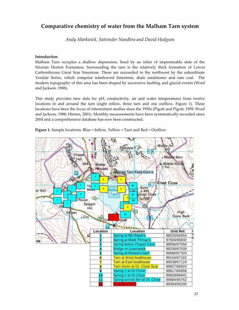
Figure 1. Sample locations. Blue = Inflow, Yellow = Tarn and Red = Outflow.
Location Location Grid Ref.
1 Spring at Bill Bland’s 88020/66954
2 Spring at Mark Throup’s 87604/66832
3 Spring below Chapel Cave 88096/67056
4 Bridge on boardwalk 88336/67028
5 Spring at Robert’s barn 88680/67320
6 Tarn at West boathouse 89164/67162
7 Tarn at East boathouse 89538/67124
8 Tarn shore at Gt. Close Scar 89827/66924
9 Spring 1 at Gt Close 89817/66958
10 Spring 2 at Gt Close 89828/66941
11 Spring across fen at Gt. Close 89884/66762
12 Outflow of tarn 89394/66200
5
11
10 2
9 4
3
1
6 7
8
12
5
11
10 2
9 4
3
1
6 7
8
24
Results summary and discussion
The data in Table 1 is representative of the whole data set; it highlights three chemically distinct
environments. Inflow water can be divided into two sources. The first (Robert’s barn), shows the
lowest values of pH, conductivity and T(H2O) with very little variation over the year, indicating
that this water derives from a deep source. Whereas the other inflow sources, which have had
longer exposures to radiant heating and surface conditions, have greater ranges in pH,
conductivity and T(H2O) and show considerable fluctuation over the year, often increasing during
summer. The third water environment includes the tarn and its outflow, where pH and T(H2O)
are on average higher, conductivity is lower and decreases during the summer months. These
seasonal changes in the tarn are the result of a number of factors removing Ca2+ from solution.
Increased photosynthetic activity of algae and macrophytes removes CO2, which increases CaCO3
precipitation into the tarn. This process was first considered by Pigott and Pigott (1959) and later
suggested as a main reason for depletion in tarn alkalinity by Hinton (2001). Hinton (2001) also
makes a tentative link between macrophyte abundance and the Gulf Stream oscillation. Woof and
Jackson (1988) showed that CaCO3 is removed by precipitation directly onto stoneworts. In
addition, the warmer water during the summer increases CO2 dissolution, thus raising pH and
increasing CaCO3 precipitation.
CO2 + H2O ↔ H2CO3 (1)
CaCO3 + H2CO3 ↔ Ca2+ + 2HCO3- (2)
The above processes force the equilibrium in (1) to the left, which results in a reduction of H2CO3 (H+) and
hence (2) is forced to the left with more CaCO3 precipitating.
When total alkalinity in this study is compared to historic data significant changes are observed.
The average total alkalinity (CaCO3 mg/l) for inflow water has gradually increased and for more
recent years (2004 to 2006) values show a greater fluctuation in values. Despite the highly varied
water composition from inflow sources into the tarn, strong chemical and biological buffering
regulates alkalinity and this action is reflected in the composition of outflow water.
Table 1. Selected data showing yearly minimum and maximum values with ranges in brackets.
Location Year T air TH2O pH Conductivity
Bill Blands 2004 3.4-24.3 (20.9) 4.6-20.3 (15.7) 7.5-8.7 (1.2) 256-497 (241)
‘inflow’ 2005 0.9-26.0 (25.1) 1.8-19.6 (17.8) 7.0-8.7 (1.7) 309-520 (211)
2006 0.8-20.6 (19.8) 4.5-18.4 (13.9) 6.9-7.9( 1.0) 284-464 (180)
Roberts Barn 2004 3.6-26.8 (23.2) 7.6-8.1 (0.5) 6.8-8.0 (1.2) 190-361 (171)
‘inflow’ 2005 1.3-24.3 (23.0) 7.1-7.9 (0.8) 6.6-7.7 (1.1) 245-385 (140)
2006 2.0-17.5 (15.5) 6.9-7.9 (1.0) 6.5-7.2 (0.7) 212-345 (133)
W.Boathouse 2004 3.9-26.2 (22.3) 2.6-19.7 (17.1) 7.4-9.1 (1.7) 160-260 (100)
‘tarn’ 2005 0.7-25.6 (23.9) 0.9-25.0 (24.1) 7.0-9.6 (2.6) 102-278 (176)
2006 1.4-18.0 (16.6) 2.7-21.5 (18.8) 6.9-8.6 (1.7) 105-267 (162)
Outflow 2004 3.2-26.0 (22.8) 1.6-19.6 (18.0) 7.8-9.6 (1.8) 109-283 (174)
2005 2.1-31.5 (29.4) 0.1-22.2 (22.1) 7.4-9.6 (2.2) 101-268 (167)
2006 2.9-17.4 (14.5) 2.5-15.6 (13.1) 7.4-8.1 (0.7) 111-264 (153)

25
NO3- and PO43- concentrations were obtained during August 2007 and when compared to data
from the 1950s, show a significant increase. This may in part, be due to changes in agricultural
practices.
Results from this study can be summarised as follows:
• T(H2O) v T(air) produces three distinct water environments
• Concentration of ions (Ca2+) correlate with flora/fauna abundance and T(H2O)
• Poor correlation exists between pH and ion concentrations
• The tarn chemically and biologically buffers inflow waters
• Annual alkalinity trends in the tarn have changed since the 1950s and show a significant
decrease during summer
• PO43- and NO3- levels are greater now than in the 1950s
Into the future
We are just beginning to unravel the complex nature of the tarn area and to see how comparisons
between current and historic data supports change in climate in the area. It is important that the
following measurements continue or develop:
• pH, Conductivity and Temperature
• Cation and anion concentrations
• Soil analysis
• Biodiversity monitoring
References:
Pigott and Pigott, 1959. Field Studies. 1, pp 84-102;
Woof and Jackson, 1988. Field Studies 7, pp 159-187;
Hinton, 2001. Field Studies Research Seminar, pp. 32-33.
Acknowledgements: We are grateful to Adrian Pickles for providing us with the opportunity to
become involved in this study. The National Trust, farmers and land owners are thanked for their
co-operation.
26
Quartz in Gordale
Allan Pentecost
During an investigation of the bryophyte remains in the travertines (‘tufas’) at Gordale Scar, a few
km southeast of Malham Tarn Field Centre, small doubly-terminated crystals of quartz were
found. The deposit has been dated approximately to 2000-4000 years and the crystals are found
only in certain layers. They are not found in the ‘Rivularia’ travertines, deposited around the blue-
green alga Rivularia haematites and appear be associated with the bryophyte facies of these
deposits. Rounded or irregular detrital quartz is common in travertines but these well-formed
(euhedral) crystals, 20 um or more long may have formed within the deposit itself. There are no
records of euhedral crystals in any of the rocks occurring in the Gordale catchment, but there are
isolated reports of such crystals occurring in other travertine deposits.
Diatoms – algae with silicified cell walls, are common on bare travertine and also on the mosses
growing over active travertine. After death the diatoms become incorporated within the deposit.
However, most diatoms disappear within a few years of burial, and the occurrence of partly-
dissolved diatom frustules points to dissolution of the silica in the moderate, to occasionally
highly alkaline environment of surface travertines. Thus it is possible that the crystals of euhedral
quartz are the result of silica precipitation further down the travertine profile where the pH is
lower.
In 1979, Waterfall Beck, a small travertine-depositing stream near Gordale, was diverted so that
travertine formation could be investigated over time. Soon, this travertine will be sampled for
evidence of euhedral quartz. This site should help elucidate the ‘quartz problem’. It is an
example of both serendipity in research and the potential value of long-term field monitoring
sites. Such studies often become valuable in ways which were not forseen when they were
initiated.

27
Glaciation of the Yorkshire Dales
W A Mitchell
The uplands of northern England, including the high fells of the Yorkshire Dale National Park
(YDNP) (Fig. 1), were a major ice sheet source area during the last (Late Devensian) glaciation of
Great Britain (cf. Evans, 2005). This interpretation was originally derived from geomorphological
evidence, such as striations and erratics that indicated radial ice flow from the upper western
parts of dales with the erratics indicating a local ice source (Dakyns, et al., 1891). This early work
was followed by more detailed fieldwork on the landforms found within the different dales,
particularly a series of terminal moraine ridges, which have been interpreted as a series of valley
glaciers that actively retreated back to source areas in the upper dales (Raistrick, 1926, 1927, 1932).
However whilst there has been mapping in some dales, there has no systematic evaluation of this
work in the light of current geomorphological understanding. This is the particularly the case
with regard to the pattern of meltwater channels across the area and which are interpreted within
Raistrick’s papers within the lake overflow model (cf. Kendall and Wroot, 1924). Following
retreat of the last ice sheet, small cirque glaciers developed in the western Pennines associated
with snowblow off the high plateau areas (Mitchell, 1996).
Figure 1. Landsat image of the Yorkshire Dales showing locations; note also the well developed glacial
lineations and drumlins associated with subglacial streamlining.
A recent compilation of the glacial geomorphological evidence for the last British ice sheet
(BRITICE) (Clark, et al., 2004) clearly demonstrates a lack of detailed geomorphic information for
many parts of the Yorkshire Dales. This database shows the known distribution of the main
landforms as GIS layers particularly the drumlin, moraines and meltwater channels. Equally
important, but not included in the BRITICE database is the widespread development of
glaciokarst on the more extensive limestone outcrops in the southern part of the YDNP.
The widespread distribution of drumlins across many parts of the Yorkshire Dales provides
critical evidence in reconstructions of former ice flow directions and ice divides (Raistrick, 1926,
DENTDALE
WENSLEYDALE
WHARFEDALERIBBLEDALE
Baugh Fell
Whernside
Ingleborough
Pen-y-ghent
DENTDALE
WENSLEYDALE
WHARFEDALERIBBLEDALE
Baugh Fell
Whernside
Ingleborough
Pen-y-ghent
28
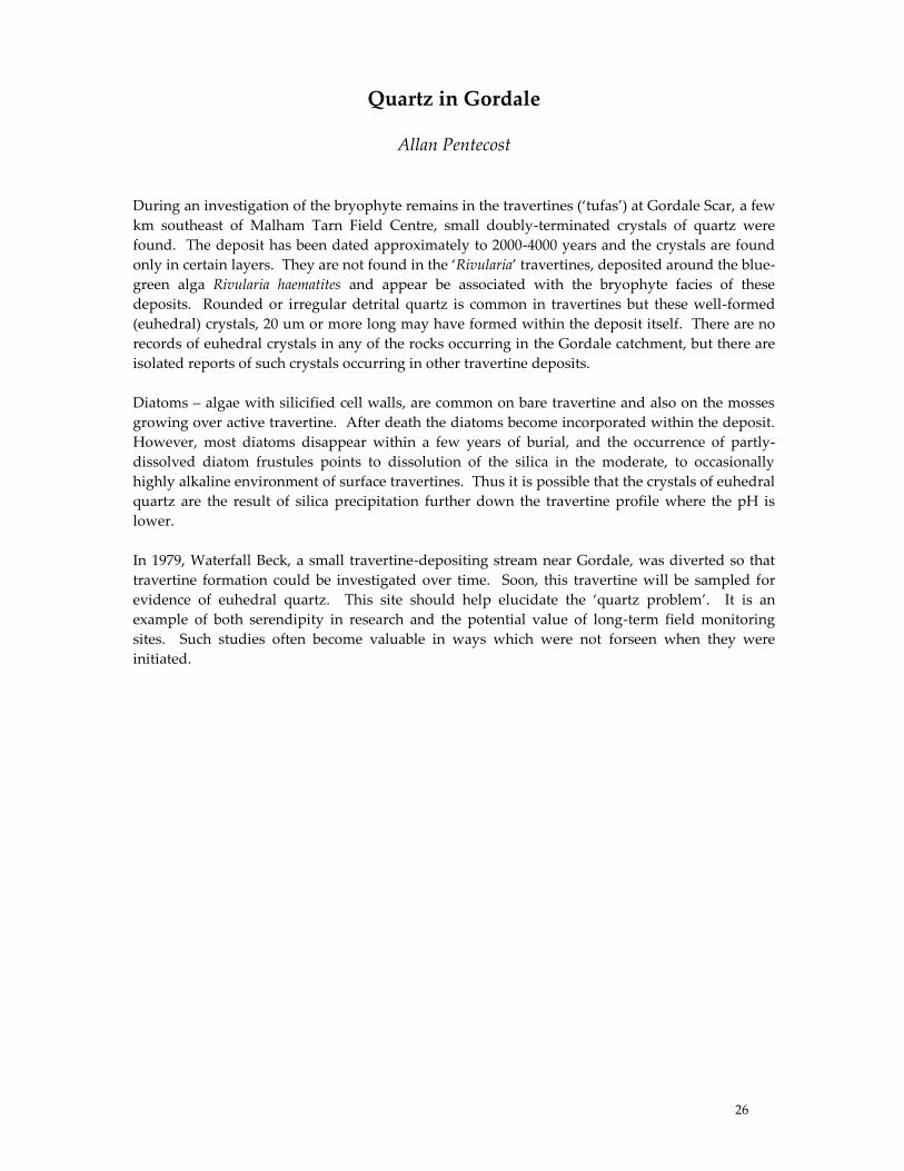
1930; Mitchell, 1994, 2008; Mitchell and Letzer, 2006). Mapping has clearly shown that the
drumlins are more extensive than previously thought and not confined to the valley floors (Fig.
2). The presence of superimposed drumlin forms in certain areas has been used to determine
distinct flow events associated with changing ice centres through a glaciation (Mitchell and
Letzer, 2006). This has allowed an ice divide to be recorded across the western Pennines from the
Howgill Fells southeast across Wild Boar Fell/Baugh Fell towards Denthead (Mitchell, 1994).
Figure 2. Drumlin distribution in the western Pennines (after Mitchell, 1994; Mitchell and Letzer, 2006)
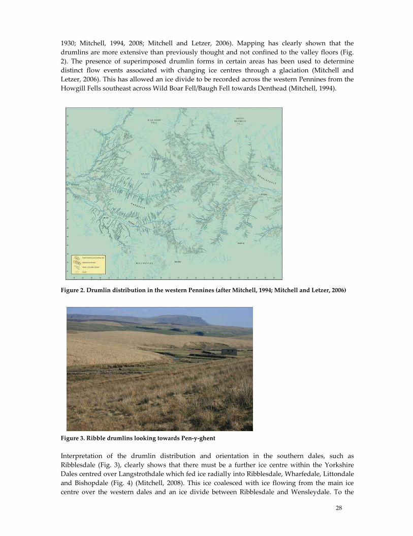
Figure 3. Ribble drumlins looking towards Pen-y-ghent
Interpretation of the drumlin distribution and orientation in the southern dales, such as
Ribblesdale (Fig. 3), clearly shows that there must be a further ice centre within the Yorkshire
Dales centred over Langstrothdale which fed ice radially into Ribblesdale, Wharfedale, Littondale
and Bishopdale (Fig. 4) (Mitchell, 2008). This ice coalesced with ice flowing from the main ice
centre over the western dales and an ice divide between Ribblesdale and Wensleydale. To the

29
north, this ice joined ice in Wensleydale flowing eastwards to the Vale of York. To the southeast,
this centre provided the source area for the Wharfedale glacier which may have been an
independent ice mass during the last glaciation. To the south ice converged into Ribblesdale and
flowed south to join ice in the Craven Lowlands around Settle. No detailed mapping has been
carried out in these areas. The Craven uplands also have one of the more well known erratics
discovered within northern England. At Norber, Silurian greywackes have been moved upwards
and over Carboniferous limestone (Huddart, 2002). Their significance has yet to be properly
assessed, although they clearly indicate ice flow from the south-eastern ice centre over the
Yorkshire Dales.
Figure 4. Reconstruction of ice flow directions (yellow) derived from drumlin distribution and proposed
location of former ice divides (blue) across the Yorkshire Dales. (Base DEM is PanoramaTM ©Crown
Copyright Ordnance Survey).
In conclusion, it can be clearly shown that although the details of many of the individual dales
remain to be understood, the overall patterns of ice sheet dynamics and deglaciation indicate that:
• Yorkshire Dales were completely covered by last ice sheet
• Ice flow directions indicate a local origin forming a major ice centre
• A linear ice divide can be defined across the Yorkshire Dales extending to the Lake
District.
• During deglaciation, ice thinning led to the formation of a series of valley glaciers that
actively retreated within each major dale.
• Very small cirque glaciers existed during the Loch Lomond Stadial
?
?
?
?
?
?
?
?
30
References: Clark, C. D., Evans, D. J. A., Khatwa, A., Bradwell, T., Jordan, C. J., Marsh, S. H., Mitchell, W. A. & Bateman,
M. D. 2004. Map And GIS Database of glacial landforms and features related to the Last British Ice Sheet.
Boreas, 33, 359-375.
Dakyns, J. R., Tiddeman, R. H., Russell, R., Clough, C. T. & Strahan, A. 1891. The Geology of the Country
around Mallerstang with Parts of Wensleydale, Swaledale and Arkendale. Memoir of the Geological
Survey of England and Wales.
Evans, D. J. A., Clark, C. D. & Mitchell, W. A. 2005. The Last British Ice Sheet: A Review Of the evidence
utilised in the compilation of the glacial map of Britain. Earth Science Reviews, 70, 253-312.
Huddart, D. 2002. Norber. In Huddart D & Glasser, N. F. (Eds.). Quaternary Of Northern England. Geological
Conservation Review Series, No. 25. Joint Nature Conservation Committee, Peterborough.
Kendall, P. F. & Wroot, H. E. 1924. Geology of Yorkshire.
Mitchell, W. A. 1994. Drumlins in ice sheet reconstructions with reference to the western Pennines, Northern
England. Sedimentary Geology, 91, 313-331.
Mitchell, W. A. 1996. Significance of snowblow in the generation of Loch Lomond (Younger Dryas) Stadial
glaciers in the western Pennines, northern England. Journal of Quaternary Science, 11, 233-248.
Mitchell, W. A. 2008. The Ribblehead drumlins. Geographical Review, 21, 24-28.
Mitchell, W. A. & Letzer, J. M. 2006. Drumlin map of the Western Pennines and southern Vale Of Eden.
Journal of Maps. 10-16.
Raistrick, A. 1926. The glaciation of Wensleydale, Swaledale and the adjoining parts of the Pennines.
Proceedings of the Yorkshire Geological Society, 20, 366-410.
Raistrick, A. 1927. Periodicity of glacial retreat in West Yorkshire. Proceedings of the Yorkshire Geological
Society, 21, 24-29.
Raistrick, A. 1930. Some glacial features of the Settle district. Proceedings of the University of Durham
Philosophical Society, 8, 239-251
Raistrick, A. 1931. The glaciation of Wharfedale, Yorkshire. Proceedings of the Yorkshire Geological Society, 22,
9-30.
Raistrick, A. 1932. The Correlation of Retreat Stages across the Pennines. Proceedings of the Yorkshire Geological
Society, 22, 199-214.
31
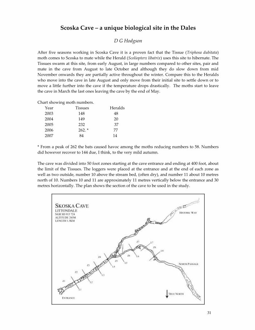
Scoska Cave – a unique biological site in the Dales
D G Hodgson
After five seasons working in Scoska Cave it is a proven fact that the Tissue (Triphosa dubitata)
moth comes to Scoska to mate while the Herald (Scoliopterx libatrix) uses this site to hibernate. The
Tissues swarm at this site, from early August, in large numbers compared to other sites, pair and
mate in the cave from August to late October and although they do slow down from mid
November onwards they are partially active throughout the winter. Compare this to the Heralds
who move into the cave in late August and only move from their initial site to settle down or to
move a little further into the cave if the temperature drops drastically. The moths start to leave
the cave in March the last ones leaving the cave by the end of May.
Chart showing moth numbers.
Year Tissues Heralds
2003 148 48
2004 149 20
2005 232 37
2006 262. * 77
2007 84 14
* From a peak of 262 the bats caused havoc among the moths reducing numbers to 58. Numbers
did however recover to 144 due, I think, to the very mild autumn.
The cave was divided into 50 foot zones starting at the cave entrance and ending at 400 foot, about
the limit of the Tissues. The loggers were placed at the entrance and at the end of each zone as
well as two outside, number 10 above the stream bed, (often dry), and number 11 about 10 metres
north of 10. Numbers 10 and 11 are approximately 11 metres vertically below the entrance and 30
metres horizontally. The plan shows the section of the cave to be used in the study.
32
Summary of observations at this site.
1. Herald moths use this site primarily for hibernation.
2. Tissue moths use this site to swarm and mate.
3. Herald moths prefer the cave roof to hibernate, the majority using the north side of the
passage and the majority of these actually face north.
4. Herald moths frequent the threshold zone of the cave and I have never found them more than
45 metres from the entrance. Maximum numbers are in Zone 2.
5. Although the Heralds basically stay in the same position all winter in cold spells some do
move into crevices or further into the cave however throughout their stay in the cave one can
occasionally observe slight wing movements.
6. Sometimes two or three Herald moths stay together all winter and I wonder if this is in
preparation for mating as I have found a pair of Herald moths mating in the cave in May
2007.
7. Herald moths are quite often covered in condensation while this is a rare occurrence for
Tissues.
8. I have only once found the remains of a Herald moth after a bats meal. This could be due to
the fact they do not move and they also stay on the cave roof.
9. Herald moths arrive in the cave a little later than the Tissues (2 weeks) and are always the last
to leave the cave.
10. Heralds are always in smaller numbers than Tissues; possibly because they use other
hibernation sites i.e. barns and holes in trees.
11. Tissue moths prefer the cave walls to settle but occasionally use the cave roof, however they
also use stones on the cave floor. When entering the cave these stones are used in a haphazard
way however as the season progresses the moths end up using the same stones which have
been used in previous seasons, selecting only five stones each year. The majority of Tissues
use the north wall; they peak in Zone 4 but can be found at all times in all zones, however
they rarely go down Historic Way. (See plan).
12. Humidity does not seem to play a part in how the moths act. Stream levels do have an effect,
the Tissues are always more active when stream levels are high, this could be due to the air
movement or the noise.
13. Tissues are always in larger numbers than the Heralds. Records for Yorkshire VC 64, which
includes Scoska, show one Tissue moth recorded and 21 Heralds from a total of 90,000 moth
records.
14. As soon as the Tissues start entering the cave at the beginning of August they start to pair up
moving into pairs or trios on the cave walls and starting to mate almost immediately. Mating
carries on to late October but sometimes pairs or trios are seen into December. However the
moths remain active most of the winter.
15. Some of the Tissues do settle down for short periods, more like a period of torpor.
16. Due to this continual activity and seeing Tissues settle on the surface of a pool then take off
again I am now looking at the possibility of the moths obtaining some form of nutrition from
the condensation water on the cave walls as this is at its highest when the moths are at there
most active.
17. From time to time bats devastate the Tissue moth population. (262 to 58 the worst week in
2006). We know from catching at this site five species of bat use Scoska Cave and I often see
Brown Long-eared bats (Plecotus auritus) in the cave, which are very partial to moths.
18. Eleven loggers have been on site at the cave since August 2006. These are situated at the
entrance and at the end of each zone as well as two outside the cave approximately ten metres
lower than the entrance and 100 metres away. One is above Gildersbank Sike (10) and one ten
metres to the north (11). They log the temperature every hour and the ones outside have
33
proved the existence of a cold air waterfall above the dry streambed. This was noted two
years previously when walking up to the cave on warm nights.
19. In certain conditions the Tissue moths are very difficult to see in the cave, blending into the
walls perfectly. This is usually when the cave is heavy with condensation producing a fog in
the cave.
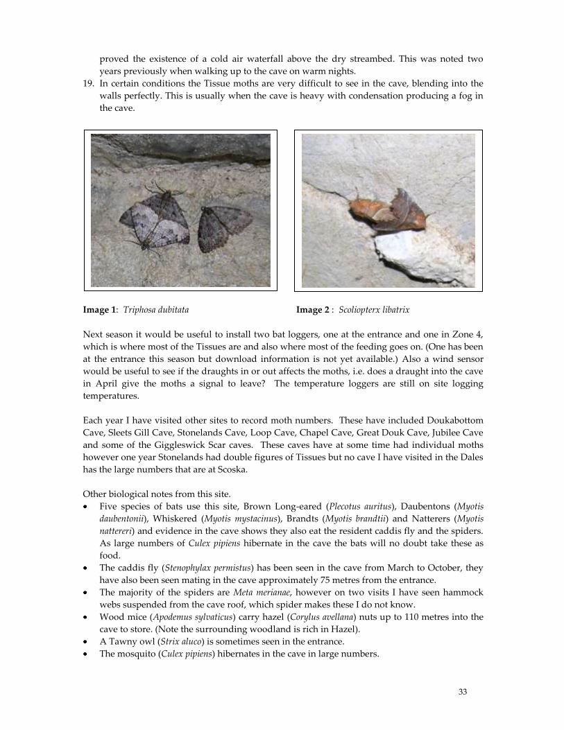
Image 1: Triphosa dubitata Image 2 : Scoliopterx libatrix
Next season it would be useful to install two bat loggers, one at the entrance and one in Zone 4,
which is where most of the Tissues are and also where most of the feeding goes on. (One has been
at the entrance this season but download information is not yet available.) Also a wind sensor
would be useful to see if the draughts in or out affects the moths, i.e. does a draught into the cave
in April give the moths a signal to leave? The temperature loggers are still on site logging
temperatures.
Each year I have visited other sites to record moth numbers. These have included Doukabottom
Cave, Sleets Gill Cave, Stonelands Cave, Loop Cave, Chapel Cave, Great Douk Cave, Jubilee Cave
and some of the Giggleswick Scar caves. These caves have at some time had individual moths
however one year Stonelands had double figures of Tissues but no cave I have visited in the Dales
has the large numbers that are at Scoska.
Other biological notes from this site.
Five species of bats use this site, Brown Long-eared (Plecotus auritus), Daubentons (Myotis
daubentonii), Whiskered (Myotis mystacinus), Brandts (Myotis brandtii) and Natterers (Myotis
nattereri) and evidence in the cave shows they also eat the resident caddis fly and the spiders.
As large numbers of Culex pipiens hibernate in the cave the bats will no doubt take these as
food.
The caddis fly (Stenophylax permistus) has been seen in the cave from March to October, they
have also been seen mating in the cave approximately 75 metres from the entrance.
The majority of the spiders are Meta merianae, however on two visits I have seen hammock
webs suspended from the cave roof, which spider makes these I do not know.
Wood mice (Apodemus sylvaticus) carry hazel (Corylus avellana) nuts up to 110 metres into the
cave to store. (Note the surrounding woodland is rich in Hazel).
A Tawny owl (Strix aluco) is sometimes seen in the entrance.
The mosquito (Culex pipiens) hibernates in the cave in large numbers.
34
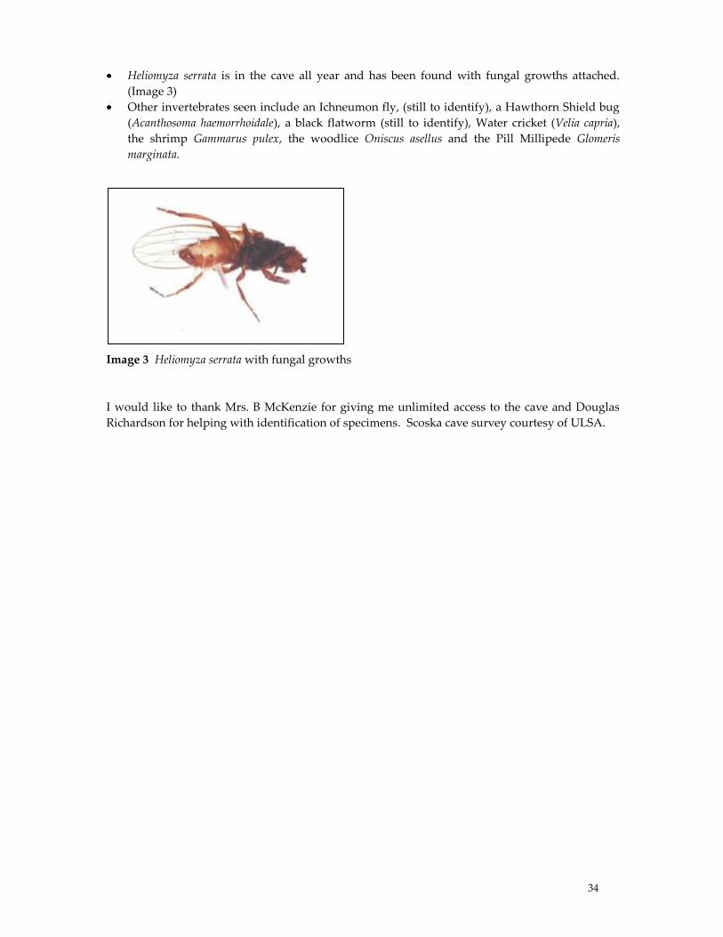
Heliomyza serrata is in the cave all year and has been found with fungal growths attached.
(Image 3)
Other invertebrates seen include an Ichneumon fly, (still to identify), a Hawthorn Shield bug
(Acanthosoma haemorrhoidale), a black flatworm (still to identify), Water cricket (Velia capria),
the shrimp Gammarus pulex, the woodlice Oniscus asellus and the Pill Millipede Glomeris
marginata.
Image 3 Heliomyza serrata with fungal growths
I would like to thank Mrs. B McKenzie for giving me unlimited access to the cave and Douglas
Richardson for helping with identification of specimens. Scoska cave survey courtesy of ULSA.
35
Geodiversity and Geoconservation – Relevance for limestone
pavements
Cynthia V. Burek
What is Geodiversity?
The term Geodiversity was first used in Tasmania in a Forestry Commission document in 1993 by
Chris Sharples (Quoted in Gray, 2004), and defined as ‚the diversity of Earth features and
systems‛. The term remained south of the equator for several years and first surfaced in the UK 4
years later in an article on Planning and landforms by Gray (1997). However, the word wasn’t
really used until 2000. By 2001, Stanley then of the Royal Society for Nature Conservation, had
defined it as ‚The link between people, landscape & their culture: it is the variety of geological
environments, phenomena & processes that make those landscape rocks, minerals, fossils & soils
which provide the framework for life on Earth‛ (Stanley, 2001). It complements Biodiversity,
which was defined at the 1992 Rio conference and in the treaty of Biological Conservation as
‚Biological diversity means the variability among living organisms from all sources including
inter alia, terrestrial, marine and other aquatic ecosystems and the ecological complexes of which
they are part: this includes diversity within species between species and of ecosystems‛. By 2002,
Geodiversity had been simplified to ‚Geological diversity or the variety of rocks, fossils, minerals
& natural processes‛, by Prosser of English Nature.
A more colloquial definition often used with the general public or students not familiar with
geological terminology is ‚The stage on which life acts out its plays.‛ Geodiversity therefore
provides the props and scenery and biodiversity the players. Many lay people can relate to this
analogy. A limestone pavement is an admirable example of this stage with the players remaining
hidden in grikes and crevasses. This is especially true of open pavements. The relationship
between the geodiversity and biodiversity is obvious. Indeed the catch phrase Geodiversity
underpins biodiversity (Fig 1) is readily seen here (Burek, 2001)
What is Conservation?
Conservation is actively managing something to retain a particular quality – so allowing change
to occur through evolution. It is working with nature at its timescale.
Preservation in contrast allows no change to occur. These definitions arise from the original Latin
verb servare to keep with the two prefixes denoting either change (con = with) or no change (pre =
before).
Man-made objects are often preserved but natural sites are normally conserved.
What is Geoconservation?
When dealing with Geoconservation we are looking at conserving geodiversity in its natural
setting. That is managing change but at a longer timescale than the normal human one. Thus sea
level rise, global climate change and migration of landforms occur on a longer than human
timescale. This is at variance with biodiversity and biological conservation where often the
‘biosphere’ is operating at a close to human timescale.
The Biodiversity Action Plan for limestone pavements for example states its aims as
Ensure that there is no further loss to the extent of limestone pavement areas.
Ensure that there is no further deterioration in the quality of existing limestone pavement
areas.
36
Maintain features of geological importance
Restore & maintain a characteristic assemblage of native plant species
In this case it is preservation as it is necessary to keep the pavements as they are. Once we have
lost this protected habitat formed under glacial conditions, we have lost it effectively forever as
far as humans are concerned. This though is an exception.
It is the appreciation of these different changing spatial and temporal scales which dominate
Geoconservation. However there are exceptions to this. If we look at how geodiversity sites or
landscapes are classified we see that they are divided into three categories (Murphy, 2005). These
are
Exposure Sites
Finite Sites
Integrity Sites
Geodiversity Site Classification
Exposure sites
These are relatively extensive underground. The basic principle is that removal of material does
not diminish or damage the site e.g. active quarries, railway cuttings, coastal cliffs
Finite Sties
Limited exposure or limited features. Often they are irreplaceable if destroyed e.g. rare fossil beds
or mineral veins. The processes that produced them are no longer available. Essentially the same
as extinction in biodiversity terms as removal may harm them and deplete the resource.
Integrity Sites
Geomorphological sites which demand a holistic approach. Damage to one part of the site may
damage the whole site. In some ways this classification is similar to habitat conservation, as these
are active sites such as river channels or cave sites. Limestone pavements fall into this category.
Geoconservation philosophies
Exposure sites are managed for maintaining the geodiversity feature of interest. Often clean up is
all that is needed along with access thus a conservation type philosophy. Finite sites and Integrity
sites demand a much more preservation approach. They look for maintaining the active process
by non-interference as far as possible. Limestone pavements should be maintained in their present
state as far as possible, so preservation as opposed to maintenance is the key here. Both their
fragile nature and the Habitat Directive from Europe dictate this (Burek & Conway 2000, Burek,
2001a)
Geoconservation is the youngest of the conservation sciences and only recently is driven by
planning policy (PPS9 which deals with
Biological conservation is driven by legislation and public concern
Archaeological conservation is driven by planning policy guidance and legislation and
recently by public concern.
Local Geodiversity Action Plans
Local Geodiversity Action Plans (LGAPs) are a fairly recent (2002) invention to sit alongside Local
Biodiversity Action Plans. The difference again rather like Biodiversity conservation versus
geodiversity conservation is that LGAPs are not driven by legislation whereas LBAPs are
resulting as they did from the Rio - Biological Conservation treaty of 1992. The Yorkshire Dales
National Park has recently produced an LGAP (Fig 2) which does include the limestone
37
pavements. There are now over 40 LGAPs emanating from the first one produced in the Cheshire
region and published in 2003 (Burek & Potter, 2002, 2004, 2006). LGAPs are at the centre of the
circle enabling conservation of our Earth Heritage and look to be inclusive. They are all
partnerships. Successful ones are often led by or involve a RIGS group.
Conclusions
The overall conclusions of this presentation are that limestone pavements must be approached
holistically as from a geodiversity point of view they are integrity sites. Thus geodiversity and
biodiversity must sit alongside each other. The successful maintenance of limestone pavements
will be enhanced by a new inclusive classification scheme looking at all aspects of the pavements
(Willis, this seminar). The management must also plan for climate change for it to be successful.
References
Burek C.V, 2001, Non-geologists now dig Geodiversity, Earth Heritage, (16), 21
Burek C. V. 2001a, The use and abuse of RIGS sites, 3rd UKRIGS conference, Newton Rigg,
Cumbria, in Addison K, Geoconservation in action, UKRIGS,
Burek C.V. & Conway J., 2000, Limestone pavements – managing a fragile habitat, in Ed Oliver P.
Proceedings of the 2nd UKRIGS conference, Worcester 1999, 37-55
Burek C.V. & Potter J.A. 2002, Minding the LGAPs. A different approach to the conservation of
local geological sites in England? Geoscientist, 12, (9), 16-17
Burek C.V. & Potter J., 2004, The Cheshire region LGAP experience, Earth Heritage, 21, 11
Burek C.V. & Potter J. 2006, Local Geodiversity Action Plans- Setting the context for geological
conservation, English Nature Research Report 560, Ed J. Larwood, ISSN 0967 876X 56p
Gray M, 2004, Geodiversity, - valuing and conserving abiotic nature, John Wiley
Murphy M, 2005, NEW Earth Science conservation classification, Earth Heritage, 24, 13-15
Prosser C, 2002, Terms of endearment, Earth Heritage, 17, 12-13
Stanley M, 2001, Welcome to the 21st century, Geodiversity update, (1), 1, RSNC
Willis S, 2007, Classification and management of limestone pavements, Malham Tarn Research
Seminar 16-18th Nov 2007
Figures as power point slides
Figure 1 Geodiversity underpins biodiversity
Figure 2 Yorkshire Dales LGAP
Figure 3 clearing a limestone pavement site in NE Wales
Figure 4 Limestone pavement showing geodiversity underpinning biodiversity.
38
Relationships between karst and glaciation in the Yorkshire Dales
and Northwest England
Helen Goldie
Re-assessment of surface solutional lowering rates for dryer interfluve locations derived from
erratic-pedestal sites (Goldie, 2005) has opened up age interpretation of numerous maturely
weathered, intermediate sized limestone landforms in Northern England. Lowering rates of c.5 –
20 cm in 15 ka can be applied rather than the 50 cm formerly assumed and there are locations
which suggest even lower rates. Many well-rounded and widely spaced landforms must have
taken longer to develop than the c. 15 ka available since the end of the Devensian Glaciation and
thus they may have inherited characteristics from before that glaciation. In some cases it is
possible that inheritance is pre-Quaternary. Comparison with sites in Derbyshire, not scoured by
the Devensian ice, is interesting, as there are similar landforms.
Altitude, degree of shelter from glacier flow lines, and geology are all significant factors in the
development of these landforms. Many Yorkshire Dales sites are around the edges of deep and
large surface karstic depressions. Landform evidence of ice flow directions for this area as
depicted on the Britice map (REF) has not been worked on for some decades and urgently needs
revising in the light of modern knowledge and techniques (Mitchell, 2007). However, it is clear
that the main ice flow lines focussed in Ribblesdale, Littondale and Chapel-le-dale with the strong
possibility that land in between and especially at higher altitudes had cold-based ice which was
probably static. The Malham High Country is one of the most distinct areas for the well-rounded
outcrops many of which are found at altitudes of c. 400 m and above. This is the area of the Dales
which Sweeting (1972) regarded as the most evolved in karstic terms. In addition to being at high
altitudes the most rounded outcrops are in massive thick limestones of the upper Asbian and
lower Brigantian successions and they are in sheltered locations - all factors which favour their
survival of glacial scour, for example, sites around Clapham High Mark, Back Pasture, Lea Gate
High Mark. Further east around Dowkabottom and Sleets Gill there are numerous tower-like or
other rounded outcrops located at about 380 m, about 50 m above scoured pavement consistent
with the suggestion that the upper sites escaped scour by ice. Sites sheltered in relation to main
ice flow lines are provided both by the large karstic depressions and by side valleys off the main
Dales.
One approach to this topic is to examine the roundedness at the various sites as an indication of
degree of karstification. The more rounded forms, especially where clint tops have lost all flatness
and where the undersides of clints have been rounded are found in a few locations which may be
indicative of greater age. At The Clouds near Kirkby Stephen advanced roundedness supports the
idea that karstified outcrops have been plucked at rather than scoured by ice and that therefore
that landforms could be inherited from some pre- Devensian, ie earlier Quaternary period, of
karstic activity. Two sites of great roundedness are Newbiggin Crags near Morecambe Bay, south
of Kendal, and sites off the Monk’s Path on the Malham High Country. It is thought that many of
these sites have complex geomorphological histories, solutional lowering rates support the idea
that the forms have not developed just since the end of the Devensian; they need longer time
periods. When, and how long the likely periods of karstification were can be suggested by
considering evidence from spelothem work (Gascoyne, 1992; Murphy, 2007) in relation to
possible erosion rates. A rate of 5 cm in the last 15 ka would give 10 cm wide features since the
end of the Devensian, which is a typical grike width on ‘well-scoured’ pavement, 20 cm in 15 ka
would give 40 cm wide features which is wider than the most typical grike on many pavements
39
(this assumes the rate is applicable to two sides of a developing feature such as a grike). So the
typically low rate would not be able to explain all the larger features which must thus have some
inherited component.
Calculating for the accumulated cool/temperate/warm periods totalling c.210 k years, (going back
as far as 300 ka BP) then the larger, better-rounded and well-separated outcrops discussed here
can be accounted for. A rate of 5 cm lowering per 15 ka spread over 210 k years would allow
features of 1.4 m width to develop (rate of 70 cm in 210 ka), ie. most of the large holes and well-
rounded clints, although not necessarily the biggest, or most well-spaced eg. Newbiggin Crags).
There is the further possibility that solutional lowering rates are very low indeed, suggested by a
virtual lack of pedestals under some glacially moved boulders, for example on Farleton Knott,
near Kendal. At the north end of this hill limestone boulders are deposited having been
apparently plucked off the cliffs on the iceward, north side of the hill and deposited down-dip on
already developed pavement. Under these boulders the pedestals are insignificant; it is hard to
measure more than 1 to 2 cm. So calculations about landform development could be based on
long-term rates as low as 1 cm in 15 ka, ie it would take 750 k years of karstification to get 1.0 m
wide holes. With this rate, the total development of the larger features would need to begin in the
early Quaternary.
An alternative theory to explain these mature forms is if some exceptional and highly localised
corrosion were able to persist at that particular place for an extended period so that large features
can form quickly. This is unlikely, as such processes tend to move on to other locations,
essentially capturing earlier sites. Thus it appears that Northern England’s surface karst areas
contain pre-Devensian inheritance with some quite small forms possibly beginning as early as the
Tertiary. This inheritance within a glaciated karst area needs recognition as well as accurate and
detailed dating. The likelihood is that answers regarding dating and development will be
complex, as Phillips et al (2006) found for the tor landforms of the Cairngorms using cosmogenic
dating. Revising solutional lowering rates has led to several hypotheses concerning the
relationship between glaciation and surface karst landform age in Northern England:many
smaller surface karst landforms are not solely due to post-Devensian karstification and they may
have pre-Devensian components. Greater degrees of landform maturity suggest initiation from
respectively earlier times in the Quaternary. Some landforms may be pre-Quaternary in inception
as suggested by their very advanced karst weathering states.
It is worth bearing in mind Linton’s views on neighbouring gritstone tors in Wharfedale: “ – the
present landscape still owes not only its main outlines but also much of its small scale relief to processes that
were operating before and between the glacial episodes” (Linton, 1964, p.22). Linton’s remarks might not
only also apply to neighbouring limestone features, in the sites above the Skirfare and the Wharfe,
but to limestone outcrops elsewhere in Northern England as well. Cosmogenic dating should be
used to test these views. There are over 20 locations in these Northern Carboniferous Limestone
areas where these tests would be vital to test these hypotheses and to clarify the ages of the
landforms and thus their developmental histories.
40
The Holistic Classification and Management of Limestone
Pavements - An Endangered Habitat’
Sue Willis
This presentation describes the early stages of a 3 year PhD project, which commenced in July
2006. The overall aim of the research is to produce an holistic classification of limestone
pavement which will act as a valuable tool for Conservation management in the future. Research
is supervised by Professor Cynthia Burek (University of Chester); Professor Roy Alexander
(University of Chester) & Dr Tim Thom (YDNPA) and jointly funded by both the Yorkshire Dales
NP Authority & the University of Chester. Current classification tools are very generalised e.g.
‚Open/Wooded‛ and relate to either biodiversity or geodiversity, not considering the habitat as a
holistic entity. The details of methodology are described in order to stimulate discussion with
the seminar participants.
Key elements of the project
– Review of literature and classification tools relating to limestone pavement currently in use
- ecological and geological
– Development of robust research methodologies for data collection
– Assessment of limestone pavement sites (target 50), representing the full range of pavement
types across Yorkshire; Lancashire; Cumbria & N. Wales
– Fieldwork April-Sept 2007 & again in 2008 (20 pavements visited to date), with assistance
from specialists including YDNPA staff
– Analysis of data to produce a Classification Scheme based on results
– Production of Management Guidelines relating to this holistic classification
– Writing thesis/disseminating results
Methodology
Pavement selection -
Stratified random sampling was undertaken to ensure a representative geographical
distribution was achieved, using Ward & Evans groupings (Ward & Evans, 1975) with some
pavement stands added which have been identified since the 1970s (mainly wooded
pavements)
Variables measured -
Climate: rainfall; prevailing wind; temperature range
Topography: maritime influence; altitude; slope; aspect
Geodiversity: Grike width; depth; orientation / Clint width; length; perimeter / Runnel width;
length; frequency / Geomorphic features present / Bedding plane thickness / Pavement dip &
direction / Lithology & geochemistry / Soil depth; pH; colour; texture
Biodiversity: Full floral species search particularly rare species & negative species present /
Emergent species height & type / % vegetation cover over 10m transect / Macro-faunal
species search
Human influences measured by litter count; trampling; accessibility; including current
management techniques.
Grazing: type; timing; density
Other factors: Landscape; Archaeology; Fixed point photography

41
Next stages
– Non field-based site research including: topography; climate; distance to nearest
botanically rich site; proximity to coast; lithology; geochemistry; management; protection
etc.
– Multivariate data analysis to ascertain which are the key variables which categorise
limestone pavements
– Compilation of a preliminary Classification Scheme based on results of data analysis
– Further data collection on 30 more sites in 2008, piloting the holistic classification
– Development of Management Guidelines for Conservation of pavement
– Writing of thesis and dissemination of outcomes, with completion anticipated in summer
2009.
Summary
Research is in early stages so comments and suggestions are very welcome.
Reference:
Ward, S. D., & Evans, D. F. (1975). A botanical survey and conservation assessment of British
limestone pavements. Bangor: Institute of Terrestrial Ecology.
A full bibliography from this project will shortly be available online from the Limestone
Pavement Action Group at http://www.limestone-pavements.org.uk. A copy is of this is available
from the author on request.
42
Sharing data and promoting collaboration
Andy Markwick and Satvinder Nandhra
At the 2005 research conference Douglas Richardson made a request to the FSC group to consider
strategies for sharing data. Doug’s personal preference was hard copy, yet he also suggested
using data discs and web space to store data. In the very short time we have been involved with
the activities of the FSC research group, it has become increasingly clear that there exists a
richness of data, both current and historic. In order to gain a greater understanding of the
interplay between the different aspects of this dynamic area, data must be easily accessible to
encourage greater collaboration. At present, obtaining data is problematic because it is not held
centrally.
We support Doug’s idea and suggest that as the research activities are so closely linked to the
work of the FSC, they provide web space for participants to upload data into a shared area. To
protect the integrity of data, read-only files could be created. Could the FSC consider setting up a
web ‘discussion room’ for the group? This would go along way in providing a live forum for
discussion and sharing of ideas.
It may be appropriate at this time, to consider constructing a comprehensive review paper from
the very extensive and wide-ranging information available on the tarn and surrounding areas.
43
Sixty years of environmental issues.
Should we be looking back to guide us forward?
D G Hodgson
This very personal talk has been inspired by words and phrases in the media: global warming,
health and safety, carbon footprint, cheap labour, offsetting, rise in sea levels, food miles and
genetic modification. Taking Malham Tarn as the centre point I looked at what I have seen which
makes me wonder if the path we are following is the right one.
Large estates were still in the area growing wood for use on the estate - so as we are now using
more wood (60% more timber framed buildings today compared to five years ago) are we
planting the right trees? Hard woods are coming from all over the world but even soft woods for
use in fencing posts are coming from Latvia and Finland. A large amount of woodland we are
planting is for ethical reasons not for commercial use but looking forward sixty years we will
need wood to harvest to use in our own developments.
Looking at Malham Tarn House with its lead roof, we now import lead and of course with the
National Park, Natural England and other institutions we have the hardy perennial of mining and
quarrying. Who drives and who flies - from one quarry in Ribblesdale stone goes to all major
roads and even to airport runways. It is no good saying we don’t want quarries and mines, we
need them and the only alternative is to import from Spain, S.America, China and India, so not in
my back yard but we will just carry on driving and flying. We have to find a compromise. Stone
slates were mined and quarried in Wensleydale, slates in Wales and the Lake District, all these
products now come from India and China so what is environmentally friendly in this? We need
these mines and we need these quarries. Most coal now comes from Poland and Bolivia. I was
taught at school that the steam engine was 20% efficient; if we make it 85% efficient then we have
coal reserves in the UK for 2000 years and surely now we have the technology to burn coal clean
and even use the by-products.
We are in an upland farming area but things like sheep wool have virtually no value - a Swaledale
fleece brings in ten pence and it costs eighty-five pence to clip the sheep. Surely someone out
there can find an alternative use for wool rather than produce man-made fibres from oil; what
about industrial filters or a mix with cotton, hemp or flax to produce harder wearing floor
coverings, insulation blocks for buildings (it works on sheep) etc.
Milk was delivered to the door in a can and measured out into a jug left on the doorstep, then
came the milk bottle so things were done in a more hygienic way. As supermarkets took over less
milk was delivered in reusable glass bottles and more is now sold in bottles which use two types
of non compatible plastic so cannot be recycled together, is this a step back or a step forward?
Reuse not recycle.
If global warming continues will we need to grow wheat or sugar beet for bio-fuel or do we use
the extra warmth to grow other crops in poly tunnels or greenhouses, which we now import.
Look in your supermarket and see how much food is imported , after World War 2 we were going
to be self sufficient !!, How much food comes in packaging that is non recyclable, what has
happened to the paper bag and the greaseproof paper? Everything seems to revolve around the
throw away image, we have to move on from this.

44
Vets and hospitals use plastic syringes that are burnt after use, what happened to the glass and
metal syringe that was autoclaved. I know time and expense comes in but how much does it cost
to sterilise and package all those syringes we are burning. In the hospitals there is no smell of
disinfectant, do we need all these new sophisticated methods of cleaning when a good mop down
with disinfectant would do the job. The old butchers block of sycamore proves a point.
With Genetic Modification I think of two things that have happened in my lifetime, thalidomide
and myxomatosis. Although they have no connection it still makes me wonder if this could
happen.
As far as rising sea levels go they have always risen and fallen. Grotte Cosquer off the coast of
Cassis has an entrance 35 metres below the sea but the cave contains magnificent cave paintings
14,000-30,000 years old so in those days people must have crawled into the cave.
Why on all new build do we not collect water especially on large (farm) buildings for reuse, cover
the roofs with photo voltaic cells and double insulate all new build? These should be things that
councils and National Park planners should be aware of. The government and councils keep
telling us about recycling but I think we need to move a step back; we don’t want to be using
goods that cannot be reused rather than recycle. If we ban plastic bags then we may go back to
baskets. We need to be aware of changes to agriculture, quarrying and mining so we can utilise
the by-products and make others aware that even small parcels of land can sustain a wide variety
of species (Thoragill). The landscape will always change, it always has, we cannot stop it but as a
group we need to educate, perhaps via this centre for learning, young people and involve them
and help them to monitor what is happening and also ask for their ideas because it will be their
world when we hand it over.
45
AUTHORS’ CONTACTS Paul Bradley (Dept of Animal & Plant Sciences, University of Sheffield) 18 Strathtay Rd, Sheffield,
S11 7GU [email protected] / [email protected]
Cynthia Burek University of Chester, Parkgate Rd., Chester CH1 4BJ [email protected]
Helen Goldie (Department of Geography, University of Durham) 2 Springwell Road, Durham
DH1 4LR [email protected] / [email protected]
David Hodgson (The Craven Pothole Club) 9 Craven Terrace, Settle, North Yorkshire BD24 9DF [email protected]
Denise Loten Environmental Practices Officer, The National Trust, The Goddards, 27 Tadcaster
Road, Dringhouses, York, YO2 2QG [email protected]
Andy Markwick (Birkbeck College, University of London) [email protected]
Roger Meade Wetland Ecology Consultant, Roger Meade Associates, Nab Barn, South Dykes,
Great Salkeld, Penrith, CA11 9LL [email protected]
Wishart Mitchell Geography Dept, University of Durham, Durham, DH1 3LE [email protected]
Stephen Morley Regional Nature Conservation Advisor, The National Trust, The Goddards, 27
Tadcaster Road, Dringhouses, York, YO2 2QG [email protected]
Satvinder Nandhra (Birkbeck College, University of London) [email protected]
Allan Pentecost Freshwater Biological Association, Ferry House, Ambleside, Cumbria. [email protected]
Douglas T. Richardson (formerly Department of Earth Sciences, University of Leeds) 5 Calton Terrace,
Skipton, North Yorkshire BD23 2AY
Sue Willis (University of Chester) Hannah’s Cottage, Main Street, Kirby Malham, Skipton,
BD234BT [email protected]
ATTENDEES
Judith Allinson
Paul Bradley
Cynthia Burek
Martin Davis
Marion Dunn
Helen Goldie
George Hinton
David Hodgson
David Johnson
Ian Lawson
Denise Loten
Margaret Marker
Andy Markwick
Roger Meade
Wishart Mitchell
Stephen Morley
Satvinder Nandhra
Keith Orrell
Allan Pentecost
Linden Pentecost
Adrian Pickles
Douglas Richardson
Katy Roucoux
Mike Spence
Victoria Spence
Robin Sutton
Terry Whitaker
Sue Willis
Richard Willis
Christopher Young