Embed Size (px)
Citation preview
rr
f'."····,·,·II
[j':1:1 _
r'·'··""·,/Ii;
(( I
fJ..\.':.>'·,·!J!
TEXAS STATE BOARD OF WATER ENGINEERS
R. M. Dixon, ChairmanH. A. Beckwith, Member
O. F. Dent, Member
BULLETIN 5503
RECORDS OF WATER-LEVEL MEASUREMENTS IN HASKELL
AND KNOX COUNTIES, TEXAS
Compiled by
C. R. Follett, Engineer
Texas state ;Board of Water Engineers
P~epared in cooperation with the Geological Survey
United Qt~tes Department of the Inter~or
'September 1955
r:i.;.•.•. :,.,',.1/ .
Ii! :, ,
CONTENTS
Page
ri.'!.'.'.'·',I rrIntroduction - - - - - -- - --- - - - --- - - ----- - -- - -------,--- - - - - -._- - -.- - - --.-- ---
List of publications -----~--------------------------------------------
1
2
fif..r
:"
!'(
Water-level measurements in Haskell County ---------------------------" 5
Water-level measurements in Knox County ------------------------------ 13
ILLUSTRATIONS
rMap showing location of observation wells in Haskell County ----------
Hydrographs sho~wing fluctuation of water levels in wells in ::. -......:.
Haskell County and the annual precipitation at Haskell, Tex. -------
Map showing location of observation wells in Knox County -------------
Hydrographs showing fluctuation of water levels in wells in Knox
Courrty and the annual precipitation at Munday, Tex. ----------------
4
10
12
16
r
rl..'.il.'.,,.,,,W
r
RECORDS OF WAT~ ~LEVEL MEASUREMENTS IN HASKELL AND
KNOX COUNTIES, TEXAS
Campiled by.
C. R. Follett, Engineer
Texas·· state :Soard ·of Water Engineers.,
September 1955
The bulletin contains records of measurements of the depth to water,in·
feet be~ow land-surface.¢latum 'in 28 wells in Haskell County and 15 we·lls in
Knox County. It is one of a series of publications by the Texas state Board
of Water Engineers which contains measurements of the.water levels in selected
observation wells made as a part of the cooperative program of ground-water
investigations throughout Texas by the United sta,tes .Geological Survey and
the Texas State Board of Water Engineers. The records cover the years 1944
The accompanying maps show the locations of the observation wells •.
Hydrographs showing the fluctuation of the water level in a few selected
wells and the precipitation at a nearby Weather Bureau station are given for
each county. Records of wells, geologic data, and pumpage data are given in
the following publications.
-2-
LIST OF. PUBLICATIONS
BRQADIllJRST, w•.L .• ),.andFO~, C'. R •. " 1944, Preliminary report of.theground-.water resources near Stamford in ·Jones and Haskell 'Counties", Te~~: Texasstate lloard of Water Engineers> Memorandum,' itt op~n fil~.-
FO~, CAt. R,~, ,and JlA:N!l'E, JQXN, H~, 1945, Gro,undwater. in the vicinity of:BenjaIUn, Texas: Texas state Board, of Water Ellgineers·, Memorand~, inopen file.
G9RDON,C~ H•., 1913,- Geology.·and underground waters of the Wichita ·r·egion,north-central Texas: Uo So Geol. Survey, ',:Water -Supply Paper 317.*
WooINS, L, P., and 'lhmNER,~ F 0' 1937, R<?c or·Q.s of _wells in Knox County-:Texas state Board of Water Eng1nee~s.
.SUN:QSTROM., ,R:. ·W • ,.~T, 1I1..L·•., and~, B. C., 1947". Public- :water, supplie's· 1ncentral and north-central Texs$·: 'Texas a.tate Board of Water
lmgineers ~*,, 1949, Public wate'rsupplie-s in cent~al----------------and.north-central 'Texas: U0. S.. Geol. Survey·- W$te-r -Supply Paper 10690
" .. ._- ~ . .. ~.. .
* Out of print. CQpies available for re:re·rence' at th~ Austin office of theV-~ S,~ Geological Surveyo.
,11
11
,1
1,111
l'
-3-
HASKELL COUNXY
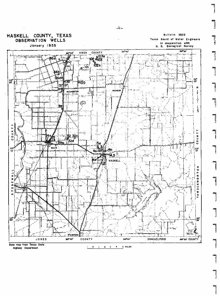
Base map from Texas StateHighway Department
-4-
......1I~''I-..L'?-.,..-,,-'_"""---L--_t'----J~ MILES
Bu II et in 5503
Texas Boord of Water E'ngin-eertIn cooperation with
U. S. Geotogical Survey
>to-Z
"
"r",il
llf','!,~
liP
It,'\','.','II
I,I
1
1l,T"il
~i ~,
11",;:
II
I
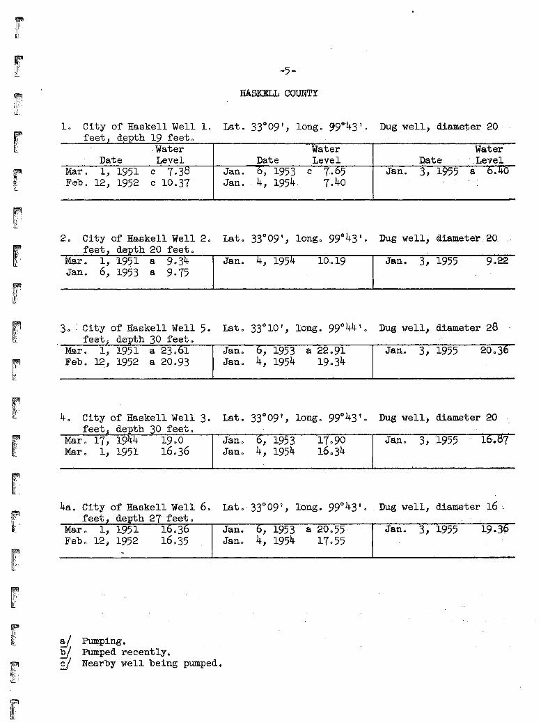
-5-
HASKELL COUNTY
Lat 0 33° 10 " long. 99° 44 t. 0 Dug well, d1ame~er 28-
10 City of Haskell Well 1.feet, d~pth 19 feeto
,WaterDate Level
Mar. 1, 1951 c 7.3C3Febo 12, 1952 c 10037
2 0' City of .Haskell Well 201eet, depth 20 feeto
Mar 0 1, :1951 a 9 0 34Jan 0 6, 1953 a 9075
30 " City' o:r Haskell Well 50feet j depth 30 feeto
Mar 0 1" 1951 a 23 0 61Feb 0 ~, 1952 a 20093
Lat. 33°09', l'ongo 99~~43'.
WaterDate .'Level
Jan. 6, 1953 c 7·.65Jan. 4, 1954. 7.40
Jano 4, 1954
Jan 0 6, 1953 a 22.91Jan 0 4, 1954 19034
Dug well,diameter 20.·.·
·Water 'nate . ,Level
Jan. 3, 1955 .8 0.40
Dug well, d18~eteI'.;20. .,:
Jan. 3', 1955 9022
Jan.. 3, ',1955
feetMar 0 17,Mare 1,
o feetoJan 0 ,1953Jane 4, 1954
1709016 C) 34
Jan 0 3, '1955 1. 7
tfl,';::','liT;
4SoCity of Haskell Well 60 Lata 33°09'., lo·ng., 99°43' 0 Dug well, diameter 16 :-~eet, depth 27- feet 0
Mar 0 1, 1951 16036 Jan. 6, 1953 a 20055- Jan. 3, 195,5 19'.36Feb q 12, 1952 16035 Jan 0 4, 1954 17055
y. ~ping~f§j Pumped recently.Sf Nearby well being pumped.
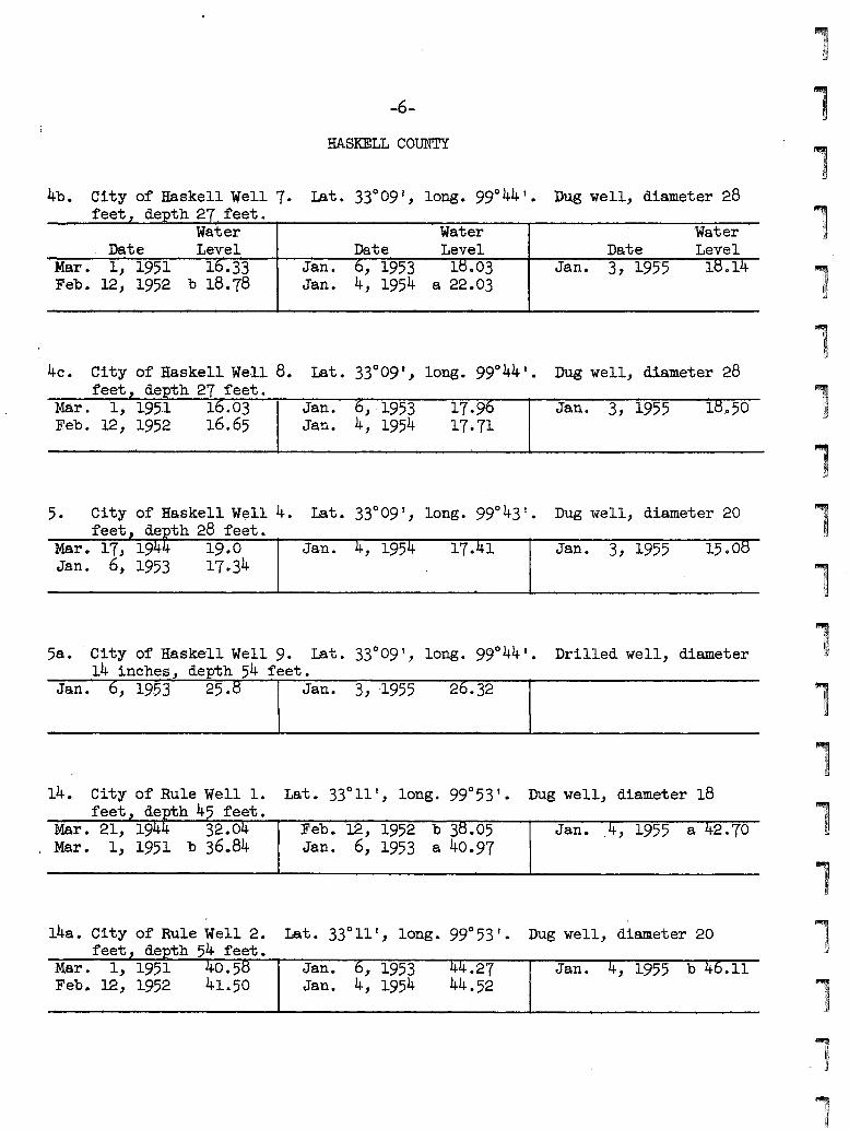
.6-
HASKELL COUNTY
4b. City of Haskell Well 7. Lat. 33°09 v, long. 99° 44' •feet, depth 27 feet.
Dug well, diameter 28
WaterDate Level
Mar. 1, '1951 16.33Feb. 12, 1952 b 18.78
Jan.Jan.
WaterDate .Level6, 1953 le.034, 1954 a 22.03
DateJan. 3, 1955
'WaterLevelle.14
Dug well, diameter 28
Dug well, diameter 20
4c. City of Haskell Vle·l1 8.feet,. depth 27 feet.
Mar. 1, 195·1 16.03Feb. 12, 1952 16.65
5. City of Haskell Well 4.feet, depth 28 feet.
Mar. 17, 1944 19.0Jan. 6, 1953 17.34
Jan. 6, ·1953Jan. 4, 1954
Ja·n. 4, 1954
17.9617·71
17.41
Jan. 3, 1955
Jan. 3, 1955
le o 50
1500B
,"\III,J
58. City of Haske'11 Well 9. Lat. 33°09 I, long. 99° 44 I.
14 inches, depth 54 feet.Drilled well, diameter
14. City of Rule Well 1.feet, depth 45 feet.
Mar. 21, 1944 -32.04, Mar. 1, 1951 b 36084
Lat. 33°11', long. 99°53'. Dug well, diameter 18
Feb. 12, 1952 b 3e.05 Jan. _4, 1955 a 42.70Jan. 6, 1953 a 40.97
"
':>.:.\.'::.
IIII
14a. City of Rule Well 2.feet depth 54 feet.
Mar. 1, 1951 0.5Feb. 12, 19·52 41.50
Jan. ,1953Jan. 4, 1954
.2744.52
Dug well, diameter 20
Jan. , 1955 b .11
1
-7-
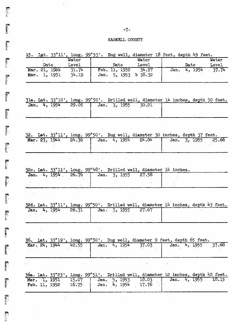
HASKELL CO~y
15. - ~t. 33°11', long. 99° 53' • Dug well", diameter' 18 feet, depth 49 feet.
Date.Mar. 21, '-19~!f
Mar. 1, 1951
,'Water ,Water - Water'Level Date ,Level Date Level
31.• 74 Feb. 11, '1952 34.97 . Jan. 4" 195~ 37.7434.19 Jan. 5, 1953 .b 38.32
.318. Lat. 33°10', long. 99°50'. Drilled well, diameter. 14 inches, depth 50.feet.'Jan.. 4, 1954 ," 29.05 1 Jan.· 3, 1955 """ 30!21' "I
r32 •. ' :tat.Mar. 23,
30 inches de ,th 37,feet.Jan. 3, 1955 25.
!",',i'If":'
,'I
32d.•. Lat. 33°11', long. 99°50'. Drilled well, diameter 14 inches, .depth 43 feet. ,
Jan. 4, 1954 26.31 1 Jan. 3, 1955 27-:7 1
long. 99°50'. Dug well diameter 9 feet depth 65 feet.2.55 Jan. 37.03 Jan., 1955 .37.
36&. La,.,t. 33°23',. long. 99° 51 v. Drilled well, diameter 12 innhes, depth 42 feet.Mar. ·-1, 1951 15.07 Jan. 5; 1953 18.03- Jan. 4, 1955 18.15F~b .• li, 1952 16~'75'" Jan. ,4, 1954 ~17.76
1i
)i,
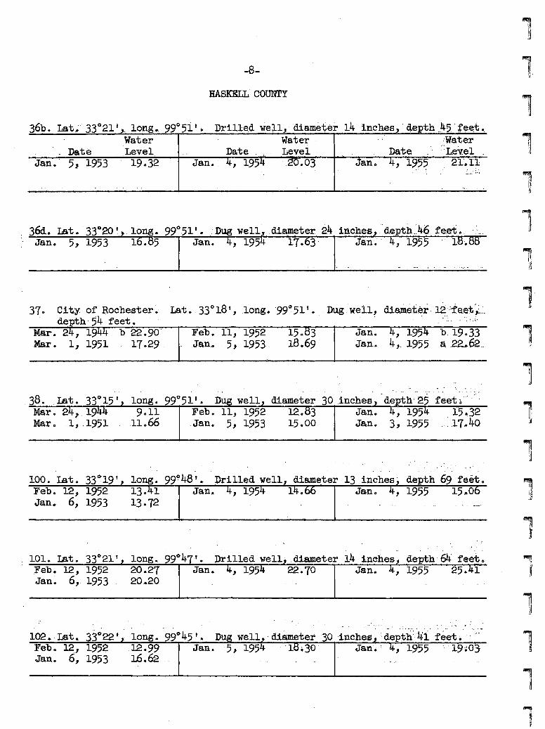
-8-
HASKELL'COUNTY
5, 1953Date
Jan.
36b.Lat.~ ,33°21'Y;,. long,. 99°51' ~ Drill~d well,', 'diameter ,14 ipches,' 4epth .~5.'~f~,~t,.,..
Water water ,~:Water
',Level, Date ", ' , 'Level Date" ., '·.Level,,~
, 3M. rat ~ "33°20 •: Jan. 5, ~953
inches ,,'depth_~.46, fe,et C' .',
Jan:.' " ,195"5 : 1· '. .
37 0 .City .of Rochester~' Lat •. 33°18 " ,long. '99°51 y •
·de ith' 54 feet.Mar. 2 , 19 b 22.90' Feb. 11, 1952 150 3,Mar. 1,1951 17.29· . Jan.• , 5,1953,. 18.69
Dug .. w.ell~....diwD.et.~~ 12.:f'e.~t i-.:..... :.,... a-.!" •.'-
Jan. ,195 b, 19~33Jan,. 4,_ 1955a.~.62 .. llJ
II
1
1long. 99°51 t. Dug well diameter 30 ,inches'9011 Feb. 11, 1952 12.. 3 Ja~.,
,11066 .Jan. 5, 1953 15.00 Jan. 3, 1
. . . - - .. .
1010 lat., 33°21', long., 99°47"0 Drilledwe11j.diameter 14 inches, depth'64 feeto,Feb. 12, 1952 20.27 Jan. 4~ 1954 22.70 Jan. 4, 1955 2541.41Jan. 6" ~953 . 20 .•,20
100. Lat. 33C)',19 t
Feb 0 12, 1952Jan 0- 6, 1953
long. 99948'. Drilled well130 1 Jan.13·72
. .. -
13.inches' depth 69 feeto
,(' '". ,I••••
1020 :Lat., 33~22 t j long. "990 45 t ,6.' "'~Ug wel1~" diameter" '30 ;1nches~':'d~pth'::,~41' f~~t." ,":"~-Febo 12:,1952 ,12.99 Jan. ,5,1954 'ltj.30' Jan'.,: 4,1955 "'19i03-Jan 4 6, 1953 16.62 .-.
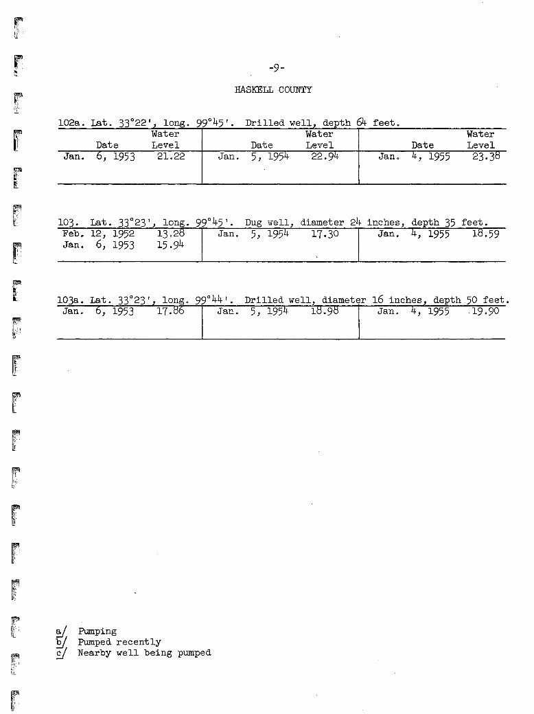
-9-
HASKELL COUNTY
Drilled well, depth 64 feeto
rJan.
Date6, 1953
WaterLevel21.22 Jan.
Date5, 1954
WaterLevel22.94 Jan 0
Date4, 1955
WaterLevel
23.313
r.:.,.:."-,,.l_
16 inches, depth 50 feet.
5, 1954 17.30 Jan. 4, 1955 18.59
5, 195 1
Dug well, diameter 24 inches, depth 35 feet.
Drilled well,Jan. ,1953 17. Jan~
Feb. 12, 1952 13028 Jan.Jan. 6, 1953 15.94
r rd. Pumping~ Pumped recently£I Nearby well being pumped
11
,I
,1111111111111,
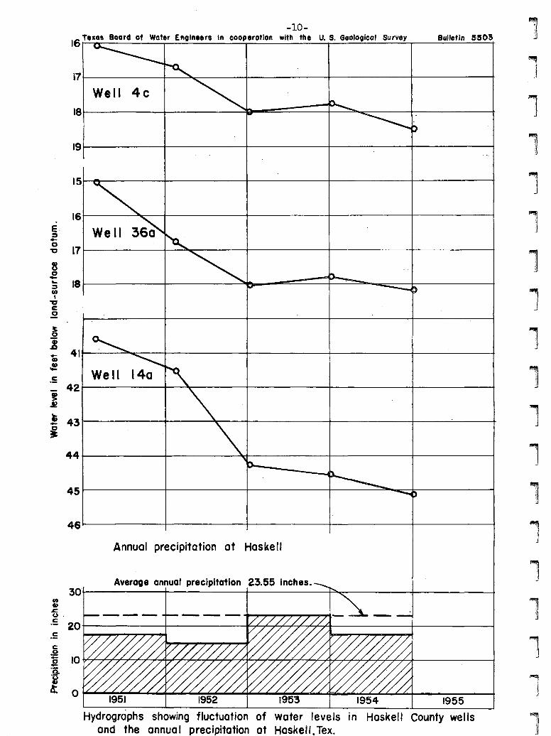
Bulletin 6803
We II171-------~~r------+-------+-------+--'----------t
161-----~-+-------+-------+---------+----------t
181------+---------.:::~-~~---+--~~~----+---------t
-lO-IS Texas Board of Water Enoine.r. in cooperation with the U. S. Geological Survey
41~--~:::-----+--------+--------+------__+-----__t
421----~---f------.;:ll~----+--------I-------+-------1
30II)
4»s=(J .
.5 20
.=
45 I-------+--------+--------+----~___==~---------t
46~------+--------+-------+--------f---------t
Annual precipitation at Haskell
441--------+-----~lri--------f------__t_-----____1
19~-----~------+---------f-------+--------t
Average annual precipitation 23.55 inches.
18L------l----------:::~~~::::::::=--~~~~--___+_-~--____+
Well 4c
15~-------+------~-+-------+-------;--------t
i7~-----+-----::::!~---+-------+-------+------:-----t
E:::I..o
'"C
t~
.!431----------+---------Jtr----+--------f--------+----.-;;...--~
i
..Q)
.!
.5
Hydrographs showing fluctuation of water levels in Haskell County' wellsand the annua I precipitation at Haskell. Tex.
-11-
KNOX COUNTY

-12-
KNOX COUNTY, TE XA SOBSERVATION WELLS
January 1955
Bu II et in 5503
Texas Board of Water EnGineersin cooperation with
U. S. Geo IOGica I Survey1)11
1,1
P
FOA R 0 COUNTY
11i,:,'n
lrI,)
,~
11
!1.I,r
r...._ ...._-- 0,," " -T
~ <, ~~-~_'...... /' ,/ ..... J ~".
\<. ;s!.-\ .-.~.
___--:,.-_--t--~-__.f_~.....,......,._+__-~\3S0\40'
'~J.,J '1,>'1Iz
::::)
. '.0.. ,(,)
2 3 4 a MILESI , I I
I 01111,
\..... I
"'" " ."',1'1,I
I(
>...z~
o(,)
~-.
r J " '\• ./ "'\.•.::~I---_:'-) ----+~-.....L--:.~----+-----.-_+7_~-~-~-__,.t_------
c-, /J -._''1 '(
I
Base map from TeKas StateH·,ghwar Department
1
-13-
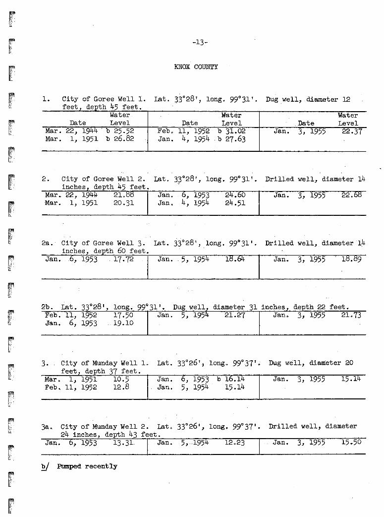
KNOX COUNTY
Dug .well, .diameter 121. City of Goree ·We·ll 1.feet, depth 45 feet •
.WaterDate Level
Mar. 22, 1944 . b 25.52Mar. 1, 1951 b 26.82
WaterDate Level
Feb~ 11, 1952 b 31.02Jan. 4, 1954 .b 27.63
.DateJan. 3, 1955
WaterLevel22.37
2. City of Goree Well 2. Lat. 3~028', long. 99°31'.inches, depth 45 feet.
Mar .• 22,. 19··- .210Mar. 1, 1951 20.31
Jan.. , 1953Jan. 4, 1954
2 • 024.51
Drilled well, diameter 14
Jan. 3, 1955 22.
2a . City of Goree Well 3. Lat '. 33°28', long. 99 0 31'. Drilled well,. q.iameter '14inches, depth 60 feet.
Jan. ,.. 1953· ..17.72. Jan .. 5, 195 Jan. 3, 1955 "1. 9
2b.. Lat. 33°28', long~ 99°31'. Dug well, diameter 31 inches, depth 22 feet.Feb. 11, 1952 17.50 Jan. 5, 1954 21.2'7 Jan 0 3, 1955 21073Jan. 6, 1953 19.··10
3. City of Munday'Well 10 Lat. 33°26 " long... 99037 t ~ Dug well, diameter 20feet, depth 37 feet.
Mar. 1, 1951 10.5 Jan. 6, 1953 b 16 •. 14 Jan. 3, 1955 15.14Feb., 11, 1952 12.8 Jan. 5, 1954 . 15.14
r"·"..I...i..•.. i.·.·.' ~,~\I:
3a... City of' Munday Well 2. Lato 33°26', long. 99°37'.depth 43 feet.
13.31.. .. Jan.. 5,···195 12023
EJ PUmped recently
Drilled well, diameter
Jan. 3, 1955
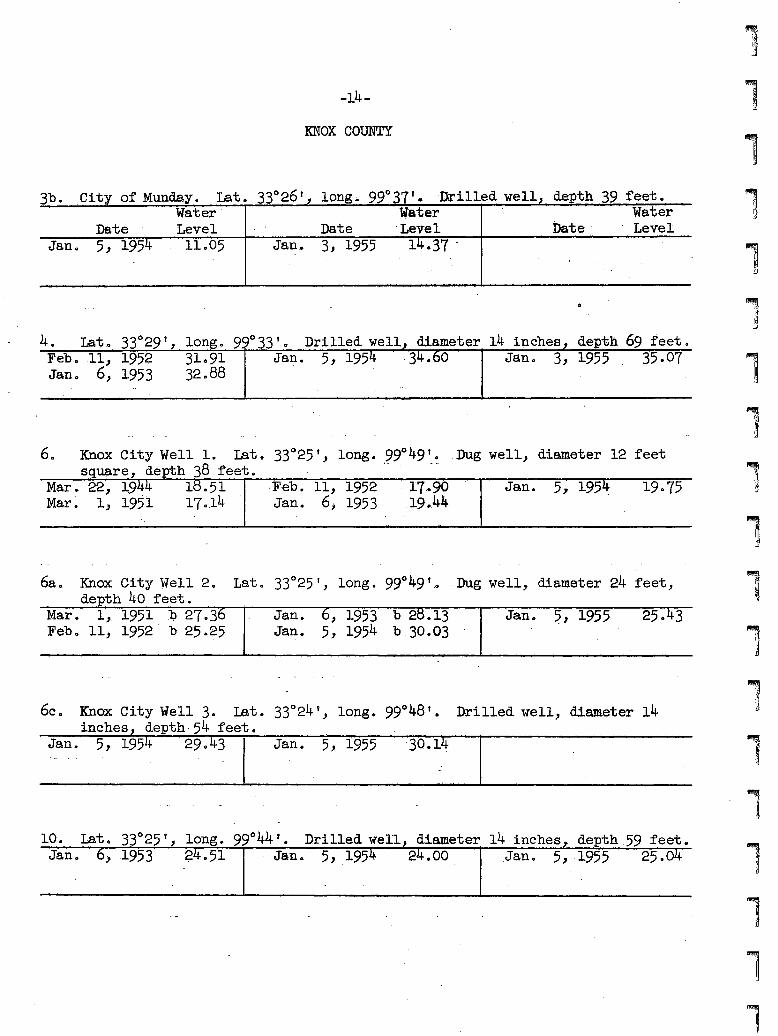
-14-
KNOX COUNTY
3b. ,City of Munday. Lat. 33°26', long. 99°37' .. :o.rilled well, depth '39· feet 0
Water' water WaterDate Level Date' Level . Date' Level
Jan. 5, 1954· 11.05 Jan. 3, 1955. 14.37·
,j
4. Lat. 33°29', long. 99°33 10 Drilled well, diameter 14 inches, depth 69 feeto
Feb. -.11.1' 1952 31091 Jan. 5, 1954 ·34 •.60 Jan. 3, 1955 3'5.07 "'!'J'j.'r'
Jan. 6, 1953 32088
16. Knox City Well 1. Lat. 33°25",. long.·,.~9°49'.~.. Dug well, diameter 12 feet
square, depth 38 feet.Mar. 22, ~944 18.51Mar ~' I;, 1951 17 0.14
·F-eb. 11, 1952Jan. 6, 1953
. 17··90.19 •.44
Jan. 5; 195~ 19·75
Lat. 33°25', long. 99°49' .•. Dug well, diameter 24 feet,6a o. Knox City Well 2 •.depth 40 feet.
Mar. 1" 1951 .0 .27 036Feb 0 11) 1952 b 25.25
Jan. 6, 1953 b 2tl.13Jan. 5, 1954 b.30~03
25.431··.·.).~.~.(,
,...\...'.'....•..
(I
""..•.:.'I'i
Ii5., 1955Jan.Jan. 5, 1954 29.43 I
·6c. Knox City Well 3. rat 0 33°24 Y, long. 990 48'. Drilled well, diameter 14inches, depth-54 feet.
10. Lat. 33°'25', long. 99°44'. Drilled well, diameter 14 inches,. depth .59 feeteJan 0 6', .1953 g4.51 .Jan.. 5, .1954 24.00 Jan. 5, .1955 25.04
11lr
fJ
r'·.·::··'·"iT!i,I
rri'11\,"/..' .
fi.,.r'.·(T
r"·;'I.I.!.•.·······:
I"1\
r
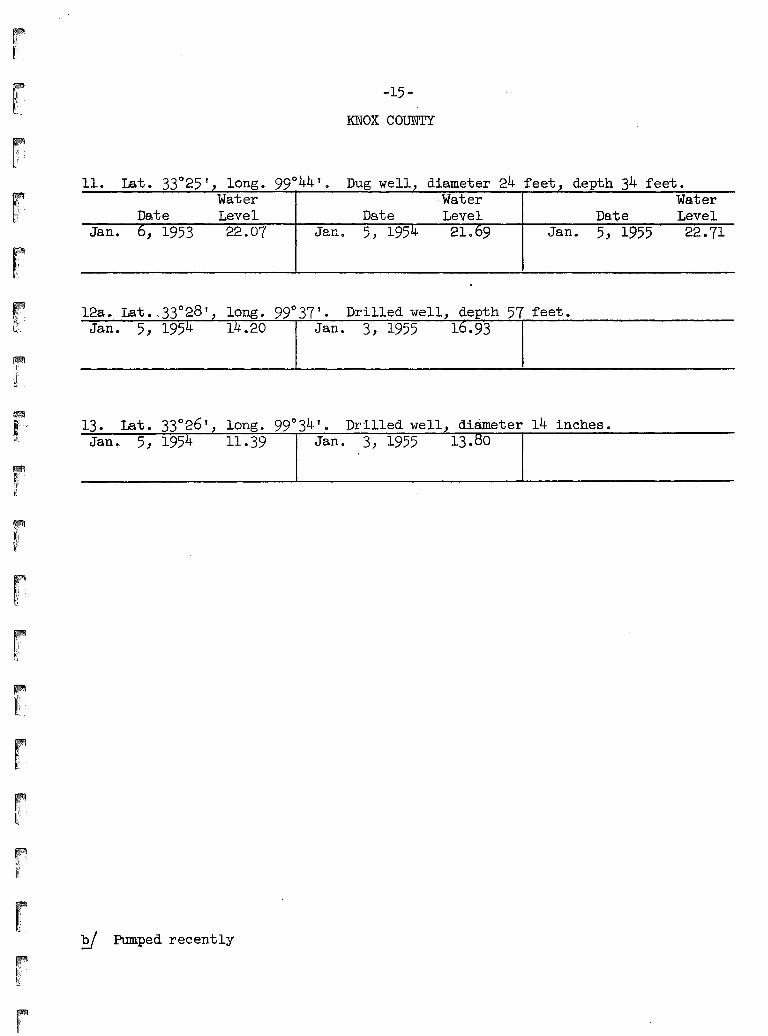
-15
KNOX COUNTY
11. Lat. 33°25', long. 99°44'ep Dug well, diameter 24 feet, depth 34 feet.Water Water Water
Date Level Date Level Date LevelJan. 6, 1953 22.07 Jan 0 5, 1954 21069 Jan. 5,' 1955 22.71
~ Pumped recently
11,1,
j
l1
,j
11111111111
....tift 1101
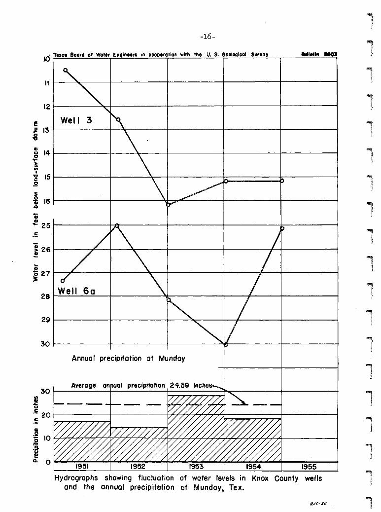
-16-
Well :3
.~ Telos Boar~ of Water Englne.r. in coop,ration with the U. S. G(i)ological SurvI,
28t---------+------~------~---.~---+-------....-01
~ 26 .-------#---f--~r-----~------t__----_I__+_-----__i•
S~161-------t--------.rt-~~----+--------+--------t~
301----------+--------+------~~------+--------t
29 t--------t---------t---~---+_____I1_----__+__-----__1
Annual precipitation at Munday
Average annual precipitation30t---------+---------+-------~-------+---------t
J.I:UC.- 20 -t----------t----------t-~~~""_+_~~~-----__+_-----___+C
RJC-sr· .
H'ydrographs s.howing fluctuation of water levels in Knox County wellsand the annual precipitation ot Munday, Tex.
12~----~_+_-----__f_------t__-----_t_-----__1
,t ~-~~--_4_-----__+-----~...__-----_+_-----__1
..Q)C; 2 7 .t-----,j,r.------+----~-_+---------f_---_#__-......_-----___1:s
E.= 13 J---------f-~..__----_+_------..._-----_+_-----__t.g
~ 14 1-------4---~--__+------......_-----_+_-----__to....~
:Jen•~ 15.--------f----~.......---+----------1......-------+r---------t
...5!
..e.f25t---------+-'lIFIt--------+----------I~------+--------1c