Embed Size (px)
Citation preview
1
R E F E R E N C E I N F O R M A T I O N P A P E R 1 1 6
Records Relating to Railroads in the
Cartographic Sectionof the national archives

Records Relating to
Railroads in the Cartographic
Section of the National Archives
R E F E R E N C E I N F O R M A T I O N P A P E R 1 1 6
National Archives and Records Administration, Washington, DC
Compiled by Peter F. Brauer
2010

United States. National Archives and Records Administration.
Records relating to railroads in the cartographic section
of the National Archives / compiled by Peter F. Brauer.—
Washington, DC : National Archives and Records
Administration, 2010.
p. ; cm.— (Reference information paper ; no 116) includes index.
1. United States. National Archives and Records
Administration. Cartographic and Architectural Branch
— Catalogs. 2. Railroads — United States — Armed Forces —
History —Sources. 3. United States — Maps — Bibliography —
Catalogs. I. Brauer, Peter F. II. Title.
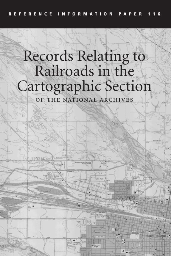
Cover: A section of a topographic quadrangle map produced by the U.S. Geological
Survey showing the Union Pacific Railroad’s Bailey Yard in North Platte, Nebraska,
1983. The Bailey Yard is the largest railroad classification yard in the world. Maps
like this one are useful in identifying the locations and names of railroads throughout
the United States from the late 19th into the 21st century. (Topographic Quadrangle
Maps—1:24,000, NE-North Platte West, 1983, Record Group 57)
iii
Preface vii
PART I
INTRODUCTION ix
Origins of Railroad Records ix
Selection Criteria xii
Using This Guide xiii
Researching the Records xiii
Guides to Records xiv
Related Records xv
Acknowledgments xvii
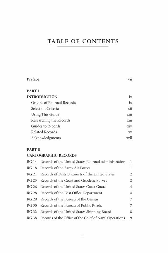
PART II
CARTOGRAPHIC RECORDS
RG 14 Records of the United States Railroad Administration 1
RG 18 Records of the Army Air Forces 1
RG 21 Records of District Courts of the United States 2
RG 23 Records of the Coast and Geodetic Survey 2
RG 26 Records of the United States Coast Guard 4
RG 28 Records of the Post Office Department 4
RG 29 Records of the Bureau of the Census 7
RG 30 Records of the Bureau of Public Roads 7
RG 32 Records of the United States Shipping Board 8
RG 38 Records of the Office of the Chief of Naval Operations 9
table of contents
iv
RG 43 Records of International Conferences, Commissions,
and Expositions 9
RG 46 Records of the United States Senate 10
RG 48 Records of the Office of the Secretary of the Interior 12
RG 49 Records of the Bureau of Land Management 21
RG 54 Records of the Bureau of Plant Industry, Soils, and
Agricultural Engineering 25
RG 57 Records of the United States Geological Survey 26
RG 59 General Records of the Department of State 28
RG 60 General Records of the Department of Justice 28
RG 66 Records of the Commission of Fine Arts 29
RG 69 Records of the Work Projects Administration 30
RG 70 Records of the U.S. Bureau of Mines 30
RG 71 Records of the Bureau of Yards and Docks 31
RG 74 Records of the Bureau of Ordnance 31
RG 75 Records of the Bureau of Indian Affairs 31
RG 77 Records of the Office of the Chief of Engineers 32
RG 79 Records of the National Park Service 36
RG 83 Records of the Bureau of Agricultural Economics 36
RG 91 Records of the Inland Waterways Corporation 36
RG 92 Records of the Office of the Quartermaster General 36
RG 94 Records of the Adjutant General’s Office, 1780’s–1917 39
RG 95 Records of the Forest Service 40
RG 112 Records of the Office of the Surgeon General (Army) 43
RG 114 Records of Natural Resources Conservation Service 44
RG 120 Records of the American Expeditionary Forces
(World War I) 44
RG 126 Records of the Office of Territories 51
RG 127 Records of the United States Marine Corps 52
RG 131 Records of the Office of Alien Property 52
RG 133 Records of the Federal Coordinator of Transportation 52
RG 134 Records of the Interstate Commerce Commission 54
RG 140 Records of the Military Government of Cuba 57
v
RG 142 Records of the Tennessee Valley Authority 57
RG 145 Records of the Farm Service Agency 58
RG 150 Records of the National Bituminous Coal
Commission, 1935–1936 59
RG 151 Records of the Bureau of Foreign and
Domestic Commerce 59
RG 156 Records of the Office of the Chief of Ordnance 60
RG 165 Records of the War Department General and
Special Staffs 60
RG 169 Records of the Foreign Economic Administration 72
RG 181 Records of Naval Districts and Shore Establishments 73
RG 185 Records of the Panama Canal 74
RG 187 Records of the National Resources Planning Board 75
RG 219 Records of the Office of Defense Transportation 77
RG 220 Records of Temporary Committees, Commissions,
and Boards 77
RG 226 Records of the Office of Strategic Services 78
RG 233 Records of the United States House of Representatives 78
RG 234 Records of the Reconstruction Finance Corporation 79
RG 241 Records of the Patent and Trademark Office 82
RG 256 Records of the American Commission to
Negotiate Peace 82
RG 260 Records of U.S. Occupation Headquarters,
World War II 83
RG 319 Records of the Army Staff 83
RG 331 Records of Allied Operational and Occupation
Headquarters, World War II 84
RG 338 Records of the United States Army Operational,
Tactical, and Support Organizations (World War II
and Thereafter) 86
RG 351 Records of the Government of the District of
Columbia 87
RG 373 Records of the Defense Intelligence Agency 87
vi
RG 385 Records of the Naval Facilities Engineering
Command 89
RG 395 Records of U.S. Army Overseas Operations and
Commands, 1898–1942 89
RG 398 General Records of the Department of Transportation 90
RG 399 Records of the Federal Railroad Administration 90
RG 406 Records of the Federal Highway Administration 91
RG 407 Records of the Adjutant General’s Office, 1917– 91
Donated Materials (DM) 92
Illustrations starting page 61
APPENDIX
The National Archives and Records Administration 93
INDEXES
Topical Index 99
Railroad Name Index 103

vii
This reference information paper describes records in the Cartographic
Section at the National Archives in College Park, MD, that relate to railroads.
Over 70 years ago, the National Archives began publishing reference
information papers (RIPs) as part of a comprehensive descriptive program
designed to provide researchers with concise information about Federal
records relating to specific topics of interest.
This paper is one of three that describe railroad-related records at the
National Archives and Records Administration (NARA). The first was The
Valuation Records of the Interstate Commerce Commission as a Source of Sta-
tistical Data Relating to American Railroads During the 19th Century (RIP
56, 1973), by Joseph B. Howerton. More recently, Records Relating to North
American Railroads (RIP 91, 2000), by David E. Pfeiffer, described textual,
cartographic, still picture, motion picture, sound recording, and electronic re-
cords in the Washington, DC, area as well as in the regional archives and Presi-
dential libraries in the National Archives. Whereas RIP 91 described selected
groups of cartographic records, this paper provides an exclusive and exhaustive
review of records in the Cartographic Section.
As the nation’s record keeper, NARA safeguards records of all three branches
of the Federal Government. NARA meets an almost unlimited range of informa-
tion needs, ensuring access to records upon which both the credibility of govern-
ment and the accuracy of history depend. We welcome any comments you may
have on the information products and services NARA provides. Please visit our
web site at www.archives.gov to learn about all the ways to connect with us.
David S. Ferriero
Archivist of the United States
preface


ix
This reference information paper describes records relating to railroads
housed in the Cartographic Section of the National Archives at College Park, in
College Park, Maryland. The records include cartographic records, archi-
tectural and engineering drawings, and aerial photographs relating to rail-
road equipment, tracks, and property. These records focus primarily on the
United States, although there is widespread coverage of countries and regions
worldwide. The dates of these records range from 1828 to 2009. Foreign
coverage dates mostly from the early to mid 20th century. The records described
include more than 215 series of records in 69 record groups. Additional rail-
road records are housed in other National Archives offices in the Washington,
DC, area, as well as the regional records facilities and Presidential libraries
administered by the National Archives and Records Administration (NARA).
Origins of Railroad Records
The Federal Government has been linked to railroads since the first charters
were issued in the United States during the 1810s and 1820s. Army surveyors
from the Corps of Engineers were involved in the surveying and construc-
tion of the Baltimore and Ohio Railroad, the first operational railroad in the
United States. Although no records remain of this work in the Cartographic
Section of the National Archives, many survey maps do remain of other
early railroads. These include records created by the Corps of Engineers
as part of internal improvements carried out by the Federal Government
during the 1830s (See Record Group [RG] 77).
The U.S. Postal Service quickly realized the potential of railroads and
began using them to carry mail. In 1838, all railroads in the United States
introduction
x
were declared postal routes (See RG 28). Following the conclusion of the
internal improvement program, ca. 1835, the U.S. Army continued to
assist with the surveying of right-of-ways and bridge and tunnel construc-
tion throughout the 19th century. In 1850, the United States began issuing
land grants directly to railroads in what would become known as the Public
Land States. These transfers of public land to private hands helped to greatly
increase the tax base of the country. The General Land Office, in the newly
established Department of the Interior, was assigned the responsibility of
supervising the railroads. Its duties included surveying public lands for
potential railroad routes, administering land grant policy, and resolving issues
involving right-of-way through public lands such as national parks and Indian
lands. The records of the General Land Office, including right-of-way maps
and railroad land grant maps, may be found in RG 49.
As the country continued to expand westward, President Abraham Lincoln
felt it imperative that a railroad should connect the continent from coast to
coast. The Pacific Railway Act of 1862 provided the financial and legal ground-
work for this undertaking. Records in the Cartographic Section relating to the
transcontinental railroad consist of survey and proposed route maps from both
military and civilian agencies, including the U.S. Senate (RG 46), the Office of
the Secretary of the Interior (RG 48), the Office of the Chief of Engineers
(RG 77), the Office of the Quartermaster General (RG 92), and the Adjutant
General’s Office (RG 94).
With the coming of the second industrial revolution during the second
half of the 19th century, railroads underwent rapid transformation and
advancement in technology. These advances were led by thousands of new
inventions, from larger and more powerful steam engines, to improved
track designs, safer breaking systems, more luxurious passenger cars, and
specialized freight cars. These inventions were documented through patent
application files submitted to the Patent and Trade Mark Office (RG 241).
The Cartographic Section maintains the patent drawings from these files
for Utility Patents 1 to 1,000,000.
During the railroads’ first 40 years of operation in the United States, they
benefited from a close and favorable relationship with the Federal Govern-
xi
ment that included tax breaks, land grants, and a lack of Federal regula-
tions. This all began to change in the 1870s and 1880s as the Government
responded to the public’s outcry against the railroads’ financial greed. In
1887, Congress passed legislation creating the Interstate Commerce Com-
mission (ICC), the first independent regulatory body. It was not until the
Progressive Era during the turn of the century, however, that the ICC gained
the authority necessary to enforce regulation of the railroads. Congress
would pass a number of historic acts during the next 20 years that would
signal the high-water mark for railroading in the United States. This legisla-
tion included the Elkins Act of 1903, the Hepburn Act of 1906, the Mann-
Elkins Act of 1910, the Valuation Act of 1913, and the Transportation Act
of 1920. The Valuation Act led to the creation of the most complete and
detailed set of railroad maps produced by the Federal Government to date.
These maps and their related textual records document the entire freight
rail network in the coterminous United States during the 1915–20 time
period (See RG 134).
While still an isolationist country at the turn of the 20th century, the
United States was becoming increasingly involved in international politics
and the global economy. Numerous military and civilian agencies operated
foreign offices and compiled information on a plethora of subjects relat-
ing to foreign countries. Railroads were high on these lists as they often
formed the core of a country’s economy and were quickly becoming an
indispensable military asset for the offensive and defensive movement of
troops and supplies. The United States Government was also becoming
involved in construction projects and other activities on foreign soil, so that
a large number of maps relating to foreign railroads may be found within
the holdings of the Cartographic Section. These include survey maps relat-
ing to the Intercontinental Railway Commission in South America (RG 43),
maps of railroads constructed or studied by the Corps of Engineers (RG
77), and maps of railroads compiled for intelligence purposes by the War
Department General and Special Staffs (RG 165).
Due to the military significance of railroads, NARA’s cartographic hold-
ings are particularly rich for the time periods of America’s foreign and

xii
domestic wars. Railroad maps relating to the Civil War may be found
among the records of the Office of the Chief of Engineers (RG 77) and
the Adjutant General’s Office (RG 94). Maps of railroads used by General
Pershing during the Mexican Punitive Operation may be found in Records
of United States Army Overseas Operations and Commands, 1898–1942
(RG 395). Maps showing railroad networks in Europe and the Middle East
during World War I, as well as trench and other narrow-gauge military rail-
roads, may be found among Records of the American Expeditionary Forces
(World War I) (RG 120). Cartographic railroad records relating to World
War II may be found in nearly a dozen record groups, including maps of
rail networks in Europe (RG 331), intelligence maps produced by the Office
of Strategic Services (RG 226), and aerial photographs showing railroads in
major theaters of operation throughout the world (RG 373).
For a number of reasons, including Government regulation, increased
competition, legal and labor issues, and financial loses stemming from
maintenance obligations, railroads suffered greatly during the Great
Depression and the postwar years of the mid to late 20th century. These
hard times are documented through maps relating to railroad mergers
and consolidation. Maps relating to consolidation studies created by the
Reconstruction Finance Corporation during the 1930s are located in RG 234.
Conrail property transfer maps created to document land transfers authorized
by the Regional Rail Reorganization Act of 1973 may be found in RG 21.
Railroads continue to be of relevance to the domestic and global
economies of the 21st century. As their relationship and interaction with the
Federal Government evolves over the coming years railroads will continue
to be well represented in the records of the National Archives.
Selection Criteria
Record series were chosen for inclusion in this reference information paper
on the basis of four criteria: 1) the series was created specifically to show
railroad-related information; 2) the series was created by an organization
directly related to railroad functions; 3) the overall series relates primarily
to railroads; 4) the overall series does not relate primarily to railroads but

xiii
contains some railroad-related records deemed significant by the compiler.
The detail of the record descriptions depends on the compiler’s judgment,
the quality of existing finding aids, and the importance of the records to
railroad researchers. If there are detailed and useful finding aids available
for the records (such as preliminary inventories, indexes, item and folder
lists, or other published and unpublished descriptions) they were used in
the records descriptions in this paper.
Using This Guide
This paper contains records descriptions, an appendix, and subject and
railroad name indexes. The paper is organized by the Government body
that created the records. The records of every major Government body,
such as an agency, a bureau, or an office has been assigned a specific
“Record Group” number within NARA. Within each record group, the basic
archival unit of control is the “series.” A series is a group of records that are
arranged according to a specific filing system and/or are related as the result
of being created, received, or used in the same activity. Each records descrip-
tion within this paper is organized numerically by record group number
and thereunder by series title. Also included for each description is the
online Archival Research Catalog (ARC) number, number of records
(if available), details about the records, date range, arrangement statement,
and finding aid designation (described below).
The indexes provide the paragraph numbers for record series descrip-
tions. For example, a reference to the first series of Record Group 23 would
appear as 23.1. The Railroad Name Index includes the names of railroads
that have been specifically identified through previously compiled finding
aids. If a railroad does not appear in the index it does not necessarily mean
that no records exist for that railroad, as some series of records have been
more thoroughly described in this guide than others.
Researching the Records
Researchers can request and view records in the Cartographic Research
Room located at 8601 Adelphi Road, College Park, Maryland. Public
xiv
service hours are Monday and Tuesday, 9 a.m.–5 p.m.; Wednesday–Friday,
9 a.m.–9 p.m.; and Saturday, 9 a.m.–5 p.m. Records are not pulled after
2:30 p.m., Monday and Tuesday, and after 3:30 p.m. Wednesday–Friday.
Records are not pulled on Saturdays. NARA offers cash-and-carry over-
sized photocopies or scans to CD/flash for on-site researchers. Researchers
may use non-flash photography in the research rooms. No appointment is
necessary when visiting NARA. For updated information regarding research
room hours and policies please visit the NARA web site at www.archives.
gov. The research room maintains the finding aids identified in this guide.
Researchers unable to perform research in person may direct their inquiry
to the Cartographic Section via e-mail at [email protected]. NARA staff will
perform a general search to determine if the records of interest are located
within the holdings. If more extensive research is required, researchers may
hire a private researcher to perform these tasks. Information regarding this
research option may be found at www.archives.gov/research/hire-help. Off-
site researchers may order reproductions of cartographic records from one
of several private vendors that have been authorized by NARA through a
Memorandum of Agreement to supply digital, photographic, and oversize
electrostatic reproductions of the items in its holdings.
Guides to Records
While this paper focuses on railroad records held by the Cartographic
Section, thousands of additional railroad records are found throughout the
National Archives, including textual records, still photographs, motion
pictures, sound recordings, and electronic records. An excellent source for North
American railroad records is Reference Information Paper 91: Records Relating
to North American Railroads (2001), compiled by David Pfeiffer. This paper
provides a description of railroad records housed in the National Archives across
record formats. Also useful is the multivolume guide The Trans-Mississippi West,
1804–1912, Parts I–IV (1993–2007), compiled by Robert M. Kvasnicka. They
survey the records of four Government agencies for the territorial period: Part
I, Department of State; Part II, Department of Justice; Part III, Department of
Justice; and Part IV, Department of the Interior.
xv
For additional sources of information, consult the Guide to Federal
Records in the National Archives of the United States (1995). This guide
provides an overview of records accessioned by NARA, and is available
electronically online at www.archives.gov/research/guide-fed-records. The
guide is periodically updated to include records newly accessioned into
NARA.
Another valuable source of information for on-site and off-site research-
ers is the online Archival Research Catalog (ARC). This catalog, similar to
a library catalog, provides general descriptions of records housed in NARA
at the series, file unit, and item levels. Researchers can search ARC under
a variety of terms (railroads, transportation, geographic location, etc.) or
search fields (record type, NARA facility, creating office, date, etc.). As of
publication ARC contained descriptions for approximately 70 percent of
NARA’s total volume of records at the series level, although the catalog is
continuously being updated. ARC can be accessed through the NARA web
site at www.archives.gov/research/arc.
The finding aids identified in this guide for the record series provide
physical and intellectual control of the records and helps researchers
better understand and gain access to the materials. Finding aids can
come in a wide range of formats, such as item lists, folder lists, shelf
lists, filing plans, inventories, and registers. Copies of all of the finding
aids referenced in this paper may be found in the Cartographic Research
Room. Unfortunately, very few of these finding aids are available elec-
tronically. Lists of online versions can be found in Select List of Publi-
cations of the National Archives and Records Administration (GIL 3) at
www.archives.gov/publications.
Related Records
Records in the Washington, DC, area.
Textual Records
Textual records of military organizations dated after 1917 and records of
civilian organizations are located at Military and Civilian Records, Textual

xvi
Archives Services Division, National Archives at College Park, 8601 Adel-
phi Road, College Park, MD 20740-6001, telephone 301-837-3510. E-mail:
Textual records relating to genealogy, District of Columbia government and
courts, Supreme Court, maritime agencies, and the military services before
1917 are located at Old Military and Civil Records, Textual Archives Services
Division, National Archives and Records Administration, 700 Pennsylvania
Avenue, NW, Washington, DC 20408-0001, telephone 202-357-5311 (mili-
tary-Army), 202-357-5444 (military-Navy), and 202-357-5411 (civil). E-mail:
The records of the U.S. Senate (RG 46) and the records of the U.S.
House of Representatives (RG 233) are located at the Center for Legislative
Archives, National Archives and Records Administration, 700 Pennsylvania
Avenue, NW, Washington, DC 20408-0001, telephone 202-357-5350.
E-mail: [email protected]
Nontextual Records
Nontextual records, maintained by media type, are available at the follow-
ing divisions:
Electronic and Special Media Records Services Division, National Archives
at College Park, 8601 Adelphi Road, College Park, MD 20740-6001, tele-
phone 301-837-0470. E-mail: [email protected]
Cartographic Section, Special Media Archives Services Division, National
Archives at College Park, 8601 Adelphi Road, College Park, MD, 20740-
6001, telephone, 301-837-3200. E-mail: [email protected]
Motion Picture, Sound, and Video Records Section, Special Media Archives
Services Division, National Archives at College Park, 8601 Adelphi Road,
College Park, MD 20740-6001, telephone 301-837-3520. E-mail: mopix@
nara.gov

xvii
Still Picture Records Section, Special Media Archives Services Division,
National Archives at College Park, 8601 Adelphi Road, College Park, MD,
20740-6001, telephone, 301-837-3530. E-mail: [email protected]
Acknowledgments
This paper would not be possible without the extensive descriptive work
carried out by numerous staff members who came before me. In addition
to these contributors, I would like to extend a special thanks to Deborah
Lelansky who allowed me the flexibility and time to research and write this
paper. Thanks to Richard Smith and Keith Kerr of the Cartographic Section
for their expert knowledge of the records and valuable suggestions.
The compiler would also like to thank David Pfeiffer of the Textual
Reference Section at the National Archives at College Park, MD, for his
invaluable assistance over the years with railroad records and history. Thanks
also to Maureen MacDonald for her help in making this paper a reality and to
Benjamin Guterman for his excellent comments and many hours of editing
as product manager.
Finally, I would like to thank my wife for her continuous support and my
father and grandfather, whose passion for railroads has passed to a third
generation.
Peter F. Brauer
Archivist, Cartographic Records
Washington, DC

Record Group (RG) 14 Records of the United States Railroad
Administration
14.1 Maps of the Northeastern United States Showing Railroad Lines
(ARC 1561318)
This series consists of three maps created by the Regional Director of Eastern
Railroads. The maps, at a scale of 1˝:18 miles show the location and routes
of railroads in the United States from Illinois and Wisconsin eastward and
from Kentucky and Virginia northward.
Dates: 1918–20
Arrangement: unarranged
Finding Aid: none
RG 18 Records of the Army Air Forces
18.1 Air Service Command – 14th Air Force
The records of the 14th Air Force include an aerial analysis by the 18th Photo
Interpretation Detachment of railroads in occupied China during World
War II consisting of aerial photographs annotated to show the location of
railroads and related textual descriptions and analysis.
Dates: ca. 1941–45
Arrangement: by geographic location
Finding Aid: none
1
cartographic records
2
RG 21 Records of District Courts of the United States
21.1 Conrail Railroad Property Transfer Maps (ARC 734702)
This series consists of 7,000 maps that are addendums and supplements
to property transfer deeds executed in the creation of the Consolidated
Rail Corporation (Conrail). The vast majority of these maps are railroad
valuation maps originally prepared by railroads at the request of the
Interstate Commerce Commission. The maps show railroad tracks and
other railroad facilities, railroad rights-of-way, the names of adjacent
property owners, and other features. These maps were copied, anno-
tated, and certified by the U.S. Railway Association. These maps include
addendums to the deeds executed for the original property transfers and
supplements that illustrate subsequent land transfers and adjustments.
Also included are deleted and other related maps retained by the court.
These maps were created to document land transfers authorized by
the Regional Rail Reorganization Act of 1973 (87 Stat. 985) that created
the Consolidated Rail Corporation (Conrail), a Federally funded corpo-
ration that began operations on April 1, 1976.
Dates: 1973– ca. 1996
Arrangement: by type of property transfer and thereunder alphabetically by
name of property transferor and transferee.
Finding Aid: Filing plan
RG 23 Records of the Coast and Geodetic Survey
23.1 Special Civil War Maps (ARC 305410)
This series contains 116 maps and charts that relate, primarily, to the
Southern states during the Civil War. The records show topography,
roads, railroads, locations of cities and towns, coastal areas and shore-
lines, lines of defense, approaches to forts, positions of water craft, and
operations during Sherman’s advances upon Atlanta and the Union
Army’s advances upon Vicksburg.
3
Dates: 1862–65
Arrangement: either by name of region or alphabetically by state, and there
under by title and date.
Finding Aid: none
23.2 Atlas of Washington, DC, Subdivisions (ARC 2518990)
This series consists of 10 maps showing the subdivisions, grades, and
the general configuration of the ground for Washington, DC. Also
shown on the maps are the location of streets and railroads within the
city limits, including the location of horse drawn railroads, prominent
government buildings, rivers and waterways, and fire alarm boxes and
fire hydrants.
Dates: 1872
Arrangement: numerically by agency-assigned sheet number
Finding Aid: An index map showing coverage of individual map sheets is
filed with the records.
23.3 Library and Archives (ARC 562826)
The Library and Archives Section of the Coast and Geodetic Survey main-
tained these records as source material for research into the history of sur-
veying and mapping. This series contains a number of military and topo-
graphical maps, as well as state and city maps, that show the location of
railroad lines. Map 859-1891, Sheet 9 of 11, shows the location of street
railways in Washington, DC, in 1891. This series includes some coverage of
foreign areas.
Dates: ca. 1845–ca. 1945
Arrangement: numerically by Cutter number, thereunder chronologically
by year
Finding Aid: Card catalog
4
RG 26 Records of the United States Coast Guard
26.1 Published Mississippi and Tennessee River Section Survey Charts
and Maps Showing Light Locations (ARC 628644)
This series consists of 150 published river survey charts and general maps of
the Mississippi and Tennessee Rivers and adjacent lands showing the loca-
tion of railroads in the vicinity of the shorelines.
Dates: 1875–1910
Arrangement: alphabetically by river name, thereunder geographically by
sequential river section
Finding Aid: index maps
RG 28 Records of the Post Office Department
28.1 Drawings and Specifications for Postal Railroad Cars (ARC 305431)
This series consists of 450 original and photoprocessed drawings of rail-
road mail cars. Included are floor plans, structural details of equipment and
interior fixtures, and a lettering guide for exterior painting. Also includ-
ed are bound specifications, instructions, and circulars relating to the
construction of railroad cars for postal use.
Dates: 1891–1941
Arrangement: unarranged
Finding Aid: none
The following series in this record group contain maps principally relating
to railroads used for carrying mail.
28.2 Manuscript Postal Route Maps (ARC 305425)
This series consists of 63 manuscript postal route maps of states, terri-
tories, and island possessions of the United States used to prepare pub-
lished postal route maps. The Division of Topography made changes as
necessary to the manuscripts, and each one is correct as of the last date
5
appearing on it. Some of the earlier maps are not dated. These maps
show mail-carrying railroads by name of railroad.
Dates: 1901–47
Arrangement: alphabetically by state or territory
Finding Aid: none
28.3 Published Regional Postal Route Maps (ARC 305430)
This series consists of an incomplete published record set of 48 interme-
diate-scale maps of regions of the United States. These maps show the
locations of mail-carrying railroads by name of railroad. The maps usually
include from two to six states, territories, or parts of states and territories.
Many have been corrected by hand, and the date of the correction is written
on the map.
Dates: 1867–94
Arrangement: chronologically by date of publication
Finding Aid: none
28.4 Published State Postal Route Maps (ARC 305432)
This series consists of a published record set of 586 intermediate-scale
maps of the individual states, territories, and island possessions of the
United States. These maps show mail-carrying railroads by name of
railroad. This series is incomplete for the years before 1937. Certain
maps in this series are annotated to indicate navigation information
within a particular state and within the coastal waters of those states
bordering on the Atlantic Ocean and the Gulf of Mexico. Some are
marked with the boundaries and numbers of the congressional dis-
tricts within individual states. Other maps are annotated with red dots
over certain cities or towns (possibly to identify first-class mail offices)
and with unidentified six-digit numbers stamped generally along rail-
road routes.
6
Dates: 1894–1957
Arrangement: alphabetically by name of state, territory, or island possession
and thereunder chronologically by date of publication.
Finding Aid: none
28.5 Burr Atlas of Postal Maps (ARC 305420)
This series consists of 13 sheets, containing 102 maps, from the American
Atlas: Exhibiting the Post Offices, Post Roads, Railroads, Canals, and the Physi-
cal and Political Divisions of the United States of North America Constructed
from the Government Surveys and other Official Materials, published in 1839
by David H. Burr, Geographer of the House of Representatives, under the
Direction of the Postmaster General. These atlas sheets depict drainage; some
topography; towns; forts; railroads; canals; post and other classes of roads; road
mileages between towns; and state, county, and township boundaries.
Dates: 1839
Arrangement: numerically by sheet number
Finding Aid: list of atlas sheets
28.6 Library Map Collection (ARC 305423)
This series consists of maps collected for exhibit purposes by the Post
Office Department. Included is a map published by the Chicago, Quincy,
and Burlington Railroad showing common carrier railroads and their
station stops in the western two-thirds of the United States in 1928 (map
#25). Also included is a reproduction of a map and letter relating to
the Washington Branch of the Baltimore and Ohio Railroad showing
proposed routes between Baltimore and Washington and the detailed
location of the line within the city limits of the District of Columbia
(map #35).
Dates: 1835–1928
Arrangement: numerically by assigned map number
Finding Aid: item list
7
28.7 Maps of Cities (ARC 305421)
This series consists of 544 published, photoprocessed, and manuscript
maps of various cities in the United States. These maps show details of the
railroad network at the city level.
Dates: 1849–1935 (Bulk 1912–35)
Arrangement: alphabetically by state and thereunder alphabetically by city name
Finding Aid: item list
RG 29 Records of the Bureau of the Census
29.1 Enumeration District Maps (ARC 821491)
This series consists of county and city maps annotated to show Census Enu-
meration Districts. Many of the maps were printed at a large enough scale
to show the railroad network at the city and county levels. Railroads are
often identified by name on the maps.
Dates: 1880–1970 (bulk 1900/1910–70)
Arrangement: chronologically by census year, thereunder alphabetically by state
or territory name, and thereunder alphabetically by county or equivalent name.
Finding Aid: “Cartographic Records of the Bureau of the Census,” Prelimi-
nary Inventory 103, National Archives and Records Service, 1958, con-
tains a check list of available maps for the 1880 through the 1940 censuses.
RG 30 Records of the Bureau of Public Roads
30.1 State Transportation Maps (ARC 1040733)
This series consists of 657 published maps of states, each on two or more
sheets, showing highways, railroads, canals, air lanes, and dredged channels.
These maps show the national railroad network at the state level.
Dates: 1936–72
Arrangement: alphabetically by state
Finding Aid: “Records of the Bureau of Public Roads,” Preliminary Inven-
tory 134, Entry 37
8
30.2 Transportation Maps of Defense Areas (ARC 570146)
This series consists of 195 maps showing roads, railroads, airports, and other
transportation facilities in the immediate vicinity of military forts, reservations,
naval bases, and military airfields. The Public Roads Administration prepared
these maps to graphically illustrate the transportation network in the immediate
vicinity of military reservations.
Dates: 1940–42
Arrangement: alphabetically by state name and thereunder alphabetically
by defense area name
Finding Aid: item list
30.3 State Road Maps (ARC 567636)
This series consists of 531 state maps showing roads and railroads. These
maps show the national railroad network at the state level.
Dates: 1937–64
Arrangement: alphabetically by state and thereunder chronologically
Finding Aid: none
30.4 County Road Maps (ARC 567214)
This series consists of 52,718 county maps showing roads and railroads.
These maps show the national railroad network at the county level. The
maps typically had a scale of one to two inches per mile.
Dates: 1920–70
Arrangement: alphabetically by state and thereunder alphabetically by county
Finding Aid: none
RG 32 Records of the United States Shipping Board
32.1 Maps and Plans of Shipyards (ARC 578166)
This series consists of 4,225 blueprint plans of commercial shipyards in the
United States. These shipyards furnished ships to the United States Shipping
9
Board or the Emergency Fleet Corporation. Typical plans show layouts of
buildings, machinery, railroad tracks, derricks and berths for ships.
Dates: 1917–19
Arrangement: numerically by geographic district number, thereunder alpha-
betically by a letter assigned to each individual shipyard, thereunder
numerically by drawing number
Finding Aid: folder list and index
RG 38 Records of the Office of the Chief of Naval Operations
38.1 Maps Relating to Naval Attaché Reports (ARC 921245)
This series consists of manuscript, published, and annotated maps both
prepared by and received by the Office of Naval Intelligence as enclosures
to correspondence. Many of the maps relate to foreign trade, including rail-
road networks and facilities. Geographic coverage includes French Indo
China, Japan, Spain, and various countries in Central and South America.
Dates: ca. 1876–ca. 1942
Arrangement: numerically by NARA-assigned number
Finding Aid: item list
RG 43 Records of International Conferences, Commissions,
and Expositions
43.1 Records Relating to the Proposed Intercontinental Railway
(ARC 1633379)
This series consists of 1,045 manuscript and published maps, graphs, and
profiles relating to the proposed Intercontinental Railway in Central and
South America. Included are large-scale maps of the area surveyed show-
ing existing and proposed routes for the railroad, topography and drainage,
towns, roads and trails, and boundaries. Also included are profiles of the
areas covered by the proposed railroad routes and panoramic sketches of
selected areas. Geographic coverage consists of Guatemala, Salvador, Hon-
duras, Nicaragua, Costa Rica, Ecuador, Colombia, Panama, and Peru.
10
The records in this series were created by three corps-level survey
teams of the Intercontinental Railway Commission in Central and South
America between 1891 and 1893. Upon returning to the United States,
members of the three corps prepared their reports and cartographic
exhibits, which were published in 1898.
Dates: 1891–98
Arrangement: by corps
Finding Aid: none
RG 46 Records of the United States Senate
46.1 Internal Improvement Maps (ARC 2108831)
This series consists of manuscript maps and maps compiled from sur-
veys of internal improvements in the eastern parts of the United States.
Included are survey maps and profiles showing proposed and located lines
of railroads. Also included is an incomplete set of engraved maps that were
produced from the manuscript maps. The maps in this series were made
chiefly by engineer officers of the United States Army. A smaller number
of maps were produced by civil engineers. Specific railroads include the
Charleston and Hamburg Railroad, the Fredericksburg and Potomac Creek
Railroad, the West Feliciana Railroad, the Catskill and Canajoharie Rail-
road, the Mad River and Lake Erie Railroad, and the Hudson and Ohio Rail-
road. Also included is a map showing proposed railroad lines between the
Atlantic Ocean and the Mississippi River.
Dates: 1829–34
Arrangement: according to type of map (manuscript and published) and
thereunder numerically by map number
Finding Aid: item list
46.2 Manuscript Maps (ARC 305452)
The 42nd Congress (1872) records include maps of Yerba Buena Island in
11
San Francisco, California, showing plans for railroad use and the probable
position and plan for a railroad bridge from the eastern shore of San Fran-
cisco to Yerba Buena Island. The 45th Congress (1877–79) records include
an annotated map of Little Rock, Arkansas, authorizing the Arkansas River
Transfer Railway Company to construct a railway bridge across the Arkan-
sas River. The 46th Congress (1879–81) records include two maps showing
part of Port Huron and Fort Gratiot Military Reserve with the proposed
location of the Port Huron and North Western Railway. Also included
under this Congress are six annotated maps showing the proposed route
and the constructed route of the Northern Pacific Railroad through Wis-
consin, Minnesota, Dakota Territory, Montana, Idaho, and Washington.
Dates: 1872–81
Arrangement: numerically by number of Congress
Finding Aid: item list
46.3 Published Maps (ARC 305455)
The 25th Congress, 2nd Session (1837), records include profiles of prin-
ciple routes and surveys of various routes for the Western and Atlan-
tic Railroad in Georgia. The 33rd Congress, 1st Session (1854), records
include a map of the United States, Mexico, the West Indies, and the
Isthmus of Darien showing the proposed routes of the Pacific Railroad
and its branches. The 60th Congress, 1st Session (1907), records include
a road and railroad map of Puerto Rico. The 61st Congress, 3rd Ses-
sion (1910), records include a map showing the Pan American Railway
Transportation Route by railway, river, and ocean. The 62nd Congress,
1st Session (1911), records include a number of maps and plans relating
to railroads in Alaska. Railroads mentioned by name include the Alaska
Pacific Railway and Terminal Company, the Copper River and North-
western Railway, the Bering River Railroad, the Catalla Carbon Moun-
tain Railway, the Controller Railway and Navigation Company, and the
Kush-ta Ka Southern Railway.
12
Dates: 1837–ca. 1911
Arrangement: numerically by number of Congress
Finding Aid: item list
RG 48 Records of the Office of the Secretary of the Interior
48.1 Maps of Railway Systems in the West (ARC 1662796)
These three manuscript maps show the principal railway systems in the
western part of the United States.
Dates: 1887–91
Arrangement: unarranged
Finding Aid: Cartographic Records of the Office of the Secretary of the In-
terior (1955), Preliminary Inventory 81, Entry 6
48.2 Records Relating to the Atchison, Topeka, and Santa Fe Railroad
(ARC 1662800)
A manuscript map and profile show the location of the railroad in Kansas
from Atchison to Sargent.
Dates: unknown
Arrangement: unarranged
Finding Aid: Preliminary Inventory 81, Entry 7
48.3 Entry 9: Profile of Part of the Burlington and Missouri River
Railroad (ARC 1662802)
A manuscript profile shows grades of the railroad across Nebraska from
Pacific Junction, Iowa, to Denver, Colorado.
Dates: unknown
Arrangement: unarranged
Finding Aid: Preliminary Inventory 81, Entry 9
13
48.4 Records of the Central Pacific Railroad (ARC 1664926)
These five maps show the location of the railroad in parts of California,
Nevada, and Utah.
Dates: 1878–87
Arrangement: unarranged
Finding Aid: Preliminary Inventory 81, Entry 10
48.5 Profile of Grades on the Chicago, Burlington and Quincy Railroad
(ARC 1664931)
A manuscript profile shows grades between Chicago, Illinois, and Pacific
Junction, Iowa.
Dates: unknown
Arrangement: unarranged
Finding Aid: Preliminary Inventory 81, Entry 11
48.6 Map Showing the Route of the Colorado Central Railroad
(ARC 1664944)
Consists of a printed map annotated to show the route of the railroad
between Denver, Colorado, and Cheyenne, Wyoming, by way of Greeley,
Colorado.
Dates: unknown
Arrangement: unarranged
Finding Aid: Preliminary Inventory 81, Entry 12
48.7 Profile of Part of the Georgetown, Breckinridge and Leadville
Railroad (ARC 1664946)
Consists of a manuscript profile of the railroad from station 50 to station
190 in Colorado.
14
Dates: unknown
Arrangement: unarranged
Finding Aid: Preliminary Inventory 81, Entry 13
48.8 Map and Profile of the Hailey, Gold Belt and Western Railroad
(ARC 1664949)
Consists of a manuscript map and profile of the railroad in Idaho Territory
between Hailey and Camas No. 1 Mine.
Dates: 1887
Arrangement: unarranged
Finding Aid: Preliminary Inventory 81, Entry 14
48.9 Maps Relating to the Nebraska and Colorado Railroad
(ARC 1664950)
Four manuscript maps show the location of the railroad in parts of Ne-
braska.
Dates: 1885
Arrangement: unarranged
Finding Aid: Preliminary Inventory 81, Entry 15
48.10 Records Relating to the New Mexico and Southern Pacific Railroad
(ARC 1664989)
This series consists of a map showing the location of the railroad in the
vicinity of Raton Station, New Mexico; a map showing sections of the Raton
Tunnel; and a map showing the location of the railroad from milepost 775
to milepost 865.
Dates: 1881–82
Arrangement: unarranged
Finding Aid: Preliminary Inventory 81, Entry 16
15
48.11 Map of the Northern Pacific Railroad (ARC 1664991)
A manuscript map shows the line of the Pacific Division of the Northern
Pacific Railroad in Washington.
Dates: unknown
Arrangement: unarranged
Finding Aid: Preliminary Inventory 81, Entry 17
48.12 Blueprint of the Pueblo and Arkansas Valley Railroad
(ARC 1664992)
A blueprint map shows the railroad in Colorado from La Junta to Raton Summit.
Dates: Unknown
Arrangement: unarranged
Finding Aid: Preliminary Inventory 81, Entry 18
48.13 Records Relating to the Salmon Creek Railroad (ARC 1664993)
A manuscript map bearing an affidavit of August 1887 traces the route of
the Salmon Creek Railroad in Mendocino County, California. Also included
is a profile map of the railroad.
Dates: ca. 1887
Arrangement: unarranged
Finding Aid: Preliminary Inventory 81, Entry 19
48.14 Maps Relating to the Southern Pacific Railroad (ARC 1664994)
These two manuscript maps, bearing affidavits of May 29, 1883, show the
railroad in Arizona and New Mexico.
Dates: 1883
Arrangement: unarranged
Finding Aid: Preliminary Inventory 81, Entry 20
16
48.15 Records Relating to the Union Pacific Railroad (ARC 1664996)
This series consists of an undated manuscript map and profile of grades of
the Union Pacific Railroad from the Missouri River to Nevada; an undated
manuscript map showing land granted to the Kansas Division of the Union
Pacific Railroad; a printed map and profile, dated 1865, showing the differ-
ent routes surveyed from the Union Pacific between the Missouri River and
the Platte River Valley; an 1872 manuscript map showing the shortest and
most practicable route for “the road through Kansas [and Nebraska] west
of the meridian of Fort Riley to a junction with the Union Pacific Railroad,
at the one hundredth meridian of Longitude West from Greenwich”; and an
1890 blueprint map of the Union Pacific lines comprising the Pacific Divi-
sion in Washington and parts of Oregon and Idaho, annotated in color to
show the lines already constructed and those under construction.
Dates: ca. 1865–90
Arrangement: unarranged
Finding Aid: Preliminary Inventory 81, Entry 21
48.16 Map of the Winona and St. Peters Railroad (ARC 1664997)
This manuscript map shows the Winona and St. Peters Railroad in South
Dakota from Gary to Watertown.
Dates: Unknown
Arrangement: unarranged
Finding Aid: Preliminary Inventory 81, Entry 22
48.17 Map of the Worthington and Sioux Falls Railroad
(ARC 1664998)
A manuscript map illustrates the located line of the railroad from Sioux
Falls, Dakota Territory, westward to Township 102N, Range 59W, fifth
principal meridian.
17
Dates: 1879
Arrangement: unarranged
Finding Aid: Preliminary Inventory 81, Entry 23
48.18 General Survey and Exploration Records (ARC 1667853)
These records include annotated maps and manuscript sketches of parts
of a map of the United States from the Mississippi River to the Pacific
Ocean, compiled in 1854–58, to accompany reports of the explorations for
a railroad route; annotated profiles, compiled in 1855, of the main routes
surveyed; a general profile of the country between the western boundary of
Missouri and San Francisco, California, by way of Albuquerque, New Mex-
ico, and Walker’s Pass in California; an annotated printed map of the area
west of Lake Superior, showing proposed lines for railroads; pencil sketch-
es (mostly unidentified) of profiles, camps, and routes of Pacific railroad
surveys; and annotated, lithographed, and manuscript landscape sketch-
es used in printing the 13-volume Reports of Explorations and Surveys to
Ascertain the Most Practicable and Economical Route for a Railroad from the
Mississippi River to the Pacific Ocean, 1853–1856 (Washington, 1861).
Dates: 1849–58
Arrangement: unarranged
Finding Aid: Preliminary Inventory 81, Entry 26
48.19 Records Relating to Routes near the 47th and 49th Parallels (ARC
1669904)
These records consist of manuscript maps of explorations and surveys by
Isaac I. Stevens from St. Paul, Minnesota, to Riviere de Lacs, North Dakota,
from Riviere des Lacs to the Rocky Mountains, and from the Rocky Moun-
tains to Puget Sound; manuscript profiles of routes near the 47th and 49th
parallels; sketches of reconnaissance by Lt. J. Mullan from Cantonment
Stevens to the Kootenai River and across the Bitter Root Mountains to Ft.
18
Dallas, Oregon; sketches and profiles of parts of the route explored by Lt.
Lander and A. W. Tinkham; and a map of the Missouri River from the Great
Falls to the mouth of the Milk River, by Lt. C. Grover.
Dates: 1853–54
Arrangement: unarranged
Finding Aid: Preliminary Inventory 81, Entry 27
48.20 Records Relating to Routes near the 41st Parallel (ARC 1670272)
These records include pencil plates of Lt. E. G. Beckwith’s route near the
41st parallel; a profile of the route from Ft. Reading, California, to Ft. Leav-
enworth, Kansas, near the 41st parallel; and manuscript sketches of views
along the route of the 41st parallel.
Dates: ca. 1854
Arrangement: unarranged
Finding Aid: Preliminary Inventory 81, Entry 28
48.21 Profile of Route near the 38th and 39th Parallels (ARC 1670279)
The two records consist of manuscript profile of Captain Gunnison’s route
from the Big Bend of the Arkansas River (in Kansas) to the Sevier River (in
Utah) and an accompanying sketch of Sangre de Cristo Pass.
Dates: ca. 1853–54
Arrangement: unarranged
Finding Aid: Preliminary Inventory 81, Entry 29
48.22 Records Relating to Routes near the 35th Parallel (ARC 1670280)
Included are a geologic map of the route explored in 1853–54 by Lieu-
tenant Whipple near the 35th parallel from the Mississippi River to the
Pacific Ocean; a general profile of a route from Ft. Smith, Arkansas, to
Martinez, California; an undated manuscript map and profile of Aztec
19
Pass and Pueblo Creek; and 75 field sheets and manuscript maps of sur-
veys along the 35th parallel.
Dates: 1853–54
Arrangement: unarranged
Finding Aid: Preliminary Inventory 81, Entry 30
48.23 Records Relating to Routes Surveyed in Southern California to
Connect with those near the 32nd and 35th Parallels (ARC 1670344)
The records consist of a manuscript map showing explorations and sur-
veys made in southern California; maps of explorations and surveys by Lt.
R. S. Williamson and Lt. J. G. Parke, including a manuscript map and a
tracing of a survey of the passes in the Sierra Nevada Mountains from Walk-
er’s Pass; manuscript maps and profiles of the Canada de las Uvas and Tejon
Pass; manuscript profiles of passes in the Sierra Nevada; manuscript maps
of a survey line run by the San Diego and Gila River Railroad Company
from San Diego to Vallecito; manuscript field sketches of routes in Southern
California, one of which is labeled “original plates of various portions of Lt.
R. S. Williamson’s survey in Southern California, 1853.”
Dates: ca. 1853–56
Arrangement: unarranged
Finding Aid: Preliminary Inventory 81, Entry 31
48.24 Records Relating to Routes near the 32nd Parallel (ARC 1670345)
This series includes maps of Lt. J. G. Parke’s explorations, including a
reconnaissance and survey of a route from the Pimas Villages on the
Rio Gila to Ft. Fillmore on the Rio Grande; manuscript topographic and
geologic maps of the route from the Red River to the Rio Grande as ex-
plored and surveyed by Capt. John Pope; a map of the country between
the Rio Grande and the Mimbres Mountains near the 32nd parallel; a
manuscript map and profile of Guadalupe Pass in New Mexico from
20
Capt. Pope’s explorations; and a manuscript map of a route from San
Antonio, Texas, to Dona Ana, New Mexico.
Dates: 1854–56
Arrangement: unarranged
Finding Aid: Preliminary Inventory 81, Entry 32
48.25 Records Relating to Routes in Oregon and California
(ARC 1768146)
Included are profiles of routes in Oregon and California as explored by Lt.
H. L. Abbot and Lt. R. S. Williamson from Benicia to Ft. Reading in Cali-
fornia and from Ft. Reading to Vancouver; from the head of the Deschutes
Valley in Oregon to Vancouver and from Vancouver to Ft. Reading; from
Benicia to Vancouver, east of the Cascade Mountains, and from Benicia to
Vancouver, west of the Cascade Mountains; and manuscript maps and pro-
files of the route of exploration and a survey by Lt. John G. Parke of the area
from San Francisco to Los Angeles.
Dates: 1854–55
Arrangement: unarranged
Finding Aid: Preliminary Inventory 81, Entry 33
48.26 Maps and Profiles to Accompany Reports of Explorations and
Surveys for a Railroad Route from the Mississippi River to the Pacific
Ocean (ARC 1768155)
These materials are an incomplete set of 42 maps and profiles that
were published in the 13-volume Reports of Explorations and Surveys.
Included are a map of the territory of the United States from the
Mississippi River to the Pacific Ocean; a map showing routes surveyed
for a railroad to the Pacific; and an incomplete set of maps and profiles
of the separate routes.
21
Dates: 1853–57
Arrangement: unarranged
Finding Aid: Preliminary Inventory 81, Entry 34
48.27 Maps and Profiles Relating to Alaska Railroads (ARC 1768538)
This series consists primarily of maps and profiles of the Tanana Mines
Railroad and the Tanana Valley Railroad. Also included is a map of Alaska
showing railroad systems, ca. 1908.
Dates: 1865–1923
Arrangement: numerically by NARA-assigned number
Finding Aid: none
RG 49 Records of the Bureau of Land Management
49.1 Railroad Right-of-Way Maps (ARC 607764)
This series consists of 900 manuscript and annotated maps showing the
rights-of-way and location through public lands for both proposed and
existing railroad lines. These maps show the precise locations of the lines
and sites in relation to section and township lines. The maps also show
prominent land features in unsurveyed areas. Some features shown include
towns, rivers, and railroad stations.
Dates: 1849–1923
Arrangement: numerically by tube number and thereunder numerically by
map number (Tubes 1–82)
Finding Aid: item list
49.2 Railroad Right-of-Way Maps-Canceled Maps (ARC 607944)
These 2,000 manuscript right-of-way maps show properties that were
relinquished by the railroad company. They indicate rights-of-way through
public lands that railroad companies never constructed on or show rail-
22
road lines that were removed. These maps also show the precise location of
the railroad lines and sites in relation to section and township boundaries
as well as the prominent land features in unsurveyed areas. Some features
shown include towns, rivers, and railroad stations.
Dates: ca. 1878–ca. 1931
Arrangement: numerically by tube number and thereunder numerically by
bundle number (Tubes 83-152)
Finding Aid: item list
49.3 Railroad Maps Related to the 1875 Act Granting to Railroads the
Right-of-Way through the Public Lands of the United States
(ARC 565960)
This series consists of 1,800 manuscript and annotated maps showing rights-
of-way through public lands for both proposed and existing railroad lines. The
maps show the precise location of the lines and sites in relation to section and
township lines. They also show prominent land features in unsurveyed areas.
Some features shown include towns, rivers, and railroad stations.
The railroad companies prepared these maps to be filed with the General
Land Office, Division F, to obtain the benefits of the Act of Congress ap-
proved March 3, 1875. “The railroads had the right to take, from the public
lands adjacent to the railroad, material, earth, stone, and timber necessary
for the construction of said railroad” (18 Stat. 482).
Dates: ca. 1875–ca. 1930
Arrangement: numerically by bundle number, and thereunder alphabeti-
cally by name of railroad
Finding Aid: folder list
49.4 Railroad Right-of-Way Maps (Old Local Office Files) (ARC 720244)
These 300 manuscript and annotated maps show the rights-of-way and
definite locations through public lands for both proposed and existing railroad
lines. These maps show the precise location of the lines and sites in relation
23
to section and township lines. The maps also show prominent land features
in unsurveyed areas. Some features shown include towns, rivers, and railroad
stations.
Dates: 1856–1927
Arrangement: alphabetically by state and thereunder by railroad name
Finding Aid: folder list, index
49.5 Railroad Profile Maps (ARC 624277)
This series contains 200 rolled railroad profile maps that indicate the land
structure and the distinctive features of various railroads in the western
United States.
Dates: ca. 1859 – 1917
Arrangement: alphabetically by railroad name, thereunder alphabetically by
state, and thereunder numerically by section number.
Finding Aid: box list
49.6 Records Relating to Railroad and Wagon Road Land Grants
(ARC 1710587)
This variety of records herein include a map showing the geographical
limits within which land grants were made by the Federal Government
to aid in the construction of railroad and wagon roads; charts listing land
grants made by Congress to aid in the construction of railroad, wagon road,
canals, and internal improvements; a listing of acts of Congress relating to
the Grant of Public Lands to the Northern Pacific Railroad Company; a
map showing the location of land grants for the Santa Fe–Pacific Railroad
Company in New Mexico; and a volume of maps showing the extent of land
grants to railroads in 15 public land states.
Dates: ca. 1865–ca. 1915
Unarranged
Finding Aid: none
24
49.7 Railroad Land Grant Maps (ARC 617471)
This series consists of 520 manuscript and published survey maps with
annotations showing land grant limits for railroad companies in public
land states.
Dates: 1848–1925
Arrangement: by type of map (flat or rolled), thereunder alphabetically by
state, and thereunder by railroad
Finding Aid: folder list
49.8 Maps Showing Land Designated Under the Enlarged Homestead Act
(ARC 778790)
This series includes 64 maps showing railroad right-of-ways. These
maps were annotated to show land designated by the Secretary of the
Interior under the provisions of the Enlarged Homestead Act that
Congress passed in 1909. Geographic coverage consists of Utah, Wash-
ington, and Wyoming.
Dates: 1909–ca. 1946
Arrangement: alphabetically by state name
Finding Aid: none
49.9 Land Grant Tabulation Statements (ARC 606365)
The 17 tabulation statements in this series show land grants given to the
railroads by Congress. These statements provide the names of the railroads,
the dates when the definite location was issued, and the dates for the resto-
ration of indemnity lands. They also indicate the manner of the restoration,
the condition of the grant, and the acreage of the grant.
Dates: ca. 1900–ca. 1915
Arrangement: chronologically
Finding Aid: none
25
49.10 Division F Miscellaneous and Correspondence Enclosures
(ARC Title: General Maps 615548)
These manuscript and published maps have annotations showing right-
of-way and routes through public land states. The maps often show
prominent land features in unsurveyed areas, as well as towns, rivers,
and roads.
Dates: 1864–1927
Arrangement: alphabetically by state and thereunder by folder number
Finding Aid: folder list
49.11 Maps Used to Revise Published State Maps (ARC 305462)
This series contains maps showing the location of various railroads running
through public land states. These maps were used by the General Land Of-
fice to help update and revise existing state maps.
Dates: ca. 1912–ca. 1937
Arrangement: alphabetically by state, followed by a section of miscellaneous
maps, and thereunder numerically by map number
Finding Aid: item list
RG 54 Records of the Bureau of Plant Industry, Soils, and
Agricultural Engineering
54.1 Plans of Refrigerated Buildings and Railroad Cars (ARC 2314518)
This series includes blueprint plans for experimental railroad cars
used for storing and shipping fruits and vegetables. Included are sec-
tion and elevation drawings, cross sections, detail drawings, and floor
plans.
Dates: 1909–20
Arrangement: unarranged
Finding Aid: none
26
RG 57 Records of the United States Geological Survey
57.1 Topographic Quadrangle Maps
Topographic Quadrangle Maps can be found in a number of different series
within RG 57, including Manuscript Topographic Quadrangle Maps (ARC
305474) and Published Topographic Quadrangle Maps (ARC 305476). The
maps illustrate and name prominent natural and cultural (man-made)
features covering a large percentage of the United States and its territories.
Many of the maps were printed at a large enough scale to show the railroad
network at the town and city level (generally scales of 1:63,360 and larger).
Railroads are often identified by name on the maps.
Dates: 1879–current
Arrangement: The Manuscript series is arranged alphabetically by quadrangle
name and thereunder alphabetically by state. The Published series is arranged
numerically by scale, thereunder alphabetically by state, thereunder alphabeti-
cally by quadrangle name, and thereunder chronologically.
Finding Aid: index maps
57.2 Administrative Control Maps (ARC 644843)
The 200 photoprocessed base maps in this series represent eight western
states at a uniform scale annotated to show rights-of-way and easements
across the public domain granted under several Acts of Congress. The
annotations indicate the location, ownership, and serial number of each
permit or grant for proposed and existing railroads, highways, telegraph
and telephone lines, pipelines, transmission lines, reservoirs, tunnels,
and canals associated with irrigation and power projects. The eight states
covered in this series are Arizona, California, Colorado, Idaho, Montana,
New Mexico, Oregon, and Nevada.
Dates: ca. 1901–ca. 1956
Arrangement: alphabetically by name of state
Finding Aid: none
27
57.3 Manuscript and Planetable Maps of Military Installations
(ARC 629105)
This series includes notes regarding the location and condition of railway
stations and railway bridges near military facilities in the vicinity of Fort
Omaha.
Dates: ca. 1911–ca. 1918
Arrangement: alphabetically by name of military installation
Finding Aid: none
57.4 Maps Relating to the Activities of John W. Powell (ARC 305475)
This series includes maps showing the locations of railroad land grants
primarily in the Rocky Mountain Region.
Dates: 1871–99 (Bulk 1875–79)
Arrangement: unarranged
Finding Aid: none
57.5 Aerial Photography of the Geological Survey (ARC 305471)
The approximately 28,000 aerial photographs in this series relate to widely
distributed project areas with an emphasis on the New England region.
While there are no identifying labels on the photographs, railroad lines,
sidings, yards, and prominent structures are visible. The photography
was taken in conjunction with mapping projects and was used by the
Topographic Division in making topographic maps.
Dates: 1935–42
Arrangement: by symbol and roll number
Finding Aid: Index maps arranged by project provide symbol and roll
numbers. Special List 25, an unpublished finding aid to aerial pho-
tographs in the National Archives is also available in the Cartographic
Research Room.
28
RG 59 General Records of the Department of State
59.1 Map Enclosures to Inspection Reports on Foreign Service Posts
(ARC 1719109)
This series includes maps of foreign cities, some of which show the location
of railroads within the cities. There are also a number of maps that relate
specifically to railroads. These include a map of West Africa (#2) with insets
showing railroad networks for specific countries; a map showing railway
systems of Australia (#5); a map showing railroad networks in the Far East
(#13); and maps showing the South Manchurian Railway (#17 and 18).
Dates: 1908–17
Arrangement: numerically by map number
Finding Aid: item list
RG 60 General Records of the Department of Justice
60.1 Cartographic Enclosures from the Numerical Central Case Files
(ARC 561961)
Included in this series are railroad and utility maps of New England; plans for
the adjustment of the railroad property lines along the Anacostia River, Wash-
ington, DC; land plats sold to the Southern Pacific Railroad; map and station
plans for the Idaho Northwestern Railroad running through the Coeur d’Alene
Reservation; a map of the Arizona Copper Range Railroad; Oregon and Cali-
fornia Railroad contracts, statistical data, and correspondence; and a 1911
railroad map of the United States. Also included are maps of the Montana and
Wyoming Eastern Railroad; the Billings and Northern Railroad; the Idaho and
Nevada Southern Railroad; the Watertown and Lake Kampeska Railway; the
Montana and Northern Railroad; the Montana, Wyoming and Southern Rail-
way; the Denver, Laramie and Northwestern Railroad; and the proposed electric
railroad between Condon, Oregon and John Day River.
Dates: 1888–1913
Arrangement: numerically by consecutive case file number
Finding Aid: item list
29
60.2 Cartographic Enclosures from the Subject Case Files
(ARC 561983)
These records include a railroad map of Eastern Pennsylvania showing lo-
cations of anthracite collieries and washeries; records showing Pullman
revenues by contract; rail line maps of the United States for 1867 and 1875;
a map showing bituminous coal loaded onto railway cars in the Appalachian
District; a map showing the Atlantic-Pacific Railroad passing through Arizona;
Great Falls Western Railway Company maps; a Rawhide Western Railway map;
Denver and Rio Grande Railroad maps; Kansas Pacific Railway maps; Torrance
Roswell and Gulf Railroad maps; Portland Southeastern Railway Company
maps and proposed station grounds; a Council City and Solomon River Rail-
road location map; plans for the Los Angeles train station; and profiles, maps,
and reports relating to the Atchison, Topeka, and Santa Fe Railway.
Dates: 1867–1940
Arrangement: numerically by case subject number, thereunder numeri-
cally by consecutive secondary number (judicial district), and thereunder
numerically by the third number (consecutive case number)
Finding Aid: item list
RG 66 Records of the Commission of Fine Arts
66.1 DC Area Plans (ARC 643573)
This series consists of architectural and engineering drawings relating
to projects in the Washington, DC, area. Included are 10 plans for the
Anacostia River Railroad Bridge, a plan for the Baltimore and Ohio Rail-
road Ticket Office, 4 plans for the Shepherd’s Landing–Potomac River
Railroad Bridge, 3 plans for the Railroad Retirement Board Building,
6 plans relating to streetcar lines, 2 plans relating to subway systems, and 10
plans for Union Station.
Dates: ca. 1910–ca. 1952
Arrangement: alphabetically by subject.
Finding Aid: folder list, inventory
30
RG 69 Records of the Work Projects Administration
69.1 Transportation, Land, and Census Study Maps (ARC 563385)
This series includes a set of 45 railroad survey blueprints for the City of
Buffalo, New York. The maps have a scale of 1˝:100´ and include right-of-
way, track, and structure information for the following railroads: New York
Central Railroad; New York, Chicago, and St. Louis Railroad; Pennsylva-
nia Railroad; Delaware, Lackawanna, and Western Railroad; Lehigh Valley
Railroad; Erie Railroad; Buffalo and Ohio Railroad; Buffalo Creek Railroad;
Canadian Pacific Railroad; and South Buffalo Railroad.
Dates: 1940
Arrangement: by subject, thereunder numerically by folder number, and
thereunder numerically by sheet number
Finding Aid: folder list, index
69.2 Federal Theater Project, Entry 537 (ARC Stage and Theater Plans
2518998)
This series includes blueprint plans for a portable theatre titled “Cara-
van Theatre” constructed inside a boxcar for use in New York City. It also
includes blueprints for non-railroad projects.
Dates: 1938–39
Arrangement: alphabetically by subject
Finding Aid: folder list
RG 70 Records of the U.S. Bureau of Mines
70.1 Miscellaneous
This series includes engineering blueprints of sewage disposal cars and purifica-
tion and re-purification cars used in or designed for the mining industry.
Dates: 1911–26
Unarranged
Finding Aid: none
31
RG 71 Records of the Bureau of Yards and Docks
71.1 Plans of Navy Facilities (ARC 305478)
This series includes maps showing railroad tracks within U.S. naval
facilities throughout the world. These records are most likely to be located
under filing code 0-3-0 (General Maps of Naval Facility), or 0-8-0 (Marine
Railways).
Dates: ca. 1860–1960 (Bulk 1920–45)
Arrangement: by a three-part numeric code that identifies the facility, type
of plan, and sheet number within the classification (e.g., 350-29-131)
Finding Aid: facility list
RG 74 Records of the Bureau of Ordnance
74.1 Publications
These publications include a bound volume titled U.S. Naval Railway Artil-
lery. The volume consists of 16 pages, including a short history of the naval
railway batteries during World War I, a picture of one of the 14-inch guns
used on the Western Front, listings of the composition of battery and staff
trains, a map showing operations of the naval railway batteries in France
during the war, and engineering drawings for select battery and staff cars.
Dates: 1918
Arrangement: by publication
Finding Aid: none
RG 75 Records of the Bureau of Indian Affairs
75.1 Central Map File (ARC 305482)
Numerous maps in this file show railroad land grants and railroad right-
of-ways as they relate to Indian reservations. A number of these maps are
on indefinite loan to the Bureau of Indian Affairs for use in its land records
and title improvement program. Geographic coverage is weighted towards
the western two-thirds of the United States, but there is coverage for some
eastern states as well.
32
Dates: 1800–1939
Arrangement: numerically by map number
Finding Aid: Special List No. 13, Cartographic Records of the Bureau of
Indian Affairs; Card File Index in Research Room searchable alphabeti-
cally by railroad name.
75.2 Maps of Indian Lands and Reservations (ARC 1048511)
This incomplete record set contains 120 published maps of Indian lands
and reservations. Some of the maps show the location of railroads passing
through Indian property.
Dates: 1920–56
Arrangement: alphabetically by name of reservation
Finding Aid: Special List 13, Entry 853
RG 77 Records of the Office of the Chief of Engineers
77.1 Fortification File (ARC 305749)
This series contains a number of maps, plans, and drawings relating to rail-
roads, including a tunnel and track design for the Birmingham and London
Railway in the United Kingdom (Dr. 156, Sht. 1 & 2); a report on railroad
defenses during the Civil War; maps of the Kentucky Central Railroad;
maps of the Louisville and Nashville Railroad; a map of military railroad
routes in 1864; and records relating to the Richmond and Danville Railroad.
Dates: ca. 1860 – ca. 1900
Arrangement: numerically by drawer number (Dr.) and thereunder numer-
ically by sheet number (Sht.)
Finding Aid: index
77.2 Civil Works Map File (ARC 305566)
The records in this series comprised the main map collection for the Corps
of Engineers during the 19th and early 20th centuries. They include manu-
33
script maps forwarded to headquarters by Corps of Topographic Engineers
and Army Engineer surveyors and cartographers in the field, and published
editions of selected maps. The maps pertain to numerous subjects, includ-
ing construction or improvement of railroads (largely filed under the RDS
designator). Included are approximately 30 manuscript maps and profiles
showing the original surveyed route for the Charleston and Hamburg Rail-
road in South Carolina, 1829 (filed under RDS-31). Map W-123 shows the
connection site of the Transcontinental Railroad at Promontory, Utah.
Dates: 1800–1947
Arrangement: Organized into two components, one arranged by alpha-
numeric designator and one numerically by map number.
Finding Aid: Numerous finding aids for this series exist, among them: geo-
graphic, subject, author, and contractor card indexes; shelf lists; registers;
and published guides and inventories. See A Guide to Civil War Maps in
the National Archives (National Archives, 1986) for a listing of railroad
maps from the Civil War era found in this series.
77.3 War Department Map Collection (ARC 305808)
The 8,510 maps in this series were maintained from about 1903 through
1928 by the War Department General Staff. The series was transferred
through various War Department offices, and in 1939 became the responsi-
bility of the Office of the Chief of Engineers, where it was referred to as the
“General Staff Map Collection,” and later the “War Department Map Col-
lection.” The series includes manuscript and annotated maps compiled by
Army units or accompanying reports of military intelligence attachés and
observers. Included are maps of areas throughout the world showing the
location of railroads.
Dates: 1895–1942
Arrangement: geographically by world geographic divisions; thereunder
alphabetically by names of major regions (using names existing at the time
34
of creation of the series); thereunder alphabetically by names of countries
or smaller geographic divisions; thereunder alphabetically by still smaller
geographic units such as islands, provinces, or states (when needed); and
thereunder numerically by map number.
Finding Aid: A card index describing the maps in this series is available in
the Cartographic and Architectural research room.
77.4 Water Control Project Maps (ARC 1078584)
The railroad maps in this series show tracks and property subjected to
relocation as part of dam, lock, and reservoir projects.
Dates: 1948–52
Arrangement: alphabetically by project name
Finding Aid: folder list
77.5 Published Maps – Engineer Reproduction Plant (ARC 1068116)
This series includes maps of railroad systems in the United States, Mexico,
and Australia.
Dates: 1919–42
Arrangement: numerically by Engineer Reproduction Plant (ERP) number
Finding Aid: item list
77.6 Shire Maps (ARC 1068028)
Approximately 150 published Ordnance Survey maps of Great Britain are found
in this series. The maps include information on the location of railway lines.
Dates: 1921–22
Arrangement: numerically by Ordnance Survey plate number
Finding Aid: none
77.7 Strategic Engineering Studies (ARC 1112480)
This series includes studies of various railroads in China.
35
Dates: 1943–45
Arrangement: geographically (Europe or Asia) and thereunder alphabeti-
cally by country or area name.
Finding Aid: none
77.8 Williams Numbers (ARC 589230)
This series includes the following maps relating specifically to railroads:
a railroad map of United States (US6) showing routes of railway artillery
mounts; railway systems in the United States (US7); a railroad map of
the United States (US8); a railroad map, Gettysburg, PA, to Richmond,
VA (US19); a map showing Deerfield River and Wilmington Railroad
(US-MA67); railroad maps of Mexico (Mexico 4-6); an annotated map
showing the Interoceanic Railway and the Mexican Railway (Mexico
15); a map of Cuba showing Public Service Railroads (Cuba 9); a map
showing the location of the Great Western of Brazil and other railroads
in Brazil (Brazil 3); a map showing selected railroad military objectives
in Belgium (Belgium 1); a map showing the location of existing federal
railway lines and stations in Germany (Germany 2); a railroad map of
Turkey (Turkey 5) showing standard and narrow-gauge railroads; maps
showing railroads from Manila, through Camp Stotsenburg, and on to
Dagupan (Philippine Islands-Luzon 5); a map showing the proposed
Camp Overton-Marahui Railroad (Philippine Islands-Mindanao 3);
and railroad maps of Taiwan (Taiwan 3 & 4). There are also a large
number of maps in this series that relate generally to railroads that have
not been included here.
Dates: 1916–46
Arrangement: geographically by world geographic divisions, such as con-
tinents or ocean areas, thereunder alphabetically by country name or
subject, such as the Canadian-U.S. boundary or the Iberian Peninsula,
thereunder alphabetically by smaller geographic unit name, such as a state
or island name, thereunder numerically by the Williams numbers
Finding Aid: item list
36
77.9 Maps of Rivers and Reservoirs (ARC 598961)
This series includes revised railroad valuation maps compiled and anno-
tated by the Huntington District office. These maps relate to a Corps of
Engineers river control project conducted in West Virginia involving
portions of the Chesapeake and Ohio Railroad.
Dates: ca. 1950s
Arrangement: arranged by subject (Railroad Valuation maps), thereunder
numerically by valuation section, and thereunder numerically by map
number
Finding Aid: folder list
RG 79 Records of the National Park Service
79.1 Chesapeake and Ohio Canal Maps (ARC 592089)
This series consists of maps and drawings relating to the Chesapeake and
Ohio Canal and its property, including the location of railroad lines that ran
along or intersected the canal. These include a map and profile of the Wash-
ington and Western Railroad; a map showing Baltimore and Ohio Railroad
connections with the West Virginia Central Railroad over the Chesapeake
and Ohio Canal Company’s wharf and proposed new wharf at Cumberland,
Maryland; a right-of-way and track map showing the Cumberland and
Pennsylvania Railroad Company Cumberland wharf; a map of the Western
Maryland Railroad Cumberland Extension; and a plan of the Franklin Rail-
road lines at Powell’s Bend.
Dates: 1870–1916
Arrangement: numerically by assigned number
Finding Aid: item list
RG 83 Records of the Bureau of Agricultural Economics
83.1 Records of Francis J. Marschner (ARC 2517184)
These records include a 1920 map of the United States showing railroad
systems and rate zones; a set of maps, 1923–27, showing land granted to
37
the Southern Pacific and Central Pacific Railroads in southern California,
annotated to show agricultural land use in some areas; four undated large-
scale maps of parts of Montana showing lands granted to the Northern
Pacific Railway; a 1904 map of Oregon showing land grants to the Northern
Pacific Railway and the Oregon and California Railroad; two undated maps
of northern Arizona showing landholdings of the lessees and purchasers of
lands of the Santa Fe Pacific Railroad Company and the St. Louis and San
Francisco Railway Company.
Dates: ca. 1904–ca. 1927
Arrangement: by entry number
Finding Aid: Special List 28, Entry 149
RG 91 Records of the Inland Waterways Corporation
91.1 Railway and Steam Navigation Maps (ARC 833658)
The 18 annotated published maps in this series show the locations of rail-
way and steam navigation lines along the Mississippi River for which rail or
freight rates were established. These maps were used to coordinate rail and
water transportation.
Dates: ca. 1925–ca. 1945
Arrangement: unarranged
Finding Aid: none
RG 92 Records of the Office of the Quartermaster General
92.1 Railroad Transportation Tables and Reports (ARC 645456)
This series consists of one linear foot and four linear inches of tables and
reports concerning railroad capacities. These records list rolling stock and
service areas.
Dates: 1920–33
Arrangement: unarranged
Finding Aid: none
38
92.2 Maps of Railroad Systems in the United States (ARC 644028)
These 16 full continental maps of the United States show railroad systems.
These records include a map showing explorations for a Pacific railroad
route.
Dates: 1865–1935
Arrangement: chronologically
Finding Aid: none
92.3 Maps of Railroad Systems and Military Posts (ARC 645437)
Also known as the Railroad Blueprint File, this series consists of 500 maps
of railroad lines, depots, sidings, terminals, and bridges that were part of a
military post or adjacent to the post.
Dates: 1917–33
Arrangement: alphabetically by railroad or military post name
Finding Aid: folder list
92.4 Post and Reservation Maps (ARC 305818)
This series includes a few general maps and miscellaneous plans of railroad
terminals.
Dates: 1820-1905 (bulk 1861–66)
Arrangement: numerically by map number
Finding Aid: The following finding aids exist for this series: an index on
3- by 5-inch cards; typed lists of individual items filed under map Nos. 1,
85, 110, and 111; a list of fortifications for which there are plans; and a list
of plans for each fortification. These finding aids are available in the
Cartographic and Architectural research room. A number of the plans
and maps in this series also are described in A Guide to Civil War Maps in
the National Archives (1986).
39
RG 94 Records of the Adjutant General’s Office, 1780’s–1917
94.1 McClellan Portfolio Maps (ARC 305837)
This series formed a portfolio belonging to Maj. Gen. George B. McClellan
in November 1861. It consists primarily of 39 printed maps compiled for the
Pacific Railroad Surveys and issued by the War Department’s Office of Explo-
rations and Surveys. The maps depict topography, routes of marches, military
posts, and Indian reservations, primarily in the western United States.
Dates: 1853–56
Arrangement: numerically by map number
Finding Aid: item list
94.2 Civil War Atlas Published Maps (ARC 305834)
These published plates were from the Atlas to Accompany the Official
Records of the Union and Confederate Armies, published 1891–95. The
plates collectively form a general topographic map of all of the states in
which Civil War battles were fought, including the locations of major
railroad systems and lines during the war. Also included are drawings of
railroad hospital cars used to transport wounded soldiers during the war.
Dates: 1861–65
Arrangement: numerically by plate number
Finding Aid: index
94.3 Maps Separated from Document File (ARC 305836)
This series contains 36 survey maps documenting the proposed route for a steam
railroad running between Camp Overton and Camp Keithly in the Philippines.
Dates: 1909
Arrangement: by Adjutant General’s Office file number or by subject
Finding Aid: none
40
RG 95 Records of the Forest Service
95.1 Maps Relating to Grazing Lands within the Limits of the Atlantic
and Pacific Railroad Land Grant (ARC 1104383)
These five large and detailed maps of parts of Arizona and New Mexico are
annotated in color to illustrate selected features of the Atlantic and Pacific
Railroad Land Grant and adjacent areas.
Dates: 1918–19
Arrangement: unarranged
Finding Aid: Preliminary Inventory 167, Cartographic Records of the Forest
Service, Entry 112
95.2 Map Showing the Main and Branch Lines of the Northern Pacific
Railroad (ARC 1011300)
This manuscript map of the northwestern United States shows the North-
ern Pacific main line and Federal land grant limits. Inset maps also show
branch lines proposed by the railroad in 1864 and 1870.
Dates: 1864–1930
Arrangement: unarranged
Finding Aid: Preliminary Inventory 167, Entry 44
95.3 Maps Showing Unsold Lands of the Northern Pacific Railroad
within National Forests (ARC 1011325)
These 27 annotated maps of individual national forests show the locations
of lands patented to the Northern Pacific Railroad that remained unsold by
the railroad.
Dates: 1930
Arrangement: alphabetically by name of national forest
Finding Aid: Preliminary Inventory 167, Entry 46
41
95.4 Maps Showing the Land Grant Limits of the Northern Pacific
Railroad in National Forests (ARC 1011314)
This series consists of 28 annotated maps of individual national forests
shows the locations of Northern Pacific Federal land grant limits within
those forests.
Dates: 1930
Arrangement: alphabetically by name of national forest
Finding Aid: Preliminary Inventory 167, Entry 45
95.5 Maps Related to Forest Lands in the Oregon and California Railroad
Land Grant (ARC 1123481)
This series consists of seven photoprocessed maps of the revested and
controverted lands from the Oregon and California Railroad Land Grant,
annotated to show lands administered by the Forest Service, the Depart-
ment of the Interior, and the states. Also included are maps showing pro-
posed changes in the administration of this land, Forest Service facilities,
land in private ownership, and timber land.
Dates: ca. 1935–ca. 1952
Arrangement: unarranged
Finding Aid: Preliminary Inventory 167, Entry 147
95.6 Map of Oregon Showing the Extent of Public Lands (ARC 733779)
This base map is annotated to show national forests, other areas under
permanent Federal control, and the number of acres of public lands and of
Oregon and California Railroad lands in each township.
Dates: 1930–42
Arrangement: unarranged
Finding Aid: Preliminary Inventory 167, Entry 138
42
95.7 Maps of the Eastern United States Showing Railroads and Canals
(ARC 722025)
The manuscript and printed versions of four maps in this series show
railroads in operation in 1840, 1850, and 1860.
Dates: 1840–60
Arrangement: unarranged.
Finding Aid: Preliminary Inventory 167, Entry 18
95.8 Right-of-Way Maps (ARC 722042)
These maps show railroad right-of-ways through national forest lands.
Dates: 1890–1913
Arrangement: alphabetically by name of national forest
Finding Aid: Preliminary Inventory 167, Entry 43
95.9 Transportation Maps (ARC 733819)
Included are maps of national forests, grassland areas, land utilization
project areas, land-use areas, and national forest purchase units. The maps
have been annotated in colors to show the transportation plan or system for
each. Roads and trails are shown by class or type of maintenance, and other
transportation facilities, such as railroads and airfields, are included.
Dates: 1962
Arrangement: alphabetically by name of forest or other project area
Finding Aid: Preliminary Inventory 167, Entry 75
95.10 Aerial Photographs of the Forest Service (ARC 305842)
This series consists of approximately 272,000 aerial photographs showing
national forests of the Western United States. Scales vary from 1:20,000 to
1:24,000. While there are no identifying labels on the photographs, rail-
road lines, sidings, yards, and prominent structures are visible. The Forest
43
Service’s Division of Engineering produced these surveys to obtain infor-
mation for the administration and mapping of these forests.
Dates: 1932–54
Arrangement: sequentially on film rolls by symbol and roll number
Finding Aid: Index maps arranged by name of national forest provide sym
bol and roll numbers. Special List 25, an unpublished finding aid to aerial
photographs in the National Archives is also available in the Cartographic
Research Room.
95.11 Maps of National Forests (ARC 721500)
This series contains the record set of 2,050 published maps of national
forests. The location of railroad lines within the boundaries of national for-
ests is shown at a scale range between 1 inch:1 mile and 1 inch:4 miles.
Additional features, such as state and county boundaries, game and bird
refuges, primitive areas, roads and their condition, trails, telephone lines,
forest supervisors’ headquarters, ranger and guard stations, triangulation
stations, camp sites, houses and buildings, and airfields are shown on the
maps. Some versions also show acquired forest lands, lands to be acquired,
and purchase units.
Dates: 1911–60
Arrangement: alphabetically by name of national forest and thereunder
chronologically by date of edition
Finding Aid: Preliminary Inventory 167, Entry 68
RG 112 Records of the Office of the Surgeon General (Army)
112.1 Plans of Military Hospitals and Medical Facilities (ARC 702562)
Included in this series are a railroad map of southern New Jersey from
Camden to Cape May, a map of the Atlantic City Railroad, and a 1912
map showing the routes of the Southern Railway. Also included is a map
of the Arlington Yards in Staten Island, New York, showing the storage
44
areas for Army hospital cars during World War II along with 11 plans for
the storage facility.
Dates: ca. 1894–ca. 1943
Arrangement: alphabetically by state and thereunder alphabetically by facil-
ity name
Finding Aid: folder list
RG 114 Records of the Natural Resources Conservation Service
114.1 Aerial Photography of the Soil Conservation Service (ARC 305849)
The approximately 587,000 aerial photographs in this series document
primarily areas in the southwestern United States. The coverage is of
watersheds, soil erosion districts, and other areas relating to soil conser-
vation projects. The scale of the photographs varies between 1:15,840
(1 inch=1/4 mile) and 1:31,680 (1 inch=1/2 mile). While there are no identifying
labels on the photographs, railroad lines, sidings, yards, and prominent struc-
tures are visible.
Dates: 1934–54
Arrangement: either by symbol and roll number on rolled film, or by expo-
sure number in cut film projects
Finding Aid: Index maps arranged either by state and county or by project
name provide symbol and roll number. Special List 25, an unpublished
finding aid to aerial photographs in the National Archives is also avail-
able in the Cartographic Research Room.
RG 120 Records of the American Expeditionary Forces
(World War I)
For records relating more generally to railroads in RG 120, see Preliminary
Inventory 165, Entries: 1, 5, 21, 31, 34, 64, 80, 86, 107, 113, 129, 134, 144,
154, 157, 160, 164, 167, 207, 217, 316, 325, 329, 359, 397, 426, 427, 429, 432,
439, 441, 443–445, 450, 452, 455, 477, 510, 530, 531, and 534.

45
120.1 Military Railroad Maps (ARC 990677)
This series consists of 32 French maps of German railroads during World
War I. Each map shows a line of track between two cities. Smaller stations
along the line are also noted. Included on each map are profiles, station and
city maps, and the layout of tracks. Geographic coverage exists for areas of
the Rhineland and Alsace-Lorraine in western Germany. All writing is in
French, except place names, which are in German.
These maps were used by the Advance General Headquarters during the
American Expeditionary Forces’ occupation of western Germany following the
Armistice of November 11, 1918. The maps show railroads used by Germany to
transport military equipment and personnel during World War I. The maps were
originally created by the French Commission Militaire du Reseau du Nord.
Dates: 1915–16
Arrangement: alphabetically by name of railroad station
Finding Aid: item list
120.2 Maps Related to French Military Operations (ARC 1075652)
These maps highlight railroads, roads, and port facilities in Europe.
Dates: ca. 1913–ca. 1919
Arrangement: by subject
Finding Aid: Preliminary Inventory 165, Entries 450, 452, 455, 459
120.3 Plans of Military Transports (ARC 1103636)
This series consists of 7 engineering plans for two types of railroad cars and
a French horse-drawn transport wagon produced during World War I. These
plans are scaled elevation drawings containing numerous design details.
Dates: 1917–18
Arrangement: by subject
Finding Aid: item list

46
120.4 Logistics Maps and Statistics (ARC 1074140)
This series includes a map of France showing the railroad network, including
railroads utilized by the American Expeditionary Forces during World War I.
Dates: 1918–19
Arrangement: numerically
Finding Aid: item list
120.5 Aerial Photographs (ARC 956190)
The approximately 25,000 American and French vertical and oblique
aerial photographs in this series relate to military reconnaissance and
operations in France during World War I and 1919. Included are numer-
ous photographs of railroad stations, yards, and tracks located behind the
German front.
Dates: 1917–19
Arrangement: numerically by Army Corps, thereunder by squadron, and
thereunder by agency-assigned frame number.
Finding Aid: index
120.6 Aerial Photographs of Operations with Interpretations
(ARC 1067827)
Aerial photographs showing the location of railroads in the City of Cham-
bley and the Champagne region of France during World War I are included
in this series.
Dates: 1916–18
Arrangement: by place name and thereunder by sheet number
Finding Aid: folder list
120.7 French Maps of German Towns (ARC 1112620)
This series consists of French military maps of towns in Germany during
47
World War I. The maps are primarily of militarily significant towns and
railheads in western Germany and show the location of roads, railroads,
rivers and waterways, and buildings.
Dates: ca. 1914–18
Arrangement: numerically by agency-assigned folder number and thereafter
alphabetically by place name
Finding Aid: container list
120.8 Entry 22 (ARC 580592)
This entry includes a sketch map used to illustrate railway facilities for troop
concentrations on the Italian Front; an annotated sketch map of German
railways to accompany a note on troop concentrations in the Metz sec-
tor; and printed copies of monographs on waterways, roads, railways, and
bridges for Commercy NE, Longwy SW, and Metz NW.
Dates: 1918
Arrangement: by entry number
Finding Aid: Preliminary Inventory 165, Entry 22
120.9 Entry 50 (ARC 580565)
Maps included herein show railroads used by the Germans on the Western
Front in 1918.
Dates: 1918
Arrangement: by entry number
Finding Aid: Preliminary Inventory 165, Entry 50
120.10 Entry 73 (ARC 593269)
A bound volume of maps in this entry relates to railroads in Europe
during World War I. Also included are annotated maps showing French
railroad systems in general and the Eastern System in particular, Belgian
48
railways, the condition of railways along the Meuse River, and light rail-
ways left in place after the Armistice under agreements with the French.
Dates: 1917–18
Arrangement: by entry number
Finding Aid: Preliminary Inventory 165, Entry 73
120.11 Entry 95 (ARC 1103624)
The 24 maps in this entry generally show French and American construc-
tion and operation and in some instances German information for the com-
bat railway system, light (60 cm) railways in various sectors in the American
zone, light railway systems in detail in American sectors, detailed proposals
for railway extensions, and the Abainville shops and storage center.
Dates: 1918–19
Arrangement: by entry number
Finding Aid: Preliminary Inventory 165, Entry 95
120.12 Entry 97 (ARC 1103624)
This entry includes an annotated blueprint showing railroads and roads
southwest of Verdun; a blueprint survey showing the Base Hospital 9 rail-
road siding; annotated blueprints of light railways; and a manuscript map
of the Sorcy yards.
Dates: 1917–18
Arrangement: by entry number
Finding Aid: Preliminary Inventory 165, Entry 97
120.13 Entry 98 (ARC 1103624)
This entry includes blueprint track layouts, some French and some annotated, for
projects at Gien, Gievres, Is-sur-Tille, Liffol-le-Grand, and Migneres-Gondreville.
49
Dates: 1917–18
Arrangement: by entry number
Finding Aid: Preliminary Inventory 165, Entry 98
120.14 Entry 106 (ARC 1103553)
Blueprints in this entry relate to the construction of tracks and docks at St.
Nazaire; for track connections at Mesves-Bulcy and Mars hospitals, between
Bazoilles and Liffol-le-Grand, and at the Sorcy railhead.
Dates: 1917–18
Arrangement: by entry number
Finding Aid: Preliminary Inventory 165, Entry 106
120.15 Entry 220 (ARC 580481)
This blueprint sketch map shows railroads in parts of the Moselle and Rhine
Valleys.
Dates: 1918
Arrangement: by entry number
Finding Aid: Preliminary Inventory 165, Entry 220
120.16 Entry 330 (ARC 1040707)
This entry includes 1:20,000 manuscript maps showing surrounding rail-
road systems and connecting lines to major industrial locations in Belgium,
including blast furnaces, rolling stock, chemical industries, timber and
bridge shops, steel works and flattening mills, and powder and explosive
plants.
Dates: ca. 1914–ca.1918
Arrangement: by entry number
Finding Aid: Preliminary Inventory 165, Entry 330; 1:320,000 index maps
50
120.17 Entry 350 (ARC1040751)
Included in this entry is a set of maps showing the location of railroad lines
and railroad bridges in parts of Belgium and France. Also included are
various railroad maps for parts of Belgium, France, Europe in general, and
Palestine.
Dates: 1912–18
Arrangement: by entry number
Finding Aid: Preliminary Inventory 165, Entry 350
120.18 Entry 364, 372 (ARC 1068157)
This entry consists of overprinted base maps showing army railroads
around Bethune, France.
Dates: ca. 1918
Arrangement: by entry number
Finding Aid: Preliminary Inventory 165, Entry 364, 372
120.19 Entries 411, 412 (ARC 1074063)
These entries include railroad maps showing the Trans-Siberian Railroad,
the main railroads of central Europe, and the chief German supply lines and
railroads for the Western Front.
Dates: 1917–18
Arrangement: by entry number
Finding Aid: Preliminary Inventory 165, Entries 411, 412
120.20 Entry 440 (ARC 1074753)
Included in this entry are 1:80,000 topographic maps annotated to show
railroads and details concerning them on the French side of the Vosges
front.
51
Dates: 1918
Arrangement: by entry number
Finding Aid: Preliminary Inventory 165, Entry 440
120.21 Entry 459 (ARC 1075652)
The annotated maps included in this entry show railroad systems, railroads
near the front, and railroad, supply, artillery, and medical facilities in France.
Dates: ca. 1914–ca.1918
Arrangement: by entry number
Finding Aid: Preliminary Inventory 165, Entry 459
120.22 Entry 507 (ARC 1079696)
The two printed maps of Germany in this entry show furlough zones and
railroads serving them.
Dates: 1917–18
Arrangement: by entry number
Finding Aid: Preliminary Inventory 165, Entry 507
RG 126 Records of the Office of Territories
126.1 General and Transportation Maps of Alaska (ARC 305866)
Several maps in this series show the Alaska Railroad from Seward to
Fairbanks, and the Alaska Northern Railway.
Dates: 1918–19
Arrangement: numerically by map number
Finding Aid: card index
126.2 Topographic Maps of the Hawaiian Islands (ARC 305867)
This series consists of 46 topographic maps of the Hawaiian Islands
52
prepared from Hawaiian Government and Hawaiian Territory surveys.
Some of the maps show the location of railroads.
Dates: 1881–1919
Arrangement: numerically by map number
Finding Aid: A card index describing maps in this series is available in the
Cartographic and Architectural research room
RG 127 Records of the United States Marine Corps
127.1 Maps and Plans Relating to World War I and Peacetime
Operations (ARC 1707321)
This series includes railroad maps compiled by the U.S. Marine Corps
during peacetime military operations, mainly dating from the early 20th
century. Coverage includes the following countries: China, Costa Rica,
El Salvador, Guatemala, Honduras, Mexico, and Nicaragua. Also included
are maps relating to the Inter-Continental Railroad in Central America.
Dates: ca. 1893–ca. 1929
Arrangement: by subgroup and thereunder alphanumerically
Finding Aid: A card catalog listing the maps individually by title, date, and
scale is available in the Cartographic Research Room
RG 131 Records of the Office of Alien Property
131.1 Drawings of Foreign-Owned Equipment (ARC 4497855)
This series includes Japanese engineering plans for passenger railway cars.
Dates: 1934–1941
Arrangement: unarranged
Finding Aid: none
RG 133 Records of the Federal Coordinator of Transportation
133.1 General Records (ARC 1601056)
This series consists of a map of the United States showing time zones;
53
a set of maps of the Western states showing freight and passenger service of
the Southern Pacific Railway Company in relation to lines operated by inde-
pendent motor truck and motor bus companies and motor truck and bus
lines operated by the Southern Pacific and its subsidiaries; diagrams show-
ing through passenger service between principal points on the Baltimore and
Ohio and the Pennsylvania Railroad systems and proposed service on those
two systems after consolidation; a map annotated to show the extent of the
New River–Pocahontas Coal Field in West Virginia and railroad lines in the
vicinity of the field. It also contains plans of railroad terminals at Chicago,
Illinois; Ogden, Utah; Memphis, Tennessee; Columbus, Ohio; Raleigh, North
Carolina; and Pensacola, Florida.
Dates: 1932–36
Arrangement: unarranged
Finding Aid: none
133.2 Railroad Maps (ARC 1601063)
These four maps of the United States show Federal land-grant, bond-aided,
and equalization railroads. One map shows railroad routes aided by Federal
land grants, classified on the basis of charges collectable for the transporta-
tion of Government troops and property.
Dates: 1935
Arrangement: unarranged
Finding Aid: none
133.3 Railroad Transportation Maps and Table (ARC 1601066)
This series contains four maps of the United States showing trade
areas, equigraphic rate blocks, railroad freight traffic department
agencies, and selected mileage basing points. Also included is a map of
Delaware and the eastern parts of Maryland, Virginia, and North Caro-
lina colored to show trade areas proposed for a survey of traffic and
commodity movements and a table listing centers of American trade.
54
Dates: 1934–35
Arrangement: unarranged
Finding Aid: none
133.4 Maps of Railroad Systems (ARC 1601070)
These 20 maps of parts of the United States show lines of railroad
systems as demarcated by the Interstate Commerce Commission. These
systems include the Illinois Central, the Chicago and North Western, the
Missouri Pacific, the Great Northern-Northern Pacific, the Southern,
the Burlington, the Chesapeake and Ohio, the Wabash, the Milwaukee,
the Rock Island, the Union Pacific, the Santa Fe, the Boston and Maine,
the Southern Pacific, the New Haven, the New York Central, the Balti-
more and Ohio, and the Pennsylvania.
Dates: 1929
Arrangement: unarranged
Finding Aid: none
133.5 Maps of Proposed Prince Plan Systems (ARC 1601069)
This series consists of a map of the United States showing routes under the pro-
posed Prince Plan and 34 maps of the individual systems showing railroad lines
and lines of jointly owned railroads as advocated in the Prince Plan.
Dates: 1933–36
Arrangement: unarranged
Finding Aid: none
RG 134 Records of the Interstate Commerce Commission
134.1 Railroad Valuation Maps (ARC 562366)
This series consists of 125,000 right-of-way and tract maps, station maps,
profiles, and related indexes. Also known as detailed land maps, they
usually are in the form of annotated blueprints measuring 25 by 54 inches
and were prepared at scales ranging from one inch to 100 feet through one
55
inch to 400 feet. The series coverage is nationwide, excluding Alaska and
Hawaii, and the map sheets contain information on land acquisition (grant-
or and grantee information) and engineering details such as the layout of
track and the locations of roads, buildings, and bridges.
Under the Valuation Act of 1913, the Interstate Commerce Commission
(ICC) used these maps to help evaluate railroad corporate property. This
valuation was used as a basis for fixing rates that would yield a reasonable
profit to the railroads. Railroad companies prepared these maps and for-
warded them to the ICC. The ICC reviewed, annotated and maintained the
maps as valuation records.
This series contains the most complete and detailed set of railroad maps
held by the National Archives. Maps exist for nearly all of the major freight
carrying railroads operating during the World War I time period, when
total main line trackage reached its high-water mark of 254,000 miles.
Interurban and narrow-gauge railroads were not included in the ICC survey,
although a small number of timber railroads were mapped.
Dates: ca. 1915–ca. 1920
Arrangement: alphabetically by name of railroad, thereunder numerically
by Valuation Section, thereunder numerically by map number
Finding Aid: indexes
134.2 Revised Railroad Valuation Maps (ARC 587535)
This series of valuation maps consists of 125,000 right-of-way, tract
and station maps similar to those found in paragraph 134.1, ICC Valu-
ation Railroad Maps, 1915–1920. The revisions include new acquisi-
tions to the railroad or track/property no longer in use between 1920
and 1960. The revised maps used the same base map from the original
series. As a result, they typically contain the same information displayed
on the original maps in addition to any updated information. Revised
maps were often not created when there were no significant changes to
document. Therefore, gaps in coverage do exist at the railroad, valuation
section, and map levels.

56
Dates: ca. 1920–ca. 1960
Arrangement: alphabetically by name of railroad, thereunder numerically
by Valuation Section, thereunder numerically by map number
Finding Aid: indexes
134.3 Map Exhibits to Finance Dockets (ARC 1656597)
There are 131 oversized map exhibits to finance cases in this series, in-
cluding manuscript, annotated, published, and photoprocessed maps and
profiles of railroad lines. Also included are maps showing railroad right-
of-ways and proposed railroad routes.
The records in this series relate to actions taken by the Bureau of Finance
on requests by carriers for permission to issue bonds, make loans, effect
consolidations, or undertake financial obligations.
Dates: 1910–41
Arrangement: numerically by assigned docket number
Finding Aid: item list
134.4 Map Exhibits to Formal Dockets (ARC 1656612)
The oversized manuscript, annotated, published, and photoprocessed maps
in this series were originally submitted as exhibits to formal case dockets.
Included are maps showing railroad lines and systems, areas covered by
individual railroad systems showing the lines of railroads, industrial sites
and the railroads serving them, freight association districts, terminal points
and railroad properties, corporate ownership of railroad lines, rate infor-
mation for shipment of specific commodities and rates charged between
given points, and maintenance costs and operating expenses for railroad
lines.
This series includes a number of unidentified maps marked M1 to M18.
The records in this series relate to cases involving controversies between
carriers and shippers that were acted upon by the Bureau of Formal Cases
and cases instituted by the Bureau regarding rates and other matters over
which it had jurisdiction.
57
Dates: 1900–34
Arrangement: numerically by assigned docket number
Finding Aid: item list
134.5 Map Exhibits to Investigation and Suspense Dockets
(ARC 1656624)
This series consists of oversized manuscript, annotated, published, and photo-
processed maps submitted as exhibits to investigation and suspense case dockets.
Included are maps showing railroad lines and systems, areas covered by individual
railroad systems showing the lines of railroads, terminal points and railroad prop-
erties, and rate information and charges. Additional maps relate to stockyards,
harbor facilities, coal fields, and oil pipelines.
The records in this series relate to cases acted upon by the Bureau of Formal
Cases typically relating to the suspension of proposed changes in carrier’s tariffs
and the institution of an investigation of the proposed change.
Dates: 1904–33
Arrangement: numerically by assigned docket number
Finding Aid: item list
RG 140 Records of the Military Government of Cuba
140.1 Maps and Plans Relating to Cuba (ARC 1629636)
This series includes four maps of Havana showing proposed tracks for the
Havana Electric Railway Company.
Dates: 1899–1902
Arrangement: numerically by assigned number
Finding Aid: item list
RG 142 Records of the Tennessee Valley Authority
142.1 Aerial Photography of the Tennessee Valley Authority (ARC 305868)
This series consists of approximately 52,000 aerial photographs docu-
menting the physical and cultural landscape of the Tennessee Valley
58
area prior to World War II. While there are no identifying labels on the
photographs, railroad lines, sidings, yards, and prominent structures are
visible.
Dates: 1933–43
Arrangement: numerically by quadrangle or project symbol and exposure
number
Finding Aid: Index maps provide project symbol and exposure numbers.
Special List 25, an unpublished finding aid to aerial photographs in the
National Archives, is also available in the Cartographic Research
Room.
142.2 Maps Relating to Reservations and Projects (ARC 4527108)
This series includes maps relating to the Fontana Reservoir Project in North
Carolina showing highway and railroad relocations.
Dates: 1943
Arrangement: unarranged
Finding Aid: none
RG 145 Records of the Farm Service Agency
145.1 Aerial Photography of the Agricultural Stabilization and
Conservation Service (ARC 305870)
This series consists of approximately 3.3 million single-lens vertical aerial
photographs showing agricultural areas of the United States at a scale of
1:20,000. While there are no identifying labels on the photographs, railroad
lines, sidings, yards, and prominent structures are visible. Most of the pho-
tography is from surveys undertaken by the Agricultural Adjustment Ad-
ministration, a predecessor of the Agricultural Stabilization and Conserva-
tion Service (ASCS). These surveys were made between 1934 and 1954 for
the ASCS to make acreage determinations, insure compliance with planting
regulations, and carry out other programs as required by the Agriculture
Act of 1938.
59
Dates: 1934–54
Arrangement: sequentially on film rolls by symbol and roll number.
Finding Aid: Index maps arranged by state, county, and year provide
symbol and roll numbers. Special List 25, an unpublished finding aid to
aerial photographs in the National Archives, is also available in the Carto-
graphic Research Room.
RG 150 Records of the National Bituminous Coal Commission,
1935–1936
150.1 General Records (ARC: Records Relating to Fossil Fuel Production
2125497)
This series includes maps showing asphalt-carrying railroads in the United
States; a panel of maps of individual states showing coal districts, the type
of coal mined in each district, and railroads serving the districts; and a map
of the area served by the Baltimore and Ohio Railroad showing coalfields
and the types of coal mined in the fields.
Dates: 1935–36
Arrangement: unarranged
Finding Aid: Preliminary Inventory 156, Entries 60, 61, and 63
RG 151 Records of the Bureau of Foreign and Domestic
Commerce
151.1 Commerce and Port Facility Maps (ARC 4529876)
The majority of the maps in this series show the location of wharfs,
warehouses, and other buildings, and railroad tracks at port facilities in
Baltimore, Boston, Buffalo, Chicago, Cleveland, Duluth, Galveston, Los
Angeles, Milwaukee, greater New York, New Orleans, Norfolk, Philadel-
phia, Portland, San Francisco, Savannah, Seattle, Superior, and Tacoma.
Dates: 1909–16
Arrangement: numerically by NARA-assigned number
Finding Aid: item list
60
RG 156 Records of the Office of the Chief of Ordnance
156.1 Maps of Harpers Ferry, West Virginia (ARC 732388)
Among these maps is one showing the routes surveyed for the Baltimore
and Ohio Railroad.
Dates: ca. 1844–ca. 1854
Arrangement: numerically
Finding Aid: none
156.2 Maps and Plans of the Watertown Arsenal, New York (ARC 733678)
This series includes maps showing railroad tracks relating to the arsenal.
Dates: 1919–45
Arrangement: unarranged
Finding Aid: none
RG 165 Records of the War Department General
and Special Staffs
165.1 Records Related to Military Training (ARC 1135632)
Included are maps showing railroad lines in Mexico during the early 20th
century. Records relating to the First World War include a map of the
Western Front showing the main river systems and railroads used by the French
and Germans in 1914 and engineering plans for a military ambulance train.
Dates: ca. 1905–ca. 1946
Arrangement: alphabetically by name of geographic area
Finding Aid: folder list
165.2 World War I Aerial Photographs and Interpretations
(ARC1127539)
This series includes a set of aerial photographs for the 1st Day Bombard-
ment Group showing the bombing of towns, railroads, and other military
targets accompanied by sheets describing the results of the attacks and
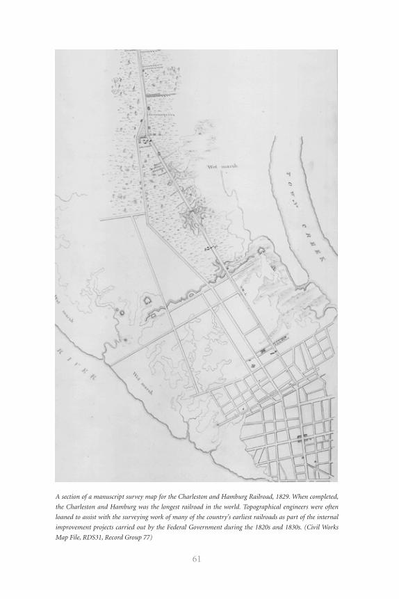
61
A section of a manuscript survey map for the Charleston and Hamburg Railroad, 1829. When completed,
the Charleston and Hamburg was the longest railroad in the world. Topographical engineers were often
loaned to assist with the surveying work of many of the country’s earliest railroads as part of the internal
improvement projects carried out by the Federal Government during the 1820s and 1830s. (Civil Works
Map File, RDS31, Record Group 77)
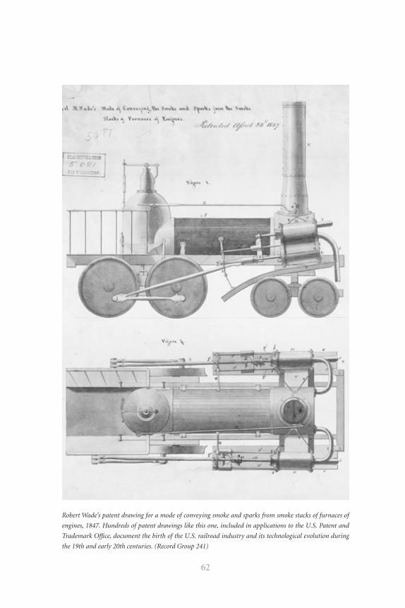
62
Robert Wade’s patent drawing for a mode of conveying smoke and sparks from smoke stacks of furnaces of
engines, 1847. Hundreds of patent drawings like this one, included in applications to the U.S. Patent and
Trademark Office, document the birth of the U.S. railroad industry and its technological evolution during
the 19th and early 20th centuries. (Record Group 241)
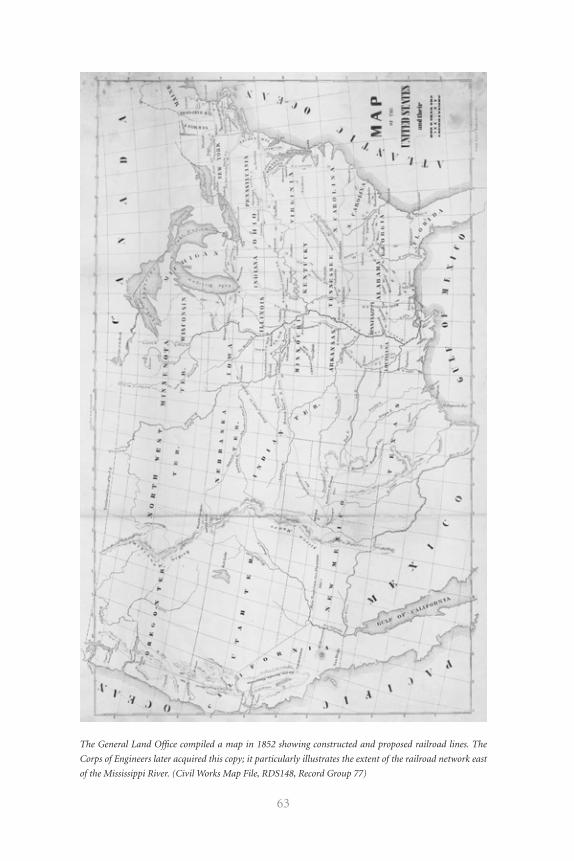
63
The General Land Office compiled a map in 1852 showing constructed and proposed railroad lines. The
Corps of Engineers later acquired this copy; it particularly illustrates the extent of the railroad network east
of the Mississippi River. (Civil Works Map File, RDS148, Record Group 77)
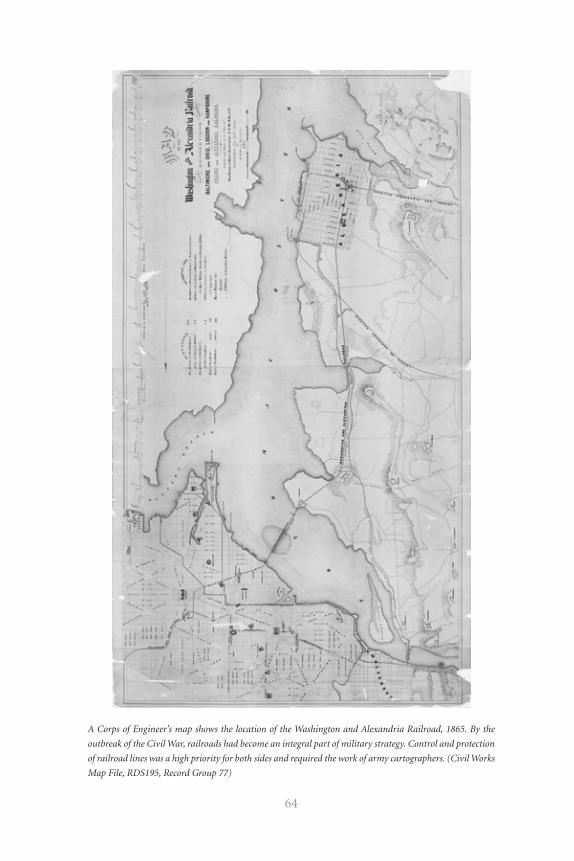
64
A Corps of Engineer’s map shows the location of the Washington and Alexandria Railroad, 1865. By the
outbreak of the Civil War, railroads had become an integral part of military strategy. Control and protection
of railroad lines was a high priority for both sides and required the work of army cartographers. (Civil Works
Map File, RDS195, Record Group 77)
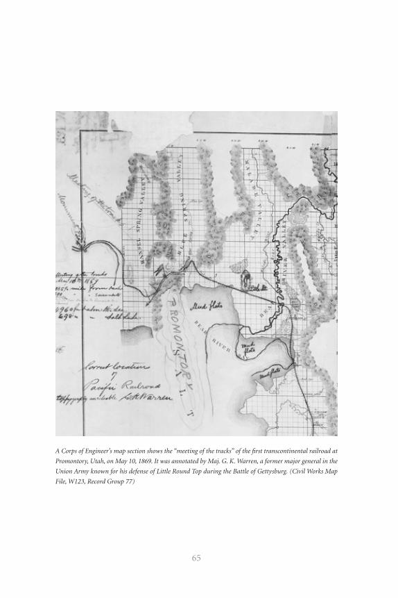
65
A Corps of Engineer’s map section shows the “meeting of the tracks” of the first transcontinental railroad at
Promontory, Utah, on May 10, 1869. It was annotated by Maj. G. K. Warren, a former major general in the
Union Army known for his defense of Little Round Top during the Battle of Gettysburg. (Civil Works Map
File, W123, Record Group 77)
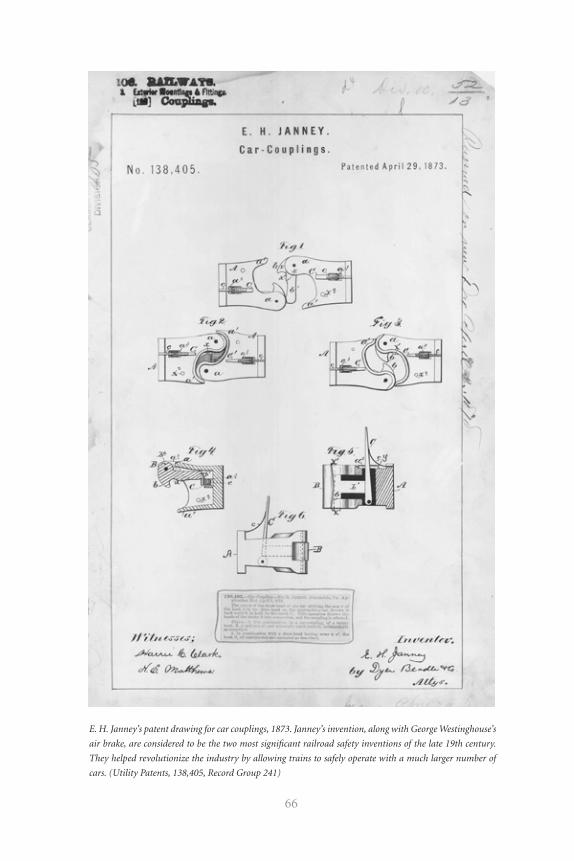
66
E. H. Janney’s patent drawing for car couplings, 1873. Janney’s invention, along with George Westinghouse’s
air brake, are considered to be the two most significant railroad safety inventions of the late 19th century.
They helped revolutionize the industry by allowing trains to safely operate with a much larger number of
cars. (Utility Patents, 138,405, Record Group 241)
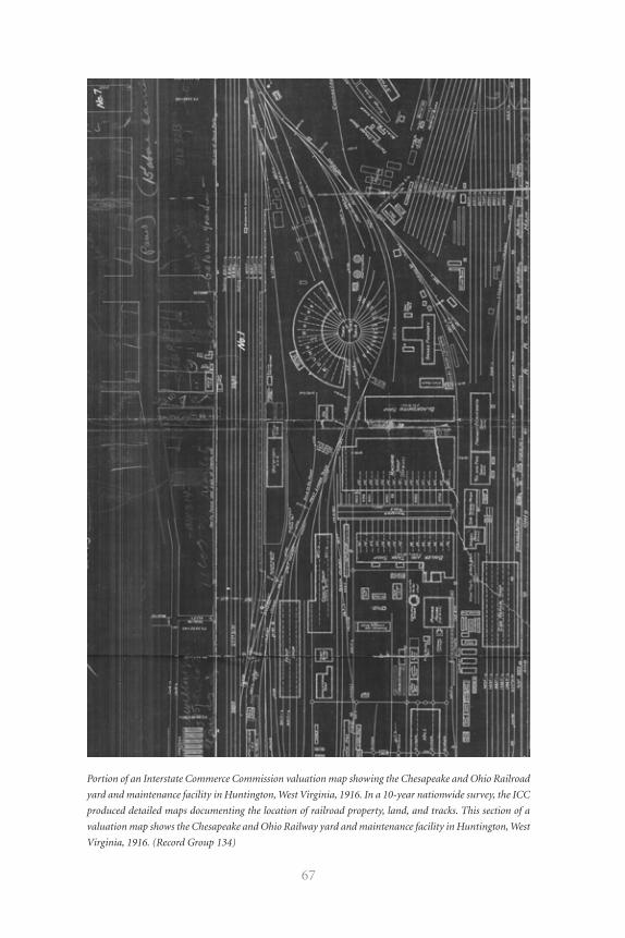
67
Portion of an Interstate Commerce Commission valuation map showing the Chesapeake and Ohio Railroad
yard and maintenance facility in Huntington, West Virginia, 1916. In a 10-year nationwide survey, the ICC
produced detailed maps documenting the location of railroad property, land, and tracks. This section of a
valuation map shows the Chesapeake and Ohio Railway yard and maintenance facility in Huntington, West
Virginia, 1916. (Record Group 134)
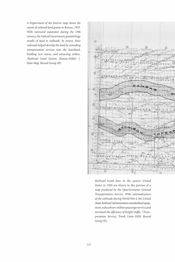
68
Railroad trunk lines in the eastern United
States in 1920 are shown in this portion of a
map produced by the Quartermaster General
Transportation Service. With nationalization
of the railroads during World War I, the United
States Railroad Administration standardized equip-
ment, reduced non-military passenger service, and
increased the efficiency of freight traffic. (Trans-
portation Service, Trunk Lines–1920, Record
Group 92)
A Department of the Interior map shows the
extent of railroad land grants in Kansas, 1925.
With westward expansion during the 19th
century, the Federal Government granted huge
swaths of land to railroads. In return, these
railroads helped develop the land by extending
transportation services into the heartland,
building new towns, and attracting settlers.
(Railroad Land Grants, Kansas–Folder 1,
State Map, Record Group 49)
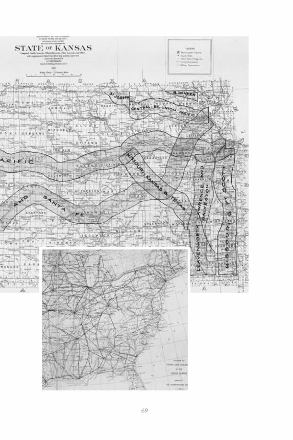
69
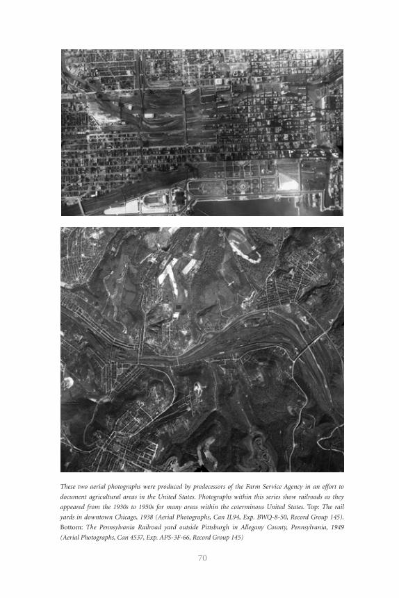
70
These two aerial photographs were produced by predecessors of the Farm Service Agency in an effort to
document agricultural areas in the United States. Photographs within this series show railroads as they
appeared from the 1930s to 1950s for many areas within the coterminous United States. Top: The rail
yards in downtown Chicago, 1938 (Aerial Photographs, Can IL94, Exp. BWQ-8-50, Record Group 145).
Bottom: The Pennsylvania Railroad yard outside Pittsburgh in Allegany County, Pennsylvania, 1949
(Aerial Photographs, Can 4537, Exp. APS-3F-66, Record Group 145)
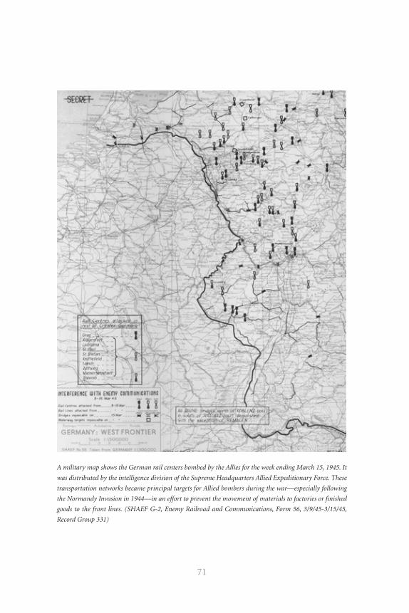
71
A military map shows the German rail centers bombed by the Allies for the week ending March 15, 1945. It
was distributed by the intelligence division of the Supreme Headquarters Allied Expeditionary Force. These
transportation networks became principal targets for Allied bombers during the war—especially following
the Normandy Invasion in 1944—in an effort to prevent the movement of materials to factories or finished
goods to the front lines. (SHAEF G-2, Enemy Railroad and Communications, Form 56, 3/9/45-3/15/45,
Record Group 331)

72
listing time, date, place, and pilots and observers involved. French records
in this series include examples of railroads as depicted through aerial pho-
tographs accompanied by interpretative drawings.
Dates: 1916–19
Arrangement: alphabetically by text language
Finding Aid: container list
165.3 Map Surveys of Korea (ARC 1128379)
Several maps in this series show the general location of railroads in Korea.
Dates: 1937–50
Arrangement: numerically by agency-assigned number
Finding Aid: none
165.4 Strategic Map Studies (ARC 1179349)
This series consists of strategic map studies (300 individual maps) of
Europe during World War II. Each study focuses on a region of Europe,
such as Central West Europe, Southeastern Europe, South Central Europe,
and Southwestern Europe, and includes maps showing terrain regions,
climatic regions, coastal conditions and landing beaches, airfields and naval
bases, agriculture, minerals, industry, roads, railroads and waterways, and
coastal and interior fortifications. Also included are maps of Europe show-
ing the location of primary roads and railroads.
Dates: 1943–45
Arrangement: alphabetically by geographic region within Europe
Finding Aid: none
RG 169 Records of the Foreign Economic Administration
169.1 Plans of Railroad Equipment Relating to the South Manchuria
Railway (ARC 1817955)
This series consists of 950 blueprint engineering drawings of railroad
73
equipment for the South Manchuria Railway. Included are detail plans for
locomotive component parts used by the Japanese during their occupation
of Manchuria in the 1930s and 1940s.
Dates: 1928–34
Arrangement: unarranged
Finding Aid: none
169.2 Enclosures to Reports Relating to Military Geography
(ARC 1817967)
This series includes maps showing railroads in France, Corsica, Sicily,
Morocco, Senegal, northern Sumatra, and Burma during World War II.
Dates: 1941–44
Arrangement: alphabetically by geographic location and thereunder nu-
merically by agency-assigned “plan” number
Finding Aid: item list for France only
169.3 Map Enclosures to Intelligence Reports (ARC 1817934)
Maps showing railroads in Indochina during World War II are included in
this series.
Dates: 1943
Arrangement: by report subject and thereunder numerically by agency-
assigned “exhibit” number
Finding Aid: none
RG 181 Records of Naval Districts and Shore Establishments
181.1 Annual Condition Maps (ARC 573325)
This series consists of 95 annual condition maps and site plans that show,
among other things, the location of railroad lines at the following U.S. Navy
facilities: Arraijan Tank Farm; U.S. Naval Ammunition Depot, Balboa; U.S.
Naval Submarine Base, Balboa; U.S. Naval Supply Depot, Balboa; Coco Solo
74
U.S. Naval Air Station; Cristibol, Canal Zone; Gatun Tank Farm; Summit
U.S. Naval Radio Station; Taboga, Panama; and Toro Point, Canal Zone.
Dates: 1937–47
Arrangement: chronologically by year
Finding Aid: none
RG 185 Records of the Panama Canal
185.1 Historical File of Arthur Raggi (ARC 588119)
A series of 15 maps relating to the Panama Railroad Company is included in
this collection. Arthur Raggi, an engineer with the Isthmian Canal Commis-
sion, the Panama Canal, and the Panama Railroad, compiled and annotated
these maps during his career.
Dates: ca. 1849–ca. 1943
Arrangement: by subject or type of record
Finding Aid: item list
185.2 General Maps, Plans, and Profiles (ARC 1513473)
This series includes maps relating to the Panama Railroad Company.
Dates: 1899
Arrangement: by record type (maps, plans, cross sections, and profiles)
Finding Aid: item list; Preliminary Inventory 91, Entry 6
185.3 Cross Sections, Profiles, and Maps of the Panama Canal
(ARC 1506143)
A variety of maps relating to the Panama Railroad Company is included in
this series.
Dates: 1889–95
Arrangement: roughly by type of plan or map and thereunder by area covered
Finding Aid: item list; Preliminary Inventory 91, Entry 3
75
185.4 Plans of French Railroad Equipment and a Hospital (ARC 1601542)
A series of 16 engineering plans of railroad equipment possibly used in
Panama is included in this series.
Dates: 1887
Arrangement: unarranged
Finding Aid: none
185.5 Manuscript Topographic Maps of the Panama Canal (ARC 607001)
This series consists of 836 manuscript topographic maps showing infra-
structure in the Panama Canal area, including the location of railroads.
Dates: ca. 1930–ca. 1965
Arrangement: numerically by scale and thereunder numerically by grid-
based sheet number
Finding Aid: A map index filed with the series shows available coverage and
provides map sheet numbers.
RG 187 Records of the National Resources Planning Board
187.1 Entry 5
Included in this entry are a tabulated list of committees and railroads represented
in the American Railway Association; an annotated map showing railroads and
areas served by them in the Missouri River and Southwest Mississippi drainage
regions; and copies of nine tracks maps for the Kansas City Terminal Railways.
Dates: ca. 1935–ca. 1943
Arrangement: unarranged
Finding Aid: Special List 41, Entry 5
187.2 Entry 22
Several maps in this series show interregional and intercity rail passenger
service for select areas, and one map shows train routes for tanker cars in
the Eastern Petroleum Service.
76
Dates: ca. 1935–43
Arrangement: unarranged
Finding Aid: Special List 41, Entry 22
187.3 Entry 39
One map in this entry shows the movement of soft coal from the originat-
ing fields to lake ports. A second map shows the capacity requirements for
all railroad shipments of iron ore from ranges to consuming centers.
Dates; 1929–34
Arrangement: unarranged
Finding Aid: Special List 41, Entry 39
187.4 Entry 63
This entry includes a map of New England indicating by circles the
important railroad-highway grade crossings and showing the relative
importance of eliminating some because of traffic conflict; and maps
showing railroad freight service and passenger service on scheduled
trains per day.
Dates: ca. 1935
Arrangement: unarranged
Finding Aid: Special List 41, Entry 63
187.5 Entry 111
This entry includes a small scale map copy showing the location of railroad
facilities in the Pacific Northwest and a manuscript map showing the rail-
road and highway network in Linn County, Oregon.
Dates: ca. 1933–ca. 1943
Arrangement: unarranged
Finding Aid: Special List 41, Entry 111
77
187.6 Entry 116
Maps relating to the Transcanadian-Alaska Railway are included in this entry.
Dates: 1942–43
Arrangement: unarranged
Finding Aid: Special List 41, Entry 116
RG 219 Records of the Office of Defense Transportation
219.1 Railroad Transportation Maps (ARC 849168)
Included in this series is a manuscript map of the railroad terminal at
Toledo, Ohio, showing the railroad lines, properties, and terminal facilities.
Also included is a map of the United States showing the traffic density of
major railroad systems. Enlarged copies of the map show the northeastern
and north central parts of the United States.
Dates: 1943–44
Arrangement: unarranged
Finding Aid: none
219.2 Railroad Abandonment Map (ARC 849172)
This published map of parts of Missouri and Arkansas shows roads, highways,
and the routes and connections of the Missouri and Arkansas Railway Company.
Dates: 1944
Arrangement: unarranged
Finding Aid: none
RG 220 Records of Temporary Committees, Commissions,
and Boards
220.1 Committee on the Conservation and Administration of the Public
Domain (ARC 2519024)
The committee records include a map of Alaska compiled by the Alaska
78
Railroad, Department of the Interior, showing routes of the Alaska Railroad
and River Service, steamship routes, commercial river lines, the line of the
Copper River and North Western Railroad, the White Pass Route, and the
Richardson Highway.
Dates: 1926
Arrangement: by subject
Finding Aid: Preliminary Inventory NC-88, Entry 7
RG 226 Records of the Office of Strategic Services
226.1 Thematic Maps (ARC 1142870)
Maps showing railroad systems in specific countries during World War II
are included in this series. There is a geographic emphasis on Allied and
Axis countries.
Dates: 1941–45
Arrangement: numerically by agency-assigned number
Finding Aid: card index
226.2 General Maps (ARC 592989)
This series includes maps showing the location of railroads in the former
Soviet Union.
Dates: ca. 1941–ca. 1945
Arrangement: by continent or country
Finding Aid: none
RG 233 Records of the United States House of Representatives
233.1 Published Maps (ARC 2110742)
These maps are arranged by congressional number. The records of the
32nd Congress (Mar. 4, 1851–Mar. 3, 1853) consists of a map of the United
States showing the location of operating railroads and railroad lines under
79
construction. Records of the 37th Congress, 3rd Session (Dec. 1, 1862–Mar.
3, 1863), include a map of the Washington Territory showing the loca-
tion of North Pacific railroad routes. Records of the 62nd Congress, 3rd
Session (Dec. 2, 1912–Mar. 3, 1913), include a set of 16 maps and map index
showing right-of-ways and profiles of railroad routes in Alaska prepared by
the Alaska Railroad Commission. Records of the 66th Congress (May 19,
1919–Mar. 3, 1921) include maps of France showing relative distances and
the extent of railroad systems used by the American Expeditionary Forces
during World War I.
Dates: ca. 1850–1918
Arrangement: numerically by number of Congress and thereunder numeri-
cally by congressional session of Congress
Finding Aid: item list
RG 234 Records of the Reconstruction Finance Corporation
234.1 Map Studies of Railroad Systems (ARC 1169163)
These map studies consist of 1,850 blueprint and manuscript maps
showing the corporate structure and property ownership of 141 rail-
roads throughout the United States and Canada during the 1930s and
1940s. Many of the maps are annotated to show yearly revisions. Also
included are map studies of certain railroad systems that contain maps
showing the varying weights of rail used by the railroads; the kinds of
ballast shipped by each line; dispatchers’ districts; communications net-
works paralleling the railroad lines; the distribution of materials carried
by the lines; sources of materials carried; passenger, train crew, and lo-
comotive runs; types of ties and tie production; maximum grades; mort-
gages existing for each line within the corporate structure of a railroad
system; operating divisions; bridges and tunnels, stations, water tanks,
signals, and icing installations; railroad crossings; dates of construction
of individual lines; and maximum and minimum freight and passenger
train speeds.
80
Dates: 1933–53
Arrangement: alphabetically by agency-assigned letter and thereunder
numerically
Finding Aid: index and item list
234.2 Railroad Maps (ARC 1208188)
This series consists of 1,800 blueprint and manuscript maps showing the
corporate structure and property ownership of 113 railroads throughout
the United States and Canada during the 1930s and 1940s. Also included
are railroad profiles, condensed profiles, right-of-way maps, and track maps
relating to the railroad systems.
Dates: 1930–43
Arrangement: alphabetically by name of railroad
Finding Aid: index
234.3 Railroad Consolidation Study Maps (ARC 1225006)
These 25 blueprint map studies relate to proposed railroad consolidation
during the Great Depression. Included are maps showing the possible con-
solidation of the New York Central and Pere Marquette railroads; the Akron,
Canton and Youngstown Railroad with various railroads; and modifications
to the New York Central Railroad. The maps show the geographic location of
the railroads’ main and branch lines, and some show possible lines to be aban-
doned or incorporated under the consolidation. Also included are blueprint
maps showing the location of railroads in various regions of the United States,
including New York, the Ohio Valley, the Midwest, the Southeast, the Mid-
Atlantic, and the Northeast.
Dates: ca. 1936–ca. 1938
Arrangement: by subject
Finding Aid: none
81
234.4 Railroad Profile Maps (ARC 1225017)
These 65 condensed profile maps illustrate various main lines of railroad sys-
tems, including the Chicago, Burlington and Quincy Railroad; the Chicago, Rock
Island and Pacific Railroad; the Missouri Pacific Railroad; the Chicago, Milwau-
kee, St. Paul and Pacific Railroad; the Chicago and Northwestern Railroad; the
Chicago, St. Paul, Minneapolis and Omaha Railroad; the Denver and Rio Grande
Western Railroad; the Illinois Central Railroad; the Southern Pacific Railroad;
the Union Pacific Railroad; the Wabash Railway; and the Western Pacific Rail-
road. The profiles show the location of individual stations along the line, the
mileage from the start of the line to each station, the maximum grade of the line
at key points, and the type of rail and ballast used to construct the line.
Dates: 1928–37
Arrangement: numerically by assigned file number
Finding Aid: none
234.5 Maps of Cities Showing Railroad Facilities (ARC 1167695)
This series consists of 23 maps for 13 cities within the United States showing the lo-
cation of industrial areas and railroad tracks, yards, terminals, and other facilities.
Dates: ca. 1919–ca. 1941
Arrangement: alphabetically by place name
Finding Aid: item list
234.6 Railroad Terminal Maps (ARC 1169002)
These nine blueprint maps show the location of railroad terminals in eight
cities within the United States.
Dates: 1932–53
Arrangement: alphabetically by place name
Finding Aid: none
82
234.7 Foreign Railroad Maps (ARC 1169004)
This series consists of a Russian map of Moscow showing railroad traffic
density within the city, maps of Cuba showing the railroad system through-
out the country, and a density map for an unidentified section of track. The
maps contain Russian and Spanish text.
Dates: ca. 1928–ca. 1942
Arrangement: alphabetically by country or place name
Finding Aid: none
RG 241 Records of the Patent and Trademark Office
241.1 Utility Patent Drawings (ARC 305888)
This series includes patent drawings illustrating proposed inventions relat-
ing to the railway industry from its inception to approximately 1911.
Dates: 1837–1911
Arrangement: numerically by patent number (1 to 1,000,000)
Finding Aid: subject index (1790–1873); image database – Patent and
Trademark Office web site
RG 256 Records of the American Commission to
Negotiate Peace
256.1 Maps Relating to Proposed Country Boundaries (ARC 722055)
This series includes maps and map studies of railroad networks for
certain European countries and other areas impacted by World War I.
Included are maps showing railroad networks in the Balkans and Ara-
bia, and maps of China showing the development and ownership of
railroads. Also included are maps of Africa showing projected Cape-to-
Cairo Railroad routes.
Dates: 1917–19
Arrangement: geographically by region or country
Finding Aid: folder list; item list
83
RG 260 Records of United States Occupation Headquarters,
World War II
260.1 Administrative Maps
This series includes maps showing the locations of railway administrative
headquarters throughout Germany during World War II.
Dates: ca. 1945
Arrangement: alphabetically by region within Germany
Finding Aid: none
RG 319 Records of the Army Staff
319.1 New York Central Bridge Survey (ARC 1943367)
This series consists of 55 engineering drawings of railroad bridges
belonging to the New York Central Railroad and its subsidiaries,
including the Michigan Central Railroad; the Cleveland, Cincinnati,
Chicago, and St. Louis Railway; the Louisville and Jeffersonville Bridge
and Railroad Company; the Peoria and Eastern Railway; the Chicago
River and Indiana Railroad; and the Indiana Harbor Belt Railroad. Plans
for specific bridges typically include site plans, sections, elevations, and
cross-section drawings.
Also included is a plan for the Detroit River Railroad Tunnel and 6
detour maps for the New York Central Railroad (west of Buffalo, New
York); the Chicago River and Indiana Railroad; the Chicago Junction
Railway; the Indiana Harbor Belt Railroad; the Michigan Central Rail-
road; and the Cleveland, Cincinnati, Chicago, and St. Louis Railway.
The records in this series were compiled by the Office of the Chief
of Staff, G-2 for use by the 5th Army in connection with a survey of
security measures for critical bridges of the New York Central Railroad
System.
Dates: 1901–51
Arrangement: by name of railroad and thereunder by bridge number
Finding Aid: item list; index map
84
319.2 CMH Geographic Map File (ARC 1948921)
These approximately 1,500 manuscript, printed, published, and annotat-
ed maps and charts and a few aerial photographic prints relate to various
geographic locations and subjects throughout the world during World War
II. A number of maps show the locations of railroads, including a German
railroad map of the Soviet Union, a map showing the southern supply
routes to the Soviet Union and East Central Asia, and a map showing rail-
roads in the Middle East.
Dates: ca. 1941–ca. 1944
Arrangement: alphabetically by geographic location
Finding Aid: folder list
319.3 Cartographic Records from the Defense Intelligence File
(ARC 578370)
This series contains five maps showing the Chinese railway network (Filed
as ID Unknown, Folder 7).
Dates: 1947–48
Arrangement: numerically by the Army Intelligence Document number.
A few records do not have ID numbers and are filed at the end of the
series.
Finding Aid: folder list
RG 331 Records of Allied Operational and Occupation
Headquarters, World War II
331.1 Maps Relating to Attacks on German Railroads (ARC 1143125)
This series of 80 maps relates to the railroad network used by German mili-
tary forces in Western Europe during World War II. Included are maps show-
ing the railroad network in western Germany; the main concentrations of
Allied air attacks on railroads in Germany during April 1945; the status of
Allied railroad bridge interdiction in France during August 1944; the loca-

85
tions of German railroad administrative headquarters; the state of damage
to German rail centers in western Germany from January to April 1945; the
status of the German rail, road, and waterway transportation network in
Germany, Austria, The Netherlands, and Czechoslovakia from December
1944 to April 1945; the main trends of rail and road movement by German
forces from February to April 1945 in Germany, Austria, and Czechoslovakia;
and maps of France annotated to show damage to railroads in June 1944.
Dates: June 1944–April 1945
Arrangement: by subject and thereunder chronologically
Finding Aid: none
331.2 Maps of Transportation Routes (ARC 1145508)
This series includes a map showing the location of railroads in eastern France.
Dates: ca. 1944–ca. 1945
Arrangement: by subject
Finding Aid: none
331.3 Maps Showing German Defenses in Western Europe
(ARC 1142811)
Maps showing the location of German railway artillery in France, Germany,
and Austria during World War II are included in this series.
Dates: 1944–1945
Arrangement: alphanumerically by Army Map Service (AMS) map num-
ber, thereunder alphanumerically by AMS sheet number, and thereunder
chronologically.
Finding Aid: index
331.4 Scandinavia Study Maps (ARC 1154541)
Maps showing rail communications in Sweden are included in this series.
86
Dates: ca. 1944–ca. 1945
Arrangement: by subject
Finding Aid: none
331.5 Maps Relating to Military Activity in France and Germany
(ARC 1170299)
A railroad map of western Germany is included in this series.
Dates: 1944–46
Arrangement: by subject
Finding Aid: none
331.6 Maps Relating to Bridges over the Rhine River (ARC 1170311)
This series consists of six maps of the Rhine River annotated to show the
location and status of bridges over the river during the closing months
of World War II. The bridges are identified as passable or impassable and
include information on the type of bridge, such as permanent road, railroad
bridge, pontoon bridge, or floating bridge.
Dates: March–April 1945
Arrangement: chronologically
Finding Aid: none
RG 338 Records of the United States Army Operational,
Tactical, and Support Organizations (World War II and
Thereafter)
338.1 Transportation Maps of Korea (ARC 1254143)
This series includes a map showing the locations of railroads in the Com-
munist Far East.
Dates: 1951–57
Arrangement: unarranged
Finding Aid: none
87
RG 351 Records of the Government of the
District of Columbia
351.1 Maps and Surveys of the District of Columbia (ARC 1127196)
Surveys of squares, subdivisions, tracks and streets within the City of Wash-
ington make up this series. Included are three maps showing proposed lines
and grades of the Baltimore and Potomac Railroad; a map showing the exten-
sion of the Baltimore and Washington Railroad (Baltimore and Ohio Rail-
road) within the limits of Washington, DC; a survey for the Anacostia and
Potomac River Railway; four plans for the terminal branch of the Baltimore
and Potomac Railroad; and a map showing the location of the Pennsylvania
Railroad tracks at the Washington and Pennsylvania Avenue bridge.
Dates: 1832–1907
Arrangement: alphanumerically by the surveyor’s filing scheme
Finding Aid: item list
351.2 Maps and Plans Accompanying Annual Reports of the
Commissioners of the District of Columbia (ARC 722072)
This series includes thematic maps relating to rail service.
Dates: 1876–1908
Arrangement: chronologically by year
Finding Aid: none
RG 373 Records of the Defense Intelligence Agency
373.1 Aerial Mosaic Negatives (ARC 306067)
Photographic negatives of aerial mosaics showing bomb damage to Ger-
man railroad yards at Euskirchen and Ulm are found in this series. Also
included are views of German railroad flak cars.
Dates: ca. 1943–ca. 1945
Arrangement: alphabetically by country
Finding Aid: none
88
373.2 Aerial Photographs (ARC 305982)
Approximately 14 million vertical and oblique aerial photographs comprise
this series. Urban and rural areas of the United States are represented with
emphasis on coastal and navigable inland harbors and waterways, military
installations, and airfields throughout the country. The coverage for areas
outside the United States is concentrated on areas of World War II and
immediate postwar U.S. military activities and facilities. Railroad lines, sid-
ings, yards, and prominent structures are visible on the photographs. These
aerial photographs were taken by the U.S. Air Force and its predecessors
and the U.S. Navy for use in military reconnaissance and mapping projects.
Dates: 1935–70
Arrangement: sequentially by assigned Original Negative (ON) number or
by assigned copy number
Finding Aid: microfilmed overlay indexes arranged by degrees of latitude and
longitude provide primary area coverage access. Additional finding aids
relating to aerial photographs are available in the Cartographic Research
Room.
373.3 German Flown Aerial Photography (ARC 306065)
This series consists of approximately 1,250,000 captured German 12- by
12-inch aerial photographic contact prints (referred to as GX Prints) cov-
ering Europe, the Middle East, and North Africa during World War II.
Included are both vertical mapping photography and oblique reconnais-
sance photography. Scales vary greatly from 1:15,000 to 1:40,000. Railroad
lines sidings, yards, and prominent structures are visible on the photographs.
Dates: 1939–45
Arrangement: numerically by mission number, thereunder by exposure number
Finding Aid: An unpublished “Guide to GX Holdings” along with additional
aerial photograph finding aids is available in the Cartographic Research
Room.
89
RG 385 Records of the Naval Facilities Engineering Command
385.1 Plans of Naval Shore Facilities (ARC 574311)
This series includes maps on microfilm showing railroad lines located
in or in support of United States Navy Facilities. Access is Restricted
Fully to part of this series: FOIA (b)(2) Internal Personnel Rules and
Practices.
Dates: 1911–99
Arrangement: alphabetically by Naval Engineering Field Division (Ant-
arctic, Atlantic, Chesapeake, Northern, Pacific, Southern, and Western),
thereunder numerically by Unit Identification Code (UIC) number, and
thereunder numerically by drawing number.
Finding Aid: database
RG 395 Records of the U.S. Army Overseas Operations and
Commands, 1898–1942
395.1 Records Relating to the Mexican Punitive Operation (ARC 1264258)
Maps in this series show the layout of camps and railroad sidings along
the route of the Mexican Punitive Operation under the command of
Gen. John J. Pershing in New Mexico, Texas, and northern Mexico.
Dates: 1916
Arrangement: numerically by NARA-assigned map number
Finding Aid: item list
395.2 Military Maps of the Philippines (ARC 644121)
This series includes maps relating to surveys of railroads in the Philippines.
Dates: 1900–42
Arrangement: unarranged
Finding Aid: none
90
RG 398 General Records of the Department of Transportation
398.1 United States Transportation Atlas (ARC 2315033)
This series includes maps showing transportation infrastructure, including
major railroads, at the regional and national levels.
Dates: 1975–76
Arrangement: geographically
Finding Aid: none
RG 399 Records of the Federal Railroad Administration
399.1 Transportation Maps (ARC 2314737)
This series consists of 41 state transportation maps and 486 transportation
zone maps detailing the railroad transportation network throughout the
contiguous United States.
The zone maps show the ownership of rail lines, trackage rights, traffic
density and signaling, and freight stations at a large scale.
The two-color state maps show the 486 zone maps at a smaller scale. Infor-
mation on the state maps includes: track ownership, trackage rights, number of
tracks, principal stations, county names and boundaries, rail junction points and
ends of branches, and the distances between rail intersections, as well as the major
United States Interstate and State Highways, and navigable waterways. The state
maps have been revised for those states in the Northeast and Midwest Region
to show the changes in rail configuration as a result of the Railroad Revitaliza-
tion and Regulatory Act of 1976 and the United States Railway Association’s Final
System Plan. These maps show bankrupt railroad lines that were consolidated to
form the Consolidated Rail Corporation (Conrail) and bankrupt lines that were
acquired by solvent railroads, states, and transportation authorities. Also shown
are those railroads available for subsidy under the reform act.
Dates: 1975–77
Arrangement: into two subseries, state maps and zone maps, both of which
are arranged numerically by agency-assigned number.
Finding Aid: item list for the state maps; index map showing zone coverage
91
399.2 Northeast Corridor Improvement Project Plans
This series consists of aperture cards containing construction drawings
for all railroad improvements between Washington, DC, and Boston
from 1978 to 1987 as part of the Northeast Corridor Improvement Proj-
ect (NEIP).
Dates: 1978–87
Arrangement: alphanumerically by agency-assigned card identifier
Finding Aid: filing plan
RG 406 Records of the Federal Highway Administration
406.1 County Transportation Maps (ARC 2431769)
These approximately 30,000 county road maps also show the national rail-
road network at the county level. Railroads are identified by name, and
the maps show the location of tracks, bridges, tunnels, road crossings, and
stations. Coverage is mostly limited to the 1970s, but some maps have been
revised for the 1980s, 1990s, and 2000s.
Dates: 1970–2008
Arrangement: alphabetically by state, thereunder alphabetically by county,
and thereunder chronologically.
Finding Aid: none
RG 407 Records of the Adjutant General’s Office, 1917–
407.1 World War II Records (ARC 3054040)
This series includes maps produced by the 660th Engineer Battalion show-
ing the location of railroads in Central Europe during the World War II time
period.
Dates: ca. 1941–ca. 1945
Arrangement: numerically by military organization (Army, Corps, Divi-
sion), thereunder geographically, and thereunder by subject
Finding Aid: folder list
92
Donated Materials (DM)
DM.1 Gussak, J. J.
This series includes a road and railway atlas for the state of Assam, India.
Dates: 1940
Arrangement: geographically
Finding Aid: none
DM.2 National Trust for Historic Preservation – Historic Buildings
(ARC 2363744)
This series includes architectural drawings and maps relating to railroad
renovation projects conducted by the National Trust for Historic Preserva-
tion during the 1970s.
Dates: ca. 1970–ca. 1979
Arrangement: alphabetically by state, thereunder alphabetically by city, and
thereunder alphabetically by project name
Finding Aid: folder list
9393
National Archives and Records Administration
700 Pennsylvania Avenue NW
Washington, DC 20408-0001
202-501-5400
E-mail: [email protected]
National Archives and Records Administration
8601 Adelphi Road
College Park, MD 20740-6001
301-837-2000
E-mail: [email protected]
National Archives at Boston
380 Trapelo Road
Waltham, MA 02452
866-406-2379
E-mail: [email protected]
Areas Served: Connecticut, Maine, Massachusetts, New Hampshire, Rhode Island,
and Vermont
National Archives at Pittsfield
10 Conte Drive
Pittsfield, MA 01201
413-236-3600
E-mail: [email protected]
(no accessioned records, only microfilm related to genealogy)
appendixThe National Archives and Records Administration
9494
National Archives at New York City
201 Varick Street, 12th Floor
New York, NY 10014
212-401-1620/1-866-840-1752
E-mail: [email protected]
Area Served: New Jersey, New York, Puerto Rico, and the Virgin Islands
National Archives at Philadelphia
900 Market Street
Philadelphia, PA 19107
215-606-0100
E-mail: [email protected]
Area Served: Delaware, Pennsylvania, Maryland, Virginia, and West Virginia
National Archives at Atlanta
5780 Jonesboro Road
Morrow, GA 30260
770-968-2100
E-mail: [email protected]
Area Served: Alabama, Florida, Georgia, Kentucky, Mississippi, North Carolina,
South Carolina, and Tennessee
National Archives at Chicago
7358 South Pulaski Road
Chicago, IL 60629
773-948-9001
E-mail: [email protected]
Area Served: Illinois, Indiana, Michigan, Minnesota, Ohio, and Wisconsin
National Archives at Kansas City
400 West Pershing Road
Kansas City, MO 64108
816-268-8000
E-mail: [email protected]
Area Served: Iowa, Kansas, Missouri, and Nebraska

9595
National Archives at Fort Worth
501 West Felix Street, Building 1
P.O. Box 6216
Fort Worth, TX 76115-0216
817-831-5620
E-mail: [email protected]
Area Served: Arkansas, Louisiana, Oklahoma, and Texas
National Archives at Denver
Denver Federal Center, Building 48
P.O. Box 25307
Denver, CO 80225
303-407-5740
E-mail: [email protected]
Area Served: Colorado, Montana, New Mexico, North Dakota, South Dakota,
Utah, and Wyoming
National Archives at Riverside
23123 Cajalco Road
Perris, CA 92570
951-956-2054
E-mail: [email protected]
Area Served: Arizona; southern California, and Clark County, Nevada
National Archives at San Francisco
1000 Commodore Drive
San Bruno, CA 94066
650-238-3500
E-mail: [email protected]
Area Served: northern California, Hawaii, Nevada (except Clark County),
American Samoa, and the Pacific Trust Territories

9696
National Archives at Seattle
6125 Sand Point Way NE
Seattle, WA 98115
206-336-5115
E-mail: [email protected]
Area Served: Idaho, Oregon, and Washington
National Archives at Anchorage
654 West Third Avenue
Anchorage, AK 99501
907-261-7800
E-mail: [email protected]
Area Served: Alaska
PRESIDENTIAL LIBRARIES
Herbert Hoover Library
210 Parkside Drive
P.O. Box 488
West Branch, IA 52358-0488
319-643-5301
www.hoover.archives.gov
Franklin D. Roosevelt Library
4079 Albany Post Road
Hyde Park, NY 12538-1999
1-800-337-8474
www.fdrlibrary.marist.edu
Harry S. Truman Library
500 West U.S. Highway 24
Independence, MO 64050-1798
1-800-833-1225
www.trumanlibrary.org

9797
Dwight D. Eisenhower Library
200 Southeast Fourth Street
Abilene, KS 67410-2900
1-877-746-4453
www.eisenhower.archives.gov
John Fitzgerald Kennedy Library
Columbia Point
Boston, MA 02125-3398
617-514-1600
1-866-JFK-1960
www.jfklibrary.org
Lyndon Baines Johnson Library
2313 Red River Street
Austin, TX 78705-5702
512-721-0200
www.lbjlib.utexas.edu
Richard Nixon Library
18001 Yorba Linda Boulevard
Yorba Linda, CA 92886-3903
714-983-9120
www.nixonlibrary.gov
Richard Nixon Library–College Park
8601 Adelphi Road
College Park, MD 20740-6001
301-837-3290
Gerald R. Ford Library
1000 Beal Avenue
Ann Arbor, MI 48109-2114
734-205-0555
www.ford.utexas.edu

9898
Gerald R. Ford Museum
303 Pearl Street, NW
Grand Rapids, MI 49504-5353
616-254-0400
Jimmy Carter Library
441 Freedom Parkway
Atlanta, GA 30307-1498
404-865-7100
www.jimmycarterlibrary.org
Ronald Reagan Library
40 Presidential Drive
Simi Valley, CA 93065-0600
805-577-4000/800-410-8354
www.reagan.utexas.edu
George Bush Library
1000 George Bush Drive
College Station, TX 77845-3906
979-691-4000
bushlibrary.tamu.edu
William J. Clinton Library
1200 President Clinton Avenue
Little Rock, AR 72201
501-374-4242
www.clintonlibrary.gov
George W. Bush Library
1725 Lakepointe Drive
Lewisville, TX 75057
972-353-0545
www.georgewbushlibrary.gov
9999
indexesCompiled by Peter F. Brauer
Topical Index
Adjutant General’s Office 94.1, 94.3, 94.2,
407.1
Aerial Photographs 18.1, 57.5, 95.10, 114.1,
120.5, 120.6, 142.1, 145.1, 165.2,
373.1–373.3
Africa 256.1
Agricultural Economics, Bureau of 83.1
Alien Property, Office of 131.1
Allied Operational and Occupation
Headquarters, World War II 331.1–
331.6
American Commission to Negotiate Peace
256.1
American Expeditionary Forces, World
War I 120.1–120.22, 233.1
American Railway Association 187.1
Anacostia River 60.1, 66.1
Arabia 256.1
Architectural Drawings 60.2, 66.1
stations 60.2, 66.1, DM.2
Argentina 38.1
Army Air Forces 18.1
Army Operational, Tactical, and Support
Organizations (See United States Army
Operational . . . )
Army Overseas Operations and Commands
(See United States Army Overseas
Operations and Commands)
Army Staff 319.1–319.3
Artillery, Railway 74.1, 77.8, 331.3, 373.1
Asia 319.2
Australia 59.1, 77.5
Austria 331.1, 331.3
Balkans 256.1
Belgium 77.8, 120.10, 120.16, 120.17
Brazil 77.8
Bridges 57.3, 66.1, 331.1, 331.6, 351.1
Bureau of Mines (See United States Bureau
of Mines)
Burma 169.2
Census, Bureau of the 29.1
Central America 38.1, 43.1
Chesapeake and Ohio Canal 79.1
Chief of Engineers, Office of the 77.1–77.9
Chief of Naval Operations, Office of the
38.1
Chief of Ordnance, Office of the 156.1, 156.2
China 18.1, 77.7, 127.1, 256.1, 319.3
City Maps
Domestic 23.3, 28.7, 29.1, 57.1, 69.1,
133.1, 151.1, 219.1, 234.5, 234.6
Foreign 23.3, 59.1, 120.7, 140.1, 234.7
Civil War 23.1, 23.3, 77.1, 77.2, 94.2
Coal 133.1, 134.5, 187.3
Anthracite 60.2, 150.1
Bituminous 60.2, 150.1
Coast and Geodetic Survey 23.1–23.3
Coast Guard (See United States Coast
Guard)
Colombia 38.1, 43.1
Conrail (Consolidated Rail Corporation)
21.1, 399.1
Conservation and Administration of the
Public Domain, Committee on the
220.1
100100
Finance, Bureau of 134.3
Fontana Reservoir Project 142.2
Foreign and Domestic Commerce, Bureau
of 151.1
Fine Arts, Commission of 66.1
Foreign Economic Administration
169.1–169.3
Forest Service 95.1–95.11
Formal Cases, Bureau of 134.4, 134.5
France 74.1, 120.4–120.6, 120.8–120.15,
120.17–120.21, 169.2, 226.1, 331.1–
331.3
French Indo China 38.1
General Land Office (See Land
Management, Bureau of)
Geological Survey (See United States
Geological Survey)
Germany 77.8, 120.1, 120.7–120.9, 120.15,
120.19, 120.22, 260.1, 331.1, 331.3,
331.5, 373.1
Government of the District of Columbia
351.1, 351.2
Guatemala 43.1, 127.1
Gussak, J. J. DM.1
Hawaii 126.2
Honduras 38.1, 43.1, 127.1
Horse Drawn Railroads 23.2
House of Representatives (See United States
House of Representatives)
India DM.1
Indian Affairs, Bureau of 75.1, 75.2
Indian Reservations 75.1, 75.2
Indochina 169.3
Inland Waterways Commission 91.1
Intercontinental Railway Commission
43.1
International Conferences, Commissions,
and Expositions 43.1
Interstate Commerce Commission 21.1,
133.4, 134.1–134.5
Italy 120.8
Consolidation 21.1, 133.1, 134.3, 234.3,
399.1
Construction, Railroad 77.2
Corsica 169.2
Costa Rica 38.1, 43.1, 127.1
County Maps 29.1, 30.4, 187.5, 406.1
Cuba 77.8, 140.1, 234.7
Czechoslovakia 331.1
Defense Intelligence Agency 373.1–373.3
Defense Transportation, Office of 219.1,
219.2
District Courts of the United States 21.1
District of Columbia 28.6
Dominican Republic 38.1
Donated Materials DM.1, DM.2
Eastern Petroleum Service 187.2
Ecuador 43.1
El Salvador 43.1, 127.1
Engineering Drawings 66.1, 70.1, 74.1, 77.2,
185.4, 241.1
Bridges and Tunnels 66.1, 77.1, 319.1
Locomotives 169.1, 241.1
Rolling Stock 28.1, 54.1, 69.2, 74.1,
120.3, 131.1, 165.1, 241.1
Tracks 77.1, 241.1
Enlarged Homestead Act (1909) 49.8
Enumeration Districts 29.1
Extension/Relocation of Railroads 77.4,
77.9, 142.2
Europe 120.2, 120.10, 120.17, 120.19, 165.4,
256.1, 373.3, 407.1
Facilities
Military 30.2, 57.3, 92.3, 112.1, 156.2
Naval 32.1, 71.1, 181.1, 385.1
Far East 59.1, 338.1
Farm Service Agency 145.1
Federal Coordinator of Transportation
133.1–133.5
Federal Highway Administration 406.1
Federal Railroad Administration 399.1,
399.2.1
101101
Occupation Headquarters (WW II) (See
United States Occupation Headquarters
[WW II])
Ordnance, Bureau of 74.1
Palestine 120.17
Pan American Railway Transportation
Route 38.1, 46.3
Panama 38.1, 43.1, 46.3, 185.1–185.5
Panama Canal 185.1–185.5
Patent and Trademark Office 241.1
Pershing, Gen. John J. 395.1
Peru 43.1
Philippines 77.8, 94.3, 395.2
Plant Industry, Soils, and Agricultural
Engineering, Bureau of 54.1
Port facilities 151.1
Post Office Department 28.1–28.7
Postal Routes 28.2–28.5
Potomac River 66.1
Powell, John W. 57.4
Prince Plan 133.5
Property Deeds 21.1
Property Owners (See Property Deeds)
Public Roads, Bureau of 30.1–30.4
Pullman Company 60.2
Quartermaster General, Office of the
92.1–92.4
Raggi, Arthur 185.1
Railroad Administration (See United States
Railroad Administration)
Railroad Retirement Board 66.1
Railroad Revitalization and Regulatory
Reform Act of 1976 399.1
Railway Association (See United States
Railway Association)
Reconstruction Finance Corporation
234.1–234.7
Regional Rail Reorganization Act of 1973 21.1
Relocation (See Extension/Relocation of
Railroads)
Rhine River 331.6
Japan 38.1
Justice, Department of 60.1, 60.2
Korea 165.3
Land Grants 49.3, 49.6, 49.7, 49.9, 57.4,
75.1, 83.1, 95.1–95.5, 133.2
Land Management, Bureau of 49.1–49.11
Land Transfer (See Consolidation)
Light Rail 66.1
McClellan, Gen. George B. 94.1
Manchuria 169.1
Marine Corps (See United States Marine
Corps)
Marschner, Francis J. 83.1
Mexican Punitive Operation 395.1
Mexico 38.1, 46.3, 77.5, 77.8, 127.1, 165.1,
395.1
Middle East 319.2, 373.3
Military Government of Cuba 140.1
Mississippi River 26.1, 91.1
Morocco 169.2
Moscow 234.7
Narrow Gauge 77.8
National Bituminous Coal Commission
150.1
National Park Service 79.1
National Resources Conservation Service
114.1
National Resources Planning Board
187.1–187.6
National Trust for Historic Preservation
DM.2
Naval Districts and Shore Establishments
181.1
Naval Facilities Engineering Command
385.1
Netherlands 331.1
Nicaragua 38.1, 43.1, 127.1
North Africa 373.3
Northeast Corridor Improvement Project
399.2
102102
Transportation Maps 30.1, 30.2, 398.1,
399.1, 406.1
Turkey 77.8
Union Station 66.1
United Kingdom 77.1, 77.6
United States 60.2, 77.5, 77.8, 83.1, 92.2,
133.2, 133.3, 219.1
Eastern 46.1, 95.7
Mid-Atlantic 234.3
Midwest 234.3, 399.1
North Central 219.1
Northeast 14.1, 57.5, 60.1, 187.4,
219.1, 234.3, 399.1, 399.2
Northwest 187.5
Ohio Valley 234.3
Rocky Mountains 57.4
South 23.1, 94.2
Southeast 234.3
Southwest 114.1, 395.1
Western 46.2, 46.3, 48.1, 48.18–48.26,
57.2, 94.1, 95.10, 133.1
United States Army Operational, Tactical,
and Support Organizations (World
War II and Thereafter) 338.1
United States Army Overseas Operations
and Commands 395.1, 395.2
United States Bureau of Mines 70.1
United States Coast Guard 26.1
United States Geological Survey 57.1–
57.5
United States House of Representatives
233.1
United States Marine Corps 127.1
United States Occupation Headquarters
(WW II) 260.1
United States Railroad Administration
14.1
United States Railway Association 21.1,
339.1
United States Senate 46.1–46.3
United States Shipping Board 32.1
Rolling Stock 74.1, 92.1
Ambulance Cars 94.2, 112.1, 165.1
Flak Cars 74.1, 373.1
Mail Cars 28.1
Passenger Cars 131.1
Refrigerated Cars 54.1
Theater Cars 69.2
Russia 120.19, 226.2, 319.2
San Francisco 46.2
Secretary of the Interior, Office of the
48.1–48.27
Senate (See United States Senate)
Senegal 169.2
Shipping Board (See United States Shipping
Board)
Shipyards (See Facilities, Naval)
Sicily 169.2
South America 38.1, 43.1
Spain 38.1
State, Department of 59.1
State Maps 23.3, 28.4, 30.1, 30.3, 94.2,
126.1, 126.2, 399.1
Strategic Services, Office of 226.1, 226.2
Street Cars (See Light Rail)
Subways (See Light Rail)
Surgeon General (Army), Office of the
112.1
Sumatra 169.2
Sweden 331.4
Systems, Railroad 133.4, 133.5, 134.3–134.5
Taiwan 77.8
Temporary Committees, Commissions,
and Boards 220.1
Tennessee River 26.1
Tennessee Valley Authority 142.1, 142.2
Territories, Office of 126.1, 126.2
Topographic Maps 23.3, 57.1, 94.2
Transcontinental Railroad 46.1, 48.18–
48.26, 77.2, 92.2, 94.1
Transportation, Department of 398.1
103
Alabama Northern 134.1
Alabama, Tennessee and Northern 134.1,
134.2
Alabama Terminal Company 134.1
Alameda Belt Line 134.1, 134.2
Alamogordo and Sacramento Mountain
49.3, 134.1, 134.2
Alaska 126.1, 220.1, 233.1
Alaska and Cape Nome 49.3
Alaska Anthracite 49.10
Alaska Central 49.3
Alaska Midland 49.2
Alaska Northern 49.3, 49.10, 126.1
Alaska Pacific 49.2
Alaska Pacific Railway and Terminal
Company 46.3, 49.10
Alaska Short Line 49.2
Albany and Northern 134.1, 134.2
Albany and Susquehanna 134.1, 134.2
Albany and Vermont 134.1, 134.2
Albany Passenger Terminal 134.1, 134.2
Albany Port District 134.1
Albuquerque and Eastern 49.2
Alcolu 134.1
Alexandria and Western 134.1
Algers, Winslow and Western 134.2
Aliquippa and Southern 134.1, 134.2
Allegheny and Southside 134.1
Allegheny and Western 134.1
Allegheny Terminal 134.1, 134.2
Aberdeen and Rockfish 134.1, 134.2
Aberdeen, Bismarck and Northwestern
49.2, 49.3
Aberdeen, Fergus Falls and Pierre 49.3
Abilene and Northern 134.1, 134.2
Abilene and Southern 134.1, 134.2
Addison and Susquehanna 134.1
Adirondack and Saint Lawrence 134.1
Agua, Fria and Hassayampa 49.3
Ahnapee and Western 134.1, 134.2
Akron and Barberton Belt 134.1, 134.2
Akron, Canton and Youngstown 34.1,
134.2, 234.1, 234.2, 234.3
Akron, Sterling and Northern 49.2, 49.3
Akron Union Passenger Depot 134.1, 134.2
Alabama and Chattanooga 49.1, 49.7
Alabama and Florida 49.1, 49.3, 49.7, 77.2,
134.1
Alabama and Little River 49.3
Alabama and Louisiana 49.7
Alabama and Mississippi 49.7, 134.1
Alabama and Northwestern 134.1
Alabama and Tennessee 49.7
Alabama and Vicksburg 134.1, 134.2
Alabama, Birmingham and Atlantic 134.1
Alabama Central Railroad 49.7, 77.2, 134.1
Alabama Central Railway 134.1
Alabama, Florida and Southern 134.1
Alabama Great Southern 134.1, 134.2
Alabama Midland 77.2
Railroad Name IndexThis index includes the names of railroads mentioned in previously compiled guides and finding aids.
Valuation Maps 21.1, 77.9, 134.1 134.2
War Department General and Special
Staffs 165.1-165.4
West Africa 59.1
West Indies 46.3
Work Projects Administration 69.1, 69.2
World War I 74.1, 120.1–120.22, 165.1,
165.2, 233.1, 256.1
World War II 18.1, 77.7, 112.1, 165.4,
169.1–169.3, 226.1, 226.2, 260.1, 319.2,
331.1–331.6, 373.1–373.3, 407.1
Yards and Docks, Bureau of 71.1
104
Arkansas and Louisiana Midland 134.1
Arkansas and Louisiana Missouri 134.2
Arkansas and Memphis Railway Bridge and
Terminal 134.2
Arkansas and New Mexico 49.2
Arkansas Central 134.2
Arkansas Midland 134.1
Arkansas Southern 49.3
Arkansas Southwestern 134.1
Arkansas Western 134.2
Arkansas Valley 49.3
Arlington 134.1
Arnot and Pine Creek 134.1
Aroostook River 134.1, 134.2
Artemus Jellico 134.2
Artesian Belt 134.2
Asherton and Gulf 134.2
Asheville and Craggy Mountain 134.2
Asheville Southern Railway 134.2
Ashland Coal and Iron 134.2
Ashland Drew and Northern 134.2
Ashley Drew and Northern 134.2
Aspen and Western 49.2
Asphalt 134.2
Asphalt Belt 134.2
Atchison and Denver 134.1
Atchison and Eastern Bridge 134.2
Atchison and Pikes Peak 49.1, 134.1
Atchison, Jewel County and Western 134.1
Atchison, Republican Valley and Pacific
134.1
Atchison, Solomon Valley and Denver
134.1
Atchison, Topeka and Santa Fe 48.2, 49.1,
49.3, 49.7, 49.11, 60.2, 77.2, 134.1,
134.2, 234.1, 234.2
Atchison Union Depot and Railroad 134.1,
134.2
Athens Belt Line 134.1
Athens Terminal 134.1, 134.2
Atlanta and Charlotte Airline 134.1, 134.2
Atlanta and St. Andrews Bay 134.1, 134.2
Atlanta and West Point 134.1, 134.2, 234.2
Allentown 134.1
Allentown Terminal 134.1
Almanor 134.2
Alton and Eastern 134.1, 134.2
Alton and Southern 134.1, 134.2, 234.1
Alton Terminal 134.1
Altoona Northern 134.1
Amador Central 134.1, 234.2
Amboy and Lansing 49.7
Amboy, Lansing and Traverse Bay 49.1, 49.7
Amsterdam, Chuctanunda and Northern
134.1
Anacostia and Potomac River Railway
351.1
Anderson Belt 134.1
Angelina and Neches River 134.1, 134.2
Ann Arbor 134.1, 134.2
Annapolis and Elk Ridge 77.2
Anthony and Northern 134.1
Apache 134.1
Apalachicola Northern 134.1
Appalachian 134.1
Aransas Harbor Terminal 134.1
Aravipa Canyon 49.2
Arcadia and Betsey River 134.1
Arcata and Mad River 134.1, 134.2
Arizona and California 49.3
Arizona and Colorado 49.2, 49.3
Arizona and Eastern 49.3
Arizona and Mineral Belt 77.2
Arizona and New Mexico 134.1, 134.2
Arizona and Southeastern 49.3
Arizona and Southern 49.3
Arizona and Utah 49.3
Arizona Copper Range 49.2, 60.1
Arizona Eastern 49.2, 134.1, 134.2
Arizona Midland 49.3
Arizona Mineral Belt 49.3
Arizona Narrow Gauge 49.2
Arizona Nevada Railroad and Navigation
Company 49.3
Arizona Southern 49.2
Arkansas and Louisiana 134.1
105
Baltimore and Eastern 134.1, 134.2
Baltimore and New York 134.1, 134.2
Baltimore and Ohio 28.6, 66.1, 77.2, 79.1,
133.1, 133.4, 134.1, 134.2, 150.1, 156.1,
234.1, 234.2, 351.1
Baltimore and Ohio and Chicago 134.1, 134.2
Baltimore and Ohio Chicago Terminal
134.1, 134.2, 234.1
Baltimore and Ohio Connecting 134.2
Baltimore and Ohio Southwestern 77.2,
134.1, 134.2
Baltimore and Philadelphia 134.1, 134.2
Baltimore and Potomac 77.2, 351.1
Baltimore and Sparrows Point 134.1, 134.2
Baltimore and Virginia 134.2
Baltimore Belt 134.1, 134.2
Baltimore, Chesapeake and Atlantic 134.1,
134.2
Bangor and Aroostook 134.1, 134.2, 234.1,
234.2
Baring Cross Bridge 134.1
Barnegat 134.1
Barnesville and Moorhead 49.3
Barnwell and Search Light 49.2
Barre and Chelsea 134.1
Bartlett and Western 134.1
Barton County and Santa Fe 134.1, 134.2
Batesville Southwestern 134.1, 134.2
Bath and Hamondsport 134.1, 134.2
Baton Rouge, Hammond and Eastern 134.2
Battle Creek and Sturgis 134.1, 134.2
Bauxite and Northern 134.1, 134.2
Bay City Belt Line 134.1
Bay de Noquet and Marquette 49.1, 49.7
Bay, Minette and Ft. Morgan 134.1
Bay Point and Clayton Railway 134.1, 134.2
Bay Shore Connecting 134.1
Bay Terminal 134.1, 134.2
Beaumont and Great Northern 134.1, 134.2
Beaumont Dock and Wharf Commission
134.2
Beaumont Sour Lake and Western Railway
134.1, 134.2
Atlanta, Birmingham and Atlantic 134.1,
134.2, 234.1
Atlanta, Birmingham and Coast 134.2
Atlanta, Stone Mt. and Lithonia 134.1
Atlanta Terminal 134.1, 134.2
Atlantic and Carolina 134.1
Atlantic and Danville 134.1, 134.2
Atlantic and East Carolina 134.2
Atlantic and East Coast Terminal 134.1,
134.2
Atlantic and North Carolina 77.2, 134.1,
134.2
Atlantic and Pacific 49.1, 49.2, 49.5, 49.7,
49.10, 60.2, 77.2, 95.1
Atlantic and St. Lawrence 77.2, 134.1
Atlantic and Western 134.1, 134.2
Atlantic and Yadkin 134.1, 134.2
Atlantic City 112.1, 134.1
Atlantic City and Ocean City 134.1
Atlantic City and Shore 134.1, 134.2
Atlantic Coast Line 134.1, 234.1, 234.2
Atlantic, Gulf and West India Transit 49.1
Atlantic Northern 134.1
Atlantic Port 134.1
Atlantic, Waycross and Northern 134.1
Augusta and Savannah 134.1
Augusta and Summerville 134.1, 134.2
Augusta and Waynesboro 134.1
Augusta Belt 134.1, 134.2
Augusta Northern 134.1, 134.2
Augusta Southern 134.1
Augusta Terminal 134.1
Augusta Union Station 134.1, 134.2
Austin Dam and Southern 134.1
Avon, Geneseo and Mt. Morris 134.1
Bachman Valley 134.1
Bailey’s Run, Sugar Creek and Athens 134.2
Baker City Branch 77.2
Baker City, Oregon Wonder Electric RY
and Improvement 49.3
Baker’s Park and Lower Anemas 49.1
Baltimore and Cumberland Valley 134.2
106
Billings, Clark Forks and Cook City 49.2,
49.3
Bingham and Garfield 134.1, 134.2
Bingham Canon and Camp Floyd 49.3
Birmingham and Atlantic 134.1
Birmingham and London 77.1
Birmingham and Northwestern 134.1
Birmingham Belt 134.1, 134.2
Birmingham Southern 134.1, 134.2
Birmingham Terminal 134.1, 134.2
Birmingham, Columbus and St. Andrews
134.1
Birmingham, Selma and Mobile 134.1
Black Hills 49.3
Black Hills and Ft. Pierre 49.2, 49.3, 134.1,
134.2
Black Hills and Wyoming 49.3
Black Hills Central 49.2
Black Mountain Railroad 134.1
Black Mountain Railway 134.1
Blackwell, Enid and Southwestern 49.3
Blaney and Southern 134.1
Bloomington Southern 134.1
Bloomsburg and Sullivan 134.1
Blossburg Coal Company 134.1
Blue Island 134.1, 134.2
Blue Mountain and Columbia River 49.3
Blue Ridge 134.1, 134.2
Bluff City Belt Line 134.1
Blytheville, Burdette and Mississippi River
134.1
Blytheville, Leichville Arkansas 134.2
Boca and Loyalton 49.2, 134.1
Bodie Railway Company and Lumber
Company 49.2
Boise Basin 49.3
Boise, Nampa and Owyhee 49.2, 49.3
Bonhomie and Hattiesburg Southern 134.1
Bonlee and Western 134.1
Bonneville and Southwestern 134.1, 134.2
Boonville Railroad and Bridge 134.1
Boonville, St. Louis and Southern 134.2
Boston and Albany 134.1, 134.2
Beaumont Wharf and Terminal Company
134.1, 134.2
Beaver Creek Western 49.2
Beaver Dam 134.1
Beaver Meade and Englewood 134.1, 134.2
Beaver Valley 49.2, 49.3, 49.4, 134.1
Beaver Valley and Denver 49.4
Beaverton and Willsburg 134.1
Bedford and Wallner 134.1
Beech Creek 134.1
Beech Creek Extension 134.1, 134.2
Belfast and Moosehead Lake 134.1, 134.2
Belle Fourche 49.2
Bellefonte Central 134.2
Bellingham and Northern 134.1
Bellingham Bay and British Columbia 49.3
Bellingham Bay and Navigation Company
49.3
Belt Line 134.1, 134.2
Belt Railway of Chattanooga 134.2
Belt Railway of Chicago 134.1, 134.2, 234.1
Belvidere and Delaware 134.1, 134.2
Bennettsville and Cheraw 134.1, 134.2
Benton Southern 134.1, 134.2
Benwood and Wheeling Connecting
Railway 134.1, 134.2
Bergen and Dundee 134.1
Bergen County134.1
Bering River 46.3
Bering Sea and Council City 49.2
Berlin Mills 134.1
Bessemer and Lake Erie 134.1, 134.2, 234.1,
234.2
Bethel Granite 134.1
Bevier and Southern 134.1, 134.2
Big Fork and International Falls 49.3, 49.4
Big Fork and Northern 134.1
Big Horn 49.2, 49.3
Big Horn and Southern 49.3
Big Sandy and Cumberland 134.1, 134.2
Big Sandy and Kentucky River 134.2
Billings and Central Montana 134.1
Billings and Northern 49.3, 60.1
107
Buffalo Union-Carolina 134.2
Bullfrog and Goldfield 49.3, 134.1
Burlington and Colorado 49.3
Burlington and Missouri 48.3, 49.1, 49.7
Burlington and Missouri River 49.1, 49.4,
49.5, 49.7, 77.2
Burlington, Kansas and Northwestern 49.3
Burlington, Kansas and Southwestern 49.4
Burlington, Kansas and Western 49.2
Burlington, Muscatine and Northwestern
134.1
Burlington Rock Island 134.2, 234.1
Burlington South Chicago Terminal 134.1
Burro Mountain 49.2, 134.1
Busk Tunnel 49.2
Butler County 134.1, 134.2
Butte, Anaconda and Pacific 134.1, 134.2
Butte, Anaconda and Western 49.2
Butte County 49.3
Butte and Salmon River 49.2
Cache Valley 134.1
Caddo and Choctaw 134.1
Cadiz 134.1
Cairo and Fulton 49.1, 49.7, 77.2, 134.1,
134.2
Cairo and Kanawha 134.1
Cairo and Thebes 134.1, 134.2
Cairo, Arkansas and Texas 134.1
Cairo, Truman and Southern 134.1, 134.2
Caldwell Interurban 49.2
Caldwell Railway 134.1
Caldwell Traction 49.2
Caliente and Pioche 49.3
California 77.2
California and Oregon 49.1
California and Oregon Coast 134.1, 134.2
California, Arizona and Santa Fe 134.1, 134.2
California Central 49.2, 134.1
California Eastern 49.3
California Northwestern 49.3
California Short Line 49.2
California Southern 49.3, 134.1, 134.2
Boston and Lowell 134.1, 134.2
Boston and Maine 133.4, 134.1, 134.2,
234.1, 234.2
Boston and Providence 134.1
Boston Coal and Fuel Company Railroad
49.3
Boston Terminal 134.1, 134.2, 234.1
Boulder, Left Hand and Middle Park 49.3
Bowling Green 134.1, 134.2
Bowman Hicks Lumber Company
Industrial 134.1
Boyne City, Gaylord and Alpena 134.1
Bradford 134.1
Bradshaw Mountain 49.3
Brainard and Northern Minnesota 49.3, 49.4
Branch Mint 49.2
Brandon, Devils Lake and Southern 134.1
Bridal Veil 49.2
Bridgton and Saco River 134.1
Brimstone Railroad and Canal 134.1, 134.2
Brinkley, Helena and Indian Bay 134.1
Bristol 134.1
Brookings and Peach Orchard 134.1
Brooklyn Eastern District Terminal 134.1,
134.2, 234.1
Brooksville and Inverness 134.1, 134.2
Broward County Port Authority 134.2
Brown Company 134.1
Brownstone and Middletown 134.1
Brownsville and Matamoras Bridge 134.1,
134.2
Brownwood North and South 134.1, 134.2
Brunswick and Chillicothe 134.1, 134.2
Buck Creek 134.1
Bucksport and Elk River 134.1
Buffalo and Ohio 69.1
Buffalo and Susquehanna 134.1, 134.2
Buffalo, Bradford and Kane 134.1
Buffalo, Bradford and Pittsburgh 134.1
Buffalo Creek 69.1, 134.1, 134.2
Buffalo Northwestern 134.1
Buffalo, Rochester and Pittsburgh 134.1,
134.2
108
Carolina, Clinchfield and Ohio of South
Carolina 134.1
Carolina Northeastern 134.1
Carolina Western 134.1
Carrolton and Worthville 134.2
Carson and Colorado 49.2, 49.3, 77.2
Cartagena-Magdelena 38.1
Carthage and Western 134.1
Carthage, Joplin and Short Creek 134.1
Cascade Valley 49.2, 49.3
Cassville and Exeter 134.1
Castle Valley 49.2, 49.3
Castleman Valley 134.1
Castleton Branch 49.3
Catalla and Carbon Mountain 46.3
Catasauqua and Fogelsville 134.1, 134.2
Catawissa 134.1, 134.2
Caton and Loundon 134.2
Catonsville Short Line 134.1
Catskill and Canajoharie 46.1, 77.2
Catskill and Ithaca 77.2
Cavella and Carbon 49.2
Cayuga and Susquehanna 134.1, 134.2
Cazenovia Southern 134.1
Cebolla 49.2
Cedar Rapids and Missouri River 49.1, 49.7
Cedar Rapids, Iowa Falls and Northwestern
49.3, 49.4
Cement, Tolenas and Tidewater 134.1
Central 134.2
Central Arizona 49.3
Central Arkansas and Eastern 134.1, 134.2
Central Branch Union Pacific 134.1
Central Idaho 49.2
Central New England 134.1
Central Indiana 134.1, 134.2
Central Missouri 77.2
Central New York Southern 134.1
Central of Georgia Railway 77.2, 134.1,
134.2, 234.1, 234.2
Central Oregon 49.2, 49.3
Central Pacific 48.4, 49.1, 49.2, 49.3, 49.4,
49.5, 49.7, 49.11, 77.2, 83.1, 134.2
California Western Railroad and
Navigation 134.1, 134.2
Calumet Fuel Company 134.1
Calumet Western 134.1, 134.2
Cambria and Indiana 134.1, 134.2, 234.1,
234.2
Camden and Alexandria 134.1
Camden and Burlington County 134.1,
134.2
Camino, Placerville and Lake Tahoe 134.1
Camp Overton-Marahui 77.8
Campbell Hall Connecting 134.1, 134.2
Campbells Creek 134.1, 134.2
Canada Southern 77.2
Canada Southern Bridge 134.1
Canadian National 134.1, 134.2, 234.1, 234.2
Canadian Northern 134.2
Canadian Pacific 69.1, 77.2, 134.1, 134.2,
234.1, 234.2
Canadian River 49.2
Cane Belt 134.1, 134.2
Caney Valley 134.1
Canon City and Cripple Creek 49.2, 49.3
Canon City and San Juan 49.1
Canon de Aqua 49.3
Canton 134.1, 134.2
Canton, Aberdeen and Nashville 49.2,
134.1, 134.2
Canyon City and Royal 49.2
Cape Charles 134.1
Cape Fear 134.1
Cape Girardeau Northern 134.1
Cape-to-Cairo 256.1
Carbon City Cut Off 49.3
Carbon County 49.2, 49.3, 134.1, 134.2,
234.1
Carlton and Coast 134.1
Carolina 134.1
Carolina and Northwestern 134.1, 134.2
Carolina and Tennessee Southern 134.1,
134.2
Carolina and Yadkin River 134.1
Carolina, Clinchfield and Ohio 134.1, 134.2
109
Chesapeake and Hocking 134.1
Chesapeake and Ohio 77.2, 77.9, 133.4,
134.1, 134.2, 234.1, 234.2
Chesapeake and Ohio of Indiana 134.1
Chesapeake Western 134.2
Chester 134.1
Chester and Becket 134.1
Chester and Delaware River 134.1, 134.2
Chester and Mt. Vernon 134.2
Chester Creek 134.1
Chestnut Hill 134.1, 134.2
Chestnut Ridge 134.2
Cheswick and Hamar 134.2
Cheyenne and Burlington 49.3
Cheyenne Northern 49.2, 49.3
Chicago and Alton 77.2, 134.1, 134.2
Chicago and Calumet River 77.2, 134.1,
134.2
Chicago and Dakota 49.3, 49.4
Chicago and Eastern Illinois 77.2, 134.1,
134.2, 234.1, 234.2
Chicago and Erie 134.1, 134.2
Chicago and Illinois Midland 134.1, 134.2
Chicago and Illinois Southern 134.1
Chicago and Illinois Western 134.1, 134.2
Chicago and North Western 49.1, 49.3,
49.7, 77.2, 133.4, 134.1, 134.2, 234.1,
234.2, 234.4
Chicago and State Line 134.1
Chicago and Wabash Valley 134.1
Chicago and West Michigan 77.2
Chicago and Western Indiana 134.1, 134.2,
234.1, 234.2
Chicago, Burlington and Northern 77.2
Chicago, Burlington and Quincy 28.6, 48.5,
49.2, 49.3, 77.2, 134.1, 134.2, 234.1,
234.2, 234.4
Chicago, Detroit and Canada Grand Trunk
Junction 49.1, 49.3, 134.1
Chicago Great Western 134.1, 134.2, 234.1,
234.2
Chicago Heights Terminal Transfer 134.1,
134.2
Central Pacific of California 49.1
Central Railroad of Arkansas 134.1
Central Railroad of New Jersey 77.2, 134.1,
134.2, 234.1, 234.2
Central Railroad of Oregon 134.1
Central Railroad of Pennsylvania 134.1
Central Railroad of South Carolina 134.1
Central Southern 77.2
Central Terminal Railway 134.1
Central Transfer Railway and Storage 134.1,
134.2
Central Union Depot 34.1
Central Utah 49.2
Central Vermont 134.1, 134.2, 234.1, 234.2
Central Vermont and Rutland 134.1
Central Washington 49.2, 49.3
Central West Virginia and Southern 134.1
Chafee 134.1
Champlain and St. Lawrence 134.1, 134.2
Champlain Transportation Company
134.1, 134.2
Charleston and Hamburg 46.1, 77.2
Charleston and Western Carolina 134.1,
134.2
Charleston Terminal Company 134.1
Charleston Union Station 134.1
Charlotte Harbor and Northern 9.3, 134.1,
134.2
Charlotte, Monroe and Columbia 134.1
Chartiers Southern 134.1
Chateaugay and Lake Placid 134.1, 134.2
Chatham 134.1
Chatham Terminal Company 134.1
Chattahoochee and Gulf 134.1
Chattahoochee Valley 134.1
Chattanooga Belt Railway 134.1
Chattanooga Station 134.1
Chattanooga Terminal 134.1, 134.2
Cheat Haven and Bruceton 134.1
Cherry River Boom and Lumber 134.1,
134.2
Cherry Tree and Dixonville 134.1
Chesapeake and Curtis Bay134.1
110
Chicago Terminal 134.2
Chicago, Terre Haute and Southeastern
134.1, 134.2
Chicago Union Station Company 134.1
Chicago Western and Indiana 134.2
Chicago, West Pullman and Southern
134.1, 134.2
Chicosa Canon 49.3
Chilkat Inlet 49.2
Chippewa Falls and Western 77.2
Chippewa Valley and Northern 134.1
Chippewa Valley and Superior 77.2
Choctaw Coal and Railway Company 49.2,
49.3
Choctaw, Oklahoma and Gulf 49.3
Christie and Eastern 134.1
Cimarron and Northwestern 134.1
Cincinnati and Dayton 134.1, 134.2
Cincinnati, Burnside and Cumberland
River 134.1, 134.2
Cincinnati, Flemingsburg and Southern
134.1
Cincinnati, Indianapolis and Western
134.1, 134.2
Cincinnati, Lafayette and Chicago 134.1
Cincinnati, Lebanon and Northern 134.1
Cincinnati, New Orleans and Texas Pacific
134.1, 134.2
Cincinnati Northern 134.1
Cincinnati, Richmond and Ft. Wayne 134.1
Cincinnati, Saginaw and Mackinaw 134.1
Cincinnati, Sandusky and Cleveland 134.1
Cincinnati Southern 77.2, 134.2
Cincinnati Union Terminal 134.1, 134.2,
234.1
Cisco and Northeastern 134.1, 134.2
City of Prineville 134.1, 134.2
Clarendon and Pittsford 134.1
Clarksville Branch 77.2
Clarion River 134.1
Clear Lake 49.2
Clear Water Short Line 49.2
Clear Water Valley 49.2
Chicago Illinois Midland 134.1
Chicago, Indiana and Eastern 134.1
Chicago, Indianapolis and Louisville 134.1,
134.2, 234.1, 234.2
Chicago Junction 134.1, 319.1
Chicago, Kalamazoo and Saginaw 134.1,
134.2
Chicago, Kansas and Nebraska 49.1, 49.3,
49.4
Chicago, Kansas and Western 49.2, 49.3,
49.4
Chicago, Kansas City and Texas 77.2
Chicago, Lake Shore and Eastern 134.1
Chicago, Lake Shore and South Bend 134.1
Chicago, Memphis and Gulf 134.1, 134.2
Chicago, Milwaukee and Gary 134.1, 134.2
Chicago, Milwaukee and Puget Sound 49.2,
49.3
Chicago, Milwaukee and St. Paul 49.1, 49.2,
49.3, 49.4, 49.7, 49.10, 77.2, 134.1, 134.2
Chicago, Milwaukee, St. Paul and Pacific
134.2, 234.1, 234.2, 234.4
Chicago, North Shore and Milwaukee 234.1
Chicago, Peoria and St. Louis 134.1
Chicago, Peoria and Western 134.2
Chicago Produce Terminal 134.1
Chicago River and Indiana 134.2, 234.1,
319.1
Chicago, Rock Island and Choctaw 49.3
Chicago, Rock Island and Colorado 49.3
Chicago, Rock Island and El Paso 49.3
Chicago, Rock Island and Gulf 134.2
Chicago, Rock Island and Pacific 49.1, 49.3,
49.7, 77.2, 134.1, 134.2, 234.1, 234.2, 234.4
Chicago Short Line 134.1
Chicago, South Shore and South Bend 134.1
Chicago, Springfield and St. Louis 134.1
Chicago, St. Louis and New Orleans 77.2,
134.2
Chicago, St. Paul and Fond du Lac 49.1, 49.7
Chicago, St. Paul, Minneapolis and Omaha
49.1, 49.3, 49.4, 134.1, 134.2, 234.1,
234.2, 234.4
111
Colorado and Southeastern 49.3, 134.1,
134.2
Colorado and Southern 49.3, 134.1, 134.2,
234.1, 234.2
Colorado and Southwestern 49.3
Colorado and Utah 49.3
Colorado and Wyoming 49.3, 134.1, 134.2,
234.1
Colorado Central 48.6, 49.2, 49.3
Colorado Central Railroad of Wyoming 49.3
Colorado, Columbus and Mexico 49.2
Colorado-Kansas 134.1, 134.2
Colorado Midland 49.2, 49.3, 134.1
Colorado River and Silver District 49.3
Colorado Springs and Cripple Creek
District Railway 49.3, 134.1
Colorado State Line 49.3
Colorado Western 49.3
Colorado, Wyoming and Eastern 134.1
Columbia and Cowlitz 134.1
Columbia and Klickitat 49.2
Columbia and Palouse 49.2, 49.3
Columbia and Port Deposit 134.1
Columbia and Puget Sound 49.3
Columbia, Newbury and Laurens 134.1,
134.2
Columbia Railway and Navigation
Company 49.2, 49.3
Columbia River and Northern 49.2, 49.3
Columbia River and Oregon Central 49.3
Columbia Southern 49.2, 49.3
Columbia Terminal 134.1
Columbia Union Station 134.1, 134.2
Columbia Valley 49.3, 134.1
Columbus and Erie 134.1
Columbus and Greenville 134.2, 234.1
Columbus and Western 77.2
Columbus and Xenia 134.1
Columbus, Findlay and Northern 134.1,
134.2
Columbus, Hope and Greensburg 134.1
Colusa and Hamilton 134.2
Combs, Cass and Eastern 134.1
Clearfield and Mahonine 134.2
Clearwater Short Line 49.3
Clearwater Valley 49.3
Cleveland, Akron and Cincinnati 134.1, 134.2
Cleveland and Mahoning Valley 134.1
Cleveland and Pittsburgh 134.1, 134.2
Cleveland, Cincinnati and St. Louis 134.2
Cleveland, Cincinnati, Chicago and St.
Louis 134.1, 134.2, 319.1
Cleveland Southwestern and Columbus 134.1
Cleveland Southwestern Railway and Light
134.2
Cleveland Union Terminals Company
134.1, 134.2, 234.1
Cliffside 134.1
Clifton and Lordsburg 49.3
Clifton and Sou Packy 49.2
Clinchfield Northern Railway of Kentucky
134.1, 134.2
Clinton and Oklahoma Western 134.1
Clinton and Oklahoma Western of Texas
134.2
Clinton and Southern Pacific 49.2
Coal and Coke 134.1, 134.2
Coal Belt 49.2, 134.1
Coal Belt Electric 134.1, 134.2
Coast Line 134.1
Cobriza Mines Development 134.1
Cochise Company Electric 49.2
Coeur d’Alene and Pend d’Oreille 134.1,
134.2
Coeur d’Alene and Spokane 49.3
Coeur d’Alene Railway and Navigation
Company 49.3
Colebrook Dale 134.1, 134.2
Colfax Northern 134.1
Collins and Glennville 134.1
Colorado 49.2, 49.3, 134.2
Colorado and Grand River 49.2
Colorado and New Mexico 49.2, 49.3
Colorado and Northern 49.2, 49.3
Colorado and Northeastern 49.3
Colorado and Northwestern 49.2
112
Cornwall and Lebanon 134.1
Corona and Santa Fe 134.1, 134.2
Corpus Christi Terminal Association 134.2
Cortez and Dolores Valley 49.2
Corvallis and Eastern 49.2, 49.3
Coudersport and Port Alleghany 134.1
Council City and Solomon River 49.2, 60.2
Council Grove, Smoky Valley and Western
134.1
Covington and Cincinnati Elevated,
Transfer and Bridge 77.2, 134.2
Cowlitz, Chehalis and Cascade 134.1
Craig Mountain 134.1
Crawford Company Mining 134.1, 134.2
Crede and Gunnison Short Line 49.2
Cripple Creek District Railway 49.3
Cripple Creek Short Line 49.3
Crittenden 134.1
Crosbyton-Southplains 134.1
Crystal River 49.2, 49.3, 134.1
Crystal River and San Juan 134.1
Culver and Port Clinton 134.1
Cumberland 134.1, 134.2
Cumberland and Manchester 134.1, 134.2
Cumberland and Maurice River 134.1
Cumberland and Pennsylvania 79.1, 134.1,
134.2
Cumberland Railway 134.2
Cumberland Valley 134.1, 134.2
Cumberland Valley and Martinsburg 134.1,
134.2
Cupples Station 134.1, 134.2
Current River 49.3, 49.4
Curtis Bay 134.2
Cuyahoga Valley 134.1, 134.2
Dakota and Great Northern 49.2, 49.3
Dakota and Great Southern 49.3
Dakota Central 49.2, 49.3
Dakota Grand Trunk 49.3
Dakota Southern 49.3
Dakota, Wyoming and Missouri River 49.3
Dallas, Cleburne & Southwestern 134.1
Concho, San Saba and Llano Valley 134.1,
134.2
Concord and Claremont New Hampshire
134.1, 134.2
Concord and Montreal 134.1, 134.2
Concord and Portsmouth 134.1, 134.2
Condon, Kinzua and Southern 134.1
Conemaugh and Black Lick 134.1, 134.2
Conesus Lake 134.1
Confluence and Oakland 134.1, 134.2
Connecticut and Passumpsic Rivers 134.1,
134.2
Connecticut River 134.1, 134.2
Connecting 134.1, 134.2
Connecting Terminal 134.1
Connell Northern 49.2
Connellsville and Monongahela 134.1,
134.2
Continental Railroad and Telegraph
Company 49.2
Controller Railway and Navigation
Company 46.3, 49.10
Conway Electric 134.1
Coopers Point and Philadelphia Ferry
134.1
Cooperstown and Charlotte Valley 134.1
Cooperstown and Susquehanna Valley
134.1, 134.2
Coosa and Chattanooga River 49.1
Coos Bay and Chattanooga 49.7
Coos Bay and Tennessee 49.7
Coos Bay Lumber 134.1
Coos Bay Oregon 49.2
Coos Bay, Roseburg and Eastern 49.3, 134.1
Coos Valley 134.1
Copper Belt 49.3
Copper Range 134.1, 134.2
Copper River 49.3, 49.10
Copper River and Northwestern 46.3, 49.2,
49.3, 49.10, 220.1
Copper River and Western 49.2
Corinth and Counce 134.2
Cornwall 134.1, 134.2
113
Denver and Interurban 134.1
Denver and Montana 49.3
Denver and New Orleans 49.2, 49.3, 77.2
Denver and Rio Grande 49.2, 49.3, 60.2,
77.2, 134.1
Denver and Rio Grande Western 49.2, 49.3,
134.2, 234.1, 234.2, 234.4
Denver and Salt Lake 134.1, 134.2, 234.1,
234.2
Denver and Santa Fe 49.3
Denver and Transcontinental 49.2
Denver, Cripple Creek and Southwestern
49.2, 49.3
Denver, Enid and Gulf 49.3
Denver, Kansas and Gulf 134.1
Denver, Laramie and Northwestern 49.2,
60.1
Denver, Leadville and Gunnison 49.2
Denver, Memphis and Atlantic 134.1
Denver, Northwestern and Pacific 49.2, 49.3
Denver Pacific 49.1, 49.5, 49.7
Denver, Rollinsville and Western 49.3
Denver, Salt Lake and Western 49.2
Denver Short Line 49.2
Denver, South Park and Hilltop 49.3
Denver, South Park and Leadville 49.2
Denver, South Park and Pacific 49.2, 49.3
Denver Southern 49.2
Denver, Texas and Ft. Worth 49.2, 49.3
Denver Union Terminal 134.1, 134.2
Denver, Utah and Pacific 49.2
Denver Western 49.2
Denver, Western and Pacific 49.2, 49.3
DeQueen and Eastern 134.1, 134.2
Des Chutes 49.2, 49.3, 134.2
Des Moines Terminal 134.1
Des Moines Union 134.1, 134.2
Des Moines Western 134.1
Detroit and Ironton 134.1, 134.2
Detroit and Mackinac 134.1, 134.2, 234.1
Detroit and Milwaukee 49.1, 49.7
Detroit and Toledo Shore Line 49.11,
134.1, 134.2, 234.1, 234.2
Dallas Terminal Railway and Union Depot
Company 134.1, 134.2
Dansville and Mt. Morris 134.1, 134.2
Danville and Western 134.1, 134.2
Dardanelle and Russellville 134.1, 134.2
Davenport, Rock Island and North Western
134.1, 134.2
Dawson 49.3, 134.1, 134.2
Dawson, El Paso and Southwestern 49.2,
49.3
Dayton and Michigan 134.1, 134.2
Dayton and Union 134.1, 134.2
Dayton and Western 134.1, 134.2
Dayton Goose Creek 134.1, 134.2
Dayton, Toledo and Chicago 134.1
Dayton Union 134.1, 134.2
Deadwood and Red Water Valley 49.2, 49.3
Deadwood Central 49.2, 49.3, 134.1
Death Valley 49.11, 134.1, 134.2
Deerfield River and Wilmington 77.8
Deering Southwestern 134.1
DeKalb and Western 134.1, 134.2
Delaware 77.2, 134.1, 134.2
Delaware and Bound Brook 134.1, 134.2
Delaware and Hudson 134.1, 134.2, 234.1,
234.2
Delaware and Northern 134.1, 134.2
Delaware, Lackawanna and Western 69.1,
77.2, 134.1, 134.2, 234.1, 234.2
Delaware, Maryland and Virginia 134.1,
134.2
Delaware River Railroad and Bridge 134.1,
134.2
Delaware Valley and Kingston 134.1
Delray Connecting 134.2
Delray Terminal 134.1
Delta Southern 134.1
Deming, Sierra Madre and Pacific 49.2
Denison and Pacific Suburban 134.1, 134.2
Denison, Bonham & New Orleans 134.1,
134.2
Denver and Canon City 49.2
Denver and Intermountain 134.1
114
Duluth and Winship 49.2
Duluth, Crookston, and Northern
Continental 49.3
Duluth, Missabe and Iron Range 134.2,
234.2
Duluth, Missabe and Northern 49.3, 49.4,
134.1, 134.2
Duluth, Mississippi River and Northern
49.3
Duluth, Pierre and Black Hills 49.2, 49.3
Duluth, Rainy Lake and Winnipeg 49.3,
134.1, 134.2
Duluth, Red Wing and Southern 77.2
Duluth, South Shore and Atlantic 49.3,
77.2, 134.1, 134.2, 234.2
Duluth, Superior and Western 49.3, 49.4
Duluth Union Depot and Transfer
Company 134.1
Duluth, Winnipeg and Pacific 134.1, 134.2,
234.2
Dunlieth and Dubuque 134.1
Dunlieth and Dubuque Bridge 134.1
Dunseith and Southeastern 49.2
Durango 49.3
Durango Albuquerque 49.2
Durango, Cortez and Salt Lake 49.2
Durango, Rice and Northern 49.2
Durham and South Carolina 134.1, 134.2
Durham and Southern 134.1, 134.2
Durham Union Station 134.2
Dyea and Chilkoot 49.2, 49.3
Eagle Salt Works 49.2
Eagle Valley 49.2
East and West Coast 134.1, 134.2
East and West Illinois 134.1
East Berlin 134.1
East Broad Top Railroad and Coal
Company 134.1, 134.2
East Carolina 134.1, 134.2
East Erie Commercial 134.1, 134.2
East Jersey Railroad and Terminal
Company 134.1, 134.2
Detroit and Western 134.1, 134.2
Detroit, Bay City and Western 134.1
Detroit, Grand Haven and Milwaukee 134.1
Detroit, Hillsdale and Southwestern 134.2
Detroit, Mackinac and Marquette 49.3, 49.4
Detroit Manufactures 134.1
Detroit River Railway and Bridge Company
77.2
Detroit River Tunnel Company 134.2, 319.1
Detroit Terminal 134.1, 134.2, 234.1, 234.2
Detroit, Toledo and Ironton 134.1, 134.2,
234.1, 234.2
Detroit, Toledo and Milwaukee 134.1, 134.2
Dexter and Newport 134.1
Dexter and Northern 134.1
Dexter and Piscataquis 134.1, 134.2
Diamond and Caldor 49.3
Dillonvale and Smithfield 134.2
Direct Navigation Company 134.1
Dodge City and Cimarron Valley 134.1,
134.2
Dodge City, Montezuma and Trinidad 49.4
Dolores, Paradox and Grand Junction 49.2
Doniphan Branch 134.1
Doniphan, Kensett and Searcy 134.1
Donora Southern 134.1, 134.2
Douglas, Wyoming State Railway 49.2
Dover and Rockaway 134.1, 134.2
Dover and South Bound 134.1
Dragon Mount and Northern 49.2
Drummond and Phillipsburg 49.3
Dubuque and Pacific 49.1, 49.4, 49.7
Dubuque and Sioux City 49.1, 134.1, 134.2
Dubuque, Bellevue and Mississippi 49.1
Due West 134.1
Duluth and Iron Range 49.2, 49.3, 49.4,
134.1, 134.2
Duluth and Manitoba 49.3
Duluth and Northeastern 134.1, 134.2
Duluth and Northern 134.1
Duluth and Superior Bridge Company 134.1
Duluth and Watertown and Pacific 49.3
Duluth and Winnipeg 49.3, 49.4
115
Elgin, Joliet and Eastern 134.1, 134.2
Elk Mountain 49.2
Elkhart and Santa Fe 134.1, 134.2
Elkin and Alleghany 134.1
Elkton and Guthrie 134.1
Elkton and Middletown 134.1
Ellenville and Kingston 134.1, 134.2
Ellsworth, McPherson, Newton and
Southeastern 134.1
Elmira and Lake Ontario 134.1, 134.2
Elmira and Williamsport 134.1, 134.2
Elmira State Line 134.1
Elwood, Anderson and Lapelle 134.1
Emmitsburg 134.1
Emory River 134.2
Englewood Connecting 134.1, 134.2
Enola Yards 134.1
Ensley Southern 134.1, 134.2
Erie 69.1, 134.1, 134.2, 234.2
Erie and Black Rock 134.1
Erie and Central New York 134.1
Erie and Kalamazoo 134.2
Erie and Michigan Railway and Navigation
Company 134.1
Erie and Pittsburgh 134.1, 134.2
Erie and Wyoming Valley 134.1
Erie Railroad 134.1
Erie Terminals 134.1, 134.2
Eriton 134.1
Escambia 49.2
Escanaba and Lake Superior 49.11, 134.1,
134.2
Etna and Montrose 134.1
Ettrick 134.1
Euclid 134.1, 134.2
Eureka Nevada 134.1
European and North American 134.1, 134.2
Evansville and Indianapolis 77.2, 134.1
Evansville and Terre Haute 77.2
Evansville, Indianapolis and Terre Haute
134.2
Evansville, Mt. Carmel and Northern 134.1,
134.2
East Jordan and Southern 134.1
East Mahanoy 134.1, 134.2
East Pennsylvania 134.1, 134.2
East St. Louis and Corondelet 134.2
East St. Louis Belt 134.1, 134.2
East St. Louis Connecting 134.1, 134.2
East St. Louis Junction 134.1, 134.2
East Tennessee and Virginia 77.2
East Tennessee and Western North Carolina
134.1, 134.2
East Texas and Gulf 134.1
East Trenton 134.1, 134.2
East Washington 134.2
Eastern 134.1
Eastern and Western 134.2
Eastern Lines 134.2
Eastern Kentucky 134.1
Eastern Maine 134.1, 134.2
Eastern Railway of Minnesota 49.3, 49.4
Eastern Railway of New Mexico 49.2, 49.3
Eastern Texas 134.1, 134.2
Eastern Wyoming 49.2
Eastland, Wichita Falls and Gulf 134.1
Easton and Northern 134.1, 134.2
Edgefield and Kentucky 77.2
El Dorado and Bastrop 134.1
El Dorado and Santa Fe 134.1, 134.2
El Dorado and Wesson 134.1, 134.2
El Paso and Durango 49.2
El Paso and Northeastern 49.3, 134.1, 134.2
El Paso and Rock Island 49.3, 134.1, 134.2
El Paso and Southwestern 49.2, 49.3, 134.1,
134.2
El Paso and Southwestern of Texas 134.1
El Paso Mining Company 134.1
El Paso Southern 134.1
El Paso Southwestern 134.1
El Paso Union Passenger Depot Company
134.1, 134.2
Elberton and Eastern 134.1
Elberton Southern 134.1, 134.2
Electric Short Line 134.1
Electric Short Line Terminal 134.1, 134.2
116
Ford Transportation Company 134.1
Fordyce and Princeton 134.1
Fore River 134.1
Forest City and Sioux City 49.2
Forest City and Watertown 49.2
Forest Lumber Company Industrial 134.1
Fort Myers Southern 134.1, 134.2
Fort Scott and Eastern 134.1
Fort Scott and Southern 134.1
Fort Scott Central 134.1
Fort Smith and Van Buren 134.1, 134.2
Fort Smith and Western 134.1, 234.1
Fort Smith, Poteau and Western 134.1
Fort Smith, Subiaco and Rock Island 134.1
Fort Smith Suburban 134.1
Fort Street Union Depot 134.1
Fort Wayne and Jackson 134.1, 134.2
Fort Wayne, Cincinnati and Louisville 134.1
Fort Wayne Union 134.1
Fort Worth and Denver 134.2
Fort Worth and Denver City 77.2, 134.1,
134.2
Fort Worth and Denver South Plains 134.1
Fort Worth and Denver Terminal 134.1
Fort Worth and Rio Grande 134.1, 134.2
Fort Worth Belt 134.1, 134.2
Fort Worth Union Passenger Station 134.1,
134.2
Fourche River Valley and Indian Territory
134.1
Frankfort and Cincinnati 134.1, 134.2
Franklin 79.1
Franklin and Abbeville 134.1, 134.2
Franklin and Carolina 134.1
Franklin and Pittsylvania 134.2
Franklin and Tilton 134.1, 134.2
Fredericksburg and Northern 134.1
Fredericksburg and Potomac Creek 46.1,
77.2
Fredonia and Reeds 134.1
Freehold and Atlantic Heights 134.1
Freehold and Jamesburg Agricultural 134.1,
134.2
Everett and Monte Christo 49.2, 49.3
Fairchild and Northeastern 134.1
Fairhaven and Southern 49.2
Fairmont-Bingamon 134.1, 134.2
Fairmont-Helen’s Run 134.1, 134.2
Fairmont, Morgantown and Pittsburg
134.1, 134.2
Fairport, Painesville and Eastern 134.1,
134.2, 234.1
Fallon Electric 49.2
Fargo and Southwestern 49.3
Fargo, Laramie and Northern 49.2
Farmers Grain and Shipping Company 134.1
Farmerville and Southern 134.1
Fayetteville and Little Rock 134.1
Feather River 134.2
Federal Valley 134.1
Fellsmere 134.1
Fellsmere Farms 134.1
Fernwood and Gulf 134.1
Fernwood, Columbia and Gulf 134.2
Findlay Belt Railway 134.1
Fitchburg 134.1, 134.2
Fitzgerald, Ocilla and Broxton 134.1
Flemingsburg and Northern 134.1
Flint and Pere Marquette 49.1, 49.5, 49.7
Flint Belt 134.1, 134.2
Flint River and Northeastern 134.1
Florence and Cripple Creek 49.2
Florence and Nashville 77.2
Florence Rea 49.2
Florence Southern 49.2
Florence, Victor and Cripple Creek 49.2
Florida 49.1, 49.7
Florida, Alabama and Gulf 134.1
Florida, Atlantic and Gulf Central 49.1, 49.7
Florida Central and Gulf 134.1, 134.2
Florida East Coast 134.1, 134.2, 234.1,
234.2
Florida Western and Northern 134.1, 134.2
Fonda, Johnstown and Gloversville 134.1,
234.1
117
Georgia, Florida and Alabama 134.1
Georgia Granite 134.1
Georgia Midland 134.1, 134.2
Georgia Northern 134.1, 134.2
Georgia Pacific 77.2
Georgia Southern and Florida 134.1, 134.2,
234.1
Georgia Southwestern and Gulf 134.1,
134.2
Georgia Terminal Company 134.1
Gettysburg and Harrisburg 134.1, 134.2
Gideon and North Island 134.1
Gila Valley, Globe and Northern 49.2, 49.3
Gilmore and Pittsburgh 49.2, 134.1, 134.2
Gilpin and Clear Creek 49.2
Glasgow 134.1, 134.2
Glenfield and Western 134.1
Glenmore and Western 134.1
Glenwood High Line 49.2
Gloversville and Broadalbin 134.1
Golconda Northern 134.1, 134.2
Goldsboro Belt Line 134.1
Goldsboro Union Station 134.1, 134.2
Golovin Bay 49.2
Goose Lake Southern Railway 49.2
Gordon and Ft. Smith 134.1
Goshen and Deckertown 134.1
Goshen Valley 134.1
Gould Southwestern 134.1
Grafton and Upton 134.1
Graham County 134.1
Grand Canyon 49.2, 134.1, 134.2
Grand Island and North Wyoming 49.2,
49.3
Grand Island and Wyoming Central 49.2,
49.3, 49.4
Grand Junction 49.2
Grand Rapids and Indiana 49.1, 49.7,
134.1, 134.2
Grand River Valley 134.1
Grand Trunk of Canada 134.1, 134.2
Grand Trunk Western 134.1, 134.2, 234.1
Grand Valley 49.2
Freemont, Elk Horn and Missouri Valley
49.2, 49.3, 49.4
Fresno Interurban 134.1, 134.2
Fresno Traction 134.1, 134.2
Frost Lumber Industries 134.2
Fulton Chain 134.1
Gaffney and James City 134.1, 134.2
Gainesville and Northwestern 134.1
Gainesville Midland 134.1, 134.2, 234.2
Gales Creek and Wilson River 134.1, 134.2
Galesburg and Great Eastern 134.1, 134.2
Galesburg, Rockford and Northern 134.1
Gallatin Valley 134.1
Galveston and Western 134.1
Galveston, Harrisburg and San Antonio
134.1, 134.2
Galveston, Harrisburg and Santa Fe 77.2
Galveston, Houston and Henderson 134.1,
134.2, 234.1
Galveston Terminal 134.1
Galveston Wharf 134.1, 134.2, 234.2
Garden City, Gulf and Northern 134.1,
134.2
Garden City Western 134.1
Garland Western 134.1
Gary and Western 134.1
Garyville Northern 134.1
Gauley and Eastern 134.1
Genessee and Wyoming 134.1
Genessee Falls 134.1
Georges Valley 134.1
Georgetown Barge Dock Elevator 134.1,
134.2
Georgetown, Breckinridge and Leadville
48.7, 49.2
Georgetown, Leadville and San Juan 77.2
Georgetown, Silver Creek and Chicago
Lake 49.2
Georgia 134.1, 134.2
Georgia and Alabama 77.2
Georgia and Florida 134.1, 134.2
Georgia Coast and Piedmont 134.1
118
Gulf Ports Terminal 134.1
Gulf Power Company 134.2
Gulf Terminal Company 134.1, 134.2
Gulf, Texas and Western 134.1
Hagerman Valley and Western 49.2
Hailey, Gold Belt and Western 48.8
Haines, Mission and Boundary 49.2
Halite and Northern 134.1
Hall and Hall 134.1
Hamilton Belt 134.1, 134.2
Hammond Belt 134.1
Hampton and Branchville Railroad and
Lumber 134.1, 134.2
Hancock and Calumet 134.2
Hanford and Summit Lake 134.1
Hannibal and St. Joseph 49.1, 49.7, 77.2,
Hannibal Bridge 134.1, 134.2
Hannibal Connecting 134.1, 134.2
Hannibal Union Depot Company 134.1
Hanover 134.1
Hardwick and Woodbury 134.1
Harlem River and Port Chester 134.1
Harlem Transfer 134.1, 134.2
Harriman and Northeastern 134.1, 134.2
Harris Co. Houston Ship Channel
Navigation 134.2
Harrison and East Newark Connecting
134.1, 134.2
Hartford and Connecticut Western 134.1
Hartford and New York Transportation
134.1, 134.2
Hartwell 134.1, 134.2
Haselhurst and Southeastern 49.2
Hastings 77.2
Hastings and Dakota 49.1, 49.7
Hastings, Minnesota River and Red River
49.1, 49.4, 49.7
Havana Electric Railway 140.1
Haverhill and Lawrence 77.2
Hawkinsville and Florida Southern 134.1
Helena and Jefferson 49.2
Helena Southwestern 134.1
Granite City and Madison Belt Line 134.1,
134.2
Grants Pass and Pacific 49.2
Grasse River 134.1
Gray Point Terminal 134.1, 134.2
Grays Peak, Snake River and Leadville 49.2
Graysonia, Nashville and Ashdown 134.1,
134.2
Great Falls and Canada 49.3
Great Falls Western 60.2
Great Northern 49.2, 49.3, 49.7, 77.2,
133.4, 134.1, 134.2, 234.1, 234.2
Great Northern Terminal Company 134.1
Great Salt Lake and Hot Springs 49.2
Great Southern 134.1
Great Western 134.1
Great Western of Brazil 77.8
Greely, Bear River and Pacific 49.2
Greely, Salt Lake and Pacific 49.2
Green Bay and Western 134.1, 134.2, 234.1,
234.2
Green River and Northern 49.2
Greenbrier and Eastern 134.1
Greenbrier, Cheat and Elk 134.1, 134.2
Greene 134.2
Greene County 134.1, 134.2
Greenville and Northern 134.1, 134.2
Greenwich and Johnsonville 134.1, 134.2
Grouse Creek 134.1
Groveton, Lufkin and Northern 134.1, 134.2
Gulf and Interstate 134.1
Gulf and Northern 134.1
Gulf and Sabine River 134.1
Gulf and Ship Island 49.1, 49.7, 134.1,
134.2
Gulf, Beaumont and Great Northern 134.1,
134.2
Gulf, Beaumont and Kansas City 134.1
Gulf, Colorado and Santa Fe 134.1, 134.2
Gulf, Florida and Alabama 134.1
Gulf, Mobile and Northern 134.1, 134.2,
234.1, 234.2
Gulf, Mobile and Ohio 134.2, 234.1, 234.2
119
Hudson River Connecting 134.1, 134.2
Humboldt and Verde Valley 49.2
Humboldt Northern 134.1
Huntington and Broad Top Mountain
Railroad and Coal 134.1, 134.2
Iberia and Vermilion 134.1, 134.2
Iberia, St. Mary and Eastern 134.1, 134.2
Idaho and Nevada Southern 60.1
Idaho and Wyoming 49.2
Idaho Central 49.2
Idaho Eastern 49.2
Idaho Midland 49.2
Idaho North and South 49.2
Idaho Northern 49.2
Idaho Northwestern 49.2, 60.1
Illinois 49.1, 49.7, 77.2, 133.4, 134.1, 134.2,
234.1, 234.2, 234.4
Illinois, Indiana and Southern 77.2
Illinois Northern 134.1, 134.2
Illinois Southern 134.1
Illinois Terminal 134.1, 134.2, 234.1,
234.2
Illinois Traction 134.1, 134.2
Illinois Transfer 134.1, 134.2
Imperial, Gypsum and Oil Co. 49.2
Indian Creek and Northern 134.1
Indian Creek Valley 134.1, 134.2
Indian Valley 134.1, 134.2
Indiana, Bloomington and Western 77.2
Indiana Harbor Belt 134.1, 134.2, 234.1,
234.2, 319.1
Indiana Northern 134.1, 134.2
Indianapolis 134.2
Indianapolis and Frankfort 134.1
Indianapolis and Michigan City 134.1
Indianapolis and St. Louis 77.2
Indianapolis Union 134.1, 134.2, 234.1,
234.2
Inland Waterways Corporation 134.1
Inter-California 49.2, 49.11, 134.1, 134.2
Intermountain Railway 49.2, 134.1, 134.2
International 134.2
Helm and Northwestern 134.2
Helvetia 49.2
Henderson Belt 134.1
Herrin 134.1
Herrin and Johnston City 134.1
Herrin Northern 134.1, 134.2
Hiawassee 77.2
Hibernia Mine 134.1
Hickory Valley 134.1
High Point, Randleman, Ashebore and
Southern 134.1, 134.2
High Point, Thomasville and Denton
134.2
Hill City 134.1
Hillsboro and Northeastern 134.1, 134.2
Hoboken Ferry 134.1
Hoboken Manufacturers 134.1, 134.2
Hocking Valley 134.1, 134.2
Holton Interurban 134.1, 134.2
Holyoke and Westfield 134.1
Home Avenue 134.1, 134.2
Hoosac Tunnel and Wilmington 134.1
Hopatcong 134.1
Horn Pond Branch 134.1
Houghton and Ontonagon 49.1
Houlton Branch Railroad of Maine 134.1
Houston and Brazos Valley 134.1, 134.2
Houston and Harris 134.2
Houston and Shreveport 134.1, 134.2
Houston and Texas Central 134.1, 134.2
Houston Belt and Terminal 134.1, 134.2,
234.1, 234.2
Houston Belt Terminal 134.2
Houston, Central Arkansas and Northern
77.2, 134.1
Houston East and West Texas 134.1, 134.2
Houston Municipal 134.2
Houston Municipal and Harbor Belt
134.1
Houston North Shore 134.1, 134.2
Howard Terminal 134.1
Hudson and Ohio 46.1, 77.2
Hudson River Bridge 134.1
120
Kalamazoo, Allegan and Grand Rapids 134.2
Kalamazoo, Lake Shore and Chicago 134.1
Kanapolis and Kansas Central 134.1
Kanawha and Michigan 134.1, 134.2
Kanawha and West Virginia 134.1, 134.2
Kanawha Central 134.1
Kanawha, Glen Jean and Eastern 134.1,
134.2
Kane and Elk 134.1
Kankakee and Seneca 134.1
Kansas and Arkansas Valley 77.2, 134.1
Kansas and Colorado 134.1
Kansas and Colorado Pacific 134.1
Kansas and Missouri 134.1
Kansas and Missouri Terminal 134.2
Kansas and Neosho Valley 49.1, 49.7
Kansas and Oklahoma 134.1
Kansas and Sidell 134.1
Kansas Central 49.2, 49.4
Kansas City and Grandview 134.1, 134.2
Kansas City and Memphis 134.1
Kansas City and Southwestern 134.1
Kansas City, Clinton and Springfield 134.1
Kansas City Connecting 134.1, 134.2
Kansas City, Excelsior Springs and
Northern 134.1, 134.2
Kansas City, Fort Scott and Gulf 77.2
Kansas City, Fort Scott and Memphis 134.1,
134.2
Kansas City, Fort Smith and Southern 49.4
Kansas City, Memphis and Birmingham
134.1, 134.2
Kansas City, Mexico and Orient 134.1,
134.2
Kansas City, Mexico and Orient Railroad of
Texas 134.1
Kansas City Northwestern 134.1, 134.2
Kansas City, St. Louis and Chicago 134.1,
134.2
Kansas City, Shreveport and Gulf 134.1,
134.2
Kansas City, Shreveport and Gulf Terminal
134.2
International and Great Northern 134.1,
134.2, 234.1, 234.2
International Bridge 134.1, 134.2
International Railway Company of Maine
134.1
Interoceanic 77.8
Interstate 77.2, 134.1, 134.2
Iowa Central Air Line 49.1, 49.4, 49.7,
77.2,
Iowa Falls and Sioux City 49.1
Iowa Transfer 134.1, 134.2
Iron Mountain of Memphis 134.1, 134.2
Iron River 49.4
Ironton 134.1, 134.2
Island Creek 134.2
Jackson and Eastern 134.1
Jackson Branch 134.1
Jacksonville and Havana 134.1
Jacksonville, Gainesville Gulf 134.2
Jacksonville, Peninsular and Mobile 49.2
Jacksonville Terminal 134.1, 134.2
James River Valley 49.2
Jamestown and Northern 49.2
Jamestown, Westfield and Northwestern
134.1
Jasper and Eastern 134.1, 134.2
Jay Street Connecting 134.2
Jefferson 134.1, 134.2
Jefferson and Northwestern 134.1
Jefferson City, Lebanon and Southwestern
134.1
Jefferson Southwestern 134.1
John Day Valley 49.2
Johnsonburg 134.1, 134.2
Johnston City Southern 134.1
Johnstown and Stony Creek 134.1, 134.2
Joliet and Chicago 134.1
Joliet and Northern Indiana 134.1
Joliet Union Depot 134.1
Jonesboro, Lake City and Eastern 134.1,
134.2
Joplin Union Depot 134.1, 134.2
121
Knoxville and Charleston 77.2
Knoxville and Kentucky 77.2
Knoxville, Sevierville and Eastern 134.1
Kootenai 49.2
Kushequa 134.1
Kush-ta Ka Southern 46.3
La Crosse and Milwaukee 49.1
La Crosse and Southeastern 134.1
La Plata 49.2
Lackawanna and Montrose 134.2
Lackawanna Railroad of New Jersey 134.1,
134.2
Laclede and Creve Coeur Lake 134.1
Lafayette Union 134.1
Lake Champlain and Moriah 134.1, 134.2,
234.1
Lake Charles and Northern 134.1, 134.2
Lake Erie, Alliance and Wheeling 134.1, 134.2
Lake Erie and Eastern 134.1, 134.2
Lake Erie and Fort Wayne 134.1, 134.2
Lake Erie and Pittsburg 134.2
Lake Erie and Western 134.1, 134.2
Lake Erie, Franklin and Clarion 134.1,
134.2
Lake Mahopac Branch 134.2
Lake Michigan and Lake Superior 49.2
Lake Shore and Michigan Southern 77.2
Lake St. Croix and Lake Superior 49.1
Lake Superior and Ishpeming 49.11, 134.1,
134.2, 234.1, 234.2
Lake Superior and Mississippi 49.1, 49.7
Lake Superior Terminal and Transfer of
Wisconsin 134.1, 134.2
Lake Tahoe Railway and Transportation
Company 134.1
Lake Terminal 134.1, 134.2
Lakefront Dock 134.2
Lakeside and Marblehead 134.1, 134.2
Lamville Valley Extension 77.2
Lancaster and Chester 134.1, 134.2
Lancaster, Cecil and Southern 134.1, 134.2
L’Anguille River 134.1
Kansas City Southern 134.1, 134.2, 234.1,
234.2
Kansas City, Springfield and Memphis 49.3,
49.4
Kansas City Terminal 77.2, 134.1, 134.2,
187.1, 234.1, 234.2
Kansas City, Topeka and Western 77.2
Kansas City, Watkins and Gulf 134.1
Kansas, Nebraska and Dakota 134.1
Kansas, Oklahoma and Gulf 134.2
Kansas Pacific 49.1, 49.5, 49.7, 60.2
Kansas Southwestern 134.1, 134.2
Keating and Smethport 134.1
Keeseville, Ausable, Chasm and Lake
Champlain 134.1
Keeweenaw Central 134.1
Kelleys Creek and Northwestern 134.1,
134.2
Kennebec Central 134.1
Kennebunk and Kennebunkport 134.1
Kennewick Northern 49.2
Kensington and Eastern 134.1, 134.2
Kensington and New Jersey Ferry 134.1
Kentucky and Indiana Terminal 134.1,
134.2, 234.1, 234.2
Kentucky and Tennessee 134.1, 134.2
Kentucky Central 77.1
Kentucky Midland 134.1
Kentucky, Rockcastle and Cumberland
134.1
Kentwood and Eastern 134.1
Keokuk and Hamilton Bridge 134.1
Keokuk Union Depot 134.1
Kersey 134.1
Kewaunee, Green Bay and Western 134.1,
134.2
Kinston Carolina Railroad and Lumber
Company 134.1
Kinzua Hemlock 134.1
Kiowa, Hardtner and Pacific 134.1, 134.2
Kishacoquillas Valley 134.1
Klamath Northern 134.2
Knox 134.1

122
Leroy and Caney Valley Airline 134.1
Lewiston and Auburn 134.1, 134.2
Lewiston Clarson 49.2
Lewiston, Nezperce and Eastern 134.1
Lexington and St. Louis 134.1
Lexington Terminal 134.1, 134.2
Lexington Union Station Company 134.1
Liberty White 134.1
Ligonier Valley 134.1, 134.2
Lima Belt 134.1, 134.2
Lincoln and Black Hills 49.3
Lincoln, Denver and Colorado 49.2
Lincoln Northern 134.1
Linville River 134.1, 134.2
Litchfield and Madison 134.1, 134.2
Litchfield, Carrollton & Western 77.2
Lithonia and Arabia Mountain 134.1
Little Kanawha 134.1, 134.2
Little Miami 134.1, 134.2
Little River 134.1
Little Rock and Ft. Smith 49.1, 49.2, 49.5,
49.7, 134.1
Little Rock and Hot Springs Western 134.1
Little Rock and Monroe 134.1
Little Rock and Texas 134.1
Little Rock Junction 134.1
Little Rock, Maumelle and Western 134.1
Little Rock, Mississippi River and Texas
134.1
Little Schuylkill Navigation 134.1, 134.2
Live Oak, Perry and Gulf 134.1, 134.2
Lockhart 134.1
Logan and Southern 134.2
London, South Park and Leadville 49.2
Long Bell 134.2
Long Dock 134.1, 134.2
Long Fork 134.1
Long Island 134.1, 134.2
Longview, Portland and Northern 134.1
Lorain and Southern 134.1
Lorain and West Virginia 134.1, 134.2
Lorain, Ashland and Southern 134.1, 134.2
Loranger, Louisiana and Northeastern 134.1
Lansing Manufacturers 134.1
Lansing Transit 134.1
Laona and Northern 134.1
Laramie and Routt Company Railway 49.2
Laramie and Sweetwater Valley 49.2
Laramie, Hahns Peak and Pacific 49.2
Laramie, North Park and Western 134.2
Laramie, North Peak and Pacific 49.2
Las Vegas and Tonopah 49.2, 134.1
LaSalle and Bureau County 134.1, 134.2
Laton and Western 134.1, 134.2
Laurel Fork 134.1
Laurel Railway 134.1
Laurel River Logging 134.1
Laurinburg and Southern 134.1, 134.2
Layalsock 134.2
Lawndale Railway and Industrial Company
134.1
Lawrenceville Branch 134.1
Leavenworth and Topeka 134.1
Leavenworth Depot and Railroad 134.1
Leavenworth, Lawrence and Galveston
49.1, 49.7
Leavenworth Terminal Railway and Bridge
134.1, 134.2
Leavenworth, Topeka and Southwestern
77.2
Leech Lake and Northern 49.2
Leesville, Slagle and Eastern 134.1
Leetonia 134.1
Lehigh and Hudson River 134.1, 134.2,
234.1, 234.2
Lehigh and New England 134.1, 134.2,
234.1, 234.2
Lehigh and Susquehanna 134.1, 134.2
Lehigh Buffalo Terminal 134.1
Lehigh Coal and Navigation 134.2
Lehigh Valley 69.1, 134.1, 134.2, 234.1, 234.2
Lehigh Valley Harbor Terminal 134.1, 134.2
Lehigh Valley of New Jersey 134.2
Lehigh Valley of New York 134.2
Leland Southwestern 134.2
Lemhi and Salmon Valley 49.2
123
Macon and Birmingham 134.1
Macon and Western 77.2
Macon, Dublin and Savannah 134.1, 134.2
Macon Terminal 134.1
Mad River and Lake Erie 46.1
Madison County 134.1
Madison, Illinois and St. Louis 134.1, 134.2
Madisonville, Hartford and Eastern 134.1
Magma Arizona 134.1, 134.2
Mahoning Coal 134.2
Mahoning State Line 134.1, 134.2
Maine Central 134.1, 134.2, 234.1, 234.2
Mammoth Cave 134.1
Manassas Gap 77.2
Manchester and Lawrence 134.1, 134.2
Manchester and Oneida 134.1
Manila and Southwestern 134.1
Manistee and Northeastern 134.1, 134.2
Manistee and Repton 134.2
Manistique and Lake Superior 134.1, 134.2
Manitou and Pikes Peak 134.1
Marion and Johnston City 134.1
Maryland and Pennsylvania 134.1
Marysville and Benicia 77.2
Mansfield Railway and Transportation
Company 134.1, 134.2
Manufacturers (St. Louis, MO) 134.1, 134.2
Manufacturers (Toledo, OH) 134.1
Manufacturers Junction Railway 134.1,
134.2
Marble Creek Valley 49.2
Marcellus and Otisco Lake 134.1
Marianna and Blountstown 134.1, 134.2
Marinette, Tomahawk and Western 134.1,
134.2
Marion and Eastern 134.1, 134.2
Marion and Rye Valley 134.1
Marion and Southern 134.1
Marion Railway Corporation 134.1
Marquette and Ontonagon 49.1, 49.7
Marquette, Houghton and Ontonagon
49.1, 49.7
Marris and Essex 134.2
Lordsburg and Hachita 49.2
Los Angeles and Owens Valley 49.2
Los Angeles and Salt Lake 134.2
Los Angeles and San Francisco Short Line
49.2
Los Angeles Junction 134.1, 134.2
Louisiana and Arkansas 134.1, 134.2, 234.1
Louisiana and Missouri River 134.1
Louisiana and Northwest 134.1, 134.2
Louisiana and Pacific 134.1, 134.2
Louisiana and Pike County 134.1, 134.2
Louisiana and Pine Bluff 134.1, 134.2
Louisiana Railway and Navigation
Company 134.1
Louisiana Southern 134.1, 134.2
Louisiana Western 134.1, 134.2
Louisville and Jeffersonville Bridge
Company 134.1, 134.2, 319.1
Louisville and Nashville 77.1, 77.2, 134.1,
134.2, 234.1, 234.2
Louisville and Wadley 134.1, 134.2
Louisville Bridge and Terminal Railway
134.1, 134.2
Louisville, Henderson and St. Louis 134.1,
134.2
Louisville, New Albany and Chicago 77.2
Louisville, New Albany and Corydon
134.1, 134.2
Louisville, New Orleans and Texas Railyard
of Arkansas 77.2, 134.1, 134.2
Louisville Southern 77.2
Louisville, St. Louis and Texas 77.2
Lowell and Andover 134.1, 134.2
Lowell and Southern 134.1
Lowville and Beaver River 134.1, 134.2
Loyalsock 134.1
Lucerne and Aurelia Crown 49.2
Ludington and Northern 134.1
Lufkin, Hemphill and Gulf 134.1, 134.2
Lykens Valley Railroad and Coal 134.1, 134.2
Macomb Industry and Littleton Railway
134.1
124
Metropolitan 77.2
Metropolitan Rapid Transit Light and
Power 134.1
Metropolitan Southern 134.1, 134.2
Metropolitan Western 134.2
Mexican Central 77.2
Mexican Railway 77.2, 77.8
Mexican Gulf, Pacific and Puget Sound 49.10
Miami Belt Line 134.1
Miami Mineral Belt 134.1, 134.2
Miami Municipal 134.1
Michigan Air Line 134.1
Michigan Central 49.11, 134.1, 134.2, 319.1
Middle Brook, Easton and Western 134.1
Middle Creek 134.1
Middle Tennessee 134.1
Middleburgh and Scoharie 134.1
Middleport and Northeastern 134.1
Middlesboro 134.1
Middletown and Crawford 134.1
Middletown and Hummelstown 134.2
Middletown and Unionville 134.1, 134.2
Midland and Northwestern 134.2
Midland Continental 134.1, 134.2
Midland Railroad Company of Vermont
134.1
Midland Railway 134.1
Midland Terminal Railway 49.2, 134.1,
134.2
Midland Valley 49.2, 134.1, 134.2
Mill Creek and Mine Hill Navigation 134.1,
134.2
Milledgeville 134.1, 134.2
Millers Creek 134.1
Milltown Air Line Railway 134.1
Milner and North Side 49.2
Milstead 134.1
Milwaukee and Northern 77.2
Milwaukee and Port Huron 49.7
Milwaukee & Prairie du Chien 77.2
Milwaukee, Lake Shore and Western 49.4,
77.2
Milwaukee Terminal 134.1
Marshall, Elysian Fields and Southeastern
134.1
Maryland and Delaware 134.1
Maryland and Pennsylvania 134.1
Maryland, Delaware and Virginia 134.1,
134.2
Mascot and Western 134.1, 134.2
Mason City and Ft. Dodge 134.1
Massena Terminal 134.2
Masson City and A. Dodge 134.2
Massillon and Cleveland 134.1
Massillon Belt Railway 134.1
Mauch Chunk and Summit Hill 134.1
Mauch Chunk Switchback 134.1
Maywood and Sugar Creek 134.2
McCloud River 49.11, 134.1, 134.2
McGregor and Missouri River 49.7
McGregor and Sioux City 49.1
McGregor Western 49.1, 49.4, 49.7
McKeesport Connecting 134.1, 134.2
Mead Run 134.1
Meadville, Conneaut Lake and Linesville
134.1, 134.2
Mechanicsville and Fort Edward 134.1
Memphis and Charleston 77.2, 134.2
Memphis and Little Rock 49.1, 49.7
Memphis and State Line 134.1
Memphis Chattanooga 134.1
Memphis, Dallas and Gulf 134.1
Memphis, Helena and Louisiana 134.1
Memphis Union Station Company 134.1,
134.2
Menominee and St. Paul 134.1, 134.2
Merced River 49.2
Mercer Valley 134.1
Meridian and Bigbee River 134.1, 234.1,
234.2
Meridian and Memphis 134.1
Meridian and Vicksburg 49.7
Meridian, Brookhaven and Natchez 134.1,
134.2
Meridian Terminal Company 134.1, 134.2
Methow Railway and Smelting 49.2
125
Mississippi, Ouachita and Red River 134.1
Mississippi River and Bonne Terre 134.1,
134.2
Mississippi River, Hamburg and Western
134.1
Mississippi Southern 134.1
Mississippi Valley Company 134.1, 134.2
Missouri and Arkansas 134.2, 219.2, 234.1,
234.2
Missouri and Fort Scott 49.7
Missouri and Illinois Bridge and Belt 134.1,
134.2
Missouri and North Arkansas 134.1
Missouri Illinois 134.1, 134.2
Missouri, Kansas and Texas 49.1, 49.5, 49.7,
77.2, 134.1, 134.2, 234.1, 234.2
Missouri, Kansas and Texas Railway of
Texas 134.1, 134.2
Missouri Lumber and Mining Company
134.1, 134.2
Missouri, Oklahoma and Gulf 134.1, 134.2
Missouri Pacific 133.4, 134.1, 134.2, 234.1,
234.2, 234.4
Missouri River 49.2, 49.3
Missouri River, North Platte and Denver
49.2, 49.4
Missouri Southern 134.1, 134.2
Mobile and Birmingham 134.1, 134.2
Mobile and Girard 49.1, 49.7
Mobile and Ohio 49.1, 49.7, 77.2, 134.1,
134.2, 234.1, 234.2
Mobile, Jackson and Kansas City 49.2, 49.4
Modesto and Empire Traction 134.1, 134.2
Modoc Northern 49.2
Moffat Tunnel and Connecting 134.1
Mohawk and Traverse Bay 134.2
Mojave and Bakersfield 49.2, 134.1
Monessen Southwestern 134.1
Monongahela 134.1, 134.2, 234.1, 234.2
Monongahela and Ohio 134.1
Monongahela Connecting 134.1, 134.2
Monongahela Southern 134.2
Monroe 134.1, 134.2
Minarets and Western 134.1, 134.2
Mine Hill and Schuylkill 134.1, 134.2
Mineral Point and Northern 134.1
Mineral Range 134.1, 134.2
Minidarka and Southwestern 49.2
Minkler Southern 134.1, 134.2
Minneapolis and Cedar Valley 49.1
Minneapolis and Rainy River 134.1, 134.2
Minneapolis and St. Cloud 49.4
Minneapolis and St. Louis 134.1, 134.2,
234.1, 234.2
Minneapolis and St. Paul Suburban 134.1
Minneapolis Belt Line 134.1
Minneapolis Eastern 134.1, 134.2
Minneapolis, Northfield and Southern
134.1, 134.2
Minneapolis, Red Lake and Manitoba
134.1, 134.2
Minneapolis, Sault Ste. Marie and Atlantic
49.4
Minneapolis, St. Paul and Sault Ste. Marie
49.3, 49.4, 134.1, 134.2, 234.1
Minneapolis Western 134.2
Minnesota and International 134.1
Minnesota and Manitoba 49.3, 134.1, 134.2
Minnesota and Pacific 49.1, 49.7
Minnesota Central 49.1
Minnesota, Dakota and Western 134.1,
134.2
Minnesota, St. Paul and Sault Ste. Marie
49.2
Minnesota Transfer 134.1, 134.2, 234.1,
234.2
Minnesota Valley 49.1, 49.5
Minnesota Western 134.2
Mississippi and Alabama 134.1
Mississippi and Missouri 49.1, 49.4
Mississippi and Skuna Valley 134.1
Mississippi and Tennessee 134.1, 134.2
Mississippi Central 134.1, 134.2, 234.1,
234.2
Mississippi Eastern 134.1, 134.2
Mississippi Export 134.1, 134.2
126
Mount Hope Mineral 134.1
Mount Jewett, Kinzua and Riterville 134.1,
134.2
Mount Sterling 49.2
Mount Vernon Terminal 134.2
Muckegon Railway and Navigation 134.1
Muncie and Western 134.1, 134.2
Muncie Belt 134.1
Munising, Marquette and Southeastern
134.1, 134.2
Muscatine, Burlington and Southern 134.1
Muscogee 234.1, 234.2
Muskegon, Grand Rapids and Indiana
134.1
Muskegon Railway and Navigation
Company 134.2
Nacogdoches and Southeastern 134.1, 134.2
Naples Seaboard and Gulf 134.1, 134.2
Narragansett Pier 134.1, 134.2
Nashua and Acton 134.1, 134.2
Nashua and Lowell 134.1, 134.2
Nashville and Atlantic 134.1
Nashville and Decatur 77.2, 134.1, 134.2
Nashville, Chattanooga and St. Louis 77.2,
134.1, 134.2, 234.1, 234.2
Nashville Terminal 134.2
Natchez and Southern 134.1, 134.2
Natchez, Columbia and Mobile 134.1,
134.2
Natchez, Red River and Texas 134.1
National Coal 134.1, 134.2
National Railroad of Mexico 134.1, 134.2
Navajo and Southern 49.2
Neame, Carson and Southern 134.1
Nebraska and Colorado 48.9, 49.4
Nebraska and Western 49.4
Nebraska Central 77.2
Nebraska, Kansas and Gulf 49.2
Nebraska Southern 134.1
Nebraska, Wyoming and Western 49.2, 49.4
Nelson and Albemarle 134.1
Nesquehoning 134.1
Monroe and Texas 134.1
Monson 134.1
Montana 49.2, 134.1
Montana and Northern 49.2, 60.1
Montana and Wyoming Eastern 60.1
Montana, Wyoming Eastern Railroad and
Southern 49.2
Montana Central 49.2, 49.3
Montana Eastern 49.2, 134.1
Montana, Idaho and Pacific 49.2
Montana Western 134.1, 134.2
Montana, Wyoming and Southern 60.1,
134.1, 134.2
Montauk Steamboat Company 134.1
Montgomery and Erie 134.1
Montgomery and West Point 77.2
Montour 134.1, 134.2, 234.2
Montpelier and Wells River 134.1, 134.2
Montreal and Atlantic 134.2
Montrose 134.2
Moore Haven and Clewiston 134.1, 134.2
Moosic Mountain and Carbondale 134.1
Morehead and North Fork 134.1, 134.2
Morenci Southern 134.1
Morgan and Fentress 134.1
Morgan Run 134.1
Morgan’s Louisiana and Texas 134.1, 134.2
Morgantown and Kingwood 134.1, 134.2
Morris and Essex 134.1, 134.2
Morris Terminal 134.1
Morristown and Erie 134.1, 134.2
Moscow, Camden and San Augustine 134.1
Moscow-St. Petersburg Railway 77.2
Moshassuck Valley 134.1, 134.2
Motley County 134.1, 134.2
Mount Carbon and Port Carbon 134.1,
134.2
Mount Carbon, Gunnison and Lake City
49.2
Mount Carmel 134.1, 134.2
Mount Gilead Short Line 134.1
Mount Guero Coal 49.2
Mount Hood 134.1, 134.2
127
New Orleans, Mobile and Chattanooga 77.2
New Orleans, Natalbany and Natchez 134.1
New Orleans, Natchez and Fort Scott 77.2
New Orleans, Opelousas and Great Western
49.1, 49.7
New Orleans Pacific 49.1, 49.5, 49.7
New Orleans Public Belt 134.1, 134.2
New Orleans Terminal Company 134.1,
134.2, 234.1, 234.2
New Orleans, Texas and Mexico 134.1, 134.2
New Port and Richford 134.2
New River, Holston and Western 134.1
New River Mining and Manufacturing
Company 134.2
New York and Greenwood Lake 134.1
New York and Harlem 134.1, 134.2
New York and Long Branch 134.1, 134.2
New York and Pennsylvania 134.1
New York and Philadelphia Norfolk 134.2
New York and Rockaway Beach 134.1
New York Bay 134.1, 134.2
New York, Brooklyn and Manhattan Beach
134.1, 134.2
New York Central 49.11, 69.1, 77.2, 133.4,
134.1, 134.2, 234.1, 234.2, 234.3, 319.1
New York Central and St. Louis 134.2
New York, Chicago and St. Louis 69.1, 77.2,
134.1, 134.2, 234.1, 234.2
New York City 134.2
New York City and St. Louis 134.2
New York Connecting 134.1, 134.2
New York Dock Railway 134.1
New York, Lackawanna and Western 134.1,
134.2
New York, Lake Erie and Western 134.1
New York, Lake Erie and Western Dock
Improvement 134.2
New York, New Haven and Hartford 133.4,
134.1, 134.2, 234.1, 234.2
New York, Ontario and Western 134.1,
134.2, 234.1, 234.2
New York, Philadelphia and Norfolk 134.1,
134.2
Nesquehoning Valley 134.2
Nevada and California 49.2
Nevada and Girard 134.1
Nevada and Minden 134.1
Nevada, California and Oregon 49.2, 49.3,
134.1, 134.2
Nevada Central 134.1
Nevada Copper Belt 134.1, 134.2
Nevada County Narrow Gauge 134.1, 134.2
Nevada Northern 49.3, 134.1, 134.2, 234.1,
234.2
Nevada Short Line Railway 49.2, 134.1
Nevada Southern 49.2
New Bedford, Martha Vineyard and
Nantucket 134.1
New Boston 134.1
New Cumberland and Pittsburgh 134.2
New England Steamship Company 134.1,
134.2
New Haven and Dunbar 134.1
New Haven Terminal 134.1
New Iberia and Northern 134.1, 134.2
New Jersey and New York 134.1, 134.2, 234.1
New Jersey, Indiana and Illinois 134.1, 134.2
New Jersey Junction 134.1, 134.2
New Jersey Southern 134.1
New London Northern 134.1, 134.2
New Mexican 49.2
New Mexico and Arizona 49.2, 77.2, 134.1
New Mexico and Southern 49.2
New Mexico and Southern Pacific 48.10,
49.3
New Mexico Central 134.1, 134.2
New Orleans and Lower Coast 134.1, 134.2,
234.1
New Orleans and Northeastern 77.2, 134.1,
134.2
New Orleans and Northwestern 134.1
New Orleans, Baton Rouge and Shreveport
49.7
New Orleans, Baton Rouge and Vicksburg
49.1, 49.7
New Orleans Great Northern 134.1, 134.2
128
North Pennsylvania 134.1, 134.2
North Plains and Santa Fe 134.2
North Platte Valley Railway 134.1, 134.2
North Texas and Santa Fe 134.2
North West 49.2
North Western 49.2
North Wisconsin 49.1, 49.2
Northampton and Bath 134.1, 134.2
Northeast Oklahoma 134.2
Northeast Oklahoma Traction Company
134.1
Northeast Pennsylvania 134.1, 134.2
Northeastern and Southwestern 49.7
Northern 134.1, 134.2
Northern Alabama 134.1, 134.2
Northern and Southern 49.2
Northern Central 134.1, 134.2
Northern Coal and Iron 134.1, 134.2
Northern Dakota 134.1
Northern Liberties 134.1
Northern Main Seaport 134.1, 134.2
Northern Ohio Railway 134.1, 134.2
Northern Pacific 46.2, 48.11, 49.1, 49.2,
49.3, 49.5, 49.6, 49.7, 49.10, 77.2, 83.1,
95.2–95.4, 133.4, 134.1, 134.2, 233.1,
234.1, 234.2
Northern Pacific and Cascade 49.2
Northern Pacific and Montana 49.2, 49.3
Northern Pacific and Puget Sound Shore 77.2
Northern Pacific Terminal Company of
Oregon 134.1, 134.2, 234.1
Northern Railroad Company of New Jersey
134.1
Northside Belt 134.1, 134.2
Northwestern Coal 134.1
Northwestern Pacific 49.2, 49.11, 134.1, 134.2
Northwestern Railroad of South Carolina
134.1, 134.2
Northwestern Terminal 134.1, 134.2, 234.2
Norton and Northern 134.1
Norway Branch 134.1
Norwich and Worchester 134.1
Norwood and St. Lawrence 134.1
New York Short Line 134.1, 134.2
New York, Susquehanna and Western
134.1, 134.2
New York, Westchester and Boston 234.1
Newark and Bloomfield 134.1
Newark and Hudson 134.1
Newaukum Valley 134.1
Newburgh and South Shore 134.1
Newfoundland 234.1
Newport and Richford 134.1
Newport and Shermans Valley 134.1,
134.2
Nez Perce and Idaho 134.1
Niagara Falls International Bridge
Company 134.1
Nicholas, Fayette and Greenbrier 134.2
Norfolk and Portsmouth Belt Line 134.1,
134.2
Norfolk and Southern 134.2
Norfolk and Western 77.2, 134.1, 134.2,
234.1, 234.2
Norfolk Southern 134.1, 134.2, 234.1,
234.2
Norfolk Terminal 134.1
Norristown and Main Line Connecticut
134.2
Norristown Junction 134.1
North and South Alabama 49.7
North and South Carolina 134.1
North and South Railroad of Georgia 77.2
North and South Railway 134.1
North Bend and Eastern 134.1
North Brookfield 134.1
North Carolina 134.1, 134.2
North Carolina Midland 134.1, 134.2
North Carolina Railroad Durham Union
Station 134.1
North Charleston Terminal 134.1, 134.2
North Coast 49.2
North Fork and Anthracite 49.2
North Louisiana 134.1
North Pacific and Puget Sound 49.2
North Park and Gila River Valley 49.2
129
Oneida and Western 134.1, 134.2
Ontario, Carbondale and Scranton 134.1,
134.2
Ontonagon 134.1
Opelousas, Gulf and Northeastern 134.1
Open River Railway and Navigation
Company 49.2
Orange and Northwestern 134.1, 134.2
Orangeburg 134.1
Ordway, Bismarck and Northwestern 49.2
Oregon and Cache Valley 49.2
Oregon and California 49.1, 49.3, 49.5,
49.7, 60.1, 83.1, 95.5, 95.6, 134.1, 134.2
Oregon and Washington Territory 49.3
Oregon, California and Eastern 49.2, 134.1,
134.2
Oregon Central 49.1, 49.7
Oregon Eastern 49.2
Oregon Interurban 134.1
Oregon Pacific 77.2
Oregon, Pacific and Eastern 134.1, 134.2
Oregon Railway and Navigation Company
49.2, 49.3, 77.2
Oregon Short Line 49.2, 49.3, 77.2, 134.1,
134.2
Oregon Short Line and Utah Northern 49.3
Oregon Short Line and Utah Valley 49.2
Oregon Southern 49.2
Oregon Trunk 49.2, 134.1, 134.2
Oregon Washington Railroad and
Navigation Company 49.2, 134.1, 134.2
Oregon, Pacific and Eastern 134.1
Oroville and Beckworth 49.2
Osage County and Santa Fe Railway 134.1,
134.2
Osage Railway 134.1
Oswego and Syracuse 134.1, 134.2
Ouachita and Northwestern 134.1, 134.2
Outer Harbor Terminal 134.1
Owasco River 134.1
Owensboro and Nashville 134.2
Owner City of St. Louis 134.2
Oxford and Kansas 49.4
Nua-Trang-Tourane Railway 38.1
Nyack and Southern 134.1
Nypano 134.1
Oak Hill Coal and Mining 134.1
Oakdale and Gulf 134.1
Oakland Terminal 134.1
Oakley and Colby 49.2
Ocala and Southwestern 134.1
Ocean Shore 49.2, 134.1
Ocilla Southern 134.1
Ocklawaha Valley 134.1
Ogden and Wyoming 49.2
Ogden Mine 134.1, 134.2
Ogden Union Railway and Depot 134.1,
134.2, 234.1, 234.2
Ohio and Kentucky 134.1, 134.2
Ohio and Little Kanawha 134.1, 134.2
Ohio Connecting 134.1, 134.2
Ohio River 77.2
Ohio River and Western 134.1, 134.2
Oil Fields and Santa Fe 134.1, 134.2
Oil Fields Short Line 134.1
Oklahoma and Rich Mountain 134.1
Oklahoma Belt 134.1, 134.2
Oklahoma Central 134.1, 134.2
Oklahoma City Ada Atoka 134.2
Oklahoma City and Western 49.3
Oklahoma City Junction 134.1, 134.2
Oklahoma, Kansas and Missouri 134.1
Oklahoma, New Mexico and Pacific 134.1
Oklahoma Southwestern 134.1
Okmulgee Northern 134.1, 134.2
Old Colony 77.2, 134.1, 134.2
Omaha and Council Bluffs 77.2
Omaha and Elkhorn Valley 49.2
Omaha and Niobrara Valley 49.2
Omaha and Republican Valley 49.2, 49.4
Omaha Belt 134.1
Omaha Bridge and Terminal 77.2, 134.1,
134.2
Omaha Northern 49.2
Omaha Southern 134.1
130
Pennsylvania 69.1, 77.2, 133.1, 133.4, 134.1,
134.2, 234.1, 234.2, 351.1
Pennsylvania and Atlantic 134.1, 134.2
Pennsylvania and New York Canal 134.1,
134.2
Pennsylvania Company 134.1
Pennsylvania, Ohio and Detroit 134.2
Pennsylvania, Reading and Seashore 134.2
Pennsylvania Tunnel and Terminal 134.1,
134.2
Pensacola and Alabama 49.7
Pensacola and Atlantic 49.1
Pensacola and Georgia 49.1, 49.7
Pensacola and Louisville 49.2
Pensacola and Mobile 49.2
Pensacola, Mobile and New Orleans 134.1
Peoria and Eastern 134.1, 134.2, 319.1
Peoria and Perkin Union 134.1, 134.2,
234.1, 234.2
Peoria, Hanna City and Western 134.1
Peoria Railway Terminal 134.1, 134.2
Pere Marquette 134.1, 134.2, 234.1, 234.2,
234.3
Perkiomen 134.1, 134.2
Perth Amboy and Woodbridge 134.1, 134.2
Peru LaSalle and Deer Park 134.1
Peterborough 134.1, 134.2
Peterborough and Hillsborough 134.1,
134.2
Petersburg and Lynchburg 77.2
Philadelphia and Baltimore Central 134.1
Philadelphia and Beach Haven 134.1, 134.2
Philadelphia and Camden Ferry 134.2
Philadelphia and Chester 134.2
Philadelphia and Chester Valley 134.1,
134.2
Philadelphia and Frankford 134.1, 134.2
Philadelphia and Reading 134.1
Philadelphia and Reading Terminal 134.1,
134.2
Philadelphia and Trenton 134.1, 134.2
Philadelphia, Baltimore and Washington
134.1, 134.2
Pacific (United States) 49.1, 49.3, 49.5, 49.7,
77.2, 134.1
Pacific (South America) 46.3
Pacific and Eastern 134.1
Pacific and Idaho Northern 49.2, 49.3,
134.1, 134.2
Pacific Artic Railway and Navigation
Company 49.3
Pacific Coast (California) 49.10, 134.1,
134.2
Pacific Coast (Washington) 134.1, 134.2
Pacific Electric 49.3, 134.1, 134.2, 234.2
Paducah and Illinois 134.1, 134.2
Pajaro Valley Consolidated 134.1
Palatka and Indian River 49.3
Palestine, Lake Zurich and Wauconda 134.1
Panama Railroad Company 77.2, 185.1–
185.3
Panhandle and Santa Fe 134.1, 134.2
Paragould Southeastern 134.1, 134.2
Paris and Great Northern 134.1
Paris and Mt. Pleasant 134.1
Passaic and Delaware 134.1, 134.2
Patapsco and Back Rivers 134.1
Paterson and Hudson 134.1
Paterson and Ramapo 134.1
Paterson, Newark and New York 134.1
Payallup Valley 49.2
Pearl River Valley 134.1, 134.2
Pecksport Connecting 134.1
Pecos and Northern Texas 134.1, 134.2
Pecos and Northern Texas, Gulf, Colorado
and Santa Fe 134.2
Pecos River 134.1, 134.2
Pecos Valley 49.2, 49.3
Pecos Valley Southern 134.1, 134.2
Pemigewasset 134.2
Pemigewasset Valley 134.1
Pencoyd and Philadelphia 134.1
Penhorn Creek 134.1, 134.2
Peninsula 49.1
Peninsular 49.3, 134.1, 134.2
Peninsular Terminal Company 134.2
131
Pittsburgh, Cincinnati, Chicago and St.
Louis 134.1, 134.2
Pittsburgh, Fort Wayne and Chicago 134.1,
134.2
Pittsburgh Joint Stock Yards 134.1, 134.2
Pittsburgh Junction 134.1, 134.2
Pittsburgh, Lisbon and Western 134.1, 134.2
Pittsburgh, McKeesport and Youghiogheny
134.1, 134.2
Pittsburgh, Ohio Valley and Cincinnati
134.1, 134.2
Pittsburgh Railway 134.2
Pittsburgh, Shawmut and Northern 134.1,
134.2, 234.1, 234.2
Pittsburgh, Wheeling and Kentucky 134.1
Pittsburgh, Youngstown and Ashtabula
134.1, 134.2
Pittsfield and North Adams 134.1, 134.2
Placerville and Sacramento Valley 49.1,
49.7
Plattsburg and Dannemora 134.1, 134.2
Plymouth 134.1, 134.2
Pochuck 134.1, 134.2
Point Comfort Northern 134.2
Point Pleasant and Ohio River 77.2
Pomeroy and Newark 134.1
Pomeroy Belt 134.1
Pond Fork and Balk Knob 134.1, 134.2
Pontchartrain 134.1
Port Angeles Western 134.1, 234.1
Port Arthur Canal and Dock 134.1, 134.2
Port Bolivar Iron Ore 134.1
Port Huron and Detroit 134.1, 134.2
Port Huron and Milwaukee 49.1
Port Huron and Northwestern 46.2
Port Huron Southern 134.1
Port Jervis, Monticello and Summitville
134.1, 134.2
Port Reading 134.1, 134.2
Port St. Joe Dock and Terminal 134.1, 134.2
Port Terminal Railroad Association 134.1,
134.2
Port Townsend and Puget Sound 134.1
Philadelphia, Baltimore and Wilmington
134.1
Philadelphia Belt Line 134.1, 134.2
Philadelphia, Bethlehem and New England
134.1, 134.2
Philadelphia Camden Ferry 134.1
Philadelphia, Germantown and Norristown
134.1, 134.2
Philadelphia, Harrisburg and Pittsburg
134.1, 134.2
Philadelphia, Newtown and New York
134.1, 134.2
Philadelphia Perishable Products Terminal
Company 134.1, 134.2
Philadelphia, Wilmington and Delaware
134.1
Phoenix and Eastern 49.2, 49.3, 134.1
Pahrump Valley 49.2
Pickens 134.1, 134.2
Pickering Valley 134.1, 134.2
Piedmont and Northern 134.1, 134.2
Pierre, Rapid City and Northwestern 49.3
Pikes Peak 49.2
Pine Bluff and Arkansas River 134.1, 134.2
Pine Bluff and Northern 134.1
Pine Bluff and Western 134.1
Pine Bluff, Sheridan and Southern 134.1
Pique and Troy Branch 134.1, 134.2
Pittsburgh, Allegheny and McKees Rock
134.1, 134.2
Pittsburgh and Columbia 134.1
Pittsburgh and Columbus 134.2
Pittsburgh and Fort Wayne 77.2
Pittsburgh and Lake Erie 77.2, 134.1, 134.2
Pittsburgh and Ohio Valley 134.1, 134.2
Pittsburgh and Shawmut 134.1, 134.2, 234.1
Pittsburgh and West Virginia 134.1, 134.2,
234.1, 234.2
Pittsburgh and Western 134.1, 134.2
Pittsburgh, Bessemer and Lake Erie 134.1,
134.2
Pittsburgh, Chartiers and Youghiogheny
134.1, 134.2
132
Providence, Warren and Bristol 134.1
Providence, Webster and Springfield 134.1,
134.2
Pueblo and Arkansas Valley 48.12, 49.2,
49.3, 134.1
Pueblo and Silver Cliff 49.2
Pueblo and State Line 49.3, 134.1
Pueblo, Gunnison and Pacific 49.2
Pueblo Stock Yards Company 134.1
Pueblo Union Depot and Railroad 134.1,
134.2
Puget Sound and Cascade 134.1, 134.2
Puget Sound and Chehalis 49.2
Puget Sound and Willapa Harbor 134.1
Puget Sound, Gray’s Harbor Railroad and
Transportation 49.3
Puget Sound, Skagit and Eastern 49.2
Pullman Railroad Company 134.1, 134.2
Quakertown and Bethlehem 134.1
Quanah, Acme and Pacific 134.1, 134.2
Quemahoning Branch 134.1, 134.2
Quincy Western 134.1
Quincy, Omaha and Kansas City 134.1
Rahway Valley 134.1
Raleigh and Charleston 134.1, 134.2
Randolph and Cumberland 134.1
Randsburg 49.3
Rapid City, Black Hills and Western 134.1,
134.2
Rapid City, Harney Peak and Southwestern
49.2
Rapid City, Missouri River and St. Paul
49.2, 49.3
Raquette Lake 134.1
Raritan River 134.1, 134.2
Raritan Terminal and Transfer Company
134.1
Rawhide Western 49.2, 60.2
Ray and Gila Valley 134.1, 134.2
Reading 134.2
Reading and Columbia 134.1, 134.2
Port Townsend Southern 134.1
Port Utilities Commission 134.2
Port Wentworth 134.2
Port Wentworth Terminal 134.1
Portage, Winnebago and Lake Superior 49.7
Porterville and Northeastern 134.1, 134.2
Portland and Ogdensburg 134.1, 134.2
Portland and Puget Sound 77.2
Portland and Rumford Falls 134.1, 134.2
Portland and Seattle 49.3
Portland and Southwestern 134.1
Portland, Dalles and Salt Lake 77.2
Portland, Lower Columbia and Eastern
Washington 49.2
Portland Southeastern 49.2, 60.2
Portland Terminal 134.1, 134.2, 234.1,
234.2
Portland, Vancouver and Yakima 49.2
Portage, Winnebago and Lake Superior
49.1
Potato Creek 134.1
Poteau Valley 134.1, 134.2
Potomac, Fredericksburg and Piedmont
134.1
Pottstown 134.2
Prairie du Chien & McGregor 77.2
Prescott and Arizona Central 49.3
Prescott and Eastern 49.3
Prescott and Northwestern 134.1, 134.2
Preston 134.1
Priest Rapids 49.2, 49.3
Prince George and Chesterfield Railway
134.2
Princeton and Utah 49.3
Princeton and Western 49.4
Prineville Municipal 134.2
Proprietor of Portsmouth Bridge 134.1
Proprietors of Connecticut River Bridge
134.1
Proprietors of Wells River Bridge 134.1
Prospect Hill 49.2
Providence and Worchester 134.1
Providence Terminal 134.1
133
Rio Grande Southern 49.2, 49.3, 134.1,
234.1, 234.2
Rio Grande Western 49.2, 49.3
River Terminal Railway 134.1, 134.2
River Transfer Railway Company 46.2
Riverside, Rialto and Pacific 134.1
Roanoke Railway 134.1
Roanoke River Railway 134.1, 134.2
Roaring Fork 134.1
Road Canon 49.2, 49.3
Roby and Northern 134.1
Rock Island, Arkansas and Louisiana 49.3
Rock Island Frisco Terminal 134.2
Rock Island Southern 134.1
Rockcastle River Railway 134.1
Rochester and Genesee Valley 134.1
Rockford Belt Railway 134.1
Rockingham 134.1
Rockport, Langdon and Northern 134.1,
134.2
Rocky Fork and Cook City 49.3
Rocky Hill Railroad and Transportation
134.1
Rocky Mountain 49.3
Rocky Mountain and Santa Fe 134.1,
134.2
Rocky Mountain Railroad of Montana
49.3, 49.4
Rome 134.1
Rome and Clinton 134.1
Rome and Northern 134.1
Rome, Watertown and Ogdensburg 77.2
Roscoe, Snyder and Pacific 134.1, 134.2
Roseland Railway 134.1
Rosslyn Connecting 134.1, 134.2
Roswell 134.1
Rowlesburg and Southern 134.1
Rumford Falls and Rangeley Lakes 134.1
Rupert and Bloomsburg 134.1, 134.2
Rural Valley 134.1
Rutland 134.1, 134.2, 234.1, 234.2
Rutland and Whitehall 134.1
Rutland, Toluca and Northern 134.1
Reading Belt 134.1, 134.2
Reading Company 134.2, 234.1, 234.2
Reading, Marietta and Hanover 134.1,
134.2
Red River and Gulf 134.1, 134.2
Red River and Lake of the Woods 49.2
Redstone Central 134.1
Rensselaer and Saratoga 134.1, 134.2
Republic and Kettle River 49.2
Republican Valley 49.3, 134.1
Republican Valley and Wyoming 49.2, 49.3,
49.4
Reynoldsville and Falls Creek 134.1
Richland Northern 49.2
Richmond and Danville 77.1
Richmond and Mecklenburg 134.1, 134.2
Richmond and Petersburg 77.2
Richmond and Rappahannock River 134.1
Richmond Belt 134.1, 134.2
Richmond, Fredericksburg and Potomac
134.1, 134.2, 234.1, 234.2
Richmond, Nicholasville, Irvine &
Beattyville 77.2
Richmond Terminal 134.1
Ridgefield and New York 134.1
Ringling and Oil Fields 134.1
Rio Grande 49.3
Rio Grande and Eagle Pass 134.1, 134.2
Rio Grande and Pagosa Springs 49.2
Rio Grande and Sangre de Cristo 49.3
Rio Grande and Southern 134.2
Rio Grande and Southwestern 49.3, 134.1
Rio Grande Branch Line 49.2
Rio Grande City 134.1
Rio Grande Eastern 49.2, 134.1
Rio Grande, El Paso and Santa Fe 134.1
Rio Grande Gunnison 49.2
Rio Grande Junction 49.3, 134.1
Rio Grande, Mexico and Pacific 49.2, 49.3
Rio Grande, Micolithic and Northern
134.1
Rio Grande, Pagosa and Northern 49.3
Rio Grande, Pueblo and Southern 49.3
134
San Juan and Pagosa Springs 49.2
San Luis Central 134.1, 134.2
San Luis Southern 134.1
San Pablo and Barbaroa 38.1
San Pablo and Tulare Extension 49.2, 49.3
San Pedro, Los Angeles and Salt Lake 49.2,
49.3, 134.1
Sanborn, Cooperstown and Turtle
Mountain 49.2
Sand Springs Railway 134.1, 134.2
Sandersville 134.1, 134.2
Sandy River and Rangeley Lakes 134.1,
134.2
Sandy Valley and Elkhorn Railway 134.1
Santa Fe and Los Angeles Harbor Railway
134.1, 134.2
Santa Fe Central 49.3
Santa Fe Dock and Channel Company
134.1
Santa Fe, Liberal and Englewood 49.2
Santa Fe Northwestern 134.1
Santa Fe Pacific 49.3, 49.6, 83.1
Santa Fe, Prescott and Phoenix 49.3
Santa Fe, Raton and Des Moines 49.2
Santa Fe, Raton and Eastern 134.1
Santa Maria Valley 49.11, 134.1, 134.2
Saratoga and Schenectady 134.1, 134.2
Saratoga to Encampment Railway 134.1,
134.2
Sault Ste. Maria Bridge Company 134.1
Savannah, Americus and Montgomery 77.2
Savannah and Atlanta 134.2, 234.1
Savannah and Northwestern 134.1, 134.2
Savannah and Statesboro 134.1
Savannah River Terminal 134.2
Savannah State Docks 134.2
Savannah Terminal 134.1
Savannah Union Station Company 134.1,
134.2
Schuylkill and Leigh 134.1, 134.2
Schuylkill River East Side 134.1, 134.2
Schuylkill Valley Navigation 134.1, 134.2
Scoharie Valley Railway 134.1
Sabine and Neches Valley 134.1
Sacramento Electric Gas and Railway
Company 49.2
Sacramento Northern 134.1, 134.2
Salem, Winona and Southern 134.1
Salina and Santa Fe 134.2
Salina Northern 134.1
Salina, Sterling and El Paso 134.1
Saline Valley Railway 134.1
Salmon Creek 48.13
Salmon River 49.3
Salt Lake and Deep Creek 49.2
Salt Lake and Denver 49.2
Salt Lake and Eastern 49.2, 49.10
Salt Lake and Idaho 49.2
Salt Lake and Western 49.3
Salt Lake Valley 49.2
Salt Lake City and Park City 49.2
Salt Lake City Union Depot and Railroad
Company 134.1
Salt Lake, Garfield and Western 134.1, 134.2
San Antonio and Aransas Pass 134.1, 134.2
San Antonio Belt Terminal 134.1, 134.2
San Antonio, Uvalde and Gulf 134.1, 134.2
San Antonio Southern 134.2
San Benito, Rio Grande Valley Railway
134.1, 134.2
San Bernardino Mountain 49.2
San Diego and Arizona 49.2, 49.11, 134.1,
134.2
San Diego and Gila River 48.24
San Diego and Gila, Southern Pacific and
Atlantic 77.2
San Diego and Gulf 134.2
San Diego and Southeastern 134.2
San Diego and St. Louis 49.2
San Diego, Arizona and Eastern 134.2
San Francisco and Eureka 49.2
San Francisco and Ocean Shore 49.2
San Francisco and San Jose 49.1
San Francisco Sacramento 49.11, 134.1
San Joaquin and Eastern 134.1, 134.2
San Jose 134.2
135
Sioux Falls Joint Industry Track 134.2
Skaneateles 134.1
Sligo and Eastern 134.1
Sligo Furnace Company 134.1
Smethport 134.1
Smoky Mountain 134.1
Snake River Valley 49.2, 49.3
Somerset Coal 134.1, 134.2
Sonoma (Mexico) 77.2
South and North Alabama 49.1, 134.1
South and Western Railway 134.1
South Buffalo Railway 69.1, 134.1, 134.2
South Carolina Pacific 134.1, 134.2
South Chicago 134.1, 134.2
South Chicago and Southern 134.1, 134.2
South Dakota Central 134.1
South Dakota Western 49.2
South Georgia Railway 134.1, 134.2
South Manchester 134.1, 134.2
South Manchuria Railway 59.1, 169.1
South Omaha Terminal 134.2
South Pacific Coast 134.1, 134.2
South Plains and Santa Fe 134.1, 134.2
South San Francisco Belt Railway 134.1,
134.2
South Shore 134.1
Southeast and St. Louis 134.1, 134.2
Southern 49.1, 49.7, 77.2, 112.1, 133.4,
134.1, 134.2
Southern Illinois and Kentucky 134.1, 134.2
Southern Illinois and Missouri Bridge
Company 134.1, 134.2
Southern Kansas 49.3
Southern Minnesota 49.1, 49.5, 49.7, 77.2
Southern Pacific 38.1, 48.14, 49.1, 49.2,
49.3, 49.7, 60.1, 77.2, 83.1, 133.1, 133.4,
134.1, 134.2, 234.1, 234.2, 234.4
Southern Pacific Terminal Company 134.1,
134.2
Southern Pennsylvania and Mining 134.1,
134.2
Southern Railway Company 134.1, 134.2,
234.1
Scotts Run Railway 134.1
Seaboard Air Line 134.1, 134.2, 234.1, 234.2
Seaboard All Florida Railway 134.1, 134.2
Seattle and Northern 77.2
Seattle, Boise and Salt Lake 49.2
Seattle, Lake Shore and Eastern 49.2, 49.3
Seattle, Port Angeles and Western 134.1
Search Light and Northern 49.2
Sedalia, Warsaw and Southwestern 134.1
Seivern and Knoxville 134.1
Selma, Rome and Dalton 49.1, 49.7, 77.2
Sevier 49.2
Sevier Valley 49.2
Sewell Valley 134.1
Shamokin, Sunbury and Lewisburg 134.1,
134.2
Shamokin Valley and Pottsville 134.1, 134.2
Shannon Arizona 134.1
Sharon 134.1
Sharpsville 134.1, 134.2
Shearwood Railway 134.1
Sheffield and Tionesta 134.1
Shelby County Railway 134.1
Shelby Northwestern Railway 134.1
Shenango Valley 134.2
Shoshone 49.2
Shreveport Bridge and Terminal Company
134.1, 134.2
Shreveport, Houston and Gulf 134.1, 134.2
Shubuta and Southwestern 134.1
Sibley, Lake Bisteneau and Southern
Railway 134.1, 134.2
Sierra Railway of California 134.1, 134.2
Silica Northern 134.1, 134.2
Silver City, Deming and Pacific 49.3
Silver City, Pinos Altos and Mogallon 49.2
Silverton Northern 134.1, 134.2
Silverton Railway 49.2, 134.1
Sioux City and Northwestern 49.2
Sioux City and Pacific 49.1, 49.5, 49.7
Sioux City and St. Paul 49.7
Sioux City Bridge Company 134.1, 134.2
Sioux City Terminal Railway 134.1, 134.2
136
St. Joseph Union Depot Company 134.1,
134.2
St. Lawrence and Adirondack 134.1
St. Louis and Carondelet 134.1
St. Louis and Emporia 134.1
St. Louis and Hannibal 134.1, 134.2
St. Louis and Iron Mountain 49.1, 49.7,
77.2, 134.1
St. Louis and North Arkansas 49.3
St. Louis and O’Fallon Railway 134.1, 134.2
St. Louis and Ohio River 134.1, 134.2
St. Louis, Belleville and Southern 134.1
St. Louis Belt and Terminal 134.1, 134.2
St. Louis Bridge 134.1, 134.2
St. Louis, Brownsville and Mexico 134.1,
134.2
St. Louis, Council Bluffs and Omaha 134.1,
134.2
St. Louis Electric Terminal 134.2
St. Louis, El Reno and Western 134.1
St. Louis Electric Terminal 134.1
St. Louis, Ft. Scott and Wichita 134.1
St. Louis, Iron Mountain and Southern
77.2, 134.1
St. Louis, Kansas and Arizona 134.1
St. Louis, Kennett and Southeastern 134.1,
134.2
St. Louis, Keokuk & Northwestern 77.2
St. Louis Merchant Bridge 134.1, 134.2
St. Louis, Oak Hill and Carondolet 134.1
St. Louis, Rocky Mountain and Pacific 49.2
St. Louis San Francisco Railway 83.1, 134.1,
134.2, 234.1, 234.2
St. Louis Southwestern Railway 134.1,
134.2, 234.1, 234.2
St. Louis Southwestern Railway of Texas
134.1, 134.2
St. Louis Terminal 134.1, 134.2
St. Louis Transfer 134.1, 134.2
St. Louis Troy and Eastern 134.2
St. Louis Valley 134.1
St. Louis, Wichita and Western 49.3, 49.4
St. Mary’s 134.1, 134.2
Southern Railway Company of Utah 49.2
Southern Railway of Indiana 134.1
Southern Railway of Kentucky 134.1
Southern Railway of Mississippi 134.1
Southwestern 49.2, 134.1, 134.2
Southwestern Arkansas and Indian
Territory 134.1
Southwestern Pacific 49.2
Spanish Range 49.2
Spokane and British Columbia 49.2, 134.1
Spokane and Palouse 49.2, 49.3
Spokane, Coeur D’Alene and Palouse 134.1
Spokane Falls and Northern 49.2
Spokane International 49.3, 134.1, 134.2
Spokane, Portland and Seattle 49.2, 134.1,
134.2, 234.1, 234.2
Spokane, Wallace and Interstate 49.2
Springfield and Southern 49.4
Springfield Connecting 134.1
Springfield Terminal Railway 134.1, 134.2
Springfield, Havana and Peoria 134.1
Springfield Southwestern 134.1
Springfield, Yellowville and White River 49.2
St. Andrews Bay Terminal and Railway
134.1
St. Anthony 49.2
St. Augustine and South Beach 49.2
St. Charles Air Line 134.1, 134.2
St. Clair and Western 134.1
St. Clair Terminal 134.1, 134.2
St. Clairsville and Northern 134.1, 134.2
St. Croix and Lake Superior 49.1, 49.7
St. Francois County 134.1
St. John and Ophir 134.1
St. Johns River Terminal Company 134.1,
134.2
St. Johnsbury and Lake Champlain 134.1,
134.2
St. Joseph and Denver City 49.1, 49.7
St. Joseph and Grand Island 134.1, 134.2
St. Joseph Belt Railway 134.1, 134.2
St. Joseph, South Bend and Southern 134.1
St. Joseph Terminal 134.2

137
Sumter and Choctaw 134.1
Sumter Terminal 134.1
Suncook Valley 134.1, 134.2
Sunday Creek 134.1
Sunset Railway 134.1, 134.2
Superior and Southern 49.2
Superior and Susquehanna 134.2
Superior Belt Line and Terminal Company
77.2
Surprise Valley 49.2
Susquehanna and New York 134.1, 134.2
Susquehanna, Bloomsburg and Berwick
134.1
Susquehanna Connecting 134.1
Susquehanna River and Western 134.1,
134.2
Sussex 134.1, 134.2
Swan Creek 134.1
Swedesford Bridge 134.1
Sylvania and Girard 134.1
Sylvania Central 134.1
Syracuse and Baldwinsville 134.1, 134.2
Syracuse, Birmingham and New York
134.1, 134.2
Tacoma Eastern 134.1
Tacoma, Ellensburg and Conconully RR
and Navigation 49.2
Tallassee Power Company 134.1
Tallulah Falls 134.1, 134.2
Tamaqu, Hazleton and Northern 134.1, 134.2
Tampa and Gulf Coast 134.1
Tampa and Jacksonville 134.1, 134.2
Tampa Northern 134.1, 134.2
Tampa Port Tampa Terminal 134.1
Tampa Southern 134.1, 134.2
Tampa Terminal Company 134.2
Tampa Union Station Company 134.1,
134.2
Tanana Mines 48.27
Tanana Valley 48.27
Tavares and Gulf 134.1, 134.2
Teal Creek 49.2
St. Paul and Duluth 49.7, 77.2
St. Paul and Northern Pacific 49.4
St. Paul and Pacific 49.1, 49.7
St. Paul and Sioux City 49.1, 49.2
St. Paul and Still Water and Taylor’s Falls
49.1
St. Paul, Black Hills and Pacific 49.2
St. Paul Bridge and Terminal Railway 134.1
St. Paul, Minneapolis and Manitoba 49.1,
49.2, 49.3, 49.4, 49.7
St. Paul Union Depot Company 134.1,
134.2, 234.1, 234.2
St. Vrain 49.2
Stamford and Northwestern 134.1, 134.2
Standard and Hernando 134.1
Stanislaus 49.2
Stanley, Merrill and Phillips 134.1
State Belt Railroad of California 134.1
State Line and Sullivan 134.2
State University 134.1, 134.2
Staten Island Rapid Transit Railway 77.2,
134.1, 134.2
Statesboro Northern 134.1
Ste. Marie Union Depot Company 134.1
Steelton and Highspire 134.1, 134.2
Stephenville North and South 134.1, 134.2
Stewart 134.2
Stewartstown 134.1
Stockton and Beckwith Pass 49.3
Stockton and Copperopolis 49.1
Stockton Port Terminal Association 134.2
Stockton Public Belt 134.2
Stockton Terminal and Eastern 134.1
Stone Harbor Terminal 134.1
Stony Brook 134.1, 134.2
Stony Creek 134.1, 134.2
Strouds Creek and Muddlety 134.1, 134.2
Sugar Land Railway 134.1, 134.2
Sugar Pine Railway 134.1
Sullivan County 134.1, 134.2
Sultan Valley 49.2
Sumpter and Bourne 49.2
Sumpter Valley Railway 134.1, 134.2
138
Tijuana and Tecate Railway 49.11
Timpson and Henderson Railway 134.1
Tin City and Artic 49.2
Tintic Range 49.2
Tioga 134.1
Tionesta Valley Railway 134.1, 134.2
Tipton 134.1
Toledo and Cincinnati 134.1, 134.2
Toledo and Ohio Central Railway 134.1,
134.2
Toledo, Angola and Western 134.1, 134.2
Toledo Belt 134.1
Toledo Central Station Company 134.1
Toledo, Columbus and Ohio River 134.1
Toledo, Columbus and St. Louis 77.2
Toledo, Peoria and Western Railway 134.1,
134.2, 234.1
Toledo Port Commission 134.2
Toledo, Saginaw and Muskegon 134.2
Toledo, St. Louis and Western 134.1
Toledo Terminal 134.1, 134.2, 234.1, 234.2
Toledo, Wabash and Western 77.2
Tomah and St. Croix 49.7
Tomah and Lake St. Croix 49.1
Toms River 134.1
Toms River and Barnegat 134.1
Tonopah and Goldfield 49.2, 134.1, 134.2
Tonopah and Tidewater 49.2, 49.11, 134.1,
134.2
Tooele Valley 134.1, 134.2
Topeka, Salina and Western 134.1
Torrance, Roswell and Gulf 49.2, 60.2
Transcanadian-Alaska Railway 187.6
Trans Mississippi Terminal 134.1, 134.2
Transit 49.1, 49.7
Traverse City 134.1
Tremont and Gulf Railway 134.1, 134.2
Tresckow 134.1, 134.2
Trinidad, San Lewis Valley and Pacific 49.2
Trinity and Brazos Valley Railway 134.1
Trinity Valley and Northern Railway 134.1
Trinity Valley Southern 134.2
Trona 134.2
Tennessee 134.1, 134.2
Tennessee, Alabama and Georgia 134.1,
134.2
Tennessee and Alabama 77.2
Tennessee and Carolina Southern 134.1,
134.2
Tennessee and Coosa 49.1
Tennessee and North Carolina 134.1
Tennessee Belt of Chattanooga 134.1
Tennessee Central 134.1, 134.2, 234.1, 234.2
Tennessee, Kentucky and Northern 134.1
Tennessee Western 134.1
Terminal Railroad Association of St. Louis
134.1, 134.2, 234.1, 234.2
Terminal Railroad of East St. Louis 134.1
Terminal Railway Alabama State Docks
134.1, 134.2
Terre Haute and Peoria 134.1, 134.2
Texarkana and Fort Smith 49.2, 134.1, 134.2
Texas and Gulf 134.1, 134.2
Texas and New Orleans 134.1, 134.2
Texas and Pacific 49.1, 49.5, 49.7, 77.2,
134.1, 134.2, 234.1, 234.2
Texas and St. Louis 77.2
Texas Central 134.1, 134.2
Texas City Terminal Railway 134.1, 134.2
Texas City Transportation 134.2
Texas Mexican Railway 134.1, 134.2, 234.1
Texas Midland 134.1, 134.2
Texas New Mexico 134.2
Texas, Oklahoma and Eastern 134.1, 134.2
Texas, Pacific and Missouri Pacific Terminal
134.2, 234.1
Texas Short Line Railway 134.1, 134.2
Texas Southeastern 134.1
Texas State 134.1
Texas Station 134.2
The Bodie Railway Company and Lumber
Company 49.2
Thornton and Alexandria 134.1
Ticonderoga 134.1, 134.2
Tidewater and Western 134.1
Tidewater Southern Railway 134.1, 134.2
139
Union Terminal 134.2
Union Terminal Company of Dallas 134.1
Union Terminal Railroad of Buffalo 134.1
Union Terminal Railway of St. Joseph
134.1, 134.2
Union Transportation Company 134.1,
134.2
United New Jersey 134.2
United New Jersey and Canal 134.1, 134.2
United Railroad of Washington 49.2
United Railway of Oregon 134.1
United Railway of Pennsylvania 134.1
United Railways 134.2
United States and Canada 134.1, 134.2
United Verde and Pacific 49.2, 134.1
Unity Railways 134.1, 134.2
Upper Arkansas, San Juan and Pacific 49.2
Upper Coos 134.1
Upper Merion and Plymouth 134.1, 134.2
Ursina and North Fork 134.1
Utah 49.2, 134.1, 134.2, 234.1
Utah and Grand Canyon 49.2
Utah and Northern 49.2, 49.3, 77.2
Utah and Wyoming 49.2
Utah and Wyoming Central 49.2
Utah Central 49.2, 49.10
Utah Eastern 49.2
Utah, Nevada and California 49.2
Utah Pacific 49.2
Utah Southern 49.2
Utah Terminal 134.2
Utah Western 49.2
Utica, Chenango and Susquehanna Valley
134.1, 134.2
Utica, Clinton and Binghamton 134.1
Uvalde and Northern 134.1, 134.2
Valdez, Marshall Pass and Northern 49.2,
49.10
Valdez North Shore 49.2
Valdosta, Moultrie and Western 134.1
Valley 134.1, 134.2
Valley and Northern 49.2
Troy and Bennington 134.1
Troy and Greenbush 134.1, 134.2
Troy Union 134.1, 134.2
Tuckaseegee and Southeastern 134.1
Tuckerton 134.1, 134.2
Tucson and Nogales 134.1, 134.2
Tucson, Cornellia and Gila Bend 49.2,
134.1
Tucson, Phoenix and Tidewater 49.2
Tug River and Kentucky 134.1
Tunnel 134.1
Tunnel Railroad of St. Louis 134.2
Tuscaloosa 134.2
Tuscaloosa Mineral 134.1
Tuscarora Valley 134.1
Tuskegee 134.1, 134.2
Twin Branch 134.1
Twin Falls 49.2
Tylerdale Connecting 134.2
Tyronza Central 134.1
Uinta Coal 49.2
Uintah Railway 49.2, 134.1, 134.2
Ulster and Delaware 134.1
Unadilla Valley Railway 134.1
Union 134.1
Union and Glen Springs 134.1
Union Depot 134.1
Union Freight 134.1, 134.2
Union Pacific 48.15, 49.1, 49.2, 49.3, 49.4,
49.5, 49.7, 49.11, 77.2, 133.4, 134.1,
134.2, 234.1, 234.2, 234.4
Union Pacific and Western Colorado 49.2
Union Pacific, Denver and Gulf 49.2
Union Pacific, Lincoln and Colorado 49.2
Union Passenger Depot Company of
Galveston 134.1
Union Point and White Plains 134.1
Union Railroad of Baltimore 134.1, 134.2
Union Railroad of Pittsburgh 134.1, 134.2
Union Railway of Memphis 134.1, 134.2
Union River Logging 49.2
Union Stock Yards of Omaha 134.1, 134.2
140
Valley and Siletz 134.1
Valley Railroad of Pennsylvania 134.1
Valley Street 77.2
Valley Terminal Railway 134.1, 134.2
Vandalia 134.1
Ventura County 134.1
Verde Tunnel and Smelter 134.1, 134.2
Verde Valley 134.1, 134.2
Verdigris Valley, Independence and Western
134.1
Vermont and Massachusetts 134.1, 134.2
Vermont and Province Line 134.1
Vermont Valley 134.2
Vernon, Greensburg and Rushville 134.1,
134.2
Vicksburg and Meridian 49.1
Vicksburg, Shreveport and Pacific 77.2,
134.1, 134.2
Vicksburg, Shreveport and Texas 49.1, 49.7
Victor 49.2
Vineland 134.1
Virginia and Carolina Southern 134.1,
134.2
Virginia and Rainey Lake 49.2
Virginia and Southwestern 134.1, 134.2
Virginia and Tennessee 77.2
Virginia and Truckee Railway 134.1, 134.2
Virginia Blue Ridge Railway 134.1
Virginia Central 134.2
Virginia Railway and Power Company
134.1
Virginia Southern 134.1
Virginia-Carolina Railway 134.1
Virginian and Western Railway 134.1
Virginian Railway 134.1, 134.2, 234.1,
234.2
Virginian Terminal Railway 134.1
Visalia Electric 134.1, 134.2
Wabash 77.2, 133.4, 134.1, 134.2, 234.1,
234.2, 234.4
Wabash Pittsburgh Terminal 134.1
Wabash, St. Louis and Pacific 77.2
Waco, Beaumont, Trinity and Sabine 134.2
Wadena and Park Rapids 49.3, 49.4
Wadley Southern 134.1, 134.2
Wallkill Valley 134.2
Wardner Mining 49.2
Ware River 134.2
Warehouse Terminal Property 134.2
Warren 134.1, 134.2
Warren and Ouachita Valley 134.1, 134.2
Warren Creek 134.1
Warrenton 134.1, 134.2
Warrior River Terminal 134.1, 134.2
Wasatch Iron and Coal 49.2
Washington and Alexandria 77.2
Washington and Atlantic 77.2
Washington and Choctaw 134.1
Washington and Franklin 134.1, 134.2
Washington and Georgetown Steam
Railway 77.2
Washington and Great Northern 49.2,
49.3
Washington and Hope 134.1
Washington and Idaho 49.2, 49.3
Washington and Lincolnton 134.1
Washington and Ohio 77.2
Washington and Old Dominion 134.1, 134.2
Washington and Vandemere 134.1
Washington and Western 79.1
Washington and Western Maryland 134.1,
134.2
Washington, Baltimore and Annapolis
Electric 234.1
Washington, Brandywine and Point
Lookout 134.2
Washington Central 49.2
Washington Cooperative Mining Syndicate
49.2
Washington County 134.1, 134.2
Washington Dalles 49.2
Washington, Idaho and Montana 134.1,
134.2
Washington Railway and Electric Company
49.2
141
Washington Run 134.1, 134.2
Washington Southern 134.1, 134.2
Washington Terminal Company 134.1,
134.2, 234.1
Washington Western 134.1
Wasioto and Black Mountain 134.1
Watauga and Yadkin River 134.1
Watchung Railway 134.1
Watertown and Lake Kampeska 49.2, 60.1
Watertown and Sioux Falls 134.1
Watertown, Sioux City and Duluth 49.2
Waterville 134.1
Waterville and Washington 134.1
Waupaca Green Bay 134.1
Waycross and Southern 134.1
Waycross and Western 134.1
Waynesburg and Washington 134.1, 134.2
Weatherford, Mineral Wells and
Northwestern 134.1, 134.2
Weiser and Idaho Northern 49.2
Weldon and Petersburg 77.2
Wellington and Powellsville 134.1
Wellston and Jackson Belt 134.1
Wellsville, Coudersport and Pine Creek
134.1
Wenatchee Valley 49.2
West Clarion 134.1
West Coast 49.2, 134.1, 134.2
West Feliciana 46.1
West Jersey and Seashore 134.1, 134.2
West Pittston-Exeter 134.1, 134.2
West River 134.1
West Shore 134.1, 134.2
West Side Belt 134.1
West Tulsa Belt Railway 134.1
West Virginia and Northern 134.1, 134.2
West Virginia Central 79.1
West Wisconsin 49.7
Westerman Coal and Iron 134.1
Western Allegheny 134.1, 134.2
Western and Atlantic 77.2, 134.1
Western Arizona 134.1, 134.2
Western Atlantic 46.3, 134.2
Western Dakota 49.2
Western Maryland 79.1, 134.1, 134.2, 234.1,
234.2
Western New York and Pennsylvania 134.1,
134.2
Western Oklahoma 134.1
Western Pacific 49.1, 49.3, 49.7, 49.10,
134.1, 134.2, 234.1, 234.2, 234.4
Western Railroad of Minnesota 49.1
Western Railway of Alabama 134.1, 134.2
Westfield 134.1
Wet Mountain Valley 49.2
Wharton and Northern 134.1, 134.2
Wharton Valley 134.1
Wheeling and Lake Erie 134.1, 134.2, 234.1,
234.2
Wheeling, Pittsburgh and Baltimore 134.1,
134.2
Wheeling Terminal 134.1, 134.2
White Oak 134.1
White River 49.3, 134.1
White River Valley 49.3
White Sulphur Spring and Yellowstone
Park 134.1
Wichita and Colorado 134.1
Wichita and Valley 134.2
Wichita Falls 134.1, 134.2
Wichita Falls and Northwest of Texas 134.1
Wichita Falls and Northwestern
(Oklahoma) 134.1, 134.2
Wichita Falls and Oklahoma 134.1, 134.2
Wichita Falls and Southern 134.1, 134.2,
234.1, 234.2
Wichita Falls and Wellington 134.1, 134.2
Wichita Falls, Ranger and Fort Worth
134.1, 134.2
Wichita Northwestern 134.2
Wichita Union Terminal Railway 134.1,
134.2
Wichita Valley 134.1, 134.2
Wiggins Ferry Company 134.1, 134.2
Wildwood and Delaware Bay Short Line
134.1
142
Wilkes Barre and Eastern 134.1, 134.2
Wilkes Barre and Scranton 134.1
Wilkes Barre Connecting 134.1, 134.2
Willamette Pacific 49.2
Willamette Valley 49.1
Willamette Valley and Coast 49.2, 49.3,
134.1
Willamina and Grand Ronde 134.2
Williams Valley 134.1, 134.2
Williamson and Pond Creek 134.1, 134.2
Williamsport and North Branch 134.1
Williamsport, Nessle and Martinsburg
134.1
Willmar and Sioux Falls 49.4
Wilmington and Northern 134.1, 134.2
Wilmington, Brunswick and Southern
134.1
Wilmington, Columbia and Augusta 77.2
Wilmington Railway Bridge 134.1
Wilmington Terminal 134.1
Wilton 134.1, 134.2
Winchester and Potomac 77.2, 134.1, 134.2
Winchester and Strasburg 134.1, 134.2
Winchester and Western 134.1
Winfield 134.1
Winifrede 134.1
Winona and St. Peters 48.16, 49.1, 49.7
Winona Branch 134.2
Winston Salem Southbound 134.1, 134.2
Winston Salem Terminal Company 134.1
Winters and Ukiah 49.2
Wiscasset, Waterville and Farmington 134.1
Wisconsin 49.7
Wisconsin and Michigan 134.1
Wisconsin and Northern 134.1
Wisconsin and Northwestern 134.1
Wisconsin Central 49.1, 49.3, 49.4, 49.5,
49.7, 77.2, 134.1, 134.2
Wisconsin, Minnesota and Pacific 134.1
Wolf Creek 49.2
Wood River Branch 134.1
Woodstock 134.1
Woodstock and Brockton 134.1, 134.2
Woodworth and Louisiana Central 134.1
Worthington and Sioux Falls 48.17
Wrightsville and Tennille 134.1, 134.2
Wyandotte, Kansas City and Northwestern
134.1
Wyandotte Southern 134.1
Wyandotte Terminal 134.1, 134.2
Wyoming 134.1, 134.2
Wyoming and Eastern 49.2
Wyoming and Northern 49.2
Wyoming and Northeastern 49.2
Wyoming and Northwestern 49.3
Wyoming and Western 49.2
Wyoming Central 49.2, 49.3
Wyoming Montana 49.11
Wyoming, Montana and Pacific 49.2
Wyoming North and South 134.1
Wyoming Southern 9.2
Wyoming State 49.2
Wyoming Western 49.2
Yadkin 134.1, 134.2
Yakutat and Southern 49.3
Yale Short Line 134.1
Yazoo and Mississippi Valley 134.1, 134.2
Yellowstone Park 49.3
York, Hanover and Frederick 134.1, 134.2
York Harbor and Beach 134.1
York Terminal Railway Company 134.1
Yosemite Valley 49.3, 49.11, 134.1, 134.2,
234.1
Youghiogheny Northern 134.1
Youngstown and Austintown 134.1
Youngstown and Northern 134.1, 134.2
Youngstown and Ravenna 134.1, 134.2
Youngstown and Southern 134.2
Yreka 134.1
Yreka Western 134.2
Zanesville and Western 134.1, 134.2
Zanesville Belt and Terminal 134.1
Zanesville Terminal 134.1, 134.2
Zuni Mountain 49.2

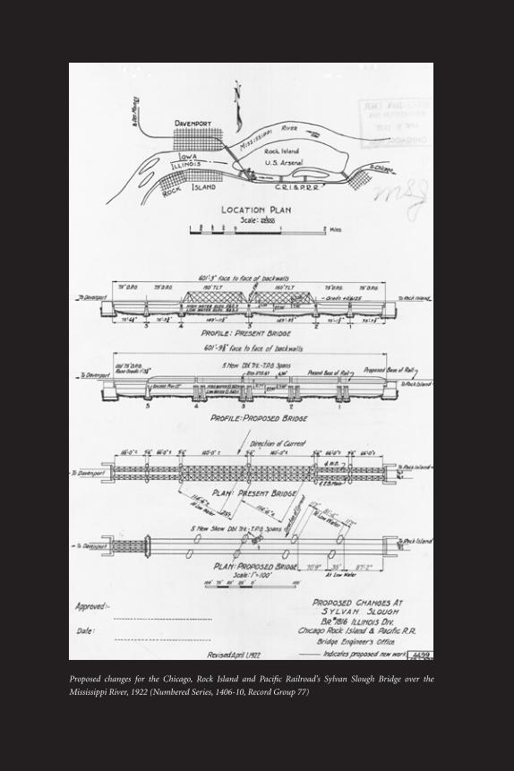
Proposed changes for the Chicago, Rock Island and Pacific Railroad’s Sylvan Slough Bridge over the
Mississippi River, 1922 (Numbered Series, 1406-10, Record Group 77)