Embed Size (px)
Citation preview
Recreation ElementRecreation ElementRecreation Element
EXECUTIVE SUMMARY
The Recreation element provides a description of the park system and an inventory of facilities and standards.It also covers recreation programs.
provide a parks and recreation system that meets the needs of the resident and visitorpopulation and is convenient, accessible and diverse in programs, locations and facilities.
develop design guidelines for private development adjacent to preserves,washes and open space to promote visibility and access to all park facilities.
link multi-purpose trails from parks to major open spaces and village cores.
Parks System:
Parks and preserve interface:
Trails and pathways:
INTRODUCTION
This element includes a description of the park
system; a general inventory of parklands and
recreation facilities; and a mission statement, goals
and policies for recreation programs and services
throughout the city of Phoenix. The goals, policies,
and recommendations reflect and support those of
approved plans: i.e., the parks plan, the Sonoran
Preserve Master Plan, the Five-Year Capital
Improvement Plan, and the State Comprehensive
Outdoor Recreation Plan (SCORP). The Recreation
element relates and, in some areas, overlaps in a
complementary fashion several other General Plan
elements: Circulation; Bicycling; Public Buildings;
Conservation, Rehabilitation and Redevelopment;
Safety; Natural Resources Conservat ion;
Neighborhood; Land Use; Open Space; and Growth
Area. A list of major accomplishments relating to
parks and recreation since the last General Plan
update is included in the Accomplishments section.
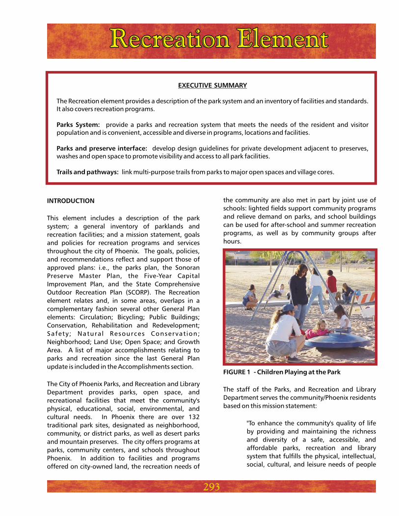
The City of Phoenix Parks, and Recreation and Library
Department provides parks, open space, and
recreational facilities that meet the community's
physical, educational, social, environmental, and
cultural needs. In Phoenix there are over 132
traditional park sites, designated as neighborhood,
community, or district parks, as well as desert parks
and mountain preserves. The city offers programs at
parks, community centers, and schools throughout
Phoenix. In addition to facilities and programs
offered on city-owned land, the recreation needs of
the community are also met in part by joint use of
schools: lighted fields support community programs
and relieve demand on parks, and school buildings
can be used for after-school and summer recreation
programs, as well as by community groups after
hours.
The staff of the Parks, and Recreation and Library
Department serves the community/Phoenix residents
based on this mission statement:
"To enhance the community's quality of life
by providing and maintaining the richness
and diversity of a safe, accessible, and
affordable parks, recreation and library
system that fulfills the physical, intellectual,
social, cultural, and leisure needs of people
FIGURE 1 - Children Playing at the Park
293
without regard to their race, ethnicity,
national origin, sex, religion, age, sexual
orientation, or disability."
The social and environmental benefits of parks and
recreation are required in order for the city of Phoenix
to grow and prosper. Under the Phoenix City Charter,
the Parks and Recreation Board sets parks and
recreation policy and the City Council approves the
budget for services. The city is fully committed to
meeting or exceeding the requirements of the
Americans with Disabilities Act.
Phoenix strives to retain its unique desert character
by preserving mountains and open space. Natural
open space accounts for 80 percent of Phoenix's
parklands. However, developed parkland at the
neighborhood and community level is severely
deficient based on public demand for facilities. The
value of trails is growing in importance, but the
existing system is far from the goal of forming a
connected network. Growing population and
residential densities will result in an increasing
demand for recreational open space and trail
development. The following is a description of the
BACKGROUND
FACILITY STANDARDS
department's preferred development standards for
parks, community centers, pools, and trails. Figures
4-10 identify the location of existing parks by village.
For a detailed inventory or a list of facilities and
amenities, contact the Parks Development Division in
the Parks, and Recreation and Library Department.
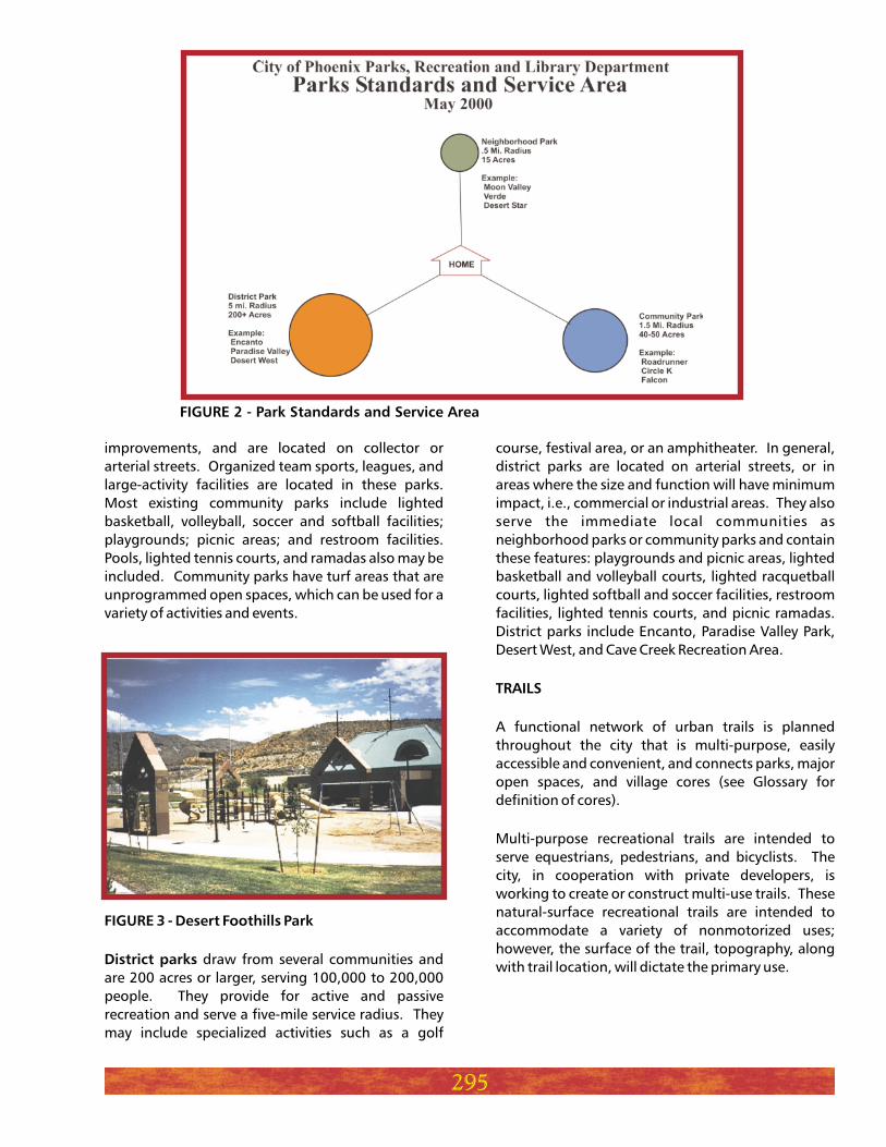
are designed to serve an area
within a radius of one-half mile or a population from
4,000 to 7,000 people; examples include Moon
Valley, Verde, and Desert Star. These parks are within
walking or bicycling distance of residences and are
typically 15 acres in size. Local or collector streets
typically border them. Most neighborhood parks
include children's playground and picnic areas, open
play turf areas, parking, lighted volleyball and
basketball courts, and restroom facilities.
Planned community developments may also provide
neighborhood recreational facilities and open space.
However, these areas tend to be small, private, and
limited in recreational opportunities. They are not
sufficient to meet a wide range of recreational and
public open space needs.
such as Roadrunner, Circle K, and
Falcon serve an area of one and one-half miles and a
population of 20,000 to 50,000 people. These parks
are typically 40 acres or larger, with active recreation
Neighborhood parks
Community parks
294
Mountain preserves
Neighborhood parks
Community parks
Desert parks
District parks
Recreation centers
Number of visitors
Number of participants
Number of volunteer hours
Number of after school programs
Number of summer recreation programs
Number of participants to at-risk youth programs
Number of rounds of golf at eight courses
Number of pool participants at 28 pools
Recreation services (annual)
0
77
45
7
10
13
# OF FACILITIESPARKS FACILITIES
23,627
791
1,473
5,230
1,822
28,075,000
7,945,000
217,000
180
121
460,000
700,000
925,000
ACRES
STATISTICAL OVERVIEW OF KEY
PARKS AND RECREATION SERVICES
improvements, and are located on collector or
arterial streets. Organized team sports, leagues, and
large-activity facilities are located in these parks.
Most existing community parks include lighted
basketball, volleyball, soccer and softball facilities;
playgrounds; picnic areas; and restroom facilities.
Pools, lighted tennis courts, and ramadas also may be
included. Community parks have turf areas that are
unprogrammed open spaces, which can be used for a
variety of activities and events.
draw from several communities and
are 200 acres or larger, serving 100,000 to 200,000
people. They provide for active and passive
recreation and serve a five-mile service radius. They
may include specialized activities such as a golf
FIGURE 3 - Desert Foothills Park
District parks
course, festival area, or an amphitheater. In general,
district parks are located on arterial streets, or in
areas where the size and function will have minimum
impact, i.e., commercial or industrial areas. They also
serve the immediate local communities as
neighborhood parks or community parks and contain
these features: playgrounds and picnic areas, lighted
basketball and volleyball courts, lighted racquetball
courts, lighted softball and soccer facilities, restroom
facilities, lighted tennis courts, and picnic ramadas.
District parks include Encanto, Paradise Valley Park,
Desert West, and Cave Creek Recreation Area.
A functional network of urban trails is planned
throughout the city that is multi-purpose, easily
accessible and convenient, and connects parks, major
open spaces, and village cores (see Glossary for
definition of cores).
Multi-purpose recreational trails are intended to
serve equestrians, pedestrians, and bicyclists. The
city, in cooperation with private developers, is
working to create or construct multi-use trails. These
natural-surface recreational trails are intended to
accommodate a variety of nonmotorized uses;
however, the surface of the trail, topography, along
with trail location, will dictate the primary use.
TRAILS
295
FIGURE 2 - Park Standards and Service Area
296
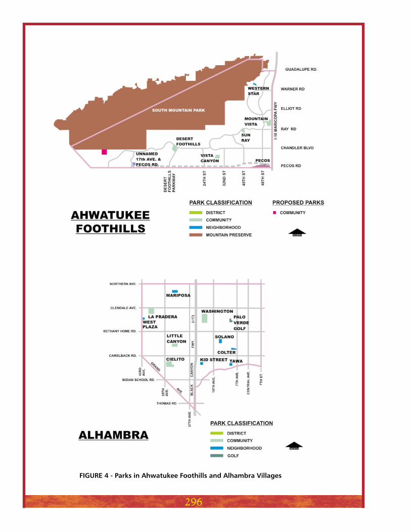
FIGURE 4 - Parks in Ahwatukee Foothills and Alhambra Villages
297
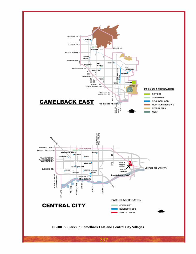
FIGURE 5 - Parks in Camelback East and Central City Villages
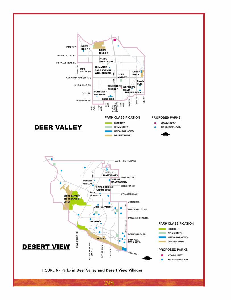
FIGURE 6 - Parks in Deer Valley and Desert View Villages
298
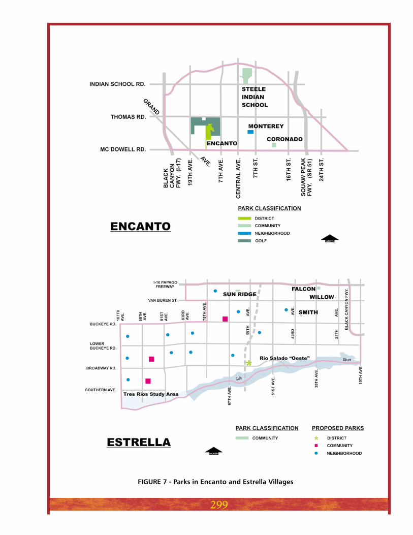
FIGURE 7 - Parks in Encanto and Estrella Villages
299
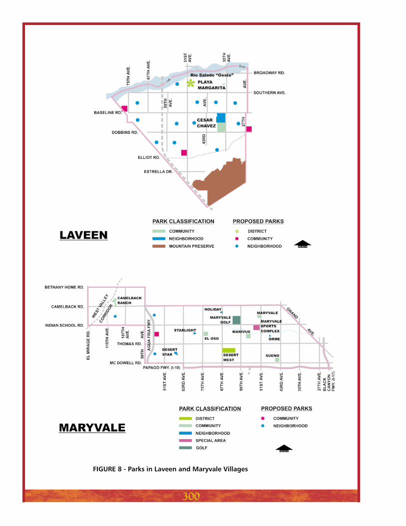
FIGURE 8 - Parks in Laveen and Maryvale Villages
300
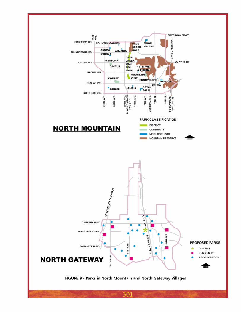
FIGURE 9 - Parks in North Mountain and North Gateway Villages
301
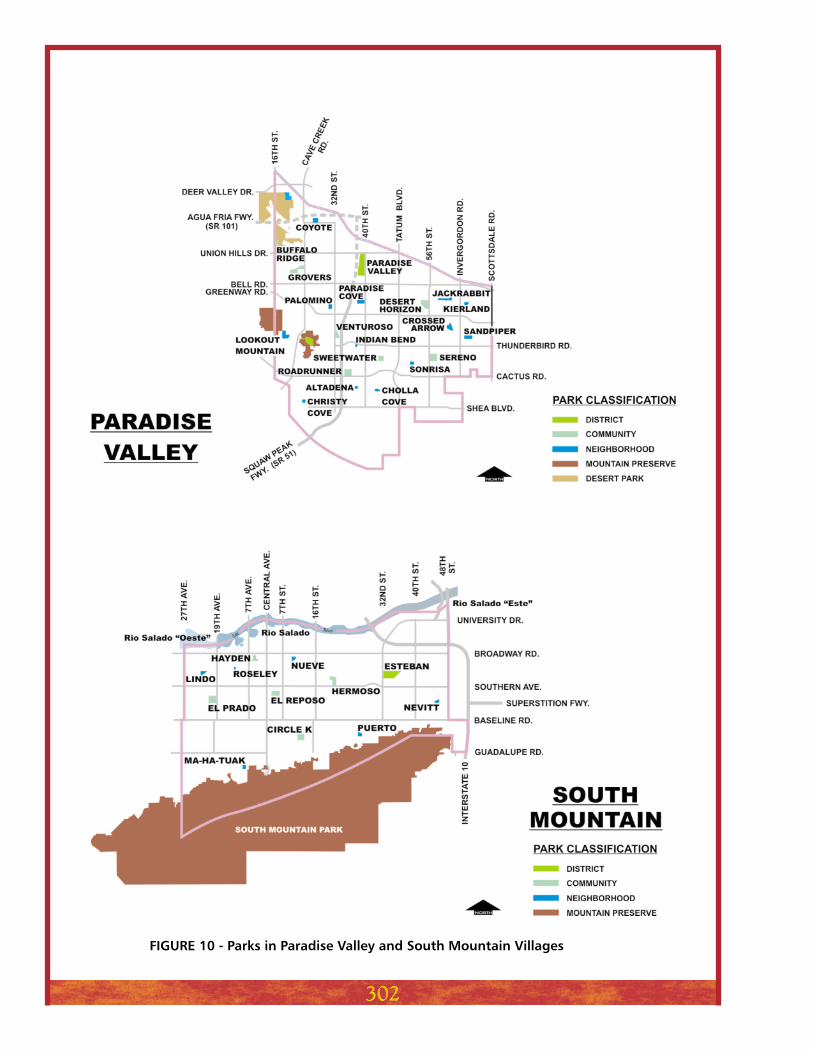
FIGURE 10 - Parks in Paradise Valley and South Mountain Villages
302
RECREATIONAL TRAILS
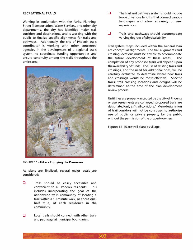
FIGURE 11 - Hikers Enjoying the Preserves
Working in conjunction with the Parks, Planning,
Street Transportation, Water Services, and other city
departments, the city has identified major trail
corridors and destinations, and is working with the
public to finalize specific alignments for trails and
pathways. Additionally, the city of Phoenix trails
coordinator is working with other concerned
agencies in the development of a regional trails
system, to coordinate funding opportunities and
ensure continuity among the trails throughout the
entire area.
As plans are finalized, several major goals are
considered:
Trails should be easily accessible and
convenient to all Phoenix residents. This
includes incorporating the goal of the
nationwide trails community of locating a
trail within a 10-minute walk, or about one-
half mile, of each residence in the
community.
Local trails should connect with other trails
and pathways at municipal boundaries.
The trail and pathway system should include
loops of various lengths that connect various
landscapes and allow a variety of user
experiences.
Trails and pathways should accommodate
varying degrees of physical ability.
Trail system maps included within the General Plan
are conceptual alignments. The trail alignments and
crossing locations must be flexible to accommodate
the future development of these areas. The
completion of any proposed trails will depend upon
the availability of funds. The use of existing trails and
crossings, and the need for additional ones, will be
carefully evaluated to determine where new trails
and crossings would be most effective. Specific
trails, trail crossing locations and designs will be
determined at the time of the plan development
review process.
Until they are properly accepted by the city of Phoenix
or use agreements are conveyed, proposed trails are
designated only as "trail corridors." Mere designation
of trail corridors will not be construed to authorize
use of public or private property by the public
without the permission of the property owners.
Figures 12-15 are trail plans by village.
303
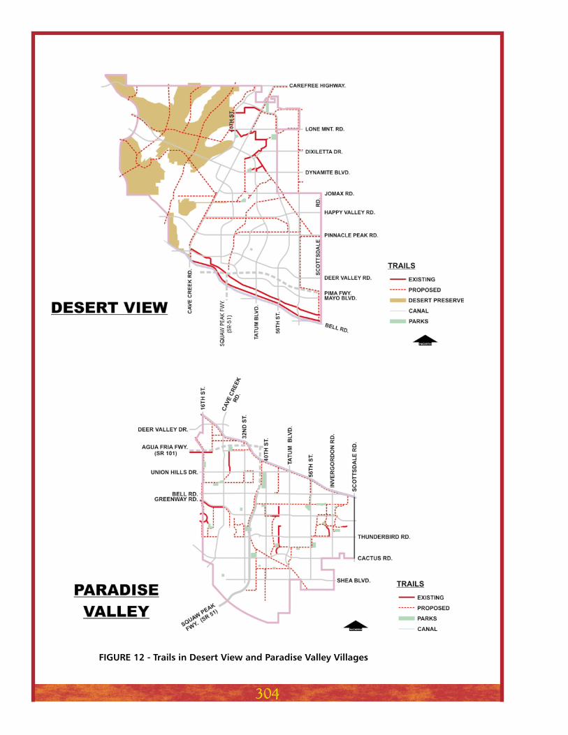
FIGURE 12 - Trails in Desert View and Paradise Valley Villages
304
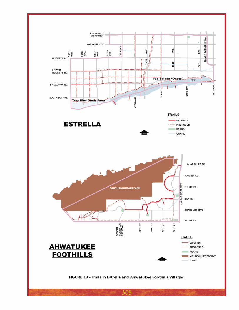
FIGURE 13 - Trails in Estrella and Ahwatukee Foothills Villages
305
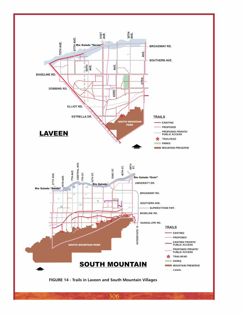
FIGURE 14 - Trails in Laveen and South Mountain Villages
306
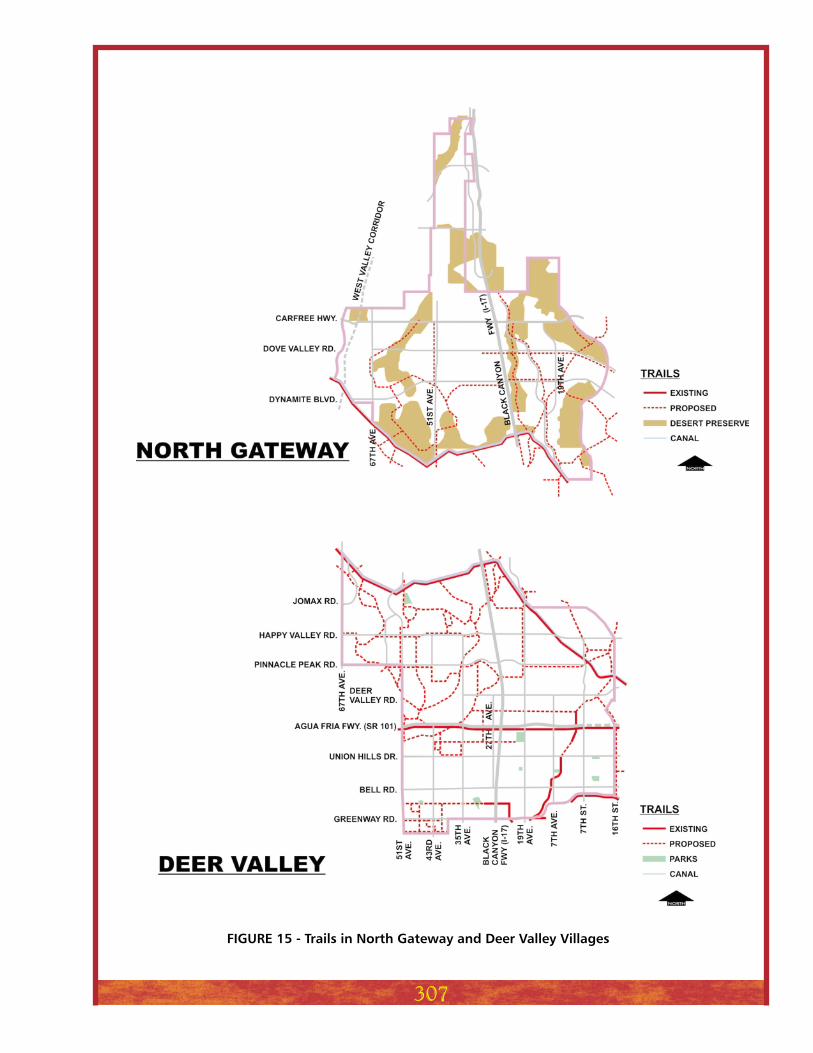
FIGURE 15 - Trails in North Gateway and Deer Valley Villages
307
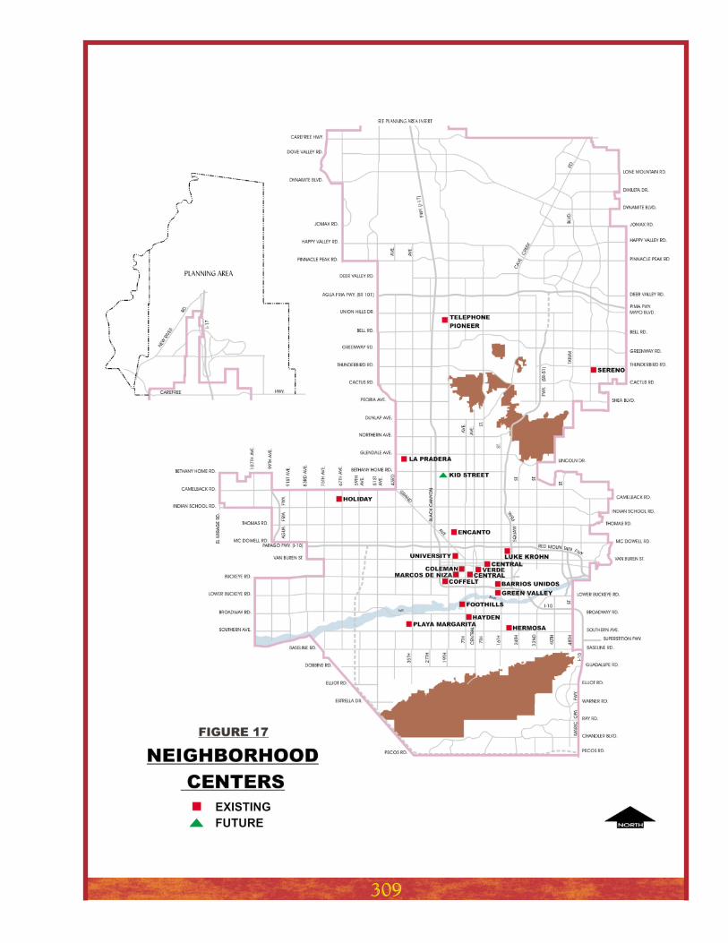
Neighborhood recreation centers
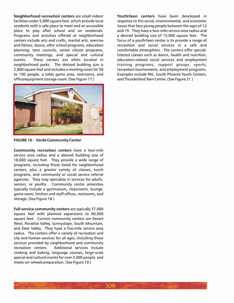
FIGURE 16 - Verde Community Center
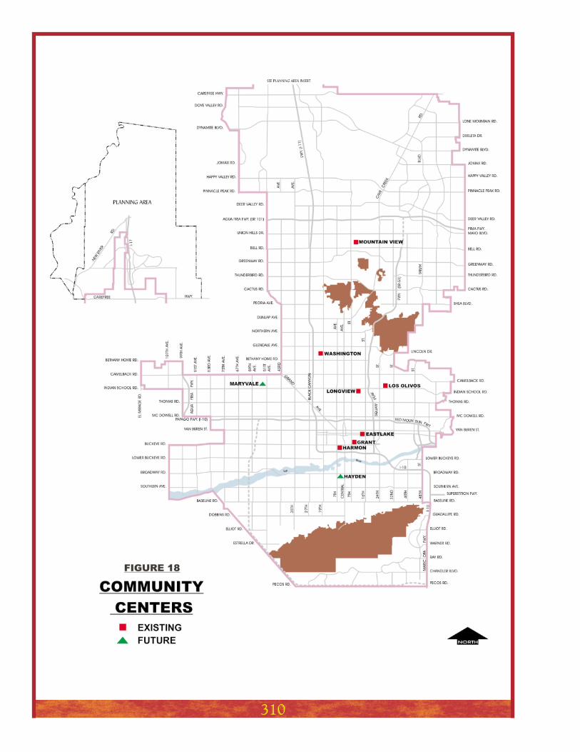
Community recreation centers
Full-service community centers
are small indoor
facilities under 5,000 square feet, which provide local
residents with a safe place to meet and an accessible
place to play after school and on weekends.
Programs and activities offered at neighborhood
centers include arts and crafts, martial arts, exercise
and fitness, dance, after school programs, education
planning, teen councils, senior citizen programs,
community meetings, and special and cultural
events. These centers are often located in
neighborhood parks. The desired building size is
2,800 square feet and includes a meeting room for 50
to 100 people, a table game area, restrooms, and
office/equipment storage room. (See Figure 17.)
have a two-mile
service area radius and a desired building size of
18,000 square feet. They provide a wide range of
programs, including those listed for neighborhood
centers, plus a greater variety of classes, lunch
programs, and community or social service referral
agencies. They may specialize in services for adults,
seniors, or youths. Community center amenities
typically include a gymnasium, classrooms, lounge,
game room, kitchen and staff offices, restrooms, and
storage. (See Figure 18.)
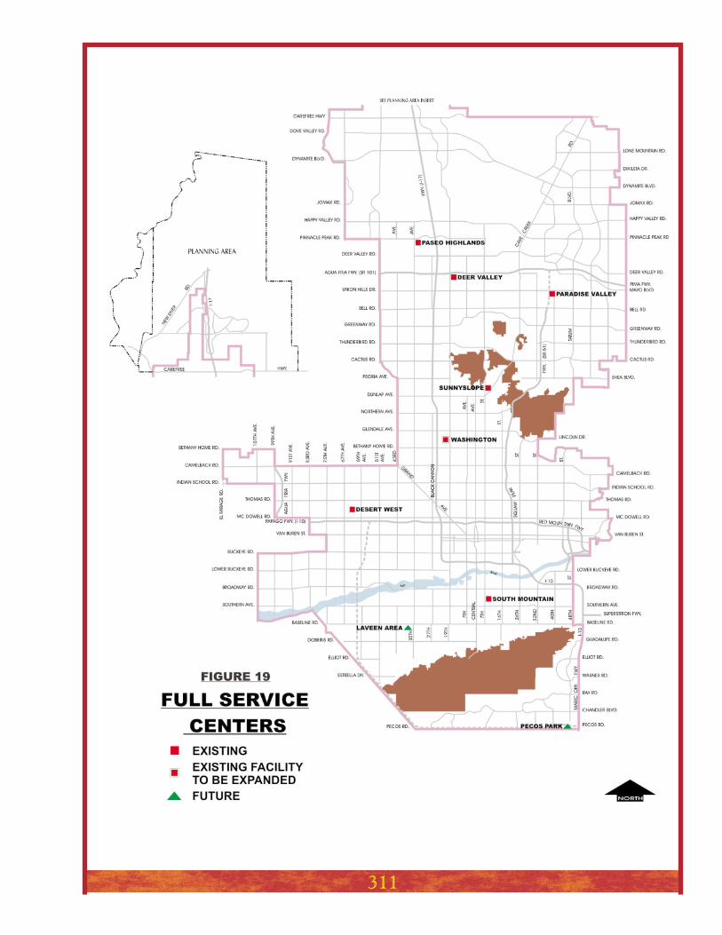
are typically 37,000
square feet with planned expansions to 60,000
square feet. Current community centers are Desert
West, Paradise Valley, Sunnyslope, South Mountain,
and Deer Valley. They have a five-mile service area
radius. The centers offer a variety of recreation and
city and human services for all ages, including those
services provided by neighborhood and community
recreation centers. Additional services include
cooking and baking, language courses, large-scale
special and cultural events for over 3,000 people, and
meals-on-wheels preparation. (See Figure 19.)
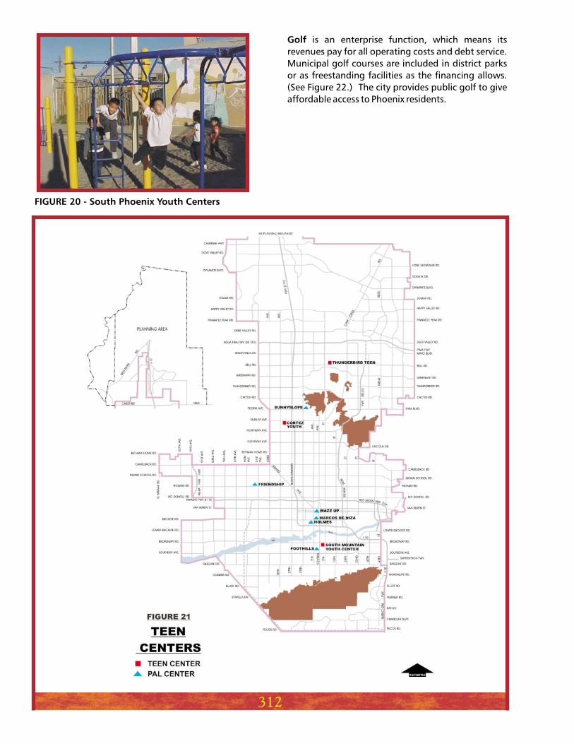
Youth/teen centers have been developed in
response to the social, environmental, and economic
issues that face young people between the ages of 12
and 19. They have a two-mile service area radius and
a desired building size of 15,000 square feet. The
focus of a youth/teen center is to provide a range of
recreation and social services in a safe and
comfortable atmosphere. The centers offer special-
interest classes such as dance, health and nutrition,
education-related social services and employment
training programs, support groups, sports,
recreation tournaments, and employment programs.
Examples include PAL, South Phoenix Youth Centers,
and Thunderbird Teen Center. (See Figure 21.)
308
309
310
311
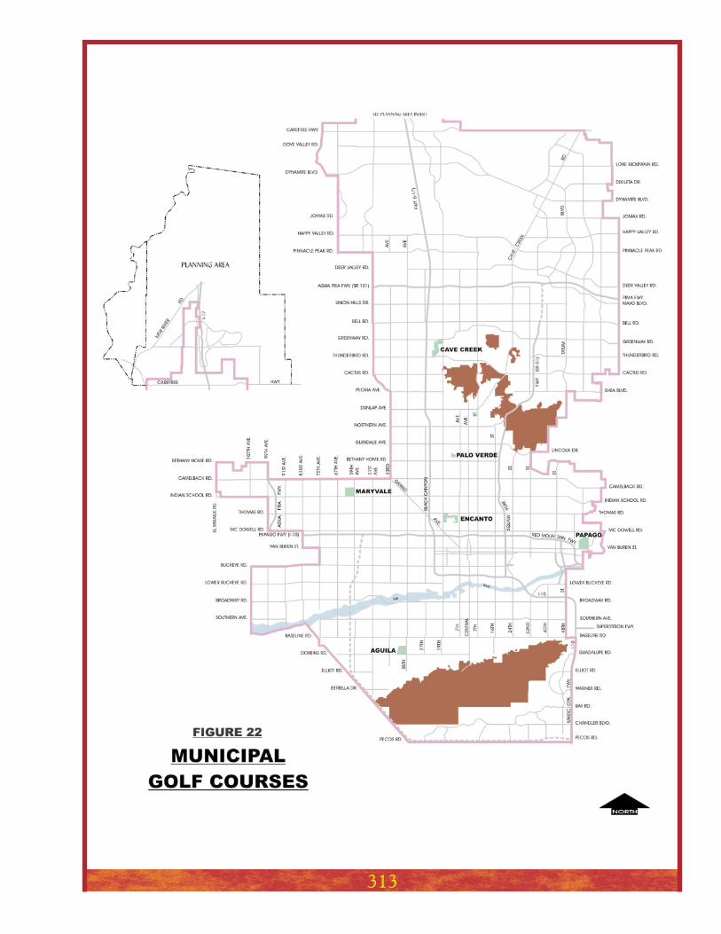
Golf is an enterprise function, which means its
revenues pay for all operating costs and debt service.
Municipal golf courses are included in district parks
or as freestanding facilities as the financing allows.
(See Figure 22.) The city provides public golf to give
affordable access to Phoenix residents.
312
FIGURE 20 - South Phoenix Youth Centers
313
314
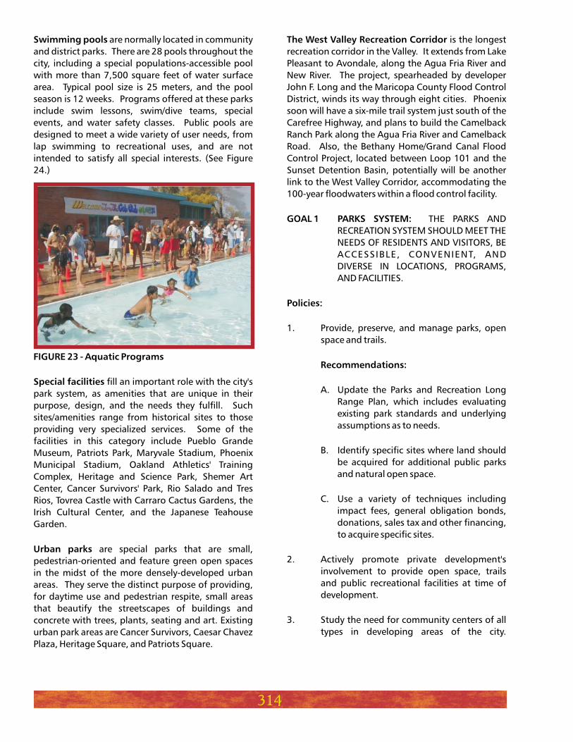
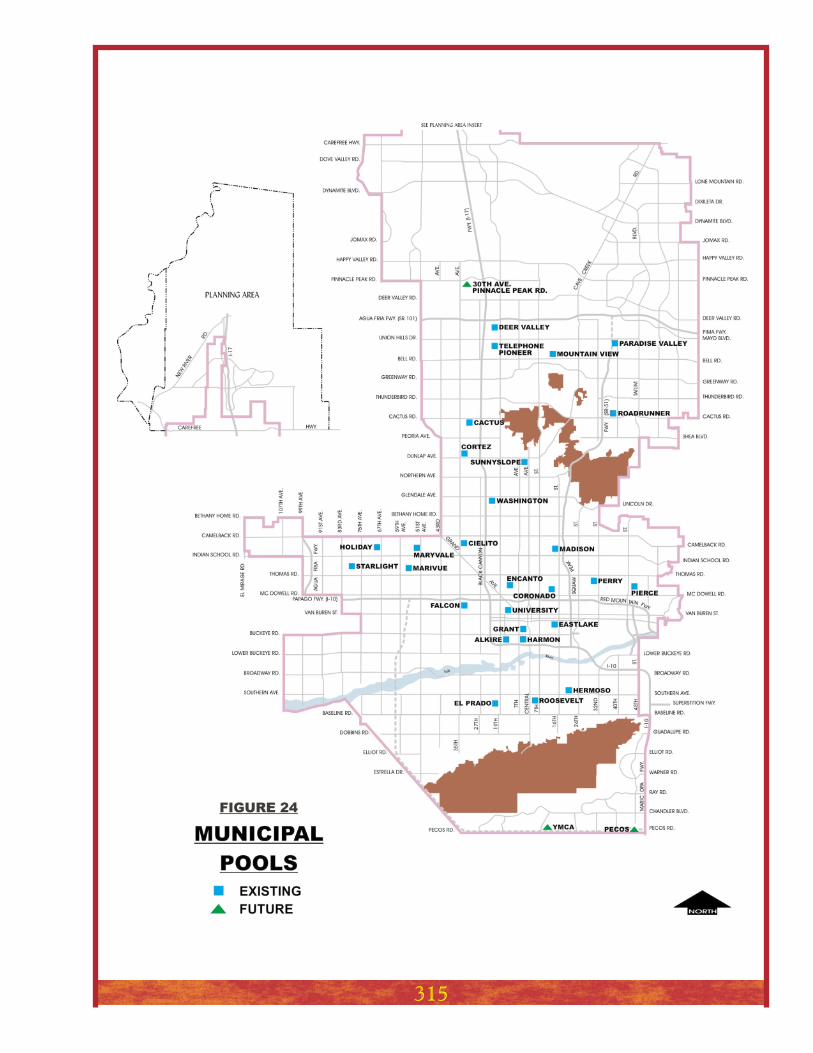
Swimming pools
FIGURE 23 - Aquatic Programs
Special facilities
Urban parks
are normally located in community
and district parks. There are 28 pools throughout the
city, including a special populations-accessible pool
with more than 7,500 square feet of water surface
area. Typical pool size is 25 meters, and the pool
season is 12 weeks. Programs offered at these parks
include swim lessons, swim/dive teams, special
events, and water safety classes. Public pools are
designed to meet a wide variety of user needs, from
lap swimming to recreational uses, and are not
intended to satisfy all special interests. (See Figure
24.)
fill an important role with the city's
park system, as amenities that are unique in their
purpose, design, and the needs they fulfill. Such
sites/amenities range from historical sites to those
providing very specialized services. Some of the
facilities in this category include Pueblo Grande
Museum, Patriots Park, Maryvale Stadium, Phoenix
Municipal Stadium, Oakland Athletics' Training
Complex, Heritage and Science Park, Shemer Art
Center, Cancer Survivors' Park, Rio Salado and Tres
Rios, Tovrea Castle with Carraro Cactus Gardens, the
Irish Cultural Center, and the Japanese Teahouse
Garden.
are special parks that are small,
pedestrian-oriented and feature green open spaces
in the midst of the more densely-developed urban
areas. They serve the distinct purpose of providing,
for daytime use and pedestrian respite, small areas
that beautify the streetscapes of buildings and
concrete with trees, plants, seating and art. Existing
urban park areas are Cancer Survivors, Caesar Chavez
Plaza, Heritage Square, and Patriots Square.
The West Valley Recreation Corridor
GOAL 1 PARKS SYSTEM:
Policies:
Recommendations:
is the longest
recreation corridor in the Valley. It extends from Lake
Pleasant to Avondale, along the Agua Fria River and
New River. The project, spearheaded by developer
John F. Long and the Maricopa County Flood Control
District, winds its way through eight cities. Phoenix
soon will have a six-mile trail system just south of the
Carefree Highway, and plans to build the Camelback
Ranch Park along the Agua Fria River and Camelback
Road. Also, the Bethany Home/Grand Canal Flood
Control Project, located between Loop 101 and the
Sunset Detention Basin, potentially will be another
link to the West Valley Corridor, accommodating the
100-year floodwaters within a flood control facility.
THE PARKS AND
RECREATION SYSTEM SHOULD MEET THE
NEEDS OF RESIDENTS AND VISITORS, BE
ACCESSIBLE, CONVENIENT, AND
DIVERSE IN LOCATIONS, PROGRAMS,
AND FACILITIES.
1. Provide, preserve, and manage parks, open
space and trails.
A. Update the Parks and Recreation Long
Range Plan, which includes evaluating
existing park standards and underlying
assumptions as to needs.
B. Identify specific sites where land should
be acquired for additional public parks
and natural open space.
C. Use a variety of techniques including
impact fees, general obligation bonds,
donations, sales tax and other financing,
to acquire specific sites.
2. Actively promote private development's
involvement to provide open space, trails
and public recreational facilities at time of
development.
3. Study the need for community centers of all
types in developing areas of the city.
315
Recommendation:
Recommendation:
A. Time new facility development to
coincide with residential development as
resources permit.
4. Develop special facilities where appropriate,
based upon how they fit department
priorities and available funding, and based
upon the needs and interests of area
residents.
A. Design flexible facilities to meet
changing needs of the community and to
accommodate physically and mentally-
disabled users.
5. Acquire and develop additional parks and
natural open space prior to urbanization
when possible.
6. Utilize redevelopment opportunities to
acquire parks and open space in developed
areas.
7. Investigate acquiring land adjacent to
existing parks in older developed areas that
are experiencing residential renewal.
Identify innovative measures such as an
inventory and identification of surplus public
land, and sharing agreements with schools,
private owners and developers to provide
park areas, open space and trails within the
infill neighborhoods currently deficient in
those features.
8. Continue to provide adjacent park/school
facilities that are highly effective in meeting
the overall educational and recreational
needs of the community, when they do not
excessively limit park access to non-school
attendees when school is in session.
9. As schools close, work in conjunction with
the appropriate school district and the
residents of the adjoining neighborhoods to
evaluate the desirability of maintaining the
recreational use of the facility. (A closed
school refers to a school that is no longer in
operation.)
10. Provide active recreational development that
generates significant traffic only in
community or district parks, or in parks in
commercial areas.
11. Actively promote open space within the
Governmental Mall, the city, county and
state office complexes and space between
them.
12. Provide security lighting in all parks, and
appropriate sports lighting in neighborhood,
community and district parks.
A. Provide appropriate security lighting
that is operational dusk to dawn in all
parks and recreation facilities.
B. Provide lighted courts in neighborhood
parks and facilities located within district
parks. Community and district parks will
have lighted courts and lighted athletic
fields. Lighted facilities are turned off no
later than 11 p.m., unless authorized by
the city of Phoenix Parks and Recreation
Board.
13. Provide a diverse and broad range of
recreation programs and services. Offer
services based on the demonstrated need of
the community at large, public interest, and
responsible fiscal management of public
resources.
14. Consider partnerships with other city
departments and government agencies to
develop facilities and provide programs and
services where appropriate.
A. Evaluate including city services in full-
service community centers during the
long-range and site planning phases.
B. Evaluate the potential for locating police
and fire stations jointly within
community and district parks.
Recommendations:
Recommendations:
316
15. Limit commercial activity within parks to
licensed uses authorized by the parks and
recreation board.
16. Plan and design municipal swimming pools
for the recreational needs of the community
at large.
A. The priority of use is:
Swim lessons
Recreation swim
Recreation teams
Cooperative agreements with
schools
General rentals
17. Strive to provide the same level of service for
parks facilities and recreation programs in
new or growth areas of the city that is
provided in the developed areas of the city.
A. Evaluate the possibilities of developing
municipal golf courses in new and
proposed park areas.
B. Assure that, at a minimum, local streets
bound all sides of a new park. Streets of
the appropriate street classification
according to the street classification map
can be placed around community and
district parks.
C. Maintain service level standards for
facilities in growth areas by using bond
funds, impact fees, donations, and sales
tax revenue.
18. Develop, improve and renovate existing park
sites at all levels as resources, condition, and
need dictate.
A. Renovate and maintain older parks
according to current community needs
and department standards.
Recommendation:
Recommendations:
Recommendations:
317
B. Acquire land in accord with department
standards, for neighborhood and
community parks in older, developed
areas that are experiencing residential
renewal.
C. Evaluate the need for retaining park
facilities in areas that have lost their
residential base.
19. Provide public streets around all sides of new
neighborhood, community and district
parks.
20. Continue programs for public participation
in the planning and design of new and
renovation of existing parks, open space,
trails, and other recreational facilities.
THE INTERFACE
OF PRIVATE DEVELOPMENT AND PARKS,
PRESERVES, AND NATURAL AREAS IS
CRITICAL TO THE NATURAL FUNCTIONS
AND PUBLIC ENJOYMENT OF THESE
AREAS.
1. Establish design and management standards
for natural washes and connected open
spaces that will preserve the natural
ecological and hydrological systems while
allowing for appropriate public use, such as
multi-use trails.
A. Implement any design guidelines
adopted by the City Council that preserve
natural washes by encouraging
nonstructural flood control, and include
wide, natural wash corridors that are
substantially undisturbed and allow for
the growth of natural vegetation for
controlling erosion and sustaining
ecological systems.
B. Implement fire management policies
that allow homeowners to clear annual
plant material and create a firebreak. For
example, non-native species such as
tumbleweed should be removed
regularly. Allow access to wash areas for
fire and emergency vehicles.
GOAL 2 PRESERVE INTERFACE:
Policies:
Recommendations:
2. Propose new design standards that address
drainage, use of native plants, edge effect,
and access both visual and physical for
private development adjacent to public
preserves, parks, washes and open spaces.
A. Implement any design guidelines
adopted by the City Council that require
private development adjacent to
preserves, washes, and open spaces to
provide visual and physical access to the
public from a variety of land uses. These
guidelines should include orienting
development to open space, single-
loaded streets as predominant edge,
native plant policy, public access points,
and transition areas.
A FUNCTIONAL
NETWORK OF SHARED URBAN TRAILS
THAT ARE ACCESSIBLE, CONVENIENT,
AND CONNECTED TO PARKS, MAJOR
OPEN SPACES, AND VILLAGE CORES,
SHOULD BE DEVELOPED THROUGHOUT
THE CITY. THE TRAILS SHOULD CONNECT
WITH FUTURE REGIONAL TRAIL SYSTEMS
WHEREVER POSSIBLE.
1. Update the city trails/pathways plan,
including an inventory by location, types of
surface, and management responsibilities.
Recommendation:
GOAL 3 TRAILS AND PATHWAYS:
Policies:
Recommendations:
Recommendation:
A. Actively encourage and, where
appropriate, require private developers
to provide private trails with public
access within their developments.
B. Prior to abandonment or altering of any
existing right-of-way, assure that trails or
trail easements are maintained.
C. Prepare and distribute maps, brochures,
and other information on the trails and
pathway system in order to inform the
pub l i c o f cu r r en t and fu tu re
opportunities. Trail system route maps
will indicate best or recommended
routes depending on the type of trail. An
interactive World Wide Web site should
be an accessory component of this
system.
2. Work with other agencies to assure the
availability and accessibility of canal banks
for trail usage.
3. Connect public parks with pedestrian
destinations and open space areas created in
conjunction with urban development.
4. Plan, design, and develop pedestrian
linkages between parks, open spaces, village
cores, neighborhood shopping centers,
neighborhood schools, and neighboring
municipalities.
A. Develop the pedestrian linkage system as
a joint responsibility of the private and
public sectors, as new development and
infi l l development occurs. As
appropriate, the city should enhance the
pedestrian linkage system through the
development of new parks.
5. Provide, preserve, and manage trails in parks
and open space.
6. Encourage the widest possible range of
opportunities for non-motorized recreation
and multi-modal transportation systems.
318
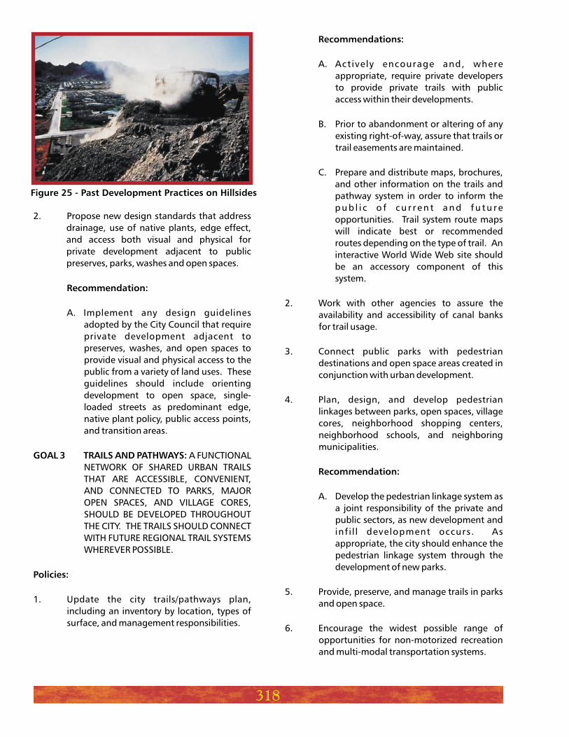
Figure 25 - Past Development Practices on Hillsides
Recommendations:
Recommendations:
A. Plan, design and install trail signs, to help
identify the trail system and for public
safety.
B. Post signs along multi-use trails, which
state that motorized vehicles are
prohibited except for emergency and
maintenance vehicles.
7. Prepare standards for planning, design, and
management of trails and pathways within
parks, preserves, open space, and rights-of-
way.
A. Utilize the city's trail standards to
integrate public trails into new
developments.
B. Proactively seek trail easements within
planned trail corridors as development
occurs adjacent to the corridors. Seek
trail easements along existing developed
properties where no trail connections
currently exist.
C. Create trail design and construction
standards, signage, locational criteria,
and other design guidelines to establish
consistency within the trails and preserve
system.
8. Create linear open space with multi-use
paths and offer recreational elements such as
ramadas, playground equipment and
landscaping to attract urban wildlife.
319


![Food security and nutrition: building a global narrative ... · EXECUTIVE SUMMARY EXECUTIVE SUMMARY EXECUTIVE SUMMARY EXECUTIVE SUMMAR Y [ 2 ] This document contains the Summary and](https://img.pdfslide.net/doc/110x75/5ff5433612d22125fb06e6b5/food-security-and-nutrition-building-a-global-narrative-executive-summary-executive.jpg)