Embed Size (px)
Citation preview

Recreational Boating
Facilities Plan

Recreational Boating
Facilities Plan
Recreational Boating
Facilities Plan
Introduction
The Wellington Recreational Boating Facilities Plan has been developed to assist in planning for Council owned and operated recreational boating areas within Wellington Shire. These include:
• Port of Sale,
• Port Albert,
• Manns Beach,
• McLoughlins Beach,
• Loch Sport (Charlies Street and Seagull Drive),
• Seacombe,
• Marlay Point, and
• Hollands Landing.
This Plan addresses boating areas and assets managed by Wellington Shire Council, which are located within the defined Coastal Management Act area. While there are other boating facilities within Wellington Shire, these are managed by other agencies.
Lake Glenmaggie is managed by Southern Rural Water and Robertsons Beach and Springberg Lane are managed by Parks Victoria. Whilst these facilities are important recreational boating assets within the Shire, they are not included in this plan as Wellington Shire has no responsibility for their management.
Gippsland Ports manages designated marine assets and is the port manager for the Ports of Gippsland Lakes, and Corner Inlet at Port Albert.
This Plan supports the Gippsland Boating Coastal Action Plan 2013 (GBCAP 2013), undertaken by the Gippsland Coastal Board. The GBCAP 2013 identified the following action:
Develop coastal management plans or site master plans for locations
identified as having a future role as a state or regional boating precinct or
district boating facility, where the plans do not already exist.
The Gippsland Coastal Board no longer exists as the Coastal Management Authority, replaced by the Marine and Coastal Act, on 1 September 2018.
Within Wellington Shire this action applies to Port Albert, Loch Sport, Port of Sale, McLoughlins Beach, Marlay Point and Hollands Landing. This Recreational Boating Facilities Plan has been developed to meet this need and has been extended to include other popular recreational boating sites within the Shire.

The types of recreational boating activity in Wellington Shire vary across each site but generally includes:
• Power boating and touring,
• Boat based recreational fishing,
• Water skiing,
• Jet skiing (powered personal water craft),
• Sailing, and
• Kayaking, canoeing and rowing.
Recreational boating contributes significantly to local economies and lifestyle throughout Wellington Shire.
Previous Plan
The 2013-2016 Wellington Boating Strategic Plan was developed following community and key stakeholder engagement conducted in 2012/13. The previous plan guided Council’s forward capital plan that has led to significant upgrade and investment in the Council’s recreational boating facilities.
Key highlights of capital works undertaken through the boating facilities strategic plan, include:
Facility Project Description Picture Project Cost
Completed
All Facilities Statutory safety signage upgrade
Refer pg XX
$20k 2013
Manns Beach Boat Ramp Upgrade Refer pg
XX $200k 2015
McLoughlins Beach Pontoon installation and Foot Bridge replacement
Refer pg XX
$1m 2015
Loch Sport – Charlies St Boat Ramp upgrade and pontoon/jetty installation
Refer pg XX
$860k 2018
Port Albert Boat Ramp replacement and upgrade and car park upgrade
Refer pg XX
$1m 2018
Developing the Plan
The Wellington Recreational Boating Facilities Plan has been developed through the following process:
• Site visits to confirm site conditions and constraints,
• Identification and documentation of required actions at each site to meet relevant
safety standards and guidelines,
• Development of a draft plan for review and discussion with Wellington Shire Council
and relevant agency and community stakeholders,
• Adoption of the final document for use to underpin and inform ongoing development
through the Wellington Shire Council Capital Management process’.
This plan will allow the Shire, as facility manager, to plan and budget for actions required to maintain and develop these facilities in a safe and contemporary manner to meet current and future needs of the users.

Guiding Principles
Wellington 2030
Wellington Shire has developed a strategic vision to guide the Shire’s development to the
year 2030. This vision has been divided into nine themes. The Wellington Recreational
Boating Facilities Plan addresses strategies from four of these themes being Development,
Liveability, Wellbeing & Safety and Natural Environment.
The strategies under each theme that this plan addresses include:
Development
• Support communities to attain a sustainable level of local infrastructure reflecting the
needs of communities,
• Plan growth reflecting values and environmental capacities specific to individual
communities,
• Develop strategies to address the potential impacts of climate change,
• Continue to develop Sale as a regional centre well connected with appropriate transport
linkages to the smaller communities across the Shire, and
• Promote developments with high standard of design including energy efficiency
initiatives.
Liveability
• Improve the quality and accessibility of our open space and community facilities,
• Develop our sports and recreation infrastructure, and
• Provide clean and attractive public toilets.
Wellbeing & Safety
• Support community initiatives that promote participation and working together.
• Natural Environment
• Restrict development to environmentally sustainable areas.
Gippsland Coastal Board Boating Coastal Action Plan 2013
The Gippsland Coastal Board Boating Coastal Action Plan (GCBCAP 2013) provides
strategic guidance for managing recreational boating facilities in Gippsland. It has been
developed to reflect the approach of the Victorian Coastal Strategy (VCS).
It led to planning and management of recreational facilities in the region that:
• is well coordinated,
• is well accepted by the people and organisations affected by it,
• deals effectively with the issues facing recreational boating and its interaction with
people and the environment,
• takes into account longer term factors affecting the region, such as climate change,
and
• will assist in guiding funding and resources.
The GBCAP uses the Recreational Boating Facilities Hierarchy to identify the future role of
each boating facility and the expected level of service that would be provided.

Recreational Boating Facilities Hierarchy
The management and development of sites in line with the recreational boating facilities
hierarchy will ensure, over time, that there is a network of boating facilities spread across the
region catering for the different types of boating activities. The recreational boating facilities
hierarchy defines six levels of facility, including:
State Marine Precinct
This incorporates facilities of international, national, state, regional and local significance.
These include ports, marinas, charter boat facilities, slip facilities, waterfront activities,
marine services, piers, jetties and ramps. Such an area would generate major investment
and opportunities in a range of facilities, as there are many requirements of a state level
precinct.
Regional Boating Precinct
This accommodates a significant amount of recreational boating in appropriate conditions.
These include multiple boat ramps, jetties, substantial car parking, safety measures where
required and significant onshore facilities such as fish cleaning facilities, wash down areas
and toilets. A site satisfying this level of the hierarchy generates a significant level of
boating activity from a wide catchment.
District Boating Facility
A district boating facility, while not specifically defined in the Victorian Coastal Strategy,
generally caters for one type of boating activity and attracts users from a smaller
catchment area. However, in peak seasons the demands on these facilities can be quite
high and such a facility should be able to accommodate this by providing a range of
services.
Local Boating Facility
A local boating facility requires a good standard that caters for local access and has
amenities such as car parking.
Basic Boating Facility
A basic boating facility provides boating access with basic infrastructure which generally
does not meet current design standards.
Informal Boating Facility
An informal boating facility does not involve any built infrastructure and may not be
managed or maintained. In general, informal facilities will not be listed in this plan as there
are too many of them to catalogue.

The levels of service provided for each of these facilities is provided in the Recreational
Boating Facilities Hierarchy table below.
Recreational Boating Facilities Hierarchy
Typical Components Level of Service
State
Marine Precinct
Regional Boating Precinct
District Boating Facility
Local Boating Facility
Basic Boating Facility
Informal Boating Facility
ACCESS
Safe Harbour
Public Access
Car Parking
Car Access to Beach
Disabled Access
LAUNCH AND RETRIEVAL
Boat Ramps
Pier/Jetty
BERTHING
Public Berths (Itinerant)
Wet Berths
Dry Berths
Mooring Jetties
Swing Moorings
Commercial Shipping Facilities
SUPPLEMENTARY SERVICES
Fuel
Pump-out
Toilets
Wash Down
Fish Cleaning
Security

Typical Components Level of Service
State
Marine Precinct
Regional Boating Precinct
District Boating Facility
Local Boating Facility
Basic Boating Facility
Informal Boating Facility
Signage
Service Utilities (Power/water/lighting)
RECREATIONAL/TOURIST FACILITIES
Capacity for Major Public Boating Events
Boat Hire/Charter
Commercial Vessel Berthing Facilities
Community Facilities (Including Club Rooms)
Recreational Facilities (Picnic Tables, BBQs)
Retail or Entertainment and Land Based Uses/ Attractions
MAINTENANCE
Boat Repair and Servicing
Chandlery/Boating Retail
Key Required Not Required Optional

Design Principles
Australian Standards
Any new or upgraded facilities shall comply with the relevant Australian standards (as
appropriate to local conditions) and shall be planned and designed with boating safety as a
primary consideration.
All recreational boating facilities identified in this plan will be maintained to the identified
service level. Facilities may, from time to time, become unavailable due to deterioration,
damage or reduced accessibility, until such time as they can be made safe for use.
Rectification timeframes will be appropriate to the level and expected use of the affected
facility.
There is no specific Australian Standard for the design of boat ramps and boating facilities.
Australian Standard Guidelines for Design of Marinas (AS 3962-2001) is generally used as a
guideline. This Standard recommends that boat launching ramps should be located and
aligned as follows:
• Aligned into the dominant waves from swell, sea and boat wash,
• Sheltered from waves larger than 0.2 m,
• Located as near as possible to the host waterway,
• Land approaches that permit queuing without blocking other traffic systems, and
• Water approaches of sufficient area to allow queuing and low speed manoeuvres without
blocking fairways and channels.
Several issues associated with boat ramps have been highlighted for special consideration
and they include:
Gradient: The ramp gradient should be within the range of 1:9 to 1:7 with a preferred gradient
of 1:8. Where possible the boat ramp gradient should be within this range and suit local
conditions.
Surface: The ramp surface needs to provide traction for the towing vehicle at all tide levels
and a sound footing for boat users. The surface should have non-slip grooves and contours
to drain excess water and debris. Boat ramp surfaces may need to be regularly maintained
and updated.
Boat Holding Structures: Providing a mooring pontoon or jetty increases the efficiency of use
of the boat ramp. Local conditions will determine if the boat holding structure should be fixed
or floating. This Plan recommends that investigations are undertaken at several locations to
determine the locally appropriate boat holding structures.
Trailer Rigging and/or De-rigging Areas: Provision of rigging and de-rigging areas can assist
in efficiency and ease of launching. Wash down areas, while provided at some locations, are
not recommended in this Plan due to the limited use when water restrictions apply and the
ability of the private sector to provide such facilities in adjoining townships.
Vehicle Manoeuvring Areas: Should allow for a vehicle turning areas appropriate for the
largest reasonable boat expected to be used at the facility.

The Disability Discrimination Act (1992) promotes the rights of people with disabilities to
ensure they have equal access to facilities and services. Out of this Act came a number of
Australian Standards that are relevant when reviewing public facilities. These include:
• AS1428.1-2009 Design for access and mobility General requirements for access - New
building work,
• AS1428.2-1992 Design for access and mobility Enhanced and additional requirements -
Buildings and facilities,
• AS1428.3-1992 Design for access and mobility Requirements for children and
adolescents with physical disabilities,
• AS1428.4.1:2009 Design for access and mobility Means to assist the orientation of
people with vision impairment - Tactile ground surface indicators,
• AS1657:2018 Fixed platforms, walkways, stairways and ladders - Design, construction
and installation, and
• AS4997-2005 Guidelines for the design of Maritime Structures.
If the surface of a pier, pontoon or jetty is of timber construction, the timber must run at right
angles to the direction of traffic. Gaps between the timber surfaces must not exceed 13mm
so that the tips of long white canes or the narrow wheels of sports type wheelchairs do not
catch in between the timber gaps.
For boarding a vessel from a pier, pontoon or jetty the following criteria applies:
• Provide a ramped access from the pier/pontoon/jetty to a floating pontoon,
• Ensure that the ramp complies with the ramp criteria,
• Base of the ramp to be on wheels and steel plate to be able to move freely with varying
water heights,
• At the highest water level, the ramp can be no higher than horizontal and at the lowest
level have a gradient no greater than 1:14 with a maximum length of 9m. Multiple
pontoons and ramps may be required if the water heights are extreme,
• For accessing a boat from the pontoon, portable or hinged ramps are permitted,
• Ensure that the securing pole guides for the pontoon are at least 900mm above the level
of the pontoon deck at the highest water level,
• Boats should be no higher than 600mm above water level for ease of access, unless the
boats and jetties are purpose built to line up with each other, and
• Handrails are required on either side of the portable ramp for people with ambulant
disabilities.
• Some other general requirements for disabled access include but are not limited to:
• The minimum unobstructed width of a walkway shall be 1000mm with a gradient no
steeper than 1:20,
• Threshold ramps must have a gradient no steeper than 1:8 with no cross fall and a
maximum length of 280mm,
• Ramp gradients should not exceed 1:14 preferably 1:20 with landings every 9m or 14m
respectively,
• Ramps must have a slip resistant surface with tactile indicators at the top and bottom of
the ramp, and

• Adequate circulation spaces at doorways is essential and varies dependent on the width
of the door.
Signage
All boating access areas, including boat ramps, should display a sign outlining boating safety
information. The sign should contain a map of boating zones as well as boating information
and rules. Appropriate standard signage is shown in the image below.
The different panels will display different information as follows:
Panel A: Location name and type of sign.
Panel B: Waterway rules and special or localised hazards.
Panel C: Boating zones and additional information related to the site presented in graphic
form.
Panel D: Boating safety rules information and safety equipment.
Panel E: To identify Emergency 000 and local Waterways Managers only.
The signs should be mounted as close as practicable to the observers’ line of site in the
vertical plan and placed so that they are not a hazard to pedestrians.
Signs should be located where the messages are legible; they attract the attention and are
clearly visible to all people who are going boating.
New signage should align with existing conforming signage.
Dredging
The depth of water in access channels and around boat ramps and jetties varies at several of
the recreational boating areas addressed in this plan (e.g. McLoughlins Beach, Marlay
Point). Some of the areas beyond the boat ramp may be dredged by other authorities on an
as needed basis.
Dredging is not undertaken by Wellington Shire Council. As a result, regular dredging does
not occur and use of some facilities may become restricted by a lack of water depth. Any
dredging activities conducted by other authorities shall be conducted in line with Best
Environmental Management – Guidelines for Dredging by EPA Victoria.
Tidal and Siltation impacts
Access to boating facilities across Wellington Shire are impacted by tide and dynamic coastal
actions which can cause siltation and sand build up. Wellington Shire Council acknowledges
that when operating in tidal zones, access is likely to be impacted at times and will take
appropriate action to mitigate these impacts, where appropriate. Boat ramps directly affected
by siltation will be scheduled for cleaning before major events such as long weekends,
holidays and peak usage periods.
On average this will occur 3 to 4 times per year, prior to:
• Easter,
• September Holidays,
• Melbourne Cup, and
• Christmas Holidays.

Gap Analysis
Key boating areas within Wellington Shire have been identified and are addressed in this
section.
The facilities at each area are described. Some facilities are managed by Wellington Shire
Council, while others are managed by other agencies (e.g. Gippsland Ports and Parks
Victoria). This plan focuses only on facilities managed by Wellington Shire Council, while
acknowledging the significance and role of facilities managed by others.
The recreational boating facilities hierarchy has been used at each site to compare the
facilities deemed appropriate at the relevant level of the hierarchy, the current facilities at the
site and the potential future facilities to be considered for the site.
Assessment Criteria
FEATURES OF BOATING FACILITY
CRITERIA
Boat Ramps Maintaining and upgrading existing boat ramps to meet
required standards is a high priority.
Safety and Regulatory Signage Signage at all sites is reviewed regularly to meet current
safety standards.
Pier/Jetty to Assist Boat Launching and Retrieval
Having a pier or jetty adjacent to a boat ramp will assist to
increase the efficiency of boat launching and retrieval.
Primary Car and Trailer Parking Facility
Each recreational boating facility site should have
adequate primary car parking to meet the need of the
user base for the facility and should be in accordance
with this Plan.
Public Toilets
Public toilets should be provided at facilities identified as
having a regional, district or local role. Public toilets are
managed through Council’s Public Toilet Strategic Plan.
Fish Cleaning
Fish cleaning facilities should be provided as appropriate
at all sites that are well used by boat based and shore-
based anglers.
Pump-out Sewerage pump-out facilities where possible may be
provided at regional facilities.
Fuel Fuelling facilities will not be provided by Wellington Shire
Council.
Pedestrian Paths, Access to Car Parks and Boat Retrieval Facilities
Pedestrian paths leading from car parks to boat ramps
should be provided at well used sites.
Public Lighting Public lighting to boat ramps should be provided at all
boat ramps.
Overflow Car and Trailer Parking Facility
Overflow trailer parking may be necessary at highly utilised boating facilities at peak usage times. Where

there is sufficient area, sealed or unsealed hardstands may be provided to meet peak parking needs. Where space is deemed insufficient for peak times, the surrounding road and street network may be utilised.
Site Environment and Amenity
Maintenance and enhancement of site amenity and the surrounding natural environment is important at all sites. Indigenous landscaping, water sensitive urban design and other environmental management approaches should be considered and implemented when facilities are identified for upgrade.

Regional Boating Facilities
Port of Sale
The township of Sale is a major population centre, but a number of factors have prevented its
Port precinct reaching its full potential as a boating destination.
Access to the port is restricted by height limitations due to the Swing Bridge situated three
kilometres south of the port. The Swing Bridge is opened to allow for boating movements at
identified times and can be opened by prior arrangement, as required. The area between
Sale and the Swing Bridge is also regularly used for rowing.
Existing Facilities
Criteria Current
Number of Ramps 2
Boat ramp gradient 1:9
Boat ramp surface Good
Boat holding structures Fixed jetty and floating pontoon
Trailer rigging and/or de-rigging areas No formal areas identified
Vehicle manoeuvring areas Approx. 2,200m2
Parking capacity (Car and Trailer parking spaces)
Min. 50 (unmarked, unsealed)
The Future
The Port of Sale precinct has been identified by the GCBBCAP 2013 to fulfil a role as a
regional boating facility. To this end, potential updates to the existing infrastructure to
improve access and amenity may include:
• Replacement of fixed jetty and use of floating pontoons;
• Installation of additional floating pontoons to improve public access and amenity;
• Sealing of parking spaces to ensure adequate formal parking, manoeuvring and trailer
rigging/de-rigging space; and
• Works in partnership with the Boating Club to improve public and private space access
and amenity.
Features Regional Boating Precinct
Existing Facilities
Potential Facilities
Safe Harbour
Public Access
Car Parking
Boat Ramps
Pier/Jetty
Public Berths (Itinerant)
Wet Berths
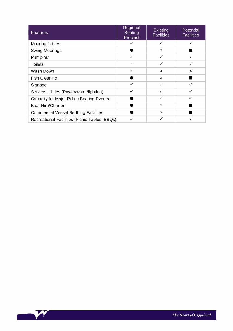
Features Regional Boating Precinct
Existing Facilities
Potential Facilities
Mooring Jetties
Swing Moorings
Pump-out
Toilets
Wash Down
Fish Cleaning
Signage
Service Utilities (Power/water/lighting)
Capacity for Major Public Boating Events
Boat Hire/Charter
Commercial Vessel Berthing Facilities
Recreational Facilities (Picnic Tables, BBQs)
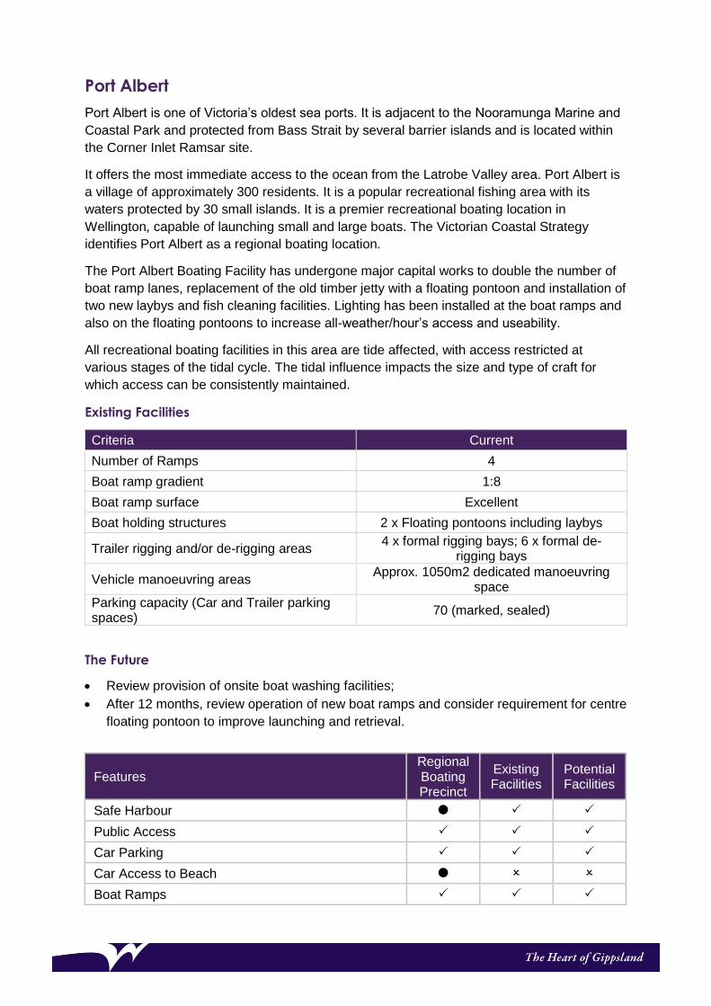
Port Albert
Port Albert is one of Victoria’s oldest sea ports. It is adjacent to the Nooramunga Marine and
Coastal Park and protected from Bass Strait by several barrier islands and is located within
the Corner Inlet Ramsar site.
It offers the most immediate access to the ocean from the Latrobe Valley area. Port Albert is
a village of approximately 300 residents. It is a popular recreational fishing area with its
waters protected by 30 small islands. It is a premier recreational boating location in
Wellington, capable of launching small and large boats. The Victorian Coastal Strategy
identifies Port Albert as a regional boating location.
The Port Albert Boating Facility has undergone major capital works to double the number of
boat ramp lanes, replacement of the old timber jetty with a floating pontoon and installation of
two new laybys and fish cleaning facilities. Lighting has been installed at the boat ramps and
also on the floating pontoons to increase all-weather/hour’s access and useability.
All recreational boating facilities in this area are tide affected, with access restricted at
various stages of the tidal cycle. The tidal influence impacts the size and type of craft for
which access can be consistently maintained.
Existing Facilities
Criteria Current
Number of Ramps 4
Boat ramp gradient 1:8
Boat ramp surface Excellent
Boat holding structures 2 x Floating pontoons including laybys
Trailer rigging and/or de-rigging areas 4 x formal rigging bays; 6 x formal de-
rigging bays
Vehicle manoeuvring areas Approx. 1050m2 dedicated manoeuvring
space
Parking capacity (Car and Trailer parking spaces)
70 (marked, sealed)
The Future
• Review provision of onsite boat washing facilities;
• After 12 months, review operation of new boat ramps and consider requirement for centre
floating pontoon to improve launching and retrieval.
Features Regional Boating Precinct
Existing Facilities
Potential Facilities
Safe Harbour
Public Access
Car Parking
Car Access to Beach
Boat Ramps

Features Regional Boating Precinct
Existing Facilities
Potential Facilities
Pier/Jetty
Public Berths (Itinerant)
Wet Berths
Mooring Jetties
Swing Moorings
Fuel
Pump-out
Toilets
Wash Down
Fish Cleaning
Signage
Service Utilities (Power/water/lighting)
Capacity for Major Public Boating Events
Boat Hire/Charter
Commercial Vessel Berthing Facilities
Recreational Facilities (Picnic Tables, BBQs)

Loch Sport
Loch Sport is centrally located within the Gippsland Lakes system. It is a linear township
(approximately 5.5 km long and 0.5 km wide) sitting between Lake Victoria and Lake Reeve
and contained at each end by National and Coastal Parks.
Boating facilities at Loch Sport are spread across 3 areas, referred to as Charlies Street,
Seagull Drive and The Boulevard. Loch Sport has been identified as having a future role as a
regional boating precinct. All facilities across the 3 sites are included in this assessment i.e.
if one facility complies, all three are deemed to comply.
In peak times these facilities are well used, and the provision of adequate parking can be an
issue.
Recent works at the Charlies Street Boat Ramp have increased the number of boat ramp
lanes by one and includes installation of a new fixed jetty and floating pontoon. Minor
carparks works were completed to improve vehicle manoeuvring space at the boat ramps.
All three boat ramps are subject to sand build up from time to time. Access to all three
facilities cannot be guaranteed, however, appropriate action will be undertaken to clear sand
and maintain access to at least one facility at all times.
Existing Facilities
Charlies Street
Criteria Current
Number of Ramps 3
Boat ramp gradient 1:8
Boat ramp surface Very Good
Boat holding structures Fixed jetty and floating pontoon
Trailer rigging and/or de-rigging areas No formal areas identified
Vehicle manoeuvring areas Approx. 550m2
Parking capacity (Car and Trailer parking spaces)
46 (marked, sealed)
Seagull Drive
Criteria Current
Number of Ramps 1
Boat ramp gradient 1:8
Boat ramp surface Fair
Boat holding structures Nil
Trailer rigging and/or de-rigging areas No formal areas identified
Vehicle manoeuvring areas Approx. 350m2
Parking capacity (Car and Trailer parking spaces)
Min. 20 (unmarked, sealed)

The Boulevard
Criteria Current
Number of Ramps 1
Boat ramp gradient 1:6
Boat ramp surface Fair
Boat holding structures Nil
Trailer rigging and/or de-rigging areas No formal areas identified
Vehicle manoeuvring areas Approx. 440m2
Parking capacity (Car and Trailer parking spaces)
Min. 15 (unmarked, unsealed)
The Future
• Review and upgrade of public lighting;
• Continue ongoing boat ramp sand monitoring and removal at Charlies Street Boat Ramp,
to ensure access for recreation users;
• Continue seasonal clearing of Seagull Drive and National Park boat ramps prior to
Melbourne Cup weekend, Christmas and Easter holidays;
• Review parking at the Charlies Street Boat ramp.
Features Regional Boating Precinct
Existing Facilities
Potential Facilities
Safe Harbour
Public Access
Car Parking
Car Access to Beach
Boat Ramps
Pier/Jetty
Public Berths (Itinerant)
Wet Berths
Mooring Jetties
Swing Moorings
Pump-out
Toilets
Wash Down
Fish Cleaning
Signage
Service Utilities (Power/water/lighting)
Capacity for Major Public Boating Events
Boat Hire/Charter
Commercial Vessel Berthing Facilities
Recreational Facilities (Picnic Tables, BBQs)

District Boating Facilities
McLoughlin's Beach
McLoughlins Beach is a small community surrounded by the Nooramunga Marine and Coastal
Park and occurs within the Corner Inlet Ramsar Site. Recreational boating and fishing are
popular with people coming from the Latrobe Valley and further afield to fish. It is separated
from nearby Bass Strait by barrier islands. There are a number of entrances to Bass Strait,
with the one closest to McLoughlins Beach located approximately five kilometres from the boat
ramp via a meandering channel. Access to the entrance can change erratically due to the
dynamic coastal processes at this location.
All recreational boating facilities in this area are tide affected, with access restricted at various
stages of the tidal cycle. The tidal influence impacts the size and type of craft for which access
can be consistently maintained.
The area is low lying and susceptible to the effects of climate change and coastal erosion.
Existing Facilities
Criteria Current
Number of Ramps 2
Boat ramp gradient 1:8
Boat ramp surface Good
Boat holding structures Fixed jetty and floating pontoons
Trailer rigging and/or de-rigging areas 2 x de-rigging bays; 4 x unmarked rigging
bays
Vehicle manoeuvring areas Approx. 500m2 immediately adjacent to boat
ramp
Parking capacity (Car and Trailer parking spaces)
Min. 70 (unmarked, unsealed)
The Future
Future works at the McLoughlins Boating Facility may include the following:
• Review parking facilities;
• Maintain modern fish cleaning facilities.
Features District Boating Facility
Existing Facilities
Potential Facilities
Safe Harbour
Public Access
Car Parking
Car Access to Beach
Boat Ramps
Pier/Jetty
Public Berths (Itinerant)

Features District Boating Facility
Existing Facilities
Potential Facilities
Wet Berths
Mooring Jetties
Swing Moorings
Fuel
Pump-out
Toilets
Wash Down
Fish Cleaning
Signage
Service Utilities (Power/water/lighting)
Boat Hire/Charter
Capacity for Major Public Boating Events
Commercial Vessel Berthing Facilities
Recreational Facilities (Picnic Tables, BBQs)
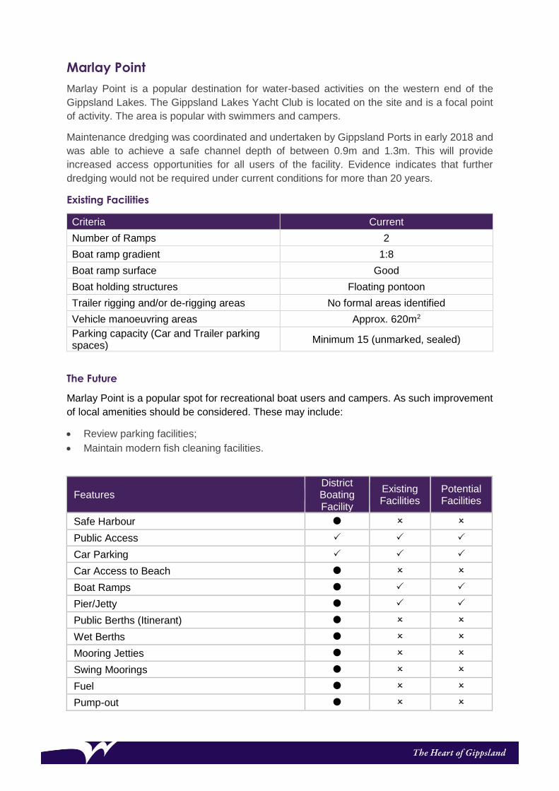
Marlay Point
Marlay Point is a popular destination for water-based activities on the western end of the
Gippsland Lakes. The Gippsland Lakes Yacht Club is located on the site and is a focal point
of activity. The area is popular with swimmers and campers.
Maintenance dredging was coordinated and undertaken by Gippsland Ports in early 2018 and
was able to achieve a safe channel depth of between 0.9m and 1.3m. This will provide
increased access opportunities for all users of the facility. Evidence indicates that further
dredging would not be required under current conditions for more than 20 years.
Existing Facilities
Criteria Current
Number of Ramps 2
Boat ramp gradient 1:8
Boat ramp surface Good
Boat holding structures Floating pontoon
Trailer rigging and/or de-rigging areas No formal areas identified
Vehicle manoeuvring areas Approx. 620m2
Parking capacity (Car and Trailer parking spaces)
Minimum 15 (unmarked, sealed)
The Future
Marlay Point is a popular spot for recreational boat users and campers. As such improvement
of local amenities should be considered. These may include:
• Review parking facilities;
• Maintain modern fish cleaning facilities.
Features District Boating Facility
Existing Facilities
Potential Facilities
Safe Harbour
Public Access
Car Parking
Car Access to Beach
Boat Ramps
Pier/Jetty
Public Berths (Itinerant)
Wet Berths
Mooring Jetties
Swing Moorings
Fuel
Pump-out

Toilets
Wash Down
Fish Cleaning
Signage
Service Utilities (Power/water/lighting)
Capacity for Major Public Boating Events
Boat Hire/Charter
Commercial Vessel Berthing Facilities
Recreational Facilities (Picnic Tables, BBQs)

Hollands Landing
Hollands Landing is a small fishing community on the McLennan Straits. There is a caravan park and store adjacent to the boat ramp area which is busy in peak times, when fishing in the McLennan Straits is good. A Master Plan for Hollands Landing was developed in 2007, which identified the relocation of the boat ramp. A new boat ramp was designed and constructed in 2009. Any further development of facilities at this site is restricted by a lack of services; particularly power and water.
Existing Facilities
Criteria Current
Number of Ramps 2
Boat ramp gradient 1:8
Boat ramp surface Excellent
Boat holding structures 2 x fixed jetties and 2 x floating pontoons
Trailer rigging and/or de-rigging areas No formal areas identified
Vehicle manoeuvring areas Approx. 800m2
Parking capacity (Car and Trailer parking spaces)
Min. 10 (unmarked, sealed)
The Future
Future works at Hollands Landing may include:
• Review parking facilities;
• Maintain modern fish cleaning facilities.
Features District Boating Facility
Existing Facilities
Potential Facilities
Safe Harbour
Public Access
Car Parking
Car Access to Beach
Boat Ramps
Pier/Jetty
Public Berths (Itinerant)
Wet Berths
Mooring Jetties
Swing Moorings
Fuel
Pump-out
Toilets
Wash Down

Fish Cleaning
Signage
Service Utilities (Power/water/lighting)
Capacity for Major Public Boating Events
Boat Hire/Charter
Commercial Vessel Berthing Facilities
Recreational Facilities (Picnic Tables, BBQs)

Basic Boating Facilities
Manns Beach
Manns Beach is a small coastal village boarded by the Nooramunga Marine and Coastal
Park and is located within the Corner Inlet Ramsar Site.
Recreational boating facilities consist of a small boat ramp and a timber jetty (managed by
Gippsland Ports). Small boats are launched at the ramp, often by tractor. The Manns Beach
foreshore area is an active focal point for the community with the Community Hall,
playground and a parking area located at the site.
All recreational boating facilities in this area are tide affected, with access restricted at various
stages of the tidal cycle. The tidal influence impacts the size and type of craft for which access
can be consistently maintained.
Existing Facilities
Criteria Existing
Number of Ramps 1
Boat ramp gradient 1:8
Boat ramp surface Excellent
Boat holding structures Nil
Trailer rigging and/or de-rigging areas No formal areas identified
Vehicle manoeuvring areas Approx. 750m2
Parking capacity (Car and Trailer parking spaces)
Min. 30 (unmarked, unsealed)
The Future
Future works at Manns Beach may include:
• Review parking facilities;
• Maintain modern fish cleaning facilities on Gippsland Ports Jetty.
Manns Beach Features Basic Boating
Facility Existing Facilities
Potential Facilities
Safe Harbour
Public Access
Car Parking
Car Access to Beach
Boat Ramps
Pier/Jetty
Public Berths (Itinerant)
Wet Berths
Mooring Jetties
Swing Moorings
Fuel

Manns Beach Features Basic Boating
Facility Existing Facilities
Potential Facilities
Pump-out
Toilets
Wash Down
Fish Cleaning
Signage
Service Utilities (Power/water/lighting)
Capacity for Major Public Boating Events
Boat Hire/Charter
Commercial Vessel Berthing Facilities
Recreational Facilities (Picnic Tables, BBQs)

Seacombe
Seacombe is a small isolated recreational boating facility suitable for launching small boats
only. It is accessed via a gravel road.
Users of this site are most likely local anglers accessing the McLennan Straits and greater
Gippsland lakes system.
Existing Facilities
Criteria Current
Number of Ramps 1
Boat ramp gradient 1: 9
Boat ramp surface Good
Boat holding structures Nil
Trailer rigging and/or de-rigging areas No formal areas identified
Vehicle manoeuvring areas Approx. 600m2
Parking capacity (Car and Trailer parking spaces)
Min. 18 (marked, sealed)
The Future
The future of the Seacombe Boating Facility may include:
• Replacement of Boat ramp;
• Installation of boardwalks along north-eastern and south-western approaches to the
boat ramp;
• Review parking facilities;
• Maintain modern fish cleaning facilities.
Features Basic Boating
Facility Existing Facilities
Potential Facilities
Safe Harbour
Public Access
Car Parking
Boat Ramps
Pier/Jetty
Public Berths (Itinerant)
Wet Berths
Mooring Jetties
Swing Moorings
Fuel
Pump-out
Toilets
Wash Down
Fish Cleaning

Features Basic Boating
Facility Existing Facilities
Potential Facilities
Signage
Service Utilities (Power/water/lighting)
Capacity for Major Public Boating Events
Boat Hire/Charter
Commercial Vessel Berthing Facilities
Community Facilities (Including Club Rooms)
Recreational Facilities (Picnic Tables, BBQs)
Opportunities for Improvement
Projects, actions and funding are outlined and identified for inclusion through Council’s
Annual Capital Works Budget. Actions are assessed against the following established
criteria:
• The type of project,
• The level of the site on the recreational boating facilities hierarchy,
• Whether the project is a renewal, upgrade or expansion,
• The current level of use, and
• The level of risk (in not undertaking the action).
Identified projects are prioritised as part of the forward capital program. Potential funding
sources should be identified for major capital works. External grant funding should be
sourced to assist with the implementation of projects.
Potential sources of grant funding include:
• Victorian Fisheries Authority website;
• Department of Transport (including the Boating Safety and Facilities Program)
www.transport.vic.gov.au/grants.
Monitoring is essential to track the success of the Wellington Recreational Boating Strategic
Plan in meeting the vision and objectives for the Wellington Shire. To meet this need, a
forward capital program and review process shall be presented to Council periodically.

References
There are legislation, policies and strategies that apply to the planning, management and
development of recreational boating facilities in Gippsland, which include but are not limited
to:
Legislation
• Environment Protection and Biodiversity Conservation Act 1999 (Commonwealth),
• Native Title Act 1993 (Commonwealth),
• Coastal Management Act 1995,
• Crown Land (Reserves) Act 1978,
• Planning and Environment Act 1987,
• Heritage Act 1995,
• Traditional Owner Settlement Act 2010,
• Aboriginal Cultural Heritage Act 2006,
• Environment Protection Act 1970,
• Flora and Fauna Guarantee Act 1988,
• Fisheries Act 1995,
• National Parks Act 1975,
• Land Act 1958,
• Marine Safety Act 2010,
• Pollution of Waters by Oil and Noxious Substances Act 1986,
• Port Management Act 1995, and
• Climate Change Act 2017.
Policies and Strategies
• Victorian Coastal Strategy 2014,
• Victorian Climate Change Adaptation Plan 2017-2020,
• State Environment Protection Policy (Waters of Victoria) 2003,
• Gippsland Boating Coastal Action Plan 2013,

• East Gippsland Regional Catchment Strategy 2013-2019,
• West Gippsland Regional Catchment Strategy 2013-2019, and
• Victorian planning provisions, including the State planning policy framework and the
Local planning Policy framework.
Guidelines and Other Documents
• Gippsland Regional Coastal Plan 2015 – 2020,
• Ramsar convention on wetlands,
• Guidelines for dredging, Best practice environmental management series (EPA 2001),
• Siting and design guidelines for structure on the Victorian coast (VCC 1998),
• Gippsland Lakes coastal action plan 1999,
• Integrated coastal planning for Gippsland coastal action plan 2002,
• Committee of management responsibilities and good practice guidelines 2015,
• Structure plans and urban design frameworks,
• Coastal Acid Sulphate Soils Strategy 2009,
• Boating Safety Signage & Buoyage Guidelines (Transport Safety Victoria),
• National Aquatic and Recreational Signage Style Manual Third Edition (2006).