Embed Size (px)
Citation preview
Spring 2018
Recurrent Flooding, Sea Level Rise,
and the Relocation of At-Risk Communities: Case Studies from the Commonwealth of Virginia
Jeffrey Moore, J.D. Candidate 2018 Lauren Acker, J.D. Candidate 2019
Virginia Coastal Policy Center Virginia Coastal Policy Center
William & Mary Law School William & Mary Law School
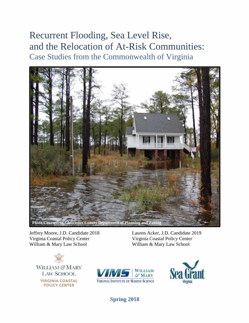
Photo Courtesy of Gloucester County Department of Planning and Zoning

1
About the Authors
Jeffrey Moore is a third year student at William & Mary Law School. He joined
the Virginia Coastal Policy Center in the fall of 2017. At William & Mary, he
serves as the Executive Editor of the Environmental Law & Policy Review, and
interned with the Denver City Attorney's Office and the Future of Privacy Forum.
He graduated from Colorado College in 2013 where he studied History and
Museum Studies.
Lauren Acker is a J.D. Candidate 2019 at William and Mary Law School. Lauren
graduated magna cum laude with a BA in Sociology and Anthropology from
Washington and Lee University in 2012. Upon graduation, she moved to Oregon
where she lived, worked, and played in the Pacific Northwest before returning to
Virginia to attend law school. She interned in Phnom Penh, Cambodia her 1L
summer through the Center for Comparative Legal Studies and Post-Conflict
Peacebuilding working on international environmental issues. She is staff editor
for The Comparative Jurist Blog and Treasurer for the Student Environmental &
Animal Law Society. She plans to pursue a career in international and/or
environmental law.
About the Virginia Coastal Policy Center
The Virginia Coastal Policy Center (VCPC) at the College of William & Mary Law School
provides science-based legal and policy analysis of ecological issues affecting the state's coastal
resources, providing education and advice to a host of Virginia’s decision-makers, from
government officials and legal scholars to non-profit and business leaders.
With two nationally prominent science partners – the Virginia Institute of Marine Science,
and Virginia Sea Grant – VCPC works with scientists, local and state political figures, community
leaders, the military, and others to integrate the latest science with legal and policy analysis to
solve coastal resource management issues. VCPC activities are
inherently interdisciplinary, drawing on scientific, economic, public
policy, sociological, and other expertise from within the University
and across the country. With access to internationally recognized
scientists at VIMS, to Sea Grant’s national network of legal and
science scholars, and to elected and appointed officials across the
nation, VCPC engages in a host of information exchanges and
collaborative partnerships.
VCPC grounds its pedagogical goals in the law school's philosophy
of the citizen lawyer. VCPC students’ highly diverse interactions beyond the borders of the legal
community provide the framework for their efforts in solving the complex coastal resource
management issues that currently face Virginia and the nation.
CONTACT US
Please contact
Elizabeth Andrews
if you have comments,
questions, or suggestions.

2
I. Recurrent Flooding and Sea Level Rise in Virginia
A. Defining Relocation
B. The Dillon Rule, Sea Level Rise and Relocation
C. Public Trust Doctrine
D. Property Rights
E. National Flood Insurance Program
II. Resilience to Relocation
A. The Virginia Code and Resilience to Relocation
B. Resilience to Relocation Case Study: Tangier Island
1.Strategies Employed & Envisioned
2.Accomack County Comprehensive Plan
3.FEMA, NFIP, and Tangier
C. What Can We Learn from Tangier?
III. Relocating in Place
A. The Virginia Code and Relocation in Place
B. Relocation in Place Case Study: Poquoson
1.Relocation in Place in Poquoson
2.Poquoson Ordinance Regarding Elevating Homes
3.Poquoson Comprehensive Plan and Hazard Mitigation Plan
4.FEMA, NFIP, and Poquoson
C. What Can We Learn from Poquoson?
IV. Relocating Nearby
A. Relocation Nearby Case Study: Norfolk
B. Strategies Employed & Envisioned: Vision 2100
1.Citywide areas
2.Red Areas
3.Yellow Areas
4.Green Areas
5.Purple Areas
C. What Can We Learn from Norfolk?
V. Relocating at a Distance
A. Relocating at a Distance Case Studies
1.Broadwater
2.Shishmaref and Newtok
3.Isle de Jean Charles
B. What Can We Learn from These Communities?
VI. Conclusion

3
I. RECURRENT FLOODING AND SEA LEVEL RISE IN VIRGINIA
Recurrent flooding and sea level rise have been identified as Virginia’s “highest
probability/highest impact hazard.”1 Recurrent flooding is flooding that inundates the same area
repeatedly over time, and can be triggered by precipitation events, high tides, or storm surges.2
Relative sea level rise occurs as: (1) climate change causes the oceans to warm and expand, melting
ice sheets and altering circulation patterns; and (2) land subsidence continues, which is attributable
to isostatic glacial rebound and groundwater withdrawal.3 Coastal Virginia is particularly
vulnerable to recurrent flooding and sea level rise. It is estimated that recurrent flooding and sea
level rise put 400,000 Virginia homes at risk, and the cost of rebuilding flooded residential property
is predicted to be $92 billion, based on June 2014 estimated reconstruction values.4 Additionally,
a three-foot rise, considered to be a conservative rise, in sea level would submerge nearly 900
miles of roads in the Hampton Roads Planning District.5
The Virginia Institute of Marine Science (VIMS) projects four scenarios of sea level rise
in Tidewater Virginia: historic (observed rates over the last century, incorporating no acceleration),
low, high, and highest (estimated consequences of global warming combined with maximum
possible ice-sheet melt).6 These projections indicate that, by the end of the century, Virginia could
see a potential sea level rise of more than five feet.7
Because so many Virginia residents will suffer the effects of recurrent flooding and sea
level rise, coastal communities must begin considering questions like: How will communities
address the challenges that rising water poses to established neighborhoods and businesses? Will
they continue to provide services? At what point will homes and roads be raised, or locality
services withdrawn? How can residents be involved and engaged in deciding their own fate?
To address these questions, University of Virginia architecture professor Alex Wall used a
Resilience Research seed grant to work with Tanya Denckla Cobb, director of the UVa Institute
for Environmental Negotiation to convene a Focus Group of coastal locality stakeholders. With
the support and partnership of Michelle Covi, Assistant Professor of Practice, Virginia Sea Grant
Climate Adaptation and Resilience Program, Old Dominion University/Virginia Sea Grant, a focus
1 Recurrent Flooding Sub-Panel, Recommendations to the Secure Commonwealth Panel on the Issue of Sea Level
Rise and Recurrent Flooding in Coastal Virginia, 3 (Sept. 5, 2014),
http://ccrm.vims.edu/SCPRecommendationsReport_Sept2014.pdf. 2 Recurrent Flooding Study for Tidewater Virginia, VIRGINIA INSTITUTE OF MARINE SCIENCE, 4 (Jan. 2013),
http://ccrm.vims.edu/recurrent_flooding/Recurrent_Flooding_Study_web.pdf. 3 Commonwealth of Virginia Governor Terence R. McAuliffe’s Executive Order 57 Work Group: Report and Final
Recommendations to the Governor, 2 (May 12, 2017), https://naturalresources.virginia.gov/media/9156/eo57-report-
final-5-12-17.pdf [hereinafter Commonwealth of Virginia]; Recurrent Flooding Study for Tidewater Virginia,
VIRGINIA INSTITUTE OF MARINE SCIENCE, 3 (Jan. 2013)
http://ccrm.vims.edu/recurrent_flooding/Recurrent_Flooding_Study_web.pdf; Carl Hershner, Class Lecture for
Virginia Coastal Policy Center, (August 29, 2017). 4 Commonwealth of Virginia, supra note 3; Howard Botts, Thomas Jeffery, Wei Du, Morgan Suhr, 2014 CoreLogic
Storm Surge Report, 5 (July 2014), https://www.eenews.net/assets/2014/07/10/document_cw_01.pdf. 5 Commonwealth of Virginia, supra note 3. 6 Sea Level Rise Scenarios, VIRGINIA INSTITUTE OF MARINE SCIENCE,
http://www.vims.edu/newsandevents/topstories/slr_scenarios.php (last visited Oct. 19, 2017). 7 Commonwealth of Virginia, supra note 3.
4
group of eleven knowledgeable “thought leaders” from coastal localities, universities, and
nonprofits gathered on August 30, 2016 to tackle the difficult (and dire) topic of relocation.
Participants explored how at-risk coastal communities might conceptualize, plan, and implement
the undesired and unwanted relocation of a neighborhood or community. The result of their work
– Community Relocation in the Face of Recurring Inundation: A Preliminary Framework – is
intended as a conversation starter, in hopes that others will build on this work to help coastal
localities prepare for the challenges associated with possible community relocation.8 This Paper is
a continuation of the seed grant’s efforts to discuss the challenges of relocating at-risk communities
in coastal Virginia.
A. Defining Relocation
This Paper conceptualizes relocation for communities at high risk of recurrent flooding
into four different categories: resilience to relocation, relocating in place, relocating nearby, and
relocating at a distance. Definitions for these categories are briefly outlined below, with more
detailed discussions, including case studies, to follow.
● Resilience to Relocation is defined as methods employed by a community or
locality to stave off more dramatic relocation phases. Resilience strategies can
include both “soft” and “hard” infrastructure. Examples of these resilience
strategies include implementing natural or nature-based solutions, installing living
shorelines, regenerating and preserving wetlands, digging retention basins,
conducting dredge disposal projects, installing floodgates, or building sea walls.
● Relocating in place is relocation that is minimally invasive, allowing a household
to stay in place by elevating the structure, moving to a different part of the lot, or,
at most, moving down the street. In addition to retrofitting individual homes,
communities also would have to consider raising selected roads as designated
evacuation routes and addressing any inundated septic systems.
● Relocating nearby is relocation that requires a move beyond the immediate
neighborhood, but allows the household to stay in the same general area. Ideally,
the community is still familiar, children are able to attend the same school or stay
within the same district, and working adults are able to maintain their jobs without
enduring significantly longer commutes.
● Relocating at a distance is relocation that requires moving to a new, unfamiliar
receiving community. This is the most disruptive and invasive relocation effort for
both the uprooted and receiving communities. It will impact school districts for
children and employment for working adults.
B. The Dillon Rule, Sea Level Rise, and Relocation
The Dillon Rule is a rule of statutory construction that is “used in construction of statutes
delegating authority to local government.”9 Virginia is a Dillon Rule state, meaning that localities
8 Tanya Denckla Cobb, Alex Wall & Michelle Covi, Community Relocation in the Face of Recurring Inundation: A
Preliminary Framework, 2016 Coastal Focus Group, 7 (2016),
https://ien.virginia.edu/sites/ien.virginia.edu/files/CommunityRelocationFramework_6TSone-page.pdf. 9 The Dillon Rule, BLACK’S LAW DICTIONARY (6th ed. 1991).

5
can only take action where the Virginia Assembly has enabled them to do so.10 Thus, the Dillon
Rule is relevant to the relocation of at-risk communities and sea level rise because it dictates what
actions localities are able to take.
The Dillon Rule requires a two-step analysis. First, the locality can only exercise powers
that are: (1) expressly granted by the legislature; (2) necessarily or fairly implied from an express
grant of authority; or (3) essential and indispensable in exercising those expressly granted
powers.11 Second, the locality must properly execute the power granted to it.12 When the enabling
authority specifies the method for implementing the power, localities may not use a different
method.13 However, when the enabling authority does not specify the method for implementation,
localities have discretion, applying the “reasonable selection of method” rule.14 If a locality
exercised powers beyond those the General Assembly delegated, the locality can be sued for
exceeding its authority in violation of the Dillon Rule.15
Some of the Virginia Code provisions that relate to sea level rise and relocation are:
● § 10.1-658: State interest in flood control;
● § 15.2-970: Construction of dams, levees, seawalls, etc.;
● § 15.2-2223: Comprehensive plan to be prepared and adopted; scope and purpose;
● § 15.2-2279: Ordinances regulating the building of houses and establishing setback
lines;
● § 15.2-2280: Zoning ordinances generally;
● § 15.2-2283: Purpose of zoning ordinances;
● § 28.2-104.1: Living shorelines; development of general permit; guidance
● § 28.2-1100: Virginia Institute of Marine Science continued; duties; and
● § 62.1-229.5: Loans for living shorelines.16
The Code section that speaks most broadly to the issue of recurrent flooding and sea level
rise is Virginia Code § 10.1-658, which declares flooding a state interest because flooding can
often “result in the loss of life, damage to property, unsafe and unsanitary conditions and the
disruption of commerce and government services, placing at risk the health, safety and welfare of
those citizens living in flood-prone areas…[T]he public interest requires the management of flood-
10 Lauren Gill, The Dillon Rule and Sea Level Rise: An analysis of the impact of the Dillon Rule on potential
adaptation measures the City of Poquoson may implement, VIRGINIA COASTAL POLICY CENTER, 5 (2013),
http://law.wm.edu/academics/programs/jd/electives/clinics/vacoastal/documents/march2014reports/dillonrulesealeve
l.pdf. 11 Marble Techs., Inc. v. City of Hampton, 279 Va. 409, 417 (2010). 12 Greg Kamptner, Chapter 5: The Dillon Rule and Its Limitations on a Locality’s Land Use Powers, THE
ALBEMARLE COUNTY LAND USE LAW HANDBOOK, 5-421 (July 2015),
https://www.albemarle.org/upload/images/Forms_Center/Departments/County_Attorney/Forms/LUchapter05-
dillonrule.pdf. 13 Id. 14 Advanced Towing Co., LLC v. Fairfax County Bd. Of Supervisors, 280 Va. 187, 193 (2010). 15 Gill, supra note 10. 16 Commonwealth of Virginia Governor Terence R. McAuliffe’s Executive Order 57 Work Group: Report and Final
Recommendations to the Governor, 12-14 (May 12, 2017) https://naturalresources.virginia.gov/media/9156/eo57-
report-final-5-12-17.pdf; Gill, supra note 10, at 6; Planning & Policy, ADAPT VA,
http://adaptva.org/info/planning_enab.html (last visited Nov. 9, 2017).
6
prone areas.”17 Further, § 10.1-658(B) continues by stating, “The General Assembly, therefore,
supports and encourages those measures which prevent, mitigate, and alleviate the effects of
stormwater surges and flooding.”18 These provisions lend localities authority to address current
and future flooding that stems from sea level rise.19
C. Public Trust Doctrine
The Public Trust Doctrine “provides that submerged and submersible lands are preserved
for public use in navigation, fishing and recreation and [the] state, as trustee for the people, bears
the responsibility of preserving and protecting the right of the public to use the waters for those
purposes.”20 In most states, intertidal land is owned by the state and held under the public trust
doctrine; however, in Virginia, “the rights and privileges of the owners...shall extend to the mean
low-water mark but no farther.”21 The Virginia Marine Resource Commission is charged with
acting on the public’s behalf to protect marine resources and publicly-owned submerged lands
below the mean low-water mark.22
The Public Trust doctrine can become a defense to a Takings Clause challenge to a
governmental exercise of police powers. Several coastal states such as South Carolina have applied
this defense.23 For coastal states, the “public-trust-doctrine-based defense would be that the
government action in advancement or protection of public interests in the coastal lands and waters
cannot constitute a taking.”24 In South Carolina, riparian owners own “all lands except beaches in
the coastal zone between the mean high-water and the mean-low water mark of navigable
waters.”25 Thus, it is possible this defense may be more difficult to apply in Virginia given the
state’s mean low water mark boundary for private ownership.
D. Property Rights
The consideration of property rights will be an underlying issue throughout the course of
this Paper. What are the rights of the landowner? What about the tenant, if one is involved? At
what point does the government’s interest in relocating people at risk of recurrent flooding override
the resident’s interest in remaining on the land? While an in-depth delve into the details of property
rights in Virginia are beyond the scope of this Paper, it is an important overarching concept to keep
17 VA. CODE ANN. § 10.1-658 (1989). 18 Id. 19 Mary-Carson B. Saunders, The Dillon Rule & Norfolk Sea Level Rise: An analysis of the limited impact of the
Dillon Rule on planning for sea level rise in Norfolk, Virginia Coastal Policy Center, 6 (2013),
http://law.wm.edu/academics/programs/jd/electives/clinics/vacoastal/documents/march2014reports/dillonrulenorfolk
.pdf. 20 Public Trust Doctrine, BLACK’S LAW DICTIONARY (6th ed. 1991). 21 VA. CONST. art XI, § 1; VA. CODE ANN. §§ 28.2-1200, 28.2-1201 (2014); Common Law & Statutes, ACCESSING
THE VIRGINIA COAST, http://www.virginiacoastalaccess.net/law_statutes.html (last visited Oct. 19, 2017). 22 Common Law & Statutes, ACCESSING THE VIRGINIA COAST,
http://www.virginiacoastalaccess.net/law_statutes.html (last visited Oct. 19, 2017). 23 Robin Kundis Craig, Public Trust and Public Necessity Defenses to Takings Liability for Sea Level Rise
Responses on the Gulf Coast, 26 J. Land Use & Envtl. Law 395, 404 (2011). 24 Id. 25 S.C. CODE ANN. § 48-39-220 (1993).

7
in mind. In addition to this brief overview of property rights, each case study below will contain a
short summary of relevant ordinances and laws that impact relocation within that community.
Property rights are “the rights given to the person or persons who have a right to own the
property through purchase or bequest. These are basic rights in any society though absolute right
for a property is rare in any society.”26 In short, property rights can be considered a “bundle of
sticks:”27 Each “stick” represents an individual right, and an owner possesses a “bundle” relating
to the collection of rights to which she has a stake. For example, a title owner has the right to
possession and use of the land, the right to lease or sell the land, the right to subdivide the land,
and the right to create a covenant running with the land, amongst other rights.28 Individually, each
right is a stick; together, they create a bundle of rights. The government possess property rights as
well. Several examples of a government’s right include the right to collect property tax, enforce a
lien, protect endangered animals and/or wetlands, and exercise the power of eminent domain.29
In Virginia, in the years following the American Revolution, Thomas Jefferson engineered
legislation to keep the control of land wholly with the living—whereas prior to this, a landowner
could restrict how future generations used or sold the land.30 Following this, individuals tried more
and more to cement individual rights in property over those of the government. However, in 1926,
the United States Supreme Court clarified that the government has certain “police powers” over
the use of land, such as zoning.31 Governments also can control ownership in private land, are able
to force the transfer of property from one citizen to another,32 and can take land from a citizen
through the exercise of the power of eminent domain.
Eminent domain is the government’s right to force the sale or transfer of private land into
the possession of the government.33 There are restrictions on when the government can exercise
eminent domain. These restrictions include the requirement that taking the land must be for the
public use, such as building a necessary roadway, and the owners must be paid the fair value of
the land.34 The Virginia legislature has also taken several impactful steps in limiting the situations
in which the government can acquire property by eminent domain. For example, Virginia Code §
1-219.1 restricts the term “public use” to the following:
(i) the property is taken for the possession, ownership, occupation, and enjoyment of
property by the public or a public corporation; (ii) the property is taken for construction,
maintenance, or operation of public facilities by public corporations or by private entities
provided that there is a written agreement with a public corporation providing for use of
the facility by the public; (iii) the property is taken for the creation or functioning of any
26 Property Rights, BLACK’S LAW DICTIONARY (6th ed. 1991). 27 Jane B. Baron, Rescuing the Bundle-of-Rights Metaphor in Property Law, 82 U. CIN. L. REV. 57, 59 (2014). 28 Robert C. Ellickson, Two Cheers for the Bundle-of-Sticks Metaphor, Three Cheers for Merrill and Smith, ECON
JOURNAL WATCH 8(3) 215, 217 (2011). 29 Id. 30 Local Zoning, Eminent Domain, and the “Bundle of Rights” in Virginia, VIRGINIA PLACES,
http://www.virginiaplaces.org/landuseplan/rightszoning.html (last visited Dec. 5, 2017). 31 See Village of Euclid v. Ambler Realty Co., 272 U.S. 365 (1926). 32 See Kelo v. New London, 545 U.S. 469 (2005). 33 Eminent Domain, BLACK’S LAW DICTIONARY (6th ed. 1991). 34 See Ramsey v. Comm’r of Highways, 2014 Va. LEXIS 140929, at *164 (Apr. 16, 2015).
8
public service corporation, public service company, or railroad; (iv) the property is taken
for the provision of any authorized utility service by a government utility corporation; (v)
the property is taken for the elimination of blight provided that the property itself is a
blighted property; or (vi) the property taken is in a redevelopment or conservation area
and is abandoned or the acquisition is needed to clear title where one of the owners
agrees to such acquisition or the acquisition is by agreement of all the owners.35
The Code defines blighted property as “any property that endangers the public health or
safety in its condition at the time of the filing of the petition for condemnation” and is either a
public nuisance or an individual commercial, industrial, or residential structure beyond repair.36
The Virginia Legislature believes that ownership of private property is a fundamental right and,
therefore, the land can only be taken when the public interest—such as building a necessary road,
as seen in Ramsey v. Commissioner of Highways—dominates the private right and the primary
purpose is not private financial gain, private benefit, an increase in tax base or revenues, or another
similar situation.37 The Legislature has also placed limits on the amount of land that can be taken38
and preserved the rights of the individual landowner to challenge any exercise of eminent
domain.39
As sea levels continue to rise and land continues to subside, the exercise of eminent domain
may become more and more prevalent in the discussions regarding relocation. As sea levels in
Virginia rise, the number of properties that must be removed as a “blighted property,” public
nuisance, or unfit for repair may rise with it. In addition to the obvious social and environmental
impacts, rising sea levels will have a significant economic impact as well. A significant portion of
the country’s energy infrastructure—as well as transportation infrastructure—is situated in coastal
areas and at risk to damage from sea level rise and flooding.40 For example, Norfolk anticipates a
$1 billion budget to construct floodgates and drains due to current and anticipated sea level rise
and land subsidence.41
In order to help preserve the expensive infrastructure, as well as attempt to avoid as much
of the environmental and social damage from flooding as possible, the government can take the
property of landowners via eminent domain, or effectively take it through regulatory restriction.
Most states, such as Virginia, have statutory authority to take private property under certain
circumstances.42 The property owner can challenge the government’s action in court under several
legal claims, such as alleging that the act is unconstitutional. However, challenging this in court
could prove a lengthy and expensive process—something for which not every citizen would have
the time or resources. For these individuals, recourse seems to be very limited.
35VA. CODE ANN. § 1-219.1. 36 Id. 37 VA. CODE ANN. § 1-219.1(B). 38 VA. CODE ANN. § 1-219.1(C). 39 VA. CONST. art I, § 11; VA. CODE ANN. § 1-219.1(E). 40 J. Peter Byrne, The Cathedral Engulfed: Sea-Level Rise, Property Rights, and Time, 73 LA. L. REV. 69, 79 (2012). 41 Darryl Fears, Built on sinking ground, Norfolk tries to hold back tide amid sea-level rise, WASH. POST, June 17,
2012, https://www.washingtonpost.com/national/health-science/built-on-sinking-ground-norfolk-tries-to-hold-back-
tide-amid-sea-level-rise/2012/06/17/gJQADUsxjV_story.html?utm_term=.682108b87b44. 42 VA. CODE ANN. § 1-219.1.

9
There are also incentives that localities can put into place, such as purchase and/or transfer
of development rights programs—which can encourage voluntary relocation from repeatedly
flooding areas due to a financial benefit. This list is not exhaustive, but, as mentioned previously,
it is beyond the scope of this Paper to delve into more detail.
E. National Flood Insurance Program
One of the Federal Emergency Management Agency’s (FEMA) tasks is to administer the
National Flood Insurance Program (NFIP). The NFIP aims to reduce the impact of flooding on
private and public structures through regulations and rules that must be followed—such as not
building in current floodplains and limiting restoration that can occur on structures already within
the floodplain. The NFIP also serves to provide affordable flood insurance to property owners.
However, this insurance is only available to communities that choose to participate; single
homeowners are ineligible to participate if they do not live in a community that also chooses to do
so.43 While this can be frustrating for a homeowner if they live in an ineligible neighborhood, this
rule does serve to encourage communities to consider participating as a group and encourages
potential purchasers to consider living in a participating community in order to be eligible for the
NFIP.
Communities that participate in the NFIP can help reduce the costs of policyholder
premiums by participating in the Community Rating System (CRS).44 This program incentivizes
communities to go beyond the requirements of the NFIP through activities like restricting
development within the 100-year floodplain, citizen education programs, and conservation
easement programs.45 In Virginia, there are twenty-five communities participating in the CRS,
totaling a savings of $3.36 million for more than 55,000 policyholders.46
The CRS is generally a beneficial program for localities to explore. For example, the
benefit cost ratio calculated for the City of Norfolk’s participation in the CRS is 68 to 1, with an
average benefit cost ratio of 8 to 1 for all CRS-participating Virginia localities.47 Of the twenty-
five CRS-participating communities in Virginia, only two operate with a negative benefit cost
ratio.48
The NFIP’s efforts help to “mitigate the effects of flooding on new and improved
structures” and attempts to reduce the socio-economic impact of disasters by promoting the
purchase of flood insurance.49 However, these attempts are not without criticism. One of the major
43 The National Flood Insurance Program, FED. EMERGENCY MGMT. AGENCY, https://www.fema.gov/national-
flood-insurance-program (last visited Dec. 4, 2017). 44 Floodplain Managemnt Program Major Elements, VA. DEP’T CONSERVATION & RECREATION,
http://www.dcr.virginia.gov/dam-safety-and-floodplains/fpelemnz (last accessed Dec. 2, 2017). 45 Id. 46 Community Rating System, WETLANDS WATCH, http://wetlandswatch.org/community-rating-system (last visited
Dec. 4, 2017); Floodplain Management Program Major Elements, supra note 45. 47 Mary-Carson Stiff, The Costs & Benefits of the CRS Program in Virginia, WETLANDS WATCH (Oct. 2017),
https://static1.squarespace.com/static/56af7134be7b96f50a2c83e4/t/5a09fea153450af07cf6d652/1510604451611/W
etlands+Watch+VA+CRS+Cost+Benefit+Report.pdf. 48 Id. 49 Id.

10
criticisms of the NFIP is that the flood insurance risk maps, which FEMA uses to help determine
insurance prices, are largely outdated.50 For example, when Hurricane Harvey tore through
Hitchcock, Texas in 2017, residents were unsure of the risk of their homes flooding because the
flood maps had not been updated since 1983.51
FEMA lacks the resources and staff to keep all of the coastal flood maps updated for the
more-than 20,000 communities participating in the NFIP.52 These maps are supposed to be updated
one of three ways: (1) FEMA-initiated map updates studies; (2) community-initiated revisions
through Part 65 of the NFIP regulations; or (3) community-initiated map revisions through the
Cooperating Technical Partners Program.53 Every year, FEMA studies and restudies flood hazards
across the U.S. but, because of funding constraints, these studies are limited to a select number of
communities each year.54 The other two methods by which FEMA’s maps are updated are filed by
the community seeking an update. However, these are not always accepted right away and FEMA
has policies in place restricting revisions to an effective map unless the changes involve
modifications to “Special Flood Hazard Areas.”55
The extended period for which flood maps remain outdated makes it not only difficult for
residents to know if their home is at risk for flooding and whether flood insurance would be a
smart purchase, but also makes it difficult to plan communities and keep them appropriately placed
and out of floodplains. Working from an outdated flood map, it is conceivable that entire
neighborhoods are built in areas that appear safe on the map, but are in fact located in an area that
is at risk for recurrent flooding. This only serves to further the social and economic damage
suffered as a result of floods.
Furthermore, the U.S. Government Accountability Office (GAO) found that there were
improvements that could be made within the NFIP to increase mitigation efforts by
policyholders.56 The GAO found that increasing mitigation efforts could produce savings for
policyholders and federal taxpayers through reduced insurance losses, something which
policyholders currently have no incentive to attempt to reduce.57 However, in terms of relocation,
the GAO also found that this might be met with resistance by communities that rely on at-risk
properties for tax revenues, such as coastal communities.58 As it stands now, many communities
that suffer from recurrent flooding also are discouraged from relocation as the subsidized flood
insurance ensures tax revenue continues to be collected while the property is continually repaired
after damage.
50 Michael Keller et al., Outdated and Unreliable: FEMA’s Faulty Flood Maps Put Homeowners at Risk,
BLOOMBERG (Oct. 6, 2017), https://www.bloomberg.com/graphics/2017-fema-faulty-flood-maps/. 51 Id. 52 Flood Map Revision Process, FED. EMERGENCY MGMT. AGENCY, https://www.fema.gov/flood-map-revision-
processes (last visited Dec. 2, 2017); Cooperating Technical Partners Program, FED. EMERGENCY MGMT. AGENCY,
https://www.fema.gov/cooperating-technical-partners-program (last visited Dec. 19, 2017). 53 Id. 54 Id. 55 Id. 56 U.S. GOV’T ACCOUNTABILITY OFFICE, GAO-16-190, NATIONAL FLOOD INSURANCE PROGRAM: OPTIONS FOR
PROVIDING AFFORDABILITY ASSISTANCE (2016). 57 Id. 58 Id.

11
Another problem the NFIP faces is multiple loss properties.59 These are homes and
businesses that suffer from recurrent flooding, leading the owner to file repeated claims.60 While
these types of properties are a mere 2% of the NFIP’s five million policies, they account for 30%
of flood claims—totaling approximately $17 billion since the NFIP’s commencement.61
Along with the NFIP, FEMA is also tasked with flood mitigation assistance. While there
are a variety of grant programs FEMA manages, one example is the Flood Mitigation Assistance
Grant Program (FMA). The goal of the FMA is to reduce claims under the NFIP by encouraging
policyholders to take steps to mitigate potential flood damage before it occurs.62 In fiscal year
2017, the FMA had $160 million available for community flood mitigation projects.63 Eligible
projects include infrastructure protective measures, stormwater management, wetlands restoration,
and utility protective measures.64 One infrastructure protective measure popular with homeowners
is elevation of the house. When properly elevated, the living area of a house will be above all but
the most severe floods—such as the 500-year flood.65 This technique greatly reduces the damage,
and therefore NFIP claims, caused by flooding and is one of the mitigation efforts the GAO
supports.66
II. RESILIENCE TO RELOCATION
In addition to discussing various types of relocation, this Paper addresses resilience to
relocation. For the purpose of this discussion, resilience to relocation is defined as methods
employed by a community or locality to stave off more dramatic relocation phases. Resilience
strategies can include the use of “soft” or “hard” infrastructure, or both.
“Soft” strategies generally involve creating or restoring natural or nature-based features.
For example living shorelines may be constructed to mitigate erosion, but provide the additional
benefits of improving water quality, supporting wildlife habitat, and maintaining coastal
processes.67 Soft strategies allow the shoreline to naturally migrate upland as sea levels rise,
preserving valuable ecosystems.68 Thus, soft techniques that promote naturally migrating living
shorelines “do not include structures that sever the natural processes and connections between
uplands and aquatic areas.”69 Beach replenishment is a soft approach that does not prevent erosion,
59 Katie Leslie, Some homes that repeatedly flood could lose insurance under proposed federal overhaul, DAILY
PRESS (Oct. 17, 2017), http://www.dailypress.com/news/politics/sns-tns-bc-flood-insurance-20171017-story.html. 60 Id. 61 Id. 62 See THE STAFFORD ACT, FEMA 592 (codified as amended at 42 U.S.C. 5121 § et seq. (2016)); Flood Mitigation
Assistance Grant Program, FED. EMERGENCY MGMT. AGENCY, https://www.fema.gov/flood-mitigation-assistance-
grant-program (last visited Dec. 3, 2017). 63 FY 2017 Flood Mitigation Assistance (FMA) Grant Program, FED. EMERGENCY MGMT. AGENCY,
https://www.fema.gov/media-library-data/1499793315357-
c31fef3839ece1533d9fccfe5caee71d/FMA_FactSheet_FY2017_508.pdf. 64 Id. 65 Elevating Your House, FED. EMERGENCY MGMT. AGENCY, https://www.fema.gov/pdf/rebuild/mat/sec5.pdf. 66 U.S. GOV’T ACCOUNTABILITY OFFICE, supra note 56. 67 Soft Armoring, WETLANDS WATCH, http://wetlandswatch.org/soft-armoring. 68 Id. 69 THE CITY OF NORFOLK CITY PLAN, Living Shoreline Process,
https://www.norfolk.gov/DocumentCenter/View/15450 (Dec. 2, 2015).

12
but instead pumps sand onto an eroding shoreline to reduce damage to coastal infrastructure.70 Soft
techniques enhance aesthetics, add economic value, and are generally more cost-effective than
“hard” techniques.71
“Hard” infrastructure has been the go-to approach for shoreline protection when valuable
development and infrastructure is endangered.72 Examples of hardening shorelines include:
seawalls, jetties, bulkheads, floodgates, dikes, or levees. Using hard infrastructure to protect
shorelines has a number of disadvantages. It is often extremely expensive to construct and
maintain, requiring years of planning and securing funding sources before they can be
implemented.73 Instead of truly mitigating erosion, it merely shifts the burden downstream.74
Additionally, they can fail catastrophically and perversely inspire further coastal development.75
A. The Virginia Code and Resilience to Relocation76
There are several Code sections relevant to soft strategies that can be used to increase a
community’s resilience to flooding.77 First, Virginia Code § 15.2-2223.2 requires any locality in
Tidewater Virginia to incorporate VIMS guidance on developing “the sustainability of shoreline
resources,” which identifies preferred shoreline management strategies to mitigate projected sea
level rise, into the locality’s next scheduled review of its comprehensive plan.78 Second, Virginia
Code § 28.2-1100 outlines VIMS duties referenced by Virginia Code § 15.2-2223.2.79 Third,
Virginia Code § 28.2-104.1 outlines and discusses the permitting process for implementing living
shorelines.80 Finally, Virginia Code § 62.1-229.5 speaks to loans that local governments can use
for promoting living shorelines.81
Similar to soft strategies, there are several relevant Code sections for hard infrastructure.82
First, Virginia Code § 10.1-658 relates to the State interest in flood control, which provides support
and encouragement for mitigating flooding, stating that spending public funds on flood control
and civil works projects are, therefore, necessities.83 Second, Virginia Code § 15.2-970 specifically
allows a locality to construct “a dam, levee, seawall or other structure or device or perform
dredging,” which has a purpose of preventing tidal erosion or flooding.84 Finally, as previously
mentioned, Virginia Code § 28.2-1100 outlines VIMS duties including research, studies, and
management responsibilities.85
70 Beach Replenishment, WETLANDS WATCH, http://wetlandswatch.org/beach-replenishment/. 71 Supra note 67. 72 Hard Armoring, WETLANDS WATCH, http://wetlandswatch.org/hard-armoring. 73 Id. 74 Id. 75 Id. 76 Id.; Soft Armoring, WETLANDS WATCH, http://wetlandswatch.org/soft-armoring. 77 See VA. CODE ANN. §§ 15.2-2223.2; 28.2-104.1; 28.2-1100; 62.1-229.5. 78 VA. CODE ANN. § 15.2-2223.2. 79 VA. CODE ANN. § 28.2-1100. 80 VA. CODE ANN. § 28.2-104.1. 81 VA. CODE ANN. § 62.1-229.5. 82 VA. CODE ANN. §§ 10.1-658; 15.2-970; 28.2-1100. 83 VA. CODE ANN. § 10.1-658 (1989). 84 VA. CODE ANN. § 15.2-970 (1997). 85 VA. CODE ANN. § 28.2-1100 (2011).

13
B. Resilience to Relocation Case Study: Tangier Island
The town of Tangier is located on Tangier Island in the Chesapeake Bay; the Island is part
of Accomack County.86 According to the 2016 Census, the town of Tangier had a population of
722.87 The Island has three miles of roads; and a one-foot rise in water level above mean higher
high tide inundates all three miles.88 In 2014, Tangier’s poverty level was twenty-three percent,
and the median household income sat at $38,056.89 Tangier is known for its history, and is
recognized on the National Register of Historic Places.90 Many of Tangier’s residents are
“watermen,” and strongly identify with their culture, traditions, and history.91 Tangier has lost two
thirds of its landmass since 1850; under mid-range sea level rise predictions, the Town will likely
have to be abandoned in the next fifty years, while the high range predictions show it may need to
be abandoned in twenty-five years.92 As a result, Tangier residents are predicted to be among the
first climate-change refugees in the continental United States.93
Tangier’s residents are skeptical of sea level rise. Even Tangier’s Mayor, James Eskridge,
claims, “Our island is disappearing, but it’s because of erosion and not sea-level rise,” and his
statements make it clear he does not believe it is caused by humans.94 Residents love their Island
and their unique heritage, and they are committed to staying on the island as long as possible; as
one resident explains: “We really have not thought of Plan B…or it may be that Plan B scares
me.”95 It is clear residents would rather prioritize strategies that provide resilience to relocation
than consider relocation off the Island, at least for the time being.
Tangier is a special case. It should be noted that although this Paper uses it as an example
of resilience strategies, it is a microcosm of the following three types of relocation: relocation in
place as residents elevate their homes; relocation nearby as five upland ridges have become
marshes since 1850, requiring residents to migrate within the island; and relocation at a distance
86 EASTERN SHORE HAZARD MITIGATION PLAN 2016: TOWN OF TANGIER, Chapter 25, 1 (2016), http://www.a-
npdc.org/wp-content/uploads/2016/04/Tangier-11072016.pdf; Respecting the Past, Creating the Future: Accomack
County Comprehensive Plan, COUNTY OF ACCOMACK, VA., (2014),
https://www.co.accomack.va.us/home/showdocument?id=2154. 87 Tangier Town, Virginia, AM. FACT FINDER, (last visited Oct. 26, 2017),
https://factfinder.census.gov/faces/nav/jsf/pages/community_facts.xhtml?src=bkmk. 88 EASTERN SHORE HAZARD MITIGATION PLAN 2016: TOWN OF TANGIER, Chapter 25, at 5 (2016), http://www.a-
npdc.org/wp-content/uploads/2016/04/Tangier-11072016.pdf. 89 Id. at 2. 90 Christa Marshall, Virginia Islanders Could Be U.S. First Climate Change Refugees, SCI. AM. (Dec. 11, 2015),
https://www.scientificamerican.com/article/virginia-islanders-could-be-u-s-first-climate-change-refugees/. 91 Jon Gertner, Should the United States Save Tangier Island From Oblivion?, N.Y. TIMES (July 6, 2016),
https://www.nytimes.com/2016/07/10/magazine/should-the-united-states-save-tangier-island-from-
oblivion.html?_r=1. 92 David M. Schulte et al., Climate Change and the Evolution and Fate of the Tangier Islands of Chesapeake Bay,
USA, SCIENTIFIC REPORTS, 1 (2015), https://www.nature.com/articles/srep17890.pdf. 93 Id. at 6. 94 Carol Vaughn, Tangier mayor disputes cause of island’s land loss on CNN’s Al Gore town hall, USA TODAY
(Aug. 2, 2017), https://www.usatoday.com/story/news/nation-now/2017/08/03/tangier-mayor-disputes-cause-
islands-land-loss-cnns-al-gore-town-hall/535327001/; Marshall, supra note 90. 95 Schulte et al., supra note 92.

14
because residents will need to consider this drastic measure as erosion and sea level rise continue
to threaten the Island.96
1. STRATEGIES EMPLOYED & ENVISIONED
Tangier already has a seawall extending one mile along its western shore that is credited
with slowing erosion and protecting the Island’s airport.97 Unfortunately, this seawall is reportedly
losing height due to storm action shifting and moving the seawall rocks.98 Individual residents
have elevated their homes and graded their land, but that does not prevent the sea level rise and
the land subsidence.99 In August 2017, President Trump called Mayor Eskridge, and told him not
to worry about sea level rise, because “[y]our island has been there for hundreds of years, and I
believe your island will be there for hundreds more.”100 Because the Island is “too poor” to fund
projects on its own, it would be reliant upon funds from the state and federal government.101
The United States Army Corps of Engineers (USACE) is planning to build a jetty on the
northwestern side of the Island to preserve a navigation channel, and some acknowledge the jetty
will not stave off worsening floods.102 The project was originally suggested in the mid-1990s and
USACE completed an environmental assessment in 2016. As of October 2017, the project is not
yet underway, although it is estimated to begin in 2018 if federal and state funding is secured.103
The lengthy planning process and great expense of hard infrastructure to protect Tangier indicate
it may not be the Island’s best or quickest solution. Another solution that some residents hope for
is a dredge and fill project following Poplar Island, Maryland’s example. Poplar Island is
uninhabited and sits about sixty miles north of Tangier in the Chesapeake Bay.104 As Maryland
dredges channels to maintain access to the Baltimore Harbor, it is carefully depositing the silt onto
Poplar along with the installation of other hard boundaries, dikes, and infrastructure.105 Although
Maryland would be dredging anyway, this project is no small undertaking; estimates show it will
cost $1.4 billion, which equates to about $800,000 per acre.106 Tangier residents, like the town’s
manager, Renee Tyler, point out those efforts are being put towards an uninhabited island, so why
96 EASTERN SHORE HAZARD MITIGATION PLAN 2016, supra note 88, at 14. 97 Schulte et al., supra note 92. 98 EASTERN SHORE HAZARD MITIGATION PLAN 2016, supra note 88, at 15. 99 Schulte et al., supra note 92. 100 Dave Mayfield, Tangier Island is sinking and its residents are putting their faith in Trump, THE VIRGINIAN PILOT
(Aug. 2, 2017), https://pilotonline.com/news/local/environment/tangier-island-is-sinking-and-its-residents-are-
putting-their/article_59eca236-c383-5603-98d0-ba0ae7ef562f.html?webSyncID=787533d1-d1d5-922a-1cb3-
7461e853a4cb&sessionGUID=2eaa32d3-aeb2-0da9-104c-
b94cceb5e4d4&_ga=2.218807135.797175793.1511996279-101978295.1511996278.; The Inconvenient Science of
Tangier Island, THE BALT. SUN (Aug. 3, 2017 1:30 PM), http://www.baltimoresun.com/news/opinion/editorial/bs-
ed-0806-tangier-island-20170803-story.html. 101 Gertner, supra note 91. 102 Id. 103 Id.; Draft Detailed Project Report Tangier Island Jetty Accomack County, Virginia Section 107 Navigation Study
Appendix C Environmental Assessment, U.S. ARMY CORPS OF ENGINEERS, (2016),
http://www.nao.usace.army.mil/Portals/31/docs/civilworks/TangierJetty/Section%20107%20Navigation%20Study%
20Draft%20Report/APPENDIX%20C%20-
%20Tangier%20Jetty%20DRAFT%20Environmental%20Assessment.pdf; Marshall, supra note 90. 104 Schulte et al., supra note 92. 105 Id. 106 Id.

15
not replicate the project to save the town of Tangier?107 The USACE usually dredges Tangier’s
channels every five years, and using the dredge spoils to mitigate erosion is an increasingly popular
idea.108 However, those spoils are not sufficient on their own, and any work conducted by the
USACE must be economically justified.109 This economic justification is an obstacle, as
transporting dredge material from farther locations is more costly.110
Other recommendations for Tangier involve the incorporation of soft strategies. David M.
Schulte’s article, Climate Change and the Evolution and Fate of the Tangier Islands of Chesapeake
Bay, USA in Scientific Reports, recommends a breakwater system built offshore, with a dune
system between the breakwaters and existing shoreline.111 Schulte also proposes restoring Tangier
Island using dredged sand and woody vegetation, spray dredging uninhabited areas, and fertilizing
the Islands’ wetlands to increase growth where spray dredging is not feasible.112 Schulte estimates
these recommendations would cost about $20-30 million.113 It is important to reinforce Uppards
Island, which currently loses about 10 feet of shoreline annually, because it helps shelter Tangier
from northern currents.114
2. ACCOMACK COUNTY COMPREHENSIVE PLAN
The Accomack County Comprehensive Plan was adopted in May 2008, and amended in
January 2016.115 The Hampton Roads Planning District Commission’s draft Coastal Resilience
Report notes that Accomack’s Comprehensive Plan addresses sea level rise and floodplain
management by evaluating coastal management strategies and examining flood protection
programs.116 The Comprehensive Plan acknowledges that shoreline hardening is often expensive
and potentially damaging because it impedes natural processes and migration of wetlands, and the
county’s Wetlands Board should discourage riparian owners from the use of hardening
strategies.117 Instead, it encourages non-structural alternatives and living shorelines.118 Further, it
calls for a comprehensive shoreline management plan for the county.119 Interestingly, the
Comprehensive Plan does not explicitly address Tangier and its special relationship with, and
vulnerability to, sea level rise. The only time is it treated individually, is its designation within
“Special Needs Populations” for purposes of the Hazard Mitigation Plan, arranging for Tangier
residents to be evacuated and transported to shelters.120
107 Id. 108 EASTERN SHORE HAZARD MITIGATION PLAN 2016, supra note 88, at 7. 109 Interview with Gregory Steele, Chief, Water Resources Division, Norfolk District, U.S. Army Corps of
Engineers, in Williamsburg, Va. (Nov. 17, 2017). 110 Id. 111 Schulte et al., supra note 92 at 6. 112 Id. 113 Id. 114 Schulte et al., supra note 92. 115 Respecting the Past, Creating the Future: Accomack County Comprehensive Plan, COUNTY OF ACCOMACK, VA.,
(2014), https://www.co.accomack.va.us/home/showdocument?id=2154. 116 Draft Integrating Coastal Resilience into Local Plans, Policies, and Ordinances, HAMPTON ROADS PLANNING
DISTRICT COMMISSION, 56 (2017). 117 Draft Integrating Coastal Resilience into Local Plans, Policies, and Ordinances, supra note 116 at 2-66. 118 Id. 119 Id. 120 Id., at 2-72.

16
As for floodplain management, Accomack County requires a two-foot freeboard.121
Freeboard describes a margin of safety that is usually expressed in feet above the one-percent-
annual chance flood level.122 The county participates in the NFIP CRS and has a class 8 designation
(classes are rated from nine to one, each lower class results in a five-percent-greater discount on
flood insurance premiums), which allows for a ten-percent discount on flood insurance premiums
for residents.123 The Accomack County Floodplain Management Plan calls for preservation of
floodplain areas as open space, and other management options like education and outreach
concerning flooding, drainage system maintenance, and lower density zoning in floodplains.124
3. FEMA, NFIP, AND TANGIER
The Eastern Shore Hazard Mitigation Plan, adopted in 2016, provides excellent FEMA and
NFIP-related information for Tangier. Tangier started participating in the NFIP in 1982.125 As of
2016, there were seventy-eight NFIP policies on the island (the 2010 U.S. Census recorded 324
occupied housing units)126, eleven of which are low-risk policies whose property owners are not
required to carry flood insurance.127 From 1982 to 2011, the Town filed a total of 87 flood
insurance claims, averaging $10,705 per claim; from May 2011 through January 2016, the Town
filed an additional 11 claims, averaging $13,348 per claim.128 In total, premiums on the island are
$63,852, covering $11,100,600 of assets, and payments since 1978 have reached a total of
$1,078,159.129
Surprisingly, when FEMA created the new Flood Insurance Rate Maps (FIRM) in 2015,
there was a net reduction of buildings on the island in the Special Flood Hazard Area.130
Additionally, the new FIRM lowered the base flood elevation (BFE)131 for the Zone A132 from five
feet to four feet.133 The Hazard Mitigation Plan notes that this change comes “despite the complaint
that some homes flood regularly,” even when they are built at four feet BFE. The practical
ramifications of this BFE is that since 2015, Accomack County zoning requires homes be built at
121 ACCOMACK COUNTY, VA. § 106-364(a)(5) (2015). (However, a three-foot freeboard is cited in Draft Integrating
Coastal Resilience into Local Plans, Policies, and Ordinances, HAMPTON ROADS PLANNING DISTRICT COMMISSION,
56 (2017) (forthcoming)). 122 Fact Sheet: Building Higher in Flood Zones: Freeboard - Reduce Your Risk, Reduce Your Premium, FED.
EMERGENCY MGMT. AGENCY (2014), https://www.fema.gov/media-library-data/1438356606317-
d1d037d75640588f45e2168eb9a190ce/FPM_1-pager_Freeboard_Final_06-19-14.pdf. 123 Draft Integrating Coastal Resilience into Local Plans, Policies, and Ordinances, supra note 116, at 2-72; Fact
Sheet: Federal Insurance and Mitigation Administration, FED. EMERGENCY MGMT. AGENCY (2017),
https://www.fema.gov/media-library-data/1507029324530-
082938e6607d4d9eba4004890dbad39c/NFIP_CRS_Fact_Sheet_2017_508OK.pdf. 124 Draft Integrating Coastal Resilience into Local Plans, Policies, and Ordinances, supra note 116, at 2-72. 125 EASTERN SHORE HAZARD MITIGATION PLAN 2016, supra note 88, at 12. 126 Id. at 4. 127 Id. at 12-13. 128 Id. at 12. 129 Id. at 13. 130 Id. at 12. 131 The BFE is the level to which floodwaters are anticipated to rise during a base flood. 132 Zone A, established by the FIRM published by FEMA and NFIP, is an area of Special Flood Hazard, but no base
elevations are determined. 133 EASTERN SHORE HAZARD MITIGATION PLAN 2016, supra note 88, at 12.

17
two feet above the FEMA BFE, but FEMA will not pay for homes to be built or raised beyond the
FIRM’s BFE.134
Some Tangier residents have used FEMA’s Hazard Mitigation Grant Program (HMGP) to
raise their homes. The HMGP will pay seventy-five percent of the project cost, and requires the
last twenty-five percent to be paid by a private source or the state or local government.135
Following Hurricane Isabel, which damaged ninety-nine homes and fifty businesses on Tangier,
there were sixty-five residents requesting elevation projects.136 The Town does not manage a
HMGP grant, however Accomack County does and Tangier has used it to elevate homes on the
Island.137 Unfortunately, elevating homes through HMGP has become cost prohibitive.138 Some
homes on the Island have also been elevated by the Accomack-Northampton Planning District
Commission using Disaster Recovery Initiative funds following Hurricane Floyd.139
C. What Can We Learn from Tangier?
As a case study, Tangier presents many interesting issues across the relocation spectrum.
Relocation aside, Tangier sits at the intersection of politics and sea level rise. As one article puts
it, “Tangier Island’s steadfast rejection of climate change reflects the rigidity of American opinions
about global warming, often defined along political party lines.”140 Tangier begs the question: How
much are we willing and able to spend defending the coast? The costs of doing so in Tangier
“would be astronomical.”141 As Michael Oppenheimer stated in the New York Times, “It’s just a
sad fact that we can’t spend an infinite amount of money defending the coast…the concept of
retreat, which is sort of un-American, has to be normalized. It has to become part of the culture.
Because there are some places where we’re really going to have to retreat.”142 This retreat will
likely be necessary regardless of whether the Island’s lost ground is believed to be attributed to
erosion or sea level rise.
III. RELOCATING IN PLACE
This Paper defines relocation in place as strategies that are minimally invasive, allowing a
household to stay in place by elevating the structure, moving to a different part of the lot, or, at
most, moving down the street. In addition to retrofitting individual homes, communities also may
have to consider raising selected roads as designated evacuation routes. While other strategies are
included in the definition, this Paper will focus on elevating homes, as it is one of the most common
134 EASTERN SHORE HAZARD MITIGATION PLAN 2016, supra note 88, at 12. 135 Two Tangier Island Homes Rise Above the Wrath of Hurricane Isabel, FED. EMERGENCY MGMT. AGENCY
(2011), https://www.hsdl.org/?abstract&did=682451. 136 Id. 137 EASTERN SHORE HAZARD MITIGATION PLAN 2016, supra note 88, at 13. 138 Id. at 12-13. 139 Id. 140 Emily Flitter, Residents of Republican-dominated US island refuse to acknowledge climate change despite rising
sea level, INDEP. (Oct. 24, 2017), http://www.independent.co.uk/news/world/americas/republicans-climate-change-
shrinking-tangier-island-rising-sea-levels-virginia-chesapeake-bay-a8016566.html. 141 The Inconvenient Science of Tangier Island, supra note 100. 142 Schulte et al., supra note 92.
18
approaches to retrofitting homes within a floodplain.143 Generally, this strategy requires lifting the
home to build a new foundation, or extending an existing foundation.144 Alternatively, the house
may remain in place but a new elevated floor system is built within the home or another story is
built and the ground level is converted.145
There are a number of factors to consider when elevating a home: elevation height, whether
the existing foundation will be incorporated, building to withstand other hazards like wind and
earthquakes, designing new access to the home, and which elevation technique to use.146 If the
home is substantially damaged or substantially improved, a locality’s floodplain management
ordinance, regulation, or building codes will require the lowest floor to be elevated to or above the
BFE.147 It is most economical to use as much of the existing foundation as possible.148 Intuitively,
larger and more complex homes are more difficult to lift, and multi-story homes are more difficult
to stabilize.149 The elevation technique used depends on the type of home. FEMA outlines
techniques for elevating a home as follows: 1) elevating on extended foundation walls; 2)
alternative elevation techniques for masonry homes on slab-on-grade foundations including
elevating by extending the walls of the home or elevating by abandoning the lower enclosed area;
and 3) elevating on an open foundation.150 151 Wetlands Watch, a nonprofit organization dedicated
to protecting wetlands, considers elevating homes an important interim adaptation effort given its
relatively low political cost, but Wetlands Watch considers it a short-term fix to a long-term
problem.152
A. The Virginia Code and Relocation in Place
One Code section relevant to the elevation of homes is Virginia Code §15.2-2280, which
speaks to zoning ordinances generally. This statute addresses building codes, design standards,
freeboard requirements, and structure elevation.153 A locality can designate its territory into
districts, and each district can “regulate, restrict, permit, prohibit, and determine the following: 1.
The use of land, buildings, structures… 2. The size, height, area, bulk, location, erection,
construction, reconstruction, alteration, repair, maintenance, razing, or removal of structures.”154
Thus, regulating the processes involved in elevating a home to combat recurrent flooding falls
within a locality’s authority.
143 Homeowner’s Guide to Retrofitting: Six Ways to Protect Your Home from Flooding, FED. EMERGENCY MGMT.
AGENCY, 5-1 (2014), https://www.fema.gov/media-library-data/1404148604102-
f210b5e43aba0fb393443fe7ae9cd953/FEMA_P-312.pdf. 144 Id. 145 Id. 146 Id. at 5-2. 147 Id. 148 Id. at 5-4. 149 Id. at 5-6. 150 Id. at 5-6-5-23. 151 For a detailed discussion see supra note 144; FEMA Region III Elevation Guidelines (2012),
http://www.vaemergency.gov/wp-content/uploads/drupal/FEMAR-IIIElevationGuidelines.pdf. 152 Structure Elevation, WETLANDS WATCH, http://wetlandswatch.org/structure-elevation/ (last visited Nov. 9,
2017). 153 Planning & Policy, ADAPT VA, http://adaptva.org/info/planning_enab.html (last visited Nov. 9, 2017). 154 VA. CODE ANN. § 15.2-2280.

19
The Virginia Uniform Statewide Building Code (USBC), promulgated by the Virginia
Board of Housing and Community Development, establishes minimum regulations for
construction and maintenance.155 The USBC is part of the Virginia Administrative Code.156 Many
provisions explicitly state as an exception that the section “shall not be construed to permit
noncompliance with any applicable flood load or flood-resistant construction requirements of this
code.”157 FEMA compiled excerpts of the flood provisions from the 2015 versions of the
International Building Code, International Residential Code, International Existing Building Code,
International Mechanical Code, International Plumbing Code, International Fuel Gas Code,
International Fire Code, International Swimming Pool and Spa Code, International Private Sewage
Disposal Code, and International Code Council.158 This compilation is another detailed source for
codes relevant to flooding and elevation.
B. Relocation in Place Case Study: Poquoson
Poquoson is considered a small suburban city in Virginia’s Hampton Roads region.159
Census data from 2016 estimated Poquoson’s population at 12,017.160 Additionally, the data
estimates that: 1) there are 4,774 housing units; 2) the median value of owner-occupied housing
units from 2011-15 is $307,800; and 3) the median household income 2011-2015 in 2015 dollars
is $83,735.161 Poquoson is recognized for having one of the highest household incomes in the
Hampton Roads region and the state.162 This is relevant because it indicates Poquoson residents
will have more means than other communities in the region to put towards relocation. The City
was previously part of York County, but was established as an independent town in 1952, and
chartered as an independent city in 1975.163
Like many coastal communities, Poquoson has a rich history, especially as it relates to
fishing and coastal resources. The City’s name derives from a Native American term that is
believed to mean “low lands”, “flat land,” or “great marsh.”164 It comes as no surprise that today
it is threatened by sea level rise and recurrent flooding. As much as ninety percent of Poquoson
sits in the floodplain, and most of the City is a mere four to seven feet above sea level.165 The City
155 See generally Virginia Uniform Statewide Building Code (2012). 156 13 VA. ADMIN. CODE § 5-63-10 to -550 (2014). 157 See, e.g., Id. at §§ 5-63-30(C)(1), -30(D)(1), -30(E)(1). 158 2015 International Building Code: a compilation of flood resistant provisions, FED. EMERGENCY MGMT.
AGENCY (2015) https://www.fema.gov/media-library-data/1446030649587-
10e447987a16b1313253361ed0871a46/2015_Icodes_Flood_Provisions_508_v2.pdf. 159 City of Poquoson Comprehensive Plan 2008-2028, CITY OF POQUOSON, VA., 1-2 (2011), http://www.poquoson-
va.gov/DocumentCenter/View/561. 160 Quick Facts: Poquoson city, Virginia, U.S. CENSUS BUREAU,
https://www.census.gov/quickfacts/fact/table/poquosoncityvirginia,poquosoncityvirginiacounty/AGE775216#viewto
p (last visited Nov. 9, 2017). 161Id. 162 Quick Facts: Poquoson city, Virginia, supra note 160; Aaron Applegate, Poquoson takes action to outpace rising
sea levels, THE VIRGINIAN PILOT (Nov. 16, 2014), https://pilotonline.com/news/local/environment/poquoson-takes-
action-to-outpace-rising-sea-levels/article_f18106b0-7d96-51c2-b1c6-47b3b34a58c8.html. 163 City of Poquoson Comprehensive Plan 2008-2028, supra note 159, at 1-3. 164 Id. at 1-6. 165 Applegate, supra note 162.

20
has transitioned from a rural community to a suburban population with the construction and growth
of the air force, military, and naval bases in the Hampton Roads area.166
Sea level rise is a “touchy subject” in Poquoson, according to the City’s floodplain
manager.167 Residents either believe it is happening, or believe there is no proof for it and it just
happens to be a trendy topic.168 The Mayor himself admits that sea level rise is “really not one of
the things that keeps me up at night.”169 However, he says that is primarily because, as a coastal
community, Poquoson always has to “plan for an ever-changing environment.”170
1. RELOCATION IN PLACE IN POQUOSON
Poquoson residents have elevated about 600 homes, approximately fifteen percent of the
City’s housing.171 Elevating a home costs an average of $70,000 per project, and these projects are
generally funded through insurance, public, and private sources.172 This includes nearly every
house within a mile of the waterfront marshes.173 Generally, older homes are raised on brick or
cinder block foundations, and newer homes are built one story off the ground with garages
underneath.174 In addition to elevating homes, the City mounded fill to create high ground where
they rebuilt the elementary school, fire station, and sewer pump stations.175 As for elevating roads,
Poquoson plans to work with the state and the City of Hampton to elevate one of the main roads
into the City ten feet above the wetlands.176 The cost of the road elevation project is estimated to
be sixty million dollars.177
2. POQUOSON ORDINANCES REGARDING ELEVATING HOMES
Poquoson can set forth requirements that guide elevating homes.178 Poquoson’s Floods
Ordinance requires that buildings in coastal Zone A, “shall have the lowest floor elevated to or
above the base flood elevation plus three feet of freeboard.”179 The ordinance also specifies that
“[a] registered professional engineer or architect shall develop or review the structural design,
specifications and plans for the construction.”180 Among other responsibilities, the floodplain
administrator: interprets and provides base flood elevations, reviews elevation certificates, works
166 City of Poquoson Comprehensive Plan 2008-2028, supra note 159, at 1-7. 167Applegate, supra note 162. 168Id. 169Id. 170Id. 171 Structure Elevation, supra note 152; Applegate, supra note 162. 172 Rex Springston, Rising seas a major threat to low-lying Poquoson, RICHMOND TIMES-DISPATCH (Dec. 9, 2012),
http://www.richmond.com/news/virginia/rising-seas-a-major-threat-to-low-lying-poquoson/article_256f4839-f833-
545c-9ca7-11eefe3314d4.html. 173 Jennifer Weeks, Whatever You Call It, Sea Leve Rises in Virginia, SCI. AM. (Aug. 21, 2012),
https://www.scientificamerican.com/article/whatever-you-call-it-sea-level-rises-in-virginia/. 174 Id. 175Applegate, supra note 162. 176 Id. 177 Id. 178 VA. CODE ANN. § 15.2-2280. 179 POQUOSON, VA. § 42-31(10)(a). 180 POQUOSON, VA. § 42-31(11)(b).

21
with FEMA to maintain FIRMs and address changes to base flood elevations, and keeps records
like permits and elevation certificates.181 In its FMA Floodplain Management Area Overlay
District, the City’s Zoning Ordinance dictates standards for elevating streets. If new, the road must
be no lower than four and a half feet above mean sea level, but when extending an existing street,
lower elevations can be approved by the city engineer as long as the elevations are not lower than
the existing street.182
3. POQUOSON COMPREHENSIVE PLAN AND HAZARD MITIGATION PLAN
Poquoson’s 2008-2028 Comprehensive Plan (the “Poquoson Plan”) recognizes sea level
rise and Poquoson’s vulnerability to flooding, calling for it to be incorporated into future planning
efforts and referring readers to the Hazard Mitigation Plan.183 The Poquoson Plan identifies four
development policies that should be adhered to in order to combat sea level rise in Poquoson: 1)
minimize fill of land; 2) maximize vegetation preservation; 3) evaluate development and zoning
ordinances for large properties inside and small properties outside the floodplain; and 4) address
elevating roadways within the City.184
The Hazard Mitigation Plan (HMP) was updated in January 2015.185 The HMP states that
hazard mitigation practices, like elevating flood-prone homes, are ideally implemented prior to
disasters.186 It recognizes elevating homes as a way the City has helped residents mitigate
flooding.187 The HMP Committee “decided to continue relocation, and elevation measures for all
flooded properties.”188 Two hundred of the City’s homes were elevated using funds through the
NFIP’s Increased Cost of Compliance (ICC) coverage after flooding from Hurricane Isabel in
2003.189 (Isabel resulted in Poquoson residents filing over two thousand flood insurance claims,
totaling fifty-seven million dollars.190) ICC is part of most standard NFIP policies, and helps
policyholders in need of additional help rebuild after a flood.191 ICC will cover up to $30,000 of
mitigation measures that will reduce future flood risk.192 Additionally, the City secured four
grants, from the Community Development Block Grant program and HMGP, to elevate another
seventy homes between 2004 and 2007.193 In November 2014, FEMA approved two more grants
to elevate nineteen homes.194 Poquoson’s Hazard Mitigation Plan itself was funded by a grant
181 POQUOSON, VA. § 42-22 (2014). 182 POQUOSON, VA., app. A § 11.5-5(d). 183 City of Poquoson Comprehensive Plan 2008-2028, supra note 159, at 5-3; See generally Hampton Roads Hazard
Mitigation Plan, HAMPTON ROADS PLANNING DISTRICT COMMISSION (2017),
https://www.hrpdcva.gov/uploads/docs/2017%20Hampton%20Roads%20Hazard%20Mitigation%20Plan%20Updat
e%20FINAL.pdf. 184 City of Poquoson Comprehensive Plan 2008-2028, supra note 159, at 8-15. 185 HAZARD MITIGATION PLAN, CITY OF POQUOSON, VIRGINIA, at 6:3 (2015),
https://www.ci.poquoson.va.us/DocumentCenter/View/681. 186 Id. 187 Id. 188 Id., at 7:5. 189 Id. at 6:11. 190 Applegate, supra note 162. 191 Increased Cost of Compliance (ICC) Fact Sheet, FED. EMERGENCY MGMT. AGENCY (Oct. 24, 2017),
https://www.fema.gov/media-library/assets/documents/1130. 192 Id. 193 HAZARD MITIGATION PLAN, CITY OF POQUOSON, supra note 186, at 6:11. 194 Id.

22
through FEMA HMGP.195 For homeowners and renters of flood-prone properties, it seems
elevation is one of the best mitigation solutions, as the Poquoson City Manager’s Office has stated
that “[a]cquisition of flood-prone properties is not considered a viable alternative.”196 Property
acquisition is the most permanent strategy for mitigating flooding,197 but it also results in removing
properties from the tax base. When communities qualify for funding, FEMA usually covers
seventy-five percent of the cost, while the state or locality provides the last twenty-five percent.198
However, buyouts must be initiated and administered by state and local governments with grant
funding, rather than FEMA buying directly from homeowners.199 So, if the City of Poquoson
government is not on board, buyouts will not be an option.
4. FEMA, NFIP, AND POQUOSON
As the number of flood insurance policies has increased, Poquoson’s HMP considers the
City’s promotion of flood insurance policies successful.200 In February 2014, Poquoson residents
had a total of 3,266 flood insurance policies, which provided about $858 million in coverage.201
About eighty-four percent of those policies insure structures within the 100-year floodplain, and
about eighty-three percent of all structures in the 100-year floodplain are covered by NFIP.202
Poquoson has a number of repetitive loss (RL) properties. FEMA defines RL properties as those
that have had at least two paid flood losses of more than $1,000 each in any ten-year period since
1978.203 Further, FEMA defines severe repetitive loss (SRL) properties for single-family homes
as those with four or more claims payments of $5,000 and cumulatively more than $20,000 within
a ten-year period since 1978.204 As of 2014, Poquoson had 971 RL properties, however the City
estimates about 274 of these properties have been mitigated and/or elevated to protect from
flooding.205 Still, these 971 RL properties totaled $43 million in individual insured losses since
1985.206 The number of SRL properties in Poquoson was thirty-five in 2013, which totaled over
$3.5 million in claims in 2014.207 FEMA aims to reduce RL properties nationwide.208 With its
large number of RL and SRL properties (which make up about one third of the City’s policies) and
subsequent claims, Poquoson illustrates why elevating homes is an approach communities are
turning to in order to combat sea level rise and recurrent flooding.
195 Id. 196 Id. at 7:5. 197 For Communities Plagued by Repeated Flooding, Acquisition May Be the Answer, FED. EMERGENCY MGMT.
AGENCY (May 28, 2014), https://www.fema.gov/news-release/2014/05/28/communities-plagued-repeated-flooding-
property-acquisition-may-be-answer. 198 Id. 199 Id. 200 HAZARD MITIGATION PLAN, CITY OF POQUOSON, supra note 186, at 7:5. 201 Id. at 5:7. 202 Id. 203 Id. 204 HAZARD MITIGATION PLAN, CITY OF POQUOSON, VIRGINIA, at 5:7 (2015),
https://www.ci.poquoson.va.us/DocumentCenter/View/681. 205 Id. 206 Id. 207 Id. at 5:7-5:8. 208 HAZARD MITIGATION PLAN, CITY OF POQUOSON, supra note 186, at 5:7.

23
C. What Can We Learn from Poquoson?
Poquoson shows us that while elevating homes can mitigate flooding concerns from sea
level rise, this relocation strategy comes with its challenges. First, it is primarily a short-term fix,
because rising seas will also impede road access to and from the home and nearby services. Second,
it can be expensive. Not every homeowner or renter will be able to afford to raise their homes.
Thus, it often requires securing funding assistance through the state or federal government, which
can be a lengthy process. However, it is a good option for those who have the means and want to
remain in their home as long as possible before rising seas force more drastic relocation measures.
Because elevating homes is a short-term solution to rising seas, these projects may be most
successful when combined with other strategies. Specifically, homeowners or localities could
consider adding other resilience strategies like “soft” infrastructure creating or restoring nature-
based features. Alternatively, localities could pair relocation-in-place strategies with more long-
term, comprehensive planning that contemplates relocation nearby or at a distance.
IV. RELOCATING NEARBY
Relocating nearby is essentially a relocation within the same school district, close to current
employment, and with access to the same church, grocery store, and other amenities. While
multiple cities are beginning to consider this form of relocation, within Virginia one of the
prevalent localities working on relocating nearby is the City of Norfolk. There are several major
components that tie into relocating nearby, such as costs and the local ordinances and procedural
framework that impact relocation. This section will serve to analyze these components and their
impact on what Norfolk has already done for relocation, as well as what Norfolk is planning for
the future.
A. Relocation Nearby Case Study: Norfolk
In 2013, Norfolk was one of the first cities selected by the Rockefeller Foundation as a
member of the 100 Resilient Cities (100RC) network.209 As a member, Norfolk was recognized
for its approach in addressing potential impacts of climate change in the coastal environment—
particularly in addressing sea level rise.210 Initially, Norfolk was addressing the issue of sea level
rise as a single-solution problem: which communities would the City protect from sea level rise
and which communities would be abandoned and “retreated” from?211 However, through a 100RC
conference, and input and feedback from individuals outside the City, Norfolk changed its
approach and thinking. Instead of focusing on protecting small pockets, Norfolk instead turned to
creating a vision for a long-term future that incorporated the entire City.212 The City incorporated
the idea that it is not only the communities at risk to flooding that will require assistance, but also
those areas which will bear the burden of redevelopment and relocation.213
209 Vision 2100, CITY OF NORFOLK 2 (Nov. 22, 2016), https://www.norfolk.gov/DocumentCenter/View/27768. 210 Id. 211 Id. at 3. 212 Id. 213 Id.

24
Much of Norfolk’s current plan with respect to relocation is incorporated into its “Vision
2100” planning process. This plan, a part of its overall resiliency efforts, was adopted by Norfolk
in the fall of 2015.214 In adopting this plan, Norfolk has adopted the attitude that “the best way to
get across the room, is by taking the first step.”215
B. Strategies Employed & Envisioned: Vision 2100
Once Norfolk shifted its frame of mind from retreat to response, it developed different
action plans for different parts of the City based on the risks specific areas were facing.
1. CITYWIDE AREAS
To begin with, Norfolk identified several actions that the entire City will focus on as the
plan progresses. These include:
● Focusing on major infrastructure investments in the most resilient areas;
● Improving transportation connections;
● Being a model for responsibly addressing resilience;
● Creating tools and incentives to develop a more resilient housing market; and
● Seizing the economic opportunities of emerging resilience-based industries.216
The citywide goals Norfolk has laid out demonstrate that the City is committed to
improving itself in the face of sea level rise and recurring flooding. By focusing on improved
transportation and serving as a model for responsibly addressing resilience, Norfolk has committed
itself to remaining where it is (due to the vital and immobile military installations and public
universities) through 2100.217 In addition to citywide goals, the Vision 2100 plan also implemented
goals for specific areas of the City dependent on the flood risks and assets within each area.218
These areas are color-coded in the Plan.
2. RED AREAS
Red Areas encompass the major economic engines of Norfolk. In these regions, the Vision
2100 plan stresses supporting the assets reliant on the water and for which relocation is simply not
an option.219 These economic hubs, such as Naval Station Norfolk, Old Dominion University,
Tidewater Community College, Norfolk State University, and the “vibrant and growing
downtown,” are all either too dependent on the water to relocate, or too costly.220 For these Areas,
Norfolk mapped out five actions the City intends to focus on:
● Expanding the flood protection system;
● Building a comprehensive, 24-hour transportation network;
214 See generally Vision 2100, CITY OF NORFOLK (Nov. 22, 2016). 215 NorfolkTV, Norfolk Perspectives with Bob Batcher 2015, YOUTUBE (Dec. 22, 2015),
https://www.youtube.com/watch?v=zbptR7WNaoA&index=2&list=PLW6nnehlYJS2_8PHZwLuIduTOUgtb7dj3. 216 Id. at 21. 217 Id. at 4. 218 Id. at 11-12. 219 Vision 2100, supra note 210, at 28. 220 Id.

25
● Transforming less-intense uses into a denser, mixed-use pattern;
● Diversifying the housing options available to residents; and
● Strengthening and increasing economic diversity.221
These five actions all share a common theme; the economy. Norfolk has had a flood
protection system in place since the 1970s, and their first action seeks to expand this system
through a combination of hard and soft infrastructure to keep water away from key assets
concentrated in the downtown area.222 The 24-hour transportation system ensures that people are
still able to move around, not only for safety reasons, but to “encourage street-level activity to the
extent possible.”223 For example, as the largest employer in Norfolk, it is an economic necessity
that access to Naval Station Norfolk remains available during flooding.224 Encouraging additional
development—particularly residential development—seeks to increase the utilization of public
infrastructure and concentrate people in an area that will not only be free of most common flood
events due to the flood protection system in place, but also keeps economic activity flourishing
during some of the lighter flood events.
Norfolk has made it very clear that there are some areas that cannot be relocated, whether
it is due to a necessity to be on the water such as the Naval Station or it is simply too difficult to
relocate like the many higher education institutions. Their approach is a simple, yet possibly very
effective one: Keep the economy as successful as possible in an attempt to keep revenue and
activity high, which will help offset the harm suffered during major flooding events.
3. YELLOW AREAS
For Yellow Areas, where there is a long history of living with the water225 and where many
neighborhoods are, Norfolk detailed five different actions the City may take and/or consider in its
struggle with sea level rise:
● Exploiting new and innovative technologies to reduce flood risk to the built
environment;
● Focusing infrastructure investments on improvements that extend resilience;
● Educating residents about the risk of recurrent flooding;
● Developing mechanisms to allow property owners to recoup economic value lost
to water rise; and
● Developing a solution for sea level rise adaptation in historic neighborhoods.226
Some of these actions are self-explanatory, such as exploiting new and innovative
technologies to reduce flood risk to the environment. Staying on top of developing technologies
is an important—but easy to forget—step. This also demonstrates the forward-thinking focus with
which Norfolk is approaching the problem. It is not content developing a plan and then following
it; Norfolk is constantly adjusting its plan as necessary.
221 Id. at 27 222 Id. at 29 223 Id. 224 Id. at 30-31. 225 Vision 2100, supra note 210, at 34. 226 Id. at 33.

26
However, some of the actions are more difficult to complete. For example, developing
mechanisms to allow property owners to recoup economic value lost to water rise is a problem that
experts have struggled with for decades—and it cannot be fixed with a new technology. Some of
the areas Norfolk has marked as vulnerable will remain vulnerable, regardless of the steps the City
takes. Currently, Norfolk participates in the NFIP, which serves as the most common tool to restore
value to property owners impacted by flooding.227
This does not mean it is an effective tool. The NFIP faces a multitude of problems, as noted
above. Flood zone maps are out of date, so those impacted may not know they are facing a reality
of recurrent flooding. Furthermore, the mere fact a home may be located outside of a flood zone
on the map does not protect the home from flooding. The NFIP is also slow to respond, potentially
leaving homeowners to pay not only their mortgage but also repairs caused by the flooding.
Norfolk has proposed some alternative tools to allow property owners to recoup economic value
lost to water rise, however. These include a transfer of development rights (TDR) program and
relaxing regulations on accessory and seasonal uses.228
A TDR program seeks to preserve the property owner’s economic value in the land by
moving it to another location where Norfolk desires the home to be built.229 This voluntary
program allows landowners to sell development rights from their land to a developer who can use
the rights to “increase the density of development at another designated location.”230 While
Virginia Code § 15.2-2316.2 authorizes localities to establish TDRs, Norfolk has not established
a program due to substantial municipal code changes that must occur prior to the establishment of
a TDR program.231
However, in Virginia, purchase of development rights (PDR) programs are more
common—with 21 local state governments participating.232 PDR programs “provide governmental
compensation to landowners while restricting development on their land.”233 Specifically, in
Virginia Beach, the PDR program is extremely successful—preserving over 9,265 acres as of
2015.234 One of the advantages Virginia Beach had in developing such a successful PDR program
was the rural land around the municipality where the government was able to restrict
development.235 While Norfolk lacks this luxury, a PDR program remains another option in
addition to a TDR program.
227 Id. at 36. 228 Id. 229 See What Is a Transfer of Development Rights (TDR) Program?, RUTGERS: N.J. AGRIC. EXPERIMENT STATION,
https://njaes.rutgers.edu/highlands/tdr.asp (last visited Dec. 5, 2017). 230 Vision 2100, supra note 210, at 24. 231 Id. 232 Jessica Lung & Michael Killius, TOOLS FOR A RESILIENT VIRGINIA COAST: DESIGNING A SUCCESSFUL TDR
PROGRAM FOR VIRGINIA’S MIDDLE PENINSULA 3 (2016). 233 Id. 234 Id. 235 Id.

27
4. GREEN AREAS
The Green Areas represent Norfolk’s greatest opportunity for expansion and relocation
nearby. These areas include wide roads, empty parking lots, and underutilized buildings.236
Norfolk estimates that these Green Areas could easily accommodate the estimated 30,000-60,000
new residents that may live in Norfolk by 2100, as well as those residents already living in the
City that must relocate.237 Once again, Norfolk mapped out an action plan in their strategy for
utilizing this precious space. They proposed to:
● Outline a land use and infrastructure pattern, developed around transit, to support
new urban centers;
● Build the infrastructure necessary to support the new urban centers;
● Make realizing the long-term vision for these areas the central factor in all
development decisions; and
● Capitalize on the opportunity to create a model urban form of development in these
areas.238
Once again, Norfolk has demonstrated its commitment to looking beyond short-term and
immediate problems and ensure that the grand scheme of Vision 2100 is being taken into account
by outlining smaller-scale goals and measures of success which will ultimately result in working
towards the grand goal of combating sea level rise and recurrent flooding as best as possible.
Norfolk states that transformation of the Green Areas will take a generation or two, and it is vital
to know how to respond to land-use requests that may not be compatible with the long-term goal
of Vision 2100.239 Instead of either letting the space remain unutilized for the time being, or
committing to something that may ruin long-term plans completely, Norfolk aims to utilize short-
term investments that require limited construction or investment. This ensures that the land is not
being wasted presently, but that the long-term goal is still able to come to fruition.
5. PURPLE AREAS
The final section Norfolk includes in its plan are “Purple Areas,” or locations throughout
the City identified as lower risk locations without many key assets.240 Many of these purple areas
encompass stable neighborhoods with local parks, recreational amenities, and events residents
value.241 Due to the stable and residential makeup of these locations, the purple areas are not
suitable for large-scale transformation.242 Instead, the Vision 2100 plan focuses on small-scale
enhancements in these areas, such as improved roadways and transit routes to the key assets in red
and green areas, additional sidewalks, and enhanced parks and libraries.243
The four actions laid out in the plan to achieve these smaller-scale improvements are:
● Improving connection to the City’s key assets;
236 Id. at 38. 237 Id. 238 Id. at 37. 239 Id. at 40. 240Vision 2100, supra note 210, at 16. 241 Id. at 42. 242 Id. 243 Id.

28
● Prioritizing infrastructure investments that enhance neighborhood attractiveness;
● Maintaining housing affordability while improving economic value; and
● Redeveloping underperforming commercial and multifamily residential
properties.244
C. What Can We Learn from Norfolk?
Norfolk presents a unique look into a locality that is approaching relocation nearby with
such a forward-focused attitude. By recognizing that this problem is one that will be faced for
decades to come, Norfolk has situated itself in a better position than most to prepare for the
impacts. Norfolk recognizes that sea level rise will continue long after current city planners are
gone, and therefore staff need to be planning for the long-term after they are gone as well. Norfolk
is a great example of a city attempting to reinforce those areas that simply cannot be relocated,
such as Naval Station Norfolk, while also pushing relocation and new development into less flood-
prone areas within the City. This success can serve as a model to other localities in how they might
approach various challenges through long-term resiliency planning and identification of strategies
for different types of conditions within the community.
V. RELOCATING AT A DISTANCE
The final type of relocation this Paper considers is relocation at a distance. This requires
moving to a new community or location. It is both disruptive and invasive for the rooted
community, as well as the receiving community, if there is one. It requires new schools, new places
of worship, new grocery stores, and potentially a new job. This is the rarest of the types of
relocation, as most people understandably want to avoid moving an entire community if possible.
Due to a scarcity of case studies, this Paper compares the little information available regarding the
town of Broadwater, which was evacuated for good in 1941, with two relocations occurring in
other parts of the country.
A. Relocating at a Distance Case Studies
Relocation at a distance is a large-scale relocation of entire neighborhoods or communities.
It is the most expensive, most disruptive option of relocation available, but has the chance to be
the most effective in avoiding future flooding. Problems associated with this form of relocation
are not only the costs and the disruption it brings to the people forced to relocate away from their
homes, but the disruption it brings to the receiving community as well. To relocate at a distance,
either an already-established community must receive an entire group into facilities and
establishments that may not be designed or capable to handle the increased capacity, or an entirely-
new community must be constructed. Both can be time-consuming, expensive, and stressful for all
parties involved. Due to the complications and severity of the decision to relocate at a distance,
there are only a few current examples of this type of relocation today.
244 Id. at 43.
29
1. BROADWATER
Broadwater was a town founded on Hog Island—a popular hunting, fishing, and tourist-
based barrier island on the Eastern Shore of Virginia—in the mid-19th century.245 Just after the
Civil War, people were drawn to the island with “tales of adventure and limitless duck
shooting.”246 Structures were erected, but they were built on the sand. The sand is easily susceptible
to influence from decades of waves, as well as the strong storms that quickly move through the
barrier islands. Photos from the town’s heyday show fifteen to twenty houses along the main road,
none of which—including the road—remain today.247
The once thriving town played host to a president-elect, and there were two coast guard
stations, a church, and a post office. However, the barrier islands of Virginia move, and move
quickly. Some of the islands move at rates of twenty or thirty feet per year, according to Dr.
Christopher Hein of VIMS.248 These movements occur from a combination of the significant
storms that rip through the area, rising sea levels, and a lack of sand that ends up washed away.249
As Hog Island moved, the residents of Broadwater did what they could to try and remain.
They raised their houses; they floated them on barges and moved them to higher ground.250 After
a particularly violent string of storms in the 1930s, the residents of Broadwater gave up. By 1941,
everyone had left the island.251 They moved their houses—floating them to the mainland and
higher ground.252 Nothing remains of Broadwater, save for the memories of the few surviving
people who lived in the town.253
These survivors have defined some of the struggles of completely relocating a community.
Some talk about how they no longer enjoy visiting the island, as it seems to warp their childhood
memories from what the island used to be into what it is today; some think it is time to stop the
reunions of the kids who lived on the island together.254 As families slowly moved away from the
island and scattered, people felt a loss of the community they had grown up in. The small size of
the town—two stores and the single post office—resulted in a tight-knit community.255 Feeling a
loss of this community, some of the remaining survivors of the town began annual reunions in an
245 The Eastern Shore of Virginia: Strategies for Adapting to Climate Change, THE NATURE CONSERVANCY 1
(2011),
https://www.conservationgateway.org/ConservationByGeography/NorthAmerica/UnitedStates/virginia/Documents/
VA%20Eastern%20Shore%20CC%20Adaptation%20Report%20Final.pdf. 246 Diane Tennant, The Eastern Shore island left behind, THE VIRGINIAN PILOT (Jan. 16, 2011),
https://pilotonline.com/life/the-eastern-shore-island-left-behind/article_12b4ad24-56a8-5c60-8f4f-
e98efece65b2.html. 247 Id. 248 Nick Gilmore, Virginia’s Barrier Islands Are on the Move, WVTF (Jan. 27, 2017), http://wvtf.org/post/virginias-
barrier-islands-are-move. 249 Id. 250 Tennant, supra note 247. 251 Gilmore, supra note 249. 252 Tennant, supra note 247. 253 Id. 254 Id. 255 Id.
30
attempt to keep that community close.256 However, as their home has changed and those who had
lived on the island number fewer and fewer, the conceptual community of Broadwater seems
condemned to disappear.
2. SHISHMAREF AND NEWTOK
Nestled up in the western coastal region of Alaska sit two very small Eskimo villages—
Shishmaref and Newtok. Both of these towns face similar problems of erosion which cause houses
to collapse and the towns themselves to relocate.
In August 2016, Shishmaref’s community of 500 voted to move the entire town off the
rapidly eroding island to one of several potential locations on the mainland.257 This is the second
time this community has voted to relocate. They voted to relocate back in 2002, but logistical
holdups and reservations of the receiving community caused all efforts to be put on hold. However,
with the island’s shoreline still rapidly eroding from sea levels rising, those efforts are underway
again.258
There are, of course, logistical holdups still present. Relocating this small town will cost
well over $100 million.259 Not everyone was in favor of relocating the town. Of the 172 who voted,
the city clerk’s office reported that 94 votes favored relocating at a distance, but 78 votes favored
protecting the community in place.260 One of the villagers who favored relocation, Esau Sinnok,
has moved 13 houses in 15 years due to the estimated 3,000 feet of land lost to coastal erosion
over the past 35 years.261 Sinnok said that he favored relocating because:
Shishmaref will be underwater within the next three decades, and if we do not do
anything, we’ll be forced to move to another city . . . and not many people will move to
the same place. So that means our unique community of Shishmaref will soon die out
because we have our unique dialect of Inupiat Eskimo language, our unique Eskimo
dancing . . . . All that will soon die out if we do not move as a community.262
A 2009 GAO report found that limited progress has been made on relocating Alaska Native
villages threatened by both flooding and erosion.263 Furthermore, some of these villages do not
qualify for federal housing funds from The Department of Housing and Urban Development
(HUD)’s Community Development Block Grant Program because there is no political subdivision
of the state, such as a local government, to receive the funds.264 The GAO noted that the exclusion
256 Id. 257 Mary Beth Griggs, Community In Alaska Votes to Relocate Because Of Climate Change, POPULAR SCIENCE
(Aug. 22, 2016), https://www.popsci.com/community-in-alaska-votes-to-relocate-because-climate-change. 258 Merrit Kennedy, Threatened by Rising Seas, Alaska Village Decides to Relocate, NAT’L PUB. RADIO (Aug. 18,
2016), https://www.npr.org/sections/thetwo-way/2016/08/18/490519540/threatened-by-rising-seas-an-alaskan-
village-decides-to-relocate. 259 Griggs, supra note 258. 260 Kennedy, supra note 259. 261 Id. 262 Id. 263 U.S. GOV’T ACCOUNTABILITY OFFICE, GAO-09-551, ALASKA NATIVE VILLAGES: LIMITED PROGRESS HAS BEEN
MADE ON RELOCATING VILLAGES THREATENED BY FLOODING AND EROSION (2009). 264 Id. at 42.

31
of Native villages from this fund adds to the difficulties unincorporated Native villages face in
their efforts to relocate.265
Similar to Shishmaref, Newtok is facing up to 70 feet of land erosion per year—caused by
the permafrost (or frozen soil) underground thawing.266 As the land continually erodes away, the
village’s buildings are moved closer and closer to the water.267 This town of 450 wants to move to
a new village, located a mere nine miles away. Several of the villagers have already constructed
houses in the new location. However, the majority of the village cannot afford to relocate. The
USACE estimated an $80 to $130 million cost to relocate the village’s key infrastructure.268
Villagers are attempting to piece together a quilt of state and federal funding, but Newtok
is quickly running out of time. Newtok has already lost its barge landing, sewage lagoon, and
landfill; they expect to lose their source of drinking water in 2017 and their school and airport by
2020.269 In late-2016, the Village—acting on newly-established law allowing federally recognized
Indian tribal governments to pursue a declaration directly from the president270—had asked
President Obama, with input from FEMA, to declare a disaster area based on the damage from
erosion and thawing permafrost.271 This request was unanswered and, following the administration
change, is not likely to be granted. If this request is granted, however, it could unlock the necessary
funding for Newtok to relocate.272
Part of the problem is that the federal government has no policies in place to deal with
relocation. While FEMA pushes communities to plan for climate change through programs like
the NFIP, the federal government has yet to establish practices or guidelines for communities that
must relocate in some fashion. While Newtok was able to directly request a disaster declaration
from the president as a result of the Sandy Recovery Improvement Act,273 as of now there has been
no update to the situation in Newtok.274
3. ISLE DE JEAN CHARLES
Similar to the Native villages in Alaska, a small Native American community in south
Louisiana is retreating off their island. Since 1955, Isle de Jean Charles has lost 98% of its land.275
In January 2016, Isle de Jean Charles became the first community to receive federal tax dollars to
265 Id. 266 Rachel Waldholz, Alaskan Village, Citing Climate Change, Seeks Disaster Relief in Order to Relocate, NAT’L
PUB. RADIO (Jan. 10, 2017), https://www.npr.org/2017/01/10/509176361/alaskan-village-citing-climate-change-
seeks-disaster-relief-in-order-to-relocate. 267 Id. 268 Id. 269 Id. 270 Federal Disaster Assistance, 44 C.F.R. § 206(B). 271 Waldholz, supra note 267. 272 Id. 273 The Disaster Declaration Process, FED. EMERGENCY MGMT. AGENCY, https://www.fema.gov/disaster-
declaration-process (last visited Dec. 2, 2017). 274 Id. 275 Kyle Mandel, Trump abandons Obama-era plan to help climate refugees, GRIST (Oct. 17, 2017),
http://grist.org/article/trump-abandons-obama-era-plan-to-help-climate-refugees/.

32
help move an entire community relocating due to climate change.276 The HUD approved grants
totaled $1 billion to various states and cities across the United States to help adapt to—and recover
from—climate change277; Isle de Jean Charles received $48 million of that total amount.278
Receiving funding to help relocate a community is not the only obstacle faced when
considering relocation at a distance. For Isle de Jean Charles, these federal funds have to be spent
by the year 2022—a seven-year period from receiving funds to fully allocating them.279 Like those
in Alaska, citizens of Isle de Jean Charles also expressed concern at losing culture and heritage.
Chief Albert Naquin of the Biloxi-Chitimacha-Choctaw tribe, which most residents of Isle de Jean
Charles belong to, has said he believes their heritage will “be history” after they relocate.280
Additionally, there is always a struggle in determining where the community will relocate.
A year after receiving the federal funding, a location for the new community has still not been
selected. The state is considering several sites about an hour’s drive inland.281 Naquin, in the
application for HUD funding, specifically requested hurricane-proof houses arranged in an
identical pattern to those on the island, a centralized community grocery store, and the capacity to
bring together the more than 200 families who have since scattered after leaving the island.282
There is also an administrative “nightmare” associated with relocating at a distance,
especially once federal funds come into play. Naquin has said that the process involves going
through “a lot of red tape. A lot of bureaucracy.”283 The $48 million HUD grant was approved
under the Obama administration and, as of now, the Trump administration has not tried to block
or stall the grant. However, the Trump administration is limiting progress made by the
communities in Alaska.284 An Obama-administration memorandum established a working group
of eleven different agencies to work together to support communities’ migration away from
vulnerable areas, “particularly those threatened by recurring natural disasters and the cumulative
effects of severe environmental changes.”285 However, since the Trump administration took over,
this working group has not met and the memorandum is lying dormant.286 Naquin and the residents
of Isle de Jean Charles have gone through two hurricane seasons since receiving the funding, and
at the pace things are moving, it seems they may experience a third.
276 Coral Davenport & Campbell Robertson, Resettling the First American ‘Climate Refugess’, N.Y. TIMES (May 3,
2016), https://www.nytimes.com/2016/05/03/us/resettling-the-first-american-climate-refugees.html?_r=0. 277 Press Release, Housing and Urban Development, HUD Awards $1 Billion Through National Disaster Resilience
Competition, HUD No. 16-006 (Jan. 21, 2016)
(https://www.hud.gov/press/press_releases_media_advisories/2016/HUDNo_16-006). 278 Id. 279 Id. 280 Id. 281 Sarah Kaplan, ‘We’re searching to reclaim what was lost’: In museum archives, a tribe urgently seeks proof of its
past, WASH. POST (Nov. 11, 2017), https://www.washingtonpost.com/news/speaking-of-
science/wp/2017/11/11/were-searching-to-reclaim-what-was-lost-in-museum-archives-a-tribe-urgently-seeks-proof-
of-its-past/?utm_term=.5809b25ba68e. 282 Id. 283 Press Release, Housing and Urban Development, supra note 278. 284 Id. 285 Id. 286 Id.

33
B. What Can We Learn from These Communities?
There are so many factors that play into relocating at a distance when compared to any of
the other forms of relocation discussed in this Paper. Funding, deciding on a spot where people
will want to go and where the existing community will receive them, fear of losing one’s
community and place-based heritage, and the administrative process all play a role in relocation.
Additionally, because it is not something that occurs within a single location, there is an added
complication of governments (local and federal) needing to communicate and agree with one
another. This also can slow the process down.
However, for all the problems, this type of relocation also offers the most permanent
solution. As long as localities think ahead and plan according to projected flood zones by avoiding
them, it is entirely possible—even likely—that the community will not experience flooding to the
same extent again. As more and more communities reach the realization they must relocate, it is
likely that this process will become more centralized. For example, the federal government may
develop policies that assist and govern the physical relocation—as well as assist in documenting
the community’s heritage and historical landmarks prior to relocation for preservation. Receiving
communities may better understand what the process is like and how to prepare to receive an influx
of people. Relocating communities may even find it is possible to relocate together and not
completely lose their heritage and culture. Hopefully, this process occurs before it is too late for
these communities.
VI. CONCLUSION
Recurrent flooding is a problem that impacts a significant portion of coastal communities
in the United States, and it will continue to threaten coastal communities as the sea level rises. In
Virginia, everything from the largest naval base in the world to a small island with a few hundred
residents is impacted by flooding. To combat this, different forms of relocation can provide
varying solutions. However, the type of relocation chosen is dependent on a wide range of
contributing factors. These range from funding—as relocating an entire community or raising
houses can be prohibitively expensive—to the local residents’ political and personal views.
Regardless of these views, however, communities will have a much easier time moving forward
with proactive planning if they can focus on the impacts of recurrent flooding without engaging in
political and personal debate distractions.
No matter the type of relocation chosen, one thing is clear: planning ahead can help
alleviate many of the problems faced by relocating communities today. Norfolk’s Vision 2100
plan lays a solid foundation for a city that cannot relocate at a distance, and Tangier’s extensive
work with the USACE promotes dialogue and the development of creative options for approaching
the problems the Island faces. There is no “one size fits all” approach to relocating a community.
The four relocation categories outlined (resilience to relocation, relocation in place, relocation
nearby, and relocation at a distance) do not need to be implemented in isolation. In fact, they will
likely have greater success when implemented in concert, as each strategy has its respective
shortcomings and benefits. Choosing which relocation strategies to implement carries significant
economic impacts, and can uproot families that have lived in the same place for generations.

34
Comprehensive federal policy and state action can make significant impacts in improving the
efficiency with which relocation occurs, and should be a focus in implementing moving forward.