Embed Size (px)
Citation preview
Red Hill Mining Lease project
Coordinator-General’s evaluation report on the environmental impact statement
June 2015
:
The Department of State Development is responsible for driving Queensland’s economic prosperity and championing the interests of business and industry.
Copyright
This publication is protected by the Copyright Act 1968. Licence
This work is licensed by the Department of State Development under a Creative Commons Attribution (CC BY) 3.0 Australia licence. To view a copy of this licence, visit: http://www.creativecommons.org/licenses/by/3.0/au/
You are free to copy, communicate and adapt this publication, as long as you attribute it as follows:
© State of Queensland, Department of State Development, June 2015.
The Queensland Government is committed to providing accessible services to Queenslanders of all cultural and linguistic backgrounds. If you have difficulty understanding this publication and need a translator, please call the Translating and Interpreting Service (TIS National) on telephone 131 450 and ask them to contact the Queensland Department of State Development, Infrastructure and Planning on (07) 3227 8548.
Disclaimer
This report contains factual data, analysis, opinion and references to legislation. The Coordinator-General and the State of Queensland make no representations and give no warranties regarding the accuracy, completeness or suitability for any particular purpose of such data, analysis, opinion or references. You should make your own enquiries and take appropriate advice on such matters. Neither the Coordinator-General nor the State of Queensland will be responsible for any loss or damage (including consequential loss) you may suffer from using or relying upon the content of this report. By using or relying on such information you agree to indemnify the Coordinator-General and the State of Queensland against any loss arising out of or in relation to your use or reliance.
Copies of this publication are available on our website at www.statedevelopment.qld.gov.au and further copies are available upon request to:
Department of State Development PO Box 15009 City East, Queensland 4002. 63 George Street Brisbane Qld 4000 (Australia) Phone: 13QGOV (137468) Fax: 07 3405 1122 Email: [email protected] Web: www.statedevelopment.qld.gov.au D15/74738
Red Hill Mining Lease project: Coordinator-General’s evaluation report on the environmental impact statement
- iii -
Contents Synopsis ..................................................................................................................... vi 1. Introduction ........................................................................................................ 1
2. About the project ............................................................................................... 1
2.1 Project proponent ....................................................................................... 1
2.2 Project description ...................................................................................... 1
2.3 Project rationale .......................................................................................... 7
3. EIS assessment process ................................................................................... 7
3.1 Coordinated project declaration .................................................................. 7
3.2 Commonwealth assessment ....................................................................... 8
3.3 Terms of reference ..................................................................................... 8
3.4 Review of the EIS ....................................................................................... 8
3.5 Additional information to the EIS ................................................................. 9
4. Project approvals ............................................................................................... 9
4.1 Australian Government approvals ............................................................. 10
4.2 State government approvals ..................................................................... 10
4.3 Local government approvals ..................................................................... 11
5. Evaluation of environmental impacts ............................................................. 11
5.1 Land impacts ............................................................................................ 11
5.2 Ecology ..................................................................................................... 15
5.3 Traffic and transport .................................................................................. 24
5.4 Air emissions ............................................................................................ 28
5.5 Waste ....................................................................................................... 32
5.6 Noise and vibration ................................................................................... 35
5.7 Cultural heritage ....................................................................................... 37
5.8 Hazard and risk ........................................................................................ 38
6. Economic impacts ........................................................................................... 39
6.1 Impacts and mitigation .............................................................................. 39
7. Social impacts ................................................................................................. 41
7.1 Community and stakeholder engagement ................................................. 42
7.2 Employment and training .......................................................................... 44
7.3 Housing and accommodation ................................................................... 46
7.4 Local business and industry content ......................................................... 47
7.5 Health, safety and community infrastructure ............................................. 48
8. Matters of national environmental significance ............................................ 50
8.1 Introduction ............................................................................................... 50
8.2 Project assessment and approvals ........................................................... 50
8.3 Description of proposed action ................................................................. 51
8.4 Listed threatened species and ecological communities (sections 18 and 18A) ................................................................................................... 52
8.5 Offsets ...................................................................................................... 88
8.6 A water resource, in relation to coal seam gas development and large coal mining development (sections 24D & 24E) ........................................ 94
- iv - Red Hill Mining Lease project:
Coordinator-General’s evaluation report on the environmental impact statement :
8.7 Ecological sustainable development ....................................................... 126
8.8 Social and economic impacts ................................................................. 128
8.9 Coordinator-General’s conclusions—MNES ........................................... 129
9. Conclusion ..................................................................................................... 129
Appendix 1. Imposed conditions .................................................................. 131
Appendix 2. Stated conditions ...................................................................... 136
Appendix 3. Coordinator-General’s recommended conditions .................. 179
Appendix 4. Proponent commitments .......................................................... 188
Acronyms and abbreviations ................................................................................. 228
Glossary .................................................................................................................. 230
Figures Figure 2.1 Project location ......................................................................................... 2
Figure 2.2 Project components .................................................................................. 4
Figure 5.1 Existing land uses .................................................................................. 12
Figure 5.2 MNES and MSES overlap ...................................................................... 16
Figure 5.3 Intersections and local roads .................................................................. 25
Figure 5.4 Existing and proposed infrastructure ...................................................... 27
Figure 5.5 Locations of nearby sensitive receptors .................................................. 29
Figure 8.1 Locations of EPBC Act Threatened Ecological Communities (TECs) .................................................................................................... 65
Figure 8.2 Location of EPBC Act significant flora species—bluegrass ..................... 69
Figure 8.3 Potential habitat for bluegrass ................................................................ 70
Figure 8.4 Potential habitat for king blue grass ........................................................ 72
Figure 8.5 Locations of EPBC Act fauna species .................................................... 74
Figure 8.6 Potential habitat for the squatter pigeon ................................................. 78
Figure 8.7 Potential habitat for the ornamental snake.............................................. 82
Figure 8.8 Potential habitat mapping for the koala ................................................... 86
Figure 8.9 Project offset stages ............................................................................... 89
Figure 8.10 MNES and MSES offset values .............................................................. 91
Figure 8.11 Survey area locality .............................................................................. 101
Figure 8.12 Typical geological cross-section ........................................................... 103
Figure 8.13 Bore locations ...................................................................................... 106
Figure 8.14 Numerical model extent ........................................................................ 108
Figure 8.15 Local catchment context and watercourse ............................................ 114
Figure 8.16 Predicted subsidence ........................................................................... 117
Figure 8.17 Potential ponding in subsidence areas—example mitigation case ........ 120
Red Hill Mining Lease project: Coordinator-General’s evaluation report on the environmental impact statement
- v -
Tables Table 4.1 Approvals sought from this Coordinator-General’s report ......................... 9
Table 5.1 Overlapping between MNES and MSES values ..................................... 15
Table 5.2 MSES—Significant residual impact to ‘of concern’ vegetation communities ........................................................................................... 18
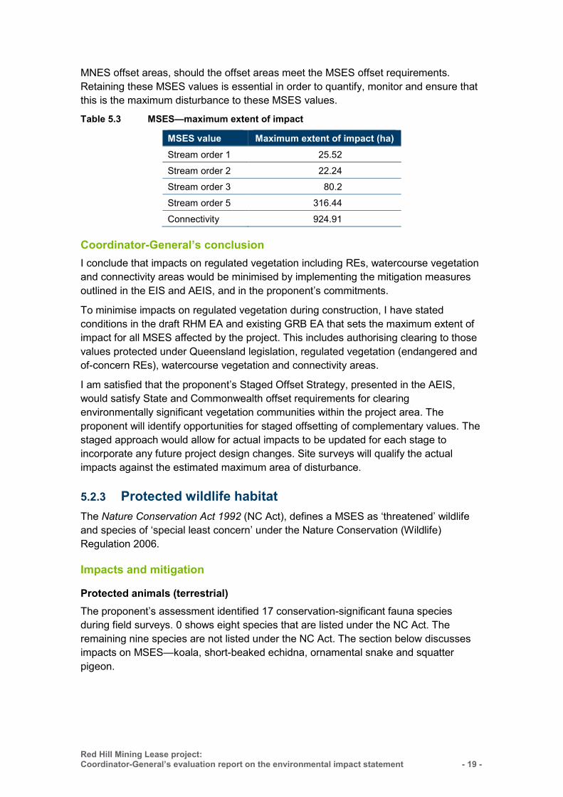
Table 5.3 MSES—maximum extent of impact ........................................................ 19
Table 5.4 Listing status of significant fauna species ............................................... 20
Table 5.5 Declared pests ....................................................................................... 23
Table 8.1 Threatened flora and fauna species and the likelihood in the EIS study area .............................................................................................. 55
Table 8.2 Summary of flora and fauna field surveys ............................................... 57
Table 8.3 Impact areas and land availability of high potential habitat for species and communities listed under the EPBC Act that are known to occur ....................................................................................... 92
Table 8.4 Stratigraphy of the survey area ............................................................. 102
Table 8.5 Summary of information collected during bore census ......................... 107
Table 8.6 Summary of predicted geomorphic response for the Isaac River: impacts, mitigation options and risks .................................................... 118
Table 8.7 Coal projects north of Moranbah in Isaac River catchment ................... 124
- vi - Red Hill Mining Lease project:
Coordinator-General’s evaluation report on the environmental impact statement :
Synopsis This report evaluates the potential impacts of the Red Hill Mining Lease project. It has been prepared in accordance with the State Development and Public Works Organisation Act 1971 (Qld) (SDPWO Act).
BHP Billiton Mitsubishi Alliance (BMA), the project proponent, proposes to construct the Red Hill Mine (RHM), a new underground coking coal mine that would produce 14 million tonnes per annum (mtpa). The project also includes an expansion of two existing coking coal mines: Broadmeadow underground mine (BRM) and Goonyella Riverside Mine (GRM). The combined production of the RHM and the expansions is 32.5mtpa.
Should the project proceed, the existing Red Hill mining lease application (MLA 70421), covering an area of 8,841ha, would be converted to a mining lease to facilitate the development of the RHM, which would have an estimated mine life of 25 years. An extension of three longwall panels of the existing BRM into the Red Hill mining lease application is also proposed.
The project is located in the Bowen Basin, approximately 20km north of Moranbah and 135km south-west of Mackay, within the Local Government Area (LGA) of Isaac Regional Council (IRC). The environmental impact statement (EIS) study area covers the existing Goonyella Riverside Broadmeadow (GRB) mine complex.
The project is expected to create 2,000 jobs during the construction phase and 1,500 jobs during the operational phase.
In evaluating the project, I have considered all EIS documentation, issues raised in submissions during public consultation, additional information to the EIS provided by the proponent, advice received from state government agencies, state government policy statements on the use of FIFO, the Australian Government Department of the Environment, and the Independent Expert Scientific Committee on Coal Seam Gas and Large Coal Mining Development.
The following provides an overview of the main issues considered in my evaluation and outcomes.
Matters of State environmental significance
Land impacts Land impacts of the project include the potential loss of 546ha of grazing land and the potential contamination of soil from the use and storage of hazardous chemicals. The proponent would manage soil contamination through spill prevention and response procedures and comply with soil disposal procedures for contaminated soil removed off site. Land affected by mining activities would be rehabilitated post mining to achieve a stable landform capable of supporting cattle grazing and protecting water quality.
I am satisfied with the proponent’s commitments to manage and mitigate impacts on land. I have stated conditions in the draft RHM environmental authority (EA) requiring
Red Hill Mining Lease project: Coordinator-General’s evaluation report on the environmental impact statement
- vii -
the proponent to minimise potential soil contamination and rehabilitate the land in accordance with my detailed requirements in this report.
Ecology The project would require the potential clearing of five of-concern regional ecosystems totalling 826.14ha, approximately 444.4ha of vegetation along watercourses and approximately 924.9ha of areas of connectivity.
To reduce impacts on matters of State environmental significance, I have set conditions in the draft RHM EA and amended the existing GRB EA that specify maximum disturbance limits for the amount of vegetation to be cleared, and a condition for the proponent to provide offsets for significant residual impacts.
Traffic and transport The main traffic and transport impacts relate to increased pavement maintenance of local roads due to a proposed increase in traffic movements. To mitigate potential impacts, the proponent will be required to realign sections of Red Hill Road and make financial contributions to pavement upgrades for the Peak Downs Highway and three local intersections.
I am satisfied with the proponent’s commitments to fund intersection and pavement upgrades for state-controlled and local roads. I have set conditions that require the proponent to maintain the on-going safety, condition and efficiency of state-controlled and local roads and to develop management plans for road use, traffic and heavy vehicle haulage.
I have also set a condition for the proponent to continue negotiations with the Department of Natural Resources and Mines (DNRM) and IRC to agree on an appropriate realignment of the Moranbah-Glendon stock route that crosses through the mining lease area.
Noise, vibration and air emissions The main noise impacts will be from the construction of the Red Hill CHPP, the MIA and IMG drainage wells and pipelines. To reduce the potential impacts of noise, vibration and dust, the project must adhere to strict regulatory standards for noise, vibration and air quality at sensitive receptors. Sensitive receptors include two cattle grazing properties.
All potential noise, vibration and dust impacts must be managed in accordance with the draft EA, and my conditions that set limits on these impacts.
Economic and social impacts
A social impact assessment conducted for the project addressed community and stakeholder engagement, workforce management, housing and accommodation, local business and industry content and health, safety and community infrastructure. Action plans and strategies have been developed to address potential social and economic impacts.

- viii - Red Hill Mining Lease project:
Coordinator-General’s evaluation report on the environmental impact statement :
The project would boost local, regional and state economies with a projected 73 per cent of the project’s capital expenditure spent in Queensland and a further 7 per cent spent nationally. Part of the project involves expanding two existing mines that have a 90 per cent residential workforce.
Concern about 100 per cent FIFO operations over the past few years, particularly in Central Queensland, has prompted clear policy statements from the state government, for example the government’s objective not to allow the use of 100 per cent FIFO workforces for the operation of mines located near a regional centre or existing mining community. This has led to the Queensland Parliamentary Inquiry into Fly-in, Fly-out (FIFO) and other long distance commuting work practices in regional Queensland. The Queensland Government has also initiated a FIFO Review.
Although the outcomes of the Inquiry and Review are not available now, I am satisfied that I have sufficient information and commitments from the proponent at this stage to finalise my evaluation report on the project.
While I acknowledge that the proponent employs a large number of residential workers across its mining operations and that the existing Goonyella/Riverside mine operates a 90 per cent residential operational workforce (as advised by the proponent), every reasonable opportunity must be provided for local workers to be employed on the project, without having to enter into a FIFO arrangement.
I will not accept any proposal for a 100 per cent FIFO operational workforce due to its potential impacts on local communities and local workers.
I have worked with the proponent to develop a set of workforce management principles, that it has agreed to apply, to minimise the reliance on a FIFO workforce and maximise local opportunities. These principles will form the guiding framework for this project. They will be reviewed following the completion of the state government’s inquiries and definition of the government’s resultant policy position on FIFO.
These principles are:
(1) anyone must be able to apply for a job, regardless of where they live (2) provided they can meet the requirements of the job, people must have choice
where they live and be able to apply for jobs in the mine (3) the percentage of FIFO must be less than 100 per cent (4) a thorough audit of existing housing capacity must be undertaken before the
project starts. To support those who wish to live locally, BMA will ensure the availability of accommodation that is fit for purpose and will make optimal use of existing housing capacity
(5) the proponent must thoroughly assess its workforce requirements and plan to accommodate the likely numbers of workers who may live locally
(6) social impacts associated with the local workforce, in relation to local housing, services and infrastructure, must be identified and mitigated in consultation with relevant local and state government service providers
(7) the proponent’s social impact mitigation measures should support regional towns in pursuing opportunities to ensure communities are strong and sustainable and they are attractive places to live and work.
Red Hill Mining Lease project: Coordinator-General’s evaluation report on the environmental impact statement
- ix -
I have also set a range of imposed conditions that include an Operational Workforce Management Plan, a Social Impact Assessment Review undertaken 12 months prior to construction and bi-monthly and annual reporting on the FIFO/drive-in, drive-out workforce (DIDO).
Matters of national environmental significance
Threatened ecological communities and species The project will impact two threatened ecological communities (TECs): 368.8ha of brigalow and 117.5ha of the Natural Grasslands of the Queensland Central Highlands and the Northern Fitzroy Basin. Habitat for three threatened fauna species that occur or are likely to occur in the project area will be impacted: ornamental snake (1,189.3ha), squatter pigeon (252ha) and the koala (1,516.4ha). One threatened flora species will be impacted: bluegrass (117.5ha). This species is located over the RHM footprint. No threatened aquatic species were found on site.
I have recommended a condition for the Commonwealth Minister for the Environment that requires the proponent to prepare and submit a Biodiversity Offset Plan for impacted TECs and threatened species.
Water resource impacts
Groundwater impacts
The 27 private registered bores located within a 5km radius of RHM use groundwater primarily for stock watering purposes. The proponent’s groundwater modelling indicates that only one registered bore would be potentially impacted.
Groundwater quality is not expected to be affected as a result of the project and groundwater levels are expected to recover after closure. Post mining, water quality within all aquifers surrounding the project area is expected to remain similar to pre-mining water quality.
It is proposed that all RHM water and waste storage infrastructure be designed, constructed, and managed to minimise the risk of seepage to ensure that groundwater quality within aquifers surrounding the site does not change during mining operations.
To ensure that risks to groundwater users are monitored and effectively managed, I have set conditions for the draft RHM EA requiring the proponent to develop and implement a robust groundwater monitoring, iterative modelling and management program during the life of the project. This includes the implementation of a comprehensive bore monitoring network to enable the long-term monitoring of groundwater levels and groundwater quality, and inform corrective actions if needed.
I have also set conditions requiring the proponent to enter into make-good agreements with any potentially affected groundwater users. Make-good agreements could include providing an alternative water supply should groundwater supplies be impacted by the project.
- x - Red Hill Mining Lease project:
Coordinator-General’s evaluation report on the environmental impact statement :
Surface water
Water quality
The project’s proposed water supply will be linked to the existing adjacent GRB mine complex water management system. Water from mine dewatering will be transferred to the GRB mine complex and re-used in coal handling and preparation activities as well as dust suppression.
The water balance model indicates that there is adequate storage within the GRB mine water management network to contain all waters from the RHM mine. The proponent’s water balance model indicates that mine water from RHM would have a negligible contribution to the GRB mine complex and is capable of complying with the existing GRB EA conditions for releases from the GS4A dam into the Isaac River.
Subsidence impacts on surface water
Potential subsidence impacts over the BRM extension and RHM footprint could impact on river geomorphology causing bed and bank instability, river bed deepening and subsequent widening through bank erosion. The proponent is committed to applying engineering solutions, such as timber pile fields and vegetation, to minimise impacts.
Fracturing may occur at surface level due to subsidence but is not predicted to extend downwards to connect to the altered aquifer below. Surface subsidence is expected to self-seal as a result of sediment-laden surface runoff and subsidence management.
Subsidence may impact on the availability of catchment water resources in the Isaac River downstream of the project area. The proponent is committed to mitigating potential ponding as a result of subsidence impacts by draining voids to maintain overall flows from the 12 Mile Gully catchment. I have also imposed a condition that subsided longwall panels must not result in the capture of significant overland flow (i.e. greater than 50ML).
Further work is required during the next project stage to quantify the potential impacts of subsidence on water resources and develop effective mitigation measures. Accordingly, I have stated a condition in the draft EA for the project requiring the proponent to develop and implement a Subsidence Management plan prior to the commencement of activities that could result in subsidence. In addition, I have set a condition requiring an annual inspection of subsided longwall panels to assess structural, geotechnical and hydraulic adequacy.
Coordinator-General’s conclusion
I consider that the environmental impact assessment requirements of the SDPWO Act have been met for the Red Hill Mining Lease project and that sufficient information has been provided to enable a thorough evaluation of the potential impacts of the project.
I conclude that there are significant local, regional and state benefits to be derived from the project, and that any adverse environmental impacts can be adequately avoided, minimised, mitigated or offset by implementing the measures and commitments outlined in the EIS documentation. Conditions in this report have been formulated to further manage the project’s predicted impacts.
Accordingly, I approve the project subject to the conditions and recommendations set out in the appendices of this report and the proponent obtaining all subsequent statutory approvals. In addition, I require the proponent's commitments to be fully implemented.
This report will be provided to the Commonwealth Minister for the Environment, in accordance with section 36(2) of the SDPWO Regulation and the bilateral agreement between the State of Queensland and the Commonwealth, to support a decision on the controlled action for this project in accordance with section 133 of the EPBC Act.
A copy of this report will be provided to relevant advisory agencies and will be publicly available at www.statedevelopment.qld.gov.au/redhill
&ellj.~~··· · ··· · ········· · · Barry Broe Coordinator-General
't June 2015
Red Hill Mining Lease project: Coordinator-General's evaluation report on the environmental impact statement - xi -

Red Hill Mining Lease project: Coordinator-General’s evaluation report on the environmental impact statement
- 1 -
1. Introduction
This report has been prepared in accordance with Part 4, section 34D of the State Development and Public Works Organisation Act 1971 (Qld) (SDPWO Act) and provides an evaluation of the environmental impact statement (EIS) for the Red Hill Mining Lease project (the project). The report:
summarises the key issues associated with the potential impacts of the project on the physical, social and economic environments at the local, regional, state and where relevant, national levels
presents the findings of my evaluation of the project based on information in the EIS, additional information to the EIS (AEIS), responses to information requests, submissions made on the EIS, and information and advice from advisory agencies and the Independent Expert Scientific Committee on Coal Seam Gas and Large Coal Mining Development (IESC)
states and imposes conditions and makes recommendations under which the project may proceed.
2. About the project
2.1 Project proponent The proponent for the project is BHP Billiton Mitsubishi Alliance (BMA), through its joint venture manager, BM Alliance Coal Operations Pty Ltd.
BMA formed in 2001 as a 50:50 unincorporated joint venture between BHP Billiton and Mitsubishi Corporation. The joint venture is known as the Central Queensland Coal Associates (CQCA) Joint Venture. BMA currently operates eight mines in the Bowen Basin (Goonyella Riverside, Broadmeadow, Daunia, Peak Downs, Saraji, Gregory Crinum mine, Blackwater and Caval Ridge), as well as the Hay Point Coal Terminal (HPCT) near Mackay.
2.2 Project description The proposed project is an expansion of the existing Goonyella Riverside and Broadmeadow (GRB) mine complex and is located approximately 20km north of Moranbah and 135km south-west of Mackay. The project is located in the Bowen Basin and is situated within the IRC Local Government Area (LGA). The project location and regional context is shown in Figure 2.1.
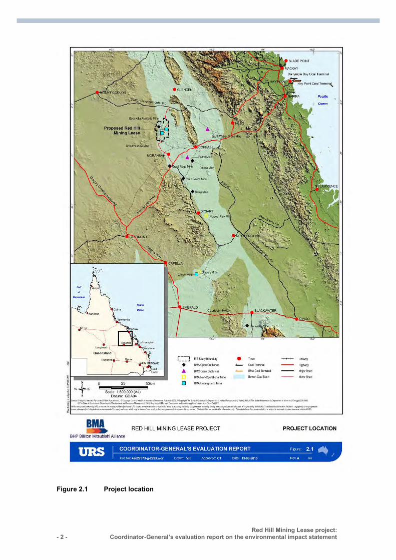
- 2 - Red Hill Mining Lease project:
Coordinator-General’s evaluation report on the environmental impact statement :
Figure 2.1 Project location
Red Hill Mining Lease project: Coordinator-General’s evaluation report on the environmental impact statement
- 3 -
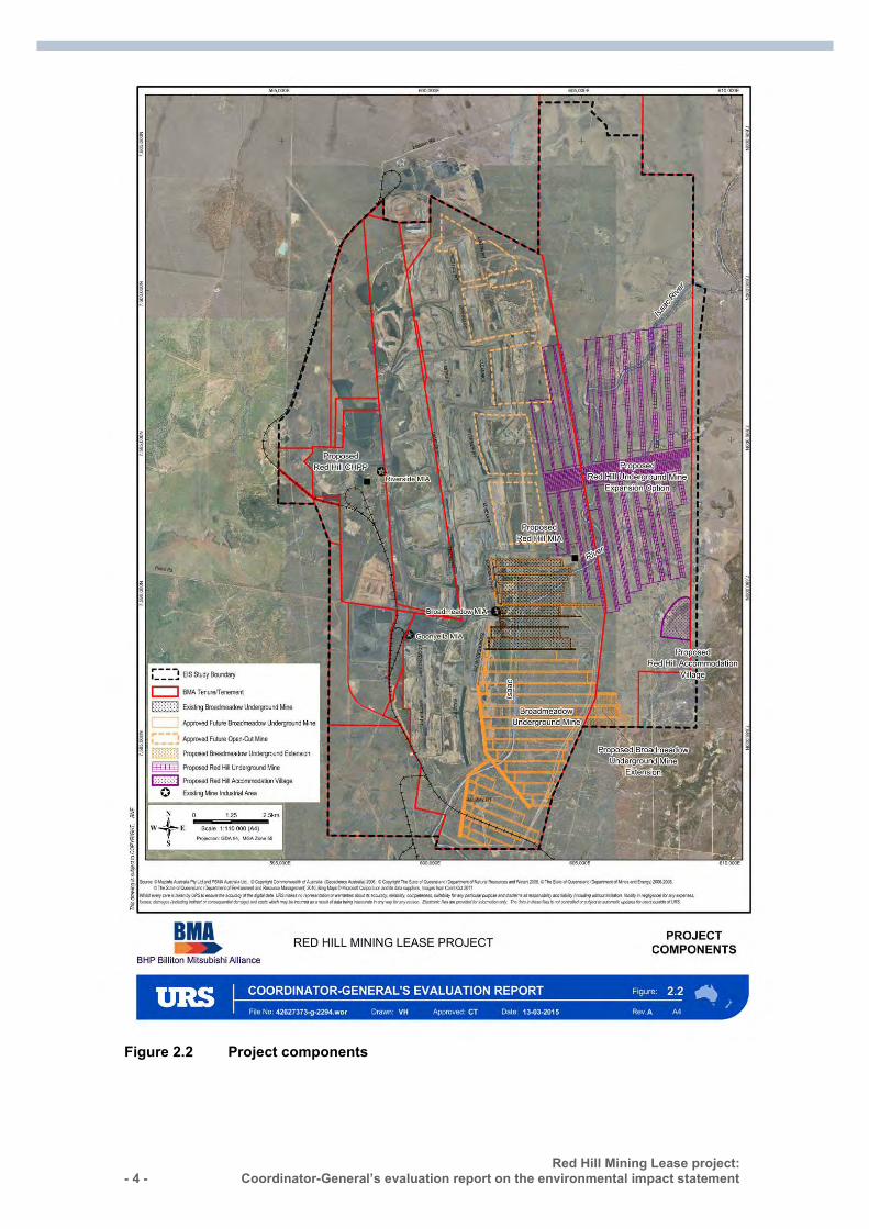
2.2.2 Project components The key components of the project are:
a new underground Red Hill Mine (RHM) located to the east of the existing Goonyella Riverside Mine (GRM)
an expansion of the GRM to provide key infrastructure for the RHM an extension of three longwall panels (14, 15 and 16) of the existing Broadmeadow
underground mine (BRM) into the RHM lease area.
The individual project components, which are shown in Figure 2.2, comprise a total area of 3,967ha.
- 4 - Red Hill Mining Lease project:
Coordinator-General’s evaluation report on the environmental impact statement :
Figure 2.2 Project components
Red Hill Mining Lease project: Coordinator-General’s evaluation report on the environmental impact statement
- 5 -
Red Hill underground mine
Key aspects of the new RHM include:
an underground footprint of 3,600ha a mine layout consisting of a main drive extending west to east with longwall panels
ranging to the north and south potential production capacity of 14mtpa of high quality hard coking coal over a
period of 20–25 years underground mining to target the Goonyella Middle Seam (GMS) a network of bores and associated surface infrastructure for mine gas pre-drainage
(incidental mine gas—IMG) and management of goaf methane drainage to enable the safe extraction of coal
a ventilation system for the underground workings a bridge across the Isaac River to provide a crossing point for mine-related
infrastructure including water pipelines and power supply a new accommodation village (Red Hill accommodation village) with capacity for up
to 3,000 workers.
Goonyella Riverside mine expansion
An expansion of the GRM to include:
a new mine industrial area (MIA) a new coal handling and preparation plant (CHPP) construction of an entry point for mine access a conveyor system linking RHM to the Red Hill CHPP a new 66kV transmission line to provide power from the existing GRB mine
complex. A 132/66kV substation would be required for the CHPP. The substation and transmission line would provide power to RHM and the MIA
associated coal handling infrastructure and stockpiles a new conveyor system linking product coal stockpiles to a new rail load-out facility means for providing flood protection to the mine and MIA, potentially requiring a
levee along the west bank of the Isaac River.
Broadmeadow longwall panel extensions
The extension of three BRM longwall panels to include:
infrastructure required for gas drainage to enable safe and efficient mining management of waste and water produced from drainage of IMG to be integrated
with the existing BRM waste and water management systems
2.2.3 Infrastructure requirements The project will require 50 megawatts of additional power. New power lines are being constructed to provide power supply to both the existing operations and the proposed RHM.
- 6 - Red Hill Mining Lease project:
Coordinator-General’s evaluation report on the environmental impact statement :
Additional infrastructure will be constructed for the project including a 3000-person accommodation village, CHPP and associated conveyor system.
Ancillary infrastructure including telecommunication, storage areas and connections to high voltage electricity distribution networks will be required to support project operations.
2.2.4 Development stages
Construction
Subject to the granting of required approvals, the proponent estimates a two-to-three-year construction period commencing 2020.
The timeframe for delivering GRM project components and commencing construction of the RHM will be determined by the project owners once the mining lease grant has been finalised. Key infrastructure including a CHPP, a new MIA and conveyor systems would be constructed on the existing GRM to support the new RHM.
Operation
Operations for the RHM are anticipated to commence in 2022 for a period of 20–25 years. Coal extraction would be by longwall mining using a thick seam mining technique to maximise resource recovery. Coal would be processed on site in a CHPP then loaded onto trains for shipment to a coal export terminal for export to overseas markets. At full production, the potential capacity of the extended complex (GRB and RHM) would be approximately 32.5mtpa.
Subject to the granting of required approvals, the proponent estimates that operations for the BRM panel extensions could commence in 2016 with mining of the extensions completed by approximately 2019.
Decommissioning
Post mining, disturbed areas would be rehabilitated and returned to a stable landform capable of supporting cattle grazing as per the current land use. Rehabilitation will occur progressively in accordance with the site rehabilitation management plan as disturbed areas become available and will continue after mining has ceased and until completion criteria have been met. Decommissioning will depend on the rate of development and mining.
2.2.5 Dependencies and relationships with other developments
Existing infrastructure within the GRB will be used to support the new RHM and provide synergies in terms of shared water management, water and power supply, mine waste management, coal handling facilities and access to rail infrastructure.
The proponent owns and operates the HPCT which is located approximately 40km south of Mackay. The HPCT is currently being expanded in order to increase handling capability from 44mtpa to 55mtpa.
Red Hill Mining Lease project: Coordinator-General’s evaluation report on the environmental impact statement
- 7 -
2.3 Project rationale The project resource has been identified for future development on the basis that:
high-quality hard coking coal exists within the Goonyella middle seam and would meet current and expected future market demand
due to the proximity of the surrounding BMA mines, the exploration information is of a greater level of detail and accuracy therefore increasing the certainty for any mining program to develop the resource.
The project has the potential to result in substantial economic impacts throughout the region, Queensland and Australia. The major economic benefits of the project would include:
potential peak employment of approximately 3,000 direct and 4,200 indirect jobs in Queensland
significant capital investment and an increase in Queensland’s gross state product increased local expenditure in the Moranbah township due to direct project
expenditure, expenditure by employees and indirect employment growth coal royalty payments to the Queensland Government estimated to be between
$2.07 billion and $7.70 billion (subject to exchange rate and coal price variations over the life of the mine).
3. EIS assessment process
In undertaking this evaluation, I have considered the following:
initial advice statement (IAS) the EIS the AEIS technical reports agency advice from several departments including:
– Department of Environment and Heritage Protection (DEHP) – Department of Natural Resources and Mines (DNRM) – Australian Government Department of the Environment (DE)
properly made submissions from members of the public on the EIS.
The steps taken in the project’s EIS process are documented on the project’s website at www.statedevelopment.qld.gov.au/redhill
3.1 Coordinated project declaration On 17 June 2013, the Coordinator-General declared the project to be a ‘coordinated project’ under section 26(1)(a) of the SDPWO Act. This declaration initiated the statutory environmental impact evaluation procedure described in Part 4 of the Act, requiring the proponent to prepare an EIS for the project.
- 8 - Red Hill Mining Lease project:
Coordinator-General’s evaluation report on the environmental impact statement :
3.2 Commonwealth assessment On 20 June 2013, a delegate for the Commonwealth Minister for the Environment determined that the project is a ‘controlled action’ under the Environment Protection and Biodiversity Conservation Act 1999 (Cwlth) (EPBC Act) (EPBC ref. 2013/6865). The relevant controlling provision under the EPBC Act was ‘listed threatened species and communities’, under sections 18 and 18A.
The delegate also determined that the project should be assessed by way of an EIS under Part 8 of the EPBC Act, through the accredited bilateral agreement with the State. The EIS prepared by the proponent was therefore required to address potential impacts on matters of national environmental significance (MNES) under the EPBC Act.
On 17 October 2013, the Commonwealth Minister for the Environment confirmed that the newly legislated controlled action: water resources—coal seam gas development and large coal mining (sections 24D and 24E of the EPBC Act), also applied to the project.
Section 6 of this evaluation report lists each controlling provision under the EPBC Act and explains the extent to which the Queensland Government EIS process addresses the actual or likely impacts of the project on the matters covered by each provision.
After a copy of this evaluation report is provided to the Australian Government, a decision on the controlled action under section 133 of the EPBC Act is required to be made by the Commonwealth Minister for the Environment. The Minister will use the information in this report to decide whether the project should proceed, and if so, if any additional conditions, beyond those I have recommended in this report on MNES, will be applied to manage the impacts on MNES.
3.3 Terms of reference The draft terms of reference (TOR) for the EIS for the proposed project were released for public and advisory agency comment from 13 July 2013 to 12 August 2013; and comments were received from 22 submitters.
The final TOR were prepared and released on 6 September 2013, having regard to comments received, and issued to the proponent on 9 September 2013.
3.4 Review of the EIS The proponent submitted the EIS for assessment on 29 November 2013. The EIS was released for public and state advisory agency comment from 14 December 2013 to 13 February 2014. Fifty-six submissions were received, copies of which were forwarded to the proponent and DE. The most prominent issues raised in public submissions were:
surface water—potential for subsidence to result in a range of geomorphic impacts on the Isaac River and tributaries as a result of the proposed underground mine
Red Hill Mining Lease project: Coordinator-General’s evaluation report on the environmental impact statement
- 9 -
groundwater—the development, operation and closure of the underground mine may impact groundwater resources
soils—subsidence may cause the formation of cracks in some areas terrestrial flora—remnant vegetation communities may be impacted by the project terrestrial fauna—native animals may be impacted by the project due to habitat loss
and fragmentation from direct vegetation clearing, as well as disturbance from general activity
social aspects—concerns regarding the potential for a predominantly remote workforce.
3.5 Additional information to the EIS On 1 April 2014, I requested that the proponent submit additional information to the EIS (AEIS) to further supplement issues including:
mine water management surface water quality impacts flora and fauna impacts, including appropriate offsets groundwater impacts potential impacts to MNES workforce management, housing and accommodation strategies.
The proponent provided the additional information, which I have considered in my evaluation.
4. Project approvals
Following the release of this evaluation report, the proponent will need to obtain a range of statutory approvals from Australian, state and local government agencies before the project can proceed.
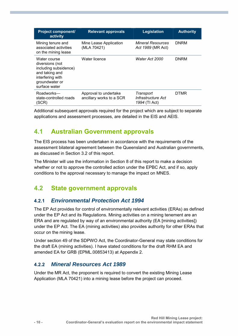
Approvals sought by the proponent for the project, for which this Coordinator-General’s evaluation report includes recommended or stated conditions, are listed in Table 4.1.
Table 4.1 Approvals sought from this Coordinator-General’s report
Project component/ activity
Relevant approvals Legislation Authority
Whole of project Controlled action Environment Protection and Biodiversity Conservation Act 1999 (EPBC Act)
DE (Cwlth)
Mining and associated activities on the mining lease
New EA for RHM and amended EA for GRB (EPML.00853413)
Environmental Protection Act 1994 (EP Act)
DEHP
- 10 - Red Hill Mining Lease project:
Coordinator-General’s evaluation report on the environmental impact statement :
Project component/ activity
Relevant approvals Legislation Authority
Mining tenure and associated activities on the mining lease
Mine Lease Application (MLA 70421)
Mineral Resources Act 1989 (MR Act)
DNRM
Water course diversions (not including subsidence) and taking and interfering with groundwater or surface water
Water licence Water Act 2000 DNRM
Roadworks—state-controlled roads (SCR)
Approval to undertake ancillary works to a SCR
Transport Infrastructure Act 1994 (TI Act)
DTMR
Additional subsequent approvals required for the project which are subject to separate applications and assessment processes, are detailed in the EIS and AEIS.
4.1 Australian Government approvals The EIS process has been undertaken in accordance with the requirements of the assessment bilateral agreement between the Queensland and Australian governments, as discussed in Section 3.2 of this report.
The Minister will use the information in Section 8 of this report to make a decision whether or not to approve the controlled action under the EPBC Act, and if so, apply conditions to the approval necessary to manage the impact on MNES.
4.2 State government approvals
4.2.1 Environmental Protection Act 1994
The EP Act provides for control of environmentally relevant activities (ERAs) as defined under the EP Act and its Regulations. Mining activities on a mining tenement are an ERA and are regulated by way of an environmental authority (EA [mining activities]) under the EP Act. The EA (mining activities) also provides authority for other ERAs that occur on the mining lease.
Under section 49 of the SDPWO Act, the Coordinator-General may state conditions for the draft EA (mining activities). I have stated conditions for the draft RHM EA and amended EA for GRB (EPML.00853413) at Appendix 2.
4.2.2 Mineral Resources Act 1989
Under the MR Act, the proponent is required to convert the existing Mining Lease Application (MLA 70421) into a mining lease before the project can proceed.
Red Hill Mining Lease project: Coordinator-General’s evaluation report on the environmental impact statement
- 11 -
4.2.3 Approvals under other legislation Under section 52 of the SDPWO Act, I have recommended conditions to be included for approvals under the Water Act 2000 and the TI Act in Appendix 3.
4.3 Local government approvals The project is located within the IRC LGA. The development of a mining activity for which an EA applies is exempt from assessment against a local government planning scheme under the SPA. Therefore, there are no applicable local government approvals for the mining lease. Although development permits would be required if any project infrastructure and associated development was located off a mining lease or for operational works in relation to dewatering bores.
Building approvals are also regulated under the SPA and building certification will be required for buildings associated with the proposed project.
5. Evaluation of environmental impacts
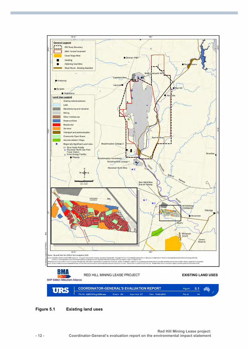
5.1 Land impacts The project area covers approximately 26,000ha. Current land uses in the project area include coal mining, cattle grazing and residential homesteads. Roads, stock routes, railways and utility infrastructure cross the project area.
Eleven mining lease tenements, two mineral development licences and four exploration permits for coal intersect wholly or partially within the project area. The proponent manages these tenements on behalf of the Central Queensland Coal Associates Joint Venture.
The two privately owned grazing properties within the project area include Riverside in the north-east corner and Broadmeadow in the south-west corner. The Broadmeadow property includes a Homestead and Broadmeadow Cottages 1 and 2 as shown in Figure 5.1. The proponent has commenced negotiations with the landholders to purchase the land or compensate owners for project impacts.
- 12 - Red Hill Mining Lease project:
Coordinator-General’s evaluation report on the environmental impact statement :
Figure 5.1 Existing land uses
Red Hill Mining Lease project: Coordinator-General’s evaluation report on the environmental impact statement
- 13 -
5.1.2 Impacts and mitigation
Land suitability
Agricultural land Soil tests and land suitability assessments found that soil in the project area is suitable for cattle grazing but generally unsuitable for rainfed broadacre cropping due to poor water availability. Approximately half of the project area (47 per cent) is considered to be good quality agricultural land.
A total of 546ha of grazing land would be impacted due to construction of the mine and associated infrastructure. Post mining, the proponent has committed to rehabilitate the majority of the impacted grazing land to pasture for grazing.
Strategic cropping areas Strategic cropping land (SCL) trigger maps identified a small area of SCL in the north-east corner of the project area. As the area is outside the proposed mine footprint, it will not be impacted by the project and will not require approval under the Regional Planning Interests Act 2014.
Erosion The underground mine footprint and associated infrastructure would cause a maximum potential annual soil loss of 71.78 tonnes (t) per hectare per year.
To minimise erosion impacts, site and activity-specific erosion and sediment control measures would be developed based on the following principles:
divert clean water flows around disturbed areas and infrastructure minimise soil exposure to erosive forces minimise the release of sediment-laden water from disturbed areas where erosion is
unavoidable.
The proponent has committed to retain erosion and sediment control structures on the site post mining until adequate vegetation cover has been achieved, to assist rehabilitation.
Contaminated soils
Contaminated soil disturbance A desktop review and field inspections found three primary and seven secondary sites with potential soil contamination. The sources of potential contamination at these sites are principally from chemical, fuel and oil storage, waste disposal and stock dips.
The proponent has committed to inspect areas for potential contamination and conduct further investigations prior to disturbance. If soil contamination is identified, remediation and management plans would be developed and implemented to prevent inadvertent release of contaminants during project construction and operations. Any contaminated soil that is to be removed off site would be managed in accordance with statutory
- 14 - Red Hill Mining Lease project:
Coordinator-General’s evaluation report on the environmental impact statement :
requirements. I have set a condition in the draft EA requiring the proponent to provide a site investigation report for known or likely contaminated sites.
Potential soil contamination activities Chemical, oil and waste handling and storage have the potential to contaminate soil during construction and operation.
The proponent has made commitments to prevent and manage soil contamination from these sources, including:
designing and operating chemical, oil and waste storage areas to minimise soil contamination
incorporating spill prevention and response procedures in the site emergency management plan and in staff training
keeping material safety data sheets in a central register on site registering all spills and applying local remediation to minor spills complying with soil disposal procedures for contaminated soil that is removed off
site. I have set a condition in the draft EA for the proponent to minimise the potential for soil contamination.
Rehabilitation
Land disturbed by mining must be rehabilitated to achieve a stable landform capable of supporting cattle grazing and protecting water quality. Progressive rehabilitation would be consistent and complementary with the rehabilitation strategy adopted for GRM and BRM.
Areas disturbed by IMG drainage and longwall mining subsidence would be progressively rehabilitated.
The proponent has committed to prepare a mine rehabilitation management plan, which would provide a framework for mine closure and outline measures to avoid, reduce and mitigate adverse impacts to the environment and public health and safety.
Prior to surrendering the mining lease and commencing rehabilitation, the proponent must submit a site investigation report to DEHP for approval. The proponent must also comply with the rehabilitation requirements in the draft EA.
5.1.3 Coordinator-General’s conclusions I am satisfied with the proponent’s commitments to manage and mitigate land impacts. I note that the proponent has commenced negotiations with the landholders of Riverside and Broadmeadow to either purchase the land or compensate for project impacts.
I have stated conditions in the draft EA requiring the proponent to minimise potential soil contamination and to rehabilitate the land in accordance with specific requirements.
Red Hill Mining Lease project: Coordinator-General’s evaluation report on the environmental impact statement
- 15 -
5.2 Ecology This section provides an assessment of matters of state environmental significance (MSES) that may be impacted by the project.
The MSES values that will be discussed in this chapter relate to regulated vegetation which includes watercourse vegetation and connectivity areas. MSES also include protected plants and animals. For my evaluation on MSES that are also protected under the EPBC Act, refer to the MNES assessment at Chapter 8 of this report.
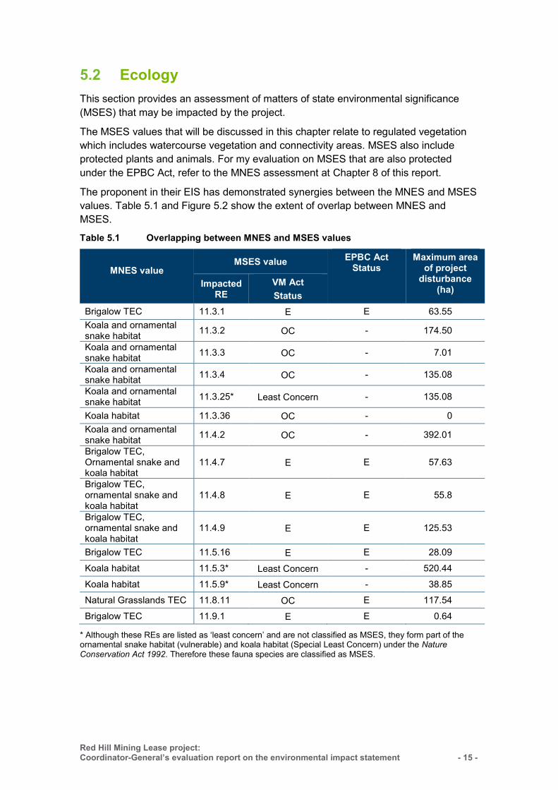
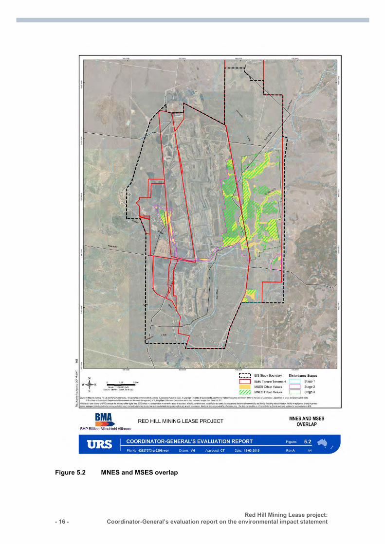
The proponent in their EIS has demonstrated synergies between the MNES and MSES values. Table 5.1 and Figure 5.2 show the extent of overlap between MNES and MSES.
Table 5.1 Overlapping between MNES and MSES values
MNES value
MSES value EPBC Act Status
Maximum area of project
disturbance (ha) Impacted
RE VM Act Status
Brigalow TEC 11.3.1 E E 63.55 Koala and ornamental snake habitat 11.3.2 OC - 174.50
Koala and ornamental snake habitat 11.3.3 OC - 7.01
Koala and ornamental snake habitat 11.3.4 OC - 135.08
Koala and ornamental snake habitat 11.3.25* Least Concern - 135.08
Koala habitat 11.3.36 OC - 0 Koala and ornamental snake habitat 11.4.2 OC - 392.01
Brigalow TEC, Ornamental snake and koala habitat
11.4.7 E E 57.63
Brigalow TEC, ornamental snake and koala habitat
11.4.8 E E 55.8
Brigalow TEC, ornamental snake and koala habitat
11.4.9 E E 125.53
Brigalow TEC 11.5.16 E E 28.09
Koala habitat 11.5.3* Least Concern - 520.44
Koala habitat 11.5.9* Least Concern - 38.85 Natural Grasslands TEC 11.8.11 OC E 117.54
Brigalow TEC 11.9.1 E E 0.64
* Although these REs are listed as ‘least concern’ and are not classified as MSES, they form part of the ornamental snake habitat (vulnerable) and koala habitat (Special Least Concern) under the Nature Conservation Act 1992. Therefore these fauna species are classified as MSES.
- 16 - Red Hill Mining Lease project:
Coordinator-General’s evaluation report on the environmental impact statement :
Figure 5.2 MNES and MSES overlap
Red Hill Mining Lease project: Coordinator-General’s evaluation report on the environmental impact statement
- 17 -
5.2.2 Regulated vegetation The EIS study area shown in Figure 5.2 is located within the Brigalow Belt Bioregion, which contains 36 sub-regions. The study area is within the Northern Bowen Basin sub-region. The study area is dominated by brigalow (Acacia harpophylla) communities on clay soils and narrow-leaved ironbark (Eucalyptus crebra) and poplar box (E. populnea) open woodland communities.
Brigalow communities have been extensively cleared in the study area due to coal extraction and cattle grazing. As a result, the area has been significantly modified, although areas of remnant vegetation remain intact to the north of the EIS study area.
The Environmental Offsets Regulation 2014 states that a MSES is defined as regulated vegetation that is ‘endangered’ and ‘of concern’. Watercourses that contain high ecological values and connectivity areas that contain remnant vegetation are also defined as a MSES.
Impacts and mitigation
Regional ecosystems Impacts for the RHM footprint are based on a worst case scenario which shows a maximum disturbance of 100 per cent vegetation clearance due to the construction of IMG drainage and mine infrastructure.
Approximately 1,669ha of remnant vegetation communities would be impacted by clearing for surface infrastructure and subsidence caused by the proposed underground mining.
Field surveys identified 19 regional ecosystems (REs) within the study area. Six are listed as ‘endangered’, six as ‘of concern’ and seven of ‘least concern’ (Table 5.1). These REs predominately occur around the Isaac River and its tributaries.
To mitigate the impacts, the proponent has committed to clearly marking areas to be cleared so as to avoid inadvertent clearing. As part of this commitment, the proponent would avoid placing IMG extraction wells and infrastructure within endangered REs 11.4.7, 11.4.8 and 11.4.9. These REs overlap with MNES as described in Table 5.1. Impacts to these REs are also addressed in Section 8.
MSES values that are identified as having a significant residual impact are outlined in Table 5.2. Of the six identified ‘of concern’ REs, five were identified as having a significant residual impact (Table 5.2).
One of the largest areas of remnant vegetation to be cleared is ‘of concern’ RE 11.4.2 (Eucalyptus spp. and/or Corymbia spp. Woodland) where approximately 392ha would be cleared or fragmented. Accordingly, these impacts listed in Table 5.2 are required to be offset.
- 18 - Red Hill Mining Lease project:
Coordinator-General’s evaluation report on the environmental impact statement :
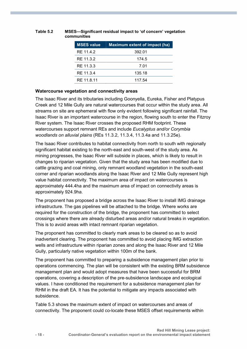
Table 5.2 MSES—Significant residual impact to ‘of concern’ vegetation communities
MSES value Maximum extent of impact (ha) RE 11.4.2 392.01
RE 11.3.2 174.5 RE 11.3.3 7.01
RE 11.3.4 135.18
RE 11.8.11 117.54
Watercourse vegetation and connectivity areas The Isaac River and its tributaries including Goonyella, Eureka, Fisher and Platypus Creek and 12 Mile Gully are natural watercourses that occur within the study area. All streams on site are ephemeral with flow only evident following significant rainfall. The Isaac River is an important watercourse in the region, flowing south to enter the Fitzroy River system. The Isaac River crosses the proposed RHM footprint. These watercourses support remnant REs and include Eucalyptus and/or Corymbia woodlands on alluvial plains (REs 11.3.2, 11.3.4, 11.3.4a and 11.3.25e).
The Isaac River contributes to habitat connectivity from north to south with regionally significant habitat existing to the north-east and south-west of the study area. As mining progresses, the Isaac River will subside in places, which is likely to result in changes to riparian vegetation. Given that the study area has been modified due to cattle grazing and coal mining, only remnant woodland vegetation in the south-east corner and riparian woodlands along the Isaac River and 12 Mile Gully represent high value habitat connectivity. The maximum area of impact on watercourses is approximately 444.4ha and the maximum area of impact on connectivity areas is approximately 924.9ha.
The proponent has proposed a bridge across the Isaac River to install IMG drainage infrastructure. The gas pipelines will be attached to the bridge. Where works are required for the construction of the bridge, the proponent has committed to select crossings where there are already disturbed areas and/or natural breaks in vegetation. This is to avoid areas with intact remnant riparian vegetation.
The proponent has committed to clearly mark areas to be cleared so as to avoid inadvertent clearing. The proponent has committed to avoid placing IMG extraction wells and infrastructure within riparian zones and along the Isaac River and 12 Mile Gully, particularly native vegetation within 100m of the bank.
The proponent has committed to preparing a subsidence management plan prior to operations commencing. The plan will be consistent with the existing BRM subsidence management plan and would adopt measures that have been successful for BRM operations, covering a description of the pre-subsidence landscape and ecological values. I have conditioned the requirement for a subsidence management plan for RHM in the draft EA. It has the potential to mitigate any impacts associated with subsidence.
Table 5.3 shows the maximum extent of impact on watercourses and areas of connectivity. The proponent could co-locate these MSES offset requirements within
Red Hill Mining Lease project: Coordinator-General’s evaluation report on the environmental impact statement
- 19 -
MNES offset areas, should the offset areas meet the MSES offset requirements. Retaining these MSES values is essential in order to quantify, monitor and ensure that this is the maximum disturbance to these MSES values.
Table 5.3 MSES—maximum extent of impact
MSES value Maximum extent of impact (ha) Stream order 1 25.52
Stream order 2 22.24 Stream order 3 80.2
Stream order 5 316.44
Connectivity 924.91
Coordinator-General’s conclusion
I conclude that impacts on regulated vegetation including REs, watercourse vegetation and connectivity areas would be minimised by implementing the mitigation measures outlined in the EIS and AEIS, and in the proponent’s commitments.
To minimise impacts on regulated vegetation during construction, I have stated conditions in the draft RHM EA and existing GRB EA that sets the maximum extent of impact for all MSES affected by the project. This includes authorising clearing to those values protected under Queensland legislation, regulated vegetation (endangered and of-concern REs), watercourse vegetation and connectivity areas.
I am satisfied that the proponent’s Staged Offset Strategy, presented in the AEIS, would satisfy State and Commonwealth offset requirements for clearing environmentally significant vegetation communities within the project area. The proponent will identify opportunities for staged offsetting of complementary values. The staged approach would allow for actual impacts to be updated for each stage to incorporate any future project design changes. Site surveys will qualify the actual impacts against the estimated maximum area of disturbance.
5.2.3 Protected wildlife habitat The Nature Conservation Act 1992 (NC Act), defines a MSES as ‘threatened’ wildlife and species of ‘special least concern’ under the Nature Conservation (Wildlife) Regulation 2006.
Impacts and mitigation
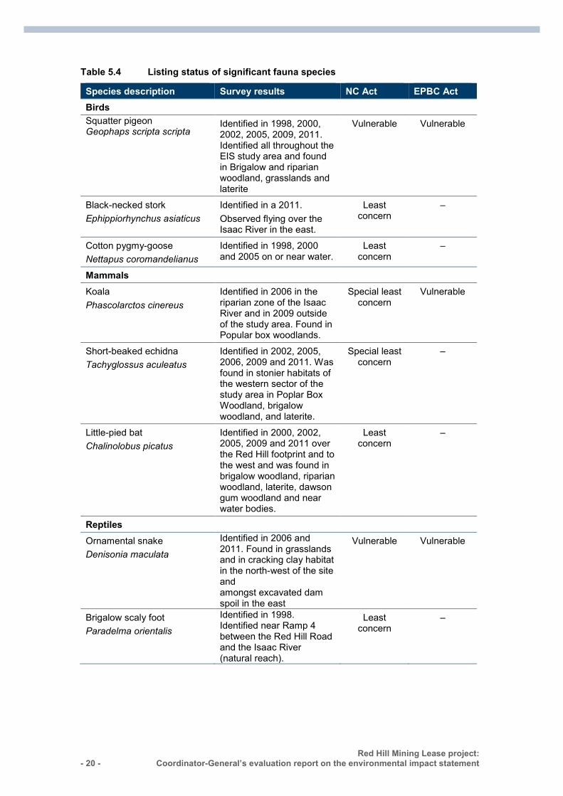
Protected animals (terrestrial) The proponent’s assessment identified 17 conservation-significant fauna species during field surveys. 0 shows eight species that are listed under the NC Act. The remaining nine species are not listed under the NC Act. The section below discusses impacts on MSES—koala, short-beaked echidna, ornamental snake and squatter pigeon.
- 20 - Red Hill Mining Lease project:
Coordinator-General’s evaluation report on the environmental impact statement :
Table 5.4 Listing status of significant fauna species
Species description Survey results NC Act EPBC Act Birds Squatter pigeon Geophaps scripta scripta
Identified in 1998, 2000, 2002, 2005, 2009, 2011. Identified all throughout the EIS study area and found in Brigalow and riparian woodland, grasslands and laterite
Vulnerable Vulnerable
Black-necked stork Ephippiorhynchus asiaticus
Identified in a 2011. Observed flying over the Isaac River in the east.
Least concern
–
Cotton pygmy-goose Nettapus coromandelianus
Identified in 1998, 2000 and 2005 on or near water.
Least concern
–
Mammals
Koala Phascolarctos cinereus
Identified in 2006 in the riparian zone of the Isaac River and in 2009 outside of the study area. Found in Popular box woodlands.
Special least concern
Vulnerable
Short-beaked echidna Tachyglossus aculeatus
Identified in 2002, 2005, 2006, 2009 and 2011. Was found in stonier habitats of the western sector of the study area in Poplar Box Woodland, brigalow woodland, and laterite.
Special least concern
–
Little-pied bat Chalinolobus picatus
Identified in 2000, 2002, 2005, 2009 and 2011 over the Red Hill footprint and to the west and was found in brigalow woodland, riparian woodland, laterite, dawson gum woodland and near water bodies.
Least concern
–
Reptiles
Ornamental snake Denisonia maculata
Identified in 2006 and 2011. Found in grasslands and in cracking clay habitat in the north-west of the site and amongst excavated dam spoil in the east
Vulnerable Vulnerable
Brigalow scaly foot Paradelma orientalis
Identified in 1998. Identified near Ramp 4 between the Red Hill Road and the Isaac River (natural reach).
Least concern
–
Red Hill Mining Lease project: Coordinator-General’s evaluation report on the environmental impact statement
- 21 -
The ornamental snake and squatter pigeon are both classified as ‘vulnerable’ under the NC Act, therefore their habitat is classified as a MSES. The koala and short-beaked echidna are classified as ‘special least concern’ (SLC) therefore their habitat is classified as a MSES under the Environmental Offsets Regulation 2014.
The ornamental snake was found in the north-west of the EIS study area and amongst excavated dam spoil in the east. Approximately 1189.3ha of habitat may potentially be impacted. The squatter pigeon was also found in remnant and non-remnant habitat types. Approximately 252ha of habitat may potentially be impacted through the proposed action.
One koala was recorded within poplar box woodland outside of the study area. The project may impact on approximately 1516.4ha of habitat critical to the survival of the koala. There are potential impacts to koalas during vegetation clearing for construction and during operation of the project. Habitat in which both the ornamental snake and koala were recorded could potentially be altered by subsidence.
The short-beaked echidna was found within poplar box woodland, brigalow woodland and laterite. This species prefers a broad range of habitat types and was commonly found in the EIS study area therefore it could be co-located within areas of connectivity. The proponent has committed to minimise the number of IMG wells constructed in riparian and woodland areas. The proponent has also committed to using spotter-catchers prior to clearing, which would reduce potential impacts to koalas. If koalas are identified during additional pre-clearance surveys, a threatened species management plan would be prepared to address short and long-term impacts.
If significant habitat is found within the disturbance footprint, a threatened species management plan will be developed. This plan would outline the level of activity that the habitat can sustain, the remediation procedures if tension cracking or vegetation loss occurs and further monitoring requirements.
Measures such as avoidance and clearly marking areas to be cleared to avoid inadvertent clearing would address loss and degradation of fauna habitat. The proponent would be required to offset significant residual impacts to MSES including co-locating habitat for the short-beaked echidna within areas of connectivity.
Protected animals (aquatic) The survey area is situated in the upper reaches of the Isaac River catchment. There were 12 sites surveyed across the Isaac River, Eureka, Fisher, Goonyella, Platypus and Ceil Creek. No aquatic fauna (fish, stygofauna, macroinvertebrates and other vertebrates) of special conservation significance (under the NC Act or EPBC Act) were recorded during current or previous surveys.
The Fitzroy River turtle is listed as ‘vulnerable’ both under the NC Act and the EPBC Act. While not observed during the most recent or past surveys, the species may occur in the wider area and is described as occurring in the Isaac River.
Impacts on the aquatic environment may occur during the construction and operational phases of the project and include impacts on aquatic organisms from degraded water quality, subsidence, bridge construction, spills or leaks from chemicals, earthworks and vegetation clearing.
- 22 - Red Hill Mining Lease project:
Coordinator-General’s evaluation report on the environmental impact statement :
The proponent proposes to develop erosion and sediment control plans prior to surface disturbance. Measures in the plan would include minimising vegetation clearing, managing disturbance arising from bridge construction, using sediment fences, revegetating riparian zones and constructing stormwater diversion and containment structures prior to any substantial earthworks. The proponent has also committed to develop and implement an aquatic ecosystem monitoring program, which would include various control sites, biannual monitoring and statistical analysis of results.
Protected plants Field surveys identified two conservation-significant flora species within the study area: Cerbera dumicola (no common name), listed as ‘near-threatened’ under the NC Act and bluegrass (Dichanthium setosum), listed as ‘vulnerable’ under the EPBC Act.
Whilst Cerbera dumicola was found within non-remnant modified open grassland within the proposed Red Hill accommodation village footprint, this species does not qualify as a MSES, as the Queensland Environmental Offset Act 2014 no longer requires offsets for ‘near-threatened’ species. Notwithstanding, the proponent has committed to preparing a species management plan to address short and long-term impacts on the species should it be found during pre-clearance surveys. If protected plants are found during pre-clearance surveys, the proponent would require a permit under the NC Act and offsets under the Environmental Offsets Act 2014.
Bluegrass (Dichanthium setosum) was recorded in the east of the study area where it was observed within RE 11.8.11. This RE forms part of the EPBC Act listed Natural Grasslands of the Queensland Central Highlands and the Northern Fitzroy Basin threatened ecological community (TEC). The maximum impact to bluegrass is 117.54ha. Accordingly, this RE has been addressed in Section 8.
Coordinator-General’s conclusion
I am satisfied that the proponent’s mitigation measures such as the sediment control plans and aquatic ecosystem monitoring program described in the commitments register would appropriately deal with impacts to the Isaac River and its associated tributaries. The proponent has committed to conduct regular inspections of subsided areas for erosion and undertake actions to stabilise eroded surfaces.
I am satisfied that the proponent’s commitments would address impacts to state-listed fauna species. I have stated conditions in the draft RHM EA and existing GRB EA which states the maximum extent of impact to MSES. The proponent has proposed a staged offset strategy which will reconcile impacts and offset requirements as each project stage progresses. The proponent may need to revise its offset requirements during this process if any additional fauna surveys detect additional listed species.
5.2.4 Weed and pest animals The survey area supports populations of weed and pest animal species. The Land Protection (Pest and Stock Route Management) Act 2002 regulates the management of pest plants and pest animals in Queensland that are declared Class 1, 2 or 3 pests. Under the Land Protection (Pest and Stock Route Management) Regulation 2003, the cane toad and house mouse are not required to be managed, as shown in Table 5.5.
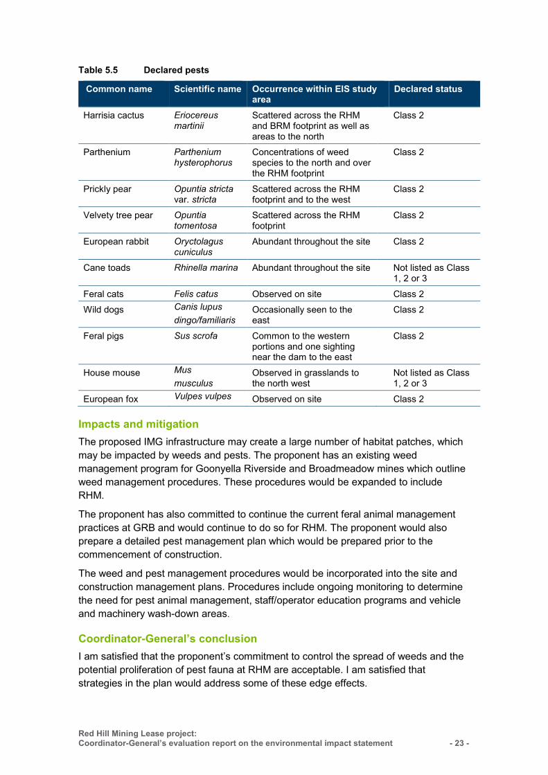
Red Hill Mining Lease project: Coordinator-General’s evaluation report on the environmental impact statement
- 23 -
Table 5.5 Declared pests
Common name Scientific name Occurrence within EIS study area
Declared status
Harrisia cactus
Eriocereus martinii
Scattered across the RHM and BRM footprint as well as areas to the north
Class 2
Parthenium Parthenium hysterophorus
Concentrations of weed species to the north and over the RHM footprint
Class 2
Prickly pear Opuntia stricta var. stricta
Scattered across the RHM footprint and to the west
Class 2
Velvety tree pear Opuntia tomentosa
Scattered across the RHM footprint
Class 2
European rabbit Oryctolagus cuniculus
Abundant throughout the site Class 2
Cane toads Rhinella marina Abundant throughout the site Not listed as Class 1, 2 or 3
Feral cats Felis catus Observed on site Class 2 Wild dogs Canis lupus
dingo/familiaris Occasionally seen to the east
Class 2
Feral pigs Sus scrofa Common to the western portions and one sighting near the dam to the east
Class 2
House mouse Mus musculus
Observed in grasslands to the north west
Not listed as Class 1, 2 or 3
European fox Vulpes vulpes Observed on site Class 2
Impacts and mitigation
The proposed IMG infrastructure may create a large number of habitat patches, which may be impacted by weeds and pests. The proponent has an existing weed management program for Goonyella Riverside and Broadmeadow mines which outline weed management procedures. These procedures would be expanded to include RHM.
The proponent has also committed to continue the current feral animal management practices at GRB and would continue to do so for RHM. The proponent would also prepare a detailed pest management plan which would be prepared prior to the commencement of construction.
The weed and pest management procedures would be incorporated into the site and construction management plans. Procedures include ongoing monitoring to determine the need for pest animal management, staff/operator education programs and vehicle and machinery wash-down areas.
Coordinator-General’s conclusion
I am satisfied that the proponent’s commitment to control the spread of weeds and the potential proliferation of pest fauna at RHM are acceptable. I am satisfied that strategies in the plan would address some of these edge effects.
- 24 - Red Hill Mining Lease project:
Coordinator-General’s evaluation report on the environmental impact statement :
5.3 Traffic and transport This section evaluates project impacts on road, rail and transportation routes and describes mitigation measures to ensure traffic and transport routes remain efficient and safe.
5.3.1 Impacts and mitigation
Roads
The Peak Downs Highway is the main state-controlled road providing access to the mine. It is the primary link between Mackay and regional townships and mines in Central Queensland and comprises an undivided, sealed two-lane road.
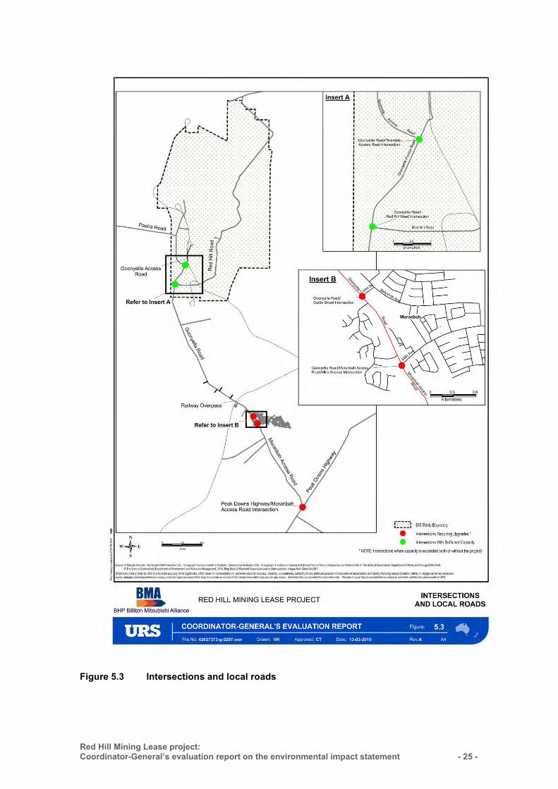
Local roads accessing the mining lease area are undivided, sealed two-lane roads. They include Moranbah Access Road, Goonyella Road and Red Hill Road as shown in Figure 5.3. IRC controls these roads, with the exception of Goonyella Road north of the railway overpass and the section of Red Hill Road in the mining lease area, which are controlled and maintained by the proponent.
The majority of additional traffic generated by the project would use the section of Red Hill Road that is managed by the proponent. This traffic would predominantly be worker movement between the on-site accommodation village and the mine site.
The proponent assessed rural road ‘levels of service’, intersection impacts and pavement impacts for the EIS. The assessments found that the project would not have a significant impact on traffic or transport infrastructure for local or state-controlled roads and that upgrades to the following intersections may be required, regardless of the project:
Goonyella Road–Curtin Street Goonyella Road–Moranbah Access Road–Mills Avenue Peak Downs Highway–Moranbah Access Road.
The proponent has committed to liaise with IRC in relation to the required intersection upgrades and to make contributions that are proportional to the project’s impacts on the respective intersections.
The proponent has also committed to liaise with DTMR regarding contributions for any Peak Downs Highway pavement upgrades.
Red Hill Mining Lease project: Coordinator-General’s evaluation report on the environmental impact statement
- 25 -
Figure 5.3 Intersections and local roads
- 26 - Red Hill Mining Lease project:
Coordinator-General’s evaluation report on the environmental impact statement :
Rail
There are currently two train load-out facilities on the mine site—Goonyella and Riverside. Approximately five trains are loaded each day with approximately 12,700t of coal, which is transported to the Hay Point Coal Terminal for shipping via the Aurizon-operated Goonyella rail system.
Up to four additional trains with a nominal train capacity of 12,000t would be required each day at peak production. A dedicated train load-out facility will be constructed to service coal mined from Red Hill.
The additional train movements are not anticipated to impact existing rail infrastructure.
Stock routes
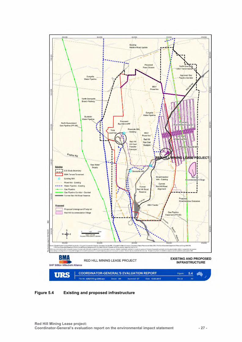
The Moranbah–Glendon stock route (U831), as shown in Figure 5.4, bisects the EIS study area and is currently unused. There are no watering points, bores, windmills or holding yards that belong to the State within the mining lease area.
The section of the Moranbah–Glendon stock route within the mining lease area would need to be realigned to accommodate new mine infrastructure. The proponent would continue consultations with DNRM and IRC to determine an appropriate realignment for the stock route. Realignment of the stock route is subject to a separate approval process under the Land Protection (Pest and Stock Route Management) Act. Ongoing management of the new alignment would be required as mining progresses.
Red Hill Mining Lease project: Coordinator-General’s evaluation report on the environmental impact statement
- 27 -
Figure 5.4 Existing and proposed infrastructure
- 28 - Red Hill Mining Lease project:
Coordinator-General’s evaluation report on the environmental impact statement :
Air transport
The Moranbah Airport is owned and operated by BHP Billiton and services several mines in the region through commercial and charter flights. The airport was recently upgraded to accommodate the projected increased demand for travel to and from Moranbah.
During operations, the project would result in approximately 30 additional round trips per week. The assessment undertaken by the proponent concluded that the airport is able to accommodate the proposed increase in flights. Any future expansions of the airport, if required, would be subject to a separate approvals process.
5.3.2 Coordinator-General’s conclusions I am satisfied that traffic and transport impacts have been adequately assessed in the EIS. I have imposed conditions requiring the proponent to:
maintain the ongoing safety, condition and efficiency of state-controlled and local roads
contribute towards pavement upgrades for the Peak Downs Highway and three local intersections to be impacted by the project
submit an updated road-use management plan for each stage of the project and an updated road impact assessment for the project at least six months before significant construction works commence
develop a heavy vehicle haulage management plan and obtain necessary permits and approvals three months prior to the commencement of significant construction works or project-related traffic
develop traffic management plans for implementation during construction, as required by DTMR.
5.4 Air emissions
5.4.1 Mine dust The EIS and supporting information described the potential impacts of the project on ambient air quality. Potential impacts from dust emissions were assessed against objectives of the Environmental Protection (Air) Policy 2008 (EPP (Air)). The air quality assessment for the project evaluated dust emissions generated from the GRM incremental expansion and the RHM underground expansion. The Broadmeadow extension is underground and is not predicted to generate significant levels of dust. Therefore, a detailed air assessment for the Broadmeadow extension was not included in the EIS.
Sensitive receptors
Sensitive receptors (SRs) are illustrated in Figure 5.5. There are four privately owned residences located within the EIS study.
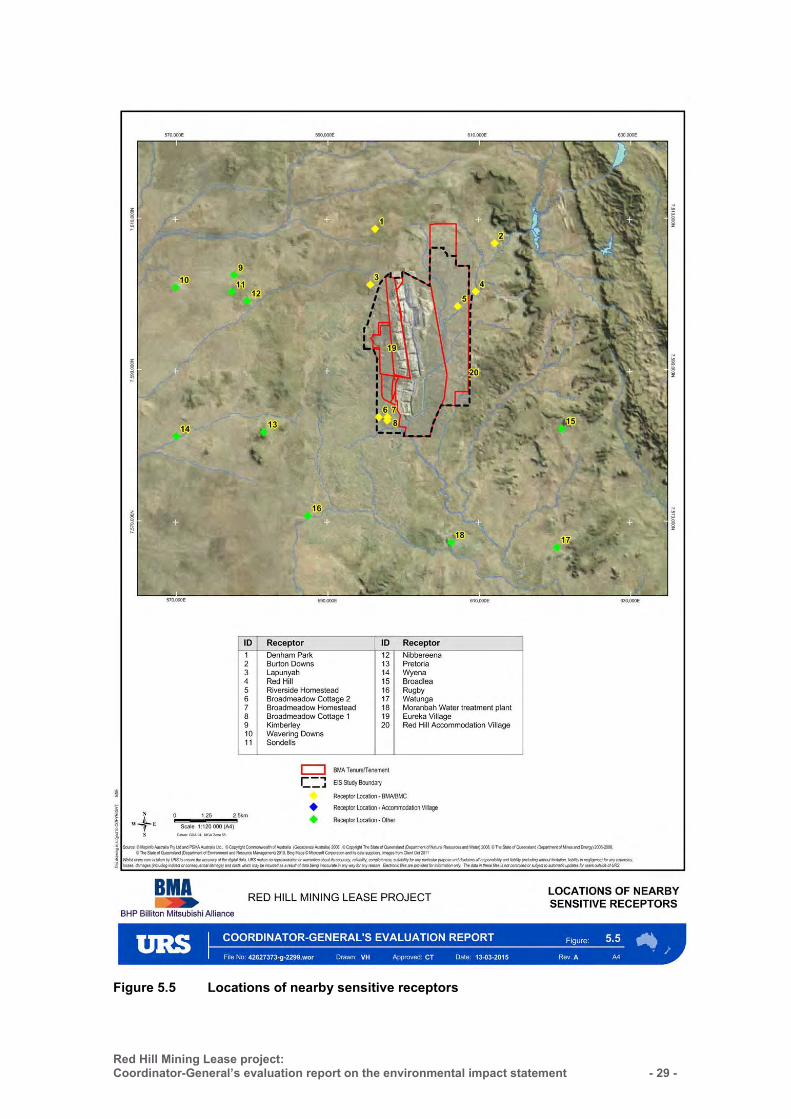
Red Hill Mining Lease project: Coordinator-General’s evaluation report on the environmental impact statement
- 29 -
Figure 5.5 Locations of nearby sensitive receptors
- 30 - Red Hill Mining Lease project:
Coordinator-General’s evaluation report on the environmental impact statement :
5.4.2 Impacts and mitigation To assess the potential for dust impacts, the proponent developed an emissions inventory, which was calculated using the National Pollutant Inventory (NPI) Emission Estimation Technique Manual (EETM) for mining (version 3). The emissions inventory enabled the proponent to estimate concentrations of particulate matter emitted from each of the various project-related activities and then predictively model dust dispersion and deposition. Emission factors were developed for mining activities including:
coal breaking and crushing stockpile loading and unloading dozer operations such as trucks dumping loads conveying of coal to the CHPP underground mining ventilation outlets windblown particulates from transfer points and exposed areas.
Predictive ground-level impacts from dust emissions found that the project would not exceed relevant EPP (Air) objectives at the location of any SR. Further analysis determined breaker stations and coal crushing activities would account for 32 per cent of the total dust predicted from the project.
The proponent is committed to implementing strategies to further minimise dust from dust generating sources by:
partially or fully enclosing conveyors, belt scraper or water sprays/foggers using telescopic stackers with chutes and scraper reclaimers fitting ventilation outlets with a dust collection system using water sprays on coal stockpiles managing the breaking and crushing of coal at
the sizing station to reduce visible dust limiting the use of dozers at the CHPP retrofitting enclosures on conveyors, bins and transfer points and/or water sprays at
key dust sources.
Currently, dust emissions from the GRB mine complex is authorised and monitored in accordance with the air quality requirements of the existing EA. Results from predictive dust modelling indicated that the proposed project makes minimal contribution to overall levels of dust from natural sources and existing GRB approved mining operations.
To monitor dust emissions and reduce dust exacerbated by wind events, the proponent has committed to install a meteorological monitoring station near the project coal stockpiles. The meteorological station will be located to the east of the current open-cut mining operations of the GRB mine complex and will identify potentially adverse meteorological conditions. The meteorological station will be in addition to the existing monitoring stations associated with the GRB mine complex. As the mine infrastructure and majority of above-ground dust generating sources will be co-located on the GRB mine complex, the locations of these dust monitors are considered appropriate for the requirements for all elements of the project.
Red Hill Mining Lease project: Coordinator-General’s evaluation report on the environmental impact statement
- 31 -
I have set air quality limits in the draft EA to ensure dust emissions are managed at the locations of all sensitive receptors. My conditions require that dust and particulate matter emissions generated by the project do not exceed:
dust deposition of 120 milligrams per square metre per day (averaged over one month)
no more than 5 exceedances of PM10 concentrations greater than 50 micrograms per cubic metre (averaged over a 24-hour timeframe).
5.4.3 Coordinator-General’s conclusions I am satisfied that, based on the predictive modelling undertaken, dust emissions resulting from the projects construction and operation will not exceed relevant EPP (Air) objectives at the locations of SRs. The proponent has identified dust-generating activities on the project site and has committed to specific mitigation and management treatments in each instance. In applying such mitigations, the proponent has demonstrated the ability to further manage dust impacts from dust generating sources at the project site.
I have conditioned that the proponent must not exceed the draft RHM EA limits at any stage of the project. In regards to the proponent’s existing operations in the GRB mine complex, there are existing EA limits for air quality that the proponent is required to comply with.
5.4.4 Greenhouse gas emissions Under the National Greenhouse and Energy Reporting Act 2007 (Cwlth) (NGER Act), the proponent is required to provide annual reporting of greenhouse gas (GHG) emissions as it has a predicted annual carbon dioxide equivalent (CO2-e) of 50 kilotonnes and/or energy production or consumption levels of 200 terajoules per year.
The NGER Act includes the following scope definitions for emissions attributable to a project.
Scope 1 emissions (direct emissions) Scope 2 emissions (indirect emissions from the consumption of purchased
electricity) Scope 3 emissions (all indirect emissions).
Scope 1 and 2 emissions must be reported under the NGER Act. Although not mandatory under the NGER Act, the proponent additionally predicted Scope 3 emissions from the project in the EIS.
5.4.5 Impacts and mitigation The main sources of Scope 1 and 2 GHG emissions from the project include the:
consumption of diesel fuel consumption of electricity release of incidental mine gas (IMG) associated with underground mining including
pre-drainage, ventilation air methane and goaf gases
- 32 - Red Hill Mining Lease project:
Coordinator-General’s evaluation report on the environmental impact statement :
flaring of IMG production of electricity (mitigation option) consumption of fuels in transporting the workforce.
The EIS reported that the project will increase GHG emissions by approximately 50.8 per cent above that of the existing GRB mine complex. In total, the project’s base-case GHG emissions is expected to contribute 0.08 per cent of the Australian total Scope 1 and 2 GHG emissions.
To reduce Scope 1 and Scope 2 emissions of the project, the proponent has committed to either use captured IMG for the production of electricity or sell captured IMG to a third party. The EIS estimated that on-site generation of power could reduce Scope 1 and 2 GHG emissions by up to 6.7 per cent whilst the sale of IMG to a third party could reduce Scope 1 and 2 GHG emissions by up to 10.9 per cent.
As a registered controlling corporation, BMA must report on the project’s annual consumption and production of energy as well as emissions of GHG. To comply with the NGER Act and to reduce GHG emissions associated with the project, the proponent has committed to:
implement GHG minimisation measures and site-based programs particularly targeting electrical efficiency, diesel efficiency and IMG emissions
consider energy efficiency in designing buildings and selecting plant and equipment, including high-efficiency electric motors, variable speed pumps, possibly with high-efficiency linings and variable speed conveyors to match belt speeds to loads
participate in corporate energy efficiency and GHG reduction corporate programs and government initiatives, including energy excellence programs and implement mine methane management.
5.4.6 Coordinator-General’s conclusions I am satisfied that the GHG emissions assessments provided in the EIS adequately quantified the project’s Scope 1 and Scope 2 GHG emissions. I note that the proponent is aware of the legislative requirements of the NGER Act to report on CO2-e and has committed to implement measures to reduce GHG emissions over the life of the project.
5.5 Waste
5.5.1 General waste The EIS identified the legislative and regulatory framework relevant to waste impact management, including the Waste Reduction and Recycling Act 2011.
The proponent estimated that the following general waste streams would be generated during construction and operation:
6,890t of regulated wastes, such as waste oils, hydrocarbon-contaminated waste, tyres, greases, batteries, sewage sludge, resins, solvents and paints
4,940t of standard waste, such as food waste and packaging materials
Red Hill Mining Lease project: Coordinator-General’s evaluation report on the environmental impact statement
- 33 -
2,140t of recyclables such as paper, plastic and aluminium 647 megalitres (ML) of sewage effluent 400t of other waste including timber, metal, concrete and bricks a minimal amount of cleared vegetation.
5.5.2 Impacts and mitigation The project would integrate with the waste management program in place at the GRB mine complex. This includes the removal and disposal of solid waste by an authorised waste management contractor to licensed landfill operations. Recyclable waste would be taken to an authorised recycling centre. Regulated waste would be transported to an authorised resources recovery facility for disposal. Sewage would be treated at on-site sewage treatment plants in accordance with EA requirements.
To manage waste, the proponent proposes to develop waste management plans informed by the Waste Reduction and Recycling Act 2011 for the all phases of the project.
Proponent commitments to minimise general waste impacts include:
storing, handling and transporting wastes in accordance with legislative requirements and existing management measures within the GRB mine complex
segregating waste for re-use on site, collection for recycling or disposal by authorised waste contractors
tracking major and regulated waste streams regarding quantities, opportunities for minimisation and reuse and appropriate disposal
developing and maintaining a waste register for construction and operations for recording the types, quantities and management measures for wastes generated.
5.5.3 Coordinator-General’s conclusion I conclude that the waste impacts have been adequately assessed in the EIS. I have stated conditions in the draft RHM EA including the development and implementation of a Waste Management Plan with a program for safe recycling or disposal of all wastes. I have also stated a condition that all regulated waste must be transported by an authorised person under the provisions of the Environmental Protection Act 1994. I have stated conditions to control the re-use and disposal of treated sewage effluent.
I have also stated a condition within the amended GRB EA for scrap tyres to be disposed of appropriately. I am satisfied that the potential impacts of general waste can be adequately managed through the conditions I have stated and through the proponent’s commitments.
5.5.4 Mineral waste The project’s spoil―comprised of overburden and interburden―would only be removed during the construction of the entry point to mine access and main drives. The proponent expects much of the overburden to remain largely intact.
- 34 - Red Hill Mining Lease project:
Coordinator-General’s evaluation report on the environmental impact statement :
As a result of coal processing, the project would produce 44 million tonnes of rejects, or non-product coal, over the life of the project. This consists of approximately 32 million tonnes of coarse rejects and 12 million tonnes of dewatered tailings―the fine particles produced after processing and washing coal.
5.5.5 Impacts and mitigation Static geochemical tests were conducted to determine the total acid generating and total acid neutralising potential of mineral waste samples from the project area. Key results from the geochemical tests found that approximately:
86 per cent of samples were non-acid forming (NAF) or acid consuming 6 per cent of samples were potentially acid forming 2 per cent of samples were potentially acid forming—low capacity 6 per cent of samples were uncertain.
The EIS also identified that the mineral waste samples had low sulfide–sulfur concentration and very high pH values, indicating minimal potential generation of acidity under natural oxidation processes.
Drainage water quality should not generate significant salinity. Therefore, runoff and seepage water quality arising from mineral waste materials is predicted to contain low dissolved metal and salt concentrations. Combined with the predominant NAF nature of the mineral waste, mineral waste should not generate acid or mobilise metals and salts. Therefore, mineral waste from the project is not considered to present a substantial risk to downstream water quality.
Strategies and management plans proposed in the EIS to minimise mineral waste impacts include:
burying all rejects materials from the RHM below plant root zones managing tailings and rejects in accordance with the GRB mine complex Tailings
Management and Rehabilitation Management plans containing potentially contaminated water from coal stockpiles to avoid interaction
with clean waters.
Proponent commitments to minimise mineral waste impacts include:
undertaking the characterisation of reject materials (coarse rejects and dewatered tailings) to verify their geochemical nature
potentially using drift construction wastes with suitable geotechnical properties for engineering and construction purposes such as bulk fill, road sub-base, laydown areas, foundations or levees
disposing of mineral waste―both unsuitable spoil and rejects―into the existing GRB mine complex waste facilities and managing these wastes in accordance with the existing GRB mine complex site practices.
Red Hill Mining Lease project: Coordinator-General’s evaluation report on the environmental impact statement
- 35 -
5.5.6 Coordinator-General’s conclusion I conclude that the mineral waste impacts have been adequately assessed in the EIS. I have stated conditions in the draft EA to ensure mineral waste does not cause impacts to the environment. These include the requirement to develop a Water Management Plan with measures to prevent saline and acid rock drainage. My conditions also require the proponent to adhere to rehabilitation requirements to ensure that spoil and reject dumps do not impact upon the environment.
I am satisfied that, based on my conditions and the proponent’s commitments, mineral waste would be effectively managed over the life of the project.
5.6 Noise and vibration In 2009 and 2011, background noise and vibration monitoring was undertaken at locations within and adjacent to the EIS study area. Noise criteria were established in accordance with regulatory frameworks including the EP Act and national and international best practice standards. Noise criteria focused on amenity of residential locations as well as managing sleep disturbance.
Sensitive receptors (SRs) in the EIS study area include four dwellings. Whilst not considered SRs, the proponent’s Red Hill Accommodation Village and Eureka Village, located within the study area, were included in the noise and vibration assessment to manage any potential impacts of sleep disturbance.
5.6.1 Impacts and mitigation
Construction noise
Noise will result from construction of the Red Hill CHPP, a new MIA and IMG drainage wells and pipeline system.
Predicted construction noise levels will depend on the number of plant items and equipment operating at one time. The modelling assumed that all equipment would operate simultaneously, representing a worst-case scenario. The outcome of the modelling is that construction noise levels are predicted to achieve the nominated noise criteria at all SRs.
The proponent has committed to implement a community consultation and dispute resolution process in the event of noise complaints. The proponent has also committed to implement monitoring and control strategies such as selecting quieter plant and increasing maintenance of equipment to check noise attenuation features.
Operational noise
The modelling and assessment of noise was undertaken in accordance with EPP (Noise) and the Planning for Noise Control guidelines. The assessment for the Red Hill Accommodation Village and Eureka Village was based on noise and sleep disturbance criteria.
- 36 - Red Hill Mining Lease project:
Coordinator-General’s evaluation report on the environmental impact statement :
The noise modelling concluded that noise levels are predicted to achieve the nominated noise criteria at all receptors, apart from a 2–4 dBA exceedance of the nominated LAeq criterion at Eureka Village during worst-case weather conditions. The proponent has committed to use ‘self-adjusting volume’ or ‘broad-band buzzer’ reversing alarms to mitigate noise, as well as noise idlers, thicker glazing and upgraded wall construction (at Eureka Village) and/or construct earth bunds and noise barriers. The EIS concluded that acceptable operational noise levels could be achieved at Eureka Village using these various noise control measures.
The proponent has committed to implement a community consultation framework to inform local residents of potential noise impacts, and make available proponent contact details if noise-related disturbance occurs. Where noise complaints are received, mitigation measures would be implemented so nominated noise levels are achieved.
Noise modelling was also undertaken to assess construction and operational noise emissions resulting from the proposed Red Hill Accommodation Village, and to predict general mine noise levels at the Red Hill Accommodation Village.
Noise emissions from the Red Hill Accommodation Village are predicted to be negligible at surrounding receiver locations. Whilst noise levels within the Red Hill Accommodation Village are predicted to generally achieve nominated criterion, a number of plant items have the potential to exceed it. The proponent has committed to use a range of mitigation measures, including selecting quieter mechanical plants, double glazing, increasing distances between plant and accommodation units and installing noise barriers.
Road
The EIS predicted that increases in road traffic noise from Moranbah Access Road, Goonyella Road, Red Hill Road and Riverside Road would comply with the threshold in relation to changes in the noise emission levels; therefore, no additional mitigation measures were required.
Vibration
There are no significant vibration sources associated with the project as blasting is not proposed to be undertaken.
Ambient vibration monitoring has been undertaken at the proposed Red Hill Accommodation Village to monitor air blast overpressure and ground vibrations from existing operations at the GRB mine complex, and was found acceptable.
5.6.2 Coordinator-General’s conclusions I am satisfied that, based on the predictive modelling undertaken in the EIS assessment, any noise and vibration impacts from the project can be managed.
I have set conditions in the project’s draft RHM EA for all noise and vibration sources relevant to sensitive receptors, and my conditions set limits on these matters. I require the proponent to comply with existing GRB EA limits for noise and vibration.
Red Hill Mining Lease project: Coordinator-General’s evaluation report on the environmental impact statement
- 37 -
5.7 Cultural heritage This section evaluates project impacts on Indigenous and non-Indigenous cultural heritage sites and describes mitigation measures to ensure heritage values within the project area are preserved.
5.7.1 Impacts and mitigation
Indigenous cultural heritage
The Aboriginal Cultural Heritage Act 2003 (ACH Act) protects Indigenous cultural heritage (ICH) in Queensland. To comply with the duty of care provisions under section 23 of the ACH Act, proponents of projects requiring an EIS must prepare a Cultural Heritage Management Plan (CHMP) prior to commencing construction. A CHMP is a legally binding agreement between the proponent and native title claimants and details the procedures for identifying and managing potential impacts on ICH.
The EIS identified three native title claimants with cultural heritage interests over parts of the ICH study area. These are the:
Barada Barna people Wiri Core Country people Wiri people 2.
BMA has committed to comply with the ICH duty of care requirements under the ACH Act to ensure that mechanisms are established and implemented to protect known and discovered items of ICH over the life of the project. In accordance with the ACH Act, the proponent has developed, with the Barada Barna people, a CHMP outlining how impacts on their cultural heritage can be minimised or managed. CHMPs are yet to be finalised with the Wiri Core Country people and the Wiri people 2.
Non-Indigenous cultural heritage
The proponent’s assessment of non-Indigenous cultural heritage (NICH) identified a total of 15 sites within the EIS study area comprising nine places of cultural heritage significance and six places of historic interest. Of these sites, seven are located within the proposed disturbance area of the mine. The proponent evaluated each of the heritage items in accordance with section 34 of the Queensland Heritage Act 1992 (QH Act) to determine eligibility to be included on the Queensland heritage register. The assessment concluded that the cultural heritage significance of the NICH sites was low and therefore, did not qualify for inclusion on the Queensland Heritage Register.
Notwithstanding, the proponent is committed to reducing project impacts on known locations of NICH by:
photographing known NICH sites prior to construction to capture the nature of identified items and their context within the existing cultural environment
marking all known heritage sites on a constraints map for the project avoiding NICH sites when establishing IMG management infrastructure, where
possible.
- 38 - Red Hill Mining Lease project:
Coordinator-General’s evaluation report on the environmental impact statement :
Due to the nature and scale of the project, there is a high potential to disturb and/or uncover further NICH values such as artefacts, during surface and subsurface excavation and clearing. To comply with the QH Act, the proponent must prepare a NICH plan for the construction and operational phases that establishes processes for identifying, avoiding and/or minimising impacts on any identified NICH items before disturbance activities commence. The proponent is committed to employing mine environmental officers with relevant experience to identify heritage items and notifying EHP of any NICH discoveries.
5.7.2 Coordinator-General’s conclusion I am satisfied with the proponent’s assessment of ICH and NICH places and objects in the EIS and AEIS and I conclude that any potential impacts can be managed and all relevant duty of care requirements with the ACH Act and the QH Act are fulfilled.
5.8 Hazard and risk The EIS identified numerous legislative and regulatory requirements concerning hazards and risks, and described how the proponent would comply.
The proponent undertook a preliminary hazard and risk assessment for the project in accordance with principles set out in Risk management – Principles and Guidelines (Australian Standard/New Zealand Standard AS/NZS:ISO 31000:2009).
The hazards were assessed to rate the consequence, likelihood and outcome that may result should the potential hazards be realised (considering the proposed preventative and protective controls for each hazard). Categories of predicted risks assessed included environmental, community health and safety, and worker health and safety.
5.8.1 Impacts and mitigation The EIS identified 41 potential hazards for the life of the proposed mine. Most potential hazards were assessed as low or moderate risk with no extreme risks identified. The following were considered possible high risk issues for the project:
traffic incidents mine safety risks underground drift construction gas drainage underground mining decommissioning of underground mine.
The proponent would conduct further risk assessment through a hazard and operability study for the project prior to commencing construction, and again prior to commencing operations. These findings would inform the development of the site safety management plan and procedures, and safety design processes.
The proponent has proposed to develop management plans to reduce predicted hazards and risks, including:
Red Hill Mining Lease project: Coordinator-General’s evaluation report on the environmental impact statement
- 39 -
traffic management plan health and safety management plan and procedures hazard management plan and safe working procedures mine water management plan emergency response plan for referable dams emergency management plan.
The proponent has also committed to minimise hazards and risks by:
developing and implementing a safety and health management system including: – identifying hazards and assessing risks – developing controls to address risks – monitoring the effectiveness of controls
implementing design, operation and management measures to prevent land contamination from fuels and chemicals
conducting compulsory induction training for all workers and contractors, covering all relevant safety, environmental and cultural matters
providing an appropriate level of security to control public access to areas affected by mining activity
preparing an emergency management plan addressing spill, bushfire and flood incidents.
The emergency management plan would be prepared for the construction and operation phases of the new RHM in consultation with relevant emergency service providers.
5.8.2 Coordinator-General’s conclusions I am satisfied that project hazards and risks have been adequately assessed in the EIS. I conclude that by implementing its commitments, the proponent would adequately manage the potential hazards and risks for the life of the project.
6. Economic impacts
The proponent assessed the direct economic impacts of the project, in conjunction with a qualitative review of broader indirect economic impacts. Percentages of estimated capital and operating expenditure have been divided in accordance with the expected location of expenditure within Australia.
6.1 Impacts and mitigation
6.1.1 Employment The proponent estimates a two-to-three-year construction period commencing 2020. Operations for the RHM are anticipated to commence in 2022 for 20–25 years.

- 40 - Red Hill Mining Lease project:
Coordinator-General’s evaluation report on the environmental impact statement :
During the construction phase, the project is estimated to support up to 2,000 direct employees. During the operation phase, the project is estimated to support up to 1,500 direct employees as well as an additional 1,200 indirect jobs in Queensland from the flow-on or multiplier effect on those sectors which support coal mining activities. This includes additional demand generated by the spending of wages by persons employed in the sector, which generates more jobs.
During the period of overlap for the construction and operation phases, there would be a peak workforce of approximately 3,000 direct and 4,200 indirect jobs.
The proponent has made the following commitments to enhance workforce opportunities:
develop and implement a workforce management plan consistent with the Work for Queensland: Resources Skills and Employment Plan (Skills Queensland 2012)
facilitate opportunities for training and employment of local people apply the proponent’s existing Workforce Development Strategy during the
operations phase establish targets for female and Indigenous workforce participation prior to
construction implement training and recruitment strategies to significantly increase the number of
workers who are new entrants to coal mining.
Economic outputs
In addition to direct employment benefits, the project also has the potential to generate substantial economic outputs throughout the region, Queensland and Australia. These include:
significant capital investment and an increase in Queensland’s gross state product during construction
potential for significant ongoing operating investment increased local expenditure in the Moranbah township due to direct project
expenditure, expenditure by project employees and indirect employment growth coal royalty payments to the Queensland Government.
The project would boost local, regional and state economies with a projected 73 per cent of the project’s capital expenditure spent in Queensland and a further 7 per cent spent nationally.
There would not be any direct costs to government associated with the development of the project, which would include rail, port and shipping, road, water, energy and accommodation infrastructure.
The proponent has made the following commitments to enhance local business opportunities:
implement its local buying program for all phases of the project to provide opportunities for small businesses in Moranbah, Dysart, Blackwater, Emerald and Nebo to competitively supply goods and services
Red Hill Mining Lease project: Coordinator-General’s evaluation report on the environmental impact statement
- 41 -
prepare and implement a local industry participation plan consistent with the Queensland Charter for Local Content and the Queensland Resource and Energy Sector Code of Practice for Local Content 2013 (QRC Code)
be a signatory to the QRC Code, administered by the Queensland Resources Council.
6.1.2 Coordinator-General’s conclusions I am satisfied with the proponent’s economic assessment for the project.
To maximise the economic benefits of the project, the proponent is committed to:
maximising local employment opportunities over the life of the project, including opportunities for local Indigenous people and other disadvantaged groups
providing training and development opportunities for people locally and regionally being a signatory to the QRC Code and ensure that Queensland suppliers,
contractors and manufacturers are given full, fair and reasonable opportunity to tender for project-related business activities.
As the workforce requirements of the project will change over time, I have imposed a condition requiring the proponent to provide an annual report for 5 years. The report must describe the actions, outcomes, workforce management principles and adaptable management strategies to enhance local and regional employment, training and development opportunities.
7. Social impacts
A social impact assessment (SIA) was conducted for the project in accordance with the principles of the Coordinator-General’s Social impact assessment guideline and Managing the impacts of major projects in resource communities guideline.
The study area for the SIA included the IRC LGA which includes the key locality of Moranbah. The SIA summarised the impacts of the project and provided mitigation and management measures to address the impacts. Key impacts and opportunities identified in the SIA include:
creating additional, direct and indirect local and regional employment continued provision of educational and training opportunities sustaining and enhancing opportunities for mining-related service industries and
business in Moranbah increased procurement opportunities for local and regional business. impact on changing housing markets associated with fly-in fly-out (FIFO) practices increased demand on local health services health and safety issues associated with increased traffic volumes on local roads
and highways.
The proponent has developed a series of action plans to mitigate and manage impacts.
- 42 - Red Hill Mining Lease project:
Coordinator-General’s evaluation report on the environmental impact statement :
Concern about 100 per cent FIFO operations over the past few years, particularly in Central Queensland, has prompted clear policy statements from the state government, for example the government’s objective not to allow the use of 100 per cent FIFO workforces for the operation of mines located near a regional centre or existing mining community.
On 27 March 2015, the Queensland Government launched a Parliamentary Inquiry into FIFO and other long distance commuting work practices in regional Queensland by the Queensland Infrastructure, Planning and Natural Resources Parliamentary Committee. This inquiry is considering the effects of 100 per cent FIFO workforces on established communities like Moranbah, including health and housing impacts. The committee is scheduled to release its report in September 2015. In May 2015, the Queensland Government initiated a FIFO Review.
Although the outcomes of the inquiry and review will not be available until towards the end of 2015, I am satisfied that I have sufficient information and commitments from the proponent at this stage, to finalise my evaluation report on the project.
I am satisfied that the agreed workforce management principles (as described in section 7.2.1) and conditions relating to the Operational Workforce Management Plan, a Social Impact Assessment Review and regular reporting on the FIFO/drive-in, drive-out workforce will adequately address the social impacts.
7.1 Community and stakeholder engagement
7.1.1 Impacts and mitigation To inform the SIA, the proponent undertook extensive community and stakeholder consultation and engagement. Key stakeholders included landholders, local residents, local and regional communities, Indigenous groups, local, state and Australian Government agencies, business, industry community agencies and service providers. The proponent’s consultation follows the BHP Billiton Charter, Code of Business Conduct and group Level Documents for Community and Major Capital Projects, which sets out the process for consulting with the community and other stakeholders.
Consultation and engagement activities identified a range of issues and concerns requiring mitigation and management strategies including:
changing housing markets impacted by the downturn in the mining industry use of an accommodation village for the workforce and the impact on businesses
and the economy of Moranbah remote workforce arrangements (FIFO) attracting and retaining staff in local businesses that compete for labour with mining
companies offering higher wages impacts and demands on health and emergency services dissatisfaction with the level of social infrastructure and services in Moranbah community health and safety in respect of increased road traffic volumes, frequency
and driver behaviour
Red Hill Mining Lease project: Coordinator-General’s evaluation report on the environmental impact statement
- 43 -
the need for the project to provide education, training and employment opportunities opportunities for the project to provide community investment benefits for the
community.
The proponent has proposed to implement a comprehensive consultation, communication and engagement plan for the construction, operation and de-commissioning of the project, following BHP’s Code of Business conduct. The plan will specify the stakeholders to be consulted, timeframes, roles and responsibilities, issues to be addressed, and feedback, monitoring and reporting mechanisms.
The proponent also proposes to develop communication tools to support the consultation and engagement strategies as well as operate a comprehensive feedback and dispute resolution process to facilitate prompt, confidential and fair investigation into incident or complaint.
The proponent has committed to provide a report 12 months prior to commencing operations, which will review current community and stakeholder processes describing actions to inform the community about project impacts and showing that community concerns about project impacts have been taken into account.
7.1.2 Coordinator-General’s conclusions I conclude that the proponent’s SIA fully assessed the potential impacts of the project and the consultation process undertaken was adequate. I consider the proposed consultation, communication and engagement process is sufficient to identify potential impacts and develop mitigation and management strategies. I require the proponent’s commitments regarding ongoing consultation, communication and engagement for the life of the project to be fully implemented. I require the proponent to:
engage with the community regarding impacts and mitigation and management measures
consult and negotiate with local and state government agencies, business, industry, community agencies, service providers and other stakeholders as required to maximise opportunities, address impacts and implement agreed outcomes and commitments
submit workforce management plans, and monitor and report on workforce composition and operations in accordance with the requirements of this report.
I also require the proponent to review and report on current impacts 12 months prior to commencing construction.
Given the potential for community and stakeholder impacts to change, I have imposed a condition requiring the proponent to report on the actions taken to inform the community about project impacts and how their concerns have been taken into account. The report must be provided annually for a period of five years.
- 44 - Red Hill Mining Lease project:
Coordinator-General’s evaluation report on the environmental impact statement :
7.2 Employment and training
7.2.1 Impacts and mitigation This project will require a construction workforce of 2,000 and an operational workforce of 1,500.
The project would create both direct and indirect employment opportunities through the creation of new jobs and through increased demand for local, regional and state business services. It would also provide training and education opportunities in the mining industry.
The Queensland Government strongly opposes 100 per cent FIFO operations and has committed to end the use of 100 per cent FIFO operations in regional communities and to introduce choice for workers to live in the communities near where they work.
While I acknowledge that the proponent employs a large number of residential workers across its mining operations and that the existing Goonyella/Riverside mine operates a 90 per cent residential operational workforce (as advised by the proponent), every reasonable opportunity must be provided for local workers to be employed on the project, without having to enter into a FIFO arrangement.
I will not accept any proposal for a 100 per cent FIFO operational workforce due to its potential impacts on local communities and local workers. Although this evaluation report is being finalised prior to the government concluding its reviews, I have negotiated a set of workforce principles with the proponent that are considered to be consistent with the government’s policy statements and directions on FIFO, such as the Strong and Sustainable Resource Communities Policy.
I expect the seven workforce management principles to form the guiding framework for this project. They will be reviewed following the completion of the state government’s inquiries and definition of the government’s resultant policy position on FIFO.
I have conditioned the proponent to submit a more detailed Operational Workforce Management Plan to the Coordinator-General by the end of 2015. I will consider this, together with the outcome of the FIFO reviews, in setting the final social conditions for the project.
To minimise reliance on FIFO and maximise local opportunities, the workforce management principles the proponent has agreed to apply are:
anyone must be able to apply for a job, regardless of where they live provided they can meet the requirements of the job, people must have a choice
where they live and be able to apply for jobs in the mine the percentage of FIFO workers employed must be less than 100 per cent a thorough audit of existing housing capacity must be undertaken before the project
starts. To support those who wish to live locally, BMA will ensure the availability of accommodation that is fit for purpose and will make optimal use of existing housing capacity
the proponent must thoroughly assess its workforce requirements and plan to accommodate the likely number of workers who may live locally
Red Hill Mining Lease project: Coordinator-General’s evaluation report on the environmental impact statement
- 45 -
social impacts associated with the local workforce, in relation to local housing, services and infrastructure, must be identified and mitigated in consultation with relevant local and state government service providers
the proponent’s social impact mitigation measures should support regional towns in pursuing opportunities to ensure communities are strong and sustainable and that they are attractive places to live and work.
Measuring the percentage of a FIFO workforce is inherently difficult but absolutely necessary. I require the proponent to measure and report on the project operational workforce’s place-of-residence composition every second month on this project. It is important information and will be evaluated in association with the principles above. The Coordinator-General must be able to effectively monitor and evaluate compliance with conditions.
Given the potential for change in the workforce and market conditions, I require the proponent to report on and review the predicted project impacts 12 months prior to commencing construction. The report will describe actions to avoid or mitigate direct local housing market impacts attributable to the project based on the proposed workforce arrangements as identified by the proponent. The report must also detail actions to enhance local employment, training and community and economic development opportunities.
The proponent proposes to implement an Employment Diversity Strategy, which includes a range of targeted strategies including:
establishing targets for female and Indigenous workforce participation prior to the commencement of construction
committing to undertake training and recruitment strategies to significantly increase the number of workers who are new entrants to coal mining
ensuring the workforce is representative of the gender, ethnicity, abilities and age of the communities
ensuring the workforce has a wide range of experience, capacity, beliefs and perspectives that influence the organisation
providing equal opportunity for all persons.
The proponent has existing training commitments that will continue to be implemented at a local, regional and state level as part of this project, including school and industry-based training partnerships, traineeships and apprenticeships, Indigenous pre-employment and employment strategies and training and trade qualifications for local young people. These training commitments would be delivered through a proposed Training Supply Strategy.
Prior to commencing the project, and before finalising training plans for construction and operation, the proponent will consult with state agencies and IRC regarding current initiatives.
7.2.2 Coordinator-General’s conclusions The proponent has agreed to adopt the Coordinator-General’s workforce management principles and has committed in the EIS process to a range of mitigation and

- 46 - Red Hill Mining Lease project:
Coordinator-General’s evaluation report on the environmental impact statement :
management strategies that provide choice, opportunity and employment for resident and non-resident workers.
The workforce management principles will be reviewed following the completion of the state government’s FIFO inquiry and review and definition of the government’s resultant policy position on FIFO. The proponent is required to submit their proposed detailed operational workforce management plan by the end of 2015, which must be consistent with the workforce management principles in this report. I will consider this, together with the outcome of the FIFO reviews, in setting the final social conditions for the project.
I condition the proponent to mitigate all potential workforce management impacts, implement all commitments, and report to the Coordinator-General and make publicly available the results of the review, 12 months prior to commencing construction.
I have also conditioned the proponent to report every two months on the composition of the operational workforce including percentage of FIFO (non-resident workers) and resident workers.
I have imposed a condition requiring the proponent to prepare a report describing the proponent’s subsequent actions, outcomes and adaptive management strategies to enhance local employment, training and development opportunities. The proponent must report annually for a period of 5 years.
7.3 Housing and accommodation
7.3.1 Impacts and mitigation Housing impacts predicted during the SIA, based on the changing housing market in the region, included:
the downturn in the mining industry has significantly reduced house prices for both purchase and rental, resulting in higher vacancy rates
reliance on a FIFO workforce limits workers choice to live locally use of workforce accommodation villages for operational workers would reduce the
demand for rental accommodation and affects the local housing market when vacancy rates are at or above the 3 per cent benchmark
development and use of the proposed accommodation village has the potential to limit the population and business growth of local towns
reliance on FIFO practices during a downturn results in oversupply and underutilisation of housing
a fluctuating housing market impacts on availability and cost.
The proponent has committed to strategies to manage and mitigate housing impacts which include a rent control policy for employees, housing residential workers, and an accommodation village for non-resident workers. In addition, the proponent provided 400 houses across the Bowen Basin in the period 2011–13 and contributed $5m to the Isaac Affordable Housing Trust to construct affordable housing in Dysart and Moranbah.
Red Hill Mining Lease project: Coordinator-General’s evaluation report on the environmental impact statement
- 47 -
Given the changes that have occurred in the housing market and the resulting housing impacts and opportunities relating to housing supply, the proponent has committed to review and report on the current housing and accommodation impacts of resident and non-resident workers 12 months prior to commencing construction. Accordingly, I have conditioned this review to occur. The report will assess whether current polices, initiatives and mitigation and management strategies require change to respond to the prevailing housing market conditions at that time. I will review these at this time.
The commitments above to resolve mitigate and manage housing impacts will:
provide a suitable mechanism to accommodate any relevant factors that may need to be considered in the future when the RHM commences operations
avoid or mitigate the project’s potential adverse local housing market impacts e.g. price volatility, affordability problems, and excessive vacancy rates
provide scope for the proponent to develop and provide purpose-built accommodation for its RHM workforce to ensure there are no adverse local property impacts.
7.3.2 Coordinator-General’s conclusions I require the proponent to allow workers choice of where they wish to live, and to fully implement all commitments to mitigate and manage housing impacts during the life of the project.
The proponent has committed to review and report on current impacts 12 months prior to commencing construction, so I have conditioned this action to be completed.
Given the potential for housing impacts to change over time, I have imposed a condition requiring the proponent to report subsequent actions, outcomes and adaptive management strategies to avoid, manage and mitigate project-related impacts on local and regional housing markets. The report must be provided annually for five years from the commencement of operations.
7.4 Local business and industry content The project will boost local, regional and state economies with 91 per cent of the project’s capital expenditure expected to be spent in Queensland and the remaining 9 per cent expected to be spent in the rest of Australia.
7.4.1 Management and mitigation measures The proponent has committed to the Queensland Resource and Energy Sector Code of Practice for Local Content (QRC Code) and associated implementation and reporting guidelines. This commitment is supported through the proponent’s Local Buying Program (LBP), which commits to the following strategies to provide opportunities for local, regional and Queensland-wide businesses:
opportunities for small businesses to competitively supply goods and services alignment and implementation of strategies contained in the QRC Code
- 48 - Red Hill Mining Lease project:
Coordinator-General’s evaluation report on the environmental impact statement :
locally awarded contracts, demonstrated through existing BMA public reporting of quarterly local buying activities for its northern Bowen basin projects
an awareness program to outline the process for tender-based contracts.
Given that the timing for delivering the GRM and RHM components of the project is uncertain, the proponent has committed to engage with QRC 12 months prior to construction to ensure the LBP established mechanisms remain aligned with the QRC Code.
7.4.2 Coordinator-General’s conclusions I require the proponent to be a signatory to the QRC Code and ensure that Queensland suppliers, contractors and manufacturers are given full, fair and reasonable opportunity to tender for project-related business activities.
The proponent will be required to submit an annual Code Industry Report to QRC demonstrating how the principles and framework have been applied.
It is a requirement that the proponent’s commitments, along with any other initiatives adopted as a result of ongoing engagement with local and regional business, will be reflected in these reports.
7.5 Health, safety and community infrastructure
7.5.1 Impacts and mitigation During the consultation process, the community identified the importance of maintaining its community values and identified the following potential impacts:
increased potential for antisocial behaviour to affect community values and lifestyle and increase risk to personal and community safety
increase of non-resident workers placing demand on social infrastructure and services including hospital and emergency services
decline in support for volunteer services the potential effect of non-resident workers on community safety in Moranbah and
the impact on police resources interruption of land management, business and livelihood and the potential
displacement and loss of social/family connectivity for affected landowners.
The proponent has committed to review and report on health, safety and community infrastructure impacts 12 months prior to construction.
To manage and mitigate health and community wellbeing impacts, the proponent has committed to:
develop Workforce Code of Conduct and local values induction materials to manage workforce behaviour, enforce expected standards of behaviour and encourage respect and integration with existing community values
Red Hill Mining Lease project: Coordinator-General’s evaluation report on the environmental impact statement
- 49 -
engage with the Queensland Police Service (QPS) and other emergency services to monitor any changes to community safety issues and statistics and to implement the emergency response and management protocol
develop an accommodation Village Management Plan that outlines behavioural standards, policies on drug and alcohol and emergency response procedures
engage with local and regional police and emergency services prior to project commencement to ensure effective cooperation between project staff and local and regional services
provide cooperative training and engagement opportunities to strengthen local emergency response needs in the region
provide ongoing support for school programs that encourage young people’s resilience, positive role modelling and community safety initiatives
engage regularly with IRC and the existing BMA Community Network to monitor and address changes to community health and wellbeing indicators
implement complaints and dispute resolution procedures implement targeted strategies with all key stakeholders addressing road safety
needs participate in local sporting and cultural events and associated volunteer and giving
programs develop a Community Development Strategy to focus on strengthening social
resources, including community development and partnerships, education and training, employment choice and adequate incomes, health facilities, community values and public amenity.
With regard to landholder and resident impacts, the proponent has committed to: comply with the Land Access Code to mutually agree land access and acquisition
and to ensure landowners’ needs and expectations are considered conduct regular, ongoing and transparent engagement and communication with
landowners regarding construction plans, potential impacts, the effectiveness of mitigation strategies and the resolution of complaints
implement a dust monitoring program for adjacent landholders.
As the construction start date for the RHM has not yet been finalised (the year 2020 was adopted for impact modelling purposes in the EIS), the proponent has committed, 12 months before commencing construction, to re-engage with local health professionals regarding impacts on health services. This would assess the capacity for additional demand to be absorbed by local service providers to ensure that non-resident workers’ needs could be addressed while avoiding any impact on residents’ access to local health services. Appropriate mitigation and management strategies could also be developed and agreed at that time.
7.5.2 Coordinator-General’s conclusions I require the proponent to work with key stakeholders and the community to implement strategies to minimise impacts on health, safety, emergency services and community infrastructure. I also require the proponent to fully implement all commitments as
- 50 - Red Hill Mining Lease project:
Coordinator-General’s evaluation report on the environmental impact statement :
identified in the SIA to ensure all impacts are mitigated and managed during the life of the project, including the commitment to review and report on current impacts 12 months prior to commencing construction.
Given the potential for health, safety and social infrastructure impacts to change over time, I have imposed a condition requiring the proponent to report on its subsequent actions, outcomes and adaptive management strategies to avoid, manage and mitigate project-related impacts on community health, safety and social infrastructure. The report must be provided annually for five years from the commencement of construction.
8. Matters of national environmental significance
8.1 Introduction The Red Hill Mining Lease project is eligible for assessment under the bilateral agreement between the Commonwealth and Queensland Government. I have conducted an environmental impact statement (EIS) process that meets the requirements of the Commonwealth and Queensland legislation. Accordingly, this section presents the findings of my assessment on MNES under the Environment Protection and Biodiversity Conservation Act 1999 (EPBC Act).
The relevant controlling provisions under the EPBC Act that apply to the project are:
sections 18 and 18A, listed threatened species and communities sections 24D and 24E, a water resource in relation to coal seam gas development
and large coal mining development.
8.2 Project assessment and approvals On 13 May 2013, the proponent, BHP Billiton Mitsubishi Alliance, submitted an application for declaration as a ‘coordinated project’ and an IAS under the SDPWO Act. On 14 May 2013, the proponent referred the project (referral number 2013/6865) to the former Commonwealth Minister for Sustainability, Environment, Water, Population and Communities (SEWPaC), now the Minister for the Environment for a determination as to whether the project would constitute a ‘controlled action’ with respect to potential impacts on MNES under section 75 the EPBC Act.
The EPBC Act establishes an Australian Government process for assessing environmental impacts on and approving proposed actions that are likely to have a significant impact on MNES.
On 20 June 2013, a delegate of the former Commonwealth Minister for SEWPaC determined that the project qualified as a ‘controlled action’ made under the EPBC Act. The relevant controlling provisions under the EPBC Act at that time were: sections 18 and 18A, listed threatened species and ecological communities.
Red Hill Mining Lease project: Coordinator-General’s evaluation report on the environmental impact statement
- 51 -
The EPBC Act was amended in June 2013 to include water resources in relation to coal seam gas and large coal mining developments, as a MNES. The Environment Protection and Biodiversity Conservation Amendment Act 2013 (EPBC Amendment Act) commenced on 22 June 2013 to allow the impacts of proposed coal seam gas and large coal mining developments on water resources to be comprehensively assessed at a national level.
On 17 October 2013, the Commonwealth Minister for the Environment decided that water resources would be a controlling provision for the project under item 23 of Schedule 1 of the EPBC Amendment Act. The new controlling provision under the EPBC Act was sections 24D and 24E: protection of water resources from coal seam gas development and large coal mining development.
The bilateral agreement (made under section 45 of the EPBC Act), enables the EIS to meet the impact assessment requirements of both Commonwealth and Queensland legislation to ensure an integrated and coordinated approach for actions requiring approval.
On 29 November 2013, the proponent submitted an EIS, which was subsequently released for public comment from 14 December 2013 to 13 February 2014. On 1 April 2014, I sought additional information from the proponent, including information about impacts on MNES. The additional information on the EIS (AEIS) was released for Commonwealth and State advisory agency comment on 30 October 2014.
The controlled action will be considered for approval under section 133 of the EPBC Act, once the Commonwealth Minister for the Environment has received this evaluation report, which is prepared under section 35 of the SDPWO Act.
8.3 Description of proposed action The project is an expansion project of the existing Goonyella Riverside and Broadmeadow (GRB) mine complex and is located approximately 20km north of Moranbah and 135km south-west of Mackay. The project is located in the Bowen Basin and is situated within the Isaac Regional Council (IRC) Local Government Area.
The proposed project includes development of a future Red Hill underground mine expansion option (RHM). The project also includes a future incremental expansion of the existing open-cut Goonyella Riverside Mine (GRM). This expansion will provide infrastructure for the future RHM. The third aspect of the project relates to the existing Broadmeadow (BRM) underground panel extensions. Panels 14, 15, 16 are proposed to be extended and will cross into the Red Hill mining lease area.
The proposed RHM and GRM incremental expansion have the potential to produce up to 14 million tonnes per annum (mtpa) of high-quality hard coking coal from the Goonyella Middle Seam (GMS) over a life of 20 to 25 years. The BRM will extend the life of mine by approximately one year and will not materially increase annual production rates.
The GRB mine complex operated by BMA currently produces approximately 14.5mtpa. BMA’s current plans are for the GRB mine complex to produce up to approximately
- 52 - Red Hill Mining Lease project:
Coordinator-General’s evaluation report on the environmental impact statement :
18.5mtpa. The potential capacity of the entire extended complex would be up to approximately 32.5mtpa.
The EIS study area covers the combined GRB mine complex and extends over 25,989 hectares (ha). The ephemeral Isaac River and its tributaries, Goonyella Creek and 12 Mile Gully, cross the proposed RHM; and Eureka Creek crosses the GRB mine complex. Approximately 1,669ha of remnant vegetation communities may be impacted by the proposed underground mining, surface facilities and infrastructure associated with the project. This includes the indirect disturbance of remnant vegetation associated with subsidence from underground mining operations.
8.4 Listed threatened species and ecological communities (sections 18 and 18A)
This section provides an assessment of listed threatened species and communities and the potential impacts of the project. In deciding whether or not to approve the proposal under the EPBC Act, and what conditions to attach to such an approval, the Commonwealth Minister for the Environment must not act inconsistently with:
Australia’s obligations under: – The Biodiversity Convention – The Apia Convention – Convention on International Trade in Endangered Species of Wild Fauna and
Flora (CITES) a recovery plan or threat abatement plan.
8.4.1 Recovery plans and threat abatement plans Recovery plans and threat abatement plans provide for and set out research and management actions necessary to stop or reduce the decline of listed threatened species or threatened ecological communities (TECs). A recovery plan maximises the long-term survival of a threatened species or ecological community while a threat abatement plan assists in the long term survival of affected native species or ecological communities.
There is one approved recovery plan, two proposed recovery plans, six threat abatement plans and seven approved conservation advice documents for species that are ‘likely’ or ‘known’ to occur in the project area. The plans are listed below with the objectives and actions to achieve the goals summarised throughout this report.
Recovery plans
Recovery Plan for the Queensland Brigalow Belt Reptiles, 2008–2012 (Richardson 2006)
Draft Recovery Plan for the Bluegrass (Dichanthium spp.) dominant grasslands of the Brigalow Belt Bioregions (north and south) endangered ecological community 2007–2011 (Butler, D.W. 2007)
Red Hill Mining Lease project: Coordinator-General’s evaluation report on the environmental impact statement
- 53 -
Proposed National Recovery Plan for the Brigalow (Acacia harpophylla dominant and co-dominant), (Butler 2007)
Threat abatement plans
Threat Abatement Plan for Predation by Feral Cats (Department of Environment, Water, Heritage and the Arts 2008)
Threat Abatement Plan for Predation, Habitat Degradation, Competition and Disease Transmission by Feral Pigs (Department of Environment, Water, Heritage and the Arts 2005)
Threat Abatement Plan for Predation by the European Red Fox (Department of the Environment, Water, Heritage and the Arts 2008)
Threat Abatement Plan for Competition and land degradation by rabbits (Department of the Environment, Water, Heritage and the Arts 2008)
Reduction in impacts of tramp ants on biodiversity in Australia and its territories (Department of the Environment and Heritage 2006)
Threat Abatement Plan for the biological effects, including lethal toxic ingestion, caused by cane toads (Department of Sustainability, Environment, Water, Population and Communities 2011).
Conservation advice
Approved Conservation Advice for Brigalow (Acacia harpophylla dominant and co-dominant) ecological community (Department of the Environment 2013)
Approved Conservation Advice on Natural Grasslands of the Queensland Central Highlands and the northern Fitzroy Basin (Department of the Environment 2008)
Approved Conservation Advice, Dichanthium queenslandicum (King Blue Grass), (Department of the Environment 2013)
Approved Conservation Advice on Dichanthium setosum (Bluegrass), (Department of the Environment 2008)
Approved Conservation Advice on Denisonia maculata (Ornamental Snake) (Department of the Environment 2014)
Approved Conservation Advice on Geophaps scripta scripta (Squatter Pigeon (southern)) (Department of the Environment 2008)
Approved Conservation Advice on Phascolarctos cinereus (combined populations of Queensland, New South Wales and the Australian Capital Territory) (koala Northern Designatable Unit) Department of the Environment 2013).
8.4.2 Methodology and habitat mapping
Methodology of assessment
Desktop assessments and field surveys were conducted to determine the extent of EPBC Act listed threatened species and TECs occurring across the EIS study area.
- 54 - Red Hill Mining Lease project:
Coordinator-General’s evaluation report on the environmental impact statement :
Desktop searches Commonwealth and State databases and reports of relevance into the assessment of matters protected under the EPBC Act included:
Commonwealth Department of the Environment online EPBC MNES database Commonwealth Department of the Environment Australian Heritage database DEHP Herbarium flora database DEHP fauna and flora record database DEHP 1:100,000 Regional Ecosystems (RE) mapping DEHP Wildlife Online database DEHP Essential Habitat mapping DEHP Environmentally Sensitive Area mapping database Queensland Museum fauna records DEHP Biodiversity Planning Assessment for the Brigalow Belt Birds Australia database species distribution maps from current field guides records published in scientific journals, reports and general flora and fauna
distribution texts results of 11 previous flora and fauna surveys undertaken in the vicinity of the EIS
study area.
An EPBC protected matters search report was generated on 12 June 2013, which considered a 10-kilometre radius around the project area.
The report identified 2 TECs, 3 species of threatened flora and 12 species of threatened fauna as potentially occurring in the project area (refer to Table 8.1 for the full list of species).
Flora and fauna field surveys
Given the long-term existence of the Goonyella Riverside and Broadmeadow Mine Complex, field surveys have been conducted on, or in the vicinity of, the EIS study area since 1998. The proponent undertook a number of literature reviews and desktop studies prior to each field survey to better assist the survey effort (refer to Table 8.2).
Field surveys conducted by the proponent between 2005 and 2011 were targeted towards conservation-significant vegetation communities and species and conservation-significant fauna. The type and timing of field surveys contributing to the EIS is detailed in the table below.
Field surveys comprised:
general surveys to verify RE mapping and to identify and prioritise terrestrial flora values in the project area
assessment in keeping with the methodology employed by the Queensland Herbarium for the survey of REs and vegetation communities
a botanical assessment at a number of representative sites within each remnant, non-remnant and regrowth vegetation community
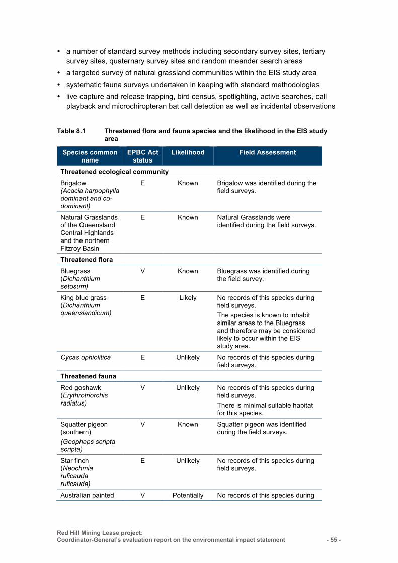
Red Hill Mining Lease project: Coordinator-General’s evaluation report on the environmental impact statement
- 55 -
a number of standard survey methods including secondary survey sites, tertiary survey sites, quaternary survey sites and random meander search areas
a targeted survey of natural grassland communities within the EIS study area systematic fauna surveys undertaken in keeping with standard methodologies live capture and release trapping, bird census, spotlighting, active searches, call
playback and microchiropteran bat call detection as well as incidental observations
Table 8.1 Threatened flora and fauna species and the likelihood in the EIS study area
Species common name
EPBC Act status
Likelihood Field Assessment
Threatened ecological community Brigalow (Acacia harpophylla dominant and co-dominant)
E Known Brigalow was identified during the field surveys.
Natural Grasslands of the Queensland Central Highlands and the northern Fitzroy Basin
E Known Natural Grasslands were identified during the field surveys.
Threatened flora Bluegrass (Dichanthium setosum)
V Known Bluegrass was identified during the field survey.
King blue grass (Dichanthium queenslandicum)
E Likely No records of this species during field surveys. The species is known to inhabit similar areas to the Bluegrass and therefore may be considered likely to occur within the EIS study area.
Cycas ophiolitica E Unlikely No records of this species during field surveys.
Threatened fauna Red goshawk (Erythrotriorchis radiatus)
V Unlikely No records of this species during field surveys. There is minimal suitable habitat for this species.
Squatter pigeon (southern) (Geophaps scripta scripta)
V Known Squatter pigeon was identified during the field surveys.
Star finch (Neochmia ruficauda ruficauda)
E Unlikely No records of this species during field surveys.
Australian painted V Potentially No records of this species during
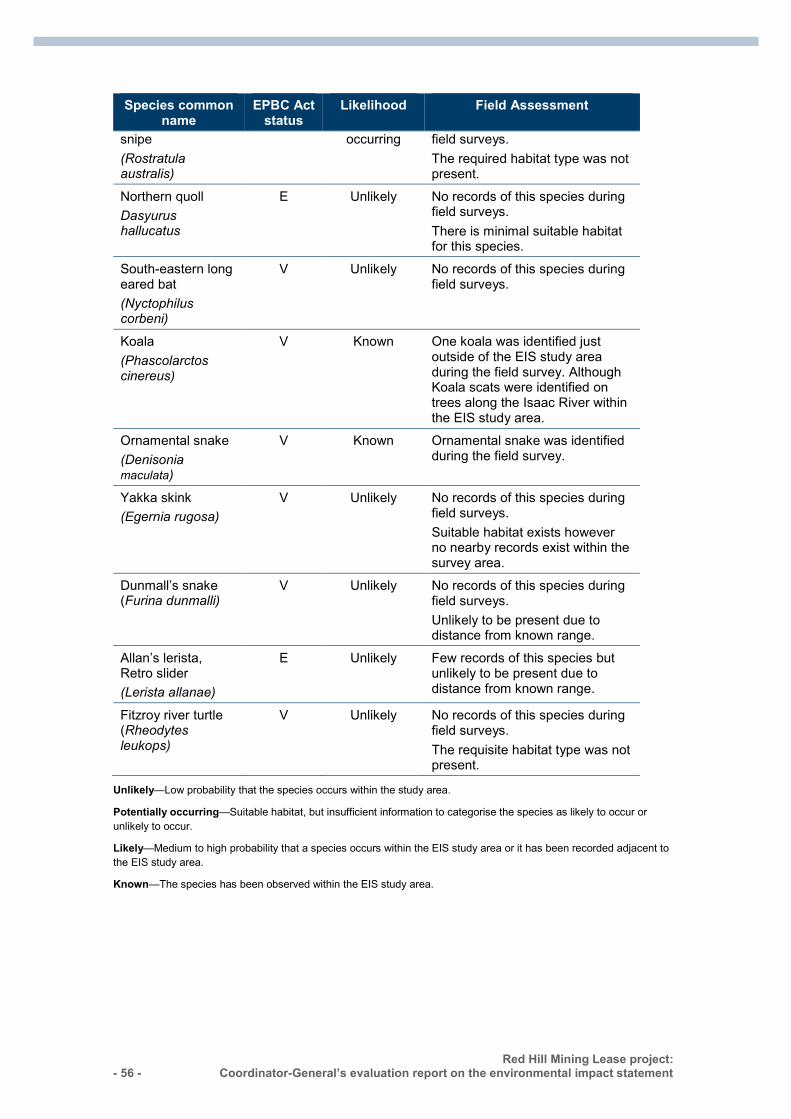
- 56 - Red Hill Mining Lease project:
Coordinator-General’s evaluation report on the environmental impact statement :
Species common name
EPBC Act status
Likelihood Field Assessment
snipe (Rostratula australis)
occurring field surveys. The required habitat type was not present.
Northern quoll Dasyurus hallucatus
E Unlikely No records of this species during field surveys. There is minimal suitable habitat for this species.
South-eastern long eared bat (Nyctophilus corbeni)
V Unlikely No records of this species during field surveys.
Koala (Phascolarctos cinereus)
V Known One koala was identified just outside of the EIS study area during the field survey. Although Koala scats were identified on trees along the Isaac River within the EIS study area.
Ornamental snake (Denisonia maculata)
V Known Ornamental snake was identified during the field survey.
Yakka skink (Egernia rugosa)
V Unlikely No records of this species during field surveys. Suitable habitat exists however no nearby records exist within the survey area.
Dunmall’s snake (Furina dunmalli)
V Unlikely No records of this species during field surveys. Unlikely to be present due to distance from known range.
Allan’s lerista, Retro slider (Lerista allanae)
E Unlikely Few records of this species but unlikely to be present due to distance from known range.
Fitzroy river turtle (Rheodytes leukops)
V Unlikely No records of this species during field surveys. The requisite habitat type was not present.
Unlikely—Low probability that the species occurs within the study area.
Potentially occurring—Suitable habitat, but insufficient information to categorise the species as likely to occur or unlikely to occur.
Likely—Medium to high probability that a species occurs within the EIS study area or it has been recorded adjacent to the EIS study area.
Known—The species has been observed within the EIS study area.
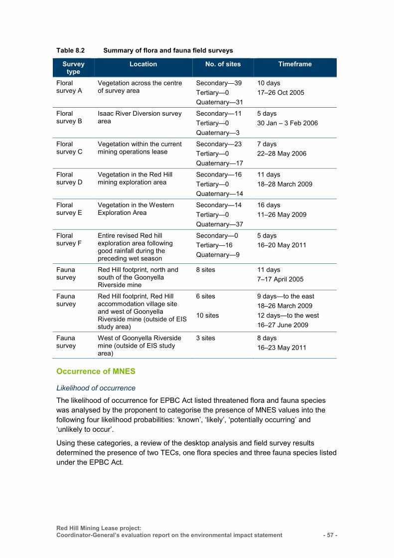
Red Hill Mining Lease project: Coordinator-General’s evaluation report on the environmental impact statement
- 57 -
Table 8.2 Summary of flora and fauna field surveys
Survey type
Location No. of sites Timeframe
Floral survey A
Vegetation across the centre of survey area
Secondary—39 Tertiary—0 Quaternary—31
10 days 17–26 Oct 2005
Floral survey B
Isaac River Diversion survey area
Secondary—11 Tertiary—0 Quaternary—3
5 days 30 Jan – 3 Feb 2006
Floral survey C
Vegetation within the current mining operations lease
Secondary—23 Tertiary—0 Quaternary—17
7 days 22–28 May 2006
Floral survey D
Vegetation in the Red Hill mining exploration area
Secondary—16 Tertiary—0 Quaternary—14
11 days 18–28 March 2009
Floral survey E
Vegetation in the Western Exploration Area
Secondary—14 Tertiary—0 Quaternary—37
16 days 11–26 May 2009
Floral survey F
Entire revised Red hill exploration area following good rainfall during the preceding wet season
Secondary—0 Tertiary—16 Quaternary—9
5 days 16–20 May 2011
Fauna survey
Red Hill footprint, north and south of the Goonyella Riverside mine
8 sites 11 days 7–17 April 2005
Fauna survey
Red Hill footprint, Red Hill accommodation village site and west of Goonyella Riverside mine (outside of EIS study area)
6 sites 10 sites
9 days—to the east 18–26 March 2009 12 days—to the west 16–27 June 2009
Fauna survey
West of Goonyella Riverside mine (outside of EIS study area)
3 sites 8 days 16–23 May 2011
Occurrence of MNES
Likelihood of occurrence
The likelihood of occurrence for EPBC Act listed threatened flora and fauna species was analysed by the proponent to categorise the presence of MNES values into the following four likelihood probabilities: ‘known’, ‘likely’, ‘potentially occurring’ and ‘unlikely to occur’.
Using these categories, a review of the desktop analysis and field survey results determined the presence of two TECs, one flora species and three fauna species listed under the EPBC Act.
- 58 - Red Hill Mining Lease project:
Coordinator-General’s evaluation report on the environmental impact statement :
Threatened species and communities not addressed as MNES The flora species finger panic grass (Digitaria porrecta) was included in the EIS as a threatened flora species under the EPBC Act. This species was removed from the threatened species list under the EPBC Act on 14 December 2013. Accordingly, there is no longer a requirement to address it as a MNES under the EPBC Act.
The flora survey identified that this species was not recorded within the EIS study area. However potential habitat mapping identified 366ha of high-potential habitat and 306ha of low-potential habitat for which the species may occur within the EIS study area.
8.4.3 Threatened ecological communities An ecological community is a naturally occurring group of plants, animals and other organisms that interact in a unique habitat. Their structure, composition and distribution are determined by environmental factors such as soil type, position in the landscape, altitude, climate and water availability. An ecological community becomes threatened when it is at risk of extinction. There are three categories that exist for the listing of a TEC under the EPBC Act and include ‘critically endangered’, ‘endangered’ and ‘vulnerable’.
The literature review identified that two EPBC Act TECs were potentially present on site and include the brigalow (Acacia harpophylla dominant and co-dominant) (brigalow TEC) and the Natural Grasslands of the Queensland Central Highlands and the northern Fitzroy Basin (natural grasslands TEC).
Field surveys confirmed the presence of both these communities within the EIS study area. Approximately 366ha of the Natural Grasslands TEC and 1,094ha of brigalow (Acacia harpophylla dominant and co-dominant) TEC are present. The distribution and extent of these TECs in the northern and southern project area is shown in Figure 8.1 (page 56).
Natural grasslands
Description
The Natural Grasslands TEC was listed under the EPBC Act as ‘endangered’ on 7 January 2009. The Natural Grasslands TEC is among the most threatened ecosystems in Australia due to the conversion of native pastures to improved pastures, cropping and overgrazing by stock.
The Natural Grasslands TEC usually occurs on flat ground or gently undulating rises and consist of perennial native grasses. The grass species occurs within the Brigalow Belt North and South subregions but mostly within the Fitzroy River Basin. The natural grasslands TEC can also merge at a broad scale with the brigalow TEC. The natural grasslands TEC in Queensland is similar to those areas mapped as REs 11.3.21, 11.4.4, 11.4.11, 11.8.11, 11.9.3, 11.9.12 and 11.11.17. Within the EIS study area, the characteristics of the natural grasslands TEC is similar to the remnant grassland ‘of concern’ RE 11.8.11. The other REs were not encountered.
Red Hill Mining Lease project: Coordinator-General’s evaluation report on the environmental impact statement
- 59 -
Conservation advice, recovery plans and threat abatement plans
There is no specific Recovery Plan for Natural Grasslands of the Queensland Central Highlands and the northern Fitzroy Basin.
There is a draft Recovery Plan for the Bluegrass (Dichanthium spp.) dominant grasslands of the Brigalow Belt Bioregions (north and south) endangered ecological community 2007–2011 (Butler, D.W. 2007). The bluegrass (Dichanthium spp.) forms part of the natural grasslands TEC.
Specific objectives include: maintain the remnant areas of the bluegrass natural grassland TEC in subregions in which its extent is 30 per cent or less of its pre-clearing extent. In other subregions, maintain the remnant areas that are either known habitat for threatened species, are infrequently grazed or are larger than 50ha in area.
The Approved Conservation Advice for Natural grasslands of the Queensland Central Highlands and the northern Fitzroy Basin notes that its distribution has undergone severe decline due to threats such as cropping, grazing, pasture improvements, weeds and pests, mining activities and construction of roads and other infrastructure. Advice and priority actions regarding its future conservation includes:
raising awareness of the TEC to land managers and within the local community conducting priority research avoiding mowing and slashing during peak flowering season investigating, monitoring, and mitigating habitat loss and disturbance to the TEC developing management plans to avoid spreading weeds and managing sites to
prevent the introduction of weeds developing management plans for stock and grazing to avoid and/or mitigate the
impacts of trampling of native grasses Develop and implement management plans for the control of the house mouse (Mus
spp.).
Survey results
Targeted grassland surveys (Survey F) for RE 11.8.11 Queensland bluegrass (Dichanthium sericeum) grassland on Cainozoic igneous rocks) which forms part of the Natural Grasslands TEC, were undertaken in the north-east part of the EIS study area. The survey confirmed the presence of 366ha on site. Eight secondary sites were sampled for the RE and three secondary and one quaternary site was sampled for RE11.8.11/non-remnant grasslands. Despite some areas being confirmed as non-remnant, under suitable conditions, which include the absence of grazing, the management of weeds and optimal weather conditions, these areas would qualify for the listed community. Accordingly, the entire area has been mapped by the proponent in the EIS as an EBPC Act listed TEC that met the threshold of ‘good quality’.
The TEC was located on black cracking clays north-east of the Isaac River along natural drainage lines on the eastern edge of the GRB mine complex and in the north-east part of the EIS study area.
- 60 - Red Hill Mining Lease project:
Coordinator-General’s evaluation report on the environmental impact statement :
Project impacts
The proponent has prepared its EIS on the basis of 100 per cent clearance of vegetation as a worst-case maximum disturbance scenario. This relates to the RHM footprint for the placement of incidental mine gas (IMG) drainage and the construction of surface infrastructure. A worst-case scenario has been applied due to the uncertainty of areas to be cleared, the timing of the RHM component and areas of regrowth over the next 5–10 years.
Direct impacts to the TEC are vegetation clearing associated with gas drainage activities, surface facilities and subsidence. As shown in Figure 8.1 (page 56), a portion of the Natural Grasslands TEC is located within the RHM footprint whilst the remainder is located to the north of the EIS study area. The proponent has stated in its Offset Strategy that a maximum impact area of approximately 117.54ha may be affected.
Indirect impacts to the TEC include overgrazing by stock as well as cropping and pasture improvement. Accordingly, when this TEC is overgrazed, the risk of weed invasion increases, reducing habitat quality and the overall quality of the TEC. The threat of buffel grass and parthenium has also contributed to the endangered status of the TEC.
Mitigation measures
The proposed RHM would remove a portion of the Natural Grasslands TEC on the RHM site. Those areas that remain would be managed by the proponent to reduce buffel grass and parthenium, increasing the chance of attracting other important ecological communities or species within the TEC.
The proponent has committed to avoid and/or minimise earthworks to be undertaken within the Natural Grasslands TEC. This includes the following:
Avoid placing IMG extraction wells and infrastructure within the Natural Grasslands TEC where practicable. Where unavoidable, offsets will be sourced. Controlling buffel grass and parthenium within offset areas will also aid its recovery.
If clearing is required, individual plants may be collected and relocated and topsoil will be carefully removed and set aside to protect seed banks. Topsoil will be replaced over pipelines as soon as practicable.
If clearing in the area of RE11.8.11/TEC Natural Grasslands is required, conduct pre-clearing surveys for bluegrass (Dichanthium setosum) and king bluegrass (Dichanthium queenslandicum).
If these grasses are identified, clearing should be avoided in these areas wherever possible, with slashing preferred to gain access. Slashing to be undertaken as per suitable guidelines for managing native pastures, such as Henry et al. (2004).
I note that these measures are generally consistent with the Commonwealth Conservation Advice priority actions to the extent that habitat loss and disturbance, weed and pest invasion and grazing impacts have been addressed through proponent mitigation measures and commitments. Areas of the TEC that remain would be managed by the proponent to reduce buffel grass and parthenium invasion.

Red Hill Mining Lease project: Coordinator-General’s evaluation report on the environmental impact statement
- 61 -
I also note that the advice makes reference to developing management plans for the control of weeds and pests, specifically the house mouse (Mus spp.). In the AEIS, the proponent identified the house mouse amongst other pests as being on site. The proponent also notes that a detailed pest management plan will be prepared prior to commencing construction.
The EIS identified that a weed management plan already exists for GRM and the proponent intends to implement ongoing weed monitoring and management programs throughout the RHM and BRM mining period. Weed management strategies and methods for RHM include controlling the spread of declared weed species (including parthenium) in keeping with regional management practices as well as ongoing monitoring of the EIS study area.
Overgrazing by stock was also a key threat to the TEC. The proponent has stated that it will be taking the learnings from subsidence at the BRM and will manage stock access prior to and during subsidence until a stable landform is achieved. The subsidence management plan will be revised annually and will be closely integrated with management of soils, terrestrial ecology and rehabilitation. The proponent has committed to implementing a single realignment of the stock route as opposed to multiple realignments over time and will rehabilitate the land as necessary.
I am satisfied with the assessment undertaken by the proponent to determine the impacts to the TEC. I consider that the proposed mitigation measures, and commitments relating to the management of pest animals are not inconsistent with the Conservation Advice.
Offsets
The Natural Grasslands TEC is likely to be impacted through land clearing and subsidence impacts from the construction of surface facilities at RHM. The proponent has provided impact mitigation measures to avoid in the first instance and then to mitigate any proposed impacts in the second instance. The proponent has provided a staged offsets approach under the EPBC Act Environmental Offsets Policy 2013 and the Queensland Government Environmental Offset Framework 2014.
The Natural Grasslands TEC is located over stage 2 of the offsets strategy. The approximate ‘worst case’ disturbance anticipated is 117.54ha. I have recommended a condition to the Commonwealth Minister that sets maximum disturbance limits for the TEC. I have also recommended that the proponent submit a Biodiversity Offset Plan (BOP) to the Minister for approval which will detail proposed offset areas.
The proponent is proposing land-based offsets. Ecological equivalence assessments of disturbed areas will be undertaken prior to any works, as site-specific surveys verify the baseline condition of the biodiversity values for the site and inform the requirements for actual offsets in the BOP.
- 62 - Red Hill Mining Lease project:
Coordinator-General’s evaluation report on the environmental impact statement :
Brigalow
Description
The brigalow (Acacia harpophylla dominant and co-dominant) TEC was listed under the EPBC Act as ‘endangered’ on 4 April 2001. Remnant and regrowth forms of this community are protected under the EPBC Act. The brigalow TEC was listed because it has severely declined (to approximately 10 per cent of its former area) following extensive clearing in both Queensland and New South Wales for agricultural purposes.
The brigalow TEC consists of dense shrub lands or woodlands of A. harpophylla, usually with a diverse mid-storey of softwood species, and occasionally emergent eucalypts. Under the EPBC Act, regrowth that is 15 years old is included within the brigalow TEC, because it generally possesses a structure and species composition similar to remnant brigalow TEC.
In Queensland, the brigalow TEC is found in the Brigalow Belt North and South, Mulga Lands, Darling Riverine Plains and Southeast Queensland IBRA bioregions. The EIS study area is located within the Brigalow Belt bioregion and further within the Northern Bowen Basin subregion.
Conservation advice, recovery plans and threat abatement plans
The Approved Conservation Advice for the Brigalow (Acacia harpophylla dominant and co-dominant) ecological community lists the threats to the TEC as vegetation clearing, fire, invasion of weeds including introduced grasses such as buffel grass, succulents and climbing weeds, feral animals destroying young plants and disturbing soil. The proponent has committed to implement mitigation measures to address these direct and indirect threats.
The brigalow community was listed as endangered on the basis of extensive clearing. Most remnants of the community now occur as fragments. It is desirable to establish connectivity between remnants and associated vegetation to promote the conservation of fauna values in the ecological community. The conservation advice contains priority actions to protect and conserve remnant and regrowth areas and to undertake research to understand how to restore and reclaim degraded brigalow communities.
There is no approved recovery plan for the brigalow TEC. There is a draft national recovery plan which was prepared in 2007. Specific objectives include:
increase the area of the brigalow TEC and its representation in conservation reserves by avoiding clearing and fragmentation
improve knowledge of the brigalow TEC and its condition as a habitat for native species by facilitating community involvement and on the ground management
mitigate key threats by controlling fire, weeds, and animal pests (Butler 2007).
Survey results
In Queensland, the brigalow TEC is comprised of 16 REs. Within the EIS study area, the characteristic of the brigalow TEC is similar to those areas mapped as RE 11.3.1, 11.4.7, 11.4.8, 11.4.9, 11.9.1 and 11.5.16.
Red Hill Mining Lease project: Coordinator-General’s evaluation report on the environmental impact statement
- 63 -
The brigalow TEC was found to be fragmented over the EIS study area, with larger clusters found over the RHM footprint, GRM footprint and areas to the north and south of the EIS study area. The brigalow TEC was also found along 12 Mile Gully and Goonyella Creek. Accordingly, the survey confirmed the presence of 1,094ha on site. The brigalow TEC was found generally in poor condition, with evidence of dieback and a high level of buffel grass invasion within the understorey.
Project impacts
Direct impacts to the brigalow TEC are vegetation clearing associated with gas drainage activities and subsidence over the RHM footprint. Approximately 368.8ha of the brigalow TEC may be impacted as a result of the proposed action. Approximately 298.13ha of equivalent RE 11.3.1, 11.4.7, 11.4.8, 11.4.9, 11.9.1 and 11.5.16 may be impacted by the construction of RHM. This includes clearing for surface facilities which include the Red Hill mine industrial area (MIA), conveyor and the Red Hill Coal Handling Processing Plant (CHPP). Approximately 70.62ha of equivalent REs mentioned above will be impacted by subsidence during stage 3 works.
As shown in in Figure 8.1 the brigalow TEC is scattered to the north and south of the EIS study area which is not impacted by the proposed action. The Brigalow Belt is the centre for coal production and mining and as described in the Conservation Advice for the brigalow TEC, indirect impacts include introduced weeds and grasses such as buffel grass (Cenchrus ciliaris), fire, feral animals and inappropriate grazing. Several of these threats are listed as key threatening processes under the EPBC Act. The spread of buffel grass and grazing within the EIS study area has contributed to the poor condition of brigalow on site. The general ecology of the area has been significantly modified as result.
Mitigation measures
The proposed RHM, and infrastructure on GRM would remove several portions of the brigalow TEC.
The proponent has committed to avoid and mitigate impacts to the brigalow TEC. This includes:
In the first instance, to avoid placing IMG extraction wells and infrastructure within the brigalow TEC, including: – endangered REs 11.4.7, 11.4.8 and 11.4.9 – riparian zones along Isaac River and 12 Mile Gully, particularly native vegetation
within 100m of the bank – where these areas cannot be avoided, offsets will be required to mitigate the
impacts. When clearing vegetation for any of the surface facilities:
– clearly delineate areas for clearing to avoid inadvertent clearing – identify and clearly mark habitat trees that can be retained without compromising
safety – consider habitat features such as felled trees and logs for relocation to other
areas where practicable to provide microhabitat.
- 64 - Red Hill Mining Lease project:
Coordinator-General’s evaluation report on the environmental impact statement :
When selecting locations for wells, tracks and other infrastructure during the detailed design, already disturbed areas will be used wherever practical, particularly in riparian and woodland vegetation.
River and creek crossings will be selected where natural or anthropogenic breaks in vegetation occur wherever possible, recognising that crossing locations must align with the pillars between each longwall panel.
Weed and pest monitoring will be undertaken as follows: – annual observations by site personnel for weeds and pests of management
concern – a post-construction weed audit of the surface facilities, well sites, pipeline routes
and access tracks at the end of the first wet season after completion of construction activities in each area
– monitoring for pest plants and fauna within subsided areas where ponding occurs and maintenance of monitoring records for a period of at least five years to aid in the assessment of the project’s weed management program.
Implement impact mitigation measures for design, construction, installation of IMG management infrastructure and operation phases to minimise disturbance to identified biodiversity values wherever practicable and safe. Biodiversity values include TECs listed under the EPBC Act, ‘endangered’ and ‘of concern’ REs and riparian zones along the Isaac River, 12 Mile Gully and Goonyella Creek.
When selecting a site for the bridge and IMG drainage infrastructure, already disturbed areas will be used and areas of intact remnant riparian vegetation will be avoided.
Develop and implement a strategy to offset state significant biodiversity values where destruction cannot be avoided. Strategy is to comply with the Queensland Environmental Offsets Act 2014.
I note that the proponent has provided adequate mitigation measures to manage and monitor impacts to the brigalow TEC. The mitigation measures are generally consistent with the conservation advice for the brigalow TEC. The proponent will prepare a rehabilitation management plan along with a detailed pest and weed management plan and subsidence management plan in response to the potential impacts. Land rehabilitation will be managed through the Environmental Authority (EA) issued by the Queensland Department of Environment and Heritage Protection (DEHP).
Offsets
Several areas of the brigalow TEC are likely to be impacted through vegetation clearing for surface infrastructure and subsidence impacts from the RHM. The TEC is located over stages 2 and 3 of the proponents’ offsets strategy. The approximate ‘worst case’ disturbance anticipated is 368.8ha. I have recommended a condition to the Commonwealth Minister that sets maximum disturbance limits. I have also recommended that the proponent submit a BOP to the Minister for approval which will further detail proposed offset areas.
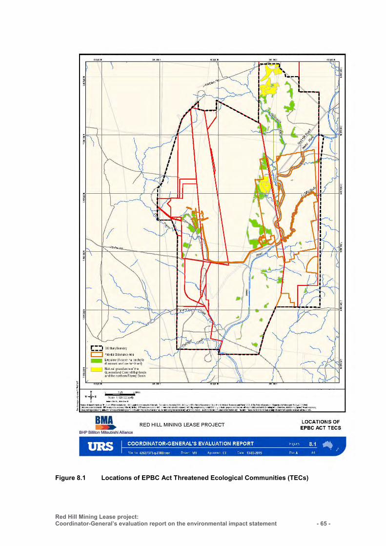
Red Hill Mining Lease project: Coordinator-General’s evaluation report on the environmental impact statement
- 65 -
Figure 8.1 Locations of EPBC Act Threatened Ecological Communities (TECs)
- 66 - Red Hill Mining Lease project:
Coordinator-General’s evaluation report on the environmental impact statement :
8.4.4 Listed threatened species—flora Threatened flora are plants that have been assessed as being at risk of extinction. The EPBC Act lists 1,298 flora species to be ‘extinct’, ‘critically endangered’, ‘endangered’ or ‘vulnerable’.
Desktop assessments identified three ‘threatened’ terrestrial flora species that have the potential to occur in the project area. An assessment of the likelihood of occurrence for these species is provided in Table 8.1 (page 47). Of the three species identified, one terrestrial flora species (bluegrass—Dichanthium setosum) listed as ‘vulnerable’ under the EPBC Act was considered to be ‘known’ as it was observed within the EIS study area.
The remaining two flora species identified in the desktop search—king blue grass (Dichanthium queenslandicum), which is ‘likely to occur’ and Cycas ophiolitica, which is ‘unlikely to occur’, were not recorded during the field surveys. The king blue grass was identified as being ‘likely’ to be present given the types of habitat available.
Bluegrass
Description
Bluegrass (Dichanthium setosum) was listed under the EPBC Act as ‘vulnerable’ on 16 July 2000. It is associated with heavy basaltic black soils and stony red-brown hard setting loam with clay subsoil and is found in moderately disturbed areas such as cleared woodland, grassy roadside remnants, grazed land and highly disturbed pasture. The primary habitat for this species is RE 11.8.11.
The distribution of this species overlaps with the following EPBC Act listed TECs which are ‘known’ to occur within the EIS study area:
brigalow (Acacia harpophylla) dominant and co-dominant bluegrass (Dichanthium spp.) dominant grasslands of the Brigalow Belt Bioregions
(North and South) (similar to the Natural Grasslands TEC).
Conservation advice, recovery plans and threat abatement plans
There is no specific recovery plan for bluegrass. The conservation advice for bluegrass notes that regional priority recovery and threat abatement actions can be taken to support the recovery of the bluegrass including:
investigating, monitoring, and mitigating habitat loss and disturbance to the species developing management plans to avoid the spread of weeds and managing sites to
prevent the introduction of weeds such as coolatai (Hyparrhenia hirta), African lovegrass (Eragrostis curvula) and lippia (Phyla canescens)
ensuring chemicals used do not adversely impact on the species developing management plans for stock and grazing to avoid and/or mitigate the
impacts of trampling of native grasses ensuring road widening and maintenance activities (or other infrastructure or
development activities) do not adversely impact on known populations
Red Hill Mining Lease project: Coordinator-General’s evaluation report on the environmental impact statement
- 67 -
investigating formal conservation arrangements such as the use of covenants, conservation agreements or inclusion in reserve tenure
developing and implementing a suitable fire management strategy identifying appropriate intensity and interval of fire to promote seed germination providing maps of known occurrences to local and state Rural Fire Services and
seeking inclusion of mitigation measures in bushfire risk management plans, risk register and/or operation maps.
Survey results
This species was recorded to the east of the survey area over the proposed RHM disturbance area. It was observed within RE 11.8.11 Queensland bluegrass (Dichanthium sericeum) grassland on Cainozoic igneous rocks which forms part of the Natural grasslands of the Queensland Central Highlands and the northern Fitzroy Basin EPBC Act TEC. Only one specimen of bluegrass was observed during the 2009 field survey. The area shown in Figure 8.2 has been mapped as essential habitat.
A detailed survey by the proponent identified that the most suitable habitat within the EIS study area is RE 11.8.11. The proponent recorded approximately 366ha of high potential habitat and approximately 292ha of low potential habitat for the species. Areas considered low potential habitat for the bluegrass species to occur were RE 11.3.25 and can be found along the waterways (refer to Figure 8.3). The area as observed by the proponent was heavily grazed at the time of the survey and it is anticipated that additional specimens would be recorded with decreased grazing and improved growing conditions. Suitable habitat for the species was observed to extend approximately 1km to the north of its recorded location.
Project impacts
The proponent has under taken an assessment of impacts in relation to high and low potential habitat. Approximately 117.54ha of high and approximately 13ha of low potential habitat may be impacted by the proposed action. Low potential habitat is found along the waterways.
Essential habitat has been mapped for the Bluegrass. Essential habitat falls within stage 2 of the project. The proponent has stated that there will be no impact on essential habitat, as commitments have been made to avoid and or minimise earthworks within the Natural Grasslands TEC, which forms part of the bluegrass species.
Direct impacts include subsidence and clearing of high potential habitat which currently falls over the RHM footprint and within gas drainage activities. Indirect impacts include weed invasion such as the Coolatai grass (Hyparrhenia hirta), Lippia (Phyla canescens), and African Lovegrass (Eragrostis curvula). A detailed pest management plan would be developed by the proponent to mitigate and manage the potential spread of pest flora and fauna species. Species specific management will be undertaken for identified key weed species at risk of spread through project activities. Weed control efforts would be increased in areas particularly sensitive to invasion.
- 68 - Red Hill Mining Lease project:
Coordinator-General’s evaluation report on the environmental impact statement :
There are several portions of high potential habitat to the north of the EIS study area which will not be impacted as part of project activities. There is no habitat present in the area of impact that is critical to the survival of the species as it was observed in a heavily grazed area. All potential habitat within the EIS study area is currently substantially compromised due to heavy grazing.
Mitigation measures
Key threats to the survival of the species are vegetation clearing and the spread of weeds and invasive grasses. The proponent has made commitments to avoid and or minimise clearing in the area of RE 11.8.11. Where unavoidable, offsets will be required.
The existing project components (GRM and BRM components) already have a weed management plan in place. The proponent has committed to weed and pest management and annual monitoring for a period of five years. Inspections for weeds and pests in disturbed areas will be carried out on a regular basis.
The following management measures will be incorporated into the site and construction management plans to mitigate the key threats and include:
pre-clearance surveys will be conducted and if Bluegrass is identified, clearing will be avoided in these areas wherever possible, with slashing preferred to gain access. Slashing to be undertaken as per suitable guidelines for managing native pastures
if clearing is required, individual plants may be collected and relocated and topsoil will be carefully removed and set aside to protect seed banks. Topsoil will be replaced over pipelines as soon as practicable
identification of the origin of construction materials, machinery and equipment management methods to control spread of declared weed species (in particular
Parthenium hysterophorus), in keeping with regional management practice or the Queensland Department of Agriculture, Fisheries and Forestry pest control prescriptions or Isaac Regional Council’s fact sheets
ongoing monitoring of the EIS study area to identify any new incidence of weed infestation
wash down protocols for any vehicles or machinery entering and leaving site monitoring weed levels and actively managing weeds around the edges of
vegetation fragments will be ongoing throughout the mining period if chemical controls are used, herbicides will be selected based on low potential
impact on waterways, native plants and native animals promotion of awareness of weed management, by inclusion of weed issues, pictures
and procedures into the project’s site induction program. I am satisfied that the proponents proposed mitigation measures can minimise the threats to the Bluegrass and that the proponent’s weed control measures and proposed pest management plan will satisfy the requirements under the Conservation Advice. I have recommended a condition to the Commonwealth Minister for the Environment for the proponent to submit a BOP to the Minister for approval. The BOP must be consistent with relevant recovery plans, threat abatement plans, conservation advices and must also include a weed management plan.
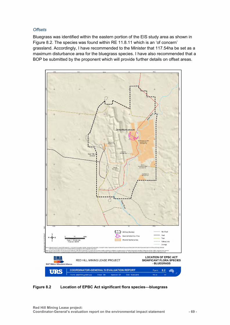
Red Hill Mining Lease project: Coordinator-General’s evaluation report on the environmental impact statement
- 69 -
Offsets
Bluegrass was identified within the eastern portion of the EIS study area as shown in Figure 8.2. The species was found within RE 11.8.11 which is an ‘of concern’ grassland. Accordingly, I have recommended to the Minister that 117.54ha be set as a maximum disturbance area for the bluegrass species. I have also recommended that a BOP be submitted by the proponent which will provide further details on offset areas.
Figure 8.2 Location of EPBC Act significant flora species—bluegrass
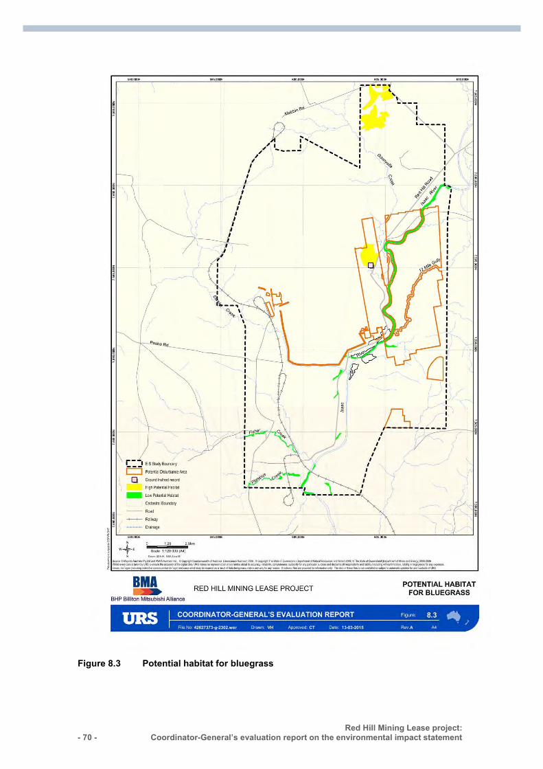
- 70 - Red Hill Mining Lease project:
Coordinator-General’s evaluation report on the environmental impact statement :
Figure 8.3 Potential habitat for bluegrass
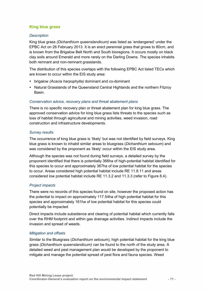
Red Hill Mining Lease project: Coordinator-General’s evaluation report on the environmental impact statement
- 71 -
King blue grass
Description
King blue grass (Dichanthium queenslandicum) was listed as ‘endangered’ under the EPBC Act on 26 February 2013. It is an erect perennial grass that grows to 80cm, and is known from the Brigalow Belt North and South bioregions. It occurs mostly on black clay soils around Emerald and more rarely on the Darling Downs. The species inhabits both remnant and non-remnant grasslands.
The distribution of this species overlaps with the following EPBC Act listed TECs which are known to occur within the EIS study area:
brigalow (Acacia harpophylla) dominant and co-dominant Natural Grasslands of the Queensland Central Highlands and the northern Fitzroy
Basin.
Conservation advice, recovery plans and threat abatement plans
There is no specific recovery plan or threat abatement plan for king blue grass. The approved conservation advice for king blue grass lists threats to the species such as loss of habitat through agricultural and mining activities, weed invasion, road construction and infrastructure developments.
Survey results
The occurrence of king blue grass is ‘likely’ but was not identified by field surveys. King blue grass is known to inhabit similar areas to bluegrass (Dichanthium setosum) and was considered by the proponent as ‘likely’ occur within the EIS study area.
Although the species was not found during field surveys, a detailed survey by the proponent identified that there is potentially 366ha of high-potential habitat identified for this species to occur and approximately 367ha of low potential habitat for the species to occur. Areas considered high potential habitat include RE 11.8.11 and areas considered low potential habitat include RE 11.3.2 and 11.3.3 (refer to Figure 8.4).
Project impacts
There were no records of this species found on site, however the proposed action has the potential to impact on approximately 117.54ha of high potential habitat for this species and approximately 161ha of low potential habitat for this species could potentially be impacted
Direct impacts include subsidence and clearing of potential habitat which currently falls over the RHM footprint and within gas drainage activities. Indirect impacts include the invasion and spread of weeds.
Mitigation and offsets
Similar to the Bluegrass (Dichanthium setosum), high potential habitat for the king blue grass (Dichanthium queenslandicum) can be found to the north of the study area. A detailed weed and pest management plan would be developed by the proponent to mitigate and manage the potential spread of pest flora and fauna species. Weed
- 72 - Red Hill Mining Lease project:
Coordinator-General’s evaluation report on the environmental impact statement :
control efforts would be increased in areas particularly sensitive to invasion. Habitat rehabilitation and restoration activities using seedlings of local provenance are likely to assist the recovery of the species in the local area.
Figure 8.4 Potential habitat for king blue grass
Red Hill Mining Lease project: Coordinator-General’s evaluation report on the environmental impact statement
- 73 -
8.4.5 Listed threatened species—fauna Threatened fauna listed under the EPBC Act are those species that have been assessed as being at risk of extinction. The EPBC Act lists 459 fauna species that are listed as ‘extinct’, ‘extinct in the wild’, ‘critically endangered’, ‘endangered’, ‘vulnerable’ and ‘conservation dependent’. The EPBC Act promotes their recovery using conservation advice, recovery plans, threat abatement plans and assessment and approval provisions.
Desktop assessments identified 12 threatened terrestrial fauna species that have the potential to occur in the project area. An assessment of the likelihood of occurrence for these species is provided in Table 8.1 (page 55).
Field surveys identified three of the 12 terrestrial fauna species and include the squatter pigeon (southern) (Geophaps scripta scripta), the ornamental snake (Denisonia maculata) and the koala (Phascolarctos cinereus). These species are listed as ‘vulnerable’ under the EPBC Act. Survey observations are shown in Figure 8.5.
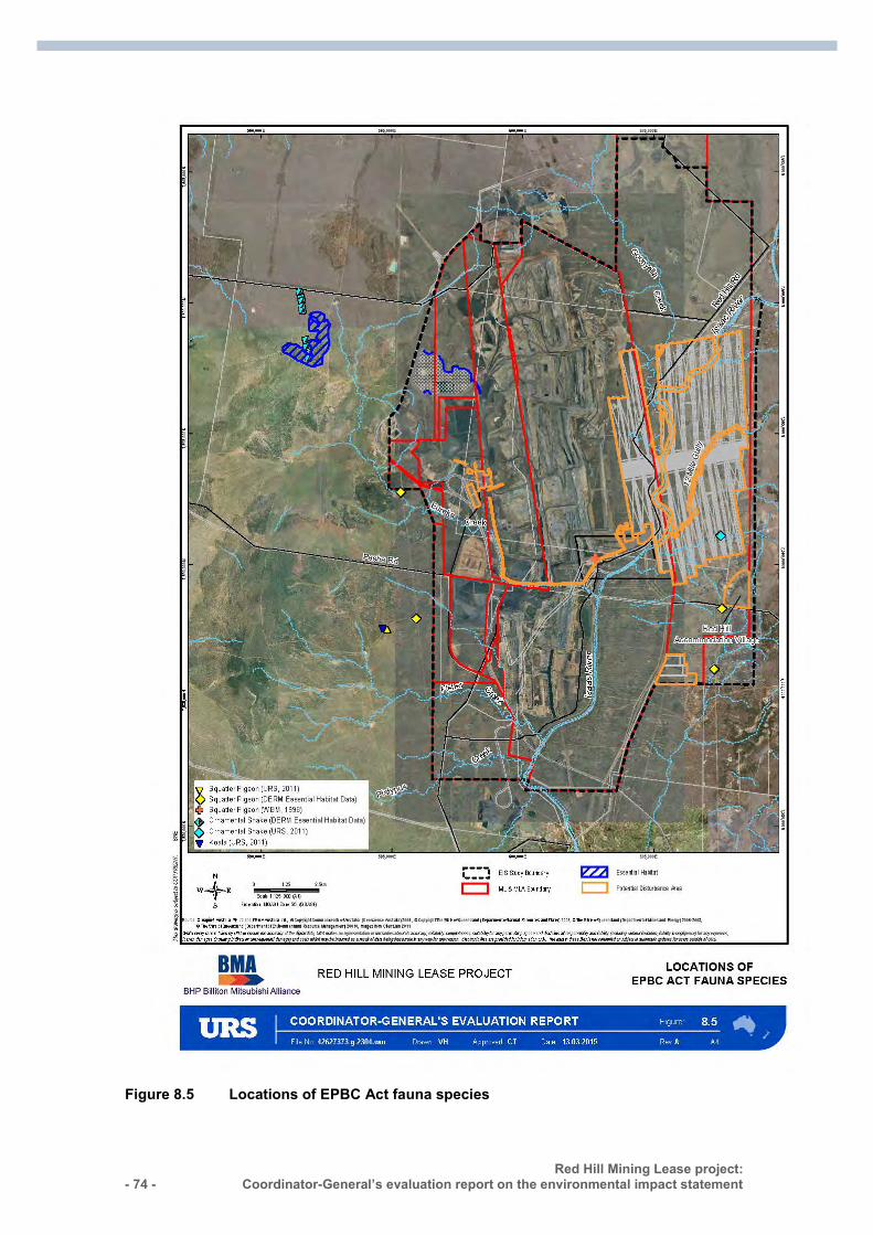
- 74 - Red Hill Mining Lease project:
Coordinator-General’s evaluation report on the environmental impact statement :
Figure 8.5 Locations of EPBC Act fauna species
Red Hill Mining Lease project: Coordinator-General’s evaluation report on the environmental impact statement
- 75 -
Squatter pigeon (southern)
Description
The squatter pigeon was listed as ‘vulnerable’ under the EPBC Act on 16 July 2000. It is a ground-dwelling bird that roams locally and forages on insects, grasses, fallen grass seeds, herbs and shrubs. This species is widely distributed in Queensland and extends from the southern region of the Cape York Peninsula to the north, down to central Queensland and through to the east coast. It is commonly observed in more open areas of dry eucalypt woodland on sandy soil dissected by low gravelly ridges, close to permanent water.
The distribution of this species overlaps with the Brigalow (Acacia harpophylla) dominant and co-dominant TEC, which is ‘known’ to occur within the EIS study area.
Conservation advice, recovery plans and threat abatement plans
There is no recovery plan for the squatter pigeon (southern). The approved conservation advice details the main identified threats as ongoing clearing of habitat, grazing of livestock and feral herbivores and predation, especially by feral cats and foxes.
Priority actions in the conservation advice to support the recovery of the species include implementing the recommendations identified in the Threat Abatement Plan for Predation by Feral Cats and the Threat Abatement Plan for Predation by the European Red Fox. The threat abatement plans for feral cats and foxes discuss a range of control methods including baiting, shooting, trapping, habitat management, biological control and fertility control.
Other priority actions include managing threats to areas of vegetation that support populations of the species and implementing plans for the control or eradication of feral herbivores. The Threat Abatement Plan for Competition and Land Degradation by Rabbits is relevant to this threat to the species. Rabbits directly impact native flora and fauna by grazing on native vegetation and preventing regeneration and well as competing with the species for food and shelter.
The squatter pigeon may also be adversely affected by the red imported fire ant (Solenopsis invicta), which has been identified as one of the six priority tramp ant species that are invading Australia and increasing their population at the expense of other species. Accordingly, the Threat Abatement Plan to Reduce the Impacts of Tramp Ants on Biodiversity in Australia and its Territories is relevant to the squatter pigeon.
Survey results
The squatter pigeon has been recorded within the EIS study area on six separate occasions with the latest observation in 2011. The EIS stated that they were sited in brigalow woodland, riparian woodland, grassland and laterite. It is likely to represent a viable population on site. They were also found in grazed, degraded areas, indicating that their survival in the study area is not restricted to high value habitat areas. Squatter pigeon potential habitat mapping has been provided in Figure 8.6.

- 76 - Red Hill Mining Lease project:
Coordinator-General’s evaluation report on the environmental impact statement :
High potential habitat for the squatter pigeon has been mapped within the EIS study area as REs 11.5.3, 11.5.9, 11.5.16, 11.7.1 and 11.7.2 within 1km of permanent water. Low potential habitat includes a range of REs: 11.3.1, 11.3.2, 11.3.3, 11.3.4, 11.3.5, 11.3.7, 11.3.25, 11.3.36, 11.4.2, 11.4.7, 11.4.8, 11.4.9, 11.5.3, 11.5.9, 11.5.16, 11.7.1, 11.7.2, 11.9.1.
Project impacts
All areas of the mine footprint could be considered potential habitat for the squatter pigeon. It appears from site observations that it has no preference for high or low value habitat areas as it was consistently found in degraded areas. The majority of the EIS study area has been modified to some extent by historical and current land management practices. The greatest impacts to biodiversity have resulted from clearing and the introduction of buffel grass.
Direct impacts include habitat loss due to clearing of vegetation. Reduction of water in the Isaac River due to cracking and subsidence caused by longwall mining could also impact on the species distribution. Indirect impacts to the species include predation by feral animals and illegal hunting.
Approximately 252ha of high potential habitat may potentially be impacted by the RHM and surface facilities. Approximately 2,612ha of low potential habitat may potentially be impacted across the RHM footprint, surface facilities and BRM panel extensions.
Mitigation measures
The survey area supports populations of rabbits, foxes, pigs, feral cats, dogs, cane toads, yellow crazy ants and fire ants. The Threat Abatement Plan for Predation by Feral Cats and the Threat Abatement Plan for Predation by the European Red Fox discuss a range of control methods including baiting, shooting, trapping, habitat management, biological control and fertility control. The proponent has committed to implement weed and pest management procedures. Accordingly, the AEIS stated that the proponent is currently conducting feral animal control at the existing GRB mine complex and is committed to continuing to manage feral animals.
The EIS identified that a number of ponds will be created from intermittent inundation and subsidence. Whilst the squatter pigeon is known to inhabit areas of permanent water, the availability of permanent water will attract pest species such as feral pigs and cane toads. Accordingly, the proponent will develop a detailed pest management plan prior to commencing construction. Typical strategies in the PMP to minimise the opportunities for scavenging and proliferation of pest fauna will include:
general (non-recyclable) waste will be collected by a licensed contractor and disposed to a licensed landfill facility. This will ensure that food scraps are not available on site for scavengers
fauna-proof bins will be provided around the accommodation village and outlying facilities
workers will be advised to dispose of food scraps properly and to not feed feral animals (especially cats)
Red Hill Mining Lease project: Coordinator-General’s evaluation report on the environmental impact statement
- 77 -
feral animal control will continue with target species and methods being reviewed over time, based on monitoring and anecdotal reporting.
Increased project traffic and damage to nests and young birds by machinery during clearing could increase injury and death of birds. I note that the proponent has outlined measures to engage spotters/catchers when remnant vegetation is likely to contain nesting fauna. Additional measures include raising awareness of fauna conservation issues by educating staff as part of induction training. Staff will be provided with contact details in the event that fauna is present, needs to be removed or is accidently injured. Using construction machinery and importing building and construction materials to the mine site has the potential to introduce pest animals such as the red imported fire ant.
Offsets
It was noted that the squatter pigeon prefers a broad range of habitat types as the species was observed foraging in disturbed areas such as farm tracks. The proponent has identified approximately 252ha of high potential habitat and approximately 2,612ha of low potential habitat that may be impacted by surface facilities and subsidence as this habitat falls over the RHM footprint and BRM panel extensions.
Suitable breeding habitat for the squatter pigeon is found outside of the EIS study area. There is a large area of high potential habitat concentrated to the south east corner of the EIS study area (Figure 8.6). This area is excluded from the disturbance calculations. These areas have the capacity to act as a refuge in the short term.
I have recommended a condition to the Commonwealth Minister whereby maximum disturbance limits have been set at 252ha for the species habitat. I have also recommended that the proponent submit a BOP to the Minister for approval which will further detail proposed offset areas. The proponent may co-locate squatter pigeon habitat within other offset areas for EPBC listed species and communities.
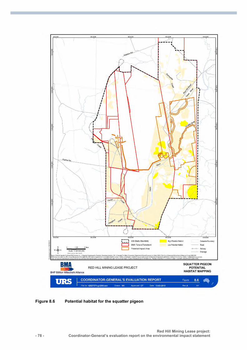
- 78 - Red Hill Mining Lease project:
Coordinator-General’s evaluation report on the environmental impact statement :
Figure 8.6 Potential habitat for the squatter pigeon
Red Hill Mining Lease project: Coordinator-General’s evaluation report on the environmental impact statement
- 79 -
Ornamental snake
Description
The ornamental snake was listed under the EPBC Act as ‘vulnerable’ on 16 July 2000. Its habitat requirements are woodlands and open forests containing brigalow (Acacia harpophylla), gidgee (Acacia cambagei), blackwood (Acacia argyrodendron) or coolabah (Eucalyptus coolabah) communities or pure grassland associated with gilgais or wetlands. Micro-habitat features include coarse, woody debris such as fallen timber as well as rocky areas and deep soil cracks. The species is widespread in Queensland.
During the day, the species shelters under fallen timber, coarse woody debris, rocks, bark and in deep soil cracks on gilgai mounds, particularly during dry periods. At night, the species forages near water and feeds almost exclusively on frogs.
Conservation advice, recovery plans and threat abatement plans
There is no recovery plan for the ornamental snake. The Approved Conservation Advice for Denisonia maculata (Ornamental Snake) details the main identified threats as land clearing and habitat degradation from development, destruction of wetland and frog habitat by feral pigs and the potential threat of poisoning from ingesting cane toads.
Actions in the conservation advice to support the recovery of the species include controlling introduced pests such as pigs, implementing management plans for the control of cane toads and establishing conservation arrangements or reserve tenure in population areas of high conservation priority.
The Queensland Brigalow Belt Reptile Recovery Plan includes the ornamental snake. The overall recovery objective of the plan is to secure and improve the long-term survival of the species and their key habitat, and to raise awareness of reptile conservation issues within the community.
The Threat Abatement Plan for Predation, Habitat Degradation, Competition and Disease Transmission by Feral Pigs sets out the national framework to guide the coordination of the objectives and actions considered necessary to manage the environmental damage by feral pigs to species and ecological communities. Feral pigs were recorded in the project area and assessed as having the potential to cause serious environmental harm through habitat degradation and vegetation damage and are a major risk to threatened species including the ornamental snake.
The Threat Abatement Plan for the biological effects, including lethal toxic ingestion, caused by cane toads is relevant to the ornamental snake. Using construction machinery and transporting construction materials to the mine site has the potential to introduce pest animals such as cane toads. An increase in pooled water due to subsidence caused from underground mining may provide breeding habitat for cane toads.
Survey results
The ornamental snake was recorded within the RHM footprint and in grassland to the east of the EIS study area during the May 2011 field survey. The species was found to
- 80 - Red Hill Mining Lease project:
Coordinator-General’s evaluation report on the environmental impact statement :
be occupying dredge spoil from an adjacent constructed farm dam. The ornamental snake was also recorded adjacent to the west of the EIS study area during pipe trenching operations.
High potential habitat for the ornamental snake has been mapped within the EIS study area as RE 11.3.1, 11.3.2, 11.3.3, 11.3.4, 11.3.25, 11.4.2, 11.4.7, 11.4.8 and 11.4.9. There is approximately 2,571ha of high potential habitat and approximately 1,049ha of low potential habitat mapped. Low potential habitat includes the essential habitat factor RE 11.5.16, 11.8.11 and 11.9.1. These low potential habitat REs are less likely to support the ornamental snake but all feature brigalow (refer to Figure 8.7).
Project impacts
Approximately 1189.66ha of high-potential habitat may be impacted as a result of the proposed action. This includes a 500m buffer around known locations. Direct impacts include habitat destruction from vegetation clearing. Habitat in which the ornamental snake was recorded could potentially be altered as a result of subsidence and clearing for surface facilities.
Ponding of water within subsidence voids will provide additional frog breeding habitat which is beneficial to the feeding habits of the snake. However cane toads (Rhinella marina) have been identified on the site in large numbers. Indirect impacts include the potential for an increase in the number of cane toads as a result of the provision of more water sources from ponding. The ornamental snake is one of the species considered to be potentially at risk from lethal ingestion of cane toad toxin.
Mitigation measures
The proponent has committed to undertake targeted field surveys of essential habitat areas. Surveys will be undertaken 12 months prior to the commencement of construction of the RHM to determine the presence and extent of the ornamental snake habitat within this area.
If any areas within the disturbance footprint are deemed as significant habitat, a threatened species management plan will be developed. This plan will outline:
the level of activity that the habitat can sustain the remediation procedures if tension cracking or vegetation loss occurs further monitoring requirements.
The threatened species management plan will aim to mitigate the long-term impacts on this species within the EIS study area.
The proponent has an existing weed and pest management plan to manage the impact of feral animals and invasive weeds. The proponent has committed to additional monitoring requirements as part of the RHM component. Invasive aquatic weeds are a threat to the ornamental snake, as they choke waterways and reduce the quality of frog breeding habitat which results in the reduction of the species’ food source.
I note that the proponent has outlined measures that require spotters/catchers when remnant vegetation is likely to contain nesting fauna. Additional measures include raising awareness of fauna conservation issues by educating staff as part of induction
Red Hill Mining Lease project: Coordinator-General’s evaluation report on the environmental impact statement
- 81 -
training. Staff will be provided with contact details in the event that fauna is present, needs to be removed or is accidently injured.
The proponent is committed to developing a detailed pest management plan that will be prepared prior to the commencement of construction. The proponent has not committed to reduce the impacts of cane toads. Under the Land Protection (Pest and Stock Route Management) Regulation 2003, cane toads are not a Class 1 pest and the management of cane toads is not required. I require the proponent to implement measures to reduce new cane toad breeding opportunities by minimising the creation of additional small waterbodies suitable for cane toad breeding. These include ponding areas, roadside ditches and flood channels.
Offsets
Several areas of high potential habitat areas for the ornamental snake habitat are likely to be impacted through vegetation clearing from surface infrastructure, BRM panel extensions and subsidence impacts from the RHM. The proponent has provided mitigation measures to avoid and/or mitigate any proposed impacts as described above.
Ornamental snake high potential habitat is located over all three stages of the offset strategy. The largest impacted area is over stage 3 with approximately 803.04ha impacted. Stage 2 has approximately 360.5ha impacted whilst stage 1 has approximately 25.76ha impacted.
I have recommended a condition to the Commonwealth Minister whereby maximum disturbance limits for ornamental snake habitat have been set at 1189.3ha. I have also recommended that the proponent submit a BOP to the Minister for approval which will further detail proposed offset areas.
BMA holds a number of properties within the Brigalow Belt that could be used as offset areas.
The property, ‘Terang’, has been assessed for suitability against a number of BMA’s interests for stage 1. The assessment identified that the property is located near Blackwater within the Brigalow Belt Bioregion, is confirmed to support 85.5ha of RE11.3.2 (BVG17a); and supports known ornamental snake habitat.
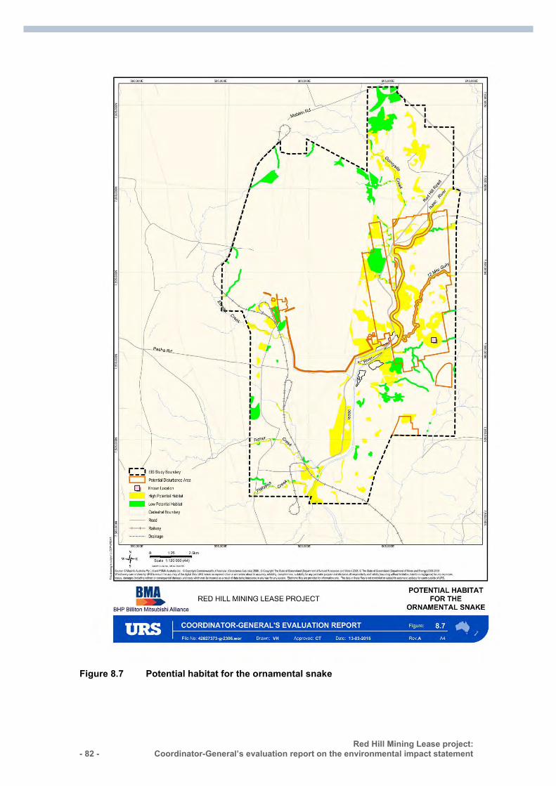
- 82 - Red Hill Mining Lease project:
Coordinator-General’s evaluation report on the environmental impact statement :
Figure 8.7 Potential habitat for the ornamental snake

Red Hill Mining Lease project: Coordinator-General’s evaluation report on the environmental impact statement
- 83 -
Koala
Description
The koala (Phascolarctos cinereus) was listed under the EPBC Act as ‘vulnerable’ on 30 April 2012. Its preferred habitat is eucalyptus-dominated temperate, sub-tropical and tropical forest, woodland and semi-arid habitats. Koalas can be found from Cairns to the New South Wales – Victorian border. Its distribution is not continuous across this range due to habitat degradation, fragmentation, urbanisation and unsuitable habitat conditions.
Vegetation communities mapped within the EIS study area that feature preferred koala trees as dominant or sub-dominant canopy species have been selected for use as the mapping criteria.
Conservation advice, recovery plans and threat abatement plans
A recovery plan for the koala is to be developed by the Australian Government and is to commence following the expiration of the National Koala Conservation and Management Strategy in 2014. This recovery plan will be for those populations covered by the national threatened species listing. There is currently a suite of planning instruments, policies and guidelines that protect koalas and their habitat.
The Conservation Advice for Phascolarctos cinereus (combined populations of Queensland, New South Wales and the Australian Capital Territory) lists actions at a broad level to support the recovery of the species and its future conservation:
research priorities that would inform future regional and local priority actions investigate, monitor, and mitigate habitat loss and disturbance to the species develop and implement a development planning protocol to be used in areas of
koala populations to prevent loss of important habitat, koala populations or connectivity options
develop and implement options of vegetation recovery and re-connection in regions containing fragmented koala populations, including inland regions in which koala populations were diminished by drought and coastal regions where development pressures have isolated koala populations
develop and implement a management plan to control the adverse impacts of predation on koalas by dogs in urban, peri-urban and rural environments
engage with private landholders and land managers responsible for the land on which populations occur and encourage these key stakeholders to contribute to the implementation of conservation management actions.
Survey results
A single koala was recorded in 2009 within poplar box woodland south-west of the survey area. It has not historically been observed within the EIS study area, however suitable habitat (poplar box woodlands, forest red gum riparian woodlands) exist for this species. Koala scats and scratches were observed in 2006 in the riparian zone of the Isaac River. The Isaac River riparian corridor is more likely to act as habitat for the
- 84 - Red Hill Mining Lease project:
Coordinator-General’s evaluation report on the environmental impact statement :
koala due to the dominance of forest red gum (E. tereticornis), an important food tree, and to the movement opportunities offered by the corridor itself.
Given that the surveys identified suitable habitat present within the EIS study area, the proponent undertook an assessment using an analysis tool recommended in the EPBC Act referral guidelines for the vulnerable koala. The Koala Habitat Assessment Tool (KHAT) produced a score of 8-9 for habitat critical to the survival of the koala within the EIS study area. Given the score, vegetation communities mapped within the EIS study area that feature preferred koala trees include RE 11.3.2, 11.3.3, 11.3.4, 11.3.25, 11.3.36, 11.4.2, 11.4.7, 11.4.8, 11.5.3 and 11.5.9. These REs have been mapped as high potential habitat critical to the survival of the koala (Figure 8.8). Accordingly, approximately 1,516ha of habitat critical to the survival of the koala has been mapped over the RHM footprint and may potentially be impacted by surface facilities and subsidence. Approximately 72ha may be impacted by the BRM panel extensions.
Project impacts
The direct impacts to this species are loss and fragmentation of habitat. The indirect impacts include vehicle strike, disease, and predation by dogs. However it was identified in the KHAT that there was no evidence of koala mortality from vehicle strike or dog attack in the study area. Drought and incidences of extreme heat are also known to cause very significant mortality, and post-drought recovery may be substantially impaired by the range of other threatening factors.
If the koala is identified during pre-clearance surveys, further management measures may be required. However progressive disturbance arising from the IMG management infrastructure, the overall fragmentation, loss of habitat and disturbance may make their continued presence unsustainable within the EIS study area.
Mitigation measures
The proponent has committed to undertake targeted field surveys of essential habitat areas. Surveys will be undertaken 12 months prior to the commencement of construction of the RHM to determine the presence and extent of koala habitat within this area.
If any areas within the disturbance footprint are deemed as significant habitat, a threatened species management plan will be developed. This plan will outline:
the level of activity that the habitat can sustain the remediation procedures if tension cracking or vegetation loss occurs further monitoring requirements.
The threatened species management plan will aim to mitigate the long-term impacts on this species within the EIS study area.
When clearing vegetation for any surface facilities, spotter catchers will be required when clearing areas of conservation significance such as woodland vegetation with high likelihood of arboreal animals. The proponent will avoid placing IMG extraction wells and infrastructure within the high potential habitat areas. Where this is unavoidable, offsets are proposed.

Red Hill Mining Lease project: Coordinator-General’s evaluation report on the environmental impact statement
- 85 -
Offsets
Approximately 1,516ha of high potential habitat critical to the survival of the koala and 405ha of low potential habitat (all other REs) will be potentially impacted as part of the proposed action. The largest impacted area is over stage 3 with approximately 898.26ha potentially impacted. I have recommended a condition to the Commonwealth Minister for the Environment that the proponent submit a BOP to compensate for authorised unavoidable impacts to the listed species.
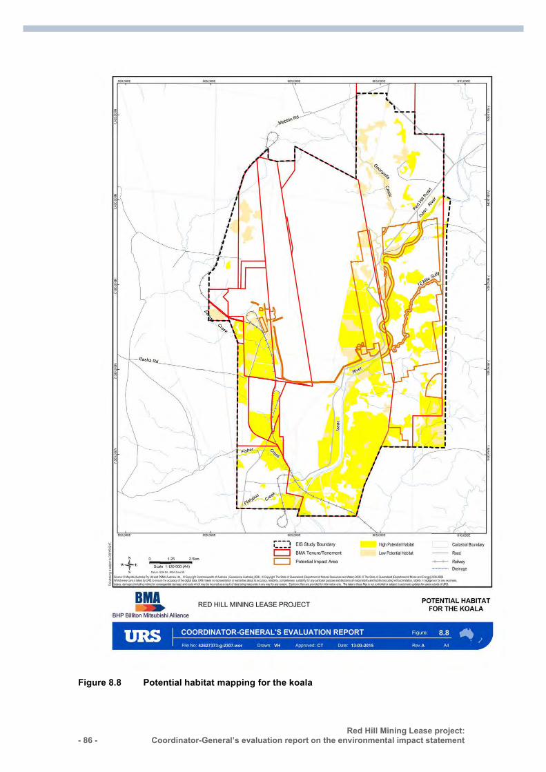
- 86 - Red Hill Mining Lease project:
Coordinator-General’s evaluation report on the environmental impact statement :
Figure 8.8 Potential habitat mapping for the koala
Red Hill Mining Lease project: Coordinator-General’s evaluation report on the environmental impact statement
- 87 -
8.4.6 Listed threatened fauna species that may ‘potentially’ occur
Australian painted snipe
The Australian painted snipe was listed as ‘endangered’ under the EPBC Act. The species is usually found in shallow inland wetlands, either freshwater or brackish, that are either permanently or temporarily filled.
This species was not detected during fauna surveys for the project but was considered by the proponent to ‘potentially’ occur as a visitor but it is ‘unlikely’ to occur given the required habitat type was not present.
8.4.7 Listed threatened fauna species ‘unlikely’ to occur
Dunmall’s snake
Dunmall’s snake is listed as ‘vulnerable’ under the EPBC Act. This species was not detected during fauna surveys for the project. According to the proponent’s AEIS, the Atlas of Living Australia (ALA 2014) shows that the nearest record of Dunmall’s snake to the study area is approximately 120km to the south-west near Clermont. All other records indicate a distance of greater than 300km from the study area.
Yakka skink
The yakka skink (Egernia rugosa) is listed as ‘vulnerable’ under the EPBC Act. This species was not detected during fauna surveys for the project. According to the proponent’s AEIS, the ALA 2014 shows that the yakka skink was recorded 200km to the south-east of the study area, near Blackwater, and 180km to the north-west near Mount Cooper Station.
South-eastern long-eared bat
The south-eastern long-eared bat is listed as ‘vulnerable’ under the EPBC Act. This species was not detected during fauna surveys for the project. There is no suitable habitat for the species to occur. It is considered that suitable habitat includes anywhere south of the Capricorn Highway, which is approximately 200km south of Moranbah.
8.4.8 Coordinator-General’s conclusion I conclude that significant impacts are likely on MNES for:
the threatened ecological community: – brigalow (Acacia harpophylla) – natural grasslands
threatened flora and fauna species: – bluegrass (Dichanthium setosum) – ornamental snake (Denisonia maculata) – koala (Phascolarctos cinereus) – squatter pigeon (southern) (Geophaps scripta scripta).
- 88 - Red Hill Mining Lease project:
Coordinator-General’s evaluation report on the environmental impact statement :
The two listed TECs and threatened flora and fauna species listed above will be impacted by the project; therefore, I have recommended a condition to the Commonwealth Minister for the Environment, for maximum disturbance limits for vegetation clearing.
I have also recommended a condition for the proponent to develop a BOP outlining how offsets will address the residual impacts of the project on TECs and how threatened flora and habitat for fauna species will be managed, monitored and legally secured. I will determine and approve any State offset conditions for impacts to matters of state environmental significance (MSES).
I note that the proponent in the first instance aims to avoid, minimise and mitigate impacts to biodiversity values by using sensitive design and careful site selection for the placement of surface infrastructure. I acknowledge that the impacts of the project will be confirmed and refined during the final design phase of the project. Should detailed design result in changes to habitat removal, I expect the proponent to detail these changes in the final BOP.
I am satisfied that the proponent’s proposed mitigation measures and commitments align with the relevant conservation advice, recovery plans and threat abatement plans to the extent that management actions to reduce the direct and indirect impacts such as targeting weed and feral animal control have been applied. The proponent will prepare a rehabilitation management plan along with a detailed pest and weed management plan and subsidence management plan in response to the potential direct impacts. Land rehabilitation will be managed through the EA issued by DEHP. I note that BMA already have a weed and pest management plan in place for Goonyella Riverside and Broadmeadow which outlines the weed and pest management activities. The plan will be expanded to include the Red Hill area to cover the management measures as stated in the EIS.
To ensure that impacts to TECs and threatened flora and fauna are monitored and effectively managed, I consider the impacts to MNES are adequately addressed through the conditions I have recommended.
8.5 Offsets
8.5.1 Offset proposal The proponent’s proposed Offset Strategy, presented in the AEIS documentation, presents a framework for a staged approach to deliver offsets for MNES and MSES. The proponent proposes to deliver offsets in three stages, which corresponds to the stages of mine development as shown in Figure 8.9. Stage 1 is over the Broadmeadow panel extensions; stage 2 is the Red Hill Accommodation village, the incremental expansion of Goonyella Riverside and initial works for Red Hill; and stage 3 will be the remainder of Red Hill expansion.
The strategy includes MNES-related offsets required by the Commonwealth Minister for the Environment under the EPBC Act. Each stage of the project provides maximum disturbance to biodiversity values.
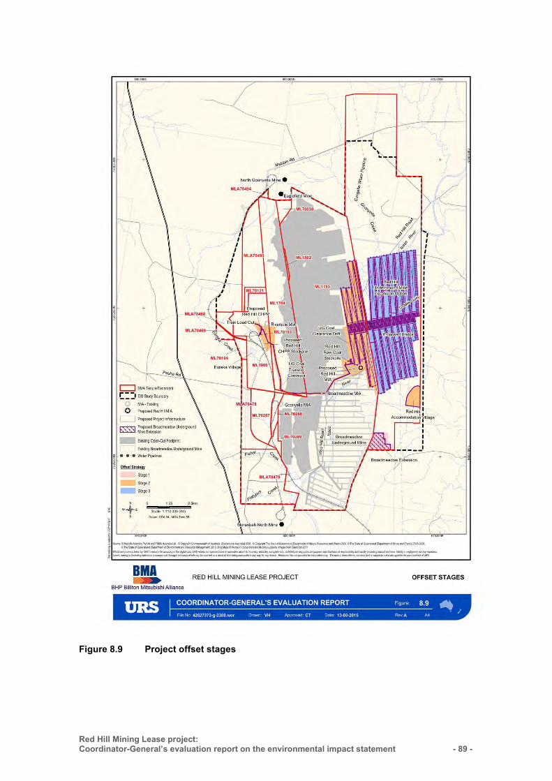
Red Hill Mining Lease project: Coordinator-General’s evaluation report on the environmental impact statement
- 89 -
Figure 8.9 Project offset stages
- 90 - Red Hill Mining Lease project:
Coordinator-General’s evaluation report on the environmental impact statement :
The proponent has demonstrated in the Offset Strategy contained within the AEIS documentation that MSES values overlap with MNES values as shown in Figure 8.10. The EPBC Act Environmental Offset Policy and Environmental Offset Act support the development of complementary offset packages. The EPBC Environmental Offset Policy states that “a State or Territory offset will count toward an offset under the EPBC Act to the extent that it compensates for the residual impact to the protected matter identified under the EPBC Act”. The overlapping MNES and MSES will be considered when developing offset packages for the project and offset delivery will preferentially secure offset areas which satisfy both MNES and MSES.
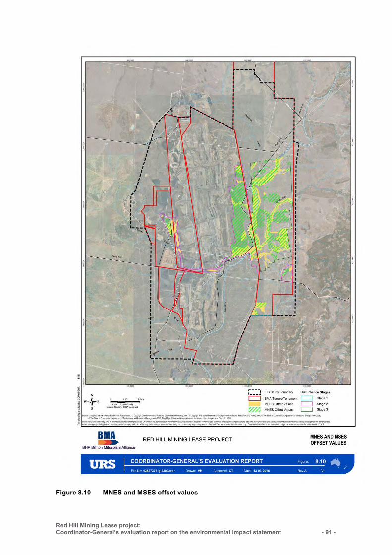
Red Hill Mining Lease project: Coordinator-General’s evaluation report on the environmental impact statement
- 91 -
Figure 8.10 MNES and MSES offset values
- 92 - Red Hill Mining Lease project:
Coordinator-General’s evaluation report on the environmental impact statement :
Methodology
Prior to the start of each stage, the proponent proposes to undertake an ecological equivalence assessment which is a methodology under the Queensland Environmental Offsets Policy. Actual impacts on site associated with clearing and subsidence will be reconciled against estimated disturbances following project works. The balance accrued against the overall values will be offset in the next stage.
The methodology used to determine offsets is determined by assessing the ecological equivalence between a cleared area and an offset area through the determination of an ecological score for both areas based on certain ecological conditions and special features. The results will inform the requirements for offsets in the final Offset Management Plan, about which I have recommended a condition for the Minister for the Environment’s consideration.
Impact areas
In the Offsets Strategy, the proponent has committed to conduct ecological assessments, legally secure the offset sites and prepare an Offsets Management Plan (OMP). The proponent has committed to avoid, minimise and mitigate impacts in the first instance. Accordingly, the Offsets Strategy presents a scenario for 100 per cent disturbance of vegetation as a worst-case disturbance scenario due to the uncertainty regarding clearing and design works associated with IMG drainage. As such, until further details can be obtained, the proponent has not identified residual impacts to MNES values, but rather an estimation of maximum disturbance to biodiversity values for each stage of the project. It is expected that offsets would be required to mitigate any residual impact after taking into account the mitigation measures. The proponent has stated that offsets will be selected and managed to deliver a net benefit. The offset area will become protected.
The maximum impact areas for vegetation clearing are presented in Table 8.3 and are across all three stages. For my assessment on outstanding residual MSES (watercourses and areas of connectivity), refer to Section 5.2 (Ecology).
The proponent has demonstrated that land is available in the bioregion which is presented below.
Table 8.3 Impact areas and land availability of high potential habitat for species and communities listed under the EPBC Act that are known to occur
MNES value Maximum impact area of high potential habitat (ha)
Brigalow TEC 368.76
Natural Grasslands TEC* 117.54 Squatter pigeon habitat 252
Ornamental snake habitat 1189.3
Koala habitat 1516.4
*Natural Grasslands TEC includes offset areas for high potential habitat of bluegrass and king blue grass.

Red Hill Mining Lease project: Coordinator-General’s evaluation report on the environmental impact statement
- 93 -
Delivery of offsets
The proponent has committed in its Offset Strategy to develop an OMP. The development of an OMP would provide further details based on results from the ecological equivalence assessments. The plan would provide opportunities for offsetting complementary values, identifying land available for offsetting and securing their locations and identifying offset requirements that would be secured through an offset transfer.
I expect the proponent to legally secure land with sufficient offset requirements prior to any project activities that are predicted to adversely impact on any of the species and communities which are to be offset.
I consider that the proposed Offset Strategy can be delivered in stages to compensate for environmental impacts of each mining stage to the level of ecological impacts incurred at each stage.
I am satisfied with the assessment undertaken by the proponent, which proposes adequate offsets for project impacts. I consider that the proposed staged Offset Strategy provides adequate information on offsets to all MSES and MNES impacted by the project.
I have recommended a condition for consideration by the Commonwealth Minister for the Environment that requires the proponent to provide biodiversity offsets to compensate for the unavoidable loss of habitat for EPBC Act listed threatened species and communities.
I have also recommended a condition for consideration by the Minister that requires the proponent to prepare and submit a Biodiversity Offset Plan (BOP) to the Minister for approval prior to commencement of the project.
The condition requires the approval holder to legally secure the minimum offset areas for each environmental value listed in Table A1 of the condition within two years of commencement of the specific component of the action. The condition also defines the content which must be contained in the BOP for each offset area. This plan is to be submitted to the Minister for approval within three months of identifying each offset area and must be implemented.
I have imposed a condition requiring the proponent to submit the BOP detailing any offset requirements conditioned by the Commonwealth Minister for the Environment to the Coordinator-General for approval within 60 days of an approval decision under the EPBC Act and no later than 2 months prior to the commencement of construction.
- 94 - Red Hill Mining Lease project:
Coordinator-General’s evaluation report on the environmental impact statement :
8.6 A water resource, in relation to coal seam gas development and large coal mining development (sections 24D & 24E)
8.6.1 Independent Expert Scientific Committee The Red Hill Mining Lease project proposes the taking of an action involving a large coal mining development that is likely to have a significant impact on a water resource. Therefore, in accordance with section 131AB of the EPBC Act, advice on the proposal was sought from the Independent Expert Scientific Committee (IESC).
On 5 March 2014, I submitted to the IESC a joint request for advice with the Department of the Environment (DE) on water-related matters for the project. The matter was considered at the IESC meeting of 8–10 April 2014 and the IESC responded with advice on 11 April 2014.
Matters of interest to the IESC from the project’s EIS included the following:
groundwater modelling subsidence modelling impacts to surface and groundwater resources impacts to water-dependent assets.
IESC advice and Coordinator-General’s response
IESC comment 1—conceptual and numerical groundwater models The IESC advised that the conceptual and numerical groundwater models were not adequate to assess potential impacts on water resources and water-related assets, and do not deal fully with the uncertainty of predictions. In particular, there are limitations around the parameters used for recharge and hydraulic conductivity.
In response, the proponent provided additional information regarding the conceptualisation of the groundwater regimes, both local and regional, including three conceptual cross-sections constructed to show:
current groundwater resources, levels, aquifers, recharge and flow end of RHM project activities long-term groundwater levels after mine closure.
The proponent suggests that there is a limited impact of mining on the Tertiary basalt aquifer to the south-west of the GRB mine complex due to regional groundwater monitoring within the vesicular basalt which indicates groundwater level increasing over time (in response to recharge). Therefore, the Tertiary basalt was not discussed further in the conceptualisation.
I am satisfied that the groundwater models are adequate to assess the potential impacts on groundwater, interactions with surface water, water resources and water-dependent assets. To ensure that risks to groundwater users are monitored and effectively managed, I have set conditions for the EA requiring the proponent to develop and implement a robust groundwater monitoring, iterative modelling and
Red Hill Mining Lease project: Coordinator-General’s evaluation report on the environmental impact statement
- 95 -
management program for the life of the project. This includes the implementation of a comprehensive bore monitoring network to enable the long-term monitoring of groundwater levels and groundwater quality.
IESC comment 2—subsidence modelling The IESC advised that the subsidence model:
did not address impacts such as the risk of direct hydraulic connectivity between the ground surface and the coal seam
only predicted subsidence in terms of vertical displacement needs to outline surface subsidence monitoring and triggers for mitigation to ensure
that risks to surface water resources and aquatic ecosystems are adequately managed.
For the predictive modelling, the proponent considers the surface water and groundwater interaction to be limited. The alluvium is considered as having minor surface water–groundwater interaction and the river does not receive significant inflows from groundwater resources. The proponent also states that the assessment of the dewatered alluvium, and in turn the potential for impacts on surface water, had been adequately considered concluding that the Isaac River in the project area does not receive significant inflows from groundwater resources with negligible impacts on the surface water flow during the wet season. The proponent has committed to refine the predictive model using actual groundwater monitoring results at regular three-year intervals.
Whilst the proponent has advised that fracturing may occur within the Tertiary sediments as a result of surface subsidence, it is predicted to only occur to a maximum depth of 10m and will not extend through the entire Tertiary unit which is 80m thick. Hence, longwall mining impacts are not predicted to result in any connections between the target Goonyella Middle Seam (GMS) coal and the surface.
The proponent has committed to monitor subsidence impacts, including sub-surface subsidence fracturing and alteration to aquifer hydraulic parameters (including vertical hydraulic conductivity). The proponent is also committed to updating the subsidence management plan where subsidence occurs to depths greater than predicted and has provided further details in relation to the proposed subsidence adaptive management approach to ensure risks to surface water resources and aquatic ecosystems are adequately managed.
In addition, the Coordinator-General has stated conditions to be included in the draft EA for the project requiring the proponent to develop and implement a Subsidence Management Plan prior to the commencement of activities that could result in subsidence and the annual inspection of subsided longwall panels to assess structural, geotechnical and hydraulic adequacy.
IESC comment 3—subsidence voids The IESC suggested that mitigation measures for the capture of water in subsidence voids would be more comprehensively informed by considering the volume of water captured and the geomorphic impacts of subsidence. The IESC does not consider that
- 96 - Red Hill Mining Lease project:
Coordinator-General’s evaluation report on the environmental impact statement :
the scale of bank erosion in the Isaac River and other streams has been quantitatively addressed, and that the total annual loss of flow to the Isaac River should be quantified as a result of subsidence impacts. Whilst the proponent intends to drain only some of the larger subsidence voids to minimise impacts of physical disturbance, the IESC suggests that mitigation to address flow losses to the Isaac River and tributaries be designed in order to better inform decisions on the need for mitigation measures including the potential for draining all voids.
In response, the proponent provided additional information regarding the estimation of water capture in subsidence voids as well as information on sediment transport modelling developed to manage the risks of bed and bank instabilities following subsidence. The proponent also provided additional information on avulsion risks based on the quantitative hydraulic modelling of extreme events.
The proponent has committed to implement mitigation measures for the subsidence voids and will determine the actual depth and volume of each void once the panel has subsided to determine the appropriate mitigation response. In addition, I have imposed a condition that subsided longwall panels must not result in the capture of significant overland flow (i.e. greater than 50ML) and must allow water to drain from the panel after the adjacent panel has been completed, or after a period of twelve months if there is no adjacent panel to be developed.
IESC comment 4—cumulative impacts The IESC considered cumulative impacts on groundwater resources within the region to be significant given the number and extent of other coal mines and coal seam gas projects in the Bowen Basin.
The proponent advised that its predictive modelling approach, based on site-specific data indicating that the impact of long-term mine dewatering on the surrounding groundwater resources was limited (due to low aquifer parameters and compartmentalisation due to large fault structures), allowed for an assessment of the cumulative impact of the proposed project including the approved GRB mine on groundwater resources.
Based on the proponent’s projected drawdown contours for the target coal seam at the end of the project life, the potential impacts associated with mine dewatering for the GRB mine complex, including the proposed project, are not expected to change significantly. In addition, there are 13 other mines and coal seam gas projects within the region that will extract groundwater from the upper Isaac River catchment. The proponent advised that the available information for these projects indicates limited groundwater resources and limited drawdown impacts outside of the mine workings based on the predicted groundwater ingress estimates. The cumulative impact assessment of the surrounding resource projects was considered using the GRB and RHM simulations, groundwater responses to historic mine dewatering, and the individual project studies. Based on the impact predictions for various projects, groundwater extraction will generally exceed recharge across the cumulative study area at the various projects sites at different times depending on mine schedules. The groundwater resources are predicted to recover as mining activities enhances groundwater potential to the base of residual voids.
Red Hill Mining Lease project: Coordinator-General’s evaluation report on the environmental impact statement
- 97 -
IESC comment 5—stygofauna survey The IESC commented that the 150µm net mesh size used for the stygofaunal survey was too large and that a review of the stygofauna sampling strategy should be undertaken with a second round of post-wet sampling being conducted using equipment that complies with Western Australian guidelines, including 50µm mesh and a solid famed net.
In response, the proponent advised that the stygofauna sampling conducted with the 150μm net mesh was used by the proponent’s field staff because of the turbid nature of the groundwater samples. The Western Australia EPA Guidance Statement No. 54a, Sampling Methods and Survey Considerations for Subterranean Fauna in Western Australia (EPA 2007) indicates that the use of a large mesh size is appropriate for high turbidity samples. For this reason, the proponent did not undertake a second stygofauna sample. Further, the proponent found that the likelihood of stygofauna was limited due to the high turbidity (which was reflected in the absence of stygofauna in any of the five groundwater samples assessed) and poor groundwater quality, low permeability and porosity (clay-rich), limited recharge, and the unsaturated (seasonal) nature of the more favourable stygofauna habitat alluvium.
Further, the results of a review of available stygofauna occurrence in the Bowen Basin (including the sampling of 127 groundwater sites for stygofauna) showed that only 12 per cent (15 sites) contained stygofauna, and the majority of these bores were in alluvial aquifers in unconsolidated sediments. All of the recorded stygofauna were collected from alluvial/sedimentary aquifers and none were identified in coal seam aquifers. The review highlighted the conditions for potential stygofauna. The proponent concluded that due to the ephemeral nature of the upper Isaac River, its associated aquifers do not contain sufficient permanent groundwater to support stygofauna populations.
IESC comment 6—groundwater-dependent ecosystem The IESC commented that the use of groundwater by riparian vegetation needs to be evaluated using techniques from the Australian Groundwater Dependent Ecosystem Toolbox (Richardson et al., 2011).
In response, the proponent advised that no GDEs have been identified within or adjacent to the project area due to the perched and seasonal nature of the alluvial aquifer.
The proponent’s conclusion was premised on:
Available hydrologic data suggesting that water infiltrates/drains to the base of the alluvium relatively quickly after rainfall events where more permeable units are at surface. Saturation was observed to be sporadic, producing semi-permanent, localised, and thin aquifers.
The results of a groundwater penetrating radar (GPR) survey undertaken along the Isaac River north of Moranbah. This suggested that groundwater occurrence is limited to deeper parts of the channel and may not be saturated all year round.
Available drilling data adjacent to the Isaac river indicating that base flow of groundwater to the Isaac River is not significant.
- 98 - Red Hill Mining Lease project:
Coordinator-General’s evaluation report on the environmental impact statement :
The results of vegetation studies, which suggested that mapped flora and riparian vegetation rely on water trapped within the unsaturated zone as opposed to being groundwater dependent.
Use of groundwater by riparian vegetation was also found to be limited by the groundwater quality from the alluvium aquifers. A summary of groundwater quality from registered bores in the upper Isaac River alluvium demonstrated that alluvial groundwater has a highly variable salinity, ranging from fresh to very saline and ionic balance dominated by sodium and chloride. Only isolated pockets of low-salinity groundwater may exist in the Isaac River alluvium.
IESC comment 7—water quality The IESC commented that the proponent has adopted modified water quality objectives (WQOs) for EC, aluminium, copper and chromium and that additional information to support the adoption of the modified EC WQOs that exceed baseline EC levels, as well as information on how the modified WQOs for dissolved aluminium, copper and chromium were derived, would enable evaluation of their appropriateness for a new development in the Isaac River catchment.
In response, the proponent advised that modified WQOs for EC, dissolved aluminium, copper and chromium were derived from the existing EA (EPML00853413 approved by DEHP on 6 September 2013). This approach was taken because the water used at RHM would be integrated into the GRB water management system. Additionally, WQOs for EC were developed in accordance with the EPP (Water) and Queensland Water Quality Guidelines (2009).
IESC comment 8—management strategy The IESC commented that the storage of surplus mine-affected water in ‘low priority pits’ is substantially more saline than in situ groundwater and water abstracted from the underground mine. The salinity of mine-affected water discharges is likely to be increased by mixing the proposed project’s mine-affected water with pit water, resulting in increased salinity in mine discharges.
In response, the proponent advised that the mine water balance modelling was undertaken as part of the EIS to assess expected salinity levels at the downstream monitoring point in the worst-case scenario of surplus mine water being generated by the project. The results indicated that for 99 per cent of the time, salinity concentrations downstream of the mine would comply with the EA condition of the GRB mine complex (EPML00853413) of 2,000μS/cm with or without the addition of water from the proposed project. Furthermore, the modelling indicated that addition of the project’s water slightly increases the salt levels in the receiving environment for around 1–6 per cent of the time. For 94–99 per cent of the time, the difference between salt levels in the receiving environment with and without the project is negligible.
It is important to note that in most years of operation, the project’s water demand will exceed its dewatering volumes and surplus water from the GRB mine complex will be required. No further quantification, such as analysis of the mixing zone, is considered justified given that the level of impact from the project is minimal.
Red Hill Mining Lease project: Coordinator-General’s evaluation report on the environmental impact statement
- 99 -
IESC comment 9—leachate The IESC commented that runoff and seepage water from mineral waste materials is predicted to contain low dissolved metal concentrations. However, the proponent’s data indicates that leachate from mine wastes may contain elevated concentrations of a number of metals. Quantification of the concentration and loading of contaminants that may leach from waste materials and comparison with appropriate guidelines would assist in identifying risks to downstream aquatic ecosystems.
The proponent provided quantifications of the concentration and loading of contaminants that may leach from waste materials. The results have been compared to the trigger values for the 95 per cent protection of aquatic species (ANZECC 2000). The water-extractable dissolved metal concentrations for the mineral waste samples are generally below the trigger values, where guideline values exist. The concentrations of aluminium, chromium and copper in some samples exceed the trigger values (ANZECC 2000) but it is noted that they do not exceed (or marginally exceed) the Release Contaminant Trigger Investigation Levels under the current EA (at GRB).
Elevated concentrations of arsenic, molybdenum and nickel above the ANZECC (2000) trigger values and/or release contaminant trigger investigation levels are noted in some samples. The proponent noted that the water-extractable dissolved metal concentrations are conservative and likely to overestimate the actual concentrations observed in the field because metal leachability analysis was completed on continuously agitated pulverised sample suspensions. It is noted that arsenic is not amongst the contaminants of potential concern in the contaminant trigger investigation levels (under the existing EA for GRB), which have been refined over a long period of time and reflect the cumulative observations collected in the field to date.
Sulphate and calcium concentrations in leachates may exceed the Australian Livestock Drinking Water Guidelines (ANZECC 2000). Since the re-use of decant water from the tailings dams in the CHPP and due to the climate of the region where evaporation exceeds rainfall, the proponent concluded that the migration of metal (and sulphate) contaminants via seepage through the tailings will be limited as will the potential risk for drainage to migrate off site.
The geochemical testing undertaken for the EIS was undertaken in a manner that is consistent with industry practice, other coal mines in Queensland, and accepted national and international guidelines.
Coordinator-General’s conclusions—IESC advice
I am satisfied that the proponent’s technical reports and advice from Queensland government agency experts addresses the outstanding matters raised in the IESC advice.
- 100 - Red Hill Mining Lease project:
Coordinator-General’s evaluation report on the environmental impact statement :
8.6.2 Groundwater
Introduction
The geological Bowen Basin is an elongated, north-south trending basin which extends from east-central Queensland to northern New South Wales. Figure 8.11 illustrates the groundwater study boundary within the project study area. The basin covers an area of approximately 200,000km2, and is exposed at the surface over a distance of 600km from Collinsville in the north to Rolleston in the south, from where it is then overlain by the Surat Basin. It contains a sedimentary sequence of Permian to Triassic age, which attains a maximum thickness of 9,000m.
The major geological structure of the survey area is the Collinsville Shelf, the eastern boundary of which is marked by the Burton Range Thrust Fault, which is located approximately 10km east of the EIS study area.
Regionally, the stratigraphic sequence is summarised as follows: the early to Middle Permian Back Creek Group overlain by the late Permian Blackwater Group which contains the coal seams of interest. These are followed by the Triassic Mimosa Group, Tertiary volcanic units and extensive Quaternary alluvial deposits, as shown in Table 8.4
The groundwater regime in the survey area is considered to include:
Quaternary alluvial aquifers associated with the creeks and Isaac River tertiary sediment aquifers tertiary basalt aquifers Permian-Triassic sedimentary fractured rock aquifers.
The project is located within the Isaac Connors Groundwater Management Area (GMA), as defined in the Water Resource (Fitzroy Basin) Plan 2011. Based on a review of available data, groundwater is not considered to be a major water source in the area and is also considered to comprise low sustainable yields and be of poor quality.
The occurrence and continuity of the aquifers will be highly dependent on the spatial distribution of the corresponding geological units in the area. Figure 8.12 presents a typical geological cross-section for the area.
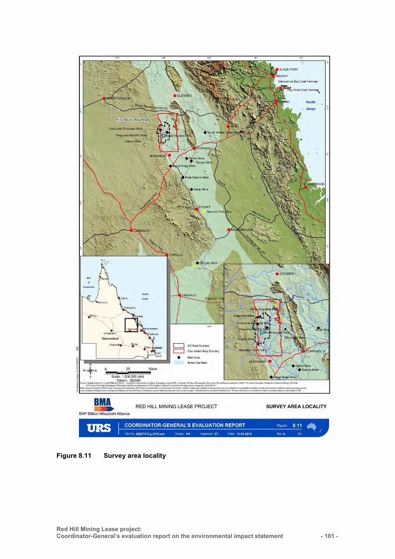
Red Hill Mining Lease project: Coordinator-General’s evaluation report on the environmental impact statement
- 101 -
Figure 8.11 Survey area locality
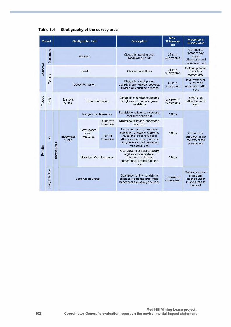
- 102 - Red Hill Mining Lease project:
Coordinator-General’s evaluation report on the environmental impact statement :
Table 8.4 Stratigraphy of the survey area
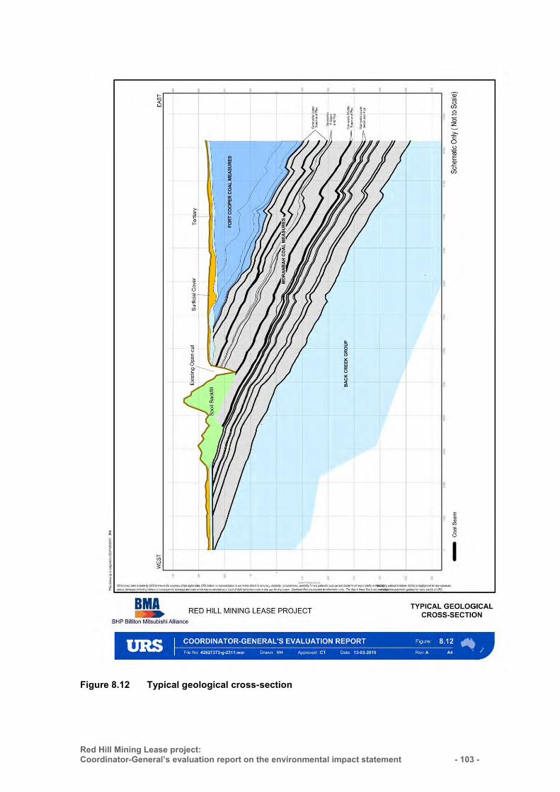
Red Hill Mining Lease project: Coordinator-General’s evaluation report on the environmental impact statement
- 103 -
Figure 8.12 Typical geological cross-section
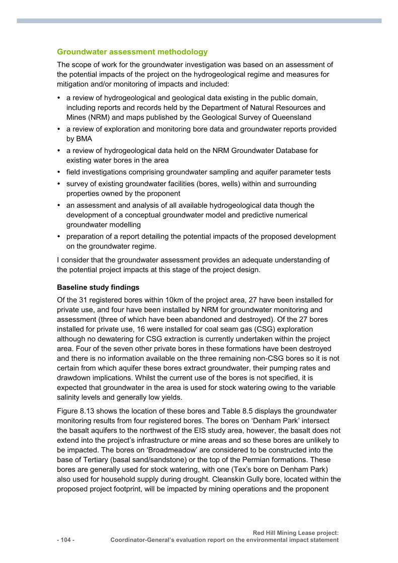
- 104 - Red Hill Mining Lease project:
Coordinator-General’s evaluation report on the environmental impact statement :
Groundwater assessment methodology
The scope of work for the groundwater investigation was based on an assessment of the potential impacts of the project on the hydrogeological regime and measures for mitigation and/or monitoring of impacts and included:
a review of hydrogeological and geological data existing in the public domain, including reports and records held by the Department of Natural Resources and Mines (NRM) and maps published by the Geological Survey of Queensland
a review of exploration and monitoring bore data and groundwater reports provided by BMA
a review of hydrogeological data held on the NRM Groundwater Database for existing water bores in the area
field investigations comprising groundwater sampling and aquifer parameter tests survey of existing groundwater facilities (bores, wells) within and surrounding
properties owned by the proponent an assessment and analysis of all available hydrogeological data though the
development of a conceptual groundwater model and predictive numerical groundwater modelling
preparation of a report detailing the potential impacts of the proposed development on the groundwater regime.
I consider that the groundwater assessment provides an adequate understanding of the potential project impacts at this stage of the project design.
Baseline study findings Of the 31 registered bores within 10km of the project area, 27 have been installed for private use, and four have been installed by NRM for groundwater monitoring and assessment (three of which have been abandoned and destroyed). Of the 27 bores installed for private use, 16 were installed for coal seam gas (CSG) exploration although no dewatering for CSG extraction is currently undertaken within the project area. Four of the seven other private bores in these formations have been destroyed and there is no information available on the three remaining non-CSG bores so it is not certain from which aquifer these bores extract groundwater, their pumping rates and drawdown implications. Whilst the current use of the bores is not specified, it is expected that groundwater in the area is used for stock watering owing to the variable salinity levels and generally low yields.
Figure 8.13 shows the location of these bores and Table 8.5 displays the groundwater monitoring results from four registered bores. The bores on ‘Denham Park’ intersect the basalt aquifers to the northwest of the EIS study area, however, the basalt does not extend into the project’s infrastructure or mine areas and so these bores are unlikely to be impacted. The bores on ‘Broadmeadow’ are considered to be constructed into the base of Tertiary (basal sand/sandstone) or the top of the Permian formations. These bores are generally used for stock watering, with one (Tex’s bore on Denham Park) also used for household supply during drought. Cleanskin Gully bore, located within the proposed project footprint, will be impacted by mining operations and the proponent

Red Hill Mining Lease project: Coordinator-General’s evaluation report on the environmental impact statement
- 105 -
has an existing compensation agreement with the owner in the event that the bore is no longer available for water supply.
The environmental values for groundwater in the project area include aquatic ecosystems, stock watering and cultural values and the existing groundwater environment, within the groundwater survey area, were assessed against these environmental values.
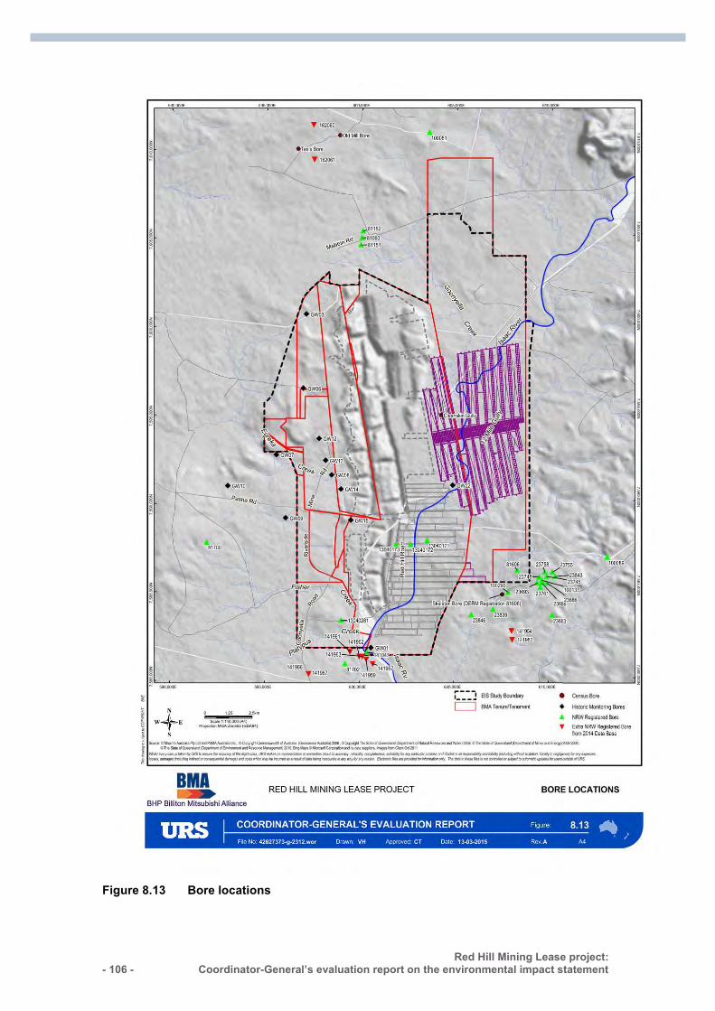
- 106 - Red Hill Mining Lease project:
Coordinator-General’s evaluation report on the environmental impact statement :
Figure 8.13 Bore locations
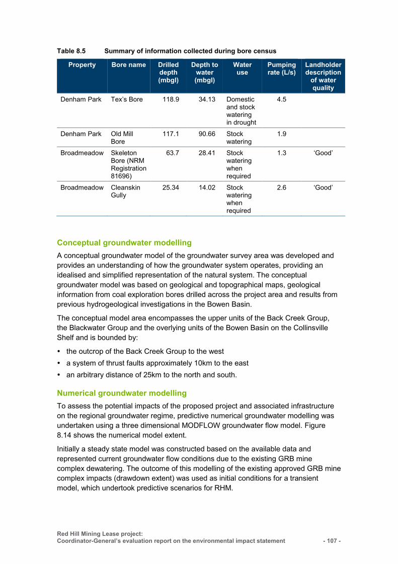
Red Hill Mining Lease project: Coordinator-General’s evaluation report on the environmental impact statement
- 107 -
Table 8.5 Summary of information collected during bore census
Property Bore name Drilled depth (mbgl)
Depth to water (mbgl)
Water use
Pumping rate (L/s)
Landholder description
of water quality
Denham Park Tex’s Bore 118.9 34.13 Domestic and stock watering in drought
4.5
Denham Park Old Mill Bore
117.1 90.66 Stock watering
1.9
Broadmeadow Skeleton Bore (NRM Registration 81696)
63.7 28.41 Stock watering when required
1.3 ‘Good’
Broadmeadow Cleanskin Gully
25.34 14.02 Stock watering when required
2.6 ‘Good’
Conceptual groundwater modelling
A conceptual groundwater model of the groundwater survey area was developed and provides an understanding of how the groundwater system operates, providing an idealised and simplified representation of the natural system. The conceptual groundwater model was based on geological and topographical maps, geological information from coal exploration bores drilled across the project area and results from previous hydrogeological investigations in the Bowen Basin.
The conceptual model area encompasses the upper units of the Back Creek Group, the Blackwater Group and the overlying units of the Bowen Basin on the Collinsville Shelf and is bounded by:
the outcrop of the Back Creek Group to the west a system of thrust faults approximately 10km to the east an arbitrary distance of 25km to the north and south.
Numerical groundwater modelling
To assess the potential impacts of the proposed project and associated infrastructure on the regional groundwater regime, predictive numerical groundwater modelling was undertaken using a three dimensional MODFLOW groundwater flow model. Figure 8.14 shows the numerical model extent.
Initially a steady state model was constructed based on the available data and represented current groundwater flow conditions due to the existing GRB mine complex dewatering. The outcome of this modelling of the existing approved GRB mine complex impacts (drawdown extent) was used as initial conditions for a transient model, which undertook predictive scenarios for RHM.
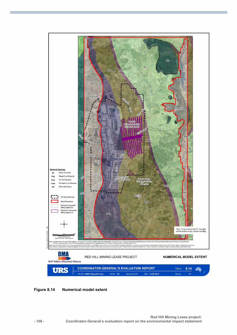
- 108 - Red Hill Mining Lease project:
Coordinator-General’s evaluation report on the environmental impact statement :
Figure 8.14 Numerical model extent
Red Hill Mining Lease project: Coordinator-General’s evaluation report on the environmental impact statement
- 109 -
Based on this modelling, it is estimated that 35 gigalitres (GL) of groundwater will be extracted before and during mining for gas drainage and mine dewatering, with an average extraction of 1.4GL per annum. Some of this predicted extraction will not be extracted by IMG drainage or seepage collection, but will be lost from the mine water balance as embodied water in extracted coal or evaporation through the mine ventilation system. While extraction from the underground mines stop at the completion of mining, groundwater will continue to flow into the mine void and goaf with a consequent lag in groundwater drawdown as this storage is filled.
Potential groundwater impacts and mitigation measures
Predictive numerical groundwater modelling was undertaken to evaluate impacts on groundwater from the development, specifically with regard to groundwater extraction over the mine life, predicted drawdown in aquifers, and possible impacts on other groundwater users.
The groundwater model was constructed using the geological model, hydraulic parameters and groundwater level information within the survey area.
Given the close proximity of coal mines to the north and south (North Goonyella Mine and Moranbah North mine), the assessment was undertaken in consideration of the additional impacts of the project on the current (mine influenced) groundwater resources in the survey area.
Development and operation Groundwater modelling was used to predict drawdown caused by dewatering and IMG drainage of the proposed RHM. Predictive modelling indicated that drawdown of 5m (from pre-RHM mining levels) will occur to a distance of up to 4km from the proposed RHM footprint.
Cleanskin Gully bore, located within the proposed project footprint, will be impacted by mining operations and the proponent has an existing compensation agreement with the owner in the event that the bore is no longer available for water supply. The proponent is committed to providing make-good agreements for other groundwater users should impacts be identified.
The Quaternary alluvium associated with the Isaac River is considered to be the most significant aquifer within the survey area. This aquifer is unlikely to be significantly impacted by groundwater drawdown as there are no major excavations proposed in close proximity to the Isaac River, and there is limited hydraulic connection between the perched water tables in the alluvium and the confined coal seam aquifers.
An estimated 35GL of groundwater will be extracted before and during mining for gas drainage and mine dewatering, with an average extraction of 1.4GL per annum and a maximum annual extraction of 2GL. Aquifers outside the mine will continue to receive recharge via the current pre-mining processes.
Mine dewatering, IMG management, and ingress into the mine workings will cause drawdown of regional groundwater levels. Predictive groundwater modelling indicates that drawdown of 5m could occur approximately 4km from the RHM boundary, within
- 110 - Red Hill Mining Lease project:
Coordinator-General’s evaluation report on the environmental impact statement :
the target coal seam, the GMS. Groundwater drawdown will also occur in the units above the GMS.
The proponent indicates that, whilst subsidence is predicted to create some cracking at surface, the clay-rich nature of the sediments is expected to self-seal which will reduce the potential leakage from surface to the mine workings.
Despite the project being located within the Isaac Connors GMA, there are few groundwater users locally.
Impacts on groundwater-dependent ecosystems (GDEs) are not expected due to the ephemeral nature of the Isaac River and creeks as well as the lack of perennial water holes.
Groundwater quality
It is proposed that all RHM water and waste storage facilities infrastructure be designed, constructed, and managed to ensure little or no potential seepage to ensure groundwater quality within aquifers surrounding the site does not change during mining operations. In the event that groundwater contamination did occur, contaminant migration off site in the groundwater is not expected as groundwater will be continually extracted from bores or sumps in the underground workings (to ensure a safe working environment). This extraction of groundwater will create a depression in the potentiometric surface around the workings such that the net movement of groundwater is towards the workings during mine operation.
No GDEs have been identified within or adjacent to the project area. This is due to the perched and seasonal nature of the alluvial aquifer. Whilst potential for usable groundwater resources exists within the more permeable sand and gravel sections of the alluvium, variations in saturated thickness and bedrock outcrops indicate that the alluvium is not one continuous aquifer. Further, with the alluvial aquifers strongly linked to surface water due to recharge during stream-flow events, available hydrologic data suggests that water drains quickly to the base of the alluvium producing semi-permanent, localised, and thin aquifers. Available drilling data suggest that the channel may not be saturated all year round and that the sediments adjacent to the Isaac River are generally dry to a depth below the base of the bed sands suggesting that base flow of groundwater to the Isaac River is not significant.
Due to the semi-arid climate, the ephemeral nature of the stream flow and discontinuity of the more permeable gravel and sand layers, the groundwater resources in the Quaternary alluvium in the study area are not abundant. Vegetation studies also indicate that the mapped flora and riparian vegetation rely on trapped water as opposed to being groundwater dependent. The suitability of groundwater from the alluvium aquifer in the upper Isaac River is also limited by the groundwater quality which is mostly unacceptable for domestic use and too saline for stock watering and crop irrigation.
Stygofauna was not detected in the five groundwater samples undertaken by the proponent. The potential for stygofauna is considered low due to the turbid nature of the groundwater sampled, poor groundwater quality, low permeability and porosity, limited recharge and the unsaturated (seasonal) nature of the more favourable
Red Hill Mining Lease project: Coordinator-General’s evaluation report on the environmental impact statement
- 111 -
stygofauna habitat alluvium. Whilst most identified Australian stygofauna species live exclusively in groundwater, the upper Isaac River is ephemeral and its associated aquifers do not contain sufficient permanent groundwater to support stygofauna populations. Therefore, the potential for stygofauna within the study area is limited.
Additional potential impacts
Underground mining using conventional longwall mining and thick seam mining methods will result in subsidence of the overlying strata which can cause fractures and joints in the overlying strata. Within the tensile zone above and adjacent to the longwall panels the vertical and horizontal strata permeability will be significantly and permanently altered due to sub-surface fracturing. In the RHM, the fracturing in the Permian units is predicted to extend up to 10m from the ground surface.
Methods of degassing the coal in advance of mining are currently being developed for the project, and are likely to include installation of gas drainage wells. The drilling and installation of gas drainage wells has the potential to impact on groundwater by creating potential pathways for leakage between formations.
Compression of the ground surface associated with road construction, building formations and IMG infrastructure is not expected to greatly alter the permeability of strata immediately beneath the site and, as such, will not markedly reduce rainfall recharge of the underlying aquifers. Works will be limited in the vicinity of the Isaac River, further limiting potential impacts on the Quaternary alluvial aquifer.
Post-mining The main features of the final landform after mining ceases will comprise partially to totally filled mine voids in the underground workings, and subsidence troughs on the surface.
As with the impacts during mining, the increased permeability and storage for groundwater in the goaf will remain after mining.
Over time, groundwater levels are expected to recover within RHM after closure, to the base of the GRB mine complex open pits. Due to the significant impact the closure requirements for the GRM will have on recharge to groundwater and the rate of groundwater recovery, a detailed study of groundwater level recovery within RHM has not been conducted. Post-mining, water quality within all aquifers surrounding the project area should remain similar to pre-mining water quality.
Mitigation measures While groundwater model predictions do not indicate any significant impacts on adjacent groundwater users, the proponent will seek to negotiate agreements for the provision of alternative supplies (make-good agreements) throughout the mine life, and after mine closure in the event detrimental impacts on landholder groundwater supplies are detected. This commitment is reflected in the proponent’s commitment register.
The proponent proposes to maintain a monitoring bore network for the Broadmeadow extension and the future RHM mine to enable the long-term monitoring of groundwater levels and groundwater quality, as well as re-running the groundwater model every
- 112 - Red Hill Mining Lease project:
Coordinator-General’s evaluation report on the environmental impact statement :
three years as additional level, ingress and dewatering data become available. The proponent has also committed to undertake routine monitoring to ensure any variation in groundwater predictions is identified early, and measures implemented to minimise potential impacts on surrounding groundwater users and the environment.
While groundwater monitoring will enable the identification of any groundwater level drawdown impacts, I note that all proposed bores and existing monitoring bores are located within the project area. To ensure impacts are adequately detected off lease, I will require that the groundwater monitoring network be reviewed and extended over time, including additional sites off lease if required, to adequately measure impacts as drawdown in water levels spread over time and have recommended a condition to this effect.
Coordinator-General’s conclusions—groundwater
The project’s key groundwater impact is expected to be drawdown. To ensure that risks to groundwater users are monitored and effectively managed, I have set conditions for the EA requiring the proponent to develop and implement a robust groundwater monitoring, iterative modelling and management program during the life of the project. This includes the implementation of a comprehensive bore monitoring network to enable the long-term monitoring of groundwater levels and groundwater quality. Further, I have set conditions requiring the proponent to enter into make-good agreements with any potentially affected groundwater users.
I consider the impacts to groundwater resources are adequately addressed through the conditions I have imposed and do not consider additional water conditions to be required.
8.6.3 Surface water
Introduction
The EIS study area is located within the headwaters of the Isaac-Connors sub-catchment of the greater Fitzroy Basin. The project activities span the Isaac River and tributary catchments of Goonyella Creek and 12 Mile Gully. Other tributaries in the area include Eureka Creek, Fisher Creek, and Platypus Creek, all of which flow into the Isaac River downstream of the proposed RHM underground footprint (see Figure 8.15).
In 2011, there were five registered water licensees located within 100km downstream of the project area, along the Isaac River. Four of these are using water for stock and domestic purposes and the fifth licence is in relation to a diversion. Whilst there were no licensed water users identified within the project area, the Water Act 2000 (Qld) does allow landholders adjacent to rivers to take water for stock and domestic purposes without a licence.
The Isaac River and tributaries in and around the project area are ephemeral. Flow mainly occurs for a short period during and immediately after rainfall events. Base flow appears to be sustained by surface base flow stores rather than distinct groundwater contribution (as levels recede rapidly after rainfall events) and is typically limited to a few days after surface runoff has drained from contributing sub-catchments.

Red Hill Mining Lease project: Coordinator-General’s evaluation report on the environmental impact statement
- 113 -
Sediment is transported naturally in the Isaac River sub-catchment with land disturbance contributing to increased levels of sediment in this area. Subsidence caused by the RHM will result in a range of geomorphic impacts in the Isaac River and tributaries with subsidence troughs gradually filling in over time leading to a more uniform bed level.
The flood modelling results show that flow velocity and stream power are generally within a similar hydraulic range to the pre-project conditions base case. Localised higher velocities and stream power are likely at the upstream end of the subsidence areas and unsubsided pillar areas, and lower velocities and stream power within the subsided panels.
While the Isaac River water quality and tributaries are generally suitable for most beneficial uses, the streams are highly ephemeral which results in limited use due to limited flow.
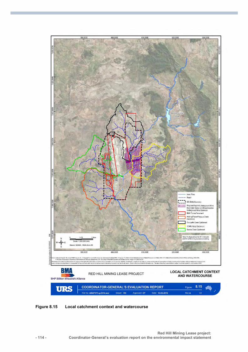
- 114 - Red Hill Mining Lease project:
Coordinator-General’s evaluation report on the environmental impact statement :
Figure 8.15 Local catchment context and watercourse
Red Hill Mining Lease project: Coordinator-General’s evaluation report on the environmental impact statement
- 115 -
Surface water assessment methodology
A Surface Water Quality Assessment Technical Report was prepared to assess baseline conditions and potential impacts of the proposed project on surface water quality in watercourses within and downstream from the project area.
The methodology adopted for the surface water quality impact assessment included:
identification of relevant environmental values applicable to water quality management outlined in the EPP (Water)
assessment and preliminary description of the background surface water quality based on available datasets from a nearby NRM monitoring station and water quality sampling
description of the features and activities of the project relevant to the surface water quality impact assessment and description of potential impacts
identification of mitigation strategies and measures required to manage the potential impacts on surface water quality
identification of the potential residual impacts, following implementation of mitigation strategies and measures.
Mine water management
The future RHM would operate separately from the existing GRB mine complex; however, there will be an interaction between the two operations in relation to mine water management. Mine water generated by the project will be transferred to the GRB mine complex and re-used in coal handling and preparation activities as well as dust suppression.
It is expected that for the majority of the RHM operational life, mine water demands associated with processing coal will exceed the quantity of mine water generated at the RHM. As such, the GRB mine water management network will not require new licensed discharge points or changes to release conditions. The interface between the RHM and GRB mine water management networks is expected to provide greater efficiency whilst maximising the opportunity for mine water reuse and reducing water related risks.
Mine water balance A detailed ‘whole-of-operation’ mine water balance model assessment was undertaken to compare the performance of the GRB mine water management network with and without inputs from the project in terms of containment storage, water inventory and compliance with discharge criteria and conditions defined in the existing GRB mine complex EA. A mine water balance assessment was also undertaken for the project and simulates water volumes and salt mass (in salinity of waters) from all sources, thereby allowing estimates of water quality to be determined from the model results to guide operations for discharges in accordance with EA conditions.
In most years of operation, water generated from the project gas drainage activities and underground mine dewatering will be taken from within the GRB mine complex to operate the new Red Hill CHPP. In some years, there will be a surplus, and the water balance model has determined that there is adequate storage within the GRB mine
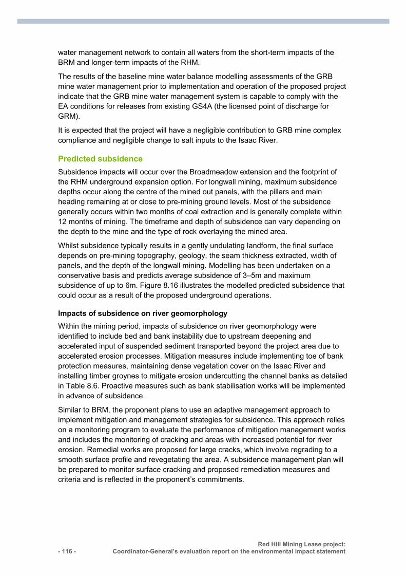
- 116 - Red Hill Mining Lease project:
Coordinator-General’s evaluation report on the environmental impact statement :
water management network to contain all waters from the short-term impacts of the BRM and longer-term impacts of the RHM. The results of the baseline mine water balance modelling assessments of the GRB mine water management prior to implementation and operation of the proposed project indicate that the GRB mine water management system is capable to comply with the EA conditions for releases from existing GS4A (the licensed point of discharge for GRM).
It is expected that the project will have a negligible contribution to GRB mine complex compliance and negligible change to salt inputs to the Isaac River.
Predicted subsidence
Subsidence impacts will occur over the Broadmeadow extension and the footprint of the RHM underground expansion option. For longwall mining, maximum subsidence depths occur along the centre of the mined out panels, with the pillars and main heading remaining at or close to pre-mining ground levels. Most of the subsidence generally occurs within two months of coal extraction and is generally complete within 12 months of mining. The timeframe and depth of subsidence can vary depending on the depth to the mine and the type of rock overlaying the mined area.
Whilst subsidence typically results in a gently undulating landform, the final surface depends on pre-mining topography, geology, the seam thickness extracted, width of panels, and the depth of the longwall mining. Modelling has been undertaken on a conservative basis and predicts average subsidence of 3–5m and maximum subsidence of up to 6m. Figure 8.16 illustrates the modelled predicted subsidence that could occur as a result of the proposed underground operations.
Impacts of subsidence on river geomorphology Within the mining period, impacts of subsidence on river geomorphology were identified to include bed and bank instability due to upstream deepening and accelerated input of suspended sediment transported beyond the project area due to accelerated erosion processes. Mitigation measures include implementing toe of bank protection measures, maintaining dense vegetation cover on the Isaac River and installing timber groynes to mitigate erosion undercutting the channel banks as detailed in Table 8.6. Proactive measures such as bank stabilisation works will be implemented in advance of subsidence.
Similar to BRM, the proponent plans to use an adaptive management approach to implement mitigation and management strategies for subsidence. This approach relies on a monitoring program to evaluate the performance of mitigation management works and includes the monitoring of cracking and areas with increased potential for river erosion. Remedial works are proposed for large cracks, which involve regrading to a smooth surface profile and revegetating the area. A subsidence management plan will be prepared to monitor surface cracking and proposed remediation measures and criteria and is reflected in the proponent’s commitments.
Red Hill Mining Lease project: Coordinator-General’s evaluation report on the environmental impact statement
- 117 -
Figure 8.16 Predicted subsidence
- 118 - Red Hill Mining Lease project:
Coordinator-General’s evaluation report on the environmental impact statement :
Table 8.6 Summary of predicted geomorphic response for the Isaac River: impacts, mitigation options and risks
The hydraulic connectivity of the fracture network The groundwater model shows that fracturing in the caved and fractured zones is not expected to extend through the overlying Fort Cooper Coal measures or Tertiary Sediments. Fracturing may occur within the surficial material (as a result of surface subsidence) to a depth of 10m only. Surface subsidence is not predicted to extend downwards to connect to the altered units below and is expected to self-seal as a result of sediment laden surface runoff and subsidence management.
Post-mine phase impacts on water resources hydrology Subsidence resulting from the project mining activities may potentially impact on catchment water resources availability in the Isaac River downstream of the mine. This will occur for a limited period of time ranging from the approximate 25 years life of mine up to approximately 40 years depending on the rate of infill. As the panels subside, there is potential for water to be captured within surface depressions known as subsidence voids, which capture direct rainfall and surface runoff and no longer freely drain to the natural waterways. Within the subsidence voids water may be lost as:
evaporation from the water surface of the ponded waters potential percolation to the groundwater including through surface cracking resulting
from the subsidence.
The mapping of potential subsidence void ponding identified 44 ponding areas with the largest being 40ha and ranging from less than 10ML up to 1,100ML capacity (averaging 210ML). The combined total volume of the worst-case subsidence voids is estimated to be approximately 9,500ML. It is proposed that two of the larger voids (RH101 and RH102 shown in Figure 8.16), totalling 2,100ML capacity, be drained towards the Isaac River and that other larger subsidence voids be partially drained to reduce ponding of all voids in the 12 Mile Gully catchment to approximately 1,900ML (compared with 5,200ML with no mitigation). A subsidence ponding map for the mitigated case is presented in Figure 8.17.
Red Hill Mining Lease project: Coordinator-General’s evaluation report on the environmental impact statement
- 119 -
Proponent commitments to mitigate ponding resulting from subsidence impacts include:
assessing the depth and volume of subsidence troughs monitoring sediment deposition determining if partial drainage will be required to maintain overall flows from the 12
Mile Gully catchment designing and constructing channels to mimic natural channels in creating a stable
flow path.
The potential mitigation of partially draining some of the larger voids was reassessed in the hydrological model, which indicated that the impact to the mean annual flow in the Isaac River would be a net loss of approximately 1 per cent or 500ML/year. Accordingly, the hydrological impacts of the project on water resources in the Isaac River are not expected to be significant.
To ensure subsided longwall panels do not result in the capture of significant overland flow, I have recommended a condition to ensure significant water volumes are drained from the panels. Specifically, ponding greater than 50ML is not to occur within individual subsided longwall panels after the adjacent panel has been completed or after a period of 12 months if there is no adjacent panel to be developed.
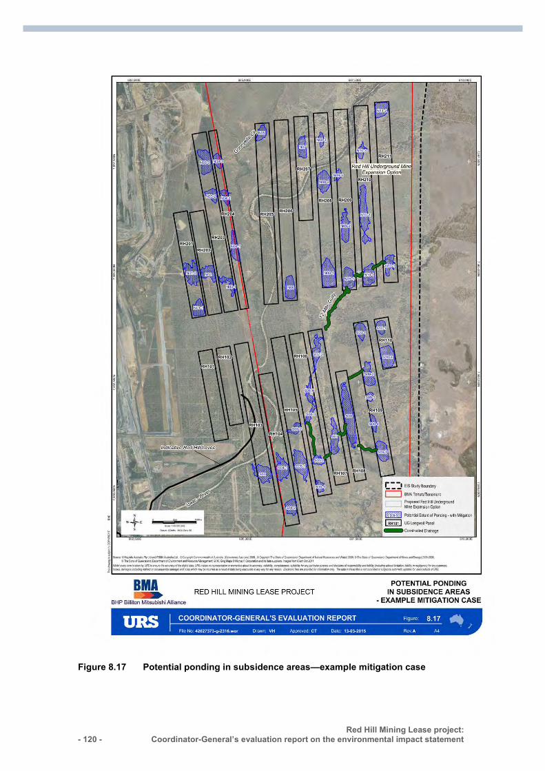
- 120 - Red Hill Mining Lease project:
Coordinator-General’s evaluation report on the environmental impact statement :
Figure 8.17 Potential ponding in subsidence areas—example mitigation case
Red Hill Mining Lease project: Coordinator-General’s evaluation report on the environmental impact statement
- 121 -
Water quality impacts of subsidence voids Water quality in subsidence ponds is likely to be variable over time. Initial flows from surface water runoff will be relatively low in salinity but potentially containing suspended solids collected from the catchment. The concentration of salts and dissolved contaminants may increase over time as water is lost through evaporation. However, the volume of water collected in subsidence voids is small compared with that which flows through the Isaac River. Therefore it is expected that any deteriorated water in the voids will be diluted by the channel flow with negligible effects on water quality in the Isaac River. However, it may be necessary to drain semi-permanent ponds along 12 Mile Gully due to their risk of them containing degraded water quality.
Water quality criteria All mine water arising from the project’s operations will be incorporated into the existing GRB mine complex water management system. Releases will be subject to the regulatory conditions of the existing EA for the GRB mine complex. The transfer and storage of water is to be determined by site management with the transfer of water into GS4A dam (the licensed point of discharge for GRM) only to occur if appropriate conditions exist to ensure compliance with the water release conditions.
The GRB mine complex is part of the Fitzroy Basin Pilot Mine Water Release Scheme which was developed to provide for improved release opportunities whilst maintaining a controlled and managed form of release. As part of the scheme, an amended EA was issued for the GRB mine comprising modified water quality objectives incorporating a modified downstream limit on EC as well as changed flow rate triggers for release events. An Enhanced Environmental Monitoring Program was developed and implemented as a result of the pilot release scheme which found that during the 2012/13 wet season, there was a 17 per cent reduction in legacy water volume for the GRB mine complex and no measured effects on salinity downstream.
Water balance modelling shows a minor increase in stored water volume requirements at GRB, in the order of 3 per cent. This minor increase can be accommodated in GRB’s existing storage capacity and it is predicted that RHM operations will consume more water than they produce over the life of mine.
Coordinator-General’s conclusions—surface water
I conclude that the surface water assessment and modelling provided adequate information about the project’s potential impacts on surface water flow and surface water quality.
The project’s key surface water impacts relate to ponding in subsidence voids and subsequent impacts on downstream water resources availability.
To ensure subsided longwall panels do not result in the capture of significant overland flow, I have conditioned the requirement that ponding greater than 50ML is not to occur within individual subsided longwall panels after the adjacent panel has been completed or after a period of twelve months if there is no adjacent panel to be developed, to ensure compliance.
- 122 - Red Hill Mining Lease project:
Coordinator-General’s evaluation report on the environmental impact statement :
In addition, further work will be required during the next project stage to quantify the potential impacts of subsidence on water resources and develop effective mitigation measures. To this end, I have stated conditions to be included in Schedule F of the draft EA for the project requiring the proponent to develop and implement a Subsidence Management Plan prior to the commencement of activities that could result in subsidence and the annual inspection of subsided longwall panels to assess structural, geotechnical and hydraulic adequacy.
I consider the impacts to surface water resources would be adequately managed through the conditions I have imposed and do not consider additional water conditions to be required.
8.6.4 Regional water impacts
Cumulative surface water
The GRB mine complex is part of the Fitzroy Basin Pilot Mine Water Release Scheme which was initiated to provide for improved release opportunities during the 2012/13 wet season. The 2013/14 release pilot is supported by an operational policy and guideline, which provides guidance to the mining industry in the Fitzroy River Basin about releases of mine-affected water under enhanced EA conditions and on managing cumulative impacts. This policy is designed to provide protection to local environmental values located downstream of mine water release points through the requirement for mines to conduct a detailed assessment on the localised impacts of these releases. The policy also specifies acceptable water quality limits for downstream locations that are subject to cumulative impacts from mine-affected water releases across the Fitzroy River Basin.
As part of the scheme, the GRB mine EA was amended incorporating a modified downstream limit on EC within the Isaac River and other receiving waters, as well as changes in the flow rate triggers defining the commencement and cessation of release events. An enhanced environmental monitoring program was developed to ensure that water quality in the Fitzroy catchment is suitable for drinking and other downstream uses and concluded that there were no measured effects on salinity levels downstream of the Isaac/Connors confluence as a result of releases from the 16 mines in the Isaac and Connors River catchments.
This study also concluded that the basin and catchment-scale salinity behaviour within the Fitzroy Basin appears characterised by diffuse sources of salts, both natural in origin as well as influenced by previous and current catchment management practices.
It is proposed that the project continues to operate under relevant guidelines and policies aimed at mitigating cumulative impacts in the Fitzroy River Basin. In addition, any mine-affected water from the project that discharges into the receiving environment will be subject to EA conditions designed to protect local and downstream environmental values. No environmental harm is predicted as the water quality objectives reflected in the EA conditions consider the receiving environment and cumulative effects of other releases and impacts.
Red Hill Mining Lease project: Coordinator-General’s evaluation report on the environmental impact statement
- 123 -
It is considered that there will be no significant impacts on the hydrology or quality of surface water as a result of the project.
In terms of cumulative regional impacts, the potential impacts of longwall mining on the Isaac River have been subject to investigation within and around the EIS study area. Recognising that river systems are a continuum and impacts at different locations are likely to influence each other and may compound, it was recognised that there was a need to assess the potential impacts on the Isaac River, more broadly than individual mine leases. Hence, the Isaac River Cumulative Impact Assessment of Mine Developments (IRCIA) was undertaken.
The IRCIA developed and quantified impacts across all existing and proposed underground mine plans that were planned to extend beneath the Isaac River. Overall, plans to subside approximately 28km of the Isaac River channel were included with approximately 60 longwalls extending beneath the river with maximum subsidence of approximately 3m. The IRCIA identified that, while there is potential for impacts on the Isaac River as a result of mine-related subsidence, none were anticipated to instigate long-term, large-scale geomorphological change. Overall, subsidence voids were predicted to be infilled within 20 years after the cessation of mining on the Isaac River, unless there is a substantial reduction of sediment inputs from the Isaac River catchment. Within the mining period, risks were identified to bed and bank stability, such as potential for river bed deepening and subsequent widening through bank erosion, which are presently being managed at the local scale with solutions such as timber pile fields and vegetation.
Further, the proponent’s hydrological analysis indicates that, with the implementation of mitigation measures, the potential loss of flow from 12 Mile Gully catchment due to ponding of water in subsidence voids would be approximately 1,600ML. This volume represents an approximate loss of 3 per cent of the Isaac River mean annual flow at Goonyella gauge and less than 0.07 per cent mean annual flow in the Isaac River at Yatton gauge. Hence, the project impact on Isaac River flow volumes is not anticipated to materially impact on the State’s ability to meet the water resource plan environmental flow objectives.
Cumulative groundwater
The proponent used predictive modelling to determine if the multiple mines and coal seam gas projects in the region would have a marked cumulative impact on regional groundwater resources.
Regional impacts were assessed using predictive modelling, which allowed for:
evaluating drawdown impacts of mining operations immediately adjacent to each other
mine dewatering within the same geology and hydrogeology simulating mining concurrently to assess impacts on the local and regional
groundwater resources
The total predicted groundwater ingress into the mine workings for both the RHM project and the GRB mine complex is 146GL and will result in a drawdown of 5m at the target coal seam extending 2.5 to 3km around the mine workings.
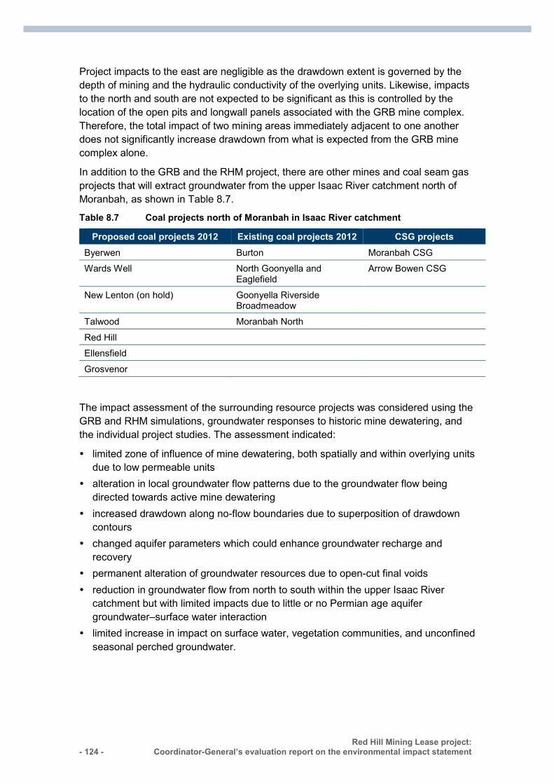
- 124 - Red Hill Mining Lease project:
Coordinator-General’s evaluation report on the environmental impact statement :
Project impacts to the east are negligible as the drawdown extent is governed by the depth of mining and the hydraulic conductivity of the overlying units. Likewise, impacts to the north and south are not expected to be significant as this is controlled by the location of the open pits and longwall panels associated with the GRB mine complex. Therefore, the total impact of two mining areas immediately adjacent to one another does not significantly increase drawdown from what is expected from the GRB mine complex alone.
In addition to the GRB and the RHM project, there are other mines and coal seam gas projects that will extract groundwater from the upper Isaac River catchment north of Moranbah, as shown in Table 8.7.
Table 8.7 Coal projects north of Moranbah in Isaac River catchment
Proposed coal projects 2012 Existing coal projects 2012 CSG projects Byerwen Burton Moranbah CSG Wards Well North Goonyella and
Eaglefield Arrow Bowen CSG
New Lenton (on hold) Goonyella Riverside Broadmeadow
Talwood Moranbah North
Red Hill Ellensfield
Grosvenor
The impact assessment of the surrounding resource projects was considered using the GRB and RHM simulations, groundwater responses to historic mine dewatering, and the individual project studies. The assessment indicated:
limited zone of influence of mine dewatering, both spatially and within overlying units due to low permeable units
alteration in local groundwater flow patterns due to the groundwater flow being directed towards active mine dewatering
increased drawdown along no-flow boundaries due to superposition of drawdown contours
changed aquifer parameters which could enhance groundwater recharge and recovery
permanent alteration of groundwater resources due to open-cut final voids reduction in groundwater flow from north to south within the upper Isaac River
catchment but with limited impacts due to little or no Permian age aquifer groundwater–surface water interaction
limited increase in impact on surface water, vegetation communities, and unconfined seasonal perched groundwater.
Red Hill Mining Lease project: Coordinator-General’s evaluation report on the environmental impact statement
- 125 -
Whilst groundwater extraction is predicted to exceed recharge across the region, the groundwater resources are predicted to recover as mining activities enhance groundwater potential to the base of residual voids. Accordingly, impacts on groundwater resources are predicted to be minimal based on the project information available.
State assessment of regional water impacts
Whilst the proponent has attempted to assess the impacts of surrounding resource projects, I have been advised that a quantitative regional water balance model requires specific knowledge of surface and groundwater management and usage, of all potential industries and users within the region and the conditions under which these vary. This necessitates direct involvement and management from regulators as it would require data collection and full cooperation from those responsible for all industries, projects, towns, councils and agricultural activities in the region, which have the potential to impact surface water.
Due to insufficient publicly available information on each project and the high degree of uncertainty about the timing, nature and extent of the activities of other projects, I am satisfied that it is not possible for the proponent to develop a regional model for the Bowen Basin. The work to develop a regional model goes beyond the individual proponent responsibility, and I consider this should be the responsibility of the state government as part of its responsibility for the overall management of water resources in the region.
It is noted that DEHP is currently undertaking investigations within the Fitzroy Catchment to quantify the impacts of combined mining projects on water resources, which will provide an analogous study for comparative purposes.
Water release All mine water arising from the project’s operations will be incorporated into the existing GRB mine complex water management system. Releases will be subject to the regulatory conditions of the existing EA for the GRB mine complex. The transfer and storage of water is to be determined by site management with the transfer of water into GS4A dam only to occur if appropriate conditions exist to ensure compliance with the water release conditions.
Water monitoring and assessment While groundwater modelling did not predict any significant impacts on adjacent groundwater users, the proponent will seek to negotiate agreements for the provision of alternative supplies (make-good agreements) throughout the mine life, and after mine closure in the event detrimental impacts on landholder groundwater supplies are detected.
The proponent proposes to maintain a monitoring bore network for the Broadmeadow extension and the future RHM mine to enable the long-term monitoring of groundwater levels and groundwater quality, as well as to provide data for regular (three-year) updates of the predictive groundwater model. The proponent also proposes to undertake routine monitoring to ensure any variation in the response of the
- 126 - Red Hill Mining Lease project:
Coordinator-General’s evaluation report on the environmental impact statement :
groundwater system to predictions is identified early. This will enable the proponent to undertake mitigation measures to minimise impact on surrounding groundwater users and the environment.
I will require that the groundwater monitoring network be reviewed and extended over time, including additional sites off lease if required, to adequately measure impacts as drawdown in water levels spread over time and have recommended a condition to this effect. I have also conditioned a requirement for the proponent to review the groundwater model within 2 years of commencement of any mining activities for the project and at least every 3 years thereafter and have imposed a condition to this effect.
Coordinator-General conclusion—regional water impacts
I am satisfied that the addition of the project’s operations to the Bowen Basin will not have a significant additional impact on the surface and groundwater resource of the basin caused by the combination of existing mines and coal seam gas projects. I consider the development of a regional water balance model to be the responsibility of the state government as part of its overall management of water resources in the region. Should the government prepare a model in the future, I would expect the proponent of this and other operational mines and projects in the region to provide relevant data to the state government for modelling purposes. The results of modelling would then be made available to the relevant proponents to assist in mine operational planning and mine closure planning to minimise adverse impacts on regional water resources.
8.7 Ecological sustainable development
8.7.1 Principles My assessment of the project has taken into account the principles of ecologically sustainable development, which as defined in Part 1, section 3A of the EPBC Act, are:
the integration principle: decision-making processes should effectively integrate both long-term and short-term economic, environmental, social and equitable considerations
the precautionary principle: if there are threats of serious or irreversible environmental damage, lack of full scientific certainty should not be used as a reason for postponing measures to prevent environmental degradation
the inter-generational equity principle: the present generation should ensure that the health, diversity and productivity of the environment is maintained or enhanced for the benefit of future generations
the biodiversity principle: the conservation of biological diversity and ecological integrity should be a fundamental consideration in decision-making
the valuation principle: improved valuation, pricing and incentive mechanisms should be promoted.
Red Hill Mining Lease project: Coordinator-General’s evaluation report on the environmental impact statement
- 127 -
The integration principle
This report is the culmination of a rigorous assessment process addressing economic, environmental, social and equitable considerations. The project has involved public and agency consultation and all submissions received were considered as part of the evaluation process.
All long-term and short-term impacts for the mine will be managed through a new EA and an amended EA to be administered by DEHP (conditions to be applied are included in Appendix 2). I consider that by complying with my conditions (appendices 1–3) and implementing all proposed management measures, the long-term and short-term economic, environmental and social impacts of the project are equitable and acceptable.
The precautionary principle
Based on the proponent’s EIS and AEIS documentation, submissions made on the documentation and advice received from advisory agencies, I am satisfied that there is sufficient scientific information to conclude there will not be an unacceptable impact to the controlling provisions of the project. Where there is a lack of scientific certainty regarding environmental impacts, a precautionary approach has been taken in setting conditions that require the proponent to ensure that adverse environmental impacts from the project are minimised.
My conditions supplement the proponent’s commitments and proposed management measures and require baseline and ongoing monitoring to increase the scientific understanding of potential impacts to MNES.
The inter-generational equity principle
I am satisfied that the inter-generational equity principle has been adequately applied throughout my evaluation of the project; and I consider that the EIS process has sufficiently enabled submitters to raise concerns about the project in a fair and equitable manner.
I am also satisfied that the intergenerational principle has been adequately applied throughout my conditioning. I consider that the conditions applied in appendices 1–3 will allow for the project to be constructed, operated, rehabilitated and decommissioned in a sustainable matter so as to protect MNES and the environment generally for future generations.
The biodiversity principle
The TOR that I finalised for the project outlined the requirements for the proponent’s EIS, including the requirement to consider biodiversity conservation and ecological integrity. The biodiversity principle has been carried throughout all stages of the EIS process in both the proponent’s assessment documentation and my evaluation.
I am satisfied that this principle has been adequately incorporated into my conditions for a new draft EA and amended EA for the project (Appendix 2), groundwater impact offset requirements conditioned in Appendix 1 and my recommended biodiversity conditions to the Commonwealth Minister for the Environment (Appendix 3).
- 128 - Red Hill Mining Lease project:
Coordinator-General’s evaluation report on the environmental impact statement :
The valuation principle
I am satisfied that the project’s adverse impacts on the environment will be suitably compensated through environmental biodiversity offsets for all unavoidable residual significant impacts. I consider that the outcomes delivered by both direct and indirect offsets will be commensurate with the potential impacts on MNES and the environment generally.
8.7.2 Coordinator-General’s conclusions I have considered the above principles in my evaluation. Based on the completion of a comprehensive environmental assessment process, considering proponent commitments, my stated conditions for the new draft EA and amended EA for the project (Appendix 2) and my recommendations for conditions to be placed on subsequent State and Commonwealth approvals, I am satisfied that the project complies with the provisions of Part 1, section 3A of the EPBC Act in accordance with the above criteria.
8.8 Social and economic impacts
8.8.1 Social impact assessment A social impact assessment conducted for the project addressed community and stakeholder engagement, workforce management, housing and accommodation, local business and industry content and health, safety and community infrastructure. Action plans and strategies have been developed to address potential social and economic impacts.
The project would boost local, regional and state economies with a projected 73 per cent of the project’s capital expenditure spent in Queensland and a further 7 per cent spent nationally. The project would create up to 2,000 construction and 1,500 operational jobs. Part of the project involves expansion of two existing mines that have a 90% residential workforce.
The proponent has agreed on a set of workforce management principles to minimise the reliance on a FIFO workforce and maximise local opportunities.
These principles are:
(1) anyone must be able to apply for a job, regardless of where they live (2) provided they can meet the requirements of the job, people must have choice
where they live and be able to apply for jobs in the mine (3) the percentage of FIFO must be less than 100% (4) a thorough audit of existing housing capacity must be undertaken before the
project starts. To support those who wish to live locally, BMA will ensure the availability of housing accommodation that is fit for purpose and will make optimal use of existing housing capacity
(5) the proponent must thoroughly assess their workforce requirements and plan to accommodate the likely numbers of workers who may live locally
Red Hill Mining Lease project: Coordinator-General’s evaluation report on the environmental impact statement
- 129 -
(6) social impacts associated with the local workforce, in relation to local housing, services and infrastructure must be identified and mitigated in consultation with relevant local and state government service providers
(7) the proponent’s social impact mitigation measures should support regional towns in pursuing opportunities to ensure communities are strong and sustainable and they are attractive places to live and work.
The Coordinator-General has also set a range of imposed conditions that include an Operational Workforce Management Plan, a Social Impact Assessment Review undertaken 12 months prior to construction and bi-monthly/annual reporting on the FIFO/DIDO workforce.
8.9 Coordinator-General’s conclusions—MNES I have reviewed all of the EIS documentation provided and I am satisfied that the proponent has adequately assessed the project’s potential impacts on the controlling provisions under the EPBC Act.
The proponent has provided information on mitigation measures, control strategies and monitoring programs in the EIS, AEIS and proponent commitment list to avoid, minimise, or manage adverse impacts, with offsets provided for residual impacts. Mitigation measures will also be addressed in the future EAs for the project. My recommended and imposed conditions will supplement these measures, strategies and programs to ensure the requirements of the EPBC Act are met.
I consider that the requirements of the bilateral agreement have been satisfied. Based on my conclusions for each of the respective controlling provisions, I am satisfied that the project would not result in unacceptable significant impacts on MNES.
9. Conclusion
The Red Hill Mining Lease project has undergone a comprehensive environmental impact assessment. In undertaking my evaluation, I have considered the EIS and AEIS prepared for this project, submissions on the EIS and AEIS (including agency advice) and additional documentation provided by the proponent as requested.
I am satisfied that the requirements of the SDPWO Act have been met and that sufficient information has been provided to enable me to evaluate the potential impacts and proposed mitigation strategies, and to develop conditions of approval. I am also satisfied that the material supplied by the proponent sufficiently addresses any potential impacts on MNES for the project.
I consider that the proponent’s mitigation measures would result in acceptable overall outcomes and that the conditions in appendices 1–3 provide comprehensive and targeted measures to further manage potential impacts.
I conclude that the project would deliver economic benefits to local, regional and state economies. The employment benefits expected to be generated over the 25-year project life would be significant, with an estimated 2,000 construction jobs, 1,500

- 130 - Red Hill Mining Lease project:
Coordinator-General’s evaluation report on the environmental impact statement :
operational jobs and further indirect local, regional and Indigenous employment opportunities to be generated. The project would also contribute to state and federal government revenue through taxes and royalties.
Accordingly, I approve the Red Hill Mining Lease project, subject to the conditions and recommendations in appendices 1–3. I expect the proponent’s commitments, as presented in the EIS documentation and summarised in Appendix 4 of this report, to be fully implemented. I regard proponent’s commitments as having the same force and degree of importance as my conditions because they are aimed at mitigating project impacts.
To proceed further, the proponent will be required to:
obtain EPBC Act approval obtain a range of state government approvals, including two EAs and a mining lease finalise and implement a range of management plans finalise the biodiversity offsets strategy.
Copies of this report will be issued to DE, DEHP, DNRM, DTMR and IRC. A copy will also be available on the Department of State Development’s website at www.statedevelopment.qld.gov.au/cg
As per section 35A(b) of the SDPWO Act, this report will lapse three years from the date it is published on the department’s website, or when an approval application is decided for the project.
Appendix 1. Imposed conditions Red Hill Mining Lease project: Coordinator-General’s evaluation report on the environmental impact statement
- 131 -
Appendix 1. Imposed conditions This appendix includes conditions imposed by the Coordinator-General under section 54B of the SDPWO Act. The conditions are relevant to applications for development approvals for those parts of the project where there is no relevant approval applicable under other legislation.
All of the conditions imposed in this appendix take effect from the date of this Coordinator-General’s report.
These conditions do not relieve the proponent of the obligation to obtain all approvals and licences from all relevant authorities required under any other Act.
In accordance with section 54B(3) of the SDPWO Act, I have nominated the entity to have jurisdiction for the conditions in this schedule.
Pursuant to section 54D of the SDPWO Act, these conditions apply to anyone who undertakes the project, such as the proponent and an agent, contractor, subcontractor or licensee of the proponent, and any public utility providers undertaking public utility works as a result of the project.
Social impacts Condition 1 Operational Workforce Management Plan (a) By no later than 31 December 2015, the proponent is required to finalise an Operational
Workforce Management Plan and provide this to the Coordinator General for approval.
(b) The Operational Workforce Management Plan must demonstrate how the outcomes of the following inquiry and reviews have been addressed in the Plan:
(i) Queensland Parliament Inquiry into Fly in, Fly out and other long distance commuting work practices in regional Queensland (established in March 2015) ;
(ii) Queensland Government’s Fly in, Fly out Review (established in May 2015); and
(iii) The Coordinator-General’s workforce management principles in this report, that will be reviewed and finalised following the outcomes of the Inquiry and Review described in (b)(i) and (b)(ii).
(c) The Operational Workforce Management Plan is to describe the proposed level of the FIFO/DIDO workforce, forecast the impacts and propose measures to mitigate the impacts.
The Coordinator General is to have jurisdiction for this condition.
Condition 2. Social Impact Assessment review (a) Twelve months prior to the commencement of construction, the proponent is required to
undertake a Social Impact Assessment review and report to the Coordinator-General.
(b) The Social Impact Assessment review will include:
(i) a review of the social baseline to ensure the assessment of impacts is accurate in the current context
(ii) an assessment of the proposed level of the non-resident workforce, a forecast of the impacts and the measures intended to mitigate the impacts
(iii) a review of housing availability and affordability in the region, including any mitigation strategies proposed by the proponent to address any negative impacts of the project on regional housing availability and affordability, and
(iv) a review of the proposed social impact mitigation strategies arising from stakeholder consultation on the project.
(c) The report must be made publicly available.
- 132 -
Appendix 1. Imposed conditions Red Hill Mining Lease project:
Coordinator-General’s evaluation report on the environmental impact statement
The Coordinator General is to have jurisdiction for this condition.
Condition 3. Annual reporting on Social Impact Assessment (a) From the commencement of construction, the proponent is to provide to the Coordinator-
General an annual report on the Social Impact Assessment for a period of five years.
(b) The annual reports will describe the actions taken to:
(i) inform the community about project impacts and showing that community concerns have been taken into account when reaching decisions
(ii) enhance local employment, training and development opportunities
(iii) avoid, manage or mitigate project related impacts on the capacity of local and regional housing markets
(iv) avoid, manage and mitigate project related impacts on community health, safety and social infrastructure, and
(v) manage any negative impacts caused by any non-resident workforce arrangement.
(c) The annual reports must be made publicly available.
The Coordinator General is to have jurisdiction for this condition.
Condition 4. Bi-monthly reporting on FIFO/DIDO workforce (a) From the commencement of the recruitment of the operational workforce, the proponent
must provide to the Coordinator-General a report on the non-resident operational workforce including the percentage of FIFO/DIDO and resident workers.
(b) The report is to be provided every two months for a period of five years.
(c) The bi-monthly reports must be made publicly available.
(d) In circumstances where the report shows non-compliance or deviation from the principles, conditions and commitments in this report, the proponent must take corrective action and report to the Coordinator-General on such action within three months of the occurrence.
The Coordinator-General is to have jurisdiction for this condition.
Environmental offsets Condition 5. Offsets (a) The proponent must prepare a detailed plan that:
(i) details any offset requirements conditioned by the Commonwealth Minister for the Environment in any approval for the project under the Environment Protection and Biodiversity Conservation Act 1999 (EPBC Act)
(ii) details proposed offsets to address any significant residual impacts for matters of state environmental significance consistent with (a)(i)
(iii) includes but is not necessarily limited to:
(A) a detailed description of the land to which the plan relates, the values affected and the extent and likely timing of impact on each value
(B) evidence that values impacted can be offset
(C) the offset delivery mechanism(s) comprising one or more of:
(1) land-based offsets
(2) direct benefit management plans
(3) offset transfers and/or offset payments
(iv) a legally binding mechanism that ensures protection and management of offset areas.
Appendix 1. Imposed conditions Red Hill Mining Lease project: Coordinator-General’s evaluation report on the environmental impact statement
- 133 -
(v) the proposed staging plan for offset delivery (if applicable)
(b) The offsets plan must be provided to the Coordinator-General for approval within 60 days of an approval decision under the EPBC Act and no later than 2 months prior to the commencement of construction.
(c) The approved offsets plan must be implemented as directed by the Coordinator-General.
The Coordinator-General is to have jurisdiction for this condition
Traffic and transport Condition 6. Outcome to be achieved At all times and for each stage of the project, the proponent must maintain the existing safety, condition and efficiency of state-controlled and local roads and minimise any project impacts on the network.
DTMR is to have jurisdiction for this condition.
Condition 7. Road impact assessment and road-use management plan (a) Update the road impact assessment (RIA) for the project to quantify and document
measures to manage impacts on the safety, efficiency and condition of state-controlled and local roads. The RIA must:
(i) be developed in accordance with the DTMR Guidelines for Assessment of Road impacts of Development (2006) (GARID) and/or as required by the relevant LGA and include a completed DTMR ‘Transport Generation proforma’ detailing project-related traffic and transport generation information or as otherwise agreed in writing with DTMR and the relevant LGA
(ii) clearly indicate where detailed estimates are not available and document the assumptions and methodologies that have been previously agreed in writing with DTMR and relevant LGA, prior to RIA finalisation
(iii) detail the final impact mitigation proposals, including contributions to road works/maintenance and summarising key road-use management strategies, including the Peak Downs Highway/Moranbah South Access Road intersection
(iv) be approved in writing by DTMR and/or the relevant LGA no later than six (6) months prior to the commencement of significant construction works, or as otherwise agreed between the proponent, DTMR and/or the relevant LGA.
(b) Prepare a road-use management plan (RMP) for each stage of the project. The RMP must:
(i) be developed in accordance with DTMR’s Guide to Preparing a Road-use Management Plan and/or as required by the relevant LGA, with a view to also optimising project logistics and minimising road-based trips on all state-controlled and local roads
(ii) include a table listing RMP commitments and provide confirmation that all works and road-use management strategies have been designed and will be built in accordance with all relevant DTMR standards, manuals and practices or as required by the relevant LGA
(iii) be approved in writing by DTMR and the relevant LGA no later than six (6) months prior to the commencement of significant construction works, or as otherwise agreed between the proponent, DTMR and the relevant LGA.
(c) Prior to the commencement of significant project-related construction works, the proponent must:
(i) contribute towards the upgrade of any necessary intersection/accesses and undertake any other required works in state-controlled and/or LGA road reserves, in accordance with the current DTMR and/or LGA road planning and design
- 134 -
Appendix 1. Imposed conditions Red Hill Mining Lease project:
Coordinator-General’s evaluation report on the environmental impact statement
policies, principles and manuals, unless otherwise agreed in writing with the DTMR Mackay Regional Office and/or LGA
(ii) prior to undertaking any works, obtain the relevant licenses and permits, for example, under the Transport Infrastructure Act (Qld) 1994 for works and project facilities/infrastructure within the state-controlled road corridor.
(d) Prepare a Heavy Vehicle Haulage Management Plan for any excess mass or over-dimensional loads for all phases of the project and obtain necessary permits and approvals three (3) months prior to the commencement of significant construction works or project-related traffic in consultation with DTMR’s Heavy Vehicles Road Operation Program Office, the Queensland Police Service and the relevant LGA.
(e) Prepare Traffic Management Plan/s (TMP) in accordance with DTMR’s Guide to preparing a Traffic Management Plan and/or as required by the relevant LGA. A TMP must be prepared and implemented during the construction and commissioning of each site where road works are to be undertaken, including site access points, road intersections or other works undertaken in the state-controlled road corridor.
DTMR is to have jurisdiction for this condition.
Capture of overland flow Condition 8. Capture of overland flow from subsided longwall panels (a) The subsided longwall panels must not result in the capture of significant overland flow
and must allow water to drain freely from all panels
(b) Ponding greater than 50ML is not to occur within individual subsided longwall panels after the adjacent panel has been completed or after a period of twelve (12) months if there is no adjacent panel to be developed
(c) shall not apply if, in the opinion of a suitably qualified and experienced person, the establishment of new drainage channels or the re-establishment of pre-existing flow paths and drainage features to allow the panel to drain freely will result in environmental harm.
DNRM is to have jurisdiction for this condition.
Groundwater monitoring Condition 9. Groundwater management and monitoring program (a) A groundwater management and monitoring program must be developed and certified by
an appropriately qualified person which addresses all phases of the mining operation approved under the project’s environmental authority (‘project’s EA’).
(b) The groundwater management and monitoring program must be provided to the administering authority for the Water Act 2000 for approval in accordance with the requirements of the baseline monitoring program in relevant conditions of the project’s EA.
(c) The groundwater management and monitoring program must be developed to ensure that the plan meets the following objectives:
(i) validation of groundwater numerical model to refine and confirm accuracy of groundwater impacts predicted
(ii) groundwater level monitoring in all identified geological units present across and adjacent to the mine site to confirm existing groundwater flow patterns and monitor the full extent of drawdown impacts
(iii) monitoring of geological units throughout all phases of project life including for the period post-closure as required by the administering authority for the Water Act 2000
Appendix 1. Imposed conditions Red Hill Mining Lease project: Coordinator-General’s evaluation report on the environmental impact statement
- 135 -
(iv) identifying monitoring bores that will be replaced due to mining activities and to ensure all potential groundwater impacts from mine dewatering and mine water and waste storage facilities (artificial recharge) are identified, mitigated and monitored.
DNRM is to have jurisdiction for this condition.
Condition 10. Groundwater Monitoring Program Review (a) The groundwater management and monitoring program required under Condition 9 must
be reviewed by an appropriately qualified person with a report provided on the outcome of the review to the administering authority within two years from the issuing of the project’s EA and mining lease/s required for the project; and then no later than 1 July every 3 years following. The review must include:
(i) an assessment of the outcome of the groundwater management and monitoring program against the objectives in the project’s EA
(ii) a review of the adequacy of the monitoring locations, frequencies and groundwater quality triggers specified in the project’s EA
(iii) recommendations for any required increase in monitoring bore locations off lease to adequately monitor drawdown impacts.
DNRM is to have jurisdiction for this condition.
Condition 11. Groundwater model review (a) The performance of the numerical model must be reviewed within 2 years of
commencement of any mining activities for the project and at least every 3 years thereafter, or at other intervals specified by the administering authority for the Water Act 2000 in writing, if the observed groundwater levels are not consistent with those predicted by the latest version of groundwater model.
(b) The review must include:
(i) review of the hydrogeological conceptualisation used in the previous model
(ii) a comparison of predicted impacts against those observed
(iii) review of assumptions used in the previous model including those relating to fracturing caused by longwall mining
(iv) information about any changes made since the development of the previous model, including data changes
(v) an evaluation of the accuracy of the predicted changes in groundwater levels and recommended actions to improve the accuracy of model predictions including the need for adjustment of the model.
(c) A report outlining the findings and any recommendations from the review must be completed by an appropriately qualified person and submitted to the administering authority for approval no later than 3 months after the commencement of the review.
DNRM is to have jurisdiction for this condition.
- 136 -
Appendix 2. Stated conditions Red Hill Mining Lease project:
Coordinator-General’s evaluation report on the environmental impact statement
Appendix 2. Stated conditions Section 1. Red Hill Mine EA
This section includes the Coordinator-General’s stated conditions for the draft environmental authority (EA) (mining lease) under the Environmental Protection Act 1994 (EP Act) for the Red Hill Mine. These conditions are stated pursuant to section 47C of the SDPWO Act.
These conditions do not form a complete draft EA for the project.
Jurisdiction—Department of Environment and Heritage Protection
Environmentally relevant activity and location details
Environmentally relevant activities) Location(s)
Schedule 2A—Environmental Protection Regulation 2008
ERA 13—Mining black coal
MLA70421 (part)
ML 1763 (part)
Schedule 2—Environmental Protection Regulation 2008
ERA 8—Chemical Storage 1(c) Storing more than 500m3 of chemicals of class C1 or C2 combustible liquids under AS1940 or dangerous goods class 3.
ERA 56—Regulated Waste Storage 1 Receiving and storing regulated waste.
ERA 63—Sewage Treatment 1(c) Operating sewage treatment works, other than no-release works, with a total daily peak design capacity of more than 1,500 but not more than 4,000 equivalent persons.
Schedule A—General
A1 This environmental authority authorises environmental harm referred to in the conditions. Where there is no condition or this environmental authority is silent on a matter, the lack of a condition or silence does not authorise environmental harm.
A2 In carrying out the mining activity authorised by this environmental authority, disturbance of land:
(a) may occur in the areas marked as green on the map that is shown in Annexure 1 to this environmental authority.
A3 The holder of this environmental authority must:
(a) install all measures, plant and equipment necessary to ensure compliance with the conditions of this environmental authority
(b) maintain such measures, plant and equipment in a proper and efficient condition
(c) operate such measures, plant and equipment in a proper and efficient manner
(d) ensure all instruments and devices used for the measurement or monitoring of any parameter under any condition of this environmental authority are properly calibrated.
Appendix 2. Stated conditions Red Hill Mining Lease project: Coordinator-General’s evaluation report on the environmental impact statement
- 137 -
MONITORING A4 Except where specified otherwise in another condition of this environmental authority, all
monitoring records or reports required by this environmental authority must be kept for a period of not less than 5 years.
FINANCIAL ASSURANCE A5 The activity must not be carried out until the environmental authority holder has given
financial assurance to the administering authority as security for compliance with this environmental authority and any costs or expenses, or likely costs or expenses, mentioned in section 298 of the Act.
A6 The amount of financial assurance must be reviewed by the holder of this environmental authority when a plan of operations is amended or replaced or the authority is amended.
NOTIFICATION OF EMERGENCIES, INCIDENTS AND EXCEPTIONS A7 The holder of this environmental authority must notify the administering authority by
written notification within 24 hours, after becoming aware of any emergency or incident which results in the release of contaminants not in accordance, or reasonably expected to be not in accordance with, the conditions of this environmental authority.
A8 Within 10 business days following the initial notification of an emergency or incident, or receipt of monitoring results, whichever is the latter, further written advice must be provided to the administering authority, including the following:
(a) results and interpretation of any samples taken and analysed
(b) outcomes of actions taken at the time to prevent or minimise unlawful environmental harm
(c) proposed actions to prevent a recurrence of the emergency or incident.
COMPLAINTS A9 The holder of this environmental authority must record all environmental complaints
received about the mining activities including:
(a) name, address and contact number for of the complainant
(b) time and date of complaint
(c) reasons for the complaint
(d) investigations undertaken
(e) conclusions formed
(f) actions taken to resolve the complaint
(g) any abatement measures implemented
(h) person responsible for resolving the complaint.
A10 The holder of this environmental authority must, when requested by the administering authority, undertake relevant specified monitoring within a reasonable timeframe nominated or agreed to by the administering authority to investigate any complaint of environmental harm. The results of the investigation (including an analysis and interpretation of the monitoring results) and abatement measures, where implemented, must be provided to the administering authority within 10 business days of completion of the investigation, or no later than 10 business days after the end of the timeframe nominated by the administering authority to undertake the investigation.
- 138 -
Appendix 2. Stated conditions Red Hill Mining Lease project:
Coordinator-General’s evaluation report on the environmental impact statement
THIRD PARTY REPORTING A11 The holder of this environmental authority must:
(a) within 1 year of the commencement of this environmental authority, obtain from an appropriately qualified person a report on compliance with the conditions of this environmental authority
(b) obtain further such reports at regular intervals, not exceeding 3 yearly intervals, from the completion of the report referred to above; and
(c) provide each report to the administering authority within 90 days of its completion.
A12 Where a condition of this environmental authority requires compliance with a standard, policy or guideline published externally to this environmental authority and the standard is amended or changed subsequent to the issue of this environmental authority, the holder of this environmental authority must:
(a) comply with the amended or changed standard, policy or guideline within 2 years of the amendment or change being made, unless a different period is specified in the amended standard or relevant legislation, or where the amendment or change relates specifically to regulated structures conditions in this environmental authority;
(b) until compliance with the amended or changed standard, policy or guideline is achieved, continue to remain in compliance with the corresponding provision that was current immediately prior to the relevant amendment or change.
Schedule B—Air
B1 When requested by the administering authority or as a result of a complaint (which is neither frivolous nor vexatious nor based on mistaken belief in the opinion of the authorised officer), dust and particulate monitoring must be undertaken, and the results thereof notified to the administering authority within fourteen (14) days following completion of monitoring. Monitoring must be carried out at a place(s) relevant to the potentially affected dust sensitive place.
B2 The holder of the environmental authority shall ensure that all reasonable and feasible avoidance and mitigation measures are employed so that the dust and particulate matter generated by the mining activities do not exceed the following levels when measured at any sensitive or commercial place:
(a) dust deposition of 120 milligrams per square metre per day, averaged over 1 month, when monitored in accordance with the most recent version of Australian Standard AS3580.10.1 Methods for sampling and analysis of ambient air—Determination of particulate matter—Deposited matter – Gravimetric method.
(b) a concentration of particulate matter with an aerodynamic diameter of less than 10 micrometres (PM10) suspended in the atmosphere of 50 micrograms per cubic metre over a 24-hour averaging time, for no more than 5 exceedances recorded each year, when monitored in accordance with the most recent version of either:
(i) Australian Standard AS3580.9.6 Methods for sampling and analysis of ambient air—Determination of suspended particulate matter—PM10 high volume sampler with size-selective inlet – Gravimetric method; or
(ii) Australian Standard AS3580.9.9 Methods for sampling and analysis of ambient air—Determination of suspended particulate matter—PM10 low volume sampler—Gravimetric method.
(iii) Australian Standard AS 3580.9.8 Methods for sampling and analysis of ambient air—Determination of suspended particulate matter - PM10 continuous direct mass method using a tapered element oscillating microbalance analyser
Appendix 2. Stated conditions Red Hill Mining Lease project: Coordinator-General’s evaluation report on the environmental impact statement
- 139 -
(iv) Australian Standard AS3580.9.11 Methods for sampling Methods for sampling and analysis of ambient air—Determination of suspended particulate matter - PM10 beta attenuation monitors
Schedule W—Water
CONTAMINANT RELEASE W1 Contaminants that will, or have the potential to cause environmental harm must not be
released directly or indirectly to any waters as a result of the authorised mining activities, except as permitted under the conditions of this environmental authority.
W2 The release of mine affected water to internal water management infrastructure installed and operated in accordance with a water management plan that complies with condition W6 is permitted.
WATER REUSE W3 Mine affected water may be piped or trucked or transferred by some other means that
does not contravene the conditions of this environmental authority and deposited into artificial water storage structures, such as farm dams or tanks, or used directly at properties owned by the environmental authority holder or a third party (with the consent of the third party).
ANNUAL WATER MONITORING REPORTING W4 The following information must be recorded in relation to all water monitoring required
under the conditions of this environmental authority and submitted to the administering authority in the specified format:
(a) the date on which the sample was taken
(b) the time at which the sample was taken
(c) the monitoring point at which the sample was taken
(d) the measured or estimated daily quantity of mine affected water released from all release points
(e) the release flow rate at the time of sampling for each release point
(f) the results of all monitoring and details of any exceedances of the conditions of this environmental authority
(g) water quality monitoring data must be provided to the administering authority in the specified electronic format upon request.
TEMPORARY INTERFERENCE WITH WATERWAYS W5 Destroying native vegetation, excavating, or placing fill in a watercourse, lake or spring
necessary for and associated with mining operations must be undertaken in accordance with Department of Natural Resources and Mines (or its successor) Riverine protection permit exemption requirements, WSS/2013/726 Version1.01.
WATER MANAGEMENT PLAN W6 A Water Management Plan must be developed by an appropriately qualified person and
implemented.
STORMWATER AND WATER SEDIMENT CONTROLS W7 An Erosion and Sediment Control Plan must be developed by an appropriately qualified
person and implemented for all stages of the mining activities on the site to minimise erosion and the release of sediment to receiving waters and contamination of stormwater.
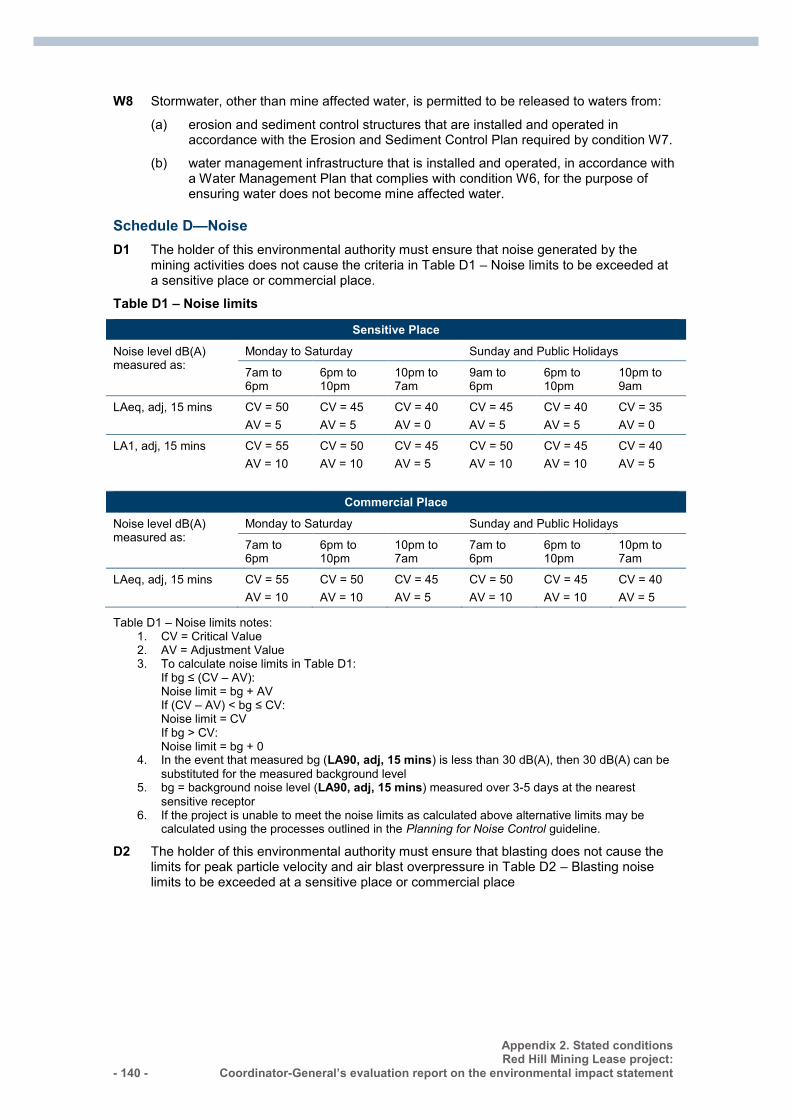
- 140 -
Appendix 2. Stated conditions Red Hill Mining Lease project:
Coordinator-General’s evaluation report on the environmental impact statement
W8 Stormwater, other than mine affected water, is permitted to be released to waters from:
(a) erosion and sediment control structures that are installed and operated in accordance with the Erosion and Sediment Control Plan required by condition W7.
(b) water management infrastructure that is installed and operated, in accordance with a Water Management Plan that complies with condition W6, for the purpose of ensuring water does not become mine affected water.
Schedule D—Noise
D1 The holder of this environmental authority must ensure that noise generated by the mining activities does not cause the criteria in Table D1 – Noise limits to be exceeded at a sensitive place or commercial place.
Table D1 – Noise limits
Sensitive Place
Noise level dB(A) measured as:
Monday to Saturday Sunday and Public Holidays
7am to 6pm
6pm to 10pm
10pm to 7am
9am to 6pm
6pm to 10pm
10pm to 9am
LAeq, adj, 15 mins CV = 50 AV = 5
CV = 45 AV = 5
CV = 40 AV = 0
CV = 45 AV = 5
CV = 40 AV = 5
CV = 35 AV = 0
LA1, adj, 15 mins CV = 55 AV = 10
CV = 50 AV = 10
CV = 45 AV = 5
CV = 50 AV = 10
CV = 45 AV = 10
CV = 40 AV = 5
Commercial Place
Noise level dB(A) measured as:
Monday to Saturday Sunday and Public Holidays
7am to 6pm
6pm to 10pm
10pm to 7am
7am to 6pm
6pm to 10pm
10pm to 7am
LAeq, adj, 15 mins CV = 55 AV = 10
CV = 50 AV = 10
CV = 45 AV = 5
CV = 50 AV = 10
CV = 45 AV = 10
CV = 40 AV = 5
Table D1 – Noise limits notes: 1. CV = Critical Value 2. AV = Adjustment Value 3. To calculate noise limits in Table D1:
If bg ≤ (CV – AV): Noise limit = bg + AV If (CV – AV) < bg ≤ CV: Noise limit = CV If bg > CV: Noise limit = bg + 0
4. In the event that measured bg (LA90, adj, 15 mins) is less than 30 dB(A), then 30 dB(A) can be substituted for the measured background level
5. bg = background noise level (LA90, adj, 15 mins) measured over 3-5 days at the nearest sensitive receptor
6. If the project is unable to meet the noise limits as calculated above alternative limits may be calculated using the processes outlined in the Planning for Noise Control guideline.
D2 The holder of this environmental authority must ensure that blasting does not cause the limits for peak particle velocity and air blast overpressure in Table D2 – Blasting noise limits to be exceeded at a sensitive place or commercial place
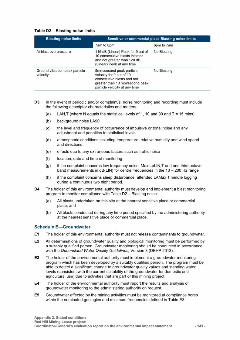
Appendix 2. Stated conditions Red Hill Mining Lease project: Coordinator-General’s evaluation report on the environmental impact statement
- 141 -
Table D2 – Blasting noise limits
Blasting noise limits Sensitive or commercial place Blasting noise limits 7am to 6pm 6pm to 7am
Airblast overpressure 115 dB (Linear) Peak for 9 out of 10 consecutive blasts initiated and not greater than 120 dB (Linear) Peak at any time
No Blasting
Ground vibration peak particle velocity
5mm/second peak particle velocity for 9 out of 10 consecutive blasts and not greater than 10 mm/second peak particle velocity at any time
No Blasting
D3 In the event of periodic and/or complaint/s, noise monitoring and recording must include
the following descriptor characteristics and matters:
(a) LAN,T (where N equals the statistical levels of 1, 10 and 90 and T = 15 mins)
(b) background noise LA90
(c) the level and frequency of occurrence of impulsive or tonal noise and any adjustment and penalties to statistical levels
(d) atmospheric conditions including temperature, relative humidity and wind speed and directions
(e) effects due to any extraneous factors such as traffic noise
(f) location, date and time of monitoring
(g) if the complaint concerns low frequency noise, Max LpLIN,T and one third octave band measurements in dB(LIN) for centre frequencies in the 10 – 200 Hz range
(h) if the complaint concerns sleep disturbance, attended LAMax 1 minute logging during a continuous two night period.
D4 The holder of this environmental authority must develop and implement a blast monitoring program to monitor compliance with Table D2 – Blasting noise.
(a) All blasts undertaken on this site at the nearest sensitive place or commercial place; and
(b) All blasts conducted during any time period specified by the administering authority at the nearest sensitive place or commercial place.
Schedule E—Groundwater
E1 The holder of this environmental authority must not release contaminants to groundwater.
E2 All determinations of groundwater quality and biological monitoring must be performed by a suitably qualified person. Groundwater monitoring should be conducted in accordance with the Queensland Water Quality Guidelines, Version 3 (DEHP 2013).
E3 The holder of the environmental authority must implement a groundwater monitoring program which has been developed by a suitably qualified person. The program must be able to detect a significant change to groundwater quality values and standing water levels (consistent with the current suitability of the groundwater for domestic and agricultural use) due to activities that are part of this mining project.
E4 The holder of the environmental authority must report the results and analysis of groundwater monitoring to the administering authority on request.
E5 Groundwater affected by the mining activities must be monitored at compliance bores within the nominated geologies and minimum frequencies defined in Table E3.
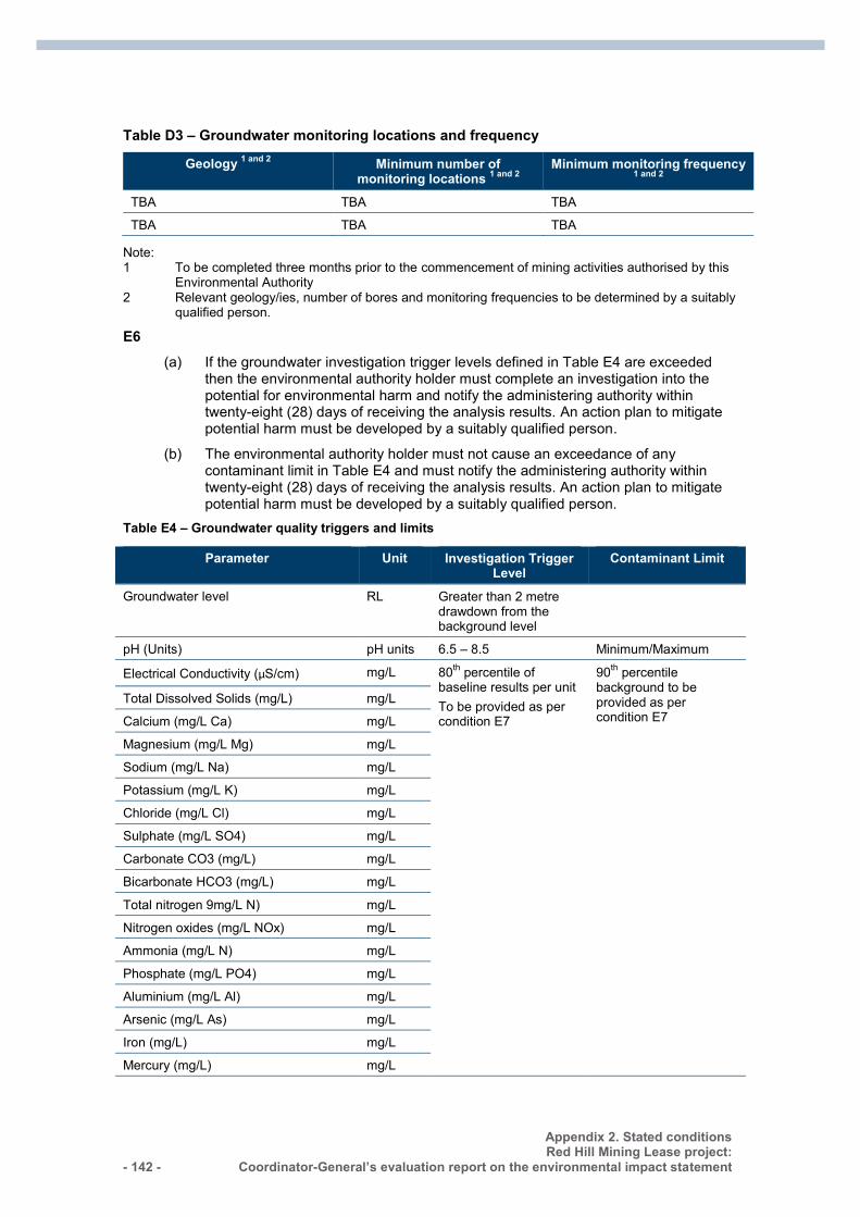
- 142 -
Appendix 2. Stated conditions Red Hill Mining Lease project:
Coordinator-General’s evaluation report on the environmental impact statement
Table D3 – Groundwater monitoring locations and frequency
Geology 1 and 2 Minimum number of monitoring locations 1 and 2
Minimum monitoring frequency 1 and 2
TBA TBA TBA
TBA TBA TBA
Note: 1 To be completed three months prior to the commencement of mining activities authorised by this
Environmental Authority 2 Relevant geology/ies, number of bores and monitoring frequencies to be determined by a suitably
qualified person.
E6 (a) If the groundwater investigation trigger levels defined in Table E4 are exceeded
then the environmental authority holder must complete an investigation into the potential for environmental harm and notify the administering authority within twenty-eight (28) days of receiving the analysis results. An action plan to mitigate potential harm must be developed by a suitably qualified person.
(b) The environmental authority holder must not cause an exceedance of any contaminant limit in Table E4 and must notify the administering authority within twenty-eight (28) days of receiving the analysis results. An action plan to mitigate potential harm must be developed by a suitably qualified person.
Table E4 – Groundwater quality triggers and limits
Parameter Unit Investigation Trigger Level
Contaminant Limit
Groundwater level RL Greater than 2 metre drawdown from the background level
pH (Units) pH units 6.5 – 8.5 Minimum/Maximum
Electrical Conductivity (µS/cm) mg/L 80th percentile of baseline results per unit To be provided as per condition E7
90th percentile background to be provided as per condition E7
Total Dissolved Solids (mg/L) mg/L
Calcium (mg/L Ca) mg/L
Magnesium (mg/L Mg) mg/L
Sodium (mg/L Na) mg/L
Potassium (mg/L K) mg/L
Chloride (mg/L Cl) mg/L
Sulphate (mg/L SO4) mg/L
Carbonate CO3 (mg/L) mg/L
Bicarbonate HCO3 (mg/L) mg/L
Total nitrogen 9mg/L N) mg/L
Nitrogen oxides (mg/L NOx) mg/L
Ammonia (mg/L N) mg/L
Phosphate (mg/L PO4) mg/L
Aluminium (mg/L Al) mg/L
Arsenic (mg/L As) mg/L
Iron (mg/L) mg/L
Mercury (mg/L) mg/L
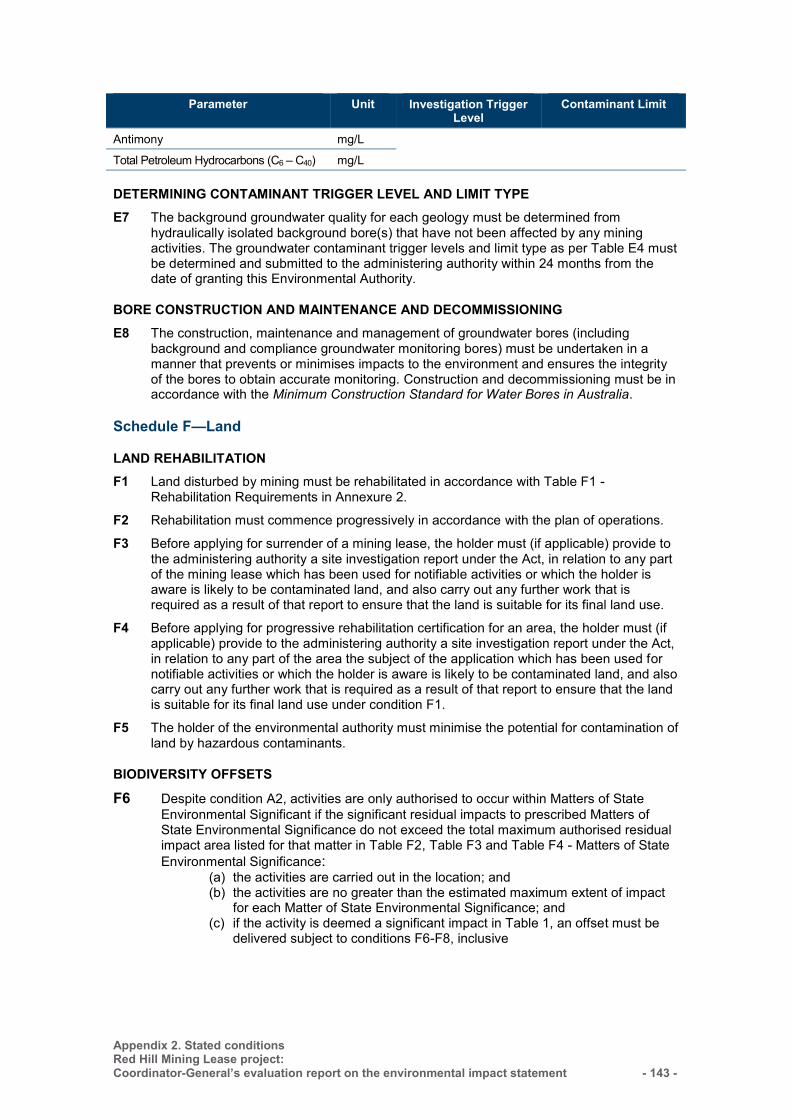
Appendix 2. Stated conditions Red Hill Mining Lease project: Coordinator-General’s evaluation report on the environmental impact statement
- 143 -
Parameter Unit Investigation Trigger Level
Contaminant Limit
Antimony mg/L
Total Petroleum Hydrocarbons (C6 – C40) mg/L
DETERMINING CONTAMINANT TRIGGER LEVEL AND LIMIT TYPE E7 The background groundwater quality for each geology must be determined from
hydraulically isolated background bore(s) that have not been affected by any mining activities. The groundwater contaminant trigger levels and limit type as per Table E4 must be determined and submitted to the administering authority within 24 months from the date of granting this Environmental Authority.
BORE CONSTRUCTION AND MAINTENANCE AND DECOMMISSIONING E8 The construction, maintenance and management of groundwater bores (including
background and compliance groundwater monitoring bores) must be undertaken in a manner that prevents or minimises impacts to the environment and ensures the integrity of the bores to obtain accurate monitoring. Construction and decommissioning must be in accordance with the Minimum Construction Standard for Water Bores in Australia.
Schedule F—Land
LAND REHABILITATION F1 Land disturbed by mining must be rehabilitated in accordance with Table F1 -
Rehabilitation Requirements in Annexure 2.
F2 Rehabilitation must commence progressively in accordance with the plan of operations.
F3 Before applying for surrender of a mining lease, the holder must (if applicable) provide to the administering authority a site investigation report under the Act, in relation to any part of the mining lease which has been used for notifiable activities or which the holder is aware is likely to be contaminated land, and also carry out any further work that is required as a result of that report to ensure that the land is suitable for its final land use.
F4 Before applying for progressive rehabilitation certification for an area, the holder must (if applicable) provide to the administering authority a site investigation report under the Act, in relation to any part of the area the subject of the application which has been used for notifiable activities or which the holder is aware is likely to be contaminated land, and also carry out any further work that is required as a result of that report to ensure that the land is suitable for its final land use under condition F1.
F5 The holder of the environmental authority must minimise the potential for contamination of land by hazardous contaminants.
BIODIVERSITY OFFSETS
F6 Despite condition A2, activities are only authorised to occur within Matters of State Environmental Significant if the significant residual impacts to prescribed Matters of State Environmental Significance do not exceed the total maximum authorised residual impact area listed for that matter in Table F2, Table F3 and Table F4 - Matters of State Environmental Significance:
(a) the activities are carried out in the location; and (b) the activities are no greater than the estimated maximum extent of impact
for each Matter of State Environmental Significance; and (c) if the activity is deemed a significant impact in Table 1, an offset must be
delivered subject to conditions F6-F8, inclusive
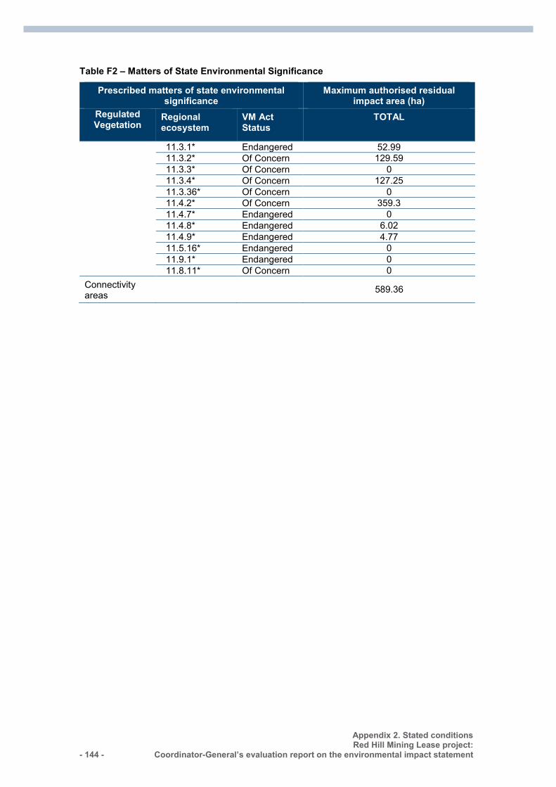
- 144 -
Appendix 2. Stated conditions Red Hill Mining Lease project:
Coordinator-General’s evaluation report on the environmental impact statement
Table F2 – Matters of State Environmental Significance
Prescribed matters of state environmental significance
Maximum authorised residual impact area (ha)
Regulated Vegetation
Regional ecosystem
VM Act Status
TOTAL
11.3.1* Endangered 52.99 11.3.2* Of Concern 129.59 11.3.3* Of Concern 0 11.3.4* Of Concern 127.25 11.3.36* Of Concern 0 11.4.2* Of Concern 359.3 11.4.7* Endangered 0 11.4.8* Endangered 6.02 11.4.9* Endangered 4.77 11.5.16* Endangered 0 11.9.1* Endangered 0 11.8.11* Of Concern 0
Connectivity areas 589.36
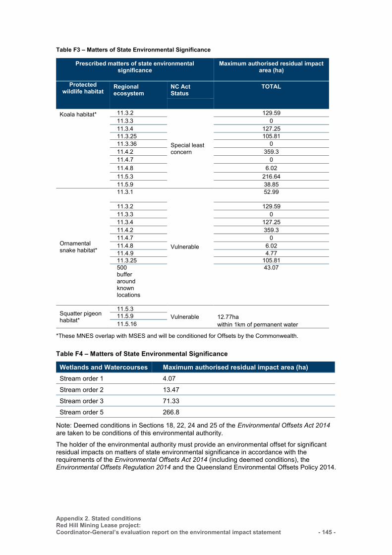
Appendix 2. Stated conditions Red Hill Mining Lease project: Coordinator-General’s evaluation report on the environmental impact statement
- 145 -
Table F3 – Matters of State Environmental Significance
Prescribed matters of state environmental significance
Maximum authorised residual impact area (ha)
Protected wildlife habitat
Regional ecosystem
NC Act Status
TOTAL
Koala habitat* 11.3.2
Special least concern
129.59 11.3.3 0 11.3.4 127.25 11.3.25 105.81 11.3.36 0 11.4.2 359.3 11.4.7 0 11.4.8 6.02 11.5.3 216.64 11.5.9 38.85
Ornamental snake habitat*
11.3.1
Vulnerable
52.99
11.3.2 129.59 11.3.3 0 11.3.4 127.25 11.4.2 359.3 11.4.7 0 11.4.8 6.02 11.4.9 4.77 11.3.25 105.81 500 buffer around known locations
43.07
Squatter pigeon habitat*
11.5.3 Vulnerable
12.77ha within 1km of permanent water
11.5.9 11.5.16
*These MNES overlap with MSES and will be conditioned for Offsets by the Commonwealth.
Table F4 – Matters of State Environmental Significance
Wetlands and Watercourses Maximum authorised residual impact area (ha) Stream order 1 4.07
Stream order 2 13.47
Stream order 3 71.33 Stream order 5 266.8
Note: Deemed conditions in Sections 18, 22, 24 and 25 of the Environmental Offsets Act 2014 are taken to be conditions of this environmental authority.
The holder of the environmental authority must provide an environmental offset for significant residual impacts on matters of state environmental significance in accordance with the requirements of the Environmental Offsets Act 2014 (including deemed conditions), the Environmental Offsets Regulation 2014 and the Queensland Environmental Offsets Policy 2014.
- 146 -
Appendix 2. Stated conditions Red Hill Mining Lease project:
Coordinator-General’s evaluation report on the environmental impact statement
AGREED DELIVERY ARRANGEMENT F7 A suitably qualified person/appropriately qualified person must prepare any offset
delivery plan and determine any proposed financial settlement offset.
POST-STAGE ANALYSIS F8 A suitably qualified person must prepare a report for each annual return period which
includes all of the following:
(a) the actual extent of all completed impacts on matters of state environmental significance referred to in condition F9
(b) a notice of election to address outstanding offset debits for the authorised activity.
SUBSIDENCE MANAGEMENT PLAN F9 A subsidence management plan must be developed and implemented by the holder of
this environmental authority prior to the commencement of activities that result in subsidence. The plan provides for the proper and effective management of the actual and potential environmental impacts resulting from the mining activity and to ensure compliance with the conditions of the environmental authority.
F10 The subsidence management plan must be developed to the satisfaction of the administering authority in accordance with the departmental guideline Watercourse subsidence – Central Queensland Mining Industry or any subsequent versions and must include the following components:
(a) the condition of the existing watercourse (including baseline assessment)
(b) the proposed impacts of subsidence on the watercourse and floodplain including but not limited to:
(i) physical condition of surface drainages
(A) erosion
(B) areas susceptible to higher levels of erosion such as watercourse confluences
(C) incision processes
(D) stream widening
(E) tension cracking
(F) lowering of beds and banks
(G) creation of in stream waterholes
(H) changes to local drainage patterns
(ii) overland flow
(A) capture of overland flow by subsided long-wall panels
(B) increased overbank flows due to lowering of high bank of watercourses
(C) the portion of local and large scale catchment likely to be captured by subsided long-wall panels and the associated impacts on downstream users
(iii) water quality
(A) surface water
(B) groundwater
(C) overland flow water detained in subsided long-wall panels
(iv) land condition: current land condition to be impacted by subsidence
Appendix 2. Stated conditions Red Hill Mining Lease project: Coordinator-General’s evaluation report on the environmental impact statement
- 147 -
(v) infrastructure
(A) detail of existing infrastructure (pipelines, railway, power lines and haul roads) should be identified where there is a potential impact from the effects of land subsidence.
(c) proposed options for mitigating any impacts associated with subsidence and how these mitigation methods will be implemented
(d) a risk assessment
(e) a monitoring, evaluation and maintenance program
(f) cumulative Impacts on watercourses or catchments
(g) impacts on groundwater.
F11 The holder of this environmental authority must not commence subsidence of a longwall panel unless:
The holder has submitted to the administering authority two copies of the subsidence management plan together with certification by a suitably qualified and experienced person that the plan is compliant in all respects with the environmental authority.
ANNUAL INSPECTION F12 The holder of this environmental authority must arrange for each subsided longwall panel
to be inspected annually by a suitably qualified and experienced person, in accordance with conditions F13–F16.
F13 The annual inspection must be conducted prior to 1 November of each year.
F14 At each annual inspection, the condition of each subsided longwall panel must be assessed, including the structural, geotechnical and hydraulic adequacy of the subsided longwall panel and the adequacy of the works with respect to the subsidence management plan.
F15 For each inspection, two copies of a report certified by a suitably qualified and experienced person, including any recommendations must be provided to the administering authority within 28 days of the inspection.
F16 The report must detail any remedial works that have been undertaken and the outcomes of these works.
REMEDIAL WORKS F17 The holder of the environmental authority, if directed by the administering authority, shall
carry out any remedial works that are deemed necessary to minimise impacts on the physical integrity of the watercourse from subsidence.
Schedule H—Sewage treatment
H1 The only contaminant permitted to be released to land is treated sewage effluent in compliance with the release limits stated in Table H1 - Contaminant release limits to land.
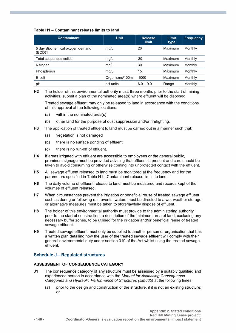
- 148 -
Appendix 2. Stated conditions Red Hill Mining Lease project:
Coordinator-General’s evaluation report on the environmental impact statement
Table H1 – Contaminant release limits to land
Contaminant Unit Release limit
Limit type
Frequency
5 day Biochemical oxygen demand (BOD)1
mg/L 20 Maximum Monthly
Total suspended solids mg/L 30 Maximum Monthly
Nitrogen mg/L 30 Maximum Monthly
Phosphorus mg/L 15 Maximum Monthly
E-coli Organisms/100ml 1000 Maximum Monthly
pH pH units 6.0 – 9.0 Range Monthly
H2 The holder of this environmental authority must, three months prior to the start of mining activities, submit a plan of the nominated area(s) where effluent will be disposed.
Treated sewage effluent may only be released to land in accordance with the conditions of this approval at the following locations:
(a) within the nominated area(s)
(b) other land for the purpose of dust suppression and/or firefighting.
H3 The application of treated effluent to land must be carried out in a manner such that:
(a) vegetation is not damaged
(b) there is no surface ponding of effluent
(c) there is no run-off of effluent.
H4 If areas irrigated with effluent are accessible to employees or the general public, prominent signage must be provided advising that effluent is present and care should be taken to avoid consuming or otherwise coming into unprotected contact with the effluent.
H5 All sewage effluent released to land must be monitored at the frequency and for the parameters specified in Table H1 - Contaminant release limits to land.
H6 The daily volume of effluent release to land must be measured and records kept of the volumes of effluent released.
H7 When circumstances prevent the irrigation or beneficial reuse of treated sewage effluent such as during or following rain events, waters must be directed to a wet weather storage or alternative measures must be taken to store/lawfully dispose of effluent.
H8 The holder of this environmental authority must provide to the administering authority prior to the start of construction, a description of the minimum area of land, excluding any necessary buffer zones, to be utilised for the irrigation and/or beneficial reuse of treated sewage effluent.
H9 Treated sewage effluent must only be supplied to another person or organisation that has a written plan detailing how the user of the treated sewage effluent will comply with their general environmental duty under section 319 of the Act whilst using the treated sewage effluent.
Schedule J—Regulated structures
ASSESSMENT OF CONSEQUENCE CATEGORY J1 The consequence category of any structure must be assessed by a suitably qualified and
experienced person in accordance with the Manual for Assessing Consequence Categories and Hydraulic Performance of Structures (EM635) at the following times:
(a) prior to the design and construction of the structure, if it is not an existing structure; or
Appendix 2. Stated conditions Red Hill Mining Lease project: Coordinator-General’s evaluation report on the environmental impact statement
- 149 -
(b) prior to any change in its purpose or nature of its stored contents; or
(c) following any change in surroundings or in the conditions downstream.
J2 A consequence assessment report and certification must be prepared for each structure assessed and the report may include a consequence assessment for more than one structure.
J3 Certification must be provided by the suitably qualified and experienced person who undertook the assessment, in the form set out in the Manual for Assessing Consequence Categories and Hydraulic Performance of Structures (EM635).
J5 All regulated structures must be designed by, and constructed* under the supervision of a suitably qualified and experienced person in accordance with the requirements of the Manual for Assessing Consequence Categories and Hydraulic Performance of Structures (EM635). *Certification of design and construction may be undertaken by different persons.
J6 Construction of a regulated structure is prohibited unless the holder has submitted a consequence category assessment report and certification to the administering authority has been certified by a suitably qualified and experienced person for the design and design plan and the associated operating procedures in compliance with the relevant condition of this authority.
J7 Certification must be provided by the suitably qualified and experienced person who oversees the preparation of the design plan in the form set out in the Manual for Assessing Consequence Categories and Hydraulic Performance of Structures (EM635), and must be recorded in the Regulated Dams/Levees register.
J8 Regulated structures must:
(a) be designed and constructed in accordance with and conform to the requirements of the Manual for Assessing Consequence Categories and Hydraulic Performance of Structures (EM635)
(b) be designed and constructed with due consideration given to ensuring that the design integrity would not be compromised on account of:
(i) floodwaters from entering the regulated dam from any watercourse or drainage line
(ii) wall failure due to erosion by floodwaters arising from any watercourse or drainage line.
J9 Certification by the suitably qualified and experienced person who supervises the construction must be submitted to the administering authority on the completion of construction of the regulated structure, and state that:
(a) the 'as constructed' drawings and specifications meet the original intent of the design plan for that regulated structure
(b) construction of the regulated structure is in accordance with the design plan.
OPERATION OF A REGULATED STRUCTURE J10 Operation of a regulated structure, except for an existing structure, is prohibited unless:
(a) the holder has submitted to the administering authority:
(i) one paper copy and one electronic copy of the design plan and certification of the ‘design plan’ in accordance with condition J6
(ii) a set of ‘as constructed’ drawings and specifications
(iii) certification of those ‘as constructed drawings and specifications’ in accordance with condition J9
- 150 -
Appendix 2. Stated conditions Red Hill Mining Lease project:
Coordinator-General’s evaluation report on the environmental impact statement
(iv) where the regulated structure is to be managed as part of an integrated containment system for the purpose of sharing the DSA volume across the system, a copy of the certified system design plan
(v) the requirements of this authority relating to the construction of the regulated structure have been met
(vi) the holder has entered the details required under this authority, into a Register of Regulated Dams
(vii) there is a current operational plan for the regulated structures.
J11 Each regulated structure must be maintained and operated, for the duration of its operational life until decommissioned and rehabilitated, in a manner that is consistent with the current operational plan and, if applicable, the current design plan and associated certified ‘as constructed’ drawings.
MANDATORY REPORTING LEVEL J12 Conditions J13 to J16 inclusive only apply to Regulated Structures which have not been
certified as low consequence category for ‘failure to contain – overtopping’.
J13 The Mandatory Reporting Level (the MRL) must be marked on a regulated dam in such a way that during routine inspections of that dam, it is clearly observable.
J14 The holder must, as soon as practical and within forty-eight (48) hours of becoming aware, notify the administering authority when the level of the contents of a regulated dam reaches the MRL.
J15 The holder must, immediately on becoming aware that the MRL has been reached, act to prevent the occurrence of any unauthorised discharge from the regulated dam.
J16 The holder must record any changes to the MRL in the Register of Regulated Structures.
DESIGN STORAGE ALLOWANCE J17 The holder must assess the performance of each regulated structure or linked
containment system over the preceding November to May period based on actual observations of the available storage in each regulated dam or linked containment system taken prior to 1 July of each year.
J18 By 1 November of each year, storage capacity must be available in each regulated structure (or network of linked containment systems with a shared DSA volume), to meet the Design Storage Allowance (DSA) volume for the dam (or network of linked containment systems).
J19 The holder must, as soon as possible and within forty-eight (48) hours of becoming aware that the regulated dam (or network of linked containment systems) will not have the available storage to meet the DSA volume on 1 November of any year, notify the administering authority.
J20 The holder must, immediately on becoming aware that a regulated structure (or network of linked containment systems) will not have the available storage to meet the DSA volume on 1 November of any year, act to prevent the occurrence of any unauthorised discharge from the regulated dam or linked containment systems.
ANNUAL INSPECTION REPORT J21 Each regulated structure must be inspected each calendar year by a suitably qualified
and experienced person.
J22 At each annual inspection, the condition and adequacy of all components of the regulated structure must be assessed and a suitably qualified and experienced person must prepare an annual inspection report containing details of the assessment and include recommended actions to ensure the integrity of the regulated structure.
Appendix 2. Stated conditions Red Hill Mining Lease project: Coordinator-General’s evaluation report on the environmental impact statement
- 151 -
J23 The suitably qualified and experienced person who prepared the annual inspection report must certify the report in accordance with the Manual for Assessing Consequence Categories and Hydraulic Performance of Structures (EM635).
J24 The holder must:
(a) Within 20 business days of receipt of the annual inspection report, provide to the administering authority:
(i) The recommendations section of the annual inspection report; and
(ii) If applicable, any actions being taken in response to those recommendations; and
(b) If, following receipt of the recommendations and (if applicable) actions, the administering authority requests a full copy of the annual inspection report from the holder, provide this to the administering authority within 10 business days* of receipt of the request.
*Please note that for some model conditions, such as model conditions for dams associated with a resource activity—non-mining activity, the notification requirements may be located in a separate part of the conditions of an environmental authority (e.g. under notification requirement conditions).
TRANSFER ARRANGEMENTS J25 The holder must provide a copy of any reports, documentation and certifications prepared
under this authority, including but not limited to any Register of Regulated Structures, consequence assessment, design plan and other supporting documentation, to a new holder on transfer of this authority.
DECOMMISSIONING AND REHABILITATION J26 Regulated structures must not be abandoned but be either:
(a) decommissioned and rehabilitated to achieve compliance with condition (J27); or
(b) be left in-situ for a beneficial use(s) provided that:
(i) it no longer contains contaminants that will migrate into the environment
(ii) it contains water of a quality that is demonstrated to be suitable for its intended beneficial use(s)
(iii) the administering authority, the holder of the environmental authority and the landholder agree in writing that the regulated structure will be used by the landholder following the cessation of the environmentally relevant activity(ies).
J27 After decommissioning, all significantly disturbed land caused by the carrying out of the environmentally relevant activity(ies) must be rehabilitated to meet the following final acceptance criteria:
(a) the landform is safe for humans and fauna
(b) the landform is stable with no subsidence or erosion gullies for at least three (3) years
(c) any contaminated land (e.g. contaminated soils) is remediated and rehabilitated
(d) not allowing for acid mine drainage; or
(e) there is no ongoing contamination to waters (including groundwater)
(f) rehabilitation is undertaken in a manner such that any actual or potential acid sulfate soils on the area of significant disturbance are treated to prevent or minimise environmental harm in accordance with the Instructions for the treatment and management of acid sulfate soils (2001)
- 152 -
Appendix 2. Stated conditions Red Hill Mining Lease project:
Coordinator-General’s evaluation report on the environmental impact statement
g) all significantly disturbed land is reinstated to the pre-disturbed soil suitability class
h) for land that is not being cultivated by the landholder:
(i) groundcover, that is not a declared pest species is established and self-sustaining
(ii) vegetation of similar species richness and species diversity to pre-selected analogue sites is established and self-sustaining
(iii) the maintenance requirements for rehabilitated land is no greater than that required for the land prior to its disturbance caused by carrying out the petroleum activity(ies).
i) for land that is to be cultivated by the landholder, cover crop is revegetated, unless the landholder will be preparing the site for cropping within 3 months of mining activities being completed.
REGISTER OF REGULATED STRUCTURES J28 A Register of Regulated Structures must be established and maintained by the holder for
each regulated structure.
J29 The holder must provisionally enter the required information in the Register of Regulated Structures when a design plan for a regulated structure submitted to the administering authority.
J30 The holder must make a final entry of the required information in the Register of Regulated Structures once compliance with condition J10 has been achieved.
J31 The holder must ensure that the information contained in the Register of Regulated Structures is current and complete on any given day.
J32 All entries in the Register of Regulated Structures must be approved by the chief executive officer for the holder of this authority, or their delegate, as being accurate and correct.
J33 The holder must, at the same time as providing the annual return, supply to the administering authority a copy of the records contained in the Register of Regulated Structures, in the electronic format required by the administering authority.
Schedule K—Waste
K1 Unless otherwise permitted by the conditions of this environmental authority or with prior approval from the administering authority and in accordance with a relevant standard operating procedure, waste must not be burnt.
K2 The holder of this environmental authority may burn vegetation cleared in the course of carrying out extraction activities provided the activity does not cause environmental harm at any sensitive place or commercial place.
DISPOSAL OF TYRES K3 Disposing of scrap tyres resulting from the authorised activities in spoil emplacements is
acceptable, provided tyres are placed as deep in the spoil as reasonably practicable. A record must be kept of the number and location for tyres disposed.
ACID SULFATE SOILS K4 The holder of this environmental authority must treat and manage acid sulfate soils in
accordance with the latest edition of the Queensland Acid Sulfate Soil Technical Manual.
TAILINGS DISPOSAL K5 The holder of this environmental authority must not dispose of any tailings at this site.
END OF CONDITIONS
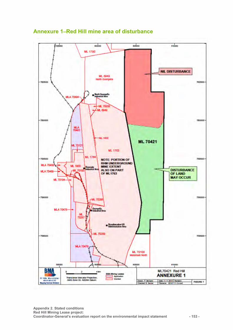
Appendix 2. Stated conditions Red Hill Mining Lease project: Coordinator-General’s evaluation report on the environmental impact statement
- 153 -
Annexure 1—Red Hill mine area of disturbance
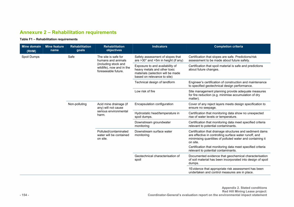
- 154 -
Appendix 2. Stated conditions Red Hill Mining Lease project:
Coordinator-General’s evaluation report on the environmental impact statement
Annexure 2 – Rehabilitation requirements Table F1 – Rehabilitation requirements
Mine domain (RHM)
Mine feature name
Rehabilitation goals
Rehabilitation objectives
Indicators Completion criteria
Spoil Dumps Safe
The site is safe for humans and animals (including stock and wildlife), now and in the foreseeable future.
Safety assessment of slopes that are >30° and >5m in height (if any)
Certification that slopes are safe. Predictions/risk assessment to be made about future safety.
Exposure to and availability of heavy metals and other toxic materials (selection will be made based on relevance to site)
Certification that spoil material is safe and predictions about future changes.
Technical design of landform Engineer’s certification of construction and maintenance to specified geotechnical design performance.
Low risk of fire Site management planning provide adequate measures for fire reduction (e.g. minimise accumulation of dry matter).
Non-polluting Acid mine drainage (if any) will not cause serious environmental harm.
Encapsulation configuration Cover of any reject layers meets design specification to ensure no seepage.
Hydrostatic head/temperature in spoil dumps.
Certification that monitoring data show no unexpected rise of water levels or temperature.
Downstream groundwater monitoring
Certification that monitoring data meet specified criteria relevant to potential contaminants.
Polluted/contaminated water will be contained on site.
Downstream surface water monitoring
Certification that drainage structures and sediment dams are effective in controlling surface water runoff, and minimising quantities of polluted water and containing it on site. Certification that monitoring data meet specified criteria relevant to potential contaminants.
Geotechnical characterisation of spoil
Documented evidence that geochemical characterisation of soil material has been incorporated into design of spoil dumps.
1Evidence that appropriate risk assessment has been undertaken and control measures are in place.
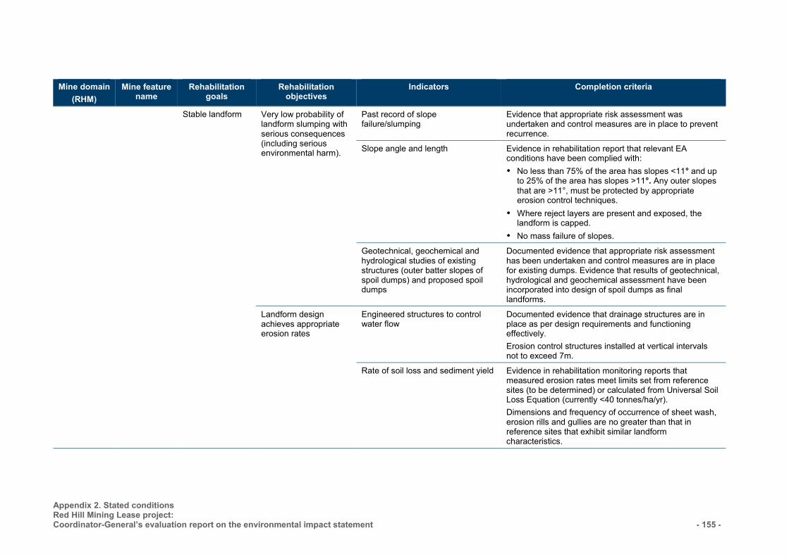
Appendix 2. Stated conditions Red Hill Mining Lease project: Coordinator-General’s evaluation report on the environmental impact statement
- 155 -
Mine domain (RHM)
Mine feature name
Rehabilitation goals
Rehabilitation objectives
Indicators Completion criteria
Stable landform
Very low probability of landform slumping with serious consequences (including serious environmental harm).
Past record of slope failure/slumping
Evidence that appropriate risk assessment was undertaken and control measures are in place to prevent recurrence.
Slope angle and length Evidence in rehabilitation report that relevant EA conditions have been complied with: No less than 75% of the area has slopes <11° and up
to 25% of the area has slopes >11°. Any outer slopes that are >11°, must be protected by appropriate erosion control techniques.
Where reject layers are present and exposed, the landform is capped.
No mass failure of slopes.
Geotechnical, geochemical and hydrological studies of existing structures (outer batter slopes of spoil dumps) and proposed spoil dumps
Documented evidence that appropriate risk assessment has been undertaken and control measures are in place for existing dumps. Evidence that results of geotechnical, hydrological and geochemical assessment have been incorporated into design of spoil dumps as final landforms.
Landform design achieves appropriate erosion rates
Engineered structures to control water flow
Documented evidence that drainage structures are in place as per design requirements and functioning effectively. Erosion control structures installed at vertical intervals not to exceed 7m.
Rate of soil loss and sediment yield Evidence in rehabilitation monitoring reports that measured erosion rates meet limits set from reference sites (to be determined) or calculated from Universal Soil Loss Equation (currently <40 tonnes/ha/yr). Dimensions and frequency of occurrence of sheet wash, erosion rills and gullies are no greater than that in reference sites that exhibit similar landform characteristics.
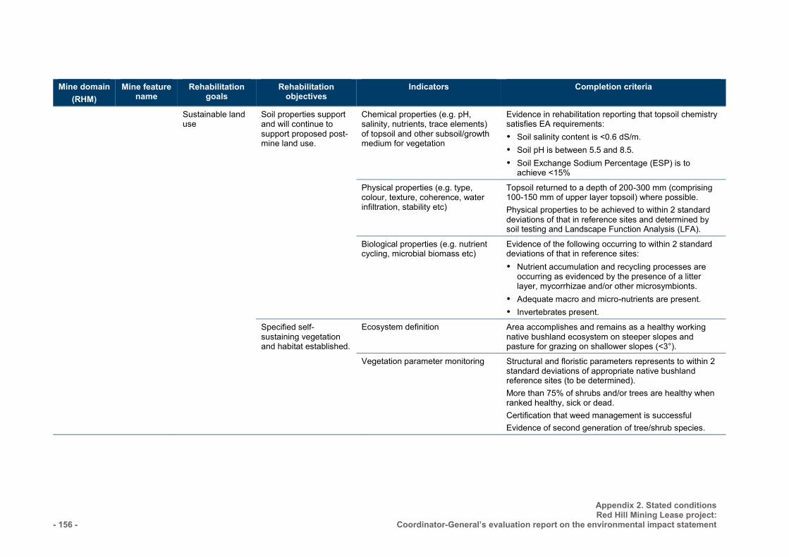
- 156 -
Appendix 2. Stated conditions Red Hill Mining Lease project:
Coordinator-General’s evaluation report on the environmental impact statement
Mine domain (RHM)
Mine feature name
Rehabilitation goals
Rehabilitation objectives
Indicators Completion criteria
Sustainable land use
Soil properties support and will continue to support proposed post-mine land use.
Chemical properties (e.g. pH, salinity, nutrients, trace elements) of topsoil and other subsoil/growth medium for vegetation
Evidence in rehabilitation reporting that topsoil chemistry satisfies EA requirements: Soil salinity content is <0.6 dS/m. Soil pH is between 5.5 and 8.5. Soil Exchange Sodium Percentage (ESP) is to
achieve <15%
Physical properties (e.g. type, colour, texture, coherence, water infiltration, stability etc)
Topsoil returned to a depth of 200-300 mm (comprising 100-150 mm of upper layer topsoil) where possible. Physical properties to be achieved to within 2 standard deviations of that in reference sites and determined by soil testing and Landscape Function Analysis (LFA).
Biological properties (e.g. nutrient cycling, microbial biomass etc)
Evidence of the following occurring to within 2 standard deviations of that in reference sites: Nutrient accumulation and recycling processes are
occurring as evidenced by the presence of a litter layer, mycorrhizae and/or other microsymbionts.
Adequate macro and micro-nutrients are present. Invertebrates present.
Specified self-sustaining vegetation and habitat established.
Ecosystem definition Area accomplishes and remains as a healthy working native bushland ecosystem on steeper slopes and pasture for grazing on shallower slopes (<3°).
Vegetation parameter monitoring Structural and floristic parameters represents to within 2 standard deviations of appropriate native bushland reference sites (to be determined). More than 75% of shrubs and/or trees are healthy when ranked healthy, sick or dead. Certification that weed management is successful Evidence of second generation of tree/shrub species.
Appendix 2. Stated conditions Red Hill Mining Lease project: Coordinator-General’s evaluation report on the environmental impact statement
- 157 -
Mine domain (RHM)
Mine feature name
Rehabilitation goals
Rehabilitation objectives
Indicators Completion criteria
Fauna monitoring Habitat complexity is within 2 standard deviations of reference site values for pasture or native bushland as appropriate. Evidence of active use of habitat provided during rehabilitation such as nest boxes, stags and logs and signs of natural generation of shelter sources including leaf litter.
Representation of a range of species characteristics (e.g. activity pattern, habitat usage, diet, dispersal character etc) from each faunal assemblage group (e.g. reptiles, birds, mammals, amphibians), present in the ecosystem type based on values of reference sites (to be determined).
Presence of representatives of a broad range of invertebrate functional indicator groups involved in different ecological processes based on values of reference sites (to be determined).
Land use is established with comparable management requirements to similarly used un-mined land.
Extent of management required Evidence that management required for grazing is similar to that required for grazing on adjacent un-mined land. Evidence that management required of native bushland is similar to that of bushland in adjacent un-mined areas.
Reject Dumps
Safe
The site is safe for humans and animals (including stock and wildlife), now and in the foreseeable future.
Safety assessment of slopes that are >30° and >5m in height (if any)
Certification that slopes are safe. Predictions to be made about future safety.
Safe Non-polluting
The site is safe for humans and animals (including stock and wildlife), now and in the
Exposure to and availability of heavy metals and other toxic materials (selection will be made based on relevance to site)
Certification that spoil material is safe and predictions about future changes.
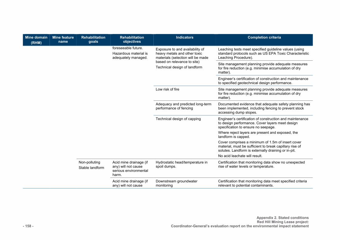
- 158 -
Appendix 2. Stated conditions Red Hill Mining Lease project:
Coordinator-General’s evaluation report on the environmental impact statement
Mine domain (RHM)
Mine feature name
Rehabilitation goals
Rehabilitation objectives
Indicators Completion criteria
foreseeable future. Hazardous material is adequately managed.
Exposure to and availability of heavy metals and other toxic materials (selection will be made based on relevance to site) Technical design of landform
Leaching tests meet specified guideline values (using standard protocols such as US EPA Toxic Characteristic Leaching Procedure). Site management planning provide adequate measures for fire reduction (e.g. minimise accumulation of dry matter). Engineer’s certification of construction and maintenance to specified geotechnical design performance.
Low risk of fire Site management planning provide adequate measures for fire reduction (e.g. minimise accumulation of dry matter).
Adequacy and predicted long-term performance of fencing
Documented evidence that adequate safety planning has been implemented, including fencing to prevent stock accessing dump slopes.
Technical design of capping Engineer’s certification of construction and maintenance to design performance. Cover layers meet design specification to ensure no seepage. Where reject layers are present and exposed, the landform is capped. Cover comprises a minimum of 1.5m of insert cover material, must be sufficient to break capillary rise of solutes. Landform is externally draining or in-pit. No acid leachate will result.
Non-polluting Stable landform
Acid mine drainage (if any) will not cause serious environmental harm.
Hydrostatic head/temperature in spoil dumps.
Certification that monitoring data show no unexpected rise of water levels or temperature.
Acid mine drainage (if any) will not cause
Downstream groundwater monitoring
Certification that monitoring data meet specified criteria relevant to potential contaminants.
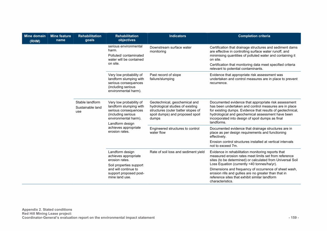
Appendix 2. Stated conditions Red Hill Mining Lease project: Coordinator-General’s evaluation report on the environmental impact statement
- 159 -
Mine domain (RHM)
Mine feature name
Rehabilitation goals
Rehabilitation objectives
Indicators Completion criteria
serious environmental harm. Polluted/ contaminated water will be contained on site.
Downstream surface water monitoring
Certification that drainage structures and sediment dams are effective in controlling surface water runoff, and minimising quantities of polluted water and containing it on site. Certification that monitoring data meet specified criteria relevant to potential contaminants.
Very low probability of landform slumping with serious consequences (including serious environmental harm).
Past record of slope failure/slumping
Evidence that appropriate risk assessment was undertaken and control measures are in place to prevent recurrence.
Stable landform Sustainable land use
Very low probability of landform slumping with serious consequences (including serious environmental harm). Landform design achieves appropriate erosion rates.
Geotechnical, geochemical and hydrological studies of existing structures (outer batter slopes of spoil dumps) and proposed spoil dumps
Documented evidence that appropriate risk assessment has been undertaken and control measures are in place for existing dumps. Evidence that results of geotechnical, hydrological and geochemical assessment have been incorporated into design of spoil dumps as final landforms.
Engineered structures to control water flow
Documented evidence that drainage structures are in place as per design requirements and functioning effectively. Erosion control structures installed at vertical intervals not to exceed 7m.
Landform design achieves appropriate erosion rates. Soil properties support and will continue to support proposed post-mine land use.
Rate of soil loss and sediment yield Evidence in rehabilitation monitoring reports that measured erosion rates meet limits set from reference sites (to be determined) or calculated from Universal Soil Loss Equation (currently <40 tonnes/ha/yr). Dimensions and frequency of occurrence of sheet wash, erosion rills and gullies are no greater than that in reference sites that exhibit similar landform characteristics.
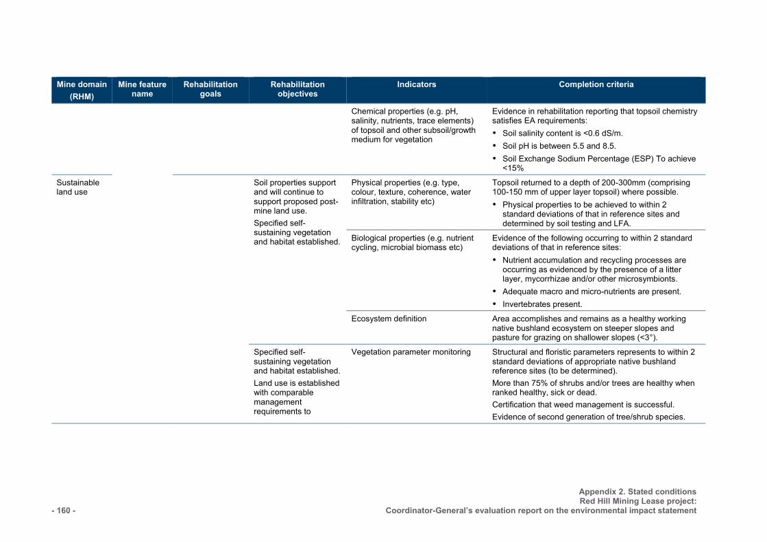
- 160 -
Appendix 2. Stated conditions Red Hill Mining Lease project:
Coordinator-General’s evaluation report on the environmental impact statement
Mine domain (RHM)
Mine feature name
Rehabilitation goals
Rehabilitation objectives
Indicators Completion criteria
Chemical properties (e.g. pH, salinity, nutrients, trace elements) of topsoil and other subsoil/growth medium for vegetation
Evidence in rehabilitation reporting that topsoil chemistry satisfies EA requirements: Soil salinity content is <0.6 dS/m. Soil pH is between 5.5 and 8.5. Soil Exchange Sodium Percentage (ESP) To achieve
<15% Sustainable land use
Soil properties support and will continue to support proposed post-mine land use. Specified self-sustaining vegetation and habitat established.
Physical properties (e.g. type, colour, texture, coherence, water infiltration, stability etc)
Topsoil returned to a depth of 200-300mm (comprising 100-150 mm of upper layer topsoil) where possible. Physical properties to be achieved to within 2
standard deviations of that in reference sites and determined by soil testing and LFA.
Biological properties (e.g. nutrient cycling, microbial biomass etc)
Evidence of the following occurring to within 2 standard deviations of that in reference sites: Nutrient accumulation and recycling processes are
occurring as evidenced by the presence of a litter layer, mycorrhizae and/or other microsymbionts.
Adequate macro and micro-nutrients are present. Invertebrates present.
Ecosystem definition Area accomplishes and remains as a healthy working native bushland ecosystem on steeper slopes and pasture for grazing on shallower slopes (<3°).
Specified self-sustaining vegetation and habitat established. Land use is established with comparable management requirements to
Vegetation parameter monitoring Structural and floristic parameters represents to within 2 standard deviations of appropriate native bushland reference sites (to be determined). More than 75% of shrubs and/or trees are healthy when ranked healthy, sick or dead. Certification that weed management is successful. Evidence of second generation of tree/shrub species.
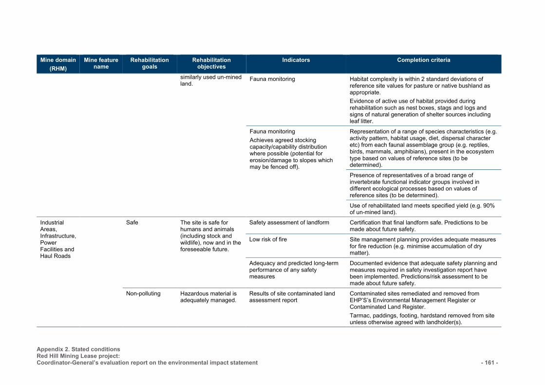
Appendix 2. Stated conditions Red Hill Mining Lease project: Coordinator-General’s evaluation report on the environmental impact statement
- 161 -
Mine domain (RHM)
Mine feature name
Rehabilitation goals
Rehabilitation objectives
Indicators Completion criteria
similarly used un-mined land.
Fauna monitoring Habitat complexity is within 2 standard deviations of reference site values for pasture or native bushland as appropriate. Evidence of active use of habitat provided during rehabilitation such as nest boxes, stags and logs and signs of natural generation of shelter sources including leaf litter.
Fauna monitoring Achieves agreed stocking capacity/capability distribution where possible (potential for erosion/damage to slopes which may be fenced off).
Representation of a range of species characteristics (e.g. activity pattern, habitat usage, diet, dispersal character etc) from each faunal assemblage group (e.g. reptiles, birds, mammals, amphibians), present in the ecosystem type based on values of reference sites (to be determined). Presence of representatives of a broad range of invertebrate functional indicator groups involved in different ecological processes based on values of reference sites (to be determined). Use of rehabilitated land meets specified yield (e.g. 90% of un-mined land).
Industrial Areas, Infrastructure, Power Facilities and Haul Roads
Safe
The site is safe for humans and animals (including stock and wildlife), now and in the foreseeable future.
Safety assessment of landform Certification that final landform safe. Predictions to be made about future safety.
Low risk of fire Site management planning provides adequate measures for fire reduction (e.g. minimise accumulation of dry matter).
Adequacy and predicted long-term performance of any safety measures
Documented evidence that adequate safety planning and measures required in safety investigation report have been implemented. Predictions/risk assessment to be made about future safety.
Non-polluting Hazardous material is adequately managed.
Results of site contaminated land assessment report
Contaminated sites remediated and removed from EHP’S’s Environmental Management Register or Contaminated Land Register. Tarmac, paddings, footing, hardstand removed from site unless otherwise agreed with landholder(s).
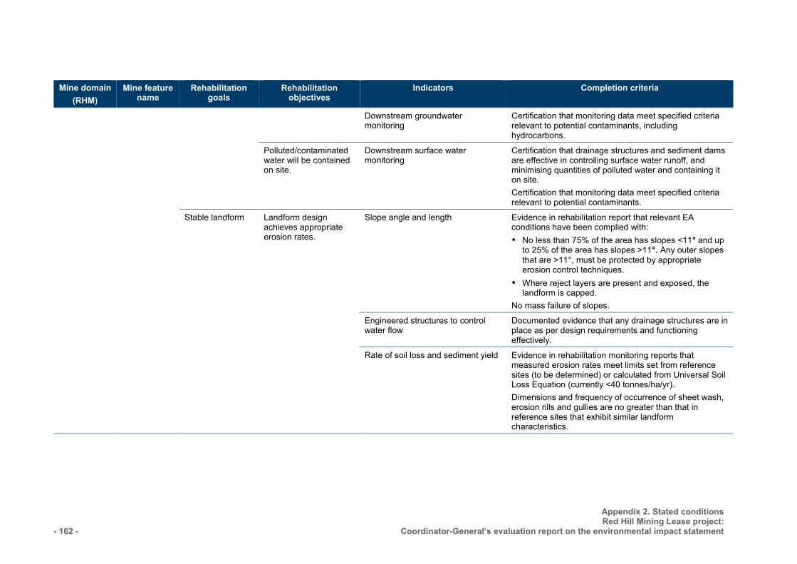
- 162 -
Appendix 2. Stated conditions Red Hill Mining Lease project:
Coordinator-General’s evaluation report on the environmental impact statement
Mine domain (RHM)
Mine feature name
Rehabilitation goals
Rehabilitation objectives
Indicators Completion criteria
Downstream groundwater monitoring
Certification that monitoring data meet specified criteria relevant to potential contaminants, including hydrocarbons.
Polluted/contaminated water will be contained on site.
Downstream surface water monitoring
Certification that drainage structures and sediment dams are effective in controlling surface water runoff, and minimising quantities of polluted water and containing it on site. Certification that monitoring data meet specified criteria relevant to potential contaminants.
Stable landform
Landform design achieves appropriate erosion rates.
Slope angle and length Evidence in rehabilitation report that relevant EA conditions have been complied with: No less than 75% of the area has slopes <11° and up
to 25% of the area has slopes >11°. Any outer slopes that are >11°, must be protected by appropriate erosion control techniques.
Where reject layers are present and exposed, the landform is capped.
No mass failure of slopes. Engineered structures to control
water flow Documented evidence that any drainage structures are in place as per design requirements and functioning effectively.
Rate of soil loss and sediment yield Evidence in rehabilitation monitoring reports that measured erosion rates meet limits set from reference sites (to be determined) or calculated from Universal Soil Loss Equation (currently <40 tonnes/ha/yr). Dimensions and frequency of occurrence of sheet wash, erosion rills and gullies are no greater than that in reference sites that exhibit similar landform characteristics.

Appendix 2. Stated conditions Red Hill Mining Lease project: Coordinator-General’s evaluation report on the environmental impact statement
- 163 -
Mine domain (RHM)
Mine feature name
Rehabilitation goals
Rehabilitation objectives
Indicators Completion criteria
Sustainable land use
Soil properties support and will continue to support proposed post-mine land use.
Chemical properties (e.g. pH, salinity, nutrients, trace elements) of topsoil and other subsoil/growth medium for vegetation
Evidence in rehabilitation reporting that topsoil chemistry satisfies EA requirements: Soil salinity content is <0.6 dS/m. Soil pH is between 5.5 and 8.5. Soil Exchange Sodium Percentage (ESP) is to
achieve <15%.
Physical properties (e.g. type, colour, texture, coherence, water infiltration, stability etc)
Topsoil returned to a depth of 200-300 mm (comprising 100-150 mm of upper layer topsoil) where possible. Physical properties to be achieved to within 2 standard deviations of that in reference sites and determined by soil testing and LFA.
Biological properties (e.g. nutrient cycling, microbial biomass etc)
Evidence of the following occurring to within 2 standard deviations of that in reference sites: Nutrient accumulation and recycling processes are
occurring as evidenced by the presence of a litter layer, mycorrhizae and/or other microsymbionts.
Adequate macro and micro-nutrients are present. Invertebrates present.
Specified self-sustaining vegetation and habitat established.
Ecosystem definition Area accomplishes and remains as a healthy grassland ecosystem.
Vegetation parameter monitoring Structural and floristic parameters represents to within 2 standard deviations of appropriate native bushland reference sites (to be determined). More than 75% of shrubs and/or trees are healthy when ranked healthy, sick or dead. Certification that weed management is successful. Evidence of second generation of tree/shrub species.
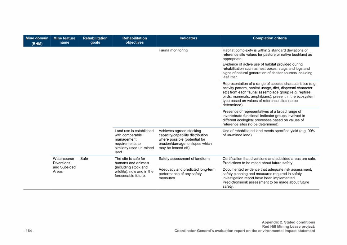
- 164 -
Appendix 2. Stated conditions Red Hill Mining Lease project:
Coordinator-General’s evaluation report on the environmental impact statement
Mine domain (RHM)
Mine feature name
Rehabilitation goals
Rehabilitation objectives
Indicators Completion criteria
Fauna monitoring Habitat complexity is within 2 standard deviations of reference site values for pasture or native bushland as appropriate. Evidence of active use of habitat provided during rehabilitation such as nest boxes, stags and logs and signs of natural generation of shelter sources including leaf litter.
Representation of a range of species characteristics (e.g. activity pattern, habitat usage, diet, dispersal character etc) from each faunal assemblage group (e.g. reptiles, birds, mammals, amphibians), present in the ecosystem type based on values of reference sites (to be determined).
Presence of representatives of a broad range of invertebrate functional indicator groups involved in different ecological processes based on values of reference sites (to be determined).
Land use is established with comparable management requirements to similarly used un-mined land.
Achieves agreed stocking capacity/capability distribution where possible (potential for erosion/damage to slopes which may be fenced off).
Use of rehabilitated land meets specified yield (e.g. 90% of un-mined land)
Watercourse Diversions and Subsided Areas
Safe
The site is safe for humans and animals (including stock and wildlife), now and in the foreseeable future.
Safety assessment of landform Certification that diversions and subsided areas are safe. Predictions to be made about future safety.
Adequacy and predicted long-term performance of any safety measures
Documented evidence that adequate risk assessment, safety planning and measures required in safety investigation report have been implemented. Predictions/risk assessment to be made about future safety.
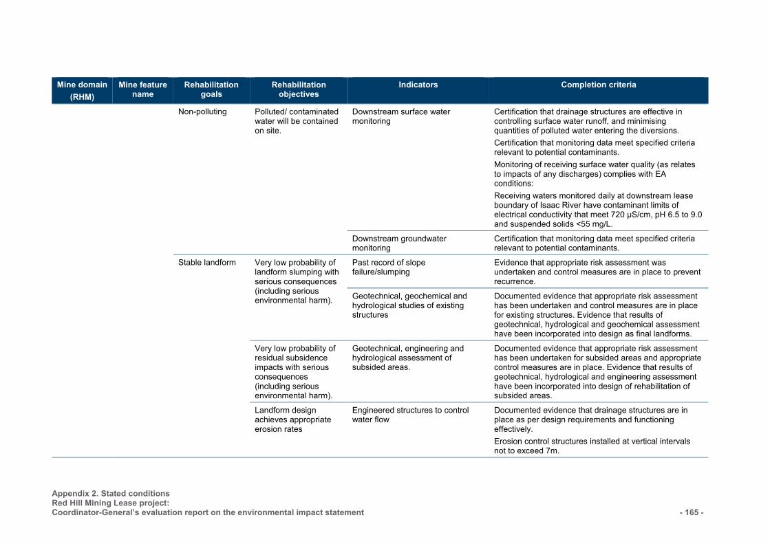
Appendix 2. Stated conditions Red Hill Mining Lease project: Coordinator-General’s evaluation report on the environmental impact statement
- 165 -
Mine domain (RHM)
Mine feature name
Rehabilitation goals
Rehabilitation objectives
Indicators Completion criteria
Non-polluting Polluted/ contaminated water will be contained on site.
Downstream surface water monitoring
Certification that drainage structures are effective in controlling surface water runoff, and minimising quantities of polluted water entering the diversions. Certification that monitoring data meet specified criteria relevant to potential contaminants. Monitoring of receiving surface water quality (as relates to impacts of any discharges) complies with EA conditions: Receiving waters monitored daily at downstream lease boundary of Isaac River have contaminant limits of electrical conductivity that meet 720 µS/cm, pH 6.5 to 9.0 and suspended solids <55 mg/L.
Downstream groundwater monitoring
Certification that monitoring data meet specified criteria relevant to potential contaminants.
Stable landform
Very low probability of landform slumping with serious consequences (including serious environmental harm).
Past record of slope failure/slumping
Evidence that appropriate risk assessment was undertaken and control measures are in place to prevent recurrence.
Geotechnical, geochemical and hydrological studies of existing structures
Documented evidence that appropriate risk assessment has been undertaken and control measures are in place for existing structures. Evidence that results of geotechnical, hydrological and geochemical assessment have been incorporated into design as final landforms.
Very low probability of residual subsidence impacts with serious consequences (including serious environmental harm).
Geotechnical, engineering and hydrological assessment of subsided areas.
Documented evidence that appropriate risk assessment has been undertaken for subsided areas and appropriate control measures are in place. Evidence that results of geotechnical, hydrological and engineering assessment have been incorporated into design of rehabilitation of subsided areas.
Landform design achieves appropriate erosion rates
Engineered structures to control water flow
Documented evidence that drainage structures are in place as per design requirements and functioning effectively. Erosion control structures installed at vertical intervals not to exceed 7m.
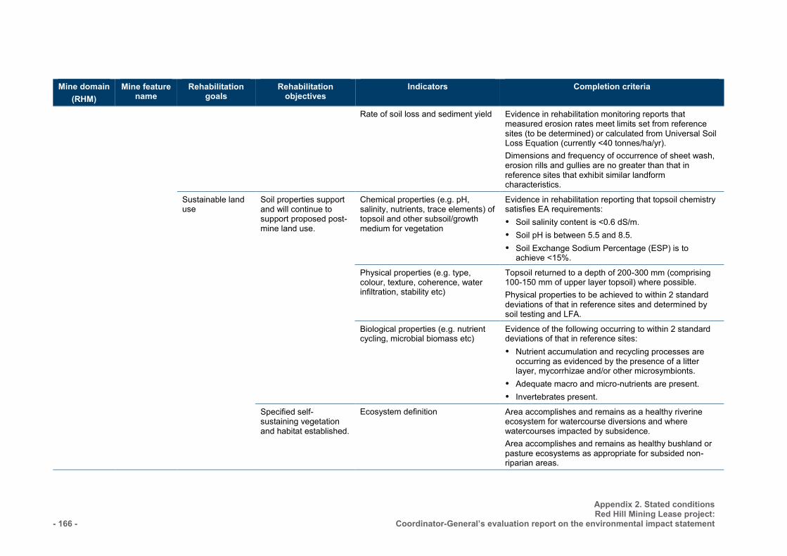
- 166 -
Appendix 2. Stated conditions Red Hill Mining Lease project:
Coordinator-General’s evaluation report on the environmental impact statement
Mine domain (RHM)
Mine feature name
Rehabilitation goals
Rehabilitation objectives
Indicators Completion criteria
Rate of soil loss and sediment yield Evidence in rehabilitation monitoring reports that measured erosion rates meet limits set from reference sites (to be determined) or calculated from Universal Soil Loss Equation (currently <40 tonnes/ha/yr). Dimensions and frequency of occurrence of sheet wash, erosion rills and gullies are no greater than that in reference sites that exhibit similar landform characteristics.
Sustainable land use
Soil properties support and will continue to support proposed post-mine land use.
Chemical properties (e.g. pH, salinity, nutrients, trace elements) of topsoil and other subsoil/growth medium for vegetation
Evidence in rehabilitation reporting that topsoil chemistry satisfies EA requirements: Soil salinity content is <0.6 dS/m. Soil pH is between 5.5 and 8.5. Soil Exchange Sodium Percentage (ESP) is to
achieve <15%.
Physical properties (e.g. type, colour, texture, coherence, water infiltration, stability etc)
Topsoil returned to a depth of 200-300 mm (comprising 100-150 mm of upper layer topsoil) where possible. Physical properties to be achieved to within 2 standard deviations of that in reference sites and determined by soil testing and LFA.
Biological properties (e.g. nutrient cycling, microbial biomass etc)
Evidence of the following occurring to within 2 standard deviations of that in reference sites: Nutrient accumulation and recycling processes are
occurring as evidenced by the presence of a litter layer, mycorrhizae and/or other microsymbionts.
Adequate macro and micro-nutrients are present. Invertebrates present.
Specified self-sustaining vegetation and habitat established.
Ecosystem definition Area accomplishes and remains as a healthy riverine ecosystem for watercourse diversions and where watercourses impacted by subsidence. Area accomplishes and remains as healthy bushland or pasture ecosystems as appropriate for subsided non-riparian areas.
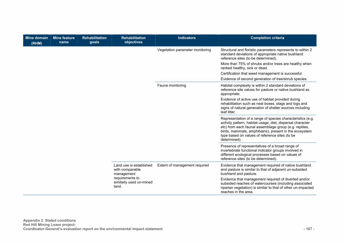
Appendix 2. Stated conditions Red Hill Mining Lease project: Coordinator-General’s evaluation report on the environmental impact statement
- 167 -
Mine domain (RHM)
Mine feature name
Rehabilitation goals
Rehabilitation objectives
Indicators Completion criteria
Vegetation parameter monitoring Structural and floristic parameters represents to within 2 standard deviations of appropriate native bushland reference sites (to be determined). More than 75% of shrubs and/or trees are healthy when ranked healthy, sick or dead. Certification that weed management is successful. Evidence of second generation of tree/shrub species.
Fauna monitoring Habitat complexity is within 2 standard deviations of reference site values for pasture or native bushland as appropriate. Evidence of active use of habitat provided during rehabilitation such as nest boxes, stags and logs and signs of natural generation of shelter sources including leaf litter.
Representation of a range of species characteristics (e.g. activity pattern, habitat usage, diet, dispersal character etc) from each faunal assemblage group (e.g. reptiles, birds, mammals, amphibians), present in the ecosystem type based on values of reference sites (to be determined).
Presence of representatives of a broad range of invertebrate functional indicator groups involved in different ecological processes based on values of reference sites (to be determined).
Land use is established with comparable management requirements to similarly used un-mined land.
Extent of management required Evidence that management required of native bushland and pasture is similar to that of adjacent un-subsided bushland and pasture. Evidence that management required of diverted and/or subsided reaches of watercourses (including associated riparian vegetation) is similar to that of other un-impacted reaches in the area.
- 168 -
Appendix 2. Stated conditions Red Hill Mining Lease project:
Coordinator-General’s evaluation report on the environmental impact statement
Annexure 3 — Definitions Words and phrases used throughout this environmental authority are defined below. Where a definition for a term used in this environmental authority is not provided within this environmental authority, but is provided in the EP Act 1994 or subordinate legislation, the definition in the EP Act or subordinate legislation must be used.
Acid rock drainage means any contaminated discharge emanating from a mining activity formed through a series of chemical and biological reactions, when geological strata is disturbed and exposed to oxygen and moisture.
Affected person is someone whose drinking water can potentially be impacted as a result of discharges from a dam or their life can be put at risk due to dwellings or workplaces being in the path of a dam break flood.
Airblast overpressure means energy transmitted from the blast site within the atmosphere in the form of pressure waves. The maximum excess pressure in this wave, above ambient pressure is the peak airblast overpressure measured in decibels linear (dBL).
Annual inspection report means an assessment prepared by a suitably qualified and experienced person containing details of the assessment against the most recent consequence assessment report and design plan (or system design plan):
(a) against recommendations contained in previous annual inspections reports;
(b) against recognised dam safety deficiency indicators;
(c) for changes in circumstances potentially leading to a change in consequence category;
(d) for conformance with the conditions of this authority;
(e) for conformance with the ‘as constructed’ drawings;
(f) for the adequacy of the available storage in each regulated dam, based on an actual observation or observations taken after 31 May each year but prior to 1 November of that year, of accumulated sediment, state of the containment barrier and the level of liquids in the dam (or network of linked containment systems);
(g) for evidence of conformance with the current operational plan.
Annual exceedance probability or AEP the probability that at least one event in excess of a particular magnitude will occur in any given year.
ANZECC means the Australian and New Zealand Guidelines for Fresh Marine Water Quality 2000
Appropriately qualified person means a person who has professional qualifications, training, skills or experience relevant to the nominated subject matter and can give authoritative assessment, advice and analysis on performance relative to the subject matter using the relevant protocols, standards, methods or literature
Assessed or assessment by a suitably qualified and experienced person in relation to a consequence assessment of a dam, means that a statutory declaration has been made by that person and, when taken together with any attached or appended documents referenced in that declaration, all of the following aspects are addressed and are sufficient to allow an independent audit of the assessment:
(a) exactly what has been assessed and the precise nature of that determination;
(h) the relevant legislative, regulatory and technical criteria on which the assessment has been based;
(i) the relevant data and facts on which the assessment has been based, the source of that material, and the efforts made to obtain all relevant data and facts; and
(j) the reasoning on which the assessment has been based using the relevant data and facts, and the relevant criteria.
Appendix 2. Stated conditions Red Hill Mining Lease project: Coordinator-General’s evaluation report on the environmental impact statement - 169 -
Associated works in relation to a dam, means:
(a) operations of any kind and all things constructed, erected or installed for that dam; and
(k) any land used for those operations.
Authority means an environmental authority or a development approval.
Bed and banks for a waters, river, creek, stream, lake, lagoon, pond, swamp, wetland or dam means land over which the water of the waters, lake, lagoon, pond, swamp, wetland or dam normally flows or that is normally covered by the water, whether permanently or intermittently; but does not include land adjoining or adjacent to the bed and banks that is from time to time covered by floodwater.
Beneficial use in respect of dams means that the current or proposed owner of the land on which a dam stands, has found a use for that dam that is:
(a) of benefit to that owner in that it adds real value to their business or to the general community,
(l) in accordance with relevant provisions of the Environmental Protection Act 1994,
(m) sustainable by virtue of written undertakings given by that owner to maintain that dam, and
(n) the transfer and use have been approved or authorised under any relevant legislation.
Biosolids means the treated and stabilised solids from sewage.
Blasting means the use of explosive materials to fracture-
(a) rock, coal and other minerals for later recovery; or
(o) structural components or other items to facilitate removal from a site or for reuse.
Bunded means within bunding consistent with Australian Standard 1940.
Certification means assessment and approval must be undertaken by a suitably qualified and experienced person in relation to any assessment or documentation required by this authority, including design plans, ‘as constructed’ drawings and specifications, construction, operation or an annual report regarding regulated structures, undertaken in accordance with the Board of Professional Engineers of Queensland Policy Certification by RPEQs (ID: 1.4 (2A)).
Construction or constructed in relation to a dam includes building a new dam and modifying or lifting an existing dam, but does not include investigations and testing necessary for the purpose of preparing a design plan.
Consequence in relation to a structure as defined, means the potential for environmental harm resulting from the collapse or failure of the structure to perform its primary purpose of containing, diverting or controlling flowable substances.
Consequence category means a category, either low, significant or high, into which a dam is assessed as a result of the application of tables and other criteria in the Manual for Assessing Consequence Categories and Hydraulic Performance of Structures (EM635).
Chemical means:
(a) an agricultural chemical product or veterinary chemical product within the meaning of the Agricultural and Veterinary Chemicals Code Act 1994 (Commonwealth); or
(b) a dangerous good under the Australian Code for the Transport of Dangerous Goods by Road and Rail approved by the Australian Transport Council; or
(c) a lead hazardous substance within the meaning of the Workplace Health and Safety Regulation 1997;
(d) a drug or poison in the Standard for the Uniform Scheduling of Drugs and Poisons prepared by the Australian Health Ministers’ Advisory Council and published by the Commonwealth; or
(e) any substance used as, or intended for use as:
- 170 -
Appendix 2. Stated conditions Red Hill Mining Lease project:
Coordinator-General’s evaluation report on the environmental impact statement
(i) a pesticide, insecticide, fungicide, herbicide, rodenticide, nematocide, miticide, fumigant or related product; or
(ii) a surface active agent, including, for example, soap or related detergent; or
(iii) a paint solvent, pigment, dye, printing ink, industrial polish, adhesive, sealant, food additive, bleach, sanitiser, disinfectant, or biocide; or
(iv) a fertiliser for agricultural, horticultural or garden use; or
(v) a substance used for, or intended for use for mineral processing or treatment of metal, pulp and paper, textile, timber, water or wastewater; or
(vi) manufacture of plastic or synthetic rubber.
Commercial place means a workplace used as an office or for business or commercial purposes, which is not part of the mining activity and does not include employees’ accommodation or public roads.
Construction or constructed in relation to a regulated structure includes building a new regulated structure and lifting or otherwise modifying an existing regulated structure, but does not include investigations and testing necessary for the purpose of preparing a design plan.
Dam means a land-based structure or a void that contains, diverts or controls flowable substances, and includes any substances that are thereby contained, diverted or controlled by that land-based structure or void and associated works.
Dam crest volume means the volume of material (liquids and/or solids) that could be within the walls of a dam at any time when the upper level of that material is at the crest level of that dam. That is, the instantaneous maximum volume within the walls, without regard to flows entering or leaving (for example, via spillway).
Design plan is a document setting out how all identified consequence scenarios are addressed in the planned design and operation of a regulated structure.
Design storage allowance or DSA means an available volume, estimated in accordance with the Manual for Assessing Consequence Categories and Hydraulic Performance of Structures (EM635) published by the administering authority, must be provided in a dam as at 1 November each year in order to prevent a discharge from that dam to an annual exceedance probability (AEP) specified in that Manual.
Designer for the purposes of a regulated dam, means the certifier of the design plan for the regulated dam.
Disturbance of land includes:
(a) compacting, removing, covering, exposing or stockpiling of earth
(b) removal or destruction of vegetation or topsoil or both to an extent where the land has been made susceptible to erosion
(c) carrying out mining within a watercourse, waterway, wetland or lake
(d) the submersion of areas by tailings or hazardous contaminant storage and dam/structure walls
(e) temporary infrastructure, including any infrastructure (roads, tracks, bridges, culverts, dam/structures, bores, buildings, fixed machinery, hardstand areas, airstrips, helipads etc) which is to be removed after the mining activity has ceased, or
(f) releasing of contaminants into the soil, or underlying geological strata.
Effluent treated wastewater released from sewage treatment plants.
Emergency action plan means documentation forming part of the operational plan held by the holder or a nominated responsible officer, that identifies emergency conditions that sets out procedures and actions that will be followed and taken by the dam owner and operating personnel in the event of an emergency. The actions are to minimise the risk and consequences
Appendix 2. Stated conditions Red Hill Mining Lease project: Coordinator-General’s evaluation report on the environmental impact statement - 171 -
of failure, and ensure timely warning to downstream communities and the implementation of protection measures. The plan must require dam owners to annually update contact.
Environmental authority holder means the holder of this environmental authority holder
Existing structure means a structure that was in existence prior to the adoption of this schedule of conditions under the authority.
Extreme Storm Storage – means a storm storage allowance determined in accordance with the criteria in the Manual for Assessing Consequence Categories and Hydraulic Performance of Structures (EM635) published by the administering authority.
Flowable substance means matter or a mixture of materials which can flow under any conditions potentially affecting that substance. Constituents of a flowable substance can include water, other liquids fluids or solids, or a mixture that includes water and any other liquids fluids or solids either in solution or suspension.
Hydraulic performance means the capacity of a regulated dam to contain or safely pass flowable substances based on the design criteria specified for the relevant consequence category in the Manual for Assessing Consequence Categories and Hydraulic Performance of Structures (EM635).
Infrastructure means water storage dams, levees, roads and tracks, buildings and other structures built for the purpose of the mining activity.
Land in the ‘land schedule’ of this document means land excluding waters and the atmosphere, that is, the term has a different meaning from the term as defined in the Environmental Protection Act 1994. For the purposes of the Acts Interpretation Act 1954, it is expressly noted that the term ‘land’ in this environmental authority relates to physical land and not to interests in land.
Land use means the selected post mining use of the land, which is planned to occur after the cessation of mining operations.
Leachate means a liquid that has passed through or emerged from, or is likely to have passed through or emerged from, a material stored, processed or disposed of at the operational land which contains soluble, suspended or miscible contaminants likely to have been derived from the said material.
Levee means an embankment that only provides for the containment and diversion of stormwater or flood flows from a contributing catchment, or containment and diversion of flowable materials resulting from releases from other works, during the progress of those stormwater or flood flows or those releases; and does not store any significant volume of water or flowable substances at any other times.
Low consequence dam means any dam that is not a high or significant consequence category as assessed using the Manual for Assessing Consequence Categories and Hydraulic Performance of Structures (EM635).
m means metres.
Mandatory reporting level or MRL means a warning and reporting level determined in accordance with the criteria in the Manual for Assessing Consequence Categories and Hydraulic Performance of Structures (EM635) published by the administering authority.
Manual means the Manual for Assessing Consequence Categories and Hydraulic Performance of Structures (EM635) published by the administering authority.
Mine affected water: (a) means the following types of water:
(i) pit water, tailings dam water, processing plant water
(ii) water contaminated by a mining activity which would have been an environmentally relevant activity under Schedule 2 of the Environmental Protection Regulation 2008 if it had not formed part of the mining activity
- 172 -
Appendix 2. Stated conditions Red Hill Mining Lease project:
Coordinator-General’s evaluation report on the environmental impact statement
(iii) rainfall runoff which has been in contact with any areas disturbed by mining activities which have not yet been rehabilitated, excluding rainfall runoff discharging through release points associated with erosion and sediment control structures that have been installed in accordance with the standards and requirements of an Erosion and Sediment Control Plan to manage such runoff, provided that this water has not been mixed with pit water, tailings dam water, processing plant water or workshop water
(iv) groundwater which has been in contact with any areas disturbed by mining activities which have not yet been rehabilitated
(v) groundwater from the mine’s dewatering activities
(vi) a mix of mine affected water (under any of paragraphs (i)–(v)) and other water.
(b) does not include surface water runoff which, to the extent that it has been in contact with areas disturbed by mining activities that have not yet been completely rehabilitated, has only been in contact with:
(i) land that has been rehabilitated to a stable landform and either capped or revegetated in accordance with the acceptance criteria set out in the environmental authority but only still awaiting maintenance and monitoring of the rehabilitation over a specified period of time to demonstrate rehabilitation success, or
(ii) land that has partially been rehabilitated and monitoring demonstrates the relevant part of the landform with which the water has been in contact does not cause environmental harm to waters or groundwater, for example:
(A) areas that are been capped and have monitoring data demonstrating hazardous material adequately contained with the site
(B) evidence provided through monitoring that the relevant surface water would have met the water quality parameters for mine affected water release limits in this environmental authority, if those parameters had been applicable to the surface water runoff, or
(C) both.
Measures include any measures to prevent or minimise environmental impacts of the mining activity such as bunds, silt fences, diversion drains, capping, and containment systems.
Modification or modifying (see definition of ‘construction’)
NATA means National Association of Testing Authorities, Australia.
Natural flow means the flow of water through waters caused by nature.
Operational plan includes:
(a) normal operating procedures and rules (including clear documentation and definition of process inputs in the DSA allowance);
(b) contingency and emergency action plans including operating procedures designed to avoid and/or minimise environmental impacts including threats to human life resulting from any overtopping or loss of structural integrity of the regulated structure.
Peak particle velocity (ppv) means a measure of ground vibration magnitude which is the maximum rate of change of ground displacement with time, usually measured in millimetres/second (mm/s).
Receiving environment in relation to an activity that causes or may cause environmental harm, means the part of the environment to which the harm is, or may be, caused.
Receiving waters means the waters into which this environmental authority authorises releases of mine affected water.
Register of Regulated Structures includes: (a) Date of entry in the register
Appendix 2. Stated conditions Red Hill Mining Lease project: Coordinator-General’s evaluation report on the environmental impact statement - 173 -
(b) Name of the dam, its purpose and intended/actual contents
(c) The consequence category of the dam as assessed using the Manual for Assessing Consequence Categories and Hydraulic Performance of Structures (EM635)
(d) Dates, names, and reference for the design plan plus dates, names, and reference numbers of all document(s) lodged as part of a design plan for the dam
(e) Name and qualifications of the suitably qualified and experienced person who certified the design plan and 'as constructed' drawings
(f) For the regulated dam, other than in relation to any levees—
(i) The dimensions (metres) and surface area (hectares) of the dam measured at the footprint of the dam
(ii) Coordinates (latitude and longitude in GDA94) within five metres at any point from the outside of the dam including its storage area
(iii) Dam crest volume (megalitres)
(iv) Spillway crest level (metres, AHD)
(v) Maximum operating level (metres AHD)
(vi) Storage rating table of stored volume versus level (metres AHD)
(vii) Design storage allowance (megalitres) and associated level of the dam (metres AHD)
(viii) Mandatory reporting level (metres AHD)
(ix) The design plan title and reference relevant to the dam
(x) The date construction was certified as compliant with the design plan
(xi) The name and details of the suitably qualified and experienced person who certified that the constructed dam was compliant with the design plan
(xii) Details of the composition and construction of any liner
(xiii) The system for the detection of any leakage through the floor and sides of the dam
(xiv) Dates when the regulated dam underwent an annual inspection for structural and operational adequacy, and to ascertain the available storage volume for 1 November of any year
(xv) Dates when recommendations and actions arising from the annual inspection were provided to the administering authority
(xvi) Dam water quality as obtained from any monitoring required under this authority as at 1 November of each year.
Regulated dam means any dam in the significant or high consequence category as assessed using the Manual for Assessing Consequence Categories and Hydraulic Performance of Structures (EM635) published by the administering authority.
Regulated structure includes land-based containment structures, levees, bunds and voids, but not a tank or container designed and constructed to an Australian Standard that deals with strength and structural integrity.
Rehabilitation the process of reshaping and revegetating land to restore it to a stable landform
Release event means a surface water discharge from mine affected water storages or contaminated areas.
Representative means a sample set which covers the variance in monitoring or other data either due to natural changes or operational phases of the mining activities.
Residual drilling material means waste drilling materials including muds and cuttings or cement returns from well holes and which have been left behind after the drilling fluids are pumped out.
- 174 -
Appendix 2. Stated conditions Red Hill Mining Lease project:
Coordinator-General’s evaluation report on the environmental impact statement
RL means reduced level, relative to mean sea level as distinct from depths to water.
Saline drainage the movement of waters, contaminated with salts, as a result of the mining activity.
Sensitive place* means:
(a) a dwelling, residential allotment, mobile home or caravan park, residential marina or other residential premises, or
(b) a motel, hotel or hostel, or
(c) an educational institution, or
(d) a medical centre or hospital, or
(e) a protected area under the Nature Conservation Act 1992, the Marine Parks Act 1992 or a World Heritage Area, or
(f) a public park or gardens. *Note: A mining camp (i.e., accommodation and ancillary facilities for mine employees or contractors or both, associated with the mine the subject of the environmental authority) is not a sensitive place for that mine or mining project, whether or not the mining camp is located within a mining tenement that is part of the mining project the subject of the environmental authority.
Structure means dam or levee.
Spillway means a weir, channel, conduit, tunnel, gate or other structure designed to permit discharges form the dam, normally under flood conditions or in anticipation of flood conditions.
Suitably qualified and experienced person in relation to regulated structures means a person who is a Registered Professional Engineer of Queensland (RPEQ) under the provisions of the Professional Engineers Act 2002, and has demonstrated competency and relevant experience:
(a) for regulated dams, an RPEQ who is a civil engineer with the required qualifications in dam safety and dam design.
(b) for regulated levees, an RPEQ who is a civil engineer with the required qualifications in the design of flood protection embankments. Note: It is permissible that a suitably qualified and experienced person obtain subsidiary certification from an RPEQ who has demonstrated competence and relevant experience in either geomechanics, hydraulic design or engineering hydrology.
Suitably qualified and experienced person in relation to watercourse subsidence means one who holds relevant professional qualifications to the satisfaction of the administering authority; AND the administering authority is satisfied that person has knowledge, suitable experience and demonstrated expertise in relevant fields, as set out below:
(a) knowledge of engineering principles related to the structures, hydrology, hydraulics and environmental impact of watercourse subsidence; and
(b) a total of five years of suitable experience and demonstrated expertise in the following categories:
(i) hydrology with particular reference to flooding, estimation of extreme storms or water management
(ii) hydraulics with particular reference to sediment transport and deposition and erosion control
(iii) hydrogeology with particular reference to seepage, groundwater.
System design plan means a plan that manages an integrated containment system that shares the required DSA and/or ESS volume across the integrated containment system.
The Act means the Environmental Protection Act 1994.
μS/cm means micro siemens per centimetre.

Appendix 2. Stated conditions Red Hill Mining Lease project: Coordinator-General’s evaluation report on the environmental impact statement - 175 -
Void means any constructed, open excavation in the ground.
Watercourse has the meaning in Schedule 4 of the Environmental Protection Act 1994 and means a river, creek or stream in which water flows permanently or intermittently—
(c) in a natural channel, whether artificially improved or not; or
(d) in an artificial channel that has changed the course of the watercourse.
Watercourse includes the bed and banks and any other element of a river, creek or stream confining or containing water.
Waters includes all or any part of a river, stream, lake, lagoon, pond, swamp, wetland, unconfined surface water, unconfined water in natural or artificial watercourses, bed and banks of a watercourse, dams, non-tidal or tidal waters (including the sea), stormwater channel, stormwater drain, roadside gutter, stormwater run-off, and groundwater.
END OF DEFINITIONS
- 176 -
Appendix 2. Stated conditions Red Hill Mining Lease project:
Coordinator-General’s evaluation report on the environmental impact statement
Section 2. Goonyella Riverside and Broadmeadow mines amended EA
This section includes the Coordinator-General’s amended stated conditions for the Goonyella Riverside and Broadmeadow mines amended environmental authority (EA) (mining lease) under the Environmental Protection Act 1994 (EP Act). These conditions are stated pursuant to section 47C of the SDPWO Act and have been stated as they relate to the Red Hill Mining Lease project EIS assessment process. Any proposed changes to any other conditions do not arise due to relevant considerations addressed in the Red Hill Mining Lease EIS assessment process
These conditions do not form a complete draft EA for the project.
Jurisdiction – Department of Environment and Heritage Protection
Environmentally relevant activity and location details
Environmentally relevant activity(ies) Location(s)
Schedule 2A 13 Mining Black Coal
ML1763 ML1764 ML1802 ML1900 ML70038 ML70121 ML70193 ML70194 ML70287 ML70288 ML70289 ML70468 ML70469 ML70493 ML70494 MLA 70421 SA1 (part)
Schedule 2 8 Chemical Storage 31 Mineral Processing 56 Regulated Waste Storage 63 Sewage Treatment
Agency Interest: Water
W24 Mine-affected water may be piped or trucked or transferred by some other means that does not contravene the conditions of this environmental authority and deposited into artificial water storage structures, such as dams or tanks, for the purpose of supplying water to or accepting water from North Goonyella Mine, Red Hill Mine or properties directly adjoining properties owned by the environmental authority holder. The volume, pH and electrical conductivity of water transferred must be monitored and recorded.
Schedule E—Waste
STORAGE OF TYRES E3 Disposing of scrap tyres resulting from the authorised activities, including scrap tyres from
Red Hill Mine, in spoil emplacements is acceptable, provided tyres are placed as deep in the spoil as reasonably practicable. A record must be kept of the number and location for tyres disposed.
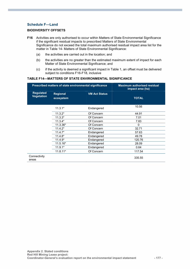
Appendix 2. Stated conditions Red Hill Mining Lease project: Coordinator-General’s evaluation report on the environmental impact statement - 177 -
Schedule F—Land
BIODIVERSITY OFFSETS
F16 Activities are only authorised to occur within Matters of State Environmental Significance if the significant residual impacts to prescribed Matters of State Environmental Significance do not exceed the total maximum authorised residual impact area list for the matter in Table 14- Matters of State Environmental Significance:
(a) the activities are carried out in the location; and
(b) the activities are no greater than the estimated maximum extent of impact for each Matter of State Environmental Significance; and
(c) if the activity is deemed a significant impact in Table 1, an offset must be delivered subject to conditions F16-F18, inclusive
TABLE F14—MATTERS OF STATE ENVIRONMENTAL SIGNIFICANCE
Prescribed matters of state environmental significance Maximum authorised residual impact area (ha)
Regulated Vegetation
Regional ecosystem
VM Act Status TOTAL
11.3.1* Endangered 10.56
11.3.2* Of Concern 44.91 11.3.3* Of Concern 7.01 11.3.4* Of Concern 7.83 11.3.36* Of Concern 0 11.4.2* Of Concern 32.71 11.4.7* Endangered 57.63 11.4.8* Endangered 49.78 11.4.9* Endangered 120.76 11.5.16* Endangered 28.09 11.9.1* Endangered 0.64 11.8.11* Of Concern 117.54
Connectivity areas 335.55
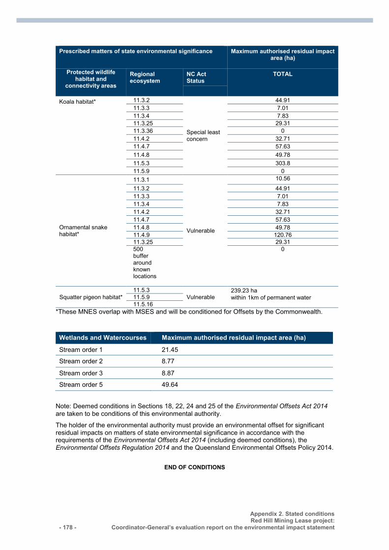
- 178 -
Appendix 2. Stated conditions Red Hill Mining Lease project:
Coordinator-General’s evaluation report on the environmental impact statement
Prescribed matters of state environmental significance Maximum authorised residual impact area (ha)
Protected wildlife habitat and
connectivity areas
Regional ecosystem
NC Act Status
TOTAL
Koala habitat* 11.3.2
Special least concern
44.91 11.3.3 7.01 11.3.4 7.83 11.3.25 29.31 11.3.36 0 11.4.2 32.71 11.4.7 57.63 11.4.8 49.78 11.5.3 303.8 11.5.9 0
Ornamental snake habitat*
11.3.1
Vulnerable
10.56
11.3.2 44.91 11.3.3 7.01 11.3.4 7.83 11.4.2 32.71 11.4.7 57.63 11.4.8 49.78 11.4.9 120.76 11.3.25 29.31 500 buffer around known locations
0
Squatter pigeon habitat* 11.5.3
Vulnerable 239.23 ha within 1km of permanent water 11.5.9
11.5.16 *These MNES overlap with MSES and will be conditioned for Offsets by the Commonwealth. Wetlands and Watercourses Maximum authorised residual impact area (ha)
Stream order 1 21.45
Stream order 2 8.77
Stream order 3 8.87
Stream order 5 49.64
Note: Deemed conditions in Sections 18, 22, 24 and 25 of the Environmental Offsets Act 2014 are taken to be conditions of this environmental authority.
The holder of the environmental authority must provide an environmental offset for significant residual impacts on matters of state environmental significance in accordance with the requirements of the Environmental Offsets Act 2014 (including deemed conditions), the Environmental Offsets Regulation 2014 and the Queensland Environmental Offsets Policy 2014.
END OF CONDITIONS
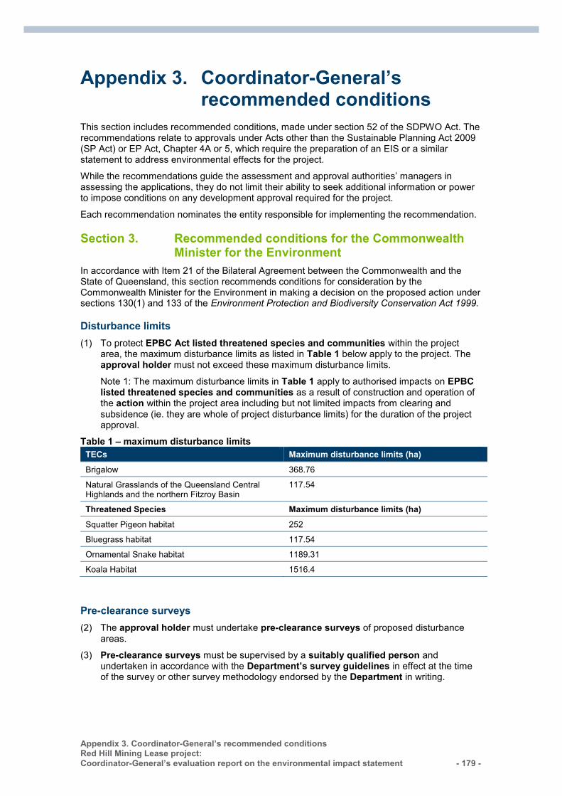
Appendix 3. Coordinator-General’s recommended conditions Red Hill Mining Lease project: Coordinator-General’s evaluation report on the environmental impact statement - 179 -
Appendix 3. Coordinator-General’s recommended conditions
This section includes recommended conditions, made under section 52 of the SDPWO Act. The recommendations relate to approvals under Acts other than the Sustainable Planning Act 2009 (SP Act) or EP Act, Chapter 4A or 5, which require the preparation of an EIS or a similar statement to address environmental effects for the project.
While the recommendations guide the assessment and approval authorities’ managers in assessing the applications, they do not limit their ability to seek additional information or power to impose conditions on any development approval required for the project.
Each recommendation nominates the entity responsible for implementing the recommendation.
Section 3. Recommended conditions for the Commonwealth Minister for the Environment
In accordance with Item 21 of the Bilateral Agreement between the Commonwealth and the State of Queensland, this section recommends conditions for consideration by the Commonwealth Minister for the Environment in making a decision on the proposed action under sections 130(1) and 133 of the Environment Protection and Biodiversity Conservation Act 1999.
Disturbance limits
(1) To protect EPBC Act listed threatened species and communities within the project area, the maximum disturbance limits as listed in Table 1 below apply to the project. The approval holder must not exceed these maximum disturbance limits.
Note 1: The maximum disturbance limits in Table 1 apply to authorised impacts on EPBC listed threatened species and communities as a result of construction and operation of the action within the project area including but not limited impacts from clearing and subsidence (ie. they are whole of project disturbance limits) for the duration of the project approval.
Table 1 – maximum disturbance limits TECs Maximum disturbance limits (ha) Brigalow 368.76
Natural Grasslands of the Queensland Central Highlands and the northern Fitzroy Basin
117.54
Threatened Species Maximum disturbance limits (ha) Squatter Pigeon habitat 252
Bluegrass habitat 117.54
Ornamental Snake habitat 1189.31
Koala Habitat 1516.4
Pre-clearance surveys
(2) The approval holder must undertake pre-clearance surveys of proposed disturbance areas.
(3) Pre-clearance surveys must be supervised by a suitably qualified person and undertaken in accordance with the Department’s survey guidelines in effect at the time of the survey or other survey methodology endorsed by the Department in writing.
- 180 -
Appendix 3. Coordinator-General’s recommended conditions Red Hill Mining Lease project:
Coordinator-General’s evaluation report on the environmental impact statement
EPBC Species Impact Management Plan
(4) Prior to the commencement of the action, the approval holder must prepare and submit an EPBC Species Impact Management Plan for the Minister’s written approval. The EPBC Species Impact Management Plan must include:
(a) measures that will be taken to avoid, mitigate and manage impacts to EPBC listed threatened species and their habitat during clearance of vegetation, including the involvement of a suitably qualified person at all times during clearance of vegetation;
(b) measures that will be taken to avoid, mitigate and manage impacts to EPBC listed threatened species and their habitat and to EPBC communities during construction, operation and decommissioning of the action;
(c) a monitoring program to determine the success of mitigation and management measures to ensure adaptive management for the duration of this approval;
(d) a discussion of relevant conservation advice, recovery plans and threat abatement plans and how measures proposed in the EPBC Species Impact Management Plan are consistent with the measures in these documents; and
(e) details of how the approval holder has addressed any residual significant impacts to any EPBC listed threatened species and its habitat and/or EPBC communities not identified in Table 1, to be offset in accordance with the EPBC Act Environmental Offsets Policy.
(5) The approval holder cannot commence the action until an EPBC Species Impact Management Plan has been approved by the Minister in writing. The approved EPBC Species Impact Management Plan must be implemented by the approval holder.
Biodiversity Offset Plan
(6) To compensate for authorised unavoidable impacts on EPBC Act Threatened species and communities (detailed in Table 1), the approval holder must submit a Biodiversity Offset Plan (BOP) to the Minister for approval. The approval holder must ensure that environmental offsets comply with the principles of the EPBC Act Environmental Offsets Policy.
(7) The BOP must be consistent with relevant recovery plans, threat abatement plans, conservation advices and must include:
(a) detailed baseline description of offset areas, including surveys undertaken, condition of existing EPBC Act threatened species and communities and their habitats, relevant environmental values, area of habitat for each EPBC Act listed threatened species and communities including maps in electronic Geographic Information System (GIS) format, connectivity with other habitat areas and biodiversity corridors;
(b) conservation and management measures for long term protection;
(c) a weed management plan;
(d) details of how offset sites have been or will be legally secured within required timeframes to ensure their long-term protection;
(e) a monitoring program for the offset site/s suitable to measure the success of the management measures against stated performance criteria including monitoring locations, parameters and timing;
(f) a description of the potential risks to the successful implementation of the BOP, and details of contingency measures that will be implemented to mitigate these risks and the triggers for implementing contingency measures;
(g) a table setting out how the BOP is consistent with relevant recovery plans, threat abatement plans, conservation advices and the EPBC Act Species Impact Management Plan; and
Appendix 3. Coordinator-General’s recommended conditions Red Hill Mining Lease project: Coordinator-General’s evaluation report on the environmental impact statement - 181 -
(h) a description of the potential risks to the successful implementation of the OMP, including details of the contingency measures that will be implemented to mitigate against these risks.
Note 2: An approved Biodiversity Offset Plan is also required by the State government. A combined document should be prepared to address both State and EPBC Act approval conditions where possible.
Project stages
(8) The approval holder may carry out the action in project stages. If the approval holder carries out the action in project stages, the approval holder must deliver environmental offsets for each project stage related to the significant residual impacts of each respective project stage on EPBC Act listed threatened species and communities. If the environmental offsets are to be delivered in stages:
(a) The BOP may be prepared and submitted to the Minister for approval in stages. Each project stage of the BOP must correspond with a project stage. A project stage must not commence until a BOP for that stage has been approved by the Minister. The approved BOP must be implemented;
(b) The approval holder must demonstrate how each project stage of the offset builds on the offsets already secured for each previous project stage, and how this contributes to a larger strategic offset for whole of project impacts; and
(c) The approval holder must legally secure at least the minimum offset areas for each project stage within two years of commencement of the specified project stage and prior to commencement of any subsequent project stage.
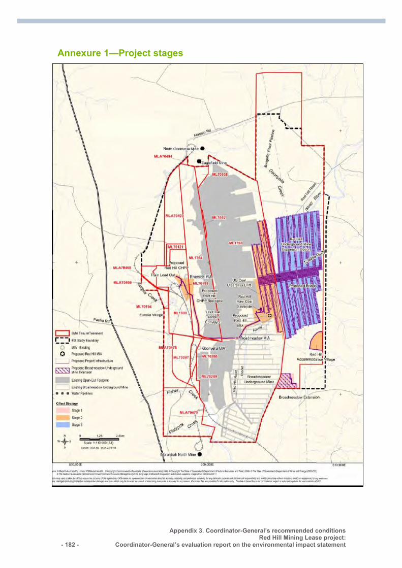
- 182 -
Appendix 3. Coordinator-General’s recommended conditions Red Hill Mining Lease project:
Coordinator-General’s evaluation report on the environmental impact statement
Annexure 1—Project stages
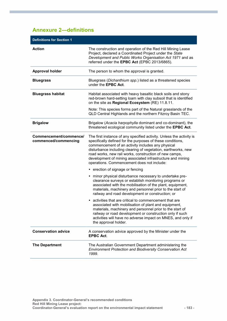
Appendix 3. Coordinator-General’s recommended conditions Red Hill Mining Lease project: Coordinator-General’s evaluation report on the environmental impact statement - 183 -
Annexure 2—definitions Definitions for Section 1
Action The construction and operation of the Red Hill Mining Lease Project, declared a Coordinated Project under the State Development and Public Works Organisation Act 1971 and as referred under the EPBC Act (EPBC 2013/6865).
Approval holder The person to whom the approval is granted.
Bluegrass Bluegrass (Dichanthium spp.) listed as a threatened species under the EPBC Act.
Bluegrass habitat Habitat associated with heavy basaltic black soils and stony red-brown hard-setting loam with clay subsoil that is identified on the site as Regional Ecosystem (RE) 11.8.11.
Note: This species forms part of the Natural grasslands of the QLD Central Highlands and the northern Fitzroy Basin TEC.
Brigalow Brigalow (Acacia harpophylla dominant and co-dominant), the threatened ecological community listed under the EPBC Act.
Commencement/commence/ commenced/commencing
The first instance of any specified activity. Unless the activity is specifically defined for the purposes of these conditions, commencement of an activity includes any physical disturbance including clearing of vegetation, earthworks, new road works, new rail works, construction of new camps, development of mining associated infrastructure and mining operations. Commencement does not include:
erection of signage or fencing
minor physical disturbance necessary to undertake pre-clearance surveys or establish monitoring programs or associated with the mobilisation of the plant, equipment, materials, machinery and personnel prior to the start of railway and road development or construction; or
activities that are critical to commencement that are associated with mobilisation of plant and equipment, materials, machinery and personnel prior to the start of railway or road development or construction only if such activities will have no adverse impact on MNES, and only if the approval holder.
Conservation advice A conservation advice approved by the Minister under the EPBC Act.
The Department The Australian Government Department administering the Environment Protection and Biodiversity Conservation Act 1999.
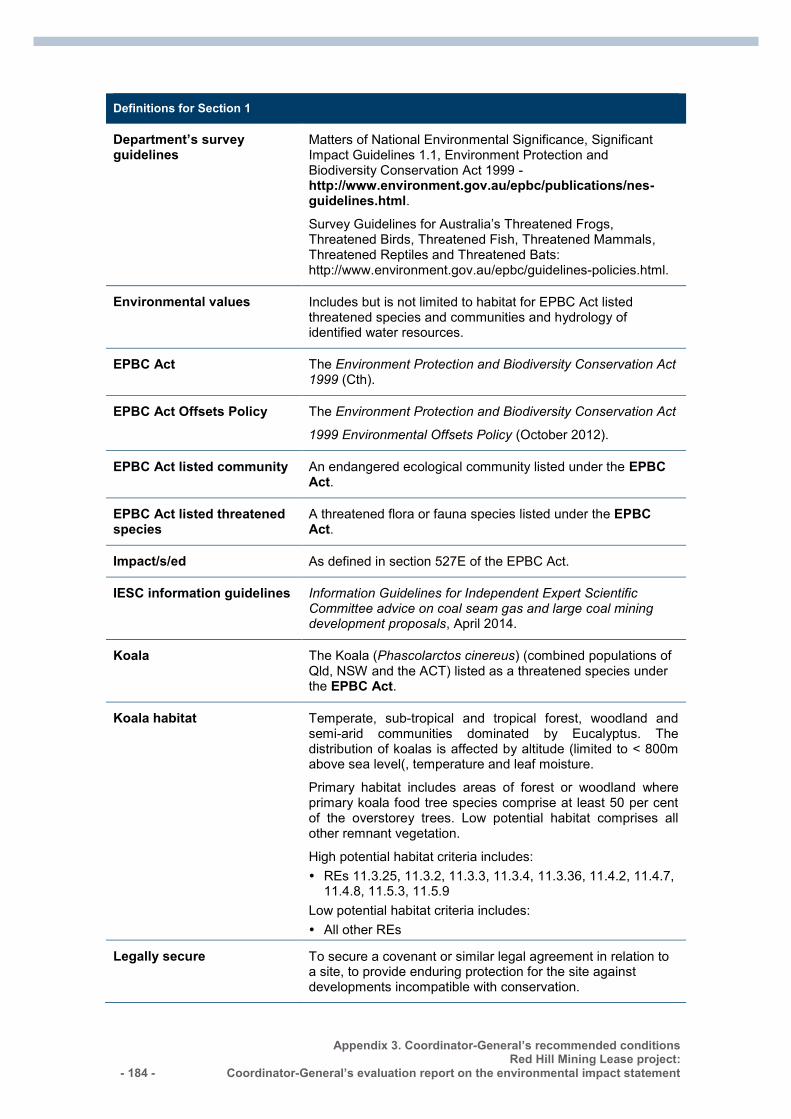
- 184 -
Appendix 3. Coordinator-General’s recommended conditions Red Hill Mining Lease project:
Coordinator-General’s evaluation report on the environmental impact statement
Definitions for Section 1
Department’s survey guidelines
Matters of National Environmental Significance, Significant Impact Guidelines 1.1, Environment Protection and Biodiversity Conservation Act 1999 - http://www.environment.gov.au/epbc/publications/nes-guidelines.html. Survey Guidelines for Australia’s Threatened Frogs, Threatened Birds, Threatened Fish, Threatened Mammals, Threatened Reptiles and Threatened Bats: http://www.environment.gov.au/epbc/guidelines-policies.html.
Environmental values Includes but is not limited to habitat for EPBC Act listed threatened species and communities and hydrology of identified water resources.
EPBC Act The Environment Protection and Biodiversity Conservation Act 1999 (Cth).
EPBC Act Offsets Policy The Environment Protection and Biodiversity Conservation Act
1999 Environmental Offsets Policy (October 2012).
EPBC Act listed community An endangered ecological community listed under the EPBC Act.
EPBC Act listed threatened species
A threatened flora or fauna species listed under the EPBC Act.
Impact/s/ed As defined in section 527E of the EPBC Act.
IESC information guidelines Information Guidelines for Independent Expert Scientific Committee advice on coal seam gas and large coal mining development proposals, April 2014.
Koala The Koala (Phascolarctos cinereus) (combined populations of Qld, NSW and the ACT) listed as a threatened species under the EPBC Act.
Koala habitat Temperate, sub-tropical and tropical forest, woodland and semi-arid communities dominated by Eucalyptus. The distribution of koalas is affected by altitude (limited to < 800m above sea level(, temperature and leaf moisture.
Primary habitat includes areas of forest or woodland where primary koala food tree species comprise at least 50 per cent of the overstorey trees. Low potential habitat comprises all other remnant vegetation.
High potential habitat criteria includes: REs 11.3.25, 11.3.2, 11.3.3, 11.3.4, 11.3.36, 11.4.2, 11.4.7,
11.4.8, 11.5.3, 11.5.9 Low potential habitat criteria includes: All other REs
Legally secure To secure a covenant or similar legal agreement in relation to a site, to provide enduring protection for the site against developments incompatible with conservation.
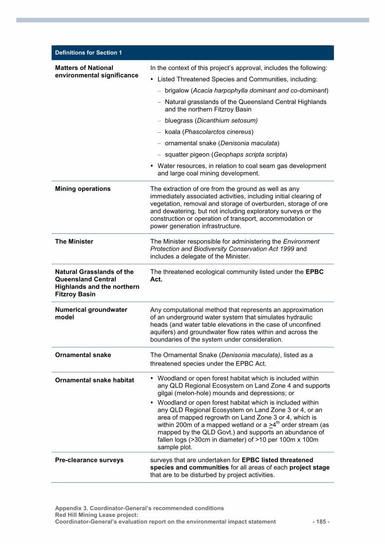
Appendix 3. Coordinator-General’s recommended conditions Red Hill Mining Lease project: Coordinator-General’s evaluation report on the environmental impact statement - 185 -
Definitions for Section 1
Matters of National environmental significance
In the context of this project’s approval, includes the following:
Listed Threatened Species and Communities, including:
– brigalow (Acacia harpophylla dominant and co-dominant)
– Natural grasslands of the Queensland Central Highlands and the northern Fitzroy Basin
– bluegrass (Dicanthium setosum)
– koala (Phascolarctos cinereus)
– ornamental snake (Denisonia maculata)
– squatter pigeon (Geophaps scripta scripta)
Water resources, in relation to coal seam gas development and large coal mining development.
Mining operations The extraction of ore from the ground as well as any immediately associated activities, including initial clearing of vegetation, removal and storage of overburden, storage of ore and dewatering, but not including exploratory surveys or the construction or operation of transport, accommodation or power generation infrastructure.
The Minister The Minister responsible for administering the Environment Protection and Biodiversity Conservation Act 1999 and includes a delegate of the Minister.
Natural Grasslands of the Queensland Central Highlands and the northern Fitzroy Basin
The threatened ecological community listed under the EPBC Act.
Numerical groundwater model
Any computational method that represents an approximation of an underground water system that simulates hydraulic heads (and water table elevations in the case of unconfined aquifers) and groundwater flow rates within and across the boundaries of the system under consideration.
Ornamental snake The Ornamental Snake (Denisonia maculata), listed as a threatened species under the EPBC Act.
Ornamental snake habitat Woodland or open forest habitat which is included within any QLD Regional Ecosystem on Land Zone 4 and supports gilgai (melon-hole) mounds and depressions; or
Woodland or open forest habitat which is included within any QLD Regional Ecosystem on Land Zone 3 or 4, or an area of mapped regrowth on Land Zone 3 or 4, which is within 200m of a mapped wetland or a >4th order stream (as mapped by the QLD Govt.) and supports an abundance of fallen logs (>30cm in diameter) of >10 per 100m x 100m sample plot.
Pre-clearance surveys surveys that are undertaken for EPBC listed threatened species and communities for all areas of each project stage that are to be disturbed by project activities.
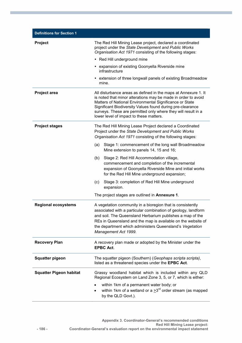
- 186 -
Appendix 3. Coordinator-General’s recommended conditions Red Hill Mining Lease project:
Coordinator-General’s evaluation report on the environmental impact statement
Definitions for Section 1
Project The Red Hill Mining Lease project, declared a coordinated project under the State Development and Public Works Organisation Act 1971 consisting of the following stages:
Red Hill underground mine
expansion of existing Goonyella Riverside mine infrastructure
extension of three longwall panels of existing Broadmeadow mine.
Project area All disturbance areas as defined in the maps at Annexure 1. It is noted that minor alterations may be made in order to avoid Matters of National Environmental Significance or State Significant Biodiversity Values found during pre-clearance surveys. These are permitted only where they will result in a lower level of impact to these matters.
Project stages The Red Hill Mining Lease Project declared a Coordinated Project under the State Development and Public Works Organisation Act 1971 consisting of the following stages:
(a) Stage 1: commencement of the long wall Broadmeadow Mine extension to panels 14, 15 and 16;
(b) Stage 2: Red Hill Accommodation village, commencement and completion of the incremental expansion of Goonyella Riverside Mine and initial works for the Red Hill Mine underground expansion;
(c) Stage 3: completion of Red Hill Mine underground expansion.
The project stages are outlined in Annexure 1.
Regional ecosystems A vegetation community in a bioregion that is consistently associated with a particular combination of geology, landform and soil. The Queensland Herbarium publishes a map of the REs in Queensland and the map is available on the website of the department which administers Queensland’s Vegetation Management Act 1999.
Recovery Plan A recovery plan made or adopted by the Minister under the EPBC Act.
Squatter pigeon The squatter pigeon (Southern) (Geophaps scripta scripta), listed as a threatened species under the EPBC Act.
Squatter Pigeon habitat Grassy woodland habitat which is included within any QLD Regional Ecosystem on Land Zone 3, 5, or 7, which is either:
within 1km of a permanent water body; or within 1km of a wetland or a >3rd order stream (as mapped
by the QLD Govt.).
Appendix 3. Coordinator-General’s recommended conditions Red Hill Mining Lease project: Coordinator-General’s evaluation report on the environmental impact statement - 187 -
Definitions for Section 1
State approvals Include any permits, licences or other authorisations, including any associated conditions, issued in relation to the action by any Queensland Government agency.
Subsidence The totality of subsidence effects and subsidence impacts;
subsidence effects:
– deformation of the ground mass due to mining, including all mining induced ground movements, such as vertical and horizontal displacement, tilt, strain and curvature
subsidence impacts:
– physical changes to the ground and its surface caused by subsidence effects, including tensile and shear cracking of the rock mass, localised buckling of strata caused by valley closure and upsidence and surface depressions or troughs.
Suitably qualified independent expert
A person who has professional qualifications, training, skills or experiences related to the nominated subject matter and can give authoritative assessment, advice and analysis on performance relative to the subject matter using the relative protocols, standards, methods or literature
Survey guidelines Include the following:
Matters of National Environmental Significance, Significant Impact Guidelines 1.1, Environment Protection and Biodiversity Conservation Act 1999: http://www.environment.gov.au/epbc/publications/nes-guidelines.html
Survey Guidelines for Australia’s Threatened Frogs, Threatened Mammals, Threatened Reptiles and Threatened Bats: http://www.environment.gov.au/epbc/guidelines-policies.html
Survey Guidelines for Australia’s Threatened Birds: http://www.environment.gov.au/resource/survey-guidelines-australias-threatened-birds-guidelines-detecting-birds-listed-threatened
Threat abatement plan A threat abatement plan made or adopted by the Minister under the EPBC Act.
- 188 -
Appendix 4. Proponent commitments Red Hill Mining Lease project:
Coordinator-General’s evaluation report on the environmental impact statement
Appendix 4. Proponent commitments This appendix includes commitments made by the proponent in the EIS and AEIS. The relevant section of the EIS or AEIS section is included in the tables for reference.
# Proponent commitment EIS reference
1. Prior to the commencement of construction, develop and implement a water management plan that meets requirements of guidelines issued by Queensland Department of Environment and Heritage Protection (EHP).
EIS Section 4 – Climate Section 7 – Surface Water
2. Detailed design criteria for construction will include allowances for climate change effects including increased intensity of rainfall events and associated increases in flood levels and reduced overall rainfall. In particular, design of the bridge across the Isaac River will need to consider impacts on flows and flooding. Where impacts occur, the EIS flood modelling may need to be revised.
EIS Section 4 – Climate Section 7 – Surface Water
3. Incorporate flood forecasting and management of flood events into site emergency management plans and make allowance for possible effects of climate change.
EIS Section 4 – Climate Section 20 – Health, Safety and Risk
4. In order to avoid risk to the ongoing operation of Powerlink infrastructure from mining operations, engineering and geological investigations will be completed by BMA and shared with Powerlink in advance of mining in the relevant area. Where required, relocation arrangements will be in place in advance of impacts.
AEIS - Appendix T Section 11 Land
5. If necessary to avoid impacts of subsidence, consult with the licence holder of petroleum pipeline licence (PPL) 83 in relation to the co-ordination and future management of the proposed pipeline alignment.
EIS Section 5.1 – Land Use
6. Prior to the commencement of construction, consult with Isaac Regional Council regarding management of Red Hill Road.
EIS Section 5.1 – Land Use
7. Wherever practicable, maintain existing vegetation cover. EIS Section 5.2 – Scenic Amenity and Lighting
8. Design lighting to prevent bright lighting with direct impacts associated within line of sight of public roads (Red Hill Road), where possible. Design lighting at the Red Hill MIA and accommodation village to minimise light spill into adjacent habitat areas is minimised. Place infrastructure and facility footprints outside riparian zones, wherever possible. In order to maintain visual amenity: Plant grass or other vegetation on the flood levee between
Red Hill Road and the Red Hill mine industrial area (MIA) to minimise its visual prominence.
Retain existing tree and shrub vegetation along Red Hill Road wherever safe and practicable to do so, to maximise
EIS Section 5.2 – Scenic Amenity and Lighting
Appendix 4. Proponent commitments Red Hill Mining Lease project: Coordinator-General’s evaluation report on the environmental impact statement - 189 -
# Proponent commitment EIS reference
screening of mining activities from views of passing motorists.
Progressively rehabilitate areas disturbed by the incidental mine gas (IMG) management infrastructure. Revegetate buried infrastructure alignments and excess areas around drilling pads as soon as possible after initial disturbance and revegetate remaining areas as soon as infrastructure is decommissioned.
9. Utilise thick seam mining methods to maximise resource recovery wherever safe, practical and commercially feasible.
EIS Section 5.3 – Topography, Geology and Soils
10. Prior to any surface disturbance, develop and implement erosion and sediment control plans for all land disturbing activities that may cause mobilisation of topsoil to surface waters as well as for works in and adjacent to streams. Erosion and sediment control plans should be based on minimising exposed soils, managing overland and concentrated flows and using appropriate devices to capture sediment if required. Conduct regular inspections of disturbed areas, including subsided areas for erosion and undertake actions to stabilise eroded surfaces as soon as practicable.
EIS Section 5.3 – Topography, Geology and Soils Section 7 – Surface Water Section 10 – Aquatic Ecology
11. Prior to the commencement of construction, design an accommodation village stormwater system to divert clean stormwater around the developed area where necessary to control stormwater and prevent flow concentration and erosion.
EIS Section 5.3 – Topography, Geology and Soils
12. Prior to the commencement of construction, design stormwater systems at the Red Hill MIA, coal handling and preparation plant (CHPP), stockpiles and accommodation village to collect surface run-off from developed areas in sediment basins.
EIS Section 5.3 – Topography, Geology and Soils
13. Where practicable, develop IMG management infrastructure to avoid disturbance in areas of vertosol soils. These are particularly at the southern extent of panels 105 to109.
EIS Section 5.3 – Topography, Geology and Soils
14. Management of topsoil should be undertaken as part of operations and account for the following: Prior to soil disturbance, confirm depth of topsoil and
subsoil and identify stripping depths. Wherever practicable, strip soils while in a slightly moist
condition, not in either an excessively dry or wet condition. If possible, place stripped material directly into the area to
be rehabilitated and spread immediately to avoid the requirement for stockpiling.
If topsoil is to be stockpiled, grade or push soil into windrows with graders or dozers.
When developing stockpiles, avoid tracking over previously placed soil. Suitable methods include direct dumping from dump trucks, pushing soil into windrows using scrapers or use of light equipment to form windrows.
Leave surfaces of soil stockpiles in as coarsely structured a condition as possible in order to promote infiltration and minimise erosion until vegetation is established, and to
EIS Section 5.3 – Topography, Geology and Soils
- 190 -
Appendix 4. Proponent commitments Red Hill Mining Lease project:
Coordinator-General’s evaluation report on the environmental impact statement
# Proponent commitment EIS reference
prevent anaerobic zones forming. Maintain a maximum stockpile height of three metres (m).
Store clayey soils in lower stockpiles for shorter periods of time compared to coarser textured sandy soils.
If long-term stockpiling is planned (i.e. more than 12 months), seed and fertilise stockpiles as soon as possible. Sow an annual cover crop species that produces sterile florets or seeds and establish rapid growing and healthy annual pasture sward to provide sufficient competition to minimise the emergence of undesirable weed species.
Assess levels of weed infestation prior to re-spreading stockpiled topsoil onto disturbed areas. Use herbicides to control weeds in stockpiles prior to reuse or, if weed infestation is particularly significant, “scalp” stockpiles to remove weed seed layers. Particular, attention to weed levels in topsoil stockpiles is required where topsoil is to be reused in areas to be regenerated with native trees or shrubs.
Remove soil from windrow stockpiles using open bowl scrapers or front end loaders loading into dump trucks or other equipment as appropriate to avoid driving heavy equipment across topsoil stockpiles.
Maintain an inventory of available soil to ensure adequate topsoil materials are available for planned rehabilitation activities.
Spread topsoil to a minimum depth of 0.1 m except on steep slopes, where sloped exceeding 0.1 m can cause slippage of the topsoil from the slope.
15. For all construction activities undertaken in the wet season, install diversion and sediment control measures prior to other surface disturbance taking place. During dry season, diversion and sediment control measures may be modified depending on assessment of erosion risk at each location.
EIS Section 5.3 – Topography, Geology and Soils
16. If check dams or other structures are installed on streams or drainage lines, these will be in accordance with the Guideline - activities in a watercourse, lake or spring associated with mining operations (NRM 2012).
EIS Section 5.3 – Topography, Geology and Soils
17. On completion of construction of surface infrastructure, backfill disturbed areas, restoring soil profile and then replace topsoil and sow with pasture species or mulch.
EIS Section 5.3 – Topography, Geology and Soils
18. On completion of construction of wells, reinstate those areas of the drill pad not required for operations. Drains can be left in place in steeper areas or where significant overland flow occurs. If the area is assessed as being at high risk of erosion, the remaining area will be gravelled, mulched or otherwise stabilised to reduce exposure of soils to erosive forces.
EIS Section 5.3 – Topography, Geology and Soils
19. In relation to spontaneous combustion risk: Manage stockpile inventory so that coal does not remain
in the stockpile for more than 60 days. Monitor temperature within older stockpiles.
EIS Section 5.3 – Topography, Geology and Soils
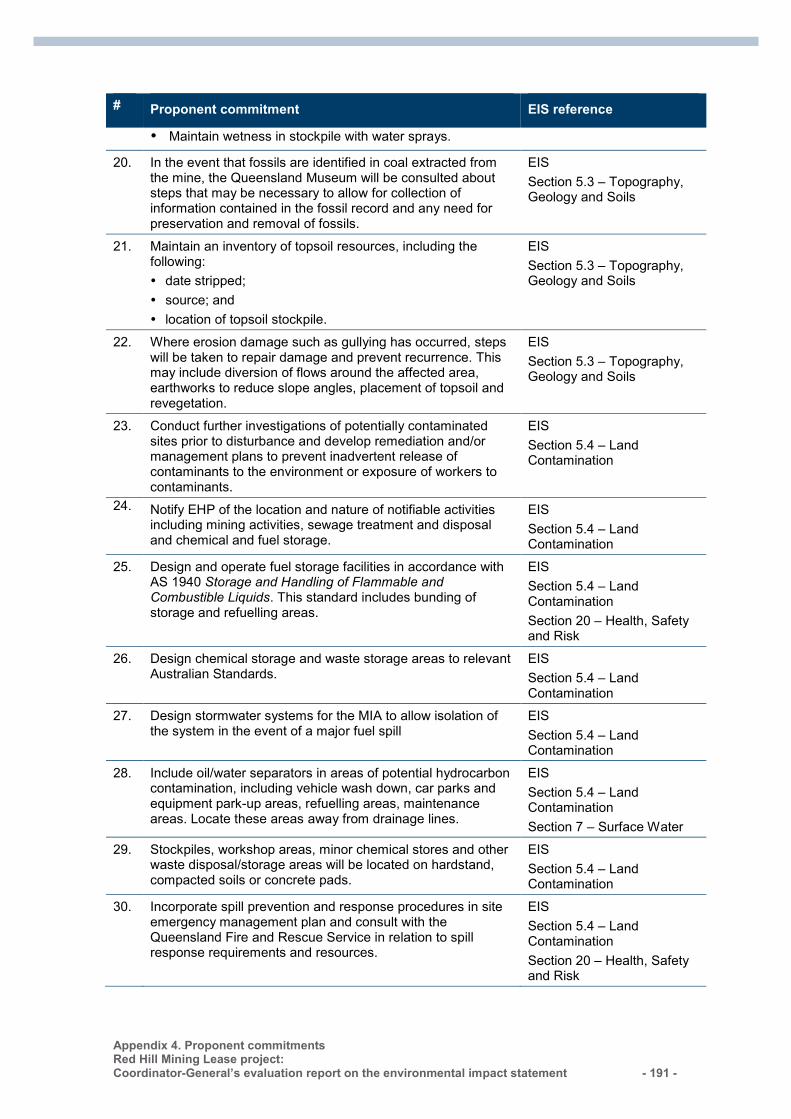
Appendix 4. Proponent commitments Red Hill Mining Lease project: Coordinator-General’s evaluation report on the environmental impact statement - 191 -
# Proponent commitment EIS reference
Maintain wetness in stockpile with water sprays.
20. In the event that fossils are identified in coal extracted from the mine, the Queensland Museum will be consulted about steps that may be necessary to allow for collection of information contained in the fossil record and any need for preservation and removal of fossils.
EIS Section 5.3 – Topography, Geology and Soils
21. Maintain an inventory of topsoil resources, including the following: date stripped; source; and location of topsoil stockpile.
EIS Section 5.3 – Topography, Geology and Soils
22. Where erosion damage such as gullying has occurred, steps will be taken to repair damage and prevent recurrence. This may include diversion of flows around the affected area, earthworks to reduce slope angles, placement of topsoil and revegetation.
EIS Section 5.3 – Topography, Geology and Soils
23. Conduct further investigations of potentially contaminated sites prior to disturbance and develop remediation and/or management plans to prevent inadvertent release of contaminants to the environment or exposure of workers to contaminants.
EIS Section 5.4 – Land Contamination
24. Notify EHP of the location and nature of notifiable activities including mining activities, sewage treatment and disposal and chemical and fuel storage.
EIS Section 5.4 – Land Contamination
25. Design and operate fuel storage facilities in accordance with AS 1940 Storage and Handling of Flammable and Combustible Liquids. This standard includes bunding of storage and refuelling areas.
EIS Section 5.4 – Land Contamination Section 20 – Health, Safety and Risk
26. Design chemical storage and waste storage areas to relevant Australian Standards.
EIS Section 5.4 – Land Contamination
27. Design stormwater systems for the MIA to allow isolation of the system in the event of a major fuel spill
EIS Section 5.4 – Land Contamination
28. Include oil/water separators in areas of potential hydrocarbon contamination, including vehicle wash down, car parks and equipment park-up areas, refuelling areas, maintenance areas. Locate these areas away from drainage lines.
EIS Section 5.4 – Land Contamination Section 7 – Surface Water
29. Stockpiles, workshop areas, minor chemical stores and other waste disposal/storage areas will be located on hardstand, compacted soils or concrete pads.
EIS Section 5.4 – Land Contamination
30. Incorporate spill prevention and response procedures in site emergency management plan and consult with the Queensland Fire and Rescue Service in relation to spill response requirements and resources.
EIS Section 5.4 – Land Contamination Section 20 – Health, Safety and Risk
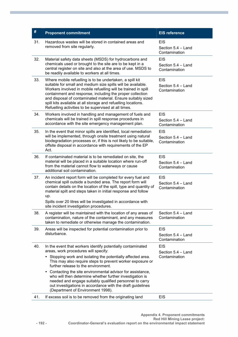
- 192 -
Appendix 4. Proponent commitments Red Hill Mining Lease project:
Coordinator-General’s evaluation report on the environmental impact statement
# Proponent commitment EIS reference
31. Hazardous wastes will be stored in contained areas and removed from site regularly.
EIS Section 5.4 – Land Contamination
32. Material safety data sheets (MSDS) for hydrocarbons and chemicals used or brought to the site are to be kept in a central register on site and also at the area of use. MSDS to be readily available to workers at all times.
EIS Section 5.4 – Land Contamination
33. Where mobile refuelling is to be undertaken, a spill kit suitable for small and medium size spills will be available. Workers involved in mobile refuelling will be trained in spill containment and response, including the proper collection and disposal of contaminated material. Ensure suitably sized spill kits available at all storage and refuelling locations. Refuelling activities to be supervised at all times.
EIS Section 5.4 – Land Contamination
34. Workers involved in handling and management of fuels and chemicals will be trained in spill response procedures in accordance with the site emergency management plan.
EIS Section 5.4 – Land Contamination
35. In the event that minor spills are identified, local remediation will be implemented, through onsite treatment using natural biodegradation processes or, if this is not likely to be suitable, offsite disposal in accordance with requirements of the EP Act.
EIS Section 5.4 – Land Contamination
36. If contaminated material is to be remediated on site, the material will be placed in a suitable location where run-off from the material cannot flow to waterways or cause additional soil contamination.
EIS Section 5.4 – Land Contamination
37. An incident report form will be completed for every fuel and chemical spill outside a bunded area. The report form will contain details on the location of the spill, type and quantity of material spilt and steps taken in initial response and follow up. Spills over 20 litres will be investigated in accordance with site incident investigation procedures.
EIS Section 5.4 – Land Contamination
38. A register will be maintained with the location of any areas of contamination, nature of the contaminant, and any measures taken to remediate or otherwise manage the contamination.
Section 5.4 – Land Contamination
39. Areas will be inspected for potential contamination prior to disturbance.
EIS Section 5.4 – Land Contamination
40. In the event that workers identify potentially contaminated areas, work procedures will specify: Stopping work and isolating the potentially affected area.
This may also require steps to prevent worker exposure or further release to the environment.
Contacting the site environmental advisor for assistance, who will then determine whether further investigation is needed and engage suitably qualified personnel to carry out investigations in accordance with the draft guidelines (Department of Environment 1998).
EIS Section 5.4 – Land Contamination
41. If excess soil is to be removed from the originating land EIS
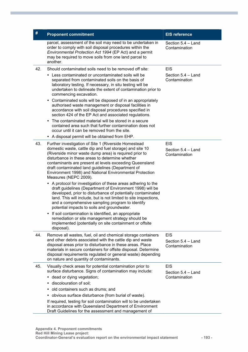
Appendix 4. Proponent commitments Red Hill Mining Lease project: Coordinator-General’s evaluation report on the environmental impact statement - 193 -
# Proponent commitment EIS reference
parcel, assessment of the soil may need to be undertaken in order to comply with soil disposal procedures within the Environmental Protection Act 1994 (EP Act) and a permit may be required to move soils from one land parcel to another.
Section 5.4 – Land Contamination
42. Should contaminated soils need to be removed off site: Less contaminated or uncontaminated soils will be
separated from contaminated soils on the basis of laboratory testing. If necessary, in situ testing will be undertaken to delineate the extent of contamination prior to commencing excavation.
Contaminated soils will be disposed of in an appropriately authorised waste management or disposal facilities in accordance with soil disposal procedures specified in section 424 of the EP Act and associated regulations.
The contaminated material will be stored in a secure contained area such that further contamination does not occur until it can be removed from the site.
A disposal permit will be obtained from EHP.
EIS Section 5.4 – Land Contamination
43. Further investigation of Site 1 (Riverside Homestead domestic waste, cattle dip and fuel storage) and site 10 (Riverside minor waste dump area) is required prior to disturbance in these areas to determine whether contaminants are present at levels exceeding Queensland draft contaminated land guidelines (Department of Environment 1998) and National Environmental Protection Measures (NEPC 2009). A protocol for investigation of these areas adhering to the
draft guidelines (Department of Environment 1998) will be developed, prior to disturbance of potentially contaminated land. This will include, but is not limited to site inspections, and a comprehensive sampling program to identify potential impacts to soils and groundwater.
If soil contamination is identified, an appropriate remediation or site management strategy should be implemented (potentially on site containment or offsite disposal).
EIS Section 5.4 – Land Contamination
44. Remove all wastes, fuel, oil and chemical storage containers and other debris associated with the cattle dip and waste disposal areas prior to disturbance in these areas. Place materials in secure containers for offsite disposal. Determine disposal requirements regulated or general waste) depending on nature and quantity of contaminants.
EIS Section 5.4 – Land Contamination
45. Visually check areas for potential contamination prior to surface disturbance. Signs of contamination may include: dead or dying vegetation; discolouration of soil; old containers such as drums; and obvious surface disturbance (from burial of waste). If required, testing for soil contamination will to be undertaken in accordance with Queensland Department of Environment Draft Guidelines for the assessment and management of
EIS Section 5.4 – Land Contamination
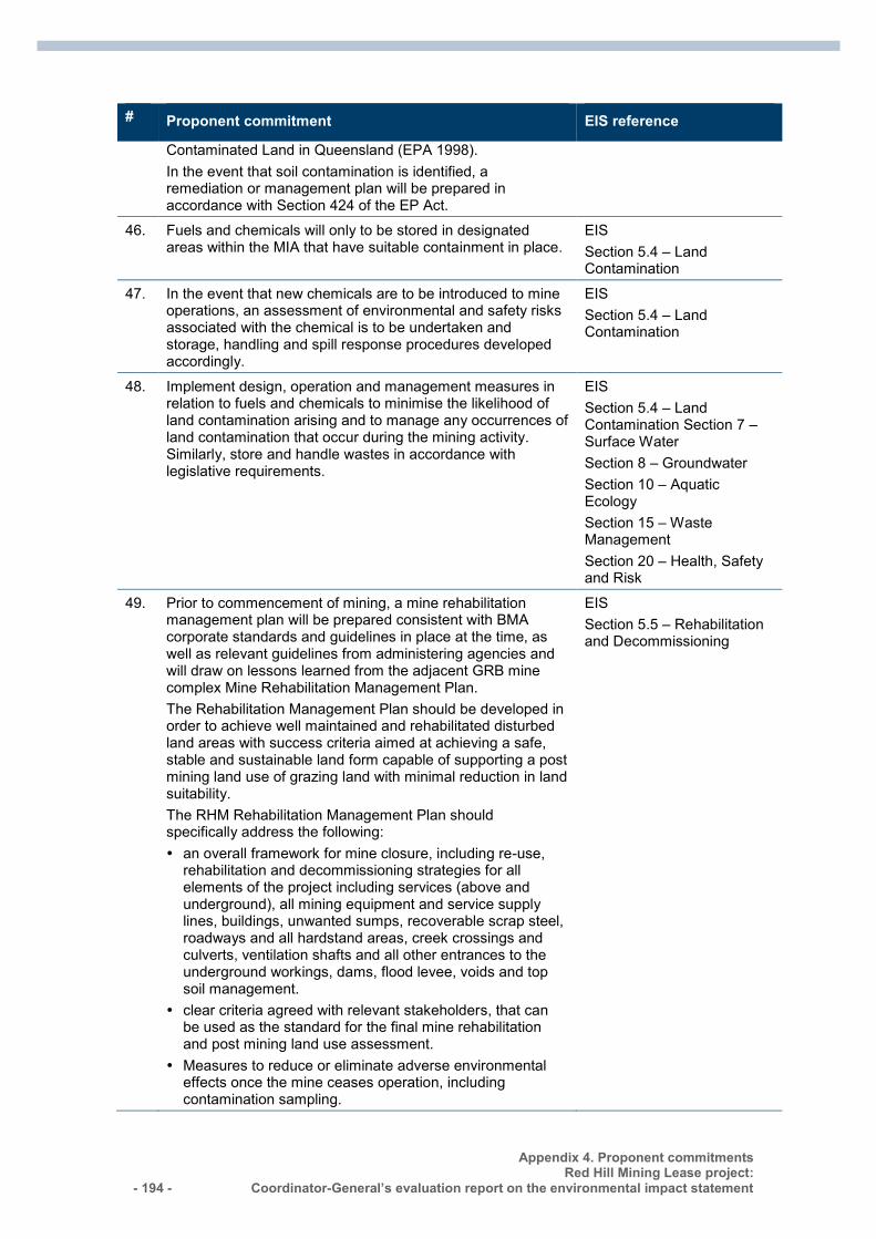
- 194 -
Appendix 4. Proponent commitments Red Hill Mining Lease project:
Coordinator-General’s evaluation report on the environmental impact statement
# Proponent commitment EIS reference
Contaminated Land in Queensland (EPA 1998). In the event that soil contamination is identified, a remediation or management plan will be prepared in accordance with Section 424 of the EP Act.
46. Fuels and chemicals will only to be stored in designated areas within the MIA that have suitable containment in place.
EIS Section 5.4 – Land Contamination
47. In the event that new chemicals are to be introduced to mine operations, an assessment of environmental and safety risks associated with the chemical is to be undertaken and storage, handling and spill response procedures developed accordingly.
EIS Section 5.4 – Land Contamination
48. Implement design, operation and management measures in relation to fuels and chemicals to minimise the likelihood of land contamination arising and to manage any occurrences of land contamination that occur during the mining activity. Similarly, store and handle wastes in accordance with legislative requirements.
EIS Section 5.4 – Land Contamination Section 7 – Surface Water Section 8 – Groundwater Section 10 – Aquatic Ecology Section 15 – Waste Management Section 20 – Health, Safety and Risk
49. Prior to commencement of mining, a mine rehabilitation management plan will be prepared consistent with BMA corporate standards and guidelines in place at the time, as well as relevant guidelines from administering agencies and will draw on lessons learned from the adjacent GRB mine complex Mine Rehabilitation Management Plan. The Rehabilitation Management Plan should be developed in order to achieve well maintained and rehabilitated disturbed land areas with success criteria aimed at achieving a safe, stable and sustainable land form capable of supporting a post mining land use of grazing land with minimal reduction in land suitability. The RHM Rehabilitation Management Plan should specifically address the following: an overall framework for mine closure, including re-use,
rehabilitation and decommissioning strategies for all elements of the project including services (above and underground), all mining equipment and service supply lines, buildings, unwanted sumps, recoverable scrap steel, roadways and all hardstand areas, creek crossings and culverts, ventilation shafts and all other entrances to the underground workings, dams, flood levee, voids and top soil management.
clear criteria agreed with relevant stakeholders, that can be used as the standard for the final mine rehabilitation and post mining land use assessment.
Measures to reduce or eliminate adverse environmental effects once the mine ceases operation, including contamination sampling.
EIS Section 5.5 – Rehabilitation and Decommissioning
Appendix 4. Proponent commitments Red Hill Mining Lease project: Coordinator-General’s evaluation report on the environmental impact statement - 195 -
# Proponent commitment EIS reference
Measures to ensure closure is completed in accordance with good industry practice as well as meeting the statutory requirements that may be applicable at the time.
Measures to ensure the closed mine does not pose an unacceptable risk to public health and safety.
Following removal of any above ground infrastructure, disturbed areas will be dozer trimmed to facilitate the appropriate drainage of surface run-off, and ripped along the contour. Rocks greater than 500 mm will be removed.
Available topsoil will be spread and seed and fertiliser will then be applied to assist in the establishment of a grazing post-mine land use within a mosaic of bushland.
A sustainable land use plan will be prepared and delivered to the landholder to assist with management of grazing activities on the rehabilitated surface.
50. On completion of construction of each element of surface infrastructure and facilities, unused areas will be rehabilitated to a stable surface where it is practicable to do so. Rehabilitation methods will include: ripping of compacted areas. In larger areas, ripping should
will follow contours and tynes should be lifted approximately 2 m every 200 m to reduce the potential for channelised erosion;
spreading of topsoil to a minimum depth of 100 millimetres (mm) on surfaces requiring rehabilitation unless direct planting is to be undertaken;
preparation of seed beds to provide for optimum establishment and growth of vegetation;
seeding with suitable pasture species or, in areas identified to be retained as native vegetation, with suitable native vegetation species;
weed control as required; and ongoing maintenance of erosion and sediment control
measures until adequate vegetation cover has been achieved.
EIS Section 5.5 – Rehabilitation and Decommissioning
51. Interim rehabilitation will be undertaken as soon as practicable after construction of each section of IMG management infrastructure, and including: Removal of temporary facilities associated with drilling. Rehabilitation of the drilling pad area, leaving only the
required operational area immediately around the well. These areas will be ripped as necessary, and then topsoil will be replaced and the areas seeded with pasture species.
Rehabilitation over redundant gas and water pipeline trenches, contouring of the surface to promote drainage and minimise concentration of drainage, ripping as required to address compaction and replacement of topsoil and seeding with pasture grass species.
EIS Section 5.5 – Rehabilitation and Decommissioning
52. Erosion and sediment control structures will be left in place until adequate vegetation cover has been achieved.
EIS Section 5.5 – Rehabilitation and Decommissioning
- 196 -
Appendix 4. Proponent commitments Red Hill Mining Lease project:
Coordinator-General’s evaluation report on the environmental impact statement
# Proponent commitment EIS reference
53. Final decommissioning of IMG pre-drainage infrastructure is expected to be undertaken progressively, in accordance with safe and efficient mining requirements, as follows: Wells that have no further IMG pre-drainage use will be
grouted and capped in accordance with industry practice and any guidelines on de-commissioning of IMG wells current at the time.
Any wells grouted and capped in areas still prone to mining subsidence will be checked to see if any hazards or deficiencies have arisen from the mine subsidence and will be rectified accordingly if so.
Pads around each decommissioned well will be de-compacted as necessary, topsoil re-spread and the disturbed areas ripped and seeded.
IMG gathering and temporary surface facilities associated with the decommissioned wells will be removed or relocated to be reused at other operating parts of the site (if still in a safe and useable condition).
Unused or damaged water and gas pipelines will be decommissioned and removed if unsafe or exposed above ground.
Access tracks that are not required for future access for mining or mine de-gassing services will be ripped, re-graded and seeded.
EIS Section 5.5 – Rehabilitation and Decommissioning
54. Goaf drainage infrastructure will be decommissioned as soon as practicable after monitoring indicates that the goaf wells have served their useful life. Decommissioning of goaf drainage infrastructure is expected to be undertaken as follows: Wells that have no further goaf drainage use will be
grouted and capped in accordance with industry practice and any guidelines on de-commissioning goaf wells current at the time.
Any wells grouted and capped in areas still prone to mining subsidence will be checked to see if any hazards or deficiencies have arisen from the mine subsidence and will be rectified accordingly.
Pads around each decommissioned well will be de-compacted as necessary, topsoil re-spread and the disturbed areas ripped and seeded.
Goaf gas gathering and temporary surface facilities associated with the decommissioned wells will be removed or relocated to be reused at other operating parts of the site (if still in a safe and useable condition).
Unused or damaged water and gas pipelines will be decommissioned and removed if unsafe or exposed above ground.
Access tracks that are not required for future access for mining or mine de-gassing services will be ripped, re-graded and seeded.
EIS Section 5.5 – Rehabilitation and Decommissioning
55. Underground facilities will be decommissioned as follows: Mining equipment or service supply lines and cables that
EIS Section 5.5 – Rehabilitation
Appendix 4. Proponent commitments Red Hill Mining Lease project: Coordinator-General’s evaluation report on the environmental impact statement - 197 -
# Proponent commitment EIS reference
are no longer required and are not readily recoverable for salvage or reuse will be left in the underground mine.
Fluids with the potential to cause contamination, such as hydraulic oils, will be drained from equipment left underground.
Brick rubble, concrete rubble or other inert waste from the decommissioning of the mine infrastructure area may be placed in the drift. This will only be undertaken where it is demonstrated that groundwater will not be impacted.
Entrances to the underground workings will be blocked off and sealed to prevent access.
Ventilation shafts will also be decommissioned and sealed. All entrances to underground workings will undergo a final
safety inspection and certification.
and Decommissioning
56. Wherever revegetation is required, the surface will be prepared as follows: Prior to re-spreading stockpiled topsoil, an assessment of
weed infestation on stockpiles will be undertaken to determine if individual stockpiles require herbicide application and/or ‘scalping’.
Areas where subsoils have become compacted will be ripped.
Where topsoil resources allow, topsoil will be spread to a minimum depth of 100 mm and preferably 200 mm where sufficient topsoil is available on surfaces requiring rehabilitation. Topsoil will be treated with fertiliser and other ameliorants as required to optimise soil properties for revegetation.
Delay between spreading of topsoil and seeding will be minimised as far as possible.
Prior to sowing, topsoiled areas will be contour ripped to create a ’key’ between the soil and the underlying subsoil, thereby increasing infiltration. This will be undertaken using a fine-tyned plough, or disc harrow or other similar equipment. Ripping will be undertaken on the contour and the tynes lifted approximately 2 m every 200 m to reduce the potential for channelised erosion. Soil will be contour ripped when soil is moist but not under very wet conditions.
EIS Section 5.5 – Rehabilitation and Decommissioning
57. Three types of revegetation are proposed: Pasture grassland suitable for grazing. As grazing is the
selected post mining land use, this will be the predominant type of revegetation across the site.
Bushland maintenance and enhancement. Bushland maintenance and enhancement will aim to build on areas of native vegetation not affected by IMG management infrastructure and subsidence impacts such that these areas can continue to provide suitable habitat.
Riparian zone maintenance, restoration and enhancement. As the Isaac River has been identified as providing an important north-south movement corridor for native fauna, loss of riparian and flood plain vegetation will be restored through revegetation.
EIS Section 5.5 – Rehabilitation and Decommissioning
- 198 -
Appendix 4. Proponent commitments Red Hill Mining Lease project:
Coordinator-General’s evaluation report on the environmental impact statement
# Proponent commitment EIS reference
58. Some initial and progressive revegetation (pasture grassland) will take place over areas disturbed by the IMG management infrastructure. Enhancement of riparian areas at high risk of avulsion or bank instability will also be undertaken in advance of planned subsidence. Otherwise, revegetation will occur progressively after subsidence and in response to changes induced by subsidence. Revegetation of areas such as the MIA, accommodation village and other non-gas related infrastructure will take place on removal of these facilities.
EIS Section 5.5 – Rehabilitation and Decommissioning
59. Where possible, the timing of revegetation works will enable a preferred seasonal sowing of pasture and tree seed in autumn or spring.
EIS Section 5.5 – Rehabilitation and Decommissioning
60. Access to revegetated areas by cattle and vehicles will be restricted until vegetation has reached pre-determined levels of establishment.
EIS Section 5.5 – Rehabilitation and Decommissioning
61. Plant selection for areas to be maintained as bushland will be taken from species identified as preferred species selection based on: available growth medium; slope; and developing habitat that is structurally complex and will
provide resources for native species potentially occurring in each zone.
EIS Section 5.5 – Rehabilitation and Decommissioning
62. Native species will be established through direct seeding or planting of tube stock/nursery-raised stock from local propagules. Seed will be collected from the EIS study area where practicable to ensure it is adapted to environmental conditions in the area.
EIS Section 5.5 – Rehabilitation and Decommissioning
63. Pasture seed will be sown using direct ground broadcasting methods and aerial seeding where required. Species to be sown will be nominated from the list with the total sowing rate being about 10 kilograms per hectare.
EIS Section 5.5 – Rehabilitation and Decommissioning
64. Riverine areas requiring pre-subsidence enhancement or rehabilitation following subsidence will be seeded or planted with selected species identified as preferred and locally endemic. Lower seeding rates may be possible in optimal conditions.
EIS Section 5.5 – Rehabilitation and Decommissioning
65. The mine rehabilitation management plan will contain a monitoring program to measure progress against rehabilitation success criteria and identify the need for corrective action.
EIS Section 5.5 – Rehabilitation and Decommissioning Section 9 – Terrestrial Ecology
66. Monitoring will include establishment of reference sites that can be used to indicate the condition of surrounding un-mined areas that the rehabilitated disturbance area should match, taking into account factors such as weather conditions that can affect rehabilitation success.
EIS Section 5.5 – Rehabilitation and Decommissioning Section 9 – Terrestrial Ecology
67. Results of progressive rehabilitation against the success criteria will be used to refine rehabilitation methods for future application, such as the selection of appropriate drainage and
EIS Section 5.5 – Rehabilitation and Decommissioning
Appendix 4. Proponent commitments Red Hill Mining Lease project: Coordinator-General’s evaluation report on the environmental impact statement - 199 -
# Proponent commitment EIS reference
erosion control measures and the selection of plant species for re-establishment.
Section 9 – Terrestrial Ecology
68. If monitoring indicates that rehabilitation success is poor, and particularly that success criteria in relation to revegetation will not be met by the time of mine closure, the following maintenance measures may be required: re-seeding or planting with vegetation species to infill
areas where revegetation success is low; seeding or planting with alternative species; soil improvements; and drainage works and erosion protection measures.
EIS Section 5.5 – Rehabilitation and Decommissioning Section 9 – Terrestrial Ecology
69. In the event that monitoring indicates that rehabilitated areas are not likely to meet performance criteria, corrective actions will be undertaken. These may include: replanting or reseeding of vegetation; use of hydromulch or similar techniques to enhance re-
seeding success; weed control programs – if chemical controls are used,
herbicides will be selected based on low potential impact on waterways, native plants and native animals;
pest animal control programs; drainage, erosion and sediment control; and earthworks to restore contours and/or drainage lines.
EIS Section 5.5 – Rehabilitation and Decommissioning Section 9 – Terrestrial Ecology
70. Records will be kept for: rehabilitation activities including location, techniques,
species utilised and rehabilitation date; monitoring activities; and corrective actions.
EIS Section 5.5 – Rehabilitation and Decommissioning Section 9 – Terrestrial Ecology
71. Measures will be implemented in relation to preventing introduction of new weed species and preventing proliferation of existing weed species
EIS Section 5.5 – Rehabilitation and Decommissioning Section 9 – Terrestrial Ecology
72. When selecting location for roads, tracks and other infrastructure, maximise use of already disturbed areas, wherever practicable.
EIS Section 9 – Terrestrial Ecology
73. The Isaac River bridge will be designed to minimise disruption to fauna passage along riparian zone.
EIS Section 9 – Terrestrial Ecology
74. A biodiversity offset strategy and management plan will be developed for the project at least 6 months before disturbance.
EIS Section 9 – Terrestrial Ecology
75. Include sites of terrestrial ecological significance on constraints maps for the project to minimise the opportunity for disturbance during detailed design and construction.
EIS Section 9 – Terrestrial Ecology
76. Finalise offset strategy and undertake ecological equivalence assessment for areas to be disturbed during construction and
EIS
- 200 -
Appendix 4. Proponent commitments Red Hill Mining Lease project:
Coordinator-General’s evaluation report on the environmental impact statement
# Proponent commitment EIS reference
years one to five of mining. Finalise deed of agreement in relation to provisions of offsets for construction and years one to five of mining. Identify and secure offsets for areas to be disturbed by construction activities.
Section 9 – Terrestrial Ecology
77. Avoid and/or minimise earthworks to be undertaken within Environment Protection and Biodiversity Conservation Act 1999 (EPBC Act) threatened ecological community (TEC) Natural grasslands of the Queensland Central Highlands and the northern Fitzroy Basin (of concern RE 11.8.11).
EIS Section 9 – Terrestrial Ecology
78. When clearing vegetation for any of the surface facilities: Clearly delineate areas for clearing to avoid inadvertent
clearing. Identify and clearly mark habitat trees that can be retained
without compromising safety. Consider habitat features such as felled trees and logs for
relocation to other areas where practical to provide microhabitat.
EIS Section 9 – Terrestrial Ecology
79. Vehicles and equipment are to be cleaned before being brought to site and inspected on entry to site. Queensland Government Checklist for Cleandown Procedures (DNR 2000) to be followed for clean down and inspection.
EIS Section 9 – Terrestrial Ecology
80. All soil and materials of plant origin to be certified as weed free by the supplier using the Queensland Government weed hygiene declaration form or similar (DAFF 2013e).
EIS Section 9 – Terrestrial Ecology
81. Monitor disturbed areas for weed proliferation and undertake weed control as required and in accordance with relevant Queensland Government guidelines (DAFF 2013a).
EIS Section 9 – Terrestrial Ecology
82. Disturbed areas not required will be stabilised and rehabilitated as soon as practical after construction consistent with the rehabilitation plan: Rehabilitate riparian vegetation for the bridge across the
Isaac River. Revegetate around surface infrastructure by establishing
pasture grass as it will not generally be appropriate to establish native woodland or scrubland very close to surface facilities.
EIS Section 9 – Terrestrial Ecology
83. Ensure vehicles remain on established access tracks and do not traverse vegetated areas except in emergency circumstances.
EIS Section 9 – Terrestrial Ecology
84. When clearing woodland vegetation with high likelihood of arboreal animals, utilise spotter/catchers to inspect area for presence of fauna immediately prior to clearing, and then remove any fauna in situ. Spotter/catchers will hold appropriate permits under the Nature Conservation Act 1992. If an animal is injured, contact local wildlife carers or veterinary clinics. Place animal in a secure container.
EIS Section 9 – Terrestrial Ecology
85. Fauna killed on roads within the mining lease areas will be dragged to the side immediately, and then removed and disposed of on a regular basis to prevent carrion eaters from
EIS Section 9 – Terrestrial Ecology
Appendix 4. Proponent commitments Red Hill Mining Lease project: Coordinator-General’s evaluation report on the environmental impact statement - 201 -
# Proponent commitment EIS reference
being exposed to vehicle strike.
86. Seek to avoid and/or minimise placement of IMG extraction wells and infrastructure within RE11.8.11/TEC (Natural grasslands of the Queensland Central Highlands and the northern Fitzroy Basin) where practical. Where unavoidable, offsets will be required. If this community is to be traversed, the topsoil and roots will not be disturbed. This area may be slashed.
EIS Section 9 – Terrestrial Ecology
87. If clearing in the area of RE11.8.11/TEC (Natural grasslands of the Queensland Central Highlands and the northern Fitzroy Basin) is required, conduct pre-clearing surveys for Dichanthium setosum, Dichanthium queenslandicum and Digitaria porrecta. If these grasses are identified, clearing should be avoided
in these areas wherever possible, with slashing preferred to gain access.
If clearing is required, individual plants may be collected and relocated, and topsoil removed and set aside to protect seed banks. Topsoil will be replaced over pipelines as quickly as possible.
EIS Section 9 – Terrestrial Ecology
88. When selecting locations for wells, tracks and other infrastructure during the detailed design, already disturbed areas will be used wherever practicable, particularly in riparian and woodland vegetation.
EIS Section 9 – Terrestrial Ecology
89. Placement of IMG extraction wells and other infrastructure will seek to avoid the following areas wherever practicable: endangered REs 11.4.7, 11.4.8 and 11.4.9; and riparian zones along Isaac River and 12 Mile Gully,
particularly native vegetation within 100 m of the bank. Where these areas cannot be avoided, offsets will be required.
EIS Section 9 – Terrestrial Ecology
90. River and creek crossings will be selected where natural or anthropogenic breaks in vegetation occur wherever possible, recognising that crossing locations must align with the pillars between each longwall panel.
EIS Section 9 – Terrestrial Ecology
91. If weed or pest animal proliferation occurs, implement weed and pest management procedures in accordance with relevant requirements of: Queensland Department of Agriculture, Fisheries and
Forestry pest control prescriptions and pest fact sheets; and
Isaac Regional Council guidelines.
EIS Section 9 – Terrestrial Ecology
92. Rehabilitate buried pipeline alignments consistent with the rehabilitation plan. Rehabilitate excess areas of drill pads once wells are installed consistent with the rehabilitation plan.
EIS Section 9 – Terrestrial Ecology
93. Retain tall trees on either side of creek crossings or install glider poles to enable arboreal mammals to move across the crossings.
EIS Section 9 – Terrestrial Ecology
94. Impose and enforce a speed limit on all roads and tracks EIS
- 202 -
Appendix 4. Proponent commitments Red Hill Mining Lease project:
Coordinator-General’s evaluation report on the environmental impact statement
# Proponent commitment EIS reference
associated with the IMG management network. Forty kilometres per hour is likely to be appropriate for most roads and tracks.
Section 9 – Terrestrial Ecology
95. Adaptive management will be incorporated into the subsidence management strategies based on lessons learned from the adjacent BRM subsidence monitoring results.
EIS Section 9 – Terrestrial Ecology
96. Repair cracks in areas of native vegetation as they occur. Where works are required to repair surface cracks from subsidence, this will be done with minimal clearing or damage to vegetation. Suitable machinery will be used to minimise disturbance. Grasses and other groundcover will be slashed rather than cleared to allow access.
EIS Section 9 – Terrestrial Ecology
97. Ongoing monitoring of the effects of surface cracking and rapid ground movement will be required to identify the potentially affected vegetation and to allow management measures to be implemented.
EIS Section 9 – Terrestrial Ecology
98. Determine need to include artificial roosts, roost boxes and glider poles for animals such as little pied bat and gliders and incorporate into rehabilitation requirements.
EIS Section 9 – Terrestrial Ecology
99. Weed and pest monitoring will be undertaken as follows: annual observations by site personnel for weeds and pests
of management concern; a post-construction weed audit of the surface facilities, well
sites, pipeline routes and access tracks at the end of the first wet season after completion of construction activities in each area;
monitoring for pest plants and fauna within subsided areas where ponding occurs; and
maintenance of monitoring records for a period of at least five years to aid in the assessment of the long term success of the project’s weed management program.
EIS Section 9 – Terrestrial Ecology
100. Where monitoring indicates that treatment is required to address weed or pest infestation, a treatment plan will be developed drawing on state and local government guidelines in place at the time. Follow up monitoring will be undertaken within three months to determine the success of the weed or pest eradication program and additional treatment will be undertaken where eradication is unsuccessful.
EIS Section 9 – Terrestrial Ecology
101. Prior to the commencement of construction, conduct additional surveys for the plant Cerbera dumicola around the accommodation village location and for the ornamental snake; and koala in suitable habitat. If these species are present, prepare a species management plan to address short and long term impacts and mitigation measures.
EIS Section 9 – Terrestrial Ecology
102. During construction, monitoring of ornamental snake, koala or Cerbera dumicola and native grass species if species management plans indicate that monitoring is required.
EIS Section 9 – Terrestrial Ecology
103. Implement impact mitigation measures for design, construction, installation of IMG management infrastructure
EIS
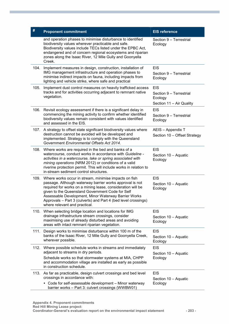
Appendix 4. Proponent commitments Red Hill Mining Lease project: Coordinator-General’s evaluation report on the environmental impact statement - 203 -
# Proponent commitment EIS reference
and operation phases to minimise disturbance to identified biodiversity values wherever practicable and safe. Biodiversity values include TECs listed under the EPBC Act, endangered and of concern regional ecosystems and riparian zones along the Isaac River, 12 Mile Gully and Goonyella Creek.
Section 9 – Terrestrial Ecology
104. Implement measures in design, construction, installation of IMG management infrastructure and operation phases to minimise indirect impacts on fauna, including impacts from lighting and vehicle strike, where safe and practical
EIS Section 9 – Terrestrial Ecology
105. Implement dust control measures on heavily trafficked access tracks and for activities occurring adjacent to remnant native vegetation.
EIS Section 9 – Terrestrial Ecology Section 11 – Air Quality
106. Revisit ecology assessment if there is a significant delay in commencing the mining activity to confirm whether identified biodiversity values remain consistent with values identified and assessed in the EIS.
EIS Section 9 – Terrestrial Ecology
107. A strategy to offset state significant biodiversity values where destruction cannot be avoided will be developed and implemented. Strategy is to comply with the Queensland Government Environmental Offsets Act 2014.
AEIS – Appendix T Section 10 – Offset Strategy
108. Where works are required in the bed and banks of a watercourse, conduct works in accordance with Guideline - activities in a watercourse, lake or spring associated with mining operations (NRM 2012) or conditions of a valid riverine protection permit. This will include works in relation to in-stream sediment control structures.
EIS Section 10 – Aquatic Ecology
109. Where works occur in stream, minimise impacts on fish passage. Although waterway barrier works approval is not required for works on a mining lease, consideration will be given to the Queensland Government Code for Self Assessable Development, Minor Waterway Barrier Works Approvals – Part 3 (culverts) and Part 4 (bed level crossings) where relevant and practical.
EIS Section 10 – Aquatic Ecology
110. When selecting bridge location and locations for IMG drainage infrastructure stream crossings, consider maximising use of already disturbed areas and avoiding areas with intact remnant riparian vegetation.
EIS Section 10 – Aquatic Ecology
111. Design works to minimise disturbance within 100 m of the banks of the Isaac River, 12 Mile Gully and Goonyella Creek, wherever possible.
EIS Section 10 – Aquatic Ecology
112. Where possible schedule works in streams and immediately adjacent to streams in dry periods. Schedule works so that stormwater systems at MIA, CHPP and accommodation village are installed as early as possible in construction schedule.
EIS Section 10 – Aquatic Ecology
113. As far as practicable, design culvert crossings and bed level crossings in accordance with: Code for self-assessable development – Minor waterway
barrier works – Part 3: culvert crossings (WWBW01)
EIS Section 10 – Aquatic Ecology
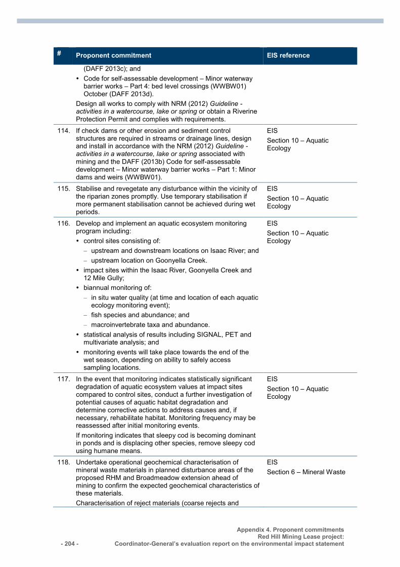
- 204 -
Appendix 4. Proponent commitments Red Hill Mining Lease project:
Coordinator-General’s evaluation report on the environmental impact statement
# Proponent commitment EIS reference
(DAFF 2013c); and Code for self-assessable development – Minor waterway
barrier works – Part 4: bed level crossings (WWBW01) October (DAFF 2013d).
Design all works to comply with NRM (2012) Guideline - activities in a watercourse, lake or spring or obtain a Riverine Protection Permit and complies with requirements.
114. If check dams or other erosion and sediment control structures are required in streams or drainage lines, design and install in accordance with the NRM (2012) Guideline - activities in a watercourse, lake or spring associated with mining and the DAFF (2013b) Code for self-assessable development – Minor waterway barrier works – Part 1: Minor dams and weirs (WWBW01).
EIS Section 10 – Aquatic Ecology
115. Stabilise and revegetate any disturbance within the vicinity of the riparian zones promptly. Use temporary stabilisation if more permanent stabilisation cannot be achieved during wet periods.
EIS Section 10 – Aquatic Ecology
116. Develop and implement an aquatic ecosystem monitoring program including: control sites consisting of:
– upstream and downstream locations on Isaac River; and – upstream location on Goonyella Creek.
impact sites within the Isaac River, Goonyella Creek and 12 Mile Gully;
biannual monitoring of: – in situ water quality (at time and location of each aquatic
ecology monitoring event); – fish species and abundance; and – macroinvertebrate taxa and abundance.
statistical analysis of results including SIGNAL, PET and multivariate analysis; and
monitoring events will take place towards the end of the wet season, depending on ability to safely access sampling locations.
EIS Section 10 – Aquatic Ecology
117. In the event that monitoring indicates statistically significant degradation of aquatic ecosystem values at impact sites compared to control sites, conduct a further investigation of potential causes of aquatic habitat degradation and determine corrective actions to address causes and, if necessary, rehabilitate habitat. Monitoring frequency may be reassessed after initial monitoring events. If monitoring indicates that sleepy cod is becoming dominant in ponds and is displacing other species, remove sleepy cod using humane means.
EIS Section 10 – Aquatic Ecology
118. Undertake operational geochemical characterisation of mineral waste materials in planned disturbance areas of the proposed RHM and Broadmeadow extension ahead of mining to confirm the expected geochemical characteristics of these materials. Characterisation of reject materials (coarse rejects and
EIS Section 6 – Mineral Waste
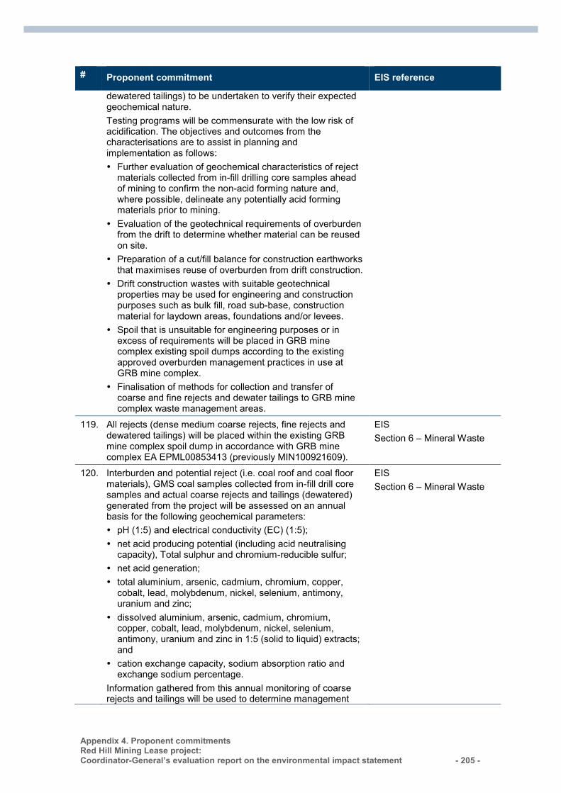
Appendix 4. Proponent commitments Red Hill Mining Lease project: Coordinator-General’s evaluation report on the environmental impact statement - 205 -
# Proponent commitment EIS reference
dewatered tailings) to be undertaken to verify their expected geochemical nature. Testing programs will be commensurate with the low risk of acidification. The objectives and outcomes from the characterisations are to assist in planning and implementation as follows: Further evaluation of geochemical characteristics of reject
materials collected from in-fill drilling core samples ahead of mining to confirm the non-acid forming nature and, where possible, delineate any potentially acid forming materials prior to mining.
Evaluation of the geotechnical requirements of overburden from the drift to determine whether material can be reused on site.
Preparation of a cut/fill balance for construction earthworks that maximises reuse of overburden from drift construction.
Drift construction wastes with suitable geotechnical properties may be used for engineering and construction purposes such as bulk fill, road sub-base, construction material for laydown areas, foundations and/or levees.
Spoil that is unsuitable for engineering purposes or in excess of requirements will be placed in GRB mine complex existing spoil dumps according to the existing approved overburden management practices in use at GRB mine complex.
Finalisation of methods for collection and transfer of coarse and fine rejects and dewater tailings to GRB mine complex waste management areas.
119. All rejects (dense medium coarse rejects, fine rejects and dewatered tailings) will be placed within the existing GRB mine complex spoil dump in accordance with GRB mine complex EA EPML00853413 (previously MIN100921609).
EIS Section 6 – Mineral Waste
120. Interburden and potential reject (i.e. coal roof and coal floor materials), GMS coal samples collected from in-fill drill core samples and actual coarse rejects and tailings (dewatered) generated from the project will be assessed on an annual basis for the following geochemical parameters: pH (1:5) and electrical conductivity (EC) (1:5); net acid producing potential (including acid neutralising
capacity), Total sulphur and chromium-reducible sulfur; net acid generation; total aluminium, arsenic, cadmium, chromium, copper,
cobalt, lead, molybdenum, nickel, selenium, antimony, uranium and zinc;
dissolved aluminium, arsenic, cadmium, chromium, copper, cobalt, lead, molybdenum, nickel, selenium, antimony, uranium and zinc in 1:5 (solid to liquid) extracts; and
cation exchange capacity, sodium absorption ratio and exchange sodium percentage.
Information gathered from this annual monitoring of coarse rejects and tailings will be used to determine management
EIS Section 6 – Mineral Waste
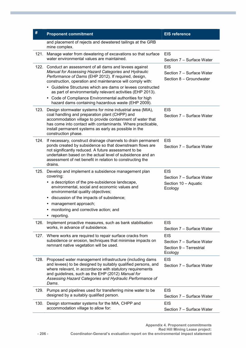
- 206 -
Appendix 4. Proponent commitments Red Hill Mining Lease project:
Coordinator-General’s evaluation report on the environmental impact statement
# Proponent commitment EIS reference
and placement of rejects and dewatered tailings at the GRB mine complex.
121. Manage water from dewatering of excavations so that surface water environmental values are maintained.
EIS Section 7 – Surface Water
122. Conduct an assessment of all dams and levees against Manual for Assessing Hazard Categories and Hydraulic Performance of Dams (EHP 2012). If required, design, construction, operation and maintenance will comply with: Guideline Structures which are dams or levees constructed
as part of environmentally relevant activities (EHP 2013). Code of Compliance Environmental authorities for high
hazard dams containing hazardous waste (EHP 2009).
EIS Section 7 – Surface Water Section 8 – Groundwater
123. Design stormwater systems for mine industrial area (MIA), coal handling and preparation plant (CHPP) and accommodation village to provide containment of water that has come into contact with contaminants. Where practicable, install permanent systems as early as possible in the construction phase.
EIS Section 7 – Surface Water
124. If necessary, construct drainage channels to drain permanent ponds created by subsidence so that downstream flows are not significantly reduced. A future assessment to be undertaken based on the actual level of subsidence and an assessment of net benefit in relation to constructing the drains.
EIS Section 7 – Surface Water
125. Develop and implement a subsidence management plan covering: a description of the pre-subsidence landscape,
environmental, social and economic values and environmental quality objectives;
discussion of the impacts of subsidence; management approach; monitoring and corrective action; and reporting.
EIS Section 7 – Surface Water Section 10 – Aquatic Ecology
126. Implement proactive measures, such as bank stabilisation works, in advance of subsidence.
EIS Section 7 – Surface Water
127. Where works are required to repair surface cracks from subsidence or erosion, techniques that minimise impacts on remnant native vegetation will be used.
EIS Section 7 – Surface Water Section 9 – Terrestrial Ecology
128. Proposed water management infrastructure (including dams and levees) to be designed by suitably qualified persons, and where relevant, in accordance with statutory requirements and guidelines, such as the EHP (2012) Manual for Assessing Hazard Categories and Hydraulic Performance of Dams.
EIS Section 7 – Surface Water
129. Pumps and pipelines used for transferring mine water to be designed by a suitably qualified person.
EIS Section 7 – Surface Water
130. Design stormwater systems for the MIA, CHPP and accommodation village to allow for:
EIS Section 7 – Surface Water
Appendix 4. Proponent commitments Red Hill Mining Lease project: Coordinator-General’s evaluation report on the environmental impact statement - 207 -
# Proponent commitment EIS reference
separation of clean and dirty water systems; retention of stormwater flows; sediment basins able to contain stormwater runoff from the
Red Hill MIA, CHPP and accommodation village areas up to the 1:10 Annual Exceedence Probability (AEP) rainfall event;
treatment of water from areas of high risk of hydrocarbon contamination through a treatment system to remove hydrocarbons;
reuse of stormwater where possible; discharge to suitable watercourses with protection to
prevent erosion and scouring; and effects of climate change including increased storm
intensity.
131. Determine flood protection measure for MIA and mine access to achieve flood protection up to the 1:1000 AEP event. Design any levees in accordance with EHP (2012) Manual for Assessing Hazard Categories and Hydraulic Performance of Dams. Suitable qualified persons to undertake design of flood protection measures.
EIS Section 7 – Surface Water
132. Schedule levee to be in place early in construction and during the dry season, if practicable.
EIS Section 7 – Surface Water
133. Pump any water removed from excavations to the storage dams within GRM for reuse.
EIS Section 7 – Surface Water
134. Conduct regular maintenance and inspections of any levee and dam structures in accordance with the EHP (2012) Manual for Assessing Hazard Categories and Hydraulic Performance of Dams.
EIS Section 7 – Surface Water
135. If a levee is constructed and subsidence of the levee occurs, repair subsidence damage. Repair measures and design and construction of repair works to be overseen by a suitable qualified person, and to be in accordance with the EHP (2012) Manual for Assessing Hazard Categories and Hydraulic Performance of Dams.
EIS Section 7 – Surface Water
136. Review and update mine water management plan every five years, or more frequently if operational requirements change significantly.
EIS Section 7 – Surface Water
137. Record the following in relation to mine water transferred to GRB mine complex: daily volume; pH using a continuous monitoring system; and electrical conductivity, using a continuous monitoring
system.
EIS Section 7 – Surface Water
138. Surface water quality monitoring will be undertaken at eight locations across the Upper and Lower Isaac River, Goonyella Creek and 12 Mile Gully. Baseline monitoring will be undertaken at seven locations along the same waterways. The Upper Isaac sites will be developed as subsidence affects existing Isaac River upstream monitoring points. Final locations will be determined based on access, suitability of
EIS Section 7 – Surface Water
- 208 -
Appendix 4. Proponent commitments Red Hill Mining Lease project:
Coordinator-General’s evaluation report on the environmental impact statement
# Proponent commitment EIS reference
the stream channel and operational requirements. Monitoring sites will be equipped with continuous water quality measurement for EC and pH. Monitoring parameters will include: physico-chemical: electrical conductivity (field and lab), pH
(field and lab), suspended solids, flow rate, dissolved oxygen (field), temperature (field), sulphate (lab), fluoride (lab), sodium (lab);
metals (total and dissolved): aluminium, arsenic, boron, cadmium, chromium, cobalt, copper, iron, lead, manganese, mercury, molybdenum, nickel, selenium, silver, uranium, vanadium, zinc;
total petroleum hydrocarbons: C8 to C9, C10 to C36; and nutrients: ammonia, nitrate. Monitoring will be undertaken fortnightly during and after major rainfall events where flow is sufficient and access is available. Water quality monitoring will be undertaken in accordance with EHP’s Monitoring and Sampling Manual (which provides guidance on techniques, methods and standards for sample collection; sample handling; quality assurance and control; and data management).
139. Design any subsurface components to allow for groundwater pressure relief where required.
EIS Section 8 – Groundwater
140. Design and construct IMG drainage wells in accordance with industry standards, with the goal of maintaining hydraulic isolation between discrete water bearing formations, where safe and practical. Integrity of the wellhead and casing will be monitored as part of normal operations.
EIS Section 8 – Groundwater
141. Augment the existing groundwater monitoring network within and adjacent to the proposed mine area. Conduct baseline (water level and quality) monitoring over a two year period prior to commencement of coal extraction. At least 12 samples to be collected over the two year period.
EIS Section 8 – Groundwater
142. Determine hydrochemical contaminant limits and trigger levels for comparison to the Environmental Protection (Water) Policy 2009 groundwater quality objectives for the Isaac River sub-catchment (zone 34).
EIS
Section 8 – Groundwater
143. Enter into make-good agreements with landholders with registered (at risk) bores within the predicted 1 and 5 m drawdown contour projected at the end of mining. These drawdown contours to be validated using the updated groundwater model.
EIS Section 8 – Groundwater
144. Design stockpile areas with compacted or hardstand base, and diversion of run-off to mine water management system. Disturbed areas to be sloped to prevent ponding water.
EIS Section 8 – Groundwater
145. Pre-mining dewatering will be required to ensure safe (dry) working areas during drift construction. All groundwater extracted will be utilised within the GRB mine water management system.
EIS Section 8 – Groundwater
146. In the unlikely event of groundwater contamination, mitigation EIS
Appendix 4. Proponent commitments Red Hill Mining Lease project: Coordinator-General’s evaluation report on the environmental impact statement - 209 -
# Proponent commitment EIS reference
strategies may include some or all of the following measures (depending on the specific requirements): investigation of water management system integrity; removal of contaminant source and repair/ redesign of any
water management structures as required; installation of and pumping from, groundwater interception
wells; and/or installation of and pumping from groundwater interception
trenches.
Section 8 – Groundwater
147. If monitoring indicates that the drawdown area may be larger than predicted, update groundwater model and model predictions regularly (no longer than every three years).
EIS Section 8 – Groundwater
148. At mine closure, shaping and rehabilitation of waste piles and infrastructure footprints will be required to limit infiltration and run-off of potentially poor quality water and to monitor the effectiveness of rehabilitation. In addition, continuous groundwater level monitoring will be conducted across at least two wet and dry seasons using vibrating wire piezometers automatically recording water levels at least every 12 hours.
EIS Section 8 – Groundwater
149. On completion of monitoring, the following will be determined for inclusion in the mine EA in accordance with the groundwater quality objectives of the Isaac River catchment (zone 34): groundwater trigger levels, based on the 85th percentile
value of groundwater quality results; and groundwater contaminant limits based on the 99th
percentile of groundwater quality results.
EIS Section 8 – Groundwater
150. The following groundwater monitoring routine will be undertaken during operations: groundwater levels in standpipe monitoring bores and
vibrating wire piezometers automatically with at least one reading every 48 hours; and
groundwater quality sampling will be undertaken at least once every wet season and once every dry season with analysis of the parameters: - pH, EC, TDS, major cations and anions, nutrients (total nitrogen, nitrous oxides, ammonia, phosphorous), selected dissolved metals (aluminium, arsenic, boron, chromium, cobalt, copper, iron, lead, manganese, mercury, nickel, selenium and zinc), and, if a significant fuel spill has occurred, total petroleum hydrocarbons (for bores monitoring potential fuel spill / seepage sources).
EIS Section 8 – Groundwater
151. If groundwater quality results exceed trigger levels set out in the EA, monitoring will be repeated within 60 days. If concentrations exceed trigger levels in the second sampling event then an investigation into cause, optimum response, and the potential for environmental harm must be conducted and mitigation measures developed and implemented to address the outcome of the investigation.
EIS Section 8 – Groundwater
152. Additional monitoring will be conducted in down-gradient bores in the event of a significant spill of fuels or other
EIS
- 210 -
Appendix 4. Proponent commitments Red Hill Mining Lease project:
Coordinator-General’s evaluation report on the environmental impact statement
# Proponent commitment EIS reference
contaminants with potential to cause groundwater contamination.
Section 8 – Groundwater
153. Groundwater monitoring results will be reviewed annually to detect any changes in groundwater regimes that may indicate environmental harm or potential impacts on nearby groundwater users. The review will be conducted by a suitably qualified and experienced hydrogeologist and will include assessment of groundwater level and quality data, and the suitability of the monitoring network.
EIS Section 8 – Groundwater
154. If groundwater monitoring indicates potential for groundwater impacts to extend further east, south or north of the proposed groundwater monitoring network, the groundwater monitoring network will be expanded as required.
EIS Section 8 – Groundwater
155. Dewatering volumes from mine dewatering and gas production will be recorded.
EIS Section 8 – Groundwater
156. Post-closure groundwater monitoring requirements will be determined at least five years prior to mine closure.
EIS Section 8 – Groundwater
157. Groundwater monitoring and sampling will be conducted by a suitably qualified and experienced professional in accordance with recognised procedures, as detailed in the Murray Darling Basin Commission Groundwater Quality Sampling Guidelines, or the current edition of the Queensland Government Monitoring and Sampling Manual (DERM 2009) or subsequent updated versions; and the AS/NZS 5667.11:1998 Guidance on sampling groundwater.
EIS Section 8 – Groundwater
158. Establish a meteorological monitoring station in the vicinity of the project ROM coal stockpiles, located to the east of the current open-cut mining operations to allow real time identification of potentially adverse meteorological conditions.
EIS Section 11 – Air Quality
159. Based on detailed design and further dust emissions modelling, determine whether engineering controls are required to be incorporated into design to address localised impacts of dust emissions from RHM activities. Controls may include: Conveyor options, depending on moisture content of
underground ROM coal, include partial or full enclosure of conveyors, belt scrapers or water sprays/foggers.
Transfer point options include partial or full enclosure, belt scrapers or water sprays/foggers.
Bins: either enclose or limit drop height into surge bins. Stacking and reclaiming mitigation options include water
sprays or use of low dust-generating techniques such as telescopic stackers with chutes and scraper reclaimers.
Ventilation outlets can be fitted with a dust collection system depending on final location and design of these outlets.
EIS Section 11 – Air Quality
160. If dust clouds are observed from exposed soils associated with project, unsealed roads, surfaces and stockpiles should be watered. Indicative rate should be a minimum of two litres per square metre per hour (L/m2/hr).
EIS Section 11 – Air Quality
161. Use water sprays on coal stockpiles as required, maintaining EIS
Appendix 4. Proponent commitments Red Hill Mining Lease project: Coordinator-General’s evaluation report on the environmental impact statement - 211 -
# Proponent commitment EIS reference
moisture content and minimising dust. Section 11 – Air Quality
162. If dust emission issues arise, consider the following dust control methods: manage breaking and crushing of coal at the sizing station
to reduce visible dust; limit the use of dozers at the Red Hill CHPP; and consider retrofit of enclosures on conveyors, bins and
transfer points and/or water sprays at key dust sources.
EIS Section 11 – Air Quality
163. Implement greenhouse gas minimisation measures and site based programs particularly targeting: electrical efficiency; diesel efficiency; and fugitive emissions.
EIS Section 12 – Greenhouse Gases
164. Determine most appropriate means to safely manage and preferably beneficially use IMG in a manner compliant with the Mineral Resources Act 1989 and Petroleum and Gas (Production and Safety) Act 2004.
EIS Section 12 – Greenhouse Gases
165. Consider energy efficiency in selection and design of buildings, plant and equipment including: high efficiency electrical motors; variable speed pumps, possibly with high-efficiency linings;
and variable speed conveyors to match belt speeds to load.
EIS Section 12 – Greenhouse Gases
166. Consider energy efficiency in personnel and material transportation methods and routes.
EIS Section 12 – Greenhouse Gases
167. Minimise diesel consumption in mobile plant and for the production of stationary energy.
EIS Section 12 – Greenhouse Gases
168. Participate corporate energy efficiency and greenhouse gas reduction corporate programs and government initiatives, including: energy excellence program; and mine methane management.
EIS Section 12 – Greenhouse Gases
169. If safe and practicable, minimise venting of goaf gas through flaring or mixing with IMG for beneficial use options.
EIS Section 12 – Greenhouse Gases
170. Record diesel, electricity and other energy consumption using National Greenhouse and Energy Reporting system requirements.
EIS
Section 12 – Greenhouse Gases
171. Regularly monitor the compressed air circuit so that leaks are repaired in a timely manner.
EIS Section 12 – Greenhouse Gases
172. Maintain contact and provide information to local community networks in relation to noise generating activities.
EIS Section 13 – Noise and Vibration
- 212 -
Appendix 4. Proponent commitments Red Hill Mining Lease project:
Coordinator-General’s evaluation report on the environmental impact statement
# Proponent commitment EIS reference
173. In the event of a complaint, implement complaint investigation and resolution as per BMA procedures.
EIS Section 13 – Noise and Vibration
174. If a conveyor and train load-out is required in proximity to Eureka Village, consider potential options for addressing noise levels at Eureka Village, including: maximising separation distance between the conveyor and
Eureka Village; or increasing outside to inside noise reduction in
accommodation units using acoustically upgraded constructions for the accommodation units (for example thicker glazing, acoustic door seals and upgraded wall constructions).
Erect temporary noise barriers.
EIS Section 13 – Noise and Vibration
175. Consider noise impacts within Red Hill accommodation village when designing village layout and selecting plant and equipment. Considerations may include: selection of quieter mechanical plant; increasing the building façade noise reduction above the
nominal 20 dB, for example by double glazing or choice of wall materials;
locating the plant such that it is shielded (for example behind buildings or on roof tops) from sensitive areas;
increasing the distance between the plant and the nearest accommodation unit; and
placing of noise barriers or plant enclosures around noise items.
EIS Section 13 – Noise and Vibration
176. Prior to commencement of construction, and at regular intervals during construction, notify local community of upcoming noisy activities through existing BMA community liaison networks.
EIS Section 13 – Noise and Vibration
177. Provide contact details for noise related complaints in project related literature and on the website.
EIS Section 13 – Noise and Vibration
178. If valid noise complaints are received, noise levels will be addressed utilising noise control strategies set out in AS 2436-1981 Guide to Noise Control on Construction, Maintenance and Demolition Sites including: use of quieter plant and equipment if practical for
undertaking the work efficiently; increased maintenance of equipment in check noise
attenuation features in good working order; awareness raising among operators of construction
equipment to identify potential noise problems and techniques to minimise noise emission such as turning equipment off when not in use; and
relocate noise sources away from sensitive receptors, if possible.
EIS Section 13 – Noise and Vibration
179. Consider use of ‘self-adjusting volume’ or ‘broad-band buzzer’ type reversing alarms where these may assist in
EIS Section 13 – Noise and
Appendix 4. Proponent commitments Red Hill Mining Lease project: Coordinator-General’s evaluation report on the environmental impact statement - 213 -
# Proponent commitment EIS reference
reducing annoyance to neighbours and those in accommodation villages.
Vibration
180. Plant and equipment will be regularly inspected and maintained to keep in good working order.
EIS Section 13 – Noise and Vibration
181. Operators of equipment to be made aware of potential noise problems and of techniques to minimise noise emissions through a continuous process of operator education.
EIS Section 13 – Noise and Vibration
182. Implement long term noise monitoring (or supplement existing GRB monitoring if required). Monitoring events will consist of deployment of noise loggers at selected locations for a period of seven days with attended monitoring also undertaken during this period. Monitoring frequency will be as follows: collection of one set of baseline data prior to
commencement of construction; at least one monitoring event per year during construction; quarterly monitoring collection of baseline data during the
first year of operations; and annual monitoring subsequently.
EIS Section 13 – Noise and Vibration
183. Haulage will occur in accordance with the Transport Operations (Road Use Management) Act 1995. It is noted that approvals and transport of dangerous materials are the consignor and/or transporter’s responsibility and will be made in accordance to the TMR (2008) Australian Dangerous Goods Code, Seventh Edition (ADG Code 2008) requirements. Waste materials will be transported by waste transport contractors authorised under the Sustainable Planning Act 2009 and Environmental Protection Act 1994 using the waste transport system established under the Environmental Protection Act 1994.
EIS Section 14 – Transport Section 20 – Health, Safety and Risk
184. If construction and operation traffic generation differs significantly from that estimated for the EIS (increase or decrease), re-run traffic modelling (road network performance, intersection performance and pavement assessment) using updated construction and operation traffic estimates.
EIS Section 14 – Transport
185. Prior to the commencement of construction, develop and implement a traffic management and road user management plan.
EIS Section 14 – Transport Section 18 – Social Impact Assessment
186. Prior to the commencement of construction, liaise with Isaac Regional Council in relation to required intersection upgrades and the extent to which project-related traffic (once determined prior to construction) might impact on these intersections. Where it is demonstrated that an impact will occur, proportionally contribute to upgrade requirements may be required.
EIS Section 14 – Transport
187. If additional pavement assessment indicates that pavement upgrades are necessary on the Peak Downs Highway, reach
EIS
- 214 -
Appendix 4. Proponent commitments Red Hill Mining Lease project:
Coordinator-General’s evaluation report on the environmental impact statement
# Proponent commitment EIS reference
agreement with Department of Transport and Main Roads (Peak Downs Highway) regarding required contributions.
Section 14 – Transport
188. If over-dimensional loads are required: consult with Queensland Police Service; obtain permits; and arrange for escorts and other traffic management
requirements.
EIS Section 14 – Transport
189. Compulsory induction training will be required for all workers and contractors, except where contractors are performing low risk activities. The induction will cover all relevant safety, environmental and cultural matters in accordance with any relevant legislation or as prescribed separately by BMA’s policies and procedures.
EIS Section 7 – Surface Water Section 9 – Terrestrial Ecology Section 10 – Aquatic Ecology Section 12 – Greenhouse Gases Section 14 – Transport Section 15 – Waste Section 16 – Cultural Heritage Section 20 – Health Safety and Risk
190. Waste generated during site preparation and construction (including construction of IMG infrastructure) will be segregated for reuse onsite or subsequent collection by an authorised third party waste contractor for recycling or disposal at a registered landfill.
EIS Section 15 – Waste Management
191. Store and handle wastes on-site in accordance with existing management measures within GRB. Regulated wastes will be handled in accordance with materials safety data sheets (MSDS) and product-specific practices with waste materials stored, handled and treated by a licensed operator for reprocessing, recycling or final disposal. All waste contractors will hold appropriate authorisations.
EIS Section 15 – Waste Management
192. Prior to the commencement of construction, select appropriate sewage treatment plants for the Red Hill MIA, CHPP and accommodation village, based on: anticipated waste quantities; planned reuse or disposal of treated wastewater; and MEDLI modelling outputs in terms of suitability of lands for
irrigation of treated wastewater. If MEDLI modelling indicates that land disposal is appropriate, prepare a treated effluent irrigation management plan for land disposal of treated sewage.
EIS Section 15 – Waste Management
193. Determine appropriate locations and layouts for permanent waste storage areas at the MIA, CHPP and the accommodation village. Consideration should be given to: ability to segregate recyclable components of the waste
stream, and segregation of hazardous and incompatible wastes;
quantities of waste likely to be stored, including some
EIS Section 15 – Waste Management
Appendix 4. Proponent commitments Red Hill Mining Lease project: Coordinator-General’s evaluation report on the environmental impact statement - 215 -
# Proponent commitment EIS reference
contingency in the event that regular waste collection services are disrupted;
location away from areas where vehicle interactions may occur;
storage requirements for hazardous wastes to minimise risk of release to the environment;
health and safety requirements including exposure to hazardous materials, safe lifting and working from heights; and
ease of access and egress by waste collection vehicles.
194. Major waste streams and regulated waste streams will be tracked in terms of quantities, opportunities for minimisation and reuse and appropriate disposal. Develop a waste register for construction for recording the types, quantities and management measures for wastes generated. Update waste register monthly and review to identify potential for waste minimisation.
EIS Section 15 – Waste Management
195. Place waste bins for paper, cardboard, plastic, metal and putrescibles wastes at appropriate locations throughout construction areas. Place and maintain signs on all waste storage containers and locations regarding type of waste to be placed in the container or storage area. Store wastes only in designated areas and storage containers.
EIS Section 15 – Waste Management
196. Manage wastes in accordance with management strategies outlined in the EIS and as identified through examination of the waste register or discussions with waste contractors and service providers.
EIS Section 15 – Waste Management
197. Reuse cleared vegetation on site for rehabilitation, landscaping and/or erosion control Green waste may only be burnt as a last resort, subject to obtaining necessary permits and approvals.
EIS Section 15 – Waste Management
198. Drill cuttings and drilling mud are to be removed from the drill pad area and either used in reinstatement activities within the mine footprint, or disposed of in spoil disposal areas at the GRB mine complex (contaminated land disposal permits may be required if contaminated soil is moved across property boundaries).
EIS
Section 15 – Waste Management
199. Establish temporary waste storage areas at drilling pads. Waste storage areas must include secure storage of any oily wastes or other contaminated wastes.
EIS
Section 15 – Waste Management
200. Develop and maintain a waste register (in association with existing site practices at GRB) for operations to record the types, quantities and management measures for wastes generated. Record actual quantities of each waste stream that is removed or reused and the waste management method (i.e. removed for landfill disposal reprocessing, reuse). Waste records will be retained as follows:
EIS Section 15 – Waste Management
- 216 -
Appendix 4. Proponent commitments Red Hill Mining Lease project:
Coordinator-General’s evaluation report on the environmental impact statement
# Proponent commitment EIS reference
Details of contractors, waste removal, treatment and final destination will be kept for seven years.
Records of regulated waste transport will be retained for seven years.
Waste register will be updated monthly. The waste register will be reviewed monthly in the first year of operation and then quarterly to identify: New waste types. In the event that new waste types are
identified, a review of waste minimisation opportunities and waste disposal requirements will be undertaken.
Trends in waste quantities, particularly increases in waste generation. If significant increases are identified, investigation will be undertaken into the source of the waste and opportunities to reduce, reuse or recycle the waste.
Whether reuse and recycling opportunities are being maximised.
Establish inventory system for chemicals, solvents and other hazardous materials to minimise over-ordering.
201. Conduct a waste audit every two years in association with existing GRB management practices: The audit will highlight potential improvements in waste
management and minimisation, including trends in waste management and minimisation since the last audit.
Waste contract arrangements will be reviewed to check for opportunities to maximise reuse and recycling.
Waste contractors authorisations under the EP Act will be confirmed.
EIS Section 15 – Waste Management
202. BMA will comply with a the Aboriginal cultural heritage duty of care requirements under the Aboriginal Cultural Heritage Act 2003 (ACH Act) to ensure that mechanisms are established and implemented to protect known Aboriginal cultural heritage, as well as cultural heritage items detected during project activities. This will occur in accordance with Cultural Heritage Management Plans (CHMP) developed with each registered Aboriginal party group and approved under the ACH Act.
EIS Section 16.2 – Aboriginal Cultural Heritage
203. Develop a CHMP in relation to cultural heritage places and items in consultation with the registered Aboriginal parties and compliant with requirements of the ACH Act.
EIS Section 16.2 – Aboriginal Cultural Heritage
204. Sites of Aboriginal cultural heritage significance, archaeological significance and historical interest will be marked on constraints maps for the project.
EIS Section 16.2 – Aboriginal Cultural Heritage Section 16.3 – Non-Indigenous Cultural Heritage
205. As ground visibility and access has prevented adequate survey in some areas with high potential for cultural heritage material to occur, monitoring of these areas may also be required during surface disturbance works, with pre-agreed procedures to be followed as set out in the relevant CHMPs.
Section 16.2 – Aboriginal Cultural Heritage
Appendix 4. Proponent commitments Red Hill Mining Lease project: Coordinator-General’s evaluation report on the environmental impact statement - 217 -
# Proponent commitment EIS reference
206. IMG infrastructure will avoid sites of heritage and archaeological significance and historical interest wherever practicable. In the event that disturbance in these areas cannot be avoided: Further archaeological monitoring should be undertaken
prior to disturbance in this area. This should be undertaken by an archaeologist and a report prepared for BMA.
Photographic records should be taken of significant sites prior to disturbance. These records should be retained by BMA.
EIS Section 16.3 – Non-Indigenous Cultural Heritage
207. Prior to works commencing in the area, a basic level of photographic recording should be conducted for relevant sites nominated in the EIS to capture the nature of any identified items and their context within the cultural environment.
EIS Section 16.3 – Non-Indigenous Cultural Heritage
208. In the event that items of possible cultural heritage significance are identified, work in the area should cease and mine environmental officers contacted. Mine environmental officers will determine whether archaeological assessment is required and make arrangements for this assessment as well as notification to EHP.
EIS Section 16.3 – Non-Indigenous Cultural Heritage
209. 12 months prior to the commencement of construction, review the social baseline and impact assessment to ensure the assessment of impacts is accurate in the current context, and refine the social mitigation strategies proposed in association with BMA’s broader community development strategy. Actions to be undertaken include: identification of emerging stakeholder or community
concerns in relation to the project; assessing the capacity of local social infrastructure and
services and identify implications for on-site service provision or collaborative strategies with local service providers;
reviewing skills availability for construction and operation, and developing appropriate training and recruitment strategies;
engagement with IRC and DSDIP in relation to Royalties for Regions and RARTP priority areas and opportunities for appropriate strategic investment;
developing an evidence base of housing availability and affordability trends; and
reviewing the status of key social indicators.
EIS Section 13 – Noise and Vibration Section 14 – Transport Section 18 – Social Impact Assessment
210. Six months prior to commencement of operations at GRM incremental expansion and Red Hill Mine, or alternate time agreed with the Coordinator General, BMA will provide a report reviewing the social impacts of the project and describing: the status of social conditions outlined in Section 18; actions and adaptable management strategies to avoid,
manage or mitigate project-related impacts on social conditions and indicators;
EIS Appendix U - AEIS Section 3 – General Suitability of Impact Mitigation Strategies
- 218 -
Appendix 4. Proponent commitments Red Hill Mining Lease project:
Coordinator-General’s evaluation report on the environmental impact statement
# Proponent commitment EIS reference
actions to avoid or mitigate direct local housing market impacts attributable to the project based on the optimal workforce arrangements as identified by the proponent
actions to enhance local employment, training and community and economic development opportunities;
actions to avoid, manage or mitigate project-related impacts on local community services, social infrastructure and community safety and wellbeing; and
actions to inform the community about project impacts and show that community concerns about project impacts have been taken into account when reaching decisions.
211. Accommodate up to 100 per cent of construction and operation workforces at an accommodation village within the proposed mining lease.
EIS Section 15 – Waste Management Section 18 – Social Impact Assessment
212. Relevant Government programs (e.g. Royalties for the Regions) will be incorporated into BMA’s Community Development Program.
EIS Appendix U - AEIS Section 7 - Potential Growth of Moranbah and Sense of Community
213. Incorporate project information into BMA wide community planning support activities.
EIS Appendix P
214. Prior to the commencement of construction, develop and implement an ongoing stakeholder engagement plan which identifies stakeholders to be consulted, information requirements and suitable consultation methods and communication activities and timing.
EIS Section 18 – Social Impact Assessment Appendix P
215. Develop and implement the following management and monitoring strategies in relation to the accommodation village: workforce health and support services; a Workforce Code of Conduct; and an Accommodation Village Management Plan which
addresses workforce well-being and facility provision, engagement with local services including Queensland Police Service, Fire and Rescue and Ambulance Services, engagement with community members to anticipate and avoid impacts on community values, management of behaviour in the accommodation villages, gender and cultural issues and the complaints management procedure.
EIS Section 18 – Social Impact Assessment Appendix P
216. BMA will arrange air transport and/or bus transport for remote workers both during construction and operations, and all transport between site and the Red Hill accommodation village.
EIS Section 18 – Social Impact Assessment Appendix P
217. Include the GRM incremental expansion and RHM underground expansion option in BMA-wide programs in relation to medical, health and social services.
EIS Appendix P
Appendix 4. Proponent commitments Red Hill Mining Lease project: Coordinator-General’s evaluation report on the environmental impact statement - 219 -
# Proponent commitment EIS reference
218. Investigate options to enhance health information provision by members of the remote workforce.
EIS Appendix P
219. Develop and implement a workforce management plan consistent with the Work for Queensland: Resources Skills and Employment Plan (Skills Queensland 2012) and Appendix P. For the construction phase, the contractor will coordinate across construction contractors to manage the demand for tradespeople over the course of construction. To facilitate opportunities for training and employment of local people, the contractor is likely to require liaison with Construction Skills Queensland and the Department of Education Employment and Training. For operations, BMA’s existing Workforce Development Strategy will apply to the project. Prior to the commencement of construction, BMA will establish targets for female and Indigenous workforce participation. BMA would also commit to undertaking training and recruitment strategies to significantly increase the number of workers who are new entrants to coal mining.
EIS Section 18 – Social Impact Assessment Appendix P
220. Implement BMA’s local buy program on all phases of the project. Prepare and implement a local industry participation plan consistent with the Queensland Charter for Local Content, Appendix P and the Queensland Resource and Energy Sector Code of Practice for Local Content 2013 (QRC Code). As part of BMA’s commitment to the QRC Code, BMA submits a Code Industry Report (CIR) every year to the QRC secretariat as defined in the QRC Code. This report builds on the postcode data collection exercise that the QRC has undertaken over several years. The QRC secretariat uses this data to produce and disseminate an annual Code Effectiveness Report.
EIS – Appendix P
221. Develop and implement a safety and health management system which meets requirements of the Coal Mining Safety and Health Act 1999, complies with BHP Billiton group level documents and includes matters set out in the Appendix P. The safety and health management system will include comprehensive identification of hazards and assessment of risks, development of appropriate controls to address risks and monitoring of the effectiveness of controls.
EIS Section 18 – Social Impact Assessment Section 20 – Health, Safety and Risk Appendix P
222. Provide an appropriate level of security to control public access to areas affected by the mining activity.
EIS Section 20 – Health, Safety and Risk
223. An emergency management plan will be prepared in consultation with relevant emergency service providers including the Queensland Fire and Rescue Service, Queensland Police Service, Rural Fire Service, Queensland Ambulance Service, Queensland Mines and Rescue, Queensland Chemical Hazards and Emergency Management, the Moranbah Hospital and/or Isaac Regional Council. In relation to environmental incidents, the emergency management plan will include: spill response and management, both on and off the
EIS Appendix T – AEIS Section 15 – Transport EIS sections: Section 18 – Social Impact Assessment Section 20 – Health, Safety and Risk
- 220 -
Appendix 4. Proponent commitments Red Hill Mining Lease project:
Coordinator-General’s evaluation report on the environmental impact statement
# Proponent commitment EIS reference
mining lease; bushfire; and flood.
224. Implement BMA’s incident reporting and investigation procedure.
EIS Section 20
225. Subsidence management and monitoring for the Broadmeadow extensions will be integrated with existing BRM subsidence management plan for operations. Prior to the commencement of operations for GRM and RHM, a subsidence management plan will be prepared. The plan will be consistent with the BRM subsidence management plan and adopt measures that have been successful for BRM operations, covering: a description of the pre-subsidence landscape including:
– ecological values; – land use and agricultural land suitability; – topography; – geology; – soil types and constraints; – watercourses, including cross sectional and longitudinal
profiles; – surface water quality; – groundwater resources; – infrastructure; and – cultural heritage.
environmental, social and economic values and environmental quality objectives;
impacts of subsidence: – predicted subsidence effects (first order effects)
including: o likely depth of subsidence; o post subsidence topography and formation of
subsidence ponds; and o timing of subsidence.
– geomorphic response (second order effects): o areas of increase channel erosion risk; o areas of avulsion risk; o hydraulic impacts; and o sediment transport impacts.
– water quality and quantity (third order effects): o in-channel ponding; o overland flow capture and storage; o surface water quality; and o groundwater.
– vegetation and habitat (fourth order effects): o trees and shrubs; and o grasses and pasture.
EIS Section 7 – Surface Water Appendix I6 – Geomorphology Appendix I7 – Subsidence Hydrology Assessment
Appendix 4. Proponent commitments Red Hill Mining Lease project: Coordinator-General’s evaluation report on the environmental impact statement - 221 -
# Proponent commitment EIS reference
– effects on infrastructure. management approach:
– proactive and preventative works; – responsive works and adaptive management based on
observed outcomes; – rehabilitation; and – monitoring and corrective action.
reporting. Proactive measures, such as bank stabilisation works, will be undertaken. These works will be conducted within areas to be subsided in early years of mining.
226. An adaptive management approach is proposed to subsidence management, consistent with approaches currently in place for BRM and other mines in the Isaac River sub-basin. Basic principles of adaptive management rely on: assessment of environmental and social risk associated
with changes observed; design of operational treatments appropriate to
significance of risk associated with observed changes - operational treatments may include both proactive and reactive measures;
implementation of treatments; monitoring against key response indicators to test
effectiveness of the treatment; re-evaluation of effectiveness of the implemented
mitigation measures; and adjustment of policies and practices.
EIS Section 7 – Surface Water Appendix I6 – Geomorphology Appendix I7 – Subsidence Hydrology Assessment
227. Based on experience managing subsidence at the BRM, the following controls are expected to be implemented: Proactive works as required to stabilise streams prior to
subsidence, potentially including: – installing timber groynes/pile field retards or other toe of
bank protection measures at the base of the channel banks (extending into the channel) to mitigate erosion undercutting the channel banks and to facilitate creation of in-channel benches;
– implementing toe of bank protection measures near upstream limit of subsidence on the Isaac River - these measures will most likely also be in the form of timber groynes or pile fields; and
– maintaining and enhancing high density vegetation cover on the Isaac River and other tributaries where potential for avulsion or cut-off is identified.
Where surface cracks do not self-seal, or are large enough and located such as to pose a safety risk, repair of surface cracking. This may include ripping the surface surrounding the cracks, regrading to a smooth surface profile, and revegetating the cracked areas. Techniques will minimise disturbance to healthy vegetation. Grasses and other groundcover will be slashed rather than cleared to allow access and if vegetation is to be cleared, it will be cleared
EIS Section 7 – Surface Water Appendix I6 – Geomorphology Appendix I7 – Subsidence Hydrology Assessment
- 222 -
Appendix 4. Proponent commitments Red Hill Mining Lease project:
Coordinator-General’s evaluation report on the environmental impact statement
# Proponent commitment EIS reference
to ground level only. Repair of erosion wherever this may result in loss of topsoil
resources or degradation of downstream water quality. Management of stock access prior to and during
subsidence and until a stable landform is achieved. Signage and fencing to restrict human and vehicle access
to subsided areas where a hazard exists, or where this is necessary to allow vegetation to re-establish.
For more substantial cracks (predicted up to 0.5 m wide): topsoil will be stripped and stockpiled; clay material will be imported to fill and seal cracks; topsoil will be respread once cracks have sealed; and the area will be seeded with appropriate plant species.
228. After subsidence has occurred in the 12 Mile Gully catchment: assess the depth and volume of subsidence troughs
created; monitor sediment deposition; determine whether partial drainage of selected ponds is
required to maintain overall flows from the 12 Mile Gully catchment; and
if partial drainage is required, design and construct channels to mimic natural channels as closely as possible, in particular creating a stable flow path.
EIS Section 7 – Surface Water Appendix I6 – Geomorphology Appendix I7 – Subsidence Hydrology Assessment
229. The Subsidence Management Plan will be revised annually. EIS Section 7 – Surface Water Appendix I6 – Geomorphology Appendix I7 – Subsidence Hydrology Assessment
230. Subsidence management will be closely integrated with management of soils, terrestrial ecology and rehabilitation.
EIS Section 7 – Surface Water Appendix I6 – Geomorphology Appendix I7 – Subsidence Hydrology Assessment
231. Prior to commencement of mining under the Isaac River, Goonyella Creek and 12 Mile Gully, a baseline data set of existing stream conditions and influences will be collected. This will include: establishment of monitoring points, typically across pillars
which are the main focus for erosion and bank/channel instability;
collection of information based on the Index of Diversion Condition;
photographic transects; aerial photography; cross section and long section survey; riparian vegetation assessment;
EIS Section 7 – Surface Water Appendix I6 – Geomorphology Appendix I7 – Subsidence Hydrology Assessment
Appendix 4. Proponent commitments Red Hill Mining Lease project: Coordinator-General’s evaluation report on the environmental impact statement - 223 -
# Proponent commitment EIS reference
flow event information; and qualitative geomorphological description. Consideration will be given to monitoring requirements in any guidelines that may be issued by EHP, to provide for consistency in monitoring across the sub-basin.
232. During the mining activity, monitoring will include: Repeat monitoring of stream transects established in
baseline monitoring. Monitoring of effectiveness of proactive measures such as
pile fields and other bank stabilisation measures. Locating and recording cracks and areas of erosion.
Periodic checks of these areas will then be carried out and if not resolving naturally, intervention will be initiated.
Monitoring of vegetation health as subsidence occurs. Monitoring will utilise pre-subsidence ecological equivalence monitoring undertaken as part of the terrestrial ecology management (see also Section 14) as a baseline for comparison.
EIS Section 7 – Surface Water Appendix I6 – Geomorphology Appendix I7 – Subsidence Hydrology Assessment
233. Where monitoring indicates that performance outcomes are not being achieved in relation to subsidence or related areas of terrestrial ecology, aquatic ecology, soil management and rehabilitation, corrective actions will be undertaken and incorporated into the adaptive management approach to subsidence.
EIS Section 7 – Surface Water Appendix I6 – Geomorphology Appendix I7 – Subsidence Hydrology Assessment
234. During design and pre-construction phases, monthly checks will be carried out against controls identified.
General – Checks and Inspections
235. During construction and operations, checks and inspections will be carried out at least weekly, covering the following items: Visually check for dust clouds at stockpiles, at locations
along coal handling and transfer system and on unsealed roads and tracks where excessive dust emissions may be occurring.
Inspect all active stream crossing locations after any flow event. Repair erosion, scouring and other damage promptly.
Regular inspection of waste storage and management areas to check for proper storage.
Inspections of erosion and sediment control measures will take place weekly throughout the wet season and as soon as practicable after any rain event exceeding 25 mm in 24 hours.
Stormwater management systems will be inspected weekly during the wet season and as soon as practical after any rain event exceeding 25 mm in 24 hours.
Check topsoil stockpiles for signs of disturbance. Regular inspections of all hydrocarbon and chemical
storage areas will be undertaken by site environmental officers. This will include inspection of containers, bund integrity, valves, and storage and handling areas.
General – Checks and Inspections
- 224 -
Appendix 4. Proponent commitments Red Hill Mining Lease project:
Coordinator-General’s evaluation report on the environmental impact statement
# Proponent commitment EIS reference
Inspect MIA for inappropriate placement or storage of chemicals or hydrocarbons.
Inspect areas for visual signs of soil contamination prior to surface disturbance.
The following checks and inspections will be carried out on a regular basis by environmental officers: – road kill and injured animals along roadways and
construction areas; – pests and weeds in disturbed areas; – clearing is not occurring in unauthorised areas; and – vehicles are remaining on access tracks and not
traversing unauthorised areas. Visually check for dust clouds at stockpiles, at locations
along coal handling and transfer system and on unsealed roads and tracks, where excessive dust emissions may be occurring.
Stormwater, erosion and sediment control systems will also be checked prior to forecast heavy rain, and as soon as safe and practicable after rain events involving more than 25 mm in 24 hours.
236. During construction, it is expected that contractor(s) will have an environmental management system in place, and will conduct internal and external audits in accordance with this system. In addition, BMA will conduct audits of the contractors environmental performance covering: compliance with legislative obligations and conditions of
approval; whether management and control strategies in place are
appropriate to environmental impacts and risks; whether management and control strategies are being
properly implemented; and monitoring requirements and identification and
implementation of corrective actions in response to adverse monitoring results.
Frequency of these audits will be determined once the construction schedule is finalised and will align with key stages of construction. At least four such audits will be conducted during the construction period.
General – Auditing
237. Regular reporting commitments under the EA and other legislation are expected to include: annual returns to EHP in accordance with EA conditions; emissions as required to meet Federal National Pollutant
Inventory requirements; greenhouse gas emissions as required to meet National
Greenhouse Emissions Reporting requirements; and report non-compliances with the EA and any incidents with
potential to cause environmental harm to EHP as soon as practicable.
Reporting will consist of: initial notification to the relevant EHP office and/or EHP
General – reporting and notification - External

Appendix 4. Proponent commitments Red Hill Mining Lease project: Coordinator-General’s evaluation report on the environmental impact statement - 225 -
# Proponent commitment EIS reference
pollutant hotline; and follow up reporting on the incident or non-compliance. In the event that an incident may pose risk to the community, BMA will also notify relevant emergency services. Further details of interactions with emergency services are set out in the SIA. BHP Billiton prepares regular annual reports and sustainability reports which include details of environmental performance of operations including BMA operations. BMA is also involved in a range of community networks and other stakeholder engagement activities and will report environmental performance issues as requested and agreed with these stakeholder groups. More information on likely reporting to stakeholder groups is provided in the SIA.
238. In accordance with BHP Billiton procedures, the following will be reported to the general manager on a monthly basis: incidents; greenhouse gas emissions, including fugitive emissions; energy consumption; water consumption; water discharges and releases; waste generation and management; mineral processing and mining waste; and domestic and commercial wastewater. In accordance with BHP Billiton procedures, the following will be reported on a quarterly basis: land disturbed and rehabilitated; and non-mineral hazardous waste. Incident notifications and reporting, including any non-compliance incident, will occur in accordance with BMA’s incident notification, reporting and investigation procedure.
General – reporting and notification - Internal
239. Management review of environmental performance will take place as follows: Environmental performance will be an item on standing
agendas for recurring site management meetings. Discussion will include reporting on environmental incidents, non-compliances and investigations.
Annual audit results will be reported to the site general manager.
General – Management review
240. A detailed assessment of construction materials demand and supply will be undertaken by BMA prior to execution of the expansion options and will be based on the rate and scale of development determined by the project owners.
Appendix T – AEIS Section 3 – Project Description
241. The groundwater model will be refined through the verification/comparison of groundwater model predictions to actual groundwater monitoring results compiled during mining. This model refinement and re-running will be undertaken at regular intervals (e.g. 3 years) during mining, as additional groundwater level, ingress and dewatering data become available.
Appendix T – AEIS Section 6 - Groundwater
- 226 -
Appendix 4. Proponent commitments Red Hill Mining Lease project:
Coordinator-General’s evaluation report on the environmental impact statement
# Proponent commitment EIS reference
242. A strategy to offset state significant biodiversity values where destruction cannot be avoided will be developed and implemented. Strategy is to comply with the Queensland Government Environmental Offsets Act 2014.
243. Where contaminated soil is expected BMA will undertake a preliminary site investigation prior to disturbance, as per EHP guidelines.
Appendix T – AEIS Section 11 - Land
244. In order to avoid risk to the ongoing operation of Powerlink infrastructure from mining operations, engineering and geological investigations will be completed by BMA and shared with Powerlink in advance of mining in the relevant area. Where required, relocation arrangements will be in place in advance of impacts.
Appendix T – AEIS Section 11 – Land
245. BMA commits to facilitate access for Powerlink in accordance with the Electrical Safety Regulation 2013.
Appendix T – AEIS Section 11 – Land
246. BMA is committed to identifying and implementing one realignment (as opposed to multiple minor adjustments over time) to maintain the continuous viability of the stock route, unless joint planning activities with regulators confirm that an alternative approach is warranted.
Appendix T – AEIS Section 11 – Land
247. BMA will engage with Aurizon to implement the coal dust management plan at the rail load out.
Appendix T – AEIS Section 13 – Air Quality
248. Prior to construction and once the project is operational, air quality management measures will be reviewed to ensure they are adequate.
Appendix T – AEIS Section 13 – Air Quality
249. An emergency management plan will be prepared in consultation with relevant emergency service providers including the Queensland Fire and Rescue Service, Queensland Police Service, Rural Fire Service, Queensland Ambulance Service, Queensland Mines and Rescue, Queensland Chemical Hazards and Emergency Management, the Moranbah Hospital and/or Isaac Regional Council. In relation to environmental incidents, the emergency management plan will include: spill response and management, both on and off the
mining lease; bushfire; and flood.
Appendix T – AEIS Section 15 – Transport EIS sections: Section 18 – Social Impact Assessment Section 20 – Health, Safety and Risk
250. The emergency management plan will include emergency access requirements, possible landing sites and any limitations for emergency vehicles. QAS will be advised of any diversions, restrictions or limitations on road infrastructure that may impact on the delivery of ambulance services.
Appendix T – work Section 15 – Transport
251. The GRM incremental expansion and the RHM underground expansion option will engage emergency response personnel and/or service providers in accordance with existing mine safety practices and associated regulation. The arrangements will include the provision of training for nominated employees to assist in emergencies and/or on site incidents.
Appendix T – AEIS Section 15 – Transport
Appendix 4. Proponent commitments Red Hill Mining Lease project: Coordinator-General’s evaluation report on the environmental impact statement - 227 -
# Proponent commitment EIS reference
252. Design plans of flammable and combustible liquid storages will be submitted to EHP prior to commencement (subject to checking and confirmation at the time that EHP require such plans).
Appendix T – AEIS
253. The Workforce Development Strategy for RHM operations will require all applicants, regardless of their work or home location, to be considered during the operations workforce recruitment process.
Appendix U – AEIS Section 4 – Housing and Workforce Accommodation
- 228 - Red Hill Mining Lease project:
Coordinator-General’s evaluation report on the environmental impact statement
Acronyms and abbreviations Acronym Definition µS/cm microsiemens per centimetre ABARE Australian Bureau of Agricultural and Resource Economics ACH Act Aboriginal Cultural Heritage Act 2003 (Qld) AEIS Additional information to the environmental impact statement AHD Australian Height Datum ANZECC Australian and New Zealand Environment Conservation Council AS/NZS Australian Standard/New Zealand Standard BOP Biodiversity Offset Plan BRM Broadmeadow Underground Mine CHMP cultural heritage management plan CHPP coal handling processing plant CO2-e carbon dioxide equivalent CSG coal seam gas dB(A) decibels measured at the ‘A’ frequency weighting network DE Australian Government Department of the Environment DSDIP Department of State Development, Infrastructure and Planning DTMR Department of Transport and Main Roads (Qld) EA environmental authority EIS environmental impact statement EP Act Environmental Protection Act 1994 (Qld) EPBC Act Environment Protection and Biodiversity Conservation Act 1999 (Cwlth) EPP (Air) Environmental Protection (Air) Policy 2008 EPP (Noise) Environmental Protection (Noise) Policy 2008 EPP (Water) Environmental Protection (Water) Policy 2009 ERA environmentally relevant activity FIFO fly-in fly-out FSL full supply level GHG greenhouse gas GMA groundwater management area GMS Goonyella middle seam GRB Goonyella Riverside and Broadmeadow Mine Complex GRM Goonyella Riverside Mine IAS initial advice statement IMG incidental mine gas IRC Isaac Regional Council LA1 those noise levels that are exceeded for one per cent of each one-hour
sample period LAeq the average A-weighted sound pressure level of a continuous steady sound
that has the same mean square sound pressure as a sound level that varies
Red Hill Mining Lease project: Coordinator-General’s evaluation report on the environmental impact statement - 229 -
Acronym Definition with time
LAmax the maximum average A-weighted sound pressure measured over a specified period of time
LGA local government area
max LPZ,15 min the maximum value of the Z-weighted sound pressure level measured over 15 minutes
mg/L milligrams per litre of liquid/gaseous liquid MIA Mine Industrial Area ML megalitres MLA mining lease application MNES matters of national environmental significance MRA Mineral Resources Act 1989 (Qld) MSES matters of State environmental significance mtpa million tonnes per annum NC Act Nature Conservation Act 1992 (Qld) NEPC National Environmental Protection Council NT agreement native title agreement PM10 particulate matter with equivalent aerodynamic diameter less than 10m PM2.5 particulate matter with equivalent aerodynamic diameter less than 2.5m PPV peak particle velocity, which is a measure of ground vibration magnitude and
is the maximum instantaneous particle velocity at a point during a given time interval in mms-1
QWC Queensland Water Commission RE regional ecosystem RHM Red Hill Mine RIA road impact assessment RMP road-use management plan SCL strategic cropping land SDA state development area SDPWO Act State Development and Public Works Organisation Act 1971 (Qld) SDWPO Regulation
State Development and Public Works Organisation Regulation 2010 (Qld)
SIA social impact assessment SP Act Sustainable Planning Act 2009 (Qld) TDS total dissolved solids TMP traffic management plan TOR terms of reference VM Act Vegetation Management Act 1999 (Qld) WMP waste management plan
- 230 - Red Hill Mining Lease project:
Coordinator-General’s evaluation report on the environmental impact statement
Glossary Term Definition assessment manager
For an application for a development approval, means the assessment manager under the Sustainable Planning Act 2009 (Qld).
bilateral agreement The agreement between the Australian and Queensland governments that accredits the State of Queensland’s EIS process. It allows the Commonwealth Minister for the Environment to rely on specified environmental impact assessment processes of the state of Queensland in assessing actions under the Environment Protection and Biodiversity Conservation Act 1999 (Cwlth).
construction areas The construction worksites, construction car parks, and any areas licensed for construction or on which construction works are carried out.
controlled action A proposed action that is likely to have a significant impact on a matter of national environmental significance; the environment of Commonwealth land (even if taken outside Commonwealth land); or the environment anywhere in the world (if the action is undertaken by the Commonwealth). Controlled actions must be approved under the controlling provisions of the Environment Protection and Biodiversity Conservation Act 1999 (Cwlth).
controlling provision The matters of national environmental significance, under the Environment Protection and Biodiversity Conservation Act 1999 (Cwlth), that the proposed action may have a significant impact on.
coordinated project A project declared as a ' coordinated project' under section 26 of the SDPWO Act.
Coordinator-General The corporation sole constituted under section 8A of the State Development and Public Works Organisation Act 1938 and preserved, continued in existence and constituted under section 8 of the SDPWO Act.
environment As defined in Schedule 2 of the SDPWO Act, includes: a) ecosystems and their constituent parts, including people and
communities b) all natural and physical resources c) the qualities and characteristics of locations, places and
areas, however large or small, that contribute to their biological diversity and integrity, intrinsic or attributed scientific value or interest, amenity, harmony and sense of community
d) the social, economic, aesthetic and cultural conditions that affect, or are affected by, things mentioned in paragraphs (a) to (c).
environmentally relevant activity (ERA)
An activity that has the potential to release contaminants into the environment. Environmentally relevant activities are defined in Part 3, section 18 of the Environmental Protection Act 1994 (Qld).
Red Hill Mining Lease project: Coordinator-General’s evaluation report on the environmental impact statement - 231 -
imposed condition A condition imposed by the Queensland Coordinator-General under section 54B of the SDPWO Act. The Coordinator-General may nominate an entity that is to have jurisdiction for the condition.
initial advice statement (IAS)
A scoping document, prepared by a proponent, that the Coordinator-General considers in declaring a coordinated project under Part 4 of the SDPWO Act. An IAS provides information about: the proposed development the current environment in the vicinity of the proposed project
location the anticipated effects of the proposed development on the
existing environment possible measures to mitigate adverse effects.
matters of national environmental significance
The matters of national environmental significance protected under the Environment Protection and Biodiversity Conservation Act 1999. The eight matters are: a) world heritage properties b) national heritage places c) wetlands of international importance (listed under the
Ramsar Convention) d) listed threatened species and ecological communities e) migratory species protected under international agreements f) Commonwealth marine areas g) the Great Barrier Reef Marine Park h) nuclear actions (including uranium mines).
nominated entity (for an imposed condition for undertaking a project)
An entity nominated for the condition, under section 54B(3) of the SDPWO Act.
properly made submission (for an EIS or a proposed change to a project)
Defined under Schedule 2 of the SDPWO Act as a submission that: a) is made to the Coordinator-General in writing b) is received on or before the last day of the submission period c) is signed by each person who made the submission d) states the name and address of each person who made the
submission e) states the grounds of the submission and the facts and
circumstances relied on in support of the grounds. proponent The entity or person who proposes a coordinated project. It
includes a person who, under an agreement or other arrangement with the person who is the existing proponent of the project, later proposes the project.
- 232 - Red Hill Mining Lease project:
Coordinator-General’s evaluation report on the environmental impact statement
stated condition Conditions stated (but not enforced by) the Coordinator-General under sections 39, 45, 47C, 49, 49B and 49E of the SDPWO Act. The Coordinator-General may state conditions that must be attached to a: development approval under the Sustainable Planning Act
2009 proposed mining lease under the Mineral Resources Act
1989 draft environmental authority (mining lease) under Chapter 5
of the Environmental Protection Act 1994 (EPA) proposed petroleum lease, pipeline licence or petroleum
facility licence under the Petroleum and Gas (Production and Safety) Act 2004
non-code compliant environmental authority (petroleum activities) under Chapter 4A of the EPA.
works Defined under the SDPWO Act as the whole and every part of any work, project, service, utility, undertaking or function that: a) the Crown, the Coordinator-General or other person or body
who represents the Crown, or any local body is or may be authorised under any Act to undertake, or
b) is or has been (before or after the date of commencement of this Act) undertaken by the Crown, the Coordinator-General or other person or body who represents the Crown, or any local body under any Act, or
c) is included or is proposed to be included by the Coordinator-General as works in a program of works, or that is classified by the holder of the office of Coordinator-General as works.


The Coordinator-General PO Box 15517, City East Qld 4002 tel 13 QGOV (13 74 68) fax +61 7 3452 7486 [email protected] www.statedevelopment.qld.gov.au