Embed Size (px)
Citation preview
REDISCOVERING
ARMENIA
An Archaeological/Touristic Gazetteer and Map Set for the
Historical Monuments of Armenia
Brady Kiesling
June 2000
Yerevan/Washington DC
This document is aimed at encouraging interest in Armenia; no restriction is place on duplication of this electronic version for personal use. The author would appreciate acknowledgment of the source of any substantial quotations from this work. Please send corrections/suggestions to: [email protected]

i
Kiesling, 9 June 2000
Table of Contents
Table of Contents ........................................................ i Index to Maps ........................................................ iii
Author’s Preface ........................................................ iv Sources and Methods ..................................................... iv
Timeline .............................................................. vi Archaeological Etiquette ............................................ vi
Armenian Alphabet and Monument Dating ................................. vi Note on Transliteration: ........................................... vii
Armenian Terms Useful for Getting Lost With ........................... ix Bibliography .......................................................... ix
HISTORICAL GEOGRAPHY OF THE REPUBLIC OF ARMENIA .......................... 1 ARMENIAN MONASTERIES ..................................................... 3 YEREVAN CITY ............................................................. 5
Archaeology ............................................................ 6 The Erivan Fortress .................................................... 7 The City ............................................................... 8 Churches ............................................................... 8 The Museums ........................................................... 10 Suburbs: Avan and Kanaker ............................................ 12 The First American Tourists ........................................... 13
EXPLORING ARAGATSOTN .................................................... 14 South from Ashtarak - Oshakan (Maps A, D) ............................. 14 The South Slopes of Aragats --Amberd (Map A) .......................... 15 Climbing Mt. Aragats (Map A) .......................................... 15 West Around Aragats -- Aghdzk and Aruch (Map A) ....................... 16 North Toward Talin and Mastara (Map B) ................................ 18 Talin Fortress and Kristapori Vank (Map B) ............................ 19 North from Ashtarak -- Hovhannavank to Aparan (Map A) ................. 20
EXPLORING ARARAT ........................................................ 23 West of Yerevan (Maps C, D) ........................................... 24 South from Yerevan (Map C) ............................................ 24 To Ancient Dvin (Map C) ............................................... 25 Khor Virap and Artaxiasata (Map C) .................................... 27 Vedi and Eastward (Map C, inset) ...................................... 29 East from Yeraskh -- S. Karapet Monastery (Map C inset) ............... 30
EXPLORING ARMAVIR ....................................................... 31 Ejmiatsin and Environs (Map D) ........................................ 31 The Northeast Corner -- Aghavnatun and Targmanchats (Map D) ........... 35 Metsamor and Environs (Map D) ......................................... 36 Sardarapat and Ancient Armavir (Map D) ................................ 37 Southwestern Armavir (advance permission required) .................... 39 Southeastern Armavir (Map D) .......................................... 39 North of Armavir City ................................................. 40 West from Armavir ..................................................... 40
EXPLORING GEGHARKUNIK ................................................... 41 Approaching Sevanavank (Maps H, E) .................................... 41 Gavar and the South Sevan Basin (Maps E, F) ........................... 43 East from Martuni -- Teyseba and Vanevan (Map F, G) ................... 46 Former Vardenis Rayon -- Makenyats Vank (Map G) ....................... 47 North from Vardenis (Map G) ........................................... 48 East from Vardenis (Map G) ............................................ 48 The East Side of Sevan -- Chambarak (Map E) ........................... 48 South toward Vardenis (Map E) ......................................... 49 Down (NW) the Getik River -- Old Getik Vank (Map E) ................... 49
EXPLORING KOTAYK ........................................................ 50

ii
Kiesling, 9 June 2000
The Road to Garni and Geghard (Map H) ................................. 50 North along Hrazdan Gorge -- Bjni (Map H) ............................. 54 Tsaghkadzor and the Marmarik Valley (Map H) ........................... 57 Abovian and the Foothills (Map H) ..................................... 58 To the Geghama Mountains (Map H) ...................................... 59 The East Road from Abovian (Map H) .................................... 60 Into Mt. Ara (Map H) .................................................. 60 To Yeghvard and Buzhakan (Map H) ...................................... 61
EXPLORING LORI .......................................................... 62 Spitak and Eastward (Map I) ........................................... 62 North to Stepanavan (Map I, J) ........................................ 63 Along the Gargar River -- Hnevank (Map J) ............................. 63 Along the Dzoraget -- Lori Berd (Map J) ............................... 64 North from Stepanavan (Map J) ......................................... 66 Vanadzor and Eastward (Map I) ......................................... 66 North from Vanadzor on the Debed -- Dsegh, Kober (Map I, J) ........... 67 West of the Debed Gorge -- Odzun (Map J) .............................. 68 Sanahin and Haghpat (Map J) ........................................... 69 West from Spitak (Map I) .............................................. 74 The Zakarian Lords Zakare and Ivane ................................... 74
EXPLORING SHIRAK ........................................................ 74 North to Gyumri -- Horom (Map B) ...................................... 75 East from Maralik -- Artik, Harich (Map B) ............................ 76 Up the Akhuryan -- Yereruyk (Map B) ................................... 78 Gyumri East toward Spitak (Map M) ..................................... 79 West of the Akhuryan River (Map M) .................................... 80 The Northwest Corner -- Marmashen Vank (Map M) ........................ 80 North Toward Akhalkalakh (Map M) ...................................... 81
EXPLORING SYUNIK ........................................................ 82 Entering Syunik -- Angeghakot (Map L) ................................. 84 Sisian and Tanahati Vank (Map L) ...................................... 89 To Dastakert (Map L) .................................................. 93 To Vorotnavank and Beyond (Map L) ..................................... 93 East to Goris -- Kotrats Caravansaray, Khndzoresk (Map L) ............. 95 The Road to Tatev (Map L) ............................................. 97 South to Kapan (Map L) ................................................ 99 East of Kapan (Map M) ................................................ 102 The Shikahogh Reserve (Map M) ........................................ 102 West toward K'ajaran -- Vahanavank (Map L, M) ........................ 102 South to Meghri (Map L) .............................................. 105
EXPLORING TAVUSH ....................................................... 106 Dilijan .............................................................. 107 West of Dilijan -- Jukhtak Vank (Map N) .............................. 107 East From Dilijan -- Haghartsin, Goshavank (Map N) ................... 108 The Shamsadin District -- Khoranashat, Varagavank (Map O) ............ 112 East of Ijevan (Map N) ............................................... 114 North to Noyemberian -- Makaravank, Kirants (Map N) .................. 115
EXPLORING VAYOTS DZOR .................................................. 118 East from Ararat -- Areni, Noravank (Map P) .......................... 119 Selim Caravansaray and the Yeghegis Monasteries (Map P) .............. 121 Shatin and Eastward -- Tsakhatskar, Smbataberd (Map P) ............... 123 Yeghegnadzor and Environs -- Tanahat, Boloraberd (Map P) ............. 125 Moving East to Vayk (Map P) .......................................... 127 Southern Vayots Dzor (Map P) ......................................... 127 Jermuk and Eastward -- Gndevank (Map P) .............................. 128 The Orbelian Princes ................................................. 128

iii
Kiesling, 9 June 2000
Index to Maps
Note on maps: This map is an index to sixteen sectional topographic maps at approximately 1:220,000 scale, prepared in Adobe PhotoDeluxe 2.0 and designed each to print out on a letter-sized sheet. Versions of these are available on-line at www.arminco.com/embusa. I have updated the maps by hand to show the location of the more important monuments listed in the guide. There is now available in Yerevan a useful bilingual road atlas of Armenia, showing most roads and tracks, but without topographic data and with some misleading indications on the precise location of monuments. I urge visitors to Armenia to buy it, as an encouragement to its well-intentioned publisher (Noyan Tapan, 1999, author G. Beglarian), despite the potentially dangerous liberties they takes with international borders and place names.
iv
Kiesling, 9 June 2000
Author’s Preface
Since the collapse of the Soviet Union, the Republic of Armenia has fallen off the tourist map. Ethnic Armenians from the diaspora make their brief pilgrimage to the religious capital Ejmiatsin, see Garni, Geghard and Khor Virap, pass a few wind-swept days by Lake Sevan, and possibly make the journey to Artsakh/Nagorno Karabakh or the Gyumri-Spitak earthquake zone to see where their donations have gone. The scenery of the Ararat valley and its rocky edges can seem bleak and alien. They leave Armenia, often, with memories of faulty plumbing interspersed with random monumentality.
But there is another Armenia, a subtly green, richly textured landscape, every corner of which has been sculpted by millennia of human triumphs and tragedies. There is a gifted and generous population, now mostly cut off from outside stimuli but still desperately eager to demonstrate to foreign visitors its traditional hospitality and pride at its survival. There is nature, exotic, sometimes heart-rendingly beautiful, now mostly unvisited but far from inaccessible. And of course there is the basic human truth, that enjoyment of a place or activity is directly dependent on the investment made. Armenia is still difficult to explore unaided, but the rewards of doing so are commensurately great.
This guide was designed for several purposes, but its central goal is simply to exist, as a first taste of Armenia in English for enthusiasts willing to invest some attention in this country during a difficult transition period. I believe that tourism development will play an important role in Armenia’s economic rebirth, a rebirth many brave souls are helping to achieve. Second goal is to empower independent travel, not dependent on a paid guide or interpreter, to allow curious visitors to navigate the often unsignposted hinterland. A third goal is to encourage interest in Armenia’s antiquities by English-speaking scholars. A fourth, expressed through the choice of material, is to preserve some record of the wrenching demographic changes that have taken place since 1988, to preserve some traces of a once multi-ethnic landscape. A final goal is to repay through some hope of future economic development the dozens of ordinary Armenians, scattered across the landscape, who opened their homes, larders and hearts to a disheveled traveler on foot, bicycle or battered station wagon, speaking mangled Armenian and looking for monasteries.
As the after-hours work of an enthusiast who has visited many but far from all the sites mentioned, this guide is not a complete archaeological, historical, cultural and/or practical guidebook to Armenia. It is only as accurate as its sources, some of which are vague or contradictory. I hope that other guidebook compilers, and several are reportedly at work, will draw upon the information contained herein, with the goal of opening up Armenia to the broadest possible range of tourism, study, and adventure.
Sources and Methods Sources of information: This differs from other works on Armenia in that its subject is the fixed territory of the Republic of Armenia, rather than on the dispersed monuments of the Armenian people. Original starting point for this work was the official list of communities and number of registered voters published in electronic form by the Armenian Central Election Commission (funded by IFES and USAID) following the 1998 Presidential elections (major population shifts have occurred in Armenia since the last Soviet census in 1989, published results of which were in any case was not conveniently to hand). These place names, which have changed in a series of waves since 1921, most recently after the mutual ethnic cleansing of 1988-90, were compared against Soviet General Staff maps (1978) and more recent maps of Armenia, and the names were then looked up in the Soviet

v
Kiesling, 9 June 2000
Armenian Encyclopedia or, in a more sophisticated stage, the four existing (out of five planned) volumes of the Dictionary of Armenian Place Names. This latter work contains a huge amount of information and is an invaluable reference. Many inscription translations were derived from Khachatrian’s French version. It seemed important to include as many translated inscriptions as I had strength for: in most cases the donors of a church ask to be remembered in our prayers, and it would seem churlish to refuse.
This research was sometimes followed, sometimes preceded, by long drives in the countryside, sometimes alone, sometimes in the company of patient friends and colleagues. The results are erratic and incomplete of course, despite friendly contributions by many wonderful people (See below). As a work in progress, in flexible electronic form, it will, I hope, continue to expand and evolve through the contributions of all those interested in the land of Armenia.
Two asterisks after a place name (**) signal a place that struck me as unforgettable. One asterisk (*) signals a place worth a detour. Absence of stars may simply mean that I haven’t been there properly and should in no case be a deterrent to exploration.
People: Thanks to Dr. Aram Kalantarian, Director of the Institute of Archaeology and Ethnography of the National Academy of Sciences, and to Boris Gasparian of the same Institute, who shared their time and expertise. Boris spent sleepless nights making the archaeological component more detailed and rigorous than it would have been. Thanks to the State Administration for Protection of Historic and Cultural Monuments, whose Director, Dr. Gurjian, and Mrs. Melania Dovlatian, chief of Vayots Dzor region, offered encouragement and hospitality. Some marz and local officials have provided information, and throughout Armenia we have benefited from the hospitality and generosity of dozens of local citizens and informal guides. Especial thanks to my U.S. Embassy companions along the way, particularly to Political Assistant Alla Bakunts and Economic Officer Jeff Horwitz, whose (respectively) patience and Niva I abused on many adventures. Dr. Levon Avdoyan of the Library of Congress was the finder of many obscure publications. I am much indebted from afar to Professor George Bournoutian, whose published works have recently made available a treasure of documentation on Armenia in the 19th century. I take cheerful responsibility for all mistakes of fact or interpretation. My views are not those of my employer, the U.S. State Department. Brady Kiesling

vi
Kiesling, 9 June 2000
Timeline
The sequence of historical periods I use for Armenia is inconsistent but roughly as follows, with precise dating still subject to scholarly debate:
Prehistoric: Paleolithic 2,000,000 – 12,000 BC (open-air workshops, cave sites, Mesolithic 12,000 - 8000 BC with stone, bone tools) Neolithic 8000 - 6000 BC (early agriculture sites) Chalcolithic 6000 – 3500 BC (first copper implements) Early Bronze Age 3500 – 2000 BC (black burnished pottery) Middle Bronze Age 2000 – 1500 BC (red-burnished painted pottery) Late Bronze Age 1500 – 1200 BC (Cyclopean fortresses) Early Iron Age 1200 - 850 BC (first iron implements)
Historic: Urartian/Van Kingdom 800 - 585 BC (links to Assyrian culture) Early Armenian Kingdom 585 - 330 BC (Median/Achaemenid influence) Hellenistic/Orontid 330 - 201 BC Artashesid 189 BC – 1st c. AD Arsacid 66 – 428 AD (also Roman, Parthian, Sasanian) Early Christian 4th – 6th c. Medieval 7th – 16th c. (Arab, Seljuk, Mongol, Turkmen) Persian 17th – 18th c. Russian Imperial 19th c. – 1917 First Republic 1918 - 1921 2nd Soviet Republic 1921 - 1991 3rd, Independent, Republic 1991 -
Archaeological Etiquette
It is illegal in Armenia, as in most other places, to export cultural patrimony without a license, obtained from a special commission of the Ministry of Culture. In almost no case will export of antiquities be licensed. Many ancient sites in Armenia are still strewn with potsherds, obsidian tools (“Satan’s fingernails” in colloquial Armenian) and other small finds. With next to no commercial value in any case, wrenched from their context they lose their scientific value as well. These should be picked up, fondled, photographed, and replaced, both as a courtesy to future tourists and scholars and to avoid expensive embarrassment at the border. May apes void on the ancestral sepulchres of any reader of this work who defaces Armenia’s battered but beautiful patrimony with graffiti or trash.
Armenian Alphabet and Monument Dating
Knowledge of the Armenian alphabet is useful but not essential for appreciation of Armenia's cultural patrimony. However, one sure way to impress on-lookers, including local worthies, is by deciphering the date on medieval inscriptions. Dates are generally marked by the letters Âì or the like, often with a line over, indicating "t'vin" ("in the year") followed by one to four letters, each of which stands for a number based on its order in the alphabet. In the Middle Ages, Armenians used a calendar that started in AD 552 as the beginning of the Armenian era. To translate into standard years, simply add 551 to the number. Thus, should you see an inscription reading Âì àж , simply check the alphabet table below and see that this equals 600+70+3+551= the year of Our Lord 1224.

vii
Kiesling, 9 June 2000
Upper Case
Lower Case
Number Value
Roman alphabet
Upper Case
Lower Case
Number Value
Roman alphabet
² ³ 1 a Ö × 100 ch ´ µ 2 b Ø Ù 200 m ¶ · 3 g Ú Û 300 y ¸ ¹ 4 d Ü Ý 400 n º » 5 ye, e Þ ß 500 sh ¼ ½ 6 z à á 600 o, vo ¾ ¿ 7 e â ã 700 ch' À Á 8 schwa ä å 800 p  à 9 t' æ ç 900 j Ä Ä 10 zh è é 1000 rr Æ Ç 20 i ê ë 2000 s È É 30 l ì í 3000 v Ê Ë 40 kh î ï 4000 t Ì Í 50 ts ð ñ 5000 r Î Ï 60 k ò ó 6000 ts' Ð Ñ 70 h àõ áõ 7000 u Ò Ó 80 dz ö ÷ 8000 p' Ô Õ 90 gh ø ù 9000 k'
¨ yev, ev ú û o ü ý f
Note on Transliteration:
The Latin alphabet is poorly adapted to exact rendering of Armenian names. Basic approach in this guide is generally phonetic, to produce a rough approximation of the standard pronunciation of Eastern Armenian. Word stresses tend to be more evenly distributed than in English, but with the greatest stress almost always on the final syllable. Note that GH is pronounced like a French "r", voiced from the back of the mouth. KH is a raspy, unvoiced consonant like the German ch in "Ach." The CH combination is used for two distinct letters, one the CH in "church", the other somewhere between "church" and "jug". Few American ears can tell the difference in real time between these three Armenian consonants, nor between aspirated and unaspirated K/K’, P/P’, and TS/TS’. Armenian does not usually write out the short, colorless vowel "schwa" like the vowel sound of the second syllable in "trouble." When you see a series of impossible consonants together, you should add that short vowel in between, e.g., Mkhchian is pronounced more like "mUHkh-chyAHn, except the first syllable is shorter than American "Uh..."
The difference between Eastern and Western Armenian is a potential minefield: G and K often flip-flop, as do D and T and P and B. There are various other differences, including a different conjugation system, and other mostly minor differences in vocabulary, grammar and pronunciation. A lot of old place names are Turkish, but Turkish with a local (Azerbaijani) dialectal pronunciation. Turkish "k" tends to turn into Armenian "gh." Turkish also has the same short, colorless vowel as
viii
Kiesling, 9 June 2000
Armenian, depicted with an undotted "i" in Turkish but omitted in Armenian. Thus, Turkish "Kara" (Black) becomes Ghara, and "Kizil" (Red) becomes Ghzl in Turkish transliterated into Armenian transliterated into English. Apologies for the consequent difficulties in figuring out what is where and how to pronounce it.
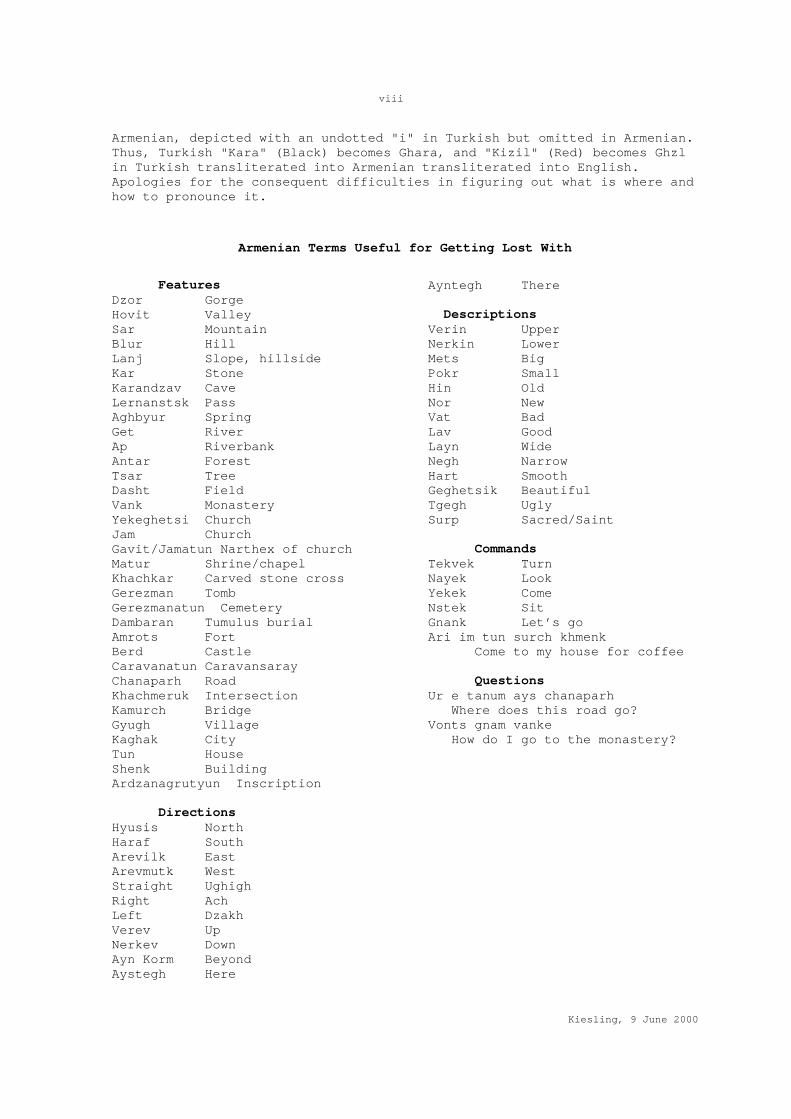
Armenian Terms Useful for Getting Lost With
Features
Dzor Gorge Hovit Valley Sar Mountain Blur Hill Lanj Slope, hillside Kar Stone Karandzav Cave Lernanstsk Pass Aghbyur Spring Get River Ap Riverbank Antar Forest Tsar Tree Dasht Field Vank Monastery Yekeghetsi Church Jam Church Gavit/Jamatun Narthex of church Matur Shrine/chapel Khachkar Carved stone cross Gerezman Tomb Gerezmanatun Cemetery Dambaran Tumulus burial Amrots Fort Berd Castle Caravanatun Caravansaray Chanaparh Road Khachmeruk Intersection Kamurch Bridge Gyugh Village Kaghak City Tun House Shenk Building Ardzanagrutyun Inscription
Directions Hyusis North Haraf South Arevilk East Arevmutk West Straight Ughigh Right Ach Left Dzakh Verev Up Nerkev Down Ayn Korm Beyond Aystegh Here
Ayntegh There Descriptions Verin Upper Nerkin Lower Mets Big Pokr Small Hin Old Nor New Vat Bad Lav Good Layn Wide Negh Narrow Hart Smooth Geghetsik Beautiful Tgegh Ugly Surp Sacred/Saint
Commands Tekvek Turn Nayek Look Yekek Come Nstek Sit Gnank Let’s go Ari im tun surch khmenk Come to my house for coffee
Questions Ur e tanum ays chanaparh Where does this road go? Vonts gnam vanke How do I go to the monastery?

ix
Kiesling, 9 June 2000
Bibliography
Following were sources available to me at the time of preparing this work. Obviously, a scientific bibliography would be much longer, in various languages:
Soviet Armenian Encyclopedia, Yerevan, 1974-1986.
Divan Hay Vimagrutyan (Corpus of Armenian Inscriptions), vols 2-6; Yerevan
Bedrosian, Dr. Robert; web site http://www.virtualscape.com/rbedrosian/hsrces.html contains his English translations of several important Armenian historians, including Kirakos Gandzaketsi quoted in this work.
Bournoutian, George A., The Khanate of Erevan Under Qajar Rule 1795-1828; California: Mazda Publishers, 1992.
Bournoutian, George A., Russians and the Armenians of Transcaucasia 1797-1889; a Documentary Record; California: Mazda Publishers, 1998.
Donabedian, Patrick and Thierry, Jean Michel, Les Arts Armeniens; Paris: Editions Mazenod, 1987.
Ghafadarian, Karo, Dvin: Kaghake yev nra Perumnere(Dvin: The City and its Excavations), Armenian Academy of Sciences, Yerevan 1982.
Ghafadarian, Karo, Yerevan: Mijnadaryan Hushardzannere (Yerevan: Medieval Monuments), Armenian Academy of Sciences, Yerevan 1975.
Hakobian, Hakob, Armaviri Marz; Armavir: 1998.
Hakobian, T.Kh. et al. editors, Hayastani yev Harakits Srjanneri Teghanunneri Bararan (Dictionary of Placenames of Armenia and Adjoining Regions), vols 1-4; Yerevan University Press, 1988-98.
Harutyunian, Varazdat; Haykakan Chartarapetutyan Patmutyun (History of Armenian Architecture), Luys 1992.
Hasratian, M., The Monuments of Meghri Region (in Armenian), Yerevan 1987.
Hewsen, Robert, "The Meliks of Eastern Armenia," in Revue des Etudes Armeniennes, (1972-1980).
Hovannisian, Richard ed., The Armenian People: From Ancient to Modern Times, St. Martin’s Press 1997.
Khachatrian, Armen, Inscriptions et Histoire des Eglises Armeniennes; Ricerca sull’ Architettura Armena vol 8, Yerevan/Milan, n.d.
Khachatrian, A.A., Corpus of Arabic Inscriptions in Armenia, (in Russian), Armenian Academy of Sciences, 1987.
Kirakosian, G.E.; Hayastan∋ Lank-Tamuri ev Turkmen Tsegheri Arshavnkneri Shrjanum (Armenia in the Period of the Invasions of Timur Lenk and the Turkmen Tribes), Gitutyun, 1997.
Mahe, J.-P., Moise de Khorene et les Inscriptions grecques d’Armawir, Topos vol 4, 1994.
Martirosian, A.A., Armenia in the Bronze and Early Iron Age (in Russian), Yerevan 1964.
Mikayelian, G.H., The Cyclopean Forts of Sevan Basin, (in Armenian),Yerevan 1968.
Orbelian, Stepanos, Syuniki Patmutyun, annotated translation, A.A. Abrahamian; Yerevan, 1986.
Santrot, Jacques, ed.; Armenie – Tresors de L’Armenie ancienne, Somogy Editions d’Art, Paris, 1996. (good brief articles in French on a wide range of topics.)
Sardarian, S.H., Primitive Society in Armenia (in Armenian), Yerevan 1967.
Yesayan, S.A., The Old Culture of the Tribes of Northeastern Armenia (in Russian), Yerevan 1976.
Yesayan, S.A., Archaeology of Armenia (in Armenian), Yerevan 1992.

1
Kiesling, 9 June 2000
HISTORICAL GEOGRAPHY OF THE REPUBLIC OF ARMENIA This work is confined to the territory of the independent Republic of Armenia in 1999, and is driven in its subject matter by the surviving historical monuments on which the narrative -- when there is one -- hangs. As a country of regular earthquakes, periodic invasions, and severe winters, Armenia does not lend itself to the preservation of ephemeral structures. Until this century, most architecture was in unfired brick, on a foundation of mortared stone. Practically nothing of that has survived the rain or the ferocity of Soviet urban planners, leaving the impression that modern Armenia sprang from an unpopulated wilderness of half-collapsed stone churches. This impression leaves out a great deal. The borders of the Republic are those set by Soviet authorities in 1921, with minor subsequent adjustments in the late 1920s. This work does not include Nagorno-Karabakh/Artsakh or other territories inside the internationally recognized state borders of the Republic of Azerbaijan. Nor does it address the much larger areas that at various times in various political contexts have been considered part of historical Armenia. For a late Roman, this book is confined to Eastern Persarmenia, for a 6th century Armenian the provinces of Ayrarat, Syunik, and Gugark. In the 18th century under the Qajar rulers of Persia, the core of Armenia (Yerevan city and the modern marzes of Aragatsotn, Ararat, Armavir, Kotayk, and western Gegharkunik) fell within the Khanate of Erevan. The Northeast (now Tavush marz) belonged to the Khanate of Ganja, though claimed by the Kingdom of Georgia as well. The North (now Shirak and Lori marzes) were part of the Kingdom of Georgia. South-central Armenia (Vayots Dzor marz) was in the Khanate of Nakhichevan, and the far South (Syunik marz) belonged to the Khanate of Karabagh. The phased Russian conquest, from the 1801 annexation of Georgia to the fall of the Erivan fortress in 1827, kept Armenia split among the Gubernias of Tiflis (Tbilisi), Erivan (Yerevan), and (later) Yelizavetpol (Ganja). The borders of the modern Republic of Armenia were drawn under intense military and political pressure in 1919-21, satisfying no one, but put into Armenia most of Erivan gubernia -- but without Nakhichevan or the uezd of Surmalu (west of the Arax River) -- plus the west half of Zangezur and Kazakh uezds of Yelizavetpol, the southern part of Borchalu uezd of Tiflis gubernia, and a small piece of the former Kars oblast around the Arpa reservoir in NW Shirak. Before discussing historic populations, it is important to note that the murderous figment called the "nation-state" did not reach Armenia until the mid-19th century (and then from Armenians in Europe or as an unintended lesson of American Protestant missionaries in the Ottoman Empire -- Russian censors and police tried to stamp out the idea on the Czar's territory). Through waves of invasion, Armenians kept a private language and private religion while adapting to and sometimes flourishing under successive foreign empires. In particular, Eastern Armenia in its culture and history is heavily dependent on Persia. The Armenian language, though an independent branch of the Indo-European family, borrowed much of its vocabulary from Persian. The ancient Armenian calendar derived from Persian, as did the Armenian royal house.
Seldom before 1880 did Armenians rally around a national identity, 20th century efforts to reinterpret Armenian history in nationalist terms notwithstanding. Instead, each region or village, each feudal family, reached what accommodation it could with the conquerors, sometimes taking arms alongside a Muslim overlord against Christian neighbors. And by the

2
Kiesling, 9 June 2000
17th century (and particularly after the forcible transfer of much of the useful population to New Julfa near Isfahan by Shah Abbas in 1604), Armenian-speaking Christians had become a minority across their historic territory, pushed back into the foothills and deep stream valleys, coexisting under their native gentry, the meliks and bishops, with Persianized Azerbaijani Turks (known to Russian imperialists as Tatars) and various semi-nomadic Turkic or Kurdish tribes.
It was Armenia's embrace of Orthodox Russia in the early 19th century that turned the tide. According to Russian official figures cited by George Bournoutian, Armenian Christians represented only some 20 percent of the population of the Khanate of Erevan when the Russians took over in 1828. The proportion of Armenians swelled to 50 percent by 1832, as tens of thousands of Armenians -- not only recent refugees but also long-settled Persian or Ottoman citizens -- flocked at Russian urging into lands left empty by Muslims fleeing to Persia. Many of the villages listed in this gazetteer date their current population to this period, and bore -- until a series of wholesale renamings in the 1930s, 1940s, 1960s, or 1980s -- Turkish names. Over the next 90 years, each successive Russian adventure into Ottoman lands prompted Ottoman Armenians to link their fate to Russia’s, and each successive Russian retreat brought the Armenian province new waves of Armenian refugees. Shortly after 1900, Armenians became a majority even in the city of Yerevan itself.
Bloody clashes between Armenians and Azeris in 1905-6 resulted in small-scale ethnic cleansing on both sides. In 1915-21, this process intensified, as Armenia and Azerbaijan fought over Karabakh and Zangezur. The population make-up of the Arax River valley changed as Armenia struggled to find land for the starving survivors of the massacres in Eastern Anatolia while under threat of complete extinction at the hands of Turkey. Sovietization stabilized the situation. As Soviet Armenia industrialized, the outflow of Armenian migrants to Baku and Tbilisi decreased; indeed, Armenia began to attract Armenians from Iran and elsewhere in the diaspora, and from Nakhichevan. To make room for them (or to respond to Turkey’s wrong choice of Cold War allies), Stalin decreed in December 1947 the resettlement of 100,000 Azerbaijani Turks from Armenia to the barren Kura-Arax lowlands of Azerbaijan.
The upsurge of nationalist sentiment in the Soviet Republics in 1988 was a key component in the collapse of the Soviet Union. Mikhail Gorbachev appealed vainly for Socialist fraternity in the Caucasus, and then sent in troops. These failed to halt, and in some cases perhaps even encouraged, the atrocities that over the period 1988-92 drove out hundreds of thousands of residents and turned Armenia and Azerbaijan into largely monoethnic states.
The Russian Empire was a mixed blessing to the Armenian people. On the one hand, Russia provided security from war and kept brigandage at a low level. On the other hand, Russia was ineffective in encouraging economic development in the Yerevan gubernia, favoring Tbilisi and Baku. The camel caravans to Persia and the Far East took other routes. Russian tax collectors were no less rigorous than the Khan's had been, and the rights of the nobility were strengthened vis-a-vis their peasants. As heterodox Christians, Armenians were only slightly higher than Muslims on the Imperial social scale. The Armenian church was exploited and manipulated, its properties taxed and gradually confiscated, its schools kept under close control. Armenia's gentry had great difficulty in establishing its noble status (including tax exemptions) in Russian eyes. Armenian refugees who resettled abandoned "Tatar" villages learned with chagrin that Russia

3
Kiesling, 9 June 2000
would respect the property rights of Muslim begs who returned from exile in Persia.
On his way to Tehran in 1859 to take up his position as HM Minister to the Persian Court, that model Major General and great Orientalist Sir Henry Rawlinson passed through Tbilisi and Tabriz and reported back to the Secretary of State for India on the massive Russian military presence in the Caucasus and whether it posed any threat to British interests in India. Treated with suspicion by his Russian hosts, Rawlinson still managed to glean that Russia was losing money in the Caucasus, with no prospect of ever breaking even. General Koliubakin, the vice governor, admitted that he would favor abandoning the Caucasus entirely, were it not for the risk of a military revolution. Rawlinson reported that:
"The Armenian population of Erivan and Nakhshevan, although numerically unimportant, deserves a brief notice. Russia, although paying much attention to the Armenians when they were first ceded to her by the treaty of Turcomanchai, now takes little pains to conciliate this class. They complain of oppression. A considerable part of the church property has been sequestered, and when I visited Etchmiadzin, the seat of the Patriarch of the whole Armenian church, I could detect in his conversation many signs of discontent and disappointment. The Armenians know, however, that they would be worse treated if they migrated to Persia or Turkey, and they thus remain obedient, if not really loyal subjects of the Russian Government."
Colonel Herbert Chermside, visiting Transcaucasia in 1888, offered a more racist and acerbic view of Russian-Armenian relations: "The dislike of Armenians by Russians, and their attitude toward them socially, seems natural enough to a European acquainted at all intimately with Armenian characteristics, and are very analogous to the feelings and attitudes of Englishmen towards various native races."
Come the Revolution, however, the antipathy of the average Russian aristocrat was more than repaid by the warmth of relations between Russian communists and their Armenian brethren. Armenian intellectuals, long denied social standing by a reactionary Russia, embraced Marxism more rapidly and effectively than any other of Russia's subject populations, and they were duly rewarded when Lenin came to power. From being a poor, backward province, Armenia found itself by the end of the Soviet Union a substantial high-tech industrial power, prosperous far out of proportion to Armenia's natural resources or geostrategic situation. This is not to say that Armenians were devout Communists -- far from it. Rather, they adopted comfortably the outward forms and rituals of the Soviet Empire, as many Armenians had those of the Mongol Empire before it.
ARMENIAN MONASTERIES
“O fathers, had you built fortresses instead of the monasteries with which are country is full ... our country would have been more fortunate than she is today.” (Raffi)
Though Armenians in fact built plenty of fortresses, monasteries (vank, plural vanker) are clearly the most distinctive feature of the Armenian landscape. Situated, as most are, deep in river gorges or in wooded glens, they are, apart from intrinsic architectural or historical interest, typically in lovely destinations well worth the trouble of finding. Many were fortified; most have inscriptions or carved tombstones. Some once housed schools, libraries, and scriptoria, producing the manuscripts that kept Armenian culture alive through many dark centuries.
4
Kiesling, 9 June 2000
Besides piety and the usual number of sins to expiate, one reason for the huge number of monasteries derives from the precarious nature of land tenure. Neither Turks, Mongols nor Persians endorsed the concept of freehold real property, almost all of which in theory belonged to the Sultan/Khan/Shah to bestow in return for (usually) military services. Though Armenian lords participated in this system, as infidels their ability to pass land down to their descendants was more than usually insecure. However, the tax-exempt ownership of land by religious foundations (Arabic waqf), whether Muslim or Christian, was usually respected, even by new conquerors. Since those religious foundations could be and generally were run by a self-appointing, self-renewing board, and since the Armenian priesthood was largely hereditary, a noble family could, with a little help from key officials, donate land to a family-run waqf under a family-member bishop and thereby control it and its revenues. Many of the inscriptions decorating monastery walls record the donation of gardens or whole villages to the monastery. The peasants tended to convey along with the land.
The Mother Church at Ejmiatsin was by the end of the Persian period the largest Christian landowner in Armenia. In the drier foothills and isolated stream valleys, a small number of Armenian noble families, the meliks, defended their hereditary control of villages or small districts. The richer irrigated land of the Arax river valley had mostly long ago been commandeered by successive Arab, Turkic and Persian lords. The revenue from the relatively fertile Church lands near Ejmiatsin was a permanent source of inspiration to foreign rulers and the clergy alike; years of its income were sometimes mortgaged to pay the requisite bribes to the functionaries of the Shah, Sultan, or both to be recognized as rightful head of the church. The monastic system survived under Islamic overlords. Katholikos Abraham of Crete, in a memoir written in the 1730s, described his travels from functioning monastery to functioning monastery, and received deference and lavish gifts from the Shah. In the late 17th century the Khanate of Erivan had 23 men's monasteries and five women's, but by 1830 had only 10 functioning, all for men.
Even before the Russian Empire annexed the Khanate of Erevan in 1828, it had begun to assume a tutelary role over the Armenian Apostolic Church, pulling strings to assure the election of katholikoi who would mobilize the Armenian people in support of Russia's territorial aspirations in Anatolia and Persia. Persian and Ottoman authorities took a dim view, diverting much of the flow of funds from the Armenian diaspora. The Church was demoralized, short of qualified leaders, and deep in debt by the time Ejmiatsin became part of the Russian Empire. Having failed to put the finances and administration of the Church on a rational footing through a series of heavy-handed reforms, the Russian authorities ultimately confiscated most monastery property. By the time of Sovietization, most monasteries had been ruined by earthquakes or were occupied by only one or two monks.
Seventy years of Soviet atheism nearly completed the destruction. The monks were evicted or deported and the tattered remnants of monastic libraries shifted to Ejmiatsin and then to the Matenadaran, the great manuscript repository in Yerevan. Apart from a handful of internationally known tourist sites such as Geghard, most village churches were transformed into storage sheds and padlocked, while some in Yerevan were destroyed in the name of urban redevelopment. The priesthood shrank in numbers, and religious education withered almost completely. Though the late Katholikos Vazgen I is revered (his picture, like that of a saint, still posted in most churches) for keeping Armenian Christianity alive at all during four

5
Kiesling, 9 June 2000
difficult decades, there was in 1999 no longer any organized monastic community in the Republic of Armenia, apart from Holy Ejmiatsin itself. Fewer than 300 churches, all small by Western standards and mostly decrepit, and a similar number of priests, serve a population of 3,000,000, and few of those churches are crowded. However, the influx of money and energy inspired by the (official) 1700th anniversary of Armenian Christianity has led to massive programs of church reconstruction and some efforts to revive Armenian monasticism as a core element of Armenia's distinctive form of Christianity. Seminaries have been reopened, with a goodly number of new students, and a few wealthy Armenians are building/rebuilding churches, though the resources allocated to parish priests for ordinary pastoral work remain negligible.
YEREVAN CITY Armenia was for most of its history a rural society, with few cities of its own. The modern city of Yerevan was built on tragedy and dreams. Little more than a garrison town of mud-brick and gardens before its first brief experience as capital of an independent Armenia in 1918, the city burgeoned under Soviet rule. The flood of refugees from the 1915 holocaust and its aftermath fueled an uneasy but productive alliance between Armenian nationalism and Soviet hopes of spreading the Communist gospel through the Armenian diaspora. Modern Yerevan was built, deliberately, to be the universal center and pole of attraction for the diaspora, with an educational and cultural infrastructure far out of proportion to the size or intrinsic wealth of Soviet Armenia.
In 1988, when the collapse of the Soviet Union became visible, Yerevan was a full-fledged, booming Soviet city of (officially) 1 million people. A gracious street plan of parks, ring-roads, and tree-lined avenues had been laid out by the architect Alexander Tamanian and his successors in the 1920s and 1930s for a population they dreamed might reach 200,000. That goal long surpassed, the process of expansion to reach the magic million-person threshold that qualified Yerevan for a metro and the other perquisites of a city of all-Union importance involved Armenia's successive First Secretaries in sordid expedients and half-finished, earthquake-vulnerable construction projects in sprawled, depressing suburbs.
The success of the 1988 independence movement dealt the city a series of major shocks, first with the forced emigration of a centuries-old Muslim (mostly Azerbaijani Turkish) population, and its replacement by newly impoverished refugees from Baku. The disastrous collapse of the Soviet economic system (Armenia made high-tech pieces of everything, but produced all of practically nothing) triggered the economic migration of hundreds of thousands of impoverished Armenians bound for the bright lights of Moscow or Glendale. A badly-needed census has been postponed till 2001, partly for lack of funds, partly for fear of demoralizing those who are left.
The city of Yerevan preserves little of its early history in a form of interest to casual visitors. Behind the anonymous Soviet facades, however, a rich and complex life took place and still does, in the "bak" or courtyard or in private apartments far better furnished -- with books, musical instruments, art, and hospitality -- than 70 years of official culture or a decade of grim poverty would suggest. There are thousands of Yerevantsis who know, love, and can present their city far better than I, so this chapter is designed for those with no opportunity to seek one out, and with apologies for its sketchiness.

6
Kiesling, 9 June 2000
Archaeology
Yerevan is a very ancient place. Caves in the walls of the Hrazdan river gorge, particularly near the modern Yeravanian Lake, show traces of Stone Age habitation. The substantial Chalcolithic (transitional from stone to metal-using) settlement of Shengavit, scientifically of great importance for the prehistory of the whole region, is perched on the slope on the far side of the lake (from the airport road, take the road SE across the dam, then turn left). There you will find the crumbling circular foundations of a number of rubble and mud-brick houses, once surrounded by a stone fortification wall and with an underground passage leading to the river. Four settlement phases have been identified, from the end of the 4th millennium B.C. to the beginning of the second millennium B.C.
The Urartian kingdom centered on Lake Van in Eastern Turkey gave Yerevan its first major impetus. The Urartians built the citadel of Erebuni, on the hill of that name in SE Yerevan. (Take Tigran Mets Blvd from Republic Square, then turn left following the trolley tracks on the major street about half a km past the train station). A substantial museum at the base of the hill formerly known as Arin Berd houses many of the finds, including a few examples of Urartu's splendid metalwork. The citadel itself was founded by Argishti I son of Menua, King of Urartu in the year 782, the first Urartian conquest on the East side of the Arax. We know this from a cuneiform inscription discovered built into the fortification wall by the gate, an inscription which reads roughly as follows: "By the greatness of the god Khaldi, Argishti son of Menua built this great fortress, named it Erebuni, to the power of Biainili and the terror of its enemies. Argishti says: the land was waste, I undertook here great works..." Armenian scientists argue that one can derive the name Yerevan from Erebuni by a series of simple phonological shifts, suggesting that modern Yerevan is the lineal descendant of this 8th c. B.C. citadel. In 1998, the Mayor of Yerevan arranged a festivity marking the 2780th birthday of Yerevan. A good time was had by all.
The site has been heavily restored, not always well, and those restorations badly need their own restoration, making it difficult to separate original Urartian walls from Achaemenid Persian remodeling. In any case, enough survives to convey that this was a large, complex center, with shrines, palatial rooms with elaborately frescoed walls, and major storage facilities. A number of smaller cuneiform inscriptions on basalt building stones attest to a "susi," apparently an Urartian temple.
About a century after Erebuni was built, in the first year of Urartian King Rusa II, the inhabitants of Erebuni seem to have relocated to a citadel they called Teishebai URU (City of the God Teisheba), the site now known as Karmir Blur ("Red Hill"). This site overlooks the Hrazdan river from a bluff downstream from Shengavit (from the airport road, cross the dam, turn right on Aragats Ave., then right again about 1 km down, and go to the end). The site takes its name from the huge pile of decomposed red mud-brick, some of which still sits atop the impressive stone foundations of the city wall.
Yerevan's history fades away after Karmir Blur in terms of things to look at, with the early Armenian kings and Roman and Persian conquerors preferring Artaxiasata to the south and Vagharshapat/Ejmiatsin to the north. The horrific earthquake of 1679 completed the destruction done by passing Arab, Mongol, Persian, and Ottoman armies over the centuries. Still, bits and pieces remain for the patient explorer.

7
Kiesling, 9 June 2000
The Erivan Fortress
Reconstituted in the 17th century as a Persian city-fortress guarding the marches with the Ottoman Empire, Yerevan was a key military/strategic point at the intersection of three empires. At the beginning of the 19th century, first the French and later the British sent military experts to prop up Persia against Russian aggression. Drawing on their expertise, the last Khan of Yerevan made his headquarters the strongest and most modern fortress in the Persian Empire, with a cannon factory and arsenal. The palace was large and gracious, with fountains, a hall of mirrors, painted ceilings depicting the Persian epic hero Rostom, and other trappings of civilized living.
In 1804 the arrogant Georgian Prince Tsitsianov led a Russian army against Yerevan, but was forced to withdraw due to lack of supplies. That part of the Armenian population that supported him, including a number of Armenian notables and their retainers, retreated with him to Georgia. Tsitsianov was murdered in 1806 outside the walls of Baku, and his loss was little lamented. Future Russian leaders were more diplomatic, and found the Armenians of Yerevan better allies, though by no means in a position to liberate themselves from the 3000 troops of the Persian garrison. General Gudovich tried and failed in 1808, but General Paskevich succeeded, entering Yerevan on October 2, 1827, as recounted in a British War Office summary:
"As soon as Paskiewitch assumed the command-in chief (note: in 1827) he had a siege train carried up to the neighborhood of Erivan, which fortress was still held by the Persians. Leaving the train in a redoubt near Erivan, he marched to Abasabad, a new and regular European fortress on the banks of the Arax near Nachitschevan. This place opened its gates to him. Sardarabad, a large fortified village on a canal fed by the Arax, was next taken, and the stock of provisions found in it placed Paskiewitch in a position to commence the siege of Erivan. Erivan had already been twice unsuccessfully besieged, and was considered almost impregnable. The fortifications consisted of two walls, an outer 25 feet and an inner 35 feet high round three sides; the steep cliff of the ravine of the Zangi formed a natural defense on the fourth side. Two weak detached bastions on European principles had been added since an attack by General Gudevich. Trenches were advanced under the natural cover of the ground almost up to the foot of the walls. The batteries effected a breach in a single day's firing; many of the garrison deserted during the night, and on the following day Erivan was taken by assault."
After a bit of pillaging, Paskevich intervened to have most of the city spared. Hosein Khan, the capable and generally respected Persian Khan of Yerevan, escaped but his warlike brother Hasan Khan was captured along with his prize possession, a sword that had once belonged to Timur Lenk (Tamerlaine). This sword was subsequently presented to Czar Nikolai. Paskevich's forces continued S to Tabriz, and forced Persia to cede all the territory N of the Arax river to the Russian Empire in the Treaty of Torkmenchay. Paskevich was rewarded with the title Count of Yerevan, and went on to further glory as the brutal suppressor of a revolt in Poland. Meanwhile, tens of thousands of Armenians flocked into the liberated territories from Persia and the Ottoman empire.
Yerevan itself remained a Russian garrison town, but the fortress had lost its importance. When Berge visited Yerevan in January 1848, he reported that the thick, crenellated mud-brick walls of the Yerevan fortress were already deeply crevassed, dissolving in the rain as mud-brick does unless

8
Kiesling, 9 June 2000
roofed and maintained. The Sardar's superficially splendid palace slowly melted as well, and had become an eyesore by mid-century. In Soviet times, the last traces of the fortress disappeared; the hulking basalt prison of the Yerevan Wine Factory marks the site, though the fortress walls once extended up and down the river as well as back toward town. An inscription in Armenian on the lower wall of the Wine Factory commemorates the staging in 1827 of a play by Griboyedov, a Russian diplomat/writer in Paskevich's entourage, who was murdered by a Persian mob in 1829 with the rest of the Russian Embassy in Tehran.
The City
In 1827, Yerevan was a town of 1736 low mud-brick houses, 851 shops, 10 baths, seven caravansaries, and six public squares, set among gardens likewise walled with mud. Czar Nikolai I found no more endearing description for Yerevan during his one brief visit in 1837 than "a clay pot," and the Russian travel writer Mardovtsiev found little difference in the 1890s: "Clay houses with flat clay roofs, clay streets, clay squares, clay surroundings, in all directions clay and more clay." Yerevan remained a garrison town of 12,500 inhabitants, more than half Muslim, a place of low, flat-roofed houses and lush walled gardens, until the 20th century. Practically nothing of this earlier town remains, except in Kond, tucked between Moscovian Blvd. and the Dvin Hotel on Proshian ("Barbecue") and Paronian Streets. The hill of Kond was a predominantly Armenian neighborhood in Persian times, presided over by the Geghamian family of meliks. Set apart for preservation in Soviet times, its winding alleyways and tumbledown houses are now being razed surreptitiously to build orange tuff palaces for Yerevan's post-Soviet gentry. But a careful search still reveals crumbling archways and courtyards of an older Armenia.
The Medieval Bridge
The decayed remnants of a four-arched bridge of 1679 stand on the Hrazdan river just below the fortress, now the site of the Yerevan Wine Factory at the bottom of Mashtots Blvd. Built just after the great earthquake at the expense of the wealthy merchant Hoja P'ilavi, this bridge (also known as the Red Bridge from the tuff used) was extensively modified in 1830 by the Russians. There had been a bridge at this site since very early times, the connection between the city-fortress of Yerevan and the rich farmlands and caravan routes of the Arax valley.
Churches
In 1828 there were seven Armenian Apostolic churches in Yerevan with a like number of clergy, serving an Armenian population of perhaps 4000. Four of those churches, two of them tiny, survived the Soviet period; though a grand cathedral church of S. Grigor Lusavorich is a-building just E of Republic Square, only one-tenth of one percent of Yerevan's population can attend services at any given moment.
The oldest surviving church in Yerevan, the Katoghike, stands nestled in a courtyard on the W side of Abovian Street just above Sayat Nova Blvd. Its current form dates to 1936 , when the old cathedral church of Yerevan, a substantial but undistinguished basilica rebuilt in 1693/4, was slated for destruction in the name of urban renewal. The archaeologists won a modest concession from Stalin's architects, that they could oversee the dismantling and record the inscriptions and architectural fragments incorporated in the rubble walls. Lo and behold, as the walls came down it became clear that the central apse, the sanctuary, was in fact an almost intact small Astvatsatsin church with inscriptions from the 13th century. Public and scientific outcry won the newly discovered church a reprieve,

9
Kiesling, 9 June 2000
and since independence it has resumed its religious function, albeit invisibly from the main streets. In front of the church is a small collection of khachkar and other sculpted fragments from the core of the destroyed basilica.
The 17th c. Poghos-Petros (Peter and Paul) church was not so fortunate, destroyed to build the Moscow Cinema. Likewise the S. Grigor Lusavorich church, begun in 1869 but not finished till 1900, gave way to the widening of Amirian Blvd, and sits underneath the Eghishe Charents school.
The Zoravar Church survives concealed behind apartment fronts in the block bounded by Moscovian, Pushkin, Ghazar Parpetsu, and Tumanian streets, a hodgepodge of architecture dating from 1693 (funded by the wealthy Hoja Panos) and rebuilt at various times, including by local dignitary Gabriel Yuzbashi in the late 18th c. and French benefactor Sargis Petrossian in the 1990s. According to ecclesiastical history, it sits near the site of the tomb/shrine of S. Ananias the Apostle.
In 1684, at the request of King Louis XIV to the Shah of Persia, French Jesuits set up a mission in Yerevan, goal of which was to persuade the Katholikos in Ejmiatsin to bring himself and his church into the Catholic fold. Effectiveness of Jesuit diplomacy was reduced by their habit of dying after a few months, but the second of them, Father Roux, became friendly enough with the Katholikos that when he died in 1686 he was buried by the Katholikos in the "magnificent monastery of Yerevan" next to the Armenian bishops and archbishops. When the newly enthroned Shah Hussein banned wine throughout his dominions in 1694, the missionaries mourned the destruction of Yerevan's vintage, "the best wine in the Persian Empire." Local authorities respected the extraterritoriality of the Jesuits, putting seals on the door of the Mission wine cellar in such a way that the door could still be opened. Nothing remains of the Jesuit mission, nor of the "magnificent monastery of Yerevan" that housed their mortal remains. Yerevan now has, not far from the U.S. Embassy, a small scholarly outpost of their spiritual descendants, the Mekhitarist fathers.
Mosques
At the time of the Russian conquest there were eight mosques in Yerevan. On the capture of the city in 1827, the grateful and prudent inhabitants (both Muslim and Christian) bestowed the fortress mosque on the conquerors to serve as a Russian Orthodox church until a more suitable structure could be built for the purpose a few years later. The largest mosque of Yerevan and only one still preserved, the Gyoy or Gök-Jami, (gök means "sky-blue" in Turkish) was built in AH 1179 or AD 1765/6 by the command of local ruler Hussein Ali-Khan to be the main Friday mosque. The mosque portal and minaret were decorated with fine tile work. The central court had a fountain and stately elm trees, with rooms around it,. There was an adjoining hamam and school. In Soviet times, the mosque housed the Museum of the City of Yerevan. In the mid-1990s, the powerful Iranian quasi-statal foundation for religious propagation agreed to fund a total restoration of the mosque with shiny new brick and tile. This restoration, structurally necessary but aesthetically ambiguous, was largely finished in 1999. However, Armenian authorities, torn between the need to placate a powerful neighbor and desire to minimize the practice of an unpopular religion, have been slow to bless the reconsecration of the complex as a mosque, suggesting it should serve as a cultural center instead. There is supposed to have been a working mosque somewhere in Yerevan; made superfluous by the 1988-91 population transfers, it burned down.

10
Kiesling, 9 June 2000
The Museums
There are dozens of museums in Yerevan, mostly house-museums to writers, painters, and musicians. The entry fee is minimal, and the staff are generally delighted to receive a foreign visitor. If the language barrier can be overcome, the hospitality and taste of a little-known culture will be memorable.
The best museum in Yerevan is small and idiosyncratic, the would-be final home of famed Soviet filmmaker Sergei Parajanov (1924-1990). Though an ethnic Armenian (Parajanian), he was born in Tbilisi and spent most of his professional career in Kiev or Tbilisi. He won international fame with "Shadows of Forgotten Ancestors" and "The Color of Pomegranates," but his career was crippled by imprisonment (for homosexual liaisons) and denial of resources. Under perestroika, Yerevan claimed him as its own, and built him a lovely house overlooking the Hrazdan gorge in an area of ersatz "ethnographic" buildings on the site of the former Dzoragyugh village (just behind and left of the upscale restaurant "Dzoragyugh," commonly but no longer accurately known as the "Mafia Restaurant" due to a leather-clad clientele, a mysteriously reliable electrical supply during the dark nights of 1993-95, and the occasional discharge of firearms). Alas, Parajanov died before the house was finished, but it became a lovely museum/memorial that also hosts dinners and receptions to raise funds. Parajanov's visual imagination and subversive humor are represented in a series of compositions from broken glass and found objects. His figurines from prison-issue toilet brushes are proof that a totalitarian, materialist bureaucracy need not prevail. Look for "The Childhood of Genghis Khan" and Fellini's letter thanking Parajanov for the pair of socks.
The Matenadaran (manuscript library) is the other world-class museum in Yerevan, partly for its exhibition of fine illuminated manuscripts but primarily for its status as the eternal (one hopes) repository for Armenia's medieval written culture. A vast gray basalt mass at the top of Mashtots Blvd. (built 1945-57, architect M. Grigorian), the Matenadaran is guarded by the statue of primordial alphabet-giver S. Mashtots (ca. 400) and those of the other main figures of Armenian literature: Movses Khorenatsi (5th -- or maybe 8th -- century "father of Armenian history"); T'oros Roslin (13th c. manuscript illuminator in Hromkla/Rum Qalat near Edessa); Grigor Tatevatsi (theologian of Tatev Monastery, died 1409); Anania Shirakatsi (7th c. mathematician, studied in Trebizond, fixed the Armenian calendar); Mkhitar Gosh (died 1213, cleric and law codifier); and Frik (ca. 1230-1310, poet). There are khachkars and other ancient carved stones in the side porticos. The entry hall has a mosaic of the Battle of Avarayr, and the central stair frescos of Armenian history, all by H. Khachatrian.
English-speaking guides are usually on deck. Beside the exhibit hall (and a small gift shop with excellent hand-painted reproductions of important manuscript miniatures), there are conservation rooms and shelf on shelf of storage (closed except to specialists with advance permission) for the 17000 manuscripts in a dozen languages. Cut deep in the hillside behind, and shielded by double steel blast doors, is a splendid marble tomb designed to preserve the collection against nuclear holocaust. Alas, the execution did not live up to the grandiosity of the conception -- water from a series of underground springs drips through the vaults, making them unusable until a few million dollars are found for a total reworking.
The State History Museum in Republic Square (formerly Lenin Square) is notable for the statues of Catherine the Great and Lenin squirreled away in a back courtyard ready for any change in the political winds. The

11
Kiesling, 9 June 2000
important archaeological collection from Stone Age through Medieval periods is dark and almost unlabeled, but should not be missed. Note a Latin inscription from Ejmiatsin attesting to the presence of a Roman garrison. There are some interesting models of early modern Yerevan and other historical exhibits of interest to those comfortable in Armenian or Russian.
The floors above contain the National Picture Gallery. Start by taking the elevator to the top, then descend through the huge collection of Russian, Armenian, and European works, some of the latter copies or else spoils of W.W.II divided among the various Soviet republics.
Accessible from the street running behind the State History Museum is the Middle Eastern Museum and Museum of Literature. The former has an interesting collection, including a carpet-weaving display.
The Museum of the City of Yerevan is essentially defunct, its archaeological and ethnographic collections in storage while the staff sits in a small building at 33A Mashtots Blvd (left of and behind the school) hoping someone will build them a new building to replace the original quarters in the Gök Cami.
The Genocide Memorial and Museum at Tsitsernakaberd ("Swallow Castle") sits on the site of a Iron Age fortress, all above-ground trace of which seems to have disappeared. The Museum's testimony to the 1915 destruction of the Armenian communities of Eastern Anatolia is moving, and the monument itself is austere but powerful. The riven spire symbolizes the sundering of the Eastern and Western branches of the Armenian people.
The view over the Ararat valley is striking. Gazing south, a Western Christian might muse on the 10,000 Martyrs of Mt. Ararat, who used to be in the Catholic saints' calendar for June 22. According to a legend that made its way westward to become popular in 14th and 15th century Western art, 9000 Roman soldiers sent out to the Euphrates frontier with a certain Acacius were led by angelic voices to convert to Christianity. The Roman emperors sent troops against them, another 1000 of whom converted when the stones they threw rebounded from the converts. Finally, the 10,000 were subdued and crucified atop Mt. Ararat. A painting of this scene by the late 15th c. Venetian artist Carpaccio shows the persecutors in Turkish garb. Though the legend is too garbled to link to any historical event, and the 10,000 are not part of the Armenian or Orthodox canons, perhaps the cult is the echo of one of many Armenian cries to the West for help that did not come. Purported relics of these martyrs can still be found in various churches of France, Italy and Spain.
Armenians and Turks are still unable to sit down together to apportion and accept responsibility for the modern and fully documented atrocities of 1915. Armenians say their Kurdish former neighbors have apologized and been forgiven for their leading role in the murders and despoliations. Modern Turkey, however, does not like to think or talk about the Armenians, once a third of the population of Eastern Anatolia, though it tolerates the ancient, prosperous, but shrinking Armenian community of Istanbul. Turkish historians deny that the extermination was deliberate and systematic, and lay stress on the fact that Armenian nationalist groups had made common cause with the invading armies of the Russian Empire to carve out a Great Armenia as part of a general dismembering of the Ottoman empire. The surviving kin of the more than 800,000 Armenians who perished -- a population that had inhabited the region for millennia and lived side by side with Turks as the "loyal millet" for centuries -- reject such justifications. Let us hope that a Europe-bound Turkey, and an independent

12
Kiesling, 9 June 2000
Armenia that has committed crimes as well as suffered them, will recognize they have common ground for dialogue to heal this wound.
Suburbs: Avan and Kanaker
The village of Avan, lying in the angle between the Sevan and Garni roads, has been swallowed up by Yerevan. Heading N past the Zoo (on the right, larger than it looks, and not as depressing as it could be) and just before the Botanic Garden (on the left, spacious and nice for walks, with some plans for redemption), take the right off-ramp for Garni, but then go straight through the intersection and turn left at the stop sign. Turn immediately right, and head about 1 km up the main road of Avan. Where the main road turns right at a modern monument and cemetery, continue straight past the intersection a few meters, then take the first left down a narrow lane. The church is about 300 m along, on the left. Like many other early churches, this one is known locally as the Tsiranavor (“apricot-colored”). Avan Church is the earliest surviving church inside the Yerevan city limits, dating to the late 6th c. At a time when Armenia enjoyed competing Persian-backed and Byzantine-backed katholikoi, the Avan church was built by the pro-Byzantine Katholikos Hovhannes Bagavanetsi (traditional dates 591-603) as his headquarters, while his Persianizing rival sat in Dvin. Multi-apsed, built on a two-step podium, the church preserves a low arched doorway but is roofless. A surviving inscription preserves the name Yohan in a plausibly early style, but with no title to confirm that this commemorates the founder. There are ruins of monastic buildings N, perhaps the seat of the rival katholikosate.
On a slope south of the early village, now on the edge of town, are two chapels, of S. Hovhannes and S. Astvatsatsin, with interesting carvings. Restored several times over the ages, they are believed to originate from the 5-6th centuries. They underwent major reconstruction in the 13th c., but have spent three centuries in ruins since the 1679 earthquake. The Avan cemetery on the west edge of the town has khachkars of the 13-18th c and, across the road, the uninscribed stepped plinth and broken pillar of a 5-6th c. grave monument.
Kanaker was another important self-standing village in medieval times, now absorbed into modern Yerevan. An important khachkar of 1265 stands with pointed roof near the Sevan road, erected by Petevan and his wife Avag-tikin for the remembrance of their souls. The church of S. Hakob was dedicated to Hakob of Mtsbina (aka James of Nisibis), an early 4th c. Syrian bishop who was one of the founders of Armenian Christianity. In Armenian tradition (though not Syriac), S. Hakob attempted along with his followers to climb the mountain of Noah's Ark (which back then was located in Kurdistan south of Lake Van, rather than its currently popular location, Armenian "Masis" or Turkish "Agri Dag" just across the border from Armenia). Led by a vision, he found a piece of the Ark, which he brought down in triumph. He was famous also for the springs of water that burst forth where he laid his head, and also for leading the defense of Nisibis against the Persians in AD 338. Near S. Hakob is a large basilica dedicated to the Mother of God. Both churches have elaborate carved entrances. Ruined in the 1679 earthquake, both were rebuilt soon after, S. Hakob by a wealthy businessman based in Tbilisi, S. Astvatsatsin by local efforts. S. Hakob was the seat of the bishop, with a diocesan school founded in 1868. S. Astvatsatsin was a monastic church, originally walled and with cells. Used as a warehouse in Soviet times, S. Hakob resumed its churchly function in 1990. In the gorge below Kanaker may still remain traces of a ruined "Tivtivi Vank" and of a stone bridge.

13
Kiesling, 9 June 2000
Kanaker is famous also as the home of Khachatur Abovian, the school-inspector/novelist who elevated the modern dialect of Yerevan to its current literary eminence. Abovian was a nephew of the hereditary chief of Kanaker village, a descendant, in turn, of the Beglarian clan of meliks of Gyulistan (Nagorno-Karabakh). Abovian contributed to his fame by accompanying Professor Friedrich Parrot of Dorpat University on the first modern ascent of Mt. Ararat (the local one), in September 1829. Abovian disappeared mysteriously in April 1848, leaving a wife and two young children. The favorite theory, albeit with no firm evidence behind it, is that he was kidnapped by the Czar's agents to rid the Empire of a potentially dangerous Armenian nationalist in the year of the great European revolutions. The Abovian house-museum, at 5th Kanaker St (Tel 28-16-87) is reportedly still functioning.
The First American Tourists
Few Americans ever made their way to Russian Armenia, and even fewer left much of a record behind. The earliest and most intrepid were probably the Reverend Eli Smith and the Reverend H.G.O. Dwight, two Congregationalist missionaries of the American Board of Commissioners for Foreign Ministers. In 1830, as soon as the Russian conquest was firm, they set out to explore first-hand the possibilities of converting the Muslims or at least reforming the local Christians. Traveling from Ottoman Turkey, they crossed into Russian Armenia at Gyumri, went up to Tbilisi, down to Shushi/Shusha in Karabakh, west to Tatev monastery, down to Nakhichevan, up to Yerevan and Ejmiatsin, then back down to Tabriz in Persia and eventually back to Anatolia, traveling in great discomfort on Russian post-horses or Persian mules, frequently ill, but always ready to reprove the theological notions of those they met in route. Unfortunately, Smith had a bad fever in Yerevan, and recorded little there except the uneven floor of his room at the Georgian caravansary, use of which required the written permission of the Russian police chief.
Smith painted in his book (Researches of the Rev. E. Smith and Rev. H.G.O. Dwight in Armenia; Boston 1833) a vivid picture of the poverty, ignorance, and hospitality of the Armenian countryside, of the circumscribed life of Armenian women, and of the insularity of the Armenian Church. He was appalled at the generally low educational level of the Armenian priesthood, its fee-for-service system, its (in his view) idolatrous emphasis on the Mother of God ("Her perpetual virginity is held to with an almost inconceivable strictness as an essential article of belief, and is dwelt upon with indecent minuteness."), and tales of unnatural vice among the monastic clergy. Like today's Western missionaries of market reform, Smith and Dwight seem to have made clear in advance what they expected to hear from their hospitable interlocutors, who may not have always been strictly truthful in obliging them.
Smith and Dwight's scouting mission had no immediate aftermath in Russian Armenia, but 85 years later its importance was clearer. The American Board of Commissioners' missionaries in Anatolia documented the destruction of the Armenian communities and raised a cry for help. The result was the American Near East Relief, which between 1915 and 1930 helped hundreds of thousands of victims of WWI in Greece, Armenia, and the Middle East. So effective was their humanitarian and educational work with the 15,000 Armenian orphans that Soviet Armenia kept them on a full decade after Sovietization and expulsion of all other outside assistance groups,.
In Shushi, Smith and Dwight passed an agreeable time with a little group of Calvinists from Basle in Switzerland, allowed by the Russians to set up near the Persian border in hopes of proselytizing the Muslims. The Muslims

14
Kiesling, 9 June 2000
showed no interest (naturally, given the fate of apostates from Islam). The Swiss concluded that, to make Christianity more appealing to the Muslims, they needed to improve the moral tone of Karabakhi Christians, which they did by opening a school. Two Armenian deacons, the thirstiest for this alien wisdom, were eventually dragged back to Ejmiatsin in chains by a dismayed Synod.
EXPLORING ARAGATSOTN Aragatsotn Marz consists of the huge volcanic shield of Mt. Aragats, formerly Alagyaz, whose main cone rises 4090 meters above sea level. The high uplands provide grazing in summer for Yezidi shepherds, as well as the clear air for Armenia’s observatories. The rocks, wildflowers, and views make the ascent of Aragats unforgettable. A favorite site for the summer cottages of affluent Yerevantsis due to its proximity and cool climate, the S slopes of Aragats are also the subject of tentative efforts to develop skiing (via snowmobile) and other winter sports. The remote medieval fortress of Amberd is a memorable destination once the snows melt in May.
The eastern part of the Marz is laid out along the Kasagh river gorge, which cuts deep into the rock and forms the backdrop for a chain of spectacular monasteries. The western uplands of Aragats, a bleakly beautiful landscape of volcanic boulders and green grass overlooking the Ararat Valley, are dotted with villages, each athwart a stream gorge, most with medieval churches and fortresses of the Bronze and Early Iron Age. Aruch Cathedral, the castle at Nerkin Talin (Dashtadem) the paleolithic open air workshops around Mt. Arteni, are all well worth a separate expedition.
Ashtarak (15813 v., “Tower”) is the administrative capital of Aragatsotn, spread out in and above the gorge of the Kasagh river. The city is endowed with old churches, interesting museums, and some ambitious restaurant/hotel/casino complexes suitable for lengthy carouses. From the highway, a left exit before the massive half-finished bridge winds down into Ashtarak, crossing via the lower bridge downstream. Turning right and continuing about 1 km, turn right again just after the main square to reach the Tsiranavor, Spitakavor, and Karmravor S. Astvatsatsin churches, the House Museum of the novelist Perch Proshian, and a view of the old bridge of 1664. S. Mariane church of 1281 is further W. It is marred by an unfinished early 20th c. basilica tacked on. On the right bank of the gorge above the medieval bridge is the new church of S. Sargis on early foundations.
South from Ashtarak - Oshakan (Maps A, D)
Oshakan (3783 v), is most famous as the last resting place of Mesrop Mashtots, (d 442) founder of the Armenian alphabet. Above his grave (19th c. gravestone) is a church rebuilt by Katholikos George IV in 1875. It has wall-paintings from 1960 by the artist H. Minasian. See below (Armavir Marz, the Northeast Corner, for the 1827 Battle of Oshakan, a monument to which lies near Ejmiatsin on the road S.
Excavations on Didikond hill, which rises just behind (S) of Oshakan, revealed a square fort of the 7-5th c. BC, with five palace complexes on the N slope. Just N of Oshakan, in a little valley called Mankanots, is a 7th c. S. Sion church, with beside it an unusual pillar on a plinth dated to the 6-7th c. and traditionally believed to mark the grave of the Byzantine emperor Mauricius or his mother, based on the fact that one Armenian historian says he came from here. Elsewhere in the vicinity are shrines of

15
Kiesling, 9 June 2000
S. Grigor, S. Sargis, S. Tadevos the Apostle, a rock-cut Astvatsatsin, and a Tukh Manuk shrine atop the hill. The area has a series of rich Iron Age tomb fields. W of Oshakan is a bridge of 1706 over the Kasagh river.
Voskehat (663 v., till 1949 Patrinj) has remains of an IA fort W, and remnants of a 14th c. church. Voskevaz (2751 v.) was originally known as Ghzltamur (“Red Timur”), by popular etymology out of gratitude to the 15th c. scourge Timur Lenk, who chose not to slaughter the villagers. The village has a roofless S. Hovhannes church. About 1 km S and a little W of the village, overlooking the Kasagh gorge where another stream comes in, are the ruins of the 5-7th c. “Badali Jam” church. W of this is a prehistoric “Vishap” (carved dragon stone) brought from its original site on Mt. Aragats and set up on a modern concrete plinth by local youths. Another 100 m W are the important remnants of a major Bronze Age fortress, called Aghtamir, including massive defensive walls, with medieval house remains and early tombs within. Nearby is a late medieval stone and mud fort, now crumbling. Nor Sasunik (2171 v.) began as a state farm in 1955, but was augmented by the population of the original Sasunik further W, brought in 1960.
The South Slopes of Aragats --Amberd (Map A)
Bypassing Ashtarak and the first exits for Mughni and Aparan, the first big cloverleaf on the main highway leads one N to Parpi (1470 v), with a 5th c. Tsiranavor church with later modifications. On the hill E is Targmanchats domed church of 7th century and S. Grigor church. There is a fine cave with a working door, used as a place of refuge in the 16th-18th c. E beyond Parpi is the hamlet of Bazmaghbyur (620 v., till 1949 Takia), with early burial sites and, on the cliff opposite Parpi's Tsiranavor church, ruins of an Iron Age fort also call Bazmaghbyur. End of the road is Ghazaravan (339 v.), formerly Nazrvan, with interesting Bronze Age fortresses nearby.
Exiting right at the second interchange at the turnoff for Byurakan from the Gyumri highway, on the left is a bird’s wing monument to the heroes of the battle for Van. The monument is built on the site of the Bronze Age graveyard of Verin Naver, with substantial chamber tombs of coarse boulders surrounded by stone rings and covered with a mound. In Byurakan (2947 v., Bed & Breakfast) is the important S. Hovhannes basilican church. About 1 km NE (ask directions) is the Artavazik church of 7th c., with a 13th c. khachkar. A side road goes W to just below Orgov and Tegher (see below). Uphill from Byurakan, Antarut (224 v., until 1949 Inaklu, founded in the 2nd half of the 19th c.) has early khachkars. The road continues climbing up the mountain. At the fork, a sign painted on the asphalt points left to the fortress and church of Amberd** occupying a rugged promontory between the Amberd river and its main tributary. The fortress reached its zenith as the seat of the Pahlavuni feudal family in the 11th c. Prince Vahram Pahlavuni built the church in 1026, as the inscription on the inside lintel of the N. doorway documents. Conquered by the Turks, reacquired by the Byzantines, lost again to the Seljuks, reconquered in 1196 by Ivane and Zakare Zakarian, and purchased by Vache Vachutian in 1215, the fortress was a key defensive site for centuries. Besides the citadel, bath, church, and extensive house fortifications, there are outer defensive works and, descending a perilous track on the SW corner, a covered passageway leading to the river.
Climbing Mt. Aragats (Map A)
Taking the right fork away from Amberd, a narrow paved road (often closed by snow well into June) climbs to a small artificial lake beside the Cosmic Ray Institute at about 3200 m. This is the jumping off point for the climb of Armenia’s tallest mountain.

16
Kiesling, 9 June 2000
There are four summits, North (the highest, 4090m), West (4080m), South (3879m) and East (3916m) forming the rim of a volcanic crater. Between South and East summits the crater wall is broken, and a stream flows down to the village of Aragats. A sharp ridge descends south from the South summit. Between the other summits are high saddles with sweeping views.
Even on a clear August day, clouds usually gather in the crater by about 10:00 a.m. Therefore, it is preferable to start walking as early as possible (e.g. 5:00 a.m.) to increase both the safety of the final ascent and the odds of a spectacular view. Weather is unpredictable and often dramatic, with snow possible at any time. Multiple layers (e.g., fleece and Gore-tex) are indispensable, as are sturdy boots, sunscreen, lip balm, a hat, and plenty of water.
The South summit, lowest and nearest of the four, can be reached in under two hours from the lake. Easiest route is to ascend the mountain meadows generally NNW, aiming for the NW corner of the summit. After an hour, on the shoulder you will pick up a decaying jeep track that ascends in easy switchbacks to the broad, relatively flat double summit. Faster perhaps, but more strenuous, is to scramble up the ridge half way to the summit and follow it north to the highest point.
The North summit takes about four hours from the lake. There are two main routes. First is to cut north from below the NW corner of the South summit, sliding down scree to the SW saddle, then descend into the crater aiming for the eastern base of the North summit, from which one scrambles up a series of scree slopes to a path along the crater rim. Though involving (perhaps) less climbing, this route confronts a large icefield that makes the SW saddle difficult to traverse. One can also climb the ridge extending S from the S summit, then descend from the SE saddle. From the rocky, exposed false summit, a trail continues to the true summit (with a metal tripod), less difficult than it looks but not for acrophobes.
West Around Aragats -- Aghdzk and Aruch (Map A)
Taking the Byurakan exit but continuing past the turnoff for Byurakan, one first reaches the village of Agarak (1135 v), on the Amberd river, founded in 1919 from Van and Tbilisi. The village was apparently located on the site of an Urartian settlement. Adjoining the road on the left side as one ascends N toward the village, there is one massive, well preserved wall of an earlier building converted to use as a church possibly in the 5-6th c. through the addition of an apse. Turning right (N) in Agarak, the road reaches the recently renamed village of Aghdzk (1109 v, once Akis/Hakhs), still known to its inhabitants as Dzorap. Half way through the village on the right of the road is a 4th c. grave monument complex. According to the Epic Histories attributed to the more or less existent 5th c. historian Pavstos Buzand, King Shapuh II of Persia exhumed the bones of the kings of Armenia and carried them off to Persia, taking with him the luck and power of Armenia. However, sparapet Vasak Mamikonian, having defeated the Persians, reclaimed the bones of the Arshakuni dynasty and buried the royal bones, pagan and Christian separately, in a low vaulted chamber. Bring a flashlight to see the carved figures -- Daniel in the lions’ den on the left, a mythical hero on the right, decorating the side niches, a unique example of late 4th or early 5th c. Christian art in Armenia. N of the shrine, whose superstructure is destroyed, are the lower walls of a 4th c. Christian basilica. About 100 m N of the basilica, by a shrine, a path leads right into the gorge below the church, with a series of interesting caves, some with doors, used in the 16-18th c. for refuge.
Continuing N. up the mountain from Aghdzk, one bears left at the fork to reach the monastery of Tegher* (176 v), made of dark gray basalt. The

17
Kiesling, 9 June 2000
gavit, finished in 1232, is particularly impressive. The complex was built at the behest of Mamakhatun, wife of Prince Vache Vachutian, and the architect, according to an inscription on a column of the gavit, was the vardapet Aghbayrik. The ruined village has interesting houses and the remains of a funerary chapel. Taking the right fork, the road winds to Orgov (329 v), with several huge radio-astronomy telescopes and, in the W part of the village, remains of a Bronze Age cyclopean fort, beside which an underground passage was recently discovered leading to a neighboring spring.
From the main road to Gyumri, a right turn some 15 km past the Ashtarak bridge leads to Ujan (1765 v), endowed with a cave, a cyclopean fort with ruined church and underground passage, and a statue of General Andranik, hero of Armenia's battles against the Turks and Azeris in 1917-1920. On the highway beyond Ujan is the turnout SW for Aragatsotn (583 v.)and Nor Edesia (569 v.), former Sovkhozes founded in 1971 and 1975.
Just off the road E before the first turnoff to Kosh is a large khachkar whose inscription, from 1195, commemorates the delivery of Aragatsotn from the Seljuk Turks. Kosh (1938 v.) is attested from early Christian times as Kvash, with a relatively rich history. In the village are ruins of S. Grigor (13th c) and S. Gevorg (19th c. churches). N of Kosh is the 13th c. Kosh castle, built on earlier remains, as Hellenistic period pottery attests. SE of this castle on a nearby hill are IA towers. From Kosh, at 3.1 km from the Gyumri highway driving N on a good asphalt road, a dirt track angles off to the right, leading to the 7th S. Stepanos church in the gorge, with hermits’ caves and substantial ruins of the Koshavank monastic complex. Continuing, the main road forks at the hamlet of Verin Sasunik (formerly Gharajilar), which was emptied in 1960 and resettled in 1989. Right of the road at the turnoff are a cemetery and remains of a 7th? C. domed church and various medieval remnants. Follow the main road right to Avan (533 v), bearing right inside the village. On the right is the single-aisle 5th c. Astvatsatsin basilica, roofless. Continuing straight S on a muddy track, one sees ultimately the piled stones of a substantial Iron Age cyclopean fortification on a S. facing promontory, with excellent view. A left fork at Sasunik leads to Lernarot (222 v., till 1949 Makhta)
At approximately 25 km on the left is the turnoff for Shamiram (838 v), a predominantly Yezidi village. On the right near the S end of the village, where two gorges merge, are the low-lying remains of a substantial fortress and settlement of the Bronze Age through medieval periods. All around the fortress are traces of large, wealthy tomb fields.
Next village N is Aruch (711 v., until 1970 Talish), once the seat of Grigor Mamikonian (661-682), a prince who enjoyed considerable autonomy under the Arab invaders. The Katholikos/historian Hovhannes Draskhanakertsi described the villages as follows (tr. Maksoudian):
"...through divine visitation the pious prince Grigor Mamikonian laid the foundations of the beautiful church in the dastakert of Aruch and had it built in haste as a celestial abode on earth. To the south of it he built his palace on the edge of the rocky glen, where a limpid spring gushed bubbling through the recesses of the rocks, so that it covered the edge like a parapet on a bastion. And then, encircling it with a wall built with well-fastened stones that were cemented with lime mortar, he set it up as his place of residence.
To reach the village, turn W from the main road to Gyumri where you see on the left the heavily restored remains of one wing of a 13th c. caravansaray. A paved road leads to the village, with the impressive domed Cathedral Church of St. Gregory*, built in 666. Beside it are the excavated remains

18
Kiesling, 9 June 2000
of the Mamikonian palace. Nearby are ruined walls from a 13-14th c. castle, among the well-built 19th c. stone houses. The road continues S to Nor Amanos (427 v.), until 1984 Sovkhoz #2.
Opposite the Aruch turnoff the road NE goes to Agarak (662 v, once Talishi Agarak), whose inhabitants came in 1920 from Van. There is an Urartian site, and a ruined 5-6th c. church. West and N of Agarak, a road leads from the main road to Nerkin Bazmaberd (947 v., formerly Aghjaghala), whose population came as refugees from W. Armenia in 1915. Some 3 km SSW are ruins of the IA fort of Karakala. NE of N. Bazmaberd are Kakavadzor (590 v., formerly Yashil), Baysz (108 v., formerly Bashsis) with 12th c. church ruins, castle remnants, and Dian (76 v., name unchanged). Verin Bazmaberd (284 v, Aghjaghala Ulia) has church and fortress ruins. The road continues up into the mountains, ending at Avtona (119 v., until 1935 Schanlu), a Yezidi village whose name means “Waterless” in Kurdish. A spur S of the highway leads to the village of Partizak (189 v.), formerly Bakhchajur.
North Toward Talin and Mastara (Map B)
Nerkin Sasnashen (654 v., formerly Gharagonmaz) has the foundations of a small 7th c. monastery on a beautiful promontory at the SW end of the village beyond the cemetery. There are traces of substantial IA fortifications closing off the promontory, and caves in the gorge below. A series of left turns from the village council building leads to the battered walls of a second early church. Continuing NW through the village, a bad road to the right at the far end leads to the simple granite marker commemorating the crash site of 17 U.S. Air Force personnel shot down by Soviet MIG fighters on September 2, 1958 when their C-130 electronic intelligence plane strayed across the border from Turkey. Six bodies were returned in September 1958, and a USAF team recovered additional remains in the 1990s. The paved road continues across the gorge and up to Verin Sasnashen (271 v.), allegedly with cyclopean fort ruins. The road ascends temptingly, paved with rough cobbles, deep into the Aragats highlands.
A choice of roads leads to Kat'naghbyur (895 v., formerly Mehraban), with ruined 5th c. church, Davtashen (479 v., till 1950 Aylanlu) and Irind (518 v., name unchanged). A right turn on the paved road from the Irind village square leads in 100 m to the remains of an important 7th c. octagonal church*. Somewhere nearby is an IA fortress. The left fork in Katnaghbyur leads to Shgharshik (349 v., till 1935 Sheikh Haji), with the small IA fortress of Kyoroghlu Berd (and a miniature cave shrine) on the cemetery hill, and to Yeghnik (288 v., till 1946 Dadalu), with S. Nshan church of 1866. The main highway cuts through a rise containing a substantial 4-6th c. fortress found and excavated during road construction.
North of this site, a good road leads SW to Ashnak (868 v., aka Eshniak), known since the 5th century as a substantial settlement but in its current location a foundation of 1830, refugees from Sasun. A left turn just past the little village square leads to the ruins of a simple 10th c. chapel on earlier foundations. In the cemetery on the right hand side of the main road are scanty mortar and rubble outcrops from a 5th(?) c. church, and traces of a cyclopean fort amid the well-tended farmyards. Further W about 5 km are ruins of a 9-10th c fort, and 1st c BC graves. Ashnak has a famous folk dance troop that, in better times, toured internationally.
Turning N instead of S at the turnoff for Talin, one fork leads to Akunk (462 v, till 1946 Gyuzlu), founded in 1829 from Khoy and Mush. There is a cyclopean fort nearby. The right fork goes to Karmrashen (381 v., till 1946 Krmzlu), with a S. Astvatsatsin church of 1865, a “Chknavor” rock-cut

19
Kiesling, 9 June 2000
shrine, khachkars, and ruins of a cyclopean fort nearby. Vosketas (333 v., till 1935 Ghuldervish) is beyond.
Turning from the main road toward Talin (4591 v), the 2nd or 3rd right turn leads to a large cemetery in which are the impressive remains of an important cathedral church* very similar to the 7th c. church at Aruch . Nearby is a smaller S. Astvatsatsin church, built in the 7th c. According to the inscription, “I Nerseh the patrician proconsul, lord of Shirak and Asharunik, built this church in the name of the Holy Mother of God for her intercession for me and my wife Shushan and Hrapat my son.” Two Nersehs are attested as Byzantine governor, one from the reign of the Emperor Heraclius in 639, the other from the reign of Justinian II in 689. Somewhere in the vicinity are remnants of a medieval castle.
Taking the first turnoff to Mastara (1779 v.) the road leads toward an excellent early church* on the E edge of the village. On the S wall outside a fragmentary Greek inscription seems to mention the Sasanid king Peroz (reign 459-484), suggesting a 5th century date, but other building inscriptions indicate that the bulk of the church is 7th century with later repairs. According to popular etymology, Mastara derives its name from Gregory the Illuminator, who brought back from Caesaria the relics of John the Baptist, one fragment of which he enshrined beneath the church site: Mas (a piece) Tara (I buried). The church was closed in 1935 and used as the collective farm storehouse until it was reopened in 1993.
From Mastara a road continues NE to Dzoragyugh (till 1940 N. Pirtikan), Dprevank (149 v., not the lost monastery of that name), and Tsaghkasar (59 v.), with a shrine of Tadevos the Apostle, and ruins of a cyclopean fort. Beyond is Zovasar (353 v, till 1978 Aghakchik), 2km SW of which is the former village of Shenik with 5th c. S. Amenaprkich church and 7th c. S. Astvatsatsin church. End of the road is Garnahovit (293 v., till 1946 Adyaman). Nearby to the E and SE are Urartian remains. In the middle of the village is S. Gevorg church of the mid-7th c. There are other church remains in the gorge.
Talin Fortress and Kristapori Vank (Map B)
Turning left in the main square of Talin, follow the asphalt road S to Dashtadem (429 v., formerly Nerkin/Lower Talin). A few hundred meters after the electric substation, on the left rise the ruined stone walls of a large medieval caravansaray. W of the road on a hill are remains of Stone Age obsidian workshops. In the middle of the village of Dashtadem, a left turn leads almost immediately to the arched gateway to the fortress*. Most of the outer circuit wall dates to the last Qajar khans of Yerevan, at the beginning of the 19th c. However, the fortress is considerably earlier. The keep within is a bizarre structure, with half-round towers glued onto an earlier Armenian fortress probably of the 10th c. Beneath the citadel are substantial cisterns. There is also a chapel of S. Sargis beside it, dated to the 10th c.
An elegant Arabic inscription in Kufic letters on the E wall of the keep reads: “May Allah exalt him. In the blessed month of Safar in the year 570 (September 1174) the lord of this strong fortress, the Prince, the great Spasalar, the Pillar of the Faith, the Glorifier of Islam, Sultan son of Mahmud son of Shavur.” Sultan ibn Mahmud, known to Arab historians under the Persian name Shahanshah, was the last of a fascinating clan of Kurdish adventurers, the Shaddadids, who entered Armenian history in 951 at the city of Dvin. This was a period of political chaos, and the Christian and Muslim citizens of Dvin, fearful for their women and property, invited Muhammad ibn Shaddad and his little tribe to stay and protect them as contract warlords. Soon driven out of Dvin, the Shaddadids performed the

20
Kiesling, 9 June 2000
same services for the Muslim folk of Ganja in Azerbaijan, where they established themselves as emirs. Until 1030, they intermittently ruled at Dvin as well. They intermarried with the Bagratid princes of Armenia, and seem to have coexisted with their Armenian subjects. After considerable difficulties with the invading Byzantines, the Shaddadids welcomed the Seljuk Sultan Alp-Arslan effusively in 1067, offering him the keys to Ganja and most of their treasure. They assisted in his campaigns, and in 1072 one son of the family purchased the Bagratid capital city of Ani, which he and his descendants ruled, albeit with interruptions, until 1199. One month after the date of the Dashtadem inscription, Shahanshah was driven out of Ani by Georgian King Giorgi. Perhaps he had prudently reinforced this fortress to be his bolt-hole. In any case, his departure was temporary; the Seljuk sultan ravaged southern Georgia, and an Armenian inscription of 1193 and Arabic inscription of 1198/9 attest that Shahanshah/Sultan was again ruling in Ani at the time of its conquest by the Zakarian brothers Ivane and Zakare. The Shaddadids thereupon faded away.
Continuing through Dashtadem, and descending toward the S, a spur road climbs left to the restored 7th c. Kristapori Vank*. The road from Dashtadem deteriorates greatly passing Lusakn (120 v.), but finally reaches the Armavir-Gyumri road S of Arteni.
The main road from Talin leads W to Areg (580 v, till 1935 Firmalak). Continuing W, one reaches the hamlets of Gyalto (125 v.), and then Hakko (123 v.) on the N side of Mt. Arteni. The first left fork before Areg leads S on a newer road, passing Mt. Arteni on the E and leading past the village of Barozh (148 v., till 1935 Duzkend) and Ghabaghtapa (123 v.) to the town of Arteni (2171 v., till 1950 Boghutlu) with its wine factory. A second dirt road before Areg leads up toward the summit of Arteni, with a huge Urartian-medieval fortification. On the SE slopes of Arteni is the famous Lower Paleolithic-Neolithic site of Satani Dar.
N from the village of Arteni paralleling the railroad and the Turkish border, you pass in succession Aragats (3885 v., founded in 1924), Getap (159 v., till 1946 Gharaghla) and Tlik (118 v.) before entering Shirak Marz near the village of Anipemza.
From Areg, a road goes NW to Sorik (151 v., till 1935 Dzorba), Hatsashen (250 v., till 1978 Sabunchi), Tsamakasar (296 v., BA burials), Suser (245 v., till 1946 Ghlijatagh, shrine E) and Nor Artik (364 v. founded 1902) and enters Shirak Marz at Bagravan. A right turn in Tsamakasar leads to Zarinja (411 v.) in N. part of which village is 7th c. S. Khach, rebuilt in the 10th c.
Saralanj (171 v), if it is not a list-maker’s duplicate, is likely to be discovered only by accident.
North from Ashtarak -- Hovhannavank to Aparan (Map A)
Crossing the main highway bridge, the first exit right leads to the village of Mughni, now inside the Ashtarak city limits but till the Russian conquest the southernmost village in the mahal of Aparan. Mughni kept its medieval name, along with the 14th c. Monastery of S. Gevorg, once a popular pilgrimage site for both Christians and Muslims. The church, with its distinctive striped drum below the conical cupola, was rebuilt in 1661-69 by order of the vardapet Yovhannes. It had an archbishop, a monk, five deacons, and one acolyte in 1830, supported by the revenues of Mughni village. In 1999 the church was undergoing major restoration.
Karbi (2405 v), the next village north along the Kasagh gorge, has been known since the 13th century. Though ravaged and plundered repeatedly, several churches remain: S. Astvatsatsin basilica of 1691-93, the 11-13th c.

21
Kiesling, 9 June 2000
S. Kiraki or S. Gevorg, Tsiranavor and Tukh Manuk, and the “Zargarents Jam” chapel.
Ohanavan (1403 v) was resettled by migrants from Mush in 1828. Perched on the Kasagh gorge rim, Hovhannavank* is a major monument from the 7th c. and later, the best documented of the major Armenian monasteries due to a manuscript of pious history compiled in 1686 by the Archdeacon Zakaria. The monastery was dedicated to John the Baptist, and has a 12th c. fortification wall with towers to the W, a 13th c. church and gavit (a rebuilding financed in part by Kurd Vachutian), and an early single-aisle church. The monastery has rich stone decoration, and many inscriptions. According to one high on the N wall of the so-called “tapanatun”, “By the grace of beneficent God, in the reign of Queen Tamara daughter of the great George, in the year 642 (AD 1200), of the race of Torgom, we the brothers Zakaria and Ivane, sons of Sargis the great, son of Avag Zakaria, when the light of God’s grace rose and entered Armenia and strengthened our weakness in the battle against the enemies of Christ’s cross and destroyed their power and quenched their violence and the country of Ararat was delivered from the heavy yoke of their servitude, we wished to make offering and gave the tribute of grace to the Holy Forerunner of Hovhannavank...”
Ushi (929 v) was until the Russian conquest in 1828 the administrative center of the Mahal of Sayyidli-Aksakhli, encompassing the mountain slopes inhabited by the Turkic tribes of those names. Entering the village opposite the turn-off for Hovhannavank and taking the paved fork right, one bumps W past a small 10th c. church and reaches in about 1 km the badly ruined S. Sargis Vank* and 7th c. shrine on a hillside with a splendid view. Work is under way to lay clear the collapsed 13th c. church and adjacent gavit. The complex is surrounded by a fortification wall of 1654. There is an Iron Age fort atop the hill nearby.
Built on the gorge N of Ohanavan is Saghmosavank* (130 v), the “Monastery of Psalms”, with S. Sion church and an adjoining gavit built in 1215 by Prince Vache Vachutian and his wife Mamakhatun. According to an inscription of 1255 on the structure S of the main church, “I Kurd (son of Vache) and my wife Khorishah built this library and established this chapel in the name of our daughter.” The monastery was restored several times including in 1890.
Continuing north beyond the village of Artashavan (393 v, formerly Ilanchalan), there is a ruined 7th c. Amenaprkich church 500 m NE. Next village is Apnagyugh (314 v, formerly Akina-Gök), then Aray (224 v, formerly Bazarjik) with a ruined caravansary built by the Zakarian brothers in 1213, rebuilt in the 19th c., and a cyclopean fort to SW. N of Aray on the spur road is Vardenut (487 v, formerly Shirakala), settled, along with the neighboring villages, by emigrants who came from Persia in 1829-30 under the exchange of populations provided by the Treaty of Turkmanchay. There are remains of a shrine, and a substantial Iron Age fort in the village. Aragats (1927 v, till 1948 Ghazanfar) is jumping off place for scaling Mt. Aragats from the E, following the stream. Next is Tsaghkashen (397 v, till 1950 Takiarli). E from Aragats is Shenavan (979 v, formerly Bulkheyr). Opposite Shenavan on the main road is Hartavan (548 v, formerly Ghara-Kilisa). Turning E at the entrance to Hartavan, the road crosses the Kasagh gorge. By taking the old road (left fork) into the gorge, one reaches the ruined Astvatsnkal monastery of 5-13th c. An inscription on the S. wall of the Kathoghike church reads: “By the grace and mercy of God, I Kurd, Prince of Princes, son of the great Vache, and my wife Khorishah, daughter of Marzpan, built the Holy Katoghike for the memory of our souls. We have decorated it with every kind of precious ornament and offered the garden bought by us in Parpi, virgin land in Oshakan, a garden in Karbi, a

22
Kiesling, 9 June 2000
villager (?), and three hostels, in the year 693/AD 1244.” Continuing E, you reach Yernjatap (318 v., till 1949 Ghrabulagh). 2km SW along the gorge is allegedly a ruined church. A spur N leads to the hamlet of Norashen (86 v., till 1946 Sachili).
An unmarked road leads E from the main Aparan highway to the little settlement of Jrambar (203 v.) housing workers and security personnel for the Aparan dam and reservoir which supply some of Yerevan’s drinking water. Beneath the waters of the reservoir are the ruins of Zovuni, with an important Poghos-Petros church, Tukh Manuk shrine, and mortuary chapel called by popular tradition the mausoleum of Zoravar Vardan Mamikonian, the heroic loser of the battle of Avarayr. The church* and mausoleum were moved stone by stone to higher ground E of the reservoir.
Kuchak (1227 v) was founded in 1829-30 by migrants from Mush. It is named for Nahapet Kuchak, a 16th c. bard from near Van traditionally but erroneously credited with a whole genre of medieval Armenian verse call Hayrens. There is a 19th c. church. The road E from Kuchak passes an evocative “Tukh Manuk” shrine on a hilltop overlooking the reservoir and a ruined basilica church. The scatter of obsidian flake around the shrine suggests use from earliest times. The road crosses the N end of the reservoir to reach Yeghipatrush (439 v.) known till 1945 as Tanjrlu and then till 1992 called Mravyan after Askanaz Mravyan, first Soviet Armenian Cultural Commissar. In the village is a 10-13th c. S. Astvatsatsin church. Some 100 m beyond is an early cemetery with one corner of an allegedly 5th c. basilica in addition to a khachkar shrine.
Back on the main road, you soon reach the former region capital of Aparan (4913 v), till 1935 Bash Aparan, site of an important battle against the Turkish army in 1918. Just N of town, on a hill left of the road, is an impressive monument to the battle. In June 2000, the remains of General Dro, the great war leader, were transferred here from Massachusetts. Behind the monument toward the Kasagh gorge is a large Bronze Age settlement site, with tomb fields and caves. Aparan’s population, mixed Armenians and Kurds, is the butt of various jokes. As Kasagh, Aparan was listed by the geographer Ptolemy in the 2nd century. About 100 m E of the highway toward the N end of town is the impressive and architecturally important 5th c. Kasagh Basilica*, restored and operating again as a church. From Aparan, a road angles back SE to Mulki (361 v, formerly Melkum-Kendi), Vardenis (414 v., till 1969 Gyulluja, with 19th c. church), Chknagh (143 v.), and Ttujur (“Sour water”, 214 v., till 1950 Imrlu), this latter with a S. Harutyun church in the village and a 17th c. shrine called Karmir Vank to the S. Beyond is Dzoraglukh (203 v., till 1946 Gyulablu), reportedly with a 10-12th c. S. Hovhannes church on the E side. In principle, a jeep tracks winds up into the mountains from Ttujur and ends at Hankavan.
Turning E at the main traffic circle in Aparan (S of the basilica), a good road leads to the village of Lusagyugh (510 v., formerly Gharanlegh). The village has a small working church of 1887. A few hundred meters up the valley by dirt track is a badly ruined church with a sign dating it to the 4th c. On a hilltop N of the village is a 7th c. chapel, called a Tukh Manuk.
North from Aparan, the road rises to upland grasslands, home of Yezidi shepherds and mountain views. Nigavan (417 v., till 1947 Damagermaz, then Hovit till 1967) has a cyclopean fort and a 19th c. church. E of the road, Mirak (67 v., formerly Miriak) has ruins of a 5th c. church. Further NE is Melikgyugh (624 v., formerly Melik-Kendi). Next on the main road are Shenkani (119 v., till 1978 Kr'oyigegh or K'yorbulagh) and Rya Taza (284 v, formerly Ghondaksaz) the latter a Yezidi village with a ruined 10-13th c.

23
Kiesling, 9 June 2000
church and a cemetery with zoomorphic (animal shaped) tombstones. Rya Taza ("New Way") gives its name to a Kurdish newspaper and other cultural activities.
The crossroads village of Alagyaz (338 v., till 1938 Mets Jamshlu), is likewise primarily inhabited by Yezidi Kurds. There is a cheese factory. Turning W, one passes in succession the villages of Vardablur (357 v., till 1950 Jangi), Sangyar (251 v., formerly Jangi Kuchuk), and Tsaghkahovit (1144 v., till 1946 Haji Khalil). The latter has substantial Late Bronze Age (ca. 1100) through Urartian remains on the hill to the E, the Kalachi Amrots. A joint team of U.S. and Armenian archaeologists has begun excavation of the fortress atop the hill, the houses spread out to the S and the cemeteries nearby. There is a modern Grigor Lusavorich church in the village. Next is Amre Taza (122 Yezidi v., till 1978 Karavansara), then Hnaberd (1081 v.), named after the ruins of an Urartian fortress nearby. There is a 5th c. church and shrine. Beyond are Geghadzor (646 v.), Berkarat (559 v.), Geghadir (382 v.), and Norashen (664 v., formerly Ghur'udara). The road then enters Shirak Marz.
Another road from Alagyaz leads E to the hamlets of Derek (296 v., till 1978 Jarjaris), with a ruined church said to be 5th c, and Ortachia (101 v, formerly Kuruboghaz). The straight track N from Alagyaz leads to Sipan (192 v., till 1978 P'amb Kurd or P'ambak)and Avshen (232 v., till 1978 Chobangerekmaz) on the old Tsarist road to Spitak. However, the road over the Spitak pass is badly washed out and probably impassible.
The modern main road to Spitak and Lori Marz thus bends slightly west, passing Jamshlu (163 v.), Gegharot (344 v., till 1945 Keshiskend), and Tsilkar (310 v.). W of the road, Lernapar (288 v.) was known till 1978 as Haykakan (Armenian) Pamb or Gharakilisa.
EXPLORING ARARAT Ararat Marz is the agriculturally rich but hot and flat valley of the Arax river S of Yerevan, including the severe brown hills of the lower Azat and Vedi river watersheds, but including fine green valleys and mountains in the upper reaches, mostly now protected within the bounds of the Khosrov Nature Reserve. Ararat Marz is dominated by the double silhouette of Mt. Ararat, which looms on a clear day close and magical.
Main tourist destination of the Marz is Khor Virap monastery, legendary site of the captivity of Gregory the Illuminator, which sits among the ruins of Ancient Artashat. The ruins of Dvin are another important destination, at least scientifically, while the upper valley of the Vedi River includes interesting natural sites and a fortified monastery. The fishponds of Armash are one of the Caucasus’s richest spots for birders. East from Yeraskh, a fold of Mt. Urts shelters the S. Karapet Monastery. Technically in Ararat Marz, but more accessible from Garni (see Kotayk section), the remote valleys of the Azat river and its tributaries shelter Aghjots (S. Stepanos) Vank and Geghi Castle (Kakavaberd).
Over the centuries, the population of the Arax valley had become predominantly Muslim, as Turkish, Mongol, and Persian conquerors pushed aside the Christian population out of these fertile lands. Though Armenians began to return to Ararat Marz, then Zangi-Basar and Garni-Basar mahals, as early as 1828 with the Russian conquest, most of the villages retained Turkish names until the middle of this century, and the last Azerbaijani villages became Armenian only with the mutual ethnic cleansing of 1988-89.

24
Kiesling, 9 June 2000
Given the difficulty of integrating Ararat’s numerous villages into a single logical itinerary, and the relative scarcity of preserved sites, they are listed in roughly N-S order, with exceptions stated.
West of Yerevan (Maps C, D)
Argavand (1019 v., till 1946 Uzunoba) is just S of the road to Zvartnots airport. It has a ruined 5th c. S. Harutyun church in the cemetery, and a large Turkmen funerary monument of 1413 with Arabic inscription (see Armavir section for text). Geghanist (1635 v., till 1948 Kolkat, church of 1852). Arbat ( 1210 v., kept its name) Azatashen (416 v., founded 1929) Getap'nya (861 v., till 1978 Aghjaghshlagh); Khachpar (1320 v.) Ghukasavan (1190 v., till 1949 Kalali), named for Ghukas Ghukasian (1899-1920), founder of Armenia’s Communist Youth Movement. The Komsomol Museum in the village was founded in 1970. Hayanist (1178 v., Gharaghshlar till 1978, then renamed Dostlugh -- “Friendship” in Turkish -- till the exchange of populations in 1988-89 replaced its Azeris with Armenians). Darbnik (665 v.) Darakert (1741 v.,, till 1978 Haji Elias or Ipeklu Eylas) Hovtashat (2568 v., till 1978 Mehmandar) Dashtavan (1251 v., till 1978 Shorlu Demirji) Norabats (1564 v., till 1978 Yengija) has the Neolithic ruins of Yengija or Masis Blur (6-4th millennium BC) to the S. Nearby is a sandstone quarry with mammoth bones and other fossils. N of Norabats toward Nerkin Charbakh is a 3rd-1st millennium BC settlement site on a hill. Aynt'ap (5428 v., renamed in 1970 from Bayburdabad or Bazakend) Dzorak (1472 v.) Nizami (1130 v., till 1978 Nejeli Verin, renamed in honor of the 12th century poet Nizami Ganjevi, from Ganja. Nizami is the most respected poet of Azerbaijan. His verse, in Persian, included epic tales and reams of good advice in the form of rhyming couplets.) Nor Kharbert (4364 v., founded 1929) is named for a town in Western Armenia, the 1915 massacres in which were thoroughly documented by American missionaries. Sip'anik (309 v., formerly an Azeri annex to Hovtashat village, resettled in 1989 by refugees from Azerbaijan) Sayat-Nova (1507 v., till 1978 Nechili Nerkin), formerly Azeri, now resettled by refugees from Azerbaijan Masis (12599 v., formerly Zangibasar, Narimanlu and Ulukhanlu villages) used to be a main transportation depot of the S. Caucasus. Sis (1198 v., till 1991 the Azeri village of Sarvanlar) Noramarg (1040 v.), primarily refugees from Azerbaijan in 1988. Ranchpar (1047 v., also Ranchpar Jafar Khan), formerly Azeri, resettled by refugees in 1988. A ranchpar was in pre-Soviet times a peasant with no tie to a specific piece of land.
South from Yerevan (Map C)
Heading S on the old main road (E of the four-lane highway) toward the Marz capital of Artashat, the villages are: Nor Kyurin (476 v.) Marmarashen (1930 v., till 1967 Aghhamzalu) Jrahovit (675 v., till 1960 Jabachalu), has a Chalcolithic-Iron Age tell nearby. Arevabuyr (616 v., till 1978 Kharatlu) Mrgavet (1600 v., till 1945 Gharadaghlu, then Tsaghkashen till 1967)
25
Kiesling, 9 June 2000
Mkhchyan (2982 v., till 1935 Imamshahlu), named after a Soviet commander killed in 1921 civil strife. Dimitrov (1101 v., till 1949 Ghuylasar Nerkin) has a church. Masis village (1109 v., till 1945 Tokhanshalu) Burastan (1567 v., formerly Gharahamzalu) Azatavan (2300 v., till 1945 Chigdamlu) Baghramian (1261 v., till 1949 Bashnalu) has 19th c. church. Berkanush (1204 v., till 1945 Oghurbekli, old church) Dalar (1992 v., till 1935 Dalilar Buyuk) has church of 1904 and a modern sculpted spring monument called “The Three Girls.” Mrgavan (1349 v., till 1945 Gyodaklu)
Artashat (18848 v.) is the modern capital of Ararat Marz, deriving its name from ancient Artaxiata, “Joy of Artashes.”. This large, planned town, known till 1945 as Ghamarlu, was founded in 1828-29 by migrants from Persia. West of the modern highway N of Artashat are Hovtashen (784 v., till 1978 Pughamlu) and Araksavan (540 v., till 1978 Sabunchi).
A road from S of Jrahovit leads E to Jrashen (1220 v., founded 1928) then S to Ditak (506 v., founded 1927), and Arevshat (1552 v., once Mets Armalu, then until 1945 Nerkin Aghbash, new church). NE from Arevshat are Abovian (964 v., till 1946 Upper Aghbash), Lanjazat (907 v., till 1940 Janatlu, then Zovashen till 1967), and Bardzrashen (1060 v., till 1945 Bitlija). Near Lanjazat, a paved road leads NE past the Azat River Reservoir and eventually joins up with the main road to Garni and Geghard. This road offers a shortcut for tourists attempting a one-day circuit including Khor Virap along with Garni.
From Arevshat S. the next village is Deghdzut (710 v., till 1967 Yamanchali), with a spur leading E and N to Mrganush (751 v., till 1945 Zohraplu), Vardashen (372 v., till 1945 Mehrablu), and Getazat (1280 v., till 1948 Aghjaghshlagh.) West and South from Deghdzut are Nshavan (1306 v., till 1946 Arpavar, then till 1967 Lusakert), and Byuravan (982 v., till 1945 Ghuylasar Hin), with modern church.
To Ancient Dvin (Map C)
From Dalar, a good paved road leads NE toward the ancient capital of Dvin, passing Aygestan (1883 v. once Ayaslu and Bzovand Ghulamali) and (off to the left) Kanachut (881 v., once Dokkuz). Hnaberd (416 v., till 1949 Kurbantepe or Toprakkale) is the closest village to the low brown hill of decomposed mudbrick marking the citadel of Dvin* ("dvin" means "hill" in Middle Persian), founded in the 4th c. AC by Persian King Khosrov III and for centuries the capital and the largest and richest city of Armenia. At its peak, Dvin's population may have surpassed 100,000, with Armenians, Jews, Arabs, Kurds, and others living together in reasonable harmony under a Muslim governor appointed by the Caliph in Baghdad. The Arab geographers reported that Dvin (called Dabil in Arabic) exported a wide range of wool and silk textiles, "Armenian wares" of a quality famous throughout the Muslim world, some elaborately figured and dyed with cochineal. Excavations at Dvin from the 1940s through 1970s revealed metal-working, glass-blowing, other luxury goods, and gorgeous glazed pottery, as well as coins from a mint that functioned at least until AD 930. The city was walled, with multiple gates labeled for the roads they served: to Ani, Tbilisi, Nakhichevan and beyond. The citadel was once thought to be impregnable. Alas, time has not been kind to the site, and the intact mudbrick structures exposed at the time of excavation have in most cases slumped into unexpressive heaps. Much of the ancient site is presumably unexcavated, spread out beneath the surrounding fields and villages.

26
Kiesling, 9 June 2000
Turning R on a paved road before the modern village of Dvin, pass S through the village, and enter the site on the left through the gate in a metal fence. First monument is the massive foundation of a major 5th c. basilica, dedicated to S. Gregory the Illuminator, with a smaller, centrally planned church built inside it when the basilica collapsed in one of Dvin's many earthquakes. Beyond are remains of the small S. Sargis church and a palace (excellent column capitals), presumably the remains of the palace of the Katholikos. From the testimony of the 10th c. Arab geographer Ibn Hawqal, this palace became the cathedral mosque of the city. Following a path right, one crosses a small green gully with cows to reach the old excavation quarters, now the storage area for worked stone blocks and the site of a small museum with excellent Persian-style glazed ceramic bowls from Dvin’s medieval period. Left above the museum, a path leads up to the citadel. One km S of the citadel the archaeologists found remains of a large 5th c. market building.
Dvin's history is complex. In 572, when the Armenians rose up with Byzantine help under Vardan Mamikonian (a later one, not the saint of Avarayr in 451), they captured Dvin and killed the Persian marzpan Suren. The great cathedral of S. Gregory, used by the Persians as a storehouse, burned in the process. This uprising was quashed. Plundered by the Arabs

27
Kiesling, 9 June 2000
in 640, Dvin was captured and occupied in 654 by Habib b. Maslama, who promised the inhabitants their lives, property, and religion so long as they paid their taxes. Dvin became the seat of the appointed Muslim governor or ostikan of the vast region of Arminiya. The Armenian majority in Dvin learned Arabic (while not forgetting their Persian), and exploited the political unity of the Caliphate to travel as merchants across the whole Middle East. Unfortunately, this arrangement fell victim to internal disorders of the Caliphate, and over the centuries a number of figures, Arab, Kurdish, Turkic, or Armenian, seized and plundered the town. Dvin was almost obliterated by a horrific earthquake in 893/4, which left 70,000 people entombed in the ruins. The city was rebuilt, and remained the seat of the Katholikos until the 10th century.
Dvin is linked to the rise and martyrdom of Smbat I Bagratuni in 909. Attempting to assert his control over this Armenian lord who had carved out an effectively autonomous realm under the nominal authority of the Caliph, the evil Arab ostikan (governor) Yusuf poisoned Smbat's son and nephew, who had surrendered themselves to him as Smbat's allies and relatives deserted a fading cause. Capturing Smbat himself, Yusuf had him tortured to death in an attempt to persuade his wife and relatives to surrender the invincible fortress of Ernjak (now in Iran) where they had taken refuge. The mutilated body of Smbat was exposed on a cross outside Dvin, where it allegedly worked a number of miracles. Smbat's son Ashot II Yerkat (Iron Ashot) survived, reunited the Armenian chieftains, and established the Bagratuni dynasty as independent emirs over most of modern-day Armenia and Kars (though not Dvin itself).
In 951, a little group of Kurdish adventurers, the Shaddadids, moved into Dvin as hired defenders. They ended up staying more than a century, albeit with interruptions. According to Arab historians, the father of the great Kurdish general Saladdin, nemesis of the Crusaders, was born near Dvin. A bewildering series of Muslim lords succeeded the Shaddadids. Only in 1203 did a Christian army under Atabeg Ivane take and hold Dvin, just one generation before the Mongol invasion of 1236 destroyed the city.
East are Nerkin Dvin (2011 v., till 1950 Dyugun Hay) and Verin Dvin (1627 v.), the latter notable for its population of Assyrian Christians. Norashen (2154 v., once known as Kurdish Dvin) is S of Hnaberd.
A second road from Artashat leads to Dvin via Berdik (636 v., formerly Bzovand Akhundi) and Verin Artashat (2902 v.). Once can also drive E past Vostan (2253 v., till 1945 Bekjivazlu) to K'aghtsrashen (1812 v.) and Narek (557 v., named in 1984 in honor of the poet Grigor Narekatsi), before leading E into the mountains eventually to reach the Azat river valley.
East of Artashat are Aygepat (995 v., till 1949 Musumlu) and Aygezard (2269 v., till 1949 Darghalu, then till 1957 Anastasavan) South are the villages of Shahumian (2917 v., till 1950 Yuva), Tap'erakan (2659 v., till recently Kirov) and, right of the main highway, P'ok'r Vedi (2075 v., also Vedi Nerkin), first village in the old mahal of Vedi Basar.
Khor Virap and Artaxiasata (Map C)
The road through Pokr (Little) Vedi is signposted for Khor Virap. The left fork beyond Pokr Vedi leads to the village of Lusarat (1551 v., till 1968 Khor Virap or Shikhlar), with a conspicuous statue of one of the early 20th c. fidayi, nationalist fighters against the Turks.
Take the right fork and drive past the extensive cemetery to the monastery of Khor Virap* ("deep pit"), built on the side of one of a chain of low hills looking out across the Russian-guarded border to Turkey and Mt. Ararat. The central church, S. Astvatsatsin, dates from the end of the 17th
28
Kiesling, 9 June 2000
c. The smaller S. Gevorg church was originally constructed in 642 by Katholikos Nerses the Builder, but has been repeatedly rebuilt. In this second church are two deep stone cisterns, the further of which, then garnished with serpents (or alternatively poisonous insects), is said to have been the pit in which Gregory the Illuminator was imprisoned for 13 years by the cruel king Trdat (Tiridates) III (or maybe IV – the chronology set forth by the ancient Armenian sources makes no sense without finding another Trdat the ancients left out). The descent into the pit, now via a perilous metal stairway, is spiritually rewarding and generally not fatal. (The same cannot be said about the public restrooms behind the monastery.)
After the murder of his father Chosroes by Chosroes' evil brother (or a Persian -- the sources differ), the young Tiridates was taken to Rome to protect him from the usurper and give him a good Roman upbringing. Installed by the Romans on his father's throne around AD 298, after the Romans made Greater Armenia a protectorate as one of the spoils of their victory over the Persians in AD 297, King Tiridates "the Great" cheerfully followed the lead of his friend the Emperor Diocletian in savagely persecuting Christians. It is open to question whether he put Gregory in the pit for being a Christian or for being (some sources say) the son of his father's murderer. God ultimately punished Tiridates' misdeeds by giving him the head of a boar in place of his own. Gregory cured the King and was rewarded with the official conversion of Armenia to Christianity probably in the year 314 (after the Emperor Constantine the Great made it safe to do so) rather than in the year 301, 1700th anniversary of which date will be celebrated with great pomp in 2001. Gregory was sent to Caesaria to be consecrated a bishop, and he and his children and descendants became the hereditary religious chiefs of Armenia.
Nerses the Builder is supposed to be buried in Khor Virap, along with relics of Gregory himself. Khor Virap was an important educational center in medieval times. Abandoned in late Persian times, it was reinhabited by three monks from Ejmiatsin after the Russian conquest. It remains a pilgrimage site and place for wedding photos and sheep sacrifice up to the present day.
The hill of Khor Virap and those adjoining were the site of the important early Armenian capital city of ancient Artashat* or Artaxiasata, built by King Artashes I, founder of the Artashesid dynasty, around 180 BC. This dynasty was an offshoot of the Parthian royal house, reflecting Armenia's status then as Parthian protectorate. According to legend, the Carthaginian general Hannibal, who spent his twilight years in flight from a vengeful Rome, chose the site and inspired the founding of the city. In one of the long series of wars between Rome and Parthia, Artashat was captured by the Roman general Corbulo and razed to the ground in AD 58. In the Roman-Parthian compromise of Rhandeia in AD 63, King Trdat (Tiridates), the Artashesid lord of Armenia, traveled to Rome to be crowned by Nero. He renamed the rebuilt city of Artashat "Neroneia" after his new patron, but this name did not long survive Nero's downfall.
Though well-known in literary sources, Artashat remained long-undiscovered, archaeologists misled by its ancient description as a spacious and well-laid-out city located at the confluence of the Araxes and Metsamor rivers. The course of the rivers has changed, and that confluence is now 20-odd km further N of the city site. On the upper slopes of the hills, extensive excavations have revealed the foundations of residential and other structures, along with Mediterranean-style art and other traces of a rich Hellenizing culture. Short stretches of well-preserved mud-brick fortifications line the N slope of the third hill from the NE. Ancient coins and potsherds can still be found, showing links with the whole

29
Kiesling, 9 June 2000
ancient world. Gregory the Illuminator led the destruction of Artashat's famous pagan temples to the goddess Anahit and god Tir in AD 314. There was a large Jewish community, allegedly transplanted here by Tigran the Great from Palestine in the 1st c BC, here in the 4th century when Artashat was ravaged by the Persian King of Kings Shapur II. The city was one of only three customs points at which trade between the Persian and Byzantine empires was authorized.
Armenia's capital was moved to Dvin by King Khosrov III (330-338), partly because of the increasingly unhealthy swamps nearby. However, Artashat was still a major town in the mid-5th century, when Persian King Yazkert attempted to force his Armenian subjects to convert to Zoroastrianism, according to the (late 6th c?) monk-historian Eghishe. Teams of trained magi were sent to evangelize the Christians and build temples to Ahura Mazda (Ormizd), including one by the city gate in Artashat. The priests and dignitaries of Armenia met in Artashat to write their reply to Yazkert's demands, and there two militant clerics, the priest Samuel and deacon Abraham, destroyed the temple and desecrated the sacred fire by dumping it in the water. Rising up under their sparapet (hereditary military chief) Vardan Mamikonian, the Armenian nobles destroyed the Persian garrisons, fought their way east to the Chor Pass near the Caspian Sea, and made a (useless) alliance with the Huns. Alas, treacherous nobles on the home front had cut a deal with Yazkert. Artashat was burned, the churches pillaged, and Vardan Mamikonian and 1035 of his associates martyred in the battle of Avarayr (in modern Iran) in AD 451. S. Vardan is still a nationalist icon. After long torture and imprisonment, Samuel and Abraham had their impious right hands cut off and were beheaded.
Vedi and Eastward (Map C, inset)
To reach the town of Vedi and follow the Vedi Chay into the hills, exit and cross over at the first overpass after the signposted turnoff for Khor Virap. Turn right on the old road, then immediately left (E) toward Vedi. You pass the villages of Aygavan (2652 v. till 1945 Reghanlu), with next to the gas station an important 4th millennium BC through 6th c. AD settlement, and Vanashen (1668 v., till 1978 Taytan). Other nearby villages include: Aralez (1530 v., till 1978 Gharabulagh, renamed for the "Ara-lickers," magic dogs that were supposed to lick the mythical hero Ara the Beautiful back to life after Shamiram fell catastrophically in love with him); Goravan (1506 v., previously Gorovan, Yenikend); Nor Kyank (1618 v., founded in 1946); Sisavan (1033 v., till 1991 Yengija); Vosketap (3000 v., till 1991 Shirazlu), resettled in 1988 by refugees from Azerbaijan; Vedi Wine Factory Banavan (425 v.), housing the workers; Nor Ughi (508 v.) used to be the “New Way Wine Factory.”
Vedi (7584 v.) reputedly houses an ethnographic museum and the headquarters of the Khosrov Nature Reserve, director Samvel Shaboyan (Vedi telephone 21332). Given the size and importance of the Reserve, Shaboyan is a man of considerable local stature. E past Vedi is Dashtakar (305 v., till 1968 Dashlu) and then Urtsadzor (1853 v., formerly Chimankend), with a turn S along the Selav river toward Shaghap and S. Karapet Monastery. S of the village is a 5-6th c. ruined basilica. There is an Early Iron Age cemetery. Beyond Urtsadzor, the road continues E along the Vedi Chay to a metal archway. Just beyond, the road forks, the paved road right leading up the Vedi Chay past a sumptuous dacha belonging to the younger brother of the late Defense Minister (and in 1999 Prime Minister) Vazgen Sargsian. Soon after that, a dirt road left (opposite a farmhouse with a blue truck body) ascends a beautiful stream valley (camping) toward the ruined and

30
Kiesling, 9 June 2000
uninhabited Azeri mountain village of Mankuk, with important ancient khachkars. However, the road is closed by a gate shortly after the camping area, and written permission is required from the Nature Preserve director in Vedi. The main track continues past several desultory hamlets and eventually switchbacks up and over the mountain to Martuni at the S. end of Lake Sevan. This pass is not recommended for anyone but a well-equipped masochist unfazed by deep mud, late snow, and multiple unpromising, unsignposted tracks leading apparently nowhere.
The left fork (dirt) leads to a padlocked gate at the entrance to the Reserve, with the road gradually deteriorating. However, well before that, a rough fork left leads in a few hundred meters to a small fortified monastery called in the guidebooks the Gevorg Marzpetuni Castle*. Following the main (right) fork a few hundred meters inside the reserve, there is a small mound with scattered medieval and earlier pottery. The road follows the stream high into the mountains.
East of the highway are Avshar (2987 v., once Kyalbalavan) and then the dusty city of Ararat (12361 v.), founded in 1920, its raison d'être the Ararat Cement Factory, whose director Aram Sargsian was made Prime Minister in November 1999 after the murder of his brother. Ararat also boasts a gold ore processing plant, the massive spoil dump from which is now being profitably exploited for residual gold by a multinational corporation. There is allegedly a hotel and a spa attached to a mineral spring nearby.
Just west, Ararat village (5077 v., till 1935 Davalu) is the native village of former Armenian Defense Minister Vazgen Sargsian, named Prime Minister in June 1999 and murdered along with the whole parliamentary leadership on October 27, 1999 by a small band of malcontents. Sargsian's brother Aram, who replaced him as Prime Minister, continues to live there, as does his mother. Davalu was the capital of the Vedi-Basar Mahal in Persian times, a region that began to be repopulated with Armenians only with the Russian conquest and exchange of populations in 1828. W of Ararat are Noyakert (1713 v., till 1991 Khalisa), repopulated by refugees from Azerbaijan in 1988, and Yeghegnavan (1363 v.)
South from Ararat on the main road is Surenavan (1632 v., till 1946 Avshar Mets, named after Suren Spandarian the professional revolutionary). From Surenavan a road leads W to the Armash fishponds, which attract a remarkable profusion of exotic birds. Armash (1541 v., founded in 1925 as Yayji) has or had a unique Museum of Sanitary Culture, founded in 1972.
East from Yeraskh -- S. Karapet Monastery (Map C inset)
Yeraskh (684 v., formerly Arazdayan) is notable as the last village before Nakhichevan, now the terminus of what was once the main highway and rail connection to Meghri, Baku and beyond. Turn left (E) at the large traffic circle. Continuing straight ahead, the road ends at a small military post after a few hundred meters, just before the no-man's land with Azerbaijan.
Paruyr Sevak (454 v., a new settlement founded in 1978), named after the writer Paruyr Sevak (see Zangakatun below), lies N of the road. Tigranashen, until 1990 the Azerbaijani enclave of Kyarki, S of the road, is now inhabited by a mixture of local Armenians and refugees from Azerbaijan. Zangakatun (994 v., till 1948 Chanakhchi, then till recently Sovetashen) is the birthplace (1924) and gravesite (1971, killed in an auto accident) of the writer Paruyr Sevak, and site of his house museum. A 10th c. chapel is nearby. Vardashat (142 v., till 1948 Ghashka) is just N.
Tucked into a fold of the Urts Range overlooking a back valley of the Ararat region, S. Karapet Vank* (the “Forerunner” -- i.e. John the Baptist) is a wonderfully remote and melancholy site for a picnic (shaded picnic
31
Kiesling, 9 June 2000
table). The church of 1254 (padlocked) is well preserved, with a graveyard, ruined belltower and tumbled remains of outbuildings and a choked cistern. The road passes broken khachkars, faint ruined farm buildings, and hawks and harriers hunting across the sheep-cropped hillsides. To reach the site, take the main Yeghegnadzor road 19 km from the Yeraskh circle and turn left on the paved road just before Urtsalanj (150 v.). Passing through Lanjar (143 v., till 1968 Pirlu), you crest a small pass at 2.5 km, from which a clear dirt road follows the contour line off to the left. The monastery of St. Karapet is 7.1 km along a road rocky and steep in places, in others axle-deep in dust (or, in season) mud.
Beyond the S. Karapet turnoff, the road continues NW to Lusashogh (333 v., till 1978 Karakhach). Turning right at the main intersection of Lusashogh, then left and uphill right, you reach the faint foundations of a church, of which remains standing a shrine known by the locals as Surp Hovhannes, with interesting artifacts and tombstones. Beyond Lusashogh, a track leads N to Lanjanist (160 v., till 1968 Khidirli, ruined old church N of village). Next village is Shaghap (522 v., till 1968 Shaghaplu) with a ruined 12th c. church. The road joins the road from Vedi to the Khosrov Reserve at Urtsadzor.
EXPLORING ARMAVIR Armavir Marz is located in the Arax (Yeraskh in historical times) river valley, and has some of the richest and most fertile land in Armenia, made up of the three Soviet regions of Ejmiatsin (the basin of the lower Kasagh river), Armavir (the Metsamor, formerly Kara Su or Sevjur --“Blackwater” -- basin), and Baghramian, the rocky western upland. Jewel in the touristic crown is Ejmiatsin, the mother church of Armenia, with its treasury and outlying early medieval churches, including the ruined Zvartnots Cathedral. The Sardarapat battle monument includes a splendid, recently refurbished ethnographic museum worth a separate visit. The Urartian/Hellenistic city of Armavir/Argishtihinili and fortress of Aragats, and the early Iron Age site/museum of Metsamor, are of considerable archaeological significance, though somewhat mysterious to non-specialists.
Inhabited since the Neolithic period, and of great importance in Urartian and Hellenistic times (Armavir and Ervandashat were ancient Armenian capitals), under Mongol, Turkish and Persian occupation these fertile river lands were too tempting to the conquerors, who pushed the Armenian population into the foothills. Only around Ejmiatsin, where the Armenian church held on to rich estates, did the Armenian people retain a majority in the Arax valley before the 20th century population transfers. Thus, medieval Armenian remnants are fairly sparse. Nor has Russian/Soviet rule been kind to the monuments of Armenia’s subsequent Persian overlords.
Though flat, the country is intersected by streams, ponds and canals, with rich bird life. Swifts dart along the road at evening, and storks soar sternly overhead.
Ejmiatsin and Environs (Map D)
Leaving Yerevan on the airport road, a left turn at the light just after the huge traffic circle leads to the village of Argavand. Take the right fork at the sign “Customs Worehouse” and immediately look right. Standing on its own is a substantial faceted stone funerary tower, one of the handful of significant Islamic monuments remaining intact in Armenia. The lengthy Arabic frieze inscription dated to 1413 begins with a famous Sura from the Koran and commemorates Pir Hussein son of Sa’ad, a self-satisfied tribal lord in Armenia during the brief period after the death of Timur Lenk when

32
Kiesling, 9 June 2000
Kara Yusuf, leader of the Turkmen Karakoyunlu (Black Sheep) tribal confederation, was supreme ruler of much of Timur’s Persian empire. Pir Budaq was Kara-Yusuf’s son, who briefly shared the throne with his father. The Karakoyunlu got mixed reviews in Armenian accounts, and were in any case soon driven out by the Akkoyunlu, or White Sheep, a rival confederation.
In the name of Allah gracious and merciful! Allah -- there is no god besides him, alive, real; neither drowsiness nor sleep can seize Him, He owns everything in the Heavens and on the Earth. Who will plead, except with His permission? He knows what was before them and what will be after them, while they perceive nothing from His knowledge other than He wishes. His throne embraces the heavens and the earth, and He is not burdened by guarding them. Indeed Great and High is He.
Ordered to build this blessed tomb (kubba) the greatest, the noblest, abundant in generosity and magnanimity, the support of kings and sultans, refuge for the weak and the poor, guardian of scientists and those who seek knowledge, aid to the poor and wayfarers, the glory of the state and the faith, Emir Pir-Hussein, son of the late absolved Emir elevated to His [Allah's] patronage, the most merciful Emir Sa'ad, -- may the soil lie light upon him -- in the days of reign of the Great Sultan, the most generous Khakan, the Sultan of Sultans in the East and the West, the aid of the state and the faith, Pir Budaq Khan and Yusuf Noyon, -- may Allah perpetuate their power, on the fifteenth of Radzhab of the year 816 [October 11, 1413].
Back on the airport road, next is the village of P'arakar (5329 voters, once called Shirabad) with gypsum mine, S. Mariam Astvatsatsin, S. Harutyun church of 1855). Next is Musaler (1531 v., renamed in 1972 for the heroic Armenian resistance at Musa Dagh in Turkey in 1915), Ptghunk (1185 v) and Zvartnots (“Place of Angels”). Marked on the highway (S) by an ornamental gateway and backward-looking eagle, the massive, centrally planned church of Zvartnots S. Grigor Lusavorich* would have been a marvel in any case, though scholars disagree on how to restore the ruined foundations. The wedding-cake restoration in most tourist books, three stories high with gallery, is unprecedented and probably incorrect. The church was built by Katholikos Nerses III (641-662) to house the relics of St. Gregory the Illuminator, presumably where he converted King Trdat/Tiridates in 301 or (more likely) 314 AD. Beyond the church, which shows signs of North Syrian influence and which has some interesting sculpted decorations, are remains of Nerses’ palace and a winepress, with a tiny (closed) museum. Behind the winepress is a small Chalcolithic tell. In front of the museum is a 7th c. cuneiform inscription of Urartian King Rusa II commemorating the construction of a canal from the Hrazdan (“Ildaruni”) River.
The Monastery of Surp Ejmiatsin** (“The Descent of the Only-Begotten” in traditional etymology) is surrounded by the city of the same name, now officially renamed Vagharshapat (36956 v) after its 2nd century AC founder, King Vagharshak. The city may also be identical with Kainepolis (“New City”) founded as a replacement for the ruined Artashat by King Sohaemus/Tigran, who was twice installed on the throne by Roman armies, first by Antoninus Pius (lasting from 144-161 AC) and then by Marcus Aurelius (164-186). Two Roman inscriptions, now in the State Historical Museum, document the presence of a Roman garrison in Ejmiatsin, almost but not quite the remote edge of Rome’s military extension to the Caucasus (one centurion carved his name at Gobustan on the Caspian). One of these inscriptions was put up by a tribune of the 15th Legion in memory of his wife and daughter. The city's common name in early modern times was Üch-Kilise or "Three Churches," named for the most prominent features of the local landscape.

33
Kiesling, 9 June 2000
Entrance to the monastery is by turning left from the main traffic circle inside the town. The Mother Temple (Mayr Tachar) was begun in the 4th century, built on the ruins of a pagan cult site, but it has been heavily restored through the centuries, most thoroughly in the 17th c. Displacing a rival mother church at Ashtishat in Western Armenia, Ejmiatsin has been seat of the Katholikos in the 4th and 5th centuries and again since 1441. As such, and as the seat of the miraculous relics of the Armenian church -- the Lance, the hand of St. Gregory the Illuminator, the hand of the Apostle Thaddeus, a finger of St. Jude, a drop of St. Hripsime's blood, etc. -- it came to control vast estates and received rich gifts from around the Armenian world. The Treasury, which houses some of this largesse, and steps down to sparse remains of the purported Persian fire temple, are reached through the church, right of the altar. English-speaking deacons are available as guides, but contributions are expected. Opposite the entrance to the church and through the is the Palace of the Katholikos, with a smaller treasury not open to the public. There is a newly rebuilt theological school (Chemaran) on the grounds. One famous graduate was Aghasi Khanjian, Armenia's First Secretary from 1930-36.
Ejmiatsin has received many eminent visitors over the centuries. The Reverends Smith and Dwight, after a chilly welcome based on the misapprehension that they were on the same baleful errand as their Swiss missionary colleagues in Shushi, spent four days over November 19-23, 1830, as far as they knew the first Americans ever to come there. They described the walled monastery and the town itself: "a crowded collection of mud cabins, perhaps 500 in number." They never met the aging Katholikos Eprem, but had a pleasant conversation with his secretary Hovhannes, the only monk of the place who knew Russian. They noted snidely the wealth of the decor: "The protestant Chardin and the papal Tournefort unite in testifying that much of this wealth has come from the pope in the form of bribes for the conversion of the Katholikos; and now remains a monument of the credulity of the one, and the deception of the other." Visiting a bishop's apartments, Smith wrote, "Everything had an air of ease, if not of luxury, little corresponding with the ideas usually entertained of the cell of a monk, and confirming what we in other ways learned, that the leading inmates of this establishment practice few of the self-denials for which their profession is reputed."
The eminent historian Edward Gibbon, writing Decline and Fall of the Roman Empire from Lausanne at the end of the 18th century, had heard more positive reports:
"...the zeal of the Armenians is fervent and intrepid; they have often preferred the crown of martyrdom to the white turban of Mohammed; they devoutly hate the error and idolatry of the Greeks; and their transient union with the Latins is not less devoid of truth than the thousand bishops whom their patriarch offered at the feet of the Roman pontiff. (Gibbon's footnote: See a remarkable fact of the twelfth century in the History of Nicetas Choniates (p. 258). Yet three hundred years before, Photius (Epistol. ii. p. 49, edit. Montacut.) had gloried in the conversion of the Armenians.) The catholic, or patriarch, of the Armenians resides in the monastery of Ekmiasin, three leagues from Erivan. Forty seven archbishops, each of whom may claim the obedience of four or five suffragans, are consecrated by his hand; but the far greater part are only titular prelates, who dignify with their presence and service the simplicity of his court. As soon as they have performed the liturgy, they cultivate the garden; and our bishops will hear with surprise that the austerity of their life increases in just proportion to the elevation of their rank."

34
Kiesling, 9 June 2000
The French/Russian scholar Marie-Felicite Berge shivered for the better part of 40 days in Ejmiatsin in January 1848, a prisoner of that winter's extreme cold. He provided a detailed description of the manuscript collection, drawing from the first catalogue prepared at the insistence of then-Archbishop Nerses of Ashtarak. Berge reported that outside the Cathedral, S of the bell tower was an inscription in Greek, Persian and English marking the cenotaph of Lt. Col. Sir John MacDonald, who expired in Tabriz in 1830 as envoy of British India to the Shah of Persia. MacDonald had earned a certain amount of gratitude for his help in 1828 in mediating the Russo-Persian Treaty of Turkmanchay, ceding Armenia to Russia.
In 1830 according to Shopen, Ejmiatsin housed the Katholikos, 12 archbishops and bishops, 26 archimandrites and monks, 14 archdeacons, 9 protodeacons, and eight acolytes, half the monastic population of the former Khanate of Yerevan. British Colonel Herbert Chermside visited Ejmiatsin in 1888 and wrote, "I heard great complaints as to the profligacy of the celibate Bishops and monks of Etchmiadzin. In Turkey the Armenians have a safeguard against this in their habit of surrounding and surprising houses where the ecclesiastics are supposed to be taking advantage of their privileges to debauch the women, but this species of lynch law is not allowed by the police in Russia."
There are three other major early churches in town: First is S. Hripsime Church of 618, built to the right of the main road on the traditional site of this martyr’s tomb -- traditionally, she and her virgin followers came escaping persecution in Rome and were put to death by King Tiridates; her relics were allegedly pilfered in the 17th century by two Latin monks, but then recovered, except for fragments which by 1830 had reached churches in Venice, Goa in India, Nakhichevan, and Galata in Constantinople. S. Gayane church of 630 was also built on the site of Gayane’s martyrdom. Shoghakat church of 1694 was built by Prince Aghamal Shorotetsi on the site of an early chapel to one of S. Hripsime’s companions. Near Shoghakat is a small, ruined single-aisle chapel of the 5-6th c. Because the Armavir diocese, founded in 1996 on creation of the marz, has no church or bishop’s residence in the marz capital of Armavir city, the Bishop currently operates out of Ejmiatsin’s S. Astvatsatsin church (1767). In 1998 there were only eight working churches and 13 priests to serve Armavir Marz’s official population of 315,000.
Vagharshapat also claims a hotel, the museums of local artists Manuk Abeghian and Hovhannes Hovhannisian,, and the gallery of Khoren Harutian. Just S of Ejmiatsin is the tell of Teghut, a Chalcolithic-Early Bronze Age settlement excavated and published by archaeologist Rafik Torosian.
About four km S of Ejmiatsin, about 150 m W of the main S road to Margara just before a railroad embankment, is a low hill behind a little hamlet, surrounded by an iron fence (gaps in NE side). This is the Chalcolithic (late 4th Mill. BC) through Hellenistic (4th-1st c. BC) site of Mokhrablur (“Ash Hill”). There are 8 meters of deposits representing 12 distinct habitation layers. Very little is visible, beyond one huge stone block and a wide range of pottery fragments. The Soviet Armenian Encyclopedia makes the daring claim that Mokhrablur’s central temple, which they say dates to the 10th c. but actually seems to be of the 1st half of the 3rd millennium BC, was the earliest known example of monumental stone architecture in the Soviet Union.
North from Zvartnots are: Norakert (1738 v, founded 1946) and Baghramian (1541 v, founded 1947), named in honor of Hero of the Soviet Union and later Marshal Hovhannes (Ivan) Baghramian (born in Chardakhlu village of Yelizavetpol, now Ganja region in Azerbaijan in 1897). The village has a church and S. Sargis shrine built 1997. Further E are Aygek (779 v),

35
Kiesling, 9 June 2000
founded in 1946 to house immigrants from Iran, and Merdzavan (2150 v), founded in 1947 and home of various agricultural institutes.
South of Zvartnots are Voskehat (1645 v, formerly Patr'inj), and Arevashat (1098 v, till 1946 Varmazyar) with a church and 19th c. Tukh Manuk (“Dark Baby”) shrine.
The Northeast Corner -- Aghavnatun and Targmanchats (Map D)
At the entrance to Ejmiatsin, the main highway angles right to bypass the city. The first paved road on the right leads to a tall stone pillar, a monument erected in 1833 in the presence of the visiting Czar Nicholas I to commemorate the 1131 Russian soldiers who fell nearby at the so-called battle of Oshakan on August 17, 1827 “defending Holy Ejmiatsin” against the Persian army. In April 1827, the Russian army, accompanied by the energetic Archbishop Nerses of Ashtarak (the future Katholikos Nerses V), had occupied the Holy See, which had been since 1822 in moribund condition, the unworldly Katholikos Eprem having taken refuge in Karabakh and then Haghpat Monastery (already in Russian territory) to avoid voracious Persian debt collectors. A large Persian army under Abbas Mirza, son of the Shah of Persia, was advancing against the walled but sparsely-garrisoned monastery, when General Krasovskii, dividing his forces (which included Armenian auxiliaries), rushed to the defense, cutting his way through the Persians at enormous loss, while Nerses brandished the Holy Spear from the battlements. Though Krasovskii was criticized for losing most of his force, his action may well have saved the Russian campaign, not to mention the life of the pro-Russian Nerses, who had already in 1810 narrowly escaped being blown apart by one of Hassan Khan’s cannon in retribution for his complaints of the Church’s ill-treatment at Persian hands. The battle also spawned an Armenian folk-hero. Hakob Harutyunian, gunner in the Persian army, won a name in Armenian history books for pointing his cannon at his own army. He was horribly tortured by the irritated Persians, losing his eyes, nose, lips, etc, but survived to collect a Russian imperial pension. (Note, however, that Nerses’ own recommendation for the pension says Harutyunian had crossed over to the Russians with information about Abbas Mirza’s plans, a less colorful action than fratricide but perhaps also less likely to make a Russian officer squeamish.)
The spur road then curves W to join the road N from Ejmiatsin to Mrgastan (829 v, till 1935 Hajjilar, with S. Hovhannes church built 1912) and beyond. Back toward Ejmiatsin, only 50 m E of the road to Oshakan, is Shresh Blur, a Chalcolithic-Early Bronze Age settlement. Next village is Shahumian (796 v, renamed from Mullah Dursun ["Let the Mullah Stop"?] in 1935 for the martyred Baku Commissar) and the nearby Shahumiani Poultry Factory (669 v). N is Dasht (“Field”, 556 v, founded 1926). In the vicinity (N and left of road?) is a 1st millennium BC cyclopean fort called “Ardar Davit” (David the Just) by locals.
Angling left from Dasht, once reaches Aigeshat (1100 v, until 1935 Hajighara, mixed Armenian/Kurdish), which has (turn right at the SE edge of town) the badly ruined Targmanchats (“Translators”) Vank of the 7th c., and maybe also a S. Gevorg church of the 18th c. and, on a hill nearby, an early tower. West of Aigeshat is Amberd (800 v, till 1978 Frankanots), with a Tovmas Arakeal (Thomas the Apostle) church of the 12th c. and Poghos-Petros church of 19th c.
A further turnoff from the main Ejmiatsin bypass leads NW to Tsaghkunk (794 v, till 1946 Abdurahman), with S. Astvatsatsin church of 19th c, restaurant; NW is Mkhltapa Neolithic tell. Next come Hovtamej (687 v., once Mughanjik, with 19th c. church), and Tsiatsan (“Rainbow”) (714 v, till 1978 Gerampa), with ruined S. Astvatsatsin church. Further N is Doghs (767 v), site of a

36
Kiesling, 9 June 2000
glorious victory here in 894 of Smbat I Bagratuni over the invading Emir Apshin of Atrapatakan. Doghs has a S. Stepanos church built in the 19th c.
Further W, opposite the turnoff for Taronik/Metsamor, a signposted road leads NE to Arshaluys (“Dawn”, 2548 v, till 1935 Kyorpalu), with S. Astvatsatsin church built 1903-09; fort, restaurant; S. Karapet shrine/pilgrimage site of 14-18th c. 2 km S. Next village is Haytagh (1686 v, church of 19th c.). A small road bears left to Ferik (227 v), named in honor of the revolutionary and poet Ferik Polatbekov, while the main road continues N to Samaghar (1862 v, also called Geghakert, S. Harutyun church of 13th c.), and Tsaghkalanj (944 v, till 1978 Aghjaghala), with a S. Gevorg church of the 1870s. Nearby are Bronze Age grave mounds and, to the NE, Amenaprkich medieval settlement with graveyard. The Neolithic-Chalcolithic tell site of Aghjaghala is on the E side of the village.
Continuing north, one reaches the village of Aragats (1817 v, Armenians and Kurds, till 1946 Khznauz), with a S. Stepanos church of 1870. To reach the Urartian fortress/settlement just SW of the village, turn left from the large building festooned with storks’ nests on the W side of the main road, then right following the asphalt road, then take the second dirt road left to where it becomes impassible. The rough walls of the site are visible, embedded in a rocky 10 m high mound. Total area of this important early 7th c defensive site is about 10-15 acres.
Entering from the S. the village of Aghavnatun (1975 v), there are sparse remains of an Iron Age cyclopean fort. On the left of the road entering the village from the S is a ruined medieval princely tomb of 13th c., chapel and graveyard surrounding. There are remains of four churches: S. Astvatsatsin church of 1876, S. Gevorg of 10th c; Tsiranavor of 14th c; Karmravor; S. Karapet churches; and reportedly a restaurant. Turning left (N) on a paved road at the N end of town, a dusty road leads through a major tuff quarry (prehistoric graveyard below) to a hilltop with a prominent circular tower*. Build of massive stones, with a tiny entrance, this tower commands a sweeping view and may have served as a watchtower or, perhaps, as a Zoroastrian funeral site (cf. Parsee “towers of silence” in India). In any case, no finds are associated with the tower, which is undated. Next village N, Lernamerdz (286v, once Ayarlu) once also had a restaurant.
Metsamor and Environs (Map D)
Passing Ejmiatsin on the E bypass, 2 km past the overpass is on the left a conspicuous monument to 7 Yugoslav (now Serbian) aviators killed in December 1988 when their plane, carrying relief supplies to the December 7 Gyumri-Spitak earthquake victims, crashed in a field. Behind the monument, a small mound and water-worn stones mark a Bronze Age (but marked on the sign as 5-4th millennium BC) occupation site, partly covered now by a little shed that has become a local shrine.
The skyline is dominated by the four cooling towers of the Metsamor Armenian Nuclear Power Plant. The nuclear plant, not open to the public, still generates about 40% of Armenia’s electricity. Though neither of the two reactor units suffered damage in the December 1988 earthquake, they were shut down in response to domestic political pressure as inherently unsafe. Unit Two was reopened in 1996, with loans from Russia and subsequent safety assistance from the U.S. Department of Energy and the International Atomic Energy Agency. As a further safety measure, the plant management brought Katholikos Garegin I to bless a new chapel in the plant’s main administrative building in 1997. The Government of Armenia pledged under international pressure to shut the reactors down permanently by the end of 2004, but is likely to renege unless financing is found to build safer new reactors and keep its nuclear power sector employed.

37
Kiesling, 9 June 2000
About 6.1 km after the Ejmiatsin overpass, about two km before the Metsamor reactor, shortly after a gas station, an unsignposted road leads left in 3 km to Taronik (1370 v, once Zeyva Turkakan), rich in storks’ nests. Turning right in the village, the left after 500 meters, the paved road leads to a substantial mound 1 km W of Taronik, the site of the Chalcolithic through Early Iron Age settlement of Metsamor*, with a small but rich archaeological museum* attached. Excavations were resumed in 1998 with funding from the nuclear plant (which pumps its cooling water from next door) in a vain effort to locate a gate (and preferably an inscription giving the ancient name) in the lower defensive wall. The summit of the mound has an early first millennium BC sanctuary, and there are important remains of pits used for gravitational separation of iron from slag. A little SW is a hill with 3rd millennium BC carvings on the rock indicating the direction of the rising of Sirius. The museum has a treasury in the basement exhibiting jewelry from chamber tombs around the site, and upstairs rooms display the full sequence of Armenian prehistoric pottery, including splendid black and red burnished vases. A visit to the site can be followed by jogging NW to Aknalich (1558 v). The small lake between Metsamor and Aknalich, for which the latter village is named, is one of the sources of the Metsamor river, fed by underground springs. The lake is overlooked by a pleasant restaurant.
Nearby villages include Aratashen (1743 v, till 1978 Zeyva Hayi, church of 1870, S of village is Neolithic-Chalcolithic tell), Khoronk (1489 v, S. Nshan church of 1880), and Artimet (1133 v, once Ali-Begli, then till recently Atarbekian, S. Grigor Lusavorich church of 1876). Further south by the railroad are Zartonk (1111 v, originally with Yeghegnut), Yeghegnut (1043 v, until 1947 Ghamishlu, before then Sefiabad), and Artashar (480 v).
W of Aknalich, the new city of Metsamor (7698 v, hotel) rises on the right. It was incorporated in 1979, designed to house workers for the nuclear power plant.
Sardarapat and Ancient Armavir (Map D)
On reaching the Marz capital of Armavir (27747 v, till recently Hoktemberian), the main road passes under a large red stone overpass. Turning right before the overpass, one enters the city, passing on the right the Armavir Cognac factory. Armavir also boasts a hotel, restaurants, and a private zoo/botanical garden.
To reach Sardarapat, pass underneath the overpass and immediately turn right and back up and over the railroad lines. The road will jog right, then left, passing through the village of Norapat (2022 v, since 1967 part of Hoktemberian/Armavir) and become the wide main road leading straight to Sardarapat battle monument and museum. First village is Hoktember (3785 v, till 1935 Sardarapat, church). Turning right on the paved road in the village (W toward the village of Dzerzhinski), somewhere on the right before the cemetery is the site of the important Persian fortress of Sardari Berd. This was built around 1810 with British technical assistance by Sardar Hosein Qoli Khan, last and best of the Persian governors of the Erevan Khanate, using stones taken from the ruins of ancient Armavir, some still bearing traces of cuneiform inscriptions. Used as administrative center for the Sardarapat district and summer residence of the Khan of Erevan, the fortress was taken by the Russians under General Paskevich in 1828, despite stout defense by Khan Hasan, Hosein’s brother. Almost no trace of the fortress is left, this remnant of foreign rule having been dismantled to build Soviet Armenia.
On this side road is Dzerzhinski (1050 v), a former state farm founded in 1946 in honor of Felix Dzerzhinski (1877-1926), Lenin’s Secret Police chief and hero in the ceaseless war against counterrevolutionary traitors and

38
Kiesling, 9 June 2000
saboteurs. Also, the village of Lenughi (1022 v), till 1946 Aghlanli Nerkin or Yasakhli, with S. Nshan church from 1870s.
Back on the Sardarapat road, Araks (1012 v) was founded in 1940 as a state farm. Just beyond on a low ridge is the battle monument of Sardarapat*, commemorating the Armenian defeat of an invading Turkish army, May 20-22, 1918. The Turks, coming south down the railroad from Alexandropol (Gyumri), were pushed back, giving the wavering Armenian provisional government the encouragement to declare the independent Republic of Armenia on May 28, 1918. The monument is guarded by massive Assyrian-style winged lions, and is flanked by a memorial garden for Karabakh martyrs. Bearing left before the monument, a driveway skirts the monument ridge to reach a tourist pavilion (refreshments) and the highly attractive Sardarapat museum**. Director (at least of the military museum) is the head (since the untimely 1999 death of Sergei Grigorevich Badalian) of the Armenian Communist Party. The ground floor central hall contains commemorative material from the battle. Starting from the right, the lower galleries present archaeological materials from Neolithic to Medieval, and implements for various traditional handicrafts. Upstairs are exhibits of carpets and embroidery, modern Armenian decorative ceramics, and jewelry.
The main road SW jogs right, skirting the Sardarapat hill and passing turnoffs for the mostly modern villages of Amasia (577 v, founded 1930), and Hushakert (L) (537 v, till 1968 Shah-Varut), Bagaran (R), Nor Kesaria (807 v, founded 1949 as a geranium-oil extracting sovkhoz), Shenavan (1119 v, till 1946 Kolagarkh), Getashen (1651 v, till 1946 Jafarabad, S. Harutyun church) and Berkashat (409 v, founded 1928). Continuing straight, one soon reaches the Russian-controlled border zone check-point, closed to foreigners without advance permission.
The excavated remains of Arghishtihinili/Ancient Armavir spread over two volcanic hills and the intervening ridge which rise out of the river plain. Site of an Armenian capital city in antiquity, the ruins are now a series of low stone walls and decaying mudbrick, strewn with ancient pottery fragments and the occasion ancient coin. On the S edge of Nor Armavir, a paved road runs E to the unprepossessing chapel and pilgrimage site of S. Davit, rebuilt in 1833 on a foundation of ancient boulders. The entire ridge above the church is occupied by the massive walls of the Urartian city of Argishtihinili, founded ca. 776 BC by Argishti I, who added the Arax valley and much of the rest of modern Armenia to his empire based near Lake Van. A cuneiform inscription discovered at the site says, “For the greatness of god Khaldi, Argishti son of Menua, speaks. I built a majestic fortress and gave it a name from my own, Argishtihinili. The earth was wilderness: nothing was built there. Out of the rivers I built four canals; the vineyards and the orchards were divided. I accomplished many heroic deeds there.” There are still substantial remains of mud brick walls visible in the scarp, and an ample scattering of potsherds, some decorated, from the Iron Age to the Late Medieval period.
The Hellenistic city of Armavir, capital of the Orontid dynasty from the 4th-2nd c BC, was centered on the taller, steeper volcanic hill about 2 km further E. Easiest approach is, from modern Armavir, crossing the overpass and then jogging left and (after 100 m) right toward Haikavan (signposted “Margara”). About 300 m after the road bears left, a right turn will take you to the S side of the hill. Though Armavir was replaced as capital first by Ervandashat and then by Dvin, it maintained substantial habitation through the Medieval period, judging from the glazed pottery fragments still to be found. There is a substantial temple platform on the summit, and extensive house walls on the W side. Somewhere on the S slope outside the wall, 7 inscriptions in ancient Greek were carved into two rock faces about 12 meters apart, a reminder of Hellenistic influence on the Orontid kings.

39
Kiesling, 9 June 2000
These inscriptions, probably carved around 200 BC, include a snatch of poetry regarding the Archaic Greek poet Hesiod, a pastiche of lines from Euripides, a list of Macedonian months, and some fragmentary letter texts. At the base of the hill is a small, modern cave-shrine marked by an iron cross.
In the vicinity are a thick cluster of farming villages. Bambakashat (“Lots of cotton”) (2075 v, once Mullah-Bayazid) has S. Astvatsatsin church, on medieval foundations but according to the inscription over the door built in 1914 and restored in 1991. Others, in no particular order, are: Mrgashat (3630 v, once Gechrli, with Bronze Age site of Gharatapa nearby); Armavir (2105 v, till 1935 Ghrdghuli/Kurdu-Kuli) S. Astvatsatsin church, find spot of cuneiform inscriptions of Urartian King Sarduri; Nor Armavir (1168 v, founded 1923); Haykavan (939 v, till 1946 T'apadibi, church); Nalbandian (2839 v, formerly Shahriar, church); Nor Artagers (982 v); Janfida (2194 v, its old name); Jrashen (464 v, founded 1928); Tandzut (1177 v, formerly Armutlu, S. Sahak church built 1912); Sovetakan (1099 v, till 1935 Karim-Arkh); Pshatavan (1244 v, formerly Igdali) Aygeshat (1135 v, till 1950 Ghuzigidan) S. Gevorg church; Arevik (1601 v., formerly Aghja-Arkh) has a hill with Early Bronze Age settlement on the road toward Armavir village.
Southwestern Armavir (advance permission required)
Nestled into the angle of the Arax and Akhurian rivers is a bleak volcanic landscape, the former Sa'adli mahal. At the time of the Russian conquest, this area was home to nomadic Turkmen tribes, but in early Armenian times it was a significant center. Continuing past the Sardarabad monument and turning right (NW) toward Bagaran, one passes the village of Vanand (479 v, founded 1984 from a sovkhoz), then turnings for Shenik (476 v, founded 1971) and Koghbavan (70 v), before reaching another Russian border troop checkpoint which bars the way for foreigners to the villages of Yervandashat (405 v, formerly Kheyri-Begli, 4-5th c. ruined basilica, S. Shushanik church of the 10-17th c) and Bagaran (406 v, formerly Haji-Bayramli). Between the two villages, on the ridge overlooking the Akhurian river at its confluence with the Arax, is the 3rd c. BC city of Ervandashat, founded by King Orontes (Eruand) IV, last of the Orontid dynasty as a new capital to replace Armavir which, according to Armenia’s “Father of History” Movses Khorenatsi, had been left dry by a shift of the Arax river. In addition to remains of fortifications, brief archaeological researches in the 1980s reportedly revealed traces of the ancient gardens and palaces attested by Movses. On the Akhurian river are traces of the ancient bridge connecting Ervandashat to the fortress of Ervandakert built by the same ruler on the opposite bank of river. The village of Bagaran was until 1935 called Haji Bairam, then until 1968 Bakhchalar, with a mixed Armenian/Turkish population. Many of its inhabitants stemmed from ancient Bagaran across the Akhurian river, also founded by Orontes IV as his religious center. In a grove of plane trees near ancient Bagaran, Armenia’s pre-Christian priests foretold the future from the rustling of the leaves.
Southeastern Armavir (Map D)
A good paved road leads south from Ejmiatsin to the Turkish border crossing point at Margara, now closed. The road passes Mokhrablur (see above) and a series of farming villages. Griboyedov (1459 v, till 1978 Aralikh Kyolanlu) is named after the Russian writer/diplomat Alexander Sergeyich Griboyedov, who first visited Armenia in 1819, then returned as General Paskevich’s chief diplomat to take part in the Russian conquest of Armenia and Treaty of Turkmanchay. Appointed Plenipotentiary Minister to Tehran, he was murdered along with the rest of the Russian Embassy staff by a Persian mob in 1829. There is an inscription on the wall of the Yerevan Wine factory, former site of the Erevan fortress, commemorating the first staging

40
Kiesling, 9 June 2000
of one of his plays in December 1827, in the defeated Persian Khan’s palace. SW of the village is a Chalcolithic tell.
Next come Aknashen (1054 v, till 1978 Khatunarkh Verin, with S. Bardughimeos church; SW of village is ruin of 8th c. building); Gay (2222 v, founded in the 1670s as Khatunarkh after the wife of Sefi Khan, renamed in 1978 with the nom de guerre of Russian Civil War hero Hayk Bzhshkian), with S. Nshan church built 1888-92, and remains of a 6th-2nd millennium BC settlement just E; Haykashen (837 v, till 1967 Gharashirin or Gharabasar); Metsamor (not the ancient site or the power plant, with 639 v, till 1946 Ghamarlu); Araks (1102 v, till 1946 Sharifabad or Nerkin Gharkhun, some Kurds); and Jrarat (1742 v, formerly Gharkhun) founded 1918 from Surmalu; special reserve for Vordan Karmir (“Worm Red”) beetles, Porphyrophora hamelii Brandt, females of which, properly boiled, produced the famous bright red Armenian cochineal dye, an important export and state secret in ancient times. The beetles depend on special vegetation, and their habitat has been threatened by the expansion of fish farming and intensive mechanized agriculture. Jrarat also has a poultry factory with 682 registered voters in 1998.
The road leads W to Lusagyugh (615 v, until 1935 Turkmanlu), birthplace of Soviet Hero N. A. Darbinian; thence Apaga (“Future”, 1075 v, some Kurds, till 1935 part of Turkmanlu); and Yeraskhahun (884 v, founded 1920, till 1950 Kuru Araz), which boasts a sand quarry. Running W along the border are Vardanashen (650 v, formerly Chibukhchi); Margara (932 v, in 1830 Margara-Gök), with the customs point locked and desolate and the Turkish flag flying at the far end of the road bridge over the Arax; Arazap (870 v, till 1947 Evjilar) S. Astvatsatsin church; and Argavand (1284 v, till 1947 Uzunoba).
North of Armavir City
Counterclockwise from E of Armavir are the former state farms of Zhdanov (1147 v, until 1953 Sovkhoz #2), named after Andrei Alexandrovich Zhdanov, 1896-1948, Colonel-General, PolitBuro member, and Central Committee secretary for ideology; Noravan (722 v); Lukashin (1554 v, founded 1922), a Sovkhoz renamed in 1957 for Sargis Lukashin (Srapionian) 1883-1937, Russian-born President of the Armenian Council of People’s Commissars and an all-Union economic figure; Khanjian (1265 v), a Sovkhoz founded in 1957, named in honor of Aghasi Khanjian, First Secretary of the Armenian Communist Party from 1930 until 1936. Born in Van in 1901, later a theological student in Ejmiatsin, Khanjian became as early as 1917 a leading member of Yerevan's Communist youth movement. After Sovietization, Khanjian was sent to Moscow for higher socialist education, then shipped back to Armenia in 1928 to put the local Party back on track. In July 1936, after fierce criticism by the TransCaucasus Party plenum for his nationalist deviation and toleration of Trotskyites, Khanjian experienced a fatal gunshot wound in the Tbilisi office of Lavrenti Beria, a man who tolerated no rivals in the Caucasus. Patriotic even in death, Khanjian transported himself to his hotel room, where his official suicide was attributed to despondency at his political failings and poor health. Khanjian and many of his fellows were posthumously rehabilitated and credited with much of Armenia’s Soviet-era economic progress.
West from Armavir
On the main road W from Armavir, first village is Hatsik (1517 v, founded in 1933, called Nairi from 1963 till 1991); then Myasnikian (2685 v, named after the first Prime Minister of Soviet Armenia), with an Amenaprkich (All-Savior) church built in 1997. Dalarik (2488 v, till 1965 Mastara), was founded in 1902 when the railroad was under construction. The village of Lernagog (1299 v, until 1978 “the community attached to the pig-farming Sovkhoz”) is on a spur N. Karakert (2906 v) supposedly has an Iron Age fortress nearby. End of the road is the remote hamlet of Argina (242 v),

41
Kiesling, 9 June 2000
not to be confused with the 10th c. monastery of that name, further north across the Akhurian river in Turkey.
From Myasnikian, a road runs WSW to Baghramian (481 v), purpose-built in 1983 as capital of the Baghramian region, despite its lack of history or characteristics. Somewhere before Baghramian, a road may run S to the settlements of Artamet (99 v), Arevadasht (160 v), and Talvorik (151 v).
EXPLORING GEGHARKUNIK Gegharkunik Marz, comprised of the four former rayons of Sevan, Martuni, Vardenis, and Krasnosyelsk, is dominated by Lake Sevan and the watershed of the numerous streams that flow into it and out down the Hrazdan River to the Arax. The Marz also includes the separate basin of the Getik River, which flows N to the Aghstev and joins ultimately the Kura river in Azerbaijan. The Sevan basin is windswept, treeless and austere, but with stunning skies, an ever-changing lake surface, and a rich history. All around the lake are the tumbled stone remains of Bronze and Iron Age fortifications and towns, and little boulder clumps marking vast fields of prehistoric burials with superb burnished pottery.
Lake Sevan enters recorded history with the Urartians. King Rusa I seems to have conquered the Sevan basin and made it the eastern frontier of the kingdom of Urartu sometime around 720 BC. A number of boundary markers of Artashes I written in Aramaic, the Middle Eastern lingua franca, show the presence of the Arsacid dynasty in Hellenistic times. In medieval times, Gegharkunik was dominated by the Dopian clan.
At the time of the Russian conquest in 1828, Gegharkunik’s population was almost entirely Muslim, much of it Kurdish or Turkmen transhumant tribes. Many of the villages on the N side of the lake were founded by Russian schismatics, Molokans and their ecstatic offshoot the Priguni or "Jumpers." A relatively compact Muslim population remained in the villages of the Vardenis region until the reciprocal ethnic cleansing that took place from 1988-92.
Approaching Sevanavank (Maps H, E)
Gagarin, an industrial town founded in 1955 and named after the cosmonaut Yuri Gagarin in 1961, is the first settlement reached in Gegharkunik, left of the main Sevan highway. Sevan (17643 v), till 1935 Elenovka, named after the wife of Czar Nicholas I, was founded in 1842 by exiled Molokans, Russian schismatics, and the town remained all Russian till the end of the 19th c. Sevan is known for its 1000-bed psychiatric hospital. One km N is the cyclopean fortress of Metsep. On a hill just south of the village of Tsamakaberd, just E of Sevan town, is a cyclopean fortress.
Turning back west on the old Hrazdan road from the town of Sevan, one first reaches Varser (1134 v, till 1946 Chrchr), first noted in the 9th c., a village given by Ashot II Bagratuni to an Apostles’ Church. According to a picturesque popular etymology, the name Varser (from a root meaning “hair”) derives from a girl who fell in the lake and drowned, her long hair spreading out across the water. Next is Geghamavan (1154 v), till 1946 Shahriz, founded from Maku in 1830s, with church/shrine ruins in E part of village. Next comes Tsaghkunk (625 v), then Ddmashen (1610 v), founded 1828 from Maku, with S. Tadevos the Apostle church of the 7th c. on the E side. Zovaber (928 v, till 1978 Yayji) is the first village reached in Gegharkunik on the old road from Hrazdan to Sevan. Its residents came from Maku in 1830. There is a S. Stepanos church built in 1860.
As Lake Sevan (formerly Gökcha, but renamed after the monastery) comes into view at 1890 m, it is important to remember that since the mid-1930s the

42
Kiesling, 9 June 2000
water level has dropped some 19 m, turning Sevan Island into a peninsula and creating a series of flat shelves and gravelly beaches around the lake. Under Stalin, Soviet engineers had concluded that Sevan’s large surface area meant wasteful evaporation. They decided to reduce the surface area of the lake to one-sixth is original size, farming the new land at the S end and using the excess water for hydropower and irrigation. Public outcry and the realization that completing the plan would turn the Sevan basin into a desert killed the plan, but Armenia’s engineers have continued to believe in massive intervention, digging huge tunnels to bring water north from the Arpa and (this tunnel not yet completed) Vorotan rivers, so as to allow fuller exploitation of the Hrazdan hydroelectric cascade.
Continuing straight past the Sevan city turn-off, passing various hostels, one crosses the Hrazdan river and, about 2 km later, reaches a wide parking area with the road (right) leading to the Sevan peninsula. Ignoring the red “no entry” signs and bearing right, one comes to the parking area and restaurants at the foot of the steps to Sevanavank* (once also known as Sevank, "Black Monastery"). Here on the then island, Princess Mariam Bagratuni sponsored construction of a monastery, first post-Arab example of an important religious/architectural regional school, under the spiritual guidance of the future katholikos Mashtots. As the 13th c. Bishop/historian Stepanos Orbelian describes it,
“In that time, the venerable Mashtots shone for his amazing virtue on the island of Sevan. ... He received the order in a vision to build a church in the name of the twelve apostles and to set up a religious community there. In his trance, he saw 12 figures walking toward him on the sea, who showed him the place for the church. After this vision and a warning from on high, the great queen Mariam, wife of Vasak of Syunik, came to St. Mashtots and, having persuaded him, built a richly ornamented church called the Twelve Apostles, next a second called the Mother of God. She furnished them abundantly, and made them the house of God and the refuge of pious men, in the year 323/AD 874.”
Per Kirakos Gandzaketsi (Tr. R. Bedrosian), "... lord Mashtots was katholikos for one year. He was a blessed and virtuous man, filled with brilliance and wisdom and he dwelled on the island in lake Sevan practicing great asceticism--wearing a single garment and walking barefoot--for forty years he ate no bread and drank no water. It was lord Mashtots who established the book (which is called Mashtots after him), gathering together all the ordered prayers and readings, arranged with an appendix which itself has all the orders of Christian faith. Reaching a ripe age, he gloriously reposed in Christ."
The monastery fell on harder times, and there is a terrible tale that, in the mid-18th century, the monks were ashamed lest the visiting katholikos see their collection of ragged and water-damaged manuscripts, and so secretly dumped them in the lake. The Russians' tame French Caucasus expert Jean-Marie Chopin (Ivan Shopen) reported that in 1830 the monastery had an abbot, five monks, 5 archdeacons, 7 protodeacons, 1 priest, and 11 servers. He noted that the monastic regime on the island was exceptionally strict, that meat and wine were banned, as well as women and youths. The monastery therefore served as reformatory for monks Ejmiatsin had banished for their transgressions. Chopin listed the monastery's property: five villages, four mills, a ruined dairy, 46 farm animals, and gardens and fields. Eli Smith reported in 1830 that one of the monks was a dedicated teacher, and manuscripts were still copied there by hand as late at 1850.

43
Kiesling, 9 June 2000
Passing on the steps a monument to a 20th c. navy captain, lonely commander of the Sevan fleet, one reaches first the Arakelots (Apostles) church and then Astvatsatsin (Mother of God), the latter with various khachkar fragments in the courtyard. These churches were restored in the 17-18th c, and extensively rebuilt recently. The other monastery buildings have mostly disappeared, though there are foundations of a third church, S. Harutyun, above. Nothing is visible of two smaller ruined shrines ruined by earthquakes, including one to S. Karapet. Beyond the monastery parking area, the road continues past a police checkpoint to modern, assertive guesthouses belonging to the Writer’s Union and the Government. There is a commercial bathing beach below the monastery. Somewhere on the peninsula may lurk scant remains of a cyclopean fortress or its medieval successor.
Gavar and the South Sevan Basin (Maps E, F)
Turning right (S) at the outskirts of Sevan onto the Gavar road, one first reaches Lchashen (2720 v), till 1946 Ordaklu, inhabited from before 3000 BC. There are remains of a 13th c. church, and an Iron Age fort 3 km S, with Urartian occupation; 3 km E is the major Bronze Age cemetery. Excavations here identified the predominant Late Bronze Age cultural type in Armenia, the so-called Lchashen-Metsamor culture dating from about 1500 BC to the Urartian conquest in the 8th century BC. Two chariots excavated at the site and other interesting materials are now on display in the State History Museum in Yerevan. Near the cemetery, on the left side of the Sevan-Gavar road about 15-20 m from the road, there is an inscription of Arghishti I carved in the rock facing the lake.
Next village, again W of the road, is Chkalovka (412 v), founded 1840 by Russian emigrants as Alexandrovka on the site of Zeynalaghali, renamed in 1946 for Valeri Chkalov, famed test pilot and Hero of the Soviet Union, killed during a test flight in 1938. A paved but badly potholed village road parallels the main highway S, connecting Chkalovka to Norashen (258 v, founded 1920 on the site of Rahmankendi with a church and cemetery, and Aghli Berd cyclopean fort 2 km W), Tsovazard (1181 v, till 1978 Mukhan; Bronze Age burials, church rebuilt in 19th c.), Lchap (660 v, till 1945 Aghzibir or Kiziljik, with a cluster of three Early Iron Age cyclopean forts E and S, with caves nearby) and ultimately Gavar.
Berdkunk (161 v, formerly Aghkala), was a transit point on the ancient Dvin-Partev (Barda in Azerbaijan) road. On the E edge of the village is a cyclopean fortress called locally Ishkhanats Amrots. From the village 1 km W and 200 m SE of the left edge of the Sevan-Gavar road is a cyclopean fortress with megalithic tombs. Hayravank or Ayrivan 488 v; 22.4 km from the Sevan highway, on the left (E of the road) shortly after the Geghama Pensionat, a paved road leads to a rock outcrop with a fine view of Lake Sevan. There stands Hayravank monastery*, with a late 9th c church, a 12th c. gavit, and khachkars. The rocks just NW preserve substantial walls of a Bronze Age through medieval fort and settlement; nearby are Iron Age tombs. There are two shrines in the village, with inscribed khachkars.
Exiting E at a somewhat over-engineered cloverleaf intersection leads one toward Lake Sevan and the ancient village of Noratus* or Noraduz (3534 v). Turning right at the first street past the bridge leads to the S edge of town and S. Grigor Lusavorich church/Daputs Monastery of the 9-10th c., rebuilt by the 11th c architect Khachatur. Continuing straight into the center of village, the second left leads to the ruined S. Astvatsatsin church, a basilica built by Prince Sahak at the end of the 9th c., probably on earlier foundations. Outside the W door are intriguing carved grave monuments. On the E edge of town is a huge medieval-modern cemetery with an impressive array of early khachkars* as well as evocative modern

44
Kiesling, 9 June 2000
funerary statuary. Continuing up the bare, windswept hillside beyond, there is a smaller cluster of khachkars around a medieval funeral chapel. Two km E of Noratus on the top of a hill is the Heghi Dar cyclopean fortress with a large tomb and two big inhabited caves. On a promontory N of Noratus is a large, well-maintained forest of antenna masts, ostensibly belonging to Armentel. A couple of km S of Noraduz, near the former village of Artsvakar (formerly Ghshlakh, now a suburb of Gavar), are the Early Iron Age cyclopean fortresses of Ghslakh (near the lake), Zhami Dar (just W of Artsvakar) and Mrtbi Dzor (S of Zhami Dar).
West of the main highway on the cloverleaf is Gavar (20626 v), the marz capital, founded in 1830 by migrants from Bayazit in Turkey, with city status since 1850. Till 1959 it was called Nor Bayazit, then Kamo, from the nom de guerre of Simon Ter-Petrosian (1882-1922), a “professional revolutionary” who robbed banks for the communist cause and escaped from various Czarist jails. He died in a car crash in Tbilisi. Most of Gavar’s industry is defunct, except for the cable factory. There is a folklore museum, an airport, and a bishop, who for lack of suitable quarters spends most of his time closer to Yerevan. The Early Iron Age fort of Berdi Glukh occupies a long, slender rocky hill, now a modern cemetery, paralleling the Gavaraget stream, behind the Haldi hotel on the main square. The fort includes early cave dwellings, towers and an underground passage to the Gavaraget. Just S is a large Early Iron Age cemetery. Urartian inscriptions lend credence to the theory that this was the center of the ancient Urartian district of Velikukhi. There are cyclopean fort remains all around the city, particularly one 5 km E of Berdi Glukh.
Bearing somewhat right on the road at the bottom of the main square takes one to the suburb of Hatsarat, with the small domed S. Astvatsatsin church, built in 898 by the will of Prince Shagubat Arneghati, and the 19th c. S. Grigor Lusavorich church adjoining, which still operates. Another cyclopean fort also called Berdi Glukh, with a large tumulus, is on the NE edge of Hatsarat by the modern cemetery. Just W of Gavar is Tsaghkashen (310 v, founded in 1859) with S. Hovhannes church of the 9-10th c.
A badly rutted road leads S first to Gandzak (2755 v) whose residents came originally from Mush, Bayazit, and Alashkert; it was called Batikian until recently, named for Batik Batikian (1892-1920), a communist agitator shot by the Dashnaks after the failed May 1920 uprising. The village was known previously as Kyosamamed. There is a half-ruined Astvatsatsin basilica of the 4-5th c, S. Gevorg domed church of 9-10th c. Next village S on the road is Sarukhan (5588 v) on the bank of Kukudzor Creek. Its residents came in 1830 from Kogovit district. Once called Dalighardash, it was renamed for the professional communist revolutionary Hovhannes Sarukhanian (1882-1920) from Nor Bayazit, who was shot by the Dashnaks after they quelled his attempt at a Communist seizure of his home town during the failed May 1920 uprising. On a hill called Tsaghkavan on the N edge of the village is a cyclopean fort. The next village, Lanjaghbyur (1449 v) was called Kyuzajr till 1950. It was founded in 1828 by migrants from Alashkert and Bayazit. On the slope of the SE hill is Ilikavank or Paravi Vank, stylistically dated to the 7th c. Near the monastery are cyclopean building remains covering an area of 70 hectares. Gegharkunik (1109 v, till 1946 Bashkend) is the end of the road, except for jeep trails leading up to the summer pastures of the Geghama range. Its inhabitants came from Bayazit etc. in 1828. There is a tumble-down church/shed in village., and a humble S. Gevorg church on a hill beyond.
Back on the main road S from Gavar, one first reaches Karmirgyugh (“Red Village” 3873 v, till 1940 Ghulali), which was founded 1831 by migrants from Bayazit. In the center of the village are ruined churches of S.

45
Kiesling, 9 June 2000
Grigor and S. Astvatsatsin, with khachkars. A boundary stone inscribed in Aramaic of King Artashes was found here, and there are Urartian ruins nearby. Some 12 km S of Gavar, on a peninsula jutting into the lake, is Kanagegh medieval settlement with khachkars and a cyclopean fortress.
S of Karmirgyugh, a turn-off W leads to Eranos (3404 v), with an Astvatsatsin church of 1215 (bear left inside the village) and Tukh Manuk and S. Sofia shrines. Left of the Gavar-Martuni road, by the old chicken farm, are cyclopean fort remains. A rutted road leads S from Eranos to Vardadzor 1565 v), founded 1828-29 from Mush, with an Urartian inscription of 722-705 BC. This road continues to Dzoragyugh (2280 v, reoccupied 1930., named for its position in a river gorge. Turning W to follow the stream through the village, then keeping on the left (S) side of a tongue-shaped hill, one reaches on the W edge of the village the ruins of Shoghaga Vank of the 7-17th c. and its surrounding cemetery. The church is labeled S. Petros and dated 877-886; it was apparently another work of Princess Mariam, the sponsor of Sevanavank. Retracing steps, the road continues S to an outlying section of the village with the Masruts Anapat (hermitage of Masru) of the 9th c., visible through houses about 200 m W of the road. The church, maintained lovingly and kept locked, still operates. A local woman keeps the key. On a hill 2 km W of Dzoragyugh is the Sangyar cyclopean fort occupying 40 hectares.
Continuing S, turning W brings one to Tazagyugh (1465 v, formerly Tazakend). There is a Grigor Lusavorich church of 9-10th c and a 16th c. S Astvatsatsin. A good dirt road continues W into the mountains. In the opposite direction from Tazagyugh is Tsakkar (1372 v), founded in 1828 from Mush. It allegedly has a natural bridge, a church rebuilt in 19th c., and a boundary stone of Artashes I. NW on Bakhtak creek is a Hellenistic settlement.
Lichk (2803 v), formerly Gyol (“lake”), was founded in 1830 by migrants from Alashkert. Cyclopean fort, medieval town remains, S. Astvatsatsin church and 13th c. khachkars. Tsaghkevank is on a level hill summit on the SW edge. 1.5 km W is Ghrer Bronze Age burial site. Next village south, Nerkin (lower) Getashen (4486 v, till 1945 Adyaman), was an early medieval capital of the region. The road from the main highway is signposted in Armenian. The 9th c. Kotavank church is perched on the ridge overlooking the village and the Argich river. Kotavank was built by Grigor Supan, son of Princess Mariam. On the main village road just beyond the dirt road up to the church, is a tumble-down little basilica hiding behind a prefab store. Arranged with stalls as a barn, this church preserves many khachkars built into its walls. On a hill 2 km E is a cyclopean fortress, where a cuneiform inscription of Rusa I was found. Another cyclopean fort 3 km W is called Berdi Dosh. South of Lower Getashen is Verin (upper) Getashen (2629 v), founded 1828-29 from Mush and Alashkert; S. Astvatsatsin, S. Sargis churches. The road continues S to Madina (610 v), whose residents settled there in 1922. The mountain west of Madina, the extinct Armaghan volcano, rises 450 m above its surroundings, with a small lake in the crater.
Martuni (8846 v), anciently Mets Kznut, from 1830-1922 Nerkin Gharanlugh, from 1926 Martuni, former rayon capital, named for first Soviet PM Myasnikian’s nom de guerre. It has various non-functioning industries and “Martuni” Rest House. Astvatsatsin church rebuilt in 1886; on the S edge of Martuni left of the Martuni-Geghhovit road are cyclopean fort ruins above the modern cemetery. South from Martuni on the road that, in good weather in a sturdy car, leads to the Selim Caravansaray and Yeghegnadzor, one first reaches Geghhovit (3722 v, till 1968 Verin Gharanlugh; founded in the 15th c, but current residents from Alashkert in 1823). In the

46
Kiesling, 9 June 2000
village is a S. Gevorg church. The small modern cement church just on the S end of town was erected by the local member of parliament, perhaps for electoral purposes. There is a small cyclopean fort on the hill above. In the middle of the village, a road descends SW and crosses the river. Turning left at the first opportunity after the river, you reach a hilltop just S of the village with walls of an Iron Age fort (best seen at S end) excavated in 1997 by an Armenian-Italian team. Supposedly the medieval Alberd fort, mentioned in connection with a 9th c. Byzantine military campaign, is here as well, with a shrine of S. Mamas. About 4 km S of Geghhovit, on a hill E of the road where the Martuni and Dashtidzor rivers come together, is a Berdi Glukh cyclopean fort. The paved road passes Lernakert, then ascends (now unpaved) into the mountains toward the Selim Pass/Caravansaray and Yeghegnadzor. Just E of the road before the summit, a series of boulders have carved on them faint outline maps of the major constellations, possibly dated to the 3rd millennium BC. Sev Sar, the mountain just East, also has important petroglyphs.
East from Martuni -- Teyseba and Vanevan (Map F, G)
Vaghashen 2291 v, till 1935 Abdalaghalu), has two 16th c. churches and (1.5 km S) Kyurdi Kogh and Aloyi Kogh cyclopean fort ruins,. Village was founded 1828-29 from Mush, Alashkert. Then Astghadzor (2193 v), till 1935 Alighrkh, historically Kats or Katsik; Poghos-Petros church in the village, and old churches and khachkars, including shrines of St. Hripsime, following the gorges SE and SW of the village. On a high hill SW of the village, a little shrine had another Aramaic boundary stone of King Artashes I. There are cyclopean fort ruins of Vanki Amrots 3 km S, and Iron Age graves in the vicinity.
Zolakar (4127 v), till 1935 Zolakhach, settled in 1829 from Alashkert; with funerary monument in center. Tukh Manuk and S. Sargis churches, Bronze Age cemeteries.
Vardenik 5591 v, till 1945 Gyuzeldara), on Vardenis river, cyclopean fort ruins of Kaftarli 3 km S, with rock carvings downhill on the right bank; also churches, shrines; founded 1828-29 from Mush.
E of Tsovinar (2417 v), on a hill cut by the old (and very rough) road between Tsovinar and Artsvanist, is the Urartian city of Teyseba, (modernly Odzaberd or “Serpent Castle”) founded by Rusa I (approx. 735-713 BC), the best-preserved Urartian fortification in the Sevan Basin. The site is best reached from the spur to Artsvanist, turning right (W) on a little dirt road toward Tsovinar. Carved into a low cliff below the road on the Lake Sevan side is a worn cuneiform inscription of Rusa I recounting his conquest of 23 countries. With equal arrogance, the modern engineers of the Arpa-Sevan tunnel chose the hill of Teyseba to be the point where the tunnel debouches on the lake. Up the hill S of the road there are various walls of boulders, preserved particularly on the S side of the hill fortress.
Artsvanist (1734 v) till 1968 N. Aluchalu, founded in 1829-30 by migrants from Alashkert. As the road reaches the center of the village, bear half-left at the war memorial and follow the gorge a few hundred meters to Vanevan*, an important work of 10th c. regional architecture. The main church of S. Grigor (left) was built in 903 by Prince Shapuh Bagratuni, brother of King Smbat, and his sister Mariam. The right-hand church may be contemporary, but the gavit between them was added later. There is a spring and a shallow cave behind the monastery. Father Tiratur Hagopian, son and grandson of priests serving this village, is attempting to revive Vanevan as the center of an active parish. Continuing straight S through the village, one sees on the left across the gorge remains of an early

47
Kiesling, 9 June 2000
cemetery and church. 3 km S is Kolataki S. Astvatsatsin of late 9th-early 10th c., and Hnevank of 10th c. In the same area is Bruti Berd cyclopean fortress.
Former Vardenis Rayon -- Makenyats Vank (Map G)
The area between Vardenis and Lake Sevan used to be the shallow Gilli Lake and surrounding wetlands, home to vast populations of migrating birds. The wetlands have almost disappeared, however, due to the fall of the water level in Lake Sevan. The Vardenis region was heavily Azeri Muslim in population until 1988, with only a handful of its 30-odd villages predominantly Armenian. Since 1989, there has been modest resettlement by ethnic Armenian refugees from Azerbaijan, as well as reoccupation of the now renamed Azeri villages by local farmers. The road E through Vardenis continues on to the Zod gold mines, inactive in recent years but taken over in 1998/99 by a multinational mining company. Just beyond the mine works and a Military Police post, the dirt road crosses a pass (2366 m, often closed in winter) into Kelbajar district of Azerbaijan (since 1992 depopulated of its predominantly Kurdish inhabitants and under occupation by Karabakhi/Armenian forces), and proceeds as far as Mardakert in northern N-K. There are daily buses from Mardakert to Yerevan, and occasional trucks bringing firewood cut in the occupied territories.
Karchaghbyur (1663 v) has petroglyphs in the gorge of Karchaghbyur river; SE is Berdidash cyclopean fort with two Christianized pagan shrines; 2 km W are BA burials. Beginning in 1975, archaeologists have been excavating a Persian and Hellenistic period walled settlement on a promontory jutting out into the lake. The site was abandoned at the end of the 1st century BC, with mass burials of that period.
Some 5 km E of the Karchaghbyur turn-off, in a little wood, is an unsignposted right turn for Tsovak (1494 v), with a cuneiform inscription of Sarduri II of the 8th c. BC, cut in the rock on the N edge of a huge Iron Age cyclopean fort occupying the hill forming the S and W side of the village. After 1 km, take the right fork which winds up onto a narrow spine of rock, with khachkars, the road leading S to Lchavan (296 v, till 1967 Yarpuzlu, Bronze Age tombs, church of 13-14th c, khachkars) and then Makenis (312v). Makenyats Vank*, right of the road about 100 m inside the village, was a major cultural/education center of medieval Gegharkunik with 10-13th c. churches. Prince Grigor Supan built the central S. Astvatsatsin church (locked) at the end of the 9th c. In the near corner of the walled enclosure, hanging out over the gorge, is a picturesque medieval sanitary facility. The road continues to Akhpradzor 202 v), till 1978 Verin Zaghalu.
Past the turn for Tsovak, the road passes Vanevan (249 v) formerly Shafak, and Torfavan (281 v, formerly Kamishlu?). A right turn leads to Lusakunk (837 v, formerly Tuskyulu), Khachaghbyur (752 v, formerly Chakhirlu or Sovietakert, with ruined Iron Age fort, 13th c. church), and Geghakar (112 v, formerly Subatan).
Vardenis (9145 v) till 1969 Basargechar, anciently Vasakashen, was settled in 1830 from Western Armenia. There are two hotels as well as Bronze Age tombs. Leaving the village on the E road (the 10 o’clock turn on the roundabout), there is on the left a large late 19th/early 20th c. Astvatsatsin church, built on earlier foundations. Surrounding the church are fine khachkars and tombstones of a 16th c. burial ground.
Heading S from Vardenis, one road goes to Akunk (2572 v, till 1935 Ghrkhbulagh, 6-4th c. BC fort, Klor Dar cyclopean fort W of village, Bronze Age settlement, two Tukh Manuk pilgrimage sites), and another (the right-

48
Kiesling, 9 June 2000
hand turn at the main Vardenis roundabout) goes to the eerie but appealing village of Ayrk* (398 v, till recently Dashkend). In Ayrk, take the right fork at the village store, and watch out on the right for the Astvatsatsin Church (dated 1181) and, 150 m beyond, the Katoghike S. Gevorg church of 13th c., both with substantial graveyards. Between the two churches are massive stone walls of an Iron Age fortification, with shallow caves below. Taking the left fork at the store, one comes to the essentially abandoned hamlets of Nerkin Shorzha (39 v), and Verin Shorzha (19 v).
North from Vardenis (Map G)
Mets (big) Masrik (1684 v) or Mets Mazra, habitation attested since the 7th c, has a famous khachkar of 881, a 17th c. church, two shrines of 12-13th c. Then Pokr (little) Masrik (630 v,) with 12-13th c. church and khachkars. W of the road is Norakert (532 v) founded in 1927 as a state farm specializing in wheat seed. Continuing N, one reaches Geghamasar (679 v, formerly Shishkaya, with 16th c. church, cemetery N of village), Areguni (247 v, formerly Gyuney, till 1935 Satanakhach), Daranak (168 v, formerly Dara, founded 1921 by people from Pambak), Pambak (363 v, churches, caravansaray, cemeteries), and Tsapatagh (187 v, formerly Babajan). The road continues around the lake, passing through the former Krasnosyelsk region.
North and East of the main road are the villages of Kakhakn (326 v, formerly Karayman or Sovietakend, with 13-16th c. khachkars), Arpunk (306 v, formerly Kyasaman, since 1978 Bahar, with 15th c. church 3 km SE), and Avazan (207 v, till recently Gyosu). From Mets Masrik spur roads go NE to Kutakan (194 v, formerly Gyunashli, till 1968 Janahmed), Tretuk (98 v, formerly Inakdagh, in 1978 became Yenikend) and Aghyokhosh.
East from Vardenis (Map G)
East of Vardenis on the road to Sotk (past the church, then angle right at the next traffic light), the first right turn leads to Shatjrek (226 v, formerly Ghoshabulagh), Jaghatsadzor (82 v, formerly Sariyaghub), and Geghamabak (52 v, formerly Ghayabagh). Next right leads to Shatavan (521 v, formerly Narimanlu, with 15-16th c. cemetery) and Norabak (267 v, formerly Azizlu, before then Mets Gharaghoyun). Continuing straight, the road reaches the gold mining town of Sotk (1553 v, formerly Zod, founded in 1969 on the Zod river). In the village is a large three-aisle basilica of S. Astvatsatsin, said to be 7th c. but with 13th c. gravestones built into the walls. South of the road are Azat (107 v, till 1935 Aghkilisa, with a pair of khachkars and the poor remains of an 11th c. church), and Kut (2344 v, formerly Zarkend, till 1935 Zarzibil, founded 1801).
The East Side of Sevan -- Chambarak (Map E)
Past the Sevan peninsula, the road forks right to Chambarak (still known to most by its old name of Krasnosyelsk). The left fork leads to Dilijan and beyond, passing first through Tsovagyugh (2350 v), till 1935 Chibukhlu, Karatap has ruins of church; on an egg-shaped hill NE is an Iron Age fort. Just before the top of the pass leading to Dilijan is Semyonovka (164 v), a Russian village founded in 1849.
Chambarak and the former Krasnosyelsk rayon on the far side of Lake Sevan are best reached by driving N from Sevan and around the lake, paralleling the railroad line to the Zod gold mine. After passing a series of lake resorts, the E Sevan shore becomes national park. A turn-off left (at 26.4 km from the Dilijan/Krasnosyelsk fork) leads to Drakhtik (701 v), formerly Tokhluja, with old cemeteries. A substantial asphalt road (at 27.9 km) left leads over the Chambarak pass (8.3 km), which marks the boundary

49
Kiesling, 9 June 2000
between the Sevan/Hrazdan/Arax watershed and that of the Getik, which flows N and E into the Aghstev and Kura rivers.
At about 16 km one reaches a fork on the outskirts of Chambarak (5508 v), the left track passing through the administrative center of the former Krasnosyelsk rayon. Chambarak was founded in 1835-40 on the Getik (“little river”) by Russian immigrants, with the name Mikhaylovka. In 1920 it became Karmir Gyugh (“Red village”), then in 1972 Krasnosyelsk (meaning the same in Russian). This is a border region whose eastern defensive positions are still subject to occasional shelling. At the far end of town (jog right then left in the center), one reaches a crossroads. Turning left to follow the Getik, one sees on the right, five houses before the NW edge of town, the (reportedly still functioning) house museum of the Borian brothers. Armenak, one of the 26 Baku commissars, was shot by Bolshevik-fearing Turkmen in September 1918, while his more successful brother Bagrat, revolutionary, Pravda correspondent, and Central Committee member, met his maker in 1938 after fatally underestimating the role of Russia in his history of Armenian diplomacy. Chambarak also boasts some 13th c. khachkars.
Turning right (SE) in Chambarak, the road leads to Vahan (1107 v), formerly Orjonikidze, founded in 1925 in honor of Sergo Orjonikidze (1886-1937), the great Caucasus revolutionary. At the E end of Vahan, on a hill between two tributaries of the Getik, is an Early Iron Age cyclopean fort.. From Vahan, the road used to continue E into Azerbaijan and thence into the Armenian enclave of Artsvashen, a large village known until about 1980 as Bashkend. 7 km E on this road (you may be shot at if you get this far) are ruins of another cyclopean fort. Artsvashen was founded in 1845. It was the birthplace of Hero of the Soviet Union Saribek Chilingarian, who in April 1945 raised the Red Flag over the fortifications of Berlin. Artsvashen was captured by Azeri forces in August 1992, one of the most painful reverses suffered by Armenia in the N-K dispute.
South toward Vardenis (Map E)
Beyond the Chambarak turnoff on the road S. to Vardenis, a smaller road leads E to Aghberk (239 v), until recently Aghbulagh and inhabited by Azeris. Just beyond this turnoff is the small village of Shorzha (432 v), with a 17th c. chapel/cemetery on the S edge of town, a ruined chapel on the hill above, and an Iron Age fort somewhere in the vicinity. South of the village, a paved road angles SW onto the Artanish peninsula. There is a substantial vacation compound, including gravel beach, now belonging to the Union of Artists. The main road south deteriorates after Artanish (804 v, ruins of cyclopean fortresses on hill just to W, also 5 km SE, also 1 km N; church, cemeteries); and Jil (518 v, founded in 12th c., with Dashti-ler fort 2 km N).
Down (NW) the Getik River -- Old Getik Vank (Map E)
Crossing the Getik and turning left, a bumpy asphalt road passes the Borian house museum and follows the river NW toward the Dilijan-Ijevan road. At 8.4 km past the Krasnosyelsk intersection, just beyond Ttujur (686 v, Kotrats church, Tsak kar ruined settlement), a good dirt/asphalt road ascends back to the east and then climbs N toward the Shamsadin region of Tavush Marz and the town of Berd, becoming perhaps the most spectacular road in Armenia. (see Tavush section, Map O).
Next village on the main road is Getik (306 v) formerly Nor Bashgyugh (“New chief village”), founded in 1922, with megalithic monuments, khachkars, and an Iron Age cyclopean fort (Mughani Khach). Next village, left of the road, is Martuni (384 v, named for first Soviet Armenian PM
50
Kiesling, 9 June 2000
Alexander Myasnikian’s cover name; Iron Age forts; medieval churches at Aghjkaghala). Just after Martuni, a dirt road angles steeply up N and continues to the impressive 10th c. Castle of Aghjkaghala* on the ridgeline. Next turnoff, a good dirt road crossing the river about 100 m before two wooden houses on the right, leads S and up through woods to the ruins of Old Getik monastery, predecessor of Goshavank or New Getik. The monastery was ruined in an earthquake, and the remaining walls are only about 2 m high. The dirt road continues to Jivikhlu, once home to 40-50 Azeri families, now occupied by 10 Armenian families, refugees from Artsvashen.
The main road next reaches Aygut (623 v, till recently Gyolkend, named in Turkish from 7 little nearby lakes) on the main road.
From Dprabak (393 v, formerly Chaykend, founded in 1778 by migrants from Kazakh and Karabakh), a road S goes to the once Azeri villages of Barepat, (Bariabad) and Kalavan (140 v, formerly Amirkher). After Dzoravank (126 v, formerly Gharaghaya), there is a turn-off left to Antaramej (“In the woods”, 145 v, till recently Meshakend, till 1978 Yanighpaya), and then the main road reaches the border with Tavush Marz.
EXPLORING KOTAYK Kotayk Marz is the offspring of the Hrazdan and Getar rivers. The flow of the Hrazdan (formerly Zangi) river from Lake Sevan past Yerevan to the Arax River cut a gorge through the twisted basalt formations of the foothills, creating a micro-environment that attracted Paleolithic toolmakers. Since Sovietization, the Hrazdan river has driven a long series of hydropower plants, whose cheap electricity and water attracted in the 1940s-80s a new breed of tool makers. This series of new industrial cities is now plagued by massive unemployment and hard-pressed to find a raison d’être. The gorge of the Hrazdan river remains striking for its varied climate and rock formations, and in its northern reaches, mountains and forests are the setting for an array of summer guest-houses and sanatoria. The riven crater of Mt. Ara dominates the western skyline of the marz. Beyond the upland valleys of the Getar river basin E of Yerevan, the Geghama range becomes a desolate but beautiful upland of eroded volcanic cones, almost uninhabited, while the southern border is the dramatic gorge of the Azat river and Garni/Geghard.
As a tourist destination Kotayk is rich indeed. Besides the traditional attractions of Garni, Geghard, and Tsaghkadzor, the region abounds in wonderfully sited rural monasteries such as Havuts Tar, S. Stepanos, Teghenyats and Meghradzor, forts such as Bjni and Sevaberd, and the splendid folk shrine of Kuys Varvara inside the Mt. Ara volcanic crater.
The Road to Garni and Geghard (Map H)
First village after leaving Yerevan on the Garni road (up the continuation of Abovian St. through the Getar river gap, past Vano Siradeghian’s house and the zoo, take the off-ramp right, and then bear left after passing through Nor Nork) is Jrvezh (4122 v, “Waterfall”), with a ruined cemetery complex of the 5th century. Next is Voghjaberd (669 v), with megalithic monuments nearby and a series of ancient or medieval caves cut in the cliffs above. S of this village, a small domed church of the 4-5th c. was excavated. If the dating is correct, this is one of the oldest churches of its type. Geghadir (429 v, till 1935 Kyarpichlu), settled in 1918-24 by residents of Van, Kars, etc. To SW were found four red stone sarcophagi and interesting grave goods of the 5-3rd c. BC. South of the road, about two hundred meters before the turnoff to Hatsavan (357 v), a low ridge has

51
Kiesling, 9 June 2000
the remains of a fortification with half-round towers, dated by its excavator to the 1st-3rd c AC.
The village of Garni* (4575 v, until 1936 Bash-Gyarni) has been inhabited almost continuously since the 3rd millennium BC, with intermittent plunderings (e.g., Timur Lenk in 1386), earthquakes, et cetera. The current population derives from the Persian district of Maku, in an exchange of populations in 1829-30 following the Russo-Persian treaty of Turkmanchay. Medieval remains in the village include a ruined 4th c. single-aisle church (SE part of village), the 11th c. Astvatsatsin church (in the center), and the 12th c. “Little” or “Mashtots Hayrapet” church. There are supposedly shrines of Tukh Manuk (NE), S. Sargis (NW on hilltop), and Queen Katranide (S of the fortress).
The Hellenistic to late Roman (3rd-c BC - 4th c. AD) fortress of Garni**, on a basalt promontory jutting out into the Azat/Garni river gorge, enjoys spectacular views that change with the seasons. The site is a relic of one of the relatively brief periods in Armenia’s history when, poised between the Mediterranean world and the Middle East, its rulers opted culturally as well as politically for the former. However, little of their world survives outside the fortress walls.
Entering from the car park, note the substantial fortress walls across and around the promontory, massive basalt ashlar blocks bonded to one another with iron clamps. These probably date to the 1st c. AC, with 4th c. and medieval repairs. Carved on a wall block, now removed, is a battered Greek inscription from the 11th year of the reign of King Tiridates, who styled himself "Helios" (the Sun God), commemorating the construction of the "unconquerable fortress." Unfortunately, there is nothing to indicate which of several Tiridates is meant. The fortress crept into Roman history through a discreditable incident from the reign of Claudius, around AD 52, recounted by Tacitus in book 12 of his Annals. Rome had placed on the throne of Armenia one Mithridates, brother of Pharasmanes the king of Iberia (Georgia). Rhadamistus, son of Pharasmanes, thirsted for a kingdom of his own. He besieged Mithridates in the Garni fortress, along with a Roman camp prefect and legionary garrison. The prefect, "who had seduced one of the king's concubines and was reputed a man who could be bribed into any wickedness," lived up to his reputation and cut a deal. Mithridates was treacherously smothered under a pile of rugs. The Roman Senate opined in response that "any crime in a foreign country was to be welcomed with joy, and that the seeds of strife ought to be actually sown, on the very principle on which Roman emperors had often under a show of generosity given away this same kingdom of Armenia to excite the minds of the barbarians." The Parthians, less cynical, invaded. Rhadamistus was chased from his palace by the enraged Armenian townsfolk. Fearing his loyal wife Zenobia would be caught and subjected to a fate worse than death, he stabbed her and threw her in the Arax. Fortunately she survived, and Handel wrote an opera about them, called "Radamisto."
The Greco-Roman-style temple at the tip of the promontory is generally thought to have been built around 77 AD under King Tiridates I. However, a study of the architectural details by R.D. Wilkinson suggests that it was more plausibly a temple-tomb of the late 2nd c. AC, perhaps built for the Roman vassal king Sohaemus. This Sohaemus was from Emesa in Syria, site of a famous Sun temple. Sohaemus may well have been a distant relative not only of the Artashesids but also of the young and disastrous 3rd century Emperor Elagabalus, who attempted to impose Sun worship on the entire Roman empire. The Garni temple collapsed in the earthquake of 1679, which laid low most of medieval Yerevan, and was implacably restored in the early 1970s. Note a series of 9-10th c. Arabic graffiti on the walls.

52
Kiesling, 9 June 2000
The four-lobed 7th-9th c church foundation abutting the temple is likewise heavily restored. The 4th c. bath building preserves part of a mosaic floor, decorated with oddly named Greco-Roman sea goddesses and an enigmatic Greek inscription, “Taking nothing we labored” (perhaps the imported workmen were stiffed?). The mosaic is better appreciated through the replica on the wall of the main hall of the Picture Gallery in Republic Square than in situ, where it is concealed by an unattractive shelter.
The Garni Gorge* and Khosrov Reserve entrance by car: Though the Garni Gorge can be entered on foot by taking a steep, rough path from the left side of the temple parking lot, one can also drive. The first of two vehicle entrances to the Garni gorge is reached by taking the paved road to the right about 1 km W of Garni. Continue straight over the bridge, then turn left at the cement wall (straight goes to a mysterious Physics Institute), and left again on the dirt road where the dachas begin. A narrow dirt road, barely passable for street cars, descends into the gorge and E along the river past wonderful rock formations and pleasant picnic places, joining up with the other road from Garni village. Note that beyond the Physics Institute, another road dead-ends at the bottom of the gorge at a small hydropower station. There is a footbridge across the river just upstream, leading to an excellent set of walking trails following the river.
The Garni cobbled road into the gorge is also the route to reach the entrance to the Khosrov Nature Reserve, and an excellent jumping off point for Havuts Tar (see below). The preserve takes its name from King Khosrov III, who ordered the planting of a massive forest to repair centuries of deforestation. Enter Garni village via the right fork at the WWII memorial. Continue straight till the road runs up against a large building, the House of Culture. Go left, then take the first significant dirt road right. Angling slightly right at the bottom, a steep, white-cobbled road (an icy deathtrap in winter) leads into the gorge. Turning right at the bottom of the gorge takes one along the Garni river, to the 11 c. medieval bridge, strange columnar basalt cliffs, colonies of house martins and swifts, lush greenery, and a series of picnic spots. Turning left, one bumps along a stream-traversed dirt road, past fishponds, across a bridge and up the far side of the gorge. At the top of the saddle is a padlocked cable across the road. The Khosrov Reserve guards at the gatehouse beyond may let you in, if you tell them you are visiting the “Surp” (St. Stepanos church, see below). Officially, prior permission to pass must be obtained from the Ministry of Nature Protection in Yerevan or from Mr. Samvel Shaboyan, Director of the Khosrov Reserve, based in the town of Vedi (phone 21332). Just before the guard house, clambering up the hill to the left and back, you will find a footpath that quickly widens, following the contours east about 40 minutes to Havuts Tar, passing khachkars along the route.
A rough dirt track continues down into the Reserve, running upstream along the Azat river. At 5 km from the entrance, where Milli Creek (vtak), runs into the Azat from the left, the road straight across the bridge is closed by a wire (key in house on hill back to left). Turning left along an even rougher track brings one in 200 m to Baiburt,. A simple, single-aisle basilica probably of the 5th c. stands left of the road among ruins of old dwellings of an Armenian population deported to Persia by Shah Abbas in the 17th c, and more modern ruins of its more recently departed Azeri population. Baiburt now houses three families of Reserve employees. There are allegedly pagan period remains in the vicinity. Another few km uphill past Baiburt, on a poor jeep track, is the hamlet of Mets Gilanlar, with a few simple wooden huts. Turning left just before Gilanlar, the road continues to a valley across which (20 minutes on foot) are the evocative

53
Kiesling, 9 June 2000
ruins of the Aghjots Vank/S. Stepanos Church* of the early 13th century (though founded, according to local legend, by Gregory the Illuminator on the site of the martyrdom of a certain Stepanos, companion of St. Hripsime). Added to the W end of the church of 1207, funded by Ivane Zakarian and the local prince Grigor Khaghbakian, is a gavit with many inscriptions and khachkars, now partly fallen down the hill, and N is a small chapel of 1270 with with a carved portal flanked by Saints Peter (left) and Paul (bearded, right). The monastery was sacked by the Persians in 1603, subsequently restored, despoiled again in the 18th century, and ruined permanently in Muslim-Christian clashes in 1905/6. S. Stepanos can also be reached on foot or horse (and, in good weather, maybe Jeep) from Goght, about 3 hours of stiff but highly rewarding climb. See below under Goght.
Opening the barrier and crossing the bridge to follow the road along the Azat River, one reaches after a few km a fork back to the right, which fords the Azat river and leads S over a difficult mountain track to Gelaysar and then on to Dvin and the southern part of the Khosrov Reserve E of Vedi. Just beyond, a fork left leads to Kyorpikend and (maybe) to Mets Gilanlar and another approach to Kakavaberd. At approximately 8 km from the Bayburd bridge, a stream across the road forms a barrier to most vehicles. Beyond it on a hill to the left is a ruined hamlet, an early habitation site. Somewhere nearby is a ruined medieval church and cluster of khachkars called Vanstan. On the sheer summit east of the river is Kakavaberd*, more properly Geghi or Keghi Berd. This well preserved fortress of the 9th-13th c. is attested in manuscripts as a family fiefdom of the Bagratunis, then the Pahlavunis, site of a defeat of the Arab chieftain Beshr by Gevorg Marzpetuni in 924, and where Prince Ivane Zakarian took refuge after his defeat by Jalal ad Din Mingburnu, the last Khwarezm-Shah, near Garni in 1224. Besides walls and towers, there is a medieval church in the fortress. In the vicinity are or were five large dragon monuments (vishap), carved standing stones, with designs of bulls and birds.
Back out of the gorge on the main road from Garni, Goght village (1104 v), between Garni and Geghard, is known from 13th c. manuscripts as Goghot; turnoff to right is 4.9 km past the Garni W.W.II monument. Past the main square, straight ahead down the dirt road, is a ruined little basilica church of the 17th or 18th (?) century, with good khachkars built into the walls.
Havuts Tar Vank*, 11-13th c., is an impressive walled monastery, half ruined, on a promontory across the Garni river gorge from Goght. It can be reached in a bit less than an hour on foot, either from Goght or from the dirt road at the bottom of the gorge, accessible by car from Garni.
From Goght, follow the dirt track from the far end of the main paved square, past the ruined basilica church, then bear left on the asphalt road to the end. Go through a green metal gate into a farmyard (friendly folk), then bear right past the barn down cement steps to a clear, steep footpath down into the gorge, across a wooden bridge, then up to farmlands. In the far right corner of the fields, the path continues steeply up, about fifty yards to the left side of a little gully and vertical rock spine. Most of the way up, a clear path goes right following the contour line. First you reach a cluster of small shrines/tombs, then the monastery, and beyond it the Amenaprkich church on the western outcrop. Amenaprkich was built in 1013 by the young Grigor Pahlavuni (ca. 990-1058), son of the lord of Bjni and nephew of the sparapet Vahram Pahlavuni. a fascinating character who went down in history as Grigor Magistros from the Byzantine imperial titles he received after the Armenia kingdom of Gagik II Bagratuni passed into

54
Kiesling, 9 June 2000
Byzantine hands in 1045. Having given his own lands to the Emperor, Grigor Magistros received estates in Mesopotamia and was ultimately appointed governor of large tracts of historical Armenia. He was also a major scholar of the period, author of a grammatical treatise, a 1000-line (each rhyming on “-in”) verse rendition of Holy Scripture, and a book of letters in an erudite but untranslatable style.
The bulk of the monastic complex is 12-14th c., rebuilt in the early 18th c. by the Katholikos Astvatsatur after being ruined in the great 1679 earthquake. The walled enclosure preserves a rich trove of inscriptions and carvings from earlier times, as well as vaulted guest rooms.
From Goght, a jeep/mule track descends into the gorge, crosses, and climbs up and over to reach S. Stepanos monastery. Driving into Goght on the paved road, turn left on the dirt road just before the paved square. After 200 meters, the right fork descends E into the gorge, fords the stream, and rises steeply up to the top of the ridge. On foot from Goght, following the jeep track, you reach in about an hour the ruined hamlet of Almardan (left of track a little khachkar beside a ruined apsidal church?), then slope up W to the summit (another hour). The right fork leads around the slope, descending to the ruined hamlet of Ellija, and continues E, passing just above S. Stepanos before ending in a series of particularly bad goat tracks. The left fork follows the crest of the ridge E into the deep mountains. Note that the track is steep and likely to be covered during wet weather in very greasy mud. There is also a mule-track that ascends the ridge more directly, starting from the same point at the bottom of the gorge but bearing off to the W. after reaching a lower saddle W of the jeep track, take the left downhill fork following the contour, and then take the jeep track downhill.
At Goght, a road branches left to the village of Geghard (177 v), but the straight road ends in the parking lot of Geghardavank**, “Monastery of the Spear,” otherwise known as Ayrivank. A spearhead-shaped metal object, now in the Ejmiatsin treasury, but once housed at Geghard, gave the monastery its name, as the lance with which Christ was wounded in the side. Nestled at the end of a rugged gorge, Geghard was clearly a sacred spot even in antiquity, with a seep of water coming out of the rock. Though there are inscriptions dating to the 1160s, the main church was built in 1215 under the auspices of the brothers Zakare and Ivane, the generals of Queen Tamar of Georgia, who took back most of Armenia from the Turks. The gavit, partly free-standing, partly carved in the cliff, dates to before 1225, and a series of chapels hewn into the rock dates from the mid 13th century following the purchase of the monastery by Prince Prosh Khaghbakian, vassal of the Zakarians and founder of the Proshian principality. The chamber reached from the NE of the gavit became his tomb in 1283. The adjacent chamber has carved in the rock the arms of the Proshian family, including an eagle with a lamb in its claws. A stairway W of the gavit leads up to a funerary chamber carved out in 1288 for Papak Proshian and his wife Ruzukan. All around the monastery are caves and khachkars. The monastery was defunct, the main church used to shelter the flocks of the Karapapakh nomads in winter, until resettled by a few monks from Ejmiatsin after the Russian conquest. Restored for tourist purposes but now with a small ecclesiastical presence, the site is still a major place of pilgrimage. Outside the far door is a table for ritual animal offerings (“matagh”), and a bridge over the stream.
North along Hrazdan Gorge -- Bjni (Map H)
Hrazdan Gorge is impressive primarily for its Paleolithic-looking rock formations, and for the Paleolithic persons who inhabited them, leaving

55
Kiesling, 9 June 2000
along the river bank ample worked stone traces of their presence. The drive is a pleasant alternative to the main Sevan highway, slower of course, but over a generally decent asphalt road.
The first village N of Yerevan is Arinj (3424 v), with remains of a medieval fort nearby, with dragon carving of 1501 on lintel and eagle commemorating Bishop Hovhannes. A Hellenistic settlement is nearby. E of the village is Dzagavank or Getargeli S. Nshan, with a ruined 7th c. church (S. Nshan) and a formerly two-story 13th c. church E of it. To reach Ptghni (907 v), you leave Yerevan on the main Sevan highway, take the U-turn at the traffic police (GAI) station soon after all the roads from Yerevan converge, before the Abovian turn-off, then immediately right, following an asphalt road that curves down to the right into Hrazdan gorge. Taking the first right turn possible into the village, thread along an unconvincing asphalt road until a grotesque, silver-painted concrete WWII memorial on the right looking fiercely over the gully. Take the first left thereafter, and the 5-6th c. church of Ptghni*, an imposing ruined basilica, comes immediately into view. Verin Ptghni (624 v) is adjacent. Getamej (515 v, till 1948 Ketran) is the next village north inside the gorge. Founded in 1317, many of its residents came from Turkey in 1920. Its road network is twisted at best.
To drive to Hrazdan inside the gorge, easiest way is to backtrack to the main Sevan road and take the second Abovian exit, 5.7 km N of the GAI post (“Abovian 2 km”). Turn left at the top, and cross the high bridge over Hrazdan gorge. At 4.2 km from the Sevan highway is an intersection W to Mrgashen. Keeping right, first village is Arzni (1700 v), Soviet Armenia’s first spa town, founded in 1925. Until the late 1980s, the village was predominantly Assyrian Christian. Many of this minority emigrated, their houses taken over by refugees from Azerbaijan, and some rancor remains. The mineral springs are N of the village, in the gorge. Old coins found in cleaning one of springs prove the mineral waters were used from early times. Treatment lasted 26 days for adults, 45 for children; Paleolithic (Acheulian – 300-100,000 year old) stone tool open air workshops have been found along the river near the spa. Entering the village, the right paved fork leads to an unusual fine small domed 6th c. church* built on a square platform. An odd late antique capital and column base, and the mouldings of the platform, suggest that the church was placed atop a pagan shrine. Next is Nor Hachn (7428 v), noteworthy for its diamond factory. Founded in 1953 on the site of abandoned Silachoy, it has a museum to the heroic 1920 battle of Hachn in Cilicia. W is Nor Artamet (786 v), home of the Zoology Center of the Academy of Sciences, dedicated to preserving native fauna.
Byureghavan (6922 v) is E of the road. Founded in 1945, this industrial town had a glass crystal factory, a marble works, the Arzni mineral water plant, and a reinforced concrete production unit. Next is Nor Geghi (3871 v, till 1957 Chatghran), which had an agromechanical collective. In the gorge E of Nurnus (276 v) is an important Stone Age (Upper Paleolithic) stone tool production center. Just before the village of Argel (1996 v, until recently Lusakert), a paved road angles down into the gorge, passing a cemetery and the narrow turnoff left to S. Gevorg church, a basilica built in 1890 embodying some earlier remains. In the wall of the gorge behind the cemetery are two important Mousterian-Mesolithic cave sites, Lusakert I and II, littered with worked obsidian flakes. The road continues past a lake to the Gyumush hydroelectric plant. The map shows, now incorrectly (the bridge is gone) this or another road leading to Charentsavan by way of Karenis (600 v, former Gyumush), which preserves a 5th c. single-aisle basilica and the 15th c. Matteos Arakyal (Apostle Mathew) monastery.

56
Kiesling, 9 June 2000
Argel had a medieval fort and church, destroyed by Timur Lenk. There are Bronze Age burials nearby. Back on the main road, which jogs right and left at the far end of the village, one continues on to Karashamb (472 v). Almost 3 km E is the small church of S. Gevorg, 7th c. Caves, negligible remains of a cyclopean fort, Aghzibir deserted medieval hamlet. W of the village is an important set of Bronze Age tombs excavated by Vahan Hovhanisian, better known as leader of the Dashnaktsutyun (Armenian Revolutionary Federation) in Armenia. The turnoff to Teghenik (386 v, formerly Tghit) is 1.4 km ahead on the right. This village has a 7-8th c. church and, on a hilltop 2.5 km W, a fort of the 13-9th c. BC. About 3.8 km past the turnoff is Arzakan (1710 v, formerly Arzakyand), with quarries and mineral springs. It is mentioned as Artavazdakan in medieval sources. 3km NW is Neghutsi S. Astvatsatsin Vank, church of 10th c, gavit with 13th c. inscriptions. Inhabitants came from Maku ca. 1829. Continuing on the left fork leads up a side gorge to a series of pensionats, owned by the Interior Ministry and other worthy organizations.
In Arzakan, turn right and then take the left (straight) fork to Bjni (1759 v). You will pass two ambitious, incomplete hotel/restaurant “obekt”, one a complex fantasy covered with rounded river stones. Two tenths of a mile beyond, across the river, is an impressive natural bridge. Entering Bjni, the 9-10th c. fortress* of the Pahlavuni family will appear on a mesa overlooking the river at the far end of the village, with the Astvatsatsin church, 1031, looming below on the left. A hundred meters below the large church, with a collection of excellent khachkars, is the small rectangular S. Gevorg church of the 13th c., with older stones built in. A narrow dirt road rises straight to a water tank near the NW end of the berd, thence a 50-meter scramble to the summit. Castle walls are poorly preserved. There are remains of two cisterns, one with vaulting partly intact, and low foundations of a 5th? C church near the far end, past the one standing medieval structure. A covered passage leads to the river. Nestled between the berd and the village is a small ruined shrine employing massive stones.
Solak (1538 v), is the next village, with Mayravank Astvatsatsin church of the 7th c. perched on the hill, with fort and cemetery. There are several Late Bronze Age/Iron Age forts in the vicinity. Kaghsi (1443 v) has 3rd Mil. BC burial sites, 17-19th c. churches. The road next skirts an artificial lake (restaurants) on the outskirts, and then enters Hrazdan, (39463 v, formerly Akhta), noteworthy for the Hrazdanmash plant, jewel in the crown of Armenia’s Soviet-era military-industrial complex, now struggling for a reason to exist, and for the Hrazdan thermal power plants, whose district heating pipes run hither and yon over a once pleasant valley. While passing the lake of Hrazdan, a spur road leads up to the left to Makravan, now an outlying neighborhood of Hrazdan and site of the Makravank monastery. There is a half-ruined 11th c. chapel, a 13th c. domed S. Astvatsatsin church, and the lower walls of the gavit. North of Hrazdan is Jrarat (323 v, formerly R'andamal), incorporated in 1982 as the administrative center of a dairy complex linked to Aghavnadzor. There is also the district formerly known as Atabekian, for an early Secret Police chief, with ruins of a medieval caravansaray.
Most easily reachable from the main Sevan highway rather than the gorge, Charentsavan (20460 v) was founded in 1948 to house workers building the Gumush hydroelectric station, called Lusavan, then renamed in 1967 in honor of the famous but somewhat dissolute poet Eghishe Charents (born Soghomonian in the city of Kars, who died in prison in 1937, accused of nationalist deviation (note his photograph, with distinctive nose, blown up on the wall of the Abovian St. Pizza di Roma, and his house museum on Mashtots Blvd.). Charentsavan waxed fat on cheap electricity, becoming a

57
Kiesling, 9 June 2000
major industrial city. The Charentsavan machine-building factory, the city’s largest employer, is no longer booming. Note at the entrance to the city the bronze “Renaissance” monumental group, inspired by Charents’s “Curly-headed Boy” opus. Inside the greater Charentsavan boundary is Vardanavank (1647 v, until recently Alapars, anciently and perhaps now again Aylaberk). Refounded in 1828-30 by immigrants from Maku and Khoy, the village center has the General Vardan church, built by Prince Grigor in 901 and rebuilt in the 19th c. According to local legend, one of the stones contains a drop of blood from Vardan Mamikonian, the hero of the famous defeat of Avarayr on May 26, 451 at the hands of Persians attempting to restore the Zoroastrian religion in Armenia.
Tsaghkadzor and the Marmarik Valley (Map H)
Best way to reach Tsaghkadzor, Armenia’s premier sports facility and the former training ground of the Soviet Olympic Ski Team, is to take the make a U-turn (at the marked location) just after the second (now non-existent) Hrazdan exit from the Sevan highway. At 4.2 km, one goes straight at the large traffic circle. At the second traffic circle (0.7 km further), going straight takes one to Tsaghkadzor (1049 v, in Persian times Darachichak), the Kecharis Monastery*, and the ski slopes. Right goes to Meghradzor and Hankavan.
Turning left from the main square of Tsaghkadzor, the Writer’s Union guest house is relatively opulent and available to paying customers. The road bearing right through town leads to Kecharis Monastery, founded early in the 11th c. by Grigor Magistros Pahlavuni (see Havuts Tar above), who built the S. Grigor church (the northernmost), and may also have built and occupied the smaller funerary chapel of S. Nshan (1051). When the Zakarians liberated the region, they gave the church to Prince Vasak Khaghbakian, father of Prosh, who sponsored the Katoghike church and (probably) the gavit of S. Grigor. Architect of the Katoghike was Vetsik, who left a khachkar inscribed, “Remember in your prayers the servant of God, the stonecutter Vetsik, who built this new church and, with its completion, completed his own life as well.” About 100 meters beyond the monastery is the smaller funerary church of S. Harutyun (the Resurrection) from 1220, sitting in a medieval cemetery. Close to the monastery is the House Museum of the Orbeli brothers, distant descendants of the Orbelian princely family and distinguished scholars: Levon (1882-1958) was a famous physiologist and member of the Soviet Academy of Sciences; his younger brother Hovsep (1887-1961) was Russia’s leading Orientalist and director of the Hermitage Museum in Leningrad; Ruben the eldest (1880-1943) was the father of underwater archaeology in the USSR. Only one was born in Tsaghkadzor, but all spent childhood years here when their father worked here in the Czar’s service.
At the monastery, the left fork goes to the Armenian Olympic training facility, the right fork to the ski slope. The lower chair lift runs all year, creaky but charming (500 dram), with excellent views of the forests surrounding. Skiing is indeed possible -- small entrepreneurs in the parking area rent out skis and boots, on a one-size-fits-all basis.
Following the Marmarik river (reputedly rich in fishing possibilities) from the second roundabout, jog left, and pass at 7.5 km from the 2nd circle the turnoff to Aghavnadzor (765 v, till 1948 Babakishi, founded in 1829 by emigrants from Alashkert). At 9.4 km, Marmarik (469 v, formerly Dali Pasha) with various hostels and summer camps. S. Hovhannes church in village. At 11.5 km, the turn-off for Meghradzor (1783 v, formerly T'aycharukh) on the Meghradzor (“honey gorge”) river. Another 0.8 km further, a footbridge left crosses the Marmarik and a foot track ascends

58
Kiesling, 9 June 2000
the wooded S. slope in a 15-minute stiff climb to the 12th c. “Chalcedonian” (Georgian Orthodox) monastery of Tezharuyk*, built by the Georgian general/dynast Ivane Zakarian in 1196-99. His vassal, Prince Bubak, and the latter’s heirs are buried in the gavit. N above Meghradzor, a road leads past a disused gold mine awaiting foreign investment, and the 9 km-long rail tunnel under the mountain, connecting Hrazdan and Yerevan with the Dilijan-Kazakh line. The road over the mountain is a jeep track, closed in winter.
After Meghradzor, a spur left goes to the hamlet of Dzorak, formerly Korchlu. Next comes Pyunik, formerly the Azeri village of Akhundov, (till 1939 Dadaghishlagh), named for a famed Azeri communist who, among other things, translated Marx and Lenin into Azeri Turkish. Next, just before a disused reservoir and some excellent camping sites, is Artavaz (823 v, formerly Takyarlu, an Azeri village), with Artavadz Vank in or near the village and a ruined church across the river. The asphalt ends just beyond the village of Hank'avan, (110 v, once Berzen or Novomikhayelovka), founded in the late 18th century by Greek miners brought in to dig the copper ore nearby. Rising at various points are dirt roads leading N and W up to the grassy hilltops above. In good weather and a sturdy car, it is allegedly possible to drive over the mountains to Aparan.
Abovian and the Foothills (Map H)
Beginning on the Sevan highway, one takes the first exit right, signposted Abovian. First village is Balahovit (2299 v, till 1968 Mhub, renamed by the Supreme Soviet at the request of an Armenian-American group to commemorate an ancient village of that name in Turkey), settled in 1828-29, site of Yerevan Veterinary Institute’s experimental station. Abovian (36798 v), a new industrial city founded in 1963 on the site of the early village of Elar, was named after Khachatur Abovian, Yerevan school inspector, climber of Mt. Ararat, and founder of modern Armenian literature (1809-1848? -- his mysterious disappearance, perhaps at the hands of Czarist authorities fearful of Europe-inspired revolutions, has never been explained). Abovian is laid out ambitiously with wide streets and high-rise apartments. The ancient village of Elar, a key site at the time of the Urartian conquest, occupies a hill just S of town, but has been almost entirely obliterated by the modern cemetery (chapel of S. Stepanos). Elar was inhabited from the 4th millennium BC, as attested by chamber tombs and other finds. An Urartian cuneiform inscription of Argishti I refers to it as Darani.
Turning right at the traffic circle before Abovian, about 3 km from the Sevan highway, one passes Mayakovski (1359 v, formerly Shahab, renamed after the Russian poet). Right of the road is a locked basilica church of S. Tamar (or maybe S. Cross), started, per an inscription, in 1825. Inhabitants came from Hijvaz village of Salmast district in 1829-30. From Mayakovski, a paved road turns S to Dzoraghbyur (1451 v), cyclopean fort nearby, shrine. Inhabitants came from Khoy, Alashkert in 1828-30. E is Dzoraghbyur is Zovk (575 v, until 1978 Kyulluja).
Continuing SE from Mayakovski, however, one sees just before the village of Aramus a long, narrow hill, just right of the road, with remains of an Urartian (8th c.?) circuit wall, with sherd scatter, some chipped obsidian, and sketchy house walls. Aramus (2178 v), is listed in early manuscripts as Aramonk. By legend, got its name as the place where Queen Shamiram looked for the corpse of Ara the beautiful. In the 4th c, the village belonged to the Katholikos in Ejmiatsin. Left of the village main street, there are partly restored ruins of a late 6th or 7th c. tetraconch church, probably built by Katholikos Hovhan. Katholikos David I Aramonetsi (728-

59
Kiesling, 9 June 2000
741) built a church here and made it his seat. Other medieval constructions in vicinity, and 13-14th c. khachkars. A new paved road running N from before Aramus ends at the new and ambitious “Getap” hotel/restaurant compound on the Getar river, well fortified and suitable for weekend assignations or gangland funerals.
Beyond Aramus, the road continues E to Kamaris (1279 v, until 1978 Gyamrez). There is an unexcavated Bronze Age/early Iron Age fort of Gyamrez S of the road to Geghashen. Bronze age tombs 2 km SW of fort; in village 18-19th c ruined church, inscription of 1840 refers to destruction of Akori village; shrine of S. Astvatsatsin rebuilt in 1258; in 1679, residents came from Maku, in 1829 from Khoy and Bayazit. SE of Kamaris is Geghashen (2389 v, till 1935 Chatghran, till 1967 Hrazdan), with various shrines and a ruined church; inhabitants came from Ispahan, Alashkert, Khoy in 1829-35 and 1870.
To the Geghama Mountains (Map H)
The road to the Hatis and Geghama mountain slopes begins at the first signposted turn-off from the Sevan highway to Abovyan. From the off-ramp, continue NE about 3 km to the first traffic light, with a large pink building on the right and the Abovian train station ahead on the left. Turn right at the traffic light, and follow the road past the cemetery, with S. Stepanos church of 1851 built on medieval and prehistoric precursors. Bear left at the gas station, first to Nor Gyugh (981 v), with the 1886 S. Astvatsatsin church on the right (locked). Then comes Kotayk (1069 v, until 1965 Yeldovan or Yelkovan), settled 1830-31 from Bayazit, with S. Nshan and S. Astvatsatsin churches in village. Continue straight (L fork) to Kaputan (692 v), with the tiny vertical two-story Kaptavank church of 1349 standing alone on a tall hill NW of village. To approach the church by car, turn right into the village, then take a dirt road left that leads behind the church hill and past the cemetery. Bypassing Kaputan, the paved road continues to Hatis (238 v, until 1978 Kyankyan), with dairy production. The inhabitants came as refugees from Bayazit in 1918-20. The area is a treeless upland, with eroded volcanic cones (Mt. Hatis rises to 2528 m), tumbled boulders, and wonderful dirt roads for mountain biking leading toward the far Geghama mountains. From behind the school in Hatis, a dirt road leads NNE about 3 km to Astghaberd, a cyclopean fort used as a place of refuge from the Bronze Age till medieval times.
Continuing past Hatis, one passes the village of Zovashen (102 v, until 1948 Dallaklu), founded in 1914 by refugees from Turkey. E and S are ruined settlements. A few km beyond Zovashen the road reaches a T, with a fairly good asphalt road leading NNE (left), past an empty reservoir, completed in 1982, to Sevaberd* (207 v, till 1948 Gharaghala, both meaning “Black Castle”). There is indeed a black stone castle, or at least the tumbled stones from one, on the right through a hole in the fence as you enter the village. The villagers say the fort was the stronghold of Ashot II Yerkat (“Iron Ashot”), King of the Armenians from 914 to 928, and report that a sword blade found a few years back in the rubble is now in a museum. There is another prehistoric fort about 3 km NE. This upland village, end of the paved road and jumping off point for the Geghama mountain range, survives on stock-rearing and wheat. Much of the population has emigrated, with 65 families remaining, 7 of which Yezidi. Mkhitar the mayor lives in down in Abovian. A bad jeep trail leads E from the village to Aknalich (“White Lake”), about 15 km, with fishing and reportedly splendid spring/summer wildflowers. Above the lake toward Sevsar and Shekhichingil are spread out a gallery of petroglyphs from the 6th-1st millennium BC, including swastikas, hunting scenes, ritual dances, and mythological images. Just N of the lake are two fish-shaped vishap (dragon stones)

60
Kiesling, 9 June 2000
Returning by the other branch of the T, one passes Zar (852 v), and Akunk' (1246 v, Armenians and Kurds, until 1946 Bashgyugh/Bashkend, by which it is still known), founded in 1829. A paved spur goes N from the Akunk-Zar road 0.5 km E of Akunk, leading to a striking fold in the rock with the late medieval Poghos-Petros shrine* below a series of caves and springs, since antiquity and even today a place of pilgrimage and sacrifice. There are cyclopean fort remains nearby, and the hillsides between Zar and Akunk are rich in Paleolithic and Neolithic open air workshops. Katnaghbyur (363 v, formerly Aghadzor) is just S of Akunk. This region, known in Persian times as Kirk Bulagh (“Forty Springs”), gave the Getar river its earlier name.
The East Road from Abovian (Map H)
Continuing N at the main intersection at the entrance to Abovian, an older asphalt road leads over foothills and wheat fields to Jraber (281 v, with forestry, pig farming). Some 1 km N, between the old and new highways, is an area used by Paleolithic man to chip obsidian tools in the Olduvian, Acheulian, and Mousterian epochs of the Lower Paleolithic. Then Fantan (656 v), founded in 1829 on S slope of Gutanasar Mt. Three of its villagers won Hero of Socialist Labor status for their high wheat yields. The inhabitants of Lernanist (1878 v, till 1978 Verin Akhta), came from Persia in 1827-28, S. Hakob shrine and khachkar.
Into Mt. Ara (Map H)
From entrance ramp to the Red Cross Hospital on the Ashtarak Highway, pass the villages of Kasakh (3127 v), near the Defense Ministry, and Proshyan (3214 v). At 10.5 km take right off-ramp (signposted “Egvard”). At 12.3 km turn left (no sign) on asphalt road. At 13.9 km turn left (signposted “Nor Yerznka”), asphalt. Nor Erznka (1087 v), founded in 1949. Go uphill through village (mudholes). At 17.4 km keep straight at fork in road. At 17.7 km bear right at 3-way fork (asphalt). At 18.4 km continue past the factory (on right), orchards. At 24.2 km turn right at T (by pump station -- going left takes you through a Yedidi hamlet to an impassible track up the back side of the mountain). At 24.4 km turn left over canal onto rocky jeep track (going straight leads eventually to Yeghvard).
Ascend along a gully approximately 1.5 km, or a 30-minute uphill walk into the heavily eroded and mysterious volcanic crater of Mt. Ara*, named after the handsome early Armenian god/hero/king killed and brought back to life under mythological circumstances involving Queen Semiramis (but less elegantly called in Perso-Russian times Garniyarigh -- "Torn Stomach" in Turkish). Built into a mossy cave, complete with sacred spring, is the shrine of Kuys Varvara (the Virgin Barbara), also known as Tsaghkevank, with saint’s tomb, altar, ferns, and candle vendors. The Vatican has decided that St. Barbara, like St. Christopher, is probably mythical, but if she did exist she was martyred by her cruel father for espousing Christianity, or alternatively snatched away by angels. Local holy person will say prayers and help you nick the comb or ear of rooster or sheep before you sacrifice it down below in gratitude for/anticipation of the saint’s healing intercession. Picnic tables available.
In the gorge leading into the crater are house and fortification walls. Further up the crater to the right of the shrine is another small cave with a cross and some pictures of the saint. To the left of the shrine, along a narrow path, are faint traces of a medieval building. There is at least one bear roaming the mountain, and two snakes; also, other caves, rock formations, and a strenuous but scenic hike around the crater rim (ca. 3 hours; the trail up, like St. Barbara herself, existentially challenged).

61
Kiesling, 9 June 2000
To Yeghvard and Buzhakan (Map H)
At the far (W) end of the Kievyan bridge turn right, paralleling Hrazdan gorge. At 2.3 km, take the right fork, passing the half-finished Davitashen bridge. At approximately 6.5 km, you reach Zovuni (3167 v), founded in 1965 for the residents of Zovuni village (mostly Yezidis) near Aparan, which was flooded out upon construction of the Aparan reservoir. Taking the right fork in the village and turning right again on a dirt road 150 m down, take the left fork twice to reach a promontory overlooking the Hrazdan gorge. This is the site of the medieval castle of Karmir Berd* (“Red Castle”), built on a prehistoric fortress. At the NE corner, the Iron Age gateway is preserved, including a cuneiform inscription that is still undeciphered. The leading Russian expert dismissed it as a medieval or modern forgery, but it may well have been an effort by an illiterate local dynast to imitate the Urartians at Erebuni across the way. The paved road continues on to Kanakeravan (2329 v) and Mrgashen (1216 v, till 1964 “the town attached to Sovkhoz No. 36”, founded in 1950).
To reach Yeghvard, follow the main road turning slightly left. Pass under the underpass signposted for Ashtarak and Arzni. Entering the outskirts of Yeghvard, go to the end of the divided bit of road and turn right at 16.5 km (shop “Presents” on right). Continue another 1.8 km to the edge of town (“Commercial Shop” on left), turn sharply left and 50 meters thereafter zig right again. This is the road that leads to Buzhakan and Aparan.
Yeghvard (8499v) is a large, tidy, ancient village with the small, two-story S. Astvatsatsin (“Mother of God”) Church (1301 or 1321), steeple visible from afar, and an important 5/6th century ruined basilica about 350 m NNW of it.
Some 4 km past the Yeghvard zigzag, at the entrance to the village of Zoravan (894 v, formerly Pokravan), is a small cemetery on the left, turning at which one reaches after a few hundred yards the Zoravar church, a ruined circular church and graveyard, built by Prince Grigor Mamikonian (661-685), on the lower slopes of Mt. Ara. In the cemetery above is a small funerary chapel. About 200 m N of Zoravan, a dirt road right (opposite an old stone-cutting plant) leads in 1.2 km to a reservoir and (right of the road) the important fortified settlement of Dovri*, primarily Urartian but with Bronze Age, Hellenistic, and medieval traces as well. Take the right fork and park by the little church of 1879, which incorporates khachkars from an abandoned medieval hamlet. The Urartian fortress walls are best preserved on the N edge.
A distance of 10 km from Yeghvard is Aragyugh (1767 v, till 1946 Gharajoran or Karajeyran), birthplace of an early ASSR finance commissar. (signposted “Aparan 30, Hrazdan 25”). Supposedly, there are ruins of a 5th c. square-apsed church and a 7th c S. Astvatsatsin in or near the village. A side road leads W to the hamlet of Saralanj (212 v, till 1945 Tulinabi), whose inhabitants came originally from Mush region.
Bear leftish toward Aparan and continue 5.5 km to an unsignposted asphalt road to the right, which leads across the valley to the village of Buzhakan (985 v, once Babakishi) and the splendid ruined Teghenyats* monastery in a forested fold of the Tsaghkunyats mountain range. Set between two streams, with a distant view of Mt. Ararat, the site has sheep and horse-shaped tombstones, an impressive half-intact gavit (narthex) beside the ruined sanctuary (12th century), parts of a monumental dining room (13th c.), and lots of atmosphere. From the entrance to Buzhakan, take the right fork through the center of the village. At the far end of the village (1.8 km), where the asphalt turns left, keep straight along a dirt road. Continue 1 km to a large, half-built pensionat, then go straight another 0.6 km to a

62
Kiesling, 9 June 2000
fork, at which turn left. Bump along the rutted track, cross the stream, up to the top of the rise. Bear right and the monastery buildings will be visible on the left. The road, dubiously passable, allegedly goes on to Tsaghkadzor.
There are walking/mountain bike trails and picnic ambiance. The final bit of road is not recommended for street cars (except someone else’s). On the east side of the village of Buzhakan is a 6th-7th century ruined church.
EXPLORING LORI Lori is located on Armenia’s northern border, the largest in area of Armenia’s eleven regions. Bounded on all sides by rugged mountains and cut by sheer gorges, Lori is a dramatically beautiful region, sparsely settled except for the valleys of the Pambak, Debed and Dzoraget rivers. Apart from richly furnished tombs, the early history of the region is little documented, but its medieval monuments are an interesting fusion of Georgian and Armenian, Georgian dominant politically, Armenian culturally. Bone of contention between the King (in Persian eyes a vassal Vali) of Georgia and the Khan of Yerevan during the 18th century, this region was incorporated into the Russian Empire in September 1801 as part of Russia’s annexation of Georgia. Until 1918, Lori N of the Pushkin pass was part of the Borchalu region of Tbilisi Gubernia, considered part of Georgia despite its mixed Armenian, Azeri, Russian, Greek, and Georgian population. In a short, sharp war over New Years 1919, a war both Georgians and Armenians deprecated, Armenian troops under their famous war leader Dro pushed N up the Debed river along the railroad, capturing Sadakhlo and beyond. The British military mission in Batumi intervened to broker a cease-fire and partial troop withdrawal, with the modern Georgia-Armenia border one consequence.
Lori’s more modern history is shaped by the terrible earthquake of December 7, 1988, centered on the eastern Lori village of Shirakamut. This disaster (best known for the havoc it wrought in Gyumri) destroyed the city of Spitak, damaged Vanadzor (Kirovakan) and Stepanavan, and left scars it will take generations to heal.
Lori is home to Haghpat and Kober monasteries -- two of Armenia’s loveliest -- and a host of other important medieval monuments, to the spectacularly sited Lori Castle (Lori Berd), to a pleasing Arboretum in Gyulagarak, and to a range of stunning landscapes. Though lacking a major resort destination, Lori’s importance as the land transport lifeline to Georgia has contributed to the development of a growing number of small hotels and restaurants on the main routes N.
Spitak and Eastward (Map I)
Approaching Spitak from the South from Aparan via the 2153 m Pambak Pass, you pass on your right hand Saramej (870 v., till 1946 Chotur, church of 1906), with Jrashen (1944 v., till 1940 Vordnav, 19th c. church) on the left and, further W, Lernavan (967 v., till 1946 Ghachaghan). This latter has the ruined settlement of Kharabak 2 km W, and a 19th c. church in the village.
On the outskirts of Spitak (9349 v., till 1949 Hamamlu) you see various housing projects built by the international community to shelter the thousands made homeless by the December 1988 earthquake. On the hill is a monument to the estimated 4000 killed in Spitak. There is a new, ornate church just off the road and a semi-adequate hotel reached by turning left after the new Cultural Center and before the descent to the railroad tracks.
From Spitak, a road leads S up the mountain to Lernantsk (836 v., till 1950 Spitak, with S. Minas Church of 1910), whence a disused road climbs to the

63
Kiesling, 9 June 2000
2378m Spitak pass. North of Spitak is Arevashogh (1756 v., till 1978 Zigdamal, 19th c. church, ruined fortress nearby). The map shows a bad dirt road continuing N from Arevashogh 33 km to Urasar and Stepanavan, but locals are highly skeptical that it is passable. East on the main road to Vanadzor, following the Pambak river and the railroad, you pass the turnoffs for Karadzor (220 v., founded 1836); Ghursal (426 v.) with a ruined 7th c. church of S. Gevorg, and Nor Khachakap (449 v., formerly Saral); and Lernapat (1199 v., Hajighara till 1946, then Makarashen till 1959), situated in a beautiful mountain valley. It preserves a neglected basilica of 1868 and has an Early Iron Age fortress on a nearby hill. The right/lower fork continues to Halavar (115 v.), once occupied by Azeris but now home to a small population of refugees from Azerbaijan. N of the main road, Arjut (564 v.) has a ruined mosque; Darpas (834 v.).
North to Stepanavan (Map I, J)
Just before entering Stepanavan, near a cluster of high-rise apartments, a side road takes off north, signposted for Stepanavan. Passing a military base, you reach the village of Bazum (672 v., till 1978 Bezobdal), with Berdatagh ruined fort on a hill 1.5 km NE. W is Aznvadzor (432 v., till 1940 Khanjughaz, then Gyuzeldara, Azeri until 1988). Passing through a long, dank tunnel (which avoids the once deadly 2037 m Pushkin pass), you emerge into a part of Armenia incorporated in Russian imperial times into the Georgian district of Borchalu. There is an excellent roadside khorovats stand among pretty woods. Beyond, Gargar (969 v., formerly Gerger Hay -- "Armenian Gerger") has a ruined church and S. Amenaprkich shrine.
Off to the W is Pushkino (518 v., till 1937 Gerger Rus, a Russian village); the main road passes Gyulagarak (see below), and Amrakits (447 v., formerly Kirov), this latter with a newish motel ($20/night, hot water) on the Stepanavan side. Just after the motel, look right across the gorge to see the ruins of Lori Berd. The city and former regional capital of Stepanavan (14290 v., till 1923 Jalaloghlu) is located on a dramatic green plateau beside the remarkable gorge of the Dzoraget river. There are two pensionats SW of town on the edge of the forest, the Vahagn and the Anahit, which accept overnight visitors (No hot water but the price is right). About 150 m SW of the main traffic circle (with huge statue of the town’s namesake, the famous Baku revolutionary martyr Stepan Shahumian) is a modern bright orange tuff cultural center housing a museum to Shahumian. A ruined 5-6th c. church has disappeared, but there is an 11th c restored functioning basilica church E of the main Vanadzor-Tashir road about 0.5 km S of the circle.
Turning right at the back corner of the cultural center, a bumpy road leads W up hill to (3 km) an attractive shrine/picnic site overlooking the city, and then to the villages of Armenis and Urasar (300 v., formerly Kuybishev, renamed for the 2992 m Mt. Urasar). The road continues up and over to Katnaghbyur (613 v., till 1935 Ghotughbulagh), which has a cold spring considered a sacred spot since antiquity.
Along the Gargar River -- Hnevank (Map J)
Turning E in the village of Gyulagarak (1489 v.), the road passes a ruined church of 1874. Shortly after, the main road turns left while a poor paved road straight/right leads S toward the hills, passing the much rebuilt ruined 6th c. Tormak church and a new khorovats restaurant to end at a sanatorium and the gates of the “DendroPark”*. This splendid botanical garden, covering 35 hectares, was founded in 1931 to collect, study and acclimatize to Armenian conditions useful trees and other plants. Kept in excellent condition by its director, the son of the founder (buried on the site), the Dendropark is a cool and beautiful sanctuary unlike anywhere else in Armenia.

64
Kiesling, 9 June 2000
Continuing E from Gyularak parallel to the Gargar River, Hobardzi (540 v.) is reported to have a ruined 6th c. single-aisle church. Toward the E end of Vardablur (873 v.), a muddy road leads N across the fields to the impressive gorge of the Dzoraget River and to the ruined 6/7th c. Jgrashen church on the edge.
Entering Kurtan (1438 v.) from the West, you pass a small ruined single-aisle church. The main road then angles right to cross the stream. Keeping straight on toward the village, you pass a number of large official buildings and then, on the left, after a large school yard and fountain, reach the ethnographic museum, open 11-5. A bit beyond is a partially restored S. Astvatsatsin single-aisle basilica, allegedly of the 5th c. Back on the main road, a right turn on a dirt road leads to Antaramut (242 v., till 1948 Kolageran), with a ruined church and various unobtrusive bore holes dug by the U.S. Geological Survey in 1998 for a joint U.S.-Armenian coal exploration project. The paved road from Kurtan gradually descends E along the side of the gorge, heading toward the Debed river. At 6.3 km from the Kurtan intersection, after a series of switchbacks, you reach a spring, monument and picnic table, from which spot a rough track descends to Hnevank* on a hill inside the dramatically beautiful gorge, near where the Dzoraget and Gargar rivers join. This splendid monastery, decorated with fine stone carving, was built originally in the 7th c., but totally rebuilt by lord Smbat of the then Georgian but later Armenian Orbeli/Orbelian family, ancestor of the Armenian princes of Syunik, in 1144, as a Georgian inscription around the drum attests. There is a gavit of 1186-1206, and several impressive service buildings rise out of the tall grass.
It seems likely to me that this was the monastery known by 13th century historians and scribes as Pghndzahank ("Coppermine"), presumably from some miracle worked at the mines nearby. According to Kirakos Gandzaketsi, Atabek Ivane Zakarian took this monastery from the Armenian church and made it a Georgian/Chalcedonian monastery. The remains of both Ivane and his son Avag were brought here to be buried. Stepanos Orbelian recounts how a precious relic of the True Cross, appropriated by Atabek Ivane and stashed in Pghndzahank, was ransomed back for 1000 gold dahekans by Libarit Orbelian and brought back to Noravank after it had miraculously caused the surrender of the fortress of Charek (now in Azerbaijan). Hnevank's Georgian name reportedly translates to "True Cross," perhaps an echo of the story. The 13th c. priest and scribe Simeon, two of whose manuscripts survive, copied in the Pghndzahank scriptorium a work of Gregory of Nyssa and translated from Georgian to Armenian a theological tract of the Neoplatonist Proclus. His colophons confirm that Pghndzahank was a Georgian monastery near Lori (indeed only a few km W).
About 1.5 km beyond Hnevank, a deteriorated dirt road cuts back toward the monastery, crossing the river on a modern bridge and switchbacking up the far side to emerge at Arevatsag (580 v., till 1978 Nerkin Uzunlar). However, just before leaving the gorge the road passes two steep hills facing one another across the gorge, each garnished with a small fortress/monastery. The right fork in Arevatsag leads to Tsater (311 v.), which boasts a church.
Along the Dzoraget -- Lori Berd (Map J)
Crossing the bridge over the aptly named Dzoraget (“Gorgeriver”) at Stepanavan and turning right at the traffic circle, bump along the road about 1.5 km until just before a cluster of pipe-shaped “temporary” shelters for earthquake victims. The field on both sides of the road is full of huge (10x2x3m) Bronze Age chamber tombs* formed from massive boulders. In some of them, rich bronze grave goods and horse burials were found. Continue to the village of Lori Berd (303 v.). There a road angles right through the village, ending at the

65
Kiesling, 9 June 2000
spectacular fortress of Lori** (“Lori Berd”). This was the capital of David Anhoghin (989-1049) of the Tashir-Dzoraget Kingdom, and was a feudal center of the Kyurikian family. It was taken over by the Orbelian lords of Georgia in the early 12th c, then came under the sway of the Zakarian brothers Ivane and Zakare. When the Mongols arrived, Lori Berd was the capital of Shahnshah, Zakare's son. Kirakos Gandzaketsi described its fall (Tr. R. Bedrosian:)
Chaghatai, the commander of all the detachments of the pagans, heard about the fortification of the city of Lorhe and about the abundance of treasures in it, for located there were the home of prince Shahnshah and his treasury. [Chaghatai] took with him select weapons and many siege machines, and in full readiness he went and settled in around [Lorhe], besieging the city. Prince Shahnshah took his wife and children, secretly went into the valley there and secured them in a cave. He gave superintendence of the city to his father-in-law['s sons] but because they were weaklings, they spent their time eating and drinking and getting drunk, trusting in the strength of the city walls, and not in God. The enemy arrived. They dug at the base of the walls and made them collapse, then settled around them and kept watch so that no one would flee. Now once the inhabitants of the city saw that [the Mongols] had taken the city, they began to crowd with fear and filled up the valley. When the enemy saw that, they started to enter the city and indiscriminately cut down men, women, and children taking their goods and belongings as booty. They discovered the treasures of prince Shahnshah which he had extorted and robbed from those he subdued. [He had] constructed there a sturdy treasury which no one could see, since the mouth of the pit was so narrow that treasures could be cast in, but nothing could be removed. They killed Shahnshah's father-in-law['s sons] and they did reconnaissance around all the fortresses in the district taking many both by threats and by treachery. For the Lord gave them into their hands.
Surrounded E, S, and W by the sheer gorges of the Dzoraget and Urut rivers, the N side of the promontory is protected by a massive stone wall with multiple towers. Preserved inside the fortress are two baths, the one on the W edge with complex clay piping inside the masonry. A rectangular roofed structure incorporating various medieval tombstones and Christianized by a couple of flanking khachkars, has no E apse but rather a shallow niche in the S wall facing Mecca, a reminder of Muslim occupation of the fortress till the 18th c. Lori Berd is attested as being inhabited under the Russians, but few traces are left of its recent history. A medieval bridge over the Urut is reached by a steep and winding boulder-cobbled path from the gate, but only one pier base is left of a second bridge over the Dzoraget.
Backtracking through Lori Berd, the NE fork leads to Lejan (627 v.) with a 19th c. church on 5th c. foundations. Lejan hosted in 1907 the 3rd Conference of Borchalu Bolsheviks. Agarak (975 v.) is an ancient village, with a ruined 5-6th c. S. Astvatsatsin church, a 17-18th c. church, and a fountain monument of the 10-11th c. Near Yaghdan (131 v.) is a medieval bridge and Karmir Khach (“Red Cross”) church of the 13-14th c. N up the gorge is Hovnanadzor (67 v., till 1950 Tazagyugh, founded in 1867), with a medieval cemetery in the gorge housing the tomb of Prince Tute (1241). Koghes (240 v.) reportedly has a 13th c. church. Karmir (“Red”) Agheg (139 v.) has traces of an old fort and Aghek church. On the flank of Mt. Shekaghbyur, Mghart (361 v.) has a 14th c. shrine. The village and its produce belonged to Odzun monastery in the 18th c. Beyond Mghart, the road joins up with the once-paved, now deplorable N-S road from

66
Kiesling, 9 June 2000
Odzun to Arevatsagh (one small church in village; W of village on a hill on the L bank of the Dzoraget are ruins of a medieval guard post; Late Bronze/Early Iron tomb field nearby.
North from Stepanavan (Map J)
Just N of Stepanavan, a road angles NE toward Bovadzor (170 v., formerly Maksim Gorki), Urut (819 v.)and Sverdlov (693 v., till 1940 Haydarbek, renamed for the Bolshevik leader). This last has a 6-7th c. S. Gevorg or Grigor church. This road leads to Privolnoye (714 v.), with Khuchapi Vank of the 13th c., and then crosses the “Wolf’s Gates” pass into Georgia at Aghkyrpi.
The main road follows the Tashir river N, passing Saratovka (322 v. mixed Russian, Armenian); a left turn leads to Novoseltsovo (102 v.) with a Russian school and peat bogs.
The former regional capital of Tashir (9151 v.) was founded in 1844 and named Vorontsovka after the Russian viceroy, then renamed Kalinino in 1935 after Soviet functionary Mikhail I. Kalinin, who rose to be Chairman of the Presidium of the Supreme Soviet 1938-46. The Tashir cheese factory used to produced 33% of the USSR’s Swiss cheese. Turning E in Tashir, the road leads to Medovka (299 v., old fort nearby) and Lernahovit (1063 v., till 1978 Gharakilisa), with a 12-13th c. church.
Turning West in Tashir, a sadly deteriorated asphalt road leads past the villages of Blagodarnoye (176 v., a Russian settlement once known as Kirilovka); Meghvahovit (108 v., formerly Karaisa); Noramut (till 1991 Gharaghala, with tomb field, an old bridge, caves, and a ruined medieval fort; Katnarat (S of Blagodarnoye) (636 v., founded in 1923 as a horse-breeding Sovkhoz). It then rises into the mountains, crossing a majestic empty upland (closed in winter) of grass and eagles, and eventually descends into Shirak Marz.
Back on the main road, you pass Mikhaylovka (569 v., originally Imirhasan, population mostly Russian), and Dzoramut (392 v., formerly Evli) to reach the Georgian border. A right fork leads to Petrovka (161 v., founded 1920), and Norashen (1266 v., formerly Bogdanovka), which boasts a museum. 5 km S is a 6-5th c. BC fort, excavation of which produced weapons and figurines. Beyond Norashen in the hills S of the border are Apaven (85 v., formerly Sarkar), Artsni (227 v., formerly Kizildash), and Sarchapet (1529 v.), with a ruined church and fort nearby. On Mt. Lok to the N is an 18th c. pilgrimage site.
By-roads NW from Tashir or W from before Dzoramut lead to Metsavan (4553 v., originally Ghoshakilisa --“double church”, then Shahnazar till 1978), with a 5-6th church and another of the 10th c. There is a ruined fort nearby and a “Tevavor Khach” shrine. W of the village are outcrops of red agate and Acheulian open air workshops. Further W are Dzyunashogh (176 v., till recently Kizilshafak), and Paghaghbyur (69 v., formerly Sovukbulagh -- “Cold Spring”). South from Dzyunashogh or W from Tashir is Dashtadem (162 v., formerly the Azeri village of Ilmazlu).
Vanadzor and Eastward (Map I)
Vanadzor (99664 v., till 1935 Gharakilisa or “Black Church,” till 1992 Kirovakan after Bolshevik Caucasus specialist Sergei M. Kirov/Kostrikov, murdered in 1934 and buried in the Kremlin Wall) is the capital of Lori Marz, Armenia’s third largest city, laid out ambitiously in a once-lovely valley now hideously blighted by a huge chemical plant. The plant, privatized in 1999, produced a wide range of chemicals, and also specialized in growing industrial crystals. In 1998, the remaining workers of the plant were using the gas-fired crystal growing boxes to bake potatoes. Vanadzor lost 564 residents in

67
Kiesling, 9 June 2000
the 1988 earthquake, but preserved most of its grand main street. There is a high-rise hotel with intermittent running water and other amenities.
Vanadzor’s history dates back to the Bronze Age, with interesting tombs and other material finds now, in principle, housed in the local museum. The town received its name possibly as early as the 13th c, from a black stone church on a nearby hill. Totally destroyed in 1826 by Hasan Khan during the Russo-Persian war, the city enjoyed considerable uplift from the opening of the railroad to Tbilisi in 1899. In May 1918, General Nazarbekian’s outnumbered troops fought the Turkish Army to a creditable tie, pushing them back a few days later at the crucial battle of Sardarapat. On the N side of the Spitak-Vanadzor highway, about 2 km W of the city, there is a little shrine in the ruins of a church, site of a planned monument to that battle.
Driving E from Vanadzor on the road to Dilijan, one passes the suburb of Shahumian (1325 v.), the turn-off S for Antarashen (157 v.), the Russian village of Lermontovo (558 v., till 1941 Voskresenovka), Margahovit (2577 v., till 1978 Hamzachiman, with 3rd millennium BC antiquities on Sarisop), and Fioletovo (841 v.). This latter, along with Voskresenovka, was founded in the late 1820s by Russian schismatics exiled from Tambov District. Formerly Nikitino, the village was renamed in 1936 in honor of Ivan T. Fioletov, an old Socialist activist shot with the other Baku Commissars in 1918. From Margahovit a bad jeep track leads S over the mountain to the gold-mining town of Meghradzor in the Marmarik river valley. An impressively underutilized 11 km (?) rail tunnel cuts through the same mountain.
North from Vanadzor on the Debed -- Dsegh, Kober (Map I, J)
Taking the main road to Alaverdi (most easily reached by staying on the N bank of the Pambak, taking an inconspicuous left at a traffic light rather than crossing the bridge to reach Vanadzor) you bypass the village of Gugark (3166 v., Yeghaplu till 1945, then Meghrut till 1983) with a 19th c. S. Sargis church, and then enter the scenic gorge of the Debed River*. Past the turnoff W for Karaberd (120 v.), Pambak (256 v.) has castle ruins. Vahagnadzor (255 v., formerly Shagali), has Sisi ruined fortress. A bridge crosses the river to reach Yeghegnut (594 v., founded 1857, till 1935 Ghamishkut), with S. Kiraki shrine 2-3 km S. Continuing N past Yeghegnut, the road continues to Debed (619 v., founded 1857, till 1935 Khachigegh), Chkalov (166 v., named after the Soviet test pilot, till 1936 Saghibagdi) with 13-15th c. khachkars, and Dsegh, where is joins another E-W road. Dsegh (1780 v.) was called Tumanian from 1938-1969, after its famous son, the writer Hovhannes Tumanian (1869-1923), and maintains the Tumanian house museum. In the village there is a basilica of 654 housing an ethnographic museum, and nearby a 7th c. church built by the Mamikonians, and Bardzrakashi S. Grigori Vank of 12-13th c. W of the village is Karasun Mankots Vank of 12th c. In a field near Dsegh is the “Sirun Khach” (“beautiful cross”) khachkar.
From the main road, a turnoff L leads to Vahagni (830 v.), with S. Sargis church, Verin Vahagni church nearby. Thence one road leads W to Antaramut, and another N to Dzoragyugh (305 v., formerly Darakend), with fort remains. There it joins up with a road leading W past Hnevank to Kurtan and beyond (see “Along the Dzoraget”, above). Just before Dzoraget (166 v., till 1978 Kolageran), another bridge crosses the Debed to Dsegh and Marts (383 v.), which has a khachkar of 1285 above the village. 5 km SE of the village is Igatak, with Igataki Vank of 1255 on the SW edge. A road angles back NW to Karinj (484 v.) and then Tumanian. From Marts, a road follows the Marts River about 12 km to Lorut (750 v., formerly Babajan), with Bronze Age tumuli, two medieval bridges on the Lorut river, a small S. Sargis church, and a medieval settlement with khachkars. Next village E is Shamut (233 v.), which has a 17th c. church and 18th c. fort. Atan (226 v.) and Ahnidzor (222

68
Kiesling, 9 June 2000
v.) at the end of their respective stream valleys were founded in the mid 19th c. by villagers who abandoned the monastic estates of Haghpat. Atan has a church in the village and SW has ruined medieval secular buildings.
Just N of the modern industrial town of Tumanian (1389 v.), on the W side of the main Alaverdi road, almost invisible in the trees, is the tiny hamlet of Kober. About 80 m before the elevated little train station, a little paved spur leads up beside the railroad tracks. Crossing them, a flight of steps leads up and back, finally climbing up steeply up the side of the gorge. The reward for the strenuous (and sometimes muddy) 10-minute scramble is one of the most beautiful places in Armenia, Kober or Kobayr Monastery**. Perched on a shelf of the gorge, in an ancient and sacred place where springs seep out of the rock, trees and vines twine among the intricately carved blocks of the monastery. The Katoghike church at the S end, partly fallen into the gorge, was built in 1171 by two Kyurikian princesses (see Sanahin, below), but became a property of the Georgian Orthodox Zakarian family soon after. Shahnshah Zakarian is buried here. Most of the beautifully carved inscriptions are in Georgian, as is the manner of the splendid (albeit restored) fresco decoration in the churches. The bell-tower/mausoleum in the middle of the complex was built in 1279 to house the tombs of Mkhargryel and his wife Vaneni. Note the little sacred spring flowing within. On the ledge above is the refectory building.
West of the Debed Gorge -- Odzun (Map J)
Just S of the built up area of Alaverdi, a paved road switchbacks up the gorge wall to a sizable plateau. Going straight W, one reaches the village of Hagvi (386 v.), with a ruined 12-13th c. church. The main fork S leads to Odzun (3849 v.), with its famous church about 100 m W on the main paved village road. Dated stylistically to the first half of the 7th c., according to medieval historical tradition the church was built by Katholikos Yovhan of Odzun (717-728), about whom Kirakos Gandzaketsi (tr. Bedrosian) offers the following anecdote:
Lord Yovhannes was a learned and holy man, attractive physically and even more so spiritually. [The Caliph] Hisham [724-43] summoned him to court, and honored him greatly for the comeliness of his appearance. Now [Yovhannes] had sprinkled gold dust in his beard [before] he went into [the Caliph's presence]. Seeing Yovhannes, Hisham was amazed at his handsomeness and mildly said to him: "They say about your Christ that he was very meek and humble and greatly loved poverty, The Christian order professes that those who are their leaders honor poverty and plainness more than luxury and riches. Then why are you bedecked so"? The blessed one replied: "You have nothing more than your servant except a crown and royal dress, yet it is for these things that people fear and honor you. Our first Fathers were miracle-workers and undertook wondrous disciplines. For that reason, people who fell into their hands feared them and obeyed their commands with trepidation. But we are not like them; therefore we adorn ourselves in clothes and fashion, so that they will not ignore our commands. Then, baring his breast, [Yovhannes) showed [Hisham] a hairshirt which was worn underneath his clothing. And he said: "This is my dress." The king marveled and praised the beliefs of the Christians. He said to the blessed one: "Ask of me what you will and I will grant it to you". The patriarch responded: "I ask of you three things which are easy for you to grant. Do not force Christians to abandon their faith, but leave each to his wishes. Second do not make the liberty of the Church subject to you through taxation, take nothing from the priests or deacons. Third, wherever there are Christians in your realm, let them perform their rites fearlessly. Give this to us in writing, and my entire people will serve you" At once [Hisham] ordered

69
Kiesling, 9 June 2000
that a document be written as requested, stamped it with his own ring, and gave Yovhannes many gifts. He mustered many troops to accompany him, and sent him to Armenia with great honor. When Yovhannes arrived he persecuted all the Greeks in Armenia, both overseers and soldiers. The Greeks fled so quickly that they did not have time to take their treasures with them. So they buried them in the ground, wrote a description of the hiding place, and took the information with them. The blessed patriarch, placing our country under Ishmaelite rule, then convened a meeting in Manazkert ... (to weed out the Chalcedonians) Thus providing the land with all virtuousness, he occupied himself with doctrine and prayers. [Yovhannes] also constructed a large church in his village of Odzun (which is close to the city Lorhi) and he settled in a spot he had chosen for his residence, a short distance from the village. One day, when the blessed one was at prayer, two frightful dragons fell upon the residence of this virtuous man. When lord Yovhannes' deacon saw this, he was terrified, and clamored for the holy man's help. Lord Yovhannes made the sign of the Cross before them and the two dragons instantly turned into stone. They exist today. Water spurts from the belly of the dragons, and it is an antidote for all snake-bitten folk who turn to the saint with prayers. After being patriarch for eleven years, and having lived a virtuous life, lord Yovhannes reposed in Christ. (Note: Odz means "Serpent", and presumably the name of the town the legend are connected.)
Beside the church is an unusual 7th c. funerary monument with two sculpted pillars depicting biblical scenes and the Christianization of Armenia. On the NE edge of town is a ruined 7th c. “Tsiranavor” basilica. South from Odzun is Aygehat (201 v., renamed Danushavan from 1963 till 1992, in honor of its native son, revolutionary and diplomat Danush Shahverdian, who served as Armenian trade representative in Turkey from 1924-28, and then representative to the Red Cross on refugee resettlement), from which a dirt road leads W to Ardvi (177 v.). Above this village is a sacred spring with legendary dragon, and beyond that a humble village monastery of S. Hovhannes, allegedly founded by Yovhan of Odzun, with church of the 17th c.
Just beyond the Odzun turnoff, a track leads W to Kachachkut (320 v., formerly Sevdi), which has ruins of a 13-14th c. fortress and S. Nshan vank. Further N, in Alaverdi near the Sanahin turnoff, another road winds back W up to Akori (1649 v.), an estate belonging in the 19th c. to Count Loris-Melikov, successful general and briefly Prime Minister to Czar Alexander, one of the few Armenian members of the Russian nobility. In the gorge SE is S. Gevorg church, and there is the so-called Bgavor shrine somewhere nearby.
Sanahin and Haghpat (Map J)
The city of Alaverdi (18395 v., “Allah gave” in Turkish) owes its existence to the rich copper mines nearby. Systematic exploitation began around 1780, with Greek miners brought in to supplement the conscripted labor of local villagers. The mines benefited the Argutinskii-Dolgoruki noble family, which claimed descent from the Zakarian princes. Members of this family, serving the Czar as military officers or Armenian archbishops, were central to the annexation of the Transcaucasus. At one point, Alaverdi was allegedly the source of one quarter of the Russian Empire’s output of refined copper. In the 1880s, the concession was sold to a French company, but the skilled miners remained primarily Greek. The collapse of the Soviet economy has contributed substantially to cutting the once terrible pollution the works generated.
At the S end of town, a modern double bridge crosses the Debed river and winds up to the E district of Sanahin, with the drafty, dilapidated but survivable

70
Kiesling, 9 June 2000
Debed Hotel on the main square. Beyond the hotel, the road goes straight and then right to the important and richly decorated monastic complex of Sanahin*, an important literary and educational center in medieval times. It was the seat of an archbishop up into the 19th c. Queen Khosrovanush, wife of King Ashot III Bagratuni, founded the monastery in 966, building an Amenaprkich (All-Savior) church beside a pre-existing 10th c. S. Astvatsatsin church (left/N). The Kyurikian family, a junior branch of the Ani-based Bagratunis, ruled the Tashir-Dzoraget region from their stronghold at Lori Berd quasi-independently from the 10th c. till 1113, when the breakdown of their relationship with the invading Seljuk Turks forced them to move E into Tavush. Between the two churches is a gallery, the so-called Academy of Grigor Magistros, considered to have been the school. You will be shown a place where the famous 18th c. multilingual Caucasian bard Sayat Nova is supposed to have sat. The gavit of S. Astvatsatsin was built by Prince Vache Vachutian (a more southerly dynast) in 1211, that of Amenaprkich in 1181 under the sponsorship of the Kyurikian family. The bell tower, built between 1211 and the Mongol invasion of 1236, is thought to be the earliest in Armenia. On the outside E wall of the Amenaprkich is a dedicatory relief showing Princes Gurgen, first of the Kyurikians, and his brother Smbat Bagratuni, the sons of the founder, presenting a model of the church. N and E of S. Astvatsatsin is the relic depository or library, built in 1063 by Queen Hranush. Adjacent is a S. Grigor chapel. The cemetery beyond is full of notable graves, including a funerary chapel of the Zakarian family and tombs of some of the 19th c Argutinsky (Arghutian) princes, their descendants. The great Georgian/Armenian amirspasalar Zakare (d. 1212) was buried in the main church, according to Kirakos Gandzaketsi (tr. R. Bedrosian):
After many feats of bravery and triumphs accomplished by the great princes Zak'are and Ivane, they went to the city of Marand, took it, and destroyed the districts around it. Then they went on to Ardabil (Artawil) and similarly took it. Many of the inhabitants together with their prayer-callers (who are called mughri) took refuge in their prayer houses. Zakare ordered that grass and stalks be brought. He had oil and naphtha poured on this kindling until [the mosques] were blazing with flames; and he burned [the Muslims] to death saying: "Here are princes and laymen in return for the Armenian princes whom the Tachiks immolated in the churches of Naxchawan, Koran-readers (kurhayk'n) in return for the priests of Baguan who were slaughtered and whose blood was splattered on the gates of the church--a place which is darkened to this day". And Zakare went to his own land. On the way he became ill, for incurable sores appeared on his limbs. As soon as one would heal, another would flare up. He died after a few days of such torments. All the Christians mourned. They took his body and buried it at Sanahin, in the great church beneath the altar on the right side. Great mourning was undertaken by the king of Georgia.

71
Kiesling, 9 June 2000
Sanahin was the birthplace of Artashes Mikoyants, better known to history as Anastas Mikoyan (1895-1978). His father was a capable but illiterate carpenter at the mines. According to Mikoyan’s memoirs, the village of Sanahin had only two literate men, the priest and the (sole) monk of Sanahin monastery. The village itself was impoverished, a holding of the Argutinskii family. Mikoyan was educated at the seminary in Tbilisi at the behest of the visiting Armenian bishop, joined up with Stepan Shahumian, whom he deeply admired, and was the sole survivor of the Baku Commissars, his name somehow left off the list of those to be executed. Uniquely among Bolsheviks of his generation, Anastas survived every purge and change of leadership to become Chairman of the Presidium of the Supreme Soviet, perhaps the most successful Armenian ever to settle in Soviet Moscow. His brother Artyom (1905-1970) was the famous aeronautical engineer, co-designer of the MIG fighter series. A third brother was killed in WWII. The house-museum of the Mikoyan brothers is downhill from the monastery.
Beyond Sanahin, the road continues N to Akner, from which you may be able to reach Kayan Berd, a brooding black fortress built in 1233. Kirakos Gandzaketsi (tr. R. Bedrosian) reports that "Yovhannes, the sister's son of princes Zak'are and Ivane, and the previous Yovhannes' brother's son [was bishop of Haghpat]. This Yovhannes built a fortress with sturdy walls between Haghpat and Sanahin. On account of this fortress, discord arose between the two great monasteries, to the effect that it was on land belonging to Sanahin. Prince Shahnshah, Zakare's son avenged Sanahin, since his father was buried there and he considered it their property, for Haghpat was under the Georgian kings' control at that time. As soon as bishop Yovhannes died, they pulled down the walls of the fortress on orders from the Tatars." The fortress, which sits on a pinnacle above the Debed between Sanahin and Haghpat, preserves the small Dsevanki S. Astvatsatsin church. In the village is an Early Iron Age tomb field. Note that there is another Kayan Berd W of Ijevan in Tavush.
Retracing steps across the Debed river, take the main road N, passing the Sanahin bridge, built in 1192. The bridge is elegantly decorated with stone cats. About one km after crossing back to the E side of the Debed on leaving Alaverdi, a cluster of large modern buildings, the transport terminal (?), marks the turn-off right to Haghpat and Tsaghkashat (149 v., till 1935
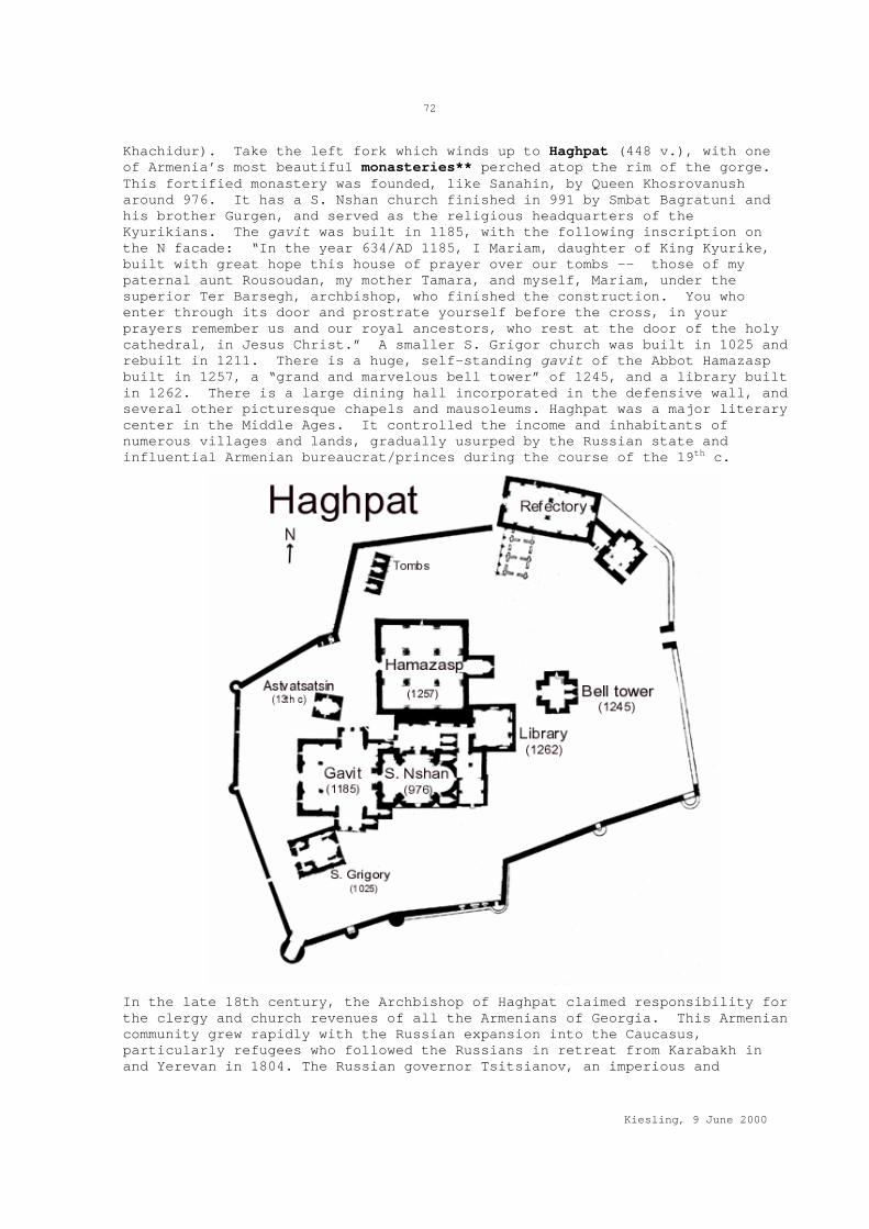
72
Kiesling, 9 June 2000
Khachidur). Take the left fork which winds up to Haghpat (448 v.), with one of Armenia’s most beautiful monasteries** perched atop the rim of the gorge. This fortified monastery was founded, like Sanahin, by Queen Khosrovanush around 976. It has a S. Nshan church finished in 991 by Smbat Bagratuni and his brother Gurgen, and served as the religious headquarters of the Kyurikians. The gavit was built in 1185, with the following inscription on the N facade: “In the year 634/AD 1185, I Mariam, daughter of King Kyurike, built with great hope this house of prayer over our tombs -- those of my paternal aunt Rousoudan, my mother Tamara, and myself, Mariam, under the superior Ter Barsegh, archbishop, who finished the construction. You who enter through its door and prostrate yourself before the cross, in your prayers remember us and our royal ancestors, who rest at the door of the holy cathedral, in Jesus Christ.” A smaller S. Grigor church was built in 1025 and rebuilt in 1211. There is a huge, self-standing gavit of the Abbot Hamazasp built in 1257, a “grand and marvelous bell tower” of 1245, and a library built in 1262. There is a large dining hall incorporated in the defensive wall, and several other picturesque chapels and mausoleums. Haghpat was a major literary center in the Middle Ages. It controlled the income and inhabitants of numerous villages and lands, gradually usurped by the Russian state and influential Armenian bureaucrat/princes during the course of the 19th c.
In the late 18th century, the Archbishop of Haghpat claimed responsibility for the clergy and church revenues of all the Armenians of Georgia. This Armenian community grew rapidly with the Russian expansion into the Caucasus, particularly refugees who followed the Russians in retreat from Karabakh in and Yerevan in 1804. The Russian governor Tsitsianov, an imperious and
73
Kiesling, 9 June 2000
somewhat anti-Armenian Georgian prince, unilaterally transferred this authority in 1805 to the Armenian archbishop in Tbilisi, a pro-Russian ecclesiastic it was easier to keep an eye on. The Archbishop of Haghpat, Sargis Hasan-Jalalean, scion of an ancient family of meliks of Karabakh and brother of the late Katholikos of Aghvank, protested in vain, noting that his brother had been killed and he himself imprisoned by the Khan of Karabakh as a result of their friendly correspondence with the Russians. Archbishop Sargis eventually moved back to Karabakh to become in 1810 the last Katholikos of Aghvank. This Katholikosate, founded (Armenians say) by the grandson of S. Gregory the Illuminator, controlled the religious affairs of the Caucasian Albanians, the pre-Turkic population of what is now Azerbaijan. During the Middle Ages its geographic basis shrank and it became culturally assimilated to the Armenian church. In the 18th century it was a near-exclusive family holding of the Hasan-Jalalean family, operating out of the monasteries of Gandzasar and Amaras in Karabakh. The Russian Empire abolished the Katholikosate of Aghvank in 1815.
Neghuts (199 v., formerly Gomahand) has khachkars and, in the cemetery, 3rd-2nd millennium BC cliff carvings. Crossing the Debed on an unsignposted bridge to an industrial appendage of Akht'ala, heading N, then bearing W, you reach the 13th c. monastery* at Akht'ala (2002 v.), with three churches, the largest to the Mother of God, inside a 10th c fortress. The monastery is thought to be the one attested by medieval writers as Pghndzahank ("Copper mine"), but see Hnevank above. In 1763, King Herakli II of Georgia brought Greek miners to work the ore deposits nearby, and their inscriptions can be found on the monastery walls.. The village has a 13th c. spring monument. By the village was a large Early Iron Age cemetery. Upper Akht'ala has a Greek church. A road W from Akht'ala leads to the copper mining town of Shamlugh, (659 v.) whose deposits have been worked since ancient times (Late Bronze/Iron Age cemetery, one 13th c. cross monument). From Akht'ala, another road runs N on the W side of the Debed to reach Mets Ayrum (611 v.), with a Nahatak (martyr) shrine of 1612 4-5 km NW. Chochkan (1421 v.), the next town NE, was an estate of the Russian-Armenian princely Loris-Melikov family, and has a church built by the Count’s mother. There is a Shportavank of the 17th c. W of the village is a cliff called Timurlenk’s stone. Last village before entering Tavush and Georgia is Karkop (242 v., founded 1936).
Back on the E bank of the Debed, Shnogh (2261 v.) has on its territory various traces of metal-working sites from ancient times. In the village is an ethnographic museum. On a triangular promontory above the Debed is Kaytson Castle, probably founded in the 9th c on the remains of a cyclopean fort. There is a ruined single-aisle church, S. Gevorg church of 1893, the Terunakan shrine of 1222 E of the fort. From Shnogh, a road goes 4 km S to Teghut (501 v.) and its 13th c. Manastefi hermitage, 10-17th c. churches, and a 13-14th c. Vardan Zoravar monument.
Tucked into an inaccessible corner of N Armenia, reachable (the map says) only from the Georgian town of Opreti, the village of Jiliza (182 v.) has on its territory a 13th c. ruined fort and shrine and, in deep forest at 1300 m elevation somewhere on the W slopes of Mt. Lalvar, the architecturally unique Khorakert monastery*. The 11th or 12th c. domed church has a 12-faceted, columnar drum. The gavit was built in 1252 in the days of King David of Georgia by Hovhannes Varnetsi’s son Stepanos. There is a ruined fortification wall, dining hall and, south of two little shrines, remains of a covered passage leading into the gorge. The monastery was restored in 1661 and 1710, but was already in ruins at the beginning of this century.

74
Kiesling, 9 June 2000
West from Spitak (Map I)
A major E-W road and rail route, mostly in good shape, leads from Spitak to Gyumri, following the Pambak river. North of the road are Shenavan (300 v., till 1946 Kiziloran, Azeris), with a cave and a ruined 6-7th c. single-aisle basilica nearby; Sarahart (854 v., till 1950 Gyullija), with two churches, and ruined hamlets 6 km N.; and Gogaran (706 v., till 1946 Gyogarchin), with a 17th c. church, and the Sangyot fort nearby. Before Geghasar (561 v., till 1978 Tapanli), you pass early cave dwellings near the road. There is a 19th c. S. Sargis church in the village. Astvatsatsin shrine is 2 km distant. On August 25, 1807, Karapapakh nomads who used to live there descended on the Armenian settlers and decapitated several, according to a report to General Gudovich. Shirakamut (1631 v., Nalband till 1978) was the epicenter of the 1988 earthquake, with 313 killed. The 7th c. Chichkhanavank N of the village is now a pile of stones. Some 3rd millennium BC graves have been explored nearby. Other villages, from East to West, are: Katnajur (988 v., till 1946 Gharal); Mets Parni (1381 v., in 1807 site of a Russian military post called Bekant, then Beykend, then Parni Gegh), with a 19th c. S. Sargis church; Tsaghkaber (769 v., till 1939 Avdibek); Saralanj (125 v., till 1946 Gyogoghush); Hartagyugh (727 v., till 1946 Ghaltakhji) with a 19th c. church and, 1 km S, a S. Hovhannes shrine and pilgrimage site; Lusaghbyur (658 v., till 1946 Aghbulagh, ruined church); and Khnkoyan (221 v., till 1946 Gharaboya), birthplace of children’s writer Khnko Aper, site of his house museum. The road then crosses the watershed into Shirak Marz.
The Zakarian Lords Zakare and Ivane
A huge number of Armenia's monasteries were built or rebuilt under the auspices of two brothers, the generals and protectors of Queen Tamar of Georgia, Zakare the Amirspasalar (roughly "commander in chief" in Arabic/Persian) and Ivane the Atabeg ("prince's tutor" in Turkish). The origin of the family are obscure -- Kurds by one medieval account, mid-level Armenian lords by another -- but their successful generalship was indisputable. In a series of campaigns from the 1190s to 1220s, they freed Georgia and most of historical Armenia from the Seljuk Turks and reestablished Christian control of the region. Zakare was Armenian Gregorian by religion, his brother Ivane Georgian Orthodox. They were pious, and made sure to record their numerous benefactions in inscriptions on stone. The almost permanently victorious Ivane was ultimately defeated near Garni by Jalal ad Din Mingburnu, the last Khwarezm-Shah, in 1224 (allegedly the Lord of Battles caused his troops to hear the order "Flee!" instead of "Attack!) and died shortly afterwards. The Khwarezm-Shah was himself on the run from forces beyond his control. When the Mongols arrived in 1236, both Zakare's son and heir Shahnshah ("King of Kings" in Persian, a lovely example of the common Armenian use of titles as personal names) and Ivane's son Avag ("Senior") reached fragile and unsatisfactory accommodations with the new world rulers, but they and their descendants held on to substantial fiefdoms until the onslaught of Timur and his hordes.
EXPLORING SHIRAK Shirak Marz, the Northwest corner of Armenia, is defined by the upper flow of the Akhurian river, the NW corner of Mt. Aragats, the Georgian border, and a series of mountains dominated by the 3000 m Mt. Urasar in the East. In spring the rolling treeless hills and rocky outcrops are quietly beautiful. The capital city of Gyumri/Leninakan, since the 1988 the focus

75
Kiesling, 9 June 2000
of international humanitarian assistance, remains depressingly unrebuilt, but is rich in archaeological interest for the specialist. There are many architecturally important churches, such as in Artik, Ani-Pemza, Maralik, and Harich. Marmashen, NW of Gyumri, is a particularly interesting monastic complex. The Urartian citadel at Horom is perhaps the most impressive of its kind in Armenia. The hilly grasslands of the northern part of the marz, once dotted with Azeri villages, have their own bleak charm, and important migratory bird life around the Arpi Reservoir.
Shirak was incorporated into the Russian Empire in 1804, before the rest of Armenia. Alexandropol/Gyumri was a strategically vital garrison town and rail depot in the Czar’s frequent wars against Turkey. The closure of the Turkish border, the terrible condition of the road across the Georgian border, and in particular the earthquake which leveled much of the region, have depressed the region economically and contributed to a major exodus to Yerevan, Moscow, and Glendale.
North to Gyumri -- Horom (Map B)
Taking the main highway from Ashtarak to Gyumri, you enter Shirak Marz on a ridge between Mastara and Lanjik (600 v., till 1947 Muslughlu). Just SW of the village is an Early Bronze Age cyclopean fort/cemetery. A road leads W to Dzithankov (782 v., till 1966 Bagirhana, 19th c. church) and Karaberd (650 v., founded 1829, church, fortress nearby). Shortly before Dzorakap (765 v., till 1935 Boghazkyasan, S. Astvatsatsin church of 1783), a side road angles back SE toward Sarnaghbyur. About 1 km on the right is the Hogevank monastery complex, primarily of the 13th c. Beyond a dam and reservoir rises the village of Sarnaghbyur* (1858 v., “Cold Spring”, till 1940 Sogutlu or Ghzlkilisa). This venerable village derives its name and antiquity from a cave at the back of the village from which flows an ample spring believed to have mystical healing powers. Now walled up (key in house on right), the cave houses a shrine of Gregory the Illuminator. The cave is reached by proceeding through the village (note ornate carved fireplace in ruined house on left) to the substantial S. Tadevos church of 1883, before which one turns left, then the first paved right turn. There is reportedly also a ruined 5-6th c. church of S. Hakob and a S. Karapet church of 1205. On a hill 6 km E is S. Ghazar ruined church of the 5-6th c.
The E side of Maralik has caves, 11-12th c. khachkars, and a church of 1903. Continuing N, the villages of Haykasar (121 v., till 1947 Sivribash), Hayrenyats (373 v., till 1946 Sangyarlu), with 5th c. Karmir Vank church, and Tuffshen (“tuff-built”, 295 v., with 13th c. Tukh Manuk shrine, traces of a cyclopean fort, ruined arch of 6th c.) are E of the road. An unmarked intersection leads W to Gusanagyugh (690 v., till 1977 Ghapulu), named after the famous bard (“Gusan”) Nakhshikar Sargis born here. There is a ruined church of 11th c. in the village and one remaining wall of a medieval castle. W of the village are two Urartian cyclopean forts, at Ghak? and Shvaghtapa. Taking the opposite road E, about 1 km E of the village of Horom (1333 v., S. Hripsime church of 1861) is a dam and reservoir. S of the road, opposite the dam, rise two substantial hills wreathed with impressive Bronze Age through Urartian citadel** walls. Armenian and American archaeologists led by Ruben Badalian and Philip Kohl began excavations there recently, and have found well-preserved walls and a great depth of cultural materials. This is one of the most impressive archaeological sites in Armenia, particularly in the spring when the massive volcanic stones of the fortress are set off by brilliant green grass. Potsherds and obsidian flakes are strewn everywhere.
The road then passes Saratak (766 v., till 1940 Emirkhan, Hellenistic settlement and graveyard), with Lusakert (478 v., 2nd mill BC tombs, 18th c.
76
Kiesling, 9 June 2000
Astvatsatsin church), Hovtashen (221 v., founded 1830 from Kars, just E), and Beniamin (387 v., till 1945 Jlovkhan, renamed in honor of home-town WWII hero, General-Major Beniamin Galstian). On hills near Beniamin, an 80-hectare 8th c. BC through 4th c. AC settlement site was found and excavated in 1989-94, including a 3-2nd c. BC palace, with 5-4th c. BC structures underneath. The excavator believes that this was the seat of the Kamsarakan noble family, which led an insurrection against Arshak II in the mid-4th c. and was almost exterminated in revenge. Azatan (3087 v., till 1945 Gharakilisa) has a Catholic church of 1890 and Armenian Apostolic church of 1860; it was site of an 1826 battle between Russian and Persian troops. East of Azatan are Arevik (1148 v., 19th c. church) and Aygabats (465 v., till 1946 Ilkhiabi). E of the Gyumri road outside Azatan are a cluster of megaliths. On the Ghej hill near Azatan is a 6th c. BC - 1st c. AC settlement.
The town of Gyumri* (officially 120641 v., briefly Kumayri, before than Leninakan, before that Alexandropol) is conspicuous for the large cemeteries, some full of the victims of the 1988 earthquake. Despite many well-intentioned efforts, the economy of the city remains a shambles ten years after the event, with thousands of people still living in “domiks,” converted cargo containers, while newly rebuilt apartments stand empty. There is still a substantial international presence from various assistance projects. In 1926, League of Nations High Commissioner for Refugees Fridtjof Nansen, accompanied by his secretary, fellow Norwegian Vidkun Quisling of later dark repute, visited Gyumri and its huge complex of schools and orphanages sheltering 11,000 Armenian orphans under the auspices of the American Near East Relief.
The main square has a pair of churches, one standing, one a distinguished ruin awaiting reconstruction. There is a reputable European-style hotel, a well-reputed regional museum plus a city museum, the Russian Alexandropol fortress of 1834 on the W side of town, and probably more for the curious urban explorer, though Gyumri was battered in 1926 by a previous earthquake as well. Inside the city limits are several important archaeological sites. By the fortress is the Sev Ghul Chalcolithic through Iron Age settlement. Near the meat factory (by the train tracks) was excavated an Early Iron Age settlement/cemetery. Near the stadium, another Iron Age site had stone molds and a smelter for metal casting. In the NE part of Gyumri, on a hill in the area known as Vardbach, excavations revealed a Roman-period cemetery lying over a Bronze Age settlement. There is a medieval settlement with ruined 7th c. church that has been excavated in the Botanical Gardens. The city was site of a major Russian Army garrison and fortress since its conquest in 1804, a role it continues to play even today. The few thousand Russian troops still based in Armenia serve as a reminder that Russia would intervene militarily were Turkey to invade Armenia. Pending the unlikely event of an invasion, the Russian troops grow potatoes and find other ways to stay alive.
East from Maralik -- Artik, Harich (Map B)
Opposite a huge cotton spinning factory on the edge of Maralik, a decent paved road departs the main Gyumri highway W, bound for Artik. On the W approaches of Pemzashen (1922 v., “Pumice built”) is the 11th c. Arakelots Vank (dirt road to right). Note at the road’s closest approach to the church an interesting massive carved tomb shrine. Back on the main road, turning right and right again into the village, there is a decorated 7th c. ruined church* built abutting the foundations of a 5th c. basilica. Continuing past this church up the hill in the direction of Lernakert, you pass Makaravank*, dating to the 10-13th c, with S. Sion church of 1001. In the gorge below the monastery, reached by a steep, rock-cut path is an 18th

77
Kiesling, 9 June 2000
c. small church built on earlier foundations, and a hermit’s cell (?) cut in the cliff.
The village of Lernakert (807 v.) is remarkable for its traditional stone houses, mostly now in disrepair. Bearing left at the little square and climbing, one eventually reaches a simple 5th c. basilica* church with immensely thick walls, now used for storing hay and dried dung. There is a Poghos-Petros Khachkar shrine, and two cyclopean forts S of the village.
Coming into Artik (14240 v.) on the road from Maralik/Pemzashen, turn left at the entrance of town, then right on the flyover across the railroad tracks. At the town square (WWII monument), continue straight up Tonakanian St. to where the two adjacent early churches appear on the left: Marine or Astvatsatsin Church, 5th c.; S. Gevorg church, 7th c.. Both are ruined, with restoration interrupted by the collapse of the USSR. There is also an 18th c. church in a cave in a gorge 1 km SE in direction of Harich. Catacomb type tombs of the 14th-9th c.BC have been excavated near Artik as well. The well-preserved Lmbatavank church of the 7th c. stands on a hillside just SW of Artik (S. Stepanos church, important wall paintings). Some interesting 18-19th c. houses also survive in Artik.
Driving E from Artik along the main road toward the village of Harich (673 v.), Harichavank* is reached by turning right before the prison. The main church has on the N wall the following inscription: “By the grace and mercy of mankind-loving God, I Zakare Mandatorta Amirspasalar of the Armenians and Georgians, son of the great Sargis, made this donation to the famous holy monastery of Haricha, for the benefit of its natural tenants, for the long life of my master the pious Queen Tamar and for my safety and that of my brother Ivane and our children Shahnshah and Avag, and my parents. I built here a castle and cathedral at great expense and decorated it with plate and sacred objects of every kind. And my village Mokoris, which was near the holy monastery, I offered to the Holy Virgin, with all its lands and mountains and waters. And I gave a mill called Divaghats at Getik, a mill at Glidzor of Ani, and a garden at Tsaghkadzor, a garden at Yerevan and a garden at Talin, and I established the rule that the mass at the main altar always be celebrated in my name. Written in the year 750/AD1201.” The brothers Zakare and Ivane are figured on the E facade of the church. The St. Gregory church abutting at an angle the gavit of the main church was built perhaps as early as the 7th c. over a rock-cut tomb (?) and may have been originally a martyr’s shrine. The site became in 1850 the summer residence of the Katholikos, with substantial 19th c. monastic architecture. One of the modern buildings houses a small museum. Across the gorge from the monastery is a 3rd millennium BC fortress and tomb field.
North of Artik are Nor Kyank (981 v., till 1940 Mejitli, with ruined 6-7th c. Grigor Lusavorich church) and Anushavan (1296 v., till 1969 Bekyand or Parni Sultan, with S. Gevorg church; named after Dr. Anushavan Galoyan, dead WWII hero). In 1988, a hill-top fortress was excavated near Anushavan, dating from the 2nd c. BC to the 2nd c. AC. West of Harich is Saralanj (653 v.), with a 5th c. ruined basilica. To the S, Nahapetavan (508 v., till 1935 Khachakilisa, till 1961 Paros, renamed in honor of its local hero, Nahapet Kurghinian, a participant in the May 1920 Bolshevik uprising) has a 6th c. S. Gevorg church. Mets Mantash (1378 v, till 1935 Mets Arkhvali, an old settlement with traces of early churches, and center for propagation of the medieval Tondrakian heresy). Pokr Mantash (1386 v., church of 1864) From Mets Mantash, a road leads WNW to Arevshat (1104 v., till 1948 Yekanlar). The 14-15th c. church, rebuilt in 1873, had in earlier times a fortress nearby. Spandarian (882 v., till 1946 Gyullija, renamed for the Armenian revolutionary) has a ruined church, an Iron Age fort and,

78
Kiesling, 9 June 2000
on a nearby cliff, an Urartian cuneiform inscription of King Argishti I. N of Spandarian is Geghanist (708 v., till 1948 Chanki Tapa or Ghovlughat, church of 1852). W of Spandarian are Getapi (486 v., till 1940 Ghasm-Ali), Panik (731 v., till 1924 Kyavtarlu, named in honored of Bolshevik agitator A. Panian) with a 19th c. church; Vardakar (316 v., till 1946 Tomartash, Bronze Age and medieval ruins, including khachkar shrine, nearby) and Meghrashen (798 v., till 1946 Ghazanchi), with church and khachkars.
Up the Akhuryan -- Yereruyk, Ani Overlook (Map B)
Approaching Shirak via the border highway from Armavir, you enter the Marz just after the village of Tlik. A faded metal pillar commemorating a now-forgotten Party Congress marks the turnoff for the village of Ani-Pemza (312 v., till 1938 Kzkule) on the Akhurian river gorge. The village gets its name from the pumice mines nearby, which bury the town in fine dust. Approaching the village, you see on the right the imposing remains of the Yereruyk basilica* of the 5th c.; there is an early Iron Age cemetery in the valley just N of the basilica. Back on the main road, turn left on a narrow paved road just after the little village of Ani kayaran (Ani Station, 294 v.). The road winds to a military checkpoint manned by Russian border guards, half of them Armenians under contract. With prior permission from the Foreign Ministry, or a pleasant smile and good story or (supposedly pending) a policy change on access to the closed zone, you may be allowed to drive to an overlook point W of the settlement of Kharkov, from which the churches and palaces of the medieval Armenian capital city of Ani** are laid out on a promontory a few hundred meters and many centuries away across the Akhurian river gorge in Turkey. The sight is unforgettable, particularly in late afternoon.
Saved from stone-robbers by its remoteness, Ani preserves the finest assemblage of Armenian architectural remains in the world. A stronghold of the Kamsarakan family from the 4th century, Ani rose to prominence around 953, when the Bagratid King Ashot the Merciful, having failed to dislodge the Muslim emirs from their capital at Dvin, made the defensible and scenic town of Ani his seat. Trade flourished. Katholikos Sargis moved his own seat here in 992, amid an ambitious building program of churches and palaces. Alas, the period of prosperity was brief. Squeezed between the Byzantine Empire and the Seljuk Turks, the Bagratids lost Ani to the Emperor Constantine Monomachus in 1046. Then in 1064 Ani was captured and plundered by the Seljuk Sultan Alp-Arslan. In 1074, he sold the town to the Shaddadid emir Manuche, scion of a successful clan of Kurdish adventurers. Three generations of Shaddadids tolerated and taxed a prosperous Armenian population, but they were in 1199 driven out along with the Seljuks by the Georgian/Armenian brothers Ivane and Zakare. This new Christian ascendancy and wave of building was cut short by a Mongol invasion in 1239. Life continued under the Mongols and their successors, the town growing gradually poorer but with its churches still maintained. Tamerlane's invasions in 1400-1403, and the shift of the trade routes, brought Ani to desolation.
Bagravan (511 v.) is named for an ancient Armenian religious site on the far side of the river near Yervandashat. A road leads NW from Bagravan Station to Haykadzor (292 v. till 1950 Ghzlkilisa, “Red Church,” named for Horomos Vank across the Akhurian river), which preserves in the village S. Grigor Lusavorich church of 985, restored in 13th c. Jrapi (588 v.) is near the Akhurian reservoir built jointly with Turkey in late Soviet times. The water is split 50-50. Building of the dam meant the removal of Upper and Lower Jrapi, till 1947 Chirpli and Keghach. A ruined medieval bridge on the Akhurian is now under water, but an 11th c. caravansaray was rebuilt by new Jrapi. There is a church of 1874 and, 1 km S of Jrapi, a 1st millennium

79
Kiesling, 9 June 2000
BC graveyard. E of the road is Sarakap (388 v., till 1935 Bozdoghan), which has a 6-7th c. S. Astvatsatsin church, rebuilt in 1885. 6 km SE is a ruined 7th c. church called Karmir Vank or Ghr'ichi Vank. Aghin (387 v.) has a S. Hakob church of 1878.
Several km E is Bardzrashen (till 1947 Baburlu), with a 7th c. S. Astvatsatsin church and, nearby, a Poghos-Petros hermitage. Beyond the Bardzrashen turnoff is the new village of Isahakyan (652 v., till 1945 Ghazarabad -- Ghazar Aga led the village in a successful defense against the Persians in 1826-28; earlier name was Kharum), then Lusaghbyur (365 v., till 1945 Sufanverdi). Shirakavan (539 v., till 1950 Davshanlan) is the new town built to replace the old, flooded by the reservoir. South is the site of Sevakn on the confluence of the Akhurian river and Sevakn creek. The site was excavated in 1977, and revealed a substantial cult site of the 2nd c BC to 3rd c. AC, showing cultural links with both Rome and Persia. The site is now partly flooded by the reservoir, as is a Stone Age site with mammoth bones, but a cyclopean fort remains on a hill above. There is or was a large church nearby. However, the original site of the medieval city of Shirakavan or Yerazgavors, famous as the seat of the Bagratuni family in the 9th c. before they moved to Ani around 961, was on the far side of the Akhurian river at Bash-Shoragyal. Bayandur (475 v., the original site, ruined in the 1926 earthquake, had Armenian and Greek churches); Erazgavors (945 v., “Deer Hunter”, till 1945 Aralikh, then resuming the other medieval name of the Bagratid capital Shirakavan) has sparse medieval remains, including of two fortresses, one in the village and one W on the stream bank, and a 9th c. church. Getk (353 v., till 1945 Daharlu) had two churches destroyed in the 1926 earthquake. Gharibjanian (479 v., Gharakilisa, then Alexandrovka, renamed in 1935 in honor of Bagrat Gharibjanian, 1890-1920, a Bolshevik revolutionary imprisoned by the Dashnaks after the failed May uprising and later shot in reprisal for the execution of two Dashnaks -- his house museum is in Gyumri) has a ruined modern church. Between Gharibjanian and Akhurik, the Akhurik railroad station has a special facility, completed just before the collapse of the USSR and never used, for lifting train cars off their wheels and changing the undercarriage from Soviet to European gauge, to allow trains on the Gyumri-Kars rail line to make the transition between two incompatible rail systems.
Gyumri East toward Spitak (Map M)
The main West-East road to Spitak, once and potentially in the future an important transportation route from Kars to Tbilisi or Baku, leaves Gyumri to the NE, passing first through the village of Shirak (582 v., till 1940 Ghonaghkran, this earlier name in popular etymology meaning “guest-killer,” after a legendary incident when the locals, warned of their guests’ evil intentions, massacred a group of Persian soldiers quartered in their houses). There is a S. Hakob church and S. Minas shrine. Jajur (501 v.) has the house-museum of the painter Minas Avetisian (1928-1975). Paleolithic tools have been found on the territory. The road continues over the Jajur Pass (1952 m) to Lori Marz. North of Jajur is what looks to be interesting country: Lernut (148 v., new church W, medieval remains 1 km W); Jajur kayaran (RR station, 205 v.); Krashen (187 v., till 1945 Aghkilisa) has a church of 1859; Mets Sariar (255 v.) has a 19th c. S. Nshan church which used to house several early manuscripts. From Mets Sariar, the map shows a bad road winding NE through difficult terrain to Pokr Sariar (157 v., 19th c. church) on the Chichkan river; thence Kakavasar (93 v., till 1978 Kefli) with ruined Karmravor church of the 7th c. just W, and remains of cyclopean fort; then Sarapat (95 v., till 1946 Samrlu), and Dzorashen (162 v.), which has a rebuilt church of 1863 and ruined S.

80
Kiesling, 9 June 2000
Stepanos monastery of 12-13th c., and remnants of a 10th c. AC fortress. The road then connects to Saralanj, in Lori Marz.
The road leaving Gyumri heading East passes through Akhurian (6668 v. till 1945 Duzkent, capital of the former Akhurian rayon) and Karnut (549 v., till 1946 Diraklar), this latter with Early Bronze Age ruins on a hill nearby and, to the NE, a ruined church probably built on the site of a pagan temple in the 4-5th c and rebuilt in the 10th. About 1 km N are remains of a 8-7th c. BC dam. The road N from Karnut leads to Kamo (815 v., till 1935 Haji Nazar, Astvatsatsin church of 1878, named for a romantic but somewhat unsavory revolutionary bank robber). Two km NW is Chataljur medieval settlement and Khacher Hellenistic site.
Near the reservoir S of Karnut are Hovit (335 v., with khachkars 2 km E) and Musayelian, (1084 v., till 1935 Mets Kyapanak, renamed in honor of Sargis G. Musayelian, a captain who committed his troops and armored train to the May 1920 Bolshevik uprising against the Dashnak government in Alexandropol/Gyumri. Sentenced to death when the May uprising collapsed, Musayelian was reprieved, but then shot by vengeful Dashnaks after the torture and execution of two Dashnak leaders by the Red Army in Zangezur); church rebuilt 1842. Beyond Musayelian, the road looks as if it peters out at Jrarat (732 v., till 1945 Chirakhlu). There is a small ruined 6th c. church of S. Minas, and remains of a cyclopean fort.
West of the Akhurian River (Map M)
A turn W in Gharibjanian leads to the village of Akhurik (798 v., till 1935 Gharakilisa Turki). From there, a muddy track leads to the border fence and what was once a road crossing point into Turkey, now closed. Northeast from Akhurik is Arapi (1202 v., till 1946 Ojakhghuli), which has on its N side a spot sacred to the Virgin Mary. SW is a site with cyclopean remains and mammoth bones. There is a Hellenistic cemetery 1 km S. The road N from Akhurik goes to Voskehask (1664 v., till 1947 Musakan, cyclopean fort 1 km NE), Haykavan (830 v., formerly Bajoghlu), then Voghji (313 v., till 1991 the Azeri village of Oghjoghli), Meghrashat (268 v., till 1946 Gharamahmet, church of 1868), Gyulibulagh (500 v., ruined church 1 km S of village), Kamkhut (formerly Chakhmakh, 7th c. church in village), Gtashen (215 v., formerly Magharajugh), and Aregnadem (162 v., formerly Azizbekov, till 1939 Gharachanta), joining up with the road to Arpi Reservoir in the far NW corner of Armenia.
The Northwest Corner -- Marmashen Vank (Map M)
Leaving Gyumri on the main N road, turn left at a restaurant just past a set of post-earthquake international housing projects. A bad paved road passes the village of Marmashen (1212 v., until 1946 Verin Ghanlija). At the far end of Vahramaberd (696 v., 12-13th c. church in village), the next village, turn left, then follow the dirt road back along the gorge and then descend (right fork) to Marmashen Vank**. This impressive monastic complex sits on a picturesque shelf with fruit trees above the Akhurian River, beside a stream that ends in a waterfall. The Katoghike church of S. Stepanos was built by Vahram Pahlavuni, whose gravestone sits in the ruined gavit, between 988 and 1029. The gavit itself is 13th c. There is an Astvatsatsin church, and a S. Petros, and archaeologists found remnants of a fourth, nearly circular church, along with foundations of a pre-Christian temple and many service buildings. The complex was ruined by the Seljuks, and rebuilt by Vahram’s grandsons. On the hill N is a cemetery with a ruined chapel. There is a bridge probably of the 10-11th c. on the Akhurian nearby. Across the river, near an abandoned medieval settlement, are Bronze Age graves.

81
Kiesling, 9 June 2000
Retracing steps up to the rim of the gorge and continuing S on the dirt road skirting the gorge, one sees a basalt knob and scarp WNW of Marmashen village. Descending a few feet into the gorge, one finds about 40 meters NW of the power lines a perfectly preserved Urartian inscription of Argishti I (730-714 BC) carved into the basalt. Above it are sparse ruins of an Urartian stronghold. The main road continues N (in doubt take the right fork) to Kaps (405 v.) and then crosses the Akhurian to reach another road N, with Jradzor (201 v., rebuilt 19th c. church) on the right hand. 1.5 km SE is a cyclopean fort. A road goes E from Jradzor to Hoghmik (301 v.), on whose territory, on a plateau on the left bank of the Akhurian river, a Hellenistic settlement was excavated. There are Bronze Age and medieval burials as well.
The road forks in Amasia (1372 v.) district capital, NW is “Chatin Dara” ruined fortress. A road E leads to Bandivan (171 v., ancient fort remains E of village on plateau) and, N from Bandivan, Hovtun (116 v., till recently Baitar, before Alakilisa, originally Azeris, then Greeks, now Armenians). The road from Amasia to the NW passes through low, rolling pasture lands to reach near the villages of Berdashen (144 v., till recently Tapakoy, ruins of old church, cyclopean fort) and Paghakn (once Shurabad), the Arpi Reservoir, created by a dam at the source of the Akhurian river. This reservoir is a major way station for migrating birds in season. All the little villages around it used to be occupied by Azeris until 1988. Zorakert (61 v., formerly Balikhli, ruined fort a little NE) Tsaghkut (91 v., once Gyullija, with medieval fortress 2 km E); Yernajur (30 v., Chivinli); Garnarich (130 v., Kuzeykend); Shaghik (57 v., till 1991 Karabulagh); Zarishat (49 v., Konjali); Yerizak (formerly Ibish, before that Aychinkil). Opposite the turnoff for Yerizak, a road leads NE to Alvar (86 v., till recently Duzkend, ruins of church); Aravet (formerly Chaibasar); Pokr Sepasar (100 v., cyclopean fort, 17-18th c. church); and Mets Sepasar(567 v., 10th c. church in village). A dirt road N of the Akhurian leads E from Berdashen to Ardenis (59 v., formerly Gyollu) and Aghvorik (44 v., till recently Yeni Yol “New Road”, till 1935 Gharanamaz), then joins the main road N to the border near Tavshut. About 1.5 km from Aghvorik toward Tavshut is an obsidian outcropping with an assortment of stone tools.
North Toward Akhalkalakh (Map M)
The main road N from Gyumri toward the Georgian border passes through Mayisyan (1078 v., till 1946 Ortakilisa), named for the failed May 1920 Bolshevik attempt to seize power. In the village is a 7th c. S. Astvatsatsin church of red and black tuff, with inscriptions. Off to the E is Hatsik (701 v., till 1949 Taparlu) with old church, cemetery and, 1 km NE, unspecified holy place. N of Hatsik is Karmrakar (44 v., till 1946, Gharaband) with two ruined churches and pre-Christian fort remains nearby. Beside the road entering the village is a 2-4th c AC graveyard. A spur road N of Mayisyan leads to Hovuni (412 v., till 1945 Yasaghul). Keti (634 v.) has Bronze Age settlements, one by the stream at the NE of the village, the other SE. There is a shrine and church. Some 2 km NW in a fold of the hills is another Bronze Age site. The road then passes Pokrashen (128 v.), after which a turnoff right leads to Arpeni (236 v., till 1978 Palutlu, 19th c. church). Next turnoff left goes to Goghovit (254 v., till 1978 Taknalu, church of 1860) and Hoghmik (see below).
The road next reaches Torosgyugh (204 v., once Gyurjiyol, Astvatsatsin church of 1865), Tsoghamarg (347 v., medieval church and cyclopean fort nearby), and Vardaghbyur (59 v., once Gyullibulagh “Rose spring”). At Vardaghbyur, the road forks, the right branch leading to Musayelyan (226 v., till 1946 Boz gyugh) with S. Trdat church of 1896. The road then

82
Kiesling, 9 June 2000
switchbacks over the mountain (not passable until May) some 35 km to Tashir, through a beautiful, stark, treeless landscape. The first road right after Vardaghbyur leads S to Salut (50 v., once Skut) and Bashgyugh (51 v., church). NNW of Musayelian is Hartashen (121 v., till 1946 Dyuzkharaba, church).
The main road N from Vardaghbyur leads to (on left) Karmravan (151 v. till 1935 Ghzlkilisa, church) and (on right) Zuygaghbyur (262 v., till 1946 Chiftali, ruined 19th c. church). Beyond is the capital of the former Ghukasian Rayon, Ashotsk (1733 v., till 1938 Ghzlghoch, church). Ashotsk, renamed recently for the medieval name of the area, had been named in honor of young militant Ghukas Ghukasian, a Spartacist firebrand, head of the Kars Revkom in the May 1920 Bolshevik uprising, killed by “Mauserists” while attempting to flee the collapsed revolt). Krasar (272 v. till 1946 Kurdbulagh) is off to the SW.
Ghazanchi (370 v.) has an two old settlement sites, Urmi gerezmanner and Karvasara, with remains of a 10-11th c. church, etc. Left of the road is Tavshut (245 v., till 1967 Tazakend), and Sizavet (199 v., till 1946 Korbulagh, then till 1967 Tasghkashen) is on the right. East of Sizavet is an obsidian outcropping with early stone tools, beside a Bronze Age settlement. Bavra (326 v., once Titoy Kharaba, ruined in a 1958 earthquake) has a cemetery SW; has old Arabic tombstones. The main road continues N into the poor, remote, largely Armenian-inhabited Georgian districts of Akhalkalaki and Akhaltsikhe, over a terrible road. A spur NE from Bavra leads to Saragyugh (125 v., till 1946 Darakoy).
EXPLORING SYUNIK Syunik Marz contains some of the most dramatic scenery in Armenia, and is home to some of the most important historical and cultural remains. Little explored archaeologically, the region, is a wilderness of high mountains cut by huge, deep river gorges. The southern tip of the country, around Meghri, can be reached now only over a high and often foggy or snowy pass, its normal, easy access through Nakhichevan along the Arax River now cut off by politics. The roads are being steadily improved, but you should count on a full day to reach Meghri from Yerevan. Unquestionably, however, the trip is worth it, in terms of natural beauty and cultural riches.
Important destinations in Syunik include Tatev Monastery, the spectacularly sited religious capital of S. Armenia, Vorotnavank, Vahanavank, the standing stones near Sisian, the medieval cave-dwellings of Khndzoresk, and nature preserves such as Sev Lich and Shikahogh. The little hotel in Sisian, though shabby, is a clean and satisfactory place to spend a night or three. The hotel in Kapan is adequate. Every road offers beautiful streams or sacred spring sites, often with covered picnic tables, by which to pitch a tent.
Due to its rough terrain and isolation, Syunik stayed relatively autonomous under the control of local Armenian notables (see the Orbelians in Vayots Dzor below) long after the rest of the country had been incorporated in Mongol, Turkish or Persian fiefdoms. It was a hotbed of insurrection under Davit Bek (see below), and the last redoubt of independent Armenia in 1921 under Garegin Nzhde.
A note on safety: Though a cease fire has held since 1994, occupied areas of Azerbaijan should be avoided. However, the area along the eastern border of Syunik is now nowhere near the contact line, and seems safe. Though rare, there have been incidents in the mountains that separate
83
Kiesling, 9 June 2000
Syunik from the Azerbaijani enclave of Nakhichevan; hikers should thus steer away from that particular watershed.
EXPLORING SYUNIK (updated 8/06, JBK) Syunik, Armenia's southernmost marz, contains some of the country's most dramatic scenery, high mountains and alpine pastures cut by the deep gorges of the Vorotan and other rivers. The region takes its name from a local dynasty, the Syuni, who ruled Syunik and the neighboring districts from before the 4th century AD until their line was ended by the Seljuks in the 12th century. Early in the 13th century Syunik was handed over to the Georgian-Armenian noble family of the Orbelians (see VAYOTS DZOR). Though occasionally devastated by invasion or earthquake, Syunik was protected by its mountains. The region thus enjoyed a high degree of autonomy under Persian, Arab, Mongol, Turkish or other overlords. Syunik was a hotbed of insurrection against Ottoman occupiers in the 18th century under Davit Bek, and was the last redoubt of independent Armenia in 1921 under Garegin Nzhde and the Dashnaks. There was little study of the region's rich history during Soviet times. Systematic archaeological exploration of the region has begun since 2000, with promising results. The capital of Syunik is the mining town of Kapan. Important destinations in Syunik include Tatev Monastery, the spectacularly sited religious capital of southern Armenia, Vorotnavank, Vahanavank, the Zorats Karer standing stones near Sisian, the Ukhtasar petroglyps, the medieval cave-dwellings of Khndzoresk, and nature preserves such as Sev Lich and Shikahogh. The main cities, Sisian, Goris, and Kapan all have museums and decent places to spend a night or three. Every road offers beautiful streams or sacred spring sites, often with covered picnic tables by which to pitch a tent. Substantial road improvements since 1999 have made Syunik easier to reach. In Soviet times the railroad and main imperial highway ran down the Arax valley to the southernmost city of Meghri through Nakhichevan. With the Azerbaijan border closed, Meghri is no longer a three-hour drive from Yerevan. Now, the Iranian border is at least eight hours away, with two dangerous mountain passes and the deep gorge of the Vorotan River to cross. The road connecting Sisian to Yerevan used to veer south into Nakhichevan to cross the mountains via a lower pass. Now the trip can be agonizingly slow and difficult in bad weather. Bring extra food and clothing even in August, and plan on not driving after dark. Unquestionably, however, the trip is worth it, in terms of natural beauty and historic interest. The border between Syunik and the neighboring provinces of Azerbaijan was in Soviet times fairly arbitrary, despite Stalin's best efforts as Nationalities Commissar in 1922. It
84
Kiesling, 9 June 2000
is thus easy to wander unknowing into occupied territories. This is probably a bad idea. The northern and eastern borders of Syunik are safely remote from the military contact line, but there are occasional incidents in the mountains that separate Syunik from the Azerbaijani enclave of Nakhichevan. Hikers should thus steer away from this particular watershed, but there are plenty of others. Entering Syunik – The Syunik Highlands Access to Syunik is via the highway S down the Ararat valley to the Erashk traffic circle and then east along the Arpachay through Vayots Dzor. This road – Armenia's vital connection to Iran and Nagorno Karabakh -- is kept in good repair thanks to generous contributions from the Armenian diaspora. Still, figure on more than three hours of intense driving to reach Sisian from Yerevan. At the summit of the pass from Vayots Dzor, the border with Syunik is marked by a huge modern stone monument, the Gates of Zangezur, with a little spring. A little way beyond the pass are metal sheds and dirt piles left over from construction of the Vorotan tunnel. Begun in 1982 but only completed in 2003, this 22-km tunnel takes water from the Vorotan (once the Bazarchai) River, the dominant feature of North Syunik, and uses it to restore the water level of Lake Sevan. Entering the Vorotan watershed the landscape changes dramatically. North of the highway, rolling grasslands rise toward a cluster of geologically recent 3000-meter volcanoes along the border with Azerbaijan. From mid-June until mid-October, families from the local villages camp in the little valleys to pasture their sheep and cows, cut hay, and keep bees. In October they drive their flocks the five-day journey to winter pasture in the (occupied) Azerbaijani lowlands of Qubatli. In many respects this life has changed little from the three thousand years before, when their remote ancestors left little mounded tombs on many of the grassy hilltops. The village of Gorayk (600 p, also Gorhayk, formerly Bazarchai) stands just before the Spandarian artificial reservoir. Opposite the northern part of Spandarian reservoir 2 km south of where the Goris highway crosses the Vorotan river, an unsignposted dirt road (four-way intersection at N39 40.96 E45 47.97) leads N into this beautiful alpine country. In dry weather (July through September), a Niva or the like can reach the dramatic obsidian cliffs of Mt. Basenk, Sevkar (formerly Karakhach) and Satanakar (formerly Davagyoz). Basenk is the nearest but least impressive obsidian site. Its cloudy gray obsidian chips too unpredictably for stone tools. From the highway, take the right fork at 0.8 km, and bear right again at approx. 8.6 km. The obsidian outcropping shows across a little valley (N39 45.36 E45 51.16).

85
Kiesling, 9 June 2000
The western flanks of Sevkar provided fine, almost transparent black (or mottled black/brown/red) obsidian for Neolithic and Bronze Age toolmakers. Some of their wares were exported as far as Iran. At approximately 8.2 km on the road toward Basenk, a track forks left, generally paralleling a modern water pipeline to Goris, and leads ultimately (ca. 14 km from the highway) to a major spring underneath the Sevkar cliffs (N39 46.70 E45 47.40). Mets Satanakar is strikingly beautiful, a massive obsidian cliff with obsidian boulders two meters long. It is well worth the effort to get there. One workable route takes the left fork (0.8 km from highway), then bears right at the ensuing fork (ca. 6.4 km), then follows the main track to the end, from which it is about a 3 km walk NE across rolling grassland to the cliffs (N39 49.10 E45 48.74). The ride is bumpy, the weather unstable, and the reward for hammering on obsidian is nasty cuts on your eyeballs – obsidian is the sharpest natural substance you will ever encounter. In 2003 the eminent vulcanologist Sergei Haikevich Karapetian surprised a bear in its cave in the gorge west of Sevkar, and earned some impressive scars. Wolves have also been spotted. So bring lunch, warm clothes, eye protection, sunscreen, and an unthreatening but resolutely un-food-like attitude. If offered hospitality by a local shepherd, accept it – the dairy products. lavash, and homemade mulberry vodka are delicious. Back on the main highway south of the reservoir is Tsghuk (405 p, formerly Borisovka, Murkuz). About 1 km N of the next village, Sarnakunk (540 p), a clay pot was found in 1945 with a coin hoard including coins from Alexander the Great to Mark Antony (who captured Armenia briefly in 35 BC). This is the richest classical find ever from southern Armenia. Somewhere near Satanakar, at about 3000 m near the headwaters of the Vorotan river, petroglyphs (in Armenian itsagir "goat-writing") are hammered into the dark "desert varnish" that covers the exposed face of basalt boulders. These prehistoric line-drawings occur on thousands of boulders all along the ridge line further to the E. The most common drawing is of wild sheep or goats with big, curved horns, but deer, horses, wolves, bears, and their human hunters are also depicted. The exact dating of the petroglyphs is unknown, with guesses ranging from 5000 to 2000 BC. The most important petroglyph site in Armenia is 25 km SW in the saddle of Ukhtasar ("covenant/pilgrimage mountain" but often written Ughtasar -- "camel mountain", N39 41.20 E46 03.25). This was clearly a favorite campsite for prehistoric herding/hunting parties roaming the grasslands N of the mountain range. In the boulder field around a little lake are

86
Kiesling, 9 June 2000
hundreds of petroglyphs. The air at 3300 m is clear, the views memorable, and the little volcanic crater lakes just W show bear tracks in the mud to remind us that the gap between these simple hunter/shepherds and ourselves is not always as wide as we believe. Be very careful when camping. The desert varnish in which these artworks are etched is fragile. Their only protection from modern vandals is the extreme difficulty of access. The track starts from the little hamlet of Iskhanasar (204 p, through the 2001 census Ghzljugh, though its Azerbaijani population has been replaced by Armenians). Take the right turn in front of the village store and bear generally NE. However, the odds are heavily against finding the right track without a local guide, available in Sisian. Typically the driver (e.g., Sasun Baghdasarian at 093 821472, some English; Arshak Sahakian, 093 842819) charges 30000 dram for himself and his sturdy Willys. Figure at least 3.5 hours of bone-jarring tracks, plus the time on site. Angeghakot and Environs (Map L) The modern village of Spandarian (445 p, named for the famous Armenian revolutionary, till 1939 Meliklu or Kalachik) is a nondescript cluster of houses. In the Vorotan gorge below it, a difficult scramble down wet, overgrown slopes, is a ruined 5-6th c. basilica church of good ashlar masonry in the middle of the original village. The church was crudely repaired and roofed in the 19th century. It has 14th century khachkars, tombstones, and a few reused blocks from some other grand early structure. South toward the Vorotan and across a little stream is a small ancient blockhouse with walls two meters thick. Its date is unknown, but it must have guarded one of the few points where the Vorotan is easily fordable. It also gave the name "Berdik" (little fort) to the old village. Allegedly there is an Islamic cemetery on the hillside SE. Angeghakot (1739 p) is a sprawling village athwart the pre-1980 highway on the cliffs overlooking the Vorotan River. Judging from obsidian tools found on the slope below the east end of the village, the caves below the modern village have been inhabited from later Paleolithic times. The name is allegedly a reference to a pre-Christian divinity named Angegh. Inside the village, the earliest datable remains are the lower walls of a small but substantial church, possibly as early as the 5th c, on the west side of the village below the road. This is now a nameless and neglected shrine. The adjacent plot is full of medieval tombstones. On the cliff edge below is an unornamented late 18th or early 19th century S. Mariam Astvatsatsin church, refurbished by a Sisian businessman in 2006 and served by Father Grigor. A few meters above it to the NW is a tiny cemetery and an odd medieval tower house now called the "Zeythan" or "oil press." Along the
87
Kiesling, 9 June 2000
road east of S. Astvatsatsin is a cluster of medieval khachkars. Continuing 300 m further southeast on the cliff road to the last houses, a foot path leads down to S. Stepanos church with a good khachkar of 1283 built into the front wall. An inscription credits the building of the church to Master Panos the son of Reverend Vilusi, with a partly obliterated date of 1708. Further E, in the gorge just below the town, completely hidden behind a modern stone-cutting plant, is an impressively ancient roofless S. Hazaraprkich (“Savior of Thousands”) church. The N wall is bedrock with many crosses carved in it. In the church are several medieval khachkars. In 1699 an enterprising local figure named Israel Ori convoked a meeting of eleven Armenian meliks at the fortified house of local notable Melik Safraz to draft a petition to Czar Peter the Great, the Pope, and other potentates asking their intervention against Armenia’s Persian overlords. He was ignored by the pope, and thrown in jail by the Russians for his trouble. Traces of that period, including a couple of water mills and one substantial late medieval ruined mansion, spread on the slopes below the S. Astvatsatsin church. There are also at least six small caves, some of them now shrines. In the 18th century the population of Angeghakot became largely Turkic. The village was refounded in 1829 by Armenians expelled from the Persian empire in reprisal for the Russian conquest of Armenia. Angeghakot is surrounded by Bronze Age and later tumulus graves. A few hundred meters east of the village, on a path serving a series of rock shelters below the cliffs, is a large cave with a spring below. Deep test trenches and sherd scatter suggest thousands of years of human occupation, but now the cows prevail. West from Angeghakot the lower fork of the road leads SW toward Shaghat. One km along on the right, a footpath leads up to a rough medieval church of S. Vardan nestled against the cliffs on a terrace overlooking the Vorotan valley. The shrine, made of massive unworked blocks butted up against a small cave and rock shelter, is still a pilgrimage site. According to village tradition, the defeated Armenian army stopped to rest here after the battle of Avarayr in AD 451, carrying the body of their martyred general Vardan Mamikonian. There are picnic tables above, and a small group of khachkars, including one dated 1298. The next right fork leads up to a small valley, Maturadasht, with scant remains of a medieval church nestled among robbed-out early graves and walls. Up the track is Karanli cave, with traces of early habitation, and a Chalcolithic and Iron Age site excavated in 2005-6 by archaeologist Pavel Avetisyan. Further up the gorge of the Vorotan is a pair of boulders with prehistoric petroglyphs.

88
Kiesling, 9 June 2000
The main road crosses the Vorotan to the modern village of Shaghat (1018 p). According to Stepanos Orbelian, the original Shaghat, which may or not be in this location, became the religious capital of Syunik under Prince Babik in the late 4th century AD. His father Andovk, hereditary lord of Syunik, had grievously offended King Shapur II of Persia (309-379), by treacherously plundering one of his cities while Shapur was dealing with the Huns. Shapur, determined to assert Sasanian predominance in Armenia, sent his army to Syunik. Andovk fled to Constantinople while his subjects scattered. Before they did so, they concealed their valuable relics and other religious treasures in the domed church of Surp Stepanos (St. Stephen the Protomartyr) and then, the legend has it, disguised the church as a hill of dirt. Years later, Babik managed to redeem his family in Persian eyes through heroism in the Shah's wars. Having reclaimed his feudal rights in Syunik, he then rediscovered the buried church, allegedly while hunting a deer, when his horse got its hoof stuck in a hole. The church then proved its holiness through a series of miracles. Shaghat, however, was also on the main invasion route. The bishopric moved to Syuni Vank in Sisian, and then in the 9th century to the more defensible site of Tatev. Modern Shaghat boasts only a 19th century church of S. Gevork, precariously split by a 1978 landslide that forced most villagers to move to more stable soil N in the Vorotan valley. On the hills around are faint but important remains from the Bronze Age and later. In 2005-6 a joint U.S.-Armenian team under the auspices of the Joukowsky Institute for Archaeology and the Ancient World at Brown University excavated one room of an Iron Age hilltop citadel and interesting traces of a Middle Bronze Age (2000-1500 BC) settlement. Balak (128 v), east of Shaghat, has one 19th century church, in ruins, and just south of the village a mound with Yervandid chamber tombs, some of whose stones were recarved as khachkars and stood up in a field. The terraced hill further east has traces of a significant Yervandid/Hellenistic settlement. Another road south from Shaghat leads up a river gorge to the muddy village of Mutsk (376 p), still known to the locals as Bardzravan but called Mazra until 1946. The village is built on clay deposits, the slippage of one of which caused the S. Astvatsatsin church of 1870 to collapse ignominiously. Just before the modern cemetery (with a prominent WWII memorial and splendid panoramic view), in a house on the left, is a shrine to "Sato Baji," Satenik Mirzakhanian (1895-1968), a pious perpetual virgin credited with several miraculous cures. From Bardzravan the road winds up the hills to the (closed and militarized) border with Nakhichevan.
89
Kiesling, 9 June 2000
Back on the main Yerevan-Goris highway, a stone-built traffic police checkpoint with bus stop, restaurant and cafe marks the right turn south toward Sisian. From the Sisian road, turn right into Shaki (1237 p), until 1992 a mixed village, Azeris uphill in the older part (occasional khachkars), Armenians downhill. Above the Armenian cemetery on the west side are the ruins of a modest medieval chapel, now replaced as cult site by an incongruous, tiny post-Soviet stone church. The Azeri cemetery E across the Sisian road has been thoroughly vandalized. According to legend, the village was named for Shake, one of 93 maidens saved from flood by a miracle. From the Shaki village center jog right, and left again to follow a dirt road that leads to the Shaki river. This tributary of the Vorotan, fed by Armenia's second largest spring after Garni's, joins the main stream via a small (because diverted to a hydroelectric plant) but attractive waterfall. For a small fee (2000 dram should suffice), the operators will turn the wheels that restore the waterfall to something near its original splendor. Near the village should be ruins of Shaki Vank, mentioned by Stepanos Orbelian but unlocated. Sisian and Tanahati Vank (Map L) Sisian (15019 p, Gharakilisa “Black Church” till 1935, then Sisavan till 1940) is a pleasant town at the confluence of the Vorotan and Sisian rivers. Its Soviet-era hotel, the Dina (www.hoteldina.am, 093 334393, ask for Nuneh) is simple but clean, 10,000 dram for a large double room with hot water. The more expensive Basen hotel is just around the corner, opposite an adequate internet club. There are several B&Bs, including a well-recommended one above Syuni Vank. Entering Sisian from the north, the visitor first confronts the posterior of a statue of Mother Armenia on a tall pedestal. The plaque below gives the names of those who fell fighting to achieve the Sovietization of Zangezur in 1922 (i.e., fighting the Dashnaks). To the left, a long dragon-frieze fountain commemorates the 40th anniversary of Soviet victory in World War II and counsels a peaceful life. The road uphill to the left (signposted S. Hovhannes) leads to a cemetery to Sisian’s Karabakh martyrs, and from there to Syuni Vank, better known as Sisavan or (commonly but probably incorrectly) as S. Hovhannes. According to Stepanos Orbelian, Syuni Vank was founded by the pious Princess Varazdukht in the middle of the 6th century and dedicated to St. Gregory the Illuminator. The architect was Bishop Hovhannes of Syunik, who became Katholikos in 590. The church was rebuilt with its current domed structure by Prince Kohazat and Bishop Yovsep I between 670 and 689, and restored in the 19th and 20th centuries. In Stepanos's time Syuni Vank was third in
90
Kiesling, 9 June 2000
ecclesiastic precedence after Tatev and Tanahati Vank. It housed a religious school and was the court church of many of Syunik's early rulers. The church, heavily damaged by earthquakes, was restored and reopened to worship in 1979. High on the west facade of the church is a sculpted relief of Bishop Hovhannes. Crowning the left-hand niche of the same facade is the face of Princess Varazdukht. Inside the church, around the dome, are portraits of Kohazat and Yovsep. The altar is allegedly built on the site of a pagan temple, from which only a few holes remain in the rock. Inside the church are a couple of early printed ecclesiastical works and four impressively tiny miniatures etched by Eduard Ter-Ghazarian on a human hair, on half a grain of rice, etc. The crossroads framing the history museum is marked by a massive statue of the eminent historian Nicholas Adontz (1872-1942), who wrote important works on Byzantine and Armenian history from academic exile in Europe. Born in the nearby village of Brnakot, Adontz has an exhibit in his honor in the entry hall of the museum. Tickets cost 300 dram, and the museum is officially open 11-13 and 14-17 every day but Monday. The second room of the museum has on display 2nd and 1st millennium BC pottery and other finds from the Bronze Age cemetery of Zorats Karer and nearby (see below). On the E side of Sisian, a princely tomb of the 2-1st c. BC contained rich grave goods. On the plateau east of town is a large Middle Bronze through Early Iron Age cemetery. The hall on the right has folk handicrafts and ethnographic materials. The left-hand hall has displays on 19th and 20th century Syunik, including land records, a sword, and other memorabilia of the Melik-Tangian noble family (see Brnakot below). There are displays on the Armenian resistance to Turkey and Azerbaijan in 1917-1920, on the Dashnak leader Garegin Nzhdeh, and on Sisian's WWII veterans. In the museum garden are medieval khachkars from Angeghakot, boulders with petroglyphs, and a series of medieval sheep-shaped tombstones, some with Persian inscriptions, perhaps a testament to the presence of Turkmen tribes in the region in the 15th through 18th centuries. Not to be missed when visiting Sisian are the standing-stone circles at Zorats Karer* (or Zorakarer). Ascending from downtown Sisian on the steep road NNE from the center of town, climb up the hill, then turn hard left where you see two rusting yellow steel umbrellas. This road will lead you in a couple of km over rolling grassland until shortly before rejoining the main Goris road, where a signposted dirt road on your left leads to the Bronze Age settlement/cemetery site of Zorats Karer. The principal attraction is a cluster of large chamber tombs made of massive boulders, around which are circles of standing stones. Clearly these Bronze Age royal

91
Kiesling, 9 June 2000
burials attracted later worshipers, who stood additional lines of massive stones, some with holes pierced in them. Local enthusiasts claim this is an early astronomical observatory predating Stonehenge, but neither the chronology of the tombs nor the alignment of stones suits their arguments very well. In any case, the site is beautiful and ancient, well worth the visit, especially near sunset when the views over the grassy hillsides are dramatic. Descending into the gorge and following the little creek downstream gives one a beautiful walk back to Sisian through the wooded valley of the Sisian forestry enterprise, a state institution. The westerly of the two roads leading SW from Sisian takes one to Brnakot (1926 p), which supposedly boasts three churches: S. Grigor (right of the road beyond the war memorial), S. Astvatsatsin, and a third nameless. Tacked onto the S side of the 1704 basilica of S. Grigor is a gavit/cupola built in 1848 to house the tombs of the family of Melik T'angi, “hazarapet” (Armenian equivalent of his Turkic/Persian title Min-bashi, “lord of a thousand”) and major notable in Syunik till the last years of Russian imperial rule. The Melik-T'angian family claimed descent from the Orbelian rulers of Syunik in the 13-15th c. When the Orbelians were finally dispossessed by Jehan Shah of the Karakoyunlu Turkmen confederation in 1437, the Melik-T'angians allegedly kept hold of rights to the villages in the NW corner of modern Syunik Marz, from Angeghakot to Vorotan. In 1912 members of the family still controlled huge tracts of property. As was common in these noble families, a late member Nerses Melik-T'angian (1866-1948), served as Archbishop of Atrpatakan (Persian Azerbaijan). The church is locked, and the donkey guarding it bites. Residents of Sisian say that Brnakot is famous for its crazy people. From the E edge of Brnakot a dirt road leads to Ashotavan. The second SW road from Sisian leads past the Tolors reservoir and a prominent WWII memorial to the modern village of Ashotavan (561 p). The church and most of the old houses are submerged in the reservoir, built in 1976. Following the course of the Sisian river, the road passes Hatsavan (224 p, medieval bridge, ruined medieval fort of Kakavaberd on the stony hill immediately NW). Note that the paved right fork just before Hatsavan leads up a pretty stream valley to the village of Salvard (406 p). From Salvard, a rough dirt track leads back to Tasik (293 p, with Ditkash sacred site, castle ruins). Beyond Hatsavan and Tasik, the road passes the turnoff (W) to the hamlet of Tanahat (31 p, formerly the Azeri village of Jomardlu). The road ends at Arevis (77 p), now inhabited by refugees from Azerbaijan. At about 7 km above the Hatsavan fork, you see on a bluff left across the river the low red remains of Tanahati Vank* or (as

92
Kiesling, 9 June 2000
it is known to the locals) Karmir Vank. It may be possible to ford the river by car below the monastery, while one km upstream of it is a deeper ford or, 80 m further upstream, a precarious footbridge made of an old truck chassis, with a pleasant foot track leading up (20 minutes) to the monastery. Preserved are remains of a single-aisle basilica, perhaps of the fifth c., with a small columned hall adjoining it S. W of the church is a little cemetery, which includes the well-preserved cist grave of a notable at its highest point. According to Stepanos Orbelian, the Bishop of Syunik and family historian writing in the late 13th century: “At that time flourished the superb and marvelous refuge of Tanahati Vank, situated at the bottom of Upper Syunik, on a wooded plateau. Except the servers, no one passed the gates of the convent. Despite the repeated injunctions of the princes and bishops of Syunik, they would not consent to fortify themselves on Sundays with soup, cheese and oil -- fruits and vegetables sufficed. Thence their name of Tanahat, ‘deprived of soup.’ ... We have found in their inscriptions that their church was built 400 years before the Armenian era (ed. note: AD 151, not possible) by the princes of Syunik, under the name of S. Stepanos the Protomartyr. They had as superior a certain Mkhitar, who by his austerities had taken his place in the ranks of those most virtuous, who tamed wild beasts such as bears and wolves into service to the church, and forced them to make themselves useful to the convent or, as an inscription attests, to be the vassals of the convent. ... having presided for many years over the convent, he joined the angels. His holy remains were placed in a wooden coffin on a hill near the church, where a grave had been dug and lined with masonry. This tomb has survived to the present day and works great miracles on those afflicted with illness.” Noteworthy from Tanahat, though moved to the Yerevan museum, is the only known Urartian inscription from this region, a stele later recarved as a khachkar and bearing an inscription of King Argishti II of the late 8th century BC: “To God Haldi, Lord, Argishti son of Rusa erected this stele for his life. Let from Haldi to Argishti son of Rusa be benevolence, happiness, life, joy, might, as well as greatness, strength and power. By the might of Haldi … in one day I captured… (missing). (On the reverse) Came to me the king of the country of Etiuhi, gave me tribute of his country … here I carried off men, women, burned cities, destroyed fortresses. … There was a battle. The noble men of [the country of] Tsuluku before [the city of] Irdua appeared in front of me. I enslaved [king] Zazina, imposed tribute there. By might of Haldi, Argishti son of Rusa – mighty king, king [of the country of] Biainili,

93
Kiesling, 9 June 2000
ruler of the city of Tushpa.” The inscription marks the furthest limit of Urartian expansion. To Dastakert (Map L) A road SE from Sisian leads past Uyts (424 p). The hill N of the vilalge boasts substantial walls and tower remains of an important fortress settlement of the late Bronze and Iron Age, plus many robbed prehistoric tombs. Excavations began there in 2006. Continuing past the reservoir, the modern site of Tolors (378 p) has Late Bronze Age and early Iron Age tombs nearby. Uphill from the village is an interesting medieval cemetery. The old village of Akhlatyan (551 p), destroyed by the 1931 earthquake, has a ruined S. Sargis church, Bronze Age megalithic monuments, and a monumental tumulus to the N. Bnunis (187 p): Prince Ashot of Syunik gave this village to Tatev monastery in 906. In the NW part is an Orbelian prince’s tombstone of 1321. There are two churches, one ruined, the other with 14th c. khachkars built into the walls. Till the earthquake of 1931 there was funerary monument of the late 13th c. standing in the graveyard, built for Prince Manik. The village was reinhabited in 1866. S of the village is a water channel built by a local priest and called Keshish Arkh. Further S are Torunik (157 p, formerly Kizilshafak, with church and cemetery), Soflu (93 p), and Dastakert (264 p), with a non-functioning molybdenum mine. Some 2 km N is an inscription called Vardapeti Kar, dated 1320, for a gentleman named Baghtar who had no son and was obliged to look after his own soul rather than leave it to his descendants. To Vorotnavank and Beyond (Map L) A highly recommended route leaves Sisian to the SE following the main road through the village on the E side of the river. The road turns left uphill, and ends at a T junction just past a stop sign. Turn right at the T, and follow the road SE. The road cuts through the remnants of a medieval fortress, generally identified as the historic Syuni Berd, facing the earlier fortress at Uyts across the river gorge. Just before the village of Aghitu (365 p), you see on the left the remains of a substantial Muslim cemetery. The village, better known as Aghudi, has a large restored 7th c. funerary monument W of the road (39 31.00N x 046 05.00E). It is claimed that this was the burial site of the Syuni dynasty since Hellenistic times. There is also a Middle Bronze Age tomb field. From Aghitu, a fork left allegedly climbs to Noravan (505 p, founded 1928), and thence to the main Sisian-Goris highway. Staying on the main road through Aghitu, a few km beyond, take the right fork (left goes to Vaghatin, 589 p, till 1991 the Azeri village of Vagudi), which soon provides a splendid view of the Vorotan gorge and Vorotnavank*. This fortified monastery sits, right
94
Kiesling, 9 June 2000
of the road via a paved driveway about 8.5 km from the stop sign, on a promontory overlooking the Vorotan. The main S. Stepanos church was built in AD 1000 by Queen Shahandukht, and the adjoining S. Karapet church was built in 1007 by her son Sevada. The dome of S. Karapet collapsed in the earthquake of 1931. There are interesting carved gravestones in the cemetery. One of the churches is allegedly good for snakebite. From the monastery, the road winds down to a bridge. Staying on the N side of the river, a road goes to Vorotan (280 p), with 9-14th c. khachkars and a bridge of 1855 built by Melik Tangi, the Brnakot notable, and thence to Shamb hot springs, warm springs that local Peace Corps volunteers have bathed without ill effects. Crossing the automobile bridge, the road reaches (1.1 km) a bend in the river, with a steep, rocky hill left of the road. Crowning the summit are the sparse remains of Vorotnaberd*, a key site in Armenian history since AD 450, when it was a stronghold of the rebels under Vardan Mamikonian. Border fortress of the kingdom of Kapan, it was captured by the Seljuk Turks in 1104, then recaptured by Ivane Zakarian in 1219 and given to Liparit Orbelian. It was captured by the troops of Timur Lenk in 1386, but the Orbelian brothers managed to persuade the Mongols to give it back. Karayusuf took it from Smbat in 1407, but in 1724 Davit Bek took it back from Melik Baghr. There are interesting pottery fragments of all periods on the slope, perhaps crockery dropped on the heads of successive invaders. Beyond, a left fork goes to Ltsen (161 p), with a church and a shrine of 1347. There is a S. Khach pilgrimage site SE. Name of the village comes, according to legend, from a local holy man named Nerses, who urged the villagers to drop (ltsnel) boulders down on the invading Mongols. The right fork joins the Loradzor river at Darbas (689 p). This village has a ruined S. Astvatsatsin church built in the 13th c. by Tarsayich Orbelian and his wife Mamakhatun. There is a small, ruined S. Stepanos church and, below the village, the “Arzumani Bridge” of 1680, with inscription: “In the year of the Armenians 1129 (1680), in the reign of Shah Suleiman, and of local prince Maghsot Bek, who was controller of the royal house, was built the bridge of Haji Arzuman Agha for his remembrance, who was administrator of this place and many villages of this region, a man of good repute … by the hand of master Hayrapet.” Next is Getatagh (202 p), with S. Astvatsatsin Church of 1702. Lor (358 p) has at the entrance to town the so-called Spitak Khach (white cross) khachkar monument of 1271. The basilica church of S. Gevorg in the village (non-functioning, locked) dates to 1666, built according to legend by Khoja Poghos in gratitude for the safe return of his beautiful wife from the

95
Kiesling, 9 June 2000
clutches of Shah Abbas. On the slope above town is a chapel called Sargsi Khacher with an inscription of 1345 saying this S. Astvatsatsin church was built by Sargis and Amir Hasan for the salvation of their souls. Tsaru S. Hovhannes church of 1686 is 0.5 km SW. The reverends Smith and Dwight spent two days snow-bound in Lor in 1830, staying with the son of the local priest. "He welcomed us hospitably to his own family room. It was under ground, like all the houses of these mountains, and lighted only by an open sky-light in the centre, through which the snow was continually falling. In different parts, piles of grain were heaped upon the ground, which formed the floor. Here a deep wicker basket plastered with mud and cow-dung, answered the purpose of a flour-barrel; there was a large chest of bread, the principal food of the family. In a dark corner was a pile of carpets, mattresses, cushions and coverlets for their accommodation at night; and in another direction stood a cradle with its crying contents." Warmed by the tonir oven sunk into the floor, the two Americans were warmed even more to find a man who owned and even read the Bible. From Lor, which they said had been depopulated under Nadir Shah and had only 12 houses, they rode on to Sisian, Shaghat (where they found the locals to be working or traveling on the Sabbath), and over the mountains to Nakhichevan. More or less at the end of the road, Shenatagh (299 p, from 1940 till recently Lernashen) has a S. Martiros church of 1860, with inscribed tombstones, and various cave hiding places and ruined hamlets nearby. There is a ruined castle in the gorge somewhere. East to Goris -- Kotrats Caravansaray, Khndzoresk (Map L) From the Sisian-Goris highway, dirt roads (ask) lead N to Mets Ishkhanasar, a 3550 m volcano on the border with Azerbaijan. In the crater 3 km E of the main summit is Sev Lich, Black Lake at 2657 m, a unique lake ecosystem, since 1987 a State Reserve. A signposted road turns S from the highway to Harzhis (781 p), which is perched above the Vorotan Gorge among rolling volcanic uplands. About half way to Harzhis, where the power pylons cross the road, a dirt road leads back NNW to the substantial remains of the Kotrats Caravansaray* built in 1319 by the Orbelian family as a way point on the Silk Road. The Armenian inscription over the door is badly weathered, but a Persian inscription survives above it. There are also standing stones of an early Iron Age cemetery nearby. An Aramaic inscription was found nearby. Beyond Harzhis, a rough dirt road continues SE to Shinuhayr, passing remains of a medieval hamlet on the edge of the gorge. There are castle remains
96
Kiesling, 9 June 2000
somewhere nearby. Deep inside the gorge below Harzhis is a 13th c. bridge over the Vorotan. Coming from the West, turn right just before the bridge to enter the town of Goris (20840 p), which sprawls out along the gorge of the Goris River. There is a good small hotel, new in 2006, and a B & B. The old Soviet-era hotel, if it still operates, has a poor reputation. Goris is home to the Axel Bakunts house museum, commemorating one of Armenia’s great prose writers, who died in prison in 1937, paying a delayed price for “nationalist deviationism” and past Dashnak sympathies. There is a regional museum as well, with some important recent archaeological finds, and new busts of some of the Dashnak leaders of Zangezur's resistance from 1918-21, first to Azerbaijani territorial aspirations and then to the Red Army. Goris is famous for its fierce home-made fruit vodkas, its honey, and for the medieval cave-dwellings carved out of the soft volcanic tuff in the southern part of town. Crossing the bridge at the entrance to Goris, the road continues toward Lachin and Stepanakert, first passing the turnoff right to Hartashen (653 p, founded 1965-70 from the three small villages of Azatashen/Alighuli, Dzorashen and Aigedzor, with a S. Hripsime church in one of them) and then the metal archway marking the right turn for Khndzoresk (1954 p). At the far end of Khndzoresk village, turn hard right (straight goes to Nerkin Khndzoresk, 184 p) and wind down past a cemetery. A deteriorating dirt track descends into the gorge and the interesting remains of Old Khndzoresk*, a medieval and early modern village largely hewn into the soft rock. Almost nothing remains, alas, of the 18th c. mansion of the local lord, Melik Paramaz, well-preserved in the 1930s. Given a local break-in artist who visits isolated cars, it is advisable to leave your car at the top of the gorge and walk down. You pass a number of artificial caves now used as stables, and other building remains. At the bottom of the gorge, turn downstream to reach a S. Hripsime church of 1663, sadly defiled by graffiti and cow droppings. On a spur beyond on the right side of the gorge is a 17th c. Anapat (hermitage), with the tomb of Mkhitar Sparapet, who was Davit Bek’s chief aide and successor in his war to drive out the infidel Muslims. Mkhitar was murdered in 1730 by the nervous Armenian villagers of Khndzoresk, who had vainly beseeched him to hole up in his own stronghold rather than their village. The Ottoman Pasha in Tabriz, to whom they presented his head, found this treachery distasteful, and decapitated the murderers. The site is green and memorable. There is a 17th c. cave church of S. Tadevos somewhere about, and a couple of 17th c. spring monuments.

97
Kiesling, 9 June 2000
Back on the main road E, Karashen (544 p) has a 16-17th c. church, and tombs with 13-15th c. khachkars; it was home to a 1920 Communist Party cell. Tegh (2135 p) has a S. Gevorg church of the 4-5th c., rebuilt in medieval times, and the 1783 mansion of the Melik-Barkhudarian family just NE of the church. The reverends Smith and Dwight probably spent a night around the fire here in 1830. Nearby are Iron Age tombs, and Arneghtsi church 4 km SE. N of the village are some fine khachkars. Aravus (160 p) has an 18th c. church. Kornidzor (1047 p) has cave dwellings nearby. From Goris, the road N from the bridge on the E side of the Goris river leads up to Verishen (2129 p), which has a large S. Hripsime church built in 1621 on 5th c. foundations. There is also a rock-cut inscription of 1294, with an early Persian inscription above, marking a rebuilding of an aqueduct that carried the water from Verishen’s famous Vararaki springs to the estates of Tatev. Brun (1035 p) has cyclopean structures and remains of a medieval fortress. Near the village are remains of a 10th c. water channel. Beyond Brun are Vaghatur (467 p), Khoznavar (463 p, ruined S. Minas church of 1675) and Khnatsakh (980 p), the latter with a church of 1610, khachkars of 13-17th c. on hilltops surrounding, and shrines. Perhaps two km NE of Khnatsakh, on a hillside just inside the Lachin district of Azerbaijan, are the ruins of Tsitsernavank, named either for the nearby swallows or else for a piece of the little finger of the Apostle Peter supposed to have been kept here. The long, narrow basilica is thought to date from as early as the 5th c., with a small bell-tower added in late medieval times. The Road to Tatev (Map L) The turnoff to Tatev from the Sisian-Goris highway is 27.7 km east of the Sisian/Shaki turnoff. Take the right (SW) fork, aiming for the village of Shinuhayr (2222 p, 17th c. S. Stepanos church, cave dwellings near old village, and a fine, tall 16th c. khachkar). The SE fork leads to Khot (863 p), which has or had a ruined 5-8th c. church, Khotavank, now gone, an insignificant Meghradzori Khach church of 1700, ruins of Karmir Khach church in the cemetery, Iron Age tombs and, near the gorge, the ruined medieval castle of Khanapa and other remains. Beyond it, Karahunj (1172 p) has a S. Hripsime shrine of 1675, cave dwellings, khachkars, and a fort of some description. Passing straight through Shinuhayr you pass the modern site of Halidzor village (563 p), which was donated to Tatev monastery in the 10th c. It has an early 17th c. church. One km E is Vanasar, a site with khachkars, which Prince Tarsayich Orbelian gave to the architect Siranes as payment for building Amaghu Noravank.
98
Kiesling, 9 June 2000
From Halidzor, the narrow, partly dirt road winds down into the gorge of the Vorotan. On a promontory jutting out into the gorge is built a small stone gazebo. A dubious local legend says a maiden threw herself off the precipice to avoid marriage to a Muslim notable. More likely the spot is an observation point marking Tatev's territory. The road crosses the river at the so-called Satan’s Bridge, worth a brief halt. There the Vorotan goes briefly underground, its deep and narrow gorge having been blocked by an ancient landslide. Upstream of the "bridge" is a naturally carbonated warm mineral spring (Smith and Dwight found it full of pigs, to the dismay of their thirsty Muslim muleteers; now it is full of trash) and a small picnic area. Below the Devil’s bridge is an isolated 11-13th c. church in the valley. The road switchbacks steeply up to the village of Tatev (985 p, with a simple village church restored by the Land and Culture Organization during the 1990s) and the monastery just below. The fortified Tatev monastery** (39 22.81N x 046 15.01E) stands overlooking the Vorotan gorge from a very strong setting. It was for centuries the seat of the Bishops of Syunik, a center of learning, and storehouse of wealth from taxing all the villages in the region. According to legend it was named for St. Eustathius, one of 70 disciples who accompanied the Apostle Thaddeus into Armenia. Stepanos Orbelian, the medieval bishop/historian of Syunik, recounts that Tatev housed 600 monks, philosophers “deep as the sea,” able musicians, painters, calligraphers, and all the other accoutrements of a center of culture and learning. The monastery produced teachers and manuscripts for the whole Armenian world. Stepanos Orbelian knew no date for the original insignificant church on the site. However, Bishop Davit gathered the princes of Syunik in 844 and persuaded them to grant the monastery villages and lands worthy of the relics -- including bits of S. John the Baptist, S. Stephen, S. Hripsime, S. Gregory the Illuminator, and a piece of the True Cross -- that had found their way to the designated seat of the Bishops of Syunik. It was Bishop Ter-Hovhannes, however, who built the main church dedicated to Saints Poghos and Petros (Paul and Peter) in 895-906. Ter-Hovhannes was the son of a poor villager. According to Stepanos Orbelian, the young Hovhannes, sent off by his cruel step-mother to watch the mayor's chickens, lost them, and took refuge at the monastery. There his intellectual gifts brought him a rapid ascent. Elected bishop by acclamation, he resolved to build a church worthy of the See, and did so. The N facade has carved portraits of the donors, Prince Ashot, his wife Shusan, Grigor Supan of Gegharkunik, and Prince Dzagik. There are scant remains of the original 10th c. frescos on the
99
Kiesling, 9 June 2000
inside N wall. The S. Grigor church of 1295 adjoins. In the courtyard is an octagonal pillar 8 m high which, by pious myth, can be rocked backed and forth at the touch of a hand. In 1830, Smith and Dwight found two bishops, ten vardapets, and two deacons, supervising a diocese of 74 villages and 62 priests. In the Russo-Persian war, the monastery had been pillaged, the bishop tortured and carried off to Tabriz. Tatev remained an active monastery in the 19th c, though the Russians stripped its archbishop of metropolitan status in 1837, and removed to Ejmiatsin its remaining 140 manuscripts in 1912. Times got worse in the Soviet period. The earthquake of 1931 did considerable damage, some of which has recently been repaired. The crane still stands. In the gorge below Tatev is Harants Anapat, a walled subsidiary monastery with a 17th c church. A difficult dirt road, requiring good ground clearance, continues S from Tatev through beautiful wooded country. The first fork right leads to Svarants (336 p), with a 17th c. church and one km south the sparse ruins of Tsuraberd, a ruined fortress/village that earned a brief historical mention for a long rebellion against its donation in 906 to the Tatev monastery. Tsuravank, a monastery that copied manuscripts during the 10-17th c., is thought to be nearby. Staying left, the road then passes turns for Tandzatap (102 p, 17th c. S. Minas church), Kashuni (30 p, formerly Maldash), and Aghvani (102 p), with Iron Age burials and a 17th c. church. Tandzaver (225 p) has a 16th c. S. Stepanos church and a ruined medieval fort, and Bronze Age tomb fields. Then follow a cluster of villages on the Achanan river and its tributaries: Verev Khotanan (294 p) has W of it the 10-14th c. Ghazarants hamlet with a S. Astvatsatsin church; Tavros (93 p) used to be the Azeri village of Dovrus; Nerkin Khotanan (100 p, S. Astvatsatsin church of 17-19th c.); Gharatgha (0 p) 17th c. Horomants church nearby; Okhtar (100 p) 10th c church; Dzorastan (117 p) medieval fort, 17th c. church; Shrvenants (72 p) 10-11th c. church; Norashenik (161 p) 17th c. church; Antarashat (129 p, till 1945 Tortni, by which name Stepanos Orbelian lists it) has a S. Hripsime church of the 10th c. in the village; Arajadzor (197 p) has the Melik-Stepanian family tomb in village; 2 km SE is ancient cemetery. Achanan (150 p, formerly Khalaj) has a church. The road joins up with the main Kapan-Goris road just E of Kapan. South to Kapan (Map L) Going S. on the main road from Goris to Kapan, the road rises from the village and hydroelectric station of Vorotan (264 p) in the gorge (restaurant). A kilometer or two beyond the summit, a signposted road leads W to Bardzravan (171 p, till 1940 Eritsatumb). At 3.1 km from the turnoff, a paved road (faded white sign) leads right to a little wooded promontory

100
Kiesling, 9 June 2000
on which stand the remains of Bgheno Noravank, with a small reconstructed church of 1062. The ruins of this church were rediscovered in the 1920s by Axel Bakunts, the writer from Goris, during one of his wanderings as agronomist. The modern village of Bardzravan, moved after the original village was destroyed in the 1931 earthquake, has a S. Astvatsatsin church of 1870. Two km S on the slope toward the Vorotan river is Karkopi S. Minas church of the 17th c. The main S. road follows the border to Shurnukh (142 p, founded 1930). S of Shurnukh a road runs W to Katar, formerly Aghbulagh, with ruined Kalandat castle. Further S is Davit-Bek (811 p, till 1949 Zeyva). This village on the Kashunik river has an old bridge, a 10th c. ruined grave monument E and the Takh church 3 km E. Zeyva was a Muslim stronghold besieged by the forces of David Bek in 1722. After two days of vain attacks, the redoubtable warrior priest Ter Avetis infiltrated and opened the path for the fort to be stormed and its garrison slaughtered. (When the war ended, Ter-Avetis made the pilgrimage to Jerusalem and was ultimately forgiven his unpriestly bellicosity.) East of the road, Kaghnut (118 p, till 1949 Moghes) has a modern hermitage. Artsvanik (704 p) dates to the 6th c. Some 3 km NE is Yeritsavank, a 6th c. church and pilgrimage site named after Yeritsuk, a mid-6th c. bishop of Syunik; 1 km W is a small 9th c. church, with 11th c. khachkars. Further W are ruins of a medieval structure, the so-called Aghravi Tapan (“Crow’s Ark”), Chknavori ("hermit") shrine, and ruins of a 4th-1st c. BC fortress. There is a village tree thought to be 500 years old. The melik (chieftain) of the village, Melik-Frangyul, is fabled for betraying his kinsmen by going over with his troops to the Turks in the middle of one of Davit Bek's crucial battles. From Artsvanik a road goes NW to Chapni (126 p), a former mining site, Sevakar (137 p), with 10-17th c. churches, and Yegheg (194 p, formerly Shabadin, ruins of 10-13th c. churches nearby). East of the road is Vardavank (114 p, formerly Verin Gyodaklu) Kapan (34656 p, till 1991 Ghapan, originally Maden - "mineral" in Turkish) is the marz capital, a once bustling mining town built originally with French financing in the late 19th c. It boasts a small private hotel/restaurant, the Darist, on Aram Manukyan St. 1A facing the river (telephone 085-62662) in addition to the crumbling state-owned high-rise hotel on the main square (both on S bank of the river -- hot water in certain rooms). The local museum, on Shahumian street 500 meters E of the square, has a modest collection of local antiquities and folklore. On the W edge of Kapan, on a hill S of the Voghji river above the military base, sit the ruins of Halidzor fortress (39 13.09N x 046 21.12E), with church

101
Kiesling, 9 June 2000
remains within. Built in the 17th c. as a nunnery, it became the headquarters of Davit Bek, the famous early 18th c. freedom fighter. He died there of illness in 1728, and is by repute buried in the cemetery outside the castle. On the NE edge of town is a 17th c. church in the district called Kavard. Mt. Khustup', which rises to 3200 m S of Kapan, has on its slopes somewhere beyond the village of Vachagan (5 km SW of town) the spring called Hats'i Aghbyur, destination of a local pilgrimage to a reputed holy man's tomb each year on July 8. Somewhere about 5 km NW of Kapan is the former village of Achakhlu with the 10-13th c. Ashaghui Vank. Apparently in the same area is the former village of Bashkend, with a Greek church and ruins of the Achanan castle. The Wars of Davit Bek: Preserved in Armenian (with French translation by M. Brosset) is "The Excellent History of Davit Bek," allegedly written by or at the behest of Stepanos Shahumian, scion of a local noble family and instigator of Davit Bek's insurrection (and possibly an ancestor of Stepan Shahumian, chief of the Baku Commissars). In 1722, when the Persian khans were distracted by dynastic and other troubles (i.e., Afghans on the move), Stepanos Shahumian applied to King Vakhtang of Georgia (aka Hussein Qoli-Khan, a Persian vassal but fairly autonomous) for a war leader to defend "Yotnaberd" ("Seven Castles"), the Kapan region, against the ongoing depredations. Davit Bek, descendant of an ancient Syunik princely family, answered the call, descending on the region with 400 colleagues. After quick early success in routing the Karachorlu and Jevanshir nomads and pillaging the Muslim village of Kurtlar, they persuaded various influential local leaders, such as Melik Pharsadan of Bekh (now a suburb of Kapan) to join the cause. The local sultan Bathali and increasingly large Muslim armies marched against Davit Bek, but suffered horrific defeats at the hands of their outnumbered foe. Davit Bek and his allies destroyed the Turkic villages of Kapan and Meghri districts, slaughtering the Muslim population and loading the plunder on camels. In 1727, however, the Ottoman army invaded Syunik after wresting Erivan from the Persians the previous year. Most of David Bek's supporters prudently slipped away, but, besieged with 12 priests, three bishops, and 300 men in Halidzor castle, he manfully resisted an army said to be 70,000 men strong. When the end seemed near, the assembled clergy invoked St. Minas and the defenders launched a suicidal attack. The Ottoman forces panicked and fled, leaving (according to legend) 12,000 dead on the field. This miracle persuaded Davit Bek that God intended him to expel the Ottomans from Kapan. He made an alliance with the Persian armies across the Arax. Unfortunately, the alliance was short-lived. With new Ottoman

102
Kiesling, 9 June 2000
armies on the warpath, David Bek died of disease in his castle. His chief lieutenant and successor, Mkhitar Sparapet, was murdered by local villagers. The rebellion faded away, but lent (at least for local purposes) the name of Davit Bek to every castle in the vicinity. East of Kapan (Map M) Going E past the airport from Kapan, take the right fork in Syunik (796 p). The straight road leads through a little projection of Azerbaijan, the village of Seyidlar, to reach Agarak (176 p, Ohana Church of 19th c., khachkars). A newer road N bypasses the salient to reach Khdrants (70 p, formerly Sirkatas), with a church of 1892 and, 2 km E, Chorekdrni Vank. The one standing church, with Russian-style onion dome, commands an excellent view. Uzhanis (138 p) has 2 km NE in the hamlet of Old Uzhanis a church built in 1629 by Grigor Ustan, and a 12-13th c. funerary monument. Yeghvard (274 p) has an Astvatsatsin church of 1700. Nine km E in “Shushan’s field” in 1725 took place a battle between Davit Bek and Fathali Khan, won by the former. Near the village is the White Spring Cross (Spitak Aghbyuri Khach) church with 10-19th c. khachkars and remains of a medieval market. The Shikahogh Reserve (Map M) A beautiful drive from Kapan is S toward Shikahogh and the gorge of the Tsav river. Driving E from downtown Kapan, turn right after the short road tunnel. Cross under the tracks, then up. Keep left (right fork goes to Geghanush, 267 p with two churches, one of the 15-16th c.). The road runs along the state border with Azerbaijan, perhaps occasionally crossing it. First village is Chakaten (177 p), with a 10th c. church, a shrine, and a 16/17th c. bridge. Shikahogh (274 p) has 17-18th c. churches, Chalcolithic through Iron Age tombs, and a 19th c. bridge. Srashen (105 p) has 2 km W a 17th c. S. Hripsime church. A few km after Srashen the road forks, the left branch descending into the floodplain of the Tsav river at Nerkin Hand (110 p). Here along the river is a grove of plane trees* (Platanus orientalis), sacred to the ancient Armenians, since 1958 the “Platan” State Reservation. Tsav (148 p) is located on a picturesque part of the Tsav river. It has a church and, S of the river on a crag upstream from the village, a modest medieval Aghjkaberd, “Maiden Castle.” Somewhere nearby is another fortress, Ghazaghan. The mountains on either side of the Tsav and Shikahogh river, with forests of oak and hornbeam, are included in the 100 sq. km. Shikahogh State Reserve. At the end of the road, Shishkert has 17-18th c. churches. Beyond Shishkert is said to be the beautiful M'dnadzor canyon, shrouded in perpetual twilight because of the N-S orientation of the narrow canyon walls. West toward K'ajaran -- Vahanavank (Map L, M)

103
Kiesling, 9 June 2000
The main road W from Kapan runs along the striking gorge of the Voghji river. After about 6 km, near the village of Shharjik, a paved road on the left angles down across the river, then runs back SE to the monastery of Vahanavank* (39 13.09N x 046 21.12E) hidden in a fold of the mountain. This was founded in 911 by Vahan, son of Prince Gagik of Kapan, who (as Stepanos Orbelian reports) took on a monk's robe and lifestyle to cure himself of demonic possession. Gathering 100 like-minded clerics, he built the original S. Grigor Lusavorich church, and was buried near the door. His equally royal nephew, also Vahan, was educated at Vahanavank and rose to be Bishop of Syunik and then Katholikos. The monastery became the religious center of the kings of Syunik in the 11th c. Queen Shahandukht built the Astvatsatsin church as a burial site for her and her relatives. The site is lovely, the ruins evocative, and a small team led by Academician Grigor Grigorian is attempting to restore as much as possible. SE of Vahanavank is a large tomb field of the end of the 2nd millennium BC. The next turnoff leads to a sanatorium/summer camp and a rather snazzy guesthouse belonging to the Marzpet’s office. There is allegedly excellent rock-climbing nearby. The former village of Musallam has a 13th c. bridge on the Geghi river and an 11-13th c. church. Just west of the sanatorium turnoff, a stone rampart with a couple of semi-circular towers on the north edge of the main road signals that an impressive local castle is nearby. The little hamlet (restaurant signposted) is now officially known as Andokavan, formerly the dormitory village of Davit Bek, whence a steep and muddy goat track leads up to the so-called Baghaberd* or David Bek’s castle (39 12.84N x 046 16.68E) perched on a crag that dominates the gorge from the north. A strong curtain wall and several towers are preserved, and the view is worth the slippery climb. If this is indeed the historical Baghaberd, its legendary past, preserved in Stepanos Orbelian’s history of Syunik, starts in the middle of the 4th century AD. After Prince Andovk treacherously plundered a Sasanian city (see Shaghat above), he holed up in Baghaberd with a large supply of provisions while his unhappy citizens fled. Andovk defeated three of Shapur II’s armies, rolling rocks down on them, and then slipped away to Constantinople, where the emperor Theodosios showered him with honors. Baghaberd became the last capital of the hard-pressed Syunik kingdom in the 12th c. It was captured in 1170 by the Seljuk Turks. Stepanos Orbelian mourned the catastrophe as worse than the sack of Jerusalem by the Babylonians. All the treasures of the Syunik monasteries had been stored there – relics, gold crosses, church silver, and more than ten thousand bibles and

104
Kiesling, 9 June 2000
church manuscripts – and they were scattered to the four winds. A close reading of Orbelian’s description tends to support the view of local historian Robert Grigorian, director of the Lernadzor village school a few km further west, that the castle above Andokavan is too recent (10th c or later), on the wrong side of the Voghji river, and not inaccessible enough to be the castle that so long withstood the Persians and Turks. He would place Baghraberd at another ruined fortress deep in the mountains SE of Andokavan. The small villages of the Voghji and Geghi river valleys were largely Azerbaijani in population until 1988. The Azerbaijanis are gone, but their gutted house walls remain. There has been some resettlement by local farmers and refugees from Baku. One road goes N to the hamlet of Verin Giratagh. Another road goes up the Geghi river, bypassing the former hamlet of Zeyva (now Barikavan, inhabited by refugees) and a substantial earth dam, whose reservoir was never filled. The village of Geghi (196 p) has, above the town hall and on the opposite bank of the stream, the apse of a ruined 10th c. church. Locals are unaware of a reported local ruined fortress nearby. Kahurt (formerly Kyurut) has castle remains S. The road forks in the village of Chaykend (officially Getishen), with a bad track bearing left to the tiny hamlet of Kard. Under the altar of the ruined Kard church (17th c.?) is supposed to flow a spring of mineral water. Payahan hamlet on the main fork has two permanent residents, while Ajibaj at the end of the road has a 17th c. church. A dirt road leading S follows a stream to Avsarlu, which has on the opposite bank a 14th c. settlement and church. The strategic value of the Voghji river gorge is symbolized by the statue, on a rock above the river, of a bear holding in its mouth a ring of (now missing) keys. In November 1919, regular and irregular troops from then-independent Azerbaijan attempted to seize Zangezur and create a physical link between Azerbaijan and Nakhichevan. Garegin Nzhdeh (see Vayots Dzor) rallied the Armenian partisans on the hills above K'ajaran, rolling barrels full of gunpowder and copper scrap into the Azeri stronghold and ultimately routing them. Lernadzor (430 p, till the 1920s Kyurdikend) is endowed with a makeshift but worthy historical museum thanks to its school principal Grigorian. Exhibits include Iron Age weapons, ancient pottery, late medieval vessels, and artifacts from Lernadzor’s Soviet glory as a collective farm. The village boasts an 18th c. three-aisled S. Astvatsatsin basilica on the hill above. Across the river is a ruined S. Gevorg katoghike church of the 6th c. The once-important village of Okhchi would have been nearby.

105
Kiesling, 9 June 2000
The 20th c. mining town of Kajaran (7976 p, once Gejevan.) and (just beyond) village of Kajarants (172 p) are famous for the massive copper-molybdenum mine, which is still the economic mainstay of the whole region. It is impressive to drive up to the mine and see the trucks, tiny in comparison to the pit, dumping ore into an elaborate system of conveyers. The ore receives initial processing in K'ajaran but must be exported for final conversion to metal. The waste rock is piped a discreet distance away, filling various stream valleys with dirt on which only the most impervious weeds grow. Pollution of the Voghji river is an unsolved problem. South to Meghri (Map L) Turning left and crossing the bridge in K'ajaran, the road winds up to the Tashtun Pass at 2483 m. Note that even in August the fog can settle in, making the pass hazardous to the lines of Iranian trucks and those in their way. The road descends to follow the Meghri River. The first turnoff right, some 19 km after K'ajaran, leads to Tashtun (166 p) on the right, with a 17th c. domed basilica of S. Stepanos; and Lichk (209 p), with two 17th c. bridges on the Meghri river, a 17th c. S. Karapet church, and 17th c. Dzvaravank by the village. On the Arevik river S of Lichk is a 17th c. bridge Four km S, a road NE leads to Vank (67 p), with a 17th c. church and bridge, and Kaler, with a 17th c. Astvatsatsin church. From there a jeep track leads over the mountain to Shishkert and Tsav. The main road descends through the hamlets of Tkhkut, (formerly Maralzami), with 17th c. church, Aygedzor, and Vardanidzor (194 p). At Lehvaz (537 p, tomb field nearby), a road angles NW to Vahravar (68 p, formerly Azeri) with a S. Gevorg church in the village and 17th c. Karmravank church just E. Under the altar platform is a secret storage area. Gudemnis (64 p) has a 17th c. Astvatsatsin church, and Kakavaberd ruins nearby; Kuris (109 p, small 17th c. S. Sargis church N) and Karchevan (340 p, 12th c. S. Astvatsatsin church, Hellenistic graves, medieval cemetery, castle traces nearby). Karchevan is famous for the impenetrable dialect of its inhabitants. It was bought and given to Tatev monastery by King Smbat Bagratuni (890-914). Somewhere in this general area in the mountains W of the Meghri river is a ruined mosque once a significant Muslim pilgrimage site. Between Karchevan and Agarak (176 p, founded 1949) the dirt road passes along the edge of a huge open-pit copper-molybdenum mine, currently closed as uneconomical. From Agarak, the road descends to the Iranian border. The border-crossing bridge and new customs point is nearby, with long lines of trucks generally waiting for some mysterious paperwork to arrive from somewhere. In the former village of Agarak close by are two 17th c. churches, Aknakhach and S.
106
Kiesling, 9 June 2000
Amenaprkich Vank. The scenery along the Arax river is striking -- jagged, arid gorges juxtaposed with verdant river valleys. The road runs along the border fence east, passing the Meghri turnoff and then (12 km) the turn for Alvank (291 p, formerly the Azeri village of Aldara). A dirt road seems to run NNW from Alvank toward the abandoned villages of Malyev, Upper Malyev, and Apges in the Malev river gorge S of 3024 m. Mt. Cknavor, with five churches of the 14-17th centuries in the area: “Sevadan Kujert”, Amenaprkich in Malyev, S. Hakop (Upper Malyev), Apkes, and Tos. The road E along the border deteriorates badly as one goes E to the turn for Shvanidzor (338 p), with a 17th or 18th c. aqueduct, builder unknown, of considerable engineering interest. Last village before the road enters Azerbaijani territory is Nurnadzor (150 p), better known as Nyuvadi). This is a heavily militarized area. Taking pictures of the Iranian border is frowned upon, and film may be confiscated. The town of Meghri (4514 p) boasts a dilapidated hotel, lots of places for thirsty truckers to buy vodka for the road, and amazing lush fruits and vegetables. The figs are particularly famous. The setting is striking, with green gardens in the rocky desert. There is a fortress on the hills on the N and E of town, known from the 10th century but rebuilt in the early 18th c. by Davit Bek. It had four 2-story circular towers and two rectangular, but no circuit wall between them. This was the only Armenian fortress specifically designed for firearms. In 1727, 400 of Davit Bek’s men held off many times their number of Turkish troops for 5 days, till relief troops arrived. In the Mets Tagh district below the fortress is a 17th c. Astvatsatsin church with interesting 19th c. wall paintings. In the Pokr Tagh district SW is a 17th c. S. Sargis basilica church, with battered 17th c. frescoes. Also in the SW part of town up the slope is Meghru Vank with a S. Hovhannes church (15-17th c.). From the roof there is an excellent view of the entire district. This area has crumbling remains of 18-19th c. houses, giving a taste of what local tradition sacrificed to Soviet charmlessness.
EXPLORING TAVUSH Tavush Marz in the northeastern corner of Armenia offers a wonderful range of mountain and forest scenery sprinkled with beautifully sited historic monasteries. Dilijan, nearest point of entry to the Marz, is only 90 minutes from Yerevan by good car via Lake Sevan, and is probably the best place to stay for an extended exploration, though there are hotels in Ijevan, Berd and Noyemberian as well. The best-known destinations are Haghartsin, Goshavank, and Makaravank, but a series of other remote sites, particularly the cluster of monasteries in the forest near

107
Kiesling, 9 June 2000
Kirants/Acharkut, repay with wild scenery, warm village hospitality, and adventure the difficulty of reaching them. The visit lends itself to a formidable driving circuit, following the border to Noyemberian in the N and returning via Akhtala, Haghpat, Sanahin, and the main Georgia-Vanadzor road. The mountain road from Chambarak to Berd is as starkly beautiful as any in the Mediterranean, and a splendid track traverses high summer pastures from Enokavan to Noyemberian.
Historically, the Tavush region came sometimes under Georgian and sometimes Armenian rulers. Before Armenia’s short-lived independence in 1918-20, Tavush was part of the Yelizavetpol (now Ganja in Azerbaijan) district. Armenia and Georgia fought a short, sharp war in 1919 to establish what became the Soviet-era border, whereas the border with Azerbaijan was dictated by geography and ethnography -- Armenia inherited the hills, Azerbaijan the broad river valleys of the Kura and its tributaries. Where the rivers intruded into the hills, two Azerbaijani enclaves were captured in the 1988-94 hostilities.
Dilijan
Dilijan (13216 registered voters), was a major summer resort in Soviet times, blessed with a cool, moist climate, even in summer, and pleasant evergreen forests protected, in principle, by a large nature reserve that wraps around the town and extends along the SW bank of the Getik river. There are hotels, pensionats, and bed & breakfasts of various descriptions, most notably the “Lernayin Hayastan” resort on the ridge S of town, formerly a spa for Soviet nomenklatura families, now controlled by the Defense Ministry but often available for tourists or seminars. There is an ethnographic museum and a row of early 20th c. houses now serving as a museum. Dilijan is rich in prehistoric tombs, including the Golovino Early Iron Age site 3 km on the Sevan road, and Redkin Lager Iron Age site 3 km along the Ijevan road on the Aghstev river.
West of Dilijan -- Jukhtak Vank (Map N)
From the main Dilijan roundabout 3.2 km W of Dilijan on the Vanadzor (upper left) road, the N fork of a small roundabout leads under the orange railroad bridge about 2.7 km to the ornate iron gates of the Dilijan mineral water factory (less salty than Jermuk, this recently revived table water was in early 1999 trying to recapture a share of the Yerevan bottled water market). A dirt road (impassible to cars due to landslides) leads up to the right to (10 minutes on foot) Jukhtak Vank*, nestled in an attractive forest grove with picnic tables. The near church, St. Grigor, was built probably in the 11th or 12th c. The dome disappeared long ago, and the foundation and walls have been brutally reinforced with concrete against the collapsing soft stone below. The W church, S. Astvatsatsin, has this inscription: “In the year 1201, in the Amirdom of Lasha and the Khanate of (missing), I Hayrapet, abbot of S. Petros Monastery, built S. Astvatsatsin with the hope that every sunrise in both vestibules one mass will be offered for me and one for my brother Shmavon, and in all the churches for my parents.” Khachkars. On the wooded slope somewhere opposite is Matosavank monastery. The small church, dedicated to S. Astvatsatsin of Pghndzahank and dated 1247, was built under Avag Zakarian, son of Ivane, after he had pledged submission to the Mongols and become Georgian/Armenian military leader for Mangu Khan, grandson of the great Genghis.
Continuing W on the potholed but adequate former traffic artery paralleling the Aghstev river and railroad line, one soon enters Lori Marz bound for Vanadzor and Gyumri.
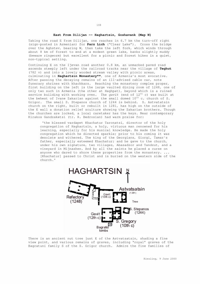
108
Kiesling, 9 June 2000
East From Dilijan -- Haghartsin, Goshavank (Map N)
Taking the road E from Dilijan, one reaches in 6.7 km the turn-off right (sign-posted in Armenian) for Parz Lich (“Clear Lake”). Cross the bridge over the Aghstev, bearing W, then take the left fork, which winds through about 8 km of forest to end at a modest green lake, banks slightly muddy (beware ringworm) but excellent for a picnic and forest hikes in a quiet, non-typical setting.
Continuing E on the Ijevan road another 0.8 km, an unmarked paved road ascends steeply left under the railroad tracks near the village of Teghut (782 v) and into a lovely wooded stream valley with picnic areas, culminating in Haghartsin Monastery**, one of Armenia’s most evocative. After passing the decaying remains of an ill-advised cable car, note funerary shrines with khachkars. Reaching the monastery complex proper, first building on the left is the large vaulted dining room of 1248, one of only two such in Armenia (the other at Haghpat), beyond which is a ruined service building with working oven. The gavit (end of 12th c) was built at the behest of Ivane Zakarian against the small domed 10th c. church of S. Grigor. The small S. Stepanos church of 1244 is behind. S. Astvatatsin church on the right, built or rebuilt in 1281, has high on the outside of the E wall a donation relief sculture showing the Zakarian brothers. Though the churches are locked, a local caretaker has the keys. Near contemporary Kirakos Gandzaketsi (tr. R. Bedrosian) had warm praise for:
"the blessed vardapet Khachatur Taronatsi, director of the holy congregation of Haghartsin, a holy, virtuous man renowned for his learning, especially for his musical knowledge. He made the holy congregation which he directed sparkle; prior to his coming it was desolate and withered. The king of the Georgians, Giorgi, Tamar's father, especially esteemed Khachatur; and he gave to the church, under his own signature, two villages, Abasadzor and Tandzut, and a vineyard in Mijnashen. And by all the saints he placed a curse on anyone who dared to shore these properties from the monastery. ... [Khachatur] passed to Christ and is buried on the western side of the church."
There is an ancient nut tree just E of the Astvatsatsin, shading a fine view point, and various remains of graves, including “royal” graves of the Bagratuni family S of the S. Grigor church. Admire the fine families of

109
Kiesling, 9 June 2000
pigs rooting on the surrounding hillside. Five km N of Teghut were found and taken to the museum two Aramaic inscriptions of Artashes I (189-160 BC).
Continuing E on the main road, first village is Haghartsin (2316 v, until recently called Kuybishev after the famous Bolshevik, till 1940 Zarkhej). At 9.8 m (15.8 km) is the turnoff right (S) toward Gosh and Chambarak/Krasnosyelsk. Take the first right up to Goshavank* or Nor Getik Vank in the village of Gosh (730 v). The monastery was founded in 1188 by the great Armenian cleric Mkhitar Gosh (died 1213) with the help of Prince Ivane Zakarian as replacement for Old Getik Vank (SW near Martuni in Gegharkunik, on the Jivikhlu road), which was destroyed by earthquake. Mkhitar is most famous for having compiled a collection of Armenian laws to help his flock resist the imposition of Muslim Shariah law.
The monastic complex is large and well-endowed, and was for a brief period an important center of Armenian medieval culture. The rectangular room next to the reading room stands out from the rest of the complex by its walls of large unworked stones. In all probability, this room is a holdover from an early Iron Age fortress built on the site perhaps 2000 years before. The reading room itself is unusual, built in several stages, with a chapel/bell-tower built on top in 1291. Note the intricately carved khachkar, the famous "Aserghnagorts" ("embroidered"), standing beside the S. Gregory church doorway, the work of Master Poghos, dated 1291. Its mate was moved to the State History Museum in Yerevan. The Gregory the Illuminator chapel is richly carved. There is a museum in the village, along with alleged remnants of Mkhitar's house; his tomb church stands in the village W of the monastery.
Kirakos Gandzaketsi, who studied here in the 13th c, described Nor Getik and its benefactors (tr. R. Bedrosian):
The marvelous vardapet and his monks then began work on the construction of a monastery and church in the above-mentioned Tandzut valley, by order of the great prince Ivane. They built a beautiful wooden church which was consecrated in the name of saint Gregory... At Nor Getik, at the head of the monastery, they also built a smaller church in the name of Saint John the Baptist, the ordained of Christ,

110
Kiesling, 9 June 2000
the greatest fruit of womankind. Then they began on the foundation of the glorious church built with dressed stones and [crowned] with a heavenly dome, a marvel to the beholder. [Construction] was begun in 640 A.E. [=1191], four years after Salahadin took Jerusalem, and it was completed in five years ... It was built by vardapet Mkhitar with his religious community with the aid of Vakhtang Khachenatsi, lord of Haterk and his brothers Grigor, Grigoris, Khoydan, and Vasak and other pious princes, Dawit and Sadun (the sons of Kurd) as well as their sister named Arzu khatun (Vakhtang Haterketsi's wife). This woman did much to help. She and her daughters made a beautiful curtain of the softest goats' hair as a covering for the holy altar; it was a marvel to behold. It was dyed with variegated colors like a piece of carving with pictures accurately drawn on it showing the Incarnation of the Savior and other saints. It astonished those who saw it. Beholders would bless God for giving women the knowledge of tapestry-making and the genius of embroidery, as is said in Job, for it was no less than the altar ornaments Beseliel and Eghiab fashioned [Exodus 36.1]; nor is it bold to say so, for the same spirit moved them both. Not only did the woman make a curtain for this church at Getik, but for other churches as well, Haghpat, Makaravank and Dadivank; for she was a great lover of the Church, and very pious.
The pre-consecration festival at Getik was conducted with great throngs of people attending. Among those present was Yovhannes, the bishop of Haghpat, a virtuous and blessed man as well as a multitude of priests and servitors. And they consecrated the church in the name of the blessed Mother of God.
They also constructed a beautiful parvis of dressed stones for the church. The great general Zakare and his brother Ivane provided much support, for they held the princeship of the district and they so loved the holy vardapet (for in confession, Zakare was his spiritual son). They gave the church [extensive] land bounded by streams [extending] from mountain to mountain, as well as a mine in Abasadzor, and Zoradzor in the district of Bjni, and Ashawan above the monastery. They themselves also built a village close to a small lake of immense depth, naming the village after the lake Tzrkatsov (for in it swam many marsh-loving, mud-loving reptiles), as well as another smaller village below the monastery which they named Urhelanj. They also built many other chapels in the name of the blessed Apostles and the holy Hripsime.
Because Mkhitar loved deserts and uninhabited places, he made his home distant from the monastery. There he built a small wooden church in the name of the Holy Spirit. In his old age he built a church as a mausoleum for himself above the monastery on the right. It was made with dressed stones and lime and named for the Resurrection of Christ. This venerable man of whom we spoke above, reached great old age, having kept his faith. But when he saw that his bodily strength was failing and that he was close to joining his fathers, he called the residents of the congregation of Nor Getik who had shared with him in all the labors of the church and monastery, and he blessed them and his students in the name of the Lord.
Selecting one of them, named Martiros, who had studied with him and was his intimate, Mkhitar appointed him as their director. Martiros was a youth but perfected in learning, a man mellifluous in the songs of worship, a great reader and a speedy writer. Mkhitar commanded him to direct them. And he wrote a will to the great hazarapet Ivane, Zakare's brother, and entrusted to him the monastery and its

111
Kiesling, 9 June 2000
director. Then he himself, white-haired and ripe in age, passed from this world to Christ.
The director of the monastery, Martiros, together with the congregation handsomely saw to the proper requirements for the spiritual and physical burial of Mkhitar. They laid him to rest before the door of the smaller church which stands above the monastery on the west side. And to this day Mkhitar's grave aids those in pain who take refuge in his prayers, in faith; and people always take soil from that place to cure sick people and animals, for God glorifies those that glorify Him, in life and in death.
Continuing S of Gosh toward Chambarak/Krasnosyelsk on a worsening road, one reaches Khachardzan (256 v, formerly the Azeri village of Polad), with a church W of the village, and then Aghavnavank (275 v), until recently the Azeri village of Salah, with Anapat-Astvatsatsin church of the 11-13th c. and an early bridge on the Getik river. From Khachardzan, a rough road goes W to Chermakavan (formerly Azeri Aghkilisa) and Geghatap (formerly Chichakbulagh) There is a ruined 11-13th c. church nearby.
Just W of the Ijevan road N of the Gosh turn-off is Hovk (312 v), originally Aghkikhlu?, until recently Samed Vurghun (named after the Lenin Prize-winning Azeri poet/dramatist, 1906-1956, famed for his laconic style, author of some fine works but also patriotic tracts such as “Partisans of the Ukraine” and “On Reading Lenin”). Nearby are ruins of a church and cemetery. On hills overlooking the Aghstev valley E of Hovk are at least three ruined castles, with great confusion over their ancient and modern names. Keep looking up, and ask the locals. On the summit of a hill E (or perhaps W) of the Aghstev 12 km SW (or maybe 15 km W) of Ijevan is the 7-9th c. fortress of Mantash (or maybe Karakala), one of several candidates to be the historical Kayan Berd. This site (or maybe another one) has substantial remains of walls and towers. If it really is Kayan Berd, it presided in medieval times over the medieval district of Chorapor. It was probably built in the 10th century under King Ashot Yerkat, and restored under various masters, including Atabeg Ivane Zakarian. Besieged here by the Mongols in 1236, Avag the son of Ivane prudently surrendered and became a valued Mongol ally. The castle was destroyed at the end of the 14th century during Timur Lenk's invasions. Another 4 km SW is an Aghjkaberd (formerly Turkish Ghzghala, from the annoying early modern custom of associating all castles with an imprisoned maiden) on a wooded hill. There might be a ruined church and some cisterns in the fort.
The name “Ijevan” (13789 v) means “Inn,” reflecting the Tavush capital’s previous name of Karvansara (though also Istibulagh), stopping place on an important E-W road and also, since 1870, of the railroad. In the place called Hamam-Jala on the bank of the Aghstev are remains of a medieval caravansaray. On the N side of the main road at the W end of town (cannon outside) is a small historical/ethnographic museum reopened in 1999, with a diorama commemorating the entry of the Red Army in 1920. Ijevan has a large (dormant?) rug factory, and wood product factories. There is a 200-bed high-rise hotel built in 1969 on the N side of the main road. In the SW part of town is a S. Hovhannes church. Chamber tombs near the city hospital and a late bronze age cemetery on the left bank of river attest early occupation of the site. Crossing the Aghstev river by the bridge on the W end of town, a right turn leads to Gandzakar (2000 v, till 1978 Aghdan) with S. Gevorg church, a S. Kiraki chapel of 1286, Budur cyclopean fort E atop Budur mountain, with two 12-13th c. churches with khachkars in the forest nearby. To the W of upper Gandzakar is the ruined medieval Tanik fort. There is supposed to be a ruined “Ashot Yerkat” fort 6 km SW. However, another source says the Ashot Yerkat fort is 7 km W of Ijevan.

112
Kiesling, 9 June 2000
From Gandzakar the road winds up a narrow set of unpaved switchbacks toward Berd and the Shamsadin region.
The Shamsadin District -- Khoranashat, Varagavank (Map O)
A remote and beautiful part of Armenia along the NE border with Azerbaijan, the former Shamsadin district is comprised of three deep river valleys, the Hakhum, Tavush, and Khndzorut, all running N to the Kura in Azerbaijan from the Miapor mountain range, with high ridges in between. The region took its name (Arabic “sun of the faith”) from the Turkic Shamsh-od-Dinlu tribe, its predominant occupants in early modern times. At the end of the 18th c., this region was claimed both by the Kingdom of Georgia and by Javad Khan of Ganja. Russia cheerfully espoused the Georgian claim and occupied the district (which they called Shamshadil) in 1801, despite occasional raids by Javad Khan's forces. A few decades later, having meanwhile on January 2, 1804 stormed the Ganja fortress and killed the Khan, the Russians conceded to geography and transferred the district back to Ganja/Yelizavetpol gubernia. Though part of Kazakh uezd, Shamsadin ended up in Armenia in 1919. The predominant population in the early 19th century was nomadic, though a Russian survey of 1804 listed 42 Muslim villages (some now in Azerbaijan) and two Armenian (Choratan and Krzen, with 227 people), paying taxes to the chief of the Ayrumlu tribe. Locals say Shamsadin has been entirely Armenian since the 1950s or before. The region has a collection of interesting Armenian monasteries, mostly remote and difficult of access. Care should be exercised in areas near the Azerbaijan border, since occasional firing incidents occur.
There are three access roads into the region. First is a spectacular mountain road** that leaves from the NW edge of Ttujur, just beyond Chambarak/Krasnosyelsk, and follows the ridge between the Hayrum and Tavush rivers to Navur. Second is a road that goes E from the N extremity of the Ijevan-Kazakh road, following the Azerbaijani border. Third, shortest looking on the map but the most difficult, is a poor dirt road that switchbacks up from the S edge of Ijevan, through Ganzakar and thence to Itsakar and Berd.
From Krasnosyelsk/Chambarak E of Lake Sevan, the road NW along the Getik river passes Ttujur and (8.4 km from the Krasnosyelsk junction) turns back to the right on a smooth, partly asphalted road. From this turn-off, the road reaches the marz boundary/watershed at 5.8 km, and then a series of hamlets for pasturing animals during the summer. At 28.5 km is a modern monument from 1988, with picnic tables made from old millstones and an ornamental fortress inscribed “Eternal is my paternal earth.” At 41.3 km is an impressive equestrian statue (1993?) of General Andranik facing fiercely toward Azerbaijan, with a small child? clutched to his chest. Beside this is the well-tended grave of Mushegh “Papo” Asrian, commander of the Navur self-defense forces, killed in 1990 in an auto accident near Hrazdan (or else, by a more poetic narrative, sacrificed in Karabakh). At 42 km is the intersection with the Itsakar-Berd road. Turning left one soon reaches the little village of Itsakar (252 v) on the road back to Ijevan. Turning right, one enters Navur, (800 v), with a series of ruined 3rd-1st millennium forts: Tandzut fort, 1st millennium BC (5 km S); Berdi Glukh fort, early 1st mill. BC (S edge of town); Kari Glukh cyclopean fort; Srtner fort, 6-4th c. BC (small hill 6 km W); Dashti Berd cyclopean fort (3km SW) has substantial wall remains.
Turning N in Navur, an adequate dirt road leads to Chinchin, (587 v). The 13th c. (or maybe 1151) Kaptavank monastery lies W of the road, only about 1 km N of Navur but a stiff hike over the ridge. Three km W of Chinchin,

113
Kiesling, 9 June 2000
looking down on the Hakhum river valley, is the 6-4th c. cyclopean fortress of Berdakar.
The road from Navur to Berd passes a modest chapel on the right of the road. Berd (8075 v, formerly Tovuzghala on the Tavush river has a hotel and a school founded in 1871. To reach the sketchy but picturesque walls of Tavush Fort (9-10th c. or 10-13th), for which the city is named, take the right fork at the entrance to town, cross the river and head up and left; there are also traces of cyclopean walls in the central park, a cemetery of the 5-4th c. BC, and a small museum. Some 3-4 km E are S. Sargis and S. Nshan shrines.
Beyond Berd’s castle, the road continues to Verin Karmiraghbyur (1346 v), founded in 1860, but with S. Hovhannes church of 1701. Below the village, the right fork leads to the large village of Artsvaberd (2314 v, formerly Ghighi or Gharaghaya -- restaurant but no hotel, khachkars in village. On the NW edge of the village is a Late Bronze Age tomb field. Reportedly, S. Zoravar church is 3 km W on the edge of a gorge. Three km NW are remains of Mamaslu cyclopean fortress. One km S is an important Late Bronze/Early Iron Age tomb field of Horjin Horer. W are Sprikghalacha fortress remains.
From Artsvaberd, the road descends to the Khndzorut River. Turning right on the bumpy dirt road leads up the river to a military post at a reservoir. Reportedly, a bad jeep track continues SW beyond the roadblock through walnut groves, ultimately to join the Krasnosyelsk road. Turning left toward Aigezdor, after 2.5 km a rough dirt track drops right across the Khndzorut to follow the Akhinja (or Hakhinja) tributary upstream to a little picnic area with a 1986 monument to General Andranik and the Fedayi. The track presumably continues to Azerbaijan, not recommended at this time. Continuing NE along the Khndzorut, one reaches Aigedzor, (1828 v, until 1939 Ghulali) has S. Hripsime Church of the 5-6th c. in the village below the school. NE of the village atop the mountain named for Salkari Vank is a 6-4th c. fortress. There are also remains of Yereg Vank Berd medieval fortress, also called Kzkalasi, a refuge during various medieval invasions. Continuing N, one reaches the village of Chinari (1104 v), visible from which to the NE is Khoranashat Vank* of 1211-20, with a gavit of 1222. Because of occasional sniping incidents, it is advisable to check with villagers before visiting the monastery (bear right through the village, then follow the dirt road left and up). Per Dr. Robert Bedrosian, the 13th century Kirakos Gandaketsi studied here under one of Mkhitar Gosh's students, the historian Yovhannes Vanakan (d. 1251). "When the Khwarazmian sultan Jalal al-Din ravaged Xoranashat in 1225, Vanakan fled with his students to a nearby cave, near the village of Lorut, south of Tawush. He continued teaching there until 1236 when a Mongol army under Molar-noyin occupied Tawush. Both Vanakan and Kirakos were taken captive by the Mongols and kept as secretaries for several months. Eventually, Vanakan was ransomed by the Christians of Gag for eighty dahekans, and Kirakos escaped secretly the same night.". In the vicinity of Chinari there are reportedly shrines of the 13-17th c., and 1st millenium BC graves.
From Artsvaberd, a road leads N to Choratan (736 v), with S. Hripsime church of 1683 and a 17th c. shrine. From there, a road NW leads to Norashen (1174 v), reportedly with a museum; Soviet biologist A. Avagian was born here; on the S end of Norashen is a cyclopean fort call Pilor Pat. 5 km SW on the left of road leading to mountains is a ruined fort of 5-4th c. BC, source of rich finds during excavation. North toward the border is Mosesgegh (1683 v), with unspecified churches, shrines, and caves nearby. The road NW to Aigepar (425 v, founded in 1937, until 1967 “the town connected to the fermentation factory”) and Nerkin Karmiraghbyur (706 v,

114
Kiesling, 9 June 2000
church of 16-19th c., ruins of Shenategh, khachkars of S. Sargis and S. Khach) passes dangerously close to the border.
Returning to the Berd roundabout, the main road N leads (left fork) to the attractive village of Zavenavan (1188 v. until recently -- or maybe still -- Tovuz), with an Astvatsatsin church by the road, a S. Gevorg sacred site, the Tavush and Katsaret forts and a rock-cut grotto (vimapor karayr) somewhere in the vicinity. Continuing, one passes on the left an unmarked dirt road to Chinchin and then descends steeply into the valley of the Hakhum river, and Tsaghkavan (685 v, until 1939 Veligegh) The important Shkhmuradi Vank of the 12-13th c. with S. Astvatsatsin church built in 1181, is west of town about 6 km up the river valley; 150 m up from the monastery is 6-5th c. fortress called Kalkar. Some 2 km N of Kalkar and 1.5 km N of the road to Shkhmuradi Vank is another similar fort called Sevkareri Blur. One km NE of this fort is a third, Sevkareri Takht on the left bank of the Hakhum River. In front of the cattle breeding farm of Tsaghkavan village on the right bank of the river is another cyclopean fort called Baghri Khach.
Next village E is Varagavan (476 v, till 1978 Azizlu). To reach the charmingly sited monastery of Nor Varagavank*, with S. Astvatsatsin church of 1237, Anapat 1198, David Ishkhan tomb/shrine 13th c, enter the village at the cemetery, then follow the main road through the village (when in doubt, always bear left), about 4.5 km through pleasant woods. N beyond Varagavan and E at the intersection, Paravakar (1383 v) has shrines, khachkars, and other minor ruins. Turning W instead, the village of Vazashen (570 v, till 1978 Aghgegh or Lala) has Karmir Kar ruined fort and churches. WNW toward the border is the ruined 10-13th c monastery of Honut in the abandoned village of the same name. Aigehovit (2402 v, until 1969 Uzuntala) has Srveghi Vank of the 12-13th c. on the skyline SW of the village, with an inscription: “In the year 1252 we Artavazd and Sargis built this church by the hand of master Hovhannes.” There is also a S. Sargis shrine, Kotrats Yeghtsi (“Broken church”), and an 18th c. (Persian period) guard tower on the right bank of the Aghstev.
East of Ijevan (Map N)
Getahovit (1954 v, till 1978 Tala) and Yenokavan (376 v, till 1935 Krdevan) lie N of the road, on either side of the Sarnajur (formerly Tala) river. West of Getahovit is the ruined Iritsi Aghbyur medieval settlement with church and cemetery. Yenokavan was named after early Communist Enok Mkrtumian, who founded the first party cell in the region. On the S. edge of Yenokavan, perched on a rock overlooking the scenic gorge, is a small church with medieval tombstones. About a km S, down inside the gorge, reachable only on foot, is an Astvatsatsin church of the 13th c. Some 17 km W is the Okonakhach church. There are anciently inhabited caves in the river valley. At the NE end of the village overlooking the gorge is the 6-5th c. BC Astghi Blur with cyclopean walls and a huge tomb field. The main dirt road through Yenokavan bears right and up the ridge, traversing the starkly beautiful mountain pastures of the Ijevan Mt. Range*. This road, passible April-November (barely) by street car, serves various yaylas inhabited only in summer, and leads in some 66 km to the main Azatamut-Noyemberian road just S of Noyemberian. This may be the best road to Samsoni Vank. Eight km NW of Yenokavan on this road, atop a hill, is Berdategh Early Armenian cyclopean fortress. Somewhere toward the Noyemberian end of the road is a village called Gomshavar with, 2 km E in a spot called Dondar, remains of a Bronze Age settlement.
Lusadzor (331 v) is 7 km E of Ijevan; until 1935 it was called Khavaradzor; S and W are medieval remains with khachkars. On the W end is an Iron Age
115
Kiesling, 9 June 2000
cemetery. There is a recent church. E of the main road is the village of Khasht'arak (1149 v, once Sahatlu), with a recent church; W and SE are abandoned medieval settlements with khachkars. Beyond, a road continues S to Lusahovit (235, until 1978 Tsrviz), with the Moro Dzoro (its name from early inscriptions) or Tsrviz Vank of the 5-13th c. Atabek Ivane Zakarian sponsored a rebuilding of the long-ruined Astvatsatsin church in 1213, stipulating in return that regular masses for the long life of his sons Avag and Shahnshah be celebrated till the Second Coming. According to an inscription of 1197, Ivane's sister Nana, his "soulmate and helper," spent time here as a nun. An earlier inscription gives a decree of King Giorgi III of Georgia (1156-84) the father of Queen Tamar, freeing the monastery from taxes and endowing it with land. The Tsrviz medieval settlement nearby has khachkars. Continuing E toward the border, Aknaghbyur (352 v) -- until 1967 Nerkin Aghdan, from 1967-70 Morut -- is left of the road. East of the village near a spring is a huge oak tree, legendarily planted by sparapet Vardan Mamikonian in 450 AD, used as a pilgrimage site.
Ditavan (267 v) was founded in the beginning of the 19th c., and until 1967 was called Revazlu. It has a bentonite mine. Azatamut (2168 v, till 1978 the Bentonite Combinat) is the end of the road, travel into Azerbaijan blocked by an impromptu barricade and cautionary whistles from the locals. A road turns S up toward Aigehovit and the Shamsadin district.
North to Noyemberian -- Makaravank, Kirants (Map N)
The Azatamut-Noyemberian road forks left (N) off the main Ijevan-Kazakh road a few km before the Azeri border. The road, paved and in reasonably good condition, parallels the border, and at Askipara/Voskepar cuts through occupied Azeri territory, but is normally safe for travel. However, the villages of Barekamavan and Shavarshavan, E of Baghanis, should probably be avoided, as the target of occasional heavy machinegun fire. Note that commonly available Armenian maps fail to show the accurate border.
What makes this road worth the frisson of driving through a war zone is a cluster of medieval churches set in lovely stream valleys amid the wooded hills W of the road. Also, those of a philosophical bent can profitably contemplate the destroyed and looted remains of Yukari (upper) and Ashagi (lower) Askipara, an Azerbaijani enclave and salient reduced in fierce fighting in 1992. Cows and sheep graze among the roofless remains, a reminder of how quickly a prosperous village of the late 20th c. can become an archaeological site.
Almost immediately after taking the left fork toward Noyemberian, an unsignposted paved road turns W to the village of Achajur (2518 v, once Achasu). Continuing on the main road through the village, at the top a muddy but passable asphalt/dirt road bears left (generally SW), winding along about 6 km (taking the main fork each time, if in doubt go right) to the beautifully situated hillside monastery of Makaravank*. First is a picnic area next to an ancient spring. Passing through the gate in the circuit wall, the main church of 1205, built by Vardan son of Prince Bazaz, is on the right, and the gavit on the left. The facade of the gavit, which was built with a donation from Prince Vache Vachutian in 1224, bears sculptures of a sphinx and a lion attacking a bull. Inside the gavit, one reaches the earliest church, of the 10th or 11th c. Outside, E of these, is a small Astvatsatsin church built by Abbot Yovhannes in 1198 in memory of his parents and brothers, with sculpted portal. Beside it is a small ruined chapel.
At the NW edge of Achajur is the Tmbadir Early Armenian fortress. Also near Achajur, about 2 km NW on a flat hilltop near Sevkar, is a ruined Nahatak (martyr) church probably of the 17th c, with an 8-7th c. BC fort.

116
Kiesling, 9 June 2000
Some 3km NW of the village on a wooded height is S. Hovhannes church. In the SW part of the village is an old settlement with khachkars; 3 km SW are remains of Old Achajur with remnants of a medieval fortress, identified as Kayan Berd, atop Paytatap Mountain. There is an old shrine on the S slope. A dirt road winds 25 km SW from the W end of Achajur to intersect with another from Yenokavan, near which intersection is the Early Iron Age fort of Bardzraberd.
Returning to the Noyemberian road, a by-road left leads to Sevkar (1601 v, formerly Gharatash), with 14th c. church. An underground Communist Party cell was founded here in 1919. Next comes Sarigyugh (1000 v, till 1951 Ghlchkend), birthplace of a whole herd of Heroes of Socialist Labor. On a little hill on the W edge of the village is a cyclopean fort of the 8-7th c. BC; cist graves 1 km W of village. Ruins of Tsakageghtsi church are located on summit of little hill 3 km W near another small Iron Age fortress. The village of Berkaber (323 v, formerly Joghaz) is on a small road right, near a small reservoir just inside the border. It has a wood-roofed church and khachkars. About 1 km W of Berkaber on the Joghaz river is the Gavarzin medieval fort (dangerously near the border). Even more dangerous would be the climb to medieval Gaga Berd on the border summit W of Berkaber. A spur road left from the main road leads to Tsaghkavan (362 v, till 1940 Melikgyugh), with S. Hakob Church and 12-13th c. khachkars.
Kirants (223 v, until 1967 Getashen) lies above the N bank of the Askipara, Karkhan or Kunen river. A bit further W, straddling the river, is Acharkut (99 v, once Kunen), a formerly mixed village founded in 1930 as part of a forestry collective but occupying part of a once major 9-10th c. town site. On the N bank is an early church. On the slope S of Acharkut by the bridge, a dirt road winds uphill to a ramshackle cemetery church of S. Astvatsatsin (inscription reads: “In the year 1675 I Melikshahnazar son of Melikaslamaz of the Herume clan, and my wife Khanzate built S. Astvatsatsin by the hand of Master Hakop.”) and a picnic area beyond. At the W edge of Acharkut, on the N side of the stream (medieval Sranots bridge somewhere nearby), the main village road ends at a locked gate, which a neighbor will open. About 1 km W of the gate, overlooking the muddy, rutted but passable track (ideal for mountain bikes), are the ruined but interesting remains of a caravansaray below the 13th c. Arakelots (Apostles’) Monastery* complex. About 80 m further, a jeep track branches uphill to the monastery proper, visible on the crest of the hill in dense forest. Though the church is unimpressive, the forest setting, the mossy tombstones and substantial remains of the defensive circuit make this a rewarding site. A worn inscription of 1293 over the S entrance to the gavit links the site to Khut'lu Bugha Artsruni, son of Atabek Sadun, lord of Mahkanaberd in the 13th c. In return for helping Vakhtang mount the throne of Georgia, Khut'lu Bugha was made atabek and amirspasalar of Georgia. Unfortunately, a change of Mongol Il-Khans left him on the wrong side, and he was put to death in 1297 for plotting insurrection. There is a ruined chapel on the next hill as well. Supposedly, 2 km NE of Arakelots Vank on a flat place on the mountain ridge is the little church and khachkar of Khndzorut.
To reach the remote but unique 13th-14th c. Kirants Monastery*, continue upstream. After another 5 km or so, one branch of the road turns left, crossing the Zayghoshani bridge (with Persian inscription: in the year of the Hijra 1207 -- AD 1792) and ascending S toward Deghdznuti Vank of the 13th c. (1 km or so). The small but fine main church seems to have been begun in 1258 and finished in 1274, and the gavit built very soon afterwards. An inscription on the S arch of the gavit remembers Asil, a pilgrim of 1292 from Mesopotamia, probably an Armenian merchant who did well in difficult times. Another 6 km S of Deghdznuti (and probably more

117
Kiesling, 9 June 2000
reachable from Yenokavan) is Samsoni Vank. This latter monastery has a domed 12-13th c. church, a shrine and another small church. On the right bank of the Khndzorkut river, atop a mountain between Deghdznuti and Samsoni Vank is supposed to be the Berdakar medieval fort, with cisterns. This would have been Mahkanaberd, the fortress-capital of the Artsruni family, who enjoyed quasi-autonomy in the area in the 11-13th c. On a slope opposite Deghdznuti Vank are allegedly remains of another fort, Melik-Abovi Berd.
Back along the main river track, at about 8 km from the gate on the main W track is a splendid modern local monument, a monumental stone-built picnic site with open-air museum* above -- a rock overhang closed with an iron grating, with local agricultural and household implements from the 19th c. Continuing upstream, dodging rocks and deep ruts, one finally sees at about 10 km Kirants Monastery*, 13-14th c. The well-preserved but disused main church is unusual for its brick construction and elegant colored tile decoration.
Bumping back to the main road, you cross imperceptibly into a projecting piece of Azerbaijan and the destroyed Azeri village of Lower Askipara. However, the de facto boundary in 1999 runs along a line of hills about 3 km further E. The spur road left takes one back into Armenia, the village of Voskepar (677 v) just W of the road. Still standing on the edge of the ruins of Askipara, intact/restored despite use in the fighting as a machine gun nest, is Astvatsatsin Church of the 7th c. Somewhere near are traces of a 10-11th c. castle. A deteriorating road W from Voskepar leads one to a lovely stream valley filled with the skeletal houses of Upper Askipara (Verin Aghsibara), a piece of Azerbaijani territory entirely surrounded by Armenia and separated from Lower Askipara by Voskepar. At the W end of the village is an 18th (?) c. tower fort with arrow slits. One km beyond is a medieval stone bridge. Taking the road further upstream, the right fork may lead to a large ruined church beyond the old collective farm complex.
Leaving Azerbaijan again, you follow the Baghanis river to reach Baghanis (560 v) with a ruined church perhaps of the 10th c. E of the road, and 12-13th c. funerary monument. The right (NE) fork from Baghanis leads to areas still under occasional artillery fire and should probably be avoided. It goes to Voskevan (1399 v), formerly Ghoshghotan, with a 19th c. church; birthplace of Soviet hero Ishkhan Saribekian, a sergeant in the Great Patriotic War. Next is Koti (1602 v), until 1964 Kotigegh, then renamed Shavarshavan in honor of Shavarsh Amirkhanian, 1894-1959, born in the village, an early communist who rose to become head of the Armenian KGB precursor. This road ends at Barekamavan (551 v, till 1978 Dostlu, Kurumsulu). Some 2 km NW is the Bardzryel pilgrimage site.
Continuing toward Noyemberian, Jujevan (407 v) was founded in 1874 and has the 19th c. Jujevank monastery and a 12-13th c. chapel. At the SE end of the village on the left side of the Ijevan road is the Early Bronze Age Jaghatsategh settlement. On the S side of Jujevan atop a hill by the Ijevan-Noyemberian road is Poploz-Gash, an Early Iron Age cyclopean fort
Noyemberian (3686 v, till 1938 Baran) has a small, spartan hotel on the W side of the square/park, behind a cafe with a bright blue awning. Near the town are three Iron Age cyclopean forts, with traces of early metalworking: Berdagh, 2km NE; Mraghants Areguni; and Tpi-Gash, N of town. NE is Dovegh (475 v), formerly Balakend. About 3 km S of Dovegh is the shrine of S. Sargis, a pilgrimage site for the region.
The main road continues W to Koghb (4092 v). Mshkavank* or Mshakavank, with a restored Astvatsatsin church, gavit, 5-6th c. Tsghakhach church, 6th c. Tvarageghtsi church and cemetery of the 12-13th c., is somewhere on the

118
Kiesling, 9 June 2000
mountain 3-4 km SW, accessible by jeep track from Koghb or Noyemberian. SE 1.5 km is Berdategh cyclopean fort, and also (maybe) in the same direction the Gharanots Gol fort. W of Koghb are two cyclopean forts, Zikurati and Kozmani (10 km), with Bronze Age tomb fields adjoining. 15 km W is Patashar cyclopean fort. NW of Koghb is a S. Arakel ruined shrine in the old Arakelots village. After Koghb, the main road reaches Archis (994 v, S. Hakop church, shrine, old iron-working site; Early Iron Age cyclopean fort traces 1.5 km S from the village atop a hill parallel to the Debed) and Ayrum (1618 v), where the road joins the main Vanadzor-Tbilisi highway. S of Ayrum on the right bank of the Debed on the hill of the candy factory is an Early Bronze Age Shahlama fortress. Another Shahlama Bronze Age site is on the Debed at the intersection where the roads diverge to Tbilisi and Alaverdi. Ayrum also had an Early Iron Age site 3 km SW of the train station, where a group of 10-8th c. BC bronze figurines were found in 1962. To SE is Lchkadzor (319 v, formerly Chalagegh) with 3 km NE on Danieli Tala hill an unexcavated cyclopean fort.
From Koghb, a road leads NE to Berdavan (2494 v, once Kalacha). Turning right, an asphalt road winds down through the village. Where two dirt roads fork, take the left hand, cross the stream, and then bear left again at the next fork, leading (jeeps only) to a picturesque 10-11th c. Ghalinjakar castle* on a hill near the Azerbaijan border. There are large khachkars in the village. From Berdavan, a road goes W to Zorakan (703 v, formerly the Azeri village of Verin Kerplu), Haghtanak (“Victory”)(867 v, formerly the Village Linked to Tumanian Sovkhoz), with a Shahlama 6-4th c. fortress on the right bank of the Debed, Ptghavan (675 v, Azeri until 1988), Deghdzavan (224 v, founded 1978), and Bagratashen (2120 v, formerly Lambalu) on the Georgian border. Called Debedashen from 1960-72, Bagratashen was renamed after Hero of Socialist Labor and founder of the Zeitun plant, Bagrat Vardanian (1894-1971). North along the border, Debedavan (513 v) was formerly the largely Azeri wine-producing center of Lalvar.
EXPLORING VAYOTS DZOR Vayots Dzor is one of the most scenic and historically interesting regions of Armenia, centered on the watershed of the Arpa River and its tributaries before they flow SW into Nakhichevan to join the Arax river. Mountainous and sparsely populated, Vayots Dzor (by popular etymology “the Gorge of Woes”) is crowded with medieval monasteries, forts, caves, and camping spots. The uplands have potential hiking/horseback/mountain bike tracks. There are trout in the streams, and wild sheep, bear (protected) and smaller game in the mountains. The marz capital is Yeghegnadzor, a 90-120 minute drive from Yerevan over the usually well-paved N-S highway.
Day trips from Yerevan are easy and rewarding. For a fuller exploration, however, it is necessary either to camp or exploit one of the region’s modest hotels. The Tigran Hotel in Vaik (phone 279-21434) accommodates mostly groups. There may now be an adequate hotel in Yeghegnadzor. There are a series of sanatoria and hotels in Jermuk. Aquarius Travel in Yeghegnadzor (246-24011, 22113) can reportedly arrange fishing, camping, caving, and other tours in the region.
The earliest historically recorded settlement in Vayots Dzor was at Moz, near Malishka, and there are scattered remains of Bronze and early Iron Age graveyards and “cyclopean” forts (built of large, unworked boulders, as if by Cyclopes) elsewhere. The region flourished most mightily in the 13th-14th centuries, when a series of gifted and pious local rulers managed to coexist with the Mongols and other passing empires. In 1604, the region

119
Kiesling, 9 June 2000
was depopulated when Shah Abbas of Persia, fighting a series of fierce campaigns against the Ottomans in and over Armenia, forcibly relocated much of the Armenian community to Persia, both to strengthen his own domain economically and to leave scorched earth for the Turks. In 1828, with the Russian conquest, thousands of Armenians emigrated from Persia or Eastern Turkey to resettle the region. Still, there are scattered remains of deserted hamlets. In 1988, the population of the combined Yeghegnadzor and Azizbekov (Vaik) regions was perhaps 60,000, including 10,000 Azeri Muslims.
East from Ararat -- Areni, Noravank (Map P)
After descending the Arax valley on the main S road from Yerevan, turn left at the Yeraskh traffic circle (straight will take you to the Nakhichevan border and possible disaster), and wind up through increasingly scenic hills until the watershed that marks the border between Ararat and Vayots Dzor.
The first village one reaches once over the pass is Yelpin (801 voters, population came from Salmast in 1830) N of the road. Climbing the mountain NNW of the village are traces of a medieval fort; in the village is a 14th c. Tukh Manuk shrine/pilgrimage site. One km N are fine khachkars. There are prehistoric caves nearby. A dirt road leads about 12 km NW to a mineral spring, on a hill above which is a medieval church. A dirt road N from Yelpin leads in about 10 km to Khndzorut (Elmalu) village with a ruined gavit/narthex and cemetery with inscriptions. The old road E toward Aghavnadzor passes a left turn at the ruined hamlet of Geshin, which leads in turn to a substantial fortified cave on the mountain slope.
Chiva, turnoff left, (606 v) has a 10th c. church. Just W of the village on the S side of the road is an early Christian cemetery with fine carved tombstones. Rind (1013 v) E of Chiva, founded in 1967 to replace the old village of the same name abandoned due to slides. There is a cave-shrine 3 km NE of the 10-15th c.; Verin Ulgyugh, 1 km, 11-14th c., with S. Stepanos church, 13-14th c.
The village of Areni (1264 v, formerly called Arpa) is famous for its wine, much of which is produced in Getap further down the road. Visible to the right of the main road is the Astvatsatsin (Mother of God) church of 1321, with interesting tombstones outside; turn S into the village, cross the bridge, and turn left on a clear road up to the church. There are ruins of the medieval mansion of Tarsayich Orbelian in the valley and, reportedly, remains of a cyclopean fort SE of the village on the edge of gorge and a 13th c. bridge on the Arpa r. built by Bishop Sargis (1265-1287); further along the gorge toward Arpi, on a hill on the S rim of the gorge, is the ruined 13th c. fort of Ertij. In Areni was found in 1981 an altar with a Greek inscription of AD 163 dedicating it to the Olympian Goddess on behalf of a Roman officer, Aemilius Ovalis, of the 15th Legion Apollinaris.
Turning south through the village of Areni, a paved road climbs up to spectacular views of the Noravank gorge, passing the hamlet of Amaghu. Near Amaghu on a hill by the gorge are remains of a medieval fortress. On the right can be seen in the distance the recent fortifications along the border with Nakhichevan. About 1 km before the village of Khachik, (952 v) visible on the right are the sadly ruined remains of the 9th c. Karkopi or Khotakerats (“grass-eaters”) Vank. The site owes its name to the vegetarian ascetics who used to live in the gorge, assembling only for Sunday prayers. They were reined in and monasticized by Bishop Hovhannes III, who built them a church of 911 (several times rebuilt after earthquakes) with the support of Shushan, widow of Ashot I. The gavit is 13th c. In the village itself is the Astvatsatsin basilica dated 1681. Some

120
Kiesling, 9 June 2000
1.5 km E of the village are remains of Berdatagh ruined medieval castle. There is supposed a Hngazard ruined medieval church 2 km NE.
A kilometer past Areni on the main road to Yeghegnadzor is the turnoff right for Noravank**, across the bridge and through a narrow gorge, whose stream has sadly disappeared into a large iron pipe. At the entrance to the gorge on the right is a cluster of high but shallow and unornamented caves, called Trchuneri Karayr (Bird Cave), in with Bronze Age child burials were found. Further inside the gorge on the left is the Magil cave, going a considerable distance into the hillside. Note a huge boulder right of the road outfitted as a picnic site. Beyond the caves, the gorge opens out and the monastery comes into view. The paved road continues up and to the left, ending in a parking lot below the monastery.
A gravel road continuing up the canyon ends after a few meters amid a welter of khorovats detritus. Continuing on foot, at the iron gates for the water project one can continue straight along the left bank of the stream toward a concealed picnic site with table and fire circle (about 200 meters) or else follow a path that slopes up to the left. This latter passes below the little chapel of St. Pokas (Phokas), in which is the basin of a sacred spring and, according to a tradition that was already "old" when Bishop Stepanos Orbelian wrote about him in the late 13th century, the site of a seep of miraculous healing oil from Pokas's buried relics. The learned bishop wrote, "Here surprising miracles used to occur. All kinds of pains, whose cure by men was impossible, such as leprosy and long-infected and gangrenous wounds, were cured when people came here, bathed in the water and were anointed with the oil. But in cases where these were fatal, they expired immediately." Modest votive crosses show that the shrine remains venerated. Past St. Pokas, the narrow, occasionally steep, but clear path climbs along the canyon side to a series of broad ledges with beautiful views of the cliffs.
Noravank (“New monastery”) was founded by Bishop Hovhannes, Abbot of Vahanavank (in Syunik W of Kapan), who moved there in 1105 and built the original S. Karapet church. According to Stepanos Orbelian, Hovhannes went to the Persian (actually Seljuk) Sultan Mahmud and came back with a firman giving him possession. He gathered religious folk, and established a rule barring women and lewd persons. Unfortunately, the evil amira (lord) of the nearby castle of Hraskaberd (scanty ruins of which, not firmly identified, are somewhere in the hills SE) plotted to kill him and destroy the monastery. Hovhannes, who was gifted in languages, went to Isfahan, cured the Sultan's sick son, and came back with the title deeds to Hraskaberd and 12 nearby estates, and a trusty band of heavily armed men who pushed the amira and his family off a cliff. A century later, Stepanos says, a group of "Persians" rebuilt Hraskaberd, but two lieutenants of the Zakarian brothers kicked them out in favor of Liparit Orbelian (see last page) and reestablished the monastery's claim to the estates surrounding. Bishop Hovhannes led a holy life and worked numerous miracles, such as catching in his hands unharmed a woman and infant who fell off the cliff.
During the 13th and 14th centuries a series of princes of the Orbelian clan built churches which served as the burial site for the family. The monastery became the center of the Syunik bishopric. The nearest and grandest church is the Astvatsatsin (“Mother of God”), also called Burtelashen (“Burtel-built”) in honor of Prince Burtel Orbelian, its donor. The church, completed in 1339, is said to be the masterpiece of the talented sculptor and miniaturist Momik. In modern times the church has had a plain hipped roof, but in 1997 the drum and conical roof were rebuilt to reflect the original glory still attested by battered fragments. The ground floor (locked in 1999 during restoration) contained elaborate tombs of

121
Kiesling, 9 June 2000
Burtel and his family. Narrow steps projecting from the west façade lead up to the entrance to the church/oratory. Note the fine relief sculpture over the doors, Christ flanked by Peter and Paul.
The earlier church is the S. Karapet, a cross-in square design with restored drum and dome built in 1216-1227, just N of the ruins of the original S. Karapet, destroyed in an earthquake. Forming the western antechamber is an impressive gavit of 1261, decorated with splendid khachkars and with a series of inscribed gravestones in the floor. That of the historian/bishop Stepanos dated 1303 is toward the western door. Note the famous carvings over the outside lintel. The side chapel of S. Grigor, built in 1275, contains more Orbelian family tombs, including a splendidly strange carved lion/human tombstone dated 1300, covering the grave of Elikum son of Prince Tarsayich and brother of Bishop Stepanos. Alas, nothing is preserved of the rich church ornaments and miraculous relics Stepanos and his predecessors assembled for the glory of God. In its heyday, Noravank housed a piece of the True Cross stained with Christ's blood. This wondrous relic, acquired forcibly by a notable family of Artsakh from a mysterious stranger after it raised a villager's dead child, was purchased by the Orbelians for cash when the family became refugees.
Noravank was hot in July/August, even in the 13th c. Bishop Stepanos reports that the bishops and monks moved to Arates monastery in the mountains E of Shatin to avoid the summer heat. Summer tourists should arrive early morning or late afternoon for a more pleasant visit.
Arpi (697 v) founded in 1965. About 6.4 km after Areni, just before the Arpi sign, the first road turning right to cross the Arpa r, leads in 7.6 km to an old guardhouse on the left and, immediately beyond on the right beside the road, the tin-covered entrance to the Mozrovi cave. Discovered in the 1970s during road building and still not completely mapped, this cave is deep and full of spectacular colored stalagmite and stalactite formations. Entrance is perilous, through a hole in the cover and down a steep slope, and should not be attempted without an experienced caver. The Arji cave and several others are in the same general area. Another mile further up is the village of Mozrov, with about 50 families, and, on an increasingly poor dirt road, Gnishik, (3 families) almost abandoned in 1975 due to landslides. Some 2 km NE is Dali Khach ruined shrine. In the village are khachkars of 9-17th c. and a church of 1463. There are 1st millennium BC graves 2 km N of village; allegedly by bad road SE about 10 km is Hraskaberd of the 9-12th c. Four km E of Gnishik are the remains of old Boloraberd village with a 13-14th c. Tukh Manuk chapel. S of Boloraberd are remains of Vardablur village with a ruined church and cemetery. There is a medieval Vardablur fortress E. Some 4 km NE of Gnishik is the former Gandzak village with a medieval cemetery and church.
Selim Caravansaray and the Yeghegis Monasteries (Map P)
At 34.3 m is the Yeghegis River, with roads leading N to Getap on both sides of the stream. Take the far (E) road, bypassing Getap, (“River bank”, known until 1935 as Ghoytur, 1402 v), home of some of the Areni vintages. Two km NE of Getap atop a hill are ruins of Aghli Vank church, with inscriptions. Continuing N along the Yeghegis R, note at 5.8 km the spur of a medieval bridge.
...Right of the road inside the village is a small ruined basilica. In 2000, a team from the Hebrew University of Jerusalem under Professor Michael Stone excavated on the S side of the Yeghegis river opposite the village a Jewish cemetery with some 40 gravestones with fine Hebrew inscriptions, attesting to the existence of a literate and prosperous Jewish community in Yeghegis in the years around 1289. Somewhere on the
122
Kiesling, 9 June 2000
mountain a few km NE are ruins of 13th c. Gyulum Bulaghi Vank (probably Upper Noravank, attested in manuscripts). At 9.1 km is the first turnoff to the right for Shatin (see below). Continuing straight (N), now along the Selim river, you seen on the left at Hors (239 v), with the Chibukh Kyorpi bridge of the 14th c.; the tomb of Chesar Orbelian, and a 14th c. church with khachkars. On the right is Salli (136 v); then on the left Taratumb, (378 v), with a khachkar of 1251 and a church of 1880; again on the right is Karaglukh, (553 v). Some 3 km S on a high plateau are the ruined 13th c. walls of Mamasi Vank, built according to medieval legend to house the relicts of St. Mamas, carried back to Armenia by the princes of Syunik from Caesaria in Asia Minor in the 4th c. The 13th c. church is called S. Poghos (St. Paul). On a hill 3 km E of Karaglukh is a simple Tukh Manuk shrine built by the ruins of a substantial earlier church. There are numerous khachkars.
Aghnjadzor (1281 v) (formerly Aghkend, a mixed Armenian/Azeri village, with church/cemetery), is the site of Lernantsk Caravansaray, located about a kilometer N of the village, appearing east of the road like a half-buried Quonset hut. Take the dirt road just past the bridge, crossing the early bridge and heading up the stream valley. A smaller and cruder structure than the Selim Caravansaray, it was built in roughly the same period. Four km N are the so-called Kapuyt Berd (“Blue Fort”) ruins.
Shortly beyond, asphalt gives way to a narrow dirt road, which begins to switchback up the mountain toward the Selim Pass. Note that the road becomes impassable to normal cars in wintertime, usually December - April. Unless recent road work has been done, take the first turnoff up to the right, rather than the apparently smoother and wider main track, which was cut further up by a washout.)
Selim Caravansaray** lies below the road just before the summit on the south side of Selim Pass (2410 m), a splendid relic of the days when an international trade route connected Vayots Dzor to the Sevan basin and points North. According to the Armenian inscription on the right inside the door, Prince Chesar Orbelian and his brothers built this rest-house in 1332 in the reign of Abu Said Il Khan, “the ruler of the world,” whose death in 1335 deprived the world of an enlightened Mongol despot and ushered in a new wave of invasions. The Persian inscription on the outside lintel (almost effaced by recent vandals, gives the date 1326-7. The Armenian inscription reads:
“In the name of the Almighty and powerful God, in the year 1332, in the world-rule of Busaid Khan, I Chesar son of Prince of Princes Liparit and my mother Ana, grandson of Ivane, and my brothers, handsome as lions, the princes Burtel, Smbat and Elikom of the Orbelian nation, and my wife Khorishah daughter of Vardan [and ...] of the Senikarimans, built this spiritual house with our own funds for the salvation of our souls and those of our parents and brothers reposing in Christ, and of my living brothers and sons Sargis, Hovhannes the priest, Kurd and Vardan. We beseech you, passers-by, remember us in Christ. The beginning of the house {took place} in the high-priesthood of Esai, and the end, thanks to his prayers, in the year 1332.
The best preserved caravansaray in Armenia, Selim is built of basalt blocks, with a cavernous central hall for animals separated from the two vaulted side aisles by rows of stone mangers. Bring a flashlight (though the dim light through the smoke holes in the roof adds a proper medieval flavor). There is a little spring/fountain monument just uphill beyond the

123
Kiesling, 9 June 2000
caravansaray. The bad road continues N over the pass and ultimately to Martuni.
Shatin and Eastward -- Tsakhatskar, Smbataberd (Map P)
At 10.0 km from the Yeghegnadzor road is the second turn-off for Shatin, (1164 v, till 1935 Hasankend), where the Yeghegis river turns E. Main attraction is Shativank*, a fortified monastery 3km E up the gorge. Directions: Toward the far end of the village, take the right fort down to the bridge and cross. About 150 m further, take the right fork and then, about .5 further, the left fork steeply up to a tiny cemetery. From there, a jeep road winds up and around to the monastery. Preferable option, particularly for the jeepless, is to walk up the gorge, a rewarding 45-minute climb. The path can be found by taking the left fork above the bridge, going about 100 m until 15 meters before a white-painted garage gate. On the right, between a telephone pole and an iron rod, a faint trail ascends steeply. At the power pylon on the spine to the left, the path becomes wide and clear. Inside a substantial fortification wall, Shativank consists of the S. Sion Church rebuilt in 1665, two-story monks and guest quarters (SE corner is best preserved), a grain storage silo (NW), khachkars, and (outside the walls SE) a waterworks. Other antiquities in the vicinity reportedly include Berdakar fort (2 km S, 5th c.), Shatin bridge, a shrine S, and a 10th c. church in Hostun.
Going E from Shatin, one follows the Yeghegis river upstream. Note that many of the village names have changed since 1988, along with the population. At the first fork beyond Shatin, signposted “Tsakhatskar Vank 13 km”, turning left (N) on a paved road brings one to Artabuynk (726 v, until 1946 Erdapin, then Yeghegis until the recent transfer of populations, when Alayaz reclaimed the name.) Its inhabitants were brought in 1830 from Khoy region. Follow the lower road parallel to the stream until about 1 km past the village. An unmarked jeep track angles steeply down to the right, fords the stream, and climbs up. The left fork (and left again) leads (6 km NE of village) to the splendid ruined Tsakhatskar Monastery**, with S. Hovhannes church of 989, S. Karapet church of the 10th c, and a host of other ruined buildings, decorated with splendid khachkars, on the flank of the mountain. Retracing the track and taking the first right fork leads to the 9th century fortress of Smbatabert**. This spectacular castle sits on the crest of the ridge between Artabuynk and Yeghegis (or, as most people still call them, Yeghegis and Alayaz), and includes an upper citadel. The castle received water from a buried clay pipe leading from the monastery. According to legend, the Turks compelled the fort’s surrender by employing a thirsty horse to sniff out the pipeline.
Beyond Artabuynk on the main dirt road is Horbategh (166 v), with S. Hreshtakapetats (Holy Archangels) Church, rebuilt in 1692, and khachkars.
Returning through Artabuynk to the main E-W paved road, one soon reaches the village of Yeghegis* (272 v, until 1994 Alayaz), historically Armenian, as attested by the rich sprinkling of antiquities. When its Azeri inhabitants departed, the houses were occupied by Armenians, half refugees from Sumgait in Azerbaijan and half locals seeking a house and land of their own. Entering the village, one sees on the left a stone enclosure with khachkars commemorating the Orbelian family. Left on a narrow village road takes one first to the Astvatsatsin basilica, rebuilt in 1703, then to a small domed 13th c. church of S. Karapet with cemetery and then, on a green hill E of town, S. Zorats cathedral or S. Stepanos, built in 1303 by a grandson of Prince Tarsayich Orbelian. The church has been extensively restored. Its name comes allegedly from the custom of consecrating arms and horses there before battle. In the NW part of the village,
124
Kiesling, 9 June 2000
incorporated into house and garden walls, are substantial remains of cyclopean walls and caves/cellars. Right of the road inside the village is a small ruined basilica. Somewhere on the mountain a few km NE are ruins of 13th c. Gyulum Bulaghi Vank (probably Upper Noravank, attested in manuscripts).
A few km E on the main road is Hermon, (119 v), until recently Ghavushugh. Guney Vank, plausibly identified with the anciently attested monastic center Hermoni Vank, of the 9-17th c, is somewhere nearby up a difficult road, with S. Grigor Lusavorich church and a 12-13th c. cemetery. N of Hermon is the former village of Kalasar, with scant remains of a church and cemetery. Taking the left fork in Hermon, and then the next left (signposted for Arates Vank), an asphalt road winds N to a small military checkpoint, beyond which is the village of Arates (formerly the Azeri village of Ghzlgyul, now mostly unpopulated). Arates Vank* has the 7th c. S. Sion church; Astvatsatsin of 10th c. church; and S. Karapet of 13th c. church; a ruined gavit built in 1265/70, by order of Prince Smbat Orbelian, architect Siranes. Dirt roads lead beyond into the mountains.
Keeping right at the turnoff for Arates, one climbs to the village of Vardahovit (141 v, formerly the three Azeri hamlets of Gyulliduz (with huge khachkar), Gharaghaya, Gyadikvank). The current population (130 families in summer, 30 in winter) is half refugees from Azerbaijan, half locals. When the weather holds, they scratch out a bare existence with wheat and potatoes. Continuing straight through the village, a deteriorating dirt road leads to the large, totally ruined hamlet of Gyadikvank, which has, left of the road, a few khachkars and worked blocks from a disappeared monastery. According to the mayor, the inhabitants of Gyadikvank were removed, with compensation, before the Karabakh crisis, with the aim of building a reservoir. Somewhere a few km NE is supposedly a monastery of the 10th c, Kotur Vank/Ghoturvan, with a church of 1271. Beyond Gyadikvank, the jeep track leads on through the mountains to Vardenis and Kelbajar.
Returning to Hermon, the other (S) fork leads in 3.2 km up to Goghtanik (161 v, formerly Ghabakhlu), with an artificial cave, a 13th c. bridge, and 13th c. church. Climbing out of the Yeghegis R. valley, the road becomes a mud track, impassible in winter (summit of pass 8.6 km from Hermon). On the far side of the pass (15.7 km), on the Herher river, is Karmrashen, (201 v, 65 families, originally Kyotanli), from 1963 a construction site for the Arpa-Sevan tunnel. On a hill E are ruins of a small church, and 1.5 km SW are ruins of two more. There is a carved votive to Saints Peter and Paul, set up by Prince Elikum Orbelian in 1291, one km S of town.
The road improves markedly at Herher, (504 v) with its Surp Sion Monastery one km NE on a hilltop, first attested in the 8th c. There are S. Sion and Astvatsatsin churches. On the interior S wall of the latter, an inscription reads: “By the will of Almighty God, this is the memorial inscription and the indelible monument of the glorious Baron Varham, son of Vasak, grandson of the great Magistros, and of his pious wife Sandoukht and of their handsome offspring Ukan, and of the powerful and great general Varham, and of his Christ-loving mother Mamkan, and the well-born lady wife of Gontza, who built this church with much toil and ornamented it with rich plate for my long life and that of my wife and our children Ukan ... An offering to the Holy Monastery in 732/AD 1283.”
In the village itself is a 19th c. S. Gevorg church and, just S, Grigor Lusavorich shrine (1296), with S. Gevorg or Chiki Vank of 1297; SE 1 km is the small Kapuyt Berd (“Blue Castle”) on a summit; various other ruins nearby, including a ruined village with 14th c. khachkars. In the 13th c,

125
Kiesling, 9 June 2000
Herher was fief of the Orbelian vassals, the Shahurnetsi family. The Herher road rejoins the main Yeghegnadzor-Goris road about 6.5 km E of Vaik.
Yeghegnadzor and Environs -- Tanahat, Boloraberd (Map P)
Aghavnadzor, (1281 v) has 13th c. Aghjkaberd fort 1 km E; S. Astvatsatsin Church of 12th c. 4km NE, with funerary monument of 1009; ruined caravansaray 4 km NW; and 4 km N the Ul Gyughi 13-14th c. church.
Yeghegnadzor, (6898 v), historically Yeghegik, an ancient seat of the Orbelian family, until 1935 Keshishkend, from 1935-57 called Mikoyan. Turning left up the main road into town, bear left to pass the hotel (60 rooms, bleak), then bear right. 100 m beyond on the left is a white building with round doorway destined to be the Museum, once funds are found to set up the exhibits. A small display room in the basement shows interesting medieval pottery, while the storerooms contain everything from fossils to spinning wheels. At the west side of town is a 17th c. church of S. Sargis, still in use. Immediately beyond it is a fortified mound surrounded by a cyclopean wall. Yeghegnadzor’s cannery, cheese factory, rug factory are moribund. A fresh report suggests that there is a refurbished small hotel, and also an enterprising travel office, Aquarius, offering riding and other adventures in the surrounding hills.
Continuing N up the road past the Museum, one reaches the village of Gladzor (1553 v) until 1946 Ortakend; inhabitants came from Soma, Iran in 1830. There is the so-called Vardani berd of the 9th c. on SW edge, with khachkars; also 1692 S. Hreshtakapet (Archangel) church. Continuing, the road reaches Vernashen, (961 v., historical name Srkoghovk, known till 1946 as Bashkend) site of the Masis shoe factory. Inhabitants came from Salmast in 1829. In village, S. Hakob church of 17th c. built with earlier carved blocks, has been converted into a museum for the Gladzor university. There are photographs and maps charting the existence of educational institutions in Armenia, and the influence of Gladzor and its pupils. Outside the door are seven modern khachkars representing the trivium and quadrivium, the 7 branches of medieval learning. Tanahati Vank* (or Tanade), the actual site of the university is 7 km SE continuing along the same narrow paved road. The S. Stepanos church was built 1273-79 by the Proshian family (family crest of eagle with lamb in its claws carved in S wall, with the Orbelian crest of lion and bull near it). Here is the story of S. Stepanos, as told by Kirakos Gandzaketsi (tr. R. Bedrosian):
At this time, in the year 222 A.E. [= 773], Step'annos, the court priest, who was recognized as an eloquent man, attained mastery of all scholarly and grammatical knowledge, with spiritual virtue. In Armenia there were select, enlightening vardapets then, [among them] lords Ep'rem, Anastas, Xach'ik and Dawit' Horhomayets'i, and the great scholar Step'annos Siwnets'i, a pupil of Movses, whom we recalled above. Step'annos was a translator from the Greek to the Armenian language who, beyond his translations, wrote spiritual songs of sweet melody, sharakans, kts'urds (anthems), and other songs. He also wrote brief commentaries on the Gospels, on grammar, on the Book of Job and [the hymn] "Lord, that the edge of night..." (Ter et'e shrt'ants'n gisheroy). It is said that from childhood, the blessed Step'annos was versed in the writings of holy men. Aspet Smbat, a Diophysite, was antagonistic toward Step'annos. So Step'annos left him in disagreement and went to Rome where he found a certain orthodox hermit with whom he stayed and learned from. Now when Smbat heard about this, he wrote to the Byzantine emperor [informing him] that Step'annos was a heretic who anathematized the emperor's confession, and that he was [66] staying with a certain hermit named

126
Kiesling, 9 June 2000
such-and-such. The emperor became furious and ordered Step'annos to court. But the hermit first advised him to say about himself: "I am a beggar and a wanderer". When the emperor heard this, his angry rage subsided. Becoming bold, Step'annos entreated the emperor to open the trunks of sacred writings for him. Finding there a book with golden letters containing an account of the faith, he showed it to the emperor. [The latter] upon reading it, sent Step'annos to the city of Rome to bring thence three similar books about the true faith, so that the country be converted to that religion.
Now Step'annos, heedless of the autocrat's order, took the books from Rome and went to the city of Dwin in order to enlighten his country with them. And lord Dawit' ordained Step'annos bishop of Siwnik', at the request of K'urd and Babgen, princes of Siwnik'. After occupying the episcopacy for only a year, [Step'annos] was slain by a whore from Moz district. His body was taken to a chamber in Arkaz; from there they laid it to rest in the monastery of T'anahat. The venerable Step'annos brought the writings to the bishopric of Siwnik'; three ranks for the bishops of Armenia were established. Now a certain cenobite named Noah (Noy), saw a vision in which Step'annos' breast was covered with blood as he stood before the Savior, saying: "Behold this, Lord,for Your judgements are righteous". Notifying the cenobites in the district about the coming wrath, he admonished them to pray. Then behold, from On High an impenetrable darkness enveloped the borders of Moz, and the place shook for forty days. Ten thousand people were buried [in the earthquake], for which reason the place was named Vayots' Dzor [Valley of Sighs], as it still is today. For those in pain, and those who are ill, there is much healing in Step'annos' relics, for those who seek the intercession of the blessed man. In this world God glorifies those who glorify Him, while in the next world, He gives them good things He has prepared, [things] "which eye has not seen, which ear has not heard, and which the heart of mankind has not experienced" [I Corinthians 2, 9].
Varaga S. Nshan shrine of 13th c adjoins S. Stepanos Church. South of it, among the ruins of the educational buildings, are foundations of a small 5th c. basilica. The site was excavated in 1970 by I. Gharibian. Gladzor University flourished from 1291 till the 1340s and was a bastion of Armenia’s theological resistance to Uniate Catholicism. About 3 km E of Tanahati Vank is Arkazi S. Khach (Holy Cross) Vank, a church completely rebuilt in 1870-71, still a significant pilgrimage site particularly on October 8 or 11. According to legend, a piece of the true Cross, given by the Byzantine Emperor Heraclius to the wife of Burtegh, ruler of Syunik, was buried in the walls.
Boloraberd* or Proshaberd, is 6-7 km N of Vernashen on a poor jeep track (L just beyond Gladzor U. Museum). The fortress was built in 13th c. by Prince Prosh, namesake of the Proshian family; shrine to E. About one km distant is the Spitakavor S. Astvatsatsin church*, built in 1321 by the Proshians, with a bell tower of 1330 and rich sculptural decoration similar to that of Noravank and perhaps by the same artists. There are traces of a ruined 5th c. basilica. In the yard of the monastery are buried the earthly remains of the famous Turk-fighter Garegin Nzhdeh, brought secretly to Armenia in 1983. Nzhdeh, born Garegin Ter-Harutyunian in 1886, the son of a village priest in Nakhichevan, led an Armenian band fighting alongside the Bulgarians in the 1912 First Balkan War. He then led a combined Armenian-Yezidi volunteer detachment against the Turks in WWI. In the 1919-21 battles for Armenian independence, Nzhdeh led the Armenian irregular forces

127
Kiesling, 9 June 2000
in Zangezur (now S. Syunik Marz) that, according to the 1995 biography published by the Republican Party of Armenia, killed 15,000 Azeris for a total loss of 28 Armenians, and cleansed of their former inhabitants 200 villages in the process of saving Zangezur as part of Armenia. Forced into exile with the Sovietization of Armenia, Nzhdeh pursued fruitless negotiations with Nazi Germany in hopes of redeeming the lost Armenian lands of Eastern Turkey. He died in a Soviet prison in 1955.
Some 150 meters E past the main turnoff into downtown Yeghegnazdor, a paved road goes S toward Agarakadzor, (884 v), just across the Arpa. Immediately after crossing the bridge, turn right and follow the dirt road downstream about 2 km to the well-preserved 13th c. bridge* which served once the road to Julfa. There is a 13-15th c. graveyard 2km E of town. On the N bank of the Arpa somewhere nearby is the abandoned site of Erdes with a ruined medieval castle and a small church.
Moving East to Vayk (Map P)
Some 3 km E beyond the large and active village of Malishka (3347 v), a dirt road right leads to the sparse remains of Moz, the original city of Vayots Dzor, ruined by earthquake in the 8th c. There is a Bronze Age burial ground, an early fort and church of the 7th c. Other smaller sites in the Malishka region reportedly include Ghaluchay fort 2 km SE, 13-15th c.; Solyani fort in Doshalti. A once-paved road about 4 km E of Malishka crosses the Arpa and ends at Zedea (115 v) formerly Zeita, a small mountain village with a few khachkars amid bleak but interesting scenery.
Vayk (4801 v) (originally Soylan, from 1956-1994 Azizbekov, named for one of the few ethnic Azeris among the famous 26 Baku commissars, vanguard of Azerbaijan’s largely ethnic Armenian proletariat, whose short-lived Bolshevik government of Baku was deposed as the Turkish army approached. Fleeing to Turkmenistan, the 26 were detained and finally executed in September 1918 by jittery local authorities after the British refused to take them), on the Arpa r.; Tigran Hotel, restaurants. One km E is a bridge rebuilt by General Paskevich in 1827.
Somewhere N above Vaik is Arin (196 v) formerly Daylakhlu, founded in the mid-19th c. on an older site. South from Vaik is Azatek (402 v), with a 17-18th c. church and ruins of a castle locally called Smbataberd; residents came from Salmast in 1828. Two km S is S. Hakop shrine of 1072, with S. Marinos shrine nearby. The disused village of Por has a 19th c. church and a medieval cemetery.
Southern Vayots Dzor (Map P)
Crossing the second bridge after leaving Vaik puts one on the paved road to Zaritap (1002 v), (until 1935 Pashaghu, then until 1957 Azizbekov), with 13th c. khachkars, a modern church, and traces of an old fort. A regional tobacco center. Continuing straight past Zaritap, one takes the unmarked left fork to reach the newer section of Martiros village (515 v). At the military barracks, turn left and bear left again to reach in 2 km the older part of Martiros, founded, as a huge khachkar still attests, in 1283 at the command of Prince Prosh and his son Paron Hasan. Opposite the khachkar is a basilica built in 1866 and extensively rebuilt in the 1980s, including half-finished buildings for a future theological academy. A local woman named Taguhi Zeldian saw a vision here, and inspired the All-Holy Trinity Second Jerusalem church.
Just before entering this part of Martiros, a dirt road forks right, around the hill and across a flat field. Stop at the far edge, and follow the slope around to the left (E) toward a lone khachkar with several tumbled monument bases. A rough track SE follows a water channel around to a small

128
Kiesling, 9 June 2000
dam in the gorge. Cross it, and climb about 100 m to a little door in the rock leading to the rock-cut S. Astvatsatsin church and side chapel, founded by Matevos vardapet in 1286 at the behest of the Proshians (who also built the rock-cut Geghard). There is an underground passage, now blocked, to the stream, and caves below left of the church.
The right fork in new Martiros leads to Sers (193 v). The right fork closer to Zaritap on the Zaritap-Martiros road leads to Khndzorut (400 v, 19th c. church), until 1946 Almalu (Turkish name also means “apple-ish”). Somewhere NW of Khndzorut is the abandoned site of Horadis, with a church of 1668. Gulistan village near Khndzorut has a ruined fortress S. Bardzruni village further E has a small church used as a shop.
Turning E through Zaritap, a left fork leads to Akhta, populated by Azeris until 1990, now with a single occupant. The cemetery has ram and other animal-shaped tombstones. The right fork leads to Gomk, (159 v) formerly Gomur, with a 17th c. church and an important shrine/khachkar of 1263. The inscription reads, “In 712 of the Armenian era, under the pious Prince Prosh, Mkhitar, Arevik, son of Khoidan, set up this cross and chapel. In the village there was not even a church; we have built this church with our own means with much trouble, for us and our parents. You who read, remember us in your prayers.” Kapuyt has various khachkars and inscriptions of the 10-15th c.
Jermuk and Eastward -- Gndevank (Map P)
Continuing on toward Jermuk, in the gorge of the Arpa river, below the village of Gndevaz, (566 v, Astvatsatsin church of 1686, water channel of 11th c.), is Gndevank*. This monastery was founded in 936 by Princess Sofia of Syunik, who reportedly boasted that “Vayots Dzor was a jewelless ring, but I built this as the jewel on it.” Inside the S. Stepanos church is a wall-painting of Mary and the Christ child, thought to be contemporary with the church. The gavit dates to 999, but the monastery circuit wall is late medieval. Gndevank can be reached by taking the narrow road on the W side of the river, or by taking the main Jermuk road, turning left till the far lower edge of Gndevaz, and walking about 2 km (?). The village of Kechut has three ruined churches of the 7th, 13th and 17th c. Khachkars from there were used to build a later bridge over the Arpa.
Jermuk, (4090 v) on the Arpa r., 2080 m elevation. Named for the hot springs (up to 65 °C), source of the famous fizzy water. There is a picturesque waterfall, interesting walks, a rock formation in the shape of Vardan Mamikonian, and the possibility of a cure of most human ailments at one of the many sanatoriums. A rich village in medieval times, its remains are under the modern buildings.
A right turn (S) at or just after the main turnoff for Gndevaz and Jermuk leads to Artavan (239 v), with 18th c. bridge, cemetery, probably a fief of Tatev. Continuing on takes one to Saravan (162 v, till 1956 Darb, Azeri until 1988), with a 17th c. church and some medieval gravestones, and Ughedzor, formerly Kochbek, on the Darb river. At the summit of the pass, one enters the Marz of Syunik (Map K).
The Orbelian Princes
The Orbelian lords of Syunik were a fascinating family, documented in inscriptions throughout Vayots Dzor and Syunik, and recorded by the family bishop Stepanos in his 1297 History of Syunik. They traced their legendary origin back to China (or at any rate somewhere east and exotic), but from the 4th through 12th century were a major feudal family in Georgia, with their home base the fortress of Orbet in or near Abkhazia. In the late 12th century, their leader Ivane led his whole extended clan on the losing

129
Kiesling, 9 June 2000
side in a power struggle between the deceased king's young heir, Ivane's protege Demetre, and the king's brother Georgi. Ivane sent his brother Liparit and nephews Elikum and Ivane to the Persians in Tabriz for help, but this new army came too late, after Ivane had been blinded, his family strangled, and young Demetre blinded and castrated.
Liparit died in exile. One son, Ivane, returned to Georgia when the situation cooled down; his descendants, on their dwindled estates, stayed prominent in Georgia and even the USSR. Honored by the Persian atabek, other son Elikum stayed and became an important official, converting (half-heartedly and maybe not at all) to Islam and dying in one of the atabek's wars. He left behind a widow, sister of an Armenian bishop of Syunik, and a young son Liparit. These quickly became, involuntarily, the wife and step-son of a Muslim notable in Nakhichevan.
In the year 1211 a combined Georgian and Armenian army under Ivane Zakarian wrested control of Syunik from the Turks. Remembering the Orbelians -- whose dominant role in Georgia the Zakarians had since filled -- Ivane made a search, located Liparit thanks to the bishop brother-in-law, and established him as feudal lord of Vayots Dzor. Bolstered by marriage alliances with its feudal relations the Khaghbakians or Proshians and others, the Orbeliansflourished, building or supporting a network of fine monasteries, historically important manuscripts, and inscribed khachkars. Every medieval monastery in Vayots Dzor bears inscriptions recording their patronage.
The Mongol arrival imposed the need for fast footwork. In 1251 and 1256, the prudent and multi-lingual Orbelian prince Smbat made arduous pilgrimages to Karakorum, armed with a splendid jewel and divine blessing, and persuaded Mangu Khan, son of Genghis, the Mongol ruler, to make Syunik and its churches a tax-exempt fiefdom under Mangu’s (or at least his Christian mother's) direct patronage. The family expanded its influence, helped by an apparently genuine and reciprocated liking and respect for the Mongols, at least until the Mongols converted to Islam. In 1286, the scholar of the family, the historian Stepanos, made the pilgrimage to the Western Armenian kingdom in Cilicia and was made Metropolitan -- presiding archbishop --of the newly amplified See of Syunik.
The fiefdom was divided in three from 1290-1300, then reunited by Burtel, who ruled a flourishing principality and was ultimately named Mayor/Amir of the Mongol capitals Sultania and Tabriz. This close cooperation with the Mongol rulers had its price. Several Orbelians died on the Khan’s campaigns far from home, and one spent 12 years a captive in Egypt before being ransomed. The Orbelians survived the arrival of Timur Lenk and his Turkmen hordes in the 1380s, but in the collapse of Timur’s empire into warring factions, Smbat, the last firm Orbelian ruler of Syunik, chose the wrong side and, on the capture of his stronghold of Vorotnaberd (S of Sisian) in 1410, decamped for Georgia where he died. Orbelians managed to retain property in Vayots Dzor throughout the 15th c, though many of them emigrated to their relatives in Georgia.