Embed Size (px)
Citation preview
Catalogue of International Charts
Catalogue des cartes internationales
I. 1
Part B – Region I S-11 Partie B – Région I
February 2015 Edition 2.0.9 Février 2015
PART B PARTIE B
REGION I
NORTH-WEST INDIAN OCEAN (Persian Gulf, Arabian Sea)
Coordinator : Iran
NORD-OUEST DE L’OCEAN INDIEN (Golfe Persique, Mer d’Arabie)
Coordonnateur : Iran
Catalogue of International Charts
Catalogue des cartes internationales
I. 2
Part B – Region I S-11 Partie B – Région I
February 2015 Edition 2.0.9 Février 2015
Page intentionally left blank Page laissée en blanc intentionnellement
Catalogue of International Charts
Catalogue des cartes internationales
I. 3
Part B – Region I S-11 Partie B – Région I
February 2015 Edition 2.0.9 Février 2015
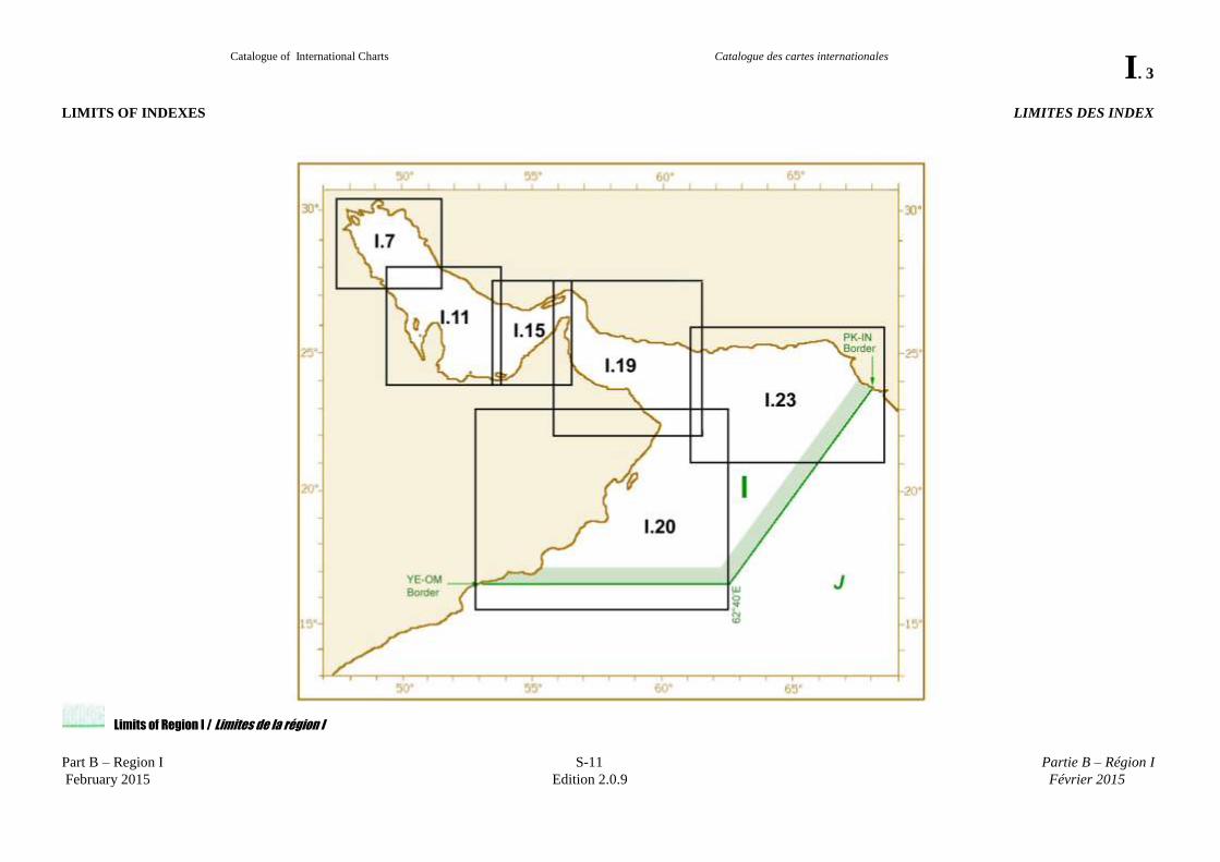
LIMITS OF INDEXES LIMITES DES INDEX
Limits of Region I / Limites de la région I
Catalogue of International Charts
Catalogue des cartes internationales
I. 4
Part B – Region I S-11 Partie B – Région I
February 2015 Edition 2.0.9 Février 2015
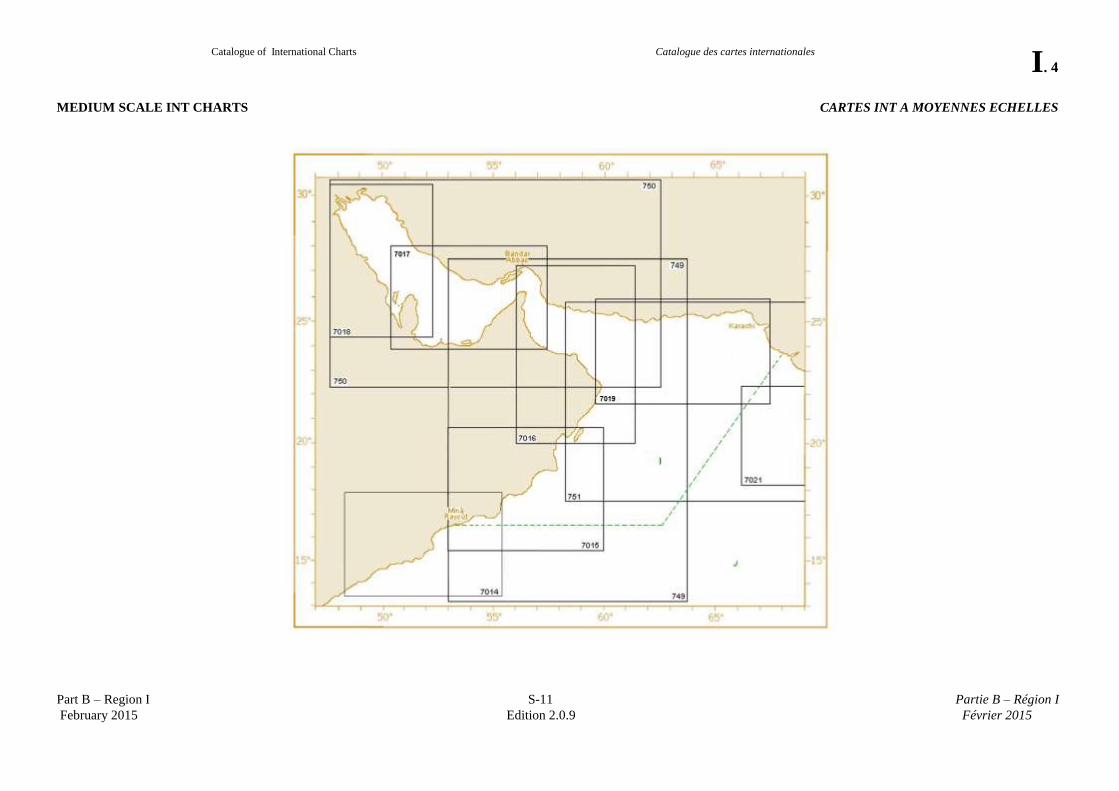
MEDIUM SCALE INT CHARTS CARTES INT A MOYENNES ECHELLES
Catalogue of International Charts
Catalogue des cartes internationales
I. 5
Part B – Region I S-11 Partie B – Région I
February 2015 Edition 2.0.9 Février 2015
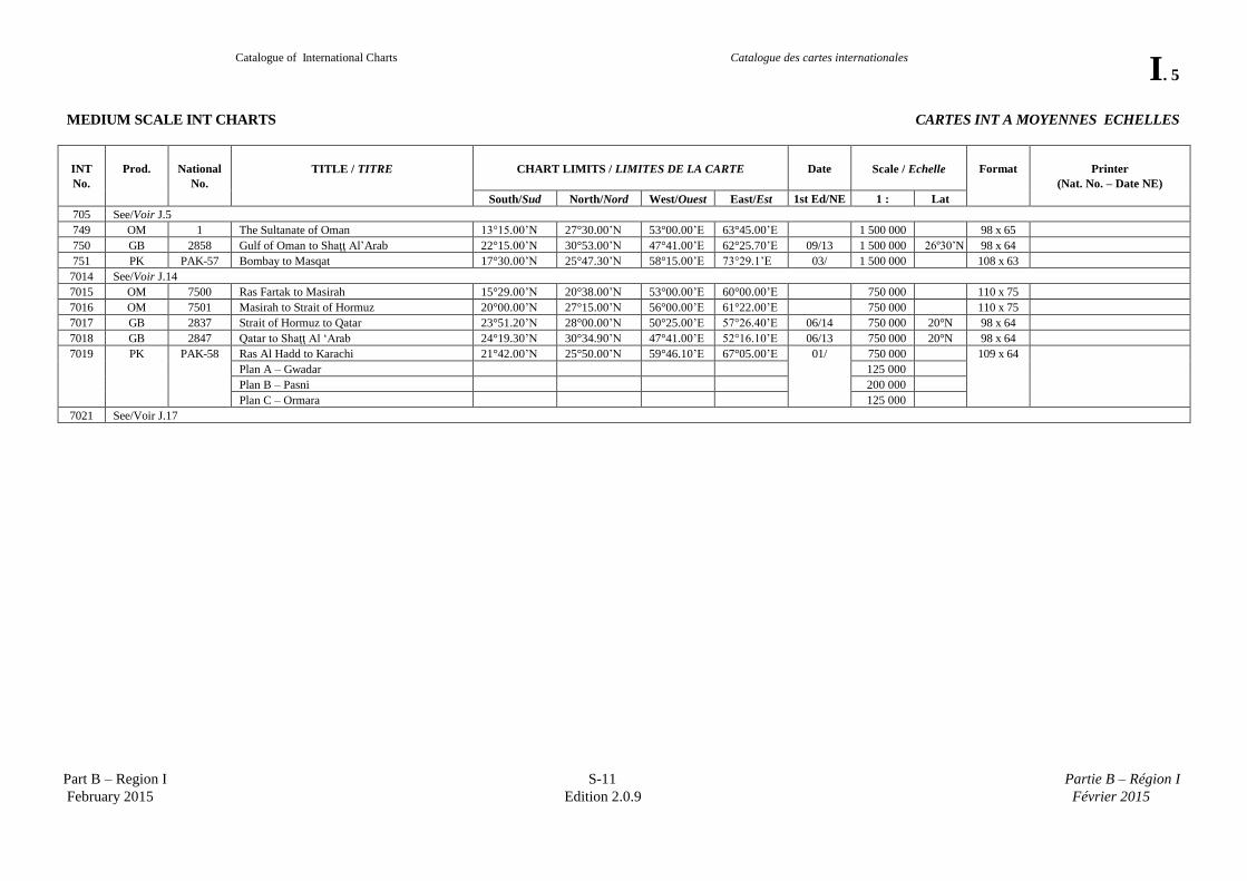
MEDIUM SCALE INT CHARTS CARTES INT A MOYENNES ECHELLES
INT
No.
Prod.
National
No.
TITLE / TITRE
CHART LIMITS / LIMITES DE LA CARTE
Date
Scale / Echelle
Format
Printer
(Nat. No. – Date NE)
South/Sud North/Nord West/Ouest East/Est 1st Ed/NE 1 : Lat
705 See/Voir J.5
749 OM 1 The Sultanate of Oman 13°15.00’N 27°30.00’N 53°00.00’E 63°45.00’E 1 500 000 98 x 65
750 GB 2858 Gulf of Oman to Shaţţ Al’Arab 22°15.00’N 30°53.00’N 47°41.00’E 62°25.70’E 09/13 1 500 000 26º30’N 98 x 64
751 PK PAK-57 Bombay to Masqat 17°30.00’N 25°47.30’N 58°15.00’E 73°29.1’E 03/ 1 500 000 108 x 63
7014 See/Voir J.14
7015 OM 7500 Ras Fartak to Masirah 15°29.00’N 20°38.00’N 53°00.00’E 60°00.00’E 750 000 110 x 75
7016 OM 7501 Masirah to Strait of Hormuz 20°00.00’N 27°15.00’N 56°00.00’E 61°22.00’E 750 000 110 x 75
7017 GB 2837 Strait of Hormuz to Qatar 23°51.20’N 28°00.00’N 50°25.00’E 57°26.40’E 06/14 750 000 20°N 98 x 64
7018 GB 2847 Qatar to Shaţţ Al ‘Arab 24°19.30’N 30°34.90’N 47°41.00’E 52°16.10’E 06/13 750 000 20°N 98 x 64
7019 PK PAK-58 Ras Al Hadd to Karachi 21°42.00’N 25°50.00’N 59°46.10’E 67°05.00’E 01/ 750 000 109 x 64
Plan A – Gwadar 125 000
Plan B – Pasni 200 000
Plan C – Ormara 125 000
7021 See/Voir J.17
Catalogue of International Charts
Catalogue des cartes internationales
I. 6
Part B – Region I S-11 Partie B – Région I
February 2015 Edition 2.0.9 Février 2015
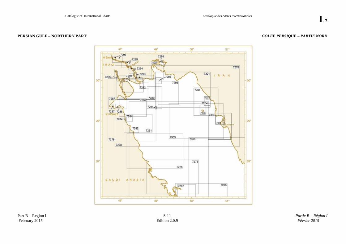
PERSIAN GULF – NORTHERN PART GOLFE PERSIQUE – PARTIE NORD
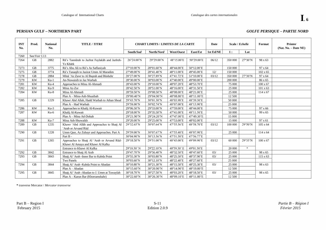
INT
No.
Prod.
National
No.
TITLE / TITRE
CHART LIMITS / LIMITES DE LA CARTE
Date
Scale / Echelle
Format
Printer
(Nat. No. – Date NE)
South/Sud North/Nord West/Ouest East/Est 1st Ed/NE 1 : Lat
7260 See/Voir I.13
7264 GB 2882 Rā’s Tannūrah to Jazīrat Faylakāh and Jazīreh-
Ye Khārk
26°24.00’N 29°29.00’N 48°15.00’E 50°29.00’E 06/12 350 000 27°30’N 98 x 63
7273 GB 3775 Rā’s Abu Ali to Rā’s As Saffaniyah 27°10.00’N 28°01.60’N 48°44.00’E 50°12.00’E 150 000 97 x 64
7275 GB 3774 Rā’s Tanaqib to Jazirat Umm Al Maradim 27°49.00’N 28°41.40’N 48°11.00’E 49°45.00’E 12/ 150 000 102 x 65
7278 GB 2884 Mīnā ’Az Zawr to Al Başrah and Būshehr 28°27.00’N 30°27.89’N 47°41.72’E 51°10.00’E 03/12 350 000 27°30’N 97 x 64
7279 KW Ku-1 An-Nuwaisib to Jaz Warbah 28°30.00’N 30°03.00’N 47°40.00’E 49°00.00’E 200 000 86 x 65
7281 KW Ku-4 Approaches to Mina Al-Ahmadi 28°43.00’N 29°10.00’N 48°07.20’E 48°53.70’E 75 000 100 x 67
7282 KW Ku-9 Mina Az-Zor 28°42.50’N 28°51.00’N 48°16.00’E 48°31.50’E 25 000 101 x 63
7284 KW Ku-8 Mina Al-Ahmadi 28°59.50’N 29°08.50’N 48°08.00’E 48°21.00’E 25 000 114 x 67
Plan A – Mina-Ash-Shuaibah 29°00.40’N 29°04.90’N 48°08.80’E 48°11.00’E 12 500
7285 GB 1229 Khawr Abd Allah, Hadd Warbah to Athan Shoal 29°43.70’N 30°01.30’N 48°03.98’E 48°39.30’E 50 000
Plan A – Had Warbah 29°58.00’N 30°02.74’N 48°07.00’E 48°13.90’E 25 000
7286 KW Ku-3 Approaches to Khalij Al-Kuwait 29°06.50’N 29°33.00’N 47°59.00’E 48°44.00’E 75 000 97 x 66
7287 KW Ku-6 Khalij Al-Kuwait 29°18.00’N 29°35.50’N 47°41.00’E 48°11.50’E 50 000 99 x 65
Plan A – Mina Ad-Dohah 29°21.90’N 29°24.20’N 47°47.00’E 47°49.30’E 15 000
7288 KW Ku-7 Mina Ash-Shuwaikh 29°20.00’N 29°25.00’N 47°53.00’E 48°02.00’E 15 000 97 x 61
7289 GB 1235 Khawr ‘Abd Allāh and Approaches to Shaţţ Al
‘Arab or Arvand Rūd
29°32.65’N 30°07.64’N 47°55.56’E 48°58.70’E 03/12 100 000 29°50’N 105 x 64
7290 GB 1228 Umm Qasr, Az Zubayr and Approaches. Part A 29°59.00’N 30°07.67’N 47°55.40’E 48°07.90’E 25 000 114 x 64
Part B - 30°04.90’N 30°13.56’N 47°51.50’E 47°56.77’E
7291 GB 1265 Approaches to Shaţţ Al ‘Arab or Arvand Rūd-
Khawr Al Amaya and Khawr Al Kafka
29°18.50’N 29°51.00’N 48°45.00’E 49°09.90’E 03/12 60 000 29°35’N 100 x 67
Entrance to Khawr Al Kafka 29º18.50’ N 29º22.10’N 48º59.30’ E 49º01.50’E 20 000 *
7292 GB 3842 Entrance to Shaţţ Al Arab 29°47.70’N 29°56.40’N 48°32.50’E 48°47.60’E 03/ 25 000 98 x 65
7293 GB 3843 Shaţţ Al ‘Arab -Inner Bar to Kabda Point 29°55.30’N 30°03.80’N 48°25.50’E 48°37.90’E 03/ 25 000 115 x 63
Two Panels 30°03.60’N 30°12.10’N 48°22.40’E 48°27.60’E 25 000
7294 GB 3844 Shaţţ Al ‘Arab -Kabda Point to Abadan 30°10.80’N 30°21.30’N 48°15.50’E 48°25.30’E 03/ 25 000 98 x 63
Plan A – Abadan 30°15.60’N 30°20.90’N 48°14.90’E 48°19.80’E 12 500
7295 GB 3845 Shaţţ Al ‘Arab -Abadan to J. Umm at Tuwaylah 30°18.70’N 30°27.50’N 48°03.20’E 48°18.50’E 03/ 25 000 98 x 65
Plan A – Karun Bar (Khorramshahr) 30°22.60’N 30°26.30’N 48°09.10’E 48°11.80’E 12 500
* tranverse Mercator / Mercator transverse
Catalogue of International Charts
Catalogue des cartes internationales
I. 7
Part B – Region I S-11 Partie B – Région I
February 2015 Edition 2.0.9 Février 2015
PERSIAN GULF – NORTHERN PART GOLFE PERSIQUE – PARTIE NORD
Catalogue of International Charts
Catalogue des cartes internationales
I. 8
Part B – Region I S-11 Partie B – Région I
February 2015 Edition 2.0.9 Février 2015
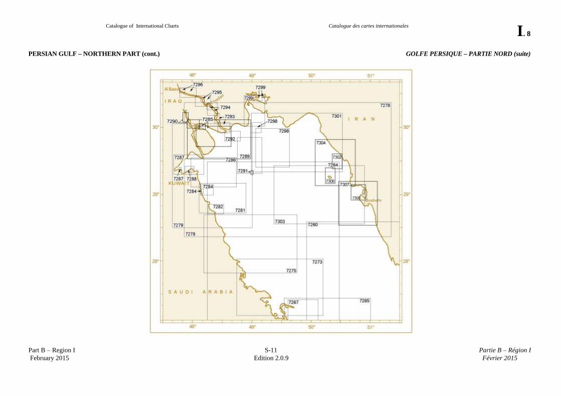
PERSIAN GULF – NORTHERN PART (cont.) GOLFE PERSIQUE – PARTIE NORD (suite)
Catalogue of International Charts
Catalogue des cartes internationales
I. 9
Part B – Region I S-11 Partie B – Région I
February 2015 Edition 2.0.9 Février 2015
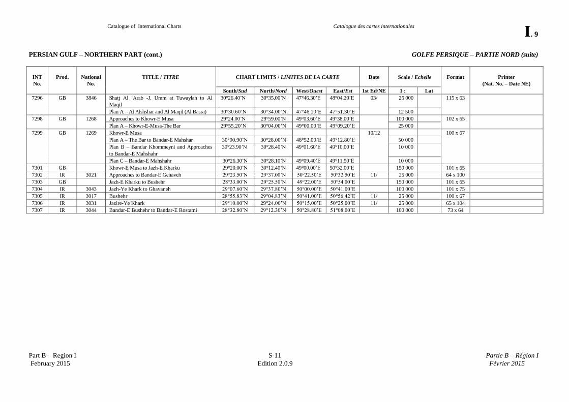
PERSIAN GULF – NORTHERN PART (cont.) GOLFE PERSIQUE – PARTIE NORD (suite)
INT
No.
Prod.
National
No.
TITLE / TITRE
CHART LIMITS / LIMITES DE LA CARTE
Date
Scale / Echelle
Format
Printer
(Nat. No. – Date NE)
South/Sud North/Nord West/Ouest East/Est 1st Ed/NE 1 : Lat
7296 GB 3846 Shaţţ Al ‘Arab -J. Umm at Tuwaylah to Al
Maqil
30°26.40’N 30°35.00’N 47°46.30’E 48°04.20’E 03/ 25 000 115 x 63
Plan A – Al Alshshar and Al Maqil (Al Basra) 30°30.60’N 30°34.00’N 47°46.10’E 47°51.30’E 12 500
7298 GB 1268 Approaches to Khowr-E Musa 29°24.00’N 29°59.00’N 49°03.60’E 49°38.00’E 100 000 102 x 65
Plan A – Khowr-E-Musa-The Bar 29°55.20’N 30°04.00’N 49°00.00’E 49°09.20’E 25 000
7299 GB 1269 Khowr-E Musa 10/12 100 x 67
Plan A – The Bar to Bandar-E Mahshar 30°00.90’N 30°28.00’N 48°52.00’E 49°12.80’E 50 000
Plan B – Bandar Khommeyni and Approaches
to Bandar-E Mahshahr
30°23.90’N 30°28.40’N 49°01.60’E 49°10.00’E 10 000
Plan C – Bandar-E Mahshahr 30°26.30’N 30°28.10’N 49°09.40’E 49°11.50’E 10 000
7301 GB Khowr-E Musa to Jazh-E Kharku 29°20.00’N 30°12.40’N 49°00.00’E 50°32.00’E 150 000 101 x 65
7302 IR 3021 Approaches to Bandar-E Genaveh 29°23.50’N 29°37.00’N 50°22.50’E 50°32.50’E 11/ 25 000 64 x 100
7303 GB Jazh-E Kharku to Bushehr 28°33.00’N 29°25.50’N 49°22.00’E 50°54.00’E 150 000 101 x 65
7304 IR 3043 Jazh-Ye Khark to Ghavaneh 29°07.60’N 29°37.80’N 50°00.00’E 50°41.00’E 100 000 101 x 75
7305 IR 3017 Bushehr 28°55.83’N 29°04.83’N 50°41.00’E 50°56.42’E 11/ 25 000 100 x 67
7306 IR 3031 Jazire-Ye Khark 29°10.00’N 29°24.00’N 50°15.00’E 50°25.00’E 11/ 25 000 65 x 104
7307 IR 3044 Bandar-E Bushehr to Bandar-E Rostami 28°32.80’N 29°12.30’N 50°28.80’E 51°08.00’E 100 000 73 x 64
Catalogue of International Charts
Catalogue des cartes internationales
I. 10
Part B – Region I S-11 Partie B – Région I
February 2015 Edition 2.0.9 Février 2015
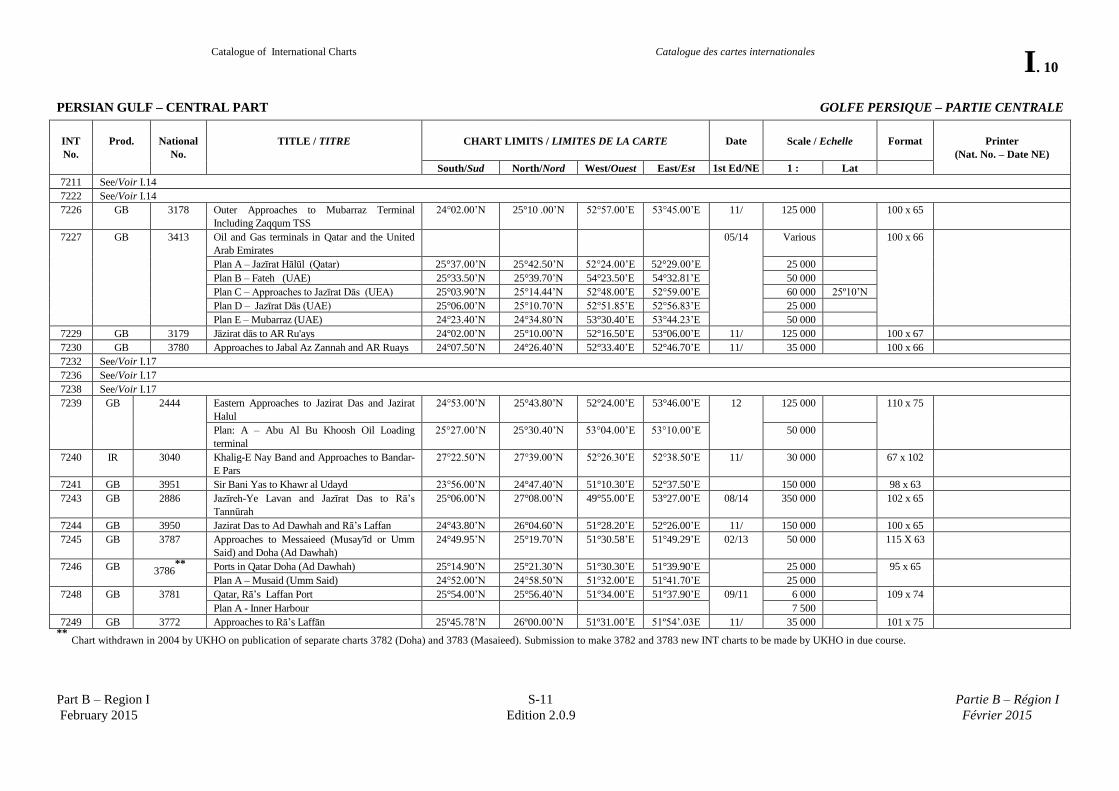
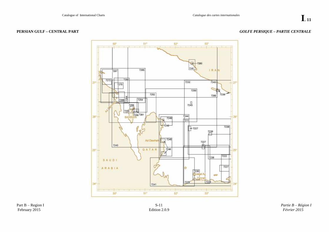
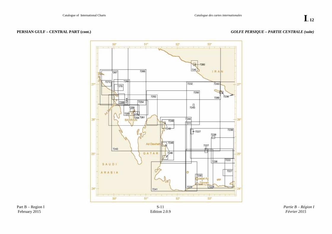
PERSIAN GULF – CENTRAL PART
GOLFE PERSIQUE – PARTIE CENTRALE
INT
No.
Prod.
National
No.
TITLE / TITRE
CHART LIMITS / LIMITES DE LA CARTE
Date
Scale / Echelle
Format
Printer
(Nat. No. – Date NE)
South/Sud North/Nord West/Ouest East/Est 1st Ed/NE 1 : Lat
7211 See/Voir I.14
7222 See/Voir I.14
7226 GB 3178 Outer Approaches to Mubarraz Terminal
Including Zaqqum TSS
24°02.00’N 25°10 .00’N 52°57.00’E 53°45.00’E 11/ 125 000 100 x 65
7227 GB 3413 Oil and Gas terminals in Qatar and the United
Arab Emirates
05/14 Various 100 x 66
Plan A – Jazīrat Hālūl (Qatar) 25°37.00’N 25°42.50’N 52°24.00’E 52°29.00’E 25 000
Plan B – Fateh (UAE) 25°33.50’N 25°39.70’N 54°23.50’E 54°32.81’E 50 000
Plan C – Approaches to Jazīrat Dās (UEA) 25°03.90’N 25°14.44’N 52°48.00’E 52°59.00’E 60 000 25º10’N
Plan D – Jazīrat Dās (UAE) 25°06.00’N 25°10.70’N 52°51.85’E 52°56.83’E 25 000
Plan E – Mubarraz (UAE) 24°23.40’N 24°34.80’N 53°30.40’E 53°44.23’E 50 000
7229 GB 3179 Jāzirat dās to AR Ru'ays 24°02.00’N 25°10.00’N 52°16.50’E 53°06.00’E 11/ 125 000 100 x 67
7230 GB 3780 Approaches to Jabal Az Zannah and AR Ruays 24°07.50’N 24°26.40’N 52°33.40’E 52°46.70’E 11/ 35 000 100 x 66
7232 See/Voir I.17
7236 See/Voir I.17
7238 See/Voir I.17
7239 GB 2444 Eastern Approaches to Jazirat Das and Jazirat
Halul
24°53.00’N 25°43.80’N 52°24.00’E 53°46.00’E 12 125 000 110 x 75
Plan: A – Abu Al Bu Khoosh Oil Loading
terminal
25°27.00’N 25°30.40’N 53°04.00’E 53°10.00’E 50 000
7240 IR 3040 Khalig-E Nay Band and Approaches to Bandar-
E Pars
27°22.50’N 27°39.00’N 52°26.30’E 52°38.50’E 11/ 30 000 67 x 102
7241 GB 3951 Sir Bani Yas to Khawr al Udayd 23°56.00’N 24°47.40’N 51°10.30’E 52°37.50’E 150 000 98 x 63
7243 GB 2886 Jazīreh-Ye Lavan and Jazīrat Das to Rā’s
Tannūrah
25°06.00’N 27°08.00’N 49°55.00’E 53°27.00’E 08/14 350 000 102 x 65
7244 GB 3950 Jazirat Das to Ad Dawhah and Rā’s Laffan 24°43.80’N 26°04.60’N 51°28.20’E 52°26.00’E 11/ 150 000 100 x 65
7245 GB 3787 Approaches to Messaieed (Musay'īd or Umm
Said) and Doha (Ad Dawhah)
24°49.95’N 25°19.70’N 51°30.58’E 51°49.29’E 02/13
50 000 115 X 63
7246 GB 3786**
Ports in Qatar Doha (Ad Dawhah) 25°14.90’N 25°21.30’N 51°30.30’E 51°39.90’E 25 000 95 x 65
Plan A – Musaid (Umm Said) 24°52.00’N 24°58.50’N 51°32.00’E 51°41.70’E 25 000
7248 GB 3781 Qatar, Rā’s Laffan Port 25°54.00’N 25°56.40’N 51°34.00’E 51°37.90’E 09/11
6 000 109 x 74
Plan A - Inner Harbour 7 500
7249 GB 3772 Approaches to Rā’s Laffān 25º45.78’N 26º00.00’N 51º31.00’E 51º54’.03E 11/ 35 000 101 x 75 **
Chart withdrawn in 2004 by UKHO on publication of separate charts 3782 (Doha) and 3783 (Masaieed). Submission to make 3782 and 3783 new INT charts to be made by UKHO in due course.
Catalogue of International Charts
Catalogue des cartes internationales
I. 11
Part B – Region I S-11 Partie B – Région I
February 2015 Edition 2.0.9 Février 2015
PERSIAN GULF – CENTRAL PART GOLFE PERSIQUE – PARTIE CENTRALE
Catalogue of International Charts
Catalogue des cartes internationales
I. 12
Part B – Region I S-11 Partie B – Région I
February 2015 Edition 2.0.9 Février 2015
PERSIAN GULF – CENTRAL PART (cont.) GOLFE PERSIQUE – PARTIE CENTRALE (suite)
Catalogue of International Charts
Catalogue des cartes internationales
I. 13
Part B – Region I S-11 Partie B – Région I
February 2015 Edition 2.0.9 Février 2015
PERSIAN GULF – CENTRAL PART (cont.) GOLFE PERSIQUE – PARTIE CENTRALE (suite)
INT
No.
Prod.
National
No.
TITLE / TITRE
CHART LIMITS / LIMITES DE LA CARTE
Date
Scale / Echelle
Format
Printer
(Nat. No. – Date NE)
South/Sud North/Nord West/Ouest East/Est 1st Ed/NE 1 : Lat
7250 GB 2523 Cable Bank to Rā’s Rakan 25°50.00’N 26°50.50’N 51°02.00’E 52°40.50’E 05/14 150 000 110 x 75
7252 GB 3790 Ra’s Rakan to Rā’s Tannūrah 25°50.32’N 26°43.00’N 49°50.30’E 51°22.00’E 10/12 150 000 110 x 64
7254 BH 6501 Outer Approaches to Bahrain 26°02.00’N 26°35.00’N 50°39.00’E 51°04.00’E 00/12 65 000 26º00’N 92 x 63 GB (3738-12)
7255 BH 5004 Approaches to Bahrain 26°08.00’N 26°25.30’N 50°18.80’E 50°47.20’E 88/12 50 000 26º15’N 95 x 64 GB (3737–12)
7258 BH 1501 Mīnā Salmān and Approaches 26°09.07’N 26°14.30’N 50°35.92’E 50°44.48’E 94/13 15 000 26º12’N 95 x 65 GB (3736–13)
7259 BH 1502 Mīnā’ Al Manāma and Approaches 26°13.50’N 26°18.80’N 50°30.50’E 50°39.10’E 05/12 15 000 95 x 65 GB (3735–12)
7260 GB 2883 Jazīreh-Ye Lavan to Kalāt and Rā’s Tannūrah 26°34.08’N 28°35.00’N 49°55.00’E 53°20.00’E 08/12 350 000 97 x 64
Plan A - Bandar – E Pars (Port of ‘Asalūyeh) 27°30.80’N 27°35.40’N 52°30.00’E 52°35.00’E 35 000
7261 BH 1503 Khalifa Bin Salmān Port and Approaches 26°08.80'N 26°14.30'N 50°39.70'E 50°48.50'E 12/ 15 000 26°12’N 98 x 68 GB (3734-12)
7264 See/Voir I.6
7265 GB 3788 Fasht Al Jārim to Rā’s Abū 'Alī 26°25.14’N 27°26.11’N 49°32.55’E 51°00.00’E 11/12 150 000 27°00’N 97 x 75
7266 GB 3777 Approaches to Ad Dammām, Rā’s Tannūrah
and Rā’s Ju’aymah
26°25.00’N 27°09.00’N 49°59.00’E 50°31.00’E 07/12 80 000 102 x 66
7267 GB 3719 Approaches to Port of Al Jubayl (Al Jubayl) 26°42.00’N 27°24.40’N 49°36.00’E 50°07.00’E 07/ 80 000 98 x 64
7268 GB 3812 Ad Dammām and Rā’s Tannūrah 26°28.30’N 26°44.60’N 50°08.00’E 50°20.00’E 07/12 30 000 100 x 66
7270 GB 3776 Ras Al Juaymah Terminals 26°50.00’N 27°00.50’N 50°00.00’E 50°18.00’E 30 000 99 x 65
7272 GB 3718 Port of Al Jubayl (Al Jubayl) 26°57.33’N 27°07.74’N 49°36.05’E 49°54.55’E 07/ 30 000 98 x 64
Catalogue of International Charts
Catalogue des cartes internationales
I. 14
Part B – Region I S-11 Partie B – Région I
February 2015 Edition 2.0.9 Février 2015
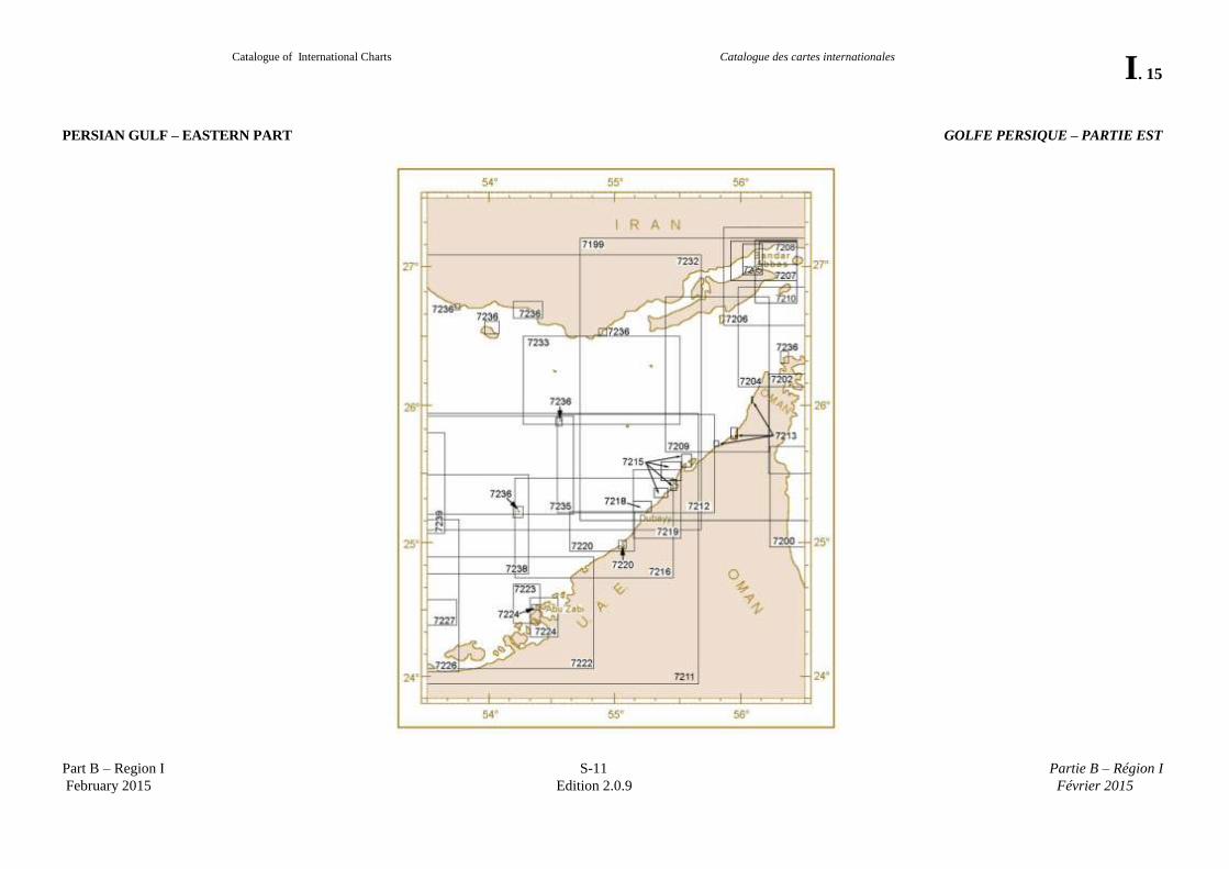
PERSIAN GULF – EASTERN PART GOLFE PERSIQUE – PARTIE EST
INT
No.
Prod.
National
No.
TITLE / TITRE
CHART LIMITS / LIMITES DE LA CARTE
Date
Scale / Echelle
Format
Printer
(Nat. No. – Date NE)
South/Sud North/Nord West/Ouest East/Est 1st Ed/NE 1 : Lat
7200 See/Voir I.18
7204 See/Voir I.18
7205 IR 3070 Bandar-E Shahīd Rajāī 26°57.00’N 27°10.6’N 56°01.0’E 56°11.0’E 08/ 25 000 66 X 100
7206 See/Voir I.18
7207 IR 3012 Approaches to Bandar-E Shahīd Bahonar and
Bandar-E Shahīd Rajāī
26°54.00’N 27°11.50’N 55°56.90’E 56°27.70’E 08/11 50 000 102 x 65
7208 IR 3002 Bandar-E Shahīd Bahonar to Jazireh-Ye
Hormoz
27°01.20’N 27°11.40’N 56°09.90’E 56°27.70’E 11/ 30 000 98 x 63
7209 GB 3174 Western Approaches to the Strait of Hormuz 25°40.50’N 26°47.50’N 55°23.80’E 56°13.50’E 12/ 125 000 100 x 67
7210 IR 3010 Jazire-Ye Qeshm to Jazayer-E Hormoz & Larak 26°45.50’N 27°12.00’N 56°07.90’E 56°27.50’E 50 000 65 x 98
7211 GB 2889 Dubai (Dubayy) to Jabal az Zannah and Jazīrat
Das
23°57.00’N 25°57.00’N 52°15.00’E 55°40.00’E 95/12 350 000 98 x 65
7212 GB 3175 Jazīrat al Hamra’ to Dubai (Dubayy) and Jazīreh
– ye Sirrī
25°13.00’N 25°57.00’N 54°32.50’E 55°48.00’E 06/12 125 000 25°30’N 101 x 65
7213 GB 3404 Ports in Ras Al Khaymah 13/
Plan A – Saqr Port (Mina Saqr) 25°56.20’N 26°01.40’N 56°00.40’E 56°04.76’E 15 000
Plan B – Rak Khor Port 25°47.40’N 25°48.80’N 55°56.90’E 55°58.05’E 7 500
Plan C – Approaches to RAK Khor Port 25°45.88’N 25°52.00’N 55°54.41’E 55°58.30’E 30 000
Plan D – Al Jazeera Port (Al Jazirah Port) 25°42.02’N 25°45.10’N 55°46.50’E 55°49.05’E 20 000
Plan E – Al Jeer Port 26°01.32’N 26°04.40’N 56°04.00’E 56°05.30’E 20 000
7215 GB 3405 Ports in Ajman, Sharjah and Umm Al
Quaywayn
13/
Plan A – Ajman 25°23.40’N 25°28.60’N 55°26.20’E 55°28.20’E 15 000
Plan B – Umm al Qaywayn 25°33.60’N 25°39.40’N 55°31.53’E 55°36.00’E 30 000
Plan C – Hamriyah Freezone Port 25°27.50’N 25°37.90’N 55°22.33’E 55°31.00’E 30 000
Plan D – Sharjah (Ash Shariqah) 25°20.50’N 25°24.18’N 55°19.00’E 55°23.90’E 25 000
7216 GB 3176 ‘Ajmān to Şīr Abū Nú Ayr 24°44.50’N 25°28.50’N 54°12.00’E 55°28.00’E 06/12 125 000 102 x 65
7218 GB 3414 Dubai (Dubayy) and Approaches 25°14.10’N 25°19.30’N 55°09.55’E 55°18.30’E 06/11 15 000 100 x 65
7219 GB 3412 Hamriyah to Mina Seyaha 25°02.90’N 25°32.70’N 55°08.00’E 55°30.30’E 06/11 50 000 110 x 75
7220 GB 3739 Jebel Ali (Mīnā’ Jabal ‘Ālī) and Approaches 24°55.89’N 25°13.50’N 54°39.20’E 55°09.50’E 02/12 50 000 102 x 65
Plan A – Jebel Ali (Mīnā’ Jabal ‘Ālī) 24°58.20’N 25°03.00’N 55°01.80’E 55°05.10’E 25 000
7222 GB 3177 Outer Approaches to Abu Zabi 24°03.00’N 24°54.00’N 53°29.00’E 54°50.00’E (10)/ 125 000 109 x 75
7223 GB 3713 Approaches to Abu Zabi (Abu Dhabi) 24°24.20’N 24°41.80’N 54°11.80’E 54°24.70’E 11/ 32 500 100 x 67
7224 GB 3715 Abu Zabi (Abu Dhabi) and Umm An Nar 24°18.00’N 24°35.60’N 54°20.00’E 54°32.90’E 11/ 32 500 100 x 67
Plan A – Mina Zayed 24°30.80’N 24°32.60’N 54°22.50’E 54°24.50’E 12 500
( ) published as national chart / publiée en tant que carte nationale
Catalogue of International Charts
Catalogue des cartes internationales
I. 15
Part B – Region I S-11 Partie B – Région I
February 2015 Edition 2.0.9 Février 2015
PERSIAN GULF – EASTERN PART GOLFE PERSIQUE – PARTIE EST
Catalogue of International Charts
Catalogue des cartes internationales
I. 16
Part B – Region I S-11 Partie B – Région I
February 2015 Edition 2.0.9 Février 2015
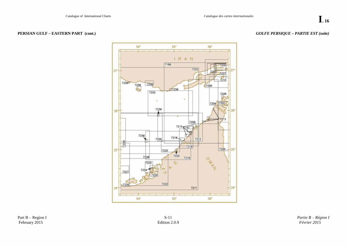
PERSIAN GULF – EASTERN PART (cont.) GOLFE PERSIQUE – PARTIE EST (suite)
Catalogue of International Charts
Catalogue des cartes internationales
I. 17
Part B – Region I S-11 Partie B – Région I
February 2015 Edition 2.0.9 Février 2015
PERSIAN GULF – EASTERN PART (cont.) GOLFE PERSIQUE – PARTIE EST (suite)
INT
No.
Prod.
National
No.
TITLE / TITRE
CHART LIMITS / LIMITES DE LA CARTE
Date
Scale / Echelle
Format
Printer
(Nat. No. – Date NE)
South/Sud North/Nord West/Ouest East/Est 1st Ed/NE 1 : Lat
7226 See/Voir I.10
7227 See/Voir I.10
7232 GB 2887 Dubai (Dubayy) and Jazīreh-ye Qeshm to
Jazīreh Hālūl
25°06.10’N 27°04.92’N 52°17.06’E 55°41.77’E 05/14 350 000 98 x 63
7233 GB 2441 Jazīreh-Ye Tonb-e Borzog to Jazīreh-Ye-Forūr 25°52.50’N 26°30.00’N 54°16.00’E 55°32.00’E 13/ 125 000 102 x 65
7235 GB 2442 Jaz-Ye Sirri to Sir Anu Nuayr 25°13.00’N 25°57.00’N 53°26.00’E 54°40.00’E 125 000 100 x 65
7236 GB 3409 Ports and Anchorages in Iran, Oman and United
Arab Emirates
100 x 64
Plan A – Bandar-E-Moqam 26°57.30’N 26°59.10’N 53°26.50’E 53°28.90’E 25 000
Plan B – Chiru 26°41.30’N 26°43.50’N 53°43.00’E 53°44.80’E 35 000
Plan C – Bandar-E Charak 26°38.00’N 26°45.00’N 54°11.00’E 54°25.10’E 150 000
Plan D – Jazireh-Ye Lavan 26°44.80’N 26°48.80’N 53°18.10’E 53°25.20’E 25 000
Plan E – Jazirat Sir Abu NU Ayr 25°11.30’N 25°16.10’N 54°11.00’E 54°15.80’E 50 000
Plan F – Qeys Anchorage 26°30.60’N 26°36.20’N 53°57.00’E 54°03.40’E 50 000
Plan G – Sirri Oil Terminal 25°52.20’N 25°55.00’N 54°31.90’E 54°35.50’E 25 000
Plan H – Bnadar-E Lengeh 26°30.80’N 26°33.60’N 54°51.90’E 54°54.40’E 25 000
Plan I – Khwar Al Quway Anchorage 26°18.60’N 26°23.80’N 56°19.60’E 56°22.90’E 15 000
7238 GB 2443 Sir Abu Nuayr to Jaz Zarakkuh 24°46.00’N 25°30.00’N 53°03.00’E 54°19.00’E 11/ 125 000 102 x 65
7239 See/Voir I.10
Catalogue of International Charts
Catalogue des cartes internationales
I. 18
Part B – Region I S-11 Partie B – Région I
February 2015 Edition 2.0.9 Février 2015
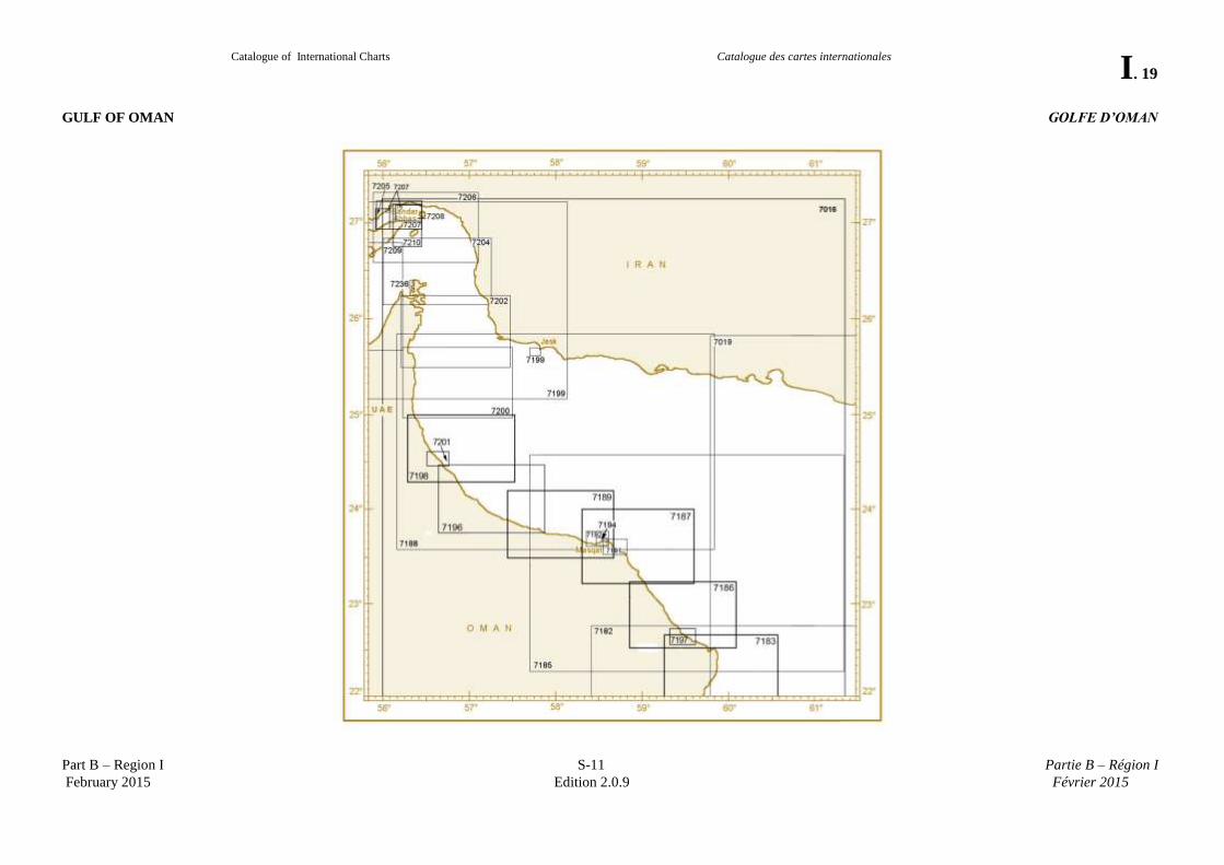
GULF OF OMAN GOLFE D’OMAN
INT
No.
Prod.
National
No.
TITLE / TITRE
CHART LIMITS / LIMITES DE LA CARTE
Date
Scale / Echelle
Format
Printer
(Nat. No. – Date NE)
South/Sud North/Nord West/Ouest East/Est 1st Ed/NE 1 : Lat
7019 See/Voir I.5
7182 See/Voir I.21
7183 See/Voir I.21
7185 OM 3504 Rā’s Al Hadd to Muscat 22°16.00’N 24°34.00’N 57°42.00’E 61°22.00’E 350 000 110 x 75
7186 OM 1212 Rā’s Al Hadd to Dagmar 22°31.00’N 23°14.50’N 58°51.80’E 60°06.80’E 125 000 110 x 75
7187 OM 1213 Quriyat to Jazirat Al Fahl 23°13.00’N 24°00.00’N 58°18.00’E 59°36.00’E 125 000 110 x 75
7188 OM 3505 Muscat to Lima 23°34.00’N 25°58.00’N 56°10.00’E 59°50.00’E 350 000 110 x 75
7189 OM 1214 Muscat to As Suwaiq 23°29.00’N 24°12.20’N 57°26.00’E 58°41.00’E 125 000 110 x 75
7191 OM 254 Eastern Approaches to Muscat 23°30.20’N 23°40.30’N 58°31.70’E 58°47.80’E 25 000 110 x 75
7192 OM 255 Western Approaches to Muscat 23°34.80’N 23°44.90’N 58°20.90’E 58°37.00’E 25 000 110 x 75
7194 OM 120 Muscat to Mina Al Fahl 23°36.50’N 23°41.60’N 58°28.60’E 58°36.60’E 12 500 110 x 75
7196 OM 1215 Rā’s As Sawadi to Sohar 23°45.00’N 24°28.78’N 56°35.00’E 57°49.00’E 125 000 110 x 75
7197 OM 301 Sur to Qalhat 22º33.80’N 22º44.20’N 59º19.40’E 59º37.00’E 30 000 110 x 75
7198 OM 1216 Ras Salan to Khatmat Melaha 24°17.00’N 25°00.00’N 56°17.00’E 57°32.00’E 125 000 110 x 75
7199 GB 2888 Jāsk to Dubai (Dubayy) and Jazīreh-ye Qeshm 25°10.00’N 27°13.00’N 54°43.00’E 58°08.00’E 05/13 350 000 25°30’N 98 x 65
Plan A – Iran - Jāsk 25°36.00’N 25°41.00’N 57°41.00’E 57°48.20’E 25°30’N
7200 GB 3520 Khawr Kalbā and Dawhat Diba to Gahhā Shoal 24°58.33’N 25°42.40’N 56°14.40’E 57°30.50’E 04/10 125 000 25°30’N 101 x 65
7201 OM 257 Approaches to Port Sohar 24º27.50’N 24º37.00’N 56º30.50’E 56º46.00’E 25 000 110 x 75
7202 OM 1218 Ras Daba to Khawr Al Habalayn 25°30.50’N 26°14.00’N 56°13.50’E 57°29.50’E (11)/ 125 000 102 x 65
7204 OM 1219 The Strait of Hormuz 26°08.40’N 26°50.70’N 56°00.10’E 57°15.10’E (11)/ 125 000 110 x 75
7205 See/Voir I.14
7206 GB Strait of Hormuz-Northern part 26°35.00’N 27°18.00’N 55°53.00’E 57°07.00’E 125 000 90 x 65
7207 See/Voir I.14
7208 See/Voir I.14
7209 See/Voir I.14
7210 See/Voir I.14
( ) published as national chart / publiée en tant que carte nationale
Catalogue of International Charts
Catalogue des cartes internationales
I. 19
Part B – Region I S-11 Partie B – Région I
February 2015 Edition 2.0.9 Février 2015
GULF OF OMAN GOLFE D’OMAN
Catalogue of International Charts
Catalogue des cartes internationales
I. 20
Part B – Region I S-11 Partie B – Région I
February 2015 Edition 2.0.9 Février 2015
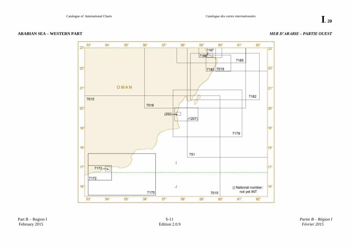
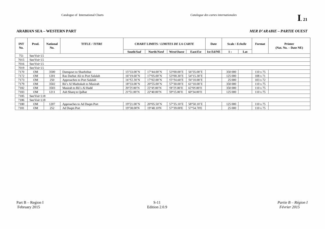
ARABIAN SEA – WESTERN PART MER D’ARABIE – PARTIE OUEST
Catalogue of International Charts
Catalogue des cartes internationales
I. 21
Part B – Region I S-11 Partie B – Région I
February 2015 Edition 2.0.9 Février 2015
ARABIAN SEA – WESTERN PART MER D’ARABIE – PARTIE OUEST
INT
No.
Prod.
National
No.
TITLE / TITRE
CHART LIMITS / LIMITES DE LA CARTE
Date
Scale / Echelle
Format
Printer
(Nat. No. – Date NE)
South/Sud North/Nord West/Ouest East/Est 1st Ed/NE 1 : Lat
751 See/Voir I.5
7015 See/Voir I.5
7016 See/Voir I.5
7019 See/Voir I.5
7170 OM 3500 Damqawt to Sharbithat 15°33.00’N 17°44.00’N 53°00.00’E 56°35.00’E 350 000 110 x 75
7172 OM 1201 Ras Darbat Ali to Port Salalah 16°19.60’N 17°05.00’N 53°00.30’E 54°15.30’E 125 000 108 x 71
7173 OM 250 Approaches to Port Salalah 16°52.30’N 17°02.00’N 53°54.60’E 54°10.00’E 25 000 103 x 72
7179 OM 3502 Rā’s Al Madrakah to Masirah 18°33.00’N 20°55.00’N 57°30.00’E 61°10.00’E 350 000 110 x 75
7182 OM 3503 Masirah to Rā’s Al Hadd 20°25.00’N 22°45.00’N 58°25.00’E 62°05.00’E 350 000 110 x 75
7183 OM 1211 Ash Sharq to Qalhat 21°51.00’N 22°40.00’N 59°15.00’E 60°34.00’E 125 000 110 x 75
7185 See/Voir I.18
7186 See/Voir I.18
7180 OM 1207 Approaches to Ad Duqm Port 19°21.00’N 20°05.50’N 57°35.10’E 58°50.10’E 125 000 110 x 75
7181 OM 252 Ad Duqm Port 19°38.00'N 19°48.10'N 57°39.00'E 57°54.70'E 25 000 110 x 75
Catalogue of International Charts
Catalogue des cartes internationales
I. 22
Part B – Region I S-11 Partie B – Région I
February 2015 Edition 2.0.9 Février 2015
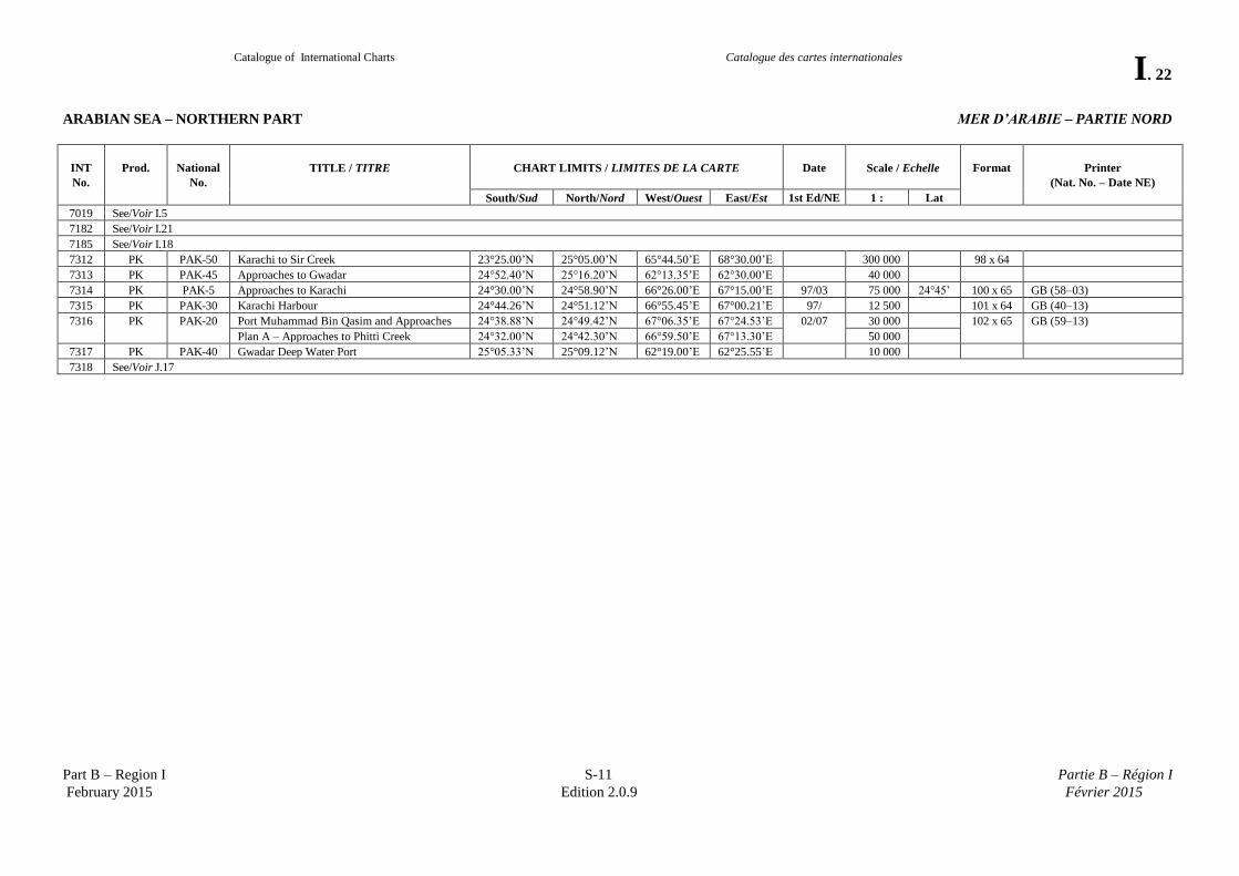
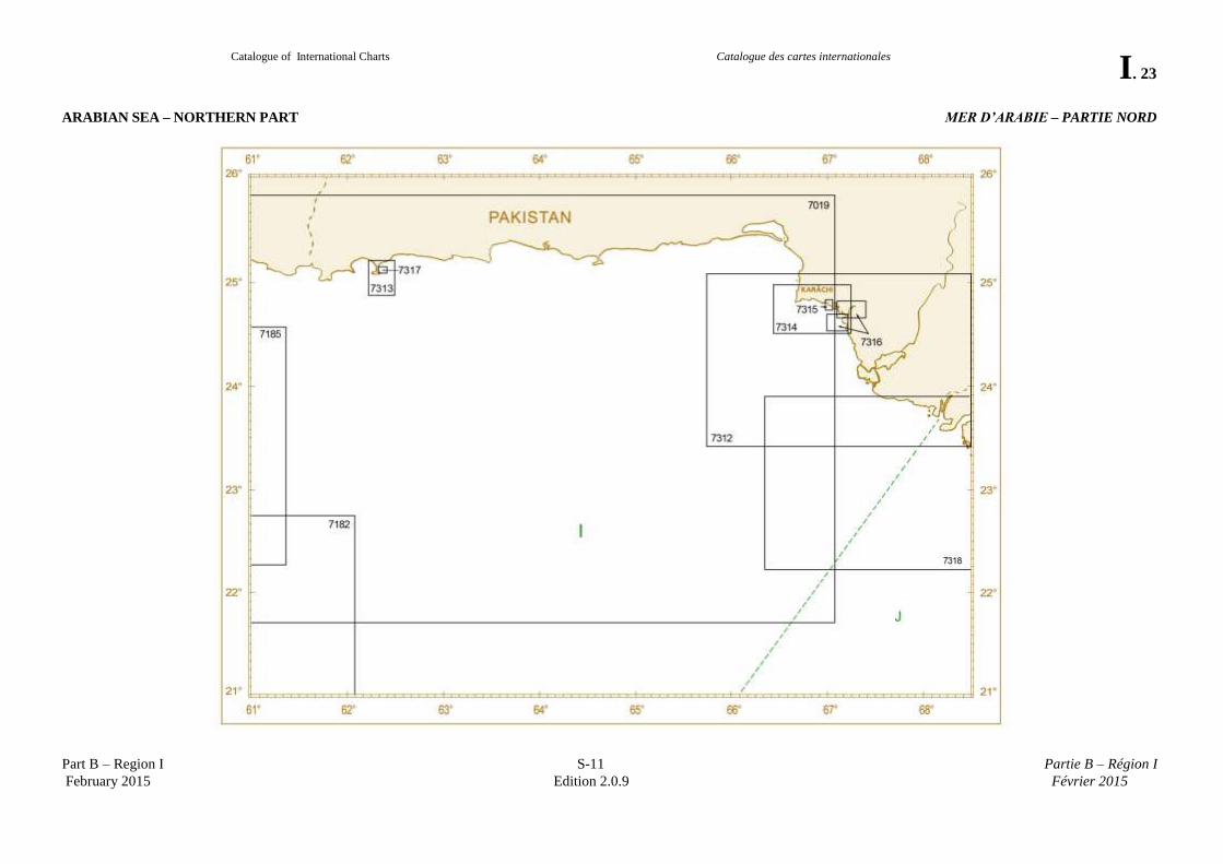
ARABIAN SEA – NORTHERN PART MER D’ARABIE – PARTIE NORD
INT
No.
Prod.
National
No.
TITLE / TITRE
CHART LIMITS / LIMITES DE LA CARTE
Date
Scale / Echelle
Format
Printer
(Nat. No. – Date NE)
South/Sud North/Nord West/Ouest East/Est 1st Ed/NE 1 : Lat
7019 See/Voir I.5
7182 See/Voir I.21
7185 See/Voir I.18
7312 PK PAK-50 Karachi to Sir Creek 23°25.00’N 25°05.00’N 65°44.50’E 68°30.00’E 300 000 98 x 64
7313 PK PAK-45 Approaches to Gwadar 24°52.40’N 25°16.20’N 62°13.35’E 62°30.00’E 40 000
7314 PK PAK-5 Approaches to Karachi 24°30.00’N 24°58.90’N 66°26.00’E 67°15.00’E 97/03 75 000 24°45’ 100 x 65 GB (58–03)
7315 PK PAK-30 Karachi Harbour 24°44.26’N 24°51.12’N 66°55.45’E 67°00.21’E 97/ 12 500 101 x 64 GB (40–13)
7316 PK PAK-20 Port Muhammad Bin Qasim and Approaches 24°38.88’N 24°49.42’N 67°06.35’E 67°24.53’E 02/07 30 000 102 x 65 GB (59–13)
Plan A – Approaches to Phitti Creek 24°32.00’N 24°42.30’N 66°59.50’E 67°13.30’E 50 000
7317 PK PAK-40 Gwadar Deep Water Port 25°05.33’N 25°09.12’N 62°19.00’E 62°25.55’E 10 000
7318 See/Voir J.17
Catalogue of International Charts
Catalogue des cartes internationales
I. 23
Part B – Region I S-11 Partie B – Région I
February 2015 Edition 2.0.9 Février 2015
ARABIAN SEA – NORTHERN PART MER D’ARABIE – PARTIE NORD
Catalogue of International Charts
Catalogue des cartes internationales
I. 24
Part B – Region I S-11 Partie B – Région I
February 2015 Edition 2.0.9 Février 2015
Page intentionally left blank Page laissée en blanc intentionnellement