Embed Size (px)
Citation preview
Regional and Local Agency Comments

Sent via electronic mail: No hard copy to follow
June 2, 2015 CIWQS Place ID No. 815559 California State Parks Off-Highway Motor Vehicle Recreation Division c/o AECOM, attn. Carnegie SVRA General Plan 2020 L Street, Suite 400 Sacramento CA 95811
Attn: Dan Canfield, California Department of Parks and Recreation - OHMVR Division ([email protected])
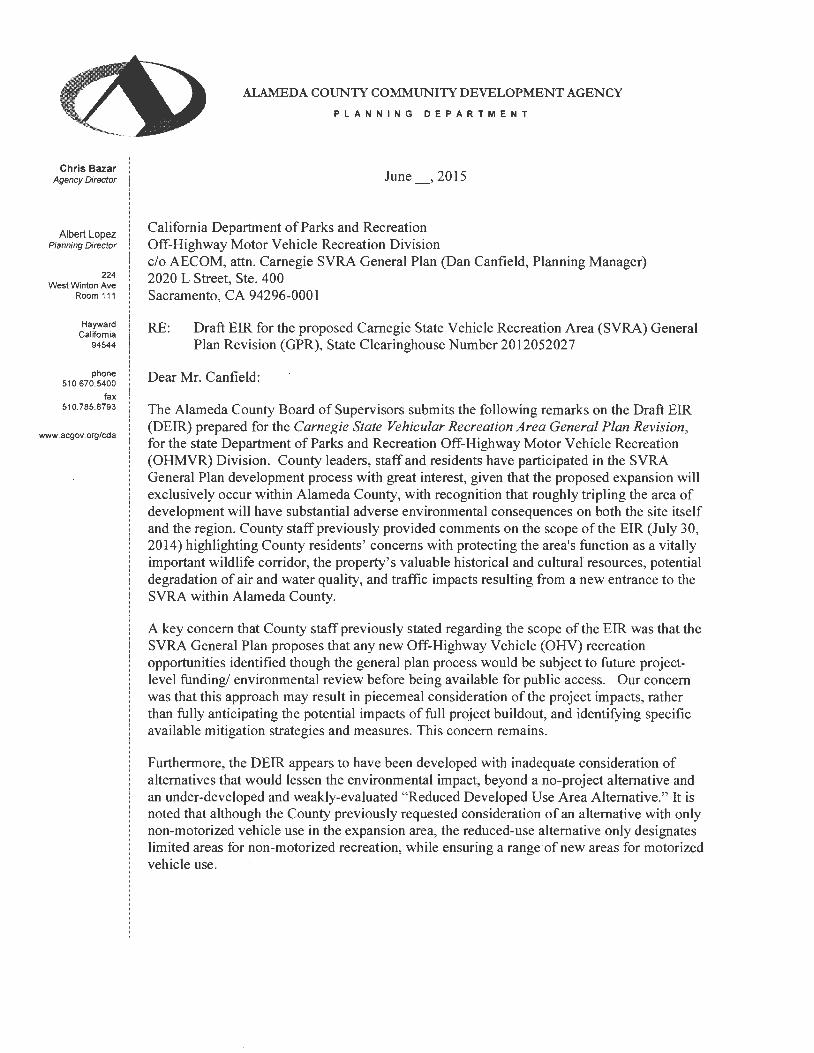
Subject: Draft Environmental Impact Report for the Carnegie State Vehicular Recreation Area General Plan Revision, Alameda County
SCH No. 2012052027
Dear Mr. Canfield:
San Francisco Bay Regional Water Quality Control Board (Water Board) staff has reviewed the Draft Environmental Impact Report for the Carnegie State Vehicular Recreation Area General Plan Revision, Alameda County (DEIR). The DEIR assesses potential impacts associated with implementing the Carnegie State Vehicular Recreation Area (SVRA) General Plan (Project).
We are concerned that the DEIR does not yet provide sufficient and sufficiently detailed information and analysis to support its findings that reasonably foreseeable impacts will be mitigated to a level of insignificance. It should be revised, as discussed in more detail below, and recirculated to allow the public and governmental agencies to review the proposed impacts and mitigations consistent with the CEQA Guidelines. Examples of areas needing more detail include potential impacts to California Red-Legged Frog (CRLF) and beneficial uses of State Waters resulting from creek crossings, paths near creeks, and vehicle use in and around creeks. Also, we recommend that the DEIR be revised to include existing guidance on species impacts: the East Alameda County Conservation Strategy. Finally, please revise the DEIR to recognize that the San Francisco Bay Regional Water Board has jurisdiction over portions of the project located in the Arroyo Seco watershed.
Project Description
The Carnegie SVRA is a destination for intermediate and advanced off-highway motorcycles from multiple age groups. Known for steep hillsides and challenging terrain, the SVRA attracts families and single riders who want to ride for a few hours, camp and ride for several days, or
California State Parks, OHV Recreation Division - 2 - Carnegie SVRA General Plan Revision, DEIR compete in or watch hill climbs or other special events. Various facilities that support recreation opportunities are located within the approximately 4,675-acre SVRA: 1,575 acres in the original SVRA and 3,100 acres in the expansion area. Existing facilities include multiple restrooms, day-use sites for picnicking and staging, and recreational facilities that include off-highway vehicle (OHV) trails, a motocross track, all-terrain vehicle (ATV)/motocross track, 70cc children’s track, 110cc beginner track, 4x4 challenge area, hillclimb special-event area, campsites, and park concessions. In addition to the long-range planning provided through the General Plan, the project includes multiple improvements to park facilities related to access, education, recreation opportunities, and operations. Proposed improvements include: new entrance gates; a gathering area and interpretive facility at the Tesla Coal Mine Site; more recreational opportunities (i.e., multiuse OHV routes, four-wheel-drive technical course and trail/road system); new gathering areas; parking; a training site that could include office space, parking, or camping; additional maintenance space; a ranger station; a new interpretive facility; communication or technology support facilities; and a helicopter landing site.
Water Board Staff Comments
Water Board staff have the following comments on the DEIR.
Comment 1. Chapter 1, Section 1.1, Type, Purpose, and Intended Use of this Environmental Impact Report. The DEIR should be revised to include the need to obtain permits from the San Francisco Bay Regional Water Quality Control Board for activities in the Arroyo Seco watershed. This section of the DEIR includes a list of the regulatory agencies that may use the EIR when issuing permits for activities at the Carnegie SVRA. The list includes the Central Valley Regional Water Quality Control Board, and should be revised to include the San Francisco Bay Regional Water Board. Although much of the facility is located within watersheds that are regulated by the Central Valley Regional Water Quality Control Board, portions of the proposed expansion area are located within the Arroyo Seco watershed. Activities within the Arroyo Seco watershed are subject to the jurisdiction of the San Francisco Bay Regional Water Quality Control Board.
Additionally, the DEIR should be revised to include information about any proposed trail crossings over Arroyo Seco or its tributaries. Based on Figure 2-3, areas in the Arroyo Seco watershed are proposed for use as a Limited Recreation Area. The DEIR states that allowable uses in a Limited Recreation Area may include:
Roads or trails may cross these areas to facilitate public egress/ingress and connectivity between other visitor experience areas; however, their footprint should be limited to the minimum necessary to serve their intended purpose, and they should be designed and managed to avoid or minimize impacts on the surrounding resources. No other facilities will be allowed. These areas could be available for nonmotorized recreational opportunities.
In the Arroyo Seco watershed, portions of the Arroyo and its tributaries are located within the Limited Recreation Area. The DEIR lacks sufficient detail for Water Board staff to assess the extent to which impacts to waters of the State would “be limited to the minimum necessary to serve their intended purpose.” If trail crossings are proposed over Arroyo Seco or its tributaries,
California State Parks, OHV Recreation Division - 3 - Carnegie SVRA General Plan Revision, DEIR the DEIR should indicate the proposed number, location, and designs of such crossings. Without this information, Water Board staff is not able to assess the potential significance of impacts to these waters of the State.
Comment 2. Chapter 3, Biotic Resources, Section 3.3.3, Thresholds of Significance. The DEIR should be revised to use the guidance of the East Alameda County Conservation Strategy to assess project impacts and to develop mitigation measures. Text in Section 3.3.3 incorrectly states that the expansion area is not within the coverage area of any adopted or proposed HCP or NCCP. However, the expansion area is in the area covered by the East Alameda County Conservation Strategy (EACCS). The EACCS was developed with the input of multiple stakeholders, including the Water Board, the California Department of Fish and Wildlife (CDFW), and the U.S. Fish and Wildlife Service (USFWS). These agencies rely significantly on the EACCS when assessing potential project impacts to listed species and their habitats and in setting appropriate mitigation for impacts to listed species and their habitats. Therefore, for the purposes of the DEIR and to facilitate future planning at Carnegie SVRA, the EACCS should be treated as an adopted or proposed HCP, or as local policy or ordinance protecting biological resources.
Under the authority of the Porter-Cologne Water Quality Control Act, the Water Board has developed, and implements, the San Francisco Bay Basin Water Quality Control Plan (Basin Plan), which defines the Beneficial Uses of waters of the State within the San Francisco Bay Region. The water bodies in the San Francisco Bay Region that may be impacted by the Project include Arroyo Seco and its headwater tributaries. Per the Basin Plan, Arroyo Seco has the following existing Beneficial Uses in the Basin Plan: groundwater recharge; cold freshwater habitat; fish migration; preservation of rare and endangered species; warm freshwater habitat; wildlife habitat, water contact recreation; and non-contact water recreation. Since the Beneficial Uses of any specifically identified water body generally apply to all its tributaries, the beneficial uses assigned to Arroyo Seco apply to the tributaries of Arroyo Seco. Any permit action taken by the Water Board must be consistent with appropriately protecting and maintaining Beneficial Uses of waters of the State. Since the beneficial uses of Arroyo Seco include the preservation of rare and endangered species, any permits issued by the Water Board for impacts to waters of the State (e.g., hardened creek crossings or culverts) must address potential impacts to listed species or their habitat. The EACCS will be one of the resources used by the Water Board in assessing potential impacts to the beneficial use of the preservation of rare and endangered species, and in assessing appropriate mitigation for any such impacts.
Comment 3. Chapter 3, Biotic Resources, Section 3.3.4, Environmental Evaluation. The information provided in the DEIR does not support the assertion that impacts to biological resources can be reduced to less than significant levels Section 3.3.4 includes the following text:
Although avoiding and minimizing impacts on biological resources is an important objective of the Carnegie SVRA General Plan, it may not be possible to avoid all potential impacts on all biological resources and still provide OHV and related recreational opportunities in the planning area. For purposes of the General Plan and this evaluation, impacts on biological resources would be considered unavoidable if the overall purpose of the General Plan (providing OHV and other recreational activities) could not be achieved while still avoiding the potential impact on biological resources. However, as discussed in the impact assessment below, no significant unavoidable impacts on biological resources
California State Parks, OHV Recreation Division - 4 - Carnegie SVRA General Plan Revision, DEIR
would occur with implementation of statutory and regulatory requirements and the General Plan goals and guidelines.
As is discussed below, the current text of the DEIR does not support the conclusion that implementation of the Carnegie SVRA General Plan would have “no significant unavoidable impacts on biological resources . . . with implementation of statutory and regulatory requirements and the General Plan goals and guidelines.”
Section 3.3.4 includes Impact 3.3-3, Potential Loss of or Substantial Disturbance to Riparian Habitat or Special-Status Natural Communities. According to text in the discussion of this impact, potential impacts to riparian habitat or special-status natural communities would be mitigated to less than significant levels with Water Goal 1, NRM Goal 1, and NRM Goal 2, and their associated guidelines in the General Plan. Each of these goals and guidelines are discussed below.
Water Goal 1: Manage the SVRA for the protection of jurisdictional waters of the United States, including wetlands, and waters of the state, while maintaining a quality OHV recreational experience.
► Water Guideline 1.1: Avoid locating facilities in areas delineated as jurisdictional waters of the United States, including wetlands; areas that qualify as waters of the state under the Porter-Cologne Water Quality Control Act of 1969, and areas subject to CDFW regulation under California Fish and Game Code Section 1602. Where avoidance is not feasible, such as for trail crossings, design facilities to minimize impacts.
► Water Guideline 1.2: Work to attain no net loss of wetlands functions and values at the SVRA. If impacts on jurisdictional features cannot be fully avoided:
• Determine the acreage of direct impacts (i.e., fill of wetlands) and indirect impacts (i.e., alterations to wetland hydrology) that would result from project implementation.
• Provide compensatory mitigation such that the functions and values of all affected wetlands and other waters of the United States, waters of the state, and stream and riparian habitats protected under the California Fish and Game Code are replaced, restored, or enhanced on a “no net loss” basis. Restore, enhance, and/or replace wetland, water, and riparian habitat acreage at a location and by methods agreeable to USACE, the Central Valley RWQCB, CDFW, and/or USFWS as appropriate and depending on agency jurisdiction.
Water Guideline 1.1 lacks a discussion of designs of trail crossings that would minimize impacts. In the absence of this information, it is not possible to conclude from the material present in the DEIR that facilities can be designed to minimize impacts to less than significant levels.
Water Guideline 1.2 only mentions the Central Valley Regional Water Board. Impacts within the Arroyo Seco watershed will be subject to the jurisdiction of the San Francisco Bay Regional Water Board. This guideline also focusses only on acreage of impacts. For impacts to linear features, such as stream channels and riparian habitat, the San Francisco Bay Regional Water Quality Control Board requires that impacts and proposed mitigation measures be provided on the basis of linear feet. Also, Water Guideline 1.2 provides no concrete examples of mitigation, other than, “[r]estore, enhance, and/or replace wetland, water, and riparian habitat acreage at a
California State Parks, OHV Recreation Division - 5 - Carnegie SVRA General Plan Revision, DEIR location and by methods agreeable to USACE, the Central Valley RWQCB, CDFW, and/or USFWS as appropriate and depending on agency jurisdiction.” CEQA requires that both impacts and proposed mitigation measures be provided for public review. Without an adequate description of both potential project impacts and proposed mitigation measures, it is impossible for reviewers of the DEIR to determine whether or not proposed mitigation measures are likely to be successful in mitigating project impacts to less than significant levels. The present text of the DEIR does not provide sufficient mitigation detail to support a conclusion of less than significant impacts with mitigation.
NRM Goal 1: Manage Carnegie SVRA for a balance of uses that allow protection and stewardship of natural resources while maintaining a quality OHV recreational experience.
► NRM Guideline 1.1: Locate visitor-serving facilities in prior disturbed areas or in areas of relatively low resource value to minimize disturbance to higher value habitat areas.
► NRM Guideline 1.2: Before planning new visitor-serving or operations facilities, or expanding existing ones, conduct site-specific surveys/mapping of sensitive biological resources (such as special-status species and sensitive habitats) and take the location and extent of these resources into consideration during the planning and design process. Avoid affecting sensitive biological resources during planning, design, and construction. Utilize fencing and other methods to exclude public access in environmentally sensitive areas, as necessary. Conduct worker environmental awareness training for construction personnel before construction.
► NRM Guideline 1.3: In the event that disturbing a sensitive biological resource is unavoidable, minimize the disturbance to the minimum area necessary to achieve the project purpose, and identify and implement measures to offset those impacts in consultation with a qualified biologist and the appropriate resource agencies (e.g., CDFW, USFWS, USACE, and the Central Valley RWQCB), depending on the listing or protection status of the resource.
While the intent of these guidelines is appropriate, it is not clear how they could be implemented to successfully protect listed species. For example, providing fencing around ponds or riparian habitat may protect the aquatic resource from direct impact, but it is not clear that fencing would successfully protect a listed species that used habitat that was not included in the fenced area. The guidelines should be improved by providing scientifically supported buffer widths for each listed species that is present at the Project site.
Guideline 1.1 recommends locating visitor-serving facilities in prior disturbed areas or in areas of relatively low value resource value. Since the Project area includes designated critical habitat for the California red-legged frog (CRLF), any areas within designated critical habitat should be considered to have high resource value and new facilities should not be constructed in those areas.
Guideline 1.3 should be improved with specific measures to offset impacts to listed species. Because the current text of the DEIR does not provide concrete examples of measures that may be used to offset impacts, the feasibility of implementing those measures cannot be assessed.
California State Parks, OHV Recreation Division - 6 - Carnegie SVRA General Plan Revision, DEIR
NRM Goal 2: Encourage a balance of uses that allow for the restoration or enhancement of natural habitats while maintaining a quality OHV recreational experience.
► NRM Guideline 2.1: Implement an adaptive management plan for biological resources that combines the results of monitoring implemented through the HMS (NRM Guideline 1.4) and monitoring for soil conservation (Soils Guideline 1.2). Identify and establish adaptive management opportunity zones in areas of high-quality natural habitat and sensitive habitat, or where populations of special-status wildlife and plants occur or could occur (e.g., elderberry shrub or California tiger salamander breeding ponds). Implement management actions to protect these zones from activities that could disturb sensitive resources or to enhance/restore them as part of the adaptive management process.
► NRM Guideline 2.2: Implement adaptive management, including temporary or rotating closures, invasive species management, and habitat enhancement, to allow for natural regenerative processes to occur; enact these measures proactively. Use signage to inform visitors of areas that contain sensitive biological resources or are closed. Use interpretive materials to inform visitors of habitat enhancement and restoration activities to promote environmental stewardship.
► NRM Guideline 2.3: Manage SVRA landscapes to preserve natural vegetation and to enhance native California plant communities and associated habitat functions and values. Management strategies include habitat restoration and enhancement; invasive species management; focused propagation of desired species; fencing or other barriers to protect sensitive habitats such as riparian areas, to maximize natural recruitment of riparian species; controlled burns; managed grazing; or other management techniques proven beneficial to the maintenance of healthy natural ecosystems.
► NRM Guideline 2.4: Apply state-of-the-art science and ecological knowledge to the management of natural communities and associated habitat functions at the SVRA. Management strategies shall take current science and results from ongoing management and research into consideration. Work with the academic community to continue to allow research at the SVRA and apply knowledge gained through on-site and off-site research to site-specific resource management. OHMVR Division environmental scientists shall conduct research and coordinate studies with research at other SVRAs, as appropriate
As was noted above, NRM Guidelines 2.1 through 2.4 do not provide concrete means of protecting natural habitats. Guideline 2.4 requires that “state-of-the-art science” be applied to the management of natural communities and associated habitat. As is noted below, the proposed buffer zones for California red-legged frogs do not appear to be based on a “state-of-the-art” understanding of the movement range of this species.
Impact 3.3-2 closes with the following text:
Analysis shows that there is no potential for significant loss or disturbance of riparian and special-status natural communities because: ► riparian and sensitive natural communities would be identified during the
planning and design phase and would be avoided through design;
California State Parks, OHV Recreation Division - 7 - Carnegie SVRA General Plan Revision, DEIR
► unavoidable impacts on riparian habitats and special-status natural communities would be offset through measures identified in consultation with the appropriate resource agencies, including compensating for unavoidable losses so that no net loss of riparian or sensitive natural communities would result; and
► the General Plan includes requirements for monitoring and adaptive management to enhance or restore habitats disturbed through General Plan activities.
The actual extent of avoidance of riparian communities is not established in the DEIR, proposals for riparian mitigation are not present in the DEIR, and adaptive management proposals in the DEIR lack details. Therefore, the conclusion that “there is no potential for significant loss or disturbance of riparian and special-status natural communities” is not supported by the text present in the DEIR.
Comment 4. Chapter 3, Biotic Resources, Section 3.3.4, Environmental Evaluation. Impact 3.3-3, Water Guideline 2.1. Water Guideline 2.1 does not provide sufficient mitigation for potential impacts. Water Guideline 2.1 includes the following text:
► Water Guideline 2.1: Avoid siting facilities in and immediately adjacent to riparian or stream corridors or within waters of the United States or the state, including seeps, ponds, or drainages. Stream corridors shall be managed with vegetated buffers and crossings shall be properly sited for circulation and designed to minimize erosion and other water quality impacts. Design measures may include but are not limited to:
• armoring approaches, • providing sediment traps or filter areas, • hardening the crossing surface, • protecting the streambanks from vehicle backwash and overflow during flooding,
and • modifying super elevation (direction of tilt) such that roads and trails drain away from stream corridors to the extent possible. • Culverts or bridge crossings shall be considered in highly erosive areas.
Several of the design measures that are intended to minimize impacts to riparian or stream corridors (e.g., armoring approaches, hardening the crossing surface, and culverts) are themselves likely to result in impacts to waters of the State. Any introduction of hardscape into a creek channel (e.g., armoring, rock or concrete fords, or culverts) will be regulated as fill by the San Francisco Bay Regional Water Board, and may not be permitted. Should they be permitted, they will require appropriate mitigation. Water Guideline 2.1 should be revised to include proposed designs for creek crossings and proposed mitigation measures for any impacts to waters of the State associated with those designs. Design measures for culverts should include guidance for sizing culverts and for matching the slope of the watershed to the slope of the culverts. Without additional design details and mitigation proposals, the DEIR lacks support for the assertion that impacts can be mitigated to less than significant levels.
California State Parks, OHV Recreation Division - 8 - Carnegie SVRA General Plan Revision, DEIR Comment 5. Chapter 3, Biotic Resources, Section 3.3.4, Environmental Evaluation. Impact 3.3-5, Potential Impacts on the California red-legged frog (CRLF). Mitigation measures should be revised to provide sufficient mitigation for reasonably foreseeable impacts. The presence, or potential presence, of CRLF likely presents a significant conflict with proposed project elements, such as creek crossings. However, that conflict has not yet been addressed in the DEIR. Text in the DEIR acknowledges that “CRLF may use suitable upland refugia habitats up to 2 miles from breeding habitat,” and that the expansion area is “within designated critical habitat for CRLF.” Wildlife Guideline 1.2 establishes a buffer of 150 feet between new facilities and “water features known or later identified to support CRLF.” However, despite NRM Guideline 2.4’s requirement to use “state-of-the-art science,” the DEIR does not explain why a 150-foot buffer is sufficient to protect a species that may roam 2 miles from its breeding habitat. In addition, the buffer is only proposed around ponds. The DEIR should be revised to include buffers around stream channels, since riparian corridors are often used as migration corridors by CRLF. Wildlife Guideline 1.7 requires that:
If construction activities are planned within suitable upland habitat for special-status amphibians (California red-legged frog, California tiger salamander, or western spadefoot) and within the known maximum upland dispersal distance of those species from known breeding habitat, develop and implement appropriate measures to avoid or compensate for potential direct and indirect impacts of project-specific activities on special-status amphibians in upland habitats. Before the start of construction, implement any protection or mitigation measures agreed upon during consultation with the wildlife agencies.
Wildlife Guideline 1.7 should be revised to include examples of measures that CDFW and the USFWS consider to be effective to protect CRLF and other special status species. In addition, the EACCS should be consulted for examples of appropriate mitigation for potential impacts to CRLF in designated critical habitat.
In summary, Wildlife Guidelines 1.2 and 1.7 do not provide sufficient detail to support the assertion that the Project will not have significant impacts to CRLF. The same concerns are also relevant for Impact 3.3-7, Potential Impacts on California Tiger Salamander.
Comment 6. Chapter 3, Biotic Resources, Section 3.3.5, Summary of Significant Impacts. The conclusion that impacts on biotic resources would be avoided or minimized is not supported. Section 3.3.5 states:
Adoption of the General Plan would have the potential to result in impacts on sensitive natural communities, federally regulated wetlands and other waters of the United States, and special-status plant and wildlife species, including listed species. The General Plan includes goals and guidelines that would be followed during project planning and construction in the planning area to avoid or minimize the potential impacts on biotic resources. With adherence to these natural resource management goals and guidelines in the General Plan, impacts on biotic resources would be avoided or minimized.
As is discussed in comments 2 through 5, the text of the DEIR does not support the conclusion that impacts on biotic resources would be avoided or minimized to less than significant levels.
California State Parks, OHV Recreation Division - 9 - Carnegie SVRA General Plan Revision, DEIR Comment 7. Chapter 3, Biotic Resources, Section 3.8, Hydrology and Water Quality, Impact 3.8-1. The DEIR should be revised to include guidelines for constructing stream crossings that will not impair the stability of creek channels. It does not yet establish that stream crossings in the low flow channel would be consistent with water quality standards in the Basin Plan. This section of the DEIR states:
Driving across an unprotected streambed also may mobilize sediment that already is present but otherwise would not be transported during low flows. USFS summarized a study comparing natural (unimproved) fords to hardened fords and found much less sediment appeared downstream of a hardened ford after vehicles crossed. Although naphthalene and gas- and diesel-range organic compounds were detected during the study of the OHV event referenced in the USFS report, all were below levels of concern for ambient surface water. The study concluded that, for the hydrocarbon parameters measured, OHV traffic did not appear to cause substantial damage to the aquatic environment.
The DEIR lacks sufficient detail to establish the relevance of the referenced study to the Carnegie SVRA. The text does not state if the number of stream crossing events in the study was similar to the number of stream crossing events during anticipated use levels at the Carnegie SVRA. The rate of sediment generation and pollutant discharge to streams will be a function of the number of times that vehicles cross a stream, as well as the material present in the stream bed.
The text states that the hydrocarbon levels measured in the study were below “levels of concern for ambient surface water.” However, the DEIR does not identify the source of those “levels of concern”, or identify the hydrocarbons that were analyzed in the study. Therefore, it is not clear whether those levels would be consistent with water quality objectives in the Basin Plan, or whether the referenced study included the full range of analytes that should be assessed for compliance with the water quality objectives in the Basin Plan.
The text further states:
Three of the five existing stream crossings in the planning area have already been hard surfaced, and hard surfacing of the remaining crossings is planned as part of the SWMP. In addition, culverts or bridge crossings would be considered in highly erosive areas.
Hardening of stream crossings tends to create grade control structures in the stream channel. These can result in significant erosional impacts to streams from flowing water and from efforts to subsequently protect the constructed structure. The DEIR should include an assessment of the potential impacts to channel stability within the watershed if hardened stream crossings or other artificial grade control structures are constructed within the watershed.
Also, while culverts, another form of stream crossing, can prevent direct contact between vehicles and creek beds, culverts may have detrimental impacts on the geomorphic stability of creek channels. Undersized culverts usually result in the creation of scour holes at the downstream exit of culverts and culverts that are set at slopes that differ from the slope of the creek channel can generate headcuts that progress upstream of the culvert. The DEIR should be
California State Parks, OHV Recreation Division - 10 - Carnegie SVRA General Plan Revision, DEIR revised to include guidelines for constructing stream crossings that will not impair the stability of creek channels.
Comment 8. The DEIR should be revised and recirculated. In its present form the DEIR lacks an adequate discussion of impacts and proposed mitigation measures to support its findings that impacts have been mitigated to a level of insignificance. Similarly, the discussion, as currently presented, would be insufficient to support the Water Board’s issuance of Clean Water Act Section 401 Water Quality Certification or Waste Discharge Requirements (WDRs) for impacts to waters of the State associated with the proposed Project. Mitigation measures are presented as general guidelines and are not presented in any detail.
Proposed mitigation measures should be presented in sufficient detail for readers of the CEQA document to evaluate the likelihood that the proposed remedy will actually reduce impacts to a less than significant level. CEQA requires that mitigation measures for each significant environmental effect be adequate, timely, and resolved by the lead agency. In an adequate CEQA document, mitigation measures must be feasible and fully enforceable through permit conditions, agreements, or other legally binding instruments (CEQA Guidelines Section 15126.4). Mitigation measures to be identified at some future time are not acceptable. It has been determined by court ruling that such mitigation measures would be improperly exempted from the process of public and governmental scrutiny that is required under the California Environmental Quality Act.
Since an EIR should provide both proposed impacts and proposed mitigation measures for public and governmental review, the DEIR should be revised to include more-detailed mitigation proposals for public review. The revised DEIR should be re-circulated for public review. Re-circulation is necessary to allow for public and governmental review and comment on both the Projects impacts and proposed mitigation. Provision of this information in a Final EIR is inappropriate, since this information would not have been subject to public and governmental review before the Final EIR was adopted.
Please contact me at (510) 622-5680 or [email protected] if you have any questions. All future correspondence regarding this Project should reference the CIWQS Place ID Number indicated at the top of this letter.
Sincerely,
Brian Wines Water Resource Control Engineer Watershed Management Division
cc: State Clearinghouse ([email protected])
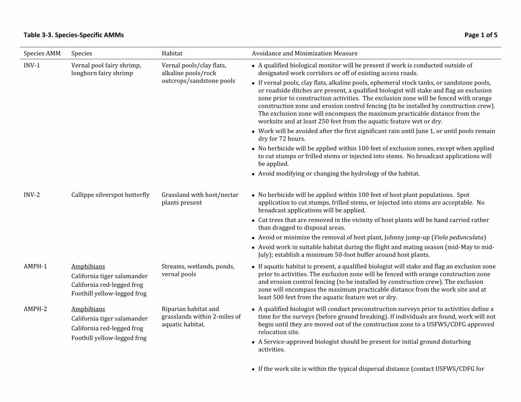
Table 3-3. Species-Specific AMMs Page 1 of 5
Species AMM Species Habitat Avoidance and Minimization Measure
INV-1 Vernal pool fairy shrimp, longhorn fairy shrimp
Vernal pools/clay flats, alkaline pools/rock outcrops/sandstone pools
A qualified biological monitor will be present if work is conducted outside of designated work corridors or off of existing access roads.
If vernal pools, clay flats, alkaline pools, ephemeral stock tanks, or sandstone pools, or roadside ditches are present, a qualified biologist will stake and flag an exclusion zone prior to construction activities. The exclusion zone will be fenced with orange construction zone and erosion control fencing (to be installed by construction crew). The exclusion zone will encompass the maximum practicable distance from the worksite and at least 250 feet from the aquatic feature wet or dry.
Work will be avoided after the first significant rain until June 1, or until pools remain dry for 72 hours.
No herbicide will be applied within 100 feet of exclusion zones, except when applied to cut stumps or frilled stems or injected into stems. No broadcast applications will be applied.
Avoid modifying or changing the hydrology of the habitat.
INV-2 Callippe silverspot butterfly Grassland with host/nectar plants present
No herbicide will be applied within 100 feet of host plant populations. Spot application to cut stumps, frilled stems, or injected into stems are acceptable. No broadcast applications will be applied.
Cut trees that are removed in the vicinity of host plants will be hand carried rather than dragged to disposal areas.
Avoid or minimize the removal of host plant, Johnny jump-up (Viola pedunculata)
Avoid work in suitable habitat during the flight and mating season (mid-May to mid-July); establish a minimum 50-foot buffer around host plants.
AMPH-1 Amphibians
California tiger salamander
California red-legged frog
Foothill yellow-legged frog
Streams, wetlands, ponds, vernal pools
If aquatic habitat is present, a qualified biologist will stake and flag an exclusion zone prior to activities. The exclusion zone will be fenced with orange construction zone and erosion control fencing (to be installed by construction crew). The exclusion zone will encompass the maximum practicable distance from the work site and at least 500 feet from the aquatic feature wet or dry.
AMPH-2 Amphibians
California tiger salamander
California red-legged frog
Foothill yellow-legged frog
Riparian habitat and grasslands within 2-miles of aquatic habitat.
A qualified biologist will conduct preconstruction surveys prior to activities define a time for the surveys (before ground breaking). If individuals are found, work will not begin until they are moved out of the construction zone to a USFWS/CDFG approved relocation site.
A Service-approved biologist should be present for initial ground disturbing activities.
If the work site is within the typical dispersal distance (contact USFWS/CDFG for
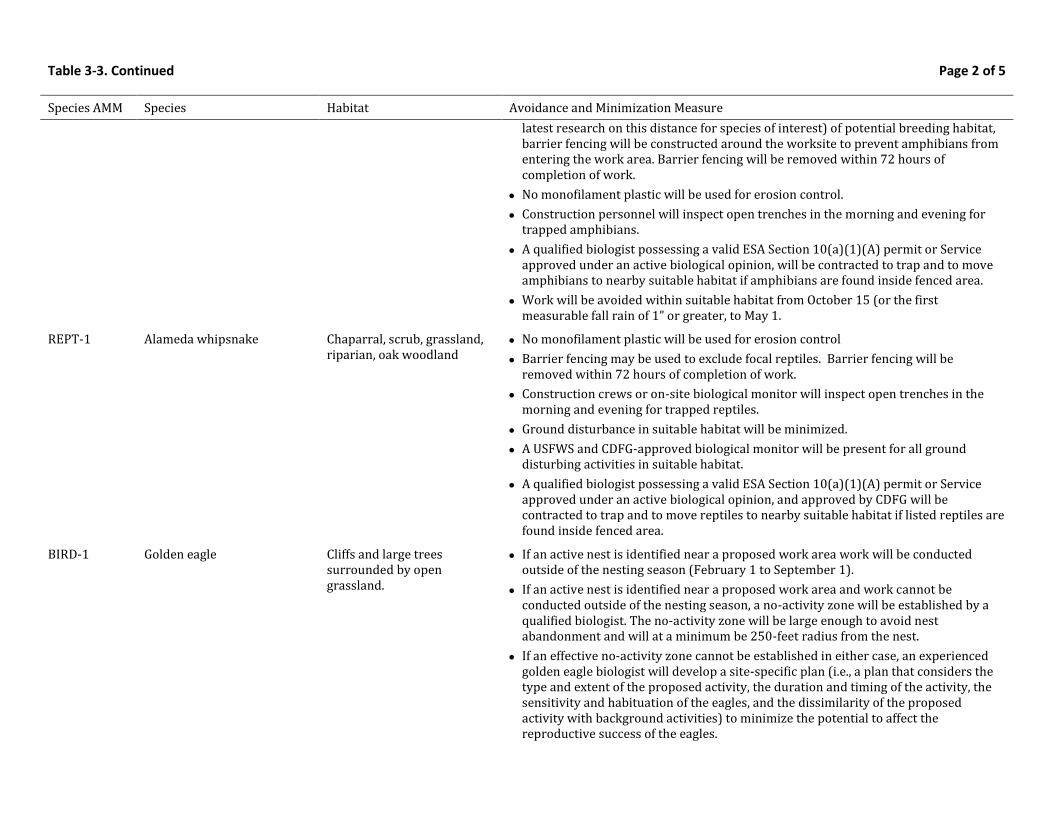
Table 3-3. Continued Page 2 of 5
Species AMM Species Habitat Avoidance and Minimization Measure
latest research on this distance for species of interest) of potential breeding habitat, barrier fencing will be constructed around the worksite to prevent amphibians from entering the work area. Barrier fencing will be removed within 72 hours of completion of work.
No monofilament plastic will be used for erosion control.
Construction personnel will inspect open trenches in the morning and evening for trapped amphibians.
A qualified biologist possessing a valid ESA Section 10(a)(1)(A) permit or Service approved under an active biological opinion, will be contracted to trap and to move amphibians to nearby suitable habitat if amphibians are found inside fenced area.
Work will be avoided within suitable habitat from October 15 (or the first measurable fall rain of 1” or greater, to May 1.
REPT-1 Alameda whipsnake Chaparral, scrub, grassland, riparian, oak woodland
No monofilament plastic will be used for erosion control
Barrier fencing may be used to exclude focal reptiles. Barrier fencing will be removed within 72 hours of completion of work.
Construction crews or on-site biological monitor will inspect open trenches in the morning and evening for trapped reptiles.
Ground disturbance in suitable habitat will be minimized.
A USFWS and CDFG-approved biological monitor will be present for all ground disturbing activities in suitable habitat.
A qualified biologist possessing a valid ESA Section 10(a)(1)(A) permit or Service approved under an active biological opinion, and approved by CDFG will be contracted to trap and to move reptiles to nearby suitable habitat if listed reptiles are found inside fenced area.
BIRD-1 Golden eagle Cliffs and large trees surrounded by open grassland.
If an active nest is identified near a proposed work area work will be conducted outside of the nesting season (February 1 to September 1).
If an active nest is identified near a proposed work area and work cannot be conducted outside of the nesting season, a no-activity zone will be established by a qualified biologist. The no-activity zone will be large enough to avoid nest abandonment and will at a minimum be 250-feet radius from the nest.
If an effective no-activity zone cannot be established in either case, an experienced golden eagle biologist will develop a site-specific plan (i.e., a plan that considers the type and extent of the proposed activity, the duration and timing of the activity, the sensitivity and habituation of the eagles, and the dissimilarity of the proposed activity with background activities) to minimize the potential to affect the reproductive success of the eagles.
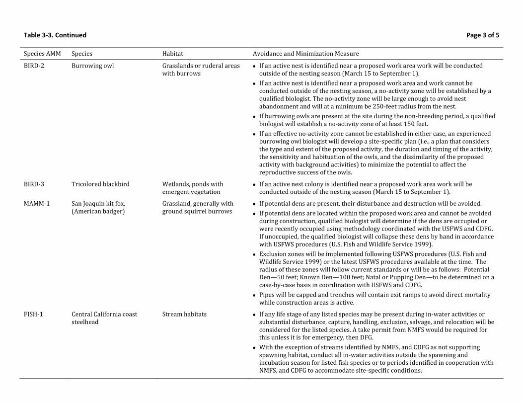
Table 3-3. Continued Page 3 of 5
Species AMM Species Habitat Avoidance and Minimization Measure
BIRD-2 Burrowing owl Grasslands or ruderal areas with burrows
If an active nest is identified near a proposed work area work will be conducted outside of the nesting season (March 15 to September 1).
If an active nest is identified near a proposed work area and work cannot be conducted outside of the nesting season, a no-activity zone will be established by a qualified biologist. The no-activity zone will be large enough to avoid nest abandonment and will at a minimum be 250-feet radius from the nest.
If burrowing owls are present at the site during the non-breeding period, a qualified biologist will establish a no-activity zone of at least 150 feet.
If an effective no-activity zone cannot be established in either case, an experienced burrowing owl biologist will develop a site-specific plan (i.e., a plan that considers the type and extent of the proposed activity, the duration and timing of the activity, the sensitivity and habituation of the owls, and the dissimilarity of the proposed activity with background activities) to minimize the potential to affect the reproductive success of the owls.
BIRD-3 Tricolored blackbird Wetlands, ponds with emergent vegetation
If an active nest colony is identified near a proposed work area work will be conducted outside of the nesting season (March 15 to September 1).
MAMM-1 San Joaquin kit fox, (American badger)
Grassland, generally with ground squirrel burrows
If potential dens are present, their disturbance and destruction will be avoided.
If potential dens are located within the proposed work area and cannot be avoided during construction, qualified biologist will determine if the dens are occupied or were recently occupied using methodology coordinated with the USFWS and CDFG. If unoccupied, the qualified biologist will collapse these dens by hand in accordance with USFWS procedures (U.S. Fish and Wildlife Service 1999).
Exclusion zones will be implemented following USFWS procedures (U.S. Fish and Wildlife Service 1999) or the latest USFWS procedures available at the time. The radius of these zones will follow current standards or will be as follows: Potential Den—50 feet; Known Den—100 feet; Natal or Pupping Den—to be determined on a case-by-case basis in coordination with USFWS and CDFG.
Pipes will be capped and trenches will contain exit ramps to avoid direct mortality while construction areas is active.
FISH-1
Central California coast steelhead
Stream habitats If any life stage of any listed species may be present during in-water activities or substantial disturbance, capture, handling, exclusion, salvage, and relocation will be considered for the listed species. A take permit from NMFS would be required for this unless it is for emergency, then DFG.
With the exception of streams identified by NMFS, and CDFG as not supporting spawning habitat, conduct all in-water activities outside the spawning and incubation season for listed fish species or to periods identified in cooperation with NMFS, and CDFG to accommodate site-specific conditions.
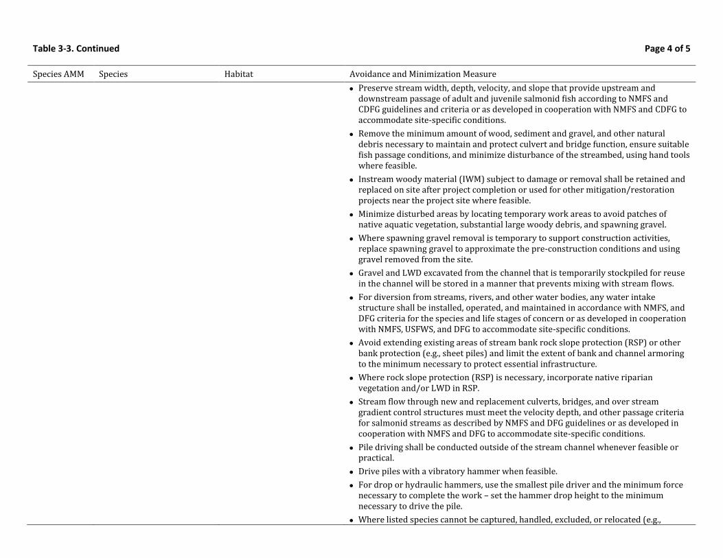
Table 3-3. Continued Page 4 of 5
Species AMM Species Habitat Avoidance and Minimization Measure
Preserve stream width, depth, velocity, and slope that provide upstream and downstream passage of adult and juvenile salmonid fish according to NMFS and CDFG guidelines and criteria or as developed in cooperation with NMFS and CDFG to accommodate site-specific conditions.
Remove the minimum amount of wood, sediment and gravel, and other natural debris necessary to maintain and protect culvert and bridge function, ensure suitable fish passage conditions, and minimize disturbance of the streambed, using hand tools where feasible.
Instream woody material (IWM) subject to damage or removal shall be retained and replaced on site after project completion or used for other mitigation/restoration projects near the project site where feasible.
Minimize disturbed areas by locating temporary work areas to avoid patches of native aquatic vegetation, substantial large woody debris, and spawning gravel.
Where spawning gravel removal is temporary to support construction activities, replace spawning gravel to approximate the pre-construction conditions and using gravel removed from the site.
Gravel and LWD excavated from the channel that is temporarily stockpiled for reuse in the channel will be stored in a manner that prevents mixing with stream flows.
For diversion from streams, rivers, and other water bodies, any water intake structure shall be installed, operated, and maintained in accordance with NMFS, and DFG criteria for the species and life stages of concern or as developed in cooperation with NMFS, USFWS, and DFG to accommodate site-specific conditions.
Avoid extending existing areas of stream bank rock slope protection (RSP) or other bank protection (e.g., sheet piles) and limit the extent of bank and channel armoring to the minimum necessary to protect essential infrastructure.
Where rock slope protection (RSP) is necessary, incorporate native riparian vegetation and/or LWD in RSP.
Stream flow through new and replacement culverts, bridges, and over stream gradient control structures must meet the velocity depth, and other passage criteria for salmonid streams as described by NMFS and DFG guidelines or as developed in cooperation with NMFS and DFG to accommodate site-specific conditions.
Pile driving shall be conducted outside of the stream channel whenever feasible or practical.
Drive piles with a vibratory hammer when feasible.
For drop or hydraulic hammers, use the smallest pile driver and the minimum force necessary to complete the work – set the hammer drop height to the minimum necessary to drive the pile.
Where listed species cannot be captured, handled, excluded, or relocated (e.g.,
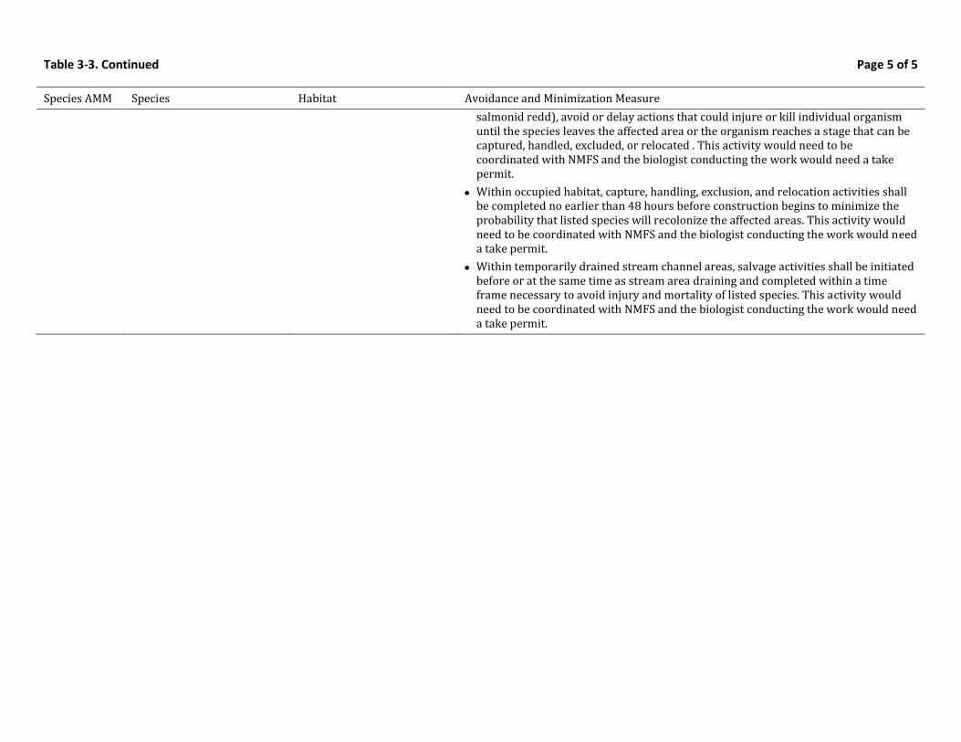
Table 3-3. Continued Page 5 of 5
Species AMM Species Habitat Avoidance and Minimization Measure
salmonid redd), avoid or delay actions that could injure or kill individual organism until the species leaves the affected area or the organism reaches a stage that can be captured, handled, excluded, or relocated . This activity would need to be coordinated with NMFS and the biologist conducting the work would need a take permit.
Within occupied habitat, capture, handling, exclusion, and relocation activities shall be completed no earlier than 48 hours before construction begins to minimize the probability that listed species will recolonize the affected areas. This activity would need to be coordinated with NMFS and the biologist conducting the work would need a take permit.
Within temporarily drained stream channel areas, salvage activities shall be initiated before or at the same time as stream area draining and completed within a time frame necessary to avoid injury and mortality of listed species. This activity would need to be coordinated with NMFS and the biologist conducting the work would need a take permit.

Table 3-4. Standardized Mitigation Ratios for Vernal Pool Fairy Shrimp in the EACCS Study Area
Location of Impact1
Location of Mitigation1,2
Notes Inside Critical Habitat in EACCS study area
Outside Critical Habitat and Inside Vernal Pool Recovery Unit
Outside Critical Habitat and Outside Vernal Pool Recovery Unit
Outside EACCS Study Area
Inside Critical Habitat in EACCS study area
9:1—(6 acres preservation; 3 acres restoration)
*requires site-specific USFWS approval
10:1—(6.5 acres preservation; 3.5 acres restoration)
*requires site-specific USFWS approval
11:1—(7 acres preservation; 4 acres restoration)
*requires site-specific USFWS approval
Requires site-specific agency approval
In order to preserve 90% of vernal pool fairy shrimp habitat, consistent with the goals and objectives of the EACCS, a high ratio is required due to the rarity of this habitat type.
Outside Critical Habitat and Inside Vernal Pool Recovery Unit
9:1—(6 acres preservation; 3 acres restoration)
9:1—(6 acres preservation; 3 acres restoration)
10:1—(6.5 acres preservation; 3.5 acres restoration)
Requires site-specific agency approval
Outside Critical Habitat and Outside Vernal Pool Recovery Unit
9:1—(6 acres preservation; 3 acres restoration)
10:1—(6.5 acres preservation; 3.5 acres restoration)
11:1—(7 acres preservation; 4 acres restoration)
Requires site-specific agency approval
1 Reference Figure 3-6 for the location of key mitigation features for vernal pool fairy shrimp. 2 In order to meet CDFG’s standard of full mitigation for state listed species under CESA, project applicants will have to demonstrate habitat enhancement, not just
permanent protection, on properties used for mitigation. If credits are purchased at a CDFG approved mitigation bank, this enhancement is assumed, therefore the full mitigation standard would be met upon purchase of the credits.
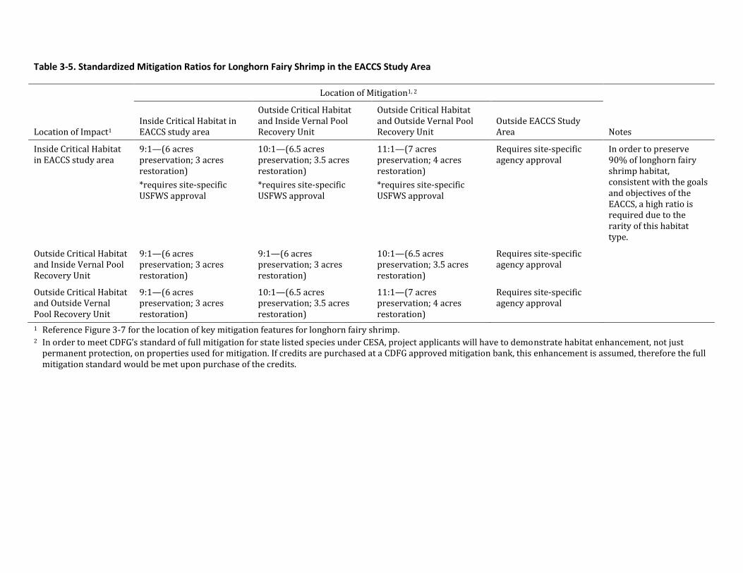
Table 3-5. Standardized Mitigation Ratios for Longhorn Fairy Shrimp in the EACCS Study Area
Location of Impact1
Location of Mitigation1, 2
Notes Inside Critical Habitat in EACCS study area
Outside Critical Habitat and Inside Vernal Pool Recovery Unit
Outside Critical Habitat and Outside Vernal Pool Recovery Unit
Outside EACCS Study Area
Inside Critical Habitat in EACCS study area
9:1—(6 acres preservation; 3 acres restoration)
*requires site-specific USFWS approval
10:1—(6.5 acres preservation; 3.5 acres restoration)
*requires site-specific USFWS approval
11:1—(7 acres preservation; 4 acres restoration)
*requires site-specific USFWS approval
Requires site-specific agency approval
In order to preserve 90% of longhorn fairy shrimp habitat, consistent with the goals and objectives of the EACCS, a high ratio is required due to the rarity of this habitat type.
Outside Critical Habitat and Inside Vernal Pool Recovery Unit
9:1—(6 acres preservation; 3 acres restoration)
9:1—(6 acres preservation; 3 acres restoration)
10:1—(6.5 acres preservation; 3.5 acres restoration)
Requires site-specific agency approval
Outside Critical Habitat and Outside Vernal Pool Recovery Unit
9:1—(6 acres preservation; 3 acres restoration)
10:1—(6.5 acres preservation; 3.5 acres restoration)
11:1—(7 acres preservation; 4 acres restoration)
Requires site-specific agency approval
1 Reference Figure 3-7 for the location of key mitigation features for longhorn fairy shrimp. 2 In order to meet CDFG’s standard of full mitigation for state listed species under CESA, project applicants will have to demonstrate habitat enhancement, not just
permanent protection, on properties used for mitigation. If credits are purchased at a CDFG approved mitigation bank, this enhancement is assumed, therefore the full mitigation standard would be met upon purchase of the credits.
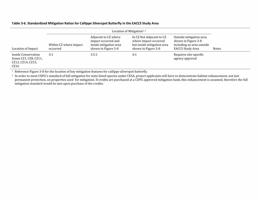
Table 3-6. Standardized Mitigation Ratios for Callippe Silverspot Butterfly in the EACCS Study Area
Location of Impact
Location of Mitigation1, 2
Notes Within CZ where impact occurred
Adjacent to CZ where impact occurred and inside mitigation area shown in Figure 3-8
In CZ Not Adjacent to CZ where impact occurred but inside mitigation area shown in Figure 3-8
Outside mitigation area shown in Figure 3-8 including an area outside EACCS Study Area
Inside Conservation Zones CZ1, CZ8, CZ11, CZ12, CZ14, CZ15, CZ16
3:1 3.5:1 4:1 Requires site-specific agency approval
1 Reference Figure 3-8 for the location of key mitigation features for callippe silverspot butterfly. 2 In order to meet CDFG’s standard of full mitigation for state listed species under CESA, project applicants will have to demonstrate habitat enhancement, not just
permanent protection, on properties used for mitigation. If credits are purchased at a CDFG approved mitigation bank, this enhancement is assumed, therefore the full mitigation standard would be met upon purchase of the credits.
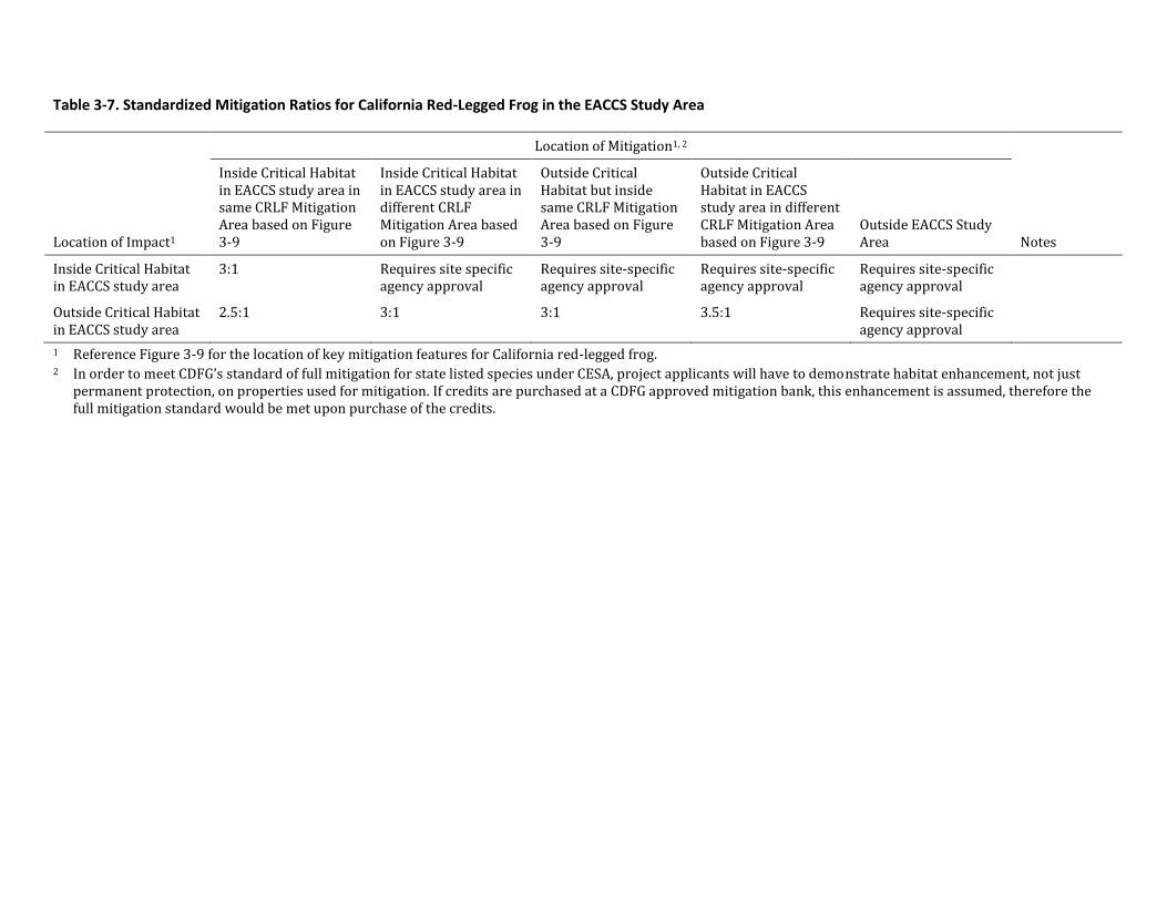
Table 3-7. Standardized Mitigation Ratios for California Red-Legged Frog in the EACCS Study Area
Location of Impact1
Location of Mitigation1, 2
Notes
Inside Critical Habitat in EACCS study area in same CRLF Mitigation Area based on Figure 3-9
Inside Critical Habitat in EACCS study area in different CRLF Mitigation Area based on Figure 3-9
Outside Critical Habitat but inside same CRLF Mitigation Area based on Figure 3-9
Outside Critical Habitat in EACCS study area in different CRLF Mitigation Area based on Figure 3-9
Outside EACCS Study Area
Inside Critical Habitat in EACCS study area
3:1 Requires site specific agency approval
Requires site-specific agency approval
Requires site-specific agency approval
Requires site-specific agency approval
Outside Critical Habitat in EACCS study area
2.5:1 3:1 3:1 3.5:1 Requires site-specific agency approval
1 Reference Figure 3-9 for the location of key mitigation features for California red-legged frog. 2 In order to meet CDFG’s standard of full mitigation for state listed species under CESA, project applicants will have to demonstrate habitat enhancement, not just
permanent protection, on properties used for mitigation. If credits are purchased at a CDFG approved mitigation bank, this enhancement is assumed, therefore the full mitigation standard would be met upon purchase of the credits.
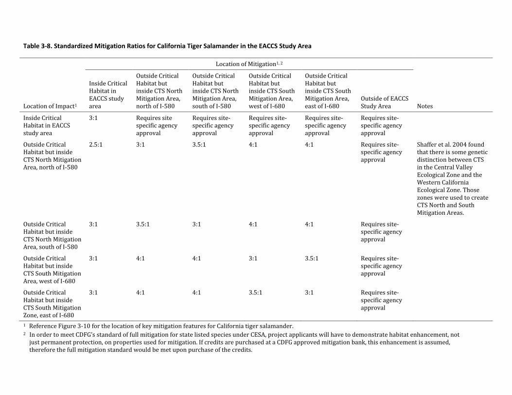
Table 3-8. Standardized Mitigation Ratios for California Tiger Salamander in the EACCS Study Area
Location of Impact1
Location of Mitigation1, 2
Notes
Inside Critical Habitat in EACCS study area
Outside Critical Habitat but inside CTS North Mitigation Area, north of I-580
Outside Critical Habitat but inside CTS North Mitigation Area, south of I-580
Outside Critical Habitat but inside CTS South Mitigation Area, west of I-680
Outside Critical Habitat but inside CTS South Mitigation Area, east of I-680
Outside of EACCS Study Area
Inside Critical Habitat in EACCS study area
3:1 Requires site specific agency approval
Requires site-specific agency approval
Requires site-specific agency approval
Requires site-specific agency approval
Requires site-specific agency approval
Outside Critical Habitat but inside CTS North Mitigation Area, north of I-580
2.5:1 3:1 3.5:1 4:1 4:1 Requires site-specific agency approval
Shaffer et al. 2004 found that there is some genetic distinction between CTS in the Central Valley Ecological Zone and the Western California Ecological Zone. Those zones were used to create CTS North and South Mitigation Areas.
Outside Critical Habitat but inside CTS North Mitigation Area, south of I-580
3:1 3.5:1 3:1 4:1 4:1 Requires site-specific agency approval
Outside Critical Habitat but inside CTS South Mitigation Area, west of I-680
3:1 4:1 4:1 3:1 3.5:1 Requires site-specific agency approval
Outside Critical Habitat but inside CTS South Mitigation Zone, east of I-680
3:1 4:1 4:1 3.5:1 3:1 Requires site-specific agency approval
1 Reference Figure 3-10 for the location of key mitigation features for California tiger salamander. 2 In order to meet CDFG’s standard of full mitigation for state listed species under CESA, project applicants will have to demonstrate habitat enhancement, not
just permanent protection, on properties used for mitigation. If credits are purchased at a CDFG approved mitigation bank, this enhancement is assumed, therefore the full mitigation standard would be met upon purchase of the credits.
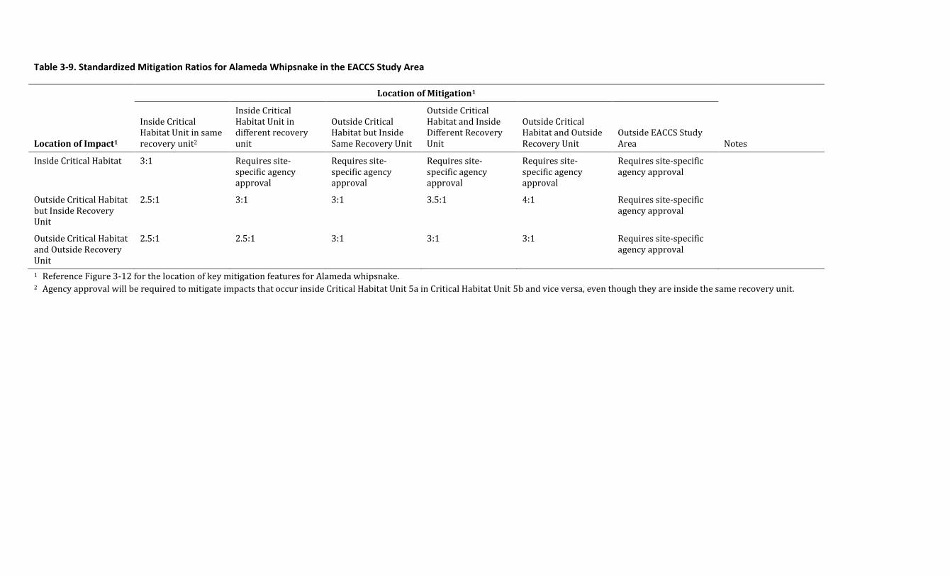
Table 3-9. Standardized Mitigation Ratios for Alameda Whipsnake in the EACCS Study Area
Location of Impact1
Location of Mitigation1
Notes
Inside Critical Habitat Unit in same recovery unit2
Inside Critical Habitat Unit in different recovery unit
Outside Critical Habitat but Inside Same Recovery Unit
Outside Critical Habitat and Inside Different Recovery Unit
Outside Critical Habitat and Outside Recovery Unit
Outside EACCS Study Area
Inside Critical Habitat 3:1 Requires site-specific agency approval
Requires site-specific agency approval
Requires site-specific agency approval
Requires site-specific agency approval
Requires site-specific agency approval
Outside Critical Habitat but Inside Recovery Unit
2.5:1 3:1 3:1 3.5:1 4:1 Requires site-specific agency approval
Outside Critical Habitat and Outside Recovery Unit
2.5:1 2.5:1 3:1 3:1 3:1 Requires site-specific agency approval
1 Reference Figure 3-12 for the location of key mitigation features for Alameda whipsnake. 2 Agency approval will be required to mitigate impacts that occur inside Critical Habitat Unit 5a in Critical Habitat Unit 5b and vice versa, even though they are inside the same recovery unit.
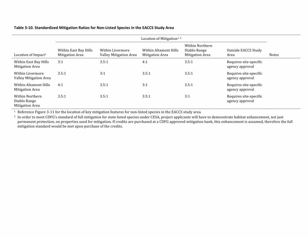
Table 3-10. Standardized Mitigation Ratios for Non-Listed Species in the EACCS Study Area
Location of Impact1
Location of Mitigation1, 2
Notes Within East Bay Hills Mitigation Area
Within Livermore Valley Mitigation Area
Within Altamont Hills Mitigation Area
Within Northern Diablo Range Mitigation Area
Outside EACCS Study Area
Within East Bay Hills Mitigation Area
3:1 3.5:1 4:1 3.5:1 Requires site-specific agency approval
Within Livermore Valley Mitigation Area
3.5:1 3:1 3.5:1 3.5:1 Requires site-specific agency approval
Within Altamont Hills Mitigation Area
4:1 3.5:1 3:1 3.5:1 Requires site-specific agency approval
Within Northern Diablo Range Mitigation Area
3.5:1 3.5:1 3.5:1 3:1 Requires site-specific agency approval
1 Reference Figure 3-11 for the location of key mitigation features for non-listed species in the EACCS study area. 2 In order to meet CDFG’s standard of full mitigation for state listed species under CESA, project applicants will have to demonstrate habitat enhancement, not just
permanent protection, on properties used for mitigation. If credits are purchased at a CDFG approved mitigation bank, this enhancement is assumed, therefore the full mitigation standard would be met upon purchase of the credits.
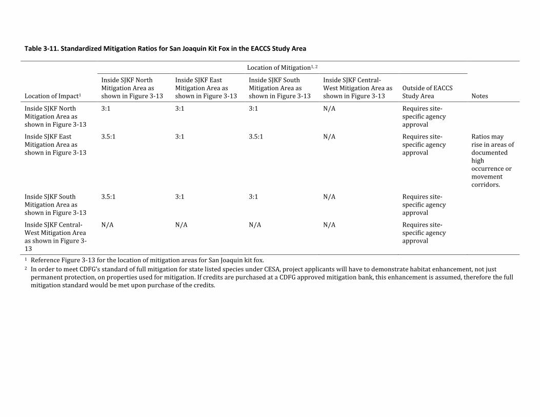
Table 3-11. Standardized Mitigation Ratios for San Joaquin Kit Fox in the EACCS Study Area
Location of Impact1
Location of Mitigation1, 2
Notes
Inside SJKF North Mitigation Area as shown in Figure 3-13
Inside SJKF East Mitigation Area as shown in Figure 3-13
Inside SJKF South Mitigation Area as shown in Figure 3-13
Inside SJKF Central-West Mitigation Area as shown in Figure 3-13
Outside of EACCS Study Area
Inside SJKF North Mitigation Area as shown in Figure 3-13
3:1 3:1 3:1 N/A Requires site-specific agency approval
Inside SJKF East Mitigation Area as shown in Figure 3-13
3.5:1 3:1 3.5:1 N/A Requires site-specific agency approval
Ratios may rise in areas of documented high occurrence or movement corridors.
Inside SJKF South Mitigation Area as shown in Figure 3-13
3.5:1 3:1 3:1 N/A Requires site-specific agency approval
Inside SJKF Central-West Mitigation Area as shown in Figure 3-13
N/A N/A N/A N/A Requires site-specific agency approval
1 Reference Figure 3-13 for the location of mitigation areas for San Joaquin kit fox. 2 In order to meet CDFG’s standard of full mitigation for state listed species under CESA, project applicants will have to demonstrate habitat enhancement, not just
permanent protection, on properties used for mitigation. If credits are purchased at a CDFG approved mitigation bank, this enhancement is assumed, therefore the full mitigation standard would be met upon purchase of the credits.
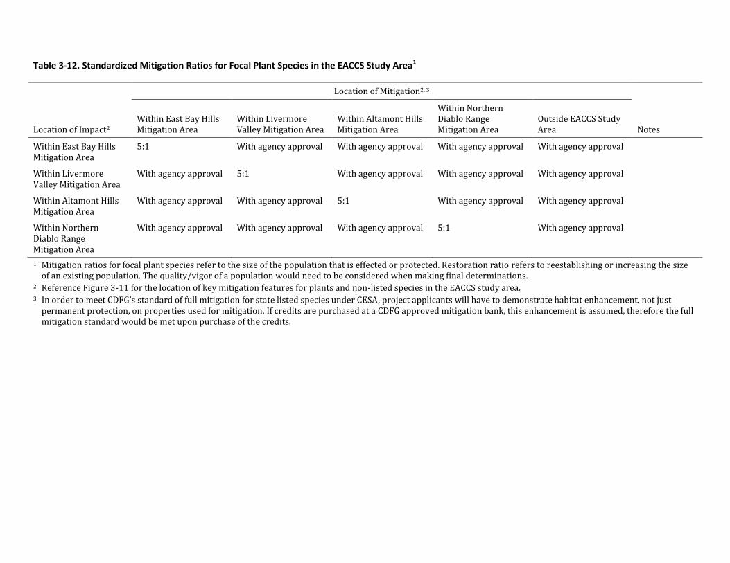
Table 3-12. Standardized Mitigation Ratios for Focal Plant Species in the EACCS Study Area1
Location of Impact2
Location of Mitigation2, 3
Notes Within East Bay Hills Mitigation Area
Within Livermore Valley Mitigation Area
Within Altamont Hills Mitigation Area
Within Northern Diablo Range Mitigation Area
Outside EACCS Study Area
Within East Bay Hills Mitigation Area
5:1 With agency approval With agency approval With agency approval With agency approval
Within Livermore Valley Mitigation Area
With agency approval 5:1 With agency approval With agency approval With agency approval
Within Altamont Hills Mitigation Area
With agency approval With agency approval 5:1 With agency approval With agency approval
Within Northern Diablo Range Mitigation Area
With agency approval With agency approval With agency approval 5:1 With agency approval
1 Mitigation ratios for focal plant species refer to the size of the population that is effected or protected. Restoration ratio refers to reestablishing or increasing the size of an existing population. The quality/vigor of a population would need to be considered when making final determinations.
2 Reference Figure 3-11 for the location of key mitigation features for plants and non-listed species in the EACCS study area. 3 In order to meet CDFG’s standard of full mitigation for state listed species under CESA, project applicants will have to demonstrate habitat enhancement, not just
permanent protection, on properties used for mitigation. If credits are purchased at a CDFG approved mitigation bank, this enhancement is assumed, therefore the full mitigation standard would be met upon purchase of the credits.
Chris Bazar Agency Director
Albert Lopez Planning Director
224 West Winton Ave
Room 11 1
Hayward California
94544
phone 510.670.5400
fax 510. 785.8793
www.acgov.org/cda
ALAMEDA COUNTY COMMUNITY DEVELOPMENT AGENCY
PLANNING DEPARTMENT
Jm)e _ , 2015
California Department of Parks and Recreation Off-Highway Motor Vehicle Recreation Division c/o AECOM, attn. Carnegie SVRA General Plan (Dan Canfield, Planning Manager) 2020 L Street, Ste. 400 Sacramento, CA 94296-0001
RE: Draft EIR for the proposed Carnegie State Vehicle Recreation Area (SVRA) General Plan Revision (GPR), State Clearinghouse Number 2012052027
Dear Mr. Canfield:
The Alameda County Board of Supervisors submits the following remarks on the Draft EIR (DEIR) prepared for the Carnegie State Vehicular Recreation Area General Plan Revision, for the state Department of Parks and Recreation Off-Highway Motor Vehicle Recreation (OHMVR) Division. County leaders, staff and residents have participated in the SVRA General Plan development process with great interest, given that the proposed expansion will exclusively occur within Alameda County, with recognition that roughly tripling the area of development will have substantial adverse environmental consequences on both the site itself and the region. County staff previously provided comments on the scope of the EIR (July 30, 2014) highlighting County residents ' concerns with protecting the area's function as a vitally important wildlife corridor, the property' s valuable historical and cultural resources, potential degradation of air and water quality, and traffic impacts resulting from a new entrance to the SVRA within Alameda County.
A key concern that County staff previously stated regarding the scope of the EIR was that the SVRA General Plan proposes that any new Off-Highway Vehicle (OHV) recreation opportunities identified though the general plan process would be subject to future projectlevel funding/ environmental review before being available for public access. Our concern was that this approach may result in piecemeal consideration of the project impacts, rather than fully anticipating the potential impacts of full project buildout, and identifying specific available mitigation strategies and measures. This concern remains.
Furthermore, the DEIR appears to have been developed with inadequate consideration of alternatives that would lessen the environmental impact, beyond a no-project alternative and an under-developed and weakly-evaluated "Reduced Developed Use Area Alternative." It is noted that although the County previously requested consideration of an alternative with only non-motorized vehicle use in the expansion area, the reduced-use alternative only designates limited areas for non-motorized recreation, while ensuring a range·of new areas for motorized vehicle use.
Dan Canfield, Planning Manager Off-Highway Motor Vehicle Recreation Division, State Parks Re: Carnegie SVRA General Plan I Draft EIR, April 2015 June 12, 2015 Page 2
In broad terms, the County objects to the extent to which the DEIR concludes that significant impacts would simply be avoided by existing practices or regulations, or by proposed General Plan policy. CEQA Guidelines Section 15126.4 states that an EIR shall describe mitigation measures, and that it must also distinguish between those measures proposed by a project proponent and measures promulgated by the lead or responsible agency. It is more appropriate to declare and acknowledge the significant and unavoidable adverse impacts that can be anticipated from project-related development and activities, and identify an independent program of mitigation and avoidance through a Mitigation Monitoring and Reporting Program (MMRP). In particular, the County believes that impacts on agriculture, aesthetics, biological resources, cultural and historic resources, air quality and greenhouse gases/climate change, energy use, and noise have not been adequately addressed in the DEIR.
Agriculture. The DEIR did not analyze impacts to agriculture due to the conclusion that no impacts would occur to agricultural uses. Prior to the recent termination of the grazing lease on the property, the land had been used for cattle grazing for more than one hundred years.
The County acknowledges that the site is not designated as Important Farmland, based on the Department of Conservation' s definition. However, the Policies and Programs of the East County Area Plan (ECAP, a part of the Alameda County General Plan) strongly encourage the preservation of agricultural uses. Therefore, the County strongly believes that the conversion of grazing land to recreational uses is in direct conflict with ECAP. Some key ECAP Policies and Programs are stated below:
Policy 74: The County shall require that, where conflicts between a new use and an existing use are anticipated, the burden of mitigating the conflicts be the responsibility of the new use.
Policy 89: The County shall retain rangeland in large, contiguous blocks of sufficient size to enable commercially viable grazing.
Program 36: the County shall periodically convene an advisory panel of experts to make recommendations to enhance the economic viability of agriculture and ranching, and to minimize environmental impacts. The panel shall recommend new County policies and ways to strengthen the implementation of existing policies. Citizen input shall be solicited.
In regards to Program 36, the County's Agricultural Advisory Committee has expressed strong concern that the historical use of the property as grazing land will be permanently terminated under this proposal, and County staff believes that the loss of this historical use is a potentially significant impact and should be analyzed.
Aesthetics. The DEIR analysis of aesthetics does not acknowledge any of the policies of the County' s Scenic Route Element (May, 1966), which the County has continued to use to evaluate development bordering its rural roads and highways. Tesla Road and by extension Corral Hollow Road are designated therein as major rural roads along which panoramic views and vistas should be preserved and enhanced (p. 13 , Scenic Route Element). Among several other applicable policies in the Scenic Route Element, there is a directive to both public agencies and private property owners with large land holdings to protect and enhance the natural resources and scenic values within their properties, and to cooperate with smaller lot owners and community improvement and conservation
Dan Canfield, Planning Manager Off-Highway Motor Vehicle Recreation Division, State Parks Re: Carnegie SVRA General Plan I Draft EIR, April 2015 June 12, 2015 Page 3
groups (p. 14). While a majority of the principles and standards in the Scenic Route Element limit building development near scenic corridors, alteration of natural land contours is to be kept to a minimum. It is clearly evident to the County that the development of new trails visible from Corral Hollow Road would violate both the terms and intent of this policy.
It is standard industry practice to provide photo-simulations taken from various sensitive vantage points. The Aesthetics section of the DEIR is lacking in this manner, as descriptions on page 3.1-4 discuss a new ranger station, training site, and an interpretive facility/visitor center. It is unclear where these facilities would be located, and therefore could possibly conflict with ECAP Policy 106, below:
Structures may not be located on ridgelines or hilltops or where they will project above a ridgeline or hilltop as viewed from public roads, trails, parks and other public viewpoints unless there is no other site on the parcel for the structure or on a contiguous parcel in common ownership on or subsequent to the date this ordinance becomes effective. New parcels may not be created that have no building site other than a ridgeline or hilltop, or that would cause a structure to protrude above a ridgeline or hilltop, unless there is no other possible configuration.
While the DEIR asserts that no structures are proposed on the ridgelines or hilltops in the SVRA Expansion Area, the DEIR should include at least one focused site plan and photo-simulation of the new structure(s), and graded areas for parking or other uses.
This is an important example in the DEIR where the reliance on the evaluation of the project as a "General Plan Revision", as if the site were an incorporated city, appears highly questionable. The County recommends that the project be evaluated more like a Specific Plan, in which some individual structures or features that are known to be proposed in a defined location, as is the case here, can be closely evaluated for environmental impacts, including those on visual qualities on the site.
Air Quality, Climate Change and Energy. The County has recently adopted its Community Climate Action Plan (CCAP) that sets forth a variety of goals and programs to reduce C02, methane and other greenhouse gas (GHG) emissions that result from activities within the County boundaries. While the vast majority of the CCAP's Policy efforts are aimed at the urban core area of the County, the overarching goal of the CCAP is to reduce as much as possible the emission of GHGs in the County in contributing to reduction or, and resilience against, climate change. Furthermore, unnecessary and inefficient energy use should be considered carefully in the DEIR, as it is among the original central · themes ofCEQA, and is cited directly in Section 15126.4 of the CEQA Guidelines.
Cultural and Historic Resources. The proposed expansion area contains a number of cultural and historic resources including a number of sites that are scared to locaJ Native American tribes and other historic sites related to the mining and agriculture. In total, 70 sites have been documented in the DEIR. In the section beginning on page 3.4-4 and titled "General Plan Impact Analysis'', the DEIR states that recreational activities, and development of facilities and infrastructure" have the potential to affect or degrade pre-historic and historic era cultural resources. It is impossible to determine the cumulative impacts of the proposed General Plan without a clearer understanding of the level and intensity of development that will occur at the site. The lack of specificity brings into
Dan Canfield, Planning Manager Off-Highway Motor Vehicle Recreation Division, State Parks Re: Carnegie SVRA General Plan I Draft EIR, April 2015 June 12, 2015 Page4
question the adequacy of the DEIR' s "guidelines" which it contends will reduce any impacts to a "less than significant" level, and on the basis of those findings, concludes that no mitigation is required. The DEIR has failed to acknowledge that significant and unavoidable impacts to cultural resources will result as a result of this project and to produce a comprehensive MMMR to address those impacts.
With respect to consultation with Native American tribes, page 3.4-4 of DEIR states:
All tribes expressed concerns regarding potential direct impacts associated with the operation and management of the SVRA. As a result, consultation with these groups is ongoing.
In short, local tribes have not endorsed this project, nor have they found the proposed guidelines to be sufficient to protect sacred sites within the expansion area. Given the views expressed by local Native American tribes and documented in the DEIR that "the entire expansion area is part of the cultural landscape that is an integral part of their ancestral spiritual (religious) practice", it would appear improbable the OHMVR could achieve CR (Cultural Resources) Guidelines 2.2 and 2.4.
CR Guideline 2.2: Protect, stabilize, and preserve in place all known cultural resources either listed or eligible for listing in the NRHP or CRHR, and all Native American ethnographic resources identified by local tribes and individuals as sacred or culturally significant, in accordance with PRC Sections 5024 and 5024.5 and Governor's Executive Order B-10-11 (''Native American Consultation Policy").
CR Guideline 2.4: Design all SVRA undertakings, including routine maintenance and new facility development, to avoid or minimize significant impacts on all known cultural resources either listed or eligible for listing in the NRHP or CRHR, and all Native American ethnographic resources identified by local tribes and individuals as sacred or culturally significant. Knowledge of the location of these sites was taken into consideration when selecting the preferred concept and shall be taken into consideration during future site specific planning in all visitor experience areas.
Failure to fully evaluate the project's impacts to cultural and historic resources may result in irreparable harm to those resources. Changes to the view shed, excessive noise, dust and vibrations from OHV use, and development on or adjacent to cultural resources can adversely affect the context of a resource and the resource itself. The County believes that identification of resources is not sufficient protection for cultural resources if trails and facilities are to be located within and adjacent to sensitive areas.
Biological Resources. Several Responsible Agencies have shared with our Board their concerns regarding the lack of proper analysis and mitigation regarding the potential loss of Special Status Species. Since numerous agencies will already be providing comments on this topic, we will limit our comments to applicable Policies and Programs within ECAP:
Policy 124, The County shall encourage the maintenance of biological diversity in East County by including a variety of plant communities and animal habitats in areas designated for open space.
Dan Canfield, Planning Manager Off-Highway Motor Vehicle Recreation Division, State Parks Re: Carnegie SVRA General Plan I Draft EIR, April 2015 June 12, 2015 Page 5
Policy 125, The County shall encourage preservation of areas known to support special status species.
Policy 126, The County shall encourage no net loss of riparian and seasonal wetlands.
Additionally, our Board has reviewed the comment letter dated June 2, 2015 from the San Francisco Bay Regional Water Quality Control Board, and substantially agrees with their conclusions that the impacts to Biotic Resources have not been adequately identified, nor mitigated. The County has participated in and is supportive of various agencies ' efforts at the local, state and federal level to develop standards and practices to protect native and threatened species of plants and animals, including birds and amphibians, in the East County area, and believes the state Department of Parks and Recreation should take responsibility for ensuring that these efforts are supported by adopting comparable mitigation strategies. There are a substantial number of special-status species in the region and specifically identified areas of critical habitat in Alameda County for those species. These currently established habitat resource protection strategies start with a recognition that any human activity or development that encroaches upon those habitat areas would need to mitigate its impacts as defined in relevant CEQA documents. ·
Our Board is concerned that the General Plan and DEIR do not provide adequate avoidance, minimization, and mitigation measures for special status species and their immediate and/or migratory habitat. In fact, no mitigation measures and no mitigation monitoring and reporting program (MMRP) exist in the DEIR. Failure to adequately consider these species and the requirements for their survival may lead to elimination or reduction of the species. In this case, the DEIR is simply inadequate. In addition, excessive noise from the OHVs, in terms of both duration and decibel levels, can have very significant health impacts on species. Further discussion and consultation with the California Department of Fish and Wildlife is needed to address the adverse effects of noise on protected species.
Traffic. The DEIR failed to consider the ECAP in its analysis of the project' s traffic related impacts. As a result, the County contends that the Traffic analysis contained in the DEIR is insufficient. In particular, the DEIR does not acknowledge ECAP Policy 193, which requires that traffic volumes on Interstates I-580 and 680 and does not exceed Level of Service (LOS) E within unincorporated areas and that major arterials and designated roadways do not exceed LOS D. Table 3 .14-6 on page 3 .14-14 of the DEIR anticipates that the project would result in a LOS Fon Corral Hollow Road/Southbound I-580. If a reduction in LOS occurs project proponents are to develop a Deficiency Plan in consultation with the Congestion Management Agency (now called the Alameda County Transportation Commission). There is no evidence that the OHMVR has consulted with the Alameda County Transportation Commission for this project.
Conclusion. The County believes that the proposed Carnegie SVRA expansion plan, with its tripling in size of land designated for severe surface disturbance and erosion by vehicles using internal combustion engines, has the potential to be inconsistent with a number of policies and programs under the stated ECAP Goals, along with the overarching goal of the CCAP, and established habitat protection policies. The SVRA General Plan and proposal must be reviewed for consistency with these Goals and pertinent underlying policies.
Dan Canfield, Planning Manager Off-Highway Motor Vehicle Recreation Division, State Parks Re: Carnegie SVRA General Plan I Draft EIR, April 2015 June 12, 2015 Page 6
The County is particularly dissatisfied with the following statement in the DEIR:
Because Carnegie SVRA is owned and operated by the State of California, it is not subject to local policies or ordinances. Nonetheless, State Parks ' Off-Highway Motor Vehicle Recreation (OHMVR) Division intends to manage Carnegie SVRA in a manner compatible with the values expressed by the surrounding community. Therefore, these policies and ordinances were considered during development of the General Plan goals and guidelines, and in this environmental evaluation. Because the General Plan was developed to preserve biotic resources on-site, no conflict with local ordinances would result. (Pg. 3.3-2)
Our Board is extremely concerned with this statement, and is disappointed that California State Parks has not taken into account many of the policies and goals of not only Alameda County, but other agencies and community groups, as well.
The people of Alameda County have a long history of commitment to environmental stewardship of its natural resources, its history and cultural resources, and to preserving agricultural productivity and accommodating responsible recreation. Without significant additional analysis and mitigation proposed as part of the DEIR, and by extension the expanded SVRA, the County believes the DEIR contains numerous inadequacies, and therefore Alameda County cannot support the project unless the stated concerns are addressed.
Please contact Albert Lopez, Planning Director, Community Development Agency, if you have questions or concerns regarding this matter.
Fax: 510-785-8793
cc: Agricultural Advisory Committee Parks, Recreation, and Historical Committee
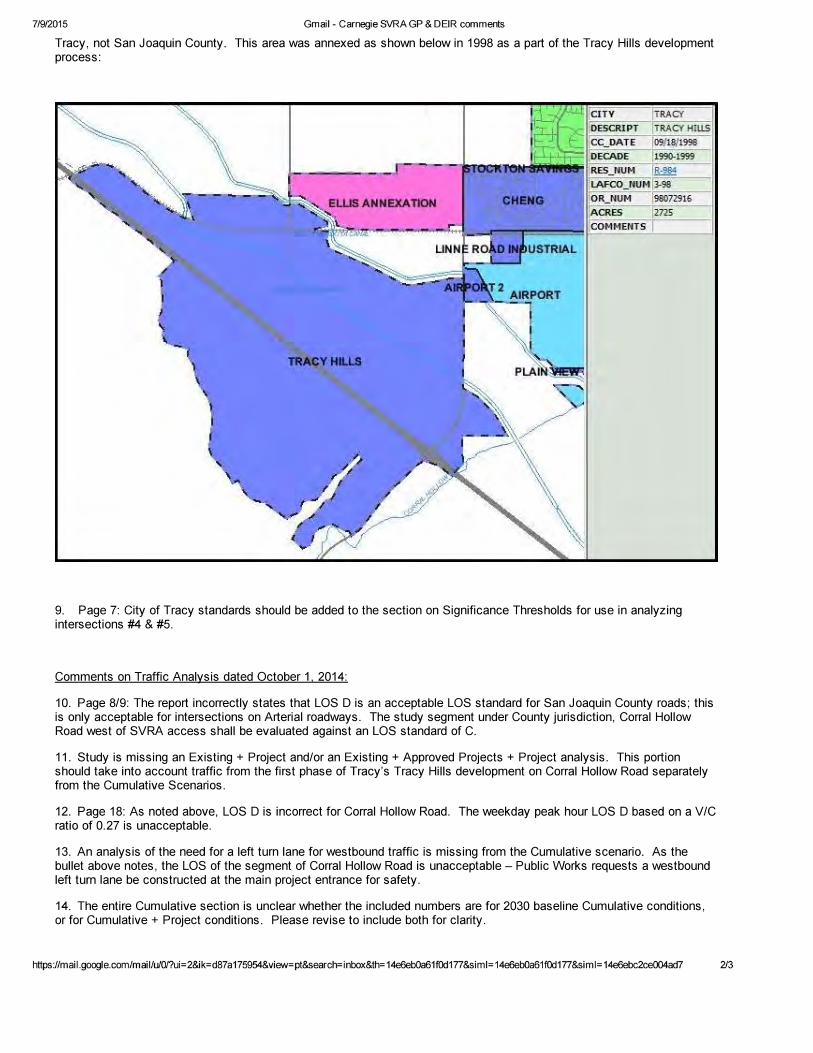


![lectureantibiogramme DESC2017 JCAILLON avec corrections … · 2017. 10. 27. · 3dupl ohv sursrvlwlrqv vxlydqwhv frqfhuqdqw6 dxuhxvhqwrxuh] od rx ohv upsrqvhvh[dfwhv" $ 7rxwhv ohv](https://img.pdfslide.net/doc/110x75/60db9b3c26c21a4e1558a99d/lectureantibiogramme-desc2017-jcaillon-avec-corrections-2017-10-27-3dupl-ohv.jpg)