Embed Size (px)
Citation preview

Regional Assessment on Ecosystem-based Disaster Risk Reduction and Biodiversity in South AmericaA report for the Resilience through Investing in Ecosystems - knowledge, innovation and transformation of risk management (RELIEF Kit) project
Regional Assessment on Ecosystem-based Disaster Risk Reduction and Biodiversity in South AmericaA report for the Resilience through Investing in Ecosystems - knowledge, innovation and transformation of risk management (RELIEF Kit) project
September | 2016
2
James McBreen
Karen Podvin, Fabiola Monty, Radhika Murti, Angela Andrade, Martín Calisto
McBreen, J. 2016. Regional Assessment on Ecosystem-based Disaster Risk Reduction and Biodiversity in South America. A report for the Resilience through Investing in Ecosystems – knowledge, innovation and transformation of risk management (RELIEF Kit) project. International Union for Conservation of Nature.
The Regional Assessment on Ecosystem-based Disaster Risk Reduction and Biodiversity in South America is a collaborative effort. We thank the many organisations and individuals who have contributed to this assessment. This report was supported by the Japan Biodiversity Fund under the Secretariat of the Convention on Biological Diversity, as well as coordination and advice from the IUCN Headquarters, and the IUCN Regional Office for South America.Finally, the author expresses sincere appreciation to all the government agencies, members of the IUCN Commission on Ecosystem Management (CEM), members of the IUCN World Commission on Protected Areas (WCPA), and organisations that provided information and shared their experiences on ecosystem-based disaster risk reduction in the region; especially to the following people for their valuable input to the development of this Regional Assessment: María Augusta Almeida Ferri, Fernando Ardura, Daniel Arteaga, Pablo Azua, Orlando Chuquisengo, Miguel A. Cueva, Dexter Dombro, Elsa Matilde Escobar, Henry Flores Julca, Bertha Cecilia García Cienfuegos, Nestor Roberto Garzón Cadena, Ernesto Godelman, Tarsicio Granizo, Oscar Guevara, Carmela Landeo Sánchez, Tatiana Pequeño Saco, María Pinilla, Susan V. Poats, Wilson Ariel Ramírez, Gunter Reck, Néstor Javier Roncancio Duque, Oscar Saavedra Arteaga, Didier Sánchez, Klaus Schutze, Einstein Tejada Vélez, María Dolores Vera, Próspero Yance and Juan Alejo Zarzycki.
Left to right: Biosphere Reserve ‘Corredor Biológico Nevados de Chillán-Laguna del Laja’, Biobío Region -Chile © Karen Podvin; Nor-Yauyos Cochas Landscape Reserve, Peru © Anelí Gómez; Hydro-agricultural systems in modern "camellones" in the Bolivian Beni Amazonia © Amazonia Services.
Tomás Lara Eskola
La designación de entidades geográficas y la presentación del material en este documento no implican la expresión de ninguna opinión por parte de la UICN respecto a la condición jurídica de ningún país, territorio o área, o de sus autoridades, o referente a la delimitación de sus fronteras y límites.
Av. República de El Salvador N34-127 y Suiza.Edificio Murano Plaza, piso 12; 170515 Quito, Ecuador.FAX: (593 2) 3331668; PBX: (593 2) 3330 684 www.iucn.org/sur www.portalces.org Twitter: @UICN_SURFacebook UICN-Sur: facebook.com/UICN.SUR [email protected]; [email protected]
Author
Revision and contributions
Citation
Acknowledgements
Cover photos
Design
Contacts
3
Table of contentsTablesFiguresAbbreviations, acronyms and symbolsGlossary
Summary1 Introduction2 Methodology3 South America: Regional overview
Socio-economic context Natural hazards in South America 3.1 Case study: Argentina Natural hazards Policies and strategies related to Eco-DRF Eco-DRR initiatives 3.2 Case study: Bolivia Natural hazards Policies and strategies related to Eco-DRR Eco-DRR initiatives 3.3 Case study: Chile Natural hazards Policies and strategies related to Eco-DRR Eco-DRR initiatives 3.4 Case study: Colombia Natural hazards Policies and strategies related to Eco-DRR Eco-DRR initiatives 3.5 Case study: Ecuador Natural hazards Policies and strategies related to Eco-DRR Eco-DRR initiatives 3.6 Case study: Peru Natural hazards Policies and strategies related to Eco-DRR Eco-DRR initiatives
4 Eco-DRR experiences in the region Examples of Eco-DRR for biodiversity Role of biodiversity in DRR in South America Economic case for Eco-DRR Protected Area management: integrating biodiversity conservation and DRR
45578
1120222531344141434547474953565658626464656971727378818183858990929699
4
Table of contents Regional Assessment on Ecosystem-based Disaster Risk Reduction and Biodiversity in South America
102102107108123124125126132133142146
147
1318
272831323333345763
100
122525262727282930
5 Conclusions Challenges and opportunities Key messagesReferencesAnnex Annex 1. Country selection matrix Annex 2. Vulnerability matrix Annex 3. Stakeholder matrix Annex 4. Share of occurrence by disaster type per country, 2000-2015 Annex 5. Survey format Annex 6. International agreements and policy processes relevant for Eco-DRR Annex 7. Overview of regional policies, strategies and frameworks related to EbA and Eco-DRR in the region Annex 8. Regional cooperation mechanisms / multilateral agreements related or with potential links to EbA and Eco-DRR
Table 1. Examples of initiatives on Eco-DRR in the regionTable 2. Summary of the key challenges, opportunities and recommendations to promote ecosystem-based approaches for DRR in South America.Table 3. Coastline in South AmericaTable 4. Global Ecological Zones (GEZ) in South AmericaTable 5. Population characteristics of countries in South America, 2014Table 6. Gross Domestic Product by country, 2014Table 7. Total economically active population and share in agriculture, 2013Table 8. Cultivated land and cultivable area in South American countries, 2012Table 9. Principal natural hazards in South AmericaTable 10. Earthquake’s impact in Chile, 2000–2015Table 11. Climate change adaptation and disaster risk reduction projects in ChileTable 12. The role of protected areas in reducing natural hazards
Figure 1. Occurrence by disaster type in South America, 2000–2015Figure 2. Map of South AmericaFigure 3. Topographic relief in South AmericaFigure 4. Koppen-Geiger climate type map of South AmericaFigure 5. Hydrological Basins of South AmericaFigure 6. Rivers in South AmericaFigure 7. Global Ecological Zones in South AmericaFigure 8. SPOT Normalised Difference Vegetation IndexFigure 9. World Heritage Sites and IUCN/SSC First-level Habitat Types in South America
5
Tables
Figures
3536363737383838393940414242434848494956575764656572727381828383
Figure 10. Flood incidence in South America, 2000–2015 Figure 11. Drought incidence in South America, 2000–2015Figure 12. Storm incidence in South America, 2000–2015Figure 13. Landslide incidence in South America, 2000–2015Figure 14. Extreme temperature incidence in South America, 2000–2015Figure 15. Epidemic incidence in South America, 2000–2015Figure 16. Earthquake incidence in South America, 2000–2015Figure 17. Volcanic activity incidence in South America, 2000–2015Figure 18. Wildfire incidence in South America, 2000–2015Figure 19. Total deaths and people affected by disaster type in South America, 2000–2015Figure 20. Occurrence by disaster type in main countries, 2000–2015Figure 21. Most common hazards in Argentina, 2000–2015Figure 22. Total deaths and people affected by floods in Argentina, 2000–2015Figure 23. Total deaths by storms and extreme temperatures in Argentina, 2000–2015Figure 24. Argentina’s Proportion of main hazards in the region, 2000–2015Figure 25. Most common hazards in Bolivia, 2000–2015Figure 26. Total deaths and people affected by floods in Bolivia, 2000–2015Figure 27. People affected by droughts in Bolivia, 2000–2015Figure 28. Bolivia’s proportion of main hazards in the region, 2000–2015Figure 29. Most common hazards in Chile, 2000–2015Figure 30. Total deaths and people affected by floods in Chile, 2000-2015Figure 31. Chile’s proportion of main hazards in the region, 2000–2015Figure 32. Most common hazards in Colombia, 2000–2015Figure 33. Colombia’s proportion of main hazards in the region, 2000–2015Figure 34. Total deaths and people affected by floods in Colombia, 2000–2015Figure 35. Most common hazards in Ecuador, 2000–2015Figure 36. People affected by floods and volcano activity in Ecuador, 2000–2015Figure 37. Ecuador’s proportion of main hazards in the region, 2000–2015Figure 38. Most common hazards in Peru, 2000–2015Figure 39. Total deaths and people affected by floods and earthquakes in Peru, 2000–2015Figure 40. Total deaths and people affected by extreme temperatures in Peru, 2000–2015Figure 41. Peru’s proportion of main hazards in the region, 2000–2015
6
Regional Assessment on Ecosystem-based Disaster Risk Reduction and Biodiversity in South America
Agricultural Stress IndexComunidad AndinaCentro del Agua para Zonas Áridas y Semiáridas de América Latina y el Caribe, ChileConvention on Biological DiversityClimate Change AdaptationConsejo Interinstitucional del Cambio Climático, BoliviaComisión Nacional Asesora sobre el Cambio Climático, ArgentinaComisión Nacional de Riego, ChileDirección de Cambio Climático, ArgentinaDisaster Risk ManagementDisaster Risk ReductionEcosystem-based AdaptationEcosystem-based Disaster Risk ReductionEconomic Commission for Latin America and the CaribbeanEmergency Events DatabaseEl Niño Southern OscillationFood and Agriculture Organization of the United NationsGlobal Forest Resources AssessmentGross Domestic ProductGlobal Environment FacilityGlobal Facility for Disaster Reduction and RecoveryGreenhouse gasPlan de gestión de riesgo y adaptación al cambio climático en el sector agrario para 2012-2021, PerúGrupo Técnico de Trabajo de Gestión de Riesgos de Desastres, PerúInternational Federation of Red Cross and Red Crescent SocietiesInstituto Nacional de Meteorología e Hidrología, EcuadorInstituto de Desarrollo Agropecuario, ChileInstituto Nacional de Defensa Civil, PerúInstituto Nacional de Estadística e Informática, PerúIntergovernmental Panel on Climate ChangeInternational Union for Conservation of NatureIntegrated water resource managementLeast Developed Countries FundMinisterio de Agricultura y Riego, PerúMinisterio de Medio Ambiente y Agua, BoliviaMecanismo Nacional de Adaptación al Cambio Climático, BoliviaNational Adaptation PlanNational Adaptation Programme of ActionFifth National Report (CBD)Red Iberoamericana de Oficinas de Cambio ClimáticoServicio Agrícola y Ganadero, ChileSecretaría de Ambiente y Desarrollo Sustentable, ArgentinaSpecial Climate Change FundSustainable Development GoalSendai Framework for Disaster Risk ReductionServicio Nacional de Meteorología e Hidrología del PerúServicio Meteorológico Nacional de ArgentinaUnited Nations Development Programme United Nations Environment ProgrammeUnited Nations Framework Convention on Climate ChangeUnited Nations Office for Disaster Risk ReductionUN-Water Decade Programme on Capacity DevelopmentVegetation Health IndexWorld Meteorological Organization
ASICANCAZALACCBDCCACICCCNACC CNR DCCDRMDRREbAEco-DRRECLACEM-DATENSOFAOFRAGDPGEFGFDRR GHGGRACCGTTGRDIFRC INAMHIINDAPINDECIINEIIPCCIUCNIWRMLDCFMINAGRIMMAyAMNACC NAPNAPANR5RIOCCSAGSAyDSSCCFSDGSFDRRSENAMHISMNUNDP UNEPUNFCCCUNISDRUNW-DPCVHIWMO
degree Celsiushabitanthectarekilogrammesquare kilometremetremetres above sea leveltonne
°Chabhakgkm2
mm.a.s.l.t
7
Abbreviations, acronyms and symbols
8
The process of adjustment to actual or expected climate and its effects. In human systems, adaptation seeks to moderate or avoid harm or exploit beneficial opportunities. In some natural systems, human intervention may facilitate adjustment to expected climate and its effects (IPCC, 2014a).
The ability of systems, institutions, humans and other organisms to adjust to potential damage, to take advantage of opportunities, or to respond to consequences (IPCC, 2014a).
Climate change refers to a change in the state of the climate that can be identified (e.g. by using statistical tests) by changes in the mean and/or the variability of its properties and that persists for an extended period, typically decades or longer. Climate change may be due to natural internal processes or external forcings such as modulations of the solar cycles, volcanic eruptions and persistent anthropogenic changes in the composition of the atmosphere or in land use. (IPCC, 2014a).A change of climate which is attributed directly or indirectly to human activity that alters the composition of the global atmosphere and which is in addition to natural climate variability observed over comparable time periods (UNFCCC, 1992).
The ability of people, organisations and systems, using available skills and resources, to face and manage adverse conditions, emergencies or disasters (UNISDR, 2009).
Land degradation in arid, semi-arid and dry sub-humid areas resulting from various factors, including climatic variations and human activities (UNCCD, 1994).
A serious disruption of the functioning of a community or a society involving widespread human, material, economic or environmental losses and impacts, which exceeds the ability of the affected community or society to cope using its own resources (UNISDR, 2009).
The potential disaster losses, in lives, health status, livelihoods, assets and services, which could occur to a particular community or a society over some specified future time period (UNISDR, 2009).
Processes for designing, implementing, and evaluating strategies, policies, and measures to improve the understanding of disaster risk, foster disaster risk reduction and transfer, and promote continuous improvement in disaster preparedness, response and recovery practices, with the explicit purpose of increasing human security, well-being, quality of life, and sustainable development (IPCC, 2012).
The concept and practice of reducing disaster risks through systematic efforts to analyse and manage the causal factors of disasters, including through reduced exposure to hazards, lessened vulnerability of people and property, wise management of land and the environment, and improved preparedness for adverse events (UNISDR, 2009).
A period of abnormally dry weather long enough to cause a serious hydrological imbalance. Drought is a relative term, therefore any discussion in terms of precipitation deficit must refer to the particular precipitation-related activity that is under discussion. For example, shortage of precipitation during the growing season impinges on crop production or ecosystem function in general (also termed agricultural drought), and during the runoff and percolation season primarily affects water supplies (hydrological drought). A megadrought is a very lengthy and pervasive drought, lasting much longer than normal, usually a decade or more (IPCC, 2014a).
Adaptation
Adaptive capacity
Climate change
Coping capacity
Desertification
Disaster
Disaster risk
Disaster risk management –DRM
Disaster Risk Reduction –DRR
Drought
DefinitionName
Glossary
9
The use of biodiversity and ecosystem services as part of an overall adaptation strategy to help people adapt to the adverse effects of climate change. EbA aims to maintain and increase the resilience and reduce the vulnerability of people and the ecosystems they rely upon in the face of the adverse effects of climate change (SCBD, 2016).
Sustainable management, conservation and restoration of ecosystems to reduce disaster risk, with the aim to achieve sustainable and resilient development (Estrella & Saalismaa, 2013). Decision-making activities that take into consideration current and future human livelihood needs and biophysical requirements of ecosystems, and recognise the role of ecosystems in supporting communities to prepare for, cope with and recover from disaster situations. Sustainable ecosystem management for disaster risk reduction is based on equitable stakeholder involvement in land management decisions, land-use-trade-offs and long-term goal setting (Sudmeier-Rieux, K. et al., 2013).
The benefits people derive from ecosystems. These include provisioning services such as food, water, timber and fibre: regulating services that affect climate, floods, disease, wastes and water quality; cultural services that provide recreational, aesthetic and spiritual benefits; and supporting services such as soil formation, photosynthesis and nutrient cycling (MEA, 2005).
A complex interaction of the tropical Pacific Ocean and the global atmosphere that results in irregularly occurring episodes of changed ocean and weather patterns in many parts of the world, often with significant impacts over many months, such as altered marine habitats, rainfall changes, floods, droughts and changes in storm patterns (UNISDR, 2009).
The reduction of the capacity of the environment to meet social and ecological objectives and needs (UNISDR, 2009).
The presence of people; livelihoods; species or ecosystems, environmental services and resources; infrastructure; or economic, social, or cultural assets in places that could be adversely affected (IPCC, 2014a).
The overflowing of the normal confines of a stream or other body of water, or the accumulation of water over areas that are not normally submerged. Floods include river (fluvial) floods, flash floods, urban floods, pluvial floods, sewer floods, coastal floods and glacial lake outburst floods (IPCC, 2014a).
Gaseous constituents of the atmosphere, both natural and anthropogenic, that absorb and emit radiation of thermal infrared radiation emitted by the Earth’s surface, the atmosphere itself, and by clouds (UNISDR, 2009).
The potential occurrence of a natural or human-induced physical event that may cause loss of life, injury, or other health impacts, as well as damage and loss to property, infrastructure, livelihoods, service provision, and environmental resources (IPCC, 2014a).
Effects on natural and human systems. In this report, the term ‘impacts’ is used to refer to the effects on natural and human systems of physical events, of disasters, and of climate change (IPCC, 2014a).
A mass of material that has moved downhill by gravity, often assisted by water when the material is saturated. The movement of soil, rock or debris down a slope can occur rapidly, or may involve slow, gradual failure (IPCC, 2012).
Ecosystem-basedAdaptation ––EbA
Ecosystem-based Disaster Risk Reduction –Eco-DRR
Ecosystem service
El Niño-Southern Oscillation phenomenon –– ENSO
Environmental degradation
Exposure
Flood
Greenhouse gases
Hazard
Impacts
Landslide
10
The process undertaken by public authorities to identify, evaluate and decide on different options for the use of land, including consideration of long-term economic, social and environmental objectives and the implications for different communities and interest groups, and the subsequent formulation and promulgation of plans that describe the permitted or acceptable uses (UNISDR, 2009).
The lessening or limitation of the adverse impacts of hazards and related disasters (UNISDR, 2009).
Natural process or phenomenon that may cause loss of life, injury or other health impacts, property damage, loss of livelihoods and services, social and economic disruption, or environmental damage (UNISDR, 2009).
The ability of a system, community or society exposed to hazards to resist, absorb, accommodate to and recover from the effects of a hazard in a timely and efficient manner, including through the preservation and restoration of its essential basic structures and functions (UNISDR, 2009).
The capacity of social, economic and environmental systems to cope with a hazardous event or trend or disturbance, responding or reorganising in ways that maintain their essential function, identity and structure, while also maintaining the capacity for adaptation, learning and transformation (IPCC, 2014a).
The combination of the probability of an event and its negative consequences (UNISDR, 2009).The potential for consequences where something of value is at stake and where the outcome is uncertain, recognising the diversity of values. Risk is often represented as probability or likelihood of occurrence of hazardous events or trends multiplied by the impacts if these events or trends occur (IPCC, 2014a).
The systematic approach and practice of managing uncertainty to minimise potential harm and loss (UNISDR, 2009).
The phenomenon of increased occurrence of certain geophysical and hydrometeorological hazard events, such as landslides, flooding, land subsidence and drought, that arise from the interaction of natural hazards with overexploited or degraded land and environmental resources (UNISDR, 2009).
The temporary increase, at a particular locality, in the height of the sea due to extreme meteorological conditions (low atmospheric pressure and/or strong winds). The storm surge is defined as being the excess above the level expected from the tidal variation alone at that time and place (IPCC, 2014a).
The propensity or predisposition to be adversely affected. Vulnerability encompasses a variety of concepts including sensitivity or susceptibility to harm and lack of capacity to cope and adapt (IPCC, 2014a).The characteristics and circumstances of a community, system or asset that make it susceptible to the damaging effects of a hazard (UNISDR, 2009).
Land-use planning
Mitigation
Natural hazard
Resilience
Risk
Risk Management
Socio-natural hazard
Storm surge
Vulnerability
Regional Assessment on Ecosystem-based Disaster Risk Reduction and Biodiversity in South America
Summary
S1 Background
cultural and natural diversity, and is home to a number of global biodiversity hotspots; with five of the 17 megadiverse countries that harbour the majority of the Earth’s species located in South America. The biodiverse ecosystems provide multiple services to reduce risks from environmental hazards, support adaptation to climate change, and contribute to sustainable development.
Extreme temperatures and changing precipitation have adverse effects on agricultural, forestry and fishery productivity, the water cycle and biodiversity. Acidification of the oceans, rising sea levels, hurricanes, and changes in climate will have a severe impact on coastal livelihoods, tourism, health, food and water security. Whilst glacial melt presents a significant threat to the source of drinking water for Andean cities. The rapid population growth and displacement as well as rural economic collapse have triggered one of the fastest urbanisation rates in the world. However, agriculture, the forestry sector and fisheries contribute significantly to the livelihoods and well-being of women, indigenous and local communities, and the poor and vulnerable. Therefore, it is necessary to build the adaptive capacities of such communities who depend on ecosystem services and who are often the most vulnerable, especially with regards to food security.
The adaptive capacity of human systems in Latin America is low, particularly to extreme climate events, and vulnerability is high (Magrin et al., 2007). In this sense, the dependency of many countries in South America on (degrading) natural resources and the agriculture, forestry and fisheries sectors forincomes and livelihoods, combined with inadequate
outh America is home to approximately 18 percent of the world’s population. The region
economic and technological development, weak governance and institutions, and rapid growth, make it a particularly vulnerable region to climate change. Climate variability further increases this vulnerability due to the increasing frequency of El Niño and La Niña events -the former responsible for a large part of the climate variability at inter-annual scales in Latin America- with impacts varying across the subcontinent (IPCC, 2007).
In the face of a changing climate and consequent increase in frequencies and magnitudes of disasters, the well-being and livelihoods of humans and ecosystems are threatened and the vulnerability of communities to natural hazards has increased.
2 The scope and purpose of this assessment
The assessment for South America provides a brief analysis of natural hazards in the region, identifies the most significant disasters by type, their occurrence and impacts -both in terms of populations affected and economic damages incurred. It incorporates information and experiences on ecosystem-based disaster risk reduction and is a first attempt to demonstrate linkages with biodiversity, from six focal countries in the region- Argentina, Bolivia, Chile, Colombia, Ecuador and Peru.1
Together, these countries accounted for 70% of total reported disasters in South America in the period 2000–2015, comprising 60% of floods, 84% of landslides, 74% of extreme temperatures, 55% of storms, 47% of drought, 93% of wildfire, 100% of volcanic activity, 56% of epidemics, and 96% of earthquakes in the region (Figure 1).
1 See Annex 1 for country selection
11
By Karen Podvin and James McBreen
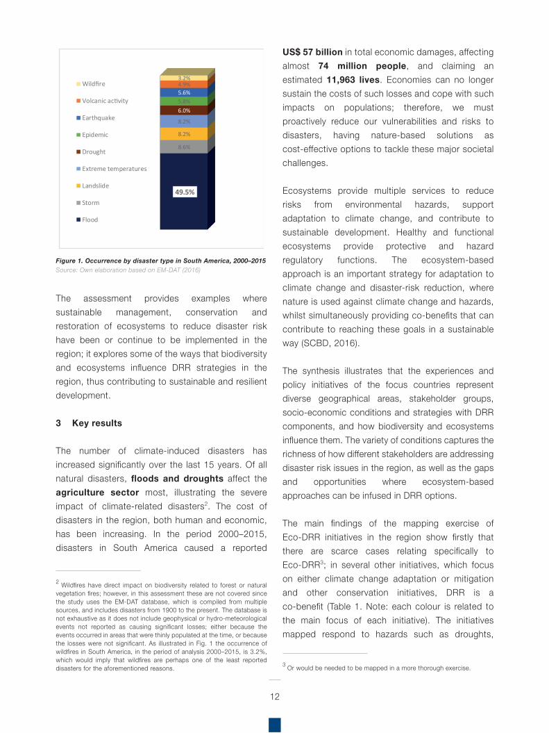
Figure 1. Occurrence by disaster type in South America, 2000–2015Source: Own elaboration based on EM-DAT (2016)
The assessment provides examples where sustainable management, conservation and restoration of ecosystems to reduce disaster risk have been or continue to be implemented in the region; it explores some of the ways that biodiversity and ecosystems influence DRR strategies in the region, thus contributing to sustainable and resilient development.
3 Key results
The number of climate-induced disasters has increased significantly over the last 15 years. Of all natural disasters, floods and droughts affect the agriculture sector most, illustrating the severe impact of climate-related disasters2. The cost of disasters in the region, both human and economic, has been increasing. In the period 2000–2015, disasters in South America caused a reported
US$ 57 billion in total economic damages, affectingalmost 74 million people, and claiming an estimated 11,963 lives. Economies can no longer sustain the costs of such losses and cope with such impacts on populations; therefore, we must proactively reduce our vulnerabilities and risks to disasters, having nature-based solutions as cost-effective options to tackle these major societal challenges.
Ecosystems provide multiple services to reduce risks from environmental hazards, support adaptation to climate change, and contribute to sustainable development. Healthy and functional ecosystems provide protective and hazard regulatory functions. The ecosystem-based approach is an important strategy for adaptation to climate change and disaster-risk reduction, where nature is used against climate change and hazards, whilst simultaneously providing co-benefits that can contribute to reaching these goals in a sustainable way (SCBD, 2016).
The synthesis illustrates that the experiences and policy initiatives of the focus countries represent diverse geographical areas, stakeholder groups, socio-economic conditions and strategies with DRR components, and how biodiversity and ecosystems influence them. The variety of conditions captures the richness of how different stakeholders are addressing disaster risk issues in the region, as well as the gaps and opportunities where ecosystem-based approaches can be infused in DRR options.
The main findings of the mapping exercise of Eco-DRR initiatives in the region show firstly that there are scarce cases relating specifically to Eco-DRR3; in several other initiatives, which focus on either climate change adaptation or mitigation and other conservation initiatives, DRR is a co-benefit (Table 1. Note: each colour is related to the main focus of each initiative). The initiatives mapped respond to hazards such as droughts,
2 Wildfires have direct impact on biodiversity related to forest or natural vegetation fires; however, in this assessment these are not covered since the study uses the EM-DAT database, which is compiled from multiple sources, and includes disasters from 1900 to the present. The database is not exhaustive as it does not include geophysical or hydro-meteorological events not reported as causing significant losses; either because the events occurred in areas that were thinly populated at the time, or because the losses were not significant. As illustrated in Fig. 1 the occurrence of wildfires in South America, in the period of analysis 2000–2015, is 3.2%, which would imply that wildfires are perhaps one of the least reported disasters for the aforementioned reasons.
12
3 Or would be needed to be mapped in a more thorough exercise.
49.5%
8.6%
8.2%
8.2%
6.0%5.8%5.6%4.9%3.2%
Wildfire
Volcanic activity
Earthquake
Epidemic
Drought
Extreme temperatures
Landslide
Storm
Flood
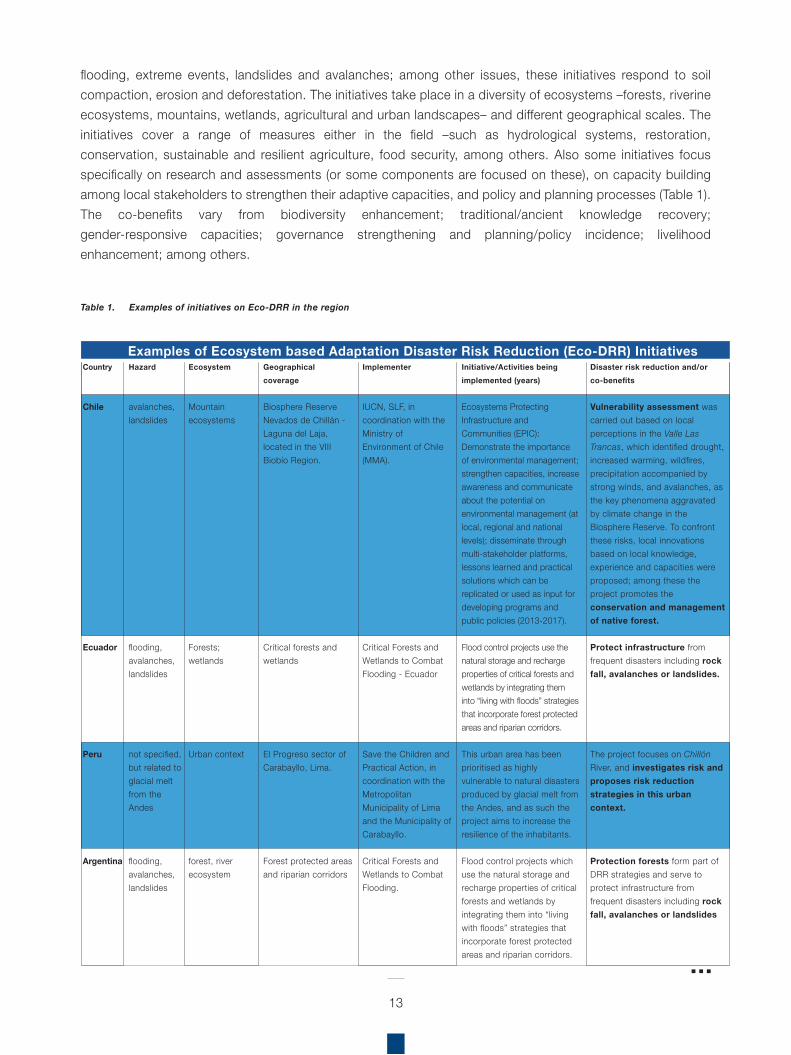
Table 1. Examples of initiatives on Eco-DRR in the region
Hazard
avalanches, landslides
flooding, avalanches, landslides
not specified, but related to glacial melt from the Andes
flooding, avalanches, landslides
Country
Chile
Ecuador
Peru
Argentina
Geographicalcoverage
Biosphere Reserve Nevados de Chillán - Laguna del Laja, located in the VIII Biobío Region.
Critical forests and wetlands
El Progreso sector of Carabayllo, Lima.
Forest protected areas and riparian corridors
Implementer
IUCN, SLF, in coordination with the Ministry of Environment of Chile (MMA).
Critical Forests and Wetlands to Combat Flooding - Ecuador
Save the Children and Practical Action, in coordination with the Metropolitan Municipality of Lima and the Municipality of Carabayllo.
Critical Forests and Wetlands to Combat Flooding.
Initiative/Activities being implemented (years)
Ecosystems Protecting Infrastructure and Communities (EPIC): Demonstrate the importance of environmental management; strengthen capacities, increase awareness and communicate about the potential on environmental management (at local, regional and national levels); disseminate through multi-stakeholder platforms, lessons learned and practical solutions which can be replicated or used as input for developing programs and public policies (2013-2017).
Flood control projects use the natural storage and recharge properties of critical forests and wetlands by integrating them into “living with floods” strategies that incorporate forest protected areas and riparian corridors.
This urban area has been prioritised as highly vulnerable to natural disasters produced by glacial melt from the Andes, and as such the project aims to increase the resilience of the inhabitants.
Flood control projects which use the natural storage and recharge properties of critical forests and wetlands by integrating them into “living with floods” strategies that incorporate forest protected areas and riparian corridors.
Disaster risk reduction and/or co-benefits
Vulnerability assessment was carried out based on local perceptions in the Valle Las Trancas, which identified drought, increased warming, wildfires, precipitation accompanied by strong winds, and avalanches, as the key phenomena aggravated by climate change in the Biosphere Reserve. To confront these risks, local innovations based on local knowledge, experience and capacities were proposed; among these the project promotes the conservation and management of native forest.
Protect infrastructure from frequent disasters including rock fall, avalanches or landslides.
The project focuses on Chillón River, and investigates risk and proposes risk reduction strategies in this urban context.
Protection forests form part of DRR strategies and serve to protect infrastructure from frequent disasters including rock fall, avalanches or landslides
Ecosystem
Mountain ecosystems
Forests; wetlands
Urban context
forest, river ecosystem
13
flooding, extreme events, landslides and avalanches; among other issues, these initiatives respond to soilcompaction, erosion and deforestation. The initiatives take place in a diversity of ecosystems ‒forests, riverine ecosystems, mountains, wetlands, agricultural and urban landscapes‒ and different geographical scales. The initiatives cover a range of measures either in the field ‒such as hydrological systems, restoration, conservation, sustainable and resilient agriculture, food security, among others. Also some initiatives focus specifically on research and assessments (or some components are focused on these), on capacity building among local stakeholders to strengthen their adaptive capacities, and policy and planning processes (Table 1). The co-benefits vary from biodiversity enhancement; traditional/ancient knowledge recovery; gender-responsive capacities; governance strengthening and planning/policy incidence; livelihood enhancement; among others.
Examples of Ecosystem based Adaptation Disaster Risk Reduction (Eco-DRR) Initiatives
flooding, drought
not specified
drought
extreme events, drought
extreme events, drought
drought
extreme events, drought, fires (in one community)
Bolivia
Bolivia
Ecuador
Bolivia
Peru
Peru
Fallow land in the basin of the Mamoré River ––in the San Ignacio de Moxos Municipality, in the Beni Department
In six departments: La Paz, Oruro, Cochabamba, Chuquisaca, Potosí and Tarija
Azuay, Loja, Manabí, Morona Santiago provinces.
Department of La Paz, in the Municipalities of Batallas and Palca.
Cintis; and Andean zone of the Department of Cochabamba
Lima Region, Yauyos Province in the high basin of the Cañete River, characterised by high Andean wetlands and puna grasslands.
Nor Yauyos-Cochas Landscape Reserve (NYCLR) in the Peruvian Andes (Junin and Lima regions)
Bolivia’s Ministry of Environment and Water (MMAyA)
Swiss Cooperation
Ministry of Environment, UNDP
World Bank, CARE, and the Swiss Cooperation in the eastern Andes
Fundación Agua Tierra Campesina (ATICA)
Patronato-Nor Yauyos Cochas Landscape Reserve, IUCN-Sur, Universidad Católica Sedes Sapientiae and the RPNYC
TMI and IUCN (as part of the Mt. EbA project, implemented also with UNDP and UNEP)
Waru Waru was used for risk management, CCA, improving food security, and strengthening the livelihood options for local population. The project revived an ancestral system of cultivation and irrigation, forming a patterned system of raised cropland and water-filled trenches.
DRR project for prevention, to build awareness and strengthen DRR capacities for communities and organisations.
Climate Change Adaptation through an effective water governance project (PACC): reduce climate change vulnerability in Ecuador, through the efficient use of water resources (2006-2014).
Adaptation to the impacts of Andean Glacier retreat (PRAA for its acronym in Spanish); DDR for Climate Change Adaptation pilot activities in the two municipalities.
Reducing disaster risk and CCA, through the strengthening of local governance in the municipalities forming the Commonwealth of Cintis.
Study to understand current capacity and potential for capturing and storing water in the upper Cañete river basin: This initiative aimed to establish baseline conditions of water storage capacities of the bofedales and pajonales, as part an integrated water management strategy in the basin, to increase climate resilience of the socio-ecological system.
Implementing no-regret EbA measures to reduce the vulnerability and increase resilience of 2 local communities and ecosystems (Canchayllo and Miraflores)
This system captures water when there are droughts and drains away water when there is too much rain, which allows crops to be effectively irrigated all year round and acts as an important buffer to ecosystems and communities in times of flash flooding; improved income opportunities for communities by promoting crop production in periods of flood and drought, and also promotes CCA and DRR by floods and drought in communities.
One of the project components focused on reducing climate risks in agriculture, which promoted the application of agroecology practices for prevention, mitigation and adaptation.
36 community-level projects focused on agroecology and forests, with the recovery of ancient knowledge and practices to ensure enough water resources now and in the future.
More resilient crops, likely linked to plant genetic diversity and therefore serve as a good example of the role of biodiversity in DRR.
The capacities of women groups were also strengthened to confront climate change impacts in the Andean zone of the Department of Cochabamba.
Identify critical areas for restoring water storage capacity and restore the capacity of the bofedales and pajonales to capture and store rainwater through: a) Establishing a baseline of the natural area from 1962; b) Implementing two restoration parcels (bofedales and pajonales) in 17 ha of land with farmer communities in Huancaya.
Faced with the degradation of grasslands and one of the main climate vulnerabilities related to extreme events and droughts, two communities in the Nor Yauyos-Cochas Landscape Reserve, developed adaptive land practices that focus on the enlargement and conservation of wetlands and community-based management of native grasslands, as part of no-regret EbA measures. In one of the communities, the increased humidity as result of the measures supports prevents wildfires.
Amazon plain and gallery forests
Mountain ecosystems
Agricultural landscapes, forests
Mountain ecosystems
Mountain ecosystems
High Andean wetlands and puna grasslands
Mountain ecosystems
14
Examples of Climate Change Adaptation initiatives with Eco-DRR co-benefits
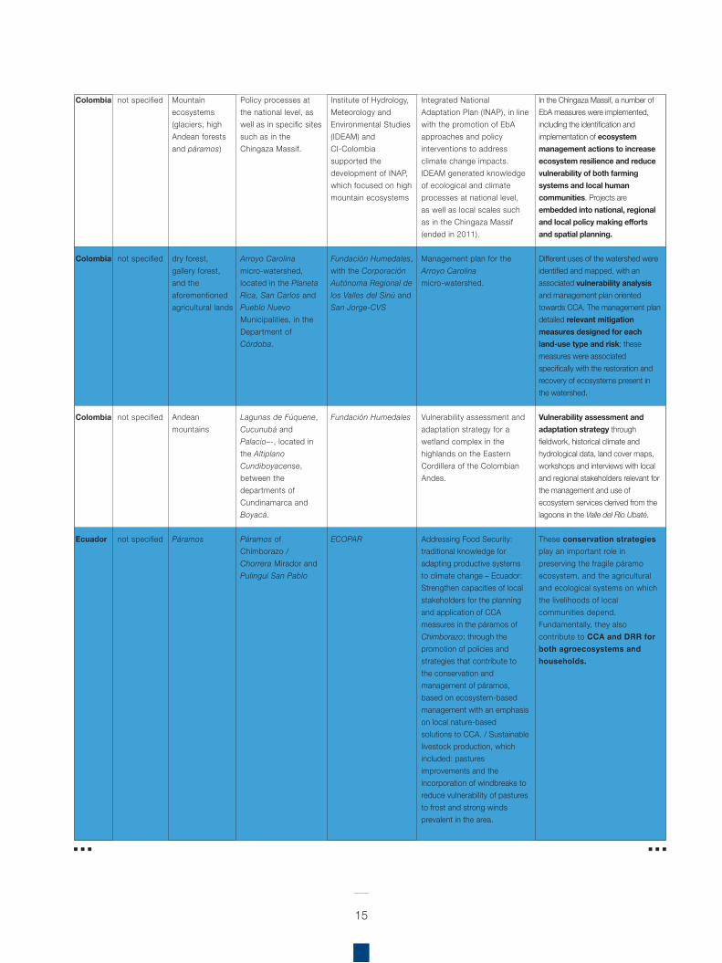
not specified
not specified
not specified
not specified
Colombia
Colombia
Colombia
Ecuador
Policy processes at the national level, as well as in specific sites such as in the Chingaza Massif.
Arroyo Carolina micro-watershed, located in the Planeta Rica, San Carlos and Pueblo Nuevo Municipalities, in the Department of Córdoba.
Lagunas de Fúquene, Cucunubá and Palacio–-, located in the Altiplano Cundiboyacense, between the departments of Cundinamarca and Boyacá.
Páramos of Chimborazo / Chorrera Mirador and Pulinguí San Pablo
Institute of Hydrology, Meteorology and Environmental Studies (IDEAM) and CI-Colombia supported the development of INAP, which focused on high mountain ecosystems
Fundación Humedales, with the Corporación Autónoma Regional de los Valles del Sinú and San Jorge-CVS
Fundación Humedales
ECOPAR
Integrated National Adaptation Plan (INAP), in line with the promotion of EbA approaches and policy interventions to address climate change impacts. IDEAM generated knowledge of ecological and climate processes at national level, as well as local scales such as in the Chingaza Massif (ended in 2011).
Management plan for the Arroyo Carolina micro-watershed.
Vulnerability assessment and adaptation strategy for a wetland complex in the highlands on the Eastern Cordillera of the Colombian Andes.
Addressing Food Security: traditional knowledge for adapting productive systems to climate change – Ecuador: Strengthen capacities of local stakeholders for the planning and application of CCA measures in the páramos of Chimborazo; through the promotion of policies and strategies that contribute to the conservation and management of páramos, based on ecosystem-based management with an emphasis on local nature-based solutions to CCA. / Sustainable livestock production, which included: pastures improvements and the incorporation of windbreaks to reduce vulnerability of pastures to frost and strong winds prevalent in the area.
In the Chingaza Massif, a number of EbA measures were implemented, including the identification and implementation of ecosystem management actions to increase ecosystem resilience and reduce vulnerability of both farming systems and local human communities. Projects are embedded into national, regional and local policy making efforts and spatial planning.
Different uses of the watershed were identified and mapped, with an associated vulnerability analysis and management plan oriented towards CCA. The management plan detailed relevant mitigation measures designed for each land-use type and risk; these measures were associated specifically with the restoration and recovery of ecosystems present in the watershed.
Vulnerability assessment and adaptation strategy through fieldwork, historical climate and hydrological data, land cover maps, workshops and interviews with local and regional stakeholders relevant for the management and use of ecosystem services derived from the lagoons in the Valle del Río Ubaté.
These conservation strategies play an important role in preserving the fragile páramo ecosystem, and the agricultural and ecological systems on which the livelihoods of local communities depend. Fundamentally, they also contribute to CCA and DRR for both agroecosystems and households.
Mountain ecosystems (glaciers, high Andean forests and páramos)
dry forest, gallery forest, and the aforementioned agricultural lands
Andean mountains
Páramos
15
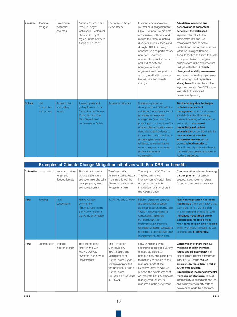
flooding, drought
Soil compaction and erosion
not specified
flooding
Deforestation
Ecuador
Bolivia
Colombia
Peru
Peru
Andean páramos and forest; El Ángel watershed, Ecological Reserve El Ángel region, in the northern Andes of Ecuador.
Amazon plain and gallery forests in the Santa Ana del Yacuma Municipality, in the Beni Department, north-eastern Bolivia
The basin is located in Vichada Department, and covers moriche palm swamps, gallery forest and flooded forests.
Native Awajun community ‘Shampuyacu’ in the San Martín region in the Peruvian Amazon
Tropical montane forest in the San Martín, Ucayali, Huánuco, and Loreto Departments
Corporación Grupo Randi Randi
Amazonia Services
The Corporación Ambiental La Pedregoza, in partnership with the Alexander von Humboldt Research Institute
IUCN, AIDER, CI-Perú
The Centre for Conservation, Investigation, and Management of Natural Areas (CIMA – Cordillera Azul), and the National Service of Natural Areas Protected by the State (SERNANP)
Inclusive and sustainable watershed management for CCA – Ecuador: To promote sustainable livelihoods and reduce the threat of natural disasters such as floods and drought, CGRR is using a coordinated and participatory approach, involving communities, public sector, and civil society and non-governmental organisations to support food security and build resilience to disasters and climate change.
Sustainable productive development and CCA, with the re-introduction and promotion of an ancient system of soil management (Waru Waru), to protect against soil erosion of the Amazon plain and gallery forests; using traditional knowledge to improve the quality of livelihoods and strengthen community resilience, as well as improve water management techniques and natural resource conservation.
The project ––CO2 Tropical Trees––, promotes improvement of certain land use practices with the introduction of silviculture in the Río Bita basin
REDD+: Supporting countries and communities to design schemes for benefit sharing’: pilot ‘REDD+’ activities within CI’s Conservation Agreement framework have been implemented, among these, restoration of riparian ecosystems to promote sustainable river basin management has taken place.
PNCAZ National Park Programme: protect a variety of species, biological communities, and geological formations pertaining to the montane forest of the Cordillera Azul; as well, as support the development of an integrated and sustainable management of natural resources in the buffer zone
Adaptation measures and conservation of ecosystem services in the watershed. Implementation of activities incorporated into land-use management plans to protect riverbanks and wetlands in territories within the Ecological Reserve El Ángel. In addition to a study to assess the impact of climate change on principle crops in the lower/medium El Ángel watershed. A climate change vulnerability assessment was carried out in a key irrigation area in Pueblo Viejo, and capacities strengthened for members of the irrigation consortia. Eco-DRR can be integrated into watershed development planning.
Traditional irrigation technique includes improved soil management, which has increased soil stability and soil biodiversity, thereby a) reducing soil compaction and erosion; b) increased productivity and carbon sequestration; c) contributing to the conservation of valuable ecosystem services and d) promoting food security by diversification of productivity through the use of plant genetic resources for food and agriculture.
Compensation scheme focusing on tree planting for carbon sequestration, covering natural forest and savannah ecosystems
Riparian vegetation has been maintained (from an initiative that took place in mid-2013 before this project) and expanded, with increased vegetation cover and protecting crops from river bank erosion and flooding when river levels increase, as well as increasing biodiversity.
Conservation of more than 1.3 million ha of intact montane forest, and its biodiversity, the project aims to prevent deforestation in the PNCAZ, and to reduce emissions by more than 17 million tCO2e over 10 years. Strengthening local environmental management strategies, to build local capacity for sustainable land use and to improve the quality of life of communities inside the buffer zone.
Riverbanks; wetlands; páramos
Amazon plain and gallery forests
swamps, gallery forest and flooded forests
River ecosystems
Tropical montane forest
16
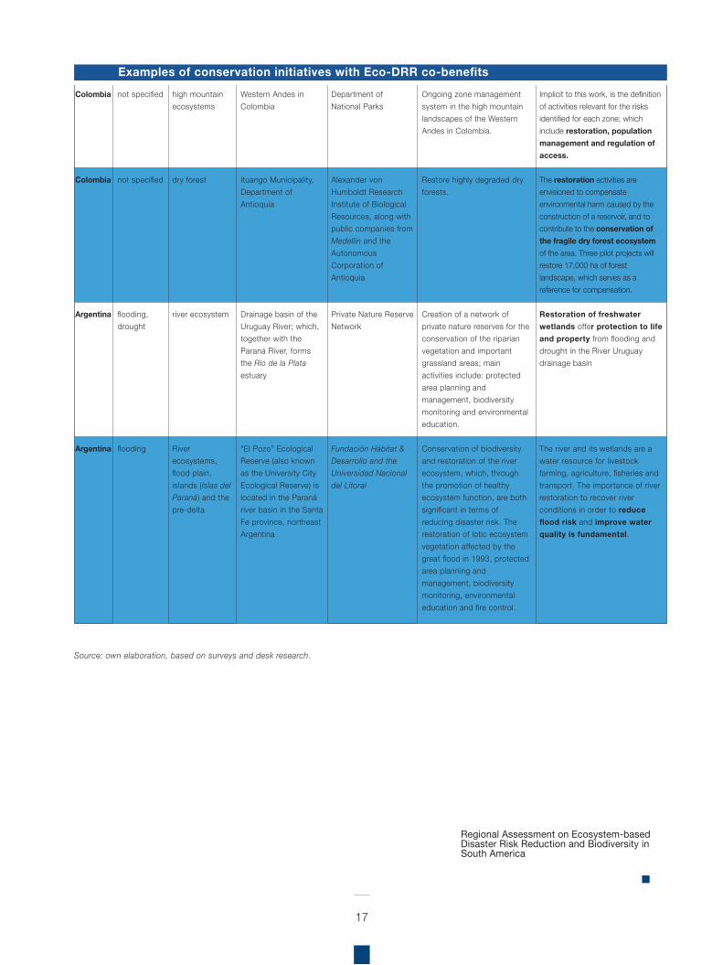
Examples of Climate Change Mitigation initiatives with Eco-DRR co-benefits
not specified
not specified
flooding, drought
flooding
Colombia
Colombia
Argentina
Argentina
Western Andes in Colombia
Ituango Municipality, Department of Antioquia
Drainage basin of the Uruguay River; which, together with the Paraná River, forms the Río de la Plata estuary
“El Pozo” Ecological Reserve (also known as the University City Ecological Reserve) is located in the Paraná river basin in the Santa Fe province, northeast Argentina
Department of National Parks
Alexander von Humboldt Research Institute of Biological Resources, along with public companies from Medellín and the Autonomous Corporation of Antioquia
Private Nature Reserve Network
Fundación Hábitat & Desarrollo and the Universidad Nacional del Litoral
Ongoing zone management system in the high mountain landscapes of the Western Andes in Colombia.
Restore highly degraded dry forests.
Creation of a network of private nature reserves for the conservation of the riparian vegetation and important grassland areas; main activities include: protected area planning and management, biodiversity monitoring and environmental education.
Conservation of biodiversity and restoration of the river ecosystem, which, through the promotion of healthy ecosystem function, are both significant in terms of reducing disaster risk. The restoration of lotic ecosystem vegetation affected by the great flood in 1993, protected area planning and management, biodiversity monitoring, environmental education and fire control.
Implicit to this work, is the definition of activities relevant for the risks identified for each zone; which include restoration, population management and regulation of access.
The restoration activities are envisioned to compensate environmental harm caused by the construction of a reservoir, and to contribute to the conservation of the fragile dry forest ecosystem of the area. Three pilot projects will restore 17,000 ha of forest landscape, which serves as a reference for compensation.
Restoration of freshwater wetlands offer protection to life and property from flooding and drought in the River Uruguay drainage basin
The river and its wetlands are a water resource for livestock farming, agriculture, fisheries and transport. The importance of river restoration to recover river conditions in order to reduce flood risk and improve water quality is fundamental.
high mountain ecosystems
dry forest
river ecosystem
River ecosystems, flood plain, islands (Islas del Paraná) and the pre-delta
17
Source: own elaboration, based on surveys and desk research.
Examples of conservation initiatives with Eco-DRR co-benefits
Regional Assessment on Ecosystem-based Disaster Risk Reduction and Biodiversity in South America
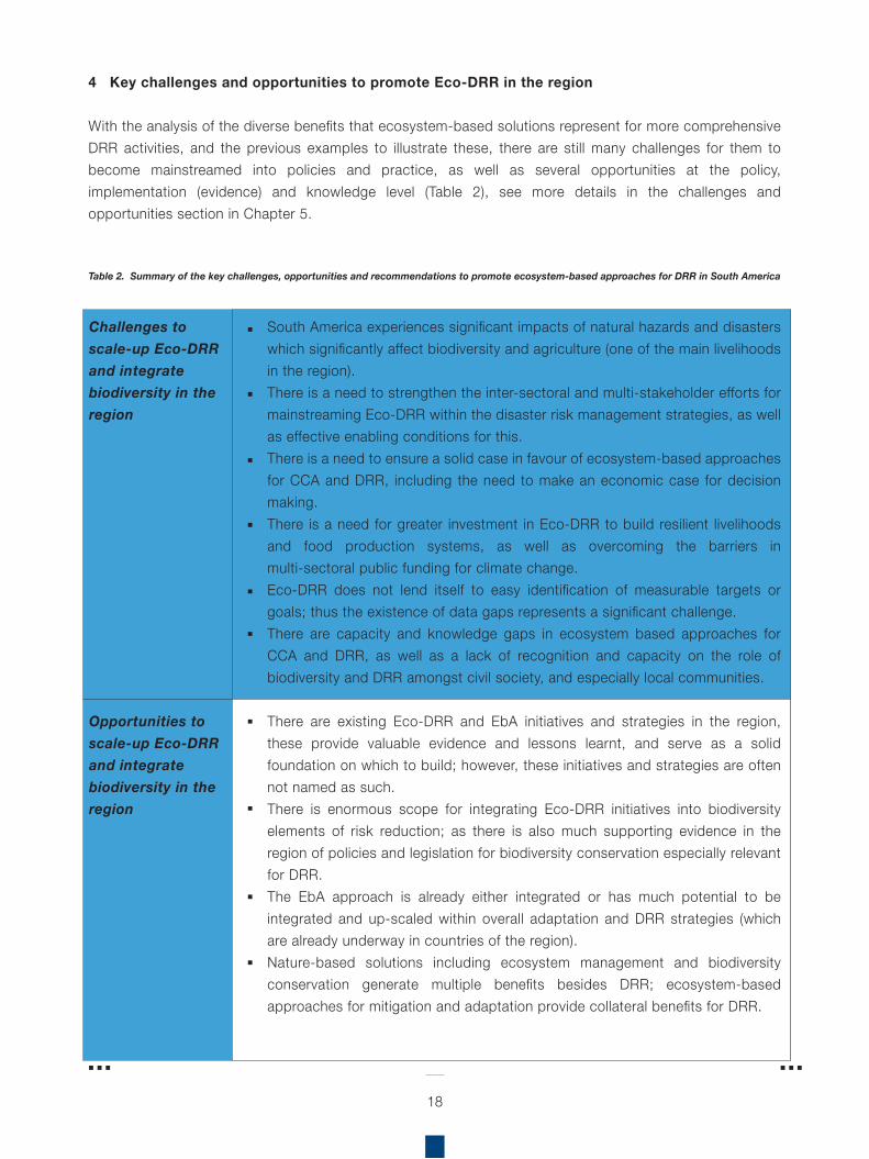
4 Key challenges and opportunities to promote Eco-DRR in the region
With the analysis of the diverse benefits that ecosystem-based solutions represent for more comprehensive DRR activities, and the previous examples to illustrate these, there are still many challenges for them to become mainstreamed into policies and practice, as well as several opportunities at the policy, implementation (evidence) and knowledge level (Table 2), see more details in the challenges and opportunities section in Chapter 5.
Table 2. Summary of the key challenges, opportunities and recommendations to promote ecosystem-based approaches for DRR in South America
18
South America experiences significant impacts of natural hazards and disasters which significantly affect biodiversity and agriculture (one of the main livelihoods in the region). There is a need to strengthen the inter-sectoral and multi-stakeholder efforts for mainstreaming Eco-DRR within the disaster risk management strategies, as well as effective enabling conditions for this. There is a need to ensure a solid case in favour of ecosystem-based approaches for CCA and DRR, including the need to make an economic case for decision making. There is a need for greater investment in Eco-DRR to build resilient livelihoods and food production systems, as well as overcoming the barriers in multi-sectoral public funding for climate change. Eco-DRR does not lend itself to easy identification of measurable targets or goals; thus the existence of data gaps represents a significant challenge. There are capacity and knowledge gaps in ecosystem based approaches for CCA and DRR, as well as a lack of recognition and capacity on the role of biodiversity and DRR amongst civil society, and especially local communities.
There are existing Eco-DRR and EbA initiatives and strategies in the region, these provide valuable evidence and lessons learnt, and serve as a solid foundation on which to build; however, these initiatives and strategies are often not named as such.There is enormous scope for integrating Eco-DRR initiatives into biodiversity elements of risk reduction; as there is also much supporting evidence in the region of policies and legislation for biodiversity conservation especially relevant for DRR. The EbA approach is already either integrated or has much potential to be integrated and up-scaled within overall adaptation and DRR strategies (which are already underway in countries of the region).Nature-based solutions including ecosystem management and biodiversity conservation generate multiple benefits besides DRR; ecosystem-based approaches for mitigation and adaptation provide collateral benefits for DRR.
Challenges to scale-up Eco-DRR and integrate biodiversity in the region
Opportunities to scale-up Eco-DRR and integrate biodiversity in the region
19
Source: Own elaboration based on Chapter 5.
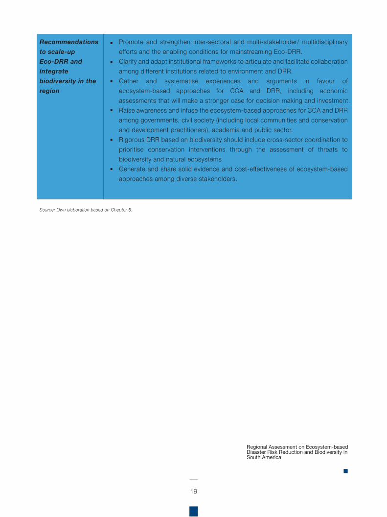
Promote and strengthen inter-sectoral and multi-stakeholder/ multidisciplinary efforts and the enabling conditions for mainstreaming Eco-DRR. Clarify and adapt institutional frameworks to articulate and facilitate collaboration among different institutions related to environment and DRR. Gather and systematise experiences and arguments in favour of ecosystem-based approaches for CCA and DRR, including economic assessments that will make a stronger case for decision making and investment. Raise awareness and infuse the ecosystem-based approaches for CCA and DRR among governments, civil society (including local communities and conservation and development practitioners), academia and public sector.Rigorous DRR based on biodiversity should include cross-sector coordination to prioritise conservation interventions through the assessment of threats to biodiversity and natural ecosystemsGenerate and share solid evidence and cost-effectiveness of ecosystem-based approaches among diverse stakeholders.
Recommendations to scale-up Eco-DRR and integrate biodiversity in the region
Regional Assessment on Ecosystem-based Disaster Risk Reduction and Biodiversity in South America
4 Geophysical events include earthquakes, volcano eruptions, tsunamis, dry mass movements.5 Hydro-meteorological events include storms, floods, wet mass movements.
20
ver the last decade, 700,000 people lost their lives, over 1.4 million were injured, and around 23 million were made homeless, as a result of disasters. Population growth, environmental degradation and climate change will likely exacerbate disaster impacts in many regions of the world. As such, with the increasing incidence and severity of geophysical4 and hydro-meteorological5 hazards, it is critical to identify opportunities for effective Disaster Risk Reduction (DRR) strategies.
Climate change is leading to more frequent and more severe natural catastrophes such as floods, extended periods of drought, and storms, while ecologically relevant climate variables are projected by the Intergovernmental Panel on Climate Change (IPCC, 2013), to increase dramatically over the next century, the effectiveness of traditional approaches to disaster risk reduction is likely to become increasingly strained as the rate and severity of climate-driven impacts grow.
Extreme events that often impact water availability, fisheries, landslides and forest fires, often have profound effects on people’s lives where for instance, smallholder farmers may lose their livelihoods due to weather-related crop failures. However, such impacts extend beyond the individual, affecting the economic situation of entire countries. In addition to these social and economic effects, existing threats to biodiversity, and therefore current conservation efforts, are likely to also be exacerbated, disrupting important ecological processes, and causing drastic changes in species ranges as a consequence of increasingly inhospitable climatic conditions.
Whilst disasters often follow natural hazards like earthquakes, floods, droughts and cyclones, DRR aims to reduce the damages caused by such hazards through an ethic of prevention. Therefore, DRR focuses on risk management that can avoid a natural hazard turning into a disaster, which is primarily dependent on how a society can cope with impacts so building the ability to reduce such risks and strengthening coping capacities. Disaster risk management aims to avoid, lessen or transfer the adverse effects of hazards through activities and measures for prevention, mitigation and preparedness (UNISDR, 2009).
There is increasing evidence that nature is a vital component of cost-effective DRR strategies. Ecosystem-based Disaster Risk Reduction (Eco-DRR) can be understood as the sustainable management, conservation and restoration of ecosystems to reduce disaster risk, with the aim to achieve sustainable and resilient development (Estrella & Saalismaa, 2013).
Well-managed ecosystems, such as wetlands, forests and coastal systems, act as natural infrastructure, reducing physical exposure to many hazards and increasing the socio-economic resilience of people and communities by sustaining local livelihoods and providing essential natural resources such as food, water and building materials. The services provided by ecosystems contribute to building resilience, helping recovery after a disaster, and include the provision of food, fuel and clean water during emergencies. Therefore, effective ecosystem management not only offers an opportunity to strengthen natural infrastructure and human resilience against natural hazards, but also generates a range of other social, economic and environmental benefits for multiple stakeholders, which in turn feed back into reduced risk.
O
1 Introduction
In a climate-altered future, where change is constant and inevitable, there will be much uncertainty about the rate, magnitude, and direction of changes for natural systems in the region, thus there is a need for a long-term and strategic vision for DRR. Certainly, biodiversity conservation planning over larger biogeographical scales and across multiple political and institutional jurisdictions could play a fundamental role in this. In many ways, South America possesses a unique opportunity in this regard, as it boasts an array of political and institutional instruments that can contribute in achieving this goal.
This Regional Assessment is a component of the Resilience through Investing in Ecosystems - knowledge, innovation and transformation of risk management (RELIEF Kit)6 Project (also developed in five other regions), and sets out to provide an overview of the situation of disaster risk in South America, as well as document the role of biodiversity and ecosystems in DRR. In an effort to strengthen capacities for Eco-DRR implementation, this assessment will contribute to the generation of knowledge on the importance of biodiversity and ecosystems in Eco-DRR approaches at national and the regional level. The results will inform capacity needs, national and regional policy coherence opportunities amongst key sectors such as disaster management, climate change, development and conservation as well as provide a basis to build actions and initiatives on.
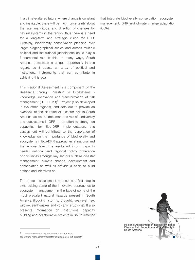
The present assessment represents a first step in synthesising some of the innovative approaches to ecosystem management in the face of some of the most prevalent natural hazards present in South America (flooding, storms, drought, sea-level rise, wildfire, earthquakes and volcanic eruptions). It also presents information on institutional capacity building and collaborative projects in South America
that integrate biodiversity conservation, ecosystem management, DRR and climate change adaptation (CCA).
21
6 https://www.iucn.org/about/work/programmes/ecosystem_management/disaster/solutions/relief_kit_project/
Regional Assessment on Ecosystem-based Disaster Risk Reduction and Biodiversity in South America
T
22
7 http://www.emdat.be/
he preparatory phase initiated with a revision of secondary information sources, beginning with background material to contextualise central topics for carrying out the South American regional assessment on biodiversity and DRR, and its scope in relation to the RELIEF Kit Project. Principal sources of background literature include the Convention on Biological Diversity (CBD) global synthesis on ecosystem-based approaches for climate change adaptation and DRR, which also provided useful methodological guidance to conduct the assessment for South America, and to maintain coherence with the other five regional assessments developed for the RELIEF Kit Project.
A matrix was prepared to facilitate selection of focal countries in the region (Annex 1). The key criteria used for final country selection included: i) Previous work on CCA initiatives with IUCN-Sur (and partners) in the last five years; ii) Previous work specifically on Eco-DRR with IUCN-Sur within the last five years; iii) Presentation of Countries’ Fifth National Reports to CBD; iv) Institutions working in DRR (with links to ecosystem management); v) Feasibility to revise information regarding country size; vi) Vulnerability to disasters by natural phenomena. An analysis of the twelve South American countries in terms of vulnerability to natural hazards was carried out (Annex 2) as part of this last criterion. Due to the necessity to use data that allowed for comparability between countries, and the time constraints of this assessment, the Emergency Events Database (EM-DAT) maintained by the Centre for Research on the Epidemiology of Disasters (CRED)7 was used, as it is widely considered the most comprehensive, publicly available global database on natural hazards and their impacts.
The final country selection matrix identified Argentina, Bolivia, Chile, Colombia, Ecuador and Peru as the six focus countries for the Regional Assessment. However, the assessment aims to provide information and recommendations on Eco-DRR that can also be useful for the other six countries in the region (i.e. Brazil, Guyana, Paraguay, Suriname, Uruguay, and Venezuela).
The collection of reliable data and information considered two main but equally important methods. As mentioned above, secondary data sources provided important background particularly on the state of the region and the focus countries in terms of vulnerability to disasters and biodiversity. Whilst primary data and information was key to corroborate the existence of ecosystem management initiatives in focus countries as a tool for reducing damage by natural hazards.
The literature review of official national and local biodiversity and disaster risk management and adaptation strategies included: National Reports to the CBD, National Biodiversity Strategies and Action Plans (NBSAPs), National Disaster Management Plans, National Adaptation Plans, National Adaptation Programmes of Actions (NAPAs), project documents and reports/case studies, scientific articles and news articles.
The core of the empirical effort was based on the standardised survey, conducted during February 2016, with the objective of obtaining first-hand insights into Eco-DRR experiences in the region, whilst also corroborating existing secondary source information.
The survey outline (used as a basis for all regional assessments of the RELIEF Kit Project) was translated into Spanish, adapted to the regional
2 Methodology
context, and uploaded into an online survey format in SurveyMonkey (see Annex 5). This facilitated various aspects of the primary information gathering component, especially in terms of efficient distribution and return times, greater convenience for experts working in conservation and DRR related topics in government institutions and other relevant organisations. An additional benefit of using the online survey format is that it streamlined the analysis, making results available as soon as the stakeholders responded to the survey.
Once completed, the collated information from the online survey was organised into key thematic areas related to biodiversity, ecosystems and conservation approaches to DRR in a database to facilitate country-specific data recording and recall, as required according to the different stages of the analysis. In terms of the policy and institutional analysis in the focus countries, in addition to valuable insight from the survey results, national policy documents and documentation on considerations of DRR and biodiversity were reviewed, including the policy and institutional context for EbA and DRR from the CBD global synthesis report, official government websites, etc.
The following keywords were used for the literature review:
Natural hazards (floods, storms, drought, wildfire, earthquakes, hurricanes, desertification, tsunamis, sea level rise, landslides, avalanches, land degradation)Disaster (risk, reduction, vulnerability, adaptation, adaptive capacity)Ecosystems (coastal/marine, drylands, mountains, forests, wetlands, mangroves, rivers / river basins / watersheds)Other common keywords: climate change, adaptation, resilience
The identification of key stakeholders represented an important precursor to the survey, specifically in terms of ensuring relevant stakeholder engagement
from focus countries, thereby maximising the potential for obtaining accurate and up-to-date information, and permitting the most efficient use of time and resources. Here, the regional presence of IUCN, its partners, and related national organisations in focus countries proved key to ensuring a solid stakeholder mapping. The most relevant stakeholders identified included government agencies working in DRR related areas: environmental sector, development planning, security, and infrastructure; as well as national organisations working with environmental management, conservation and DRR.
The survey was sent to approximately 350 contacts ––including IUCN Members and Commission on Ecosystem Management (CEM) and World Commission on Protected Areas (WCPA) members in Argentina, Bolivia, Chile, Colombia, Ecuador and Peru–– selected according to their respective affiliation to either the DRR (where possible, Eco-DRR), natural resource management, conservation community in their respective country and/or the South American region.
These key stakeholders were identified through their respective conservation, development and humanitarian organisations, related ministries and public institutions, as well as international donor and scientific institutions. Of the 31 experts who responded to the survey – Argentina (13%), Bolivia (7%), Colombia (28%), Chile (1%), Ecuador (28%), and Peru (23%) – most belong to research institutions, followed by development organisations, and public disaster risk management organisations. Other experts came from humanitarian organisations that often have close links to both development and disaster risk organisations.
The stakeholder matrix (Annex 3) provides a detailed list of the names of the experts and their affiliation to relevant institutions, which includes government agencies working in DRR related areas: environmental sector, development planning, security, and infrastructure; as well as NGO, CSO,
23
INGO, multilateral organisations, as well as the private sector and scientific institutions working with environmental management, conservation and DRR. This database is in no way intended to be exhaustive, but instead presents initial stakeholder information for each focus country, which will serve as an important tool for the collection of primary data and information, and for future initiatives within the RELIEF Kit Project.
In summary, the results of this Assessment are based on a literature review and standardised survey with a focus on key experiences from the six focus countries. The revision of assessments and strategic documents from the CBD and other relevant country initiatives, enabled the identification of case studies related to biodiversity, ecosystems and conservation approaches to DRR. These in turn, served as an important input for understanding and preparing a preliminary synthesis of country vulnerability, identifying types of natural hazards, ecosystems and biodiversity in the region.
24
Regional Assessment on Ecosystem-based Disaster Risk Reduction and Biodiversity in South America
25
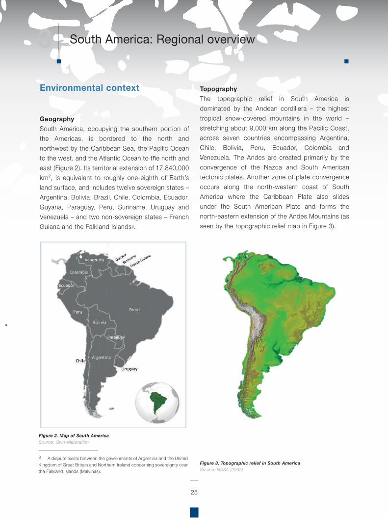
8 A dispute exists between the governments of Argentina and the United Kingdom of Great Britain and Northern Ireland concerning sovereignty over the Falkland Islands (Malvinas).
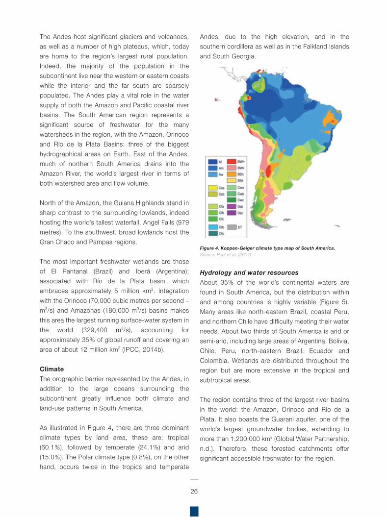
TopographyThe topographic relief in South America is dominated by the Andean cordillera – the highest tropical snow-covered mountains in the world – stretching about 9,000 km along the Pacific Coast, across seven countries encompassing Argentina, Chile, Bolivia, Peru, Ecuador, Colombia and Venezuela. The Andes are created primarily by the convergence of the Nazca and South American tectonic plates. Another zone of plate convergence occurs along the north-western coast of South America where the Caribbean Plate also slides under the South American Plate and forms the north-eastern extension of the Andes Mountains (as seen by the topographic relief map in Figure 3).
Environmental context
Figure 2. Map of South AmericaSource: Own elaboration
Figure 3. Topographic relief in South AmericaSource: NASA (2003)
GeographySouth America, occupying the southern portion of the Americas, is bordered to the north and northwest by the Caribbean Sea, the Pacific Ocean to the west, and the Atlantic Ocean to the north and east (Figure 2). Its territorial extension of 17,840,000 km2, is equivalent to roughly one-eighth of Earth’s land surface, and includes twelve sovereign states – Argentina, Bolivia, Brazil, Chile, Colombia, Ecuador, Guyana, Paraguay, Peru, Suriname, Uruguay and Venezuela – and two non-sovereign states – French Guiana and the Falkland Islands8.
3 South America: Regional overview
26
The Andes host significant glaciers and volcanoes, as well as a number of high plateaus, which, today are home to the region’s largest rural population. Indeed, the majority of the population in the subcontinent live near the western or eastern coasts while the interior and the far south are sparsely populated. The Andes play a vital role in the water supply of both the Amazon and Pacific coastal river basins. The South American region represents a significant source of freshwater for the many watersheds in the region, with the Amazon, Orinoco and Río de la Plata Basins: three of the biggest hydrographical areas on Earth. East of the Andes, much of northern South America drains into the Amazon River, the world’s largest river in terms of both watershed area and flow volume.
North of the Amazon, the Guiana Highlands stand in sharp contrast to the surrounding lowlands, indeed hosting the world’s tallest waterfall, Angel Falls (979 metres). To the southwest, broad lowlands host the Gran Chaco and Pampas regions.
The most important freshwater wetlands are those of El Pantanal (Brazil) and Iberá (Argentina); associated with Río de la Plata basin, which embraces approximately 5 million km2. Integration with the Orinoco (70,000 cubic metres per second – m3/s) and Amazonas (180,000 m3/s) basins makes this area the largest running surface-water system in the world (329,400 m3/s), accounting for approximately 35% of global runoff and covering an area of about 12 million km2 (IPCC, 2014b).
ClimateThe orographic barrier represented by the Andes, in addition to the large oceans surrounding the subcontinent greatly influence both climate and land-use patterns in South America.
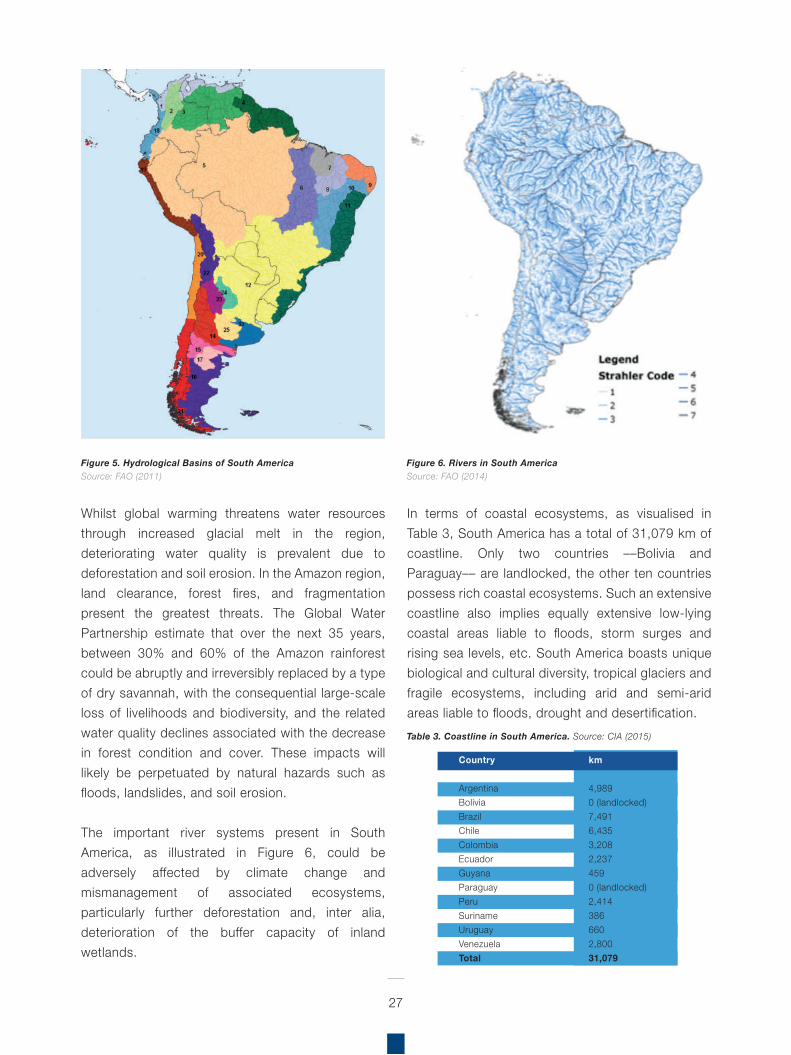
As illustrated in Figure 4, there are three dominant climate types by land area, these are: tropical (60.1%), followed by temperate (24.1%) and arid (15.0%). The Polar climate type (0.8%), on the other hand, occurs twice in the tropics and temperate
Andes, due to the high elevation; and in the southern cordillera as well as in the Falkland Islands and South Georgia.
Hydrology and water resourcesAbout 35% of the world’s continental waters are found in South America, but the distribution within and among countries is highly variable (Figure 5). Many areas like north-eastern Brazil, coastal Peru, and northern Chile have difficulty meeting their water needs. About two thirds of South America is arid or semi-arid, including large areas of Argentina, Bolivia, Chile, Peru, north-eastern Brazil, Ecuador and Colombia. Wetlands are distributed throughout the region but are more extensive in the tropical and subtropical areas.
The region contains three of the largest river basins in the world: the Amazon, Orinoco and Rio de la Plata. It also boasts the Guarani aquifer, one of the world’s largest groundwater bodies, extending to more than 1,200,000 km2 (Global Water Partnership, n.d.). Therefore, these forested catchments offersignificant accessible freshwater for the region.
Figure 4. Koppen-Geiger climate type map of South America. Source: Peel et al. (2007)
27
Whilst global warming threatens water resources through increased glacial melt in the region, deteriorating water quality is prevalent due to deforestation and soil erosion. In the Amazon region, land clearance, forest fires, and fragmentation present the greatest threats. The Global Water Partnership estimate that over the next 35 years, between 30% and 60% of the Amazon rainforest could be abruptly and irreversibly replaced by a type of dry savannah, with the consequential large-scale loss of livelihoods and biodiversity, and the related water quality declines associated with the decrease in forest condition and cover. These impacts will likely be perpetuated by natural hazards such as floods, landslides, and soil erosion.
The important river systems present in South America, as illustrated in Figure 6, could be adversely affected by climate change and mismanagement of associated ecosystems, particularly further deforestation and, inter alia, deterioration of the buffer capacity of inland wetlands.
In terms of coastal ecosystems, as visualised in Table 3, South America has a total of 31,079 km of coastline. Only two countries ––Bolivia and Paraguay–– are landlocked, the other ten countries possess rich coastal ecosystems. Such an extensive coastline also implies equally extensive low-lying coastal areas liable to floods, storm surges and rising sea levels, etc. South America boasts unique biological and cultural diversity, tropical glaciers and fragile ecosystems, including arid and semi-arid areas liable to floods, drought and desertification.
Figure 5. Hydrological Basins of South America Source: FAO (2011)
Figure 6. Rivers in South America Source: FAO (2014)
Table 3. Coastline in South America. Source: CIA (2015)
Country
ArgentinaBoliviaBrazilChileColombiaEcuadorGuyanaParaguayPeruSurinameUruguayVenezuelaTotal
km
4,9890 (landlocked)7,4916,4353,2082,2374590 (landlocked)2,4143866602,80031,079
28
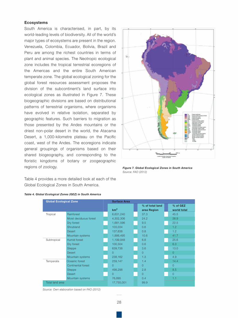
EcosystemsSouth America is characterised, in part, by its world-leading levels of biodiversity. All of the world’s major types of ecosystems are present in the region. Venezuela, Colombia, Ecuador, Bolivia, Brazil and Peru are among the richest countries in terms of plant and animal species. The Neotropic ecological zone includes the tropical terrestrial ecoregions of the Americas and the entire South American temperate zone. The global ecological zoning for the global forest resources assessment proposes the division of the subcontinent’s land surface into ecological zones as illustrated in Figure 7. These biogeographic divisions are based on distributional patterns of terrestrial organisms, where organisms have evolved in relative isolation, separated by geographic features. Such barriers to migration as those presented by the Andes mountains or the driest non-polar desert in the world, the Atacama Desert, a 1,000-kilometre plateau on the Pacific coast, west of the Andes. The ecoregions indicate general groupings of organisms based on their shared biogeography, and corresponding to the floristic kingdoms of botany or zoogeographic regions of zoology.
Table 4 provides a more detailed look at each of the Global Ecological Zones in South America.
Figure 7. Global Ecological Zones in South America Source: FAO (2012)
Source: Own elaboration based on FAO (2012)
Global Ecological Zone
Tropical Rainforest Moist deciduous forest Dry forest Shrubland Desert Mountain systems
Subtropical Humid forest Dry forest Steppe Desert Mountain systems
Temperate Oceanic forest Continental forest Steppe Desert Mountain systems
Total land area
Surface Area
km2
6,631,2404,302,3061,681,596103,034137,6381,886,4951,199,948100,504639,7380238,162259,1470498,298076,89517,755,001
% of total land area Region37.324.29.50.60.810.66.80.63.601.31.402.800.499.9
% of GEZworld total45.538.922.51.21.241.725.66.313.004.914.408.501.1
Table 4. Global Ecological Zones (GEZ) in South America
29
Forests Forest biomes in the region include tropical rainforests like the Amazon and the Mata Atlantica in Brazil. Other tropical deciduous forests can be found in the Pacific watershed of Ecuador, in Venezuela, and on the Brazilian coast from about 7°S to the Tropic of Capricorn. Mid-latitude deciduous or temperate forests are located on low elevation coastal mountains in southern Brazil, southern Chile and southern Argentina. It is possible to find Austral forests on the southernmost tip of the continent and on Tierra del Fuego Islands (ESA, n.d.).
Tropical forests make up about 40% of the world’s forested area and contain about 60% of global forest biomass. Forests occupy approximately 22% of South America, and represent about 27% of the world’s global forest coverage. Forests in the region represent an important economic resource, both for trade and subsistence. They play an important role in the carbon budget and in the economy of the region.
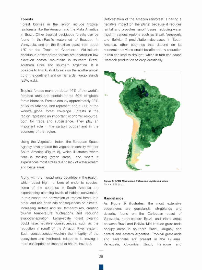
Using the Vegetation Index, the European Space Agency have created the vegetation density map for South America (Figure 8), which illustrates where flora is thriving (green areas), and where it experiences most stress due to lack of water (cream and beige area).
Along with the megadiverse countries in the region, which boast high numbers of endemic species, some of the countries in South America are experiencing alarming levels of habitat conversion. In this sense, the conversion of tropical forest into other land use often has consequences on climate, increasing surface and soil temperatures, creating diurnal temperature fluctuations and reducing evapotranspiration. Large-scale forest clearing could have negative consequences, such as the reduction in runoff of the Amazon River system. Such consequences weaken the integrity of the ecosystem and livelihoods related to it, leaving it more susceptible to impacts of natural hazards.
Deforestation of the Amazon rainforest is having a negative impact on the planet because it reduces rainfall and provokes runoff losses, reducing water input in various regions such as Brazil, Venezuela and Bolivia. If precipitation decreases in South America, other countries that depend on its economic activities could be affected. A reduction in rain can lead to drought, which in turn can cause livestock production to drop drastically.
RangelandsAs Figure 9 illustrates, the most extensive ecosystems are grasslands, shrublands and deserts, found on the Caribbean coast of Venezuela, north-eastern Brazil, and inland areas between Brazil and Bolivia. Mid-latitude grasslands occupy areas in southern Brazil, Uruguay and central and eastern Argentina. Tropical grasslands and savannahs are present in the Guianas, Venezuela, Colombia, Brazil, Paraguay and
Figure 8. SPOT Normalised Difference Vegetation Index Source: ESA (n.d.)
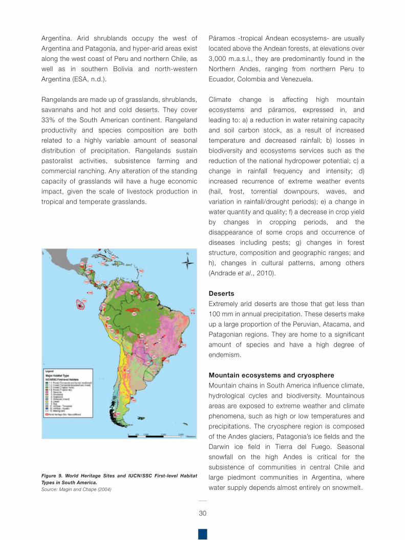
30
Argentina. Arid shrublands occupy the west of Argentina and Patagonia, and hyper-arid areas exist along the west coast of Peru and northern Chile, as well as in southern Bolivia and north-western Argentina (ESA, n.d.).
Rangelands are made up of grasslands, shrublands, savannahs and hot and cold deserts. They cover 33% of the South American continent. Rangeland productivity and species composition are both related to a highly variable amount of seasonal distribution of precipitation. Rangelands sustain pastoralist activities, subsistence farming and commercial ranching. Any alteration of the standing capacity of grasslands will have a huge economic impact, given the scale of livestock production in tropical and temperate grasslands.
Páramos -tropical Andean ecosystems- are usually located above the Andean forests, at elevations over 3,000 m.a.s.l., they are predominantly found in the Northern Andes, ranging from northern Peru to Ecuador, Colombia and Venezuela.
Climate change is affecting high mountain ecosystems and páramos, expressed in, and leading to: a) a reduction in water retaining capacity and soil carbon stock, as a result of increased temperature and decreased rainfall; b) losses in biodiversity and ecosystems services such as the reduction of the national hydropower potential; c) a change in rainfall frequency and intensity; d) increased recurrence of extreme weather events (hail, frost, torrential downpours, waves, and variation in rainfall/drought periods); e) a change in water quantity and quality; f) a decrease in crop yield by changes in cropping periods, and the disappearance of some crops and occurrence of diseases including pests; g) changes in forest structure, composition and geographic ranges; and h), changes in cultural patterns, among others (Andrade et al., 2010).
DesertsExtremely arid deserts are those that get less than 100 mm in annual precipitation. These deserts make up a large proportion of the Peruvian, Atacama, and Patagonian regions. They are home to a significant amount of species and have a high degree of endemism.
Mountain ecosystems and cryosphereMountain chains in South America influence climate, hydrological cycles and biodiversity. Mountainous areas are exposed to extreme weather and climate phenomena, such as high or low temperatures and precipitations. The cryosphere region is composed of the Andes glaciers, Patagonia’s ice fields and the Darwin ice field in Tierra del Fuego. Seasonal snowfall on the high Andes is critical for the subsistence of communities in central Chile and large piedmont communities in Argentina, where water supply depends almost entirely on snowmelt.
Figure 9. World Heritage Sites and IUCN/SSC First-level Habitat Types in South America. Source: Magin and Chape (2004)
Mountain ranges and plateaus conserve the biological diversity and unique ecological state of the river. There are glaciers in the high Andes (Venezuela and Peru) and three major ice sheets in the Patagonian Andes. Climate change and the El Niño Southern Oscillation (ENSO) phenomenon in particular can modify the rate of snowfall and runoff in areas of piedmont. Approximately 35% of the world’s continental water is found in the region (ESA, n.d.).
PopulationAs of 2014, the total population in South America was estimated at 414 million inhabitants, representing approximately 18 percent of the world’s population. The most populous countries in the region were Brazil (50%), Colombia (12%), Argentina (10%), Peru (8%) and Venezuela (7%); whilst the countries with the greatest rural populations are Guyana (72%), Paraguay (41%), Ecuador (37%), and Bolivia (32%); the region’s rural population as a whole accounted for 17% of total population.
The rural poor are particularly dependent on forest resources and depend substantially on forest ecosystems for their subsistence and survival. In addition to providing essential ecosystem services such as habitat for biodiversity and provisioning clean water supplies, forests in South America support the livelihoods of a large number of Indigenous Peoples and forest-dependent communities, who are especially dependent on forest resources and the health of forest ecosystems (MEA, 2005). However, rapid population growth, displacement and rural economic collapse have triggered one of the fastest urbanisation rates in the region.
that integrate biodiversity conservation, ecosystem management, DRR and climate change adaptation (CCA).
Urban population, on the other hand, accounted for 80% of the region’s total population; with almost all countries in the region experiencing a high degree of migration from rural to urban areas. The link between urbanisation and natural disasters is currently part of an international debate, which casts light on the complex effects that urbanisation has on territories. According to the Economic Commission
31
Source: Own elaboration based on World Development Indicators (2015)
Table 5. Population characteristics of countries in South America, 2014
Countries Total population
Share of total
population
Population Density
Rural population
Share of rural
population
Urban population
Share of urban
population
Human Development
Index 2013
Gender Inequality Index 2013
Unit Inhabitants % inhab/km 2 Inhabitants % Inhabitants % (Min 0, Max 1)
(0=best, 1=worst)
Argentina 42,980,026 10.4 15.71 3,608,603 8.4 39,371,423 91.6 0.808 0.381 Bolivia 10,561,887 2.6 9.75 3,368,503 31.9 7,193,384 68.1 0.667 0.472 Brazil 206,077,898 49.8 24.66 30,019,367 14.6 176,058,531 85.4 0.744 0.441 Chile 17,762,647 4.3 23.89 1,890,656 10.6 15,871,991 89.4 0.822 0.355 Colombia 47,791,393 11.5 43.07 11,392,990 23.8 36,398,403 76.2 0.711 0.460 Ecuador 15,902,916 3.8 64.03 5,802,020 36.5 10,100,896 63.5 0.711 0.429 Guyana 763,893 0.2 3.88 546,497 71.5 217,396 28.5 0.638 0.524 Paraguay 6,552,518 1.6 16.49 2,659,274 40.6 3,893,244 59.4 0.676 0.457 Peru 30,973,148 7.5 24.20 6,725,819 21.7 24,247,329 78.3 0.737 0.387 Suriname 538,248 0.1 3.45 182,547 33.9 355,701 66.1 0.705 0.463 Uruguay 3,419,516 0.8 19.54 165,778 4.8 3,253,738 95.2 0.790 0.364 Venezuela 30,693,827 7.4 34.80 3,394,430 11.1 27,299,397 88.9 0.764 0.464 South America 414,017,917 69,756,484 16.8 344,261,433 83.2
Socio-economic context

As Table 7 indicates, in 2013 the economically active population in South America accounted for 51% of the total population. Agriculture remains the backbone of the region’s economic activity, with over 25 million people depending on agriculture for their livelihoods. Important agricultural activities include coffee, soybeans, wheat, rice, corn, sugarcane, cocoa, citrus, beef, bananas and shrimp.
32
for Latin America and the Caribbean (ECLAC), “urbanisation is one of the forces intensifying and expanding the human factor in today’s natural disasters. Essentially, urbanisation necessarily creates an artificial environment and encourages production and consumption patterns that put pressures on the ecosystem, increasing the likelihood of local and global ecosystem imbalances that lead to natural disasters” (ECLAC, 2016).
South America has the highest urbanisation rate in the world. Urban settlements have established themselves from sea level to mountain ranges exceeding 3,000 m.a.s.l. These locations have a wide variety of geographic and topographic conditions, which often make them particularly vulnerable to the impacts of natural hazards. For
instance, in the Andean and highland regions, people may populate precarious zones, living on or near potentially unstable slopes; while at sea level, people inhabit coastal areas, estuaries, and valley systems near rivers and streams. In this sense, the occurrence of flooding and landslides has adverse effects on the welfare and health conditions of more vulnerable populations.
EconomySouth America is currently experiencing an economic slowdown due to the region’s vulnerability to a lower external demand and a fall in commodity prices. After an average annual growth of 4.6% from 2004 to 2013, the region’s gross domestic product (GDP) expanded only 2.6% in 2014, reaching US$ 4 trillion in the same year (Table 6).
Source: Own elaboration based on World Economic Outlook, IMF (2015); and 1World Development Indicators (2015)
Table 6. Gross Domestic Product by country, 2014
Countries Total GDP Share of total GDP
Annual growth rate
2010–2014
GDP per capita
Value added by agriculture 1
Unit million US$ % % US$/inhab % of GDP
Argentina 543,061 13.0 4.1 12,735 6.7 Bolivia 33,237 0.8 13.8 2,943 12.9 Brazil 2,346,583 56.4 1.5 11,573 5.3 Chile 258,017 6.2 4.4 14,480 3.2 Colombia 377,867 9.1 7.1 7,928 6.3 Ecuador 100,543 2.4 9.6 6,273 9.1 Guyana 3,059 0.1 7.8 3,826 18.7 Paraguay 30,220 0.7 10.0 4,379 18.1 Peru 202,642 4.9 8.1 6,449 7.4 Suriname 5,210 0.1 4.5 9,427 7.1 Uruguay 57,471 1.4 9.3 16,882 9.3 Venezuela 206,252 5.0 (6.7) 6,772 5.5
South America 4,164,162 2.6
With over 412 million ha, South America has approximately 23% of the world’s potential cultivable land, but the total cultivated lands in 2012 reached almost 148 million ha, representing 36% of cultivable area in the region (FAO, 2015b; Table 8). The quality of land and climate is important in determining the agricultural potential of land, and the region has historically been characterised by its ability to incorporate more land into agricultural production. But whilst there is still potential for further expansion in the region, the expansion of the agricultural frontier –characterised by the conversion of native habitats to agriculture– has critical environmental impacts, including deforestation of vast areas high in biodiversity, especially in the Amazon region. Additionally, the use of agrochemicals and soil erosion caused by unsustainable farming practices has led to major negative impacts on terrestrial, aquatic and marine biodiversity.
33
Source: Own elaboration based on population characteristics, FAO (2015)
Table 7. Total economically active population and share in agriculture, 2013
Source: Own elaboration based on land-use characteristics, FAO (2015b)
Table 8. Cultivated land and cultivable area in South American countries, 2012
Countries Total economically active population
Share of total
population
Economically active
population in agriculture
Share of economic
active population
Unit inhabitants % inhabitants %
Argentina 19,699,000 48.0 1,378,000 7 Bolivia 5,337,000 50.0 2,150,000 40 Brazil 104,439,000 52.0 10,211,000 10 Chile 7,606,000 43.0 956,000 13 Colombia 25,545,000 53.0 3,467,000 14 Ecuador 7,427,000 7.0 1,268,000 17 Guyana 373,000 47.0 51,000 14 Paraguay 3,624,000 53.0 861,000 24 Peru 16,428,000 54.0 3,780,000 23 Suriname 203,000 38.0 33,000 16 Uruguay 1,689,000 50.0 184,000 11 Venezuela 14,739,000 48.0 687,000 5
South America 207,109,000 51 25,026,000 12
Countries Land area Cultivable area Cultivated area
Unit 1,000 ha in % of region
ha/ inhab 1,000 ha
% of country
area 1,000 ha
% of country
area
% of cultivable
area
ha/ inhab
Argentina 278,040 15.7 6.7 174,000 62.6 40,291 14.5 23.2 0.98 Bolivi a 109,858 6.2 10.3 25,908 23.6 4,515 4.1 17.4 0.43 Brazil 851,577 48.1 4.3 138,000 16.2 79,605 9.3 57.7 0.4 Chile 75,610 4.3 4.3 5,100 6.7 1,794 2.4 35.2 0.1 Colombia 114,175 6.4 2.4 10,398 9.1 3,453 3.0 33.2 0.07 Ecuador 5,637 1.4 1.6 10,523 41.0 2,531 9.9 24.1 0.16 Guyana 21,497 1.2 26.9 496 2.3 448 2.1 90.3 0.56 Paraguay 40,675 2.3 6.0 23,817 58.6 4,500 11.1 18.9 0.67 Peru 28,522 7.3 4.2 7,609 5.9 5,529 4.3 72.7 0.18 Suriname 16,382 0.9 30.4 1,500 9.2 66 0.4 4.4 0.12 Uruguay 17,622 1.0 5.2 4,000 22.7 1,795 10.2 44.9 0.53 Venezuela 91,205 5.2 3.0 10,986 12.0 3,400 3.7 30.9 0.11
South America 1,770,800 100 4 412,337 23.3 147,927 8.4 35.9 0.37
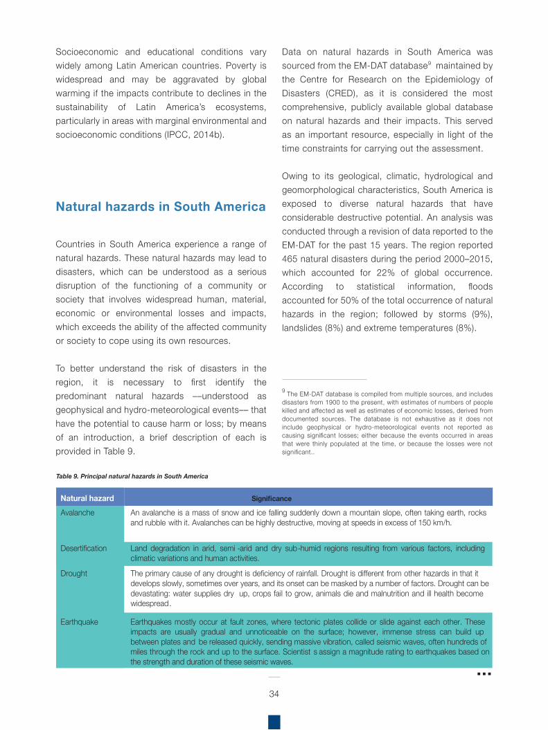
Socioeconomic and educational conditions vary widely among Latin American countries. Poverty is widespread and may be aggravated by global warming if the impacts contribute to declines in the sustainability of Latin America’s ecosystems, particularly in areas with marginal environmental and socioeconomic conditions (IPCC, 2014b).
Countries in South America experience a range of natural hazards. These natural hazards may lead to disasters, which can be understood as a serious disruption of the functioning of a community or society that involves widespread human, material, economic or environmental losses and impacts, which exceeds the ability of the affected community or society to cope using its own resources.
To better understand the risk of disasters in the region, it is necessary to first identify the predominant natural hazards ––understood as geophysical and hydro-meteorological events–– that have the potential to cause harm or loss; by means of an introduction, a brief description of each is provided in Table 9.
Data on natural hazards in South America was sourced from the EM-DAT database9 maintained by the Centre for Research on the Epidemiology of Disasters (CRED), as it is considered the most comprehensive, publicly available global database on natural hazards and their impacts. This served as an important resource, especially in light of the time constraints for carrying out the assessment.
Owing to its geological, climatic, hydrological and geomorphological characteristics, South America is exposed to diverse natural hazards that have considerable destructive potential. An analysis was conducted through a revision of data reported to the EM-DAT for the past 15 years. The region reported 465 natural disasters during the period 2000–2015, which accounted for 22% of global occurrence. According to statistical information, floods accounted for 50% of the total occurrence of natural hazards in the region; followed by storms (9%), landslides (8%) and extreme temperatures (8%).
34
Table 9. Principal natural hazards in South America
Natural hazard Significance Avalanche An avalanche is a mass of snow and ice falling suddenly down a mountain slope, often taking earth, rocks
and rubble with it. Avalanches can be highly destructive, moving at speeds in excess of 150 km/h.
Desertification Land degradation in arid, semi -arid and dry sub-humid regions resulting from various factors, including climatic variations and human activities.
Drought The primary cause of any drought is deficiency of rainfall. Drought is different from other hazards in that it develops slowly, sometimes over years, and its onset can be masked by a number of factors. Drought can be devastating: water supplies dry up, crops fail to grow, animals die and malnutrition and ill health become widespread.
Earthquake Earthquakes mostly occur at fault zones, where tectonic plates collide or slide against each other. These impacts are usually gradual and unnoticeable on the surface; however, immense stress can build up between plates and be released quickly, sending massive vibration, called seismic waves, often hundreds of miles through the rock and up to the surface. Scientist s assign a magnitude rating to earthquakes based on the strength and duration of these seismic waves.
9 The EM-DAT database is compiled from multiple sources, and includesdisasters from 1900 to the present, with estimates of numbers of people killed and affected as well as estimates of economic losses, derived from documented sources. The database is not exhaustive as it does not include geophysical or hydro-meteorological events not reported as causing significant losses; either because the events occurred in areas that were thinly populated at the time, or because the losses were not significant..
Natural hazards in South America
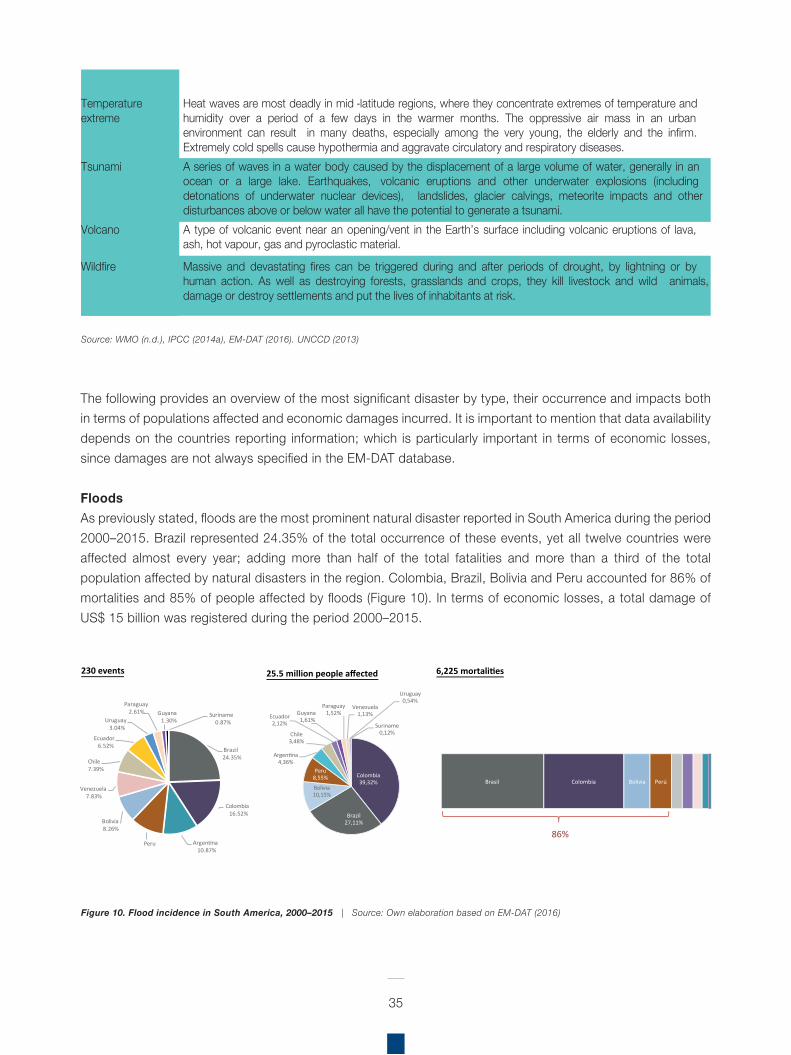
The following provides an overview of the most significant disaster by type, their occurrence and impacts both in terms of populations affected and economic damages incurred. It is important to mention that data availability depends on the countries reporting information; which is particularly important in terms of economic losses, since damages are not always specified in the EM-DAT database.
FloodsAs previously stated, floods are the most prominent natural disaster reported in South America during the period 2000–2015. Brazil represented 24.35% of the total occurrence of these events, yet all twelve countries were affected almost every year; adding more than half of the total fatalities and more than a third of the total population affected by natural disasters in the region. Colombia, Brazil, Bolivia and Peru accounted for 86% of mortalities and 85% of people affected by floods (Figure 10). In terms of economic losses, a total damage of US$ 15 billion was registered during the period 2000–2015.
35
Figure 10. Flood incidence in South America, 2000–2015 | Source: Own elaboration based on EM-DAT (2016)
Source: WMO (n.d.), IPCC (2014a), EM-DAT (2016). UNCCD (2013)
Temperature extreme
Heat waves are most deadly in mid -latitude regions, where they concentrate extremes of temperature and humidity over a period of a few days in the warmer months. The oppressive air mass in an urban environment can result in many deaths, especially among the very young, the elderly and the infirm. Extremely cold spells cause hypothermia and aggravate circulatory and respiratory diseases.
Tsunami A series of waves in a water body caused by the displacement of a large volume of water, generally in an ocean or a large lake. Earthquakes, volcanic eruptions and other underwater explosions (including detonations of underwater nuclear devices), landslides, glacier calvings, meteorite impacts and other disturbances above or below water all have the potential to generate a tsunami.
Volcano A type of volcanic event near an opening/vent in the Earth’s surface including volcanic eruptions of lava, ash, hot vapour, gas and pyroclastic material.
Wildfire Massive and devastating fires can be triggered during and after periods of drought, by lightning or by human action. As well as destroying forests, grasslands and crops, they kill livestock and wild animals, damage or destroy settlements and put the lives of inhabitants at risk.
Brazil24.35%
Colombia16.52%
Argentina10.87%
Peru
Bolivia8.26%
Venezuela7.83%
Chile7.39%
Ecuador6.52%
Uruguay3.04%
Paraguay2.61% Guyana
1.30%Suriname
0.87%
230 events
Colombia39,32%
Brazil27,11%
Bolivia10,15%
Peru8,55%
Argentina4,36%
Chile3,48%
Ecuador2,12%
Guyana1,61%
Paraguay1,52%
Venezuela1,13%
Uruguay0,54%
Suriname0,12%
25.5 million people affected
Brasil Colombia Bolivia Perú
6,225 mortalities
86%
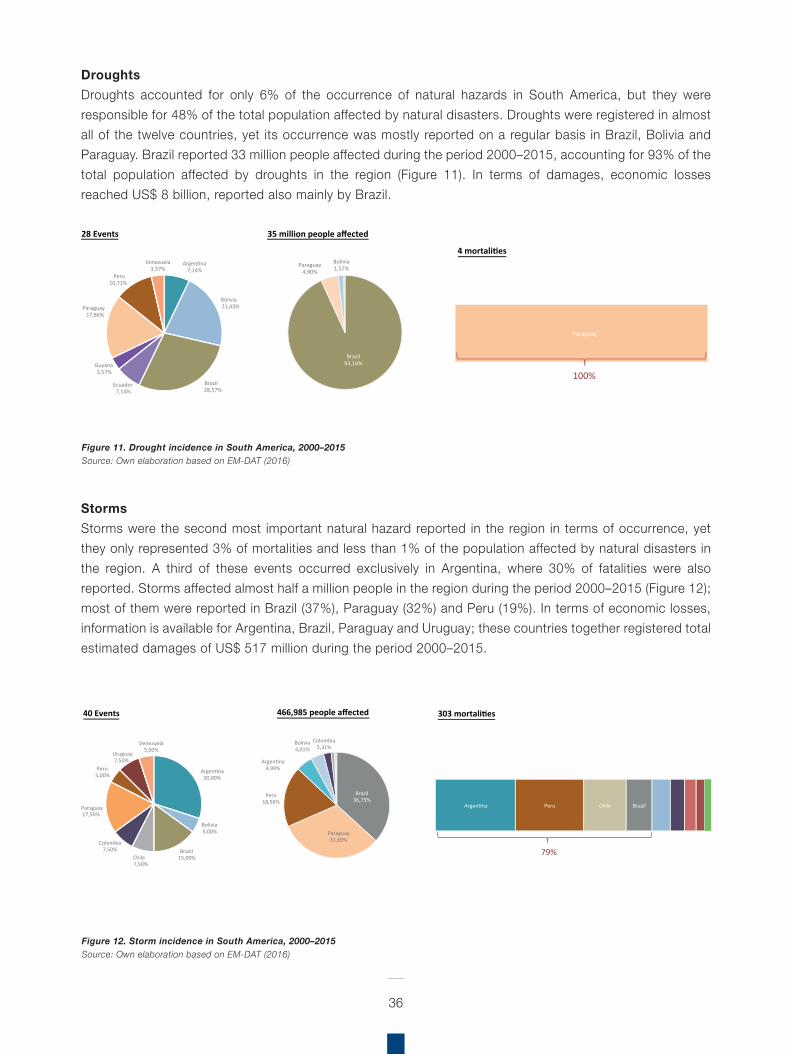
36
DroughtsDroughts accounted for only 6% of the occurrence of natural hazards in South America, but they were responsible for 48% of the total population affected by natural disasters. Droughts were registered in almost all of the twelve countries, yet its occurrence was mostly reported on a regular basis in Brazil, Bolivia and Paraguay. Brazil reported 33 million people affected during the period 2000–2015, accounting for 93% of the total population affected by droughts in the region (Figure 11). In terms of damages, economic losses reached US$ 8 billion, reported also mainly by Brazil.
StormsStorms were the second most important natural hazard reported in the region in terms of occurrence, yet they only represented 3% of mortalities and less than 1% of the population affected by natural disasters in the region. A third of these events occurred exclusively in Argentina, where 30% of fatalities were also reported. Storms affected almost half a million people in the region during the period 2000–2015 (Figure 12); most of them were reported in Brazil (37%), Paraguay (32%) and Peru (19%). In terms of economic losses, information is available for Argentina, Brazil, Paraguay and Uruguay; these countries together registered total estimated damages of US$ 517 million during the period 2000–2015.
Figure 11. Drought incidence in South America, 2000–2015Source: Own elaboration based on EM-DAT (2016)
Figure 12. Storm incidence in South America, 2000–2015Source: Own elaboration based on EM-DAT (2016)
Argentina7,14%
Bolivia21,43%
Brazil28,57%
Ecuador7,14%
Guyana3,57%
Peru10,71%
Venezuela3,57%
Paraguay17,86%
28 Events
Brazil93,16%
Paraguay4,90%
Bolivia1,57%
35 million people affected
Paraguay
4 mortalities
100%
Argentina30,00%
Bolivia5,00%
Brazil15,00%Chile
7,50%
17,50%
Peru
Paraguay
5,00%
Colombia7,50%
Uruguay7,50%
Venezuela5,00%
40 Events
Brazil
Paraguay31,69%
36,75%Peru
18,56%
Argentina4,99%
Bolivia4,01%
Colombia2,31%
466,985 people affected
Argentina Peru Chile Brazil
303 mortalities
79%
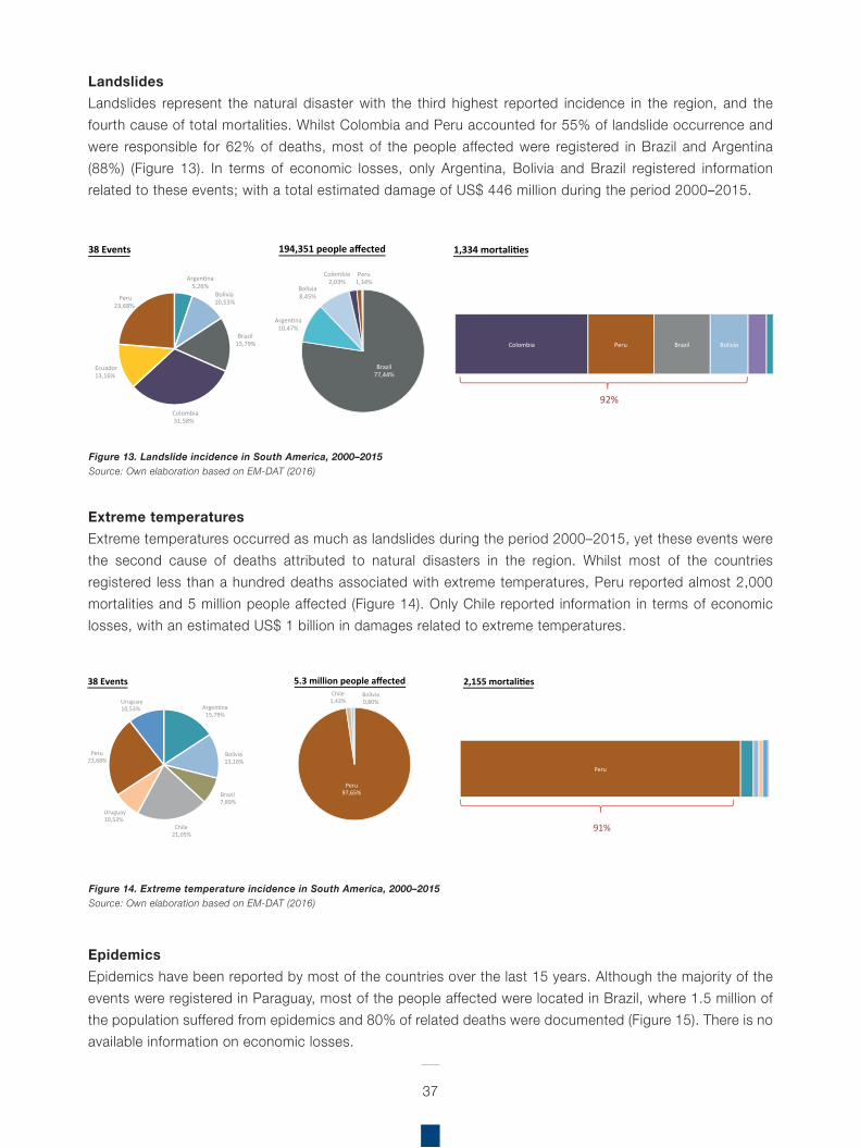
37
LandslidesLandslides represent the natural disaster with the third highest reported incidence in the region, and the fourth cause of total mortalities. Whilst Colombia and Peru accounted for 55% of landslide occurrence and were responsible for 62% of deaths, most of the people affected were registered in Brazil and Argentina (88%) (Figure 13). In terms of economic losses, only Argentina, Bolivia and Brazil registered information related to these events; with a total estimated damage of US$ 446 million during the period 2000–2015.
Extreme temperaturesExtreme temperatures occurred as much as landslides during the period 2000–2015, yet these events were the second cause of deaths attributed to natural disasters in the region. Whilst most of the countries registered less than a hundred deaths associated with extreme temperatures, Peru reported almost 2,000 mortalities and 5 million people affected (Figure 14). Only Chile reported information in terms of economic losses, with an estimated US$ 1 billion in damages related to extreme temperatures.
EpidemicsEpidemics have been reported by most of the countries over the last 15 years. Although the majority of the events were registered in Paraguay, most of the people affected were located in Brazil, where 1.5 million of the population suffered from epidemics and 80% of related deaths were documented (Figure 15). There is no available information on economic losses.
Figure 13. Landslide incidence in South America, 2000–2015Source: Own elaboration based on EM-DAT (2016)
Figure 14. Extreme temperature incidence in South America, 2000–2015Source: Own elaboration based on EM-DAT (2016)
Argentina5,26%
Bolivia10,53%
Brazil15,79%
Ecuador13,16%
Colombia31,58%
Peru23,68%
38 Events
Brazil77,44%
Argentina10,47%
Bolivia8,45%
Colombia2,03%
Peru1,34%
194,351 people affected
Colombia Peru Brazil Bolivia
1,334 mortalities
92%
Argentina15,79%
Bolivia13,16%
Brazil7,89%
Chile21,05%
Peru23,68%
Uruguay10,53%
Uruguay10,53%
38 Events
Peru97,65%
Chile1,43%
Bolivia0,80%
5.3 million people affected
Peru
2,155 mortalities
91%
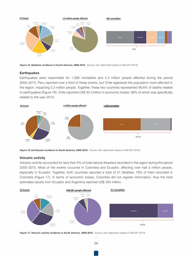
38
EarthquakesEarthquakes were responsible for 1,368 mortalities and 4.3 million people affected during the period 2000–2015. Peru reported over a third of these events, but Chile registered the population most affected in the region, impacting 3.2 million people. Together, these two countries represented 98.6% of deaths related to earthquakes (Figure 16). Chile reported US$ 30.3 billion in economic losses, 99% of which was specifically related to the year 2010.
Volcanic activityVolcanic activity accounted for less than 5% of total natural disasters recorded in the region during the period 2000–2015. Most of the events occurred in Colombia and Ecuador, affecting over half a million people, especially in Ecuador. Together, both countries reported a total of 21 fatalities, 76% of them recorded in Colombia (Figure 17). In terms of economic losses, Colombia did not register information, thus the total estimated results from Ecuador and Argentina reached US$ 264 million.
Figure 15. Epidemic incidence in South America, 2000–2015. Source: Own elaboration based on EM-DAT (2016)
Figure 16. Earthquake incidence in South America, 2000–2015. Source: Own elaboration based on EM-DAT (2016)
Figure 17. Volcanic activity incidence in South America, 2000–2015. Source: Own elaboration based on EM-DAT (2016)
Argentina3,70%
Bolivia14,81%
Brazil14,81%
Ecuador18,52%
Colombia7,41%
Peru11,11%
Paraguay25,93%
Venezuela3,70%
27 Events
Brazil80,14%
Paraguay7,03%
Ecuador5,76%
Peru3,41%
Bolivia1,69%
Colombia1,26%
1,9 million people affected
Brazil Colombia Paraguay Bolivia
481 mortalities
89%
Argentina3,85% Brazil
3,85%
Chile23,08%
Ecuador3,85%
Colombia26,92%
Peru38,46%
26 Events
Chile75,72%
Peru23,90%
4 million people affected
Peru Chile
1,368 mortalities
98,6%
Argentina13,04%
Chile17,39%Ecuador
30,43%
Colombia30,43%
Peru8,70%
23 Events
Ecuador87,95%
Colombia7,45%
Chile3,36%
Peru0,71%
568,681 people affected
Colombia Ecuador
21 mortalities
100%
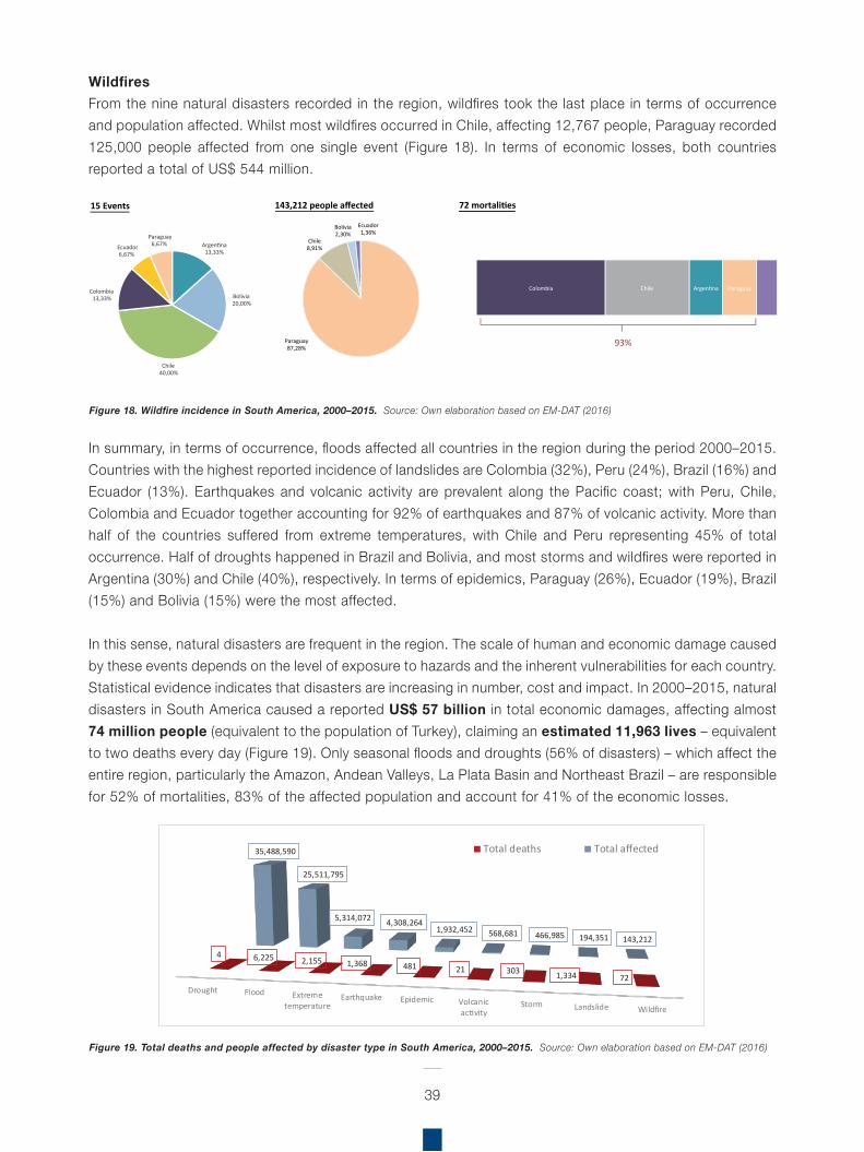
39
WildfiresFrom the nine natural disasters recorded in the region, wildfires took the last place in terms of occurrence and population affected. Whilst most wildfires occurred in Chile, affecting 12,767 people, Paraguay recorded 125,000 people affected from one single event (Figure 18). In terms of economic losses, both countries reported a total of US$ 544 million.
In summary, in terms of occurrence, floods affected all countries in the region during the period 2000–2015. Countries with the highest reported incidence of landslides are Colombia (32%), Peru (24%), Brazil (16%) and Ecuador (13%). Earthquakes and volcanic activity are prevalent along the Pacific coast; with Peru, Chile, Colombia and Ecuador together accounting for 92% of earthquakes and 87% of volcanic activity. More than half of the countries suffered from extreme temperatures, with Chile and Peru representing 45% of total occurrence. Half of droughts happened in Brazil and Bolivia, and most storms and wildfires were reported in Argentina (30%) and Chile (40%), respectively. In terms of epidemics, Paraguay (26%), Ecuador (19%), Brazil (15%) and Bolivia (15%) were the most affected.
In this sense, natural disasters are frequent in the region. The scale of human and economic damage caused by these events depends on the level of exposure to hazards and the inherent vulnerabilities for each country. Statistical evidence indicates that disasters are increasing in number, cost and impact. In 2000–2015, natural disasters in South America caused a reported US$ 57 billion in total economic damages, affecting almost 74 million people (equivalent to the population of Turkey), claiming an estimated 11,963 lives – equivalent to two deaths every day (Figure 19). Only seasonal floods and droughts (56% of disasters) – which affect the entire region, particularly the Amazon, Andean Valleys, La Plata Basin and Northeast Brazil – are responsible for 52% of mortalities, 83% of the affected population and account for 41% of the economic losses.
Figure 18. Wildfire incidence in South America, 2000–2015. Source: Own elaboration based on EM-DAT (2016)
Figure 19. Total deaths and people affected by disaster type in South America, 2000–2015. Source: Own elaboration based on EM-DAT (2016)
Drought Flood Extremetemperature
Earthquake Epidemic Volcanicactivity
Storm Landslide Wildfire
4 6,225 2,155 1,368 481 21 303 1,334 72
35,488,590
25,511,795
5,314,072 4,308,264 1,932,452 568,681 466,985 194,351 143,212
Total deaths Total affected
Argentina13,33%
Bolivia20,00%
Chile40,00%
Colombia13,33%
Paraguay6,67%Ecuador
6,67%
15 Events
Paraguay87,28%
Chile8,91%
Bolivia2,30%
Ecuador1,36%
143,212 people affected
Colombia Chile Argentina Paraguay
72 mortalities
93%
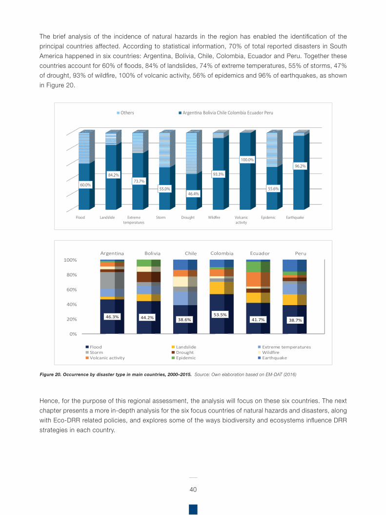
40
The brief analysis of the incidence of natural hazards in the region has enabled the identification of the principal countries affected. According to statistical information, 70% of total reported disasters in South America happened in six countries: Argentina, Bolivia, Chile, Colombia, Ecuador and Peru. Together these countries account for 60% of floods, 84% of landslides, 74% of extreme temperatures, 55% of storms, 47% of drought, 93% of wildfire, 100% of volcanic activity, 56% of epidemics and 96% of earthquakes, as shown in Figure 20.
Hence, for the purpose of this regional assessment, the analysis will focus on these six countries. The next chapter presents a more in-depth analysis for the six focus countries of natural hazards and disasters, along with Eco-DRR related policies, and explores some of the ways biodiversity and ecosystems influence DRR strategies in each country.
Figure 20. Occurrence by disaster type in main countries, 2000–2015. Source: Own elaboration based on EM-DAT (2016)
Flood Landslide Extremetemperatures
Storm Drought Wild�re Volcanicactivity
Epidemic Earthquake
60.0%
84.2%73.7%
55.0%46.4%
93.3%
100.0%
55.6%
96.2%
Others Argentina Bolivia Chile Colombia Ecuador Peru
0%
20%
40%
60%
80%
100%
46.3% 44.2% 38.6%53.5%
41.7% 38.7%
Flood Landslide Extreme temperaturesStorm Drought WildfireVolcanic activity Epidemic Earthquake
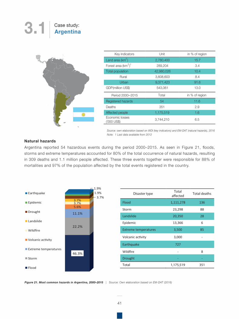
Natural hazardsArgentina reported 54 hazardous events during the period 2000–2015. As seen in Figure 21, floods, storms and extreme temperatures accounted for 80% of the total occurrence of natural hazards, resulting in 309 deaths and 1.1 million people affected. These three events together were responsible for 88% of mortalities and 97% of the population affected by the total events registered in the country.
41
Source: own elaboration based on WDI (key indicators) and EM-DAT (natural hazards), 2016Note: 1 Last data available from 2012
Key indicators Unit in % of region Land area (km2) 2,780,400 15.7 Forest area (km2)1 289,204 3.4 Total population 42,980,026 10.4
Rural 3,608,603 8.4 Urban 9,371,423 91.6
GDP (million US$) 543,061 13.0
Period 2000–2015 Total in % of region Registered hazards 54 11.6 Deaths 351 2.9 Affected people 1,175,519 1.6 Economic losses (´000 US$) 3,744,210 6.5
46.3%
22.2%
11.1%
5.6%3.7%3.7%
3.7%1.9%1.9%
Earthquake
Epidemic
Drought
Landslide
Wildfire
Volcanic activity
Extreme temperatures
Storm
Flood
Disaster type Total
a�ected Total deaths
Flood 1,111,278 136
Storm 23,298 88
Landslide 20,350 28
Epidemic 13,366 6
Extreme temperatures 3,500 85
Volcanic activity 3,000 -
Earthquake 727
Wildfire - 8
Drought - -
Total 1,175,519 351
Figure 21. Most common hazards in Argentina, 2000–2015 | Source: Own elaboration based on EM-DAT (2016)
3.1 ArgentinaCase study:
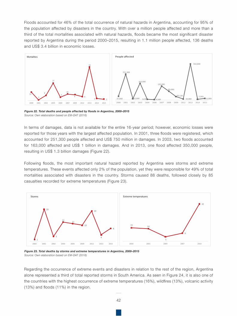
Floods accounted for 46% of the total occurrence of natural hazards in Argentina, accounting for 95% of the population affected by disasters in the country. With over a million people affected and more than a third of the total mortalities associated with natural hazards, floods became the most significant disaster reported by Argentina during the period 2000–2015, resulting in 1.1 million people affected, 136 deaths and US$ 3.4 billion in economic losses.
In terms of damages, data is not available for the entire 16-year period; however, economic losses were reported for those years with the largest affected population. In 2001, three floods were registered, which accounted for 251,300 people affected and US$ 750 million in damages. In 2003, two floods accounted for 163,000 affected and US$ 1 billion in damages. And in 2013, one flood affected 350,000 people, resulting in US$ 1.3 billion damages (Figure 22).
Following floods, the most important natural hazard reported by Argentina were storms and extreme temperatures. These events affected only 2% of the population, yet they were responsible for 49% of total mortalities associated with disasters in the country. Storms caused 88 deaths, followed closely by 85 casualties recorded for extreme temperatures (Figure 23).
Regarding the occurrence of extreme events and disasters in relation to the rest of the region, Argentina alone represented a third of total reported storms in South America. As seen in Figure 24, it is also one of the countries with the highest occurrence of extreme temperatures (16%), wildfires (13%), volcanic activity (13%) and floods (11%) in the region.
42
Figure 22. Total deaths and people affected by floods in Argentina, 2000–2015Source: Own elaboration based on EM-DAT (2016)
Figure 23. Total deaths by storms and extreme temperatures in Argentina, 2000–2015Source: Own elaboration based on EM-DAT (2016)
13
1
8
27
510
9 6
52
3 2
2000 2001 2002 2003 2004 2007 2009 2012 2013 2014 2015
Mortalities
37,840
251,300
12,000
163,000
6,307 4,500
135,000
85,000
34,128
10,000
350,000
7,203 15,000
2000 2001 2002 2003 2004 2006 2007 2008 2009 2012 2013 2014 2015
People a�ected
1
20
3
1211
10
19
4
8
2000 2001 2002 2003 2005 2009 2012 2013 2015
Storms
15 14
5
9
42
2000 2001 2004 2007 2010
Extreme temperatures
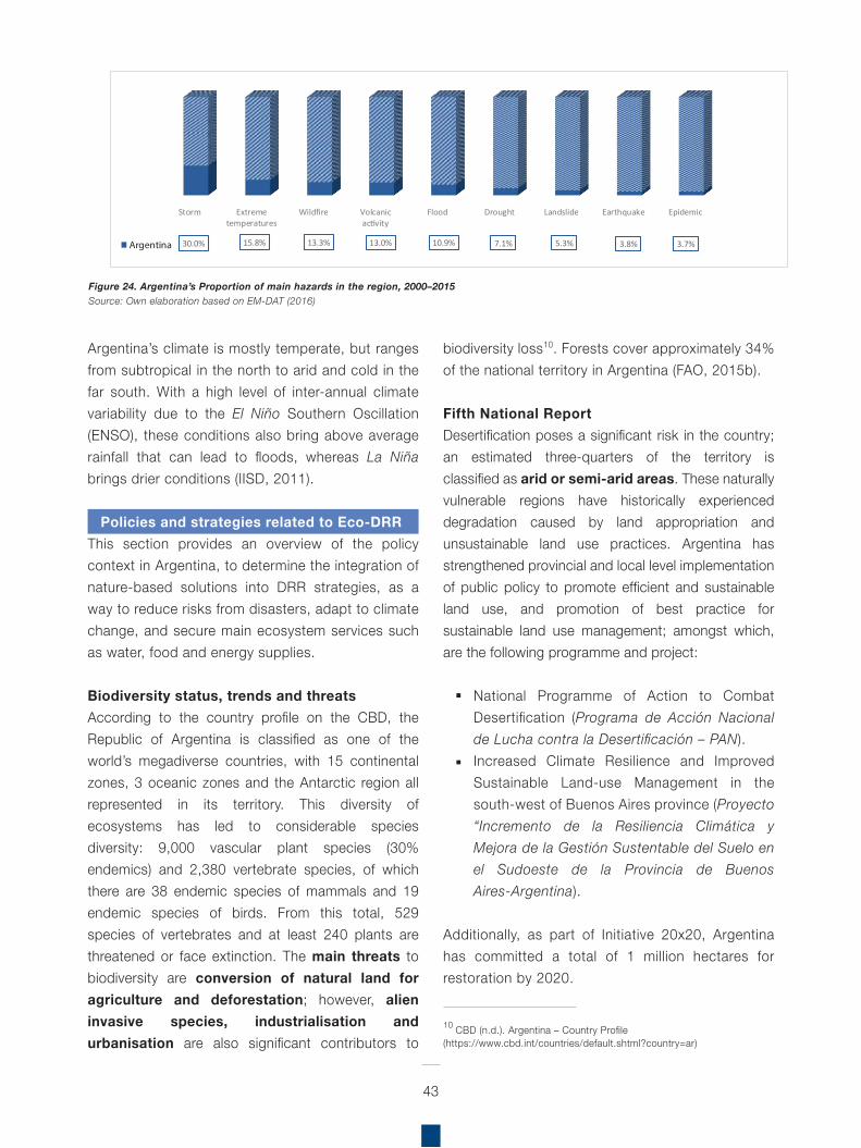
Argentina’s climate is mostly temperate, but ranges from subtropical in the north to arid and cold in the far south. With a high level of inter-annual climate variability due to the El Niño Southern Oscillation (ENSO), these conditions also bring above average rainfall that can lead to floods, whereas La Niña brings drier conditions (IISD, 2011).
Policies and strategies related to Eco-DRRThis section provides an overview of the policy context in Argentina, to determine the integration of nature-based solutions into DRR strategies, as a way to reduce risks from disasters, adapt to climate change, and secure main ecosystem services such as water, food and energy supplies.
Biodiversity status, trends and threatsAccording to the country profile on the CBD, the Republic of Argentina is classified as one of the world’s megadiverse countries, with 15 continental zones, 3 oceanic zones and the Antarctic region all represented in its territory. This diversity of ecosystems has led to considerable species diversity: 9,000 vascular plant species (30% endemics) and 2,380 vertebrate species, of which there are 38 endemic species of mammals and 19 endemic species of birds. From this total, 529 species of vertebrates and at least 240 plants are threatened or face extinction. The main threats to biodiversity are conversion of natural land for agriculture and deforestation; however, alien invasive species, industrialisation and urbanisation are also significant contributors to
biodiversity loss10. Forests cover approximately 34% of the national territory in Argentina (FAO, 2015b).
Fifth National Report
Desertification poses a significant risk in the country; an estimated three-quarters of the territory is classified as arid or semi-arid areas. These naturally vulnerable regions have historically experienced degradation caused by land appropriation and unsustainable land use practices. Argentina has strengthened provincial and local level implementation of public policy to promote efficient and sustainable land use, and promotion of best practice for sustainable land use management; amongst which, are the following programme and project:
National Programme of Action to Combat Desertification (Programa de Acción Nacional de Lucha contra la Desertificación – PAN).Increased Climate Resilience and Improved Sustainable Land-use Management in the south-west of Buenos Aires province (Proyecto “Incremento de la Resiliencia Climática y Mejora de la Gestión Sustentable del Suelo en el Sudoeste de la Provincia de Buenos Aires-Argentina).
Additionally, as part of Initiative 20x20, Argentina has committed a total of 1 million hectares for restoration by 2020.
43
Figure 24. Argentina’s Proportion of main hazards in the region, 2000–2015Source: Own elaboration based on EM-DAT (2016)
Storm Extremetemperatures
Wildfire Volcanicactivity
Flood Drought Landslide Earthquake Epidemic
30.0% 15.8% 13.3% 13.0% 10.9% 7.1% 5.3% 3.8% 3.7%Argentina
10 CBD (n.d.). Argentina – Country Profile(https://www.cbd.int/countries/default.shtml?country=ar)
National Biodiversity Strategy and Action Plan (NBSAP)The general goals of Argentina’s NBSAP are to: guarantee the conservation and sustainable use of biological resources; reduce adverse effects of production activities on biological diversity; and the equitable sharing of benefits derived from the appropriate use of genetic resources.
The NBSAP sets out, according to the themes of the 2010 Biodiversity Target, different objectives and actions for each thematic area. These themes include: sustainable use of biodiversity, restoration of degraded lands, bio-regional planning and use of land, protected areas and education, communication and capacity-building.
The actions identified in the NBSAP should serve to strengthen: the integration of biodiversity-related issues in the sectoral plans and programmes that lead to national development and increase in life quality; understanding of functions of genes, species and ecosystems; access to information related to biodiversity by different sectors of society; the process of moving towards models of use and consumption that are compatible with maintaining essential ecological processes, while trying to avoid a reduction in the natural capital of Argentina; the fair and equitable sharing of the benefits derived from the use of genetic resources; and the conservation of the cultural heritage of Argentina.
National Adaptation PlanArgentina has not submitted its National Adaptation Programme of Action to the UNFCCC, but it has published two National Communications to the UNFCCC – the first in 1997 and the second in 2007. Between these reports, it created a National Program on Climate Change Impacts in 2006 with a view to improve understanding of vulnerability and impacts and to help design adaptation measures. An additional programme addresses the same questions in the Antarctic region and islands (República Argentina, 2007).
Although Argentina has a Local Development Plan (Plan Estratégico Territorial – PET), it doesn’t have a National Development Plan per se, its development is instead guided by a set of strategic national policies. Climate change, but not adaptation in particular, is mentioned in these policies in relation to its environment. A National Climate Change Strategy has been elaborated through a participatory process that addresses both climate change adaptation and mitigation.
The Secretariat for Environment and Sustainable Development (SAyDS) is the UNFCCC focal point. It operates on climate change issues through its Climate Change Directorate (DCC). Furthermore, there is a National Consulting Commission on Climate Change (CNACC) that brings together representatives of various ministries at the national level, regional governments, universities and private sector (IISD, 2011).
National Disaster Management PlansThe National Programme for Disaster Risk Prevention and Reduction, developed since 2006, has as its objective to promote the inclusion of DRR in land use and development policy at all levels in the State. This is achieved through awareness raising and the strengthening of capacities of key stakeholders, and includes risk analysis in the planning and evaluation of public investment projects.
In 2010, “Disaster Risk in Development Planning” was published as a result of the National Programme; this was followed by a Joint Declaration between the Department of Climate Change and the National Direction of Civil Protection, which outlined common risk reduction strategies, especially related to climate change risk, at different scales. This collaboration resulted in the elaboration of the “Manual of Vulnerability to Climate Change for Disaster Management and Local Planning”.
In 2012, Argentina developed its Disaster Risk Country Document under the European Commission’s
44
(2014) Humanitarian Aid and Civil Protection department’s disaster preparedness programme: DIPECHO Action plan. The Under-secretary for the Council of Development Planning and Action (Subsecretaría del Consejo de Planificación y Acción para el Desarrollo – COPADE) is implementing the Provincial Programme for Risk Reduction and Climate Change Adaptation, for the Neuquén Province. In compliance with the Provincial Law No 2713, which requires risk management to be included in local development planning, a Provincial Risk Network was formed as an institutional space for provincial and local planning.
Aichi Biodiversity TargetsAichi Target 11 focuses on protected areas, calling for the expansion of protected areas to encompass 17% of terrestrial ecosystems and 10% of marine ecosystems to cover areas of importance for biodiversity and ecosystem services. It also calls for the effective and equitable management of ecologically representative and well-connected networks of protected areas, which are integrated into the wider landscape. These targets and the principles they represent are critical to ensuring that protected areas continue to deliver on the objectives for which they were established, as well as their vital role to reduce disaster risk for the ecosystems and local communities that depend on them.
Box 1. “El Pozo” Ecological Reserve – Argentina
“El Pozo” Ecological Reserve (also known as the University City Ecological Reserve) is located in the Paraná river basin in the Santa Fe province, northeast Argentina. For the last 18 years, the Fundación Hábitat & Desarrollo and the Universidad Nacional del Litoral have been working in the riparian zone, flood plain, islands (Islas del Paraná) and the pre-delta. They have contributed to the successful conservation of biodiversity and restoration of the river ecosystem, which, through the promotion of healthy ecosystem function, are both significant in terms of reducing disaster risk.
The river and its wetlands are a water resource for livestock farming, agriculture, fisheries and transport. The importance of river restoration to recover river conditions in order to reduce flood risk and improve water quality is fundamental. Specific activities undertaken include: the restoration of lotic ecosystem vegetation affected by the great flood in 1993, protected area planning and management, biodiversity monitoring, environmental education and fire control.
45
Source: Fundación Hábitat & Desarrollo (2016)
Eco-DRR Initiatives
46
Box 2. Private Nature Reserve Network – Argentina
In accordance with the CBD, the country has a target of conserving at least 10% of natural regions. Agricultural and productive lands in Argentina are largely owned by private individuals and companies, therefore private conservation must play a significant role in achieving this target. The Private Nature Reserve Network (Red Hábitat de Reservas Naturales Privadas) was created in recognition of the importance of such conservation initiatives and their contribution towards sustainable development in the country.
For the last twelve years, the Fundación Hábitat & Desarrollo ––together with Argentina’s National Parks Administration (Administración de Parques Nacionales – APN), Masisa Argentina, and the Uruguay River forestry consortium–– have been working in the drainage basin of the Uruguay River, which, together with the Paraná River, forms the Río de la Plata estuary. Work has focused on the creation of a network of private nature reserves for the conservation of the riparian vegetation and important grassland areas; protected area planning and management, biodiversity monitoring and environmental education are all prevalent activities.
These riparian forests absorb and reduce water flow and provide space for flood attenuation, but the river and its wetlands are also the source of water that supports all forms of life, and are an important resource for livestock farming, agriculture, fisheries and transport. The crucial role of flood plain forests as breeding grounds for fish whilst preventing erosion, highlights the importance of such a network of private nature reserves for conservation in terms of promoting healthy ecosystems and their role in DRR.
The conservation of these wetlands not only provides effective flood defences, but also safeguards the many other benefits that these ecosystems provide. An initiative to control invasive species is also an important restoration component of the work, and includes the elaboration of a protocol to control the wild boar population, thus providing an opportunity for emblematic indigenous species found in the grassland of Corrientes to thrive. In terms of reducing disaster risk, such restoration of freshwater wetlands offers protection to life and property from flooding and drought in the River Uruguay drainage basin.
Source: Fundación Hábitat & Desarrollo (2016)
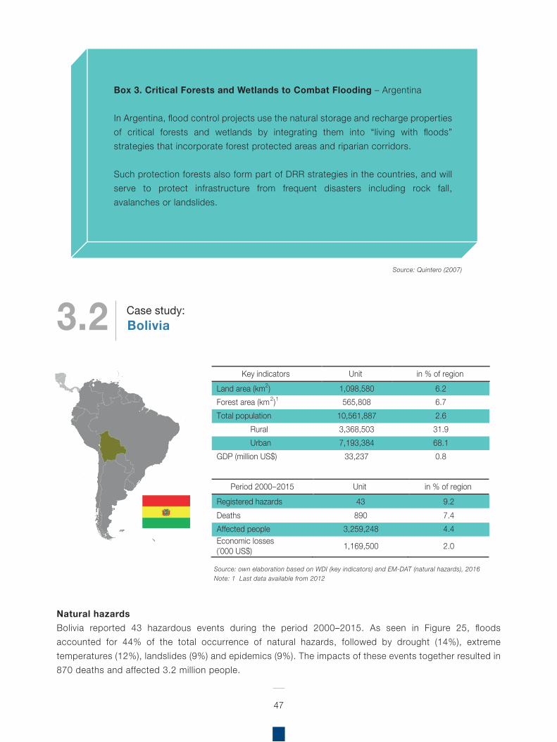
Natural hazardsBolivia reported 43 hazardous events during the period 2000–2015. As seen in Figure 25, floods accounted for 44% of the total occurrence of natural hazards, followed by drought (14%), extreme temperatures (12%), landslides (9%) and epidemics (9%). The impacts of these events together resulted in 870 deaths and affected 3.2 million people.
47
Box 3. Critical Forests and Wetlands to Combat Flooding – Argentina
In Argentina, flood control projects use the natural storage and recharge properties of critical forests and wetlands by integrating them into “living with floods” strategies that incorporate forest protected areas and riparian corridors.
Such protection forests also form part of DRR strategies in the countries, and will serve to protect infrastructure from frequent disasters including rock fall, avalanches or landslides.
Source: Quintero (2007)
Source: own elaboration based on WDI (key indicators) and EM-DAT (natural hazards), 2016Note: 1 Last data available from 2012
Key indicators Unit in % of region Land area (km2) 1,098,580 6.2 Forest area (km2)1 565,808 6.7 Total population 10,561,887 2.6
Rural 3,368,503 31.9 Urban 7,193,384 68.1
GDP (million US$) 33,237 0.8
Period 2000–2015 Unit in % of region Registered hazards 43 9.2 Deaths 890 7.4 Affected people 3,259,248 4.4 Economic losses (´000 US$) 1,169,500 2.0
3.2 BoliviaCase study:
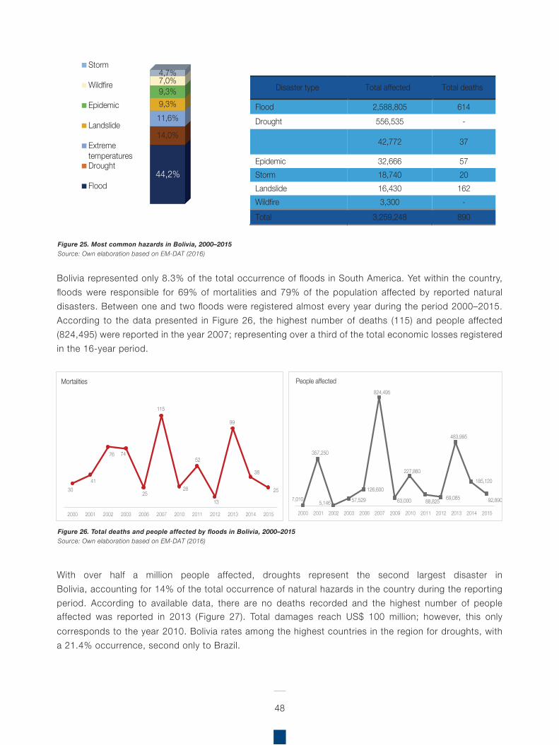
Bolivia represented only 8.3% of the total occurrence of floods in South America. Yet within the country, floods were responsible for 69% of mortalities and 79% of the population affected by reported natural disasters. Between one and two floods were registered almost every year during the period 2000–2015. According to the data presented in Figure 26, the highest number of deaths (115) and people affected (824,495) were reported in the year 2007; representing over a third of the total economic losses registered in the 16-year period.
48
Figure 25. Most common hazards in Bolivia, 2000–2015Source: Own elaboration based on EM-DAT (2016)
Figure 26. Total deaths and people affected by floods in Bolivia, 2000–2015Source: Own elaboration based on EM-DAT (2016)
With over half a million people affected, droughts represent the second largest disaster in Bolivia, accounting for 14% of the total occurrence of natural hazards in the country during the reporting period. According to available data, there are no deaths recorded and the highest number of people affected was reported in 2013 (Figure 27). Total damages reach US$ 100 million; however, this only corresponds to the year 2010. Bolivia rates among the highest countries in the region for droughts, with a 21.4% occurrence, second only to Brazil.
44,2%
14,0%
11,6% 9,3% 9,3% 7,0% 4,7%
Storm
Wildfire
Epidemic
Landslide
ExtremetemperaturesDrought
Flood
Disaster type Total affected Total deaths
Flood 2,588,805 614 Drought 556,535 -
Extreme temperatures 42,772 37
Epidemic 32,666 57 Storm 18,740 20 Landslide 16,430 162 Wildfire 3,300 - Total 3,259,248 890
7,010
357,250
5,146 57,529
126,600
824,495
63,000
227,860
88,825 69,085
483,995
185,120
92,890
2000 2001 2002 2003 2006 2007 2009 2010 2011 2012 2013 2014 2015
People affected
3041
76 74
25
115
26
52
13
99
38
25
2000 2001 2002 2003 2006 2007 2010 2011 2012 2013 2014 2015
Mortalities
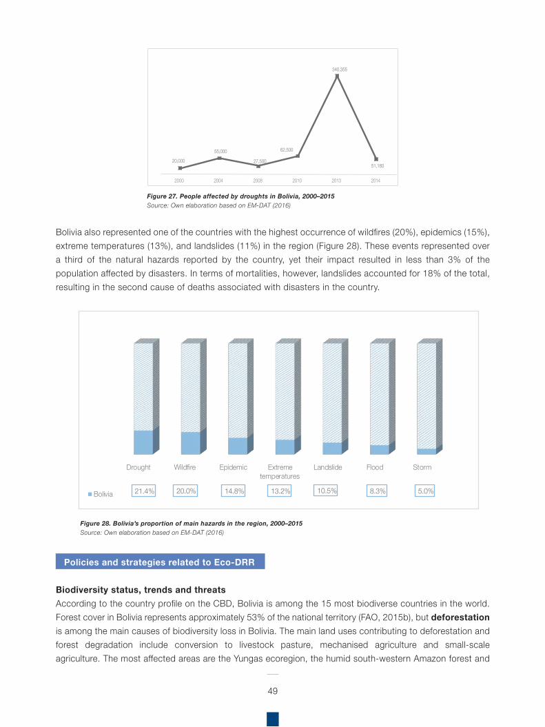
49
Bolivia also represented one of the countries with the highest occurrence of wildfires (20%), epidemics (15%), extreme temperatures (13%), and landslides (11%) in the region (Figure 28). These events represented over a third of the natural hazards reported by the country, yet their impact resulted in less than 3% of the population affected by disasters. In terms of mortalities, however, landslides accounted for 18% of the total, resulting in the second cause of deaths associated with disasters in the country.
Policies and strategies related to Eco-DRR
Biodiversity status, trends and threatsAccording to the country profile on the CBD, Bolivia is among the 15 most biodiverse countries in the world. Forest cover in Bolivia represents approximately 53% of the national territory (FAO, 2015b), but deforestation is among the main causes of biodiversity loss in Bolivia. The main land uses contributing to deforestation and forest degradation include conversion to livestock pasture, mechanised agriculture and small-scale agriculture. The most affected areas are the Yungas ecoregion, the humid south-western Amazon forest and
Figure 27. People affected by droughts in Bolivia, 2000–2015Source: Own elaboration based on EM-DAT (2016)
Figure 28. Bolivia’s proportion of main hazards in the region, 2000–2015Source: Own elaboration based on EM-DAT (2016)
20,000
55,000
27,500
62,500
340,355
51,180
2000 2004 2008 2010 2013 2014
Drought Wildfire Epidemic Extremetemperatures
Landslide Flood Storm
21.4% 20.0% 14.8% 13.2% 10.5% 8.3% 5.0%Bolivia
50
the dry forests of Chiquitano and Chaco. It is estimated that one-tenth of Bolivia’s forests has been lost since 1990. Notably, deforestation levels in protected areas and in the territories managed by Indigenous Peoples and campesino communities are significantly lower than outside them.
In 2010, Bolivia adopted the historic Law on the Rights of Mother Earth. This was followed in 2012 by the adoption of the Framework Law on Mother Earth and Integral Development for Living Well, focused primarily on climate change mitigation and adaptation, although stressing the importance of implementing holistic measures for biodiversity and cultural conservation to “live well”. The Framework Law on Mother Earth also specifies an objective to prevent and reduce risk and vulnerability to the people of Bolivia. Against this background, the Patriotic Agenda 2025 was adopted in 2013 as a comprehensive programme for achieving sustainable development in the country.
In 2014, Bolivia began implementation of the Mitigation and Adaptation Mechanism for Integrated and Sustainable Management of Forests and Mother Earth, as a fundamental public policy to contribute to reducing the loss, degradation and fragmentation of its ecosystems. The mechanism is implemented in regional and/or macro-regional territories in the country.
Bolivia has developed the technical document “Risk Management for the Water and Environment”, designed to mainstream disaster risk management in the development plans of the Ministry of Environment and Water (MMAyA).
Bolivia has also implemented management tools, such as the Agricultural Sector Development Strategy 2014–2018, which identifies the environment as a crosscutting issue and refers to reduction of natural disaster impacts in the agricultural sector, through
the prevention and mitigation of disasters, emergency response, and recovery and reconstruction. It is also acknowledged that a crucial element of this management relates to the participation of different sectors and society in general12.
Fifth National ReportThroughout Bolivia’s Fifth National Report to the CBD, the environment, and ecosystems in particular, are recognised at multiple levels. Although the text does not strongly acknowledge the role of ecosystems for DRR, Bolivia does include hazards, which indicates that there is scope for increased activities on the ground for Eco-DRR. Despite the absence of specific targets related to DRR, in terms of natural hazards, Bolivia’s fifth national report does make specific reference to the principal hazards identified in the previous section: flood, drought and temperature extremes.
The NR5 highlights that climate variability and climate change pose significant threats to both livelihoods and species, highlighting increased risk of flooding, drought, temperature extremes and climatic events. Projected climate change impacts are expected to be very strong for biodiversity, especially in the Altiplano where high desertification is projected, owing to the reduction in precipitation and temperature variability. Whereas in the lowland regions, it is agricultural expansion, not climate change, that represents the main threat to biodiversity.
Bolivia’s fifth national report explicitly recognises biodiversity conservation as fundamental for resilience, a key element for CCA. Highlighting the important role of landscapes for species and community connectivity, and ecological processes for the conservation of nature and its adaptive capacity; also acknowledging ecological corridors as essential for migration of species displaced by a changing climate.
11 Ley Marco de la Madre Tierra (Ley No 300, 2012).12 CBD (n.d.). Bolivia – Country Profile(https://www.cbd.int/countries/default.shtml?country=bo
51
In Art. 2 of Decree No. 1696, Bolivia defines adaptation as the adjustment in the life systems of Mother Earth in response to climate change impacts. Therefore, it promotes conditions, capacities and forms for prevention and minimising damages and risks associated with it; and promotes opportunities and benefits for protecting and defending Mother Earth in all its forms. Biological diversity is recognised as an important consideration for CCA, also acknowledging the essential role of agrobiodiversity.
Bolivia has adopted a number of legislations and mechanisms to implement the country’s vision for biodiversity conservation and sustainable development:
Law on the Rights of Indigenous Peoples (2007) (Bolivia was the first country in the world to adopt this UN Declaration as national law. Bolivia recognises the customary use of biological resources by Indigenous Peoples and campesino communities in all legislations and regulations on this subject). Law on the Rights of Mother Earth (2010) Framework Law on Mother Earth and Integral Development for Living Well (2012) Plurinational Fund for Mother Earth (established under the Framework Law on Mother Earth and Integral Development for Living Well to generate financial support for managing the country’s life-systems and is mainly linked to in situ conservation) Patriotic Agenda 2025 (2013) Act on Ancestral Traditional Bolivian Medicine (2013) Education Act (2010) Joint Mitigation and Adaptation Mechanism for the Integral and Sustainable Management of Forests and Mother Earth (2014) (this is Bolivia’s alternative to the UN REDD+ Programme) Strategy on Gender Complementarity (for Living Well) (within the context of the National Programme on Bioculture) Integrated Programme for Solid Waste
Management (2011–2015) Master Plan for the National System of Protected Areas National Afforestation and Reforestation Plan Andean Ecosystems Strategy
Some of the challenges highlighted in the fifth national report relate to the implementation of EbA in Bolivia, which include threats posed by climate change and agriculture; specifically highlighting that the majority of soils suitable for forests are currently utilised for agriculture, which is a significant livelihood activity and as such provides immediate benefits. The management of residual waters and toxic residuals was highlighted as a necessity, as there is no system for residual water, this means effectively that contamination often goes directly into rivers and water sources, thus debilitating water ecosystem integrity. As such, these affected natural water sources lose their integrity, and therefore the protection offered by them is diminished. Their capacity for providing a continuous supply of quality water is impeded and they are unable to safeguard against crop failure and damage in times of drought.
Bolivia has experienced an increase in protection of areas such as Ramsar sites from 7,894,472 ha to 14,842,405 ha in 2013, which demonstrates a willingness to preserve water sources in the country, and although not necessarily including DRR or CCA, the inherent benefits of protecting these wetland sites and other protected areas for DRR is evident.
National Biodiversity Strategy and Action Plan (NBSAP)Adopted in 2001, Bolivia’s first NBSAP consists of 5 key components: (i) conserve ecosystems, species and genetic resources of ecological, economic and cultural importance; (ii) attract investment in biodiversity products and functions; (iii) develop national capacity for biodiversity management; (iv) develop local management for biodiversity conservation and sustainable use; (v) education, awareness-raising, communication and social control regarding sustainable biodiversity management.
52
Bolivia began revising and updating its NBSAP in 2014, to cover the period 2015–2025. Bolivia has included some EbA-related aspects in its NBSAP (although EbA is not mentioned explicitly), and has a dual focus on both people and nature:
Protected Areas: 44% of national watersheds protectedSpatial Plan Integrated Management: better management of 7 protected areasRestoration/rehabilitation: restoration of biodiversity, improving soil use, reducing deforestation, sustainable livelihoods of local communities and indigenous communities; 169 ha reforestationBuild adaptive capacity, technical capacity, education and awareness: capacity building in indigenous communitiesGovernment/policy planning and regulatory frameworks/mainstreaming of biodiversity values into national policy: Planned for 2020: 115 policies approved for biodiversity managementDiversify agriculture, soil conservation, improve water efficiency, sustainable land management (SLM), sustainable forest management (SFM): Improvement in food security, 2,598 families; 381 tm seeds; 4,041 ha soils with agroecological systemsManage threats to biodiversity, e.g. invasive species (AIS): Only threat to humans is the A. Aegypti speciesEconomic analyses, e.g. cost-benefit, valuation of ecosystem services: mentioned in the NBSAPNatural resource management (fisheries, forests): from 2014 forest management, one territory and ten in progress
Aichi Biodiversity TargetsBased on Pillar 6 of the Patriotic Agenda 2025 on “diversified sovereign production and holistic development free from the dictates of capitalist markets”, Bolivia is promoting the optimal usage of water for irrigation, a transition to additional
systems for intensive livestock production, integrated water resources and watershed management, among other actions.
In 2013, the Coordination Unit of the National Council on Ecological Agricultural Production provided technological support to 6,000 producers to plant 8,500 hectares of organic crops. Bolivia also intends to develop actions to protect the genetic heritage of agricultural biodiversity and prohibits the introduction, production, use, release into the environment and commercialisation of genetically modified (GM) seeds.
A collection of 16,006 accessions (seeds) of plants (e.g. beans, quinoa, lupine, cañahua, amaranth, potatoes, peppers, achojchas) is protected and preserved. The Agricultural Sectoral Development Plan (2014–2018) “Towards 2025” presents an assessment for the years 2010–2013 and confirms an increase in the number of gene banks during this period.
National Disaster Management PlansThe Law for Disaster Risk Reduction and Emergency Actions13 came into force in 2000, with the formation of a corresponding National System for Risk Reduction and Disaster Response (SISRADE), and the National Council for Risk Reduction and Disaster Response (CONARADE), for implementing this law.
13 Ley Nº 2140.
Regional Assessment on Ecosystem-based Disaster Risk Reduction and Biodiversity in South America
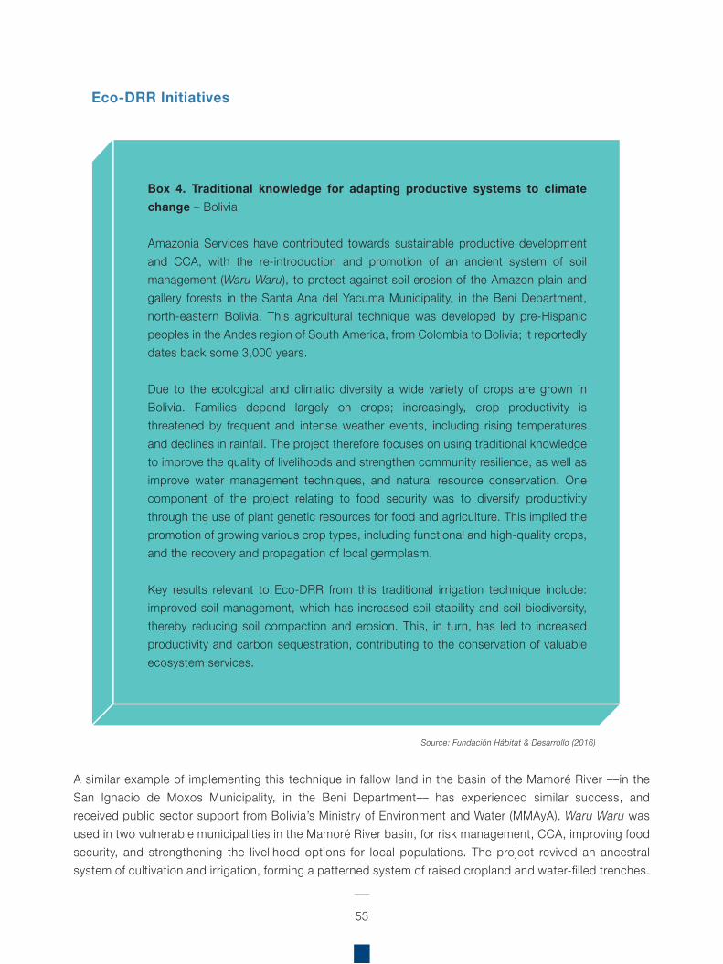
A similar example of implementing this technique in fallow land in the basin of the Mamoré River ––in the San Ignacio de Moxos Municipality, in the Beni Department–– has experienced similar success, and received public sector support from Bolivia’s Ministry of Environment and Water (MMAyA). Waru Waru was used in two vulnerable municipalities in the Mamoré River basin, for risk management, CCA, improving food security, and strengthening the livelihood options for local populations. The project revived an ancestral system of cultivation and irrigation, forming a patterned system of raised cropland and water-filled trenches.
53
Box 4. Traditional knowledge for adapting productive systems to climate change – Bolivia
Amazonia Services have contributed towards sustainable productive development and CCA, with the re-introduction and promotion of an ancient system of soil management (Waru Waru), to protect against soil erosion of the Amazon plain and gallery forests in the Santa Ana del Yacuma Municipality, in the Beni Department, north-eastern Bolivia. This agricultural technique was developed by pre-Hispanic peoples in the Andes region of South America, from Colombia to Bolivia; it reportedly dates back some 3,000 years.
Due to the ecological and climatic diversity a wide variety of crops are grown in Bolivia. Families depend largely on crops; increasingly, crop productivity is threatened by frequent and intense weather events, including rising temperatures and declines in rainfall. The project therefore focuses on using traditional knowledge to improve the quality of livelihoods and strengthen community resilience, as well as improve water management techniques, and natural resource conservation. One component of the project relating to food security was to diversify productivity through the use of plant genetic resources for food and agriculture. This implied the promotion of growing various crop types, including functional and high-quality crops, and the recovery and propagation of local germplasm.
Key results relevant to Eco-DRR from this traditional irrigation technique include: improved soil management, which has increased soil stability and soil biodiversity, thereby reducing soil compaction and erosion. This, in turn, has led to increased productivity and carbon sequestration, contributing to the conservation of valuable ecosystem services.
Source: Fundación Hábitat & Desarrollo (2016)
Eco-DRR Initiatives
This system captures water when there are droughts and drains away water when there is too much rain, which not allows crops to be effectively irrigated all year round, but also acts as an important buffer to ecosystems and communities in times of flash flooding.
Therefore, the resurgence of this ancient farming system with local communities improves income opportunities by promoting crop production in periods of flood and drought, and also promotes adaptation to climate change, as well as productive development to manage and reduce disaster risk posed by floods and drought in communities in the San Joaquín and San Ignacio de Moxos municipalities.
Regarding other ecosystems within Bolivia, Andean glaciers have displayed continued recession, with the most pronounced retreats beginning in the early 1980s. Glaciers and the water they provide are intimately associated with indigenous culture, customs and religion. Many of these glaciers exhibit some of the most rapid mass and surface area losses in the world (Painter, 2007).
The region is faced with diverse climate impacts, especially, for instance, in the Altiplano extending from the equator to central Chile, and the high plateau of Peru and Bolivia, these areas depend, in large measure, on meltwater from snow or ice. The loss of glaciers, snow and associated meltwater is of particular concern as this meltwater provides drinking water for a large proportion of the region’s population, as well as water for irrigation and hydroelectric dams. Rapid changes in the climate can destabilise glacial lakes leading to sudden floods, and destabilise snowpack causing avalanches.
Glacial retreat presents a serious problem, not least for people inhabiting arid climates in the Andes, who rely on glacial melt for their water supply, especially during dry spells and periods of drought. Farmers irrigate their crops by channelling meltwater, without which livelihoods are severely affected.
Since 2008, Bolivia, Ecuador and Peru, with the support of the World Bank, have been implementing a project to adapt to the impacts of receding glaciers in the Tropical Andes (Adaptation to the Impact of Rapid Glacier Retreat in the Tropical Andes), see Box 5.
The Swiss Agency for Development Cooperation (SDC) supported the development of DRR activities within the MMAyA. For instance, the Vice-Ministry of Water Resources and Irrigation (VRHR) coordinated the following national programmes: MiAgua (Más Inversión para Agua) and PROAR (Programa Agua y Riego para Bolivia). And, significantly, the Farming and Climate Change Risk Management Unit within the Vice-Ministry of Rural Development and Farming (VDRA) incorporates DRR and CCA into their planning and work instruments, thereby reducing disaster risk.
The SDC also developed and implemented its “Guide for Integrating Climate, Environment and Disaster Risk Reduction” (CEDRIG), which, as the name suggests, systematically integrates climate, environment and DRR into development cooperation and humanitarian aid to increase resilience of ecosystems and communities.
DRR and CCA projects have been implemented by the World Bank, CARE, and the Swiss Cooperation in the eastern Andes, Department of La Paz, Adaptación al Impacto del Retroceso Acelerado de los Glaciares en los Andes (PRAA) Disaster Risk Reduction for Climate Change Adaptation pilot activities in the Municipalities of Batallas and Palca. It was reported that the crops were made more resilient, and although it is unclear exactly how this was achieved, it is likely linked to plant genetic diversity and therefore serves as a good example of the role of biodiversity in DRR.
From 2005–2014, the Swiss Cooperation implemented a DRR project for prevention, to build awareness and strengthen DRR capacities for communities and organisations in six Departments:
54
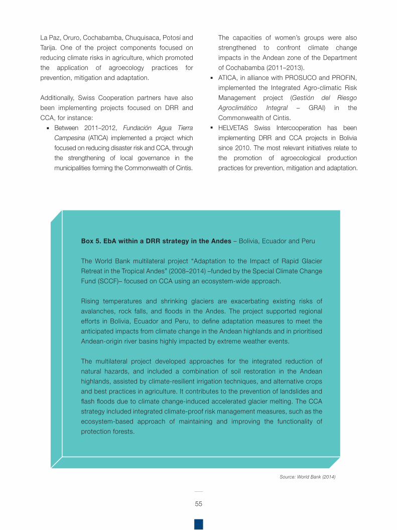
La Paz, Oruro, Cochabamba, Chuquisaca, Potosí and Tarija. One of the project components focused on reducing climate risks in agriculture, which promoted the application of agroecology practices for prevention, mitigation and adaptation.
Additionally, Swiss Cooperation partners have also been implementing projects focused on DRR and CCA, for instance:
Between 2011–2012, Fundación Agua Tierra Campesina (ATICA) implemented a project which focused on reducing disaster risk and CCA, through the strengthening of local governance in the municipalities forming the Commonwealth of Cintis.
The capacities of women’s groups were also strengthened to confront climate change impacts in the Andean zone of the Department of Cochabamba (2011–2013).ATICA, in alliance with PROSUCO and PROFIN, implemented the Integrated Agro-climatic Risk Management project (Gestión del Riesgo Agroclimático Integral – GRAI) in the Commonwealth of Cintis.HELVETAS Swiss Intercooperation has been implementing DRR and CCA projects in Bolivia since 2010. The most relevant initiatives relate to the promotion of agroecological production practices for prevention, mitigation and adaptation.
55
Source: World Bank (2014)
Box 5. EbA within a DRR strategy in the Andes – Bolivia, Ecuador and Peru
The World Bank multilateral project “Adaptation to the Impact of Rapid Glacier Retreat in the Tropical Andes” (2008–2014) –funded by the Special Climate Change Fund (SCCF)– focused on CCA using an ecosystem-wide approach.
Rising temperatures and shrinking glaciers are exacerbating existing risks of avalanches, rock falls, and floods in the Andes. The project supported regional efforts in Bolivia, Ecuador and Peru, to define adaptation measures to meet the anticipated impacts from climate change in the Andean highlands and in prioritised Andean-origin river basins highly impacted by extreme weather events.
The multilateral project developed approaches for the integrated reduction of natural hazards, and included a combination of soil restoration in the Andean highlands, assisted by climate-resilient irrigation techniques, and alternative crops and best practices in agriculture. It contributes to the prevention of landslides and flash floods due to climate change-induced accelerated glacier melting. The CCA strategy included integrated climate-proof risk management measures, such as the ecosystem-based approach of maintaining and improving the functionality of protection forests.
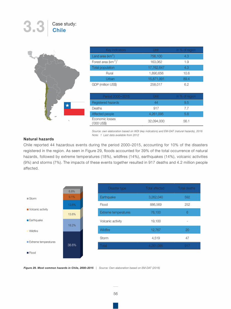
Natural hazardsChile reported 44 hazardous events during the period 2000–2015, accounting for 10% of the disasters registered in the region. As seen in Figure 29, floods accounted for 39% of the total occurrence of natural hazards, followed by extreme temperatures (18%), wildfires (14%), earthquakes (14%), volcanic activities (9%) and storms (7%). The impacts of these events together resulted in 917 deaths and 4.2 million people affected.
56
Figure 29. Most common hazards in Chile, 2000–2015 | Source: Own elaboration based on EM-DAT (2016)
Key indicators Unit in % of region Land area (km2) 756,100 4.3 Forest area (km 2)1 163,062 1.9 Total population 17,762,647 4.3
Rural 1,890,656 10.6 Urban 15,871,991 89.4
GDP (million US$) 258,017 6.2
Period 2000–2015 Unit in % of region
Registered hazards 44 9.5 Deaths 917 7.7 Affected people 4,261,095 5.8 Economic losses (´000 US$) 32,094,000 56.1
38.6%
18.2%
13.6%
13.6%
9.1%
6.8%
Storm
Volcanic activity
Earthquake
Wildfire
Extreme temperatures
Flood
Disaster type Total affected Total deaths
Earthquake 3,262,040 592
Flood 886,569 252
Extreme temperatures 76,100 6
Volcanic activity 19,100 -
Wildfire 12,767 20
Storm 4,519 47
Total 4,261,095 917
Source: own elaboration based on WDI (key indicators) and EM-DAT (natural hazards), 2016Note: 1 Last data available from 2012
3.3 ChileCase study:
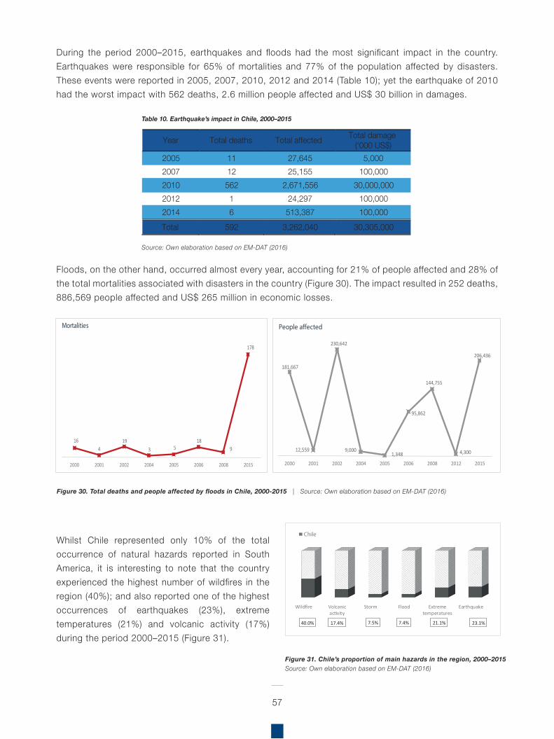
During the period 2000–2015, earthquakes and floods had the most significant impact in the country. Earthquakes were responsible for 65% of mortalities and 77% of the population affected by disasters. These events were reported in 2005, 2007, 2010, 2012 and 2014 (Table 10); yet the earthquake of 2010 had the worst impact with 562 deaths, 2.6 million people affected and US$ 30 billion in damages.
Floods, on the other hand, occurred almost every year, accounting for 21% of people affected and 28% of the total mortalities associated with disasters in the country (Figure 30). The impact resulted in 252 deaths, 886,569 people affected and US$ 265 million in economic losses.
Whilst Chile represented only 10% of the total occurrence of natural hazards reported in South America, it is interesting to note that the country experienced the highest number of wildfires in the region (40%); and also reported one of the highest occurrences of earthquakes (23%), extreme temperatures (21%) and volcanic activity (17%) during the period 2000–2015 (Figure 31).
57
Figure 30. Total deaths and people affected by floods in Chile, 2000-2015 | Source: Own elaboration based on EM-DAT (2016)
Figure 31. Chile’s proportion of main hazards in the region, 2000–2015Source: Own elaboration based on EM-DAT (2016)
Source: Own elaboration based on EM-DAT (2016)
Year Total deaths Total affected Total damage (‘000 US$)
2005 11 27,645 5,000 2007 12 25,155 100,000 2010 562 2,671,556 30,000,000 2012 1 24,297 100,000 2014 6 513,387 100,000 Total 592 3,262,040 30,305,000
Table 10. Earthquake’s impact in Chile, 2000–2015
164
193 5
189
178
2000 2001 2002 2004 2005 2006 2008 2015
Mortalities
181,667
12,559
230,642
9,000 1,348
95,862
144,755
4,300
206,436
2000 2001 2002 2004 2005 2006 2008 2012 2015
People a�ected
Wildfire Volcanicactivity
Storm Flood Extremetemperatures
Earthquake
40.0% 17.4% 7.5% 7.4% 21.1% 23.1%
Chile
58
Biodiversity status, trends and threats
According to the country profile on the CBD, Chile is a long and narrow country located to the west of the Andes, between latitudes 17° and 56°S and longitudes 66° and 75°W. Consequently, the country’s landscapes are extremely varied, consisting of desert, forest, valleys, mountains and several distinct ecosystems. Chile possesses around 30,000 species, 25% of which are endemic. The central and southern zones of the country are considered a global biodiversity hotspot and among the most threatened. Chile’s Atacama Desert is considered the driest in the world, while the Valdivian temperate rainforests, dominated by evergreen angiosperm trees, are unique to southern Chile and Argentina on the South American continent.
Chile is also located within the “Pacific Ring of Fire”, an area prone to earthquakes and volcanic eruptions. It also claims around 480,000 square miles of Antarctica as part of its territory, however this claim is currently suspended under the Antarctic Treaty. The forestry, fisheries, agriculture and tourism sectors depend directly on renewable natural resources and account for 9.7% of the GDP while directly providing at least one million jobs.
In general, ecological conditions are better in southern Chile and worse in the country’s central zone. In the northern zone, activities conducted by the mining and agricultural sectors are negatively impacting the status of rivers and lakes and coastal wetlands. The country’s terrestrial ecosystems have experienced a major loss in native forest cover, particularly in the central zone with rates reaching between 3.5% and 4.5% annually. Over the last two decades, ecosystems located in the coastal zone of Maule (VII Region) and Bio Bío (VIII Region) lost about 26% of their coverage. During the same period, losses of 10% to 20% have been recorded in 11 other ecosystems in the central zone, mainly due to the establishment of new forest plantations in these areas. Anthropic ecosystems meanwhile have
come to occupy 12% of the national territory, transforming natural ecosystems, forests, scrub, deserts and steppes into residential areas, roads and productive land.
The main threats to biodiversity are changes in land use due to activities related to the forestry and agricultural sectors. Other threats are associated with urbanisation, invasive alien species, forest fires, climate change and water extracted for mining and agricultural activities in the northern zone of the country 14.
Forest covers approximately 44% of Chile’s national territory (FAO, 2015b). Chile is the only country in the region that experienced a net gain of between 0.5–5 million ha in forest cover during the 1990–2015 period (FAO, 2015b).
Policies and strategies related to Eco-DRR
Regarding disaster risk reduction, Chile signed the Hyogo Framework for Action 2005–2015 and created a national multisectoral DRR platform called Mesa Temática para la Gestión del Riesgo y Reducción de Riesgos de Desastres15. Participants to the platform belong to the public sector, United Nations agencies, financial institutions, regional bodies, the civil society, the private sector as well as representatives of the academic and scientific community. The Ministries involved are: Ministry of Interior (Steering Committee), Education, Housing and Town Planning, Environment, Public Works, Finance, Social Development. Other public and private institutions can be invited to special sessions (in Cordero et al., 2014: 9-10).
The National Office of Emergencies (ONEMI) as part of the Ministry of Interior and Public Security is the
14 CBD (n.d). Chile – Country Profile (https://www.cbd.int/countries/default.shtml?country=cl)15 Ministerio del Interior y Seguridad Pública: Acta de Constitución de la Plataforma Nacional de Reducción del Riesgo de Desastres en Chile, 2012. http://www.preventionweb.net/files/28726_actadeconstitucindelaplataformanaci.docx
59
institution in charge of planning, coordinating and implementing activities for the prevention, mitigation, warning, response and rehabilitation required for the National System of Civil Protection’s functioning as response to threats, emergencies, disasters and catastrophes; in order to protect people, property and environment at national, regional, provincial and communal levels16 (in Podvin et al., 2016).
A law pending approval favours the establishment of a National Emergency and Civil Protection System and the creation of a National Civil Protection Agency to take over the role of the ONEMI in the future. To date the law had not yet passed the Senate17. Once the law enters into force, the development and implementation of regulations will take further time.
Chile has a National Policy for Disaster Risk Management, which was developed by a National Platform established for Disaster Risk Reduction led by ONEMI, whose first mission was the formulation of a policy that allows the development of comprehensive disaster risk management in the country.
The objective of this policy is to grant the State of Chile, an instrument or guidance framework, which allows the development of comprehensive disaster risk management where general polities are articulated in transversal policies and sectoral policies, and where the prevention, response and disaster recovery actions take place within a sustainable development framework (ONEMI, 2014). Within the scope of this policy, it states that there should be a comprehensive disaster risk management, including, in the future, other planning and/or spatial delimitation units such as watersheds, ecosystems, macro-zones and biodiversity, among others (Ibíd, p. 33 in Podvin et al., 2016).
Fifth National ReportIn its Fifth National Report, Chile specifies targets related to Eco-DRR, principally, the capacity of wetlands to act as buffer zones in the VII Region del Maule (PRES Constitución, PRES Licantén -borde costero de Iloca, Duao y La Pesca- y PRES Pelluhue-Curanipe) and the VIII Bio Bío Region (18 plans in three different zones: North (Cobquecura, Caleta Perales and Dichatoamong among others); Centre (Penco-Lirquén, Talcahuano and Caleta Tumbes, among others) and South (Llico, Lebu and Isla Mocha, among others).
The NR5 also highlights cyclone, flood/storm surge, drought, food security, fire, erosion and water security as relevant natural hazards for the country.
Challenges highlighted in the NR5 related to the implementation of EbA in Chile include:
lack of information relating to marine ecosystemsterrestrial ecosystems in central Chile are especially vulnerable to climate changethere are no indicators at country level for preserving genetic resources (Aichi 13); land use change has a significant impact
Challenges related to the implementation of DRR in Chile include:
There are incentives for deforestation (farm and industry) from diesel imports (US$ 605 million) that affect ecosystem based approaches for DRR; however, in 2015 there was an estimated 35% reduction in the import of dieselFisheries have the potential to increase by 12,000 tonnes per year, and there is a need for monitoring studies for invasive species32 protected areas require proper management
Lessons learned: Urgent need to protect marine and terrestrial areas that are biodiversity hotspots and harbour a wide diversity of habitats that are not currently protectedmore basic research is needed to determine
16 http://www.onemi.cl/mision-y-vision/17 http://www.latercera.com/noticia/nacional/2014/04/680-575856-9-las-similitudes-y-diferencias-entre-la-onemi-y-el-proyecto-de-agencia-nacional.shtm
60
which areas to protect and which need a state regulation for preserving genetic diversityneed for state regulation to protect the ecosystems that provide human wealth (Aichi 14)there are several restoration projects but there is a need for proper coordination for their implementationIt is necessary to eliminate financial, institutional and operational barriers to increase the awareness and protection of biodiversity and ecosystem servicesNeed to improve the conservation and restoration of degraded ecosystems and eliminate perverse incentives
National Biodiversity Strategy and Action Plan (NBSAP)
Chile adopted its first National Biodiversity Strategy in 2003, which proposed the following strategic orientations: (i) ensure ecosystem conservation and recovery to significantly slow the loss of biological diversity before 2010; (ii) ensure the preservation of species and genetic heritage; (iii) promote sustainable production practices; (iv) strengthen inter-institutional and intersectoral coordination for the integrated management of biodiversity; (v) establish formal and informal mechanisms required for the optimal management of biodiversity; (vi) strengthen environmental education, public awareness and access to information on biodiversity; (vii) strengthen and coordinate research; and (viii) consolidate funding mechanisms. Only 50% of the actions in the Strategy have been implemented for reasons associated with an absence of political will, change in priorities among the bodies responsible for implementation, lack of coordination and/or agreement and a lack of financial resources.
Activities are firmly in progress to revise the Strategy, which will contain a vision to 2030 and consider the current global biodiversity agenda. The overarching strategic goals will focus on protection, restoration and sustainable use, with sub-strategies
focused on participation, institutional, financial and human capacity-building, knowledge strengthening and access and benefit-sharing. Chile also intends to develop resource mobilisation strategies and indicators, as well as Regional Biodiversity Strategies.
Chile has included EbA-related aspects in its NBSAP, which is focused on both people and nature (although EbA is not explicitly mentioned):
Protected Areas: 20% of terrestrial protected areas; 4.3% marine protected areas between 2009–2014; nine terrestrial areas (189,074.5 ha) and three marine areas (15,000,000 ha)Restoration/rehabilitation: 53 ha of the native tree species coigue (Nothofagus dombeyi) for project to restore 3,000 ha eucalyptusBuild adaptive capacity, technical capacity, education and awareness: publication of books, printed materials, environmental education to students, for informing people about conservation; strengthening capacities with certified environmental educational services from 375 in 2009 to 876 in 2013Government/policy planning and regulatory frameworks/mainstreaming of biodiversity values into national policy: Política de Áreas Protegidas Política y Estrategia Nacional para Restauración Ecológica en Áreas Silvestres Protegidas del Estado (2012)Diversify agriculture, soil conservation, improve water efficiency, sustainable land management (SLM), sustainable forest management (SFM): Acuerdos de Producción Limpia (Estudio de Caso 6) y la iniciativa Vino, Cambio Climático y Biodiversidad (Estudio de Caso 7)Natural resource management (fisheries, forests): artisanal fisheries are self-regulated by fisher folk, whereas there are problems with foreign / non-local commercial fisheries that use unsustainable nets in the Reserva Costera Valdiviana (RCV)REDD+: mention of REDD+ and the country’s collaboration with the UN-REDD Programme, where projects are ongoing.
61
Additionally, as part of Initiative 20x20, Chile has committed a total of 500,000 hectares for restoration by 2020; this will be achieved through the Ministry of Agriculture.
Aichi Biodiversity TargetsAwareness-raising activities are being carried out through an afforestation programme begun in 2010 to be implemented until 2018. The programme’s target is to plant 17 million trees (approximately 50% being native species) with the participation of municipalities, businesses, educational institutions, organisations, neighbourhoods and the general public.
Chile recently joined the World Bank WAVES Initiative, and was also selected by the UN to carry out pilot projects on ecosystem accounting.
As a signatory to various free-trade agreements, Chile is obliged to improve the sustainability of some of its products in accordance with the provisions of these agreements. In the forestry sector, a culture of certifying production processes by productive enterprises exists nowadays, complementing the international rules and standards governing sectors linked to the export of natural resources. In the field of waste management, the concept of Extended Producer Responsibility (EPR) has been introduced as an environmental protection strategy.
Concerning invasive species, success has been achieved in eradicating the rabbit on Santa Clara Island while progress is being made towards its eradication in the Humboldt Penguin National Reserve. Meanwhile the most harmful alien species (e.g. beaver, mink) are increasing. A Resolution was adopted in August 2013 on the creation of an Operations Committee for the Prevention, Control and Eradication of Invasive Alien Species, which will be coordinated by the Ministry of the Environment.
Regulations have been prepared and are currently being formalised for developing plans for the recovery, conservation and management of classified wild species. Plans have been proposed
for the Hummingbird of Arica (XV Region), Little Tern (XV Region, I Region, II Region), Ruddy-headed Goose (XII Region), various amphibians, Darwin’s Fox (VIII Region, IX Region, XIV Region, X Region) and five cactus species (XI Region).
National Adaptation PlanTo address climate change adaptation Chile developed the National Climate Change Adaptation Plan, as well as nine sector specific plans, all aligned with national priorities. Until now, two sectoral plans have been developed and approved: 1) Forestry and agriculture plan and 2) Biodiversity plan. The other seven plans are related to: water resources, fisheries and aquaculture, health, energy, infrastructure, cities and tourism (Government of Chile, 2015)18.
The sectoral Plan for Biodiversity is based on sustainable management and ecosystem conservation and restoration, through measures aimed at reducing anthropogenic and bioclimatic stresses and increasing capacity in the fields of research, monitoring, information and training. In this light, the Ministry of Environment is promoting the creation of a task force to address matters on ecological restoration and develop an implementation programme. Chile is a participant both of the UN REDD+ Programme and the UNDP Biodiversity Finance Initiative (BIOFIN).
Protected AreasWork on protected areas is advancing; however, there exist significant gaps in ecosystem representation. At present, terrestrial protected areas comprise 20% of the national territory, while marine protected areas comprise 4.3%, however, 99% of this area corresponds to only one marine protected area (Motu Motiro Hiva Marine Park). In addition, the management effectiveness of the marine protected areas has been determined to be low. A positive development has been the recent creation and implementation of the Committee on Protected Areas.
18 For more information on policy analysis related to climate changeadaptation, and opportunities and gaps related to EbA for CCA and DRR, see Podvin et al., 2016.
62
There is insufficient information to provide an account of the loss and/or alteration of marine ecosystems and component species in Chile. Moreover, no official classification system exists to properly plan and manage these ecosystems. The global Ocean Health Index ranks the conservation status of Chile’s marine biodiversity as “good”; the same status is, however, not applicable to fisheries and aquaculture resources that are presently overexploited. Oceanic islands, such as the Juan Fernandez Archipelago, considered a biodiversity hotspot, face serious conservation problems due to the introduction of invasive alien species, the absence of integrated land management and sustainable resource management, among other factors. As for inland aquatic ecosystems, the absence of data and systematised information and monitoring also prevent a complete picture from being formulated. These factors are key in evaluating the potential for restoration and preservation of coastal habitats in Chile, forming bioshields along tsunami affected coastline that don’t just protect, they also provide an essential way of generating a sustainable income.
Box 6. Community-based Adaptation to Climate Change – Chile
To help protect communities from disasters and tackle the adverse effects of climate change, the Ecosystems Protecting Infrastructure and Communities (EPIC) project investigates the role that healthy ecosystems play in reducing disaster risk and supporting community-based adaptation (CbA) to climate change. EPIC is a five-year initiative funded by Germany’s Federal Ministry of the Environment, Nature Conservation, Building and Nuclear Safety’s International Climate Initiative.
Chile is one of the seven countries participating in this project, which focuses on the Biosphere Reserve Nevados de Chillán – Laguna del Laja, located in the VIII Biobío Region – a global biodiversity hotspot. The reserve is an ecological transition area, located on the limit of two globally threatened ecosystems: the Mediterranean Shrubland of central Chile considered as one of the most vulnerable environments on the planet, and the Valdivian Temperate Rainforest.
In Chile, EPIC implementation is from 2013–2017, and is coordinated by IUCN, working closely with Chile’s Ministry of Environment, Regional Ministerial Secretary of the Biobío Region (SEREMIBiobío) and the Swiss Federal Institute for Forest, Snow and Landscape Research (SLF); the project has also worked in some activities with TERRAM, Universidad Austral de Chile and the University of Chile. It sets out to investigate the protective role of native forest in the face of hazards and subsequent disasters caused by avalanches; and where necessary, explores alternate management and conservation strategies for these forests.
For Chile, there are three main components: 1) demonstrate the importance of environmental management; 2) Strengthen capacities, increase awareness and communicate about the potential for environmental management (at local, regional and national levels) and 3)disseminate through multi-stakeholder platforms, lessons learned and practical solutions which can be replicated or used as input for developing programmes and public policies.A vulnerability assessment was carried out based on local perceptions in the Valle Las Trancas, which identified drought, increased warming, wildfires, precipitation accompanied by strong winds, and avalanches, as the key phenomena aggravated by climate change in the Biosphere Reserve. To confront these risks, local innovations based on local knowledge, experience and capacities were proposed, which include the conservation and management of native forest, promotion of ecotourism, integrated management of the Biosphere Reserve, use of sustainable energy, and promoting sustainable water use. Importantly, it is local stakeholders who are implementing these actions, under the leadership of public institutions.
Box 6. Community-based Adaptation to Climate Change – Chile
To help protect communities from disasters and tackle the adverse effects of climate change, the Ecosystems Protecting Infrastructure and Communities (EPIC) project investigates the role that healthy ecosystems play in reducing disaster risk and supporting community-based adaptation (CbA) to climate change. EPIC is a five-year initiative funded by Germany’s Federal Ministry of the Environment, Nature Conservation, Building and Nuclear Safety’s International Climate Initiative.
Chile is one of the seven countries participating in this project, which focuses on the Biosphere Reserve Nevados de Chillán – Laguna del Laja, located in the VIII Biobío Region – a global biodiversity hotspot. The reserve is an ecological transition area, located on the limit of two globally threatened ecosystems: the Mediterranean Shrubland of central Chile considered as one of the most vulnerable environments on the planet, and the Valdivian Temperate Rainforest.
In Chile, EPIC implementation is from 2013–2017, and is coordinated by IUCN, working closely with Chile’s Ministry of Environment, Regional Ministerial Secretary of the Biobío Region (SEREMI Biobío) and the Swiss Federal Institute for Forest, Snow and Landscape Research (SLF); the project has also worked in some activities with TERRAM, Universidad Austral de Chile and the University of Chile. It sets out to investigate the protective role of native forest in the face of hazards and subsequent disasters caused by avalanches; and where necessary, explores alternate management and conservation strategies for these forests.
For Chile, there are three main components: 1) demonstrate the importance of environmental management; 2) Strengthen capacities, increase awareness and communicate about the potential for environmental management (at local, regional and national levels) and 3) disseminate through multi-stakeholder platforms, lessons learned and practical solutions which can be replicated or used as input for developing programmes and public policies.A vulnerability assessment was carried out based on local perceptions in the Valle Las Trancas, which identified drought, increased warming, wildfires, precipitation accompanied by strong winds, and avalanches, as the key phenomena aggravated by climate change in the Biosphere Reserve. To confront these risks, local innovations based on local knowledge, experience and capacities were proposed, which include the conservation and management of native forest, promotion of ecotourism, integrated management of the Biosphere Reserve, use of sustainable energy, and promoting sustainable water use. Importantly, it is local stakeholders who are implementing these actions, under the leadership of public institutions.
Eco
-D
R
R
Initiatives
Eco-DRR Initiatives
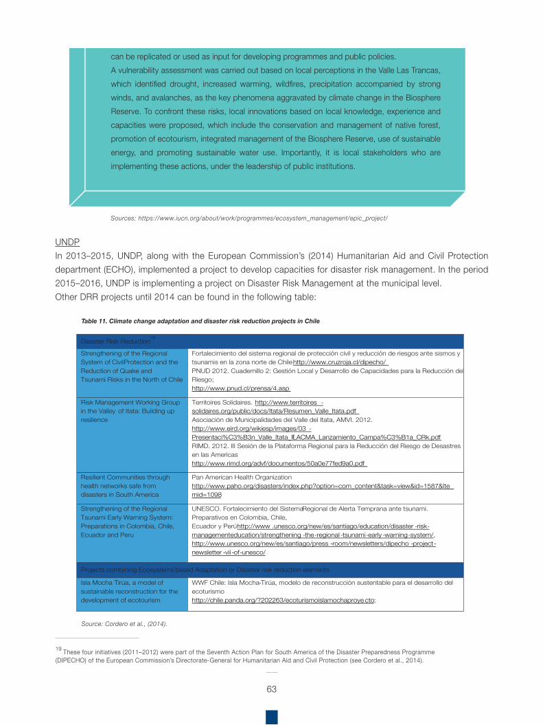
UNDPIn 2013–2015, UNDP, along with the European Commission’s (2014) Humanitarian Aid and Civil Protection department (ECHO), implemented a project to develop capacities for disaster risk management. In the period 2015–2016, UNDP is implementing a project on Disaster Risk Management at the municipal level.Other DRR projects until 2014 can be found in the following table:
63
19 These four initiatives (2011–2012) were part of the Seventh Action Plan for South America of the Disaster Preparedness Programme(DIPECHO) of the European Commission’s Directorate‐General for Humanitarian Aid and Civil Protection (see Cordero et al., 2014).
Source: Cordero et al., (2014).
Table 11. Climate change adaptation and disaster risk reduction projects in Chile
Box 6. Community-based Adaptation to Climate Change – Chile
To help protect communities from disasters and tackle the adverse effects of climate change, the Ecosystems Protecting Infrastructure and Communities (EPIC) project investigates the role that healthy ecosystems play in reducing disaster risk and supporting community-based adaptation (CbA) to climate change. EPIC is a five-year initiative funded by Germany’s Federal Ministry of the Environment, Nature Conservation, Building and Nuclear Safety’s International Climate Initiative.
Chile is one of the seven countries participating in this project, which focuses on the Biosphere Reserve Nevados de Chillán – Laguna del Laja, located in the VIII Biobío Region – a global biodiversity hotspot. The reserve is an ecological transition area, located on the limit of two globally threatened ecosystems: the Mediterranean Shrubland of central Chile considered as one of the most vulnerable environments on the planet, and the Valdivian Temperate Rainforest.
In Chile, EPIC implementation is from 2013–2017, and is coordinated by IUCN, working closely with Chile’s Ministry of Environment, Regional Ministerial Secretary of the Biobío Region (SEREMI Biobío) and the Swiss Federal Institute for Forest, Snow and Landscape Research (SLF); the project has also worked in some activities with TERRAM, Universidad Austral de Chile and the University of Chile. It sets out to investigate the protective role of native forest in the face of hazards and subsequent disasters caused by avalanches; and where necessary, explores alternate management and conservation strategies for these forests.
For Chile, there are three main components: 1) demonstrate the importance of environmental management; 2) Strengthen capacities, increase awareness and communicate about the potential for environmental management (at local, regional and national levels) and 3) disseminate through multi-stakeholder platforms, lessons learned and practical solutions which can be replicated or used as input for developing programmes and public policies.A vulnerability assessment was carried out based on local perceptions in the Valle Las Trancas, which identified drought, increased warming, wildfires, precipitation accompanied by strong winds, and avalanches, as the key phenomena aggravated by climate change in the Biosphere Reserve. To confront these risks, local innovations based on local knowledge, experience and capacities were proposed, which include the conservation and management of native forest, promotion of ecotourism, integrated management of the Biosphere Reserve, use of sustainable energy, and promoting sustainable water use. Importantly, it is local stakeholders who are implementing these actions, under the leadership of public institutions.
Sources: https://www.iucn.org/about/work/programmes/ecosystem_management/epic_project/
Disaster Risk Reduction19
Strengthening of the Regional System of Civil Protection and the Reduction of Quake and Tsunami Risks in the North of Chile
Fortalecimiento del sistema regional de protección civil y reducción de riesgos ante sismos y tsunamis en la zona norte de Chile http://www.cruzroja.cl/dipecho/ PNUD 2012. Cuadernillo 2: Gestión Local y Desarrollo de Capacidades para la Reducción del Riesgo; http://www.pnud.cl/prensa/4.asp
Risk Management Working Group in the Valley of Itata: Building up resilience
Territoires Solidaires. http://www.territoires -solidaires.org/public/docs/Itata/Resumen_Valle_Itata.pdfAsociación de Municipalidades del Valle del Itata, AMVI. 2012. http://www.eird.org/wikiesp/images/03 -Presentaci%C3%B3n_Valle_Itata_FLACMA_Lanzamiento_Campa%C3%B1a_CRk.pdf RIMD. 2012. III Sesión de la Plataforma Regional para la Reducción del Riesgo de Desastres en las Americas http://www.rimd.org/advf/documentos/50a0e77fed9a0.pdf
Resilient Communities through health networks safe from disasters in South America
Pan American Health Organization http://www.paho.org/disasters/index.php?option=com_content&task=view&id=1587&Itemid=1098
Strengthening of the Regional Tsunami Early Warning System: Preparations in Colombia, Chile, Ecuador and Peru
UNESCO. Fortalecimiento del Sistema Regional de Alerta Temprana ante tsunami. Preparativos en Colombia, Chile, Ecuador y Perú http://www .unesco.org/new/es/santiago/education/disaster -risk-managementeducation/strengthening -the-regional -tsunami-early -warning-system/, http://www.unesco.org/new/es/santiago/press -room/newsletters/dipecho -project-newsletter -vii -of-unesco/
Projects combining Ecosystems-based Adaptation or Disaster risk reduction elements
Isla Mocha Tirúa, a model of sustainable reconstruction for the development of ecotourism
WWF Chile: Isla Mocha-Tirúa, modelo de reconstrucción sustentable para el desarrollo del ecoturismo http://chile.panda.org/?202263/ecoturismoislamochaproye cto;
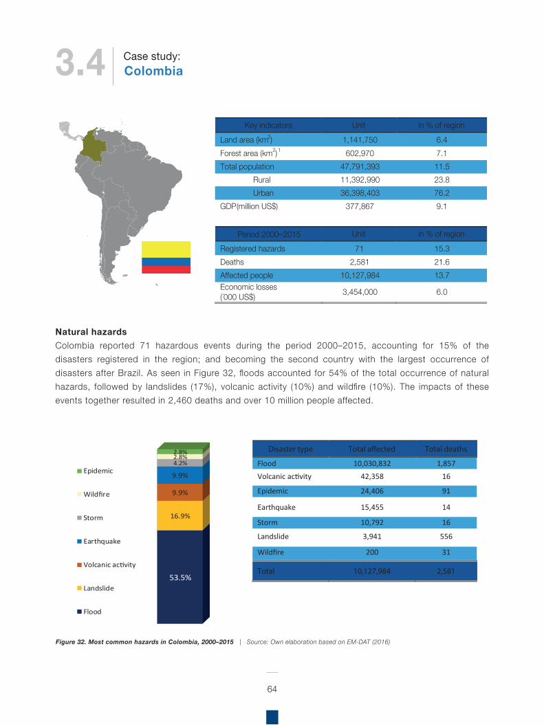
Natural hazardsColombia reported 71 hazardous events during the period 2000–2015, accounting for 15% of the disasters registered in the region; and becoming the second country with the largest occurrence of disasters after Brazil. As seen in Figure 32, floods accounted for 54% of the total occurrence of natural hazards, followed by landslides (17%), volcanic activity (10%) and wildfire (10%). The impacts of these events together resulted in 2,460 deaths and over 10 million people affected.
64
Figure 32. Most common hazards in Colombia, 2000–2015 | Source: Own elaboration based on EM-DAT (2016)
Key indicators Unit in % of region Land area (km2) 1,141,750 6.4 Forest area (km2)1 602,970 7.1 Total population 47,791,393 11.5
Rural 11,392,990 23.8 Urban 36,398,403 76.2
GDP (million US$) 377,867 9.1
Period 2000–2015 Unit in % of region
Registered hazards 71 15.3 Deaths 2,581 21.6 Affected people 10,127,984 13.7 Economic losses (´000 US$) 3,454,000 6.0
53.5%
16.9%
9.9%
9.9%
4.2%2.8%2.8%
Epidemic
Wildfire
Storm
Earthquake
Volcanic activity
Landslide
Flood
Disaster type Total a�ected Total deaths
Flood 10,030,832 1,857 Volcanic activity 42,358 16
Epidemic 24,406 91
Earthquake 15,455 14
Storm 10,792 16
Landslide 3,941 556
Wildfire 200 31
Total 10,127,984 2,581
3.4 ColombiaCase study:
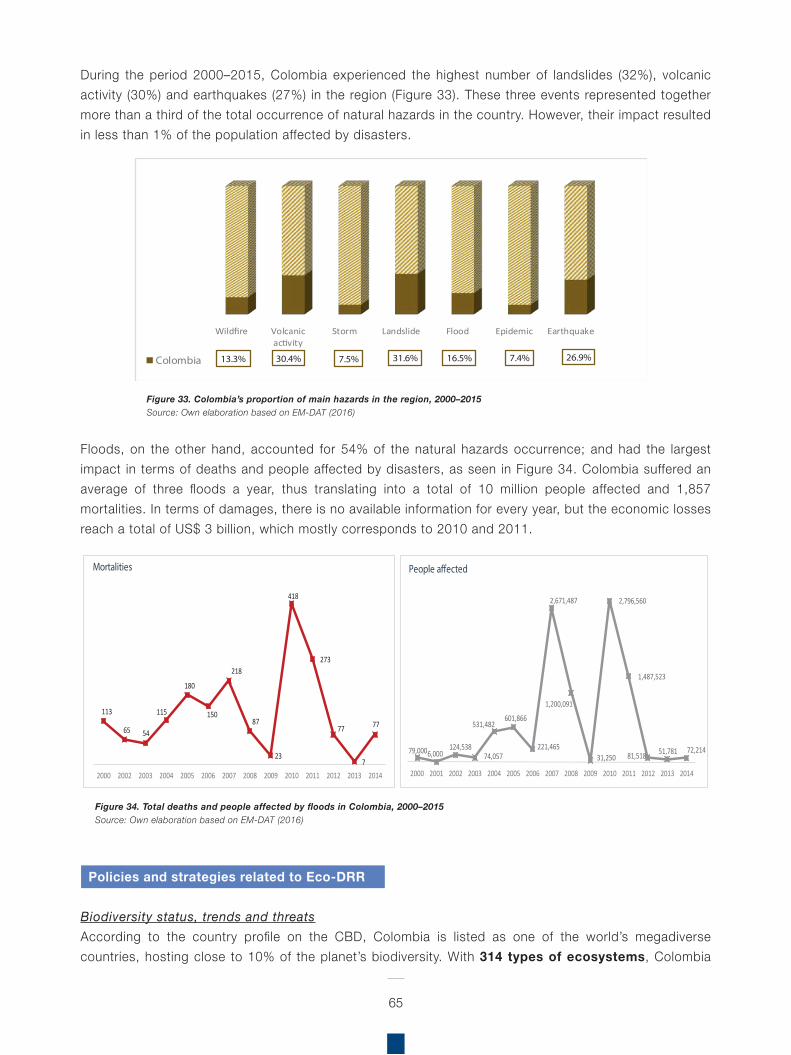
During the period 2000–2015, Colombia experienced the highest number of landslides (32%), volcanic activity (30%) and earthquakes (27%) in the region (Figure 33). These three events represented together more than a third of the total occurrence of natural hazards in the country. However, their impact resulted in less than 1% of the population affected by disasters.
Floods, on the other hand, accounted for 54% of the natural hazards occurrence; and had the largest impact in terms of deaths and people affected by disasters, as seen in Figure 34. Colombia suffered an average of three floods a year, thus translating into a total of 10 million people affected and 1,857 mortalities. In terms of damages, there is no available information for every year, but the economic losses reach a total of US$ 3 billion, which mostly corresponds to 2010 and 2011.
65
Figure 33. Colombia’s proportion of main hazards in the region, 2000–2015Source: Own elaboration based on EM-DAT (2016)
Figure 34. Total deaths and people affected by floods in Colombia, 2000–2015Source: Own elaboration based on EM-DAT (2016)
Wildfire Volcanicactivity
Storm Landslide Flood Epidemic Earthquake
13.3% 30.4% 7.5% 31.6% 16.5% 7.4% 26.9%Colombia
79,000 6,000 124,538
74,057
531,482 601,866
221,465
2,671,487
1,200,091
31,250
2,796,560
1,487,523
81,518 51,781 72,214
2000 2001 2002 2003 2004 2005 2006 2007 2008 2009 2010 2011 2012 2013 2014
People a�ected
113
65 54
115
180
150
218
87
23
418
273
77
7
77
2000 2002 2003 2004 2005 2006 2007 2008 2009 2010 2011 2012 2013 2014
Mortalities
Policies and strategies related to Eco-DRR
Biodiversity status, trends and threatsAccording to the country profile on the CBD, Colombia is listed as one of the world’s megadiverse countries, hosting close to 10% of the planet’s biodiversity. With 314 types of ecosystems, Colombia
possesses a rich complexity of ecological, climatic, biological and ecosystem components. It is ranked as one of the world’s richest countries in aquatic resources, explained in part by the country’s large watersheds feeding into the four massive sub-continental basins of the Amazon, Orinoco, Caribbean, Magdalena-Cauca and the Pacific. The country has several areas of high biological diversity in the Andean ecosystems, characterised by a significant variety of endemic species, followed by the Amazon rainforests and the humid ecosystems in the Chocó biogeographical area. However, a considerable part of these natural ecosystems has been transformed for agriculture, primarily in the Andean and Caribbean regions. It has been estimated that almost 95% of the country’s dry forests have been reduced from their original cover, including close to 70% of typically Andean forests.
The primary terrestrial biomes in Colombia have experienced significant changes; approximately 67% of the national territory is covered by forest (FAO, 2015b). One of the most threatened forest ecosystems is the dry forest, with approximately 2% of its original extension. About 2% of the Colombian mainland is covered by moorlands, considered one of the most important ecosystems for human well-being because of the source of water they provide to more than three-quarters of the population in these areas. The Amazon and Andean regions have the highest number of plant species, followed by the Pacific, the Caribbean region and the Orinoquía.
Colombia’s biodiversity is not only important for the country’s natural heritage and the preservation of unique species in the world, it is also essential for guaranteeing basic conditions for the improvement of human welfare, social equality and economic development today and in the future. Moreover, biodiversity and its functions and processes provide direct-use goods and services, such as food, medicines, fuel, wood and water as well as indirect-use services, such as climate regulation,
prevention of disasters, soil formation, water purification and recreation.
The main threats to the conservation of biodiversity include, among others: increasing social inequality; internal armed conflict for more than five decades; returning to a resource-based economy; the illegal drug trade; weak access policy and titling; the use of extensive livestock and agricultural models. Such factors contribute to habitat degradation, changes in land use, increased presence of invasive species, climate change, overconsumption of services and general pollution dynamics. There are intrinsic elements that threaten biodiversity protection in Colombia, some of which include a lack of political priority for environmental issues in national and sectoral policies, undesired effects of macroeconomic policies, conflict with indigenous rights and traditional knowledge, and conflicts due to a lack of coordination regarding land-use planning that takes place at various state levels20.
Fifth National ReportThere is no specific mention of DRR or hazards in the Fifth National Report; neither does it specify targets related to DRR. It does, however, refer to sea level rise, drought, food security, erosion, water security and sanitation.
Challenges highlighted in the NR5 that would relate to the implementation of EbA in Colombia include:
Lack of coordination of entities involved in the EbA, and a lack of political will in decision making.Key obstacles include:
Mainstreaming biodiversity conservation considerations in the productive sector;Effective solutions to degradation processes, both sectoral and global in nature; Unresolved social and environmental conflicts regarding protected territories;
66
20 CBD (n.d). Colombia – Country Profile (https://www.cbd.int/countries/default.shtml?country=co)
67
National Adaptation PlanColombia’s experience with promoting EbA and Eco-DRR within the framework of the NAP is described below.
Colombia’s National Adaptation Plan to Climate Change has been conceived as a dynamic process that started in 2011. The NAP defines guidelines so that the country’s sectors and territories prioritise their actions aimed at reducing vulnerability, and include climate change and climate variability in their planning processes, through the formulation and implementation of territorial and sectoral adaptation plans. These efforts, to date, have focused on the Caribbean and Andean regions, as well as on the transport, housing, energy, agriculture and health sectors, taking into account the damages and losses caused by La Niña phenomena in 2010–2011.
Through national guidelines, the NAP promotes EbA and Eco-DRR approaches by identifying vulnerable socio-ecological systems, concentrating efforts towards analysing impacts of climate change in combination with drivers of transformation and loss of biodiversity and ecosystem services. Additionally, benefits that ecosystem services provide to society are investigated, and options to promote the use of biodiversity and ecosystem services in order to reduce vulnerability of the population in the face of potential disruption that may occur in climate change scenarios. To date, Colombian entities have formulated 11 territorial adaptation plans to climate change, which have prioritised adaptation actions. These plans are the basis for decision-makers to identify the vulnerability of the territory and define adaptation measures to be incorporated in the different development and spatial planning instruments.
EbA and the Eco-DRR measures that are currently being implemented in the NAP include:
The rehabilitation of wetlands and their hydrology as a means to reduce risk of flooding
Deficit in economic valuation of biodiversity and cultural values;Budgetary resources destined for biodiversity management have been reducing since 1996; Fragmentation of responsible institutions for environmental management;Insufficient citizen participation mechanisms for environmental management (environmental governance); Failure to explicitly recognise the importance of transformed ecosystems;Inexistence of sustainability criteria and action plans for fisheries and marine biological resources.
National Biodiversity Strategy and Action Plan (NBSAP)Colombia has included aspects related to EbA in its NBSAP, which is focused on both people and nature (although EbA is not explicitly included in policies and strategies).
Protected Areas: Protected Area system extended to exceed 17% of land area, as well as three new national marine protected areas. Management agreements and strategies with active community participation for the valuation and conservation of ecosystem services related to protected areas, and for their sustainable use by local communities.Restoration/rehabilitation: The area designated for restoration during 2010–2014 was 68,597 ha, equivalent to 15% of the planned goal. According to the restoration map (1:100.000), a high restoration priority has been designated to 3,700,000 ha, and a very high priority to 1,158,000 ha. Additionally, as part of Initiative 20x20, Colombia has committed a total of 1 million hectares for restoration by 2020, this will be achieved through the Ministry of Agriculture.Build adaptive capacity, technical capacity, education and awareness: Community Environmental Education Projects (PROCEDA).
68
and drought associated with climate change and variability.The identification and implementation of adaptation measures designed to mitigate the impacts of climate change on the water yield and hydrological regulation capacity of the wetlands and high mountain ecosystem.
The NAP also identifies key entry points for the application of EbA and the Eco-DRR approaches regarding water supply, specifically:
Moors (páramo, Andean woodlands), wetlands, high Andean forests, cloud forests and tropical forestsAbility of soils and microclimates setting for growing cropModeration of extreme events through buffer structures Prevention of erosion and sediment control.
The Government of Colombia participated in the CBD Technical Workshop on EbA and Eco-DRR (SCBD, 2016). Additionally, Colombia implemented an Integrated National Adaptation Plan (INAP)21 to address climate change threats. In line with the promotion of EbA approaches and policy interventions to address climate change impacts, with particular emphasis on high mountain ecosystems in the country. Further detail on the INAP is provided in the next section outlining Eco-DRR Initiatives in Colombia.
Protected AreasColombia’s Climate Change Adaptation Framework for Marine Protected Areas addresses the need for developing a framework methodology integrating i) technical actions to assess climate risks and resilience of the protected area’s conservation targets, ii) prioritisation of climate adaptation actions, iii) implementation of priority actions to increase resilience and adaptation capacity; and iv) integrating adaptation measures with the park’s existing planning tools in Gorgona National Park.
The project provides a framework that allows protected area managers in Colombia to mainstreamthe necessary actions to increase the resilience of coastal and marine ecosystems within the existing planning framework, strengthening the protected areas capacity to provide environmental goods and services, and to benefit conservation objectives and communities in the face of existing and future climate conditions.
Ecological benefits: Gorgona National Park aims to maintain ecological integrity of its conservation targets, particularly coral reefs and the pelagic ecosystem. To that end, the protected area periodically (every 4–5 years) assesses ecological integrity of its conservation targets and monitors climate adaptation benefits.
Social benefits: It allows the local fisheries to coordinate their activities to protect a common resource. It also increases information and knowledge about the benefits of the protected area.
Economic benefits: An increase in fish stocks is expected. Continual monitoring is carried out to report accurate results.
21 INIAP was a GEF funded project, which was implemented until 2011, with support from the World Bank.
Regional Assessment on Ecosystem-based Disaster Risk Reduction and Biodiversity in South America
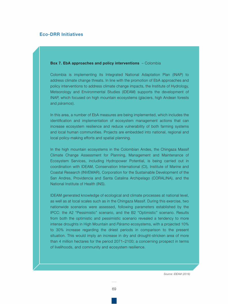
69
Box 7. EbA approaches and policy interventions – Colombia
Colombia is implementing its Integrated National Adaptation Plan (INAP) to address climate change threats. In line with the promotion of EbA approaches and policy interventions to address climate change impacts, the Institute of Hydrology, Meteorology and Environmental Studies (IDEAM) supports the development of INAP, which focused on high mountain ecosystems (glaciers, high Andean forests and páramos).
In this area, a number of EbA measures are being implemented, which includes the identification and implementation of ecosystem management actions that can increase ecosystem resilience and reduce vulnerability of both farming systems and local human communities. Projects are embedded into national, regional and local policy-making efforts and spatial planning.
In the high mountain ecosystems in the Colombian Andes, the Chingaza Massif Climate Change Assessment for Planning, Management and Maintenance of Ecosystem Services, including Hydropower Potential, is being carried out in coordination with IDEAM, Conservation International (CI), Institute of Marine and Coastal Research (INVEMAR), Corporation for the Sustainable Development of the San Andres, Providencia and Santa Catalina Archipelago (CORALINA), and the National Institute of Health (INS).
IDEAM generated knowledge of ecological and climate processes at national level, as well as at local scales such as in the Chingaza Massif. During this exercise, two nationwide scenarios were assessed, following parameters established by the IPCC: the A2 “Pessimistic” scenario, and the B2 “Optimistic” scenario. Results from both the optimistic and pessimistic scenario revealed a tendency to more intense droughts in High Mountain and Páramo ecosystems, with a projected 10% to 30% increase regarding the driest periods in comparison to the present situation. This would imply an increase in dry and drought-stricken area of more than 4 million hectares for the period 2071–2100; a concerning prospect in terms of livelihoods, and community and ecosystem resilience.
Source: IDEAM (2016)
Eco-DRR Initiatives
70
Fundación Humedales, with the Corporación Autónoma Regional de los Valles del Sinú and San Jorge-CVS, coordinated the development of the management plan for the Arroyo Carolina micro-watershed, located in the Planeta Rica, San Carlos and Pueblo Nuevo Municipalities, and is of particular importance for the area because:
It is the primary water source for the Planeta Rica aqueduct, which provides water to the large farms in the region that work mostly in cattle raising, commercial forestry plantations, and oil palm production, as well as smallholder farmers from the upper watershed. It receives wastewater discharge from the Planeta Rica urban centre.It is a seasonal watershed, with its rivers and streams fed by runoff and direct rainfall in winter, but it is dried up in summer months.
The micro-watershed includes tropical dry forest, gallery forest, and the aforementioned agricultural lands in the Department of Córdoba. This work enabled the different uses of the watershed to be identified and mapped, with an associated vulnerability analysis and management plan oriented towards CCA.
Key hazards identified for the watershed include: floods, torrential rain, landslides, contamination of water supply, and different combinations of these. These risk factors were overlapped with the land-use zoning for the watershed, which allowed high risk areas to be identified and mapped. The management plan detailed relevant mitigation measures designed for each land-use type and risk; these Eco-DRR measures were associated specifically with the restoration and recovery of ecosystems present in the watershed.
In relation to the role of Andean wetlands in response to climate change, Fundación Humedales developed a vulnerability assessment and adaptation strategy for a wetland complex in the highlands on the Eastern Cordillera of the Colombian Andes –Lagunas de Fúquene, Cucunubá and Palacio– located in
the Altiplano Cundiboyacense, between the departments of Cundinamarca and Boyacá. This involved fieldwork, historical climate and hydrological data, land cover maps, workshops and interviews with local and regional stakeholders relevant for the management and use of ecosystem services derived from the lagoons in the Valle del Río Ubaté.
The Department for Western Andes Territory ––from the Department of National Parks––implement an ongoing zone management system in the high mountain landscapes of the Western Andes in Colombia. Implicit to this work, is the definition of activities relevant for the risks identified for each zone; which include restoration, population management and regulation of access.
Payment for Ecosystem Services (PES) schemes to compensate protected areas, communities, indigenous peoples and private landowners for maintaining forests and other water regulating habitats are being piloted for water services in Colombia (Lopoukhine et al., 2012)
WWFAs part of its initiative for reducing risk in river basins prone to flooding, WWF developed “Reducing the Risk of Floods: A Good Practices Guide for Natural Resource Based Practices”. This guide includes capacity building material on DRR, based on integrated management of ecosystems and green infrastructure.
Alexander von Humboldt Research Institute of Biological ResourcesThe Alexander von Humboldt Research Institute, along with public companies from Medellin and the Autonomous Corporation of Antioquia, is currently implementing a project to restore highly degraded dry forests in the Ituango Municipality, Department of Antioquia. The restoration activities are envisioned to compensate environmental harm caused by the construction of a reservoir, and to contribute to the conservation of the fragile dry forest ecosystem of the area. Three pilot projects will restore 17,000 ha
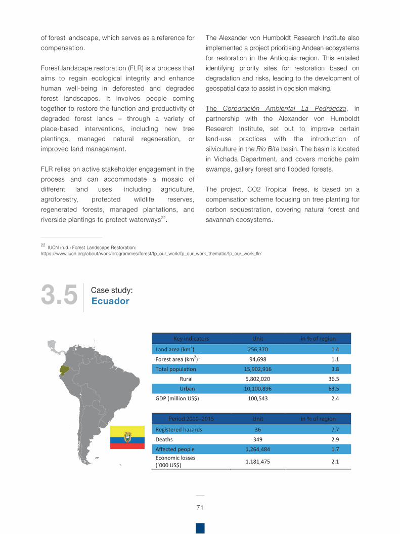
71
of forest landscape, which serves as a reference for compensation.
Forest landscape restoration (FLR) is a process that aims to regain ecological integrity and enhance human well-being in deforested and degraded forest landscapes. It involves people coming together to restore the function and productivity of degraded forest lands – through a variety of place-based interventions, including new tree plantings, managed natural regeneration, or improved land management.
FLR relies on active stakeholder engagement in the process and can accommodate a mosaic of different land uses, including agriculture, agroforestry, protected wildlife reserves, regenerated forests, managed plantations, and riverside plantings to protect waterways22.
The Alexander von Humboldt Research Institute also implemented a project prioritising Andean ecosystems for restoration in the Antioquia region. This entailed identifying priority sites for restoration based on degradation and risks, leading to the development of geospatial data to assist in decision making.
The Corporación Ambiental La Pedregoza, in partnership with the Alexander von Humboldt Research Institute, set out to improve certain land-use practices with the introduction of silviculture in the Río Bita basin. The basin is located in Vichada Department, and covers moriche palm swamps, gallery forest and flooded forests.
The project, CO2 Tropical Trees, is based on a compensation scheme focusing on tree planting for carbon sequestration, covering natural forest and savannah ecosystems.
22 IUCN (n.d.) Forest Landscape Restoration:https://www.iucn.org/about/work/programmes/forest/fp_our_work/fp_our_work_thematic/fp_our_work_flr/
Key indicators Unit in % of region
Land area (km2) 256,370 1.4
Forest area (km2)1 94,698 1.1
Total population 15,902,916 3.8
Rural 5,802,020 36.5
Urban 10,100,896 63.5
GDP (million US$) 100,543 2.4
Period 2000–2015 Unit in % of region
Registered hazards 36 7.7
Deaths 349 2.9
Affected people 1,264,484 1.7 Economic losses (´000 US$) 1,181,475 2.1
3.5 EcuadorCase study:
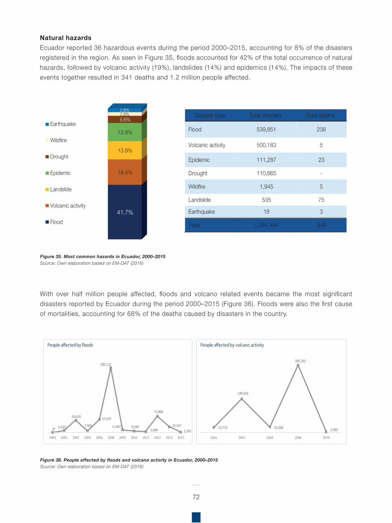
Natural hazardsEcuador reported 36 hazardous events during the period 2000–2015, accounting for 8% of the disasters registered in the region. As seen in Figure 35, floods accounted for 42% of the total occurrence of natural hazards, followed by volcanic activity (19%), landslides (14%) and epidemics (14%). The impacts of these events together resulted in 341 deaths and 1.2 million people affected.
With over half million people affected, floods and volcano related events became the most significant disasters reported by Ecuador during the period 2000–2015 (Figure 36). Floods were also the first cause of mortalities, accounting for 68% of the deaths caused by disasters in the country.
72
Figure 35. Most common hazards in Ecuador, 2000–2015Source: Own elaboration based on EM-DAT (2016)
Figure 36. People affected by floods and volcano activity in Ecuador, 2000–2015Source: Own elaboration based on EM-DAT (2016)
41.7%
19.4%
13.9%
13.9%
5.6%2.8%2.8%
Earthquake
Wildfire
Drought
Epidemic
Landslide
Volcanic activity
Flood
Disaster type Total affected Total deaths
Flood 539,851 238
Volcanic activity 500,183 5
Epidemic 111,287 23
Drought 110,665 -
Wildfire 1,945 5
Landslide 535 75
Earthquake 18 3
Total 1,264,484 349
32 9,530
54,633
7,905
57,670
289,122
11,807 6,940 3,600
71,860
25,567 1,185
2000 2001 2002 2003 2006 2008 2009 2010 2011 2012 2013 2015
People a�ected by �oods
22,770
149,650
25,000
300,263
2,500
2001 2002 2003 2006 2010
People a�ected by volcano activity
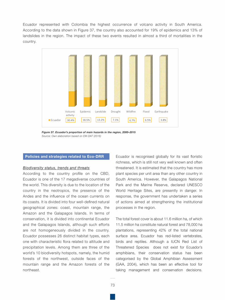
Ecuador represented with Colombia the highest occurrence of volcano activity in South America. According to the data shown in Figure 37, the country also accounted for 19% of epidemics and 13% of landslides in the region. The impact of these two events resulted in almost a third of mortalities in the country.
73
Figure 37. Ecuador’s proportion of main hazards in the region, 2000–2015 Source: Own elaboration based on EM-DAT (2016)
Policies and strategies related to Eco-DRR
Biodiversity status, trends and threatsAccording to the country profile on the CBD, Ecuador is one of the 17 megadiverse countries of the world. This diversity is due to the location of the country in the neotropics, the presence of the Andes and the influence of the ocean currents on its coasts. It is divided into four well-defined natural geographical zones: coast, mountain range, the Amazon and the Galapagos Islands. In terms of conservation, it is divided into continental Ecuador and the Galapagos Islands, although such efforts are not homogeneously divided in the country. Ecuador possesses 26 distinct habitat types, each one with characteristic flora related to altitude and precipitation levels. Among them are three of the world’s 10 biodiversity hotspots, namely, the humid forests of the northwest, outside faces of the mountain range and the Amazon forests of the northeast.
Ecuador is recognised globally for its vast floristic richness, which is still not very well known and often threatened. It is estimated that the country has more plant species per unit area than any other country in South America. However, the Galapagos National Park and the Marine Reserve, declared UNESCO World Heritage Sites, are presently in danger. In response, the government has undertaken a series of actions aimed at strengthening the institutional processes in the region.
The total forest cover is about 11.6 million ha, of which 11.5 million ha constitute natural forest and 78,000 ha plantations, representing 42% of the total national surface area. Ecuador has red-listed vertebrates, birds and reptiles. Although a IUCN Red List of Threatened Species does not exist for Ecuador’s amphibians, their conservation status has been categorised by the Global Amphibian Assessment (GAA, 2004), which has been an effective tool for taking management and conservation decisions.
Volcanicactivity
Epidemic Landslide Drought Wildfire Flood Earthquake
30.4% 18.5% 13.2% 7.1% 6.7% 6.5% 3.8%Ecuador
74
No documentation exists to clarify the conservation status of fish species. Ecuador recognises that in spite of the fact that information on biodiversity has increased in the last few years, information is still lacking in regard to the country’s ecosystems and drivers of change to biodiversity.
The Galapagos Islands are unique in the world in that they are a self-contained ecological system and an ecoregion with a high level of biological endemism. These islands constitute the last undisturbed ecosystem of insects in the world where it is possible to identify patterns that existed before homogenisation by introduced species of insects. Notably, it is estimated that 50% of vertebrates could become extinct if conservation efforts are not successful. Bird species appear to have a greater potential risk of extinction. In the last few years, there has been no evidence of biodiversity loss. To this day, 95% of the original biodiversity has been maintained. The Galapagos could represent one of the largest conservation challenges and opportunities for Ecuador.
The main threat to biodiversity conservation in Ecuador is deforestation, with the country ranked second among Latin American countries in terms of highest levels of deforestation. Firewood collection, urban expansion, petroleum exploration and exploitation, agriculture, mining, fishing, overexploitation of natural resources, poverty, human migrations, tourism development, and introduced species are other important aspects contributing to the deterioration of the country’s biological richness in both continental and island areas.
Biodiversity has been integrated in the following sectors: agriculture, education, health, fisheries, water resources, mining and petroleum, tourism and commerce/industry.
Continental Ecuador does not possess any plans or legislation on land use. Conversely, the Galapagos Islands have strong spatial plans. In the last 10 years, legislation regarding the development of the islands has been put in place, restricting residents’ freedom
of rights, ownership and commercial activity. Spatial plans in the Galapagos include a regional plan to regulate land management, the Galapagos National Park Management Plan and the Galapagos Marine Reserve Management Plan.
The National Development Plan highlights a number of protection and recovery initiatives related to forests (e.g. National Decentralised Forest Control System, Reforestation and Conservation Programme for the Chongón-Colonche Mountain Range, Green Watch Program, National Forestry Program, National Plan for Afforestation and Reforestation, strengthening of an outsourced system for forest control).
Fifth National ReportAlthough there are no specific DRR targets in Ecuador’s Fifth National Report, it does mention DRR. Also, highlighting the following natural hazards, and their importance in the country: flood/storm surge, sea level rise, drought, food security, fire, erosion and sanitation.
Challenges highlighted in the NR5 related to the implementation of EbA in Ecuador include:
Transboundary cooperation to implement Conservation Corridor and Sustainable Development projects, serving as management models, and to reduce existing conservation pressures and threats, to improve protected area management and contribute to social cohesion and border integration in the Putumayo region.A serious challenge is to reduce the expansion of the agricultural frontier, illegal logging, defaunation, natural system disruption, and negative impacts of development projects, especially hydrocarbon, hydroelectric, mining, infrastructure in natural forest areas and páramos.Data reveals deterioration in terms of quantity and quality of forest cover and natural ecosystems, and an increase in the number of endangered and threatened species. Ecosystem goods and services are subsequently experiencing significant disturbances, and with these, affecting the national and local population.
75
23 CBD (n.d). Ecuador – Country Profile (https://www.cbd.int/countries/default.shtml?country=ec)
No documentation exists to clarify the conservation status of fish species. Ecuador recognises that in spite of the fact that information on biodiversity has increased in the last few years, information is still lacking in regard to the country’s ecosystems and drivers of change to biodiversity.
The Galapagos Islands are unique in the world in that they are a self-contained ecological system and an ecoregion with a high level of biological endemism. These islands constitute the last undisturbed ecosystem of insects in the world where it is possible to identify patterns that existed before homogenisation by introduced species of insects. Notably, it is estimated that 50% of vertebrates could become extinct if conservation efforts are not successful. Bird species appear to have a greater potential risk of extinction. In the last few years, there has been no evidence of biodiversity loss. To this day, 95% of the original biodiversity has been maintained. The Galapagos could represent one of the largest conservation challenges and opportunities for Ecuador.
The main threat to biodiversity conservation in Ecuador is deforestation, with the country ranked second among Latin American countries in terms of highest levels of deforestation. Firewood collection, urban expansion, petroleum exploration and exploitation, agriculture, mining, fishing, overexploitation of natural resources, poverty, human migrations, tourism development, and introduced species are other important aspects contributing to the deterioration of the country’s biological richness in both continental and island areas.
Biodiversity has been integrated in the following sectors: agriculture, education, health, fisheries, water resources, mining and petroleum, tourism and commerce/industry.
Continental Ecuador does not possess any plans or legislation on land use. Conversely, the Galapagos Islands have strong spatial plans. In the last 10 years, legislation regarding the development of the islands has been put in place, restricting residents’ freedomof rights, ownership and commercial activity. Spatial plans in the Galapagos include a regional plan to
regulate land management, the Galapagos National Park Management Plan and the Galapagos Marine Reserve Management Plan.
The National Development Plan highlights a number of protection and recovery initiatives related to forests (e.g. National Decentralised Forest Control System, Reforestation and Conservation Programme for the Chongón-Colonche Mountain Range, Green Watch Program, National Forestry Program, National Plan for Afforestation and Reforestation, strengthening of an outsourced system for forest control)23.
Fifth National ReportAlthough there are no specific DRR targets in Ecuador’s Fifth National Report, it does mention DRR. Also, highlighting the following natural hazards, and their importance in the country: flood/storm surge, sea level rise, drought, food security, fire, erosion and sanitation.
Challenges highlighted in the NR5 related to the implementation of EbA in Ecuador include:
Transboundary cooperation to implement Conservation Corridor and Sustainable Development projects, serving as management models, and to reduce existing conservation pressures and threats, to improve protected area management and contribute to social cohesion and border integration in the Putumayo region.A serious challenge is to reduce the expansion of the agricultural frontier, illegal logging, defaunation, natural system disruption, and negative impacts of development projects, especially hydrocarbon, hydroelectric, mining, infrastructure in natural forest areas and páramos.Data reveals deterioration in terms of quantity and quality of forest cover and natural ecosystems, and an increase in the number of endangered and threatened species. Ecosystem goods and services are subsequently experiencing significant disturbances, and with these, affecting the national and local population.
National Biodiversity Strategy and Action Plan (NBSAP)The National Biodiversity Policy and Strategy (Política y Estrategia Nacional de Biodiversidad del Ecuador 2001–2010) addresses five main themes: fragile ecosystems (with a particular emphasis on páramo, wetlands, mangroves, marine ecosystems and dry forest), strengthening of the protected areas national system and protection of threatened species, sustainable agriculture and the rehabilitation of degraded areas (emphasising food security and sovereignty), biocommerce, biosafety and genetic resources.
The document proposes 4 main strategic axes, as well as management measures, areas of priority and actions: (1) consolidate and strengthen the sustainability of production activities based on native biodiversity; (2) ensure the existence, integrity and functionality of all biodiversity components (ecosystems, species, genes); (3) balance pressures from conservation and sustainable use on biodiversity; and (4) guarantee the respect and exercise of individual and collective rights to participate in decisions related to access and control of resources, and ensure that the benefits derived from the conservation and sustainable use of biodiversity, as well as from the use of knowledge, innovations and practices of the indigenous communities and local populations, are justly and equitably distributed. It is recognised that, in spite of the existence of Environmental Impact Assessment legislation, the State has often failed to comply with the constitutional mandate to consult affected populations. Other sectors that have also not complied with this mandate are agribusiness, mining, manufacturing, timber and fisheries.
To date, the NBSAP has not been properly implemented due to its many limitations (e.g. the scope of competencies of different government levels is unclear, mainstreaming strategies are limited). Also, the legal framework for the NBSAP is incomplete and one of the main obstacles to its implementation. Moreover, initiatives in Ecuador are
not necessarily linked to the NBSAP, which was created in 2000 and only approved in 2007. Consequently, initiatives have followed a “common sense” approach and considered the experiences gained by different private, public and international organisations.
Ecuador is currently in the process of updating its NBSAP. And the implementation of the CBD 2011–2020 Strategic Plan in Ecuador is ongoing.
Ecuador includes EbA related aspects in its NR5 / NBSAP, with a particular focus on nature.
Assess impacts, risk or vulnerability of people from climate change impacts, evaluate scenarios: the project Climate Change Adaptation with Effective Water Governance in Ecuador (PACC) has contributed with decision-making tools, such as the application of climate change scenarios, vulnerability studies, capacity strengthening and formation of national and local stakeholders related to the management of water resources, agriculture, hydroelectricity, and the provision of water for human consumption. Protected Areas:
5,014,993 ha correspond to 19.6% terrestrial and 13,500,000 ha marine protected areas.National System of Protected Areas (SNAP) is currently composed of 51 areas (divided into eight protected area management categories).
Restoration/rehabilitation: As part of the national policy on the Governance of Natural Heritage, in 2011 the process began for ecological restoration of degraded areas in ecosystems considered key for development in the country; in the period 2011–2013, approximately 42,000 ha were restored. Additionally, as part of Initiative 20x20, Ecuador has committed a total of 500,000 hectares for restoration by 2020, this will be achieved through the Ministry of Environment.
76
77
red-footed booby, mangrove finch), as well as to the recovery of important ecosystems. Studies have been conducted on turtles and the pink iguana, as have censuses on native and endemic bird populations.
The Ministry of Environment has developed and promoted initiatives to train and educate forest rangers in Ecuador. A Marine Coastal Environmental Education Programme also exists which aims to raise biodiversity awareness among populations living in coastal zones and on riverbanks. Public awareness programmes require strengthening as current resources are insufficient to influence public opinion. Numerous activities have emerged from local initiatives and are linked to issues such as forest resources management, alternatives to reduce marginalisation and poverty, definition of the uses of biodiversity products and environmental services, among others.
The three objectives of another initiative entitled the “Socio Bosque” (Forest Partnership) Programme24 include: the protection of forests and their economic, ecological and cultural values; the reduction of deforestation rates and forest degradation and associated GHG; the improvement of the living conditions of the poor through sustainable forest management. However, due to limited resources, there are no programmes to control invasive species in continental Ecuador. However, an inspection and quarantine system exists in the Galapagos to prevent the introduction of new species and organisms to the region.
A project focused on capacity building for socioeconomic assessment of the High Andean wetlands is underway. Activities include training and awareness raising for environmental decision-makers, municipal technicians, water authorities and other groups on the values and functions of local wetlands through socioeconomic assessments. Efforts are concentrated on two regions in particular (Tungurahua and Ona-Saraguro-Yacuambi). Training modules for socioeconomic valuation have been developed.
Build adaptive capacity, technical capacity, education and awareness: To strengthen capacities of protected area officials, the Ministry of Environment, along with EcoFondo Foundation and the Centre of Education and Promotion (CEPP), established the Green Classroom Programme. Through vocational training, this Programme constitutes a national effort to improve SNAP and wildlife management in the country.Manage threats to biodiversity, e.g. invasive species (AIS): Of the 44 introduced alien species, five species have been identified for their greater incidence and impact for the agricultural sector, as well as ecosystems and even on human health in Ecuador. Competent state institutions operate management plans for the monitoring and eradication of these species. REDD+: Since 2009, Ecuador has been participating, and advancing in preparations for REDD+, generating institutional arrangements and information gathering from the forest sector to ensure adequate policy, technical, legal and institutional capacities necessary for REDD+ implementation.
Aichi Biodiversity Targets
The government has taken several important steps in the Galápagos Islands to support the conservation of biodiversity (e.g. conversion of 96% of land area into a national park, commitment to protect the Galapagos as a World Heritage Site and Biosphere Reserve, creation of the Marine Reserve of the Galapagos).
As a result of various initiatives, such as the Reforestation and Conservation Programme for the Chongón-Colonche Mountain Range, the rate of deforestation has been reduced from 2.39% (1990–2000) to less than 0.5% (2005) annually. In the last 10 years, the clearing of mangroves has also been reduced. Conservation advances in the Galapagos Islands correspond to the recovery of threatened species (e.g. giant turtles, iguanas,
24 http://sociobosque.ambiente.gob.ec/
78
National Adaptation Plan
The Ministry of Environment is responsible for implementing the National Climate Change Plan, designed to facilitate the coordination of short-term actions, promoting the mainstreaming of climate change in institutions, sectors, and in territory, with effective participation of local communities. Whilst the ecosystems sector promotes actions to improve the resilience of natural heritage in the country.
Additionally, in Ecuador, an assessment of vulnerabilities and impacts was conducted as part of a project on water governance, utilising diverse tools such as climate change scenarios, models, and vulnerability studies, which were used to increase capacity to manage water and agricultural resources (reported in Ecuador’s fifth national report).
National Disaster Management Plans
Ecuador includes disaster risk management in the Constitution and national development plan.
Box 8. Critical Forests and Wetlands to Combat Flooding – Ecuador
In Ecuador, flood control projects use the natural storage and recharge properties of critical forests and wetlands by integrating them into “living with floods” strategies that incorporate forest protected areas and riparian corridors.
Such protection forests also form part of DRR strategies in the country, and will serve to protect infrastructure from frequent disasters including rock fall, avalanches or landslides.
Source: Quintero (2007)
The country’s Secretariat for Risk Management received support from UNDP in the project to strengthen institutional and community capacity at national and local levels, to reduce vulnerability to seismic events in Ecuador. However, this project is focused more on contributing to the process of the New Ecuadorian Construction Code.
The assessment of vulnerabilities and impacts was conducted as part of a project on water governance, utilising diverse tools such as climate change scenarios, models, and vulnerability studies, which were used to increase capacity to manage water and agricultural resources (reported in Ecuador’s fifth national report).
Eco-DRR Initiatives
Direct comparisons between the costs of investing in built infrastructure and maintaining natural habitats as protected areas are scarce, but some countries are already investing in habitat protection or restoration as part of DRR strategies.
The Climate Change Adaptation through an effective water governance project (PACC) had the objective to reduce climate change vulnerability in Ecuador, through the efficient use of water resources. The project has supported the development of the National Climate Change Strategy and the National Climate Change Plan. In addition to 36 community-level projects focused on agroecology and forests, with the recovery of ancient knowledge and practices to ensure sufficient water resources now and in the future.
79
Box 9. Inclusive and sustainable watershed management for CCA - Ecuador
The Corporación Grupo Randi Randi (CGRR) has been implementing a project in the Andean páramos and forest. The project focuses on CCA and incorporates local concerns related to environment, livelihoods and disaster risk in the El Ángel watershed, Ecological Reserve El Ángel region, in the northern Andes of Ecuador.
To promote sustainable livelihoods and reduce the threat of natural disasters such as floods and drought, CGRR is using a coordinated and participatory approach, involving communities, public sector, and civil society and non-governmental organisations to support food security and build resilience to disasters and climate change.
The project works to sustainably and equitably manage water and land resources through the promotion of dialogue, actions and collaboration between small producers, rural families and irrigation consortia with public institutions in the mid- and lower- watershed. Key to improving water resource governance, and therefore to the success of the project, is the role of existing multi-stakeholder spaces, such as the Steering Committee for the Ecological Reserve El Ángel. The Committee enables dialogue among water users in the catchment area (community organisations, local community and local government) to support the inclusive management of water resources in an equitable and sustainable manner. Equally, strengthening community structures to discuss natural resource use and access, and the creation of agreements and mutually beneficial incentives for all water users in the basin.
A contribution towards reducing vulnerability and strengthening resilience to climate change is achieved through adaptation measures and conservation of ecosystem services in the watershed. Implementation of activities incorporated into land-use management plans to protect riverbanks and wetlands in territories within the Ecological Reserve El Ángel. In addition to a study to assess the impact of climate change on principal crops in the lower/medium El Ángel watershed. A climate change vulnerability assessment was carried out in a key irrigation area in Pueblo Viejo, and capacities strengthened for members of the irrigation consortia.
A participatory process permitted the definition and inclusion of relevant climate change considerations in local government development and land-use zoning plans in the El Ángel watershed, including La Libertad and San Isidro. And in collaboration with the University of San Francisco of Quito, a pilot system was implemented for participatory monitoring of water quality and quantity in the micro-watershed Río Mal Paso-Colorado of the El Ángel watershed.
Eco-DRR can be integrated into watershed development planning. Upstream and downstream river users are brought together to tackle disaster risk and development planning in a more integrated manner.
Source: CGRR (2016)
In Ecuador, about 80% of Quito’s more than 1.5 million residents receive drinking water from two protected areas in the Andes, the Cayambe – Coca (400,000 ha) and Antisana Ecological Reserves (120,000 ha). Payments for ecosystem services (PES) schemes to compensate protected areas, communities, indigenous peoples and private landowners for maintaining forests and other water regulating habitats are being piloted for water services in Ecuador (Lopoukhine et al., 2012).
Restoring natural grazing patterns: research in the Chimborazo Faunal Production Reserve has shown the ecological benefits of encouraging the husbandry of native camelids, instead of cattle and horses. Benefits include a higher stocking rate with llamas and improved pasture conditions. New protected areas and mosaics of land use are being designed to establish ecological corridors in the Vilcabamba-Amboró region, a 30 million ha expanse of the Andes in Colombia, Venezuela, Ecuador and Peru (Lopoukhine et al., 2012).
80
Box 10. Addressing Food Security: traditional knowledge for adapting productive systems to climate change - Ecuador
Ecopar implemented a project to strengthen capacities of local stakeholders for the planning and application of CCA measures in the páramos of Chimborazo. The project implemented and promoted sustainable land-use practices in the páramos to reduce climate change vulnerability. This was achieved, in part, through the promotion of policies and strategies that contribute to the conservation and management of páramos, based on ecosystem-based management with an emphasis on local nature-based solutions to CCA.
The project also supported the development of sustainable livestock production in Chorrera Mirador and Pulinguí San Pablo, which included: pastures improvements and the incorporation of windbreaks to reduce vulnerability of pastures to frost and strong winds prevalent in the area. Regarding agriculture and food security, composting pens and organic fertilisers were used to reduce soil degradation. Agroecological or conservation agriculture practices, in addition to improving food security, build on the natural resources smallholder farmers already have, using both local and scientific knowledge. Therefore, promoting actions to improve the productivity and livelihoods of smallholder farmers is crucial to achieving the poverty and food security goals of the Sustainable Development Goals (SDGs).
Management and conservation of the páramos and water resource was implemented by protecting upper-catchment slopes, cultivating grazing areas with native species of trees and shrubs for windbreaks. With the reintroduction of an ancestral technique for water management, the irrigation of alpaca grazing areas was improved. Improvements were made to local water harvesting systems, resulting in increased water availability for irrigation. Restoration of water courses and vulnerable areas to climate impacts was realised with native tree species. Canals were constructed as an alternative for water supplies and fulfilling the regions irrigation needs. Restoration of degraded wetlands, a key source of water for the communities and their livelihoods was also achieved.
These conservation strategies play an important role in preserving the fragile páramo ecosystem, and the agricultural and ecological systems on which the livelihoods of local communities depend. Fundamentally, they also contribute to CCA and DRR for both agroecosystems and households.
Source: Ecopar (2016)
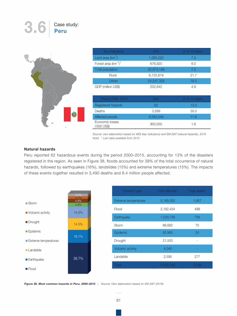
Natural hazardsPeru reported 62 hazardous events during the period 2000–2015, accounting for 13% of the disasters registered in the region. As seen in Figure 38, floods accounted for 39% of the total occurrence of natural hazards, followed by earthquakes (16%), landslides (15%) and extreme temperatures (15%). The impacts of these events together resulted in 3,490 deaths and 8.4 million people affected.
81
Figure 38. Most common hazards in Peru, 2000–2015 | Source: Own elaboration based on EM-DAT (2016)
Source: own elaboration based on WDI (key indicators) and EM-DAT (natural hazards), 2016Note: 1 Last data available from 2012
Key indicators Unit in % of regionLand area (km2 ) 1,285,220 7.3 Forest area (km 2 )1 676,920 8.0 Total population 30,973,148 7.5
Rural 6,725,819 21.7 Urban 24,247,329 78.3
GDP (million US$) 202,642 4.9
Period 2000 -2015 Unit in % of region
Registered hazards 62 13.3 Deaths 3,589 30.0 Affected people 8,582,249 11.6 Economic losses (´000 US$) 900,050 1.6
38.7%
16.1%
14.5%
14.5%
4.8%4.8%3.2%3.2%
Storm
Volcanic activity
Drought
Epidemic
Extreme temperatures
Landslide
Earthquake
Flood
Disaster type Total affected Total deaths
Extreme temperatures 5,189,300 1,957
Flood 2,182,434 498
Earthquake 1,029,738 758
Storm 86,682 75
Epidemic 65,960 24
Drought 21,500 -
Volcanic activity 4,040 -
Landslide 2,595 277
Total 8,582,249 3,589
3.6 PeruCase study:
Floods and earthquakes accounted for over a third of the population affected by natural hazards in the country during the period 2000–2015. While floods were reported almost every year, the worst impact resulting from earthquakes was registered in 2001 and 2007. According to the data, floods affected a total of 2 million people and caused 498 deaths; there is no information about economic losses. The impact of two earthquakes, on the other hand, resulted in 1 million of the population affected, represented US$ 1 million in damages and were responsible for 21% of the total mortalities caused by disasters in the country (Figure 39).
Peru reported the highest occurrence of extreme temperatures in South America, accounting for 24% of these events in the region (Figure 40). Extreme temperatures had the most significant impact in terms of deaths and people affected by natural hazards in the country. These events resulted in 55% of the mortalities associated with disasters in the country, and reached a total of 5 million people affected during the period 2000–2015. However, it is important to point out that their impact has decreased substantially, from 2 million people affected in 2004 to 100,000 people affected in 2014. There is no available information about economic losses related to these events.
82
Figure 39. Total deaths and people affected by floods and earthquakes in Peru, 2000–2015Source: Own elaboration based on EM-DAT (2016)
2215
23 22 17
40
158
20
7268
41
2000 2001 2002 2003 2007 2008 2009 2010 2011 2013 2014
Mortalities caused by �oods
50
66,310 10,868
65,462 7,500 15,325 47,714
450,012
236,308
80,000
822,945
181,121
92,878
105,941
2000 2001 2002 2003 2004 2006 2007 2008 2009 2010 2011 2013 2014 2015
People a�ected by �oods
151
5
593
18
2001 2005 2007 2011 2014
Mortalities caused by earthquakes
354,098
2,505
658,331
2,681 4,435 7,084 604
2001 2005 2007 2011 2012 2013 2014
People a�ected by earthquakes
Peru reported the largest occurrence of most of the natural hazards reported in the region. As seen in Figure 41, the country accounted for 39% of earthquakes, 24% of landslides, 24% of extreme temperatures, 11% of epidemics, 11% of droughts, 10% of floods, 9% of volcanic activity and 5% of storms.
83
Figure 40. Total deaths and people affected by extreme temperatures in Peru, 2000–2015 Source: Own elaboration based on EM-DAT (2016)
Figure 41. Peru’s proportion of main hazards in the region, 2000–2015Source: Own elaboration based on EM-DAT (2016)
In Peru, approximately 65% of the national territory is covered by forest (FAO, 2015b). The country hosts about 25,000 plant species, with 30% endemism. Of these, 4,400 species have known properties and are used by the population. In terms of fauna, it has close to 2,000 fish species; 1,736 bird fauna species; 332 amphibian species; 460 mammals and 365 reptile species. With about 5,528 plant and 760 animal endemic species.
There are a total of 222 endangered species of which, 31 are facing extinction, 89 are classified as vulnerable, 22 are rare species and 80 have an indefinite status.
Policies and strategies related to Eco-DRR
Biodiversity status, trends and threatsAccording to the country profile on the CBD, owing to its rich diversity in ecosystems, species, genetic resources and culture, Peru is one of the world’s megadiverse countries. Its biodiversity is one of the pillars of the national economy, playing a direct role in sustaining a large part of the population, and playing an important role for culture, science and technology, providing essential environmental services in terms of soil fertility, air quality and water supply.
339
90 67
274
409
20
252
1
505
2003 2004 2007 2009 2010 2011 2012 2013 2014
Mortalities
1,839,888
2,137,467
884,572
24,262 57,600 13,440 30,113 92,701 109,257
2003 2004 2007 2009 2010 2011 2012 2013 2014
People a�ected
Earthquake Landslide Extremetemperatures
Epidemic Drought Flood Volcanicactivity
Storm
38.5% 23.7% 23.7% 11.1% 10.7% 10.4% 8.7% 5.0%Peru
84
25 CBD (n.d.). Peru – Country Profile(https://www.cbd.int/countries/profile/default.shtml?country=pe)
Peru is also rich in ecosystem biodiversity with the major biomes being marine, mountain, forest, freshwater and agricultural ecosystems. Peru also has very high cultural diversity with 14 linguistic families, and 44 distinct ethnic groups, of which, 42 are found in the Amazon25.
Fifth National Report
Peru mentions DRR in its NR5, highlights flood/storm surge, sea level rise, drought, food security, fire and erosion, as prevalent hazards in the country, it does not however mention specific targets related to DRR or hazards.
Challenges highlighted in the NR5 related to the implementation of EbA in Peru include:
Need to articulate actions to achieve targets, as there is no planning for implementation of strategy and little consistency in progressAddress threats to mountain and forest ecosystems, caused by land-use change, climate change, deforestation and extractive industries. Meanwhile inland water ecosystems suffer contamination, degradation, damming and overfishing
Lessons learned: Lack of knowledge of biodiversity and the real state of ecosystems in PeruMechanisms and process for evaluation and environmental auditingNecessity to strengthen capacities for conservation management approaches within the National Service of Natural Protected Areas of Peru (SERNANP)Conservation of high biodiversity areas is a priority for the Ministry of Environment (MINAM) and Ministry of Agriculture (MINAGRI)Recovery of vulnerable and threatened species
National Biodiversity Strategy and Action Plan (NBSAP)The vision of the strategy is that by 2021, Peru will be the first country in the world to have the best benefits for its population from its conserved and sustainably used biodiversity, as well as having restored all its biodiversity components in order to meet the basic needs and well-being for present and future generations.The overall objective of the NBSAP is the conservation of biodiversity, sustainable use of its components, fair and equitable sharing of the benefits arising from their use, adequate access to those resources, appropriate transfer of pertinent technologies, taking into account the rights to those resources and technologies, as well as appropriate financing. There are eight specific strategy lines, which have specific objectives and actions defined for each one. These are: the conservation of biodiversity in Peru; integrating sustainable use of biodiversity into the management of natural resources; establishing special measures for the conservation and restoration of biodiversity faced with external processes; promoting participation and engagement from the Peruvian society in the conservation of biodiversity; improving knowledge of biodiversity; perfecting the instruments needed for management of biodiversity; enhancing Peru’s image at the international level; and implementing immediate actions.
In its NBSAP, Peru includes EbA-related aspects; which has a dual focus on both people and nature:
Build adaptive capacity, technical capacity, education and awareness: Important progress has been made for this strategic approach, especially in relation to the educational sector, for instance, the approval of the National Environmental Education Policy (PNEA) and the National Environmental Education Plan 2013–2021 (PLANEA).Government/policy planning and regulatory frameworks/mainstreaming of biodiversity values into national policy:
Organisation of the Annual Meeting for the Climate and Forest Governors
85
Approval of the work plan for the climate change technical commission
Manage threats to biodiversity, e.g. invasive species (AIS): monitor pressure caused by invasive species and living modified organismsNatural resource management (fisheries, forests): Specific objective 2 of the National Aquaculture Development Plan: increase private investment in aquaculture by increasing appropriate areas for this sectorREDD+ related pilot project implementation has occurred in forested National Protected Areas (ANP), in addition to other key areas in the country.
Additionally, as part of Initiative 20x20, Peru has committed a total of 3.2 million hectares for restoration by 2020; this will be achieved through the Ministry of Agriculture.
National Adaptation Plan
Peru is a country highly vulnerable to the adverse effects of climate change; it presents seven of the nine characteristics of vulnerability recognised by the UNFCCC (MINAM, 2016). Therefore, adaptation to climate change is a matter of immediate priority for the country on its way to development.
Peru has put in place several policies and strategies related to adaptation and mitigation of climate change, particularly as a key aspect to reach sustainable development. CCA has been incorporated into different State policies, and it includes other sectors and different levels of the government. The National Climate Change Strategy draft (2015) which was under public consultation last year and approved in September 2015, describes the two main objectives: adaptation and mitigation (see more in Podvin & Arellano, 20T6).
With regards to CCA, after a review of the vulnerabilities and adaptation priorities of the country, and based on the study of the national goals established by the current national planning
documents (Bicentennial Plan, National Plan for Disaster Risk Management – PLANAGERD, Environmental Action Plan – PLANAA, Environment Agenda 2014) and sectoral planning documents (PLANGRACC-A11, Budget Programmes, Integral Plan of mitigation and adaptation to the effects of climate change on public health, among others), the adaptation component is formulated for different sectors and prioritised systems (Republic of Peru, 2015, p. 9).
National Disaster Management Plans
Through the DIPECHO IX project (2015–2016), the UNDP is supporting the country in the implementation of its National Plan for Disaster Risk Reduction (PLANAGERD), by promoting the coordination of the National System for Disaster Risk Reduction (SINAGERD), strengthening institutional capacities and enhancing community preparedness. Through this contribution to improving the PLANAGERD, the principal project objective is to reduce disaster risk for communities and their livelihoods.
The Centre for Conservation, Investigation, and Management of Natural Areas (CIMA – Cordillera Azul), and the National Service of Natural Areas Protected by the State (SERNANP) have been implementing the PNCAZ National Park Programme. The programme also includes the Cordillera Azul National Park REDD Project (PNCAZ), which protects a large area of intact tropical montane forest in the San Martín, Ucayali, Huánuco and Loreto Departments, and will run from 2008–2028.
The protected area in the Peruvian Yungas ecoregion is located on the eastern slopes and valleys of the Peruvian Andes and includes intact forests ranging
Eco-DRR Initiatives
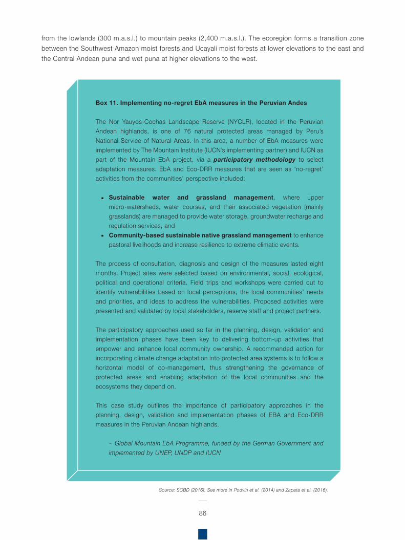
from the lowlands (300 m.a.s.l.) to mountain peaks (2,400 m.a.s.l.). The ecoregion forms a transition zone between the Southwest Amazon moist forests and Ucayali moist forests at lower elevations to the east and the Central Andean puna and wet puna at higher elevations to the west.
86
Box 11. Implementing no-regret EbA measures in the Peruvian Andes
The Nor Yauyos-Cochas Landscape Reserve (NYCLR), located in the Peruvian Andean highlands, is one of 76 natural protected areas managed by Peru’s National Service of Natural Areas. In this area, a number of EbA measures were implemented by The Mountain Institute (IUCN’s implementing partner) and IUCN as part of the Mountain EbA project, via a participatory methodology to select adaptation measures. EbA and Eco-DRR measures that are seen as ‘no-regret’ activities from the communities’ perspective included:
Sustainable water and grassland management, where upper micro-watersheds, water courses, and their associated vegetation (mainly grasslands) are managed to provide water storage, groundwater recharge and regulation services, andCommunity-based sustainable native grassland management to enhance pastoral livelihoods and increase resilience to extreme climatic events.
The process of consultation, diagnosis and design of the measures lasted eight months. Project sites were selected based on environmental, social, ecological, political and operational criteria. Field trips and workshops were carried out to identify vulnerabilities based on local perceptions, the local communities’ needs and priorities, and ideas to address the vulnerabilities. Proposed activities were presented and validated by local stakeholders, reserve staff and project partners.
The participatory approaches used so far in the planning, design, validation and implementation phases have been key to delivering bottom-up activities that empower and enhance local community ownership. A recommended action for incorporating climate change adaptation into protected area systems is to follow a horizontal model of co-management, thus strengthening the governance of protected areas and enabling adaptation of the local communities and the ecosystems they depend on.
This case study outlines the importance of participatory approaches in the planning, design, validation and implementation phases of EBA and Eco-DRR measures in the Peruvian Andean highlands.
~ Global Mountain EbA Programme, funded by the German Government and implemented by UNEP, UNDP and IUCN
Source: SCBD (2016). See more in Podvin et al. (2014) and Zapata et al. (2016).
87
The project focuses on the montane forest, lowland forests in the watershed of the Ucayali River, and the dry forests in the buffer zone of the Huallaga River. Main objectives of the project are to protect a variety of species, biological communities, and geological formations pertaining to the montane forest of the Cordillera Azul; as well, as support the development of an integrated and sustainable management of natural resources in the buffer zone.
By conserving more than 1.3 million ha of intact montane forest and its biodiversity, the project aims to prevent deforestation in the PNCAZ, and to reduce emissions by more than 17 million tCO2e over 10 years. A key component of this is to strengthen the protection strategy of the PNCAZ, promoting a participatory approach to involve local communities and other stakeholders in the management of the park and its buffer zone, thus generating environmental benefits. Strengthening local environmental management strategies builds local capacity for sustainable land use and improves the quality of life of communities inside the buffer zone.
To date, the most comprehensive source of information on EbA in Peru is the Mountain EbA Flagship Programme. Mt. EbA lessons have been shared through the implementing agencies’ (UNDP, UNEP, IUCN and TMI) communication channels; Peru has incorporated them into national adaptation policies and priorities, such as the national environmental training programme of the Ministry of Environment (MINAM) and the development of guidelines for public investment in ecosystem service projects by the MEF. The Peru INDC even refers to the Mountain EbA Programme (among other projects) specifically in the context of results and practical experiences provided by key projects, which have informed the adaptation proposal (Republic of Peru, 2015).
In the period 2013–2015, Practical Action supported the initiative of UNEP’s Regional Gateway forTechnology Transfer and Climate Change Action in
Latin America and the Caribbean (REGATTA), and managed the EbA Community of Practice (EbA CoP). This permits the exchange of experience and knowledge on EbA to climate change. The target group are people and organisations facing similar development challenges, interested in sharing and critically reviewing experiences, and determining how best to apply lessons learned.
In 2014–2017, Save the Children and Practical Action, in coordination with the Metropolitan Municipality of Lima and the Municipality of Carabayllo, are implementing a project to reduce risk in the El Progreso sector of Carabayllo, Lima. This urban area has been prioritised as highly vulnerable to natural disasters, and as such the project aims to increase the resilience of the inhabitants. The project focuses on the Chillón River, produced by glacial melt from the Andes, and investigates risk and proposes risk reduction strategies in this urban context.
As part of the Mountain EbA Project, the ‘Patronato-RPNYC’ carried out a study to understand current capacity and potential for capturing and storing water in the upper Cañete river basin. The project is coordinated by the Nor Yauyos-Cochas Landscape Reserve Foundation (NYCLR-Patronato), along with IUCN-Sur, Universidad Católica Sedes Sapientiae and the RPNYC, and focuses on Lima Region, Yauyos Province in the high basin of the Cañete River, characterised by high Andean wetlands and puna grasslands.
The Nor Yauyos-Cochas Landscape Reserve (RPNYC) is located in the Lima Region, Yauyos Province and in the Junín Region, Jauja Province, in the high and middle basin of the Cañete River and in the Cochas Pachacayo basin. It lies in the Peruvian Yungas and Central Andean wet puna ecoregions. This initiative aimed to establish baseline conditions of water storage capacities of the bofedales and pajonales, as part of an integrated water management strategy in the basin, to increase climate resilience of the socio-ecological system.
88
The aim was to identify critical areas for restoring water storage capacity and to restore the capacity of the bofedales and pajonales to capture and store rainwater through: a) Establishing a baseline of the natural area from 1962; b) Implementing two restoration parcels (bofedales and pajonales) in 17 ha of land with farmer communities in Huancaya.
As part of the “REDD+: Supporting countries and communities to design schemes for benefit sharing” project implemented by IUCN in alliance with the Association for Research and Integral Development (AIDER) and Conservation International-Peru (CI-Peru), there have been pilot ‘REDD+’ activities within CI’s Conservation Agreement framework implemented by CI-Peru in the Native Awajun community ‘Shampuyacu’ in the San Martin region in the Peruvian Amazon. Among these, restoration of riparian ecosystems to promote sustainable river basin management has taken place; specifically, riparian vegetation has been maintained (from an initiative that took place in mid-2013 before this project) and expanded, with increased vegetation cover and protecting crops from river bank erosion and flooding when river levels increase.
Regional Assessment on Ecosystem-based Disaster Risk Reduction and Biodiversity in South America
S
89
26 IWRM has been defined as “a process which promotes the coordinated development and management of water, land and related resources in order to maximise economic and social welfare in an equitable manner without compromising the sustainability of vital ecosystems” (Global Water Partnership).
outh America boasts diverse ecosystems rich in biodiversity, supporting a wide range of flora and fauna, but they also provide many services to the people inhabiting the coastal, high mountains, and Amazon areas. However, these services can only be delivered when the ecosystems are in healthy condition. Whilst it is evident that communities and local populations in the region may instinctively use natural ecosystems such as forests, natural dryland vegetation and mangroves to protect themselves against the impacts of natural hazards, unsustainable land-use practices have led to environmental degradation and left people without these vital ecosystem services, leaving them exposed to increasing risks of disasters.
Disasters due to natural hazards can have adverse environmental consequences; degraded environments can cause or exacerbate the negative impacts of disasters. Additionally, climate change will magnify existing vulnerabilities to disasters due to changing patterns of some hazards (such as heat waves and increased precipitation) in specific regions and due to increased population exposure (IPCC, 2012).
As evidenced, deaths and impacts from disasters in the region have been steadily increasing, and as such, no-regret, cost-effective strategies are to explore and prioritise greater investment in ecosystem services for DRR. But environmental tools for disaster reduction have not yet been widely applied by many practitioners in the region, and although DRR measures are being incorporated into environment and development planning and management in the region, there is still potential to expand this further.
Healthy and well-managed ecosystems -such as coral reefs, mangroves, forests and wetlands-
reduce disaster risk by acting as natural buffers or protective barriers, for instance through flood and landslide mitigation and water filtration and absorption. At the same time, fully functioning ecosystems build local resilience against disasters by sustaining livelihoods and providing important products to local populations (PEDRR, 2010).
The impact a disaster has upon a community is largely determined by how a society manages its environment, how well prepared it is to face adversity, and what resources are available for recovery. DRR requires managing risks with different tools, and hard and soft interventions allow communities to become more resilient by ensuring increased capacity to cope in the face of threats from disasters.
Certainly, ecosystem management approaches can be cost-effective when compared to alternatives like engineered infrastructure; examples in the region include integrated coastal zone management (ICZM), integrated water resource management (IWRM)26, forest landscape restoration, protected areas management and community-based natural resource management.
Eco-DRR is used to demonstrate and promote ecosystem management for DRR. In addition to being cost effective, ecosystem management approaches have the advantage of being well understood, with the benefit of having been tested in a variety of ecosystem types, in different geographical regions, and at different scales. Additionally, they are based on participatory, local ownership, social and institutional governance mechanisms – all of which are critical for DRR implementation.
4 Eco-DRR experiences in the region
T
90
27 The Paraná River is second in length only to the Amazon River among South American rivers.
his section will document practical examples of how Eco-DRR approaches contribute to biodiversity conservation based on the regional assessment.
Argentina: The initiatives carried out by Fundación Hábitat & Desarrollo contribute to biodiversity conservation by protecting wetlands, and the flora and fauna of the ecoregion (Argentine Espinal and the Paraná River27 watershed – the southernmost portion of the Paraná ecoregion). Due to its unique characteristics, and despite its relatively small area, the ecological reserve boasts important biodiversity. The riparian zone provides important wildlife habitat, increasing biodiversity, which also serves as an important wildlife corridor. By conserving wetlands, not only is biodiversity conserved and effective flood defences preserved, but the many other benefits provided by these ecosystems are also safeguarded.
The riparian area serves as an important natural biofilter, protecting the aquatic environment from excessive sedimentation, polluted surface runoff and erosion. The restoration of these zones through revegetation plays a key role in improving water quality, but also significantly reduces soil erosion and flood damage through erosion control. The revegetation plays a specific role in stabilising the soil, keeping carbon in the ground, and protecting the land from drying out.
Bolivia: The initiatives implemented by Amazonia Services highlight the benefits of water and soil management and conservation, to promote biodiversity and the functional integrity of this ecosystem. Waru Waru ensures both effective water collection and subsequent drainage, and therefore
prevents damage due to soil erosion during floods. As such, this technique is particularly interesting forareas with extreme climatic conditions, such as mountainous areas that experience heavy rainfalls and periodic droughts, and where temperature fluctuations range from intense heat to frost. It could also prove very useful in arid and semi-arid areas of the region.
The contribution to biodiversity conservation of the project “Adaptation to the Rapid Impact of Glacier Retreat in the tropical Andes” (2008–2014), includes: soil restoration in the Andean highlands, climate-resilient irrigation techniques, alternative crops and best practices in agriculture; and the prevention of landslides and flash floods due to climate change-induced accelerated glacier melting.
Chile: Although EPIC does not directly contribute to biodiversity conservation, one of the local innovations related to understanding the role of native forests and their ecosystem services, as well as promoting knowledge on this among local stakeholders, which will be taking place in the coming months, also includes relevance for biodiversity aspects (implicitly). Also, as part of these knowledge enhancement actions, the role of the Biosphere Reserve is being highlighted as a category relevant for facing CCA and DRR. Lastly, the study carried out by SLF to understand the role of native forests to protect against avalanches and landslides, has delivered scientific knowledge on the importance of maintaining the current native forest in the study area in the Valley of Las Trancas, as well as supporting with tools and information which could eventually be used to develop green-grey infrastructure to prevent avalanches and landslides specifically in the study area but also replicated in other areas in Chile.
Colombia: The land-use zoning of the Arroyo Carolina micro-watershed actively promotes the creation of exclusive areas for protection and restoration of the natural ecosystems in the micro-watershed. Likewise, within the management plan, mitigation measures designed to improve conditions in the watershed are proposed to protect biodiversity.
Examples of Eco-DRRfor biodiversity
91
The development of the vulnerability assessment and adaptation strategy in the Lagunas de Fúquene, Cucunubá and Palacio proposes a series of measures to reduce vulnerability and to increase the adaptive capacity of the wetland ecosystems in response to climate change. It has the objective of protecting biodiversity and thereby ensuring the vital ecosystem services provided to local communities. As CCA and DRR overlap in many cases, it is important to highlight these efforts to ensure ecosystem services that will also face risks from disasters (often aggravated by climate change impacts).
The project zone management in the high mountain landscapes of the Western Andes contributes towards ecosystem protection and restoration, with a strong focus on protected areas and buffer zones in high mountain landscapes. The WWF promotes conservation and sustainable management of ecosystem practices for the reduction of flood risk, and green infrastructure alternatives.
The FLR activities contribute to biodiversity conservation by restoring the remnants of the dry forest ecosystem, some of which are at increasing risk of flooding, whilst others require protection from increased degradation and landslide risk on steep slopes.
Both projects coordinated by the Corporación Ambiental La Pedregoza, in partnership with the Alexander von Humboldt Research Institute, promoted the use of native tree species.
Ecuador: Through the coordinated development and management of water and land resources in the El Angel watershed, the CGRR places specific emphasis on the land management plans developed for the páramo region. This contributes towards increasing economic and social welfare in an equitable manner without compromising the sustainability of these fragile highland ecosystems.
By contributing to the biodiversity conservation of the ECOPAR project in the Chimborazo province, it thus promotes and recovers environmental practices that
enable adaptation to climate change, whilst improving incomes. Sustainable natural resource management in the Andean páramos mean it is less threatened and, with time, may recover ecosystem integrity, as well as associate species.
Peru: The project carried out by CIMA – Cordillera Azul and SERNANP, contributes to biodiversity conservation as it protects an area of 1.3 million ha within the limits of Cordillera Azul National Park REDD Project (PNCAZ), and will contribute to reducing deforestation and forest degradation in its buffer zone. The conservation of this area will also generate valuable ecosystem services.
In the case of Mt. EbA and component 3 of the project, related to the implementation of EbA measures on the ground, the EbA no-regret measures implemented by IUCN and led by TMI (IUCN’s implementer partner), focused on improving water availability and distribution and enhancing community management of native grasslands, addresses one of the main climate change vulnerabilities related to droughts (threatening also the main livelihood related to cattle farming). In addition, it is expected to reduce the likelihood of fires thanks to increased moisture in the grasslands, which was already seen in August 2015, when a fire in the upper part of the community of Canchayllo did not spread in the area of influence of the EbA measure because of the higher humidity.
As part of the “REDD+: Supporting countries and communities to design schemes for benefit sharing” (IUCN, AIDER and CI-Peru), the activities carried out by CI-Peru of maintaining and expanding the restoration ofriparian ecosystems has increased vegetation cover,and protects crops from river bank erosion and floodingwhen river levels increase. Also, it has increased fruitplants which diversifies the local community’s foodconsumption (promoting food security) and providinghabitat and food for animals (increasing biodiversityconservation). This activity has also been shown to beeffective in engaging local community members inconservation activities with evidence-based benefits.
92
his section will document practical examples of how biodiversity (different species), ecosystems (different habitat types) and means of conservation (different management approaches) contribute to Eco-DRR.
Climate change is a serious threat for local people in the region whose livelihoods depend largely on climate-sensitive activities such as agriculture and exploitation of natural resources. In this way, climate variability and change also threaten food security and agriculture in South America, but by integrating climate adaptation measures into agriculture sectors, vulnerability can be reduced, and adaptive capacity enhanced.
Healthy ecosystems contribute to reducing risk and increasing resilience for people and the environment. Preserving ecosystems such as wetlands, forests and coastal areas – including mangroves and reefs – reduces vulnerability by supporting livelihoods, while acting as physical protection to reduce the impact of hazard events. Ecosystem restoration and sustainable management of natural resources can therefore play an essential role in people’s ability to prevent, manage and recover from disasters and longer term impacts of climate change. These nature-based measures not only provide cost-effective and environmentally friendly infrastructures for risk mitigation, but also enable local communities to build and sustain a safe and productive environment in the long term.
Various forms of capital are critical to ecological and community resilience. Capital is developed during phases of system growth and development. That capital, as well as the influx of capital from broader areas, is critical for system recovery and determining a system’s trajectories (MEA, 2005). Especially important
to natural disasters is the role of maintaining or restoring natural capital in the form of ecosystem goods and services (Liu et al., 2007; Olshansky & Kartez, 1998).
Wetland ecosystems – whether forested or not – are critical buffers for mitigating the impacts of hurricanes in coastal areas (Day et al., 2007). Floodplain ecosystems provide similar functions during extreme floods.
Mangroves play a role as natural coastal defence strategies. Mangroves can serve as ‘bioshields’ or buffers to reduce the impacts of extreme weather events, waves, storm surges, swells, and sea-level rise. Overall coastal resilience (the ability of a system to cope with or recover from “shocks”) to disasters and climate change impacts will be increased if mangroves are considered as an integral part of integrated coastal planning and management. In addition to their coastal protection functions, intact mangrove ecosystems are also important for food security and for sustaining human livelihoods. For example, after a particular disaster event, affected communities often rely on their environment to meet vital needs such as water, food and shelter and in locations where ecosystems and their services have been degraded, the ability of communities to adapt and recover from disaster is reduced.
In water management systems, levees and canals are designed to provide buffers against floodwaters. Examples of buffering can be found in coastal ecosystems. In the state of Florida, governmental policies protect coastal mangrove forests from development. These forests provide buffers against storm surges (Berke & Campanella, 2006), as demonstrated in south Florida in 1992, when Hurricane Andrew severely impacted coastal mangrove forests; these forests took the brunt of the wind and wave energy, thereby sparing the inland areas. Others argue that the protection of barrier islands is critical for similar reasons (Pilkey & Fraser, 2003). Following Hurricane Katrina, Day et al. (2007) demonstrated how management that led to the loss of coastal wetlands in Louisiana increased the vulnerability of the area to hurricane impacts.
T
Role of biodiversity in DRRin South America
93
A growing body of experimental evidence reveals how biotic diversity can stabilise ecosystems that are subject to perturbations. Biological diversity refers to both the different types of species and the different functional roles of species. Tilman et al. (2001) demonstrated that more diversity helped in the recovery of ecosystem functions (productivity, biogeochemical cycling) after a disturbance.
The relationship between biological diversity and resilience has been explored, and biodiversity has a positive influence on ecological resilience. For example, overgrazing in rangelands selectively removes drought-resistant species. When droughts subsequently occur, the system suddenly flips into a shrub-dominated ecosystem, often more prone to wildfires. Similar linkages have been found between response diversity and resilience in a range of ecological systems. Elmqvist et al. (2004) argue that spatial forms of functional diversity (land-use types) build resilience in human community landscapes.
Floods/soil erosion, sea level-rise, tsunamis
The importance of plant diversity (characteristics) for soil bioengineering in watershed management has been investigated, for example, by Oldfield and Olwell (2015), who conclude that seed production in natural ecosystems ensures the regeneration of locally adapted plant species, which provide habitat for wildlife, stabilise soils, control surface-water flow, and contribute to ecological integrity and resilience.
Whilst Petrone and Preti (2010) conducted research on the use of soil bio-engineering techniques for disaster mitigation, environmental restoration and poverty reduction in developing countries. The research focused on the characteristics of suitable autochthonal plants used in soil bioengineering for risk mitigation and environmental restoration in the humid tropics of Nicaragua. The following is a brief description of the chosen plant species:
Erythrina fusca (Lour.) (local common name: Helequeme); member of the Fabaceae family, is a
deciduous tree thickly branched which at its mature stage can reach 20 m in height and about 40 cm in diameter. It is a pioneer species that, in the wild, is frequent in areas subjected to periodic flooding and along streams and waterways, generating pure stands. It requires average precipitations between 1500 and 3000 mm per year and average temperatures between 16–24 oC. It is native to the humid tropics of Central and Southern America. It is the species with the widest distribution within the genus of Erythrina, as it can grow at any altitude between 0 and 2000 m. Erythrina fusca is commonly used as a shadow tree in coffee and cacao plantations, but it is also used for firewood, fodder and healing (IRENA, 1992).
Gliricidia sepium (Jacq.) Steud (local common name: Madero negro); is a member of the Fabaceae family. It is a small- to medium-sized tree, reaching heights between 6 and 20 m (10 m on average), very common in Mexico and Central America. It grows well with a temperature of 20–30 oC, with precipitations between 900 and 1500 mm per year and a five-month dry season. It is used for firewood, fodder and healing (Petrone & Preti, 2008).
Tabebuia rosea (Bertol.) DC (local common name: Roble macuelizo); member of the Bignoniaceae family, is a medium-sized tree (it can reach 20 m in height), with a straight trunk and a wide, irregular crown. As far as soil is concerned, it is not very exacting. It has good climatic adaptability, and it easily colonises untended fields. It is native to central-southern America and is very common all over the territory of Nicaragua. Its red wood is highly appreciated in carpentry for furniture manufacture. Tabebuia rosea also has ornamental and healing uses (IRENA, 1992).
Petrone and Preti concluded that hydrological-risk mitigating actions performed on a basin scale and through naturalistic (live) interventions are not only socially and technically possible, even in hardship areas (by maximising the contribution of the local labour force and minimising the use of mechanical
94
equipment), but also economically sustainable (Petrone & Preti, 2010).
Regarding riparian restoration, the principal goals include erosion control, channel stabilisation, runoff reduction and enhancement of wildlife and fishery habitat. In terms of species selection, Dreesen et al. (2001) found that the appropriate species to establish in degraded riparian zones may or may not be those present before the disturbance occurred.
An intensive study of willow (Salix) species on the Apache-Sitgreaves National Forests has determined the elevation range of occurrence on hundreds of sites on numerous watersheds between 5,500 and 10,000 feet (Granfelt, 2001).
Bioclimatic or ecoregion can determine species suitability in addition to elevation and latitude. As examples, Arizona sycamore (Platanus wrightii S. Wats.) is only a dominant species at mid- elevations in southwest New Mexico and southeast Arizona. Arizona walnut (Juglans major (Torr.) Heller) can be a co-dominant species in southwest New Mexico mountains while little walnut (Juglans microcarpa Berl.) can be a co-dominant in southeast New Mexico (Dick-Peddie, 1993).
While some are obligate riparian species (e.g. willows and cottonwoods); others are facultative or semi-riparian in that they often are found in upland areas. As examples, New Mexico locust (Robinia neomexicana Gray) and aspen (Populus tremuloides Michx.) are often found in montane riparian zones, but also form dense stands on mountain slopes after disturbance (Dick-Peddie, 1993). Obligate species are not always found in typical streamside environments. As an example, in north-central New Mexico narrowleaf cottonwood (Populus angustifolia James) has invaded mine overburden where the lack of competing vegetation, in part, allows soil moisture levels to build up sufficiently to support this species (Dreesen & Harrington, 1999).
Site assessment examining such factors as water table depth and fluctuation, soil texture, soil salinity, and browsing pressure from livestock and wildlife is a prerequisite to successful riparian restoration. These factors along with elevation and ecoregion considerations will aid in the selection of appropriate restoration species.
Biodiversity can make a contribution to different components of DRR, particularly prevention and mitigation and preparedness. For instance, the role of biodiversity in preventing or reducing the intensity of a hazard is significant. Whilst most hazards cannot be prevented, in some cases, management practices can prevent them from occurring.
We know for instance that coastal vegetation, including mangrove forests, provide protection from floods, sea-level rise and tsunamis. The contribution of biodiversity to this protective function has been highlighted in a study by Tanaka et al. (2006) in Sri Lanka and Thailand, which indicated that the identity of species and their structural characteristics can contribute to increase the protective function of vegetation against tsunamis, for example:
Variation in horizontal and vertical structure can reduce the speed of tsunami currents. Complex aerial root structure of some mangrove species provides protection from tsunami damageSome tree species provide soft landing for people carried by currentsBigger trees will catch more man-made debrisSome tree species are also effective at providing escape routes for people by having low branches
Preparedness is intended to reduce the impact of a hazard, for example, by increasing resilience (through livelihood improvement, livelihood diversification, increase in income, and contributing to people’s ability to build stronger houses/infrastructures).
95
The main example of such avoidable hazards: wildfire
Preti and Petrone (2013) conducted a practical assessment of local species’ suitability for soil bio-engineering work in the Santo Domingo Ecuadorian tropical region. Autochthonous plant species’ survivorship and vegetative growth were evaluated in a short-term palisade experimental regime. Among the four species evaluated, Brugmansia versicolor, Malvaviscus penduliflorus, and Trichanthera gigantea performed well, evidenced by > 70% survivorship, however Euphorbia cotinifolia exhibited increased mortality (59%). Significant differences and notable variability in terminal shoot length and stem diameter among species indicated further study is warranted in growth parameters.
Landslides, flooding, and erosion are among the most threatening natural hazards in tropical and sub-tropical countries (e.g. Petley et al., 2005; Miner & Villagran de Leon, 2008). Soil bio-engineering techniques are considered important tools to combat erosion, shallow landslides, bank instability, desertification and drought (Schiechtl & Michaelsen, 1985). Gray and Sotir (1996) provided evidence these techniques contributed to soil strength, with positive influences on geotechnical, hydrological and hydraulic soil characteristics. Lasting beneficial effects on soil physical and chemical properties were reported in other studies (e.g. Schwarz et al., 2006; Moscatelli et al., 2009; Preti et al., 2011). It is clear soil bio-engineering methods are a low cost, environmentally conscience, and effective solution for even large-scale erosion control, and riverbank and slope protetction.
Soil bio-engineering has been implemented frequently in Europe (Evette et al., 2009), and has also been successful in developing countries, including Nepal (Florineth, 2004; Ghimire & Karki, 2004; Lammeraner et al., 2005; Acharya & Lammeranner, 2011; Rauch et al., 2011), Brazil (Sutili et al., 2004), Colombia (Rivera & Sinisterra, 2006), Ethiopia (Reubens et al., 2007), and Nicaragua (Petrone & Preti, 2008, 2010).
Once soil bio-engineering techniques are defined, appropriate plant species selection is based on the following factors: (i) function plan (catch, armour, reinforce, anchor, and support or drain, among other components); (ii) site characteristics (physical environment, climate, soil type, moisture conditions); and (iii) regional economic and social criteria (e.g. Rossi Pisa et al., 1999; Reza Pezeshki et al., 2007; Preti & Giadrossich, 2009; Acharya & Lammeranner, 2011; Osman & Barakbah, 2011).In the framework of the “Disaster Risk Reduction in Santo Domingo de los Tsáchilas” (EU-DIPECHO) project, the present study tested the suitability of autochthonous species, recommended by local residents and experts, to establish soil bio-engineering installations in Ecuador. Our project was characterised by a strong involvement of local communities, as we shared with local people the choice of the experimental site, soil bio-engineering installations, and all monitoring procedures; we also trained people in soil bio-engineering techniques. We think this is vital because local people are one of the stakeholders, and this involvement makes it their project.
Droughts/ climatic changes
In recognition of the importance of genetic diversity for climate-resistant and resilient strains of crops, small farmers in the Andean highlands of Peru have diversified crop production in response to changes in weather patterns, by altering their planting season and varying their crops. Farmers in Chopcca now grow maize at 3,600 m.a.s.l., some 300 metres above traditional cultivated lands, and apply ancient strategies of risk diversification to adapt to the new weather conditions and their effects (Newsweek, 2008).
Pests present a significant problem; blight (a fungus-like water mould) and the Andean potato weevil, or potato white grub, are significant threats. However, the Peruvian farmers count a rich diversity of crop strains in their arsenal to confront these threats; with 2,700 native varieties of potato and 35
types of corn in the country, these species are suitable for different climatic circumstances, including length of growing season, water and nutrient requirements, and pest resistance. This highlights the importance of conserving agro-biodiversity and crop wild relatives of common crops. Therefore, expanding the stock of native varieties of potato and using organic methods for controlling pests have been useful in helping farmers adapt to climate change.
Wildfire
Prolonged drought poses a significant threat in the region, with the associated risk of increasing wildfires. Forest and natural vegetation fires represent a key disaster risk for the region, which has a direct impact on biodiversity. A related threat is the spread of invasive and noxious weeds. Oldfield and Olwell (2015), report the natural resilience of heavily grazed native grassland ecosystems weakened by the use of introduced grass species initially intended to stabilise soils and improve productivity.
Efforts to restore the land involve both tackling invasive species and restoring native plants. In the rangelands and steppes of the Great Basin and inland Pacific Northwest, cheatgrass (Bromus tectorum), an invasive species has spread rapidly. Cheatgrass-dominated land burns every 2–5 years. Land rich in sagebrush and other native species, in contrast, is more ecologically resilient, burning every 11–200 years (Koch et al., 2015).
The use of native plants, to restore biodiverse, plant-rich ecosystems, is particularly beneficial for flagship animal species, such as the greater sage grouse (Centrocercus urophasianus) in the Western United States. This species is heavily dependent on sagebrush landscapes and due to habitat loss over the last 100 years, bird numbers have declined dramatically. With action to prevent and suppress rangeland fire and to restore extensive fire-damaged sagebrush communities, such species will once
again form a part of this ecosystem. Therefore, the use of locally adapted seeds and native plant species should be promoted, where possible, for vegetation management and restoration.
96
28 2015 Report of the Secretary-General on the Implementation of the International Strategy for Disaster Reduction.
conomic losses related to disaster reduction have reached an average of US$ 250 billion to US$ 300 billion a year, severely affecting stable economic growth in low- and middle-income countries and eroding development gains in vulnerable communities28.
Disasters not only generate impacts in terms of economic losses (affecting economic activities and damaging infrastructure), as well as disruption of social networks (reducing human living standards and separating families); but they also cause negative impacts on natural and environmental conditions. “When an extreme event occurs there will tend to be damages to the natural capital in terms of destruction of habitat, soil degradation, water pollution, etc., leading to the loss and damage of environmental and ecological services. These impacts affect ecosystem dynamics reducing the system’s capacity to withstand natural phenomena” (ECLAC, 2010).
There are several studies regarding the role of protecting ecosystems to reduce the impact of natural disasters. For instance, an analysis of damages caused by 34 major hurricanes in the United States of America, revealed that one hectare of healthy wetland prevents, on average, US$ 33,000 of damages per hurricane; also concluding
E
Economic case for Eco-DRR
97
that the loss of wetlands around New Orleans prior to hurricane Katrina was largely to blame for the failure of the constructed sea defences (Costanza et al., 2008). The country estimated that coastal wetlands provide US$ 23.2 billion a year in storm protection services.
In New Zealand, the Whangamarino Ramsar site is the second largest swamp complex on North Island and has a significant role in flood control (the value of which has been estimated at US$ 601,037 per annum at 2003 values) and sediment trapping. Values can rise in years when there is flooding and it is estimated that flood prevention in 1998 was worth US$ 4 million alone. There have been 11 occasions when the wetlands have been needed to absorb floods since 1995. The site is also of considerable biodiversity value and more botanically diverse than any other large low-lying peatland on North Island (Dudley et al., 2013). Globally, wetlands are estimated to provide on average (year 2000 values) US$ 464 per ha per year for flood control.
Coastal systems (e.g. mangroves, seagrass beds, coral reefs) are extremely important in protecting shorelines and vulnerable coastal communities against storm surges and sea-level rise. The degradation of natural coastal defence accelerates coastal erosion, which in many cases may undermine the sea walls and other natural barriers. A study of the value of mangroves in Thailand found replacement costs for shoreline protection were at least US$ 3,679/ha based on a 20-year timeline. And in most cases disastermitigation benefits are in addition to existing benefitsfrom biodiversity conservation, livelihood, recreationand cultural values (Dudley et al., 2013).
Regarding the value of ecosystem services provided by restored mangroves, Cooper and colleagues (2008) estimated that the value of the shoreline protection services provided by mangroves in Belize was US$ 140 million per year in avoided damages. Whilst the combined value of ecosystem services that mangroves and coral reefs provide to the
economy of Belize in shoreline protection, fisheries, and tourism is an estimated US$ 500 million per year.
In this sense, the economic benefits of maintaining natural ecosystems to protect against disasters are noteworthy, yet in South America an ecosystem approach for reducing disaster impacts is only recently receiving attention with existing mitigation strategies. Direct comparisons between the costs of investing in built infrastructure and maintaining natural habitats as protected areas are scarce, but some countries in the region are already specifically investing in habitat protection or restoration as part of DRR strategies.
For example, Argentina has implemented flood control projects that use the natural storage and recharge properties of critical forests and wetlands by integrating them into “living with floods” strategies that incorporate forest protected areas and riparian corridors (Quintero, 2007). A relatively small investment of US$ 3.6 million in wetland protection and management, as part of a total outlay of US$ 488 million in flood defences in the Paraná River basin, has now led to significant changes in state and municipal regulations in Argentina, including establishment of protected areas as part of flood protection schemes (Quintero, 2007). This incorporation of natural habitats into flood defences provided a low-cost alternative and supplement to costlier hard infrastructure, with the added benefit of high biodiversity gains through protection of 60% of birds and more than 50% of amphibians, reptiles, and mammal species. This example serves as a useful lesson on how best to harness natural habitats as green infrastructure to reduce the vulnerability of downstream communities (Lopoukhine et al., 2012).
Another interesting example is the EPIC project in Chile, which intends to demonstrate the effectiveness and economic value of environmental management for DRR and CCA, while bringing
98
wider livelihoods benefits to communities; and gather empirical evidence of the value of ecosystem-based approaches to risk and hazards in many different situations. As the project is due to be finalised in 2017, the knowledge products created will no doubt provide an important source of regional relevant information on the economic aspects of Eco-DRR. This initiative is being complemented by the Ecosystem-based Adaptation approaches29 initiative, which aims to show climate change policymakers when and why EbA is effective: the conditions under which it works, and the benefits, costs and limitations of natural systems compared to options such as hard, infrastructural approaches. It aims to promote and provide tools to support the better integration of EbA principles into policy and planning.
As part of the Mt. EbA project in Peru, and faced with the degradation of grasslands, two communities in the Nor Yauyos-Cochas Landscape Reserve have developed no-regret Ecosystem-based Adaptation measures focusing on the enlargement and conservation of wetlands and the community-based management of native grasslands, measures comprised by three pillars: institutional strengthening and communal organisation, strengthening capacities and local knowledge, and ‘green-grey’ infrastructure (implemented by TMI and IUCN). These are nature-based solutions that are supporting the communities to better manage the grasslands, water and livestock, as well as maintaining and enhancing the ecosystem’s services.
As part of the activities to “determine whether the EbA measures can be economically feasible for the local communities”, IUCN and TMI carried out conventional and qualitative Cost-Benefit Analysis (CBA) for the EbA no-regrets implemented in Canchayllo and Miraflores. Meetings and workshops were held to design and test the qualitative CBA
29 http://www.iied.org/ecosystem-based-approaches-climate-change-adaptation
methodology (with a participatory approach); this methodology was applied in both communities (see Alvarado et al., 2016). CBA qualitative analysis (thatintegrated the perceptions of the community including social, economic, environmental and climate change dimensions) the B/C ratio was 2.8 and 2.25 in Canchayllo and Miraflores, respectively confirming that benefits are higher rather than costs (Alvarado, 2015a, 2015b). Although this case focused on EbA, a DRR element relates to droughts that can be aggravated by climate change (i.e. extreme events), but showcases economic assessment tools that can be applied in Eco-DRR initiatives.
Also, using the methodology developed as part of component 4 of this project (led by UNDP), a conventional CBA was developed considering ecosystem services related to provision and water provision for farming activities in four scenarios: without climate change & without project, without climate change & with project; with climate change & without project, and with climate change & with project. Results in all cases show that it is better to implement the project in climate change scenarios.
There are also some interesting sources for information on a global level. For example, the Economics of Ecosystems and Biodiversity (TEEB) initiative is a potentially valuable source of data and could lead to a better understanding of the contribution of nature to the economies of the region specifically. TEEB and other economic valuation studies have provided evidence that nature provides services that contribute economically to human well-being, and have recommended investment in ecosystems for CCA. Furthermore, in making the case for EbA, analyses of the economic costs and benefits of these options can be useful in highlighting their cost-effectiveness (SCBD, 2016).
The Economic Commission for Latin America and the Caribbean (ECLAC) is another important resource for economic information. An assessment prepared between 1972 and 1999 revealed the
99
economic impact of natural disasters in five countries of the region (Chile, Colombia, Jamaica, Mexico and Nicaragua). Total damages reached more than US$ 50 billion; however, the report states that the impact would have been far greater but for the fact that ECLAC only assesses damages when governments have asked for assistance. Nonetheless, one of the results of this analysis sheds light on the two main factors to be considered on the assessment of environmental impacts of major disasters: (1) pre-disaster environmental degradation will enhance the vulnerability to hazards; and (2) the economic valuation of environmental assets and services are usually not reflected in the national accounting systems.
Whilst disasters do not distinguish levels of development, they usually expose inequalities where more vulnerable populations often experience the worse impacts in relation to people affected, fatalities and economic impacts. In this sense, the vulnerability of populations to natural hazards determines their impact; thus resilience and capacity to adapt to extremes are key factors to reduce vulnerabilities and exposure.
In addition to geophysical and hydro-meteorological hazards, increasingly unpredictable weather brings a new challenge, which makes it harder for communities to adapt, cope and respond to risks. Extreme climate-related events are projected to increase in frequency, intensity, spatial extent, duration and timing as a result of climate variability. The increased exposure of people and economic assets to these changes has been the major cause of long-term increases in economic losses from climate-related disasters. Hence, this points to the importance of considering disaster risk reduction also in terms of adaptation to climate variability and change rather than just mitigation of impacts.
Protected Area management: integrating biodiversity conservation and DRR
The role of protected areas for protecting people and
their livelihoods from devastating impacts of disasters is well documented. Protected areas in the region play a vital role in conserving biodiversity and the ecosystem services on which many communities depend. However, rapid economic development, population growth and an erosion of traditional practices are resulting in habitat loss and degradation. This is putting protected areas in South America at risk and leading to serious decline in the biodiversity they harbour, which is having, and will continue to have, a devastating effect when faced with increasing climate variability and risk of disasters.
Environmental degradation already increases the risk that extreme weather events and geological events will lead to a disaster for vulnerable communities. Cleared shorelines, denuded mountain slopes, bare earth and canalised rivers provide little protection against floods, tidal surges, storms and desertification. On the other hand, people living in healthy ecosystems have a much better chance of surviving extreme weather events, without them becoming a major disaster (Dudley et al., 2013).
Maintaining natural ecosystems that buffer against hazards such as tidal surge (coastal mangroves, coral reefs); flash floods (wetlands, floodplains), and landslides (forests and other native vegetation).Maintaining traditional/ cultural ecosystems and crops that have an important role in mitigating extreme weather events, such as agroforestry systems, terraced crop-growing and fruit tree forests in arid lands that can prevent desertification.Providing an opportunity for active or natural restoration of degraded ecosystems, such as reforesting steep slopes or restoring flood plains.Providing emergency sources of food, freshwater, building materials and living space following disasters (which, if unplanned can itself cause problems for the protected area).
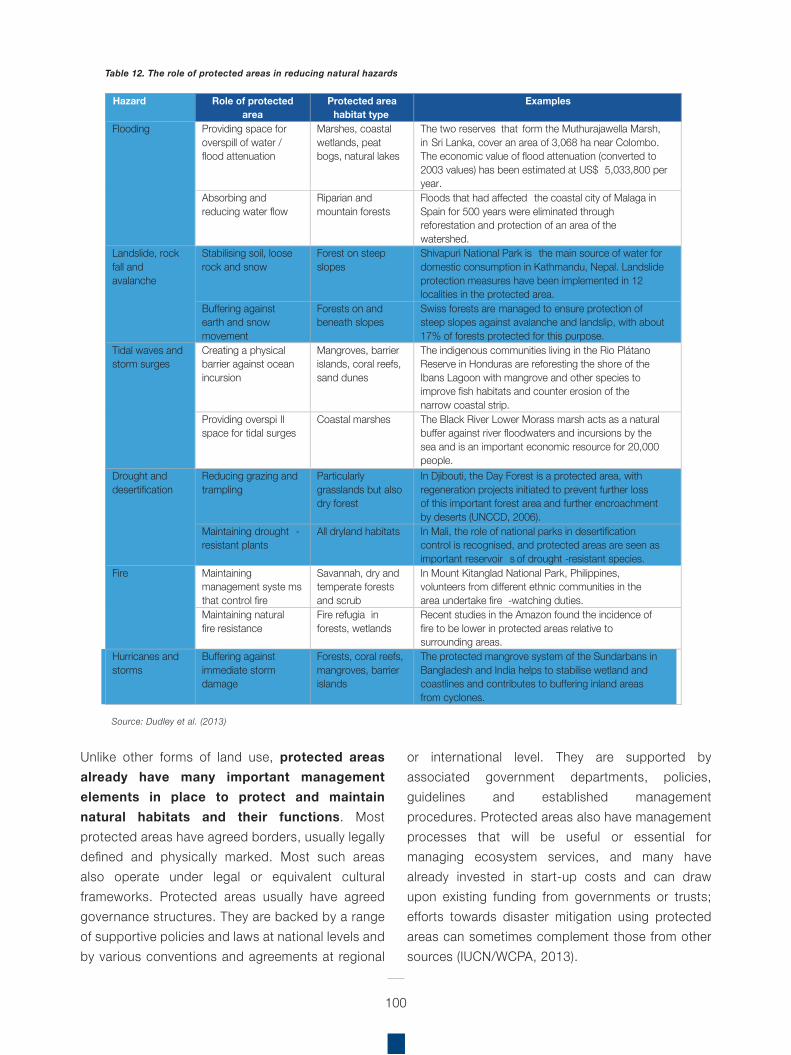
100
Unlike other forms of land use, protected areas already have many important management elements in place to protect and maintain natural habitats and their functions. Most protected areas have agreed borders, usually legally defined and physically marked. Most such areas also operate under legal or equivalent cultural frameworks. Protected areas usually have agreed governance structures. They are backed by a range of supportive policies and laws at national levels and by various conventions and agreements at regional
or international level. They are supported by associated government departments, policies, guidelines and established management procedures. Protected areas also have management processes that will be useful or essential for managing ecosystem services, and many have already invested in start-up costs and can draw upon existing funding from governments or trusts; efforts towards disaster mitigation using protected areas can sometimes complement those from other sources (IUCN/WCPA, 2013).
Hazard Role of protected area
Protected area habitat type
Examples
Flooding Providing space for overspill of water / flood attenuation
Marshes, coastal wetlands, peat bogs, natural lakes
The two reserves that form the Muthurajawella Marsh, in Sri Lanka, cover an area of 3,068 ha near Colombo. The economic value of flood attenuation (converted to 2003 values) has been estimated at US$ 5,033,800 per year.
Absorbing and reducing water flow
Riparian and mountain forests
Floods that had affected the coastal city of Malaga in Spain for 500 years were eliminated through reforestation and protection of an area of the watershed.
Landslide, rock fall and avalanche
Stabilising soil, loose rock and snow
Forest on steep slopes
Shivapuri National Park is the main source of water for domestic consumption in Kathmandu, Nepal. Landslide protection measures have been implemented in 12 localities in the protected area.
Buffering against earth and snow movement
Forests on and beneath slopes
Swiss forests are managed to ensure protection of steep slopes against avalanche and landslip, with about 17% of forests protected for this purpose.
Tidal waves and storm surges
Creating a physical barrier against ocean incursion
Mangroves, barrier islands, coral reefs, sand dunes
The indigenous communities living in the Rio Plátano Reserve in Honduras are reforesting the shore of the Ibans Lagoon with mangrove and other species to improve fish habitats and counter erosion of the narrow coastal strip.
Providing overspi ll space for tidal surges
Coastal marshes The Black River Lower Morass marsh acts as a natural buffer against river floodwaters and incursions by the sea and is an important economic resource for 20,000 people.
Drought and desertification
Reducing grazing and trampling
Particularly grasslands but also dry forest
In Djibouti, the Day Forest is a protected area, with regeneration projects initiated to prevent further loss of this important forest area and further encroachment by deserts (UNCCD, 2006).
Maintaining drought -resistant plants
All dryland habitats In Mali, the role of national parks in desertification control is recognised, and protected areas are seen as important reservoir s of drought -resistant species.
Fire Maintaining management syste ms that control fire
Savannah, dry and temperate forests and scrub
In Mount Kitanglad National Park, Philippines, volunteers from different ethnic communities in the area undertake fire -watching duties.
Maintaining natural fire resistance
Fire refugia in forests, wetlands
Recent studies in the Amazon found the incidence of fire to be lower in protected areas relative to surrounding areas.
Hurricanes and storms
Buffering against immediate storm damage
Forests, coral reefs, mangroves, barrier islands
The protected mangrove system of the Sundarbans in Bangladesh and India helps to stabilise wetland and coastlines and contributes to buffering inland areas from cyclones.
Source: Dudley et al. (2013)
Table 12. The role of protected areas in reducing natural hazards
101
The role of protected areas can also be strengthened by integrating them more thoroughly into existing DRR planning, for example by:
Rigorous economic, engineering and environmental analyses: government institutions, universities and the private sector should be encouraged to invest in rigorous economic, engineering and environmental analysis of proposed infrastructure projects to determine when and where there are benefits of incorporating, wherever possible, complementary green and hard infrastructure into DRR plans.Broad scale spatial planning: at a national and regional/ transboundary scale, disaster relief agencies should cooperate with partners to identify places where natural ecosystems could prevent and mitigate disasters and to develop associated ecosystem protection strategies. This should include, where appropriate, the establishment of new protected areas, connectivity areas in buffer zones or outside protected areas, in vulnerable areas to safeguard vital ecosystem services that buffer communities.Management plans: some protected area authorities may consider revising management objectives and management plans in order to maximise benefits in terms of disaster reduction and to increase awareness of these values among the general public.PES and financing strategies: DRR institutions can often usefully work with protected area managers to develop innovative financing strategies for protected areas, which recognise PES. DRR funds should in some cases be used to establish or manage protected areas in places where these provide cost-effective DRR.Restoration: in some cases, it may be useful to protect and restore degraded ecosystems specifically to improve their role in DRR; in such situations, some level of active management may be required, e.g. removal of invasive alien species to allow natural regeneration or planting of native species to restore natural processes (IUCN/WCPA, 2013).
In addition to protected areas per se, the important role of Indigenous Peoples and Community Conserved Territories and Areas (ICCAs) in Eco-DRR is also a key consideration. ICCAs involve collective decision-making about nature, and are closely related to peoples’ livelihoods, culture and identity; they can be found around the world, span all types of ecosystems and cultures, have thousands of local names and are extremely diverse. They are built on collective ecological knowledge and capacities, including sustainable use of wild resources and maintenance of agrobiodiversity.
ICCAs are typically designed to maintain livelihood resources for times of stress, such as during severe climate events, war and natural disasters. Examples of ICCAs include:
Sacred spaces such as the Chizire sacred forest, Zimbabwe, Khumbu of the Sherpa people (Mount Everest National Park), sacred lake, Indian Himalayas;Indigenous territories and cultural landscapes/seascapes such as the Paruku Indigenous PA, Western Australia, Traditional territory of ASATRIZY, Yapú, Vaupés, Colombia;Territories and migration routes of nomadic herders/mobile indigenous peoples, such as wetlands in Qashqai mobile peoples’ territory, Iran;Sustainably managed wetlands, fishing grounds and water bodies (Temporarily and/ or permanently forbidden sites (manjidura), Bijagos biosphere reserve, Guinea Bissau);Community-established, owned and managed areas in industrialised countries (Gajna floodplain commons, Croatia) (SCBD, 2016).
Regional Assessment on Ecosystem-based Disaster Risk Reduction and Biodiversity in South America
102
At the policy level
n spite of the benefits that ecosystem-based solutions represent for more comprehensive DRR activities, there are still many challenges for them to become mainstreamed into policies and practice:
Promote inter-sectoral and multi-stakeholder efforts for mainstreaming Eco-DRR: there is a need to promote inter-sectoral work on Eco-DRR and EbA in other sectors beside environment (and climate change). As well as for EbA, engaging other partners is crucial, for instance other NGOs and academia; also working with institutions such as protected areas, can provide opportunities and governance structures to integrate Eco-DRR in planning and policy instruments and implement Eco-DRR measures on the ground (Podvin et al., 2014). Additionally, in the context of biodiversity conservation and climate change adaptation, land use and spatial planning not only contributes to the creation of resilient lands to reduce the vulnerability of ecosystems and communities and conserve ecological services, it is also one of the best ways to link biodiversity with sectors at territorial level (Andrade & Vides, 2009).
Enabling conditions for Eco-DRR require a multidisciplinary approach and inter-sectoral collaboration: Integrating Eco-DRR and EbA require bringing together different actors and expertise across sectors and encouraging multidisciplinary approaches at project implementation and policy levels (Doswald & Estrella, 2015b). In this sense, one of the main challenges relates precisely to the lack of dialogue and action between sectors, which increases the difficulties of translating policies into plans, programmes, resource
allocations, and across and into development sectors. It is important for Eco-DRR and EbA to be embedded in national development plans/vision/strategy to provide an enabling framework for local-level implementation and facilitate access to budget/funds. In this regard, it is paramount to consider the impacts of actions implemented by other sectors that creates or increases vulnerability. Among the conditions, it is also important to enhance governance capacities for ecosystem-based DRR through multi-sector, multi-disciplinary platforms (PEDRR, 2010).
Institutional set-up matters: In addition to having the right enabling conditions, a clear institutional framework is needed to articulate and facilitate collaboration among different institutions related to environment and disaster management. Therefore, the establishment of a policy-making and advisory body on climate change and DRR programmes and projects in each country could have the potential to enable interventions with a broader perspective by coordinating public institutions related to climate change, environment, energy, meteorology, infrastructure and disaster management. The contribution of several institutions will potentially enable to scale up field interventions (to increase the geographic scope and thus the impact of interventions), in order to facilitate replication or expand into national-level programmes and plans.
Arguments in favour of ecosystem-based approaches: make an economic case for Eco-DRR: Demonstrating cost-efficiency on Eco-DRR and EbA (e.g. promoting NSB as viable options versus conventional grey infrastructure options) can support its financing overcoming the financial barrier detailed earlier. For instance, cost-benefit analyses carried out in Peru
I
By James McBreen and Karen Podvin
Challenges and opportunities
5 Conclusions
103
demonstrated the viability of EbA options compared to inaction or to other adaptation measures in diverse scenarios, however quantifying multiple benefits on EbA requires time, (technical) resources, and data that might not be available (UNDP, 2015; Rizivi et al., 2015). Rapid cost-benefit analysis of ongoing and completed projects could be an alternative and may provide arguments for decision making on EbA (Rizivi et al., 2015, in Podvin & Arellano, 2016).
The role of Regional Economic Commissions in Eco-DRR: The role of the Economic Commission for Latin America and the Caribbean (ECLAC), regarding Eco-DRR, has until now, been minimal. However, following an informal conversation with programme officers from the ECLAC, it appears that they are planning to embark on an initiative to better understand the role of biodiversity and ecosystems in relation to DRR in the region. However, at the time of preparing this report, further details are pending.
Incentives should be targeted for specific stakeholders. Factoring in incentives to ensure long-term buy-in or ownership of the interventions is key to achieving sustainability. Incentives should be targeted to national government institutions, households, etc., whilst perverse incentives should in turn, be eliminated: land tenure clarification is especially important in this point. Also, it is relevant to link Eco-DRR with sustainable livelihoods and development (PEDRR, 2010).
In this sense, there are also interesting opportunities:
There is enormous scope for integrating DRR initiatives into biodiversity elements of risk reduction. There is wide evidence in the region of supportive policies and legislation for biodiversity conservation relevant for disaster risk. For instance, there is an increasing tendency for sustainably managed forest areas, and the
participatory development of these plans. This presents an opportunity for mainstreaming the role of locally appropriate biodiversity in DRR, whilst reducing new risk scenarios and maximising social and environmental benefits.
Eco-DRR and EbA may be already integrated but may not be called as such. Eco-DRR should be part of a broader DRR and CCA strategy, yet there are not enough advocacy efforts from the conservation, disaster management and climate change communities to articulate the DRR/ Adaptation function of ecosystems. If decision makers and communities were sensitised alike, there would be a strong support for DRR and CCA. Thus, there is an opportunity for the development of policies, guidelines and positions; advising on regional, international and national CC and DRR obligations; disseminating information on sectoral level initiatives; advising, guiding and coordinating the development of national climate change and DRR initiatives in the countries.
At the implementation level (evidence)
The survey carried out by this assessment enabled the gathering of some interesting information regarding the challenges of implementation of ecosystem-based initiatives:
South America experiences significant impacts of natural hazards and disasters on biodiversity and agriculture. Smallholder farmers in the region are highly dependent on rain-fed agriculture. Droughts and floods are occurring with increased frequency and severity. Higher temperatures impact crop growth and augment the presence of pests. The lack of soil cover and lack of organic matter in the soil means they no longer hold rainwater effectively. With intense rains, the water runs off the land quickly and causes more erosion and flooding. Depending on the management practices, agriculture is highly susceptible to climate variability and change. If no risk reduction and adaptation measures are
104
put in place, enhanced exposure to drought will further compromise livelihoods in the region. This is of particular significance, as 35 million people in South America were affected by droughts between 2000–2015. In this sense, evidence suggests that there is a necessity for enhanced mainstreaming of DRR and resilience building within the agricultural sectors in the region.
There is a need for greater investment in Eco-DRR to build resilient livelihoods and food production systems. The impact of different types of hazards on agriculture subsectors varies substantially, which requires context-specific DRR and management. Eco-DRR measures should pay specific attention to crops that contribute most to food security and nutrition. A common priority identified by the survey respondents is the necessity to ensure sustainability beyond a project-based lifetime. In light of the lack of information on baseline conditions, the development of peer-reviewed databases could contribute to better informed nationally and/or locally appropriate risk reduction funding and investments.
Eco-DRR does not lend itself to easy identification of measurable targets or goals. The existence of data gaps represents a significant challenge; especially in terms of effective data collection and its inclusion in national and regional analysis. Ecosystem and environmental benefits are still hard to measure (e.g. percentage of disaster losses reduced due to well-functioning ecosystems, monetary savings by wetlands preservation for flood reduction, etc.). The benefits of sustainable ecosystem management are spread across so many sectors that the topic does not receive singular attention from any of them (e.g. agriculture, health, education, culture or DRR). In addition, there remain many critical gaps between best practices and the reality of current DRR and CCA measures.
Raise awareness and infuse the ecosystem bases approaches for CCA and DRR: although there are institutional settings and strategies/policies in the region, there is still a need to raise awareness on the crucial role of ecosystems to strengthen ongoing CCA and DRR efforts. Eco-DRR and EbA need to be consolidated and ‘operationalised’ at national, regional and local levels through feasible and tested tools and mechanisms.
Lack of recognition and capacity on the role of biodiversity and DRR amongst civil society, and especially local communities: there is a need to challenge the idea of living with risks and the absence of regard for the role of nature. Therefore, there is a need to enhance evidence-based knowledge and capacities among implementers and communities on the diversified benefits of nature-based solutions for DRR.
Several opportunities were also identified:
EbA approaches enable the integration of climate change considerations in special planning efforts. The incorporation of EbA approaches in spatial planning efforts (e.g. in land management plans, local development plans, watershed management plans, and departmental development plans) is the best way to ensure that local governance takes climate change into account, addressing climate change impacts. It is also relevant to consider that ecosystem-based approaches for CCA and DRR also have their limitations. Understanding these, as well as when and how these approaches work, their benefits and costs, is imperative for its implementation, replication and scaling-up.
A decrease in threat levels will allow natural ecosystems to become more resilient to increasing variability and climate change. Nature-based solutions are more cost-effective
105
and successful when facing climatic change challenges. More diversified agricultural systems can mitigate climate-related impacts up to a point, providing habitats and also connectivity between fragments of natural habitats. The region does have some excellent experiences involving farmers, communities, CSOs, NGOs and institutions who have come together to better respond to variable conditions, implementing farming strategies such as water conservation through watershed management and agroecological farming, including crop and livelihood diversification.
Environmental benefits from agroecological practices enhance DRR. For instance, adaptation of high-mountain farming systems decreases the pressure on natural ecosystems, such as the fragile páramos in the Andes. Environmental benefits include the reduction in soil erosion, and thus of road, dam and hydroelectric power plant maintenance costs; the improvement of water quality and quantity; improvement of air quality; increase in biodiversity; and, carbon sequestration. Agroecological practices help farmers to develop soil, water and ecosystem management techniques that restore productivity and make farms and ecosystems more resilient, thereby enhancing food security and control over resources for DRR and resilience at local level.
Information availability needs to be improved. A decrease in climate change vulnerability of local communities will occur once information on the effects of climatic variation is available, progress in local organisational processes is made, and a better reconnaissance of the land has been carried out.
Nature-based solutions including ecosystem management and biodiversity conservation generate multiple benefits besides DRR: The examples provided throughout the assessment,
show that the diverse initiatives that include ecosystem management besides reducing risks to disasters, also support other aspects such as climate change adaptation and mitigation (such as EbA, FLR and REDD+) as well as co-benefits, including livelihood diversification and enhancement, food security, traditional knowledge and practices.
Building understanding, capacities and engagement of communities and civil society on the role of biodiversity and DRR: there is a need to continue promoting capacity building and institutional strengthening among public, private and civil society stakeholders directly involved with landscape management for EbA internalisation and implementation on the ground.
Consolidate experiences and progress and upscale ecosystem-based approaches: in the specific case of IUCN-Sur, continue working on the diverse initiatives jointly with members, governments, other NGOs, academia (for instance, EPIC, RELIEF Kit and EbA approaches projects) as well as creating synergies with other initiatives to promote ecosystem-based approaches for CCA and DRR in policies and strategies.
At the knowledge base
One of the main challenges in terms of the Eco-DRR knowledge base is the insufficient technical understanding among stakeholders to develop tools and models to facilitate proactive use of ecosystems as a DRR/adaptation measure:
Rigorous DRR based on biodiversity should include cross-sector coordination to prioritise conservation interventions through the assessment of threats to biodiversity and natural ecosystems. The different disaster risks in South America include: floods, drought, wildfires, tsunamis, earthquakes, etc., whilst
different threats to biodiversity include: sea-level rise, deforestation, ecosystem degradation (caused by agricultural expansion for crops and livestock, infrastructure, extractive industries, etc.). The level of threat could be spatially quantified and mapped together with ecosystems, in order to better understand DRR in priority regions and biodiversity opportunities specific to these areas.
Generate and share solid evidence and cost-effectiveness of ecosystem-based approaches: There have been several experiences worldwide on EbA (for instance, see Rizivi, 2014) that have been providing evidence of the environmental and socio-economic benefits and added value of EbA as CCA options. However, further knowledge and understanding on the limitations, gaps, costs and benefits need to be evaluated and disseminated among EbA practitioners and policy makers (Rizivi et al., 2015).
However, there are several opportunities to improve the knowledge base already in place:
The EbA approach is integrated within an overall adaptation and DRR strategy. This approach includes essential measures, such as: preparing for emergency intervention; reviewing the climate change fitness of existing structural protection measures; enhanced coordination between spatial planning and risk management; setting up and optimising long-term monitoring and warning systems; establishing a risk culture and initiating risk dialogue; and strengthening individual preparedness and precaution.
The Red List of Ecosystems (RLE) provides a global standard for risk assessment of worldwide ecosystems, and is applicable to global, regional, national or local level. The RLE methodology uses a set of criteria based on evidences of ecosystem collapse, measured through the reduction of area, geographical
distribution, and on degradation of key physical and biotic components and processes (Keith, 2013). The RLE in South America includes descriptions for the 200 units (based on vegetation macrogroups); and is at varying stages in Bolivia, Colombia, Chile, Costa Rica, Ecuador, Paraguay, Peru, Uruguay, Venezuela, and several large regions (states, watersheds) in Brazil. This tool can support gathering and assessing ecosystems’ status and consider measures to restore or maintain ecosystems and their services and functions against risks to disasters. In general, it utilises existing instruments and tools in ecosystems management and enhances their DRR value (PEDRR, 2010).
Fostering exchange of experiences and best practices in the region. The ability of communities to anticipate natural disasters can in large part be facilitated by the predictive capacity of knowing when and where a disaster might occur, and anticipating the impact of those disasters on communities, which both rely on past experience or the history of disasters. In this sense, the role of documentation, shared learning and active engagement, in terms of past experience and resilience, should be recognised and promoted in the region. Local strategies could influence decision-making processes to promote sustainable management practices.
Mainstreaming local environmental management in the planning process. There is an opportunity to include DRR based on biodiversity cross-sector coordination to prioritise conservation interventions through the assessment of threats to biodiversity and natural ecosystems. The level of threat could be spatially quantified and mapped together with ecosystems, in order to better understand DRR in priority regions and biodiversity opportunities specific to these areas.
106
107
outh America, as with other regions of the world, is exposed to diverse, and ever-increasing natural hazards, including: floods, droughts, wildfires, earthquakes, tsunamis, among others. As evidence suggests, climate change can magnify existing vulnerabilities, thus posing a serious threat to climate-sensitive activities that sustain people’s livelihoods. Generally, most of the hazards cannot be prevented, yet management practices can reduce their intensity and impact. Extreme impacts on human, ecological or physical systems can result from individual extreme weather or climate events, from non-extreme events where exposure and vulnerability are high, or from a compounding of events or their impacts (flash floods, landslides). High vulnerability and exposure are generally the outcome of skewed development processes, for example, environmental mismanagement, demographic change, rapid and unplanned urbanisation, failed governance, and a scarcity of livelihood options (IPCC, 2012).
In this context, biodiversity contributes greatly to the ability of ecosystems to withstand natural phenomena by acting as natural buffers or protective barriers. Environmental degradation has a direct effect in leaving populations exposed to increasing risks of disasters. Thus, by integrating ecosystem-based solutions, vulnerabilities can be reduced and adaptive capacity enhanced. The impact of a disaster is related to how society manages its environment and how well prepared it is in terms of resilience and capacity to adapt. In this sense, resilient and adaptive land-use systems and measures to conserve or restore functional ecosystems that support sustainable human development, while preserving the natural resource base of future generations in South America and beyond are of utmost importance.
As relatively low-cost, locally accessible solutions, Eco-DRR is an opportunity to promote improved ecosystem management for DRR. Natural infrastructure can reduce hazard impacts and vulnerability, and by integrating biodiversity elements into DRR initiatives and highlighting the key role of ecosystem restoration and sustainable management of natural resources, Eco-DRR presents a broader perspective to reduce potential risk scenarios, whilst maximising social and environmental benefits, which include livelihood benefits for human well-being, regardless of a disaster event.
The importance of maintaining and restoring natural ecosystems to protect against disasters is becoming increasingly recognised, yet in South America the link between Eco-DRR and DRR is only recently receiving more attention. Although specific Eco-DRR initiatives are scarce, most of the countries are investing in ecosystem protection and restoration as a component of different projects. Therefore, in order to reinforce the link between DRR and biodiversity in South America, it is necessary to support more national Eco-DRR awareness in government plans and programmes, for instance through workshops with countries’ Ministry of Environment, Ministry of Agriculture, Ministry of Energy, Ministry of Water, Ministry of Infrastructure, Ministry of Planning, Disaster Management Authority, Meteorological Authority, etc. In this way, attempting to strike a better balance between economic and social needs of the local communities and protecting ecosystems for future generations.
It is also necessary to continue to promote the non-conservation sector to talk about how they can use natural infrastructure as part of the infrastructure agenda, so that nature-based solutions are complementary to other investments coming from hard engineering used for DRR and climate change adaptation. Benefiting from the fact that nature-based solutions help reduce costs, increase cost-effectiveness, whilst increasing the co-benefits that go alongside DRR and adaptation, including biodiversity conservation.
S
Key messages
Regional Assessment on Ecosystem-based Disaster Risk Reduction and Biodiversity in South America
108
Acharya, M.S. and W. Lammeranner (2011). How to select the appropriate techniques and suitable plant species for soil bio-engineering works? An application example from Nepal. Geophysical Research Abstracts, vol. 13
Altieri, M.A., Nicholls-Estrada, C.I., Henao-Salazar, A., Galvis-Martínez, A.C. and Rogé P. (2015). Didactic Toolkit for the Design, Management and Assessment of Resilient Farming Systems. Retrieved from: http://foodtank.com/assets/files/Didactic_Toolkit_REDAGRESversionjuly10.pdf
Alvarado L. (2015a). Informe Final. ACB Convencional y ACB Participativo en la comunidad de Canchayllo; Consultoría para la Elaboración de análisis costo-beneficio y valoración participativa de las medidas robustas de adaptación al cambio climático. Lima: Instituto de Montaña y UICN.
Alvarado L. (2015b). Informe Final. ACB Convencional y ACB Participativo en la comunidad de Miraflores; Consultoría para la Elaboración de análisis costo-beneficio y valoración participativa de las medidas robustas de adaptación al cambio climático. Lima: Instituto de Montaña y UICN.
Alvarado, L., Podvin, K., and Gómez, A. (2016). Guía para la elaboración de un Análisis Costo Beneficio (ACB) participativo de medidas de adaptación al cambio climático: una herramienta complementaria al ACB convencional. UICN e Instituto de Montaña en el marco del proyecto EbA Montaña. Lima. Documento de trabajo.
Andrade Pérez, A., Herrera Fernandez, B. and Cazzolla Gatti, R. (eds.) (2010). Building Resilience to Climate Change: Ecosystem-based adaptation and lessons from the field. Gland, Switzerland: IUCN. 164pp. Retrieved from:
https://portals.iucn.org/library/sites/library/files/documents/CEM-009.pdf
Andrade Pérez, A., Córdoba, R., Dave, R., Girot, P., Herrera-F., B., Munroe, R., Oglethorpe, J., Paaby, P., Pramova, E., Watson, E. and Vergar, W. (2011). Draft Principles and Guidelines for Integrating Ecosystem-based Approaches to Adaptation in Project and Policy Design: A discussion document. IUCN-CEM, CATIE. Turrialba, Costa Rica. Retrieved from:
http://cmsdata.iucn.org/downloads/draft_guidelines_eba_final.pdf
APMT – Autoridad Plurinacional de la Madre Tierra (2014). Guía de adscripción al mecanismo conjunto de mitigación y adaptación para el manejo integral y sustentable de los bosques y la Madre Tierra. MMAyA – APMT. La Paz, Bolivia. 32p.
Berke, P. R., and T. J. Campanella (2006). Planning for postdisaster resiliency. The Annals of the American Academy of Political and Social Science 604(1):192-207.
Brodzinsky, S. (2014). At the world urban forum in Medellin, resilience takes centre stage, The Guardian, 2014. Retrieved from:
http://www.theguardian.com/cities/2014/apr/14/world-urban-forum-medellin-resilience
References
109
Caramel, L. (2014). Peru’s farmers fight climate change using modern and Inca techniques, The Guardian, 2014. Retrieved from: http://www.theguardian.com/environment/2014/jan/20/peru-farmers-weather-climate-change
Centro de Estudios para América Latina y El Caribe (CELAC) (n.d.). http://www.celac.org/
Coalición para la Resiliencia de la Niñez y la Juventud en Latinoamérica y El Caribe (CORELAC) (n.d.): http://www.corelac.org/
Comisión Permanente del Pacífico Sur (CPPS) (n.d.): http://www.cpps-int.org
Comité Andino para la Prevención y Atención de Desastres (CAPRADE) (n.d.): http://www.comunidadandina.org/predecan/contexto_capra de.html
Comunidad Andina (2009). Estrategia Andina de Prevención y Atención de Desastres (EAPAD). Decisión número 713 del Consejo Andino de Ministros de Relaciones Exteriores. Retrieved from: http://www.comunidadandina.org/PREDECAN/doc/libros/EAPAD+ESP.pdf
Cooper, E., L. Burke and N. Bood (2008). Coastal Capital: Economic Contribution of Coral Reefs and Mangroves to Belize. Washington DC: World Resources Institute. Retrieved from: https://www.wri.org/sites/default/files/pdf/coastal_capital_belize_brochure.pdf
Costanza, R., O. Pérez-Maqueo, M.L. Martinez, P. Sutton, S.J. Anderson and K. Mulder (2008). The value of coastal wetlands for hurricane protection. Ambio 37(4):241–248
Cordero, C., Casteller, A., Podvin, K., Buchholz, A. and Jiménez, M. C. (2014). Ecosystems Protecting Infrastructure and Communities (EPIC). Chile Baseline Report.
Day, J.W., Jr., D.F. Boesch, E.J. Clairain, G.P. Kemp, S.B. Laska, W.J. Mitsch, K. Orth, H. Mashriqui, D.R. Reed, L. Shabman, C.A. Simenstad, B.J. Streever, R.R. Twilley, C.C. Watson, J.T. Wells, and D.F. Whigham (2007). Restoration of the Mississippi Delta: lessons from hurricanes Katrina and Rita. Science 315:1679-1684.
Dick-Peddie W. (1993). New Mexico vegetation, past, present, and future. Univ. of New Mexico Press, Albuquerque, NM. 244 p.
Doswald, N, and Estrella, M. (2015a). Promoting ecosystems for disaster risk reduction and climate change adaptation: Opportunities for Integration. UNEP Post-Conflict and Disaster Management Branch, 2015. Retrieved from: http://www.unep.org/disastersandconflicts/portals/155/publications/
Eco_DRR_discussion_paper.pdf?pdf=EcoDRR_Discussion_paper_web
Doswald, N. and Estrella, M. (2015b). Ecosystem-based approaches to Disaster Risk Reduction (Eco-DRR) and Ecosystem-based approaches for Adaptation (EBA): commonalities and differences and key integration points. Geneva: UNEP, 50pp.
Dreesen, D., Harrington, J., Subirge, T., Stewart, P. and Fenchel, G. (2001). Riparian Restoration in the
100
Southwest – Species Selection, Propagation, Planting Methods, and Case Studies. Retrieved from: http://www.nrcs.usda.gov/Internet/FSE_PLANTMATERIALS/publications/nmpmcsy03852.pdf
Dreesen DR, Harrington JT. (1999). Vegetative propagation of aspen, narrowleaf cottonwood, and riparian trees and shrubs. In: Landis TD, Barnett, JP, technical coordinators. National proceedings: forest and conservation nursery associations – 1998. Asheville (NC): USDA, Forest Service, Southern Research Station. General Technical Report SRS-25. p 129-137.
Dudley, N., MacKinnon, K. and Stolton, S. (2013). Reducing vulnerability: The role of protected areas in mitigating natural disasters. In F.G. Renaud, K. Sudmeier-Rieux and M. Estrella (eds.) The Role of Ecosystems in Disaster Risk Reduction, United Nations University Press, Tokyo, New York and Paris.
Dudley, N., Buyck, C., Furuta, N., Pedrot, C., Renaud, F. and Sudmeier-Rieux, K. (2015). Protected Areas as Tools for Disaster Risk Reduction. A handbook for practitioners. Tokyo and Gland, Switzerland: MOEJ and IUCN. 44pp. Retrieved from: https://portals.iucn.org/library/node/45054
ECLAC – Economic Commission for Latin America and the Caribbean (2010). Economics of Climate Change in Latin America and the Caribbean. Summary 2010. United Nations, Santiago, Chile, pp. 107.
ECLAC – Economic Commission for Latin America and the Caribbean (2016). Population, territory and sustainable development. Retrieved from: https://issuu.com/publicacionescepal/docs/s2012013_en
EIRD – Estrategia Internacional para la Reducción de Desastres (2013). Grupo de Trabajo de Alto Nivel para la Gestión Integral de Riesgos de Desastres de UNASUR: Resolución UNASUR/CMRE/RESOLUCIÓN/No 4 /2013. Retrieved from: http://www.eird.org/wikiesp/images/RESOLUCION_GESTION_DE_RIESGOS_
DESASTRES_UNASUR.pdf
EIRD – Plataforma Regional para la Reducción del Riesgo de Desastres (RRD) de las Américas (2014). Retrieved from: http://www.eird.org/pr14/
EIRD – Estrategia Internacional para la Reducción de Desastres (n.d.). Reunión Especializada de Reducción de Riesgos de Desastres Socionaturales, la Defensa Civil, la Protección Civil y la Asistencia Humanitaria (REHU). Las Américas.
Retrieved from: http://www.eird.org/perfiles-paises/perfiles/index.php/REHU
Elmqvist, T., J. Colding, S. Barthel, A. Duit, S. Borgström, J. Lundberg, E. Andersson, K. Ahrné, H. Ernstson, J. Bengtsson, and C. Folke (2004). The dynamics of social-ecological systems in urban landscapes: Stockholm and the national urban park, Sweden. Annals of New York Academy of Sciences 1023:308-322.
EM-DAT – Emergency Events Database (2016). The International Disaster Database – Centre for Research on the Epidemiology of Disasters (CRED): Country profiles. Université Catholique de Louvain Brussels – Belgium. Retrieved from: http://www.emdat.be/country_profile/index.html
ESA – European Space Agency (n.d). Vegetation in South America. Retrieved from: https://www.esa.int/ SPECIALS/Eduspace_Global_EN/SEM94FNW91H_0.html
111
Estrella, M. & N. Saalismaa (2013) Ecosystem-based Disaster Risk Reduction (Eco-DRR): An Overview, In: Renaud, F., Sudmeier-Rieux, K. and M. Estrella (eds.) The role of ecosystem management in disaster risk reduction. Tokyo: UNU Press
Estrella, M., Guillén, T., Lange, W., Lomarda, M., Aris Marfa, M., Nehren, U., Sandholz, S., Sudmeier-Rieux, K. and Vicarelli, M. (2014). The Ecosystem-based Disaster Risk Reduction: Case Study and Exercise Source Book. United Nations Environment Programme and Center for Natural Resources and Development. Retrieved from: http://postconflict.unep.ch/publications/DRR_CASE_STUDIES_
&_EXERCISES.pdf
European Commission (2014). ECHO and the DIPECHO Programme in Latin America and the Caribbean: Evolution and Challenges. Retrieved from: http://ec.europa.eu/echo/files/policies/
dipecho/drr_evolution_challenges_en.pdf
European Union, PREDECAN, Andean Community (2009). Progress on Disaster Risk Management in the Andean Community Project with support from the Andean Community Disaster Prevention Project (PREDECAN) 2005–2009.
Retrieved from: http://www.comunidadandina.org/predecan/doc/libros/logros+ing+web.pdf
Evette, A.; S. Labonne, F. Rey, F. Liebault, O. Jancke and J. Girel (2009). History of bio-engineering techniques for erosion control in rivers in Western Europe. Environmental Management 43: 972-984.
FAO – Food and Agriculture Organization of the United Nations (2011). AQUASTAT. Retrieved from: http://www.fao.org/nr/water/aquastat/main/index.stm
FAO – Food and Agriculture Organization of the United Nations (2012). Global ecological zones for FAO forest reporting: 2010 Update. Forest resources Assessment Working Paper 179. Retrieved from: http://www.fao.org/docrep/017/ap861e/ap861e00.pdf
FAO – Food and Agriculture Organization of the United Nations (2014). Rivers in South America (Derived from HydroSHEDS). Retrieved from: http://www.fao.org/geonetwork/srv/en/metadata.show?id=37330
FAO – Food and Agriculture Organization of the United Nations (2015a). AQUASTAT 2015. Country summary tables for Southern America.
Retrieved from: http://www.fao.org/nr/water/aquastat/countries_regions/americas/index.stm
FAO – Food and Agriculture Organization of the United Nations (2015b). Global Forest Resources Assessment 2015 – Desk reference. Retrieved from: http://www.fao.org/3/a-i4808e.pdf
FAO – Food and Agriculture Organization of the United Nations (2016). Earth Observation. Retrieved from: http://www.fao.org/giews/earthobservation/asis/index_1.jsp?lang=en
Florineth, F. (2004). Stabilization of gullies with soil – bio-engineering methods in the Alps and in Nepal, in: Gully Erosion under Global Change, edited by: Li, Y., Poisen, J., and Valentin, C., Sichuan Science and Technology Press, Chengdu, China, 315– 339.
112
Forest Trends (2014). Flood disaster in the Amazon: A fight against climate change gets personal, The Huffington Post, The Blog, 2014. Retrieved from: http://www.huffingtonpost.com/forest-trends/
flood-disaster-in-the-ama_b_6216242.html
Foro de coordinación y cooperación de mecanismos subregionales de gestión del riesgo de desastres de las Américas (n.d.): http://www.indeci.gob.pe/sgcccc/foro.pdf
GAA (2004). Global Amphibian Assessment Database. Global Amphibian Assessment. IUCN.
GNDR – Global Network of Civil Society Organisations for Disaster Reduction (n.d.). AFL Case Study Challenge 2012.
Retrieved from: http://www.gndr.org/learning/resources/case-studies/all-case-studies.html
Ghimire SK. and K.K. Karki (2004). Mitigation of soil erosion hazards through bio-engineering: a case study of Mid-Himalaya, Nepal. In: Proceedings of the “International Conference Eco-Engineering - The use of vegetation to improve slope stability’’.
Government of Chile. (2015). Intended Nationally Determined Contribution (INDC) of Chile Towards the Climate Agreement of Paris 2015. Santiago, Chile. 34. Available from: http://www4.unfccc.int/
submissions/INDC/Published%20Documents/Chile/1/INDC%20Chile%20english%20version.pdf
Granfelt, C.E. (2001). Willows on the Apache-Sitgreaves National Forests. Apache Sitgreaves National Forests, Springerville, AZ.
Gray, D.H. and R.B. Sotir (1996). Biotechnical and soil bio-engineering slope stabilization. A practical guide for erosion control. John Wiley & Sons Inc., New York, USA, pp. 378.
Hardoy, J. and Romero, L.P. (2011). Latin American cities and climate change: Challenges and options to mitigation and adaptation responses, Current Opinion in Environmental Sustainability 3(3): 158–163.
Hill, D. (2016). Colombian court bans oil, gas and mining operations in paramos, The Guardian, 2016. Retrieved from: http://www.theguardian.com/environment/andes-to-the-amazon/2016/
feb/21/colombia-bans-oil-gas-mining-paramos
IISD – International Institute for Sustainable Development (2011). Review of Current and Planned Adaptation Action: South America.
Retrieved from: https://www.iisd.org/pdf/2011/South_America_Adaptation_Action.pdf
InforMEA (United Nations Information Portal on Multilateral Environmental Agreements) (n.d.): http://www.informea.org/
IPBES – Intergovernmental Science-Policy Platform on Biodiversity and Ecosystem Services (n.d.) (Catalogue of Assessments on Biodiversity and Ecosystem Services): http://catalog.ipbes.net/?attachments=f&geo_scale=
&systems_assessed=&ecosystem_services_functions_assessed=&tools_and_approaches=&page=1
113
IPCC – Intergovernmental Panel on Climate Change (2007). Contribution of Working Group II to the Fourth Assessment Report of the Intergovernmental Panel on Climate Change, 2007 M.L. Parry, O.F. Canziani, J.P. Palutikof, P.J. van der Linden and C.E. Hanson (eds). Cambridge University Press, Cambridge, United Kingdom and New York, NY, USA.
IPCC – Intergovernmental Panel on Climate Change (2012). Managing the Risks of Extreme Events and Disasters to Advance Climate Change Adaptation. A Special Report of Working Groups I and II of the Intergovernmental Panel on Climate Change [C.B. Field, V. Barros, T.F. Stocker, D. Qin, D.J. Dokken, K.L. Ebi, M.D. Mastrandrea, K.J. Mach, G.-K. Plattner, S.K. Allen, M. Tignor, and P.M. Midgley (eds.)]. Cambridge University Press, Cambridge, UK, and New York, NY, USA, 582 pp.
IPCC – Intergovernmental Panel on Climate Change (2013). Summary for Policymakers. In: Climate Change 2013: The Physical Science Basis. Contribution of Working Group I to the Fifth Assessment Report of the Intergovernmental Panel on Climate Change [Stocker, T.F., D. Qin, G.-K. Plattner, M. Tignor, S. K. Allen, J. Boschung, A. Nauels, Y. Xia, V. Bex and P.M. Midgley (eds.)]. Cambridge University Press, Cambridge, United Kingdom and New York, NY, USA.
IPCC – Intergovernmental Panel on Climate Change (2014a). Summary for Policymakers. In: Climate Change 2014: Impacts, Adaptation, and Vulnerability. Part A: Global and Sectoral Aspects. Contribution of Working Group II to the Fifth Assessment Report of the Intergovernmental Panel on Climate Change, C.B. Field, V.R. Barros, D.J. Dokken, K.J. Mach, M.D. Mastrandrea, T.E. Bilir, M. Chatterjee, K.L. Ebi, Y.O. Estrada, R.C. Genova, B. Girma, E.S. Kissel, A.N. Levy, S. MacCracken, P.R. Mastrandrea, and L.L. White (eds.). Cambridge University Press, Cambridge, United Kingdom and New York, NY, USA, pp. 1-32.
IPCC – Intergovernmental Panel on Climate Change (2014b). Annex II: Glossary [K.J. Mach, S. Planton and C. von Stechow (eds.)]. In: Climate Change 2014: Synthesis Report. Contribution of Working Groups I, II and III to the Fifth Assessment Report of the Intergovernmental Panel on Climate Change, R.K. Pachauri and L.A. Meyer (eds.). IPCC, Geneva, Switzerland, pp. 117-130.
IRENA – Instituto Nicaragüense de Recursos Naturales y del Ambientes (1992). Árboles forestales útiles para su propagación. Managua, Nicaragua, 246 pp.
Isbell, F., Craven, D., Connolly, J., Loreau, M., Schmid, B., Beierkuhnlein, C., Bezemer, T.M., Bonin, C., Bruelheide, H., de Luca, E., Ebeling, A., Griffin, J.N., Guo, Q., Hautier, Y., Hector, A., Jentsch, A., Kreyling, J., Lanta, V., Manning, P., Meyer, S.T., Mori, A.S., Naeem, S., Niklaus, P.A., Polley, H.W., Reich, P.B., Roscher, C., Seabloom, E.W., Smith, M.D., Thakur, M.P., Tilman, D., Tracy, B.F., van der Putten, W.H., van Ruijven, J., Weigelt, A., Weisser, W.W., Wilsey, B. and Eisenhauer, N. (2015). Biodiversity increases the resistance of ecosystem productivity to climate extremes. Nature 526(7574): 574–577. Retrieved from: http://www.nature.com/nature/journal/v526/n7574/full/nature15374.html
IUCN (2015). Guidelines for the application of IUCN Red List of Ecosystems Categories and Criteria, Version 1.0. Bland, L.M., Keith, D.A., Murray, N.J. and Rodríguez, J.P. (eds.). Gland, Switzerland: IUCN. ix + 93 pp.
IUCN/WCPA (2013). Natural Solutions. Protected Areas Protecting People - a tool for Disaster Risk
114
Reduction. Paper adapted from: Dudley, N., K MacKinnon and S. Stolton (2013). Reducing vulnerability: the role of protected areas in mitigating natural disasters. In F.G. Renaud, K. Sudmeier-Rieux and M. Estrella (eds.) The Role of Ecosystems in Disaster Risk Reduction, United Nations University Press, Tokyo, New York and Paris.
Keith, D.A. (2013). Scientific Foundations for an IUCN Red List of Ecosystems. PLoS-ONE 8 (5).
Keith, D.A. (2015). Assessing and managing risks to ecosystem biodiversity. Austral Ecology (2015) 40, 337–346. Retrieved from: http://www.iucnredlistofecosystems.org/wp-content/uploads/
2015/07/AustralEcology_keith-2015-Assessing-and-managing.pdf
Khamis, M. and Osorio, C. (2013). América del Sur: Una visión de la situación de riesgo de desastres. United Nations Office for Disaster Risk Reduction (UNISDR) and European Commission Humanitarian Aid and Civil Protection DG (ECHO). Retrieved from: http://www.eird.org/wikiesp/images/Visi%C3%B3n_regional_de_la_situaci%C3%B3n_de_riesgo_
de_desastres_America_del_Sur_FINAL.pdf
Kreft, S. and Eckstein, D. (2014). Global Climate Risk Index 2014. Who Suffers Most from Extreme Weather Events? Weather-Related Loss Events in 2012 and 1993 to 2012. Retrieved from: http://eird.org/pr14/cd/documentos/espanol/Publicacionesrelevantes/AdaptacionalCambioClimatico/GlobalClimateRiskIndex_2014_WhoSuffersMostfromExtremeWeatherEvents.pdf
Koch, G., B. St. Clair and V. Erickson (2015). No Place Like Home: Using Seed Zones to Improve Restoration of Native Grasses in the West. Science Findings no. 171. US Department of Agriculture, US Forest Service, Pacific Northwest Research Station.
Retrieved from: http://www.fs.fed.us/pnw/sciencef/scifi171.pdf
Lammeraner W.; H.P. Rauch and G. Laaha (2005). Implementation and monitoring of soil bio-engineering measures at a landslide in the Middle Mountains of Nepal. Plant Soil 278: 159-170.
Lee, K.N. (1999). Appraising adaptive management. Conservation Ecology 3(2): 3. Retrieved from: http://www.consecol.org/vol3/iss2/art3/
Liu, J., T. Dietz, S. R. Carpenter, M. Alberti, C. Folke, E. Moran, A. N. Pell, P. Deadman, T. Kratz, J. Lubchenco, E. Ostrom, Z. Ouyang, W. Provencher, C. L. Redman, S. H. Schneider, and W. Taylor (2007). Complexity of coupled human and natural systems. Science 317:1513-1516.
Lopoukhine, N., Crawhall, N., Dudley, N., Figgis, P., Karibuhoye, C., Laffoley, D., Miranda Londoño, J., MacKinnon, K. and Sandwith, T. (2012). Protected areas: Providing natural solutions to 21st Century challenges, S.A.P.I.EN.S 5(2): 117-131. Retrieved from: https://sapiens.revues.org/1254#tocto1n3
Magin, C. and Chape, S. (2004). Review of the World Heritage Network: Biogeography, Habitats and Biodiversity. UNEP-WCMC, IUCN. Retrieved from: http://cmsdata.iucn.org/downloads/global_review.pdf
115
Magrin, G., Gay García, C., Cruz Choque, D., Giménez, J.C., Moreno, A.R., Nagy, G.J., Nobre, C. and Villamizar, A. (2007). Latin America. Climate Change 2007: Impacts, Adaptation and Vulnerability. Contribution of Working Group II to the Fourth Assessment Report of the Intergovernmental Panel on Climate Change, M.L. Parry, O.F. Canziani, J.P. Palutikof, P.J. van der Linden and C.E. Hanson (eds.). Cambridge University Press, Cambridge, UK, 581–615.
Manuel-Navarrete, D., Gómez J.J. and Gallopin G. (2007). Syndromes of sustainability of development for assessing the vulnerability of coupled human-environmental systems: The case of hydrometeorological disasters in Central America and the Caribbean, Global Environmental Change 17(2): 207–217.
Marengo, J., Chou, S., Torres, R., Giarolla, A., Alves, L. and Lyra A. (2014). Climate Change in Central and South America: Recent Trends, Future Projections, and Impacts on Regional Agriculture. CCAFS Working Paper no. 73. CGIAR Research Program on Climate Change, Agriculture and Food Security (CCAFS). Copenhagen, Denmark. Retrieved from: https://cgspace.cgiar.org/bitstream/
handle/10568/41912/Climate%20change%20in%20CA%20and%20SA%20final_.pdf?sequence=2
McDowell, J.Z. and Hess, J.J. (2012). Accessing adaption: Multiple stressors on livelihoods in the Bolivian highlands under a changing climate, Global Environmental Change 22(2): 342–352.
MEA – Millennium Ecosystem Assessment (2005). Ecosystems and Human Well-being: Synthesis. Island Press, Washington, DC.
MINAM. 2016. Proyectos de Adaptación al Cambio Climático http://www.minam.gob.pe/cambioclimatico/ proyectos-de-adaptacion/ (Accessed: 14-04-16).
Miner, Y.F. and J.C. Villagran de Leon (2008). Managing landslides in Guatemala, critical issues. pp 45-48 1st World Landslide Forum, Session 03, 18-21 November. 2008, United Nations University, Tokyo, Japan
Ministerio de Ambiente y Agua (2015). Estado Plurinacional de Bolivia – V Informe Nacional: Vivir Bien en armonía con la Madre Tierra. Retrieved from: https://www.cbd.int/doc/world/bo/bo-nr-05-es.pdf
Ministerio de Ambiente y Desarrollo Sostenible, Programa de las Naciones Unidas para el Desarrollo (2014). Quinto Informe Nacional de Biodiversidad de Colombia ante el Convenio de Diversidad Biológica. Bogotá, D.C., Colombia. 101 p. Retrieved from: https://www.cbd.int/countries/profile/?country=co
Ministerio del Ambiente (2015). Quinto Informe Nacional ante el el Convenio sobre la Diversidad Biológica (2012-2013). Retrieved from: https://www.cbd.int/countries/profile/?country=pe
Ministerio del Ambiente del Ecuador (2015). Quinto Informe Nacional para el Convenio sobre la Diversidad Biológica. Quito, Ecuador. Retrieved from: https://www.cbd.int/countries/profile/?country=ec
Ministerio del Medio Ambiente (2014). Quinto Informe Nacional de Biodiversidad de Chile. Retrieved from: https://www.cbd.int/countries/profile/?country=cl
116
Mitchell, T. and van Aalst, M. (2008). “Convergence of Disaster Risk Reduction and Climate Change Adaptation. A Review for DFID”. Modified from Tearfund/IDS. Linking Climate Change Adaptation and Disaster Risk Reduction.
Moscatelli, M.; M. Romagnoli. S. Cenfi, A. Lagomarsino, A. Di Tizio, S. Spina and S. Grego (2009). Wood-soil interactions in soil bioengineering slope stabilization works. iForest 2 (1): 187-191
Munang, R., Thiaw, I., Alverson. A., Liu, J. and Han, Z. (2013). The role of ecosystem services in climate change adaptation and disaster risk reduction. COSUST-285; 6p. Retrieved from: http://www.climasouth.eu/docs/The_role_of_
ecosystem_services_in_climate_change_adaptation_and_DRR1.pdf
Murti, R. and Buyck, C. (eds.) (2014). Safe Havens: Protected Areas for Disaster Risk Reduction and Climate Change Adaptation. Gland, Switzerland: IUCN. xii + 168 pp. Retrieved from: https://portals.iucn.org/library/sites/library/files/documents/2014-038.pdf
NASA (2003). South America, Shaded Relief and Coloured Height. Jet Propulsion Laboratory and California Institute of Technology. Retrieved from: http://photojournal.jpl.nasa.gov/catalog/PIA03388
Newsweek (2008). Peruvian Farmers Adapt to Global Warming. Retrieved from: http://europe.newsweek.com/peruvian-farmers-adapt-global-warming-93101?rm=eu
Nuñez, J.H., Verbist, K., Wallis, J.R., Schaefer, M.G., Morales, L. and Cornelis, W.M. (2011). Regional frequency analysis for mapping drought events in North-Central Chile, Journal of Hydrology 405(3-4): 352–366.
Oldfield, S. and Olwell P. (2015). The Right Seed in the Right Place at the Right Time. BioScience 65(10): 955–956. Retrieved from: http://bioscience.oxfordjournals.org/content/early/2015/09/16/biosci.biv127
Olshansky, Robert, and Jack Kartez (1998). Managing land use to build resilience. Pages 167-202 in R. Burby, editor. Cooperating with nature: confronting natural hazards with land-use planning for sustainable communities. Joseph Henry Press, Washington, D.C., USA.
ONEMI (Oficina Nacional de Emergencias). (2014). Política Nacional para la Gestión de Riesgo de Desastres,http://siac.onemi.gov.cl/documentos/POLITICA_NACIONAL_PARA_LA_RRD.pdf.
Osman, N. and S.S. Barakbah (2011). The effect of plant succession on slope stability. Ecological Engineering 37 (2): 139-147
Pacin, F. and Oesterheld, M. (2014). In-farm diversity stabilizes return on capital in Argentine agro-ecosystems, Agricultural Systems (124): 51–59.
Painter, J. (2007). Deglaciation in the Andean region. New York: United Nations Development Programme. 21 pp.
PEDRR (2010). Demonstrating the Role of Ecosystem-based Management for Disaster Risk Reduction. Partnership for Environment and Disaster Risk Reduction.
117
Peel, M.C., Finlayson, B.L. and McMahon, T.A. (2007). Updated world map of the Koppen-Geiger climate classification. Hydrol. Earth Syst. Sci., 11, 1633–1644. Retrieved from: http://www.hydrol-earth-syst-sci.net/11/1633/2007/hess-11-1633-2007.pdf
Pelling, M. (2011). Adaptation to Climate Change: From Resilience to Transformation. London and New York, Routledge.
Petley DN, Dunning SA, Rosser NJ (2005). The analysis of global landslide risk through the creation of a database of worldwide landslide fatalities. In: Hungr O, Fell R, Counture R, Ebergardt E (eds) Landslide risk management. Balkema, Amsterdam, pp 367–374.
Petrone, A. and Preti, F. (2008). Suitability of soil bioengineering techniques in Central America: a case study in Nicaragua, Hydrol. Earth Syst. Sci., 12, 1241–1248. http://www.hydrol-earth-syst-sci.net/12/
Petrone, A. and Preti, F. (2010). Soil bioengineering for risk mitigation and environmental restoration in a humid tropical area. Hydrol. Earth Syst. Sci. (14): 239–250. Retrieved from: http://www.hydrol-earth-syst-sci.net/14/239/2010/hess-14-239-2010.pdf
Pilkey, O.H. and M.E. Fraser (2003). A Celebration of the World's Barrier Islands, Columbia University Press, New York. 309 pp.
Podestá, G.P., Natenzon, C.E., Hidalgo C. and Ruiz Toranzo F. (2013). Interdisciplinary production of knowledge with participation of stakeholders: A case study of a collaborative project on climate variability, human decisions and agricultural ecosystems in the Argentine Pampas, Environmental Science & Policy (26): 40–48.
Podvin, K. and Arellano, S. (2016). Peru Climate Change Adaptation Policy Analysis. Report as part of the Ecosystem-based approaches to adaptation: Strengthening the evidence and informing policy project (led by IIED). IUCN. Quito. 15 pp.
Podvin, K., Arellano, S. and McBreen, J. (2016). Chile Climate Change Adaptation Policy Analysis. Report as part of the Ecosystem-based approaches to adaptation: Strengthening the evidence and informing policy project (led by IIED). IUCN. Quito. 25 p.
Podvin, K., Cordero, D. and Gómez, A. (2014). Climate Change Adaptation in the Peruvian Andes: Implementing no-regret measures in the Nor Yauyos-Cochas Landscape Reserve. In: R. Murti and C. Buyck (eds.). (2014). Safe Havens: Protected Areas for Disaster Risk Reduction and Climate Change Adaptation. Gland, Switzerland: IUCN. https://portals.iucn.org/library/node/44887
Preti, F. and F. Giadrossich (2009). Root reinforcement and slope bio-engineering stabilization by Spanish Broom (Spartium junceum L.). HESS 13 (9): 1713-1726.
Preti F, Forzieri G, Chirico GB (2011). Forest cover influence on regional flood frequency assessment in Mediterranean catchments. Hydrology and Earth System Sciences 15 (10): 3077-3090.
118
Preti, F. and Petrone, A. (2013). Soil bio-engineering for watershed management and disaster mitigation in Ecuador: A short-term species suitability test, iForest (6) 95–99. Retrieved from: http://www.sisef.it/iforest/pdf/?id=ifor0636-006
Quintero, J.D. (2007). Mainstreaming Conservation in Infrastructure Projects. Case Studies from Latin America. Washington D.C.: World Bank. Retrieved from: http://siteresources.worldbank.org/INTBIODIVERSITY/
Resources/Mainstream-Infrastructure-wteb.pdf
Rauch, H.P., F. Rey, F. Graf and F. Preti (2011). Mitigating against natural hazards: biological contribution to sustainable soil bio-engineering in a changing world. In: Proceedings of the “European Geosciences Union General Assembly 2011”. Vienna (Austria) 3-8 Apr 2011
Renaud, F.G., Sudmeier-Rieux, K. and Estrella, M. (eds.) (2013). The Role of Ecosystems in Disaster Risk Reduction, United Nations University Press, Tokyo, New York and Paris.
Republic of Peru. (2015). Intended Nationally Determined Contribution (INDC) from the Republic of Peru. Retrieved from: http://www4.unfccc.int/submissions/INDC/Published%20Documents/Peru/1/
iNDC%20Per%C3%BA%20english.pdf.
Reubens, B., J. Windey, F. Danjon, J. Poesen and B. Muys (2007). Root system architecture of woody species important for erosion control in Tigray, Northern Ethiopia. In: Proceedings of the 4th International Symposium on “Dynamics of Physiological Processes in Roots of Woody Plants” (Lukac M ed). Bangkor (UK) 16-20 Sep 2007. University of Wales, UK.
Reza Pezeshki, S., F. Shuwen Li, SJr. Douglas and T.M Lili (2007). Factors governing survival of black willow (Salix nigra) cuttings in a streambank restoration project. Ecological Engineering 29: 56-65.
Rivera, H.R. and J.A. Sinisterra (2006). Uso social de la Bioingeniería para el control de la erosión severa. CIPAV-CVC, Quito, Ecuador
Rizivi, A.R. (2014). Nature Based Solutions for Human Resilience. A Mapping Analysis of IUCN’s Ecosystem Based Adaptation Projects. IUCN. 50 pp.
Rizivi, A.R., Baig, S. and Verdone, M. (2015). Ecosystems Based Adaptation: Knowledge Gaps in Making an Economic Case for Investing in Nature Based Solutions for Climate Change. Gland, Switzerland: IUCN. v + 48 pp.
Rossi Pisa, P., F. Preti, M. Rossi, F. Ventura and B. Mazzanti (1999). Water, soil and chemical losses: field experiments and model analysis. Water Science and Technology 39 (3): 93-102. Saving Species (2012). Stunning new biodiversity maps show where to prioritize conservation. Retrieved from: http://www.savingspecies.org/2012/stunning-new-biodiversity-maps-show-where-to-prioritize-conservation/
SCBD – Secretariat of the Convention on Biological Diversity (n.d.). Fifth national report information portal: https://www.cbd.int/nr5
119
SCBD – Secretariat of the Convention on Biological Diversity (n.d.). National Biodiversity Strategies and Action Plans: https://www.cbd.int/nbsap/
SCBD – Secretariat of the Convention on Biological Diversity (2009). Connecting Biodiversity and Climate Change Mitigation and Adaptation: Report of the Second Ad Hoc Technical Expert Group on Biodiversity and Climate Change. Montreal, Technical Series No. 41, 126 pp.
SCBD – Secretariat of the Convention on Biological Diversity (2015). Opportunities to address climate change and support biodiversity through better management of ecosystems. CBD Briefing note. Prepared by UNEP-WCMC on behalf of the Secretariat of the Convention on Biological Diversity, Montreal, Canada. Retrieved from: https://www.cbd.int/climate/doc/brochure-climate-ecosystems-wcmc-en.pdf
SCBD – Secretariat of the Convention on Biological Diversity (2016). Synthesis report on experiences with ecosystem-based approaches to climate change adaptation and disaster risk reduction.
Schiechtl, H.M. and T. Michaelsen (1985). Watershed management field manual: vegetative and soil treatment measures. FAO, Rome, Italy, pp. 61.
Schwarz M., F. Preti and F. Graf (2006). Effetti stabilizzanti della vegetazione in opere di ingegneria naturalistica - un caso di studio nelle Alpisvizzere. In: Proceedings of the meeting “Le sistemazioni idraulico-forestali per la difesa del territorio”. Saint Vincent (Aosta, Italy) 27 Oct 2006. Nuova Editoriale Bios., Quaderni di Idronomia Montana, vol. 26
Secretaría de Ambiente y Desarrollo Sustentable (2015). Quinto Informe Nacional para la Conferencia de las Partes del Convenio sobre la Diversidad Biológica. Retrieved from: https://www.cbd.int/countries/profile/?country=ar
Secretaría General Iberoamericana (SEGIB) (n.d.): http://segib.org/es/node/4784
Sedano-Cruz, K., Carvajal-Escobar, Y. and Ávila-Díaz, A. (2011). Variabilidad climática, cambio climático y gestión integrada del riesgo de inundaciones en Colombia, ¿Cómo nos afecta el cambio climático en Colombia? Revista Semillas, 46(47): 47–53. Retrieved from: http://semillas.org.co/es/revista/variedad-clim
Soluciones Prácticas (2013). Institutionalising disaster risk management: Latin America’s systems approach, PreventionWeb, 2013. Retrieved from: http://www.preventionweb.net/english/
professional/publications/v.php?id=35932&a=email&utm_source=pw_email
Sommer, J.H., Kreft, H., Kier, G., Walter, J., Mutke, J. and Barthlott, W. (2010). Climate change and plant species richness. Proc. R. Soc. B. Retrieved from: http://rspb.royalsocietypublishing.org/
content/early/2010/03/20/rspb.2010.0120
Sudmeier-Rieux, K., Ash, N. and Murti, R. (2013). Environmental Guidance Note for Disaster Risk Reduction: Healthy Ecosystems for Human Security and Climate Change Adaptation. 2013 edition. Gland, Switzerland: IUCN, iii + 34 pp. First printed in 2009 as Environmental Guidance Note for Disaster Risk Reduction: Healthy Ecosystems for Human Security.
120
Sutili, F.J., M.A. Durlo and D.A. Bressan (2004). Biotechnical capability of “sarandi-branco’’ (Phyllanthus sellowianus mull. Arg.) and “vime’’ (Salix viminalis L.) for re-vegetation watercourse edges. Ciencia Florestal 14 (1): 13-20.
Tanaka, N., Sasaki, Y., Mowjood, M.I.M., Jinadasa, K.B.S.N. and Homchuen, S. (2006). Coastal vegetation structures and their functions in tsunami protection: Experience of the recent Indian Ocean tsunami. Landscape and Ecological Engineering 3(1): 33–45.
Tilman, D., P.B. Reich, J. Knops, D. Wedin, T. Mielce, and C. Lehman (2001). Diversity and productivity in a long-term grassland experiment. Science, 294, 843–845.
Travers, A., Elrick, C., Kay, R. and Vestergaard, O. (2012). Ecosystem-Based Adaptation Guidance: Moving from Principles to Practice.
Trotman, A., Gordon, R.M., Hutchinson, S.D., Singh, R. and McRae-Smith, D. (2009). Policy responses to GEC impacts on food availabilities and affordability in the Caribbean community, Environmental Science & Policy 12(4): 529–541.
UNCCD – United Nations Convention to Combat Desertification (1994). Retrieved from: http://www.unccd.int/Lists/SiteDocumentLibrary/conventionText/conv-eng.pdf
UNCCD – United Nations Convention to Combat Desertification (2006). Ten African Experiences: Implementing the United Nations Convention to Combat Desertification in Africa. Bonn, Germany: Secretariat of the United Nations Convention to Combat Desertification.
UNCCD – United Nations Convention to Combat Desertification (2013). A Stronger UNCCD for a Land-Degradation Neutral World, Issue Brief, Bonn, Germany. Retrieved from: http://www.unccd.int/Lists/SiteDocumentLibrary/Rio+20/issue%20brief%2004_09_13%20web.pdf
UNDP – United Nations Development Programme (2015). 1st EbA Learning Brief – Introduction to Ecosystem-based Adaptation (EbA): A natured-based response to climate change. Retrieved from: http://www.undp-alm.org/sites/default/files/downloads/mt_eba_learning_brief_1_final_lowres_291015.pdf
UNFCCC – United Nations Framework Convention on Climate Change (1992). Retrieved from: https://unfccc.int/files/essential_background/background_publications_htmlpdf/application/pdf/conveng.pdf
UNFCCC – United Nations Framework Convention on Climate Change (n.d.). National reports: http://unfccc.int/national_reports/items/1408.php
UNFCCC – United Nations Framework Convention on Climate Change (n.d.). Database on ecosystem-based approaches to adaptation. Retrieved from: http://unfccc.int/adaptation/
nairobi_work_programme/knowledge_resources_and_publications/items/6227.php
UNFPA, UNISDR and UN-HABITAT (2013). Linkages between population dynamics, urbanisation processes
121
and disaster risk: A regional vision of Latin America, PreventionWeb, 2013. Retrieved from:http://www.preventionweb.net/english/professional/publications/v.php?id=35932&a=email&utm_source=pw_email
UNISDR – United Nations International Strategy for Disaster Reduction (2005). Hyogo Framework for Action 2005-2015. www.preventionweb.net
UNISDR (2009). UNISDR Terminology on Disaster Risk Reduction. Retrieved from: http://www.unisdr.org/files/7817_UNISDRTerminologyEnglish.pdf
UNISDR (2011). Global Assessment Report, Revealing Risk, Redefining Development. 178pp. Geneva: UNISDR.
UNISDR – United Nations International Strategy for Disaster Reduction (2015a). Sendai Framework for Disaster Risk Reduction 2015–2030. Retrieved from: http://www.unisdr.org/files/
43291_sendaiframeworkfordrren.pdf
UNISDR (2015b). Sendai Framework is key: Latin America, Caribbean. Retrieved from: http://www.unisdr.org/archive/44504
UNISDR (2015c). América del Sur: Enfoque para la gestión del riesgo de desastres.
UNISDR (2015d). Global Assessment Report on Disaster Risk Reduction 2015. Retrieved from: http://www.preventionweb.net/english/hyogo/gar/2015/en/home/
UNISDR (2015e). Working papers on public investment planning and financing strategy for DRR: Review of Peru. Retrieved from: http://www.preventionweb.net/english/hyogo/gar/2015/en/gar-pdf/UNISDR_
Working_Papers_on_Public_Investment_Planning_and_Financing_Strategy_for_Disaster_Risk_ Reduction_Review_of_Peru_(Interim_Report).pdf
UNISDR-DIPECHO (2013). América del Sur: Visión regional de la situación de riesgo de desastre. Documento Regional.
UNW-DPC – UN-Water Decade Programme on Capacity Development (2015). Acta del Taller Regional sobre Desarrollo de capacidades en apoyo a las Políticas Nacionales de Gestión de Sequías para los países de América Latina y el Caribe. Retrieved from: http://www.droughtmanagement.info/literature/UNW-DPC_Capacity_Development_to_Support_NDMP_Latin-America_Caribbean_Countries_Spanish_2015.pdf
van Wesenbeeck, B.K., Griffin, J.N., van Koningsveld, M., Gedan, K.B., McCoy, M.W. and Silliman, B.R. (2013). Nature-Based Coastal Defenses: Can Biodiversity Help? In: S.A. Levin (ed.) Encyclopedia of Biodiversity, second edition (5) 451–458. Waltham, MA: Academic Press.
Villagra, P., Rojas, C., Ohno, R., Xue, M. and Gómez, K. (2014). A GIS-base exploration of the relationships between open space systems and urban form for the adaptive capacity of cities after an
122
earthquake: The cases of two Chilean Cities, Applied Geography (48): 64–78.
WMO – World Meteorological Organization (n.d.). Natural hazard. Retrieved from: https://www.wmo.int/pages/themes/hazards/index_en.html
World Bank Development indicators (n.d.). http://data.worldbank.org/
Zapata, F., Torres, M., Gómez, A. and Podvin, K. (2016). Informe de sistematización de la experiencia: Implementación de las medidas robustas de adaptación al cambio climático en las comunidades campesinas de Canchayllo y Miraflores (Reserva Paisajística Nor Yauyos Cochas). Instituto de Montaña y UICN.
Zwick, S. (2015). Lima to invest US$ 110 million in green infrastructures and climate change adaptation. Retrieved from: http://www.ecosystemmarketplace.com/articles/lima-to-invest-110-million-in-
green-infrastructure-and-climate-adaptation/
Regional Assessment on Ecosystem-based Disaster Risk Reduction and Biodiversity in South America
Annex
123
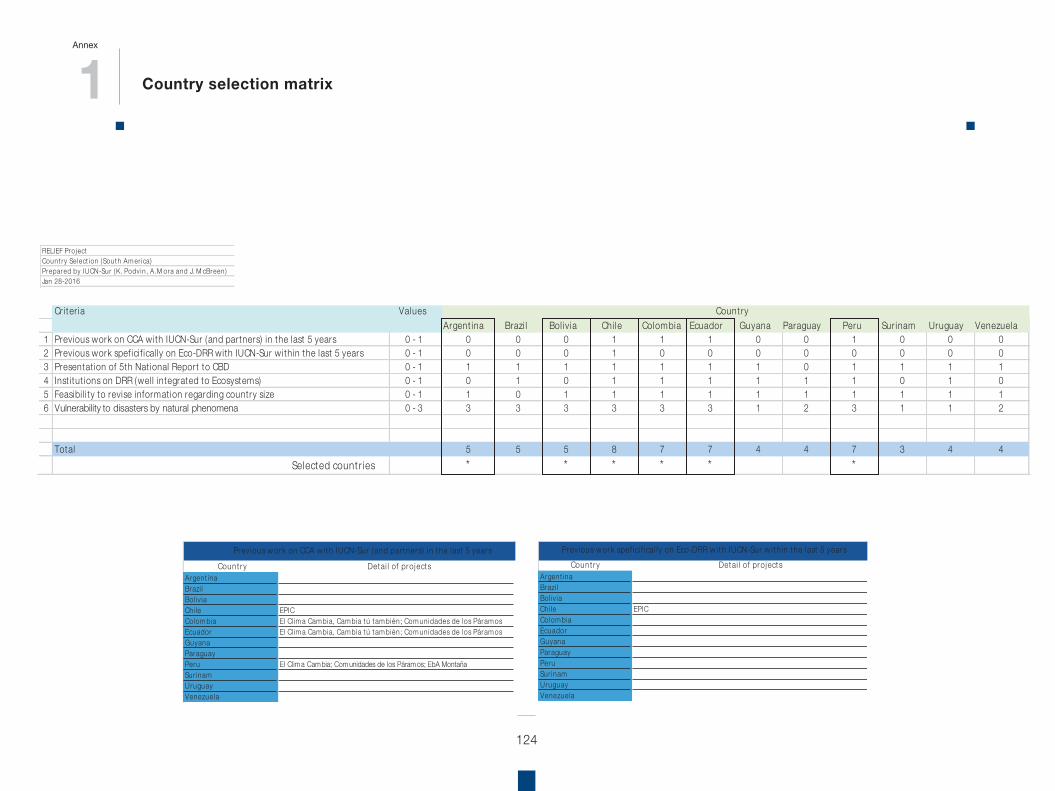
124
RELIEF Pro j ectCount ry Select ion ( South Am er ica)Prepared by IUCN-Sur (K. Podv in , A.M ora and J. M cBreen )Jan 28-2016
Cr i t er ia ValuesArgen t ina Brazi l Bo l i v i a Ch i le Colom bia Ecuador Guyana Paraguay Peru Sur inam Uruguay Venezuela
1 Previous work on CCA w ith IUCN-Sur ( and par tners) in the last 5 years 0 - 1 0 0 0 1 1 1 0 0 1 0 0 02 Previous work spef ici f ical ly on Eco-DRR w ith IUCN-Sur w ith in the last 5 years 0 - 1 0 0 0 1 0 0 0 0 0 0 0 03 Presentat ion of 5th Nat ional Repor t to CBD 0 - 1 1 1 1 1 1 1 1 0 1 1 1 14 Inst i tu t ions on DRR (wel l in tegrated to Ecosystem s) 0 - 1 0 1 0 1 1 1 1 1 1 0 1 05 Feasibi l i t y to revise in form at ion regarding count ry size 0 - 1 1 0 1 1 1 1 1 1 1 1 1 16 Vulnerabi l i t y to disasters by natural phenom ena 0 - 3 3 3 3 3 3 3 1 2 3 1 1 2
Total 5 5 5 8 7 7 4 4 7 3 4 4Selected count r ies * * * * * *
Count ry
Count ryArgent inaBrazi lBol iv iaChi leColom biaEcuadorGuyanaParaguayPeruSur inamUruguayVenezuela
EPIC
Prev ious w ork on CCA w i th IUCN-Sur ( and par tners) in the last 5 years
Detai l of pro jects
El Cl im a Cam bia, Cam bia tú tam bién; Com unidades de los Páram osEl Cl im a Cam bia, Cam bia tú tam bién; Com unidades de los Páram os
El Clim a Cam bia; Com unidades de los Páram os; EbA Montaña
Count ryArgent inaBrazi lBol iv iaChi leColom biaEcuadorGuyanaParaguayPeruSur inamUruguayVenezuela
EPIC
Detai l of pro j ectsPrev ious w ork spef ici f i cal l y on Eco-DRR w i th IUCN-Sur w i th in the last 5 years
RELIEF ProjectCount ry Select ion (South Amer ica)Prepared by IUCN-Sur (K. Podvin, A.M ora and J. M cBreen)Jan 28-2016
Cr i ter ia ValuesArgent ina Brazi l Bol iv ia Chi le Colombia Ecuador Guyana Paraguay Peru Sur inam Uruguay Venezuela
1 Previous work on CCA with IUCN-Sur (and partners) in the last 5 years 0 - 1 0 0 0 1 1 1 0 0 1 0 0 02 Previous work spef icif ical ly on Eco-DRR with IUCN-Sur within the last 5 years 0 - 1 0 0 0 1 0 0 0 0 0 0 0 03 Presentat ion of 5th Nat ional Report to CBD 0 - 1 1 1 1 1 1 1 1 0 1 1 1 14 Inst itut ions on DRR (well integrated to Ecosystems) 0 - 1 0 1 0 1 1 1 1 1 1 0 1 05 Feasibi l i ty to revise informat ion regarding country size 0 - 1 1 0 1 1 1 1 1 1 1 1 1 16 Vulnerability to disasters by natural phenomena 0 - 3 3 3 3 3 3 3 1 2 3 1 1 2
Total 5 5 5 8 7 7 4 4 7 3 4 4Selected count r ies * * * * * *
Country
1 Country selection matrix
Annex
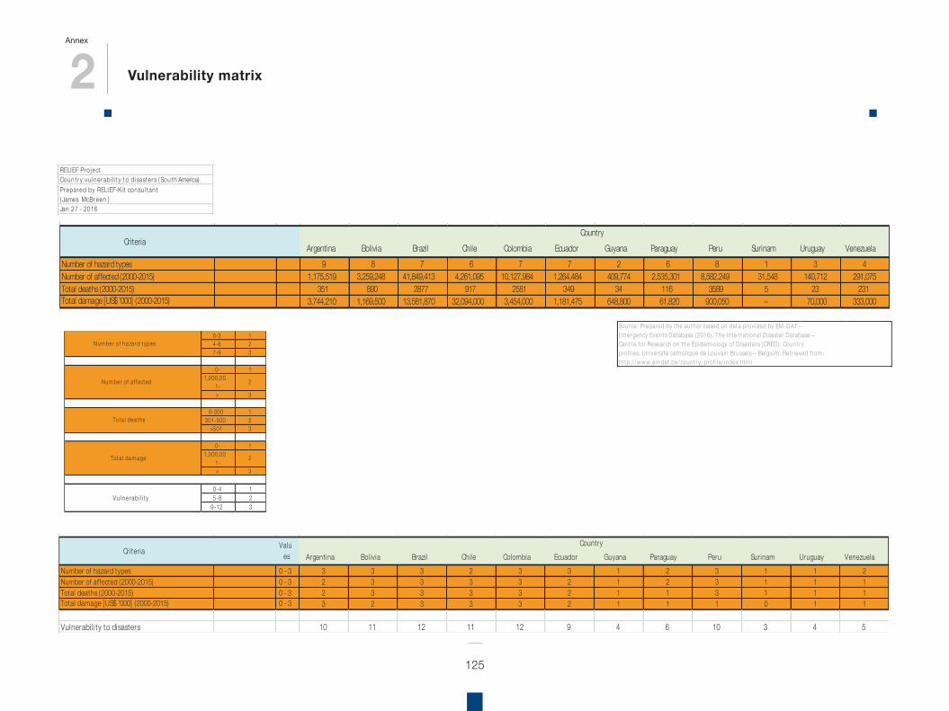
2 Vulnerability matrix
Annex
125
0-3 14-6 27-9 3
0- 11,000,00
1-2
> 3
0-300 1301-500 2
>501 3
0- 11,000,00
1-2
> 3
0-4 15-8 2
9-12 3V u ln e rabi l i t y
Num ber of ha za rd t ypes
Nu m ber of a f f ect ed
Tot a l dea t hs
Tot a l da m a ge
RELIEF Pro j ectCou n t r y v u ln e rab i l i t y t o d i sast e r s ( Sou t h America)Prepared by RELIEF-Ki t consu l t an t( James McBreen )Jan 27 - 2016
A rgen t i n a Bo l i v i a Brazi l Ch i l e Co lom bia Ecu ador Gu yan a Paragu ay Peru Su r in am Ur u gu ay V en ezu e laNum ber of ha za rd t ypes 9 8 7 6 7 7 2 6 8 1 3 4Num ber of a f f ect ed ( 2000-2015) 1,175,519 3,259,248 41,849,413 4,261,095 10,127,984 1,264,484 409,774 2,535,301 8,582,249 31,548 140,712 291,075Tot a l dea t hs ( 2000-2015) 351 890 2877 917 2581 349 34 116 3589 5 23 231Tot a l da m a ge [ U S$ '000] ( 2000-2015) 3,744,210 1,169,500 13,581,870 32,094,000 3,454,000 1,181,475 648,800 61,820 900,050 – 70,000 333,000
A rgen t i n a Bo l i v i a Brazi l Ch i l e Co lom bia Ecu ador Gu yan a Paragu ay Peru Su r in am Ur u gu ay V en ezu e laNum ber of ha za rd t ypes 0 - 3 3 3 3 2 3 3 1 2 3 1 1 2Num ber of a f f ect ed ( 2000-2015) 0 - 3 2 3 3 3 3 2 1 2 3 1 1 1Tot a l dea t hs ( 2000-2015) 0 - 3 2 3 3 3 3 2 1 1 3 1 1 1Tot a l da m a ge [ U S$ '000] ( 2000-2015) 0 - 3 3 2 3 3 3 2 1 1 1 0 1 1
V u lne rab i l i t y t o d isast e r s 10 11 12 11 12 9 4 6 10 3 4 5
Cou n t r y
Cou n t r y
Cr i t e r i a
Cr i t e r i aV a lu
es
Source: Prepared by the author based on data prov ided by EM -DAT –Em ergency Events Database (2016) . The In ternat ional Disaster Database –Cent re for Research on the Epidem iology of Disasters (CRED) : Count ryprof i les. Un iversi té cathol ique de Louvain Brusse ls – Belgium . Ret r ieved f rom :h t tp:/ / w w w .em dat .be/ count ry_prof i le/ index.h tm lRELIEF Project
Country vulnerabi l i ty to disasters (SouthPrepared by RELIEF-Kit consultant(James M cBreen)Jan 27 - 2016
Argentina Bol ivia Brazi l Chi le Colombia Ecuador Guyana Paraguay Peru Surinam Uruguay VenezuelaNumber of hazard types 9 8 7 6 7 7 2 6 8 1 3 4Number of affected (2000-2015) 1,175,519 3,259,248 41,849,413 4,261,095 10,127,984 1,264,484 409,774 2,535,301 8,582,249 31,548 140,712 291,075Total deaths (2000-2015) 351 890 2877 917 2581 349 34 116 3589 5 23 231Total damage [US$ '000] (2000-2015) 3,744,210 1,169,500 13,581,870 32,094,000 3,454,000 1,181,475 648,800 61,820 900,050 – 70,000 333,000
Argentina Bol ivia Brazi l Chi le Colombia Ecuador Guyana Paraguay Peru Surinam Uruguay VenezuelaNumber of hazard types 0 - 3 3 3 3 2 3 3 1 2 3 1 1 2Number of affected (2000-2015) 0 - 3 2 3 3 3 3 2 1 2 3 1 1 1Total deaths (2000-2015) 0 - 3 2 3 3 3 3 2 1 1 3 1 1 1Total damage [US$ '000] (2000-2015) 0 - 3 3 2 3 3 3 2 1 1 1 0 1 1
Vulnerabi l i ty to disasters 10 11 12 11 12 9 4 6 10 3 4 5
Country
Country
Criteria
CriteriaValu
es
RELIEFProjectCountry vulnerability to disasters (SouthPrepared by RELIEF-Kit consultant(JamesMcBreen)Jan 27 - 2016
Argentina Bolivia Brazil Chile Colombia Ecuador Guyana Paraguay Peru Surinam Uruguay VenezuelaNumber of hazard types 9 8 7 6 7 7 2 6 8 1 3 4Number of affected (2000-2015) 1,175,519 3,259,248 41,849,413 4,261,095 10,127,984 1,264,484 409,774 2,535,301 8,582,249 31,548 140,712 291,075Total deaths (2000-2015) 351 890 2877 917 2581 349 34 116 3589 5 23 231Total damage [US$ '000] (2000-2015) 3,744,210 1,169,500 13,581,870 32,094,000 3,454,000 1,181,475 648,800 61,820 900,050 – 70,000 333,000
Argentina Bolivia Brazil Chile Colombia Ecuador Guyana Paraguay Peru Surinam Uruguay VenezuelaNumber of hazard types 0 - 3 3 3 3 2 3 3 1 2 3 1 1 2Number of affected (2000-2015) 0 - 3 2 3 3 3 3 2 1 2 3 1 1 1Total deaths (2000-2015) 0 - 3 2 3 3 3 3 2 1 1 3 1 1 1Total damage [US$ '000] (2000-2015) 0 - 3 3 2 3 3 3 2 1 1 1 0 1 1
Vulnerability to disasters 10 11 12 11 12 9 4 6 10 3 4 5
Country
Country
Criteria
CriteriaValu
es
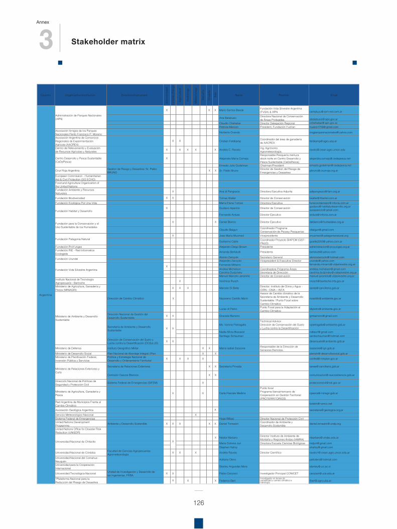
3 Stakeholder matrix
Annex
126
Country Organization/Insti tution Direction/Instrument
Envi
ronm
ent
Clim
ate
chan
ge
Agr
icul
ture
Hyd
rolo
gy
Met
eoro
logy
S ecu
rity
Dis
a ste
r
Ris
k
Name Position Emai l
X X X Mario Santos Beade Fundación Vida Silvestre Argentina (FVSA) & APN camptuyu@ rpm-net.com.ar
Ana Balabusic Directora Nacional de Conservación de Áreas Protegidas abalabusic@ apn.gov.ar
Claudio Chehebar Director Delegación Regional cchehebar@ apn.gov.arPatricia Marconi President, Fundación Yuchan huaico1709@ gmail.com
Asociación Amigos de los Parques Nacionales Perito Francisco P. Moreno Norberto Ovando ongparquesnacionales@ yahoo.com
Asociación Argentina de Consorcios Regionales de Experimentación Agrícola (AACREA)
X X Cristian Feldkamp Coordinador del área de ganadería de AACREA feldkamp@ agro.uba.ar
Centro de Relevamiento y Evaluación de Recursos Agrícolas y Naturales X X X X X Andrés C. Ravelo Ing. Agrónomo
Agrometeorología. ravelo@ crean.agro.uncor.edu
X Alejandra María CornejoResponsable Pesquería merluza stock norte en Centro Desarrollo y Pesca Sustentable (CeDePesca)
alejandra.cornejo@ cedepesca.net
Ernesto Julio Godelman Chairman/President ernesto.godelman@ cedepesca.net
Cruz Roja Argentina Gestion de Riesgo y Desastres: Sr. Pablo BRUNO X X Sr. Pablo Bruno Director de Gestion del Riesgo de
Emergencias y Desastres pbruno@ cruzroja.org.ar
European Commission - Humanitarian Aid & Civil Protection (DG ECHO) Food and Agriculture Organization of the United Nations Fundación Ambiente y Recursos Naturales X Ana di Pangracio Directora Ejecutiva Adjunta adipangracio@ farn.org.ar
Fundación Biodiversidad X X Tomas Waller Director de Conservación twaller@ fibertel.com.ar
Fundación Ecológica Por Una Vida María Elena Torresi Directora Ejecutiva funecovidamejor@ infovia.com.ar
X Gustavo Aparicio Director de Conservación gustavo@ habitatydesarrollo.org.argusaparicio@ gmail.com
Fernando Ardura Director Ejecutivo ardura@ infovia.com.ar
X X Daniel Blanco Director Ejecutivo deblanco@ humedales.org.ar
Claudio Baigun Coordinador Programa Conservación de Pecesy Pesquerías cbaigun@ gmail.com
X Jose María Musmeci Vicepresidente jmusmeci@ patagonianatural.org
Guillermo Caille Coordinador Proyecto SIAPCM (GEF-PNUD) gcaille2003@ yahoo.com.ar
Fundación ProYungas Alejandro Diego Brown Presidente administracion@ proyungas.org.arFundación RIE - Red Informatica Ecologista Amanda Bertolutti Presidenta bertolutti@ yahoo.com
Alonzo Zarzycki Secretario General alonzozarzycki@ hotmail.comAlejandro Zarzycki Vicepresident & Executive Director urundei@ yahoo.comFernando Miñarro fernando.minarro@ vidasilvestre.org.ar
Andrea Michelson Coordinadora Programa Áreas andrea.michelson@ gmail.comCarolina Dydzinsky Secretaria de Dirección carolina.dydzinsky@ vidasilvestre.org.Manuel Marcelo Jaramillo Director de Conservación manuel.jaramillo@ vidasilvestre.org.a
Instituto Nacional de Tecnología Agropecuaria - Bariloche X Verónica Rusch vrusch@ bariloche.inta.gov.ar
Ministerio de Agricultura, Ganadería y Pesca (MINAGRI) X X X Marcelo Di Bella Director: Instituto de Clima y Agua -
CIRN - CNIA – INTA seree@ cancilleria.gob.ar
Dirección de Cambio Climático X Nazareno Castillo Marín
Asesor de Cambio climático de la Secretaría de Ambiente y Desarrollo Sustentable / Punto Focal sobre Cambio Climático
ncastillo@ ambiente.gov.ar
Lucas di Pietro Punto Focal para la Adaptación al Cambio Climático ldipietro@ ambiente.gov.ar
Dirección Nacional de Gestión del Desarrollo Sustentable X X Graciela Barreiro gmbarreiro@ gmail.com
Ms. Vanina PietragallaTechnical AdvisorDirección de Conservación del Suelo y Lucha contra la Desertificación
vpietragalla@ ambiente.gob.ar
Nadia Silvia Boscarol ndbscrl@ gmail.comSantiago Schauman santischauman@ hotmail.com
Dirección de Conservación del Suelo y Lucha contra la Desertificación (DCSyLcD) X X desersuelo@ ambiente.gob.ar
Ministerio de Defensa Instituto Geográfico Militar X X María Isabel Sassone Responsable de la Dirección de Sensores Remotos. isassone@ ign.gob.ar
Ministerio de Desarrollo Social Plan Nacional de Abordaje Integral (Plan X X planahi@ desarrollosocial.gob.arMinisterio de Planificación Federal, Inversión Pública y Servicios
Polí tica y Estrategia Nacional de Desarrollo y Ordenamiento Territorial X X X X confed@ minplan.gov.ar
Secretaría de Relaciones Exteriores X X Secretaría Privada seree@ cancilleria.gob.ar
Comisión Cascos Blancos X X comunicacion@ cascosblancos.gob.ar
Dirección Nacional de Polí ticas de Seguridad y Protección Civil Sistema Federal de Emergencias (SIFEM) X proteccioncivil@ ssi.gov.ar
Ministerio de Agricultura, Ganadería y Pesca X X Carla Pascale Medina
Punto focalPrograma Iberoamericano de Cooperación en Gestión Territorial (PROTERRITORIOS)
cpasca@ minagri.gob.ar
Red Argentina de Municipios Frente al Cambio Climático boletin@ ramcc.net
Asociación Geológica Argentina X secretaria@ geologica.org.ar
Servicio Meteorológico Nacional XSistema Federal de Emergencias Hugo Bilbao Director Nacional de Protección CivilUnited Nations Development Programme Ambiente y Desarrollo Sostenible X X X X X Daniel Tomasini Coordinador de Ambiente y
Desarrollo Sostenible daniel.tomasini@ undp.org
United Nations Office for Disaster Risk Reduction (UNISDR)
X Néstor Bárbaro Director Instituto de Ambiente de Montaña y Regiones Áridas ( IAMRA) nbarbaro@ undec.edu.ar
Maria Dolores Juri Directora Escuela Ciencias Biológicas mdjuri@ gmail.comStephan Halloy shalloy@ gmail.com
Universidad Nacional de Córdoba Facultad de Ciencias AgropecuariasAgrometeorología X X X Andrés Ravelo Director Cientí fico ravelo1@ crean.agro.uncor.edu.ar
Universidad Nacional del Comahue - Neuquén Adriana Otero petiotero@ hotmail.com
Universidad para la Cooperación Internacional Stanley Arguedas Mora stanley@ uci.ac.cr
Universidad Tecnológica Nacional Unidad de Investigación y Desarrollo de las Ingenierías, FRBA X X Pablo Canziani Investigador Principal CONICET canziani@ uca.edu.ar
*Plataforma Nacional para laReducción del Riesgo de Desastres X X X Federico Bert
Investigador en temas de variabilidad y cambio climático e hidrología fbert@ agro.uba.ar
Fundación Urundei
Fundación Vida Silvestre Argentina
X X
Key stakeholders working in EbA and Eco-DRR in South America
Ministerio de Ambiente y Desarrollo Sustentable
X
Administración de Parques Nacionales (APN)
Fundación Habitat y Desarrollo
Argentina
Secretaría de Ambiente y Desarrollo Sustentable
Universidad Nacional de Chilecito X
Ministerio de Relaciones Exteriores y Culto
Centro Desarrollo y Pesca Sustentable (CeDePesca)
Fundación para la Conservación y el Uso Sustentable de los Humedales
Fundación Patagonia Natural
arr
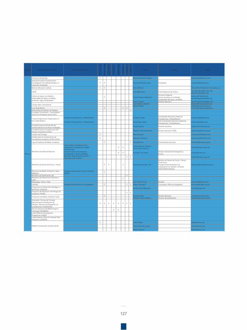
127
Country Organization/Insti tution Direction/Instrument
Envi
ronm
ent
Clim
ate
chan
ge
Agr
icul
ture
Hyd
rolo
gy
Met
eoro
logy
Secu
rity
Dis
aste
r
Ris
k
Name Position Emai l
Amazonia Sostenible X Oscar Saavedra Arteaga osaavedraus@ yahoo.comAsociación para la Conservación, Investigación de la Biodiversidad y el Desarrollo Sostenible
X X Carmen Miranda Larrea Presidenta cemirandal@ gmail.com
Bolivian Mountain Institute X X Dirk Hoffmann dirk.hoffmann@ bolivian-mountains.org
CARE Luis Salamanca Oficial Nacional de Enlace luis.salamanca@ bo.care.orgdipechobol@ gmail.com
X Paula Pacheco MollinedoDirectora RegionalCentro de Apoyo a la Gestión Sustentable del Agua y el Medio
paulis_p@ hotmail.compaula@ aguasustentable.org
Carlos Carafa Director Ejecutivo carlos@ aguasustentable.orgJuan Carlos Ledezma jledezma@ conservation.orgCadido Pastor cpastor@ conservation.org
Cruz Roja Bolivia X X X cruzrobo@ caoba.entelnet.boDirecciones de Gestión de Riesgos XEuropean Commission - Humanitarian Aid & Civil Protection (DG ECHO)
Unidad de Emergencias y Rehabilitación Einstein Tejada Coordinador Nacional Unidad deEmergencias y Rehabilitación einstein.tejada@ fao.org
Unidad de Emergencias y Rehabilitación Rosse Mery Noda Sub Coordinador Nacional Unidad deEmergencias y Rehabilitación Rosse.Noda@ fao.org
Fundación para el Desarrollo del Sistema Nacional de Áreas Protegidas Sergio Eguino Director Ejecutivo seguino@ fundesnap.org
Fundación para la Conservación del Bosque Chiquitano (FCBC) Roberto Vides-Almonacid Director Ejecutivo FCBC robertovides@ fcbc.org.bo
Instituto de Ecología X Mario Baudoin mariobaudoin@ gmail.comInstituto para la Conservación de Ecosistemas Acuáticos ( ILPEC-ICEA) X Alejandro Moscoso artmoscoso@ hotmail.com
Liga de Defensa del Medio Ambiente X X Marisabel Paz Coordinadora Ejecutiva marisabel@ lidema.org.bo
Viceministerio de Defensa Civil y Cooperación al Desarrollo Integral (VIDECICODI)
X X Carlos Mariaca CeballosOmar Pedro Velazco info@ defensacivil.gov.bo
Dirección General de Atención Emergencias y Auxilio (DGAEA) X X Gonzalo Lora Araoz Director General de Emergencia y
Auxilio coenbol@ yahoo.es
Dirección General de Prevención y Reconstrucción (DGPR) X X info@ defensacivil.gov.bo
Ministerio de Desarrollo Rural y Tierras X X X Nemesia Achacollo Tola
Ministra de Desarrollo Rural y TierrasPunto focalPrograma Iberoamericano de Cooperación en Gestión Territorial (PROTERRITORIOS)
despacho@ agrobolivia.gob.bo
Ministerio de Medio Ambiente y Agua (MMAyA)
Programa Nacional de Cambio Climático (PNCC) X
Ministerio de Planificación del XMinisterio de Relaciones Exteriores y Culto X
Naturaleza, Tierra y Vida Ivan Arnold Torrez Director ivanarnoldt@ gmail.comOXFAM Disaster Risk Reduction and Adaptation X X X Roger Quiroga B Coordinator DRR and Adaptation RQuiroga@ oxfam.org.ukProgramas de Desarrollo Estratégico y Monitoreo Ambiental X imena Silva Maturana xisima@ gmail.com
Programa de Reducción de Riesgos de Desastres (PRRD) X X
X Rodrigo Ayala Director Ejecutivo rayala@ prometa.org.boRoberto Cabrera Balvoa Director de planificación rcabrera@ prometa.org.bo
Secretaría Técnica del Consejo Nacional para la Reducción de Riesgos, Atención de Desastres y/o Emergencias (CONARADE)
X X X X X X X X
Servicio Nacional de Meteorología e Hidrología (SENAMHI) X X
United Nations Development Programme (UNDP) United Nations Office for Disaster Risk Reduction (UNISDR)
X Lilian Painter lpainter@ wcs.org
Oscar Gonzalo Loayza oloayza@ wcs.org
Robert Wallace rwallace@ wcs.org
Key stakeholders working in EbA and Eco-DRR in South America
Bol iv ia
Conservation International
Wildlife Conservation Society (WCS)
Food and Agriculture Organization of the United Nations
Ministerio de Defensa Nacional
Centro de Apoyo a la Gestión Sustentable del Agua y el Medio Ambiente “Agua Sustentable”
Protección del Medio Ambiente Tarija
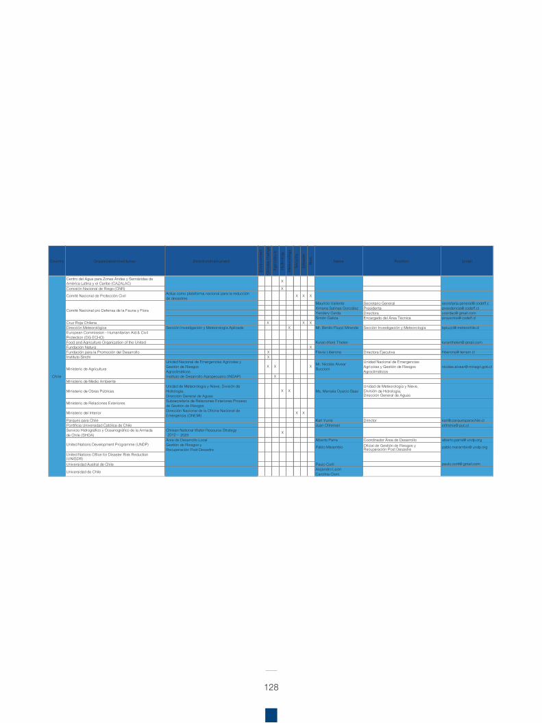
128
Country Organization/Insti tution Direction/InstrumentEn
viro
nmen
t
Cl im
a te
chan
ge
Agr
icul
ture
Hyd
rolo
g y
Met
eoro
logy
Secu
rity
Dis
aste
r
Ri s
k
Name Position Emai l
Centro del Agua para Zonas Áridas y Semiáridas de América Latina y el Caribe (CAZALAC) X
Comisión Nacional de Riego (CNR) X
Comité Nacional de Protección Civil Actúa como plataforma nacional para la reducción de desastres X X X
Mauricio Valiente Secretario General secretaria.general@ codeff.cXimena Salinas González Presidenta presidencia@ codeff.clYendery Cerda Directora ycerdac@ gmail.comSimón Gatica Encargado del Área Técnica proyectos@ codeff.cl
Cruz Roja Chilena X X XDirección Meteorológica Sección Investigación y Meteorología Aplicada X Mr. Benito Piuzzi Miranda Sección Investigación y Meteo or logía bpiuzzi@ meteochile.clEuropean Commission - Humanitarian Aid & Civil Protection (DG ECHO) Food and Agriculture Organization of the United Kyran (Ken) Thelen kyranthelen@ gmail.comFundación Natura XFundación para la Promoción del Desarrollo X Flavia Liberona Directora Ejecutiva fliberona@ terram.clInstituto Sinchi X
Unidad Nacional de Emergencias Agrícolas y Gestión de RiesgosAgroclimáticos
X X X Mr. Nicolás Alvear Buccioni
Unidad Nacional de Emergencias Agrícolas y Gestión de RiesgosAgroclimáticos
nicolas.alvear@ minagri.gob.cl
Instituto de Desarrollo Agropecuario ( INDAP) XMinisterio de Medio Ambiente
Ministerio de Obras PúblicasUnidad de Meteorología y Nieve, División de Hidrología, Dirección General de Aguas
X X Ms. Marcela Oyarzo BaezUnidad de Meteorología y Nieve,División de Hidrología, Dirección General de Aguas
Ministerio de Relaciones Exteriores Subsecretaría de Relaciones Exteriores Proceso de Gestión de Riesgos
Ministerio del Interior Dirección Nacional de la Oficina Nacional de Emergencia (ONEMI) X X
Parques para Chile Karl Yunis Director karl@ parquesparachile.clPontificia Universidad Católica de Chile Juan Oltremari joltrama@ puc.clServicio Hidrográfico y Oceanográfico de la Armada de Chile (SHOA)
Chilean National Water Resource Strategy 2012 – 2025 X
Área de Desarrollo Local Alberto Parra Coordinador Área de Desarrollo alberto.parra@ undp.orgGestión de Riesgos yRecuperación Post Desastre Pablo Marambio Oficial de Gestión de Riesgos y
Recuperación Post Desastre pablo.marambio@ undp.org
United Nations Office for Disaster Risk Reduction (UNISDR)Universidad Austral de Chile Paulo Corti paulo.corti@ gmail.com
Universidad de Chile Alejandro LeónCarolina Clerc
Ministerio de Agricultura
Chi le
Key stakeholders working in EbA and Eco-DRR in South America
United Nations Development Programme (UNDP)
Comité Nacional pro Defensa de la Fauna y Flora
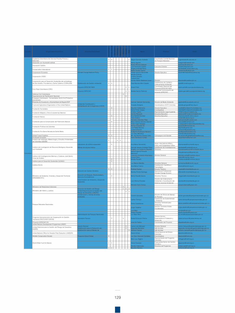
129
Country Organization/Insti tution Direction/Instrument
Envi
ronm
ent
Clim
ate
chan
g e
Agr
icul
ture
Hyd
rolo
gy
Met
eor o
l ogy
Secu
rity
Dis
aste
r
Ris
k
Name Position Emai l
Academia Colombiana de Ciencias Exactas Fisicas y Naturales X X X Miguel Gonzalo Andrade Coordinador Comité Nacional
de Parques Naturales mgandradec@ unal.edu.co
Alexander von Humboldt Institute Nancy Aguirre cnaguirre@ hotmail.comNoemi Moreno Salazar noemisa7@ yahoo.esLuis Fernando Castillo Executive Director lfcastillo7@ gmail.comAngela Andrade Pérez aandrade@ conservation.orgMatha Zarate Ospina zaratemalu@ gmail.com
Corporación Ecoversa Climate Change National Policy Fabián Ignacio Navarrete Director Ejecutivo navarrete.fabian@ ecoversa.org
Corporacion OSSONayibe JimenezCristina RosalesYuliana DiazDurcey Alison Stephens Lever Director direccion@ coralina.gov.co
Subdirección de Gestión Ambiental X X Opal Marcela Bent Zapata Subdirectora de Calidad y Ordenamiento Ambiental opalb@ coralina.gov.co
Proyecto DIPECHO NDS X X Edwin Pinto Coordinador Nacional del Proyecto DIPECHO NDS edwin.pinto@ cruzrojacolombiana.org
Proyecto DIPECHO X X Natalia Garcia Palencia Oficial de Comunicación delproyecto DIPECHO natalia.garcia@ cruzrojacolombiana.org
Defensa Civil Colombiana XDepartamento de Planificación Nacional XEuropean Commission - Humanitarian Aid & Civil Protection (DG ECHO) Empresa de Acueducto y Alcantarillado de Bogotá ESP German Galindo Hernandez Director de Medio Ambiente ggalindoh@ acueducto.com.co
Food and Agriculture Organization of the United Nations Unidad de Coordinación y Rehabilitación de Emergencias (UCER) Teresita Gongora Coordinadora UCER Colombia teresita.gongora@ fao.org.co
X Mauricio Valderrama Director Ejecutivo mvalde@ fundacionhumedales.orgMaría Pinilla Vargas Investigadora mpinilla@ fundacionhumedales.orgXimena Tapias Representante Legal Suplente info@ fundacionmalpelo.orgSandra Bessudo Directora Ejecutiva sbessudo@ fundacionmalpelo.org
X Elsa Matilde Escobar Directora Ejecutiva elsamescobar@ natura.org.coClara Solano csolano@ natura.org.coHeliodoro Sánchez Páez heliosanchez@ outlook.comMaryi Adriana Serrano Garzón maryiads@ hotmail.comVictor Hugo Vásquez v.vasquez@ fundacionbiocolombia.orgAlonso Quevedo Gil aquevedo@ proaves.orgLuis Felipe Barrera lfbarrera@ gmail.comLucas Echeverri lecheverri@ prosierra.orgGuillermo Rodríguez-Navarro grodriguez@ prosierra.orgLuz Dary Mendoza lmendoza@ prosierra.org
Global Forest Coalition X X Ms. Isis Karinna Alvarez Ortiz Campaigner and Gender isis.alvarez@ globalforestcoalition.orgHumboldt University Dario Zambrano Cortes dgzambranoc@ gmail.comInstituto de Hidrología, Meteorología y Estudios Ambientales de Colombia ( IDEAM) X X X
Laboratorio de análisis espaciales Ana María Hernández Head, International Affairs, Policy and Cooperation Office ahernandez@ humboldt.org.co
Manejo de recurso hídrico Germán Ignacio Andrade Pérez Subdirector de Investigaciones gandrade@ humboldt.org.coBrigitte Luis Guillermo Baptiste Directora secretariadireccion@ humboldt.org.coMaria Eugenia Rinaudo Mannucci rinaudomannucci@ gmail.com
Francisco Armando Arias-Isaza Director General francisco.arias@ invemar.org.coDinora Otero dotero@ invemar.org.co
X Morela Rengifo morela.rengifo@ invemar.org.coInstituto para el Desarrollo Sostenible QUINAXI X
Luz Marina Mantilla Directora General luzmarmantilla@ sinchi.org.co
Ana María Franco Subdirección Cientí fica y Tecnológica afranco@ sinchi.org.co
X X Rodrigo Suárez Director Técnico rsuarez@ minambiente.gov.co
Maritza Florian Buitrago Specialized ProfessionalClimate Change Division mflorian@ minambiente.gov.co
Dirección de Bosques, Biodiversidad y Servicios Ecosistémicos X María Claudia García Directora Técnico mcgarcia@ minambiente.gov.co
Viceministerio de Ambiente y Desarrollo Sostenible Luis Alfonso Escobar
Director de Ordenamiento Ambiental y Coordinación del Sistema nacional Ambiental
lescobar@ minambiente.gov.co
Marcela Cano Correa pnnprovidencia@ gmail.comMinisterio de Relaciones Exteriores X
Dirección de Gestión del Riesgo X X XUnidad Nacional para la Gestión del Riesgo de Desastres (UNGRD) X X
Conservación y manejo de áreas protegidas Yasmin Gonzalez Director de Oficina de Manejo
de Riesgos jazmin.gonzalez@ parquesnacionales.gov.co
Carlos Tamayo Subdirector de Sostenibilidad y Ambiente carlos.tamayo@ parquesnacionales.gov.co
Diana Castellanos Directora Territorial para Amazonía
diana.castellanos@ parquesnacionales.gov.co
Jorge Ceballos Director Territorial Andes Occidentales
jorge.ceballos@ parquesnacionales.gov.co
Luís Malo luimalop@ aol.comGisela Paredes gisela.paredesl@ gmail.com
Administración de Parques Nacionales Luz Nelly Nino luz.nino@ parquesnacionales.gov.co
Programa Iberoamericano de Cooperación en Gestión Territorial (PROTERRITORIOS) Secretario Técnico X X Rafael Echeverri Perico
Director técnicoEspecialista en Población y Desarrollo
rafael.echeverri@ proterritorios.net
Proyecto DIPECHO VIII José De Pablos Coordinador del Proyecto jdepablos@ plan.org.coUnited Nations Development Programme (UNDP)
Directo General X Carlos Iván Márquez Director General carlos.marquez@ gestiondelriesgo.gov.coSubdirección para la Reducción del X Alejandra Mendoza Jefe de área alejandra.mendoza@ gestiondelriesgo.gov.coSubdirección para el Manejo de X Adriana Cuevas Jefe de área adriana.cuevas@ gestiondelriesgo.gov.co
United Nations Office for Disaster Risk Reduction (UNISDR) Oscar Armas Oficial Nacional de Enlace Colombia dipechocol@ eird.org
Wildlife Conservation Society Programa Salud Global X Luz Dary Acevedo Cendales Coordinadora ldacevedo@ wcs.org
Mary Lou Higgins Representante del Programa Colombia mlhiggins@ wwf.org.co
X X Oscar Guevara Especialista Senior de Cambio Climático ojguevara@ wwf.org.co
Sandra Valenzuela Directora de Programas svalenzuela@ wwf.org.coX X Mauricio Herrera cmherrera@ wwf.org.co
Conservation International X
Key stakeholders working in EbA and Eco-DRR in South America
Unidad Nacional para la Gestión del Riesgo de Desastres (NGRD)
X
Colombia
Asociación Calidris
Dirección de Cambio Climático
X
X
Cruz Roja Colombiana (CRC)
Ministerio del Interior y Justicia
Fundación para la Conservación del Patrimonio Natural
Corporación para el Desarrollo Sostenible del archipiélago de San Andrés, Providencia y Santa Catalina (CORALINA)
World Wide Fund for Nature
Fundación Humedales
Instituto Sinchi
Instituto de Investigación de Recursos Biológicos Alexander von Humboldt
Ministerio de Ambiente, Vivienda y Desarrollo Territorial (MINAMBIENTE)
Parques Naturales Nacionales
Fundación Malpelo y Otros Ecosistemas Marinos
Fundación Natura
Fundación ProAves de Colombia
Fundación Pro-Sierra Nevada de Santa Marta
Instituto de Investigaciones Marinas y Costeras José Benito Vives de Andreis
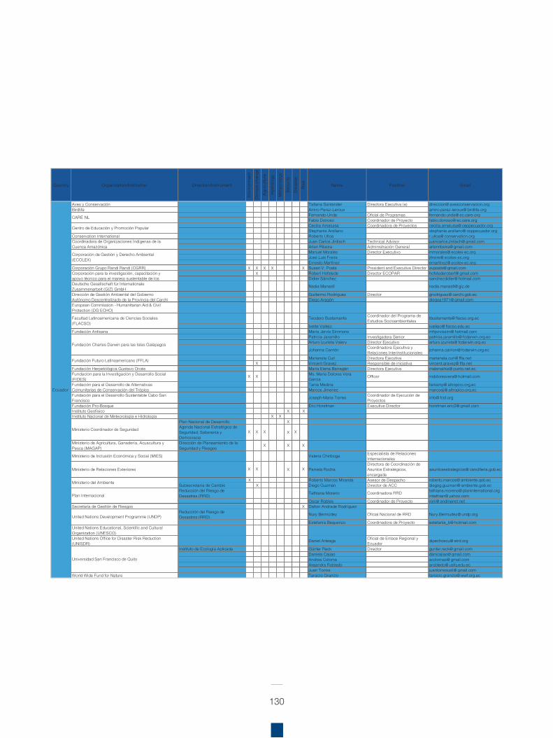
130
Country Organization/Insti tution Direction/Instrument
Envi
ronm
ent
Cl im
a te
c han
ge
Agr
icul
ture
Hyd
rolo
gy
Met
eor o
logy
Secu
r ity
Dis
aste
r
Ris
k
Name Position Emai l
Aves y Conservación Tatiana Santander Directora Ejecutiva (e) direccion@ avesconservacion.orgBirdlife Amiro Perez-Leroux amiro.perez-leroux@ birdlife.org
Fernando Unda Oficial de Programas fernando.unda@ ec.care.orgFabio Donoso Coordinador de Proyecto fabio.donoso@ ec.care.orgCecilia Amaluisa Coordinadora de Proyectos cecilia.amaluisa@ ceppecuador.orgStephanie Arellano stephanie.arellano@ ceppecuador.org
Conservation International Roberto Ulloa r.ulloa@ conservation.orgJuan Carlos Jintiach Technical Advisor juancarlos.jintiach@ gmail.comArlen Ribeira Administración General arlenribeira@ gmail.comManuel Morales Director Executivo mmorales@ ecolex-ec.orgJosé Luis Freire jlfreire@ ecolex-ec.orgErnesto Martínez emartinez@ ecolex-ec.org
Corporación Grupo Randi Randi (CGRR) X X X X X Susan V. Poats President and Executive Director svpoats@ gmail.comX Robert Hofstede Director ECOPAR hofstederobert@ gmail.com
Didier Sánchez sanchezdidier@ hotmail.comDeutsche Gesellschaft für Internationale Zusammenarbeit (GIZ) GmbH Nadia Manasfi nadia.manasfi@ giz.de
Guillermo Rodríguez Director grodriguez@ carchi.gob.ecDiego Aragón diegoa1971@ gmail.com
European Commission - Humanitarian Aid & Civil Protection (DG ECHO)
Teodoro Bustamante Coordinador del Programa de Estudios Socioambientales tbustamante@ flacso.org.ec
Ivette Vallejo ivallejo@ flacso.edu.ecFundación Antisana María Jervis Simmons mhjervissim@ hotmail.com
Patricia Jaramillo Investigadora Senior patricia.jaramillo@ fcdarwin.org.ecArturo Izurieta Valery Director Ejecutivo arturo.izurieta@ fcdarwin.org.ec
Johanna Carrión Coordinadora Ejecutiva y Relaciones Interinstitucionales johanna.carrion@ fcdarwin.org.ec
Marianela Curi Directora Ejecutiva marianela.curi@ ffla.netX Vincent Gravez Responsible de iniciativa vincent.gravez@ ffla.net
Fundación Herpetológica Gustavo Orcés María Elena Barragán Directora Ejecutiva malenairka@ punto.net.ecFundacion para la Investigacion y Desarrollo Social (FIDES) X X Ms. Maria Dolores Vera
Garcia Officer mdoloresvera@ hotmail.com
Tania Medina taniamp@ altropico.org.ecMarcos Jimenez marcosjj@ altropico.org.ec
Fundación para el Desarrollo Sustentable Cabo San Francisco Joseph-Marie Torres Coordinador de Ejecución de
Proyectos info@ fcsf.org
Fundación Pro-Bosque Eric Horstman Executive Director horstman.eric2@ gmail.comInstituto Geofísico X XInstituto Nacional de Meteorología e Hidrología X X
Plan Nacional de Desarrollo XAgenda Nacional Estratégica de Seguridad, Soberanía y Democracia
X X X X X
Ministerio de Agricultura, Ganadería, Acuacultura y Pesca (MAGAP)
Dirección de Planeamiento de la Seguridad y Riesgos X X X
Ministerio de Inclusión Económica y Social (MIES) Valeria Chiriboga Especialista de Relaciones Internacionales
Ministerio de Relaciones Exteriores X X X X Pamela RochaDirectora de Coordinación de Asuntos Estratégicos, encargada
asuntosestrategicos@ cancilleria.gob.ec
X Roberto Marcos Miranda Asesor de Despacho roberto.marcos@ ambiente.gob.ecSubsecretaría de Cambio X Diego Guzmán Director de ACC diegog.guzman@ ambiente.gob.ecReducción del Riesgo de Desastres (RRD) Tathiana Moreno Coordinadora RRD tathiana.moreno@ planinternational.org
mtathian@ yahoo.comOscar Robles Coordinador de Proyecto roni@ andinanet.net
Secretaria de Gestión de Riesgos X Dalton Andrade RodríguezReducción del Riesgo de Desastres (RRD) Nury Bermúdez Oficial Nacional de RRD Nury.Bermudez@ undp.org
Estefanía Baquerizo Coordinadora de Proyecto estefania_b@ hotmail.comUnited Nations Educational, Scientific and Cultural Organization (UNESCO)United Nations Office for Disaster Risk Reduction (UNISDR) Daniel Arteaga Oficial de Enlace Regional y
Ecuador dipechoecu@ eird.org
Instituto de Ecología Aplicada Günter Reck Director gunter.reck@ gmail.comDaniela Cajiao danicajiao@ gmail.comAndrea Coloma acolomas@ gmail.comAlejandra Robledo arobledo@ usfq.edu.ecJuan Torres juantorresceli@ gmail.com
World Wide Fund for Nature Tarsicio Granizo tarsicio.granizo@ wwf.org.ec
Universidad San Francisco de Quito
Facultad Latinoamericana de Ciencias Sociales (FLACSO)
Ecuador
Key stakeholders working in EbA and Eco-DRR in South America
Ministerio del Ambiente
Ministerio Coordinador de Seguridad
United Nations Development Programme (UNDP)
Plan Internacional
CARE NL
Centro de Educación y Promoción Popular
Coordinadora de Organizaciones Indígenas de la Cuenca Amazónica
Corporación de Gestión y Derecho Ambiental (ECOLEX)
Corporación para la investigación, capacitación y apoyo técnico para el manejo sustentable de los
Dirección de Gestión Ambiental del Gobierno Autónomo Descentralizado de la Provincia del Carchi
Fundación Charles Darwin para las Islas Galápagos
Fundación Futuro Latinoamericano (FFLA)
Fundación para el Desarrollo de Alternativas Comunitarias de Conservación del Trópico
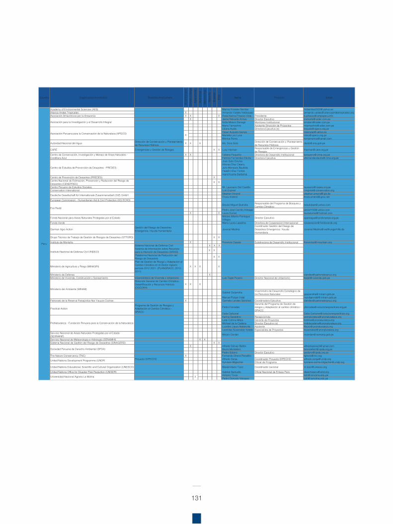
131
Country Organization/Insti tution Direction/Instrument
Envi
ronm
ent
Clim
ate
chan
ge
Agr
icul
ture
Hyd
rolo
gy
Me t
e oro
l ogy
Secu
rity
Dis
aste
r
Ri s
k
Name Position Emai l
Academy of Environmental Sciences (AES) Marina Rosales Benites mrbenites2002@ yahoo.esAlianza Andes Tropicales X Armando Valdés-Velásquez armando.valdes@ alianzaandestropicales.orgAsociación Amazónicos por la Amazonía X X X Rosa Karina Pinasco Vela Presidente k.pinasco@ ampaperu.info
X Jaime Nalvarte Armas Director Ejecutivo jnalvarte@ aider.com.peSofia Molero Denegri Monitoreo Institucional smolero@ aider.com.peMaría Tamashiro Asistente Dirección de Proyectos mtamashiro@ aider.com.peLiliana Ayala Directora Ejecutiva (e) leayala@ apeco.org.peCesar Augusto Ipenza cipenzap@ yahoo.esMariella Leo Luna mleo@ apeco.org.peMónica Romo romomonica@ gmail.com
Autoridad Nacional del Agua Dirección de Conservación y Planeamiento de Recursos Hídricos X X X Ms. Dora Soto Dirección de Conservación y Planeamiento
de Recursos Hídricos dsoto@ ana.gob.pe
CARE Emergencias y Gestión de Riesgos X X Lucy Harman Responsable de Emergencias y Gestión de Riesgos lharman@ care.org.pe
X X Tatiana Pequeño Directora de Desarrollo Institucional tpequeno@ cima.org.pePatricia Fernández-Dávila Directora Ejecutiva pfernandezdavila@ cima.org.pe
Centro de Estudios de Prevencion de Desastres - PREDES
Jose Sato OnumaAlfonso Diaz Calero,Julio Meneses BautistaYeseli n Diaz ToribioIngrid Azana Saldana)
Centro de Prevención de Desastres (PREDES) XCentro Nacional de Estimación, Prevención y Reducción del Riesgo de Desastres (CENEPRED) X X
Centro Peruano de Estudios Sociales Mr. Laureano Del Castillo laureano@ cepes.org.peConservation International Luis Espinel l.espinel@ conservation.org
Stephan Amend stephan.amend@ giz.deThora Amend thora.amend@ gmx.net
European Commission - Humanitarian Aid & Civil Protection (DG ECHO)
Braulio Miguel Buendía Responsable del Programa de Bosques y Cambio Climático brauliobpe@ yahoo.com
Pedro José Carrillo Arteaga pecart100@ yahoo.comX X Laura Dumet lauradumet@ hotmail.com
Fondo Nacional para Areas Naturales Protegidas por el Estado Moises Alberto Paniagua Villagra Director Ejecutivo apaniagua@ profonanpe.org.pe
Fondo Verde María Laura Lapalma Directora de Cooperacion Internacional cooperacion@ fondoverde.org
German Agro Action Gestión del Riesgo de DesastresEmergencia / Ayuda Humanitaria Juvenal Medina
Coordinador Gestión del Riesgo de Desastres Emergencia / Ayuda Humanitaria
Juvenal.Medina@ welthungerhilfe.de
Grupo Técnico de Trabajo de Gestión de Riesgos de Desastres (GTTGRD) X X
Instituto de Montaña X Florencia Zapata Subdirectora de Desarrollo Institucional florenciaz@ mountain.orgSistema Nacional de Defensa Civil X X XSistema de Información sobre Recursos para la Atención de Desastres (SIRAD) X X
Plataforma Nacional de Reducción del Riesgo de Desastres X X
Ministerio de Agricultura y Riego (MINAGRI)
Plan de Gestión de Riesgo y Adaptación al Cambio Climático en el Sector Agrario período 2012 2021- (PLANGRACC, 2010-2011)
X X X X
Ministerio de Defensa X clandeo@ patronatorpnyc.orgMinisterio de Vivienda, Construcción y Saneamiento Viceministerio de Vivienda y Urbanismo Luis Tagle Pizarro Director Nacional de Urbanismo ltagle@ vivienda.gob.pe
Dirección General de Cambio Climático, Desertificación y Recursos Hídricos (DGCDRH)
X X X
Gabriel Quijandria Viceministro de Desarrollo Estratégico de los Recursos Naturales gquijandria@ minam.gob.pe
Manuel Pulgar-Vidal mpulgarvidal@ minam.gob.pePatronato de la Reserva Paisajística Nor Yauyos Cochas X Carmela Landeo Sánchez Coordinadora Ejecutiva clandeo@ patronatorpnyc.org
Pedro FerradasGerente del Programa de Gestión de riesgos y Adaptación al cambio climático - GRACC
pferradas@ solucionespracticas.org.pe
Dalia Carbonel Dalia.Carbonel@ solucionespracticas.orgKarina Geraldino Recepcionista pronaturaleza@ pronaturaleza.orgLady Cotrina Mejía Gerente de Proyectos lcotrina@ pronaturaleza.orgMichael de la Cadena Director Ejecutivo (e) mdelacadena@ pronaturaleza.orgLourdes Llaury Noblecilla Asistente lllaury@ pronaturaleza.orgLeonidas Suasnabar Astete Especialista de Proyectos lsuasnabar@ pronaturaleza.org
Servicio Nacional de Áreas Naturales Protegidas por el Estado (SERNANP) Miriam Cerdan mcerdan@ sernanp.gob.pe
Servicio Nacional de Meteorología e Hidrología (SENAMHI) X XSistema Nacional de Gestión del Riesgo de Desastres (SINAGERD) X X
X Alfredo Gálvez Ballón alfredogalvezb@ gmail.comBruno Monteferri bmonteferri@ spda.org.pePedro Solano Director Ejecutivo psolano@ spda.org.pe
The Nature Conservancy (TNC) X Fernando Ghersi Penalillo fghersi@ tnc.orgProyecto DIPECHO Alfredo Zerga Coordinador Proyecto DIPECHO alfredo.zerga@ undp.org
Sylviane Bilgischer Oficial de Programa sylviane-carine.bilgischer@ undp.org
United Nations Educational, Scientific and Cultural Organization (UNESCO) Massimiliano Tozzi Coordinador nacional m.tozzi@ unesco.org
United Nations Office for Disaster Risk Reduction (UNISDR) Gabriel Samudio Oficial Nacional de Enlace Perú dipechoperu@ eird.orgAntonio Tovar latn@ lamolina.edu.pePedro Gonzalo Vásquez cdc@ lamolina.edu.pe
Key stakeholders working in EbA and Eco-DRR in South America
Instituto Nacional de Defensa Civil ( INDECI)
Deutsche Gesellschaft für Internationale Zusammenarbeit (GIZ) GmbH
Centro de Conservación, Investigación y Manejo de Áreas Naturales - Cordillera Azul
XAsociación Peruana para la Conservación de la Naturaleza (APECO)
Eco Redd
X
United Nations Development Programme (UNDP)
Programa de Gestión de Riesgos yAdaptación al Cambio Climático -GRACC
Practical Action
Sociedad Peruana de Derecho Ambiental (SPDA)
Ministerio del Ambiente (MINAM)
ProNaturaleza - Fundación Peruana para la Conservación de la Naturaleza
Universidad Nacional Agraria La Molina
Peru
Asociación para la Investigación y el Desarrollo Integral
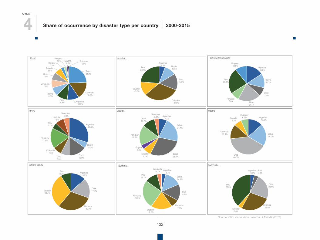
4 Share of occurrence by disaster type per country | 2000-2015
Annex
132
Brazil24.3%
Colombia16.5%
Argentina10.9%
Peru10.4%
Bolivia8.3%
Venezuela7.8%
Chile7.4%
Ecuador6.5%
Uruguay3.0%
Paraguay2.6% Guyana
1.3%Suriname
0.9%
Flood
Argentina5.3% Bolivia
10.5%
Brazil15.8%
Colombia31.6%
Ecuador13.2%
Peru23.7%
Landslide
Argentina15.8%
Bolivia13.2%
Brazil7.9%
Chile21.1%
Paraguay7.9%
Peru23.7%
Uruguay10.5%
Extreme temperatures
Argentina30.0%
Bolivia5.0%
Brazil15.0%Chile
7.5%
Colombia7.5%
Paraguay17.5%
Peru5.0%
Uruguay7.5%
Venezuela5.0%
Storm
Argentina7.1%
Bolivia21.4%
Brazil28.6%
Ecuador7.1%
Guyana3.6%
Paraguay17.9%
Peru10.7%
Venezuela3.6%
Drought
Argentina13.3%
Bolivia20.0%
Chile40.0%
Colombia13.3%
Ecuador6.7%
Paraguay6.7%
Wildfire
Argentina13.0%
Chile17.4%
Colombia30.4%
Ecuador30.4%
Peru8.7%
Volcanic activity
Argentina3.7%
Bolivia14.8%
Brazil14.8%
Colombia7.4%
Ecuador18.5%
Paraguay25.9%
Peru11.1%
Venezuela3.7%
Epidemic
Argentina3.8%
Brazil3.8%
Chile23.1%
Colombia26.9%Ecuador
3.8%
Peru38.5%
Earthquake
Source: Own elaboration based on EM-DAT (2016)
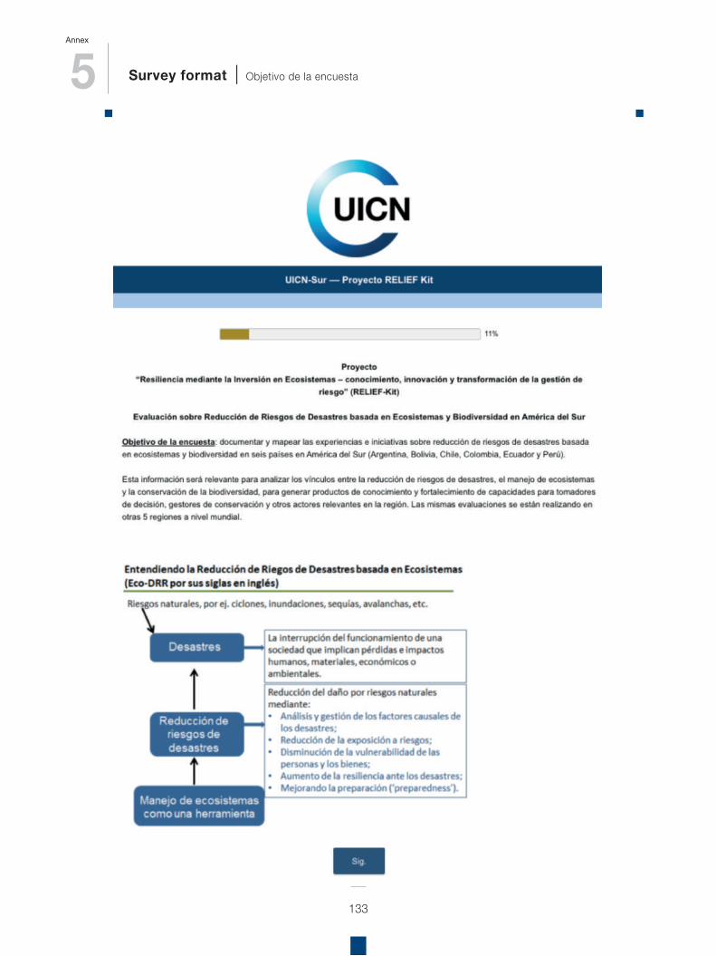
5 Survey format | Objetivo de la encuesta
Annex
133
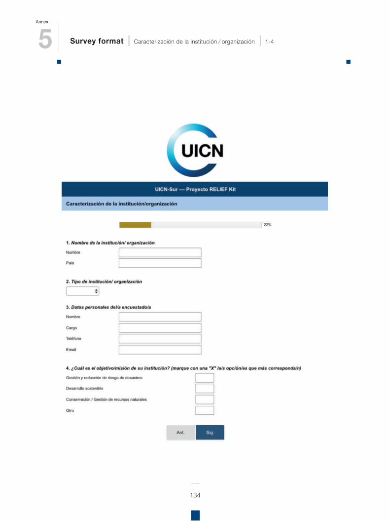
5 Survey format | Caracterización de la institución ⁄ organización | 1-4
Annex
134
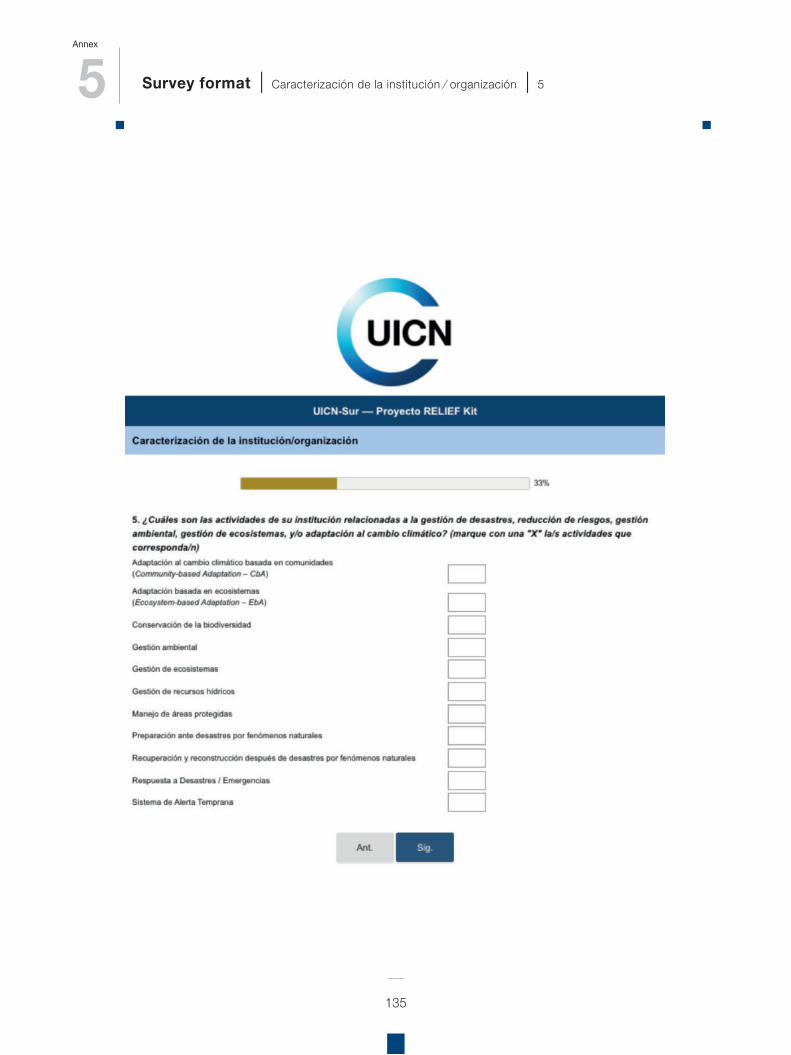
5 Survey format | Caracterización de la institución ⁄ organización | 5
Annex
135
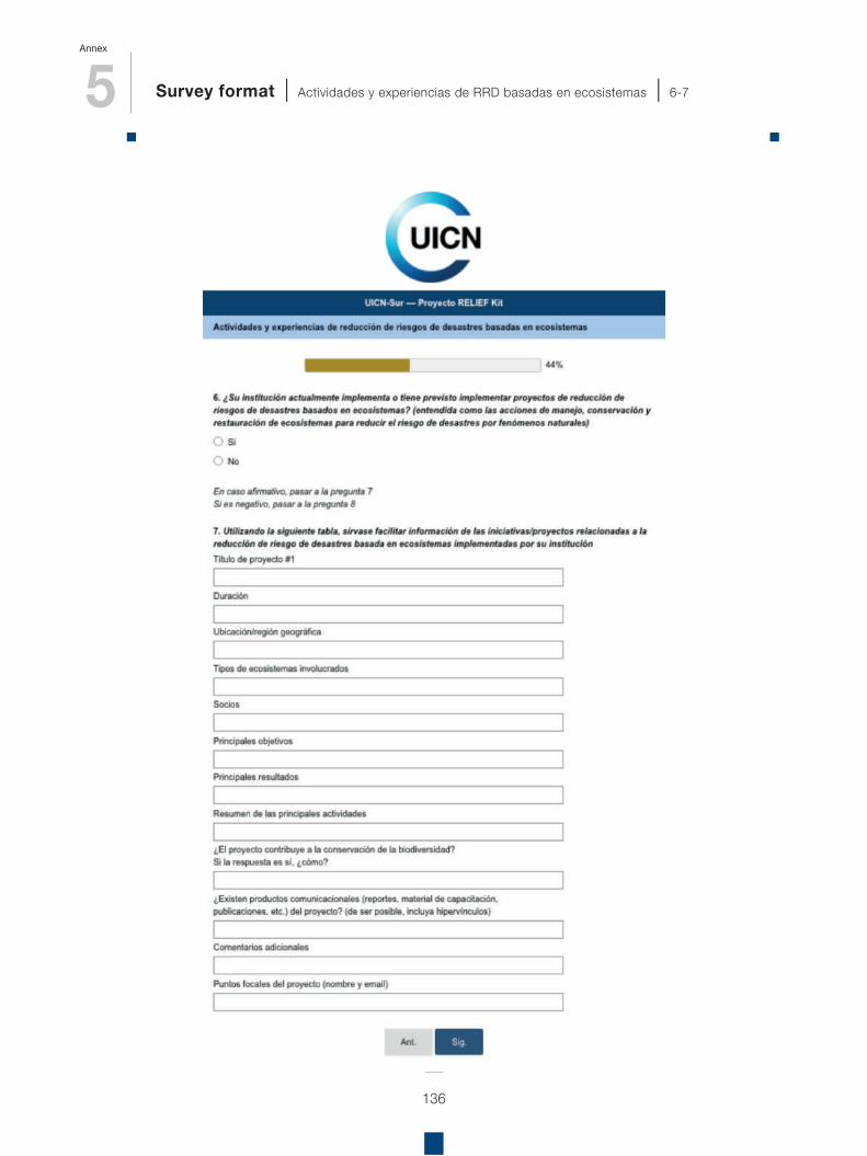
5 Survey format | Actividades y experiencias de RRD basadas en ecosistemas | 6-7
Annex
136
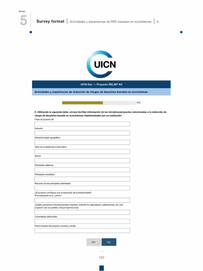
5 Survey format | Actividades y experiencias de RRD basadas en ecosistemas | 8
Annex
137
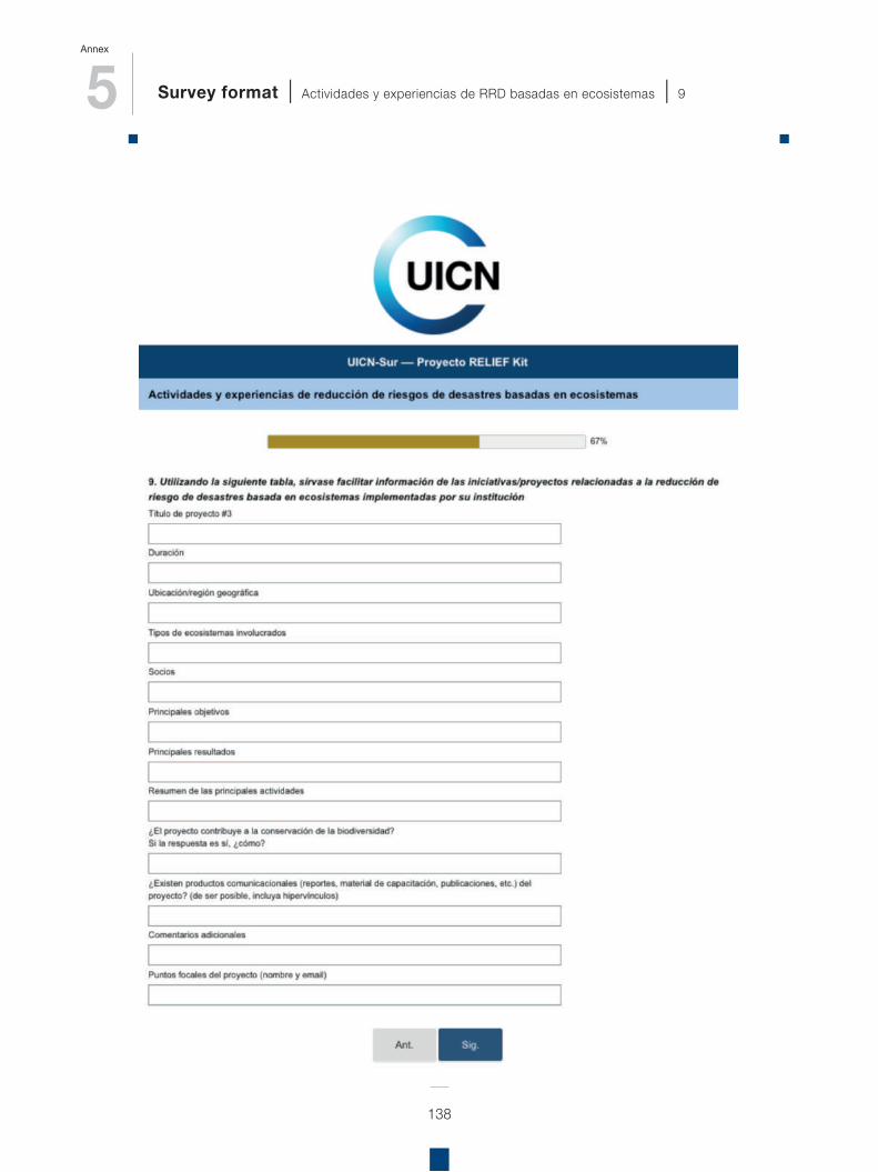
5 Survey format | Actividades y experiencias de RRD basadas en ecosistemas | 9
Annex
138
5 Survey format | Actividades y experiencias de RRD basadas en ecosistemas | 10-11
Annex
139
5 Survey format | Experiencia con aspectos económicos | 12-13-14
Annex
140
5 Survey format | Fin de la encuesta
Annex
141
6 International agreements and policy processes relevant for Eco-DRR
Annex
142
de la diversidad biológica y cultural del bioma Amazónico basada en los ecosistemas". Integración de las Áreas Protegidas del Bioma Amazónico (IAPA) – Visión Amazónica es un proyecto financiado por la Unión Europea, que busca generar una red de trabajo en torno a los sistemas de áreas protegidas ubicados en la región amazónica.Áreas Protegidas, Soluciones Naturales al Cambio Climático – SNACC: Áreas Protegidas de la Amazonia son clave ayudando a las comunidades y a la naturaleza en la adaptación al cambio climático. Éstas construyen resiliencia y ayudan a mitigar los impactos durante los eventos de un clima cambiante.The Strategic Plan of the UN Convention to Combat Desertification calls on Parties to introduce or strengthen mutually reinforcing measures to address desertification and land degradation and climate change mitigation and adaptation, while also addressing biodiversity issues.The Ramsar Convention on Wetlands has invited its Parties to undertake action on peatlands and climate change, including by improving the available information on carbon sequestration in peatlands and on good practice in peatland restoration.The Sendai Framework for Disaster Risk Reduction – the successor instrument to the Hyogo Framework for Action (HFA) 2005–2015: Building the Resilience of Nations and Communities to Disasters – calls on countries to strengthen the sustainable use and management of ecosystems and implement integrated environmental and natural resource management approaches that incorporate disaster risk reduction.
number of international agreements and policy processes related to the environment and sustainable development have called on countries to implement ecosystem-based approaches that contribute to their response to climate change, because this is seen as an important option for achieving their goals. Some examples of relevant decisions include:
In addition to decisions on mitigation actions in the Land Use, Land Use Change and Forestry sector, the UN Framework Convention on Climate Change (UNFCCC) has invited Parties to make use of ecosystem-based approaches to adaptation, and established a database of practical examples.The Strategic Plan of the Convention on Biological Diversity (CBD) includes a target on contributing to climate change mitigation and adaptation through conservation and restoration of ecosystems; the Conference of the Parties of the CBD has also invited countries to implement ecosystem management activities as a contribution towards achieving the objectives of the UNFCCC.In this light, a noteworthy mention is also the Visión Amazónica: “A finales de los años noventa, se creó un Programa Regional de Planificación y Gestión de Áreas Protegidas de la Región Amazónica. En 2008, basándose en los logros de la Subred de áreas protegidas amazónicas y la OTCA, y como parte de los esfuerzos regionales para la implementación del Programa de Trabajo del CDB de Áreas Protegidas (PTAP), REDPARQUES lideró el desarrollo de una "Visión para la conservación
A
143
ECHO launched its DIPECHO in 1996, in recognition of the importance of pre-emptive measures, targeting vulnerable communities living in the main disaster-prone regions of the world. Projects are intended to demonstrate that simple and inexpensive preparatory measures, particularly those implemented by communities themselves, can be effective in limiting damage and saving lives when disaster strikes.
Typically, DIPECHO-funded projects cover training, capacity-building, awareness-raising, early-warning, and planning and forecasting measures, with the funds being channelled through aid agencies and NGOs working in the regions concerned.
DIPECHO projects are designed as pilots within their region, their impact being multiplied when the strategies they advocate are integrated into long-term development projects, whether by the development services of the European Commission, national governments or other development partners. Ultimately, DIPECHO’s primary goal is to ensure the integration of disaster reduction measures into wider national policies: from education to building codes to health.
Key elements can be divided into two groups, those related to the quality and impacts of DRR processes, and those contributing directly to their institutionalisation:
Because of the many additional benefits that ecosystem-based approaches to climate change can provide, it is likely that actions of the type outlined in this document will also contribute to the implementation of other environmental, social and development-related policies, including at the national and subnational level (SCBD, 2015).
The Partnership for Environment and Disaster Risk Reduction (PEDRR) represents global coordination of ecosystems for adaptation and DRR between UN agencies, NGOs and specialist institutes. The International Strategy for Disaster Reduction – ISDR (Estrategia Internacional para la Reducción de Desastres) reflects a major shift from the traditional emphasis on disaster response to disaster reduction, and in effect seeks to promote a culture of prevention30. The United Nations Office for Disaster Risk Reduction (UNISDR) is the secretariat of the International Strategy and mandated by the UN General Assembly to ensure its implementation.
DIPECHO Programme 31
The European Commission’s Department of Humanitarian Aid and Civil Protection (DG-ECHO) was established to provide rapid and effective support to the victims of crises outside the European Union. With a presence in the Latin America and Caribbean region since 1996, ECHO has contributed to reduce risk conditions in the event of disasters, and contribute to increase people’s, communities’ and countries’ resilience in the region, through their Disaster Preparedness Programme (DIPECHO).
30 UNISDR. What is the International Strategy? https://www.unisdr.org/who-we-are/international-strategy-for-disaster-reduction31 European Commission (2004). The DIPECHO Programme: Reducing the impact of disasters.
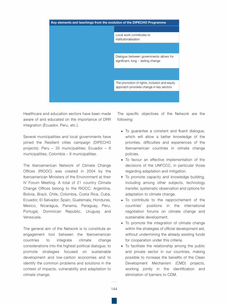
144
The specific objectives of the Network are the following:
To guarantee a constant and fluent dialogue, which will allow a better knowledge of the priorities, difficulties and experiences of the Iberoamerican countries in climate change policies.To favour an effective implementation of the decisions of the UNFCCC, in particular those regarding adaptation and mitigation.To promote capacity and knowledge building, including among other subjects, technology transfer, systematic observation and options for adaptation to climate change.To contribute to the rapprochement of the countries’ positions in the international negotiation forums on climate change and sustainable development.To promote the integration of climate change within the strategies of official development aid, without undermining the already existing funds for cooperation under this criteria.To facilitate the relationship among the public and private sector in our countries, making possible to increase the benefits of the Clean Development Mechanism (CMD) projects, working jointly in the identification and elimination of barriers to CDM.
Healthcare and education sectors have been made aware of and educated on the importance of DRR integration (Ecuador, Peru, etc.).
Several municipalities and local governments have joined the Resilient cities campaign (DIPECHO projects): Peru – 35 municipalities; Ecuador – 8 municipalities; Colombia – 8 municipalities.
The Iberoamerican Network of Climate Change Offices (RIOOC) was created in 2004 by the Iberoamerican Ministers of the Environment at their IV Forum Meeting. A total of 21 country Climate Change Offices belong to the RIOCC: Argentina, Bolivia, Brazil, Chile, Colombia, Costa Rica, Cuba, Ecuador, El Salvador, Spain, Guatemala, Honduras, Mexico, Nicaragua, Panama, Paraguay, Peru, Portugal, Dominican Republic, Uruguay and Venezuela.
The general aim of the Network is to constitute an engagement tool between the Iberoamerican countries to integrate climate change considerations into the highest political dialogue, to promote strategies focused on sustainable development and low-carbon economies and to identify the common problems and solutions in the context of impacts, vulnerability and adaptation to climate change.
Key elements and teachings from the evolution of the DIPECHO Programme
In regards to quality and impact In regards to institutionalisation
Humanitarian aid does not begin after a disaster
Local work contributes to institutionalisation
Flexibility and adaptation contribute to achieving a better impact
Consulting and participation towards appropriation and collective construction
Actions focused on communities and their participation contributes to protecting and saving lives
Dialogue between governments allows for significant, long - lasting change
Investment in local capacities strengthens DRR institutionalisation
The development and use of appropriate tools contributes to improving quality
Collaboration and complementary between actors improves efficacy and efficiency
Humanitarian aid and disaster risk reduction are part of the development process
The promotion of rights, inclusion and equity approach provokes change in key sectors
145
Promote the development of participative projects on adaptation to climate change in priority sectors and systems, giving special importance to trans-frontier projects, trans-sectorial projects and/or pansectorial projects.Promote information and communication activities of the PIACC.Produce evaluation reports of work on impacts, vulnerability and adaptation to climate change in Ibero America.
To promote the competitiveness of the region and the access to the market, in a way that facilitates the identification and development of supply and demand within CDM.To favour the signing and application of memorandums of agreement.
Iberoamerican Programme of Impacts assessment, vulnerability and adaptation to Climate Change (PIACC)
The global aim of the PIACC is to strengthen the development and application of adaptation strategies in the region by making the most of the countries’ strengths and interests, and to facilitate assistance to all the members of the RIOCC in the evaluation of impacts, vulnerability and the adaptation options to climate change.
The Programme was conceived as an instrument for exchanging knowledge and experiences within the RIOCC framework, which will facilitate North-South and South-South cooperation and will enhance adaptation capacity to climate change in the Latin American region. Along with this, the Programme contributes to adaptation to climate change issues within the UNFCCC framework, due to the multiple connections between adaptation initiatives carried out under both initiatives.
Among the specific objectives to be achieved in a continuous way are the following:
Strengthening of the institutional frameworks.Search for synergies with regional institutions and initiatives working on adaptation to climate change in Ibero America.Support climate and climate change research, and systematic observation.Empower exchange and availability of knowledge, experiences, methods and tools to evaluate Impacts, Vulnerability and Adaptation to Climate Change.
Regional Assessment on Ecosystem-based Disaster Risk Reduction and Biodiversity in South America
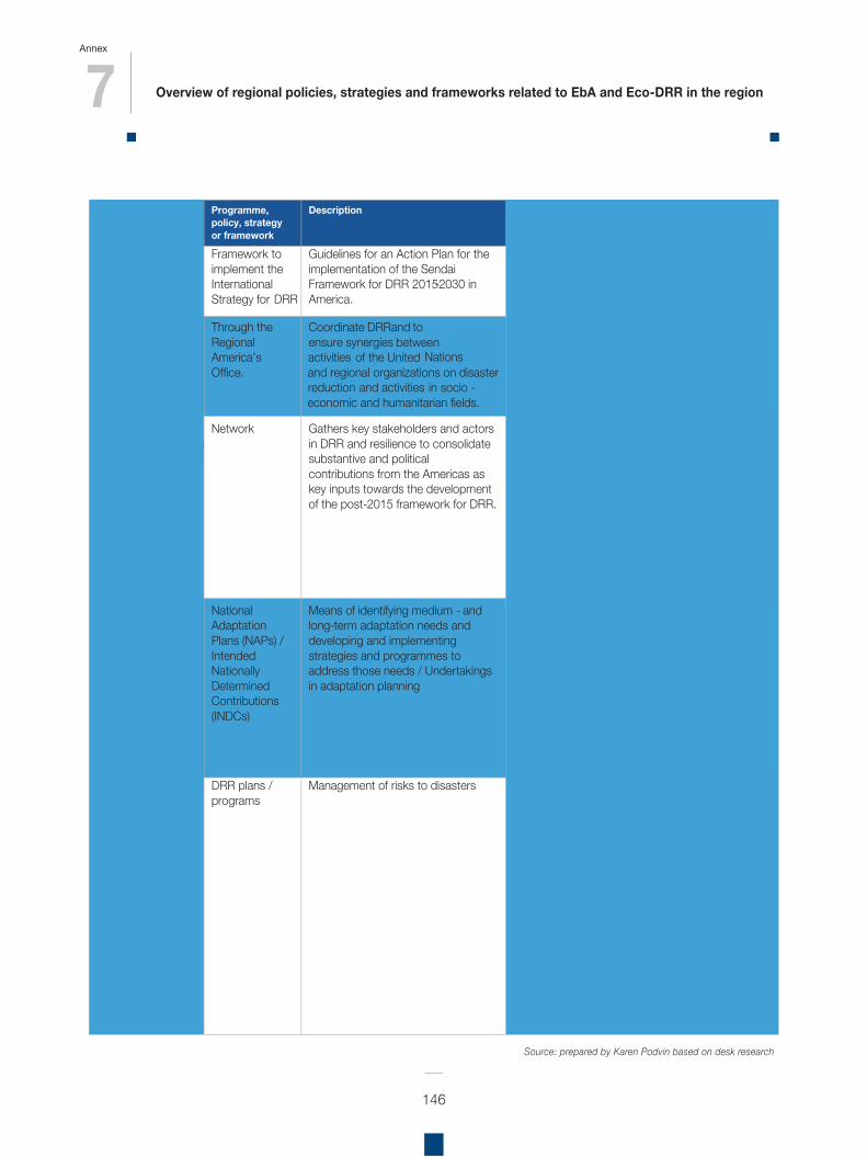
7 Overview of regional policies, strategies and frameworks related to EbA and Eco-DRR in the region
Annex
146
Agency/convention
Programme, policy, strategy or framework
Description Linkages to EbA and Eco-DRR (examples)
Sendai Framework for Disaster Risk Reduction 2015 -2030
Framework to implement the International Strategy for DRR
Guidelines for an Action Plan for the implementation of the Sendai Framework for DRR 2015-2030 in America.
Yes, includes ecosystems-based approach to DRR.
United Nations Office for Disaster Risk Reduction ( UNISDR )
Through the Regional America’s Office.
Coordinate DRR and to ensure synergies between
activities of the United Nations and regional organizations
reductionon disaster
and activities in
socio - economic and humanitarian fields.
Regional Platform for DRR in America Regional Platforms in the region in Panama, 2009 2011 Mexico, 2011
Chile, 2012 Ecuador, 2014
Network Gathers key stakeholders and actors in DRR and resilience to consolidate substantive and political contributions from the Americas as key inputs towards the development of the post-2015 framework for DRR.
Ecosystems are mentioned: “Foster horizontal and triangular cooperation to favor the exchange of good practices and stimulate strengthening local, national and regional capacities that take into consideration trans-boundary elements and shared resources in terms of ecosystems, watershed management, cultural aspects, among others” art. 36. Platform webpage: http://eird.org/pr14 -eng/index.html ; Final Communiqué of the 2014 platform: http://eird.org/pr14 -eng/docs/Communique_Guayaquil_PR14_29May14.pdf
UNFCCC
National Adaptation Plans (NAPs) / Intended Nationally Determined Contributions (INDCs)
Means of identifying medium - and long-term adaptation needs and developing and implementing strategies and programmes to address those needs / Undertakings in adaptation planning
Argentina , “The promotion of biodiversity conservation and AbE” in their CCA efforts.
Bolivia : “Mother Earth” comprehensive approach - CCA in water, forests and agriculture sectors.
Chile: Sectoral biodiversity CCA Plan Colombia: CCA efforts include Socio- EbA. Ecuador: prioritizes ecosystems as one of the
sectors for CC efforts, and risk management. Peru: highlights vulnerability, and protecting
ecosystem services in CCA efforts. Countries DRR plans /
programs Management of risks to disasters Argentina : National program for prevention and
DRR (EbA , EcoDRR not mentioned). Bolivia : “Risk Management Law”, mention ecosystems for risk mitigation; Risk Management for the Water and Environment.
Chile: Thematic table for risk management and DRR – multi -sectorial platform, including environmental sector. Colombia: National Plan of Disaster Risk Management “A Strategy for Development” –synergies of CCA and DDR, and socio EbA. Ecuador: Secretariat for Risk Management – links between CCA and DRR, and ecosystems prior itized Peru: National Plan for Disaster Risk Reduction – mentions ecosystem protection relevant for DRR
Source: prepared by Karen Podvin based on desk research
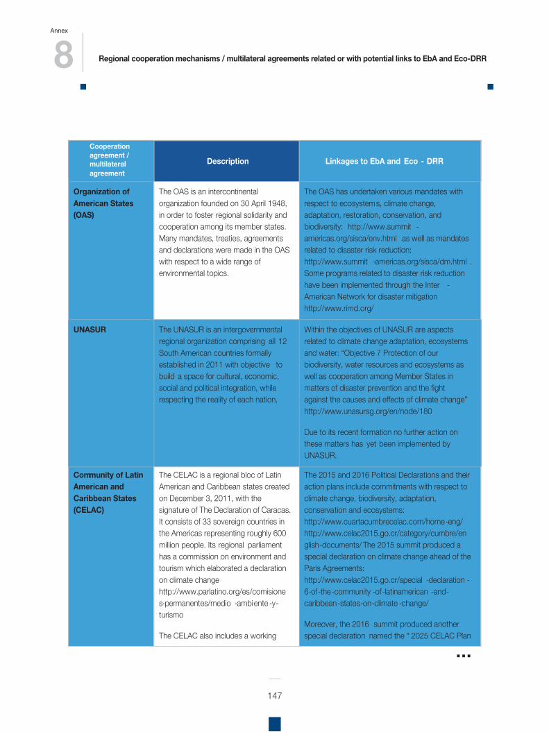
8 Regional cooperation mechanisms / multilateral agreements related or with potential links to EbA and Eco-DRR
Annex
147
Cooperation agreement / multilateral agreement
Description Linkages to EbA and Eco - DRR
Organization of American States (OAS)
The OAS is an intercontinental organization founded on 30 April 1948, in order to foster regional solidarity and cooperation among its member states. Many mandates, treaties, agreements and declarations were made in the OAS with respect to a wide range of environmental topics.
The OAS has undertaken various mandates with respect to ecosystems, climate change, adaptation, restoration, conservation, and biodiversity: http://www.summit -americas.org/sisca/env.html as well as mandates related to disaster risk reduction: http://www.summit -americas.org/sisca/dm.html . Some programs related to disaster risk reduction have been implemented through the Inter -American Network for disaster mitigation http://www.rimd.org/
UNASUR The UNASUR is an intergovernmental regional organization comprising all 12 South American countries formally established in 2011 with objective to build a space for cultural, economic, social and political integration, while respecting the reality of each nation.
Within the objectives of UNASUR are aspects related to climate change adaptation, ecosystems and water: “Objective 7 Protection of our biodiversity, water resources and ecosystems as well as cooperation among Member States in matters of disaster prevention and the fight against the causes and effects of climate change” http://www.unasursg.org/en/node/180
Due to its recent formation no further action on these matters has yet been implemented by UNASUR.
Community of Latin American and Caribbean States (CELAC)
The CELAC is a regional bloc of Latin American and Caribbean states created on December 3, 2011, with the signature of The Declaration of Caracas. It consists of 33 sovereign countries in the Americas representing roughly 600 million people. Its regional parliament has a commission on environment and tourism which elaborated a declaration on climate change http://www.parlatino.org/es/comisiones-permanentes/medio -ambiente -y-turismo
The CELAC also includes a working
The 2015 and 2016 Political Declarations and their action plans include commitments with respect to climate change, biodiversity, adaptation, conservation and ecosystems: http://www.cuartacumbrecelac.com/home-eng/ http://www.celac2015.go.cr/category/cumbre/english-documents/ The 2015 summit produced a special declaration on climate change ahead of the Paris Agreements: http://www.celac2015.go.cr/special -declaration -6-of-the-community -of-latinamerican -and-caribbean-states-on-climate -change/
Moreover, the 2016 summit produced another special declaration
named the “ 2025 CELAC Plan
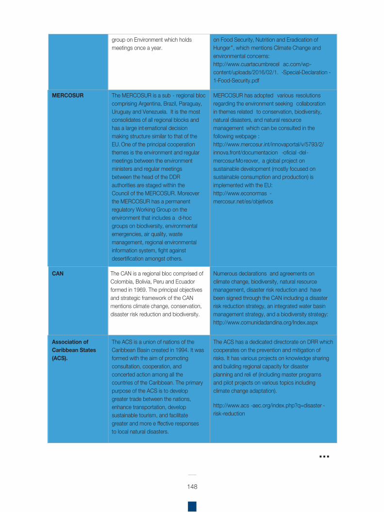
148
group on Environment which holds meetings once a year.
on Food Security, Nutrition and Eradication of Hunger”, which mentions Climate Change and environmental concerns: http://www.cuartacumbrecel ac.com/wp-content/uploads/2016/02/1. -Special-Declaration -1-Food-Security.pdf
MERCOSUR The MERCOSUR is a sub - regional bloc comprising Argentina, Brazil, Paraguay, Uruguay and Venezuela. It is the most consolidates of all regional blocks and has a large int ernational decision making structure similar to that of the EU. One of the principal cooperation themes is the environment and regular meetings between the environment ministers and regular meetings between the head of the DDR authorities are staged within the Council of the MERCOSUR. Moreover the MERCOSUR has a permanent regulatory Working Group on the environment that includes a d-hoc groups on biodiversity, environmental emergencies, air quality, waste management, regional environmental information system, fight against desertification amongst others.
MERCOSUR has adopted various resolutions regarding the environment seeking collaboration in themes related to conservation, biodiversity, natural disasters, and natural resource management which can be consulted in the following webpage : http://www.mercosur.int/innovaportal/v/5793/2/innova.front/documentacion -oficial -del-mercosurMoreover, a global project on sustainable development (mostly focused on sustainable consumption and production) is implemented with the EU: http://www.econormas -mercosur.net/es/objetivos
CAN The CAN is a regional bloc comprised of Colombia, Bolivia, Peru and Ecuador formed in 1969. The principal objectives and strategic framework of the CAN mentions climate change, conservation, disaster risk reduction and biodiversity.
Numerous declarations and agreements on climate change, biodiversity, natural resource management, disaster risk reduction and have been signed through the CAN including a disaster risk reduction strategy, an integrated water basin management strategy, and a biodiversity strategy: http://www.comunidadandina.org/Index.aspx
Association of Caribbean States (ACS).
The ACS is a union of nations of the Caribbean Basin created in 1994. It was formed with the aim of promoting consultation, cooperation, and concerted action among all the countries of the Caribbean. The primary purpose of the ACS is to develop greater trade between the nations, enhance transportation, develop sustainable tourism, and facilitate greater and more e ffective responses to local natural disasters.
The ACS has a dedicated directorate on DRR which cooperates on the prevention and mitigation of risks. It has various projects on knowledge sharing and building regional capacity for disaster planning and reli ef (including master programs and pilot projects on various topics including climate change adaptation).
http://www.acs -aec.org/index.php?q=disaster -risk-reduction
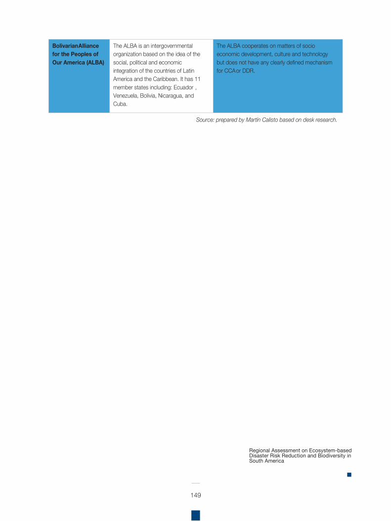
149
Bolivarian Alliance for the Peoples of Our America (ALBA)
The ALBA is an intergovernmental organization based on the idea of the social, political and economic integration of the countries of Latin America and the Caribbean. It has 11 member states including: Ecuador , Venezuela, Bolivia, Nicaragua, and Cuba.
The ALBA cooperates on matters of socio economic development, culture and technology but does not have any clearly defined mechanism for CCA or DDR.
Source: prepared by Martín Calisto based on desk research.
Regional Assessment on Ecosystem-based Disaster Risk Reduction and Biodiversity in South America
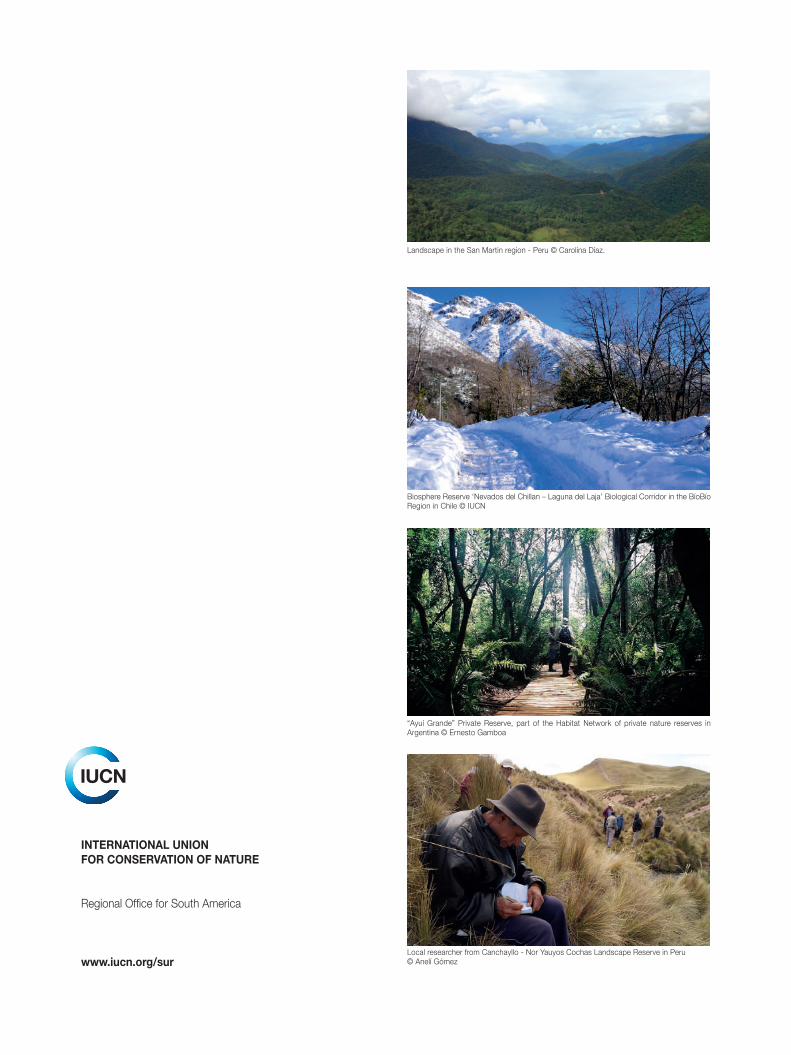
INTERNATIONAL UNIONFOR CONSERVATION OF NATURE
Regional Office for South America
www.iucn.org/sur Local researcher from Canchayllo - Nor Yauyos Cochas Landscape Reserve in Peru© Anelí Gómez
Biosphere Reserve ‘Nevados del Chillan – Laguna del Laja’ Biological Corridor in the BíoBío Region in Chile © IUCN
“Ayuí Grande” Private Reserve, part of the Habitat Network of private nature reserves in Argentina © Ernesto Gamboa
Landscape in the San Martin region - Peru © Carolina Díaz.