Embed Size (px)
Citation preview
CENSUS OF INDIA 1991
REGIONAL •
DIVISIONS OF INDIA -A CARTOGRAPHIC ANALYSIS
OCCASIONAL PAPERS
SERIES-l VOLUME-XIX PUNJAB
Planning & Supervision Dr. R.P. SINGH Assistant Registrar General (Map)
General Direction & Editing J.K. BANTHIA of the Indian Administrative Service Registrar General & Census Commissioner, India 2-A, Mansingh Road, New Delhi.
Maps included in this Volume are based upon Survey of India map with the permission of the Surveyor General of India
The boundary of Meghalaya shown on the map of India is as interpreted from North-eastern areas (Reorganisation Act, 1971), but has yet to be verified (applicable to India map only).
The territorial waters of India extend into the sea to a distance of twelve nautical miles measured from the appropriate base line (applicable to India map only). I
© Government of India Copyright 2000
FOREWORD
"Regional Divisions of India - A Cartographic Analysis", of each State and Union Territory Volume, 1991 is undertaken by the Map Division of this office. The project is in continuation of a similar 'Occasional Paper' published during the 1981 Census. In this study, regions are delineate~ at macro, meso; micro and submicro level in each StatelUnion Territory. While delineating such regions, the physio-geographic factors are taken into account. These physio-geographic factors consist of (i) Physiography; (ii) Geological structure; (iii) Forest coverage; (iv) Climatic conditions and (v) Soils. The sub-micro regions are delineated within the district keeping in view the above physio-geographic factors. The regional boundaries delineated earlier at different levels are retained as such. However, the jurisdictional changes at the district level during 1981-91 were added in the respective regions. A few more tables and maps on educational level of primary and secondary schools and availability of medical facilities at the villages, have been appended in this volume.
This publication consists of three parts. Part I contains the brief introductory note on Regional Divisions of India along with a map of India showing the regional boundaries at micro level. This part is common for all the States and Union Territories volume. Part II deals with the description of Regional Divisions of each State and Union Territory. In this section, there are nearly 21 maps related to different themes e.g. density, sex ratio, growth of population, workers, literacy and the Scheduled Castes and the Scheduled Tribes. These maps are prepared at the sub-micro level. Part III is mainly devoted to presentation of data and maps of the districts. The districts are divided into sub-micro regions of the fourth order and brief analysis of each of these sub-micro regions is written and supported by tables relating to the main demographic theme of the districts.
This project is executed under the technical supervision of Dr. RP. Singh, Assistant Registrar General (Map) and other officers and staff of the Map division of this office and Directorates of Census Operations of StateslUnion Territories. The officers and the staff associated with this project are acknowledged separately. An effort is made to publish this volume on Compact Discs also for the convenience of the users. I hope this publication will be useful for administrators, geographers, demographers and others interested in different fields of population study.
New Delhi Dated: 30.01.2001
Ul
lK. Banthia Registrar General &
Census Commissioner, India
REGIONAL DIVISIONS OF INDIA: PUNJAB (Officersl Staff associated witb tbe project)
Office of the Registrar General, India
General Direction & Editing
Planning and Supervision
Progress and Monitoring
Computer mapping of India and other computerized work
Cover Design
Secretarial work
1.K. Banthia, lAS, Registrar General & Census Commissioner of India
Dr. R.P. Singh Assistant Registrar General, India (Map)
R.N. Chhipa Research Officer ( Map) R.K. Chaurajil Singh (upto 31.8.2001) Research Officer (Map)
Pooran Singh, Sr. Geographer Dinesh, Draftsman (photo) Anil B. Dhengle, Sr. DlMan
Mohd. Ishaque, Sr. Drawing Assistant
AK. Jain, P.A P.K. Ajbani, P.A.
Directorate of Census Operations, Punjab
General Supervision & Monitoring
Drafting, Supervision, Evaluation and Checking of Draft
Mapping and Compilation of Data.
Tabulation & Printing Assistance
Secretarial Assistance
Inder Jit Singh. lAS Director Census Operations, Punjab
Madhav Shyam Deputy Director
Surinder lit Singh, ~search Officer (Map)
Tej Pal Singh, Sr. Geographer Jiwan Singh, Sr. Drawing Assistant Mrs. Usha Kalra, Sr. D/man Kulbir Singh, Sr.DlMan Mrs. Sangeeta Rahi, DIMan
Malkit Singh. S.l.Grnde- I Parkash Sharma, S.T.A( Printing) Mrs. Hardeep Kam, S.LGrade-III Rajpal Pathak, Compiler
P.K. Bajaj, C.A D.K. Sharma, UDC Zitender Kumar, LDC Rajeev Kumar Verma, LDC Bali Ram, GO Ajit Singh, JGO Bhag Singh, Daftari
iv
Foreword Acknowledgement Contents List of Maps
CONTENTS
PART-I
Page 11
IV
V-lX
X
REGIONAL DIVISIONS Of INDIA- A CARTOGRAPIDC ANALYSIS
General Note Brief Characteristics of Regional Divisions Regional Divisions of India
PART-II
REGIONAL DIVISIONS OF PUNJAB
3-6 7-16 19-27
General Maps 47-83 Position of Punjab in India 47 Administrative Divisions of Punjab, 1991 49 Relief and Drainage 51 Normal Monthly and Annual RainfalJ 53 Normal Monthly and Annual Temperature 55 Geology 57 Soils 59 Distribution of Population, 1991 61 Growth of Population, 1981-91 (by sub-micro region) 63 Density of Population, 1991 (by sub-micro region) 65 Variation in Density of Population, 1981-91 (by sub-micro region) 67 Rural Density of Population, 1991 (by sub-micro region) 69 Variation in Rural Density of Population, 1981-91 (by sub-micro region) 71 Urban Density of Population, 1991 (by sub-micro region) 73 Variation in Urban Density of Population, 1981-91 (by sub-micro region) 75 Sex-Ratio, 1991 (by sub-micro region) 77
Main Workers, 1991 (by sub-micro region) 79 Percentage of Literates to Total Population, 1991 (by sub-micro region) 81 Scheduled Castes, 1991 (by sub-micro region) 83
v
PART-ID
REGIONAL DIVISIONS OF DISTRICTS
District Gurdaspur (01)
(i) District Gurdaspur Regional Divisions- A Brief Note 87-91 (ii) Table 1 - Data on Regional Divisions, 1991 95 (iii) Table 2 - Region-wise village codes, 1991 96-98 (iv) Table 3- Main Workers, Marginal Workers and Non-Workers, 1991 99 (v) Table 4- Main Workers, Marginal Workers and
Non-Workers in Rural Areas, 1991 100 (vi) Table- 5 - Main Workers, Marginal Workers and
Non-Workers in Urban Areas, 1991 101 (vii) Table 6 - Literates and Scheduled Castes, 1991 102
District Amritsar (02)
(i) District Amritsar Regional Divisions- A Brief Note (ii) Table 1 - Data on Regional Divisions, 1991 (iii) Table 2 - Region-wise village codes, 1991 (iv) Table 3- Main Workers, Marginal Workers and Non-Workers, 1991 (v) Table 4- Main Workers, Marginal Workers and
Non-Workers in Rural Areas, 1991 (vi) Table- 5 - Main Workers, Marginal Workers and
Non-Workers in Urban Areas, 1991 (vii) Table 6 - Literates an~ Scheduled Castes, 1991
District Hoshiarpur (07)
(i) District Hoshiarpur Regional Divisions- A Brief Note (ii) Table 1 - Data on Regional Divisions, 1991 (iii) Table 2 - Region-wise village codes, 1991 (iv) Table 3- Main Workers, Marginal Workers and Non-Workers, 1991 (v) Table 4- Main Workers, Marginal Workers and
Non-Workers in Rural Areas, 1991 (vi) Table- 5 - Main Workers, Marginal Workers and
Non-Workers in Urban Areas, 199.1 (vii) Table 6 - Literates and Scheduled Castes, 1991
District Rupnagar(08)
(i) District Rupnagar Regional Divisions- A Brief Note (ii) Table 1 - Data on Regional Divisions, 1991 (iii) Table 2 - Region-wise village codes, 1991 (iv) Table 3- Main Workers, Marginal Workers and Non-Workers, 1991
vi
103-107 III 112-113 114
115
116 117
118-122 125 126-127
129
130 131
128
132-135 139 140-141 142
(v) Table 4- Main Workers, Marginal Workers and Non-Workers in Rural Areas, 1991
(vi) Table- 5 - Main Workers, Marginal Workers 'and Non-Workers in Urban Areas, 1991
(vii) Table 6 - Literates and Scheduled Castes, 1991
District Jalandbar(05)
(i) District Jalandhar Regional Divisions- A Brief Note (ii) Table 1 - Data on Regional Divisions, 1991 (ii) Table 2 - Region-wise village codes, 1991 (iii) Table 3- Main Workers, Marginal Workers and Non-Workers, 1991 (iv) Table 4- Main Workers, Marginal Workers and
Non-Workers in Rural Areas, 1991 (v) Table- 5 - Main Workers, Marginal Workers and
Non-Workers in Urban Areas, 1991 (vii) Table 6 - Literates and Scheduled Castes, 1991
District Kapurtbala(06)
(i) District Kapurthala Regional Divisions- A Brief Note (ii) Table 1 - Data on Regional Divisions, 1991 (iii) Table 2 - Region-wise village codes, 1991 (iv) Table 3- Main Workers, Marginal Workers and Non-Workers, 1991 (v) Table 4- Main Workers, Marginal Workers and
Non-Workers in Rural Areas, 1991 (vi) Table- 5 - Main Workers, Marginal Workers and
Non-Workers in Urban Areas, 1991 (vii) Table 6 - Literates and Scheduled Castes, 1991
District Firozpur (03)
(i) District Firozpur Regional Divisions- A Brief Note (ii) Table 1 - Data on Regional Divisions, 1991 (iii) Table 2 - Region-wise village codes, 1991 (iv) Table 3- Main Workers, Marginal Workers and Non-Workers, 1991 (v) Table 4- Main Workers, Marginal Workers and
Non-Workers in Rural Areas, 1991 . (vi) Table- 5 - Main Workers, Marginal Workers and
Non-Workers in Urban Areas, 1991 , (vii) Table 6 - Literates and Scheduled Castes, 1991
District Ludhiana (04)
(i) (ii)
District Ludhiana Regional Divisions- A Brief Note Table 1 - Data on Regional Divisions, 1991
vii
143
144 145
146-149 153 154-155 156
157
158 159
160-162 165 166 167
168
169 170
171-175 179 180-181 182
183
184 1'85
186-190 193
(iii) Table 2 - Region-wise village codes, 1991 (iv) Table 3- Main Workers, Marginal Workers and Non-Workers, 1 991 (v) Table 4- Main Workers, Marginal Workers and
Non-Workers in Rural Areas, 1991 (vi) Table- 5 - Main Workers, Marginal Workers and
Non-Workers in Urban Areas, 1991 (vii) Table 6 - Literates and Scheduled Castes, 1991
District Patiala (09)
(i) District Patiala Regional Divisions- A Brief Note (ii) Table 1 - Data on Regional Divisions, 1991 (iii) Table 2 - Region-wise village codes, 1991 (iv) Table 3- Main Workers, Marginal Workers and Non-Workers, 1991 (v) Table 4- Main Workers, Marginal Workers and
Non-Workers in Rural Areas, 1991 (vi) Table- 5 - Main Workers, Marginal Workers and
Non-Workers in Urban Areas, 1991 (vii) Table 6 - Literates and Scheduled Castes, 1991
District Sangrur (10)
(i) District Sangrur Regional Divisions- A Brief Note (ii) Table 1 - Data on Regional Divisions, 199] (iii) Table 2 - Region-wise village codes, 1991 (iv) Table 3- Main Workers, Marginal Workers and Non-Workers, 1991 (v) Table 4- Main Workers, Marginal Workers and
Non-Workers in Rural Areas, 1991 (vi) Table- 5 - Main Workers, Marginal Workers and
Non-Workers in Urban Areas, 1991 (vii) Table 6 - Literates and Scheduled Castes, 1991
District Bathinda (11)
(i) District Bathinda Regional Divisions- A Brief Note (ii) Table 1 - Data on Regional Divisions, 1991 (iii) Table 2 - Region-wise village codes, 1991 (iv) Table 3- Main Workers, Marginal Workers and Non-Workeys,1991 (v) Table 4- Main Workers, Marginal Workers and
Non-Workers in Rural Areas, 1991 (vi) Table- 5 - Main Workers, Marginal Workers and
Non-Workers in Urban Areas, 1991 (vii) Table 6 - Literates and Scheduled Castes, 1991
viii
194-195 196
197
198 199
200-203 207 208 209
210
211 212
213-218 221 222-223 224
225
226 227
228-232 235 236 237
238
239 240
District Faridkot (12)
(i) District Faridkot Regional Divisions- A Brief Note (ii) Table 1 - Data on Regional Divisions, 1991 (iii) Table 2 - Region-wise village codes, 1991 (iv) Table 3- Main Workers, Marginal Workers and Non-Workers, 1991 (v) Table 4- Main Workers, Marginal Workers and
Non-Workers in Rural Areas, 1991 (vi) Table- 5 - Main Workers, Marginal Workers and
Non-Workers in Urban Areas, 1991 (vii) Table 6 - Literates and Scheduled Castes, 1991
*****
ix
241-244 247 248 249
250
251 252
LIST OF MAPS Page No.
Regional Divisions of India 17 2 Regional Divisions of Punjab 41 3 Position of Punjab in India 47 4 Administrative Divisions of Punjab, 1991 49 5 Relief and Drainage 51 6 Normal Monthly and Annual Rainfall 53 7 Normal Monthly and Annual Temperature 55 8 Geology 57 9 Soils 59 10 Distribution of Population, 199] 61 11 Growth of Population, 19St-91 (by sub-micro regions) 63 12 Density ofPopuiation, 1991 (by sub-micro regions) 65 13 Variation in Density of Population, 1981-91 (by sub-micro regions) 67 14 Rural Density of Population, 1991 (by sub-micro regions) 69 15 Variation in Rural Density of Population, 1981-91 71
(by sub-micro regions) 16 Urban Density of Population, 1991 (by sub-micro regions) 73 17 Variation in Urban Density of Population, 1981-91 75
(by sub-micro regions) IS Sex Ratio, 1991 (by sub-micro regions) 77 19 Main Workers, 1991 (by sub-micro regions) 79 20 Percentage of Literates to Total Population, 1991 81
(by sub-micro regions) 21 Scheduled Castes, 1991 (by sub-micro regions) 83 22 District Gurdaspur - Regional Divisions 93 23 District Amritsar- Regional Divisions 109 24 District Hoshiarpur- Regional Divisions 123 25 District Rupnagar- Regional Divisions 137 26 District Ialandhar- Regional Divisions 151 27 District Kapurthala- Regional Divisions 163 28 District Firozpur- Regional Divisions 177 29 District Ludhiana- Regional Divisions 191 30 Distri~t Patiala- Regional Divisions 205 31 District Sangrur- Regional Divisions 219 32 District Bathinda- Regional Divisions 233 33 District Faridkot- Regional Divisions 245
x
PART-I
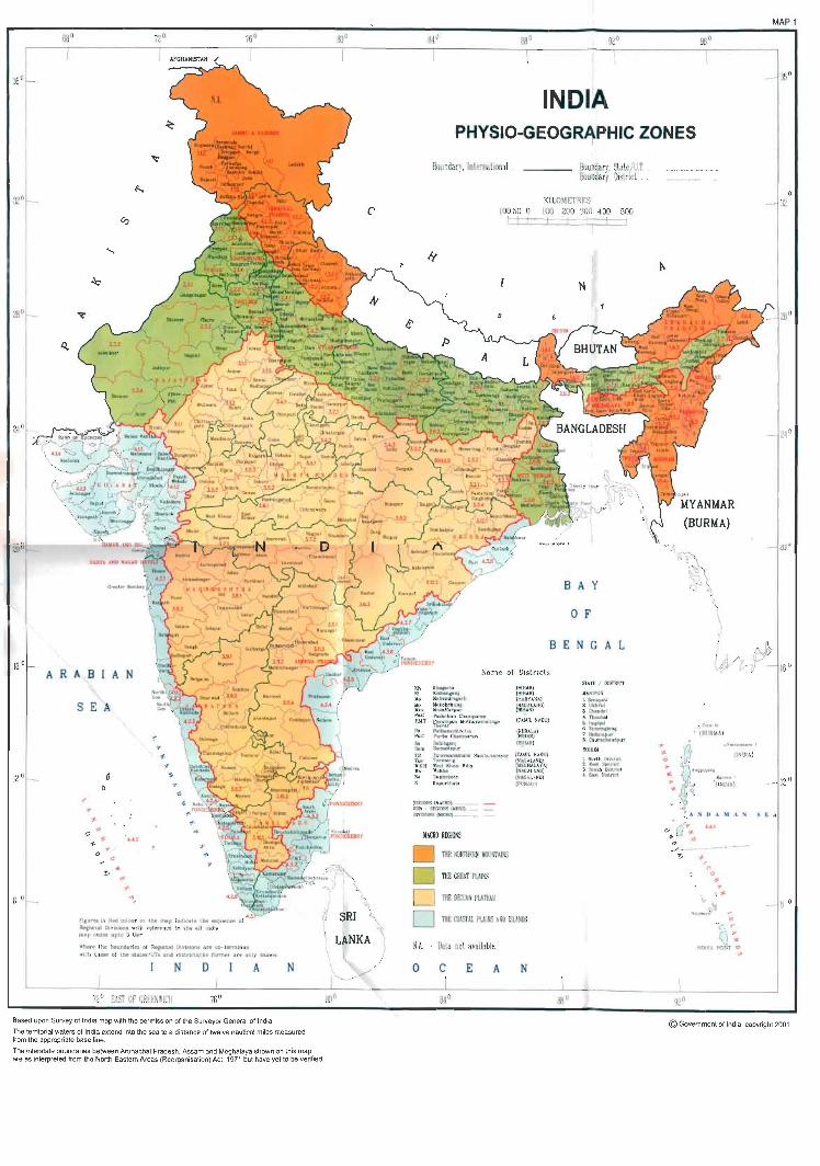
REGIONAL DIVISIONS OF INDIA

REGIONAL DIVISIONS OF INDIA-A CARTOGRAPHIC ANALYSIS
GENERAL NOTE
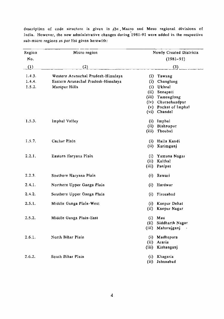
Region is a complex phenomenon which varies according to purposes but must have
homogeneous characteristics. To delineate a region in a country like India with an area of
3287,263 Km2, extending between latitudes of 80 4' 28" and 370 17' 53" North and longitudes
of 68° 7' 53" and 970 24' 47" East and having a great range of geographic variations is a
gigantic task. In the changed scenario of planning where emphasis is being laid on grassroot
level planning, the delineation of sub-micro region having village as unit, is significant. For
carving out such natural regions, the following considerations, inter-alia, are to be kept in
view;
(i) Contiguous geographical area;
(ii)· Homogeneous administrative machinery capable of formulating and
implementing integrated area plans;
(iii) Reliable statistical data base;
(iv) Existence of nodal regions; and
(v) Amenability of the natural boundaries to marginal adjustments so that the
former, by and large, conform to administrative boundaries at given points
of time.
In India, district is a defined administrative unit which is planning unit also. The
district boundaries do coincide with regional boundaries and have reliable statistical data base.
Hence, district has been taken as a basic unit of delineation.
A number of scholars have delineated the natural regions of the country which was
mainly based on physical factors. Accordingly they divided the country into t~aditional regions
of mountains, plateaus and plains. In Census of India, A. Mitra and late P. Sengupta attempted
the regionalisation of the country taking into consideration district as basic unit of data
presentation but they have not taken into consideration the intra-district variations. Hence this
study was undertaken during 1981 to delineate suo-micro region in each district based on
physio-geographical characteristics. While delineating the sub-micro region, village was taken
as a basic unit of demarcation. Since each sub-micro region has been clearly delin.eated in
rural and urban con~tituents, the demographic characteristics and other statistical data can be
generated for the post-census period also to the extent to whic'h village-wise / town-wise data
are available. The scheme was the first of its kind in the history of the Census in India and
would .serve as a useful framework for administrators, planners, researchers and other data
users for area specific planning.
The basic work of delineation of sub-micro region at district level was undertaken
during 1981 Census as a plan project and separate volumes for each State / Union Territory
was published during 1981 Census. Present study is in continuation of the 1981 project in
which sub-micro regions delineated during 1981 Census and published in the respective
volume were adopted in the same pattern without any change. The code structures of the sub-micro
regions are also the same used in 1981 Census. A detailed
3
description of code structure is given in :tlte, Mac~o and Meso regional divisions of
India. However, the new administrative changes during 1981-91 were added in the respective
sub-micro regions as per lisl given herewith:
Region
No.
Micro region Newly Created Districts
(1981-91)
(1~) ______________ ~(2~) ________________________ __ _____0_
1.4.3. 1.4.4. 1.5.2.
1.5.3.
1.5.7.
2.2.1.
2.2.3.
2.4.1.
2.4.2.
2.5.1.
2.5.2.
2.6.1.
2.6.2.
Western Arunachal Pradesh-Himalaya Eastern Arunachal Pradesh-Himalaya Manipur Hills
Imphal Valley
Cachar Plain
Eastern Haryana Plain
Southern Haryana Plain
Northern Upper Ganga Plain
Southern Upper Ganga Plain
Middle Ganga Plain-West
Middle Ganga Plain-East
North Bihar Plain
South Bihar Plain
4
(i) Tawang (i) Changlang (i) Ukhrul
(ii) Senapati (iii) Tamenglong (iv) Ch urachandpur (v) Pocket of Imphal
(vi) Chan del
(i) Imphal (ii) Bishnupur
(iii) Thoubal
(i) Haila Kandi (ii) Karimganj
(i) Yamuna Nagar (ii) Kaithal
(iii) Panipat
(i) Rewari
(i) Hardwar
(i) Firozabad
(i) Kanpur Dehat (ii) Kanpur Nagar
(i) Mau (ii) Siddharth Nagar
(iii) Maharajganj
(i) Madhepura (ii) Araria
(iii) Kishanganj
(i) Khagaria (ii) lehanabad
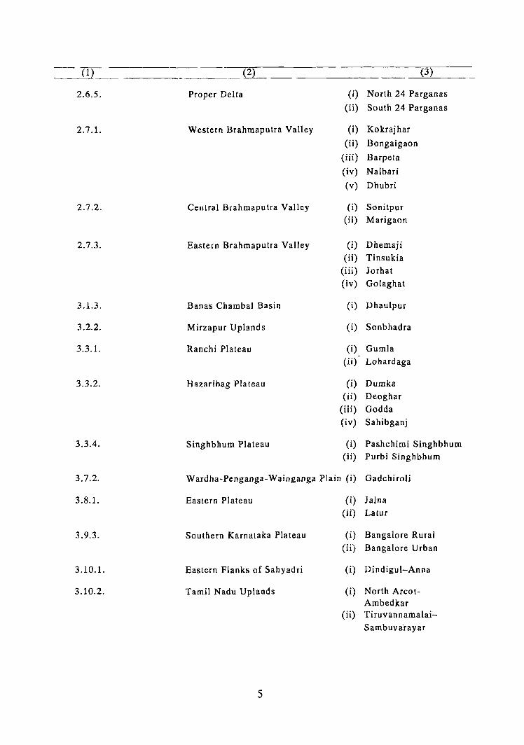
-(1) 0___ (3)
2.6.5. Proper Delta (i) North 24 Parganas
(ii) South 24 Parganas
2.7.1. Western Brahmaputra Valley (i) Kokrajhar
(ii) Bongaigaon
(iii) Barpeta
(iv) Nalbari
(v) Dhubri
2.7.2. Central Brahmaputra Valley (i) Sonitpur (ii) Marigaon
2.7.3. Eastern Brahmaputra Valley (i) Dhemaji
(ii) Tinsukia (iii) Jorhat
(iv) Golaghat
3.1.3. Banas Chambal Basin (i) Dhaulpur
3.2.2. Mirzapur Uplands (i) Sonbhadra
3.3.1. Ranchi Plateau (i) Gumla
(ii) Lohardaga
3.3.2. Hazaribag Plateau (i) Dumka
(ii) Deoghar
(iii) Godda
(iv) Sahibganj
3.3.4. Singhbhum Plateau (i) Pashchimi Singhbhum (ii) Purbi Singhbhum
3.7.2. Wardha-Penganga-Wainganga Plain (i) Gadchiroli
3.8.I. Eastern Plateau (i) Jalna
(U) Latur
3.9.3. Southern Karnataka Plateau (i) Bangalore Rural
(ii) Bangalore Urban
3.10.1. Eastern Flanks of Sahyadri (i) Dindigul-Anna
3.10.2. Tamil Nadu Uplands (i) North Areot-Ambedkar
( ii) Tiruvan namalai-
Sambuva"rayar
5
(1) (2) (3)
4.2.1. Maharashtra Littoral (i) Sindhudurg
4.2.2. Goa Coast (i) North Goa (ii) South Goa
4.2.4. North Kerala Coast (i) Kasaragod ( ii) KannuT
4.2.5. Central Kerala Coast (i) Palakkad (ii) Thrissur
4.2.6. South Kerala Coast (i) Alappuzba (ii) Pathanamthitta
(iii) Kollam (iv) Thiruvananthapuram
4.3.2. Sandy Littoral (i) Pasumpon Muthu Ramalinga Thevar
(ii) Kamarajar (iii) Chidambaranar
4.3.3. Coromandel Coast ---- (i) Chengalpattu M.G.R.
6
BRIEF CHARACTERISTICS OF REGIONAL DIVISIONS
1. THE NORTHERN MOUNTAINS:
The Northern Mountains corresponding with the Himalayan zone facing the northern
frontier of the sub-continent comprise Jammu and Kashmir, Himachal Pradesh, Northern Uttar
Pradesh, Sikkim, Northern West Bengal, Arunachal Pradesh, Nagaland, Manipur, Mizoram,
Tripura, Meghalaya and part of Assam. The Northern Mountains have been divided primarily
according to the geology and forest cover. The relief and drainage however, have also played a
dominant role in establishing various sub-divisions within the Himalayan zone. This macro
region has been divided into 5 sub-regions (meso) and 24 divisions (micro) on the basis of
above mentioned factors.
These sub-regions are:
1.1 Jammu and Kashmir Himalaya:
This sub-region covers the entire Jammu and Kashmir and is further divided into
following three divisions (micro regions)
1.1.1 Ladakh
1.1.2 Kashmir Valley
1.1.3 Jammu
In these divisions the relief presents remarkable variations. The grouping of the
districts has been made in conformity with the geological structure, elevation and forest cover.
Other factors do not play significant role in delineating these divisions. However, sub-montane
soil (Podsolic) is dominant in the Kashmir Valley and brown hill soil is seen in the southern
part of Jammu and Kashmir. Ladakh region is fully predominated by mountain meadow soils as
well as glaciers and eternal snow. Forest is mostly alpine type in the northern regions and sub
alpine in the southern regions.
1.2. Himachal Pradesh Himalaya:
The en tire state of Himachal 1;lradesh falls under this sub-region. It has been further
divided into the following 4 divisions:
1.2.1 Northern Himachal Pradesh
1.2.2 Trans-Himalayan Zone
1.2.3 Central Himachal Pradesh
1.2.4 Southern Himachal Pradesh
Geologically, it is almost similar to that of Jammu and Kashmir Himalaya. However,
this sub-region is characterised by marked variations in the relief features, mainly on the
consideration of micro-relief and little variations in soils.
7
1.3. Uttar Pradesh Himalaya:
This sub-region has been divided into three divisions, viz.,
1.3.1 Kumaon Himalaya-North
1.3.2 Western Kumaon Himalaya, Siwalik and Doons
1.3.3 Kumaon Himalaya-East
In these areas, the elevation has been taken as the main basis for classification.
Geology and forest have also been taken into account. The sdils are mostly of brown hill type
in the sub-region with marked differences in the southern Siwalik zone, locally known as
'Tarai I and 'Bhur' soils. The Kumaon Himalaya-North has important peaks like Nanda Devi,
Kamel and Badrinath. The Ganga and the Yamuna have their sources in this region. The
Western Kumaon Himalaya, Siwalik and Doons cover Dehradun, Garhwal and Tehri Garhwal
districts and have an elevation of 900 to 1000 m. The Kumaon Himalaya-East which comprises
Almora and Nainital districts is marked with some narrow valleys on high altitudes.
1.4 North Eastern Himalaya:
This region includes four sub-regions extending over Sikkim, Darjiling and 'Duar'
areas of West Bengal and Arunachal Pradesh. The Darjiling section of the Himalayan zone
rises abruptly from 'Duar' plains of West Bengal. Three high p-eaks namely, Siwalik Phu (3630
m), Sabargam (3546 m) and Phalut (3596 m) are located in this section of Himalayan
zone. Similarly, the lofty range of about 5000 m. with intermittent summits are the chief
_ characteristics of Arunachal Pradesh. Weather is damp and cold and the forests are
dense. Annual rainfall ranges between 250 and 350 cm. The drainage is in evolutionary stage
and immature. This region has been divided into 4 divisions as below:
1.4.1 Sikkim Himalaya
1.4.2 Darjiling Himalaya including 'Duars'
1.4.3 Western Arunachal Pradesh Himalaya
1.4.4 Eastern Arunachal Pradesh Himalaya
I.S Eastern Hill Zone:
This region represents the eastern section of Himalayan zone extending over Nagaland,
Manipur Mizoram, Tripura, part of Assam and Meghalaya. This region is interspersed with
plains especially in Silchar, North Cachar Hills and adjoining areas. Topographically it is
rugged. The slopes are quite steep. Over the Tripura region the topography has interspersed
ranges and valleys. Consequently communication is difficult.
The Khasi and laintia Hills region in Meghalaya is like a table land. Geologically it is
an eastward extension of the massive block of the peninsular region broken by the alluvium of
Bengal basin. In its long geological history this region is said to have been submerged during
Mesozoic and early Tertiary times due to marine transgression which was further uplifted at
the time of Himalayan orogenesis.
8
The region has been divided into 10 divisions as below:
1.5.1 Nagaland Hills
1.5.2 ManipuT Hills
1.5.3 Imphal Valley
1.5.4 Mizo Hill Zone
1.5.5 Tripura Plain
1.5.6 Tripura Hills
1.5.7 Cachar Plain
1.5.8 Katbi Anglong and North Cachar Hills
1.5.9 Easiern Meghalaya
1.5.10 Western Meghalaya
2. THE GREAT PLAINS:
This is the most important zone in view of human concentration and it stretches from
Rajasthan via Punjab, Haryana, Uttar Pradesh, Bihar, West Bengal to the eastern section of
Brahmaputra Valley. It is an enclosed vast basin of various small and large rivers separated
by 'alluvial divides'.
The western section COmpriSIng arid Rajasthan, Punjab, Haryana, Chandigarh, Delhi
and Western Uttar Pradesh is slightly higher in elevation (over 150 rn) than the eastern section
of the plain. However, according to elevation, this plain shows three levels of relief
configuration, between 0 to 75 m. in the eastern section, 75 to 150 m ,in the Central Uttar
Pradesh and 150 to 300 rn. in the western zone with the exception of small zone in eastern
laisalrner district where the elevation is below 75 rn. Geologically the whole region is made
of alluvium brought by rivers from the Himalayas and this is a gradational plain formed during
Pleistocene and Recent geological times. On the basis of drainage, soils and rainfall, the
region has been divided into 7 (meso) sub-regions and 24 (micro) divisions: -
2.1 Punjab Plain:
In this plain 4 divisions as listed below have been delineated on the basis of soils and
rainfall. Soils are alluvial with variations of 'banger' and 'Khadar'. Agriculturally, this is the
most important region.
2.1.1 Ravi-Beas Inter-Fluvial Plain
2.1.2 Hoshiarpur-Chandigarh sub-montane Plain
2.1.3 Beas-Satluj Doab
2.1.4 Punjab Malwa Plain
2.2 Haryana Plain:
In this region which also includes Delhi, three divisions have been delineated on the
basis of topography and distribution of soils which are sandy and calcareous.
2.2.1 Eastern Haryana Plain
2.2.2 Western Haryana Plain
2.2.3 Southern Haryana Plain
9
2.3 Arid Rajasthan Plain:
This meso region receives an average rainfall of less than 40 cm. It has been divided
into four micro regions mainly on the basis of distribution of rainfall which are:
2.3.1 Ghaggar Plain
2.3.2 Rajasthan Bagar
2.3.3 Extremely Arid Tract
2.3.4 Luni Valley
2.4 Upper Ganga Plain:
This is the vast stretch of the Ganga Plain where the rivers are playing an important
role in carrying out definite influence of their own. In general, the soil is alluvial but
variations have developed on the upland and the low land areas. The Upper Ganga Plain has
been divided into 2 divisions, viz.,
2.4.1 Northern Upper Ganga Plain
2.4.2 Southern Upper Ganga Plain
2.5 Middle Ganga Plain:
This is the transitional zone between the Upper Ganga Plain and the Lower Ganga
Plain and has been divided into two divisions, viz.,
2.5.1 Middle Ganga Plain-West
2.5.2 Middle Ganga Plain-East
2.6 Lower Ganga Plain:
The chara'cteristics of the landscape in the Ganga PLain change abruptly in Lower
Ganga Plain extending over Bihar and West Bengal due to high rainfall. It has an elevation of
beLow 75 m. and has been further divided into following six micro regions: -
2.6.1 North Bihar Plain
2.6.2 South Bihar Plain
2.6.3 Barind Tract
2.6.4 Moriband Delta
2.6.5 Proper Del ta
2.6.6 Rarh Plain
2.7 Brahmaputra Valley:
The Brahmaputra Valley presents typical geographical features. In general, the valley
has an elevation of below 75 m. The eastern section is more undulating. Rainfall is very high
and river pattern is braided in various sections of the Brahmaputra. The tributaries joining the
main river Brahmaputra
10
discharge large amount of water during the monsoon period and hence cause floods in the
valley region. It is also covered with luxuriant vegetations throughout. Hence, on these basis
this valley has been divided into three divisions with definite characteristics.
2.7.1 Western Brahmaputra Valley
2.7.2 Central Brahmaputra Valley
2.7.3 Eastern Brahmaputra Valley
3. THE DECCAN PLATEAU:
The Deccan Plateau represents the whole of South Indian tableland. From the point of
view of geology, the whole region is composed of metamorphic rocks of pre Cambrian age.
Considering drainage, elevation, forest cover, soils and rainfall, sub-divisions were delineated.
In general, the elevation rises to over 1000 m. in the south while it hardly exceeds 500 m. in
the north. The rivers of this region have mostly reached their base level of erosion which have
carved wide valleys in various regions of considerable importance. This region has been
divided into 12 (meso) sub-regions and 33 micro divisions.
3.1 Semi-Arid Rajasthan:
This portion of Rajasthan is marked with intervening valleys where the soils are red,
yellow and mixed red-black in character. The regional characteristics of this region are
different from those of the arid zone of the Rajasthan (2.3). The annual rain fall here varies
from 35 to 45 cm. Besides; the vegetation is partly developed over the hills and slopes which
mostly belong to semi-arid type; while the arid plains are infested with thorny scrub and bushy
vegetation. This region has further been divided into three divisions:
3.1.1 Aravalli Range and the Associated Uplands
3.1.2 Semi-Arid Uplands of Eastern Rajasthan
3.1.3 Banas-Chambal Basin
3.2 (Ittar Pradesh Uplands:
Uttar Pradesh Uplands represent well defined zone of Vindhyan System in the
south. The average elevation is 500-600 m. and slope towards the plain in the north. The
divisions made in this meso region are:
3.2.1 Jhansi Uplands
3.2.2 Mirzapur Uplands
Jhansi Uplands are comparatively dry while the Mirzapur Uplands are wet.
3.3 Bibar-West Bengal Uplands:
Bihar-West Bengal Uplands region is one of the most interesting regions for the studies
in geomorphology and cultural geography. The whole region belongs to the unclassified
crystalline rocks. The elevation of the Bihar Highlands known as Chotanagpur Plateau, is in
the range of 300-900 m. which is often high above 900 m. at places in the form of rounded
hills. Soils in this region are mainly red
11
and yellow, and red sandy. Red and black soils are predominant in Singhbhum region. The
drainage is radial. Forests are dense in Palamu, Ranchi and Hazaribag areas, while it becomes
sparse in Puruliya on account of degenerated soils on the uplands. On the basis of elevation
and nature of topography the region has been divided into 4 divisions:
3.3.1 Ranchi Plateau
3.3.2 Hazaribag Plateau
3.3.3 Puruliya Uplands
3.3.4 Singhbhum Plateau
3.4 Nortbern Madbya Pradesh Uplands:
The Northern Madhya Pradesh Uplands region has been sub-divided into three
divisions. In general, the elevation is between 300-600 m. with numerous hills which are
thickly forested. The Northern Madhya Pradesh is typically a ravine and derelict land zone on
account of erosion by the tributaries of Chambal system. The Northern Madhya Pradesh
Uplands-East region represents the Vindhyas with well developed scraps. Three divisions
made in this meso region are:
3.4.1 Northern Madhya Pradesh Ravine Uplands-West
3.4.2 Northern Madhya Pradesh Uplands-Central
3.4.3 Northern Madhya Pradesh Uplands-East
3.5 Central Madhya Pradesh Plateau:
The Central Madhya Pradesh Plateau inherits a complex geology. In general, Gneisses,
Vindhyans and Gondwanas are fairly represented here. Forest is deciduous and presents large
varieties of Sal. Soils are primarily medium black to deep black types. The region has been
sub-divided into three divisions:
3.5.1 Sagar Plateau
3.5.2 Bhopal Plateau
3.5.3 RatIam Plateau
3.6 Southern Madhya Pradesh Uplands:
The region in general represents black soil. Annual rainfall varies between 200-300
cm. The whole region is densely forested in general. According to the elevation, drainage and
micro-orographic characteristics the region has been divided into three divisions.
3.6.1 Narmada Region including Flanks of Vindhya and Satpura
3.6.2 Mahanadi Basin
3.6.3 Madhya Pradesh Dandakaranya
12
3.7 Northern Maharashtra:
The Northern Maharashtra represents the major soil regions developed over 'Deccan
Flows'. In this region average annual rainfall ranges between 40 and 80 cm. The altitudinal
characteristics are quite pronounced and hence the delineation of above regions is based on the
'Valleys and divides' concept of orography of the region. It has been further divided into
following two divisions:,
3.7.1 Tapti-Puma Valley
3.7.2 Wardha-Penganga-Wainganga Plain
3.8 Maharashtra Plateau:
This meso region in general, has an altitude ranging between 300 and 900 m. and
extends over basalts. Some high ranges like Ajanta range, Harischandra range, Mahadeo range
and Balaghat range break the monotony and thus form a mosaic of plateau with protruded hills.
Annual rainfall in general, varies between 80 and 100 cm. except in the central region of
Maharashtra Plateau which generally gets less than 80 cm. rainfall. Forest cover, in general, is
sparse and at places dense which is of dry deciduous type. Consequently two divisions have
been made in this region, viz.,
3.8.1 Eastern Plateau
3.8.2 Western Plateau with Protruded Hills
3.9 Karnataka Plateau:
The Karnataka Plateau is a well defined plateau region of the Deccan over the
unclassified crystalline rocks in general, the northern portion is having an elevation of about
300 m. with a westward slope, while the southern portion is high (over 900m.) and slopes
towards the southeast. Tungabhadra river cuts it into two regions. Average annual rainfall is
around 80 cm. in major parts of this region. Soils in the northern Karnataka are black, while in
the sou th these are mostly laterite, red sandy and red loamy. Forests are dense only in Malnad
bordering Sahyadri where the main elevation reaches 1000 m. with heavy rainfall of 150 cm.
per annum. Three divisions made on the above considerations in the region are:
3.9.1 Northern Karnataka Plateau
3.9.2 Central Karnataka Plateau
3.9.3 Southern Karnataka Plateau
3.10 Tamil Nadu Uplands:
This region is the southem extension of unclassified crystalline rocks of Cambrian
period and is marked with fairly wide valley of Cauvery and its tributaries. In general, the
elevation is over 900 m. in the west due to southern Sahyadri and Nilgiri Hills. The western
and the eastern flanks get an annual rainfall of about 80-200 cm. but the central part of the
uplands is almost dry. Due to comparatively high rainfall the hilly areas are forested. On the
basis of elevation two divisions have been carved out which are:
3.10.1 Eastern Flanks of Sahyadri
3.10.2 Tamil Nadu Uplands
13
3.11 Andbra Plateau:
Andhra Plateau is another well-defined plateau region over the Archaean gneissic rock
of Southern India which is drained mostly by Godavari, Krishna and Penner river systems.
Over the western margins, the soils are mostly medium black with intrusion of deep black soils
in Krishna valley. The rest of the region is characterised by red sandy soils. The average
annual rainfall is below 80 cm. in this region. The region is covered with deciduous forests.
On the basis of elevation and other considerations, the region has been divided into four
divisions and identified as:
3.11.1 Godavari Depressions
3.11.2 Telangana Plateau
3.11.3 Krishna Piedmont Plain
3.11.4 Rayalaseema
3.12 Orissa Highlands:
The Orissa HighlandS region is comprised of the north-eastern extension of
unclassified crystalline rocks of the Deccan Plateau. Here the topography is rugged and
elevation is about 1,200 m. in Koraput Plateau. The Mahanadi and Brahmani rivers have
carved out well defined valleys. Soils of the region are mostly red and sandy interspersed
with red and yellow soils in some areas. The western portion of the region consists of deep
valleys with spurs. In general, the southern portion is much more dissected and higher than the
northern, where the range of elevation is between 300 and 900 m. Average annual rainfall of
(he region is between 200 and 300 cm. The region has been divided into two well marked
divisions according to elevation, viz.
3.12.1 Northern Orissa Highlands
3.12.2 Southern Orissa Highlands (Orissa Dandakaranya)
4. THE COASTAL PLAINS AND ISLANDS:
Geologically the Coastal Plains adjacent to the Peninsular region are mere 'Shore
Facies' of the Deccan Trap. The region has attained a definite regional approach for
classification on account of coastal alluvium characteristics hemmed in between the Sahyadri
and Arabian sea in the west and the Eastern Ghats and Bay of Bengal in the east. The rainfall
varies in the sections which is high (above 300 cm.) in the Western Coastal Region and low
(100. cm.) in the Eastern Coastal Region. The Coastal Plain has been sub-divided into 4 (meso)
sub-regions and 20 micro divisions.
4.1 Gujarat Coastal Plain:
This region represents almost the whole of Gujarat state. This region is composed of
'Deccan Flows' and coastal Tertiary deposits. Gujarat Plain is drained by Sabarmati and Mahi
rivers. Eastern Hilly Region is comprised of Panch Mahals and the Dangs districts. Kathiawar
Peninsula is partly rocky having an elevation of above 75 m. Radial drainage is the chief
characteristic feature of this zone.
14
Kachchh Peninsula solely corresponds with Kachchh district. The chief characteristic
feature of the region is the sandy plain with isolated rocky hills. All these regions may
typically be said as semi-arid while the Kachchh Peninsula is arid. The above mentioned four
regions are as follows:
4.1.1 Gujarat Plain
4.1.2 Eastern Hilly Region
4.1.3 Kathiawar Peninsula
4.1.4 Kachchh Peninsula
4.2 Western Coastal Region:
The Western Coastal Region lies just bordering the Sahyadd (the Western Ghats). The
width of the region is often very narrow in Karnataka Coastal Region which broadens further
south in Kerala. Rainfall is quite heavy over 300 cm. per annum. Six divisions have been
demarcated in this region which COver portions of Maharashtra, Karnataka, KeraJa, Mahe
district of Pondicherry and South Goa and North Goa districts of Goa. The six divisions are:
4.2.1 Maharashlra Littoral
4.2.2 Goa Coast
4.2.3 Karnataka Coast
4.2.4 North Kerala Coast
4.2.5 Central Kerala Coast
4.2.6 South Kerala Coast
4.3 Eastern Coastal Region:
The Eastern Coastal Region can be distinguished from the Western Coast because the
basic geographical factors of these two regions vary to a great extent. The 100 em. isohyetal
line separates the eastern and western coastal areas at the district level at Kanniyakumari. The
Eastern Coastal Region is wide ~nd the soils differ appreciably within this region. The big
rivers carve out broader valleys or deltas which give further help in establishing the division
in the Eastern Coastal Region. The Eastern Ghats are broken as they do not run as continuous
geographical barrier. The region has been divided into 8 divisions viz.
4.3.1 Kanniyakumari Coast
4.3.2 Sandy Littoral
4.3.3 Coromandel Coast
4.3.4 Southern Andhra Coastal Plain
4.3.5 Krishna Delta
4.3.6 Godavari Delta
4.3.7 Northern Andhra Coastal Plain
4.3.8 Mahanadi Delta
15
4.4 The Islands:
The Andaman and Nicobar Islands in the Bay of Bengal and Lakshadweep in the
Arabian Sea vary between themselves in geographical location as well as in human geography
and form two micro regions.
4.4.1 The Andaman and Nicobar Islands are composed of more than 300 named and
unnamed Islands. Out of them 33 major islands are inhabited, while the remaining islands are
uninhabited. Geologically, sandstone and shales of Eocene period predominate. Due to hot and
humid climate, soils are lateritic and degenerated with luxuriant growth of vegetation cover.
Coral formation is the chief characteristics of the islands and so the group of islands forms a
definite entity of a region on these considerations.
4.4.2 The Lakshadweep islands have developed very near to the continental shelf of
the Indian coast. The total number of islands is 27 of which 10 are inhabited and the remaining
17 uninhabited.
These two present a peculiar geographical environment, ecology and cultural zone of
India.
16
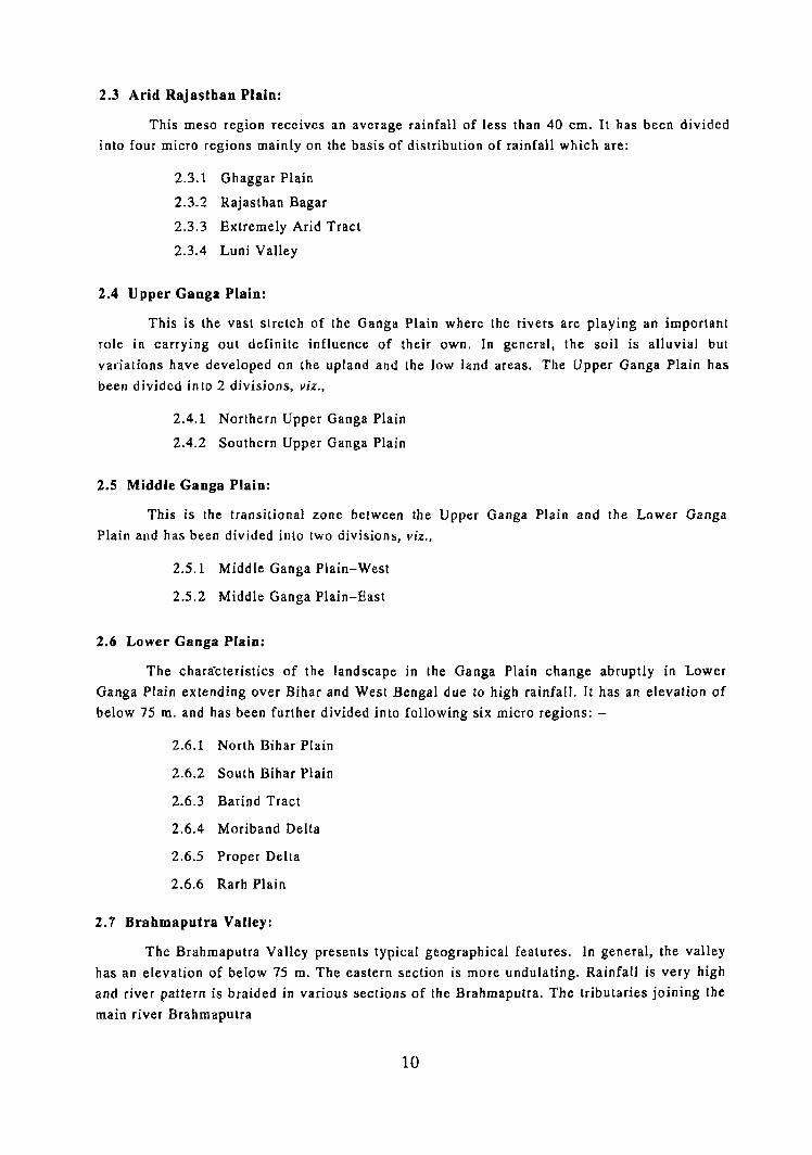
68° 72°
36°
~
't"
i'-.. 32°
Go)
.....
~
28°
ARABIAN
S E 'A
12 °
' 4.4.2
B ° Figures in Red colour in the map indicate the sequence 01
".J.
Regional Divisions with reference to the all India map codes upto 3 lier
Where the boundaries of Region!;l Divisions are co-terminus wi t h lhose of t he slalesjUTs and dislricls,lhe former are only shol'm.
N D A N
72° EAsr OF CREE~WICII
Based upon Survey of India map with the permission of the Surveyor General of India.
The territorial waters of India extend into the sea to a distance of twelve nautical miles measured from the appropriate base line.
The interstate boundaries between Arunachal Pradesh, Assam and Meghalaya shown on this map are as interpreted from the North·Eastem Areas (Reorganisation) Act, 1971 but have yet to be verified .
80°
I INDIA
MAP 1
J30
PHYSIO-GEOG~PHIC ZONES
Boundary, In lernalional Boundary, SlatejU.T Boundary, Dislrlct.
KILOMETRES 10050 0 100 200 300 400 500
BA Y
o F
BENGAL
Name of Dist r icts
'" Khogeria
" Kishanganj W. lolah.,ndniarh .. lItoil:okchung Nm liuZIlU!l.rpnr P",C Puhchim Champa",n P.N,T Pasum pon Wulhuramalinga
Thave r
~.c P"thanamthitta Pul"ba Champaran
" SIIhib,a"j
"m s..ml'Ostipur TS Tiruvanmlmlllaj Sambl:"artlYllf fu, TuenSo'lng W.K.H W~t Kh8"; HIlls .. Wokhll
'" Zunhel.>oto , K8purtheJa
RI:GIONS{NACRO) ___ .,. __ SUB- RECIONS(NESOj. __ ..... ,_ DIVISIONS (NJCRO). __ ._",. __
(BIHAR) (BIHAR) (HARYAH") fNAGALANDl BI~.AR)
(TA WILNADU)
\KERALA) BIHAR)
(B!HAH)
(TAlofILNADIJ)
~~~~~t~~A) (NACAlUlDj (NAGALIND) (PUNJAB'
MACRO R!l:IONS
D THENORTIIERNMOUNTA1NS
D THE GREAT PLAINS
DTHEOECC.INPL!TEAU
DTHECOASTALPLAINSAN01SLANIli
N.A. - Dala not available.
o c E A N
84°
STATE: I [}1STRICT
J.lANIPUR 1. Senapati 2.Ukhrul
4T'hoube.1 5.lmphel 6,Ta;ntnglong ?,Bishnnpnr 6.Churachllndpur
I. North Dislrict 2. 'lest District :lSouttlDistrict 4. E5,\ Distrb\
MYANMAR
(BURMA)
~ Coco I.
, (BURMA)
.Q' (INDIA)
~ U,""m.", ., J/~: " .(~~~~~)
"2'- ~q " :.1
;. A N D A M AN
t;. 0" 7'-1- 4..4.1
.. 0 o ~~~-
92°
<ft O. ,..
(J : IN DI RA POINT '"
<ft
o ~32
12°
S E A
© Government of India, copyrighl2001.

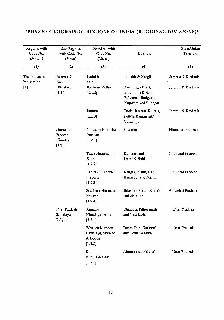
'PHYSIO-GEOGRAPHIC REGIONS OF INDIA (REGIONAL DIVISIONS)'
Regions with Sub-Regions Divisions with State/Union Code No. with Code No. Code No. Districts Territory (Macro) (Meso) (Micro)
(1) (2) '(3) (4) (5)
The Northern Jammu & Ladakh Ladakh & Kargil Jammu & Kashmir Mountains Kashmir [1.1.1 ] [1] Himalaya Kashmir Valley Anantnag (K.S.), Jammu & Kashmir
(Ll] (1.l.2] Baramula (K.N.),
Pulwama, Badgam,
Kupwara and Srinagar.
Jammu Doda, Jammu, Kathua, Jammu & Kashmir
[1.1.3] Punch, Rajauri and
Udhampur
Himachal Northern Himachal Chamba Himachal Pradesh
Pradesh Pradesh
Himalaya [1.2.1J
[1.2J
Trans Himalayan Kinnaur and Himachal Pradesh Zone Lahul & Spiti
[1.2.2]
Central Himachal Kangra, Kullu, Una, Himachal Pradesh Pradesh Hamirpur and Mandi
[1.2.3]
Southern Himachal Bilaspur, Solan, Shimla Himachal Pradesh
Pradesh and Sirmaur
[1.2.4]
Uttar Pradesh Kumaon Chamoli, Pithoragarh Uttar Pradesh
Himalaya Himalaya-North and Uttarkashi
[1.3J f1.3.1 J
Western Kumaon Dehra Dun, GarhwaI Uttar Pradesh
Himalaya, Siwalik and Tehri Garhwal
& Doons
[1.3.2]
Kumaon Almora and Nainital Uttar Pradesh
Himalaya-East
[1.3.3]
19
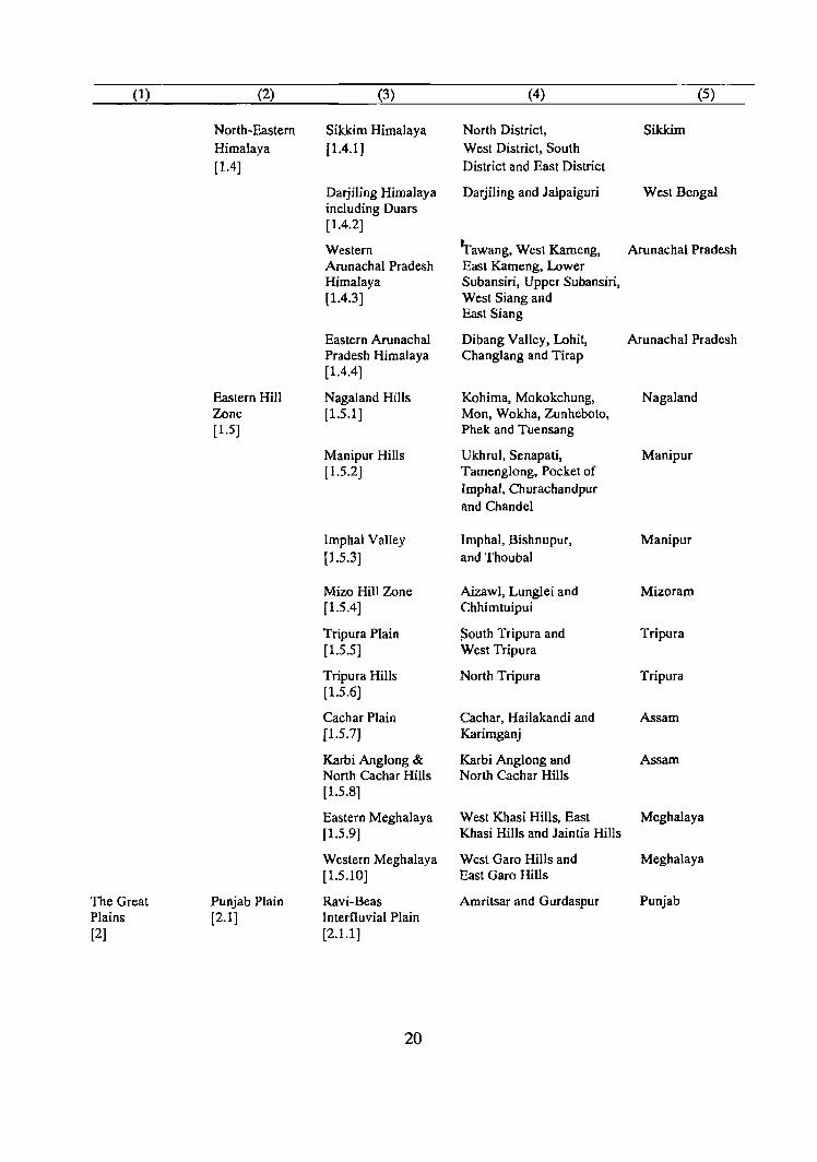
(1) (2) (3) (4) (5)
North-Eastern Sikkim Himalaya North District, Sikkim Himalaya [1.4.1 ] West District, South [1.4] District and East District
Darjiling Himalaya Darjiling and Jalpaiguri West Bengal including Duars [1.4.2]
Western Tawang, West Kameng, AIunachalPradesh Arunachal Pradesh East Kameng, Lower Himalaya Subansiri, Upper Subansiri, [1.4.3] West Siang and
East Siang
Eastern Arunachal Dibang Valley, Lohit, Arunachal Pradesh Pradesh Himalaya Changlang and Tirap [1.4.4]
Eastern Hill Nagaland Hills Kohima, Mokokchung, Nagaland Zone [1.5.1 ] Mon, Wokha, Zunheboto, [1.5] Phek and Tuensang
Manipur Hills Ukhrul, Senapati, Manipur [1.5.2] Tamengiong, Pocket of
Imphal, Churachandpur and Chandel
lmphal Valley lmphal, Bishnupur, Manipur [1.5.3] and Thoubal
Mizo Hill Zone Aizawl, Lunglei and Mizoram [1.5.4] Chhimtuipui
Tripura Plain ~outh Tripura and Tripura [1.5.5] West Tripura
Tripura Hills North Tripura Tripura [1.5.6J
Caehar Plain Caehar, Hailakandi and Assam [1.5.7] Karimganj
Karbi Anglong & Karbi Anglong and Assam North Cachar Hills North Cachar Hills [1.5.81
Eastern Meghalaya West Khasi Hills, East Meghalaya [1.5.9] Khasi Hills and Jaintia Hills
Western Meghalaya West Garo Hills and Meghalaya [1.5.10] East Garo Hills
The Great Punjab Plain Ravi-Beas Amritsar and Gurdaspur Punjab Plains [2.1] Interfluvial Plain [2] [2.1.1 ]
20
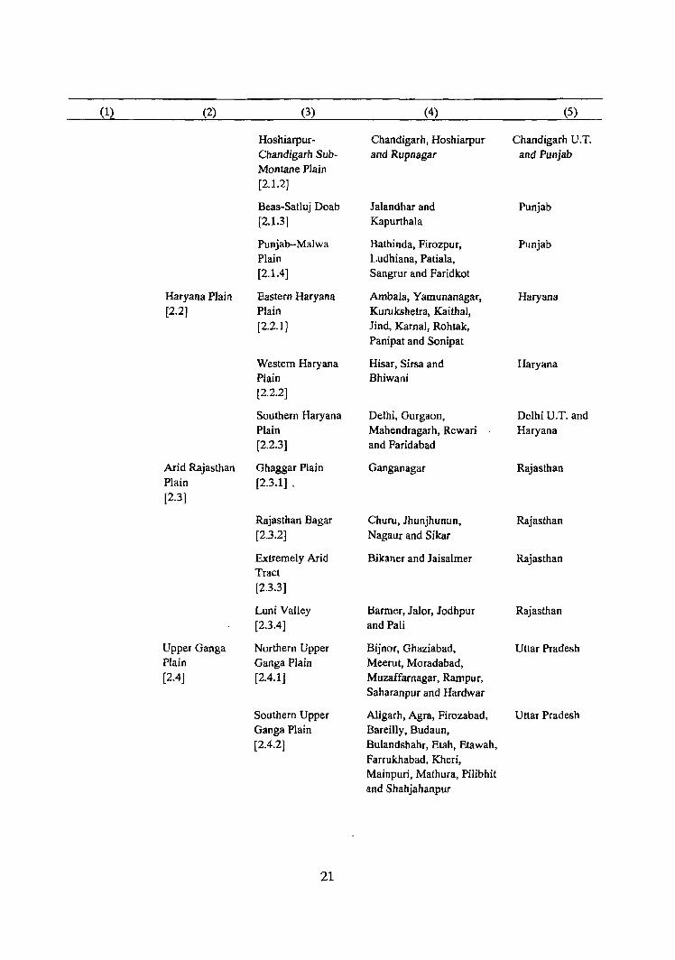
(1) (2) (3) (4) (5)
Hoshiarpur- Chandigarh, Hoshiarpur Chandigarh U. T. Chandigarh Sub- and Rupnagar and Punjab Montane Plain [2.1.2]
Beas-Satluj Doab lalandhar and Punjab [2.1.3] Kapurthala
Punjab-Malwa Bathinda, Firozpur, Punjab Plain Ludhiana, Patiala, [2.1.4] Sangrur and Faridkot
Haryana Plain Eastern Haryana Ambala, Yamunanagar, Haryana [2.2] Plain Kurukshetra, Kaithal,
[2.2.1 ] Jind, Kamal, Rohtak, Panipat and Sonipat
Western Haryana Hisar, Sirsa and Haryana Plain Bhiwani [2.2.2]
Southern Haryana Delhi, Gurgaon, Delhi U.T. and Plain Mahendragarh, Rewari Haryana [2.2.3] and Faridabad
Arid Rajasthan Ghaggar Plain Ganganagar Rajasthan Plain [2.3.1] . [2.3]
Rajasthan Bagar ChufU, Jhunjhunun, Rajasthan [2.3.2] Nagaur and Sikar
Extremely Arid Bikaner and Jaisalmer Rajasthan Tract [2.3.3]
Luni Valley Harmer, Jalor, Jodhpur Rajasthan [2.3.4] and Pali
Upper Ganga Northern Upper Bijnor, Ghaziabad, Uttar Pradesh Plain Ganga Plain Meerut, Moradabad, [2.4] [2.4.1 ] Muzaffarnagar, Rampur,
Saharanpur and Hardwar
Southern Upper Aligarh, Agra, Firozabad, Uttar Pradesh Ganga Plain Bareilly, Budaun, [2.4.2] Bulandshahr, Etah, Etawah,
Farrukhabad, Kheri, Mainpuri, Mathura, Pilibhit and Shahjahanpur
21
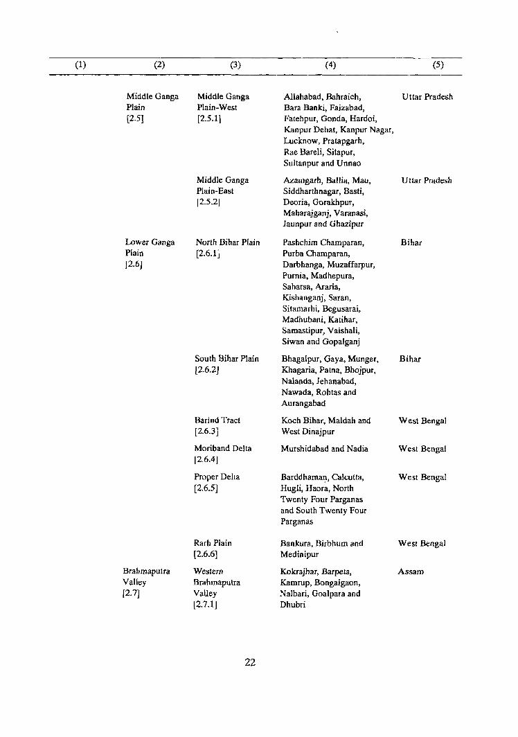
(1) (2) (3) (4) (5)
Middle Ganga Middle Ganga Allahabad, Bahraich, Uttar Pradesh Plain Plain-West Bara Banki, Faizabad, (2.51 [2.5.1] Fatehpur, Gonda, Hardoi,
Kanpur Dehat, Kanpur Nagar, Lucknow, Pratapgarh, Rae Bareli, Sitapur, Sultanpur and Unnao
Middle Ganga Azamgarh, Ballia, Mau, Uttar Pradesh Plain-East Siddharthnagar. Basti. fZ.5.Z] Deoria, Gorakhpur,
Maharajganj, Varanasi, Jaunpur and Ghazipur
Lower Ganga North Bihar Plain Pashchim Champaran, Bihar Plain [2.6.1] Purba Champaran. [2.6J Darbhanga, Muzaffarpur,
Purnia, Madhepura, Saharsa, Araria, Kishanganj, Saran, Sitamarhi, Begusarai, Madhubani, Katihar, Samastipur, Vaishali, Siwan and Gopalganj
South Bihar Plain Bhagalpur, Gaya, Munger, Bihar [2.6.2] Khagaria, Patna, Bhojpur,
Nalanda, Jehanabad, Nawada, Rohtas and Aurangabad
Barind Tract Koch Bihar, Maldah and West Bengal [2.6.3] West Dinajpur
Moriband Delta Murshidabad and Nadia West Bengal [2.6.4J
Proper Delta Barddhamat:\, Calcutta, West Bengal [2.6.5J Hugli, Haora, North
Twenty Four Parganas and South Twenty Four Parganas
Rarh Plain Bankura, Birbhum and West Bengal [2.6.6] Medinipur
Brahmaputra Westem Kokrajhar, Barpela, Assam Valley Brahmaputra Kamrup, Bongaigaon, [2.7] Valley Nalbari, Goalpara and
[2.7.1] Dhubri
22
(1) (2) (3) (4) (5)
Central Darrang, Sonitpur, Assam Brahmaputra Nagaon and Marigaon Valley [2.7.2]
Eastern Lakhimpur, Dhemaji, Assam Brahmaputra Tinsukia, Sibsagar, Valley Dibrugarh, Jorhat and [2.7.3] Golaghat
The Deccan Semi-Arid AravaIli Range and Ajmer, Alwar, Banswara, Rajasthan Plateau Rajasthan The Associated Chittaurgarh (part), [3] [3.1] Uplands Dungarpur,
[3.1.1 ] Jaipur, Sirohi and Udaipur
Semi-Arid Uplands Bhilwara, Bundi, Kota, Rajasthan of Eastern Jhalawar, Tonk and Rajasthan pocket of Chittaurgarh [3.1.2]
Banas-Chambal Bharatpur, Dhaulpur and Rajasthan Basin Sawai Madhopur [3.1.3]
Uttar Pradesh Jhansi Uplands Banda, Hamirpur, Uttar Pradesh Uplands [3.2.1] Jalaun, Lalitpur [3.2] and Jhansi
Mirzapur Uplands Mirzapur and Sonbhadra Uttar Pradesh [3.2.2]
Bihar-West Ranchi Plateau Palamu, Ranchi, Gumla Bihar Bengal Uplands [3.3.1] and Lohardaga [3.3]
Hazaribag Plateau Dhanbad, Hazaribag, Bihar [3.3.2J Giridih. Dumka, Deoghar.
Godda and Sahibganj
Puruliya Uplands Puruliya West Bengal [3.3.3]
Singhbhum Plateau Pashchimi Singhbhum Bihar [3.3.4] and Purbi Singhbhum
Northern Northern Madhya Bhind, Datia, Guna, Madhya Pradesh Madhya Pradesh Ravine Gwalior, Morena and Pradesh Uplands-West Shivpuri Uplands [3.4.1 ] [3.4J
23
(1) (2) (3) (4) (5)
Northern Madhya Chhatarpur, Panna and Madhya Pradesh
Pradesh Uplands- Tikamgarh Central [3.4.2]
Northern Madhya Rewa, Satna, Shah dol, Madhya Pradesh Pradesh Uplands- Sidhi and Surguja East [3.4.3]
Central Sagar Plateau Damoh, Sagar Madhya Pradesh Madhya [3.5.1] and Vidisha Pradesh Plateau [3.5]
Bhopal Plateau Dewas, Indore, Raisen, Madhya Pradesh [3.5.2] Bhopal and Sehore
Ratlam Plateau Dhar, Jhabua, Mandsaur, Madhya Pradesh [3.5.3] Ratlam, Rajgarh, Shajapur
and Ujjain
Southern Narmada Region Balaghat, Betul, Madhya Pradesh Madhya including Flanks of Chhindwara, Hoshangabad, Pradesh Vindhya and Jabalpur, West Nimar, UpJands Satpura East Nimar, Mandla, [3.6] [3.6.1 ] Narsimhapur and Seoni
Mahanadi Basin Bilaspur, Durg, Raigarh, Madhya Pradesh [3.6.2] Raj Nandgaon and Raipur
Madhya Pradesh Bastar Madhya Pradesh Dandakaranya [3.6.3]
Northern Tapti-Puma Amravati, Akola, Buldana, Maharashlra Maharashtra Valley Dhule and Jalgaon [3.7] [3.7.1]
Wardha Penganga Bhandara, Chandrapur, Maharashtra Wain ganga Plain Gadchiroli, Nagpur, [3.7.2] Wardha and Yavalmal
Maharashtra Eastern Plateau Aurangabad, Jalna, Latur, Maharashtra Plateau [3.8.1] Bid, Kolhapur, Nanded,
[3.8] Osmanabad, Parbhani, Sangli and Solapur
24
(1) (2) (3) (4) (5)
Western Plateau Ahmadnagar, Nashik, Maharashtra
with protruded Pune and Sa tara
Hills
[3.8.2J
Karnataka Northern Belgaum, Bidar, Bijapur Karnataka
Plateau Karnataka Plateau and Gulbarga
[3.9} (3.9.1J
Central Karnataka BeHary, Chikmagalur, Karnataka
Plateau Raichur, Chitradurga,
[3.9.2J Dharwad, Shimoga
and pocket of Tumkur
Southern Bangalore Rural, Karnataka
Karnataka 'Plateau Bangalore Urban, Kodagu,
[3.9.3J Hassan, Kolar, Mandya,
Mysore and Tumkur (part)
Tamil Nadu Eastern Flanks of Coimbatore, Madurai, Tamil Nadu , Uplands Sahyadri Nilgiri, Dindigul-Anna
[3.10J [3.10.1 J and Periyar
Tamil Nadu Tiruvannamalai Tamil Nadu
Uplands Sambuvarayar,
[3.10.2] North Arcot Ambedkar,
Dharmapuri and Salem
Andhra Godavari Karimnagar, Khammam Andhra Pradesh
Plateau Depression and Warangal
[3.11] [3.1Ll J
Telangana Plateau Adilabad, Hyderabad, Andhra Pradesh
[3.11.2] Medak. Mahbubnagar,
Nizamabad and
Rangareddi
Krishna Piedmont Nalgonda Andhra Pradesh
Plain
[3.11.3]
Rayalaseema Anantapur, Chittoor, Andhra Pradesh
[3.11.4J Cuddapah and Kumoo!
25
(1) (2) (3) (4) (5)
Orissa Northern Orissa Dhenkanal, Kendujhar, Orissa
Highlands Highlands Mayurbhanj, Sambalpur
[3.12] [3.12.1] and Sundargarh
Southern Orissa Phulabani, Balangir, Orissa
Highlands (Orissa Ganjam, Kalahandi
Dandakaranya) and Koraput
[3.12.2]
The Coastal Gujarat Region Gujarat Plain Ahmadabad, Bharuch, Gujarat,
Plains and [4.1] [4.1.1] Banas Kantha, Dadra & Nagar
Islands Gandhinagar, Kheda, Haveli U.T. and
[4] Mahesana, Sabar Kantha, Daman &
Surat, Vadodara, Valsad, Diu U.T.
Daman and Dadra &
Nagar Haveli
Eastern Hilly Panch Mahals and Gujarat
Region The Dangs
(4.1.2]
Kathiawar Amreli, Bhavnagar, Gujarat and
Peninsula Jamnagar, Junagadh, Daman & Diu
[ 4.1.3] Surendranagar, Rajkot U.T.
and Diu
Kachchh Peninsula Kachchh Gujarat
[4.1.4]
Western Maharashtra Greater Bombay, Maharashtra
Coastal Region Littoral Raigarh, Ratnagiri,
[4.2] (4.2.1 ] Sindhudurg and Thane
Goa Coast North Goa and Goa
[4.2.2] South Goa
Karnataka Coast Uttara Kannada and Karnataka
[4.2.3] Dakshina Kannada
North Kerala Coast Kasaragod, Kannur, Kerala and
[4.2.4] Kozhikode, Wayanad Pondicherry
and Mahe U.T.
Central Kerala Ernakulam, Koltayam, Kerala
Coast ldukki, Malappuram,
[4.2.5J Palakkad and Thrissur
26
(1) (2) (3) (4) (5)
South Kerala Coast Alappuzha, Kerala
[4.2.6J Pathanamthitta,
Thiruvananthapuram
and Kollam
Eastern Kanniyakumari Kanniyakumari Tamil Nadu
Coastal Region Coast
[4.3] [4.3.1 ]
Sandy Littoral Pasumpon Muthu Tamil Nadu
[4.3.2] Ramalinga Thevar,
Ramanathapuram,
Kamarajar, Chidambaranar
and Tirunelveli Kattabomman
Coromandel Coast Chengalpattu M.G.R., Tamil Nadu
[4.3.3] Madras, Thanjavur,
TiruchirappaUi,
South Arcot, Pudukkottai,
Karaikal and Pondicherry Pondicherry U.T.
Southern Andhra Nellore and Prakasam Andhra Pradesh
Coastal Plain
[4.3.4]
Krishna Delta Guntur and Krishna Andhra Pradesh
[4.3.5]
Godavari Delta East Godavari, West Andhra Pradesh and
[4.3.6] Godavari and Yanam Pondicherry U.T.
Northern Andhra Srikakulam. Vizianagaram Andhra Pradesh
Coastal Plain and Visakhapatnam
[4.3.7]
Mahanadi Delta Baleshwar, Cuttack Orissa
[4.3.8] and Puri
The Islands Andaman and Andamans and Nicobars Andaman and
[4.4] Nicobar Islands Nicobar Islands
[4.4.1] U.T.
Lakshadweep Lakshadweep Lakshadweep [4.4.2] U.T.
27

PART-II
REGIONAL DIVISIONS 'OFPUNJAB

REGIONAL DIVISIONS OF PUNJAB
Punjab is located in the northwestern part of the Indian Union. It covers an
area of 50,362.0 sq.km and has a population 20,281,969 as per 1991 Census.
Punjab State constitutes 1.53 per cent of the country's total area and 2.40 per cent
of population.
The word 'Punjab' has derived its name from two Persjan words, 'Punj'
meaning five and' Ab' means water, and is commonly referred to as the land of
five rivers possibly since the era when this region came in contact with Persia.
Punjab is roughly one-seventh of what it was during the pre-partition. At the time
of partition most of the western part went to the present Pakistan. It suffered
another loss at the time of re-organisation of the State on November 1,1966.
Three perennial rivers namely, Ravi, Beas and Satluj flow through this present
Punjab.
PUnjab State extends between 29° 33' and 32° 31' north latitudes and 73°
53' and 76° 56'east longitudes. There are no large scale diversifications in this
tract of otherwise broad physical homogeneity with the exception of scattered and
low ranges of the Siwaliks in the north and northeastern part of the State.
Geologically, Punjab Plain is of very recent age and was formed in the last phase
of geological history of the earth due to deposition by the rivers. The Siwaliks are
comprised of tertiary, rather upper tertiary (very recent deposits) sediments.
Punjab State is surrounded by Jammu & Kashmir in the north, Himachal
Pradesh in the east and northeast, Chandigarh and Haryana in the south and
southeast and Rajasthan in the southwest. The international boundary with
Pakistan makes its western boundary. On the basis of physio-geographical factors,
Punjab PJajn has been further divided into following micro-divisions~
1) 2.1.1 Ravi-Beas Inter-Fluvial Plain covering the districts ofGurdaspur
and Amritsar.
2) 2.1.2. Hoshiarpur-Chandigarh Sub-Montane Plain covering the districts
of Hoshiarpur, Rupnagar and the Union Territory ofChandigarh.
3) 2.1.3. Beas-Satluj Doab covering the districts of Jalandhar and Kapurthala.
4) 2.1.4. Punjab Malwa Plain covering the districts ofFirozpur, Ludhiana,
Patiala, Sangrur, Bathinda and Faridkot.
2.1.1 Ravi-Beas Inter-Fluvial Plain
Ravi-Beas Inter Fluvial- Plain is surrounded by Jammu & Kashmir in the
north, Hoshiarpur and Kapurthala districts in the east, Himachal Pradesh in the
northeast and Firozpur district in the south. International boundary with Pakistan
makes its western boundary. This region has Siwalik hills in the extreme
northeastern part of Gurdaspur district. These hills slope towards south and
southwest. These Siwalik hills are the result of the Orogenesis (mountain
building) forces. With the passage of time these hills got badly eroded by the
swift and torrential streams coming down these hills. These streams are seasonal.
Rest of the area of this region is plain and soils are fertile. This region is situated
between river Ravi in the west and river Beas in the east. It includes the districts
of Gurdaspur and Amritsar districts and has a population of 4,261,292. It
constitutes over one-fifth (21.01%) of the total population of the State. The areas
which are flooded by these two rivers are locally known as 'khadar or Bet'. The
soils differ from place to place depending upon the local topography. In the
Siwalik hills the soil is Ochrepts-Orthents-Ustalfs which are shallow black,
brown, alluvial and recently formed soils. The soils in most parts of Gurdaspur
and Amritsar districts are Ochrepts-Orthents-Rockout -Crops-Orthids, whereas
the soils are mainly Psamments-Fluvents-Aquents in the southern parts of this
plain. The geological structure of this region is Siwalik in the extreme
northeastern part of Gurdaspur district and alluvium in the other parts of the
32
region. Water logging is the major problem of this region due to rise in sub-soil
water table.
2.1.1 Hoshiarpur-Chandigarh Sub-Montane Plain
Hoshiarpur-Chandigarh Sub-Montane plain includes Hoshiarpur and
Rupnag~r districts and the Union Territory of Chandigarh. This region is located
in the eastern and northeastern part of Punjab extending in northwest to southeast
d irectj on. It is surrounded by Himachal Pradesh in the north and northeast,
Haryana in the east, and the micro regions of Punjab Malwa Plain and Satluj
Beas Inter-Fluvial Plain in the south and west respectively. The Siwalik hills are
located in the extreme northern part of Hoshiarpur and Rupnagar districts. The
Siwalik hills which are the result of Orogensis forces extend in northwest
southeast direction. These hills have experienced heavy soil erosion due to the
swift and seasonal rivers/streams. The soils of this region are coarse and sandy in
the hiUy tracts. In the plains the soils are fertile. According to soil classification,
the soils are Ochrepts-Psamments in the hilly area and Fluvent-Ochrepts in the
plain area. The Beas river separates Hoshiarpur district from Gurdaspur district.
The Beas and Satluj rivers have their own flood plains covering an area of
1,042.07 Km2. In addition to these two rivers, there are numerous seasonal
streamslchoes in Hoshiarpur district which causes problem of soils erosion.
Hoshiarpur-Chandigarh Sub-Montane Plain has an area of 5,966.02 sq.km
and a population of 2,370,631 persons. Among them 1,916,176 are residing in
rural and 454,455 in urban areas. Hoshiarpur, Mukerian,Garhshankar, Rupnagar,
SAS Nagar (Mohali) and Anandpur Sahib are the main towns falling in this
region. The geology of this region is Siwalik in the hilly tracts and alluvium in
the other parts. Soils of this plain are Fluvents-Ochrepts, Ochrepts-Orthents and
Ochrepts-Psamments. The main economy of the region is based on agriculture
and the important crops grown are wheat, maize, rice and grams. The belt across
Mukerian is known for producing high quality rice. From the industrial point of
view, this region comparatively is less developed. However, Rupnagar and SAS
33
Nagar (Mohali) are emerging as important industrial centers in the State. Major
industries located in the region include; manufacture of fertilizers, medicines,
cotton textiles, resin, turpentine and varnish etc.
2.1.3. Beas-Satluj Doab
Beas-Satluj Doab region covers lalandhar and Kapurthala districts. This
region is bounded by the micro-region Ravi-Beas Inter- Fluvial Plain in the west;
Hoshiarpur and Rupnagar districts in the north and east, 'and by Firozpur and
Ludhiana districts in the south. Beas and Satluj are the main rivers traversing
through this area. The river Beas separates it from Amritsar and Gurdaspur
districts, while river Satluj separates this region from Malwa Plain in the south.
The soils of this region are Ochrepts-Orthents-Rock-Outcrops-Orthids in the
northern pari and Psamments-Fluvents--Aquents in the southern parts. The
geology is alluvium. Besides river Beas and Satluj, White Bein and Black Bein,
which are seasonal streams traverse through this region in east -west direction.
This region has an area of 5,034.0 sq.km and a population of 2,673,434.
Out of the total population 1,778,027 are rural and 895,407 urban by residence.
The region has a population density of 531 persons per sq.km. Ialandhar,
Kartarpur, Phagwara., Goraya, Phillaur and Kapurthala are the main towns in the
region. Ialandhar city is famous for sports goods, while Phagwara and Goraya are
famous for the manufacture of agricultural implements, machine tools, cycle
parts, sugar and textiles.
The economy of this region is based upon agriculture and industry. Wheat,
maize, grams and sugarcane are the main crops grown in this region.
2.1.4. Punjab Malwa Plain
Punjab Malwa Plain covering the districts of Firozpur, Bathinda, Faridkot,
Sangrur and Patiala. Satluj river flows in the northern and north-western part
34
from east to west. The Ghaggar river which is rainfed and seasonal in nature
traverses through the southern part of the region in east-west direction. This Plain
is bounded by Rupnagar district in the east, Haryana state in the south and
Rajasthan in the south-west. It makes its western boundary with Pakistan. This
region covers an area of 3,0735.76 sq.km and has a population of 10,974,592
which is nearly one-half of the state's total population. Out of the total population
7,571,472 is residing in rural and 3,403,120 in urban areas. In other words 31.00
per cent of the population is living in urban areas of the region. Ludhiana, Patiala,
Bathinda, Mansa, Firozpur, Sangrur, Abohar and Faridkot are the main towns
located in this region.
This region is, by and large a flat featureless plain. Beas and Satluj rivers
separate this region from the Majha and Doab area in the north. The Beas river
flowing in northeast-southwest direction joins Satluj river at Harike ( Amritsar
district). The occurrence of sand dunes is quite common ;n the southern parts of
this region. The soils are Ustalfs-Fluvents, Orthids-Fluvents, Usafalfs-Ochrepts in
the southern parts and Psamments-Fluvents-Aquents, Ochrepts-Orthents and
Ochrepts-Psamments in the rest of the region. The geology of this plain is
alluvium. Agriculture is the main stay of economy of this region. The main
industrial centres in the region are located in the towns falling in the districts of
Ludhiana, Bathinda, Patiala and Sangrur. The soils are mainly sandy. Wheat,
cotton, grams, bajra and rice are the main crops grown. Firozpur district has a
problem of water-logging especially in its western parts. Similarly, in some
pockets of Patiala and Sangrur districts the surface water dries up in dry weather
leaving a sheet of white powdery material on the earth surface. This alkaline
matter affects the fertility of the soil and makes the land unfit for cultivation. In
the extreme southern parts of Firozpur, Bathinda and Faridkot districts wind
erosion is quite common.
In brief, Punjab MaIwa Plain is the largest, both in area and population
size. It covers about 6l.03 per cent the state's area and 54.11 per cent of the
population.
35
Punjab has semi-arid monsoon climate. The climate is severe hot in
summers and extremely cold in the winters. The maximum temperatures are
recorded in the month of June which starts declining with the onset of the
monsoons in July. The rainy season lasts till middle of September. On an average
the State receives an annual rainfall of 1000 rom and it is mainly concentrated
during the monsoon months of July to September. The rainfall decreases from
northeast to southwest The State receives some winter rains from temperate
cyclones originating in the Atlantic Ocean and Mediterranean sea and this rainfall
is very beneficial for rabi crops. The winter season starts from the middle of
October and continues till March. January is the coldest month. Generally the
mornings are relatively foggy during the months of December and January.
The soils in the State are alluvial and are extremely fertile. Sandy soils
with the presence of gravels are found in the Siwalik hills. Bathinda, Faridkot,
Sangrur districts have sandy soils. Soils in hilly areas suffer from soil erosion
particularly in the Hoshiarpur and Rupnangar districts. In areas of high water
table soils are water logged while in the southern parts of the State wind erosion is
quite common due to the presence of the sand dunes.
The geology of Punjab is alluvium except for the hilly tracts of Gurdaspur,
Hoshiarpur and Rupnagar districts where it is Siwalik.
The main economy of Punjab depends upon agriculture. Generally, the
soils are fertile and alluvial and suitable for agricultural production. Cropping
pattern changes with the change of soil contents. In the northern parts only those
crops are grown which require humid conditions, and in the southern parts those
crops are grown which require comparatively lesser quantity of water. Similarly,
in the northern and northeastern areas wheat, rice, maize and grams are the main
crops, while in the southern parts, grams, cotton, groundnuts, rapeseed and
mustard are the major crops.
36
Punjab State spreads over an area of 50,362.0 sq.km and has a population
of 20,281,969 persons. The density of population in 403 persons per sq.km which
is higher than that of the country as a whole where the density of population is
267. Ludhiana, Jalandhar, Gurdaspur and Amritsar districts in the state are
comparatively more densely populated, whereas the low density of population is
observed in the districts of Firozpur, Sangrur, Faridkot and Bathinda.
Punjab's popUlation has increased from 16,788,915 in 1981 to 20,281,969
persons in 1991 resulting in an absolute increase of 3,493,054. In other words the
state has registered a popUlation growth rate of
20.81 per cent during this decade . The growth rate is observed to be
comparatively higher in the districts of Ludhiana and Rupnagar, while it is
comparatively low in the districts of Gurdaspur and Amritsar. In consonance with
the earlier trends, the sex ratio in the state has improved from 879 in 1981 to 882
in 1991.
All those persons above six years of age, who can read and write with
understanding in any language are treated as literates in the Indian Census.
According to 1991 Census there are 9,932,116 are literates in Punjab among
which 5,919,225 are males and 4,012,891 females. As such 58,51 per cent of the
population of the State is literate and this is higher than the country as a whole
(52.19%). Among the districts in the state the literacy rate is the highest in
Hoshiarpur (70.74%), followed by Rupnangar (68.1~%), Ludhiana (67.35%) and
Ialandhar (66.45%) districts. By contrast the literacy rate is relatively low in
Bathinda (43.03%), Sangrur (46.16%), Firozpur (48.01%) and Faridkot (49.42%)
districts.
In the Punjab State there are 6,098,374 main workers, 163,615 marginal
workers and 14,019,980 are non-workers. In other words workers constitute 31.88
per cent of the total population; 30.07 per cent as main workers and 0.81 per cent
as marginal workers, and 69.12 per cent are non-workers. In the state, 4,302,750
(70.56%) are residing in rural and 1,795,624 (29.44%) in urban areas. Among the
37
main workers, 1,917,210 (31.44%) are cultivators, 1,452,828 (23.82%) are
agricultural labourers, 81,084 (1.33%) are engaged in household industry and
668,052 (43.41%) are other workers.
5,742,528 persons (28.31%) in the state belongs to Scheduled Castes.
Among them 3,065,671 are males and 2,676,857 are females. Percentage of
Scheduled Caste population in total population is the highest in Jalandhar (39.~8
%) and the lowest in Firozpur (21.80%).
Amritsar, Jalandhar, Ludhiana, Phagwara, Kapurthala, Patiala, Rajpura,
Bathinda, Gobindgarh and Batala are the major industrial centres in the State. The
well developed net work of roads and railways and also the availability of hydro
electric power has greatly helped in growth of industries in the State. The major
industries are food processing, cotton ginning and processing, agricultural
implements, engineering goods, chemicals, transport equipments, sewing
machines, leather goods and ginning mills. Cotton ginning and processing is
important in the cotton growing areas located in the Malwa Plain. Similarly, Rice
shelling mills are located in the rice growing areas of Upper Bari and Bist Doabs.
The main objective of demarcating the State into sub-micro regions by
taking into consideration village as the lowest unit is to provide a tool to the
policy planners and other data user agencies in framing policies and programmes
based on socio economic conditions of the region at the grass root level. Regional
planning is the need of the State as well as Central Government. With this in view
an attempt has been made to delineate the sub-micro regions, district by district,
which are homogenous in physio-geographic conditions.
*****
38
2.1 PUNJAB PLAIN
Micro Regions District with Sub-Micro Regions with code code number with code number number (Fourth Tier Regions) 1 2 3 2.1.1 Ravi-Beas GURDASPUR 2.1.1. 1 Gurdaspur Siwalik
Inter-Fluvial 01 2.1.1.2 Gurdaspur Upland Plain 2.l.1.3 Ravi Flood Plain
2. I. 1.4 BataIa Plain 2.1.1.5 Beas Flood Plain
AMRITSAR 2.1.1.1 Satluj and Beas Flood Plain 02 2.1.1.2 Tarn Taran Plain
2.1.1.3 Amritsar Plain 2.1.1.4 Ravi Flood Plain
2.1.2 Hoshiarpur- HOSHIARPUR 2.1.2. ] Beas Flood Plain Chandigarh 07 2.1.2.2 Choes of Hoshiarpur Sub-montane Plain 2.1.2.3 Hoshiarpur Siwalik
2.1.2.4 Satluj Khadar Plain
RUPNAGAR 2.1.2. ] Upper Satluj Basin 08 2.1.2.2 Rupnagar Siwalik
2.1.2.3 Kharar Plain
2.1.3 Beas- Satluj JALANDHAR 2.1.3.1 Bhogpur-Adampur Plain Doab 05 2.1.3.2 Jalandhar- Nawanshahr Doab Plain
2.1.3.3 Satluj Khadar
KAPURTHALA 2.1.3.1 Beas Flood Plain 06 2.1.3.2 Kapurthala Plain
2.1.4 Pu~ab-Malwa FlROZPUR 2.1.4.1 Satluj Khadar Plain 03 2.1.4.2 Firozpur Plain
2.1.4.3 Abohar Sandy Plain
LUDIllANA 2.1.4.1 Satluj Khadar 04 2.1.4.2 Western Ludhiana Plain
2.1.4.3 Eastern Ludhiana Plain
PATIALA 2.1.4.1 Patiala Plain 09 2.1.4.2 Ghaggar Flood Plain
39
Micro Regions with code number 1
District with code number
2
SANGRUR 10
BATIDNDA 11
FARIDKOT 12
.40
Sub-Micro Regions with code number (Fourth Tier Regions)
3
2.1.4.1 Western Sangrur Plain 2.1.4.2 Eastern Sangrur Plain 2.1.4.3 Southern Sangrur Plain 2.1.4.4 Ghaggar Flood Plain
2.1.4.1 Bathinda Sandy Plain 2.1.4.2 Rampura-Mansa Plain 2.1.4.3 Ghaggar Flood Plain
2.1.4.1 Muktsar Plain 2.1.4.2 Faridkot Sandy Plain 2.1.4.3 MogaPlain
CENSUS OF INDIA
PUNJAB CENSUS CODE 20
REGIONAL DIVISIONS
10 5 0 10 20 30 AO
CI)
BOUNDARY, NTERNA nONAI. " •• •• - 0 _o_ . sTATEftJT .. ........ _. _.-
" DlSrRlCT .. ........ _ . _ . _ " MACRO REGION .. .. .. _II&CIt
" MESO " " MICRO "
SOl-MICRO" ...... _ _....~
DISTRICT COD£ 1991 .. I 10 I
RE~~~ .~I~~~. : : _j~2. tL 4 ••
MESO .... .. .. .. __J MICRO .. .. .. ..
SU8-MlCRO .. "
I
j
.J WIGRlIt f 1101 2.1.4.2
.,
PAT'IAU 101' 2.I.4J
()
~
MAP 2

I I
III C) <0 ...... c-> CO
! (1) ~I (1)
,~ III C) (t)
N~I: (1) CO ...... <0 W W III ...... (1) III ...... N <0 ...... (W) ...... '<t "!. III ...... (t) ...... <0 '<t Q) ...... III
0 ci ,...: ..r M ...... m \ ..r ...... - N cD «i ..- M "<;I" N III CO C) ...... (1) N '<t '<t ...... <0
~ .... N ...... , ...... N ...... ......
, , ! , ::;) ,
I I
I I I
I c ...... III ...... (1) ...... (W) M "<;I" Q) III <0 N ...... C) 0 <0 III ...... ..,. <0 ......
i N N 0 CO ...... CO "<;I" CO ...... III ...... Q) <0 ...... 0 ...... CO ..... N N M III ...... Q) (1) ..... III "<;I" <0 0 <0 III Q) <0 (1) CO III Q) <0 III CO ......
CJa N ID cD ID ai M N- ...... -,...: ..r ,...: M cD ID ci cD ,...: Ill- M M ,...:
Ii 1! (1) ...... M ...... '<t Q) W ...... ...... 0 N co ..... 0 (1) eo Ol N co <0 0
M ..... <0 ...... ...... III co ...... Q) ..... N ('t) N ...... M N ...... ::s
D- o:: ...... 0 ...... III N M 8 ~ (1) III III ...... ...... (1) 0"<;1" 0 ..... r- co co N N co <0 M eo ...... III (t) r- co co 0 ...... M<O ..,. V Ol III III N ...... <01 ~ r-_ "!. 0 <0 M ~ co ~ co ...... <0 0 "<;I" III ~ N cD ..r ci N M Q) "<;I" ,...: ..r N ...... co- co ci co ..r ..r iii ,...: ......
co Q) (1) "<;I" ...... III (1) ..,. co r- 0 M 0 ...... (1) en N N r-!~
r- r-III ..... ...... ..... ...... <0 III ...... ..... N N III (Y) "<;1"- N .....
! I ...... ..... .,....
I co co "<;I" N 0 III 0) 0 N eo 0 <0 M 0 0
c co ...... N III M 0 co 0) I
co C'! N to Q) 0 0
.e .... 0 0 "<;I" 0' ci M 0 0 0 ...... N 0 cO Iri cO III N I III "<;I" ...... ...... III M ...... "<;I" III
E ::;) I ...... ...... I I I I I
c( ~ 0 N 0 co eo (Y) co ..... ...... 0 <0 0 III M (1) eo ~ re r- 0) III
Ii 0) N co ...... "<;I" ...... ...... co ...... eo "<;I" C) 0) "<;I" 0) "<;I" "<;I" 0 "<;I" - 00 0) M 00 Iri Iri .... 00 N 0) 00 cO q- cO Iri 0 0) 0) '..t M '<i 0 1! to ~
('t) <0 0) I() ...... 0 (W) co N 0) co co ...... (Y) 0) III ...... 0 Ol ...... .... Z .5 ...... ..,. "<;I" "<;I" r- ...... 0 M M .,.... ..... III "<;I" Q) ...... I() N co M ::s ..... .... N N ..... .,.... .....
(7) - I « (7) Ll- Z 0 0 co N 0 (W) co <0 ..... 0 I() 0 I() I() (1) <0 "<;I" N "<;I" (1) III .... < 0) ..... I() v 0 ..... "<I': co ,.- eo (t) (1) Q) N 0) 1"-:' ..... 0) ('t) 0 "<;I"
0 - 00 0 -.i N cO Iri N 0) 0) cO -.i ......: Iri N 0) 00 0 I :s ~ II) .... ..... ..... ..-
N (1) ~ N I() ...... It) eo co N CD (1) co N (W) N ...... ...... N Q) (Y)
<C tn M ...... I() "<;I" ...... r- ...... M M N ...... CD '<t 0 ...... r- ..... co "<;I" ..... ...... N N .,.... ..... ..... - Z Q.
I v N
I() I""" M r- eo ..... "<;I" ..,. (Y) Q) M ..... ..... C 0 al ~ ., Z ~
I I I I - c( I I - tn I ..". <0 III co <0 ...... 0 ..... ..... 0 V N ...... 0 0) (1) en N 0 co "<;I" .....
LL. s: .., ! I()N N ('t)M III <0 co I() III ...... ...... "<;I" co ..... 0 co III M (Y) III "<t- CON ...... M II) ..... ...... N N N ...... It) N <0 ..,. 'V ......
0 Z t~ :> I ...... -tn 0 :::J
..J Q. 05 05 ... :::) CD til
c( '8 it C1J.s::. rn ... -C1J ... "0 :J o..s::.
Z Z • 0 c ~ "0 0 a.~ , c ... 0 ,
N 0 ~= °iii ~ :J C
0 Ii (ij c 05 05 c c ('0 ('0 a. ('0 c c W 0 .!1! c u:: ~ C1J ~ o~ °cu ('0 ('0 °cu :E o~ al ('0 E ~ °iii
0 - ~ J a. it it 0- c
it a. 0 ... o~ ('0 C1J ... a. it C) en :::l r::: C1Jo. °iii 0 en C1J 0::;0 en c "0 Z C1J
.§ "0 CD c it "0 J:
~ "0
:J ~
"0 "0 0:: ... ... "0 ~ "0 ';; ~ .!. C1J W '" :J :J 0 0 III e! 0 0 - C1J
~ ,C1J 0 a;
I .. a. a. 0 a. 0 ... .Q 0 0 .s::. C/) a. ... C1J .s::. 0 a:: ~ 0 0 u:: ~ til ro u:: ~ ~
.s::. ~ u:: € C1J C1J u:: C1J I- 0 LL. 0 C1J 0::0 ... C1J ... "0
"E "E ~ 0 oS' t 0 CD ::c :J CD C; !!! 0) c oS' 0 ~ € o~ C1J .. E oS; ('0 0 0- a. a. C1J 0 .!!! .. C1J e :J :J CD ('0
~ E C1J CD .s::. om Co :J .c .s::. ro r::: C1J CD to
I .W ::s (.!) (.!) a:: a:I III en « ~ a:I (.) :I: en :::> ~ ~ a:I .., ~ en a:I ~
:Ii 0 "'": C\! ~ "<I': ~
, "'": C'! M "<I': ...... N (Y) "<;I" ...... N c-> ...... N a. M ..... N
~ !!:.
"'": -r: ..- ..... r: "'": r: -r: r: <"i <"i <"i <"i N N C'! 'M M ..0 ('t) M ~ ci 0' ° , ° C1J
::s ...... ...... ...... ..... ...... ...... ...... ...... ...... ...... ...... ...... ..- ...... ...... ..- ..... ..- 0 .... ..... ..-I U) Z N N N N N N N N N N N NN N N N N N 0 N N N
...... r- <0 1
i C) 0 co III ~I ... N ... 0 0
~ i :J 0 e. ... ... N a. ... to to C1J
~ C1J 0) .c .s::. , 0 to
I~ "0 ,
t:: C1J 0 , \ CD "0 t :E I C :J
'8 .... 0 a. C1J a. Jl :J E 0 :J (ij C1J Q 0 (.!) « J: ~ .., ~
r::: c ~ , I
ci jg a. j a. I CD Z I
-£: c oS' I
I CD ":" ~ .... oS :J .. '8 e- C1J c , C1J :J 02> 0 C/)'
e 0 u:: o~ "0 :!: I ,
:@ ...... .!. I C'! .s::. c I ~ 0 .c
oW CD 0 to ..0 to to ..... c: i ...... o.c :J ...... CD 0 IE ~ N I N J: (.) C/) N co c
I I ! I I
." l!: "tJ !'l c: III c: ...... ~. ~ .:!. :eo. III III e- III e-
I
I I , I
,
I I I , ,
" OJ en ." r- I " III III III III c: a' :::I. :f ~ !:t. 0- ,
0. III ::7 ~ " :r ., or iir 0 0. I c: I ::J C ..... III
., III
., ...... 0 0 ...... 0, <0 0 W I\.) ..... .". .....
I , I\.) I\.) !'J !'l !'J !'J !'J !'J !'l !'l !'l !'J !'J !'l !'J !'l !'l !'J ..... .... ..... ...... ...... ..... ..... ...... ...... ...... ..... ..... ..... ..... ...... ..... ..... ..... :eo. .,.. ~ :eo. :eo. of"- :eo.:eo. :eo. -!>- :eo. :eo. :eo. :eo. :eo. :eo. .,.. ~ (..) I\.) ..... (..) i-v ...... :eo.w i-v ...... i-v ..... c." i-v ..... w i-v ..... s:: " s:: (j) ;;0 OJ (j) en m :E (j) ." m :E en » " en ~
III C ::7 III ~ ::7 0 III ::7 III III ~ e- ~r ~ ... a: ~ 3 II) S. {t CD
~ ar {t CD 0 a: ::7
~ ;- ;-~ ::7 ~ g_ II)
~ "0 s· ::7 or III I» ~ c: CD
.., ~
..., ." 0. ::J 3 ::J 3 "
..., c: " ... @ I» III 3 "tJ ... !!.
... ... en ... r- ::7
~ ::7 en "tJ
" ~ " en " iii' r- III "tJ I» ::J I» iii' en en I» c: 0. 0; 0. 6' 6' CD 6' s· c.. c:
::J II) III ::J c.. III III 0.. s· 0 I» :::s 0 ::J co ~ 0 ::7 '::T ..., s· .., '< 0. ::J
~ 0.. co .., c.. iii' iii' fit 2 c: c: ::J
~I ." III ." ... ." ::J ." .., III
iii' 'tJ ii) ... "tJ iii' til iii' ." iii' ." "tJ s· s· iii' s· s· iii' 0; s· iii' "tJ
s· s· s· 0; s· s· s· t
-
I\.) N I\.) N W ..... U'l co .,.. N N .,.. 0) W 00-...1 (71 0 0) 0) ()() <0 ...... I\.) W N (71 <0 00 W .". ..... N ..... ()() I\) ...... w .,.. (71 CJ) ()() .,.. .". <0 CJ) W .". U'I
I I I I
.". .,.. .... .,.. ...... I\.) 0) .,.. w co (71 (71 ...... 0) W
N N ...... W I\.) ..... ..... N ...... ..... ..... N ..... I\.) 00000J ......
.,.. <0 0 U'I ...... ...... ...... CJ) ()() .,.. CJ) ()() ..... ()() co (71 ...... 0) ()() "'.J co ..... "'.J 0 0 <0 <0 0 I\.) I\.) ..... w ..... "'.J U'I ~ ..... I\) ...... ~ w ()() en 0 ~ ..... co 0) en !ll ~ 0 co co (:) i:n w ..... en w CD i:n w en ..... w a, 00 .... "'.J co .". I\) "" "" co CJ) "" ..... ..... co I\.) CJ) I\) I\.) .,. .,..
N I\.) ...... I\) I\.) ..... ..... I\.) ..... ..... ..... I\.) .... ..... CJ) "'.J "" co co en "'.J 0 CJ) 0) "'.J W "" 00 0 "'.J co co "'.Jen ()() w "'.J ..... en "'.J "'.J "'.J "'.J "'.J CJ) I\) <0 ()() 1$ ~ ~ !J-l ...... :'I !» co ..... en CJ) "'.J I\.) ..... I\.) 0) !'l 0 en en ..... 0 "'.J co ..... i-v (n :eo. 0 (XI ..... w W "'.J CD ..... ..... .,.
"" I\.) 0 I\.) co "" 0 "" en A (XI ..... I\.) U'I en U'I I , I ..... ..... .....
0) .,.. ..... w ...... I\.) w I\.) ..... I\.) w 0) :1\) en ..... ~ U'I W ~ (XI !'l I\) co w ..... ~ 0) ~ !ll I\)
U'I :c:. (XI <0 :c:. w ()() :eo. en en w a, 0 ..... Co 0) 01 0 "" I\.) I\J J:o. "'.J 0) (]l J:o. (]l ...... co co
1
...... ..... 00 "'.J I\.) ..... 01 (XI ..... I\) ()() .,. (]l w 0) i:n ...... I\) -...I 01 .... 0 .... 0 ()() ...... N .,.. en "'.J (]l J:o. N 0) ()() co co 004
_0) _0 _w (XI _0 ...... _co _"'.J CJ) -...I (]l _0 _01 0 0) W _J:o. "'.J 00 0 co -0 01 ~ W 0 i:n '0 W 00 ...... ..... W -I\.) "'.J 00 co w .,.. 0 ...... .,.. N J:o. N J:o. en ()() w en 0 .,.. "'.J 0 W .". co 0) I\.) W J:o. I\.) W ..... "'.J (]l co en 0 0) 0 ......
I I I 0) 01 ..... ..... "" 0) ..... ..... 0) W A 00; U'I (]l ..... ..... en A ...... N .,.. 0 (J'I J:o. N ()() ..... Ul co w 0 w ()() 00 co .".
_-...I _01 "'.J _00 <0 ..... 50 "'.J ()() 0) -"" .!"- co w !11 _0) "'.J _0 0) 00 01 0 i:n ..... w <.n en m (XI w 'i-v 'i-v w 0 ..... ..... .,.. N 0) 0 co N N ...... .,.. ...... "'.J co W ()() 0 00 .,.. 00 0) 01 CJ) CJ) <0 (]l A 00 co (]l ..... (XI w 0 0 w 0) 00
I I I
, , I ...... ,
I_. ...... ...... ...... I\.) I\.) ...... Ul ...... ...... ..... co "'.J CJ) I\) w (]l W N 0) 0 ..... N 0 co"'.J co "" 0) _0 _0 _co _(XI 0 0 0) _U'I 0) _"'.J "'.J "'.J
-I\.) 'i-v W 00 w .,.. 0 w ~ -:,.. co 00 i
_. ~ m
"" 0 00 "'.J ..... CJ) ...... 0) (XI (XI 0 "'.J 0> ..... -...I co W w (XI "" "" 0) 0) "'.J 0) (]l w "" W
GENERAL MAPS

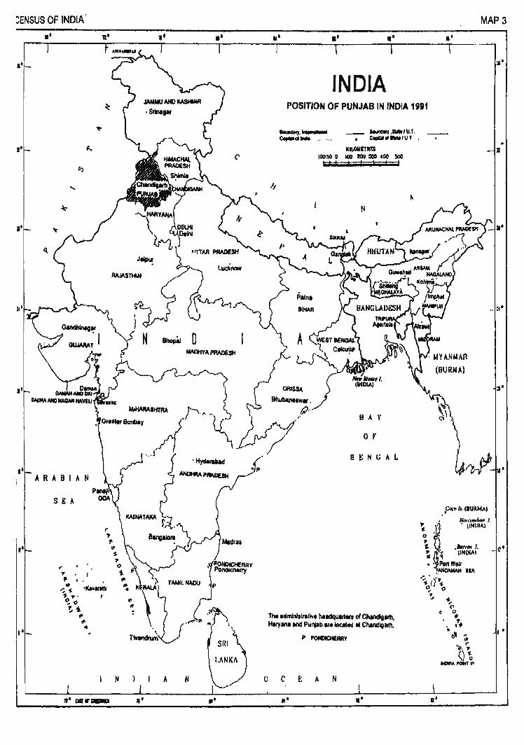
:ENSUS OF INDIA II
I' _
"
I'
I'
I'
.'
I I'
SEA
«' ., .. .
( ., 1-III S
..-;. "'s ·1(,~1I1111 ,. .,.. ~() !,~
~ .,. ..
l'
lWIMAaHTFIA _,-..,..
-.~ ... J
A N
'II'
II
l
SRI~ I,ANKh
....
.'
III II I'
INDIA POSITION OF PUNJAB IN INDIA 1991
1MnNq.~ _ IouMII1.SllltIU.T. c.,.. ... _ C ... "IIaIaIUT
KlloOMrtm IOOSI 0 I()O I!OO 300.00 ~
BAY
o r
BtNGAL
The .dmlnl,lrIliv. heldqulltltl of Chandlgllh, Haryan. llId Punjab IItlocNd .. Chandlglm.
p POfOCHERIIY
o C E A N
.. ' I' .'
MAP 3
.' ;s.
- ;I
,e1f'l/ •. IIUIU4AI N.,,,, ... b ... I . • (lNlllill
12'
. '

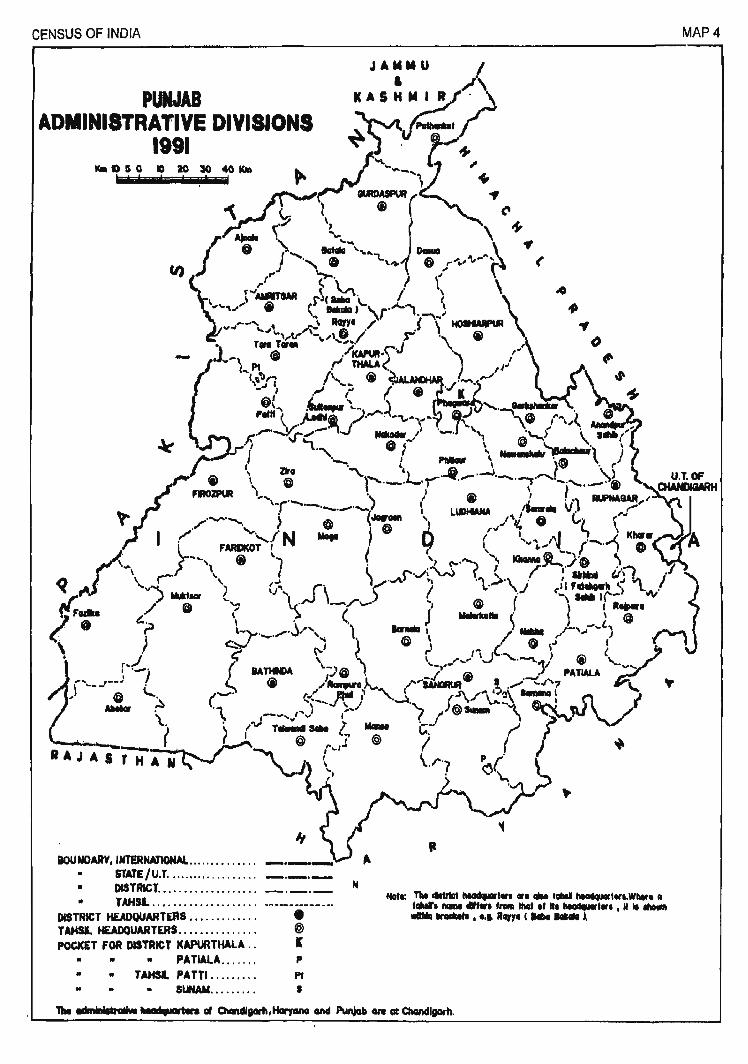
CENSUS OF INDIA MAP 4
aouNOARV,INTERNAnONAL •.•••••••.•... STATE/U.T ........... '" ..... _._._
• DlSTRICTo- ................... _._._ N
• TAMIL .. I 0- ...................... _ .... __ .. _____ ••
DISTRICT HEADQUARTERS............ . • TAHSL HEADQUARTERS.......... .. .. . @ POCICET FOR DISTRICT KAPURTHALA . . I
II .. .. PATW.A....... P
II II TAHSI. PATTI .. _...... Pt
• S~......... I

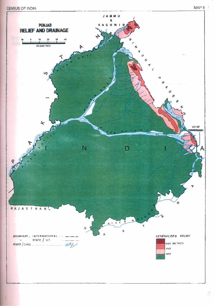
CENSUS OF INDIA
PUNJAB RELIEF AM> DRAINAGE
10 o 10 20 )0 40
KllOMETIlES
BOUNDARY. INTERNATIONAL . . . .. _._._
STATE I U.T. . . .. _ ._ ._
RIVER!CHOE .. ............... . ..... ~/~
JAM M U &
GENERALISED REUEF
600 (METRES)
450
300
MAP5 .

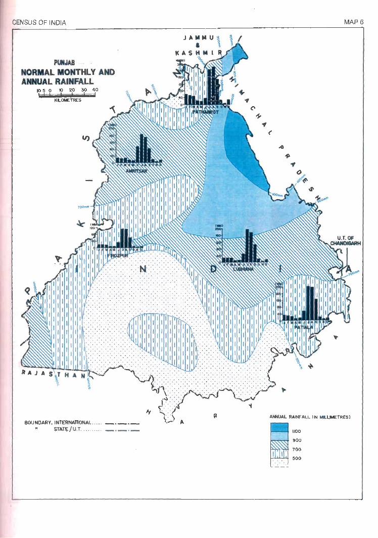
CENSUS OF INDIA
PUNJAB NORMAL MONTHLY AND ANNUAL RAINFALL
1050 10 20 '30 "10
KLOMETRES
BOUNDARY. INTERNATIONAl.. ... _._. _ I. STATE/U.T . ......... _._o_
JAMMU og & ~
MASHMI
., (
MAP 6
ANNUAL RAINFALL lIN MlLLIMETRES)
1100
900
100
500
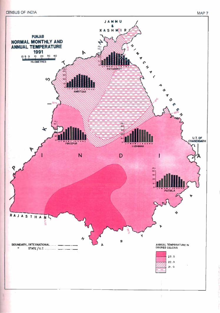
CENSUS OF INDIA
PUNJAB NORMAL MONTHLY AND ANNUAL TEMPERATURE
1991 10 5 0 10 20 '30 40
KLOMETRES
9OUNDARY.INTERNATIONAL. . . . . _._._ STATE/U.T .. ........ _ . _ . _
N o
., ()
~
ANNUAL TEMPERATURE IN DEGREE CELCIUS
2'3 . 0
22 . 0
21 . 0
MAP?
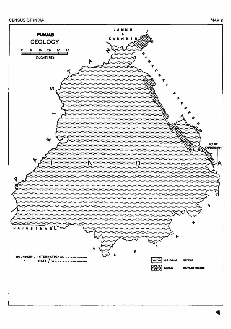
CENSUS OF INDIA
PUN.IA8
GEOLOGY o 10 20 30
KILOMETRES
60
JAMMU . & t
MAS H M I R~1?!?~
~':wVV~Y!.\~
{!_- YV!~v "J ~J.:-=- Vv
==-==y ..... ' -$E - - -:L,., ... .N_3' =======-7 "J_ r ----~ ....
~~~:_--=======~--:... ., ~ ~_=_=_=_=_=_=_=_=_=_=...:~ C'
~~--=-=-=-=.,..=-=-=-=-=-=-====~ + F=-===-::::'========-:::::'============ .,
(
IOUNOARY. INT£~NATIONAL ..... _._._ .. STATE I U.T .......... _._._ ALLUV&J1oI
MAPS
RIECENT
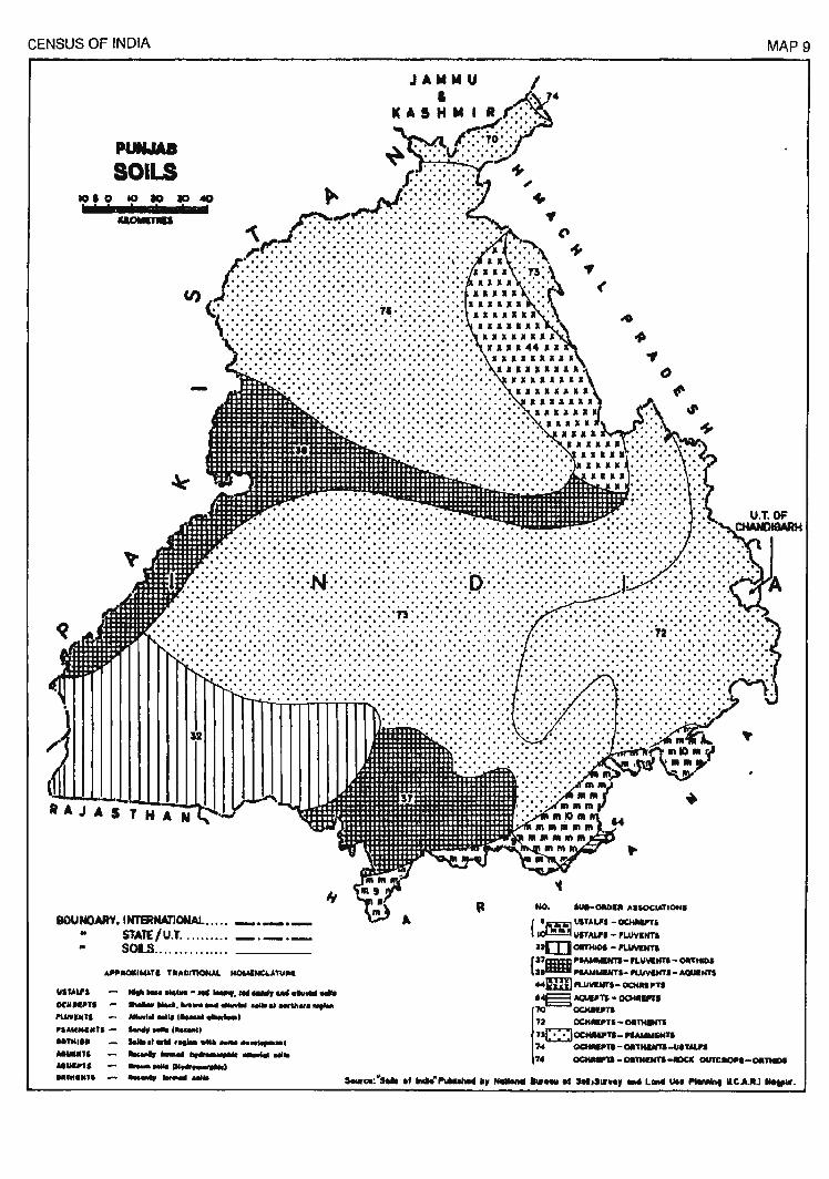
CENSUS OF INDIA
PUNMII SOILS
CI)
BOUNDARY. INTERNATIONAL .... . • STATE/U.T . ........ . " sou .............. .
"",un ..... __ ~ ... ....,.I'IIII_,IMI_ .... _ DeIl.II''' __ .... ___ ........... _"'at ....... ,I.UVINJI _101 Mia. C _ _._,
'I ........ ts - ..... _ C .. _I
"'NI" .... ,_' ......... _ ......... . _7. ......., _ ....,_... -.... ... .. ........ , . .. ,,, ..... __ 111,--., ...... - .....
.. .,.
NO. "'1-0lI0111 ".IOC .... TION.
{ '1i!JItlI!] UITAU'I - OCHIIUTI
I~ IIITALI" - rLilVINT.
nmOlPHlllI - ~NTI
{:l71U1m I'5AMMIN'II- PLYllltm - OItTHIIl. J.ItttI:II ....... .....,.I_ PUIVUIT' - AQUl:NTS ~mIl PLUVlNTI- OCHIIIII'TI
74 oc::HIIII'n - OIITIIUITI-UITALII
MAP 9
It.;§;; ,. 0CtIIIIP1a - OII1KI:NTS-.:ICIC OUKIIOIII-OIIntIDI
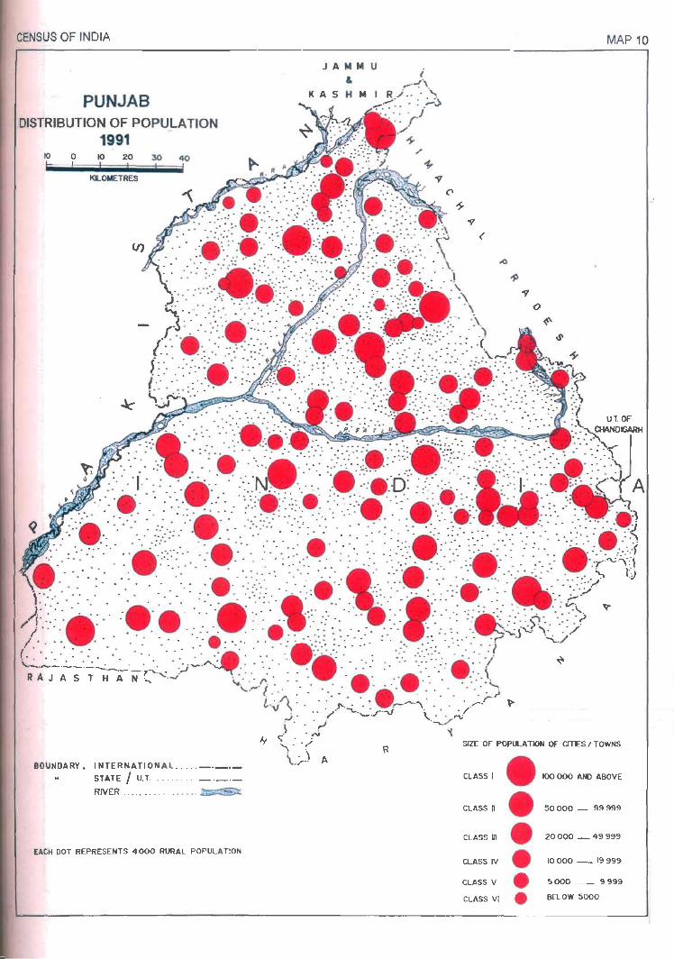
CENSUS OF INDIA
PUNJAB DISTRIBUTION OF POPULATION
1991 10 o 10 20 30 40
KLOMETRES
BOUNDARY. INTERNATIONA L ..... _._._
STATE I U.T . . ....... _._._
RIVER . .. ........ . ... . . ~
EACH DOT REPRESENTS 4000 RURAL POPULA TlON
J A tot tot u &
i
MAP 10
U.T.OF
SIZE OF POPU...A TION OF CITES I TOWNS
CLASS I • 100 000 AND ABOVE
ClASS n • 50000 _ 99999
CLASS III e 20 000 _ 49 999
CLASS IV • 10 000 _ 19999
CLASS V • 5000 _ 9999
ClASS VI • BELOW 5000

CENSUS OF INDrA
PUII.IU . GROWTH OF POPULATION
1881-81 I BY SUB-MICRO REGIONS )
1010 to 10 1O.eo
~
IOUNDARY.IHTERNATIOHAL •••.• _._._ .. STIJ£/U.T ... , ...... ._.. ___ • ._.. " DISTRICT .......... _. _ . _ It SUI-MICRO REGION .................... .
II
.. (
PERCENTAGE IICIIEAIE IN 'OPULATlOtIlHt-ti
~ 30.01 AHD .IOVE
11m :11.01 - lO.OO
~ 20.01 - 20,00 I ITA lE "YEll ... zo,. I o:m lUll -10.00
1:- :- :- : 115.00 AND '[LOW
MAP 11
+

CENSUS OF INDIA
PL»WdI DENSITY OF POPULATION
1991 , BY SUB-MICRO REGIONS )
101010 lO 10 40
~
aouNOARY •• NTERNA1lotU.l ..... _._._ • srrJJE/U.T .....•.... _._._ .. D1STRlCt ............ _._._ It Sl8-M1CRO REWON •• _ ..................... ~
If ..
., C" +
MAP 12
+
P£RaCNI JI'ER KlfII
~ 101 AN) AlOVE - OCI - 100
~ .. 01 - DOO UTA Tl AVEllA. <4011
om 101 - 400
0 . 100 AJI) IE1.OW

CENSUS OF INDIA
PUNJAB VARIATION IN DENSITY OF POPUlATION
1881-91 ( BY SUB-MeRO REGIONS I
1010 10 10 II) 40
IIIUlMPIU
IIOUNDARY. 'ITERNAT1ONAI. •.•.. _. _. _ .. STIJE/U.T •...••.... _._._
DlSTRlCT. ••.••••••... _. _ ._ • ~ RE~ •.• _____ .......
MAP 13
VARIATION IN DENSITY OF ~OPULAT'ON , •• ,."
~.oo AN) AIOVI
111 80 I.
~&O n
rnIJ 40 II
ED SI AlII IELOW

'GENSUS OF INDIA
PUIMII RURAL DEIISITY OF POPULATION
1181 (BY SUB-MICRO REGIONS)
10101010 10 40
IIIUIIomIII
BOUNDARY, WTERNATlONAl ..•.. _._._ • STAT£/U.T .......... _._._ • .TRICT ............ ___ ._ • SUI-IotCRO REGION ................... ..
J A MM U &
KASHMIR
., (
P£RIONS PElt Knl2
~ 3151 AND MOVE
_ 501- 3150
~ I nAn AVIIlAIE 212 l' ~251.S00
[ill 201 - 2'0
I : .; . :-: I 200 ANI) I£LOW
MAP 14

CENSUS OF INDIA
PCaWI VARIATION IN RURAL DENSITY OF POPULATION 1881-81
, BY SUB-MICRO REGIONS )
101010 aD m 40
IILC*I'IIU
IiIOUNOARf.INTERNATIONAL ..... ___ ._ .. r;f/ll1E/U.T .......... _._._ • DISTRICT ........... _._._ • SU8-MJCRO REGION ...................... .
J A .... U &
K ASH ";'I~R(gI'~
,
.., <
VARIATION IN RURAL DENSITY OF POPtJLATIOH
"'1-8' GAllI LOSS
10 NIl) AllOW _ a 10 AN) 1EL0W
10 •• ~ G!12il JI AM) MOVE
10 ... om 1EL0WIO [8J
MAP 15

CENSUS OF INDIA
PU&IA8 ·URBAN DENSITY OF POPULATION
1881 I BY SUB-MJCRO REGIONS )
BOUNDAAV.INTEANAJlONAL ..... ___ ._ II iTIJE/U.T .......... _o_._
DtSTRlCT ............. _'_0_ II SUB-MICRO R£GlOH .......................... .
., <
PERSONS P&R 1C.2
~ 11501 fH) AllOY[
lIS 4Il0l - uoo
~ ~~11~~wr
OIIJ 25CII - 3000
c::2l 2IlOO NCI HLOW
@ EN'IRL Y IUtAL
MAP 16

CENSUS OF INDIA
PUNJAI
\lMIATION II URBAN DENSITY OF POPlLATION 1981-81
( BY SUB-MICRO REGIONS ) 1010 10 ao _, 40
IQLOICI'IU
BOUNOARY, INTERNATIONAL ..... _._0_ N SiTATE/U.T ...... ~ .... ___ ._. ___ .. DlSTRlCT ............ _._._ .. __ MICRO REGION. _ ...................... _
., (
+
'( VARIATION IN UfUJAN o£NSIT'Y " OF POPULATION 118*-81
aMI LOA
MAP 17
IOct Nt) ABOVE ~ 1=-=::3 500 MD IELOW
IOCII 1000 _ 0 IlOl AND AIOVI
5CII 1000 ~ ~ £NTNl.Y M.IIUI.
GOO »f:J mow []]]]

,> CENSUS OF INDIA
101010 ao 10 40
ICLOtCnU
BOUNDARY, INl'ERNA11ONAL ..... _._._ .. mTE/U.T .......... _._._ .. DlSTAIC!T ............. _._._ • "'-WCRO RE,GION,. ~ •• I ••• ~I ••••• "".'.II.
JA .... U , ICASHMIR
.. ... .,
()
~
+
FEMALE8 Pm 1000 MALES
~ 121 AHD MOVE
11:1 101- 120
~"-IOO ~ I lTATI AVEllAK Na I
om 111-810
I :. :-: -: I 110 AN) mow
MAP 18

CENSUS OF INDIA
PUNJAB MAIN WORKERS
1881 , BY SUB-MICRO REGIONS )
10.010.., 10.,
CI)
RAJAS'H"
BOUNDARY, INTERNATIONAL ..... _._._ .. STATE/U.T .......... _._._ • DtSTRlCT ............. ~ _._._ • SlJB-MCRO REGIOtI .. ......... u ............... .
~
< .. ..
+
.. PERCENTAGE OF MAIiI WOIIICERS TO TOTAL ~TIOH
~ U.OIANOAIO~ ~ I lUTE. "vtJI,,~ .... OT I ~ 30.01 _ ;'':.00
~ 28.01 - 30.00
[ill ".01 - •• 00
~ t.:..:.:..:.:.: H. 00 All) J[LOW
MAP 19

CENSUS OF INDIA
PUtNAII PERCENTAGE OF LITERATES TO TOTAL POPULATION 1881
( BY SUB-MICRO REGIONS I 10.0 10 ao 1O.a
ICILOIoIITIU
BOUNDARY, UITERNAllONAL •..•• _._._ • srATE/U.T . ......... ....... _._ 01 USTRICT ••••..•••.• _._._ w IlUB-hlCRO REGION .................. ..
., (
MAP 20
...
PERCEHTAGE OF UTIRATES TO TOTAL POP\LATION IIElCa.UOM A&£-t;RO!JP O:-..!.)
~ 10.01"'" ABOV£
~ 10.01 - 70.00 .
~ 110.01 - .0.00 ~ I lTAn "VIR"" 11.151 J .
OIIJ 40.01 - 110.00
f; : : : : : :1 40.00 AN) IlELOW

CENSUS Or- INDiA
PUNJAIJ
SCHEDULED CASTES 1991
I BY SUB-MICRO REGIONS) 1050 10 ao 30 ~
BOUNDARY, INTERHATlONAl., . . __ .......... _ Of STAfE/U.T ... _ ...... _ . ..._ .. _ II DISTRICT .......... _._._ • W8-tM~O .. . . .. .. . .... _._.~ ............. ..
'f (
PERCENTAGE OF SCHEllULEO CASTE PIlPUI.ATION TO TOTAl POPUl.Al"ION
~ 15 , 01 ANi) AlOVIE
_ SO,QS - 315,00
~ Ftt21E-;,:v~\~~311
DID 20.01 - £9.00
o 20.Q() Am ua..Ow
MAP 21

PART-III
REGIONAL DIVISIONS OF DISTRICTS

DISTRICT GURDASPUR
REGIONAL DIVISIONS
Located in the north of Punjab State and covering an area of 3.562.00 sq.
km., Gurdaspur district lies between 31 ° 36' and 32° 34' north latitudes and 74°
56' and 75° 24'east longitudes. It is flanked by Jammu & Kashmir to the north,
Himachal Pradesh to the north-east, Hoshiarpur district to the east, Kapurthala
district to the southeast and Amritsar district to the south. The international
boundary with Pakistan makes its western boundary.
Gurdaspur district is comprised of three tahsils which among themselves
contain 1,626 villages (including 83 uninhabited) and 12 towns. The district has
not undergone any jurisdictional change after 198]. However, the ilUmber of
towns in the district has increased from 11 in 1981 to 12 in 1991. It has a
population of 1,756,732 among which 923,343 are males and 833,389 are
females. It has a density of 493 persons per sq. km. and a sex ratio of 908. This
signifies that Gurdaspur district is more densely populated and has a better sex
ratio compared with the state as such. Out of the total population in the district
1,370,320 is rural and 386,412 is urban by residence. Gurdaspur district has a
literacy rate of 61.84 per cent which is higher than that of the state as a whole.
Among males, 69.56 per cent and among females 5333 per cent are literate.
Nearly one-fourth (24.70%) of the total population in the district belongs to
scheduled castes. During 1981-91, the district population has recorded a decadal
growth rate of 16.08 per cent. Workers constitute 27.90 per cent of the total
population; 27.88 per cent as main workers and 0.02 per cent marginal workers.
Among the main workers, 29.68 per cent are cultivators, 25.85 per cent are
agricultural labourers, 0.67 per cent are engaged in household industry and 43.80
per cent are other workers.
Leaving aside some area covered under Siwalik hills in the northeast,
Gurdaspur district is a flat plain. The soils are fertile and comprised of alluvium
87
brought by Beas and Ravi rivers. Canal is the main source of irrigation. Upper
Bari Doab canal is the main canal flowing through this district. Some irrigation is
met through tube wells also.
The district has a well developed network of roads and railways. National
Highways No.l(A) and No.15 cross through this district. In the field of industry,
Batala is known for the manufacture of engineering goods/machine tools, while
Dhariwal is famous for woolen textiles.
Gurd~spur district is a part of Ravi- Beas Inter-Fluvial Plain (sub-micro
region code 2.1.1) and on the basis Physio-geographic factors it is further sub
divided into following five sub-micro regions.
2.1.1.1 Gurdaspur Sbivalik
This sub-micro region spreads over extreme northeastern part of the
district and covers 328.90 sq. km area which makes 9.21 per cent of the total area
of the district. It is comprised of 56 villages all of which belong to Pathankot
tahsil. It has a population of 92,527 among which 48,529 are males and 43,998
are females. This region is entirely rural. It has a density of 281 persons per sq.
km. Out of the total population of the region, 51,343 are literates. Nearly one-fifth
(20.79%) of the region's population belongs to scheduled castes. Workers
constitute 27.65 per cent of the total popUlation; 27.62 per cent as main workers
and 0.03 per cent as marginal workers.
Geologically, the region is comprised of Siwaliks and soils are Ochrepts,
Orthents- Rock- Outcrops and Orthids with hilly topography The maximum
height of about 2,800 feet is seen near village Loharan and the minimum (1,301
feet) near Phadial village in Pathankot tahsil. The region is intercepted by small
rivulets, viz., Chaki Khad and Jabbar Khad. It is thickly covered under forest
which are mainly pine wood, deodar, kail, teak and bamboo trees. The soils are
88
sandy loam to silt loam and are highly permeable and thus cannot hold water for a
longer period.
Agriculture is the main occupation of the peopl~ and cultivation is mainly
confined to hill slopes and is dependent upon rainfall. Maize, wheat and rice are
the important crops grown in the region. Owing to its hil1y topography, the region
is comparatively less developed.
2.1.1.2 Gurdaspur Upland
This region extends over parts of Pathankot and Gurdaspur tahsils. It
covers an area of 790.10 sq. krn which makes 22.18 per cent of the total area of
the district. It is an alluvial fan. This region includes 425 villages (178 villages of
Pathankot tahsil and 247 villages of Batala tahsil) and 4 towns namely Sujanpur,
Pathankot, Dinanagar and Gurdaspur. The region has a population of 596,520
which makes nearly one-third (33.96%) of the total population of the district. Out
of the total population 62.99 per cent is residing in rural areas and 37.01 per cent
in urban areas of the region. Out of the total population, 28.69 per cent belong to
scheduled castes. Almost 7 out of every 10 persons (69.63%) are literate. 27.50
per cent of the total population is recorded as workers; 27.32 per cent as main
workers and 0.18 per cent as marginal workers.
The region has a well developed network of roads and railways. National
Highway No.15 connecting Amritsar and Pathankot and further to Jammu passes
through this region. The district is well connected with broad gauge railway line
connecting important towns in the district. In addition, there is a narrow gauge
railway line connecting Pathankot with Nurpur Bedi in Himachal Pradesh.
The soils are shallow black alluvium classified as Ochrepts, Orthepts
Orthents-Rock-Outcrops-Orthids. The region is virtually devoid of vegetation
except for the occurrence of trees like shisham, ber, kikar, phulahi, neem, jamun
and pipal. As true in the case of State as a whole, the climate of the region is
89
extreme hot in summer and extreme cold in the winter. The rainfall is mainly
confined to monsoon months of June to September. This region receives some
rains during winters which are very beneficial for rabi crops. The main source of
irrigation is through canal and tubewell. Wheat, maize and rice are the main crops
grown in this region.
2.1.1.3 Ravi Flood Plain
Tms region covenng 278 villages ( Pathankot tahsil- 143 villages,
Gurdaspur tahsil- 88 villages and Batala tahsil - 47 villages) stretches in a narrow
belt along the river Ravi flowing in northeast to southwest direction. River Ravi
wmch flows through this region makes its flood plain wmch is wider in northern
part and tapers towards the south. As such, the villages in tms region are subjected
to floods during rainy season. The region is essentially a plain area with gradient
varying between 236 metres and 322 metres. It covers an area of 464.58 sq. km
which makes 13.04 per cent of the total area of the district. The region has a
population of 144,281 including 75,218 males and 69,063 females. Out of the
total population in this region 136,901 is rural and 7,380 urban. It has a literacy
rate of 49.10 per cent. One-third (34.11 %) of the population in this region belongs
to Scheduled Castes. In this region 29.49 per cent of the population is recorded
as worker; 28.62 per cent as main workers and 0.87 per cent as marginal workers.
Geologically the region is comprised of alluvium. The soils are Ochrepts
and Ochrepts-Orthents-Rock-Outcrops-Orthids. The natural vegetation includes
mango trees, kikar and jamun. Shrubs and reeds are also found along the river
belts. Agriculture is the main occupation of the people and wheat, maize and the
rice are the main crops grown. The region is relatively less developed.
2.1.1.4 Batala Plain
This region spreads over parts of Gurdaspur and Batala tahsils and is
relatively a lowland plain. It includes 217 villages of Gurdaspur tahsil and 419
90
villages of Batala tahsil, besides 5 towns namely, Batala Qadian, Fatehgarh
Churian, Fateh NangaI and Dhariwal. It covers an area of 1,522.42 sq.km which
makes 42.74 per cent of the total area of the district. The region is inhabited by
770,765 persons; 407,991 males and 362,774 females. The region has a density of
506 persons per sq. km. and thus, is more densely populated than the district and
also the state as a whole. 56.88 per cent of popUlation in the region is literate
which is less than that of the c.listrict. A little over one-fifth (21.70%) of the
population in the region pertains to scheduled castes. Out of the total popUlation
29.15 per cent of the population is recorded as workers; 29.02 per cent are main
workers and 0.13 per cent as marginal workers.
Geologically the region is having alluvium and the soils are Ochrepts and
Ochrepts-Orthents-Rock-Outcrops-Orthids. Agriculture is the main occupation of
the people and the region has a well developed system of canal and tubewell
irrigation. Wheat, maize, rice and sugarcane are the principal crops grown in this
region. The region has a well developed system of roads and railways.
2.1.1.5 Beas Flood Plain
Covering an area of 456.00 sq. km., the region spreads extends along the
Beas river covering parts of Pathankot, Gurdaspur and Batala tahsils. It includes
231 villages (38 of Patbankot tahsil, 167 of Gurdaspur tahsil and 26 of Batala
tahsil) besides Sri Hargobindpur town. It has a population of 152,632 comprised
of 78,166 males and.74,466 females. The region has a literacy rate of 58.61 per
cent and 17.55 per cent of the population belongs to Scheduled Castes.
From the point of view of geology, it is comprised of fine alluvium. The
soils are Ochrepts and Ochrepts-Orthents-Rock Outcrops-Orthids. These soils are
shallow black and brown. The natural vegetation includes, neem, kikar, shisham,
sarkanda and reeds. Agriculture is the main stay of the people, and wheat, maize
and rice are the main crops grown.
*****
91

CENSUS OF INDIA
\
~ I
GlIlOASPOR SlWAU<. __ •• 2 . I • I. I GURDASPUR· IJPLAHI)_.....:. •• 2. I • I • 2 RAVI FLOOO PLAlH. ••• _____ ! . I • I • ~ BATALA PLAIL. ____ ! . I . L. " SEAS FLOOD PLAIN •• _ •• _ ! . I • I • 5
Q TO """,,,,"
MAP 22
PUIWA8
DISTRICT GURDASPUR CElllUa:CODI! 01
REQlONAL DI~ISION8
KMT ! t r T T TKIIa
, o
~ARY ... TEFatATK>NAl. •••• •• •• • 0 ••• 0 . 0 _ •• _ ' •• _
ST4TE .•• . .... •. .• .. •• .• .. •. _ •• _ •• __ • DISTRICT •• .. •• ..•••• •. •• •• .• _. _ • _ • TAHSL . • •. .. •... •• •. .•.•.. .. _ . _ . _
VLLAGE HAVlNO '000 , ABOVE POPU..ATlON. • i lIlBAH AREA . . .. .. . . ...• ...••. •. .• . •.. ~ NATIONAL HIGHWAY. . .. . . •• .. •• •. •. •• • . .. II! "
STATE ttGHWAY .. . . ..... , . . .. .. . . ... 0 •• at " IMPORTANT METALLED ROAD •.. •. , .. , •. .. _~ __ RALWAY UHE WITH STATION, BROAD GAUGE . . ~..,dllih .... _
RAl.WAY LINE WITH STATION, HARROW ~UGE. • • ••• • RlVER .... .... ... ••..••••.•• ••...• •• .. ~
REGIONAL D1V1SIOHS . . . . .. . . .. . • .. . . .. .. ..2 . I . I . I MACRO . • .• •• •• •• .. • • •. •• •••• •• •• •. • ' •• It
MESO •.• . •••••. •.••.• ••••• . •. •• MICRO . , •••. . , . . •• •• •• •. •• . • ••
SU8-MlCRO WITH BotNlARY . • •.
{ Read the HquetIce of r~ ~ todltl ,.' .. onc:. to the ... indio map codN lip to ~ ,t.. I
L-__

W ...J
~
(J) Z o en > 5 ...J « Z o ffi 0:: Z o ~ (§
m « -, Z :;) a.. w ~ ~ en
...... o o z w Cl
8 Z o ~ 9 en :;) en Z w ()
J m E IV u.
a::: o UJ
~
j 0.
a:::
Q)
16 ~
UJ a:::
~
.- a::: UJ 0
~ .~ -'On o m Z
.E (/) § ~.-_g>
== '>.c
'Om o Z
"0 C m
~~ a::: m oZ
I
0) ~ ~ , C') C') "f' "'It
0) 0)
co ~ ~ , co co "'If" "It
..- !Xi ~ co 0 "It 10 g ~ ;g ('II ...... ......
~ ~ ...... 0
"'If" ('II ('II
M ~ (() ..- ...... C') ..... ......
rOC:;)
C')
~ 8 S; en ~ N (0
co ..-~ T"" ......
N co ~ g "fi
coo 10 co co . ." v C') • (0 co 0 VV
~ ~ C') I' N
~ ~ M
" ('II
..-~ ~ ~
~ ~ ..... co
~ ~
~ ..... ~
..... C') N
~ ~
...... .... "It.
fe
~ . ...-
10 10 I' -.....
G) r:: a ~ I: ..,
g ~ ~ ~ ~ W
~ w .... I\) w it j ~ ~ ~ ...... I\) • ~
I\) 'P ...... ......
~ ~ ...... ......
~ fd
~ ~ ...... (JI
~ ~. ~ ;..,
~ w
-~ ...... ~ w
:s w ~ ...... 0
g ~ ~ !'J .... I
~ .....,
IoU r- 8 r- s· ~ r-~
r-
~. r-
~. r-
~. CD 0 0 0 0 0 ~ s· ~ IoU ~ ~. I ~ ii3 ~ ~ 0 _g ::I I\)
~. CD g .§ ..... 5
N ::I ~ ::I .....,
s· 0 , 0
~ ~ ~ w 5i ~ N ~ g ~. s» '" '" CD ~ (') rI
..... ..... :c ..... 5 ~ '" ~
w g .... so ~ .... .... ..... ~
.... ~ ~ ~ j\)
~ .....
I ..... ...... (0 ..... w ~ ~ ~ ~
j..) (J)
..... ~ .... w I\)
u,
~ !'l s» N - ~ ...... i 2 ...... ....
~ ~ ...... ~ w ~ ~ & ~ ~ 8 co ~ N IoU
¥ cp IoU ~ en :r 3·
CD
...... .....
G) ~ ~ f '"
(/) ...... [ t [ ..... ~ ;i=
.., ...,
"'0 !. =r IoU ::I
[ N .... ..... ....
! ~ ~ ~ 0 ?>
~ .... .... .... ~ ~
...... .... Cf 5=' 0)
~ N ...... ...... N ~
...... ...... 0) cp ~ ~ ...... .....
IP ~ w Cf .... ~
I\) .... ......
lJ. • ~ (J)
..... ....., co
• I\) (JI
.....,
!8 ......
....., ~ N I\)
g; ~
...... r-
~ r-
~. w ~ 0 'P ~ g ...... ...... IoU
~ 0 ::I so [ ::I
0 .... ...... i" • .... 3 N
9" ..... .... ...... I P i" N ~
..... ..... N .:"'I ::I ...... .... ~ ~ ~ .... r2 ....
~ -~ ~ .... 3· s· J~
!'> ...... ..... ...... ......
"'0 !. =r
N IoU ::I ~
So
~ ......
~ (.:,
~ (1J (JI w ....., (1J C) N
(JI • 0)
~ en
w ~ 0)
(0
~ ....., (0
CD
r-p W
~
I ....
~ (0
~ CD 3·
l f g. ~~
I» [
~ =r ~
<~ == ~r
!~ i~ ...... a ~g
::I ~ en
< -f =: ~ (a-m ~ < =Z-f ~o . ~ m a
g IoU -
m :::0 r:: 3· i ~ C
N
i ::I
~ i 7!
0 m z (/) c (/)
(') 0 0 m Z 9 ....
(/)
~ -f m "'0 C Z
~
::0 m G> 0 ~ ~ (/) m
~ s; r- eD
~ r-m N
m (') 0 0 m sn ...... (0 co ......
l-I" c:: d ~
0> 0 0 ,... ~ co 0 (0 co 0 m
C'! '" ... ~ N .~ ~ c:: (0 ct) 'II:. I:: E ,...
0 § N fi N c: a)
i m .;, ..... 0> I:: :J
!!! fI) '3; ,... ~ E ~
,... 0 0 z 0 ~ ~
0
" .5 as N "It .~ .5 ~ ..... ,,~ '" N ~ ~ ~
N
~ ,... N I::
~ !!! ct) i ~ ~ g 10 ..... ~ !!! '" .....
~ ct)
i ~ ~ E l ...- g
~ ..... as - .5 CD N .5 ..... m r!- !
N :J :g ..... (0 a:i ..... I:: ,... ,... !!! ~ ~ (9 m ci I:: !!! ct) (0 pf (t) 0 !Q ~ 0> ,... ..... N - ('II .~ ~ t1l C'I!. ct) I:: 0 "It ~ m Q)
cb a:i ..- c:
~ re ~ N c:
i g .~ ftf ..... E M ~ .....
I ct) .
~ .- S co ...,.
~ cJ, ~ .....
:5 .....
~ ,... (l) !!! .....
"It. d, 0 ..... ,.. ..... ('II ~ c: ~ ..... ('II ('II ('II
~ .~ .5: l ('oj ('II t1l
ci ~ C'! ..... ('II
~ I
~ !!! i, ...,. ..... ~
..... !!! ..... ..... ..... ..... .;, ci I" ...... ".... ~ ~ ,...
~ (t) 0 Q) - ~ !!! ~. ci N ('II cu N - ('II.
~ ~ 10 0> E .5: c: ('II 10 ,... ..... ,... d j ".... c: cu "It a:i -; ~ ci (0
~ !Xi ci "It
J ~ 11 ~ !!! ..... 5 en fIi 0
('II ...... ct) .... ~ ...... ~ ..... ~ c'i ~ ~ !!! ....
~ ('II ..... ,... ci N I:: ('II ~ ('II ('II c: N 1'0 1'0 (0
I'~ ~ ~
~ ~ c:
~ f5 oi
~ g ~ ~ f5 ! ~ ~ g ,... ~
~ ..... ...... fa !
r;i ci 8 d 0 E ,... ..... ~ ~ C'! z ..... S .~ z I! ('II 1t. N ~ N s::. r!- .E d
,.. z :iE d ...: .~ ~ ~
s::. ~ ~ ~
!!! ~
M 0 It)
~ 0> ~ ai (t)
~ !!! .... ct) ~ ~ g 0 0> ~ ci ~ g ..... N m ~ _j
,.. 0 5. _j ..... .1:: ('II .c: N ('II I:: 10 d ct) m N ...J
co ~ ('II I" 10 d ~ ci
0 ('II co co cx:i 'It (Ij m It)
~ 'It 10 ..... 'It
co N 8 10 'It
;i N ~ ('II
...,. 10 ...,. ..-
co gs ..... I" ct) ('II (0 ('II
ct) co I" ...... m co lO ...,. co ...,. .... ..... ct) ,.. ('II ...,. ......
~ ~. re ffi .
~ ....
~ ~ ....
i ,... I" ,.. g ~ ~ ~ ;t ct)
N <0 0 ~ ..... ~ ":'
..... ...,. ct)
~ (0 'II:.
~ ~ ci 0 ..... (t) ...: ct) ij ~ m 10 (l) 0
I" ..... ...... ('II 10 ct)
~ ct) (t) ...... ..... cJ, ~ . ...: r!- ......
i N cJ, ~ ~ ...... ...,.
~ ct) a:i
~ ~ m I ('II ,... ,... ~ ct) N M ..- It) M ~ a) a) ci ...: ct) ,... ...,.
~ ~ 0 ~ l ~ m co m a) ,.. (t) ~ ~
ct) (0 0 M ~ ct) ..... a:i as ~ ! ,... ...,. 'It ,... (t) I" (0 r-: ..... N. ('II ('II ci 10 ~
...,.
~ ('II
0 ~ 0 ~ ~
ci ...,.. t ai ...: aj ..... ":' ('II I I ...... ..... ('II ('II ('II 0 ..... ,... .... ('II N ,... ('II LO N 'It ...,. N M (0
"0 ... ,_ ~
,_ .:t!. ~ 1'0 i 1'0 i c:
J 1ii c: <II 1'0
~ iii <II <II s::. "E s::. "E ~ m -:J :J cu :J
(9 (9 11. (9
. I:: 'ffi I::
~ ~ 0::
~ 'iij
] .a::: ~ c: ,.. "": ~ u. 'cu 1'0 ..... .....
:m ,..
i 0: N u. ('oj N .~ m 0::
CD
i Q)
• • m N
"".110. r. ...., ~ co
"".110. t (J) .... 0
~ t .....
f UI I\)
~ (11 UI
I\) m
~ 5 ~ f) i 5 ~ f) ~ t ~ i ~ ~ ~ ~ !!!.
~ ...., .. III
~ 0'1 ~
W N W a ..... cp
~ co .....
Q) 5" 8 i ~ ~ a ~ ~" .....
5" ~ ~ r AI ~
~. g a
m ~ UI
I s· ~ g ..... ~"
..... en
~ ~ ~ !'l I .... g .... i ~ !'l _~ ~ 5 ..... .... " ~ .... ~ ~
~ _aI ~ ~ .... .... (11
i-.l
..... o d z W Q o (.) (/) :::> (/) z w (.)
j me E ..... .f
f/) s:::::
~ex> Q)
D..
f/) s:::::
~IO Q) a..
f/) Q)
~~ Q) u.
f/) s:::::
~C'II 8?
<0 ..... m ffi
"" C'II
..... 10
~ 0. ......
C") ..... 0>
<0 ..-o g .....
10 (")
""_ ..-e ..-
ex> o 0. .....
10 o ..... cS o C'II
..... C'II .....
o "" ex>
m ...-0. ,...
(") 10 ..... af ..... C'II
co o .,....
m
ex> ,... C'II g .....
8 C'II.. .....
C'II
8 1.0 (")
OJ ?l G) (j) Q)::tJ
I I\.)
I !'> !'> ~ c: I\.) CIJ c: I\.) g_~ :::g ~ ""0 ::2 5:. a i '-if.
..... ..... ..... ..... z o· !!:!. !!:!. 'TI
~ ~
'TI ..... ..... ..... ~ ..... ..... Q) :::J :::J [ 01 :::J iii' ~ :::J
~ c,., N ~ ..... ~~ c: c: .... ....
w ..... w ~ I\.) ""t:J (J1 -~ co ~ (J1
~ w ~ ~ I\)
VJ I\.)
~ ~
co f N :::J ~ CIJ
:s::: ...... ~ .
~ ~ w $ N :s::: :::J ..... ~
~ ..... ~ 0. "0 )I. w Q)
<0 co <0 ~ m-e.> CJI 0 ...... i U3
." ..... w w ..... CD ..... ~ § m "0 ~ i ~ VJ ~ (J1 co VJ m ~ ~
~ :s::: !!:!.
(") 0 m z
...... 8
""t:J :::J ..... CD ! N <0 ..... <0 (J1
~ 0 co <0 (J1 (J1 N co (J1
..... 0 :::J
U) CD Ul
~ . s::::
f9. Q)
~. 3: :::J
(J1 ......
~ ..... ~
!!:!.. i-N ..... 0 0) Q)
CJI (J1 ...... if ~ ~ i i U3 U3
z ::tJ CIJ m c G) C/)
5 (")
~ 0 ~ 0 m !2 r
~ m
$ ~
en 0 5 ..... z en
;0 c
'TI Q) ::;::J
..... ~ ~ co (I) c.
(J1 co N ...... 3 z w ..... C1I co ...... Q) g if I
~ r
~ ...... t <0
I\)
~ &' [ 0 m w ..... ......
~ ~ '"co ..,_" ~
(0 0)
N ...... I\.) ..... 0) :::J (X) e.> VJ CIJ
Z 0
e.> ..... ~ co ~
:::J CJI ~
I _0) ....... e.>
~ ..... ~
(0 m "0 <0
m ~ co ~ N 0) ...... i
Ul
0) I\.)
~ ..... .,. " 8 ...... i ...... w
...., ...... & "0 ..,_" N ~ 0
CCi .,. ...... N ..... <0 (J1 m
10 W
ffi ~
z a§ a:: ::J
(IJ Z o (ij 5 o _J
~ o a w a:: z o ~ C§
...... a o Z W Cl o (.)
(IJ :J (IJ Z W (.)
m 160 E ...... ~
co C'? Q)
8f
Sl N
g
.....
,-o -
..... o tv
III CD
-0 111 _0 Q!. "11 ::J -
§_
c:;o -I
(j ....., ...... (JI
~ ~ ~ co
~ .. ..... ..... ..... § & m U1
(I.) (I.) ...... ...... II.)
~ ~ ~
c :;0 -I
II.) ~ ...... U1
U1 -,.., ....... ...... co ...... CD
CD ......
.... ...... :::t .(A) (A) ....
~ ...... ~
..... .....
~ N II.)
~ ~ ..... (A)
!'> .... ...... U1
~i _. D) ::J-D)
C:::U -I
~ II.)
m ~ ~ "0 ~ ~ U1
U'I ...... II.)
~ ~ .....
~ ~ 0 ...... ~
~ ...... ...... ~ ~
~ ~ ~ .....
C ::u -I
~ ...... .... ~ 0)
i ...... w ..
~ ..... 0)
...... ...... CD SD ..... co .... ~ ~ m N CD
..... 0> ...... U1 .... ......
~ 8 ~ CD 0 <XI
:;0
!'> ~ !'> ..... J! _. ..... ...... Q!."11 :.... ~ ::J ~ (A)
C ::u -I
0) ....., U1 91 0
~ ...... ; ~
~ ~ ~ ~ ~ ~
.
II.) N ..... 0) CD
......
~ ..... ...... ~ 0)
C ::;0 -I
..... ~ t 0)
~ ~ CAl 0 (JI
~ II.)
~ U'I
....... 1B 0 ...... II.) N
II.) II.)
g II.) (A)
~ <» (A)
(I.) (..)
G> G>
~ c:::: !'> en c::::
~ ..... i' a.
[ III ..... i\) ~ ~ .... ....
C::u -I C::;o -I
...... .....
* (..1)(..1)
t m ..... ...... "0 ~ ~
I
* * ~ II.)
0) ...... ...... J\) II.) ..... ~ ..... • co co
~ ~ ~ I
~ ~ (I.)
0) CD ...... J\) N t 1" ..... ..... ......
g ~ ~ I ~ ~ ..... ......
C ::u -I C ::u -f
~ ...... ...... ..... ..... N ...... co co ..... .... -,.., -,.., tj ~
...... I
01 ~ ~ ..... .....
~ ~ ~ ..... ..... 0 0
~ .... N I t t ...... ~ co U'I
II.) ~ ~. <XI CD (I.) ....... .......
~ ....... (0 I ..... CAl ~ ~ U'I ......
i !'> z 0' ..... III ::J ......
3~ ...... .... CD. D)
5-
II.)C::U-l
-0
(A)~ ::J 0
r s: ~
~!!!. I m
." CD 3 U'I D)
5l
0) C::U-l
-0 CD
...... ~ ::J 0
~ s: ~ c:
0) !!!. 8: CD 0
0 ~ CD 0
"TI CD
co ~ CD 0
o ~ ::0 q (j) C ::0
~ en -0 C ::0
0 m z en c en r 0 ~ -I a Z 0 0 0 m z 9 0 .....
0
~ » 0 z ::u m };! G> 0 III r ~ m r 0)
0 S en <5 z (/)
DISTRICT AMRITSAR
REGIONAL DIVISIONS
Located in the north-western part of the State and covering. an area of
5,087.00 sq.km, Amritsar district is bounded by Gurdaspur district in the north,
Kapurthala district in the east, Firozpur district in the south and Pakistan to its
west. River Beas separates Amritsar district from Kapurthala district in the east,
and river Satluj separates it from Firozpur district in the south.
Amritsar district includes 1,242 villages (including 39 uninhabited) and 10
towns spreading over 5 tahsils in the district. According to 1991 Census, Amritsar
district has a population of 2,504,560 comprised of 1,337,503 males and
1,167,057 females. This makes 12.35 per cent of the State's total population.
During this decade, the state has witnessed a population growth rate of 14.44 per
cent. Almost three-fifths (58.09%) of the population in the district is literate; the
corresponding figures for males and females are 65.07 and 50.10 per cent. In the
district, 30.67 per cent of the population is recoded as main workers.
Industrially, Amritsar town is famous for the manufacture of woolen
textile, artificial textiles, carpets, pashmina wools, chemical and engineering
goods. The district has a well developed network of roads and railways. National
Highway No.1 and National Highway No.IS pass through this district. The towns
of Jandiala, Rayya and Amritsar are located along NH 1, while Tam Taran town
is located on NH 15.
The district is devoid of any significant vegetal cover except for shisham,
mango, neem and kikar trees. Wheat, maize, rice and sugarcane are the main
crops grown in the district.
103
Amritsar district is a part of Ravi-Beas Inter-Fluvial Plain (2.1.1) and is
sub- divided into foHowing four sub- micro regions on the basis of soils, climate,
topography, vegetation~
2.1.1.1 Satluj and Beas Flood Plain
This region spreads over the parts of Baba Bakala, Tarn Taran and Patti
tahsils . In fact it is an extended part of Beas Flood Plain (2.1.15) of Gurdaspur
district. It lies in the eastern portion of Arnritsar district and Beas river flows in
northeast to southwest direction. This river separates Amritsar district from
Kapurthala district. Satluj river also flows in the extreme southern part of this
region and it merges with Beas river at Harike (Arnritsar district). Both these
rivers are perennial. This region covers an area of 775.13 sq.krn and includes 150
villages (20 villages of Baba Bakala tahsil, 66 villages of Tam Taran tahsil and 64
villages of Patti tahsil). The total population of this region is 193,583 out of which
103,120 are males and 90,463 are females. The density of population is 250
persons per sq.krn in 1991 as against 218 as per 1981. This region is entirely rural.
It has a sex ratio of 877 females per 1000 males and 52.88 percent of the
population is literate as per 1991 census. Three out of every ten persons (30.64%)
in this region belong to Scheduled Castes. 31.32 percent of the total population in
the region is recorded as main workers and 68.68 percent are non-workers.
The geology of the region is alluvium. The soils are Psamments- F1uvents
Aquents and Ochrepts- Rock-Out crops - Orthids.
The region has a well developed net work of roads and railways.
Agriculture is the major activty of the people and wheat, maize, rice and
sugarcane are their main crops grown in the regIOn. The vegetation includes
shisham, neem, grass, reeds and sarkanda.
2.1.1.2 Tarn Taran Plain
104
This region spreads over the parts of Tarn Taran and Patti tahsils and is a
fertile alluvial Plain. It covers 361 villages (132 villages of Tarn taran tahsil and
229 villages of Patti tahsil) and three towns namely Tarn Taran, Bhikhiwind and
Patti. The region has a population of 649,706 persons out of which 562,443 are
residing in rural and 87,263 in urban areas. The total area of this plain is 1,751.48
sq.km out of which 1,701.18 sq.km is rural and 50.30 sq.km is urban. This region
has a density of371 persons per sq.km as against 346 in 1981. During this decade
the population of this region has increased from 594,793 in 198] to 649,706 in
1991 at the decadal growth rate of9.23 per cent. Out of 649,706 persons, 349,054
are males and 300,652 females giving an over all sex ratio of 861 As per 1991
Census, this region has a literacy rate of 53.50 per cent. The Scheduled Castes
comprise 30.66 per cent of the total population of this region. The workers
constitute 31.37 per cent of the total population; 31.36 percent are main workers,
0.01 per cent marginal workers, and 68.63 per cent are non- workers.
The region is almost a plain area. Few pockets of reserved forests are
found in this region. Pocket of Rakh Sarai Amanat Khan is found near the village
Sariai Amanat Khan. The natural vegetation includes shisham, jarnun, neem, kikar
and mango trees.
This region has a well developed system of canals/distributaries and main
among them namely are, Upper Bari Doab canal, Basarke distributaries, Kasur
branch lower, Patti distributary, Chabal distributary and Sirhali distributary.
The road net work in the region is also well developed. National Highway
No.1 connecting Amritsar city with Makhu passes through this region. The soils
are Psarnments-Fluvents-Aquents and Ochrepts-Orthents-Rock-Outcrops-Orthids.
Wheat, maize, rice and sugarcane are the main crops grown in this area.
2.1.1.3 Amritsar Plain
105
This region covers almost the upper half of Amritsar district. It spreads
over the parts of Ajnala, Amritsar and Baba Bakala tahsils of Amritsar district. It
includes 581 vilages (247 of Amritsar,196 of Ajnala and 138 of Baba Bakala
tahsils) and seven urban centres. The important towns falling in this region are,
Amritsar, Amritsar Cantt, Majitha, Jandiala and Rayya. This region extends over
an area of 2,181.86 sq.krn and has a population of 1,584,252 persons including
844,424 males and 739,828 females giving an over all sex ratio of 876 females
per 1000 males. Out of the total population 8] 7,684 are residing in rural and
766,568 in urban areas. It has a density of 726 persons per sq. km. The population
of the region has increased from 1,358,246 in 198] to 1,584,252 in 1991. Thus,
there is a net increase of 226,006 persons resulting in an over all growth rate of
16.64 percent during 1981-91. The region has a literacy rate of 6l. 68 percent. A
total of 432,621 persons in the region belong to Scheduled Castes and they make
27.32 percent of the total population of the region. Out of the total populaton,
30.35 per cent are main workers, 0.01 per cent are margi .... ) 'vorkers and 69.64
are non- workers .
This region has a well developed net work of canals/distributaries; the
important among them are Upper Bari Doab Canal, Majita distibutary, Doburji
distributary, Lower Kasur Branch, Tangra distriutary, Dhar Deo distributary,
Ajnala distributary and Mamanwala distributary. There are some pockets of
reserved forest in this zone. The main vegetation includes shisham, neem, jamun,
kiker and mango. The soils are alluvial. But due to large content of salt, large part
of land becomes Kallar which is unfit for cultivation to some extent.
National Highway No.IS and No. 16 and State Highway No.2 I, 22 and 25
pass through this region. Soils are comparatively less fertile. Agriculture is the
main occupation and wheat, maize, rice, mustard and sugarcane are the important
crops grown in this region
2.1.1.4 Ravi Flood Plain
106
Ravi Flood Plain is located in the northwestern part of Amritsar district. It
is surrounded by Gurdaspur district in the north, Amritsar Plain in the east and
southeast and by Pakistan in the west. This region being a flood plain, most of the
villages are subjected to floods during rainy season. Some of the villages are
located along the course of Ravi river and most of them are uninhabited. Sub-soil
water table is very high. The natural vegetation includes taWi, sarkanda, kikar,
phulahi, mango and neem. Tall grass (three metres high) is also found along the
river bed. State Highway No.25 connecting Ajnala with Ramdas passes through
this region.
Soils in this region are Ochrepts-Orthents-Rock-Out crops-Orthids.
Agriculture is the main activity of the people. Rice, wheat and maize are the
principal crops grown in this region.
This is an extension of Ravi Flood Plain(2.1.1. 3) in Gurdaspur district. It covers
an area of 382.11sq.km and has a population of 77,019 as per 1991 Census. It
includes 150 villages of Ajnala tahsil and is entirely rural. Out of 77,019 persons
40,905 are males and 36,114 are females. It has a density of 202 persons per
sq.km as against 173 in 1981. The population of this region has increased from
65,740 in 1981 to 77,019 in 1991 resulting in an over all growth rate of ·17.16
percent during 1981-91. The region has a sex ratio of 883 females per 1000 males,
and 31.35 percent of the population is literate. 13.28 per cent of the region's
population belongs to Scheduled Castes. Out of the total population 31.29 per cent
are main workers and 68.71 per cent are non- workers; the share of marginal
workers being negligible.
*****
107

CENSUS OF INDIA •
-
SATlUJ AND SEAS FlOOD PLAIN .............. 2 • I . I. I TARN TARAN PlAIN .......... _ ...... _ ................ 2 . I . , • 2 AMRITSAR PlAIN ....... _ ...... _ ... _ ...................... 2 . , . I . 3 RAVI FLOOD PLAIN ..................... _ .................. 2 • , . , . 4
1IIm38 ~-n.INDfT.-.QtQTI
Dn~~~-1tOCK
PUNJAB
.DlSTRICT AMRITSAR CENSUS CODE 02
REGIONAL DIVISIONS KmS 0 10 ~ 20Km
~iiiiiiiiiiiiiiiiiiiiiiiii;l;;;;;;;;o;;;~
SoutI>ARY, INTERNATIONAL ...••• . ....•••.• _._._ • DISTRICT ... . •.••.•• . . • ... _ ._ ._ • TAt-tSl.. . . .. ... . . - - ... ... ... _ ._.-
VILLAGE HAVING 11000 , ABOVE PPPULATION . • • • • . • URBAN AREA . .. .. .. .. ... ........... _ .. -NATIONAL IfGHWAY • • • • • • . • • • • . . • . . . • • . NH' STAn: ttGHWAY . • • • . • . • • • • • • . . . . . . • . . SH 21 IMPORTANT METALLED ROAD . • . .•... .• . . • . • _~_
MAP 23
RALWAY LINE WITH STATION, BROAD GAUGE . • • . • • • RIVER AND STREAM, RESERVED FOREST .. . .. ..... ~ ;~~~~:7 REGIONAL Df\IlIIOHS • • • . . . . . • • • . . . . • • • • • 2 . ' . '. 2
MACRO . , •. •.•. . •• •• . ••. .• . • . • •. • ~
ME::iW : ::: ::·, :::: : ::::::::: :: t L.i SU8-MlCRO WITH 8out1>ARY . • . . . . • . • ...____
I Read the oequenee of rl9ona1 cIvIsIons 1IIth reference to ,he allndhI mop cod,. up to 3 tier )

en z o us 5 is
~ o ffi a:: z o ~ i§
c:o « ..., z ::::> a. w ~ tn
~ d z w o 8 z o ~ 9 en ::> ~ w o
j co
~ U.
c
~ i ~ j
IB C C).2
.; ~ otl o Q)
z .S
Q)
co
M M
~ ~ I
g 8
0 0 C\I C\I .... .... I M M 0 0 .... ....
I-IX::>
MM .... ..--I!? I!? , ,..._,..._
~ co g M
~ 0.
~
M
(")
§ ~ .... ~ ~
8 i€ C'i. .... ~ ~
co .... ~ f8 ~ g ,... M
~ ~ .... i ~ "'It
.... ~ ~.s .... 'E .m N«a.
,..._ ~ ~ (")
.... ~ s "'It
..,. 'ort .... ,..
..- .... I
g ~
II) II)
~ ~ I
~ ~
Q) Q) ........ 00 I
~~
"'It~ ..-: LL. .= ..... .". .m .... a. C\I~
.......
....... .......
-,_. • t..J
...... ~ ..... fP ...... <0 9' ..... <0 :.J ...... ~ N I'V I}'
;;0 ~. III
f& ::l 111. (')
~
~ ::::J III iii'
...... <f N .J>.
~ W cp W _?:> ~
~ a> (0 Cf .... g
..... <0 a>
I
I
I
I
() Z p N
~ ::::J"
~
18 ::::J -~ ! III III
~ !'l ::g .... III
~ :i" ...... W ....
» 3 :::I.
Kf ., ..... N
I
~ N ~ ...... N ......
<0
I'V ~
"""
01 00 .....
N ...... 00 ..... Co OJ
N 0 w 00 Co ......
..... ~ (;.)
o 01
III m 5'
~. :::J
p !'J ..... ..... .....
-i III !'l .... ::::J _. -I :...... III N Ql ::::J
-i III ....
II ::::J
Di ~ OJ ::::J
.... ....... ...... I <{I I ..... .....
01 ...... <0 W N N • 01 ...... ..... """
..... &. w w I ':-' ...... ..... }B <0 .....
a .J>. N ~ (J) ..... I'V ..... I
? ~ (J) .01 _ ......
I'V a> ...... ...... 5» ~ '?
...... I\)
N ...... N W <0 N
W I OJ ......
.....
...... 01
I ..... ~ 00
.....
...... 0
I ..... :...... 00
01 I P
W
h ..... () OJ 0 ::::J
t ::T P Z III t ~ z !'l ~
:::r 0 Cil ~: .....
~ N ...... ..... 5' ::::J 0 N ~
-0) a. ::T
~. 0 () ~ I 0> ..... :-t ~ 0 00 i ::::J
~ ...... ::l <0 P -...... :::J ..... -(;.)
.., I !'l CD N
~ ~ ..... ..... <0 ...... ~
..... ..... N cp III ...... IJ)
N ...... W OJ
00 ......
::g III 5'
-i III
II 3 III -I ;; III
Ql ::::J
..... 01 N ..... .t _?:> ~ ~ (J) I I ..... a N ...... ~ ~
co ...... 01 .l" I ......
~ ......
<0 <0
""" .....
...... J
w I'V :..., ......
<0 _.J>. N ..... OJ N
""" (J) N I ..... a> w 00 _.
~ a> 0)
I
I
I
I
..... r- III r-~ 0 CD (1
I Z 5' 2 ...... 0 0 ~
5" !II ~. ..... ..... 01 ...... ~ <0 0 Cf 9' 0> ::::J .....
<0 ...... ...... ::J ~ ~ 0 0 OJ !--> ~ III Cil
...... ..... :G '? .....
....... N m ::J N
~. -....... N <{I 0>
<0 0 _. I
::::J N N _01 .......
<0
OJ en III ~ !'l ~ ......
"Tl ~. ...... ......
~ III ...... 5..
g' OJ i[ III N g iii'
..... ..... <{I ...... ..... .""" ..... N 5" ..... w W
........ ..... ~ ..... 01 00
N 0 ~
..... 01 01 a
.......
....... ~ a> ..... w
.......
....... ~ ...... ..... (;.)
I 00
III r-@ ()
2 ::l 0
~. !II ......
0 ...... ::::J 00
I ::J ..... P N
N !'J __.. .... N <0 ..... f" W
..... W .0> ...... W cp ...... ~ (;.)
:::u c2l
z o· III ::::J
3 z III P
III ::l a.
-i III :::r 111.
r 0 £ < -=0'
III ::::J (Q
III 0 III g_ III III III
-g Z 0 .... ..... sa.
~£ ::::J en c IJ)
oa-l -<0 -I:::w Ill--:::r~ Z 111. III 0 -Ill .
5' sa. -i ;;o<g.
~~~ -'cg Z o 0 ::l III .
d ..... !!!.
» CD
:::u III C
i :::I
~ N
C .... g-::l
;;0 (I)
3 III ~ III
() m z (J) c (J)
() 0 0 m Z p 0 N
C/)
~ m
-0 C Z C-» OJ
:::u m G') (5
~ en m < ~ ;= ~
!D r
G) m m I'V
() 0 0 m (J)
...... co co ......
c 0 .~ .S
~ ..... e ~ r-!. .S CO
..... ..... e ('t)
~ ..... co ..... g <0 C"')
&r) ..... N C") ..... M ..... cO ~ ~ ,..: .... N ..... ..... _,.;
~ ..... M ..... ~ ci ~ .....
&r)
~ .... N ..... -.:t: ..... g N .0
~ ..... g C") ..... N ,- C
0 ~ N z '1 ..... g () ..... ('II ...J
•
I
I
I
co ('t) .....
I an co cO N M ('t) ..... IX)
(!; "l' ..... ..... ~ N &r) ..... N ..-C") ~ cb ('II
&h r-!. ..... C") ..... N .... .q-- '<t N ('t) ..--M M ..... cO ..... N ..... , ('t) N C") ..... .....
~ lU
~ co CO ~
(/)
CIS
~ 1a e:? ..... C
1l fI) t-= co .s::. cj d!) 'm ('II c ~ ci z .~ g t}_
,
..... ..... N co ('t)
..... ..... N IX) ('t)
0 an .....
0 an .....
~ ~ r-!. ..... ..... g ~ ..... .n ~ C')
re ..... ~ re .....
.n ~ N N
..... 0 ..... • ..... ..... .....
lU 1ii ·5 <:
c :m Il.
-.:t: ~ ""': ..-
N LL
~
u:i
~ IX) C»
.q- ..... cD S;
~ .... &r) m ,..: d; N
~ IX) ,-
~ ..... .... ~ a)
0 z ~ 0
...J
co ..... C')
~ ..... C')
~ ~ N
~ N_ .... N N
<0 ..... C")
~ ..... M
! N
~ ..-~ m .....
C")
..... .... N g 6 .~
.5 ~ IU
("f') --
:;0
~ oj i C/) l.
3! ~o !'l "0 ~ :2 3 ~ "0 !l !'l Zo ...... ..... ...... ~
...... m ::l !!o -n ...... i!T. i ...... m ~ ..... i!T.
~ ..... 3i!!r 50 .....
::J §_ 4!0. ::J W N ::l [ ~ ..... CD o .....
Q)
&.
~ ~ N 0) ~ -.I 0 CD W 0
~ ..... w 18 m N 0 (.0) w c.n co ::J
W ...... (I)
s:: ~ ..... m
N c.n 50 w m ~ co 3:
~ " 01 (» (.o)Q!.
~ ...... ...... m ..... ~ (.0) w i
en
(.0) ~ m ..... i CJD ~ " ~ ~ 0 c.n
0 w m -g Q!.
~ ~
s:: !!.
~ ::J
..... ~ I 8 ~ I c.n ~ CD
(I) J ~ ~ reo ~o
w s:: m. i I m I 0) !!. w m f ~
~ i Cll -n ::J
~ a.
r CJ) ~ I ...... ~ ...... w !!!. m ::J
I
0 0 m z z :;c C/) m c G> C/)
~ 0 ~ 0 0 r- eD m r-
0 m z S (.0) 0
C/)
0 5 N Z C/) I
a ~
~ ..... CD en ...... £ ......
~ iii w 0 ~ (0 w N ~
co ~ c.n " m en N ..... (I) CD
Z 0 ..... ~
...... t ::J
...... en i I ...... ~ W N t co
i w ..... i 0 ~ ~ ......
~ ...... N
~ ~ ...... ~
~ 0)
~ ..... i S 51 0
(II ...... ...... m
v W ..J m ~
..J
~ ~ en z o Ci5 5 (5 ..J
~ o a w a:: z o « ~ o
~
~ w o 8 ~ en z w (.)
C") co
m en m
"
..... -0'\
~ :r ~ !'> ..... "Tl ..... 8. ~
I
I
I
I
I
I
I
I
I
-u §" !'> ..... ::g or ( :i" ..... III
5· eN
N eN 5=' N
~
N ..... en :,.. (.0) (0
..... _.f>. CD en .....
en
.....
.f>.
(J1
~ "N ....... (.0)
..... co ..... CD CD .....
t c,., (0 N
~ r !'> ~ 3 -u ..... oj or .E . ..... " Q1 N :r [ III a :J
N _:--.I en I
CD (0
N s:n ..... I
N (.0)
-..... :,.. 0>
I
0)
• I
I I
I I
en (0
(» I
~
N ..... ~ I
eN .....
. (.0) .......
~ I
eN
!'> ..... ..... ..... .....
-u CD
N ~ :::I fII
~ W III
m
" CD .f>.3
III
m
~ en~
:::I fII
~ 0> III
m
" CD ....... 3
I» CD fII
-u CD
CD~ ~
~ (Oat
m
" CD ...... i 0
m
::0 ~
2 o· III :J 32 CD 9
III :J 0.
~ III 5·
~ ~ Ci1
d ~ ~ ~. :J
~ ~ iii
3: ~ III
f9. ~. ~ ~ ~ ~ ~ ~ Ci1
III :::I 0.
~ :J
I
~ ~ Ci1
2 0 :::I
I
~ It)
Ci1
("') m z en c en ("') 0 0 m
~ 2
en ~ -f m
§Z ~ 0 2 ::c m G> 5 ~ ~ r- m 0
r-m <: en en 5 2 en c ::0 OJ » 2
II) (") (") ..... QJ
~ ~ ~ ,.....
0) I ,.. ....: ~ S! QJ N u..
I 10 10 ('t)
() l3 ~ ~ ..,.
a3 ....
"ffi IX) I
~ "5 ~ ,..... ......
i ('t) ('t) .....
..c: (.)
(/)
II) <Xl IX)
~ C PI PI ~ ..... I
m- m- m D..
0) .....
(/) z 0 CiS N 5 0
1-0::::> co I- 0:: ::> I-
i5 co ...J 0 W ~ Z ...J 0 ~ CD
~ (5 0 w () 0:::
II)
~ ~ co QJ
~ 10 I f?J re re a) QJ m u..
Z CJ) 0 ::>
~ CJ) z
(§ w () m m ~ ~
g l! "ffi ..,. I ('t)
a) ~ 0)
QJ ~ ..,. co s ......
II) ..... ...... ~ ~ (") S! ~ ~ cD
I
~ ..... D..
1-0::::> N I- 0:: ::> I-
"'0 II)
c as as ~ c
0 QJ ..... ]! C'! z E .... -g D.. ...... ..... c as .... as
~ ,.....
0 z N 'S' N
1 =af LL en
~ ..-..... § ~ ~ ......
~ cO ..... ~ 0 N ,.....
~ ~ ~ ~ ...: ...... ~ a) ~ m ....
IX)
PI ..... ~ f?l ~ .....
~ m ..... ....: IX) ..... ,..... N
0:: ::> I- 0::
10 ~ ..... ..... ..... ~ ~ N '"It a) a) g ci ..... ...... ..,.
(") .....
10
~ 0 IX)
~ 0 ('t) IX) C")
~ ~ g- o) ...... ,..... ..,. N
~ lQ §_ ~ cD g ..... 0) ...... ~ ~ N
0:: ::> I- 0::
C 'n; c:: a:: 'n; c: ~ a:: ~ ...... ....
m ~ ...... N :c
E ~ ~
~ ..,. ...... ,..... .....
~ ..,f
8 ...... ~
~ LC)
..... 10 ..... (") N N
1 ci ..... ......
::> I-
~ ~ IX)
~ ...:
N (") co ..... "'II;. N ..... ri ..... ...... N
~ ~ C'.!. ..... 0 ~ N
::> I-
-.:s: .... ..... N
..,.
...... .....
..,f
...... f?J LC)
10 (") N ci .....
0:::
~ ...:
('t) ..... N ri .....
~ ci N
0:::
C 'ro a:
~ u. '~ 0:::
I
I
I
::>
I
I
I
::>
r-,....... ,.......
DISRICT HOSHIARPUR
REGIONAL DIVISIONS
Hoshiarpur district is a sub-montane region located in the northeast of
Punjab State. It stretches from river Beas in the northwest to river Satluj in the
southeast. It is bounded by Gurdaspur district in the north, Himachal Pradesh and
Rupnagar districts in the east and lalandhar and Kapurthala districts in the south.
Administratively, the district is comprised of 4 tahsils which among themselves
include 1,623 villages (including 32 uninhabited) and 9 towns. These four tahsils
namely are; Dasua, Hoshiarpur, Garhshankar and Balachaur. It has a population
of 1,455,028 (including 758,125 males and 696,903 females). The district has a
sex ratio of919 females per thousand males and a density of375 persons per sq.
km. Out of the total population 1,232,890 is rural and 222,138 urban by residence.
It is the most. literate district in the State as 70.74 per cent of the population has
the ability to read and write. Among males, 79.31 per cent and among females,
61.48 per cent are literate. During this decade the popUlation in the district has
increased from 1,245,374 in 1981 to 1,455,028 in 1991 exhibiting a decennial
growth rate of 16.83 per cent. It is the least urbanized district in the state as only
15.27 per cent of its popUlation is urban. Almost one-third (33.32 %) of the
population in the district is Scheduled Castes. In the district 28.86 per cent of the
population is recorded as workers; 27.84 per cent as main workers, 1.02 per cent
as marginal workers and 71.14 per cent are non-workers. Among the main
workers, 53.99 per cent are engaged in agricultural workers (cultivators- 30.44 %
and agricultural labourers 23.55 %). 2.39 per cent in household industry and
43.62 per cent are other workers'.
River Beas flows along the northern bOlUldary and river Satluj flows along
the southern boundary of the district. Both these rivers are perennial in nature. The
district is dissected by numerous choes which are seasonal in nature. The geological
structure of the district is comprised of siwalik and alluvium. The soils are Ochrepts
Orthents-Rock-Out crops- Orthids.
118
Hoshiarpur district was known for Jacquerware ivory goods and ornamental
furniture. The district has a fairly well developed network of roads and the railways.
It was an important centre for resin and turpentine industries in the State. In addition,
important industries in the district include, spinning mills, manufacture of pressure
cooker, paper mills and engineering products.
Agriculturally, the district is relatively less productive due to its difficult
terrain. Wheat, maize, rice and sugarcane are the main crops grown in this area
Hoshiarpur district is a part of Hoshiarpur-Chandigarh Sub-Montane Plain
(2.1.2) micro-region. Based on the physio-geographic factors, the district is divided
into following four sub-micro regions~
2.1.2.1 Beas Flood Plain
Locally termed as 'Bet' area, this region lies in the extreme northern part of
the district. It has an area of 329.80 sq.km. and covers 1 S4 villages of Dasua tahsil.
The region is entirely rural As the name reflects, it is the flood plain of river Beas
which flows along the northern boundary of this district and suddenly takes a tum to
its left and then flows towards the south. Being flood plain, the region is frequently
under the threats of floods during monsoon period and as such quite a number of
villages located along the river bed have either no population or have very little
population. This region has a gradient varying between 304 metres near village
F atehpur in the north and 232 meters near village Gandowal in the extreme west. The
Black Bein also flows through this region and due to occurrence of frequent floods
pucca embankment has also been constructed along the Beas river. The water table is
very high. especially during the rainy season.
Population of the region is 104,655 comprised of 52,945 males and 51,710
females. This region has a density of 317 persons per sq. km and a sex ratio of 971
females per 1000 males. It has experienced population growth rate of 15.30 per cent
during this decade. Out of the total population, 18,017 persons are Scheduled Castes.
119
The region has a literacy rate of 55.78 per cent. 26.06 per cent of the population is
recoded as workers; 25.39 as main workers, 0.67 per cent marginal workers, and
73.94 per cent are non~workers.
Wheat, rice, maize and sugarcane are the main crops grown. The natural
vegetation includes shisham, mango, phulahi, kikar, reeds and sarkanda. Region is
not well developed with regard to road network.
2.1.2.2 Choes of Hosbiarpur
The region IS surrounded by Beas flood plain in the north and west,
Hoshiarpur Siwalik and Himachal Pradesh in the east, and districts of Kapurthala and
Jalandhar in the south and west. The river Satluj flows along the southern boundary
of the district. It is highly dissected by numerous rain-fed seasonal choes. These
choes rise from the Hoshiarpur Siwalik and tenninate in this region. The gradient
varies between 343 metres near village Chakladian of Hoshiarpur tahsil and 231
metres near village Talwandi Salhan of Dasua tahsil.
This region includes 1,212 villages (Dasua tahsil-375, Hoshiarpur tahsil- 465,
Garhshankar tahsil-255 and Balachaur tahsil-II7) and 8 towns. It has an area of
2,269.35 sq. lan. and a population of 1,132,335. The density of population in the
region is 499 persons per sq. km which is significantly higher than that of 1981
(411). The population of the region has witnessed an increase of 17.59 per cent
during this decade. As regards literacy, it ranks quite high as 69.20 per cent of the
population in this region is literate. 36.26 per cent of population in this region
belongs t<;> Scheduled Castes. Workers constitute 29. 19 per cent of the total
population; 27.98 per cent as main workers and 1.21 per cent as marginal workers.
The soils of the region are Ochrepts-Orthents-Rockout crops- Orthids
and Fluvents-Ochrepts, Ochrepts- Psamments . These loamy sand to silt loam in the
eastern part and are fertile. The natural vegetation includes pi pal, shisham, mango,
neem and jamun trees. Agriculture is the main occupation and wheat, maize, rice and
sugarcane are the main crops grown in this area.
120
Jiational HighwaY-1 (A), State Highway-22, 23 and 24 pass through this
district. Besides, railway lines, connecting Nawanshahr with Jaijo and Hosbiapur
with Adampur pass through this region.
2.1.2.3 Hoshiarpur Siwalik
This regIon runs along the eastern bOlmdary of the district in
northwest- southeast direction in a narrow belt covering parts of all the four tahsi1s in
the district. It includes 217 villages besides Talwara census town. The region is
bounded by Himachal Pradesh and Rupnagar districts to the east, Satluj Khadar to
the south and choes of Hoshiarpur in the west. The rock structure is of unconsolidated
material and subject to soil erosion during rains. The choes originate from these hills
and move towards western parts of the district. They are seasonal in nature. The soils
are sandy loam to silt loam and are classified as Ochrepts-Psamments and Fluvents
Ochrepts and Ochrepts- Orthents. There are several choeslkhuds in the region and the
main among them is Kamahi Devi khud. This flows towards northwest direction and
joins the Beas river. The other streamslkhuds flowing through this region are Chak
Natha-di-Khad, Khabe-di-Khad, Kajman-di-Khud, Halowar-di-choe and Bash khad.
The region has relatively the thick vegetal coveT. There are few reserved forests such
as Karanpur RF, Bindra Ban RF and Nand Bir RF. Deodar and mango are the main
trees.grown in this area.
The region has a population density of 168 persons per sq. krn and thus is
comparatively less densely populated. It has a population of 201,371 comprised of
105,270 males and 96,101 females resulting in an overall sex ratio of 913 females per
1000 males. Out of the total population, 183,992 is residing in rural areas and 17,379
in urban areas. This region has experienced a growth rate of Ii. 97 per cent during
1981-91.0ne-fourth of the total population (25.38%) in the region belongs to
Scheduled Castes. Workers constitute 29.23 per cent of the population; 27.81 per cent
as main workers, 1.42 per cent marginal workers and 70.77 per cent are non-workers.
121
The road and rail transport system in region is relatively less developed
owing to its hilly topography. Agriculture is the main activity and grazing of cattle is
also important in this region.
2.1.2.4 Satluj Khadar
It occupies the extreme southern part of the district and covers 40 villages of
Balachaur t~it The region is entirely rural and covers an area of 84.95 sq. km. It is
inhabited by 16,667 persons comprised of 9,412 males and 7,255 females. It has a
density >of 196 persons per sq. km as against 13 6 in 1981. The population of the
region has increased from 10,284 in 1981 to 16.667 in 1991 exhibiting a decadal
increase of 62.07 per cent. The region has a literacy rate of 46.76 per cent and 30.78
per cent of the population belongs to Scheduled Castes. In this region workers
constitute 36.70 per cent of the population; 33.80 per cent main workers and 2.90 per
cent marginal workers.
The river Satluj flows ~ong the southern boundary of the region and causes
floods during rainy season. The water table is quite high. The geology is alluvium. It
is a flat land with gradient varying between 859 feet in near village Mandher and 881
feet near village Dugri.
The soils of Ochrepts-Psamments which are sandy loam to s;lt loam in
texture. Wheat, rice, maize and sugarcane are the important crops grown. The natural
vegetation includes, neem, tahli and sarkanda.
*****
122
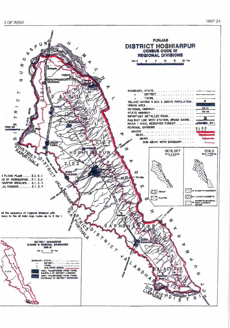
S OF INDIA
f...
o
-
l1li tIM ....-ne. of ....._. dIvtIIorri wIttt r_ to tIM .. IIIcIa ..,. codII .. to 3 tIw I
-.vn'. n An: . . . " . . .. .. _ . __ IIIITNC'T .. .. ... . . . _ . _ ._
" TAH�L . ...... .. .. _:.. ___ _
. ~"-.---_
MUo~~ T'AHk _ALA OF OSTllllCf L.UDII&*. ...... ~r1tOII T_ 1II.f'IIA_ 01' DlSTIIICT __ •
' C'
PUNJAB
DISTRICT HOSHIARPUR CENSUS CODE 07
REGIONAL DIVISIONS I0Il e 0 8 10 JI5 20 KIlt
MAP 24
BOUNDARY, STATE •••• •••. •. .• . " .• --.. DISTRICT .•.• • ••••• • •• . •• --.. TAHSL • •.•• . . . .... • •. • ---
VlLAGE HAVNi It 000 t A'OVE POPlLATIoN • • UR!AH AREA • ...• • • • ••••. . • .• . • . NATIONAL Hl!lHWAV. • • • • • • • • •• • , • . • • _ .... I!H::..;I~A._ STATE HIGHWAY ••...• . .. •• .••• . . . _...;;.itt;,.;...tI=-_ M"ORTAHT METALlED ROAD . . . . • • • • . .. --.. __ -RALWAY t.N: WITH STATION, 8ItO\D 1.W6E . . RIVER I CHOE.ItES£1Ml) FOADT . •• . • . .. ~(~r~. REGIONAL DIVISIONS •.•••• • •.. • •• .• , ~l 2.~
_ MACRO • •• .• , • • • ••• • , . .••..•• -" MESO •• . • • •. . ••••• . . •.• . • •
~~ .. . . . ...... . ....... ~ SUI-MICRO WITH 1l0UNWtY . . . . . ~
GEOLOGY "' 't.1.!!' ..
SOLS ""P~ '!'!""

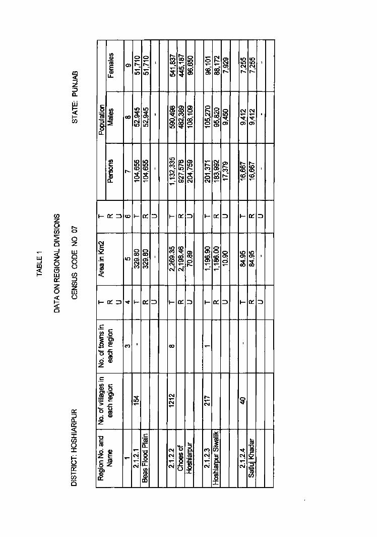
IJ.I ...J Dl
~
en z o w :> Cl
~ o ffi 0:::: Z o ~ ~
In < -, Z :::> Q..
W ~ ~ en
l:; o z w Cl
8 CIJ :::> en z w o
0:: ::J a.. 0:: < ::c en o ::c
~ ~ (5
~ cu E CD
LL
5 fI)
iii CI)
~ § 0 a..
en c
~ a..
0 0 ...... ..... "':. "':. • 0) ..... ..... II) II)
10 II)
~ ~ • <10 N N 10 I()
~ ~ <0 <0 • ..... ~ ~ ..- .....
00 co co
100)0)' NN ("') ("')
("').
c "cu a..
..... ~8 ..... _ " 1L
NrJ)
~
~ ~ 0 ...- ~ ~ IIC) IIC)
~ 0 ...... ...... ...... 10 10 • N N ....
~ 8 $ ~ ,..: ,..: ,..: ~
co 0) 0)
~ ~ ~ 0 ~ ~ N N ..- ..... ...... •
c5 N ex; ar) "lit "lit
~ ~ 0 0 8 0;- 0;- 0)-
..... .......
10
~ fe ..... ~ ~ ..... ~
..... ..... cq_ <0 <0 •
~ <0 <0 ,..: ~
..- ~ ,..: cO cO ...... ~ 0 ...... ...... ..... N ..... .....
1-0:::::::>
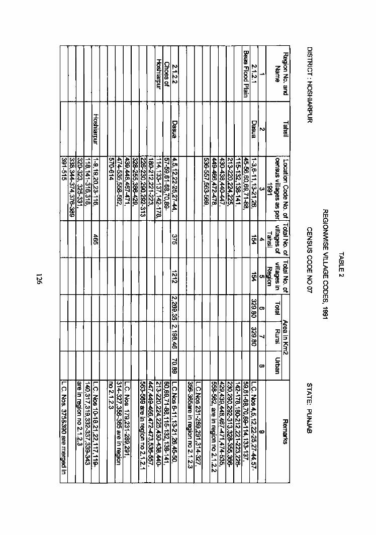
~ ;:u
~ ("') (/J ~. ':r '" :!! '" as:g m ~ ....
~. N §_ ~ ~ 3 Z S. N ..... (J) ~
r:: "C 11.1 .... iii" :::J :i' c.
J: 0
~ ~ '2 ~ N ~. ':r
11.1 11.1 ~ r:: ...
~ w ~
...... ...... tn
~ ~ ! ~ ..... ......
~ 41-
~ I ~ N ......
~ ......
~~ ~ ...... I
~ ~ ..... 5n ...... .... I ..... !TJ !D ~ ~
~ C{' W
I
~ ...... t ...... ~ CJ1 W ...... CD ~ ~
..... N ...... .... N 41- .... ......
~ a, ~ ~ ......
CJ1 !"" ...... ~ 41- 00 tn I\) N .... ...... ~ g' I
I ~ ~ ~ N ...... ~ ~ ~ ) ~ w w ~ m ....
~ ......
~I~ ~ ~ ...... N I\)
~ ~ ~ w CJ) 'of ...... ?
~ ~ 'C.l
~ I -...... N -...... ..... -~
...... N _m
.... ..... ...... ...... .... ~
a
~ _Cii N ". ....
...... !» 5» _N .... !O ~ ? .... ~ ~ i~ w- ..... f8 .... .... is. w _00 ...
;:u m (j)
<~ _. 0
". c..> ...... ~==m 11.11 -C) .... ~ ". [ ~ CJ1 tn
S.O -!S. ~
~ ;:U==1I.1 N
...... ~c!l -~ ~ tn
om~ N :::s _.' ::Js.
("') (5 Z m ~ Z en en c m en S; ~ ("')
0 r- OO 0 ~ r-m m Z m N
0 8 0 ....., 0 N
W N N -! CJ) ~ <» sa. CD c., 00 !!! a tn
i N W ...... N ;:u
CD ~ .... r:: 00 ~ :::J ~ 00
~ CJ) a
m $I> ...... $ ......
N ....., C 0 co i i» CD :::s
r- 11.1 ~ r- 5 c..> r-
~ ~ N g r- w r-
~ 41- N ~ U'I r-
0 (jJ ". f> ..... f> ...... (") ~ (") ~ ~ ~ CD f> _0
'" f' ~ ~ a,
Z :::s w
~ ..... ~ ~ m t ~ ~ ~ ~
-". ~ ..... ......
~ ..... -...... ~ _Cii ~ ~ ~. .... ~ _ .... i a ...... ! w ..... w w ~
N c!o 'P N 11.1 & 'N ..... ?J 41-W g .....
~ .....
~ w ~ ~
....., CD 9 ca ? .... ...... (jJ 5n CJ1
~ ~ s· -". N ...... ...... s· !{, ~ ~ i & CD N ...... ...... s· w ..... ::::c
~ N ~. g ...... .... N
'" N w ~. U'I Y' ~ ~. ~
W N .... ~ ~ .....
11.1 .....
I ..... N
I ~ ..... <0 ..... N (jJ !{, (j w .... g CD .... ~ 11.1
11.1 N ....., _N 00 N ~ .... .... ..... ..... ~ (jJ w ~ .... s· CD
5 I ...... 5 w -".
~ w N
3 .... N ~ ~ ...... 5 ~ 'f>
tp =" ~. CD '" f' .....
* (J) ..... N
~ ..... '" ~ ~ ~ ~ ~
...... ~ .... ..... w ~ ..... 0 ~ .....
tp :::s ~ ......
'" N ? en ...... w-
N -;-I s·
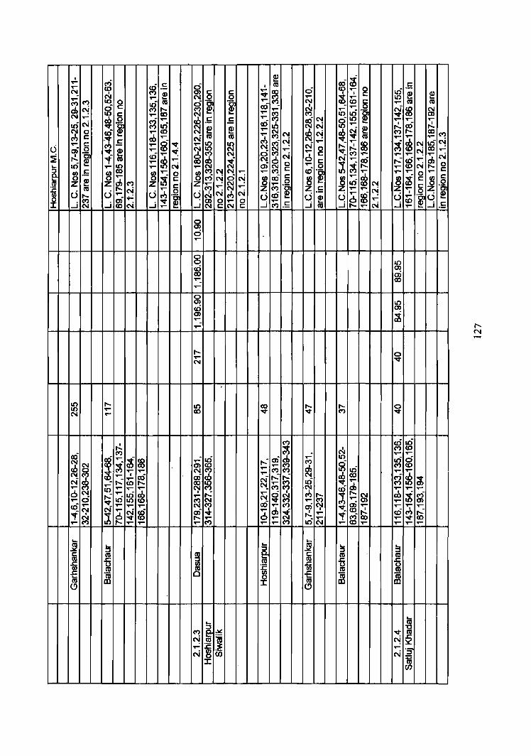
I ct) e:! g c! ,..
cO c: 0 m .5 ,.. I to ..... 0 ..... 0 It) N I M e:! Q) c: c: 'Of" ~ ;J; I c: e:! (I) N ,.. N 0 0 ..... ..... 10 ... .....
M 10 g ~ m
~ I'~ .~ ,..
N to
·1 T"" m m M
'" 0 00 - I - .....
~ ~ ~ ..... ..... ~ ..... It) ~ N
10 5 ..... M 10 m ..... ~ ~
.... ch .5 .5 .... M as C'! ; 10 .... ..... .....
It) N .~ g N to ab ~ N ....
~ as .,!.
~ 0 cO ..... N ~ e:! ..... N N ~ e:! f'-. 00
~ N M c:
";1; r1J ..... N m M
'" N_ .....; m T""
~ .....
c'l .5 g gf ..... ~ :g (.)
..... c: ..... 'Of" ..... ~ 10 N_ N .....: .,!. ~ N
~ 0 ~ e:! ..... ~ N N ..... ..... 0 ~ c'l .....
::?l . ~ cO ~ ~ M N a ~ N 0 c: M ..... ..... ..... ...... N ...,. m ..... re ..f N
~ ..... ~ .....: g ..... cJ,
It) ..... N 0) g ..... c:
~ N g ... ..... 10 ..... ..... N ~ 0 ..... ,.._
!~ tII.S ~
00 ~
..... 0 ~ M N N ..... ..... to .~ ~
..... ..... g ..... ~
..... ~ c: M c-.j ci
'" ~ ai c: 8 ~
..-
~ i ~ c:
(II ~ ~ M Z Z ..... ~
..... 0 It) N .~ :c N ;;; 5 ~ .... ..... M .~ Z .5 .... ..... N ,.. 5
~ () u ..... u ~ N N U cO U ..... g U
I
U f'-. ....,: l·~ (.) ..... .~ .M ~ 'Of" 0 ..... 0 ..... e:! 0 ..... to ..J N _j C'i _j ..... ...J N C:N c: _j M .5 _j m _j t-- ..... N _j ..... _j £
a m c:i .....
a a 10 u:i m 00 0) ..... 00 ..... a m 10 u:i m m ;i ..... .....
t-- 0 ..... 'Of" N
,
10 ,.._ 10 00 f'-. ,.._ a 10 ..... 00 'Of" 'Of" M 'Of" N .....
.,!. M ~ It) ~ I to ai M N ..... ,..
~ ..... t ~ . It) .....: a)
~ ..... 10
~ 0
~ ~ ..... M ci N m to ..... cJ, co
~ ..... ..... N M ..... ~ 10 :g ..... ..... ..... • as a) dJ
..... N r1J M f8 N rl:J ..... ~
,.._ ~ Il'i ,.... a; ..... f'-. to f'-. 00 10 ..... 'Of"
~ M
6 M 10 .... T""
~ N M M N
l .... .... ..... N_
~ ..... It) I .....: .....
~ ~ cJ> (;; S1 rb ;t ct) It) ..... N_ ..... ..... 0 10 M N ..- ..... Q)
~ ,.... ..... ..... ,.. N ('I) 00 ..... M
~ '"i" 'Of" ~ ..... ..... ..... .... N
~ ..... N !8 0) -.i- ..... ell ~ .,!. cO M .....: ,.
~ 0 0 ..... "f g 'Of" ,.._ .... ..... .... 00 ..... 'Of" co ..... t-- ..... ..... ..... M ..... .... M 10 N ..... ..... .... .... .....
.... .... ~ ....
~ ~ ... .... ::s ::s ::s c: m ~ c: m m m -5 m m
~ ~ -m til
~ -m m ~ -E ~ 0 -E ~ ~ m I m (!) (!)
... .... m M g ~ 'Of" ~ '"
m J N ..... ~ ..... ·5 N C/) N
I i C/)
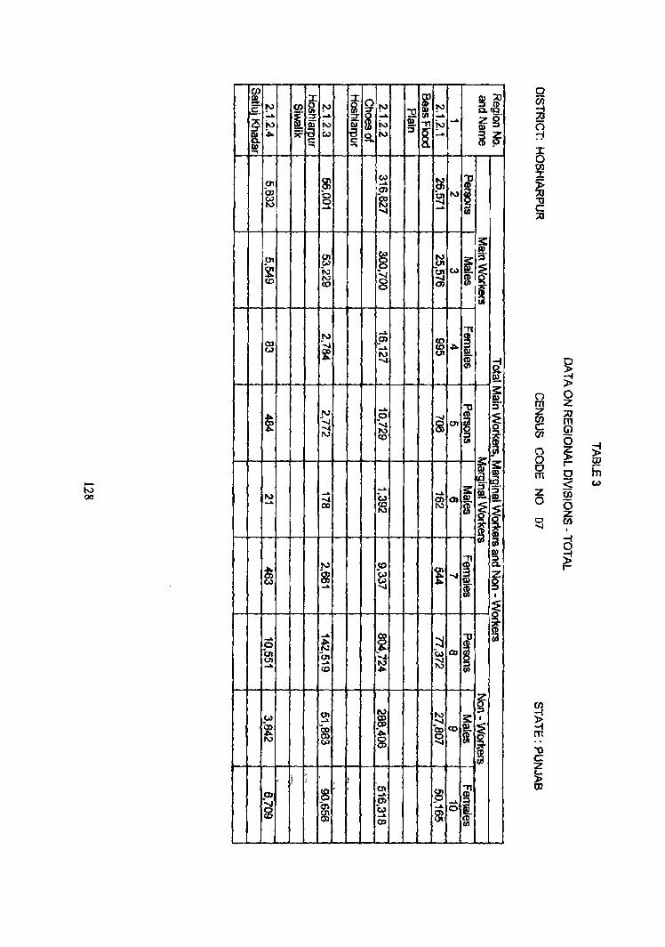
~ en i ~ ~ [ !'3 I' !'3 [l ~ l"" J2 ..... ~
..... ..... ..... ~ ~r :9 i\) ~. i\) ~. jo.) ~. " !-.>
~
~ • ~ w S. ;.,., ~ .... i~ s::
Q) .... ... ....
0\ (I,)
~ f 01 en ... iJ) 8
<» ~
....., ~ Co
~ N .-..... III
s: (I,) !!!.
01 C11 8 N ; ~ ~ (I,) UI
~ N -....r ~ Co)
(0 N 8 co
m
-N QO
... " N _aJ ~ I 03 ':..J ..... ~ Co)
~ J\) UI -...I i ~
!2.. 3: !!!.
..... "'0 :::s
~ N .0
S1 (11
~ -..... 01 § ..... ;:j N f <0 UI
jil
~ i ~. ~. ..... 3: i. ~ ..... c., ~ N ..... ~ 0)
~ ...... 00 ~ ~ ~ i ! -n [
N !C ~ f} ~ (,,) t ..... ~ ..... ~ $ ,
~ ~
0 0 m Z Z :;;0 w m c (i) (/1
~ 0 ~ ~
CD r-Iii 0
~ Co)
z (lJ 0 (5
z 0 (I) .....
I
~
~ » r-
~ i .... ..... j ::::I I ;
p it 01 U, ..... w 00 (,7'1 ..... N ~ ..... (.0 ,0..
01 N N ~
(.0) ...... ~ ..... i I
~ S1 S ~ oCO I Vol
~ ! , 1
8' 0'1
~ I _OJ ..... OJ -g m w ..... 0 g:: ...... g: co
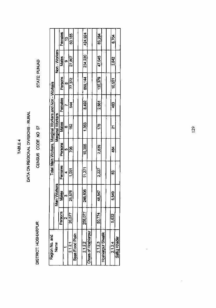
~ o u
~ (JJ z w U
fB 10 a;o~ E"" -Q) 0 U. 10
c: °cu c:::
-~8 .... _ o U.
Nil)
!
o ('II ('II
~ ('II
co .... .....
..... ~ ci ,...
..... ('II
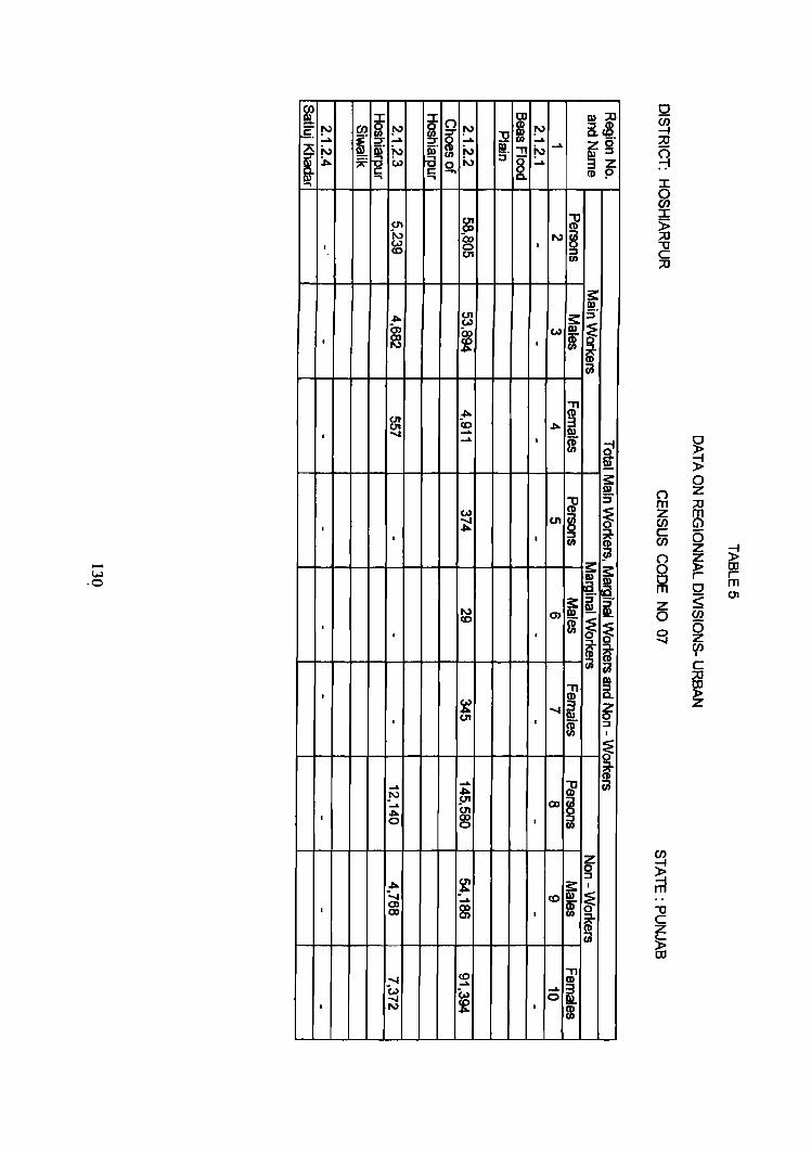
~ :::r: i n J1i ~ !'J en ~ !'J i !'J ..... [ ..... ..... 9~ ~. N ~' N ~. "T1 III _". ~ i:.> a N j[ c.. c c Q) .., .., ...
en (J1 (X)
1-J 0, I
(A) 0 co 01
_". 01
0> (0)
(x) I
(Xl
f '"
en ~ (J\ co
I ....... ..... .....
w I ~
I
-w ,0
'" co I
I
I
~ I en
..... ..... .!'J
_".
..... 511 _". 01
I 0 (X) 0
~ _".
"-.... ..... , (J)
~ QI)
co ....... ..... 'i:.> W .......
~ I '"
!'J ..... ~
..... .....
~ N § ,
rn
s: w l ,
"T1 (1)
_". ~ , f
~ (J1 ~
I j rn
m ~ I
m
"J1 ....... i
I m
~ (X) ! I
I co I
."
~ ..... 0
I m
1»::0 iic8 sr g' 3z CD p
s: I» s·
f CD ca
~ ~ s· ~
! s:: s: I»
~. I»
~. j
!!!. !!!..
~ ~ i ~ ca
I»
5. ~ ::J
I
~ ~
Z 0 ::J I
~ .., @ ca
n m Z en c en
8 0 m Z 0 0 -..J
E m "'0 c z 5> ID
~ i! 0 Z ::0 m G) (5 Z );! ~ ID r r 0 m 5; 01
en (5 Z en I
c ::0
~ Z
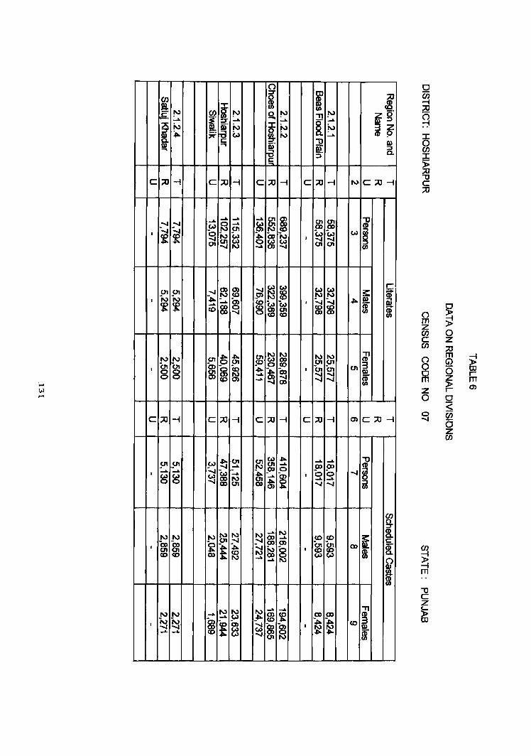
(") :r
~ ::J: ftl fI)
r-5. ~ en § ~ So ~ I ......
l N ~. N ~ ~ ;ii= <:,., r:::
I» .... ~. ... IS
C :::0 -I C :::0 -I C ::0
.... ...... .... ..... RJ ~ ~ S ......
~ ~ ~ W 01
I ~ ~ W ~ 00 Co) 0 ~ c.n N .....
m ~ c.n <11 ,:--.I ~ ~ N N ~ ~
I ...... ~ ~ ~ ~
...... CO ~ ~
~ ~ ~ N
N I\) c.n c.n ~ I § § en ~ ~ ~
~ m ..... CO .....
C ::0 -I C :;;0 -I C ::0
~ (1'1 ~
Co) .01 .5" Co) ...... U'I ...... .... -....,
~ ~ .CD
I
~ (0) ~
.... ..... 0 N
~ c.n
~ N N ......
N II.) to.,) CD m m ~ ,:--.I ,:--.I CD
I £ .J!o.. ~ ~ CO <0 CD ~ ..... .....
to.,) ~ ~ ....
N II.) ...... m N N ~
...... CO
I ~ ..... ~ ~ ~ ~ ...... ......
If fI)
~ :!! ~ ......
~ ......
N ~ N ......
i? ::J
-I C ::0 -I
~ ~ <11 CD
N c., W ~
I ~ ..... c.n <11
~ ~ ~ -...., -...., ~
, ~ ~ CO
N N to.,) m c.n U1
~ I
~ ~ ..... CD
-I C :::0 -I
~ ...... ...... ..... J1l CD 0 0
~ I 0 ...... ..... ~ ~
N .... CO CO m
~ § ~ I
.... ~ CD CD
:,:. :,:.
~ I
~ ~
l if g' i~
I» :::l a.
N C::O-l
~ Co) ~
fI)
r-3: i
.J!o.. I» ..., !a CD
fI) $
" CD
c.n i fI)
m C:;;O-l
""0 CD
-..r § fI)
en g. ~ 3: r:::
CD e!. [ $ &> S4. m
" co I
i
() m z en C en (") 0 0 m z 0
~
en );! -I m
""0 C Z
~
~ ~ 0 z ::0 m
~ G> (5 OJ r-~ m r- m 0 =< (jj a z en
DISRICT RUPNAGAR
REGIONAL DIVISIONS
Located in the eastern part of the state, Rupnagar district is sub-montane
in character. The Siwalik range stretches in northwest - southeast direction. It is
surrounded by Himachal Pradesh in the northeast, Haryana state and union
territory of Chandigarh in the east, Patiala district in the south and the districts of
Hoshiarpur and Ludhiana districts in the west.
Covering an area of 2,085.00 sq. km. and a population of 915,603 this
district spreads over all the three tahsils of the district. It includes 917 villages
(including 22 uninhabited) and 8 towns of the district. The district has a density of
439 persons per sq. km. Out of the total population 489,671 are males and
425,932 females resulting in an over all sex ratio of 870 females per 1000 males.
Scheduled Castes constitute almost one-fourth (24.57%) of the total population of
the district. It has a literacy rate of 68.14 per cent and is more literate than the
State as a whole; the literacy rate for males and females being 76.45 per cent and
58.54 per cent respectively. In the district workers constitute 30.07 per cent of the
population; 29.40 per cent as main workers and 0.67 per cent as marginal
workers.
Climatically, the region experiences extremes in climate. Summers are
hot with temperature often rising beyond 43° centigrade. In winter, the
temperature gets as low as 3° centigrade.
River Satluj passes through this district. It is the source for Bhakra Dam
located in Himachal Pradesh where Gobind Sagar Lake has been artificially built
for storing the waters of river Satluj. The electricity generated at Bhakra Dam is a
boom to the entire region for supply of power and irrigation water.
132
The district has made significant progress in the development of
industries. Many new industries have come up. The major among them are
National Fertilizers at Nangal, Electronics unit at S.A.S. Nagar (Mohali). In
addition, industrial centres are set up along the Kharar-Rupnagar highway. The
main industries located along this road include milk plant, manufacture of tractor
and tractor parts, medicines, spun pipes, TV sets, surgical instruments, textiles
and sugar mills.
The district has a well developed system of roads and railways. National
Highway No.21 passes through this district. Morinda-Naya Nangal railway line
passes through-this district.
Soils of the district are Ochrepts-Psamments and Ochrepts-Orthents. The
geological structure of the district is consisted of siwalik and alluvium. The
natural vegetation includes kikar, shisham, pipal, neem, jamun. reed and sarkanda.
Wheat, maize, rice, sugarcane, mustard oil, potatoes are the main crops grown in
this district.
District Rupnagar is part o~ the Hoshiapur-Chandigarh Sub-Montane Plain
(2.1.2) micro region. On the basis of physiographic factors, the district is sub
divided into the following three sub-micro regions.
2.1.2.1 Upper Satluj Basin
This region covers 289 villages (146 of Anandpur tahsil and 143 of
Rupnagar tahsil) and four urban centres namely, Naya Nangal, Nangal Township,
Anandpur Sahib and Rupnagar. The region has a popUlation of 298,689 and an
area of627.32 sq. km.
This region stretches in a narrow strip of land between the Siwaliks in its
upper northern part of Rupnagar district, and Ludhiana and Hoshiarpur districts in
133
the west. To its north and northeast lies:Himachal Pradesh and Rupnagar Siwalik.
In the south and southeast, it is bounded by Kharar plain. River Satluj flows
through this region in northeast to southwest direction and then turns towards
right side to make its boundary between Hoshiarpur and Rupnagar district. The
region is also drained by small seasonal tributaries which originate from
Rupnagar Siwaliks. Being sub- montane in nature, the gradient varies between
355 metres near village Manakpur (Anandpur Sahib tahsil) and 257 metres near
village Dala (Rupnagar tahsil). The villages located along the Satluj river are
often subjected to floods during rainy season. There are few khads/choes and nadis
and the main among them. are Budki nadi, Siswan nadi, Chelanwali khad,
Sitlabari -di- khad, Donala- dj- khad and Charanganga nadi.
The National Highway No.21 Jeading to Bilaspur in Himachal Pradesh
crosses through this region. All other towns in the region are well connected with
roads. The railway line connecting Nanga1 Township and Morinda passes
through this region.
Out of the total population, 157,391 are males and 141,298 are females
giving an overall sex ratio of 998 females per 1000 males. More than two-thirds
(68.96%) of the population in the region is rural and about one-third (31. 04%) is
urban. It has a population of 298,689 as against 243,594 in 1981 exhibiting a
decadal growth rate of 22.62 per cent during this decade. It has a density of 476
persons per sq.km and thus, is relatively more densely populated than the district
as such. 21.34 per cent of the population belongs to Scheduled Castes. This
region has a literacy rate of 58.47 per cent. 28.07 per cent of the total popUlation
is reported as main workers, 0.92 per cent marginal workers and 71.01 per cent
are non-workers.
From the point of view of agriculture, wheat, maize, rice and sugarcane
are the main crops grown. The natural vegetation includes shisham, neem, jamun,
134
mango, reeds and sarkanda. The soils are Ochrepts-Psamments and Ochrepts
Orthents and the geological structure is comprised of al1uvium.
2.1.2.2 Rupnagar Siwalik
Fairly scattered all over the district, this regton covers 92 villages of
Anandpur Sahib tahsil, 17 villages of Rupnagar tahsil and 10 villages of Kharar
tahsil. It has an area of 435.94 sq. kms. and a population of 90,800 which is
entirely rural. This region has a density of 208 persons per sq. km. and a sex ratio
of 838. The region has recorded a literacy rate of 56.41 per cent and the work
participation rate of 31.47 per cent as per 1991 Census; 29.54 per cent as main
workers and 1.93 per cent as marginal workers. The scheduled caste population
constitutes 22.16 per cent of the total population of the region.
The region being hilly has an elevation of up to 1,574 metres near village
Rajgiri of Anandpur Sahib tahsil and 458 metres near village Kansal in Kharar
tahsil. The region is dissected by seasonal choes and khads, namely, Hum khad,
Dabatwali khad and Jayanti Devi-Rao. The soils are Ochrepts-Psamments and
Ochrepts-Orthents which are coarse grain and sandy loam in character. Due to the
hilly topography, this region has comparatively less developed system of roads
and rails. Kutcha tracks link different places at many places. Besides agriculture,
wood cutting is an important activity. The slopes of hill provide platform for
agriculture. Rice, wheat and maize are the main crops grown in the area.
2.1.2.3 Kbarar Plain
This region covers 225 villages of Rupnagar tahsil and 284 villages of
Kharar tahsil besides four towns, namely Morinda, Kurali, Kharar and SAS Nagar
(Mohali). This region has a population of 526,114, among which 386,516 are
residing in rural areas and 139,598 in urban areas.
135
Kharar Plain is bounded by upper Satluj Basin in the north and Rupnagar
Siwalik in the northeast. The Union territory of Chandigarh and Patiala district
lies to its south and Ludhiana district lies to its west. The region has a dissected
topography caused due to numerous choeslstreams. The important choes/streams
traversing through this region include Sugh Rao, Haripur Nala, Budki Khad. In
addition, Sirhind canal, Bhakra canal. Samrala major and Bhamian minor also
traverse through this region.
The soils are Ochrepts-Psamments and Ochrepts-Orthents and are very
fertile. The geological structure of the region is alluvium. Wheat, maize, rice,
groundnuts and sugarcane are the chief crops grown in the area.
This is the well developed part of the district. All the four towns located in
this region are connected by roads. The region is important for the manufacture of
meqicines, woolen and cotton textiles, tractor and tractor parts, electronic items,
milk anq sugar.
*****
136
CENSUS OF INDIA
c . ,. 8OUhDARY, STATE/U.T . .... .... .. ..... . .. _ .. _ .. _
• DlS1RtCT ...... .. ............ _._. _ • TAta .. ...... .. .... .. ...... . _._._
VLLAGE HAVM 1S000 'ABOVE POPLU.TION . • Ifi8AN AREA . : .. .. .. .. .. .. •. .• .. .. .. .. NA TICHAL tIGHW AY .... ...... .. •. .. .. .. _-,tttll:UlO21,--_ STATE ttGHWAY .. .. .. ' .. . . .. .. . . .. .. .. .. _ ... SHILI..Iio2;:r,.4_
t.tPORT ANT METALLED ROAD .. .. .. .. .. .. .. a RALWAY l.t£ WITH STATION, BROAD GAUGE .. _ .... _~_ RIVER AN) STREAM, RESERVED FOREST .. .. .. ~:ii; REGIONAl DNJSDNS .... .. .. .. .. .. .. .. .. Z. I . ~. 2
MACRO ...... .. .. ...... .. .... .. .... I i I J. MESO ......... . .. ...... ........ ..
MICRO .... ....... .. .. .. .... .. .. sue- MICRO WITH BOUNDARY " . . ..
, I I_ I
I RIGel til • . "CJUWlc, of ,,;tonal d1YlIIona wHh "fwlnC' to thl ' ·tiI 1ndI. n-. CIIICIea ' up to 3 tier )
~.
At T
i I
MAP 25
PUNJAB
DISTRICT RUPNAGAR
\
CENSUS CODE 08 REGIONAL DIVISIONS
Km.~ !
o !
. ..(
z
5 ! T 1 ~OKm.
DlSTR!C1 RUPNAGAR CHANGE .. REGIONAL. 8OlN>ARIES
198HII
"-ti!WO""'
80UHDAftY, STATE " •... . ..•• _ .. _ " _ DlSTRlCT .... .. .. .. . .. _ . _ . _ TAHSL " " .. " ... " "" _ . _ . _ REQIOHAL DJVISIOHS _
AREA LOIT TO T AHSl. BAUCHAIII or DISTRICT HOSHlARPII!" ........... " .•
UPPER SA TLUJ BAS14 "~.~._ 2 • I • 2 • I RlPNAGAR SlW ~ .... " ........ _. 2 . I • 2 • 2 toiARAR PLAIN ... " .. " ..... _."_._. 2 • I . 2 • 3

(/)
~ "- ~ ~ ~ 8 0 CI) ..-"ffi ..- en ..-
Q) ..- ..- ..- ..... Q) E ..-
~ ~ ..- ..... I ~ ~ 't CI) "It "It "It U. ..- .....
8 f6 ..... C")
m 0 0 g ~ en 16 ~_ at) C") C") co
"ffi co oo_ ..- ..- I .... co
~ ~ (0 b of Q) en ~ ~ rt ..... ...- "It "It "It' N a..
(/)
i ~ Q) 8 8 "It' co m c: ..- ..... ~
..... ..... It) "- r-. co co t
~ ~ 0) co at)
~ at g CI) en 0 C") D- N N ..-
C/) z 00 0 (j5 d > z is w
0 ~
_J 0 w ~ () ...J 0 Z £D 0 ~ (9
~ W 0: (.) Z 0 0 _J
t-O:::J co t- o:: ::J t- o: ::J I- 0: :J
N
~ 10 ~ Q) 0) co
~ "! ~ Q) 0) ": ~ . = It) It) ad I ..... i ~ ~ 0 C") C")
N ..... C'G It) q C")
~ "It "It' .....
~ C/) ::J
~ C/) Z
i-O:::J "It t- a:: :::> t- a:: :::> I- a:: :::::>
W ()
VI
~"§ .~ C') "It '<It"
~.~ "~ I
~ (/) c &-2 :~ 0) Q) Q) >.c; 00 ..... ~ '0 0 N ..-
·m o c: Z ._
c: "0
"ii) ~
c ~ ~ C aJ .t;j
~~ ..... -=- C'! (i.) C") a:: :::I
~ C
..- C'! ~
C'\I ... ... "t;j
5~ ..... .... ~ .... ; 0:: N
I N
~ N
"~ 2 0: :::J
0::
;0 ZZ;o
0 en I§ !'l
II ~ i '" ~ ~ _.. _.. Q)!J~
~ ~ ~ ......
~ § (5" ;;0
~ II) N p. i' _.. 0.:::1 ~ ...
» ;;0 » ;;0
~ ~ I§ en ::s -I C ~
Q) Q) "'0 ::s
~ ::s J\) =r
~ 0= ~ c= ~ ~ t: Q) t: (j) .., ., ... »
~ ..... ..... ..... ~ '" ..... ..... ..... ..... ..... ..... ;;0
(1) UJ 0 ..... _(j ~ OJ ~
~ m i [ ~ '" ..... 9' ~ ~
..... _'" ..... ..... ..... ..... ..... ..... ..... ..... .....
i ~ ~ '" ~ OJ .....
~ ~ ~ .....
CN 9 -;oJ "'" !O r:: _
~ ;..., _co Ul _. ..... ..... ..... J\) __. ..... __. < g
~ ~ _~ ~ CJI 0 ..... ..... (1) _~ '" St:J _" CJI co ~ ..... ~ ~ffi=~ ~ ..... I CN ..... ..... _..
~ '" ~ ..... ..... _..
~ ~ ~ '" 0 .....
~ ~ '" 00 ..... co ..... 9' co cp ~ ~ :" m (I)
..... _.. .... UJ
'" '" ..... ..... ..... ~
Q) Z co ~ ~ ~
_.. ..... ~ " ~ ~ CII P _..
"'" m ..... ..... I "i a I ......
~ ... < -I -. 0
..... ..... -I=ar ;;0 co "'"
.,. .,. Q) ~ - m
'" :::r Z w (1) sa. 0 () G) - . m 5 s,g, Z en z < -I
C ~ en en ;;0= a () m ..... '" ~~!!!. 0 S ~ ....
~ CJI . m ~ 0 co r ...... g -.. m ~ *'" ::s 0 Z r
0 - 9 m m I\)
0 () OJ
(} 0 .,. m 0
eN '" m m (JI " et en _..
~ » ..... @ .,. CJI ;u Q)
w ~ " r:: :;-
CJI ill ~ '"
c • CJI OJ i ....
::s en );!
!'l '" ..... _.. ..... _cg (; ~ N '" ..... 0 g. (X) (; :3" ..... _.. .....
! 5 -I
~ " ~ ~ ~ ~ ~
..... ~ "'" ~
m ..... i'->
..... .....
i _..
~ ~. .....
~ I !'l ;..., Z ~ Q) ..... _.. .....
~ ..... 01 ..... ..... _.. eN "'0 _.. ro OJ ~ ~
_.. _.. CJI ~ rp g co ~ lp ~ c _.. N CJI Ct> !'l
..... ..... ;..., ::j ....
~ Z ::s ...... _.. ..... ..... W I» ..... _..
~ ~ 5 ..... ...... ..... ~ ~
~ ~ ~ !O (D _.. ~ ~ eN ;0 »
~. ..... s» -....., j..) Q) ~ ~
..... jj m CD (D :i" co N ..... .... '" ! N .....
~ ro m .... _.. .... eN co 3
0 ...... ~ ~
..... ~. ~ ~ ~
.... ~ ~ ~ m Q) ::s co I :i" ~ '" _.. p & a: ~ ~
.... ..... '" _.. ....
~ g ~ Q) ..... _.. .... ~ ~ eN " g ~ ~ ~ @ " ~ ~ CJI OJ 0
! ~ C'? .~
co
'" ! ~ co I"-
10 cb 0 ~ to 0 ..- CO C'? It) ..- ..- N
~ N .5
~ ~ .... c: .... N N ~ 8 N
g ; .... ..... c: .... ~ ai .... ..... to 0 It) ~ .... ..- N ~ .~
.... N N
~ ..- a; ~ a; .... c: ~ g 0 0 tO~ 0 ..- 0
'" c: to .... ~ c: Q) c:
~ .~ ..... ..- l"- .E .... .... ,..._
~ ·1 rt) I
5 5 .... ~ ~ ~ ~ I"-
~ It) N I"- .... ~ .5 .... 0 CIJ C'! .... N .~ .~
r;j c: 0 I ...j
! 9 ~ .... 9 ..... 9 I::: 5 ..J .E N <0 .... .E .E CIJ .... ..- .... N
.... C'?
~ Q)
N N q .....
..... v ....
~ It)
I"- 0 It) N .... .... N
0 <0 ..-
ft1 ~ Il'i
I cb .... N ..... N cb It) g .... ~
0 ..-.... I"- .... m to 0 ~ ~ r-: 0 .... It) I
to 0 .... N ai ~
.... N to 0 ;! :i1 I"- ..... It) g ~
co ..... ~
..... N (I') co r-: cD ch ai
~ a; ..... j::: It) ..... ~ I I"- ..... N .....
.... .... ~ .... ~ e CIJ e
~ e CIJ CIJ
:::J § :::J § a:: a::
C'? .... ~ e s::
~ '(ij ..- 0:: N
::0 J!9 !\) Q?t§ !\)
i'~ i ...... ...... I» I» N ~~ N :i" iiJ SIl. c: ., t:.> "I»
i\) ::II t=. ., ..,
...... I\) CD 01
00 0) W
~ '"00 '"00 I\) 01
(0 0) 00
... g N ......
UI CD ........ ........
~ w (0 I\) CD
...... ...... ~ ........ "0 ...... UI CD ...... ...... (J1 0)
.... ...... N (n ........ ........ ...... 01 .,. 00 W W
N .,. ...... ~ 0) 0 0
.... -" N
~ --.,J c.n -" CD
0) W W
~ N 0) ..... 01 N ]\) '"00 ~ ...... (0 I\) w ...... ...... CD
.... w I\) ...... I\.) W CD :,:.. w &1 I\.) 01 0) 00 w
I\.)
~ .....
W ~ I\.)
~ (D "0 0) (J1 ...... W 01
!'l ...... ~ ...... ....
-0
N ~ {/)
~ W
m-
"T1 (I) .,.. ~ m-
~ (J1 §
{/)
s: 0) I»
m
"T1 CD
...... 3 II)
[
~ CD §
{/)
s: (0 !!!.
m
"T1 (I)
..... i 0
m
1»::0 a~ zoo II) ::l 3Z (I) P
s: ~ . :::J
~ i CiJ
-i ~ e!. s: I» :;'
~ i gJ s:
f II)
~. ~. ~ :::I e!. ~ ~ i
~ CiJ I» :::I Q.
~ ::l
I
~ i CiI
~ :::I
I
! ~
() m z C/) c (f)
8 0 m z 0 (:) 00
~ m
-u c z j; OJ
~ ~ 0 z ::0 m G'> 0 ~ ~
CD r r-0 m <: w Ci5 0 z (f)
-i
~ r
.q. W ...J m ~
W I-
~ CJ)
~ g w o 8 (/) :::> (/) z w u
<") ....
N e.!: . co co ..... ,.c:-N~a..
/
o m Z en c en 8 a m
~ g
1) c
~ OJ
~ o z ;0
~ (5
$ r a ~ C/)
(5 z en c ;0
~ z
);! III r m 01
9
m III N [ !'l a~ _.. .,
N N '1l (., ~ N iii" III :r ..,
C ::tI ~ C ::tI -( C
8 N
~ ~ ~ ~ ..... ..... p 0 N "ixI ...... ~
':..t & " 01 ~ ~ " 01
~ ...... .....
N N ~ N CD ,:-J ,:-J 0) w
~ ~ (n ..... .....
~ ..... ..... _.. ~ JIo. W
~ ~ ..... ..... .....
~ ~ ..... w w
t _..
! m en "8 ~ .... ..... W W ......
c ::tI -l C ::tI ~ C
I\) ..... ..... N N ...... P N JIo. 0 P !l> 0 ..... fD .....
~ ...... ..... .....
UI
"'" ...... ..... UI ...... CD CD 00 00
..... ~ ~
...... ..... co ..... 0 0
~ ':....I ~ 'co Co ~ CD ..... ..... w co '" '" I\)
~ m fD UI co <0 !l>
~ w ~ N N 8 ~ 8 ~
~ i !'l .... _..
SIl. i'> :::s ~ _..
~.
::tI -l I\)
..... ...... _.. ~ ......
§ ~ w
~ ..... ~
~ " ~ ~ N
~ ~
! ~ 0'1
:::0 -4 m
~ 0) 0'1 W
~ ~ " ...... UI
~ ~ ~
...... 0)
~
'" N .... co
~ ~ CD
l ~ g' 3 Z (I) P
III :::s a.
C::tl~
'1l
§ til
~ :s:: (I)
et j m til
" (I)
3 III
I
C::O-l
'1l (1)
~ :::s til
en 0
3: ~. c::
~ g: I
&> sa. (I) CIl
" (I)
3 III
m
(') m Z en C en I 0 SZ -(
(5 Z
8 CJ m z 9 00
'1l C
~ CD
~ i! 0 Z ::0 m ~ G)
5 CD r $ m I m 0 ~ 00 5 z en
JALANDHAR DISTRICT
REGIONAL DIVISIONS
lalandhar district is bounded by Hoshiarpur in the east, Kapurthala in the
west, and Firozpur and Ludhiana districts in the south. For the purposes of
regional divisions, it includes four tahsils (including 14 towns) of lalandhar
district and Phagwara tahsil (including phagwara town) of Kapurthala district.
The river Satluj flowing in the south separates it from Ludhiana and Firozpur
districts.
Climatically, the. district is marked with severe hot summer and severe
cold winter. The temperature in summers touches 45° centigrade. The district
receives rains during the monsoon months of July to September. During winters,
some rainfall is received due to western disturbances, which is very beneficial for
growing of rabi crops.
Satluj is the mam flver flowing along the southern boundary of this
district. The district is marked with a number of choes or seasonal streams which
get flooded during rainy season. The White Bein and the Black Bein which are
seasonal streams also pass through this district. Geologically, the district is
comprised of fine alluvium and is highly beneficial for agriculture. The main
crops grown include wheat, maize, groundnuts, sugarcane, pulses and vegetables.
Canals and tube wells provide the main source of irrigation. Shisham, pipal,
kikar, neam, jamun, reed and sarkanda are the main trees grown.
The district has a population of 2,026,787 comprised of 1,067,093 males
and 959,694 females. Out of the total population, 1,297,985 are residing in rural
areas and 727,802 in urban areas.
146
lalandhar district is part of micro region Beas Satluj Doab (2.1.3) and is
further divided into three sub- micro regions on the basis of physio- geographic
factors. Phagwara tahsil of Kapurthala district is also considered as a part of
Jalandhar district while demarcating these sub- micro regions.
2.1.3.1 Bhogpur-Adampur Plain
Extending over parts of lalandhar, Phagwara and Nawanshahr tahsils, this
sub-micr region includes 168 villages of lalandhar tahsil, 45 villages of
Nawanshahr tahsil and 69 villages of Phagwara tahsil, besides three towns
namely, Bhogpur, Alawalpur and Adampur. It covers an area of 772.14 sq.km and
has a population of 324,630 (168,043 males and 156,587 females). The region has
a sex ratio of 931 and a density of 420 persons per sq.km. Out of the total
population, 297,985 is rural and 26,695 urban. During 1981-91 the region has
experienced a population growth of 18.61 per cent. 67.71 per cent of the
popUlation is literate which is somewhat higher than the literacy rate of the district
as such. 43.40 per cent of its population pertains to Scheduled Castes. In the total
popUlation 28.99 per cent are workers; 27.71 per cent are main workers, 1.28
marginal workers, and 71.01 per cent are non-workers.
The entire region IS, by and large, a flat plain with gradient varying
between 255 metres and 249 metres. Raunala choe, Kinganwala choe, White
Bein, Kail Nata and Choe Nala flow through this region which are seasonal.
Among the major canals/distributaries, Kartarpur minor, landusingha distributary,
Adampur distributory and Bist Doab canal find mention.
'" The soils are Ochrepts-Orthents-Rock-Out crops-Orthids and Fluvents-
Ochrepts which are fine sandy loam to silt clay loam in texture. Geologically, it
comprised of alluvium. The vegetal cover includes, kikar, mango, neern, jamun,
reed, sarkanda.
147

The region has well a developed system of roads and railways. The main
railway line connecting Ambala-Amritsar and National Highway-l pass through
this area. Agriculture is the main occupation of the people and among the main
crops grown, wheat, maize, rice and sugarcane are mentioned.
2.1.3.2 Jalandhar-Nawanshahr Doab Plain
This reglOn covers 650 villages spreading over Nakodar tahsil,
Nawanshahr tahsil and Ialandhar tahsil of Ialandhar district and Phagwara tahsil
of Kapurthala district. It covers an area of 1719.92 sq. km. and has a population
of 1,474,061, among which, 773,130 are males and 700,931 are females giving
an overall sex ratio of 907. In this region 725,611 persons are rural and 748,450
urban by residence. The region has experienced a population growth rate of 41.80
per cent during this decade. The region is highly densely populated; it has a
density 1,046 persons per sq. km. 30.46 per cent of the population is Scheduled
Castes. The literacy level (55.58%) is comparatively lower than the district as
such. Out of the total population, 29.30 per cent are main workers, 0.80 per cent
marginal workers and 69.90 per cent are non-workers .
. Banga distributary, Phagwara minor, Mukandpur distributary, Apra
distributary, Goraya distributary, Jalandhar distributary and Jandusingha
distributary flow through this region.
It has a well developed network of roads and railways. Industrially, the
region is known for the manufacture of surgical goods, rubber goods, sports
goods, plastic pipes, steel casting products and auto mobiles parts, hydraulic
presses, leather tanning and cable and conductors.
The soils in this region are Fluvents- Ocbrepts and Ochrepts-Orthents
Rock-Out crops which are very fertile. Wheat, maize, rice, mustard and sugarcane
148
are the main crops grown. The natural vegetation includes, pipal, shisham, neern.
jamun.
2.1.3.3 Satluj-Khadar
Covering 438 villages and 3 towns, this region extends over parts of
Nakodar, Phillaur and Nawanshahr tahsils. It covers an area of 1,213.40 sq.km
and has a population of 425,497, including 223,804 males and 201,693 females. It
has a density of 350 persons per sq. Ian. and a sex ratio of 901 females per
thousand males. Out of the total population, 383,524 reside in rural and 41,973 in
urban areas of the region. It has a literacy rate of 54.59 per cent and 41. 61 per
cent of the population belongs to Scheduled Castes. Workers constitute 31.87 per
cent of the total population; 31.15 per cent as main workers and 0.72 per cent as
marginal workers. The non-workers number 295,668 and they make 68.13 per
cent of the total population.
The region is a flat plain gradually sloping towards southwest. The
gradient varies between 250 and 215 metres. The Satluj river flowing along the
boundary of the region causes floods during peak monsoon period.
This reglOn has a fairly well developed network of roads and rails.
Industrially, it is not much developed. Agriculture is the main occupation. Wheat,
maize, rice and sugarcane are the main crops grown. The natural vegetation
includes shisham, neem, mango, kikar, reeds and sarkanda.
****
149

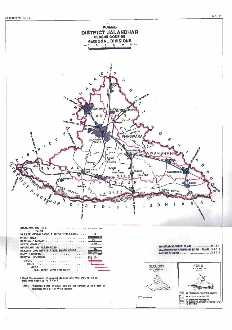
~g_ENSUS OF ~INDIA
PUNJAB
DISTRICT JALANDHAR CENSUS CODE 06
REGIONAL DIVISIONS
BOUNDARY, DISTRICT •• • ....... . . • ••..• . _._._ TAHSL ••. . .• • • •..•.. . • . • • _._ . _
VLLAGE HA VM3 11.000 , ABOVE POPULATION . • • • • URBAN AREA . . ...• . ... .•.... .... . . . N.nIONAL HIGHWAY . • . . . . . . . . . . . . . . . . • N H I
STATE HIGHWAY. • . . • . . . . . . . . . . . • . • . . -"" IMPORTANT METALLED ROAD . . . . . . . . • • • . . • : RALWAY LN: WITH STATION, BROAD GAUGE . • . . . • RIVER , STREAM •••.• • . • • . • . • ... • . • • . ~ REGIONAL DIVISIONS. . . . . • • . . . . . • . • . . . . . 2 . I • :5 . I
MACRO • •..• . .•••. • . • . . . .•.. .. . • I , I t MESO .• ' ~ " " """ " " "" '" ~
MICRO . ... . . ....• • . • .• ••• . .. ....'~=-SUB- MICRO WITH BOUNDARY . . . • . . . . '----
I Read the sequence of "vlonal division. wllh reference 10 the oW india map cod" up fa 3 lIer I
NOTE- Phagwon TahaR of Kapurfholo DI. trlct considered .s a pari of Jalandhar District tor Micro Revlon.
c T
MAP 26
o
L U 0 H A
BHOGPUR-ADAMPUR PLA" .. . . ... . ............. 2.1.3 .1 JALANOHAR-NAWANSHAHR DOAB PLA" ... 2.1 .3 .2 SATLUJ KHADAR ......... .. .. .... ..... .. .. ........ 2.1.3 .3
GEOLOGY KtfllO 0 10 20 Km
l..L-U
v
SOILS KmliflOK"
_.r>X' .. i: .. J· .7... •
7!':.. " .m ..... _"II-fI.IJVV<TS-'QUEllTS
~ ... FLINDm·OCHl!EPTS
CJ ;73 OCHtfPTI·PS.lMMEN'TS E;J ALLW",",
r:-:l 76 OCHMPTS~ORTHENTS-"OCKOUTCROrL...:-l PS-ORTHOS

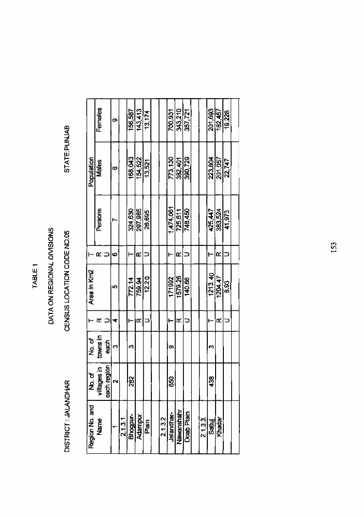
rn to ("')
~ ,... 0 ..... m ~ <0 Q) ..... ~ ..... N
10 ~ """-N ..... N
0) ..... N E ~ ("') C"') ~ ~ ~
,... ~ m Q)
""" ~ lL ..... ..... ..... ..... .....
6 $ ("') N ..... g ..... 0)
~ [l; ,.._
~ ~ ~ 0 N ~ ~
.... "'It " ~ 1ii CD ~ ~ C"') ~ ~ i ("') ..-
~ } ~ ~ ~ ..... ..... ...... "'" ("')
a.
en ~ z
0 ci Ci) z :> w is c
,... ....J 0 « 0
ill Z Z ....J 0 III 0 ~ (9
~ w ~ z 0 ....J
~ en ::)
(§ (/) z w
rn
~ 1.0
,...
~ ~- CS 8 ~ ..... ("') c
~ ..-
{» ~ " co ~ co 1.0_
~ ~ re ~ ~ ~ ~ -
tf .....
("') 'IIt_ "'It ......
t-o:::::> <0 t- o: ::) t- o: :::l t- o: ::)
N
~ 'lit ~ 0
81 co ~
~ ~ ..... N N cr) ("')
.5 It) N a) N ~ ~ ~ 0) ...... ..... ex)
~ "'" It) ...... "'" N N ,.._ ,.._ ,... ..... ..... ..- ..-
«
I-~::::> v t- o: :::::> t- o: ::) I- 0: ::::> U
- .s ornTI (") ("') 0) ("')
~~m -c c ._ 0
'0 rn·~ ~ 0 CD .8, N 1.0 ("')
°tU.s:: N co "'It Z=o .s: m "0 c ... tU
IJ ... .!. ii c
~ ~ ,... a N ~ ~ cr) .5' .... ~
c M 'fi5 c.; ! .... E .(6 -g c a; 6~
,... f a: ..-
I .Q ......
N N cu 8 N en
~ m ii
""')
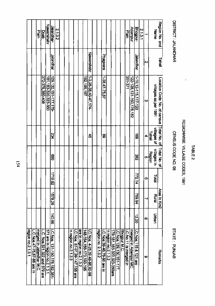
z c... l I II!. ~ 6: tIl ....,
i ~f Jl ~
m ...... "'tI m ~ ...... m. :::J ~ e,., Pi ~ w ...... ~~ :::J t if N :::I :.... I' ..... 7 III ... :::I
0-
c_ Z "'tI c...
III ! :::r At o;i iii"
~ III
:::I :::J :::I N :::r 0- ! 0-~ :::r :::r
m m OJ III ..... :::r ... ... ~
...... ...... ...... ...... ...... (.) ...... ......
<[ co ~ co I I (11
~ I
~ ..... .!'> (.) (.) ...... ...... N CO l:J _0
~ ...... ...... .....
~ ~ ...... ......
~ ~ ~ ....... ...., ...., ...... !» ~ == cr I c8:::1
I ~ ...... ...... ...., ...... ..... 01 co -.,.. _01 (.) .....
~~ 0 ...... ...... ~
co ...... 9" ~
I ...., I ...... ...... ...... 5l (II ...... ,:-.I ~ ......
Co)
~ ,:-.I ......
l~ ..... I
gj .... t!
...... ...... cp ....... ~ SfJ ......0
CO-..... ~~ co
I\) :::I
~ :::0 (I) m < ~ -. 0
I\) ...... ~=m .,. 0) ~~ -~ 01 CO m .,. sa. ~ - .
0 -!a,
< ~ ;o=S
~ I\) ~.~~ QO 01 0 I\) o (I)
:::I _.' :::I !a,
..... ...... ...... ...... d ...... ~ 0> CO
~ Co ...... ...., . .,.
Ci)
() (5
m ~ z en en c m en < ~ () ;= 0 s;: tIl 0 r m Ci) m z m N
9 ()
0 0 01 0
m en ...... co co ....... -
...... ...., i 0'1 01 ;0 ...... CO ...... c:: :i" CO
~ Ql N ~ 0)
N
..... ...... C ~ 0 I\)
00 i ~ N 0 :::I
~. r
i r ~ f) 3" r ~
...... f) i' 5 :::J' ...... f) ~
q I q 0 0 0 ~ ...... ......
~. ~ ~ t· cp g ~ ~ ~ ~
:i" ...... ~ ...... ~ ~ ~ t" ~ 00
6 ~ ...... c:: ......
3' :i" ~
...... ..... ..... :r ......
'" ~ ~ ......
~ ~ ...... t ~
...... ~ :!:
......
~" Co)
~ ~ 00 Cii 6: C» c_ ...... ~ 0 ..... III ...... I ~ 01 .... ~ ...... 3 j20 :::0 ~ iii" ~
...... ...... 5 ......
I ~ III
i g ~ ...... ~
...... e,., ; ...... ~ ~ ~ ..... CD ...... 5. e,.,
'" ~ N e,., N co 3
~ ..... ..... m i III 5 ...... (..., ...... ...... ;.., 01 8-~
...... ~ m ~ 5. -~
...... ~ Co)
~ i I :i" :!: Cil III 3: ~ ..... ...... ......
(i! 0 ~ ...... ~
..... 8 ~
...... 0 ~ 8l 3' -""'" 3"
III ...... ~ CO III (i! Cil ..... Cil 00
I
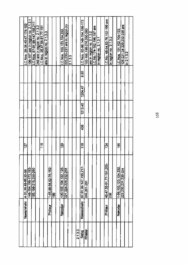
T""
C"') r!. N ..- T"" 0 0) N ('t) ..-..- '" :if ~ I() c:
~ ~. ~ c:
0 ..- C") .~ ..-..,.... c: ~ N ~
~ c: ~ 0 g ..,.... ..,.... .~ ~ ~ N ..- .S
~ 6 ; I() g ~ .5 .,...
.~ ~ ..-! ~ 6 S .... ~
('t)
'" cu co .S .~ ..... '" ~ S; ~ ~ ~ ~ ; ('t)
z ~ z z .S z '" C")
~ ~ ~ ~ e u ~ ..-..- as .....J N N
I'- I() 0) N ..... N .- ..... ..-
a I .b g N I() co I() '" ('t) 0) ..,....
~ ..... ..... ~
~ ct) cD ~ ~ I'- ";-g ~ '" ..... '" N
cD co t ai ~
..... ;t '" T"" '" ..... ~ ~ t ~ rh N
.q- 0 ~ .0-
.,.... .,.... ar)
..,....
~ gf ~. N "'t m ..... -¢ ..,.... ..... ..... ..... ~ ... J::. ... cu ... -m ::::J
~ c: ~
I :E cu a. z
('t) I'-..-
m ; ~
..... ;t N S;
~ ..,.... ..... .-~
..,....
~ '" N ~ cD .... .... .... g ~ ..-
~ '" N
~ 5 ..,.... g ~ ..... .~
~ ~ ..... 6 ~ ..,.... .S .~
~ a e ~ ..,.... CIS .5
('t) 0)
to
I'-'lit
~ '" .,...
0 'lit c.; .,....
'" T""
co ('t) 'lit
0) .... ....
r!. ..,.... N .0-It) .,....
~ ..... ~ ....
~. .,.... ~ .,....
~ ~ ...
J::. cu -m c
i ('t) '::0 t8 C"') ::::J
~ ..,.... ~ N
~ cu 0) 0) ..-
I
~ .....
~ '" C"') .....
;t N g
~ 5 ~ .~ ~ .5
.q-N ....
0 0 <'i ..... It) ..... r!. 1'-. ..,....
~ It)
r--: 'lit cD ~ .q- '" ... ::::J
~ :E a.
~ t ..... ~ ..... ..-0 .,....
~ ~
I() 0) .-
~ ~ ..... ri N ..,....
g .....
~ .....
... IU
~ CIS z
~ as ~ N
~ '"
~ ..-
~ N ..-
~ ~ ..... ('t)
'" g N
~ '"
N c.; ..,.... N .5
I() I() -
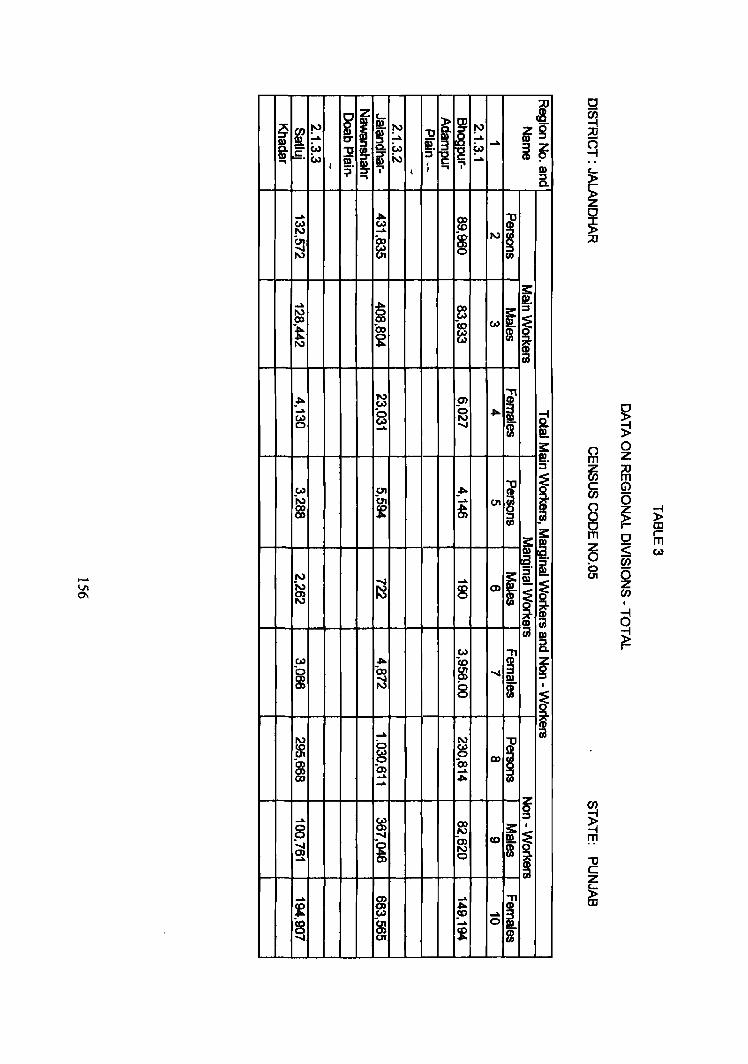
~ ~ i I i: ~ I i !"'J
l ~ .... ~ -L "0 .... ss:g
I e,., i:.l if. .... i~ ~. w: ~ ~ N ::I ~ ....
< :;i. t I I QI ., ::I a.
.... ... 00 I ~ Co) ...... <0 (n ex, ~
I\J
-..s (0) I\J U1 en
s::: .... §
~. I\J ~ I
::I 00
~ t 00 Co Co)
~ Co)
I\J Co)
UJ
_ ... N C7I i (0) .... '"0 '0 ... ~
Co) (0) N 0 ...... -..s a 5i!
;;! 3: @:!. ::I
Co) U1 _.fA I J N (n ..... U1
~ f ~ en 3:
i :I. I\J s::: 5" i N -..s ..... at
! C» ~ 8 (]) i i I\J
~ ~ !!l Co) "
a.
("') 0 m z ~ ~ c G'> en a ("')
~ ;;! 0 0 r- OJ m Q r-
t5 m
=:;; Co)
en ~ a z rn
I
cj ;;! r-
Co) ... Co ~ z ~ Oa m -..s g -..s ; N 8 I
~ N
.... ~ 0 N
I ~ ~ ~ 00 8 Oa C:n .... (lC) ..... ... fR ......
~ ...... (0) ::I
8 C7I 00
f I
-..s N
~ -..... ~ 0> <0
C» N m .... 0
.... ~
..... -n ~ ... I Co) 5'> .... ~ 8J _. 0
(JI i m
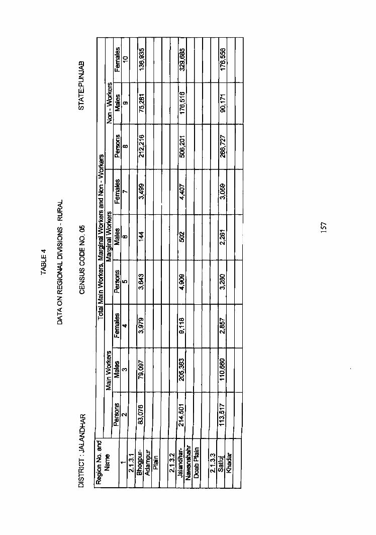
j 10
~ f8 (") as 0 0) I()
E ..... ~ ~ tti Q) ..... u. ,... ......
i m ..... fD ..... ClO
.,... ..... ~ ~
m N I() ..... a6 ~ g I .....
{5 .,...
Z
tIJ fD ..- ..... ~ClO
...... 0 ~ N N N ~ g & .....
i N N
~
_J
~ ::::> a::
I 10 (J) 0 z 0 0
Ci5 Z 'Of :> w w a 0 ....J ...I 8 m ~ ~ (J)
0 ::::> C/)
(5 z w w a:: ()
z 0
I j ~
g ..... 0)
~ ..... ~ ~ 8 -g If ri ...; ri as
i I ~ m ; ~ ..... <.0
a; ~ ~
fD C\I r:::::
...... I() N !'e '2 as ~ :::!:
~
~ I (")
~ 0
10 ~ ClO
~ N ri ..f ri
r::::: 'n; ~
~ C§
as '0 ~ t- O) ClO .....
J ~ S> ..... 10 ...... ClO ri a) N
I m ..... ~ ~ 8 (")
~ ~ (")
a) a6 0 r::::: ..... ~ ..... ..... 'ca ::IE
fIJ fD ..... ..... c: ..... 0 ..... ~C\I 0 I() &0
ri ...; ri ~ ClO ~ .....
C\I .....
"0 I: "-as
I) .... .!.. I r:::::
~ ~ ...... .~ C\I i
'n; (") ':; ! ~
r::::: C") a:: ~ :J ..... E ~ J 1ii §z .... I'G a.. ......
~ .....
N ~ N ~
N C/)
I
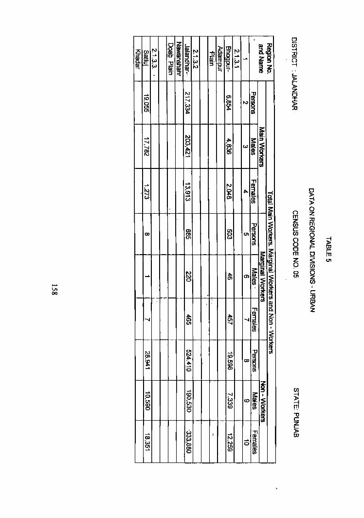
.
~ z Iu m:;t)
§ C/) !" ~ iii !" -tJ 6: i !" a~ e!. _"
~ m ~ ig' [ W :J :J e!. r§ ~ .....
~ "0 i 0. W
m ~ or i N :J c: _.. ~~ .., c i' 5' ::T \' .... . ~
_.. N " to _.. a> II)
'0 ;-I (l) N ~ en w ~ en ~ :J (II
3: ...... N m. ...... 0 .,.. so: ::J
:.." w ex, w m l OJ b. w m N N a> ..... CD CiI
..... " ..... N
~ '" w
~ ...... (0 .,.. -4
w ..... co CD S w (II ~
~ ~
3: W. :J
" ~ a> en II)
OJ OJ 0 en ~ ~ U1 W CD :J iii (II
~ 3: 1».
~. ~. :J
~ .,.. so: i !!!.. .... m m ~ 0 a> [ ~
. i i CiI CiI .. I»
" :J 0. .,.. .,.. II) Z ...... a> en ...... ~ 0
<.n ...... :J
if • ~
() 0 z m :;t) z en m c Gl en 0 8 ~ ~ 0 hi m 0 z ~ U1
P C/)
0 5 en z en
c ;:0
~ z
~ N <.n ..... "0 CiI co ~ to CD
f .".. , (n CD § ..... .... ~ 0 1/1
_. ..... ~ 0 to :-J 3:. (n 0 W <0 m
~ to Ot w m-0 w to
0
_.. W I _.. " 5» w N II)
W ..... ~ w CD '" 0 U1 co U1
if .... 0 to
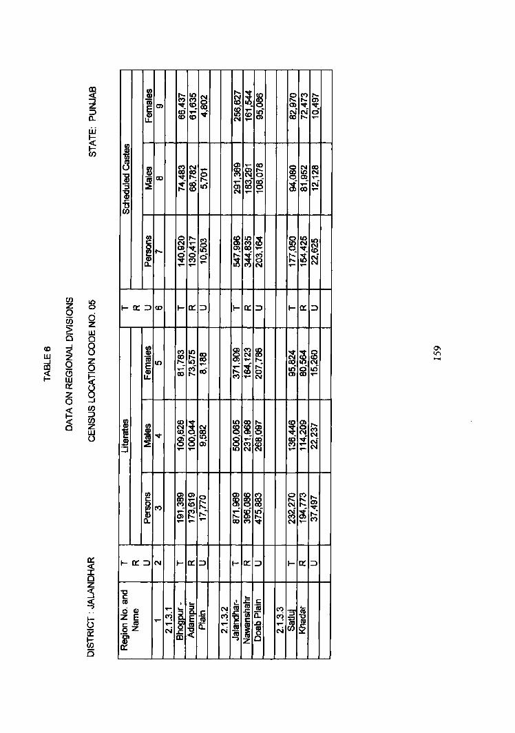
III I ~ ~-~ ~ ~ ~ ~ ~ ~ ~ Z "iii 0) v_ <0_ v ::> i ~ ..... • ~ ..... g ~ ~ d CD a.. LL CD N ..... .....
w ~
~ I-en 8 I ~ ~ .... ~ ~ ~ ~ ~ ~ i 1i co ~ g g .....
::::E ~ co It) ..... ! ..... N ::s <0 ~ co .....
i ..... ,.... .s:::: u en
I/)
~ ,..._
~ ~ ~ cg § ~ ~ J .-,.... v_ .....
~ 0 ci g ~ ~ ~ t, ~ (") ,..._ ..... ...... ..... N ..... .....
CJ) It) z 0 1-0:::::> CO I- a: ::> I- 0::: ::> I- 0::: ::> 0
~ c;; ;> w 15 Q
CD ...J 0 I § ~ ~ "" w ~ (J
~ ~ :g ~ ~ ~ V")
z ~ ..... ,..._ -...J 0 It) ...... t ~ ID 0 ..... ~ g It) C3 CI) ...... (") a)
~ ~ ~ u. co ,..._ ..- N ..... W 0::: (J Z 9 0
~ en ::>
C§ en ~ ~ ~ 8 ~ § !_ g
~ z i ~ w "t (J 'iii v 8 8 10
~ ..... ~ ~ v N 19 ~ a) ~ .....
::i ..... - ..... ..... N
1-0:::::>
KAPURTHALA DISTRICT
REGIONAL DIVISIONS
Kapurthala district is the smallest district in the state. It is physically
separated into two parts, viz., Kapurthala and Sultanpur Lodhi tahsils on the one
side and Phagwara tahsil on the other side. Both are separated from each other by
about 30 kms. For the purposes of regional divisions, Phagwara tahsil is covered
under Ialandhar district.
The area covering Kapurthala and Sultanpur Lodhi tahsils is bounded by
districts of Amritsar and Gurdaspur in the west, Hoshiarpur in the north, Jalandhar
in the east and Firozpur in the south. River Beas flowing in northeast to southwest'
direction separates it from Gurdaspur and Amritsar districts in the north and west,
and river Satluj flowing in east- west direction separates it from Firozpur district
in the south.
These two tahsiIs of Kapurthala district cover an area of 1,328.54 sq.km
which makes 81.36 per cent of district area. It has a population of 449,246
including 235,678 males and 213,568 females. In the district 370,957 persons live
in rural areas and 78,289 in urban areas. The rural population is spread over 585
villages and the urban is distributed in Kapurthala and Sultanpur Lodhi towns
falling in this area. It has a density of338 persons per sq. km . One- half (50.5 1%)
of the popUlation is literate. Scheduled Castes constitute 25.96 per cent of the total
popUlation. Out of the total popUlation, 31. 3 7 per cent are workers (main workers
29.77% and marginal workers 1.600/0) and 68.63 per cent are non-workers.
Climatically, this region is hot in summer and cold in winter. Rainfall is
received mainly during the monsoon months of July to September. The region
also gets some winter rains which are very beneficial for the rabi crops.
160
Sugar, cotton textile, beverages, starch, edible oils stand out as the
important commodities manufactured in the area. In addition, the Rail Coach
factory (ReF) at Hussainpur is famous for manufacture of rail coaches. Wheat,
maize, rice and sugarcane are the principal crops grown in the area. The natural
vegetation includes pipal trees, jamun, shisham, sarkanda, reeds. Soils are
Ochrepts-Orthents-Rock-Outcrops and Psamments-Fluvents-Aquents.
Geologically, the region is comprised offine alluvium.
This part of the district is a constituent ofBeas-Satluj Doab (2.1.3) and is
further divided into following two sub- micro regions.
2.1.3.1 Beas Flood Plain
It spreads over parts of Kapurthala and Sultanpur Lodhi tahsils of
Kapurthala district and includes 434 villages (252 of Kapurthala tahsil and 182 of
Sultanpur Lodhi tahsil) and Sultanpur Lodhi town. It has an area of 898.09 sq.
km. This floodplain is inhabited by 277,548 persons, 144,162 males and 133,386
females. It has a density of 309 persons per sq. km and a sex ratio of 925 females
per thousand males. In the total popUlation, 263,826 is rural and 13,722 urban by
residence. In other words, 95.06 per cent of the region's popUlation is rural and
4.94 per cent urban. During 198] -91, the population of the region has increased
by 17.50 per cent; in absolute terms it has increased from 236,211 in 1981 to
277,548 in 1991. Three out of every five persons (60.57 per cent) in the region are
literate, and one out of every four (24.72%) belongs to Scheduled Castes. Out of
the total population 30.74 per cent are workers; 28.47 per cent as main workers
and 2.27 per cent as marginal workers.
The number of towns in the region has declined from six in 1981 to only
one in 1991 due to the de-classification of five urban centers, namely Begowal,
Bhulath, Nadala, Dhilwan and Talwandi Chaudrian
161
2.1.3.2 Kapurthala Plain
This region spreads over an area of 430.45 sq. km and includes 151
villages (118 villages of Kapurthala tahsil and 33 villages of Sultanpur Lodhi
tahsil) besides Kapurthala town. It has a population of 171,698 including 91,516
males and 80,182 females resulting into an overall sex ratio of 876 females per
thousand males. It has a density of 399 persons per sq. lan. Out of the total
population, 107.131 reside in the rural and 64,567 in urban areas of the region.
During this decade, the region has recoded an increase of 23.33 per cent in its
population. Almost two-thirds (67.71%) of the population in the region is literate.
In this region 27.95 per cent of the total population belongs to Scheduled Castes.
The region has 32.38 per cent of its population as economically active~ 31.87 per
cent as main workers and 0.51 per cent as marginal workers.
The region is well connected by roads. The railway line joining Amritsar
Jalandhar and Firozpur- Jalandhar pass through this area.
The soils are Ochrepts-Orthents-Rock-Outcrops and Psamments-Fluvents
Aquents. These are alluvial soils which are very beneficial for agriculture.
Wheat, maize, rice and sugarcane are the principal crops grown in this area.
****
162
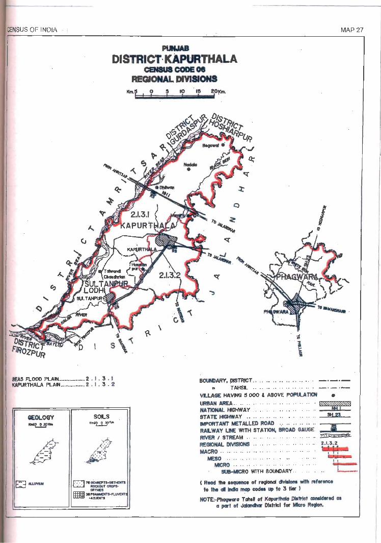
CENSUS OF INDIA .
PUNJAB
DISTRICT· KApURTHALA CEN8UI CODE os
REGIONAL DIVISIONS
I<n\f ° , , , '0 ,~ 2,Otclfl' , ' I I
c
I ,.~ " ~ ~~~~~~1~~~~~_
~ \
MAP 27
IIEAS FLOOD PtAIN. •• _ .... H.H ... _.2 . I • 3 • I SOUPI)ARY, plSTRlCT .. .• .• " •• .• •. " .. . _._ . .-KAPURTHALA PLAtL ................ 2 • I , 3 • 2
GEOLOGY -tJ.!'-
SOLS K""l,..i.!IKM
II TAHSL .................... _ ._._
VLlAGE HAVM e 000 , ABOVE POPlLATION • URBAN AREA .. .. .. . . .. .. .. . . .. .. .. .. . --'! NA TIONAL IfGHWAY .. .. .. .. .. ., .. .. .. .. _--JIiJ--_...jm..lo_-STATE HIGHWAY ........ " .. " .... .. SH.,Z3
=~~~~~~;oT=~. BR~AD' GAUGE'. I RIVER I STREAM .. .. .. .. .. .. .. .. .. .. .. ;$5· .,.~,=~ ..• ;;;S!l;6:.i. REGIONAL DIVISIONS .. .. .. .. .. .. .. .. .. .. 2 .1.3.2
MACRO .. ........ .......... .. .... .. , I I
t::.I;ii:-MESO .. ............... " . .... .. MICRO .... .. ......... .. ...... ..
SUB-MlCRO WITH BOUNDARY .. ... . .
, Read ttte .~ of rl9lond cIvlIIona with reference to the GIl IncIa map codeI up to 3 tier )
I I
NOTE:-I'tIa9wCll'G Tahal of KapurttKllo OII~t CDnIIdered al a part 0' JaIanChIr District for htcro R.CJIon.

W ...J tll
~
CI) Z o U5 5 o
~ o ffi 0:: Z o ~ (§
m « ..., z :::> a.. W I-
~ CI)
m ~ ~ 0)
~ cu LL .....
c::
j rn ~ cu ..... (ij co
~ :i: a.. .....
rn
J 1-000::Jco
.!: 10
~ a; ~ ~ ~ ..... ~ 'O;I:_ g g- o)
co N .....
~ ~ <0
~ ..... ..... .....
I.O_ 'V
~ fB ~ ,...: ..... 0) .....
1-0:::::>
..... I.C) .....
_., ....... co
...... CJ1 .....
CJ1
8 co
(') m z en c en 8 o m
~ ~
en ~ -I m
'"U C Z t.... » tD
....... CD CD .....
~ OJ rm N
III 00 0) (I) I"-
~ e N ('f') N ..- N 16 (I) N l"-LL ..-
(!?
~ ! e C')
~ LO LO
ftJ 0) 0) 00
I ::2: as ci co "ort c ~
III CD N c: N 0)
~CD N Q ..... co Q) 0') ..-(!? a.. ..- ..-Q)
t: ~ m I I"-
5 ~ I"- ..-l"- e ~ Z Q) rD
--' ~ ~
I
en z ~ 0
Ci) 0 (") > z UJ a w --' --' 0 co
~ 0 ~ C)
0 en (5 :::J W en 0::: Z w z 0 0
~ ~
"C LL c ftJ i ~ ~ .... ~ fB ~ e 0')
~ ~ co N ('f')
N ..-m c 0g
109 cu ftJ ~ ::!:
~ E1" I"-
~LO 0') 0 ~ N ~ .... Q) rD ~ a.. c: cu ::!: III
S Q) ..- N
~ "ort C"') 0
~ LO C')
(I) M M LL
(!?
~ i N
~ ~ 0)
('f') "ort
~ rD ..-C I"- LO 0(6
::2:
III C"') co c ~
N N N e I"-
Q) ci ;i a.. co
0(1) 8 cu ~E ..... c: N l! c: c: ftJ <'i LL 0(6 CO') 1::: 0(6
oZ ..-O~-g
.....
J c:: ..... ~ c:: N N
o:::cu J2
~i "m ~ ~. ~ zoo 7
_ (fJ .... II) ::::J
m. " ......
3~ 5· i w ~ ~ ::::Jg_ .... CD •
II) II) ::::J a.
Co) ~ " !JI (I)
..... ~ N 5 Co) ...... ...... ::::J (fJ
s:: II)
Co) ...... :5: ::r ..... Co)
~ (X) (0 Co) II)
~ co m Co) i (iJ
" Co) N CD ;..., ;..., .,. B! (11 ~ -I 0 m S-
et 3: m. ::::J
m " ~ ...... ~ ...... ;..., (11 (X) ~ i ::::J
(fJ iii ~ 3:
II)
tQ. tQ. :5: 5 ::::J ..... IV et
Co) ..... m II)
~ '" co m ~ i (I)
(i1 (iJ m ::::J
." a.
~ );! 0
(') z m :::0 z m en G) c
0 en );! 8 ~ r III
0 0 In m z < .,. p en 0 0 m Z
(J)
:::0 C
~ r
~ m CD Z b ...... B! 0
m ...... ::J (11 m I
~ (I)
...... ..... " (iJ .... (X) CD
;..., ..... 5 ;..., 00 .....
m ~ ::::J (fJ
Z 0
IV ~ ::::J
Co) :5:. Co IV co II)
~ co IV m 0 '" ~ (i1
.,. ..... ~ ...... ..... w ...... ..... 61 N ~ 0 m m m
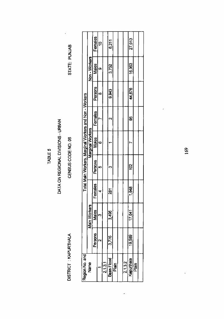
8 o z ~ o u C/) :::::>
~ w (.)
"0 c: co d Q) zE c: co oZ
1
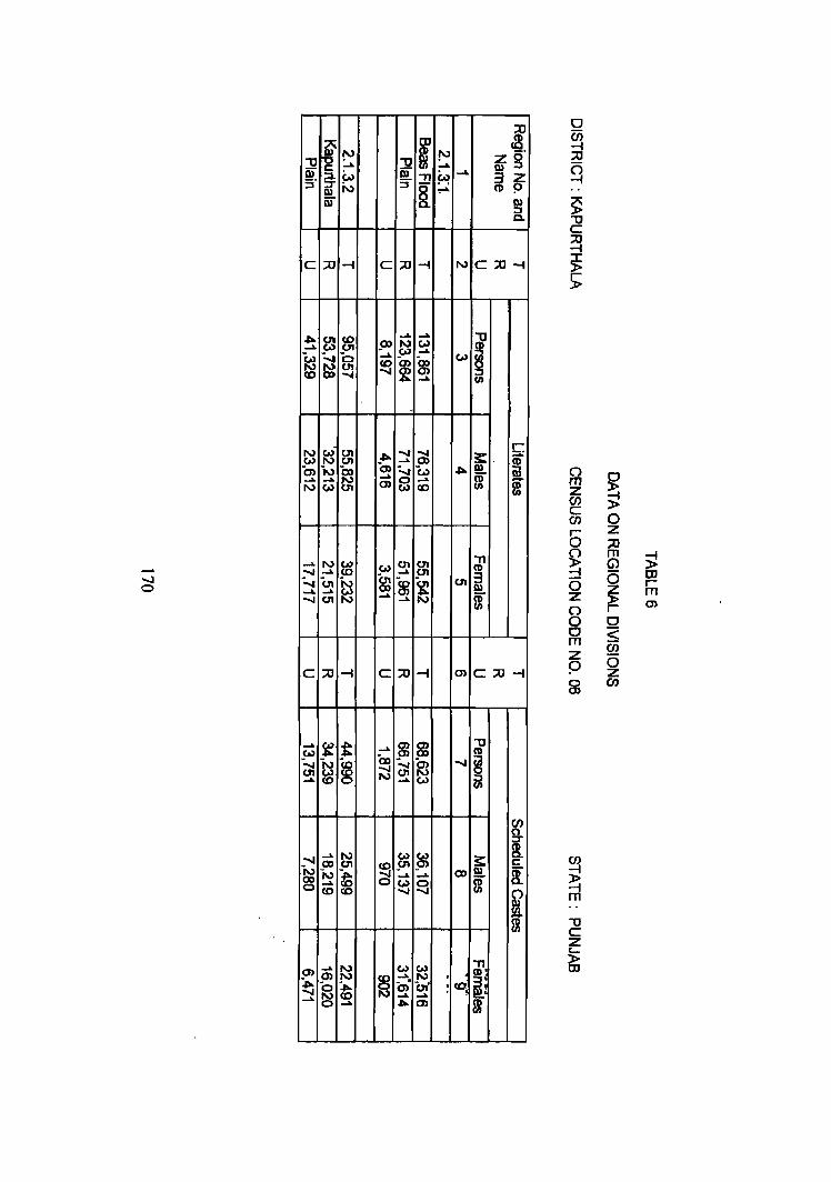
i !" -u ...... -u Q)
I:: ~. ~ ~ S' N :::J
Q)
iii
C :;;0 -i C :;;0
.". ~ ~ ......
00 N ...... 5'"
~ ~ a ...... c.n ~ ~ co 00 .......
~
~ r-1 c.n ....... 01 _.". ......
en N 00 0) :.... ...... ...... N ..... 8 N W c.n 0)
..... N W (J1 _w ....... ...... (0 ..... -....... 01 iv ~ ~ ...... ...... w
....... 01 N ..... ......
C ;;u -i C :;;0
..... ~ t ...... m w
"c,i ~ ~ 00 ~ ...... ;j ......
_ ....... ...... N ~ co 01 ~ ~ N ~
....... ..... 0 ~ CD
..... ~ w m 0)
i§ ......
~ '0 ~ en' ~
..... ..... ..... ~
f !" ..... "T1 W
......
8. ~
-i N
...... W .......
~ w
.....
~ c.., ~ ...... co
c.n c.n
~ c.n
-i m
g en ....... ~
~ ..... 00
~
w N .. 01 :(0 ..... m
l. arg 3 z CD !)
Q) ::::J Q.
C:;C-i
f f/)
c: S:. CD ~ f (I) f/)
"T1 CD
i m
C;;o-i
-u (I)
~ i
en g. s: ~
I:: ~ a. m
i "T1 ~.
i
() m z en C en r 0
~ -i 0 Z () 0 C m z 9 0 m
en ~ -i m
-u C Z
~
~ ~ 0 Z :;c m
~ G> 0 [II
r ~ m r m C < en 0 z en
DISTRICT FIROZPUR
REGIONAL DIVISIONS
Firozpur district is located in the west and southwestern part of the State
along the Indo-Pak border. It is bounded by Amritsar, Kapurthala and Jalandhar
districts in the north, Ludhiana and Faridkot districts in the east and Rajasthan
state in the south. International boundary with Pakistan makes its western
boundary. This district has been separated from la1andhar and Kapurthala districts
by Satluj river in the north which is a perennial river and flows in northeast -
southwest direction.
Climatically Firozpur district is dry and characterized by very hot summer
and severe cold winter and short rainy season. The temperature increases rapidly
from the end of March and continues till June which is generally the hottest
month. With the on set of monsoonal rains the temperature starts declining some
what from July. The rainfall is mainly received during monsoon months of July to
September and decreases from northeast to southwestern part of this district.
Physiographically, Firozpur district constitutes part of the Punjab Malwa
Plain(2.1.4) micro region which is largely a flat and featureless plain and forms
part of the main the Indo-Gangetic plain. Wind action is also active and it has
played a rol~ in shaping the relief of the district and occurrence of sand dunes due
to the swift winds is noticeable.
Firozpur district covers four tabsits which among themselves include 1, 162
villages (including 44 uninhabited) and 10 urban centers. As per 1991 Census this
district is inhabited by 1,607,817 persons among which 848,764 are males and
759,053 are females. The district has an area of 5,874.0 sq. Ian out of which
5,779.75 sq.k.rn is rural and 94.25 sq.km is urban. It has a density of 274 persons
per sq. km as against 222 in 1981. The sex ratio in the region has increased from
171
884 females per 1000 males in 1981 to 894 in 1991. Among 1,607,817 persons
in the district. 1,223,417 are residing in rural and 384,400 are in urban areas.
During 1981-91, the population of Firozpur district has increased from 1,304,713
in 198] to 1607,8]7 in 1991 exhibiting a decadal growth rate of23.23 per cent
during this decade. The district has a literacy rate of 48.00 per cent; 56.88 per cent
among males and 38.11 per cent among females. Between the rural and urban
areas the literacy rate is 41.59 per cent and 68.16 per cent respectively. In the
district 350,461 are recorded as Scheduled Castes among which 186,964 are
males and 163,497 are females. Among the Scheduled Castes 22.70 per cent are
living in rural and 18.91 per cent in urban areas of the district. Out of the total
population of the district 487,246 are reported as main workers, 29,278 marginal
workers and 1,091,293 are non-workers. In other words 30.31 per cent are main
workers, 1.82 per cent marginal workers and 67.87 per cent are non-workers.
Firozpur district is comparatively less developed. It has medium size
industrial units. Cotton ginning, processing and spinning of cotton, manufacture
of wires, dhoop making, hand loom weaving • manufacture of agricultural
implements and flour mills are the activities carried out in the important towns of
the district.
The main sources of irrigation are canals and tubewells. Wheat, maize,
cotton, sugarcane, pulses, barley, gram, and rice are the main crops grown.
Natural vegetation includes neem, kikar, pipal, jamun, mango, sarkanda and
reeds.
The geology of this district is alluvium and the soils are Psamments
Fluvents- Aquents in the northwest and western parts, Orthids- Fluvents in the
southern part and Ochrepts - Psamments in the northeastern parts of the
district.The main economy of the people is agriculture based.
172
Firozpur district is part of Punjab Malwa Plain (2.1.4.) and based on
physio- geographic factors it is divided in fonowing 3 sub-micro regions.
2.1.4.1 Satluj Khadar
This region spreads over parts of Zira., Firozpur and Fazilka tahsils. It
covers 645 villages (293 Villages of Zira, 267 villages of Firozpur and 8S villages
of Fazilka tahsils) and urban centres of Kot Ise Khan, Dharamkot and Fazilka.
The Western boundary of the region is surrounded with the International border
with Pakistan. Amritsar, Kapurthala and lalandhar districts lie to its north and
Ludhiana district to the east. It is surrounded by Firozpur Plain and Abohar
Sandy Plain in the South. Satluj river flows along its western boundary in
northeast - southwest direction. Most of the villages are located along the river
course are subject to floods during rainy season. The soils of this region are
Psamments-Fluvents-Aaquents and Orthids- Fluvents which are sandy to silty
clay-loam alluvial and low humic clay soil soils offlood plain (Bet areas).
Satluj Khadar region IS inhabited by 517,801 persons among which
272,386 are males and 245,415 females. It has a density of population of 270
persons per sq. km and a sex ratio of 901 females per 1000. Out of the total
population 440,188 are residing in rural and 77,613 in urban areas. The
population of this region has increased from 409,920 persons in 1981 to 517,781
persons in 199] showing a decadal growth rate of 26.31 per cent during 1981-9l.
The region has a literacy rate of 40.61 per cent. In this region 17.77 per cent of the
population is Scheduled Castes and this percentage is significantly lower than that
of Punjab. In the total population, workers constitute 31.97 per cent of the total
population; 30.40 per cent as main workers, and 1.57 per cent are marginal
workers.
The development of roads and railway is fairly good. National Highway
No.IO connecting Fazilka with Abohar, N.H. No.IS connecting Tam Taran with
173
Faridkot and State Highway No.20 and No.16 pass through this region. The
region is connected with rail too. Agriculture is the main activity of the people of
this region. Wheat, maize, rice and sugarcane are the main crops grown. The
natural vegetation includes shisham, pipal, neern, phulahi, jamun, mango,
sarkanda and reeds. Tall grass (munD, generally 3 metres high grows along the
nver course.
2.1.4.2 Firozpur Plain
This region spreads over part of Zira, Firozpur, Fazilka and Abohar tahsils
and covers an area of2,838.84 sq.km. This makes 48.33 per cent of the total area
of the Firozpur district. -It covers 434 villages (82 villages of Zira, 207 villages of
Firozpur,121 villages of Fazilka and 24 villages of Abohar tahsils) besides six
towns namely Zira, Talwandi Bhai, Firozpur, Firozpur Cantt., Guru Harshai and
Jalalabad. It is inhabited by 794,770 persons including 419,724 males and
375,046_females. This region has a density of 281 persons per sq.km as against
231 persons per sq.km in 1981. It has a sex ratio of 894 females per 1000 males.
Out of the total population, 597,146 are residing in rural and 197,624 in urban
areas of the region. During this decade, the population of. Firozpur Plain has
increased from 657,338 in 1981 to 794,77U in 1991 at the decadaJ rate of 20.91
per cent during this decade. 54.15 per cent population in this region is literate.
About one- fourth (24.36%) of the population belongs to Scheduled Castes. In this
region 32.02 per cent of the total population is working; 30.32 per cent as main
workers and 1.70 per cent as marginal workers. The non-workers constitute 67.98
per cent of the total population.
The region has a welJ developed system of roads. National Highway
N.HIO, State Highway No16 and SH 20 pass through this region. It has rail
connection too. All the main towns of the region are well connected with roads
and railway lines. Cotton ginning and baling is the main industry. Soils are
Orthids-Fluvents and Ochrepts-Psamments. The geology of the region is alluvium.
174
Wheat, gram and cotton are the main crops grown. The natural vegetation includes
kikar, neem, mango and thorny bushes.
2.1.4.3. Abohar Sandy Plain
The region is located in the extreme southern part of Firozpur district. It
spreads over 83 villages (33 villages of Fazilka and 50 villages of Abohar tahsils)
besides Abohar town. This region has a population of 293,246 inc1uding 156,654
males and 136,592 females and an area of 1,115.82 sq.km. Out of the total
population, 186,083 is residing in rural and 107,163 in urban areas of the region.
The density of population in the region is 266 persons per sq.km as against 220 in
1981. The population of Abohar Sandy Plain has increased from 250,546 in 1981
to 293,246 in 1991 exhibiting a growth rate of 2l.91 per cent during 1981-91.
This region has a literacy rate of 39.50 per cent and 22.09 per cent of the
population belongs to Scheduled Castes 30.30 per cent of the population is
recorded as main workers, 2.59 per cent as marginal workers and 67.11 per cent
non-workers.
Numerous sand dunes can be seen in this region. The main problem of
this region is wind erosion especially in the southern parts. The development of
roads and railways is good. National Highways No. 10 and 15 and State Highway
No.14 pass through this region and connect Abohar town with Hanumangarh
(Rajasthan).
The soils of the region are Orthids-Fluvents and the geology is alluvium.
Agriculture is the main occupation and wheat, gram and cotton are the chief crops
grown.
*****
175

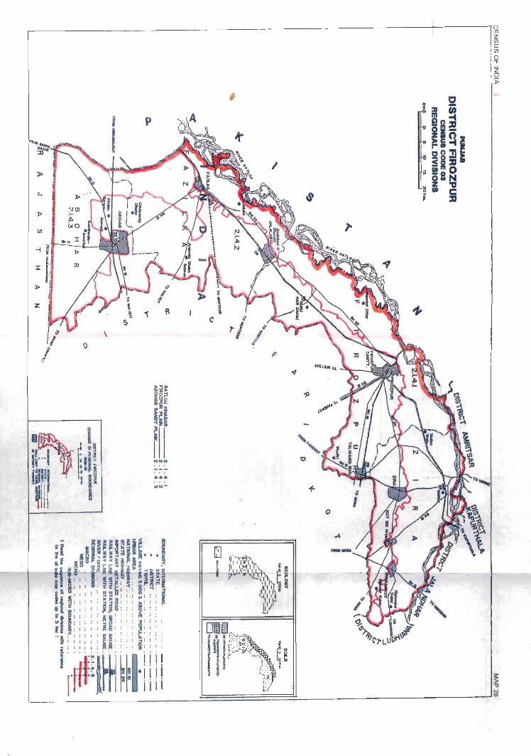
:z: ~ f\
\ C
--" ,
#
c
o

(/) I.() Ct)
~ ~ ~ ~ ~ m Q) ..... ~ .....
"ffi en v ~ ~ N E ~ ~ ~ I.() ....
~ ~ ,..: ~ Q) ~ re 00 u.. N ....
c: ~ ~ ..... ~
,... ~ ~ ~ ~ 0 [6 It)
~ ,... ~ '"
,... I.() lU 00 g 0) It) ~ ,... m m rei ~ ~ Ct) ..... ,... .....
N ..,. ..,. (f) ..... .....
~
(/) .... ~ ('I') ~ ~ ~ ~ ('I) ('I')
c: ~ :8 co ~
,... ,... ,... co .... '" ",-
~ <0
~ li ~ g g ~ Q) u; r::: 0.. '" It) ..... N .... ....
CJ) z 0 Ci5 Ct)
5 0
(5 d z
I-O::::::J co I- 0::: :::J I- 0::: :::> I- 0::: :::>
..... ...J W W ~ 0 ...J 0 0 III 0 ~ a z w
0::: 0 z F 0 C3
N
~ ..,. I.()
~ ~ N It) ..... ..... m en co '" E; . 5 It) ai l ~ ~
..... It) bi .... <'Ii f8 .... tt)
~ O! ..- ,.._- ..- q_ N ..... ..... N N ..... ..... or:(
~ 0 ...J
c5 CJ) :::>
I-O::::::J ..,. I- 0::: :::J I- 0::: :::J I- 0::: :::J
(/) z w 0 &::
_.5 .~ o I/)
co . ~ ~ ('I) (f) ..... o ..c: ·z 0 -co
Q)
.5 m § 0>'-
~~ It)
~ Ct)
> N ;Z IX)
'0"6 o lR z
" c: co "-'w ,... .= 10 N § c: ('I')
I I~ c: ~ E ~ :::J ~ ~ ..... ~ i I::J 'ffi 'n;
c: co ..... 2
..... a:: ..... 01 a:: oZ <'Ii <'Ii ... <'Ii
~ u::
..... 00 o
~
......
i N ; ~ ~ (,oJ
~ (,oJ
~
'"T1
~:f ra c: ..... "U iii 3"
U) .... ~ m
7l w .... ~ m ~ N ; w ..... ...... w 1'6 !Ji ......
h 6' ~ -i ~
..... ~ ..... (") N ~ !» ......
¥J .... ~ ..... ~ ...... ~
!'l ...... ~ N
N 01"
...... 0 ...... I ......
N !JI ......
~ ......
~ ......
~
O) N
"'" ~ N 0, w 0)
~ _N ..... en 0 en 01
CIt !» ...... <0
f> ~ h !'l .....
~ z !'J ~ !=> ...... N
~ N
~ w ..... ......
i Cf ..... en .....
f ..... I» Ci
I 5"
~" 0
~ :::I
."
~" [
..... .... "'"
~ t6 N .....
~ I ..... ...... to ..... co w (XI
W
it ~ N .... ~
..... ? ~ C1I ...... ......
0'1 J.. ~ N N N ......
.!'l co ~ m S$ ..... 01
-~ N
~ ~ ~ N ..... !JI J,..
~ ..... ~
N
~ ...... ..... ..... 9>
I
~
...... 5 :::I W N N w P m ~ ..... !JI
...., ..... z !'J :p..
~ N
~ ~ ..... ...... ..... ~ ~ cp
...... ...... N ~ I\) ct k ......
~ en ......
~ ~ N Q)
iil ~ ~ ~
::J 0> Q)
~" ..... i ~ I ...... 5" N ...... g .!'l ~" ~ ...... ....
~ ~ .... c:p g ~
l ~ ~
!'> Z c)' ..... I» ::J
~ ..... 3z I .s:
..... ..... (I) P I» ::J a.
"Tl
~ cr ~ ~ ii1 N
C ~" .....
Oi ...... m N ...... .... ~ ~ ~
I
~ ......
S [ ~ ~ i:.n N ..... :::I
~ m ~ ! N ...... i:.n
~ ~ ~ en _" ...... w ...... < g
~ ~ i:.n ...... ~5r~ co
~ ...... ~ w .....
~ ~ .....<0 N
~ ..... m (I) .:"I ~ ...... j:j W I»Z (J) (J) I
9 ...... co en !=> "C (I) 9. ..... :::0
m
<: -I N N ::: S-(J) <0
"'" ~ a e!-..... W (I) Z (I) !=>
<: -I
~ ::.: S. I I»
0'1 9,-c.n Z P
..... (0 d ...... en ~ iiI .....
"'" » ...... m
* :::0
..... c: :i" i!l ...... ~ CIt
!2 0
(") f; r-
m § z (/) C/)
c m ~ (/) ::;;
0 r- CD 0 S; r-0
m m (j) N
Z m
0 (") 0 0 0 (,oJ m Sf) ..... <0 <0 ......
N ...... c N co i (0 co ;:,
::j h ~ 0 ~ ..... 9 ~ ~ 6' ~ ~ (,oJ ..... ~ - ..... m .....
~ ......
~ N I» N ......
0'1 ~ 0 ...... ..... 9 Ci 9 ...... I\)
~ ::T I
3' ...... c:p I» ~ m N ...... :::I
~, .0'1 :::0 N 0 f
(I)
~ ..... i ~
~ ~ N <0 ...... g <p g ..... i I 5 *
.... ~ -N :....a ..... ~
~ .....
~ ...... m en ~ w ...... CIt
"'" N
..... g ~ .....
CJ) .... ....
~ an N N C
~ ~ ....
~ 0
~ .5 0 .... ~ g .~ g C N N C ~
~ N ~ ~ .-
~ N
C ~ E .0 .5 ~ t5 en 0 .... 0 m .~ N N ('I) en .~ ('I) .~ I
~ ~ ....
~ ~ ~ ....
~ .....
~ ~ r!. I
1.0 g en .... .5: .... N .5 .....
~ 'V c 1.0
~ ~ .0 .... ..... N .... .-
~ N
~ fB ..... ~ ~ ....:
~ g ~ ~ g ~ c en ....
~ en .... 0 en g ..... ....
;! g ~ 0) N ...... ~ l5 ~
..... ('I) N
~ ..- .n N ..... ('I) cb .... t ('I) .... N v_ g N .~ an .... N g N ....: cO g 'V
~ .... ~ ..... N .....
~ ~ ...... .... ~
N .... .... 5
..... 0 .... ~
.... ..... 0 c ('I) ~
.... N N
~ N .5 z N N ~ Z 0
~ ..... g ~ cD g .~ g g g ~ g g cj ~ ..... ~ .~ ..... (") N ..... N N ('I) .... en ...J N N
...... 0 M N
1.0 ...... N CJ) o_ ..... N OJ &ri ..... ..... -00 .... ......
('I) OJ
...... .... v ('I) 0 0 ('II N ..... N ('I) 1.0
,
t::: ('I) f8 ..... ~ ~. N c:J:,
~ ~ rh b cb g ('II .... 0
('II ~ ..... ~ N 'V ..... re -a; .... N ~ CJ) .0 ......
re f8 I m 1.0 ....
~ 0 ......
d! N ('I) ..... ('II 1.0 ..... ~ ch ~ *
I
~ 0 ~ I ..... ~ ~
..... ..... ('II co ~ 1.0 1.0
:g C\I
~ (¥)
! .... cO .... C\I 0) ..... ....: ~ cO r!. ri
~ ....: ~ v
~ ~ ..... ..... 'V ..... .... .... ('I) N N ~
..... C\I ~ ~ ('I) ..... ..,f ~ ..... ~ N t ..... .n ...... ~ ..... g ..... .... ..... .....
1.0 C\I N v ..... ..... N ..... N ..... ....
~ ...
~ ...
~ cu cu -'= -'= e .~
~ .~ .8
u:: u. u. «
('I) Ii
c ~ CJ)
~ ·ffi ..... a:: N
«
-00 N
i 3l !:!l. :::J
i !" ..... ~ • W ::l
<» <»
~ <»
<» W
~
(71
'0 -..& .,..
-..&
~
~ .....
-...I N .... m
..... <0 0>
~ .....
...., N .. <» co
......
~ w 0 N
'TI !" i ~ ~ f· ..... ..... • ~ N ~ .....
t\) ..... .,.. (71
P -..&
~ ~ ..... <0 (0
N ..... t\) (71 -..& 0
~ en N 0)
..... ~
m ..... ""..,J ...... (0
UI (.0)
..... !» w en .....
N ~ UI
-..& § ~
...... N -..&
00 en ..... C1t -...I w
i! w (JI
N I\)
jo.) N 0> ~ 0>
...... ..... <0 ..... ...... ...... ...... N en C1t ...... <»
W N (71 ~ ...... ...... Co 0 ~ UI
~l fg· .....
(J)~
N f (II
3: ~.
~ ~ ~
m i "T1 CD
i A i m s:::
II)
:i"
~ ~ 0 Z
-u ~ CD U1 ~ f
(I) ~
~ s::: ~. i i i
0)
~ ~ m
~ ~ " I» CD :::J
-..& 3 0. Q) Z I g
:;;u 0 m m G) z 0 C/)
~ c: ~ C/)
0 r 0 m 0 $ w
~ (/)
~ 0 z a C/)
• d );! r
•
-u l (I) Q) ~ CD
(i! :::J (I)
Z 0 ::l
3:' CD II!. i II
UJ
" (I) ..... i 0
m
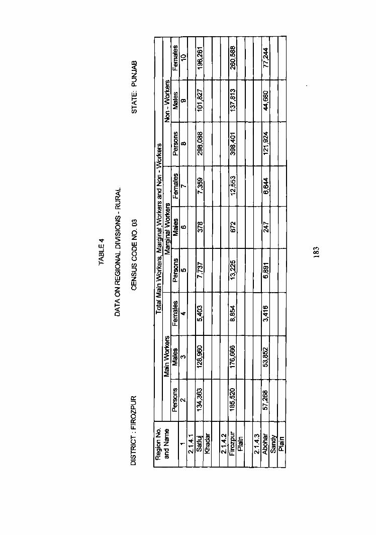
UJ
~ 0 .... LL
r!! ~ fB ~ ~
Ol I
c: ~
UJ r:: ~co !!?
Q) Q)
~ 0..
~ I
....I
~
r:: gJ 0 z ~ ..... "'C r:: Q) m LL
::J a: (/)
C") Z 0 0
(i) d "'II' :> z w Q w ....I 0 00 ....J 0 ~ ~ (.)
0 (/)
a ::::> en w z 0::: W Z (.)
0
~ e ~ ~ 0
fa ~. ~ ~
<0 1\1 ~ r::
l:e 'g. m :::E ~ ~ UJ
~ c: ~U)
~ Q) Cl..
r:: 'm ::E
~ ~
iii UJ
~ Q)
~ "It Q) LL
I ! ('t)
r:: ::?! '(6 ~
UJ r::
~ N
~~ r:: m oZ .....
&~
.... CI) (D f8 N
m ci <0 .... N
...... C")
~ .... co
..... ,...: 0 C") .... ....
co ..-~ 0
"'II'
~ cO C)
N C")
Ol C")
It) 10 (I') 10
...: N ...-
Ie N ......
C") <0
10 ..... C") ~ ..... ...: M .....
C") ~ 0 .... co t6 as
0 ~ ~ co c6 cO N ..... ..- ..-
C") 0 ~ N
10
~ t6 co or-' or-'
tv ... ..- 'S' N § ~ i ~ ~ ~ .....
2 ....
N N u:
~ ,...: l"-
0
~ t
~ .,... N or-
~ cO
I"-
~
or-C» co cO
co or-.... M
N 10 co ri 10
to co N ...: It)
.... r:: C")
~ ~ ~ .... N «
i-g c:: '(ij
~ a:
C"') 00 -
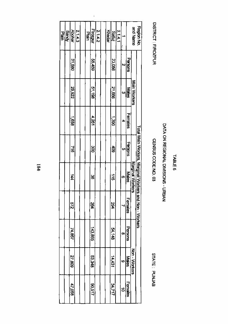
...... 00 -I;lo
01 01
& co
~l z o· III ::I 3 Z CD 9
o
~ ~ !!
2 "U C ;:0
fri Z (/) C (/)
o o ~
~ s
(/)
);! -i m
~ ~ o Z :::0
m o ~ o :S en o z (/)
C :::0
~ Z
~ ,..... m 01
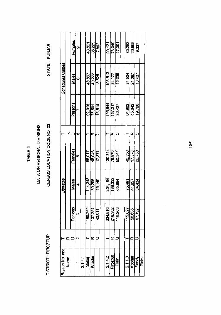
CIJ en Q) T""
~ (Xl
I 0) ~ <t: en 0
-, ("') ~ ...: Z "lit :J LL CL.
w I ~ ,__: (.) b> ~ UJ CIJ 10
~ ..9! CO CO N ~ tU t!j ~ :; :2 en "0 Q)
"6 (/)
CIJ 10 T"" "It c: ~,..._
..... 0 ..... 0 10 10 N :e cO Q) en ..-0...
(/) ("')
z 0
0 0 1-0::::::> ._ 0::: ::> (/) z <0
5 w 0 Cl
....J 0
<0 <t: 0 w z CIJ
Z Q) ...... ~
..... ...J 0 0 "iii ,.. lX; m en ~ (!) ~ E 10
t6 cO ,..: w Q) <0 "It ..-0::: (.) lL
Z 9 0 (f)
<t: :::> ~
(/) 10 z CIJ CIJ 10 ~ 0 w Q) Q) ~ ~ (.) ~ "iii "It .... "It oi It)
2 ~ .... ::::J .... co N
T""" 0 ..-("') (!; ~ ..... ci C') ...: 0) ,..._ .....
("')
~ ~ T""
~ .... a ~ 0) ..- ..-
~ ,..._ ,..._ ..... N N
g ,..: "lit
~ 10 ..... ....
I- 0::: ::>
"It ~ ~ .....
("') en g ri g ,...
~ ~ ~ T"" ~
~ ~ It) T"" co
I-cr,:::>
,_ ~~c: ~ N'm ...... 0-N ,!:: CL. u..
~ ~ ~ ("')
g 0 0) N
~ ~ r;; "It
~ t ci .....
~ ~ ~ i t6 oi
"'It ..-
I- a:: ::>
l/') 00
~ ~ ~ (") I() I"-
~ ,..: ~ ..-
..... 10 ~ en "It q "It
¥i ~ ..... "It
DISTRICT LUDHIANA
REGIONAL DIVISIONS
Located in the central part of the State, Ludhiana district forms part of Punjab
Malwa Plain (2.1.4) micro-region. It is bounded by lalandhar district in the north,
Rupnagar district in the east, Patiala and Sangrur districts in the south, and Firozpur
and Faridkot districts in the west. Satluj river flowing in the north in east-west
direction separates it from lalandhar district.
Ludhiana district is comprised of 4 tahsils namely Jagraon, Ludhiana, Samrala 1
and Khanna. These tahsils among themselves include 979 villages (including 18
uninhabited villages) and 10 urban centres. The district covers an area of 3,857.00
sq. km and is inhabited by 2,471,594 persons among which 1,340,039 are males and
1,131,555 females. Out of the total population in the district 1,228,813 is rural and
1,242,781 urban by residence. This is the only district in the state where the
proportion of urban population (50.28%) is higher than the rural (49.72%). The
district has a density of 641 persons per sq. km as per 1991 Census which is
significantly higher than that of 472 recorded at the 1981Census. During this decade
the population in the district has increased from 1,817,651 in 1981 to 2,471,594 in
1991 showing an absolute increase of 653,943 persons. In percentage terms the
district has recorded a growth rate of 35.98 per cent which is significantly higher
than that of the state (20.81 %). In the district 67.35 per cent of the popUlation is
literate; the male and female literacy rates are 72.47 and 61.23 per cent respectively.
Among the districts in the state, Ludhiana ranks 4th in literacy rate. Almost one
fourth (27.74%) of the district's population belongs to Scheduled Castes. Workers
constitute 31.26 per cent of the total population and the remaining 68.74 per cent of
the population in the district is non-working. The share of the marginal workers in
total popUlation of the district is negligible.
186
The climate of Ludhiana district is extremely hot in summer and severely cold in
winter season. The maximum temperature is recorded during the month of June and
the minimum temperature during January. The district receives rains during the
months of July to September. The winter rains are also received in the months of
December to February and these are very beneficial for the rabi crops. The soils are
Psamments-Fluvents-Aquents, Orhrepts-Psamments and Ochrepts- Orthents. These
are alluvial soils and are very fertile. The geological structure of this district is
comprised of alluvium.
The district has a wel1 developed net work of roads and railways. National
Highway No.1 and State Highways No.ll and 18 pass through this district. The
railway line connecting lalandhar town with Rajpura and Ludhiana city with Moga
via Jagraon and Malerkotla pass through this district. All the important towns viz.
Ludhiana, Doraha, Khanna and Jagraon are linked through major roads.
Ludhiana district is famous for the hosiery. both within and outside the country.
Ludhiana district has occupied the top position in industries in the Punjab State. The
most important industries are cotton ginning and pressing, oil-seed crushing, flour
milling, leather tanning, motor parts, agricultural implements, surgical instruments
and electric fans. It is also famous for manufacturing of engineering goods, cycle
and sewing machine industry Wheat, rice, maize, sugarcane, groundnuts and cotton
are the main grown crops. The natural vegetation includes shisham, pipal, neem,
kikar and tahU.
Ludhiana district is a part of the Punjab Malwa Plain (2.1.4) tpicro-region and is
sub-divided into following three sub-micro regions on the basis of soils, climate,
natural vegetation and topography.
2.1.4.1. Satluj Khadar
187
This region extends over the part of Jagraon, Ludhiana and Samrala tahsils of
Ludhiana district. It is bounded by Jalandhar and Hoshiarpur districts in the north,
Rupnagar district in the east, Firozpur district in the west and Western Ludhiana
Plain and Eastern Ludhiana Plain lie to its south. Satluj Khadar region includes 296
villages (59 villages of Jagraon, 158 villages of Ludhiana and 79 villages of
Samrala tahsils). It covers an area of 826.32 sq.km. The region is inhabited by
186,300 persons among which 98,369 are males and 87,931 are females. This
region is entirely rural. It has a density of 225 persons per sq.km. Most of the area
of the region is prone to floods during rainy season. The climate is very hot in
summer and cold in winter season. The maximum height of 248 metres above mean
sea level is found near village Kariana Khurd and the minimum height of 242.5
metres above mean sea level is observed near village Manewal of Ludhiana tahsil.
There is a pocket of Mattiwara reserved forests near village Mattiwara. Natural
vegetation includes kikkar, neem, phulahi, jamun, mango, shishsarn, reeds and
sarkanda. Besides, tall grass ( about 3 metres high) is also found along the river bed.
The National highway (N.Hl) connecting Ludhiana-Phillaur crosses through this
region. Besides, this region has a network of roads connecting Ludhiana-Rahon,
Jagraon - Nakodar. Arnbala-Amritsar railway line passes through this region. The
soils are Ochrepts-Psamments and Psamments.:Fluvents-Aquents. Industrially the
region is not well developed.
The population of the region is 186,300 ( 98,369 males and 87,931 females) and
has a sex ratio of 894 females per 1000 males. It has recorded a decadal growth rate
of23.14 per cent during 1981-91. It has a literacy rate of55.80 per cent. The region
has 69,044 persons belonging to Scheduled Castes and this makes 37.06 per cent of
the total population of the region. In this region 29.42 per cent of the population is
recorded as workers and 71.58 per cent as non- workers'. Agriculture is the main
occupation of the people and wheat, maize, rice and sugarcane are the main crops
grown.
188
2.1.4.2 Western Ludhiaoa Plain
This sub-micro region extends over parts of Jagraon and Ludhiana tahsils. It is
surrounded by Satluj Khadar in the north, Eastern Ludhiana Plain in the east,
Sangrur district in the south, and Firozpur and Faridkot districts in west. It covers
259 villages (132 villages of Jagraon and 127 villages of Ludhiana tahsiIs) besides 5
towns namely Jagraon, Raikot, MuUanpur Dakha, Ludhiana and Akalgarh. The
population of the region is t660,155 among which 908,471 males and 751,684
females. Out of total population 533,280 lives in rural and 1,]26,875 urban. This
signifies that the region is more urban (67.88%). This region is highly densely
populated as being the industrial hub of the State which attracts migratory
population~ it has a density of 1,019 persons per sq. km. The sex ratio is 827
females per 1000 males. The region has experienced a growth rate of 45.90 per cent
during 1981-91, and 20.15 per cent of the population belongs to Scheduled Castes.
31.90 per cent of the population is recorded as workers and 68.10 per cent are non
workers.
Ludhiana city and other towns are well connected with roads and railways.
National Highway No.1, and State Highway No.ll and 18 are the main routes
passing through this region. The region is weU connected with railway also. The
climate of the region is similar to other parts of regions of Ludhiana district. Soils
are Ochrepts-Psamments which are very fertile. Wheat, maize, rice, sugarcane and
grams are the principal crops. Natural vegetation includes neem, kikar, pipal, jamun
and mango.
Educationally, the region is well equipped. This region is having numerous
educational institutions. Punjab Agriculture University is located at Ludhiana.
Besides, this region has engineering and medical coJJeges located at Ludhiana city.
Manufacturing of hosiery goods, woolen mills, cotton ginning and baling, light
engineering goods inclusive of agricultural implements, machine tools, sewmg
machines. cycles, auto-cycles and silk textiles are important in the district.
189
2.1.4.3. Eastern Ludhiana Plain
The region extends over the parts of Ludhiana, Samrala and Khanna tahsils.
Eastern Ludhiana Plain is surrounded by, Satluj Khadar in the north, Rupnagar and
Patiala districts in the east, Sangrur and Patiala districts in the south and Western
Ludhiana Plain in the west. It covers 424 villages (92 villages of Ludhiana, 180
villages of Sarnrala and 152 villages of Khanna tahsils) and 5 urban centers viz.
Samrala, Machhiwara, Doraha, Payal and Khanna. The region covers an area of
1,401.52 sq.km out of which 1,371.18 sq.km is rural and 30.34 sq.km is urban. The
region is inhabited by 625,139 persons including 333,199 are males and 291,940 are
females. The density of population is 446 per sq.km compared with 403 in the State.
The population of the region has increased from 529,788 persons in 1981 to
625,139 persons in 1991 showing a decadal increase of 18.00 per cent during this
decade. Out of the total population 509,233 is rural and 11 5,906 is urban by
residence.
The climate of this region is similar to that of Western Ludhiana Plain. The soils
are Ochrepts-Orthents and Ochrepts-Psamments and are very fertile. Sarnrala,
Doraha and Khanna are the important towns in the region. The region has a well
developed net work of roads and railways. National Highway No.1 connecting
Ambala-Amritsar passes through this region. Other roads connecting Ludhiana with
Chandigarh, Rahon with Malerkotla via Khanna pass through this region. Ambala
- Amritsar railway line also crosses through this region. Khanna and Doraha are the
important centres of foodgrain mandies and numerous agro-based industries have
been set up in this region.
Natural vegetation includes pipal, neern, jamun, shisham, mango and dry bushes.
Agriculture is the occupation of the people in the region and wheat, maize, rice,
groundnuts, mustard oil seeds and sugarcane are the chief crops grown. Canals and
tubewells provide the main source of irrigation.
*****
·190
~~------~-----------------------------------------------------
~
0
« is z 11. 0 In ;:l rJ) z w ()
I
J. of>, Q llPJ :J
.... (11 '" 'It.,,,,
N(IIM
V)
Q
c
r HI I
~~ ::;" OD fIl, -\ :..;.:>
t:! :II ~
DID
>-11
~3 ~ ~,
Q]

I/) ;1) C! 0
~. 8. ~ CD ..... .... N iij ,
~ ~ ~ ...... ~ en I
E ~ ~ .... a) ..... .... I:; i, tf It) ~ f5 en 00 00 ..... N N
5 i 0') 0') ..... co 10 m .... ~ ~ ..... ...... 10 ..... ~ ~ ~ I ~ 10 cn .... .... 0
~ CD
~ as ~ C-)
~ ('I)
~ .
&. 00 ('I) .... m N ('I) co
C/) C! z 0 0 (i.i z
I/) 8 8 It)
~ 10 cn ~ 8 It) ..... c: ..... 00 ('I)
~ ...... C") C") I g N
~ ..... N
~ ~ ri aD a) aD ~ 16 ..... ~ f6 ...... a.. ..... .... ..... ...... ..-
:> UJ B 0
0 .... ...J () W ~ Z ...J 0 0 CO
~ (5 ~ UJ 0:: (.)
0 Z ...J 0 C/)
I-O:::::J <0 t- o:: :::J t- o:: :::J t- o:: :::J
N
~ N N <0 ..- 10 N c.o C") ('I) ..... C") c.o It) ..... ~
£ 10 <0 <0 I Q)
~ ~ ...... .....
~ N N ~ ~ ~ ~ co c.o ...... ..... ..- ..... .....
« ~ :::J
C/)
C3 z UJ I-O:::::J "It I- 0:: :::J I- 0:: :::J I- 0:: :::J (.)
c: "_ c: I/) 0
~ "~ ('I) I It) Il) -
~~ ~CD
I/) c: CD 0 ~"-lEe ~ cn "It >.c N It) ('II
~m ('II N "It
o c: Z ._
ci CD E ~ ~ z E ..... .= ... N ('I)
i c: as ~ ::J co ~ i c:
~ as c: oZ ......
~ i :c "n; :E "n; "~-g
..... 2
..... ~ -g 0:: .....
:3 0:: ('oj ('oj N w 0:: as ...J
r
i ~ c !'J a. ...... :::T
~ 5' Qr ::l ..... f.-:l ru ::l
c_ r (f)
~ c: w c. 3 iil :::T fir @ 0 :J 00-::l W
..... N c.u IV _.. J>. _,. ---l N v.> .:.. (0 OJ I
0 N Cf ~ N ):.. at I tv ..... to> W ~ N ,co 0, ;j ,~ Si 01 ,N 01 9'J
~ _. , , ..... ...... v.> IV N
---l V) 0< ..... _. ---l
5-V -....j N (.0 cp 'fl ...... '1' I - 0) 1-0 _..
->. ~ W
a> 9> N ..... _. ~ ...... m N ,"'" cr -..I
I ,OJ -..! ...... (...) N ..... co -..! I\) (J.) co (..) ? co (J.) '?
->. ...... -..J W N
N -....! (.0
N 01 (Q
-' m N !1' .... Cf)
.....
.p-OJ N w ...>.
_. m en 00 (1!
ill r ::1 N r (..) -> ..... r ...., r- :::l III 0 9 ~ 0 (..) <0 .t>- o ro 0 ~, » z z CJ[) (...1 CD Z Z ~" '" I I 0
~ 9 N 0 W "-' _.
0 :::l 0 _ .... :t f/I CD 0 CJl If) If)
~ ...l. -[jo. (n 5-V cr ::l :J -..! -I\) :S" (Jl 9 ~ w _,. ...... N N ..... 0 ::l .... ~
I .....!. en ::r <0
~-(0 !'.:! 9 :::T
""'" N (0 en
Q ru N , 00 _.. '-.j
(fJ ...... N _. ~ 0;
N
~ N 0 -' ....., (!) ....>. :J g ::I .p. ...... <0 tp (fJ Cf I U) :l>-c ru :::J (N ...... ...... -I.
!Jl (0
m ~ 9 N j;! N -....! iW ::I .j:I.
S':h N _,_ C; - "'" N I
I CD :::l ...... W ...... ..... ru
~ ..... VJ OJ N ....
~ ro 01 ~ ? .j>. co
(I> ~- ? I --0. ..... (;.oJ (...l -'
_. :::l
0 (.n (...I O:l .I!>-:::l N co en 01
A :::T ru a.
f ru ...,
c....
~ -. w 0 :J
_.. N ..... N ~ N cr _. , 't-.J N .....
_:E:: bo-f>- _--...!
01 N ...... 00 01 01
~ (.,) 0 -N I
->. 0) ~ at 0'1 ,(Jl
m ..... (Q -..J
_o
0'1 (.0
1 ,
I- f"":> _.. ....;. r-~,
_. () (0 .".. () JS ..... Z ~ Y' ~ z 0 ~ N _,.
~ :::J N ...... 0 ~ iZ W i:l"! ::l N N 0 N
_. 0 N ..... OJ N ...... N I;C
t<;J 50 CXI -' ......
W i'-l N ->. (0 ~ 01 ...... -..J 50 .p,.
(Q .Ilo- .... N ~ I , ..... m III ...... N w @ -J ~ .l!>- N
CD -- ....l. (J) ::I .......
~ OJ ,
-..J ..... CD (ii 'f
(1) co
~" ......
III -' .p. :::l -, 0 co en co :::l 50
:::l 9
en !'-> ~
......
.:.. £. __.
r c: 0.. ::r iii-:J III
....
.h -..J
01 ';-l (Q -..J ..... 0 '? ...... N _..
..... (Jl (XI
N (Q 0)
co N ~ (J.) I\)
00 I\)
~ (..) N
I
r-() z 0 If) .p. 00 ):.. en C1l .... ...... -..J Cf ..... ""'" -"'" ..... co 0
I
l Z o· OJ :::l ..... 3 z (0 9
OJ :::l a.
ni , N! ::r
~
@ :::J (fl r C 0 (fl
~ < =0 J8 :::l
~ W I'D (fl
III (0 (fl
-g z j
1 9 ...., , ...... 9, CD CD -'
9, 9., ~ < -l ~ .:.. III =
:::T~ Z ~. f!) 9 -(f1
1-- 0 i :J ......
::u :::. O'I~. = -.~ z o (1) 9 :::l (/)
---1 m !a
!!!.
» ::c ~ IV
'-.j c s-..., Q:?.
'" 3 N
C .... OJ g
::l
;u (!)
3 CD II) ... x-f/I
r C CJ I ;;: ~
0 rT' Z en c en 0 0 0 m z p ~
» IT.
V C Z t... P OJ
::u m ~ 0 Z :;E C/) m ::; ~ r- eD ~ r-G) m m N
()
0 CJ m en ...... <:0 <:0 .....
:8 .S J, ~ l
.5 ~ ; th I()
I!! N N ..... cu ~ ti !
N
i ~ .5
Q) ..- ..... E en
~ ..... N I!! co ..... N cu c: ~ ~ ~ g ~ jj M N
't ..... ..... (t) ~ N R 5
.... ~ th ~ ..-
I
~ (") .....
u :8 ..- ..... ~ (") ..- ...: ..... .~ ..... ..-..... ~ ~ u) .....
~ ~ :iE ~ N ..- ..- N
~ I() g g I() C'I!. g ..- .5 .....
..... 15 ~ ~
..... 0)
~ ~ ~ N
~ .lo!:
·1 ..... ~ 5 ~ g
~ t ..-
:3 :3 :3 ...: .~ g ~ ;1; :3 c:
.5 N .2 N M ..... N
~ c:i (")
ex) ..... ..... ..... (") .....
N lO ..... 0 ...,. .....
~ ...,.
N ~ ~ en ...-- ....
~ t! c.:. CX) en ..... ~
I() ..... ..... N N
~ I
I
~ ~ ..... .... en ..... ..... .....
~ .....
~ rJ ..... m ..... ..... .....
sf ~ ..... C"') m gf cD
~ m ..... ..... ~ ~ ..... -
~ ~ ...£ co g .... ;t ..... I ..... ..... N ..... cu cu cu c: cu c: ~ :c c: cu E 't:I 2 ~ ::::J
...J
(") E cu c: c:
~ cu ..... ~ ~ ~ N
...J
..... ~ ...... .,.. CD
s:: III s:: ::i"
(o)!!t~ m 0
~ HH--+-+-+--+--t--t-+-+-HH--+-+--l CiJ
.....
...... (0) o ~ 0'1
C1 m Z en c en C1 0. o m z o ~
~ ~ o Z :::0
fR o ~ o <: en a z en
d ~ r
~ IlJ r m (0)
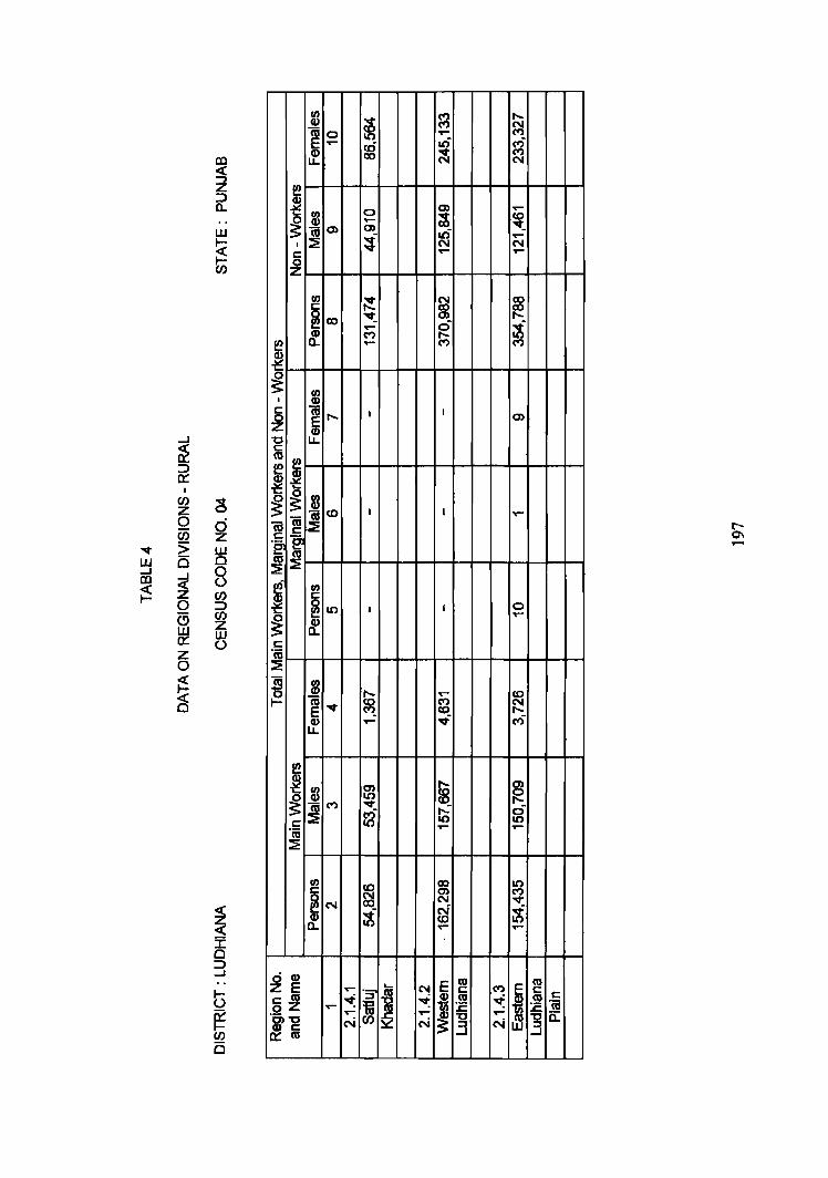
...,. W .....J CD
~
~ :::::> 0::
I
CJ) Z o Ci) :> B
~ o a w a: z o ~ C§
~ I o :::::> ...J
i ~~C» I~
C
o ..... C»
~ ~~~~~~~~~~~
....
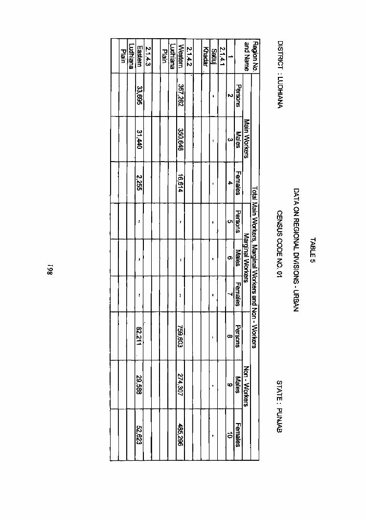
\0 00
~i c. _. Zo Ql :::J 32 (1) ~
E a :r
~
() m 6i c (/)
8 o m 2 9 o _..
o ~ » o z :::0 m (j)
o ~ c <: (/)
o ~ C :::0
~
~ rm 01
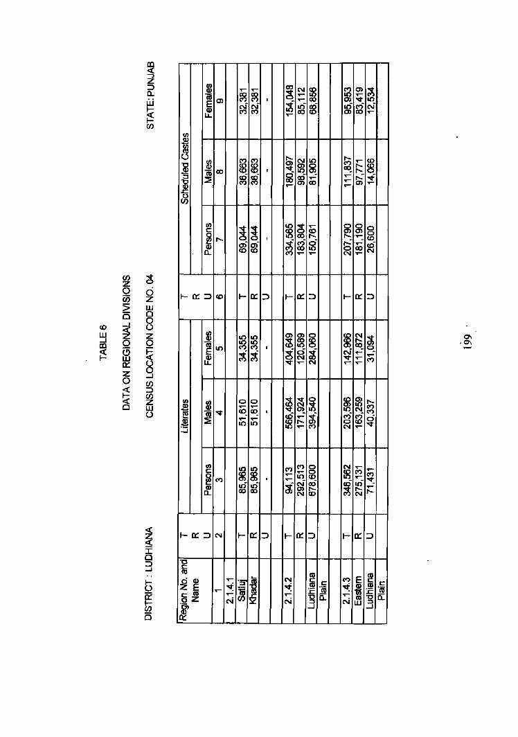
m c{ ...., z
UJ ::::> .9! or- or- co N
~ f2 0) ~ a. co co ~ or- ..-W
CIS 0> C") M I ..- 0> "It 1.0 E pf ~ ~ Il') ~ Il') ri N ~ CD CO 0) CO .... u.. .... r CJ)
UJ ~ UJ a
c/)
~ ~ ~ m ~ r;; .... 8 "0
~ CD
I "It ~ j:::: c;; <Xl g :.::2: ~ ~5f m .... ..... s; ~ ~ co ..... .... .... .....
~
c/)
~ ~ 10 g .... ~
0 g c f8 re 0>
~ ..... I ..- co ai ai ~ g ci ..... ....
~ CD co co 10 ~ co a. C") .... .... ....
CJ) ~ z 0 0 1-0::::::> I- 0:: ::::> 0:: ::::> 0:: ::::> U5 z co l- I-
5 w 0 0 __J 0
co ~
U W Z U)
10 10 ~ ~ § ~ ~- ~ 0\
...J CD 0 0
~ 10 1.0 ,0\ m C") C") I ,_.
i:5 (!) ~ 10 S ci ~ ~ ~ N .... -
w CD N ..... .... .... C")
0:: U LL ..... .... N ,.... ,.... z 9 0 CJ)
~ ::::> CJ)
~ ~ 0 m m (3 z U)
~ 0 0 .....
~ or- ..- ~ M W c;; "It ~ co_ I 0) N_ M U l!! ~ .... ~
C") M ci .$ ~ .... ..- ..... 0 co 10 10 "It :.:i
,.... N or-
CIS C C ,~ 'cu .r::._ -go. ...J
DISRICT PA TIALA
REGIONAL DIVISIONS
Patiala district, located in the southeastern part of the State was earlier a
princely state. It is mainly constituted of the territories of erstwhile princely states
of Patiala and Nabha which were commonly known as Phulkian states. It is
surrounded by Rupnagar district and Chandigarh union territory in the north,
Ludhiana district in the northwest, Sangrur district in the west and Haryana state
to the south and southeast.
Patiala district is comprised of five tahsils which among themselves
contain 1,462 villages (including 21 uninhabited) and 12 towns. It covers an area
of 4,584~0 sq. km out of which 4,448.89 sq.km. is rural and 135.11 sq. km. is
urban. It has a population of 1,896,242 including 1,008,576 males and 887,666
females . In other words it makes 9.10 per cent of the total area and 9.35 per cent
of the total population of the state.
Climatically, summers are quite hot and winters are extremely good. Hot
winds accompanied by dust storms occasionally blow during summers. At times,
the temperatures touches 46°C in summers, while in winters it reaches as low as
2°C.
Ghaggar is the main river traversing through this region. This however, is
seasonal. Satluj-Yamuna link canal passes through the southern most part of the
district.
The district has a well developed road and rail transport system. NH-I
and NH-22, and SH-8, SH-9, SH-10, SH-ll and SH-12 pass through this district.
The railway line connecting Ambala Cantt. and Ludhiana passes through Dhuri
and Sirhind towns located in this district.
200
The district has a sex ratio of 880 which is marginally less than that of the
State as such. It has a density of 414 persons per sq. km. Out of the total
population of the district, 1,329,269 (70.10%) is rural and 566,973 (29.900/0) is
urban. During 1981-91 the population of the district has registered a growth rate
of20.86 per cent.
In the district, 58.62 per .cent of the population is literate which is higher
than the state as a whole. Scheduled caste population constitutes 23.60 per cent of
the total population of the district. 29.70 per cent of the population is recorded as
main workers, 0.45 per cent as marginal workers and 69.85 per cent are non
workers.
Rajpura and Gobindgarh are the important industrial centres located in the
district. Rajpura is famous for the manufacture of biscuits, vanaspati ghee, cycles,
cables, etc., while Gobindgarh, the steel town of India, is known for steel re
rolling. Patiala and Nabha towns are known for their household industries
engaged in the manufacturing of nalas and parandas (waist cords and hair tying
cords) and Punjabi juti (leather footwear). Sirhind town is famous for the
manufacture of bus/truck bodies. All this apart, the district has a number of sugar
mills, soap and detergent mills, steal re-rolling mills, etc.
As true in other parts of the state, agriculture is the main activity. Wheat,
maize, rice and sugarcane are the principal crops grown. The soils are Ochrepts
Orthents, Ochrepts-Psamments, Ustalfs- Fluvents and Aquepts-Ochrepts. These
are fertile soils comprised of fine alluvium. The natural vegetation includes
shi sham , kikar, neem, pipal, mango, sarkanda and reed.
Patiala district is a part of Punjab Malwa Plain (2.1.4) micro-region and is
further sub-divided into following two sub- micro regions on the basis of soils,
topography, climate and natural vegetation.
201
2.4.1.1 Patiala Plain
This spreads over Nabha tahsil, Fatehgarh Sahib tahsil and parts of
Rajpura, Patiala and Samana tahsils of Patiala district. It includes 934 villages
and 9 towns. This is a flat and featureless plain covering an area of 2,934.39 sq.
km. It is inhabited by 1,340,885 persons among which 834,398 are rural and
506,487 urban by residence. The region has a density of 456 persons per sq.km.
During 198]-91, it has experienced a growth rate of 20.18 per cent. The region
has a literacy rate of 51.65 per cent. Out of the total population, 23.07 per cent
belong to Scheduled Castes. In this region 30.08 per cent of the population is
economically active; 29.71 as main workers and 0.37 per cent as marginal
workers, and 69.92 per cent of the population is non-working.
Climatically, summers are very hot and winters are severe cold. The soils
are Ochrepts-Orthents, Ochrepts-Psamments which are alluvial and fertile soils.
There are few pockets in the western part of Samana and Patiala tahsil where the
surface water dries up in dry weather leaving a sheet of powdery material at the
earth surface. This alkalinity affects the soil fertility adversely and makes the land
unfit for agriculture. This patch of land is said to be water logged and is known as
kallar or reh in Punjab.
The railway line connecting Ludhiana and Ambala Cantt. crosses through
Sirhind and Rajpura towns which are located in this region. Another Railway line
connecting Kalka and Dhuri also passes through this region. The region has a
good network of road transport and State Highways No.8, 10, 11 and 12 pass
through this region.
Wheat, maize, nee, chillies, potatoes and sugarcane are the main crops
grown in this area.
202
2.1.4.2 Ghaggar Flood Plain
Ghaggar Flood Plain spreads over eastern, southeastern and southern part
of Patiala district. It includes 528 villages (255 villages of Rajpura tahsil, 186 of
PatiaIa tahsil and 87 of Samana tahsil) and 3 towns namely Dera Bassi, Samana
and Patran. It has an area of 1,690.61 sq. km and a population of 555,357 out of
which 295,022 are males and 260,335 females giving an over all sex ratio of 882
females per 1000 males. The region has a density of 328 persons per sq. km.
During 1981-91, Ghaggar Flood Plain has recorded a growth rate of 22.53 per
cent. One-haJf(50.27%) of the total population is literate and one-fourth (24.89%)
of the total population belongs to Scheduled Castes. 30.22 per cent of the total
population is reported as workers; 29.58 per cent as main workers and 0.64 per
cent as marginal workers.
The geological structure of the region comprises of alluvium. The region
is fairly well connected with roads and railways. Wheat, maize, rice and
sugarcane are the main crops grown in this area.
*****
203

CENSUS OF INDIA
PUNJAB DISTRICT PATIALA
CENSUS CODE 01 REGIONAL DIVISIONS
KM fi r T f T flKm
,_ u
,. ~,~:\=\ /.', ·v :~ :> :"~~
•• . > -, . of .
~ .. ~ D'."""" "'''' §"_". __ Dn_ . ..,...,.. CJn_,...._
PATw.A PLAIN ..... __ • __ ._2 • I • 4 • I GHAGGAR FLOCO PLAk ___ 2 . I . 4 . 2
8our.vARY,STATE .... .. " ...... : ..... .. .. _ .. _ .. _ DISTRICT ............ .... .. .. .. _ . _ . _
• TAHSl. .... .. .. .. ............... _ . _ . _ VLLAGE HA WIG 5 000 , ABOVE I"OPIL\ TJON .. • UI8AH AR£A .. .. .. .. .. .." ....... " .. .. NA TIOtW. HIGHWAY .. .. .. .. .. .. .. .. " .. .. II! , STATE HIGHWAY ............ " .. .... " .. .. III !O II'ORT ANT MET AU.EI) ROAD .. " .. .. .. .. .. .. IS
. RALWAY LIE WITH STATION, BROAD GAUGE .. .. ___ _
IIIYEJIICHOE, RESERVED fOREST .. "" .... .. ,_Ci!) REGIOHAI.. ~ .... .... ...... .. " .. ..
"':Oso:: :: .::::: :: :: :: :: :: :: :: :: :: : :~ aICRO .. " ...... ........ .. .... .
IU8-MCRO WITH IIOIJNDARY •• •• •• .• _
CR ...... ...-. of' .............. WIllI ,.f ... _ to ... II InOla .. C8dM lIP t. ) !lor J
I'OCI([1' fQR "AT~ DlSTRlCT ..... .... .. . .... .. .. .. p
MAP 30


..-UJ ..J co ~
(/J z o Ci5 5 B ..J
~ o a w 0:: Z o ~ (§
~ ...., Z ::l a.. W J-
~ (/J
g d z UJ o 8 z o ~ 9 (/J ::l (/J Z W o
~ n; E II) u..
5 III :s II) n;
~ ::::! 0 a...
III
~ a..
t: .- t: III 0
~ .~ -'Ot5 ~m
...... ! (") It)
~ ~ (") ~ ~ 0)
(")
~ ~ 05 ~
.... ~ (") (")
N N
~ ~ g ~ ~ ~ 0 co ..... (1) cD ......
8 ~ .
..... ~ <D .....
..... N C\I C\I (")
(")0)
~ 3 II.) ::l II.)
c.n .....
I
(') m z en c en 8 o m
~ ~
"U C
~
~ m r m N
C")
L1J _. CD
~
_. ~ ~ en Z o en :> 15 _. ~ o a w a::: Z o ~ ~
~ d z L1J o o ()
en ::> en z w ()
m roo E..Q) LL
t/) c::: ~CIO
l!? ~
C")
M. ..... It) N
~~~~-4-+-+~~~
C'O (5 .....
'Q)
1t E c::: C'O oZ '~-g a::: C'O
I/) Q)
~~ Q)
LL
..-CIO co ai ....
....... C")
~ C")
N CIO .....
"T1 "'C I» :;0
[ (j) !'> ~ !'> acE =r ~
~ ...... .....
i ~r ~ I» ~ .....
"'C !! m. I» N ..... ~~ .., Ill, ::l ::l
..... ~ ~ ~
:-I co N ~ en (0
~ '" ::l 0) en
s: I» ..... t 5'
~ s: '" '" ~ ~ (.n -....., m [ .....
~ ......
'TI
N ,_. o
en _C1I CD
~ ...... ~ g 01 ~ CD ci en -!!!.
s: I»
~ 5'
'" ~
~ ~ 2J 01 ~ ... (X) :J ~ en pJ
i ~ ~, ~. 01 01 ~ ~ ~ ...... co 0)
'" 0 m ~ ~ ~ [
IIJ
" ::l N ~ CD 0.
~ ..... ...... ~ z ..... 0 ..... (X) i ::l •
~ (') );! m 0 z z en c :;0 en m (') (j)
0 0 ;;! 0 ~ m OJ Z
r r 9 g m
~ ~ g en 0 z en :;0 c ~ r-
~ i
~ ~ "'C Cil CD
'" co (X) ~ (» -....., N ~ :J ..... en
...... N ~ '" 0 s:. p 0 co ~
~ ..... m !B ...... m co
UJ
N W "T1
'" ...... CD
'" co ..... ~ ~ g 0
N (X) m
10 ill ..J (D
~
~ a:: :::J
(/) Z o U5 5 is ..J « z o ffi a:: z o ~ ~
g o Z ill o o u (J) :::J (f) Z ill U
~ ~ ... ~ c: 'm ~
!/) c: ~IO Q) a..
~ n; :E
!/) c:
(t)
~N ~
......
..-N
CD C"') co cr) C") ..-
~ C"')
ai V T""
CD N
10 (t)
CD CD 0>
..... ,......, N
G')
~ =r
~ ~ '" 8l -Il) ~ Il) .., ::J JJ '" J2
S. Q) 5·
C :;0 -I C :::tl
(,J ...... I'\) ~ ~ ~ c.> 91 c.> (..) -~ m m ~ (..)
0 m _._ UI (,t) UI
ts ...... - - I'\)
~ .b. ~ I'\) CJ'I U1 g N '"c..l N 0,
~ ~ co ~ .... ....
tv -tv - ...... ~
.... ...... .. .. c.n (..) -5'" 8 ~ ~ fd ...... f$ co I'\)
C :::tl -I C :::tl
...... _._ UI N
co I'\) (,t) _ ...... c.n
* CJ) (X) ......
~ N ~ :c... c.> ...... 0 ...... 0
m tj ~ _.
91 ~ -* ~ ~ ~ 8
~ ~ !:::l _.
!'- ...... 0)
~ (0 :c... ~ :.:.. ~ (X) ...... (_.)
...... ....
!'J -;t. ..... --I I'\)
0)
~ (..)
~ (X)
~
~ .. -c.> 0
~ ...,. U1 U1 CJ)
-I 0)
~ co --I
~
-m ~
CJ)
c.>
...... ~ (..)
~ co
l z (,-Il) ::J
3g: CII.
Il) ::J 0-
C:;O-l
11 ~ ::J I/)
!; ~ !!!.. CII
m ~
"TI (J)
i_ (J) I/)
C;;o-l
"0 (J)
~ ::J VI
en g. ~ s: c
!!!.. [ m (")
~ CII VI
"TI (J)
3 !!!.. (J) I/)
(") m z en c en r 0 (")
~ 0 z (") 0 CJ m Z P 0 ......
en -I
~ f1:l ""0 C Z c... » OJ
CJ
~ » 0 z :;0 m G)
0 ~ r CJ ~ en 0 z en
);! OJ r m 0)
DISTRICT SANGRUR
REGIONAL DIVISIONS
Sangrur district is one of the six districts forming part of the micro-region- Punjab
Malwa Plain (2.1.4). It is surrounded by Ludhiana district in the north, Patiala
district in the east, Bathinda district in the west and Faridkot district in the
northwest. Haryana state lies to its south. This district has four tahsils (Barnala,
Malerkotla, Sangrur and Sunam) having 718 viJlages (including 9 uninhabited) and
12 towns. It covers an area of 5,107.0 sq. km and is inhabited by 1,710,120 persons
including 914,361 males and 795,759 females. Sangrur district constitutes 8.43 per
cent Punjab's population and its ranks 6th among the districts in the state in
population size. Out of the total population, 1 ,292,126 are residing in niral and
417,994 in urban areas of the district.
The climate of the district is generally dry and hot in summer and cold in winter
season. The summer season extends over the months of March to June and cold
season starts from November and continues till March. The district is an alluvial
plain having occurrence of sand dunes. Essentially a flat plain, the district gently
slopes from northeast to southwest. Ghaggar river flows from east to west in the
extreme southern parts of Sunam tahsil. The population of this district has increased
from 1,410,250 in 1981 to 1,710,120 in 1991 exhibiting a net addition of 299,870
persons (21.26%) during this decade. The district has a density of 335 persons per
sq.km and a sex ratio of 870 females per 1000 males.
46.16 per cent of the population of the district is literate, and 26.83 per cent of the
population belongs to Scheduled Castes. In absolute number 458,856 persons
belong to Scheduled Castes among which 380,281 reside in rural and 78,575 in
urban areas of the district. The workers constitute 32.23 per cent of the total
population; 30.91 as main workers and 1.32 per cent as marginal workers. Almost
two-thirds (67.77%) of the district's population is recorded as non-workers.
213
The geological structure is comprised of alluvium and the soils of the district are
Ochrepts, Orthents-Psaments, Psamments-Fluevents-U stafls-Ochrepts.
Agriculture is the main activity of the people in this district and 67.41 per cent of
the total main workers are engaged in agriculture as against the 55.26 per cent for
the state as such. \\Theat, maize, gram, cotton, bajra, sugarcane and rice are the main
crops grown.
The region has a well developed net work of roads and railways. State Highway
No.10, No.l1, No.12 and No.13 pass through this district. Among the important
railway links Bathinda-Dhuri and Ludhiana-Mansa are mentioned. Most of the
towns are located along the main roads and rail routes.
Malerkotla, Dhuri, Barnala and Tapa are the important industrial centres in the
district. The important corrunodities manufactured include agricultural implements,
cycle parts, sewing machine parts. District is also famous for steel re-rolling mills,
rice shellers, paper mills, fire bricks and hosiery. Although Sangrur district is not
well developed yet, with the help of Government. financial corporation, large and
small scale industries are-being set up in the district.
Natural vegetation includes, shisham, neern, kikar, jamun, thorny bushes, reeds
and sarkanda.
Sangrur district is a part of Punjab Malwa Plain (2.1.4) and is sub-divided into
four sub-micro regions on the basis of soils, climate, topography and natural
vegetation.
2.1.4.1 Western Sangrur Plain
The region extends over the parts of Bamala, Malerkotla and Sangrur tahsils and
covers an area of 1,705.91 sq. km out of which 1,676.44 sq. km is rural and 29.47
214
sq.km is urban. This regton comprises about one-third of the total area of the
district. It is bounded by Faridkot and Ludhiana districts in the north, Eastern
Sangrur Plain in the east, Bathinda district in the west and Southern Sangrur Plain
in the south.
This region covers 176 villages; 131 villages of Barnala tahsil, 34 villages of
Malerekotla tahsil and 11 villages of Sangrur tahsil, besides four urban centres
namely, Bhadaur, Barnala, Tapa and Dhanaula. It is inhabited by 477,041 persons
comprised of 255,304 males and 221,737 females. Out of the total population of
356,675 is residing in rural and 120,366 in urban areas. The region has a density of
280 persons per sq. Ian and a sex ratio of 868 females per 1000 males. The
population has increased from 435,958 in 1981 to 477,041 in 1991 and registered a
decadal growtn rate of 9.42 per cent during this decade. The region has a literacy
rate of 46.61 per cent. Scheduled caste population constitutes 28.73 per cent of the
total population in 'the region. Workers make 32.59 per cent of the population
(31.27 per cent main workers and 1.32 per cent marginal workers) and 67.41 per
cent are non-workers.
The climate of the region is cold in winter and very hot in summer. Soils are
Ochrepts- Psamrnents. Sand dunes are widespread in the entire region and these are
formed due to shifting of sand dunes from the Bathinda Sandy Plain which is very
close to this region. Tubewells and canals provide the main source of irrigation.
Among them the prominent are Sirhind canal, Sahna distributary, Hadiya branch,
Kotla branch, Dhanaula distributary and Kurar branch.
This region is well developed with regard to roads and railways. The important
roads passing through this region include SH 12 connecting Rampura Phu} with
Sangrur via Baranala. SH 13 connects Mansa with Raikot via Bamala. Besides,
there are other important roads passing through this region. The main railway line
connecting Bathinda with Dhuri via Bamala, passes through this region.
215
The geological structure of this regIon IS comprised of alluvium. Natural
vegetation includes kikkar, thorny bushes, neem and sarkanda. Agriculture is the
main activity of the people, and wheat, rice, bajra, grams, groundnuts and cotton are
the principal crops grown.
2.1.4.2 Eastern Sangrur Plain
The region covers the eastern upper half part of Sangrur district. It extends over
parts of Barnala, Sangrur, Malerkotla and Sunam tahsils of this district. It covers
nearly 41 per cent area of Sangrur district and includes 395 villages (Baranala
tahsil-5, Malerkotla tahsil-253, Sangrur tahsil-II8 and Sunam tahsil-I9) and 6
towns namely, Abmedgarh, Malerkotla, Dhuri, Sangrur, Bhawanigarh and
Longowal. The entire region spreads over an area of 2,108.34 sq. km and has a
population of 856,623 (456,691 males and 399,932 females). This region has a
density of 406 persons per sq.km and a sex ratio of 876 females per 1000 males.
Out of the total population of the region, 72.38 per cent is residing in rural and
27.62 per cent in urban areas. During 1981-1991 the region has experienced a
growth rate of29.68 per cent. One- half (50.24%) of the population is literate. One
fourth of the population (25.27%) belongs to scheduled castes. 31.87 per cent of the
popUlation of the region is recorded as workers~ 30.56 as main workers and 1.31 per
cent as marginal workers. The non- workers comprise 68.13 per cent of the total
population of the region.
The climate of the region is similar to other parts of the district. The soils are
Ochrepts-Orthents and Ochrepts-Psamments. The geological structure of the region
is comprised of alluvium. The region has a well developed system of roads and
railways. The main towns viz. Ahmedgarh, Malerkotla, Dhuri and Sangrur are well
connected with roads and railway lines. The main railway line connecting Ludhiana
with Sunam passes through this region. State Highway No.II and No.12 also pass
through this region.
216
The main commodities manufactured in region are agricultural implements, cycle
parts, sewing machine parts. Besides, the region is famous for steel re-rolling mills,
paper mills and fire bricks and they are mainly located at Malerkotla, Dhuri and
Sangrur towns.
Agriculture is the main occupation of the people. Wheat, rice, maize, bajra, cotton
and sugarcane are the major crops grown. Natural vegetation includes neem,
shish am, pipal, kikar and thorny bushes.
2.1.4.3 Southern Sangrur Plain
This region spreads over the parts of Sangrur and Sunam tahsils and includes 84
villages (3 villages of Sangrur tahsil and 81 villages of Sunam tahsil) and 2 towns
namely, Sunam and Lehragaga. This region is inhabited by 247,042 out of which
132,706 are males and 114,336 females. It has a density of 3 19 persons per sq. km
and a sex ratio of 862 females per 1000 males. 187,578 are residing in rural and
59,464 in urban by residence. The population of the region has increased from
206,972 in 1981 to 247,042 in 1991 exhibiting a decadal growth rate 19.36 per cent
during this decade. Almost two- fifths (39.50%) of the population is literate. This
region has 27.49 per cent scheduled castes as per 1991 census. The percentage of
main and marginal workers is 31.42 per cent and 1.45 per cent respectively.
The soils are Psamments-Fluvents-Orthids and Ochrepts--Psamments. These
soils are sandy loam to silt loam. Major sources of irrigation are canals and
tubewells. Ghaggar branch (Sirhind canal) is the main canal which passes through
this region. The other distributries are Sunam distributary, Kotra distributary and
Ladbanjara distributary. The development of roads and railways is fairly good. The
major roads connect Sunam with Mansa, Sunam with lakhal (Haryana) via
Lehragaga, and Sunam with Patiala via Bhawanigarh. The main railway line
connecting Malerkotla with Jalchal (Haryana) passes through this region_ Towns of
Sunam and Lehragaga are linked with main road and railways.
217
Agriculture is the main occupation of the people and wheat, maize, cotton, rice,
bajra and groundnuts are the main crops grown.
2.1.4.4. Gbaggar FJood PJain
The region is located in the extreme southern part of Sangrur district and it spreads
over 63 villages of Sunam Tahsil. This region is entirely rural. It covers an area of
519.19 sq.km and has a population of 129,324 of which 69,660 are males and
59,664 females. The Ghaggar river is the main river which flows through this
region in east to south-west direction and is seasonal. Being flood plain, sand
deposits are found along the Ghaggar river in the southwestern part of the sub
micro region. The soils of this region are Ustalfs-Ochrets, Ustalfs- Fluvents and
Aquents-Ochrepts.
This sub-micro region has a density of249 persons per sq.km, and the sex ratio is
856 females per 1000 males. This region has 26.88 per cent of its population as
Scheduled Castes. The percentage of main workers and marginal workers is 30.85
and 1.21 per cent respectively.
From industrial point of view this region is not much developed. Agriculture is
the main occupation of the people. The major crops grown include wheat, maize,
rice and sugarcane. Natural vegetation includes shisham., kikar, neem, reeds and
sarkanda.
****
218
CENSUS OF INDIA
.1
~.t.vrv
POCKET'Of! PATIAlA oarmc:r . " .P POCKET FOf! IItIU.M r~" .. .. .. 8
e
PUNJAB DISTRICT SANGRUR
CENSUS CODE 10 RECiONAL DIVISIONS
o 10 III 20Km
WESTERN SANGRIJR PLAtt.. 2· 1+1 EASTERN SANGRUR PLAtL .. 2 .. 1+2 SOVTt£RH SANGRUR PlAIl . . ~ 1 :4 3 GHACiGAR flOOD PLAII . .. ... 2+4·4
MAP 31
It I
*' \1'1
"" ~
..-
(')
,~~
"U
~
'"f
,....
A BOUII)ARY, STATE., • .• • ••• ••••• • ••• _ .. _ .. _
u DlSTRtCT . ...•. • • • ~ •• • •• • _._._ TAHSL ••. • ••• • •••• •• •• _._. _
VUACIE HAVIIG , 000 'ABOVE ~TION • • IJR8AN AREA . • •• . • • . .•• • •••••• . • __ _ STATE ttGHWAY . . • • • • • • • • • • • • . • • • !HZ NPORTANT MEtALlED ROAD ' • •••••••• •• ,_--...--_ RALWAY l.t£ WTTH STATION, BROAD GAUGE . • • " RlVER/CHOE • .. • • .• .••• ••• •• •••• ~ REG1OHAI.. DIVISIOH8 . . • • : . • • • • • • • • • • J. ~ ... ~
MACRO • . . •• • . • •• • •. •• • ••. . •• ~
t.£~O·::: :::::: :: :: :,: ::: ~ S\JII<MICRO WTTH IIOINlARV . • • • ..__
(Road 1M ._ ., 'o9onaf ..... _ wtth ,.,,, .... I. tho allnIIo .... _ ~ 'a;' IIorI

j ...... 8 R ('\oj .... ..- ~ ~ ~ ~ ~ M (") 0 (F)
m 0) t:;. <J) 0 ~ ('t) I
~ ~ :8 sf ~ ..- ..,f g re ai ai ~ ..... .... 1.0 1.0 .... M ('\oj ..- .....
c ~ ~ ~
.... ex) ('I)
~ ...,.
SJ 0 0 0 I/) 0) ~ "'It .... co co ~ <LI
I~ co ..- M. ~ co co I a; ex) g ~ g ~ N a t .... .... Pi m ~ 10 M 0 M ('\oj ,... v C") .... ..- ..... 0
a.
I/)
~ ~ ~
C") 0) v ('\oj
~ Cb ~ ~ c ~ ~ ...... ~ ~ <0 0 ~
('I) C") I ......
~ c5 ~ ui ~ ~ ...... ai 0) ai
~ ...... ('\oj .... co 10 ('\oj N ...,.
M ..... co co N .... .... .....
CJ) 0 Z .... 0 d Ci5 Z
t-O::::::> co t- o:: :::> t- o:: :::> t- o:: ::> t- o:: ::J
5 w 25 0
0 ..... ....J U W ~ Z ....J 0 0 co ~ (5 5 w
0:: 0 Z ....J
N
~ .... ~ ~ ~ f8 ~ 0) 0) 0) t; ~ ~ :g ~
cO ~
..... .,... I .5 10 oi 0 ~
C") ...... ~
oi oi
m t- N ....... J.:: Ie ..- ..-10 10 .... ....... N N
«
0 CJ)
~ :::> CJ)
~ Z w t-a:::::::> ...,. t- o::: ::> t- o::: ::> t- o::: ::> t- o::: ::::>
()
05 r::: I/) 0
~ 0g> M "it co N
I ..... '-
'5-5 d m Z
05 I/) r::: <LI 0 0 0-..m~ co 10
~ C") == .._ t- O) co >.s:;; ..... ('I)
'5 0
~ m
'- .... ,_ "C
~ ::J ::J "8 c ,g g m c 0
d <LI ..- m r::: N c?J r::: M ~ C ~ u: c z E ~ CJ) on; ~ ~ ~ 0a; ~ '-
~ .... E ~ c m ...... ~ 0:: ....
j ..- a. ..-
oZ N N N Q) N
1 ~ .t: m -g .s:::.
W 0 (.!) CJ)
N N N
"t:J ii: ::J
(/J C
i 3
.-• ~ w N w ~ U'I ......
~ ~
co ....
r (>
~ .....
~ ~ ~
I 0) (,I)
I» ; 5'
8' s. f g> r§ 2 ...
!\) ..... ~ W
I (/J C ::J
2 ~ .,
..... (,I)
f" ...... w .....
CD If> (,I) co bI N 0, (,I)
.... (,I) CD
~
::::1 (,I)
~
Oi ......
~
N N (.., N
~ r !\) (') ....
!\)
~ ...
..... c,., ~ w ~ ~ U'I .... I» a; 5'
~, 0 ::J.
I :::2 !\) .....
1l!. g> ~ :::J ~ ~ 2 ...
~ s:
~ !!1..
i ~ 2 I-.., I»
.... ~ N (lg
p .... ]'oJ ....... • .... ..... ...... ..... 8 N
...... C{I ";'I :.... .....
~ N ...... (lg
fd ~ N ..... ]'oJ
..... N ..... Q) ~ U'I
Co) <0 U'I
N ...... 0 (lg
~ N
~ !'" U'I 0
~ ~
r !\) r r[ r
~. r
(') .... (') (') (')
~ ~
~ g ~ ~ .... !3 !3 ..... ...... ...... OJ . ... ]'oJ !'> CD !'J Cfl ...... ..... ...... ...... I .... m 0) (,I) ~
...... ~ ~ ~ ~ I» .... .....
til
~ :i" :i" ...... ~ i. ~. .... ~ 0 g .....
::J I» 5' :::J ::J (il 0 0 s·
l I :::2 ~ !'J z o· ..... I» ::J e. ~
..... ~~ ::J f ....
I»
2 a ...
f s:
!if !!1.. ~ GI ~ ~ i N ::r 2 ~ ... ii' I»
.... N ..... .... ..... ~i 50 .- ~ ~ <» ...... ...... 0 .....
!'l .... ......
~ j - .
<0 ~ i CO ..... ..... ::~~ (,I) I .... (,I)
<0 • ~= ....... N ..... t z 0 .....
~ C{' JJ P _&
;;0 m Q
$.. d -4--
..... se ..... ! c8 at .... (,I) ... ...... ~i~
9.9,
< --I
..... ;lJ=~ ~ U'I i.~ ~ g _.'
::Ja
(") (5 z m ~ z
(/J (/J c m (/) < ~ 8 F
~ to r
~ m m N
Z 9 (")
0 ..... 0 0 m ......
....... ~ a: CD
Co !!1.. ....
_en ..... <0 co .....
...... ~ CD ;;0 ~ -..J C :r Ii t ~ N C <0 co i ~ ::J
r
t· r ~ r f r (") (') (> (')
~ ~ !\)
~ ~ ..... ~ I» ..... 5 ~ ..... N ~ ~ ~ N
(ii' ..... i ..... I ..... r> r ::r ...... N ... ~ C{'
~ . ~ if <0 ...... ...... N
~ (lg ::J ~ I»
i 6 N
CiJ ~ :f N I»
~. .... (iJ .. 5' S· ;.."
m ...-a) ..... 10
m ..... a) ..... 10
M <0
M N N
M <0
cD ..... 0 ..... .....
I ..... 8 cb 0 ..-..... a) ui t--0 cD M ...- ..... 2, to co ..... co ..... I
~ IN .......... ..........
E co c: :::I
(J)
/
"T1 ~ en en ~l (j)
~ ~ III
[ f !\) r§ !'l i !'l ~ I !\) .- 2 ...... 2 ...... ...... z 0' ~ ~ ~
c: ~
...... :g ..... :::r ..... ..... III ::J
R!. ~ "tI ~ i::.> :.g 3 ...., ~ ~ ..... 3Z iii II) CD 9 ::J 5' 5' ::r
w ::j ...., ...... ; co 0) .,..
00 en ...... co N :.." N ~ ~ ~
...... ::s ..... rJJ
s::: II.) ...... R!.
~ -...J 01 • ~ ::J
01 W 01
~ 00 ~ ~ ~ w
m f6 g I\)
i N
UJ
"T1 ...... .!'l 5» _I\) CD 0 ..... (.t.) "-J .,.. 3 00 ~ 0) ~ m. 00 N CD g (I)
at ~ R!.
...... ~ ::J ..... W ..... 01
~ ~ (It N ~ 01 § "-J 01 it w I\)
(I)
jiJ
f f ~. :s:: ::J ~. ...... 01 ...... 8!. ~ 81 "-J <0 N c» III
(.t.) Co) co I" ~ ~ ~ ~
II)
..... ." 5. ...... w 0 !-'I I CJ1 (.) en ..... ...... ~ 0 <0 01 $ 00 ...... <0 m ,
~ i!
() 0 m Z Z ;:tI en m C G> en 0 ()
~ );! 0 CD 0 r r m 0 m z < Co)
9 en ..... (5 0 z en -; 0
i! r
~ i
00 ...... 01 ~ '"tJ (iJ
-...J ~ ~ CD ...... § m en ~
00 m 00 N U) "-J
01 "-J (I)
Z 0
01 I\) ...... :J
~ ~ ~ ~ I
"-J
~ ~ ~ en ~ co
tg. ~ m ~ CiJ
CJ1 .....
~ N "T1 0 .... CD -...J CD ..... ...... .... i "S :.." ~ ~ 0 -...J 00 ...... en
II) co 0 8 co CP <") ~ ~ tU 0 N ~ E ..- oci <")- ..... r-: CP II) r-- co IC)
LL ..... N
~
~ !fi 0) co ct ct ..... ~ ~ ~ 0) r-- I'-;, r--
0) ..... ..... c5 I r-- "'It 'V <") t: ..... 0 Z
II) r-- co ~ ~ c ~ N
~ r-- <")
co ~ .,f ri r-:
£!! ..... N co N "'It .....
~ ~
...J
Ci ::::> a:::: (/)
0 z 0 ..... U5 0
"'It 5 Z w is w ...J ...J 0 III
~ 8 ~ 0 (/)
C3 ::::)
w (/)
a:::: z w z (.)
0
~
I !fi t: <") ..... ..... co ~ 1 ~
..... r-- ~ r-- <"!. <")
"0 "'It 0 r;t) ..... t: LL
..... tU (!!
~ ~ ~ ~ II)
0) CP ~
co co "'iii "'iii co II) r-- IC) t: ~ ~ II) ..... °Pl 0g a; ~
tU ~
r!.!""
~ II) 0) t:
~ 0 (0
~ (0 II) co
~ IC) I'-:. II) ~ to 0 r;t) ..... t: ...-
0(6 ~ co
~ !fi i 0 r-- co
~ ..... 0) co
"'It "'It "!. 0 Q) ...- .,f ...- ..... u.
(!!
~ m N N ..... co
~ <")
~ ~ 0 co co ~
<") c5 as 0) oci t: ..... co IC) <") 0(6 ,.... ...-~
II) co N co ~ c:: r-- II) <")
~ N r-- 0 co co N r;t) 0- 0)
~ ...- 0) co <") ..... .....
c: c: c: 0cp On; On; On; c ~E ..... ~ 0::: N E a:: <") ~ CL "'It I
0a; c: tU ...a: .... ...a: j .... ...a: L.. ...a: a. oZ ..... 1 ~ ~ ~. 8 ..... ..... .....
~ ..-
O~-g N N N N .c:: ~ c: c: c: (!) a:::: tU tU tU m u. (/) (/) en
" en en en II)
g> II) II)
~ ~ G) !'J ~ !'J ~ ! '" ~ !'J
I ~ 2 S. ...... 2 ~ ~
~ ~ ~ c
~ ~ "0 .., ~
.., .., ~, II) :a.. "0 (,) ~ 3 N "0 ..... .... iii' II) iii' :::J 5' S' 5'
_. 0) ~ CD 03
~ :...,
~ , W N
..... ~ ~ _CD
-...... , ..... ..... g 03 _,. e ......
(0) ...... 00 Co ...... 00 , ...... OJ _.
'" 00
~ '" '" 00 ~ I W W
W Co) ~ I en
N :t ~ , 0 03 0)
,fa ...... 00
'" 0) w
t 00
~ I
* OJ
'" ..... 0) (}I ...... co ~ (.,.) Co I
'" _,.
e ..... 00
'" ....... (}I e ...... ..... w .... en ~ I ...... N Ol
'"
_,.
"0
'" ~ rJ)
s:: w II)
f
" CD
~ 3 !!!. CD rJ)
"0 CD
OJ ~ :::J rJ)
s::: 0) II)
f
"T1 CD
...... ~ (I) rJ)
~ 03 ~
ijJ
:!: <0 I»
m-
" CD ...... ~ 0
m-
11);0 g_~ zo' II) :::J 3z CD ~
s: II)
:i"
~ CD 0
g !!!. s:: II)
:r
~ CD _0
s: s:: II)
~, II)
~, ~ :::J
!!!.
~ ~ ~ it .... rJ) 0
I» :::J Q.
z 0 :::J ,
~ [
Z g I
~ ~ CiI
() m z en c en
(') 0 0 m z 0 ...... 0
en ~ ~ fl:l "0 C Z ); OJ
~ ~ 0 z ;0 m G)
0 ~ ~ r- OJ
0 r-m
< (}I
en (5 Z en c ;0
~ z
(j) g> m =r c: II)
~ - I "lJ !'> -0 ~ N -0
or 0) ...... ..... ..... :,.. ~. ~ 0)
&' 5· Il :,.. ::J &' (..) 5·
§. C§ C§ 2 2 ..., ..,
C :::u ....... C :::u ....... C :::u
(J,) (J,) (J,) ~ CD ....... ~ (J,) (J,) 0 <0 P N
N N U, ~ p _o
I .......
N ....... CD (X) N ~ ....... ...... ........ ....... (X) ........ N
........ w
N N ....... (J,) 01 ;3 ...... g N N ........ N 0
I 18 ~ (0
'"" " ~ N ~ ~ ~ .......
N 0)
....... ...... ...... ....... N !D JE p 0 N 0) <0 N N ~ ~ ~ ~ ~ I (X) 00 <0 <0 <0 ........
c :::0 --I C :::0 --I C :::u
~ _~ ...... Con m ~
...... N Con ...... ~ m N (b . ...... ........ ~
~ -....I ~ (X) N 0 ....... N 0) W <0 01
...... ...... ~ ~
...... <0 9> CD (X) _CIJ ~ , " " ....... ~ i:» N m f8 f8 ~ .......
~ 0 .floo.
...... ....... N (J,) ....... (X) ? ? 9' 01 ...... _O) ?
I <0 <0 <0 ~ N ..... w CD (X) ..... <0 ~ (J,) N (J,) (A) (A) 01 .......
I !'J :::2 '" ....... ....... ~ 0)
~ N
5· &' ....... c§ 2 .....
--I C :xJ --I
~ ~ ...... ....... to.) ~ 0 01
~ .......
~ ~ ~ 0 0
~ ~ ...... ....... ...... ..... ........ N ...... b ~ ~ ~ ~ Cit (X)
...... ~ li; ~ ~
~ ~ ~ U, ....... (X) Cl (X)
....... c :::0 --I
N (J,) .... ...... ...... ...... ~ w <0 A
........
~ ~ ~ ...... ~ (X)
...... ...... ~ ........ .......
........ m w 0. " ~ ~ g ~ -....I
...... ....... ~ m Cl ....... .floo. <0 (J,)
~ ~ ~ m <0
....... ........ ......
l z cr 0) ::J
~ Z p Q) ::J 0..
N C:::U-l
(J,) I f/)
r it
~ ! ~
m
"TI (J)
en ~ m
0) c::o .......
~ ....... ~
::J f/)
en 0 =r
f tl (X) c:
m tl Q !4 (J) f/)
Il
~ <0 II)
m
0 m Z CIl c en 0 0 0 m Z 0 ...... 0
C/)
~ --I m
~ );!
~ :::u m );! G> 0 OJ r ~ m
0) r-0 < en 0 z CIl
DISTRICT BA THINDA
REGIONAL DIVISIONS
Bathinda district is located in the south- central part of the State. It is
bounded by Sangrur district in the east, Faridkot district in the north and west and
Hary-ana State in the south.
Covering an area of 5551.0 sq.km. Bathinda district is comprised of 4
tahsils namely, Rampura Phul, Talwandi Sabo, Bathinda and Mansa which
among themselves include 527 villages (including 4 uninhabited villages) and II
towns. Bathinda district is inhabited by 1,559,963 persons (829,849 males and
730,114 females). Out of the total population 1,208,830 is residing in rural and
35,133 in urban areas of the district. The district has an average density of 281
persons per sq.km and a sex ratio of 880 females per 1000 males. During this
decade the population of the district has increased from 1,304,606 in 1981 to
1,559,963 in 1991 at a decadal growth rate of 19.57 per cent. The district has a
literacy rate of 43.03 per cent, and 29.27 per cent of district population belongs to
Scheduled Castes. Out of the total population of the district 485,986 are main
workers, 33,849 are marginal workers and 1,040,128 are non-workers.
The climate of the district is hot in summer season and very- cold in
winters, and the rainy season is also mild. The temperature begins to rise from
early March and often touches 460 Centigrade in June. Hot winds blow over the
land and dust storms are frequent especially in the south-western part of the
district.
Bathinda district has a number of industrial units scattered all over the
district. District is famous for cotton ginning and pressing, agricultural
implements, sewing machine and parts, steel re-rolling, wood and machine
screws, electric goods, conduit pipes, textiles, chemicals and plastic goods.
228
Besides, there are other industrial units such as, flour miIIs, milk plant and sugar
mills.
This district is well served both by the roads and railways. Seven railway
lines connect this district with other parts of the State and also the adjoining States
of Haryana and Rajasthan. The soils are Ustalfs-Ochrepts in the Ghaggar Flood
Plain and Orthids-Fluvents in the western part of the district, Psamments -
Fluvents-Orthids in the central and eastern part of the district and Ochrepts
Psamments in the northern parts. These soils are sandy in nature. The geology of
the district is alluvium.
Bathinda district is mainly an agricultural district as 69.13 per cent of its
mam workers are engaged in agriculture (cultivators 43.34% and agricultural
labourers 25.79 %). The main crops grown are rice, maize, bajra, sugarcane,
cotton., oil seeds, pulses, wheat, grams, mustard and barley_ The natural vegetation
includes kikar, shisham, neem, ber, pipal and thorny bushes.
The Punjab Malwa Plain (2.1.4) and is sub-divided into following three
sub-micro regions on the basis of soils, topography, climate and natural
vegetation.
2.1.4.1 Bathinda Sandy Plain
The region extends over the parts of all the four tahsils of the district. It
includes 267 villages (119 villages of Bathinda, 85 villages of Talwandi Sabo, 15
villages of Rarnpura Phul and 48 villages of Mansa tahsils) and also the
headquaqrters town of Bathinda district. It coveres an area of3,097.34 sq.km and
has a population of 871,443 comprised of 462,631 males and 408,812 females.
Out of the total population 641,125 is residing in rural and 230,318 in urban areas
of this region. It has population density of 281 persons per sq.km. During this
decade the population of the region has increased from 713,064 in 1981 to
229
871,443 in 1991 exhibiting a growth rate of 22.20 per cent. The region has a
literacy rate of 37.92 per cent and 29.30 per cent of this region's population
belongs to Scheduled Castes. Workers constitute 33.28 per cent of the total
population; 30.80 per cent as main workers and 2.48 per cent as marginal
workers.
This region being a sandy plain, numerous sand dunes can be seen which
have a tendency to move towards east. The geological structure of the region is
formed of alluvium. The soils of this region are Orthids- Fluvents of Psamments
- Fluvents - Orthids and Ochrepts -Psamments. This region is well developed
with regards to roads and railways. National Highway No.IS, State Highway No.
12 and No.17 pass through this region. Industrially the region has made
significant progress. Major industries include flour mills, milk plant, chemical
fertilizers, textiles mills, rice shellers, oil refinery and cement plant.
Agriculture is the main activity of the people of this region. Wheat >
grams, barley, oil seeds, rice, maize, bajra, cotton and sugarcane are the principal
crops grown in this region. Natural vegetation includes shisham. pipal, ber, kikar,
neem and thorny bushes.
2.1.4.2 Rampura - Mansa Plain.
The regIon spreads over parts of Rampura PhuI, Bhatinda and Mansa
tahils of Bathinda district. It covers the northern and eastern parts of the district
and consists of 202 Villages and 139 villages of Mansa tahsils. 61 Villages of
Rampura Phul and 2 villages of Bathinda tahsil and 4 towns viz. Rampura Phul,
Budblada, Bareta and Mansa. It is bounded by Faridkot district in the north,
Sangrur district in the east, Ghaggar Flood Plain in the south and Bathinda Sandy
Plain in the west.
230
Rampura-Mansa Plain in inhabited by 580,572 persons including 309,893
males and 270,679 females. It has a density of 294 persons per sq.km and a sex
ratio of902. Out of total population 459,699 is rural and 120873 are in urban area
As per 1991 Census figures, this region has 29.29 per cent Scheduled Caste
popUlation and a literacy rate of34.35 per cent. Workers comprise 33.22 per cent
of the total population; 31.72 per cent as main workers and 1.50 per cent marginal
workers.
The region has a well developed net work of roads and railways. Main
roads connecting Bathinda with Moonak via Maur and Bareta, Bathinda
connecting BaranaIa via Rampura PhuI and BaranaJa connecting with Sirsa are
passing through this region. Two railway lines also pass through this region. All
the 4 towns of the region are well cOIUlected with roads and railways.
The soils of the region are course sandy-loam to silt. The geology of the
region is comprised of alluvium. Agriculture is the main occupation of the people.
The main crops are wheat, maize, barley, grams oil seeds, cotton, and surgarcane
of this region. The natural vegetation includes, shisham, neem, kikar, ber and
thorny bushes.
2.1.4.3 Ghaggar Flood Plain
This region extends over the extreme southern parts of Mansa tahsil.
River Ghaggar traverses through this region east-west direction. It includes 58
villages of Mansa tahsiJ and is entirely rural. The region has an area of 481.02
sq.km and a popUlation of 108,006 among which 57,383 are males and 50,623
females. The region has a density 224 persons per sq.km and a sex ratio of 882
females per 1000 males which is at par with that of State but marginally higher
than Bathinda district. During this decade the population of the region has
increased from 89,686 in 1981 to 108,006 in 1991 and witnessed a decadal
growth rate of 20.42 per cent. This region has a literacy rate of 28.35 per cent.
231

Scheduled Castes constitute 28.85 per cent of the total population in the region.
34.23 per cent of the population of the region is recorded as worker; 31.03 per
cent as main workers and 3.20 per cent as marginal workers.
The geological structure of the region is consisted of alluvium. The soils
of the region are Ustalf-Ochrepts and Psaments-Fluvents~rthinds. The road net
work is relatively less developed and no railway line passes through this region.
This region has a problem of wind erosion. Being flood plain, the natural
vegetation includes shisham, neem, reeds and sarkanda. Agriculture is the main
occupation of the people. Wheat, maize, bajra, rice and cotton are the principal
crops.
****
232
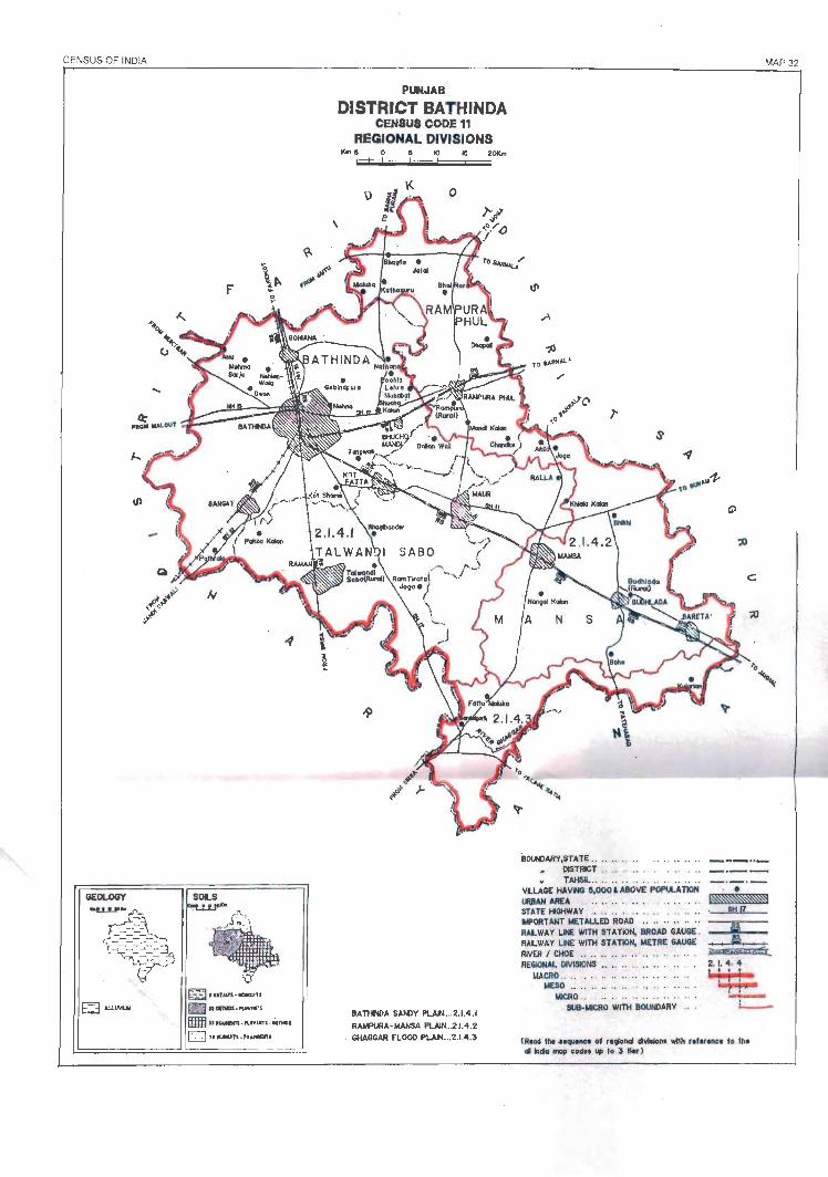
CENSUS OF INDIA
GEOLOGY SOLS
~'UJ1'''''' .lCIIMfll EE3 ,oil1NUj ~ ........... """'rr.
IHIf:} II , """', oIUlYUTI · "1W1
o "K*IPT1. rLUNlTI
PUNJAB DISTRICT BATHINDA
CENSUS CODE 11 REGIONAL DIVISIONS
BATHNDA SMIlY PLAIN....2.1.4.1 RAMPURA- MANSA PLAIN_.2J.4 .2
. GHAGGAR FLOOD f'LAtI_ •. 2.1.4 .3
BOUNlARY,STATE .. .. .. . . .. . ....••.•. DISTRICT .. ... . ...• . . • . , • ..
• TAHSIL .. .. .... .... .. VLLAGE HAVING 11,000 'ABOVE POPIA.ATIOH URBAN AREA . . . . STATE ftGHWAY .. .......... .. .... ORTANT METALLED ROAD .......... .. RALWAY LINE WITH STATiON, BROAD GAUGE . RALWAY LNE WITH STATION, METRE GAUGE RIVER I CHOE .. .. .. .. .. .. .. . REGiONAL DIVISiONS .. .. .. .. .. .. .
MACRO ................... . .. MESO ........ ...... . , .... ..
MICRO .. .. .. .... .. .. SUB-MICRO WITH BOUNDARY
(Rt04 tile n_. of 11910"'" dlvillom wH h •• forone, 10 Ih. aI "'die! map cod .. up t. 3 110.1
MAP 32

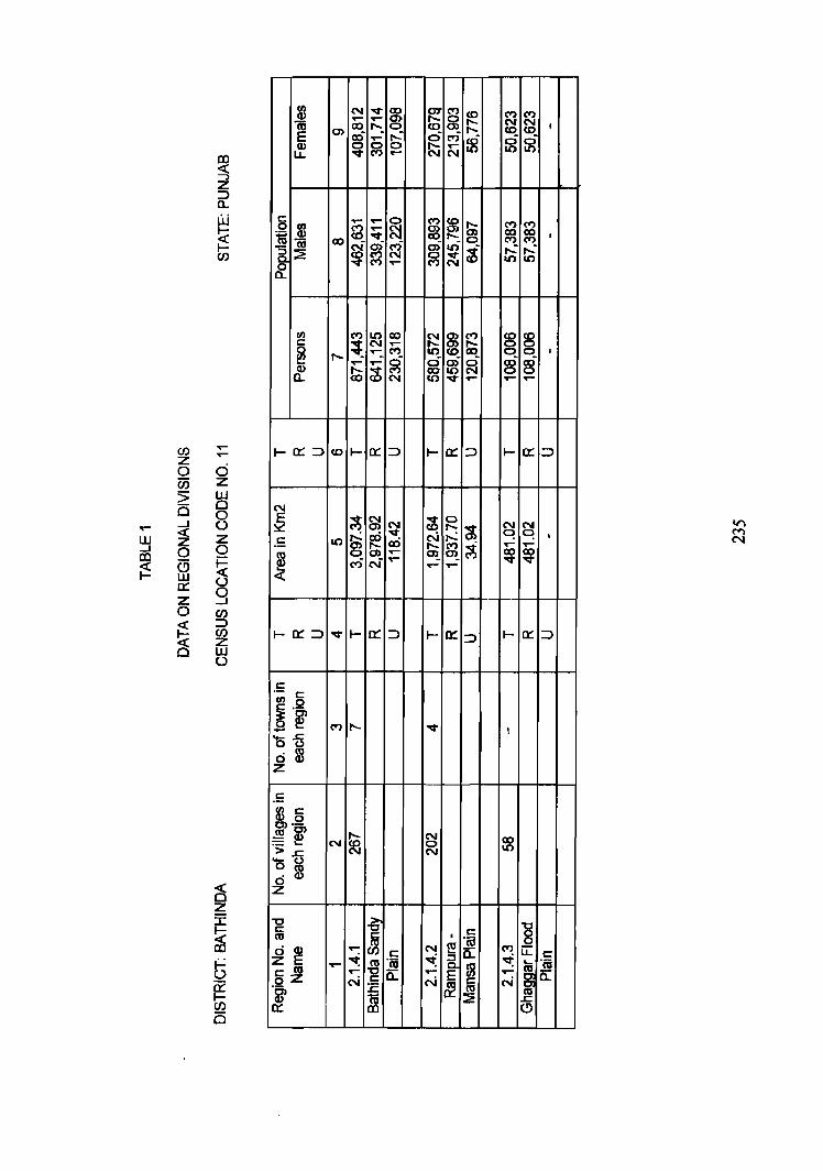
en z o en > o _. ~ o fa 0::: Z o ~ £3
!Xl .q:: -. Z ::::> a. W ~ I-CJ)
a z w o 8 z o ~ 9 CJ) ::::> CJ) z w o
:6 16 E Q)
LL
c: 0 en iii Q)
ro ~ ::a: 0 a.
c: .- c: en 0
~ .~ -'0-5 ~ ~
.5 en c: ~.Q
.~ ~ >~ 'Om o Q)
z
"0 c: m
~~ c: as oZ
1
N ..-IX)
0> ct5 ~
,.. ~
IX)
~
..,. IX)
~ ~ ...- 0> ...... _ 0 CO ...... ...: c:i ~ ~ 0 ~ ~ ~ N
..... 0 C") ~ ~ ~ 0>
'I#" ~ ~
~ ~ 0> Ii) N g ~ C") ......
co j:::;
f8
~ ~_
C") C") N N CO CO I
ci ci Ii) It)
C") ~ CO
C") C") I
...: ...: Ii) It)
~~ 00 I
a) a) 00 ...- ..-
1-0:::::::>
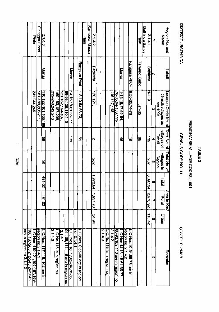
(j) ::lJ OJ 1 I\) ;:r
~ !!1.
~ ;:r
J2 '" "tJ !'J "tJ ::r I\) ig' c I\) ..... or ~
..... or 0- ..... I\) .., ~ ~ I\) ;to. ..... 3z s· s· s· :!! (,) s: ~ ~ .... CI) 9
§. I\) I\) :J :J
Rl ~ :J Co
"{1 ::lJ -I I\) III
3: s: ~ ~ 3: ~ ~ W ;I I\) I\) I\) c: :J -c: ;:r 2: I\) :J :J OJ ~ :J OJ 9: :J"
i m Rl :J ~ "tJ "tJ en Q. ;:r
I\) :J" I\) I\)
E.. c g T'
~ ..... _.. I\) ..... .... ~
..... ..... ..... ..... ...... ..... CD _.. r 0) .... ..... ?p I\) _.f>. I N ..... t
I bI I
~ ~ ..... ..... !» ~ ..... 0) .P !J1 ..... .....
;.." I ~ ..... .... w ~
..... ..... ..... ~
.... ..... !J1 0 ..... ..... C1I CD
:::J _
t m ~ _~ _~ I\) ..... ~
..... ~ ~ g' ..... .... I !» C1I 0
$ ~ ~ ..... _ ...... c..
~ ~ ~ _
..... ~ I\) ..... ..... ..... .....
iU 0)
~ ~ ~ ..... ..... ...... i' Co) .... ..... 0 ~ (11 ..... ..... _O)
9J ~ CD I\) .....
~ I\) ..... .P ~ ...... (11
..... 0) 0 _~ _w ..... ~ ..... 5JJ _(11
..... ..... ..... ;l ..... Q) 9 ..... cp I
0) f/) S-O)
:;0 m G)
S. d -i--
C1I ..... 0) -lioo ..... 0)
..... IIlg 91 0) eN ..... I\)
0) (11 (11 _.. .f>. :J"roZ co <0 ~f/)9
s'o .... < -i
::lJ=a ~
-I\)
C1I ~ ~I\)-C1I o ~ g: 0) I\) :J _ ..
:Js.
0 () Z m ~ Z (i) en c m (/) ::s;; ~ () r 0 ~
CD r
0 m m m I\)
z () p 0 ..... 0 ..... eN
.f>. (0 a -i 0) ..... ...... ~ 0) Q. 0 I\)
~ N ~ ~
..... m en .... co <0 ....
-lioo ..... N i 0) 12 (0 :;0 .... ~ ...... c: 5'
0 :" ~ I\) ...... (0 " 0 N 3 I\)
~ ..... c .....
I f ?l ClO i .f>. N :::J
I\) ..... r ®. r !'J r !'J ~ r ~ r !'J r '" ~ r ~. r
iii ~ 0 h ..... h ..... 0 h ..... P ..... h h 5' 0 Z ~ Z ~
.... !'J ~ ~ ~ ~ z g .....
~ :J ~ Z ~ Z
~. ; ~ w 9 ..... g ..... w I\) ..... 0 ~ 5 ~
f/) :J ..... ..... ...... 0 9 .....
'" ..... .... ..... :... !D
..... !D ..... ..... g 0> ..... ..... 0> _.f>.. l' .... _..
I !» C1I ..... N cp .... .:--I (ii' ..... (if ..... ..... ~ ~ is N ;to. .... Cf' 0 !J1
.... ..... .... _.. ~ .....
I\) ..... :J 01 ...... ~ s· ~ ~ 3
'" ~ ..... ......
SXJ I\)
I ...... N co
~, iii ~ III ..... .... OJ I\)
~, ...... ~ _.. @ 5' ~ 0 ~ 0) 0 3' 0 .... w
~ ~ I\) :J s· :J ~, m III _.
~. :.... iii ~
I\) ::J
~. ::J Cf' I\) iii (;(J
~ 9 9 0 ~ 5' ..... s· 0 (XI :::J
~ :J !J1 0 :::J
~ 5 ::J 9
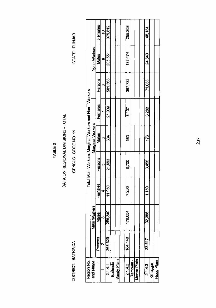
en N 00 ;}; Q) .... LO (ij 0 00 N ..-~ ..- I{') .0 cO
~ 10 ...a-u.. N
!!? Q)
~ j ..... ~ m
~ 10 ;}; 0) 10 "'It
m ~ N ..f I ~ ('I') C\J r::: .....
~
rIl ('I') N ('I') r::: ~
('I') ('I')
~ 00 r-. q ..... ....: ..-
!!? Q)
~ CIO r-. a.. ('I')
~ ~
.....J
~ 0 l-
(/) ...-Z ~
0 0 en z ('I') :> LLJ w a 0 .....J .....J 8 m « ~ Z
0 CJ)
(5 :::J CJ)
w Z 0::: LLJ Z 0 0
~ ~
I 8l I:
* r-. 0
0 16 r-. ('I') co Z
~ ..... C\J ..... «S ri "'0 N r::: m
~ !!? ~
~ ~ $ ~
('I') fe ~ 16 co co
16 ~ 10 ..... r::: "2 "g m
~ m ~
11 ~ en ('I') r::: 0 ~ ~ ~LO ~ 0 r-. "'t
& .- ro C")
I: N
"n; ~
~ en
~ Q) co m 16 ...a- 00 10 E C\J ..... .... ....: ~ .- .....
!!? Q)
~ ~ ~ 8l Q)
00 10 ('I')
~ (t)
~ cO N .!; r-. C') N ...... m ~
rIl m 0 r-. ~ P! ...a- ..-
~ 10 N ro t ri ~ ~ ..... ('I')
o Q) • I: I I: r:::
~ "m !!! ·m
II "m z E ..... c:: N
I~ c:: ('I')
a.. I: m ~ ~ ~ oZ ..- :.c I~ m ..... .... E .... ~ 8 "~-g N &i N t2. ffi N
rr.:m ~ ~ u:
Iv W IX>
-
., ~
Q N '::T
~ -'
~ IJ 9I. OJ w ..., :J
Vl 5-'l (j1 _,_ ---.I
W N W (j1 0)
.....
...... (11 ID
w '~
U1 m
...... ---.I m
W 'tv OJ 0
-..J ..... 0 w W
N J:,.
~ (0
.I>. _0> --A
~
J
~ ~ OJ
:J
&l ~ 31 c
¥ ~. :::I
......
.j:>. -0;) f\.) co 0>
__.. .I>. ~ ...... _,. ---.I
5J1 ...... -...j (0
00
t . .1>.
,
(j1 0 ---.I
.-....1 co w -...j
w 0 ..N co OJ (0
_"
0 !" _.. . -..J N
N 0 0 ~ 00 -..J
en !'V
Il) OJ !'J :J S-~ ~ ::r ..... ;... .j:>.
"U 5' tv
~ c.. .... Il)
::l
rv 0 0 to en _..
_. ID W -..J 0 0)
---.I 'tv (jI W
N -'
'" 0> ---.I
0) W ---.I
~
I
N 0 m W 0
.I>. _,_ co (» co -..J
..... l>.. OJ a en en
N -..J W 0) w ->
III :;0 :J CIl a. (Q
Z ci" -" Il) :J
3 z ro 0
""tl CD
'" @ :J <n
!5: ~.
:5: ::l
W III ~ ill ;t-CIl Ul
"T1 CIl
.I>. 3 III m ~ (/) g_
~
s: III
iJ 5' (1)
~ 0'1 ~ :::l ~ (fl (D
iil s: s OJ
~. Q)
~. s: ::::I ::J Q.l C1:l II) 9!. m ~ ~ t
(J)
~ x-(i)
U3 U3 til
-0 :::l CD 0. 3 -...j z III 0 CD ::J
0 ~ );>
0 0 m z z :u (j) m C LJ en (5 () Z --I
);> 0 );>
III 0 I r m 0 m z ~ .):>..
0 en _.. 0 ->. Z
(J)
:u c S; I
(/) I
:?! 0 .... ;:0;-ro
-0 -. m <n
O;i 8 :::l fJ)
Z 0 :::l
!:': , co ru
~ m m ~ (D ..... <11
" {l) __. :3 0 ro
W <11
z ~ 0::: :::>
en z 0 Ci5
I() 5 w Cl ...J aJ ...J
~ ;2 0 C) W 0:: Z 0
~ ~
aJ
~ 2 ::J c.. Iii I-
~ (/)
...-......
0 2
w 0 0 ()
(/) ::J (/) 2 UJ ()
~
~ ~
I
C 0 Z
~
~ ~
I
C 0 Z "0 c: en ~
i ~ ~ ~ ~ m "~ C .... "P-m .... ~
en :e ~ CI.I -t: 0 S C "m
::E m (5 I-
l!! ~ ~ c "m ::2
0 (1)
z E c <1l 02
"~-g o:::m
Ul CI.I m 0 E ..-CI.I LL
Ul CI.I IV (»
::2
Ul c ~CX) Q)
c..
$ m E t--CI.I
LJ..
$ ~
<0
Ul c
~ I()
Q) c..
Ul Q)
~ "V Q)
LJ..
$ m C')
~
Ul c
~ N CI.I c..
......
...... co .... (J) t--
"it I ...... i, 0 ......
I() N co a "it ('t)
ci ci I
co ('t)
~ ('t)
"it-t--t--
N ~
I
co ......
(» a I t-- 0 ('t) N
t-- ~ I
"it
<0 co I N 10 "it N
co t--('t) 0 I
t-- .... ..f N
~ t--('t)
I <0 t--N ri <0 ('t)
co ~ <0 I C')
,..: It) <0 M
c: I c: C
~ "m !!! "m .... "m ...- a:: N a:: C') 8 ~ C ~ §. ~ a:: ::c: l-g m ..... ...... ..... ~ ~ C'i ~ N E c N en ~ en (!) (/) ::2 LL
(i) ?l ~ l I ~ :J "0 ~ "0 ~ "0 ~
1'> Z cr .... .... _.. III :::::J &» &»
~ m iiJ ~ m ~ 3 ~ S" ..,
5° I 5° ::!l (.> s::: i-., f{l .... CD o
& III t» :::::J ~ fB :::::J Co
C :;0 -f C :;0 -i C :;0 -i II.) C:;O-l
w w m .... .... .... .... w 1J ~ ~ I\.) CD (.A) CD 0 0 _(.A) (J) (XI 0
~ I en en fS ~ ~ en Co -.". w .... ..... I\.) ~ (.A) oo"J oo"J CD :::::J ...... <J1 1/1
II.) I\)
~ ~ ....
oo"J .... ~
c: ~ ~ s: -0 0 91 CD
I ~ ~ m oo"J
~ CD ..... 8 ~ B!. iiJ ..... .... ..... m -01 01 W Co) CD
CD I\.) 1/1 ~ () ~ m
..... ..... I\) .,. oo"J ~ jj _.. 11 I\.) CD 0 0 m 00 C1I (1J
~ I ;.., N * ~ ~ oo"J
~ -.,._ 01
~ ;j ......
8 m .... .,._
z a en z c :;0 en m ~ () G)
0 0 OJ a r-m ~ m z r m 0 a ...... < ......
en 0 z
C :;0 -I C :;0 -i C ;:u -I OJ C:;O-f en
w w -~ ..... ....
~ I\) I\.) '"0 ..... ...... :t ...... ~ 01 (1)
- - 0 01 ...... ~ I ..... .... w "".....i § ...... ~ ""w OJ OJ W C1I CD Co) :::::J CD co C1I C1I C1I I\.) ...... (/)
en ..... ...... ...... oo"J ~ I\)
..... ..... g. OJ OJ W oo"J S1J ~ ~ s::: ~
I (» (» i N Co & (::) (J) 8!. s:::
~ ~ ~ ~ .... (I) [ ~ I\.) (/) 01
~ M
..... ...... .... OJ oo"J ~ ~ ...... 11 ...... (I) .,._ .,._ ..... oo"J 5" CD ~ I -.". -.". ?j ~
.... ~ m N CD
(XI (XI ~ ..... m 01 C1I oo"J
DISTRICT FARIDKOT
REGIONAL DIVISIONS
Faridkot district is located in the southwestern part of the State. It is
bo:unded by Firozpur district in the north and west, Ludhiana district in the
northeast, and Bathinda and Sangrur districts in the southeast. It shares its
southern boundary with states of Haryana and Rajasthan.
Faridkot district includes 584 villages (including 12 uninhabited)
distributed over three tahils namely, Moga, Faridkot and Muktsar and 9 towns.
The total area of the district is 5,740.00 sq.km and it is inhabited by 1,730,876
persons among which 919,680 are males and 811, 196 are females. It has a sex
ratio of 882 females per 1000 males which is at par with the state average sex
ratio. Out of the total population in the district 1,291,037 is rural and 439,839
urban. puring this decade the population of Faridkot district has increased from
1,439,319 in 1981 to 1,730,876 in 1991 registering a net increase of 291,557
persons (20.26%). The district has a density of 302 persons per sq. km. Almost
one-half (49.42%) of the district's population is literate which is comparatively
less than that of the state (58.51 %). Out of the total population, 539,924 (31. 19%)
are main workers, 24,494 (1.42%) marginal Workers and 1,166,458 (67.39%) are
non- workers. In the district 589,898 persons are Scheduled Castes among which
479,868 are residing in rural and 110,030 in urban areas of the district. In other
words, Scheduled Castes constitute 34.08 per cent total population as against
28.31 per cent in the state as a whole.
Faridkot district is an alluvial plain. The soils are Ochrepts-Psamments
and Orthids-Fluvents. Wheat, barley, grams, oil seeds are the main crops grown in
the district. Besides, rice and bajra are grown as kharif crops.
The district is situated in the dry region of the state. The climate is
extremely hot and dry in summer and severe cold in winter. Monsoon rains
commence in the first week of July and continue upto the middle of September.
The rainfall in the district decreases generally from northeast towards southwest.
241 ;
The district also receives some winter rains during the months of December and
February which are beneficial for rabi crops.
This district has well developed net work of roads and railways. Almost
all the villages are connected with each other through link roads. The industries
are generally agro-based such as, cotton ginning and processing, spinning and
weaving, rice husking, etc. Besides, surf manufacturing, manufacturing of
engineering goods industries is also important in the district.
Faridkot district is a part of the Punjab Malwa Plain (2.1.4) micro-region
and is sub-divided into following three sub-micro regions on the basis of soils,
topography, climate and natural vegetation.
2.1.4.1 Muktsar Plain
This region spreads over the southern part of the district. The geological
structure of this region is consisted of alluvium. The soils are Ochrepts
Psamments and Orthides-Fluvents which are mainly coarse sandy loam to grey or
red desert soil. The region has a major problem of wind erosion and various
measures are taken by Soil Conservation department to check the wind erosion.
Muktsar Plain covers 71 villages of Muktsar tahsil and the Muktsar town.
It has an area of 766.94 sq.km and is inhabited by 213,949 persons including
113,350 males and 100,599 females. It has a density of 279 persons per sq.km
and a sex ratio of the region is 887 females per 1000 males. Out of the total
population 147,566 (68.97%) are rural and 66,383 (31.03 %) are urban dwellers.
The population. of the region has increased from 181,649 persons in 1981 to
213,949 in 1991 at the decadal growth rate of 17.78 per cent. There are 87,314
literates out of which 53,599 are males and 33,715 females. The Scheduled Caste
population constitutes 36.83 per cent of the total population of the region. 32.86
per cent of the population is recorded as worker; 30.80 per cent as main workers
and 2.06 per cent as marginal workers.
242
The road and rail network is fairly well developed in the region. N.H. IS
connecting Abohar with Bathinda and S.H.16 connecting Malout with Muktsar
pass through his region. The meter gauge railwayline connecting Fazilka with Kot
kapura and broad gauge railway line connecting Abohar with Malout also pass
through this area. Agriculture is the main stay of economy of the regia", and
wheat, maize, bajra and grams are the main crops grown. Natural vegetation
includes kikar, neem., ber and thorny bushes.
2.1.4.2 Faridkot Sandy Plain
The region extends over parts of Faridkot and Muktsar tahsils and also
includes 4 towns namely Faridkot, Jaitu, Giddarbaha and Malout. The region
covers an area of 2,715.99 sq. km of which 2,670.54 sq. km is rural and 45.45
sq.krn is urban. This region is inhabited by 700,034 persons out of which.
525,825 persons are residing in rural and 174,209 in urban areas. Out of total
population 700,034 in this region 371,967 are males and 328,067 females. This
region has a density of 362 persons per sq.km and a sex ratio of 882 female per
1000 males. Main Workers constitute 31. 66 per cent and marginal workers 1.81
per cent of the total population. The remaining 66.53 per cent of the popUlation in
the region is non-working. This region has a literacy rate of 39.37 per cent and
35.86 per cent of the population belongs to Scheduled Castes.
This region has large number of sand dunes. Wind erosion has its
own effect on the fertility of soils. The geological structure of this region is
alluvium and soils are Ochrepts-Psaments and Orthids-Fluvents. The main
industries in the region include cotton ginning and baling, engineering goods
which also includes manufacture of agricultural implements. This region has a
well developed net work of roads and railways. N.H. 15 connecting Abohar with
Giddarbaha, N.H.10 connecting Dabwali with Malout, and S.H.16 connecting
Malout with Kot kapura via Muktsar pass through this region. The railway line
connecting Muktsar with Kot kapura, Firozpur with Jaitu via Faridkot also cross
through this region.
Agriculture is the main activity 'of the people, and wheat, maIze, grams,
cotton and sugarcane are their principal crops grown in the region.
243
2.1.4.3 Moga Plain
The region extends over parts of Moga and Faridkot tahsils. It forms the
northeastern part of the district. It includes 231 Villages (180 villages of Moga
and 51 villages of Faridkot tahsil) and 4 towns. It has an area of 2,257.07 sq.km
and a population of 816,893 including 434,363 males and 382,530 females. This
region has a density of 362 persons per sq.km and a sex ratio 881 females per
1000 males. Out of the total population 617,646 are residing in rural and 199,247
in urban areas. The population has increased from 683,662 in 1981 to 816,893 in
1991 at the decadal growth of 19.49 per cent during this decade. The region has a
literacy rate of 51. 77 per cent. Scheduled caste population comprises 3 1. 83 per
cent of the total population in the region. Out of the total population in the region
30.90 per cent are main workers, 0.90 per cent marginal workers and 68.20 per
cent non-workers.
The soils of this region are Ochrepts - Psamments. These are alluvial and
sandy soils. Sand dunes are formed near southwestern part of Moga town, while
some sand dunes can be seen located near village Chand Nawan, Baghelawala
and Bhikha of Moga tahsil, and Behbal Khurd and Gurusar of Faridkot tahsil.
The geological structure of this region is comprised of alluvium. The main
activity of the people is cultivation and the major crops grown in the region are
wheat, grams, cotton and barley.
Moga, Kot kapura, Bagha Purana and Badhni Kalan are the four towns
located in this region. The region has a well developed net work of roads and
railways. All the towns(except Badhni Kalan) are located on State Highway
No.16. National Highway No.IS connecting Kot Kapura with Zira also passes
through this region. The region also enjoys the facility of rail.
The natural vegetation includes Pipal, shisham, Jamun, neem, ber and
mango.
****
244
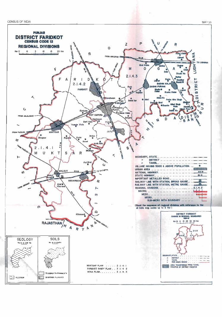
CENSUS OF INDIA
PUNJAB
DISTRICT FARIDKOT CENSUS CODE 12
REGIONAL DIVISIONS KmS o
....
~ ALLWIUM
10 ~ 20 Km
SOILS
o 73 ~EPTS..pSAMMENT5 fiillill 32OR1fC)S- FlllVENTS
MUKTSAR PLAIN . • .•• 2 . I . 4 · I F ARIDI(OT SANDY PLAIN . . 2· r· 4 . 2 MOGAPLAIN • • • .• ••• 2.1·4 · 3
MAP 33
p
BOUNDARY, STATE ......... ............... _ .. _ .. _ DISTRICT ...... . . ..... . ... . ... . _ . _ . _ TAHSl. . . .• ••. .• • . • " •...•••••• _ ._. _
lILLAGE HAVING 5000 , ABOVE POPLt.ATION . •• • URBAN AREA •••• •••••• .. •. ..•••• . • ••..•. im!~~!lI NATIONAL HIGHWAY. .• . . .. . • •. •. •• • . •. •• .. NH 10
STATE HIGHWAY •....•..• .. , •. " •. .• .. .. • . 1Ii~
IMPORTANT METALLED ROAD .• . . • . . . ••..•. "3:: RAILWAY LINE WITH STATION, BROAD GAUGE •. • . RALWAY LINE WITH STATION, METRE GAUGE . • .• REGIONAL DIVISIONS . • . .• ..•• ' ••• .. ..•••• .• .. 2.1.4. 2 ·
MACRO ... . . .... .•••.. •. •. " . • •• . • •. • . ' MESO .. . . •• .. . •. .• • . . .. " •.. . .. . . : .
UICRO . ..•• ... . .. .. . . " . . . ... ..• . SUB-toICRO WITH BOlKlARY •• •• •. ••
(Read thl .. qu...... D' rlQlDnal dIYIIIona willi ,,'or_ to 'III 01 india map cod", up to '3 tlor 1
OISTRICT F ARIOKOT ~ .. REGIONAL IOlN)AIIES
It ... !(m il) 0 10 ,2030 <4o l(m
BOlJtI)AftY , ITA T! . . .. . Ots TRIC T • •. TAHSL . • • • .•.• SUB- MICRO REGION • . • • • • _ •••••••••.•• _ -::-'~ .. ~~;~;:

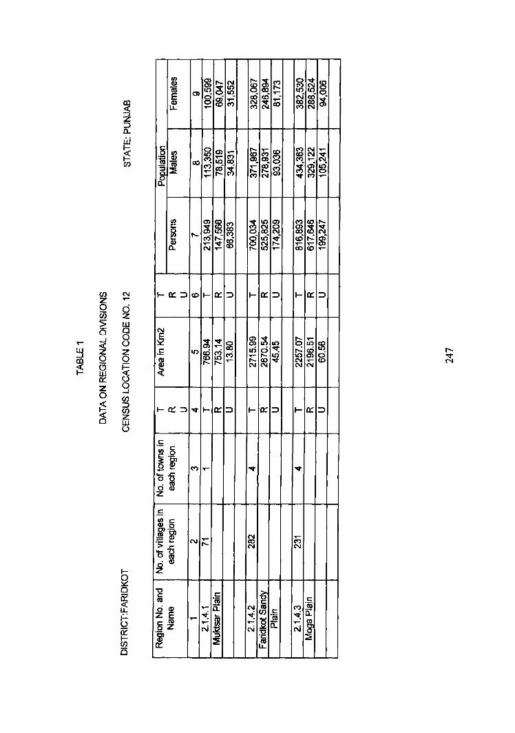
~ o U5 :> B
~ o a ill 0:: Z o ~ C3
~ ..., z :::> 0-
W l-
~ if)
g ill o 8 z o i= () 9 ~ en z ill (.)
II) Q) a; E Q) LL
e 0 ~ 1a iii ~ :: 0 0-
e ._ e II) 0
~ .~ -'0£ d m z
~ 0'> g
.....
0
~ co M ..... .....
...... l C") ~ ~ § ..... ~ ~ ~ ...... .....
m ..- ~ co ..- ~ «i 'd: ('t') ~ co re
0)
~ ..-
8 C") N ..... ..... ('I) ~ N ~ .... ~ 0)_ ..... Il)
~ ?3 g «i ~ ..... co ri ~ ...... ...... N 0) ...,. ('t') .,...
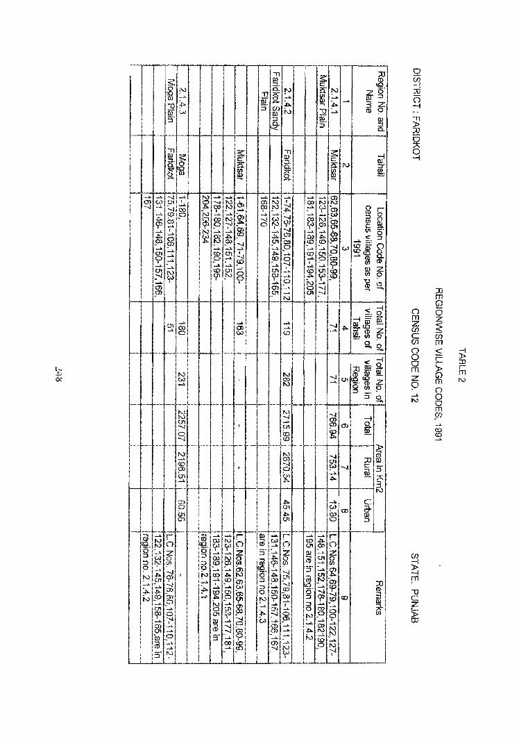
'i1
5': I.).) ::::I,
~ !'" a. I.).)
_,. 1] [ ~ ef. "Q :;) (j) ru w III :f :J a.
r< -
., s: III
If ::::I, e: 0..
~ 9: III .....
-' _,. -...I _" N ...... ..... _,_ ....... ..... O"l (.0 (Jl ,
~ ..... N , O'l N -...I _..
~ ..... cp !V CI)
ljO N - 00 tv ->. -' 10 .0 ...... _.
~ ...... ......
.p. OJ ~ CX! N ..... W Cf> .0 ~ 0 ~ .......
~ ..... , N ..... .....\. .......
~ .....
~ o:l .t>. ..,. ~ co N _co 0 ..... _,. ...... ....... ..... .......
0'1 ......
CD 01 , ..,. 0 -' p _. ..... .~ I '""" CD ..... ..... _.. _. - _,. 0'1 10 01 -'- 0"1 --...I
N <{I _N 0 co Cfi 0 I ..... I _... O'J O'J 9> .!'J"I
Q1 ..... _"
co 0) .... 0 W
IV w , .....
N N (J'I
:"'l ,
0 --..j
,
N "'"" <C 9l I
(J'I -'"
,0)
9 'trl ill
~, _.. r ro .... ..... r- III ..... N () ~, OJ N 0 CD w N (J.) W ->.
0 _
z 0 I I
Z -"" :;) _..
::::I _. _.. :;)
w 0 co N 0 ~ :::! N (/) :;) co 9l (J) en 'P 9
, 9 (» <Q, .......
--..j _. _.. -'
t'J ..,.
'P , N to ..,. N 0 ~
01 ..... ..... m 0> :J CD _,_ --..j , ..... ...... ..... W :::t _,.
~ .$>. (» :>-~ 0'1 m 0 (Jl
N 50 00 _,. p '? _o ~ ~
!'> _. .... -'
.... (Jl ..... (Jl
~ C1I
7> 0 (Jl 'f :--I _.. --..j OJ ...... --.J (.,.) ....>. I a 01 -" (j) :::J 00
(J) 0'1 ..... ~ OJ ,0 :5" ....... 0 ..... I
ro _" 00 <:0 (J) ..... ...... .1:0 -..! 5' I'..)
_
5: e:
!'> i?r !'> _.. ~ -"
~ ~ -. i-0 -0 .....
iii S'
'i1 :5: ill ::::I, e: 0. as: " ~ g. --.
..... ~ _" (J) I co N N ..... .... w m .!;>. ,
-:.._, _. ... Vl CX! N
'P t.J .OJ (j,) , U1 -...! _. _._ 6l SYJ ~ ~ 00 00 CD
0 -..I _.... ....b. .... co 0'1 a 0 _. 0 00 ~
, a _,. -" I -~ _~ (J1 co _" Cfi _I:O 0 N ...... ->. 0 -...! ~ 01 -..I N
_.. "'-J _..
<0 .....
N -..J 00 ...... N
N ..... -...l ..... ~ (J1
Co ~ co
N -...l CJ) -...l (J1
~ 0
~ _,. ~
.t>- _,. 01 (.0
~ 0:> 01 <::)
! ...... _.. r () to .j:>. 0 (J't co Z OJ ...... Z 0 .... 0'1 0 Yl (V _. (!)
S' ..... ...... ~
.0'1
~, (Jl N m 'I _... tp 50 -..I
00 ::J 7> -...! _.. CD , :;) _.. ...... ..... 0 00
~ ~ t'J 0 _.
....>. ..... _... J.>.
co N _.. N !V -'- N
_. 10 ..... _\. 0 N N
W ..... , ,
Z OJ .... 3 ('!)
N
£ ::::I (/) e: (/!
c::: ..... co= W coW .....<0
ffi OJ (/)
'0 (V ....
~, .....,= w&5 ~ =t'(!) ~(/)
g,
<:: ::::tl= ClIJ!'i (}l fti2. (!) g fJ')
:J
-I OJ £.
Q!.
XI -..J C
~
c .... CD 0-ro
::J
co
XI ~ 0' ::::I
z 9 ill :;) 0..
-! OJ ::r ~
r 0 g_ 0' ::J
9 a. (!)
Z 9 0 -.
-! 0 §I Z 9 9, -I !:l ~ z 9 a
~ .... (V W :5' §' N
~ 3 III x (Jl
() m z (J) C (J)
() 0 0 m Z q -" N
(J) g m
"'0 C Z c..,
~
Xl m G)
6 z ~ (J) m ~ ~ r-s: IJj
r G) m m N
() 0 0 m sn .... c:o <0
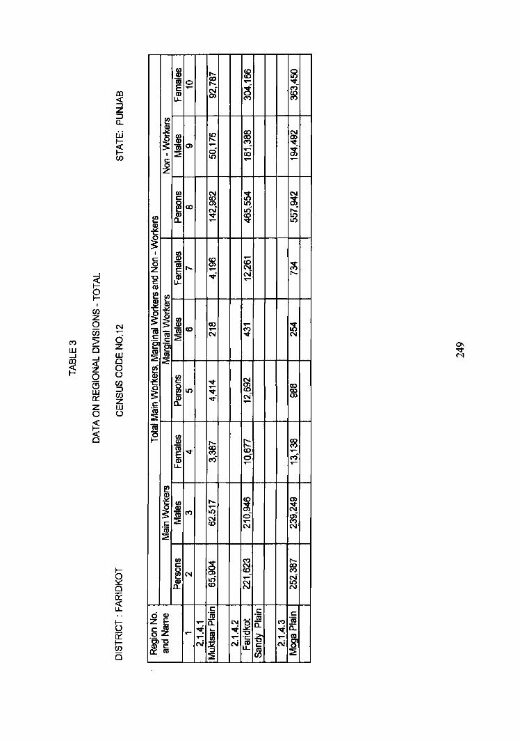
$ ....... ~ ~ ~ co
0 ....... ..-.... N ~ ri Q) U. 0> co
("') ("')
i $ 10 co ~ ~ ....... ~
(ij0> .... """ I :2 0 ..- ...f'
IS 10 co 0> ...... ..-
Z
en N ~ N C ~ ~IX) 10 -a; Q)
N Iri ...: en a.. -.:t co :g ... ..- v ~ ~
_J
~ I
(/) Z 0 N Ci5 ..-
t") 5 d w is z _J
_J W aJ
~ 0
~ 0 0 (,)
G C/)
w :::> 0:: C/)
Z Z W 0 t)
~ C§
I $ C ~ ..--
0 ~ ....... ~ ~ z ..-
-c tf ...f' N ....... C
..-co f!
i ~ ~ ~ m IX) ...... ;1,; ~ iii m co ..-- ("')
:2 N """
N
"e "~ co :2 IU ~
~ ~ ~ """
N
~ U) ...... 0> co
""" co
~ &. ...f' N
C ..-
"a; ~ 10 0 m t- ....... ~
~v ~ ~ co ..-
ri ci ri ..- ..-
e ~ en ....... co 0>
~ it") ..... ~ ~ U)
:2 ~ 0 a)
c ...... ("')
"n; N N
~
en ~
("') c .......
~N N IX)
0) co ("')
CI) .0 ..- ftI a.. co N N N
~ C C
CI) "n; C
E "":0:: NO "a; t") "a;
5 ~ ,..."'=': I "~ c:: -tia.. ..:a:-c
~ -, -g ..... ..- "C ..-I~ N N~ N
IU :::J ~ ::!: :2
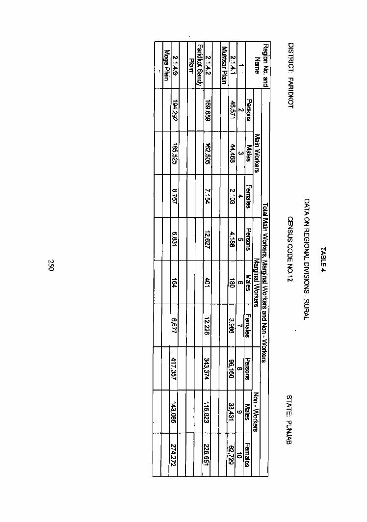
N VI o
r s:' , , I~ I
"T1 -~ !'J ......
CD
~ ...... .~ 8 m
-
.... N !'- ~ -~ ...... en ~ ~ m ::l
UJ
11 ~ g' 3z CD P
-
I» ::l c.
C} !it -~ s·
~ ~
~s:: ~.~.
I
- TtI-H+W-_!JJ • ...... ~
::l _.
0 I» :::l
...... ~m -I»
f ~~ I "T1
Cilj~ ...... [ !'J Y-" ~~ N ~ N ~ 0) f I
I f-_l
I~ _,~
~ 1/ ~
5-J en
(0) .... Q)§ :i:! ~ (I)
I
~ ~
() 0 m z z (fJ :;0 c m en G')
8 (5
0 ~ );! m r OJ
Z 0 r
p S m • ..... en
N (5 Z en I
:::0 C
~ r
m co 10 co
~ 0 I.() .... ..... 0 <0 ..-
"..... 0 r-: a) Q) C"') ..... co u..
~
I m ~ to ..... <0 0
iii 0) ..... l() ~ I ::!: cO ~ ....
c: ..... l()
0 2
I/) N 0 10 c: 0 co co
~co co ..- l()
cO N 0 ~
Q) ~ N 'V n.. ..... ..-
~ ~
2 O§
I m c: 0 iii 0 I.() ..... 2 E ..... ..... ('t) l()
N ~ "0 Q) c: u.. ro
0::: :::J
CI) N 2 ..-0 0 Ci5 Z
10 > W w is Q _.J
_.J 0 £D
~ ~ (.)
rn 0 ::> a rn w Z 0::: W
2 (.)
0
~ j ~ ~ ~ m co 0 8 ni ~
1ti to C"') ('t) c: :::2: .... "e °e ro ~ ::;!
e ~ I/)
c: 0...
~IO co ..... ~
10 (t co 10 Q) 10
c: a. 0(ij
::!: ~ « 0 ~ I/)
Q)
~ M ..-
~ ~ N ..... N 10 M
Q) ..- M ..; LL
~
~ .m 0) ..... ~
~ C"') ~ ~ ..... _ ~ rx5 rx5 C"')
c: ..- ...,. 10 0(ij ::;!
I/) ('I') ~ 10 c:
~ ('I') 0
N ('I') CD ..... 0) a) ..... cD CL ..- 10 10
c: c: 00) 0(ij c: ~ E a:: N ~
On; ('I') ~ .- 0: c: ro ~ I ~ ~ a.
02 .... :g ~ ~ o~-g .- ..- ..... N N {f_ ffi N
0:: ro ::J ~ ~ (/J
"T1
i. m :2.
!'l c.. !'l m ..... J! [ ...... ~
m :,.. 1J :r ~ er. w N :::J ~
C ;:c -f C ;:c -f
.... ~ ~ ~
..... N .... ~ ~ .0 91 co ~
..... 0 ~ N ~ .... CJ1 0
0 en 0 .....
.... II.) ..... .... ~ & ..... ~ .....
~ p W
~ ~ N ~ en ~ 0 en ~ m
.. ~ ..... ~ m ..... t ~ ~
~ ..... ~
..... en ~ .. en ..... 0 0 N en ~
C :;0 -i C :;0 -t
t II.) ~ ~ ~
II.) ...... en c.n 0 ....
N ~ ~ ~ ...... '0
:::1 :::1 .... co
N ..... ..... II.) .... -.110 ..... w ~ w ~ C» co c.n (A)
8 (:) ~ ~ .~ ~ ~ .... ~ 0 w
N J ..... N ;£
..... N ..... 0 0 .!'> ~ m ~ ~ ! ~ ~ .... m CJ)
s:: c:
f !'l ..... ~
1J .... ii) S·
C ;:c -f '"
~ g gj
t ~ w w ..... ..... ...... ..
~ W CJ1 N (,.)
~ ~ ~ .tao
..... ..... (,.) CJ1 en w .... N ~ 01 w 00 ..... 0 (J1 en
C :::0 -i C»
..... co ~ CJ) ..... en (0 ex, ex, ...... .... ~
..... .... 0
~ .. SXJ N
~ ~ w 00 ...... co
N ~ ~
~ co
~ ~ (0
.....
::u ~
ig' 3g: <D.
m ::J Q.
C;;D-f
1J
§ en
.
c: .... ~ 5 !!!. -m m
"T1 <D
S m-
C::U-f
1J <D
~ ::J en
en g. 8. 3:: c:
!!!. [ m &' I
"T1
~ CD en
n m z en c en 5 ~ -f 5 Z n 0 0 m z. p ..... N
(J)
~ rrl 1J C
~ CD
0
~ » 0 z ;;0 m
~ (j)
5 III r $ m r CJ)
0 S en (5 z (J)