Embed Size (px)
Citation preview
International Civil Aviation Organization
Approved by the Counciland published by authority of the Secretary General
RegionalSupplementaryProcedures
Fifth Edition — 2008
Doc 7030
Orders should be sent to one of the following addresses, together with the appropriate remittance in U.S. dollars or in the currency of thecountry in which the order is placed. Customers are encouraged to use credit cards (MasterCard, Visa or American Express) to avoiddelivery delays. Information on payment by credit card and by other methods is available in the Ordering Information Section of theCatalogue of ICAO Publications and Audio-visual Training Aids.
International Civil Aviation Organization. Attention: Document Sales Unit, 999 University Street, Montréal, Quebec, Canada H3C 5H7Telephone: +1 514-954-8022; Facsimile: +1 514-954-6769; Sitatex: YULCAYA; E-mail: [email protected];World Wide Web: http://www.icao.int
Cameroon. KnowHow, 1, Rue de la Chambre de Commerce-Bonanjo, B.P. 4676, Douala / Telephone: +237 343 98 42; Facsimile: +237 343 89 25; E-mail: [email protected]
China. Glory Master International Limited, Room 434B, Hongshen Trade Centre, 428 Dong Fang Road, Pudong, Shanghai 200120Telephone: +86 137 0177 4638; Facsimile: +86 21 5888 1629; E-mail: [email protected]
Egypt. ICAO Regional Director, Middle East Office, Egyptian Civil Aviation Complex, Cairo Airport Road, Heliopolis, Cairo 11776Telephone: +20 2 267 4840; Facsimile: +20 2 267 4843; Sitatex: CAICAYA; E-mail: [email protected]
Germany. UNO-Verlag GmbH, August-Bebel-Allee 6, 53175 Bonn / Telephone: +49 0 228-94 90 2-0; Facsimile: +49 0 228-94 90 2-22;E-mail: [email protected]; World Wide Web: http://www.uno-verlag.de
India. Oxford Book and Stationery Co., 57, Medha Apartments, Mayur Vihar, Phase-1, New Delhi – 110 091Telephone: +91 11 65659897; Facsimile: +91 11 22743532
India. Sterling Book House – SBH, 181, Dr. D. N. Road, Fort, Bombay 400001Telephone: +91 22 2261 2521, 2265 9599; Facsimile: +91 22 2262 3551; E-mail: [email protected]
India. The English Book Store, 17-L Connaught Circus, New Delhi 110001Telephone: +91 11 2341-7936, 2341-7126; Facsimile: +91 11 2341-7731; E-mail: [email protected]
Japan. Japan Civil Aviation Promotion Foundation, 15-12, 1-chome, Toranomon, Minato-Ku, TokyoTelephone: +81 3 3503-2686; Facsimile: +81 3 3503-2689
Kenya. ICAO Regional Director, Eastern and Southern African Office, United Nations Accommodation, P.O. Box 46294, Nairobi Telephone: +254 20 7622 395; Facsimile: +254 20 7623 028; Sitatex: NBOCAYA; E-mail: [email protected]
Mexico. Director Regional de la OACI, Oficina Norteamérica, Centroamérica y Caribe, Av. Presidente Masaryk No. 29, 3er Piso,Col. Chapultepec Morales, C.P. 11570, México D.F. / Teléfono: +52 55 52 50 32 11; Facsímile: +52 55 52 03 27 57; Correo-e: [email protected]
Nigeria. Landover Company, P.O. Box 3165, Ikeja, LagosTelephone: +234 1 4979780; Facsimile: +234 1 4979788; Sitatex: LOSLORK; E-mail: [email protected]
Peru. Director Regional de la OACI, Oficina Sudamérica, Av. Víctor Andrés Belaúnde No. 147, San Isidro, Lima (Centro Empresarial Real, Vía Principal No. 102, Edificio Real 4, Floor 4)Teléfono: +51 1 611 8686; Facsímile: +51 1 611 8689; Correo-e: [email protected]
Russian Federation. Aviaizdat, 48, Ivan Franko Street, Moscow 121351 / Telephone: +7 095 417-0405; Facsimile: +7 095 417-0254Senegal. Directeur régional de l’OACI, Bureau Afrique occidentale et centrale, Boîte postale 2356, Dakar
Téléphone: +221 839 9393; Fax: +221 823 6926; Sitatex: DKRCAYA; Courriel: [email protected]. Air Traffic Services of the Slovak Republic, Letové prevádzkové služby Slovenskej Republiky, State Enterprise,
Letisko M.R. Štefánika, 823 07 Bratislava 21 / Telephone: +421 2 4857 1111; Facsimile: +421 2 4857 2105; E-mail: [email protected] Africa. Avex Air Training (Pty) Ltd., Private Bag X102, Halfway House, 1685, Johannesburg
Telephone: +27 11 315-0003/4; Facsimile: +27 11 805-3649; E-mail: [email protected]. A.E.N.A. — Aeropuertos Españoles y Navegación Aérea, Calle Juan Ignacio Luca de Tena, 14, Planta Tercera, Despacho 3. 11,
28027 Madrid / Teléfono: +34 91 321-3148; Facsímile: +34 91 321-3157; Correo-e: [email protected]. Adeco-Editions van Diermen, Attn: Mr. Martin Richard Van Diermen, Chemin du Lacuez 41, CH-1807 Blonay
Telephone: +41 021 943 2673; Facsimile: +41 021 943 3605; E-mail: [email protected]. ICAO Regional Director, Asia and Pacific Office, P.O. Box 11, Samyaek Ladprao, Bangkok 10901
Telephone: +66 2 537 8189; Facsimile: +66 2 537 8199; Sitatex: BKKCAYA; E-mail: [email protected] Kingdom. Airplan Flight Equipment Ltd. (AFE), 1a Ringway Trading Estate, Shadowmoss Road, Manchester M22 5LH
Telephone: +44 161 499 0023; Facsimile: +44 161 499 0298; E-mail: [email protected]; World Wide Web: http://www.afeonline.com
Catalogue of ICAO Publicationsand Audio-visual Training Aids
Issued annually, the Catalogue lists all publications and audio-visual training aids currently available. Supplements to the Catalogue announce new publications and audio-visual training aids, amendments, supplements, reprints, etc.
Available free from the Document Sales Unit, ICAO.
5/07
Published in separate English, French, Russian and Spanish editions by the International Civil Aviation Organization. Allcorrespondence, except orders and subscriptions, should be addressed to the Secretary General.
International Civil Aviation Organization
Approved by the Counciland published by authority of the Secretary General
RegionalSupplementaryProcedures
Fifth Edition — 2008
Doc 7030
(ii)
AMENDMENTS
Amendments are announced in the supplements to the Catalogue of ICAO Publications; the Catalogue and its supplements are available on the ICAO website at www.icao.int. The space below is provided to keep a record of such amendments.
RECORD OF AMENDMENTS AND CORRIGENDA
AMENDMENTS CORRIGENDA
No. Date Entered by No. Date Entered by
1 8/1/09 ICAO
2 25/8/09 ICAO
3 15/10/10 ICAO
4 25/5/11 ICAO
5 22/7/11 ICAO
6 27/3/12 ICAO
7 30/12/12 ICAO
(iii) 30/11/07
TABLE OF CONTENTS — GENERAL
Page Foreword . . . . . . . . . . . . . . . . . . . . . . . . . . . . . . . . . . . . . . . . . . . . . . . . . . . . . . . . . . . . . . . . . (v) Procedure for the amendment of Regional Supplementary Procedures . . . . . . . . . . . . . . . . . . . . . (vii) Glossary . . . . . . . . . . . . . . . . . . . . . . . . . . . . . . . . . . . . . . . . . . . . . . . . . . . . . . . . . . . . . . . . . (xi) Index to Application of Supplementary Procedures . . . . . . . . . . . . . . . . . . . . . . . . . . . . . . . . . . . (xiii) Africa-Indian Ocean (AFI) Regional Supplementary Procedures Table of Contents . . . . . . . . . . . . . . . . . . . . . . . . . . . . . . . . . . . . . . . . . . . . . . . . . . . . . . AFI (i) Caribbean (CAR) Regional Supplementary Procedures Table of Contents . . . . . . . . . . . . . . . . . . . . . . . . . . . . . . . . . . . . . . . . . . . . . . . . . . . . . . CAR (i) European (EUR) Regional Supplementary Procedures Table of Contents . . . . . . . . . . . . . . . . . . . . . . . . . . . . . . . . . . . . . . . . . . . . . . . . . . . . . . EUR (i) Middle East/Asia (MID/ASIA) Regional Supplementary Procedures Table of Contents . . . . . . . . . . . . . . . . . . . . . . . . . . . . . . . . . . . . . . . . . . . . . . . . . . . . . . MID/ASIA (i) North America (NAM) Regional Supplementary Procedures Table of Contents . . . . . . . . . . . . . . . . . . . . . . . . . . . . . . . . . . . . . . . . . . . . . . . . . . . . . . NAM (i) North Atlantic (NAT) Regional Supplementary Procedures Table of Contents . . . . . . . . . . . . . . . . . . . . . . . . . . . . . . . . . . . . . . . . . . . . . . . . . . . . . . NAT (i) Pacific (PAC) Regional Supplementary Procedures Table of Contents . . . . . . . . . . . . . . . . . . . . . . . . . . . . . . . . . . . . . . . . . . . . . . . . . . . . . . PAC (i) South American (SAM) Regional Supplementary Procedures Table of Contents . . . . . . . . . . . . . . . . . . . . . . . . . . . . . . . . . . . . . . . . . . . . . . . . . . . . . . SAM (i)
The designations employed and the presentation of the material in this publication do not imply the expression of any opinion whatsoever on the part of ICAO concerning the legal status of any country, territory, city or area or of its authorities, or concerning the delimitation of its frontiers or boundaries.

(v) 30/11/07
FOREWORD
1. The ICAO Regional Supplementary Procedures (SUPPS) form the procedural part of the Air Navigation Plans developed by Regional Air Navigation (RAN) Meetings to meet those needs of specific areas which are not covered in the worldwide provisions. They complement the statement of requirements for facilities and services contained in the Air Navigation Plan publications. Procedures of worldwide applicability are included either in the Annexes to the Convention on International Civil Aviation as Standards or Recommended Practices, or in the Procedures for Air Navigation Services (PANS). 2. In the development of Regional Supplementary Procedures, the following criteria must be satisfied: a) Regional Supplementary Procedures should indicate a mode of implementing procedural provisions in
Annexes and PANS, as distinct from a statement or description of required facilities and services as published in the Air Navigation Plan publications. Regional Supplementary Procedures may also indicate permissible additions to provisions in Annexes and PANS, subject to the restrictions in b) and c).
b) Regional Supplementary Procedures must not be in conflict with the provisions contained in the
Annexes or PANS. They must either specify detailed procedural regional options for those provisions or promulgate a regional procedure of justifiable operational significance, additional to existing provisions in Annexes or PANS.
c) In the drafting of Regional Supplementary Procedures, variations in the text of procedures with similar
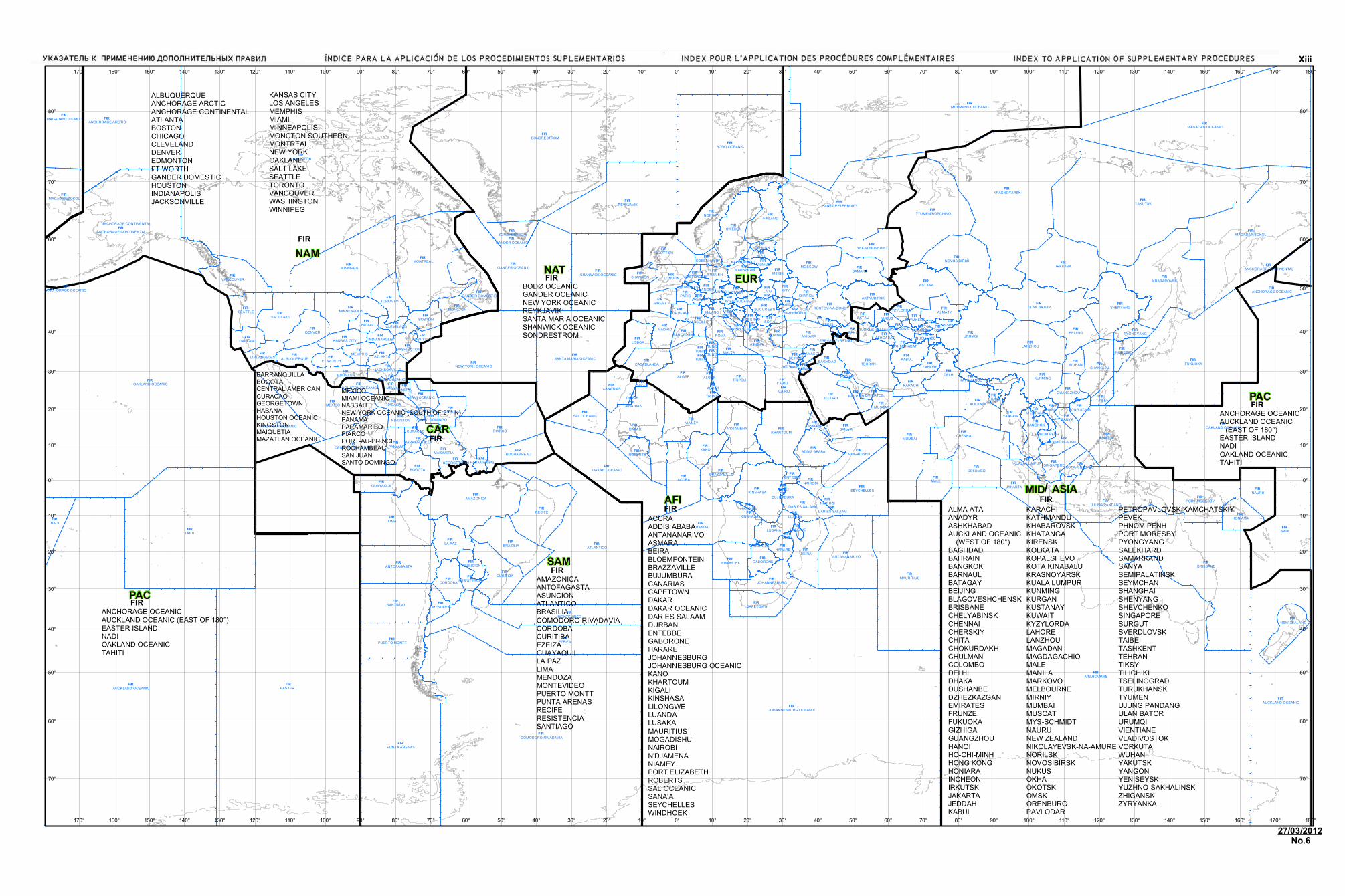
intent applicable to more than one area should be avoided. 3. The Regional Supplementary Procedures do not have the same status as Standards and Recommended Practices. The latter are adopted by Council in pursuance of Article 37 of the Convention on International Civil Aviation, subject to the full procedure of Article 90. PANS are approved by the President of the Council of ICAO on behalf of the Council and SUPPS are approved by the Council; the PANS are recommended to Contracting States for worldwide use, whilst the SUPPS are recommended to Contracting States for application in the groups of flight information regions to which they are relevant. 4. PANS were originally developed from common recommendations of regional meetings and were given worldwide application by the ICAO Council after action thereon by ICAO Divisions. Subsequently, there has been a gradual evolution of procedures from the regional to the worldwide category as ICAO Divisions have been able to adapt regionally developed procedures to worldwide requirements. Concurrently, some of the worldwide procedures have been found suitable for classification as Standards or Recommended Practices and therefore are gradually being incorporated into the Annexes to the Convention. 5. Application of the Regional Supplementary Procedures in certain areas of the world has been specified according to groups of flight information regions (FIRs) as shown on page (xiii). The abbreviations on the chart identifying the groups of flight information regions in which specific sets of SUPPS apply have been chosen in reference to ICAO region designators, but the limits of the areas of application do not necessarily coincide with the boundaries of the ICAO regions. 6. Whenever there is a specific relationship between a supplementary procedure and an Annex or PANS, such relationship has been indicated by reference to the parent document and relevant chapter, appendix, etc. These references appear above the text, together with the appropriate abbreviation as follows:
(vi) Regional Supplementary Procedures
30/11/07
A — Annexes to the Convention P — Procedures for Air Navigation Services Examples: (A2 – Chapter 3) — Refers to Chapter 3 of Annex 2 — Rules of the Air (P-ATM – Chapters 7 and 9) — Refers to Chapters 7 and 9 of Doc 4444 — Procedures for Air Navigation
Services — Air Traffic Management. 7. The degree of non-application of the Regional Supplementary Procedures or national differences are notified in Aeronautical Information Publications in accordance with the provisions of Annex 15 — Aeronautical Information Services (cf. 4.1.1, 4.1.2 c) and Appendix 1). 8. This document is maintained by amendments as required. Any errors or omissions should be brought to the attention of the Secretary General, ICAO, 999 University Street, Montréal, Quebec, Canada H3C 5H7.
_____________________
(vii) 30/11/07
PROCEDURE FOR THE AMENDMENT OF REGIONAL SUPPLEMENTARY PROCEDURES
(Approved by Council (25-2) 20/5/55, (84-5) 7/3/75, (153-3) 25/2/98)
1. INTRODUCTION 1.1 Regional Supplementary Procedures are normally formulated at regional air navigation meetings and become effective after review by the Air Navigation Commission and approval by the Council. 1.2 Amendments to Regional Supplementary Procedures may be proposed by a Contracting State or group of States as set out in Section 2 or by an international organization as set out in Section 3 or may become necessary as a consequence of action by Council in adopting or amending Standards and Recommended Practices or in approving or amending Procedures for Air Navigation Services as set out in Section 4.
2. AMENDMENTS PROPOSED BY A CONTRACTING STATE OR GROUP OF STATES
2.1 If any Contracting State or group of States of a region wishes to propose an amendment to Regional Supplementary Procedures for that region, it should submit the proposal, adequately documented, to the Secretary General through the Regional Office accredited to that State. The proposal should include the facts that led the State to the conclusion that the amendment is necessary. 2.2 The Secretary General will circulate the proposal, adequately documented, with a request for comments to all provider and user States of the region considered affected, as well as to user States outside the region and international organizations that may be concerned with the proposal. If, however, the Secretary General considers that the proposed amendment conflicts with established ICAO policy or that it raises questions which the Secretary General considers should be brought to the attention of the Air Navigation Commission, the proposal will be first presented, adequately documented, to the Commission. In such cases, the Commission will decide on the action to be taken. 2.3 If, in reply to the Secretary General’s inquiry to States and selected international organizations, no objection is raised to the proposal by a specified date, the Secretary General will circulate an amendment memorandum to Representatives on the Council and to Members of the Air Navigation Commission inviting each recipient to advise, normally within seven days,* whether formal discussion of the proposed amendment is desired. The memorandum will explain the proposed amendment, summarize the comments received and include Secretariat comments as appropriate. If, in reply to the Secretary General’s inquiry to States and selected international organizations, any objection is raised and if the objection remains after further consultation, the matter will be documented for formal consideration by the Air Navigation Commission and appropriate recommendations of the Commission to the Council. 2.4 If, at the end of the seven-day period,* there has been no request for discussion of the amendment, it will be submitted to the President of the Council who is authorized to approve the amendment on behalf of the Council.
* During recess, a period of three weeks will normally be allowed.
(viii) Regional Supplementary Procedures
30/11/07
2.5 If, on the other hand, any Representative on the Council or Member of the Air Navigation Commission indicates a desire for formal discussion of the proposed amendment, the matter will be documented for formal consideration by the Commission and appropriate recommendations of the Commission to the Council.
3. AMENDMENTS PROPOSED BY INTERNATIONAL ORGANIZATIONS 3.1 Proposals for the amendment of Regional Supplementary Procedures submitted by international organizations directly concerned with the operation of aircraft, which may be invited to attend suitable ICAO meetings and which attended the meeting(s) where the relevant procedures were prepared, will be dealt with in the same manner as those received from States, except that, before circulating a proposal to States and selected international organizations pursuant to 2.2, the Secretary General will ascertain whether it has adequate support from the State or group of States whose facilities, services and procedures will be affected. If such support is not forthcoming, the proposal will be presented to the Commission, and the Commission will decide on the action to be taken.
4. CONSEQUENTIAL AMENDMENTS 4.1 In the event of an amendment to Regional Supplementary Procedures becoming necessary as a consequence of action by Council in adopting or amending Standards and Recommended Practices or in approving or amending Procedures for Air Navigation Services, the amendment will be drafted by the Secretary General. 4.2 The Secretary General will circulate the amendment, together with relevant explanatory material, in a memorandum to each Member of the Air Navigation Commission inviting each recipient to notify him, normally within seven days,* whether formal discussion of the proposed amendment is desired. 4.3 If, at the end of the seven-day period,* there has been no request for discussion of the amendment, formal approval will be given by the Air Navigation Commission acting on behalf of the Council** or, if the Commission is in recess, by the President of the Council. 4.4 If any Commissioner indicates a desire for formal discussion of the amendment, the matter will be documented for formal consideration by the Air Navigation Commission. If the Commission concludes that the amendment is necessary, it is authorized to approve the amendment on behalf of the Council,** in its original form or modified.
5. PROMULGATION OF APPROVED AMENDMENTS 5.1 Amendments to Regional Supplementary Procedures that have been approved in accordance with the above procedures will be promulgated in Doc 7030, Regional Supplementary Procedures.
_____________________
* During recess, a period of three weeks will normally be allowed. ** The Air Navigation Commission has been authorized [17-1, Doc 7328-1, (C/853-1)] to approve consequential amendments on
behalf of the Council.
(ix) 30/11/07 25/5/11
No. 4
Glossary
ACAS airborne collision avoidance systems ACC area control centre ADLP aircraft data link processor ADS-B automatic dependent surveillance – broadcast ADS-C automatic dependent surveillance – contract AFCS automatic flight control system AFTN aeronautical fixed telecommunication network AIM ATFM information message AIP aeronautical information publication AIRAC aeronautical information regulation and control AIS aeronautical information service ANM ATFM notification message ANP air navigation plan ARO air traffic services reporting office ASDA accelerate-stop distance available ASE altimetry system error ASTER ATFM system of the EUR region ATC air traffic control ATFM air traffic flow management ATIS automatic terminal information services ATM air traffic management ATS air traffic service B-RNAV basic-RNAV, also referred to as RNAV 5 CAP Code allocation plan CARSAMMA CAR/SAM monitoring agency CFMU central flow management unit CHG modification message CNL cancellation message CPDLC controller-pilot data link communications CRAM conditional route availability message CTA control area CTOT calculated take-off time DAP downlink aircraft parameter DES de-suspension message DME distance-measuring equipment DOF date of flight EAD European AIS database EOBT estimated off-block time
(x) Regional Supplementary Procedures
30/11/07 25/5/11
No. 4
FIR flight information region FIS flight information service FL flight level FLAS flight level allocation scheme FLS flight suspension message FPL flight plan GAT general air traffic HF high frequency IFBP in-flight broadcast by pilots IFF identification friend/foe IFPS initial flight plan processing system IFR instrument flight rules IGA international general aviation INS inertial navigation system LAM logical acknowledgement message LSA localizer sensitive area LVP low visibility procedures MASPS minimum aviation system performance standards MFA minimum flight altitude MNPS minimum navigation performance specifications MSA minimum sector altitude NOF NOTAM offices NOTAM notice to airmen OCA oceanic control area OTS organized track system PACOTS Pacific organized track systems PBN performance-based navigation PIB pre-flight information bulletin P-RNAV precision-RNAV RFP replacement flight plan RNAV area navigation RNAV 1 An RNAV specification having a lateral navigation accuracy of 1 nautical mile. RNAV 1 approved
aircraft are approved for P-RNAV. RNAV 5 An RNAV specification having a lateral navigation accuracy of 5 nautical miles. RNAV 5 is also
referred to as B-RNAV in the EUR. RNP required navigation performance RPL repetitive flight plan
Regional Supplementary Procedures (xi)
30/11/07
RTF radiotelephony RVR runway visual range RVSM reduced vertical separation minimum SAM slot allocation message SRM slot revision message SATMA South Atlantic monitoring agency SAT NAV satellite navigation SATCOM satellite communication SD standard deviation SELCAL selective calling SID standard instrument departure SIF selective identification feature SLC slot cancellation message SLOP strategic lateral offset procedures SSR secondary surveillance radar STAR standard instrument arrival STS special handling TA transition altitude TAS true airspeed TLS target level of safety TMA terminal control area TODA take-off distance available TORA take-off run available TVE total vertical error UAC upper area control centre UIR upper flight information region VSM vertical separation minimum VFR visual flight rules VOLMET meteorological information for aircraft in flight VOR VHF omnidirectional radio range WATRS West Atlantic Route System
_____________________
27/3/12 No. 6

AFIAFI
PACPAC
ASIAASIA
EUREUR
SAMSAM
NATNATNAMNAM
PACPAC
CARCAR
MIDMID
FIR MELBOURNE
FIR EASTER I.
FIR EDMONTON
FIR JOHANNESBURG OCEANIC
FIR AUCKLAND OCEANIC
FIR TAHITI
FIR OAKLAND OCEANIC
FIR SONDRESTROM
FIR YAKUTSK
FIR COMODORO RIVADAVIA
FIR MURMANSK OCEANIC
FIR FUKUOKA
FIR BRISBANE
FIR ATLANTICO
FIR NADI
FIR OAKLAND OCEANIC
FIR KRASNOYARSK
FIR MAURITIUS
FIR EZEIZA
FIR PUNTA ARENAS
FIR MAGADAN OCEANIC
FIR LIMA
FIR AUCKLAND OCEANIC
FIR BODO OCEANIC
FIR REYKJAVIK
FIR MUMBAI
FIR MEXICO
FIR MAGADAN/SOKOL
FIR NEW YORK OCEANIC
FIR ANCHORAGE ARCTIC
FIR LUANDA
FIR WINNIPEG
FIR MONTREAL
FIR ANCHORAGE CONTINENTAL
ANCHORAGE CONTINENTAL
FIR DAKAR
FIR SANKT PETERBURG
FIR ALGER
FIR IRKUTSK
FIR MANILA
FIR AMAZONICA
FIR GANDER OCEANIC
FIR KHABAROVSK
FIR URUMQI
FIR RECIFE
FIR PIARCO
FIR SANTA MARIA OCEANIC
FIR DAKAR OCEANIC
FIR ASTANA
FIR TRIPOLI
FIR UJUNG PANDANG
FIR NORWAY
FIR JAKARTA
FIR TEHRAN
FIR BEIRA
FIR TYUMEN/ROSCHINO
FIR ACCRA
FIR SHANWICK OCEANIC
FIR SANTIAGO
FIR LANZHOU
FIR JEDDAH
FIR CHENNAI
FIR ANTANANARIVO
FIR MONTEVIDEO
FIR CAIRO
FIR CAIRO
FIR MALE
FIR BRASILIA
FIR KHARTOUM
FIR NIAMEY
FIR SWEDEN
FIR ULAN BATOR
FIR KINSHASA
FIR SHENYANG
FIR KUNMING
FIR SEYCHELLES FIR
NAURU
FIR NADI
FIR MAGADAN OCEANIC
FIR ANTOFAGASTA
FIR DELHI
FIR CURITIBA
FIR MOSCOW
FIR NOVOSIBIRSK
FIR COLOMBO
FIR FINLAND
FIR SANA'A
FIR SALT LAKE
FIR KANO
FIR KOLKATA
FIR N'DJAMENA
FIR LA PAZ
FIR SAMARA
FIR MAZATLAN OCEANIC
FIR BEIJING
FIR CENTRAL AMERICAN
FIR CANARIAS
FIR PUERTO MONTT
FIR PORT MORESBY
FIR BOGOTA FIR
BRAZZAVILLE
FIR SHANGHAI
FIR VANCOUVER
FIR YANGON
FIR SCOTTISH
FIR ANKARA
FIR MOGADISHU
FIR SEATTLE
FIR LISBOA
FIR MINNEAPOLIS
FIR KABUL
FIR DENVER
FIR WINDHOEK
FIR MADRID
FIR MAGADAN/SOKOL
FIR CAPETOWN
FIR MAIQUETIA
FIR ROMA
FIR HONIARA
FIR YEKATERINBURG
FIR SAL OCEANIC
FIR AKTYUBINSKFIR
TORONTO
FIR ROCHAMBEAU
FIR LUSAKA
FIR ATHINAI
FIR LONDON
FIR CORDOBA
FIR NEW ZEALAND
FIR ADDIS ABABA
FIR ALMATY
FIR JOHANNESBURG
FIR BANGKOK
FIR NAIROBI
FIR BREST
FIR KARACHI
FIR GUAYAQUIL
FIR ROBERTS
FIR CASABLANCA
FIR KYIV
FIR MUSCAT
FIR DAR ES SALAAM
FIR BOSTON
FIR PANAMA
FIR SAN JUAN
FIR MONCTON
FIR ROSTOV-NA-DONU
FIR HOUSTON
FIR MINSK
FIR OAKLAND
FIR SINGAPORE
FIR HABANA
FIR SONDRESTROM
FIR INCHEON
FIR ANCHORAGE OCEANIC
FIR MIAMI
FIR WUHAN
FIR GABORONE
FIR TAIBEI
FIR MEMPHISFIR
ALBUQUERQUE
FIR AKTAU
FIR L'VIV
FIR FT WORTH
FIR SHANNON
FIR KANSAS CITY
FIR HARARE
FIR PARIS
FIR LAHORE
FIR BAKU
FIR LOS ANGELES
FIR BREMEN
FIR KINGSTON
FIR CHICAGO
FIR MALTA
FIR BUCURESTI
FIR PYONGYANG
FIR KHARKIV
FIR KOBENHAVN
FIR GANDER DOMESTIC
FIR HO-CHI-MINH
FIR WARSZAWA
FIR GUANGZHOU
FIR GANDER OCEANIC
FIR BAGHDAD
FIR BAHRAIN
FIR MENDOZA
FIR RIGA
FIR TUNIS
FIR NUKUSFIR
MARSEILLE
FIR MIAMI OCEANIC
FIR ASUNCION
FIR JACKSONVILLE
FIR SANYA
FIR ATLANTA
FIR WASHINGTON
FIR ANCHORAGE CONTINENTAL
FIR HANOI
FIR SOFIA
FIR NEW YORK
FIR MILANO
FIR ISTANBUL
FIR BARCELONA
FIR CURACAO
FIR OSH
FIR DHAKA
FIR RESISTENCIA
FIR KOTA KINABALU
FIR WIEN
FIR CLEVELAND
FIR LANGEN
FIR SIMFEROPOL
FIR ENTEBBE
FIR BARRANQUILLA
FIR ASMARA
FIR KUALA LUMPUR
FIR INDIANAPOLIS
FIR BORDEAUX
FIR TALLINN
FIR MUNICH
FIR HONG KONG
FIR KYZYLORDA
FIR VIENTIANE
FIR HOUSTON OCEANIC
FIR VILNIUS
FIR DAMASCUS
FIR BRINDISI
FIR ZAGREB FIR
BEOGRADFIR
SHYMKENT
FIR PRAHA
FIR ODESA
FIR TBILISI
FIR PARAMARIBO
FIR ASHGABAT
FIR GEORGETOWN
FIR BISHKEKFIR
TURKMENBASHIFIR
DUSHANBE
FIR TASHKENT
FIR REIMS
FIR NASSAU
FIR AMMAN
FIR BUDAPEST
FIR AMSTERDAM
FIR TURKMENABAT
FIR EMIRATES
FIR KATHMANDU
FIR PHNOM PENH
FIR LILONGWE
FIR NAIROBI
FIR SANTO DOMINGO
FIR DASHOGUZ
FIR DAKAR
FIR BRATISLAVA
FIR TIRANA
FIR LUANDA
FIR MIAMI OCEANIC
FIR ALGER
FIR BRUXELLES
FIR KINSHASA
FIR DAR ES SALAAM
FIR PORT-AU-PRINCE
FIR BEIRA
FIR KALININGRAD
FIR KUWAIT
FIR TRIPOLIFIR
DAKAR
FIR TEL AVIV
FIR BEIRUT
FIR KIGALI
FIR CANARIAS
FIR TUNIS
FIR ALGER
FIR BUJUMBURA
FIR YEREVAN/ZVARTNOTS
FIR WINDHOEK
FIR TUNIS
FIR TUNIS
FIR ANCHORAGE OCEANIC
FIR LUSAKA
FIR TUNIS
180°
180°
170°
170°
160°
160°
150°
150°
140°
140°
130°
130°
120°
120°
110°
110°
100°
100°
90°
90°
80°
80°
70°
70°
60°
60°
50°
50°
40°
40°
30°
30°
20°
20°
10°
10°
0°
0°
10°
10°
20°
20°
30°
30°
40°
40°
50°
50°
60°
60°
70°
70°
80°
80°
90°
90°
100°
100°
110°
110°
120°
120°
130°
130°
140°
140°
150°
150°
160°
160°
170°
170°
80° 80°
70° 70°
60° 60°
50° 50°
40° 40°
30° 30°
20° 20°
10° 10°
0° 0°
10° 10°
20° 20°
30° 30°
40° 40°
50° 50°
60° 60°
70° 70°
ANCHORAGE OCEANICAUCKLAND OCEANIC (EAST OF 180°)EASTER ISLANDNADIOAKLAND OCEANICTAHITI
ANCHORAGE OCEANICAUCKLAND OCEANIC (EAST OF 180°)EASTER ISLANDNADIOAKLAND OCEANICTAHITI
ACCRAADDIS ABABAANTANANARIVOASMARABEIRABLOEMFONTEINBRAZZAVILLEBUJUMBURACANARIASCAPETOWNDAKARDAKAR OCEANICDAR ES SALAAMDURBANENTEBBEGABORONEHARAREJOHANNESBURGJOHANNESBURG OCEANICKANOKHARTOUMKIGALIKINSHASALILONGWELUANDALUSAKAMAURITIUSMOGADISHUNAIROBIN'DJAMENANIAMEYPORT ELIZABETHROBERTSSAL OCEANICSANA'ASEYCHELLESWINDHOEK
AMAZONICAANTOFAGASTAASUNCIONATLANTICOBRASILIACOMODORO RIVADAVIACORDOBACURITIBAEZEIZAGUAYAQUILLA PAZLIMAMENDOZAMONTEVIDEOPUERTO MONTTPUNTA ARENASRECIFERESISTENCIASANTIAGO
BARRANQUILLABOGOTACENTRAL AMERICANCURACAOGEORGETOWNHABANAHOUSTON OCEANICKINGSTONMAIQUETIAMAZATLAN OCEANIC
MEXICOMIAMI OCEANICNASSAUNEW YORK OCEANIC (SOUTH OF 27° N)PANAMAPARAMARIBOPIARCOPORT-AU-PRINCEROCHAMBEAUSAN JUANSANTO DOMINGO
BODØ OCEANICGANDER OCEANICNEW YORK OCEANICREYKJAVIKSANTA MARIA OCEANICSHANWICK OCEANICSONDRESTROM
ALBUQUERQUEANCHORAGE ARCTICANCHORAGE CONTINENTALATLANTABOSTONCHICAGOCLEVELANDDENVEREDMONTONFT WORTHGANDER DOMESTICHOUSTONINDIANAPOLISJACKSONVILLE
KANSAS CITYLOS ANGELESMEMPHISMIAMIMINNEAPOLISMONCTON SOUTHERNMONTREALNEW YORKOAKLANDSALT LAKESEATTLETORONTOVANCOUVERWASHINGTONWINNIPEG
ALMA ATAANADYRASHKHABADAUCKLAND OCEANIC (WEST OF 180°)BAGHDADBAHRAINBANGKOKBARNAULBATAGAYBEIJINGBLAGOVESHCHENSKBRISBANECHELYABINSKCHENNAICHERSKIYCHITACHOKURDAKHCHULMANCOLOMBODELHIDHAKADUSHANBEDZHEZKAZGANEMIRATESFRUNZEFUKUOKAGIZHIGAGUANGZHOUHANOIHO-CHI-MINHHONG KONGHONIARAINCHEONIRKUTSKJAKARTAJEDDAHKABUL
KARACHIKATHMANDUKHABAROVSKKHATANGAKIRENSKKOLKATAKOPALSHEVOKOTA KINABALUKRASNOYARSKKUALA LUMPURKUNMINGKURGANKUSTANAYKUWAITKYZYLORDALAHORELANZHOUMAGADANMAGDAGACHIOMALEMANILAMARKOVOMELBOURNEMIRNIYMUMBAIMUSCATMYS-SCHMIDTNAURUNEW ZEALANDNIKOLAYEVSK-NA-AMURENORILSKNOVOSIBIRSKNUKUSOKHAOKOTSKOMSKORENBURGPAVLODAR
PETROPAVLOVSK-KAMCHATSKIYPEVEKPHNOM PENHPORT MORESBYPYONGYANGSALEKHARDSAMARKANDSANYASEMIPALATINSKSEYMCHANSHANGHAISHENYANGSHEVCHENKOSINGAPORESURGUTSVERDLOVSKTAIBEITASHKENTTEHRANTIKSYTILICHIKITSELINOGRADTURUKHANSKTYUMENUJUNG PANDANGULAN BATORURUMQIVIENTIANEVLADIVOSTOKVORKUTAWUHANYAKUTSKYANGONYENISEYSKYUZHNO-SAKHALINSKZHIGANSKZYRYANKA
FIR
FIR
/
FIR
FIR
FIR
FIR
FIR
FIR
27/03/2012
Xiii
No.6

�������
30/11/07
AFRICA-INDIAN OCEAN (AFI) REGIONAL SUPPLEMENTARY PROCEDURES
These procedures are supplementary to the provisions contained in Annex 2, Annex 6 (Parts I, II and III), Annex 11, PANS-ATM (Doc 4444) and PANS-OPS (Doc 8168). The area of application of the AFI Regional Supplementary Procedures is included on the Index to Application of Supplementary Procedures chart.

AFI (i) 30/11/07
TABLE OF CONTENTS
Chapter Page Flight Rules . . . . . . . . . . . . . . . . . . . . . . . . . . . . . . . . . . . . . . . . . . . . 1 AFI 1-1 Flight Plans . . . . . . . . . . . . . . . . . . . . . . . . . . . . . . . . . . . . . . . . . . . . 2 AFI 2-1 Communications . . . . . . . . . . . . . . . . . . . . . . . . . . . . . . . . . . . . . . . . . 3 AFI 3-1 Navigation . . . . . . . . . . . . . . . . . . . . . . . . . . . . . . . . . . . . . . . . . . . . . 4 AFI 4-1 Surveillance . . . . . . . . . . . . . . . . . . . . . . . . . . . . . . . . . . . . . . . . . . . . 5 AFI 5-1 Air Traffic Services . . . . . . . . . . . . . . . . . . . . . . . . . . . . . . . . . . . . . . . 6 AFI 6-1 Safety Monitoring . . . . . . . . . . . . . . . . . . . . . . . . . . . . . . . . . . . . . . . . 7 AFI 7-1 Air Traffic Flow Management . . . . . . . . . . . . . . . . . . . . . . . . . . . . . . . . 8 AFI 8-1 Special Procedures . . . . . . . . . . . . . . . . . . . . . . . . . . . . . . . . . . . . . . . 9 AFI 9-1 Phraseology . . . . . . . . . . . . . . . . . . . . . . . . . . . . . . . . . . . . . . . . . . . . 10 AFI 10-1 Search and Rescue . . . . . . . . . . . . . . . . . . . . . . . . . . . . . . . . . . . . . . . 11 AFI 11-1 Meteorology . . . . . . . . . . . . . . . . . . . . . . . . . . . . . . . . . . . . . . . . . . . . 12 AFI 12-1 Aeronautical Information Services . . . . . . . . . . . . . . . . . . . . . . . . . . . . . 13 AFI 13-1


AFI 1-1 30/11/07
Chapter 1. FLIGHT RULES
1.1 VISUAL FLIGHT RULES (VFR) (A2 – Chapter 4)
1.1.1 Special application 1.1.1.1 VFR flights to be operated in specified portions of terminal control areas (TMAs) of selected aerodromes serving international flights shall: a) have two-way radio communications; b) obtain clearance from the appropriate ATC unit; and c) report positions, as required. Note.— The phrase “specified portions of terminal control areas” is intended to signify at least those portions of the TMA used by international IFR flights in association with approach, holding, departure and noise abatement procedures.
1.2 INSTRUMENT FLIGHT RULES (IFR) (A2 – Chapters 2 and 5)
Note.— Annex 2, 2.2, permits a flight to operate using either instrument flight rules or visual flight rules when operated in visual meteorological conditions subject to the limitations listed in Chapter 4 of the Annex. The following indicates certain additional restrictions.
1.2.1 Special application 1.2.1.1 Flights shall be conducted in accordance with instrument flight rules when operated above flight level (FL) 150.
1.2.2 Flight level changes (A2 – Chapter 5)
1.2.2.1 All changes of flight levels required by transition from the system of designated cruising levels for flights along controlled routes to the semicircular system of cruising levels, or vice versa, shall be made at points within controlled airspace. 1.2.2.2 The specific points to be used for the changes of flight levels mentioned in 1.2.2.1 shall be the subject of coordination between the ATS units concerned, bearing in mind the need to avoid points over boundaries or other points where transfer of communications/transfer of responsibility would be adversely affected.
AFI 1-2 Regional Supplementary Procedures
30/11/07
1.3 AIR TRAFFIC ADVISORY SERVICE (P-ATM – Chapter 9)
Note.— The PANS-ATM leaves it to the discretion of the pilot whether or not to obtain air traffic advisory service, where available. Obtaining air traffic advisory service is obligatory, however, when operating in Class F airspace. 1.3.1 All IFR flights shall comply with the procedures for air traffic advisory service when operating in Class F airspace.
_____________________
AFI 2-1 30/11/07
Chapter 2. FLIGHT PLANS
2.1 CONTENT – GENERAL (A2 – Chapter 3; P-ATM – Chapter 4 and Appendix 2)
2.1.1 Date of flight
Nil.
2.1.2 Area navigation (RNAV) specifications
Nil.
2.1.3 Performance-based navigation (PBN) specifications
Nil.
2.1.4 Minimum navigation performance specifications (MNPS)
Nil.
2.1.5 Reduced vertical separation minimum (RVSM)-approved aircraft 2.1.5.1 The letter W shall be inserted in Item Q of the repetitive flight plan (RPL) if the aircraft and operator have received RVSM State approval, regardless of the requested flight level. The aircraft registration shall be inserted in Item 18 of the flight plan.
2.1.6 Non-RVSM-approved aircraft Note.— Non-RVSM aircraft intending to operate above FL 410 will need to flight plan in accordance with RVSM procedures of neighbouring regions, should the flight commence or terminate in those regions.
2.1.7 Non-RVSM-approved State aircraft
Note.— Non-RVSM State aircraft intending to operate above FL 410 will need to flight plan in accordance with RVSM procedures of neighbouring regions, should the flight commence or terminate in those regions.
2.1.8 Indication of 8.33 kHz channel spacing capability
Nil.
30/11/12
No. 7
AFI 2-2 Regional Supplementary Procedures
30/11/07
2.1.9 Route
Nil.
2.1.10 Estimated times
Nil.
2.1.11 Mach number 2.1.11.1 For turbo-jet aircraft intending to operate at or above FL 250 within FIR Canarias, the planned true Mach number shall be specified in Item 15 of the flight plan.
2.1.12 Alternative flight level
Nil.
2.1.13 Special handling (STS)
Nil.
2.1.14 Controller-pilot data link communications (CPDLC)
Nil.
2.2 CONTENT – AIR TRAFFIC FLOW MANAGEMENT (ATFM)
2.2.1 Runway visual range (RVR)
Nil.
2.2.2 Flight plan addressing and distribution
Nil.
2.2.3 Slot allocation exemptions
Nil.
30/11/12
No. 7
Regional Supplementary Procedures AFI 2-3
30/11/07
2.3 SUBMISSION (A2 – Chapter 3)
2.3.1 General 2.3.1.1 When exercising the Annex 2 provision in 3.3.1.4 to prescribe a lead time for the submission of a flight plan other than 60 minutes before departure, the appropriate ATS authority shall prescribe a period of not less than 30 minutes.
2.3.2 Amendments
Nil.
2.4 REPETITIVE FLIGHT PLANS (RPLs)
Nil.
_____________________

AFI 3-1 30/11/07
Chapter 3. COMMUNICATIONS
3.1 AIR-GROUND COMMUNICATIONS AND IN-FLIGHT REPORTING
3.1.1 Communications equipment
Nil.
3.1.2 Continuous listening watch in uncontrolled airspace (A2 – Chapters 3 and 5; P-ATM – Chapter 4)
3.1.2.1 All VFR flights, and IFR flights outside controlled airspace, shall maintain a listening watch on the frequency where flight information service is provided and report position unless otherwise authorized by the State overflown.
3.1.3 Position reports
Nil.
3.1.4 Abbreviated position reports
Nil.
3.1.5 Read-back of VHF channels
Nil.
3.2 MANDATORY CARRIAGE OF 8.33 KHZ CHANNEL SPACING CAPABLE RADIO EQUIPMENT
Nil.
3.3 CONTROLLER-PILOT DATA LINK COMMUNICATIONS (CPDLC)
Nil.
3.4 SATELLITE VOICE COMMUNICATIONS (SATCOM)
Nil.
25/8/09
No. 2
AFI 3-2 Regional Supplementary Procedures
30/11/07
3.5 Aeronautical mobile service
3.5.1 Selective calling (SELCAL)
Nil.
3.5.2 HF operations
Nil.
3.5.2.1 Assignment of voice traffic to HF families Nil. 3.5.2.2 Procedures for mutual assistance Nil.
3.6 AERONAUTICAL FIXED SERVICE
3.6.1 AFTN rationalization
Nil.
3.7 RADIO CHANNELS/FREQUENCIES
Nil.
_____________________
25/8/09
No. 2
AFI 4-1 30/11/07
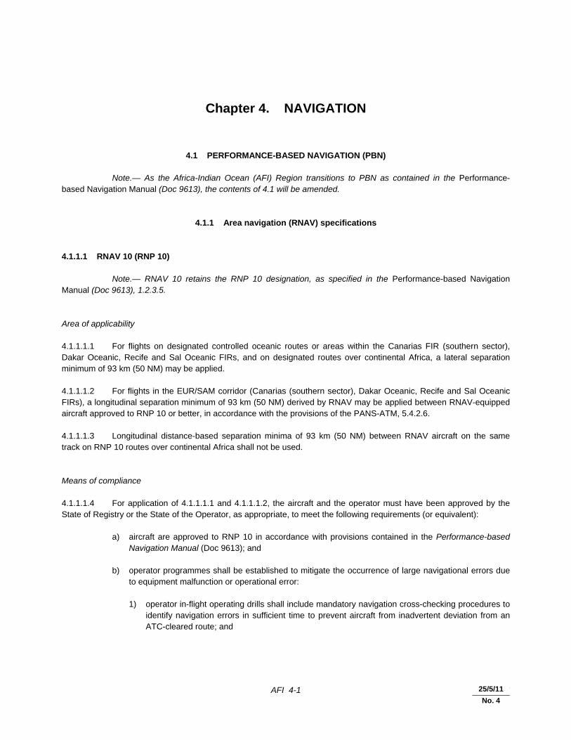
Chapter 4. NAVIGATION
4.1 PERFORMANCE-BASED NAVIGATION (PBN) Note.— As the Africa-Indian Ocean (AFI) Region transitions to PBN as contained in the Performance-based Navigation Manual (Doc 9613), the contents of 4.1 will be amended.
4.1.1 Area navigation (RNAV) specifications 4.1.1.1 RNAV 10 (RNP 10) Note.— RNAV 10 retains the RNP 10 designation, as specified in the Performance-based Navigation Manual (Doc 9613), 1.2.3.5. Area of applicability 4.1.1.1.1 For flights on designated controlled oceanic routes or areas within the Canarias FIR (southern sector), Dakar Oceanic, Recife and Sal Oceanic FIRs, and on designated routes over continental Africa, a lateral separation minimum of 93 km (50 NM) may be applied. 4.1.1.1.2 For flights in the EUR/SAM corridor (Canarias (southern sector), Dakar Oceanic, Recife and Sal Oceanic FIRs), a longitudinal separation minimum of 93 km (50 NM) derived by RNAV may be applied between RNAV-equipped aircraft approved to RNP 10 or better, in accordance with the provisions of the PANS-ATM, 5.4.2.6. 4.1.1.1.3 Longitudinal distance-based separation minima of 93 km (50 NM) between RNAV aircraft on the same track on RNP 10 routes over continental Africa shall not be used. Means of compliance 4.1.1.1.4 For application of 4.1.1.1.1 and 4.1.1.1.2, the aircraft and the operator must have been approved by the State of Registry or the State of the Operator, as appropriate, to meet the following requirements (or equivalent): a) aircraft are approved to RNP 10 in accordance with provisions contained in the Performance-based
Navigation Manual (Doc 9613); and b) operator programmes shall be established to mitigate the occurrence of large navigational errors due
to equipment malfunction or operational error: 1) operator in-flight operating drills shall include mandatory navigation cross-checking procedures to
identify navigation errors in sufficient time to prevent aircraft from inadvertent deviation from an ATC-cleared route; and
25/5/11
No. 4
AFI 4-2 Regional Supplementary Procedures
30/11/07
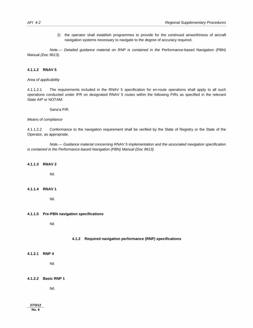
2) the operator shall establish programmes to provide for the continued airworthiness of aircraft navigation systems necessary to navigate to the degree of accuracy required.
Note.— Detailed guidance material on RNP is contained in the Performance-based Navigation (PBN) Manual (Doc 9613). 4.1.1.2 RNAV 5 Area of applicability 4.1.1.2.1 The requirements included in the RNAV 5 specification for en-route operations shall apply to all such operations conducted under IFR on designated RNAV 5 routes within the following FIRs as specified in the relevant State AIP or NOTAM: Sana’a FIR. Means of compliance 4.1.1.2.2 Conformance to the navigation requirement shall be verified by the State of Registry or the State of the Operator, as appropriate. Note.— Guidance material concerning RNAV 5 implementation and the associated navigation specification is contained in the Performance-based Navigation (PBN) Manual (Doc 9613). 4.1.1.3 RNAV 2 Nil. 4.1.1.4 RNAV 1 Nil. 4.1.1.5 Pre-PBN navigation specifications Nil.
4.1.2 Required navigation performance (RNP) specifications
4.1.2.1 RNP 4 Nil. 4.1.2.2 Basic RNP 1 Nil.
27/3/12 No. 6
Regional Supplementary Procedures AFI 4-3
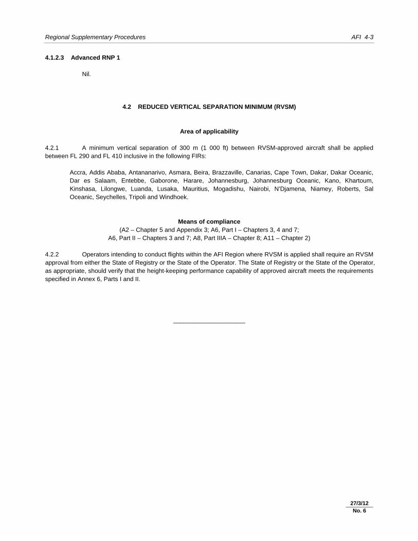
4.1.2.3 Advanced RNP 1 Nil.
4.2 REDUCED VERTICAL SEPARATION MINIMUM (RVSM)
Area of applicability 4.2.1 A minimum vertical separation of 300 m (1 000 ft) between RVSM-approved aircraft shall be applied between FL 290 and FL 410 inclusive in the following FIRs: Accra, Addis Ababa, Antananarivo, Asmara, Beira, Brazzaville, Canarias, Cape Town, Dakar, Dakar Oceanic,
Dar es Salaam, Entebbe, Gaborone, Harare, Johannesburg, Johannesburg Oceanic, Kano, Khartoum, Kinshasa, Lilongwe, Luanda, Lusaka, Mauritius, Mogadishu, Nairobi, N’Djamena, Niamey, Roberts, Sal Oceanic, Seychelles, Tripoli and Windhoek.
Means of compliance (A2 – Chapter 5 and Appendix 3; A6, Part I – Chapters 3, 4 and 7;
A6, Part II – Chapters 3 and 7; A8, Part IIIA – Chapter 8; A11 – Chapter 2) 4.2.2 Operators intending to conduct flights within the AFI Region where RVSM is applied shall require an RVSM approval from either the State of Registry or the State of the Operator. The State of Registry or the State of the Operator, as appropriate, should verify that the height-keeping performance capability of approved aircraft meets the requirements specified in Annex 6, Parts I and II.
_____________________
27/3/12 No. 6

AFI 5-1 30/11/07
Chapter 5. SURVEILLANCE (P-ATM – Chapter 8; P-OPS, Vol. I, Part III)
5.1 SECONDARY SURVEILLANCE RADAR (SSR)
5.1.1 Carriage of pressure-altitude reporting SSR transponders 5.1.1.1 All aircraft operating as IFR flights in the AFI Region shall be equipped with a pressure-altitude reporting SSR transponder. 5.1.1.2 Unless otherwise directed by air traffic control, the last assigned SSR (Mode A) code shall be retained. If no SSR code has been assigned, Mode A code 2000 shall be selected and retained.
5.1.2 Code allocation methodology
Nil.
5.1.3 Assignment of SSR codes
Nil.
5.1.4 Operation of pressure-altitude reporting SSR transponders
Nil.
5.1.5 Monitoring of SSR-derived information
Nil.
5.2 SSR MODE S
5.2.1 Carriage and operation of SSR Mode S
Nil.
5.2.2 Transition between Mode A/C and Mode S
Nil.

AFI 5-2 Regional Supplementary Procedures
30/11/07
5.3 AIRBORNE COLLISION AVOIDANCE SYSTEMS (ACAS)
5.3.1 Carriage and operation of ACAS II
Nil.
5.4 AUTOMATIC DEPENDENT SURVEILLANCE – CONTRACT (ADS-C)
Nil.
5.5 AUTOMATIC DEPENDENT SURVEILLANCE – BROADCAST (ADS-B)
Nil.
_____________________

AFI 6-1 30/11/07
Chapter 6. AIR TRAFFIC SERVICES
6.1 AIR TRAFFIC CONTROL (ATC) CLEARANCES (A11 – Chapter 3; P-ATM – Chapter 4)
6.1.1 Content 6.1.1.1 Only RVSM-approved aircraft shall be issued an air traffic control clearance to enter and operate within the AFI RVSM airspace. Non-RVSM-approved State aircraft shall, subject to ATM capacity, be issued a clearance to operate within the AFI RVSM airspace. 6.1.1.2 Non-RVSM-approved aircraft intending to operate above FL 410 will be required to have the capability to execute an uninterrupted climb or descent through the AFI RVSM airspace. Such flights shall be given appropriate ATC clearances, which will be subject to traffic levels at the time clearance is requested. 6.1.1.3 Air traffic control clearance into AFI RVSM airspace shall not be issued to formation flights.
6.1.2 Adherence 6.1.2.1 Special procedures applicable to uncoordinated flights 6.1.2.1 operating along the FIR boundaries in the Red Sea area 6.1.2.1 (P-ATM – Chapter 15; P-OPS, Vol. I, Part III, Section 3) 6.1.2.1.1 Uncoordinated flights operating along the FIR boundaries over the Red Sea portions of Asmara, Djibouti, Khartoum, Mogadishu and Sana’a FIRs shall follow the procedures prescribed in the MID/ASIA SUPPs, 6.1.2.2.
6.2 SEPARATION
6.2.1 Lateral (A11 – Attachment B; Doc 9613, Vol. II, Part B; P-ATM – Chapters 5 and 15)
6.2.1.1 Minimum lateral separation shall be 185 km (100 NM) except as provided for in 6.2.1.2 and 6.2.1.3. 6.2.1.2 Where aircraft are transiting into airspace with a larger lateral minimum than the airspace being exited, lateral separation will continue to exist provided that: a) the smaller separation minimum exists; b) flight paths diverge by 15 degrees or more until the larger minimum is established; and c) it is possible to ensure, by means approved by the appropriate ATS authority, that the aircraft have
navigation capability necessary to ensure accurate track guidance. 6.2.1.3 Minimum lateral separation shall be 93 km (50 NM) between aircraft meeting the provisions in 4.1.1.1.
25/5/11
No. 4
AFI 6-2 Regional Supplementary Procedures
30/11/07
6.2.2 Longitudinal (P-ATM – Chapter 5)
6.2.2.1 Except as provided for in 6.2.2.2, the minimum longitudinal separation between turbo-jet aircraft shall be:
a) 20 minutes, except as specified below;
b) 15 minutes at or above FL 250 within the Canarias, Dakar Oceanic, Recife and Sal Oceanic FIRs, provided that the Mach number technique is applied and, whether in level, climbing or descending flight, the aircraft have reported over the same entry point to the ATS routes or a common point into the oceanic-controlled airspace and follow the same track or continuously diverging tracks; or
c) 10 minutes or 150 km (80 NM), derived by RNAV, when the Mach number technique is applied on designated controlled RNP 10 oceanic routes in the EUR/SAM corridor within the Dakar Oceanic, Recife and Sal Oceanic FIRs; or
d) 10 minutes when the Mach number technique is applied on RNP 10 designated routes over continental Africa.
6.2.2.2 Minimum longitudinal separation shall be 93 km (50 NM) derived by RNAV between aircraft in the EUR/SAM corridor meeting the provisions of 4.1.1.1.
6.2.2.3 Longitudinal distance-based separation minima of 93 km (50 NM) between RNAV aircraft on the same track on RNP 10 routes over continental Africa shall not be used.
6.2.3 Composite
Nil.
6.2.4 Vertical
6.2.4.1 An RVSM of 300 m (1 000 ft) shall be applied between FL 290 and FL 410 inclusive within the FIRs specified in 4.2.1.
6.2.4.2 The minimum separation of 6.2.4.1 shall only be applied between aircraft where those aircraft and the operator have been approved by the State of Registry or the State of the Operator, as appropriate, to conduct flights in RVSM airspace.
6.2.4.3 Aircraft that have not received RVSM State approval may be cleared to operate in airspace where RVSM may be applied in accordance with policy and procedures established by the State provided that 600 m (2 000 ft) vertical separation is applied.
6.2.5 Radar
Nil.
Regional Supplementary Procedures AFI 6-3
30/11/07
6.2.6 Reduction in separation minima (A11 – Chapter 3; P-ATM – Chapter 5)
6.2.6.1 Where, circumstances permitting, separation minima lower than those specified in 6.2.1 and 6.2.2 will be applied in accordance with the PANS-ATM, appropriate information should be published in Aeronautical Information Publications so that users of the airspace are fully aware of the portions of airspace where the reduced separation minima will be applied and of the navigation aids on which those minima are based.
6.2.7 Airspace reservations
Nil.
6.3 MINIMUM FLIGHT LEVEL (P-ATM – Chapter 4; P-OPS, Volume I)
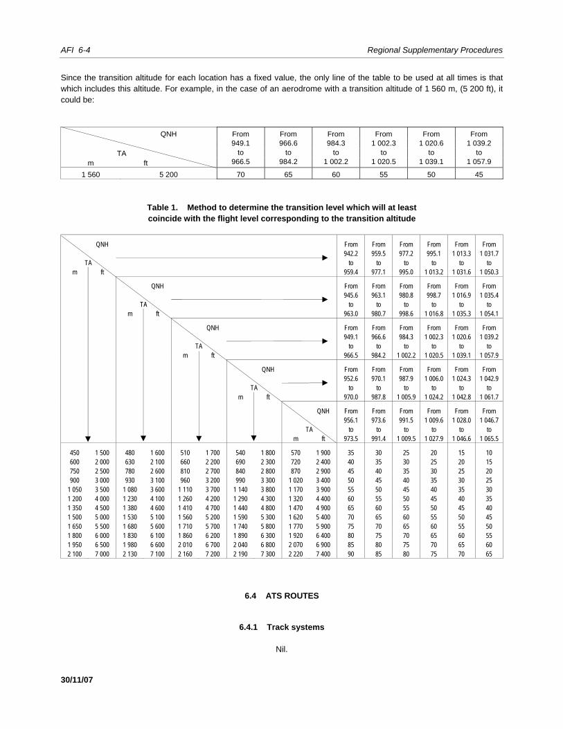
6.3.1 Establishment 6.3.1.1 The lowest useable flight level shall be calculated from actual QNH, unless the pressure variation is so small that reference to climatological data is acceptable. Note 1.— The lowest useable flight level will provide a terrain clearance of at least 300 m (1 000 ft). Note 2.— MET Offices will inform ATS units when, in abnormal conditions, pressure goes below the minimum climatological value, in order that appropriate steps can be taken to cancel temporarily the use of the lowest flight level or levels that would not ensure the minimum terrain clearance. 6.3.1.2 Based on current and anticipated atmospheric pressure distribution, area control centres shall coordinate, when required, the lowest flight level to be used. 6.3.1.3 In determining the transition level, Table 1 should be used when necessary. This table shows the transition level directly as a function of the transition altitude of the aerodrome and of the current QNH altimeter setting value. To determine the transition level for a transition layer of 150 m (500 ft), 300 m (1 000 ft), etc., it will suffice to add the figure 5, 10, etc., to the transition level shown in the appropriate table. 6.3.1.4 The columns on the left show the values that can be assigned to transition altitudes and the top lines indicate the pressure ranges in millibars between which the QNH values of the aerodrome fluctuate. The transition level for a transition layer of at least 0 m (0 ft) appears in each consolidated table in the form indicated below. Note.— The values for transition altitude, indicated in metres and feet, are given merely for the purpose of identifying typical transition altitudes. Although pairs of values are given in each column, this does not necessarily mean that they are equivalent.
Example explaining the use of the table Assuming a given QNH value (e.g. 1 012.5 mb) and a given transition altitude (e.g. 1 410 m), the transition level (under the conditions indicated) is FL 50. Should a transition layer of at least 300 m (1 000 ft) be required, then the flight level corresponding to the transition level is 60.
AFI 6-4 Regional Supplementary Procedures
30/11/07
Since the transition altitude for each location has a fixed value, the only line of the table to be used at all times is that which includes this altitude. For example, in the case of an aerodrome with a transition altitude of 1 560 m, (5 200 ft), it could be:
QNH From 949.1
to 966.5
From 966.6
to 984.2
From 984.3
to 1 002.2
From 1 002.3
to 1 020.5
From 1 020.6
to 1 039.1
From 1 039.2
to 1 057.9
TA
m ft
1 560 5 200 70 65 60 55 50 45
Table 1. Method to determine the transition level which will at least coincide with the flight level corresponding to the transition altitude
QNH From From From From From From 942.2 959.5 977.2 995.1 1 013.3 1 031.7
TA to to to to to to m ft 959.4 977.1 995.0 1 013.2 1 031.6 1 050.3
QNH From From From From From From 945.6 963.1 980.8 998.7 1 016.9 1 035.4 TA to to to to to to m ft 963.0 980.7 998.6 1 016.8 1 035.3 1 054.1
QNH From From From From From From 949.1 966.6 984.3 1 002.3 1 020.6 1 039.2 TA to to to to to to m ft 966.5 984.2 1 002.2 1 020.5 1 039.1 1 057.9
QNH From From From From From From 952.6 970.1 987.9 1 006.0 1 024.3 1 042.9 TA to to to to to to m ft 970.0 987.8 1 005.9 1 024.2 1 042.8 1 061.7
QNH From From From From From From 956.1 973.6 991.5 1 009.6 1 028.0 1 046.7 TA to to to to to to m ft 973.5 991.4 1 009.5 1 027.9 1 046.6 1 065.5
450 1 500 480 1 600 510 1 700 540 1 800 570 1 900 35 30 25 20 15 10 600 2 000 630 2 100 660 2 200 690 2 300 720 2 400 40 35 30 25 20 15 750 2 500 780 2 600 810 2 700 840 2 800 870 2 900 45 40 35 30 25 20 900 3 000 930 3 100 960 3 200 990 3 300 1 020 3 400 50 45 40 35 30 25
1 050 3 500 1 080 3 600 1 110 3 700 1 140 3 800 1 170 3 900 55 50 45 40 35 30 1 200 4 000 1 230 4 100 1 260 4 200 1 290 4 300 1 320 4 400 60 55 50 45 40 35 1 350 4 500 1 380 4 600 1 410 4 700 1 440 4 800 1 470 4 900 65 60 55 50 45 40 1 500 5 000 1 530 5 100 1 560 5 200 1 590 5 300 1 620 5 400 70 65 60 55 50 45 1 650 5 500 1 680 5 600 1 710 5 700 1 740 5 800 1 770 5 900 75 70 65 60 55 50 1 800 6 000 1 830 6 100 1 860 6 200 1 890 6 300 1 920 6 400 80 75 70 65 60 55 1 950 6 500 1 980 6 600 2 010 6 700 2 040 6 800 2 070 6 900 85 80 75 70 65 60 2 100 7 000 2 130 7 100 2 160 7 200 2 190 7 300 2 220 7 400 90 85 80 75 70 65
6.4 ATS ROUTES
6.4.1 Track systems
Nil.

Regional Supplementary Procedures AFI 6-5
30/11/07
6.4.2 RNAV
Nil.
6.5 AERODROME OPERATIONS
6.5.1 Area of applicability
Nil.
6.5.2 Intersection take-off
Nil.
6.5.3 Multiple line-ups on the same runway
Nil.
6.5.4 Visual departures
Nil.
6.5.5 Visual approaches
Nil.
6.5.6 Advanced surface movement guidance and control systems (A-SMGCS)
Nil.
6.5.6.1 General Nil. 6.5.6.2 A-SMGCS functions Nil. 6.5.6.3 A-SMGCS alerts Nil.
25/8/09
No. 2
AFI 6-6 Regional Supplementary Procedures
30/11/07
6.5.6.4 A-SMGCS identification procedures Nil.
6.6 RNAV PROCEDURES
6.6.1 General
Nil.
6.6.2 En route
Nil.
6.6.3 Terminal
Nil.
6.6.4 State aircraft
Nil.
6.7 RNP PROCEDURES
6.7.1 General
Nil.
6.7.2 En route
Nil.
6.7.3 Terminal
Nil.
6.7.4 State aircraft
Nil.
25/8/09
No. 2
Regional Supplementary Procedures AFI 6-7
30/11/07
6.8 COMPOSITE PROCEDURES
Nil.
6.9 MNPS PROCEDURES
Nil.
6.10 RVSM PROCEDURES
6.10.1 General
6.10.1.1 Operation of aircraft not approved for RVSM 6.10.1.1.1 Except for areas where transition areas have been established, aircraft not meeting the requirements of 4.2.2 shall not be allowed to operate in EUR/SAM RVSM airspace. 6.10.1.1.2 Exceptionally, aircraft that have not received RVSM State approval may be cleared to operate in airspace where RVSM may be applied in accordance with policy and procedures established by the State provided that 600 m (2 000 ft) vertical separation is applied. Note.— Transitions to and from EUR/SAM RVSM airspace will normally take place in the first FIR in EUR/SAM RVSM airspace.
6.10.2 Transition to/from RVSM airspace (A2 – Appendix 3; A6, Parts I and II, Chapter 7; A11 – Chapter 3; P-ATM – Chapter 5)
6.10.2.1 In order to allow for the transition of flights to and from EUR/SAM RVSM airspace, the ATS authorities responsible for Canarias, Dakar Oceanic, Recife and Sal Oceanic FIRs may establish designated RVSM transition areas. A 300 m (1 000 ft) vertical separation minimum may be applied between RVSM-approved aircraft within these transition areas. 6.10.2.2 An RVSM transition area shall have a vertical extent of FL 290 to FL 410 inclusive, be contained within horizontal dimensions determined by the provider States, be overlapping with or contained within EUR/SAM RVSM airspace and should have direct controller-pilot communications.
6.11 ATS COORDINATION
6.11.1 Between units providing area control services (A11- Chapter 3; P-ATM – Chapter 10)
6.11.1.1 If a flight should enter an adjacent area, information concerning any revision of the estimate of three minutes or more shall be forwarded to the adjacent area control centre.
25/8/09
No. 2
AFI 6-8 Regional Supplementary Procedures
30/11/07
6.11.2 RNAV
Nil.
6.11.3 RNP
Nil.
6.11.4 RVSM
Nil.
6.11.5 SSR codes
Nil.
6.12 ATS MESSAGES
6.12.1 Flight plan and departure (P-ATM – Chapter 11)
6.12.1.1 Filed flight plan messages for flights intending to operate within the NAT Region at a distance of 110 km (60 NM) or less from the northern and southern boundaries of Gander Oceanic and Shanwick Oceanic flight information regions shall be addressed to the area control centres in charge of the NAT flight information regions along the route and, in addition, to the area control centres in charge of the nearest adjacent NAT flight information regions. 6.12.1.2 For flights departing from points within adjacent regions and entering the NAT Region without intermediate stops, filed flight plan messages shall be transmitted to the appropriate area control centres immediately after the flight plan has been submitted.
6.12.2 Arrival
Nil.
6.12.3 Boundary estimates
Nil.
6.12.4 Computer-assisted coordination
Nil.
25/8/09
No. 2
Regional Supplementary Procedures AFI 6-9
30/11/07
6.13 Flight information service (FIS)
6.13.1 Automatic terminal information services (ATIS)
Nil.
6.13.2 SIGMETs (P-ATM – Chapter 9)
6.13.2.1 Transmission of SIGMET information to aircraft shall be at the initiative of the appropriate ATS unit, by the preferred method of directed transmission followed by acknowledgement, or by a general call when the number of aircraft would render the preferred method impracticable. 6.13.2.2 SIGMET information passed to aircraft shall cover a portion of the route up to two hours’ flying time ahead of the aircraft.
6.13.3 Special air-reports
Nil.
6.13.4 Amended aerodrome forecasts (P-ATM – Chapter 9)
6.13.4.1 Amended aerodrome forecasts shall be passed to aircraft within 60 minutes from the aerodrome of destination, unless the information has been made available through other means.
6.13.5 Landing forecasts (A11 – Chapter 4)
6.13.5.1 The latest landing forecast available to the ATS unit, provided it is no more than one hour old, shall always be transmitted to an aircraft, together with the latest report of routine or special observation, when the aircraft requests the latter information.
6.14 ALERTING SERVICE
Nil.
_____________________
25/8/09
No. 2

AFI 7-1 30/11/07
Chapter 7. SAFETY MONITORING
7.1 STRATEGIC LATERAL OFFSET PROCEDURES (SLOP)
Nil.
7.2 AIRSPACE MONITORING
7.2.1 General
Nil.
7.2.2 RNAV 7.2.2.1 A target level of safety (TLS) of 5 × 10⁻⁹ fatal accidents per flight hour per dimension shall be established for route systems operating a 93 km (50 NM) lateral separation minimum. The safety level of such airspace shall be determined by an appropriate safety assessment. Note.— Detailed guidance material on conducting safety assessments is contained in the Manual on Airspace Planning Methodology for the Determination of Separation Minima (Doc 9689). 7.2.2.2 The following criteria are used in the operational assessment of airspace system safety: a) the proportion of the total flight time spent by aircraft 46 km (25 NM) or more off the cleared track shall
be less than 7 × 10⁻⁴; and b) the proportion of the total flight time spent by aircraft between 74 km and 110 km (40 NM and 60 NM)
off the cleared track shall be less than 4.1 × 10⁻⁵. 7.2.2.3 Adequate monitoring of flight operations shall be conducted to provide data to assist in the assessment of continuing compliance of aircraft with the lateral navigation performance capabilities of RNP 10 and 7.2.2.1. Such data shall include operational errors due to all causes. A safety assessment shall be carried out periodically, based on the data collected, to confirm that the safety level continues to be met. Note.— Detailed guidance on monitoring is contained in the Air Traffic Services Planning Manual (Doc 9426) and the Manual on Airspace Planning Methodology for the Determination of Separation Minima (Doc 9689).
7.2.3 RNP
Nil.
AFI 7-2 Regional Supplementary Procedures
30/11/07
7.2.4 RVSM 7.2.4.1 Target level of safety (TLS) 7.2.4.1.1 Application of RVSM in the airspace designated in 4.2.1 should meet a TLS of 5 × 10⁻⁹ fatal accidents per aircraft flight hour due to all causes of risk in the vertical dimension. 7.2.4.1.2 Adequate monitoring of flight operations in the EUR/SAM RVSM airspace shall be conducted to assist in the assessment of continuing compliance of aircraft with the height-keeping capabilities in 4.2.2. Monitoring shall include assessment of other sources of risk to ensure that the TLS specified in 7.2.4.1.1 is not exceeded. Note.— Details of the policy and procedures for monitoring established by the South Atlantic Monitoring Agency (SATMA) are contained in the Guidance Material on the Implementation of a 300 m (1 000 ft) Vertical Separation Minimum (VSM) for Application in the EUR/SAM Corridor.
_____________________
15/10/10
No. 3
AFI 8-1 30/11/07
Chapter 8. AIR TRAFFIC FLOW MANAGEMENT (ATFM)
8.1 PROVISION
Nil.
8.2 APPLICATION
Nil.
8.3 EXEMPTIONS FROM ATFM SLOT ALLOCATION
Nil.
8.4 DEPARTURE SLOT MONITORING
Nil.
8.5 PROMULGATION OF ATFM MEASURES
8.5.1 Strategic ATFM measures
Nil.
8.5.2 Amendments to promulgated strategic ATFM measures
Nil.
8.5.3 ATFM circulars and information
Nil.
8.5.4 Pre-flight information bulletin (PIB)
Nil.

AFI 8-2 Regional Supplementary Procedures
30/11/07
8.5.5 Query procedures
Nil.
_____________________

AFI 9-1 30/11/07
Chapter 9. SPECIAL PROCEDURES
9.1 EMERGENCY DESCENT PROCEDURES
9.1.1 Action by the pilot-in-command
Nil.
9.1.2 Action by the ATS unit
Nil.
9.2 CONTINGENCY PROCEDURES INCLUDING TURN-BACKS
Nil.
9.3 AIR-GROUND COMMUNICATION FAILURE
Nil.
9.4 DEGRADATION OR FAILURE OF THE RNAV SYSTEM
9.4.1 Action by the pilot-in-command
Nil.
9.4.2 Action by the ATS unit
Nil.
9.5 LOSS OF VERTICAL NAVIGATION PERFORMANCE REQUIRED FOR RVSM
9.5.1 General
Nil.

AFI 9-2 Regional Supplementary Procedures
30/11/07
9.5.2 Degradation of aircraft equipment – pilot reported
Nil.
9.5.3 Severe turbulence – not forecast
Nil.
9.5.4 Severe turbulence – forecast
Nil.
9.6 EN-ROUTE DIVERSION
Nil.
9.7 INTER-REGION INTERFACE FOR NON-RVSM-APPROVED AIRCRAFT
Nil.
9.8 MANNED BALLOON FLIGHTS
Nil.
_____________________

AFI 10-1 30/11/07
Chapter 10. PHRASEOLOGY
10.1 RNAV
Nil.
10.2 RNP
Nil.
10.3 SURVEILLANCE
Nil.
10.4 AERODROME OPERATIONS
Nil.
10.5 ATFM
Nil.
_____________________

AFI 11-1 30/11/07
Chapter 11. SEARCH AND RESCUE
11.1 INTERNATIONAL GENERAL AVIATION (IGA) (A6, Part II – Chapter 6; A6, Part III – Chapter 4)
11.1.1 General aviation aircraft operating over designated areas, land or sea, where search and rescue operations would be difficult, should: a) carry appropriate survival equipment; and b) follow the routes or specified procedures if not equipped with two-way radio, except that under special
circumstances, the appropriate authority may grant specific exemptions from this requirement.
_____________________


AFI 12-1 30/11/07
Chapter 12. METEOROLOGY
12.1 AIRCRAFT OBSERVATIONS AND REPORTS
Nil.
_____________________


AFI 13-1 30/11/07
Chapter 13. AERONAUTICAL INFORMATION SERVICES
13.1 NOTAM ADDRESSING AND DISTRIBUTION
Nil.
13.2 AERONAUTICAL CHART INFORMATION
13.2.1 Visual procedures
Nil.
_____________________

30/11/07
CARIBBEAN (CAR) REGIONAL SUPPLEMENTARY PROCEDURES
These procedures are supplementary to the provisions contained in Annex 2, Annex 6 (Part II), Annex 11, PANS-ATM (Doc 4444) and PANS-OPS (Doc 8168). The area of application of the CAR Regional Supplementary Procedures is included on the Index to Application of Supplementary Procedures chart.


CAR (i) 30/11/07
TABLE OF CONTENTS
Chapter Page Flight Rules . . . . . . . . . . . . . . . . . . . . . . . . . . . . . . . . . . . . . . . . . . . . 1 CAR 1-1 Flight Plans . . . . . . . . . . . . . . . . . . . . . . . . . . . . . . . . . . . . . . . . . . . . 2 CAR 2-1 Communications . . . . . . . . . . . . . . . . . . . . . . . . . . . . . . . . . . . . . . . . . 3 CAR 3-1 Navigation . . . . . . . . . . . . . . . . . . . . . . . . . . . . . . . . . . . . . . . . . . . . . 4 CAR 4-1 Surveillance . . . . . . . . . . . . . . . . . . . . . . . . . . . . . . . . . . . . . . . . . . . . 5 CAR 5-1 Air Traffic Services . . . . . . . . . . . . . . . . . . . . . . . . . . . . . . . . . . . . . . . 6 CAR 6-1 Safety Monitoring . . . . . . . . . . . . . . . . . . . . . . . . . . . . . . . . . . . . . . . . 7 CAR 7-1 Air Traffic Flow Management . . . . . . . . . . . . . . . . . . . . . . . . . . . . . . . . 8 CAR 8-1 Special Procedures . . . . . . . . . . . . . . . . . . . . . . . . . . . . . . . . . . . . . . . 9 CAR 9-1 Phraseology . . . . . . . . . . . . . . . . . . . . . . . . . . . . . . . . . . . . . . . . . . . . 10 CAR 10-1 Search and Rescue . . . . . . . . . . . . . . . . . . . . . . . . . . . . . . . . . . . . . . . 11 CAR 11-1 Meteorology . . . . . . . . . . . . . . . . . . . . . . . . . . . . . . . . . . . . . . . . . . . . 12 CAR 12-1 Aeronautical Information Services . . . . . . . . . . . . . . . . . . . . . . . . . . . . . 13 CAR 13-1

CAR 1-1 30/11/07
Chapter 1. FLIGHT RULES
1.1 VISUAL FLIGHT RULES (VFR)
1.1.1 Special application
Nil.
1.2 INSTRUMENT FLIGHT RULES (IFR) (A2 – Chapters 2 and 5)
Note.— Annex 2, 2.2, permits a flight to operate using either instrument flight rules or visual flight rules when operated in visual meteorological conditions subject to the limitations listed in Chapter 4 of the Annex. The following indicates certain additional restrictions.
1.2.1 Special application 1.2.1.1 Flights shall be conducted in accordance with instrument flight rules when operated above flight level (FL) 180 within the control areas of Miami Oceanic, Houston Oceanic and San Juan FIRs.
1.2.2 Flight level changes
Nil.
1.3 AIR TRAFFIC ADVISORY SERVICE
Nil.
_____________________

CAR 2-1
Chapter 2. FLIGHT PLANS
2.1 CONTENT – GENERAL (A2 – Chapter 3; P-ATM – Chapter 4 and Appendix 2)
2.1.1 Date of flight
Nil.
2.1.2 Area navigation (RNAV) specifications
Nil.
2.1.3 Required navigation performance (RNP) specifications
Nil.
2.1.4 Minimum navigation performance specifications (MNPS)
Nil.
2.1.5 Reduced vertical separation minimum (RVSM)-approved aircraft 2.1.5.1 The aircraft registration shall be inserted in Item 18 of the flight plan.
2.1.6 Non-RVSM-approved aircraft
Nil.
2.1.7 Non-RVSM-approved State aircraft
Nil.
2.1.8 Indication of 8.33 kHz channel spacing capability
Nil.
30/11/12
No. 7
CAR 2-2 Regional Supplementary Procedures
2.1.9 Route 2.1.9.1 Flight plans for flights or portions thereof along oceanic routes not defined by specified reporting points shall be made in accordance with the following: a) for flights whose flight path is generally oriented in an east-west direction, the planned track shall
normally be defined by significant points formed by the intersection of half or whole degrees of latitude and meridians spaced at intervals of 10 degrees;
b) for flights whose flight path is generally oriented in a north-south direction, the planned track shall
normally be defined by significant points formed by the intersection of whole degrees of longitude with specified parallels of latitude spaced at 5-degree intervals.
2.1.10 Estimated times
Nil.
2.1.11 Mach number 2.1.11.1 For turbo-jet aircraft intending to operate within the control areas of Houston Oceanic, Mexico, Miami Oceanic and San Juan FIRs at or above FL 200 and west of 60°W, the planned true Mach number shall be specified in Item 15 of the flight plan.
2.1.12 Alternative flight level
Nil.
2.1.13 Special handling (STS)
Nil.
2.1.14 Controller-pilot data link communications (CPDLC)
Nil.
2.2 CONTENT – AIR TRAFFIC FLOW MANAGEMENT (ATFM)
2.2.1 Runway visual range (RVR)
Nil.
30/11/12
No. 7
Regional Supplementary Procedures CAR 2-3
8/1/09
No. 1
2.2.2 Flight plan addressing and distribution
Nil.
2.2.3 Slot allocation exemptions
Nil.
2.3 SUBMISSION
2.3.1 General
Nil.
2.3.2 Amendments
Nil.
2.4 REPETITIVE FLIGHT PLANS (RPLs)
Nil.
_____________________

CAR 3-1 30/11/07
Chapter 3. COMMUNICATIONS
3.1 AIR-GROUND COMMUNICATIONS AND IN-FLIGHT REPORTING
3.1.1 Communications equipment
Nil.
3.1.2 Continuous listening watch in uncontrolled airspace (A2 – Chapters 3 and 5; P-ATM – Chapter 4)
3.1.2.1 All VFR flights, and IFR flights outside controlled airspace, shall maintain a listening watch on the frequency where flight information service is provided and report position unless otherwise authorized by the State overflown.
3.1.3 Position reports (A2 – Chapters 3 and 5; P-ATM – Chapter 4)
Time or place 3.1.3.1 Position reports additional to those required by the general position reporting procedures shall be made at the flight information region boundary when entering or exiting Panama FIR. 3.1.3.2 Unless otherwise required by air traffic services, position reports for flights on routes not defined by designated reporting points shall be made at the significant points listed in the flight plan. 3.1.3.3 States should establish reporting points at locations fulfilling operational requirements as set forth in Annex 11, 2.14.1, 2.14.3 and Appendix 2. Except where operational considerations dictate otherwise, those points should be located at intervals of 5 degrees of latitude or longitude (latitude if the route is predominantly north-south, longitude if east-west). 3.1.3.4 Aircraft traversing 10 degrees of latitude or longitude in 1 hour and 20 minutes or less should normally be required to report only at 10-degree intervals. Slower aircraft should normally be required to report at 5-degree intervals. 3.1.3.5 For flights in oceanic areas outside the ATS routes network, the position shall be expressed in terms of latitude and longitude as follows: a) for flights operating predominantly east-west direction: 1) latitude in degrees and minutes; and 2) longitude in degrees only;
25/8/09
No. 2
CAR 3-2 Regional Supplementary Procedures
30/11/07
b) for flights operating predominantly north-south direction: 1) latitude in degrees only; and 2) longitude in degrees and minutes. 3.1.3.6 Unless air-ground communication is direct with the area control centre concerned, all times shall be expressed in four digits, giving both the hour and minutes, when making position reports within oceanic control areas. Next position and time over 3.1.3.7 Time over next position shall be expressed in four digits, giving both the hour and minutes, when making position reports within oceanic control areas. 3.1.3.8 If the estimated time over the next significant point is found to be in error by five minutes or more, a revised estimated time over shall be transmitted as soon as possible to the appropriate ATS unit. Level 3.1.3.9 Aircraft cleared for cruise climb shall report their flight level to the nearest 30 m (100 ft). Note.— Levels so reported, e.g. 354, may not necessarily be flight levels as described in the PANS-OPS, Volume I, Part III, Section 1. Transmission (P-ATM – Chapter 4) 3.1.3.10 Position reports made by aircraft operating within an oceanic control area at a distance of 110 km (60 NM) or less from the common boundary with an adjacent oceanic control area, including aircraft operating on tracks through successive points on such boundary, shall also be made to the area control centre serving the adjacent control area. 3.1.3.11 Responsibility for the transmission of position reports to the additional ATS units specified in 3.1.3.10 may be delegated to the appropriate communications station(s) through local arrangements.
3.1.4 Abbreviated position reports
Nil.
3.1.5 Read-back of VHF channels
Nil.
3.2 MANDATORY CARRIAGE OF 8.33 KHZ CHANNEL SPACING CAPABLE RADIO EQUIPMENT
Nil.
Regional Supplementary Procedures CAR 3-3
30/11/07
3.3 CONTROLLER-PILOT DATA LINK COMMUNICATIONS (CPDLC)
Nil.
3.4 SATELLITE VOICE COMMUNICATIONS (SATCOM)
Nil.
3.5 AERONAUTICAL MOBILE SERVICE
3.5.1 Selective calling (SELCAL)
Nil.
3.5.2 HF operations
Nil.
3.5.2.1 Assignment of voice traffic to HF families Nil. 3.5.2.2 Procedures for mutual assistance Nil.
3.6 AERONAUTICAL FIXED SERVICE
3.6.1 AFTN rationalization
Nil.
3.7 RADIO CHANNELS/FREQUENCIES
Nil.
_____________________
25/8/09
No. 2

CAR 4-1 8/1/09
No. 1
Chapter 4. NAVIGATION
4.1 PERFORMANCE-BASED NAVIGATION (PBN)
Note.— As the Caribbean (CAR) Region transitions to PBN as contained in the Performance-based Navigation (PBN) Manual (Doc 9613), the contents of 4.1 will be amended.
4.1.1 Area navigation (RNAV) specifications 4.1.1.1 RNAV 10 (RNP 10) Note.— RNAV 10 retains the RNP 10 designation, as specified in the Performance-based Navigation (PBN) Manual (Doc 9613), 1.2.3.5. Area of applicability 4.1.1.1.1 A lateral separation minimum of 93 km (50 NM) may be applied between flights operating on oceanic routes or areas: a) within the control areas of the San Juan FIR, Miami Oceanic FIR; Houston Oceanic FIR, the oceanic
portion of the Gulf of Mexico in the Mexico FIR; the West Atlantic Route System (WATRS); and b) outside WATRS within the control area of the New York Oceanic FIR, except minimum lateral
separation between aircraft transitioning from airspace in the New York Oceanic FIR/CTA to MNPS airspace shall be 110 km (60 NM).
Note 1.— The WATRS area is defined as beginning at a point 27°00'N/77°00'W direct to 20°00'N/67°00'W direct to 18°00'N/62°00'W direct to 18°00'N/60°00'W direct to 38°30'N/60°00'W direct to 38°30'N/69°15'W, thence counterclockwise along the New York Oceanic control area/FIR boundary to the Miami Oceanic control area/FIR boundary, thence southbound along the Miami Oceanic control area/FIR boundary to the point of beginning. Note 2.— The NAT MNPS are set forth in NAT SUPPS, 4.1.1.5. NAT MNPS airspace is identified in NAT SUPPS, 4.1.1.1.5.1. Means of compliance 4.1.1.1.2 For application of 4.1.1.1.1, operators and civil aviation authorities must follow the provisions listed below. 4.1.1.1.3 The aircraft and operator must be approved RNP 10 or RNP 4 by the State of the Operator or the State of Registry, as appropriate. RNP 10 is the minimum navigation specification for the application of 93 km (50 NM) lateral separation. 4.1.1.1.4 States shall ensure, when granting approval for RNP 10 or RNP 4, that operators establish programmes to mitigate the occurrence of large lateral track errors due to equipment malfunction or operational error. Note.— The Performance-based Navigation (PBN) Manual (Doc 9613) provides guidance on aircraft, operations and maintenance programmes for the initial achievement and continued compliance with the authorized navigation specification.
27/3/12 No. 6
CAR 4-2 Regional Supplementary Procedures
8/1/09
No. 1
4.1.1.2 RNAV 5 Nil. 4.1.1.3 RNAV 2 Nil. 4.1.1.4 RNAV 1 Nil. 4.1.1.5 Pre-PBN navigation specifications 4.1.1.5.1 Minimum navigation performance specifications (MNPS) Area of applicability 4.1.1.5.1.1 For flights in transit to or from the NAT MNPS airspace, while operating in the control area of the San Juan FIR, a lateral separation minimum of 110 km (60 NM) may be applied. Means of compliance 4.1.1.5.1.2 Aircraft must meet the NAT MNPS specifications. Note.— The NAT MNPS area and specifications are set forth in the NAT SUPPS, Chapter 4.
4.1.2 Required navigation performance (RNP) specifications 4.1.2.1 RNP 4 Nil. 4.1.2.2 Basic RNP 1 Nil. 4.1.2.3 Advanced RNP 1 Nil.
Regional Supplementary Procedures CAR 4-3
8/1/09
No. 1
4.2 REDUCED VERTICAL SEPARATION MINIMUM (RVSM)
Area of applicability 4.2.1 A minimum vertical separation of 300 m (1 000 ft) shall be applied between FL 290 and FL 410 inclusive in the following FIRs: Barranquilla, Central America, Curacao, Georgetown, Havana, Houston Oceanic, Kingston, Maiquetia,
Mazatlan Oceanic, Mexico, Miami Oceanic, Panama, Paramaribo, Piarco, Port-au-Prince, Rochambeau, Santo Domingo and San Juan.
Note.— The volume of airspace referred to as “CAR/SAM RVSM airspace” includes the FIRs listed in the area of applicability of vertical separation in the CAR and SAM Regional Supplementary Procedures.
Means of compliance (A2 – Chapter 5 and Appendix 3; A6, Part I – Chapters 3, 4 and 7;
A6, Part II – Chapters 3 and 7; A8, Part IIIA – Chapter 8; A11 – Chapter 2) 4.2.2 Operators intending to conduct flights within the CAR Region where RVSM is applied shall require an RVSM approval either from the State of Registry or the State of the Operator. The State of Registry or the State of the Operator, as appropriate, should verify that the height-keeping performance capability of approved aircraft meets the requirements specified in Annex 6, Parts I and II. Note.— Guidance material regarding the initial achievement and continued maintenance of the height-keeping performance in 4.2.2. is contained in the Guidance Material on the Implementation of a 300 m (1 000 ft) Vertical Separation Minimum (VSM) for Application in the CAR/SAM Regions.
_____________________

CAR 5-1 30/11/07
Chapter 5. SURVEILLANCE (P-ATM – Chapter 8; P-OPS, Vol. I, Part III)
5.1 SECONDARY SURVEILLANCE RADAR (SSR)
5.1.1 Carriage of pressure-altitude reporting SSR transponders
Nil.
5.1.2 Code allocation methodology
Nil.
5.1.3 Assignment of SSR codes 5.1.3.1 All aircraft in international flight under instrument flight rules shall be assigned an appropriate SSR code by ATS units in accordance with the Air Navigation Plan — Caribbean and South American Regions, Volume II – FASID (Doc 8733), Part V, Appendix B, SSR Code Allocation Plan (CAP). An assigned four-digit code shall be used for as long as possible during a flight in the CAR/SAM Regions.
5.1.4 Operation of pressure-altitude reporting SSR transponders
Nil.
5.1.5 Monitoring of SSR-derived information
Nil.
5.2 SSR MODE S
5.2.1 Carriage and operation of SSR Mode S
Nil.
5.2.2 Transition between Mode A/C and Mode S
Nil.

CAR 5-2 Regional Supplementary Procedures
30/11/07
5.3 AIRBORNE COLLISION AVOIDANCE SYSTEMS (ACAS)
5.3.1 Carriage and operation of ACAS II
Nil.
5.4 AUTOMATIC DEPENDENT SURVEILLANCE – CONTRACT (ADS-C)
Nil.
5.5 AUTOMATIC DEPENDENT SURVEILLANCE – BROADCAST (ADS-B)
Nil.
_____________________
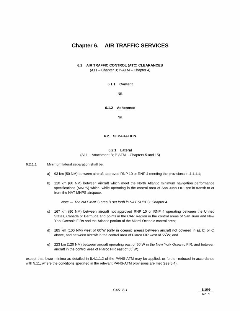
CAR 6-1 30/11/07
Chapter 6. AIR TRAFFIC SERVICES
6.1 AIR TRAFFIC CONTROL (ATC) CLEARANCES (A11 – Chapter 3; P-ATM – Chapter 4)
6.1.1 Content
Nil.
6.1.2 Adherence
Nil.
6.2 SEPARATION
6.2.1 Lateral (A11 – Attachment B; P-ATM – Chapters 5 and 15)
6.2.1.1 Minimum lateral separation shall be: a) 93 km (50 NM) between aircraft approved RNP 10 or RNP 4 meeting the provisions in 4.1.1.1; b) 110 km (60 NM) between aircraft which meet the North Atlantic minimum navigation performance
specifications (MNPS) which, while operating in the control area of San Juan FIR, are in transit to or from the NAT MNPS airspace;
Note.— The NAT MNPS area is set forth in NAT SUPPS, Chapter 4. c) 167 km (90 NM) between aircraft not approved RNP 10 or RNP 4 operating between the United
States, Canada or Bermuda and points in the CAR Region in the control areas of San Juan and New York Oceanic FIRs and the Atlantic portion of the Miami Oceanic control area;
d) 185 km (100 NM) west of 60˚W (only in oceanic areas) between aircraft not covered in a), b) or c)
above, and between aircraft in the control area of Piarco FIR west of 55˚W; and e) 223 km (120 NM) between aircraft operating east of 60˚W in the New York Oceanic FIR, and between
aircraft in the control area of Piarco FIR east of 55˚W; except that lower minima as detailed in 5.4.1.1.2 of the PANS-ATM may be applied, or further reduced in accordance with 5.11, where the conditions specified in the relevant PANS-ATM provisions are met (see 5.4).
8/1/09
No. 1
CAR 6-2 Regional Supplementary Procedures
30/11/07
6.2.2 Longitudinal (P-ATM – Chapter 5)
6.2.2.1 Between turbo-jet aircraft at or above FL 280 on oceanic published routes operating in the West Atlantic Route System (WATRS), or at or above FL 280 operating west of 60˚W when transitioning to or from the WATRS area, the longitudinal separation shall be in accordance with the PANS-ATM, 5.4.2.4. Note.— The WATRS area is defined as beginning at a point 27°00'N/77°00'W direct to 20°00'N/67°00'W direct to 18°00'N/62°00'W direct to 18°00'N/60°00'W direct to 38°30'N/60°00'W direct to 38°30'N/69°15'W, thence counterclockwise along the New York Oceanic control area/FIR boundary to the Miami Oceanic control area/FIR boundary, thence southbound along the Miami Oceanic control area/FIR boundary to the point of beginning. 6.2.2.2 Between turbo-jet aircraft operating at or above FL 200 and west of 60˚W within the Houston Oceanic, applicable parts of Mexico FIR (Merida and Monterrey CTAs), Miami Oceanic and San Juan CTA/FIR control areas, the longitudinal separation with Mach number technique applied in accordance with the relevant provisions of the PANS-ATM, 5.4.2.4, shall be: a) 15 minutes; or b) this separation may be reduced to: 1) 10 minutes at the entry point into oceanic controlled airspace, if the preceding aircraft is
maintaining a speed of at least Mach 0.03 greater than that of the following aircraft; or 2) 5 minutes at the entry point into oceanic controlled airspace, if the preceding aircraft is
maintaining a speed of at least Mach 0.06 greater than that of the following aircraft. 6.2.2.3 Between aircraft operating below FL 200 west of 55˚W and between aircraft operating at all levels east of 55˚W within the San Juan and Piarco FIRs and the Paramaribo and Rochambeau upper flight information regions (UIRs), 20-minute longitudinal separation shall be applied. This minimum may also be applied if the aircraft have not reported over the same reporting point when it is possible to ensure, by radar or other means approved by the State, that the appropriate time interval will exist at the common point from which they follow either the same track or continuously diverging tracks. 6.2.2.4 Between turbo-jet aircraft meeting the MNPS and operating in the New York Oceanic control area wholly or partly in MNPS airspace, the minimum longitudinal separation with Mach number technique shall be in accordance with the PANS-ATM, 5.4.2.4. In cases where the aircraft concerned have reported over a common point and follow continuously diverging tracks until some other form of separation is provided: a) at least 10-minute longitudinal separation shall exist at the point where the tracks diverge; or b) at least 5-minute longitudinal separation will exist where lateral separation is achieved; and c) lateral separation will be achieved at or before the next significant point (normally 10 degrees of
longitude along track(s)) or, if not, within 90 minutes of the time the second aircraft passes the common point or within 1 112 km (600 NM) of the common point, whichever is estimated to occur first.
6.2.2.5 For turbo-jet aircraft meeting the MNPS and operating in the New York Oceanic control area wholly or partly in MNPS airspace but not meeting the requirements of 6.2.2.4, 15-minute longitudinal separation shall be applied. 6.2.2.6 Between aircraft operating outside MNPS airspace in the New York Oceanic control area the minimum longitudinal separation shall be:

Regional Supplementary Procedures CAR 6-3
30/11/07
a) 15 minutes between turbo-jet aircraft, provided the Mach number technique is applied and, whether in level, climbing or descending flight:
1) the aircraft concerned have reported over a common point and follow the same track or
continuously diverging tracks until some other form of separation is provided; or 2) if the aircraft have not reported over a common point, it is possible to ensure, by radar or other
means approved by the State, that the appropriate time interval will exist at the common point from which they follow either the same track or continuously diverging tracks;
b) 10 or 5 minutes only when it is possible to ensure, by radar or other means approved by the State,
that the required time interval exists and will exist at the common point, provided the preceding aircraft is maintaining a greater Mach number than the following aircraft in accordance with the following:
1) 10 minutes if the preceding aircraft is maintaining a speed of at least Mach 0.03 greater than that
of the following aircraft; and 2) 5 minutes if the preceding aircraft is maintaining a speed of at least Mach 0.06 greater than that of
the following aircraft; c) 20 minutes between turbo-jet aircraft not covered by a) and b); d) 20 minutes between other than turbo-jet aircraft operating along routes extending between the United
States, Canada or Bermuda and Caribbean terminals, or between the United States or Canada and Bermuda; and
e) 30 minutes between other than turbo-jet aircraft not covered in d).
6.2.3 Composite
Nil.
6.2.4 Vertical 6.2.4.1 An RVSM of 300 m (1 000 ft) shall be applied between FL 290 and FL 410 inclusive within the FIRs specified in 4.2.1. 6.2.4.2 The minimum separation of 6.2.4.1 shall only be applied between aircraft where those aircraft and the operator have been approved by the State of Registry or the State of the Operator, as appropriate, to conduct flights in RVSM airspace. 6.2.4.3 Aircraft that have not received RVSM State approval may be cleared to operate in airspace where RVSM may be applied in accordance with policy and procedures established by the State provided that 600 m (2 000 ft) vertical separation is applied. 6.2.4.4 In order to allow for the transition of flights to and from RVSM airspace, the ATS authorities responsible for the FIRs involved may establish designated RVSM transition areas. A 300 m (1 000 ft) vertical separation minimum can be applied between RVSM-approved aircraft within these transition areas. 6.2.4.5 An RVSM transition area shall have a vertical extent of FL 290 to FL 410 inclusive, shall be contained within horizontal dimensions determined by the provider States, shall be overlapping with or contained within the CAR/SAM RVSM airspace and shall have direct pilot-controller communications.
CAR 6-4 Regional Supplementary Procedures
30/11/07
6.2.5 Radar
Nil.
6.2.6 Reduction in separation minima (A11 – Chapter 3; P-ATM – Chapter 5)
6.2.6.1 Where, circumstances permitting, separation minima lower than those specified in 6.2.1 and 6.2.2 will be applied in accordance with the PANS-ATM, appropriate information should be published in AIPs so that users of the airspace are fully aware of the portions of airspace where the reduced separation minima will be applied and of the navigation aids on which those minima are based.
6.2.7 Airspace reservations
Nil.
6.3 MINIMUM FLIGHT LEVEL
6.3.1 Establishment 6.3.1.1 The lowest useable flight level for flights en-route may be calculated with reference to climatological data.
6.4 ATS ROUTES
6.4.1 Track systems
Nil.
6.4.2 RNAV
Nil.
6.5 AERODROME OPERATIONS
6.5.1 Area of applicability
Nil.
Regional Supplementary Procedures CAR 6-5
30/11/07
6.5.2 Intersection take-off
Nil.
6.5.3 Multiple line-ups on the same runway
Nil.
6.5.4 Visual departures
Nil.
6.5.5 Visual approaches
Nil.
6.5.6 Advanced surface movement guidance and control systems (A-SMGCS)
Nil. 6.5.6.1 General Nil. 6.5.6.2 A-SMGCS functions Nil. 6.5.6.3 A-SMGCS alerts Nil. 6.5.6.4 A-SMGCS identification procedures Nil.
6.6 RNAV PROCEDURES
6.6.1 General
Nil.
25/8/09
No. 2

CAR 6-6 Regional Supplementary Procedures
30/11/07
6.6.2 En route
Nil.
6.6.3 Terminal
Nil.
6.6.4 State aircraft
Nil.
6.7 RNP PROCEDURES
6.7.1 General
Nil.
6.7.2 En route
Nil.
6.7.3 Terminal
Nil.
6.7.4 State aircraft
Nil.
6.8 COMPOSITE PROCEDURES
Nil.
6.9 MNPS PROCEDURES
Nil.
25/8/09
No. 2
Regional Supplementary Procedures CAR 6-7
30/11/07
6.10 RVSM PROCEDURES
6.10.1 General 6.10.1.1 Operation of aircraft not approved for RVSM 6.10.1.1.1 Except for areas where transition areas have been established, aircraft not approved for RVSM operations in accordance with the requirements of 4.2.2 shall not be allowed to operate in CAR/SAM RVSM airspace. 6.10.1.1.2 Exceptionally, aircraft that have not received RVSM State approval may be cleared to operate in airspace where RVSM may be applied in accordance with policy and procedures established by the State provided that 600 m (2 000 ft) vertical separation is applied.
6.10.2 Transition to/from RVSM airspace
Nil.
6.11 ATS COORDINATION
6.11.1 Between units providing area control services (A11 – Chapter 3; P-ATM – Chapter 10)
6.11.1.1 If a flight should enter an adjacent area, information concerning any revision of the estimate of three minutes or more shall be forwarded to the adjacent area control centre.
6.11.2 RNAV
Nil.
6.11.3 RNP
Nil.
6.11.4 RVSM
Nil.
6.11.5 SSR codes
Nil.
25/8/09
No. 2

CAR 6-8 Regional Supplementary Procedures
30/11/07
6.12 ATS MESSAGES
6.12.1 Flight plan and departure (P-ATM – Chapter 11)
6.12.1.1 Filed flight plan messages for flights intending to operate within the NAT Region at a distance of 110 km (60 NM) or less from the northern and southern boundaries of Gander Oceanic and Shanwick Oceanic flight information regions shall be addressed to the area control centres in charge of the NAT flight information regions along the route and, in addition, to the area control centres in charge of the nearest adjacent NAT flight information regions. 6.12.1.2 For flights departing from points within adjacent regions and entering the NAT Region without intermediate stops, filed flight plan messages shall be transmitted to the appropriate area control centres immediately after the flight plan has been submitted.
6.12.2 Arrival
Nil.
6.12.3 Boundary estimates
Nil.
6.12.4 Computer-assisted coordination
Nil.
6.13 FLIGHT INFORMATION SERVICE (FIS)
6.13.1 Automatic terminal information services (ATIS)
Nil.
6.13.2 SIGMETs (P-ATM – Chapter 9)
6.13.2.1 Transmission of SIGMET information to aircraft shall be at the initiative of the appropriate ATS unit, by the preferred method of directed transmission followed by acknowledgement, or by a general call when the number of aircraft would render the preferred method impracticable. 6.13.2.2 SIGMET information passed to aircraft shall cover a portion of the route up to two hours’ flying time ahead of the aircraft.
25/8/09
No. 2
Regional Supplementary Procedures CAR 6-9
30/11/07
6.13.3 Special air-reports
Nil.
6.13.4 Amended aerodrome forecasts (P-ATM – Chapter 9)
6.13.4.1 Amended aerodrome forecasts shall be passed to aircraft within 60 minutes from the aerodrome of destination, unless the information has been made available through other means.
6.13.5 Landing forecasts
Nil.
6.14 ALERTING SERVICE
Nil.
_____________________
25/8/09
No. 2

CAR 7-1 8/1/09
No. 1
Chapter 7. SAFETY MONITORING
7.1 STRATEGIC LATERAL OFFSET PROCEDURES (SLOP)
Nil.
7.2 AIRSPACE MONITORING
7.2.1 General
Nil.
7.2.2 RNAV
7.2.2.1 A target level of safety (TLS) of 5 x 10⁻⁹ fatal accidents per flight hour per dimension shall be established for route systems operating a 93 km (50 NM) lateral separation minimum. The safety level of such airspace shall be determined by an appropriate safety assessment. Note.— Detailed guidance material on conducting safety assessments is contained in the Manual on Airspace Planning Methodology for the Determination of Separation Minima (Doc 9689) and the Safety Management Manual (SMM) (Doc 9859). 7.2.2.2 Adequate monitoring of flight operations shall be conducted to provide data to assist in the assessment of the achieved lateral navigation performance of the aircraft population in relation to the lateral separation minimum. A safety assessment shall be carried out periodically, based on the data collected, to confirm that the safety level continues to be met. Data shall include operational errors due to all causes. Note.— Monitoring will be conducted in accordance with the appropriate guidance material issued by ICAO. Detailed guidance is contained in Docs 9689 and 9859.
7.2.3 RNP
Nil.
7.2.4 RVSM 7.2.4.1 Target level of safety (TLS) 7.2.4.1.1 Application of RVSM in the airspace designated in 4.2.1 shall meet a TLS of 5 x 10⁻⁹ fatal accidents per aircraft flight hour due to all causes of risk in the vertical dimension.
CAR 7-2 Regional Supplementary Procedures
8/1/09
No. 1
7.2.4.1.2 Adequate monitoring of flight operations in the CAR/SAM RVSM airspace shall be conducted to assist in the assessment of continuing compliance of aircraft with the height-keeping capabilities in 4.2.2. Monitoring shall include assessment of other sources of risk to ensure that the TLS specified in 7.2.4.1.1 is not exceeded. Note.— Details of the policy and procedures for monitoring established by the CAR/SAM Monitoring Agency (CARSAMMA) are contained in the Guidance Material on the Implementation of a 300 m (1 000 ft) Vertical Separation Minimum (VSM) for Application in the CAR/SAM Regions.
_____________________

CAR 8-1 30/11/07
Chapter 8. AIR TRAFFIC FLOW MANAGEMENT (ATFM)
8.1 PROVISION
Nil.
8.2 APPLICATION
Nil.
8.3 EXEMPTIONS FROM ATFM SLOT ALLOCATION
Nil.
8.4 DEPARTURE SLOT MONITORING
Nil.
8.5 PROMULGATION OF ATFM MEASURES
8.5.1 Strategic ATFM measures
Nil.
8.5.2 Amendments to promulgated strategic ATFM measures
Nil.
8.5.3 ATFM circulars and information
Nil.
8.5.4 Pre-flight information bulletin (PIB)
Nil.

CAR 8-2 Regional Supplementary Procedures
30/11/07
8.5.5 Query procedures
Nil.
_____________________
CAR 9-1 30/11/07
Chapter 9. SPECIAL PROCEDURES
9.1 EMERGENCY DESCENT PROCEDURES
9.1.1 Action by the pilot-in-command
Nil.
9.1.2 Action by the ATS unit
Nil.
9.2 CONTINGENCY PROCEDURES INCLUDING TURN-BACKS
Nil.
9.3 AIR-GROUND COMMUNICATION FAILURE
Nil.
9.4 DEGRADATION OR FAILURE OF THE RNAV SYSTEM
9.4.1 Action by the pilot-in-command
Nil.
9.4.2 ACTION BY THE ATS UNIT
Nil.
9.5 LOSS OF VERTICAL NAVIGATION PERFORMANCE REQUIRED FOR RVSM
9.5.1 General
Nil.

CAR 9-2 Regional Supplementary Procedures
30/11/07
9.5.2 Degradation of aircraft equipment — pilot reported
Nil.
9.5.3 Severe turbulence — not forecast
Nil.
9.5.4 Severe turbulence — forecast
Nil.
9.6 EN-ROUTE DIVERSION
Nil.
9.7 INTER-REGION INTERFACE FOR NON-RVSM-APPROVED AIRCRAFT
Nil.
9.8 MANNED BALLOON FLIGHTS
Nil.
_____________________

CAR 10-1 30/11/07
Chapter 10. PHRASEOLOGY
10.1 RNAV
Nil.
10.2 RNP
Nil.
10.3 SURVEILLANCE
Nil.
10.4 AERODROME OPERATIONS
Nil.
10.5 ATFM
Nil.
_____________________


CAR 11-1 30/11/07
Chapter 11. SEARCH AND RESCUE
11.1 INTERNATIONAL GENERAL AVIATION (IGA) (A6, Part II – Chapter 6; A6, Part III – Chapter 4)
11.1.1 General aviation aircraft operating over designated areas, land or sea, where search and rescue operations would be difficult, should: a) carry appropriate survival equipment; and b) follow the routes or specified procedures if not equipped with two-way radio, except that under special
circumstances, the appropriate authority may grant specific exemptions from this requirement.
_____________________


CAR 12-1 30/11/07
Chapter 12. METEOROLOGY
12.1 AIRCRAFT OBSERVATIONS AND REPORTS
Nil.
_____________________


CAR 13-1 30/11/07
Chapter 13. AERONAUTICAL INFORMATION SERVICES
13.1 NOTAM ADDRESSING AND DISTRIBUTION
Nil.
13.2 AERONAUTICAL CHART INFORMATION
13.2.1 Visual procedures
Nil.
_____________________

30/11/07
EUROPEAN (EUR) REGIONAL SUPPLEMENTARY PROCEDURES
These procedures are supplementary to the provisions contained in Annex 2, Annex 6 (Parts I and II), Annex 10 (Volumes IV and V), Annex 11, Annex 15, PANS-ATM (Doc 4444) and PANS-OPS (Doc 8168). The area of application of the EUR Regional Supplementary Procedures is included on the Index to Application of Supplementary Procedures chart.

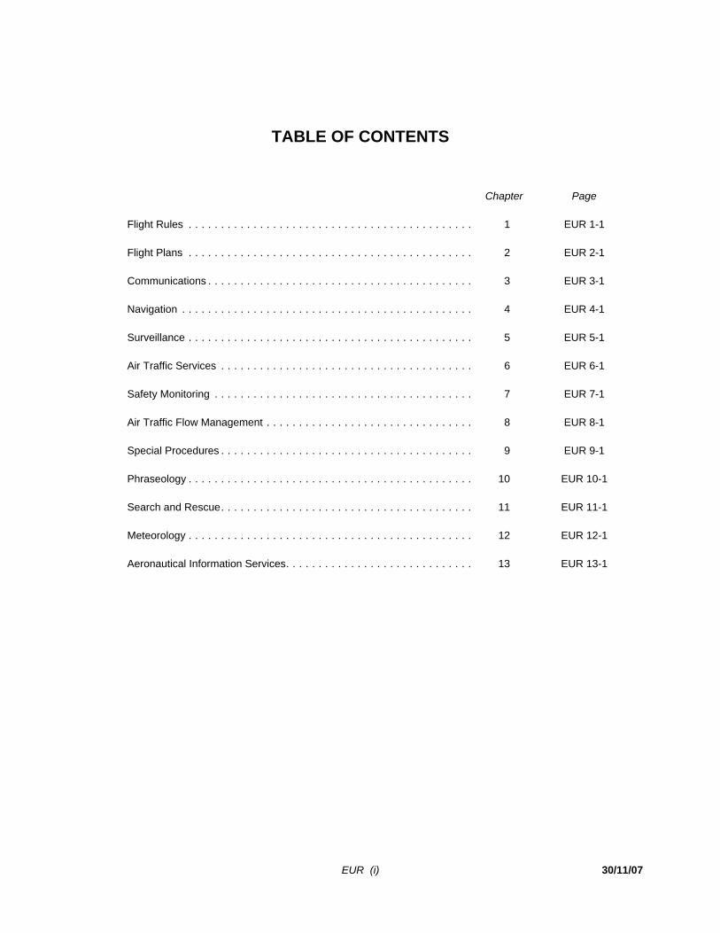
EUR (i) 30/11/07
TABLE OF CONTENTS
Chapter Page Flight Rules . . . . . . . . . . . . . . . . . . . . . . . . . . . . . . . . . . . . . . . . . . . . 1 EUR 1-1 Flight Plans . . . . . . . . . . . . . . . . . . . . . . . . . . . . . . . . . . . . . . . . . . . . 2 EUR 2-1 Communications . . . . . . . . . . . . . . . . . . . . . . . . . . . . . . . . . . . . . . . . . 3 EUR 3-1 Navigation . . . . . . . . . . . . . . . . . . . . . . . . . . . . . . . . . . . . . . . . . . . . . 4 EUR 4-1 Surveillance . . . . . . . . . . . . . . . . . . . . . . . . . . . . . . . . . . . . . . . . . . . . 5 EUR 5-1 Air Traffic Services . . . . . . . . . . . . . . . . . . . . . . . . . . . . . . . . . . . . . . . 6 EUR 6-1 Safety Monitoring . . . . . . . . . . . . . . . . . . . . . . . . . . . . . . . . . . . . . . . . 7 EUR 7-1 Air Traffic Flow Management . . . . . . . . . . . . . . . . . . . . . . . . . . . . . . . . 8 EUR 8-1 Special Procedures . . . . . . . . . . . . . . . . . . . . . . . . . . . . . . . . . . . . . . . 9 EUR 9-1 Phraseology . . . . . . . . . . . . . . . . . . . . . . . . . . . . . . . . . . . . . . . . . . . . 10 EUR 10-1 Search and Rescue . . . . . . . . . . . . . . . . . . . . . . . . . . . . . . . . . . . . . . . 11 EUR 11-1 Meteorology . . . . . . . . . . . . . . . . . . . . . . . . . . . . . . . . . . . . . . . . . . . . 12 EUR 12-1 Aeronautical Information Services . . . . . . . . . . . . . . . . . . . . . . . . . . . . . 13 EUR 13-1

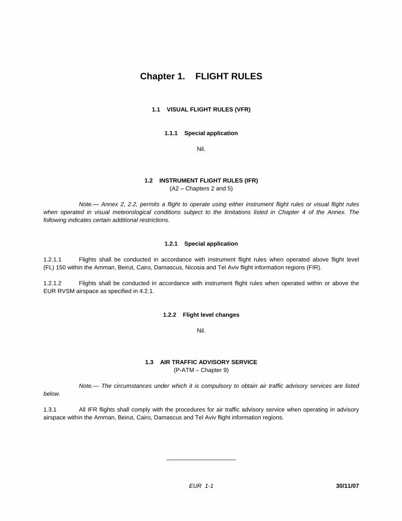
EUR 1-1 30/11/07
Chapter 1. FLIGHT RULES
1.1 VISUAL FLIGHT RULES (VFR)
1.1.1 Special application
Nil.
1.2 INSTRUMENT FLIGHT RULES (IFR) (A2 – Chapters 2 and 5)
Note.— Annex 2, 2.2, permits a flight to operate using either instrument flight rules or visual flight rules when operated in visual meteorological conditions subject to the limitations listed in Chapter 4 of the Annex. The following indicates certain additional restrictions.
1.2.1 Special application 1.2.1.1 Flights shall be conducted in accordance with instrument flight rules when operated above flight level (FL) 150 within the Amman, Beirut, Cairo, Damascus, Nicosia and Tel Aviv flight information regions (FIR). 1.2.1.2 Flights shall be conducted in accordance with instrument flight rules when operated within or above the EUR RVSM airspace as specified in 4.2.1.
1.2.2 Flight level changes
Nil.
1.3 AIR TRAFFIC ADVISORY SERVICE (P-ATM – Chapter 9)
Note.— The circumstances under which it is compulsory to obtain air traffic advisory services are listed below. 1.3.1 All IFR flights shall comply with the procedures for air traffic advisory service when operating in advisory airspace within the Amman, Beirut, Cairo, Damascus and Tel Aviv flight information regions.
_____________________

EUR 2-1 30/11/12
No. 7
Chapter 2. FLIGHT PLANS
2.1 CONTENT – GENERAL (A2 – Chapter 3; P-ATM – Chapter 11)
2.1.1 Date of flight
Nil.
2.1.2 Area navigation (RNAV) specifications
Nil.
2.1.3 Required navigation performance (RNP) specifications
Nil.
2.1.4 Minimum navigation performance specifications (MNPS)
Nil.
2.1.5 Reduced vertical separation minimum (RVSM)-approved aircraft 2.1.5.1 The aircraft registration shall be inserted in Item 18 of the ICAO flight plan form. Note.— Insertion of the aircraft registration does not apply to submissions made using the repetitive flight plan (RPL) listing form. 2.1.5.2 Operators of RVSM-approved aircraft shall also include the letter W in Item Q of the RPL, regardless of the requested flight level. If a change of aircraft operated in accordance with an RPL results in a modification of the RVSM approval status as stated in Item Q, a modification message (CHG) shall be submitted by the operator. 2.1.5.3 Operators of formation flights of State aircraft shall not insert the letter W in Item 10 of the ICAO flight plan form, regardless of the RVSM approval status of the aircraft concerned. Operators of formation flights of State aircraft intending to operate within RVSM airspace as general air traffic (GAT) shall include STS/NONRVSM in Item 18 of the ICAO flight plan form.
2.1.6 Non-RVSM-approved aircraft 2.1.6.1 Except for operations within the airspace designated in accordance with 9.7.1.1, operators of non-RVSM-approved aircraft shall flight plan to operate outside the RVSM airspace as specified in 4.2.1.
EUR 2-2 Regional Supplementary Procedures
30/11/12
No. 7
2.1.7 Non-RVSM-approved State aircraft
Nil.
2.1.8 Indication of 8.33 kHz channel spacing capability
Nil.
2.1.9 Route
Nil.
2.1.10 Estimated times
Nil.
2.1.11 Mach number
Nil.
2.1.12 Alternative flight level
Nil.
2.1.13 Special handling (STS)
Nil.
2.1.14 Controller-pilot data link communications (CPDLC)
2.1.14.1 Flights planning to use CPDLC over the aeronautical telecommunication network (ATN) shall include in Item 18 of the flight plan the indicator CODE/ followed by the 24-bit aircraft address (expressed in the form of alphanumerical code of six hexadecimal characters). Example: CODE/F00001
2.2 CONTENT – AIR TRAFFIC FLOW MANAGEMENT (ATFM)
2.2.1 Runway visual range (RVR) 2.2.1.1 When RVR information is included in Item 18 of the flight plan (“RVR/nnn”) to indicate the minimum RVR requirement of the flight, it may be used for air traffic flow management (ATFM) purposes.
Regional Supplementary Procedures EUR 2-3
30/11/12
No. 7
2.2.2 Flight plan addressing and distribution (P-ATM – Chapter 11)
2.2.2.1 Flight plans and associated messages for all IFR flights, including the IFR portions of mixed IFR/VFR flights, entering, over flying or departing the IFPS zone (IFPZ), shall be addressed only to the two integrated initial flight plan processing system (IFPS) addresses for that portion of the flight within the IFPZ. The IFPS addresses to be included in flight plans and associated messages submitted by operators that intend to fly into or through the IFPZ are as follows:
Network
IFPS Unit Addresses
IFPU1 Haren, Belgium
IFPU2 Brétigny, France
AFTN EUCHZMFP EUCBZMFP
SITA BRUEP7X PAREP7X
2.2.2.2 IFPS will ensure distribution of the accepted flight plan to all relevant ATS units within their area of responsibility. Flight plan message originators filing to IFPS are responsible for ensuring that the flight plan and any modifications made thereto are addressed to all the relevant ATS units outside the IFPZ. In order to ensure consistency between the flight plan data distributed within the IFPZ and that distributed outside the IFPZ, the Central Flow Management Unit (CFMU) has established a “re-addressing function”. The “re-addressing function” is intended primarily for flights originating within the IFPZ and proceeding outside the IFPZ. Note.— Detailed procedures and information applicable to flight plan addressing and distribution are contained in the EUROCONTROL “Basic CFMU Handbook”.
2.2.3 Slot allocation exemptions 2.2.3.1 The following flights are exempted from ATFM slot allocations: a) flights carrying Head of State or equivalent status [“ST/HEAD”]; and b) flights conducting search and rescue operations [“STS/SAR”].
2.3 SUBMISSION (A2 – Chapter 3; P-ATM – Chapters 3 and 4)
2.3.1 General 2.3.1.1 A centralized flight planning processing and distribution service has been established under the authority of the EUROCONTROL CFMU. The service is provided through the IFPS and covers part of the ICAO EUR Region known as the IFPZ. 2.3.1.2 For all IFR flights, including the IFR portions of mixed IFR/VFR flights, entering, overflying or departing the IFPZ, a flight plan shall be submitted to IFPS either directly or via the Air Traffic Services Reporting Office (ARO) serving the aerodrome of departure.
EUR 2-4 Regional Supplementary Procedures
30/11/12
No. 7
Note 1.— The area of applicability and detailed procedures pertaining to the IFPZ are contained in the EUROCONTROL “Basic CFMU Handbook”. Note 2.— See 2.2.2 for information concerning flight plan addressing and distribution. 2.3.1.3 Flight plans for flights which may be subject to ATFM shall be submitted at least 3 hours before the EOBT.
2.3.2 Amendments (P-ATM – Chapter 11)
2.3.2.1 Any changes to the EOBT of more than 15 minutes for any IFR flight within the IFPZ shall be communicated to the IFPS. 2.3.2.2 When an individual flight plan (FPL) or a repetitive flight plan (RPL) has been filed but it is decided, within 4 hours of EOBT, to use an alternative routing between the same aerodromes of departure and destination, either a modification message (CHG) may be sent or alternatively: a) a cancellation message (CNL) with priority “DD” shall be sent to IFPS; b) not less than 5 minutes after sending the CNL message, a replacement flight plan (RFP) in the form of
an FPL with identical call sign shall be transmitted; c) the RFP shall contain, as the first element of Item 18, the indication “RFP/Qn”, where RFP signifies
“Replacement Flight Plan” and “n” is “1” for the first replacement, “2” for the second replacement, and so on; and
d) the last RFP shall be filed at least 30 minutes before EOBT. Note.— The submission of a replacement flight plan is normally accepted as fulfilling a State’s requirement for advance notification of flight (diplomatic clearance).
2.4 REPETITIVE FLIGHT PLANS (RPLs) (P-ATM – Chapter 16 and Appendix 2)
Note.— Detailed provisions for the handling of RPLs within the IFPZ are specified in the EUROCONTROL “Basic CFMU Handbook”. 2.4.1 In order to avoid a disproportionate workload on ATS units, RPLs will not be accepted for any flight conducted on 25 December. On this day, individual flight plans shall be filed for all flights. 2.4.2 All operators filing RPLs shall include, in Item Q of the RPL, all equipment and capability information in conformity with Item 10 of the flight plan. This includes appropriate indicators/designators as specified in 2.1.2.1 and 2.1.5.1. 2.4.3 When there is a change of equipment or capability for a flight which is subject to an RPL, a modification message (CHG) for the day of operation shall be sent not earlier than 20 hours before the estimated EOBT. 2.4.4 Similarly, other changes, delays, or cancellations for the day of operation shall be sent not earlier than 20 hours before the EOBT.
_____________________
EUR 3-1 30/11/07
Chapter 3. COMMUNICATIONS
3.1 AIR-GROUND COMMUNICATIONS AND IN-FLIGHT REPORTING (A2 – Chapters 3 and 5; P-ATM – Chapter 4)
Note.— Annex 2, 3.6.5.1 and 5.3.3, require controlled flights and certain IFR flights outside controlled airspace to maintain a continuous listening watch on the appropriate radio channel. The PANS-ATM, 4.11.2, allows the appropriate ATS authority to limit the elements required in position reports in specified circumstances. The following expands such requirements and specifies additional details regarding the transmission and content of in-flight reports.
3.1.1 Communications equipment
Nil.
3.1.2 Continuous listening watch in uncontrolled airspace 3.1.2.1 Aircraft flying within uncontrolled airspace may be requested to maintain a continuous watch on the appropriate air-ground frequency of the ATS unit serving the flight information region within which the aircraft is flying.
3.1.3 Position reports
Nil.
3.1.4 Abbreviated position reports 3.1.4.1 Abbreviated position reports should only contain the aircraft identification, position, time and flight level or altitude, unless otherwise specified. 3.1.4.2 In defined portions of the airspace, designated by the appropriate ATS authority, where: a) through secondary surveillance radar (SSR), individual identity and verified Mode C information are
permanently available in the form of labels associated with the radar position of the aircraft concerned; and
b) reliable air-ground communications coverage and direct pilot-to-controller communications exist, the initial call after changing a radio channel may contain only the aircraft identification and level; subsequently, position reports may contain only aircraft identification, position and time.
3.1.5 Read-back of VHF channels 3.1.5.1 When instructed to contact an ATS unit on a different VHF communication channel, the pilot shall read back the newly assigned channel.
25/8/09
No. 2
EUR 3-2 Regional Supplementary Procedures
30/11/07
3.2 MANDATORY CARRIAGE OF 8.33 KHZ CHANNEL SPACING CAPABLE RADIO EQUIPMENT (A10, Vol. V – Chapter 4)
3.2.1 All aircraft operating above FL 195 in the European Region shall be equipped with 8.33 kHz channel spacing capable radio equipment. 3.2.2 Exemptions may be granted by States concerned for certain types of aircraft operation and for certain areas of operation. Note.— All exemptions granted by States, including the extent to which aircraft from other States can be exempted, should be specified in States’ AIPs. 3.2.3 When ultra-high frequency (UHF) ground infrastructure permits a close operational link to a State’s airspace management procedure, UHF-equipped State aircraft not equipped with an 8.33 kHz channel spacing capable radio will be allowed to operate in the airspace designated for 8.33 kHz channel spacing operations. Note.— Details of UHF coverage meeting the above infrastructure requirements should be specified in States’ AIPs.
3.3 CONTROLLER-PILOT DATA LINK COMMUNICATIONS (CPDLC)
3.3.1 Area of applicability 3.3.1.1 All concerned aircraft operating flights as general air traffic in accordance with instrument flight rules in the airspace defined below shall be equipped with context management (CM) and controller-pilot data link communications (CPDLC) applications capable of supporting the following data link services: data link initiation capability, air traffic control clearance, air traffic control communications management and air traffic control microphone check:
a) from 7 February 2013, in the following FIRs/UIRs above FL285: Amsterdam FIR, Wien FIR, Barcelona UIR, Brindisi UIR, Brussels UIR, Canarias UIR, France UIR,
Hannover UIR, Lisboa UIR, London UIR, Madrid UIR, Milano UIR, Rhein UIR, Roma UIR, Scottish UIR and Shannon UIR; and
b) from 5 February 2015, in the following FIRs/UIRs above FL285:
Bratislava FIR, Bucuresti FIR, Budapest FIR, Kobenhavn FIR, Ljubljana FIR, Nicosia FIR, Praha FIR, Sofia FIR, Warszawa FIR, Finland UIR south of 61°30’, Hellas UIR, Malta UIR, Riga UIR, Sweden UIR south of 61°30’, Tallinn UIR, Vilnius UIR.
Note.— Requirements for the CM and CPDLC applications to support the data link services described are contained in RTCA DO-280B/EUROCAE ED-110B Interoperability Requirements Standard For ATN Baseline 1 (INTEROP ATN B1) and RTCA DO-290/EUROCAE ED-120 Safety and Performance Requirements Standard for Air Traffic Data Link Services in Continental Airspace (Continental SPR Standard), including Changes 1 and 2, with the exceptions that:
a) uplink message 135, CONFIRM ASSIGNED LEVEL, and uplink message 233, USE OF LOGICAL
ACKNOWLEDGEMENT PROHIBITED, will not be used by the ground systems; and b) downlink message 38, ASSIGNED LEVEL (level), is not required by the aircraft.
15/10/10
No. 3
Regional Supplementary Procedures EUR 3-3
30/11/07
3.3.1.2 Conformance to the equipage requirement and operator’s approval shall be verified by the State of Registry or the State of the Operator, as appropriate. 3.3.1.3 Aircraft are exempted from the requirement stipulated in 3.3.1.1 in the following cases: a) aircraft with an individual certificate of airworthiness first issued before 1 January 2011 are exempted
until 5 February 2015; b) aircraft with an individual certificate of airworthiness first issued before 1 January 2014 and fitted with
data link equipment certified against requirements specified in RTCA DO-258A/EUROCAE ED-100A (or ED-100) are exempted for the life of that particular airframe;
c) aircraft which have a certificate of airworthiness issued before 31 December 1997 and which will
cease operation in the airspace referred to in 3.3.1.1 before 31 December 2017 are exempted from the requirement stipulated in 3.3.1.1;
d) state aircraft; e) aircraft flying in the airspace referred to in 3.3.1.1 for testing, delivery and for maintenance purposes;
and f) operators of types of aircraft reaching the end of their production life and being produced in limited
numbers, or types of aircraft for which re-engineering costs required would be disproportionate due to old design, may, based on this criteria, request from the appropriate authority the granting of an exemption. Such requests shall be made prior to 30 September 2012 and include detailed information justifying the need for the granting of the exemption.
3.4 SATELLITE VOICE COMMUNICATIONS (SATCOM)
Nil.
3.5 AERONAUTICAL MOBILE SERVICE
3.5.1 Selective calling (SELCAL)
Nil.
3.5.2 HF operations
Nil.
3.5.2.1 Assignment of voice traffic to HF families Nil.
15/10/10
No. 3
EUR 3-4 Regional Supplementary Procedures
30/11/07
3.5.2.2 Procedures for mutual assistance Nil.
3.6 AERONAUTICAL FIXED SERVICE
3.6.1 AFTN rationalization
Nil.
3.7 RADIO CHANNELS/FREQUENCIES
3.7.1 VHF Datalink (VDL) Mode 2 – system characteristics of ground and airborne installations
(A10, Vol. III, Part I) 3.7.1.1 With effect from 1 January 2010, all VDL Mode 2 ground transmitters in the European Region shall meet the provisions specified in Annex 10, Volume III, Part I, 6.2.4.1.1, 6.2.4.2.1, 6.2.4.2.2 and 6.2.4.3.1, relating to adjacent channel emissions. 3.7.1.2 With effect from 1 January 2010, all VDL Mode 2 airborne transmitters in the European Region shall meet the provisions specified in Annex 10, Volume III, Part I, 6.3.4.1.1, 6.3.4.2.1, 6.3.4.2.2 and 6.3.4.3.1, relating to adjacent channel emissions. 3.7.1.3 With effect from 1 January 2010, the receiving function of all VDL Mode 2 installations in the European Region shall meet the provisions specified in Annex 10, Volume III, Part I, 6.3.5.3.1, relating to the specified error rate.
_____________________
15/10/10
No. 3
EUR 4-1 30/11/07
Chapter 4. NAVIGATION
4.1 PERFORMANCE-BASED NAVIGATION (PBN)
Note.— As the European (EUR) Region transitions to PBN as contained in the Performance-based Navigation Manual (Doc 9613), the contents of 4.1 will be amended.
4.1.1 Area navigation (RNAV) specifications
4.1.1.1 RNAV 10 (RNP 10) Nil. 4.1.1.2 RNAV 5 Area of applicability 4.1.1.2.1 The requirements included in the RNAV 5 (B-RNAV) specification for en-route operations shall apply to all such operations conducted under IFR on designated RNAV 5 routes within the following FIRs as specified in the relevant State AIPs or NOTAMs: Amman, Beirut, Cairo, Damascus and Tel Aviv. Means of compliance 4.1.1.2.2 Conformance to the navigation requirement shall be verified by the State of Registry or the State of the Operator, as appropriate. Note.— Guidance material concerning navigation requirements associated with RNAV 5 (B-RNAV) operations is contained in EASA AMC 20-4, Airworthiness Approval and Operational Criteria for the Use of Navigation Systems in European Airspace Designated for Basic RNAV Operations. Area of applicability 4.1.1.2.3 The requirements included in the RNAV 5 (B-RNAV) specification for en-route operations shall apply to all such operations conducted under IFR on the entire ATS route network in the following flight information regions (FIRs)/upper flight information regions (UIRs) as specified in the relevant State AIPs: Amsterdam, Ankara, Athinai, Baku, Barcelona, Bodø, Bordeaux, Bratislava, Bremen, Brest, Brindisi,
Bruxelles, Bucuresti, Budapest, Canarias (AFI area of applicability), Casablanca, Chisinau, Dnipropetrovs’k, France, Hannover, Istanbul, København, Kyiv, Langen, Lisboa, Ljubljana, London, L’viv, Madrid, Malta, Marseille, Milano, München, Nicosia, Odessa, Oslo, Paris, Praha, Reims, Rhein, Riga, Roma, Rovaniemi, Scottish, Shannon, Simferopol, Skopje, Sofia, Stavanger, Sweden, Switzerland, Tallinn, Tampere, Tbilisi, Tirana, Trondheim, Tunis, Varna, Vilnius, Warszawa, Wien, Yerevan, Zagreb.
25/5/11
No. 4
EUR 4-2 Regional Supplementary Procedures
30/11/07
Means of compliance 4.1.1.2.4 Conformance to the navigation requirement shall be verified by the State of Registry or the State of the Operator, as appropriate. Note.— Guidance material concerning navigation requirements associated with RNAV 5 (B-RNAV) operations is contained in EASA AMC 20-4, Airworthiness Approval and Operational Criteria for the Use of Navigation Systems in European Airspace Designated for Basic RNAV Operations. 4.1.1.3 RNAV 2 Nil. 4.1.1.4 RNAV 1 Area of applicability 4.1.1.4.1 The requirements included in the RNAV 1 and/or P-RNAV specification shall be applied whenever P-RNAV terminal control area (TMA) procedures, excluding the final and missed approach segments, are used. Note 1.— RNAV 1 and/or P-RNAV approvals are not mandatory in the EUR Region. Note 2.— RNAV 1 approved aircraft are approved for P-RNAV. Means of compliance 4.1.1.4.2 Conformance to the navigation requirement shall be verified by the State of Registry or the State of the Operator, as appropriate. Note.— Guidance material concerning navigation requirements associated with P-RNAV operations is contained in the JAA Temporary Guidance Leaflet (TGL) No. 10 Revision 1. 4.1.1.5 Pre-PBN navigation specifications Nil.
4.1.2 Required navigation performance (RNP) specifications 4.1.2.1 RNP 4 Nil. 4.1.2.2 Basic RNP 1 Nil.
25/5/11
No. 4
Regional Supplementary Procedures EUR 4-3
30/11/07
4.1.2.3 Advanced RNP 1 Nil.
4.2 REDUCED VERTICAL SEPARATION MINIMUM (RVSM)
Area of applicability 4.2.1 RVSM shall be applicable in that volume of airspace between FL 290 and FL 410 inclusive in the following FIRs/UIRs: Alger, Amman, Amsterdam, Ankara, Arkhangelsk, Baku, Barcelona, Beirut, Beograd, Berlin, Bodø,
Bratislava, Brindisi, Bruxelles, Bucuresti, Budapest, Cairo, Casablanca, Chisinau, Damascus, Dnipropetrovs’k, France, Hannover, Hellas, Istanbul, Kaliningrad, Kazan, Kirov, København, Kotlas, Kyiv, Lisboa, Ljubljana, London, L’viv, Madrid, Malta, Milano, Minsk, Moscow, Murmansk, Murmansk Oceanic, Naryan-Mar, Nicosia, Novosibirsk, Odesa, Oslo, Penza, Perm, Petrozavodsk, Praha, Rhein, Riga, Roma, Rostov, Rovaniemi, Samara, Sankt-Peterburg, Saratov, Sarajevo, Scottish, Shannon, Simferopol, Skopje, Sofia, Stavanger, Sweden, Switzerland, Syktyvkar, Tallinn, Tampere, Tbilisi, Tel Aviv, Tirana, Tripoli, Trondheim, Tunis, Ufa, Varna, Velikiye Luki, Vilnius, Vologda, Vorkuta, Warszawa, Wien, Yekaterinburg, Yerevan, Zagreb.
Means of compliance
Nil.
_____________________
27/3/12
No. 6

EUR 5-1 30/11/07
Chapter 5. SURVEILLANCE (P-ATM – Chapter 8; P-OPS, Vol. I, Part III)
5.1 SECONDARY SURVEILLANCE RADAR (SSR)
5.1.1 Carriage of pressure-altitude reporting SSR transponders
Nil.
5.1.2 Code allocation methodology
5.1.2.1 All aircraft engaged in international flight shall be assigned an appropriate SSR code by the initial ATS unit at the beginning of the flight if it is to be conducted under instrument flight rules. The code shall be assigned in accordance with the Air Navigation Plan — European Region, Volume II — FASID (Doc 7754), Part IV, Attachment H, Principles and Procedures for the Distribution and Use of SSR Codes in the EUR Region.
5.1.3 Assignment of SSR codes
Nil.
5.1.4 Operation of pressure-altitude reporting SSR transponders
Nil.
5.1.5 Monitoring of SSR-derived information
Nil.
5.2 SSR MODE S
5.2.1 Carriage and operation of SSR Mode S (A10, Vol. IV — Chapter 2)
5.2.1.1 The carriage and operation of Mode S airborne equipment shall be mandatory in airspace designated by the appropriate ATS authorities pursuant to the implementation of SSR Mode S Elementary or Enhanced surveillance in accordance with the following requirements: a) SSR Mode S Elementary surveillance (ELS) 1) for all IFR flights, including general air traffic (GAT):
25/8/09
No. 2
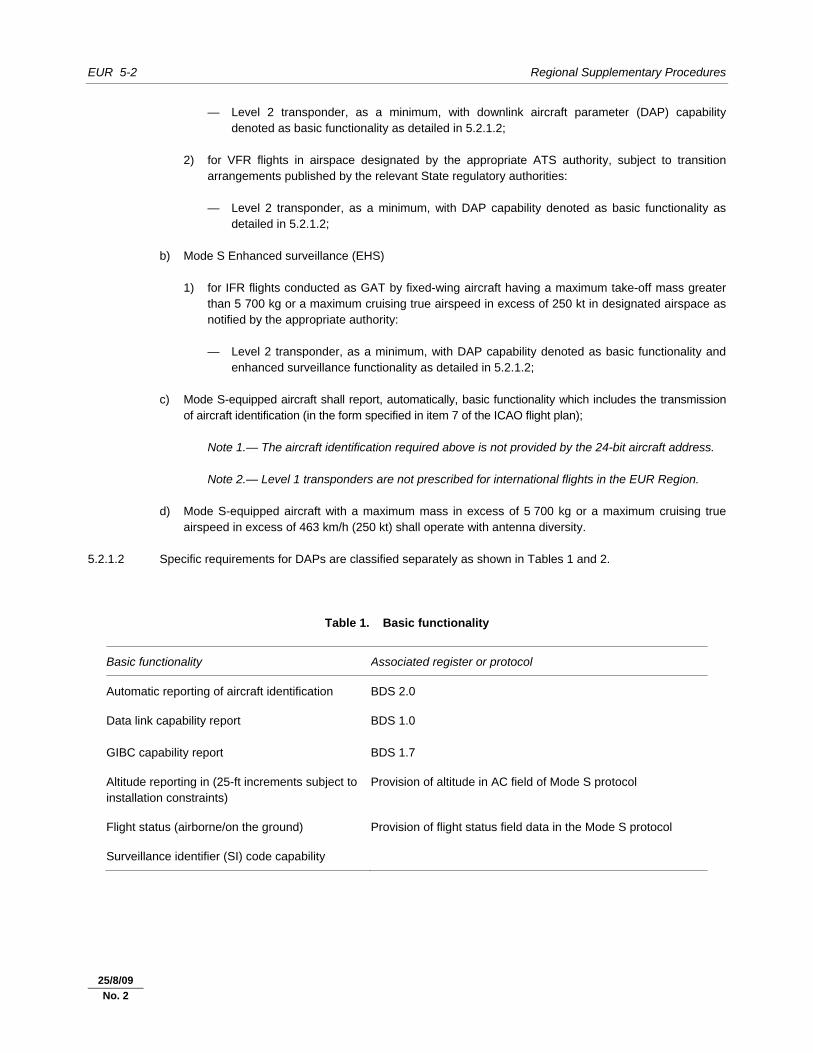
EUR 5-2 Regional Supplementary Procedures
30/11/07
— Level 2 transponder, as a minimum, with downlink aircraft parameter (DAP) capability denoted as basic functionality as detailed in 5.2.1.2;
2) for VFR flights in airspace designated by the appropriate ATS authority, subject to transition
arrangements published by the relevant State regulatory authorities: — Level 2 transponder, as a minimum, with DAP capability denoted as basic functionality as
detailed in 5.2.1.2; b) Mode S Enhanced surveillance (EHS) 1) for IFR flights conducted as GAT by fixed-wing aircraft having a maximum take-off mass greater
than 5 700 kg or a maximum cruising true airspeed in excess of 250 kt in designated airspace as notified by the appropriate authority:
— Level 2 transponder, as a minimum, with DAP capability denoted as basic functionality and
enhanced surveillance functionality as detailed in 5.2.1.2; c) Mode S-equipped aircraft shall report, automatically, basic functionality which includes the transmission
of aircraft identification (in the form specified in item 7 of the ICAO flight plan); Note 1.— The aircraft identification required above is not provided by the 24-bit aircraft address. Note 2.— Level 1 transponders are not prescribed for international flights in the EUR Region. d) Mode S-equipped aircraft with a maximum mass in excess of 5 700 kg or a maximum cruising true
airspeed in excess of 463 km/h (250 kt) shall operate with antenna diversity. 5.2.1.2 Specific requirements for DAPs are classified separately as shown in Tables 1 and 2.
Table 1. Basic functionality
Basic functionality Associated register or protocol
Automatic reporting of aircraft identification BDS 2.0
Data link capability report GIBC capability report
BDS 1.0 BDS 1.7
Altitude reporting in (25-ft increments subject to installation constraints)
Provision of altitude in AC field of Mode S protocol
Flight status (airborne/on the ground) Provision of flight status field data in the Mode S protocol
Surveillance identifier (SI) code capability
25/8/09
No. 2
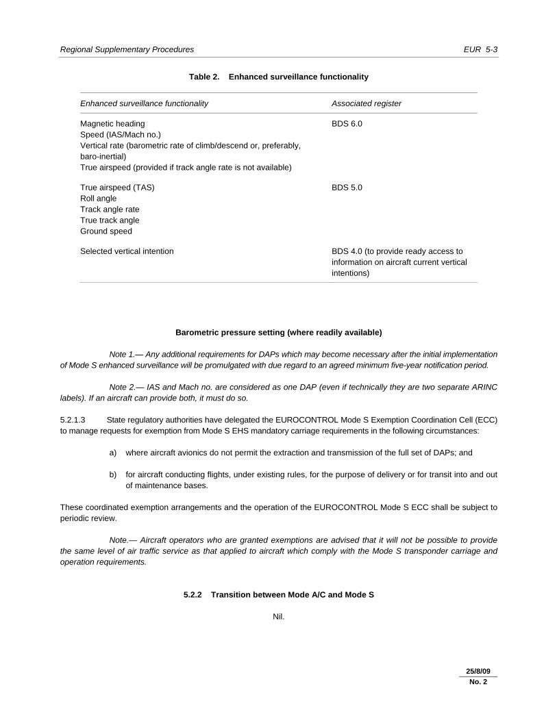
Regional Supplementary Procedures EUR 5-3
30/11/07
Table 2. Enhanced surveillance functionality
Enhanced surveillance functionality Associated register
Magnetic heading Speed (IAS/Mach no.) Vertical rate (barometric rate of climb/descend or, preferably, baro-inertial) True airspeed (provided if track angle rate is not available)
BDS 6.0
True airspeed (TAS) Roll angle Track angle rate True track angle Ground speed
BDS 5.0
Selected vertical intention BDS 4.0 (to provide ready access to information on aircraft current vertical intentions)
Barometric pressure setting (where readily available) Note 1.— Any additional requirements for DAPs which may become necessary after the initial implementation of Mode S enhanced surveillance will be promulgated with due regard to an agreed minimum five-year notification period. Note 2.— IAS and Mach no. are considered as one DAP (even if technically they are two separate ARINC labels). If an aircraft can provide both, it must do so. 5.2.1.3 State regulatory authorities have delegated the EUROCONTROL Mode S Exemption Coordination Cell (ECC) to manage requests for exemption from Mode S EHS mandatory carriage requirements in the following circumstances: a) where aircraft avionics do not permit the extraction and transmission of the full set of DAPs; and b) for aircraft conducting flights, under existing rules, for the purpose of delivery or for transit into and out
of maintenance bases. These coordinated exemption arrangements and the operation of the EUROCONTROL Mode S ECC shall be subject to periodic review. Note.— Aircraft operators who are granted exemptions are advised that it will not be possible to provide the same level of air traffic service as that applied to aircraft which comply with the Mode S transponder carriage and operation requirements.
5.2.2 Transition between Mode A/C and Mode S
Nil.
25/8/09
No. 2
EUR 5-4 Regional Supplementary Procedures
30/11/07
5.3 AIRBORNE COLLISION AVOIDANCE SYSTEMS (ACAS)
5.3.1 Carriage and operation of ACAS II (A10, Vol. IV – Chapter 4; P-OPS, Vol. I)
5.3.1.1 ACAS II shall be carried and operated in the EUR Region (and the Canarias FIR) by all turbine-engined aeroplanes having a maximum certificated take-off mass exceeding 5 700 kg or authorized to carry more than 19 passengers.
5.4 AUTOMATIC DEPENDENT SURVEILLANCE – CONTRACT (ADS-C)
Nil.
5.5 AUTOMATIC DEPENDENT SURVEILLANCE – BROADCAST (ADS-B)
Nil.
_____________________
25/8/09
No. 2
EUR 6-1 30/11/07
Chapter 6. AIR TRAFFIC SERVICES (ATS)
6.1 AIR TRAFFIC CONTROL (ATC) CLEARANCES (A11 – Chapter 3; P-ATM – Chapter 4)
6.1.1 Content
Nil.
6.1.2 Adherence
6.1.2.1 Special procedures applicable to uncoordinated flights 6.1.2.1 operating along the FIR boundaries in the Red Sea area 6.1.2.1 (P-ATM – Chapter 15; P-OPS, Vol. I, Part III, Section 3) 6.1.2.1.1 Uncoordinated flights operating along the FIR boundaries over the Red Sea portions of Cairo shall follow the procedures prescribed in the MID/ASIA SUPPs, 6.1.2.2.
6.2 SEPARATION
6.2.1 Lateral
Nil.
6.2.2 Longitudinal (P-ATM – Chapter 5)
6.2.2.1 Longitudinal separation minimum based on time and 6.2.2.1 radar-observed distance 6.2.2.1.1 A minimum longitudinal separation of three minutes may be applied between aircraft on the same track or crossing tracks, whether at the same level, climbing or descending, provided that: a) their flight progress is continuously monitored by radar forming an integral part of the ATC unit
concerned; and b) the distance between the aircraft, as observed by radar, is never less than 37 km (20 NM). Note.— Use of this separation is subject to all the limitations in the use of radar specified in the PANS-ATM, 8.1.
25/5/11
No. 4
EUR 6-2 Regional Supplementary Procedures
30/11/07
6.2.3 Composite
Nil.
6.2.4 Vertical (P-ATM – Chapter 5)
6.2.4.1 Within the RVSM airspace as specified in 4.2.1, the vertical separation minimum shall be: a) 300 m (1 000 ft) between RVSM-approved aircraft; b) 600 m (2 000 ft) between: 1) non-RVSM-approved State aircraft and any other aircraft operating within RVSM airspace; 2) all formation flights of State aircraft and any other aircraft operating within RVSM airspace; and 3) non-RVSM-approved aircraft and any other aircraft operating within the airspace designated in
accordance with 9.7.1.1.
6.2.5 Radar 6.2.5.1 Transfer of control 6.2.5.1.1 Transfer of control based on the procedures specified in the PANS-ATM, 8.7.4, may be carried out without systematic use of the bidirectional speech facilities available between the adjacent units concerned, provided that: a) the detailed conditions applicable for the transfer are the subject of a bilateral agreement; and b) the minimum distance between successive aircraft during the period of transfer is agreed as one of the
following values: 1) 19 km (10 NM) when SSR information is used in accordance with the provisions of the
PANS-ATM, provided that an overlapping radar coverage of at least 56 km (30 NM) between units involved exists; or
2) 9.3 km (5 NM) when the conditions of 1) apply and both units involved possess electronic aids for
immediate recognition of release and acceptance of aircraft under radar transfer.
6.2.6 Reduction in separation minima
Nil.
6.2.7 Airspace reservations
Nil.
25/8/09
No. 2
22/7/11
No. 5
Regional Supplementary Procedures EUR 6-3
30/11/07
6.3 MINIMUM FLIGHT LEVEL
6.3.1 Establishment (P-ATM – Chapter 4)
6.3.1.1 Based on current and anticipated atmospheric pressure distribution, area control centres shall coordinate, when required, the lowest flight level to be used.
6.4 ATS ROUTES
6.4.1 Track systems
Nil.
6.4.2 RNAV (A11 – Appendices 1 and 3)
6.4.2.1 All RNAV standard instrument arrival and departure procedures shall be suitably designated as RNAV in accordance with Annex 11, Appendix 3. 6.4.2.2 All other RNAV routes shall be designated in accordance with Annex 11, Appendix 1.
6.5 AERODROME OPERATIONS
6.5.1 Area of applicability 6.5.1.1 The provisions in Sections 6.5.2 to 6.5.4 and 13.2.1.1 shall apply in Canarias FIR (AFI Region) and all FIRs of the EUR Region except the following, which are located in the AFI or MID Regions: Alger, Beirut, Cairo, Casablanca, Damascus, Tel Aviv, Tripoli and Tunis.
6.5.2 Intersection take-off 6.5.2.1 An aircraft may be cleared to depart from a published intersection take-off position upon request of the pilot, or if initiated by ATC and accepted by the pilot, provided that all of the conditions of 6.5.2.2 to 6.5.2.6 are met. 6.5.2.2 The declared distances for each published intersection take-off position shall consist of the following: a) take-off run available (TORA) from the intersection take-off position; b) take-off distance available (TODA) from the intersection take-off position; and c) accelerate-stop distance available (ASDA) from the intersection take-off position.
30/11/12
No. 7
EUR 6-4 Regional Supplementary Procedures
30/11/07
6.5.2.3 The reference point from which the runway declared distances for a published intersection take-off position are measured shall be in accordance with the relevant provisions in the Air Navigation Plan — European Region, Volume II — FASID (Doc 7754), Part III — AOP. 6.5.2.4 Declared distances for an intersection take-off position shall be published in the relevant AIP, clearly distinguishable from full runway declared distances. 6.5.2.5 Information on the TORA from the intersection shall be issued when requested by an aircraft or whenever deemed necessary by the controller. Note.— See 10.4 for relevant radiotelephony (RTF) phraseology. 6.5.2.6 Signs shall be in accordance with Annex 14, Volume I.
6.5.3 Multiple line-ups on the same runway 6.5.3.1 Line-up instructions may be issued to more than one aircraft at different points on the same runway, taking into account that intersection take-off criteria shall be complied with, provided that: a) minimum visibility is established by the appropriate authority. Those minima shall permit the controller
and the pilot to continuously observe the position of the relevant aircraft on the manoeuvring area by visual reference;
b) local considerations, such as the airport layout, available radar equipment and local weather
phenomena, are defined. The effect of jet blast/prop wash shall be taken into consideration; c) air traffic service for aircraft involved in multiple line-ups on the same runway is provided on the same
radio frequency; d) pilots are advised of the position of any essential traffic on the same runway; e) the slope of the runway does not render preceding aircraft in the departure sequence invisible to
succeeding aircraft on the same runway; f) pilot read-back of line-up instructions is required and contains the runway designator, the name of the
intersection (if applicable) and the number in the departure sequence; and g) wake turbulence separation is applied.
6.5.4 Visual departures 6.5.4.1 A visual departure is a departure by an IFR flight when either part or all of an instrument departure procedure (e.g. standard instrument departure (SID)) is not completed and the departure is executed in visual reference to terrain. 6.5.4.2 An IFR flight may be cleared to execute a visual departure upon request of the pilot or if initiated by the controller and accepted by the pilot. 6.5.4.3 To execute a visual departure, the aircraft take-off performance characteristics shall allow them to make an early turn after take-off. When implemented, visual departure shall be applied under the following conditions:
30/11/12
No. 7
Regional Supplementary Procedures EUR 6-5
30/11/07
a) the meteorological conditions in the direction of take-off and the following climb-out shall not impair the procedure up to an altitude to be established and published by the appropriate authority, e.g. minimum flight altitude (MFA) or minimum sector altitude (MSA);
b) the procedure shall be applied during the daytime. The procedure may be considered for application at
night following a separate aeronautical study by the appropriate air traffic services (ATS) authority; c) the pilot shall be responsible for maintaining obstacle clearance until the specified altitude. Further
clearance (route, heading, point) shall be specified by ATC; and d) separation shall be provided between an aircraft cleared to execute a visual departure and other
departing and arriving aircraft. 6.5.4.4 Prior to take-off, the pilot shall agree to execute a visual departure by providing a read-back of the ATC clearance. 6.5.4.5 Any additional local restrictions shall be agreed on in consultation between the appropriate ATS authority and operators.
6.5.5 Visual approaches
Nil.
6.5.6 Advanced surface movement guidance and control systems (A-SMGCS) (A11 — Chapter 11; P-ATM — Chapters 7 and 8)
Note.— For further information, see the Advanced Surface Movement Guidance and Control Systems (A-SMGCS) Manual (Doc 9830). 6.5.6.1 General 6.5.6.1.1 A-SMGCS shall provide for the detection and display of the movement of all aircraft on the movement area as well as the identity of all suitably equipped aircraft. 6.5.6.1.2 A-SMGCS shall enable the detection and display of the movement of all vehicles on the manoeuvring area as well as the identity of all suitably equipped vehicles. 6.5.6.2 A-SMGCS functions 6.5.6.2.1 When authorized by and subject to conditions prescribed by the appropriate ATS authority, the information provided on an A-SMGCS display may be used for the purpose of: a) determining the location of aircraft on the movement area and vehicles on the manoeuvring area; Note.— Where visual observation by the aerodrome controller is not possible, or whenever
deemed beneficial by the aerodrome controller, the information provided by A-SMGCS may be used to replace visual observation.
b) monitoring aircraft and vehicles on the manoeuvring area for compliance with clearances and
instructions;
30/11/12
No. 7
EUR 6-6 Regional Supplementary Procedures
30/11/07
c) determining that a runway is clear of traffic or assisting in the assessment that a runway will be clear of traffic prior to a landing or take-off;
d) providing information on essential local traffic on or near the manoeuvring area; e) providing directional taxi information to aircraft when requested by the pilot or deemed necessary by the
controller. Such information should not be issued in the form of specific heading instructions (except in special circumstances, e.g. emergencies); and
f) providing assistance and advice to emergency vehicles. 6.5.6.3 A-SMGCS alerts 6.5.6.3.1 Local instructions concerning use of the A-SMGCS alerting function, where available, shall specify, inter alia: a) the aircraft and vehicles which might trigger alerts; b) the areas of the manoeuvring area within which the alerting function is implemented; c) the method of displaying alerts to the controller; d) the warning criteria for the triggering of alerts that could depend on meteorological situations or type
of operation being conducted, as well as alert warning time; and e) conditions under which the alert function may be inhibited. 6.5.6.3.2 In the event an alert is triggered, the controller shall, without delay, assess the situation and take appropriate action as required. 6.5.6.3.3 For the purpose of analysis and to improve overall safety levels, the appropriate ATS authority shall retain electronic records of all alerts triggered. 6.5.6.4 A-SMGCS identification procedures Note.— See PANS-ATM, 8.5, “Use of SSR transponders and ADS-B transmitters” and 8.6.2. “Identification of aircraft”. 6.5.6.4.1 Where A-SMGCS is used, aircraft and vehicles may be identified by the following procedures or by those contained in the PANS-ATM, 8.6.2: a) direct recognition of the aircraft identification of a Mode S-equipped aircraft in an A-SMGCS label; and b) direct recognition of a suitably equipped vehicle identification in an A-SMGCS label.
6.5.7 Low visibility operations (A11 – Chapter 3 and P-ATM – Chapter 7)
Note.— For the purpose of describing the provision of an aerodrome control service in the context of varying visibilities, the following four (4) visibility conditions, as defined in Doc 9830, Appendix A, are used. Criteria for
30/11/12
No. 7
Regional Supplementary Procedures EUR 6-7
30/11/07
determining the transition between visibility conditions are a function of local aerodrome and traffic characteristics and should be established by the appropriate ATS authority. Visibility condition 1. Visibility sufficient for the pilot to taxi and to avoid collision with other traffic on
taxiways and at intersections by visual reference, and for personnel of control units to exercise control over all traffic on the basis of visual surveillance.
Visibility condition 2. Visibility sufficient for the pilot to taxi and to avoid collision with other traffic on
taxiways and at intersections by visual reference, but insufficient for personnel of control units to exercise control over all traffic on the basis of visual surveillance.
Visibility condition 3. Visibility sufficient for the pilot to taxi but insufficient for the pilot to avoid collision with other traffic on taxiways and at intersections by visual reference, and insufficient for personnel of control units to exercise control over all traffic on the basis of visual surveillance. For taxiing, this is normally taken as visibilities equivalent to an RVR of less than 400 m but more than 75 m.
Visibility condition 4. Visibility insufficient for the pilot to taxi by visual guidance only. This is normally taken as an RVR of 75 m or less.
6.5.7.1 When there is a requirement for traffic to operate on the manoeuvring area in visibility insufficient for personnel of control units to exercise control over all traffic on the basis of visual surveillance, ATC shall provide pilots and vehicle drivers with instructions and information to enable them to navigate and to avoid collisions with other relevant traffic by visual reference. In visibility condition 2, such instructions and information may be derived from the use of A-SMGCS, where available.
6.5.7.2 During visibility conditions 3 and 4, A-SMGCS, where available, may be used to determine the position of aircraft and vehicles on the manoeuvring area.
Note.— The Manual of Surface Movement Guidance and Control Systems (SMGCS) (Doc 9476) and the Advanced Surface Movement Guidance and Control Systems (A-SMGCS) Manual (Doc 9830) provide guidance on surface movement guidance and control components and procedures.
6.5.7.3 The general conditions under which the low visibility procedures (LVP) applicable to Cat II/III operations are applied shall be published in the AIP, AD 1.1.
6.5.7.4 In addition to the provisions specified in PANS-ATM, 7.12.2., provisions regarding LVP should specify:
a) the requirement to inform the flight crews that LVPs are in operation and to inform them when LVPs are cancelled;
b) applicable spacing between successive arriving and/or departing aircraft to ensure protection of the sensitive and critical areas; and
c) any ATFM measures to be implemented.
Note.— Further information can be found in the Air Traffic Services Planning Manual (Doc 9426).
6.5.7.5 When an ILS auto-coupled approach to a runway is being conducted outside low visibility conditions (LVP are not in force), it is possible that some disturbance of the ILS signal may occur. In cases where protection of the localizer sensitive area (LSA) cannot be provided, ATC shall inform the flight crew if the pilot requests an autoland with protection of the LSA.
30/11/12
No. 7
EUR 6-8 Regional Supplementary Procedures
30/11/07
6.6 RNAV PROCEDURES
6.6.1 General 6.6.1.1 RNAV system operation 6.6.1.1.1 Correct operation of the aircraft RNAV system shall be established before joining and during operation on an RNAV route. This shall include confirmation that: a) the routing is in accordance with the clearance; and b) the RNAV navigation accuracy of the aircraft meets the navigation accuracy requirements of the
RNAV route and arrival or departure procedures, as applicable. 6.6.1.2 Obstacle clearance 6.6.1.2 (A2 – Chapter 5; P-ATM – Chapters 4 and 8) 6.6.1.2.1 Unless an IFR aircraft is receiving navigation guidance from ATC in the form of radar vectors, the pilot is responsible for obstacle clearance. Therefore, the use of RNAV does not relieve pilots of their responsibility to ensure that any ATC clearance or instruction is safe in respect to obstacle clearance. ATC shall assign levels that are at or above established minimum flight altitudes.
6.6.2 En-route
Nil.
6.6.3 Terminal 6.6.3.1 For operation on RNAV arrival and departure routes, where clearance is given by ATC for an RNAV procedure for which the aircraft is not approved, the pilot is to advise ATC who will then seek to provide an alternative routing. Note.— See 10.1 for relevant radiotelephony (RTF) phraseology. 6.6.3.2 Aircraft equipped with RNAV equipment having a lateral track-keeping accuracy of ±5 NM (2 SD) with an ability to determine horizontal position to an accuracy sufficient to support the track-keeping requirement and having appropriate functionality, hereafter designated as basic area navigation (B-RNAV), may use RNAV (segments) of arrival and departure routes where these meet the following criteria: a) the B-RNAV portion of the route must: 1) be above the appropriate minimum flight altitude (MFA) (e.g.: minimum radar vectoring altitude
(MRVA) and minimum sector altitude (MSA)); and 2) be in accordance with established PANS-OPS criteria for en-route operations; and 3) conform to B-RNAV en-route design principles; Note.— For minimum flight altitudes, see Annex 11, 2.22.
25/8/09
No. 2
25/5/11
No. 4
Regional Supplementary Procedures EUR 6-9
30/11/07
b) the departure procedures must be conventional (non-RNAV) up to a conventional fix (or a minimum altitude). Beyond that fix (or minimum altitude), a B-RNAV procedure can be provided in accordance with the criteria in a); and
c) the B-RNAV portion of an arrival route must terminate at a conventional fix in accordance with the
criteria given in a) and b). Beyond that fix, the arrival shall be completed by a conventional (non-RNAV) procedure or by the provision of radar vectors; and
d) due regard must be taken of those operating procedures of the users which may affect system
performance. Examples include, but are not limited to, initial position fixing on the runway and minimum automatic flight control system (AFCS) engagement altitudes; and
e) arrival and departure procedures, which can be flown by B-RNAV equipment, shall be identified
explicitly as approved for application of B-RNAV.
6.6.4 State aircraft (A11 – Chapter 3)
6.6.4.1 ATC procedures for State aircraft not equipped with RNAV 6.6.4.1 but having a navigation accuracy meeting RNP 5 6.6.4.1.1 Within TMAs, State aircraft may only be routed via the RNAV terminal area procedures if they are equipped with the appropriate RNAV equipment (4.1.1.5.2 and 6.6.3.2 apply). 6.6.4.1.2 For such aircraft operating en route, the following procedures apply: a) State aircraft should be routed via VOR/DME-defined ATS routes; or b) if no such routes are available, State aircraft should be routed via conventional navigation aids, i.e.
VOR/DME. Note.— State aircraft routed in accordance with a) or b) may require continuous radar monitoring by the ATC unit concerned. 6.6.4.1.3 When the above procedures cannot be applied, the ATC unit shall provide State aircraft with radar vectors until the aircraft is capable of resuming its own navigation.
6.7 RNP PROCEDURES
6.7.1 General
Nil.
6.7.2 En-route
Nil
25/5/11
No. 4
EUR 6-10 Regional Supplementary Procedures
30/11/07
6.7.3 Terminal
Nil.
6.7.4 State aircraft
Nil.
6.8 COMPOSITE PROCEDURES
Nil.
6.9 MNPS PROCEDURES
Nil.
6.10 RVSM PROCEDURES
6.10.1 General 6.10.1.1 Except for operations within the airspace designated in accordance with 9.7.1.1, only RVSM-approved aircraft and non-RVSM-approved State aircraft shall be issued an ATC clearance into RVSM airspace. 6.10.1.2 ATC clearance into RVSM airspace shall not be issued to formation flights of civil aircraft.
6.10.2 Transition to/from RVSM airspace
Nil.
6.11 ATS COORDINATION
6.11.1 Between units providing area control services (P-ATM – Chapter 10)
6.11.1.1 If a flight should enter an adjacent area, information concerning any revision of the estimate of three minutes or more shall be forwarded to the adjacent area control centre normally by telephone.
25/5/11
No. 4
Regional Supplementary Procedures EUR 6-11
30/11/07
6.11.2 RNAV (P-ATM – Chapter 11)
Aircraft experiencing degradation or failure of RNAV — computer-assisted coordination of estimate 6.11.2.1 In the case of automated messages not containing the information provided in Item 18 of the flight plan, the sending ATC unit shall inform the receiving ATC unit by supplementing the ACT message verbally with the phrase “RNAV OUT OF SERVICE” after the call sign of the aircraft concerned. Aircraft experiencing degradation or failure of RNAV — verbal coordination of estimate 6.11.2.2 When a verbal coordination process is being used, the sending ATC unit shall include the phrase “RNAV OUT OF SERVICE” at the end of the message. State aircraft not equipped with RNAV — computer-assisted coordination of estimate 6.11.2.3 In the case of automated messages not containing the information provided in Item 18 of the flight plan, the sending ATC unit shall inform the receiving ATC unit by supplementing the ACT message verbally with the phrase “NEGATIVE-RNAV” after the call sign of the aircraft concerned. State aircraft not equipped with RNAV — verbal coordination of estimate 6.11.2.4 When a verbal coordination process is being used, the sending ATC unit shall include the phrase “NEGATIVE-RNAV” at the end of the message.
6.11.3 RNP
Nil.
6.11.4 RVSM 6.11.4.1 If the receiving unit has not received a flight plan, the sending ATC unit shall verbally inform the receiving unit whether or not the aircraft is RVSM-approved. 6.11.4.2 When an automated message does not contain the information filed in Item 18 of the flight plan relevant to RVSM operations, the sending ATC unit shall inform the receiving unit of that information by supplementing the ACT message verbally, using the term “NEGATIVE RVSM” or “NEGATIVE RVSM STATE AIRCRAFT”, as applicable. 6.11.4.3 When a verbal coordination process is being used, the sending ATC unit shall include the information filed in Item 18 of the flight plan relevant to RVSM operations at the end of the verbal estimate message, using the term “NEGATIVE RVSM” or “NEGATIVE RVSM STATE AIRCRAFT”, as applicable. 6.11.4.4 When a single aircraft is experiencing an in-flight contingency that impacts on RVSM operations, the associated coordination message(s) shall be supplemented verbally by a description of the cause of the contingency.
25/5/11
No. 4
EUR 6-12 Regional Supplementary Procedures
30/11/07
6.11.5 SSR codes
Nil.
6.12 ATS MESSAGES
6.12.1 Flight plan and departure (P-ATM – Chapter 11)
6.12.1.1 Filed flight plan messages for flights intending to operate within the NAT Region at a distance of 110 km (60 NM) or less from the northern and southern boundaries of Gander Oceanic and Shanwick Oceanic FIRs shall be addressed to the ACCs in charge of the NAT flight information regions along the route and, in addition, to the ACCs in charge of the nearest adjacent NAT FIRs. 6.12.1.2 For flights departing from points within adjacent regions and entering the NAT Region without intermediate stops, filed flight plan messages shall be transmitted to the appropriate ACCs immediately after the flight plan has been submitted. 6.12.1.3 Provided reliable ATS speech circuits exist between the successive ATS units concerned with the flight, departure messages may be omitted for IFR flights operated within areas or along routes designated by mutual agreements between the States concerned.
6.12.2 Arrival
Nil.
6.12.3 Boundary estimates 6.12.3.1 When so specified in appropriate aeronautical information publications by the States concerned, flight plans and associated flight plan messages concerning flights within or intending to enter the airspace where the State(s) concerned are responsible for the provision of ATS shall not include FIR boundary estimates.
6.12.4 Computer-assisted coordination (P-ATM – Chapter 10)
6.12.4.1 General 6.12.4.1.1 When so agreed between adjacent ATC units, a computer-assisted coordination process shall be introduced to eliminate the need for verbal coordination of boundary estimates and to reduce the amount of manual data input into ATC computers. 6.12.4.1.2 When introduced between adjacent area control centres for the purpose of activation and updating of FPL messages or RPLs, data processing shall be based upon the messages and procedures described in 6.12.4.2, 6.12.4.3 and 6.12.4.4.
25/5/11
No. 4
Regional Supplementary Procedures EUR 6-13
30/11/07
6.12.4.1.3 The minimum requirement for the activation of flight plan data shall be the content of the boundary estimate (EST) message. When so agreed between adjacent units, the activate (ACT) message shall be used instead of the EST message, enabling additional information to be transmitted. 6.12.4.1.4 The means of communication to be employed and the procedures to be applied for the exchange of messages in the computer-assisted coordination process shall be specified by bilateral agreement between the ATC units concerned. 6.12.4.2 Messages 6.12.4.2.1 The EST message and the ACT message shall be the alternative means employed to achieve flight plan activation. The EST message shall contain Field Types 3, 7, 13a, 14 and 16a. The ACT message shall contain Field Types 3, 7, 13a, 14 and 16a, identical to that of the EST message and, in addition, one or more Field Types 22 as bilaterally agreed between adjacent ATC units for the inclusion of other current information associated with the flight plan. 6.12.4.2.2 The safeguarding of the transmitted message is achieved through the logical acknowledgement message (LAM) which is sent by the receiving ATS unit to the sending ATS unit. The LAM shall contain Field Type 3 (message type, number and reference data) with reference to the appropriate ATS message which it acknowledges. Example: (LAMP/M178M/P100) Meaning: LAM sent by Paris (P) to Maastricht (M) followed by the sending unit serial number (178) of
this message, followed by the ATS unit identifiers (M/P) and serial number (100) or related estimate.
6.12.4.3 Operational procedure 6.12.4.3.1 The following basic rules shall apply for the use of EST and ACT messages: a) These messages shall be automatically generated, exchanged and processed to obviate human
intervention to the extent practicable. b) A single message shall be sent in respect of each flight due to be transferred and any subsequent
revision shall be the subject of verbal coordination. c) The message shall provide the most recent information available on all transfer conditions at the time
of transmission. d) Acceptance by the receiving unit of the transfer conditions implied in the message shall be assumed,
unless the receiving unit initiates verbal coordination to amend the transfer conditions. Note.— Bilateral arrangement may be required to cover the event of failure of the ATS direct
speech circuit. e) There shall be bilateral agreement as to the boundary point and transmission times for each route.
The normal transmission time shall be 15 minutes before the flight concerned is expected to cross the boundary.
f) In the event of data not being correlated by the receiving computer with an appropriate entry in its
flight plan database, the computer shall originate a warning to the appropriate ATC sector to take necessary action for the acquisition of missing flight plan details. This shall normally involve a telephone inquiry.
25/5/11
No. 4
EUR 6-14 Regional Supplementary Procedures
30/11/07
g) In the event of incomprehensible or illogical data being detected within the message, the computer shall initiate an appropriate warning to the ATC sector involved, if this can be determined, for further action.
Note.— Any system-initiated warning shall require reversion to verbal coordination. 6.12.4.4 Data protection procedure 6.12.4.4.1 Appropriate safeguards in the automatic communication process shall be provided using a logical acknowledgement procedure. 6.12.4.4.2 This procedure shall be based on the following basic rules: a) The receiving computer shall transmit a LAM in response to an activation message received and
processed, up to the point where the operational content will be presented to the appropriate air traffic controller.
b) The transferring ATC unit shall set an agreed reaction parameter time of up to two minutes from
transmission of the activation message. If the LAM is not received within that time frame, an operational warning shall be initiated and reversion to telephone and manual mode shall ensue. If the appropriate ATC sector cannot be determined, a LAM shall not be transmitted.
6.13 FLIGHT INFORMATION SERVICE (FIS)
6.13.1 Automatic terminal information services (ATIS) (A11 – Chapter 4)
6.13.1.1 An ATIS broadcast shall not require the assignment of a VHF channel that is subject to international channel assignment. 6.13.1.2 An ATIS broadcast, when containing departure information only and when requiring transmission on a discrete channel, shall be transmitted on a ground control VHF channel. 6.13.1.3 ATIS broadcast messages need not contain an instruction that, on initial contact with the appropriate ATS unit, the pilot acknowledge receipt of the ATIS message.
6.13.2 SIGMETs (P-ATM – Chapter 9)
6.13.2.1 Transmission of SIGMET information to aircraft shall be at the initiative of the appropriate ATS unit, by the preferred method of directed transmission followed by acknowledgement, or by a general call when the number of aircraft would render the preferred method impracticable.
6.13.3 Special air-reports (P-ATM – Chapter 9)
6.13.3.1 Special air-reports shall be transmitted with the least possible delay to aircraft likely to be affected and shall cover the portion of the route up to one hour’s flying time ahead of the aircraft.
25/5/11
No. 4
Regional Supplementary Procedures EUR 6-15
30/11/07
6.13.4 Amended aerodrome forecast (P-ATM – Chapter 9)
6.13.4.1 Amended aerodrome forecasts shall be passed to aircraft within 60 minutes from the aerodrome of desti-nation, unless the information has been made available through other means.
6.13.5 Landing forecasts
Nil.
6.14 ALERTING SERVICES (P-ATM – Chapter 9)
6.14.1 The procedures for an alerting service detailed in PANS-ATM, 9.2, are applicable to all sectors of flights over mountainous or sparsely populated areas, including sea areas.
_____________________
25/5/11
No. 4

EUR 7-1 30/11/07
Chapter 7. SAFETY MONITORING
7.1 STRATEGIC LATERAL OFFSET PROCEDURES (SLOP)
7.2 AIRSPACE MONITORING
7.2.1 General
Nil.
7.2.2 RNAV
Nil.
7.2.3 RNP
Nil.
7.2.4 RVSM 7.2.4.1 Monitoring of flight operations in the RVSM airspace shall be conducted to assess the continuing compliance of aircraft with the height-keeping performance requirements.
_____________________
25/5/11
No. 4

EUR 8-1 30/11/07
Chapter 8. AIR TRAFFIC FLOW MANAGEMENT (ATFM)
8.1 PROVISION (P-ATM – Chapter 3)
8.1.1 ATFM is available to all States of the EUR Region and is provided in accordance with the provisions contained in the PANS-ATM (Doc 4444) and the EUR Air Navigation Plan (Doc 7754). Note.— A list of the States receiving services from the ATFM System of the EUR Region (ASTER) is contained in the Air Navigation Plan — European Region, Volume II — FASID (Doc 7754), Part V.III, Attachment B.
8.2 APPLICATION 8.2.1 All IFR flights, including the IFR portions of mixed IFR/VFR flights, regardless of status, are taken into account when measuring demand against ATC capacity. Whenever it becomes necessary to manage this demand, ATFM may be used and departure slots issued by means of calculated take-off times. 8.2.2 Flights departing from areas beyond adjacent FIRs as set out in the ANP — EUR FASID, Part V.III, Attachment C, are exempted from CFMU ATFM slot allocation. Note 1.— A list of the FIRs/UIRs adjacent to the EUROCONTROL CFMU area of responsibility which receive ASTER services from the CFMU is contained in the ANP — EUR FASID, Part V.III, Attachment C. Note 2.— Detailed procedures applicable to the CFMU area of responsibility are contained in the EUROCONTROL “Basic CFMU Handbook”.
8.3 EXEMPTIONS FROM ATFM SLOT ALLOCATION (P-ATM – Chapter 3)
8.3.1 Flights carrying Heads of State (or equivalent status) and flights conducting search and rescue operations are exempted from ATFM slot allocations. Note.— The corresponding ATFM flight planning requirements are provided in 2.2.3. 8.3.2 States receiving services from ASTER, as defined in the ANP — EUR FASID, Part V.III, Attachments B and C, may approve additional exemptions from the ATFM slot allocation for specific flights departing from an aerodrome located within their territory. 8.3.3 States shall publish the procedures for requesting ATFM slot allocation exemptions in their national AIPs. Note.— Detailed procedures and information pertaining to ATFM slot allocation exemptions, for the area covered by the CFMU, are contained in the EUROCONTROL “Basic CFMU Handbook”. 8.3.4 States shall carry out compliance monitoring of ATFM slot allocation exemptions granted in accordance with 8.3.1 and 8.3.2.
EUR 8-2 Regional Supplementary Procedures
30/11/07
8.4 DEPARTURE SLOT MONITORING 8.4.1 ATC is responsible for departure slot monitoring at departure aerodromes. The exact procedures to be followed will depend on the way that ATS is organized at each aerodrome. There are, however, three requirements: a) States shall ensure that an ATFM slot, if applicable, be included as part of the ATC clearance. ATC
shall take account of an applicable slot or flight suspension when a clearance is issued. b) ATC units responsible for departure slot monitoring shall be provided with the necessary information
concerning the restrictions in force and slots allocated. c) Aircraft operators shall inform themselves of and adhere to: 1) general ATFM procedures including flight plan filing, strategic ATFM measures and message
exchange requirements; and 2) current ATFM measures (e.g. specific measures applicable on the day in question such as ATFM
slot or flight suspension).
8.5 PROMULGATION OF ATFM MEASURES
8.5.1 Strategic ATFM measures (A15 – Chapter 4; P-ATM – Chapter 3)
8.5.1.1 Following the agreement of all States concerned, ATFM units shall promulgate a traffic orientation scheme,
when required, together with any other ATFM measures.
8.5.1.2 Coordinated strategic air traffic flow measures shall be promulgated in accordance with AIRAC procedures on the basis of the following principles:
a) the information shall be promulgated in English as aeronautical information regulation and control
(AIRAC) ATFM Bulletins in accordance with the following requirements of Annex 15 concerning AIRAC AIP Supplements:
1) the effective date of the ATFM Bulletin shall be specified;
2) an ATFM Bulletin number shall be assigned; and
3) the ATFM Bulletin distribution shall be on the basis of a pre-determined distribution list including,
but not limited to, all international AIS offices of EUR provider and user States; and
Note.— If required, national distribution will be determined by each State in accordance with its needs. Furthermore, if an ATFM Bulletin is redistributed, it should reference the original serial number.
b) following the publication of an AIRAC ATFM Bulletin, a trigger NOTAM in series F shall be
promulgated in accordance with Annex 15 provisions (8.5.2.1 also refers).
Regional Supplementary Procedures EUR 8-3
30/11/07
8.5.2 Amendments to promulgated strategic ATFM measures (A15 – Chapter 5; P-ATM – Chapter 3)
8.5.2.1 Changes to promulgated strategic ATFM measures, as defined in 8.5.1.1, shall be promulgated using a NOTAM in series F. This NOTAM shall be coordinated and provided in accordance with Annex 15 provisions. It shall include the following: a) Item Q) shall include: FIR: EUCF or EUXX CODE: QPFCA (respectively QPFCD or QPFCH, whichever is appropriate) TRAFFIC: I PURPOSE: NBO SCOPE: E LOWER/UPPER: AS APPROPRIATE COORDINATES/RADIUS: THE EPICENTRE AND RADIUS OF THE AREA OF CONCERN. b) As regards the FIR field in Item Q): EUCF should be used if Item A) contains one four-letter location
indicator only or EUXX if Item A) contains more than one four-letter location indicator. EU relates to European multinational air navigation facilities whereas CF relates specifically to the CFMU. (XX are the letters usually used to identify NOTAMs with multiple locations in Item A).)
c) Item A) shall include EU plus the two-letter ICAO identifier of the State concerned; it could include one
to seven four-letter ICAO location identifiers representing the State(s) affected by the ATFM measures or it could include EUCF if the restrictions apply to the entire area concerned; and
d) Item C): because of the temporary nature of ATFM measures, the abbreviation PERM shall not be
used.
8.5.3 ATFM circulars and information (A15 – Chapter 7)
8.5.3.1 General information pertaining to air traffic flow management issues shall be promulgated using an ATFM Circular in accordance with the requirements of Annex 15 concerning Aeronautical Information Circulars. Distribution of the ATFM Circulars shall be in accordance with the procedures specified in 8.5.1.2 a) 3). Note 1.— If required, national distribution will be determined by each State in accordance with its needs. Furthermore, if an ATFM Circular is redistributed, it should reference the original serial number. Note 2.— Provisions for promulgation of information on ATFM measures, including updates of local ATFM measures and other additional information, are described in the EUROCONTROL “Basic CFMU Handbook”.
8.5.4 Pre-flight information bulletin (PIB) (A15 – Chapter 8)
8.5.4.1 Information concerning ATFM measures promulgated using NOTAM in series F shall be included in the PIB.
EUR 8-4 Regional Supplementary Procedures
30/11/07
8.5.5 Query procedures
8.5.5.1 Standard NOTAM query procedures shall be used to access NOTAM series F information.
_____________________
EUR 9-1 30/11/12
No. 7
Chapter 9. SPECIAL PROCEDURES
9.1 EMERGENCY DESCENT PROCEDURES (P-ATM – Chapter 15)
9.1.1 Action by the pilot-in-command 9.1.1.1 When an aircraft operated as a controlled flight experiences sudden decompression or a malfunction requiring an emergency descent, the aircraft shall, if able: a) initiate a turn away from the assigned route or track before commencing the emergency descent; b) advise the appropriate air traffic control unit as soon as possible of the emergency descent; c) set transponder to Code 7700 and select the Emergency Mode on the automatic dependent
surveillance/controller-pilot data link communications (ADS/CPDLC) system, if applicable; d) turn on aircraft exterior lights; e) watch for conflicting traffic both visually and by reference to ACAS (if equipped); and f) coordinate its further intentions with the appropriate ATC unit. 9.1.1.2 The aircraft shall not descend below the lowest published minimum altitude that will provide a minimum vertical clearance of 300 m (1 000 ft) or, in designated mountainous terrain, of 600 m (2 000 ft) above all obstacles located in the area specified.
9.1.2 Action by the ATS unit 9.1.2.1 Immediately upon recognizing that an emergency descent is in progress, air traffic control units shall acknowledge the emergency on radiotelephony. 9.1.2.2 In particular, they may, as required by the situation: a) suggest a heading to be flown, if able, by the aircraft carrying out the emergency descent in order to
achieve separation from other aircraft concerned; b) state the minimum altitude for the area of operation, only if the level-off altitude stated by the pilot is
below such minimum altitude, together with the applicable QNH altimeter setting; and c) as soon as possible, provide separation from conflicting traffic, or issue essential traffic information, as
appropriate. 9.1.2.3 When deemed necessary, air traffic control will broadcast an emergency message, or cause such message to be broadcast, to other aircraft concerned to warn them of the emergency descent. The broadcast emergency message should contain instructions for specific actions to be taken by aircraft addressed in the broadcast or,
EUR 9-2 Regional Supplementary Procedures
30/11/12
No. 7
alternatively, instructions to continue in accordance with their current clearances, and stand by on the appropriate channels for further clearances and instructions. Note.— In the absence of specific instructions provided to the aircraft addressed in the broadcast, it may be expected that such aircraft will clear the area on their own initiative.
9.2 CONTINGENCY PROCEDURES INCLUDING TURN BACKS
Nil.
9.3 AIR-GROUND COMMUNICATION FAILURE
Nil.
9.4 DEGRADATION OR FAILURE OF THE RNAV SYSTEM
9.4.1 Action by the pilot-in-command 9.4.1.1 When an aircraft cannot meet the requirements as specified in either 4.1.1.5.2.4 or 6.6.3.2, as required by the RNAV route or procedure, as a result of a failure or degradation of the RNAV system, a revised clearance shall be requested by the pilot. Note.— See 10.1 for relevant radiotelephony (RTF) phraseology. 9.4.1.2 If an aircraft cannot meet the requirements as specified in 6.6.3.2 due to a failure or degradation of the RNAV system that is detected before departure from an aerodrome where it is not practicable to effect a repair, the aircraft concerned should be permitted to proceed to the nearest suitable aerodrome where the repair can be made. When granting clearance to such aircraft, ATC should take into consideration the existing or anticipated traffic situation and may have to modify the time of departure, flight level or route of the intended flight. Subsequent adjustments may become necessary during the course of the flight. Note.— See 10.1 for relevant RTF phraseology. 9.4.1.3 With respect to the degradation/failure in flight of an RNAV system, while the aircraft is operating on an ATS route requiring the use of B-RNAV: a) aircraft should be routed via VOR/DME-defined ATS routes; or b) if no such routes are available, aircraft should be routed via conventional navigation aids, i.e.
VOR/DME; or c) when the above procedures are not feasible, the ATC unit should, where practicable, provide the
aircraft with radar vectors until the aircraft is capable of resuming its own navigation. Note.— Aircraft routed in accordance with a) or b) may, where practicable, require continuous radar monitoring by the ATC unit concerned.
Regional Supplementary Procedures EUR 9-3
30/11/12
No. 7
9.4.1.4 With respect to the degradation/failure in flight of an RNAV system, while the aircraft is operating on an arrival or departure procedure requiring the use of RNAV: a) the aircraft should be provided with radar vectors until the aircraft is capable of resuming its own
navigation, or b) the aircraft should be routed by conventional navigation aids, i.e. VOR/DME.
9.4.2 Action by the ATS unit 9.4.2.1 Subsequent ATC action in respect of an aircraft that cannot meet the requirements as specified in either 4.1.1.5.2.4 or 6.6.3.2, due to a failure or degradation of the RNAV system, will be dependent upon the nature of the reported failure and the overall traffic situation. Continued operation in accordance with the current ATC clearance may be possible in many situations. When this cannot be achieved, a revised clearance, as specified in 9.4.1.3 and 9.4.1.4, may be required to revert to VOR/DME navigation.
9.5 LOSS OF VERTICAL NAVIGATION PERFORMANCE REQUIRED FOR RVSM
9.5.1 General 9.5.1.1 The pilot shall inform ATC as soon as possible of any circumstances where the vertical navigation performance requirements for RVSM airspace cannot be maintained. In such cases, the pilot shall obtain a revised ATC clearance prior to initiating any deviation from the cleared route and/or flight level, whenever possible. When a revised ATC clearance cannot be obtained prior to such a deviation, the pilot shall obtain a revised clearance as soon as possible thereafter. Note.— An in-flight contingency affecting flight in RVSM airspace pertains to unforeseen circumstances that directly impact on the ability of one or more aircraft to operate in accordance with the vertical navigation performance requirements of RVSM airspace. Such in-flight contingencies can result from degradation of aircraft equipment associated with height-keeping or from turbulent atmospheric conditions. 9.5.1.2 ATC shall render all possible assistance to a pilot experiencing an in-flight contingency. Subsequent ATC actions will be based on the intentions of the pilot, the overall air traffic situation and the real-time dynamics of the contingency.
9.5.2 Degradation of aircraft equipment – pilot reported (A6, Part I – Chapter 7 and Appendix 4; A6, Part II – Chapter 7 and Appendix 2)
9.5.2.1 When informed by the pilot of an RVSM-approved aircraft operating in RVSM airspace that the aircraft’s equipment no longer meets the RVSM requirements, ATC shall consider the aircraft as non-RVSM-approved. 9.5.2.2 ATC shall take action immediately to provide a minimum vertical separation of 600 m (2 000 ft) or an appropriate horizontal separation from all other aircraft concerned that are operating in RVSM airspace. An aircraft rendered non-RVSM-approved shall normally be cleared out of RVSM airspace by ATC when it is possible to do so. 9.5.2.3 Pilots shall inform ATC, as soon as practicable, of any restoration of the proper functioning of equipment required to meet the RVSM requirements.
EUR 9-4 Regional Supplementary Procedures
30/11/12
No. 7
9.5.2.4 The first ACC/UAC to become aware of a change in an aircraft’s RVSM status shall coordinate with adjacent ACCs/UACs, as appropriate.
9.5.3 Severe turbulence – not forecast 9.5.3.1 When an aircraft operating in RVSM airspace encounters severe turbulence due to weather or wake vortex that the pilot believes will impact the aircraft’s capability to maintain its cleared flight level, the pilot shall inform ATC. ATC shall establish either an appropriate horizontal separation or an increased minimum vertical separation. 9.5.3.2 ATC shall, to the extent possible, accommodate pilot requests for flight level and/or route changes and shall pass on traffic information as required. 9.5.3.3 ATC shall solicit reports from other aircraft to determine whether RVSM should be suspended entirely or within a specific flight level band and/or area. 9.5.3.4 The ACC/UAC suspending RVSM shall coordinate such suspension(s) and any required adjustments to sector capacities with adjacent ACCs/UACs, as appropriate, to ensure an orderly progression to the transfer of traffic.
9.5.4 Severe turbulence – forecast 9.5.4.1 When a meteorological forecast is predicting severe turbulence within RVSM airspace, ATC shall determine whether RVSM should be suspended and, if so, for how long and for which specific flight level(s) and/or area. 9.5.4.2 In cases where RVSM will be suspended, the ACC/UAC suspending RVSM shall coordinate with adjacent ACCs/UACs with regard to the flight levels appropriate for the transfer of traffic, unless a contingency flight level allocation scheme has been determined by letter of agreement. The ACC/UAC suspending RVSM shall also coordinate applicable sector capacities with adjacent ACCs/UACs as appropriate.
9.6 EN-ROUTE DIVERSION
Nil.
9.7 INTER-REGION INTERFACE FOR NON-RVSM-APPROVED AIRCRAFT
9.7.1 European/North Atlantic (NAT) interface 9.7.1.1 The State authorities responsible for Bodø (Domestic), Stavanger, Trondheim, Scottish, Shannon, London, Brest, Madrid and Lisboa FIRs may establish designated airspace within their FIRs for the purpose of transitioning non-RVSM-approved aircraft operating to and from the NAT Region. 9.7.1.2 ACCs/UACs providing ATC service within airspace designated in accordance with 9.7.1.1 may clear such non-RVSM-approved aircraft to climb or descend through RVSM airspace. 9.7.1.3 Climbs or descents through RVSM airspace, in accordance with 9.7.1.2, shall be achieved before the aircraft passes the transfer of control point to the adjacent ACC/UAC, if applicable, unless otherwise specified in an inter-ACC letter of agreement.

Regional Supplementary Procedures EUR 9-5
30/11/12
No. 7
9.8 MANNED BALLOON FLIGHTS
Nil.
_____________________

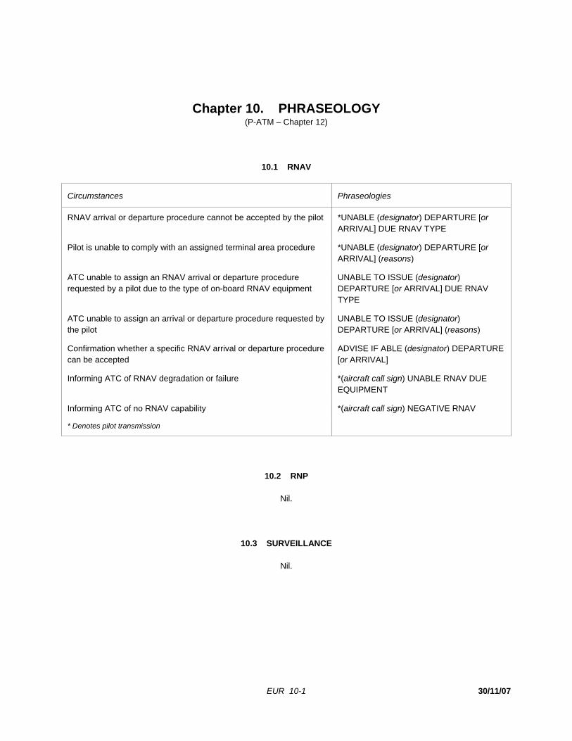
EUR 10-1 30/11/07
Chapter 10. PHRASEOLOGY (P-ATM – Chapter 12)
10.1 RNAV
Circumstances Phraseologies
RNAV arrival or departure procedure cannot be accepted by the pilot *UNABLE (designator) DEPARTURE [or ARRIVAL] DUE RNAV TYPE
Pilot is unable to comply with an assigned terminal area procedure *UNABLE (designator) DEPARTURE [or ARRIVAL] (reasons)
ATC unable to assign an RNAV arrival or departure procedure requested by a pilot due to the type of on-board RNAV equipment
UNABLE TO ISSUE (designator) DEPARTURE [or ARRIVAL] DUE RNAV TYPE
ATC unable to assign an arrival or departure procedure requested by the pilot
UNABLE TO ISSUE (designator) DEPARTURE [or ARRIVAL] (reasons)
Confirmation whether a specific RNAV arrival or departure procedure can be accepted
ADVISE IF ABLE (designator) DEPARTURE [or ARRIVAL]
Informing ATC of RNAV degradation or failure *(aircraft call sign) UNABLE RNAV DUE EQUIPMENT
Informing ATC of no RNAV capability *(aircraft call sign) NEGATIVE RNAV
* Denotes pilot transmission
10.2 RNP
Nil.
10.3 SURVEILLANCE
Nil.
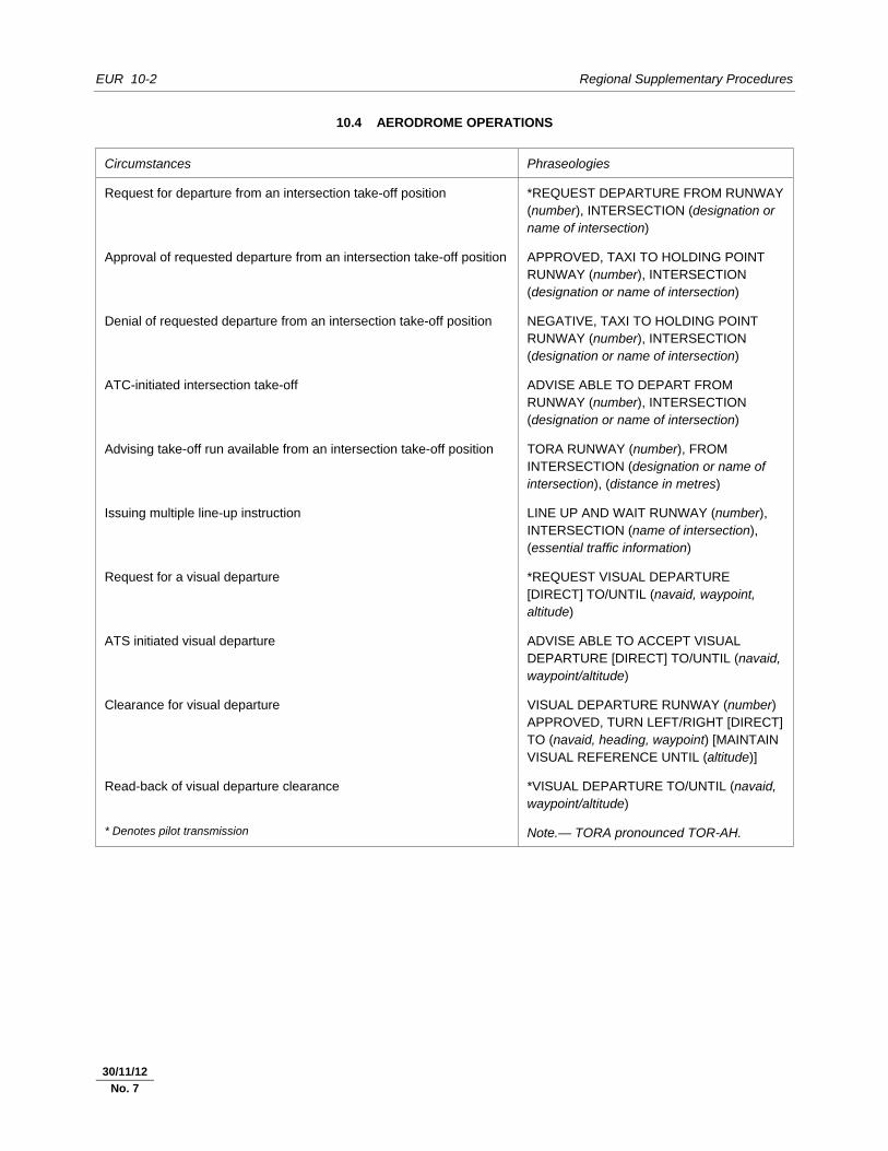
EUR 10-2 Regional Supplementary Procedures
30/11/07
10.4 AERODROME OPERATIONS
Circumstances Phraseologies
Request for departure from an intersection take-off position *REQUEST DEPARTURE FROM RUNWAY (number), INTERSECTION (designation or name of intersection)
Approval of requested departure from an intersection take-off position APPROVED, TAXI TO HOLDING POINT RUNWAY (number), INTERSECTION (designation or name of intersection)
Denial of requested departure from an intersection take-off position NEGATIVE, TAXI TO HOLDING POINT RUNWAY (number), INTERSECTION (designation or name of intersection)
ATC-initiated intersection take-off ADVISE ABLE TO DEPART FROM RUNWAY (number), INTERSECTION (designation or name of intersection)
Advising take-off run available from an intersection take-off position TORA RUNWAY (number), FROM INTERSECTION (designation or name of intersection), (distance in metres)
Issuing multiple line-up instruction LINE UP AND WAIT RUNWAY (number), INTERSECTION (name of intersection), (essential traffic information)
Request for a visual departure *REQUEST VISUAL DEPARTURE [DIRECT] TO/UNTIL (navaid, waypoint, altitude)
ATS initiated visual departure ADVISE ABLE TO ACCEPT VISUAL DEPARTURE [DIRECT] TO/UNTIL (navaid, waypoint/altitude)
Clearance for visual departure VISUAL DEPARTURE RUNWAY (number) APPROVED, TURN LEFT/RIGHT [DIRECT] TO (navaid, heading, waypoint) [MAINTAIN VISUAL REFERENCE UNTIL (altitude)]
Read-back of visual departure clearance *VISUAL DEPARTURE TO/UNTIL (navaid, waypoint/altitude)
* Denotes pilot transmission Note.— TORA pronounced TOR-AH.
30/11/12
No. 7
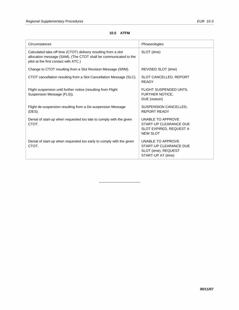
Regional Supplementary Procedures EUR 10-3
30/11/07
10.5 ATFM
Circumstances Phraseologies
Calculated take-off time (CTOT) delivery resulting from a slot allocation message (SAM). (The CTOT shall be communicated to the pilot at the first contact with ATC.)
SLOT (time)
Change to CTOT resulting from a Slot Revision Message (SRM). REVISED SLOT (time)
CTOT cancellation resulting from a Slot Cancellation Message (SLC). SLOT CANCELLED, REPORT READY
Flight suspension until further notice (resulting from Flight Suspension Message (FLS)).
FLIGHT SUSPENDED UNTIL FURTHER NOTICE, DUE (reason)
Flight de-suspension resulting from a De-suspension Message (DES).
SUSPENSION CANCELLED, REPORT READY
Denial of start-up when requested too late to comply with the given CTOT.
UNABLE TO APPROVE START-UP CLEARANCE DUE SLOT EXPIRED, REQUEST A NEW SLOT
Denial of start-up when requested too early to comply with the given CTOT.
UNABLE TO APPROVE START-UP CLEARANCE DUE SLOT (time), REQUEST START-UP AT (time)
_____________________


EUR 11-1 30/11/07
Chapter 11. SEARCH AND RESCUE
11.1 INTERNATIONAL GENERAL AVIATION (IGA) (A6, Part II – Chapter 6; A6, Part III – Chapter 4)
11.1.1 General aviation aircraft operating over designated areas, land or sea, where search and rescue operations would be difficult, should: a) carry appropriate survival equipment; and b) follow the routes or specified procedures if not equipped with two-way radio, except that under special
circumstances, the appropriate authority may grant specific exemptions from this requirement.
_____________________


EUR 12-1 30/11/07
Chapter 12. METEOROLOGY
12.1 AIRCRAFT OBSERVATIONS AND REPORTS
Nil.
_____________________

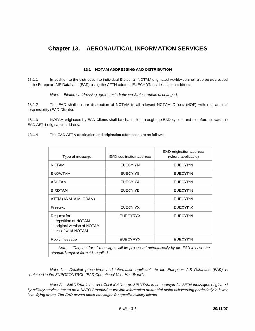
EUR 13-1 30/11/07
Chapter 13. AERONAUTICAL INFORMATION SERVICES
13.1 NOTAM ADDRESSING AND DISTRIBUTION 13.1.1 In addition to the distribution to individual States, all NOTAM originated worldwide shall also be addressed to the European AIS Database (EAD) using the AFTN address EUECYIYN as destination address. Note.— Bilateral addressing agreements between States remain unchanged. 13.1.2 The EAD shall ensure distribution of NOTAM to all relevant NOTAM Offices (NOF) within its area of responsibility (EAD Clients). 13.1.3 NOTAM originated by EAD Clients shall be channelled through the EAD system and therefore indicate the EAD AFTN origination address. 13.1.4 The EAD AFTN destination and origination addresses are as follows:
Type of message EAD destination address EAD origination address
(where applicable)
NOTAM EUECYIYN EUECYIYN
SNOWTAM EUECYIYS EUECYIYN
ASHTAM EUECYIYA EUECYIYN
BIRDTAM EUECYIYB EUECYIYN
ATFM (ANM, AIM, CRAM) EUECYIYN
Freetext EUECYIYX EUECYIYX
Request for: — repetition of NOTAM — original version of NOTAM — list of valid NOTAM
EUECYRYX EUECYIYN
Reply message EUECYRYX EUECYIYN
Note.— “Request for…” messages will be processed automatically by the EAD in case the standard request format is applied.
Note 1.— Detailed procedures and information applicable to the European AIS Database (EAD) is contained in the EUROCONTROL “EAD Operational User Handbook”. Note 2.— BIRDTAM is not an official ICAO term. BIRDTAM is an acronym for AFTN messages originated by military services based on a NATO Standard to provide information about bird strike risk/warning particularly in lower level flying areas. The EAD covers those messages for specific military clients.
EUR 13-2 Regional Supplementary Procedures
30/11/07
Note 3.— ATFM includes Air Traffic Flow Management messages such as ANM (ATFM Notification Message), AIM (ATFM Information Message) and CRAM (Conditional Route Availability Message).
13.2 AERONAUTICAL CHART INFORMATION
13.2.1 Visual procedures 13.2.1.1 Information essential for the conduct of visual departures and visual approaches (e.g. significant obstacles, topographical and cultural features), including any specific limitations as prescribed by the appropriate authority (e.g. designated airspace, recommended tracks) shall be displayed on the visual approach chart and standard instrument departure (SID) chart or standard instrument arrival (STAR) chart, as appropriate.
_____________________

30/11/07
MIDDLE EAST/ASIA (MID/ASIA) REGIONAL SUPPLEMENTARY PROCEDURES
These procedures are supplementary to the provisions contained in Annex 2, Annex 6 (Part II), Annex 11, PANS-ATM (Doc 4444) and PANS-OPS (Doc 8168). The area of application of the MID/ASIA Regional Supplementary Procedures is included on the Index to Application of Supplementary Procedures chart.

MID/ASIA (i) 30/11/07
TABLE OF CONTENTS
Chapter Page Flight Rules . . . . . . . . . . . . . . . . . . . . . . . . . . . . . . . . . . . . . . . . . . . . 1 MID/ASIA 1-1 Flight Plans . . . . . . . . . . . . . . . . . . . . . . . . . . . . . . . . . . . . . . . . . . . . 2 MID/ASIA 2-1 Communications . . . . . . . . . . . . . . . . . . . . . . . . . . . . . . . . . . . . . . . . . 3 MID/ASIA 3-1 Navigation . . . . . . . . . . . . . . . . . . . . . . . . . . . . . . . . . . . . . . . . . . . . . 4 MID/ASIA 4-1 Surveillance . . . . . . . . . . . . . . . . . . . . . . . . . . . . . . . . . . . . . . . . . . . . 5 MID/ASIA 5-1 Air Traffic Services . . . . . . . . . . . . . . . . . . . . . . . . . . . . . . . . . . . . . . . 6 MID/ASIA 6-1 Safety Monitoring . . . . . . . . . . . . . . . . . . . . . . . . . . . . . . . . . . . . . . . . 7 MID/ASIA 7-1 Air Traffic Flow Management . . . . . . . . . . . . . . . . . . . . . . . . . . . . . . . . 8 MID/ASIA 8-1 Special Procedures . . . . . . . . . . . . . . . . . . . . . . . . . . . . . . . . . . . . . . . 9 MID/ASIA 9-1 Phraseology . . . . . . . . . . . . . . . . . . . . . . . . . . . . . . . . . . . . . . . . . . . . 10 MID/ASIA 10-1 Search and Rescue . . . . . . . . . . . . . . . . . . . . . . . . . . . . . . . . . . . . . . . 11 MID/ASIA 11-1 Meteorology . . . . . . . . . . . . . . . . . . . . . . . . . . . . . . . . . . . . . . . . . . . . 12 MID/ASIA 12-1 Aeronautical Information Services . . . . . . . . . . . . . . . . . . . . . . . . . . . . . 13 MID/ASIA 13-1

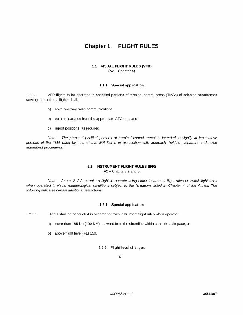
MID/ASIA 1-1 30/11/07
Chapter 1. FLIGHT RULES
1.1 VISUAL FLIGHT RULES (VFR) (A2 – Chapter 4)
1.1.1 Special application 1.1.1.1 VFR flights to be operated in specified portions of terminal control areas (TMAs) of selected aerodromes serving international flights shall: a) have two-way radio communications; b) obtain clearance from the appropriate ATC unit; and c) report positions, as required. Note.— The phrase “specified portions of terminal control areas” is intended to signify at least those portions of the TMA used by international IFR flights in association with approach, holding, departure and noise abatement procedures.
1.2 INSTRUMENT FLIGHT RULES (IFR) (A2 – Chapters 2 and 5)
Note.— Annex 2, 2.2, permits a flight to operate using either instrument flight rules or visual flight rules when operated in visual meteorological conditions subject to the limitations listed in Chapter 4 of the Annex. The following indicates certain additional restrictions.
1.2.1 Special application 1.2.1.1 Flights shall be conducted in accordance with instrument flight rules when operated: a) more than 185 km (100 NM) seaward from the shoreline within controlled airspace; or b) above flight level (FL) 150.
1.2.2 Flight level changes
Nil.

MID/ASIA 1-2 Regional Supplementary Procedures
30/11/07
1.3 AIR TRAFFIC ADVISORY SERVICE (P-ATM – Chapter 9)
Note.— The PANS-ATM leaves it to the discretion of the pilot whether or not to obtain air traffic advisory service where available. Obtaining air traffic advisory service is obligatory, however, when operating in Class F airspace. 1.3.1 All IFR flights shall comply with the procedures for air traffic advisory service when operating in Class F airspace.
_____________________
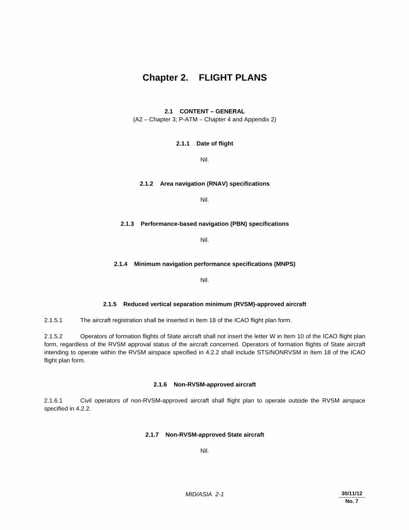
MID/ASIA 2-1 30/11/12
No. 7
Chapter 2. FLIGHT PLANS
2.1 CONTENT – GENERAL (A2 – Chapter 3; P-ATM – Chapter 4 and Appendix 2)
2.1.1 Date of flight
Nil.
2.1.2 Area navigation (RNAV) specifications
Nil.
2.1.3 Performance-based navigation (PBN) specifications
Nil.
2.1.4 Minimum navigation performance specifications (MNPS)
Nil.
2.1.5 Reduced vertical separation minimum (RVSM)-approved aircraft 2.1.5.1 The aircraft registration shall be inserted in Item 18 of the ICAO flight plan form. 2.1.5.2 Operators of formation flights of State aircraft shall not insert the letter W in Item 10 of the ICAO flight plan form, regardless of the RVSM approval status of the aircraft concerned. Operators of formation flights of State aircraft intending to operate within the RVSM airspace specified in 4.2.2 shall include STS/NONRVSM in Item 18 of the ICAO flight plan form.
2.1.6 Non-RVSM-approved aircraft 2.1.6.1 Civil operators of non-RVSM-approved aircraft shall flight plan to operate outside the RVSM airspace specified in 4.2.2.
2.1.7 Non-RVSM-approved State aircraft
Nil.
MID/ASIA 2-2 Regional Supplementary Procedures
30/11/12
No. 7
2.1.8 Indication of 8.33 kHz channel spacing capability
Nil.
2.1.9 Route
Nil.
2.1.10 Estimated times
Nil.
2.1.11 Mach number 2.1.11.1 For turbo-jet aircraft intending to operate within airspace and on air routes to which longitudinal separation minima utilizing Mach number technique will be applied, the planned true Mach number shall be specified in Item 15 of the flight plan.
2.1.12 Alternative flight level
Nil.
2.1.13 Special handling (STS)
Nil.
2.1.14 Controller-pilot data link communications (CPDLC)
Nil.
2.2 CONTENT – AIR TRAFFIC FLOW MANAGEMENT (ATFM)
2.2.1 Runway visual range (RVR)
Nil.
2.2.2 Flight plan addressing and distribution
Nil.
Regional Supplementary Procedures MID/ASIA 2-3
30/11/12
No. 7
2.2.3 Slot allocation exemptions
Nil.
2.3 SUBMISSION
2.3.1 General
Nil.
2.3.2 Amendments
Nil.
2.4 REPETITIVE FLIGHT PLANS (RPLs)
Nil.
_____________________

MID/ASIA 3-1 30/11/07
Chapter 3. COMMUNICATIONS
3.1 AIR-GROUND COMMUNICATIONS AND IN-FLIGHT REPORTING
3.1.1 Communications equipment
Nil.
3.1.2 Continuous listening watch in uncontrolled airspace (A2 – Chapters 3 and 5; P-ATM – Chapter 4)
3.1.2.1 All VFR flights, and IFR flights outside controlled airspace, shall maintain a listening watch on the frequency where flight information service is provided and report position unless otherwise authorized by the State overflown.
3.1.3 Position reports (A2 – Chapters 3 and 5; P-ATM – Chapter 4)
3.1.3.1 States should establish reporting points at locations fulfilling operational requirements as set forth in Annex 11, 2.14.1, 2.14.3 and Appendix 2. Except where operational considerations dictate otherwise, those points should be located at intervals of 5 degrees of latitude or longitude (latitude if the route is predominantly north-south, longitude if east-west). 3.1.3.2 Aircraft traversing 10 degrees of latitude or longitude in 1 hour and 20 minutes or less should normally be required to report only at 10-degree intervals. Slower aircraft should normally be required to report at 5-degree intervals. 3.1.3.3 Within the Fukuoka (excluding the area west of a line 185 km (100 NM) seaward from the eastern coastline of Japan), Incheon, Manila (East of the Philippines) and Taipei flight information regions, flights shall provide position reports. 3.1.3.4 Verbal position reports shall be identified by the spoken word “position” transmitted immediately before or after the aircraft call sign/identification. 3.1.3.5 The position of the aircraft shall be transmitted in reference to a reporting point name, name-code designator or, if not named: a) for flights operating in a predominantly east-west direction: 1) latitude in degrees and minutes; and 2) longitude in degrees only; b) for flights operating in a predominantly north-south direction: 1) latitude in degrees only; and 2) longitude in degrees and minutes.
25/8/09
No. 2
25/8/09
No. 2
MID/ASIA 3-2 Regional Supplementary Procedures
30/11/07
3.1.3.6 The time at which the aircraft is over the reporting point shall be transmitted in four digits, giving both the hour and the minutes. 3.1.3.7 Estimated time over next position shall be expressed in four digits.
3.1.4 Abbreviated position reports
Nil.
3.1.5 Read-back of VHF channels
Nil.
3.2 MANDATORY CARRIAGE OF 8.33 KHZ CHANNEL SPACING CAPABLE RADIO EQUIPMENT
Nil.
3.3 CONTROLLER-PILOT DATA LINK COMMUNICATIONS (CPDLC)
Nil.
3.4 SATELLITE VOICE COMMUNICATIONS (SATCOM)
Nil.
3.5 AERONAUTICAL MOBILE SERVICE
3.5.1 Selective calling (SELCAL)
Nil.
3.5.2 HF operations
Nil.
3.5.2.1 Assignment of voice traffic to HF families Nil.
25/8/09
No. 2
Regional Supplementary Procedures MID/ASIA 3-3
30/11/07
3.5.2.2 Procedures for mutual assistance Nil.
3.6 AERONAUTICAL FIXED SERVICE
3.6.1 AFTN rationalization 3.6.1.1 To support data communication requirements and to provide needed data integrity and minimal transit time, the CCITT X.25 protocol should be used between AFTN COM Centres in the Asia Region.
3.7 RADIO CHANNELS/FREQUENCIES
Nil.
_____________________
25/8/09
No. 2

MID/ASIA 4-1 30/11/07
Chapter 4. NAVIGATION
4.1 PERFORMANCE-BASED NAVIGATION (PBN)
Note.— As the Middle East and Asia (MID/ASIA) Regions transition to PBN as contained in the Performance-based Navigation Manual (Doc 9613), the contents of 4.1 will be amended.
4.1.1 Area navigation (RNAV) specifications 4.1.1.1 RNAV 10 (RNP 10) Note.— RNAV 10 retains the RNP 10 designation, as specified in the Performance-based Navigation Manual (Doc 9613), 1.2.3.5. Area of applicability 4.1.1.1.1 For flights on designated controlled oceanic routes or areas within the Auckland Oceanic, Brisbane, Fukuoka, Ho Chi Minh, Hong Kong, Honiara, Kuala Lumpur, Melbourne, Nauru, New Zealand, Port Moresby, Sanya and Singapore FIRs, a lateral separation minimum of 93 km (50 NM) may be applied. 4.1.1.1.2 For flights on designated controlled oceanic routes or areas within the Auckland Oceanic, Brisbane, Fukuoka, Ho Chi Minh, Hong Kong, Honiara, Kuala Lumpur, Melbourne, Nauru, New Zealand, Port Moresby, Sanya and Singapore FIRs, a longitudinal separation minimum of 93 km (50 NM) derived by RNAV may be applied between RNAV-equipped aircraft approved to RNP 10 or better, in accordance with the provisions of the PANS-ATM, 5.4.2.6. Means of compliance 4.1.1.1.3 For application of 4.1.1.1.1 and 4.1.1.1.2, the aircraft and the operator must have been approved by the State of Registry or the State of the Operator, as appropriate, to meet the following requirements (or equivalent): a) aircraft navigation performance shall be such that the standard deviation of lateral track errors shall be
less than 8.7 km (4.7 NM) (or the aircraft approved to RNP 10); and b) operator programmes shall be established to mitigate the occurrence of large navigational errors due
to equipment malfunction or operational error: 1) operator in-flight operating drills shall include mandatory navigation cross-checking procedures to
identify navigation errors in sufficient time to prevent aircraft from inadvertent deviation from ATC-cleared route; and
2) the operator shall establish programmes to provide for the continued airworthiness of aircraft
navigation systems necessary to navigate to the degree of accuracy required.
8/1/09
No. 1
MID/ASIA 4-2 Regional Supplementary Procedures
30/11/07 27/3/12 No. 6
4.1.1.2 RNAV 5 Area of applicability 4.1.1.2.1 The requirements included in the RNAV 5 specification for en-route operations shall apply to all such operations conducted under IFR on designated RNAV 5 routes within the following FIRs as specified in the relevant State AIP or NOTAM: Baghdad, Bahrain, Jeddah, Kuwait, Muscat, Tehran and Emirates FIRs. Means of compliance 4.1.1.2.2 Conformance to the navigation requirement shall be verified by the State of Registry or the State of the Operator, as appropriate. Note 1.— Guidance material concerning RNAV 5 implementation and the associated navigation specification is contained in the Performance-based Navigation (PBN) Manual (Doc 9613). Note 2.— Procedures on the use of RNAV 5 in Sana’s FIR are contained in the AFI SUPPs. 4.1.1.3 RNAV 2 Nil. 4.1.1.4 RNAV 1 Nil. 4.1.1.5 Pre-PBN navigation specifications 4.1.1.5.1 RNP 12.6 Area of applicability 4.1.1.5.1.1 For flights on controlled oceanic routes across the Tasman Sea within the Auckland Oceanic, Brisbane, Melbourne and New Zealand FIRs and for flights across the South China Sea within Bangkok, Hanoi, Ho Chi Minh, Hong Kong, Kota Kinabalu, Kuala Lumpur, Manila, Taipei and Singapore FIRs, the minimum lateral separation shall be 110 km (60 NM). Means of compliance 4.1.1.5.1.2 For application of 4.1.1.5.1.1, aircraft must be RNAV-equipped and RNAV-approved using inertial navigation systems (INS) provided that: a) the INS is updated at least every 4.5 hours; b) the standard deviation of lateral track errors shall be less than 11.7 km (6.3 NM);
Regional Supplementary Procedures MID/ASIA 4-3
30/11/07 27/3/12 No. 6
c) the proportion of the total flight time spent by aircraft 55.5 km (30 NM) or more off the cleared track shall be less than 5.3 × 10⁻⁴; and
d) the proportion of the total flight time spent by aircraft between 93 and 130 km (50 and 70 NM) off the
cleared track shall be less than 13 × 10–5. Such navigation performance capability shall be verified by the State of Registry or the State of the Operator, as appropriate. Lateral separation of 185 km (100 NM), or greater if required, shall be used if the track-keeping capability of the aircraft has been reduced for any reason. Note.— The navigation performance accuracy contained in b) is considered to be comparable to RNP 12.6 or better. 4.1.1.5.1.3 When granting approval for operations as indicated in 4.1.1.5.1.1, either the State of Registry or the State of the Operator shall ensure that in-flight operating drills include mandatory navigation cross-checking procedures which will identify navigation errors in sufficient time to prevent the aircraft from inadvertently deviating from the ATC-cleared route. 4.1.1.5.2 Composite
(A11 – Chapter 3) Area of applicability 4.1.1.5.2.1 For aircraft operating at or above FL 290 within the flexible Pacific Organized Track Systems (PACOTS), North Pacific (NOPAC) route system between the United States and Japan and the route system between Hawaii and the west coast of the United States, within the Fukuoka, Oakland Oceanic and Anchorage Oceanic FIRs, composite separation consisting of a combination of at least 93 km (50 NM) lateral and 300 m (1 000 ft) vertical separation may be applied.
4.1.2 Required navigation performance (RNP) specifications 4.1.2.1 RNP 4 Area of applicability 4.1.2.1.1 For flights on designated controlled oceanic routes or areas within the Auckland Oceanic, Brisbane, Fukuoka, Honiara, Melbourne, Nauru, New Zealand and Port Moresby FIRs, a lateral separation minimum of 55.5 km (30 NM) may be applied. 4.1.2.1.2 For flights on designated controlled oceanic routes or areas within the Auckland Oceanic, Brisbane, Fukuoka, Honiara, Melbourne, Nauru, New Zealand and Port Moresby FIRs, a longitudinal separation minimum of 55.5 km (30 NM) derived by RNAV may be applied between RNAV-equipped aircraft approved to RNP 4 or better, in accordance with the provisions of the PANS-ATM, 5.4.2.6. 4.1.2.2 Basic RNP 1 Nil.
MID/ASIA 4-4 Regional Supplementary Procedures
30/11/07 27/3/12 No. 6
4.1.2.3 Advanced RNP 1 Nil.
4.2 REDUCED VERTICAL SEPARATION MINIMUM (RVSM)
Area of applicability 4.2.1 RVSM shall be applicable in that volume of airspace between FL 290 and FL 410 inclusive in the following FIRs/UIRs: Auckland Oceanic, Baghdad, Bahrain, Bangkok, Beijing, Brisbane, Chennai, Colombo, Delhi, Dhaka,
Emirates, Fukuoka, Guangzhou, Hanoi, Ho Chi Minh, Hong Kong, Honiara, Incheon, Jakarta, Jeddah, Kabul, Karachi, Kathmandu, Kolkata, Kota Kinabalu, Kuala Lumpur, Kunming, Kuwait, Lahore, Lanzhou, Male, Manila, Melbourne, Mumbai, Muscat, Nauru, New Zealand, Phnom Penh, Port Moresby, Pyongyang, Sanya, Shanghai, Shenyang, Singapore, Taibei, Tehran, Ujung Pandang, Ulan Bator, Urumqi, Vientiane, Wuhan and Yangon.
4.2.2 RVSM shall be applicable in that volume of airspace between FL 290 and FL 410 inclusive in the following FIRs: Aktau, Aktyubinsk, Almaty, Ashgabat, Astana, Barnaul, Bishkek, Blagoveschensk, Chelyabinsk, Chita,
Chulman, Dashoguz, Dushanbe, Irkutsk, Kamenny Mys, Khabarovsk, Khanty-Mansiysk, Krasnoyarsk, Kurgan, Kyzylorda, Magadan, Magadan Oceanic, Magnitogorsk, Mirny, Norilsk, Nukus, Nyurba, Olekminsk, Omsk, Orenburg, Osh, Petropavlovsk-Kamchatsky, Polyarny, Salekhard, Samarkand, Shymkent, Surgut, Tarko-Sale, Tashkent, Tiksi, Tura, Turkmenabat, Turkmenbashi, Turukhansk, Tyumen, Vladivostok, Yakutsk, Yuzhno-Sakhalinsk, Zhigansk and Zyryanka.
Means of compliance
Nil.
_____________________
MID/ASIA 5-1 30/11/07
Chapter 5. SURVEILLANCE (P-OPS, Vol. I; P-ATM – Chapter 8)
5.1 SECONDARY SURVEILLANCE RADAR (SSR) Note.— The procedures provided below shall be applicable in all the flight information regions (FIRs)/upper flight information regions (UIRs) of Kazakhstan, Kyrgyzstan, the Russian Federation, Tajikistan, Turkmenistan and Uzbekistan located in the area of application of the MID/ASIA Regional Supplementary Procedures (Index to Application of Supplementary Procedures chart refers).
5.1.1 Carriage of pressure-altitude reporting SSR transponders 5.1.1.1 All aircraft shall be equipped with a pressure-altitude reporting transponder which operates in accordance with the relevant provisions of Annex 10.
5.1.2 Code allocation methodology
Nil.
5.1.3 Assignment of SSR codes 5.1.3.1 All aircraft engaged in international flight shall be assigned an appropriate SSR code by the initial ATS unit at the beginning of the flight if it is to be conducted under instrument flight rules. The code shall be assigned from within the code block(s) allocated to the area control centre (ACC)/flight information centre of the originating FIR and shall be retained and used by the aircraft until its arrival at destination, with modifications as provided for in 5.1.3.2 and 5.1.3.3. 5.1.3.2 For an aircraft entering the area under consideration via various “peripheral” FIRs, the ACC/flight information centre concerned shall assign a code in one of the following two ways. If the aircraft concerned is going to land in the “peripheral” FIR, a domestic code will be assigned. If the aircraft is going to overfly the “peripheral” FIR, an international code shall be assigned from the code set allocated to that FIR. Note 1.— Diversion. Whenever a diversion occurs that will take the aircraft into another FIR, advance coordination with the ACC/flight information centre having jurisdiction over that FIR shall be effected to avoid code conflict. This is of particular importance if the diverted flight returns towards its point of departure since the code used by the flight concerned may already have been reassigned to another flight. Note 2.— Peripheral FIRs. For those FIRs forming the boundary of the ASIA Region and in which domestic codes are assigned to flights originating outside the region and terminating in the peripheral FIR, international codes are assigned to flights originating outside the region and terminating in other FIRs within the area under consideration. 5.1.3.3 If an aircraft is: a) traversing non-SSR areas or landing in non-SSR areas, the ACC/flight information centre will include
the assigned four-digit code as part of the transfer message.
MID/ASIA 5-2 Regional Supplementary Procedures
30/11/07
b) departing from a non-SSR area, the aircraft shall be assigned a four-digit code upon departure, and the ACC/flight information centre shall include the code in the departure and transfer messages.
5.1.3.4 The ATS unit serving the aerodrome where the flight originates shall include the assigned four-digit code in the departure message sent to each addressee of the flight plan. 5.1.3.5 The ACC/flight information centre serving the FIR where the flight originates shall include the assigned four-digit code in the transfer message to the next ACC/flight information centre. The ACCs/flight information centres of subsequent FIRs overflown by the aircraft concerned shall ensure that the code is included in the transfer messages. Note.— This is particularly important in the case of 5.1.3.3 a).
5.1.4 Operation of pressure-altitude reporting SSR transponders 5.1.4.1 When it is necessary to stop identification friend/foe (IFF)/selective identification feature (SIF) transponders from replying on Mode A/3, pilots shall be requested to switch off Mode 3. In no case shall they be requested to switch to STANDBY, since operation of the STANDBY switch stops the IFF/SIF transponders from replying on all modes. Note.— Some military aircraft are required to operate IFF transponders for non-air traffic control purposes simultaneously with and independently of their operation in Mode A/3 for air traffic control purposes. 5.1.4.2 The “all codes” setting shall be used when it is desired to display for air traffic control purposes all aircraft in a specified area that are equipped with SSR or IFF/SIF transponders; the “all aircraft” setting shall be used when it is desired to also display aircraft equipped with basic IFF transponders.
5.1.5 Monitoring of SSR-derived information 5.1.5.1 SSR-derived information shall be checked by use of special monitoring devices or by correlation of an identified primary radar blip with the appropriate SSR response.
5.2 SSR MODE S
5.2.1 Carriage and operation of SSR Mode S
Nil.
5.2.2 Transition between Mode A/C and Mode S
Nil.
5.3 AIRBORNE COLLISION AVOIDANCE SYSTEMS (ACAS)
5.3.1 Carriage and operation of ACAS II
Nil.
Regional Supplementary Procedures MID/ASIA 5-3
30/11/07
5.4 AUTOMATIC DEPENDENT SURVEILLANCE – CONTRACT (ADS-C)
Nil.
5.5 AUTOMATIC DEPENDENT SURVEILLANCE – BROADCAST (ADS-B)
Nil.
_____________________

MID/ASIA 6-1 30/11/07 25/5/11
No. 4
Chapter 6. AIR TRAFFIC SERVICES
6.1 AIR TRAFFIC CONTROL (ATC) CLEARANCES
6.1.1 Content
Nil.
6.1.2 Adherence (A2 – Chapter 3)
6.1.2.1 If an aircraft on a long over-water flight has inadvertently deviated from the route specified in its ATC clearance, it shall forthwith take action to regain such route within 370 km (200 NM) from the position at which the deviation was observed. 6.1.2.2 Special procedures applicable to uncoordinated flights operating 6.1.2.2 along the FIR boundaries in the Red Sea area 6.1.2.2 (P-ATM – Chapter 15; P-OPS, Vol. I, Part III, Section 3) 6.1.2.2.1 Uncoordinated flights operating along the FIR boundaries over the Red Sea area shall apply the following procedures: a) squawk SSR Code A2000; b) maintain a listening watch on the appropriate ATC frequencies; c) transmit their flight details to Asmara, Cairo, Jeddah, Khartoum and Sana’a ACCs using the
operational ATC channel in order to provide call sign, direction, level and the time of crossing the reporting points or FIR boundaries along the route of flight at least ten (10) minutes prior to the FIR boundaries; and
1) if RVSM-approved: i) maintain FL 300 while crossing the Red Sea area from south to north (northwest bound), or ii) maintain FL 290 while crossing the Red Sea area from north to south (southeast bound), or 2) if not RVSM-approved: i) maintain FL 260 while crossing the Red Sea area from south to north (northwest bound), or ii) maintain FL 250 while crossing the Red Sea area from north to south (southeast bound). Note.— Requirements contained in Annex 2, 3.6.2, Adherence to flight plan, and PANS-ATM, 11.4.2.3, Coordination messages, continue to apply.
MID/ASIA 6-2 Regional Supplementary Procedures
30/11/07 25/5/11
No. 4
6.2 SEPARATION
6.2.1 Lateral (A11 – Attachment B; P-ATM – Chapters 5 and 15)
6.2.1.1 Except as provided for in 6.2.1.2 and 6.2.1.5, the minimum lateral separation shall be 185 km (100 NM), for flights on controlled oceanic routes, except where aircraft are transiting into an airspace with a larger lateral minimum than the airspace being exited provided that: a) the smaller separation minimum exists; b) flight paths diverge by 15 degrees or more until the larger minimum is established; and c) it is possible to ensure, by means approved by the appropriate ATS authority, that aircraft have the
navigation capability necessary to ensure accurate track guidance. 6.2.1.2 The minimum lateral separation shall be 110 km (60 NM) between aircraft meeting the provisions in 4.1.1.5.1. 6.2.1.3 The minimum lateral separation shall be 93 km (50 NM) between aircraft meeting the provisions in 4.1.1.1. 6.2.1.4 The minimum lateral separation shall be 55.5 km (30 NM) between aircraft meeting the provisions in 4.1.2.1, provided: a) the aircraft are approved by the State of Registry or the State of the Operator to RNP 4; b) direct controller-pilot voice communications or controller-pilot data link communications (CPDLC) are
maintained; c) surveillance is maintained using an automatic dependent surveillance (ADS) system; and d) an ADS lateral deviation change event contract is established, with a lateral deviation threshold of
9.3 km (5 NM). 6.2.1.5 Lower minima as detailed in 5.4.1.2 of the PANS-ATM may be applied, or further reduced in accordance with 5.11 of the PANS-ATM, when the conditions specified in the relevant PANS-ATM provisions are met.
6.2.2 Longitudinal (P-ATM – Chapter 5)
6.2.2.1 Except as provided for in 6.2.2.2 and 6.2.2.3, the minimum longitudinal separation between turbo-jet aircraft operating within the Auckland Oceanic, Bangkok, Brisbane, Chennai, Colombo, Delhi, Dhaka, Hanoi, Ho Chi Minh, Hong Kong, Honiara, Incheon, Jakarta, Karachi, Kolkata, Kota Kinabalu, Kuala Lumpur, Lahore, Madras, Male, Manila, Melbourne, Mumbai, Muscat, Nauru, New Zealand, Phnom Penh, Port Moresby, Singapore, Taibei, Tehran, Ujung Pandang, Vientiane and Yangon FIRs shall be in accordance with the PANS-ATM, 5.4.2.4 or 5.4.2.5. 6.2.2.2 The minimum longitudinal separation shall be 93 km (50 NM) derived by RNAV between aircraft meeting the provisions in 4.1.1.1. 6.2.2.3 The minimum longitudinal separation within the Oakland Oceanic and Fukuoka FIRs shall be 10 minutes, whether in level, climbing or descending flight, provided that the aircraft concerned have reported over the same common point and follow the same track or continuously diverging tracks until some other form of separation is provided.
22/7/11
No. 5

Regional Supplementary Procedures MID/ASIA 6-3
30/11/07 25/5/11
No. 4
6.2.2.4 The minimum longitudinal separation shall be 55.5 km (30 NM) between aircraft meeting the provisions in 4.1.2.1. Note.— The applicable provisions of PANS-ATM, 5.4.2.6, apply in all cases.
6.2.3 Composite 6.2.3.1 Composite separation consisting of a combination of at least 93 km (50 NM) lateral and 300 m (1 000 ft) vertical separation may be applied between aircraft meeting the provisions in 4.1.1.5.2. 6.2.3.2 The type of separation in 6.2.3.1 may be applied between aircraft operating in the same direction or opposite directions (see also 6.8).
6.2.4 Vertical (P-ATM – Chapter 5)
6.2.4.1 Within the RVSM airspace as specified in 4.2.1, the vertical separation minimum shall be 300 m (1 000 ft). 6.2.4.2 Within the RVSM airspace specified in 4.2.1, aircraft that have not received RVSM State approval may be cleared to operate in accordance with policy and procedures established by the State provided that 600 m (2 000 ft) vertical separation is applied. 6.2.4.3 Within the RVSM airspace specified in 4.2.2, the minimum vertical separation shall be: a) 300 m (1 000 ft) between RVSM-approved aircraft; b) 600 m (2 000 ft) between: 1) non-RVSM-approved State aircraft and any other aircraft; and 2) all formation flights of State aircraft and any other aircraft.
6.2.5 Radar
Nil.
6.2.6 Reduction in separation minima (A11 – Chapter 3; P-ATM – Chapter 5)
6.2.6.1 Where, circumstances permitting, separation minima lower than those specified in 6.2.1 and 6.2.2 will be applied in accordance with the PANS-ATM, appropriate information should be published in AIPs so that users of the airspace are fully aware of the portions of airspace where the reduced separation minima will be applied and of the navigation aids on which those minima are based.
6.2.7 Airspace reservations
Nil.
22/7/11
No. 5
MID/ASIA 6-4 Regional Supplementary Procedures
30/11/07 25/5/11
No. 4
6.3 MINIMUM FLIGHT LEVEL (P-ATM – Chapter 4; P-OPS, Vol. I)
6.3.1 Establishment
6.3.1.1 The lowest useable flight level shall be calculated from actual QNH, unless the pressure variation is so small that reference to climatological data is acceptable. Note 1.— The lowest useable flight level will provide a terrain clearance of at least 300 m (1 000 ft). Note 2.— MET Offices will inform ATS units when, in abnormal conditions, pressure goes below the minimum climatological value, in order that appropriate steps can be taken to cancel temporarily the use of the lowest flight level or levels that would not ensure the minimum terrain clearance. 6.3.1.2 Based on current and anticipated atmospheric pressure distribution, area control centres shall coordinate, when required, the lowest flight level to be used.
6.4 ATS ROUTES
6.4.1 Track systems
6.4.1.1 Flexible Pacific Organized Track Systems (PACOTS) 6.4.1.1.1 To optimize the use of airspace across the Northern, Central and South Pacific, flexible organized track systems may be established within the Fukuoka, Oakland Oceanic, Anchorage Oceanic, Nadi, Tahiti, Auckland Oceanic, Sydney, Brisbane and Port Moresby FIRs. 6.4.1.1.2 The ACCs providing air traffic service within the concerned FIRs shall provide information to users regarding the PACOTS tracks generated for use. The location of the tracks will depend on traffic demand, prevailing winds, significant weather and other relevant factors. Unless otherwise stated, tracks will apply at FL 290 and above. 6.4.1.1.3 PACOTS track messages to users specifying track details will be disseminated daily by one of the ACCs. Messages will be disseminated in a timely manner to accommodate the flight planning requirements of users. Any subsequent changes will be issued promptly. Pilots are expected to flight plan in accordance with the daily track message. Note.— PACOTS guidelines containing detailed information on track generation, lateral track spacing, level assignment, position-reporting requirements and other relevant details shall be published in the AIPs or associated supplements of those States which utilize a flexible track system within their airspace or areas of responsibility.
6.4.2 RNAV
Nil.
Regional Supplementary Procedures MID/ASIA 6-5
30/11/07 25/5/11
No. 4
6.5 AERODROME OPERATIONS
6.5.1 Area of applicability
Nil.
6.5.2 Intersection take-off
Nil.
6.5.3 Multiple line-ups on the same runway
Nil.
6.5.4 Visual departures
Nil.
6.5.5 Visual approaches
Nil.
6.5.6 Advanced surface movement guidance and control systems (A-SMGCS)
Nil. 6.5.6.1 General Nil. 6.5.6.2 A-SMGCS functions Nil. 6.5.6.3 A-SMGCS alerts Nil. 6.5.6.4 A-SMGCS identification procedures Nil.
MID/ASIA 6-6 Regional Supplementary Procedures
30/11/07 25/5/11
No. 4
6.6 RNAV PROCEDURES
6.6.1 General
Nil.
6.6.2 En route
Nil.
6.6.3 Terminal
Nil.
6.6.4 State aircraft
Nil.
6.7 RNP PROCEDURES
6.7.1 General
Nil.
6.7.2 En route
Nil.
6.7.3 Terminal
Nil.
6.7.4 State aircraft 6.7.4.1 Operations in the ICAO MID Region 6.7.4.1.1 Within TMAs, State aircraft not equipped with RNAV approved for RNP 5 should be routed via non-RNAV SIDs and STARs. 6.7.4.1.2 Such aircraft operating en-route should be routed via VOR/DME-defined ATS routes. 6.7.4.1.3 When the above procedures cannot be applied, the ATC unit shall provide the aircraft with radar vectors until the aircraft is capable of resuming its own navigation.
Regional Supplementary Procedures MID/ASIA 6-7
30/11/07 25/5/11
No. 4
6.8 COMPOSITE PROCEDURES
6.8.1 When composite separation is used, the following procedures apply: a) An aircraft may be cleared to join an outer route of the system at an entry point other than the normal
entry point provided: 1) longitudinal or non-composite vertical separation exists between that aircraft and any other on
that route; and 2) composite separation exists between that aircraft and any other on the next adjacent route. b) An aircraft may be cleared to leave an outer route of the system at an exit point other than the normal
exit point provided its course diverges so that the lateral spacing from the route increases until longitudinal or non-composite lateral or non-composite vertical separation exists between that aircraft and any other aircraft in the system.
c) An aircraft may be cleared to change from one route to an adjacent route in the system provided: 1) longitudinal or non-composite vertical separation exists between that aircraft and any other
aircraft on the route being vacated until that aircraft is established on the route to which it is proceeding;
2) longitudinal or non-composite vertical separation exists between that aircraft and any other aircraft
on the route to which that aircraft is proceeding; and 3) composite separation exists between that aircraft and any other aircraft on the next adjacent route. d) An aircraft may be cleared to cross the system provided longitudinal or non-composite lateral or non-
composite vertical separation exists between that aircraft and any other aircraft in the system. e) An aircraft may be cleared to change altitude on a route if longitudinal or non-composite vertical
separation exists between that aircraft and any other aircraft on that route and regardless of any other aircraft on adjacent routes.
Note.— Non-composite separation is separation in accordance with the minima in 6.2.1 and 6.2.2 and those in the PANS-ATM, 5.3.2.
6.9 MNPS PROCEDURES
Nil.
6.10 RVSM PROCEDURES
6.10.1 General 6.10.1.1 ATC clearance into the RVSM airspace specified in 4.2.2 shall not be issued to non-RVSM-approved civil aircraft.
MID/ASIA 6-8 Regional Supplementary Procedures
30/11/07 25/5/11
No. 4
6.10.1.2 ATC clearance into RVSM airspace shall not be issued to formation flights of civil aircraft.
6.10.2 Transition to/from RVSM airspace
Nil.
6.11 ATS COORDINATION
6.11.1 Between units providing area control services (A11 – Chapter 3; P-ATM – Chapters 10 and 11)
6.11.1.1 If a flight should enter an adjacent area, information concerning any revision of the estimate of three minutes or more shall be forwarded to the adjacent area control centre normally by telephone.
6.11.2 RNAV Aircraft experiencing degradation or failure of RNAV — computer-assisted coordination of estimate 6.11.2.1 In the case of automated messages not containing the information provided in Item 18 of the flight plan, the sending ATC unit shall inform the receiving ATC by supplementing the ACT message verbally with the phrase “RNAV OUT OF SERVICE” after the call sign of the aircraft concerned. Aircraft experiencing degradation or failure of RNAV — verbal coordination of estimate 6.11.2.2 When a verbal coordination process is being used, the sending ATC unit shall include the phrase “RNAV OUT OF SERVICE” at the end of the message. State aircraft not equipped with RNAV — ICAO MID Region 6.11.2.3 In the case of automated messages not containing the information provided in Item 18 of the flight plan, the sending ATC unit shall inform the receiving ATC unit by supplementing the ACT message verbally with the phrase “NEGATIVE RNAV” after the call sign of the aircraft concerned. 6.11.2.4 When a verbal coordination process is being used, the sending ATC unit shall include the phrase “NEGATIVE RNAV” at the end of the message.
6.11.3 RNP
Nil.
Regional Supplementary Procedures MID/ASIA 6-9
30/11/07 25/5/11
No. 4
6.11.4 RVSM 6.11.4.1 If the receiving unit has not received a flight plan, the sending unit shall verbally inform the receiving unit whether or not the aircraft is RVSM-approved. 6.11.4.2 When a single aircraft is experiencing an in-flight contingency that impacts on RVSM operations, the associated coordination message(s) shall be supplemented verbally by a description of the cause of the contingency.
6.11.5 SSR codes
Nil.
6.12 ATS MESSAGES
6.12.1 Flight plan and departure
Nil.
6.12.2 Arrival
Nil.
6.12.3 Boundary estimates
Nil.
6.12.4 Computer-assisted coordination
Nil.
6.13 FLIGHT INFORMATION SERVICE (FIS)
6.13.1 Automatic terminal information services (ATIS)
Nil.
6.13.2 SIGMETs (P-ATM – Chapter 9)
6.13.2.1 Transmission of SIGMET information to aircraft shall be at the initiative of the appropriate ATS unit, by the preferred method of directed transmission followed by acknowledgement, or by a general call when the number of aircraft would render the preferred method impracticable.
MID/ASIA 6-10 Regional Supplementary Procedures
30/11/07 25/5/11
No. 4
6.13.2.2 SIGMET information passed to aircraft shall cover a portion of the route up to two hours’ flying time ahead of the aircraft.
6.13.3 Special air-reports
Nil.
6.13.4 Amended aerodrome forecasts (P-ATM – Chapter 9)
6.13.4.1 Amended aerodrome forecasts shall be passed to aircraft within 60 minutes from the aerodrome of destination, unless the information has been made available through other means.
6.13.5 Landing forecasts
Nil.
6.14 ALERTING SERVICE
Nil.
_____________________
MID/ASIA 7-1 30/11/07
Chapter 7. SAFETY MONITORING
7.1 STRATEGIC LATERAL OFFSET PROCEDURES (SLOP)
Nil.
7.2 AIRSPACE MONITORING
7.2.1 General
Nil.
7.2.2 RNAV
Nil.
7.2.3 RNP 7.2.3.1 The following criteria are to be used in the operational assessment of airspace system safety on routes or areas where 93 km (50 NM) separation is applied: a) the proportion of the total flight time spent by aircraft 46 km (25 NM) or more off the cleared track shall
be less than 7.0 × 10⁻⁴; and b) the proportion of the total flight time spent by aircraft between 74 and 110 km (40 and 60 NM) off the
cleared track shall be less than 4.1 × 10⁻⁵. 7.2.3.2 Prior to implementation of 55.5 km (30 NM) separation, States shall undertake a system verification of sufficient duration and integrity to demonstrate that the maximum acceptable rate of lateral deviations greater than or equal to 27.8 km (15 NM) will not exceed those rates listed in Table B-1 in Annex 11, Attachment B. The verification should be conducted after the minimum navigation, communications and surveillance requirements listed in Chapter 4 have been met. 7.2.3.3 Following implementation of 55.5 km (30 NM) separation, a monitoring programme shall be established to periodically verify that the system’s actual rate of lateral deviations greater than or equal to 27.8 km (15 NM) does not exceed the maximum prescribed in Table B-1 in Annex 11, Attachment B.
7.2.4 RVSM 7.2.4.1 Monitoring of flight operations in the RVSM airspace shall be conducted to assess the continuing compliance of aircraft with the height-keeping performance requirements.
_____________________
25/5/11
No. 4


MID/ASIA 8-1 30/11/07
Chapter 8. AIR TRAFFIC FLOW MANAGEMENT (ATFM)
8.1 PROVISION
Nil.
8.2 APPLICATION
Nil.
8.3 EXEMPTIONS FROM ATFM SLOT ALLOCATION
Nil.
8.4 DEPARTURE SLOT MONITORING
Nil.
8.5 PROMULGATION OF ATFM MEASURES
8.5.1 Strategic ATFM measures
Nil.
8.5.2 Amendments to promulgated strategic ATFM measures
Nil.
8.5.3 ATFM circulars and information
Nil.
8.5.4 Pre-flight information bulletin (PIB)
Nil.

MID/ASIA 8-2 Regional Supplementary Procedures
30/11/07
8.5.5 Query procedures
Nil.
_____________________
MID/ASIA 9-1 30/11/07
Chapter 9. SPECIAL PROCEDURES
9.1 EMERGENCY DESCENT PROCEDURES
9.1.1 Action by the pilot-in-command
Nil.
9.1.2 Action by the ATS unit
Nil.
9.2 CONTINGENCY PROCEDURES INCLUDING TURN-BACKS
Nil.
9.3 AIR-GROUND COMMUNICATION FAILURE 9.3.1 The following procedures apply to aircraft operating in the oceanic airspace of the Auckland Oceanic, Brisbane, Fukuoka, Honiara, Manila, Melbourne, Port Moresby and Nauru FIRs. These procedures are intended to complement and not supersede State procedures/regulations. 9.3.1.1 In the event of total loss of communication, an aircraft shall: a) try to re-establish communication by all other means; b) if all attempts to re-establish communication with ATC are unsuccessful: 1) squawk 7600; 2) if able, broadcast in the blind at suitable intervals: flight identification, flight level, aircraft position
(including the ATS route designator or the track code) and intentions on the frequency in use, as well as on frequency 121.5 MHz (or, as a back-up, the VHF inter-pilot air-to-air frequency 123.45 MHz);
3) watch for conflicting traffic both visually and by reference to airborne collision avoidance systems
or traffic displays (if equipped); 4) turn on all aircraft exterior lights (commensurate with appropriate operating limitations); 5) maintain the last assigned speed and level for a period of 60 minutes following the aircraft’s
failure to report its position over a compulsory reporting point (including ADS-C flights), and thereafter adjust speed and altitude in accordance with the filed flight plan;
MID/ASIA 9-2 Regional Supplementary Procedures
30/11/07
Note.— In airspace where the strategic lateral offset procedures (SLOP) has been authorized, aircraft experiencing communication failure may also elect to initiate SLOP in accordance with State AIP, including an offset of 1.8 or 3.7 km (1 NM or 2 NM) right of track.
6) Upon exiting oceanic airspace, conform to the relevant State procedures and regulations. 9.3.1.2 In the event of lost communication, ATC shall maintain separation between the aircraft having the communication failure and other aircraft, based on the assumption that the aircraft having the communication failure will operate in accordance with the procedures in 9.3.1.1.
9.4 DEGRADATION OR FAILURE OF THE RNAV SYSTEM
9.4.1 Action by the pilot-in-command 9.4.1.1 For operations in the ICAO MID Region, when, as a result of a failure of the RNAV system or its degradation to below RNP 5, an aircraft is unable either to enter an ATS route designated as RNP 5 or to continue operations in accordance with the current air traffic control clearance, a revised clearance shall, whenever possible, be requested by the pilot. 9.4.1.2 Subsequent ATC action in respect of that aircraft will be dependent upon the nature of the reported failure and the overall traffic situation. Continued operation in accordance with the current ATC clearance may be possible in many situations. When this cannot be achieved, a revised clearance may be required to revert to VOR/DME.
9.4.2 Action by the ATS unit 9.4.2.1 For operations in the ICAO MID Region, when, as a result of a failure or degradation of the RNAV system, detected either before or after departure, the aircraft cannot meet the requirements of 4.1.1.5.3.3, the ATC procedures as specified in 6.11.2.1 and 6.11.2.2 are applicable.
9.5 LOSS OF VERTICAL NAVIGATION PERFORMANCE REQUIRED FOR RVSM
9.5.1 General 9.5.1.1 The pilot shall inform ATC as soon as possible of any circumstances where the vertical navigation performance requirements for RVSM airspace cannot be maintained. In such cases, the pilot shall obtain a revised ATC clearance prior to initiating any deviation from the cleared route and/or flight level, whenever possible. When a revised ATC clearance cannot be obtained prior to such a deviation, the pilot shall obtain a revised clearance as soon as possible thereafter. Note.— An in-flight contingency affecting flight in RVSM airspace pertains to unforeseen circumstances that directly impact on the ability of one or more aircraft to operate in accordance with the vertical navigation performance requirements of RVSM airspace. Such in-flight contingencies can result from degradation of aircraft equipment associated with height-keeping or from turbulent atmospheric conditions.
25/5/11
No. 4
Regional Supplementary Procedures MID/ASIA 9-3
30/11/07 25/5/11
No. 4
9.5.2 Degradation of aircraft equipment – pilot reported (A6, Part I – Chapter 7 and Appendix 4; A6, Part II – Chapter 7 and Appendix 2)
9.5.2.1 When informed by the pilot of an RVSM-approved aircraft operating in RVSM airspace that the aircraft’s equipment no longer meets the RVSM requirements, ATC shall consider the aircraft as non-RVSM-approved. 9.5.2.2 ATC shall take action immediately to provide a minimum vertical separation of 600 m (2 000 ft) or an appropriate horizontal separation from all other aircraft concerned that are operating in RVSM airspace. An aircraft rendered non-RVSM-approved shall normally be cleared out of the RVSM airspace by ATC when it is possible to do so. 9.5.2.3 Pilots shall inform ATC, as soon as practicable, of any restoration of the proper functioning of equipment required to meet the RVSM requirements. 9.5.2.4 The first ACC to become aware of a change in an aircraft’s RVSM status shall coordinate with adjacent ACCs, as appropriate.
9.5.3 Severe turbulence – not forecast 9.5.3.1 When an aircraft operating in RVSM airspace encounters severe turbulence due to weather or wake vortex that the pilot believes will impact the aircraft’s capability to maintain its cleared flight level, the pilot shall inform ATC. ATC shall establish either an appropriate horizontal separation or an increased minimum vertical separation. 9.5.3.2 ATC shall, to the extent possible, accommodate pilot requests for flight level and/or route changes and shall pass on traffic information as required. 9.5.3.3 ATC shall solicit reports from other aircraft to determine whether RVSM should be suspended entirely or within a specific flight level band and/or area. 9.5.3.4 The ACC suspending RVSM shall coordinate such suspension(s) with, and any required adjustments to, sector capabilities with adjacent ACCs, as appropriate, to ensure an orderly progression to the transfer of traffic.
9.5.4 Severe turbulence – forecast 9.5.4.1 When a meteorological forecast is predicting severe turbulence, ATC shall determine whether RVSM should be suspended and, if so, for how long and for which specific flight level(s) and/or area. 9.5.4.2 In cases where RVSM will be suspended, the ACC suspending RVSM shall coordinate with adjacent ACCs with regard to the flight levels appropriate for the transfer of traffic, unless a contingency flight level allocation scheme has been determined by letter of agreement. The ACC suspending RVSM shall also coordinate applicable sector capabilities with adjacent ACCs as appropriate.
9.6 EN-ROUTE DIVERSION
Nil.
9.7 INTER-REGION INTERFACE FOR NON-RVSM-APPROVED AIRCRAFT
Nil.

MID/ASIA 9-4 Regional Supplementary Procedures
30/11/07
9.8 MANNED BALLOON FLIGHTS
Nil.
_____________________
MID/ASIA 10-1 30/11/07
Chapter 10. PHRASEOLOGY (P-ATM – Chapter 12)
10.1 RNAV 10.1.1 In the ICAO MID Region, the phrase “UNABLE RNAV DUE EQUIPMENT” shall be included by the pilot immediately following the aircraft call sign whenever initial contact on an ATC frequency is established by an aircraft experiencing a failure or degradation of the RNAV system. 10.1.2 In the ICAO MID Region, the phrase “NEGATIVE RNAV” shall be included by the pilot immediately following the aircraft call sign whenever initial contact on an ATC frequency is established by a State aircraft not equipped with RNAV.
10.2 RNP
Nil.
10.3 SURVEILLANCE
Nil.
10.4 AERODROME OPERATIONS
Nil.
10.5 AFTM
Nil.
_____________________

MID/ASIA 11-1 30/11/07
Chapter 11. SEARCH AND RESCUE
11.1 INTERNATIONAL GENERAL AVIATION (IGA) (A6, Part II – Chapter 6)
11.1.1 General aviation aircraft operating over designated areas, land or sea, where search and rescue operations would be difficult, should: a) carry appropriate survival equipment; and b) follow the routes or specified procedures if not equipped with two-way radio, except that under special
circumstances, the appropriate authority may grant specific exemptions from this requirement.
_____________________

MID/ASIA 12-1 30/11/07
Chapter 12. METEOROLOGY
12.1 AIRCRAFT OBSERVATIONS AND REPORTS 12.1.1 When air-ground data link is used and ADS is being applied, from the aircraft intending to operate on high-density air routes, ACCs shall designate those which shall be required to include the meteorological information block in the ADS messages every 15 minutes. The designation shall be made by the ACC delivering the clearance by including the required meteorological reporting frequency in the ADS contract. The designation should normally be made so as to designate one aircraft per air route and per flight level at approximately hourly intervals. 12.1.2 Aircraft cleared on high-density routes in the Amman, Bahrain, Damascus, Emirates, Jeddah, Kabul, Muscat, and Tehran FIRs between 2300 and 0500 UTC shall be required to transmit routine meteorological observations only when so designated at the time of receiving their clearance in accordance with 12.1.1. 12.1.3 Aircraft cleared on high-density routes between Tokyo and Hong Kong, Tokyo and Taipei, Hong Kong and Taipei, Hong Kong and Bangkok, Hong Kong and Singapore, Hong Kong and Kuala Lumpur, Bangkok and Kuala Lumpur, and Bangkok and Singapore shall be required to transmit routine meteorological observations only when so designated at the time of receiving their clearance in accordance with 12.1.1.
_____________________
15/10/10
No. 3

MID/ASIA 13-1 30/11/07
Chapter 13. AERONAUTICAL INFORMATION SERVICES
13.1 NOTAM ADDRESSING AND DISTRIBUTION
Nil.
13.2 AERONAUTICAL CHART INFORMATION
13.2.1 Visual procedures
Nil.
_____________________

30/11/07
NORTH AMERICA (NAM) REGIONAL SUPPLEMENTARY PROCEDURES
These procedures are supplementary to the provisions contained in Annex 2, Annex 3, and PANS-ATM (Doc 4444). The area of application of the NAM Regional Supplementary Procedures is included on the Index to Application of Supplementary Procedures chart.


NAM (i) 30/11/07
TABLE OF CONTENTS
Chapter Page Flight Rules . . . . . . . . . . . . . . . . . . . . . . . . . . . . . . . . . . . . . . . . . . . . 1 NAM 1-1 Flight Plans . . . . . . . . . . . . . . . . . . . . . . . . . . . . . . . . . . . . . . . . . . . . 2 NAM 2-1 Communications . . . . . . . . . . . . . . . . . . . . . . . . . . . . . . . . . . . . . . . . . 3 NAM 3-1 Navigation . . . . . . . . . . . . . . . . . . . . . . . . . . . . . . . . . . . . . . . . . . . . . 4 NAM 4-1 Surveillance . . . . . . . . . . . . . . . . . . . . . . . . . . . . . . . . . . . . . . . . . . . . 5 NAM 5-1 Air Traffic Services . . . . . . . . . . . . . . . . . . . . . . . . . . . . . . . . . . . . . . . 6 NAM 6-1 Safety Monitoring . . . . . . . . . . . . . . . . . . . . . . . . . . . . . . . . . . . . . . . . 7 NAM 7-1 Air Traffic Flow Management . . . . . . . . . . . . . . . . . . . . . . . . . . . . . . . . 8 NAM 8-1 Special Procedures . . . . . . . . . . . . . . . . . . . . . . . . . . . . . . . . . . . . . . . 9 NAM 9-1 Phraseology . . . . . . . . . . . . . . . . . . . . . . . . . . . . . . . . . . . . . . . . . . . . 10 NAM 10-1 Search and Rescue . . . . . . . . . . . . . . . . . . . . . . . . . . . . . . . . . . . . . . . 11 NAM 11-1 Meteorology . . . . . . . . . . . . . . . . . . . . . . . . . . . . . . . . . . . . . . . . . . . . 12 NAM 12-1 Aeronautical Information Services . . . . . . . . . . . . . . . . . . . . . . . . . . . . . 13 NAM 13-1

NAM 1-1 30/11/07
Chapter 1. FLIGHT RULES
1.1 VISUAL FLIGHT RULES (VFR)
1.1.1 Special application
Nil.
1.2 INSTRUMENT FLIGHT RULES (IFR)
1.2.1 Special application
Nil.
1.2.2 Flight level changes
Nil.
1.3 AIR TRAFFIC ADVISORY SERVICE
Nil.
_____________________

NAM 2-1 30/11/07
Chapter 2. FLIGHT PLANS
2.1 CONTENT – GENERAL
2.1.1 Date of flight
Nil.
2.1.2 Area navigation (RNAV) specifications
Nil.
2.1.3 Required navigation performance (RNP) specifications
Nil.
2.1.4 Minimum navigation performance specifications (MNPS)
Nil.
2.1.5 Reduced vertical separation minimum (RVSM)-approved aircraft 2.1.5.1 The aircraft registration shall be inserted in Item 18 of the flight plan.
2.1.6 Non-RVSM-approved aircraft
Nil.
2.1.7 Non-RVSM-approved State aircraft
Nil.
2.1.8 Indication of 8.33 kHz channel spacing capability
Nil.
30/11/12
No. 7
NAM 2-2 Regional Supplementary Procedures
30/11/07
2.1.9 Route
Nil.
2.1.10 Estimated times
Nil.
2.1.11 Mach number
Nil.
2.1.12 Alternative flight level
Nil.
2.1.13 Special handling (STS)
Nil.
2.1.14 Controller-pilot data link communications (CPDLC)
Nil.
2.2 CONTENT – AIR TRAFFIC FLOW MANAGEMENT (ATFM)
2.2.1 Runway visual range (RVR)
Nil.
2.2.2 Flight plan addressing and distribution
Nil.
2.2.3 Slot allocation exemptions
Nil.
2.3 SUBMISSION
2.3.1 General
Nil.
25/5/11
No. 4
Regional Supplementary Procedures NAM 2-3
30/11/07
2.3.2 Amendments
Nil.
2.4 REPETITIVE FLIGHT PLANS (RPLs)
Nil.
_____________________
25/5/11
No. 4

NAM 3-1 30/11/07
Chapter 3. COMMUNICATIONS
3.1 AIR-GROUND COMMUNICATIONS AND IN-FLIGHT REPORTING
3.1.1 Communications equipment
Nil.
3.1.2 Continuous listening watch in uncontrolled airspace
Nil.
3.1.3 Position reports
Nil.
3.1.4 Abbreviated position reports
Nil.
3.1.5 Read-back of VHF channels
Nil.
3.2 MANDATORY CARRIAGE OF 8.33 KHZ CHANNEL SPACING CAPABLE RADIO EQUIPMENT
Nil.
3.3 CONTROLLER-PILOT DATA LINK COMMUNICATIONS (CPDLC)
Nil.
3.4 SATELLITE VOICE COMMUNICATIONS (SATCOM)
Nil.
NAM 3-2 Regional Supplementary Procedures
30/11/07
3.5 AERONAUTICAL MOBILE SERVICE
3.5.1 Selective calling (SELCAL)
Nil.
3.5.2 HF operations 3.5.2.1 Assignment of voice traffic to HF families 3.5.2.1.1 HF aeronautical mobile service is provided to flights operating in the Arctic area of the Anchorage Continental and Anchorage Arctic FIRs on frequencies of the North Atlantic Family D Network (NAT-D) via Gander Radio. 3.5.2.2 Procedures for mutual assistance Nil.
3.6 AERONAUTICAL FIXED SERVICE
3.6.1 AFTN rationalization
Nil.
3.7 RADIO CHANNELS/FREQUENCIES
Nil.
_____________________
25/8/09
No. 2
NAM 4-1 30/11/07
Chapter 4. NAVIGATION
4.1 PERFORMANCE-BASED NAVIGATION (PBN)
Note.— As the North American (NAM) Region transitions to PBN as contained in the Performance-based Navigation Manual (Doc 9613), the contents of 4.1 will be amended.
4.1.1 Area navigation (RNAV) specifications
4.1.1.1 RNAV 10 (RNP 10) Note.— RNAV 10 retains the RNP 10 designation, as specified in the Performance-based Navigation (PBN) Manual (Doc 9613), Volume I, 1.2.5.5. Area of applicability 4.1.1.1.1 For flights within the control area(s) of the Anchorage Arctic, Anchorage Continental and Edmonton FIRs, a lateral separation minimum of 93 km (50 NM) may be applied. Means of compliance 4.1.1.1.2 For application of 4.1.1.1.1, the aircraft and the operator must have been approved by the State of Registry or the State of the Operator, as appropriate, to meet the following requirements (or equivalent): a) aircraft are approved to RNP 10 or RNP 4; and b) operator programmes shall be established to mitigate the occurrence of large navigation errors due to
equipment malfunction or operational error. Note.— Detailed guidance material on RNP and RNAV is contained in the Performance-based Navigation (PBN) Manual (Doc 9613). 4.1.1.2 RNAV 5 Nil. 4.1.1.3 RNAV 2 Nil. 4.1.1.4 RNAV 1 Nil.
25/5/11
No. 4
NAM 4-2 Regional Supplementary Procedures
30/11/07
4.1.1.5 Pre-PBN navigation specifications Nil.
4.1.2 Required navigation performance (RNP) specifications 4.1.2.1 RNP 4 Nil. 4.1.2.2 Basic RNP 1 Nil. 4.1.2.3 Advanced RNP 1 Nil.
4.2 REDUCED VERTICAL SEPARATION MINIMUM (RVSM)
Area of applicability 4.2.1 A minimum vertical separation of 300 m (1 000 ft) shall be applied between FL 290 and FL 410 inclusive in the following flight information regions/control areas (FIRs/CTAs): Albuquerque, Anchorage Arctic, Anchorage Continental, Atlanta, Boston, Chicago, Cleveland, Denver,
Edmonton, Fort Worth, Gander, Houston, Indianapolis, Jacksonville, Kansas City, Los Angeles, Memphis, Miami, Minneapolis, Moncton, Montreal, New York, Oakland, Salt Lake City, Seattle, Toronto, Vancouver, Washington and Winnipeg.
Means of compliance (A2 – Chapter 5 and Appendix 3; A6, Part I – Chapters 3, 4 and 7;
A6, Part II – Chapters 3 and 7; A8, Part IIIA – Chapter 8; A11 – Chapter 2) 4.2.2 Operators intending to conduct flights within the NAM Region where RVSM is applied shall require an RVSM approval either from the State of Registry or the State of the Operator. The State of Registry or the State of the Operator, as appropriate, should verify that the height-keeping performance capability of approved aircraft meets the requirements specified in Annex 6, Parts I and II.
_____________________
25/5/11
No. 4
NAM 5-1 30/11/07
Chapter 5. SURVEILLANCE (P-ATM – Chapter 8; P-OPS, Vol. I, Part III)
5.1 SECONDARY SURVEILLANCE RADAR (SSR)
5.1.1 Carriage of pressure-altitude reporting SSR transponders
Nil.
5.1.2 Code allocation methodology
Nil.
5.1.3 Assignment of SSR codes
Nil.
5.1.4 Operation of pressure-altitude reporting SSR transponders
Nil.
5.1.5 Monitoring of SSR-derived information
Nil.
5.2 SSR MODE S
5.2.1 Carriage and operation of SSR Mode S
Nil.
5.2.2 Transition between Mode A/C and Mode S
Nil.

NAM 5-2 Regional Supplementary Procedures
30/11/07
5.3 AIRBORNE COLLISION AVOIDANCE SYSTEMS (ACAS)
5.3.1 Carriage and operation of ACAS II
Nil.
5.4 AUTOMATIC DEPENDENT SURVEILLANCE – CONTRACT (ADS-C)
Nil.
5.5 AUTOMATIC DEPENDENT SURVEILLANCE – BROADCAST (ADS-B)
Nil.
_____________________
NAM 6-1 30/11/07
Chapter 6. AIR TRAFFIC SERVICES
6.1 AIR TRAFFIC CONTROL (ATC) CLEARANCES
6.1.1 Content
Nil.
6.1.2 Adherence
Nil.
6.2 SEPARATION
6.2.1 Lateral (A11 – Attachment B; P-ATM – Chapters 5 and 15)
6.2.1.1 Except as provided for in 6.2.1.2 through 6.2.1.5, the minimum lateral separation in the Anchorage Arctic and Edmonton FIRs/CTAs shall be 167 km (90 NM). 6.2.1.2 The minimum lateral separation in Canadian domestic airspace shall be 110 km (60 NM) between aircraft which are MNPS-approved but not approved RNP 10 or RNP 4. 6.2.1.3 The minimum lateral separation shall be 93 km (50 NM) between aircraft meeting the provisions in 4.1.1.1, except minimum lateral separation between aircraft transitioning from Canadian minimum navigation performance specification (CMNPS) airspace to other MNPS airspace, which shall be 110 km (60 NM).
6.2.2 Longitudinal (P-ATM – Chapter 5)
6.2.2.1 Minimum longitudinal separation in the Anchorage Arctic CTA shall be: a) 15 minutes between turbo-jet aircraft: 1) this separation may be reduced to 10 minutes provided the Mach number technique is applied in
accordance with the PANS-ATM, 5.4.2.4; or b) 20 minutes between other aircraft.
6.2.3 Composite
Nil.
25/5/11
No. 4
NAM 6-2 Regional Supplementary Procedures
30/11/07
6.2.4 Vertical (A2 – Appendix 3; PANS-ATM – Chapter 5)
6.2.4.1 An RVSM of 300 m (1 000 ft) shall be applied between FL 290 and FL 410 inclusive for flights within the FIRs specified in 4.2.1. 6.2.4.2 The minimum separation of 6.2.4.1 shall only be applied between aircraft where those aircraft and the operator have been approved by the State of Registry or the State of the Operator, as appropriate, to conduct flights in RVSM airspace. 6.2.4.3 Aircraft that have not received RVSM State approval may be cleared to operate in airspace where RVSM may be applied in accordance with policy and procedures established by the State provided that 600 m (2 000 ft) vertical separation is applied. 6.2.4.4 States concerned shall publish the appropriate information in AIPs, so that users of the airspace are fully aware of the portions of the airspace where the reduced separation minimum will be applied, and of the associated special procedures, where applicable. 6.2.4.5 The operators will adopt operational policy and procedures applicable in the RVSM area of operations specified in 4.2.1.
6.2.5 Radar
Nil.
6.2.6 Reduction in separation minima
Nil.
6.2.7 Airspace reservations
Nil.
6.3 MINIMUM FLIGHT LEVEL
6.3.1 Establishment
Nil.
6.4 ATS ROUTES
6.4.1 Track systems
Nil.
25/5/11
No. 4

Regional Supplementary Procedures NAM 6-3
30/11/07
6.4.2 RNAV
Nil.
6.5 AERODROME OPERATIONS
6.5.1 Area of applicability
Nil.
6.5.2 Intersection take-off
Nil.
6.5.3 Multiple line-ups on the same runway
Nil.
6.5.4 Visual departures
Nil.
6.5.5 Visual approaches
Nil.
6.5.6 Advanced surface movement guidance and control systems (A-SMGCS)
Nil. 6.5.6.1 General Nil. 6.5.6.2 A-SMGCS functions Nil. 6.5.6.3 A-SMGCS alerts Nil.
25/5/11
No. 4
NAM 6-4 Regional Supplementary Procedures
30/11/07
6.5.6.4 A-SMGCS identification procedures Nil.
6.6 RNAV PROCEDURES
6.6.1 General
Nil.
6.6.2 En route
Nil.
6.6.3 Terminal
Nil.
6.6.4 State aircraft
Nil.
6.7 RNP PROCEDURES
6.7.1 General
Nil.
6.7.2 En route
Nil.
6.7.3 Terminal
Nil.
6.7.4 State aircraft
Nil.
25/5/11
No. 4
Regional Supplementary Procedures NAM 6-5
30/11/07
6.8 COMPOSITE PROCEDURES
Nil.
6.9 MNPS PROCEDURES
Nil.
6.10 RVSM PROCEDURES
6.10.1 General
6.10.1.1 Operation of aircraft not approved for RVSM 6.10.1.1.1 Aircraft that have not received RVSM State approval may be cleared to operate in RVSM airspace in accordance with policy and procedures established by the State provided that 600 m (2 000 ft) vertical separation is applied.
6.10.2 Transition to/from RVSM airspace (A2 – Appendix 3; A6, Parts I and II – Chapter 7; A11 – Chapter 3; P-ATM – Chapter 5)
6.10.2.1 In order to allow the transition of flights to/from a vertical separation minimum of 300 m (1 000 ft) between FL 290 and FL 410 inclusive, the ATS authorities may establish designated airspaces defined as reduced vertical separation minimum (RVSM) transition areas. 6.10.2.2 An RVSM transition area will normally have a vertical extent of FL 290 to FL 410 inclusive, with defined horizontal dimensions as determined by the appropriate ATS authority, either individually or in consultation with and agreement between the ATS authorities concerned, and be adjacent to, overlapping with or contained within designated RVSM airspace.
6.11 ATS COORDINATION
6.11.1 Between units providing area control services
Nil.
6.11.2 RNAV
Nil.
25/5/11
No. 4
NAM 6-6 Regional Supplementary Procedures
30/11/07
6.11.3 RNP
Nil.
6.11.4 RVSM
Nil.
6.11.5 SSR codes
Nil.
6.12 ATS MESSAGES
6.12.1 Flight plan and departure (P-ATM – Chapter 10)
6.12.1.1 Filed flight plan messages for flights intending to operate within the NAT Region at a distance of 110 km (60 NM) or less from the northern and southern boundaries of Gander Oceanic and Shanwick Oceanic FIRs shall be addressed to the ACCs in charge of the NAT FIRs along the route and, in addition, to the ACCs in charge of the nearest adjacent NAT FIRs. 6.12.1.2 For flights departing from points within adjacent regions and entering the NAT Region without intermediate stops, filed flight plan messages shall be transmitted to the appropriate ACCs immediately after the flight plan has been submitted.
6.12.2 Arrival
Nil.
6.12.3 Boundary estimates
Nil.
6.12.4 Computer-assisted coordination
Nil.
6.13 FLIGHT INFORMATION SERVICE (FIS)
6.13.1 Automatic terminal information services (ATIS)
Nil.
25/5/11
No. 4
Regional Supplementary Procedures NAM 6-7
30/11/07
6.13.2 SIGMETs
Nil.
6.13.3 Special air-reports
Nil.
6.13.4 Amended aerodrome forecasts
Nil.
6.13.5 Landing forecasts
Nil.
6.14 ALERTING SERVICE
Nil.
_____________________
25/5/11
No. 4

NAM 7-1 30/11/07
Chapter 7. SAFETY MONITORING
7.1 STRATEGIC LATERAL OFFSET PROCEDURES (SLOP)
Nil.
7.2 AIRSPACE MONITORING
7.2.1 General
Nil.
7.2.2 RNAV 7.2.2.1 RNAV 10 (RNP 10) 7.2.2.1.1 Prior to implementation, the safety level of airspace where a 93 km (50 NM) lateral separation minimum is to be applied shall be determined by an appropriate safety assessment. Safety will be assessed against a target level of safety (TLS) of 5 x 10⁻⁹ fatal accidents per flight hour per dimension and/or a hazard identification and risk analysis shall be performed. Note.— Detailed guidance material on conducting safety assessments is contained in the Manual on Airspace Planning Methodology for the Determination of Separation Minima (Doc 9689) and the Safety Management Manual (SMM) (Doc 9859). 7.2.2.1.2 Adequate monitoring of flight operations shall be conducted to provide data to assist in the assessment of the achieved lateral navigation performance of the aircraft population in relation to the lateral separation minimum. Ongoing safety assessments shall be carried out to ensure that acceptable levels of safety set in accordance with the ICAO safety management provisions are being met. Note.— Monitoring will be conducted in accordance with the appropriate guidance material issued by ICAO. Detailed guidance is contained in the Manual on Airspace Planning Methodology for the Determination of Separation Minima (Doc 9689) and the Safety Management Manual (SMM) (Doc 9859).
7.2.3 RNP
Nil.
25/5/11
No. 4
NAM 7-2 Regional Supplementary Procedures
7.2.4 RVSM 7.2.4.1 Target level of safety (TLS) 7.2.4.1.1 Application of RVSM in the airspace designated in 4.2.1 shall meet a TLS of 5 x 10⁻⁹ fatal accidents per aircraft flight hour due to all causes of risk in the vertical dimension. 7.2.4.1.2 Adequate monitoring of flight operations in the designated RVSM airspace shall be conducted to assist in the assessment of continuing compliance of aircraft with the height-keeping capabilities in 4.2.2. Monitoring shall include assessment of other sources of risk to ensure that the TLS specified in 7.2.4.1.1 is not exceeded.
_____________________
25/5/11
No. 4

NAM 8-1 30/11/07
Chapter 8. AIR TRAFFIC FLOW MANAGEMENT (ATFM)
8.1 PROVISION
Nil.
8.2 APPLICATION
Nil.
8.3 EXEMPTIONS FROM ATFM SLOT ALLOCATION
Nil.
8.4 DEPARTURE SLOT MONITORING
Nil.
8.5 PROMULGATION OF ATFM MEASURES
8.5.1 Strategic ATFM measures
Nil.
8.5.2 Amendments to promulgated strategic ATFM measures
Nil.
8.5.3 ATFM circulars and information
Nil.
8.5.4 Pre-flight information bulletin (PIB)
Nil.

NAM 8-2 Regional Supplementary Procedures
30/11/07
8.5.5 Query procedures
Nil.
_____________________
NAM 9-1 30/11/07
Chapter 9. SPECIAL PROCEDURES
9.1 EMERGENCY DESCENT PROCEDURES
9.1.1 Action by the pilot-in-command
Nil.
9.1.2 Action by the ATS unit
Nil.
9.2 CONTINGENCY PROCEDURES INCLUDING TURN-BACKS
Nil.
9.3 AIR-GROUND COMMUNICATION FAILURE
Nil.
9.4 DEGRADATION OR FAILURE OF THE RNAV SYSTEM
9.4.1 Action by the pilot-in-command
Nil.
9.4.2 Action by the ATS unit
Nil.
9.5 LOSS OF VERTICAL NAVIGATION PERFORMANCE REQUIRED FOR RVSM
9.5.1 General
Nil.
NAM 9-2 Regional Supplementary Procedures
30/11/07
9.5.2 Degradation of aircraft equipment – pilot reported
Nil.
9.5.3 Severe turbulence – not forecast
Nil.
9.5.4 Severe turbulence – forecast
Nil.
9.6 EN-ROUTE DIVERSION
Nil.
9.7 INTER-REGION INTERFACE FOR NON-RVSM-APPROVED AIRCRAFT
Nil.
9.8 MANNED BALLOON FLIGHTS
Nil.
_____________________

NAM 10-1 30/11/07
Chapter 10. PHRASEOLOGY
10.1 RNAV
Nil.
10.2 RNP
Nil.
10.3 SURVEILLANCE
Nil.
10.4 AERODROME OPERATIONS
Nil.
10.5 ATFM
Nil.
_____________________

NAM 11-1 30/11/07
Chapter 11. SEARCH AND RESCUE
11.1 INTERNATIONAL GENERAL AVIATION (IGA)
Nil.
_____________________


NAM 12-1 30/11/07
Chapter 12. METEOROLOGY
12.1 AIRCRAFT OBSERVATIONS AND REPORTS (A3 – Chapter 5)
Nil.
_____________________
15/10/10
No. 3


NAM 13-1 30/11/07
Chapter 13. AERONAUTICAL INFORMATION SERVICES
13.1 NOTAM ADDRESSING AND DISTRIBUTION
Nil.
13.2 AERONAUTICAL CHART INFORMATION
13.2.1 Visual procedures
Nil.
_____________________


30/11/07
NORTH ATLANTIC (NAT) REGIONAL SUPPLEMENTARY PROCEDURES
These procedures are supplementary to the provisions contained in Annex 2, Annex 6 (Parts I, II and III), Annex 8, Annex 10, Annex 11, PANS-ATM (Doc 4444) and PANS-OPS (Doc 8168). They do not apply in the local areas established by the appropriate authorities around Bermuda, Iceland, the Faroe Islands and Santa Maria, and in Greenland. The area of application of the NAT Regional Supplementary Procedures is included on the Index to Application of Supplementary Procedures chart.

NAT (i) 30/11/07
TABLE OF CONTENTS
Chapter Page Flight Rules ................................................................................................... 1 NAT 1-1 Flight Plans ................................................................................................... 2 NAT 2-1 Communications ........................................................................................... 3 NAT 3-1 Navigation ..................................................................................................... 4 NAT 4-1 Surveillance .................................................................................................. 5 NAT 5-1 Air Traffic Services ........................................................................................ 6 NAT 6-1 Safety Monitoring .......................................................................................... 7 NAT 7-1 Air Traffic Flow Management ........................................................................ 8 NAT 8-1 Special Procedures ....................................................................................... 9 NAT 9-1 Phraseology .................................................................................................. 10 NAT 10-1 Search and Rescue ...................................................................................... 11 NAT 11-1 Meteorology .................................................................................................. 12 NAT 12-1 Aeronautical Information Services ................................................................ 13 NAT 13-1

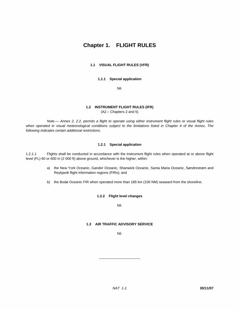
NAT 1-1 30/11/07
Chapter 1. FLIGHT RULES
1.1 VISUAL FLIGHT RULES (VFR)
1.1.1 Special application
Nil.
1.2 INSTRUMENT FLIGHT RULES (IFR) (A2 – Chapters 2 and 5)
Note.— Annex 2, 2.2, permits a flight to operate using either instrument flight rules or visual flight rules when operated in visual meteorological conditions subject to the limitations listed in Chapter 4 of the Annex. The following indicates certain additional restrictions.
1.2.1 Special application 1.2.1.1 Flights shall be conducted in accordance with the instrument flight rules when operated at or above flight level (FL) 60 or 600 m (2 000 ft) above ground, whichever is the higher, within: a) the New York Oceanic, Gander Oceanic, Shanwick Oceanic, Santa Maria Oceanic, Søndrestrøm and
Reykjavik flight information regions (FIRs); and b) the Bodø Oceanic FIR when operated more than 185 km (100 NM) seaward from the shoreline.
1.2.2 Flight level changes
Nil.
1.3 AIR TRAFFIC ADVISORY SERVICE
Nil.
_____________________

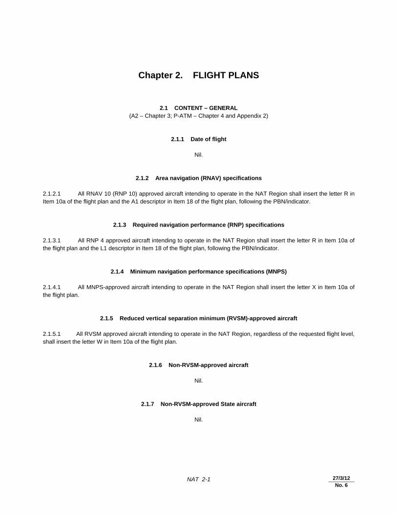
NAT 2-1 27/3/12 No. 6
Chapter 2. FLIGHT PLANS
2.1 CONTENT – GENERAL (A2 – Chapter 3; P-ATM – Chapter 4 and Appendix 2)
2.1.1 Date of flight
Nil.
2.1.2 Area navigation (RNAV) specifications
2.1.2.1 All RNAV 10 (RNP 10) approved aircraft intending to operate in the NAT Region shall insert the letter R in Item 10a of the flight plan and the A1 descriptor in Item 18 of the flight plan, following the PBN/indicator.
2.1.3 Required navigation performance (RNP) specifications
2.1.3.1 All RNP 4 approved aircraft intending to operate in the NAT Region shall insert the letter R in Item 10a of the flight plan and the L1 descriptor in Item 18 of the flight plan, following the PBN/indicator.
2.1.4 Minimum navigation performance specifications (MNPS) 2.1.4.1 All MNPS-approved aircraft intending to operate in the NAT Region shall insert the letter X in Item 10a of the flight plan.
2.1.5 Reduced vertical separation minimum (RVSM)-approved aircraft 2.1.5.1 All RVSM approved aircraft intending to operate in the NAT Region, regardless of the requested flight level, shall insert the letter W in Item 10a of the flight plan.
2.1.6 Non-RVSM-approved aircraft
Nil.
2.1.7 Non-RVSM-approved State aircraft
Nil.
NAT 2-2 Regional Supplementary Procedures
30/11/12
No. 7
2.1.8 Indication of 8.33 kHz channel spacing capability
Nil.
2.1.9 Route 2.1.9.1 General 2.1.9.1.1 Flights conducted wholly or partly outside the organized tracks shall be planned along great circle tracks joining successive significant points. Flight plans shall be made in accordance with the following. 2.1.9.1.2 Flights operating between North America and Europe shall generally be considered as operating in a predominantly east-west direction. However, flights planned between these two continents via the North Pole shall be considered as operating in a predominantly north-south direction. 2.1.9.2 Flights operating predominantly in an east-west direction 2.1.9.2.1 For flights operating at or south of 70°N, the planned tracks shall normally be defined by significant points formed by the intersection of half or whole degrees of latitude with meridians spaced at intervals of 10 degrees from the Greenwich meridian to longitude 70°W. 2.1.9.2.2 For flights operating north of 70°N and at or south of 80°N, the planned tracks shall normally be defined by significant points formed by the intersection of parallels of latitude expressed in degrees and minutes with meridians normally spaced at intervals of 20 degrees from the Greenwich meridian to longitude 60°W, using the longitudes 000W, 020W, 040W and 060W. 2.1.9.2.3 For flights operating at or south of 80°N, the distance between significant points shall, as far as possible, not exceed one hour’s flight time. Additional significant points should be established when deemed necessary due to aircraft speed or the angle at which the meridians are crossed, e.g.: a) at intervals of 10 degrees of longitude (between 5°W and 65°W) for flights operating at or south of
70°N; and b) at intervals of 20 degrees of longitude (between 10°W and 50°W) for flights operating north of 70°N
and at or south of 80°N. 2.1.9.2.4 When the flight time between successive significant points referred to in 2.1.9.2.3 is less than 30 minutes, one of these points may be omitted. 2.1.9.2.5 For flights operating north of 80°N, the planned tracks shall normally be defined by significant points formed by the intersection of parallels of latitude expressed in degrees and minutes with meridians expressed in whole degrees. The distance between significant points shall, as far as possible, not exceed 60 minutes flight time. 2.1.9.3 Flights operating predominantly in a north-south direction 2.1.9.3.1 For flights whose flight paths at or south of 80°N are predominantly oriented in a north-south direction, the planned tracks shall normally be defined by significant points formed by the intersection of whole degrees of longitude with specified parallels of latitude which are spaced at intervals of 5 degrees.
Regional Supplementary Procedures NAT 2-3
30/11/12
No. 7
2.1.9.3.2 For flights operating north of 80°N, the planned tracks shall normally be defined by significant points formed by the intersection of parallels of latitude expressed in degrees and minutes with meridians expressed in whole degrees. The distance between significant points shall, as far as possible, not exceed 60 minutes flight time. 2.1.9.4 Flights operating on an organized track 2.1.9.4.1 For flights conducted along one of the organized tracks from the entry point into the NAT FIRs to the exit point, the organized track shall be defined in the flight plan by the abbreviation “NAT” followed by the code letter assigned to the track. 2.1.9.5 Flights operating along fixed ATS routes 2.1.9.5.1 For flights operating along the fixed ATS route network between Canada, the United States, Bermuda and the CAR Region, the track shall be defined by appropriate reference to this route network.
2.1.10 Estimated times 2.1.10.1 The accumulated estimated elapsed time to each oceanic FIR boundary shall be specified in Item 18 of the flight plan.
2.1.11 Mach number 2.1.11.1 For turbo-jet aircraft intending to operate within the Bodø Oceanic, Gander Oceanic, New York Oceanic, Reykjavik, Santa Maria Oceanic and Shanwick Oceanic control areas, the planned true Mach number for any portion of their flight within these control areas shall be specified in Item 15 of the flight plan.
2.1.12 Alternative flight level 2.1.12.1 For turbo-jet aircraft intending to operate within the Gander Oceanic, New York Oceanic, Reykjavik, Santa Maria Oceanic and Shanwick Oceanic control areas, requests for a suitable alternative flight level may be included in Item 18 of the flight plan.
2.1.13 Special handling (STS)
Nil.
2.1.14 Data link services
2.1.14.1 All aircraft planning to operate in the NAT Region and intending to use data link services shall insert the appropriate descriptor (J2, J5 or J7) in Item 10a of the flight plan to indicate FANS 1/A interoperable equipment.
2.1.15 Automatic Dependent Surveillance – Broadcast (ADS-B) 2.1.15.1 All ADS-B approved aircraft intending to operate in the NAT Region shall insert either the B1 or B2 descriptor as appropriate in Item 10b of the flight plan.
NAT 2-4 Regional Supplementary Procedures
30/11/12
No. 7
Note.— Eligibility for ADS-B service in the NAT Region is based upon the compliance considerations of the European Aviation Safety Agency (EASA) AMC 20-24 or equivalent.
2.1.16 Aircraft Registration 2.1.16.1 All aircraft intending to operate in the NAT Region shall insert the aircraft registration in Item 18 of the flight plan, following the REG/indicator.
2.2 CONTENT – AIR TRAFFIC FLOW MANAGEMENT (ATFM)
2.2.1 Runway visual range (RVR)
Nil.
2.2.2 Flight plan addressing and distribution
Nil.
2.2.3 Slot allocation exemptions
Nil.
2.3 SUBMISSION (A2 – Chapter 3; P-ATM – Chapter 4)
2.3.1 General 2.3.1.1 Flight plans for flights departing from points within adjacent regions and entering the NAT Region without intermediate stops shall be submitted as early as possible.
2.3.2 Amendments
Nil.
2.4 REPETITIVE FLIGHT PLANS (RPLs)
Nil.
_____________________
NAT 3-1 30/11/07
Chapter 3. COMMUNICATIONS
3.1 AIR-GROUND COMMUNICATIONS AND IN-FLIGHT REPORTING
3.1.1 Communications equipment
Nil.
3.1.2 Continuous listening watch in uncontrolled airspace
Nil.
3.1.3 Position reports (A2 – Chapters 3 and 5; P-ATM – Chapter 4)
3.1.3.1 Unless otherwise required by air traffic services, position reports for flights on routes not defined by designated reporting points shall be made at the significant points listed in the flight plan. 3.1.3.2 Air traffic services may require any flight operating predominantly in an east-west direction to report its position at any of the intermediate meridians spaced at intervals of: a) 10 degrees of longitude south of 70°N (between 5°W and 65°W); and b) 20 degrees of longitude north of 70°N (between 10°W and 50°W). 3.1.3.3 In requiring aircraft to report their position at intermediate intervals, the air traffic services authorities will be guided by the requirement to have position information at approximately hourly intervals and also by the need to cater for varying types of aircraft and for varying traffic and meteorological conditions. Position and time 3.1.3.4 Verbal position reports shall be identified by the spoken word “Position” transmitted immediately before or after the aircraft identification. 3.1.3.5 For flights outside the ATS route network, the position shall be expressed in terms of latitude and longitude as follows: a) for flights operating in a predominantly east-west direction: 1) latitude in degrees and minutes; and 2) longitude in degrees only;
NAT 3-2 Regional Supplementary Procedures
30/11/07 27/3/12 No. 6
b) for flights operating in a predominantly north-south direction: 1) latitude in degrees only; and 2) longitude in degrees and minutes. 3.1.3.6 When making position reports, all times should be expressed in four digits, giving both the hour and minutes. Time over next position 3.1.3.7 If the estimated time for the next position last reported to air traffic control is found to be in error by three minutes or more, a revised estimated time over shall be transmitted as soon as possible to the ATS unit concerned. Transmission (P-ATM – Chapter 4) 3.1.3.8 Position reports made by aircraft operating within an oceanic control area at a distance of 110 km (60 NM) or less from the common boundary with an adjacent oceanic control area, including aircraft operating on tracks through successive points on such boundary, shall also be made to the area control centre serving the adjacent control area. 3.1.3.9 Responsibility for the transmission of position reports to the additional ATS units specified in 3.1.3.8 may be delegated to the appropriate communications station(s) through local arrangements.
3.1.4 Abbreviated position reports
Nil.
3.1.5 Read-back of VHF channels
Nil.
3.2 MANDATORY CARRIAGE OF 8.33 KHZ CHANNEL SPACING CAPABLE RADIO EQUIPMENT
Nil.
3.3 CONTROLLER-PILOT DATA LINK COMMUNICATIONS (CPDLC) Area of applicability 3.3.1 All aircraft intending to conduct flights in the airspace defined below shall be fitted with and shall operate controller-pilot data link communications (CPDLC) equipment: a) from 7 February 2013, on specified tracks and flight levels within the NAT organized track system
(OTS); and
Regional Supplementary Procedures NAT 3-3
30/11/07 27/3/12 No. 6
b) from 5 February 2015, in specified portions of NAT minimum navigation specifications (MNPS) airspace.
Note 1.— The specified tracks and flight level band within the NAT OTS will be published by the
States concerned in national AIPs and identified daily in the NAT track message. Note 2.— The specified portions of NAT MNPS airspace and aircraft equipment performance
requirements where applicable will be published by the States concerned in national AIPs. Means of compliance 3.3.2 Operators intending to conduct flights within the airspace specified in 3.3.1 shall obtain CPDLC operational authorization, where applicable, either from the State of Registry or the State of the Operator. The State of Registry or the State of the Operator shall verify that the equipment has been certified in accordance with the requirements specified in RTCA DO-258/EUROCAE ED-100 or equivalent, capable of operating outside VHF data link coverage. 3.3.3 The services provided within the airspace specified in 3.3.1 shall comply with the Oceanic Safety and Performance Requirements as specified in RTCA DO-306/EUROCAE ED-122 or equivalent. Note.— Additional guidance can be found in the ICAO Global Operational Data Link Document (GOLD).
3.4 SATELLITE COMMUNICATION (SATCOM) (A2 – Chapter 3; P-ATM – Chapter 15; P-OPS, Vol. 1)
3.4.1 Within the Bodø Oceanic, Gander Oceanic, New York Oceanic, Reykjavik, Santa Maria Oceanic and Shanwick Oceanic control areas, aircraft with installed aeronautical mobile satellite (route) services (AMS(R)S) voice equipment, may use such equipment for additional ATS communications capability, provided the following requirements are met: a) the equipment shall be approved by the State of the Operator or the State of Registry; b) the equipment shall be operated in accordance with the provisions of the respective AlPs; c) pilots shall operate SELCAL in accordance with Section 3.5.1 or maintain a listening watch on the
assigned HF frequency; and d) AMS(R)S voice communications should be made to aeronautical stations rather than ATS units unless
the urgency of the communication dictates otherwise. Note 1.— AMS(R)S voice communication initiated due to HF propagation difficulties does not constitute urgency. Dedicated AMS(R)S voice telephone numbers (short codes) for air-ground radio facilities and air traffic control facilities are published in national AlPs where approved. Note 2.— AMS(R)S voice is not a replacement for ADS-C, CPDLC or HF communications, but rather a means of reducing the risk of communications failure, improving the safety of operations and alleviating HF congestion. AMS(R)S voice provides an additional discrete communications medium and potential minimum equipment list (MEL) relief because States approving reduced carriage requirements for HF radio may allow aircraft to operate with only one serviceable HF radio.
NAT 3-4 Regional Supplementary Procedures
30/11/07 27/3/12 No. 6
3.5 AERONAUTICAL MOBILE SERVICE
3.5.1 Selective calling (SELCAL) 3.5.1.1 While operating in an HF air-ground communications environment, pilots shall maintain a listening watch on the assigned radio frequency. This will not be necessary, however, if a SELCAL watch is maintained and correct operation is ensured. Correct SELCAL operation shall be ensured by: a) the inclusion of the SELCAL code in the flight plan; b) the issue of a correction to the SELCAL code if subsequently altered due to change of aircraft or
equipment; and c) an operational check of the SELCAL equipment with the appropriate radio station at or before initial
entry into oceanic airspace. This SELCAL check must be completed successfully before commencing a SELCAL watch.
Note.— A SELCAL watch on the assigned radio frequency should be maintained, even in areas of the region where VHF coverage is available and used for air-ground communications.
3.5.2 HF operations (A10, Vol. II – Chapter 5)
3.5.2.1 Assignment of voice traffic to HF families 3.5.2.1.1 Procedures for the distribution of the NAT HF air-to-ground message traffic of the users on the NAT routes between the various NAT HF families are indicated in Table 1. Note.— Use of the NAT-D radiotelephony network frequencies is extended to the Arctic area of the Anchorage Arctic FIR, via Gander Radio. 3.5.2.1.2 In the event of overloading of a family or for other operational reasons, stations should not assign a frequency from an alternate family to aircraft flying routes outside the areas defined in Table 1, without prior coordination and agreement of other network stations, in order to minimize adverse impact on existing sub-network traffic.
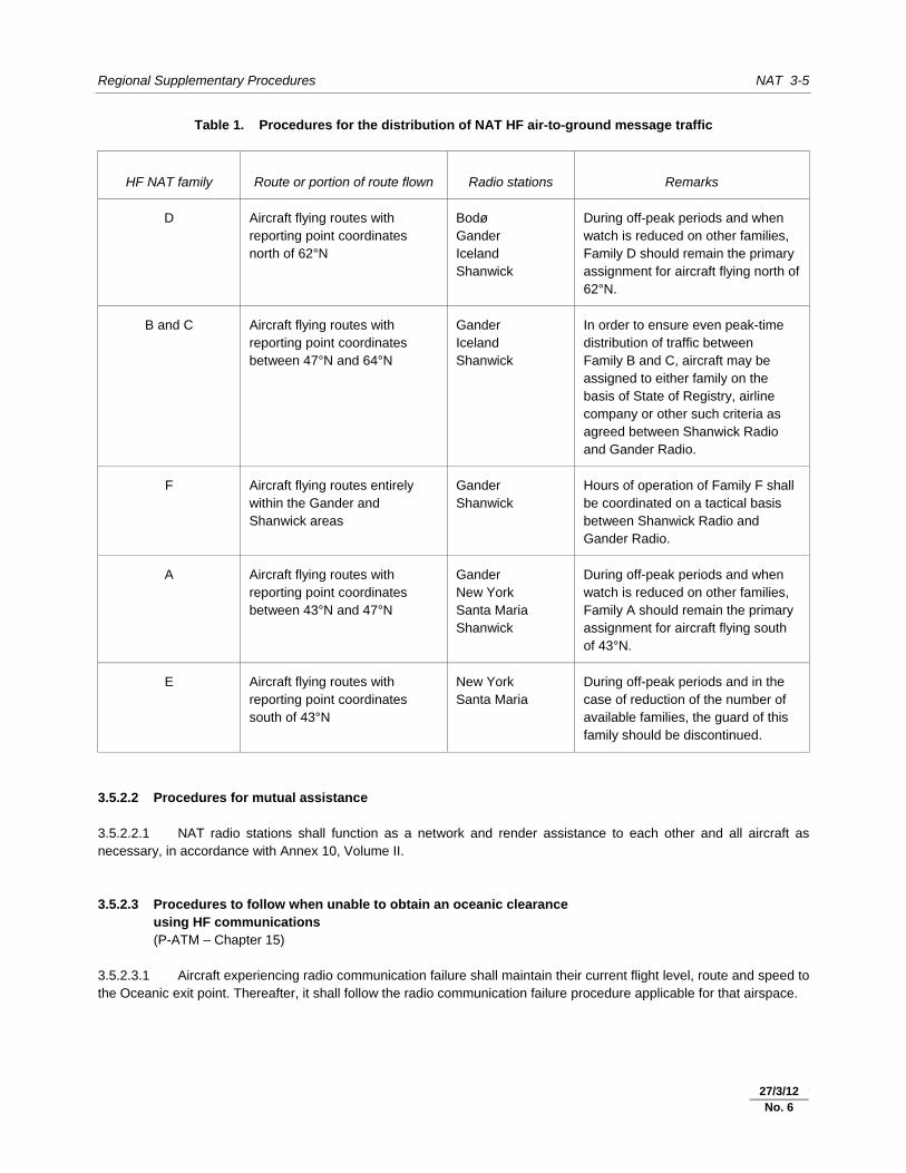
Regional Supplementary Procedures NAT 3-5
30/11/07 27/3/12 No. 6
Table 1. Procedures for the distribution of NAT HF air-to-ground message traffic
HF NAT family Route or portion of route flown Radio stations Remarks
D Aircraft flying routes with reporting point coordinates north of 62°N
Bodø Gander Iceland Shanwick
During off-peak periods and when watch is reduced on other families, Family D should remain the primary assignment for aircraft flying north of 62°N.
B and C Aircraft flying routes with reporting point coordinates between 47°N and 64°N
Gander Iceland Shanwick
In order to ensure even peak-time distribution of traffic between Family B and C, aircraft may be assigned to either family on the basis of State of Registry, airline company or other such criteria as agreed between Shanwick Radio and Gander Radio.
F Aircraft flying routes entirely within the Gander and Shanwick areas
Gander Shanwick
Hours of operation of Family F shall be coordinated on a tactical basis between Shanwick Radio and Gander Radio.
A Aircraft flying routes with reporting point coordinates between 43°N and 47°N
Gander New York Santa Maria Shanwick
During off-peak periods and when watch is reduced on other families, Family A should remain the primary assignment for aircraft flying south of 43°N.
E Aircraft flying routes with reporting point coordinates south of 43°N
New York Santa Maria
During off-peak periods and in the case of reduction of the number of available families, the guard of this family should be discontinued.
3.5.2.2 Procedures for mutual assistance 3.5.2.2.1 NAT radio stations shall function as a network and render assistance to each other and all aircraft as necessary, in accordance with Annex 10, Volume II. 3.5.2.3 Procedures to follow when unable to obtain an oceanic clearance 3.5.2.3 using HF communications 3.5.2.3 (P-ATM – Chapter 15) 3.5.2.3.1 Aircraft experiencing radio communication failure shall maintain their current flight level, route and speed to the Oceanic exit point. Thereafter, it shall follow the radio communication failure procedure applicable for that airspace.
NAT 3-6 Regional Supplementary Procedures
30/11/07 27/3/12 No. 6
Note.— In this context, the current flight level is the last cleared level unless the preceding units’ radio communication failure procedure dictates otherwise. In all cases, aircraft should stay in level flight in the oceanic area. Current speed should be the initial oceanic Mach number in the flight plan, if the aircraft does not have a speed clearance.
3.6 AERONAUTICAL FIXED SERVICE
3.6.1 AFTN rationalization
Nil.
3.7 RADIO CHANNELS/FREQUENCIES
Nil.
_____________________
NAT 4-1 30/11/07 8/1/09
No. 1
Chapter 4. NAVIGATION
4.1 PERFORMANCE-BASED NAVIGATION (PBN)
Note.— As the North Atlantic (NAT) Region transitions to PBN as contained in the Performance-based Navigation (PBN) Manual (Doc 9613), the contents of 4.1 will be amended.
4.1.1 Area navigation (RNAV) specifications 4.1.1.1 RNAV 10 (RNP 10) Note.— RNAV 10 retains the RNP 10 designation, as specified in the Performance-based Navigation (PBN) Manual (Doc 9613), 1.2.3.5. Area of applicability 4.1.1.1.1 A lateral separation minimum of 93 km (50 NM) may be applied between flights operating within the control area of the New York Oceanic FIR. Means of compliance 4.1.1.1.2 For application of 4.1.1.1.1, operators and civil aviation authorities must follow the provisions listed below. 4.1.1.1.3 The aircraft and operator must be approved RNP 10 or RNP 4 by the State of the Operator or the State of Registry, as appropriate. RNP 10 is the minimum navigation specification for the application of 93 km (50 NM) lateral separation. 4.1.1.1.4 States shall ensure, when granting approval for RNP 10 or RNP 4, that operators establish programmes to mitigate the occurrence of large lateral track errors due to equipment malfunction or operational error. Note.— The Performance-based Navigation (PBN) Manual (Doc 9613) provides guidance on aircraft, operations and maintenance programmes for the initial achievement and continued compliance with the authorized navigation specification. 4.1.1.2 RNAV 5 Nil. 4.1.1.3 RNAV 2 Nil. 4.1.1.4 RNAV 1 Nil.
NAT 4-2 Regional Supplementary Procedures
30/11/07 8/1/09
No. 1
4.1.1.5 Pre-PBN navigation specifications 4.1.1.5.1 Minimum navigation performance specifications (MNPS) Area of applicability 4.1.1.5.1.1 The MNPS shall be applicable in that volume of airspace between FL 285 and FL 420 within the Oceanic Control Areas of Santa Maria, Shanwick, Reykjavik, Gander Oceanic and New York Oceanic, excluding the area west of 60°W and south of 38°30N. Note.— This volume of airspace is referred to as the “MNPS airspace”. Means of compliance (A2 – Chapter 5; A6, Part I – Chapters 3, 4 and 7; A6, Part II – Chapters 3 and 7; A8 – Chapter 8) 4.1.1.5.1.2 Except for those flights specified in 4.1.1.5.1.5, aircraft operating within the volume of airspace specified in 4.1.1.5.1.1 shall have lateral navigation performance capability such that: a) the standard deviation of lateral track errors shall be less than 11.7 km (6.3 NM); b) the proportion of the total flight time spent by aircraft 56 km (30 NM) or more off the cleared track shall
be less than 5.3 × 10⁻⁴; and c) the proportion of the total flight time spent by aircraft between 93 and 130 km (50 and 70 NM) off the
cleared track shall be less than 1.3 × 10⁻⁴. 4.1.1.5.1.3 The State of Registry or the State of the Operator, as appropriate, should verify that the lateral navigation capability of approved aircraft meets the requirements specified in 4.1.1.5.1.2. Note.— Guidance material of use to those involved in the initial achievement and continued maintenance of the navigation capability set forth in 4.1.1.5.1.2 has been issued by ICAO under the title Guidance and Information Material Concerning Air Navigation in the North Atlantic Region (NAT Doc. 001) and will be supplemented and updated as required and as new material becomes available. 4.1.1.5.1.4 When granting approval for operations in MNPS airspace, States of Registry shall ensure that in-flight operating drills include mandatory navigation cross-checking procedures which will identify navigation errors in sufficient time to prevent the aircraft inadvertently deviating from the ATC-cleared route. Guidance on procedures are detailed in NAT Doc 001 and North Atlantic MNPS Airspace Operations Manual. 4.1.1.5.1.5 Flights not subject to an Oceanic Clearance, which flight plan to route through Brest Oceanic Transition Area (BOTA) and/or Shannon Oceanic Transition Area (SOTA), are not subject to MNPS approval. Note 1.— SOTA is defined as that airspace from DINIM (510000N 0150000W) — LESLU (510000N 0080000W) — 483000N 0080000W — BEDRA (490000N 0150000W) to DINIM (510000N 0150000W). Note 2.— BOTA is defined as that airspace from 483400N 0084500W — 483000N 0080000W — 450000N 0080000W — 450000N 0084500W to 483400N 0084500W.
8/1/09
No. 1
15/10/10
No. 3

Regional Supplementary Procedures NAT 4-3
30/11/07 8/1/09
No. 1
4.1.2 Required navigation performance (RNP) specifications 4.1.2.1 RNP 4 Nil. 4.1.2.2 Basic RNP 1 Nil. 4.1.2.3 Advanced RNP 1 Nil.
4.2 REDUCED VERTICAL SEPARATION MINIMUM (RVSM)
Area of applicability
4.2.1 RVSM shall be applicable in that volume of airspace between FL 290 and FL 410 inclusive in all FIRs of the NAT Region.
Means of compliance (A2 – Chapter 5 and Appendix 3; A6, Part I – Chapters 3, 4 and 7;
A6, Part II – Chapters 3 and 7; A8, Part IIIA – Chapter 8, A11 – Chapter 2) 4.2.2 Operators intending to conduct flights within the NAT Region where RVSM is applied shall require an RVSM approval either from the State of Registry or the State of the Operator. The State of Registry or the State of the Operator, as appropriate, should verify that the height-keeping performance capability of approved aircraft meets the requirements specified in Annex 6, Parts I and II. Note.— Guidance material of use to those involved in the initial achievement and continued maintenance of the height-keeping performance has been issued by ICAO under the title Guidance and Information Material Concerning Air Navigation in the North Atlantic Region (NAT Doc. 001) and will be supplemented and updated as required and as new material becomes available.
_____________________
8/1/09
No. 1
25/8/09
No. 2

NAT 5-1 30/11/07
Chapter 5. SURVEILLANCE
5.1 SECONDARY SURVEILLANCE RADAR (SSR) (P-ATM – Chapter 8; P-OPS, Vol. I )
5.1.1 Carriage of pressure-altitude reporting SSR transponders 5.1.1.1 All aircraft operating as IFR flights in the NAT Region shall be equipped with a pressure-altitude reporting SSR transponder.
5.1.2 Code allocation methodology
Nil.
5.1.3 Assignment of SSR codes
Nil.
5.1.4 Operation of pressure-altitude reporting SSR transponders 5.1.4.1 Unless otherwise directed by ATC, pilots of aircraft equipped with SSR flying in NAT FIRs shall retain the last assigned identity (Mode A) code for a period of 30 minutes after entry into NAT airspace.
5.1.5 Monitoring of SSR-derived information
Nil.
5.2 SSR MODE S
5.2.1 Carriage and operation of SSR Mode S
Nil.
5.2.2 Transition between Mode A/C and Mode S
Nil.
NAT 5-2 Regional Supplementary Procedures
30/11/07 27/3/12 No. 6
5.3 AIRBORNE COLLISION AVOIDANCE SYSTEMS (ACAS)
5.3.1 Carriage and operation of ACAS II (A2 – Chapter 3; A6, Part I – Chapter 6; A10, Vol. IV;
A11 – Chapter 2; P-OPS, Vol. I; P-ATM – Chapters 4 and 10) 5.3.1.1 ACAS II shall be carried and operated in the NAT Region by all turbine-engined aeroplanes having a maximum certificated take-off mass exceeding 5 700 kg or authorized to carry more than 19 passengers.
5.4 AUTOMATIC DEPENDENT SURVEILLANCE – CONTRACT (ADS-C) Area of applicability 5.4.1 All aircraft intending to conduct flights in the airspace defined below shall be fitted with and shall operate automatic dependent surveillance – contract (ADS-C) equipment: a) from 7 February 2013, on specified tracks and on specified flight levels within the NAT organized track
system (OTS); and b) from 5 February 2015, in specified portions of NAT minimum navigation specifications (MNPS)
airspace. Note 1.— The specified tracks and flight level band within the NAT OTS will be published by the
States concerned in national AIPs and identified daily in the NAT track message. Note 2.— The specified portions of NAT MNPS airspace and aircraft equipment performance
requirements, where applicable, will be published by the States concerned in national AIPs. Means of compliance 5.4.2 Operators intending to conduct flights within the airspace specified in 5.4.1 shall obtain an ADS-C operational authorization, where applicable, either from the State of Registry or the State of the Operator. The State of Registry or the State of the Operator shall verify that the equipment has been certified in accordance with the requirements specified in RTCA DO-258/EUROCAE ED-100 or equivalent, capable of operating outside VHF data link coverage. 5.4.3 The data link services provided within the NAT airspace shall comply with the Oceanic Safety and Performance Requirements as specified in RTCA DO-306/EUROCAE ED-122 or equivalent. Conformance monitoring shall provide alerts to the controller when reports do not match the current flight plan, and the following ADS contracts shall be used: a) ADS periodic contracts at an interval consistent with safety requirements and published by the States
concerned in national AIPs; and b) ADS event contracts that include the following event types: 1) lateral deviation event (LDE) with a lateral deviation threshold of 9.3 km (5 NM) or less;
Regional Supplementary Procedures NAT 5-3
27/3/12 No. 6
2) level range deviation event (LRDE) with a vertical deviation threshold of 90 m (300 ft) or less; and 3) waypoint change event (WCE) at compulsory reporting points. Note.— Additional guidance can be found in the ICAO Global Operational Data Link Document (GOLD).
5.5 AUTOMATIC DEPENDENT SURVEILLANCE – BROADCAST (ADS-B)
Nil.
_____________________

NAT 6-1 30/11/07
Chapter 6. AIR TRAFFIC SERVICES
6.1 AIR TRAFFIC CONTROL (ATC) CLEARANCES
6.1.1 Content (A11 – Chapter 3; P-ATM – Chapters 4 and 11)
6.1.1.1 An abbreviated clearance shall only be issued by ATS when clearing an aircraft to follow one of the organized tracks throughout its flight within the NAT control areas or when clearing an aircraft to follow its flight plan route. In all other circumstances, full details of the cleared track shall be specified in the clearance message. 6.1.1.2 When an abbreviated clearance is issued to follow one of the organized tracks, it shall include: a) cleared track specified by the track code; b) cleared flight level(s); c) cleared true Mach number (if required); and d) if the aircraft is designated to report meteorological information in flight, the phrase “SEND MET
REPORTS”. 6.1.1.3 On receipt of an abbreviated clearance, the pilot shall read back the contents of the clearance message. In addition, when cleared to follow one of the organized tracks, the pilot shall read back full details of the track specified by the code letter, except where alternative procedures using VHF techniques exist which include provision for the confirmation of cleared track by the pilot. 6.1.1.4 When an abbreviated clearance is issued to follow the flight plan route, it shall only be issued using direct controller-pilot communication and shall include: a) the expression “cleared via flight planned route”; b) cleared flight level(s); and c) cleared true Mach number (if required). 6.1.1.5 On receipt of an abbreviated clearance, the pilot shall read back the contents of the clearance message. In addition, when cleared via “flight planned route”, the pilot shall read back full details of the flight plan route. 6.1.1.6 A pilot-in-command shall, if at any time in doubt, request a detailed description of the route from ATS. 6.1.1.7 The ATC-approved true Mach number shall be included in each clearance given to subsonic turbo-jet aircraft operating within Bodø Oceanic, Gander Oceanic, New York Oceanic, Reykjavik, Santa Maria Oceanic and Shanwick Oceanic control areas.
NAT 6-2 Regional Supplementary Procedures
30/11/07
6.1.2 Adherence (A2 – Chapter 3)
6.1.2.1 If an aircraft has inadvertently deviated from the route specified in its ATC clearance, it shall forthwith take action to regain such route within 185 km (100 NM) from the position at which the deviation was observed. 6.1.2.2 Unable to obtain oceanic clearance using HF voice 6.1.2.2 (P-ATM – Chapter 15) 6.1.2.2.1 Aircraft operating outside VHF coverage that are unable to contact ATC on HF to obtain an Oceanic clearance shall continue to operate at the last assigned flight level and along the cleared route of flight until communications are re-established. Note.— Failure of HF communications often stems from poor signal propagation, frequently because of sun spot activity, and is likely to simultaneously affect multiple aircraft operating in a particular region. ATM systems dependent on HF are designed around the assumption that communication may be temporarily interrupted and that aircraft affected will continue to operate in accordance with the last received and acknowledged clearance, until communication is restored.
6.2 SEPARATION
6.2.1 Lateral (A11 – Attachment B; P-ATM – Chapter 5)
6.2.1.1 Minimum lateral separation shall be: a) 93 km (50 NM) between aircraft meeting the provisions in 4.1.1.1, except minimum lateral separation
between aircraft transitioning from MNPS airspace in the New York Oceanic FIR/CTA to other MNPS airspace shall be 110 km (60 NM);
Note.— NAT MNPS airspace is defined in 4.1.1.5.1.1. b) 110 km (60 NM) between aircraft which meet the minimum navigation performance specifications
(MNPS) provided that a portion of the route of the aircraft is within, above, or below MNPS airspace; c) 167 km (90 NM) between aircraft operating outside the MNPS airspace and at least one aircraft does
not meet the MNPS: 1) between the Iberian Peninsula and the Azores Islands; and 2) between Iceland and points in Scandinavia and in the United Kingdom; d) 167 km (90 NM) between aircraft not approved RNP 10 or RNP 4 operating outside MNPS airspace
where no portion of the route of the aircraft is within, above, or below MNPS airspace: 1) between the United States/Canada and Bermuda; and 2) west of 55°W between the United States, Canada or Bermuda and points in the CAR Region; Note.— MNPS airspace is defined in 4.1.1.5.1.1
8/1/09
No. 1

Regional Supplementary Procedures NAT 6-3
30/11/07
e) 223 km (120 NM) between other aircraft; except that lower minima in 5.4.1.1.2 of the PANS-ATM may be applied, or further reduced in accordance with 5.11 when the conditions specified in the relevant PANS-ATM provisions are met (see 5.4). 6.2.1.2 In the practical application of the minima in 6.2.1.1 a), b), c) d) and e), tracks may be spaced with reference to their difference in latitude, using one degree instead of 110 km (60 NM); one and one-half degrees instead of 167 km (90 NM); and two degrees instead of 223 km (120 NM), provided that in any interval of ten degrees of longitude, the change in latitude of at least one of the tracks does not exceed: a) three degrees at or south of 58°N; b) two degrees north of 58°N and south of 70°N; and c) one degree at or north of 70°N and south of 80°N. At or north of 80°N, or where the above rates of change of latitude are exceeded, the required lateral separation must be ensured by reference to the track spacing expressed in nautical miles.
6.2.2 Longitudinal (P-ATM – Chapter 5)
6.2.2.1 Minimum longitudinal separation between turbo-jet aircraft shall be: a) 15 minutes; or b) 10 minutes, provided the Mach number technique is applied whether in level, climbing or descending
flight; and the aircraft concerned have reported over a common point to follow continuously diverging tracks until some other form of separation is provided; and:
1) at least 10-minute longitudinal separation exists at the point where the tracks diverge; and 2) at least 5-minute longitudinal separation exists where lateral separation is achieved; and 3) lateral separation will be achieved at or before the next significant point (normally ten degrees of
longitude along track(s)) or, if not, within 90 minutes of the time the second aircraft passes the common point or within 1 112 km (600 NM) of the common point, whichever is estimated to occur first.
Note.— The minima contained in 6.2.2.1 b) are in addition to those found in the PANS-ATM, 5.4.2.4. 6.2.2.2 Minimum longitudinal separation between non-turbo-jet aircraft shall be: a) 30 minutes; and b) 20 minutes in the West Atlantic route system (WATRS) area. Note.— The WATRS area is defined as beginning at a point 27°00'N/77°00'W direct to 20°00'N/67°00'W direct to 18°00'N/62°00'W direct to 18°00'N/60°00'W direct to 38°30'N/60°00'W direct to 38°30'N/69°15'W, thence counterclockwise along the New York Oceanic control area/FIR boundary to the Miami Oceanic control area/FIR boundary, thence southbound along the Miami Oceanic control area/FIR boundary to the point of beginning.
8/1/09
No. 1
NAT 6-4 Regional Supplementary Procedures
30/11/07
6.2.3 Composite
Nil.
6.2.4 Vertical 6.2.4.1 Between FL 290 and FL 410 inclusive, 300 m (1 000 ft) vertical separation shall be applied in the NAT Region. 6.2.4.2 At or above FL 450, vertical separation between supersonic aircraft, and between supersonic aircraft and any other aircraft, shall be considered to exist if the flight levels of the two aircraft differ by at least 1 200 m (4 000 ft).
6.2.5 Radar
Nil.
6.2.6 Reduction in separation minima (A11 – Chapter 3; P-ATM – Chapter 5)
6.2.6.1 Where, circumstances permitting, separation minima lower than those specified in 6.2.1 and 6.2.2 will be applied in accordance with the PANS-ATM, appropriate information should be published in AIPs so that users of the airspace are fully aware of the portions of airspace where the reduced separation minima will be applied and of the navigation aids on which those minima are based.
6.2.7 Airspace reservations 6.2.7.1 Separation minima between moving temporary airspace reservations 6.2.7.1.1 Lateral separation shall be: a) 110 km (60 NM) between the closest tracks of any aircraft for which the airspace is reserved, provided
all aircraft or formation flights meet the MNPS; or b) 223 km (120 NM) between the closest tracks of any aircraft for which the airspace is reserved, except
that in the New York oceanic control area (OCA) west of 60°W, 167 km (90 NM) may be applied. Note.— A formation flight with at least one of the aircraft in the formation meeting MNPS is deemed to meet the requirement for the application of 110 km (60 NM) in a). 6.2.7.1.2 Longitudinal separation shall be 60 minutes. 6.2.7.2 Separation minima between stationary temporary airspace reservations 6.2.7.2.1 Lateral separation shall be: a) 110 km (60 NM) between the boundaries of stationary temporary airspace reservations, provided the
requesting agencies have guaranteed to confine their activities to the requested airspace, except that in the New York OCA west of 60°W, 84 km (45 NM) may be applied; or
8/1/09
No. 1
Regional Supplementary Procedures NAT 6-5
30/11/07
b) 223 km (120 NM) between the boundaries of the airspace reservations, if no guarantees have been given, except that in the New York OCA west of 60°W, 167 km (90 NM) may be applied.
6.2.7.3 Separation minima between moving temporary airspace reservations and other aircraft 6.2.7.3.1 Lateral separation shall be: a) 110 km (60 NM) between the track of an aircraft operating under the control of the ATC unit concerned
and the closest track of any of the aircraft for which the airspace is reserved, provided all aircraft meet the MNPS requirements and a portion of the route of the aircraft is within, above or below MNPS airspace; or
b) 110 km (60 NM) between the track of an aircraft operating under the control of the ATC unit concerned
and the track of a formation flight for which the airspace has been reserved, provided at least one aircraft in the formation and the aircraft operating under the control of the ATC unit meet the MNPS requirements and a portion of the route of the aircraft is within, above or below MNPS airspace; or
c) 223 km (120 NM) between the track of an aircraft operating under the control of the ATC unit
concerned and the closest track of any of the aircraft for which the airspace is reserved, except that in the New York OCA west of 60°W, 167 km (90 NM) may be applied.
6.2.7.4 Separation minima between stationary temporary airspace reservations and other aircraft 6.2.7.4.1 Lateral separation shall be: a) 56 km (30 NM) between the track of an aircraft operating under the control of the ATC unit concerned
or as part of a moving airspace reservation and the nearest limit of the reserved airspace, provided the aircraft meets the MNPS requirements and a portion of the route of the aircraft is within, above or below MNPS airspace and the requesting agency has guaranteed to confine its activities to the requested airspace; or
b) 110 km (60 NM) between the track of an aircraft operating under the control of the ATC unit concerned
or as part of a moving airspace reservation and the nearest limit of the reserved airspace, provided the aircraft meets the MNPS requirements and a portion of the route of the aircraft is within, above or below MNPS airspace and the requesting agency has not guaranteed to confine its activities to the requested airspace; or
c) 110 km (60 NM) between the track of an aircraft operating under the control of the ATC unit concerned
or as part of a moving airspace reservation and the nearest limit of the reserved airspace, when the aircraft does not meet the MNPS requirements and the requesting agency has guaranteed to confine its activities to the requested airspace, except that in the New York OCA west of 60°W, 84 km (45 NM) may be applied; or
d) 223 km (120 NM) between the track of an aircraft operating under the control of the ATC unit
concerned or as part of a moving airspace reservation and the nearest limit of the reserved airspace, when the aircraft does not meet the MNPS requirements and the requesting agency has not guaranteed to confine its activities to the requested airspace, except that in the New York OCA west of 60°W, 167 km (90 NM) may be applied.
8/1/09
No. 1
NAT 6-6 Regional Supplementary Procedures
30/11/07
6.3 MINIMUM FLIGHT LEVEL
6.3.1 Establishment
Nil.
6.4 ATS ROUTES
6.4.1 Track systems 6.4.1.1 Establishment and use of organized track system (OTS) 6.4.1.1.1 When necessary in order to permit the optimum use of the airspace, the area control centres serving Gander Oceanic, New York Oceanic, Santa Maria Oceanic and Shanwick Oceanic control areas may, subject to coordination with each other and, when appropriate, with Reykjavik area control centre, establish an organized track system. The procedures in 6.4.1.1.2 and 6.4.1.1.3 shall then be applied. 6.4.1.1.2 Operators conducting scheduled or non-scheduled flight operations at or above FL 280 within Gander Oceanic, New York Oceanic, Shanwick Oceanic and Santa Maria (North of 30°N) Oceanic control areas shall provide information to the area control centres concerned regarding the tracks likely to be requested by turbo-jet aircraft during peak traffic periods. Such information shall be provided as far in advance of the anticipated peak periods as practicable and as specified in appropriate aeronautical information publications. 6.4.1.1.3 Based on the above information, an OTS may be established. The location of the organized tracks will depend on traffic demand and other relevant factors. The related organized track messages will be disseminated to operators by Shanwick Oceanic area control centre for the predominantly westbound flow of air traffic and by Gander Oceanic area control centre for the predominantly eastbound flow of air traffic. These messages shall be disseminated at least three hours in advance of each anticipated peak traffic period. Any subsequent change made to the track system shall be notified to the operators as soon as possible. 6.4.1.2 Mandatory carriage of the OTS message 6.4.1.2.1 All aircraft operating in or above MNPS airspace shall carry a copy of the current OTS message. 6.4.1.3 Flights along the northern or southern boundaries of Gander Oceanic 6.4.1.3 and Shanwick Oceanic flight information regions 6.4.1.3.1 Aircraft operating along tracks through successive points situated on the northern or southern boundaries of Gander Oceanic and Shanwick Oceanic flight information regions shall be provided with air traffic services by Gander or Shanwick area control centre as appropriate.
6.4.2 RNAV
Nil.
Regional Supplementary Procedures NAT 6-7
30/11/07
6.5 AERODROME OPERATIONS
6.5.1 Area of applicability
Nil.
6.5.2 Intersection take-off
Nil.
6.5.3 Multiple line-ups on the same runway
Nil.
6.5.4 Visual departures
Nil.
6.5.5 Visual approaches
Nil.
6.5.6 Advanced surface movement guidance and control systems (A-SMGCS) 6.5.6.1 General Nil. 6.5.6.2 A-SMGCS functions Nil. 6.5.6.3 A-SMGCS alerts Nil. 6.5.6.4 A-SMGCS identification procedures Nil.
25/8/09
No. 2

NAT 6-8 Regional Supplementary Procedures
30/11/07
6.6 RNAV PROCEDURES
6.6.1 General
Nil.
6.6.2 En route
Nil.
6.6.3 Terminal
Nil.
6.6.4 State aircraft
Nil.
6.7 RNP PROCEDURES
6.7.1 General
Nil.
6.7.2 En route
Nil.
6.7.3 Terminal
Nil.
6.7.4 State aircraft
Nil.
6.8 COMPOSITE PROCEDURES
Nil.
25/8/09
No. 2
Regional Supplementary Procedures NAT 6-9
30/11/07
6.9 MNPS PROCEDURES 6.9.1 Aircraft not meeting the requirements of 4.1.1.5.1 shall not be allowed to operate in MNPS airspace. 6.9.2 An operator who experiences reduced navigation performance shall inform air traffic control (ATC) as soon as practicable.
6.10 RVSM PROCEDURES
6.10.1 General
Nil.
6.10.2 Transition to/from RVSM airspace
Nil.
6.11 ATS COORDINATION
6.11.1 Between units providing area control services
Nil.
6.11.2 RNAV
Nil.
6.11.3 RNP
Nil.
6.11.4 RVSM
Nil.
6.11.5 SSR codes
Nil.
25/8/09
No. 2
NAT 6-10 Regional Supplementary Procedures
30/11/07
6.12 ATS MESSAGES
6.12.1 Flight plan and departure (P-ATM – Chapter 11)
6.12.1.1 Filed flight plan messages for flights intending to operate within the NAT Region at a distance of 110 km (60 NM) or less from the northern and southern boundaries of Gander Oceanic and Shanwick Oceanic FIRs shall be addressed to the ACCs in charge of the NAT FIRs along the route and, in addition, to the ACCs in charge of the nearest adjacent NAT FIRs. 6.12.1.2 For flights departing from points within adjacent regions and entering the NAT Region without intermediate stops, filed flight plan messages shall be transmitted to the appropriate ACCs immediately after the flight plan has been submitted.
6.12.2 Arrival
Nil.
6.12.3 Boundary estimates
Nil.
6.12.4 Computer-assisted coordination
Nil.
6.13 FLIGHT INFORMATION SERVICE (FIS)
6.13.1 Automatic terminal information services (ATIS)
Nil.
6.13.2 SIGMETs (P-ATM – Chapter 9)
6.13.2.1 SIGMET information shall be transmitted to aircraft by VOLMET broadcast, by a general call to a group of aircraft, or by directed transmission to individual aircraft, as determined by the appropriate ACC according to the circumstances, bearing in mind the need to ensure timely receipt of the information by the aircraft and to keep the load on the HF en-route communications channels to a minimum. 6.13.2.2 SIGMET information passed to aircraft shall cover a portion of the route up to two hours’ flying time ahead of the aircraft.
25/8/09
No. 2

Regional Supplementary Procedures NAT 6-11
30/11/07
6.13.3 Special air-reports
Nil.
6.13.4 Amended aerodrome forecasts (P-ATM – Chapter 9)
6.13.4.1 Amended aerodrome forecasts shall be passed to aircraft within 60 minutes from the aerodrome of destination, unless the information has been made available through other means.
6.13.5 Landing forecasts
Nil.
6.14 ALERTING SERVICE
Nil.
_____________________
25/8/09
No. 2

NAT 7-1 30/11/07
Chapter 7. SAFETY MONITORING
7.1 STRATEGIC LATERAL OFFSET PROCEDURES (SLOP)
Nil.
7.2 AIRSPACE MONITORING
7.2.1 General
Nil.
7.2.2 RNAV
7.2.2.1 RNAV 10 (RNP 10) 7.2.2.1.1 A target level of safety (TLS) of 5 x 10⁻⁹ fatal accidents per flight hour per dimension shall be established for route systems operating a 93 km (50 NM) lateral separation minimum. The safety level of such airspace shall be determined by an appropriate safety assessment. Note.— Detailed guidance material on conducting safety assessments is contained in the Manual on Airspace Planning Methodology for the Determination of Separation Minima (Doc 9689) and the Safety Management Manual (SMM) (Doc 9859). 7.2.2.1.2 Adequate monitoring of flight operations shall be conducted to provide data to assist in the assessment of the achieved lateral navigation performance of the aircraft population in relation to the lateral separation minimum. A safety assessment shall be carried out periodically, based on the data collected, to confirm that the safety level continues to be met. Data shall include operational errors due to all causes. Note.— Monitoring will be conducted in accordance with the appropriate material issued by ICAO. Detailed guidance is contained in the Manual on Airspace Planning Methodology for the Determination of Separation Minima (Doc 9689) and the Safety Management Manual (SMM) (Doc 9859). 7.2.2.2 MNPS 7.2.2.2.1 Adequate monitoring of flight operations in the NAT Region shall be conducted to assist in the assessment of continuing compliance of aircraft with the lateral navigation capabilities specified in 4.1.1.5.1.2. Note.— Monitoring will be conducted in accordance with the appropriate guidance material issued by ICAO.
27/3/12 No. 6
NAT 7-2 Regional Supplementary Procedures
8/1/09
No. 1
7.2.3 RNP
Nil.
7.2.4 RVSM 7.2.4.1 Adequate monitoring of flight operations in the NAT Region shall be conducted to assist in the assessment of continuing compliance of aircraft with height-keeping requirements.
_____________________

NAT 8-1 30/11/07
Chapter 8. AIR TRAFFIC FLOW MANAGEMENT (ATFM)
8.1 PROVISION
Nil.
8.2 APPLICATION
Nil.
8.3 EXEMPTIONS FROM ATFM SLOT ALLOCATION
Nil.
8.4 DEPARTURE SLOT MONITORING
Nil.
8.5 PROMULGATION OF ATFM MEASURES
8.5.1 Strategic ATFM measures
Nil.
8.5.2 Amendments to promulgated strategic ATFM measures
Nil.
8.5.3 ATFM circulars and information
Nil.
8.5.4 Pre-flight information bulletin (PIB)
Nil.

NAT 8-2 Regional Supplementary Procedures
30/11/07
8.5.5 Query procedures
Nil.
_____________________
NAT 9-1 30/11/07
Chapter 9. SPECIAL PROCEDURES
9.1 EMERGENCY DESCENT PROCEDURES (P-ATM – Chapter 15)
9.1.1 Action by the pilot-in-command 9.1.1.1 Descent through the MNPS airspace 9.1.1.1.1 An aircraft that is not MNPS/RVSM-approved and is unable to maintain a flight level above MNPS/RVSM airspace should descend to a flight level below MNPS/RVSM airspace. 9.1.1.1.2 An aircraft compelled to make a descent through MNPS airspace, whether continuing to destination or turning back, should, if its descent will conflict with an organized track: a) plan to descend to a level below FL 280; b) prior to passing FL 410, proceed to a point midway between a convenient pair of organized tracks
prior to entering that track system from above; c) while descending between FL 410 and FL 280, maintain a track that is midway between and parallel
with the organized tracks; and d) contact ATC as soon as practicable and request a revised ATC clearance.
9.1.2 Action by the ATS unit
Nil.
9.2 CONTINGENCY PROCEDURES INCLUDING TURN-BACKS
Nil.
9.3 AIR-GROUND COMMUNICATION FAILURE (A2 – Chapter 3; P-ATM – Chapter 15; P-OPS, Vol. I)
Note.— The following procedures are intended to provide general guidance for aircraft operating into or from the NAT Region experiencing a communications failure. These procedures are intended to complement and not supersede Annex 2, the PANS-ATM and State procedures/regulations. It is not possible to provide guidance for all situations associated with a communications failure.
NAT 9-2 Regional Supplementary Procedures
30/11/07
General 9.3.1 The pilot shall attempt to contact either another aircraft or any ATC facility and inform it of the difficulty and request that information be relayed to the ATC facility with whom communications are intended. Communications failure prior to entering NAT Region 9.3.2 If operating with a received and acknowledged oceanic clearance, the pilot shall enter oceanic airspace at the cleared oceanic entry point, level and speed and proceed in accordance with the received and acknowledged oceanic clearance. Any level or speed changes required to comply with the oceanic clearance shall be completed within the vicinity of the oceanic entry point. 9.3.3 If operating without a received and acknowledged oceanic clearance, the pilot shall enter oceanic airspace at the first oceanic entry point, level and speed, as contained in the filed flight plan, and proceed via the filed flight plan route to landfall. That first oceanic level and speed shall be maintained to landfall. Communications failure prior to exiting NAT Region – Cleared on filed flight plan route 9.3.4 The pilot shall proceed in accordance with the last received and acknowledged oceanic clearance, including level and speed, to the last specified oceanic route point, normally landfall, and then continue on the filed flight plan route. The pilot shall maintain the last assigned oceanic level and speed to landfall and, after passing the last specified oceanic route point, shall conform with the relevant State procedures/regulations. Communications failure prior to exiting NAT Region – Cleared on other than filed flight plan route 9.3.5 The pilot shall proceed in accordance with the last received and acknowledged oceanic clearance, including level and speed, to the last specified oceanic route point, normally landfall. After passing this point, the pilot shall conform with the relevant State procedures/regulations and rejoin the filed flight plan route by proceeding, via the published ATS route structure where possible, to the next significant point ahead as contained in the filed flight plan. Note.— The relevant State procedures/regulations to be followed by aircraft in order to rejoin its filed flight plan route are specified in detail in the appropriate national Aeronautical Information Publication.
9.4 DEGRADATION OR FAILURE OF THE RNAV SYSTEM
9.4.1 Action by the pilot-in-command
Nil.
9.4.2 Action by the ATS unit
Nil.
Regional Supplementary Procedures NAT 9-3
30/11/07
9.5 LOSS OF VERTICAL NAVIGATION PERFORMANCE REQUIRED FOR RVSM
9.5.1 General
Nil.
9.5.2 Degradation of aircraft equipment – pilot reported
Nil.
9.5.3 Severe turbulence – not forecast
Nil.
9.5.4 Severe turbulence – forecast
Nil.
9.6 EN-ROUTE DIVERSION
9.6.1 En-route diversion across the prevailing NAT air traffic flow 9.6.1.1 Before diverting across the flow of adjacent traffic, the aircraft should climb above FL 410 or descend below FL 280 using the procedures specified in 15.2.2 of the PANS-ATM. However, if the pilot is unable or unwilling to do so, the aircraft should be flown at a level as defined in 15.2.2.3 b) of the PANS-ATM for the diversion until a revised ATC clearance is obtained.
9.7 INTER-REGION INTERFACE FOR NON-RVSM-APPROVED AIRCRAFT
Nil.
9.8 MANNED BALLOON FLIGHTS 9.8.1 Manned balloon flights authorized to operate in the NAT Region shall operate outside the MNPS airspace. 9.8.2 Within the NAT Region, manned balloons shall have a communications capability in accordance with Annex 2.
_____________________
15/10/10
No. 3


NAT 10-1 30/11/07
Chapter 10. PHRASEOLOGY
10.1 RNAV
Nil.
10.2 RNP
Nil.
10.3 SURVEILLANCE
Nil.
10.4 AERODROME OPERATIONS
Nil.
10.5 ATFM
Nil.
_____________________

NAT 11-1 30/11/07
Chapter 11. SEARCH AND RESCUE
11.1 INTERNATIONAL GENERAL AVIATION (IGA)
Nil.
11.1.1 International general aviation (IGA) shall be equipped with functioning two-way radio communications equipment except that, under special local circumstances, the appropriate authorities may grant exemption from this requirement.
_____________________


NAT 12-1 30/11/07
Chapter 12. METEOROLOGY
12.1 AIRCRAFT OBSERVATIONS AND REPORTS
Nil.
_____________________
15/10/10
No. 3


NAT 13-1 30/11/07
Chapter 13. AERONAUTICAL INFORMATION SERVICES
13.1 NOTAM ADDRESSING AND DISTRIBUTION
Nil.
13.2 AERONAUTICAL CHART INFORMATION
13.2.1 Visual procedures
Nil.
_____________________


30/11/07
PACIFIC (PAC) REGIONAL SUPPLEMENTARY PROCEDURES
These procedures are supplementary to the provisions contained in Annex 2, Annex 6 (Part II), Annex 11, PANS-ATM (Doc 4444) and PANS-OPS (Doc 8168). The area of application of the PAC Regional Supplementary Procedures is included on the Index to Application of Supplementary Procedures chart.

PAC (i) 30/11/07
TABLE OF CONTENTS
Chapter Page Flight Rules . . . . . . . . . . . . . . . . . . . . . . . . . . . . . . . . . . . . . . . . . . . . 1 PAC 1-1 Flight Plans . . . . . . . . . . . . . . . . . . . . . . . . . . . . . . . . . . . . . . . . . . . . 2 PAC 2-1 Communications . . . . . . . . . . . . . . . . . . . . . . . . . . . . . . . . . . . . . . . . . 3 PAC 3-1 Navigation . . . . . . . . . . . . . . . . . . . . . . . . . . . . . . . . . . . . . . . . . . . . . 4 PAC 4-1 Surveillance . . . . . . . . . . . . . . . . . . . . . . . . . . . . . . . . . . . . . . . . . . . . 5 PAC 5-1 Air Traffic Services . . . . . . . . . . . . . . . . . . . . . . . . . . . . . . . . . . . . . . . 6 PAC 6-1 Safety Monitoring . . . . . . . . . . . . . . . . . . . . . . . . . . . . . . . . . . . . . . . . 7 PAC 7-1 Air Traffic Flow Management . . . . . . . . . . . . . . . . . . . . . . . . . . . . . . . . 8 PAC 8-1 Special Procedures . . . . . . . . . . . . . . . . . . . . . . . . . . . . . . . . . . . . . . . 9 PAC 9-1 Phraseology . . . . . . . . . . . . . . . . . . . . . . . . . . . . . . . . . . . . . . . . . . . . 10 PAC 10-1 Search and Rescue . . . . . . . . . . . . . . . . . . . . . . . . . . . . . . . . . . . . . . . 11 PAC 11-1 Meteorology . . . . . . . . . . . . . . . . . . . . . . . . . . . . . . . . . . . . . . . . . . . . 12 PAC 12-1 Aeronautical Information Services . . . . . . . . . . . . . . . . . . . . . . . . . . . . . 13 PAC 13-1

PAC 1-1 30/11/07
Chapter 1. FLIGHT RULES
1.1 VISUAL FLIGHT RULES (VFR) (A2 – Chapter 4)
1.1.1 Special application 1.1.1.1 Outside the Oakland Oceanic FIR, VFR flights to be operated in specified portions of terminal control areas (TMAs) of selected aerodromes serving international flights shall: a) have two-way radio communications; b) obtain clearance from the appropriate ATC unit; and c) report positions, as required. Note.— The phrase “specified portions of terminal control areas” is intended to signify at least those portions of the TMA used by international IFR flights in association with approach, holding, departure and noise abatement procedures.
1.2 INSTRUMENT FLIGHT RULES (IFR) (A2 – Chapters 2 and 5)
Note.— Annex 2, 2.2, permits a flight to operate using either instrument flight rules or visual flight rules when operated in visual meteorological conditions subject to the limitations listed in Chapter 4 of the Annex. The following indicates additional restrictions.
1.2.1 Special application 1.2.1.1 Flights shall be conducted in accordance with instrument flight rules when operated more than 185 km (100 NM) seaward from the shoreline within controlled airspace.
1.2.2 Flight level changes (A2 – Chapter 5)
1.2.2.1 All changes of flight levels required by transition from the system of designated cruising levels for flights along controlled routes to the semicircular system of cruising levels, or vice versa, shall be made at points within controlled airspace.

PAC 1-2 Regional Supplementary Procedures
30/11/07
1.3 AIR TRAFFIC ADVISORY SERVICE
Nil.
_____________________

PAC 2-1 30/11/07
Chapter 2. FLIGHT PLANS
2.1 CONTENT – GENERAL (A-2, Chapter 3; P-ATM – Chapter 4 and Appendix 2)
2.1.1 Date of flight
Nil.
2.1.2 Area navigation (RNAV) specifications
Nil.
2.1.3 Required navigation performance (RNP) specifications
Nil.
2.1.4 Minimum navigation performance specifications (MNPS)
Nil.
2.1.5 Reduced vertical separation minimum (RVSM)-approved aircraft 2.1.5.1 The aircraft registration shall be inserted in Item 18 of the flight plan.
2.1.6 Non-RVSM-approved aircraft
Nil.
2.1.7 Non-RVSM-approved State aircraft
Nil.
2.1.8 Indication of 8.33 kHz channel spacing capability
Nil.
30/11/12
No. 7
PAC 2-2 Regional Supplementary Procedures
30/11/07
2.1.9 Route
Nil.
2.1.10 Estimated times
Nil.
2.1.11 Mach number 2.1.11.1 For turbo-jet aircraft intending to operate within the Anchorage Oceanic and Oakland Oceanic FIRs, the planned true Mach number shall be specified in Item 15 of the flight plan.
2.1.12 Alternative flight level
Nil.
2.1.13 Special handling (STS)
Nil.
2.1.14 Controller-pilot data link communications (CPDLC)
Nil.
2.2 CONTENT – AIR TRAFFIC FLOW MANAGEMENT (ATFM)
2.2.1 Runway visual range (RVR)
Nil.
2.2.2 Flight plan addressing and distribution
Nil.
2.2.3 Slot allocation exemptions
Nil.
8/1/09
No. 1
Regional Supplementary Procedures PAC 2-3
30/11/07
2.3 SUBMISSION
2.3.1 General
Nil.
2.3.2 Amendments
Nil.
2.4 REPETITIVE FLIGHT PLANS (RPLs)
Nil.
_____________________
8/1/09
No. 1

PAC 3-1 30/11/07
Chapter 3. COMMUNICATIONS
3.1 AIR-GROUND COMMUNICATIONS AND IN-FLIGHT REPORTING
3.1.1 Communications equipment
Nil.
3.1.2 Continuous listening watch in uncontrolled airspace (A2 – Chapters 3 and 5; P-ATM – Chapter 4)
3.1.2.1 All VFR flights, and IFR flights outside controlled airspace, shall maintain a listening watch on the frequency where flight information service is provided and report position unless otherwise authorized by the State overflown.
3.1.3 Position reports Time or place (A2 – Chapters 3 and 5; P-ATM – Chapter 4) 3.1.3.1 States should establish reporting points at locations fulfilling operational requirements as set forth in Annex 11, 2.14.1, 2.14.3 and Appendix 2. Except where operational considerations dictate otherwise, those points should be located at intervals of 5 degrees of latitude or longitude (latitude if the route is predominantly north-south, longitude if east-west). 3.1.3.2 Within the Anchorage Oceanic, Auckland Oceanic, Nadi, Oakland Oceanic (excluding the Honolulu terminal area), and Tahiti control areas/FIRs, flights shall provide position reports as follows: a) if operating on a fixed route, report over designated reporting points using the specified name of such
points; b) if operating on a route without designated reporting points, aircraft traversing 10 degrees of latitude or
longitude in 1 hour and 20 minutes or less should normally be required to report only at 10-degree intervals. Slower aircraft should normally be required to report at 5-degree intervals.
Transmission (P-ATM – Chapter 4) 3.1.3.3 The last position report before passing from one FIR to an adjacent FIR shall also be made to the ATS unit serving the airspace about to be entered. 3.1.3.4 Responsibility for the transmission of position reports to the additional ATS units specified in 3.1.3.3 may be delegated to the appropriate communications station(s) through local arrangements.
15/10/10
No. 3
PAC 3-2 Regional Supplementary Procedures
30/11/07
Position and time (P-ATM – Chapter 4) 3.1.3.5 Verbal position reports shall be identified by the spoken word “position” transmitted immediately before or after the aircraft call sign/identification. 3.1.3.6 The position of the aircraft shall be transmitted in reference to a reporting point name, name-code designator or, if not named: a) for flights operating in a predominantly east-west direction: 1) latitude in degrees and minutes; and 2) longitude in degrees only; b) for flights operating in a predominantly north-south direction: 1) latitude in degrees only; and 2) longitude in degrees and minutes. 3.1.3.7 The time at which the aircraft is over the reporting point shall be transmitted in four digits, giving both the hour and the minutes. Next position and time over 3.1.3.8 Estimated time over next position shall be expressed in four digits.
3.1.4 Abbreviated position reports
Nil.
3.1.5 Read-back of VHF channels
Nil.
3.2 MANDATORY CARRIAGE OF 8.33 KHZ CHANNEL SPACING CAPABLE RADIO EQUIPMENT
Nil.
3.3 CONTROLLER-PILOT DATA LINK COMMUNICATIONS (CPDLC)
Nil.
Regional Supplementary Procedures PAC 3-3
30/11/07
3.4 SATELLITE VOICE COMMUNICATIONS (SATCOM)
Nil.
3.5 AERONAUTICAL MOBILE SERVICE
3.5.1 Selective calling (SELCAL)
Nil.
3.5.2 HF operations
Nil.
3.5.2.1 Assignment of voice traffic to HF families Nil. 3.5.2.2 Procedures for mutual assistance Nil.
3.6 AERONAUTICAL FIXED SERVICE
3.6.1 AFTN rationalization 3.6.1.1 To support data communication requirements and to provide needed data integrity and minimal transit time, the CCITT X.25 protocol should be used between Main AFTN COM Centres and between Main and Tributary COM Centres.
3.7 RADIO CHANNELS/FREQUENCIES
Nil.
_____________________
25/8/09
No. 2


PAC 4-1 30/11/07
Chapter 4. NAVIGATION
4.1 PERFORMANCE-BASED NAVIGATION (PBN)
Note.— As the Pacific (PAC) Region transitions to PBN as contained in the Performance-based Navigation Manual (Doc 9613), the contents of 4.1 will be amended.
4.1.1 Area navigation (RNAV) specifications
4.1.1.1 RNAV 10 (RNP 10)
Note.— RNAV 10 retains the RNP 10 designation, as specified in the Performance-based Navigation Manual (Doc 9613), 1.2.3.5. Area of applicability 4.1.1.1.1 For flights on designated controlled oceanic routes or areas within the Anchorage Oceanic, Auckland Oceanic, Nadi, Oakland Oceanic and Tahiti FIRs, a lateral separation minimum of 93 km (50 NM) may be applied. 4.1.1.1.2 For flights on designated controlled oceanic routes or areas within the Anchorage Arctic, Anchorage Continental, Anchorage Oceanic, Auckland Oceanic, Nadi, Oakland Oceanic and Tahiti FIRs, a longitudinal separation minimum of 93 km (50 NM) derived by RNAV may be applied between RNAV-equipped aircraft approved to RNP 10 or better, in accordance with the provisions of the PANS-ATM, 5.4.2.6. Means of compliance 4.1.1.1.3 For application of 4.1.1.1.1 and 4.1.1.1.2, the aircraft and the operator must have been approved by the State of Registry or the State of the Operator, as appropriate, to meet the following requirements (or equivalent): a) aircraft navigation performance shall be such that the standard deviation of lateral tracks shall be less
than 8.7 km (4.7 NM) (or the aircraft approved to RNP 10); and b) operator programmes shall be established to mitigate the occurrence of large navigational errors due
to equipment malfunction or operational error: 1) operator in-flight operating drills shall include mandatory navigation cross-checking procedures to
identify navigation errors in sufficient time to prevent aircraft from inadvertent deviation from ATC-cleared route; and
2) the operator shall establish programmes to provide for the continued airworthiness of aircraft
navigation systems necessary to navigate to the degree of accuracy required.
25/5/11
No. 4
PAC 4-2 Regional Supplementary Procedures
30/11/07
4.1.1.2 RNAV 5 Nil. 4.1.1.3 RNAV 2 Nil. 4.1.1.4 RNAV 1 Nil. 4.1.1.5 Pre-PBN navigation specifications 4.1.1.5.1 Composite
(A11 – Chapter 3) Area of applicability 4.1.1.5.1.1 For aircraft operating at or above FL 290 within the flexible Pacific Organized Track Systems (PACOTS), North Pacific (NOPAC) route system between the United States and Japan and the route system between Hawaii and the west coast of the United States, within the Fukuoka, Oakland Oceanic and Anchorage Oceanic FIRs, composite separation consisting of a combination of at least 93 km (50 NM) lateral and 300 m (1 000 ft) vertical separation may be applied.
4.1.2 Required navigation performance (RNP) specifications 4.1.2.1 RNP 4 Area of applicability 4.1.2.1.1 For flights on designated controlled oceanic routes or areas within the Anchorage Arctic, Anchorage Continental, Anchorage Oceanic, Auckland Oceanic, Nadi, Oakland Oceanic and Tahiti FIRs, a lateral separation minimum of 55.5 km (30 NM) may be applied. 4.1.2.1.2 For flights on designated controlled oceanic routes or areas within the Anchorage Arctic, Anchorage Continental, Anchorage Oceanic, Auckland Oceanic, Nadi, Oakland Oceanic and Tahiti FIRs, a longitudinal separation minimum of 55.5 km (30 NM) derived by RNAV may be applied between RNAV-equipped aircraft approved to RNP 4 or better, in accordance with the provisions of the PANS-ATM, 5.4.2.6. Means of compliance 4.1.2.1.3 Aircraft must be approved by the State of Registry or the State of the Operator to RNP 4.
Regional Supplementary Procedures PAC 4-3
30/11/07
4.1.2.2 Basic RNP 1 Nil. 4.1.2.3 Advanced RNP 1 Nil.
4.2 REDUCED VERTICAL SEPARATION MINIMUM (RVSM)
Area of applicability 4.2.1 RVSM shall be applicable in that volume of airspace between FL 290 and FL 410 inclusive in the following FIRs: Anchorage Arctic, Anchorage Continental, Anchorage Oceanic, Auckland Oceanic, Easter Island, Los
Angeles, Nadi, Oakland, Oakland Oceanic, Seattle, Tahiti and Vancouver.
Means of compliance (A2 – Chapter 5 and Appendix 3; A6, Part I – Chapters 3, 4 and 7;
A6, Part II – Chapters 3 and 7; A8, Part IIIA – Chapter 8; A11 – Chapter 2) 4.2.2 Operators intending to conduct flights within the PAC Region where RVSM is applied shall require an RVSM approval either from the State of Registry or the State of the Operator. The State of Registry or the State of the Operator, as appropriate, should verify that the height-keeping performance capability of approved aircraft meets the requirements specified in Annex 6, Parts I and II.
_____________________

PAC 5-1 30/11/07
Chapter 5. SURVEILLANCE (P-ATM – Chapter 8; P-OPS, Vol. I, Part III)
5.1 SECONDARY SURVEILLANCE RADAR (SSR)
5.1.1 Carriage of pressure-altitude reporting SSR transponders 5.1.1.1 All aircraft shall be equipped with a pressure-altitude reporting transponder of a type certified by the State as meeting the relevant provisions of Annex 10.
5.1.2 Code allocation methodology
Nil.
5.1.3 Assignment of SSR codes
Nil.
5.1.4 Operation of pressure-altitude reporting SSR transponders
Nil.
5.1.5 Monitoring of SSR-derived information
Nil.
5.2 SSR MODE S
5.2.1 Carriage and operation of SSR Mode S
Nil.
5.2.2 Transition between Mode A/C and Mode S
Nil.
PAC 5-2 Regional Supplementary Procedures
30/11/07
5.3 AIRBORNE COLLISION AVOIDANCE SYSTEMS (ACAS)
5.3.1 Carriage and operation of ACAS II
Nil.
5.4 AUTOMATIC DEPENDENT SURVEILLANCE – CONTRACT (ADS-C)
Nil.
5.5 AUTOMATIC DEPENDENT SURVEILLANCE – BROADCAST (ADS-B)
Nil.
_____________________
PAC 6-1 30/11/07
Chapter 6. AIR TRAFFIC SERVICES
6.1 AIR TRAFFIC CONTROL (ATC) CLEARANCES
6.1.1 Content (A11 – Chapter 3; P-ATM – Chapters 4 and 11)
6.1.1.1 The ATC-approved true Mach number shall be included in each clearance given to subsonic turbo-jet aircraft operating within the Anchorage Oceanic and Oakland Oceanic FIRs, when Mach number technique is to be applied.
6.1.2 Adherence (A2 – Chapter 3)
6.1.2.1 If an aircraft on a long over-water flight has inadvertently deviated from the route specified in its ATC clearance, it shall forthwith take action to regain such route within 370 km (200 NM) from the position at which the deviation was observed.
6.2 SEPARATION (A11 – Attachment B; P-ATM – Chapters 5 and 15)
6.2.1 Lateral 6.2.1.1 The minimum lateral separation shall be 185 km (100 NM), except: a) where aircraft are transiting into an airspace with a larger lateral minimum than the airspace being
exited, provided: 1) the smaller separation minimum exists; 2) flight paths diverge by 15 degrees or more until the larger minimum is established; and 3) it is possible to ensure, by means approved by the appropriate ATS authority, that the aircraft
have the navigation capability necessary to ensure accurate track guidance; or b) that the lower minima in 5.4.1.2 of the PANS-ATM may be applied, or further reduced in accordance
with 5.11 of the PANS-ATM, where the conditions specified in the relevant PANS-ATM provisions are met.
6.2.1.2 The minimum lateral separation shall be 93 km (50 NM) between aircraft meeting the provisions in 4.1.1.1. 6.2.1.3 The minimum lateral separation shall be 55.5 km (30 NM) between aircraft meeting the provisions in 4.1.2.1, provided:
PAC 6-2 Regional Supplementary Procedures
30/11/07
a) the aircraft are approved by the State of Registry or the State of the Operator to RNP 4; b) direct controller-pilot voice communications or controller-pilot data link communications (CPDLC) are
maintained; c) surveillance is maintained using an automatic dependent surveillance (ADS) system; and d) an ADS lateral deviation change event contract is established, with a lateral deviation threshold of
9.3 km (5 NM).
6.2.2 Longitudinal (P-ATM, Chapters 5 and 13)
6.2.2.1 Except as provided for in 6.2.2.2, the minimum longitudinal separation between turbo-jet aircraft operating within Anchorage Oceanic, Auckland Oceanic, Nadi, Oakland Oceanic and Tahiti FIRs shall be in accordance with the PANS-ATM, 5.4.2.4 or 5.4.2.5. 6.2.2.2 The minimum longitudinal separation shall be 93 km (50 NM) derived by RNAV between aircraft meeting the provisions in 4.1.1.1. Note.— The provision of the PANS-ATM, 5.4.2.6.1 to 5.4.2.6.3, apply in all cases. Where ADS is not available, the provisions of the PANS-ATM, 5.4.6.3 apply. Where ADS is available, the provisions of the PANS-ATM, 5.4.6.4 apply. 6.2.2.3 The minimum longitudinal separation shall be 55.5 km (30 NM) between aircraft meeting the provisions in 4.1.2.1. Note.— ADS is required for the application of this minimum; therefore, the applicable provisions will be those of the PANS-ATM, 5.4.2.6.1 to 5.4.2.6.3, and 5.4.2.6.4.
6.2.3 Composite 6.2.3.1 Composite separation consisting of a combination of at least 93 km (50 NM) lateral and 300 m (1 000 ft) vertical separation may be applied between aircraft meeting the provisions in 4.1.1.5.1. 6.2.3.2 The type of separation in 6.2.3.1 may be applied between aircraft operating in the same direction or opposite directions (see also 6.8).
6.2.4 Vertical 6.2.4.1 An RVSM of 300 m (1 000 ft) shall be applied between FL 290 and FL 410 inclusive within the FIRs specified in 4.2.1. 6.2.4.2 The minimum separation of 6.2.4.1 shall only be applied between aircraft where those aircraft and the operator have been approved by the State of Registry or the State of the Operator, as appropriate, to conduct flights in RVSM airspace. 6.2.4.3 Aircraft that have not received RVSM State approval may be cleared to operate in airspace where RVSM may be applied in accordance with policy and procedures established by the State provided that 600 m (2 000 ft) vertical separation is applied.
Regional Supplementary Procedures PAC 6-3
30/11/07
6.2.5 Radar
Nil.
6.2.6 Reduction in separation minima (A11 – Chapter 3; P-ATM – Chapter 5)
6.2.6.1 Where, circumstances permitting, separation minima lower than those specified in 6.2.1 and 6.2.2 will be applied in accordance with the PANS-ATM, appropriate information should be published in AIPs so that users of the airspace are fully aware of the portions of airspace where the reduced separation minima will be applied and of the navigation aids on which those minima are based.
6.2.7 Airspace reservations
Nil.
6.3 MINIMUM FLIGHT LEVEL (P-ATM – Chapter 4; O-OPS, Vol. I)
6.3.1 Establishment 6.3.1.1 The lowest useable flight level shall be calculated from actual QNH, unless the pressure variation is so small that reference to climatological data is acceptable. Note 1.— The lowest useable flight level will provide a terrain clearance of at least 300 m (1 000 f). Note 2.— MET Offices will inform ATS units when, in abnormal conditions, pressure goes below the minimum climatological value, in order that appropriate steps can be taken to cancel temporarily the use of the lowest flight level or levels that would not ensure the minimum terrain clearance. 6.3.1.2 Based on current and anticipated atmospheric pressure distribution, area control centres shall coordinate, when required, the lowest flight level to be used.
6.4 ATS ROUTES
6.4.1 Track systems
6.4.1.1 Flexible Pacific Organized Track Systems (PACOTS) 6.4.1.1.1 To optimize the use of airspace across the Northern, Central and South Pacific, flexible organized track systems may be established within the Fukuoka, Oakland Oceanic, Anchorage Oceanic, Nadi, Tahiti, Auckland Oceanic, Melbourne, Brisbane and Port Moresby FIRs.
PAC 6-4 Regional Supplementary Procedures
30/11/07
6.4.1.1.2 The ACCs providing air traffic service within the concerned FIRs shall provide information to users regarding the PACOTS tracks generated for use. The location of the tracks will depend on traffic demand, prevailing winds, significant weather and other relevant factors. Unless otherwise stated, tracks will apply at FL 290 and above. 6.4.1.1.3 PACOTS track messages to users specifying track details will be disseminated daily by one of the ACCs. Messages will be disseminated in a timely manner to accommodate the flight planning requirements of users. Any subsequent changes will be issued promptly. Pilots are expected to flight plan in accordance with the daily track message. Note.— PACOTS guidelines containing detailed information on track generation, lateral track spacing, level assignment, position-reporting requirements and other relevant details shall be published in the AIPs or associated supplements of those States which utilize a flexible track system within their airspace or areas of responsibility.
6.4.2 RNAV
Nil.
6.5 AERODROME OPERATIONS
6.5.1 Area of applicability
Nil.
6.5.2 Intersection take-off
Nil.
6.5.3 Multiple line-ups on the same runway
Nil.
6.5.4 Visual departures
Nil.
6.5.5 Visual approaches
Nil.
6.5.6 Advanced surface movement guidance and control systems (A-SMGCS)
Nil.
25/8/09
No. 2
Regional Supplementary Procedures PAC 6-5
30/11/07
6.5.6.1 General Nil. 6.5.6.2 A-SMGCS functions Nil. 6.5.6.3 A-SMGCS alerts Nil. 6.5.6.4 A-SMGCS identification procedures Nil.
6.6 RNAV PROCEDURES
6.6.1 General
Nil.
6.6.2 En route
Nil.
6.6.3 Terminal
Nil.
6.6.4 State aircraft
Nil.
6.7 RNP PROCEDURES
6.7.1 General
Nil.
25/8/09
No. 2
PAC 6-6 Regional Supplementary Procedures
30/11/07
6.7.2 En route
Nil.
6.7.3 Terminal
Nil.
6.7.4 State aircraft
Nil.
6.8 COMPOSITE PROCEDURES 6.8.1 When composite separation is used in accordance with 6.2.3, the following procedures apply: a) An aircraft may be cleared to join an outer route of the system at an entry point other than the normal
entry point provided: 1) longitudinal or non-composite vertical separation exists between that aircraft and any other on
that route; and 2) composite separation exists between that aircraft and any other on the next adjacent route. b) An aircraft may be cleared to leave an outer route of the system at an exit point other than the normal
exit point provided its course diverges so that the lateral spacing from the route increases until longitudinal or non-composite lateral or non-composite vertical separation exists between that aircraft and any other aircraft in the system.
c) An aircraft may be cleared to change from one route to an adjacent route in the system provided: 1) longitudinal or non-composite vertical separation exists between that aircraft and any other
aircraft on the route being vacated until that aircraft is established on the route to which it is proceeding;
2) longitudinal or non-composite vertical separation exists between that aircraft and any other
aircraft on the route to which that aircraft is proceeding; and 3) composite separation exists between that aircraft and any other aircraft on the next adjacent route. d) An aircraft may be cleared to cross the system provided longitudinal or non-composite lateral or non-
composite vertical separation exists between that aircraft and any other aircraft in the system. e) An aircraft may be cleared to change altitude on a route if longitudinal or non-composite vertical
separation exists between that aircraft and any other aircraft on adjacent routes. Note.— Non-composite separation is separation in accordance with the minima in 6.2.1.1 and 6.2.2.1 and those in the PANS-ATM, 5.3.2.
25/8/09
No. 2
Regional Supplementary Procedures PAC 6-7
30/11/07
6.9 MNPS procedures
Nil.
6.10 RVSM PROCEDURES
6.10.1 General
Nil.
6.10.2 Transition to/from RVSM airspace
Nil.
6.11 ATS COORDINATION
6.11.1 Between units providing area control services (A11 – Chapter 3; P-ATM – Chapter 10)
6.11.1.1 If a flight should enter an adjacent area, information concerning any revision of the estimate of three minutes or more shall be forwarded to the adjacent area control centre normally by telephone.
6.11.2 RNAV
Nil.
6.11.3 RNP
Nil.
6.11.4 RVSM
Nil.
6.11.5 SSR codes
Nil.
25/8/09
No. 2
PAC 6-8 Regional Supplementary Procedures
30/11/07
6.12 ATS MESSAGES
6.12.1 Flight plan and departure (P-ATM – Chapter 11)
6.12.1.1 Provided reliable ATS speech circuits exist between the successive ATS units concerned with the flight, departure messages may be omitted for IFR flights operated within areas or along routes designated by mutual agreements between the States concerned.
6.12.2 Arrival
Nil.
6.12.3 Boundary estimates
Nil.
6.12.4 Computer-assisted coordination
Nil.
6.13 FLIGHT INFORMATION SERVICE (FIS)
6.13.1 Automatic terminal information services (ATIS)
Nil.
6.13.2 SIGMETs (P-ATM – Chapter 9)
6.13.2.1 Transmission of SIGMET information to aircraft shall be at the initiative of the appropriate ATS unit, by the preferred method of directed transmission followed by acknowledgement, or by a general call when the number of aircraft would render the preferred method impracticable.
6.13.2.2 SIGMET information passed to aircraft shall cover a portion of the route up to two hours’ flying time ahead of the aircraft.
6.13.3 Special air-reports
Nil.
6.13.4 Amended aerodrome forecasts
Nil.
25/8/09
No. 2

Regional Supplementary Procedures PAC 6-9
30/11/07
6.13.5 Landing forecasts
Nil.
6.14 ALERTING SERVICE
Nil.
_____________________
25/8/09
No. 2

PAC 7-1 30/11/07
Chapter 7. SAFETY MONITORING
7.1 STRATEGIC LATERAL OFFSET PROCEDURES (SLOP)
Nil.
7.2 AIRSPACE MONITORING
7.2.1 General
Nil.
7.2.2 RNAV
7.2.2.1 The following criteria are to be used in the operational assessment of airspace system safety on routes or in areas where 93 km (50 NM) lateral separation is applied: a) the proportion of the total flight time spent by aircraft 46 km (25 NM) or more off the cleared track shall
be less than 7.0 × 10⁻⁴; and b) the proportion of the total flight time spent by aircraft between 74 and 110 km (40 and 60 NM) off the
cleared track shall be less than 4.1 × 10⁻⁵.
7.2.3 RNP 7.2.3.1 Prior to implementation of 55.5 km (30 NM) lateral separation, States shall undertake a system verification of sufficient duration and integrity to demonstrate that the maximum acceptable rate of lateral deviations greater than or equal to 27.8 km (15 NM) will not exceed those rates listed in Table B-1 in Annex 11, Attachment B. The verification should be conducted after the minimum navigation, communication and surveillance requirements listed in Chapter 4 have been met. 7.2.3.2 Following implementation of 55.5 km (30 NM) lateral separation, a monitoring programme shall be established to periodically verify that the system’s actual rate of lateral deviations greater than or equal to 27.8 km (15 NM) does not exceed the maximum prescribed in Table B-1 in Annex 11, Attachment B.
7.2.4 RVSM
7.2.4.1 The following criteria shall be used in the operational assessment of airspace system safety: the total vertical error (TVE), which is the difference between the geometric height of the aircraft and the geometric height of the flight level to which it is assigned, is required to be such that: a) the probability that TVE equal to or greater than 91 m (300 ft) in magnitude is equal to or less than
2 × 10⁻³;
PAC 7-2 Regional Supplementary Procedures
30/11/07
b) the probability that TVE equal to or greater than 152 m (500 ft) in magnitude is equal to or less than 5 × 10⁻⁶;
c) the probability that TVE equal to or greater than 200 m (650 ft) in magnitude is equal to or less than
1.4 × 10⁻⁶; d) the probability that TVE between 290 m and 320 m (950 ft and 1 050 ft), inclusive, in magnitude is
equal to or less than 1.7 × 10⁻⁷; and e) the portion of time that aircraft spend at incorrect flight levels, 300 m (1 000 ft), or multiples thereof,
away from assigned flight levels is equal to or less than 7.1 × 10⁻⁷. Note.— Guidance material regarding the initial achievement and continued maintenance of the height-keeping performance in 4.2.2 is contained in the Guidance Material on the Implementation of a 300 m (1 000 ft) Vertical Separation Minimum (VSM) for Application in the Airspace of the Asia/Pacific Region. 7.2.4.2 Application of RVSM in the airspace designated in 4.2.1 shall meet a TLS of 5 × 10⁻⁹ fatal accidents per aircraft flight hour due to all causes of risk in the vertical dimension. 7.2.4.3 Adequate monitoring of flight operations in the Asia and Pacific RVSM airspace shall be conducted to assist in the assessment of continuing compliance of aircraft with the height-keeping capabilities in 4.2.2. Monitoring shall include assessment of other sources of risk to ensure that the TLS specified in 7.2.4.2 is not exceeded. Note.— Details of the policy and procedures for monitoring established by the Asia/Pacific Air Navigation Planning and Implementation Regional Group are contained in the Guidance Material on the Implementation of a 300 m (1 000 ft) Vertical Separation Minimum (VSM) for Application in the Airspace of the Asia/Pacific Region.
_____________________

PAC 8-1 30/11/07
Chapter 8. AIR TRAFFIC FLOW MANAGEMENT (ATFM)
8.1 PROVISION
Nil.
8.2 APPLICATION
Nil.
8.3 EXEMPTIONS FROM ATFM SLOT ALLOCATION
Nil.
8.4 DEPARTURE SLOT MONITORING
Nil.
8.5 PROMULGATION OF ATFM MEASURES
8.5.1 Strategic ATFM measures
Nil.
8.5.2 Amendments to promulgated strategic ATFM measures
Nil.
8.5.3 ATFM circulars and information
Nil.
8.5.4 Pre-flight information bulletin (PIB)
Nil.

PAC 8-2 Regional Supplementary Procedures
30/11/07
8.5.5 Query procedures
Nil.
_____________________
PAC 9-1 30/11/07
Chapter 9. SPECIAL PROCEDURES
9.1 EMERGENCY DESCENT PROCEDURES
9.1.1 Action by the pilot-in-command
Nil.
9.1.2 Action by the ATS unit
Nil.
9.2 CONTINGENCY PROCEDURES INCLUDING TURN-BACKS
Nil.
9.3 AIR-GROUND COMMUNICATION FAILURE 9.3.1 The following procedures apply to aircraft operating in the oceanic airspace of the Anchorage Oceanic, Auckland Oceanic, Nadi, Oakland Oceanic and Tahiti FIRs. These procedures are intended to complement and not supersede State procedures/regulations. 9.3.2 In the event of total loss of communication, an aircraft shall: a) try to re-establish communication by all other means; b) if all attempts to re-establish communication with ATC are unsuccessful: 1) squawk 7600; 2) if able, broadcast in the blind at suitable intervals: flight identification, flight level, aircraft position
(including the ATS route designator or the track code) and intentions on the frequency in use, as well as on frequency 121.5 MHz (or, as a back-up, the VHF inter-pilot air-to-air frequency 123.45 MHz);
3) watch for conflicting traffic both visually and by reference to airborne collision avoidance systems
or traffic displays (if equipped); 4) turn on all aircraft exterior lights (commensurate with appropriate operating limitations); 5) maintain the last assigned speed and level for a period of 60 minutes following the aircraft’s
failure to report its position over a compulsory reporting point (including ADS-C flights), and thereafter adjust speed and altitude in accordance with the filed flight plan;
PAC 9-2 Regional Supplementary Procedures
30/11/07
Note.— In airspace where the strategic lateral offset procedures (SLOP) has been authorized, aircraft experiencing communication failure may also elect to initiate SLOP in accordance with State AIP, including an offset of 1.8 or 3.7 km (1 NM or 2 NM) right of track.
6) Upon exiting oceanic airspace, conform to the relevant State procedures and regulations. 9.3.3 In the event of lost communication, ATC shall maintain separation between the aircraft having the communication failure and other aircraft, based on the assumption that the aircraft having the communication failure will operate in accordance with the procedures in 9.3.2.
9.4 DEGRADATION OR FAILURE OF THE RNAV SYSTEM
9.4.1 Action by the pilot-in-command
Nil.
9.4.2 Action by the ATS unit
Nil.
9.5 LOSS OF VERTICAL NAVIGATION PERFORMANCE REQUIRED FOR RVSM
9.5.1 General
Nil.
9.5.2 Degradation of aircraft equipment – pilot reported
Nil.
9.5.3 Severe turbulence – not forecast
Nil.
9.5.4 Severe turbulence – forecast
Nil.
9.6 EN-ROUTE DIVERSION
Nil.
Regional Supplementary Procedures PAC 9-3
30/11/07
9.7 INTER-REGION INTERFACE FOR NON-RVSM-APPROVED AIRCRAFT
Nil.
9.8 MANNED BALLOON FLIGHTS
Nil.
_____________________


PAC 10-1 30/11/07
Chapter 10. PHRASEOLOGY
10.1 RNAV
Nil.
10.2 RNP
Nil.
10.3 SURVEILLANCE
Nil.
10.4 AERODROME OPERATIONS
Nil.
10.5 ATFM
Nil.
_____________________


PAC 11-1 30/11/07
Chapter 11. SEARCH AND RESCUE
11.1 INTERNATIONAL GENERAL AVIATION (IGA) (A6, Part II – Chapter 6; A6, Part III – Chapter 4)
11.1.1 General aviation aircraft operating over designated areas, land or sea, where search and rescue operations would be difficult, should: a) carry appropriate survival equipment; and b) follow the routes or specified procedures if not equipped with two-way radio, except that under special
circumstances, the appropriate authority may grant specific exemptions from this requirement.
_____________________


PAC 12-1 30/11/07
Chapter 12. METEOROLOGY
12.1 AIRCRAFT OBSERVATIONS AND REPORTS
Nil.
_____________________

PAC 13-1 30/11/07
Chapter 13. AERONAUTICAL INFORMATION SERVICES
13.1 NOTAM ADDRESSING AND DISTRIBUTION
Nil.
13.2 AERONAUTICAL CHART INFORMATION
13.2.1 Visual procedures
Nil.
_____________________

30/11/07
SOUTH AMERICAN (SAM) REGIONAL SUPPLEMENTARY PROCEDURES
These procedures are supplementary to the provisions contained in Annex 2, Annex 3, Annex 6 (Parts I and II), Annex 10, Annex 11, PANS-ATM (Doc 4444) and PANS-OPS (Doc 8168). The area of application of the SAM Regional Supplementary Procedures is included on the Index to Application of Supplementary Procedures chart.

SAM (i) 30/11/07
TABLE OF CONTENTS
Chapter Page Flight Rules . . . . . . . . . . . . . . . . . . . . . . . . . . . . . . . . . . . . . . . . . . . . 1 SAM 1-1 Flight Plans . . . . . . . . . . . . . . . . . . . . . . . . . . . . . . . . . . . . . . . . . . . . 2 SAM 2-1 Communications . . . . . . . . . . . . . . . . . . . . . . . . . . . . . . . . . . . . . . . . . 3 SAM 3-1 Navigation . . . . . . . . . . . . . . . . . . . . . . . . . . . . . . . . . . . . . . . . . . . . . 4 SAM 4-1 Surveillance . . . . . . . . . . . . . . . . . . . . . . . . . . . . . . . . . . . . . . . . . . . . 5 SAM 5-1 Air Traffic Services . . . . . . . . . . . . . . . . . . . . . . . . . . . . . . . . . . . . . . . 6 SAM 6-1 Safety Monitoring . . . . . . . . . . . . . . . . . . . . . . . . . . . . . . . . . . . . . . . . 7 SAM 7-1 Air Traffic Flow Management . . . . . . . . . . . . . . . . . . . . . . . . . . . . . . . . 8 SAM 8-1 Special Procedures . . . . . . . . . . . . . . . . . . . . . . . . . . . . . . . . . . . . . . . 9 SAM 9-1 Phraseology . . . . . . . . . . . . . . . . . . . . . . . . . . . . . . . . . . . . . . . . . . . . 10 SAM 10-1 Search and Rescue . . . . . . . . . . . . . . . . . . . . . . . . . . . . . . . . . . . . . . . 11 SAM 11-1 Meteorology . . . . . . . . . . . . . . . . . . . . . . . . . . . . . . . . . . . . . . . . . . . . 12 SAM 12-1 Aeronautical Information Services . . . . . . . . . . . . . . . . . . . . . . . . . . . . . 13 SAM 13-1

SAM 1-1 30/11/07
Chapter 1. FLIGHT RULES
1.1 VISUAL FLIGHT RULES (VFR)
1.1.1 Special application
Nil.
1.2 INSTRUMENT FLIGHT RULES (IFR) (A2 – Chapters 2 and 5)
Note.— Annex 2, 2.2, permits a flight to operate using either instrument flight rules or visual flight rules when operated in visual meteorological conditions subject to the limitations listed in Chapter 4 of the Annex. The following indicates certain additional restrictions.
1.2.1 Special application 1.2.1.1 Flights shall be conducted in accordance with instrument flight rules when operated more than 37 km (20 NM) seaward from the shoreline, for a duration of more than one hour, except that compliance with IFR minimum levels is not required during the day in visual meteorological conditions.
1.2.2 Flight level changes
Nil.
1.3 AIR TRAFFIC ADVISORY SERVICE (P-ATM – Chapter 9)
Note.— The PANS-ATM leaves it to the discretion of the pilot whether or not to obtain air traffic advisory service, where available. Obtaining air traffic advisory service is obligatory, however, when operating in Class F airspace. 1.3.1 All IFR flights shall comply with the procedures for air traffic advisory service when operating in Class F airspace.
_____________________

SAM 2-1 30/11/12
No. 7
Chapter 2. FLIGHT PLANS
2.1 CONTENT – GENERAL (A2 – 3.3; P-ATM – Chapter 4 and Appendix 2)
2.1.1 Date of flight
Nil.
2.1.2 Area navigation (RNAV) specifications
2.1.2.1 State aircraft 2.1.2.1.1 State aircraft, aircraft conducting SAR missions, humanitarian missions, maintenance or first delivery flights that do not have RNAV approval can file flight plans for operations on RNAV routes. These aircraft must complete Item 18 with RMK/NONRNAV 10 and/or RMK/NONRNAV 5 information. They should also include the STS or RMK/indicator, describing the reason for special handling by ATS, i.e. STS/STATE, HUM, SAR or RMK/MAINT, DELIVERY.
2.1.3 Required navigation performance (RNP) specifications
Nil.
2.1.4 Minimum navigation performance specifications (MNPS)
Nil.
2.1.5 Reduced vertical separation minimum (RVSM)-approved aircraft 2.1.5.1 The aircraft registration shall be inserted in Item 18 of the flight plan.
2.1.6 Non-RVSM-approved aircraft
Nil.
2.1.7 Non-RVSM-approved State aircraft
Nil.
SAM 2-2 Regional Supplementary Procedures
30/11/12
No. 7
2.1.8 Indication of 8.33 kHz channel spacing capability
Nil.
2.1.9 Route
Nil.
2.1.10 Estimated times
Nil.
2.1.11 Mach number 2.1.11.1 For turbo-jet aircraft intending to operate: a) within airspace and/or routes between Santiago and Lima FIRs and the adjacent control areas of the
PAC Region; or b) at or above FL 250 within the Atlántico, Dakar Oceanic, Recife and Sal Oceanic FIRs; or c) along area navigation routes; the planned true Mach number shall be specified in Item 15 of the flight plan.
2.1.12 Alternative flight level
Nil.
2.1.13 Special handling (STS)
Nil.
2.1.14 Controller-pilot data link communications (CPDLC)
Nil.
2.2 CONTENT – AIR TRAFFIC FLOW MANAGEMENT (ATFM)
2.2.1 Runway visual range (RVR)
Nil.
Regional Supplementary Procedures SAM 2-3
30/11/12
No. 7
2.2.2 Flight plan addressing and distribution
Nil.
2.2.3 Slot allocation exemptions
Nil.
2.3 SUBMISSION
2.3.1 General
Nil.
2.3.2 Amendments
Nil.
2.4 REPETITIVE FLIGHT PLANS (RPLs)
2.4.1 Operators filing an RPL will insert in Item Q of the RPL all information concerning navigation equipment and capabilities, in accordance with Item 10 of the FPL. This includes the indicators and designators that describe the PBN approval granted to the operator
_____________________

SAM 3-1 30/11/07
Chapter 3. COMMUNICATIONS
3.1 AIR-GROUND COMMUNICATIONS AND IN-FLIGHT REPORTING
3.1.1 Communications equipment
Nil.
3.1.2 Continuous listening watch in uncontrolled airspace (A2 – Chapters 3 and 5; P-ATM – Chapter 4)
3.1.2.1 All VFR flights, and IFR flights outside controlled airspace, shall maintain a listening watch on the frequency where flight information service is provided and report position unless otherwise authorized by the State overflown.
3.1.3 Position reports (A2 – Chapters 3 and 5; P-ATM – Chapter 4)
Position and time 3.1.3.1 All times shall be expressed in four digits, giving both the hour and minutes, when making position reports within oceanic control areas. Next position and time over 3.1.3.2 Time over next position shall be expressed in four digits, giving both the hour and minutes, when making position reports within oceanic control areas. 3.1.3.3 If the estimated time for the next position last reported to air traffic control is found to be in error by three minutes or more, a revised estimated time over shall be transmitted as soon as possible to the appropriate ATS unit. Level 3.1.3.4 Aircraft cleared for cruise climb shall report their flight level to the nearest 30 m (100 ft). Note.— Levels so reported, e.g. 354, may not necessarily be flight levels as defined in PANS-OPS, Volume I, Part III, Section 1.
3.1.4 Abbreviated position reports
Nil.
SAM 3-2 Regional Supplementary Procedures
30/11/07
3.1.5 Read-back of VHF channels
Nil.
3.2 MANDATORY CARRIAGE OF 8.33 KHZ CHANNEL SPACING CAPABLE RADIO EQUIPMENT
Nil.
3.3 CONTROLLER-PILOT DATA LINK COMMUNICATIONS (CPDLC)
Nil
3.4 SATELLITE VOICE COMMUNICATIONS (SATCOM)
Nil.
3.5 AERONAUTICAL MOBILE SERVICE
3.5.1 Selective calling (SELCAL)
Nil.
3.5.2 HF operations
Nil.
3.5.2.1 Assignment of voice traffic to HF families Nil. 3.5.2.2 Procedures for mutual assistance Nil.
3.6 AERONAUTICAL FIXED SERVICE
3.6.1 AFTN rationalization
Nil.
25/8/09
No. 2

Regional Supplementary Procedures SAM 3-3
3.7 RADIO CHANNELS/FREQUENCIES
Nil.
_____________________
25/8/09
No. 2

SAM 4-1 30/11/07 22/7/11
No. 5
Chapter 4. NAVIGATION
4.1 PERFORMANCE-BASED NAVIGATION (PBN)
4.1.1 Only aircraft holding airworthiness and operations approval to carry out RNAV 10 (RNP 10) and RNAV 5 operations may file flight plans in RNAV 10 or RNAV 5 designated airspace or routes as specified in the relevant AIP or NOTAM of each State. State aircraft, aircraft conducting SAR missions, humanitarian and maintenance or first delivery flights may be cleared to operate on designated RNAV routes without the RNAV 10 (RNP 10) or RNAV 5 approval.
4.1.2 Area navigation (RNAV) specifications
4.1.2.1 RNAV 10 (RNP 10) approved aircraft operations Note.— RNAV 10 retains the RNP 10 designation, as specified in the Performance-based Navigation (PBN) Manual (Doc 9613), 1.2.5.5. Area of applicability and separation minima 4.1.2.1.1 A lateral separation minimum of 93 km (50 NM) shall be applied for flights on designated controlled oceanic routes or areas within the Canarias FIR (southern sector), Atlántico, Dakar Oceanic, Recife and Sal Oceanic FIRs. 4.1.2.1.2 A longitudinal separation minimum of 93 km (50 NM) shall be applied for flights in the EUR/SAM corridor (Canarias (southern sector), Atlántico, Dakar Oceanic, Recife and Sal Oceanic FIRs), in accordance with the provisions of the PANS-ATM, 5.4.2.6. 4.1.2.1.3 A lateral separation minimum of 93 km (50 NM) and a longitudinal separation minimum of 10 minutes or 150 km (80 NM) shall be applied for aircraft at same level operating between flight levels FL 290 and FL 410 (inclusive), in the segments of parallel routes UL780 and UL302 within the SANTIAGO DE CHILE – LIMA RNP 10 airspace (corridor) (S142324 W0774952, S140933 W0760604, S272216 W0720034, S275539 W0734645). The longitudinal separation minimum will be applied with the Mach number technique. Means of compliance 4.1.2.1.4 For application of 4.1.2.1.1, 4.1.2.1.2 and 4.1.2.1.3, the aircraft and the operator must have been approved by the State of Registry or the State of the Operator, as appropriate, to meet the following requirements (or equivalent): a) aircraft are approved to RNP 10 in accordance with provisions contained in the Performance-based
(PBN) Navigation Manual (Doc 9613); and b) operator programmes shall be established to mitigate the occurrence of large navigational errors due
to equipment malfunction or operational error: 1) operator in-flight operating drills shall include mandatory navigation cross-checking procedures to
identify navigation errors in sufficient time to prevent aircraft from inadvertent deviation from an ATC-cleared route; and
2) the operator shall establish programmes to provide for the continued airworthiness of aircraft
SAM 4-2 Regional Supplementary Procedures
30/11/07 22/7/11
No. 5
navigation systems necessary to navigate to the degree of accuracy required. Note.— Detailed guidance material on RNP is contained in the Performance-based Navigation (PBN) Manual (Doc 9613). 4.1.2.2 RNAV 5 approved aircraft operations Area of applicability 4.1.2.2.1 RNAV 5 provisions shall apply to the following FIRs on designated RNAV 5 continental routes: Antofagasta, Amazonica, Asuncion, Barranquilla, Brasilia, Bogota, Comodoro Rivadavia, Cordoba,
Curitiba, Ezeiza, Georgetown, Guayaquil, La Paz, Lima, Maiquetía, Mendoza, Montevideo, Panama, Paramaribo, Puerto Montt, Punta Arenas, Recife, Resistencia, Rochambeau and Santiago.
Means of compliance 4.1.2.2.2 Aircraft operating on designated RNAV 5 routes shall be equipped at least with RNAV equipment that meets a lateral and longitudinal en-route navigation accuracy of ±5 NM (±9.26 km) 95 per cent of the total flight time. Other considerations regarding airborne separations are listed in 4.1.2.2.6 and 4.1.2.2.7. 4.1.2.2.3 The State of Registry or the State of the Operator, as applicable, shall verify compliance with the navigation specifications. Note.— Guidance on navigation specifications is contained in the Performance-based Navigation (PBN) Manual (Doc 9613). 4.1.2.2.4 The proper operation of the RNAV system on board the aircraft shall be verified before starting an operation on an RNAV 5 route. This verification should include, among others: a) a review of records and forms to make sure that maintenance action has been taken to correct
defective equipment; b) a validity check of the database (current AIRAC cycle), if installed; and c) a check of the cleared flight path, comparing the charts and other applicable resources with the
navigation system data display and the aircraft display, if applicable. The exclusion of specific radio aids should be confirmed, if applicable.
4.1.2.2.5 The proper operation of the on-board RNAV system shall be verified when operating on an RNAV 5 route, including that: a) the equipment required for the RNAV 5 operations has not been degraded during the flight; b) the route corresponds to the authorization; c) the navigation accuracy of the aircraft is appropriate for RNAV 5 operations, making use of cross-
checks; and d) other navigation aids are selected to allow for cross-check or immediate reversal in case of losing
RNAV capability.
Regional Supplementary Procedures SAM 4-3
220/11/07 22/7/11
No. 5
4.1.2.2.6 All pilots are expected to maintain route centre line, as represented by on-board lateral deviation and/or flight guidance indicators, during all RNAV 5 operations, unless cleared to deviate by the ATC or under emergency conditions. 4.1.2.2.7 If ATC assigns a heading that takes the aircraft off a route, the pilot shall not modify the flight plan in the RNAV system until clearance to return to the route has been received or the ATC confirms a new clearance. 4.1.2.3 RNAV 2 Nil. 4.1.2.4 RNAV 1 Nil. 4.1.2.5 Pre-PBN navigation specifications Nil.
4.1.3 Required navigation performance (RNP) specifications 4.1.3.1 RNP 4 Nil. 4.1.3.2 Basic RNP 1 Nil. 4.1.3.3 Advanced RNP 1 Nil.
4.2 REDUCED VERTICAL SEPARATION MINIMUM (RVSM)
Area of applicability 4.2.1 The RVSM of 300 m (1 000 ft) shall be applicable in that volume of airspace between FL 290 and FL 410 inclusive in the following FIRs: Antofagasta, Amazonica, Asuncion, Atlántico, Barranquilla, Brasilia, Bogota, Comodoro Rivadavia to the
west of the meridian 054°W, Cordoba, Curitiba, Ezeiza, Georgetown, Guayaquil, La Paz, Lima, Maiquetia, Mendoza, Montevideo, Panamá, Paramaribo, Puerto Montt, Punta Arenas, Recife, Resistencia, Rochambeau and Santiago.
SAM 4-4 Regional Supplementary Procedures
30/11/07 22/7/11
No. 5
4.2.2 RVSM shall also be applicable in either all, or part of, the following FIRs: Canarias* (Southern Sector), Dakar Oceanic,* Sal Oceanic,* Recife and Atlántico (EUR/SAM corridor portion). Note 1.— The volume of airspace referred to as “CAR/SAM RVSM” airspace includes the FIRs listed in the area of applicability of vertical separation in the CAR and SAM Regional Supplementary Procedures. Note 2.— The volume of airspace specified in 4.2.2 will be referred to as “EUR/SAM RVSM” airspace.
Means of compliance (A2 – Chapter 5 and Appendix 3; A6, Part I – Chapters 3, 4 and 7;
A6, Part II – Chapters 3 and 7; A8, Part IIIA – Chapter 8, A11 – Chapter 2) 4.2.3 Operators intending to conduct flights within the SAM Region where RVSM is applied shall require an RVSM approval either from the State of Registry or the State of the Operator. The State of Registry or the State of the Operator, as appropriate, should verify that the height-keeping performance capability of approved aircraft meets the requirements specified in Annex 6, Parts I and II. Note.— Guidance material regarding the initial achievement and continued maintenance of the height-keeping performance in 4.2.3 is contained in the Guidance Material on the Implementation of a 300 m (1 000 ft) Vertical Separation Minimum (VSM) for Application in the CAR/SAM Airspace and in the EUR/SAM Corridor document, respectively.
_____________________
* Indicate FIRs contained in ICAO AFI Region.
SAM 5-1 30/11/07
Chapter 5. SURVEILLANCE
5.1 SECONDARY SURVEILLANCE RADAR (SSR) (P-ATM – Chapter 8; P-OPS, Vol. I)
5.1.1 Carriage of pressure-altitude reporting SSR transponders
Nil.
5.1.2 Code allocation methodology
Nil.
5.1.3 Assignment of SSR codes 5.1.3.1 Except when otherwise prescribed by bilateral agreement between adjacent ACCs located in different ICAO Regions, ACCs providing air traffic services in FIRs adjacent to other regions should, when properly equipped, assign individual SSR codes to aircraft entering their FIRs from the adjacent regions. Such codes should be selected from the subset allocated to the ACCs for assignment to international flights. 5.1.3.2 As a general rule, an individual SSR code assigned to an international flight may be reassigned to another flight: a) three hours after the departure of the lead aircraft; or b) when it is estimated that the lead aircraft has landed; whichever is the earlier.
5.1.4 Operation of pressure-altitude reporting SSR transponders
Nil.
5.1.5 Monitoring of SSR-derived information
Nil.
SAM 5-2 Regional Supplementary Procedures
30/11/07
5.2 SSR MODE S
5.2.1 Carriage and operation of SSR Mode S
Nil.
5.2.2 Transition between Mode A/C and Mode S
Nil.
5.3 AIRBORNE COLLISION AVOIDANCE SYSTEMS (ACAS)
5.3.1 Carriage and operation of ACAS II
Nil.
5.4 AUTOMATIC DEPENDENT SURVEILLANCE – CONTRACT (ADS-C)
Nil.
5.5 AUTOMATIC DEPENDENT SURVEILLANCE – BROADCAST (ADS-B)
Nil.
_____________________
SAM 6-1 30/11/07
Chapter 6. AIR TRAFFIC SERVICES
6.1 AIR TRAFFIC CONTROL (ATC) CLEARANCES
6.1.1 Content
Nil.
6.1.2 Adherence
Nil.
6.2 SEPARATION
6.2.1 Lateral (A11 – Attachment B; P-ATM – Chapters 5 and 15)
6.2.1.1 Where aircraft are transiting into airspace with a larger lateral minimum than the airspace being exited, lateral separation will continue to exist provided that:
a) the smaller separation minimum exists;
b) flight paths diverge by 15 degrees or more until the larger minimum is established; and
c) it is possible to ensure, by means approved by the appropriate ATS authority, that the aircraft have the navigation capability necessary to ensure accurate track guidance.
6.2.1.2 Minimum lateral separation between aircraft operating over the Atlantic Ocean, except for flights within Dakar Oceanic, Recife and Sal Oceanic FIRs and as provided for 6.2.1.4, shall be 223 km (120 NM).
6.2.1.3 A lateral separation minimum of 185 km (100 NM) shall be applied between aircraft operating within the Dakar Oceanic, Recife and Sal Oceanic FIRs except as provided for in 6.2.1.4.
6.2.1.4 The minimum lateral separation shall be 93 km (50 NM) between aircraft meeting the provisions in 4.1.1.1.
6.2.2 Longitudinal (P-ATM – Chapter 5)
6.2.2.1 Except as specified in 6.2.2.2, 6.2.2.3 and 6.2.2.4, the minimum longitudinal separation between turbo-jet aircraft operating over the Atlantic Ocean shall be 30 minutes.
22/7/11
No. 5
SAM 6-2 Regional Supplementary Procedures
30/11/07
6.2.2.2 A longitudinal separation minimum of 10 minutes/150 km (80 NM) shall be applied between RNAV aircraft utilizing Mach number technique: a) on the specified routes in the Lima and Santiago FIRs and the adjacent control areas of the PAC
Region; or b) at or above FL 250 within the Dakar Oceanic, Recife, Atlántico and Sal Oceanic FIRs. 6.2.2.3 For aircraft operating on designated controlled oceanic routes in the EUR/SAM corridor within the Dakar Oceanic, Recife, Atlántico and Sal Oceanic FIRs, the longitudinal separation shall be in accordance with the PANS-ATM, 5.4.2.4 or 5.4.2.5. 6.2.2.4 The minimum longitudinal separation shall be 93 km (50 NM) derived by RNAV between aircraft meeting the provisions in 4.1.1.1.
6.2.3 Composite
Nil.
6.2.4 Vertical 6.2.4.1 An RVSM of 300 m (1 000 ft) shall be applied between FL 290 and FL 410 inclusive within the FIRs specified in 4.2.1 and 4.2.2. 6.2.4.2 The minimum separation of 6.2.4.1 shall only be applied between aircraft where those aircraft and the operator have been approved by the State of Registry or the State of the Operator, as appropriate, to conduct flights in RVSM airspace. 6.2.4.3 Aircraft that have not received RVSM State approval may be cleared to operate in airspace where RVSM may be applied in accordance with policy and procedures established by the State provided that 600 m (2 000 ft) vertical separation is applied.
6.2.5 Radar
Nil.
6.2.6 Reduction in separation minima (A11 – Chapter 3; P-ATM – Chapter 5)
6.2.6.1 Where, circumstances permitting, separation minima lower than those specified in 6.2.1 and 6.2.2 will be applied in accordance with the PANS-ATM, appropriate information should be published in AIPs so that users of the airspace are fully aware of the portions of airspace where the reduced separation minima will be applied and of the navigation aids on which those minima are based.
6.2.7 Airspace reservations
Nil.
22/7/11
No. 5
Regional Supplementary Procedures SAM 6-3
30/11/07
6.3 MINIMUM FLIGHT LEVEL (P-ATM – Chapter 4; P-OPS, Vol. I)
6.3.1 Establishment 6.3.1.1 The lowest useable flight level shall be calculated from actual QNH, unless the pressure variation is so small that reference to climatological data is acceptable. Note 1.— The lowest useable flight level will provide a terrain clearance of at least 300 m (1 000 ft). Note 2.— MET Offices will inform ATS units when, in abnormal conditions, pressure goes below the minimum climatological value, in order that appropriate steps can be taken to cancel temporarily the use of the lowest flight level or levels that would not ensure the minimum terrain clearance. 6.3.1.2 In determining the transition level, Table 1 should be used. This table shows the transition level directly as a function of the transition altitude (TA) of the aerodrome and of the current QNH altimeter setting value. Note 1.— The following guidance material is provided to assist in determining the transition level for a transition layer of 150 m (500 ft), 300 m (1 000 ft), etc. It will suffice to add the figure 5, 10, etc., to the transition level shown in the appropriate table. Note 2.— The columns on the left show the values that can be assigned to transition altitudes and the top lines indicate the pressure ranges in millibars between which the QNH values of the aerodrome fluctuate. The transition level for a transition layer of at least 0 m (0 ft) appears in each consolidated table in the form indicated below. Note 3.— The values for transition altitude, indicated in metres and feet, are given merely for the purpose of identifying typical transition altitudes. Although pairs of values are given in each column, this does not necessarily mean that they are equivalent.
Example explaining the use of the table Assuming a given QNH value (e.g. 1 012.5 mb) and a given transition altitude (e.g. 1 410 m), the transition level (under the conditions indicated) is FL 50. Should a transition layer of at least 300 m (1 000 ft) be required, then the flight level corresponding to the transition level is 60. Since the transition altitude for each location has a fixed value, the only line of the table to be used at all times is that which includes this altitude. For example, in the case of an aerodrome with a transition altitude of 1 560 m (5 200 ft), it could be:
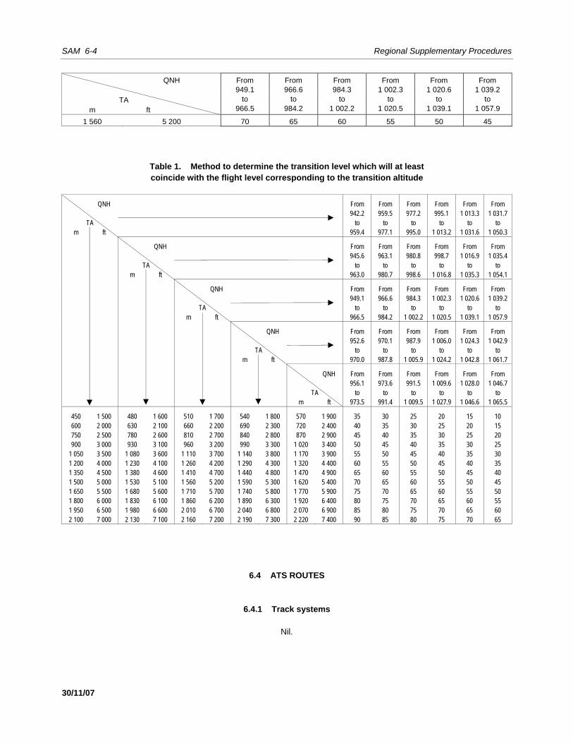
SAM 6-4 Regional Supplementary Procedures
30/11/07
QNH From 949.1
to 966.5
From 966.6
to 984.2
From 984.3
to 1 002.2
From 1 002.3
to 1 020.5
From 1 020.6
to 1 039.1
From 1 039.2
to 1 057.9
TA
m ft
1 560 5 200 70 65 60 55 50 45
Table 1. Method to determine the transition level which will at least coincide with the flight level corresponding to the transition altitude
QNH From From From From From From 942.2 959.5 977.2 995.1 1 013.3 1 031.7
TA to to to to to to m ft 959.4 977.1 995.0 1 013.2 1 031.6 1 050.3
QNH From From From From From From 945.6 963.1 980.8 998.7 1 016.9 1 035.4 TA to to to to to to m ft 963.0 980.7 998.6 1 016.8 1 035.3 1 054.1
QNH From From From From From From 949.1 966.6 984.3 1 002.3 1 020.6 1 039.2 TA to to to to to to m ft 966.5 984.2 1 002.2 1 020.5 1 039.1 1 057.9
QNH From From From From From From 952.6 970.1 987.9 1 006.0 1 024.3 1 042.9 TA to to to to to to m ft 970.0 987.8 1 005.9 1 024.2 1 042.8 1 061.7
QNH From From From From From From 956.1 973.6 991.5 1 009.6 1 028.0 1 046.7 TA to to to to to to m ft 973.5 991.4 1 009.5 1 027.9 1 046.6 1 065.5
450 1 500 480 1 600 510 1 700 540 1 800 570 1 900 35 30 25 20 15 10 600 2 000 630 2 100 660 2 200 690 2 300 720 2 400 40 35 30 25 20 15 750 2 500 780 2 600 810 2 700 840 2 800 870 2 900 45 40 35 30 25 20 900 3 000 930 3 100 960 3 200 990 3 300 1 020 3 400 50 45 40 35 30 25
1 050 3 500 1 080 3 600 1 110 3 700 1 140 3 800 1 170 3 900 55 50 45 40 35 30 1 200 4 000 1 230 4 100 1 260 4 200 1 290 4 300 1 320 4 400 60 55 50 45 40 35 1 350 4 500 1 380 4 600 1 410 4 700 1 440 4 800 1 470 4 900 65 60 55 50 45 40 1 500 5 000 1 530 5 100 1 560 5 200 1 590 5 300 1 620 5 400 70 65 60 55 50 45 1 650 5 500 1 680 5 600 1 710 5 700 1 740 5 800 1 770 5 900 75 70 65 60 55 50 1 800 6 000 1 830 6 100 1 860 6 200 1 890 6 300 1 920 6 400 80 75 70 65 60 55 1 950 6 500 1 980 6 600 2 010 6 700 2 040 6 800 2 070 6 900 85 80 75 70 65 60 2 100 7 000 2 130 7 100 2 160 7 200 2 190 7 300 2 220 7 400 90 85 80 75 70 65
6.4 ATS ROUTES
6.4.1 Track systems
Nil.
Regional Supplementary Procedures SAM 6-5
30/11/07
6.4.2 RNAV
Nil.
6.5 AERODROME OPERATIONS
6.5.1 Area of applicability
Nil.
6.5.2 Intersection take-off
Nil.
6.5.3 Multiple line-ups on the same runway
Nil.
6.5.4 Visual departures
Nil.
6.5.5 Visual approaches
Nil.
6.5.6 Advanced surface movement guidance and control systems (A-SMGCS)
Nil. 6.5.6.1 General Nil. 6.5.6.2 A-SMGCS functions Nil. 6.5.6.3 A-SMGCS alerts Nil.
25/8/09
No. 2
SAM 6-6 Regional Supplementary Procedures
30/11/07
6.5.6.4 A-SMGCS identification procedures Nil.
6.6 RNAV PROCEDURES
RNAV 10 (RNP 10) AND RNAV 5
6.6.1 General
6.6.1.1 Operation of the RNAV system Note 1.— The means of compliance with RNAV 10 (RNP 10) operational requirements are contained in 4.1.2.1.4. Note 2.— Functional check procedures prior to entering the RNAV 5 route are contained in 4.1.2.2.4.
6.6.2 En route
Note 1.— The aircraft separation minima applicable on routes designated as RNAV 10 (RNP 10) are contained in 4.1.2.1.1, 4.1.2.1.2 and 4.1.2.1.3. Note 2.— The functional check procedures and other considerations for RNAV 5 en-route navigation are included in 4.1.2.2.5, 4.1.2.2.6 and 4.1.2.2.7.
6.6.3 Terminal
Nil.
6.6.4 State aircraft
Note.— The conditions for RNAV 10 (RNP 10) and RNAV 5 operation of State aircraft and other aircraft exempt from RNAV approval are contained in 4.1.1.
6.7 RNP PROCEDURES
6.7.1 General
Nil.
6.7.2 En route
Nil.
22/7/11
No. 5
Regional Supplementary Procedures SAM 6-7
30/11/07
6.7.3 Terminal
Nil.
6.7.4 State aircraft
Nil.
6.8 COMPOSITE PROCEDURES
Nil.
6.9 MNPS PROCEDURES
Nil.
6.10 RVSM PROCEDURES
6.10.1 General 6.10.1.1 Operation of aircraft not approved for RVSM 6.10.1.1.1 Except for areas where transition areas have been established, aircraft not approved for RVSM operations in accordance with the requirements of 4.2.3 shall not be allowed to operate in CAR/SAM RVSM airspace and EUR/SAM RVSM airspace. 6.10.1.1.2 Exceptionally, aircraft that have not received RVSM State approval may be cleared to operate in airspace where RVSM may be applied in accordance with policy and procedures established by the State provided that 600 m (2 000 ft) vertical separation is applied. Note.— Transitions to and from RVSM levels will normally take place in the first FIR in CAR/SAM RVSM airspace and EUR/SAM RVSM airspace.
6.10.2 Transition to/from RVSM airspace (A2 – Appendix 3; A6, Parts I and II – Chapter 7; A11 – Chapter 3; P-ATM – Chapter 5)
6.10.2.1 In order to allow for the transition of flights to and from CAR/SAM and EUR/SAM RVSM airspace, the ATS authorities responsible for the FIRs concerned may establish designated RVSM transition areas. A 300 m (1 000 ft) vertical separation minimum can be applied between RVSM-approved aircraft within these transition areas. 6.10.2.2 An RVSM transition area shall have a vertical extent of FL 290 to FL 410 inclusive, be contained within horizontal dimensions determined by the provider States, be overlapping with or contained within CAR/SAM RVSM airspace and EUR/SAM RVSM airspace and should have direct controller-pilot communications.
22/7/11
No. 5
SAM 6-8 Regional Supplementary Procedures
30/11/07
6.11 ATS COORDINATION
6.11.1 Between units providing area control services
Nil.
6.11.2 RNAV (P-ATM – Chapter 11)
6.11.2.1 RNAV 10 (RNP 10) and RNAV 5 6.11.2.1.1 Aircraft experiencing RNAV system degradation or failure 6.11.2.1.1.1 When using a verbal coordination procedure, the sending ATS shall include the phrase “RNAV UNAVAILABLE” at the end of the message. 6.11.2.1.1.2 In the case of coordination through automated messages containing the information provided in Item 18 of the flight plan, the sending ATS unit shall verbally supplement the coordination message with the phrase “RNAV UNAVAILABLE” after the call sign of the corresponding aircraft. 6.11.2.1.2 State aircraft and other aircraft exempt from RNAV approval 6.11.2.1.2.1 When using a verbal coordination procedure, the sending ATS unit shall include the phrase “NEGATIVE RNAV” at the end of the message. 6.11.2.1.2.2 In the case of coordination through automated messages that do not contain the information provided in Item 18 of the flight plan, the sending ATS unit shall verbally supplement the coordination message with the phrase “NEGATIVE RNAV” after the call sign of the aircraft involved.
6.11.3 RNP
Nil.
6.11.4 RVSM
Nil.
6.11.5 SSR codes
Nil.
22/7/11
No. 5
Regional Supplementary Procedures SAM 6-9
30/11/07
6.12 ATS MESSAGES
6.12.1 Flight plan and departure (P-ATM – Chapter 11)
6.12.1.1 For coordination between ATS units providing air traffic control or air traffic advisory service, where direct speech communications exist, the “step-by-step” method shall be used to transmit information from the ATS unit at the aerodrome of origin to the point where the chain of direct speech communications can be established without interruption. 6.12.1.2 The ATS unit serving the aerodrome where the flight originated shall send a filed Flight Plan (FPL) message, followed by a departure message, to the ATS unit where the chain of direct speech communications is interrupted and also to the remaining ATS units along the route, in accordance with the procedures for the routing of messages contained in the PANS-ATM.
6.12.2 Arrival (P-ATM – Chapter 10)
6.12.2.1 No arrival message shall be sent in respect of an aircraft for which a transfer message has been sent and acknowledged.
6.12.3 Boundary estimates
Nil.
6.12.4 Computer-assisted coordination
Nil.
6.13 FLIGHT INFORMATION SERVICE (FIS)
6.13.1 Automatic terminal information services (ATIS)
Nil.
6.13.2 SIGMETs (P-ATM – Chapter 9)
6.13.2.1 Transmission of SIGMET information to aircraft shall be at the initiative of the appropriate ATS unit, by the preferred method of directed transmission followed by acknowledgement, or by a general call when the number of aircraft would render the preferred method impracticable. 6.13.2.2 SIGMET information passed to aircraft shall cover a portion of the route up to two hours’ flying time ahead of the aircraft.
22/7/11
No. 5
SAM 6-10 Regional Supplementary Procedures
30/11/07
6.13.3 Special air-reports
Nil.
6.13.4 Amended aerodrome forecasts (P-ATM – Chapter 9)
6.13.4.1 Amended aerodrome forecasts shall be passed to aircraft within 60 minutes from the aerodrome of destination, unless the information has been made available through other means.
6.13.5 Landing forecasts (A11 – Chapter 4)
6.13.5.1 The latest landing forecasts available to the ATS unit, provided it is no more than one hour old, shall always be transmitted to an aircraft, together with the latest report of routine or special observation, when the aircraft requests the latter information.
6.14 ALERTING SERVICE
Nil.
_____________________
22/7/11
No. 5
SAM 7-1 30/11/07
Chapter 7. SAFETY MONITORING
7.1 STRATEGIC LATERAL OFFSET PROCEDURES (SLOP)
Nil.
7.2 AIRSPACE MONITORING
7.2.1 General
Nil.
7.2.2 RNAV
7.2.2.1 A target level of safety (TLS) of 5 x 10⁻⁹ fatal accidents per flight hour per dimension shall be established for route systems operating a 93 km (50 NM) lateral separation minimum. The safety level of such airspace shall be determined by an appropriate safety assessment. Note.— Detailed guidance material on conducting safety assessments is contained in the Manual on Airspace Planning Methodology for the Determination of Separation Minima (Doc 9689). 7.2.2.2 The following criteria are used in the operational assessment of airspace system safety: a) the proportion of the total flight time spent by aircraft 46 km (25 NM) or more off the cleared track shall
be less than 7.0 × 10⁻⁴; and b) the proportion of the total flight time spent by aircraft between 74 and 110 km (40 and 60 NM) off the
cleared track shall be less than 4.1 × 10⁻⁵. 7.2.2.3 Adequate monitoring of flight operations shall be conducted to provide data to assist in the assessment of continuing compliance of aircraft with the lateral navigation performance capabilities of RNP 10 and 7.2.2.1. Such data shall include operational errors due to all causes. A safety assessment shall be carried out periodically, based on the data collected, to confirm that the safety level continues to be met. Note.— Detailed guidance on monitoring is contained in the Air Traffic Services Planning Manual (Doc 9426) and the Manual on Airspace Planning Methodology for the Determination of Separation Minima (Doc 9689).
7.2.3 RNP
Nil.
SAM 7-2 Regional Supplementary Procedures
30/11/07
7.2.4 RVSM 7.2.4.1 Target level of safety (TLS) 7.2.4.1.1 Application of RVSM in the airspace designated in 4.2.1 shall meet a TLS of 5 × 10⁻⁹ fatal accidents per aircraft flight hour due to all causes of risk in the vertical dimension. 7.2.4.1.2 Adequate monitoring of flight operations in the CAR/SAM RVSM airspace and EUR/SAM RVSM airspace shall be conducted to assist in the assessment of continuing compliance of aircraft with the height-keeping capabilities in 4.2.2. Monitoring shall include assessment of other sources of risk to ensure that the TLS specified in 7.2.4.1.1 is not exceeded. Note.— Details of the policy and procedures for monitoring established by the CAR/SAM Monitoring Agency (CARSAMMA) and South Atlantic Monitoring Agency (SATMA) are contained in the Guidance Material on the Implementation of a 300 m (1 000 ft) Vertical Separation Minimum (VSM) for Application in the CAR/SAM RVSM airspace and EUR/SAM RVSM airspace, respectively.
_____________________

SAM 8-1 30/11/07
Chapter 8. AIR TRAFFIC FLOW MANAGEMENT (ATFM)
8.1 PROVISION
Nil.
8.2 APPLICATION
Nil.
8.3 EXEMPTIONS FROM ATFM SLOT ALLOCATION
Nil.
8.4 DEPARTURE SLOT MONITORING
Nil.
8.5 PROMULGATION OF ATFM MEASURES
8.5.1 Strategic ATFM measures
Nil.
8.5.2 Amendments to promulgated strategic ATFM measures
Nil.
8.5.3 ATFM circulars and information
Nil.
8.5.4 Pre-flight information bulletin (PIB)
Nil.

SAM 8-2 Regional Supplementary Procedures
30/11/07
8.5.5 Query procedures
Nil.
_____________________
SAM 9-1 30/11/07
Chapter 9. SPECIAL PROCEDURES
9.1 EMERGENCY DESCENT PROCEDURES
9.1.1 Action by the pilot-in-command
Nil.
9.1.2 Action by the ATS unit
Nil.
9.2 CONTINGENCY PROCEDURES INCLUDING TURN-BACKS
Nil.
9.3 AIR-GROUND COMMUNICATION FAILURE
Nil.
9.4 DEGRADATION OR FAILURE OF THE RNAV SYSTEM
9.4.1 Action by the pilot-in-command
9.4.1.1 When an aircraft cannot meet the requirements, as required by the RNAV route, as a result of a failure or degradation of the RNAV system, a revised clearance shall be requested by the pilot.
9.4.2 Action by the ATS unit
9.4.2.1 Regarding in-flight degradation or failure of the RNAV system when the aircraft is on the RNAV 5 designated ATS route: a) the aircraft should be cleared to fly on the ATS VOR/DME routes; or b) if such routes are unavailable, the aircraft should be cleared to fly via conventional navigation aids, i.e.
VOR/DME; or c) when the aforementioned procedures are unavailable, the ATC unit should provide the aircraft,
whenever possible, with radar vectors until the aircraft can resume its own navigation.
22/7/11
No. 5
SAM 9-2 Regional Supplementary Procedures
30/11/07
Note.— Aircraft cleared according to a) or b) may require, whenever possible, radar tracking by the corresponding ATC unit. 9.4.2.2 Subsequent measures by the ATC with respect to an aircraft that cannot meet the RNAV requirements due to a failure or degradation of the RNAV system will depend on the nature of the reported failure and general traffic conditions. In many cases, an aircraft will be able to continue operating according to the current ATC clearance. When this is not possible, a revised clearance can be requested, as specified in 9.4.1.1, in order to return to VOR/DME navigation.
9.5 LOSS OF VERTICAL NAVIGATION PERFORMANCE REQUIRED FOR RVSM
9.5.1 General
Nil.
9.5.2 Degradation of aircraft equipment – pilot reported
Nil.
9.5.3 Severe turbulence – not forecast
Nil.
9.5.4 Severe turbulence – forecast
Nil.
9.6 EN-ROUTE DIVERSION
Nil.
9.7 INTER-REGION INTERFACE FOR NON-RVSM-APPROVED AIRCRAFT
Nil.
9.8 MANNED BALLOON FLIGHTS
Nil.
_____________________
22/7/11
No. 5
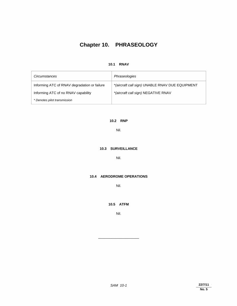
SAM 10-1 30/11/07
Chapter 10. PHRASEOLOGY
10.1 RNAV
Circumstances Phraseologies
Informing ATC of RNAV degradation or failure *(aircraft call sign) UNABLE RNAV DUE EQUIPMENT
Informing ATC of no RNAV capability *(aircraft call sign) NEGATIVE RNAV
* Denotes pilot transmission
10.2 RNP
Nil.
10.3 SURVEILLANCE
Nil.
10.4 AERODROME OPERATIONS
Nil.
10.5 ATFM
Nil.
_____________________
22/7/11
No. 5

SAM 11-1 30/11/07
Chapter 11. SEARCH AND RESCUE
11.1 INTERNATIONAL GENERAL AVIATION (IGA) (A6, Part II – Chapter 6; A6, Part III – Chapter 4)
11.1.1 General aviation aircraft operating over designated areas, land or sea, where search and rescue operations would be difficult, should: a) carry appropriate survival equipment; and b) follow the routes or specified procedures if not equipped with two-way radio, except that under special
circumstances, the appropriate authority may grant specific exemptions from this requirement.
_____________________


SAM 12-1 30/11/07
Chapter 12. METEOROLOGY
12.1 AIRCRAFT OBSERVATIONS AND REPORTS
Nil.
_____________________


SAM 13-1 30/11/07
Chapter 13. AERONAUTICAL INFORMATION SERVICES
13.1 NOTAM ADDRESSING AND DISTRIBUTION
Nil.
13.2 AERONAUTICAL CHART INFORMATION
13.2.1 Visual procedures
Nil.
— END —

�������
ICAO TECHNICAL PUBLICATIONS
The following summary gives the status, and alsodescribes in general terms the contents of the variousseries of technical publications issued by theInternational Civil Aviation Organization. It does notinclude specialized publications that do not fallspecifically within one of the series, such as theAeronautical Chart Catalogue or the MeteorologicalTables for International Air Navigation.
International Standards and RecommendedPractices are adopted by the Council in accordance withArticles 54, 37 and 90 of the Convention onInternational Civil Aviation and are designated, forconvenience, as Annexes to the Convention. Theuniform application by Contracting States of thespecifications contained in the International Standards isrecognized as necessary for the safety or regularity ofinternational air navigation while the uniformapplication of the specifications in the RecommendedPractices is regarded as desirable in the interest ofsafety, regularity or efficiency of international airnavigation. Knowledge of any differences between thenational regulations or practices of a State and thoseestablished by an International Standard is essential tothe safety or regularity of international air navigation. Inthe event of non-compliance with an InternationalStandard, a State has, in fact, an obligation, underArticle 38 of the Convention, to notify the Council ofany differences. Knowledge of differences fromRecommended Practices may also be important for thesafety of air navigation and, although the Conventiondoes not impose any obligation with regard thereto, theCouncil has invited Contracting States to notify suchdifferences in addition to those relating to InternationalStandards.
Procedures for Air Navigation Services (PANS)are approved by the Council for worldwide application.They contain, for the most part, operating proceduresregarded as not yet having attained a sufficient degree of
maturity for adoption as International Standards andRecommended Practices, as well as material of a morepermanent character which is considered too detailed forincorporation in an Annex, or is susceptible to frequentamendment, for which the processes of the Conventionwould be too cumbersome.
Regional Supplementary Procedures (SUPPS)have a status similar to that of PANS in that they areapproved by the Council, but only for application in therespective regions. They are prepared in consolidatedform, since certain of the procedures apply tooverlapping regions or are common to two or moreregions.
The following publications are prepared by authorityof the Secretary General in accordance with theprinciples and policies approved by the Council.
Technical Manuals provide guidance andinformation in amplification of the InternationalStandards, Recommended Practices and PANS, theimplementation of which they are designed to facilitate.
Air Navigation Plans detail requirements forfacilities and services for international air navigation inthe respective ICAO Air Navigation Regions. They areprepared on the authority of the Secretary General onthe basis of recommendations of regional air navigationmeetings and of the Council action thereon. The plansare amended periodically to reflect changes inrequirements and in the status of implementation of therecommended facilities and services.
ICAO Circulars make available specializedinformation of interest to Contracting States. Thisincludes studies on technical subjects.

© ICAO 20081/08, E/P1/1300
Order No. 7030Printed in ICAO