Embed Size (px)
Citation preview

Full Terms & Conditions of access and use can be found athttp://www.tandfonline.com/action/journalInformation?journalCode=cres20
Download by: [Inst of Geographical Sciences & Natural Resources Research] Date: 03 July 2017, At: 22:45
Regional Studies
ISSN: 0034-3404 (Print) 1360-0591 (Online) Journal homepage: http://www.tandfonline.com/loi/cres20
Regionalization in the Yangtze River Delta, China,from the perspective of inter-city daily mobility
Weiyang Zhang , Ben Derudder, Jianghao Wang & Wei Shen
To cite this article: Weiyang Zhang , Ben Derudder, Jianghao Wang & Wei Shen (2017):Regionalization in the Yangtze River Delta, China, from the perspective of inter-city daily mobility,Regional Studies, DOI: 10.1080/00343404.2017.1334878
To link to this article: http://dx.doi.org/10.1080/00343404.2017.1334878
View supplementary material
Published online: 29 Jun 2017.
Submit your article to this journal
Article views: 39
View related articles
View Crossmark data

Regionalization in the Yangtze River Delta, China, from theperspective of inter-city daily mobilityWeiyang Zhanga , Ben Derudderb, Jianghao Wangc and Wei Shend
ABSTRACTRegionalization in the Yangtze River Delta, China, from the perspective of inter-city daily mobility. Regional Studies. Thispaper applies a community detection algorithm to the Yangtze River Delta’s (YRD) daily inter-city mobility network toproduce an interaction-based regionalization, and then explores the processes underlying this regional (re-)productionby comparing it with attribute-based regionalization. The results show that political boundaries and historical patternsof socio-economic integration are strikingly visible, and the effects of overlapping physical, economic, cultural andadministrative spaces on regional integration are apparent. The authors conclude that both notions of ‘territory’ and‘network’ come together as the YRD region is spatially configured, while ‘regional path dependence’ also seems to berelevant for understanding its relational formation.
KEYWORDSregional geography; regionalization; urban interaction; human movements; community detection; network analysis; Yangtze River Delta
摘要
基于城际日常流动视角的中国长江三角洲区划研究。Regional Studies. 本文通过将社区探测技术应用至长三角 (YRD)城际日常流动网络,进行了基于城际联系的区划,并通过与基于属性的区划方案进行对比,探索此一区域的 (再) 形
成过程。研究结果发现,政治边界和社会经济整合的历史形成显而易见,且自然、经济、文化和行政空间对区域融
合起到显著的叠加作用。本研究于结论中主张,“领域”和“网络”共同作用于长三角区域的空间组织,且“区域路径依
赖”也似乎适用于理解区域的关系构造。
关键词
区域地理; 区划; 城际互动; 人口移动; 社区探测; 网络分析; 长江三角洲
RÉSUMÉLa régionalisation dans le delta du Yangtze, en Chine, du point de vue de la mobilité quotidienne interville. Regional Studies.Cet article applique un algorithme de détection de la structure communautaire au réseau de la mobilité quotidienneinterville dans le delta du Yangtze pour élaborer une régionalisation fondée sur l’interaction, et il s’ensuit un examendes processus sous-jacents de cette (re-)construction régionale en la comparant à la régionalisation fondée sur lesattributs. Les résultats laissent voir que les frontières politiques et l’évolution historique de l’intégrationsocioéconomique sont tout à fait évidentes, et que l’impact des zones de chevauchement physiques, économiques,culturelles et administratives sur l’intégration est plus marqué. Les auteurs concluent que les notions de ‘territoire’ et de‘réseau’ se réunissent parce que le delta du Yangtze est configuré sur le plan spatial, alors que la notion de‘dépendance du sentier’ à l’échelle régionale semble aussi aider à comprendre sa formation relationnelle.
© 2017 Regional Studies Association
CONTACTa [email protected] of Geography, Ghent University, Ghent, Belgium.b [email protected] of Geography, Ghent University, Ghent, Belgium.c (Corresponding author) [email protected] Key Laboratory of Resources and Environmental Information System, Institute of Geographic Sciences & Natural Resources Research, ChineseAcademy of Sciences, Beijing, China.d [email protected] Institute, Lancaster University, Lancaster, UK; and EU-Asia Institute, ESSCA School of Management, Angers, France.
REGIONAL STUDIES, 2017https://doi.org/10.1080/00343404.2017.1334878
MOTS-CLÉSgéographie régionale; régionalisation; interaction urbaine; mobilité humaine; détection de la structure communautaire; analyse desréseaux; delta du Yangtze
ZUSAMMENFASSUNGRegionalisierung im chinesischen Yangtze-Delta aus der Perspektive der täglichen interurbanen Mobilität. Regional Studies.In diesem Beitrag erzeugen wir durch Anwendung eines Gemeinschaftserkennungs-Algorithmus auf das täglicheinterurbane Mobilitätsnetzwerk im Yangtze-Delta eine auf Wechselwirkungen basierende Regionalisierung unduntersuchen durch einen Vergleich mit der attributbasierten Regionalisierung die dieser regionalen (Re)produktionzugrundeliegenden Prozesse. Die Ergebnisse zeugen von frappierend sichtbaren politischen Grenzen und historischenAbläufen der sozioökonomischen Integration sowie von deutlichen Auswirkungen von sich überschneidendenphysischen, wirtschaftlichen, kulturellen und administrativen Räumen auf die regionale Integration. Wir ziehen denSchluss, dass sich die Begriffe des ‘Gebiets’ und ‘Netzwerks’ bei der räumlichen Konfiguration der Yangtze-Delta-Regionmiteinander verbinden, während die ‘regionale Pfadabhängigkeit’ ebenfalls für ein Verständnis ihrer relationalen Bildungrelevant zu sein scheint.
SCHLÜSSELWÖRTERRegionalgeografie; Regionalisierung; Wechselwirkungen zwischen Städten; menschliche Bewegungen; Gemeinschaftserkennung;Netzwerkanalyse; Yangtze-Delta
RESUMENRegionalización en el delta del río Yangtsé, China, desde la perspectiva de la movilidad interurbana diaria. Regional Studies.Mediante un algoritmo de detección comunitaria para la red de movilidad interurbana diaria en el delta del río Yangtsé, eneste artículo producimos una regionalización basada en la interacción, y luego analizamos los procesos que subyacen enesta (re)producción regional comparándola con la regionalización basada en atributos. Los resultados muestran que lasfronteras políticas y los patrones históricos de la integración socioeconómica son sorprendentemente visibles y que losefectos del solapamiento de espacios físicos, culturales y administrativos en la integración regional son evidentes.Concluimos que ambas nociones de ‘territorio’ y ‘red’ van de la mano, dado que la región en el delta del río Yangtséestá configurada espacialmente, mientras que la ‘dependencia de la ruta regional’ también parece ser relevante paraentender su formación relacional.
PALABRAS CLAVESgeografía regional; regionalización; interacción urbana; movimientos humanos; detección comunitaria; análisis de redes; delta del ríoYangtsé
JEL O18, R1, R58HISTORY Received 7 October 2016; in revised form 18 May 2017
INTRODUCTION
In the literature on mega-city-regions (Hall & Pain, 2006)or their near analogues such as global city-regions (Scott,2001) and polycentric metropolises (Kloosterman & Mus-terd, 2001), the development of China’s mega-city-regionshas attracted increasing attention (Li & Phelps, 2016; Liu,Derudder, & Wang, 2017; Liu, Derudder, & Wu, 2016;Vogel et al., 2010; Xu & Yeh, 2010; Zhang & Klooster-man, 2016). One basic characteristic of China’s mega-city-regions is their considerable geographical extent. Forexample, the Yangtze River Delta (YRD) – an archetypalmega-city-region in China – is substantially larger thanits ostensible counterparts in other parts of the world,such as the South East of England and the Dutch Rand-stad. According to the geographic delineation adopted inthe YRD Urban Agglomeration Development Plan(YUADP), as implemented by the National Developmentand Reform Commission, the region covers an area of
211,700 km2, which is comparable in size with the UKas a whole. Within such a large territorial framework, theregional diversification of physical, economic, cultural andadministrative spaces becomes obvious. The YRD spansplains, basins and mountains; includes multiple economicalliances designated by multilevel governments; stretchesacross different cultural areas; and consists of four provin-cial-level political spaces. To date, relatively little attentionhas been paid to this regionalization within China’s mega-city-regions. In this paper, we seek to address this researchlacuna by examining regionalization within the YRD.
Regionalization research has long relied on attribute-based approaches, whereby homogeneous regions havebeen delineated based on geophysical, economic, socio-cul-tural or political commonalities. However, it has beenrecognized that such attribute-based regionalization andtheir absolute boundaries can be supplemented or replacedby interaction-based regionalization in which territories aredeemed ‘unbound’ (cf. Amin, 2004). The key point
2 Weiyang Zhang et al.
REGIONAL STUDIES

supporting this argument is that regional delineations gen-erated through an attribute-based approach may fail toreveal how the territorial coherence of regions is (re)cre-ated: a ‘region’ is above all (re)produced through processesof spatially interconnected socio-economic activity. Morespecifically, this approach recognizes that regions shouldnot reflect preconceived frameworks that may or may notreflect activity and flows within and across a given regionalspace. Rather, such frameworks are at best a heuristicdevice that captures a significant part of the geography ofinterconnected socio-economic activity (Pred, 1984;Söderbaum & Taylor, 2008). Following this rationale,this paper attempts to understand the YRD’s regionalorganization by describing an interaction-based regionali-zation based on patterns of actual daily mobility and dis-cussing how such patterns relate to possible attribute-based regionalization.
This objective is achieved in two consecutive steps.First, we ‘regionalize’ by analysing network formation inthe YRD from the perspective of the density of inter-cityinteraction. The ‘network turn’ (cf. Ducruet & Beauguitte,2014) in urban research has stimulated research that is use-ful for creating such ‘interaction-based’ regions. Forinstance, Taylor, Derudder, Hoyler, and Ni (2013) recentlypresented a specific regional geography of globalizationbased on the uncovering of regionalized location strategiesof leading advanced producer service firms. In our research,we apply a community1 detection approach to divide theYRD into sub-regions in which cities are more closely con-nected to one another. The information on inter-citymobility is derived from Weibo, a major Chinese onlinesocial networking and micro-blogging service. BecauseWeibo users can ‘geo-tag’ their movements, Weibo hasthe potential to link social practices to inter-city engage-ments (Zhang, Derudder, Wang, Shen, & Witlox,2016). Second, this interaction-based regionalization iscompared with physical–economic–cultural–administrative(PECA) regionalization. In this way, the link between thisinteraction-based regionalization and territorial regionalformation can be investigated.
This paper also has a second objective. Through pri-marily empirical research, we seek to contribute to the con-ceptual debate on the coexistence of ‘networks’ and‘territories’ in the (re)productions of regions. The debateon whether a region is ‘territorially embedded’ or ‘relationaland unbound’ has been addressed from a range of social andeconomic–geographical perspectives (e.g., Giddens, 1984;Gilbert, 1988; Thrift, 1983). Although it has been recog-nized that ‘territorialization’ and ‘networking’ combine asa ‘regional world’ that is (re)configured (Harrison, 2013;Hudson, 2007; Jessop, Brenner, & Jones, 2008), there isrelatively little empirical research that attempts to confrontthe approaches. Therefore, this paper can also be viewed asan empirical investigation of how the approaches interact.
The paper is structured as follows. The next sectionprovides a general discussion of the PECA regionalizationof the YRD. It is followed by a section in which we intro-duce our data and methods. The subsequent results sectionis presented in three parts: a discussion of the interaction-
based regionalization, the comparison of such regionaliza-tion with PECA regionalization, and a discussion on thesimilarities and differences between the two. The paperconcludes with an overview of its major findings, policyimplications and suggestion for avenues of future research.
DIVISION OF THE YANGTZE RIVERDELTA’S REGIONAL SPACES
In this section, we present the territorial PECA regionali-zation of the YRD. Territories have long been understoodas bounded and fixed spaces that have some type of intra-territorial coherence. This coherence can have geophysical,economic, socio-cultural and political characteristics. Incontrast, ‘network’ indicates interconnected socio-econ-omic practices, which reflects an understanding of regionsas unbound, fluid and relational. Although territory andnetwork seem to be rival ideas of spatial organization,there is increasing support for the argument that theyshould not be viewed as incommensurable but as intercon-nected and concurrent (Harrison, 2013; Jones, 2009;Macleod & Jones, 2007; Painter, 2010). As Painter(2010, p. 1090) notes, ‘territory can be seen as itself a pro-duct of relational networks’. For instance, a ‘cultural region’can be understood as the outcome of historical intercon-nections of culture-related social practices, such aslanguage. From this standpoint, we introduce the territorialdivision of the YRD in line with the ‘economic, cultural,environmental and political projects’ proposed by Jonasand Ward (2007, p. 176): (1) hierarchical administrativedivisions, (2) uneven landform patterns, (3) language-based cultural disparities and (4) emerging regional (econ-omic) alliances (created by multiple central state-ledregional plans).
In our study, the YRD is understood to include Jiangsu,Zhejiang and Anhui provinces and the municipality ofShanghai. It consists of 89 statutory cities: one municipal-ity-level city, 40 prefecture-level cities and 48 county-levelcities (Figure 1(a); for city codes used in the figures, seeAppendix A in the supplemental data online).2 The regionis arguably one of China’s main economic engines.Although it only occupies 3.6% of the nation’s total landresources and is home to 16.6% of the population, theregion generated 23.5% of the national gross domestic pro-duct (GDP), 23.9% of the national fiscal revenue, andreceived 41% of China’s inward foreign investment in2014.
Administrative regionsAdministrative barriers may play a crucial role in regional(re-)production through regulating fixed spatial configur-ations and territorial assets, such as infrastructure (Zhang& Wu, 2006). Since the economic reforms started in1978, China has adopted a series of decentralization policiesthat empower local states in the distribution of administra-tive and economic powers with the central government.The emerging ‘entrepreneurial local states’ (Wu, 2002)epitomize this transformation of the governance system.That is, local governments have strong incentives to shield
Regionalization in the Yangtze River Delta, China 3
REGIONAL STUDIES
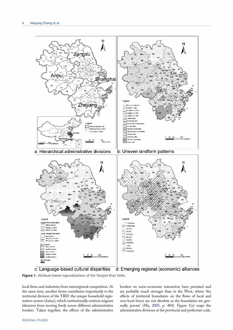
local firms and industries from interregional competition. Atthe same time, another factor contributes importantly to theterritorial division of the YRD: the unique household regis-tration system (hukou), which institutionally restricts migrantlabourers from moving freely across different administrativeborders. Taken together, the effects of the administrative
borders on socio-economic interaction have persisted andare probably much stronger than in the West, where ‘theeffects of territorial boundaries on the flows of local andnon-local forces are not absolute as the boundaries are gen-erally porous’ (Ma, 2005, p. 484). Figure 1(a) maps theadministrative divisions at the provincial and prefecture scale.
Figure 1. Attribute-based regionalizations of the Yangtze River Delta.
4 Weiyang Zhang et al.
REGIONAL STUDIES

Uneven landform regionsRegional identity has often been affected by physicalboundaries. Prior to the Industrial Revolution, physicalconditions profoundly restrained people’s movements andrelated socio-economic activities. Thus, the geographicalenvironment often shaped inter-city interaction. Industri-alization has resulted in a substantial shift in mobility andaccessibility through the rapid construction of large-scaletransportation infrastructures. Additionally, the develop-ment of information technology has reduced the constraintof physical space and distance. However, physical bound-aries may still act as a significant complement to socialand economic interactions, particularly those that involvephysical flows at a regional scale. For instance, the North-east Zhejiang Plain Region within the YRD has been wellconnected with other cities within northern China througha network of rivers and canals since the Sui dynasty (581–618 CE), and this network has been considered one impor-tant reason for its contemporary prosperity (Lin, 1992).Landform patterns are adopted in this paper as a majorcomponent of the physical environment. Figure 1(b) pre-sents a regionalization based on 15 landform regions.3
The regionalization is based on the landform partitionsin the ‘major function-oriented zone planning’ (a mainspatial planning system in China) of Anhui and Jiangsuprovinces and the self-description of Zhejiang province atits governmental website.
Language-based regionsLinguistic affinities may also consolidate socio-spatial seg-regations and agglomerations (Wu, Wang, & Dai, 2016)and thus could play an important role in the (re)productionof regions. In the Chinese context, although MandarinChinese (Putonghua) is the official language, significantlydifferent dialects and local languages exist, among whichCantonese is a well-known representative. These dialectswere historically associated with administrative regionsduring imperial times. However, they have also been essen-tial for China’s contemporary socio-economic interaction.A typical example is how the distinct Oujiang dialect inWenzhou facilitates the formation of the ‘thick’ local insti-tutions of that region’s business networks (Wei, Li, &Wang, 2007). Figure 1(c) maps the YRD’s dialect zonesto show the language-based cultural disparities, wherebyfour dialect zones and 12 sub-dialect zones are delineated.The original data are from the 2012 Atlas of Chinese Dia-lects, which documents the results of the comprehensivelanguage survey organized by the Chinese Academy ofSocial Science (Xiong & Zhang, 2012). Generally, the dia-lect patterns within the YRD are diverse, and the Taihudialect zone is broadly in line with the YRD’s core region.
Emerging regional (economic) alliancesAnother product of China’s economic/administrativerestructuring is the emergence of inter-city cooperation inresponse to interregional friction. The increasing regional(economic) alliances manifest themselves through themushrooming regional plans, formal/informal regional
cooperation and large-scale administrative annexation (Li& Wu, 2013; Ma, 2005). An obvious example is the pro-liferation of multiple central state-led regional plans(CSLRPs; for CSLRP codes, see Appendix A in the sup-plemental data online) through which the central govern-ment has reasserted its power in regional governance(Chen, Zhang, Li, & Zhang, 2014). Local governmentsaspire to be designated an ‘urban region’ to pursue theireconomic interests and showcase their strategic importance(Liu et al., 2016; Wu & Zhang, 2007). As a consequence,the YRD’s spatial organization seems to have been restruc-tured into a fragmented, overlapping combination of aseries of regional alliances (Chen, Song, & Yang, 2013).In our research, we map the emerging urban regions desig-nated by CSLRPs as our sample of these regional allianceswithin the YRD. Figure 1(d) maps the CSLRPs that covermore than one YRD city promulgated since 2010.4 Themultiple overlaps of the CSLRPs are notable. For instance,Nanjing is included in three CSLRPs, i.e., PSMDA (Planfor Sunan Modernization Demonstration Area), RPNM(Regional Plan for Nanjing Metropolitan) and RPYRD(Regional Plan for the Yangtze River Delta), whichindicates its close cooperation with Southern Jiangsu, theNanjing city-circle and the core region of the YRD (i.e.,Jiangsu and Zhejiang provinces and the municipality ofShanghai), respectively.
DATA AND METHODS
Deriving human mobility information fromWeiboIn this section we describe the Weibo data we use and testtheir validity in the context of our research. Weibo, whichmeans ‘microblog’ in Chinese, can best be described as ahybrid of Twitter and Facebook. Its users are allowed topost short texts that express impressions, information anddaily activity. They can also share their location througha ‘geo-tagged’ service. A geo-tagged post contains infor-mation on where and when the user posted the message.Thus, a user who multi-tags information in different citieshas the potential to reflect his/her inter-city mobility. In aprevious study (Zhang et al., 2016), the potential of Weibodata for analysing inter-city geographical patterns was ver-ified. Here, we focus on the data required for this particularstudy and an approach for generating day-to-day inter-citymovements from geo-tagged records.
Weibo provides a public application–programminginterface (API) for application developers to search anddownload messages. In our study, the API was used togather the geo-tagged records submitted within the YRDbetween January 2014 and November 2014. The datasetcontains 53.52 million geo-tagged records, which is6.05% of all Weibo records submitted in the same regionand period. These geo-tagged records were posted by7.03 million users, which is 32.89% of the monthly activeusers registered in this region5 and 3.09% of the overallregional population. These records provide informationon post content as well as spatial (geographic coordinates)and temporal information associated with the post.
Regionalization in the Yangtze River Delta, China 5
REGIONAL STUDIES

Following Llorente, Garcia-Herranz, Cebrian, and Moro’sprocedure (2015) for generating Twitter users’ inter-citytravel, this paper assumes that a trip has occurred if theuser has successively posted geo-tagged records in twocities within two successive days. The reason to apply twosuccessive days as a time restriction is based on a coupleof considerations: (1) the two-day duration ensures thatWeibo users can travel between the city pair with the great-est distance – the maximum trip time is more than 10 hours– and have sufficient time to post geo-tagged records; while(2) adopting a longer time interval would reduce thereliability of deriving inter-city direct movements from suc-cessively posted records. Based on a hypothetical examplein which a user posts seven geo-tagged messages in sixcities within May, Figure 2 shows how the inter-city mobi-lity network is constructed. The resulting dataset includesmore than 0.78 million records of inter-city trips amongthe 89 statutory cities, which is 38.32% of all generatedmobility records that consist of inter- and inner-city trips.
Our geo-tagged Weibo posts only represent a sample ofall Weibo records, and Weibo users only represent a sampleof the overall population. To test the representativeness ofWeibo records, we first check the demographic composition
ofWeibo users in terms of gender and age. Given the concernof personal privacy, our data do not contain users’ socio-econ-omic characteristics.We refer to theWeibo users annual stat-istic report issued by Sina Corp, which shows that Weibousers are predominantly found among younger groups (thegroup aged between 17 and 33 occupies 83% of total users)and the gender proportion is balanced. However, our studyassesses the overall formation of human movements at anaggregate level, and we see no reason why this bias towardsyouth groups will result in a meaningful regional bias. Recentstudies have suggested that social media sampling is suitablefor representing aggregated human activity, particularly incases in which individual human mobility data are sparse inChina and many other countries (Mayer-Schönberger &Cukier, 2013;Wu et al., 2016). However, in order to empha-size further the validity of the Weibo data, we investigate thespatial representativeness of Weibo sampling using popu-lation distribution data from the Statistical Yearbooks ofShanghai, Jiangsu, Zhejiang and Anhui provinces (2014) asa benchmark. Figure 3 shows high correlations betweeneach city’s population and its geo-tagged Weibo users aswell as geo-tagged Weibo records, with correlation coeffi-cients of 0.94 and 0.95 (*p < 0.001), respectively.
Figure 2. Definition of inter-city trips based on Weibo users’ geo-tagged records.
Figure 3. Correlations between cities’ population, their number of geo-tagged Weibo users and the number of geo-taggedWeibo records.Note: We normalized these variables using a log transformation to alleviate the skewness in their distributions. The grey area sur-rounding the solid line shows the 95% confidence interval.
6 Weiyang Zhang et al.
REGIONAL STUDIES

Regionalization based on inter-city humanmovementsThe purpose of this section is to divide the YRD into smallersub-regions in which cities are more strongly connected toone another. The community detection approach in networkscience, which is used to partition a network into clusterswith stronger connections, is a useful tool to achieve thisregionalization. This paper employs the community detec-tion approach known as the fast greedy method (Clauset,Newman, & Moore, 2004). The method is a hierarchicalagglomeration technique that operates by optimizing New-man–Girvan modularity (Girvan & Newman, 2002).6
Because many networks are characterized by hierarchicallynested structures, this method facilitates identifying thesenested communities using stepwise detections. In thisresearch, the community detection procedure was performedon the R statistical platform using the igraph package (Csardi& Nepusz, 2006). Four communities were detected at thefirst detection (see the results section). However, the fourgenerated communities seem to fail to reveal the fragmentedspace of the YRD at a smaller scale (for instance, the YRDconsists of 12 dialect zones, 15 landform pattern zones and11 CSLRP zones). To address this issue, we further detectedthe (sub-)communities within the first-step communities.Thus, the resulting regionalization is a two-tier partition.
Comparing interaction- and attribute-basedregionalizationsComparing two regionalization can be achieved through anassessment of the probability that a pair of cities in the samegroup in a regionalization setup also belong to the samegroup in the other regionalization. To this end, we proposethe following criterion for assessing this probability:
F (P, P ′) = N1
NP(1)
where F (P, P ′) represents the correlation index betweenthe attribute-based regionalization (P) and the inter-action-based regionalization (P ′); N1 represents the num-ber of city pairs in the same group under both P and P ′;andNP represents the number of city pairs within the com-munities under P. This criterion awards a value of 0 for twocompletely unrelated partitions. However, the maximumpossible value of F (P, P ′) is dependent on the possiblemaximum of N1. If the possible maximum of N1 is smallerthan NP, the possible maximum of F (P, P ′) is less than1. To facilitate our comparisons, we therefore report nor-malized values of F (P, P ′) in such a way that the valuesare in the range [0, 1], where 0 indicates absolutely unre-lated and 1 indicates perfect correlation. The normalizationis given by the following:
F ′(P, P ′) = F (P, P ′)Fmax(P, P
′)(2)
Fmax(P, P′) = Min(NP, NP ′)
NP(3)
where F ′(P, P ′) represents the normalized correlationindex; Fmax(P, P
′) represents the possible maximum of
F (P , P ′); NP ′ represents the number of city pairs withinthe groups under P ′; and Min (NP, NP ′) represents theminimum of NP and NP ′. Applying formulas (1) to (3)allows for a comparison of the interaction-based regionali-zation with the various PECA regionalization to be made.
Benchmarking the intra-connectivity of sub-regionsFinally, to understand further the relationship betweeninteraction-based regionalization and the PECA regions,we benchmark the intra-regional connectivity of the puta-tive sub-regions in the attribute-based regionalizationusing a two-step approach.
First, we calculate the dominance index of the intra-connectivity (DI ) of each sub-region. This index is formu-lated as the ratio between the average strength of the inter-city connections within the sub-region and the averagestrength of the outward connections of the involved cities:
DI = Intra-connectivity
Extra-connectivity(4)
Second, we benchmark the dominance index of the intra-connectivity of each sub-region against the average domi-nance of the intra-connectivity of the sub-regions of theinteraction-based regionalization:
DI ′ = DI∑J
j=1
DI j
J
(5)
where DI ′ is the benchmarked intra-connectivity; and DI jis the dominance index of the intra-connectivity of sub-region j in the interaction-based regionalization. A value> 1 indicates that the degree of regional integration ofthe sub-region is stronger than the average integrationscenario of the interaction-based regionalization, while avalue < 1 indicates that the degree of the regional inte-gration of the sub-region is less than the average inte-gration scenario of the interaction-based regionalization.
RESULTS
The YRD’s regionalization: spatial adjacency andexpected patternsThis section reports the general patterns of the interaction-based regionalization. Figure 4 maps the two-tiered regio-nalization of the YRD. The first step in the detection pro-duces four sub-regions, which are simply termed thecentral, northern, western and southern sub-regions forreasons of clarity. The iterative detection for these sub-regions produces 14 second-tier sub-regions, which arelabelled according to their major cities (i.e., prefecture-level cities). The average modularity of these partitions( �M ¼ 0.31) is indicative of the strong cluster structuresin the resulting sub-regions (Newman, 2006).7 The robust-ness of this result is tested by comparing the outcomesobtained using the Walktrap and MultiLevel algorithms.The outcomes show that the communities obtained from
Regionalization in the Yangtze River Delta, China 7
REGIONAL STUDIES

the different methods are highly similar (see Appendix B inthe supplemental data online).
Two initial observations can be made based on theregionalization. First, the cities within the same commu-nities are perfectly spatially adjacent. If one bears in mindthat the generated partition is based on the network’s top-ology rather than considering the spatial attributes of cities,the complete spatial adjacency within all communities
provides convincing evidence for the fundamental effectof distance and spatial adjacency on inter-city connectionsalthough the nature of the geographical patterns is of coursethat neighbouring territorial units have closer connections(cf. Tobler, 1970).
Second, the overall pattern is unsurprising. Except forthe central sub-region, the territories of the first-tier sub-regions are generally in accordance with provincial borders,
Figure 4. Interaction-based regionalization of the Yangtze River Delta.
8 Weiyang Zhang et al.
REGIONAL STUDIES

while the second-tier sub-regions also correspond topre-existing, integrated socio-economic clusters. Forinstance, the Nanjing–Zhenjiang–Yangzhou cluster, whichwas established by local governments over 10 years agoand is now an integrated city cluster (Ning-Zhen-Yang Tong-chenghua in Chinese), is clearly indicated. The Oujiang dia-lect zone, where non-natives are barely able to understandthe local language because of its tonal complexity, standsout as an individual community. In addition, theHuanghuaiPlain, where cities share a similar Han cultural backgroundand industrial structure and have suffered the same historicalcatastrophes, such as repeated massive Yellow River floodsand avulsions (which strengthened the emotional affinityand self-identification of the region’s inhabitants; Zhou,1993), is reproduced in this regionalization. However, towhat extent is the proposed regionalization systematicallyin line with the PECA partitions? The next section presentsa quantitative analysis of this question.
Comparing different regionalizationTable 1 summarizes the correlation indices between theinteraction-based regionalization and the differentPECA regionalization. Generally, the four PECA regio-nalization exhibit obvious correlations with the pattern ofinter-city connections that are reflected in the inter-action-based regionalization (with correlation indicesover 0.45, meaning that over 45% of the city pairs arein the same group under two partitions). Most notably,administrative boundaries have the strongest influenceon inter-city connections, with a correlation index ofover 90%. In addition, these correlations vary across thesub-regional tier. For instance, CSLRPs have a closerconnection to the first-tier communities (with a corre-lation index of 0.84), while the connection strength lar-gely decreases with the second-tier communities (with acorrelation index of 0.48). Thus, the effects of thePECA spaces on regional integration should be separ-ately discussed at different scales. The correlation indicesare the evidential basis on which the majority of analysesare based in the following section.
Parallels and differences with the PECAregionalizationThis section identifies the main similarities and differencesbetween the interaction-based regionalization and thePECA regionalization by assessing (1) ‘cross-(administra-tive) border cities’, (2) the intra-connectivity of landformregions, (3) the intra-connectivity of dialect regions and(4) the intra-connectivity of the urban regions designatedby the CSLRPs.
Cross-(administrative) border citiesThe cross-(administrative) border cities are singled outusing the following criteria: if a city and more than halfof the cities within the same community belong to differentprovinces, the city is defined as a cross-provincial bordercity; if a county-level city and its superordinate prefec-ture-level city belong to different communities, thecounty-level city is defined as a cross-prefecture bordercity. Figure 5 maps these cities.
The first observation is that the central sub-region inthe generated regionalization, which consists of the keycities that surround Shanghai, results in most of the pro-vincial border-crossing cities being located within theJiangsu and Zhejiang provinces. It also creates the cross-prefecture borders for Jiangyin, Zhangjiagang and Yixing,which belong to the Suzhou and Wuxi prefecture citieswith respect to administrative relationships but are notplaced in the central sub-region. This ‘prefecture-borderbreaking’ can be attributed to two factors. On the onehand, without exception, these three cities are the mosteconomically successful county-level cities in China.Their outstanding economic performance has enabledthem to accumulate greater financial power and adminis-trative competency and thus decreased their dependenceon their superordinate prefecture-level governments. Onthe other hand, these cities are a long commuting distancefrom Shanghai (over two hours by car) and lack directhigh-speed railway connections. Their counterparts inthis region, such as Taicang and Kunshan, are locatedwithin commuting distance of Shanghai and attractmany Shanghai workers who wish to reside in the area.Therefore, these cities are tightly grouped, as can beobserved in the generated regionalization. Second, Tian-chang breaks both the provincial and prefecture borders.Its ‘border breaking’ can be understood from two perspec-tives. On the one hand, geographically, Tianchang – nick-named ‘the eastern door of the Anhui province’ – is deeplyembedded in the territory of Jiangsu province. Morespecifically, it is closer to Yangzhou – the adjacent prefec-ture-level city in Jiangsu province – than to its superordi-nate prefecture-level city, Chuzhou. On the other hand,historically, Tianchang was part of Yangzhou for a longperiod during the Tangsong dynasty (618–1279 CE).During that period, the dialect of Tianchang and Yangz-hou formed. The combination of the spatial and historicalfactors as well as the more advanced economy of Yangz-hou has resulted in closer connections between Tianchangand Yangzhou. Third, the ‘border breaking’ of Chaohu
Table 1. Correlation indices between the interaction- andattribute-based regionalizations.
Attribute-basedregionalization
Interaction-basedregionalization
First-tiercommunities
Second-tiercommunities
Provincial territories 0.90 0.96
Prefecture-level
territories
0.91 0.90
Dialect zones 0.56 0.75
Sub-dialect zones 0.45 0.63
Landform zones 0.70 0.52
Central state-led
regional planning
territories
0.84 0.48
Regionalization in the Yangtze River Delta, China 9
REGIONAL STUDIES

can be attributed to the administrative adjustmentimplemented by the Anhui province government. In2011, the original prefecture-level city of Chaohu wassplit into three parts. One part (Juchao district) wasrenamed (new) Chaohu and was merged into Hefei Cityas a county-level city. That is, the current Chaohu is arti-ficially designated as part of Hefei. Its ‘border breaking’,which appears in the generated regionalization, is thusthe product of administrative annexation.
Restrictions of landforms on inter-city connectionsTable 2 presents the benchmarked intra-connectivity forthe 15 landform regions. The main point to make here isthat the plains and basins have stronger intra-connectionsthan the regions dominated by hills and mountains. In par-ticular, the Sunan Plain and the Southeast Coastal Plainhave even stronger intra-connections than the average inte-gration level of the generated sub-regions. It is important toremember that intra-connectivity is a relative measure,
Figure 5. Cross(-administrative) border cities within the Yangtze River Delta.
10 Weiyang Zhang et al.
REGIONAL STUDIES

which is benchmarked by comparing it with the outwardconnectivity of the involved cities. Thus, the measureimplies that plains and basins have more intra-connectionsthan outward connections, while hilly and mountainousareas have more outward connections than intra-connec-tions. In addition to the fact that plains/basins have rela-tively denser transport networks and the hills/mountainshaving relatively sparser networks, hilly and mountainousareas tend to have more connections with external cities,which help them to access larger markets and economicentities. However, the Zhenan Mountain region, inwhich Longquan and Lishui are located, is a major excep-tion and has stronger intra-connectivity, which is the resultof the strong administrative relationship between the cities.
Restrictions of dialects on inter-city connectionsTable 3 presents the benchmarked intra-connectivity forfour dialect regions and 10 sub-dialect regions. It can beobserved that the sub-dialect regions have more intra-con-nectivity than the dialect regions. At the scale of the dialectregions, the Central Plains Mandarin and Wu Chineseregions are the two most intra-connected regions. Thehigh integration of the two dialect regions can be attributedto their unique geographic and economic positions in theYRD. The Central Plains Mandarin region, which islocated at the YRD’s northern edge, has closer connectionsto the Central Plains region in terms of culture and
economy than with the other parts of the YRD. Addition-ally, the Wu Chinese region is indisputably the spatial andeconomic core region with closer inter-city connections(the YRD was once viewed as equal to the Wu Chineseregion in history, although the geographical scope of theYRD has largely extended beyond that geographic scopeof the Wu Chinese region) (Wang & Sun, 2015). At thescale of the sub-dialect regions, the intra-connections ofthe Oujiang and Taizhou dialect regions are very evident.Their extremely strong intra-connectivity appears in thegenerated regionalization as two individual clusters.These two dialects are the most mutually unintelligiblelanguages compared with other varieties of Chinese. Partlybecause of the distinct dialects, the locals possess a strongsense of identity and form tight, trust-based social net-works (Wei et al., 2007).
Assessment of the intra-connectivity of the urbanregions designated by CSLRPsMany government-designated urban regions (by means ofCSLRPs) are considered ‘arbitrary groupings’ of nearbymetropolitan areas rather than entities that reflect the actualintegration of urban regions (Liu et al., 2016). Table 4 (forCSLRP codes, see Appendix A in the supplemental dataonline) presents the benchmarked intra-connectivity for 11designated urban regions. The most obvious pattern is thatin which the intra-connectivity of all urban regions is lessthan in the average integration scenario of the generatedsub-regions. That is, the degree of the regional integrationof these regions is relatively weak, at least in terms ofhuman inter-city mobility. This view is consistent with Liand Wu’s (2013, p. 145) argument in that ‘the regional planis manipulated by the local government to lobby for develop-ment rather than coordination’. Appendix C in the sup-plemental data online discusses these so-called ‘arbitrarygroupings’ by investigating the process of grouping five
Table 2. Benchmarked intra-connectivity (DI′) for the 15landform regions.
RankLandformregions DI’ Rank
Landformregions DI’
1 Sunan plain 1.87 9 Zhebei plain 0.55
2 Southeast
coastal plain
1.64 10
11
Jianghuai hills
Jianghuai plain
0.40
0.36
3 Zhenan
mountains
0.84 12
13
Zhedong hills
Wannan
mountains
0.34
0.17
4 Jinqu basin 0.79 14 Wanxi-Dabie
mountains
0.07
5 East coastal
plain
0.75 15 Zhexi hills 0.02
6 Huanghuai
plain
0.71
7 Riverside plain 0.62
8 Huaibei plain 0.58
Table 3. Benchmarked intra-connectivity (DI′) for four dialect regions and 10 sub-dialect regions.Rank Dialect zones DI’ Rank Sub-dialect zones DI’ Rank Sub-dialect zones DI’
1 Central Plains Mandarin 0.44 1 Oujiang dialect 2.97 6 Shangfu dialect 0.49
2 Wu Chinese 0.34 2 Taizhou dialect 2.90 7 Tairu dialect 0.44
3 Jianghuai Chinese 0.20 3 Huangxiao dialect 1.26 8 Taihu dialect 0.43
4 Hui Chinese 0.17 4 Jinqu dialect 0.71 9 Shangli dialect 0.34
5 Xuhuai dialect 0.62 10 Hongchao dialect 0.25
Table 4. Benchmarked intra-connectivity (DI′) for the 11designated urban regions through central state-led regionalplans (CSLRPs).a
Rank CSLRP DI’ Rank CSLRP DI’
1 PWTSEZ 0.86 7 RPYRD 0.37
2 PSMDA 0.62 8 PDMRRD 0.31
3 PHUEC 0.58 9 RPNM 0.25
4 PITCDRSA 0.52 10 PZOEDDZ 0.22
5 PJCD 0.52 11 PCPER 0.22
6 PITDZWCB 0.40
Note: aFor the CSLRP codes, see Appendix A in the supplemental dataonline.
Regionalization in the Yangtze River Delta, China 11
REGIONAL STUDIES

Anhui province cities into the Central Plains EconomicRegion (CPER) – the least integrated urban region in Table 4.
DISCUSSION AND CONCLUSIONS
In this paper we investigated the regionalization of theYRD from the perspective of human day-to-day inter-city mobility. We conclude by discussing the key findings,some of which enhance our understanding of the YRD’sformation, while others more generally relate to our under-standing of the relation of ‘network’ and ‘territory’ inregional (re-)productions.
China’s mega-city-regions are characterized by a rangeof spatial fragmentation processes in terms of physical,economic, cultural and administrative factors. Thus, thediscussion of the generated regionalization for the YRDis rooted in the particular context of China’s regional andurban development. Our research first established thatadministrative borders – particularly provincial borders –strongly affect inter-city connections. In addition, a smallnumber of cities with strong economic performance, dis-tinctive geographical and historical characteristics, andadministrative annexation appear as ‘cross-border’ cities.We also discovered that the restrictions of rugged landformpatterns and (unintelligible) dialects on regional integrationremain significant. Moreover, by assessing the integrateddegree of emerging regional (economic) alliances (createdby multiple central state-led regional plans), we arguedthat the CSLRP regions are more or less the product of bal-ancing administrative interests and thus have a relativelyweak foundation for regional integration.
These empirical findings also invite reflection on regionscaught between territory and networks (cf. Harrison, 2013).Based on the analyses of Weibo users’ intercity mobilitywithin the YRD, three observations can be made. First, wehave shown that regional formations are bound throughinterconnected socio-economic activities. Second, the‘bounded’ network organizations can be viewed as the pro-duct of the underlying territorially embedded spaces, albeitthe effects of different physical, economic, cultural andadministrative spaces on regional integration are distinctand interpenetrating. Third, the logic of ‘regional pathdependence’ (Martin & Sunley, 2006) in economic geogra-phy seems to be relevant for understanding regional (re-)pro-duction. That is, the overall patterns of the interaction-basedregionalization and the phenomenon of cross-border citiesreveal the influence of often longstanding historical factors.
One policy implication of our research is based on theobservation that, since the early 2000s, China has experi-enced a resurgence of domestic regionalism in the widercontext of marketization and decentralization. Regionalplanning is increasingly proposed by multilevel govern-ments, and the construction of various regional allianceshas become part and parcel of urban development strategy.In the ‘new type urbanization strategy’ recentlyimplemented by the central state, prompting the develop-ment of urban agglomerations is established as a normativeobjective of national spatial development. However, fromthe standpoint of local authorities, bundled development
is not only a means to promote inter-city cooperation andpursue agglomeration externalities but also a vehicle formassive infrastructure investment. It also implies govern-ance recognition by the central state. As a result, local gov-ernments scramble to sponsor and/or join these regionalalliances. This research reminds policy-makers that thereis a need to rethink whether cities grouped during thewave of regional-alliance construction are in fact rootedin tangible inter-city connections or only ‘a forced marriage’for economic interests in reality. In addition, this researchidentifies a need for further research on how political bar-riers affect socio-economic flows in the Chinese context.
The research presented here has several limitations,which suggest methodological approaches for furtherresearch. One limitation relates to a concern for the repre-sentativeness of Weibo data. Although our data source hasbeen widely recognized as producing valuable material forfine-grained geographical research, the data only includeinformation provided by social media users. Recent studiessuggest that the social media sampling of Facebook andTwitter is biased towards highly educated groups, urbandwellers and men (Hacklay, 2012; Hecht & Stephens,2014; Li, Goodchild, & Xu, 2013; Stephens, 2013). Inour research, an age bias towards a younger group couldbe noted. However, whether these potential biases of socialmedia data sampling result in bias with respect to the esti-mated patterns of overall human activity is unclear.Although we investigated the validity of Weibo-basedmobility by comparing our data with overall population dis-tribution data, to establish the representativeness of socialmedia users finer-grained research is required. In addition,this specific comment is obviously part of a broader debateon the pitfalls of using big data in urban-geographicalresearch (Poorthuis, Zook, Shelton, Graham, & Stephens,2016). Finally, apart from the data concerns, the researchfocuses on the network of human day-to-day inter-citymovements, whereas it is clear that urban networks aremultiplex phenomena (Burger, Van der Knaap, & Wall,2014). Therefore, the need to examine other types of lin-kages through further research is required.
DISCLOSURE STATEMENT
No potential conflict of interest was reported by theauthors.
FUNDING
Jianghao Wang acknowledges financial support from theNational Natural Science Foundation of China [grantnumber 41421001] and the Key Research Program ofFrontier Science, CAS [grant number QYZDY-SSW-DQC007].
SUPPLEMENTAL DATA
Supplemental data for this article can be accessed athttps://doi.org.10.1080/00343404.2017.1334878
12 Weiyang Zhang et al.
REGIONAL STUDIES

NOTES
1. In network science, a group of nodes that are more clo-sely connected to one another than to the other nodes intheir network is termed a ‘community’. For reasons ofclarity, the clusters of cities generated by the community-detection technique in this paper are referred to as‘communities’.2. ‘City’ has two different meanings in China’s urban sys-tem. One is a municipal unit that consists of urban districtsand extensive counties and is literally translated as ‘Shi’.The other is an urbanized or metropolitan area thatapproximately corresponds to the concept of ‘city’ inEurope and the United States. Such areas are literally trans-lated as ‘Chengshi’. In this paper, ‘city’ refers to the munici-pal unit (for additional detail, see Chan, 2007). In addition,statutory cities in China consist of municipality-, prefec-ture- and county-level cities, and the latter are under theadministrative jurisdiction of prefecture-level cities (foradditional detail on China’s administrative divisions, seeMa, 2005).3. Because our research object is cities, if a region hasmore than one landform, we unify physical landformsaccording to the landform of the urban centre. The par-tition according to dialects follows the same rule.4. The official geographical scope of the Zhejiang oceaneconomic development demonstration zone in Figure 1(d) does not include the counties in Hangzhou. Thispaper extended its scope to include the extensive countiesof Hangzhou to maintain a consistent research scale.5. The number of monthly active users registered withinthe YRD is calculated based on the data from the Weibousers annual statistical report of 2014 issued by Sina Corp.6. Newman–Girvan modularity is a quality measure of thecommunity structure of networks. It is calculated by com-paring the edge density within modules with the edge den-sity in a random distribution with the same number ofnodes (for additional detail, see Newman, 2006).7. The range of modularity is from –1 to 1, with positivevalues indicating the presence of community structure.Values within the range of 0.3–0.7 are typically consideredto signify a strong cluster structure.
ORCiD
Weiyang Zhang http://orcid.org/0000-0002-8002-3207Jianghao Wang http://orcid.org/0000-0001-5333-3827
REFERENCES
Amin, A. (2004). Regions unbound: Towards a new politics of place.Geografiska Annaler, Series B: Human Geography, 86, 33–44.doi:10.1111/j.0435-3684.2004.00152.x
Burger, M. J., Van der Knaap, B., & Wall, R. S. (2014).Polycentricity and the multiplexity of urban networks. EuropeanPlanning Studies, 22, 816–840. doi:10.1080/09654313.2013.771619
Chan, K.W. (2007). Misconceptions and complexities in the study ofChina’s cities: Definitions, statistics, and implications. Eurasian
Geography and Economics, 48, 383–412. doi:10.2747/1538-7216.48.4.383
Chen, H., Zhang, J., Li, X., & Zhang, Z. (2014). Rescaling as a lead-ing national transformation project: Decoding state rescaling inChina’s changing central state-led regional planning. China
Review, 14, 97–124. Retrieved from https://muse.jhu.edu/article/543366/pdf
Chen,W., Song,W., & Yang, G. (2013). The situation, dynamic andtrend of urbanization in the city concentrated area of YangtzeRiver Delta. Bulletin of Chinese Academy of Sciences, 28, 28–38.doi:10.3969/j.issn.1000-3045.2013.01.003 [in Chinese]
Clauset, A., Newman, M. E., &Moore, C. (2004). Finding commu-nity structure in very large networks. Physical Review E, 70,066111. doi:10.1103/PhysRevE.70.066111
Csardi, G., & Nepusz, T. (2006). The igraph software package forcomplex network research. InterJournal, Complex Systems, 1695,1–9. Retrieved from http://igraph.sf.net
Ducruet, C., & Beauguitte, L. (2014). Spatial science and networkscience: Review and outcomes of a complex relationship.Networks and Spatial Economics, 14, 297–316. doi:10.1007/s11067-013-9222-6
Giddens, A. (1984). The constitution of society: Outline of the theory of
structuration. Berkeley: University of California Press.Gilbert, A. (1988). The new regional geography in English- and
French-speaking countries. Progress in Human Geography, 12,208–228. doi:10.1177/030913258801200203
Girvan, M., & Newman, M. E. J. (2002). Community structure insocial and biological networks. Proceedings of the National
Academy of Sciences, USA, 99, 7821–7826. doi:10.1073/pnas.122653799
Hacklay, M. (2012). ‘Nobody wants to do council estates’ – Digital
divide, spatial justice and outliers. Paper presented at the 57thAnnual Meeting of the Association of American Geographers,New York, NY, USA.
Hall, P. G., & Pain, K. (2006). The polycentric metropolis: Learningfrom mega-city regions in Europe. London: Earthscan.
Harrison, J. (2013). Configuring the new ‘regional world’: On beingcaught between territory and networks. Regional Studies, 47, 55–74. doi:10.1080/00343404.2011.644239
Hecht, B., & Stephens, M. (2014). A tale of cities: Urban biases involunteered geographic information. Proceedings of the Eighth
International AAAI Conference on Weblogs and Social Media, 14,197–205. Retrieved from http://www-users.cs.umn.edu/~bhecht/publications/bhecht_icwsm2014_ruralurban.pdf
Hudson, R. (2007). Regions and regional uneven development forever?Some reflective comments upon theory and practice. Regional
Studies, 41, 1149–1160. doi:10.1080/00343400701291617Jessop, B., Brenner, N., & Jones, M. (2008). Theorizing sociospatial
relations. Environment and Planning D: Society and Space, 26,389–401. doi:10.1068/d9107
Jonas, A. E., & Ward, K. (2007). Introduction to a debate on city-regions: New geographies of governance, democracy and socialreproduction. International Journal of Urban and Regional
Research, 31, 169–178. doi:10.1111/j.1468-2427.2007.00711.xJones, M. (2009). Phase space: Geography, relational thinking, and
beyond. Progress in Human Geography, 33, 487–506. doi:10.1177/0309132508101599
Kloosterman, R. C., & Musterd, S. (2001). The polycentric urbanregion: Towards a research agenda. Urban Studies, 38, 623–633. doi:10.1080/00420980120035259
Li, L., Goodchild, M. F., & Xu, B. (2013). Spatial, temporal, andsocioeconomic patterns in the use of Twitter and Flickr.Cartography and Geographic Information Science, 40, 61–77.doi:10.1080/15230406.2013.777139
Li, Y., & Phelps, N. A. (2016). Knowledge polycentricity and theevolving Yangtze River Delta megalopolis, Regional Studies.doi:10.1080/00343404.2016.1240868
Regionalization in the Yangtze River Delta, China 13
REGIONAL STUDIES

Li, Y., &Wu, F. (2013). The emergence of centrally initiated regionalplan in China: A case study of Yangtze River Delta regional plan.Habitat International, 39, 137–147. doi:10.1016/j.habitatint.2012.11.002
Lin, G. (Ed.). (1992). Zhejiang Sheng Jinji Dili [Economic geographyof Zhejiang province]. Beijing: Xinhua Press. [in Chinese]
Liu, X., Derudder, B., & Wang, M. (2017). Polycentric urban devel-opment in China: A multi-scale analysis. Environment and
Planning B: Urban Analytics and City Science. doi:10.1177/2399808317690155
Liu, X., Derudder, B., & Wu, K. (2016). Measuring polycentricurban development in China: An intercity transportation networkperspective. Regional Studies, 50, 1301–1315. doi:10.1080/00343404.2015.1004535
Llorente, A., Garcia-Herranz, M., Cebrian, M., & Moro, E. (2015).Social media fingerprints of unemployment. Plos One, 10,e0128692. doi:10.1371/journal.pone.0128692
Ma, L. J. (2005). Urban administrative restructuring, changingscale relations and local economic development in China.Political Geography, 24, 477–497. doi:10.1016/j.polgeo.2004.10.005
Macleod, G., & Jones, M. (2007). Territorial, scalar, networked, con-nected: In what sense a ‘regional world’? Regional Studies, 41,1177–1191. doi:10.1080/00343400701646182
Martin, R., & Sunley, P. (2006). Path dependence and regional econ-omic evolution. Journal of Economic Geography, 6, 395–437.doi:10.1093/jeg/lbl012
Mayer-Schönberger, N. V., & Cukier, K. (2013). Big data: A revolu-
tion that will transform how we live, work, and think. New York:Houghton Mifflin Harcourt.
Newman, M. E. (2006). Modularity and community structure in net-works. Proceedings of the National Academy of Sciences, USA, 103,8577–8582. doi:10.1073/pnas.0601602103
Painter, J. (2010). Rethinking territory. Antipode, 42, 1090–1118.doi:10.1111/j.1467-8330.2010.00795.x
Poorthuis, A., Zook, M., Shelton, T., Graham, M., & Stephens, M.(2016). Using geotagged digital social data in geographicresearch. In N. Clifford, S. French, M. Cope, & S. Gillespie(Eds.), Key methods in geography (pp. 248–269). London: Sage.
Pred, A. (1984). Place as historically contingent process:Structuration and the time–geography of becoming places.Annals of the Association of American Geographers, 74, 279–297.doi:10.1111/j.1467-8306.1984.tb01453.x. Retrieved fromhttp://www.jstor.org/stable/2569284
Scott, A. (2001). Global city-regions: Trends, theory, policy. New York:Oxford University Press.
Söderbaum, F., & Taylor, I. (2008). Considering micro-regionalismin Africa in the twenty-first century. In F. Söderbaum & I.Taylor (Eds.), Afro-regions: The dynamics of cross-border microre-gionalism in Africa (pp. 13–35). Uppsala: NordiskaAfrikainstitutet.
Stephens, M. (2013). Gender and the GeoWeb: Divisions in the pro-duction of user-generated cartographic information. GeoJournal,78, 981–996. doi:10.1007/s10708-013-9492-z
Taylor, P. J., Derudder, B., Hoyler, M., & Ni, P. (2013). Newregional geographies of the world as practised by leadingadvanced producer service firms in 2010. Transactions of the
Institute of British Geographers, 38, 497–511. doi:10.1111/j.1475-5661.2012.00545.x
Thrift, N. J. (1983). On the determination of social action in spaceand time. Environment and Planning D: Society and Space, 1,23–57. doi:10.1068/d010023
Tobler, W. R. (1970). A computer movie simulating urban growth inthe Detroit region. Economic Geography, 46, 234–240. doi:10.2307/143141. Retrieved from http://www.jstor.org/stable/143141
Vogel, K., Savitch, H., Xu, J., Yeh, A. G., Wu, W., Sancton, A.,…Cheung, P. T. (2010). Governing global city regions in Chinaand the West. Progress in Planning, 73, 1–75. doi:10.1016/j.progress.2009.12.001
Wang, S.-Y., & Sun, C. (2015). The Oxford handbook of Chinese lin-
guistics. New York: Oxford University Press.Wei, Y. D., Li, W., &Wang, C. (2007). Restructuring industrial dis-
tricts, scaling up regional development: A study of the Wenzhoumodel, China. Economic Geography, 83, 421–444. doi:10.1111/j.1944-8287.2007.tb00381.x
Wu, F. (2002). China’s changing urban governance in the transitiontowards a more market-oriented economy. Urban Studies, 39,1071–1093. doi:10.1080/00420980220135491
Wu, F., & Zhang, J. (2007). Planning the competitive city-region:The emergence of strategic development plan in China. UrbanAffairs Review, 42, 714–740. doi:10.1177/1078087406298119
Wu, W., Wang, J., & Dai, T. (2016). The geography of cultural tiesand human mobility: Big data in urban contexts. Annals of theAmerican Association of Geographers, 106, 612–630. doi:10.1080/00045608.2015.1121804
Xiong, Z. H., & Zhang, Z. X. (Eds.). (2012). Zhongguo Yuyan Ditu
Ji, Dierban [Language atlas of China, 2nd ed.]. Beijing:Commercial Press. [in Chinese]
Xu, J., & Yeh, A. G. (2010). Governance and planning of mega-city
regions: An international comparative perspective. Oxford:Routledge.
Zhang, J., & Wu, F. (2006). China’s changing economic governance:Administrative annexation and the reorganization of local gov-ernments in the Yangtze River Delta. Regional Studies, 40, 3–21. doi:10.1080/00343400500449085
Zhang, W., Derudder, B., Wang, J., Shen, W., & Witlox, F. (2016).Using location-based social media to chart the patterns of peoplemoving between cities: The case of Weibo-users in the YangtzeRiver Delta. Journal of Urban Technology, 23, 91–111. doi:10.1080/10630732.2016.1177259
Zhang, X., & Kloosterman, R. C. (2016). Connecting the ‘workshopof the world’: Intra- and extra-service networks of the Pearl RiverDelta city-region. Regional Studies, 50, 1069–1081. doi:10.1080/00343404.2014.962492
Zhou, Y. (1993). Huang-Huai-Hai Pingyuan Lishi Dili [The histori-cal geography of the Huang-Huai-Hai plain]. Hefei: AnhuiEducation Press. [in Chinese]
14 Weiyang Zhang et al.
REGIONAL STUDIES