Embed Size (px)
Citation preview
REGULAR COUNCIL MEETING A G E N D A
TOWN OF CHINCOTEAGUE
March 2, 2015 - 7:00 P.M. - Council Chambers - Town Hall CALL TO ORDER INVOCATION BY COUNCILMAN TAYLOR PLEDGE OF ALLEGIANCE OPEN FORUM / PUBLIC PARTICIPATION STAFF UP-DATE AGENDA ADDITIONS/DELETIONS AND ADOPTION: 1. Consider Adoption of the Minutes
• Regular Council Meeting of February 2, 2015 (Page 2 of 91)
2. Public Hearing and Possible adoption of the FEMA Flood Maps (Page 9 of 91)
3. Public Hearing and Possible adoption of the Revised Flood Ordinance Ch. 30 of Town Code (Page 9 of 91) 4. Chincoteague Hometown Heroes Military Banner Program (Page 80 of 91)
5. Public Safety Committee Report of February 3, 2015 (Mayor Tarr) (Page 89 of 91) 6. Budget and Personnel Committee Report of February 10, 2015 (Mayor Tarr) (Page 91 of 91)
The following action by the Committee occurred and will need to be acted upon: • Discuss Possibly Refunding the Decal Money to Electric Low Speed Vehicles for 2014
7. Mayor & Council Announcements or Comments ADJOURN:
MINUTES OF THE FEBRUARY 2, 2015 CHINCOTEAGUE TOWN COUNCIL MEETING
Council Members Present: John H. Tarr, Mayor Ellen W. Richardson, Vice Mayor J. Arthur Leonard, Councilman Gene W. Taylor, Councilman Ben Ellis, Councilman James T. Frese, Councilman John N. Jester, Jr., Councilman CALL TO ORDER Mayor Tarr called the meeting to order at 7:00 p.m. INVOCATION Councilman Ellis offered the invocation. PLEDGE OF ALLEGIANCE Mayor Tarr led in the Pledge of Allegiance. PRESENTATION Kerry Allison, Director of the Eastern Shore Tourism Commission, gave a PowerPoint presentation about their long-term goals. She reviewed each slide explaining statistics, social media and tourism experience. She advised that the Eastern Shore is included with Virginia Beach whenever economic impact data is collected. She stated that she is lobbying to have it changed. She also discussed demographics, the strategic pathway and their plans for advertising. Ms. Allison also mentioned the new consumer emails, events, mission, birding events and tax revenues. She continued reviewing the slides giving percentages and data from social media. Mayor Tarr thanked Ms. Allison and asked her to advise the nonprofit organizations on the Island of her contact information. Ms. Nancy Stern with Eastern Shore Rural Health, returned to Council giving an update about the Community Health Center. She advised that they are recruiting to fill positions. She stated that they perform operational analysis on a weekly basis. She mentioned patient concerns that they try to assess immediately. She assured that there will be a fulltime physician at the Community Health Center. She invited comments or suggestions. Councilman Taylor complimented Dr. Chad. Ms. Stern agreed and stated that they would like to retain him at the Community Health Center. She distributed the annual report and brochure to Council.
Page 2 of 91
OPEN FORUM/PUBLIC PARTICIPATION Mayor Tarr opened the floor for public participation. Mr. David Landsberger talked to Council on behalf of CIAO. He updated Council on the renovations to the Island Theatre for which they have received grants to complete and other projects. He advised that they made changes allowing financial stability. He also added that they are focusing on more events. Ms. Karen Muth also spoke about the upcoming CIAO events. She talked about bringing some off-season events. She mentioned the upcoming films and big band for the Valentine’s Day weekend to incorporate with the Death by Chocolate event with the Downtown Merchants. She stated that they are beginning a Film Producer’s Club. She continued listing plans for upcoming events. She asked Council to consider the Theatre as another artistic venue of the community. Councilman Ellis commented on their accomplishments in a short period of time. Mrs. Linda Ryan, President of the Chincoteague Island Library Board, announced the 20th celebration of the Island Library. She informed Council of their additional programs for the celebration. She stated that they have extended their Saturday hours and have new merchandise for sale in the gift shop. She advised of the luncheon cruise with Capt. Carlton. She also announced the Elementary and High School poster contest. She asked everyone to check the Facebook and web pages for upcoming events and information. Mrs. Ryan also advised Council of the water leak in the fire suppression system. She stated that as a result of that leak the Library is temporarily closed. She added that they should be reopening by Saturday the 14th so they can participate in the Downtown Merchant’s Death by Chocolate event. She invited everyone to stop by the Library. Mrs. Evelyn Shotwell, Director of the Chincoteague Chamber of Commerce, also addressed Council about the Eastern Shore Tourism Commission’s training seminar in March. She advised of a reception at the Theatre that evening and tour of NASA, the Museum and the Wildlife Refuge. She will forward a finalized agenda upon completion. She announced that Chincoteague has been chosen in the top 15 for the Coolest Small Town in America. She stated that the voting stops on the 25th. She also added that Chincoteague is currently #2. Director Shotwell encouraged everyone to vote. She reminded Council of the Easter Decoy Show in April. She also thanked Council for their support.
Mr. Spiro Papadopoulos of 5534 Warren Street came before Council regarding the vehicle decals. He understands that the reason there is a vehicle decal is for personal property tax collection. He feels this isn’t proper to tax the honest people. He urged Council to address this issue. He also feels the waste collection fee does not belong on the water bill. He stated that it should be part of the real estate services and taxes. STAFF UPDATE Planning Department Town Planner Neville advised that the report is included in the packet. He advised that the Planning Commission is pleased to present the updated Comprehensive Plan later in the meeting.
Page 3 of 91
He stated that they will be meeting again next Tuesday the 10th at 7:00 p.m. He mentioned the Flood Insurance Maps and Flood Study which will be discussed and possibly adopted at the next meeting. He stated that the meeting with the Community Rating System program has been scheduled for May 28th. He described possible changes to the Town floodplain management program which would provide the community with credit for insurance discounts at this meeting. Town Planner Neville commented on an article brought to his attention by Vice Mayor Richardson regarding the Army Corps of Engineers, Atlantic Coast Comprehensive Study. Police Department Major Mills stated that the monthly report has been included in Council’s packet. He reminded Council of the Senior Luncheon March 11th at 11:30a.m. at Don’s Seafood Restaurant. Public Works Department Public Works Director Spurlock stated that in addition to his report, the South Main Street sidewalk project will begin as soon as weather permits. General Government Town Manager Ritter reported that EMS responses for January were 69 which were 19 more than January of 2014, ALS response was 26, BLS 22 and all others were 21. He also reported that the new ambulance will be going into service this week. He stated that the agreement will be going out this week for the tide gauge. He stated that the Robert Reed Extension Project plans have been submitted to the DCR. He added that the DCR will be here in 2 weeks to review the Island Nature Trail Grant. He also advised that the grant has been approved. Town Manager Ritter stated that staff has been working on mailing 2nd notices for taxes. He advised that a letter about the Convenience Center improvements has been mailed to the Board of Supervisors. He stated that a letter has been sent to the National Park Service superintendant about the low berm. He also stated that the Town has renewed the salt water fishing license for Memorial Park and Bridge Street. Town Manager Ritter added that the Community Event Calendar is posted and reminded Council that it is still in draft form. He stated that the local organizations are in the process of preparing their calendars so that we can add the events. Vice Mayor Richardson asked about the difference of the real estate tax levy. Town Manager Ritter advised that it’s because of the delinquent taxes. Mayor Tarr welcomed Town Attorney Cela Berge. He introduced her and thanked her for joining the Town. Town Attorney Berge stated that it is an honor to serve the Town. She stated that she could only try to fill the shoes of Mr. Jon Poulson and looks forward to working with everyone. AGENDA ADDITIONS/DELETIONS AND ADOPTION Councilman Leonard motioned, seconded by Councilman Frese to adopt the agenda as presented. Motion carried. Ayes: Richardson, Ellis, Leonard, Frese, Taylor
Page 4 of 91
Nays: None Absent: Jester 1. Consider Adoption of the Minutes
Regular Council Meeting of January 5, 2015 Council Workshop Meeting of January 15, 2015
Councilman Taylor and Ellis made the correction as to the invocation. Councilman Leonard motioned, seconded by Vice Mayor Richardson to adopt the minutes of the January 5, 2015 Regular Council Meeting and January 15, 2015 Council Workshop Meeting as corrected. Motion carried. Ayes: Richardson, Ellis, Leonard, Frese, Taylor Nays: None Absent: Jester 2. Chincoteague Cultural Alliance Presentation and Grant Request Mr. John Beam submitted a packet explaining the grant and upcoming events to justify the grant. He explained that a large portion of the grant goes to “free programs” for the public. He listed the upcoming free programs. He discussed the 2nd Saturday and Farmer’s Market. He continued to discuss the upcoming plans and advised that they have been invited to staff a booth at the Chincoteague Volunteer Fireman’s Carnival. Mr. Beam stated that they are looking forward to having more of a presence in the community. He also stated that they have initiated a building fund and looking to purchase the building they currently occupy. He added that they are working with the USDA to secure a loan. He stated that the USDA will be interested to know and understand how important the Chincoteague Cultural Alliance is in the community. He invited those interested to a luncheon, Wednesday at their headquarters on Church Street. Town Manager Ritter explained that the motion would be to authorize staff to complete and sign the grant application. He stated that this is a 50/50 match. He added that the total amount of the grant is $10,000 and the Town’s match would be $5,000 of the $10,000. Councilman Frese motioned, seconded by Vice Mayor Richardson to approve the request for the Town to apply for the Chincoteague Cultural Alliance Grant and matching funds not to exceed $5,000. Motion carried. Ayes: Richardson, Ellis, Leonard, Frese, Taylor Nays: None Absent: Jester 3. Possible Adoption of the Updated Draft Comprehensive Plan Town Planner Neville advised that they have been through a number of work sessions along with the public hearing last month where they received comments. He stated that the Planning Commission has addressed those comments. He reviewed the staff report which included 8 different topics including Coastal Resource Management, sewage disposal, new information about the new FEMA Flood Maps, transportation; widening shoulders on the causeway and the Town’s intention with the private roads. He added that a couple of updates to the map were also included.
Page 5 of 91
Planning Commission Chairman Rosenberger feels that this project went very well as they took the comments and suggestions under advisement. He stated that they have been working on the update since 2013 to make sure the recommendations are viable for the Town. He added that he takes great pride in presenting the Updated Draft Comprehensive Plan to the Town for approval. Mayor Tarr thanked the Planning Commission for their work on the updates. Councilman Frese motioned, seconded by Councilman Taylor to adopt the Updated Draft Comprehensive Plan. Motion carried. Ayes: Richardson, Ellis, Leonard, Frese, Taylor Nays: None Absent: Jester 4. Design Service for the Hallie Whealton Smith Drive Drainage Improvement Mayor Tarr advised that Public Works Supervisor Spurlock included in the packet the engineering numbers which included changing pipes across Main Street to tie into the Hallie Whealton Smith Structure. He advised that he has received an estimated cost of construction of $220,000 from the engineering company. He added that Public Works Director Spurlock would like to have more time to work on this project to lower costs to the Town. Public Works Director Spurlock feels that there are a lot of other ways to accomplish the same project without the extreme cost. He advised that his intention is to reevaluate and take it to the Public Works Committee. Council agreed. 5. Recreation and Community Enhancement committee Meeting Report of January 13, 2015
Eagle Scout Project at Mariners’ Point Mayor Tarr advised that Mr. J. T. Walker would like to present his Eagle Scout Project for Mariners’ Point. Mr. Walker gave Council a handout of his. He stated that the handout shows how he plans to anchor the memorial benches. He continued to review the plans. Councilman Ellis asked if they were raising funds for the benches. Mr. Walker advised that he has help raising funds with the other Scouts and friends. Councilman Ellis asked for an estimate of the cost. Mr. Walker responded that he is in the process of listing the materials to estimate the costs. He stated that donations can be made to the Troup so that he can purchase the materials. Mayor Tarr stated that it looks like a very nice project and feels it will be a wonderful addition to the memorial.
Page 6 of 91
Councilman Leonard motioned, seconded by Councilman Ellis to approve the Eagle Scout Project at Mariners’ Point. Motion carried. Ayes: Richardson, Ellis, Leonard, Frese, Taylor Nays: None Absent: Jester 6. Mayor and Council Announcements or Comments Councilman Taylor stated that the young volunteers are keeping the Town going. He complimented the Planning Commission on their hard work on the Comprehensive Plan. He mentioned the Fire Company and stated that it takes the entire community to make Chincoteague great. Councilman Ellis thanked Mayor Tarr for assigning him to the Planning Commission. He advised that he went to Richmond for the Certified Planning Commissioner Program. He stated that it was interesting, informative and helpful. He received textbooks and 7 assignments from the textbooks along with 7 exams. He advised that he will be returning to Richmond in April for the completion of the course. He added that it is an informative program. He added that the Commission works hard. Councilman Leonard thanked the CCA and CIAO for all the work they do for the community. He added that people don’t generally see all the work that goes into the functions they do. 7. Closed Meeting in Accordance with Section 2.2-3711(A)(1&5) of the Code of Virginia
Personnel Prospective Business
Councilman Taylor moved, seconded by Councilman Leonard to convene a closed meeting under Section 2.2-3711(A)(1)&(3) of the Code of Virginia to discuss personnel matters. Motion carried. Ayes: Richardson, Ellis, Leonard, Frese, Taylor Nays: None Absent: Jester
Councilman Frese moved, seconded by Councilman Leonard to reconvene in regular session. Motion carried. Ayes: Richardson, Ellis, Leonard, Frese, Taylor Nays: None Absent: Jester Councilman Frese moved, seconded by Councilman Ellis to adopt a resolution of certification of the closed meeting. Motion carried. Ayes: Richardson, Ellis, Leonard, Frese, Taylor Nays: None Absent: Jester
Page 7 of 91
WHEREAS, the Chincoteague Town Council has convened a closed meeting on this date pursuant to an affirmative recorded vote and in accordance with the provisions of the Virginia Freedom of Information Act; and
WHEREAS, Section 2.2-3711(A)(1)&(3) of the Code of Virginia requires a certification by this Town Council that such closed meeting was conducted in conformity with Virginia law; NOW, THEREFORE, BE IT RESOLVED that the Chincoteague Town Council hereby certifies that to the best of each member's knowledge, (i) only public business matters lawfully exempted from open meeting requirements by Virginia law were discussed in the closed meeting to which this certification resolution applies, and (ii) only such public business matters as were identified in the motion convening the closed meeting were heard, discussed or considered by the Town Council.
VOTE: Ayes- Richardson, Frese, Ellis, Leonard, Taylor Nays- None Absent- Jester 8. Contract Negotiations with American Tower Councilman Frese motioned, seconded by Councilman Leonard to allow Town Manager Ritter to negotiate a contract for an additional 10 years with American Tower. Motion carried. Ayes: Richardson, Ellis, Leonard, Frese, Taylor Nays: None Absent: Jester 9. Appointment of New Chief of Police Councilman Frese motioned, seconded by Councilman Leonard to make the offer as new Chief of Police to Major Randy Mills. Motion carried. Ayes: Richardson, Ellis, Leonard, Frese, Taylor Nays: None Absent: Jester Adjourn Councilman Frese motioned, seconded by Councilman Leonard to adjourn. Motion carried. Ayes: Richardson, Ellis, Leonard, Frese, Taylor Nays: None Absent: Jester ______________________________ _____________________________ Mayor Town Manager
Page 8 of 91
STAFF REPORT
To: Mayor Tarr and Town Council Members
Through: Robert Ritter, Town Manger
From: Bill Neville, Director of Planning
Date: March 2, 2015
Subject: Public Hearing - Regular Town Council Meeting Floodplain Ordinance Revision and Adoption of the effective Flood
Insurance Rate Map and Flood Insurance Study (Town Code Section 30 – Floods)
The Federal Emergency Management Agency (FEMA) has recently completed a multi-year Coastal RiskMAP project which will revise the Flood Insurance Rate Maps (FIRM) and the Flood Insurance Study (FIS) report that are currently in effect for the Town of Chincoteague. The new FIRM for the community will become effective on May 18, 2015. For insurance rating purposes, the community number (510002) and new suffix code for the map panels being revised (51001C0270G, 51001C0280G, 51001C0290G) must be used for all new policies and renewals, elevation certificates and zoning permits. As a condition of continued eligibility in the National Flood Insurance Program (NFIP), the Town of Chincoteague must adopt the effective FIRM and FIS report to which the regulations apply, and amend existing floodplain management regulations to incorporate any additional requirements of Paragraph 60.3(e) of the NFIP regulations. A Town Council public hearing has been advertised for March 2, 2015 to provide public notice and legally enact the required minimum changes to Town Code – Chapter 30/Floods with the goal of submitting a compliant ordinance to FEMA Region III prior to April 18th. Prior to May 18th, Town Council may also consider possible higher regulatory standards for adoption such as a freeboard requirement for new or substantially improved structures that would provide credit to flood insurance discounts for all Town properties under the Community Rating System.
Town of Chincoteague Flood Map Update
New Flood Risk Maps must be adopted with a revised Ordinance before May 18, 2015
Public notice for possible action by Town Council to adopt the new maps is scheduled for March 2nd.
A community rating system (CRS) cycle review is scheduled for May 28th
A ‘freeboard’ requirement may be considered as a safety factor and management tool for the new lowered base flood elevations
Page 9 of 91
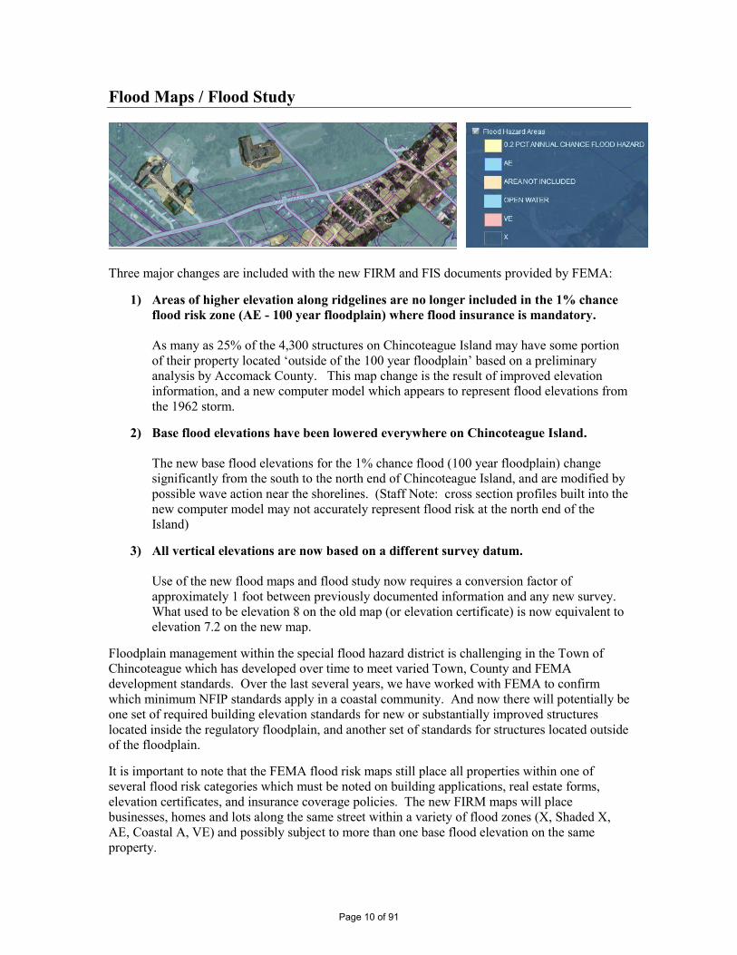
Flood Maps / Flood Study
Three major changes are included with the new FIRM and FIS documents provided by FEMA:
1) Areas of higher elevation along ridgelines are no longer included in the 1% chance flood risk zone (AE - 100 year floodplain) where flood insurance is mandatory. As many as 25% of the 4,300 structures on Chincoteague Island may have some portion of their property located ‘outside of the 100 year floodplain’ based on a preliminary analysis by Accomack County. This map change is the result of improved elevation information, and a new computer model which appears to represent flood elevations from the 1962 storm.
2) Base flood elevations have been lowered everywhere on Chincoteague Island. The new base flood elevations for the 1% chance flood (100 year floodplain) change significantly from the south to the north end of Chincoteague Island, and are modified by possible wave action near the shorelines. (Staff Note: cross section profiles built into the new computer model may not accurately represent flood risk at the north end of the Island)
3) All vertical elevations are now based on a different survey datum. Use of the new flood maps and flood study now requires a conversion factor of approximately 1 foot between previously documented information and any new survey. What used to be elevation 8 on the old map (or elevation certificate) is now equivalent to elevation 7.2 on the new map.
Floodplain management within the special flood hazard district is challenging in the Town of Chincoteague which has developed over time to meet varied Town, County and FEMA development standards. Over the last several years, we have worked with FEMA to confirm which minimum NFIP standards apply in a coastal community. And now there will potentially be one set of required building elevation standards for new or substantially improved structures located inside the regulatory floodplain, and another set of standards for structures located outside of the floodplain. It is important to note that the FEMA flood risk maps still place all properties within one of several flood risk categories which must be noted on building applications, real estate forms, elevation certificates, and insurance coverage policies. The new FIRM maps will place businesses, homes and lots along the same street within a variety of flood zones (X, Shaded X, AE, Coastal A, VE) and possibly subject to more than one base flood elevation on the same property.
Page 10 of 91
Staff Recommendation Adopt the new FEMA Flood Insurance Rate Maps and Flood Insurance Study (effective date of May 18, 2015) as an amendment to Town Code Chapter 30 – Floods to meet the minimum NFIP standards as directed by FEMA Region 3 and the Virginia NFIP Coordinator. Incorporate the appropriate reference into the Town Floodplain Ordinance along with other minor modifications (see next section for separate motion)
Possible Motion: To adopt modified Flood Insurance Rate Maps and a Flood Insurance Study for the Town of Chincoteague with an effective date of May 18, 2015 as provided by the Federal Emergency Management Agency.
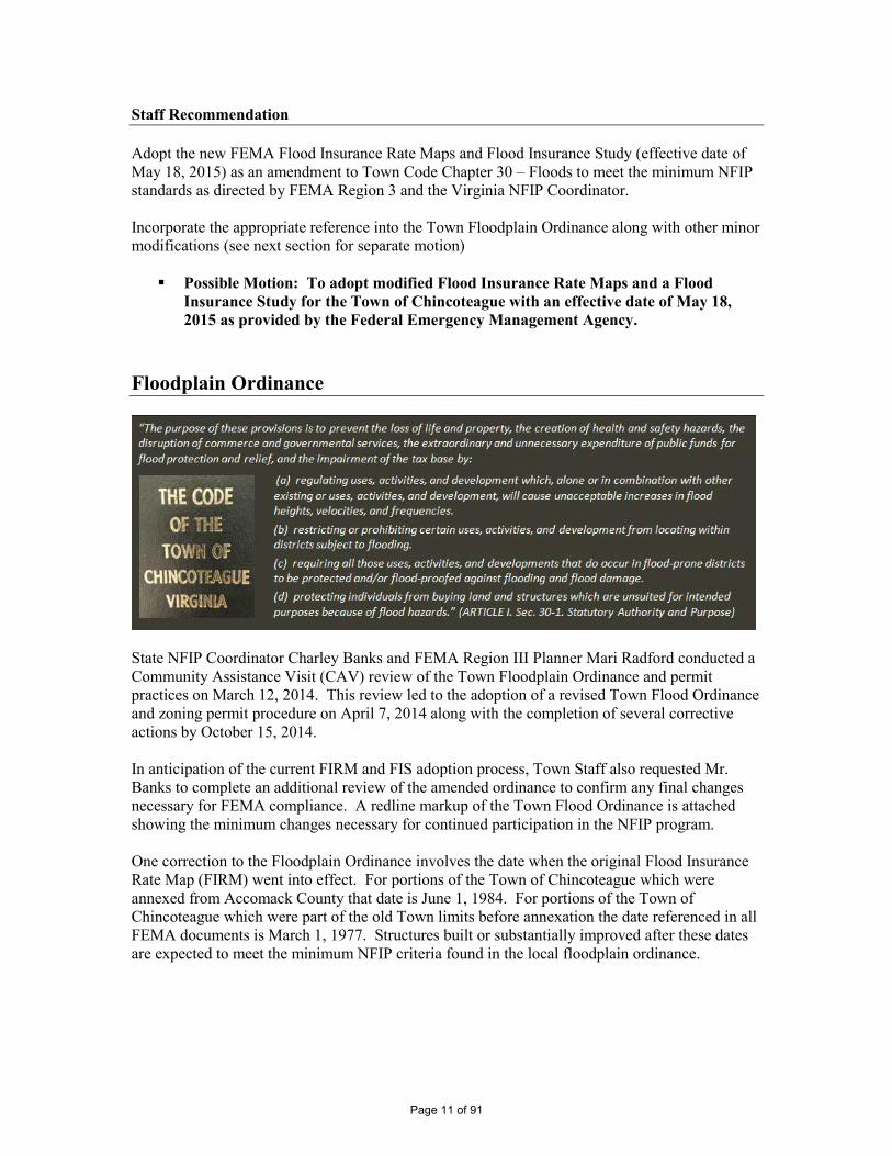
Floodplain Ordinance
State NFIP Coordinator Charley Banks and FEMA Region III Planner Mari Radford conducted a Community Assistance Visit (CAV) review of the Town Floodplain Ordinance and permit practices on March 12, 2014. This review led to the adoption of a revised Town Flood Ordinance and zoning permit procedure on April 7, 2014 along with the completion of several corrective actions by October 15, 2014. In anticipation of the current FIRM and FIS adoption process, Town Staff also requested Mr. Banks to complete an additional review of the amended ordinance to confirm any final changes necessary for FEMA compliance. A redline markup of the Town Flood Ordinance is attached showing the minimum changes necessary for continued participation in the NFIP program. One correction to the Floodplain Ordinance involves the date when the original Flood Insurance Rate Map (FIRM) went into effect. For portions of the Town of Chincoteague which were annexed from Accomack County that date is June 1, 1984. For portions of the Town of Chincoteague which were part of the old Town limits before annexation the date referenced in all FEMA documents is March 1, 1977. Structures built or substantially improved after these dates are expected to meet the minimum NFIP criteria found in the local floodplain ordinance.
Page 11 of 91
Staff Recommendation Incorporate the appropriate reference to the new Flood Insurance Rate Maps and Flood Insurance Study Report (effective May 18, 2015) into the Town Floodplain Ordinance along with other minor corrections requested in the VA NFIP Coordinator’s review (see email dated October 24, 2014) and the FEMA Letter of Final Determination (dated November 18, 2014). Modify the Floodplain Ordinance sections which define Existing/New Construction, and Pre/Post FIRM Structures to describe all applicable dates as instructed by State NFIP Coordinator (see email dated January 21, 2015).
Possible Motion: To amend Town Code – Chapter 30 Floods referencing the adopted Flood Insurance Rate Maps and Flood Insurance Study report which will become effective on May 18, 2015 along with minor changes in the floodplain management regulations as recommended by the Virginia NFIP Coordinator to meet the minimum standards of Paragraph 60.3(e) of the NFIP regulations.
Alternate Staff Recommendation Recess the Public Hearing until the next regular Town Council meeting in order to consider the adoption of a ‘freeboard’ requirement for new and substantially improved construction, or other possible modifications to the Town floodplain management program. Schedule additional review of this item at the Council Workshop on March 19th at 5pm. Attachments
Flood Insurance Rate Maps
Flood Insurance Study
Floodplain Ordinance (redline version showing amendments)
FEMA Letter of Final Determination
Notice for Public Hearing
Page 12 of 91
Page 13 of 91
Page 14 of 91
Page 15 of 91
Page 16 of 91
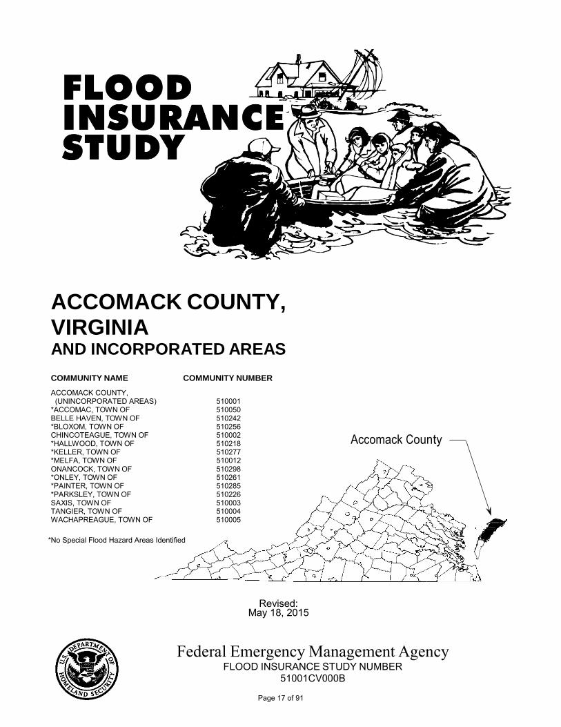
COMMUNITY NAME
ACCOMACK COUNTY,
COMMUNITY NUMBER
(UNINCORPORATED AREAS) 510001 *ACCOMAC, TOWN OF 510050 BELLE HAVEN, TOWN OF 510242 *BLOXOM, TOWN OF 510256 CHINCOTEAGUE, TOWN OF 510002 *HALLWOOD, TOWN OF 510218 *KELLER, TOWN OF 510277 *MELFA, TOWN OF 510012 ONANCOCK, TOWN OF 510298 *ONLEY, TOWN OF 510261 *PAINTER, TOWN OF 510285 *PARKSLEY, TOWN OF 510226 SAXIS, TOWN OF 510003 TANGIER, TOWN OF 510004 WACHAPREAGUE, TOWN OF 510005
ACCOMACK COUNTY, VIRGINIA AND INCORPORATED AREAS
Accomack County
*No Special Flood Hazard Areas Identified
Revised:
May 18, 2015
Federal Emergency Management Agency FLOOD INSURANCE STUDY NUMBER
51001CV000B
Page 17 of 91
NOTICE TO FLOOD INSURANCE STUDY USERS
Communities participating in the National Flood Insurance Program (NFIP) have established repositories of flood hazard data for floodplain management and flood insurance purposes. This Flood Insurance Study (FIS) may not contain all data available within the repository. It is advisable to contact the community repository for any additional data. Part or all of this FIS may be revised and republished at any time. In addition, part of this FIS may be revised by the Letter of Map Revision (LOMR) process, which does not involve republication or redistribution of the FIS. It is, therefore, the responsibility of the user to consult with community officials and to check the community repository to obtain the most current Flood Insurance Study components.
Initial countywide FIS Effective Date: March 16, 2009
Revised countywide FIS Date: May 18, 2015
Page 18 of 91
i
TABLE OF CONTENTS
Page
1.0 INTRODUCTION .............................................................................................................1
1.1 Purpose of Study ....................................................................................................1
1.2 Authority and Acknowledgments...........................................................................1
1.3 Coordination...........................................................................................................4
2.0 AREA STUDIED ...............................................................................................................5
2.1 Scope of Study .......................................................................................................5
2.2 Community Description .........................................................................................5
2.3 Principal Flood Problems .......................................................................................6
2.4 Flood Protection Measures .................................................................................... 10
3.0 ENGINEERING METHODS.......................................................................................... 10
3.1 Coastal Analyses ................................................................................................... 11
3.2 Vertical Datum ..................................................................................................... 27
4.0 FLOODPLAIN MANAGEMENT APPLICATIONS ................................................... 28
4.1 Floodplain Boundaries .......................................................................................... 28
5.0 INSURANCE APPLICATION ………………………….................................................... 30
6.0 FLOOD INSURANCE RATE MAP ............................................................................... 32
7.0 OTHER STUDIES ........................................................................................................... 32
8.0 LOCATION OF DATA ................................................................................................... 32
9.0 BIBLIOGRAPHY AND REFERENCES ....................................................................... 34
Page 19 of 91
ii
TABLE OF CONTENTS - CONTINUED
Page
FIGURES
Figure 1 – Transect Location Map..................................................................................................... 26 Figure 2 – Typical Transect Schematic ………................................................................................. 30
TABLES Table 1 – CCO Meeting Dates for Pre-countywide FISs .................................................................. 4 Table 2 – Summary of Stillwater Elevations .............................................................................. 12 - 13 Table 3 – Transect Data ………................................................................................................... 16 - 25 Table 4 – Community Map History .................................................................................................... 33
EXHIBITS Exhibit 1:
Flood Insurance Rate Map Index Flood Insurance Rate Map
Page 20 of 91
1
FLOOD INSURANCE STUDY ACCOMACK COUNTY, VIRGINIA AND INCORPORATED AREAS
1.0 INTRODUCTION
1.1 Purpose of Study
This Flood Insurance Study (FIS) revises and supersedes the previous FIS report and/or Flood Insurance Rate Map (FIRM) in the geographic area of Accomack County, Virginia, including the Towns of Accomac, Belle Haven, Bloxom, Chincoteague, Hallwood, Keller, Melfa, Onancock, Onley, Painter, Parksley, Saxis, Tangier, and Wachapreague and the unincorporated areas of Accomack County (hereinafter referred to collectively as Accomack County), and aids in the administration of the National Flood Insurance Act of 1968 and the Flood Disaster Protection Act of 1973. This study has developed flood-risk data for various areas of the community that will be used to establish actuarial flood insurance rates. This information will also be used by Accomack County to update existing floodplain regulations as part of the regular phase of the National Flood Insurance Program (NFIP), and by local and regional planners to further promote sound land use and floodplain management. Minimum flood plain management requirements for participation in the NFIP are set forth in the Code of Federal Regulations at 44 CFR, 60.3. Please note that on the effective date of this study, the Towns of Accomac, Bloxom, Hallwood, Keller, Melfa, Onley, Painter, and Parksley have no identified Special Flood Hazard Areas (SFHAs). This does not preclude future determinations of SFHAs that could be necessitated by changed conditions affecting the community (i.e. annexation of new lands) or the availability of new scientific or technical data about flood hazards. Please note that the Town of Belle Haven is geographically located in Accomack and Northampton Counties. The Town of Belle Haven is included in its entirety in this FIS report. In some states or communities, floodplain management criteria or regulations may exist that are more restrictive or comprehensive than the minimum federal requirements. In such cases, the more restrictive criteria take precedence and the state (or other jurisdictional agency) will be able to explain them.
1.2 Authority and Acknowledgments
The sources of authority for this FIS are the National Flood Insurance Act of 1968 and the Flood Disaster Protection Act of 1973. Information on the authority and acknowledgments for each jurisdiction with a pre-countywide printed FIS report included in this countywide FIS is shown below:
Accomack County: The December 1, 1983, FIS (FIRM effective June 1, 1984)
was prepared by the Norfolk District of the U.S. Army Corps of Engineers (USACE), for the Federal Emergency Management Agency (FEMA), under Inter-Agency Agreement (IAA) No. IAA-H-9-79, Project No. 35 (Reference 1). The hydrologic analyses were prepared by the National Oceanic and Atmospheric Administration (NOAA) and the Virginia Institute of Marine Science (VIMS). The wave height analysis was prepared by Dewberry & Davis, for
Page 21 of 91
2
FEMA, under Contract No. EMW-C-0543. That work was completed in January 1981. Individual FIRM panels were revised on May 1, 1985, April 2, 1992, October 16, 1996, and July 20, 1998.
Town of Belle Haven: The hydrologic and hydraulic analyses for the Town of
Belle Haven June 15, 1981, FIS (FIRM effective December 15, 1981) were prepared by the USACE, for FEMA, under IAA No. IAA-H-9-79, Project No. 35. That work was completed in July 1980 (Reference 2).
Town of Chincoteague: In the original study the hydrologic and hydraulic analyses
for the Town of Chincoteague FIS effective March 1, 1977 were prepared by the USACE, for the U.S. Department of Housing and Urban Development, under IAA No. H-16-75, Project Order No. 16. That work was completed in September 1976. A FIS revision was prepared by Dewberry & Davis, for FEMA, under Contract No. EMW-C-0543. That work was completed in June 1982. The FIS and FIRM for that revision became effective on May 16, 1983. Another revision was a l so prepared by Dewberry & Davis, at the request of the community, in September 1983. The FIS and FIRM for that revision became effective on June 1, 1984 (Reference 3).
Town of Hallwood: In the original FIS effective November 3, 1981 (FIRM
effective May 3, 1982), the hydrologic and hydraulic analyses for Messongo Creek were prepared by the USACE, for FEMA, under IAA No. H-9-79, Project Order No. 35. That work was completed in October 1980 (Reference 4). Under the Limited Map Maintenance Program (LMMP), it was determined from a restudy by the USACE that no SFHAs exist within the community. By letter, effective September 28, 2001, the effective FIRM was rescinded.
Town of Onancock: The hydrologic and hydraulic analyses for the Town of Onan-
cock June 15, 1981, FIS (FIRM effective December 15, 1981) were prepared by the USACE, for FEMA, under IAA No. IAA-H-9-79, Project No. 35. That work was completed in August 1980 (Reference 5).
Town of Saxis: The hydrologic and hydraulic analyses for the Town of
Saxis May 17, 1982, FIS (FIRM effective November 17, 1982) were prepared by the USACE, for FEMA, under IAA No. IAA-H-9-79, Project No. 35. That work was completed in February 1981. The wave height analysis was prepared by Dewberry & Davis, for FEMA, under Contract No. EMW-C-0543. That work was completed in July 1981 (Reference 6).
Town of Tangier: The hydrologic and hydraulic analyses for the Town of
Tangier April 15, 1982, FIS (FIRM effective October 15,
Page 22 of 91
3
1982) were prepared by the USACE, for FEMA, under IAA No. IAA-H-9-79, Project No. 35. That work was completed in April 1981. The wave height analysis was prepared by Dewberry & Davis, for FEMA, under Contract No. EMW-C-0543. That work was completed in July 1981. A revision to the FIRM, effective on August 3, 1992, was performed to add undeveloped coastal barriers (Reference 7).
Town of Wachapreague: The hydrologic and hydraulic analyses for t h e Town of
Wachapreague March 2, 1982, FIS (FIRM effective September 2, 1982) F IS were prepared by the USACE, for FEMA, under IAA No. IAA- H-9-79, Project No. 35. That work was completed in March 1981. The wave height analysis was prepared by Dewberry & Davis, for FEMA, under Contract No. EMW-C-0543. That work was com-pleted in July 1981 (Reference 8).
There are no previous FIS reports published for the Towns of Accomac, Bloxom, Keller, Melfa, Onley, Painter, and Parksley; therefore, the previous authority and acknowledgments for these communities are not included in this FIS. SFHAs were previously identified in the Town of Keller on April 1, 1977 as Zone A; however during the initial countywide study and after further review by FEMA, the effective Flood Hazard Boundary Map (FHBM) for the community was rescinded.
For the March 16, 2009, initial countywide FIS, revisions and updates were prepared by the USACE, for FEMA, under IAA No. EMW-2002-IA-0283. New hydrologic and hydraulic analyses were not conducted for that countywide FIS, and minor revisions were made to bring previous studies into agreement. All previous FISs were in agreement with the hydrologic and hydraulic analyses except the FISs for the Towns of Belle Haven, Hallwood, and Onancock. Through that countywide FIS, the original FIRMs for the Towns of Belle Haven and Onancock were revised to reflect the flood elevations shown in the previous Accomack County FIS. The FIRM rescission for the Town of Hallwood, by letter effective September 28, 2001, was also included in that countywide FIS. As a result, the FISs and FIRMs for all previously studied communities are now in agreement. Other revisions and updates include updated community description information, historical flood information, FEMA contact information, and bibliography and references. That countywide FIS also included information regarding survey bench marks and vertical datums. The original FIRMs were converted to a digital format, utilizing aerial photography as the base map. The original FIRM panels for the previous FISs were shown at scales of 1:2,400, 1:4,800, 1: 6,000, or 1:12,000; the revised and updated FIRM panels were shown at scales of 1:12,000 and 1:24,000. This work was completed in March 2006. For the May 18, 2015, countywide FIS revision, the coastal analysis and mapping for Accomack County was conducted for FEMA by the USACE and its project partners under Project HSFE03-06-X-0023, “NFIP Coastal Storm Surge Model for Region III” and Project HSFE03-09-X-1108, “Phase II Coastal Storm Surge Model for FEMA Region III”. The work was performed by the Coastal Processes Branch (HF-C) of the Flood and Storm Protection Division (HF), U.S. Army Engineer Research and Development Center – Coastal & Hydraulics Laboratory (ERDC-CHL). The coastal analysis involved transect layout, field reconnaissance, erosion analysis, and overland wave modeling including wave setup, wave height analysis and wave runup.
Page 23 of 91
4
The FIRM was prepared using the Virginia State Plane South zone. The horizontal datum used is North American Datum of 1983 (NAD83)/HARN, GRS80 spheroid. Differences in datum, spheroid, projection, or State Planes zones used in the production of FIRMs for adjacent jurisdictions may result in slight positional differences in map features across jurisdictional boundaries. The base map information shown on the revised FIRM was provided by the Commonwealth of Virginia through the Virginia Base Mapping Program (VBMP). The orthophotos were flown in 2009 at a scale of 1:100 and 1:200.
1.3 Coordination
The purpose of the initial Consultation Coordination Officer (CCO) meeting is to discuss the scope of the FIS. A final CCO meeting is held to review the results of the study. The dates of the pre-countywide initial and final CCO meetings held for the incorporated communities within the boundaries of Accomack County are shown in Table 1, “CCO Meeting Dates for Pre-countywide FISs”.
TABLE 1 - CCO MEETING DATES FOR PRE-COUNTYWIDE FISs
Community Name Initial CCO Date Final CCO Date
Accomack County January 22, 1979 June 24, 1982 Town of Accomac N/A N/A Town of Belle Haven January 22, 1979 January 28, 1981 Town of Bloxom N/A N/A Town of Chincoteague¹ June 19, 1975 February 2, 1976 Town of Hallwood¹ January 23, 1979 May 4, 1981 Town of Keller N/A N/A Town of Melfa N/A N/A Town of Onancock January 22, 1979 January 28, 1981 Town of Olney N/A N/A Town of Painter N/A N/A Town of Parksley N/A N/A Town of Saxis January 23, 1979 December 7, 1981 Town of Tangier Not Available December 1, 1981 Town of Wachapreague January 22, 1979 October 20, 1981
¹Coordination and review for revisions occurred during the restudy. N/A – Not applicable, no FIS previously prepared.
For the March 16, 2009, initial countywide FIS, the initial CCO meeting was held on July 14, 2003, and attended by representatives from FEMA, Accomack County, the Virginia Department of Conservation and Recreation, and the USACE. The results of the study were reviewed at the final CCO meeting held on July 18, 2006, and attended by representatives of FEMA, Accomack County, and the USACE.
For the May 18, 2015, countywide FIS revision, the FEMA Region III office initiated a coastal storm surge study in 2008 for the Atlantic Ocean, the Chesapeake Bay and its tributaries, and the Delaware Bay. Therefore, no initial CCO meeting for the coastal storm surge study was held. A final CCO meeting was held on July 31, 2013, with representatives from FEMA, the Virginia Department of Conservation and Recreation, the USACE, the study contractor, and Accomack County.
Page 24 of 91
5
2.0 AREA STUDIED
2.1 Scope of Study
This FIS covers the geographic area of Accomack County including the Towns of Accomac, Belle Haven, Bloxom, Chincoteague, Hallwood, Keller, Melfa, Onancock, Onley, Painter, Parksley, Saxis, Tangier, and Wachapreague, and the unincorporated areas of Accomack County, Virginia. In the March 16, 2009, initial countywide FIS, coastal flooding, including wave action from the Atlantic Ocean, Chincoteague Bay, and the Chesapeake Bay, was studied by detailed methods. The areas studied by detailed methods were selected with priority given to all known flood hazard areas and areas of projected development and proposed construction. The scope and methods of the study were proposed to, and agreed upon, by FEMA and Accomack County. For the May 18, 2015, countywide FIS revision, the FEMA Region III office initiated a study to update the coastal storm surge elevations within the states of Virginia, Maryland, and Delaware, and the District of Columbia including the Atlantic Ocean, Chincoteague Bay, Metompkin Bay, Wachapreague Channel, Major Hole Bay, the Chesapeake Bay, Pocomoke Sound, Onancock Creek, Pungoteague Creek, Nandua Creek, Occohannock Creek, and Outlet Bay. This effort is one of the most extensive coastal storm surge analyses to date, encompassing coastal floodplains in three states and including the largest estuary in the world. The study will replace outdated coastal storm surge stillwater elevations for all FISs in the study area, and serve as the basis for new coastal hazard analysis and ultimately updated FIRMs. Study efforts were initiated in 2008 and concluded in 2012.
No Letters of Map Revision (LOMRs) have been issued for Accomack County.
2.2 Community Description
Accomack County is located in the eastern portion of Virginia, on a peninsula of land known as the Eastern Shore. It is bordered by the State of Maryland to the north, the Atlantic Ocean to the east, the Chesapeake Bay to the west, and Northampton County to the south. The county has a total land area of 476 square miles. The population of Accomack County was 31,147 in 1980, 31,703 in 1990, 38,305 in 2000, and 33,164 in 2010 (Reference 9). Of the fourteen incorporated towns within Accomack County, the Town of Chincoteague had the largest population of 2,941 in 2010 (Reference 9). The Town of Tangier is unique, such that it is part of Tangier Island located in the Chesapeake Bay, approximately 11 miles from the Virginia Eastern Shore and 14 miles from Crisfield, Maryland. Access to the town is by airplane or vessels that run from the Towns of Onancock and Reedville, Virginia and the Town of Crisfield, Maryland. The population of Tangier was 727 in 2010 (Reference 9). Prior to European settlement, numerous Indian tribes inhabited the Eastern Shore. They named the land “Accawmache”, meaning “land beyond the waters”. In 1524, Giovanni da Verrazzano was the first European to visit the area. Captain Bartholomew Gilbert of England visited in 1603, and Captain John Smith explored the land in 1608. The entire Eastern Shore peninsula was originally founded as Accomack County in 1663. The first permanent English settlement on the Eastern Shore was settled in 1620. In
Page 25 of 91
6
1673, the peninsula was divided into two counties, Accomack and Northampton. The first settlement on Tangier Island was in 1670 (Reference 10). The topography of Accomack County is typical of a coastal region. The terrain is mostly flat with some hilly areas where elevations range from sea level to about 45 feet above sea level. It is fringed by islands and cut by countless creeks, bays, and inlets. The majority of the land is cropland and woodland. The soils are underlain by clay, sand, shell, and gravel sediments. The topography of the Town of Tangier is generally flat where elevations range from sea level to about 4 feet above sea level (Reference 10). The area enjoys a temperate climate with moderate seasonal changes. The climate is characterized by moderately warm summers with temperatures averaging approximately 78 degrees Fahrenheit (°F) during July, the warmest month. The winters are cool with temperatures averaging approximately 39°F in January, the coolest month. The annual precipitation over the area averages approximately 43 inches. There is some variation in the monthly averages; however, this rainfall is distributed evenly throughout the year. Average annual snowfall is 6 inches, generally occurring in light falls which normally melt within 24 hours (Reference 10). The economy of Accomack County is based primarily on manufacturing, services, and wholesale/retail trade. Agriculture, poultry operations, production of wood products, tourism, and the federal government also provide economic assets. With all the available cropland, the county has long been known as a highly productive farming area for soybeans, potatoes, sweet potatoes, spinach, and other field crops. The county’s large amount of timberland is important to the landowners and to those that work in the wood products industry. The close proximity to the waters of the Atlantic Ocean and Chesapeake Bay has long supported the local seafood industry. The National Aeronautics and Space Administration (NASA) Wallops Flight Facility and related contractors provide many jobs to the county (Reference 10). U.S. Route 13 and the Eastern Shore Railroad provide important links to the State of Maryland and to southeastern Virginia. Both offer easy access to the many local communities and waterfront areas that are located within the county, providing opportunity for continued growth. With the county’s many miles of shoreline, there will be pressure for future development within flood prone areas.
2.3 Principal Flood Problems
The coastal areas of Accomack County are vulnerable to tidal flooding from major storms such as hurricanes and northeasters. Both types of storms produce winds which push large volumes of water against the shore. With their high winds and heavy rainfall, hurricanes are the most severe storms which can hit the study area. The term hurricane is applied to an intense cyclonic storm originating in tropical or subtropical latitudes in the Atlantic Ocean just north of the Equator. A study of tracks of all tropical storms for which there is a record indicates that, on an average of once a year, a tropical storm of hurricane force passes within 250 miles of the area and poses a threat to Accomack County. While hurricanes may affect the area from May through November, nearly 80 percent occur in the months of August, September, and October with approximately 40 percent occurring in September. The most severe hurricanes on record to strike the study area occurred in August 1933, September 2003 (Hurricane Isabel), August 2011 (Hurricane Irene), and October 2012 (Hurricane Sandy). Other notable hurricanes which caused significant flooding in
Page 26 of 91
7
Accomack County occurred in September 1936, September 1954 (Hazel), and September 1960 (Donna). Another type of storm which could cause severe damage to the county is the northeaster. This is also a cyclonic type of storm and originates with little or no warning along the middle and northern Atlantic coast. This storm occurs most frequently in the winter months but may occur at any time. Accompanying winds are not of hurricane force but are persistent, causing above-normal tides for long periods of time. Northeasters which caused significant flooding in the county occurred in April 1956, October 1957, and March 1962. The amount and extent of damage caused by any tidal flood will depend upon the topography of the area flooded, rate of rise of floodwaters, the depth and duration of flooding, the exposure to wave action, and the extent to which structures have been placed in the floodplain. The depth of flooding during these storms depends upon the velocity, direction, and duration of the wind; the size and depth of the body of water over which the wind is acting; and the astronomical tide. The duration of flooding depends upon the duration of the tide-producing forces. Floods caused by hurricanes are usually of much shorter duration than those caused by northeasters. Flooding from hurricanes rarely lasts more than one tidal cycle, while flooding from northeasters may last several days, during which the most severe flooding takes place at the time of the peak astronomical tide. The timing or coincidence of the maximum storm surge with the normal high tide is an important factor in the consideration of flooding from tidal sources. Tidal waters in the study area normally fluctuate twice daily with a mean tide range of approximately 3.5 - 4.0 feet along the Atlantic Ocean, 1.0 - 3.5 feet in Chincoteague Bay, and 1.5 - 2.0 feet in the Chesapeake Bay (Reference 11). The range is somewhat less in most of the connecting bays and inlets. All development in the floodplain is subject to water damage. Some areas, depending on exposure, are subject to high velocity wave action which can cause structural damage and severe erosion along beaches. Waves are generated by the action of wind on the surface of the water. The entire shoreline of Accomack County is vulnerable to wave damage due to the vast exposure afforded by the Atlantic Ocean, Chincoteague Bay, and the Chesapeake Bay. Accomack County has experienced major storms since the early settlement of the area. Historical accounts of severe storms in the area date back several hundred years. The following paragraphs discuss some of the larger known storms which have occurred in recent history. This information is based on newspaper accounts, historical records, field investigations, and routine data collection programs normally conducted by the USACE. The August 1933 hurricane passed directly over the lower Chesapeake Bay area, then moved north up the west side of the bay. In addition to damage from tidal flooding, high winds caused damage to roofs, communication lines, and other structures. An account of this hurricane, dated August 25, 1933, reads in part as follows (Reference 12):
Page 27 of 91
8
“2 dead, many lost, as fierce storm hits shore…Property damage by high tide, 80 mile gale…Wharves swept away, towns flooded, Coast Guard Station deserted as havoc rages on eastern coast…” “The Eastern Shore and the whole Atlantic coast north of the Carolinas, experienced one of the worst wind and rain storms in the past quarter of a century Tuesday and Wednesday of this week as high winds, gales ranging between 50 and 80 miles per hour intensity when a northeaster piled up against a gale from the Caribbean and drove the waters of the ocean over the beaches and marshes high into the mainland at points completely flooding towns. Ocean breakers easily rode over the marshes and islands into such towns as Willis Wharf, Cape Charles, Chincoteague, Wachapreague, and Kiptopeke. In many instances the angered breakers slashed up the towns, severely damaging property.” The hurricane of September 1936 passed approximately 20 miles east of Cape Henry on the morning of September 18, 1936. High tides and gale force winds caused mush damage along the lower Chesapeake Bay area and the Eastern Shore as the storm moved to the northeast. An account of this hurricane, dated September 18, 1936, reads in part as follows (Reference 13): “…on the 18th…high tides in the lower section of Norfolk, and high winds demolishing windows, roofs, and buildings, entailed a damage of approximately $500,000 in that area.” “Farther north in Accomack and Northampton Counties, approximately 60,000 broiler chickens were lost, oyster beds were wrecked, and most late crops were lost, the loss in crops approximately $250,000, and other damage amounting to another $250,000.” Hurricane Hazel, which occurred on October 15, 1954, tore through Virginia causing the deaths of 13 persons and widespread property damage. The center of the hurricane moved inland in the vicinity of the South Carolina-North Carolina border between 9 and 10 a.m., and rapid northward movement carried the center through Virginia between 2 and 6 p.m. Hurricane force winds with gusts 80 to 100 miles per hour were experienced near the path of the storm center and eastward to the coast. Rainfall was relatively light in the coastal area but increased sharply west of the storm center (Reference 14). The northeaster of April 11, 1956 produced a steady wind in the lower Chesapeake Bay area for about 30 hours. The tides ran about 4 feet above normal for about 12 hours and crested on April 11, 1956. Large areas of low-lying sections of the Eastern Shore were inundated during the storm. The northeaster of October 6, 1957, with wind gusts of 60 - 70 miles per hour, moved north just east of Cape Hatteras during the evening of the 5th, then turned northwest to move through the lower portion of the Chesapeake Bay on the 6th. Heavy rains and gales extended west through central Virginia. The greatest property damage occurred in the coastal areas where heavy seas and high tides battered structures, grounded vessels, and disrupted transportation. An account of this storm, dated October 10, 1957, reads in part as follows (Reference 15):
Page 28 of 91
9
“Near hurricane winds lashed shore Sunday, Wachapreague, other areas hit.” “One of the severest struck areas was Wachapreague where tides were estimated four feet above normal…Several boats sunk and there were numerous reports of minor damage.” Hurricane Donna, which occurred on September 12, 1960, skirted the Virginia coast on the morning of the 12th before moving to the northeast. Strong winds, heavy seas, and severe flooding occurred along the Chesapeake Bay shoreline of the Eastern Shore from Cape Charles north, causing extensive damage. An account of this hurricane, dated September 15, 1960, reads in part as follows (Reference 16): “‘Devastating Donna’ with tree snapping winds and flooding rain smashed its way through the Eastern Shore Monday morning leaving behind a trail of destruction and tidal damage.” “As Donna progressed up the coast it was labeled as the ‘most destructive’ storm since 1840 when accurate records began. Its total damage on the shore amounted in the millions of dollars.” “Some of the highest bayside tides ever recorded were chalked up in Onancock, Bayford, and many other points. Winds up to and beyond 100 miles per hour were recorded at Chincoteague and Wallops Island. Rainfall was measured at 4.5 inches in the 24 hours between Sunday evening and Monday evening most of it falling at the height of the storm.” “The Chesapeake lightship, anchored near the mouth of the Chesapeake Bay, recorded Donna’s winds at their height at 138 miles per hour. This was the highest recording made since the storm had left Florida where recordings of over 150 were made.” On March 6 - 8, 1962, a northeaster caused disastrous flooding and high waves all along the Atlantic Seaboard from New York to Florida. This storm was unusual even for a northeaster since it was caused by a low pressure cell which moved from south to north past Hampton Roads and then reversed its course, moving again to the south and bringing with it huge volumes of water and high waves which battered the mid-Atlantic coastline for several days. During this storm, the bay side of the Eastern Shore received less damage from the winds and lower tides than the ocean side. Flooding was significant for low-lying areas like the Towns of Chincoteague, Tangier, and Wachapreague (Reference 17). The most recent tidal stage of major proportions occurred during Hurricane Isabel, making landfall on September 18, 2003, along the Outer Banks of North Carolina and tracking northward through Virginia and up to Pennsylvania. At landfall, maximum sustained winds were estimated at 104 mph. Isabel weakened to a tropical storm by the time it moved into Virginia and lost tropical characteristics as it moved into Pennsylvania. The storm caused high winds, storm surge flooding, and extensive property damage throughout the Chesapeake Bay region. Within Virginia, ninety-nine communities were directly affected by Isabel. There were thirty-three deaths, over a billion dollars in property damage, and over a million electrical customers without power for many days (Reference 18). Historical maximum water level records were exceeded at several locations within the Chesapeake Bay. In general, maximum water
Page 29 of 91
10
levels in the Chesapeake Bay resembled those of the August 1933 hurricane. Some communities along the Chesapeake Bay and its tributaries also experienced severe damage from wave action (Reference 19). In August 2011, Hurricane Irene hit the eastern coast of the United States and caused substantial damage. In November 2011, President Barack Obama declared a Major Disaster Declaration for numerous counties, including Accomack County, which allowed residents affected by the hurricane to apply for federal aid. This declaration followed the August 2011 Emergency Declaration. In October 2012, Hurricane Sandy made landfall north of the Commonwealth of Virginia, but caused substantial damage in Virginia. President Obama declared a Major Disaster Declaration for numerous counties, including Accomack County, which allowed residents affected by the hurricane to apply for federal aid.
2.4 Flood Protection Measures There are no existing flood control structures that would provide protection during major floods in the study area. There are a number of measures that have afforded some protection against flooding, including bulkheads and seawalls, jetties, sand dunes, and non-structural measures for floodplain management such as zoning codes. The "Uniform Statewide Building Code" which went into effect in September 1973 states, "where a structure is located in a 100-year floodplain, the lowest floor of all future construction or substantial improvement to an existing structure . . ., must be built at or above that level, except for non-residential structures which may be floodproofed to that level” (Reference 20). These requirements will no doubt be beneficial in reducing future flood damages in the county.
3.0 ENGINEERING METHODS
For the flooding sources studied by detailed methods in the community, standard hydrologic and hydraulic study methods were used to determine the flood-hazard data required for this study. Flood events of a magnitude that is expected to be equaled or exceeded once on the average during any 10-, 50-, 100-, or 500-year period (recurrence interval) have been selected as having special significance for floodplain management and for flood insurance rates. These events, commonly termed the 10-, 50-, 100-, and 500-year floods, have a 10-, 2-, 1-, and 0.2-percent chance, respectively, of being equaled or exceeded during any year. Although the recurrence interval represents the long-term average period between floods of a specific magnitude, rare floods could occur at short intervals or even within the same year. The risk of experiencing a rare flood increases when periods greater than 1 year are considered. For example, the risk of having a flood that equals or exceeds the 1-percent-annual-chance flood in any 50-year period is approximately 40 percent (4 in 10); for any 90-year period, the risk increases to approximately 60 percent (6 in 10). The analyses reported herein reflect flooding potentials based on conditions existing in the community at the time of completion of this study. Maps and flood elevations will be amended periodically to reflect future changes.
FEMA adopted recommendations by the National Academy of Sciences (NAS) to include prediction of wave heights in FISs for coastal communities subject to storm surge flooding, and to report the estimated wave crest elevations as the Base Flood Elevations (BFEs) on the FIRM (Reference 21).
Page 30 of 91
11
Previously, FIRMs for these communities were produced showing only the stillwater storm surge elevations due to the lack of a suitable and generally applicable methodology for estimating the wave crest elevations associated with storm surges. These stillwater elevations were subsequently stipulated in community floodplain management ordinances as the minimum elevation of the lowest floor, including basement, of new construction. Communities and individuals had to consider the additional hazards of velocity waters and wave action on an ad hoc basis. Because there has been a pronounced tendency for buildings to be constructed only to meet minimum standards, without consideration of the additional hazard due to wave height, increasing numbers of people could unknowingly be accepting a high degree of flood-related personal and property risk in coastal areas subject to wave action. Therefore, FEMA has pursued the development of a suitable methodology for estimating the wave crest elevations associated with storm surges. The recent development of such a methodology by the NAS has led to the adoption of wave crest elevations for use as the BFEs in coastal communities (Reference 21).
3.1 Coastal Analyses
Coastal analyses considering storm characteristics and the shoreline and bathymetric characteristics of the flooding sources studied, were carried out to provide estimates of the elevations of floods for the selected recurrence intervals along the shoreline. Users of the FIRM should be aware that coastal flood elevations are provided in Table 2, “Summary of Stillwater Elevations”, in this report. If the elevation on the FIRM is higher than the elevation shown in this table, a wave height, wave runup, and/or wave setup component likely exists, in which case, the higher elevation should be used for construction and/or floodplain management purposes. Sporadic commercial and residential development, as well as open space areas, encompasses that part of the Chesapeake Bay shoreline and several embayments west of the Atlantic Ocean shoreline. The barrier islands along the Atlantic Ocean shoreline, with the exception of Chincoteague, Assateague and Wallops Islands, remain privately held and largely undeveloped. Shorelines behind the Atlantic Ocean barrier islands are primarily low marshes, with some low bluffs less than 5 feet in height, along Bogues, Bradford, Burtons, Chincoteague, Gargathy, Hog Island, Kegotank, Major Hole, Metompkin, Swash, Upshur, and Watts Bays. Behind the shoreline, the ground slopes gently upward into woodlands or open agricultural areas. An analysis was performed to establish the frequency peak elevation relationships for coastal flooding in Accomack County. The FEMA Region III office, initiated a study in 2008 to update the coastal storm surge elevations within the states of Virginia, Maryland, and Delaware, and the District of Columbia including the Atlantic Ocean, Chesapeake Bay including its tributaries, and the Delaware Bay. The study replaces outdated coastal storm surge stillwater elevations for all FISs in the study area, including Accomack County, and serves as the basis for updated FIRMs. Study efforts were initiated in 2008 and concluded in 2012. The end-to-end storm surge modeling system includes the Advanced Circulation Model for Oceanic, Coastal and Estuarine Waters (ADCIRC) for simulation of 2-dimensional hydrodynamics (Reference 22). ADCIRC was dynamically coupled to the unstructured numerical wave model Simulating WAves Nearshore (unSWAN) to calculate the contribution of waves to total storm surge. The resulting model system is typically
Page 31 of 91
12
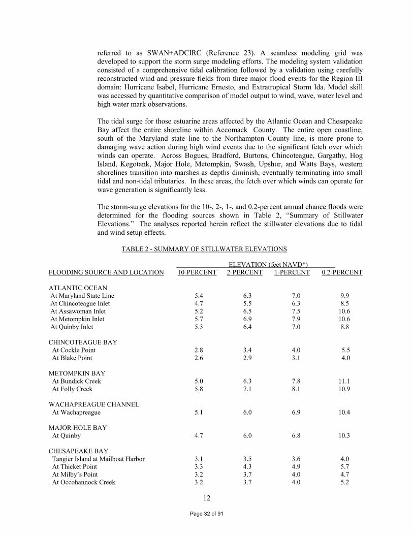
referred to as SWAN+ADCIRC (Reference 23). A seamless modeling grid was developed to support the storm surge modeling efforts. The modeling system validation consisted of a comprehensive tidal calibration followed by a validation using carefully reconstructed wind and pressure fields from three major flood events for the Region III domain: Hurricane Isabel, Hurricane Ernesto, and Extratropical Storm Ida. Model skill was accessed by quantitative comparison of model output to wind, wave, water level and high water mark observations. The tidal surge for those estuarine areas affected by the Atlantic Ocean and Chesapeake Bay affect the entire shoreline within Accomack County. The entire open coastline, south of the Maryland state line to the Northampton County line, is more prone to damaging wave action during high wind events due to the significant fetch over which winds can operate. Across Bogues, Bradford, Burtons, Chincoteague, Gargathy, Hog Island, Kegotank, Major Hole, Metompkin, Swash, Upshur, and Watts Bays, western shorelines transition into marshes as depths diminish, eventually terminating into small tidal and non-tidal tributaries. In these areas, the fetch over which winds can operate for wave generation is significantly less. The storm-surge elevations for the 10-, 2-, 1-, and 0.2-percent annual chance floods were determined for the flooding sources shown in Table 2, “Summary of Stillwater Elevations.” The analyses reported herein reflect the stillwater elevations due to tidal and wind setup effects.
TABLE 2 - SUMMARY OF STILLWATER ELEVATIONS
ELEVATION (feet NAVD*) FLOODING SOURCE AND LOCATION 10-PERCENT 2-PERCENT 1-PERCENT 0.2-PERCENT ATLANTIC OCEAN At Maryland State Line 5.4 6.3 7.0 9.9 At Chincoteague Inlet 4.7 5.5 6.3 8.5 At Assawoman Inlet 5.2 6.5 7.5 10.6 At Metompkin Inlet 5.7 6.9 7.9 10.6 At Quinby Inlet 5.3 6.4 7.0 8.8 CHINCOTEAGUE BAY At Cockle Point 2.8 3.4 4.0 5.5 At Blake Point 2.6 2.9 3.1 4.0 METOMPKIN BAY At Bundick Creek 5.0 6.3 7.8 11.1 At Folly Creek 5.8 7.1 8.1 10.9 WACHAPREAGUE CHANNEL At Wachapreague 5.1 6.0 6.9 10.4 MAJOR HOLE BAY At Quinby 4.7 6.0 6.8 10.3 CHESAPEAKE BAY Tangier Island at Mailboat Harbor 3.1 3.5 3.6 4.0 At Thicket Point 3.3 4.3 4.9 5.7 At Milby’s Point 3.2 3.7 4.0 4.7 At Occohannock Creek 3.2 3.7 4.0 5.2
Page 32 of 91
13
TABLE 2 - SUMMARY OF STILLWATER ELEVATIONS - continued
ELEVATION (feet NAVD*) FLOODING SOURCE AND LOCATION 10-PERCENT 2-PERCENT 1-PERCENT 0.2-PERCENT POCOMOKE SOUND At Pig Point 4.8 6.7 7.5 8.7 At Back Creek 3.4 4.6 5.2 6.2 ONANCOCK CREEK At East Point 3.3 4.7 5.4 6.6 At Onancock 3.6 5.5 6.3 7.6 PUNGOTEAGUE CREEK At Warehouse Point 3.3 4.6 5.2 6.2 At Harborton 3.3 4.8 5.4 6.5 NANDUA CREEK At Monadox Point 3.3 4.1 4.4 5.2 At Kusian Cove 3.5 4.5 4.9 5.7 OCCOHANNOCK CREEK At Pons Point 3.2 4.0 4.5 5.9 OUTLET BAY At Parchaby Tump 5.4 6.5 7.2 9.0 At Sunday Ditch 6.0 7.3 8.1 11.1 *North American Vertical Datum of 1988
The methodology for analyzing the effects of wave heights associated with coastal storm surge flooding is described in a report prepared by the NAS (Reference 21). This method is based on three major concepts. First, depth-limited waves in shallow water reach maximum breaking height that is equal to 0.78 times the stillwater depth. The wave crest is 70 percent of the total wave height above the stillwater level. The second major concept is that wave height may be diminished by dissipation of energy due to the presence of obstructions, such as sand dunes, dikes and seawalls, buildings and vegetation. The amount of energy dissipation is a function of the physical characteristics of the obstruction and is determined by procedures prescribed in the NAS report. The third major concept is that wave height can be regenerated in open fetch areas due to the transfer of wind energy to the water. This added energy is related to fetch length and depth. Wave heights were computed across transects that were located along coastal areas of Accomack County, as illustrated on the FIRM. The transects were located with consideration given to existing transect locations and to the physical and cultural characteristics of the land so that they would closely represent conditions in the locality. Each transect was taken perpendicular to the shoreline and extended inland to a point where coastal flooding ceased. Along each transect, wave heights and elevations were computed considering the combined effects of changes in ground elevation, vegetation, and physical features. The stillwater elevations for a 1% annual chance event were used as the starting elevations for these computations. Wave heights were calculated to the
Page 33 of 91
14
nearest 0.1 foot, and wave elevations were determined at whole-foot increments along the transects. The location of the 3-foot breaking wave for determining the terminus of the Zone VE (area with velocity wave action) was computed at each transect. Along the open coast, the Zone VE designation applies to all areas seaward of the landward toe of the primary frontal dune system. The primary frontal due is defined as the point where the ground profile changes from relatively steep to relatively mild. Dune erosion was taken into account along the Chesapeake Bay. A review of the geology and shoreline type in Accomack County was made to determine the applicability of standard erosion methods, and FEMA’s standard erosion methodology for coastal areas having primary frontal dunes, referred to as the “540 rule,” was used (Reference 24). This methodology first evaluates the dune’s cross-sectional profile to determine whether the dune has a reservoir of material that is greater or less than 540 square feet. If the reservoir is greater than 540 square feet, the “retreat” erosion method is employed and approximately 540 square feet of the dune is eroded using a standardized eroded profile, as specified in FEMA guidelines. If the reservoir is less than 540 square feet, the “remove” erosion method is employed where the dune is removed for subsequent analysis, again using a standard eroded profile. The storm surge study provided the return period stillwater elevations required for erosion analyses. Each cross-shore transect was analyzed for erosion, when applicable. Wave height calculations used in this study follow the methodologies described in the FEMA guidance for coastal mapping (Reference 24). Wave setup results in an increased water level at the shoreline due to the breaking of waves and transfer of momentum to the water column during hurricanes and severe storms. For the Accomack County study, wave setup was determined directly from the coupled wave and storm surge model. The total stillwater elevation (SWEL) with wave setup was then used for simulations of inland wave propagation conducted using FEMA’s Wave Height Analysis for Flood Insurance Studies (WHAFIS) model Version 4.0 (Reference 25). WHAFIS is a one-dimensional model that was applied to each transect in the study area. The model uses the specified SWEL, the computed wave setup, and the starting wave conditions as input. Simulations of wave transformations were then conducted with WHAFIS taking into account the storm-induced erosion and overland features of each transect. Output from the model includes the combined SWEL and wave height along each cross-shore transect allowing for the establishment of BFEs and flood zones from the shoreline to points inland within the study area. Wave runup is defined as the maximum vertical extent of wave uprush on a beach or structure. FEMA’s 2007 Guidelines and Specifications require the 2% wave runup level be computed for the coastal feature being evaluated (cliff, coastal bluff, dune, or structure) (Reference 24). The 2% runup level is the highest 2 percent of wave runup affecting the shoreline during the 1-percent-annual-chance flood event. Each transect defined within the Region III study area was evaluated for the applicability of wave runup, and if necessary, the appropriate runup methodology was selected and applied to each transect. Runup elevations were then compared to WHAFIS results to determine the dominant process affecting BFEs and associated flood hazard levels. Computed controlling wave heights at the shoreline range from 2.1 feet at embayments where the fetch is short to 5.9 feet along the open coast where the fetch is longer. The corresponding wave elevation at the shoreline varies from 4.4 feet at embayments end to 11.8 feet along the open coast.
Page 34 of 91

15
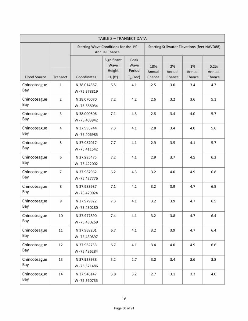
Between transects, elevations were interpolated using topographic maps, land-use and land cover data, and engineering judgment to determine the aerial extent of flooding. The results of the calculations are accurate until local topography, vegetation, or cultural development within the community experience major changes. Table 3, “Transect Data”, provides the 10%, 2%, 1% and 0.2% annual chance stillwater elevations and the starting wave conditions for each transect. Figure 1, “Transect Location Map”, provides an illustration of the transect locations for Accomack County.
Page 35 of 91
16
TABLE 3 – TRANSECT DATA
Flood Source
Transect
Starting Wave Conditions for the 1%
Annual Chance
Starting Stillwater Elevations (feet NAVD88)
Coordinates
Significant
Wave
Height
Hs (ft)
Peak
Wave
Period
Tp (sec)
10%
Annual
Chance
2%
Annual
Chance
1%
Annual
Chance
0.2%
Annual
Chance
Chincoteague Bay
1 N 38.014367
W -75.378819
6.5 4.1 2.5 3.0 3.4 4.7
Chincoteague Bay
2 N 38.070070
W -75.388034
7.2 4.2 2.6 3.2 3.6 5.1
Chincoteague Bay
3 N 38.000506
W -75.403942
7.1 4.3 2.8 3.4 4.0 5.7
Chincoteague Bay
4 N 37.993744
W -75.406985
7.3 4.1 2.8 3.4 4.0 5.6
Chincoteague Bay
5 N 37.987017
W -75.411542
7.7 4.1 2.9 3.5 4.1 5.7
Chincoteague Bay
6 N 37.985475
W -75.422002
7.2 4.1 2.9 3.7 4.5 6.2
Chincoteague Bay
7 N 37.987962
W -75.427776
6.2 4.3 3.2 4.0 4.9 6.8
Chincoteague Bay
8 N 37.983987
W -75.429024
7.1 4.2 3.2 3.9 4.7 6.5
Chincoteague Bay
9 N 37.979822
W -75.430280
7.3 4.1 3.2 3.9 4.7 6.5
Chincoteague Bay
10 N 37.977890
W -75.430269
7.4 4.1 3.2 3.8 4.7 6.4
Chincoteague Bay
11 N 37.969201
W -75.430897
6.7 4.1 3.2 3.9 4.7 6.4
Chincoteague Bay
12 N 37.962733
W -75.436284
6.7 4.1 3.4 4.0 4.9 6.6
Chincoteague Bay
13 N 37.938988
W -75.371486
3.2 2.7 3.0 3.4 3.6 3.8
Chincoteague Bay
14 N 37.946147
W -75.360735
3.8 3.2 2.7 3.1 3.3 4.0
Page 36 of 91
17
TABLE 3 – TRANSECT DATA (continued)
Flood Source
Transect
Starting Wave Conditions for the 1%
Annual Chance
Starting Stillwater Elevations (feet NAVD88)
Coordinates
Significant
Wave
Height
Hs (ft)
Peak
Wave
Period
Tp (sec)
10%
Annual
Chance
2%
Annual
Chance
1%
Annual
Chance
0.2%
Annual
Chance
Chincoteague Bay
15 N 37.952979
W -75.353038
3.1 3.9 2.6 2.9 3.1 4.1
Chincoteague Bay
16 N 37.965155
W -75.337252
3.8 3.0 2.4 2.7 3.0 4.9
Chincoteague Bay
17 N 38.006849
W -75.280982
3.6 2.6 2.3 3.0 3.1 3.7
Atlantic Ocean 18 N 38.021510
W -75.246431
27.1 13.9 5.3 6.3 7.0 9.9
Atlantic Ocean 19 N 38.008995
W -75.257195
25.9 13.5 5.1 6.1 6.8 9.6
Atlantic Ocean 20 N 37.994238
W -75.267993
24.5 14.5 5.2 6.2 6.9 9.8
Atlantic Ocean 21 N 37.980505
W -75.278700
25.0 14.5 5.1 6.1 6.9 9.7
Atlantic Ocean 22 N 37.970556
W -75.286541
25.4 14.4 5.1 6.1 7.0 9.8
Atlantic Ocean 23 N 37.957821
W -75.297210
28.0 13.7 5.2 6.2 7.1 9.9
Atlantic Ocean 24 N 37.945274
W -75.306061
30.0 13.5 5.3 6.3 7.2 9.9
Atlantic Ocean 25 N 37.931146
W -75.314674
28.7 13.5 5.4 6.3 7.2 9.9
Atlantic Ocean 26 N 37.917930
W -75.323487
27.6 13.5 5.3 6.3 7.2 10.0
Atlantic Ocean 27 N 37.911457
W -75.327615
26.6 13.3 5.3 6.4 7.2 9.9
Atlantic Ocean 28 N 37.898750
W -75.335920
25.3 13.3 5.2 6.3 7.1 9.8
Page 37 of 91
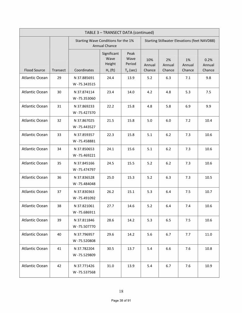
18
TABLE 3 – TRANSECT DATA (continued)
Flood Source
Transect
Starting Wave Conditions for the 1%
Annual Chance
Starting Stillwater Elevations (feet NAVD88)
Coordinates
Significant
Wave
Height
Hs (ft)
Peak
Wave
Period
Tp (sec)
10%
Annual
Chance
2%
Annual
Chance
1%
Annual
Chance
0.2%
Annual
Chance
Atlantic Ocean 29 N 37.885691
W -75.343515
24.4 13.9 5.2 6.3 7.1 9.8
Atlantic Ocean 30 N 37.874114
W -75.353060
23.4 14.0 4.2 4.8 5.3 7.5
Atlantic Ocean 31 N 37.869233
W -75.427370
22.2 15.8 4.8 5.8 6.9 9.9
Atlantic Ocean 32 N 37.867025
W -75.443527
21.5 15.8 5.0 6.0 7.2 10.4
Atlantic Ocean 33 N 37.859357
W -75.458881
22.3 15.8 5.1 6.2 7.3 10.6
Atlantic Ocean 34 N 37.850653
W -75.469221
24.1 15.6 5.1 6.2 7.3 10.6
Atlantic Ocean 35 N 37.845166
W -75.474797
24.5 15.5 5.2 6.2 7.3 10.6
Atlantic Ocean 36 N 37.836528
W -75.484048
25.0 15.3 5.2 6.3 7.3 10.5
Atlantic Ocean 37 N 37.830363
W -75.491092
26.2 15.1 5.3 6.4 7.5 10.7
Atlantic Ocean 38 N 37.821061
W -75.686911
27.7 14.6 5.2 6.4 7.4 10.6
Atlantic Ocean 39 N 37.811846
W -75.507770
28.6 14.2 5.3 6.5 7.5 10.6
Atlantic Ocean 40 N 37.796957
W -75.520808
29.6 14.2 5.6 6.7 7.7 11.0
Atlantic Ocean 41 N 37.782204
W -75.529809
30.5 13.7 5.4 6.6 7.6 10.8
Atlantic Ocean 42 N 37.771426
W -75.537568
31.0 13.9 5.4 6.7 7.6 10.9
Page 38 of 91
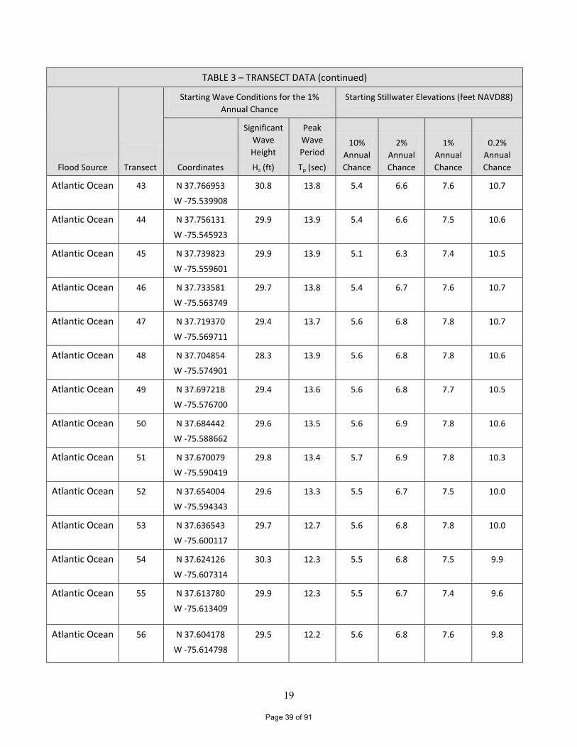
19
TABLE 3 – TRANSECT DATA (continued)
Flood Source
Transect
Starting Wave Conditions for the 1%
Annual Chance
Starting Stillwater Elevations (feet NAVD88)
Coordinates
Significant
Wave
Height
Hs (ft)
Peak
Wave
Period
Tp (sec)
10%
Annual
Chance
2%
Annual
Chance
1%
Annual
Chance
0.2%
Annual
Chance
Atlantic Ocean 43 N 37.766953
W -75.539908
30.8 13.8 5.4 6.6 7.6 10.7
Atlantic Ocean 44 N 37.756131
W -75.545923
29.9 13.9 5.4 6.6 7.5 10.6
Atlantic Ocean 45 N 37.739823
W -75.559601
29.9 13.9 5.1 6.3 7.4 10.5
Atlantic Ocean 46 N 37.733581
W -75.563749
29.7 13.8 5.4 6.7 7.6 10.7
Atlantic Ocean 47 N 37.719370
W -75.569711
29.4 13.7 5.6 6.8 7.8 10.7
Atlantic Ocean 48 N 37.704854
W -75.574901
28.3 13.9 5.6 6.8 7.8 10.6
Atlantic Ocean 49 N 37.697218
W -75.576700
29.4 13.6 5.6 6.8 7.7 10.5
Atlantic Ocean 50 N 37.684442
W -75.588662
29.6 13.5 5.6 6.9 7.8 10.6
Atlantic Ocean 51 N 37.670079
W -75.590419
29.8 13.4 5.7 6.9 7.8 10.3
Atlantic Ocean 52 N 37.654004
W -75.594343
29.6 13.3 5.5 6.7 7.5 10.0
Atlantic Ocean 53 N 37.636543
W -75.600117
29.7 12.7 5.6 6.8 7.8 10.0
Atlantic Ocean 54 N 37.624126
W -75.607314
30.3 12.3 5.5 6.8 7.5 9.9
Atlantic Ocean 55 N 37.613780
W -75.613409
29.9 12.3 5.5 6.7 7.4 9.6
Atlantic Ocean 56 N 37.604178
W -75.614798
29.5 12.2 5.6 6.8 7.6 9.8
Page 39 of 91
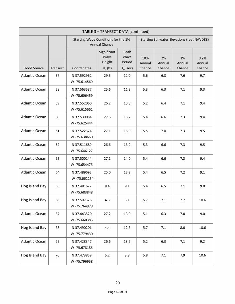
20
TABLE 3 – TRANSECT DATA (continued)
Flood Source
Transect
Starting Wave Conditions for the 1%
Annual Chance
Starting Stillwater Elevations (feet NAVD88)
Coordinates
Significant
Wave
Height
Hs (ft)
Peak
Wave
Period
Tp (sec)
10%
Annual
Chance
2%
Annual
Chance
1%
Annual
Chance
0.2%
Annual
Chance
Atlantic Ocean 57 N 37.592962
W -75.614569
29.5 12.0 5.6 6.8 7.6 9.7
Atlantic Ocean 58 N 37.563587
W -75.606459
25.6 11.3 5.3 6.3 7.1 9.3
Atlantic Ocean 59 N 37.552060
W -75.615661
26.2 13.8 5.2 6.4 7.1 9.4
Atlantic Ocean 60 N 37.539084
W -75.625444
27.6 13.2 5.4 6.6 7.3 9.4
Atlantic Ocean 61 N 37.522374
W -75.638660
27.1 13.9 5.5 7.0 7.3 9.5
Atlantic Ocean 62 N 37.511689
W -75.646127
26.6 13.9 5.3 6.6 7.3 9.5
Atlantic Ocean 63 N 37.500144
W -75.654475
27.1 14.0 5.4 6.6 7.3 9.4
Atlantic Ocean 64 N 37.489693
W -75.662234
25.0 13.8 5.4 6.5 7.2 9.1
Hog Island Bay 65 N 37.481622
W -75.683848
8.4 9.1 5.4 6.5 7.1 9.0
Hog Island Bay 66 N 37.507326
W -75.764978
4.3 3.1 5.7 7.1 7.7 10.6
Atlantic Ocean 67 N 37.443520
W -75.660385
27.2 13.0 5.1 6.3 7.0 9.0
Hog Island Bay 68 N 37.490201
W -75.779430
4.4 12.5 5.7 7.1 8.0 10.6
Atlantic Ocean 69 N 37.428347
W -75.678185
26.6 13.5 5.2 6.3 7.1 9.2
Hog Island Bay 70 N 37.473859
W -75.796958
5.2 3.8 5.8 7.1 7.9 10.6
Page 40 of 91
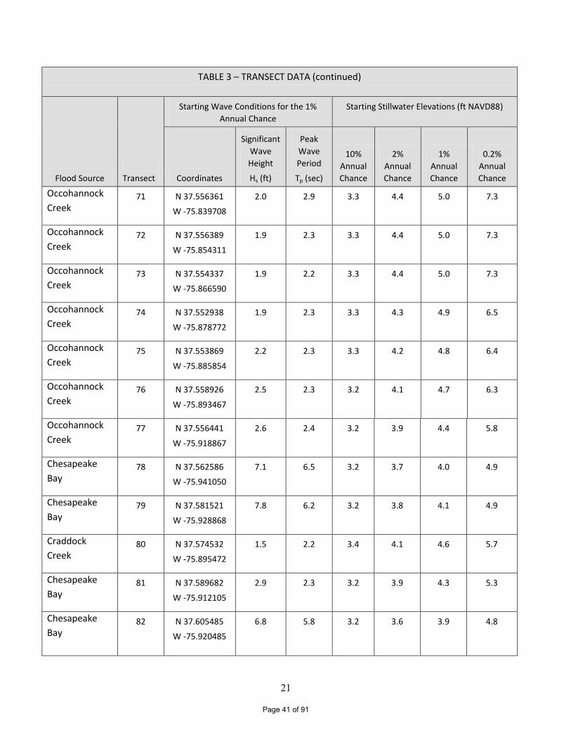
21
TABLE 3 – TRANSECT DATA (continued)
Flood Source
Transect
Starting Wave Conditions for the 1%
Annual Chance
Starting Stillwater Elevations (ft NAVD88)
Coordinates
Significant
Wave
Height
Hs (ft)
Peak
Wave
Period
Tp (sec)
10%
Annual
Chance
2%
Annual
Chance
1%
Annual
Chance
0.2%
Annual
Chance
Occohannock
Creek 71 N 37.556361
W -75.839708
2.0 2.9 3.3 4.4 5.0 7.3
Occohannock
Creek 72 N 37.556389
W -75.854311
1.9 2.3 3.3 4.4 5.0 7.3
Occohannock
Creek 73 N 37.554337
W -75.866590
1.9 2.2 3.3 4.4 5.0 7.3
Occohannock
Creek 74 N 37.552938
W -75.878772
1.9 2.3 3.3 4.3 4.9 6.5
Occohannock
Creek 75 N 37.553869
W -75.885854
2.2 2.3 3.3 4.2 4.8 6.4
Occohannock
Creek 76 N 37.558926
W -75.893467
2.5 2.3 3.2 4.1 4.7 6.3
Occohannock
Creek 77 N 37.556441
W -75.918867
2.6 2.4 3.2 3.9 4.4 5.8
Chesapeake
Bay 78 N 37.562586
W -75.941050
7.1 6.5 3.2 3.7 4.0 4.9
Chesapeake
Bay 79 N 37.581521
W -75.928868
7.8 6.2 3.2 3.8 4.1 4.9
Craddock
Creek 80 N 37.574532
W -75.895472
1.5 2.2 3.4 4.1 4.6 5.7
Chesapeake
Bay 81 N 37.589682
W -75.912105
2.9 2.3 3.2 3.9 4.3 5.3
Chesapeake
Bay 82 N 37.605485
W -75.920485
6.8 5.8 3.2 3.6 3.9 4.8
Page 41 of 91
22
TABLE 3 – TRANSECT DATA (continued)
Flood Source
Transect
Starting Wave Conditions for the 1%
Annual Chance
Starting Stillwater Elevations (ft NAVD88)
Coordinates
Significant
Wave
Height
Hs (ft)
Peak
Wave
Period
Tp (sec)
10%
Annual
Chance
2%
Annual
Chance
1%
Annual
Chance
0.2%
Annual
Chance
Chesapeake
Bay 83 N 37.614628
W -75.913194
5.8 5.7 3.2 3.8 4.1 4.9
Nandua Creek 84 N 37.606310
W -75.884627
3.0 2.7 3.4 4.0 4.3 5.2
Nandua Creek 85 N 37.613528
W -75.876656
3.3 2.7 3.4 4.1 4.4 5.3
Nandua Creek 86 N 37.617957
W -75.866682
2.7 2.3 3.3 4.2 4.6 5.4
Nandua Creek 87 N 37.628334
W -75.882961
3.9 2.9 3.3 4.0 4.4 5.1
Chesapeake
Bay 88 N 37.652296
W -75.887878
6.8 5.1 3.2 3.9 4.2 4.9
Butcher Creek 89 N 37.652996
W -75.868281
2.2 3.8 3.2 4.4 4.8 5.7
Chesapeake
Bay 90 N 37.666855
W -75.869520
4.8 3.5 3.2 4.2 4.6 5.6
Pungoteague
Creek 91 N 37.669385
W -75.841229
3.6 2.7 3.3 4.7 5.2 6.3
Pungoteague
Creek 92 N 37.663117
W -75.822326
2.4 2.3 3.4 4.9 5.5 6.6
Pungoteague
Creek 93 N 37.671960
W -75.831087
2.4 2.4 3.3 4.8 5.4 6.5
Pungoteague
Creek 94 N 37.675192
W -75.836973
2.6 2.3 3.3 4.7 5.3 6.4
Chesapeake
Bay 95 N 37.687735
W -75.843280
2.3 2.9 3.3 4.7 5.3 6.3
Page 42 of 91
23
TABLE 3 – TRANSECT DATA (continued)
Flood Source
Transect
Starting Wave Conditions for the 1%
Annual Chance
Starting Stillwater Elevations (ft NAVD88)
Coordinates
Significant
Wave
Height
Hs (ft)
Peak
Wave
Period
Tp (sec)
10%
Annual
Chance
2%
Annual
Chance
1%
Annual
Chance
0.2%
Annual
Chance
Chesapeake
Bay 96 N 37.702667
W -75.836897
3.3 5.4 3.3 4.5 5.1 6.2
Chesapeake
Bay 97 N 37.713971
W -75827415
4.4 5.3 3.3 4.6 5.2 6.2
Onancock
Creek 98 N 37.720270
W -75.815931
3.5 2.5 3.3 4.8 5.4 6.6
Onancock
Creek 99 N 37.722795
W -75.801054
3.2 2.4 3.4 5.0 5.8 7.0
Onancock
Creek 100 N 37.727612
W -75.795251
2.4 2.7 3.5 5.1 5.9 7.2
Chesapeake
Bay 101 N 37.743256
W -75.819988
5.7 4.0 3.3 4.5 5.0 5.9
Chesapeake
Bay 102 N 37.749996
W -75.797990
4.2 2.7 3.4 4.8 5.4 6.5
Chesconessex
Creek 103 N 37.754085
W -75.790090
3.8 3.0 3.5 4.9 5.7 6.8
Chesconessex
Creek 104 N 37.757006
W -75.787431
3.7 3.1 3.5 5.0 5.8 6.9
Chesconessex
Creek 105 N 37.754668
W -75.773849
2.6 2.6 3.6 5.2 6.1 7.4
Chesapeake
Bay 106 N 37.814296
W -75.791063
6.4 4.1 3.4 4.6 5.2 6.2
Chesapeake
Bay 107 N 37.802448
W -75.796698
6.9 4.1 3.5 4.7 5.4 6.4
Page 43 of 91
24
TABLE 3 – TRANSECT DATA (continued)
Flood Source
Transect
Starting Wave Conditions for the 1%
Annual Chance
Starting Stillwater Elevations (ft NAVD88)
Coordinates
Significant
Wave
Height
Hs (ft)
Peak
Wave
Period
Tp (sec)
10%
Annual
Chance
2%
Annual
Chance
1%
Annual
Chance
0.2%
Annual
Chance
Chesapeake
Bay 108 N 37.805123
W -75.787567
6.5 3.9 3.6 4.8 5.4 6.5
Chesapeake
Bay 109 N 37.787699
W -75.740267
4.4 2.9 3.8 5.3 6.2 7.6
Chesapeake
Bay 110 N 37.782857
W -75.726923
3.7 3.1 3.9 5.5 6.5 8.0
Chesapeake
Bay 111 N 37.791765
W -75.727945
4.0 3.0 3.9 5.5 6.5 8.0
Chesapeake
Bay 112 N 37.795854
W -75.711565
3.1 2.8 4.0 5.8 6.9 8.5
Chesapeake
Bay 113
N 37.812741
W -75.719804
4.8 3.2 4.0 5.7 6.7 8.2
Chesapeake
Bay 114 N 37.828038
W -75.716450
5.7 3.5 4.0 5.8 6.7 8.2
Chesapeake
Bay 115 N 37.839452
W -75.707084
6.3 3.8 4.1 6.1 7.0 8.4
Chesapeake
Bay 116 N 37.845478
W -75.679491
4.6 3.2 4.3 6.4 7.4 9.0
Chesapeake
Bay 117 N 37.869068
W -75.683641
6.2 3.9 4.3 6.4 7.3 8.8
Chesapeake
Bay 118 N 37.881215
W -75.680475
5.5 4.2 4.4 6.6 7.5 8.9
Chesapeake
Bay 119 N 37.895490
W -75.689116
4.9 4.2 4.5 6.7 7.4 8.7
Page 44 of 91

25
TABLE 3 – TRANSECT DATA (continued)
Flood Source
Transect
Starting Wave Conditions for the 1%
Annual Chance
Starting Stillwater Elevations (ft NAVD88)
Coordinates
Significant
Wave
Height
Hs (ft)
Peak
Wave
Period
Tp (sec)
10%
Annual
Chance
2%
Annual
Chance
1%
Annual
Chance
0.2%
Annual
Chance
Chesapeake Bay 120 N 37.905033
W -75.714642
4.7 4.7 4.4 6.4 7.1 8.2
Chesapeake Bay 121 N 37.909407
W -75.741118
7.9 4.4 4.3 6.0 6.7 7.8
Chesapeake Bay 122 N 37.922450
W -75.727766
6.6 4.3 4.4 6.3 6.9 8.0
Chesapeake Bay 123 N 37.932002
W -75.720637
6.7 4.3 4.5 6.4 7.0 8.1
Chesapeake Bay 124 N 37.934348
W -75.688483
4.4 2.9 4.7 6.8 7.5 8.7
Chesapeake Bay 125 N 37.941132
W -75.680398
5.3 3.5 4.7 6.8 7.5 8.7
Chesapeake Bay 126 N 37.939986
W -75.639789
4.0 3.0 4.9 7.2 8.0 9.3
Chesapeake Bay 127 N 37.949081
W -75.636203
4.6 3.4 5.0 7.3 8.0 9.3
Chesapeake Bay 128 N 37.958473
W -75.637500
4.6 3.5 5.0 7.3 8.0 9.3
Chesapeake Bay 129 N 37.962590
W -75.640128
4.6 3.5 5.0 7.3 8.0 9.3
Chesapeake Bay 130 N 37.827737
W -75.999634
8.0 5.9 2.9 3.4 3.7 4.3
Chesapeake Bay 131 N 37.817558
W -75.997539
8.6 6.3 3.1 3.5 3.7 4.3
Chesapeake Bay 132 N 37.820223
W -75.984854
7.2 4.9 3.1 3.4 3.6 4.0
Page 45 of 91
ChesapeakeBay
AtlanticOceanAccomack
County
60
59
63
62
67
29
27
26
65
57
123
54
53
125
52
108
106
9796
119
31
128
50
95
90
88
99
126
69
117
83
102
114
46
49
78
115
41
79
109
33
45
43
23
66
116
37
36
39111
92
85
112
21
121
191
68
80
6
87
10114
13
18
2
16
3
5
10
130
70
74
131
71
15
72
58
64
61
28
30
56
55
124
98
51
127
118
107
32
48
89
47
104
82
103
91
25
113
44
42
105
34
129
40
35
24
110
38
22
93
86
20
84
17
100
81
7
120
122
4
94
77
8
11
76
12
132
7375
9
£¤13
£¤13 UV175
UV178
UV176
UV179
FEDERAL EMERGENCY MANAGEMENT AGENCY
ACCOMACK COUNTY, VA
AND INCORPORATED AREAS TRANSECT LOCATION MAP
F
IGU
RE
1
Ü0 5.5 11 16.5 222.75
Miles
26 Page 46 of 91
27
Qualifying bench marks (elevation reference marks) within a given jurisdiction that are cataloged by the National Geodetic Survey (NGS) and entered into the National Spatial Reference System (NSRS) as First or Second Order Vertical and have a vertical stability classification of A, B, or C are shown and labeled on the FIRM with their 6-character NSRS Permanent Identifier. Bench marks cataloged by the NGS and entered into the NSRS vary widely in vertical stability classification. NSRS vertical stability classifications are as follows:
•Stability A: Monuments of the most reliable nature, expected to hold position/elevation well (e.g., mounted in bedrock)
•Stability B: Monuments which generally hold their position/elevation well (e.g., concrete bridge abutment)
•Stability C: Monuments which may be affected by surface ground movement (e.g., concrete monument below frost line)
•Stability D: Mark of questionable or unknown stability (e.g., concrete monument above frost line, or steel witness post)
In addition to NSRS bench marks, the FIRM may also show vertical control monuments established by a local jurisdiction; these monuments will be shown on the FIRM with the appropriate designations. Local monuments will only be placed on the FIRM if the community has requested that they be included, and if the monuments meet the aforementioned NSRS inclusion criteria. To obtain current elevation, description, and/or location information for bench marks shown on the FIRM for this jurisdiction, please contact the Information Services Branch of the NGS at telephone number (301) 713-3242 or via Internet address at www.ngs.noaa.gov. It is important to note that temporary vertical monuments are often established during the preparation of a flood hazard analysis for the purpose of establishing local vertical control. Although these monuments are not shown on the FIRM, they may be found in the Technical Support Data Notebook associated with this FIS and FIRM. Interested individuals may contact FEMA to access this data.
3.2 Vertical Datum
All FIS reports and FIRMs are referenced to a specific vertical datum. The vertical datum provides a starting point against which flood, ground, and structure elevations can be referenced and compared. Until recently, the standard vertical datum in use for newly created or revised FIS reports and FIRMs was the National Geodetic Vertical Datum of 1929 (NGVD 29). With the finalization of the NAVD 88, many FIS reports and FIRMs are being prepared using NAVD 88 as the referenced vertical datum.
All flood elevations shown in this FIS report and on the FIRMs are referenced to NAVD 88. Structure and ground elevations in the community must, therefore, be referenced to NAVD 88. It is important to note that adjacent communities may be referenced to NGVD 29. This may result in differences in BFEs across the corporate limits between the
Page 47 of 91
28
communities. The vertical datum conversion factor from NGVD 29 to NAVD 88 for Accomack County is –0.81 feet. The BFEs shown on the FIRM represent whole-foot rounded values. For example, a BFE of 12.4 feet will appear as ‘12’ on the FIRM and a BFE of 12.6 feet will appear as ‘13’ on the FIRM. Therefore, users that wish to convert the elevations in this FIS to NGVD 29 should apply the stated conversion factor to elevations shown in this FIS report, which are shown at a minimum to the nearest 0.1 foot.
For more information on NAVD 88, see FEMA publication entitled, Converting the National Flood Insurance Program to the North American Vertical Datum of 1988, FEMA Publication FIA-20/June 1992, or contact the NGS on their website (http://www.ngs.noaa.gov) or at the following address:
NGS Information Services
NOAA, N/NGS12 National Geodetic Survey
SSMC-3, #9202 1315 East-West Highway
Silver Spring, Maryland 20910-3282 (301) 713-3242
http://www.ngs.noaa.gov
4.0 FLOODPLAIN MANAGEMENT APPLICATIONS
The NFIP encourages state and local governments to adopt sound floodplain management programs. To assist in this endeavor, each FIS report provides 1-percent-annual-chance floodplain data, which may include a combination of the following: 10-, 2-, 1-, and 0.2-percent-annual-chance flood elevations and delineations of the 1- and 0.2-percent-annual-chance floodplains. This information is presented on the FIRM and in the Summary of Stillwater Elevations table in the FIS report. Users should reference the data presented in this FIS report as well as additional information that may be available at the local community map repository before making flood elevation and/or floodplain boundary determinations. 4.1 Floodplain Boundaries
To provide a national standard without regional discrimination, the 1-percent- annual- chance flood has been adopted by FEMA as the base flood for floodplain management purposes. The 0.2-percent-annual-chance flood is employed to indicate additional areas of flood risk in the community. In the March 16, 2009, initial countywide FIS, for the flooding sources studied in detail, the boundaries of the 1- and 0.2-percent-annual-chance floods have been delineated using the flood elevations determined at each transect; between transects, the boundaries were interpolated using topographic maps at scales of 1:2,400 and 1:24,000 with contour intervals of 2 and 5 feet, respectively (References 26 and 27). For the tidal areas with wave action, the flood boundaries were delineated using the elevations determined at each transect; between transects, the boundaries were interpolated using topographic maps, aerial photographs, and engineering judgment (References 26, 27, and 28). The 1-percent-annual-chance floodplain was divided into
Page 48 of 91
29
whole-foot elevation zones based on the average wave crest envelope in that zone. Where the map scale did not permit these zones to be delineated at 1-foot intervals, larger increments were used.
For the May 18, 2015, countywide FIS revision, the coastal boundaries were mapped using a Digital Elevation Model (DEM) derived from Light Detection and Ranging (LiDAR) data collected in March 2010 by Sanborn for the USGS. The coastal mapping was completed in April 2013. The coastal flood boundaries were delineated using the elevations determined at each transect; between transects, the boundaries were interpolated using engineering judgment, land cover, and topographic data. Areas of coastline subject to significant wave attack are referred to as coastal high hazard zones. The USACE has established the 3-foot breaking wave as the criterion for identifying the limit of coastal high hazard zones (Reference 29). The 3-foot wave has been determined the minimum size wave capable of causing major damage to conventional wood frame or brick veneer structures. The one exception to the 3-foot wave criteria is where a primary frontal dune exists. The limit of the coastal high hazard area then becomes the landward toe of the primary frontal dune or where a 3-foot or greater breaking wave exists, whichever is most landward. The coastal high hazard zone is depicted on the FIRM as Zone VE, where the delineated flood hazard includes wave heights equal to or greater than 3 feet. Zone AE is depicted on the FIRM where the delineated flood hazard includes wave heights less than 3 feet. A depiction of a sample transect which illustrates the relationship between the stillwater elevation, the wave crest elevation, and the ground elevation profile, and how the Zones VE and AE are mapped is shown in Figure 2, “Typical Transect Schematic”. Post-storm field visits and laboratory tests have confirmed that wave heights as small as 1.5 feet can cause significant damage to structures when constructed without consideration to the coastal hazards. Additional flood hazards associated with coastal waves include floating debris, high velocity flow, erosion, and scour which can cause damage to Zone AE-type construction in these coastal areas. To help community officials and property owners recognize this increased potential for damage due to wave action in the AE zone, FEMA issued guidance in December 2008 on identifying and mapping the 1.5-foot wave height line, referred to as the Limit of Moderate Wave Action (LiMWA). While FEMA does not impose floodplain management requirements based on the LiMWA, the LiMWA is provided to help communicate the higher risk that exists in that area. Consequently, it is important to be aware of the area between this inland limit and the Zone VE boundary as it still poses a high risk, though not as high of a risk as Zone VE (see Figure 2, “Typical Transect Schematic”). The 1- and 0.2 -percent-annual-chance floodplain boundaries are shown on the FIRM. On this map, SFHAs inundated by the 1-percent-annual-chance flood which have additional hazards due to significant wave action have been designated as Zone VE. The 1-percent-annual-chance flood boundary corresponds to the boundary of the areas of special flood hazards (Zones AE and VE). The AE and VE zones were divided into whole-foot elevation zones based on the average wave crest elevation in that zone. Where the map scale did not permit delineating zones at one foot intervals, larger increments were used. In cases where the 1- and 0.2-percent annual chance floodplain boundaries are close together, only the 1-percent annual chance boundary has been shown. Small areas within the floodplain boundaries may lie above the flood elevations, but cannot be shown due to limitations of the map
Page 49 of 91
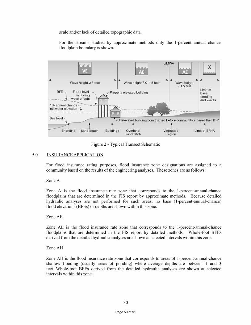
30
scale and/or lack of detailed topographic data. For the streams studied by approximate methods only the 1-percent annual chance floodplain boundary is shown.
Figure 2 - Typical Transect Schematic
5.0 INSURANCE APPLICATION
For flood insurance rating purposes, flood insurance zone designations are assigned to a community based on the results of the engineering analyses. These zones are as follows: Zone A Zone A is the flood insurance rate zone that corresponds to the 1-percent-annual-chance floodplains that are determined in the FIS report by approximate methods. Because detailed hydraulic analyses are not performed for such areas, no base (1-percent-annual-chance) flood elevations (BFEs) or depths are shown within this zone. Zone AE Zone AE is the flood insurance rate zone that corresponds to the 1-percent-annual-chance floodplains that are determined in the FIS report by detailed methods. Whole-foot BFEs derived from the detailed hydraulic analyses are shown at selected intervals within this zone. Zone AH Zone AH is the flood insurance rate zone that corresponds to areas of 1-percent-annual-chance shallow flooding (usually areas of ponding) where average depths are between 1 and 3 feet. Whole-foot BFEs derived from the detailed hydraulic analyses are shown at selected intervals within this zone.
Page 50 of 91
31
Zone AO
Zone AO is the flood insurance rate zone that corresponds to areas of 1-percent-annual-chance shallow flooding (usually sheet flow on sloping terrain) where average depths are between 1 and 3 feet. Average whole-foot depths derived from the detailed hydraulic analyses are shown within this zone. Zone AR Zone AR is the flood insurance risk zone that corresponds to an area of special flood hazard formerly protected from the base flood event by a flood-control system that was subsequently decertified. Zone AR indicates that the former flood-control system is being restored to provide protection from the 1-percent-annual-chance or greater flood event. Zone A99 Zone A99 is the flood insurance rate zone that corresponds to areas of the 1-percent-annual-chance floodplain that will be protected by a f ederal flood protection system where construction has reached specified statutory milestones. No BFEs or depths are shown within this zone. Zone V Zone V is the flood insurance rate zone that corresponds to the 1-percent-annual-chance coastal floodplains that have additional hazards associated with storm waves. Because approximate hydraulic analyses are performed for such areas, no BFEs are shown within this zone. Zone VE
Zone VE is the flood insurance rate zone that corresponds to the 1-percent-annual-chance coastal floodplains that have additional hazards associated with storm waves. Whole-foot BFEs derived from the detailed hydraulic analyses are shown at selected intervals within this zone. Zone X Zone X is the flood insurance rate zone that corresponds to areas outside the 0.2-percent-annual-chance floodplain, areas within the 0.2-percent-annual-chance floodplain, areas of 1-percent-annual-chance flooding where average depths are less than 1 foot, areas of 1-percent-annual-chance flooding where the contributing drainage area is less than 1 square mile (sq. mi.), and areas protected from the base flood by levees. No BFEs or depths are shown within this zone. Zone X (Future Base Flood) Zone X (Future Base Flood) is the flood insurance risk zone that corresponds to the 1-percent-annual-chance floodplains that are determined based on future-conditions hydrology. No BFEs or base flood depths are shown within this zone.
Page 51 of 91
32
Zone D Zone D is the flood insurance rate zone that corresponds to unstudied areas where flood hazards are undetermined, but possible.
6.0 FLOOD INSURANCE RATE MAP
The FIRM is designed for flood insurance and floodplain management applications. For flood insurance applications, the map designates flood insurance rate zones as described in Section 5.0 and, in the 1-percent-annual-chance floodplains that were studied by detailed methods, shows selected whole-foot BFEs or average depths. Insurance agents use the zones and base flood elevations in conjunction with information on structures and their contents to assign premium rates for flood insurance policies.
For floodplain management applications, the map shows by tints, screens, and symbols, the 1- percent-annual-chance floodplain, and the locations of selected transects sections used in the hydraulic analyses and floodway computations. The current FIRM presents flooding information for the entire geographic area of Accomack County. Historical data relating to the pre-countywide maps prepared for each community are presented in Table 4 , “ Community Map History”.
7.0 OTHER STUDIES
FISs are being conducted for Northampton County, Virginia, which borders Accomack County to the south, and for Somerset and Worcester Counties in Maryland, which border Accomack County to the north. Being part of the same regional analysis, the results of this study are all in or will be in agreement with the adjacent studies. Information pertaining to revised and unrevised flood hazards for each jurisdiction within Accomack County has been compiled into this FIS. Therefore, this FIS supersedes all previously printed FIS reports, and FIRMs for all of the incorporated and unincorporated jurisdictions within Accomack County, and should be considered authoritative for the purposes of the NFIP.
8.0 LOCATION OF DATA
Information concerning the pertinent data used in preparation of this FIS can be obtained by contacting FEMA, Federal Insurance and Mitigation Division, FEMA Region III, One Independence Mall, Sixth Floor, 615 Chestnut Street, Philadelphia, Pennsylvania 19106-4404.
Page 52 of 91
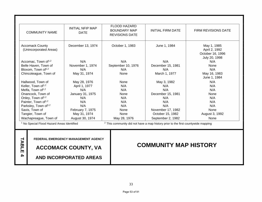
33
COMMUNITY NAME
INITIAL NFIP MAP DATE
FLOOD HAZARD BOUNDARY MAP REVISIONS DATE
INITIAL FIRM DATE FIRM REVISIONS DATE
Accomack County December 13, 1974 October 1, 1983 June 1, 1984 May 1, 1985 (Unincorporated Areas) April 2, 1992 October 16, 1996 July 20, 1998 Accomac, Town of1,2 N/A N/A N/A N/A Belle Haven, Town of November 1, 1974 September 10, 1976 December 15, 1981 None Bloxom, Town of1,2 N/A N/A N/A N/A Chincoteague, Town of May 31, 1974 None March 1, 1977 May 16, 1983 June 1, 1984 Hallwood, Town of May 28, 1976 None May 3, 1982 N/A Keller, Town of1,2 April 1, 1977 N/A N/A N/A Melfa, Town of1,2 N/A N/A N/A N/A Onancock, Town of January 31, 1975 None December 15, 1981 None Onley, Town of1,2 N/A N/A N/A N/A Painter, Town of1,2 N/A N/A N/A N/A Parksley, Town of1,2 N/A N/A N/A N/A Saxis, Town of February 7, 1975 None November 17, 1982 None Tangier, Town of May 31, 1974 None October 15, 1982 August 3, 1992 Wachapreague, Town of August 30, 1974 May 28, 1976 September 2, 1982 None 1 No Special Flood Hazard Areas Identified 2 This community did not have a map history prior to the first countywide mapping
TA
BL
E 4
FEDERAL EMERGENCY MANAGEMENT AGENCY
ACCOMACK COUNTY, VA
AND INCORPORATED AREAS
COMMUNITY MAP HISTORY
Page 53 of 91
3441
9.0 BIBLIOGRAPHY AND REFERENCES 1. Federal Emergency Management Agency, Flood Insurance Study, Accomack County, Virginia
(Unincorporated Areas), Washington, D.C., December 1, 1983. 2. Federal Emergency Management Agency, Flood Insurance Study, Town of Belle Haven,
Accomack and Northampton Counties, Virginia, Washington, D.C., June 15, 1981. 3. Federal Emergency Management Agency, Flood Insurance Study, Town of Chincoteague,
Accomack County, Virginia, Washington, D.C., June 1, 1984. 4. Federal Emergency Management Agency, Flood Insurance Study, Town of Hallwood,
Accomack County, Virginia, Washington, D.C., November 3, 1981. 5. Federal Emergency Management Agency, Flood Insurance Study, Town of Onancock,
Accomack County, Virginia, Washington, D.C., June 15, 1981. 6. Federal Emergency Management Agency, Flood Insurance Study, Town of Saxis,
Accomack County, Virginia, Washington, D.C., May 17, 1982. 7. Federal Emergency Management Agency, Flood Insurance Study, Town of Tangier, Accomack
County, Virginia, Washington, D.C., April 15, 1982. 8. Federal Emergency Management Agency, Flood Insurance Study, Town of Wachapreague,
Accomack County, Virginia, Washington, D.C., March 2, 1982. 9. U.S. Department of Commerce, Bureau of the Census, Internet address: www.census.gov,
Population Finder, 2013. 10. The Eastern Shore of Virginia Network, Internet address: www.esva.net/geodex.cgi. 11. U.S. Department of Commerce, National Oceanic and Atmospheric Administration Ocean Center,
Center for Operational Oceanographic Products and Services, Internet address: www.co-ops.nos.noaa.gov, Predictions, 2005.
12. The Eastern Shore News, Accomac, Virginia, August 25, 1933. 13. U.S. Department of Agriculture, Weather Bureau, Climatological Data, Virginia Section,
Volume XLVI, Number 9, Washington, D. C., September 1936. 14. U.S. Department of Agriculture, Weather Bureau, Climatological Data, Virginia Section,
Volume LXIV, Number 10, Washington, D. C., October 1954. 15. The Eastern Shore News, Accomac, Virginia, October 10, 1957. 16. The Eastern Shore News, Accomac, Virginia, September 15, 1960. 17. The Virginian-Pilot, Norfolk, Virginia, March 8, 1962. 18. Commonwealth of Virginia, An Assessment: Virginia’s Response to Hurricane Isabel,
Richmond, Virginia, December 2003.
Page 54 of 91
35
19. U.S. Department of Commerce, National Oceanic and Atmospheric Administration, NOAA Technical Report NOS CO-OPS 040, Effects of Hurricane Isabel on Water Levels Data Report, Silver Spring, Maryland, April 2004.
20. Commonwealth of Virginia, Virginia Uniform Statewide Building Code, Article 8, Part C,
Section 872.6, September 1973. 21. National Academy of Sciences, Methodology for Calculating Wave Action Effects Associated
with Storm Surges, Washington, D.C., 1977. 22. Luettich, R.A. and J.J. Westernik, A (Parallel Advanced Circulation Model for Oceanic, Coastal
and Estuarine Waters (ADCIRC), Version 45.12, University of North Carolina at Chapel Hill, Institute of Marine Sciences. Morehead City, North Carolina, February 6, 2008.
23. U.S. Army Corps of Engineers. ERDC/CHL TR11-X. FEMA Region III Storm Surge Study
Coastal Storm Surge Analysis: Modeling System Validation Submission No. 2, U.S. Army Corps of Engineers, 2012.
24. Federal Emergency Management Agency, Atlantic Ocean and Gulf of Mexico Coastal Guidelines
Update. Washington, DC, 2007. 25. Federal Emergency Management Agency, Wave Height Analysis for Flood Insurance Studies
(WHAFIS), Version 4.0. Washington, DC, August 2007. 26. Maps, Inc. of Baltimore, Maryland, Topographic Maps compiled from aerial photographs, Scale
1:2,400, Contour Interval 2 Feet: Town of Saxis, Accomack County, Virginia, flown October 1977; Town of Tangier, Accomack County, Virginia, flown September 1977.
27. U.S. Department of the Interior, Geological Survey, 7.5-Minute Series Topographic Maps, Scale
1:24,000, Contour Interval 5 feet: Pocomoke City, Maryland-Virginia, 1968; Girdletree, Maryland-Virginia, 1966, Photorevised 1973; Boxiron, Maryland-Virginia, 1964; Whittington Point, Maryland-Virginia, 1964; Ewell, Maryland-Virginia, 1968; Great Fox Island, Maryland-Virginia, 1968; Crisfield, Maryland-Virginia, 1968; Saxis, Virginia-Maryland, 1968, Photorevised 1973; Hallwood, Virginia-Maryland, 1968; Chincoteague West, Virginia, 1965; Chincoteague East, Virginia, 1965, Photorevised 1973; Tangier Island, Virginia, 1968; Chesconessex, Virginia, 1968; Parksley, Virginia, 1968; Bloxom, Virginia, 1968, Photorevised 1973; Wallops Island, Virginia, 1965; Nandua Creek, Virginia, 1968; Pungoteague, Virginia, 1968; Accomac, Virginia, 1968; Metomkin Inlet, Virginia, 1968; Jamesville, Virginia, 1968; Exmore, Virginia, 1968; Wachapreague, Virginia, 1974; Nassawadox, Virginia, 1968, Photorevised 1973; Quinby Inlet, Virginia, 1968.
28. Photo Science, Inc. of Gaithersburg, Maryland, Aerial Photographs, Scale 1:12,000, Accomack
County and Town of Tangier, Virginia, September 1977; Town of Saxis, Virginia, October 1977.
29. U.S. Army Corps of Engineers, Galveston District, Guidelines for Identifying Coastal High
Hazard Zones, Galveston, Texas, June 1975.
Page 55 of 91
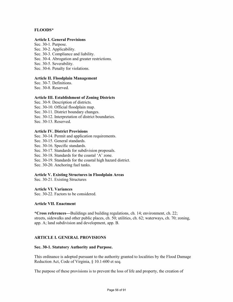
FLOODS* Article I. General Provisions Sec. 30-1. Purpose. Sec. 30-2. Applicability. Sec. 30-3. Compliance and liability. Sec. 30-4. Abrogation and greater restrictions. Sec. 30-5. Severability. Sec. 30-6. Penalty for violations. Article II. Floodplain Management Sec. 30-7. Definitions. Sec. 30-8. Reserved. Article III. Establishment of Zoning Districts Sec. 30-9. Description of districts. Sec. 30-10. Official floodplain map. Sec. 30-11. District boundary changes. Sec. 30-12. Interpretation of district boundaries. Sec. 30-13. Reserved. Article IV. District Provisions Sec. 30-14. Permit and application requirements. Sec. 30-15. General standards. Sec. 30-16. Specific standards. Sec. 30-17. Standards for subdivision proposals. Sec. 30-18. Standards for the coastal ‘A’ zone. Sec. 30-19. Standards for the coastal high hazard district. Sec. 30-20. Anchoring fuel tanks. Article V. Existing Structures in Floodplain Areas Sec. 30-21. Existing Structures Article VI. Variances Sec. 30-22. Factors to be considered. Article VII. Enactment *Cross references—Buildings and building regulations, ch. 14; environment, ch. 22; streets, sidewalks and other public places, ch. 50; utilities, ch. 62; waterways, ch. 70; zoning, app. A; land subdivision and development, app. B. ARTICLE I. GENERAL PROVISIONS Sec. 30-1. Statutory Authority and Purpose. This ordinance is adopted pursuant to the authority granted to localities by the Flood Damage Reduction Act, Code of Virginia, § 10.1-600 et seq. The purpose of these provisions is to prevent the loss of life and property, the creation of
Page 56 of 91
health and safety hazards, the disruption of commerce and governmental services, the extraordinary and unnecessary expenditure of public funds for flood protection and relief, and the impairment of the tax base by: (a) regulating uses, activities, and development which, alone or in combination with other existing or future uses, activities, and development, will cause unacceptable increases in flood heights, velocities, and frequencies. (b) restricting or prohibiting certain uses, activities, and development from locating within districts subject to flooding. (c) requiring all those uses, activities, and developments that do occur in flood-prone districts to be protected and/or flood-proofed against flooding and flood damage. (d) protecting individuals from buying land and structures which are unsuited for intended purposes because of flood hazards. The special flood hazard areas are generated for storm surges and coastal flood hazards, and then designated on the Flood Insurance Rate Maps (FIRMs) as Zones AE (base flood elevation data has been provided), Coastal A Zone (area subject to wave heights between 1.5 feet and 3 feet) and Zones VE (Coastal high hazard base flood elevation data has been provided). References to other special flood hazard areas have been omitted from this ordinance since they are not identified on the Town of Chincoteague (Accomack County) FIRMs. If other special flood hazard areas are added as revisions to the FIRMs, this ordinance will be revised to reflect the additional zones. Since the FIRMs are based on storm surges and coastal flood hazards, paragraph 60.3.(c)(10) of the CFR 44 (cumulative effects of proposed developments), which does not apply along lakes, bay shores, estuaries, and the ocean coast, has been omitted from this Ordinance as not being applicable. Sec. 30-2. Applicability. These provisions shall apply to all lands within the jurisdiction of the Town of Chincoteague and identified as areas of special flood hazard according to the flood insurance rate map (FIRM) that is provided to the Town of Chincoteague (Accomack County) by FEMA. Sec. 30-3. Compliance and liability. (a) No land shall hereafter be developed and no structure shall be located, relocated, constructed, reconstructed, enlarged, or structurally altered except in full compliance with the terms and provisions of this ordinance and any other applicable ordinances and regulations which apply to uses within the jurisdiction of this ordinance. (b) The degree of flood protection sought by the provisions of this ordinance is considered reasonable for regulatory purposes and is based on acceptable engineering methods of study. Larger floods may occur on rare occasions. Flood heights may be increased by man-made or natural causes, such as ice jams and bridge openings restricted by debris. This ordinance does not imply that districts outside the floodplain district, or that land uses permitted within such district, will be free from flooding or flood damages. (c) Records of actions associated with administering this ordinance will be kept on file and maintained by the zoning administrator. (d) This ordinance shall not create liability on the part of the town or any officer or employee thereof for any flood damages that result from reliance on this ordinance and/or any administrative decision made in good faith thereunder.
Page 57 of 91
Sec. 30-4. Abrogation and greater restrictions. This Ordinance supersedes Chapter 30 Floods of the Code of the Town of Chincoteague previously in effect prior to the adoption of these provisions. However, any underlying ordinance shall remain in full force and effect to the extent that its provisions are more restrictive than this ordinance. Sec. 30-5. Severability. If any section, subsection, paragraph, sentence, clause, or phrase of this ordinance shall be declared invalid for any reason whatever, such decision shall not affect the remaining portions of this ordinance. The remaining portions shall remain in full force and effect; and for this purpose, the provisions of this ordinance are hereby declared to be severable. Sec. 30-6. Penalty for violations Any person who fails to comply with any of the requirements or provisions of this article or directions of the Town Manager or any authorized employee of the Town of Chincoteague shall be guilty of a Class 3 misdemeanor and subject to the penalties therefore. In addition to the above criminal penalties, all other actions by the Town of Chincoteague for enforcement hereunder are hereby reserved, including but not limited to injunctive relief in the Circuit Court of Accomack County, Virginia. Violations and associated penalties of the Town of Chincoteague Zoning Ordinance are addressed in Appendix A of the Town Code, Article 10. The imposition of a fine or penalty for any violation of, or noncompliance with, this article shall not excuse the violation or noncompliance or permit it to continue; and all such persons shall be required to correct or remedy such violations or noncompliances within such time as reasonably determined by the officer charged with the enforcement hereof, based on the nature and seriousness of the violation, and other material circumstance. Any structure constructed, reconstructed, enlarged, altered or relocated in noncompliance with this article may be declared by the Town of Chincoteague to be a public nuisance and abatable as such. Flood insurance may be withheld from structures constructed in violation of this article. ARTICLE II. FLOODPLAIN MANAGEMENT Sec. 30-7. Definitions. The following words, terms and phrases, when used in this article, shall have the meanings ascribed to them in this section, except where the context clearly indicates a different meaning:
Base flood, means the flood having a one percent chance of being equaled or exceeded in any given year.
Base flood elevation, means the water surface elevations of the base flood, that is, the flood level that has a one percent or greater chance of occurrence in any given year. The water surface elevation of the base flood in relation to the datum specified on the community’s Flood Insurance Rate Map. For the purposes of this ordinance, the base flood is the 1% annual chance flood. Basement means any area of the building having its floor sub-grade (below ground level) on all sides. Board of Zoning Appeals means the board appointed to review appeals made by individuals with regard to decisions of the Zoning Administrator in the administration of this ordinance.
Page 58 of 91
Breakaway wall means a wall that is not part of the structural support of the building and is intended through its design and construction to collapse under specific lateral loading forces, without causing damage to the elevated portion of the building or supporting foundation system. Coastal A Zone, means flood hazard areas that have been delineated as subject to wave heights between 1.5 feet and 3 feet. Coastal high hazard area means a special flood hazard area extending from offshore to the inland limit of a primary frontal dune along an open coast and any other area subject to high velocity wave action from storms or seismic sources.
Development, means any man-made change to improved or unimproved real estate, including, but not limited to, buildings or other structures, mining, dredging, filling, grading, paving, excavation or drilling operations or storage of equipment or materials. Elevated building means a non-basement building built to have the lowest floor elevated above the ground level by means of fill, solid foundation perimeter walls, pilings, or columns (posts and piers). Existing construction, means structures for which the “start of construction” commenced before March 1, 1977the effective date of the FIRM or before January 1, 1975 for FIRMs effective before that date within the former Town limits prior to annexation, and June 1, 1984 within the areas annexed from Accomack County. “Existing construction” may also be referred to as “existing structures.”
Flood or flooding, means: (1) A general or temporary condition of partial or complete inundation of normally dry land areas from:
(a) the overflow of inland or tidal waters; or, (b) the unusual and rapid accumulation or runoff of surface waters from any source.
(2) The collapse or subsidence of land along the shore of a lake or other body of water as a result of erosion or undermining caused by waves or currents of water exceeding anticipated cyclical levels or suddenly caused by an unusually high water level in a natural body of water, accompanied by a severe storm, or by an unanticipated force of nature such as flash flood or an abnormal tidal surge, or by some similarly unusual and unforeseeable event which results in flooding as defined in paragraph 1(a) of this definition. Flood Insurance Rate Map (FIRM), means an official map of a community, on which the Administrator has delineated both the special hazard areas and the risk premium zones applicable to the community. A FIRM that has made available digitally is called a Digital Flood Insurance Rate Map (DFIRM). Flood Insurance Study (FIS), means an examination, evaluation and determination of flood hazards and, if appropriate, corresponding water surface elevations, or an examination, evaluation and determination of mudflow and/or flood-related erosion hazards. Floodplain – means any land area subject to a one (1%) percent or greater chance of being flooded in any given year as determined in Article III, Section 30-10 of this ordinance.
Page 59 of 91
Flood proofing - any combination of structural and non-structural additions, changes, or adjustments to structures which reduce or eliminate flood damage to real estate or improved real property, water and sanitary facilities, structures and their contents. Freeboard means a factor of safety usually expressed in feet above a flood level for purposes of floodplain management. “Freeboard” tends to compensate for the many unknown factors that could contribute to flood heights greater than the height calculated for a selected size flood and floodway conditions, such as wave action, bridge openings, and the hydrological effect of urbanization in the watershed.
Fuel oil tank means any container greater than 10 gallons used for storage of fuel oil. Highest adjacent grade - the highest natural elevation of the ground surface prior to construction next to the proposed walls of a structure. Historic structure means any structure that is: (1) listed individually in the National Register of Historic Places (a listing maintained by the Department of Interior) or preliminarily determined by the Secretary of the Interior as meeting the requirements for individual listing on the National Register; (2) certified or preliminarily determined by the Secretary of the Interior as contributing to the historical significance of a registered historic district or a district preliminarily determined by the Secretary to qualify as a registered historic district; (3) individually listed on a state inventory of historic places in states with historic preservation programs which have been approved by the Secretary of the Interior; or, (4) individually listed on a local inventory of historic places in communities with historic preservation programs that have been certified either:
(a) by an approved state program as determined by the Secretary of the Interior; or, (b) directly by the Secretary of the Interior in states without approved programs.
Letters of Map Change (LOMC), means an official FEMA determination, by letter, that amends or revises an effective Flood Insurance Rate Map or Flood Insurance Study. Letters of Map Change include:
Letter of Map Amendment (LOMA): An amendment based on technical data showing that a property was incorrectly included in a designated special flood hazard area. A LOMA amends the current effective Flood Insurance Rate Map and establishes that a Land as defined by meets and bounds or structure is not located in a special flood hazard
area. Letter of Map Revision (LOMR): A revision based on technical data that may show changes to flood zones, flood elevations, floodplain and floodway delineations, and planimetric features. A Letter of Map Revision Based on Fill (LOMR-F), is a determination that a structure or parcel of land has been elevated by fill above the base
flood elevation and is, therefore, no longer exposed to flooding associated with the base
flood. In order to qualify for this determination, the fill must have been permitted and placed in accordance with the community’s floodplain management regulations. Conditional Letter of Map Revision (CLOMR): A formal review and comment as to whether a proposed flood protection project or other project complies with the minimum NFIP requirements for such projects with respect to delineation of special flood hazard
areas. A CLOMR does not revise the effective Flood Insurance Rate Map or Flood
Page 60 of 91
Insurance Study. Lowest adjacent grade, means the lowest natural elevation of the ground surface next to the walls of a structure. Lowest floor, means the lowest floor of the lowest enclosed area (including basement). An unfinished or flood-resistant enclosure, usable solely for parking of vehicles, building access or storage in an area other than a basement area is not considered a building’s lowest floor; provided, that such enclosure is not built so as to render the structure in violation of the applicable non-elevation design requirements of Federal Code 44CFR §60.3.
Manufactured home means a structure, transportable in one or more sections, which is built on a permanent chassis and is designed for use with or without a permanent foundation when connected to the required utilities. For floodplain management purposes the term manufactured home also includes park trailers, travel trailers, and other similar vehicles placed on a site for greater than 180 consecutive days.
Manufactured home park or subdivision, means a parcel (or contiguous parcels) of land divided into two or more manufactured home lots for rent or sale. New construction means for the purposes of determining insurance rates, structures for which the “start of construction” commenced on or after 3/1/March 1, 1977 within the former Town limits prior to annexation, and June 1, 1984 within the areas annexed from Accomack County, and includes any subsequent improvements to such structures. For floodplain management purposes, new construction means structures for which start of construction commenced on or after theJune 1, 1984 within areas annexed from Accomack County and on or after February 2, 1989 for area within the former Town limits prior to annexation, 2/2/1989 and includes any subsequent improvements to such structures. Post-FIRM structures, means a structure for which construction or substantial improvement occurred after March 1, 1977 within the former Town limits prior to annexation, and June 1, 1984 within the areas annexed from Accomack CountyFebruary 2, 1989. Pre-FIRM structures, means a structure for which construction or substantial improvement occurred on or before March 1, 1977 within the former Town limits prior to annexation, and June 1, 1984 within the areas annexed from Accomack CountyFebruary 2, 1989. Primary frontal dune, means a continuous or nearly continuous mound or ridge of sand with relatively steep seaward and landward slopes immediately landward and adjacent to the beach and subject to erosion and overtopping from high tides and waves during major coastal storms. The inland limit of the primary frontal dune occurs at the point where there is a distinct change from a relatively steep slope to a relatively mild slope. Propane or liquefied petroleum gas tank means a container greater than 50 pounds used for the storage of propane.
Recreational vehicle means a vehicle which is: (1) built on a single chassis; (2) 400 square feet or less when measured at the largest horizontal projection; (3) designed to be self-propelled or permanently towable by a light duty truck; and, (4) designed primarily not for use as a permanent dwelling but as temporary living
Page 61 of 91
quarters for recreational camping, travel, or seasonal use. Repetitive Loss Structure, means a building covered by a contract for flood insurance that has incurred flood-related damages on two occasions within a 10-year period, in which the cost of the repair, on the average, equaled or exceeded 25 percent of the market value of the structure at the time of each such flood event; and at the time of the second incidence of flood-related damage, the contract for flood insurance contains increased cost of compliance coverage. Severe repetitive loss structure, means a structure that: (a) Is covered under a contract for flood insurance made available under the NFIP; and (b) Has incurred flood related damage – (i) For which 4 or more separate claims payments have been made under flood insurance coverage with the amount of each such claim exceeding $5,000, and with the cumulative amount of such claims payments exceeding $20,000; or (ii) For which at least 2 separate claims payments have been made under such coverage, with the cumulative amount of such claims exceeding the market value of the insured structure. Special flood hazard area means the land in the floodplain subject to a one (1%) percent or greater chance of being flooded in any given year as determined in Article III, Section 30-10 of this ordinance.
Start of construction means the date the building permit was issued, provided the actual start of construction, repair, reconstruction, rehabilitation, addition, placement, substantial improvement or other improvement was within 180 days of the permit date. The actual start means either the first placement of permanent construction of a structure on a site, such as the pouring of slab or footings, the installation of piles, the construction of columns, or any work beyond the stage of excavation; or the placement of a manufactured home on a foundation. Permanent construction does not include land preparation, such as clearing, grading and filling; nor does it include the installation on the property of accessory buildings, such as garages or sheds not occupied as dwelling units or not part of the main structure. For a substantial improvement, the actual start of the construction means the first alteration of any wall, ceiling, floor, or other structural part of a building, whether or not that alteration affects the external dimensions of the building. Structure - for flood plain management purposes, a walled and roofed building, including a gas or liquid storage tank, that is principally above ground, as well as a manufactured home. ``Structure'' for insurance coverage purposes, means
1. A building with two or more outside rigid walls and a fully secured roof, that is
affixed to a permanent site; 2. A manufactured home, also known as a mobile home, is a structure: built on a
permanent chassis, transported to its site in one or more sections, and affixed to a permanent foundation); or
3. A travel trailer without wheels, built on a chassis and affixed to a permanent
foundation, that is regulated under the community’s floodplain management and building ordinances or laws.
For insurance coverage purposes, “structure” does not mean a recreational vehicle or a park trailer or other similar vehicle, except as described in paragraph (3) of this definition, or a gas or liquid storage tank.
Page 62 of 91
Substantial damage means damage of any origin sustained by a structure whereby the cost of restoring the structure to its before-damaged condition would equal or exceed 50 percent of the market value of the structure before the damage occurred.
Substantial improvement means any reconstruction, rehabilitation, addition, or other improvement of a structure, the cost of which equals or exceeds 50 percent of the market value of the structure before the start of construction of the improvement. This term includes structures which have incurred substantial damage regardless of the actual repair work performed. The term does not, however, include either:
(1) any project for improvement of a structure to correct existing violations of state or local health, sanitary, or safety code specifications which have been identified by the local code enforcement official and which are the minimum necessary to assure safe living conditions, or (2) any alteration of a historic structure, provided that the alteration will not preclude the structure’s continued designation as a historic structure.
Violation, means the failure of a structure or other development to be fully compliant with the community's floodplain management regulations, as applicable. Sec. 30-8. Reserved. ARTICLE III. ESTABLISHMENT OF ZONING DISTRICTS Sec. 30-9. Description of districts. (a) Basis of Districts - The various floodplain districts shall include special flood hazard areas subject to a one (1%) percent or greater chance of being flooded in any given year. The basis for the delineation of these districts shall be the Flood Insurance Study (FIS) and the Flood Insurance Rate Maps (FIRM) for the Town of Chincoteague (Community number 510002) prepared by the Federal Emergency Management Agency, Federal Insurance Administration, dated March 16, 2009 May 18, 2015, and any subsequent revisions or amendments thereto.
(1) The Coastal Floodplain District shall be those areas identified as coastal AE Zones on the maps accompanying the Flood Insurance Study. Flood elevations are provided in these tidal floodplains; however, floodway data is not applicable. (2) The Coastal A District shall be those flood hazard areas that have been delineated as subject to wave heights between 1.5 feet and 3 feet. (2) The Coastal High Hazard District shall be those areas identified as VE, or V Zones that have been delineated as subject to wave heights in excess of 3 feet or subject to high-velocity wave action or wave-induced erosion.
(b) Overlay Concept
(1) The Floodplain Districts described above shall be overlays to the existing underlying districts as shown on the Official Zoning Ordinance Map, and as such, the provisions for the floodplain districts shall serve as a supplement to the underlying district provisions.
Page 63 of 91
(2) Any conflict between the provisions or requirements of the Floodplain Districts and those of any underlying district, the more restrictive provisions and/or those pertaining to the floodplain districts shall apply. (3) In the event any provision concerning a Floodplain District is declared inapplicable as a result of any legislative or administrative actions or judicial decision, the basic underlying provisions shall remain applicable.
Sec. 30-10. Official floodplain map. The boundaries of the Special Flood Hazard Area and Floodplain Districts are established as shown on the Flood Insurance Rate Map panels 51001C0065G, 51001C0070G, 51001C0260G, 51001C0270G, 51001C0280G, 51001C0285G, 51001C0290G, 51001C0485G, and 51001C0505G which is are declared to be a part of this ordinance and which shall be kept on file at the town offices. Sec. 30-11. District boundary changes. The delineation of any of the Floodplain Districts may be revised by the town where natural or man-made changes have occurred and/or where more detailed studies have been conducted or undertaken by the U. S. Army Corps of Engineers or other qualified agency, or an individual documents the need for such change. However, prior to any such change, approval must be obtained from the Federal Emergency Management Agency (FEMA). Sec. 30-12. Interpretation of district boundaries. Initial interpretations of the boundaries of the Floodplain Districts shall be made by the Zoning Administrator. Should a dispute arise concerning the boundaries of any of the Districts, the Board of Zoning Appeals shall make the necessary determination. The person questioning or contesting the location of the District boundary shall be given a reasonable opportunity to present his case to the Board and to submit his own technical evidence if he so desires. Submitting Technical Data The Town of Chincoteague base flood elevations may increase or decrease resulting from physical changes affecting flooding conditions. As soon as practicable, but not later than six months after the date such information becomes available, the Town shall notify the Federal Insurance Administrator of the changes by submitting technical or scientific data. Such a submission is necessary so that upon confirmation of those physical changes affecting flooding conditions, risk premium rates and flood plain management requirements will be based upon current data. Sec. 30-13. Reserved. ARTICLE IV. DISTRICT PROVISIONS Sec. 30-14. Permit and application requirements. (a) Floodplain Administrator – The Zoning Administrator is designated to administer and implement the provisions of this ordinance. Any decision of the Zoning Administrator may be appealed to Board of Zoning Appeals pursuant to Virginia State Code Sec. 15.2-2311.
Page 64 of 91
(b) Duties and Responsibilities of the Floodplain Administrator The duties and responsibilities of the Floodplain Administrator shall include but are not limited to:
(1) Review applications for permits to determine whether proposed activities will be located in the Special Flood Hazard Area (SFHA). (2) Interpret floodplain boundaries and provide available base flood elevation and flood hazard information. (3) Review applications to determine whether proposed activities will be reasonably safe from flooding and require new construction and substantial improvements to meet the requirements of these regulations. (4) Review applications to determine whether all necessary permits have been obtained from the Federal, State or local agencies from which prior or concurrent approval is required. (5) Use discretion to exempt obviously insignificant activities from the permit requirement.
(c) Permit Requirement - All uses, activities, and development occurring within any floodplain district, shall be undertaken only upon the issuance of a floodplain zoning permit. Such use, activity, or development shall be undertaken only in compliance with the provisions of this Chapter 30, the Virginia Uniform Statewide Building code, and all other applicable codes and ordinances, including any subdivision regulations, if applicable. Prior to the issuance of any such permit, the Zoning Administrator shall require all applications to include compliance with all applicable state and federal laws and shall review all sites for the purpose of determining that they will be in compliance with the issued permit in his reasonable discretion, upon completion of such work. (d) Site Plans and Permit Applications - All applications for development within any floodplain district and all building permits issued for the floodplain shall incorporate the following information:
(1) The elevation of the lowest floor (including basement). (2) For structures to be flood-proofed (non-residential only), the elevation to which the structure will be flood-proofed and the supporting engineering certificate. (3) The elevation of the one (1)percent chance in 100 year flood. (4) Topographic information showing existing and proposed ground elevations.
Sec. 30-15. General standards. In all special flood hazard areas the following provisions shall apply: (a) New construction andor substantial improvements shall be anchored to prevent flotation, collapse or lateral movement of the structure. (b) Manufactured homes shall be anchored to prevent flotation, collapse, or lateral movement. Methods of anchoring may include, but are not limited to, use of over-the-top
Page 65 of 91
or frame ties to ground anchors. This standard shall be in addition to and consistent with applicable state requirements for resisting wind forces. (c) New construction and substantial improvements shall be constructed with materials and utility equipment resistant to flood damage. (d) New construction andor substantial improvements shall be constructed by methods and practices that minimize flood damage. (e) Electrical, heating, ventilation, plumbing, air conditioning equipment and other service facilities, including duct work, shall be designed and/or located so as to prevent water from entering or accumulating within the components during conditions of flooding. (f) New and replacement water supply systems shall be designed to minimize or eliminate infiltration of flood waters into the system. (g) New and replacement sanitary sewage systems shall be designed to minimize or eliminate infiltration of flood waters into the systems and discharges from the systems into flood waters. (h) On-site waste disposal systems shall be located and constructed to avoid impairment to them or contamination from them during flooding. (i) Any alteration, repair, reconstruction or improvements to a building that is in compliance with the provisions of this ordinance shall meet the requirements of “new construction” as contained in this ordinance. (j) Any alteration, repair, reconstruction or improvements to a building that is not in compliance with the provisions of this ordinance, shall be undertaken only if said non-conformity is not furthered, extended, or replaced. (k) Prior to any proposed alteration or relocation of any channels or of any watercourse, stream, etc., within this jurisdiction a permit shall be obtained, if required, from the U. S. Corps of Engineers, the Virginia Department of Environmental Quality, and the Virginia Marine Resources Commission (a joint permit application is available from any of these organizations). The flood carrying capacity within an altered or relocated portion of any watercourse shall be maintained. Sec. 30-16. Specific standards. In all special flood hazard areas the following provisions shall apply: (a) Residential Construction - New construction or substantial improvement of any residential structure (including manufactured homes) shall have the lowest floor, including basement, elevated no lower than base flood elevation. (b) Non-Residential Construction - New construction or substantial improvement of any commercial, industrial, or non-residential building (or manufactured home) shall have the lowest floor, including basement, elevated to no lower than base flood elevation. Non-residential construction may be flood-proofed in lieu of being elevated provided that all areas of the building components below the elevation corresponding to the BFE plus one foot are water tight with
Page 66 of 91
walls substantially impermeable to the passage of water, and use structural components having the capability of resisting hydrostatic and hydrodynamic loads and the effect of buoyancy. A registered professional engineer or architect shall certify that the standards of this subsection are satisfied. Such certification, including the specific elevation (in relation to mean sea level) to which such structures are flood-proofed, shall be maintained by the Zoning Administrator (c) Elevated Buildings - Enclosed areas, of new construction or substantially improved structures, which are below the lowest floor elevation shall:
(1) not be designed or used for human habitation, but shall only be used for parking of vehicles, building access, or limited storage of maintenance equipment used in connection with the premises. Access to the enclosed area shall be the minimum necessary to allow for parking of vehicles (garage door) or limited storage of maintenance equipment (standard exterior door), or entry to the living area (stairway or elevator). The interior portion of such enclosed area shall not be partitioned or finished into separate rooms, except to enclose storage areas; (2) be constructed entirely of flood resistant materials below the regulatory flood protection elevation; (3) in the Coastal High Hazard District, follow the standards for elevation outlined in Article IV, Section 30-198. (4) in the Coastal A Zone, follow the standards outlined in Section 30-18(a). (5) include in Zones AE, measures to automatically equalize hydrostatic flood forces on walls by allowing for the entry and exit of flood waters. To meet this requirement, the openings must either be certified by a professional engineer or architect or meet the following minimum design criteria:
(a) Provide a minimum of two openings on different sides of each enclosed area subject to flooding. (b) The total net area of all openings must be at least one (1) square inch for each square foot of enclosed area subject to flooding. (c) If a building has more than one enclosed area, each area must have openings to allow flood waters to automatically enter and exit. (d) The bottom of all required openings shall be no higher than one (1) foot above the adjacent grade. (e) Openings may be equipped with screens, louvers, or other opening coverings or devices, provided they permit the automatic flow of flood waters in both directions. (f) Foundation enclosures made of flexible skirting are not considered enclosures for regulatory purposes, and, therefore, do not require openings. Masonry or wood underpinning, regardless of structural status, is considered an enclosure and requires openings as outlined above.
(d) Standards for Manufactured Homes and Recreational Vehicles
(1) All manufactured homes placed, or substantially improved, on individual lots or parcels, in expansions to existing manufactured home parks or subdivisions, in a new manufactured home park or subdivision or in substantially improved manufactured home
Page 67 of 91
parks or subdivisions, must meet all the requirements for new construction, including elevation and anchoring. (2) All manufactured homes placed or substantially improved in an existing manufactured home park or subdivision must be elevated so that:
(a) the lowest floor of the manufactured home is elevated no lower than base flood elevation; or, (b) the manufactured home chassis is supported by reinforced piers or other foundation elements of at least an equivalent strength, of no less than 36 inches in height above the grade, only in parks and subdivisions with no record of flood damage; (c) the manufactured home must be securely anchored to the adequately anchored foundation system to resist flotation, collapse and lateral movement; (d) in an existing manufactured home park or subdivision on which a manufactured home has incurred “substantial damage,” any manufactured home placed or substantially improved must meet the standards of Article IV, Section 30-16(d)(2)(a), and (c) above.
(3) All recreational vehicles placed on sites must either: (a) be on the site for fewer than 180 consecutive days; (b) be fully licensed and ready for highway use (a recreational vehicle is ready for highway use if it is on its wheels or jacking system, is attached to the site only by quick disconnect type utilities and security devices and has no permanently attached additions); or, (c) meet all the requirements for new construction, including anchoring and elevation requirements of Article IV, Section 30-16(d)(1) or (2)(a) and (c), above.
Sec. 30-17. Standards for subdivision proposals. (a) All subdivision proposals shall be consistent with the need to minimize flood damage; (b) All subdivision proposals shall have public utilities and facilities such as sewer, gas, electrical and water systems located and constructed to minimize flood damage; (c) All subdivision proposals shall have adequate drainage provided to reduce exposure to flood hazards, and (d) Base flood elevation data shall be provided for subdivision proposals and other proposed development proposals (including manufactured home parks and subdivisions) that exceed fifty lots or five acres, whichever is the lesser. Sec. 30-18. Standards for the coastal ‘A’ zone The Coastal A Zone shall be those areas, as defined by the VA USBC, that are subject to wave heights between 1.5 feet and 3 feet, and identified on the FIRM by Limits of Moderate Wave Action (LiMWA). For these areas, the following provisions shall apply: (a) Buildings and structures within this zone shall have the lowest floor elevated to or above the
Page 68 of 91
base flood elevation plus one foot of freeboard, and must comply with all other applicable provisions of this ordinance. Sec. 30-19. Standards for the coastal high hazard district. The VE or V Zones shall be those areas that are known as Coastal High Hazard areas, having been determined to be subject to wave heights in excess of 3 feet or subject to high-velocity wave action or wave-induced erosion. For these areas, the following provisions shall apply: (a) All new construction and substantial improvements in Zones VE and V to be elevated on pilings or columns so that:
1) The bottom of the lowest horizontal structural member of the lowest floor (excluding the pilings or columns) is elevated to or above the base flood level if the lowest horizontal structural member is parallel to the direction of wave approach or elevated at least one foot above the base flood level if the lowest horizontal structural member is perpendicular to the direction of wave approach; and,
2) The pile or column foundation and structure attached thereto is anchored to resist
flotation, collapse, and lateral movement due to the effects of wind and water loads acting simultaneously on all building components. Wind and water loading values shall each have a one percent chance of being equaled or exceeded in any given year (one-percent annual chance).
(b) A registered professional engineer or architect shall develop or review the structural design, specifications and plans for the construction, and shall certify that the design and methods of construction to be used are in accordance with accepted standards of practice for meeting the provisions of Article IV, Section 30-19(a). (c) Obtain the elevation (in relation to mean sea level) of the bottom of the lowest horizontal structural member of the lowest floor (excluding pilings and columns) of all new and substantially improved structures in Zones V and VE. The Floodplain Management Administrator shall maintain a record of all such information. (d) All new construction shall be located landward of the reach of mean high tide. (e) Provide that all new construction and substantial improvements have the space below the lowest floor either free of obstruction or constructed with non-supporting breakaway walls, open wood-lattice work, or insect screening intended to collapse under wind and water loads without causing collapse, displacement, or other structural damage to the elevated portion of the building or supporting foundation system. For the purpose of this section, a breakaway wall shall have a design safe loading resistance of not less than 10 and no more than 20 pounds per square foot. Use of breakaway walls which exceed a design safe loading resistance of 20 pounds per square foot (either by design or when so required by local codes) may be permitted only if a registered professional engineer or architect certifies that the designs proposed meet the following conditions:
(1) Breakaway wall collapse shall result from water load less than that which would occur during the base flood; and (2) The elevated portion of the building and supporting foundation system shall not be subject to collapse, displacement, or other structural damage due to the effects of wind and water loads acting simultaneously on all building components (structural and
Page 69 of 91
nonstructural). Maximum wind and water loading values to be used in this determination shall each have a one percent chance of being equaled or exceeded in any given year.
(f) The enclosed space below the lowest floor shall be useable solely for parking of vehicles, building access, or storage. Such space shall not be partitioned into multiple rooms, temperature-controlled, or used for human habitation. (g) Prohibit the use of fill for structural support of buildings. When fill is proposed in a coastal high hazard area, appropriate engineering analyses shall be conducted to evaluate the impacts of the fill prior to issuance of a development permit. (h) Prohibit man-made alteration of sand dunes which would increase potential flood damage. (i) All manufactured homes to be placed or substantially improved within Zones V, and VE on the town’s Flood Insurance Rate Map on sites must meet the standards of Article IV, Section 30-19(a) through (h) and that manufactured homes placed or substantially improved on other sites in an existing manufactured home park or subdivision with Zones V, and VE on the Flood Insurance Rate Map meet the requirements of Article IV, Section 30-16(d)(1) and (2), if they are located:
(1) outside of a manufactured home park or subdivision, (2) in a new manufactured home park or subdivision, (3) in an expansion to an existing manufactured home park or subdivision, or (4) in an existing manufactured home park or subdivision in which a manufactured home has incurred “substantial damage” due to flooding.
(j) Recreational vehicles placed on sites within Zones V, and VE on the community’s Flood Insurance Rate Map must either:
(1) be on the site for fewer than 180 consecutive days, (2) be fully licensed and ready for highway use, on its wheels or jacking system, is attached to the site only by quick disconnect type utilities and security devices, and has no permanently attached additions; or, (3) meet the requirements of Article IV, Section 30-14 and Article IV, Section 30-19(a) through (h).
Sec. 30-20. Anchoring fuel tanks. (a) All new, replaced, or existing oil, and propane tanks must be anchored against floatation, collapse and lateral movement under flood conditions by means of an approved anchorage system or shall be installed at or above base flood elevation and shall be set upon a firm foundation and supports to prevent floatation, collapse and lateral movement under flood conditions. It shall be unlawful to fill or refill any such tank that is not so anchored or elevated. (b) All new, replaced, or existing oil tanks shall have their vent pipe extended at least three feet above the top most portion of the body of the tank. This provision shall also apply to substantial improvement buildings and buildings experiencing repetitive loss. (c) All new, replaced, or existing oil tanks must all be fitted with a fill tube screw-on tight-fit cap with gasket.
Page 70 of 91
(d) This section shall be effective November 4, 2010 for new, existing or replaced fuel tanks. (Amended 4/7/08)
ARTICLE V. EXISTING STRUCTURES IN FLOODPLAIN AREAS Sec. 30-21. Existing Structures A structure or use of a structure or premises which lawfully existed before the enactment of these provisions, but which is not in conformity with these provisions, may be continued subject to the following conditions:
A. Any modification, alteration, repair, reconstruction, or improvement of any kind to a structure and/or use located in any flood plain areas to an extent or amount of less than fifty (50) percent of its market value shall conform to the VA USBC and the appropriate provisions of this ordinance.
B. The modification, alteration, repair, reconstruction, or improvement of any kind to a
structure and/or use, regardless of its location in a floodplain area to an extent or amount of fifty (50) percent or more of its market value shall be undertaken only in full compliance with this ordinance and shall require the entire structure to conform to the VA USBC.
ARTICLE VI. VARIANCES Sec. 30-22. Factors to be considered. In passing upon applications for variances, the board of zoning appeals shall satisfy all relevant factors and procedures specified in other sections of the zoning ordinance and consider the following additional factors: (a) The showing of good and sufficient cause. (b) The danger to life and property due to increased flood heights or velocities caused by encroachments. No variance shall be granted for any proposed use, development, or activity within any Floodway District that will cause any increase in the one (1) percent chance in 100 year flood elevation. (c) The danger that materials may be swept on to other lands or downstream to the injury of others. (d) The proposed water supply and sanitation systems and the ability of these systems to prevent disease, contamination, and unsanitary conditions. (e) The susceptibility of the proposed facility and its contents to flood damage and the effect of such damage on the individual owners. (f) The importance of the services provided by the proposed facility to the community. (g) The requirements of the facility for a waterfront location. (h) The availability of alternative locations not subject to flooding for the proposed use.
Page 71 of 91
(i) The compatibility of the proposed use with existing development and development anticipated in the foreseeable future. (j) The relationship of the proposed use to the comprehensive plan and floodplain management program for the area. (k) The safety of access by ordinary and emergency vehicles to the property in time of flood. (l) The expected heights, velocity, duration, rate of rise, and sediment transport of the flood waters expected at the site. (m) The repair or rehabilitation of historic structures upon a determination that the proposed repair or rehabilitation will not preclude the structure's continued designation as a historic structure and the variance is the minimum necessary to preserve the historic character and design of the structure. (n) Such other factors which are relevant to the purposes of this ordinance. All applicants must obtain documentation pertaining to the request for a variance from a Virginia certified engineer to evaluate the proposed project in relation to flood heights and velocities, and the adequacy of the plans for flood protection and other related matters prior to referring such to the board of zoning appeals. Variances shall be issued only after the board of zoning appeals has determined that the granting of such will not result in
(a) unacceptable or prohibited increases in flood heights, (b) additional threats to public safety, (c) extraordinary public expense; and will not (d) create nuisances, (e) cause fraud or victimization of the public, or (f) conflict with local laws or ordinances.
Variances shall be issued only after the board of zoning appeals has determined that the variance will be the minimum required to provide relief from exceptional hardship to the applicant. The board of zoning appeals shall notify the applicant for a variance, in writing, that the issuance of a variance to construct a structure below the one hundred (100)-year flood elevation (a) increases the risks to life and property and (b) will result in increased premium rates for flood insurance. A record shall be maintained of the above notification as well as all variance actions, including justification for the issuance of the variances. Any variances that are issued shall be noted in the annual or biennial report submitted to the Federal Insurance Administrator. ARTICLE VII. ENACTMENT This ordinance shall become effective upon passage on April 7, 2014. Amended __________.
Page 72 of 91
Page 73 of 91
Page 74 of 91
Page 75 of 91
Page 76 of 91
Page 77 of 91
February 5, 2015
Eastern Shore News: The Town of Chincoteague requests the following public notice be published in the Eastern Shore News on 2/12 and 2/19 and the Chincoteague Beacon on 2/25. Thank you. William Neville Planning Director
Public Notice The Mayor and Town Council of the Town of Chincoteague will hold a public hearing on Monday March 2, 2015 at 7:00 p.m. in the Council Chambers located at 6150 Community Drive to hear public comment on the following matter:
Floodplain Ordinance – Amend Town Code – Chapter 30 Floods with changes including but not limited to adoption of revised Flood Insurance Rate Maps and the Flood Insurance Study report for the Town of Chincoteague (Community ID number 510002) which will become effective as of May 18, 2015. Existing floodplain management regulations which meet the standards of Paragraph 60.3(e) of the NFIP will be updated to incorporate guidance from the Virginia NFIP Coordinator.
For additional information, and to review a copy of the revised documents, please contact William Neville, Town Planning Director at (757) 336-6519, or FEMA Region III National Flood Insurance Program, 615 Chestnut Street, 6th Floor, Philadelphia, PA 19106-4404 at (215) 931-5512 or www.fema.gov .
Page 78 of 91
News from the Coastal Virginia CRS Workgroup
Federal Flood Risk Management Standard - In late January, President Obama issued
Executive Order 13690, Establishing a Federal Flood Risk Management Standard and a
Process for Further Soliciting and Considering Stakeholder Input. This Executive Order
updates Executive Order 11988, which had previously governed federal actions in
floodplains. The new proposed standard requires federal agencies to consider future flood
risk in projects involving federal funding. Future flood risk must be considered both in terms
of a vertical increase in expected height of flooding and a horizontal expansion of the high-
risk floodplain. Three approaches are provided to determine expected flood heights and
whether a project is located in a high-risk flood hazard area:
• Utilizing best-available, actionable data and methods that integrate current and
future changes in flooding based on science,
• Two or three feet of elevation, depending on the criticality of the building, above
the 100-year, or 1%-annual-chance, flood elevation, or
• 500-year, or 0.2%-annual-chance, flood elevation
A public comment period is open until April 6 to submit feedback on the new standard.
There will be a listening session hosted by FEMA at Old Dominion University on March 11
beginning at 9:00 a.m.; reservations are encouraged.
2015 Virginia Legislative Updates - Several flood-related bills were proposed in this year’s
General Assembly legislative session. As of February 20, the following bills have passed both
the House and Senate:
SJ 291 Flood resilience; DEQ to study potential for funding source to localities in coastal Virginia. Introduced by: Lynwood W. Lewis, Jr.
SUMMARY AS INTRODUCED: Study; Regional Greenhouse Gas Initiative; report.
Requests the Department of Environmental Quality to study the potential for the
establishment of a funding source to localities in coastal Virginia for flood resilience that
could result by including the Commonwealth as a full participant in the Regional Greenhouse
Gas Initiative.
HB 1817 Flood protection plan; Department of Conservation and Recreation to regularly update. Introduced by: Christopher P. Stolle
SUMMARY AS INTRODUCED: Flood protection plan.
Directs the Department of Conservation and Recreation to regularly update the flood
protection plan for the Commonwealth and to make the plan accessible online. This is a
recommendation of the Joint Subcommittee to Formulate Recommendations to Address
Recurrent Flooding. This bill is identical to SB 1079.
SB 775 Virginia Residential Property Disclosure Act; representations related to special flood hazard zones. Introduced by: Mamie E. Locke
SUMMARY AS PASSED: Virginia Residential Property Disclosure Act; representations
related to special flood hazard zones.
Page 79 of 91
Page 80 of 91
Page 81 of 91
Page 82 of 91
Page 83 of 91
Page 84 of 91

Page 85 of 91
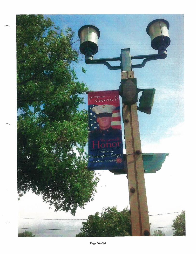
Page 86 of 91
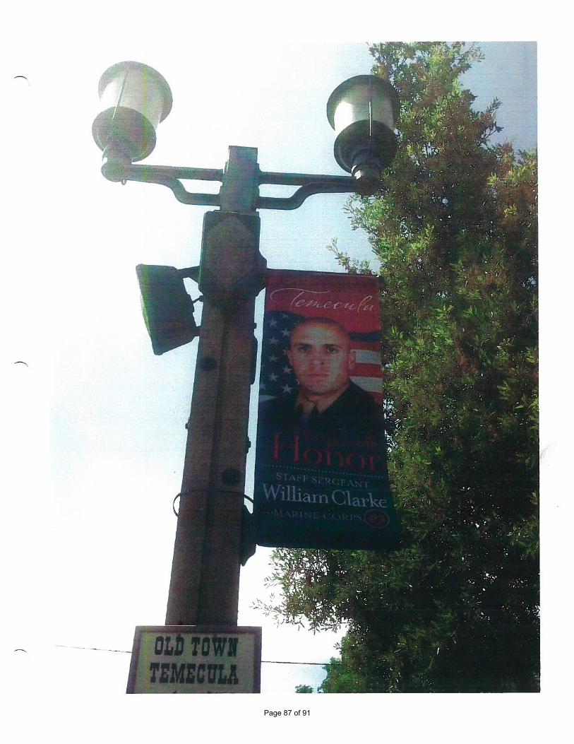
Page 87 of 91
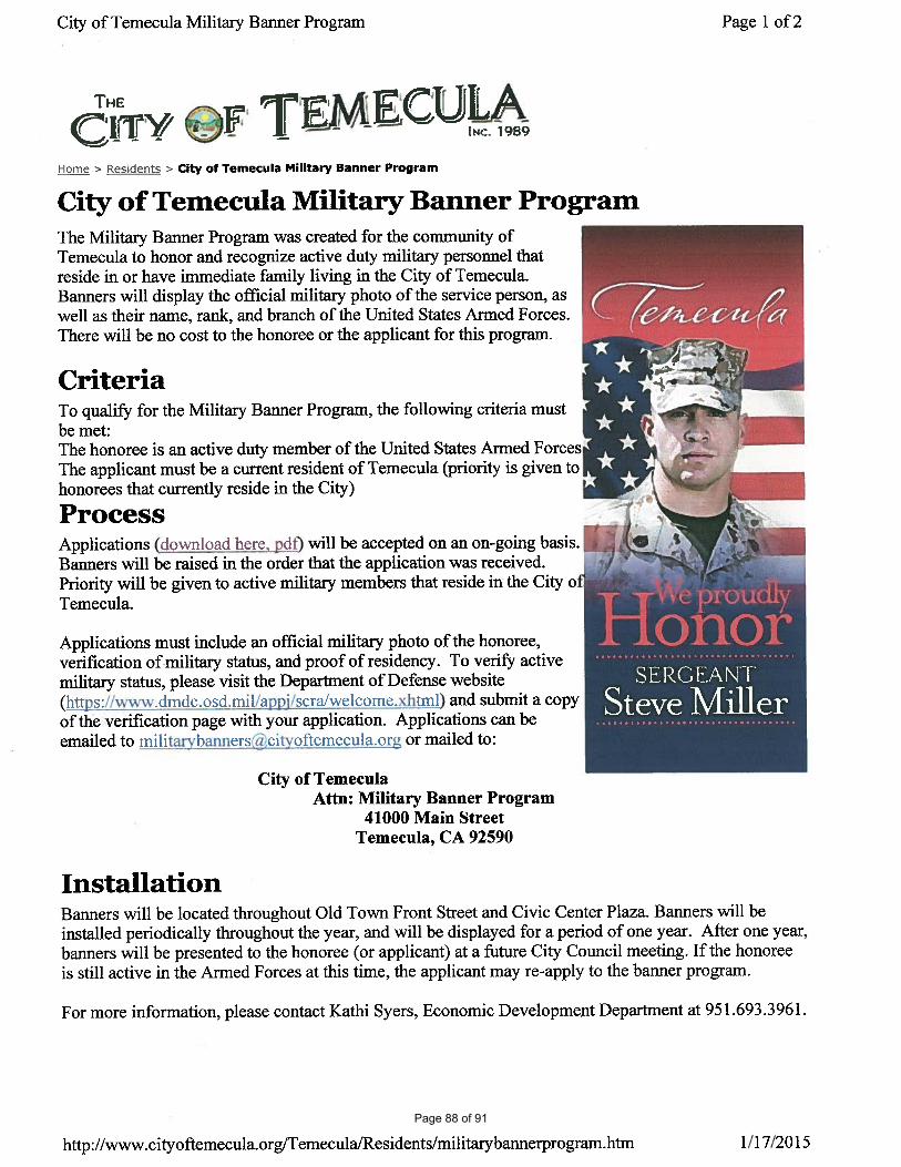
Page 88 of 91
Public Safety Meeting Minutes
February 3, 2015 Chairman Tarr stated that a quorum was not present at 17:08 Present: Mayor Tarr, Chairman Absent: Councilman Jester Robert Ritter, Jr., Town Manger Councilman Frese Bryan Rush, EM Coordinator Randy Mills, Major CPD Public Participation
No public participation. Agenda Adoption
An agenda was not adopted due to a lack of a quorum. 1. Emergency Management Report
PLANNING
EBOLA
Continued Ebola monitoring is ongoing by the Commonwealth of Virginia Department of Health. No active cases within Virginia at this time. Plans are being continually updated and revised to facilitate an emergency response if needed.
CAMPGROUND SAFETY
The Eastern Shore Disaster Preparedness Coalition is planning another meeting of Shore wide campground owners/managers to facilitate a blanket safety plan for each facility in the event of severe weather. EMERGENCY CONTACTS
The emergency contacts list for the Town EOP is being reviewed and updated as necessary. FLOOD PLAIN MANAGEMENT
The Emergency Management Division is assisting the Planning Department with surge maps of various storms to show flooding on the island. This is to anticipate the changes in base flood elevations (BFE) initiated by FEMA and devise a direction in planning that the Town should take.
LOGISTICS
NEW AMBULANCE TO BE PUT IN SERVICE
The new Chincoteague Ambulance 3-1 will be going into service the first week of February 2015. The 2014 Braun Chief XL will replace the 2008 Braun Chief XL which is in excess of 200,000 miles. The new ambulance comes as a 50/50 grant from the Virginia Office of EMS. Town EMS staff wrote and secured the grant for the volunteer fire company. Staff is currently adjusting shelving and adding after-market brackets. As soon as the radios are removed from the “old” 3-1 it will be taken out of service. Those same radios will then be installed in the “new” 3-1 and all EMS equipment will be transferred.
TIDE GAUGE The tide gauge agreement has been sent to the USGS and we are awaiting a site visit and calibration. Estimates are that data should be accessible by the end of February 2015 to the middle of March 2015. This will be well ahead of the July 1 agreement.
Page 89 of 91
EXERCISES
EBOLA
There was a table top exercise held at the Eastern Shore Community College through the Eastern Shore Disaster Preparedness Coalition on January 15, 2015. The objectives of the exercise were to implement the various plans of many agencies across the Shore to make sure everyone could respond together.
TRAINING ICS 400
There will be an ICS 400 course at the Eastern Shore Fire Training Center on April 10 and 11, 2015. Anyone needing or interested in the course should contact Bryan Rush to sign up.
OPERATIONS
DAILY WEATHER MONITORING
Daily weather monitoring is on-going, with situational awareness emails sent to department heads as necessary. In the period November – January there has been 6 conference calls and 4 briefings have been sent to department heads.
PUBLIC INFORMATION
PREPAREDNESS
Disaster preparedness information will continue on the Town’s web page, information kiosk in the office, and on the quarterly newsletter. LIFEGUARDS
The National Park Service is recruiting for lifeguards for the upcoming season at Assateague National Seashore. Anyone interested in a summer job should apply at USAjobs.com.
2. Chincoteague Volunteer Fire Company Report
Fire Chief Thornton stated that the Town’s Radio Tower would be utilized in placing a Fire/EMS Channel 1 receiver and antenna on. All portable and mobile radios will be re-programmed on the 10th of February.
3. Ordinance for False Fire Alarm Responses
Emergency Management Coordinator Rush reviewed the memo sent to committee by him in reference to a proposed ordinance allowing for billing fire alarm owners who have multiple false alarms on their premises. Coordinator Rush explained some other area ordinances and fee schedules along with the information from the Virginia State Fire Marshal’s Office that allows the locality to do such a thing. Coordinator Rush then gave an example of key points to be addressed in such an ordinance and then a discussion on time periods ensued. It was agreed upon that the time frame would be any response for a false alarm greater than 3 (three) in a 90 (ninety) day period. Mayor Tarr advised to draft an ordinance with the various proposals and send it to the Ordinance Committee for their action. 4. Committee Member Comments
Mayor Tarr was without comment. No other members present. Adjournment
The informal meeting disbanded at 17:43
Page 90 of 91
Minutes of the February 10, 2015 Chincoteague Budget and Personnel Committee Meeting
Committee Members Present John H. Tarr, Mayor Ben G. Ellis, Councilman Gene W. Taylor, Councilman 1. Call to Order. Mayor Tarr called the meeting to order at 5:03 p.m. 2. Agenda. Councilman Ellis moved, seconded by Councilman Taylor to adopt the agenda, as presented. 3. Town Motor Vehicle License for Low Speed Vehicles. Last year, there was confusion and miscommunication within the Town concerning whether or not low speed vehicles were required to have a Town Motor vehicle license. When the Town researched the Town code on the requirements for a vehicle license, the code states that all motor vehicles within the Town require a license. The question then was the definition of a motor vehicle. State code identifies low speed vehicles as motor vehicle. The code sections and information was forward to Town Attorney Poulson that opined low speed vehicle are required to purchase a decal. 23 people purchased a Town license in 2014 for a low speed vehicle other owners did not. The Committee on a motion by Councilman Taylor, seconded by Councilman Ellis to recommend to the Town Council to refund the 2014 decal money for the 23 purchased with a letter explaining that in 2015 and after the decal is required. Unanimously approved. The Committee also recommended this be advertised. 4. Delinquent Meals Tax and Transient Occupancy Taxpayers. Information was presented to the Committee on 5 delinquent taxpayers and steps which have been made to collect the taxes. Each case was discussed and the Committee asked that certain steps now be taken. The Committee also informed staff that in the future, if the delinquent taxpayer does not respond to our certified or personal service letter by the given deadline to get the Town Attorney to write a letter to the delinquent taxpayer and if that does not work, charge the owner under the appropriate code section for criminal violation and have the Town Attorney take it to court. 5. Evaluation Forms. Mayor Tarr was very disappointed in Council’s evaluations of the Town Manager and Police Chief. Council must take this seriously and put the time into an evaluation. It should be meaningful for the employee as well as Council. There is an obligation to the employee, Council and the taxpayers. Various forms and methods were discussed. Major Mills stated the Police Department uses a software program that allows him to make notes throughout the year concerning things affecting an employee so he does not have to rely on 12 months of memory for all the employees of the department. Councilman Ellis and the Town Manager are to work together on designing a new method/form for evaluation use. They are also to review the software being used by the Police Department. Their report is due to the Committee in two months. Once the Town’s Manager method/form is finalized then they will work on the Police Chief’s. It is hoped they will come up with something that can be changed for use on all Town employees. 6. Adjournment. Councilman Taylor motioned, seconded by Councilman Ellis to adjourn the meeting. Unanimously approved.
Page 91 of 91


![Don’s Efforts [Public Outreach]](https://img.pdfslide.net/doc/110x75/56816203550346895dd227e4/dons-efforts-public-outreach.jpg)