Embed Size (px)
Citation preview
Relative Abundance and Distribution of Fishes within an Established Area of Critical Environmental Concern, of the Amargosa River Canyon and Willow Creek, Inyo and San Bernardino Counties, California
U.S. Department of the InteriorU.S. Geological Survey
Open-File Report 2011–1161

Relative Abundance and Distribution of Fishes within an Established Area of Critical Environmental Concern, of the Amargosa River Canyon and Willow Creek, Inyo and San Bernardino Counties, California
By G. Gary Scoppettone, Mark E. Hereford, Peter H. Rissler, Danielle M. Johnson, and J. Antonio Salgado
Open-File Report 2011-1161
U.S. Department of the Interior U.S. Geological Survey
U.S. Department of the Interior KEN SALAZAR, Secretary
U.S. Geological Survey Marsha K. McNutt, Director
U.S. Geological Survey, Reston, Virginia: 2011
For more information on the USGS—the Federal source for science about the Earth, its natural and living resources, natural hazards, and the environment, visit http://www.usgs.gov or call 1-888-ASK-USGS. For an overview of USGS information products, including maps, imagery, and publications, visit http://www.usgs.gov/pubprod
To order this and other USGS information products, visit http://store.usgs.gov
Suggested citation: Scoppettone, G.G., Hereford, M.E., Rissler, P.H., Johnson, D.M., and Salgado, J.A., 2011, Relative abundance and distribution of fishes within an established Area of Critical Environmental Concern, of the Amargosa River Canyon and Willow Creek, Inyo and San Bernardino Counties, California: U.S. Geological Survey Open-File Report 2011-1161, 32 p.
Any use of trade, product, or firm names is for descriptive purposes only and does not imply endorsement by the U.S. Government.
Although this report is in the public domain, permission must be secured from the individual copyright owners to reproduce any copyrighted material contained within this report.
iii
Contents Abstract ......................................................................................................................................................................... 1 Introduction .................................................................................................................................................................... 2 Description of Area ........................................................................................................................................................ 4 Materials and Methods .................................................................................................................................................. 5 Results ........................................................................................................................................................................... 7 Discussion ....................................................................................................................................................................14 Acknowledgments ........................................................................................................................................................15 References Cited ..........................................................................................................................................................16 Appendix A. Photograph of an Amargosa River Pupfish, Distribution and Size Range of Crayfish and Mosquito Fish Captured, Sampling Locations, Capture Summary, and Water Quality of Select Locations in the Amargosa River Canyon and Willow Creek in the Summer of 2010 ...................................................18
Figures Figure 1. Amargosa River Canyon study area and Bureau of Land Management Area of Critical Environmental Concern (ACEC) in relation to the Amargosa River, California and Nevada .......................... 3 Figure 2. Study area with established sampling stations for fishes along Amargosa River Canyon (n = 335) and Willow Creek (n = 70). Predominant vegetation types also are shown as native vegetation (NV), closed cattail, common reed (CCR), and saltcedar (SC), Inyo and San Bernardino Counties, California ....................................................................................................................................... 6 Figure 3. Distribution and relative abundance of Amargosa River pupfish (Cyprinodon nevadensis amargosae) and speckled dace (Rhinichthys osculus spp.) in the upper reach of the Amargosa River Canyon (river km 0–3.50) in the summer of 2010, California ......................................................................... 8 Figure 4. Distribution and relative abundance of Amargosa River pupfish (Cyprinodon nevadensis amargosae) and speckled dace (Rhinichthys osculus spp.) in the middle reach of the Amargosa River Canyon (river km 3.55–6.85) in the summer of 2010, California. ................................................................... 9 Figure 5. Distribution and relative abundance of Amargosa River pupfish (Cyprinodon nevadensis amargosae) and speckled dace (Rhinichthys osculus spp.) in the lower reach of the Amargosa River Canyon (river km 6.90–12.25) in the summer of 2010, California ................................................................ 10 Figure 6. Length frequency of Amargosa River pupfish (Cyprinodon nevadensis amargosae) caught during the summer 2010 survey of the Amargosa River Canyon, California................................................ 11 Figure 7. Length frequency of speckled dace (Rhinichthys osculus spp.) caught during the summer 2010 survey of the Amargosa River Canyon, California .............................................................................. 12 Figure 8. Relative distribution and abundance of Amargosa River pupfish (Cyprinodon nevadensis amargosae) and speckled dace (Rhinichthys osculus spp.) in Willow Creek, a tributary of the Amargosa River Canyon in the summer of 2010, California ........................................................................ 13
iv
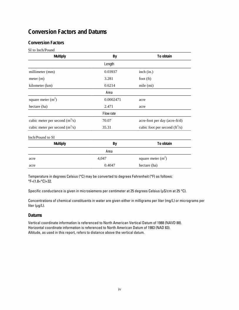
Conversion Factors and Datums Conversion Factors SI to Inch/Pound
Multiply By To obtain
Length
millimeter (mm) 0.03937 inch (in.)
meter (m) 3.281 foot (ft)
kilometer (km) 0.6214 mile (mi)
Area
square meter (m2) 0.0002471 acre
hectare (ha) 2.471 acre
Flow rate
cubic meter per second (m3/s) 70.07 acre-foot per day (acre-ft/d)
cubic meter per second (m3/s) 35.31 cubic foot per second (ft3/s) Inch/Pound to SI
Multiply By To obtain
Area
acre 4,047 square meter (m2)
acre 0.4047 hectare (ha) Temperature in degrees Celsius (°C) may be converted to degrees Fahrenheit (°F) as follows: °F=(1.8×°C)+32. Specific conductance is given in microsiemens per centimeter at 25 degrees Celsius (µS/cm at 25 °C). Concentrations of chemical constituents in water are given either in milligrams per liter (mg/L) or micrograms per liter (µg/L).
Datums Vertical coordinate information is referenced to North American Vertical Datum of 1988 (NAVD 88). Horizontal coordinate information is referenced to North American Datum of 1983 (NAD 83). Altitude, as used in this report, refers to distance above the vertical datum.
1
Relative Abundance and Distribution of Fishes within an Established Area of Critical Environmental Concern, of the Amargosa River Canyon and Willow Creek, Inyo and San Bernardino Counties, California
By G. Gary Scoppettone, Mark E. Hereford, Peter H. Rissler, Danielle M. Johnson and J. Antonio Salgado
Abstract The Amargosa River Canyon of San Bernardino and Inyo County, California, has been
designated by the Bureau of Land Management as an Area of Critical Environmental Concern, due in part to its unique flora and fauna. As a task of the Area of Critical Environmental Concern implementation plan, a survey of native fishes was conducted from June 21 to August 12, 2010. Geographic Information System tools were used to map sampling locations, which were spaced at 50-meter intervals. Global Positioning Systems were used to locate sampling stations, and stations with adequate water for successful trapping were sampled with baited minnow traps. Amargosa River pupfish (Cyprinodon nevadensis amargosae) and speckled dace (Rhinichthys osculus spp.) were widespread throughout Armargosa River Canyon. Throughout the study area 8,558 pupfish were captured at 194 stations; 3,472 speckled dace were captured at 210 stations; 238 red-swamp crayfish (Procambarus clarkia) were captured at 83 stations; and 1,095 western mosquitofish (Gambusia affinus) were captured at 110 stations. Pupfish were most abundant in open water habitat with native riparian vegetation, and they were significantly less abundant where the stream was completely covered by cattails or where saltcedar (Tamarix sp.) dominated the riparian corridor. There was no relationship between stream cover and speckled dace distribution. Non-native western mosquitofish and red-swamp crayfish densities were significantly higher in stream reaches dominated by saltcedar. The continued spread of saltcedar threatens to negatively affect pupfish and potentially reduce speckled dace abundance throughout the Amargosa River Canyon. This study can serve as baseline information for observing native fish populations in the future, as related to potential changes to the Amargosa River Canyon ecosystem.
2
Introduction The Amargosa River supports wetlands in North America’s hottest and driest region, the
Mojave Desert. The odd combination of moist habitat within an excessively dry landscape has fostered an area of high biodiversity (Williams and others, 1984; Sada, 1990; Deacon and Deacon-Williams, 1991). Flowing in its entirety in the Late Pleistocene, the Amargosa River is now represented by disjunct spring-fed reaches, each sufficiently isolated to have divergent flora and fauna (Hubbs and Miller, 1948), making these desert oases hotspots for endemic flora and fauna. Many of these wetland relics of the Pluvial Amargosa River are under public ownership (Bureau of Land Management, U.S. Fish and Wildlife Service, and National Park Service) or owned and managed by The Nature Conservancy.
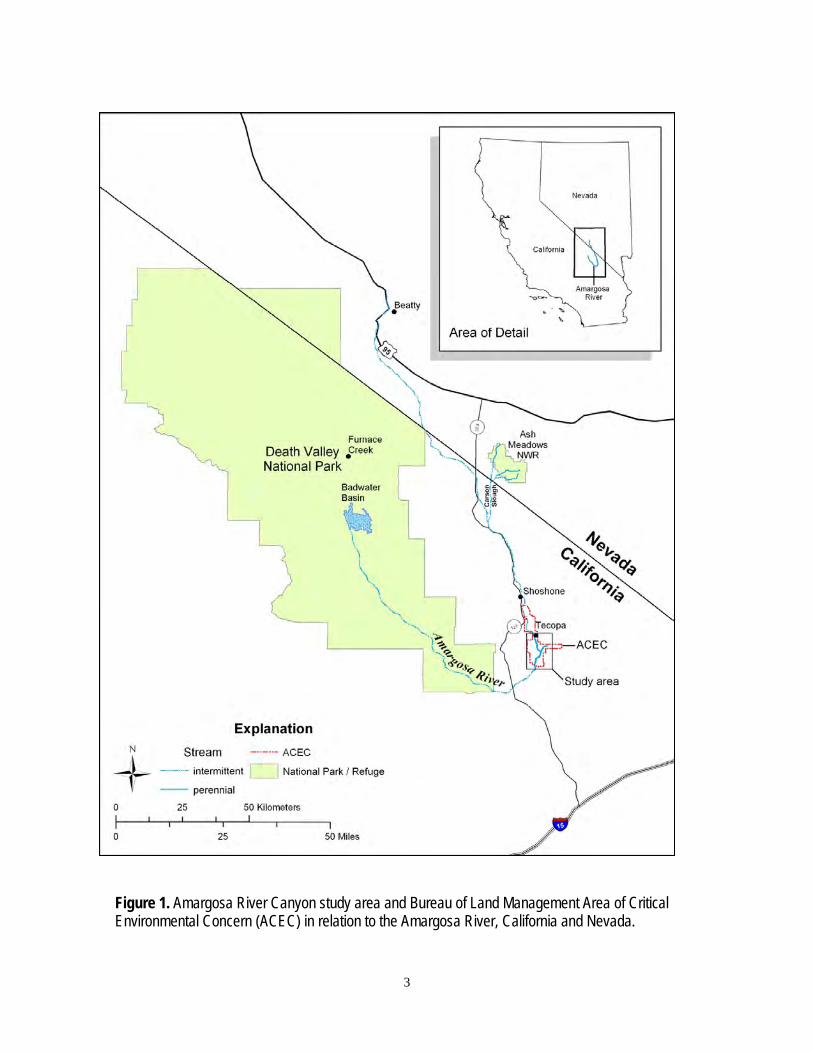
The Amargosa River Canyon, of Inyo and San Bernardino Counties in California, is the longest perennial reach of the Amargosa River today. Due to the biological importance, historical and cultural values, and scenic beauty of the Amargosa River, the Bureau of Land Management designated 21,552 acres surrounding the river and its tributaries from south of Shoshone to Sperry as an Area of Critical Environmental Concern (ACEC) (fig. 1). This survey of the Amargosa River Canyon lies in the southern portion of the ACEC and extends south past the border of the ACEC. All sampling locations that lie outside the ACEC were dry and therefore not sampled for fish. The ACEC designation led to an implementation plan aimed at protecting the canyon. The plan outlines an inventory and monitoring strategy that includes a survey of the Amargosa River pupfish (Cyprinodon nevadensis amargosae) and speckled dace (Rhinichthys osculus spp.). The last documented survey of Amargosa River Canyon fishes occurred in 1981 (Williams and others, 1982), before the establishment of the ACEC. Due to cattle grazing, less vegetation covered the stream in 1981 (Anthony Chavez, Rangeland Management Specialist/Weed Coordinator, Bureau of Land Management, Barstow, CA, oral commun., 2010).
We conducted a fish survey in the Amargosa River Canyon during the summer of 2010, almost 10 years after cattle grazing ceased. Since the 1982 survey of the Amargosa River Canyon conducted by Williams and others (1982), non-native saltcedar has proliferated in some stream reaches of the canyon (Jack Williams, Senior Scientist, Trout Unlimited, Medford OR, oral commun., 2010). Because saltcedar has been implicated in causing the decline of native species (Kennedy and others, 2005), we tested the effect of relative native versus non-native riparian stream cover on fishes and crayfish abundance.
3
Figure 1. Amargosa River Canyon study area and Bureau of Land Management Area of Critical Environmental Concern (ACEC) in relation to the Amargosa River, California and Nevada.
4
Description of Area The Amargosa River Canyon is situated 90 km southeast of the Death Valley National
Park headquarters at Furnace Creek, California (fig. 1). The perennial flow within this region originates from springs and seeps beginning just north of Old Spanish Trail Highway (OSTH) (403 m elevation) and from several springs and seeps along its course. During the time of our study, June 21–August 12, 2010, streamflow at the U.S. Geological Survey gaging station near OSTH ranged from 2.83 × 10⁻⁴ to 1.42 × 10⁻³; streamflow was 2.55 × 10⁻² m3/s 8.5 km downstream of OSTH.
During periods of intense rainfall, streamflows have exceeded 453 × 103 m3/s. From our survey start at OSTH to just south of Sperry, there were changes in dominant riparian vegetation and relative stream coverage, which we categorized into three broad habitat types: (1) riparian corridor predominated by native vegetation (NV), with riparian vegetation comprised of various combinations of cattail (Typha sp.), bulrush (Scirpus), or common reed (Phragmites sp.) and occasional willow (Salix sp.), mesquite (Prosopis), or saltcedar (Tamarix sp.), with much of the water surface open and typically receiving sunlight; (2) riparian corridor predominated and shaded by saltcedar (SC) with intermittent dense stand of cattail along the stream edge; (3) stream covered with a dense stand of cattail or common reed (CCR) lying over the stream such that locating water required forceful movement through dense vegetation.
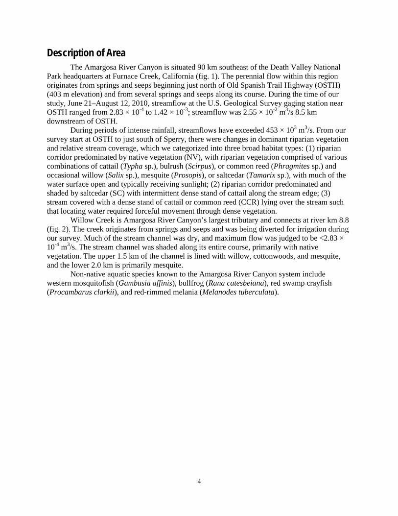
Willow Creek is Amargosa River Canyon’s largest tributary and connects at river km 8.8 (fig. 2). The creek originates from springs and seeps and was being diverted for irrigation during our survey. Much of the stream channel was dry, and maximum flow was judged to be <2.83 × 10⁻⁴ m3/s. The stream channel was shaded along its entire course, primarily with native vegetation. The upper 1.5 km of the channel is lined with willow, cottonwoods, and mesquite, and the lower 2.0 km is primarily mesquite.
Non-native aquatic species known to the Amargosa River Canyon system include western mosquitofish (Gambusia affinis), bullfrog (Rana catesbeiana), red swamp crayfish (Procambarus clarkii), and red-rimmed melania (Melanodes tuberculata).

5
Materials and Methods We used Geographic Information System (GIS) tools in ArcGIS 10 (ESRI, 2010), and the
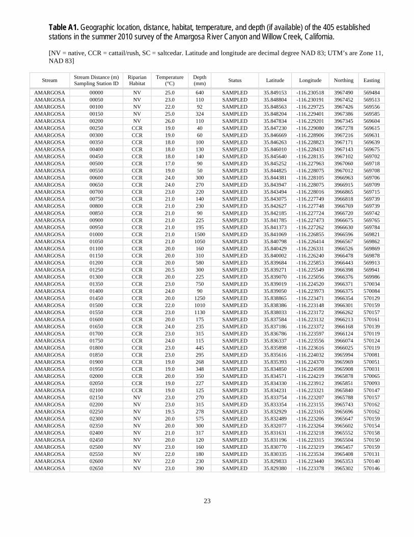
National Agricultural Imagery Program (NAIP) to trace stream channels and to determine locations of sampling stations, which were set at 50-m intervals. A total of 405 sampling stations were established, 335 along 16.75 km of the Amargosa River Canyon and 70 stations along 3.5 km of the Willow Creek (fig. 2). Each sampling station location was downloaded into Garmin© Global Positioning System (GPS) units. These units typically put us within a 2-m radius of a specific station. Once a station was located, a 3.3 mm mesh Standard Gee minnow trap, baited with dry dog food was set, and typically fished overnight for 15–24 hr. Fish captured were identified to species, 10 individuals per trap (when available) were measured to either fork length or total length (as appropriate), and the remainder were enumerated by species. Red swamp crayfish also were enumerated and measured from the tip of the rostrum to the tip of the uropods. We also measured water depth and water temperature at each trap location, and noted vegetative type, lat/long and UTM coordinates, distance from OSTH, and habitat type, for the 405 potential sample stations (table A1).
6
Figure 2. Study area with established sampling stations for fishes along Amargosa River Canyon (n = 335) and Willow Creek (n = 70). Predominant vegetation types also are shown as native vegetation (NV), closed cattail, common reed (CCR), and saltcedar (SC), Inyo and San Bernardino Counties, California.
7
A Hydrolab DataSonde® 5 was used to measure water temperature, dissolved oxygen, conductivity, and pH at five locations along the Amargosa River Canyon and three along Willow Creek. Sampling locations were spread along the length of each of the two streams, but were influenced by stream accessibility. Measurements were made on July 27, 2010.
The data collected in our sampling effort were used to develop species specific GIS maps using ArcGIS 10 (ESRI, 2010), which display species relative abundance and distribution. We analyzed the data post hoc using a Kruskal-Wallis single factor analysis of variance to test whether pupfish and speckled dace densities were negatively influenced by heavily shaded reaches (SC and CCR).
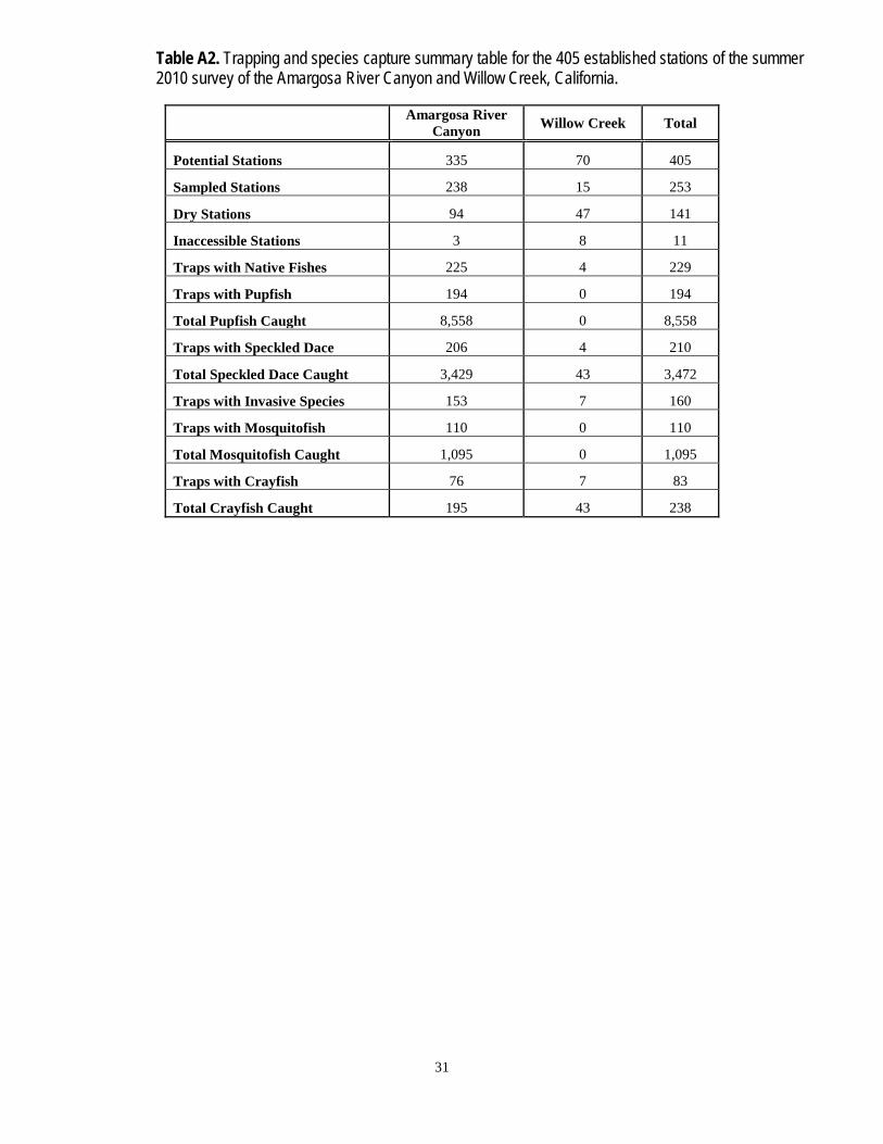
Results Of 335 stations established along the Amargosa River Canyon, three stations were
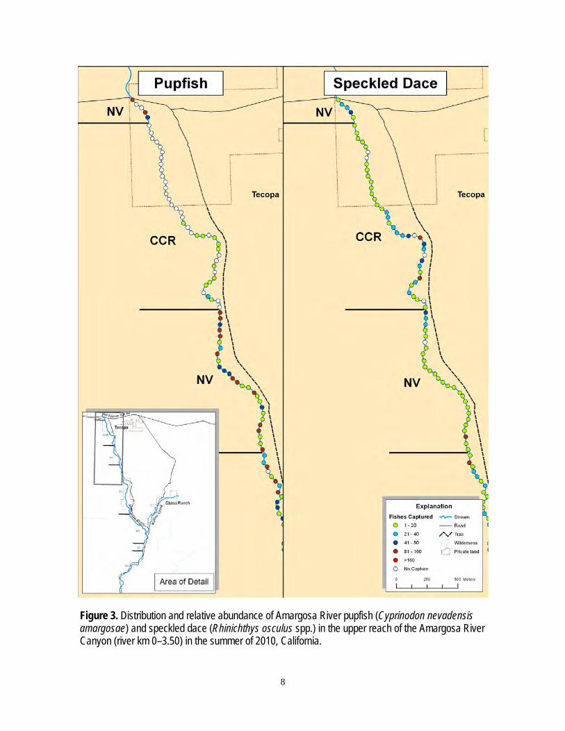
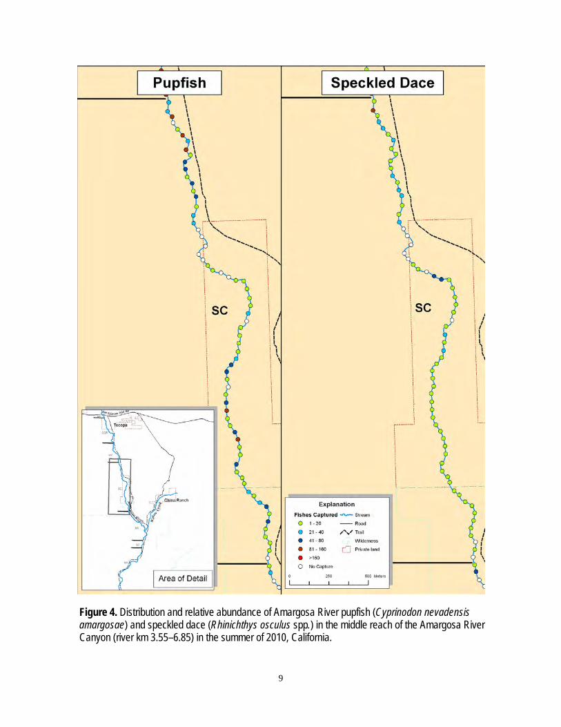
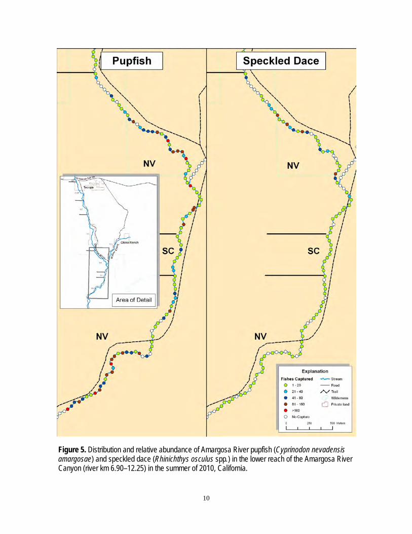
inaccessible due to a dense stand of saltcedar, and 94 were dry or water was too shallow to set a trap (fig. 2). Of 238 traps fished, 225 captured native fishes (figs. 3, 4, and 5). Speckled dace were slightly more widespread and occurred in 206 traps compared to 194 for pupfish. But total captures were higher for pupfish (n= 8,558) than speckled dace (n=3,429) (table A2). The disparity in capture success among traps suggests that neither pupfish nor speckled dace are evenly distributed throughout the Amargosa River Canyon.
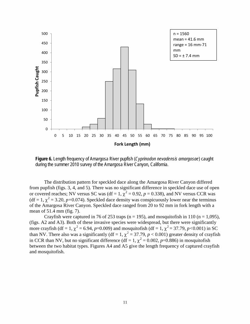
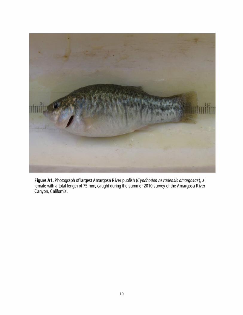
Pupfish capture success was significantly higher (df = 1, χ2 = 11.30, p = 0.006) in stream reaches predominated by native riparian vegetation (NV) with open water than those reaches heavily shaded with saltcedar vegetation (SC). Pupfish densities were significantly greater (df = 1, χ2 = 56.03, p<0.001) in stream reaches predominated by native riparian vegetation (NV) with open water than those reaches heavily shaded with cattail/common reed vegetation (CCR). Pupfish ranged from 16 to 71 mm in total length with a mean length of 41.6 mm (fig. 6). The large majority of pupfish captured were equal to or greater than 31mm in length, indicating that they were sexually mature (Moyle, 2002). The longest fish captured (71 mm) during our systematic sampling effort was a female; however, in supplemental sampling to recapture this large fish for a photograph, we captured a female 75 mm in length (fig. A1).
8
Figure 3. Distribution and relative abundance of Amargosa River pupfish (Cyprinodon nevadensis amargosae) and speckled dace (Rhinichthys osculus spp.) in the upper reach of the Amargosa River Canyon (river km 0–3.50) in the summer of 2010, California.
9
Figure 4. Distribution and relative abundance of Amargosa River pupfish (Cyprinodon nevadensis amargosae) and speckled dace (Rhinichthys osculus spp.) in the middle reach of the Amargosa River Canyon (river km 3.55–6.85) in the summer of 2010, California.
10
Figure 5. Distribution and relative abundance of Amargosa River pupfish (Cyprinodon nevadensis amargosae) and speckled dace (Rhinichthys osculus spp.) in the lower reach of the Amargosa River Canyon (river km 6.90–12.25) in the summer of 2010, California.
11
Figure 6. Length frequency of Amargosa River pupfish (Cyprinodon nevadensis amargosae) caught during the summer 2010 survey of the Amargosa River Canyon, California.
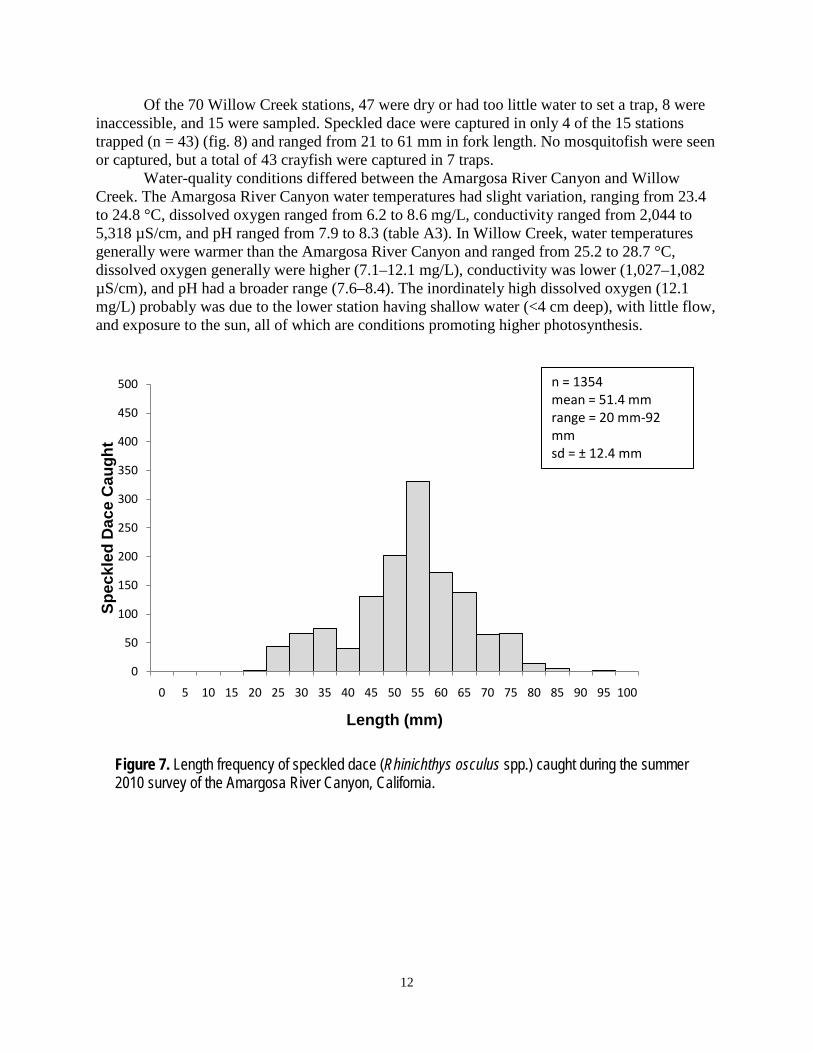
The distribution pattern for speckled dace along the Amargosa River Canyon differed from pupfish (figs. 3, 4, and 5). There was no significant difference in speckled dace use of open or covered reaches; NV versus SC was (df = 1, χ2 = 0.92, p = 0.338), and NV versus CCR was (df = 1, χ2 = 3.20, p=0.074). Speckled dace density was conspicuously lower near the terminus of the Amargosa River Canyon. Speckled dace ranged from 20 to 92 mm in fork length with a mean of 51.4 mm (fig. 7).
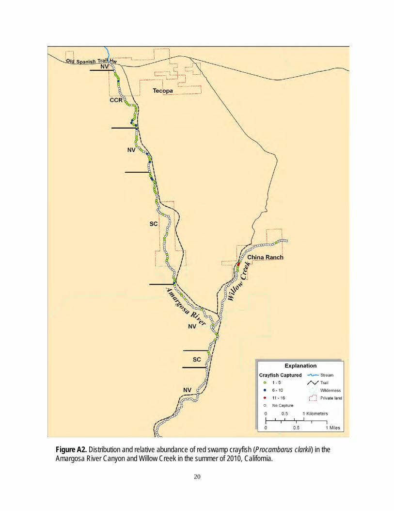
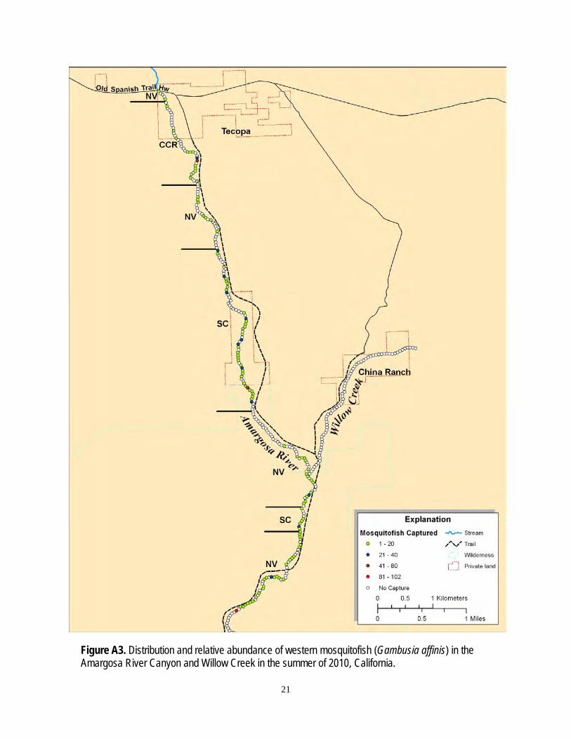
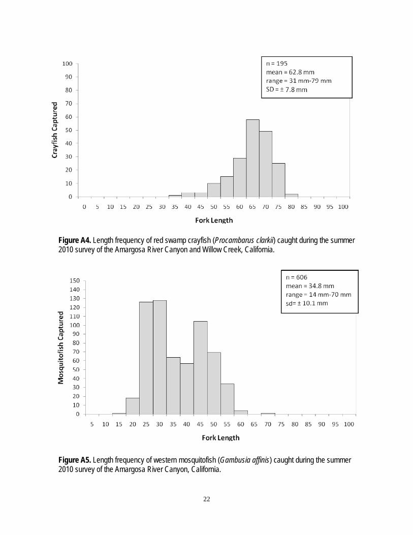
Crayfish were captured in 76 of 253 traps (n = 195), and mosquitofish in 110 (n = 1,095), (figs. A2 and A3). Both of these invasive species were widespread, but there were significantly more crayfish (df = 1, χ2 = 6.94, p=0.009) and mosquitofish (df = 1, χ2 = 37.79, p<0.001) in SC than NV. There also was a significantly (df = 1, χ2 = 37.79, p < 0.001) greater density of crayfish in CCR than NV, but no significant difference (df = 1, χ2 = 0.002, p=0.886) in mosquitofish between the two habitat types. Figures A4 and A5 give the length frequency of captured crayfish and mosquitofish.
0
50
100
150
200
250
300
350
400
450
500
0 5 10 15 20 25 30 35 40 45 50 55 60 65 70 75 80 85 90 95 100
Pupf
ish
Caug
ht
Fork Length (mm)
n = 1560mean = 41.6 mmrange = 16 mm-71 mmSD = ± 7.4 mm
12
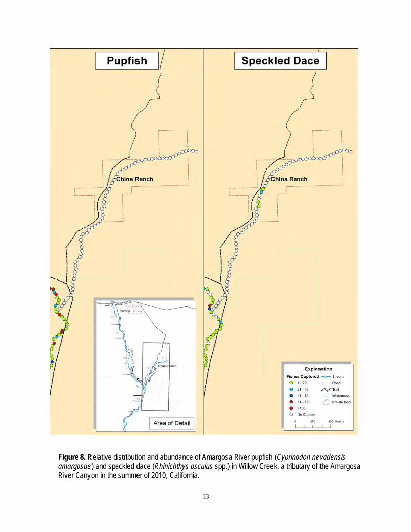
Of the 70 Willow Creek stations, 47 were dry or had too little water to set a trap, 8 were inaccessible, and 15 were sampled. Speckled dace were captured in only 4 of the 15 stations trapped (n = 43) (fig. 8) and ranged from 21 to 61 mm in fork length. No mosquitofish were seen or captured, but a total of 43 crayfish were captured in 7 traps.
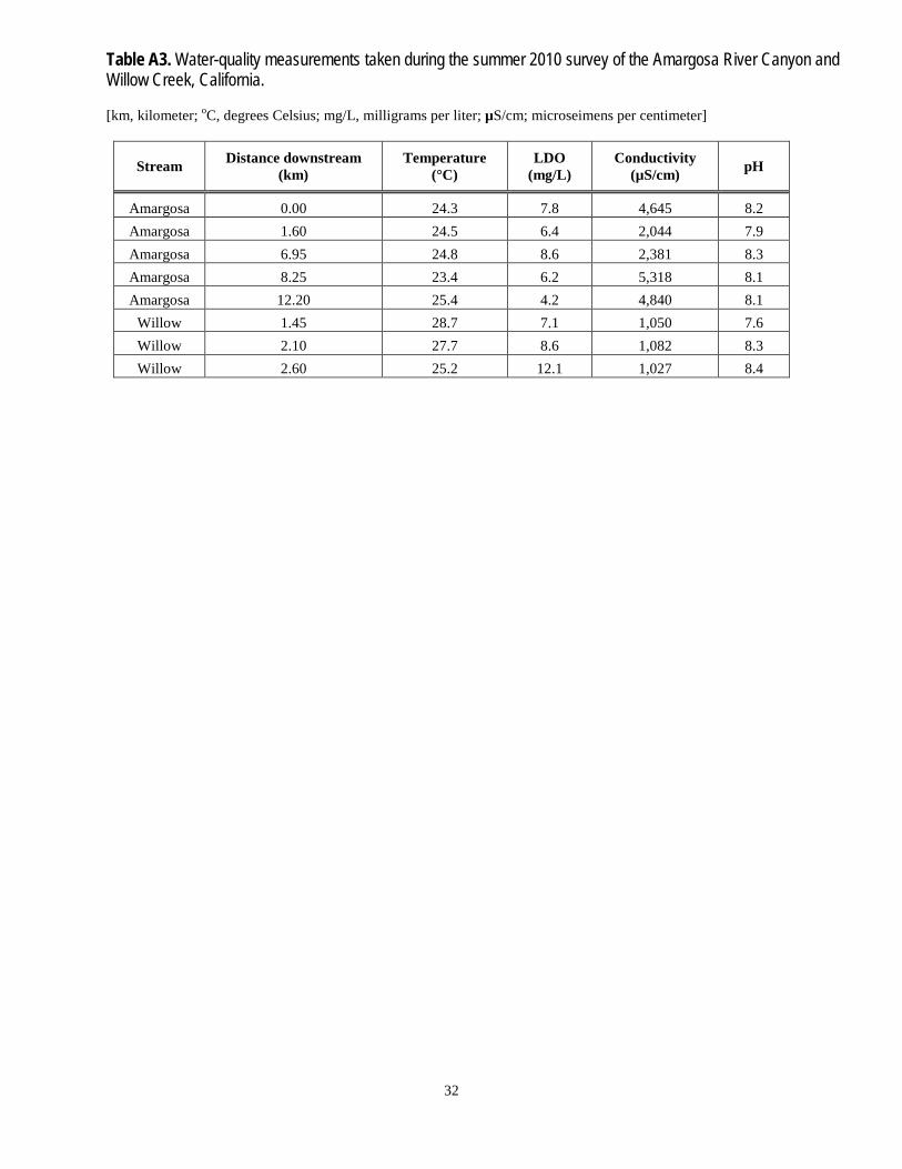
Water-quality conditions differed between the Amargosa River Canyon and Willow Creek. The Amargosa River Canyon water temperatures had slight variation, ranging from 23.4 to 24.8 °C, dissolved oxygen ranged from 6.2 to 8.6 mg/L, conductivity ranged from 2,044 to 5,318 µS/cm, and pH ranged from 7.9 to 8.3 (table A3). In Willow Creek, water temperatures generally were warmer than the Amargosa River Canyon and ranged from 25.2 to 28.7 °C, dissolved oxygen generally were higher (7.1–12.1 mg/L), conductivity was lower (1,027–1,082 µS/cm), and pH had a broader range (7.6–8.4). The inordinately high dissolved oxygen (12.1 mg/L) probably was due to the lower station having shallow water (<4 cm deep), with little flow, and exposure to the sun, all of which are conditions promoting higher photosynthesis.
Figure 7. Length frequency of speckled dace (Rhinichthys osculus spp.) caught during the summer 2010 survey of the Amargosa River Canyon, California.
0
50
100
150
200
250
300
350
400
450
500
0 5 10 15 20 25 30 35 40 45 50 55 60 65 70 75 80 85 90 95 100
Spec
kled
Dac
e C
augh
t
Length (mm)
n = 1354mean = 51.4 mmrange = 20 mm-92 mmsd = ± 12.4 mm
13
Figure 8. Relative distribution and abundance of Amargosa River pupfish (Cyprinodon nevadensis amargosae) and speckled dace (Rhinichthys osculus spp.) in Willow Creek, a tributary of the Amargosa River Canyon in the summer of 2010, California.
14
Discussion
Native fishes were found throughout the Amargosa River Canyon area. Pupfish density was significantly higher within native riparian vegetation reaches with open water rather than heavily shaded reaches. Similarly, Kennedy and others (2005) found that Ash Meadows pupfish (Cyprinodon navedensis mionectes) numbers were reduced where saltcedar shaded their habitat. Algae is the primary food item consumed by Ash Meadows pupfish as well as the Amargosa River pupfish (Naiman, 1975; Kennedy and others, 2005) and algae production is negatively affected by a saltcedar canopy, this in turn reduces pupfish density (Kennedy and Hobbie, 2004; Kennedy and others, 2005). Speckled dace are more carnivorous than pupfish, feeding more on aquatic and terrestrial invertebrates, which are not necessarily relegated to open water habitat (Osborne and Herricks, 1987; Lancaster and others, 1996). The only region of the stream where speckled dace were scarce was in the lowest reach. This reach is subject to desiccation; we observed pupfish mortality caused by stranding and pool desiccation. It was unclear whether speckled dace scarcity in this reach constitutes stranding avoidance by the species.
Results from Williams and others (1982) indicated speckled dace were rare within the Amargosa River Canyon area compared with pupfish, while this study found both species supported in robust numbers. There are two plausible reasons for the difference in results. First, Williams and others (1982) used a seine for sampling, which is limited to sampling open water pools where pupfish were high in numbers. Second, the Amargosa River Canyon was being grazed at the time of the Williams and others (1982) study, keeping the stream channel open, which we suspect favored pupfish. In sun exposed pools, male pupfish tend to be more territorial (Lema and Nevitt, 2004), which may lead to some degree of speckled dace avoidance. Saltcedar appears to be spreading throughout Amargosa River Canyon, probably at the expense of native fish populations. Our data supports the findings of Kennedy and others (2005) that pupfish are suppressed by a saltcedar canopy while the invasive red swamp crayfish and western mosquitofish are promoted.
Crayfish and mosquitofish have been found to impact native fish populations negatively in previous studies; crayfish compete with and prey upon native fishes (Guan and Wiles, 1997; Light, 2005), and mosquitofish probably compete with speckled dace for food because they share trophic resources (Caiola and de Soston, 2005). Mosquitofish also are a known predator of fish larvae and eggs (Meffe, 1985; Swanson and others, 1996; Mills and others, 2004). The highest density of these two invasive species was within reaches shaded by saltcedar. Thus, native fishes within these reaches are potentially subjected not only to reduced productivity due to shade, but also to increased probably of competition and predation from invasive species. Adult red swamp crayfish are opportunistic feeders, but tend toward herbivory (Harper and others, 2002), and they can survive by consuming saltcedar leaves. In contrast, saltcedar leaves have little direct or indirect nutritive value for pupfish or speckled dace (Kennedy and others, 2005). Our capture data suggest that crayfish were not abundant in the Amargosa River Canyon area. Why they were found in such low numbers can only be speculated upon; however, the continued spread of saltcedar may enhance the crayfish and mosquitofish populations.
15
Only speckled dace were found in Willow Creek, and whether pupfish historically occurred there is unknown. With little water in the channel, speckled dace were greatly restricted in distribution and crayfish were abundant. The combination of restricted distribution and low water volume and velocity probably enhance the negative effects of crayfish on the speckled dace population. We suggest the speckled dace population in Willow Creek be closely monitored.
Amargosa River Canyon native fish numbers appeared relatively robust in this study, but we have no analogous historical capture information with which to compare our data. Presumably, native fish were in greater abundance prior to the invasion of saltcedar, crayfish, and mosquitofish, all of which have been found to negatively impact native fish populations. Saltcedar threatens to continue proliferating throughout the river. Historically, fire and flood were stochastic events serving to keep the stream channel open and dynamic (Benda and others, 2003; Kozlowski and others, 2010), but now such events also serve as agents for the spread of saltcedar (Wiesenborn, 1996), threatening to form a saltcedar monoculture along the river and throughout the floodplain. With the increase in saltcedar, populations of native fishes are expected to decrease in size due to the increase in crayfish and mosquitofish, the reduction in primary production, and the drafting of substantially greater water by saltcedar when compared with native vegetation (Duncan and McDaniel, 1998). Other potential threats to native fish include an ever increasing human demand for water, and future increase in drafting from the aquifer(s) supplying the Amargosa River. The introduction of other non-native species also is a threat (Moyle, 2002).
Acknowledgments We thank the Bureau of Land Management, Barstow, California field office for funding
this project. We also thank Brian Brown and Mr. and Mrs. Jon Zellhoefer for allowing access to their respective properties, and Bill Christian for serving as our liaison to the landowners. Thanks to Stefanie Scoppettone and Mark Fabes for their reviews of the manuscript. Special thanks to Steve Parmenter, California Department of Fish and Game, for assisting us with our sampling effort.
16
References Cited Benda, L., Miller, D., Bigelow, P., and Andras, K., 2003, Effects of post-wildfire erosion on
channel environments: Forest Ecology and Management, v. 178, p. 105-119. Caiola, N., and de Sostoa, A., 2005, Possible reasons for the decline of two native toothcarps in
the Iberian Peninsula - evidence of competition with the introduced Eastern mosquitofish: Journal of Applied Ichthyology, v. 21, no. 4, p. 358-363.
Deacon, J.E., and Deacon-Williams, C., 1991, Ash Meadows and the legacy of the Devils Hole pupfish, in Minckley, W.L., and Deacon, J.E., eds., Battle Against Extinction: Native Fish Management in the American West: The University of Arizona Press, Tucson, p. 69-87.
Duncan, K.W., and McDaniel, K.C., 1998, Saltcedar (Tamarix sp.) Management with Imazapyr: Weed Technology, no. 12, p. 337-344.
ESRI, 2010, ArcGIS, version 10: Environmental Systems Research Institute, Redlands, California.
Guan, R., and Wiles, P.R., 1997, Ecological impact of introduced crayfish on benthic fishes in a British Lowland River: Conservation Biology, v. 11, no. 3, p. 641-647.
Harper, D.M., Smart, A.C., Coley, S., Schmiz, S., Gouder de Beauregard, A., North, R., Adams, C., Obade, P., and Kamau, M., 2002, Distribution and abundance of the Louisiana red swamp crayfish Procambarus clarkii Girard at Lake Naivasha, Kenya between 1987 and 1999: Hydrobiologia, v. 488, p. 143-151.
Hubbs, C.L., and Miller, R.R., 1948, The zoological evidence—Correlation between fish distribution and hydrographic history in the desert basins of western United States, in The Great Basin, with emphasis on glacial and postglacial times: Bulletin of the University of Utah, Biological Series 10, v. 38, no. 20, p. 17-166.
Kennedy, T.A., Finlay, J.C., and Hobbie, S.E., 2005, Eradication of invasive Tamarix ramosissima along a desert stream increases native fish density: Ecological Applications, v. 15, p. 2072-2083.
Kennedy, T.A., and Hobbie, S.E., 2004, Saltcedar (Tamarix ramosissima) invasion alters organic matter dynamics in a desert stream: Freshwater Biology, v. 49, p. 65-76.
Kozlowski, D., Swanson, S., and Schmidt, K., 2010, Channel changes in burned streams of northern Nevada: Journal of Arid Environments, v. 74, p. 1494-1506.
Lancaster, J., Hildrew, A.G., and Gjerlov, C., 1996, Invertebrate drift and longitudinal transport processes in streams: Canadian Journal of Aquatic Science, v. 53, p. 572-582.
Lema, S.C., and Nevitt, G.A., 2004, Exogenous vasotocin alters aggression during agonistic exchanges in male Amargosa River pupfish (Cyprinodon nevadensis amargosae): Hormones and Behavior, v. 46, p. 628-637.
Light, T., 2005, Behavioral effects of invaders: alien crayfish and native sculpin in a California stream: Biological Invasions, v. 7, p. 353-367.
Mills, M.D., Rader, R.B., and Belk, M.C., 2004, Complex interactions between native and invasive fish—the simultaneous effects of multiple negative interactions: Oecologia, v. 141, p. 713-721.
Naiman, R.J., 1975, Food habitats of the Amargosa pupfish in a thermal stream: Transactions of the American Fisheries Society, v. 104, p. 536-538.
Meffe, G.K., 1985, Predation and species replacement in American southwestern fishes—a case study: Southwest Naturalist, v. 30, p. 173-187.
Moyle, P.B., 2002, Inland Fishes of California: University of California Press, Berkeley, 517 p.
17
Osborne, L.L., and Herricks, E.E., 1987, Microhabitat characteristics of Hydropsyche (Tichoptera: Hydropsychidae) and the importance of body size: Journal of the North American Benthological Society, v. 6, p. 115-124.
Sada, D.W., 1990, Recovery plan for the endangered and threatened species of Ash Meadows, Nevada: U.S. Fish and Wildlife Service, Reno, Nevada, 86 p. plus appendixes.
Swanson, C.S., Cech, Jr., J.J., and Piedrahita, R.H., 1996, Mosquitofish— Biology, Culture, and Use in Mosquito Control: Mosquito and Vector Control Association of California and The University of California Mosquito Research Program, Sacramento, California, 88 p.
Wiesenborn, W.D., 1996, Saltcedar impacts on salinity, water, fire frequency and flooding, in DiTomas, J., and Bell, C.E., eds., Proceedings of the Saltcedar Management Workshop, June 12, 1996, Rancho Mirage, CA, p. 9-12.
Williams, C.D., Hardy, T.P., and Deacon, J.E., 1982, Distribution and status of fishes of the Amargosa River Canyon, California: Report submitted to U.S. Fish and Wildlife Service, Endangered Species Office, Sacramento, California.
Williams, J.E., Kobetich, G.C., and Benz, C.T., 1984, Management aspects of relict populations inhabiting the Amargosa Canyon ecosystem, in Warner, R.E., and Hendrix, K.M., eds., California Riparian Systems—Ecology, Conservation, and Productive Management: University of California Press, Berkeley, p. 706-715.
18
Appendix A. Photograph of an Amargosa River Pupfish, Distribution and Size Range of Crayfish and Mosquito Fish Captured, Sampling Locations, Capture Summary, and Water Quality of Select Locations in the Amargosa River Canyon and Willow Creek in the Summer of 2010.
19
Figure A1. Photograph of largest Amargosa River pupfish (Cyprinodon nevadensis amargosae), a female with a total length of 75 mm, caught during the summer 2010 survey of the Amargosa River Canyon, California.
20
Figure A2. Distribution and relative abundance of red swamp crayfish (Procambarus clarkii) in the Amargosa River Canyon and Willow Creek in the summer of 2010, California.
21
Figure A3. Distribution and relative abundance of western mosquitofish (Gambusia affinis) in the Amargosa River Canyon and Willow Creek in the summer of 2010, California.
22
Figure A4. Length frequency of red swamp crayfish (Procambarus clarkii) caught during the summer 2010 survey of the Amargosa River Canyon and Willow Creek, California.
Figure A5. Length frequency of western mosquitofish (Gambusia affinis) caught during the summer 2010 survey of the Amargosa River Canyon, California.
23
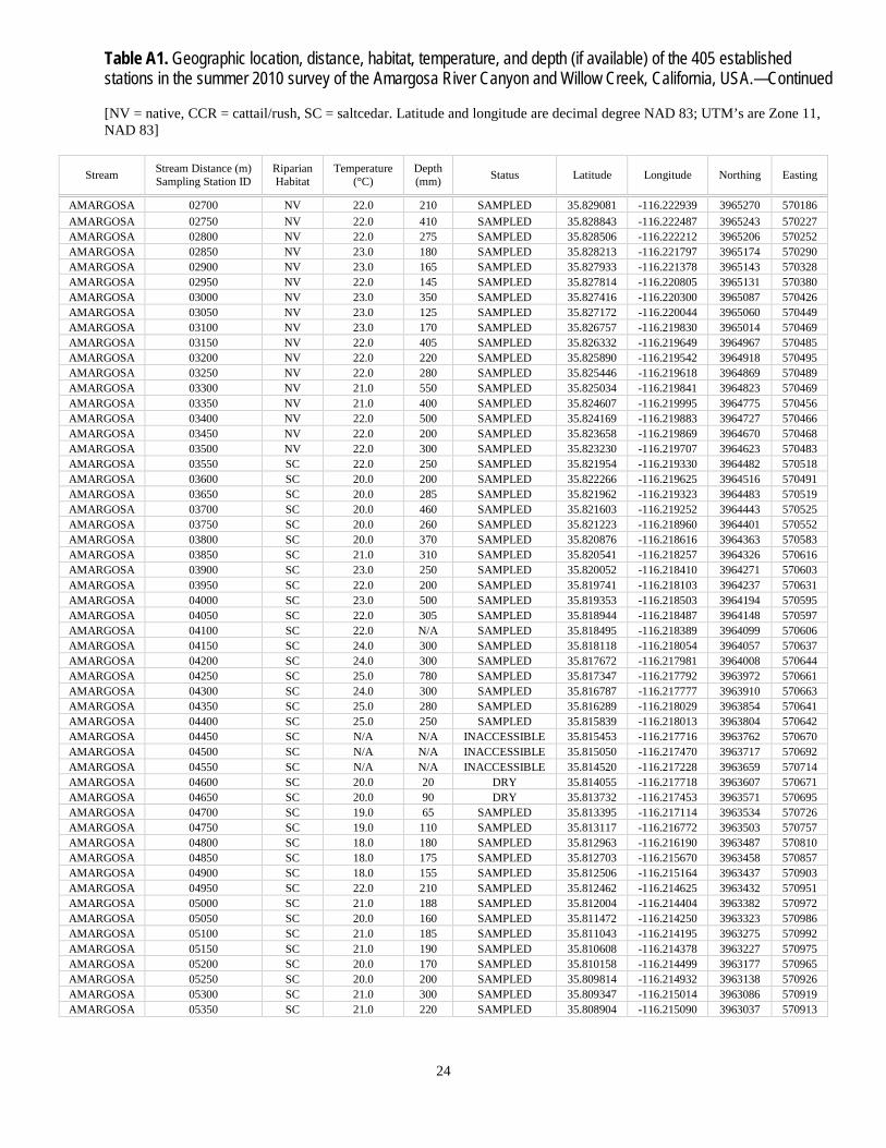
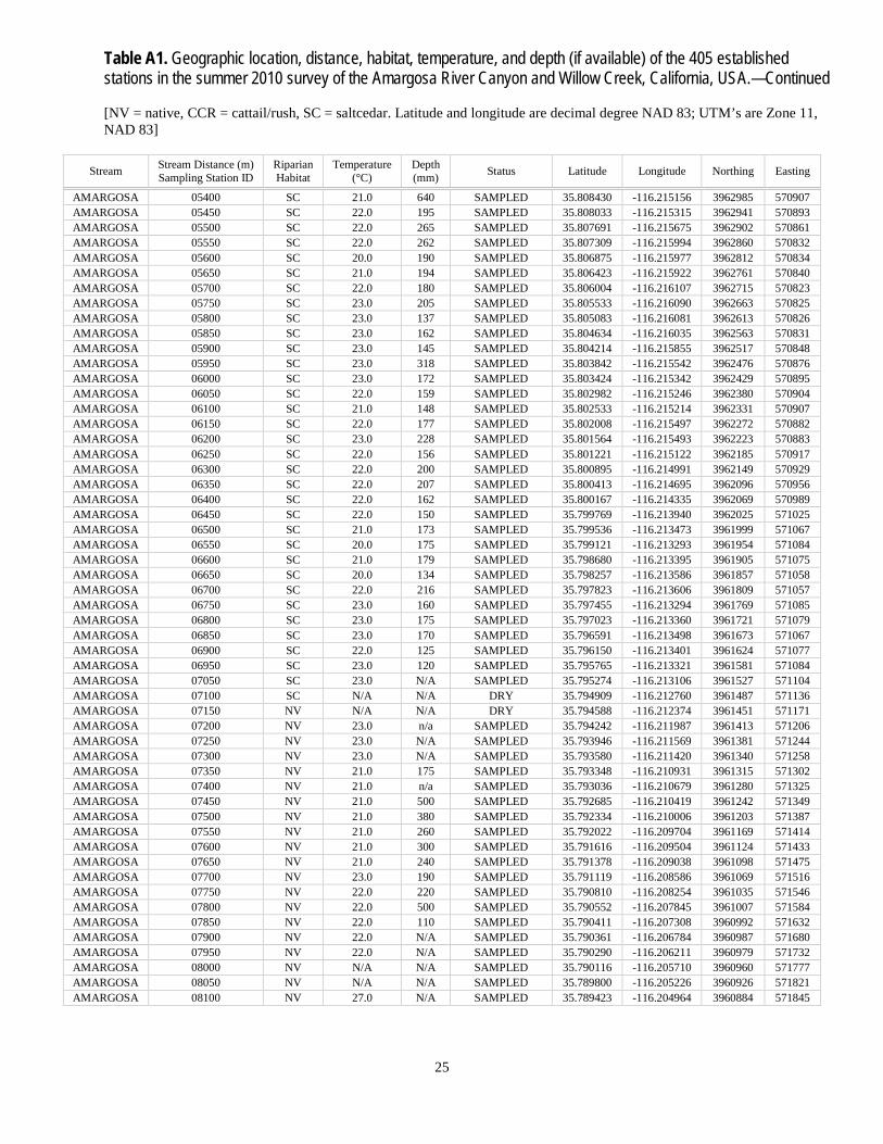
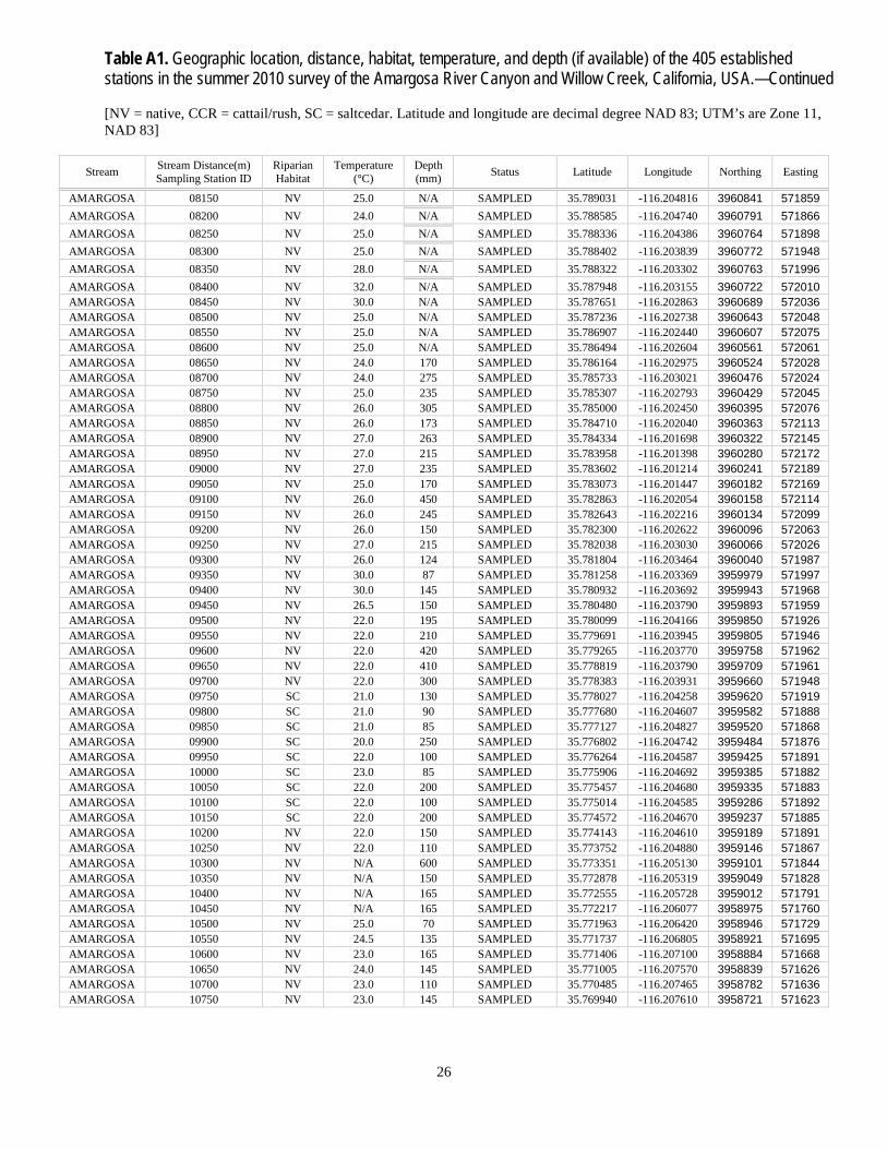
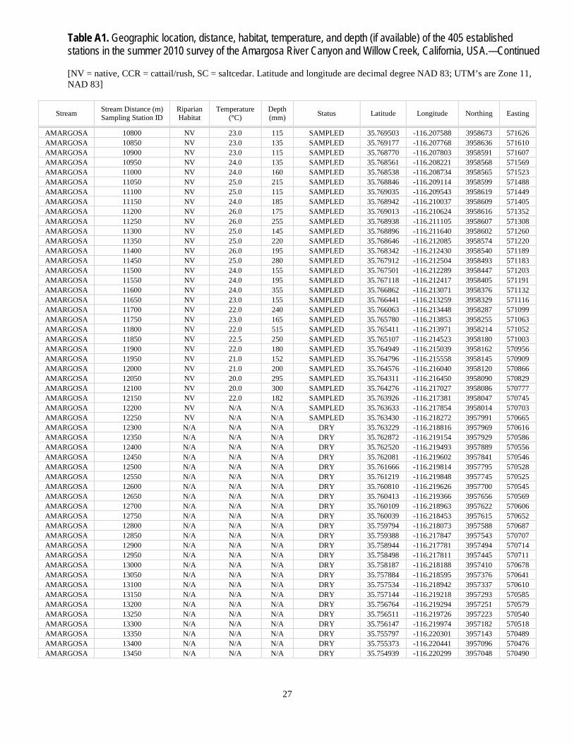
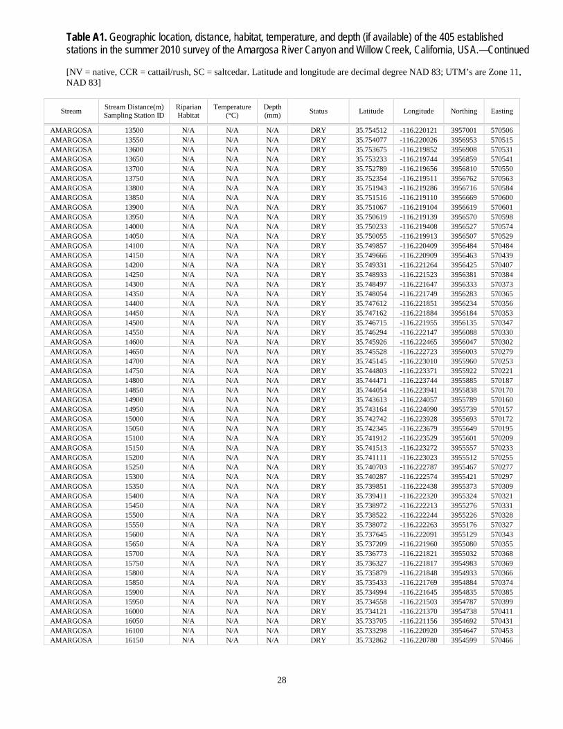
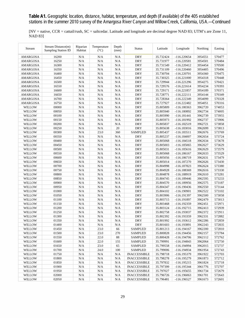
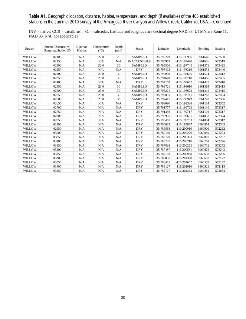
Table A1. Geographic location, distance, habitat, temperature, and depth (if available) of the 405 established stations in the summer 2010 survey of the Amargosa River Canyon and Willow Creek, California.
[NV = native, CCR = cattail/rush, SC = saltcedar. Latitude and longitude are decimal degree NAD 83; UTM’s are Zone 11,
NAD 83]
Stream Stream Distance (m) Sampling Station ID
Riparian Habitat
Temperature (°C)
Depth (mm) Status Latitude Longitude Northing Easting
AMARGOSA 00000 NV 25.0 640 SAMPLED 35.849153 -116.230518 3967490 569484 AMARGOSA 00050 NV 23.0 110 SAMPLED 35.848804 -116.230191 3967452 569513 AMARGOSA 00100 NV 22.0 92 SAMPLED 35.848563 -116.229725 3967426 569556 AMARGOSA 00150 NV 25.0 324 SAMPLED 35.848204 -116.229401 3967386 569585 AMARGOSA 00200 NV 26.0 110 SAMPLED 35.847834 -116.229201 3967345 569604 AMARGOSA 00250 CCR 19.0 40 SAMPLED 35.847230 -116.229080 3967278 569615 AMARGOSA 00300 CCR 19.0 60 SAMPLED 35.846669 -116.228906 3967216 569631 AMARGOSA 00350 CCR 18.0 100 SAMPLED 35.846263 -116.228823 3967171 569639 AMARGOSA 00400 CCR 18.0 130 SAMPLED 35.846010 -116.228433 3967143 569675 AMARGOSA 00450 CCR 18.0 140 SAMPLED 35.845640 -116.228135 3967102 569702 AMARGOSA 00500 CCR 17.0 90 SAMPLED 35.845252 -116.227963 3967060 569718 AMARGOSA 00550 CCR 19.0 50 SAMPLED 35.844825 -116.228075 3967012 569708 AMARGOSA 00600 CCR 24.0 300 SAMPLED 35.844381 -116.228105 3966963 569706 AMARGOSA 00650 CCR 24.0 270 SAMPLED 35.843947 -116.228075 3966915 569709 AMARGOSA 00700 CCR 23.0 220 SAMPLED 35.843494 -116.228016 3966865 569715 AMARGOSA 00750 CCR 21.0 140 SAMPLED 35.843075 -116.227749 3966818 569739 AMARGOSA 00800 CCR 21.0 230 SAMPLED 35.842627 -116.227748 3966769 569739 AMARGOSA 00850 CCR 21.0 90 SAMPLED 35.842185 -116.227724 3966720 569742 AMARGOSA 00900 CCR 21.0 225 SAMPLED 35.841785 -116.227473 3966675 569765 AMARGOSA 00950 CCR 21.0 195 SAMPLED 35.841373 -116.227262 3966630 569784 AMARGOSA 01000 CCR 21.0 1500 SAMPLED 35.841069 -116.226855 3966596 569821 AMARGOSA 01050 CCR 21.0 1050 SAMPLED 35.840798 -116.226414 3966567 569862 AMARGOSA 01100 CCR 20.0 160 SAMPLED 35.840429 -116.226331 3966526 569869 AMARGOSA 01150 CCR 20.0 310 SAMPLED 35.840002 -116.226240 3966478 569878 AMARGOSA 01200 CCR 20.0 580 SAMPLED 35.839684 -116.225853 3966443 569913 AMARGOSA 01250 CCR 20.5 300 SAMPLED 35.839271 -116.225549 3966398 569941 AMARGOSA 01300 CCR 20.0 225 SAMPLED 35.839070 -116.225056 3966376 569986 AMARGOSA 01350 CCR 23.0 750 SAMPLED 35.839019 -116.224520 3966371 570034 AMARGOSA 01400 CCR 24.0 90 SAMPLED 35.839050 -116.223973 3966375 570084 AMARGOSA 01450 CCR 20.0 1250 SAMPLED 35.838865 -116.223471 3966354 570129 AMARGOSA 01500 CCR 22.0 1010 SAMPLED 35.838386 -116.223148 3966301 570159 AMARGOSA 01550 CCR 23.0 1130 SAMPLED 35.838033 -116.223172 3966262 570157 AMARGOSA 01600 CCR 20.0 175 SAMPLED 35.837584 -116.223132 3966213 570161 AMARGOSA 01650 CCR 24.0 235 SAMPLED 35.837186 -116.223372 3966168 570139 AMARGOSA 01700 CCR 23.0 315 SAMPLED 35.836786 -116.223597 3966124 570119 AMARGOSA 01750 CCR 24.0 115 SAMPLED 35.836337 -116.223556 3966074 570124 AMARGOSA 01800 CCR 23.0 445 SAMPLED 35.835898 -116.223616 3966025 570119 AMARGOSA 01850 CCR 23.0 295 SAMPLED 35.835616 -116.224032 3965994 570081 AMARGOSA 01900 CCR 19.0 268 SAMPLED 35.835393 -116.224370 3965969 570051 AMARGOSA 01950 CCR 19.0 348 SAMPLED 35.834850 -116.224598 3965908 570031 AMARGOSA 02000 CCR 20.0 350 SAMPLED 35.834571 -116.224219 3965878 570065 AMARGOSA 02050 CCR 19.0 227 SAMPLED 35.834330 -116.223912 3965851 570093 AMARGOSA 02100 CCR 19.0 125 SAMPLED 35.834231 -116.223321 3965840 570147 AMARGOSA 02150 NV 23.0 270 SAMPLED 35.833754 -116.223207 3965788 570157 AMARGOSA 02200 NV 23.0 315 SAMPLED 35.833354 -116.223155 3965743 570162 AMARGOSA 02250 NV 19.5 278 SAMPLED 35.832929 -116.223165 3965696 570162 AMARGOSA 02300 NV 20.0 575 SAMPLED 35.832489 -116.223206 3965647 570159 AMARGOSA 02350 NV 20.0 300 SAMPLED 35.832077 -116.223264 3965602 570154 AMARGOSA 02400 NV 21.0 317 SAMPLED 35.831631 -116.223218 3965552 570158 AMARGOSA 02450 NV 20.0 120 SAMPLED 35.831196 -116.223315 3965504 570150 AMARGOSA 02500 NV 23.0 160 SAMPLED 35.830770 -116.223219 3965457 570159 AMARGOSA 02550 NV 22.0 180 SAMPLED 35.830335 -116.223534 3965408 570131 AMARGOSA 02600 NV 22.0 230 SAMPLED 35.829833 -116.223440 3965353 570140 AMARGOSA 02650 NV 23.0 390 SAMPLED 35.829380 -116.223378 3965302 570146
24
Table A1. Geographic location, distance, habitat, temperature, and depth (if available) of the 405 established stations in the summer 2010 survey of the Amargosa River Canyon and Willow Creek, California, USA.—Continued
[NV = native, CCR = cattail/rush, SC = saltcedar. Latitude and longitude are decimal degree NAD 83; UTM’s are Zone 11,
NAD 83]
Stream Stream Distance (m) Sampling Station ID
Riparian Habitat
Temperature (°C)
Depth (mm) Status Latitude Longitude Northing Easting
AMARGOSA 02700 NV 22.0 210 SAMPLED 35.829081 -116.222939 3965270 570186 AMARGOSA 02750 NV 22.0 410 SAMPLED 35.828843 -116.222487 3965243 570227 AMARGOSA 02800 NV 22.0 275 SAMPLED 35.828506 -116.222212 3965206 570252 AMARGOSA 02850 NV 23.0 180 SAMPLED 35.828213 -116.221797 3965174 570290 AMARGOSA 02900 NV 23.0 165 SAMPLED 35.827933 -116.221378 3965143 570328 AMARGOSA 02950 NV 22.0 145 SAMPLED 35.827814 -116.220805 3965131 570380 AMARGOSA 03000 NV 23.0 350 SAMPLED 35.827416 -116.220300 3965087 570426 AMARGOSA 03050 NV 23.0 125 SAMPLED 35.827172 -116.220044 3965060 570449 AMARGOSA 03100 NV 23.0 170 SAMPLED 35.826757 -116.219830 3965014 570469 AMARGOSA 03150 NV 22.0 405 SAMPLED 35.826332 -116.219649 3964967 570485 AMARGOSA 03200 NV 22.0 220 SAMPLED 35.825890 -116.219542 3964918 570495 AMARGOSA 03250 NV 22.0 280 SAMPLED 35.825446 -116.219618 3964869 570489 AMARGOSA 03300 NV 21.0 550 SAMPLED 35.825034 -116.219841 3964823 570469 AMARGOSA 03350 NV 21.0 400 SAMPLED 35.824607 -116.219995 3964775 570456 AMARGOSA 03400 NV 22.0 500 SAMPLED 35.824169 -116.219883 3964727 570466 AMARGOSA 03450 NV 22.0 200 SAMPLED 35.823658 -116.219869 3964670 570468 AMARGOSA 03500 NV 22.0 300 SAMPLED 35.823230 -116.219707 3964623 570483 AMARGOSA 03550 SC 22.0 250 SAMPLED 35.821954 -116.219330 3964482 570518 AMARGOSA 03600 SC 20.0 200 SAMPLED 35.822266 -116.219625 3964516 570491 AMARGOSA 03650 SC 20.0 285 SAMPLED 35.821962 -116.219323 3964483 570519 AMARGOSA 03700 SC 20.0 460 SAMPLED 35.821603 -116.219252 3964443 570525 AMARGOSA 03750 SC 20.0 260 SAMPLED 35.821223 -116.218960 3964401 570552 AMARGOSA 03800 SC 20.0 370 SAMPLED 35.820876 -116.218616 3964363 570583 AMARGOSA 03850 SC 21.0 310 SAMPLED 35.820541 -116.218257 3964326 570616 AMARGOSA 03900 SC 23.0 250 SAMPLED 35.820052 -116.218410 3964271 570603 AMARGOSA 03950 SC 22.0 200 SAMPLED 35.819741 -116.218103 3964237 570631 AMARGOSA 04000 SC 23.0 500 SAMPLED 35.819353 -116.218503 3964194 570595 AMARGOSA 04050 SC 22.0 305 SAMPLED 35.818944 -116.218487 3964148 570597 AMARGOSA 04100 SC 22.0 N/A SAMPLED 35.818495 -116.218389 3964099 570606 AMARGOSA 04150 SC 24.0 300 SAMPLED 35.818118 -116.218054 3964057 570637 AMARGOSA 04200 SC 24.0 300 SAMPLED 35.817672 -116.217981 3964008 570644 AMARGOSA 04250 SC 25.0 780 SAMPLED 35.817347 -116.217792 3963972 570661 AMARGOSA 04300 SC 24.0 300 SAMPLED 35.816787 -116.217777 3963910 570663 AMARGOSA 04350 SC 25.0 280 SAMPLED 35.816289 -116.218029 3963854 570641 AMARGOSA 04400 SC 25.0 250 SAMPLED 35.815839 -116.218013 3963804 570642 AMARGOSA 04450 SC N/A N/A INACCESSIBLE 35.815453 -116.217716 3963762 570670 AMARGOSA 04500 SC N/A N/A INACCESSIBLE 35.815050 -116.217470 3963717 570692 AMARGOSA 04550 SC N/A N/A INACCESSIBLE 35.814520 -116.217228 3963659 570714 AMARGOSA 04600 SC 20.0 20 DRY 35.814055 -116.217718 3963607 570671 AMARGOSA 04650 SC 20.0 90 DRY 35.813732 -116.217453 3963571 570695 AMARGOSA 04700 SC 19.0 65 SAMPLED 35.813395 -116.217114 3963534 570726 AMARGOSA 04750 SC 19.0 110 SAMPLED 35.813117 -116.216772 3963503 570757 AMARGOSA 04800 SC 18.0 180 SAMPLED 35.812963 -116.216190 3963487 570810 AMARGOSA 04850 SC 18.0 175 SAMPLED 35.812703 -116.215670 3963458 570857 AMARGOSA 04900 SC 18.0 155 SAMPLED 35.812506 -116.215164 3963437 570903 AMARGOSA 04950 SC 22.0 210 SAMPLED 35.812462 -116.214625 3963432 570951 AMARGOSA 05000 SC 21.0 188 SAMPLED 35.812004 -116.214404 3963382 570972 AMARGOSA 05050 SC 20.0 160 SAMPLED 35.811472 -116.214250 3963323 570986 AMARGOSA 05100 SC 21.0 185 SAMPLED 35.811043 -116.214195 3963275 570992 AMARGOSA 05150 SC 21.0 190 SAMPLED 35.810608 -116.214378 3963227 570975 AMARGOSA 05200 SC 20.0 170 SAMPLED 35.810158 -116.214499 3963177 570965 AMARGOSA 05250 SC 20.0 200 SAMPLED 35.809814 -116.214932 3963138 570926 AMARGOSA 05300 SC 21.0 300 SAMPLED 35.809347 -116.215014 3963086 570919 AMARGOSA 05350 SC 21.0 220 SAMPLED 35.808904 -116.215090 3963037 570913
25
Table A1. Geographic location, distance, habitat, temperature, and depth (if available) of the 405 established stations in the summer 2010 survey of the Amargosa River Canyon and Willow Creek, California, USA.—Continued
[NV = native, CCR = cattail/rush, SC = saltcedar. Latitude and longitude are decimal degree NAD 83; UTM’s are Zone 11,
NAD 83]
Stream Stream Distance (m) Sampling Station ID
Riparian Habitat
Temperature (°C)
Depth (mm) Status Latitude Longitude Northing Easting
AMARGOSA 05400 SC 21.0 640 SAMPLED 35.808430 -116.215156 3962985 570907 AMARGOSA 05450 SC 22.0 195 SAMPLED 35.808033 -116.215315 3962941 570893 AMARGOSA 05500 SC 22.0 265 SAMPLED 35.807691 -116.215675 3962902 570861 AMARGOSA 05550 SC 22.0 262 SAMPLED 35.807309 -116.215994 3962860 570832 AMARGOSA 05600 SC 20.0 190 SAMPLED 35.806875 -116.215977 3962812 570834 AMARGOSA 05650 SC 21.0 194 SAMPLED 35.806423 -116.215922 3962761 570840 AMARGOSA 05700 SC 22.0 180 SAMPLED 35.806004 -116.216107 3962715 570823 AMARGOSA 05750 SC 23.0 205 SAMPLED 35.805533 -116.216090 3962663 570825 AMARGOSA 05800 SC 23.0 137 SAMPLED 35.805083 -116.216081 3962613 570826 AMARGOSA 05850 SC 23.0 162 SAMPLED 35.804634 -116.216035 3962563 570831 AMARGOSA 05900 SC 23.0 145 SAMPLED 35.804214 -116.215855 3962517 570848 AMARGOSA 05950 SC 23.0 318 SAMPLED 35.803842 -116.215542 3962476 570876 AMARGOSA 06000 SC 23.0 172 SAMPLED 35.803424 -116.215342 3962429 570895 AMARGOSA 06050 SC 22.0 159 SAMPLED 35.802982 -116.215246 3962380 570904 AMARGOSA 06100 SC 21.0 148 SAMPLED 35.802533 -116.215214 3962331 570907 AMARGOSA 06150 SC 22.0 177 SAMPLED 35.802008 -116.215497 3962272 570882 AMARGOSA 06200 SC 23.0 228 SAMPLED 35.801564 -116.215493 3962223 570883 AMARGOSA 06250 SC 22.0 156 SAMPLED 35.801221 -116.215122 3962185 570917 AMARGOSA 06300 SC 22.0 200 SAMPLED 35.800895 -116.214991 3962149 570929 AMARGOSA 06350 SC 22.0 207 SAMPLED 35.800413 -116.214695 3962096 570956 AMARGOSA 06400 SC 22.0 162 SAMPLED 35.800167 -116.214335 3962069 570989 AMARGOSA 06450 SC 22.0 150 SAMPLED 35.799769 -116.213940 3962025 571025 AMARGOSA 06500 SC 21.0 173 SAMPLED 35.799536 -116.213473 3961999 571067 AMARGOSA 06550 SC 20.0 175 SAMPLED 35.799121 -116.213293 3961954 571084 AMARGOSA 06600 SC 21.0 179 SAMPLED 35.798680 -116.213395 3961905 571075 AMARGOSA 06650 SC 20.0 134 SAMPLED 35.798257 -116.213586 3961857 571058 AMARGOSA 06700 SC 22.0 216 SAMPLED 35.797823 -116.213606 3961809 571057 AMARGOSA 06750 SC 23.0 160 SAMPLED 35.797455 -116.213294 3961769 571085 AMARGOSA 06800 SC 23.0 175 SAMPLED 35.797023 -116.213360 3961721 571079 AMARGOSA 06850 SC 23.0 170 SAMPLED 35.796591 -116.213498 3961673 571067 AMARGOSA 06900 SC 22.0 125 SAMPLED 35.796150 -116.213401 3961624 571077 AMARGOSA 06950 SC 23.0 120 SAMPLED 35.795765 -116.213321 3961581 571084 AMARGOSA 07050 SC 23.0 N/A SAMPLED 35.795274 -116.213106 3961527 571104 AMARGOSA 07100 SC N/A N/A DRY 35.794909 -116.212760 3961487 571136 AMARGOSA 07150 NV N/A N/A DRY 35.794588 -116.212374 3961451 571171 AMARGOSA 07200 NV 23.0 n/a SAMPLED 35.794242 -116.211987 3961413 571206 AMARGOSA 07250 NV 23.0 N/A SAMPLED 35.793946 -116.211569 3961381 571244 AMARGOSA 07300 NV 23.0 N/A SAMPLED 35.793580 -116.211420 3961340 571258 AMARGOSA 07350 NV 21.0 175 SAMPLED 35.793348 -116.210931 3961315 571302 AMARGOSA 07400 NV 21.0 n/a SAMPLED 35.793036 -116.210679 3961280 571325 AMARGOSA 07450 NV 21.0 500 SAMPLED 35.792685 -116.210419 3961242 571349 AMARGOSA 07500 NV 21.0 380 SAMPLED 35.792334 -116.210006 3961203 571387 AMARGOSA 07550 NV 21.0 260 SAMPLED 35.792022 -116.209704 3961169 571414 AMARGOSA 07600 NV 21.0 300 SAMPLED 35.791616 -116.209504 3961124 571433 AMARGOSA 07650 NV 21.0 240 SAMPLED 35.791378 -116.209038 3961098 571475 AMARGOSA 07700 NV 23.0 190 SAMPLED 35.791119 -116.208586 3961069 571516 AMARGOSA 07750 NV 22.0 220 SAMPLED 35.790810 -116.208254 3961035 571546 AMARGOSA 07800 NV 22.0 500 SAMPLED 35.790552 -116.207845 3961007 571584 AMARGOSA 07850 NV 22.0 110 SAMPLED 35.790411 -116.207308 3960992 571632 AMARGOSA 07900 NV 22.0 N/A SAMPLED 35.790361 -116.206784 3960987 571680 AMARGOSA 07950 NV 22.0 N/A SAMPLED 35.790290 -116.206211 3960979 571732 AMARGOSA 08000 NV N/A N/A SAMPLED 35.790116 -116.205710 3960960 571777 AMARGOSA 08050 NV N/A N/A SAMPLED 35.789800 -116.205226 3960926 571821 AMARGOSA 08100 NV 27.0 N/A SAMPLED 35.789423 -116.204964 3960884 571845
26
Table A1. Geographic location, distance, habitat, temperature, and depth (if available) of the 405 established stations in the summer 2010 survey of the Amargosa River Canyon and Willow Creek, California, USA.—Continued
[NV = native, CCR = cattail/rush, SC = saltcedar. Latitude and longitude are decimal degree NAD 83; UTM’s are Zone 11,
NAD 83]
Stream Stream Distance(m) Sampling Station ID
Riparian Habitat
Temperature (°C)
Depth (mm) Status Latitude Longitude Northing Easting
AMARGOSA 08150 NV 25.0 N/A SAMPLED 35.789031 -116.204816 3960841 571859 AMARGOSA 08200 NV 24.0 N/A SAMPLED 35.788585 -116.204740 3960791 571866 AMARGOSA 08250 NV 25.0 N/A SAMPLED 35.788336 -116.204386 3960764 571898 AMARGOSA 08300 NV 25.0 N/A SAMPLED 35.788402 -116.203839 3960772 571948 AMARGOSA 08350 NV 28.0 N/A SAMPLED 35.788322 -116.203302 3960763 571996 AMARGOSA 08400 NV 32.0 N/A SAMPLED 35.787948 -116.203155 3960722 572010 AMARGOSA 08450 NV 30.0 N/A SAMPLED 35.787651 -116.202863 3960689 572036 AMARGOSA 08500 NV 25.0 N/A SAMPLED 35.787236 -116.202738 3960643 572048 AMARGOSA 08550 NV 25.0 N/A SAMPLED 35.786907 -116.202440 3960607 572075 AMARGOSA 08600 NV 25.0 N/A SAMPLED 35.786494 -116.202604 3960561 572061 AMARGOSA 08650 NV 24.0 170 SAMPLED 35.786164 -116.202975 3960524 572028 AMARGOSA 08700 NV 24.0 275 SAMPLED 35.785733 -116.203021 3960476 572024 AMARGOSA 08750 NV 25.0 235 SAMPLED 35.785307 -116.202793 3960429 572045 AMARGOSA 08800 NV 26.0 305 SAMPLED 35.785000 -116.202450 3960395 572076 AMARGOSA 08850 NV 26.0 173 SAMPLED 35.784710 -116.202040 3960363 572113 AMARGOSA 08900 NV 27.0 263 SAMPLED 35.784334 -116.201698 3960322 572145 AMARGOSA 08950 NV 27.0 215 SAMPLED 35.783958 -116.201398 3960280 572172 AMARGOSA 09000 NV 27.0 235 SAMPLED 35.783602 -116.201214 3960241 572189 AMARGOSA 09050 NV 25.0 170 SAMPLED 35.783073 -116.201447 3960182 572169 AMARGOSA 09100 NV 26.0 450 SAMPLED 35.782863 -116.202054 3960158 572114 AMARGOSA 09150 NV 26.0 245 SAMPLED 35.782643 -116.202216 3960134 572099 AMARGOSA 09200 NV 26.0 150 SAMPLED 35.782300 -116.202622 3960096 572063 AMARGOSA 09250 NV 27.0 215 SAMPLED 35.782038 -116.203030 3960066 572026 AMARGOSA 09300 NV 26.0 124 SAMPLED 35.781804 -116.203464 3960040 571987 AMARGOSA 09350 NV 30.0 87 SAMPLED 35.781258 -116.203369 3959979 571997 AMARGOSA 09400 NV 30.0 145 SAMPLED 35.780932 -116.203692 3959943 571968 AMARGOSA 09450 NV 26.5 150 SAMPLED 35.780480 -116.203790 3959893 571959 AMARGOSA 09500 NV 22.0 195 SAMPLED 35.780099 -116.204166 3959850 571926 AMARGOSA 09550 NV 22.0 210 SAMPLED 35.779691 -116.203945 3959805 571946 AMARGOSA 09600 NV 22.0 420 SAMPLED 35.779265 -116.203770 3959758 571962 AMARGOSA 09650 NV 22.0 410 SAMPLED 35.778819 -116.203790 3959709 571961 AMARGOSA 09700 NV 22.0 300 SAMPLED 35.778383 -116.203931 3959660 571948 AMARGOSA 09750 SC 21.0 130 SAMPLED 35.778027 -116.204258 3959620 571919 AMARGOSA 09800 SC 21.0 90 SAMPLED 35.777680 -116.204607 3959582 571888 AMARGOSA 09850 SC 21.0 85 SAMPLED 35.777127 -116.204827 3959520 571868 AMARGOSA 09900 SC 20.0 250 SAMPLED 35.776802 -116.204742 3959484 571876 AMARGOSA 09950 SC 22.0 100 SAMPLED 35.776264 -116.204587 3959425 571891 AMARGOSA 10000 SC 23.0 85 SAMPLED 35.775906 -116.204692 3959385 571882 AMARGOSA 10050 SC 22.0 200 SAMPLED 35.775457 -116.204680 3959335 571883 AMARGOSA 10100 SC 22.0 100 SAMPLED 35.775014 -116.204585 3959286 571892 AMARGOSA 10150 SC 22.0 200 SAMPLED 35.774572 -116.204670 3959237 571885 AMARGOSA 10200 NV 22.0 150 SAMPLED 35.774143 -116.204610 3959189 571891 AMARGOSA 10250 NV 22.0 110 SAMPLED 35.773752 -116.204880 3959146 571867 AMARGOSA 10300 NV N/A 600 SAMPLED 35.773351 -116.205130 3959101 571844 AMARGOSA 10350 NV N/A 150 SAMPLED 35.772878 -116.205319 3959049 571828 AMARGOSA 10400 NV N/A 165 SAMPLED 35.772555 -116.205728 3959012 571791 AMARGOSA 10450 NV N/A 165 SAMPLED 35.772217 -116.206077 3958975 571760 AMARGOSA 10500 NV 25.0 70 SAMPLED 35.771963 -116.206420 3958946 571729 AMARGOSA 10550 NV 24.5 135 SAMPLED 35.771737 -116.206805 3958921 571695 AMARGOSA 10600 NV 23.0 165 SAMPLED 35.771406 -116.207100 3958884 571668 AMARGOSA 10650 NV 24.0 145 SAMPLED 35.771005 -116.207570 3958839 571626 AMARGOSA 10700 NV 23.0 110 SAMPLED 35.770485 -116.207465 3958782 571636 AMARGOSA 10750 NV 23.0 145 SAMPLED 35.769940 -116.207610 3958721 571623
27
Table A1. Geographic location, distance, habitat, temperature, and depth (if available) of the 405 established stations in the summer 2010 survey of the Amargosa River Canyon and Willow Creek, California, USA.—Continued
[NV = native, CCR = cattail/rush, SC = saltcedar. Latitude and longitude are decimal degree NAD 83; UTM’s are Zone 11,
NAD 83]
Stream Stream Distance (m) Sampling Station ID
Riparian Habitat
Temperature (°C)
Depth (mm) Status Latitude Longitude Northing Easting
AMARGOSA 10800 NV 23.0 115 SAMPLED 35.769503 -116.207588 3958673 571626 AMARGOSA 10850 NV 23.0 135 SAMPLED 35.769177 -116.207768 3958636 571610 AMARGOSA 10900 NV 23.0 115 SAMPLED 35.768770 -116.207803 3958591 571607 AMARGOSA 10950 NV 24.0 135 SAMPLED 35.768561 -116.208221 3958568 571569 AMARGOSA 11000 NV 24.0 160 SAMPLED 35.768538 -116.208734 3958565 571523 AMARGOSA 11050 NV 25.0 215 SAMPLED 35.768846 -116.209114 3958599 571488 AMARGOSA 11100 NV 25.0 115 SAMPLED 35.769035 -116.209543 3958619 571449 AMARGOSA 11150 NV 24.0 185 SAMPLED 35.768942 -116.210037 3958609 571405 AMARGOSA 11200 NV 26.0 175 SAMPLED 35.769013 -116.210624 3958616 571352 AMARGOSA 11250 NV 26.0 255 SAMPLED 35.768938 -116.211105 3958607 571308 AMARGOSA 11300 NV 25.0 145 SAMPLED 35.768896 -116.211640 3958602 571260 AMARGOSA 11350 NV 25.0 220 SAMPLED 35.768646 -116.212085 3958574 571220 AMARGOSA 11400 NV 26.0 195 SAMPLED 35.768342 -116.212430 3958540 571189 AMARGOSA 11450 NV 25.0 280 SAMPLED 35.767912 -116.212504 3958493 571183 AMARGOSA 11500 NV 24.0 155 SAMPLED 35.767501 -116.212289 3958447 571203 AMARGOSA 11550 NV 24.0 195 SAMPLED 35.767118 -116.212417 3958405 571191 AMARGOSA 11600 NV 24.0 355 SAMPLED 35.766862 -116.213071 3958376 571132 AMARGOSA 11650 NV 23.0 155 SAMPLED 35.766441 -116.213259 3958329 571116 AMARGOSA 11700 NV 22.0 240 SAMPLED 35.766063 -116.213448 3958287 571099 AMARGOSA 11750 NV 23.0 165 SAMPLED 35.765780 -116.213853 3958255 571063 AMARGOSA 11800 NV 22.0 515 SAMPLED 35.765411 -116.213971 3958214 571052 AMARGOSA 11850 NV 22.5 250 SAMPLED 35.765107 -116.214523 3958180 571003 AMARGOSA 11900 NV 22.0 180 SAMPLED 35.764949 -116.215039 3958162 570956 AMARGOSA 11950 NV 21.0 152 SAMPLED 35.764796 -116.215558 3958145 570909 AMARGOSA 12000 NV 21.0 200 SAMPLED 35.764576 -116.216040 3958120 570866 AMARGOSA 12050 NV 20.0 295 SAMPLED 35.764311 -116.216450 3958090 570829 AMARGOSA 12100 NV 20.0 300 SAMPLED 35.764276 -116.217027 3958086 570777 AMARGOSA 12150 NV 22.0 182 SAMPLED 35.763926 -116.217381 3958047 570745 AMARGOSA 12200 NV N/A N/A SAMPLED 35.763633 -116.217854 3958014 570703 AMARGOSA 12250 NV N/A N/A SAMPLED 35.763430 -116.218272 3957991 570665 AMARGOSA 12300 N/A N/A N/A DRY 35.763229 -116.218816 3957969 570616 AMARGOSA 12350 N/A N/A N/A DRY 35.762872 -116.219154 3957929 570586 AMARGOSA 12400 N/A N/A N/A DRY 35.762520 -116.219493 3957889 570556 AMARGOSA 12450 N/A N/A N/A DRY 35.762081 -116.219602 3957841 570546 AMARGOSA 12500 N/A N/A N/A DRY 35.761666 -116.219814 3957795 570528 AMARGOSA 12550 N/A N/A N/A DRY 35.761219 -116.219848 3957745 570525 AMARGOSA 12600 N/A N/A N/A DRY 35.760810 -116.219626 3957700 570545 AMARGOSA 12650 N/A N/A N/A DRY 35.760413 -116.219366 3957656 570569 AMARGOSA 12700 N/A N/A N/A DRY 35.760109 -116.218963 3957622 570606 AMARGOSA 12750 N/A N/A N/A DRY 35.760039 -116.218453 3957615 570652 AMARGOSA 12800 N/A N/A N/A DRY 35.759794 -116.218073 3957588 570687 AMARGOSA 12850 N/A N/A N/A DRY 35.759388 -116.217847 3957543 570707 AMARGOSA 12900 N/A N/A N/A DRY 35.758944 -116.217781 3957494 570714 AMARGOSA 12950 N/A N/A N/A DRY 35.758498 -116.217811 3957445 570711 AMARGOSA 13000 N/A N/A N/A DRY 35.758187 -116.218188 3957410 570678 AMARGOSA 13050 N/A N/A N/A DRY 35.757884 -116.218595 3957376 570641 AMARGOSA 13100 N/A N/A N/A DRY 35.757534 -116.218942 3957337 570610 AMARGOSA 13150 N/A N/A N/A DRY 35.757144 -116.219218 3957293 570585 AMARGOSA 13200 N/A N/A N/A DRY 35.756764 -116.219294 3957251 570579 AMARGOSA 13250 N/A N/A N/A DRY 35.756511 -116.219726 3957223 570540 AMARGOSA 13300 N/A N/A N/A DRY 35.756147 -116.219974 3957182 570518 AMARGOSA 13350 N/A N/A N/A DRY 35.755797 -116.220301 3957143 570489 AMARGOSA 13400 N/A N/A N/A DRY 35.755373 -116.220441 3957096 570476 AMARGOSA 13450 N/A N/A N/A DRY 35.754939 -116.220299 3957048 570490
28
Table A1. Geographic location, distance, habitat, temperature, and depth (if available) of the 405 established stations in the summer 2010 survey of the Amargosa River Canyon and Willow Creek, California, USA.—Continued
[NV = native, CCR = cattail/rush, SC = saltcedar. Latitude and longitude are decimal degree NAD 83; UTM’s are Zone 11,
NAD 83]
Stream Stream Distance(m) Sampling Station ID
Riparian Habitat
Temperature (°C)
Depth (mm) Status Latitude Longitude Northing Easting
AMARGOSA 13500 N/A N/A N/A DRY 35.754512 -116.220121 3957001 570506 AMARGOSA 13550 N/A N/A N/A DRY 35.754077 -116.220026 3956953 570515 AMARGOSA 13600 N/A N/A N/A DRY 35.753675 -116.219852 3956908 570531 AMARGOSA 13650 N/A N/A N/A DRY 35.753233 -116.219744 3956859 570541 AMARGOSA 13700 N/A N/A N/A DRY 35.752789 -116.219656 3956810 570550 AMARGOSA 13750 N/A N/A N/A DRY 35.752354 -116.219511 3956762 570563 AMARGOSA 13800 N/A N/A N/A DRY 35.751943 -116.219286 3956716 570584 AMARGOSA 13850 N/A N/A N/A DRY 35.751516 -116.219110 3956669 570600 AMARGOSA 13900 N/A N/A N/A DRY 35.751067 -116.219104 3956619 570601 AMARGOSA 13950 N/A N/A N/A DRY 35.750619 -116.219139 3956570 570598 AMARGOSA 14000 N/A N/A N/A DRY 35.750233 -116.219408 3956527 570574 AMARGOSA 14050 N/A N/A N/A DRY 35.750055 -116.219913 3956507 570529 AMARGOSA 14100 N/A N/A N/A DRY 35.749857 -116.220409 3956484 570484 AMARGOSA 14150 N/A N/A N/A DRY 35.749666 -116.220909 3956463 570439 AMARGOSA 14200 N/A N/A N/A DRY 35.749331 -116.221264 3956425 570407 AMARGOSA 14250 N/A N/A N/A DRY 35.748933 -116.221523 3956381 570384 AMARGOSA 14300 N/A N/A N/A DRY 35.748497 -116.221647 3956333 570373 AMARGOSA 14350 N/A N/A N/A DRY 35.748054 -116.221749 3956283 570365 AMARGOSA 14400 N/A N/A N/A DRY 35.747612 -116.221851 3956234 570356 AMARGOSA 14450 N/A N/A N/A DRY 35.747162 -116.221884 3956184 570353 AMARGOSA 14500 N/A N/A N/A DRY 35.746715 -116.221955 3956135 570347 AMARGOSA 14550 N/A N/A N/A DRY 35.746294 -116.222147 3956088 570330 AMARGOSA 14600 N/A N/A N/A DRY 35.745926 -116.222465 3956047 570302 AMARGOSA 14650 N/A N/A N/A DRY 35.745528 -116.222723 3956003 570279 AMARGOSA 14700 N/A N/A N/A DRY 35.745145 -116.223010 3955960 570253 AMARGOSA 14750 N/A N/A N/A DRY 35.744803 -116.223371 3955922 570221 AMARGOSA 14800 N/A N/A N/A DRY 35.744471 -116.223744 3955885 570187 AMARGOSA 14850 N/A N/A N/A DRY 35.744054 -116.223941 3955838 570170 AMARGOSA 14900 N/A N/A N/A DRY 35.743613 -116.224057 3955789 570160 AMARGOSA 14950 N/A N/A N/A DRY 35.743164 -116.224090 3955739 570157 AMARGOSA 15000 N/A N/A N/A DRY 35.742742 -116.223928 3955693 570172 AMARGOSA 15050 N/A N/A N/A DRY 35.742345 -116.223679 3955649 570195 AMARGOSA 15100 N/A N/A N/A DRY 35.741912 -116.223529 3955601 570209 AMARGOSA 15150 N/A N/A N/A DRY 35.741513 -116.223272 3955557 570233 AMARGOSA 15200 N/A N/A N/A DRY 35.741111 -116.223023 3955512 570255 AMARGOSA 15250 N/A N/A N/A DRY 35.740703 -116.222787 3955467 570277 AMARGOSA 15300 N/A N/A N/A DRY 35.740287 -116.222574 3955421 570297 AMARGOSA 15350 N/A N/A N/A DRY 35.739851 -116.222438 3955373 570309 AMARGOSA 15400 N/A N/A N/A DRY 35.739411 -116.222320 3955324 570321 AMARGOSA 15450 N/A N/A N/A DRY 35.738972 -116.222213 3955276 570331 AMARGOSA 15500 N/A N/A N/A DRY 35.738522 -116.222244 3955226 570328 AMARGOSA 15550 N/A N/A N/A DRY 35.738072 -116.222263 3955176 570327 AMARGOSA 15600 N/A N/A N/A DRY 35.737645 -116.222091 3955129 570343 AMARGOSA 15650 N/A N/A N/A DRY 35.737209 -116.221960 3955080 570355 AMARGOSA 15700 N/A N/A N/A DRY 35.736773 -116.221821 3955032 570368 AMARGOSA 15750 N/A N/A N/A DRY 35.736327 -116.221817 3954983 570369 AMARGOSA 15800 N/A N/A N/A DRY 35.735879 -116.221848 3954933 570366 AMARGOSA 15850 N/A N/A N/A DRY 35.735433 -116.221769 3954884 570374 AMARGOSA 15900 N/A N/A N/A DRY 35.734994 -116.221645 3954835 570385 AMARGOSA 15950 N/A N/A N/A DRY 35.734558 -116.221503 3954787 570399 AMARGOSA 16000 N/A N/A N/A DRY 35.734121 -116.221370 3954738 570411 AMARGOSA 16050 N/A N/A N/A DRY 35.733705 -116.221156 3954692 570431 AMARGOSA 16100 N/A N/A N/A DRY 35.733298 -116.220920 3954647 570453 AMARGOSA 16150 N/A N/A N/A DRY 35.732862 -116.220780 3954599 570466
29
Table A1. Geographic location, distance, habitat, temperature, and depth (if available) of the 405 established stations in the summer 2010 survey of the Amargosa River Canyon and Willow Creek, California, USA.—Continued
[NV = native, CCR = cattail/rush, SC = saltcedar. Latitude and longitude are decimal degree NAD 83; UTM’s are Zone 11,
NAD 83]
Stream Stream Distance(m) Sampling Station ID
Riparian Habitat
Temperature (°C)
Depth (mm) Status Latitude Longitude Northing Easting
AMARGOSA 16200 N/A N/A N/A DRY 35.732424 -116.220654 3954551 570477 AMARGOSA 16250 N/A N/A N/A DRY 35.731977 -116.220581 3954501 570484 AMARGOSA 16300 N/A N/A N/A DRY 35.731549 -116.220412 3954454 570500 AMARGOSA 16350 N/A N/A N/A DRY 35.731109 -116.220460 3954405 570496 AMARGOSA 16400 N/A N/A N/A DRY 35.730704 -116.220701 3954360 570475 AMARGOSA 16450 N/A N/A N/A DRY 35.730325 -116.221000 3954318 570448 AMARGOSA 16500 N/A N/A N/A DRY 35.729944 -116.221296 3954275 570421 AMARGOSA 16550 N/A N/A N/A DRY 35.729576 -116.221614 3954234 570393 AMARGOSA 16600 N/A N/A N/A DRY 35.729171 -116.221857 3954189 570371 AMARGOSA 16650 N/A N/A N/A DRY 35.728771 -116.222111 3954144 570349 AMARGOSA 16700 N/A N/A N/A DRY 35.728364 -116.222349 3954099 570328 AMARGOSA 16750 N/A N/A N/A DRY 35.727927 -116.222482 3954051 570316
WILLOW 00000 N/A N/A N/A DRY 35.805809 -116.180363 3962720 574053 WILLOW 00050 N/A N/A N/A DRY 35.805940 -116.180892 3962734 574005 WILLOW 00100 N/A N/A N/A DRY 35.805990 -116.181441 3962739 573955 WILLOW 00150 N/A N/A N/A DRY 35.805973 -116.181992 3962737 573906 WILLOW 00200 N/A N/A N/A DRY 35.805837 -116.182519 3962721 573858 WILLOW 00250 N/A N/A 20 DRY 35.805638 -116.183016 3962699 573813 WILLOW 00300 N/A 23.0 360 SAMPLED 35.805437 -116.183511 3962676 573769 WILLOW 00350 N/A N/A N/A DRY 35.805237 -116.184007 3962654 573724 WILLOW 00400 N/A N/A N/A DRY 35.805068 -116.184518 3962634 573678 WILLOW 00450 N/A N/A N/A DRY 35.805003 -116.185065 3962627 573629 WILLOW 00500 N/A N/A N/A DRY 35.805031 -116.185616 3962629 573579 WILLOW 00550 N/A N/A N/A DRY 35.805068 -116.186167 3962633 573529 WILLOW 00600 N/A N/A N/A DRY 35.805056 -116.186719 3962631 573479 WILLOW 00650 N/A N/A N/A DRY 35.805014 -116.187270 3962626 573430 WILLOW 00700 N/A N/A N/A DRY 35.804998 -116.187823 3962624 573380 WILLOW 00750 N/A N/A N/A DRY 35.804928 -116.188369 3962616 573330 WILLOW 00800 N/A N/A N/A DRY 35.804878 -116.188919 3962610 573281 WILLOW 00850 N/A N/A N/A DRY 35.804745 -116.189446 3962595 573233 WILLOW 00900 N/A N/A N/A DRY 35.804570 -116.189956 3962575 573187 WILLOW 00950 N/A N/A N/A DRY 35.804347 -116.190436 3962550 573144 WILLOW 01000 N/A N/A N/A DRY 35.804102 -116.190901 3962522 573102 WILLOW 01050 N/A N/A N/A DRY 35.803906 -116.191397 3962500 573058 WILLOW 01100 N/A N/A N/A DRY 35.803715 -116.191897 3962479 573013 WILLOW 01150 N/A N/A N/A DRY 35.803468 -116.192359 3962451 572971 WILLOW 01200 N/A N/A N/A DRY 35.803124 -116.192715 3962413 572939 WILLOW 01250 N/A N/A N/A DRY 35.802758 -116.193037 3962372 572911 WILLOW 01300 N/A N/A N/A DRY 35.802392 -116.193359 3962331 572882 WILLOW 01350 N/A N/A N/A DRY 35.801992 -116.193612 3962286 572859 WILLOW 01400 N/A N/A N/A DRY 35.801603 -116.193891 3962243 572835 WILLOW 01450 N/A 23.0 66 SAMPLED 35.801213 -116.194167 3962200 572810 WILLOW 01500 N/A 23.0 270 SAMPLED 35.800828 -116.194456 3962157 572784 WILLOW 01550 N/A 22.0 88 SAMPLED 35.800428 -116.194706 3962112 572762 WILLOW 01600 N/A 22.0 155 SAMPLED 35.799991 -116.194843 3962064 572750 WILLOW 01650 N/A 23.0 65 SAMPLED 35.799558 -116.194994 3962015 572737 WILLOW 01700 N/A 24.0 100 SAMPLED 35.799006 -116.194934 3961954 572743 WILLOW 01750 N/A N/A N/A INACCESSIBLE 35.798718 -116.195379 3961922 572703 WILLOW 01800 N/A N/A N/A INACCESSIBLE 35.798278 -116.195279 3961873 572712 WILLOW 01850 N/A N/A N/A INACCESSIBLE 35.797832 -116.195215 3961824 572718 WILLOW 01900 N/A N/A N/A INACCESSIBLE 35.797399 -116.195344 3961776 572707 WILLOW 01950 N/A N/A N/A INACCESSIBLE 35.797027 -116.195655 3961734 572679 WILLOW 02000 N/A N/A N/A INACCESSIBLE 35.796726 -116.196063 3961701 572643 WILLOW 02050 N/A N/A N/A INACCESSIBLE 35.796481 -116.196527 3961673 572601
30
Table A1. Geographic location, distance, habitat, temperature, and depth (if available) of the 405 established stations in the summer 2010 survey of the Amargosa River Canyon and Willow Creek, California, USA.—Continued
[NV = native, CCR = cattail/rush, SC = saltcedar. Latitude and longitude are decimal degree NAD 83; UTM’s are Zone 11,
NAD 83. N/A, not applicable]
Stream Stream Distance(m) Sampling Station ID
Riparian Habitat
Temperature (°C)
Depth (mm) Status Latitude Longitude Northing Easting
WILLOW 02100 N/A 22.0 25 SAMPLED 35.796229 -116.196986 3961645 572560 WILLOW 02150 N/A N/A N/A INACCESSIBLE 35.795973 -116.197440 3961616 572519 WILLOW 02200 N/A 23.0 30 SAMPLED 35.795566 -116.197745 3961571 572492 WILLOW 02250 N/A N/A N/A DRY 35.795422 -116.198316 3961554 572440 WILLOW 02300 N/A 23.0 30 SAMPLED 35.795059 -116.198636 3961514 572412 WILLOW 02350 N/A 23.0 30 SAMPLED 35.794618 -116.198718 3961465 572405 WILLOW 02400 N/A N/A N/A DRY 35.794169 -116.198662 3961415 572410 WILLOW 02450 N/A 23.0 30 SAMPLED 35.793721 -116.198610 3961365 572415 WILLOW 02500 N/A 23.0 30 SAMPLED 35.793271 -116.198622 3961315 572415 WILLOW 02550 N/A 23.0 30 SAMPLED 35.792831 -116.198741 3961267 572404 WILLOW 02600 N/A 23.0 35 SAMPLED 35.792415 -116.198949 3961220 572386 WILLOW 02650 N/A N/A N/A DRY 35.792090 -116.199328 3961184 572352 WILLOW 02700 N/A N/A N/A DRY 35.791777 -116.199722 3961149 572317 WILLOW 02750 N/A N/A N/A DRY 35.791346 -116.199717 3961101 572317 WILLOW 02800 N/A N/A N/A DRY 35.790905 -116.199651 3961052 572324 WILLOW 02850 N/A N/A N/A DRY 35.790467 -116.199783 3961004 572312 WILLOW 02900 N/A N/A N/A DRY 35.790022 -116.199867 3960954 572305 WILLOW 02950 N/A N/A N/A DRY 35.789588 -116.200016 3960906 572292 WILLOW 03000 N/A N/A N/A DRY 35.789169 -116.200220 3960859 572274 WILLOW 03050 N/A N/A N/A DRY 35.788729 -116.200303 3960810 572267 WILLOW 03100 N/A N/A N/A DRY 35.788285 -116.200210 3960761 572276 WILLOW 03150 N/A N/A N/A DRY 35.787838 -116.200255 3960712 572272 WILLOW 03200 N/A N/A N/A DRY 35.787487 -116.200581 3960672 572243 WILLOW 03250 N/A N/A N/A DRY 35.787182 -116.200988 3960638 572206 WILLOW 03300 N/A N/A N/A DRY 35.786855 -116.201368 3960602 572172 WILLOW 03350 N/A N/A N/A DRY 35.786471 -116.201657 3960559 572147 WILLOW 03400 N/A N/A N/A DRY 35.786127 -116.202010 3960521 572115 WILLOW 03450 N/A N/A N/A DRY 35.785777 -116.202354 3960481 572084
31
Table A2. Trapping and species capture summary table for the 405 established stations of the summer 2010 survey of the Amargosa River Canyon and Willow Creek, California.
Amargosa River
Canyon Willow Creek Total
Potential Stations 335 70 405
Sampled Stations 238 15 253
Dry Stations 94 47 141
Inaccessible Stations 3 8 11
Traps with Native Fishes 225 4 229
Traps with Pupfish 194 0 194
Total Pupfish Caught 8,558 0 8,558
Traps with Speckled Dace 206 4 210
Total Speckled Dace Caught 3,429 43 3,472
Traps with Invasive Species 153 7 160
Traps with Mosquitofish 110 0 110
Total Mosquitofish Caught 1,095 0 1,095
Traps with Crayfish 76 7 83
Total Crayfish Caught 195 43 238
32
Table A3. Water-quality measurements taken during the summer 2010 survey of the Amargosa River Canyon and Willow Creek, California.
[km, kilometer; oC, degrees Celsius; mg/L, milligrams per liter; µS/cm; microseimens per centimeter]
Stream Distance downstream (km)
Temperature (°C)
LDO (mg/L)
Conductivity (µS/cm) pH
Amargosa 0.00 24.3 7.8 4,645 8.2 Amargosa 1.60 24.5 6.4 2,044 7.9 Amargosa 6.95 24.8 8.6 2,381 8.3 Amargosa 8.25 23.4 6.2 5,318 8.1 Amargosa 12.20 25.4 4.2 4,840 8.1
Willow 1.45 28.7 7.1 1,050 7.6 Willow 2.10 27.7 8.6 1,082 8.3 Willow 2.60 25.2 12.1 1,027 8.4

Publishing support provided by the U.S. Geological SurveyPublishing Network, Tacoma Publishing Service Center
For more information concerning the research in this report, contact the Director, Western Fisheries Research Center U.S. Geological Survey 6505 NE 65th Street Seattle, Washington 98115 http://wfrc.usgs.gov/
Scoppettone and others—Relative Abundance and Distribution of Fishes w
ithin an Established Area of Critical Environmental Concern, Am
argosa River Canyon and Willow
Creek, California—Open-File Report 2011-1161