Embed Size (px)
Citation preview
Relinquishment Report
for
Licence P.1666
Block 30/11c
December 2015
2
Contents
1. Header 2. Work Programme Summary 3. Synopsis of licence history 4. Exploration activities
4.1 Seismic data 4.2 Wells
5. Prospectivity analysis 6. Remaining Prospectivity 7. Clearance
List of Figures
1. Location map and seismic database 2. Pre-‐drill Top Fulmar Reservoir depth structure map (Suncor) 3. Pre-‐drill W-‐E seismic line through Romeo Prospect (Suncor) 4. Pre-‐drill N-‐S seismic line through Romeo Prospect (Suncor) 5. Pre-‐drill geoschematic cross section through Romeo Prospect (Suncor) 6. Post drill stratigraphy and CPI summary of Well 30/11c-‐6C (Romeo) 7. Post drill Top Fulmar Formation depth structure map (Suncor) 8. N-‐S seismic line – schematic post drill interpretation (Suncor) 9. SW-‐NE seismic line – geoseismic interpretation tying well 29/15-‐1 to Romeo (Suncor) 10. Top Fulmar Formation depth structure map (Trap Oil Ltd) 11. SW-‐NE seismic line through Well 30/11c-‐6C (Trap Oil Ltd)
List of Tables
1. Post drill volumetrics (Suncor)
3
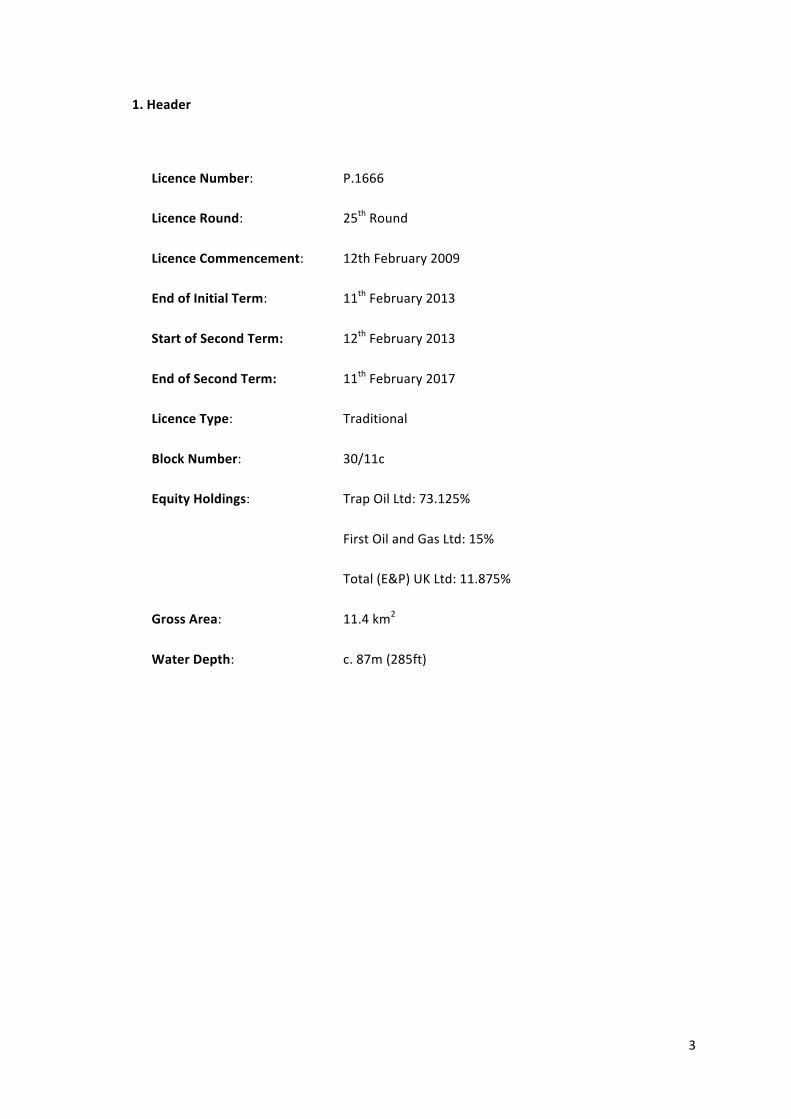
1. Header
Licence Number: P.1666
Licence Round: 25th Round
Licence Commencement: 12th February 2009
End of Initial Term: 11th February 2013
Start of Second Term: 12th February 2013
End of Second Term: 11th February 2017
Licence Type: Traditional
Block Number: 30/11c
Equity Holdings: Trap Oil Ltd: 73.125%
First Oil and Gas Ltd: 15%
Total (E&P) UK Ltd: 11.875%
Gross Area: 11.4 km2
Water Depth: c. 87m (285ft)
4
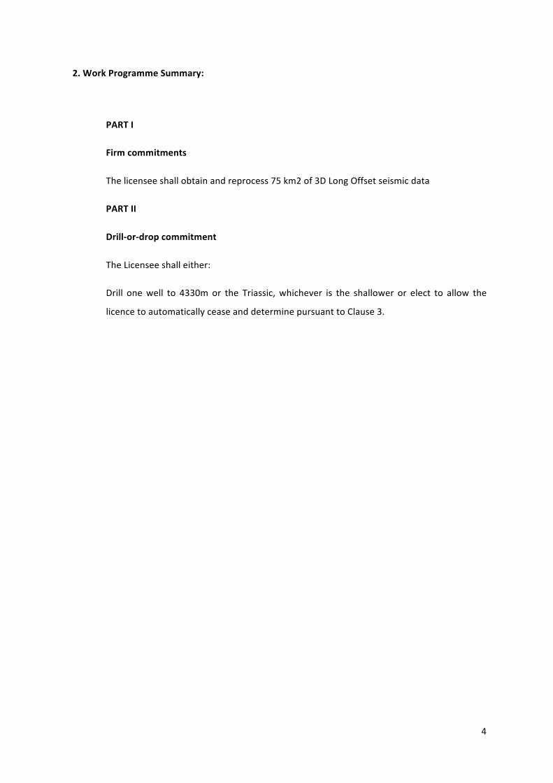
2. Work Programme Summary:
PART I
Firm commitments
The licensee shall obtain and reprocess 75 km2 of 3D Long Offset seismic data
PART II
Drill-‐or-‐drop commitment
The Licensee shall either:
Drill one well to 4330m or the Triassic, whichever is the shallower or elect to allow the
licence to automatically cease and determine pursuant to Clause 3.
5
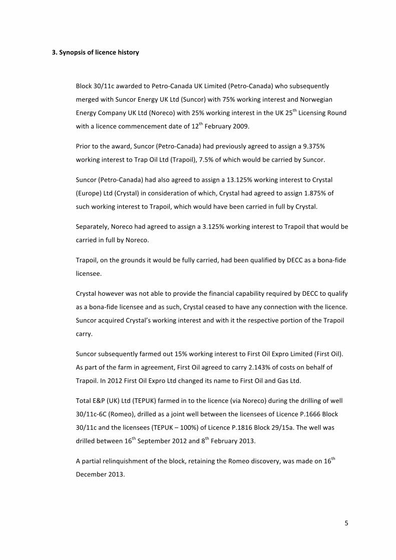
3. Synopsis of licence history
Block 30/11c awarded to Petro-‐Canada UK Limited (Petro-‐Canada) who subsequently
merged with Suncor Energy UK Ltd (Suncor) with 75% working interest and Norwegian
Energy Company UK Ltd (Noreco) with 25% working interest in the UK 25th Licensing Round
with a licence commencement date of 12th February 2009.
Prior to the award, Suncor (Petro-‐Canada) had previously agreed to assign a 9.375%
working interest to Trap Oil Ltd (Trapoil), 7.5% of which would be carried by Suncor.
Suncor (Petro-‐Canada) had also agreed to assign a 13.125% working interest to Crystal
(Europe) Ltd (Crystal) in consideration of which, Crystal had agreed to assign 1.875% of
such working interest to Trapoil, which would have been carried in full by Crystal.
Separately, Noreco had agreed to assign a 3.125% working interest to Trapoil that would be
carried in full by Noreco.
Trapoil, on the grounds it would be fully carried, had been qualified by DECC as a bona-‐fide
licensee.
Crystal however was not able to provide the financial capability required by DECC to qualify
as a bona-‐fide licensee and as such, Crystal ceased to have any connection with the licence.
Suncor acquired Crystal’s working interest and with it the respective portion of the Trapoil
carry.
Suncor subsequently farmed out 15% working interest to First Oil Expro Limited (First Oil).
As part of the farm in agreement, First Oil agreed to carry 2.143% of costs on behalf of
Trapoil. In 2012 First Oil Expro Ltd changed its name to First Oil and Gas Ltd.
Total E&P (UK) Ltd (TEPUK) farmed in to the licence (via Noreco) during the drilling of well
30/11c-‐6C (Romeo), drilled as a joint well between the licensees of Licence P.1666 Block
30/11c and the licensees (TEPUK – 100%) of Licence P.1816 Block 29/15a. The well was
drilled between 16th September 2012 and 8th February 2013.
A partial relinquishment of the block, retaining the Romeo discovery, was made on 16th
December 2013.
6
In 2014 and as part of a larger asset rationalisation, Noreco assigned its remaining equity to
Trapoil and subsequently Trapoil, as part of an asset swap, acquired Suncor’s interest and
operatorship of the block.
Trap Oil Group Plc changed its name to Jersey Oil and Gas Plc (JOG) effective 14th August
2015, however Trap Oil Ltd, as the subsidiary operating company, remained as the licensee.
Block 30/11c is located in the Central Graben on the western flank of the West Central
Graben, some 300 km east of Aberdeen in a water depth of c. 87m. Fields in close
proximity include Auk and Fulmar.
7
4. Exploration Activities
4.1 Seismic Data
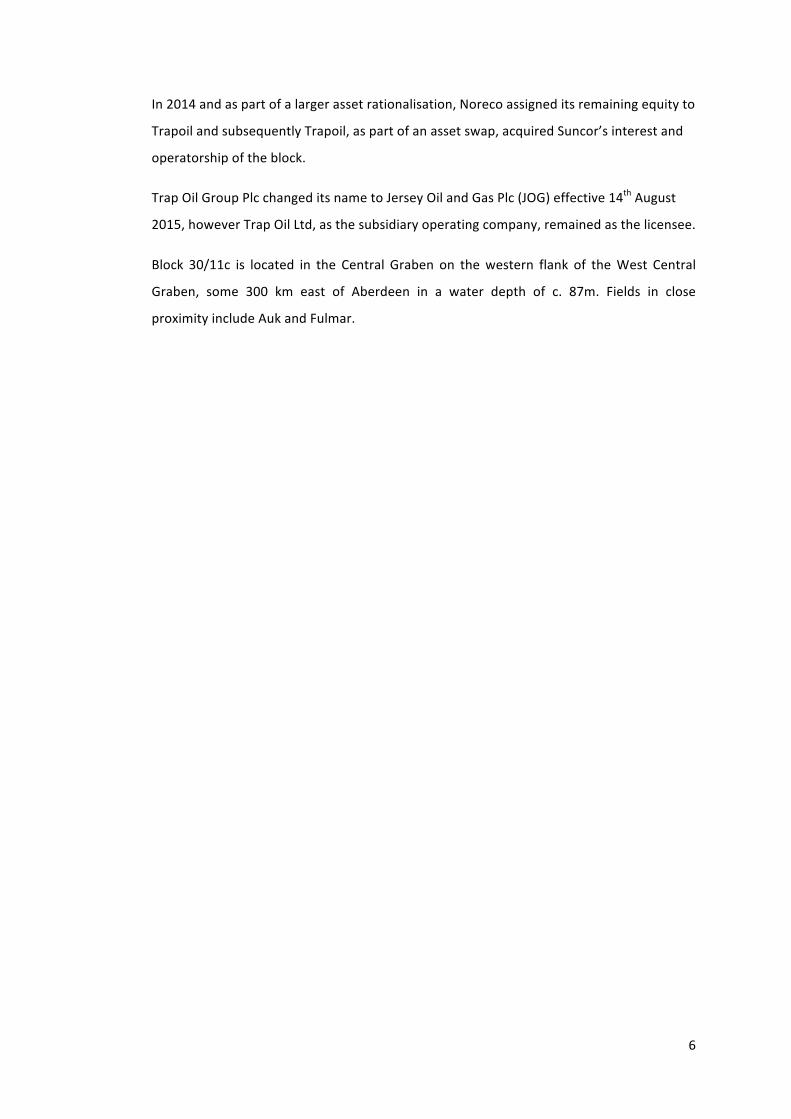
CGG VERS CNS 02 (Q30 Ph. 1) PSTM (75.7 km2 was acquired on a Group licence basis. Suncor acquired an additional 30.1 km2 on a single company licence basis, to allow the 29/15-‐2 well to be tied to the interpretation.
Post drilling of the 30/11c-‐6C (Romeo) well, 20 km2 of CGG VERS CNS 02 (Q30 Ph. 1)
reprocessed data (PSDM) was acquired. It is to be noted the western portion of the data
are not full fold data.
Figure 1. Location map and seismic database
4.2 Wells
Well 30/11c-‐6C (Suncor, 2013)
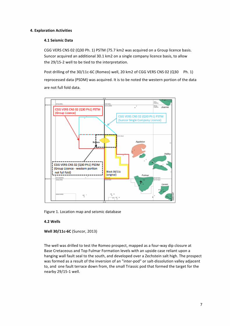
The well was drilled to test the Romeo prospect, mapped as a four-‐way dip closure at Base Cretaceous and Top Fulmar Formation levels with an upside case reliant upon a hanging wall fault seal to the south, and developed over a Zechstein salt high. The prospect was formed as a result of the inversion of an "inter-‐pod" or salt-‐dissolution valley adjacent to, and one fault terrace down from, the small Triassic pod that formed the target for the nearby 29/15-‐1 well.
8
The availability of modern long-‐offset 3D data enabled the internal reflectivity of the Romeo structure to be interpreted. Although no direct well ties were available to allow the interpretation to be definitive, (jump correlations across major faults were required), the internal reflector geometries appeared to indicate the deposition of Late Jurassic Fulmar Formation sands (primary objective of the well) within a rotating half graben. It was believed the Romeo structure developed in a very similar way to Fulmar Field, albeit on a smaller scale. Pre-‐drill, the Romeo prospect was mapped as straddling the block boundary between block 30/11c and block 29/15a with approximately 40% of the prospect located in block 29/15a.
Figure 2. Pre-‐drill Top Fulmar Reservoir depth structure map (Suncor)
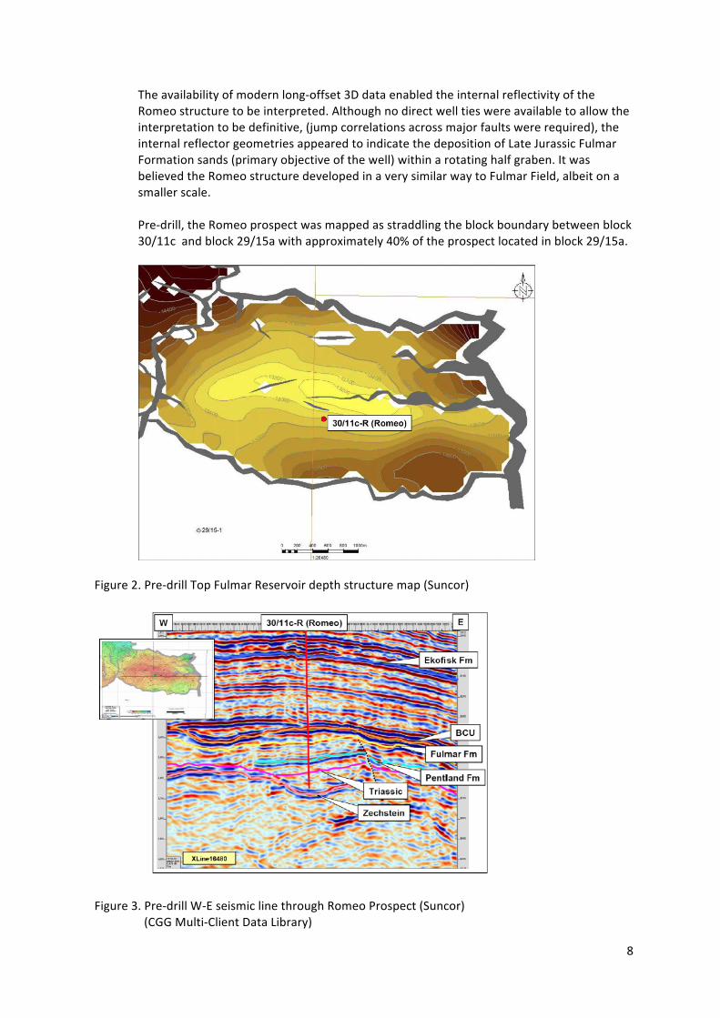
Figure 3. Pre-‐drill W-‐E seismic line through Romeo Prospect (Suncor) (CGG Multi-‐Client Data Library)
9
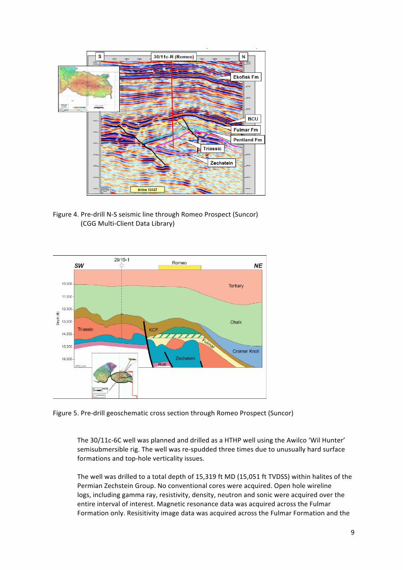
Figure 4. Pre-‐drill N-‐S seismic line through Romeo Prospect (Suncor) (CGG Multi-‐Client Data Library)
Figure 5. Pre-‐drill geoschematic cross section through Romeo Prospect (Suncor) The 30/11c-‐6C well was planned and drilled as a HTHP well using the Awilco ‘Wil Hunter’ semisubmersible rig. The well was re-‐spudded three times due to unusually hard surface formations and top-‐hole verticality issues. The well was drilled to a total depth of 15,319 ft MD (15,051 ft TVDSS) within halites of the Permian Zechstein Group. No conventional cores were acquired. Open hole wireline logs, including gamma ray, resistivity, density, neutron and sonic were acquired over the entire interval of interest. Magnetic resonance data was acquired across the Fulmar Formation only. Resisitivity image data was acquired across the Fulmar Formation and the
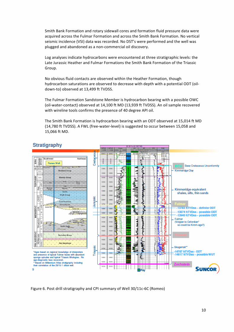
10
Smith Bank Formation and rotary sidewall cores and formation fluid pressure data were acquired across the Fulmar Formation and across the Smith Bank Formation. No vertical seismic incidence (VSI) data was recorded. No DST’s were performed and the well was plugged and abandoned as a non-‐commercial oil discovery. Log analyses indicate hydrocarbons were encountered at three stratigraphic levels: the Late Jurassic Heather and Fulmar Formations the Smith Bank Formation of the Triassic Group. No obvious fluid contacts are observed within the Heather Formation, though hydrocarbon saturations are observed to decrease with depth with a potential ODT (oil-‐ down-‐to) observed at 13,499 ft TVDSS. The Fulmar Formation Sandstone Member is hydrocarbon bearing with a possible OWC (oil-‐water-‐contact) observed at 14,100 ft MD (13,939 ft TVDSS). An oil sample recovered with wireline tools confirms the presence of 40 degree API oil. The Smith Bank Formation is hydrocarbon bearing with an ODT observed at 15,014 ft MD (14,780 ft TVDSS). A FWL (free-‐water-‐level) is suggested to occur between 15,058 and 15,066 ft MD.
Figure 6. Post drill stratigraphy and CPI summary of Well 30/11c-‐6C (Romeo)
11
5. Prospectivity Analysis
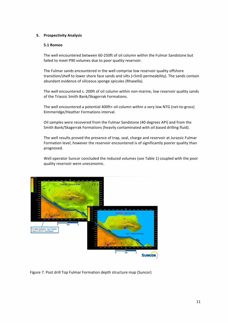
5.1 Romeo The well encountered between 60-‐250ft of oil column within the Fulmar Sandstone but failed to meet P90 volumes due to poor quality reservoir. The Fulmar sands encountered in the well comprise low reservoir quality offshore transition/shelf to lower shore face sands and silts (<5mD permeability). The sands contain abundant evidence of siliceous sponge spicules (Rhaxella). The well encountered c. 200ft of oil column within non-‐marine, low reservoir quality sands of the Triassic Smith Bank/Skagerrak Formations. The well encountered a potential 400ft+ oil column within a very low NTG (net-‐to-‐gross) Kimmeridge/Heather Formations interval. Oil samples were recovered from the Fulmar Sandstone (40 degrees API) and from the Smith Bank/Skagerrak Formations (heavily contaminated with oil based drilling fluid). The well results proved the presence of trap, seal, charge and reservoir at Jurassic Fulmar Formation level, however the reservoir encountered is of significantly poorer quality than prognosed. Well operator Suncor concluded the reduced volumes (see Table 1) coupled with the poor quality reservoir were uneconomic.
Figure 7. Post drill Top Fulmar Formation depth structure map (Suncor)
12
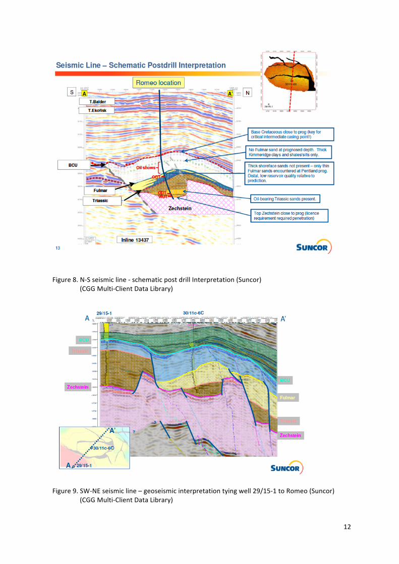
Figure 8. N-‐S seismic line -‐ schematic post drill Interpretation (Suncor) (CGG Multi-‐Client Data Library)
Figure 9. SW-‐NE seismic line – geoseismic interpretation tying well 29/15-‐1 to Romeo (Suncor) (CGG Multi-‐Client Data Library)
13
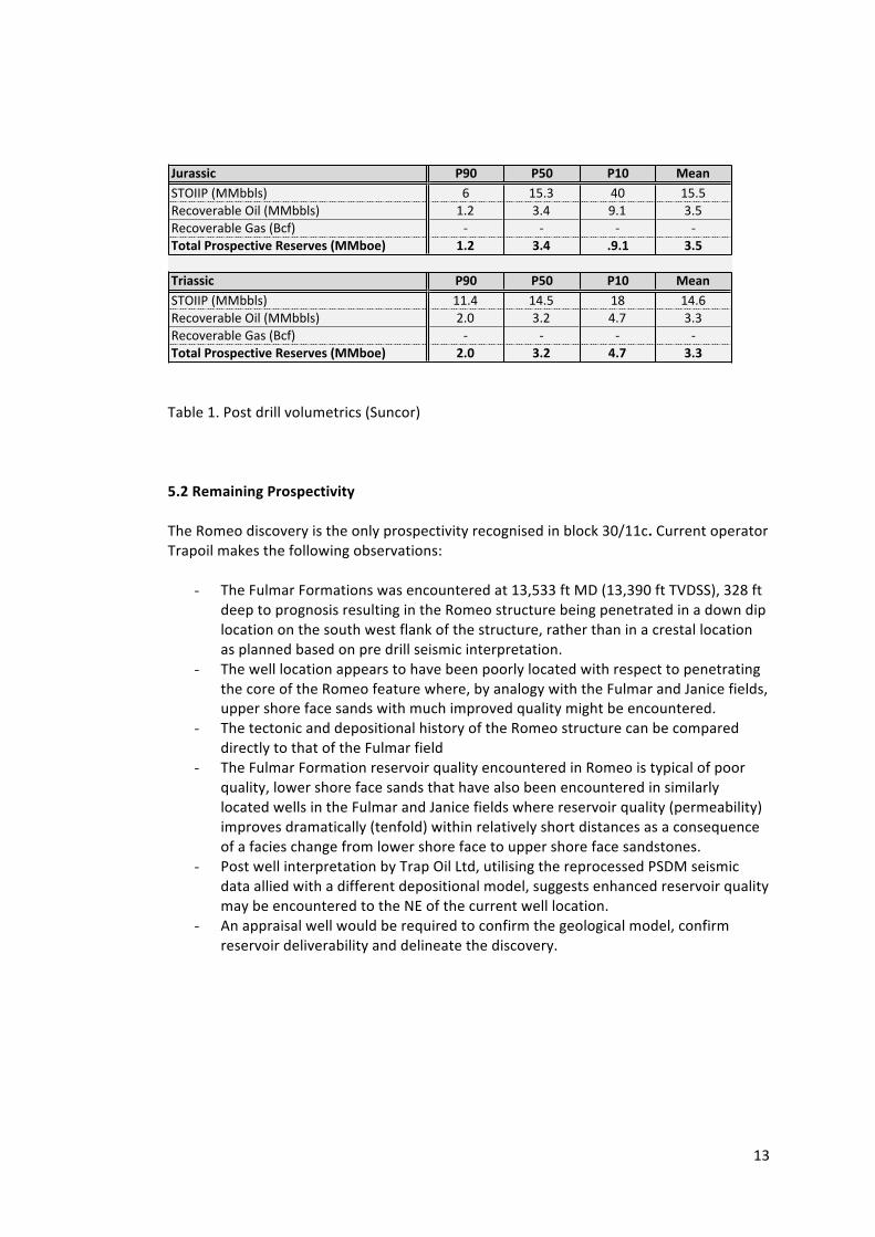
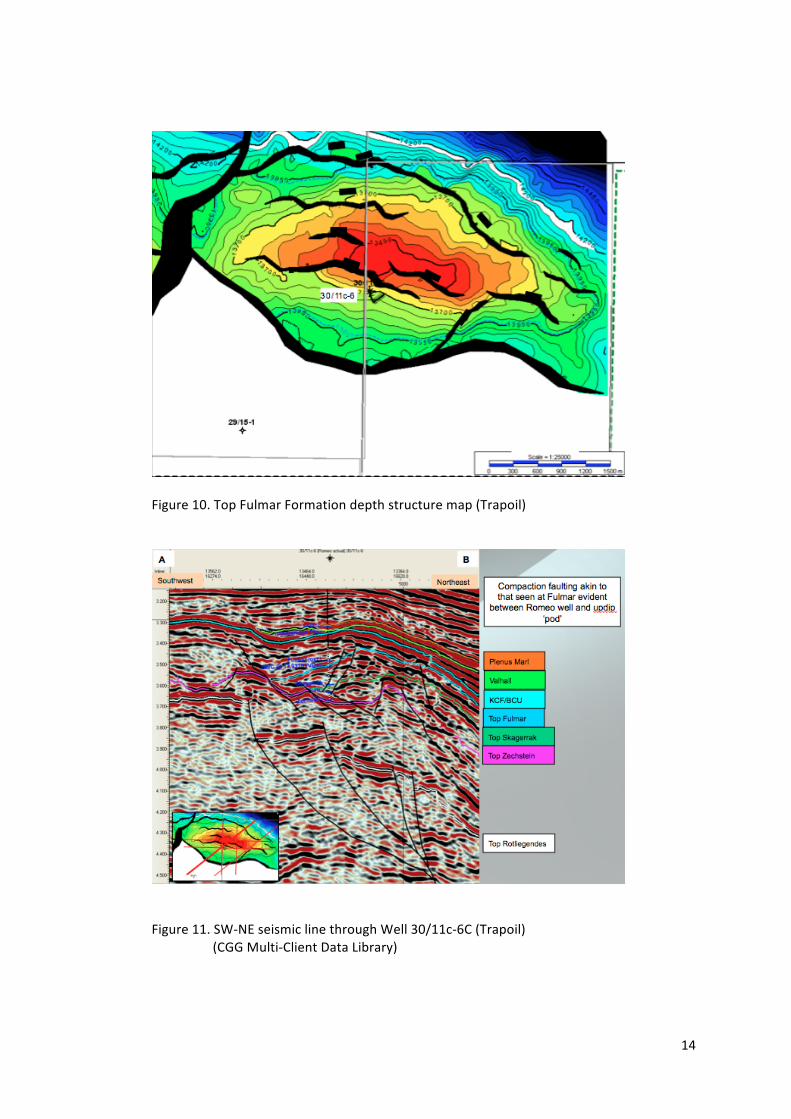
Table 1. Post drill volumetrics (Suncor) 5.2 Remaining Prospectivity The Romeo discovery is the only prospectivity recognised in block 30/11c. Current operator Trapoil makes the following observations:
- The Fulmar Formations was encountered at 13,533 ft MD (13,390 ft TVDSS), 328 ft deep to prognosis resulting in the Romeo structure being penetrated in a down dip location on the south west flank of the structure, rather than in a crestal location as planned based on pre drill seismic interpretation.
- The well location appears to have been poorly located with respect to penetrating the core of the Romeo feature where, by analogy with the Fulmar and Janice fields, upper shore face sands with much improved quality might be encountered.
- The tectonic and depositional history of the Romeo structure can be compared directly to that of the Fulmar field
- The Fulmar Formation reservoir quality encountered in Romeo is typical of poor quality, lower shore face sands that have also been encountered in similarly located wells in the Fulmar and Janice fields where reservoir quality (permeability) improves dramatically (tenfold) within relatively short distances as a consequence of a facies change from lower shore face to upper shore face sandstones.
- Post well interpretation by Trap Oil Ltd, utilising the reprocessed PSDM seismic data allied with a different depositional model, suggests enhanced reservoir quality may be encountered to the NE of the current well location.
- An appraisal well would be required to confirm the geological model, confirm reservoir deliverability and delineate the discovery.
!"#$%%&' ()* (+* (,* -.$/!"#$$%&'(())*+, - ./01 23 ./0/4567859:)*5&#;*&'(())*+, .0< 102 =0. 10/4567859:)*5&>:+&'?6@, A A A A012$34(#1%5.'2&6.47.%.#6.%48--91.: ,;< =;> ;);, =;+
0#&$%%&' ()* (+* (,* -.$/!"#$$%&'(())*+, ..02 .20/ .B .20-4567859:)*5&#;*&'(())*+, <03 10< 20C 1014567859:)*5&>:+&'?6@, A A A A012$34(#1%5.'2&6.47.%.#6.%48--91.: <;* =;< >;? =;=
14
Figure 10. Top Fulmar Formation depth structure map (Trapoil)
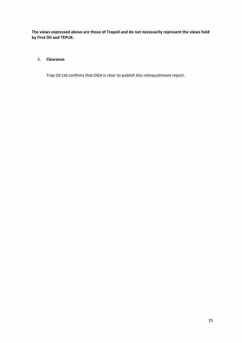
Figure 11. SW-‐NE seismic line through Well 30/11c-‐6C (Trapoil) (CGG Multi-‐Client Data Library)
15
The views expressed above are those of Trapoil and do not necessarily represent the views held by First Oil and TEPUK.
5. Clearance
Trap Oil Ltd confirms that OGA is clear to publish this relinquishment report.