Embed Size (px)
Citation preview

REMOTE SENSING OF ECO-CLIMATIC CONDITIONS ASSOCIATED WITH THE 2004 DESERT LOCUST OUTBREAK IN NORTHWEST AND SAHELIAN AFRICA
Assaf Anyamba, Associate Research Scientist Jennifer Small, Senior Programmer Analyst Compton J. Tucker, Senior Earth Scientist
NASA/Goddard Space Flight Center, Biospheric Sciences Branch, Code 614.4, GIMMS Group, Greenbelt Maryland, 20771
[email protected] [email protected]
Keith Cressman, Locust Forecasting Officer Locust Group, AGP Division
Food & Agriculture Organization of the United Nations Viale delle Terme di Caracalla, 00100 ROME - ITALY.
Timothy B. Love, Research Meteorologist, NOAA Climate Prediction Center
5200 Auth Road Camp Springs, Maryland 20746
Kenneth J. Linthicum, Center Director USDA-Center for Medical, Agricultural & Veterinary Entomology
P.O. Box 14565 1600/1700 S.W. 23rd Drive Gainesville, Florida 32604
ABSTRACT An outbreak of the Desert Locust in the spring and summer of 2004 was the worst in the last 10 years and resulted in economically significant losses to both subsistence and export agriculture across areas of northern and western Africa. An analysis of rainfall and remotely sensed vegetation index measurements shows unusual rainfall in the summer of 2003 on the margins of the Sahara Desert was the triggering event. Subsequently, unusual rains in northwest Africa during the spring of 2004 resulted in continued favorable conditions for the large-scale locust reproduction and population expansion for several generations with subsequent desert locust outbreaks or plagues that affected large areas of Northwestern and Sahelian West Africa during 2004. Satellite remote sensing of both rainfall and developing green vegetation conditions can identify locations of initial and subsequent locust breeding for targeted ground surveillance and control. This information is critical to target areas of developing populations of desert locust for control campaigns.
INTRODUCTION
The semi-arid and desert region of Africa north of the equator and adjacent arid areas of the Middle East and Southwest Asia is prone to episodic plagues of the of desert locust (Schistocerca gregaria) sometimes lasting several years (Waloff, 1966). From antiquity into the 20th century these outbreaks developed into wide-spread plagues in 1926-1933, 1941-1947, and 1968 and more recently in 1987-1989, and have resulted in enormous agricultural losses to the whole region (Waloff, 1966; Cressman, 1997). The desert locust has plagued mankind for millennia over an area of ~30 million km2 and certainly before, presently affecting more than 55 countries within
Pecora 16 “Global Priorities in Land Remote Sensing” October 23-27, 2005* Sioux Falls, South Dakota
which live ~900,000,000 people (Figure 1). The earliest known report on the desert locust is from carvings on Egyptian 6th dynasty tombs from 2400 BC. Other early depictions of the desert locust are from Assyrian bas reliefs that show desert locusts being prepared as food and the Babylonian Ta’anith describes desert locust plagues. Other pre-Biblical reports are in Ugaritic Legends, Epics, and Myths. The Bible mentions desert locusts several places, including Exodus 10:3-30 (the ‘8th plague’), Deuteronomy 28:38, Joel 2:1 and 11, and Kings 8:37. Not to be outdone, Pliny’s Natural History XXXVII:40 reports that desert locusts get so large in India that people there use their hind legs as saws.
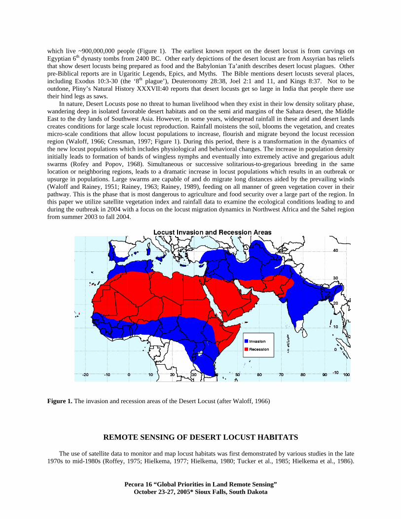
In nature, Desert Locusts pose no threat to human livelihood when they exist in their low density solitary phase, wandering deep in isolated favorable desert habitats and on the semi arid margins of the Sahara desert, the Middle East to the dry lands of Southwest Asia. However, in some years, widespread rainfall in these arid and desert lands creates conditions for large scale locust reproduction. Rainfall moistens the soil, blooms the vegetation, and creates micro-scale conditions that allow locust populations to increase, flourish and migrate beyond the locust recession region (Waloff, 1966; Cressman, 1997; Figure 1). During this period, there is a transformation in the dynamics of the new locust populations which includes physiological and behavioral changes. The increase in population density initially leads to formation of bands of wingless nymphs and eventually into extremely active and gregarious adult swarms (Rofey and Popov, 1968). Simultaneous or successive solitarious-to-gregarious breeding in the same location or neighboring regions, leads to a dramatic increase in locust populations which results in an outbreak or upsurge in populations. Large swarms are capable of and do migrate long distances aided by the prevailing winds (Waloff and Rainey, 1951; Rainey, 1963; Rainey, 1989), feeding on all manner of green vegetation cover in their pathway. This is the phase that is most dangerous to agriculture and food security over a large part of the region. In this paper we utilize satellite vegetation index and rainfall data to examine the ecological conditions leading to and during the outbreak in 2004 with a focus on the locust migration dynamics in Northwest Africa and the Sahel region from summer 2003 to fall 2004.
Figure 1. The invasion and recession areas of the Desert Locust (after Waloff, 1966)
REMOTE SENSING OF DESERT LOCUST HABITATS
The use of satellite data to monitor and map locust habitats was first demonstrated by various studies in the late 1970s to mid-1980s (Roffey, 1975; Hielkema, 1977; Hielkema, 1980; Tucker et al., 1985; Hielkema et al., 1986).
Pecora 16 “Global Priorities in Land Remote Sensing” October 23-27, 2005* Sioux Falls, South Dakota

Due to the large area of locust recession and expansion, only remote sensing technology offered the only possible means of systematic monitoring ecological conditions over such a large area. Although both LANDSAT multispectral scanner (MSS) data and, later LANDSAT Thematic Mapper (TM) and the Systeme Probatoire pour l’Observation de la Terre (SPOT) provide adequate spatial resolution (15 – 30m) for mapping and classifying various desert locust habitats across the recession region, the repeat coverage (16 to 26 days) of these high spatial resolution sensors is not suitable for routine monitoring of these habitats (Tucker et al., 1985). Most of the desert locust breeding habitats such as dry river bed channels or wadis are highly transient. They quickly develop vegetation and dry depending on rainfall conditions. It is therefore necessary to utilize high temporal resolution data to capture these dynamics. In addition, large numbers of LANDSAT or SPOT scenes that would be required to cover such a large area makes it impossible to use such data in an operational monitoring program. As such, low spatial resolution data from National Oceanic and Atmospheric Administration’s Advanced Very High Resolution Radiometer (NOAA-AVHRR) sensor (1 to 8km spatial resolution) and SPOT Vegetation (1km spatial resolution) with high temporal resolution (10 day composites) are more appropriate for routine monitoring of ecological dynamics over this large semi-rid and desert region. Tucker et al. (1985) demonstrated that, in number of these desert locust breeding habitats, NOAA-AVHRR 1km data provided sufficient resolution to capture vegetation blooms where the locusts breed. As part of its “Locust and Other Migratory Pests Monitoring system” the United Nations Food and Agricultural Organization (FAO) has established the “Emergency Prevention System for Transboundary Animal and Plant Pests and Diseases” (EMPRES) program with a Desert Locust component to minimize the risk of emergencies developing as a result of Desert Locust plagues (Cressman, 1996). This system incorporates the use of SPOT- VEGETATION 10-day data to monitor conditions favorable for Desert Locust reproduction and development (Ceccato, 2004). For monitoring purposes FAO has divided the Desert Locust region into three sectors: (a) the Western region covering the West Africa and northwest Africa, (b) the Central Region covering eastern Sahel, northeastern Africa and the Middle East and (c) the East Region which covers Southwest Asia (mostly India and Pakistan).
Solitary desert locusts breed in moist soils after rain events and prosper by foraging on green vegetation matter. Persistence of rainfall, moist conditions and availability of adequate supplies of food over a large area leads to large scale breeding and subsequent increase population and concentration. The basis for monitoring locust emergence habitats using remote sensing therefore depends on the detection of greening areas following rain events. The differential interception and reflectance of solar radiation in the visible and infrared portion of the electromagnetic spectrum by vegetated surfaces compared to bare soil or desert surfaces means that vegetation can segregated from the bare soil/desert background. Utilization of satellite data in vegetation mapping and monitoring therefore exploits the red spectrum (0.6 – 0.7um) corresponding to chlorophyll absorption region and near-infrared spectrum (0.75 -1.1um) where high reflectance corresponds to green-leaf density (Tucker, 1979). Various ratio formulations based on these spectral characteristics of green vegetation are used to derive vegetation indices of which the most commonly used is the normalized difference vegetation index (NDVI) (Tucker, 1996). Such indices can be derived from spectral measurements made by the variety of remote sensing sensors currently in operation including NOAA-AVHRR, SPOT-VEGETATION and Terra/Aqua-MODIS.
DATA AND ANALYSIS METHODS Several data sets we employed in analyzing conditions associated with locust activity during the precursor
period (July – November 2003) and during the large- scale breeding and population upsurge period from January through November 2004. These data sets include: (a) Normalized Difference Vegetation Index (NDVI)
NDVI used in this study is derived from measurements made by the VEGETATION optical instrument, a wide field of view sensor on board of the SPOT-4 earth observation satellite. SPOT-Vegetation has four spectral bands: Blue (0.43 – 0.46um), used to mainly to perform atmospheric correction, Red (R: 0.61-0.68) and Near Infrared (NIR: 0.79 – 0.89), sensitive to the vegetation's photosynthetic activity and cell structure respectively and a Short Wave Infrared band (SWIR: 1.58 – 1.75um), sensitive to soil and vegetation moisture content. The derived data has a nominal spatial resolution of 1 km which is nearly constant across the entire 2,250km swath. The NDVI data is derived from the red and near-infrared bands as follows:
NDVI = (NIR – R) / (NIR + R) The data is processed at Vlaamse Instelling voor Technologisch Onderzoek (VITO), Belgium to produce the 10-
day synthesis product (S10) using maximum value compositing technique (Holben, 1986). Further processing including sub-setting, re-projection and generation of monthly maximum value composites was performed by the
Pecora 16 “Global Priorities in Land Remote Sensing” October 23-27, 2005* Sioux Falls, South Dakota
GIMMS group at NASA’s Goddard Space Flight Center. Generation of monthly data was carried in order to further reduce cloud contamination that persists in individual 10-day composite data. We created reference monthly mean data using the 1998-2004 as baseline period to represent mean vegetation conditions. These monthly mean images are regenerated every year as more data is sensed and processed. Monthly NDVI anomalies for the relevant months in 2003 and 2004 were computed as percent departures with reference to the 1998-2003 means as described in Anyamba et al. (2002). (b) Rainfall Data
The rainfall data used in this study is a result of a project to create a satellite-estimated precipitation climatology for Africa (Love et al., 2004). The data is based on the same Rainfall Estimation (RFE) algorithm by Xie et al. (2002) method currently used to generate operational products at the NOAA/Climate Prediction Center (see http://www.cpc.ncep.noaa.gov/products/fews/rfe.html) (Xie and Arkin, 1996; Xie et al., 2002), with some modifications. In contrast to the operational daily rainfall estimate, where inputs include SSMI, AMSUB, half-hourly GPI, and GTS data, the climatology method uses only 3-hourly GPI and GTS data. This is due to the relatively recent availability of satellite-based microwave estimates and the large amount of data which makes up the operational half-hourly GPI input. For creation of the climatological GPI, 3-hourly Meteosat data were obtained from Eumetsat's archived data group, while daily-updating products use 3-hourly data pulled from NOAA's Meteosat data feed. The data resolution is 0.1 by 0.1 degrees and one day's temporal domain is from 0600 GMT through 0600 GMT. Spatial extent of all estimates spans 20.0W-55.0E and 40.0S-40.0N. We accumulated the daily RFE estimates to compute monthly totals used in this study. The data time series is from January 1995 to present. Monthly rainfall totals are used in this study to illustrate rainfall patterns during the locust outbreak period.
(c) Locust Data The locust data were obtained from the active archives of Desert Locust Information Service, Locust and other
Migratory Pests Group of the Food and Agricultural Service (FAO) in Rome, Italy. Data were extracted for the activity period from July 2003 to November 2004 and cover the whole desert locust activity region from West Africa to India. The data consist of several information fields including; Reporting ID (a unique code), Date, Longitude, Latitude, Locust Type: [Solitary Adults, Gregarious Adults (=swarms), Solitary Locusts, Gregarious Locusts (= bands)]. The locust type information simply indicates the presence (=1) or absence (=0) of a particular type of locust population (solitary adults, gregarious adults, solitary locusts, gregarious locusts) situated in a given location based on ground surveys. The location information was used to map the locust presence on the corresponding monthly NDVI anomaly data.
RESULTS
Precursor Conditions, Summer 2003 The conditions for the large scale locust outbreak in 2004 were set during the summer of 2003. A good rainfall
season in summer 2003 (Figure 2a), produced significant blooming of vegetation in the breeding sites across the Sahel region. This also provided ideal soil moisture conditions for breeding and food resources for population expansion in the summer breeding sites of southern Mauritania, Mali, Niger and Sudan from August to September (FAO, 2004a) (Figure 2b). As the solitarious locusts and adults increased in number, they began to form groups at densities of up to 40 locusts/m2 or more in some locations. Breeding continued in October leading to a dramatic increase in locust numbers and outbreaks at various locations mainly in the western Sahel (Mauritania and Mali). In some of these locations, gregarious locusts and adults began to form swarms in October 2003. With the end of the summer rains and the vegetation drying out in most of the summer breeding areas of the Sahel (Figure 2c), the swarms that had not been controlled began to move to and congregate in western and Northwest Africa beginning in November 2003 (Figure 2d). Mature adults, groups and some swarms invaded northwestern and northern Mauritania, Western Sahara, Morocco, and western and south central Algeria where there had been unusual heavy rains (10 – 100mm/month) in September and October (Figure 2c) (FAO, 2004a). Egg laying occurred over most of Western Sahara and, locust bands began to appear from December through February 2004 with densities up to 1000 locusts/m2 (FAO, 2004). Movement during this period was aided by strong south southerly winds in February that were associated with a low pressure system located over the eastern Atlantic Ocean (not shown), which aided the migration of adults to the northwestern coastal plains of Morocco and as far as the Canary Islands. In November and December, residual adults and newly emerged solitary locusts formed in central and northern Niger, northern Mali, and northwestern Mauritania. Infestations declined in Mali in January but increased in northwestern Mauritania from where they moved northwards to Western Sahara. In the central locust region, solitary and gregarious adults
Pecora 16 “Global Priorities in Land Remote Sensing” October 23-27, 2005* Sioux Falls, South Dakota

appeared in southern Egypt, Libya and along the Red Sea coast of Saudi Arabia in November 2003 having moved from breeding grounds west of the Nile in Sudan. Egg laying occurred in November, in areas along the shoreline of Lake Nasser in Egypt and on the coastal plains between Jeddah and Umm in Saudi Arabia (FAO, 2004a) (Figure 2d).
Figure 2a. Monthly rainfall for August 2003 over the Desert Locust recession region. The summer breeding sites over the Sahel region received between 25–250 mm of rainfall during this period.
Figure 2b. Locust distribution patterns superimposed on NDVI anomalies for August 2003. NDVI anomalies are expressed as percent departures from 1998-2004 mean period. The greenup of vegetation in the breeding sites over western Sahel and eastern Sudan following the summer rains provided adequate food resources for the emerging populations of locusts.
Figure 2c. Monthly rainfall for October 2003 over the Desert Locust recession and invasion region. Rainfall retreated from the summer breeding grounds of Sahel (Niger and Mali) during this period but continued in Mauritania, Senegal and northwest Africa with rainfall amounts ranging from 25-150mm.
Figure 2d. The retreat of rainfall from the Sahel and a diminishment of resources shown by negative NDVI anomalies in Mali and Niger, resulted in a migration of locust populations northwards into the recession region and westwards to Mauritania and Western Sahara where there was adequate rainfall in October 2003.
Spring Breeding and Summer Migration Patterns in 2004 The movement to the Northwest Africa region beginning in November 2003 set the stage for the subsequent
large-scale breeding in the spring of 2004. Above normal rainfall in the spring breeding areas of northern Mauritania, Western Sahara, southwest Morocco, and parts of western Algeria, from January through April 2003 with monthly rainfall totals as high as 50mm in some areas (Figure 3a), provided the necessary soil moisture conditions for breeding and the growth of vegetation, a necessary food resource. From January through March, 2004, more adult swarms continued to arrive from the Sahel, laying eggs in the spring breeding areas of Algeria and Morocco. As the region became warmer, immature hopers emerged and formed swarms of up to 1000 locusts/ m2 (FAO, 2004a). They began moving further north to the spring breeding areas south of the Atlas Mountains in Morocco in the Draa
Pecora 16 “Global Priorities in Land Remote Sensing” October 23-27, 2005* Sioux Falls, South Dakota
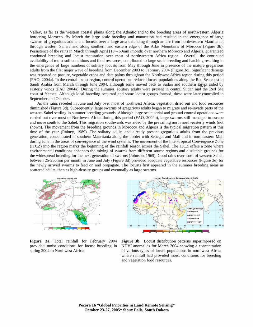
Valley, as far as the western coastal plains along the Atlantic and to the breeding areas of northwestern Algeria bordering Morocco. By March the large scale breeding and maturation had resulted in the emergence of large swarms of gregarious adults and locusts over a large area extending through an arc from northwestern Mauritania, through western Sahara and along southern and eastern edge of the Atlas Mountains of Morocco (Figure 3b). Persistence of the rains in March through April (10 – 60mm /month) over northern Morocco and Algeria, guaranteed continued breeding and locust maturation over most of northwestern Africa region. Overall, the continued availability of moist soil conditions and food resources, contributed to large scale breeding and hatching resulting in the emergence of large numbers of solitary locusts from May through June in presence of the mature gregarious adults from the first major wave of breeding from December 2003 to February 2004 (Figure 3c). Significant damage was reported on pasture, vegetable crops and date palms throughout the Northwest Africa region during this period (FAO, 2004a). In the central locust region, control operations reduced locust populations along the Red Sea coast in Saudi Arabia from March through June 2004, although some moved back to Sudan and southern Egypt aided by easterly winds (FAO 2004a). During the summer, solitary adults were present in central Sudan and the Red Sea coast of Yemen. Although local breeding occurred and some locust groups formed, these were later controlled in September and October.
As the rains receded in June and July over most of northwest Africa, vegetation dried out and food resources diminished (Figure 3d). Subsequently, large swarms of gregarious adults began to migrate and re-invade parts of the western Sahel settling in summer breeding grounds. Although large-scale aerial and ground control operations were carried out over most of Northwest Africa during this period (FAO, 2004b), large swarms still managed to escape and move south to the Sahel. This migration southwards was aided by the prevailing north north-easterly winds (not shown). The movement from the breeding grounds in Morocco and Algeria is the typical migration pattern at this time of the year (Rainey, 1989). The solitary adults and already present gregarious adults from the previous generation, concentrated in southern Mauritania along the border with Senegal and Mali and in northeastern Mali during June in the areas of convergence of the wind systems. The movement of the Inter-tropical Convergence Zone (ITCZ) into the region marks the beginning of the rainfall season across the Sahel. The ITCZ offers a zone where environmental conditions enhances the mixing of swarms from different source regions and a suitable grounds for the widespread breeding for the next generation of swarms (Johnson, 1965). Good rains over most of western Sahel, between 25-250mm per month in June and July (Figure 3d) provided adequate vegetative resources (Figure 3e) for the newly arrived swarms to feed on and propagate. The locusts first appeared in the summer breeding areas as scattered adults, then as high-density groups and eventually as large swarms.
Figure 3a. Total rainfall for February 2004 provided moist conditions for locust breeding in spring 2004 in Northwest Africa.
Figure 3b. Locust distribution patterns superimposed on NDVI anomalies for March 2004 showing a concentration of various types of locust populations in northwest Africa where rainfall had provided moist conditions for breeding and vegetation food resources.
Pecora 16 “Global Priorities in Land Remote Sensing” October 23-27, 2005* Sioux Falls, South Dakota
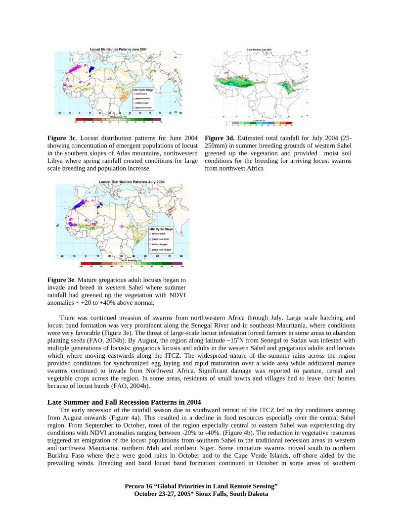
Figure 3c. Locust distribution patterns for June 2004 showing concentration of emergent populations of locust in the southern slopes of Atlas mountains, northwestern Libya where spring rainfall created conditions for large scale breeding and population increase.
Figure 3d. Estimated total rainfall for July 2004 (25-250mm) in summer breeding grounds of western Sahel greened up the vegetation and provided moist soil conditions for the breeding for arriving locust swarms from northwest Africa
Figure 3e. Mature gregarious adult locusts began to invade and breed in western Sahel where summer rainfall had greened up the vegetation with NDVI anomalies ~ +20 to +40% above normal.
There was continued invasion of swarms from northwestern Africa through July. Large scale hatching and locust band formation was very prominent along the Senegal River and in southeast Mauritania, where conditions were very favorable (Figure 3e). The threat of large-scale locust infestation forced farmers in some areas to abandon planting seeds (FAO, 2004b). By August, the region along latitude ~15oN from Senegal to Sudan was infested with multiple generations of locusts: gregarious locusts and adults in the western Sahel and gregarious adults and locusts which where moving eastwards along the ITCZ. The widespread nature of the summer rains across the region provided conditions for synchronized egg laying and rapid maturation over a wide area while additional mature swarms continued to invade from Northwest Africa. Significant damage was reported to pasture, cereal and vegetable crops across the region. In some areas, residents of small towns and villages had to leave their homes because of locust bands (FAO, 2004b). Late Summer and Fall Recession Patterns in 2004
The early recession of the rainfall season due to southward retreat of the ITCZ led to dry conditions starting from August onwards (Figure 4a). This resulted in a decline in food resources especially over the central Sahel region. From September to October, most of the region especially central to eastern Sahel was experiencing dry conditions with NDVI anomalies ranging between -20% to -40%. (Figure 4b). The reduction in vegetative resources triggered an emigration of the locust populations from southern Sahel to the traditional recession areas in western and northwest Mauritania, northern Mali and northern Niger. Some immature swarms moved south to northern Burkina Faso where there were good rains in October and to the Cape Verde Islands, off-shore aided by the prevailing winds. Breeding and band locust band formation continued in October in some areas of southern
Pecora 16 “Global Priorities in Land Remote Sensing” October 23-27, 2005* Sioux Falls, South Dakota

Mauritania and northern and central Senegal, where rainfall and ecological conditions where still favorable (Figure 4a, c). The general regional pattern for October through November, was of swarms of gregarious adults and solitary adults concentrated in a rim stretching from northern Burkina Faso, where the rains had retreated to, westwards to southern Mali, northern Senegal, western Mauritania northwards to western Sahara and into the traditional spring breeding grounds of Morocco (Figure 4c,d). Large populations of adults had also migrated northwards to northern Algeria, along the Mediterranean coast of Libya aided by strong southerly and southeasterly winds (not shown). From October through November large numbers of solitary adults appeared the along the Mediterranean coast of Egypt, the Sinai Peninsular, Israel and along the northern Red Sea coast of Saudi Arabia. Some swarms crossed the Mediterranean and were reported in Crete, Cyprus and Lebanon brought by strong southwesterly winds (Figure 4d).
Figure 4a. Rainfall patterns for September 2004. An early retreat of rainfall from the Sahel during this period diminished food
resources available to locust populations in Mali, Niger and Chad.
Figure 4b. An early end to the rainfall season dried out the
vegetation especially in Mali and Niger with NDVI anomalies -20 - -40% below normal. Locust populations were concentrated
in areas with patchy green vegetation.
Figure 4c. Locust distribution patterns for October showing the migration of gregarious locust population to areas along the Senegal
River in Mauritania and Senegal where conditions vegetations were still favorable and continued migration northwards to the spring
breeding sites in Morocco and Western Sahara.
Figure 4d. Continued dry conditions resulted in locust swarms migrating southwards to Burkina Faso and northwards to Libya,
Tunisia, and Egypt and as far as north as the Crete Islands, Cyprus, Lebanon and Israel in search food resources in the
coastal plains of the Mediterranean region. Migration was aided by prevailing wind systems.
SUMMARY AND CONCLUSIONS
The magnitude and geographical extent of Desert Locust upsurge in 2003-2004 was the largest since the plague of 1987-89. Most of the locust activity was limited to the Western Locust region (Northwest Africa and the West African Sahel) with minimal activity in the other locust regions. Locust activity in the Central region occurred from
Pecora 16 “Global Priorities in Land Remote Sensing” October 23-27, 2005* Sioux Falls, South Dakota

late 2003 to early 2004. Most of the locust populations sighted during this period were gregarious locusts that emerged in late 2003 to early 2004 but were quickly controlled, especially in Saudi Arabia, leaving behind solitary adults wandering around the region. In the Eastern region, there was very limited activity even though good rainfall fell in the region. Low numbers of adults were observed in western Pakistan in the spring and along the Indo-Pakistan border during the summer months.
A recession of locust activity over the Western region in 2002 was followed by an increase in locust numbers in the summer breeding grounds of the Sahel in 2003. The good rainfall in early summer 2003 provided the necessary conditions for contemporaneous breeding and outbreaks over a large area of the Sahel, mostly over the western sector. During this period, large numbers of solitary locusts emerged mostly over the Sahel and transformation to gregarious types began to take place towards the end of 2003. Some large swarms arising out this initial outbreak moved to Northwest Africa as rainfall diminished and the vegetation dried out in October – November 2003. During the spring of 2004, prolonged periods of rainfall and ideal temperatures provided the appropriate conditions for large-scale locust breeding over a large area from northwestern Mauritania northeastwards to western and northwestern Algeria, leading to the development of an upsurge in the population. Large numbers of solitary locusts emerged during this period arising from the breeding of gregarious adults that had moved to the region from the Sahel. In April 2004, for example, there were more than 2000 sightings of such locusts over the western region (FAO, 2004b).These locusts matured and formed swarms in early summer. Although both aerial and ground control operations were carried out in Algeria and Morocco, large swarms managed to escape and re-invaded the Sahel region in the summer of 2004. Ideal meteorological conditions exemplified by strong prevailing north-northwesterly winds aided migration, and good summer rains provided appropriate conditions for population expansion in the summer breeding grounds extending from the western to central Sahel.
The early summer rains across the Sahel in June, created conditions for multiple breeding from newly arrived swarms and swarms from the previous generations which had been localized recession areas during winter and spring. The number of destructive gregarious adults over the Sahel increased from June through the end of 2004. This led to a large number of new swarms developing over most of the region from July through September 2004. An early end to summer rains due to a migration of the ITCZ southwards and the resulting diminishment of vegetation resources led to some swarms migrating southwards to northern Burkina Faso, where rainfall and vegetation conditions were still good, and to large swarms re-invading the winter and spring breeding areas of Northwest Africa and the Mediterranean coast of Algeria and Libya in October. In November, some swarms had reached Egypt, Israel, Crete, Cyprus and Lebanon. Some infestations appeared in Saudi Arabia, Yemen and Jordan, likely from the breeding grounds in Sudan. Throughout the upsurge, agricultural damage was reported in some
Desert Locust Activity 2003-2004: Area Infested (Ha)
Are
a In
fest
ed (H
a) x
100
0
0
300
600
900
1200
1500
1800
2100
2400
2700
3000
Western Region Central Region Eastern Region
03 f m a m j j a s o n d 04 f m a m j j a s o n d
countries due to lack of enough resources to control locusts over such a large area. Most of the locust infestations occurred over the Western region with approximately 500,000 Ha of land being infested by the end of 2003. Limited resources to control locust at this stage resulted in the upsurge and an infestation of 700,000 Ha by late spring 2004. By then it was too late to control the large swarms of locust now all over northwest Africa and migrating south to West Africa. In late summer 2004 more than 1.2 million Ha were infested. By November 2004, the locusts had moved over the entire western region and more than 2.8 million Ha of land was estimated to be infested. These numbers may actually be conservative considering that limited resources were available to map areas affected by locust activity during this period, especially over remote and uninhabited areas. Cumulatively about 12 million Ha were estimated to have been infested by locusts during the 2003 – 2004
period (Figure 5). In terms of agricultural losses, the damage was localized to specific areas along the Senegal River in Senegal and subsistence faming areas of Mauritania, Mali and Niger. The major grain areas in Senegal were not affected. Post harvest estimates in October 2004 by FAO and the Comité permanent Inter Etats de Lutte Contre la Sécheresse dans le Sahel (CILSS) reported less than 10 percent losses for most of the affected countries. The losses
Figure 5. Area (in hectares x 1000) infested by Desert
Locusts during from 2003 – 2004. Most of the infestations occurred over the Western region. Data source: FAO, 2004b.
Pecora 16 “Global Priorities in Land Remote Sensing” October 23-27, 2005* Sioux Falls, South Dakota
were more apparent in Mauritania and Niger, both of which reported more than 10% damage percent because their national production is already very small (Reynolds [USDA/FAS, Washington, DC] personal communication). This damage to agriculture resulted in the recent reported famine in Niger and parts of Mali in 2005. In the northwest Africa countries, early mobilization of resources and control operations using aerial spraying minimized agricultural damage unlike previous outbreak years when agricultural damage was extensive.
The distribution patterns of locust populations during this outbreak period show areas of concentration in northeastern Mali, central and northwestern Mali, along the Senegal River in Mauritania and Senegal during the summer months, and in northwestern Mauritania, western Sahara, and along the southeastern edge and eastern edge of the Atlas Mountains in Morocco and Algeria during the winter and spring. During the retreat phase from the Sahel in 2004, locusts were distributed in an arc-shaped area from western Mauritania, northwards through Morocco, and eastwards to Libya and Egypt along the Mediterranean coast. This would suggest a preference for coastal plains along the Mediterranean coast where vegetation is often abundant in wadis and alluvial plains. At the height of the Sahel growing season there is a preference for the locusts to be concentrated along the ITCZ across the region indicating the influence of convergent wind systems on distribution patterns. The distribution patterns are also patchy, and are likely related to the patchiness of the vegetation distribution patterns across this semi-arid region as illustrated by clusters of positive NDVI anomalies during the summer rains and the aggregation of locust populations within and around these positive NDVI anomaly habitats. Vegetation in the desert locust’s range is usually discontinuous and exhibits clumping at multiple spatial scales (Popov, 1997; Waloff 1966). The mosaics of habitats across the region provide crucial zones for desert locust concentration, multiplication and gregarisation. These distribution patterns indicate that favorable food resource areas and breeding habitats are localized in particular areas that are favorable for locust breeding and population growth (Walof, 1972). Locust distribution patterns during this outbreak suggest that the patterns of the distribution of resources influenced the concentration, gregarisation and location of destination zones during migration. These distribution patterns are in agreement with the findings by Collet et al. (1998) and Despland et al. (2004) showing that particular landscapes where resources are abundant or concentrated into small patches are favorable for locust outbreaking.
We have shown that the convergence of climatic and ecological conditions resulted in an upsurge of locust activity in 2003-2004. Although the spatial resolution of the satellite data at 1km is coarse for adequate analysis of micro-scale desert locust habitats, the advantage is in the treatment of the data in the time domain to identify areas of anomalous vegetation growth. The convergence between rainfall events in northwest Africa and the Sahel and the subsequent growth of vegetation is in agreement with the locust distribution patterns. The migration patterns from northwest Africa to the Sahel in summer 2004 was reinforced by ideal meteorological conditions, which caused wind systems to converge in the Sahel. Detailed analysis of the concentration of locust habitats can be examined using the currently available 250 m spatial resolution data from the Moderate Resolution Imaging Spectroradiometer (MODIS) sensor on board NASA’s Terra and Aqua satellite platforms. Currently available seasonal forecasts coupled with near real-time satellite monitoring of rainfall and vegetation conditions will continue to be invaluable tools for desert locust monitoring and control.
ACKNOWLEDGEMENTS
This research is in part funded through Goddard Earth Sciences Technology Center (GEST) under NASA/GSFC Cooperative Agreement with University of Maryland, Baltimore County, NCC5-494 and Global Agriculture Monitoring Project, A Joint Project between NASA, United States Department of Agriculture’s Foreign Agricultural Service (USDA/FAS), and University of Maryland College Park Grant # NAG 5134000. It is a contribution to interagency program in support of United States Agency for International Development/Famine Early Warning System (USAID/FEWS) on Food Security and Environmental Monitoring and USDA/FAS Global Agriculture Monitoring activities. SPOT Vegetation from DigitalGlobe/SPOT was provided by USDA/FAS under analysis agreement with the GIMMS Group, NASA/GSFC. We would like to thank NOAA/CPC for proving access to rainfall data and Desert Locust Information Service, Locust and other Migratory Pests Group, FAO, Rome for providing locust data.
Pecora 16 “Global Priorities in Land Remote Sensing” October 23-27, 2005* Sioux Falls, South Dakota

REFERENCES
Anyamba A, C.J. Tucker, R. Mahoney R. (2002). El Niño to La Niña: Vegetation response patterns over East and Southern Africa during 1997-2000 period. J. of Clim. 15: 3096-3103.
Cressman K. (1996). Current methods of desert locust forecasting at FAO. FAO Bulletin OEPP/EPPO 26: 577-585. Cressman, K. 1997. Monitoring the Desert Locust in the Middle East since 1945: An Overview. In Transformations
of Middle Eastern Natural Environments: Legacies and Lessons. Middle Eastern Natural Environments, Yale University, 492: 123-140.
Ceccato P. (2004). An Operational Early Warning System using SPOT/ VEGETATION and TERRA/ MODIS to prevent Desert Locust Outbreaks. International SPOT 4/5 - VEGETATION users Conference, March 24th - 26th, 2004, Antwerp, Belgium.
Collett, M., E. Despland, S.J. Simpson, D.C. Krakauer (1998). Spatial scales of desert locust gregarization. Ecology 95:13052-13055.
Despland, E., J. Rosenberg, S.J. Simpson (2004). Landscape structure and locust swarming: a satellite’s eye view. Ecography 27:381-391
FAO (2004a). The Desert Locust Situation: September 2003 – November 2004 and Forecast. FAO Desert Locust Control Committee Report, AGP: DLCC-04/2a http://www.fao.org/NEWS/GLOBAL/LOCUSTS/PDFs/DLCC04/DLCC04wp.htm
FAO (2004b). FAO Desert Locust Control Committee Report, Extraordinary Session, November 29-December 2, 2004. Rome, Italy, pp. 38-46.
Hielkema, J.U. (1977). Application of Landsat data in locust survey and control, Food and Agricultural Organization (FAO), AGP/LCC/77/11. Rome, Italy.
Hielkema, J.U. (1980). Remote sensing techniques and methodologies for monitoring ecological conditions for desert locust population development. FAO/USAID Final Report, Food and Agricultural Organization. FAO/USAID CGP/INT/349/USA, Rome, Italy.
Hielkema, J.U., J. Roffey, C.J. Tucker (1986). Assessment of ecological conditions associated with the 1980/1981 desert locust plague in West Africa using environmental satellite data. Int. J. of Rem. Sens. 7(11): 1609-1622.
Holben, B.N. (1986). Characteristics of maximum-value composite images for temporal AVHRR data. Int. J. of Rem. Sens.7:1417-1434.
Johnson, D.H. (1965). The meteorological implications of downwind movement. WMO Technical Note 69:6-19. Geneva, Switzerland.
Love T, Kumar, V., Xie, P., Thiaw, W. (2004). A 20-Year Daily Africa Precipitation Climatology Using Satellite and Gauge Data. Paper presented at the 14th Conference on Applied Climatology, American Meteorological Society, Seattle, WA, January 11-15, 2004.
Kalnay, E., M. Kanamitsu, R. Kistler, W. Collins, D. Deaven, L. Gandin, M. Iredell, S. Saha, G. White, J. Woolen J, Y. Zhu, M. Chelliah, W. Ebisuzaki, W. Higgins, J.E. Janowiak, K.C. Mo, C. Ropelewski, J. Wang, A. Leetma, R. Reynolds, R. Jenne, and D. Joseph, D. (1996). The NCEP/NCAR 40-Year Reanalysis Project. Bulletin of the American Meteorological Society 77(3): 437–472.
Popov G. (1977). Atlas of desert locust breeding habitats. FAO. Rome. Rainey, R.C. (1963). Meteorology and the migration of Desert Locusts. World Meteorological Organization, Geneva,
Switzerland. Rainey, R.C. (1989). Migration and Meteorology: Flight Behaviour and the Atmospheric Environment of Locusts
and other Migrant Pests. Clarendon Press, Oxford. Roffey, J., G. Popov (1968). Environmental and behavioral processes in a Desert Locust outbreak. Nature 219: 446-
450. Rofey, J. (1975). Program plan for improving desert locust survey and control by satellite remote sensing.
Consultant Report, FAO, Rome, Italy. Tucker, C. J. (1979). Red and photographic infrared linear combinations for monitoring vegetation. Rem. Sens. of
Environ. 8:127-150. Tucker, C. J., J. U, Hielkema, J. Roffey (1985). The potential for satellite remote sensing of ecological conditions
for survey and forecasting desert locust activity. Int. J. of Rem. Sens. 6(1):127-138. Tucker, C. J. (1996). History of the Use of AVHRR data for Land Applications. In D’Souza G, Belward AS,
Malingreau, J.P., (eds.) Advances in the Use of NOAA AVHRR Data for Land Applications. Kluwer, Boston. pp. 1-20.
Pecora 16 “Global Priorities in Land Remote Sensing” October 23-27, 2005* Sioux Falls, South Dakota
Schaefer, G.W. (1976). Radar observations of insect flight. In Raney, R.C. (ed.) Insect Flight. Symposia of the Royal Entomological Society No. 7. Blackwell, Oxford.
Waloff Z. (1966). The Upsurges and Recessions of the Desert Locust Plague: An Historical Survey. Anti-Locust Memoir 8. Anti-Locust Research Center, London, UK.
Walof Z. (1972). The plague dynamics of Desert Locust Schistocerca gregaria. In Hemming, C.F., Taylor, T.H.C. (eds.) Proceedings of the International Conference on Current and Future Problems of Acridology. London: Center for Overseas Pest Research, pp. 343-349
Waloff, Z., R.C. Rainey (1951). Field studies on factors affecting displacements of Desert Locust swarms in eastern Africa. Anti-Locust Bulletin, 9:1-50. London, UK.
Xie. P., P. A. Arkin (1996). Analyses of Global Monthly Precipitation Using Gauge Observations, Satellite Estimates, and Numerical Model Predictions. J. of Clim. 9: 840-858.
Xie P., Y. Yarosh, T. Love, J.E. Janowiak, P. Arkin (2002). A Real-Time Daily Precipitation Analysis over South Asia. Paper presented at the 16th Conference. of Hydrology. Orlando, FL, American Meteorological Society.
Pecora 16 “Global Priorities in Land Remote Sensing” October 23-27, 2005* Sioux Falls, South Dakota